portfolio 作品集 田湖俊
TRANSCRIPT

Hujun Tian
December, 2015

1
Niehoff Urban Studio, Cincinnati, May, 2015 – August, 2015
-Participated in the Three-Dimensional web map development project
-Joined in the “Greater Cincinnati Outdoor Gym” project
Downtown Cincinnati Incorporation, Cincinnati May, 2015 – August, 2015
-Participated the web mapping project for “Available Vacant Storefronts in
Central Business District of Cincinnati”
-Joined in the project “Upcoming Development in Downtown Area-Joined in the project “Upcoming Development in Downtown Area
Urban-Rural Planning Institute, Guangdong July, 2013 - Sep.,2013
-Participated in the Education Planning Project of Baiyun District, Guangzhou
as an assistant planner ;
-Undertook data processing, data analysis and charting.
University of Cincinnati, Cincinnati August, 2014 – June, 2016
College of Design, Architecture, Art and Planning
Master of Community Planning
Sun Yat-sen University, Guangdong, China Sep. 2010 – June, 2014
College of Geography and Urban Planning
Bachelor of Science
RESUME
Address: 518 Riddle Rd Apt 10,
Cincinnati, OH, 45220
Phone: 513-652-5214
Email: [email protected]

2
Graphics Photoshop
SketchUp
Programming Language Python
Other ArcMap QGIS ArcGIS Online Microsoft Office – Word, Excel, Powerpoint Microsoft Office – Word, Excel, Powerpoint

CONTE
NTS
The contents of this portfolio represents the skills and knowledge that I have learned so far in my college career. These projects show the work that I am most proud of. Thanks everyone who supported me along the way. -Hujun Tian
3

4
Universal Urban Design November, 2014
GIS Spatial Analysis October, 2014
Methods of Physical Planning January, 2015
Urban Planning Studio September, 2015
Urban Design Theory September, 2015
A
B
C
D
E

AA
The purpose of creating this poster is to let
us, as planners, take some responsibility for
the handicapped while doing urban design
and allocate the facilities, to make their lives
easier when they go outside.
5

6
Spatial Analysis
Slope School
RoadPopulation
BThis is site planning for high school in Cincinnati region and the factors that
need to be taken into consideration while decide where to allocate a high
school are slope, existing schools locations, population density and road
network density. Four small maps show the data of these four factors.B

7
After rasterizing thoses four types of data, I use tools weight sum and raster calculator to determine the areas that are
suitable for construction of new school.The areas coverd by blue color are the potential area for allocate a school.
Potential Area

8
O A K L E Y
C
Physical Analysis
C

9
Current Land Use in Oakley, Cincinnati

Current zoning in Oakley, Cincinnati
10
11
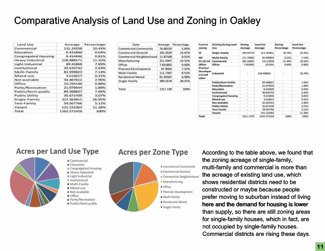
Comparative Analysis of Land Use and Zoning in Oakley
According to the table above, we found that the zoning acreage of single-family, multi-family and commercial is more than the acreage of existing land use, which shows residential districts need to be constructed or maybe because people prefer moving to suburban instead of living here and the demand for housing is lower here and the demand for housing is lower than supply, so there are still zoning areas for single-family houses, which in fact, are not occupied by single-family houses. Commercial districts are rising these days.

12
Compared with north part of Oakley, the south part is more suitable for pedestrians
Pedestrian Shed in Central Business District, Oakley

13
West End: Physical Connections
D
Urban Planning Studio
D

14
VISION:
The The West End contains an abundance of
historic and cultural assets. Our vision is to
better utilize and showcase these assets by
connecting them to those found in OTR and
CBD while simultaneously revitalizing the
West End community and creating a
cohesive basin region.
Group members:Group members:
Brad Roebke
Di Meng
Evan Koff
Hujun Tian
Tianyi Zhang

15
Opportunities:○ The West End’s major thoroughfares (Central Pkwy, Liberty St, Ezzard Charles Dr, and Linn St) are all wide enough to
be converted into “complete streets” with widened sidewalks, bike lanes, and streetscape improvements
○ Liberty St. bisects not only the West End but the entire basin region, serving as a primary access point to the West End
○ Ezzard Charles connects the West End to Union Terminal, Music Hall and Washington Park
○ Central Ave. connects the West End to Downtown and The Banks
○○ Street grid is relatively compact and easily walkable
○ Greenery already exists along Central Pkwy and Ezzard Charles Dr, which can easily be enhanced
○ Existing vegetative land on Findlay St can be turned into a park
○ Streetcar is only 1-2 blocks east of Central Pkwy, proving businesses and residents access to Downtown and
Over-the-Rhine
○ Large swath of light industrial land along Central Pkwy and Liberty St has many vacant parcels and is prime for
redevelopment
○○ Existing art studio can serve as a catalyst for other art studios, galleries, and public art
○ The West End contains many historical and cultural landmarks
Constraints:○ Central Pkwy is 120 feet wide, carries a high traffic load, and has few intersections - serves as a physical barrier between
the West End and Over-the-Rhine
○ Sam Adams brewery and Taft High School each take up 4 city blocks along Central without any cross-through streets
○○ Liberty St connects to I-75 (via Western Ave), I-471 and I-71 (via Reading Rd), generating high traffic volume and
frequent accidents
○ Many projects, such as capping I-75 with a park at Ezzard Charles, will be very expensive and take many years to
implement
○ Many industrial buildings are currently being used, and owners may resist zoning changes/relocating
16
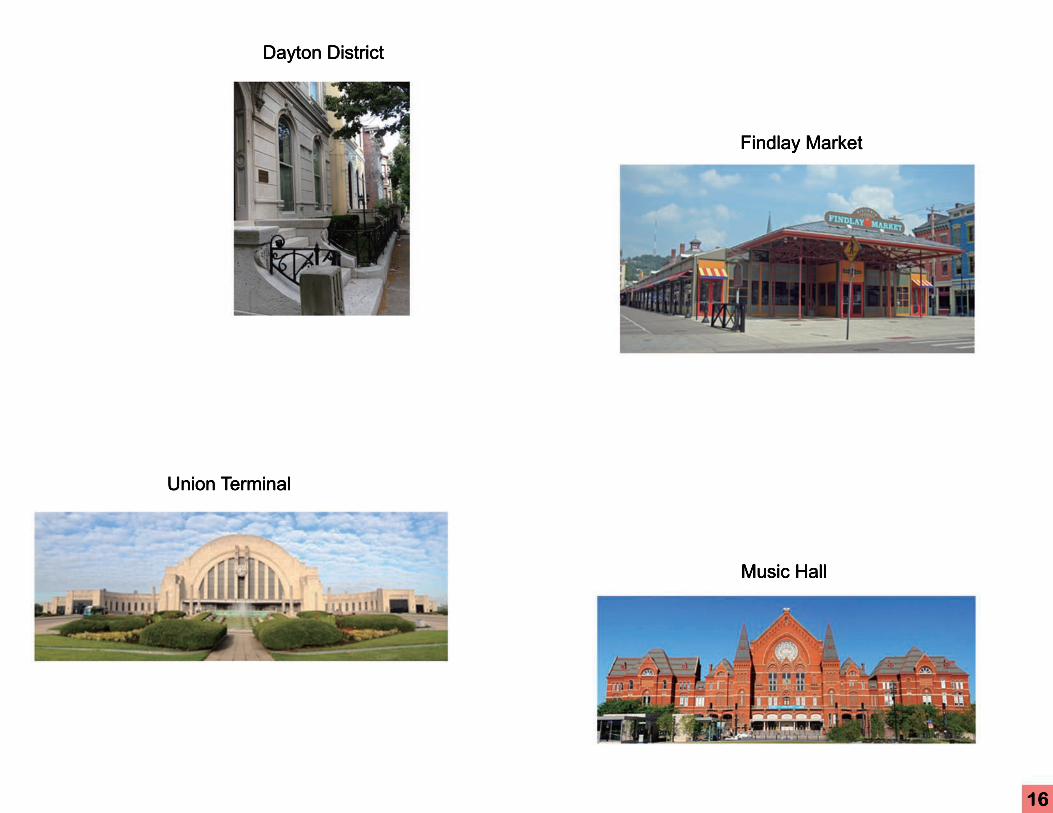
Union Terminal
Dayton District
Findlay Market
Music Hall

17
Goal 1:
Form a complete streets network on Ezzard Charles Dr., Central Pkwy., Linn St., Central Ave., and Liberty St. to
make strong connections between the cultural assets of the area for pedestrians and bicyclists.

18
Goal 2:
Establish an art and design collaborative with studio and gallery space and artist lofts in the West End, to promote the
visual enhancement of the neighborhood with public artwork and murals.

19
Goal 3:
Make strategic zoning changes to the manufacturing area along Central Pkwy. and Liberty St. to allow for commercial,
multi-family residential and mixed uses and to encourage a gradual phasing out of industrial uses.

20
Goal 4:
Connect the West End to Findlay Market by creating public spaces and improving the streetscape, transforming
Findlay St. into an attractive area for pedestrians and commercial activity.

21
Goal 5:
Establish a cultural trail which showcases the many historical and cultural assets of the West End, Over-the-Rhine
and Downtown.

22
Existing Condition of Findlay Street
Findlay Corridor Current Land Use Condition
Urban Fabric
The current land use patterns show that the
Findlay Street corridor between Central
Parkway and Linn Street is largely made of
light manufacturing usage and vacant land.
Next, we analyzed the urban tree canopy
and the condition of the existing buildings
along the Findlay Street Corridor. We found
that there is a severe lack of street trees that there is a severe lack of street trees
throughout the northern portion of the West
End.

23
Existing Condition of Findlay Street
Findlay Corridor Building Condition
The buildings along Findlay St
were analyzed and sorted into
three categories (good, fair and
bad), based upon the building’s
current condition, architectural
significance, and potential for
rehabilitation. While many of the
buildings have fallen into various buildings have fallen into various
states of disrepair, most appear
structurally sound and offer historic
architecture, suggesting high
redevelopment potential.

24
Plan Proposal
In order to achieve the goals earlier stated in the plan, three large-scale projects have been recommended:
1. Complete streets network
2. Findlay Street Corridor
3. Historic Heritage Trail

25
Complete streets network
Transforming the major streets into complete streets
has been proved as an effective way to promote
non-automobile use of the streets, and reduce the
car-dependency when travelling in the basin area.
The complete street transformation also aligns with
the transportation goals from city’s comprehensive
plan - Plan Cincinnati, which was adopted in 2012.
Most of the transformation recommendations were Most of the transformation recommendations were
meant to be low cost and “quick-win” approaches,
such as repainting surface markings and slightly
traffic signal improvements. However, to further
promote non-automobile use of the street for the
further future, some long term approaches such as a
streetcar extension have been recommended.

26
We recommend to slightly narrow the greenbelt and move bike lanes on sidewalks. The space that previous being used by bikes can now be used for on street parking as
well as bus stop. To make people crossing easy, we also recommend installing curb extensions at intersections.

27

28
We propose to eliminate the medium on the traffic lane and slightly reduce the width of on street parking to accommodate bike lanes on both sides. We also recommend
curb extensions at intersections to make crossing the street easier.

29
we recommend to transform the one-way portion into two-way, and make the whole Central Ave. a complete street by removing the on-street parking on the east side of
the street and adding bike lanes on both sides.

30

31
Our recommendation for Liberty St., especially for the portion in the West End, is to keep up with the pace of complete street transformation. We recommend to slightly
reduce the width of on-street parking, traffic lanes, and the medium to accommodate bike lanes on both side. The medium will turn into left turn lane at intersections and
curb extensions will be installed in favor of crossing pedestrians.

32
Our approach to transform Ezzard Charles Dr. into complete street would be slightly narrow the greenbelt and the parking lane to accommodate dedicated bike lanes and
wider sidewalk, and install curb extensions in intersections to make crossing the street easy. In the long-term plan, we recommend that the streetcar extension be
constructed on Ezzard Charles Dr. to strengthen the public transit network and further reduce the usage of automobile.

33
A key component to the transformation of Findlay St. is attracting the artistic community. The West End is a prime
area for artist studios and galleries because of the cheap rents, abundance of large industrial buildings, and the
historical value of the neighborhood. In turn, the art works produced can be installed throughout the neighborhood to
beautify the streetscape and make it more welcoming to visitors.
Findlay Street Corridor

34
Rendering of Current Street Physical Environment & Potential Changes

35
The art works produced can be installed throughout the neighborhood to beautify the streetscape and make it more welcoming to visitors. The potential for Findlay Street
to be developed into an art district is real - a large (12,000+ sq ft) artist studio/gallery called Solway already exists here.
Findlay Street Corridor Short - Term Plan

36
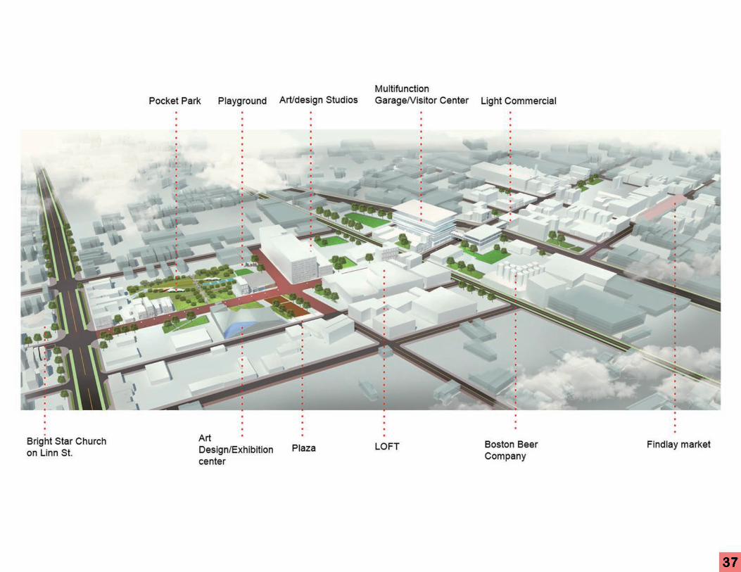
Other desired amenities to complement an artist district were identified as: a pocket park, a public plaza/square, a visitor center, a parking garage, apartments and studios,
and plenty of pedestrian-friendly mixed-use commercial/residential development. In addition to these amenities, a new streetscape was desired for Findlay St. to make the
corridor visually appealing and to encourage pedestrian activity.
Findlay Street Corridor Long- Term Plan
37
38
Street Scaping
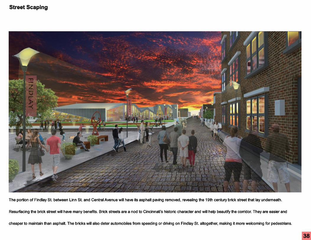
The portion of Findlay St. between Linn St. and Central Avenue will have its asphalt paving removed, revealing the 19th century brick street that lay underneath.
Resurfacing the brick street will have many benefits. Brick streets are a nod to Cincinnati’s historic character and will help beautify the corridor. They are easier and
cheaper to maintain than asphalt. The bricks will also deter automobiles from speeding or driving on Findlay St. altogether, making it more welcoming for pedestrians.

39
The Findlay Street Corridor Plan calls for the creation of two public spaces: a park and a plaza/public square. The park consists of about 2 acres of already densely
vegetated land along Findlay St., between John and Linn streets. The park will strongly be influenced by the nearby Findlay Art & Design Center, featuring murals,
sculptures, and other forms of public art crafted by local artists.
Public Space

40
Public Garage and Visiting Center
At the corner of Findlay St and Central Pkwy, the plan calls for the conversion of the existing vast gravel lots into an
architectural bacon multifunctional garage, which is designed to catch the eye of passersby and welcome visitors to
the area. (refer to Miami’s 1111 Lincoln Road garage)
The garage and the visitor center will be connected to Findlay Market via a skywalk over Central Pkwy in long term.

41
Intersection of Central Parkway and Findlay Street

42
Findlay Art Gallery

43
Bird View towards Downtown Cincinnati
44
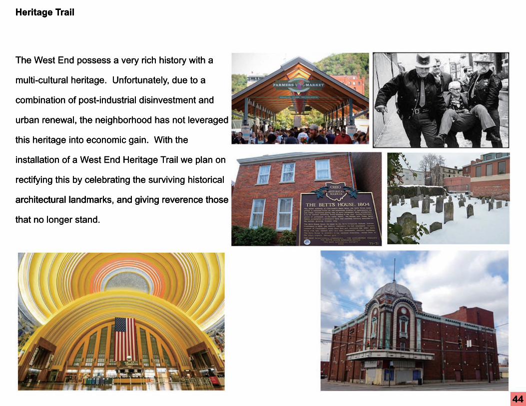
Heritage Trail
The West End possess a very rich history with a
multi-cultural heritage. Unfortunately, due to a
combination of post-industrial disinvestment and
urban renewal, the neighborhood has not leveraged
this heritage into economic gain. With the
installation of a West End Heritage Trail we plan on
rectifying this by celebrating the surviving historical
architectural landmarks, and giving reverence those architectural landmarks, and giving reverence those
that no longer stand.
45

46
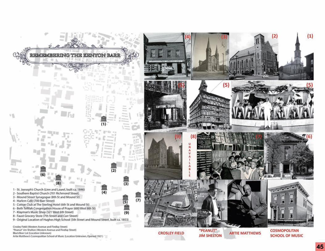
Heritage Trail Participant Experience
Starting at the proposed West End Welcome Center you will learn
the heritage of those that called the Kenyon-Barr District of the
West End home.
Make your way north west towards the Dayton Historic District to
remember the Poems of the famous German-American writer
Heinrich A. Rattermann and rediscover the efforts of West End’s
own Civil Rights activist Reverend Maurice McCrackin.
Explore the history of Findlay Market, and its role in shaping the Explore the history of Findlay Market, and its role in shaping the
West End
Make your way south and west on Central Avenue and Ezzard
Charles Drive towards the old State Theater, the African American
WWII Veteran’s Memorial and the aptly named Regal Theater.
another great testament to the grand film-going tradition of
Cincinnati and those who lived in the West End.
From the Regal, walk along Clark Street towards the Betts Longworth Historic District, where you
will have the opportunity to visit 19th century Synagogues, the oldest Jewish Cemetery this side of
the Allegany Mountains, and the Betts House, the oldest standing residence in Cincinnati

47
As part of the greater Cincinnati place marketing strategy, a West End Heritage Trail would present itself both on the
physical and digital landscapes. We recommend the development of an integrated and interactive mobile app that
can increase the city's global reach. In addition, through a Quick Response (QR) code and enhanced reality system,
the heritage trail participant can let their feet lead them through a history they hold in their hands. To enhance the
physical landscape, it is proposed that a system of wayfinding, informational, and place-making signage will be
implemented. This will be designed and coordinated through the West End Neighborhood Redevelopment
Association and stakeholders from the arts district created along the Findlay street corridoAssociation and stakeholders from the arts district created along the Findlay street corridor.
Place Marketing and Digital Interaction

48
Urban discontent raged in the US during the first half of the 20th century.
Suburbs were hot; cities were not. Suburbs were clean, cheap, luxurious; urban
cores were filthy, cramped, crime ridden. Suburbs were built for white, affluent
residents; urban cores were inhabited by poor minorities. This depleted
perception caused a fast and hard downward spiral of cities for decades.
Jacobs, the outspoken urbanophile, defended the so-labeled “slums” of this era.
Flying in the face of ‘modern discontent’, Jacobs advocated for the small-scale
urban neighborhood over its suburban counterpart. In this case studurban neighborhood over its suburban counterpart. In this case study, we take
Over - the - Rhine, a neighborhood that is adjacent to Central Business District
of Cincinnati, as an example to analyze the interrelation between the
development history of Over - the - Rhine and Jane Jacob’s theory.
Urban Design Theory
E
E
49
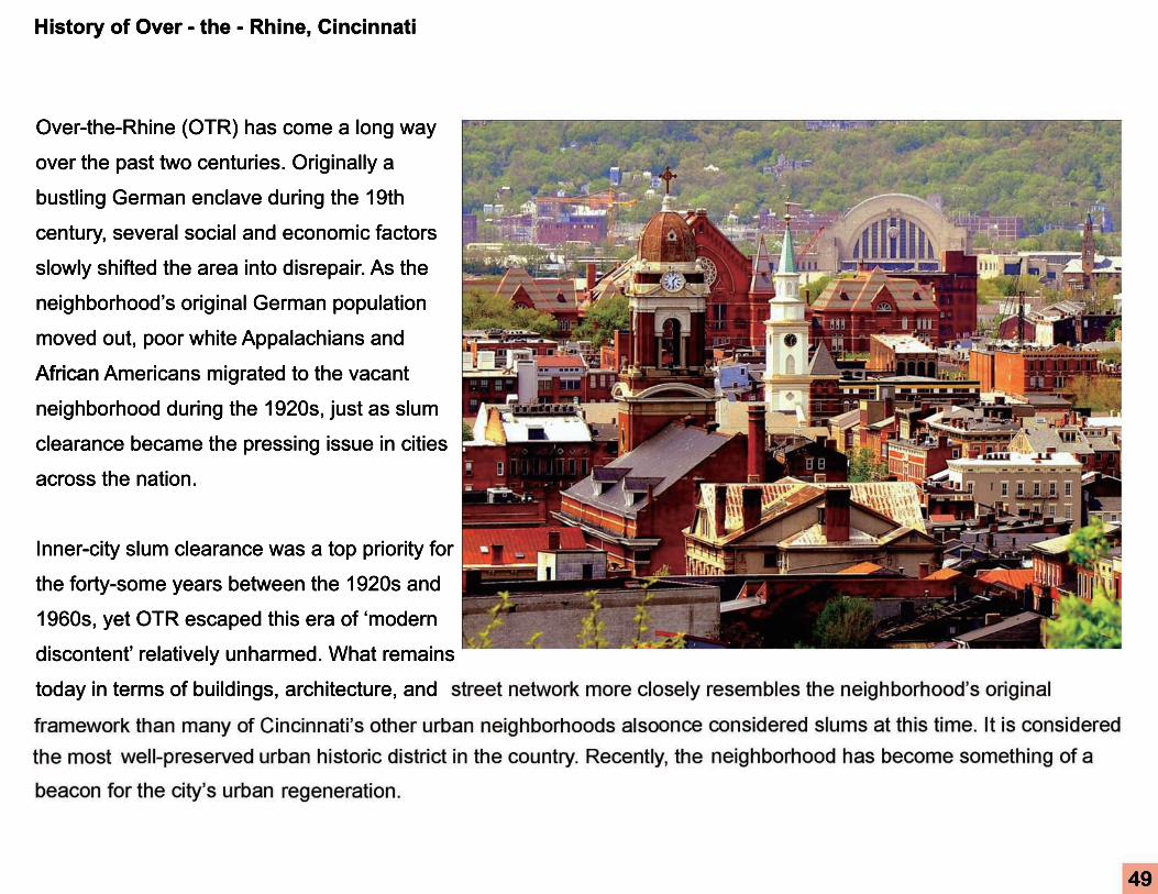
History of Over - the - Rhine, Cincinnati
Over-the-Rhine (OTR) has come a long way
over the past two centuries. Originally a
bustling German enclave during the 19th
century, several social and economic factors
slowly shifted the area into disrepair. As the
neighborhood’s original German population
moved out, poor white Appalachians and
AfricanAfrican Americans migrated to the vacant
neighborhood during the 1920s, just as slum
clearance became the pressing issue in cities
across the nation.
Inner-city slum clearance was a top priority for
the forty-some years between the 1920s and
1960s, yet OTR escaped this era of ‘modern
discontent’ relatively unharmed. What remains
today in terms of buildings, architecture, and

50
OTR’s narrow escapes from destruction
mostly due to governmental inefficiencies,
alternative priorities, and evolving theories
While Jacobs did not play a direct role in
protecting OTR during the era of ‘modern
discontent’, her support of urban communities
may have helped reshape the views of
politicians in Cincinnati.
Interrelation
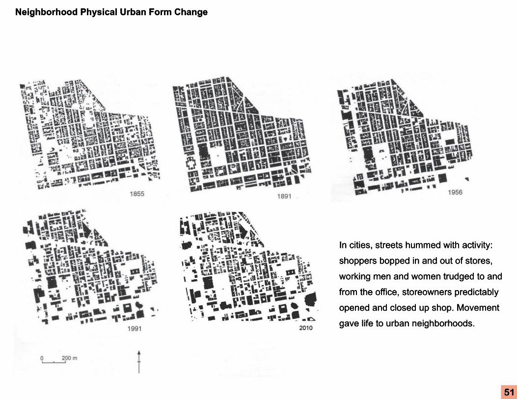
Neighborhood Physical Urban Form Change
In cities, streets hummed with activity:
shoppers bopped in and out of stores,
working men and women trudged to and
from the office, storeowners predictably
opened and closed up shop. Movement
gave life to urban neighborhoods.
51

AGENTS ACTING ON THE CENTRAL NERVOUS SYSTEM Liu Juntian ( 刘俊田 ) (Pharmacol Dept, Med School of XJTU)
整形外科学 - Hamamatsu University School of …...和田簡一郎, 山田 圭, 山本直也, 木田和伸, 谷 俊一 : 高リスク脊椎手術におけるBr(E)-MsEP 解析