port melville information booklet - amgmarine.com.au · port melville information booklet 08.2017...
TRANSCRIPT
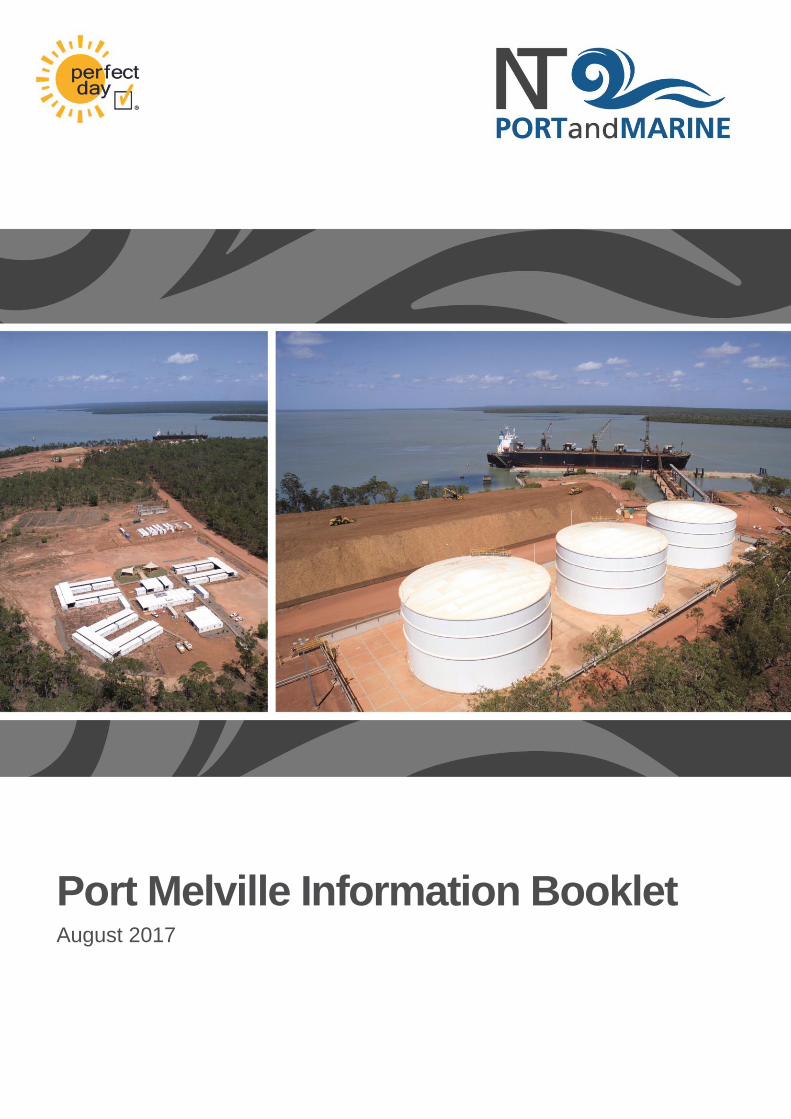
Port Melville Information Booklet August 2017
Port Melville Information Booklet
08.2017 Page 2 of 17
Contents
1 General Information ........................................................................................... 4
1.1. Port Description ................................................................................................ 4
1.2. Berth Details ..................................................................................................... 5
1.3. Weather Parameters ......................................................................................... 5
1.4. Berthing ............................................................................................................ 5
1.5. Remaining Alongside ........................................................................................ 5
1.6. Sailing ............................................................................................................... 5
1.7. Time Zone ........................................................................................................ 5
1.8. Working Hours .................................................................................................. 6
2 Meteorology ........................................................................................................ 6
2.1. Climate ............................................................................................................. 6
2.2. Prevailing Winds ............................................................................................... 6
2.3. Tropical Cyclone Response .............................................................................. 7
3 Oceanography .................................................................................................... 8
3.1. Water Temperatures ......................................................................................... 8
3.2. Wave Climate ................................................................................................... 8
3.3. Tides ................................................................................................................. 8
3.4. Tidal Streams ................................................................................................... 8
4 Melville Port Limits ............................................................................................. 9
5 Security Zones ................................................................................................. 10
5.1. Security Regulated Port .................................................................................. 10
5.2. Declarations of Security and Waterside Restricted Zones ............................... 10
6 Pre Arrival Notification ..................................................................................... 11
6.1. Notice of Arrival .............................................................................................. 11
6.2. Billing Agent .................................................................................................... 11
6.3. Cargo Details .................................................................................................. 11
7 Communications .............................................................................................. 11
7.1. Port Vhf Channels ........................................................................................... 11
8 Pilotage ............................................................................................................. 11
8.1. Pilotage Requirements .................................................................................... 12
8.2. Outer Pilot Boarding Station............................................................................ 12
8.3. Inner Pilot Boarding Station ............................................................................ 12
8.4. Pilot Boarding Arrangements and Communications ........................................ 12
Port Melville Information Booklet
08.2017 Page 3 of 17
9 Anchorages ...................................................................................................... 12
9.1. Outer Anchorage ............................................................................................ 12
9.2. Inner Anchorage ............................................................................................. 12
10 Mooring Arrangements and Vessel Warping ................................................. 13
10.1. Mooring .......................................................................................................... 13
10.2. Warping .......................................................................................................... 13
11 Declared Depths ............................................................................................... 13
11.1. Approaches to the Port and Apsley Strait........................................................ 13
11.2. At the Berth ..................................................................................................... 13
12 Under Keel Clearance Requirements .............................................................. 13
12.1. Underway ....................................................................................................... 13
12.2. Alongside Port Infrastructure........................................................................... 14
13 In-Water Life Boat Drills ................................................................................... 14
13.1. At Berth .......................................................................................................... 14
13.2. At Anchor ........................................................................................................ 14
14 Main Engine Immobilisation ............................................................................ 14
14.1. At Berth .......................................................................................................... 14
14.2. At Anchor ........................................................................................................ 14
14.3. Navigation ....................................................................................................... 14
15 Charts and Publications .................................................................................. 15
16 Port and General Contact Information ............................................................ 15
17 Darwin Shipping Agents .................................................................................. 16

Port Melville Information Booklet
08.2017 Page 4 of 17
1 General Information
The Port Melville Handbook provides information and directions for commercial vessels and operators intending to operate within Port Melville, Northern Territory.
The Port is operated by NT Port and Marine Pty Ltd. The Port is a common user port with the main activities being the shipping of woodchips by Plantation Management Partners Pty Ltd, in addition to the unloading and loading of project and break-bulk cargoes. The Port also has a 30,000,000-litre fuel farm to provide bulk fuels to vessels that require fuel. Detailed information of the fuel Facility can be found in the Port Melville Fuel Facility Handbook.
1.1. Port Description
Port Melville is located south of Barlow Point on Melville Island, 63 nautical miles north of Darwin NT and has been developed primarily for the export of logs and woodchips.
Melville Island is administered by the Tiwi Land Council, which is a statutory body with the responsibility for representing and administering or assisting with the affairs of the Tiwi People and the Tiwi Aboriginal Land Trust.
The Facility was constructed in 2013/2014 and consists of concrete pontoons forming a floating deck. The pontoons are held in place by dolphins and piles. The main berthing face of the deck is 220 metres in length with a fender system consisting of 10 equally spaced Yokohama fenders.
Port Melville Information Booklet
08.2017 Page 5 of 17
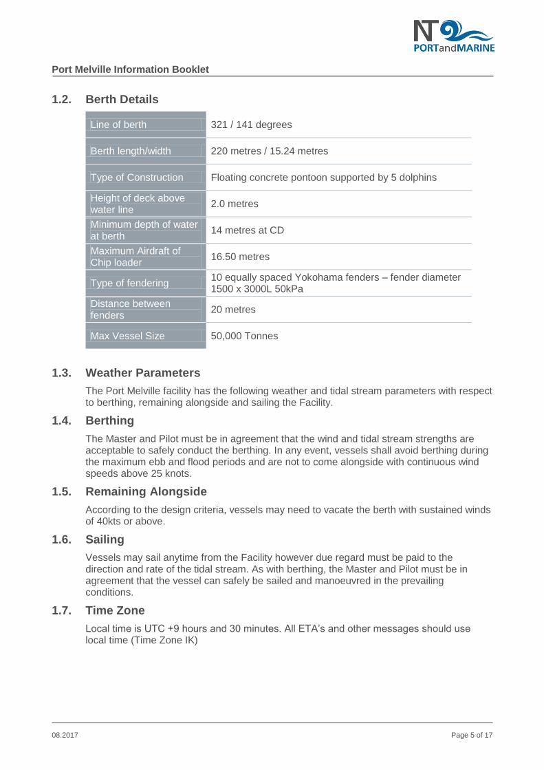
1.2. Berth Details
Line of berth 321 / 141 degrees
Berth length/width 220 metres / 15.24 metres
Type of Construction Floating concrete pontoon supported by 5 dolphins
Height of deck above water line
2.0 metres
Minimum depth of water at berth
14 metres at CD
Maximum Airdraft of Chip loader
16.50 metres
Type of fendering 10 equally spaced Yokohama fenders – fender diameter 1500 x 3000L 50kPa
Distance between fenders
20 metres
Max Vessel Size 50,000 Tonnes
1.3. Weather Parameters
The Port Melville facility has the following weather and tidal stream parameters with respect to berthing, remaining alongside and sailing the Facility.
1.4. Berthing
The Master and Pilot must be in agreement that the wind and tidal stream strengths are acceptable to safely conduct the berthing. In any event, vessels shall avoid berthing during the maximum ebb and flood periods and are not to come alongside with continuous wind speeds above 25 knots.
1.5. Remaining Alongside
According to the design criteria, vessels may need to vacate the berth with sustained winds of 40kts or above.
1.6. Sailing
Vessels may sail anytime from the Facility however due regard must be paid to the direction and rate of the tidal stream. As with berthing, the Master and Pilot must be in agreement that the vessel can safely be sailed and manoeuvred in the prevailing conditions.
1.7. Time Zone
Local time is UTC +9 hours and 30 minutes. All ETA’s and other messages should use local time (Time Zone IK)
Port Melville Information Booklet
08.2017 Page 6 of 17
1.8. Working Hours
During woodchip operations, the port will work on a 24/7 basis. For other activities, the port will operate from 0700-1700 daily unless clients have made other arrangements with the Port.
2 Meteorology
2.1. Climate
The climate in Port Melville can be categorized as tropical in nature, with two distinct seasons:
Dry Season: April to October, and
Wet Season: November to March. This season coincides with Cyclone Season in Northern Australia.
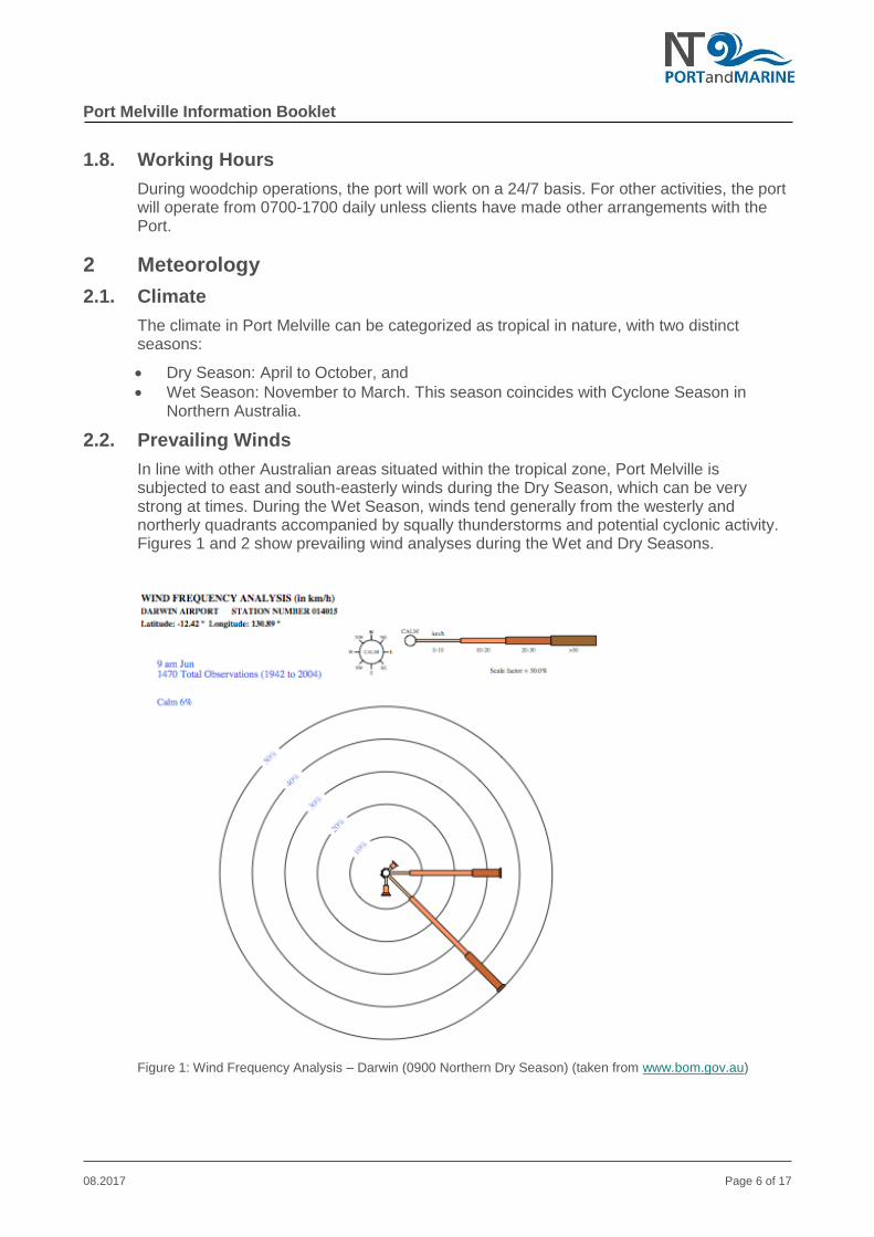
2.2. Prevailing Winds
In line with other Australian areas situated within the tropical zone, Port Melville is subjected to east and south-easterly winds during the Dry Season, which can be very strong at times. During the Wet Season, winds tend generally from the westerly and northerly quadrants accompanied by squally thunderstorms and potential cyclonic activity. Figures 1 and 2 show prevailing wind analyses during the Wet and Dry Seasons.
Figure 1: Wind Frequency Analysis – Darwin (0900 Northern Dry Season) (taken from www.bom.gov.au)

Port Melville Information Booklet
08.2017 Page 7 of 17
Figure 2: Wind Frequency Analysis – Darwin (1500 Northern Wet Season) (taken from www.bom.gov.au)
2.3. Tropical Cyclone Response
The official Tropical Cyclone Season runs from 1 November until 30 April each year, although Australia has recorded cyclones during each calendar month.
Every vessel operating in Port Melville during the Tropical Cyclone Season must have a Cyclone Response Plan, typically:
Large vessels are to proceed to sea in sufficient time to clear the port and attain adequate sea room before the onset of gale force winds; and
Small vessels should be secured to adequately engineered moorings and their crews ferried ashore before the onset of gale force winds.
The Port Melville Cyclone Response Plan is predicated upon a five-tiered response model as shown in the table below:
Tier Key Element Description
1 Monitor A cyclone or tropical low has developed in northern waters
2 Prepare A cyclone is tracking towards the port with potential for impact
3 Clear Port Potential for gale force winds to impact port within 12 hours
4 Shut Down Potential for gale force winds to impact port within 6 hours
5 Re-Open Cyclone or threat of cyclone has passed
Table 1. Tiered Cyclone Response Model

Port Melville Information Booklet
08.2017 Page 8 of 17
3 Oceanography
3.1. Water Temperatures
The mean sea surface temperature across Northern Australia remains within the 27-30 degrees Celsius range during the summer months. With the cooling effect of the southeast winds during the winter months, this temperature range drops to 25-26 degrees Celsius.
3.2. Wave Climate
The protected nature of Port Melville and Apsley Strait provides for limited influence from wave and swell action. The most predominant swell occurring during the summer months with the influence of the Northwest Monsoon on the entrance to Aspley Strait to the North. The area around Port Melville affords good protection from swell and wave development.
3.3. Tides
Port Melville (St Asaph Bay) has semi-diurnal tides with diurnal inequalities. An extract of tidal levels taken from Chart AUS 22 is at figure 3, indicating a maximum spring tidal range of 3.7 metres and Chart Datum is taken from Lowest Astronomical Tide (LAT).
Figure 3: Extract of Tidal Levels taken from Chart AUS 22
Port Melville has conducted 2 tidal studies and have created more accurate tidal prediction tables for the port area than are currently available through the Bureau of Meteorology (Tidal Unit). These tides can be provided by the Port on request.
3.4. Tidal Streams
Information about tidal stream has been taken from data collected in February 2014. The results of the study indicate that the maximum velocity observed was around 4 knots in the wharf area with lesser rates in the northern approaches to the port area and in the approach channel. Movement within the water column generally follows the direction of the channel with some anomalous vectors experienced close to shore, islands or manmade installations. Notwithstanding, tidal streams are a significant factor in the planning and execution of manoeuvring operations within Port Melville.
The flooding tide enters Apsley Strait from the north and generally travels in line with the channel. The ebb tide has a much higher rate than the flood and flows to the north generally following the line of the channel.
The tidal stream near the Port runs generally in line with the bathymetric contours.
The turn of the tide at the Pontoon is dependent of the present cycle of the tide (springs or neaps). Generally speaking, slack water occurs at the Pontoon approximately 30 minutes to 1 hour after the respective high or low water as per the Port Melville tides.
Note: these times do not coincide with the tides available through the BOM.

Port Melville Information Booklet
08.2017 Page 9 of 17
3.4.1. Flood Tide
The flooding tide generally runs to a bearing of 150 degrees and has a maximum rate of about 1.5kts. It has been observed that the tidal stream begins flooding at the wharf approximately 2 hours after low water at St Asaph Bay tidal station. This time can vary depending on the state of the tide in respect to springs or neaps.
3.4.2. Ebb Tide
The ebb tide generally runs to a bearing of 310-315 degrees and has a maximum rate in the wharf area of 3-4kts. It has been observed that the tidal stream begins ebbing approximately 1 hour after high water. It increases in rate quite rapidly in the first 2 hours when it peaks. The peak ebb continues to run until approximately high water +5 hours at which time the rate begins to drop rapidly. As for the flood tidal stream, the times may vary depending on the state of the tide.
4 Melville Port Limits
Port Melville port limits are displayed on chart AUS 22 as shown in figure 4 below.
Figure 4. Extract of AUS 22 showing Port Limits
Port Melville Information Booklet
08.2017 Page 10 of 17
5 Security Zones
5.1. Security Regulated Port
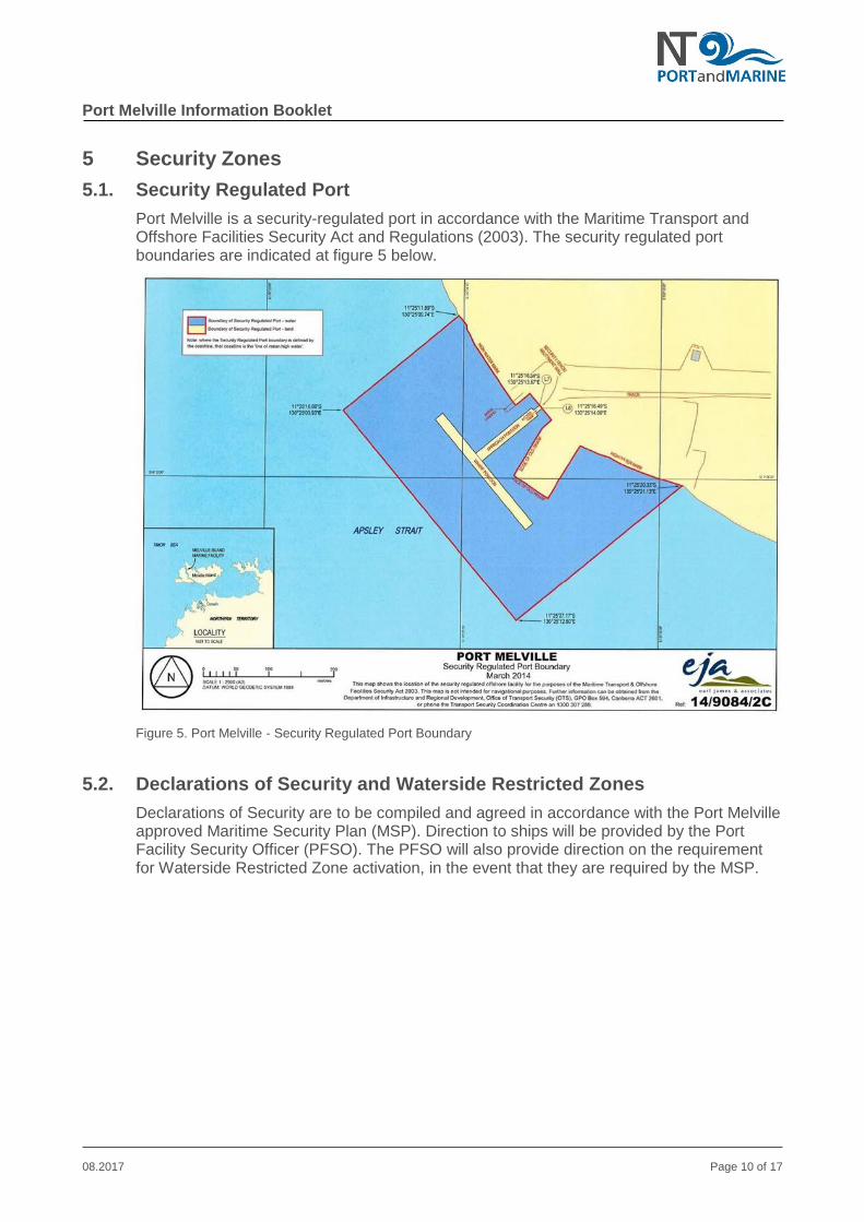
Port Melville is a security-regulated port in accordance with the Maritime Transport and Offshore Facilities Security Act and Regulations (2003). The security regulated port boundaries are indicated at figure 5 below.
Figure 5. Port Melville - Security Regulated Port Boundary
5.2. Declarations of Security and Waterside Restricted Zones
Declarations of Security are to be compiled and agreed in accordance with the Port Melville approved Maritime Security Plan (MSP). Direction to ships will be provided by the Port Facility Security Officer (PFSO). The PFSO will also provide direction on the requirement for Waterside Restricted Zone activation, in the event that they are required by the MSP.
Port Melville Information Booklet
08.2017 Page 11 of 17
6 Pre Arrival Notification
6.1. Notice of Arrival
Vessels on voyages to Port Melville are to provide, where practicable, seven days, three days and 24 hours’ notice of arrival messages to Port Melville. Vessels requiring pilotage services are to provide as much notice as practicable prior to their arrival in order to facilitate timely service provision.
6.2. Billing Agent
A vessel’s Master, owner and agent are jointly and severally liable for the payment of port charges to the Port Melville.
A vessel Master must ensure that their “Billing Agent” is nominated to Port Melville at least 24 hours prior to arrival in port.
6.3. Cargo Details
The Master of a vessel must ensure that Port Melville is provided with details of the cargo loaded and/or discharged from the vessel and details of fuel bunkered in a timely manner. All cargo details are to be included in the Berth Application Form available on the Ports’ Website.
6.3.1. Discharging of Cargo
Any vessel that intends to discharge cargo at Port Melville must notify the Port at minimum 48 hours prior to arrival. Delays may be incurred by the vessel if this information is not received by the Port in the required time frame.
6.3.2. Loading of Cargo
Vessels that load cargo at Port Melville must provide the details of all cargo loaded or bunkers received within 24 hours of completion of the loading.
7 Communications
7.1. Port Vhf Channels
The following VHF channels are established for used within Port Melville. These channels are to be monitored at all times by vessels whilst they are within Port Limits:
VHF 16 – International Calling and Distress
VHF 15 – Port Operations and tug working channel
VHF 73 – Alternate tug working channel
8 Pilotage
Port Melville has contracted the pilotage services of Argonaut Marine Group to provide pilotage for the Port. All pilot bookings and requirements are to be passed via the shipping agent to the Port Operations Manager or their delegate who will arrange for Pilot Services. A pilot is not permanently stationed at Port Melville unless there is a vessel alongside the Ports’ Facility. As such, vessel’s requesting or requiring the service of a Pilot must provide a minimum of 24 hours notification.

Port Melville Information Booklet
08.2017 Page 12 of 17
8.1. Pilotage Requirements
The Port Melville Facility is a privately owned facility and as such, pilotage is compulsory for all vessels over 80m LOA whom intend to come alongside the Facility. Pilotage for the Apsley Strait including passing over Mermaid Shoal is voluntary as this area is outside Port Limits.
8.2. Outer Pilot Boarding Station
The Outer Pilot Boarding Station is located at Lat 1117.34’S Lon 13003.62’E. The Outer Pilot Boarding Station is to be used by all vessels that, due to their draft, are tidal restricted when crossing over Mermaid Shoal, which has a minimum depth of 8.5 metres at Chart Datum or should the Master of the vessel request the services of a pilot to cross the shoal. The Outer Pilot Boarding Station is approximately 25nm from the Port via Apsley Strait.
8.3. Inner Pilot Boarding Station
The inner Pilot Boarding Station is located at Lat 1121.7967’S Lon 13022.7130’E, opposite Tamar Point and is designed for those vessels that are not tidal restricted to pass over Mermaid Shoal (8.5m minimum depth at CD). From the Inner Pilot Boarding station to the Port is approximately 4.5nm. Any vessel intending on using the Inner Pilot Boarding Station must carefully analyse the tides to ensure there is sufficient water to pass safely over Mermaid Shoal.
8.4. Pilot Boarding Arrangements and Communications
The Pilot will contact the vessel via VHF Channel 15 approximately 30 minutes prior to boarding. Prior to the pilot embarking, vessel Masters are to ensure a pilot ladder is rigged on the lee side 1.5 metres (or as directed by the Pilot) above the waterline and must be in accordance with IMO rules.
9 Anchorages
9.1. Outer Anchorage
The Outer Anchorages are those considered to be to the west of the entrance to Apsley Strait. There are no designated outer anchorage areas and as such, vessels are permitted to anchor where they deem it safe to do so. Masters should be aware that the depths surrounding Mesquite Shoal are suspect and as such it should be given a wide berth.
9.2. Inner Anchorage
There are two recommended inner anchorages within Apsley Strait, details of which are:
Inner Anchorage ‘A’: LAT 1124.794’S LON 13024.278’E Depth: 29.0 metres Bottom type: mud
Inner Anchorage ‘B’: LAT 1118.560’S LON 13021.690’E Depth: 15.9m Bottom: mud
Vessels are reminded that strong tidal streams are experienced in Apsley Strait and as such are to maintain a vigilant watch whilst at anchor to ensure they do not drag their anchor.
Port Melville Information Booklet
08.2017 Page 13 of 17
10 Mooring Arrangements and Vessel Warping
10.1. Mooring
Depending on vessel size, vessels are moored to the Pontoon generally using two head and stern lines, two breast lines forward and aft and two spring lines forward and aft. On boarding the vessel, the Pilot will discuss with the Master the specific mooring plan for his/her vessel.
As mooring cans are part of the mooring infrastructure, a line running boat must be in attendance for most vessels.
10.2. Warping
Vessels loading woodchips at Port Melville do so via a fixed head loader thus are required to warp the vessel for hatch changes. Due to the very strong tidal streams, vessels must have a tug assisting with each warp. The Pilot will also assist the vessels Master by attending the vessel for each warp.
Due to the construction of the Pontoon, it is often required that mooring lines need to be dropped and re-run to avoid being fouled on the Pontoon support dolphins. The Pilot will discuss with the Master, the sequence of shifting lines prior to commencing each warping operation.
The Port has developed a standard mooring arrangement for vessels loading woodchips. This arrangement will be provided to the vessel via the ships agent prior to the vessels arrival.
11 Declared Depths
11.1. Approaches to the Port and Apsley Strait
Vessels approaching the Port from the west should take particular care keeping well clear to the west and south of Mesquite Shoal. Vessels approaching the Outer Pilot Boarding Station should maintain a vigilant navigational watch as the tidal streams in the area can be quite strong. The ebb tide normally flows in a northerly direction with the flood normally flowing in a southerly direction.
The minimum depth approaching the port is 8.5 metres at chart datum when crossing Mermaid Shoal at the northern entrance to Apsley Strait. The minimum depth after crossing over Mermaid Shoals in Apsley Strait is 12.3m at CD.
11.2. At the Berth
The declared depth at the berth is 14.0 metres at chart datum.
12 Under Keel Clearance Requirements
12.1. Underway
Whilst vessels are underway they must maintain a minimum Under Keel Clearance (UKC) of 1.0 metre or 10% of the maximum draft, whichever is greater. When calculating UKC vessel Master’s must take in account the vessels squat and apply appropriately. The minimum depth used for UKC calculations is 8.5m which is the declared minimum depth over Mermaid Shoal.

Port Melville Information Booklet
08.2017 Page 14 of 17
12.2. Alongside Port Infrastructure
Whilst alongside the Port Melville facility, vessels must maintain a minimum UKC of 1.0 metre at all times.
13 In-Water Life Boat Drills
13.1. At Berth
Vessels are permitted to conduct lifeboat drills whilst alongside the facility providing they notify and gain permission of the Port Operation Manager prior to doing so. Vessel Masters are reminded that they are fully responsible for the safety of their crew and are to be mindful of the strong tidal flow at the facility prior to conducting drills. Masters should also be aware of the fact that salt-water crocodiles inhabit the local areas and may be in the immediate vicinity.
13.2. At Anchor
Vessels are permitted to conduct lifeboat drills whilst at anchor. Vessel Masters are reminded that they are fully responsible for the safety of their crew and are to be mindful of the strong tidal flow at the anchorages and the possibility that salt-water crocodiles inhabit the local areas and may be in the immediate vicinity.
14 Main Engine Immobilisation
14.1. At Berth
Due to the strong tidal streams experienced in Apsley Strait, vessels are not permitted to immobilise their engines whilst alongside the Port Melville facility.
14.2. At Anchor
Vessels are permitted to immobilise their engines whilst at anchor but Masters are reminded of strong tidal streams in the area, especially at the inner anchorage.
Engine immobilisation is not permitted if the Cyclone Response Plan has been activated.
14.3. Navigation
The route at Table 2 is the route the pilots will follow into and out of the port. Masters of vessels are to ensure that this transit route has been loaded into their ECDIS or marked on their paper chart if no ECDIS is carried.
WAYPOINT LAT LON COURSE
1 1117.3200’S 13003.5800’E 081
2 1115.6738’S 13014.6438’E 104
3 1116.2728’S 13017.1421’E 108
4 1117.3610’S 13020.5173’E 153
5 1123.4524’S 13023.6344’E 149
6 1125.3518’S 13024.7988’E As required for berthing starboard side to
Table 2. Aspley Strait – Recommended Route

Port Melville Information Booklet
08.2017 Page 15 of 17
Masters are reminded that during pilotage they are responsible for monitoring the position of their vessel and are to challenge the Pilot if they are concerned with the vessels position or are unsure of the Pilot’s actions. The navigation route may be amended as required in consultation between the Pilot and Master.
15 Charts and Publications
The following charts and publications are recommended for navigation within Port Melville:
Paper Chart AUS 22
ENC AU412130 – Timor Sea – Snake Bay to Cape Fourcroy
ENC AU5022P1 – Melville Island – Port Melville
Australia Pilot Volume 1 (Publication NP 13)
Admiralty List of Lights Volume K
Admiralty List of Radio Signals
16 Port and General Contact Information
Port/Facility Operations Manager – Lindsay Whiting P: +61(0)437 889 066 M: +61(0)477 050 581 F: +61(0)8 8 89306 511 Email: [email protected]
Port/Facility Security Officer – Matthew Szann P: +61(0)8 9320 7000 M: +61(0)0428 954 167 F: +61(0)8 9921 4452 Email: [email protected]
Deputy Port/Facility Security Officer – Capt. Chris Litowchak P: +61(0)8 8930 6599 M: +61(0)419 240 277 F: +61(0)8 9921 4452 Email: [email protected]
Australian Customs & Border Protection P: +61(0)9 8946 9999 Info: 1300 363 263 Hot Line: 1 800 061 800 F: +61(0)8 8946 9932
Australian Quarantine Inspection Services P: +61(0)8 8999 2118 F: +61(0)8 8999 2053 Email: [email protected]

Port Melville Information Booklet
08.2017 Page 16 of 17
Port Emergency Contact Numbers
Emergency: 000 Police: +61(0)8 8978 3969 Fire: +61(0)8 8978 3773 or 8978 3713 Ambulance: 000 Hospital: +61(0)8 8978 3953 (Pirlangimpi Medical Clinic) NT Emergency Services: +61(0)8 8922 3630 (After Hours 131444)
17 Darwin Shipping Agents
Wilhelmsen Ships Service Pty Ltd
PO Box 36169, Winnellie NT 0821 P: +61 8 8947 2882 F: +61 8 8947 2881 Email: [email protected] Gulf Agency Company (Australia) Pty Ltd - GAC GAC Australia - Darwin Office Unit 3/9 Swan Crescent, Winnellie NT 0821 P: +61 8 8947 1725 F: +61 8 8984 4277 M: +61 (0) 420 961 405 Email: [email protected] Web: www.gac.com Inchcape Shipping Services Pty Ltd. PO Box 3646, Darwin NT, 0801 Unit 32, 16 Charlton Court, Woolner NT 0820 Darwin NT 0800 P: +61 8 8981 2901 F: +61 8 8941 1987 Email: [email protected] Seaswift PO BOX 240, Berrimah NT 0828 P: +61 8 8935 2400 F: +61 8 Mobile: www.seaswift.com.au Palmerston Shipping & Logistics PO Box 1320, Darwin, NT, 0810 P: 08 8932 2437 M: +61 (0) 400 890 897 +61 (0) 417 440 403 Email: [email protected] Web: www.psal.net.au

Port Melville Information Booklet
08.2017 Page 17 of 17
Cruise Reps Darwin Cruise Terminal Fort Hill Wharf Kitchener Road, Darwin NT 0800 P: +61 1300880480 M: +61 (0) 404 601 171 Email: [email protected] Monson Offshore Pty Ltd 870 Berrimah Road, Berrimah, NT, 0828 PO Box 1743, Berrimah NT 0828 P: (08) 8947 2570 F: (08) 8947 2640 M: 0419 517 780 Email: [email protected] ANL Container Line Unit 305C, Level 1 19C, Kitchener Drive Darwin, NT 0800 P: +61 8 8944 7600 Email: [email protected] Web: www.anl.com.au Pacific Asia Express Pty Ltd Agents for Mariana Express Lines 7/641 Stuart Hwy, Berrimah, NT, 0828 PO Box 36754, Darwin, NT, 0801 P: +61 8 89473318 F: +61 8 89471098 M: +61 421 211 824 Email: [email protected] Web: www.mariana-express.com Swire Shipping 1626 Coonawarra Road, Winnellie GPO Box 35807, Winnellie NT 0820 P: +61(08) 8984 3893 F: +61(08) 8984 4845 Email: [email protected]