points of departure meditations on mapping · sept 5–oct 15, 2017 art/music library gallery rush...
TRANSCRIPT
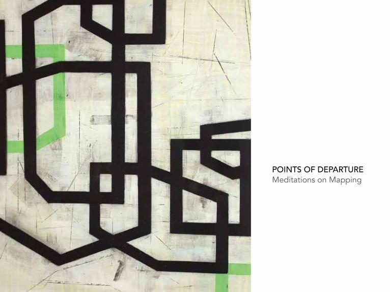
POINTS OF DEPARTURE Meditations on Mapping


POINTS OF DEPARTURE Meditations on Mapping
Curated by Karen Sardisco and Colleen Buzzard
Mercer GalleryMonroe Community CollegeRochester, NY September 5-30, 2017
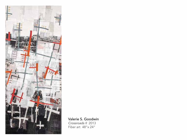
Valerie S. GoodwinCrossroads II 2013Fiber art 48”x 24”

Sunken Gallery, RIT Libraries, The Wallace CenterRochester Institute of TechnologyArtists’ Book ExhibitAug 11–Sept 30, 2017
Art/Music LibraryRush Rhees LibraryUniversity of RochesterArtists’ Book DisplaySept 5–Oct 15, 2017
Dept. of Rare Books and Special CollectionsRush Rhees LibraryUniversity of RochesterThe Dr. Ruth W. Schwartz & Dr. Seymour I. Schwartz Collection Sept 5–Oct 15, 2017
Art/Music Library Gallery Rush Rhees LibraryUniversity of Rochester Sept 11–Oct 15, 2017
Lab Space@RoCo Rochester Contemporary Art CenterInstallation by Kyle ButlerOct 6–Nov 12, 2017
Visual Studies Workshop31 Prince StreetInstallation by Cathryn SmithOct 24–Nov 11, 2017
POINTS OF DEPARTURE Meditations on Mapping
Six Satellite Venues throughout Rochester, NY

Jeanne HeifetzApproach/A Void 3 2014Ink on handmade Kozo paper 13”x 18”

CURATORS’ STATEMENT
Cuban artists, Los Carpinteros, imprinted flip-flops with a map of Old Havana, playfully conveying the idea of walking in the shoes of another. Dr. John Snow’s map of the 1854 London cholera outbreak profoundly altered the accepted understanding of disease transmission of his time. Snow’s map changed minds and launched a new field. From way-finding to envisioning the unknown, mappings record our thinking and compel us to take imaginative leaps. They help us share ways of seeing, creating avenues for questioning and communicating across deep divides. A special kind of activity, mapping becomes not only a portrait but a story of connections, contradiction, and mystery. Both collage and conversation, mapping at its best offers points of departure with destinations unknown.
When we began this project eighteen months ago we started with a hunch. We were certain that putting together visualizations across different disciplines would uncover interesting resonances. But what could Emotional Scales, Buffalo Dead Ends and Landscape Lottery have to do with cancer gene networks, garment patterns and graphic music scores? Or readdressing the world with Australian song lines and an artist’s word-man? We found that wildly diverse visualizations and methods reveal the shared urge to structure the seen and the unseen. In choosing the works for these exhibits we looked for mappings that investigate rigorously and then toss their questions into the air again. We discovered patterns across distant fields hinting at universal processes unfolding and drawing us into new territories.
Karen Sardisco and Colleen BuzzardRochester, NY August, 2017

unearth think speculate unfold imagine explore reveal evidence accumulate manipulate abstract distill invent orient track project soundings surroundings capture frame narrate navigate relate embed bridge question decipher connect mark chart translate locate intersect interface invisible coordinates signal portal snap shot assemblage index fanciful grounded playing field construct deconstruct instruct transcribe fine grain unknown portal journey emerge discover repository hoard collect store archive build arc scaffold point topography link home timeline maze labyrinth order plan DNA purpose thread rhumb line territory practical network skein communicate information social space conceptual field correspondence document concrete thick triangulate pattern sign post standardization border structure sighting measure landscape mindscape instinct frontier synergies corporeal geometry graphic oppress rebel register geocache schema category memory meaning futile palimpsest template place controlled fiction true measure obsolete constructed given time keeping argument insist question placement portrait feature variable dimension leap
Note-takings, June 2016 - September 2017

Leslie Roberts On my way uptown 2003
Colored pencil, ink, graphite on paper6. 75”x 3.75”

To be There, Is to be Lost
“Wherever you are is called Here, And you must treat it as a powerful stranger.” The line from David Wagoner’s Poem Lost suggests that being is a continual shaping of place, never fixed or known but unfolding through our engagement with it. The notion that we can somehow represent space completely and accurately seems misguided and verges on the precipice of arrogance. Mapping, as an activity, is certainly about making the “wherever” discernible and understood as “here.” And while it seems like mapping is about the accurate description of space, it is more about seeing the world rather than describing it. It is hinged on a genuine interest in the unknown. Furthermore, to create a map requires tools that have the capacity to probe the world and thus make it visible. Without the use of map-making tools the world would remain veiled, distant, and ultimately unapproachable. Mapping technology, at any level of sophistication, has been instrumental in shaping the human experience. To be is to be inextricably coupled with tools that directly affect our capacity to comprehend the world we live in.
A glorious thing indeed to be inquisitive, and more so to develop tools that help us map out a world of the other, the physical and biological realm of the planet we occupy and are occupied by, i.e., everything other than the multi-cellular you. One could make a good case that mapping one’s other began with the aboriginal cultures many thousands of years ago through complex oral histories of place passed from one generation to another. The passage of meaning occurs through the naming and speaking of things in a contiguous thread of time, thereby encoding space and transforming it into a meaningful experience of place.
Maps function, and have functioned, as provisional tools for probing forward into the foggy and mysterious realm of the globe. They can be grossly inaccurate but still highly useful for speculation and reflection, in that they offer a type of virtual engagement with the abstract. One need only look at very early maps of the world, or early cosmological maps, to see how completely distorted these representations appear when compared to 21st century satellite images of the earth, or telescope images of our universe. Yet those early distorted representations of the world were enough to set a people on foot or a ship to sea. Today, mapping is as vibrant as it was during the “turf-war” years of navigation, when Columbus, Magellan, Vespucci, and others were exploring the potential for new wealth in the form of material goods and land. Seemingly antiquated, this search for more is still very much in favor.

This is all to say that mapping as an exercise is not a thing of the past, but has grown proportionately with technology. It is continually informing our knowledge of how systems work across many different scales of life through varying processes. Certainly, the digital age has made data collection and image processing an essential tool for understanding the world within us and around us. We now have more sophisticated ways of imaging the brain to see how its biology works, allowing researchers to map areas that are associated with cognitive behavior, mental disorder, and cancer. We also have maps that represent the migration of microscopic pathogens across vectoral terrains, used by researchers who are trying to isolate the origin and pathway of an epidemic outbreak. More recently, a multitude of research activity has been focused on the physical terrain of planets close to the earth. Some of these efforts are concerned with the potential for life (biologically-friendly for future generations). Other efforts are focused on the availability of resources, such as rare earth elements that are of limited supply in our terrestrial realm.
The tools used for mapping have, literally, produced a world before us. Their use as experimental probes into the otherworldly parts of our planet and beyond continues to shape our perception of who we are within our surrounds. There will never be enough data to gather when it comes to mapping. The mystery of far off worlds (within and without) is bound to stay with us, as will our desire to invent new tools that can get us there. The tools may change over time but our inquisitive nature will not. May we continue to add dimension and difference to our perception of the world with the maps we make. These new maps are necessary to become the individual(s) we think we are. And most importantly, they remind us that we are always in a strange place even when we think we are not.
Bartow+Collaborator/Metzgar

Robert Moran Interiors for Orchestra or Chamber Ensemble 1966 Graphic Notation Music Score, printed with permission of Edition Peters Group, C.F. Peters Corp 17.5”x 23.5”

Cancer Gene Regulatory Network, 2012Luca lorga & Helene R. McMurrayUniversity of Rochester Medical Center
Anne Havens Dance 2016
Latex paint on paper 24”x 30”

Alexandra Bush Home 2012Ink on napkin 6”x 6”

Dini Campbell Tjampitjinpa Tingari Cycle 1994
Acrylic on canvas 24”x 21”

Elizabeth Coyne Convergence 2014Oil on canvas with embedded monoprints 18”x 20”
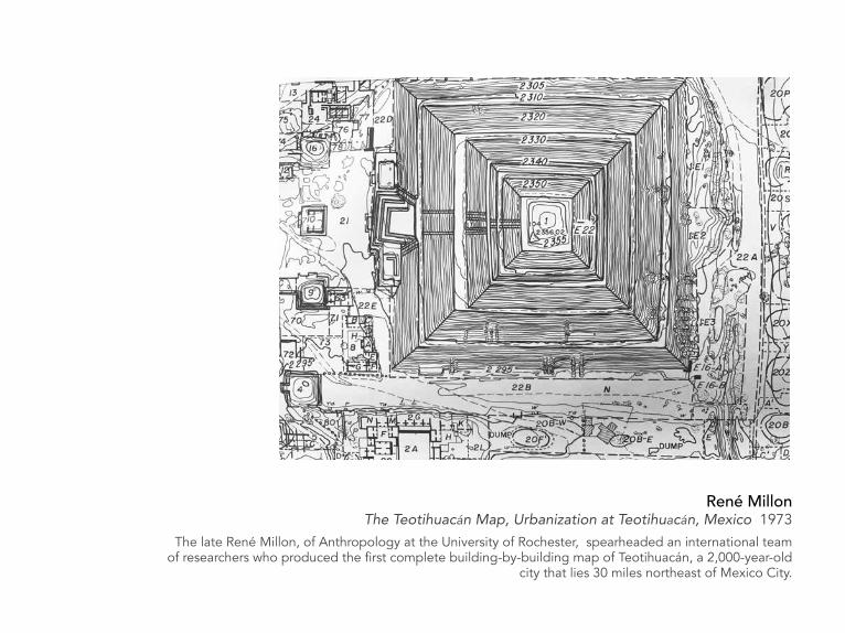
René Millon The Teotihuacán Map, Urbanization at Teotihuacán, Mexico 1973
The late René Millon, of Anthropology at the University of Rochester, spearheaded an international team of researchers who produced the first complete building-by-building map of Teotihuacán, a 2,000-year-old
city that lies 30 miles northeast of Mexico City.

Gretchen Arnold Approximate 43.1423º N, 77.5726º W 2016Photographic 24”x 30”

Stephen Cartwright Data Topography (Wind 2005-2013) 2014
Kiln cast glass 3”x 10”x 7”

Jeanne Heifetz Geometry of Hope: Steel, Rose 2010Acid-etched glass, silver wire and coated silver wire, stainless steel mesh 10”x 10”
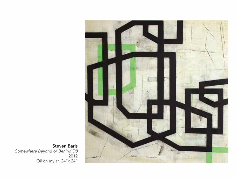
Steven Baris Somewhere Beyond or Behind D8
2012 Oil on mylar 24”x 24”

Cathryn Smith Detail from Embedded,installation 2017
My work is an exploration of the landscape of sleep. Having spent a life dealing with chronic insomnia and finding no medical solutions, I turned to artistic expression as a way to move from the role of prisoner to that of observer and participant. By juxtaposing a perceived state of sleeplessness against the desired night of a restful repose, what emerged are suggestions of terrains both terrifying and beautiful, seeming to hold answers and a path to follow embedded somewhere between the two worlds.

MXR Electronics, from the late 1970’s or early ‘80’sCircuit board negative for musical equipment, 4”x 6”

Jim Mott Hand drawn planning map for 1st Itinerant Artist Project Tour 2000Mixed media on paper 11”x 23”
Jim Mott The Itinerant Artist ProjectMap of GPS random coordinates for Landscape Lottery

Jim Mott Landscape Lottery
2014-15oil on panel
dimensions variable

Erin Ciulla Phase I 2006Mixed media, 51 books/vintage suitcase 30 x 23 x 11 cm
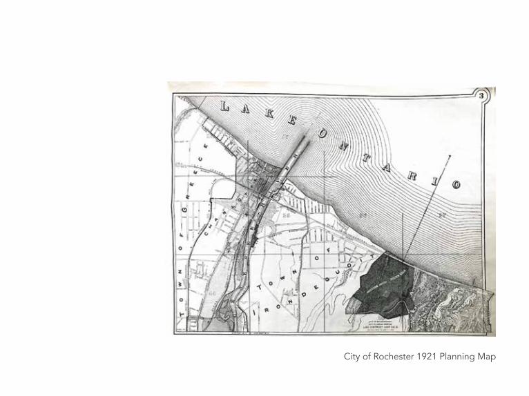
City of Rochester 1921 Planning Map

Leslie RobertsSea fight, orange and black 1999Colored pencil, ink, graphite on paper 3”x 5”
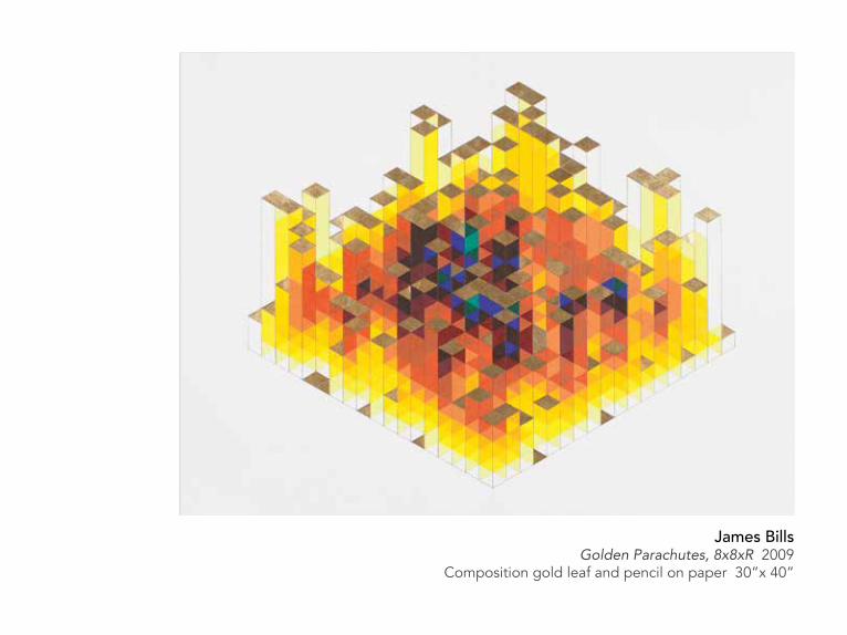
James BillsGolden Parachutes, 8x8xR 2009
Composition gold leaf and pencil on paper 30”x 40”

Willard Schulmeister, COO & GIS Specialist, EagleHawk One LLCSpaulding Fiber – NDVI 2016This mapping was created from 273 aerial images captured from a drone flight over a former industrial site occupied by Spaulding Fiber Company. An NDVI (normalized difference vegetation index) filter was applied to the imagery to produce a basic analysis of the vegetative health of the subject area.
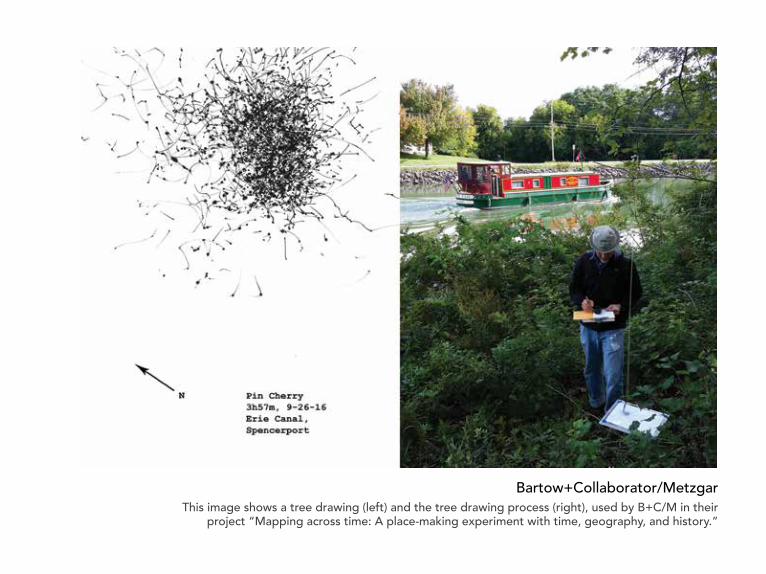
Bartow+Collaborator/MetzgarThis image shows a tree drawing (left) and the tree drawing process (right), used by B+C/M in their
project “Mapping across time: A place-making experiment with time, geography, and history.”

Knobtown, Miss 1964/82United State Geological Survey mapN3122.5-W8830/7.5

Derek LernerAsvirus 48 2014Ink on paper 26”x 20”
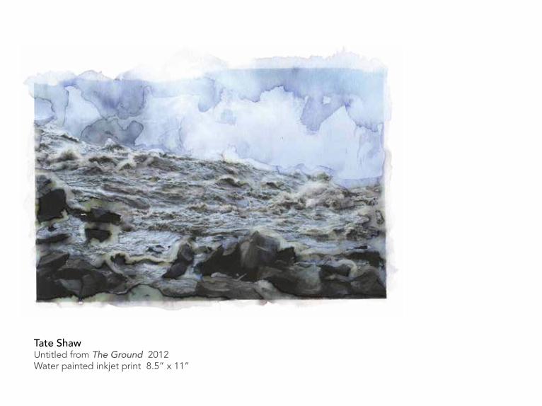
Tate ShawUntitled from The Ground 2012Water painted inkjet print 8.5” x 11”

David OpdykeSuitable Scenery 2016
Hand modified vintage postcard 3.5”x 5.5”

Scott McCarneyHomemade Maps 1998Electrostatic copy7”x 4” opens to 21”x 32”

Jasna BogdanovskaUntitled from the series Between Near and Far 2016
Archival digital pigment print 26”x 40”

Natalia ZapellaNights, the Cosmos and I 2015Paper (accordion fold book with hardcover) 8.7”x 6.6”x 0.6”

Matthew ShelleyUntitled 2015
Collage and ink on folded paper 15.5”x 17”

James BillsAlexandrite 1d99 2008Pencil on paper 19”x 24”

Neuron Pathways in the Human Brain, 2017Image credit: Luke Shaw and the Cognitive Neurophysiology Laboratory at the University of Rochester Medical Center
This image is an example of diffusion tensor imaging (DTI), which is a special subtype of functional magnetic resonance imaging (fMRI). It shows a view of the neuron pathways that transfer electrical signals to and from separate regions of the brain.
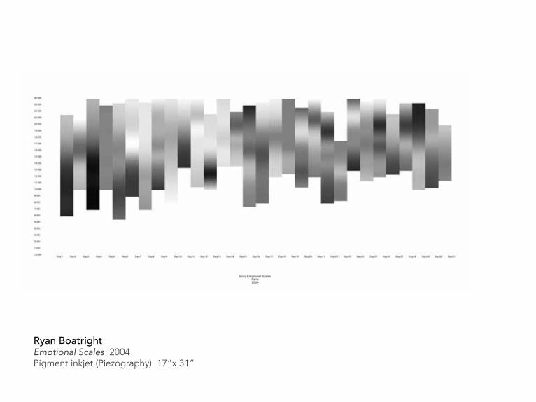
Ryan BoatrightEmotional Scales 2004Pigment inkjet (Piezography) 17”x 31”

SchnittmusterbogenMaster Pattern Sheet, German
Late 19th century, used in households for making garments in various shapes and sizes 23.5”x 35”

Ryan Boatright Return to Sender 2007Audio, dot-matrix printInstallation approx. 300”x 11”

Cecily Culver2nd Ave Manhole 2016
Concrete, wood, speakers, audio equipment and digital audio, chicken wire and foam armature, Mylar, tft screens and digital video 4’x 5’x 18”

Perturbed Samples 2015Matthew McCall & Helene R. McMurrayUniversity of Rochester Medical Center
This image illustrates the quality evaluation of genetic perturbation data underlying gene network analysis.

Megan ArmstrongA Reductionistic Anachronism 2017
Ink drawings on paperOverall dimensions approx. 36”x 72” (consisting of 18 individual panels)

Chromatin Domain Mapping, 2015Wendy A. Kellner & Paula M. Vertino, Cancer Epigenetics, Emory University
CpG islands represent a distinct chromatin domain
H3K4me3
MeDIP
H3K4me2
H3K9me1 H3K9me2
CGI with annotated TSSKellner, WA, Bell, JSK, Vertino, PM. [2015] Genome Res. 25:1600
CGI SizeCGI Size
H3K4me1
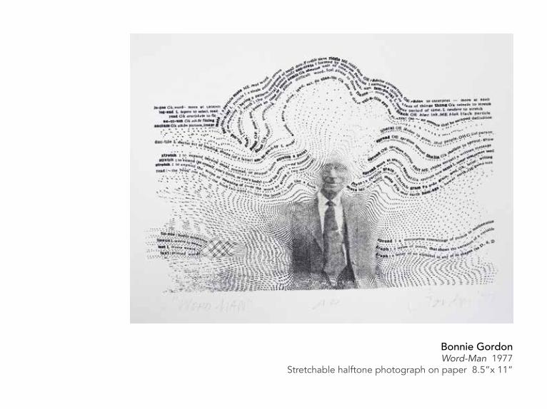
Bonnie GordonWord-Man 1977
Stretchable halftone photograph on paper 8.5”x 11”

Brittany MillerHippocampus 2014Hand embroidery and India Ink on linen 6”x 6”

Holly Greenberg Keep Me 2013
Woodcut on muslin 36”x 37”
Holly Greenberg Grand Tour 2013
Screenprint on Kitakata paper 28”x 40”

Kyle ButlerMap of Dead Ends, Buffalo, NY 2017This image, created by Butler, will act as a catalyst for his upcoming installation in connection with “Points of Departure,” at Rochester Contemporary Art Center. He writes: The map of dead ends is a prompt toward making; extracted, literal ends providing the visual structure for new work. In making the map, I found myself forming subjective criteria for what constituted an end (Is this too overgrown and derelict to still be a road? Is this more of a driveway than an end? Does this path count as an outlet?). Ultimately, the end had to be a place in its own right or a charismatic terminus to place.

Star Chart - Atlas Borealis 1950.0Antonin Bečvář Czech astronomer (1901-1965)Courtesy of the Rochester Museum and Science Center Strasenburgh Planetarium, Rochester, NY

what3words.com This London-based organization is re-addressing the world. It provides a precise and simple way to talk about location by dividing the world into a grid of 3m x 3m squares and assigning each one a unique three word address. 75% of the world suffers from poor addressing or none at all. Whilst improvements have been made in mapping and navigation, defining exactly where “there” is remains a big issue.

Tourist Map of Dali, ChinaMapping catalogue
5.5”x 15” 1985
Stencil map of United Statescirca 1943

Amanda Webster Untitled, 2015 part of a larger project titled Genesee Fever UV print on plexiglass 12”x 4”x 2.5”
Webster has been looking at Rochester’s history and how it has shaped the city’s current social, cultural, and economic identity.
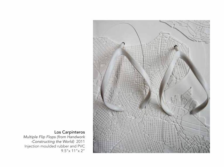
Los Carpinteros Multiple Flip Flops (from Handwork
-Constructing the World) 2011Injection moulded rubber and PVC
9.5”x 11”x 2”
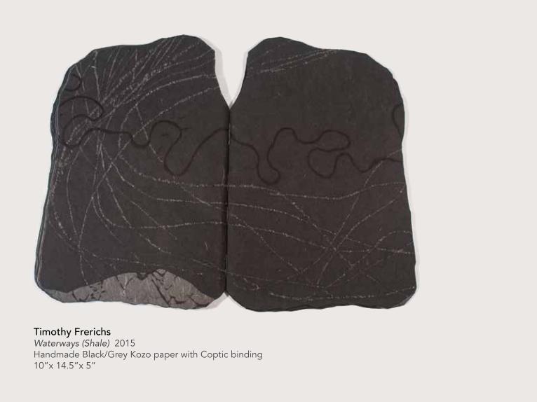
Timothy FrerichsWaterways (Shale) 2015Handmade Black/Grey Kozo paper with Coptic binding10”x 14.5”x 5”
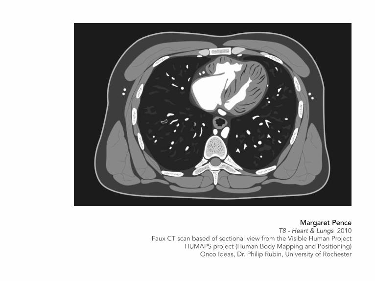
Margaret PenceT8 - Heart & Lungs 2010
Faux CT scan based of sectional view from the Visible Human ProjectHUMAPS project (Human Body Mapping and Positioning)
Onco Ideas, Dr. Philip Rubin, University of Rochester

Ben EshelmanModified technical drawing, MCC student work 2012Courtesy of Susan Ferrari Rowley

Kimberly KraftLandscape as Palimpsest (Marginalia House Lift)
2000Double-sided mylar, colored pencil,
paper collage & tone transfer 36”x 24”Kraft, an architect, developed a “palimpsest theory” that looks at landscape, both natural and built, as a
continuously evolving many-layered accumulation of interventions.

Braille page, from a publication of the Association of the Blind and Visually Impaired, based in Rochester, NY. Circa 2008

Stereogram No. 310Stereoscope and print3-D GeographyManufactured by C. F. Casella & Co., Ltd Developed by the Geographical Association, UKCirca 1960’s

Ackowledgements
There are many people to whom we owe our thanks as the project developed from wide ranging research to a more focused view. We would especially like to express our gratitude to the following:
Kathleen Farrell, Director of Mercer Gallery at Monroe Community College, who gave this project a critical home base and whose support has been invaluable.
Bleu Cease, Rochester Contemporary Art Center, Executive Director, who encouraged the idea from the beginning and enthusiastically brought RoCo into the mix.
Kari Horowicz, Librarian for the College of Imaging Arts and Sciences, Special Collections, RIT Libraries, The Wallace Center, Rochester Institute of Technology, for making available artist works from the amazing RIT Special Collections, and helping us in myriad ways to mount an exhibition from the collection.
Megan Armstrong Scheffer, artist and Director of Art/Music Library Gallery in the Rush Rhees Library at the University of Rochester, for her early vote of confidence in making the gallery space available to us.
Tate Shaw, artist and Visual Studies Workshop, Director, who graciously shared his knowledge and made VSW a part of the project.
Stephanie Frontz, Department Head and Art and Art History, Visual and Cultural Studies Librarian, Rush Rhees Library, University of Rochester, who helped us navigate various questions and offered a collection of artists’ works to be included.
Jessica Lacher-Feldman, Assistant Dean and Director of Rare Books, Special Collections and Preservation, Melissa Mead, University Archivist and Rochester Collections Librarian and Travis Johansen, Exhibits Manager, who shared the Dr. Ruth W. Schwartz & Dr. Seymour I. Schwartz Collection with us and put in extensive effort to mount an exhibition in the Rare Books and Special Collections at Rush Rhees Library.
Steve Fentress, Director of the Strasenburgh Planetarium at the Rochester Museum and Science Center for the generous loan of a copy of Antonin Bečvář‘s Atlas Borealis 1950.0 star charts.
Heather Chang, Theater Professor and Theater Program Director at Monroe Community College for being open to the idea of exploring mapping in performance and encouraging student involvement.
Pirooz Kalayeh, Film and Video Professor at Monroe Community College, for his support of video documentation.
Alice Wilson, Assistant Director, LeRoy V. Good Library, Monroe Community College for her selection and display of books that explore mapping from various points of view.
Heather Pierce, Geoscience Professor at Monroe Community College for making available student maps from the Cartography class.
Gale Lynch, former Director of Global Education & International Services at Monroe Community College for creating fertile ground at MCC for the exploration of mapping in the widest sense, and supporting its role in heightening an awareness of a broader world view.
Jon Little, Geosciences Professor at Monroe Community College for sharing valuable information on GIS technologies and their important role in education.
Joan Lyons, artist and Founding Director of the Visual Studies Workshop Press, for her ideas, interest, and references.
Bartow+Collaborator/Metzgar, artist participants and essay contributors of “To Be There, Is to be Lost”, providing more perspective on the relevance of mapping in the contemporary environment.
Allen Topolski, artist and Associate Professor of Art at University of Rochester, for his generous help in thought and deed.
Nick Ruth, artist and Professor of Art at Hobart and William Smith Colleges for lively discussions and leads.
Scott McCarney, artist and educator, for opening our minds in unexpected directions.
Sue Havens, artist, author, and Assistant Art Professor at University of South Florida for putting us in touch with artists whose work we are delighted to include.
Gerry Szymanski and Rick McRae, from the Sibley Music Library at the Eastman School of Music, for pulling over fifty graphic scores for an afternoon of unparalleled excitement to these visual artist curators.
Darren Stevenson, PUSH Physical Theatre, Founding Director, for his imagination and a great discussion of the project.
Dan Varenka, Visual Studies Workshop, Studio Coordinator, for the many practical steps he took to make an installation possible.
Margaret Pence, exhibition participant and catalogue designer, Lecturer in the Visual and Performing Arts Department at Monroe Community College, to whom we owe a very special thanks for her calm and thorough assistance in bringing the catalogue to life.
Monroe Community College for its commitment to the arts in education supporting the visual and performing arts as an incubator for innovation and creativity.
And finally, to all the exhibition participants who graciously loaned to us or provided images of their work that created resonances between fields and hinted at something fundamental about our mapping minds.
Karen Sardisco and Colleen Buzzard
Front: Steven Baris Somewhere Beyond or Behind D8 (detail) 2012 Oil on Mylar
Catalogue printed by City Blue Imaging Services of Rochester, NY

Key to Thoughts Frontispiece, The New Dictionary of Thoughts, A Cyclopedia of QuotationsStandard Book Company 1961


Derek LernerAsvirus 46 2013
Ink on paper 26”x 20”
Monroe Community College, 1000 East Henrietta Rd, Rochester, NY 14623, 585-292-2021