pndi environmental review process - gis services2 · pndi environmental review process step 2....
TRANSCRIPT

PNDI Environmental Review Process
Open the PA Natural Heritage Program website at
http://www.naturalheritage.state.pa.us
To access the PNDI Environmental Review tool, click
the “Conservation Explorer - PNDI Environmental
Review” link on the bottom left corner of the page.
PNDI Environmental Review Process
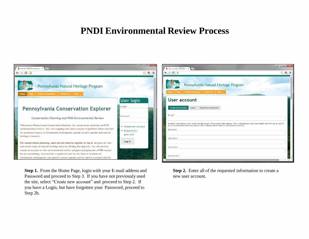
Step 2. Enter all of the requested information to create a
new user account.
Step 1. From the Home Page, login with your E-mail address and
Password and proceed to Step 3. If you have not previously used
the site, select “Create new account” and proceed to Step 2. If
you have a Login, but have forgotten your Password, proceed to
Step 2b.

PNDI Environmental Review Process
Step 2b. If you have a Login but have forgotten your
Password, select “Request new password” and enter your
Email address. A new password will be sent to the address
you entered. You can set a different password by editing your
account.
Step 2a. Read the Terms & Conditions of Use and select
“Accept.” Click “Create new account.” You will receive an Email
message prompting you to validate your new account. Click the
Login button to log in to the site, and proceed to Step 3.
Step 2b. Enter all of the requested information to log in or
request a new password.

PNDI Environmental Review Process
.
Step 3. After logging in, click on “My Projects” for a list of previously created projects. If you have not
previously created any projects, this table will be blank. To begin submitting a project, select the “Map” tab and
click on the “Create Project” button. Note: You can return to this list at any time by clicking the “My Projects”
tab.
Note: Clicking on the
project Title, then clicking
on the Receipt File opens
the Receipt that was
generated for that project.

PNDI Environmental Review Process
Step 3a. Select a project type and click “Next.” Step 3b. For a list of all project types and their corresponding
screening area sizes (buffers), hover the mouse over the Help
tab and click on “Project Types.”

PNDI Environmental Review
Use the “Find address or
place” tool if searching by
address, zip code, or
municipality.
Step 4. Use the tools in the Map to locate
and draw the project footprint for analysis.
Use the drawing tools in the Draw/Edit
toolbar to draw the project and preview the
screening area. Note: you can change the
background map by clicking on
“Switch Basemap.”

PNDI Environmental Review Process
Step 4b. To automatically create a point
project with a set of known
latitude/longitude coordinates, click on
the Draw Shape button and select Point
mode. Click on Additional Mapping
Options, and select “Coordinates” from
the Source dropdown. Enter the
coordinates and click “Next.”
Step 4a. If you are locating your
project with latitude/longitude
coordinates, use the Zoom to
Coordinates or Scale tool. Select decimal
degree or degree minutes seconds. You
can select the scale to zoom in/out to the
desired scale.

PNDI Environmental Review Process
Step 5. In addition to using the methods
described in Step 4, you can double-
click on the map, drag on the map,
and/or use the zoom bar to find the area
of interest. Hint: Hold down the Shift
key and drag a box to zoom in to a more
specific area of interest.
Select the appropriate Drawing Tool –
polygon, line or point—to draw your
project. A point project is drawn by
selecting “Point” and single-clicking on
the appropriate location. Note: Points
are buffered 10 meters in radius.
Line and polygon projects are drawn by
single-clicking on map locations
(vertices) and double-clicking to finish.
If you need to redraw the project, select
“Cancel” to start over. When finished
drawing the project, click on “Show
Preview Buffer” to preview the screening
area (see Step 5c).
Note: The Draw/Edit Toolbar displays
the project Area, Segment Length and
Total Length.
P
r
o
j
e
c
t

PNDI Environmental Review Process
Step 5a. You can edit the shape
by clicking on the Edit Shape
button in the Draw/Edit toolbar.
Hover the cursor over the project.
Round handles will appear at the
ends and midpoints of each line
segment. When finished editing,
click “Accept.”
Step 5b. To move a handle, hold
the left mouse button down and
drag the handle.
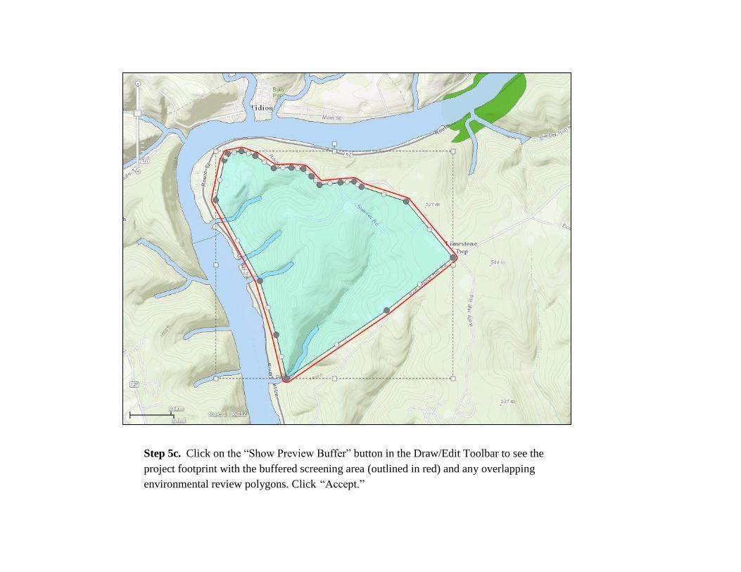
Step 5c. Click on the “Show Preview Buffer” button in the Draw/Edit Toolbar to see the
project footprint with the buffered screening area (outlined in red) and any overlapping
environmental review polygons. Click “Accept.”

Step 6. Enter a Project Title and
description. Verify that the project
and contact information is correct,
and press “Submit for Pre-
Analysis”
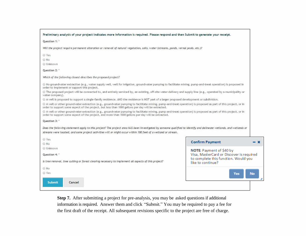
Step 7. After submitting a project for pre-analysis, you may be asked questions if additional
information is required. Answer them and click “Submit.” You may be required to pay a fee for
the first draft of the receipt. All subsequent revisions specific to the project are free of charge.

Step 8. When the PNDI analysis is complete,
an email message will be sent to you, prompting
you to visit “My Projects” to view the receipt.
The receipt indicates if there are potential
impacts, which agency(s) they are with, and it
includes instructions on how to proceed.
The receipt is displayed by clicking on the
Project Title and then the Receipt File pdf.
Project summary information is displayed in the
receipt followed by search results, location maps
and agency-specific instructions. If the receipt is
ready for agency review, click on the Edit
Details/Finalize button. Upload any documents
requested in the receipt (or click on the
checkbox(s) if mailing documents or no further
review is needed) using the Choose File button
at the bottom of the page. Click on the Project
Edit Status radio button indicating Final. Be
sure to click Save when you are finished.
Note: Agency status information and
downloadable zipped shapefiles are also
accessible on the project page.
PNDI Environmental Review Process

Tool Review. To navigate content
in Conservation Explorer, use the
gold tabs near the top of the page.
To carry out a specific task, use the
buttons below the tabs. To display
data in the map, click on/off the
checkboxes in the Table of
Contents. Note: You may need to
zoom in closer to view some or all
of the layers.
Use the buttons in the upper right
corner of the map to quickly log
in/out or change your account
settings. Find additional tools, such
as identify (get info), measure,
zoom to scale, print, bookmark,
zoom to previous/next extent, and
find address or place.