planning proposal local government area: the hills …
TRANSCRIPT

PLANNING PROPOSAL LOCAL GOVERNMENT AREA: The Hills Shire Council NAME OF PLANNING PROPOSAL: Proposed State Environmental Planning Policy (Sydney Growth Region Centres) 2006 (Amendment No (#)) – Proposed amendments to rezone the portion of land zoned E4 Environmental Living to R2 Low Density Residential, reduce the minimum lot size from 4,000m2 to 600m2 and insert a local provision that specifies a cap of 7 dwellings to the portion of the site currently zoned E4 Environmental Living at 9 Palaran Avenue, North Kellyville. STATUS: Public Exhibition ADDRESS OF LAND: 9 Palaran Avenue, North Kellyville (Lot 3 DP 249675) SUPPORTING MATERIAL: Attachment A Assessment against State Environment Planning Policies Attachment B Assessment against Section 9.1 Local Planning Directions Attachment C Council Report and Minute (8 June 2021) Attachment D Local Planning Panel Report and Minute (21 April 2021) Attachment E Proponent’s Planning Proposal Report Attachment F Bushfire Assessment Report Attachment G Preliminary & Detailed Site Investigation Report Attachment H Subdivision Layout (July 2021) Attachment I Gateway Determination (13 July 2021) Attachment J Public Agency Submission – NSW Rural Fire Service (22 August 2021)
THE SITE: The subject site is located at 9 Palaran Avenue, North Kellyville, Lot 3 DP 249675. It has a total site area of approximately two hectares and currently contains a single storey residential dwelling and associated structures. The property is generally cleared, with vegetation sparsely distributed toward the site’s north. The site has frontages to Palaran Avenue, Eden Road and Roland Garros Crescent (south). Sections of Barabati Road and Roland Garros Crescent (north) presently terminate at the site’s northern boundary, as shown in Figure 1.
Figure 1
Aerial view of subject site and locality (area subject to LEP amendments identified in yellow)

The site adjoins a recently constructed low density residential development to the north and east. A 21 lot community title residential subdivision is currently under construction to the south of the site. No application has yet been lodged with respect to the large lot adjoining the west of the site. At present the site is zoned part R2 Low Density Residential (15,270m2) and part E4 Environmental Living (4,960m2). Surrounding development activity has resulted in the isolation of the E4 Environmental Living portion of the site from Caddies Creek Riparian Corridor and effectively disassociated from the values and objectives of the E4 Environmental Living zone. The current SEPP provisions applicable to the E4 Environmental Living portion of the site would only facilitate the subdivision of the site into one Torrens Title lot or three Community Title lots. PART 1 OBJECTIVES OR INTENDED OUTCOME While the planning proposal material identifies the site at 9 Palaran Avenue in its entirety for context and demonstration of future orderly development outcomes, the LEP amendments sought through the planning proposal apply only to part of the land as shown in Figure 1 above. The LEP amendments would facilitate subdivision of the land into seven (7) residential lots ranging in size from 600m2 to 1,009m2. The planning proposal forms part of the overall future subdivision of Lot 3 DP 249675 that would consist of 16 lots on the existing R2 Low Density Residential zoned land (which could already be achieved under the current controls) and seven (7) lots on the portion of the site currently zoned E4 Environmental Living (subject to proposed amendment), one (1) residue lot and associated road network (as shown in Figure 2).
Figure 2
Indicative subdivision plan and road layout (July 2021) with land subject to the LEP amendments outlined in red

PART 2 EXPLANATION OF THE PROVISIONS The proposed outcomes will be achieved by amending Appendix 2 North Kellyville Precinct Plan of State Environmental Policy (Sydney Growth Region Centres) 2006 as follows:
1. Rezone the portion of land currently zoned E4 Environmental Living to R2 Low Density Residential;
2. Amend the minimum lot size from part 4,000m2 to part 600m2; and
3. Insert a local provision that specifies a cap of 7 dwellings over the portion of land currently zoned E4 Environmental Living as follows: 6.7 Development at 9 Palaran Avenue, North Kellyville (1) This clause applies to land at 9 Palaran Avenue, North Kellyville, being part Lot 3, DP
249675, as identified as “Area F” on the Key Sites Map.
(2) Development consent must not be granted to development that results in more than 7 dwellings on the subject land, in the form of one dwelling on each lot resulting from subdivision.
4. Amend Clause 4.6(8) to preclude the variation of development standards stipulated under
Clause 6.7 as follows (changes shown in red):
4.6 Exceptions to development standard (8) This clause does not allow development consent to be granted for development
that would contravene any of the following— (a) a development standard for complying development, (b) a development standard that arises, under the regulations under the Act, in
connection with a commitment set out in a BASIX certificate for a building to which State Environmental Planning Policy (Building Sustainability Index: BASIX) 2004 applies or for the land on which such a building is situated,
(c) clause 5.4, (ca) clause 6.2 or 6.3, (cab) clause 5.5, (cb) clause 7.11, (cd) clause 7.15, (ce) clause 6.7.
Note: These clauses are draft only and will be subject to legal review.
PART 3 JUSTIFICATION SECTION A - NEED FOR THE PLANNING PROPOSAL 1. Is the planning proposal a result of any strategic study or report?
No, the planning proposal has been initiated by the Proponent, acting on behalf of the landowners of the subject site. 2. Is the planning proposal the best means of achieving the objectives or intended outcomes, or is
there a better way?

Yes, the planning proposal is considered to be the best way to achieve the intended outcomes for the site. Rezoning the E4 Environmental Living zoned portion of the site to R2 Low Density Residential will allow the orderly development of the site in a manner that is consistent with the applicable zone objectives. Reducing the minimum lot size from 4,000m2 to 600m2 will ensure that development is consistent with the prevailing lot sizes of the adjoining R2 Low Density Residential zoned properties and E4 Environmental Living community titled properties. It is considered that the application of a dwelling cap of 7 dwellings over the portion of land currently zoned E4 Environmental Living will achieve the most effective balance between the related planning factors (that is, appropriate zoning, minimum lot size controls, density and character and streetscape outcomes). In accordance with condition 1(c) of the Gateway Determination, Council’s consideration of the Department’s comments under Section 1.3 of the Gateway Assessment Report is provided below. Minimum Lot Size To preclude the introduction of the proposed dwelling cap, the Gateway Assessment Report suggests the proposed minimum lot size be increased to 650m2, which would result in a minor increase in lot width (for example, an increase in 1.7m for proposed Lot 1). Whilst the resulting lot widths would be comparable to properties along Roland Garros Crescent and Riverside Way (21m), the referenced properties are community titled lots zoned E4 Environmental Living.
E4 zoned community titled lots have greater flexibility under the North Kellyville DCP (2018) with respect to lot size and frontage requirements and are “characterised by larger lots”. Additionally, residential properties zoned E4 must accommodate a building platform of at least 15m x 20m, and require a greater minimum setback, maximum site coverage and minimum private open space requirements compared to the DCP provisions for residential development on land zoned R2 Low Density Residential. In comparison, the prevailing character of surrounding R2 Low Density Residential zoned land comprises lot sizes ranging from 360m2 to 440m2 with frontages ranging from 12m to 16m.
However, given the unique site-specific characteristics, including the anticipated Roland Garros Crescent road link, an irregular lot shape, shallower lot depth to the north and deeper lot depth to the south, any future subdivision of the site would require relatively wider lot widths (and frontages) to accommodate a reasonable building platform. Additionally, the proposed 600m2 minimum lot size provides the developer with reasonable flexibility at the development application stage to determine the most orderly subdivision layout in response to the configuration of the land and significant variation in lot depth. Given these circumstances, it is considered appropriate to retain the proposed minimum lot size of 600m2 to maintain consistency with prevailing local character and existing streetscape of existing R2 zoned land. Development Control Plan The Gateway Assessment Report suggests the introduction of a minimum lot width control in The North Kellyville DCP 2018.
Surrounding R2 zoned lots are already subject to a 12.5m minimum frontage control given the applicable minimum residential density requirements. As the proposed development provides greater frontages than already required for the surrounding R2 zoned land, the introduction of a minimum lot width control would serve no value in reinforcing the desired development outcome.
Whilst a maximum lot width control could be more appropriate in facilitating the desired development outcome, subject to the proposed 600m2 minimum lot size and existing site constraints, the proposed

subdivision plan reflects the minimum frontage achievable for each lot and further lot width controls are considered unnecessary to effectively regulate the subdivision outcome on the site. Local Provision (Dwelling Cap) The proposed dwelling cap of 7 dwellings seeks to limit the delivery of additional dwellings beyond what is already anticipated for the planning proposal and the North Kellyville Precinct more broadly. Infrastructure impacts have been determined as negligible on the basis of the proposed yield sought by the Proponent.
As secondary dwellings, dual occupancies and semi-attached dwellings are permitted with consent in R2 Low Density zoned land, the Gateway Determination Assessment Report requires further consideration of an instance where the construction of one of these dwelling types on one lot would preclude the subsequent construction of a dwelling on one of the remaining six lots.
To circumvent this scenario, the local provision has been amended to specify that development consent must not be granted to development on the subject site that would result in more than one dwelling being erected on each lot resulting from subdivision. Further, the proposal seeks to amend Clause 4.6(8) to preclude the ability to seek a variation of this development standard. SECTION B - RELATIONSHIP TO STRATEGIC PLANNING FRAMEWORK 3. Is the planning proposal consistent with the objectives and actions contained within the
applicable regional or sub-regional strategy (including the Sydney Metropolitan Strategy and exhibited draft strategies)?
Yes, a discussion of consistency is provided below. Greater Sydney Region Plan and Central City District Plan The Greater Sydney Region Plan and Central City District Plan seek to provide liveable communities and protect biodiversity through various objectives and priorities. Those relevant to this planning proposal are as follows: Objective 10 – Greater Housing Supply; Objective 27 – Biodiversity is protected, urban bushland and remnant vegetation is
enhanced; Objective 28 – Scenic and cultural landscapes are protected; Priority C5 – Providing housing supply, choice and affordability with access to jobs, services
and public transport; and Priority C15 – Protecting and enhancing bushland, biodiversity and scenic and cultural
landscapes. These Plans articulate the importance of providing housing in the right locations. The North West Growth Area, including the North Kellyville release area is an identified location that will contribute to meeting housing targets. The subject site is located 320 to 500 metres walking distance from bus stops, which provide future residents access to services and jobs. It is therefore considered that the proposal is consistent with Objective 10 and Priority C5 of the Region and District plans. Despite a portion of the site currently zoned E4 Environmental Living, the site is sparsely vegetated, is isolated from the creek corridor and no longer serves a function in contributing to the planned scenic and cultural landscape of the nearby vegetation corridor. The rezoning of this land therefore does not contravene Objective 28 and Priority C15 of the Region and District plans. Surrounding development has isolated the site from Caddies Creek and the associated environmental corridor. Further, the subject property does not contain any threatened native species and has been biodiversity certified for development to occur. As such, the loss of vegetation on this

land has already been considered and addressed through the biodiversity certification process undertaken for the broader North Kellyville Precinct. It is therefore considered that the proposal is consistent with Objective 27 and Priority C15 of the Region and District plans. 4. Is the planning proposal consistent with the local council’s Community Strategic Plan, or other
local strategic plan? Yes, a discussion of consistency is provided below. The Hills Local Strategic Planning Statement Council’s Local Strategic Planning Statement (LSPS) outlines the Shire’s 20 year vision regarding land use, planning, population, housing, economic growth and environmental management. The planning proposal will give effect to the following relevant planning priorities of the LSPS: Priority 7 – Plan for new housing in the right locations; and Priority 17 – Protect areas of high environmental values and significance.
The site is located within the North Kellyville Release Area, which the LSPS and supporting Housing Strategy anticipate an additional 6,500 dwellings be delivered by 2036. It further articulates the continued delivery of low and medium density housing be supported by existing and planned infrastructure. The proposed development would allow for the delivery of 21 residential lots which are consistent with the established low density character and are supported by proximate public transport options and a local park. Although a portion of the site is currently zoned E4 Environmental Living, the subject site does not contain threatened vegetation and is biodiversity certified. It is therefore not considered to have high environmental values or significance and the surrounding development patterns have disassociated the site from its original environmental intent. Given the isolated nature of the E4 zoned portion of land, the rezoning of the land to permit further low density residential subdivision (6 additional lots) is considered reasonable and acceptable in this instance. The Hills Future Community Strategic Plan The Hills Future Community Strategic Direction articulates The Hills Shire community’s and Council’s shared vision, values, aspirations and priorities with reference to other local government plans, information and resourcing capabilities. It is a direction that creates a picture of where The Hills would like to be in the future. The direction is based on community aspirations gathered throughout months of community engagement and consultation with members of the community. The planning proposal will facilitate the delivery of 21 residential lots (subject to a cap of 7 dwellings on the portion of land subject to rezoning), consistent with the existing local character and adjoining subdivision layouts. It will be supported by existing public transport infrastructure and serviced by nearby open space. 5. Is the planning proposal consistent with applicable State Environmental Planning Policies? Yes. An assessment of the planning proposal against applicable State Environmental Planning Policies is provided in Attachment A. A discussion on the consistency of the proposal with the relevant Policies is provided below.
SEPP (Sydney Region Growth Centres) 2006 The Growth Centres SEPP aims to coordinate the release of residential land, provide for comprehensive planning of the growth centres, provide for the orderly and economic provision of infrastructure and provide land use and development controls that will contribute to the conservation of biodiversity. Specifically, the aims of Appendix 2 North Kellyville Precinct are to ensure development controls create good design outcomes and protect and enhance the environmentally sensitive areas.

It is considered that the proposal is consistent with the aforementioned objectives as the proposed subdivision layout (subject to a dwelling cap of 7) is consistent with surrounding subdivision character and will facilitate orderly development. It will also assist in delivery of the local road network identified within the North Kellyville DCP. The subject site is also not considered environmentally sensitive given it is not identified as containing native vegetation in the Native Vegetation Protection Map, is not located within the Riparian Protection Area Map under the Growth Centre’s SEPP and has been Biodiversity Certified.
6. Is the planning proposal consistent with applicable Ministerial Directions (s. 9.1 directions)? Yes. The consistency of the planning proposal with the Section 9.1 Ministerial Directions is detailed within Attachment B. A discussion on the consistency of the proposal with each relevant Direction is provided below.
Direction 2.1 Environment Protection Zones Under this Direction, a planning proposal must not reduce the environmental protection standards that apply to the land. While it may be perceived that the subject planning proposal would reduce the relevant environmental protections applying to the land by way of the proposed rezoning, detailed consideration of the site’s context demonstrates that the planning proposal will not result in any environmental impacts. The land was Biodiversity Certified at the time of rezoning the North Kellyville Precinct and the subject site itself comprises only sparse non-significant vegetation.
Given the manner in which surrounding land has been developed, the subject site is no longer associated with the nearby creek corridor and is consequently unable to carry out its function of managing and preserving the riparian corridor through a Community Title arrangement. As such, it is considered that the current environmental zoning is no longer representative of the original intent for the land and the proposed rezoning is of minor significance in this particular instance. The inconsistency with this Direction is considered justified on this basis.
Direction 2.6 Remediation of Contaminated Land This Direction seeks to reduce the risk of harm to human health and the environment by ensuring that contamination and remediation are considered in assessment. Contamination assessment (Preliminary & Detailed Site Investigation Report) submitted by the Proponent and included in Attachment G identifies that the site contains some contaminants within soil samples. However, the Report ultimately recommends that the site is suitable for the proposed redevelopment outcome, subject to the preparation of a Remedial Action Plan and implementation of several mitigative strategies to address contamination spread and risk. Should the proposal be finalised, this matter would be further considered as part of any future development application process. As such, the planning proposal is considered to be consistent with the objectives of this Direction and the site is considered to be capable of accommodating the proposed development outcome.
Direction 3.1 Residential Zones The objectives of this direction are to encourage a variety and choice of housing types, make efficient use of infrastructure and minimise the impact of residential development on the environment and resource lands. Additionally, the Direction specifies that a planning proposal must not contain provisions which will reduce the permissible residential density of land. The proposed rezoning to R2 Low Density Residential would facilitate a more orderly development outcome which better aligns with the zone objectives and the prevailing character of surrounding development. The proposal would also make more efficient use of public transport infrastructure and facilitate a dwelling typology that is appropriate to the local demographic. Additionally, whether zoned E4 Environmental Living (enabling a maximum of 3 community title lots permissible) or R2 Low Density Residential (with a minimum residential density of 10 dwellings per hectare under the SEPP), the proposed dwelling cap of 7 lots would result in a density of 14 dwellings per hectare and will therefore not reduce the minimum permissible residential density of the land.

Notwithstanding this, whilst the Gateway Assessment Report considers the proposed dwelling cap to be contrary to this Direction (given the Proponent’s initial proposal of 8 lots), it nonetheless acknowledges the inconsistency to be minor and justifiable given the proposed dwelling cap seeks to facilitate orderly development, maintain the existing streetscape and preclude the need for additional public infrastructure to service the unanticipated residential yield. Further to this, the dwelling cap seeks to provide certainty on the development outcomes to be delivered.
Direction 3.4 Integrated Land Use and Transport The objective of this Direction is to ensure that urban structures, building forms, land use locations, development designs, subdivision and street layouts achieve the following planning objectives:
a) Improving access to housing, jobs and services by walking, cycling and public transport; b) Increasing the choice of available transport and reducing dependence on cars; c) Reducing travel demand including the number of trips generated by development and the
distances travelled, especially by car; d) Supporting the efficient and viable operation of public transport services; and e) Providing for the efficient movement of freight.
The planning proposal is consistent with the objectives of this Direction as the site is in walking distance to public transport, which provides access to services and jobs, and thus reduces car dependency. Further, it will ensure the delivery of the local road network within this locality, including missing road links between Barabati Road and Roland Garros Crescent, which will service local traffic and extend existing walking path connections, in accordance with The North Kellyville DCP.
Direction 4.4 Planning for Bushfire Protection The objectives of this Direction are to protect life, property and the environment from bushfire hazards, by discouraging the establishment of incompatible land uses in bushfire prone areas and to encourage sound management of bush fire prone areas. The Direction also states that a planning proposal must have regard to Planning for Bushfire Protection 2019. The site is located on the mapped Vegetation Buffer Zone and in accordance with Council’s resolution, the Proponent has submitted a Bushfire Assessment Report. The report articulates that the proposal satisfies the relevant guidelines contained within Planning for Bushfire Protection 2019. It is considered that the proposed subdivision layout (subject to the implementation of the dwelling cap over a portion of the site) will not result in areas that are difficult to evacuate, create difficulties during a bushfire or adversely affect other bush fire protection strategies or place existing development at risk. In accordance with the Gateway Determination and Section 9.1 Ministerial Direction 4.4, pre-exhibition consultation was undertaken with NSW Rural Fire Service (RFS). On 22 August 2021 RFS advised that no specific objections to the proposed rezoning of the subject land are raised at this time. The submission received from NSW RFS is provided as Attachment J.
Direction 6.3 Site Specific Provision This direction applies when a relevant planning authority prepares a planning proposal that will allow a particular development to be carried out and require that a planning proposal must either:
(a) allow that land use to be carried out in the zone the land is situated on, or (b) rezone the site to an existing zone already applying in the environmental planning instrument
that allows that land use without imposing any development standards or requirements in addition to those already contained in that zone, or
(c) allow that land use on the relevant land without imposing any development standards or requirements in addition to those already contained in the principal environmental planning instrument being amended.

The Proponent’s initial indicative subdivision layout would have facilitated 8 residential lots on the portion of the site subject to rezoning, including the provision of a battle-axe allotment. It is considered that a preferable subdivision pattern on this particular part of the site and within a new greenfield subdivision would avoid the inclusion of battle-axe allotments and instead, ensure that each new lot and dwelling will have a public street frontage. The proposed local provision would limit part Lot 3 DP 249675 to a maximum of 7 dwellings and circumvent the need of a battle-axe allotment. The intent of the proposed local provision is not considered to be unnecessary or unreasonable and is therefore considered to be a satisfactory provision within the planning proposal. Further, DPIE’s Gateway Assessment Report considers that any inconsistency with this Direction is of minor significance, given the intent of the proposed local provision and the resulting outcome being the reduction in development potential by a single lot/dwelling than initially proposed. SECTION C - ENVIRONMENTAL, SOCIAL AND ECONOMIC IMPACT 7. Is there any likelihood that critical habitat or threatened species, populations or ecological
communities, or their habitats, will be adversely affected as a result of the proposal? No. Whilst the site contains sparsely distributed vegetation, it does not contain any threatened species or native vegetation. Further, it has been biodiversity certified such that there is an expectation that vegetation would be removed from the land to accommodate urban development. The adjoining residential subdivision and developments on E4 zoned land to the site’s east and south have isolated the site and effectively disassociated it from the values and objectives of the E4 Environmental Living zone, as they relate to the environmental and scenic qualities of the Caddies Creek Riparian Corridor. In accordance with the Gateway Determination, consultation will be undertaken with the Environment, Energy and Science Group during public exhibition. 8. Are there any other likely environmental effects as a result of the planning proposal and how are
they proposed to be managed? No. In the ultimate developed scenario, it is anticipated that the site will generate a reasonable volume of runoff and is considered appropriate that this be addressed at the Development Application stage. Specifically, a site-specific flood study will need to be prepared as part of any future Development Application, which would need to detail the requirements of on-site stormwater detention and the incorporation of a stormwater quality treatment or water sensitive urban design strategy for the site. 9. How has the planning proposal adequately addressed any social and economic effects?
The planning proposal will facilitate the delivery of 21 residential lots and will contribute to the Shire’s housing supply. Development on the site will be supported by existing public transport infrastructure and serviced by nearby open space. Further, it will ensure the delivery of the local road network within this locality, including missing road links between Barabati Road and Roland Garros Crescent, which will service local traffic and extend existing walking path connections. The site is located 320 to 500 metres walking distance from bus stops, which provide future residents access to services and jobs. SECTION D - STATE AND COMMONWEALTH INTERESTS 10. Is there adequate public infrastructure for the planning proposal?
It is considered unlikely that the planning proposal will substantially increase traffic volume on local and regional road infrastructure from what has been anticipated within the North Kellyville Traffic and Transport Assessment 2008 (prepared by Maunsell Australia). The proposal will facilitate in the delivery of the missing links between Barabati Road and Roland Garros Crescent, which will service

local traffic and extend existing walking path connections, in accordance with The North Kellyville DCP. 11. What are the views of State and Commonwealth Public Authorities consulted in accordance with
the gateway determination, and have they resulted in any variations to the planning proposal? In accordance with the Gateway Determination, consultation is required with the following public authorities for a period of 21 days:
Environment, Energy and Science Group; NSW Rural Fires Service (RFS); Sydney Water; Endeavour Energy; Telstra; and NBN Co.
Pursuant to Section 9.1 Direction 4.4 – Planning for Bushfire Protection, pre-exhibition consultation was undertaken with RFS. On 22 August 2021 RFS advised that no specific objections to the proposed rezoning of the subject land are raised at this time. A copy of RFS’ submission is provided as Attachment J. Consultation with the remaining public authorities will be undertaken during the public exhibition stage.

PART 4 MAPPING The planning proposal seeks to amend the Land Zone Map and Minimum Lot Size Map of State Environmental Planning Policy (Sydney Growth Region Centres) 2006.
Existing Land Zone Map
Proposed Land Zone Map
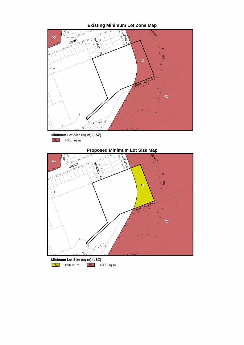
Existing Minimum Lot Zone Map
Proposed Minimum Lot Size Map

Existing Key Sites Map
Proposed Key Sites Map
PART 5 COMMUNITY CONSULTATION The planning proposal will be advertised on Council’s website and social media platforms. Adjoining landowners will be directly notified of the public exhibition period and will be invited to comment on the proposal.

PART 6 PROJECT TIMELINE
STAGE DATE Commencement Date (Gateway Determination) July 2021 Pre-exhibition Government agency consultation August 2021 Government agency consultation September 2021 Commencement of public exhibition period September 2021 Completion of public exhibition period October 2021 Timeframe for consideration of submissions November 2021 Timeframe for consideration of proposal post exhibition December 2021 Report to Council on submissions February 2021 Planning Proposal to PCO for opinion March 2022 Date Council will make the plan April 2022

ATTACHMENT A: LIST OF STATE ENVIRONMENTAL PLANNING POLICIES
STATE ENVIRONMENTAL PLANNING POLICY (SEPP)
APPLICABLE TO THSC
RELEVANT? (YES/NO)
(IF RELEVANT) INCONSISTENT/
CONSISTENT No. 19 Bushland in Urban Areas YES NO - No. 21 Caravan Parks YES NO - No. 33 Hazardous and Offensive
Development YES NO -
No. 36 Manufactured Home Estates NO - - No. 47 Moore Park Showground NO - - No. 50 Canal Estate Development YES NO - No. 55 Remediation of Land YES NO - No. 64 Advertising and Signage YES NO - No. 65 Design Quality of Residential
Apartment Development YES NO -
No. 70 Affordable Housing (Revised Schemes)
YES NO -
Aboriginal Land (2019) NO - - Activation Precincts (2020) NO - - Affordable Rental Housing (2009) YES NO - Building Sustainability Index: BASIX (2004) YES NO - Coastal Management (2018) NO - - Concurrences and Consents (2018) YES NO - Educational Establishments and Child Care Facilities (2017)
YES NO -
Exempt and Complying Development Codes (2008)
YES NO -
Gosford City Centre (2018) NO - - Housing for Seniors or People with a Disability (2004)
YES NO
Infrastructure (2007) YES NO - Koala Habitat Protection (2020) NO - - Koala Habitat Protection (2021) NO - - Kosciuszko National Park – Alpine Resorts (2007)
NO - -
Kurnell Peninsula (1989) NO - - Major Infrastructure Corridors (2020) NO - - Mining, Petroleum Production and Extractive Industries (2007)
YES NO -
Penrith Lakes Scheme (1989) NO - - Primary Production and Rural Development (2019)
YES NO -
State and Regional Development (2011) YES NO - State Significant Precincts (2005) YES NO - Sydney Drinking Water Catchment (2011) NO - - Sydney Region Growth Centres (2006) YES YES CONSISTENT Three Ports (2013) NO - - Urban Renewal (2010) NO - - Vegetation in Non-Rural Areas (2017) YES NO - Western Sydney Aerotropolis (2020) NO - - Western Sydney Employment Area (2009) NO - - Western Sydney Parklands (2009) NO - - Deemed SEPPs SREP No. 8 (Central Coast Plateau Areas) NO - - SREP No. 9 – Extractive Industry (No. 2 – 1995)
YES NO -
SREP No. 16 – Walsh Bay NO - -

STATE ENVIRONMENTAL PLANNING POLICY (SEPP)
APPLICABLE TO THSC
RELEVANT? (YES/NO)
(IF RELEVANT) INCONSISTENT/
CONSISTENT SREP No. 20 – Hawkesbury – Nepean River (No 2 – 1997)
YES NO -
SREP No. 24 – Homebush Bay Area NO - - SREP No. 26 – City West NO - - SREP No. 30 – St Marys NO - - SREP No. 33 – Cooks Cove NO - - SREP (Sydney Harbour Catchment) 2005 NO - -

ATTACHMENT B: ASSESSMENT AGAINST SECTION 9.1 MINISTERIAL DIRECTIONS
DIRECTION APPLICABLE RELEVANT? (YES/NO)
(IF RELEVANT) INCONSISTENT/
CONSISTENT
1. Employment and Resources
1.1 Business and Industrial Zones YES NO - 1.2 Rural Zones YES NO - 1.3 Mining, Petroleum Production and
Extractive Industries YES NO -
1.4 Oyster Aquaculture YES NO - 1.5 Rural Lands YES NO -
2. Environment and Heritage
2.1 Environment Protection Zone YES YES CONSISTENT 2.2 Coastal Protection NO - - 2.3 Heritage Conservation YES NO - 2.4 Recreation Vehicle Area YES NO - 2.5 Application of E2 and E3 Zones and
Environmental Overlays in Far North Coast LEPs
NO - -
2.6 Remediation of Contaminated Land YES YES CONSISTENT
3. Housing, Infrastructure and Urban Development
3.1 Residential Zones YES YES JUSTIFIED 3.2 Caravan Parks and Manufactured
Home Estates YES NO -
3.3 Home Occupations YES NO - 3.4 Integrating Land Use and Transport YES YES CONSISTENT 3.5 Development Near Regulated
Airports and Defence Airfields YES NO -
3.6 Shooting Ranges NO - - 3.7 Reduction in non-hosted short term
rental accommodation period NO - -
4. Hazard and Risk
4.1 Acid Sulfate Soils YES NO - 4.2 Mine Subsidence and Unstable Land YES NO - 4.3 Flood Prone Land YES NO - 4.4 Planning for Bushfire Protection YES NO -
5. Regional Planning
5.2 Sydney Drinking Water Catchment NO - - 5.3 Farmland of State and Regional
Significance on the NSW Far North Coast
NO - -
5.4 Commercial and Retail Development along the Pacific Highway, North Coast
NO - -
5.9 North West Rail Link Corridor Strategy
YES NO -
5.10 Implementation of Regional Plans YES NO -

DIRECTION APPLICABLE RELEVANT? (YES/NO)
(IF RELEVANT) INCONSISTENT/
CONSISTENT 5.11 Development of Aboriginal Land
Council Land NO - -
6. Local Plan Making
6.1 Approval and Referral Requirements YES NO - 6.2 Reserving Land for Public Purposes YES NO - 6.3 Site Specific Provisions YES NO JUSTIFIED
7. Metropolitan Planning
7.1 Implementation of A Plan for Growing
Sydney YES NO -
7.2 Implementation of Greater Macarthur Land Release Investigation
NO - -
7.3 Parramatta Road Corridor Urban Transformation Strategy
NO - -
7.4 Implementation of North West Priority Growth Area Land Use and Infrastructure Implementation Plan
YES NO -
7.5 Implementation of Greater Parramatta Priority Growth Area Interim Land Use and Infrastructure Implementation Plan
NO - -
7.6 Implementation of Wilton Priority Growth Area Interim Land Use and Infrastructure Implementation Plan
NO - -
7.7 Implementation of Glenfield to Macarthur Urban Renewal Corridor
NO - -
7.8 Implementation of Western Sydney Aerotropolis Interim Land Use and Infrastructure Implementation Plan
NO - -
7.9 Implementation of Bayside West Precincts 2036 Plan
NO - -
7.10 Implementation of Planning Principles for the Cooks Cove Precinct
NO - -
7.11 Implementation of St Leonards and Crows Nest 2036 Plan
NO - -
7.12 Implementation of Greater Macarthur 2040
NO - -
7.13 Implementation of the Pyrmont Peninsula Place Strategy
NO - -