planning justification report - burlington · planning justification report – 5219 upper middle...
TRANSCRIPT
Planning Justification Report
Bloomfield Homes
5912 Upper Middle Road
City of Burlington
March 2017
File 7926-1
i
i Planning Justification Report – 5219 Upper Middle Road
Table of Contents
List of Figures ............................................................................................................................... iii
List of Tables................................................................................................................................. iii
List of Appendices ....................................................................................................................... iii
1. Introduction ........................................................................................................................... 1
2. Purpose of Report ................................................................................................................. 1
3. Site Description and Context ............................................................................................... 2
3.1 Description of the Subject Property ................................................................................. 2
3.2 Neighbourhood Context ................................................................................................... 3
3.3 Surrounding Land Uses ................................................................................................... 4
3.4 Community Facilities ........................................................................................................ 7
3.5 Surrounding Area Developments ..................................................................................... 9
3.6 Transit and Transportation ............................................................................................. 12
4. Proposed Development ...................................................................................................... 13
4.1 Description of Proposed Development .......................................................................... 13
5. Description of Planning Applications ............................................................................... 14
6. Supporting Materials .......................................................................................................... 14
6.1 Functional Servicing Report ........................................................................................... 15
6.2 Tree Inventory and Preservation Study ......................................................................... 15
6.3 Traffic/Transportation Impact Brief ................................................................................. 15
6.4 Environmental Noise Assessment ................................................................................. 16
6.5 Environmental Site Assessment .................................................................................... 16
6.6 Urban Design Brief ......................................................................................................... 16
7. Planning Policy Framework ............................................................................................... 17
7.1 Provincial Policy Statement, 2014 ................................................................................. 17
7.2 Growth Plan for the Greater Golden Horseshoe (June 2013 Office Consolidation) ..... 22
7.3 Proposed Growth Plan for Greater Golden Horseshoe (2016) ..................................... 25
7.4 Region of Halton Official Plan, 2010 (January 2016) .................................................... 26
7.5 City of Burlington Official Plan (Office Consolidation 2015) .......................................... 32
7.5.1 Sustainable Design and Compatibility .................................................................... 32
7.5.2 Transportation ......................................................................................................... 34
7.5.3 Design ..................................................................................................................... 38
7.5.4 Residential Areas.................................................................................................... 40
7.5.5 Housing Intensification ........................................................................................... 42
7.6 City of Burlington Official Plan Review ........................................................................... 45
ii
ii Planning Justification Report – 5219 Upper Middle Road
7.7 Orchard Community Secondary Planning Study Report ............................................... 46
7.8 City of Burlington Comprehensive Zoning By-law 2020 ................................................ 49
8. Proposed Zoning By-law Amendment .............................................................................. 50
9. Waste Management Strategy ............................................................................................. 51
10. Public Consultation Strategy ............................................................................................. 51
11. Planning Analysis and Justification ................................................................................. 52
12. Conclusion ........................................................................................................................... 55
iii
iii Planning Justification Report – 5219 Upper Middle Road
List of Figures
Figure 1: Aerial Photograph. ........................................................................................................... 3 Figure 2: Context Photograph……………………...…………………………………………………….4 Figure 3: Dwelling located at 5257 Rome Crescent, Burlington. .................................................... 5 Figure 4: Townhouse development located at English Crescent, Burlington . ............................... 5 Figure 5: Mixed-use building located at 5327 Upper Middle Road, Burlington. ............................. 6 Figure 6: Corpus Christi Catholic Secondary School ...................................................................... 6 Figure 7: Stormwater Retention Pond located to the west of the subject lands. ............................ 7 Figure 8: Community Facilities Map. ............................................................................................... 9 Figure 9: Nearby Development Applications/Approvals . ............................................................... 8 Figure 10: Burlington Transit Map. .................................................................................................. 8 Figure 11: Development Concept Plan. .......................................................................................... 9 Figure 12: Population and Employment Distribution. .................................................................... 27 Figure 13: Region of Halton Official Plan, Map 1 – Regional Structure. ....................................... 23 Figure 14: Region of Halton Official Plan, Map 3 - Functional Transportation Plan………………25 Figure 15: City of Burlington Official Plan, Schedule 1 - Long Term Transit Service Network.….26 Figure 16: City of Burlington Official Plan, Schedule 2 - Long Term Bike Network…….…………25 Figure 17: City of Burlington Official Plan, Schedule A – Settlement Pattern. ............................. 32 Figure 18: City of Burlington Official Plan, Schedule B - Comprehensive Land Use………….….33 Figure 19: Orchard Community Secondary Plan Study Report, Preferred Land Use Scenario…34 Figure 20: Zoning Map. ................................................................................................................. 36
List of Tables
Table 1: Community Facilities . ....................................................................................................... 6 Table 2: Development Regulations, ‘D – Development Zone’ ...................................................... 37
List of Appendices
Appendix 1: Draft By-Law Amendment with Schedule . ............................................................... 55
Bloomfield Developments Inc: 5219 Upper Middle Road, Burlington Planning Justification Report
1
1. Introduction
Weston Consulting is the planning consultant for Bloomfield Homes the owner of the lands
municipally known as 5219 Upper Middle Road, 204 Georgina Court, 205 Georgina Court and the
vacant remnant blocks 262 and 263, 20M-824 from the adjacent Bronte Woods (Metro) Phase 1
subdivision, City of Burlington (herein referred to as the “subject lands” or collectively referred to
as “5219 Upper Middle Rd.”).
Bloomfield Homes is proposing to redevelop the subject lands with 8 freehold semi-detached units
on a new public cul-de-sac and 14 townhouses on a condominium road extended from the
proposed cul-de-sac. An application for a Zoning By-law Amendment has been submitted to the
City of Burlington to facilitate the proposed development.
This report provides the planning rationale in support of the proposed Zoning By-law Amendment
application and provides justification for the proposal in accordance with good planning principles.
It is recognized that applications for Draft Plan of Subdivision, Draft Plan of Condominium and Site
Plan Approval will be required to fully implement the proposed development and will be submitted
separately at the appropriate time in the planning process for review and consideration.
2. Purpose of Report
The purpose of this report is to outline the nature of the proposed development and to evaluate
the proposal in the context of the policies of the Provincial Policy Statement (‘PPS’), the Growth
Plan for the Greater Golden Horseshoe (‘GGH’), the Halton Region Official Plan (‘HROP’), the City
of Burlington Official Plan, the Orchard Community Secondary Plan and other applicable policies
and regulations that apply to the subject lands.
A Pre- Application Consultation meeting was held of December 7, 2016 which identified that a
Zoning By-law Amendment, in addition to future Draft Plan of Subdivision and Site Development
applications, is required in order to achieve the objectives of the proposed development. The
planning application for a Zoning By-law Amendment and supporting materials are submitted in
accordance with communications received from planning staff at the City of Burlington, and thus
constitute a complete application as described in Section 34(10) of the Planning Act.

Bloomfield Developments Inc: 5219 Upper Middle Road, Burlington Planning Justification Report
2
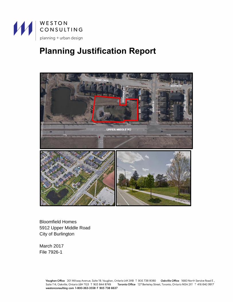
3. Site Description and Context
3.1 Description of the Subject Property
Legal Description
The subject lands are located along the north of Upper Middle Road between Quinte Street to
the east and a stormwater management pond to the West. The Legal Description of the subject
lands is as follows:
PT LOT 4, CON 1 SOUTH OF DUNDAS STREET, AS IN 646694; T/W 646694 CITY OF
BURLINGTON, and BLOCK 262, PLAN 20M828, BURLINGTON.
LOT 9, PLAN 20M-824, BURLINGTON. S/T EASE HR1373334 & HR137471 OVER PT 4,
20R14699.
LOT 8, PLAN 20M-824, BURLINGTON. S/T EASE HR137334 & HR137471 OVER PT 3,
20R14699.
BLOCK 262, and 263 PLAN 20M-824, BURLINGTON.
Property Characteristics
The subject lands are approximately 0.5 hectares (1.23 acres) in area and is generally
rectangular in shape. The subject lands have direct access to and frontage on Upper Middle
Road. The proposed development includes cul-de-sac extension of Georgina Court which was
created as part of the Bronte Woods Phase 1. Georgina Crescent currently terminates in a
hammerhead on Lots 8 and 9 of Registered Plan 20M- 824; the hammerhead will be removed to
allow the proposed residential development. 5129 Upper Middle Rd. is currently occupied by a
two-storey residential detached dwelling, one storey detached garage and wood shed; all of
which will be demolished. The remainder of the site is occupied by trees, shrubs and greenspace.
The subject lands have variable topography and are generally higher at the north-western portion
and gradually slope downward in a south-eastern direction through the site to be at grade with
abutting residential subdivision located directly to the east and north. There are no significant
features on site, physical or otherwise, that would prevent the proposed redevelopment of the
subject lands.

Bloomfield Developments Inc: 5219 Upper Middle Road, Burlington Planning Justification Report
3
Figure 1: Aerial Photograph of Subject Lands
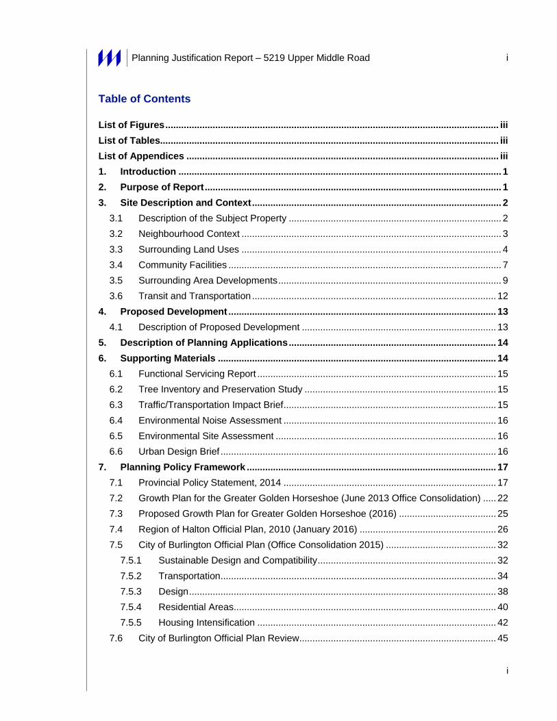
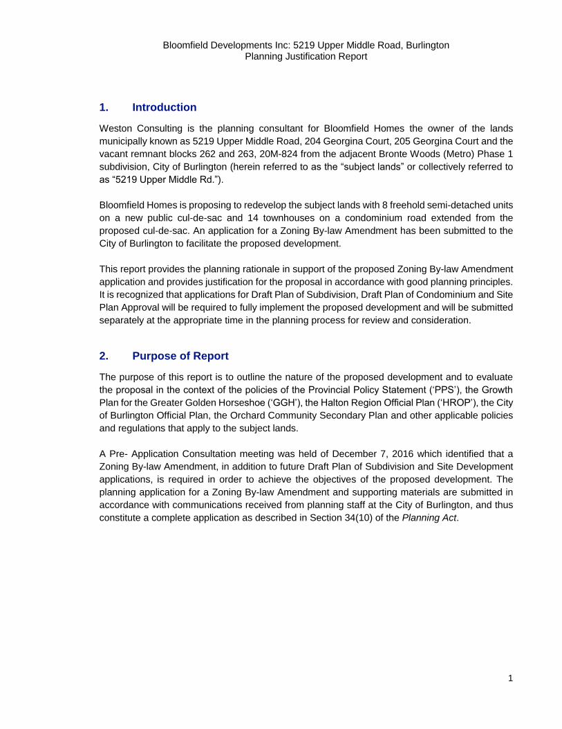
3.2 Neighbourhood Context
The subject lands are located within the Orchard Community, located in the northeast section of
the Burlington Urban Area. The area is bounded on the north by Highway 5 (Dundas Street), on
the south by Upper Middle Road, on the west by Appleby Line and on the east by the Bronte
Creek valley. The Orchard Community is located in the very northeast corner of Burlington,
Ontario, bordering Bronte Creek Provincial Park. Construction in this neighbourhood started in
the late 1990’s, with the very first home being occupied in 1997. Since that time, this community
has grown to approximately 3,800 homes. The surrounding area is characterized by a mix of
residential, commercial and institutional type uses.
Bloomfield Developments Inc: 5219 Upper Middle Road, Burlington Planning Justification Report
4
Figure 2: Context Photograph
3.3 Surrounding Land Uses
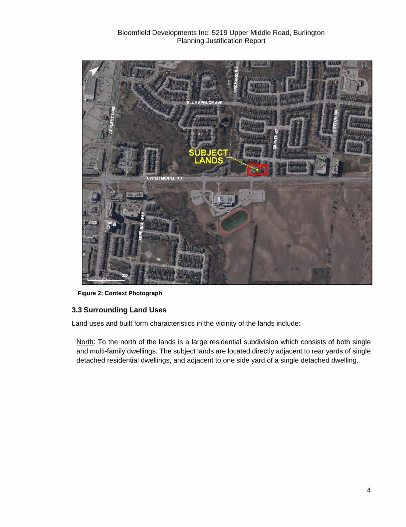
Land uses and built form characteristics in the vicinity of the lands include:
North: To the north of the lands is a large residential subdivision which consists of both single
and multi-family dwellings. The subject lands are located directly adjacent to rear yards of single
detached residential dwellings, and adjacent to one side yard of a single detached dwelling.
Bloomfield Developments Inc: 5219 Upper Middle Road, Burlington Planning Justification Report
5
Figure 3: Dwelling located at 5257 Rome Crescent, Burlington
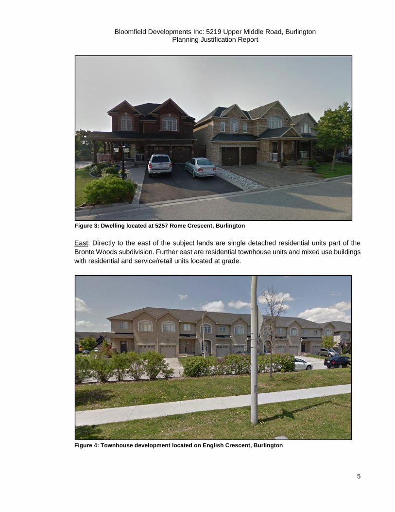
East: Directly to the east of the subject lands are single detached residential units part of the
Bronte Woods subdivision. Further east are residential townhouse units and mixed use buildings
with residential and service/retail units located at grade.
Figure 4: Townhouse development located on English Crescent, Burlington
Bloomfield Developments Inc: 5219 Upper Middle Road, Burlington Planning Justification Report
6
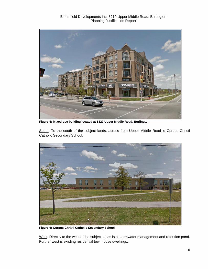
Figure 5: Mixed-use building located at 5327 Upper Middle Road, Burlington
South: To the south of the subject lands, across from Upper Middle Road is Corpus Christi
Catholic Secondary School.
Figure 6: Corpus Christi Catholic Secondary School
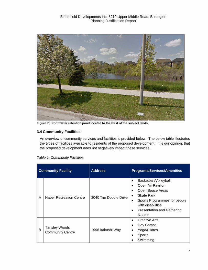
West: Directly to the west of the subject lands is a stormwater management and retention pond.
Further west is existing residential townhouse dwellings.
Bloomfield Developments Inc: 5219 Upper Middle Road, Burlington Planning Justification Report
7
Figure 7: Stormwater retention pond located to the west of the subject lands
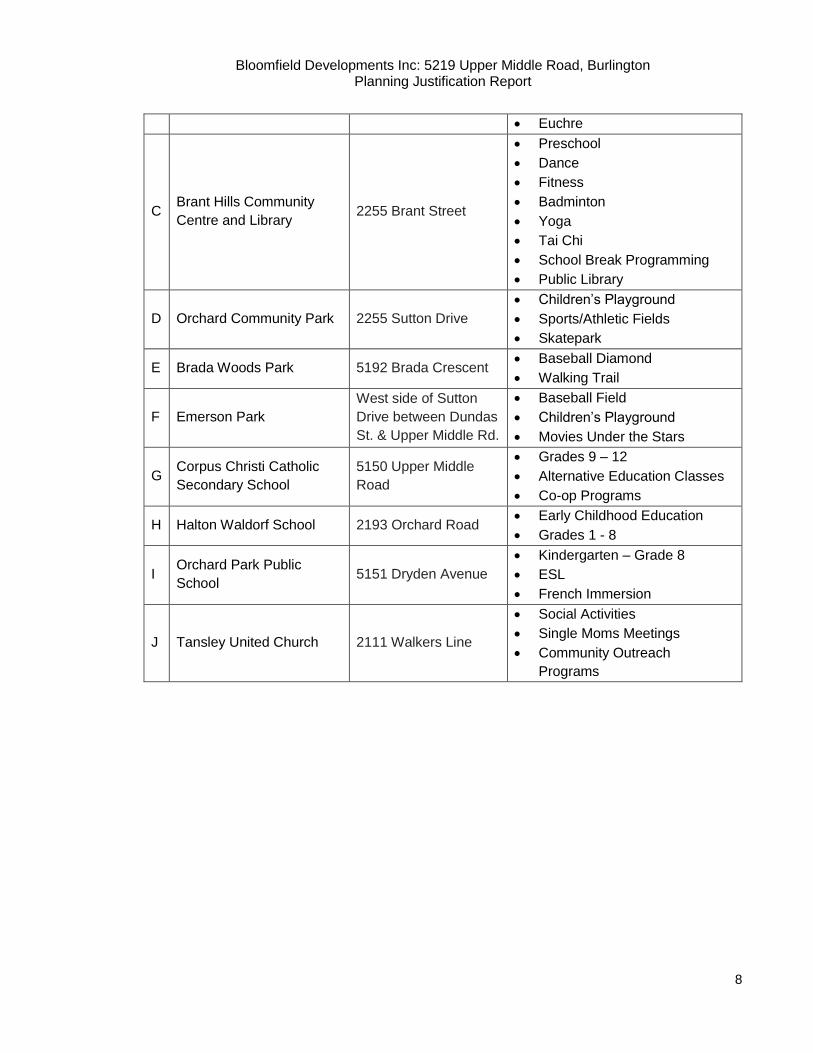
3.4 Community Facilities
An overview of community services and facilities is provided below. The below table illustrates
the types of facilities available to residents of the proposed development. It is our opinion, that
the proposed development does not negatively impact these services.
Table 1: Community Facilities
Community Facility Address
Programs/Services/Amenities
A Haber Recreation Centre 3040 Tim Dobbie Drive
Basketball/Volleyball
Open Air Pavilion
Open Space Areas
Skate Park
Sports Programmes for people
with disabilities
Presentation and Gathering
Rooms
B Tansley Woods
Community Centre 1996 Itabashi Way
Creative Arts
Day Camps
Yoga/Pilates
Sports
Swimming
Bloomfield Developments Inc: 5219 Upper Middle Road, Burlington Planning Justification Report
8
Euchre
C Brant Hills Community
Centre and Library 2255 Brant Street
Preschool
Dance
Fitness
Badminton
Yoga
Tai Chi
School Break Programming
Public Library
D Orchard Community Park 2255 Sutton Drive
Children’s Playground
Sports/Athletic Fields
Skatepark
E Brada Woods Park 5192 Brada Crescent Baseball Diamond
Walking Trail
F Emerson Park
West side of Sutton
Drive between Dundas
St. & Upper Middle Rd.
Baseball Field
Children’s Playground
Movies Under the Stars
G Corpus Christi Catholic
Secondary School
5150 Upper Middle
Road
Grades 9 – 12
Alternative Education Classes
Co-op Programs
H Halton Waldorf School 2193 Orchard Road Early Childhood Education
Grades 1 - 8
I Orchard Park Public
School 5151 Dryden Avenue
Kindergarten – Grade 8
ESL
French Immersion
J Tansley United Church 2111 Walkers Line
Social Activities
Single Moms Meetings
Community Outreach
Programs
Bloomfield Developments Inc: 5219 Upper Middle Road, Burlington Planning Justification Report
9
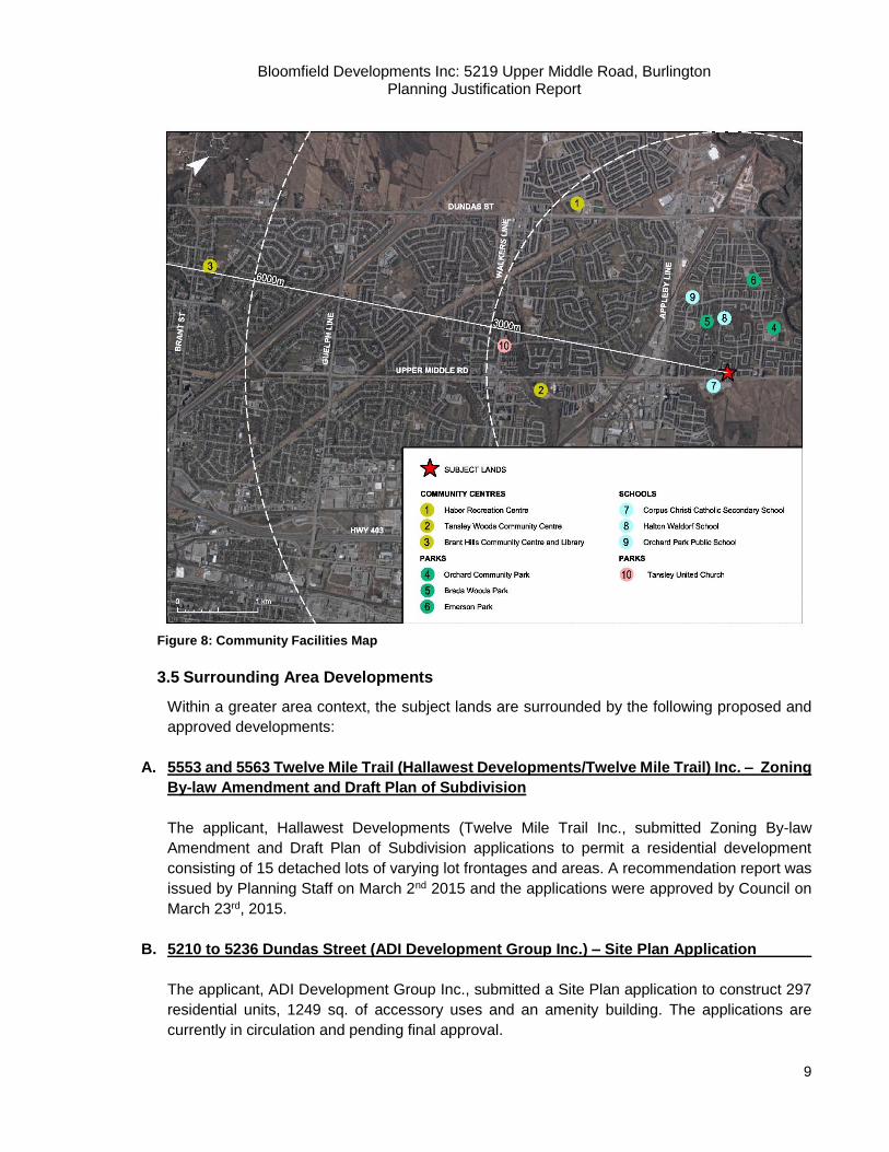
Figure 8: Community Facilities Map
3.5 Surrounding Area Developments
Within a greater area context, the subject lands are surrounded by the following proposed and
approved developments:
A. 5553 and 5563 Twelve Mile Trail (Hallawest Developments/Twelve Mile Trail) Inc. – Zoning
By-law Amendment and Draft Plan of Subdivision
The applicant, Hallawest Developments (Twelve Mile Trail Inc., submitted Zoning By-law
Amendment and Draft Plan of Subdivision applications to permit a residential development
consisting of 15 detached lots of varying lot frontages and areas. A recommendation report was
issued by Planning Staff on March 2nd 2015 and the applications were approved by Council on
March 23rd, 2015.
B. 5210 to 5236 Dundas Street (ADI Development Group Inc.) – Site Plan Application
The applicant, ADI Development Group Inc., submitted a Site Plan application to construct 297
residential units, 1249 sq. of accessory uses and an amenity building. The applications are
currently in circulation and pending final approval.
Bloomfield Developments Inc: 5219 Upper Middle Road, Burlington Planning Justification Report
10
C. 1215 Appleby Line (Rylander Holdings) – Zoning By-law Amendment and Site Plan
Approval
The applicant, Rylander Holdings, submitted applications for Zoning By-law Amendment and Site
Development applications to permit the development of a 6-storey hotel and three one-storey
commercial buildings on a vacant lot on Appleby Line, south of Mainway Drive. The proposed
buildings are a fast-food restaurant with a drive-thru, a mixed-use building that includes a bank
and another restaurant.
The application was not supported by Town staff and Council and the applicant appealed to the
Ontario Municipal Board in June 2015. The OMB decision dated July 21, approved the applicants
request to rezone the subject property from MXE to MXE-452. A site plan application is currently
being revised.

Bloomfield Developments Inc: 5219 Upper Middle Road, Burlington Planning Justification Report
11
Figure 9: Nearby Development Approvals/Applications
Bloomfield Developments Inc: 5219 Upper Middle Road, Burlington Planning Justification Report
12
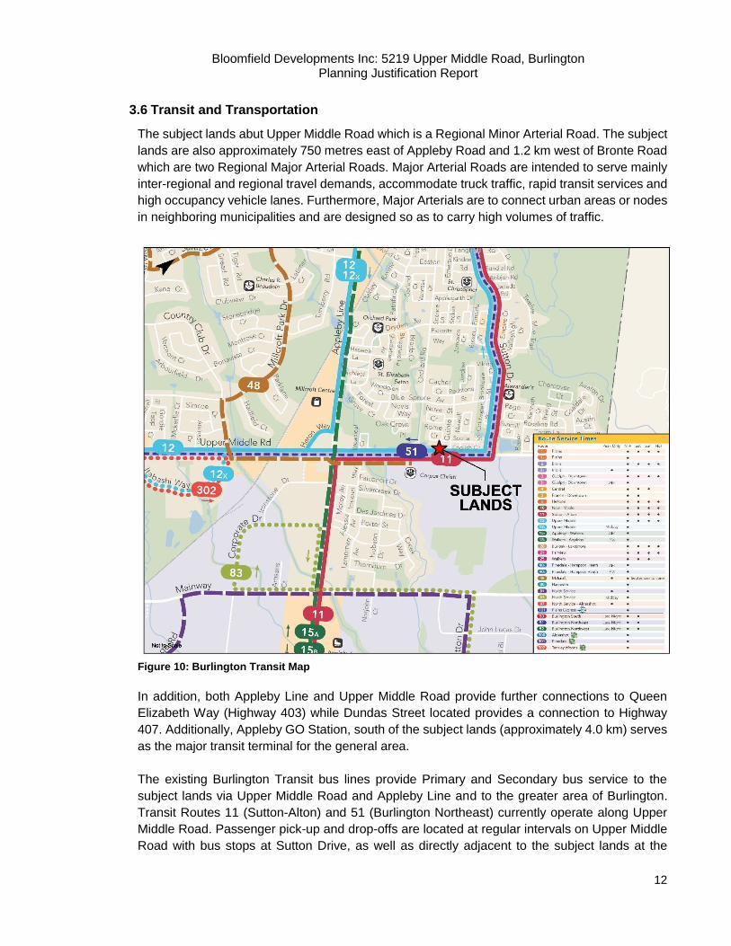
3.6 Transit and Transportation
The subject lands abut Upper Middle Road which is a Regional Minor Arterial Road. The subject
lands are also approximately 750 metres east of Appleby Road and 1.2 km west of Bronte Road
which are two Regional Major Arterial Roads. Major Arterial Roads are intended to serve mainly
inter-regional and regional travel demands, accommodate truck traffic, rapid transit services and
high occupancy vehicle lanes. Furthermore, Major Arterials are to connect urban areas or nodes
in neighboring municipalities and are designed so as to carry high volumes of traffic.
Figure 10: Burlington Transit Map
In addition, both Appleby Line and Upper Middle Road provide further connections to Queen
Elizabeth Way (Highway 403) while Dundas Street located provides a connection to Highway
407. Additionally, Appleby GO Station, south of the subject lands (approximately 4.0 km) serves
as the major transit terminal for the general area.
The existing Burlington Transit bus lines provide Primary and Secondary bus service to the
subject lands via Upper Middle Road and Appleby Line and to the greater area of Burlington.
Transit Routes 11 (Sutton-Alton) and 51 (Burlington Northeast) currently operate along Upper
Middle Road. Passenger pick-up and drop-offs are located at regular intervals on Upper Middle
Road with bus stops at Sutton Drive, as well as directly adjacent to the subject lands at the
Bloomfield Developments Inc: 5219 Upper Middle Road, Burlington Planning Justification Report
13
Corpus Christi Secondary School. These routes provide access to numerous retail and
commercial centres that are located in close proximity to the site. In addition, the routes provide
access to a number of community facilities such as schools, parks, recreation trails and
community centres. The routes provide further connections and access to the Appleby GO
Station and the Highway 407 GO Carpool lot located at Dundas Street and Walkers Line. Upper
Middle Road is also currently serviced by a multi-use path and an existing bike lane that connects
Burlington to the rest of the Region. GO Transit train service at the Appleby GO Station provides
connections westward to Hamilton and eastward to Downtown Toronto.
4. Proposed Development
4.1 Description of Proposed Development
The current concept for the subject lands contemplates 22 residential dwelling units consisting
of eight (8) semi-detached units located on a proposed cul-de-sac extending from Georgina
Court and fourteen (14) condominium townhomes located on a 6m private laneway. The
configuration of the units is oriented to provide an appropriate transition between the existing
low-density Orchard residential subdivision to the north and east and is designed to tie into the
existing road network via a municipal right-of-way cul-de-sac.
The condominium townhouse block includes three buildings ranging from four to six units. The
units will have depths of approximately 9.6 to 10.4 metres. Both the northern and southern
townhouse blocks will gain access from the proposed lane, however the southern block will take
its frontage from Upper Middle Road and pedestrian connections to the sidewalk will be provided.
Each townhouse unit will include two parking spaces (one driveway, one garage) and five (5)
surface visitor parking spots are located outside of the hammerhead. The hammerhead will
accommodate for safe vehicular movement and provide for an appropriate turning radius for
municipal service and maintenance vehicles. A total of eight freehold semi-detached units are
proposed on the cul-de-sac extension of Georgina Crescent. These units will have depths from
approximately 10.8m to 15m.
A proposed road widening along Upper Middle Road has been provided which is consistent with
the widenings taken on the west and east sides. The site will achieve a net density of 50.3 units
per hectare if the road widening (510 sq.m) and cul-de-sac (467 sq.m) are excluded. The total
frontage of the property along Upper Middle Road is approximately 102.3 metres and has an
overall site area of approximately 5,053 square metres.
Vehicular access to the site is gained from the existing public road network, Rome Crescent and
Georgina Court. The internal road is designed to operate as a two-way traffic private lane with
direct access to Georgina Court.

Bloomfield Developments Inc: 5219 Upper Middle Road, Burlington Planning Justification Report
14
Figure 11: Development Concept
5. Description of Planning Applications
The submitted Zoning By-law Amendment application is to permit the proposed housing form and
site specific development standards. Site Plan, Draft Plan of Subdivision and Draft Plan of
Condominium applications, to be submitted at a later date, will be required to fully implement this
proposal.
The subject lands are currently zoned D – Development Zone and RM3-138 – Medium Density
Residential in By-law 2020. Residential uses permitted in the `D` zone are limited to one single
detached dwelling. The RM3 zone permits semi-detached dwellings and townhomes. A Zoning
By-law Amendment is being requested to provide rezoning for the lands to RO2 (Residential
Orchard 2 Zone) – exception zone.
6. Supporting Materials
A Pre-Application Consultation (PAC) meeting was held on December 7, 2016 with City of
Burlington staff to determine the required studies, plans and other supporting materials required
Bloomfield Developments Inc: 5219 Upper Middle Road, Burlington Planning Justification Report
15
in support of the proposed development applications. In accordance with the PAC understanding,
the following provides a brief summary of the submitted studies and reports.
6.1 Functional Servicing Report
The Odan/Detech Group was retained to prepare a Functional Servicing and Stormwater
Management Report for the proposed development. The Report confirms that there is an existing
200 mm sanitary sewer extended from Georgina Court and an existing 200 mm PVC watermain
beneath Georgina Court. A propose private sanitary sewer internal of the townhouses will be
provide sanitary drainage to the proposed townhouse condominium. The existing municipal
watermain will be extended southerly into the subject proposed development to provide domestic
service to the proposed freehold semi-detached houses. A private water service will be extended
beneath the private laneway. In terms of storm sewer design, storm drainage from the subject
development will in-part follow the existing drainage patterns and in-part via the existing storm
sewer draining westerly beneath Rome Crescent to the north. The Report concludes that there
are existing mains available to provide sanitary, storm and water service to the subject
development. Stormwater calculations are provided to show that the receiving infrastructure has
capacity to receive flows from the subject development.
6.2 Tree Inventory and Preservation Study
In March of 2017, a Tree Inventory was completed by Geometric Studio Inc. providing a
comprehensive tree preservation plan and arborist report to assess and evaluate the existing
trees on the subject lands. Based on their analysis, a total of twenty (20) trees are recommended
to be preserved, nineteen (19) of which are currently located on city owned lands and one (1) of
which is on adjacent private property. Of the trees recommended for preservation there are no
anticipated encroachments to occur within the critical root zones of these tree and tree protection
hoarding is to be erected and maintain for the duration of construction. Additionally, a total of
sixteen (16) trees were recommended for removal including thirteen (13) privately owned trees
located on the subject site and three (3) city owned trees adjacent to the site. Of the trees
recommended for removal the vast majority of them are in poor health and condition, pose a
potential hazard and risk of damage to person or property and/or directly conflict with the
requirement to remove the existing building and the proposed construction of the contemplated
development. A detailed replacement strategy was created which recommended the replanting
of 55 trees on site to accommodate for the loss. Further, a streetscape plan will be submitted at
the draft plan of subdivision stage to illustrate the tree planting strategy along Upper Middle Rd.
and Georgina Crt.
6.3 Traffic/Transportation Impact Brief
NexTrans Consulting was retained to prepare a Traffic Brief & Parking Study which concludes
that the proposed development is expected to generate 15 two-way trips (3 inbound and 12
outbound) during the weekday morning peak hour and 17 two-way trips (11 inbound and 6
outbound) during the afternoon peak hour. The subject study area intersection as well as the
future site access will operate at excellent levels of service with only minor changes over the
future total traffic conditions. It is their opinion that the location of the proposed site entrance is
feasible and with the low level site generated traffic volumes, the subject site will not create any
Bloomfield Developments Inc: 5219 Upper Middle Road, Burlington Planning Justification Report
16
critical movements within the site development on or to Upper Middle Drive. The proposed
development is required to provide 51 parking spaces and the site plan depicts 49 spaces
resulting. This deficiency of two spaces (5 spaces vs. 7) is attributed to the townhouse visitor
parking only. The deficiency can be supported through comparisons of several municipal parking
By-law Requirements as well as TDM measurements. The proposed 5 parking spaces can also
sufficiently meet the peak demands of the townhouse dwellings. Garbage and emergency
vehicles will be able to circulate within the proposed site and exit the site in a cab forward
manner. Additional discussion on waste management is provided in Section 9 of this report.
6.4 Environmental Noise Assessment
Rubidium Environmental was retained to conduct an Environmental Noise Assessment that
indicated that the proposed residential development is feasible. Road traffic noise impacts on
the units located along the Southern property line are anticipated to exceed MOECC guidelines
values, however, these impacts can be addressed by noise mitigation measures including the
installation of acoustic barriers such as a pressure treated fence along the southern property line
of the eastern most semi-detached unit fronting Upper Middle Road. Given the rear yard amenity
area of this lot, a barrier fence is required to mitigate noise levels.
6.5 Environmental Site Assessment
Rubidium Environmental was retained to conduct a Land Use Compatibility Impact Assessment.
Based on the residential/ institutional/ agricultural/ light commercial land uses in the vicinity of
the subject lands and the MOE’s D-6 Guidelines, the report concluded that there is no potential
for adverse impacts from noise, vibration, dust, or odour nuisances. The proposed development
can be supported at this site as noise, vibration, odour, and dust from the surrounding land uses
are not expected to be adversely impacted. Nor is this subject site expected to impact
neighbouring land uses. The proposed development is consistent with the other residential
developments located in proximity to the development.
6.6 Urban Design Brief
The Orchard Community Secondary Planning Study Report outlines urban design guidelines
that were prepared for the three transit corridors in the community because of their key role in
establishing the character and image of the Orchard Community. The three corridors include:
the north south road connecting Highway 5 (Dundas Street) to Upper Middle Road, as a
continuation of Sutton Drive; the east west road connecting Appleby Line to the north south
transit corridor; and Upper Middle Road from Appleby Line to the north south transit corridor.
The guidelines outlined in the report address a number of design elements including block
structure, street scape treatment, open space, built form and parking. These principles are
intended to ensure a high quality public realm that will result from well-designed buildings
defining the street edge, streetscape character, and overall compatibility.
Weston Consulting has prepared an Urban Design Brief to assess the compatibility of the
proposed development with the surrounding neighbourhood. The Urban Design Brief addresses
compatibility in light of the City’s Official Plan policies for development in Residential – Medium
Density Areas. Further, a rationale is provided which justifies how the proposed development is
Bloomfield Developments Inc: 5219 Upper Middle Road, Burlington Planning Justification Report
17
consistent with the City’s definition of the term ‘compatible’ in its Official Plan Policies. This
analysis illustrates how the proposal will not pose any adverse impacts on the surrounding
context, or deviate from the areas existing character. The Urban Design Brief concludes that this
proposal will seamlessly integrate into the surrounding residential subdivision to create an
overall cohesive development.
7. Planning Policy Framework
The following sections outline the applicable planning policy regime and evaluation of the proposed
development in the context of the planning framework. The following policies have been
considered: Provincial Policy Statement (2014), the Growth Plan for the Greater Golden
Horseshoe (2006), the Halton Region Official Plan, the City of Burlington Official Plan, the Orchard
Community Secondary Plan and the City of Burlington Zoning By-law 2020.
7.1 Provincial Policy Statement, 2014
The Provincial Policy Statement (PPS) came into effect on April 30, 2014, and provides policy
direction on matters of provincial interest related to land use planning and development. The
PPS aims to permit appropriate development while ensuring that resources of provincial interest,
public health and safety, and the quality of the natural environment are protected. All planning
decisions in Ontario must be consistent with the PPS.
Section 1.0 includes policy direction related to “Building Strong Communities” and is applicable
to the lands. It generally encourages a variety of land uses within communities and encourages
initiatives that make efficient use of infrastructure. Redevelopment and intensification is also
encouraged. Section 1.1.1 states:
1.1.1 Healthy, liveable and safe communities are sustained by:
a) promoting efficient development and land use patterns which sustain the financial
well-being of the Province and municipalities over the long term;
b) accommodating an appropriate range and mix of residential (including second units,
affordable housing and housing for older persons), employment (including industrial
and commercial), institutional (including places of worship, cemeteries and long-term
care homes), recreation, park and open space, and other uses to meet long-term
needs;
c) avoiding development and land use patterns which may cause environmental or
public health and safety concerns;
d) avoiding development and land use patterns that would prevent the efficient
expansion of settlement areas in those areas which are adjacent or close to
settlement areas;
e) promoting cost-effective development patterns and standards to minimize land
consumption and servicing costs;
f) improving accessibility for persons with disabilities and older persons by identifying,
preventing and removing land use barriers which restrict their full participation in
society;

Bloomfield Developments Inc: 5219 Upper Middle Road, Burlington Planning Justification Report
18
g) ensuring that necessary infrastructure, electricity generation facilities and
transmission and distribution systems, and public service facilities are or will be
available to meet current and projected needs; and
h) promoting development and land use patterns that conserve biodiversity and
consider the impacts of a changing climate.
The proposal supports a more efficient land use and will provide a greater range of residential
uses by introducing semi-detached and townhome units. The proposed development will create a
more compact form of development that will facilitate intensification within Burlington’s built
boundary. The increased residential density can be supported by the existing and proposed
services and amenities in the area.
Section 1.1.2 contains policies specifically related to intensification and redevelopment:
“Sufficient land shall be made available to accommodate an appropriate range and mix
of land uses to meet projected needs for a time horizon of up to 20 years. However,
where an alternate time period has been established for specific areas of the Province
as a result of a provincial planning exercise or a provincial plan, that time frame may be
used for municipalities within the area”
Section 1.1.3.1 of the PPS states that “settlement areas shall be the focus and growth and
development, and their vitality and regeneration should be promoted.”
Section 1.1.3.2 of the PPS states that “land use patterns within settlement areas shall be based
on:
a) densities and a mix of land uses which:
1. efficiently use land and resources;
2. Are appropriate for, and efficiently use, the infrastructure and public service
facilities which are planned or available, and avoid the need for their unjustified
and/or uneconomical expansion;
3. minimize negative impacts to air quality and climate change, and promote
energy efficiency;
4. support active transportation;
5. are transit-supportive, where transit is planned, exists or may be developed;
and,
6. are freight-supportive; and,
b) a range of uses and opportunities for intensification and redevelopment in accordance
with the criteria in policy 1.1.3.3, where this can be accommodated”
“Planning authorities shall identify appropriate locations and promote opportunities for
intensification and redevelopment where this can be accommodated taking into account
existing building stock or areas, including brownfield sites, and the availability of suitable
existing or planned infrastructure and public service facilities required to accommodate
projected needs.
Bloomfield Developments Inc: 5219 Upper Middle Road, Burlington Planning Justification Report
19
Intensification and redevelopment shall be directed in accordance with the policies of
Section 2: Wise Use and Management of Resources and Section 3: Protecting Public
Health and Safety” (Section 1.1.3.3).
“Appropriate development standards should be promoted which facilitate intensification,
redevelopment and compact form, while avoiding or mitigating risks to public health and
safety” (Section 1.1.3.4).
The proposed development is located on Upper Middle Road in the City of Burlington, in the
Settlement Area of the City of Burlington. The proposed infill semi-detached and townhome
development facilitates moderate growth and intensification which appropriately utilizes land. The
redevelopment of lands should be planned for areas that have the appropriate infrastructure and
public service utilities are available.
Housing
Policies related to housing are addressed in Section 1.4 of the PPS. The PPS encourages a range
and mixture of housing types and densities in order to meet the current and projected needs of
residents. The PPS requires that a municipality, “maintain at all times the ability to accommodate
residential growth for a minimum of 10 years through intensification and redevelopment, and if
necessary, lands which are designated and available for residential development” (Section 1.4.1
a).
The following housing policies are also relevant:
“Planning authorities shall provide for an appropriate range of housing types and densities to
meet projected requirements of current and future residents of the regional market area by:
a) establishing and implementing minimum targets for the provisions of housing which is
affordable to low and moderate income households.
b) permitting and facilitating:
1. all forms of housing required to meet the social, health and well-being
requirements of current and future residents, including special needs
requirements; and,
2. all forms of residential intensification and redevelopment in accordance with policy
1.1.3.3;
c) directing the development of new housing towards locations where appropriate levels
of infrastructure and public service facilities are or will be available to support current
and projected needs;
d) promoting densities for new housing which efficiently use land, resources,
infrastructure and public service facilities, and support the use of alternative
transportation modes and public transit in areas where it exists or is to be developed;
and,

Bloomfield Developments Inc: 5219 Upper Middle Road, Burlington Planning Justification Report
20
e) establishing development standards for residential intensification, redevelopment and
new residential development which minimize the cost of housing and facilitate compact
form, while maintaining appropriate levels of public health and safety” (Section 1.4.3).
The proposed development will increase the number of residential units in the area while
maintaining an appropriate density within the Medium Density Residential threshold. It improves
efficiency and accessibility by incorporating more residential units within the Orchard residential
community and along Upper Middle Road, which is serviced by regular public transit, while also
making more efficient use of land and existing servicing infrastructure. The proposal reduces
demand for outward expansion of the built-up area for residential uses by locating development
within in an existing community, which satisfies key development principles in the PPS.
Infrastructure
The infrastructure policies of the PPS are outlined in Section 1.6. Existing infrastructure and public
service facilities are to be maximized, wherever possible, before developing new infrastructure
and public service facilities. The following policies are relevant to the proposed development:
“Infrastructure, electricity generation facilities and transmission and distribution systems,
and public service facilities shall be provided in a coordinated, efficient and cost-effective
manner that considers impacts from climate change while accommodating projected
needs.
Planning for infrastructure, electricity generation facilities and transmission and distribution
systems, and public service facilities shall be coordinated and integrated with land use
planning so that they are:
a) financially viable over their life cycle, which may be demonstrated through asset
management planning; and
b) available to meet current and projected needs.” (Section 1.6.1).
Planning for infrastructure and public service facilities shall be integrated with planning for growth
so that infrastructure and facilities are available to meet current and projected needs as outlined
in the policies below.
“Before consideration is given to developing new infrastructure and public service facilities:
a) the use of existing infrastructure and public service facilities should be
optimized; and
b) opportunities for adaptive re-use should be considered, wherever feasible”
(Section 1.6.3).
“Planning for sewage and water services shall:
a. direct and accommodate expected growth in a manner that promotes the
efficient use of existing:
1. municipal sewage services and municipal water services” (Section
1.6.6.1).
Bloomfield Developments Inc: 5219 Upper Middle Road, Burlington Planning Justification Report
21
“Municipal sewage services and municipal water services are the preferred form of
servicing for settlement areas. Intensification and redevelopment within settlement areas
on existing municipal sewage services and municipal water services should be promoted,
wherever feasible” (Section 1.6.6.2).
The proposed development will utilize existing and new municipal sewage services and municipal
water services. As such, the proposed development appropriately intensifies a site on existing and
proposed servicing as feasible.
Transportation
The relationship between the provision of transportation infrastructure and growth management is
a primary consideration throughout the PPS. The PPS encourages land use patterns that promote
alternative modes of transportation. Section 1.6.7.2 states that, “efficient use shall be made of
existing and planned infrastructure”. The following additional transportation policies are relevant:
“As part of a multimodal transportation system, connectivity within and among
transportation systems and modes should be maintained and, where possible, improved
including connections which cross jurisdictional boundaries” (Section 1.6.7.3).
“A land use pattern, density and mix of uses should be promoted that minimize the length
and number of vehicle trips and support current and future use of transit and active
transportation” (Section 1.6.7.4).
“Transportation and land use considerations shall be integrated at all stages of the
planning process” (Section 1.6.7.5).
The proposed development is of a density which can support future and planned transit Upper
Middle Road. Current regular public transit service is accessible at Upper Middle Road, Appleby
Line and Burloak Drive.
Summary:
The proposed development is consistent with the PPS in relation to development efficiency,
housing provisions and intensification. The subject lands are located within the urban and built-up
area and the PPS supports development in such locations that have consideration for compatibility
with surrounding land uses, support the efficient use of land, optimize municipal and transit
infrastructure, and provide additional housing options within the community.
The development proposal contemplates semi-detached and townhouse type dwellings, a
compatible medium-density housing form within the Orchard Community and will contribute to the
provision of an increased range and mix of housing to meet future demand, as required in Section
1.4 of the PPS. Additionally, the proposal introduces moderately intensified residential uses to a
site that can be better utilized through infill development within the City of Burlington urban area.
The development also respects and is appropriately set back from existing residential uses. Based
Bloomfield Developments Inc: 5219 Upper Middle Road, Burlington Planning Justification Report
22
on the foregoing, it is our opinion, that the proposed development and applications are consistent
with the PPS.
7.2 Growth Plan for the Greater Golden Horseshoe (June 2013 Office Consolidation)
The Growth Plan for the Greater Golden Horseshoe (the “Growth Plan”) provides direction on the
development and growth of communities within the Greater Golden Horseshoe (“GGH”). The intent
of the Growth Plan is to guide growth for the development of compact and vibrant communities
and to plan and manage growth in order to support a strong and competitive economy. The
following policy identifies key provisions that should guide development:
“The Growth Plan is grounded in a series of guiding principles decisions on how land is
developed and resources are managed in the Greater Golden Horseshoe. The following
principles are relevant to the proposed development...
Build compact, vibrant and complete communities.
Plan and manage growth to support a strong and competitive economy.
Protect, conserve, enhance and widely use the valuable natural resources of land,
air and water for current and future generations.
Optimize the use of existing and new infrastructure to support growth in a compact,
efficient form.
Provide for different approaches to managing growth that recognize the diversity
of communities in the GGH” (Section 1.2.2).
To ensure the development of healthy, safe and balanced communities within the GGH, the
Growth Plan policies emphasize the efficient use of land and infrastructure by directing growth to
existing urban areas. The Growth Plan envisions accommodating growth through intensification
within the existing built-up area, “with a focus on urban growth centres, intensification corridors,
major transit station areas, brownfield sites and greyfields” (Section 2.1).
Growth and Intensification
Section 2.2.2 of the Growth Plan addresses managing growth and states:
“1. Population and employment growth will be accommodated by –
a) directing a significant portion of new growth to the built-up areas of the
community through intensification;
b) focusing intensification in intensification areas;
c) building compact, transit-supportive communities in designated greenfield
areas;
d) reducing dependence on the automobile through the development of mixed-
use, transit-supportive, pedestrian-friendly urban environments;
e) providing convenient access to intra- and inter-city transit;
f) ensuring the availability of sufficient land for employment to accommodate
forecasted growth to support the GGH’s economic competitiveness;

Bloomfield Developments Inc: 5219 Upper Middle Road, Burlington Planning Justification Report
23
g) planning and investing for a balance of jobs and housing in communities across
the GGH to reduce the need for long distance commuting and to increase the
modal share for transit, walking and cycling;
h) encouraging cities and towns to develop as complete communities with a
diverse mix of land uses, a range and mix of employment and housing types, high
quality public open space and easy access to local stores and services;
i) directing development to settlement areas, except where necessary for
development related to the management or use of resources, resource-based
recreational activities, and rural land uses that cannot be located in settlement
areas;
j) directing major growth to settlement areas that offer municipal water and
wastewater systems and limiting growth in settlement areas that are serviced by
other forms of water and wastewater services.”
The subject property is located within the “Built-up Area”, where intensification at a higher density
is encouraged. Section 2.1 of the Growth Plan also emphasizes the importance of optimizing the
use of land and infrastructure. Section 2.2.3.1, states, “by the year 2015 and for each year
thereafter, a minimum of 40 per cent of all residential development occurring annually within each
upper- and single-tier municipality will be within the built-up area” (Section 2.2.3.1). The Growth
Plan directly mandates that growth occur in the built-up area, which has the necessary resources
available to accommodate growth.
Schedule 3 of the Growth Plan outlines the distribution of population and employment for the
Greater Golden Horseshoe to 2031. The Region of Halton is expected to grow to a population of
780,000 and to an employment base of 390,000 by the year 2031.
Sections 2.2.3.6 and 2.2.3.7 of the Growth Plan discuss the importance of promoting intensification
in the area municipality. Section 2.2.3.6 states that “All municipalities will develop and implement
through their official plans and other supporting documents, a strategy and policies to phase in
and achieve intensification and the intensification target. This strategy and polices will –
a) be based on the growth forecasts contained in Schedule 3, as allocated to lower-tier
municipalities in accordance with policy 5.4.2.2;
b) encourage intensification generally throughout the built-up area;
c) identify intensification areas to support achievement of the intensification target;
d) incorporate the built-up boundary delineated in accordance with Policy 2.2.3.5;
e) recognize urban growth centres, intensification corridors and major transit station areas as
a key focus for development to accommodate intensification;
f) facilitate and promote intensification;
g) identify the appropriate type and scale of development in intensification areas;
h) include density targets for urban growth centres where applicable, and minimum density
targets for other intensification areas consistent with the planned transit service levels, and
any transit-supportive land-use guidelines established by the Government of Ontario;
i) plan for a range and mix of housing, taking into account affordable housing needs;
j) encourage the creation of secondary suites throughout the built-up area.”
Bloomfield Developments Inc: 5219 Upper Middle Road, Burlington Planning Justification Report
24
The proposed development is located within the built-up area in the City of Burlington and is of a
medium density residential form compatible with the context and character of the surrounding area.
As such, the redevelopment of the lands to the proposed semi-detached and townhouse
development will contribute to the City meeting its minimum intensification targets mandated by
the Growth Plan. The proposed development will also increase the range and mix of housing types
currently available and provide housing in a form that will be more affordable than some of the
existing housing stock in the area.
Infrastructure
The Growth Plan recognizes the importance of accessible public infrastructure to maintain the
vitality of communities, economic competitiveness, quality of life and delivery of services (Section
3.1). The Growth Plan encourages compact urban forms and intensification as ways of efficiently
and effectively utilizing infrastructure (Section 3.1). Chapter 3 of the Growth Plan outlines the
policies related to infrastructure planning and promotes coordinated land use and infrastructure
planning in order to support and accommodate forecasted population and economic growth
(Section 3.1). The following infrastructure policies are especially relevant:
“Infrastructure planning, land use planning, and infrastructure investment will be co-ordinated
to implement this Plan. Infrastructure includes but is not limited to transit, transportation
corridors, water and wastewater systems, waste management systems, and community
infrastructure” (Section 3.2.1.1).
“Public transit will be the first priority for transportation infrastructure planning and major
transportation investments” (Section 3.2.3.1).
“All decisions on transit planning and investment will be made according to the following
criteria:
a) Using transit infrastructure to shape growth, and planning for high residential and
employment densities that ensure the efficiency and viability of existing and planned
transit service levels;
b) Placing priority on increasing the capacity of existing transit systems to support
intensification areas;
c) Expanding transit service to areas that have achieved, or will be planned so as to
achieve, transit-supportive residential and employment densities, together with a mix
of residential, office, institutional and commercial development wherever possible”
(Section 3.2.3.2).
The proposed development will achieve the Growth Plan’s transportation objectives given its
access to Upper Middle Road and Appleby Line which are existing Regular Service Bus Routes.
Additionally, the development is in close proximity to minor and major arterial roads (Appleby Line,
Dundas Street) and Provincial Highways (Queen Elizabeth Way, 407 Expressway). The proposed
development will result in a minor (but notable) influx in population to which will facilitate increased
ridership on existing, planned and future transit.

Bloomfield Developments Inc: 5219 Upper Middle Road, Burlington Planning Justification Report
25
The Growth Plan addresses community infrastructure and states that “planning for growth will take
into account the availability and location of existing and planned community infrastructure so that
community infrastructure can be provided efficiently and effectively” (Section 3.2.6.2).
“Upper- and single-tier municipalities will develop a housing strategy in consultation with
lower-tier municipalities, the Minister of Municipal Affairs and Housing and other
appropriate stakeholders. The housing strategy will set out a plan, including policies for
official Plans, to meet the needs of all residents, including the need for affordable housing-
both home ownership and rental housing. The housing strategy will include the planning
and development of a range of housing types and densities to support the achievement of
the intensification target and density targets” (Section 3.2.6.6).
The proposed development is located within the Orchard residential community with readily
accessible and available community services and infrastructure. The new residents introduced by
the proposed development will efficiently make use of the existing and planned community
infrastructure. The proposed development provides for a new housing type and introduces
appropriate intensification which will aid in meeting the Region’s and City’s housing target. Further,
a Functional Servicing Report has been submitted which proposes to make efficient use of existing
services.
Summary:
The Growth Plan promotes redevelopment through intensification generally throughout built-up
areas and specifically recognizes the need for more efficient utilization of lands, compact form and
supports the principle of higher densities in appropriate areas, where infrastructure and transit
exist and can be optimized.
The proposed development conforms to the policies of the Growth Plan by directing development
and intensifying residential land uses within existing settlement and built-up areas. The proposed
development maintains the objectives of the Growth Plan as it promotes a form of redevelopment
that is more compact and efficient and optimizes existing infrastructure and transit, emphasizing
intensification in proximity to higher order transit. The proposed development also makes use of
existing municipal water, wastewater systems and community infrastructure. Based on the above
analysis, it is our opinion that the proposed development conforms to the policies of the Growth
Plan.
7.3 Proposed Growth Plan for Greater Golden Horseshoe (2016)
In 2015, the Growth Plan for the Greater Golden Horseshoe was included in a co-ordinated review
of four provincial land use plans. The Proposed Growth Plan for the Greater Golden Horseshoe,
2016 is currently contemplating an increase from 40 to 60 percent of all residential development
to occur within a designated built-up area, “All upper- and single-tier municipalities will, at the time
of their next municipal comprehensive review, increase their minimum intensification target such
that a minimum of 60 per cent of all residential development occurring annually within each upper-
and single-tier municipality will be within the built-up area,” (Section 2.2.2). The proposed infill
development is in keeping with the proposed Growth Plan’s intensification direction.
Bloomfield Developments Inc: 5219 Upper Middle Road, Burlington Planning Justification Report
26
7.4 Region of Halton Official Plan, 2010 (January 2016)
The Regional Official Plan (ROP) contains policies to guide land use planning in the Region of
Halton. The 2009 ROP (Regional Official Plan Amendment No. 38) was adopted by Council on
December 16, 2009 and was modified by the Province in 2011. The plan was subsequently
appealed at the Ontario Municipal Board. The Plan has been partially approved by the Ontario
Municipal Board and, except for the policies that remain under appeal; the policies of the 2009
ROP are applicable. There are no site-specific appeals to the 2009 ROP that apply to the subject
property.
Halton’s Planning Vision
Halton’s planning vision is described in Section 31 of the Official Plan. The Region of Halton in its
vision of planning for Halton's future, Halton believes in building “healthy communities”. A healthy
community is one:
31(1) that fosters among the residents a state of physical, mental, social and economic
well-being;
31(2) where residents take part in, and have a sense of control over, decisions that affect
them;
31(3) that is physically so designed to minimize the stress of daily living and meet the life-
long needs of its residents;
31(4) where a full range of housing, employment, social, health, educational, recreational
and cultural opportunities are accessible for all segments of the community;
31(5) where mobility is provided primarily through an affordable, convenient, safe and
efficient public transportation system and non-motorized travel modes; and
31(6) where the principles of sustainability are embraced and practised by residents,
businesses and governments.
The proposed development supports Halton’s Planning Vision by providing a compact form of infill
development that introduces new forms of housing options to the neighbourhood. The proposed
development is also in support of the Region’s Healthy Community Guidelines as discussed in
Section 7.5 of this Report.
Halton’s Regional Structure
The proposed development is located within the built boundary within the Urban Area of the City
of Burlington. The City of Burlington is to grow to a population of 193,000 by 2031. A minimum of
8,300 new housing units are to be added to the built boundary by 2031. The following policies
speak further to growth and development within Halton Region:
50.2 The Regional Structure implements Halton’s planning vision of its future landscape
as described in Section 27 by organizing land uses into the following broad categories:
51(1) Urban Area, where urban services are provided to accommodate
concentrations of existing and future development,
55. The Regional Structure is accompanied by a growth strategy for Halton based on the
distribution of population and employment for the planning horizon year of 2031 as

Bloomfield Developments Inc: 5219 Upper Middle Road, Burlington Planning Justification Report
27
contained in Table 1, and in accordance with the Regional phasing outlined on Map 5, as
well as by other infrastructure elements such as transportation systems and urban services
and other policies of this Plan.
55.1 The Regional Structure also sets out targets for intensifying development
within the Built-Up Area, and development density in the Designated Greenfield
Areas as contained in Table 2.
55.2 The Regional Structure also sets out the Regional phasing to be achieved
every five years from 2012 to 2031 between the Built-Up Areas and the Designated
Greenfield Areas in Table 2a.
56. Guided by Halton's planning vision, policies in this Plan are developed to ensure the
integrity, maintenance and enhancement of the Regional Structure.
Figure 12: Population and Employment Distribution
The proposed development will add 22 residential units which will contribute to the minimum 8,300
of new housing units to be added to the built-up area between 2015 and 2031. As such, the
proposed development represents appropriate intensification within the Urban Area and Built Up
Area in the City of Burlington.
Urban Area
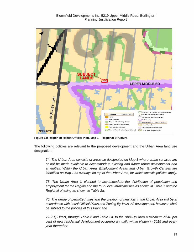
The subject lands are designated as being within the Urban Area as designated on Regional
Structure Map 1 of the Region of Halton Official Plan (Figure 17). It is the objective of the urban
area to:
72(1) To accommodate growth in accordance with the Region’s desire to improve and
maintain regional unity, retain local community identity, create healthy communities,
promote economic prosperity, maintain a high quality, sustainable natural environment,
and preserve certain landscapes permanently;
72(2) To support a form of growth that is compact and supportive of transit usage and non-
motorized modes of travel, reduces the dependence on the automobile, makes efficient
Bloomfield Developments Inc: 5219 Upper Middle Road, Burlington Planning Justification Report
28
use of space and services, promotes live-work relationships and fosters a strong and
competitive economy;
72(3) To provide a range of identifiable, inter-connected and complete communities of
various sizes, types and characters, which afford maximum choices for residence, work
and leisure;
72(4) To ensure that growth takes place commensurately both within and outside the built
boundary;
72(5) To establish a rate and phasing of growth that ensures the logical and orderly
progression of development, supports sustainable and cost-effective growth, encourages
complete communities, and is consistent with the policies of this Plan.
72(7) To plan and invest for a balance of jobs and housing in communities across the
Region to reduce the need for long distance commuting and to increase the modal share
for transit and active transportation;
72(9) To facilitate and promote intensification and increased densities;
The objectives of the Urban Area are supportive of development in which is compact, supportive
of transit and facilitates intensification and increased densities. The proposed development is a
form of infill intensification in the area which will be developed at an appropriate density as per the
density maximums in the local Official Plan.
Bloomfield Developments Inc: 5219 Upper Middle Road, Burlington Planning Justification Report
29
Figure 13: Region of Halton Official Plan, Map 1 – Regional Structure
The following policies are relevant to the proposed development and the Urban Area land use
designation:
74. The Urban Area consists of areas so designated on Map 1 where urban services are
or will be made available to accommodate existing and future urban development and
amenities. Within the Urban Area, Employment Areas and Urban Growth Centres are
identified on Map 1 as overlays on top of the Urban Area, for which specific policies apply.
75. The Urban Area is planned to accommodate the distribution of population and
employment for the Region and the four Local Municipalities as shown in Table 1 and the
Regional phasing as shown in Table 2a;
76. The range of permitted uses and the creation of new lots in the Urban Area will be in
accordance with Local Official Plans and Zoning By-laws. All development, however, shall
be subject to the policies of this Plan; and
77(2.1) Direct, through Table 2 and Table 2a, to the Built-Up Area a minimum of 40 per
cent of new residential development occurring annually within Halton in 2015 and every
year thereafter.
Bloomfield Developments Inc: 5219 Upper Middle Road, Burlington Planning Justification Report
30
According to Table 2A of the Region of Halton Official Plan, 2,758 units are proposed within the
City of Burlington’s built boundary between 2017- 2021. The proposed development contributes
to Region’s housing target within the Built Boundary. This development contributes to the Region’s
objectives for the Urban Area as it adds residential supply to the area that is compatible and
permitted under Regional and Local policy. The subject property and proposed development will
be accessible to transit and is of a transit supportive density for future and planned transit
improvements.
Housing
Housing in the Region of Halton is discussed in Section 86 of the Official Plan. Intensification of
land use for residential purposes such as infill redevelopment is permitted provided that the
physical character of existing neighbourhoods can be maintained (Section 86.11).
It is also the policy of the Region to:
86(6) Adopt the following housing targets:
a) that at least 50 per cent of new housing units produced annually in Halton be in
the form of townhomes or multi-storey buildings
86(20) Require the Local Municipalities, in developing phasing strategies, to ensure that a
full range and mix of housing types can be provided in each development phase in
accordance with Table 2a.
86(21) Require Local Official Plans to provide an appropriate mix of housing by density,
type and affordability in each geographic area, consistent with current and projected
demands reflecting socio-economic and demographic trends.
The proposed development is considered a form of intensification through infill development which
proposes residential dwellings that are compatible with the surrounding area. It is the policy of the
Region for local Official Plans to provide an appropriate mix of housing by density type and
affordability. The proposed development introduces an appropriate housing forms to the area at
an increased density. As such, the proposed development increases the mix of housing type and
density while providing housing at a more affordable market price than what currently exists.
Transportation
It is the policy of the Region of Halton ‘to ensure development is designed to support active
transportation and public transit’ as well as ‘to promote land use patterns and densities that foster
strong live/ work relationships and can be easily and effectively served by public transit and active
transportation,’ (Section 173).

Bloomfield Developments Inc: 5219 Upper Middle Road, Burlington Planning Justification Report
31
Figure 14: Region of Halton Official Plan, Map 3 – Functional Plan of Major Transportation Facilities
The proposed development is at an moderately increased density than the surrounding area which
is transit supportive and is located along a Major Arterial Road (Upper Middle Road) and an area
identified as a Long-Term Transit Service Network. In addition, Upper Middle Road is also currently
serviced by a multi-use path and bike lane that connects Burlington to the rest of the Region.
Servicing
Section 89 of the Region of Halton Official Plan speaks to servicing. It is the policy of the Halton
Region Official Plan that:
89(3) Require that approvals for all new development within the Urban Area be on the
basis of connection to Halton's municipal water and wastewater systems, unless otherwise
exempt by other policies of this Plan.
The proposed development can be fully serviced on existing municipal water and wastewater
systems as discussed in the submitted Functional Servicing Report prepared by Odan/Detech
Consulting Engineers.

Bloomfield Developments Inc: 5219 Upper Middle Road, Burlington Planning Justification Report
32
Summary:
The proposed development conforms to the policies of the ROP. This development contributes to
intensification of the area while also maintaining compatibility. The proposed development
maximizes the efficiency of the subject property by adding a residential development at an
appropriate density, while utilizing available municipal services. The proposed development
conforms to the policies of the ROP.
7.5 City of Burlington Official Plan (Office Consolidation 2015)
The City of Burlington’s Official Plan (OP) was approved by the Ontario Municipal Board on
October 24, 2008. The City is currently in the process of its 5-year Municipal Comprehensive
Review discussed further in Section 7.6 below. The policies of the City of Burlington Official Plan
1997 (2015 Official Consolidation) are in force and effect for the subject lands.
As the City of Burlington reaches a mature state, a majority of growth within the City will be in the
form of intensification and infill development while maintaining stability and compatibility as the
City grows out to its urban boundary. Key themes within the City of Burlington Official Plan include:
Development of a greater diversity of housing types to meet the changing needs of the
population;
The development of a more self-containing city by encouraging a greater live-work
relationship and supporting designation of lands for a wide variety of employment uses;
The focusing of more intense lands uses into specified mixed use centres and along
certain roads;
A move towards a more balanced transportation system.
7.5.1 Sustainable Design and Compatibility
Section 2.7 addresses sustainable design and compatibility. The objective of the City of
Burlington Official Plan is to ensure that new development is consistent with sustainable
development principles with regard to efficiency, safety, accessibility, affordability and energy
efficiency. The following policies are relevant:
a) At the site planning stage, building layout shall be reviewed for accommodating resource management and waste reduction activities for the use(s) that will be located in the building. b) At the site planning stage, site plans will be reviewed for Sustainable Development considerations such as, but not limited to:
(i) pedestrian movement within the site, to the street and to adjacent neighbourhoods; (ii) access to public transit; (iii) public safety; (iv) public views of the escarpment or lake; (v) energy efficiency; (vi) reflected/waste light; (vii) sensitivity to noise and vibration; (viii) preservation of existing trees and other vegetation;
Bloomfield Developments Inc: 5219 Upper Middle Road, Burlington Planning Justification Report
33
(ix) changes to topography and drainage patterns; (x) development guidelines for healthy communities; and appropriate protection and stewardship measures for greenways and/or watercourses as defined in adopted watershed and subwatershed plans. c) Development will be reviewed to ensure efficiency of land use in the urban community in terms of energy, travel time, intensity and diversity. d) Where appropriate, new development shall be designed to be compatible with and enhance existing natural features, such as the Lake Ontario and Burlington Bay waterfronts, the Niagara Escarpment, woodlots, watercourses and stream valleys. e) The City will encourage development that provides choices in housing, shopping, employment, and transportation. f) Energy conservation shall be encouraged through community and site planning, design, and the use of energy-efficient materials and landscaping. When development applications are reviewed, consideration shall be given to energy conservation measures such as the solar orientation of streets and buildings, increased densities, walkability and decreased automobile dependency, and the use of landscaping and building materials.
The proposed development will be directly connected to Georgina Court/ Rome Crescent which
has access to the Quinte Street and Upper Middle Rd. intersection. Upper Middle Road provides
pedestrian and transit services in the vicinity of the development. The proposed development will
also have access to the nearby train system via an existing gravel pathway. The proposed
development is an appropriate infill extension of the Orchard Community neighbourhood.
A noise report has been prepared which concludes that although road traffic noise impacts on the
units located along the Southern property line are anticipated to exceed MOECC guidelines
values, these impacts, can be addressed by noise mitigation measures including the installation
of acoustic barriers such as a pressure treated fence along the southern property line of the
eastern most semi-detached unit fronting Upper Middle Road.
A tree inventory/arborist report has been prepared which concludes that a total of twenty (20) trees
are recommended to be preserved, nineteen (19) of which are currently located on city owned
lands and one (1) of which is on adjacent private property. Additionally, a total of sixteen (16) trees
were recommended for removal including thirteen (13) privately owned trees located on the subject
site and three (3) city owned trees adjacent to the site. A detailed replacement strategy was
created which recommended the replanting of 55 trees on site to accommodate for the loss.
Further details of the proposed development will be reviewed in the future site planning stage in relation to the above Sustainable Development considerations in terms of public access, energy efficiency and light.
Stormwater Management
Section 2.11 addresses stormwater management policies. The following policies are relevant to
stormwater management and development in the City of Burlington:
a) Storm water management techniques shall be used in the design and construction of
all new developments to control both the quantity and quality of storm water runoff. The

Bloomfield Developments Inc: 5219 Upper Middle Road, Burlington Planning Justification Report
34
degree of control and techniques used will depend on the conditions in the downstream
receiving water bodies. The adverse effects of development on the downstream aquatic
environment and adjacent lands shall be avoided or kept to a minimum.
c) For those development sites draining into Burlington Bay or Lake Ontario, the City may
request an enhanced level of storm water quality control, in order to assist with the de-
listing of Hamilton Harbour as an Area of Concern and to maintain water quality in Lake
Ontario.
f) Functional drainage designs shall be prepared at the draft plan of subdivision or zoning
stage in accordance with the requirements of the City’s Storm Drainage Criteria Manual.
g) As a condition of development approval, the City will normally require the dedication of
the greater of the regulatory floodplain, or the valley through which the watercourse flows
including a conservation setback from top of bank, regulatory floodplain, or meander belt
width. Dedication of these lands shall not be considered part of parkland dedication
requirements of The Planning Act, unless the dedicated lands provide needed public
recreational opportunities as identified by the City. If any such land remains in private
ownership, it will be protected by zoning, agreement or easement to protect the ecologic
and floodplain function of such land.
i) All watershed and sub-watershed studies, functional drainage designs, storm water
management techniques and drainage facilities shall be completed with appropriate
consultation with residents and property owners, Conservation Halton, the Region of
Halton, the Ministry of Natural Resources and where appropriate, the Niagara
Escarpment Commission. These studies will consider: maintenance of natural
watercourses, control of discharges to surface and groundwater, water quality and
quantity targets and the identification and protection of significant hydrogeological
areas. (Section 2.11.3).
The proposed development can be serviced with proposed existing sanitary and water servicing
as discussed in the submitted Functional Servicing and Stormwater Management Report prepared
by Odan/Detech Consulting Engineers. The proposed development will utilize existing and extend
the existing sanitary and water service mains that exist at Georgina Court.
7.5.2 Transportation
Section 3 addresses transportation in the City of Burlington. Schedule J of the City of Burlington
Official Plan designates Upper Middle Road as a Major Arterial (Figure 18). Schedule 1 also plans
for a Secondary Transit route along Upper Middle Road. The following policies are relevant to
transportation, roads, transit and walkability in relation to the proposed development:
d) A transportation study to assess the impact of a proposed development on current travel
patterns and/or future transportation requirements may be required before Official Plan
Bloomfield Developments Inc: 5219 Upper Middle Road, Burlington Planning Justification Report
35
amendments, subdivision approvals, rezoning, site plan approvals or other development
proposals are allowed.
j) Reduced parking ratios and/or standards and/or on-street parking ratios and/or standards
may be permitted subject to evaluation by the City of the appropriateness of such standards,
and implemented through the approval of development applications or other City initiatives.
(Section 3.2.3).
The proposed development proposes to complete Georgina court with a cul-de-sac and provide a
private lane to provide access for the proposed townhouse units to connect to the existing Orchard
Community subdivision. Two residential parking spaces will be provided per unit, one in the
driveway and one in the garage. A total of 5 visitor parking spaces will be provided for the 14
townhouse block at an approximate visitor parking rate of 0.35 spaces per unit. A Traffic Brief and
Parking Study has prepared by NexTrans Consulting supports this rate where the average parking
rate from other municipalities is 0.29 spaces per unit.
Road
Relevant policies related to roads are addressed below:
o) The use of public and private laneways may be permitted subject to an evaluation by the
City and Region of functional, operational, servicing and financial issues. Public water and
wastewater services are generally prohibited by the Region in private laneways, except as
permitted by the Region’s Urban and Rural Servicing Guidelines.
r) The proponent of residential development and other sensitive land uses within 50 m of a
provincial freeway, highway right-of-way, or major arterial, multi-purpose arterial or minor
arterial road, or a greater distance at the discretion of the City or the Region of Halton, will
be required to undertake noise studies by a qualified acoustical consultant in accordance
with Provincial policy to the satisfaction of the City and any other authorized review authority
and shall undertake appropriate measures to mitigate any adverse effects from the noise
identified.
x) Infill or intensification development proposals within the City shall be required to take
place on public roads, unless it can be demonstrated by the proponent that a private road
is equally desirable from the standpoints of functionality, community safety, efficiency,
servicing, neighbourhood connectivity, ease of land assembly for future development,
environmental impacts, adequacy of parking and financial impacts to the City. (Section
3.3.2).
The proposed development is facilitated by the extension of Georgina Court into a cul-de-sac and
a private laneway for local and emergency vehicles to access the townhouse units. The cul-de-
sac is proposed to be a public roadway extension of the current dead end of Georgina court and
will complete the planned network for the Orchard community. In addition, a common element
condominium road intended for access emergency services. The proposed laneway is appropriate
as it only intends to service the townhouse units and cannot be extended as it bounded by a
Bloomfield Developments Inc: 5219 Upper Middle Road, Burlington Planning Justification Report
36
stormwater management pond directly to the west and is terminated by a hammerhead. The
private laneway will appropriately extend the cul-de-sac to facilitate the completion of Orchard
community.
As the proposed development is located adjacent to Upper Middle Road which is a Minor Arterial,
a Noise Impact Assessment was prepared by Rubidium Environmental. The Assessment
concludes that the proposed residential townhouse development is feasible but will require an
acoustic fence along the south property line of the easternmost semi-detached unit and central air
conditioning for all units along the south property line. Warning clauses are also required.
Transit Services
Relevant policies related to transit are addressed below:
d) Development applications shall be reviewed to ensure that, where feasible, proposed
land developments encourage the efficient and effective use of transit services.
(Section 3.4.2).
The proposed development abuts Upper Middle Road which is currently serviced by Burlington
Transit lines. The existing service provides both Primary and Secondary bus service to the subject
lands via Upper Middle Road and Appleby Line and to the greater City of Burlington. Burlington
Transit Routes 11 (Sutton-Alton) and 51 (Burlington Northeast) currently operate along Upper
Middle Road. Passenger pick-up and drop-offs are located at regular intervals on Upper Middle
Road with bus stops at Sutton Drive (approximately 90 metres), as well as directly adjacent to the
subject lands at the Corpus Christi Secondary School (approximately 200 metres). The transit
routes provide further connections and access to the Appleby GO Station and the Highway 407
GO Carpool lot located at Dundas Street and Walkers Line.
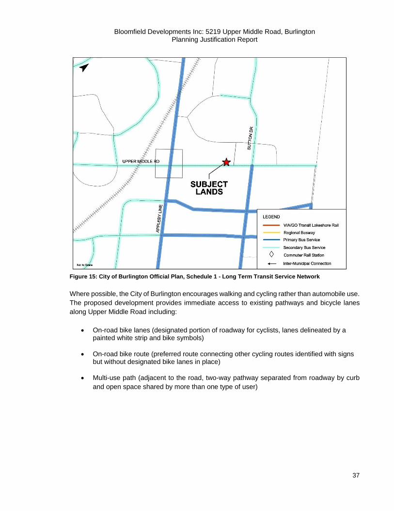
Bloomfield Developments Inc: 5219 Upper Middle Road, Burlington Planning Justification Report
37
Figure 15: City of Burlington Official Plan, Schedule 1 - Long Term Transit Service Network
Where possible, the City of Burlington encourages walking and cycling rather than automobile use.
The proposed development provides immediate access to existing pathways and bicycle lanes
along Upper Middle Road including:
On-road bike lanes (designated portion of roadway for cyclists, lanes delineated by a painted white strip and bike symbols)
On-road bike route (preferred route connecting other cycling routes identified with signs but without designated bike lanes in place)
Multi-use path (adjacent to the road, two-way pathway separated from roadway by curb
and open space shared by more than one type of user)
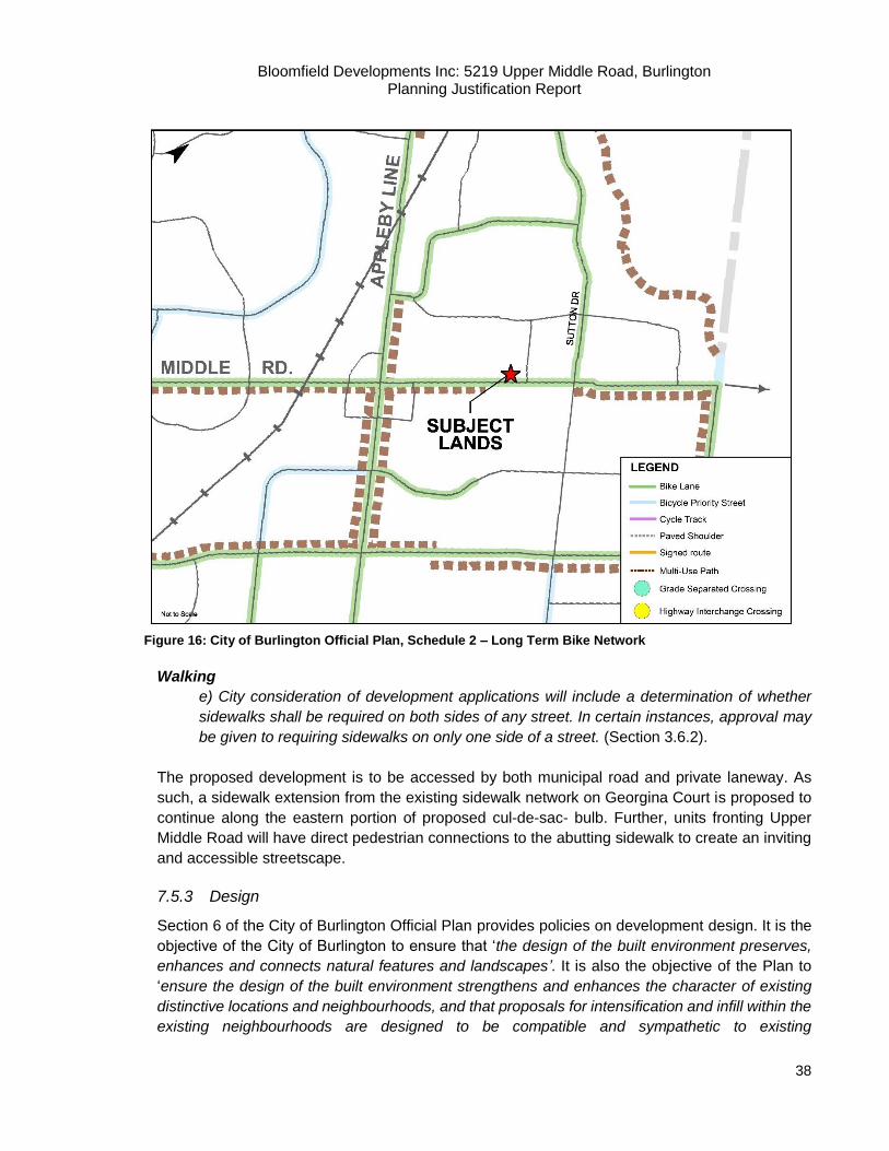
Bloomfield Developments Inc: 5219 Upper Middle Road, Burlington Planning Justification Report
38
Figure 16: City of Burlington Official Plan, Schedule 2 – Long Term Bike Network
Walking
e) City consideration of development applications will include a determination of whether
sidewalks shall be required on both sides of any street. In certain instances, approval may
be given to requiring sidewalks on only one side of a street. (Section 3.6.2).
The proposed development is to be accessed by both municipal road and private laneway. As
such, a sidewalk extension from the existing sidewalk network on Georgina Court is proposed to
continue along the eastern portion of proposed cul-de-sac- bulb. Further, units fronting Upper
Middle Road will have direct pedestrian connections to the abutting sidewalk to create an inviting
and accessible streetscape.
7.5.3 Design
Section 6 of the City of Burlington Official Plan provides policies on development design. It is the
objective of the City of Burlington to ensure that ‘the design of the built environment preserves,
enhances and connects natural features and landscapes’. It is also the objective of the Plan to
‘ensure the design of the built environment strengthens and enhances the character of existing
distinctive locations and neighbourhoods, and that proposals for intensification and infill within the
existing neighbourhoods are designed to be compatible and sympathetic to existing

Bloomfield Developments Inc: 5219 Upper Middle Road, Burlington Planning Justification Report
39
neighbourhood character and; to ensure consistency, compatibility and quality in the built
environment while allowing for a diverse design expression’. (Section 6.2). The following policies
are relevant to existing and new communities and design guideline policies in relation to the
proposed development:
Existing and New Communities
d) City Council may require the preparation of design plans in conjunction with
development proposals. These plans shall, among other things, identify the natural
environment system as the organizing framework for new community forms, define a
physical organization that supports the goals of mixed land use, diversity and pedestrian
orientation, define the public realm and the relationship of built form to the public realm,
address issues of the physical integration of the community with surrounding areas,
encourage the use of public transit and the creation of an environment for pedestrians and
bicyclists, identify opportunities to integrate public art or other cultural elements into the
community, and promote public safety.
e) Preference will be given to community design containing more compact forms of
development that support higher densities, are pedestrian oriented and encourage
increased use of public transit. (Section 6.3).
A concept plan has been submitted which takes into consideration the existing character and
context of the surrounding residential area. The proposed development provides compact
development by replacing the existing residential dwelling (5219 Upper Middle Road) and the
remnant parcels from the adjacent Bronte Woods subdivision with 22 semi-detached and
townhome units, while achieving a density threshold of within 50.3 units per net hectare.
Design Guidelines Policies
Design Guidelines policies are discussed below:
a) The density, form, bulk, height, setbacks, spacing and materials of development are to
be compatible with its surrounding area.
b) The compatibility of adjacent residential and non-residential development shall be
encouraged through site design and buffering measures, including landscape screening
and fencing.
c) The design of all buildings must recognize pedestrian scale, safety and the perception
of safety and access and the preservation of public vistas and views.
e) All developments shall be designed having regard for public transit accessibility in the
Urban Planning Area, convenience and comfort, and access and parking for the physically
challenged, and to ensure that the needs of persons with disabilities and other special
needs groups are addressed.

Bloomfield Developments Inc: 5219 Upper Middle Road, Burlington Planning Justification Report
40
f) City Council shall require that design plans promote public safety and security, with
adequate visibility and lighting and the avoidance of secluded areas.
g) The location, amount, position and design of parking areas shall be reviewed to
minimize their potential to erode the qualities of the public streetscape, and to lessen their
visual impact. City Council shall require landscaped islands and screening in the design of
large parking lots.
l) Residential neighbourhoods shall be designed to allow freedom of public access and the
development of ‘gated’ residential communities, which restrict public access and
circulation through neighbourhoods by means of security gates, walls or similar barriers,
should be avoided.
m) All development shall be designed having regard for Sustainable Development
considerations as set out in Part II, Subsection 2.7.3 of this Plan, (Section 6.5).
It is our opinion that the proposed development is compatible with the surrounding area in terms
of density, form, bulk, height and setbacks. The proposed development at 50.3 units per net
hectare is generally within the density threshold of its Medium Density Residential land use
designation of 50 units per net hectare. Further, the surrounding neighbourhood is generally
indicative of new single detached dwellings with a traditional architectural style and treatments of
two to three storeys. Appropriate setbacks will be provided to maintain privacy, daylight
penetration, and landscaping opportunities with adjacent properties.
7.5.4 Residential Areas
The Official Plan designates the subject lands as Low and Medium Density Residential sub-
designation within the Residential Areas designation as per Schedules A and B. The Residential
Area designation encourages a broader mix of residential dwellings in terms of type, size, cost and
ownership. The Plan permits infill developments and is encouraged on vacant and under-utilized
lands in existing neighbourhoods. The Plan provides that preservation and enhancement of the
quality of life features of neighbourhoods must be considered in the review of any new and/or
intensified development proposals in these areas.
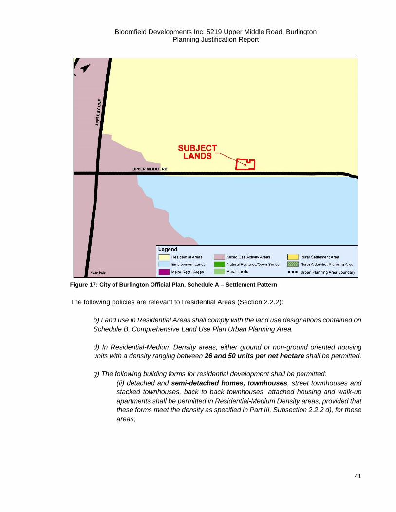
Bloomfield Developments Inc: 5219 Upper Middle Road, Burlington Planning Justification Report
41
Figure 17: City of Burlington Official Plan, Schedule A – Settlement Pattern
The following policies are relevant to Residential Areas (Section 2.2.2):
b) Land use in Residential Areas shall comply with the land use designations contained on
Schedule B, Comprehensive Land Use Plan Urban Planning Area.
d) In Residential-Medium Density areas, either ground or non-ground oriented housing
units with a density ranging between 26 and 50 units per net hectare shall be permitted.
g) The following building forms for residential development shall be permitted:
(ii) detached and semi-detached homes, townhouses, street townhouses and
stacked townhouses, back to back townhouses, attached housing and walk-up
apartments shall be permitted in Residential-Medium Density areas, provided that
these forms meet the density as specified in Part III, Subsection 2.2.2 d), for these
areas;
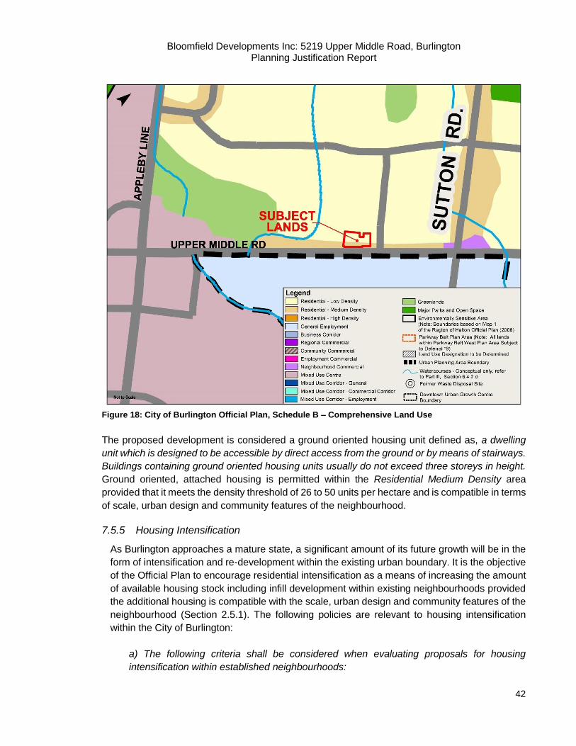
Bloomfield Developments Inc: 5219 Upper Middle Road, Burlington Planning Justification Report
42
Figure 18: City of Burlington Official Plan, Schedule B – Comprehensive Land Use
The proposed development is considered a ground oriented housing unit defined as, a dwelling
unit which is designed to be accessible by direct access from the ground or by means of stairways.
Buildings containing ground oriented housing units usually do not exceed three storeys in height.
Ground oriented, attached housing is permitted within the Residential Medium Density area
provided that it meets the density threshold of 26 to 50 units per hectare and is compatible in terms
of scale, urban design and community features of the neighbourhood.
7.5.5 Housing Intensification
As Burlington approaches a mature state, a significant amount of its future growth will be in the
form of intensification and re-development within the existing urban boundary. It is the objective
of the Official Plan to encourage residential intensification as a means of increasing the amount
of available housing stock including infill development within existing neighbourhoods provided
the additional housing is compatible with the scale, urban design and community features of the
neighbourhood (Section 2.5.1). The following policies are relevant to housing intensification
within the City of Burlington:
a) The following criteria shall be considered when evaluating proposals for housing
intensification within established neighbourhoods:
Bloomfield Developments Inc: 5219 Upper Middle Road, Burlington Planning Justification Report
43
(i) adequate municipal services to accommodate the increased demands are
provided, including such services as water, wastewater and storm sewers, school
accommodation and parkland;
(ii) off-street parking is adequate;
(iii) the capacity of the municipal transportation system can accommodate any
increased traffic flows, and the orientation of ingress and egress and potential
increased traffic volumes to multi-purpose, minor and major arterial roads and
collector streets rather than local residential streets;
(iv) the proposal is in proximity to existing or future transit facilities;
(v) compatibility is achieved with the existing neighbourhood character in terms of
scale, massing, height, siting, setbacks, coverage, parking and amenity area so
that a transition between existing and proposed buildings is provided;
(vi) effects on existing vegetation are minimized, and appropriate compensation is
provided for significant loss of vegetation, if necessary to assist in maintaining
neighbourhood character;
(vii) significant sun-shadowing for extended periods on adjacent properties,
particularly outdoor amenity areas, is at an acceptable level;
(viii) accessibility exists to community services and other neighbourhood
conveniences such as community centres, neighbourhood shopping centres and
health care;
(ix) capability exists to provide adequate buffering and other measures to minimize
any identified impacts;
(x) where intensification potential exists on more than one adjacent property, any
re-development proposals on an individual property shall demonstrate that future
re-development on adjacent properties will not be compromised, and this may
require the submission of a tertiary plan, where appropriate;
(xi) natural and cultural heritage features and areas of natural hazard are
protected;
(xii) where applicable, there is consideration of the policies of Part II, Subsection
2.11.3, g) and m); and
(xiii) proposals for non-ground oriented housing intensification shall be permitted
only at the periphery of existing residential neighbourhoods on properties abutting,
and having direct vehicular access to, major arterial, minor arterial or multi-purpose
arterial roads and only provided that the built form, scale and profile of
development is well integrated with the existing neighbourhood so that a transition
between existing and proposed residential buildings is provided.
b) where a proposal for residential intensification is deemed to have potentially significant
adverse impacts, Council shall require a planning justification report by a Qualified Person,
outlining how the proposed development will be compatible with the existing neighbourhood.
The report shall include, but shall not be limited to the criteria listed in Part III, Subsection
2.5.2 a) above. The report shall determine whether these impacts can be reduced to
acceptable levels and shall recommend any measures required to mitigate or reduce the
adverse impacts to acceptable levels.
Bloomfield Developments Inc: 5219 Upper Middle Road, Burlington Planning Justification Report
44
c) where a proposal for residential intensification is deemed to have potentially significant
adverse impacts, Council may require an expanded public consultation process, including
additional neighbourhood meeting(s).
d) Council may adopt guidelines for maximum building heights to be used in the
consideration of applications for residential intensification, in order to ensure compatibility
of proposed building heights with the height of existing buildings in the neighbourhood,
giving consideration to existing City regulations and guidelines.
The proposed development is considered to be intensification as it redevelops an existing
residential lot with a residential development at a higher density than what currently exists. The
proposal meets the following criteria as listed in Section 2.5.2 a) in the following ways:
(i) The proposed development can be adequately serviced by existing municipal water and
wastewater services;
ii) The proposed development sufficiently accommodates residential and visitor parking
requirements;
iii) The existing transportation network can accommodate the traffic flows of the proposed
development;
iv) Upper Middle Road is planned to have a Secondary Transit Service to which can
connect to existing transit services including the Appleby Go Station;
v) Compatibility is achieved as the proposed development is consistent with the existing
neighbourhood character and context;
vi) Existing trees will be retained where possible;
vii) The height and bulk of the buildings, as well as their separation distances from
neighbouring buildings will mitigate sun-shadow impacts;
viii) Community services and commercial shopping areas are located along Upper Middle
Road, located approximately 1 kilometre from the proposed development;
ix) Appropriate buffering and setbacks have been indicated on the proposed development
concept in consultation with engineering consultants;
x) The proposed development does not inhibit the future development of adjacent
properties and provides access to the proposed Georgian Court and Rome Crescent. A
Tertiary Plan has not been noted by staff as a requirement.
xi) Not applicable.
xii) Not applicable.
xiii) Not applicable. The proposed development is ground oriented.
Further details on the above components are discussed in the supporting reports and studies
submitted in conjunction with this report. The above should be read alongside the entirety of this
Report.
Infill Development
Section 2.5.4 addresses infill development within the City of Burlington. The objectives of Official
Plan include encourage residential intensification through infill development. The following policies
are relevant to the proposed development which is considered a form of infill development:

Bloomfield Developments Inc: 5219 Upper Middle Road, Burlington Planning Justification Report
45
a) Ground-oriented residential infilling within existing neighbourhoods shall be
encouraged.
b) New infill development shall be compatible with the surrounding development in terms
of height, scale, massing, siting, setbacks, coverage and amount of open space; and in
the case of individual applications for consent, the additional policies of Part VI, Subsection
4.4 of this Plan apply.
c) The creation of new housing that is compatible with existing neighbourhoods, shall be
encouraged.
d) Where a proposal for residential infill is deemed to have potentially significant adverse
impacts, Council may require a planning justification report by a Qualified Person, outlining
how the proposed development will be compatible with the existing neighbourhood. This
report shall include, but shall not be limited to, the criteria listed in Part III, Subsection 2.5.2
a), above. The report shall determine whether these impacts can be reduced to acceptable
levels and shall recommend any measures required to mitigate the adverse impacts to
acceptable levels.
e) Where a proposal for residential infill is deemed to have potentially significant adverse
impacts, Council may require an expanded public consultation process, including
additional neighbourhood meeting(s). (Section 2.5.4).
The proposed development is a form of ground oriented infill residential development. Ground
oriented infill development is explicitly stated above as being encouraged, provided that it is
compatible with the surrounding development in terms of height, scale, massing, siting, setbacks,
coverage and open space. The intent of the proposed development is to create buildings of a
similar residential scale.
Summary
The proposed development is a form of residential infill ground-oriented development. Ground
oriented infill residential development is explicitly encouraged within the City of Burlington and is
permitted within the Medium Density Residential designation provided that it is compatible with the
existing neighbourhood character and the general surrounding area. The proposed development
at a density of 50.3 units per hectare and at a height and scale of two storeys can harmoniously
exist with the existing surrounding area. It is our opinion that the proposed development is
compatible with the surrounding development in terms of massing, scale, height and setbacks and
is therefore consistent with the policies in the City of Burlington Official Plan.
7.6 City of Burlington Official Plan Review
In 2012, the City of Burlington initiated its 5-year Municipal Comprehensive Review of its Official
Plan. During the initial stages of this process, it was recognized that while many areas in the
existing Official Plan had been functioning well there were issues which needed to be addressed
as part of this review.
Bloomfield Developments Inc: 5219 Upper Middle Road, Burlington Planning Justification Report
46
A primary focus of the City’s review is to identify the areas and corridors where new growth and
intensification are to be directed. City Council endorsed the Urban Structure and Intensification
Policy Direction Report (July, 2016) which provided the framework for how the City is to Grow
Bold. Appendix D- Transportation Network identifies Upper Middle Road as a Primary Transit
Network corridor, while Appleby Line is highlighted as a Secondary Mobility Hub Connector.
Appendix C- Intensification Framework identifies the subject lands as Established neighbourhood
Area. Page 30 of the Direction Report states:
Established Neighbourhood Areas will be intended to accommodate existing development,
redevelopment and intensification opportunities which are already currently permitted
through a site’s Official Plan land use designation. As such, Established Neighbourhood
Areas will not be considered essential towards achieving population/employment growth
to 2031 and beyond.
In order to maintain the stability of the Established Neighbourhood Areas and limit the
potential for the introduction of significant and unplanned intensification proposals into
these areas, policies will be introduced that prohibit privately initiated Official Plan
amendments for increased density beyond that permitted through the underlying land use
designation. As a result, only the following forms of intensification would be permitted
within the Established Neighbourhood Area:
Redevelopment/ infill in accordance with Official Plan land use permissions;
Consents to Sever;
Plans of Subdivision; and
Accessory Dwelling Units (e.g. second suites, including detached units).
This limitation would not prevent or preclude the potential for redevelopment or
intensification of sites within the Established Neighbourhood Area but rather provide
greater certainty that any proposals will be in keeping with the existing permissions
provided through the site’s Official Plan land use designation and compatible with the
neighbourhood's existing built form, density, and scale.
Summary:
The proposed development is a form of moderate, planned intensification that is permitted within
the current Official and Secondary Plan. The proposed infill redevelopment will be created through
a plan of subdivision that is in-keeping with the existing medium density development patterns that
exist within the Orchard community along Upper Middle Rd. Further, the neighbourhood’s current
building form, density and scale are maintained as the proposed townhouses and semi-detached
units are compatible with the existing built environment.
7.7 Orchard Community Secondary Planning Study Report
The City undertook a study was to prepare a Land Use Plan, Secondary Planning Report and an
Official Plan Amendment for 257-hectares of land located in the northeast section of the Burlington
Urban Area. Prior to the initiation of the planning study, broad designation and general policies
were identified for the community by the Land Use Framework Study for the Alton and Orchard
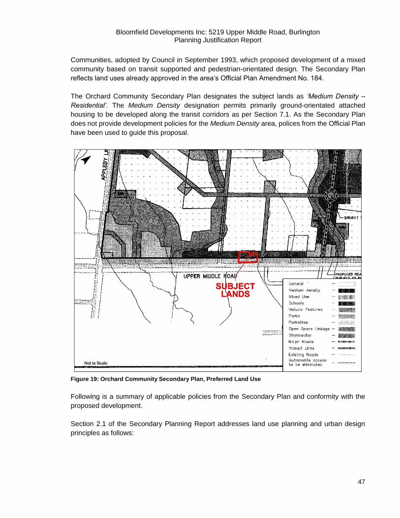
Bloomfield Developments Inc: 5219 Upper Middle Road, Burlington Planning Justification Report
47
Communities, adopted by Council in September 1993, which proposed development of a mixed
community based on transit supported and pedestrian-orientated design. The Secondary Plan
reflects land uses already approved in the area’s Official Plan Amendment No. 184.
The Orchard Community Secondary Plan designates the subject lands as ‘Medium Density –
Residential’. The Medium Density designation permits primarily ground-orientated attached
housing to be developed along the transit corridors as per Section 7.1. As the Secondary Plan
does not provide development policies for the Medium Density area, polices from the Official Plan
have been used to guide this proposal.
Figure 19: Orchard Community Secondary Plan, Preferred Land Use
Following is a summary of applicable policies from the Secondary Plan and conformity with the
proposed development.
Section 2.1 of the Secondary Planning Report addresses land use planning and urban design
principles as follows:

Bloomfield Developments Inc: 5219 Upper Middle Road, Burlington Planning Justification Report
48
b) Residential Areas
Encourage the use of the front of houses to spur social interaction on the street and
safety and security of neighbourhood (e.g. porches, front yard terraces, etc.);
Consider reduced front yard setbacks;
Provide a mix of residential densities, ownership, price and building types throughout
the community to ensure affordability and social mix;
Provide affordable housing in accordance with City of Burlington policy;
d) Streets
Minimize the use of noise walls and explore design options for mitigating noise that
are pedestrian friendly;
Section 2.2 addresses transportation principles:
Establish the patterns of streets and built form that encourages social interaction in
neighbourhoods;
Reduce parking standards for uses along transit corridor(s).
Section 2.4 outlines Municipal Services and Stormwater Management principles:
Encourage efficient use of servicing infrastructure;
Minimize increases in stormwater discharges and maintain or enhance stormwater
quality discharge.
Section 2.5 provides the guiding principles for existing and proposed use:
Incorporate existing uses on site wishing to redevelop into the concept plan for the
Orchard Community.
Section 11 of the Secondary Plan provide Urban Design Guidelines. Conformity with these polices
are discussed in Section 6.6 of this report and a more fulsome analysis is provided in the enclosed
Urban Design Brief.
Summary:
The larger Bronte Woods subdivision was designed using the principles and guidelines of the
Orchard Community Secondary Plan. The proposed development seeks to build on the lotting
pattern and road network that has already been established by. The proposed development
incorporates a mix of housing type and tenure at a density that is supported by the existing and
planned transportation and transit along the adjacent Upper Middle Road corridor. Additionally,
the development proposal seeks to incorporate the existing subdivision within the context of the
plan by extending Georgina Court and completing the municipal cul-de-sac. Further, the proposed
design encourages pedestrian interaction by bringing the units along Upper Middle Rd. frontage
closer to the street line.
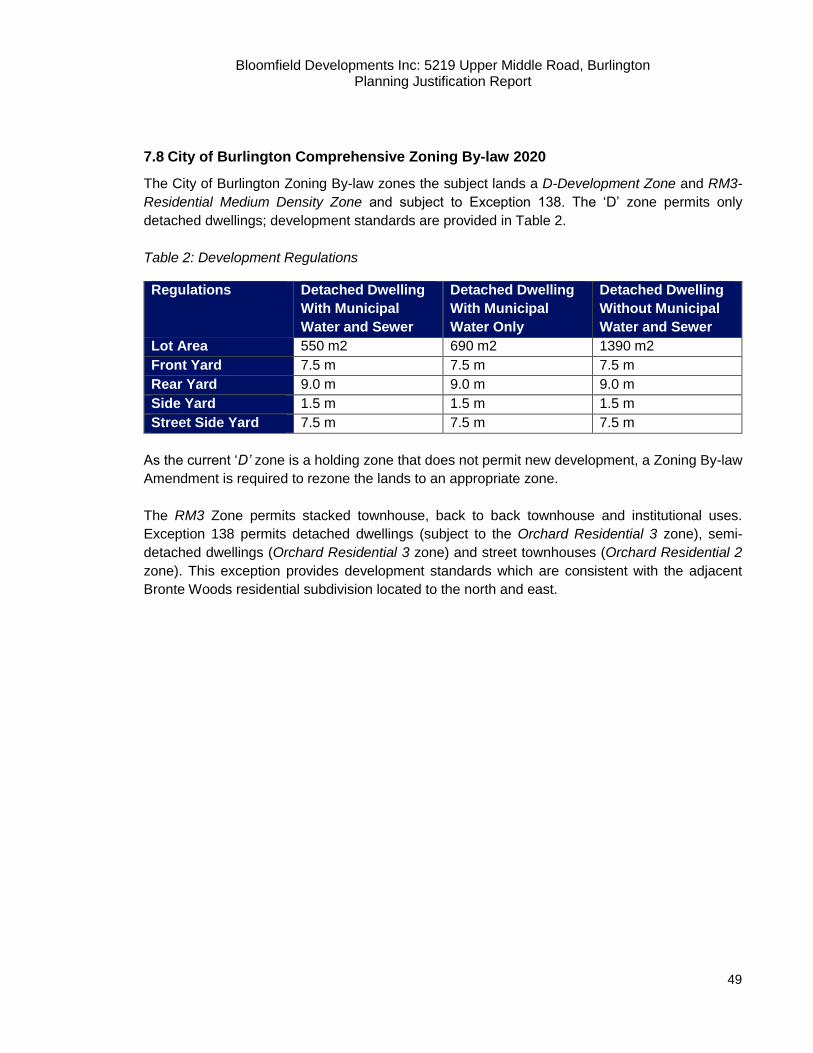
Bloomfield Developments Inc: 5219 Upper Middle Road, Burlington Planning Justification Report
49
7.8 City of Burlington Comprehensive Zoning By-law 2020
The City of Burlington Zoning By-law zones the subject lands a D-Development Zone and RM3-
Residential Medium Density Zone and subject to Exception 138. The ‘D’ zone permits only
detached dwellings; development standards are provided in Table 2.
Table 2: Development Regulations
Regulations Detached Dwelling
With Municipal
Water and Sewer
Detached Dwelling
With Municipal
Water Only
Detached Dwelling
Without Municipal
Water and Sewer
Lot Area 550 m2 690 m2 1390 m2
Front Yard 7.5 m 7.5 m 7.5 m
Rear Yard 9.0 m 9.0 m 9.0 m
Side Yard 1.5 m 1.5 m 1.5 m
Street Side Yard 7.5 m 7.5 m 7.5 m
As the current ‘D’ zone is a holding zone that does not permit new development, a Zoning By-law
Amendment is required to rezone the lands to an appropriate zone.
The RM3 Zone permits stacked townhouse, back to back townhouse and institutional uses.
Exception 138 permits detached dwellings (subject to the Orchard Residential 3 zone), semi-
detached dwellings (Orchard Residential 3 zone) and street townhouses (Orchard Residential 2
zone). This exception provides development standards which are consistent with the adjacent
Bronte Woods residential subdivision located to the north and east.

Bloomfield Developments Inc: 5219 Upper Middle Road, Burlington Planning Justification Report
50
Figure 20: Zoning Map
8. Proposed Zoning By-law Amendment
The proposed zoning amendment application seeks to rezone the existing ‘D’ Development and
RM3-138 zones to Orchard Residential 2 with site specific exceptions (RO2-XXX). It is our opinion
that the proposed RO2 zone is the most appropriate zone for the proposed development as it is
reflective of the provision of the RM3-138 zone which refers back to the RO2 standards. Site-
specific amendments are required to accommodate the proposed development, including front
yard setbacks, building height and parking provisions which are identified below:
Minimum RO2 Semi- Detached RO2-XXX Semi-Detached Compliance
Lot Area 200 m2 119 m2/unit no
Lot Width 6.5 m/unit 5.5 m no
Front Yard 3 m 3 m yes
Side Yard 3 m; 1.2 m 0.6 m; 1.2 m no
Rear yard 6 m 3 m no*
Parking 2 spaces per unit 2 spaces per unit yes
* Reduced setback to accommodate units fronting Upper Middle Rd. only.

Bloomfield Developments Inc: 5219 Upper Middle Road, Burlington Planning Justification Report
51
Minimum RO2 Townhouse RO2-XXX Townhouse Compliance
Lot Area 1200 m2 1050 m2 no
Lot Width 40 m 40.76 m yes
Front Yard 6 m 3 m no*
Side Yard 3 m; 1.2 m 0.6 m; 1.2 m no
Rear yard 6 m 4.6 m yes
Height 2 storey maximum 3 storey maximum no
Parking 2 spaces per unit 2 spaces per unit yes
Visitors Parking 0.50 spaces per unit 0.35 spaces per unit no
* Reduced setback to accommodate units fronting Upper Middle Rd. only.
A complete copy of the proposed draft by-law amendment is provided in Appendix 1.
9. Waste Management Strategy
As noted in Section 4 of this report, the development proposes 22 residential units; 8 semi-
detached which will front onto a new public road and 14 condominium townhouse units that will
front onto a new private lane.
The semi-detached units will have individual driveways. Garbage, recycling and green bins will be
brought to the street for curbside pick-up on designated pick-up days (Thursdays). The proposed
Georgina Court cul-de-sac extension has been designed to accommodate Halton Region waste
collection vehicles for public municipal collection. Vehicles which will enter, pick up waste and exit
without the need for any reverse movements.
Like the semi-detached units, the townhouse dwellings will bring their waste bins to the end of
their driveways for curbside pick-up; no designated collection area is proposed. Collection for the
townhouse units will be managed and coordinated by the future condominium corporation via
private waste collection. Private vehicles will enter from Georgina Court, pick up waste front the
northern townhouse units, turn around via the hammerhead and three-point turn to pick up waste
from the southern units.
10. Public Consultation Strategy
The Smart Growth for Our Communities Act, 2015 (Bill 73) received Royal Assent on December
3, 2015. The Act proposes regulatory amendments to both the Development Charges Act and
Planning Act to:
Help municipalities fund growth;
Give residents a greater, more meaningful say in how their communities grow;
Protect and promote greenspaces;
Make the development charges system more predictable, transparent and accountable;
Make the planning and appeals process more predictable; and,
Give municipalities more independence and make it easier to resolve disputes
Bloomfield Developments Inc: 5219 Upper Middle Road, Burlington Planning Justification Report
52
In addition to the above changes, Bill 73 requires applicants to submit a “public consultation
strategy” as part of a complete application as currently set out under the Planning Act. As the City
of Burlington’s current Official Plan does not include public consultation strategy requirements, the
subject application will adhere to requirements stipulated by the Planning Act. Our proposed
strategy includes:
After receiving Staff confirmation advising that the application is complete, a “Public
Notice” sign advising that a Zoning By-law Amendment has been applied for will be posted
on the subject lands by the applicant. The wording on the sign will be prepared by Staff;
Staff will send out notice of applications and a statutory Public Meeting to consider the
applications to all property owners within 120 metres (400 feet) of the subject lands at least
20 days prior to the meeting date and within 15 days of the applications being determined
to be complete. In addition, notice of the meeting is to be placed by Staff in one local
newspaper and on the City of Burlington website;
Should the local Councillor wish to host an informal residents’ Open House, the application
will participate and coordinate with City staff;
A Statutory Public Meeting will be held to gather formal feedback from area residents and
Council per the requirements of the Planning Act; and
Input from the Public Meeting will be considered and formal responses will be prepared to
address public concerns. Additionally, revisions may be made to the plans, as appropriate,
for re-submission.
We trust that the forgoing Public Consultation Strategy is satisfactory and in compliance with
provincial legislation and implements Official Plan policy. Weston Consulting remains committed
to facilitating public engagement and will assist in facilitating the public engagement process.
11. Planning Analysis and Justification
Based on the information above pertaining to the proposed development and Zoning By-law
Amendment application, the proposed development is consistent with the applicable policy regime.
It applies sound planning principles, implements the PPS, Growth Plan, and Region of Halton
Official Plan, and represents an opportunity for compatible infill redevelopment within an existing
urban area in the City of Burlington.
The proposed development completes the existing community.
The proposed development will complete the Bronte Woods Phase 1 subdivision. The subdivision
agreement for this area includes Schedule 5 which has the following conditions:
Bloomfield Developments Inc: 5219 Upper Middle Road, Burlington Planning Justification Report
53
Condition 5: Lots 6, 7, 8 and 9 and Blocks 262 and 263 are deemed unusable for building
until such time as Georgina Court is extended in the lands to the south; and
Condition 7: Lots 9 and Block 263 are deemed unusable for building until such time as
they have been assembled with adjacent lands at 5219 Upper Middle Rd.
The applicant has gone to great effort to acquire Lots 8 and 9 and Blocks 262 and 263 to satisfy
the requirements of the registered subdivision agreement. The proposed development
incorporated these remnant part blocks and lots into an efficient plan that is consistent with the
immediate community. Further, the existing hammerhead terminating Georgina Court over Lots 8
and 9 will removed to allow for residential development. It will be replaced with a cul-de-sac that
is the preferred means to dead-end a municipal road and accommodate municipal waste and
regional emergency services.
The preliminary design for the completion of Georgina Court included an ‘L’ shaped road westward
which would have terminated with a cul-de-sac. This extension would have provided access to 8
new single detached lots. This form of development, which does exists along Quinte Street, is not
consistent with the planned Medium Density land use pattern anticipated by the Official Plan and
Secondary Plan. It is our opinion that that proposed road extension and lotting pattern meets the
objectives of the Official and Secondary Plans.
The proposed development is compatible with the surrounding land uses.
The proposed development is compatible with the surrounding land uses and does not cause any
adverse impacts to the adjacent residential subdivision. This proposal is consistent with the
surrounding land uses and provides a form of ground orienting housing that meets the objectives
of the Official Plan. The Official Plan defines the term ‘ground oriented housing unit’ in Section VIII
as follows:
“A dwelling unit which is designed to be accessible by direct access from the ground or by means of stairways. Buildings containing ground oriented housing units usually do not exceed three storeys in height.”
The proposed semi-detached and townhouse dwellings are consistent with this definition as they
are both accessible from the ground level and will not exceed three storeys in height.
The Official Plan allows for ground oriented housing that meets the density threshold of 26 to 50
units per hectare and is compatible in terms of scale, urban design and community features of the
neighbourhood.
The existing neighbourhood contains a variety of newer, two-storey, detached, semi-detached and
townhome dwelling types which vary in architectural style and treatments (see Sutton Dr., English
Crescent, 5151 Upper Middle Rd). The design concept of the proposed development will not
conflict with the overall nature and character of the neighbourhood. The proposed development is
in keeping with the existing built form for the area and completes the Orchard community
subdivision.
Bloomfield Developments Inc: 5219 Upper Middle Road, Burlington Planning Justification Report
54
For the reasons stated above, we are of the opinion that the proposed development is compatible
with the adjacent neighbourhood and compliments the surrounding land uses. Further, the
dwelling units fronting Upper Middle Rd. will have direct pedestrian access to the street via
walkways as the units have been brought forward (3m setback) to create an active streetscape.
The proposed development represents an opportunity for compact intensification within
the City of Burlington.
The proposed development is located on an underutilized site with frontage onto a Regional Minor
Arterial Road (Upper Middle Road). The proposed development is a prime location for
redevelopment in that it supports the objectives for intensification directed by the current
Provincial, Regional and local policy regime. The development allows for an efficient use of land
through compact infill development, and provides for a greater range and mix of housing at a
gentle density increase. The proposal fulfills the PPS’s policy direction of focusing growth and
development in Settlement Areas, and the GGH’s objective of prioritizing growth and intensification
in the City of Burlington’s Built-up Area. Further, this form of residential development will help the
City reach its intensification targets mandated by the GGH, and allows for an increase in the
available ground-orientated housing types geared towards families.
The Official Plan encourages housing intensification and recognizes that due to the municipality’s
fixed urban boundary, the majority of future growth will be in the form of intensification and
redevelopment. It is also important to recognize that this redevelopment proposes a density of
50.3 units per hectare, which is consistent with the Official Plan’s density policies in residential
Medium Density areas. As such, the proposed development allows for a redevelopment form at
the upper limit of the permitted density targets while maintaining the intent Medium Density
designation.
The proposed development can be serviced by the existing and planned transit system.
The proposed development is located on a Regional Minor Arterial Road, Upper Middle Road, and
is bound by two Regional Major Arterial roads to the west (Appleby Line) and north (Dundas
Street). In addition, both Appleby Line and Upper Middle Road provide further connections to
Queen Elizabeth Way (Highway 403) while Dundas Street provides a connection to Highway 407.
Moreover, the Appleby GO Station, immediately south of the subject property (approximately 4.0
km) serves as the major train terminal for the general area.
The existing Burlington Transit bus lines provide Primary and Secondary bus service to the subject
property via Upper Middle Road and Appleby Line and to the greater area of Burlington. Transit
Routes 11 (Sutton-Alton) and 51 (Burlington Northeast) currently operate along Upper Middle
Road. Passenger pick-up and drop-offs are located at regular intervals (approximately 200 metres)
on Upper Middle Road with bus stops at Sutton Drive, as well as directly adjacent to the subject
lands at the Corpus Christi Secondary School. The routes provide further connections and access
to the Appleby GO Station and the Highway 407 GO Carpool lot located at Dundas Street and

Bloomfield Developments Inc: 5219 Upper Middle Road, Burlington Planning Justification Report
55
Walkers Line. Upper Middle Road is also currently serviced by a multi-use path and bike lane that
connects Burlington to the rest of the Region.
The proposed development utilizes existing infrastructure with sufficient water and waste
water connections in the area.
This proposal provides for an intensified, residential redevelopment in area in which appropriate
infrastructure and public service utilities are available. The Functional Servicing and Stormwater
Management Report submitted by Odan/Detech Consulting Engineers indicates that the proposed
development will utilize existing and new municipal sewage services and municipal water services.
Based on the analysis of existing conditions by Odan/Detech Consulting Engineers sufficient
capacity is available to sustain the proposed development, and includes residual capacity for future
development. The proposed development will not require additional upgrades to the municipal
water or wastewater systems.
The proposed development can address stormwater management principles and can sufficiently
maintain the maximum flow requirements in a 100-year event storm. The proposed stormwater
management plan as designed by Oden/Detech Consulting Engineers, will manage pre and post
construction conditions to meet the City’s requirements.
The proposed development is well serviced by community services and facilities.
An inventory of existing community services and facilities in the area indicates that the proposed
development is supported by a range of community services and facilities, which, in our opinion
will adequately serve the future residents of the proposed development.
Within the area surrounding the subject property, services and facilities such as school, parks,
community centres, libraries and other recreational facilities are available, many within walking
distance from the subject property. As such, the proposed development will have access to a
variety of community services and facilities, while not resulting in any adverse impacts on these
facilities and their ability to properly service the community at large.
12. Conclusion
The proposed development represents an opportunity for infill redevelopment on an underutilized
site where the subject lands are within an established residential neighbourhood within the City of
Burlington. The proposed development provides for density which is appropriate given the planned
context of the area and will be serviced by existing infrastructure. The proposed development is
located along a major arterial road with existing transit. Additionally, the subject lands are located
in the general vicinity of the Queen Elizabeth Expressway, the Highway 407 Expressway and the
Appleby GO Station.
The existing condition of the subject lands represent one of potential and opportunity. These lands,
one of the largest remaining infill development blocks in the Orchard Community, offer the
opportunity to build-out the boundaries of the residential subdivision and construct the unfinished
Bloomfield Developments Inc: 5219 Upper Middle Road, Burlington Planning Justification Report
56
and approved cul-de-sac at Georgina Court. The development scenario contemplates a custom-
fit proposal unique to the sites conditions while meeting the objectives of the City of Burlington and
Halton Region. The proposed development is consistent with good planning principles, which
ensure that new development contributes to efficient land use, complete communities and priority
development sites within urban areas which are serviced by planned or existing transit
infrastructure. The proposed development will positively contribute to the built environment of the
Orchard community and enhance the overall diversity of the neighbourhood.
It is our opinion that Bloomfield Developments’ proposal represents good planning as it conforms
to the policies of the Provincial Policy Statement, the Growth Plan for the Greater Golden
Horseshoe, and Halton Region Official Plan. Further, it supports the City of Burlington’s
intensification targets while respecting the required maximum density.
There remains a strong demand for family-friendly ground-orientated dwelling forms within the City
of Burlington. The shortage of short-term service land supplemented by budgetary land constraints
has resulted in a shortage of affordable housing options. The proposed development addresses
these issues by providing a mix of more dense and compact housing forms at modest sizes within
an existing urban area that is serviced by existing municipal infrastructure, transportation and
transit, and local amenities and facilities.
We find there to be merits in the proposed development and request that the submitted rezoning
application be approved by Burlington City Council.
Yours Truly,
Weston Consulting
Per:
Martin Quarcoopome, BES, MCIP, RPP
Associate

Bloomfield Developments Inc: 5219 Upper Middle Road, Burlington Planning Justification Report
57