planning justification report - oakville planning/da-151327-pjr.pdf · planning justification...
TRANSCRIPT
Planning Justification Report
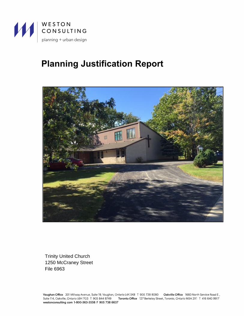
Trinity United Church
1250 McCraney Street
File 6963

i Planning Justification Report – 1250 McCraney Street, Town of Oakville
Table of Contents
1 Introduction ........................................................................................................................... 1
2 Site Description and Context ............................................................................................... 1
2.1 Description of Subject Property ....................................................................................... 1
2.2 Regional and Local Context ............................................................................................. 1
2.3 Surrounding Land Uses ................................................................................................... 2
2.4 Recent Development Activity ........................................................................................... 3
3 Proposed Development ........................................................................................................ 4
3.1 Description of Development Proposal.............................................................................. 4
3.2 Description of Planning Applications ................................................................................ 5
3.3 Supporting Materials ........................................................................................................ 6
3.3.1 Master Stormwater Management and Drainage Servicing Plan and Functional Servicing Report (Trafalgar Engineering) ................................................................ 6
3.3.2 Arborist Report and Tree Protection Plan (Arborfront Consulting) .......................... 6
3.3.3 Landscape Plan (Arborfront Consulting) .................................................................. 7
3.3.4 Phase 1 Environmental Site Assessment (Bruce Brown Associates) ..................... 7
4 Policy Context ....................................................................................................................... 7
4.1 Provincial Policy Statement (PPS) (2014) ....................................................................... 7
4.2 Growth Plan for the Greater Golden Horseshoe (2006) – June 2013 Office Consolidation ................................................................................................................. 10
4.3 Region of Halton Official Plan 2009 (September 28, 2015 Consolidation) ................... 11
4.4 Oakville Official Plan 2009 (February 23, 2015 Consolidation) ..................................... 14
4.5 Town of Oakville Zoning By-laws 1984-63 and 2014-014 ............................................. 19
4.5.1 Town of Oakville Zoning By-law 1984-63 ............................................................... 19
4.5.2 Town of Oakville Zoning By-law 2014-014 ............................................................. 20
5 Proposed Development Applications ............................................................................... 21
5.1 Proposed Zoning By-law Amendment ........................................................................... 21
5.1.1 Town of Oakville Zoning By-law 1984-63 ............................................................... 21
5.1.2 Town of Oakville Zoning By-law 2014-014 ............................................................. 22
5.2 Proposed Draft Plan of Subdivision ............................................................................... 22
6 Planning Analysis ............................................................................................................... 23
6.1 Draft Zoning By-law Amendment ................................................................................... 23
6.2 Draft Plan of Subdivision ................................................................................................ 23
6.3 Policy Context ................................................................................................................ 25
6.4 Compatibility ................................................................................................................... 25
6.5 Intensification ................................................................................................................. 25

ii Planning Justification Report – 1250 McCraney Street, Town of Oakville
7 Conclusion ........................................................................................................................... 26
List of Tables and Figures
Figure 1- Context Map ..................................................................................................................... 2 Figure 2- Facing north along McCraney Street ............................................................................... 2 Figure 3- Facing Southwest along Sewell Drive ............................................................................. 3 Figure 4- Facing Southeast along Sewell Drive .............................................................................. 3 Figure 5- Minto Multi Residential Income- 1229 Marlborough Court .............................................. 3 Figure 6- Proposed Concept Plan ................................................................................................... 5 Figure 7- Region of Halton Official Plan Map 1 ............................................................................. 12 Figure 8- Town of Oakville Official Plan Schedule 1 Central Land Use Plan ............................... 14 Figure 9- Town of Oakville Zoning By-law 1984-63 Map .............................................................. 19 Figure 10- Town of Oakville Zoning By-law 2014-014 Map .......................................................... 20

1
1 Introduction
Weston Consulting has been retained by the owner of the property located at 1250 McCraney
Street in the Town of Oakville (the “Subject Property”) to assist in obtaining the development
approvals required for the partial redevelopment of the lands. The Owners are proposing to
redevelop the 1.2 hectares (12,142 m2) site with three (3) new single detached residential lots,
while retaining 9,790 m2
of the land for the existing church, which will remain as is. Zoning By-
law Amendment (ZBA), Draft Plan of Subdivision and Site Plan applications are required to
facilitate the proposed development. The application and supporting materials are submitted in
accordance with the signed pre-consultation form dated November 19, 2014 and together form a
complete application as described under Section 34(10) and 51(17) of the Planning Act, R.S.O.
1990, c. P.13. At this time only Zoning By-law Amendment and Draft Plan of Subdivision
applications have been submitted, and a Site Plan application for the church lands will be
submitted at a later date.
The purpose of this report is to provide a planning analysis and justification for the proposed
development in the context of the Provincial Policy Statement (2014), the Growth Plan for the
Greater Golden Horseshoe (2006), the Region of Halton Official Plan (2009), the Town of
Oakville Official Plan (2006), and the Town of Oakville’s Zoning By-laws 1984-63 and 2014-014.
It is our intent to demonstrate that the proposed development represents good planning.
2 Site Description and Context
2.1 Description of Subject Property
The subject property is currently comprised of one corner lot located at the corner of Sewell
Drive and McCraney Street East. The subject property has a frontage of 133 metres along
McCraney and 166 metres along Sewell Drive. The existing church consisting of 776 m2 will
remain on the subject property along with the 113 m2
accessory office. The property will be
subdivided at the south corner to facilitate the development of three (3) single detached
residential dwellings. There is some existing vegetation on the site on the south corner that will
be removed to facilitate the development.
2.2 Regional and Local Context
The subject property is located in the Region of Halton in the central area of the Town of
Oakville. The subject property is located within close proximity to a Regional Road (Trafalgar
Road) and a Provincial highway (Queen Elizabeth Way) making the site well-connected to the
surrounding area. Trafalgar Road is located east of the subject property and the Queen
Elizabeth Way is located to the south (Figure 1).

2
2.3 Surrounding Land Uses
Land uses in the near vicinity are as follows:
North: To the north of the subject property
are single detached dwellings across
from McCraney Street. Further north
is McCraney Valley Park.
South: To the south of the subject property
are single detached dwellings with
frontages on Sewell Drive. Additional
single detached dwellings are
located further south leading up to
Oakville Place mall, located just
north of the QEW.
Figure 1- Context Map
Figure 2- Facing north along McCraney Street

3
East: Single detached dwellings are located to east of the subject property. St. Michaels
Roman Catholic Church and associated Elementary school is located further to the
southeast of the lands.
West: To the west of the
subject property are single detached
dwellings located on a cul-de-sax (Petit Court). Adjacent to the cul-de-sac is parkland
known as Reservoir Park. Further south are 6, 7 and 10 storey apartment buildings.
2.4 Recent Development Activity
There are a number of proposed and approved
developments in the area of the subject property
which includes a new school, apartment dwellings
and townhouse dwellings. The following are proposed
and approved developments in the area.
1. Minto Multi Residential Income – 1229
Marlborough Court
A Site Plan was submitted in 2015 to permit a
proposed 16 storey apartment building with 140
residential units and a total of 404 parking spaces.
The site plan application is currently in circulation to
be approved by Site Plan Committee.
2. Dunpar Developments -1319284 Ontario Inc. - Figure 5- Minto Multi Residential Income- 1229 Marlborough Court
Figure 4- Facing Southeast along Sewell Drive
Figure 3- Facing Southwest along Sewell Drive
4
2158, 2168, 2180 and 2192 Trafalgar Road
An Official Plan Amendment, Zoning By-law Amendment, Plan of Subdivision and Plan of
Condominium applications were submitted in 2012 to permit the development of 114, four
storey townhouses, fronting onto both public and internal private lanes, with a density of 70
units per hectare. The Zoning By-law Amendment and Condominium application is draft
approved with the Plan of Subdivision appealed.
3. White Oaks Secondary School – North Campus – 1055 and 1065 McCraney Street East
A rezoning application was submitted in 2013 to rezone the lands to permit the now approved
Conseil Scolaire Viamonde Secondary School and associated park facilities. The existing
school zoning of the White Oaks Secondary School is to remain. North of the school is
rezoned Open Space. 1065 McCraney is rezoned from 01 to P/E.
3 Proposed Development
3.1 Description of Development Proposal
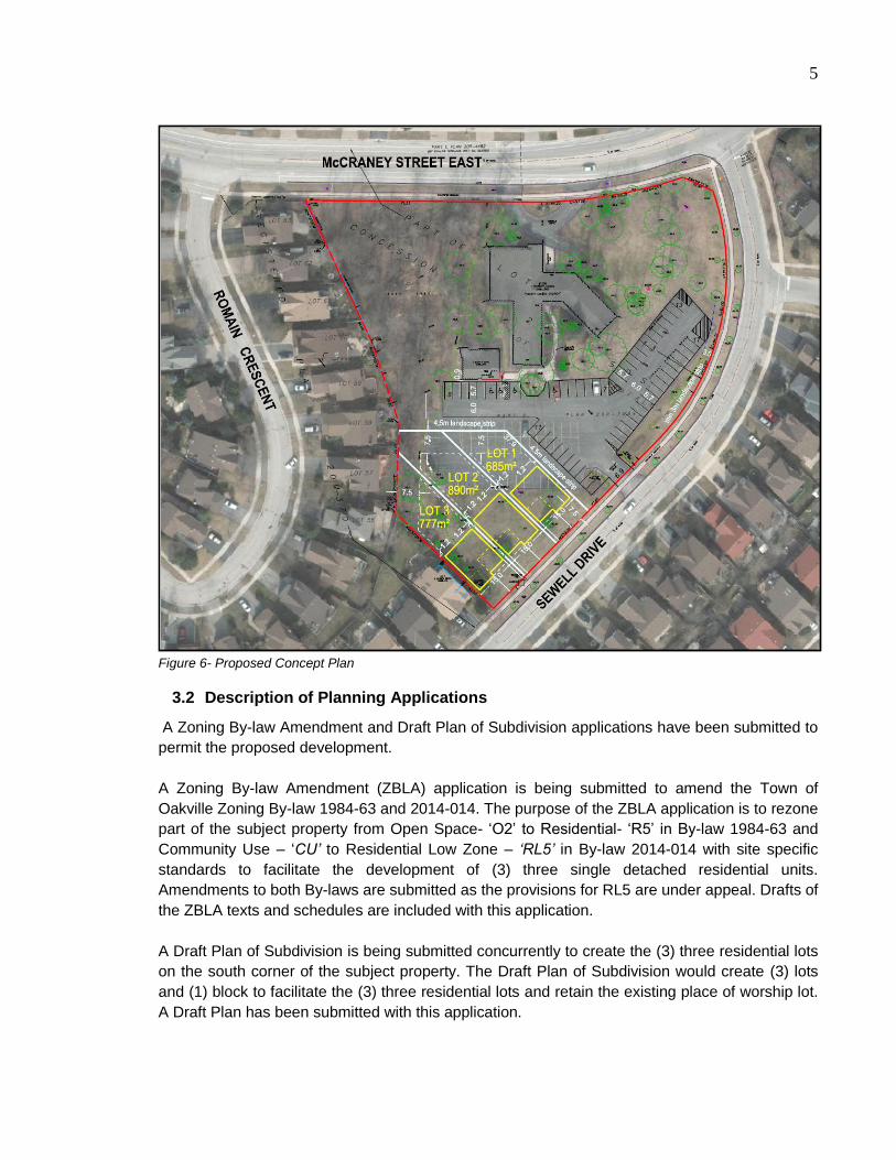
The proposed development consists of a proposed Draft Plan of Subdivision to create (3) three
residential lots on the south corner of the subject property. The existing church will remain on the
retained lot. Improvements to the parking area are proposed through reconfiguration to retain
parking spaces lost through the redevelopment of the lands. A total of 51 spaces are proposed
to be removed from the existing parking lot, and 26 spaces added through the reconfiguration of
the parking lot. A total of 56 spaces are proposed after the reconfiguration of the subject
property.
5
Figure 6- Proposed Concept Plan
3.2 Description of Planning Applications
A Zoning By-law Amendment and Draft Plan of Subdivision applications have been submitted to
permit the proposed development.
A Zoning By-law Amendment (ZBLA) application is being submitted to amend the Town of
Oakville Zoning By-law 1984-63 and 2014-014. The purpose of the ZBLA application is to rezone
part of the subject property from Open Space- ‘O2’ to Residential- ‘R5’ in By-law 1984-63 and
Community Use – ‘CU’ to Residential Low Zone – ‘RL5’ in By-law 2014-014 with site specific
standards to facilitate the development of (3) three single detached residential units.
Amendments to both By-laws are submitted as the provisions for RL5 are under appeal. Drafts of
the ZBLA texts and schedules are included with this application.
A Draft Plan of Subdivision is being submitted concurrently to create the (3) three residential lots
on the south corner of the subject property. The Draft Plan of Subdivision would create (3) lots
and (1) block to facilitate the (3) three residential lots and retain the existing place of worship lot.
A Draft Plan has been submitted with this application.
6
A Site Plan application will be submitted in the future to address modifications to the place of
worship parking area. A total of 56 of parking spaces are proposed to satisfy the minimum
parking requirements under the Town of Oakville Zoning By-law 2014-014 where 1.0 space is
required per 5 persons capacity. The place of worship has a capacity of approximately 250
persons, as such 50 parking spaces are required, whereas 56 are provided. Appropriate
landscaping has been included adjacent to the parking area to provide buffers to the proposed
residential lots and Sewell Drive.
3.3 Supporting Materials
The following supporting materials are submitted with this application under separate cover in
accordance with the Pre-consultation Form dated November 19, 2014:
Table 1- Submitted Reports and Drawings
Drawing/Report: Prepared By:
Aerial Photographs Weston Consulting
Survey Mackay Mackay & Peters
Concept Plan Weston Consulting
Draft Plan of Subdivision Mackay Mackay & Peters
Building Elevations and Renderings Weston Consulting
Master Stormwater Management and
Drainage Servicing Plan and Functional
Servicing Report
Trafalgar Engineering
Draft Zoning By-law Amendment Weston Consulting
Tree Vegetation Study/Arborist Report Arborfront Consulting
Phase 1 Environmental Site Assessment Bruce Brown Associates
Please refer to the supporting materials for further technical information on the proposed
development.
3.3.1 Master Stormwater Management and Drainage Servicing Plan and Functional
Servicing Report (Trafalgar Engineering)
A Master Stormwater Management and Functional Servicing Report was prepared by Trafalgar
Engineering which concludes that Sewell Drive has sufficient capacity for the proposed
development. The existing connection to the current church building will require relocation of the
sanitary lateral. Water service is also sufficient for the proposed development provided along
Sewell Drive. The existing water service will also require relocation. The post stormwater
development flows from the new development will be less than the existing flows.
3.3.2 Arborist Report and Tree Protection Plan (Arborfront Consulting)
An Arborist Report and Tree Protection Plan was prepared by Arborfront Consulting. A total of 60
individual trees and one tree grouping was inventoried for the report. Two (2) Town of Oakville
boulevard trees and 14 private trees are recommended for removal due to conflicts with the
proposed development and associated grading and servicing. Forty-four individual trees are

7
recommended for preservation. A number of protection measures are recommended for the
retained trees.
3.3.3 Landscape Plan (Arborfront Consulting)
A Landscape Plan has been prepared by Arborfront Consulting proposing a number of
deciduous trees, shrubs and perennials along the 4.5 metre buffer strip between the church
parking lot and proposed residential lots. This is to provide a buffer between the institutional and
residential uses. Existing shrubs along the frontage of Sewell Drive are to be maintained and
preserved to maintain the 3.0 metre landscape buffer to Sewell Drive. Additional landscaping
may be considered at the islands in the parking area.
3.3.4 Phase 1 Environmental Site Assessment (Bruce Brown Associates)
A Phase 1 Environmental Site Assessment (ESA) was conducted by Bruce Brown Associates.
The investigation found no potential sources of environmental impacts which would affect the
real value of the property; require further investigation; require mitigation to meet or assure
current environmental standards. There was no cause found to recommend further investigation
to a Phase 2 Environment Site Assessment. A Record of Site Condition will proceed based on
this Phase 1 ESA.
4 Policy Context
The following section provides a review of the proposed development within the framework of
applicable provincial and local statutory policy documents. The documents included in this
review are the Provincial Policy Statement 2014 (PPS), the Growth Plan for the Greater Golden
Horseshoe, 2006, June 2013 Office Consolidation (“Growth Plan”), the Halton Region Official
Plan 2009 (ROP), Town of Oakville Official Plan 2006, and Town of Oakville Zoning By-law
1984-63 and 2014-014, as amended.
4.1 Provincial Policy Statement (PPS) (2014)
The Provincial Policy Statement (PPS) provides direction on matters of provincial interest related
to land use planning and development. The goal of the PPS is to allow for appropriate
development while ensuring that resources of provincial interest, public health and safety, and
the quality of the natural and built environment are protected. All development in Ontario shall be
consistent with the PPS.
Section 1.0 outlines policies for “Building Strong Healthy Communities”. The policies of Section
1.0 are applicable to the proposed development and in general, promote efficient land use and
development which in turn supports sustainability.
The following policies of Section 1.1 “Managing and Directing Land Use to Achieve Efficient and
Resilient Development and Land Use Patterns” are applicable to the proposed development:
“1.1.1 Healthy, livable and safe communities are sustained by:
8
a) promoting efficient development and land use patterns which sustain the
financial well-being of the Province and municipalities over the long term;
b) accommodating an appropriate range and mix of residential (including
second units, affordable housing and housing for older persons),
employment (including industrial and commercial), institutional (including
places of worship, cemeteries and long-term care homes), recreation,
park and open space, and other uses to meet long-term needs;
c) avoiding development and land use patterns which may cause
environmental or public health and safety concerns;
d) avoiding development and land use patterns that would prevent the
efficient expansion of settlement areas in those area which are adjacent
or close to settlement areas;
e) promoting cost-effective development patterns and standards to minimize
land consumption and servicing costs;
f) improving accessibility for persons with disabilities and older persons by
identifying, preventing and removing land use barriers which restrict their
full participation in society;
g) ensuring that necessary infrastructure, electricity generation facilities and
transmission and distribution systems, and public service facilities are or
will be available to meet current and projected needs; and
h) promoting development and land use patterns that conserve biodiversity
and consider the impacts of a changing climate.”
The proposal supports a more efficient land use by adding additional residential dwellings to
underdeveloped lands. The existing place of worship carries a surplus of land for what is
required for its function. As such, there is opportunity to use the surplus of lands through a
division of land to facilitate additional residential dwellings which are compatible with the existing
form in the area.
The following polices of Section 1.1.3 “Settlement Areas” are applicable to the proposed
development:
“1.1.3.1 Settlement areas shall be the focus of growth and development, and
their vitality and regeneration shall be promoted.”
“1.1.3.2 Land use patterns within settlement areas shall be based on:
a) densities and a mix of land uses which:
1. efficiently use land and resources;
2. are appropriate for, and efficiently use, the infrastructure and
public service facilities which are planned or available, and avoid
the need for their unjustified and/or uneconomical expansion;
3. minimize negative impacts to air quality and climate change, and
promote energy efficiency;
4. support active transportation;

9
5. are transit-supportive, where transit is planned, exists or may be
developed; and
6. are freight-supportive; and
b) a range of uses and opportunities for intensification and redevelopment
in accordance with the criteria in policy 1.1.3.3, where this can be
accommodated.”
1.1.3.3 Planning authorities shall identify appropriate locations and promote opportunities
for intensification and redevelopment where this can be accommodated taking into
account existing building stock or areas, including brownfield sites, and the availability of
suitable existing or planned infrastructure and public service facilities required to
accommodate projected needs.
The subject property is located well within the settlement area in the Town of Oakville and the
proposed development is located within walking distance of Trafalgar Road which is a Major
Arterial. Trafalgar Road has an existing Busway Corridor and Multi Use Trail. The proposed
development is in a location that can make use of the existing infrastructure and places
intensification in a manner which is transit supportive.
Housing is addressed in Section 1.4 of the PPS. The following policies are relevant:
1.4.1 To provide for an appropriate range and mix of housing types and densities
required to meet projected requirements of current and future residents of the regional
market area, planning authorities shall:
a) maintain at all times the ability to accommodate residential growth for a
minimum of 10 years through residential intensification and redevelopment and, if
necessary, lands which are designated and available for residential development;
and
b) maintain at all times where new development is to occur, land with servicing
capacity sufficient to provide at least a three-year supply of residential units
available through lands suitably zoned to facilitate residential intensification and
redevelopment, and land in draft approved and registered plans.
The proposed development adds three new residential units to an existing built up residential
area. It is considered a form of infill development which helps to maintain the residential supply
in the Town of Oakville.
The following policies of Section 1.6.7 “Transportation Systems” are applicable to the proposed
development:
“1.6.7.4 A land use pattern, density and mix of uses should be promoted that
minimize the length and number of vehicle trips and support current and future
use of transit and active transportation.”
10
The subject property is located within close proximity to existing public transportation along
Trafalgar Road and McCraney Street. Trafalgar Road is a Major Arterial roadway with a busway
corridor and multi-use trail. Trafalgar Road connects to the Queen Elizabeth Way to the south
and the Oakville Go Transit station which provides for Regional connectivity.
Summary
The proposed development is consistent with the policies of the PPS 2014. This proposed
development increases the residential supply of housing in the area by proposing three (3) new
residential infill units. The location of the proposed development is also transit-supportive.
Furthermore, the proposed development makes efficient use of land and infrastructure by
redeveloping existing under-utilized land. Therefore, the proposed development is consistent
with the policies of the PPS 2014.
4.2 Growth Plan for the Greater Golden Horseshoe (2006) – June 2013 Office
Consolidation
The Growth Plan is a Provincial Plan prepared under the Places to Grow Act, 2005. It is a plan to
manage growth within the Greater Golden Horseshoe Region to a time horizon of 2041. The
Growth Plan outlines policies to manage growth in a way that creates strong and prosperous
communities. All development within this Region must conform to the Growth Plan. The intent of
the Growth Plan is to guide growth for the development of compact and vibrant communities and
to plan and manage growth in order to support a strong and competitive economy.
Section 2.2.2 of the Growth Plan addresses managing growth and states:
1. Population and employment growth will be accommodated by –
a) directing a significant portion of new growth to the built-up areas of the
community through intensification;
b) focusing intensification in intensification areas;
d) reducing dependence on the automobile through the development of mixed
use, transit-supportive, pedestrian-friendly urban environments;
g) planning and investing for a balance of jobs and housing in communities
across the GGH to reduce the need for long distance commuting and to increase
the modal share for transit, walking and cycling;
h) encouraging cities and towns to develop as complete communities with a
diverse mix of land uses, a range and mix of employment and housing types,
high quality public open space and easy access to local stores and services;
i) directing development to settlement areas, except where necessary for
development related to the management or use of resources, resource-based
recreational activities, and rural land uses that cannot be located in settlement
areas;
j) directing major growth to settlement areas that offer municipal water and
wastewater systems and limiting growth in settlement areas that are serviced by
other forms of water and wastewater services.
Schedule 3 of the Growth Plan outlines the distribution of population and employment for the
11
Greater Golden Horseshoe to 2041. The Region of Halton is expected to grow to a population of
1,000,000 by the year 2041.
Sections 2.2.3.6 and 2.2.3.7 of the Growth Plan discuss the importance of promoting
intensification in the area municipality. Section 2.2.3.6 states that “All municipalities will develop
and implement through their official plans and other supporting documents, a strategy and
policies to phase in and achieve intensification and the intensification target.
The proposed development is located within the built-up area in the Town of Oakville and is
compatible with the existing surrounding low density development. This proposed development
is considered to be infill development as it is utilizing underdeveloped lands within an existing
built up community. The Town of Oakville is reaching its Built Boundary and will require infill
development in areas such as this that have potential for more intensification. As such, the
proposed redevelopment of the lands to the proposed three (3) residential units will help the City
reach its minimum intensification targets mandated by the Province’s Growth Plan.
Summary
The proposed development conforms to the policies of the Growth Plan. The proposed
development makes efficient use of land by redeveloping an underutilized site with a compatible
low density development. The proposed development conforms to the Growth Plan as it
promotes intensification while making use of existing infrastructure and transit.
4.3 Region of Halton Official Plan 2009 (September 28, 2015 Consolidation)
The Regional Official Plan (ROP) contains policies to guide land use planning in the Region of
Halton. The 2009 ROP (Regional Official Plan Amendment No. 38) was adopted by Council on
December 16, 2009 and was modified by the Province in 2011. The plan was subsequently
appealed at the Ontario Municipal Board. The Plan has been partially approved by the Ontario
Municipal Board and, except for the policies that remain under appeal; the policies of the 2009
ROP are applicable. There are no site-specific appeals to the 2009 ROP that apply to the subject
property.
Map 1 of the ROP designates the subject property “Urban Area” within the Region’s Built
Boundary.

12
Urban Area
The ROP outlines a number of objectives for the Urban Area. The following objectives are of
particular relevance to the proposed development:
72(1) To accommodate growth in accordance with the Region’s desire to
improve and maintain regional unity, retain local community identity, create
healthy communities, promote economic prosperity, maintain a high quality,
sustainable natural environment, and preserve certain landscapes permanently;
72(2) To support a form of growth that is compact and supportive of transit usage
and non-motorized modes of travel, reduces the dependence on the automobile,
makes efficient use of space and services, promotes live-work relationships and
fosters a strong and competitive economy;
72(3) To provide a range of identifiable, inter-connected and complete
communities of various sizes, types and characters, which afford maximum
choices for residence, work and leisure;
72(4) To ensure that growth takes place commensurately both within and outside
the built boundary;
72(7) To plan and invest for a balance of jobs and housing in communities across
the Region to reduce the need for long distance commuting and to increase the
modal share for transit and active transportation;
72(9) To facilitate and promote intensification and increased densities;
Figure 7- Region of Halton Official Plan Map 1
13
75. The Urban Area is planned to accommodate the distribution of population
and employment for the Region and the four Local Municipalities as shown in
Table 1 and the Regional phasing as shown in Table 2a;
76. The range of permitted uses and the creation of new lots in the Urban Area
will be in accordance with Local Official Plans and Zoning By-laws. All
development, however, shall be subject to the policies of this Plan; and
77(2.1) Direct, through Table 2 and Table 2a, to the Built-Up Area a minimum
of 40 per cent of new residential development occurring annually within
Halton in 2015 and every year thereafter.
According to Table 2A of the Region of Halton Official Plan, 5,068 units are proposed within the
Town of Oakville’s built boundary between 2017- 2021. The proposed development contributes
to the Region’s target within the Built Boundary. The proposed development contributes to the
Region’s objectives for the “Urban Area” as it adds residential supply to the area that is
compatible and permitted under Regional and Local policy. The subject property and proposed
development is accessible to transit and is therefore transit supportive.
Housing
Housing in the Region of Halton is discussed in Section 86 of the Official Plan. Intensification of
land use for residential purposes such as infill redevelopment is permitted provided that the
physical character of existing neighbourhoods can be maintained (Section 86.11). The proposed
development is considered a form of intensification via infill development which proposes
residential dwellings that are compatible with the surrounding area.
Servicing
Section 89 of the Region of Halton Official Plan speaks to servicing. It is the policy of the Halton
Region Official Plan that:
89(3) Require that approvals for all new development within the Urban Area be on the
basis of connection to Halton's municipal water and wastewater systems, unless
otherwise exempt by other policies of this Plan.
The proposed development can be fully serviced on existing municipal water and wastewater
systems as discussed in the submitted Functional Servicing Report prepared by Trafalgar
Engineering.
Summary
The proposed development conforms to the policies of the ROP. This proposed development
contributes to intensification of the area while also maintaining compatibility and completing the
residential housing stock along Sewell Drive. The proposed development maximizes the
efficiency of the subject property by adding residential development to underutilized land.
Therefore, the proposed development conforms to the policies of the ROP.
14
4.4 Oakville Official Plan 2009 (February 23, 2015 Consolidation)
The Oakville Official Plan 2006 (Livable Oakville) applies to the lands south of Dundas Street
within the Town of Oakville. The Plan directs intensification and urban development to six growth
areas: Midtown Oakville, Uptown Core, Palermo Village, Kerr Village, Bronte Village and
Downtown Oakville. It also contains policies to maintain and protect the character of stable
residential communities. Livable Oakville was prepared to conform to the Province of Ontario’s
Growth Plan for the Greater Golden Horseshoe, 2006 (“the Growth Plan”), as required by the
Places to Grow Act, 2005. The Plan is in full force and in effect.
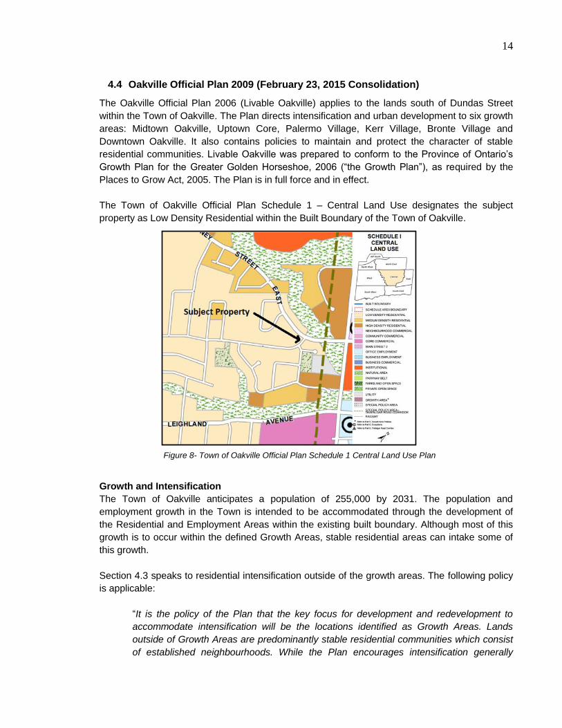
The Town of Oakville Official Plan Schedule 1 – Central Land Use designates the subject
property as Low Density Residential within the Built Boundary of the Town of Oakville.
Growth and Intensification
The Town of Oakville anticipates a population of 255,000 by 2031. The population and
employment growth in the Town is intended to be accommodated through the development of
the Residential and Employment Areas within the existing built boundary. Although most of this
growth is to occur within the defined Growth Areas, stable residential areas can intake some of
this growth.
Section 4.3 speaks to residential intensification outside of the growth areas. The following policy
is applicable:
“It is the policy of the Plan that the key focus for development and redevelopment to
accommodate intensification will be the locations identified as Growth Areas. Lands
outside of Growth Areas are predominantly stable residential communities which consist
of established neighbourhoods. While the Plan encourages intensification generally
Figure 8- Town of Oakville Official Plan Schedule 1 Central Land Use Plan

15
throughout the built up area, it also recognizes that some growth and change may occur
in these areas provided the character of the areas is preserved and the overall urban
structure of the Town is upheld. Intensification outside of the Growth Areas including
additional intensification opportunities such as infill, redevelopment and greyfield and
brownfield sites, will be considered in the context of this Plan.” (Section 4.3)
This policy indicates that intensification is permitted outside Growth Areas such as the subject
property provided that the character of the area is preserved. The proposed development is
compatible with the existing density, land use and built form of the surrounding area and
appropriately intensifies the subject property.
Urban Design
Section 6 speaks to Urban Design in the Town of Oakville. The proposed residential
development although is not subject to site plan control shall be consistent with the built form
policies of the Town of Oakville Official Plan. The following policies are relevant:
6.9.1 Buildings should be designed to create a sense of identity through massing, form,
placement, orientation, scale, architectural features, landscaping and signage;
6.9.2 Building design and placement should be compatible with the existing and planned
surrounding context and undertaken in a creative and innovative manner;
6.9.3 To achieve compatibility between different land uses, development shall be
designed to accommodate an appropriate transition through landscape buffering, spatial
separation, and compatible built form;
6.9.5 Buildings should present active and visually permeable façades to all adjacent
streets, urban squares, and amenity spaces through the use of windows, entry features,
and human-scaled elements;
6.9.6 Main principal entrances to buildings should be oriented to the public sidewalk, on-
street parking and transit facilities for direct and convenient access for pedestrians;
6.9.7 Development should be designed with variation in building mass, façade treatment
and articulation to avoid sameness;
6.9.9 New development shall ensure that proposed building heights and form are
compatible with adjacent existing development by employing an appropriate transition of
height and form from new to existing development, which may include setbacks, façade
step backs or terracing in order to reduce adverse impacts on adjacent properties and/or
the public realm;
6.9.10 Continuous streetwalls of identical building height are discouraged. Variety in
rooflines should be created through subtle variations in roof form and height;

16
6.9.12 New development should be fully accessible by incorporating universal design
principles to ensure barrier-free pedestrian circulation; and
6.9.15 Buildings should be sited to maximize solar energy, ensure adequate sunlight and
skyviews, minimize wind conditions on pedestrian spaces and adjacent properties, and
avoid excessive shadows.
The proposed Zoning By-law Amendment, applicable to the proposed residential development
ensures compatibility with the surrounding residential area by rezoning the lands to a zone which
is consistent with the surrounding area. Elevations have been submitted which depict that the
lands can be developed at a massing, form, orientation and scale which is consistent with
surrounding residential lots. The adjacent place of worship is compatible with the proposed
residential lots as the combination of uses already exists in the area. A 4.5 metre landscape strip
has been proposed to ensure adequate buffering and landscaping between uses. The proposed
residential dwellings will be oriented towards Sewell Drive and will maintain the existing
streetscape pattern of adjacent lots. The proposed Zoning By-law amendment limits the height to
10.5 metres which is consistent with the in force provision of the R5 zone of Zoning By-law 1984-
63, while providing for flexibility for roof form and height. Setbacks which are consistent with the
surrounding area will also be maintained through the proposed Zoning By-law Amendment.
Opportunities for accessibility and energy efficient designs can be pursued by the developer.
Parking
As a result of the proposed subdivided lots, the parking area will be reconfigured for the existing
place of worship. The following policies related to parking are relevant:
6.13.1 To provide safe and attractive pedestrian environments, surface parking areas
should be organized into appropriately sized areas (parking courts) separated by a
combination of built form, landscaping, and pedestrian facilities.
6.13.2 Surface parking areas should be:
a) located in the rear or side yard, or in areas that can be appropriately screened,
so they do not dominate the streetscape, but are sufficiently visible for safety and
functionality; and,
b) connected to the on-site pedestrian network and streetscape through
landscaped pedestrian linkages.
6.13.3 Barrier-free parking spaces should be located in close proximity to principal
building entrances.
6.13.4 Surface parking areas should incorporate planted landscaped areas that:
a) effectively screen parked vehicles from view from the public realm;
b) provide shade, wind break, and visual relief from hard surfaces;
c) clearly define the vehicular circulation route(s); and
d) are sufficiently sized to support the growth of trees and other vegetation.

17
The reconfigured parking lot area is consistent with the above policies by maintaining the
minimum required parking count for the associated place of worship. The parking area maintains
its location at the rear and side yard of the place of worship and is accessible to the existing
sidewalk along Sewell Drive. Three barrier free spaces are proposed which have direct access to
a walkway that connects to the back entranceway of the place of worship. A minimum 3.0 m
landscape buffer strip has been maintained along Sewell Drive separating the parking area from
the right of way.
Transportation
Schedule C of the Town of Oakville designates McCraney Street as Major Collector, while
Sewell Drive is considered a Local Road. According to Schedule D of the Active Transportation
Master Plan, bike lanes are proposed along McCraney Street. The proposed development fronts
onto Sewell Drive which does not have a proposed additional right of way.
Servicing
Section 9 of the Town of Oakville Official Plan speaks to physical services. Development of all
lands within the urban area shall be based on full urban and water and sanitary sewers. The
proposed residential development can be fully serviced by the existing infrastructure.
Residential Areas
The subject property is located within a Residential designated area of the Official Plan.
Residential areas are intended to provide for stable residential communities. Intensification
outside of Growth Areas within the stable residential communities will be subject to the policies
that are intended to maintain and protect the existing character of those communities. The
following policies apply:
11.1.8 Intensification within the stable residential communities shall be provided as
follows:
a) Within stable residential communities, on lands designated Low Density Residential,
the construction of a new dwelling on an existing vacant lot, land division, and/or the
conversion of an existing building into one or more units, may be considered where it is
compatible with the lot area and lot frontages of the surrounding neighbourhood and
subject to the policies of section 11.1.9 and all other applicable policies of this Plan;
and
11.1.9 Development within all stable residential communities shall be evaluated using the
following criteria to maintain and protect the existing neighbourhood character:
a) The built form of development, including scale, height, massing, architectural
character and materials, is to be compatible with the surrounding neighbourhood.
b) Development should be compatible with the setbacks, orientation and
separation distances within the surrounding neighbourhood.
c) Where a development represents a transition between different land use
designations or housing forms, a gradation in building height shall be used to
achieve a transition in height from adjacent development.

18
d) Where applicable, the proposed lotting pattern of development shall be
compatible with the predominant lotting pattern of the surrounding
neighbourhood.
e) Roads and/or municipal infrastructure shall be adequate to provide water and
wastewater service, waste management services and fire protection.
f) Surface parking shall be minimized on the site.
g) A proposal to extend the public street network should ensure appropriate
connectivity, traffic circulation and extension of the street grid network designed
for pedestrian and cyclist access.
h) Impacts on the adjacent properties shall be minimized in relation to grading,
drainage, location of service areas, access and circulation, privacy, and
microclimatic conditions such as shadowing.
j) Development should maintain access to amenities including neighbourhood
commercial facilities, community facilities including schools, parks and
community centres, and existing and/or future public transit services.
k) The transportation system should adequately accommodate anticipated traffic
volumes.
l) Utilities shall be adequate to provide an appropriate level of service for new and
existing residents.
The proposed development introduces (3) three new residential lots in a stable residential area.
As per Section 11.1.8 and 11.1.9 of the Official Plan, new dwellings through land division may be
considered when determined compatible. The proposed development not only proposes the
same dwelling type with a similar lotting pattern and frontages of the surrounding residential
development, but also proposes a rezoning that is reflective of the surrounding area to ensure
compatibility of future development of dwellings on the proposed lots. Supporting materials such
as elevations, renderings and servicing and grading drawings have been provided to showcase
that the future residential dwellings can be built to be compatible and appropriately integrated
with existing servicing and utilities.
Low Density Residential
The subject property is designated Low Density Residential in the Official Plan. Permitted uses
within the Low Density Residential designation include “a range of low density housing types
including detached dwellings, semi-detached dwellings and duplexes. A density of up to 29
dwelling units per site hectare may be permitted in areas designated Residential Low Density,”
(Section 11.2).
The proposed three (3) residential lots are to facilitate the future development of three (3)
detached dwellings. The three (3) detached dwellings provided on a total area of 0.23 hectares
will provide for a density of 13 units per hectare. The proposed dwelling type to be facilitated on
the proposed residential lots is a permitted use at a permitted density under the Low Density
Residential designation.
19
4.5 Town of Oakville Zoning By-laws 1984-63 and 2014-014
The Town of Oakville Zoning By-law 2014-014 is the comprehensive zoning by-law applying to
all properties in Oakville, south of Dundas and north of Highway 407. Zoning By-law 2014-014
was partially approved by the Ontario Municipal Board on February 23, 2015. Certain sections of
the by-law are not yet in force. As such, both Town of Oakville Zoning By-law 2014-014 and
Zoning By-law 1984-63 will be reviewed. The Town of Oakville Zoning By-law 1984-63 was
repealed with the passing of new Zoning By-law 2014-014, but regard must still be given to it.
4.5.1 Town of Oakville Zoning By-law 1984-63
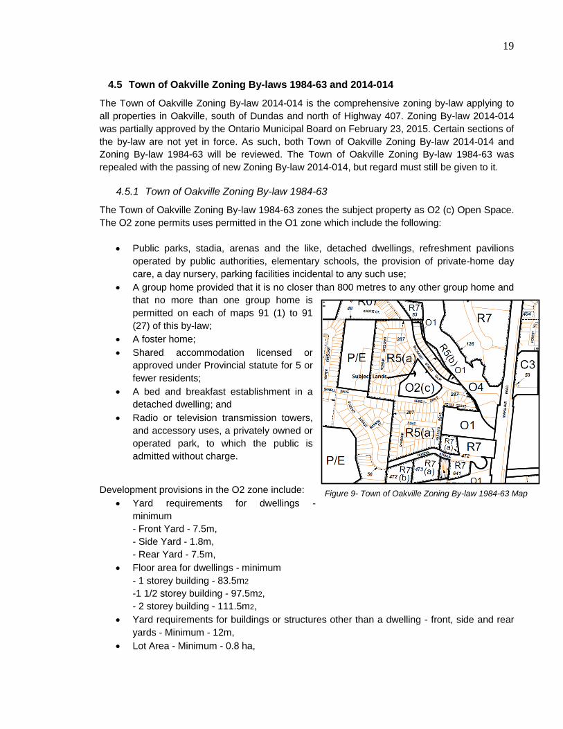
The Town of Oakville Zoning By-law 1984-63 zones the subject property as O2 (c) Open Space.
The O2 zone permits uses permitted in the O1 zone which include the following:
Public parks, stadia, arenas and the like, detached dwellings, refreshment pavilions
operated by public authorities, elementary schools, the provision of private-home day
care, a day nursery, parking facilities incidental to any such use;
A group home provided that it is no closer than 800 metres to any other group home and
that no more than one group home is
permitted on each of maps 91 (1) to 91
(27) of this by-law;
A foster home;
Shared accommodation licensed or
approved under Provincial statute for 5 or
fewer residents;
A bed and breakfast establishment in a
detached dwelling; and
Radio or television transmission towers,
and accessory uses, a privately owned or
operated park, to which the public is
admitted without charge.
Development provisions in the O2 zone include:
Yard requirements for dwellings -
minimum
- Front Yard - 7.5m,
- Side Yard - 1.8m,
- Rear Yard - 7.5m,
Floor area for dwellings - minimum
- 1 storey building - 83.5m2
-1 1/2 storey building - 97.5m2,
- 2 storey building - 111.5m2,
Yard requirements for buildings or structures other than a dwelling - front, side and rear
yards - Minimum - 12m,
Lot Area - Minimum - 0.8 ha,
Figure 9- Town of Oakville Zoning By-law 1984-63 Map
20
Lot Frontage - Minimum - 61m,
Building Height - Maximum - 10.5m,
Lot Coverage - Maximum - 25%, and
Except on detached dwellings, all metal vents, stacks, louvres, roof ventilators and the
like shall be finished in a colour compatible with adjacent finished materials.
The subject property is subject to special policy (c) which permits churches and other places of
worship (within or without church halls) used for functions conducted by church organizations,
and not including use as a public hall.
4.5.2 Town of Oakville Zoning By-law 2014-014
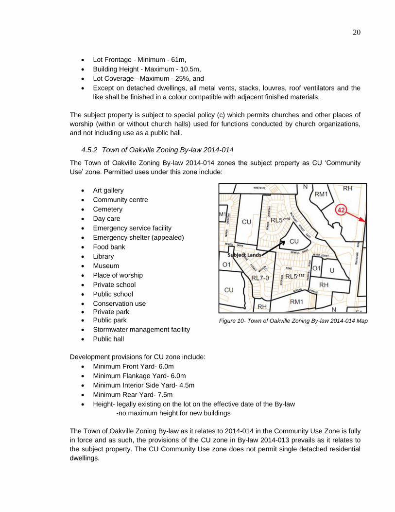
The Town of Oakville Zoning By-law 2014-014 zones the subject property as CU ‘Community
Use’ zone. Permitted uses under this zone include:
Art gallery
Community centre
Cemetery
Day care
Emergency service facility
Emergency shelter (appealed)
Food bank
Library
Museum
Place of worship
Private school
Public school
Conservation use
Private park
Public park
Stormwater management facility
Public hall
Development provisions for CU zone include:
Minimum Front Yard- 6.0m
Minimum Flankage Yard- 6.0m
Minimum Interior Side Yard- 4.5m
Minimum Rear Yard- 7.5m
Height- legally existing on the lot on the effective date of the By-law
-no maximum height for new buildings
The Town of Oakville Zoning By-law as it relates to 2014-014 in the Community Use Zone is fully
in force and as such, the provisions of the CU zone in By-law 2014-013 prevails as it relates to
the subject property. The CU Community Use zone does not permit single detached residential
dwellings.
Figure 10- Town of Oakville Zoning By-law 2014-014 Map

21
5 Proposed Development Applications
5.1 Proposed Zoning By-law Amendment
The proposed Zoning By-law Amendment application proposes to rezone a portion of the subject
property that will be divided via the concurrent submitted Draft Plan of Subdivision application to
permit (3) three single detached residential dwellings. The rezoning application proposes to
rezone the southern corner of the subject property from O2 to R5 under Zoning By-law 1984-63
and CU to RL5 under Zoning By-law 2014-014. Given that provisions of the RL5 zone under By-
law 2014-014 are under appeal, both by-laws are proposed to be amended.
5.1.1 Town of Oakville Zoning By-law 1984-63
The R5 zone of the Town of Oakville Zoning By-law 1984-63 is reviewed below as the equivalent
of the RL5 zone in Zoning By-law 2014-014.
The R5 zone permits the following uses:
Detached dwelling;
The office of a physician within a detached dwelling;
The practice of a domestic art;
Lodging houses containing no more than 3 lodging units;
Parks, playgrounds, recreational areas, and community centres under the control of a
public authority;
Churches and other places of worship, convents, public schools, private schools, and
day nurseries;
A converted dwelling;
Private home day care;
A group home;
A foster home;
Shared accommodation;
Bed and breakfast in a detached dwelling; and
Conduct of trade or business;
Table 2- Proposed R5 Zone
Provision R5 Zone Proposed
Use Detached Dwelling Detached Dwelling
Minimum Lot Area 464.5 m 685.0 m -890.0 m
Minimum Lot Frontage 15 m 15 m
Maximum Lot Coverage 35% Less than 35%
Maximum Building Height 10.5 m 10.5 m
Minimum Floor Area (2
storeys)
111 m2
More than 111 m2
Minimum Front Yard 7.5 m 7.5 m
Minimum Side Yards 2.4 m and 1.2 m 1.2 m
Minimum Rear Yards 7.5 m More than 7.5 m
22
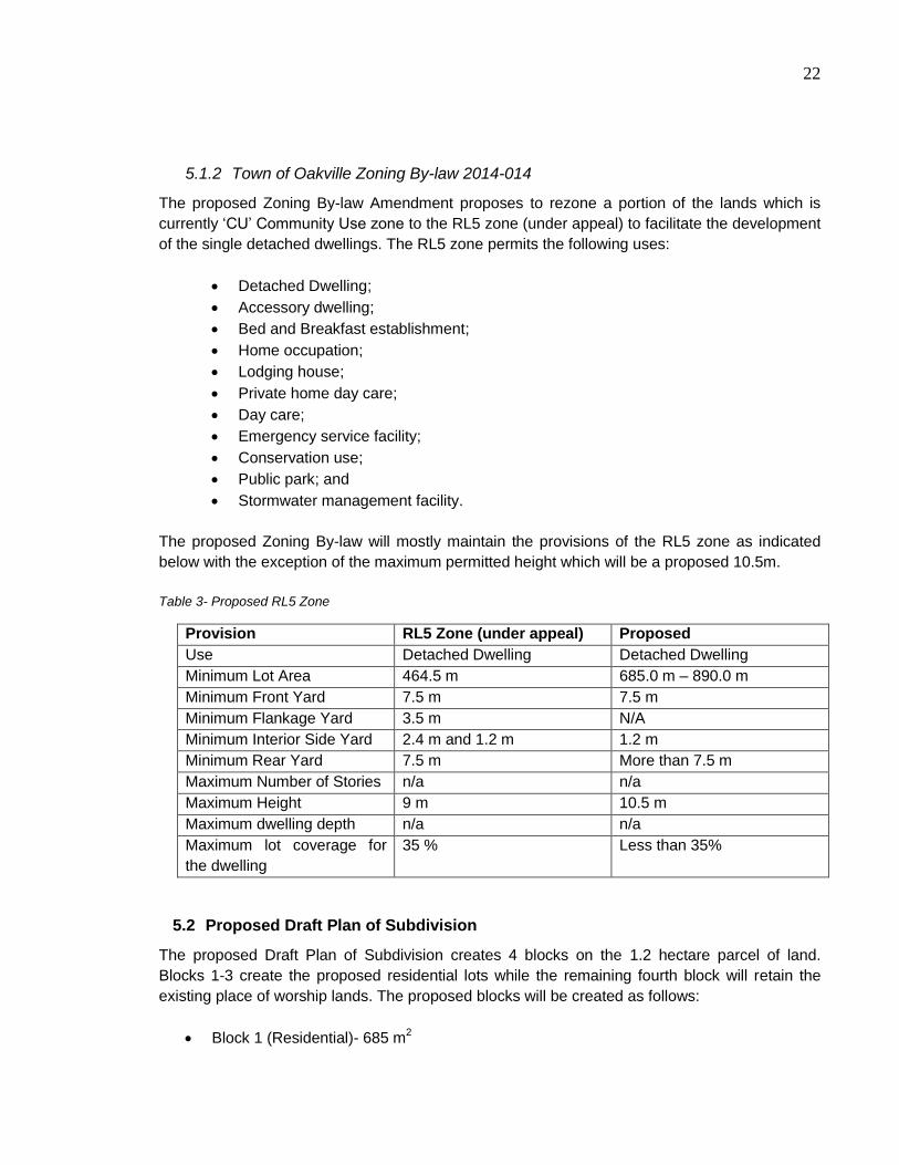
5.1.2 Town of Oakville Zoning By-law 2014-014
The proposed Zoning By-law Amendment proposes to rezone a portion of the lands which is
currently ‘CU’ Community Use zone to the RL5 zone (under appeal) to facilitate the development
of the single detached dwellings. The RL5 zone permits the following uses:
Detached Dwelling;
Accessory dwelling;
Bed and Breakfast establishment;
Home occupation;
Lodging house;
Private home day care;
Day care;
Emergency service facility;
Conservation use;
Public park; and
Stormwater management facility.
The proposed Zoning By-law will mostly maintain the provisions of the RL5 zone as indicated
below with the exception of the maximum permitted height which will be a proposed 10.5m.
Table 3- Proposed RL5 Zone
Provision RL5 Zone (under appeal) Proposed
Use Detached Dwelling Detached Dwelling
Minimum Lot Area 464.5 m 685.0 m – 890.0 m
Minimum Front Yard 7.5 m 7.5 m
Minimum Flankage Yard 3.5 m N/A
Minimum Interior Side Yard 2.4 m and 1.2 m 1.2 m
Minimum Rear Yard 7.5 m More than 7.5 m
Maximum Number of Stories n/a n/a
Maximum Height 9 m 10.5 m
Maximum dwelling depth n/a n/a
Maximum lot coverage for
the dwelling
35 % Less than 35%
5.2 Proposed Draft Plan of Subdivision
The proposed Draft Plan of Subdivision creates 4 blocks on the 1.2 hectare parcel of land.
Blocks 1-3 create the proposed residential lots while the remaining fourth block will retain the
existing place of worship lands. The proposed blocks will be created as follows:
Block 1 (Residential)- 685 m2

23
Block 2 (Residential)- 890 m2
Block 3 (Residential)- 777 m2
Block 4 (Place of Worship)- 9,790 m2
6 Planning Analysis
6.1 Draft Zoning By-law Amendment
The proposed development of the three (3) residential dwellings does not comply with the
current zone of the subject property. The property is zoned CU ‘Community Use’, which does not
permit single detached dwellings. As such, it is necessary to amend Zoning By-law 1984-63 and
2014-014 to the R5 and RL5 zone respectively which permit the proposed single detached
dwellings. Both by-laws are amended as the RL5 provisions under Zoning By-law 2014-014 are
under appeal. The proposed R5 and RL5 zone is compatible with the surrounding development
in the area which has the same parent zone. Only one site specific exception is proposed under
the 2014-014 by-law amendment where the maximum building height is proposed to be 10.5m.
The site specific exception is consistent with the existing development in the area in terms of
building height.
6.2 Draft Plan of Subdivision
The proposed Draft Plan of Subdivision meets the criteria prescribed below in Section 51 (24) of the Planning Act. Section 51 (24) states:
“(24) In considering a draft plan of subdivision, regard shall be had, among other matters,
to the health, safety, convenience, accessibility for persons with disabilities and welfare
of the present and future inhabitants of the municipality and to,
(a) the effect of development of the proposed subdivision on matters of provincial
interest as referred to in section 2;
(b) whether the proposed subdivision is premature or in the public interest;
(c) whether the plan conforms to the official plan and adjacent plans of
subdivision, if any;
(d) the suitability of the land for the purposes for which it is to be subdivided;
(e) the number, width, location and proposed grades and elevations of highways,
and the adequacy of them, and the highways linking the highways in the
proposed subdivision with the established highway system in the vicinity and the
adequacy of them;
(f) the dimensions and shapes of the proposed lots;
(g) the restrictions or proposed restrictions, if any, on the land proposed to be
subdivided or the buildings and structures proposed to be erected on it and the
restrictions, if any, on adjoining land;
(h) conservation of natural resources and flood control;
(i) the adequacy of utilities and municipal services;
(j) the adequacy of school sites;
(k) the area of land, if any, within the proposed subdivision that, exclusive of
highways, is to be conveyed or dedicated for public purposes;
24
(l) the extent to which the plan’s design optimizes the available supply, means of
supplying, efficient use and conservation of energy; and
(m) the interrelationship between the design of the proposed plan of subdivision
and site plan control matters relating to any development on the land, if the land
is also located within a site plan control area designated under subsection 41 (2)
of this Act or subsection 114 (2) of the City of Toronto Act, 2006. 1994, c. 23, s.
30; 2001, c. 32, s. 31 (2); 2006, c. 23, s. 22 (3, 4).”
The intent of the proposed Draft Plan of Subdivision is to create 3 lots and 1 block of land with
the intention of subdividing three lots for residential uses. The block will be retained for the
existing place of worship use. The above criteria have been considered and meet the
requirements of Section 51 (24) in the following ways:
a) The effect of development of the proposed subdivision is consistent with the objectives
of the PPS and provincial interest as discussed in Section 4.1 of this Report;
b) The proposed subdivision contributes to moderate infill intensification which helps the
Town to meet its population targets. The proposal will be reviewed through a public
consultation process;
c) The proposed subdivision conforms to the Town’s Official Plan as discussed in
Section 4.4 of this Report. The development is permitted under the Low Density
Residential designation. Moderate intensification is permitted on the subject property
provided that it is compatible with the surrounding area;
d) The subject property is suitable for a subdivision as it makes use of excess
institutional lands and provides suitable infill development. The submitted Phase 1 ESA
notes that the lands are suitable for residential development;
e) No proposed roadways are proposed within the proposed subdivision;
f) The proposed lots meet the minimum lot frontage and minimum lot area standards of
proposed zone;
g) There are no foreseeable restrictions of development on the proposed subdivided
land. The proposed development is compatible with the adjoining place of worship use
and existing surrounding residential lands;
h) There are no designated natural features on the subdivided lands. The lands are not
within Conservation Halton regulated area;
i) The proposed residential subdivided lands can be serviced by existing water and
wastewater servicing. There is an existing 200mm sanitary sewer and 150mm watermain
located along Sewell Drive. Relocation of connections will be required;
j) The proposed residential subdivided lands are within 200m of an existing school site
among others in the area;
k) No land is proposed to be conveyed for public purposes;
l) The proposed development contributes to infill and intensification making use of
existing servicing;
m) The place of worship block will be reviewed through a Site Plan Application with
regard to reconfiguration of the parking area. The proposed residential dwellings are not
subject to Site Plan Control.
25
6.3 Policy Context
The development of the subject property supports the policies found within the PPS, Growth
Plan, Region of Halton Official Plan, and Town of Oakville Official Plan including policies related
to land use and intensification.
The PPS provides overarching direction regarding intensification, compact urban form, and the
efficient use of existing infrastructure. This proposed development implements the policies of the
PPS by providing appropriate intensification through infill development which is well serviced by
existing infrastructure.
The proposed development also responds to the Growth Plan’s directive of providing
intensification in existing built up areas. This proposed development will contribute to the Town
reaching its population targets as outlined in the Growth Plan.
The proposed development is consistent with the Urban Area policies of the Region of Halton
Official Plan. The Urban Area policies promote intensification within the built boundary and
accommodate the distribution of population and employment for the Region. This proposed
development provides for infill development which is consistent with these policies.
The proposed development of the subject property also supports the Town’s Official Plan
policies for development in Low Density Residential areas. This designation permits single
detached residential housing while also allowing for intensification opportunities through infill
development.
6.4 Compatibility
The proposed development of three (3) single detached residential dwellings is compatible with
the surrounding area and creates a seamless continuation of the existing housing stock. The
proposed dwelling type is permitted within the Low Density Residential designation of the Town’s
Official Plan and the proposed Zoning By-law amendment seeks a zone which is reflective of the
surrounding area. Conceptual elevations have been submitted for review which are consistent
with the style, size and height of the surrounding existing residential dwellings.
6.5 Intensification
Intensification is a promoted theme through all levels of Provincial, Regional and Local policy. On
a local level, the Town of Oakville explicitly permits intensification through infill development
within areas outside growth areas provided that it is compatible with the surrounding area. The
proposed development is a form of intensification through infill development which is compatible
in both built form, density and urban design to the surrounding area.

26
7 Conclusion
The proposed development is appropriate for the subject property and represents good planning
for the following reasons:
The proposed development is consistent with the policies of the PPS 2014. It makes
efficient use of land and contributes to increasing housing supply through infill
development in an existing residential area;
The proposed development conforms to the policies of the Growth Plan;
The proposed development conforms to the policies of the ROP. This proposed
development will contribute to achieving the Region’s density targets and increase the
housing supply available to residents;
The proposed development conforms to the policies of the Town of Oakville Official Plan.
The proposed development meets all Residential and Low Density Residential polices
providing compatible infill development in a stable residential neighbourhood, without
requiring an amendments to the Official Plan; and
A Zoning By-law Amendment is required to facilitate future residential development of the
three subdivided lots on the south corner of the subject property. The proposed
amendment rezones the lands to a zone which is compatible and consistent with the
surrounding residential zone.
Based on this planning analysis, the proposed development is appropriate and represents good
planning.
Yours truly,
Weston Consulting