planning for low-emissions development in ucayali, peru 2014/policy briefs/asb_pb41.pdf · planning...
TRANSCRIPT

1
Planning for low-emissions development in Ucayali, Peru
41
Key Messages• LUWES(Land-UsePlanningforLow-EmissionsDevelopment
Strategy) isa landuseplanningmethodologyandprocessthatestimates economic and environmental costs and benefitsof alternative scenarios defined for existing forest and landmanagementunits,suchasprotectedareas,forestconcessions,community and private lands. InUcayali, Peru, this approachindicated the importance of setting up strategies to reduceemissionsandenhancecarbonstocksinlandswheresmallholdersettlementandtenureestablishmentprocessesareongoing.
• ThelandscapeapproachinLUWEShelpstoestimate,evaluateand compare development scenarios and their individualand aggregated impact at the landscape level in terms of netemissionsandeconomicandsocialreturns.
• TheworkinUcayalishowedthatlandsoutsideof legallyclassifiedforests contribute the most emissions. These lands – wheresmallholder colonist farmers have been expanding agricultureforoilpalm,pasturesandcacao–havethehighestpotentialforland-use-basedmitigation both through avoided deforestationandenhancementof carbonstockonalreadydeforestedland.
• On-going land use planning processes at the sub-nationallevelofferusefulplatforms to integratecarbonemissionsasadimensionof developmentplanning.
Implications • Evaluations of land-use change impacts on carbon
stocks, on associated greenhouse gas emissions andonotherecosystemservices shouldbe integrated intoterritorialandeconomicdevelopmentplanning.
• Land-use planning for low-carbon developmentand emissions reductions should (1) integrate anunderstanding of the interconnectedness of land-use and natural resources management systems andtheir overall impact on emissions, (2) combine theunderstandingof pastland-usechangedynamicsandthewiderangeof driversbeyondthemwiththeformulationof future scenarios and (3) encourage cross-sectoralnegotiations and engagement of public and privatesectorsatmultiplegovernancelevels.
• Participatory processes should be promoted, toolsfor negotiations provided and capacity reinforced toenhancetheparticipationof localinstitutionsandcivilsocietyinterritorialplanning.
Short SummaryRegional governments in Peru are stepping up their activities to participate in national and global efforts to reduce greenhouse gas emissions from land-use change by identifying possible mitigation actions. The ongoing process of Land Use Planning based on the Ecological and Economical Zoning is a key opportunity for integrating mitigation strategies within development planning activities. The regional government of Ucayali in Peru and partners are building on previous research on land-use change to understand the implications of development for emissions, effectively integrating economic development and environmental considerations in their land-use planning activities.
Participants in April 2013 workshop on Land-Use Planning for Low-Emissions Development Strategies (LUWES) in Pucallpa, Peru
Policybrief

2
REDD+ momentum in PeruPerubeganitsofficialinvolvementinREDDin2008atCOP14inPoznan,whenthenewlycreatedMinistryof Environment(MINAM)committedthe country to the internationalmitigationeffortbyfixing a targetof “zeronetdeforestationrate”by2021.Next,thegovernmentapprovedaplantoconserve54Mhaof forestthroughmultiplemitigationeffortsover10years,aninitiativeof theNationalForestConservationProgramfortheMitigationof ClimateChange(PNCBMCC,D.S.Nº008-2010).Peru’s REDD strategy uses a nested approach, with the Ministry of Environmentandsub-nationaljurisdictions,inparticularregions,workingtogetherinthedevelopmentof referenceemissionslevels,thedefinitionof CO2 emissions reduction strategies and the tasks of monitoring,reporting,verificationandcrediting.Thedevelopmentof deforestationmapsandreferenceemissions levels iscarriedoutat thenational levelto ensure consistency in monitoring, reporting and verification. Theroleof subnationaljurisdictionsalignsemissionsreductioneffortswiththe decentralized responsibilities of regional government’sEcological-EconomicalZoning (ZEE acronym in Spanish) and LandUse Planningactivities.Thelocalgovernment’son-goinglandusezoningandplanningprocesses at multiple levels offer opportunities to embed emissionsreductionlogicintoexistinglandusegovernanceframeworks.Ucayaliisoneof theregionswheretheZEEprocesshasnotyetbeencompleted.In collaboration with the ASB Partnership for the Tropical ForestMargins,theUcayaliREDDRoundtablehasbeenworkingtointegrateREDD+initiatives(REDDincludingalsoconservationandsustainablemanagementof forestsandenhancementof forestcarbonstocks)withterritorialandeconomicdevelopmentactivities.
Roundtabledevelopedtheworkshopaspartof alargersetof activitiesin the region.These initiativesareaimedatassessing the feasibilityof emissions reduction options. Determining the feasibility of differentoptionsdependsnotonlyonestimatingtheassociatedbenefitsandcosts,but also on examining how actions to reduce emissions are likely toachievetheirintendedeffects.TheworkshopbroughttogetherthemajorREDDplayersinUcayalitodevelopaprocessforevaluatingoptionsandscenariosforfuturedevelopmentandforreducingemissions.
Major players in the REDD process REDDroundtables(MesasREDDinSpanish)arecommitteesandcommunitiesof practicemadeupof professionalsandstakeholdersrepresenting public, private and civil society organizations whoare in somewayparticipating inefforts to reducegreenhousegasemissions.ThenationalMesaREDDwascreated in2008bycivilsocietyorganizationstoestablishaninter-sectordialoguetodiscussandformulateproposalsaboutREDD+.Activitiesof theREDDroundtables are very important to ensure fair and transparentprocessesof governmentstrategydevelopment.
MESA REDD UCAYALIEstablishedundertheinitiativeof participantorganizationsin2011,theMesaREDDUcayaliwasformalizedbytheregionalgovernmentin2012.ItsobjectiveistosupportthereadinessprocessandREDD+strategyimplementationinlinewiththeregionaldevelopmentplansandnationalpolicy.ASBpartnershavebeencollaboratingwiththeMesaREDDinUcayalisince2011,offeringscientificandtechnicaladviceandcapacitybuilding.
INDIGENOUS MESA REDD IN UCAYALIEstablishedin2011andpromotedbytheInterethnicAssociationfortheDevelopmentof thePeruvianRainforest(AIDESEP,Asociación Interétnica de Desarrollo de la Selva Peruana) with the support of 15localfederations,theMesa REDD Indígena inUcayaliispartof thelargernational IndigenousREDDroundtable.Themainobjectiveof theMesa REDD IndígenaistoensurethatdecisionsonREDD+initiativesaresubjectedtoFree,PriorandInformedConsent(FPIC),donotconflictwithindigenousclaimstolandandrespecttheVida PlenaorEl Buen Vivir (Full lifeorGoodLiving)principlesontheharmonybetweennatureandhumanbeings.
TheworkshopparticipantsusedtheLUWESapproachtounderstandandevaluatedifferentdevelopmentscenarios,estimatetheimpactof thesescenariosonlivelihoodsandgreenhousegasemissionsandsummarizetheanalysisforuseinongoingdevelopmentplanningactivities(Dewietal.,2011).
Figure 1. Map of planning units and area deforested by 2010 in the Ucayali Region.
Planning for REDD+ in the Peruvian AmazonInternational sponsors of conservation so far have been the majorplayers of REDD+ in Peru. But identifying cost-effective andattractive options for reducing emissions is a challenge that confrontsand involves a variety of stakeholders, including indigenous andpeasant communities, farmers and commodity associations, civilsociety and regional and national agencies working across sectors.ThroughtheprojectReducingEmissionsfromAllLandUses(REALU;VanNoordwijk et al., 2009), the regional government of Ucayali andASB researchers co-organized a training workshop on Land-UsePlanning for Low-Emissions Development Strategies (LUWES) inPucallpa,Peru, inApril2013.ASBresearchersandtheUcayaliREDD
LUWES: Description of the main steps in the process1. An interdisciplinary team of experts collects information and
analyzescurrentandfuturedeforestationtrends,placingparticularemphasis on understanding key sectors affecting land-use change(Table 1). In Ucayali, emphasis was given to smallholders andlarge-scaleagriculturalexpansionof oilpalm,cocoa,livestockandtoroad-building–developmentactivitiesthatareatthecenterof currentandfuturemajorland-usechangeintheregion.
2. LUWESrequirestheselectionof planningunits(zones).Inthecaseof Ucayali,pastlanduse/landcover(LU/LC)changesandrelatedemissionswereestimatedbasedonthemanagementcategoriesof the forestry registry (Forest andWildlife law 27308), includingforest concessions andprotected areas, aswell as indigenous andprivatelands.Landthatdidnotbelongtoanycategoryandwithoutafullysettledtenurialarrangementwascategorizedasundetermined(“indeterminado”inSpanish).

3
3. An analysis of past LU/LC change and itsconsequences for carbon stocks is conductedin order to establish a historical baseline. Thisstep inUcayaliwas carriedoutusingABACUSsoftware, a tool for estimating emissions,analyzing trade-offs between emissions andlivelihoodsgains(opportunitycostanalysis)anddeveloping scenarios for zone-specific policiesandstrategies(Harjaetal.,2011).
4. Futuredevelopmentscenariosaredefined,basedonregionalplanningdocuments,surveyingexpertsinthemaineconomicsectorsandanegotiationprocess among participating stakeholders. InUcayali, scenarios identified include initiativesto create major new transportation corridors,expandpalmoilarea,convertdegradedpasturesto agroforestry and silvopastoral systems andlimit deforestation through the identificationof institutional instruments (e.g., regionalconservationareas,concessionsforconservationthatreducetheconversionprocess,inparticularovertheindeterminadoland).
5. Trade-offs between environment and livelihoodsimpactsareexaminedunderthedifferentscenariosidentifiedinthepreviousstep.
6. Final review and refinement is carried out –withtheparticipationof decision-makers– of all the information and analysis mentionedaboveinordertoidentifyandprioritizepolicies,investmentsandactionsforreducingemissions.
Table 1. Data, information and preparatory work carrying out the LUWES approach.
Data or information needed Preparatory workTimeseriesof land-usemaps Spatialoverlay;land-usechangematrix
developmentPlanningunitandregionalplanmaps Createunifiedplanningunitscoveringstudy
areaAgriculture,livestockandforestdata Preparedetailedassessmentof current
conditionsCstockandemissionsfactorsdatafromsurveys&literature
EstimateCandemissionfluxesforeachland-usesystem
Economicandland-useactivitydata Estimatenetpresentvalue(NPV)of eachland-use
Socioeconomicanddemographicdata Estimateimpactsof populationgrowth,migrationandotherfactorsonemissions
Governance,landtenureandpublicpolicydata
Giventhegovernanceandpolicyenvironment,estimatepotentialclimatechangemitigationactions
Key outcomes of the analysisTwo important outcomes of the LUWES analytical approach are (1)an evaluation of trade-offs between livelihoods and greenhouse gasemissionsand(2)ananalysisof futureemissionsforeachof thealternativedevelopmentscenarios.
Opportunitycostanalysiscantellusthelivelihoodbenefittothefarmerandthelevelof emissionsforanyandallland-usechanges(WhiteandMinang,2010).Anopportunitycostcurveisavisualsummaryof thecostsassociatedwithforgoingcurrentland-usepracticesandhelpsidentifytheland-usechangesthatcausemostemissionswithinaregion(Figure2).ABACUSsoftware calculates theprofits forgoneof different land-usechangesintermsof tonsof CO2equivalentsemittedorsequestered.Themeasures canbeused to identify levelsof fair compensation requiredwithinapaymentsforenvironmentalservices(PES)schemeforREDD.To determine the economic logic and viability of policy initiatives,analystscanevaluatethesecostsof avoidingemissionsinthecontextof internationalcarbonprices.Landuseswithlowopportunitycostshavean economic justification to be incorporated into plans for emissionsreductions, although social, cultural and food security decision criteriamayaffectpolicypriorities,especiallyinthecaseof smallholders.
LUWES workshop participants created opportunity cost curves forselected provinces within the region and for different scenarios. Thecurve shown in Figure 2 includes all land-use change transitionswiththeiropportunitycostsandlevelof emissions,accordingtoeachland-useplanningunit.AlongtheX-axis,coloredbarsandlabelsshowthatmostemissions came when forests were converted to pastures or crops inlandswithoutfullysettledtenure(indeterminado inSpanish),inindigenouslandsandonprivatelands.AlongtheY-axis,thegreatmajorityof land-use transitions had opportunity costs of around $10 per ton of CO2emitted. While this analysis does not include the cost of setting upREDDprograms,itdoessuggestthatthereissomescopefordevelopingincentivestopromotealternativelandusesthatwouldreduceemissions.
Figure 2. Opportunity cost curve for land-use changes by planning unit in the Padre Abad Province.
Figure 3. Proportion of emissions by land-use planning units in Coronel Portillo province (2005-2010). In Ucayali, most land-use changes and emissions occur in land with uncertain tenure (Indeterminado), followed by the titled private land (Predios), indigenous lands (Comunidades Nativas), forest concessions under bid (Concesiones Forestales en Concurso), regional conservation areas (Áreas de Conservación Regional), community reserves (Reserva Comunal) and others.
Asecondimportantoutcomeof theLUWESprocessisthedevelopmentof estimatesof futureemissionsbasedondevelopmentscenariosidentifiedbytheprojectparticipants.Theprocessstartswithanestimateof historicalemissionsfromtheremotesensing-basedmapsof past land-usechange(Figure3).
4
The ASB Partnership for the Tropical Forest Margins is working to raise productivity and income of rural households in the humid tropics without increasing deforestation or undermining essential environmental services.
ASB is a consortium of over 90 international-and national-level partners with an ecoregional focus on the forest-agriculture margins in the humid tropics. The partners have established 12 benchmark sites in the tropical forest biome of Brazil, Cameroon, Indonesia, Peru, Philippines and Vietnam.
The ASB Policy Brief series aims to deliver relevant, concise reading to key people whose decisions will make a difference to poverty reduction and environmental protection in the humid tropics. © 2014 ASB
ASB Partnership for the Tropical Forest Margins
United Nations Avenue, GigiriP.O. Box 30677 - 00100 Nairobi, KenyaTel. +254 20 7224000Email: [email protected]://www.asb.cgiar.org
In theCoronelPortilloprovinceof Ucayali, half of all the emissionsbetween2005and2010occurredintheareaswithunsettledlegalstatus(indeterminado ),followedbyprivatelands(predios)andlandsinindigenouscommunities(comunidades nativas).Thesefindingssuggestthatsuccessfulreduction strategies will need to address problems related to landsettlement,suchasmigration,landtenureandtheprocessof landtitling,whichoftenencouragesforestconversion.
to represent distinct government policy strategies and model theassociated impactsonparticularagriculturalsectors.Forexample, theyconsideredtheeffectsoncarbonemissionsof newoilpalmplantationsreplacingpasturesorreplacingforests.Theyalsomodeledthe impactson emissions of establishing silvopastoral systems – combinations of improvedpasturesandtreesthatsequestercarbonandincreaselivestockproductivity.Once theLUWESplatform is setupasdescribedabove,anynumberof scenarioscanbeevaluatedforlanduseanddevelopmentplanning.ThepartnersinUcayalinowhavethechallengeof improvingtheinputdataanddevelopingmoredetailedanalysesforstrategicsectorsof theeconomy.
Policy message: the way towards low- emissions developmentPlanning for emissions reductions with a landscape approachrequires determining the potential impact of ways to reduce land-use based emissions from all land uses. The work in Ucayali showedthat lands outside of legally classified forests contribute the mostemissions and thus have the greatest potential to mitigate emissions.Low-emissionsdevelopmentwillrequire improvement incurrent land-useplanning and governancepractice spurredby (1) increasedqualityandaccessibilityof spatialdataandstatisticsaboutlandusesinparticularover the post-deforestation lands, (2) increased transparency andcoherenceof land-usedecisionmakingandlandgovernanceprocessesacrosssectorsandinstitutionsand(3)politicalwilltopromotechangesin land management practices across institutions and stakeholders,includingtheprivatesector.
ReferencesDewi, S., Ekadinata, A., Galudra, G. Agung, P y Johana, F. 2011. LUWES. Land use planning for Low Emission Development Strategy. Bogor, Indonesia. World Agroforestry Center. ICRAF, SEA Regional Office. 47 pp.
Gobierno Regional de Ucayali (GOREU). 2012. Plan Estratégico Institucional 2012 – 2015. Gerencia Regional de Planeamiento, Presupuesto y Acondicionamiento Territorial. Pucallpa, Perú.
Harja, D.; Dewi, S.; van Noordwijk, M.; Ekadinata, E. Rahmanulloh A. 2011. REDD Abacus SP: User Manual and Software. Available at http://www.worldagroforestry.org/sea/abacus.
van Noordwijk M, Minang PA, Dewi S, Hall J, Rantala S. 2009. Reducing Emissions from All Land Uses (REALU): The Case for a whole landscape approach. ASB Policy Brief 13. ASB Partnership for the Tropical Forest Margins, Nairobi, Kenya.
White, D., P. Minang. 2010. Estimating the Opportunity Costs of REDD+: A Training Manual. World Bank and World Agroforestry Center (ICRAF). Washington DC. 200 p. Available at http://wbi.worldbank.org/wbi/Data/wbi/wbicms/files/drupal-acquia/wbi/OppCostsREDD+manual.pdf.
Citation: Hyman G., V. Robiglio, C. Silva, D. White. 2013. Planning for low-emissions development in Ucayali, Peru. ASB Policy Brief 41. ASB Partnership for the Tropical Forest Margins: Nairobi, Kenya.
Acknowledgement: The ASB team thanks the Gerencia de Desarrollo Económico, Gerencia de Recursos Naturales y Medio Ambiente del Gobierno Regional de Ucayali,inparticularPatriciaSeijasandDavidMoreno,colleaguesSonyaDewiandDegiHarjaandthewholeLUWESteamatICRAF.
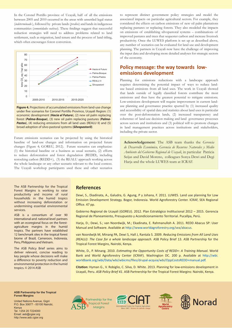
Figure 4. Projections of accumulated emissions from land-use change under five scenarios for Coronel Portillo Province, Ucayali Region: (1) economic development (Hacia el Futuro), (2) new oil palm replacing forest (Palma-Bosque), (3) new oil palm replacing pastures (Palma-Pastos), (4) reducing emissions from all land uses (REALU II) and (5) broad adoption of silvo-pastoral systems (Silvopastoril).
80
70
60
50
40
30
20
10
0
tons
C0 2 e
q / h
a/ a
ňo
2005-2010 2010-2015 2015-2020
Hacia el Futuro
Palma-Bosque
Palma-Pastos
REALU II
Silvopastoril
Future emissions scenarios can be projected by using the historicalbaseline of land-use changes and information on projected futurechanges (Figure 4;GOREU, 2012). Future scenarios can emphasize:(1) the historical baseline or a business as usual scenario, (2) effortsto reduce deforestation and forest degradation (REDD), includingrestockingcarbon(REDD+),(3)theREALUapproachworkingacrossthewholelandscapeoranyotherscenariorelevanttothelocalcontext.The Ucayali workshop participants used these and other scenarios