place names of colorado - history.denverlibrary.org · place names of colorado ... printed by...
TRANSCRIPT
The Denver Public Library - Colorado Place Names
PLACE NAMES OF
COLORADO
A Genealogical & Historical Guide to Colorado Sites
1999
Compiled by Donald R. Elliott Edited by Doris L. (Salmen) Elliott
Published by Colorado Council of Genealogical Societies, Inc. Denver, Colorado

The Denver Public Library - Colorado Place Names
Publisher: Colorado Council of Genealogical Societies, Inc. Post Office Box 40270 Denver, Colorado 80204-0270 Printed in the United States of America This book is printed on acid-free paper Library of Congress Catalog Card Number: 99-74711
© 1999-2001 by Colorado Council of Genealogical Societies, Inc. All rights reserved. Published 1999. Second printing 2000. Third printing 2001. All pages to which this copyright notice is attached are presented with the following restrictions:
The information may be freely copied and distributed, but this copyright notice and Colorado Council of Genealogical Societies' name and address must be maintained with the copies. The information must not be sold or leased for profit without specific written consent from Colorado Council of Genealogical Societies. Any changes from the original must be noted, with the name and address of the compiler and publisher also noted.
Colorado Council of Genealogical Societies has made every attempt to present accurate information and accepts no responsibility for the result of any errors.
Printed by Hansen Bros. Printing, 2439 West Main Street, Littleton, Colorado 80120 Bound by Koerperich Bookbinders, Inc., Post Office Box 139, Selden, Kansas 67757
The Denver Public Library - Colorado Place Names
Preface
This is hardly a Colorado history book. It is, rather, a directory of places in Colorado, past and present — all kinds of places. In fact, it is the most complete such guide to be found in a single reference. No previously published directory comes close to its extent or depth of coverage.
The Colorado of the bustling mining camp, railroad whistlestop, and primitive geology is gone. But the names remain in the records of its miners, railroad men, and explorers. Where were these places? Have their names changed over time? Were some ever on a map? These are the questions this guide seeks to answer. It travels the backroads, not the Interstates. It sifts through many indexes, directories, and guides to provide an easily researchable reference, and it also points the researcher toward, for the most part, other readily available resources. Should any site important to the reader not be mentioned, we apologize and would appreciate any available information.
Historical reference books have often been thought of as an hourglass storing time. The grains of history filter to the glass' bottom—slowly, methodically, predictably. But, when you turn the hourglass over—as when a new reader opens a book—history once again trickles out. And, as every genealogist knows, to research his family is to research history.
This "hourglass" constitutes a significant contribution to the research resources of the Colorado genealogical and historical community. It is with great pride that the Colorado Council of Genealogical Societies publishes this important work. And it is with much gratitude that the Council recognizes the Guide's Compiler, Donald R. Elliott and Editor, Doris L. Elliott. Their generosity, dedication, encouragement and support is indefatigable.
Not to be overlooked is the cooperation and support of Mrs. Arvid D. Blecha, who made her husband's original manuscript of Colorado Place Names available for the Elliotts' reference. We are most indebted.
i

ii
In 1868, Frank Dibben, First Public Judge of Georgetown, Colorado said, "One hundred years from this day the world shall still know us." Thanks to Donald and Doris Elliott, the world shall know many Georgetowns.
Patricia A. Kemper, President
Colorado Council of Genealogical Societies, Inc.

The Denver Public Library - Colorado Place Names
Introduction
In searching for a place name in Colorado, researchers have had no comprehensive publication readily available to them. The researcher has had to look under the subject of Colorado ghost towns, or, seek out often obscure maps and documents not readily avin local libraries in hopes of finding out about a particular site.
ailable
esearcher r
,
rvid
ublic and it
any cript
e ties.
Thus, in putting together this publication, the primary objective was to compile a comprehensive listing of place names or sites in Colorado that would direct the rto recent and readily available publications. The genealogist or historian searching foinformation about a particular location has here a first level document that provides identifying information and then points to a second level document where more detailed information can be found. Most of the documents cited are in circulation at many of the state's libraries or are currently in print and available through local bookstores. In additionmost of the referenced publications include their own references, thereby giving the researcher a third resource level.
One important exception to the inclusion of only readily available publications is the AD. (Mike) Blecha manuscript titled Colorado Place Names. The only known copy accessible to the public is housed at the Western History Department of the Denver PLibrary. However, it is by far the most comprehensive work available on the subject, contains section, township and range coordinates which none of the other cited publications have. Further, it contains a significant number of place names not found inother source. Through the cooperation and support of Mrs. Blecha, the original manuswas made available so it could be used in completing this book.
Included in this publication for each site or place name, when the information was available, are other names or spellings associated with a particular site, the earliest date evidence of that site existed, identifying information such as the railroad through the site, post office dates, section/township/range coordinates, and other information helpful in locating the site. In many cases, two counties are listed for a particular site. This has three meanings. One, and the most prevalent, is that county boundaries change over time and thsite was first in one county, then later another. Secondly, a site may overlap two counLastly, in some instances authors disagree over a site's location, or are simply in error. Some named sites moved their location during their existence. One author may have picked up on this while another did not, thus assuming that information about both locations applied to the only one of which he was aware.
iii
The Denver Public Library - Colorado Place Names
iv
tes, e
bout
mmunity.
The Arvid D. Blecha work is most likely to have uncovered the existence of multiple sias he plotted all sites he could identify on his personal set of maps. Multiple sites for onsettlement name are identified in this work in two ways. First, they are identified as separate sites with separate entries identifying them as such. Second, when an alternate section/township/range coordinate is given, attention is drawn to both locations. Note that many settlement boundaries spilled over onto more than one section. In these cases this publication lists only one of the sections. The intent was to conserve space but still point the researcher to the site. And, finally, be aware that mapmakers sometimes made errors, with sites wrongly plotted and names misspelled. The user will therefore occasionally find discrepancies in the information provided by the various authors and will need to resolve these to his own satisfaction.
This listing includes 10,625 names. The Blecha manuscript contains information for a7,450 names. The next most comprehensive work, Atlas of Colorado Ghost Towns (Reference 3), contains information for about 4,200 names. Until a more comprehensive publication is produced, it is hoped that this one will be helpful to the research co
The Denver Public Library - Colorado Place Names
References
1949 Atlas. Rand McNally's reference and road atlas for '49
This atlas was used as it contains a number of places that have been taken off of more recent atlases.
1996 Atlas. Rand McNally 1996 Road Atlas
This atlas was used to help find places still being shown on modern atlases.
1. Old Names and Golden Splenders by Lou Walther, 1983
This publication primarily covers Boulder County names, giving some information about the origin of the name & some information about the name and location. A few other Colorado names are included.
2. Colorado Ghost Towns and Mining Camps by Sandra Dallas, 1985
This publication contains many excellent stories about the ghost towns and mining camps covered, which are many. It contains maps and has a large list of references. This book should be read, if only for the stories, as it will provide an extensive appreciation of life and times in the mining communities. It is generally available in libraries and often is in circulation.
3. Atlas of Colorado Ghost Towns, Vol. I & II by Leanne C. Boyd and H. Glenn Carson, 1984,85
This publication contains many of the settlements and mines of Colorado. It contains descriptive information on settlements, both old and new, and has excellent maps for each county, showing where to find these settlements. It contains some landmarks such as hills, mountains, creeks and gulches for locating the settlements. It also lists many of the mines of the mountain towns, and in some cases plots them on the maps. It is the single, most complete, source of place names. It is available for sale and most libraries have this book on their shelves. Many libraries have this book in circulation. If not, it should be found in the reference section.
4. Ghosts of the Colorado Plains by Perry Eberhart, 1986
v
The Denver Public Library - Colorado Place Names
This publication discusses in detail some interesting places in Colorado that include trails, stage stations, farm towns, mining towns and many other interesting locations. It includes small hand drawn maps and many pictures. It is must reading if the site is referenced in the body of this publication.
5. Hiking the Highest Passes by Bob Martin, 1984
Although this publication is for the hiking crowd, it provides excellent information on the location of the passes included. It provides the county, national forest and the topographic maps to help locate the passes. Although it does not cover all passes, it is generally available in libraries, usually in circulation.
6. A Guide to Places on the Colorado Prairie by Ray Shaffer, 1989, 1990, 1991
A series of six small booklets, these publications are available at some libraries. The counties covered, individually, are Adams, Arapahoe, Boulder, Elbert, Jefferson and Weld. The publications contain descriptive information about the start of towns, the naming of the towns and other interesting information about the towns, past and present, and railroad locations. Handmade maps help locate sites. The author does not cite his sources.
7. Mountain Passes by Clyde and Chloe Edmondson, 1963
This publication was produced for those interested in driving to the remote mountain passes. For the researcher, it provides good information on the locations of many passes. It is not a complete book on Colorado passes, but is generally available in libraries and circulates.
8. Guide to the Colorado Mountains by Robert Ormes, 1979
This publication is for those interested in mountain climbing. However, it has excellent descriptive information on trails, creeks or gulches leading to the mountain peaks. Landmarks on the trails are often mines. It is generally available in libraries and circulates.
9. Historic Forts of Colorado by Dick and Wendy Spurr, 1994
This publication covers the locations of many of the old forts of Colorado, many of which were primarily trading posts, but also stockades for protection of people and supplies. This book is also generally available in libraries and circulates.
vi
The Denver Public Library - Colorado Place Names
10. The Colorado Pass Book by Don Koch, 1987
This publication lists 62 passes and locates them on maps. It also provides the national forest, the county and the elevations of the passes. The book is generally available in libraries and circulates.
11. Colorado's High Thirteeners by Mike Garratt and Bob Martin, 1984
This publication is the most complete of the mountain books. Again, it is published for mountain climbers, but contains a complete listing of the 636 13,000 foot and higher summits. 417 of these summits are named while 219 remained unnamed. Route descriptions are given for the 169 highest thirteeners (13,580 feet and above). Quads, elevations, neighboring peaks and other information is included. This book is generally available in libraries and circulates.
12. Colorado's Post Offices 1859-1989 by William H. Bauer, James L. Ozment and John H. Willard, 1990
This publication is a comprehensive listing of Post Offices, Stations and Branches in Colorado. It includes the sequence of counties from early county structure to present day location. As well as the inclusive dates the post office existed for specified sites, it lists name changes and where post offices moved from and to in the time periods before and after its tenure at a specific site.
13. Colorado Mining Camps by David Southworth, 1997
This publication provides a story about many of the early mining camps. It provides names of mines or miners, stories of town activity and statistics.
14. Colorado Place Names by Arvid D. Blecha, 1987 (Manuscript)
This Blecha compilation is the most complete place name works that exists for Colorado. The problem with the Blecha compilation is that it only exists in one public institution available to researchers, the Western History Department, Denver Public Library. A First Search of the Worldwide Catalog revealed no other institution where this manuscript could be found. This manuscript contains a chronological history of the counties of Colorado. It refers to many early maps and publications as a source for information contained in the manuscript.
vii

The Denver Public Library - Colorado Place Names
viii
Note: At the time of publication, the Arvid D. Blecha Manuscript was used. This has now been published as Blecha's Colorado Place Names.
15. Colorado Mountain Ranges by Jeff Rennicke
This publication is a good reference for the mountain ranges of Colorado.
Other - Rogers Place Names files
At the Colorado Historical Society's Hart Library and at the Denver Public Library, Western History Department, the Rogers card file, on microfilm, is available to the public. It contains place names for Colorado not found in this publication.
Note: Not all publications listed are referenced in this volume.
The Denver Public Library - Colorado Place Names
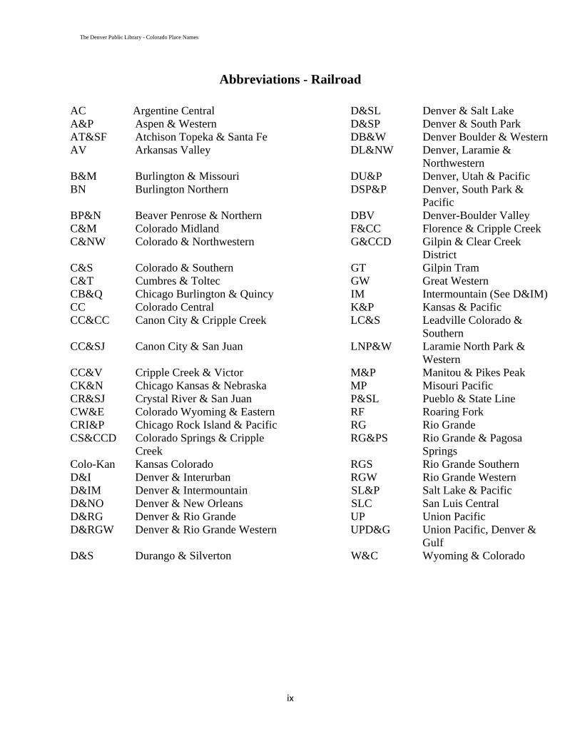
Abbreviations - Railroad AC Argentine Central D&SL Denver & Salt Lake A&P Aspen & Western D&SP Denver & South Park AT&SF Atchison Topeka & Santa Fe DB&W Denver Boulder & Western AV Arkansas Valley DL&NW Denver, Laramie &
Northwestern B&M Burlington & Missouri DU&P Denver, Utah & Pacific BN Burlington Northern DSP&P Denver, South Park &
Pacific BP&N Beaver Penrose & Northern DBV Denver-Boulder Valley C&M Colorado Midland F&CC Florence & Cripple Creek C&NW Colorado & Northwestern G&CCD Gilpin & Clear Creek
District C&S Colorado & Southern GT Gilpin Tram C&T Cumbres & Toltec GW Great Western CB&Q Chicago Burlington & Quincy IM Intermountain (See D&IM) CC Colorado Central K&P Kansas & Pacific CC&CC Canon City & Cripple Creek LC&S Leadville Colorado &
Southern CC&SJ Canon City & San Juan LNP&W Laramie North Park &
Western CC&V Cripple Creek & Victor M&P Manitou & Pikes Peak CK&N Chicago Kansas & Nebraska MP Misouri Pacific CR&SJ Crystal River & San Juan P&SL Pueblo & State Line CW&E Colorado Wyoming & Eastern RF Roaring Fork CRI&P Chicago Rock Island & Pacific RG Rio Grande CS&CCD Colorado Springs & Cripple
Creek RG&PS Rio Grande & Pagosa
Springs Colo-Kan Kansas Colorado RGS Rio Grande Southern D&I Denver & Interurban RGW Rio Grande Western D&IM Denver & Intermountain SL&P Salt Lake & Pacific D&NO Denver & New Orleans SLC San Luis Central D&RG Denver & Rio Grande UP Union Pacific D&RGW Denver & Rio Grande Western UPD&G Union Pacific, Denver &
Gulf D&S Durango & Silverton W&C Wyoming & Colorado
ix

The Denver Public Library - Colorado Place Names
x
Abbreviations - Others
& and Mtn. Mountain Abt/abt about Mtns. Mountains Btwn Between N North CPO Community Post Office NE Nebraska Chg Change NM New Mexico Co. Company NT Nebraska
Territory Corp. Corporation PO Post Office CO Colorado Res. Reservoir E East RR Railroad Est. Established S South Est. by Established by (Earliest date cited) Sev. Several Ft feet St. Saint Ft. Fort Topo Topographic
map KS Kansas W West KT Kansas Territory WWII World War II Mi/mi miles WY Wyoming Mt. Mount UT Utah

The Denver Public Library - Colorado Place Names
Explanation of Headings
Name
Name of site, landmark or geographical feature. All known names, or all names an author has shown for a site are included in ( )s. Some of the other names conflict from one author to another and some are in error. However, even those named in error are usually located at or near the named site.
County
County or counties where site is located. Counties are shown as the authors of referenced books have shown them. Some authors may have used the county where the site was located at the time the site existed or last existed, and some authors show the county where it would currently reside if the site still existed.
1949 Atlas If noted with an "X", that site can be found on the referenced 1949 Atlas. 1996 Atlas If noted with an "X", that site can be found on the referenced 1996 Atlas.
Co Seat If noted with an "X”, that site is a current county seat. Sites that were county seats, at one time in the past, are noted with an "x".
Type This column lists, in general terms, the classification of the site. These are very general classifications and the notes may provide more detail as to the type of a site it is. The "Type" column was mainly used for sorting.
Reference This column shows the number of the document where additional information can be expected to be found. Some or all of the information in the listing came from these sources.
Notes This is identifying information about the site that came from the referenced documents. Some of the information shown here can conflict from one author to another.
S/T/R
This column contains the section, township and range of the site. Although some settlements were on multiple sections, only one of the sections is shown. When maps have shown conflicting information, or possibly when places changed location there is another S/T/R listed in the Notes section.
Occasionally there is conflicting information from one author to another. This publication does not resolve the conflict, but lists the information,
leaving it to the reader or researcher to resolve the conflicts.
xi
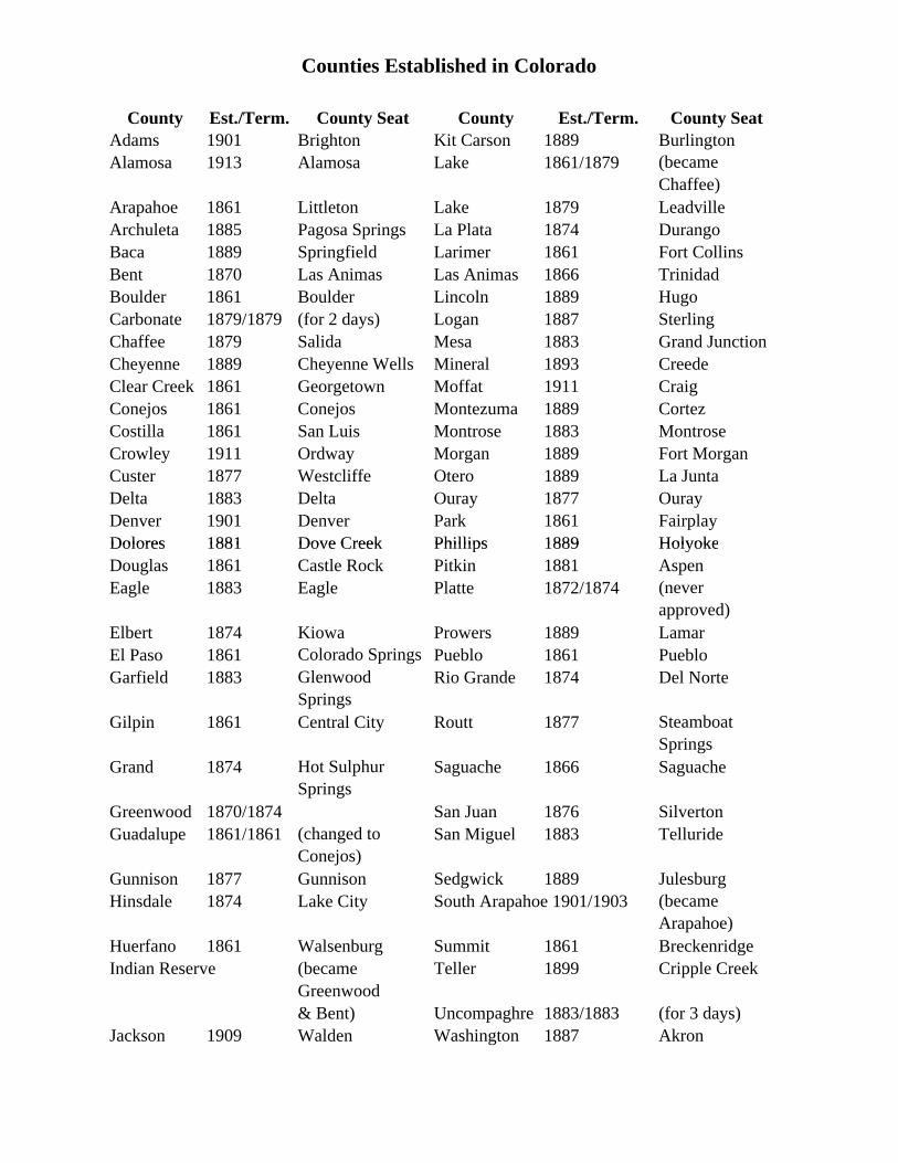
Counties Established in Colorado
Dolores 1881 Dove Creek Phillips 1889 Holyoke
County Est./Term. County Seat County Est./Term. County SeatAdams 1901 Brighton Kit Carson 1889 BurlingtonAlamosa 1913 Alamosa Lake 1861/1879 (became
Chaffee)Arapahoe 1861 Littleton Lake 1879 LeadvilleArchuleta 1885 Pagosa Springs La Plata 1874 DurangoBaca 1889 Springfield Larimer 1861 Fort CollinsBent 1870 Las Animas Las Animas 1866 TrinidadBoulder 1861 Boulder Lincoln 1889 HugoCarbonate 1879/1879 (for 2 days) Logan 1887 SterlingChaffee 1879 Salida Mesa 1883 Grand JunctionCheyenne 1889 Cheyenne Wells Mineral 1893 CreedeClear Creek 1861 Georgetown Moffat 1911 CraigConejos 1861 Conejos Montezuma 1889 CortezCostilla 1861 San Luis Montrose 1883 MontroseCrowley 1911 Ordway Morgan 1889 Fort MorganCuster 1877 Westcliffe Otero 1889 La JuntaDelta 1883 Delta Ouray 1877 OurayDenver 1901 Denver Park 1861 FairplayDolores 1881 Dove Creek Phillips 1889 HolyokeDouglas 1861 Castle Rock Pitkin 1881 AspenEagle 1883 Eagle Platte 1872/1874 (never
approved)Elbert 1874 Kiowa Prowers 1889 LamarEl Paso 1861 Colorado Springs Pueblo 1861 PuebloGarfield 1883 Glenwood
SpringsRio Grande 1874 Del Norte
Gilpin 1861 Central City Routt 1877 Steamboat Springs
Grand 1874 Hot Sulphur Springs
Saguache 1866 Saguache
Greenwood 1870/1874 San Juan 1876 SilvertonGuadalupe 1861/1861 (changed to
Conejos)San Miguel 1883 Telluride
Gunnison 1877 Gunnison Sedgwick 1889 JulesburgHinsdale 1874 Lake City South Arapahoe 1901/1903 (became
Arapahoe)Huerfano 1861 Walsenburg Summit 1861 BreckenridgeIndian Reserve (became Teller 1899 Cripple Creek
Greenwood& Bent) Uncompaghre 1883/1883 (for 3 days)
Jackson 1909 Walden Washington 1887 Akron
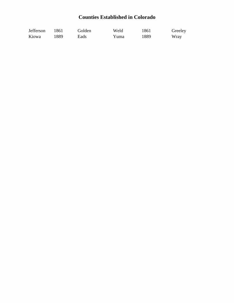
Counties Established in Colorado
Kiowa 1889 Eads Yuma 1889 WrayJefferson 1861 Golden Weld 1861 Greeley

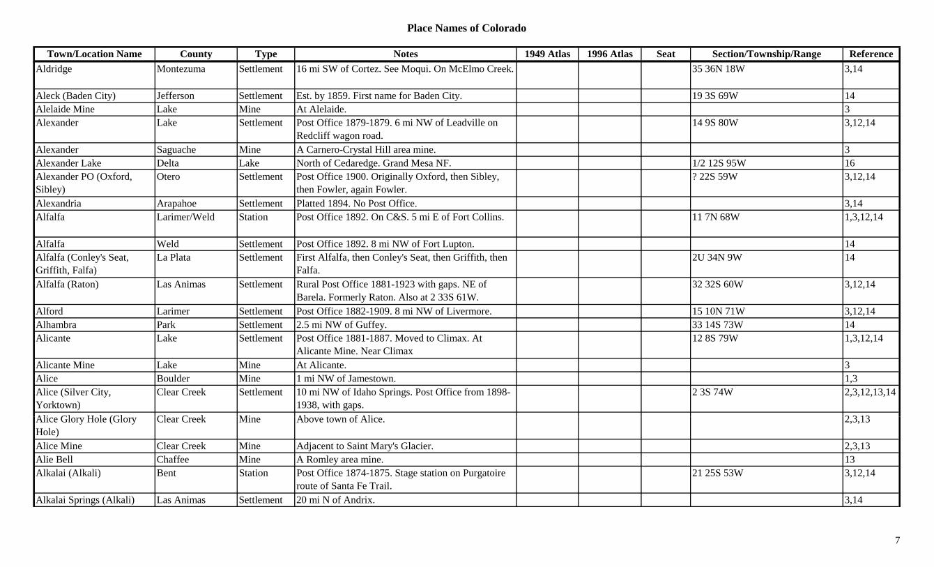
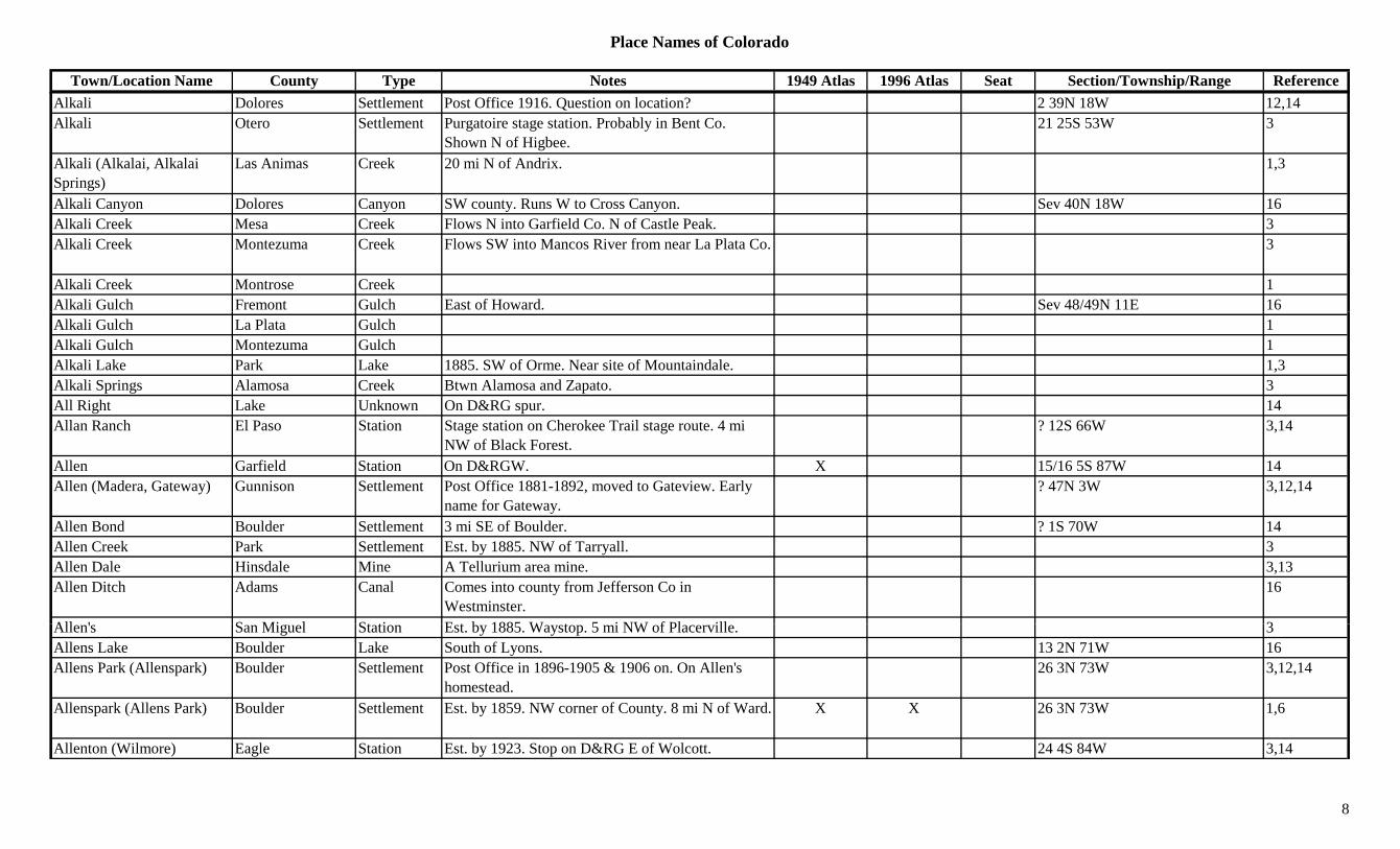
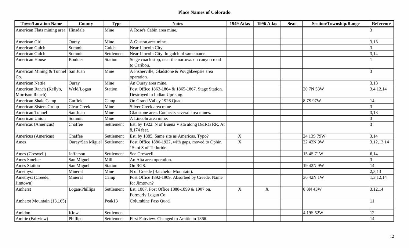
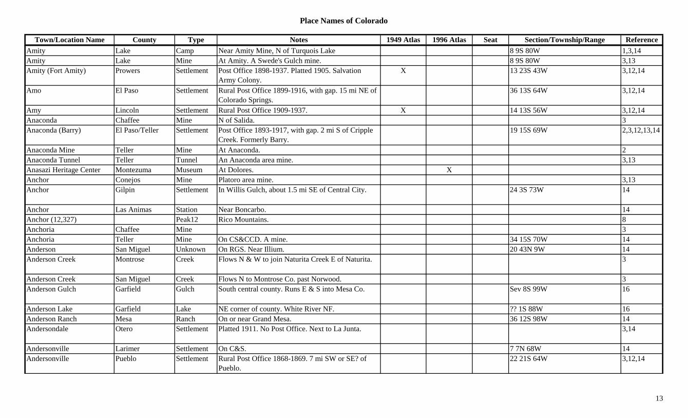
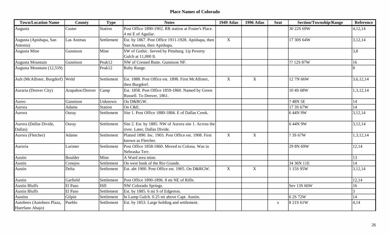
Place Names of Colorado
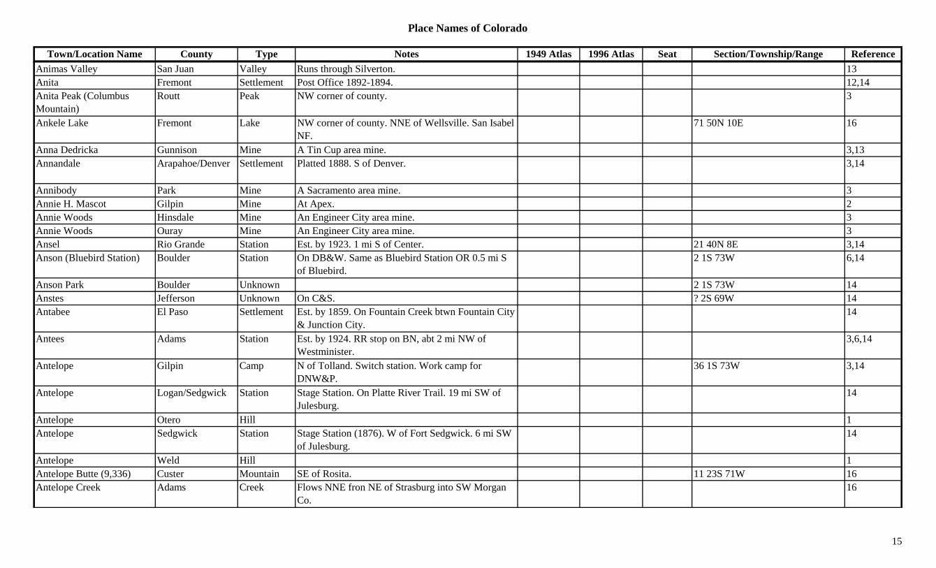
Town/Location Name County Type Notes 1949 Atlas 1996 Atlas Seat Section/Township/Range Reference12 Mile House (Church's) Jefferson Station 3 mi S of Broomfield. 13 Sisters Peak Hinsdale Peak S part of county. 34-Corners Montezuma Misc Only point in US where the corners of 4 states meet. 3
8-Mile Creek Fremont Creek Flows S from Teller Co. to Arkansas River. E of Florence.
3
A. E. Reynolds Mill Gunnison Mill At Chance. 3,13A. G. Smith Claim Teller Mine A Hull City area mine. 3A. H. Ranch Moffat Ranch 26 5N 102W 14A. Holroid & Assoc. Jackson Mine Near Pearl. 3A. P. Stevens' Mill Clear Creek Mill A Lawson area operation. 13A. Y. Lake Mine A California Gulch mine. 3,13A. Y. and Minnie Lake Station On D&RGW. In California Gulch. 2 mi SE of
Leadville.32 9S 79W 14
Aaby Cheyenne Settlement Platted 1907. 8 mi SE of Wild Horse. No Post Office.
3,14
Abarr (Brownsville) Yuma Settlement Platted 1922 as Brownsville. 1923 name changed. Post Office 1923-1947.
X 25 2S 48W 3,12,14
Abbet Place Summit Unknown On 1940 USGS Quad. 2 2S 81W 14Abbey (Muddy Creek) Pueblo Settlement Rural Post Office 1891-1914. 10 mi NW of
Cedarwood.3 24S 66W 3,12,14
Abbey School Fremont School E of Canon City. 27 18S 70W 14Abbeyville Gunnison Camp 1 mi N of Tin Cup. Post Office 1882-1884. Moved
from Hillerton.1 15S 82W 3,12,13,14
Abbot Church Washington Church On Sand Creek. 27 2S 54W 14Abbott Washington Settlement Site 1. Rural Post Office 1887-1918. 10 mi NW of
Lindon8 2S 54W 3,12,14
Lindon.Abbott Washington Settlement Site 2. Rural Post Office 1918-1926. 6 mi N of
Lindon.3 2S 54W 3,12,14
Abe Lincoln Teller Mine 18 15S 69W 14Aberdeen Gunnison Settlement Post Office 1890-1891. Quarry town on D&RG. 5 48N 1W 12,14
Aberdeen Junction Gunnison Spur D&RGW junction near Aberdeen. 18 48N 1W 14
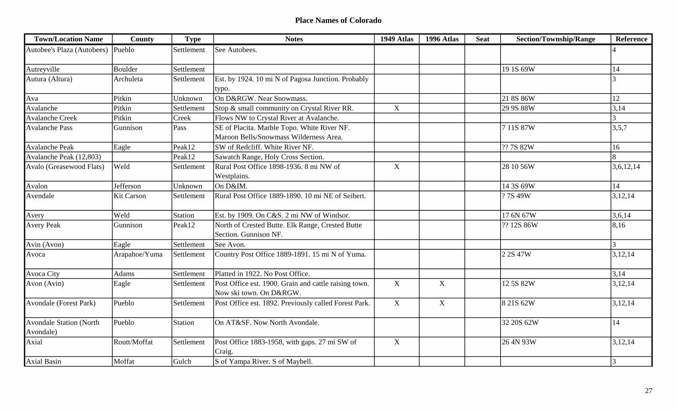
1
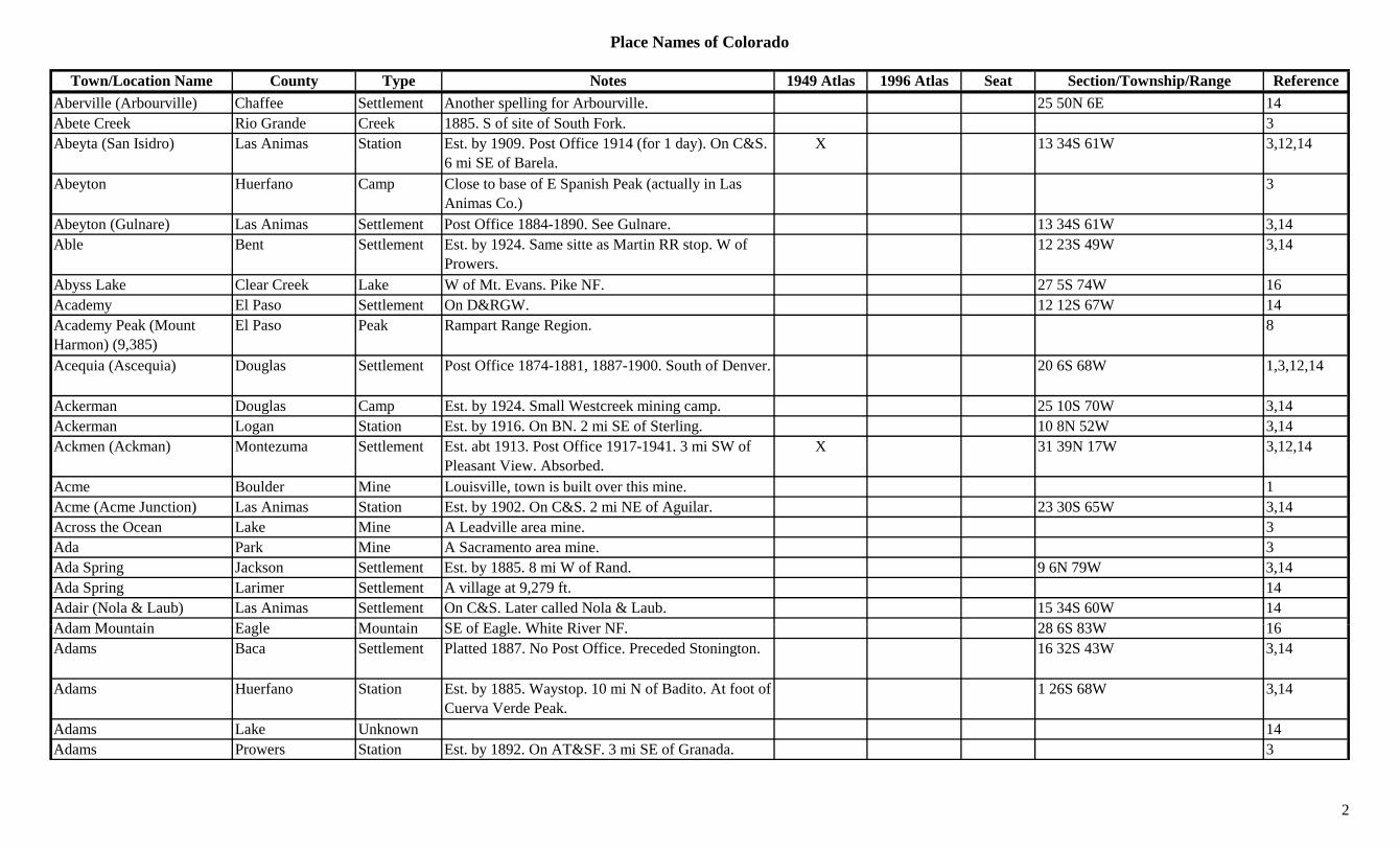
Place Names of Colorado
Town/Location Name County Type Notes 1949 Atlas 1996 Atlas Seat Section/Township/Range ReferenceAberville (Arbourville) Chaffee Settlement Another spelling for Arbourville. 25 50N 6E 14Abete Creek Rio Grande Creek 1885. S of site of South Fork. 3Abeyta (San Isidro) Las Animas Station Est. by 1909. Post Office 1914 (for 1 day). On C&S.
6 mi SE of Barela.X 13 34S 61W 3,12,14
Abeyton Huerfano Camp Close to base of E Spanish Peak (actually in Las Animas Co.)
3
Abeyton (Gulnare) Las Animas Settlement Post Office 1884-1890. See Gulnare. 13 34S 61W 3,14Able Bent Settlement Est. by 1924. Same sitte as Martin RR stop. W of
Prowers.12 23S 49W 3,14
Abyss Lake Clear Creek Lake W of Mt. Evans. Pike NF. 27 5S 74W 16Academy El Paso Settlement On D&RGW. 12 12S 67W 14yAcademy Peak (Mount Harmon) (9,385)
El Paso Peak Rampart Range Region. 8
Acequia (Ascequia) Douglas Settlement Post Office 1874-1881, 1887-1900. South of Denver. 20 6S 68W 1,3,12,14
Ackerman Douglas Camp Est. by 1924. Small Westcreek mining camp. 25 10S 70W 3,14Ackerman Logan Station Est. by 1916. On BN. 2 mi SE of Sterling. 10 8N 52W 3,14Ackmen (Ackman) Montezuma Settlement Est. abt 1913. Post Office 1917-1941. 3 mi SW of
Pleasant View. Absorbed.X 31 39N 17W 3,12,14
Acme Boulder Mine Louisville, town is built over this mine. 1Acme (Acme Junction) Las Animas Station Est. by 1902. On C&S. 2 mi NE of Aguilar. 23 30S 65W 3,14Across the Ocean Lake Mine A Leadville area mine. 3Ada Park Mine A Sacramento area mine. 3Ada Spring Jackson Settlement Est. by 1885. 8 mi W of Rand. 9 6N 79W 3,14Ada Spring Larimer Settlement A village at 9,279 ft. 14Adair (Nola & Laub) Las Animas Settlement On C&S. Later called Nola & Laub. 15 34S 60W 14Ad M t i E l M t i SE f E l Whit Ri NF 28 6S 83W 16Adam Mountain Eagle Mountain SE of Eagle. White River NF. 28 6S 83W 16Adams Baca Settlement Platted 1887. No Post Office. Preceded Stonington. 16 32S 43W 3,14
Adams Huerfano Station Est. by 1885. Waystop. 10 mi N of Badito. At foot of Cuerva Verde Peak.
1 26S 68W 3,14
Adams Lake Unknown 14Adams Prowers Station Est. by 1892. On AT&SF. 3 mi SE of Granada. 3
2

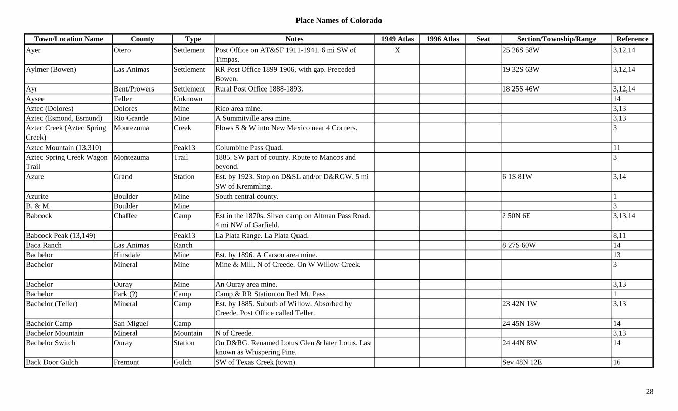
Place Names of Colorado
Town/Location Name County Type Notes 1949 Atlas 1996 Atlas Seat Section/Township/Range ReferenceAdams (Bush) Larimer Settlement Post Office 1885-1897. Small settlement. 8 9N 71W 3,12,14Adams City Adams Settlement Post Office 1923-1963. Became branch of
Commerce City.X 6 3S 67W 3,6,12,14
Adams Lake Alamosa Lake South of Alamosa. 34 37N 10E 16Adams Lake Garfield Lake NW corner of county. White River NF. 32 3S 89W 16Adamsville Boulder Settlement E of Sunset. 14Adana Prowers Unknown On AT&SF. 15 23S 43W 14Addie Gunnison Mine A Tin Cup area mine. 13Addudell Gilpin Unknown On Pewabic Mountain at head of S Willie Gulch. 24 3S 73W 14
Adel Huerfano Station Est. by 1885. RR stop. Approximately at Wahatoya 28 28S 67W 3,14y p pp y ystop.
,
Adelaide Eagle Mine New York Cabins area mine. 3,13Adelaide Fremont Settlement Post Office 1894-1901. 22 17S 69W 12,14Adelaide Lake Mine A Leadville area mine. At Adelaide. 3,13Adelaide (Adelaide City, Finntown)
Lake Settlement Est. by 1876. Post Office 1878-1879. Near Adelaide Mine.
19 9S 79W 3,12,13,14
Adelaide City (Park City, Finntown)
Lake Settlement Post Office 1878 to 1879. Earlier known as Finntown. Another name, Park City.
19 9S 79W 14
Adelaide Park Eagle Camp E of Fulford (Upper town). Absorbed by Fulford. 24 6S 83W 3,14
Adelia Summit Mine A Delaware Flats area mine. 3Adeline Gunnison Mine A Hillerton mine. 3,13Adelpha San Juan Mine A Fisherville, Gladstone & Poughkeepsie area mine. 3
Adena Morgan Settlement Rural Post Office 1910-1949. 16 mi SW of Fort M
X 33 1N 58W 3,12,14Morgan.
Adit Boulder Mine 3Adler Yuma Unknown 26 4S 47W 14Adna Weld Station On GW. 2 mi NE of Milliken. 6 4N 66W 6,14Adnan Garfield Unknown Same section as Catherine & Mulford. Adnan is an
error in spelling. See Adnaw.31 7S 87W 14
Adnaw (Mulford) Garfield Settlement On D&RGW, Aspen Branch. 31 7S 87W 14
3
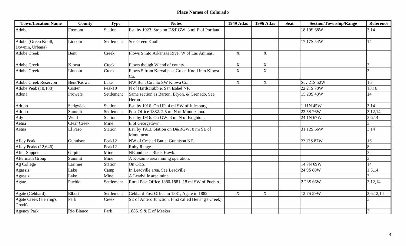
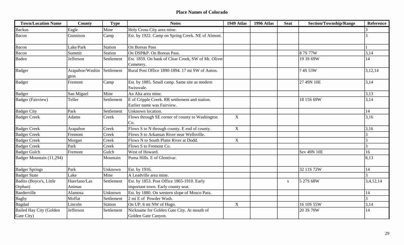
Place Names of Colorado
Town/Location Name County Type Notes 1949 Atlas 1996 Atlas Seat Section/Township/Range ReferenceAdobe Fremont Station Est. by 1923. Stop on D&RGW. 3 mi E of Portland. 18 19S 68W 3,14
Adobe (Green Knoll, Downin, Urbana)
Lincoln Settlement See Green Knoll. 17 17S 54W 14
Adobe Creek Bent Creek Flows S into Arkansas River W of Las Animas. X X
Adobe Creek Kiowa Creek Flows though W end of county. X X 3Adobe Creek Lincoln Creek Flows S from Karval past Green Knoll into Kiowa
Co.X X 3
Adobe Creek Reservoir Bent/Kiowa Lake NW Bent Co into SW Kiowa Co. X X Sev 21S 52W 16Adobe Peak (10,188) Custer Peak10 N of Hardscrabble. San Isabel NF. 22 21S 70W 13,16( , ) ,Adona Prowers Settlement Same section as Barton, Bryon, & Grenado. See
Heron.15 23S 43W 14
Adrian Sedgwick Station Est. by 1916. On UP. 4 mi SW of Julesburg. 1 11N 45W 3,14Adrian Summit Settlement Post Office 1882. 2.5 mi N of Montezuma. 22 5S 76W 3,12,14Ady Weld Station Est. by 1916. On GW. 3 mi N of Brighton. 24 1N 67W 3,6,14Aetna Clear Creek Mine E of Georgetown. 3Aetna El Paso Station Est. by 1913. Station on D&RGW. 8 mi SE of
Monument.31 12S 66W 3,14
Afley Peak Gunnison Peak12 NW of Crested Butte. Gunnison NF. ?? 13S 87W 16Afley Peaks (12,646) Peak12 Ruby Range. 8After Supper Gilpin Mine NE and near Black Hawk. 3Aftermath Group Summit Mine A Kokomo area mining operation. 3Ag College Larimer Station On C&S. 14 7N 69W 14Agassiz Lake Camp In Leadville area. See Leadville. 24 9S 80W 1,3,14Agassiz Lake Mine A Leadville area mine. 3A t P bl S ttl t R l P t Offi 1880 1881 18 i SW f P bl 2 23S 66W 3 12 14Agate Pueblo Settlement Rural Post Office 1880-1881. 18 mi SW of Pueblo. 2 23S 66W 3,12,14
Agate (Gebhard) Elbert Settlement Gebhard Post Office in 1881, Agate in 1882. X X 12 7S 59W 3,6,12,14Agate Creek (Herring's Creek)
Park Creek SE of Antero Junction. First called Herring's Creek) 3
Agency Park Rio Blanco Park 1885. S & E of Meeker. 3
4
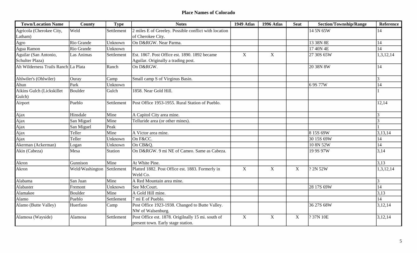
Place Names of Colorado
Town/Location Name County Type Notes 1949 Atlas 1996 Atlas Seat Section/Township/Range ReferenceAgricola (Cherokee City, Latham)
Weld Settlement 2 miles E of Greeley. Possible conflict with location of Cherokee City.
14 5N 65W 14
Agro Rio Grande Unknown On D&RGW. Near Parma. 13 38N 8E 14Agua Ramon Rio Grande Unknown 17 40N 4E 14Aguilar (San Antonio, Schulter Plaza)
Las Animas Settlement Est. 1867. Post Office est. 1890. 1892 became Aguilar. Originally a trading post.
X X 27 30S 65W 1,3,12,14
Ah Wilderness Trails Ranch La Plata Ranch On D&RGW. 20 38N 8W 14
Ahlwiler's (Ohlwiler) Ouray Camp Small camp S of Virginus Basin. 3Ahun Park Unknown 6 9S 77W 14Aikins Gulch (Lickskillet Boulder Gulch 1858. Near Gold Hill. 1(Gulch)Airport Pueblo Settlement Post Office 1953-1955. Rural Station of Pueblo. 12,14
Ajax Hinsdale Mine A Capitol City area mine. 3Ajax San Miguel Mine Telluride area (or other mines). 3Ajax San Miguel Peak 1Ajax Teller Mine A Victor area mine. 8 15S 69W 3,13,14Ajax Teller Unknown On F&CC. 30 15S 69W 14Akerman (Ackerman) Logan Unknown On CB&Q. 10 8N 52W 14Akin (Cabeza) Mesa Station On D&RGW. 9 mi NE of Cameo. Same as Cabeza. 19 9S 97W 3,14
Akron Gunnison Mine At White Pine. 3,13Akron Weld/Washington Settlement Platted 1882. Post Office est. 1883. Formerly in
Weld Co.X X X ? 2N 52W 1,3,12,14
Alabama San Juan Mine A Red Mountain area mine. 3Al b t F t U k S M C t 28 17S 69W 14Alabaster Fremont Unknown See McCourt. 28 17S 69W 14Alamakee Boulder Mine A Gold Hill mine. 3,13Alamo Pueblo Settlement 7 mi E of Pueblo. 14Alamo (Butte Valley) Huerfano Camp Post Office 1923-1938. Changed to Butte Valley.
NW of Walsenburg.36 27S 68W 3,12,14
Alamosa (Wayside) Alamosa Settlement Post Office est. 1878. Origilnally 15 mi. south of present town. Early stage station.
X X X ? 37N 10E 3,12,14
5

Place Names of Colorado
Town/Location Name County Type Notes 1949 Atlas 1996 Atlas Seat Section/Township/Range ReferenceAlamosa Creek Alamosa Creek Flows from Conejos Co. NE to Rio Grande River SE
of Alamosa.X 3,16
Alamosa Creek Conejos Creek Alamosa & Terrace Res. E to Alamosa County. X X 3,16
Alamosa Creek Rio Grande Creek Flows in and out of county from/to Alamosa Co. X X 3
Alamosa East Alamosa Settlement XAlaska San Juan Mine A Fisherville, Gladstone & Poughkeepsie area mine. 3
Albano El Paso Settlement Rural Post Office 1904-1912. 4 mi NW of Rush. 32 13S 60W 3,12,14
Albany Ouray Settlement Obscure little town near Ironton. 6 mi S of Ouray. 17 43N 7W 3,14
Albany Prowers Settlement Rural Post Office 1887-1891 & 1897-1905. Formerly in Bent Co.
33/34 27S 47W 3,12,14
Albert Reservoir Grand Lake NW corner of county. 3 3N 82W 16Albia (Mesa) Pueblo Station Est. by 1909. On D&RGW. 6 mi S of Lime. At or
near Mesa. In section with Dundee.25 21S 65W 3,14
Albion (Camp Albion) Boulder Camp Est. by 1880. 5 mi NE of Caribou. Mine discovered 1864.
17 1N 73W 1,14
Alcott (Berkeley) Arapahoe/Denver Settlement Post Office 1896-1904. NW of Denver. Formerly Berkeley.
3,12,14
Alcreek Las Animas Settlement Rural Post Office 1916-1935. 8 mi SE of Tobe. X 23 33S 57N 3,12,14Alda Delta Settlement Post Office 1913-1914. 4 mi NW of Crawford. ? 15S 92W 12,14Alden Weld Station On UP. 2 mi W of Gill. 29 6N 64W 3,6,14Aldens Junction Hinsdale/Mineral Station 1st in Hinsdale Co., then Mineral Co. 11 40N 1W 14Ald (R d Hill) S h S ttl t P t Offi 1881 1910 & 1911 1927 10 i NW f X 36 48N 8E 3 12 14Alder (Round Hill) Saguache Settlement Post Office 1881-1910 & 1911-1927. 10 mi NW of
Villa Grove.X 36 48N 8E 3,12,14
Alder Creek Ouray/San Miguel Camp Post Office 1878-1880. Placer camp on Alder Creek. NE of Placerville.
13 44N 11W 3,12,14
Alder Creek San Miguel Creek Flows NW to join Leopard Creek near Brown. 3Aldrich Gulch Custer Gulch SE of Westcliffe. Runs WNW. Sev 22S 72W 16
6
Place Names of Colorado
Town/Location Name County Type Notes 1949 Atlas 1996 Atlas Seat Section/Township/Range ReferenceAldridge Montezuma Settlement 16 mi SW of Cortez. See Moqui. On McElmo Creek. 35 36N 18W 3,14
Aleck (Baden City) Jefferson Settlement Est. by 1859. First name for Baden City. 19 3S 69W 14Alelaide Mine Lake Mine At Alelaide. 3Alexander Lake Settlement Post Office 1879-1879. 6 mi NW of Leadville on
Redcliff wagon road.14 9S 80W 3,12,14
Alexander Saguache Mine A Carnero-Crystal Hill area mine. 3Alexander Lake Delta Lake North of Cedaredge. Grand Mesa NF. 1/2 12S 95W 16Alexander PO (Oxford, Sibley)
Otero Settlement Post Office 1900. Originally Oxford, then Sibley, then Fowler, again Fowler.
? 22S 59W 3,12,14
Alexandria Arapahoe Settlement Platted 1894. No Post Office. 3,14p ,Alfalfa Larimer/Weld Station Post Office 1892. On C&S. 5 mi E of Fort Collins. 11 7N 68W 1,3,12,14
Alfalfa Weld Settlement Post Office 1892. 8 mi NW of Fort Lupton. 14Alfalfa (Conley's Seat, Griffith, Falfa)
La Plata Settlement First Alfalfa, then Conley's Seat, then Griffith, then Falfa.
2U 34N 9W 14
Alfalfa (Raton) Las Animas Settlement Rural Post Office 1881-1923 with gaps. NE of Barela. Formerly Raton. Also at 2 33S 61W.
32 32S 60W 3,12,14
Alford Larimer Settlement Post Office 1882-1909. 8 mi NW of Livermore. 15 10N 71W 3,12,14Alhambra Park Settlement 2.5 mi NW of Guffey. 33 14S 73W 14Alicante Lake Settlement Post Office 1881-1887. Moved to Climax. At
Alicante Mine. Near Climax12 8S 79W 1,3,12,14
Alicante Mine Lake Mine At Alicante. 3Alice Boulder Mine 1 mi NW of Jamestown. 1,3Alice (Silver City, Yorktown)
Clear Creek Settlement 10 mi NW of Idaho Springs. Post Office from 1898-1938, with gaps.
2 3S 74W 2,3,12,13,14
Ali Gl H l (Gl Cl C k Mi Ab t f Ali 2 3 13Alice Glory Hole (Glory Hole)
Clear Creek Mine Above town of Alice. 2,3,13
Alice Mine Clear Creek Mine Adjacent to Saint Mary's Glacier. 2,3,13Alie Bell Chaffee Mine A Romley area mine. 13Alkalai (Alkali) Bent Station Post Office 1874-1875. Stage station on Purgatoire
route of Santa Fe Trail.21 25S 53W 3,12,14
Alkalai Springs (Alkali) Las Animas Settlement 20 mi N of Andrix. 3,14
7
Place Names of Colorado
Town/Location Name County Type Notes 1949 Atlas 1996 Atlas Seat Section/Township/Range ReferenceAlkali Dolores Settlement Post Office 1916. Question on location? 2 39N 18W 12,14Alkali Otero Settlement Purgatoire stage station. Probably in Bent Co.
Shown N of Higbee.21 25S 53W 3
Alkali (Alkalai, Alkalai Springs)
Las Animas Creek 20 mi N of Andrix. 1,3
Alkali Canyon Dolores Canyon SW county. Runs W to Cross Canyon. Sev 40N 18W 16Alkali Creek Mesa Creek Flows N into Garfield Co. N of Castle Peak. 3Alkali Creek Montezuma Creek Flows SW into Mancos River from near La Plata Co. 3
Alkali Creek Montrose Creek 1Alkali Gulch Fremont Gulch East of Howard. Sev 48/49N 11E 16Alkali Gulch La Plata Gulch 1Alkali Gulch Montezuma Gulch 1Alkali Lake Park Lake 1885. SW of Orme. Near site of Mountaindale. 1,3Alkali Springs Alamosa Creek Btwn Alamosa and Zapato. 3All Right Lake Unknown On D&RG spur. 14Allan Ranch El Paso Station Stage station on Cherokee Trail stage route. 4 mi
NW of Black Forest.? 12S 66W 3,14
Allen Garfield Station On D&RGW. X 15/16 5S 87W 14Allen (Madera, Gateway) Gunnison Settlement Post Office 1881-1892, moved to Gateview. Early
name for Gateway.? 47N 3W 3,12,14
Allen Bond Boulder Settlement 3 mi SE of Boulder. ? 1S 70W 14Allen Creek Park Settlement Est. by 1885. NW of Tarryall. 3Allen Dale Hinsdale Mine A Tellurium area mine. 3,13Allen Ditch Adams Canal Comes into county from Jefferson Co in
Westminster.16
All ' S Mi l St ti E t b 1885 W t 5 i NW f Pl ill 3Allen's San Miguel Station Est. by 1885. Waystop. 5 mi NW of Placerville. 3Allens Lake Boulder Lake South of Lyons. 13 2N 71W 16Allens Park (Allenspark) Boulder Settlement Post Office in 1896-1905 & 1906 on. On Allen's
homestead.26 3N 73W 3,12,14
Allenspark (Allens Park) Boulder Settlement Est. by 1859. NW corner of County. 8 mi N of Ward. X X 26 3N 73W 1,6
Allenton (Wilmore) Eagle Station Est. by 1923. Stop on D&RG E of Wolcott. 24 4S 84W 3,14
8

Place Names of Colorado
Town/Location Name County Type Notes 1949 Atlas 1996 Atlas Seat Section/Township/Range ReferenceAlliance Huerfano Unknown On D&RGW. Btwn Oakdale Junction & Tropic. 9 29S 69W 14
Alliance Saguache Mine An Iris area mine. 3,13Allie Bell Chaffee Mine At Romley. 3Allie S. Park Mine A Puma area mine. 3Allison (Vallejo) La Plata Settlement Est. 1901. Post Office 1904-1954. First called
Vallejo.X X 15 32N 6W 3,12,14
Allison Station Boulder Station E of S Boulder Creek. Near Culbertson. 14Alma Park Mine An Alma area mine. 3Alma Park Settlement Est. 1872. Post Office est. 1873. 5 mi NW of
Fairplay.X X 12 9S 78W 2,3,12,13,14
Alma Mater Dolores Mine Rico area mine. 3Alma Station (Alma Junction, London Junction)
Park Station Junction S of Alma, at Buckskin Joe cutoff. 18 9S 77W 3,14
Almagre Mountain (12,367) El Paso Peak12 Pikes Peak Region. 8
Almond Mesa Unknown On D&RGW. 23 10S 98W 14Almont (Fishers Ranch) Gunnison Settlement Est. 1881. Post Office 1882 on, with gaps. X X 22 51N 1E 3,12,14Almont Quarry Gunnison Mine On D&RGW. 4 50N 1E 14Alnwick El Paso/Teller Settlement Post Office 1887-1893. 12/15S 70W 12,14Alpha Mineral Mine NW of Creede. Near Sunnyside. 3Alpha San Juan Mine A Fisherville, Gladstone & Poughkeepsie area mine. 3
Alpine Chaffee/Lake Settlement Post Office 1874-1904. 16 mi SW of Buena Vista. Formerly in Lake Co.
25 15S 80W 3,12,13,14
Al i E l U k O D&RGW Bt C d t & B ld 14Alpine Eagle Unknown On D&RGW. Btwn Cadet & Belden. 14Alpine Pitkin Mine An Ashcroft area mine. 3Alpine (Altman) Pass Chaffee/Gunnison Other Alpine Tunnel of D&SP RR. Gunnison & San Isabel
NF.27 51N 5E
Alpine Glen (Treasureville) Hinsdale Settlement See Treasureville. 31 44N 4W 14
Alpine Gulch Hinsdale Gulch NW county. Runs NE & N to Henson Creek. Sev 43N 5W 16
9

Place Names of Colorado
Town/Location Name County Type Notes 1949 Atlas 1996 Atlas Seat Section/Township/Range ReferenceAlpine Peak (11,525) Clear Creek Peak11 SE of Georgetown. Arapaho NF. 21 4S 74W 16Alpine Station (Alpine Tunnel)
Gunnison Station Est. by 1880. Group of block houses on W end of Alpine Tunnel. At 11,546 ft.
27 51N 5E 3,13,14
Alpine Tunnel Chaffee Camp May be on Gunnison County side of Tunnel. 3Alpine Tunnel (Alpine Station)
Gunnison Station Group of block houses on W end of Alpine Tunnel. 27 51N 5E 3
Alpine Village Rio Grande Settlement A sub-division. 30 40N 4E 14Alpine Visitors Center Laramie Park In Rocky Mountain National Park. E of Milner Pass. X
Alps Junction Lake Station On the D&RG RR 21 9S 79W 1,14Alps Mountain (10,508) Clear Creek Peak10 WSW of Idaho Springs. 6/7 4S 73W 1,16p ( , ) p g ,Alta San Miguel Camp Est. by 1878. 14 mi S of Telluride. Near Turkey
Basin.22 42N 9W 2,3,13,14
Alta Lake Reservoir Conejos Lake SE of Conejos. 10/11 32N 9E 16Alta Mine & Mill San Miguel Mine Est. by 1878. An Alta area mine. 3,13Alta Verde Custer Mine Westcliffe area mine. 3Alta Vista (Glenn) El Paso Settlement See Glenn. 9 12S 60W 14Altavista Fremont/Teller Settlement Est. by 1923. On 8-Mile Creek near Teller County
line.8 16S 69W 3,14
Altman Teller Settlement Post Office 1894-1911, moved to Macon. Inc. 1896. 3 mi N of Victor.
20 15S 69W 3,12,13,14
Altman (Altman's) Pass (12,000)
Chaffee Pass S of Hancock. Alpine Tunnel of D&SP RR. Gunnison & San Isabel NF.
27 51N 5E 3,7
Altman's Camp (Alton's Camp)
Chaffee Camp On N fork of the S Arkansas River. 3
Altona (Davenport) Boulder Settlement 8 mi N of Boulder. May be same site as Alt /M d /Ni W t
1Altona/Modoc/Ni Wot.
Altona (Modoc, Ni-Wot) Boulder Settlement Post Office 1879-1916, moved from Ni Wot. At mouth of Left Hand Canyon.
13 2N 71W 3,6,12,14
Alton's Camp (Altman's Camp)
Chaffee Camp See Altman's Camp. 3
Altura Arapahoe Unknown 32 3S 66W 14Altura (Autura) Archuleta Settlement Est. by 1923. 10 mi N of Pagosa Junction. X 21 34N 3W 3,14
10

Place Names of Colorado
Town/Location Name County Type Notes 1949 Atlas 1996 Atlas Seat Section/Township/Range ReferenceAlturia (Altruria, Fairville, Slaghts, Shawnee)
Park Settlement First Alturia, then Fairville, then Slaghts, then Shawnee.
21 7S 73W 14
Alum Springs Kiowa Settlement Est. by 1876. NW of Las Animas. 14Alva (Idalia) Arapahoe/Yuma Settlement Rural Post Office 1887-1888. Preceded Idalia. 16 4S 44W 3,12,14Alva Adams Tunnel Grand Canal Runs ENE from Grand Lake under Continental
Divide S of Otis Peak.Sev 3/4N 74/75W 16
Alvarado (Empire Junction, Peckville, Swansea)
Clear Creek Settlement Est. by 1879. On S fork of Clear Creek. Also called Russell Park.
34 3S 74W 14
Alvin Yuma Settlement Rural Post Office 1910-1929. 15 mi NE of Wray. X 27 4N 43W 3,12,14
Alvord Placer Boulder Mine N of Grand Island. Klondike Mtn. 3Alwilda Gunnison Mine At White Pine. 2Amanche (Amanche Oehwee)
Prowers Settlement Internment camp for American Japanese in WWII. 14 23S 44W 3,14
Amargo Conejos/Archuleta Settlement Est. by 1887. S of Juanita, almost to NM border. 3,14
Amazon Dolores Mine A Rico area mine. 13Ambold La Plata Station On D&RG. 32 34.5N 9W 14Amen (Logan) Logan Settlement On CB&Q. First name for Logan. 13 7N 54W 14American Boulder Mine Central part of county. Near Sunshine. 1,3,13American Lake Mine A Leadville area mine. 3American City Gilpin Settlement Est. by 1890s. No Post Office. 9 mi NW of Black
Hawk.17 2S 73W 2,3,13,14
American Eagle Chaffee Mine 3American Eagle Teller Mine An Altman area mine. 3A i Fl F t Mi S f M 3American Flag Fremont Mine S of Manoa. 3American Flag Mountain Gunnison Peak12 South of Taylor Pass. Elk Range, Crested Butte
Section. Gunnison NF.?? 13S 84W 8,13,16
American Flats (American Basin)
San Juan Gulch See also Ouray & Hinsdale Cos. 12 43N 7W 3
American Flats (Engineer City)
Ouray/Hinsdale Settlement Early name for Engineer City. 12 43N 7W 3,14
11
Place Names of Colorado
Town/Location Name County Type Notes 1949 Atlas 1996 Atlas Seat Section/Township/Range ReferenceAmerican Flats mining area Hinsdale Mine A Rose's Cabin area mine. 3
American Girl Ouray Mine A Guston area mine. 3,13American Gulch Summit Gulch Near Lincoln City. 3American Gulch Summit Settlement Near Lincoln City. In gulch of same name. 3,14American House Boulder Station Stage coach stop, near the narrows on canyon road
to Caribou.1
American Mining & Tunnel Co.
San Juan Mine A Fisherville, Gladstone & Poughkeepsie area operation.
3
American Nettie Ouray Mine An Ouray area mine. 3,13American Ranch (Kelly's, Weld/Logan Station Post Office 1863-1864 & 1865-1867. Stage Station. 20 7N 53W 3,4,12,14( y ,Morrison Ranch)
g gDestroyed in Indian Uprising.
, , ,
American Shale Camp Garfield Camp On Grand Valley 1926 Quad. 8 7S 97W 14American Sisters Group Clear Creek Mine Silver Creek area mine. 3American Tunnel San Juan Mine Gladstone area. Connects several area mines. 3,13American Union Summit Mine A Lincoln area mine. 3Americas (Americus) Chaffee Settlement Est. by 1922. N of Buena Vista along D&RG RR. At
8,174 feet.3
Americus (Americas) Chaffee Settlement Est. by 1885. Same site as Americas. Typo? X 24 13S 79W 3,14Ames Ouray/San Miguel Settlement Post Office 1880-1922, with gaps, moved to Ophir.
15 mi S of Telluride.X 32 42N 9W 3,12,13,14
Ames (Creswell) Jefferson Settlement See Creswell. 15 4S 71W 6,14Ames Smelter San Miguel Mill An Alta area operation. 3Ames Station San Miguel Station On RGS. 19 42N 9W 14Amethyst Mineral Mine N of Creede (Batchelor Mountain). 2,3,13Amethyst (Creede, Ji t )
Mineral Camp Post Office 1892-1909. Absorbed by Creede. Name f Ji t ?
36 42N 1W 1,3,12,14Jimtown) for Jimtown?Amherst Logan/Phillips Settlement Est. 1887. Post Office 1888-1899 & 1907 on.
Formerly Logan Co.X X 8 8N 43W 3,12,14
Amherst Mountain (13,165) Peak13 Columbine Pass Quad. 11
Amidon Kiowa Settlement 4 19S 52W 12Amitie (Fairview) Phillips Settlement First Fairview. Changed to Amitie in 1866. 14
12
Place Names of Colorado
Town/Location Name County Type Notes 1949 Atlas 1996 Atlas Seat Section/Township/Range ReferenceAmity Lake Camp Near Amity Mine, N of Turquois Lake 8 9S 80W 1,3,14Amity Lake Mine At Amity. A Swede's Gulch mine. 8 9S 80W 3,13Amity (Fort Amity) Prowers Settlement Post Office 1898-1937. Platted 1905. Salvation
Army Colony.X 13 23S 43W 3,12,14
Amo El Paso Settlement Rural Post Office 1899-1916, with gap. 15 mi NE of Colorado Springs.
36 13S 64W 3,12,14
Amy Lincoln Settlement Rural Post Office 1909-1937. X 14 13S 56W 3,12,14Anaconda Chaffee Mine N of Salida. 3Anaconda (Barry) El Paso/Teller Settlement Post Office 1893-1917, with gap. 2 mi S of Cripple
Creek. Formerly Barry.19 15S 69W 2,3,12,13,14
Anaconda Mine Teller Mine At Anaconda. 2Anaconda Tunnel Teller Tunnel An Anaconda area mine. 3,13Anasazi Heritage Center Montezuma Museum At Dolores. XAnchor Conejos Mine Platoro area mine. 3,13Anchor Gilpin Settlement In Willis Gulch, about 1.5 mi SE of Central City. 24 3S 73W 14
Anchor Las Animas Station Near Boncarbo. 14Anchor (12,327) Peak12 Rico Mountains. 8Anchoria Chaffee Mine 3Anchoria Teller Mine On CS&CCD. A mine. 34 15S 70W 14Anderson San Miguel Unknown On RGS. Near Illium. 20 43N 9W 14Anderson Creek Montrose Creek Flows N & W to join Naturita Creek E of Naturita. 3
Anderson Creek San Miguel Creek Flows N to Montrose Co. past Norwood. 3Anderson Gulch Garfield Gulch South central county. Runs E & S into Mesa Co. Sev 8S 99W 16
A d L k G fi ld L k NE f t Whit Ri NF ?? 1S 88W 16Anderson Lake Garfield Lake NE corner of county. White River NF. ?? 1S 88W 16Anderson Ranch Mesa Ranch On or near Grand Mesa. 36 12S 98W 14Andersondale Otero Settlement Platted 1911. No Post Office. Next to La Junta. 3,14
Andersonville Larimer Settlement On C&S. 7 7N 68W 14Andersonville Pueblo Settlement Rural Post Office 1868-1869. 7 mi SW or SE? of
Pueblo.22 21S 64W 3,12,14
13

Place Names of Colorado
Town/Location Name County Type Notes 1949 Atlas 1996 Atlas Seat Section/Township/Range ReferenceAndover Saguache Mine An Oriental area mine. 3Andracich Discovery/Load Custer Mine At Ilse. 3
Andrew Ranch Archuleta Ranch 30 36N 2.5W 14Andrews San Miguel Mine Telluride area (or other mines). 3Andrews Pass Grand/Larimer Pass McHenrys Peak Topo. Rocky Mountain Natl Park. 5,7
Andrews Peak Grand Peak12 East of Grand Lake. Front Range, National Park Section. Rocky Mtn Natl Park.
X 5 3N 74W 8,16
Andrix Las Animas Settlement Rural Post Office 1820-1952. 10 mi NE of Kim. X 12 32S 52W 3,12,14
Andrus Ouray Camp Small camp S of Mt. Sneffels and the Virginia Basin.
3
Andy Creek Pueblo Creek Flows S to Arkansas River E of Pueblo. 3Angel Pass Gunnison Pass NW of Pittsburg. Oh-be-joyful Topo. Gunnison NF. 33 12S 87W 3,5,7
Anglo Saxon Mining & Milling Co.
San Juan Mine A Fisherville, Gladstone & Poughkeepsie area operation.
3
Anglo-Saxon Clear Creek Mine N of Georgetown. 3,13Angora Otero Settlement Post Office on AT&SF 1891-1894. 6 mi SW of La
Junta.? 24S 56W 3,12,14
Angora Rio Blanco Station Post Office 1896-1912. On DU&P. 20 mi NW of White River.
32 3N 99W 3,12,14
Anheuser El Paso Unknown On D&RGW. 14Animas (Animas City) La Plata Settlement 2 sites. Post Office 1886-1907 (Animas). 1877-1885
(Animas City). Near Durango.X 17 35N 9W 3,12,14
A i F k (L Pl t S J S ttl t P t Offi 1875 1915 ith 12 i NE f X 6 42N 6W 2 3 12 13 14Animas Forks (La Plata City)
San Juan Settlement Post Office 1875-1915, with gaps. 12 mi NE of Silverton.
X 6 42N 6W 2,3,12,13,14
Animas Mountain (13,786) Peak13 Needle Mountains. The Grenadiers. Snowden Peak Quad.
8,11
Animas River La Plata River Central La Plata County. Flows S to NM S of Durango.
X X 3
Animas River San Juan River Flows S from Silverton to La Plata Co. X X 3
14
Place Names of Colorado
Town/Location Name County Type Notes 1949 Atlas 1996 Atlas Seat Section/Township/Range ReferenceAnimas Valley San Juan Valley Runs through Silverton. 13Anita Fremont Settlement Post Office 1892-1894. 12,14Anita Peak (Columbus Mountain)
Routt Peak NW corner of county. 3
Ankele Lake Fremont Lake NW corner of county. NNE of Wellsville. San Isabel NF.
71 50N 10E 16
Anna Dedricka Gunnison Mine A Tin Cup area mine. 3,13Annandale Arapahoe/Denver Settlement Platted 1888. S of Denver. 3,14
Annibody Park Mine A Sacramento area mine. 3Annie H. Mascot Gilpin Mine At Apex. 2p pAnnie Woods Hinsdale Mine An Engineer City area mine. 3Annie Woods Ouray Mine An Engineer City area mine. 3Ansel Rio Grande Station Est. by 1923. 1 mi S of Center. 21 40N 8E 3,14Anson (Bluebird Station) Boulder Station On DB&W. Same as Bluebird Station OR 0.5 mi S
of Bluebird.2 1S 73W 6,14
Anson Park Boulder Unknown 2 1S 73W 14Anstes Jefferson Unknown On C&S. ? 2S 69W 14Antabee El Paso Settlement Est. by 1859. On Fountain Creek btwn Fountain City
& Junction City.14
Antees Adams Station Est. by 1924. RR stop on BN, abt 2 mi NW of Westminister.
3,6,14
Antelope Gilpin Camp N of Tolland. Switch station. Work camp for DNW&P.
36 1S 73W 3,14
Antelope Logan/Sedgwick Station Stage Station. On Platte River Trail. 19 mi SW of Julesburg.
14
A t l Ot Hill 1Antelope Otero Hill 1Antelope Sedgwick Station Stage Station (1876). W of Fort Sedgwick. 6 mi SW
of Julesburg.14
Antelope Weld Hill 1Antelope Butte (9,336) Custer Mountain SE of Rosita. 11 23S 71W 16Antelope Creek Adams Creek Flows NNE fron NE of Strasburg into SW Morgan
Co.16
15

Place Names of Colorado
Town/Location Name County Type Notes 1949 Atlas 1996 Atlas Seat Section/Township/Range ReferenceAntelope Creek Baca Creek Flows E to join Horse Creek near Blaine. 3Antelope Creek Custer Creek Flows W to join Texas Creek at Focus. 3Antelope Creek Grand Creek Flows S into Muddy Creek N of Kremmling. 3Antelope Creek Morgan Creek Flows S to South Platte River near Snyder. 3Antelope Gulch Fremont Gulch Central county. N of Texas Creek (town). Sev 49N 12E 16Antelope Gulch Fremont Gulch North of Howard. San Isabel NF. Sev 51N 10E 16Antelope Mountain Mineral Mountain NW of Spar City. 13Antelope Pass Grand Pass N of Kremmling. 10 2N 80W 7,16Antelope Springs Fremont Unknown 23 19S 68W 14Antelope Springs Morgan Settlement Rural Post Office 1911-1917. 8 mi N of Snyder. 36 6N 56W 3,12,14
Antelope Springs Saguache Camp S part of Luis Baca Grant. A cow camp? 3Antelope Springs (Antelope Park, Salt Lick)
Hinsdale/Mineral Station Post Office 1911-1917. Stage stop on route to Silverton in 1870s.
1 40N 2W 3,12,14
Antelope Station Sedgwick Station Stage station on Central Overland stage route. 3Antero Adams Settlement Platted in 1909. 7 mi NE of Irondale. 22 2S 66W 3,6,14Antero Chaffee Settlement Post Office 1895-1896. 12,14Antero Park Unknown On CM. 23 12S 76W 14Antero Junction Park Settlement Est. abt 1892. 14 13S 77W 1,3,14Antero Reservoir Park Lake SW of Hartsel. X XAnthracite Routt Settlement Post Office 1905-1906. 29 8N 86W 12,14Anthracite (Anthricite) Gunnison Camp Est. by 1876. Post Office 1884-1896. N of Oh-Be-
Joyful Gulch.20 13S 86W 3,12,14
Anthracite Pass (The Gap) Gunnison Pass S of Marble. E of Ragged Mtn. In Elk Mountains. Gunnison & White River NF.
12 12S 88W 7,16
A th it R Pitki R P t f Elk M t i 15Anthracite Range Pitkin Range Part of Elk Mountains. 15Antioch Boulder Mine A Salina Mine. 3Antler Creek Pitkin Creek 1885. E of Janeway. 3Antlers (Ferguson) Garfield Settlement Post Office 1891-1954 with gap. On D&RGW. 2 mi
W of Silt. Formerly Ferguson.X 12 6S 93W 3,12,14
Anton Washington Settlement Rural Post Office 1916-1928 & 1934 on. 24 mi NW of Cope.
X X 32 3S 52W 3,12,14
16
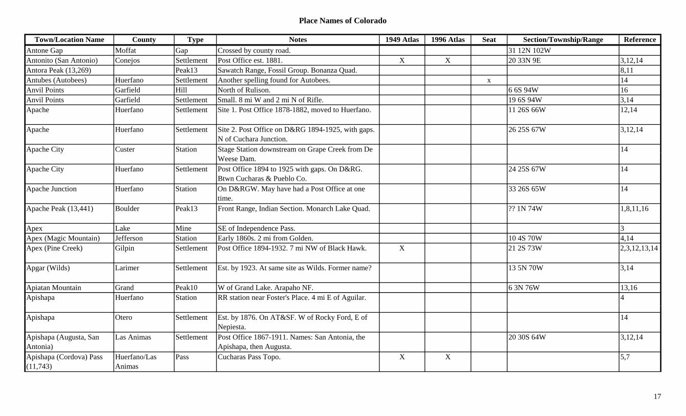
Place Names of Colorado
Town/Location Name County Type Notes 1949 Atlas 1996 Atlas Seat Section/Township/Range ReferenceAntone Gap Moffat Gap Crossed by county road. 31 12N 102WAntonito (San Antonio) Conejos Settlement Post Office est. 1881. X X 20 33N 9E 3,12,14Antora Peak (13,269) Peak13 Sawatch Range, Fossil Group. Bonanza Quad. 8,11Antubes (Autobees) Huerfano Settlement Another spelling found for Autobees. x 14Anvil Points Garfield Hill North of Rulison. 6 6S 94W 16Anvil Points Garfield Settlement Small. 8 mi W and 2 mi N of Rifle. 19 6S 94W 3,14Apache Huerfano Settlement Site 1. Post Office 1878-1882, moved to Huerfano. 11 26S 66W 12,14
Apache Huerfano Settlement Site 2. Post Office on D&RG 1894-1925, with gaps. N of Cuchara Junction.
26 25S 67W 3,12,14
Apache City Custer Station Stage Station downstream on Grape Creek from De 14p y g pWeese Dam.
Apache City Huerfano Settlement Post Office 1894 to 1925 with gaps. On D&RG. Btwn Cucharas & Pueblo Co.
24 25S 67W 14
Apache Junction Huerfano Station On D&RGW. May have had a Post Office at one time.
33 26S 65W 14
Apache Peak (13,441) Boulder Peak13 Front Range, Indian Section. Monarch Lake Quad. ?? 1N 74W 1,8,11,16
Apex Lake Mine SE of Independence Pass. 3Apex (Magic Mountain) Jefferson Station Early 1860s. 2 mi from Golden. 10 4S 70W 4,14Apex (Pine Creek) Gilpin Settlement Post Office 1894-1932. 7 mi NW of Black Hawk. X 21 2S 73W 2,3,12,13,14
Apgar (Wilds) Larimer Settlement Est. by 1923. At same site as Wilds. Former name? 13 5N 70W 3,14
Apiatan Mountain Grand Peak10 W of Grand Lake. Arapaho NF. 6 3N 76W 13,16Apishapa Huerfano Station RR station near Foster's Place. 4 mi E of Aguilar. 4
Apishapa Otero Settlement Est. by 1876. On AT&SF. W of Rocky Ford, E of Nepiesta.
14
Apishapa (Augusta, San Antonia)
Las Animas Settlement Post Office 1867-1911. Names: San Antonia, the Apishapa, then Augusta.
20 30S 64W 3,12,14
Apishapa (Cordova) Pass (11,743)
Huerfano/Las Animas
Pass Cucharas Pass Topo. X X 5,7
17
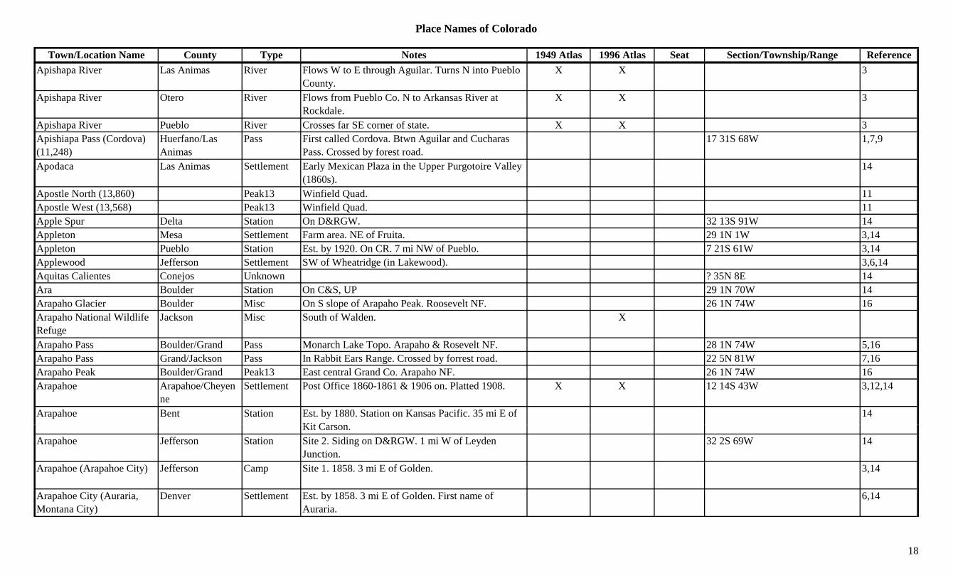
Place Names of Colorado
Town/Location Name County Type Notes 1949 Atlas 1996 Atlas Seat Section/Township/Range ReferenceApishapa River Las Animas River Flows W to E through Aguilar. Turns N into Pueblo
County.X X 3
Apishapa River Otero River Flows from Pueblo Co. N to Arkansas River at Rockdale.
X X 3
Apishapa River Pueblo River Crosses far SE corner of state. X X 3Apishiapa Pass (Cordova) (11,248)
Huerfano/Las Animas
Pass First called Cordova. Btwn Aguilar and Cucharas Pass. Crossed by forest road.
17 31S 68W 1,7,9
Apodaca Las Animas Settlement Early Mexican Plaza in the Upper Purgotoire Valley (1860s).
14
Apostle North (13,860) Peak13 Winfield Quad. 11Apostle West (13,568) Peak13 Winfield Quad. 11p ( , ) QApple Spur Delta Station On D&RGW. 32 13S 91W 14Appleton Mesa Settlement Farm area. NE of Fruita. 29 1N 1W 3,14Appleton Pueblo Station Est. by 1920. On CR. 7 mi NW of Pueblo. 7 21S 61W 3,14Applewood Jefferson Settlement SW of Wheatridge (in Lakewood). 3,6,14Aquitas Calientes Conejos Unknown ? 35N 8E 14Ara Boulder Station On C&S, UP 29 1N 70W 14Arapaho Glacier Boulder Misc On S slope of Arapaho Peak. Roosevelt NF. 26 1N 74W 16Arapaho National Wildlife Refuge
Jackson Misc South of Walden. X
Arapaho Pass Boulder/Grand Pass Monarch Lake Topo. Arapaho & Rosevelt NF. 28 1N 74W 5,16Arapaho Pass Grand/Jackson Pass In Rabbit Ears Range. Crossed by forrest road. 22 5N 81W 7,16Arapaho Peak Boulder/Grand Peak13 East central Grand Co. Arapaho NF. 26 1N 74W 16Arapahoe Arapahoe/Cheyen
neSettlement Post Office 1860-1861 & 1906 on. Platted 1908. X X 12 14S 43W 3,12,14
Arapahoe Bent Station Est. by 1880. Station on Kansas Pacific. 35 mi E of Kit C
14Kit Carson.
Arapahoe Jefferson Station Site 2. Siding on D&RGW. 1 mi W of Leyden Junction.
32 2S 69W 14
Arapahoe (Arapahoe City) Jefferson Camp Site 1. 1858. 3 mi E of Golden. 3,14
Arapahoe City (Auraria, Montana City)
Denver Settlement Est. by 1858. 3 mi E of Golden. First name of Auraria.
6,14
18
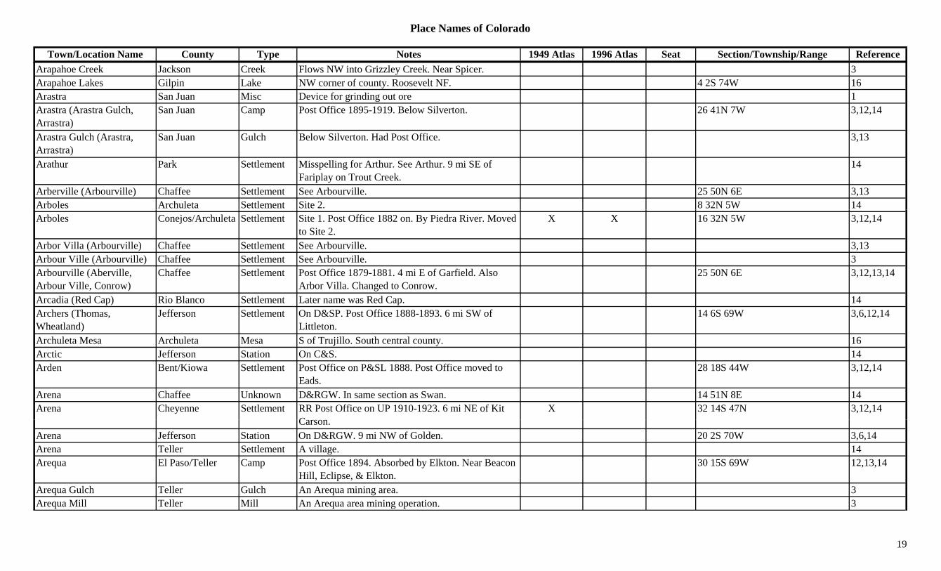
Place Names of Colorado
Town/Location Name County Type Notes 1949 Atlas 1996 Atlas Seat Section/Township/Range ReferenceArapahoe Creek Jackson Creek Flows NW into Grizzley Creek. Near Spicer. 3Arapahoe Lakes Gilpin Lake NW corner of county. Roosevelt NF. 4 2S 74W 16Arastra San Juan Misc Device for grinding out ore 1Arastra (Arastra Gulch, Arrastra)
San Juan Camp Post Office 1895-1919. Below Silverton. 26 41N 7W 3,12,14
Arastra Gulch (Arastra, Arrastra)
San Juan Gulch Below Silverton. Had Post Office. 3,13
Arathur Park Settlement Misspelling for Arthur. See Arthur. 9 mi SE of Fariplay on Trout Creek.
14
Arberville (Arbourville) Chaffee Settlement See Arbourville. 25 50N 6E 3,13Arboles Archuleta Settlement Site 2. 8 32N 5W 14Arboles Conejos/Archuleta Settlement Site 1. Post Office 1882 on. By Piedra River. Moved
to Site 2.X X 16 32N 5W 3,12,14
Arbor Villa (Arbourville) Chaffee Settlement See Arbourville. 3,13Arbour Ville (Arbourville) Chaffee Settlement See Arbourville. 3Arbourville (Aberville, Arbour Ville, Conrow)
Chaffee Settlement Post Office 1879-1881. 4 mi E of Garfield. Also Arbor Villa. Changed to Conrow.
25 50N 6E 3,12,13,14
Arcadia (Red Cap) Rio Blanco Settlement Later name was Red Cap. 14Archers (Thomas, Wheatland)
Jefferson Settlement On D&SP. Post Office 1888-1893. 6 mi SW of Littleton.
14 6S 69W 3,6,12,14
Archuleta Mesa Archuleta Mesa S of Trujillo. South central county. 16Arctic Jefferson Station On C&S. 14Arden Bent/Kiowa Settlement Post Office on P&SL 1888. Post Office moved to
Eads.28 18S 44W 3,12,14
Arena Chaffee Unknown D&RGW. In same section as Swan. 14 51N 8E 14Arena Cheyenne Settlement RR Post Office on UP 1910-1923. 6 mi NE of Kit
CX 32 14S 47N 3,12,14
Carson.Arena Jefferson Station On D&RGW. 9 mi NW of Golden. 20 2S 70W 3,6,14Arena Teller Settlement A village. 14Arequa El Paso/Teller Camp Post Office 1894. Absorbed by Elkton. Near Beacon
Hill, Eclipse, & Elkton.30 15S 69W 12,13,14
Arequa Gulch Teller Gulch An Arequa mining area. 3Arequa Mill Teller Mill An Arequa area mining operation. 3
19
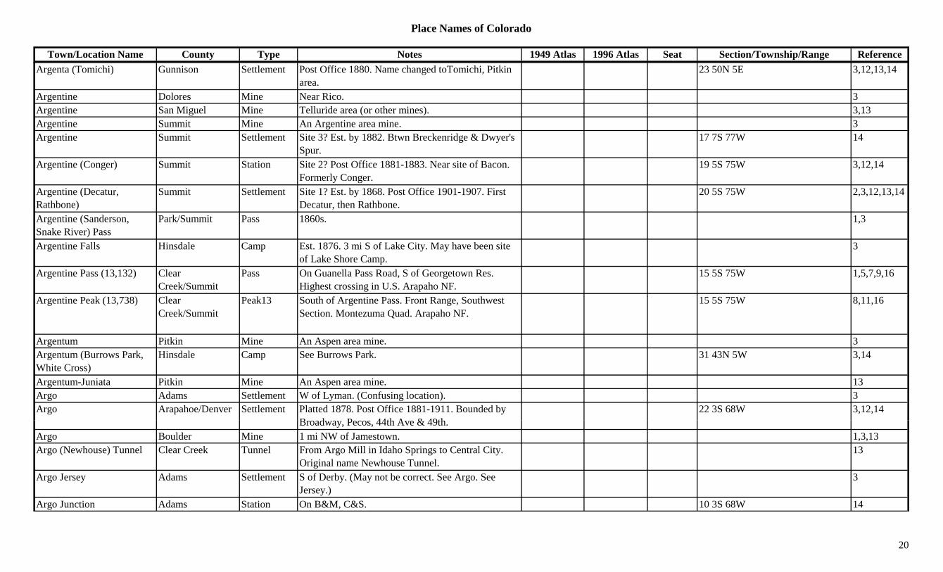
Place Names of Colorado
Town/Location Name County Type Notes 1949 Atlas 1996 Atlas Seat Section/Township/Range ReferenceArgenta (Tomichi) Gunnison Settlement Post Office 1880. Name changed toTomichi, Pitkin
area.23 50N 5E 3,12,13,14
Argentine Dolores Mine Near Rico. 3Argentine San Miguel Mine Telluride area (or other mines). 3,13Argentine Summit Mine An Argentine area mine. 3Argentine Summit Settlement Site 3? Est. by 1882. Btwn Breckenridge & Dwyer's
Spur.17 7S 77W 14
Argentine (Conger) Summit Station Site 2? Post Office 1881-1883. Near site of Bacon. Formerly Conger.
19 5S 75W 3,12,14
Argentine (Decatur, Rathbone)
Summit Settlement Site 1? Est. by 1868. Post Office 1901-1907. First Decatur, then Rathbone.
20 5S 75W 2,3,12,13,14
Argentine (Sanderson, Snake River) Pass
Park/Summit Pass 1860s. 1,3
Argentine Falls Hinsdale Camp Est. 1876. 3 mi S of Lake City. May have been site of Lake Shore Camp.
3
Argentine Pass (13,132) Clear Creek/Summit
Pass On Guanella Pass Road, S of Georgetown Res. Highest crossing in U.S. Arapaho NF.
15 5S 75W 1,5,7,9,16
Argentine Peak (13,738) Clear Creek/Summit
Peak13 South of Argentine Pass. Front Range, Southwest Section. Montezuma Quad. Arapaho NF.
15 5S 75W 8,11,16
Argentum Pitkin Mine An Aspen area mine. 3Argentum (Burrows Park, White Cross)
Hinsdale Camp See Burrows Park. 31 43N 5W 3,14
Argentum-Juniata Pitkin Mine An Aspen area mine. 13Argo Adams Settlement W of Lyman. (Confusing location). 3Argo Arapahoe/Denver Settlement Platted 1878. Post Office 1881-1911. Bounded by
B d P 44th A & 49th22 3S 68W 3,12,14
Broadway, Pecos, 44th Ave & 49th.Argo Boulder Mine 1 mi NW of Jamestown. 1,3,13Argo (Newhouse) Tunnel Clear Creek Tunnel From Argo Mill in Idaho Springs to Central City.
Original name Newhouse Tunnel.13
Argo Jersey Adams Settlement S of Derby. (May not be correct. See Argo. See Jersey.)
3
Argo Junction Adams Station On B&M, C&S. 10 3S 68W 14
20

Place Names of Colorado
Town/Location Name County Type Notes 1949 Atlas 1996 Atlas Seat Section/Township/Range ReferenceArgo Mill Hist. Mining Site Clear Creek Mill At Empire. X
Argo Town USA Clear Creek Misc At Idaho Springs. XArgyle Jefferson Station On DSP&P. In same section as Cloudcrest &
Ferndale. Btwn Ferndale & Resort.29 7S 70W 6,14
Arickaree Washington Settlement Site 2. 1916-1920. 6 mi SW of Anton. 23 4S 51W 3,14Arickaree (Arikaree) Washington Settlement Site 3. 1 mi N of site 2. Post Office closed 1961. X 2 4S 51W 3
Arickaree (Duck Springs) Arapahoe/Washington
Settlement Site 1. 10 mi NW of Lindon. Post Office 1888-1961 (3 sites).
31 5S 51W 3,12,14
Arickaree Peak (13,150) Boulder Peak13 Front Range, Indian Section. Monarch Lake Quad. 1,8,11( , ) g , Q , ,
Arickaree River Washington River Flows across SE corner of county. Flows by Cope. X 3
Arikaree (Arickaree) River Lincoln River Flows out of NE Lincoln Co to Washington Co. X
Arikaree Peak Boulder Peak13 West central Boulder Co. WSW of Ward. Arapaho/Roosevelt NF.
14 1N 74W 16
Arikaree River (Arickaree River)
Yuma River Flows from Washington Co. past Beecher Island to Kansas.
X 3
Arizona Bar Routt Gulch Area around Hahns Peak (town). 3Arizona Bar Routt Unknown 28 10N 85W 14Arizona Mountain Gilpin Peak10 S of Apex. Arapaho NF. 29 2S 73W 3,16Arkansas (Macune) Chaffee Station Site 1. On DSP&P. Station btwn McGee & Buena
Vista.21 14S 78W 14
Arkansas (Salida) Chaffee Settlement Site 2. Post Office 1880-1881. Name changed to S lid
? 50N 9E 12,14Salida.
Arkansas Crossing (Pueblo) Pueblo Settlement Early name for City of Pueblo. 14
Arkansas Junction Lake Station Post Office 1890-1918, with gap. RR stop W of Leadville.
20 9S 80W 3,12,14
Arkansas Mountain Fremont Mountain North of Cotopaxi. ?? 48N 11E 16
21
Place Names of Colorado
Town/Location Name County Type Notes 1949 Atlas 1996 Atlas Seat Section/Township/Range ReferenceArkansas Mountain Gunnison Peak11 North central county. NNE of Marble. White River
NF.?? 11S 87W 16
Arkansas Mountain (7,710) Boulder Mountain Near Crisman. 22 1N 71W 13,16
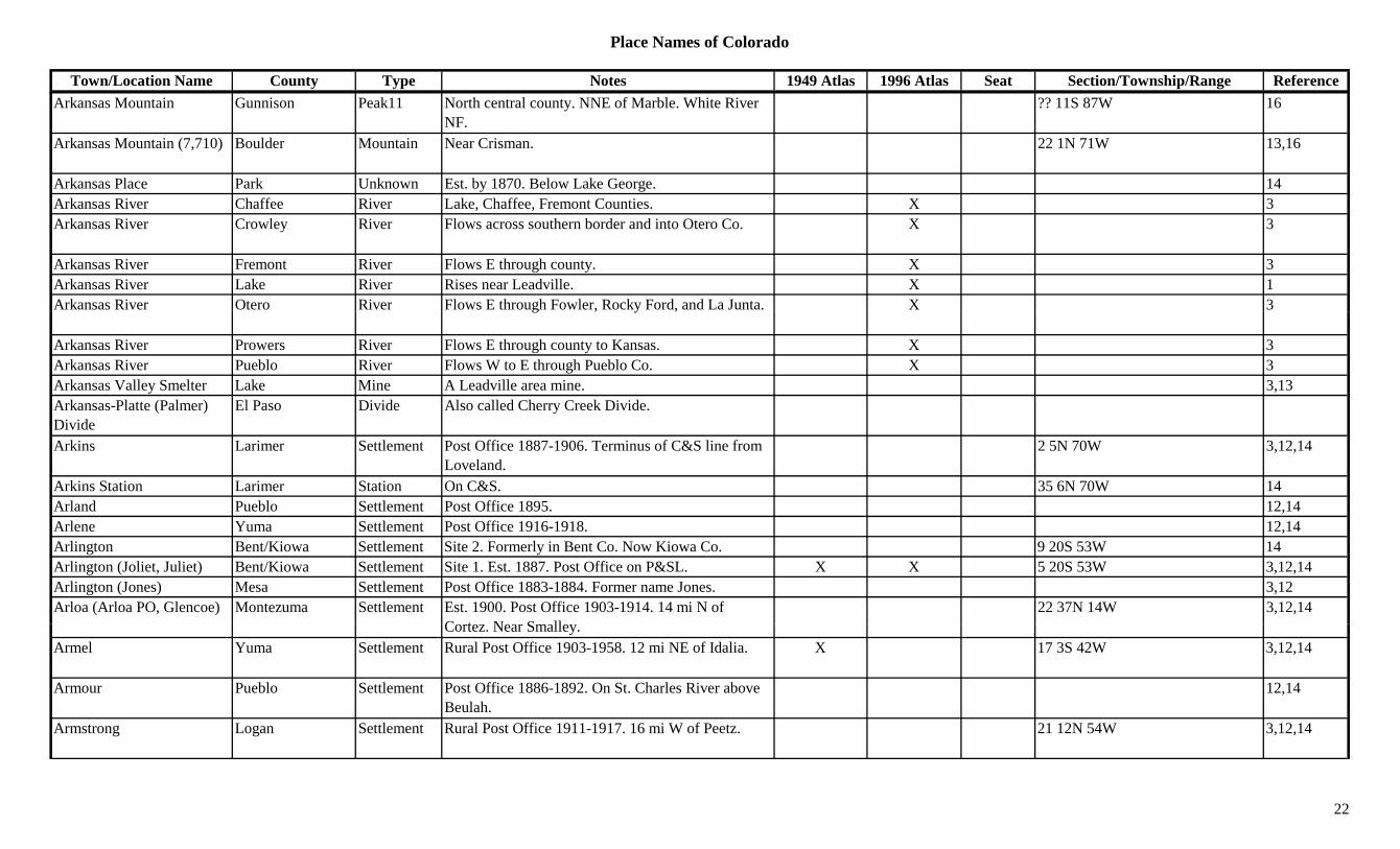
Arkansas Place Park Unknown Est. by 1870. Below Lake George. 14Arkansas River Chaffee River Lake, Chaffee, Fremont Counties. X 3Arkansas River Crowley River Flows across southern border and into Otero Co. X 3
Arkansas River Fremont River Flows E through county. X 3Arkansas River Lake River Rises near Leadville. X 1Arkansas River Otero River Flows E through Fowler, Rocky Ford, and La Junta. X 3g , y ,
Arkansas River Prowers River Flows E through county to Kansas. X 3Arkansas River Pueblo River Flows W to E through Pueblo Co. X 3Arkansas Valley Smelter Lake Mine A Leadville area mine. 3,13Arkansas-Platte (Palmer) Divide
El Paso Divide Also called Cherry Creek Divide.
Arkins Larimer Settlement Post Office 1887-1906. Terminus of C&S line from Loveland.
2 5N 70W 3,12,14
Arkins Station Larimer Station On C&S. 35 6N 70W 14Arland Pueblo Settlement Post Office 1895. 12,14Arlene Yuma Settlement Post Office 1916-1918. 12,14Arlington Bent/Kiowa Settlement Site 2. Formerly in Bent Co. Now Kiowa Co. 9 20S 53W 14Arlington (Joliet, Juliet) Bent/Kiowa Settlement Site 1. Est. 1887. Post Office on P&SL. X X 5 20S 53W 3,12,14Arlington (Jones) Mesa Settlement Post Office 1883-1884. Former name Jones. 3,12Arloa (Arloa PO, Glencoe) Montezuma Settlement Est. 1900. Post Office 1903-1914. 14 mi N of
C t N S ll22 37N 14W 3,12,14
Cortez. Near Smalley.Armel Yuma Settlement Rural Post Office 1903-1958. 12 mi NE of Idalia. X 17 3S 42W 3,12,14
Armour Pueblo Settlement Post Office 1886-1892. On St. Charles River above Beulah.
12,14
Armstrong Logan Settlement Rural Post Office 1911-1917. 16 mi W of Peetz. 21 12N 54W 3,12,14
22

Place Names of Colorado
Town/Location Name County Type Notes 1949 Atlas 1996 Atlas Seat Section/Township/Range ReferenceArmstrong Gulch Gunnison Gulch Eastern county. S of Tincup. Runs S to Quartz
Creek.Sev 51N 4E 16
Arnold Yuma Settlement Post Office 1913-1914. 14 mi N of Wray. 12,14Arnold (Willard) Logan Settlement Post Office 1897-1900. Name changed to Willard?
Not same as Willard?21 12N 54W 3,12,14
Aroya (Arroyo) Cheyenne Settlement Post Office 1889-1965. Platted 1907. Stage station before 1872.
X X 5 14S 51W 3,4,12,14
Arriba Elbert/Lincoln Settlement Platted 1888. Post Office est. 1889. Absorbed Frontier City in 1918.
X X 1/9S 53W 3,12,14
Arriola Montezuma Settlement Est. abt 1885. Post Office 1894-1933 with gap. 7 mi NW of Cortez.
X X 20 37N 16W 3,12,14
Arrow (Arrowhead) Grand Station Inc. 1904. Post Office 1905-1915. Near Corona Pass, near Hideaway Park.
34 1S 75W 1,3,12,13,14
Arrow Peak (13,803) Peak13 Needle Mountains. The Grenadiers. Storm King Peak Quad.
8,11
Arrowhead Larimer Unknown 17 7N 68W 14Arrowhead (Arrow) Grand Camp Original name for Arrow. See Arrow. 34 1S 75W 1,3,14Arrowhead Camp Mesa Camp 10 50N 18W 14Arroya Elbert/Lincoln Settlement Post Office 1877-1881, with gap. 28 13S 52W 12,14Arroyo (Aroya) Cheyenne Settlement See Aroya. 5 14S 51W 4,14Artesia (Blaine) Baca Settlement Also known as Blaine. 3 30S 43W 14Artesia (Dinosaur) Moffat Settlement Est. 1914. Post Office 1946-1966. First name for
Dinosaur. Changed in 1965.X 12 3N 104W 3,12,14
Arthur Pueblo Settlement A village. On D&RG. 32 20S 66W 14Arthurs Park Station Est. by 1885. DSP&P station outside Fairplay. 32 10S 76W 3,14Artman Pueblo Settlement Post Office 1892-1901. 6 mi above mouth of St.
Ch l Ri? 21S 63W 12,14
Charles River.Arvada (Ralston Point/Station)
Jefferson Settlement Platted 1870. Post Office est. 1871. X X ? 2S 69W 1,3,12,14
Asbury Creek Mesa Creek Flows SE to Colorado River NE of Palisade. XAscalon Cheyenne Unknown Est. by 1923. On UP. 6 mi E of Firstview. W of
Cheyenne Wells.X 27 14S 45W 3,14
23
Place Names of Colorado
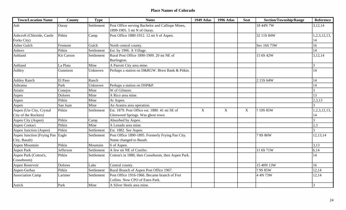
Town/Location Name County Type Notes 1949 Atlas 1996 Atlas Seat Section/Township/Range ReferenceAsh Ouray Settlement Post Office serving Bachelor and Calliope Mines,
1899-1905. 5 mi N of Ouray.18 44N 7W 3,12,14
Ashcroft (Chloride, Castle Forks City)
Pitkin Camp Post Office 1880-1912. 12 mi S of Aspen. 32 11S 84W 1,2,3,12,13,14
Asher Gulch Fremont Gulch North central county. Sev 16S 73W 16Ashero Pitkin Settlement Est. by 1906. A Village. 14Ashland Kit Carson Settlement Rural Post Office 1890-1909. 20 mi NE of
Burlington.15 6S 42W 3,12,14
Ashland La Plata Mine A Parrott City area mine. 3Ashley Gunnison Unknown Perhaps a station on D&RGW. Btwn Bank & Pitkin. 14
Ashley Ranch El Paso Ranch 2 15S 64W 14Ashrama Park Unknown Perhaps a station on DSP&P. 14Asiatic Conejos Mine W of Gilmore. 3Aspen Dolores Mine A Rico area mine. 13Aspen Pitkin Mine At Aspen. 2,3,13Aspen San Juan Mine An Arastra area operation. 3Aspen (Ute City, Crystal City of the Rockies)
Pitkin Settlement Est. 1879. Post Office est. 1880. 41 mi SE of Glenwood Springs. Was ghost town.
X X X ? 10S 85W 1,2,3,12,13,14
Aspen City (Aspen) Pitkin Camp Absorbed by Aspen. 3Aspen Contact Pitkin Mine A Lenado area mine. 2,3Aspen Junction (Aspen) Pitkin Settlement Est. 1882. See Aspen. 3Aspen Junction (Frying Pan City, Basalt)
Eagle Settlement Post Office 1890-1895. Formerly Frying Pan City. Name changed to Basalt.
7 8S 86W 12,13,14
Aspen Mountain Pitkin Mountain S of Aspen. 3,13Aspen Park Jefferson Settlement A few mi NE of Conifer. 11 6S 71W 6,14A P k (C tt ' Pitki S ttl t C tt ' i 1880 th C b th A P k 14Aspen Park (Cotton's, Cosseboom)
Pitkin Settlement Cotton's in 1880, then Cosseboom, then Aspen Park. 14
Aspen Reservoir Dolores Lake Central county. 15 40N 13W 16Aspen-Gerbaz Pitkin Settlement Rural Branch of Aspen Post Office 1967. ? 9S 85W 12,14Association Camp Larimer Settlement Post Office 1916-1966. Became branch of Fort
Collins. Now CPO of Estes Park.4 4N 73W 12,14
Astick Park Mine A Silver Heels area mine. 3
24
Place Names of Colorado
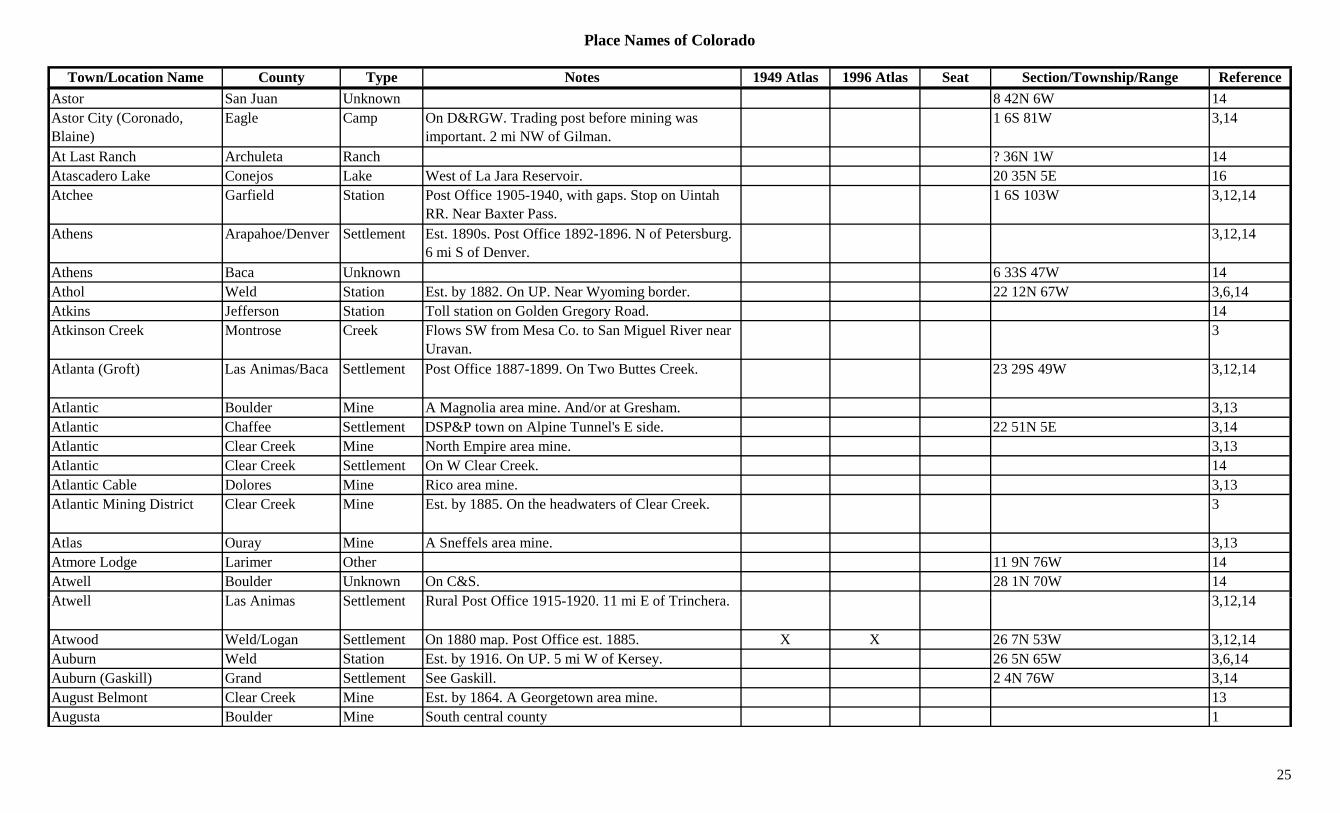
Town/Location Name County Type Notes 1949 Atlas 1996 Atlas Seat Section/Township/Range ReferenceAstor San Juan Unknown 8 42N 6W 14Astor City (Coronado, Blaine)
Eagle Camp On D&RGW. Trading post before mining was important. 2 mi NW of Gilman.
1 6S 81W 3,14
At Last Ranch Archuleta Ranch ? 36N 1W 14Atascadero Lake Conejos Lake West of La Jara Reservoir. 20 35N 5E 16Atchee Garfield Station Post Office 1905-1940, with gaps. Stop on Uintah
RR. Near Baxter Pass.1 6S 103W 3,12,14
Athens Arapahoe/Denver Settlement Est. 1890s. Post Office 1892-1896. N of Petersburg. 6 mi S of Denver.
3,12,14
Athens Baca Unknown 6 33S 47W 14Athol Weld Station Est. by 1882. On UP. Near Wyoming border. 22 12N 67W 3,6,14y y g , ,Atkins Jefferson Station Toll station on Golden Gregory Road. 14Atkinson Creek Montrose Creek Flows SW from Mesa Co. to San Miguel River near
Uravan.3
Atlanta (Groft) Las Animas/Baca Settlement Post Office 1887-1899. On Two Buttes Creek. 23 29S 49W 3,12,14
Atlantic Boulder Mine A Magnolia area mine. And/or at Gresham. 3,13Atlantic Chaffee Settlement DSP&P town on Alpine Tunnel's E side. 22 51N 5E 3,14Atlantic Clear Creek Mine North Empire area mine. 3,13Atlantic Clear Creek Settlement On W Clear Creek. 14Atlantic Cable Dolores Mine Rico area mine. 3,13Atlantic Mining District Clear Creek Mine Est. by 1885. On the headwaters of Clear Creek. 3
Atlas Ouray Mine A Sneffels area mine. 3,13Atmore Lodge Larimer Other 11 9N 76W 14Atwell Boulder Unknown On C&S. 28 1N 70W 14At ll L A i S ttl t R l P t Offi 1915 1920 11 i E f T i h 3 12 14Atwell Las Animas Settlement Rural Post Office 1915-1920. 11 mi E of Trinchera. 3,12,14
Atwood Weld/Logan Settlement On 1880 map. Post Office est. 1885. X X 26 7N 53W 3,12,14Auburn Weld Station Est. by 1916. On UP. 5 mi W of Kersey. 26 5N 65W 3,6,14Auburn (Gaskill) Grand Settlement See Gaskill. 2 4N 76W 3,14August Belmont Clear Creek Mine Est. by 1864. A Georgetown area mine. 13Augusta Boulder Mine South central county 1
25
Place Names of Colorado
Town/Location Name County Type Notes 1949 Atlas 1996 Atlas Seat Section/Township/Range ReferenceAugusta Custer Station Post Office 1890-1902. RR station at Foster's Place.
4 mi E of Aguilar.30 22S 69W 4,12,14
Augusta (Apishapa, San Antonia)
Las Animas Settlement Est. by 1867. Post Office 1911-1928. Apishapa, then San Antonia, then Apishapa.
X 17 30S 64W 3,12,14
Augusta Mine Gunnison Mine SW of Gothic. Served by Pittsburg. Up Poverty Gulch at 11,000 ft.
3,8
Augusta Mountain Gunnison Peak12 NW of Crested Butte. Gunnison NF. ?? 12S 87W 16Augusta Mountain (12,559) Peak12 Ruby Range. 8
Ault (McAllister, Burgdorf) Weld Settlement Est. 1888. Post Office est. 1898. First McAllister, then Burgdorf.
X X 12 7N 66W 3,6,12,14
Auraria (Denver City) Arapahoe/Denver Camp Est. 1858. Post Office 1859-1860. Named by Green Russell. To Denver, 1861.
10 4S 68W 1,3,12,14
Aureo Gunnison Unknown On D&RGW. ? 48N 5E 14Aurora Adams Station On C&E. 17 3S 67W 14Aurora Ouray Settlement Site 1. Post Office 1880-1884. E of Dallas Creek. 6 44N 9W 3,12,14
Aurora (Dallas Divide, Dallas)
Ouray Settlement Site 2. Est. by 1885. NW of Aurora site 1. Across the river. Later, Dallas Divide.
6 44N 9W 3,12,14
Aurora (Fletcher) Adams Settlement Platted 1890. Inc. 1903. Post Office est. 1908. First known as Fletcher.
X X ? 3S 67W 1,3,12,14
Auroria Larimer Settlement Post Office 1858-1860. Moved to Colona. Was in Nebraska Terr.
29 8N 69W 12,14
Austin Boulder Mine A Ward area mine. 13Austin Conejos Settlement On west bank of the Rio Grande. 34 36N 11E 14Austin Delta Settlement Est. abt 1900. Post Office est. 1905. On D&RGW. X X 1 15S 95W 3,12,14
Austin Garfield Settlement Post Office 1890-1896. 8 mi NE of Rifle. 12,14Austin Bluffs El Paso Hill NW Colorado Springs. Sev 13S 66W 16Austin Bluffs El Paso Settlement Est. by 1885. 6 mi S of Edgerton. 3Austins Gilpin Settlement In Lump Gulch. 0.25 mi above Capt. Austin. 6 2S 72W 14Autobees (Autobees Plaza, Huerfano Abajo)
Pueblo Settlement Est. by 1853. Large holding and settlement. x 8 21S 61W 4,14
26
Place Names of Colorado
Town/Location Name County Type Notes 1949 Atlas 1996 Atlas Seat Section/Township/Range ReferenceAutobee's Plaza (Autobees) Pueblo Settlement See Autobees. 4
Autreyville Boulder Settlement 19 1S 69W 14Autura (Altura) Archuleta Settlement Est. by 1924. 10 mi N of Pagosa Junction. Probably
typo.3
Ava Pitkin Unknown On D&RGW. Near Snowmass. 21 8S 86W 12Avalanche Pitkin Settlement Stop & small community on Crystal River RR. X 29 9S 88W 3,14Avalanche Creek Pitkin Creek Flows NW to Crystal River at Avalanche. 3Avalanche Pass Gunnison Pass SE of Placita. Marble Topo. White River NF.
Maroon Bells/Snowmass Wilderness Area.7 11S 87W 3,5,7
Avalanche Peak Eagle Peak12 SW of Redcliff. White River NF. ?? 7S 82W 16gAvalanche Peak (12,803) Peak12 Sawatch Range, Holy Cross Section. 8Avalo (Greasewood Flats) Weld Settlement Rural Post Office 1898-1936. 8 mi NW of
Westplains.X 28 10 56W 3,6,12,14
Avalon Jefferson Unknown On D&IM. 14 3S 69W 14Avendale Kit Carson Settlement Rural Post Office 1889-1890. 10 mi NE of Seibert. ? 7S 49W 3,12,14
Avery Weld Station Est. by 1909. On C&S. 2 mi NW of Windsor. 17 6N 67W 3,6,14Avery Peak Gunnison Peak12 North of Crested Butte. Elk Range, Crested Butte
Section. Gunnison NF.?? 12S 86W 8,16
Avin (Avon) Eagle Settlement See Avon. 3Avoca Arapahoe/Yuma Settlement Country Post Office 1889-1891. 15 mi N of Yuma. 2 2S 47W 3,12,14
Avoca City Adams Settlement Platted in 1922. No Post Office. 3,14Avon (Avin) Eagle Settlement Post Office est. 1900. Grain and cattle raising town.
Now ski town. On D&RGW.X X 12 5S 82W 3,12,14
A d l (F t P k) P bl S ttl t P t Offi t 1892 P i l ll d F t P k X X 8 21S 62W 3 12 14Avondale (Forest Park) Pueblo Settlement Post Office est. 1892. Previously called Forest Park. X X 8 21S 62W 3,12,14
Avondale Station (North Avondale)
Pueblo Station On AT&SF. Now North Avondale. 32 20S 62W 14
Axial Routt/Moffat Settlement Post Office 1883-1958, with gaps. 27 mi SW of Craig.
X 26 4N 93W 3,12,14
Axial Basin Moffat Gulch S of Yampa River. S of Maybell. 3
27
Place Names of Colorado
Town/Location Name County Type Notes 1949 Atlas 1996 Atlas Seat Section/Township/Range ReferenceAyer Otero Settlement Post Office on AT&SF 1911-1941. 6 mi SW of
Timpas.X 25 26S 58W 3,12,14
Aylmer (Bowen) Las Animas Settlement RR Post Office 1899-1906, with gap. Preceded Bowen.
19 32S 63W 3,12,14
Ayr Bent/Prowers Settlement Rural Post Office 1888-1893. 18 25S 46W 3,12,14Aysee Teller Unknown 14Aztec (Dolores) Dolores Mine Rico area mine. 3,13Aztec (Esmond, Esmund) Rio Grande Mine A Summitville area mine. 3,13Aztec Creek (Aztec Spring Creek)
Montezuma Creek Flows S & W into New Mexico near 4 Corners. 3
Aztec Mountain (13,310) Peak13 Columbine Pass Quad. 11( , ) QAztec Spring Creek Wagon Trail
Montezuma Trail 1885. SW part of county. Route to Mancos and beyond.
3
Azure Grand Station Est. by 1923. Stop on D&SL and/or D&RGW. 5 mi SW of Kremmling.
6 1S 81W 3,14
Azurite Boulder Mine South central county. 1B. & M. Boulder Mine 3Babcock Chaffee Camp Est in the 1870s. Silver camp on Altman Pass Road.
4 mi NW of Garfield.? 50N 6E 3,13,14
Babcock Peak (13,149) Peak13 La Plata Range. La Plata Quad. 8,11Baca Ranch Las Animas Ranch 8 27S 60W 14Bachelor Hinsdale Mine Est. by 1896. A Carson area mine. 13Bachelor Mineral Mine Mine & Mill. N of Creede. On W Willow Creek. 3
Bachelor Ouray Mine An Ouray area mine. 3,13Bachelor Park (?) Camp Camp & RR Station on Red Mt. Pass 1B h l (T ll ) Mi l C E t b 1885 S b b f Will Ab b d b 23 42N 1W 3 13Bachelor (Teller) Mineral Camp Est. by 1885. Suburb of Willow. Absorbed by
Creede. Post Office called Teller.23 42N 1W 3,13
Bachelor Camp San Miguel Camp 24 45N 18W 14Bachelor Mountain Mineral Mountain N of Creede. 3,13Bachelor Switch Ouray Station On D&RG. Renamed Lotus Glen & later Lotus. Last
known as Whispering Pine.24 44N 8W 14
Back Door Gulch Fremont Gulch SW of Texas Creek (town). Sev 48N 12E 16
28
Place Names of Colorado
Town/Location Name County Type Notes 1949 Atlas 1996 Atlas Seat Section/Township/Range ReferenceBackus Eagle Mine Holy Cross City area mine. 3Bacon Gunnison Camp Est. by 1922. Camp on Spring Creek. NE of Almont. 3
Bacon Lake/Park Station On Boreas Pass 1Bacon Summit Station On DSP&P. On Boreas Pass. 8 7S 77W 3,14Baden Jefferson Settlement Est. 1859. On bank of Clear Creek, SW of Mt. Olivet
Cemetery.19 3S 69W 14
Badger Arapahoe/Washington
Settlement Rural Post Office 1890-1894. 17 mi SW of Anton. ? 4S 53W 3,12,14
Badger Fremont Camp Est. by 1885. Small camp. Same site as modern Swissvale.
27 49N 10E 3,14
Badger San Miguel Mine An Alta area mine. 3,13Badger (Fairview) Teller Settlement E of Cripple Creek. RR settlement and station.
Earlier name was Fairview.18 15S 69W 3,14
Badger City Park Settlement Unknown location. 14Badger Creek Adams Creek Flows through SE corner of county to Washington
Co.X 3,16
Badger Creek Arapahoe Creek Flows S to N through county. E end of county. X 3,16Badger Creek Fremont Creek Flows S to Arkansas River near Wellsville. 3Badger Creek Morgan Creek Flows N to South Platte River at Dodd. X 3Badger Creek Park Creek Flows S to Fremont Co. 3Badger Gulch Fremont Gulch West of Howard. Sev 49N 10E 16Badger Mountain (11,294) Mountain Puma Hills. E of Glentivar. 8,13
Badger Springs Park Unknown Est. by 1916. 32 11S 72W 14Badger State Lake Mine A Leadville area mine. 3B dit (B ' Littl H f /L S ttl t E t b 1853 P t Offi 1865 1910 E l 5 27S 68W 3 4 12 14Badito (Boyce's, Little Orphan)
Huerfano/Las Animas
Settlement Est. by 1853. Post Office 1865-1910. Early important town. Early county seat.
x 5 27S 68W 3,4,12,14
Baederville Alamosa Unknown Est. by 1880. On western slope of Mosco Pass. 14Bagby Moffat Settlement 2 mi E of Powder Wash. 3Bagdad Lincoln Station On UP. 6 mi NW of Hugo. X 16 10S 55W 3,14Bailed Hay City (Golden Gate City)
Jefferson Settlement Nickname for Golden Gate City. At mouth of Golden Gate Canyon.
20 3S 70W 14
29
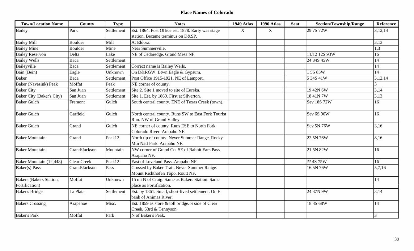
Place Names of Colorado
Town/Location Name County Type Notes 1949 Atlas 1996 Atlas Seat Section/Township/Range ReferenceBailey Park Settlement Est. 1864. Post Office est. 1878. Early was stage
station. Became terminus on D&SP.X X 29 7S 72W 3,12,14
Bailey Mill Boulder Mill At Eldora. 3,13Bailey Mine Boulder Mine Near Summerville. 1,3Bailey Reservoir Delta Lake NE of Cedaredge. Grand Mesa NF. 11/12 12S 93W 16Bailey Wells Baca Settlement 24 34S 45W 14Baileyville Baca Settlement Correct name is Bailey Wells. 14Bain (Bein) Eagle Unknown On D&RGW. Btwn Eagle & Gypsum. 1 5S 85W 14Baker Baca Settlement Post Office 1915-1921. NE of Lamport. 5 34S 41W 3,12,14Baker (Navesink) Peak Moffat Peak NE corner of county. 3Baker City San Juan Settlement Site 2. Site 1 moved to site of Eureka. 19 42N 6W 3,14y ,Baker City (Baker's City) San Juan Settlement Site 1. Est. by 1860. First at Silverton. 18 41N 7W 3,13Baker Gulch Fremont Gulch South central county. ENE of Texas Creek (town). Sev 18S 72W 16
Baker Gulch Garfield Gulch North central county. Runs SW to East Fork Tourist Run. NW of Grand Valley.
Sev 6S 96W 16
Baker Gulch Grand Gulch NE corner of county. Runs ESE to North Fork Colorado River. Arapaho NF.
Sev 5N 76W 3,16
Baker Mountain Grand Peak12 North tip of county. Never Summer Range. Rocky Mtn Natl Park. Arapaho NF.
22 5N 76W 8,16
Baker Mountain Grand/Jackson Mountain NW corner of Grand Co. SE of Rabbit Ears Pass. Arapaho NF.
21 5N 82W 16
Baker Mountain (12,448) Clear Creek Peak12 East of Loveland Pass. Arapaho NF. ?? 4S 75W 16Baker(s) Pass Grand/Jackson Pass Crossed by Baker Trail. Never Summer Range.
Mount Richthofen Topo. Routt NF.16 5N 76W 5,7,16
Bakers (Bakers Station, F tifi ti )
Moffat Unknown 15 mi N of Craig. Same as Bakers Station. Same l F tifi ti
14Fortification) place as Fortification.Baker's Bridge La Plata Settlement Est. by 1861. Small, short-lived settlement. On E
bank of Animas River.24 37N 9W 3,14
Bakers Crossing Arapahoe Misc. Est. 1859 as store & toll bridge. S side of Clear Creek, 53rd & Tennyson.
18 3S 68W 14
Baker's Park Moffat Park N of Baker's Peak. 3
30
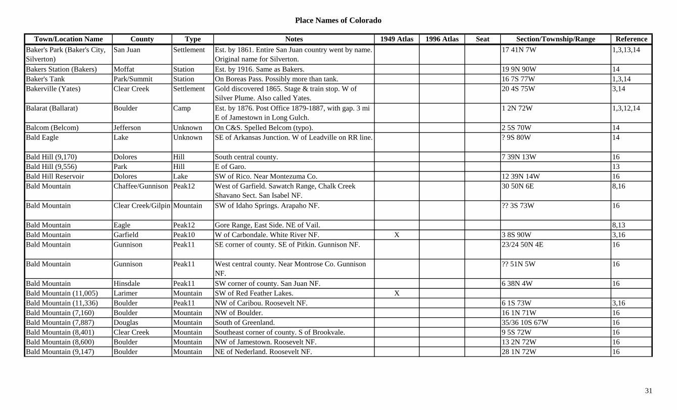
Place Names of Colorado
Town/Location Name County Type Notes 1949 Atlas 1996 Atlas Seat Section/Township/Range ReferenceBaker's Park (Baker's City, Silverton)
San Juan Settlement Est. by 1861. Entire San Juan country went by name. Original name for Silverton.
17 41N 7W 1,3,13,14
Bakers Station (Bakers) Moffat Station Est. by 1916. Same as Bakers. 19 9N 90W 14Baker's Tank Park/Summit Station On Boreas Pass. Possibly more than tank. 16 7S 77W 1,3,14Bakerville (Yates) Clear Creek Settlement Gold discovered 1865. Stage & train stop. W of
Silver Plume. Also called Yates.20 4S 75W 3,14
Balarat (Ballarat) Boulder Camp Est. by 1876. Post Office 1879-1887, with gap. 3 mi E of Jamestown in Long Gulch.
1 2N 72W 1,3,12,14
Balcom (Belcom) Jefferson Unknown On C&S. Spelled Belcom (typo). 2 5S 70W 14Bald Eagle Lake Unknown SE of Arkansas Junction. W of Leadville on RR line. ? 9S 80W 14
Bald Hill (9,170) Dolores Hill South central county. 7 39N 13W 16Bald Hill (9,556) Park Hill E of Garo. 13Bald Hill Reservoir Dolores Lake SW of Rico. Near Montezuma Co. 12 39N 14W 16Bald Mountain Chaffee/Gunnison Peak12 West of Garfield. Sawatch Range, Chalk Creek
Shavano Sect. San Isabel NF.30 50N 6E 8,16
Bald Mountain Clear Creek/Gilpin Mountain SW of Idaho Springs. Arapaho NF. ?? 3S 73W 16
Bald Mountain Eagle Peak12 Gore Range, East Side. NE of Vail. 8,13Bald Mountain Garfield Peak10 W of Carbondale. White River NF. X 3 8S 90W 3,16Bald Mountain Gunnison Peak11 SE corner of county. SE of Pitkin. Gunnison NF. 23/24 50N 4E 16
Bald Mountain Gunnison Peak11 West central county. Near Montrose Co. Gunnison NF.
?? 51N 5W 16
Bald Mountain Hinsdale Peak11 SW corner of county. San Juan NF. 6 38N 4W 16Bald Mountain (11,005) Larimer Mountain SW of Red Feather Lakes. XB ld M t i (11 336) B ld P k11 NW f C ib R lt NF 6 1S 73W 3 16Bald Mountain (11,336) Boulder Peak11 NW of Caribou. Roosevelt NF. 6 1S 73W 3,16Bald Mountain (7,160) Boulder Mountain NW of Boulder. 16 1N 71W 16Bald Mountain (7,887) Douglas Mountain South of Greenland. 35/36 10S 67W 16Bald Mountain (8,401) Clear Creek Mountain Southeast corner of county. S of Brookvale. 9 5S 72W 16Bald Mountain (8,600) Boulder Mountain NW of Jamestown. Roosevelt NF. 13 2N 72W 16Bald Mountain (9,147) Boulder Mountain NE of Nederland. Roosevelt NF. 28 1N 72W 16
31
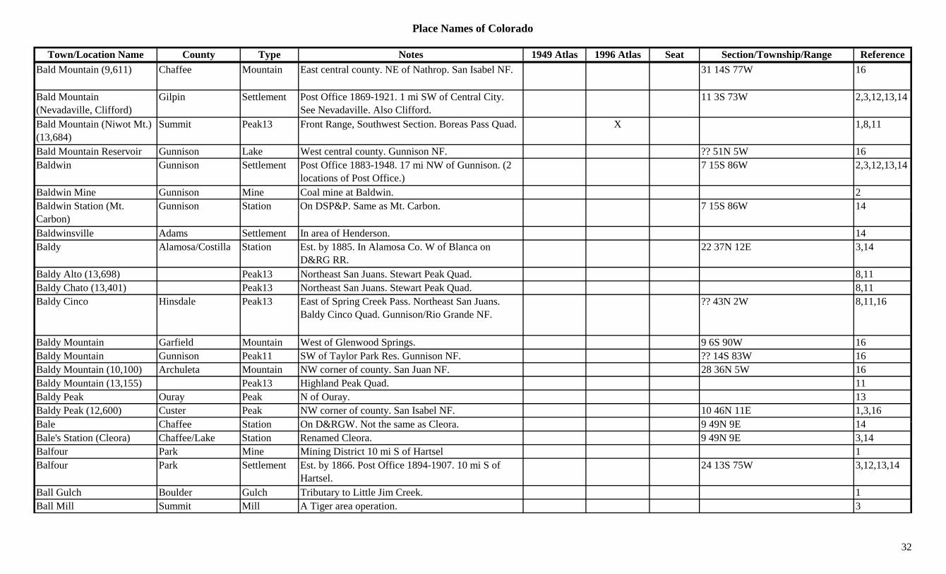
Place Names of Colorado
Town/Location Name County Type Notes 1949 Atlas 1996 Atlas Seat Section/Township/Range ReferenceBald Mountain (9,611) Chaffee Mountain East central county. NE of Nathrop. San Isabel NF. 31 14S 77W 16
Bald Mountain (Nevadaville, Clifford)
Gilpin Settlement Post Office 1869-1921. 1 mi SW of Central City. See Nevadaville. Also Clifford.
11 3S 73W 2,3,12,13,14
Bald Mountain (Niwot Mt.) (13,684)
Summit Peak13 Front Range, Southwest Section. Boreas Pass Quad. X 1,8,11
Bald Mountain Reservoir Gunnison Lake West central county. Gunnison NF. ?? 51N 5W 16Baldwin Gunnison Settlement Post Office 1883-1948. 17 mi NW of Gunnison. (2
locations of Post Office.)7 15S 86W 2,3,12,13,14
Baldwin Mine Gunnison Mine Coal mine at Baldwin. 2Baldwin Station (Mt. Gunnison Station On DSP&P. Same as Mt. Carbon. 7 15S 86W 14(Carbon)Baldwinsville Adams Settlement In area of Henderson. 14Baldy Alamosa/Costilla Station Est. by 1885. In Alamosa Co. W of Blanca on
D&RG RR.22 37N 12E 3,14
Baldy Alto (13,698) Peak13 Northeast San Juans. Stewart Peak Quad. 8,11Baldy Chato (13,401) Peak13 Northeast San Juans. Stewart Peak Quad. 8,11Baldy Cinco Hinsdale Peak13 East of Spring Creek Pass. Northeast San Juans.
Baldy Cinco Quad. Gunnison/Rio Grande NF.?? 43N 2W 8,11,16
Baldy Mountain Garfield Mountain West of Glenwood Springs. 9 6S 90W 16Baldy Mountain Gunnison Peak11 SW of Taylor Park Res. Gunnison NF. ?? 14S 83W 16Baldy Mountain (10,100) Archuleta Mountain NW corner of county. San Juan NF. 28 36N 5W 16Baldy Mountain (13,155) Peak13 Highland Peak Quad. 11Baldy Peak Ouray Peak N of Ouray. 13Baldy Peak (12,600) Custer Peak NW corner of county. San Isabel NF. 10 46N 11E 1,3,16B l Ch ff St ti O D&RGW N t th Cl 9 49N 9E 14Bale Chaffee Station On D&RGW. Not the same as Cleora. 9 49N 9E 14Bale's Station (Cleora) Chaffee/Lake Station Renamed Cleora. 9 49N 9E 3,14Balfour Park Mine Mining District 10 mi S of Hartsel 1Balfour Park Settlement Est. by 1866. Post Office 1894-1907. 10 mi S of
Hartsel.24 13S 75W 3,12,13,14
Ball Gulch Boulder Gulch Tributary to Little Jim Creek. 1Ball Mill Summit Mill A Tiger area operation. 3
32
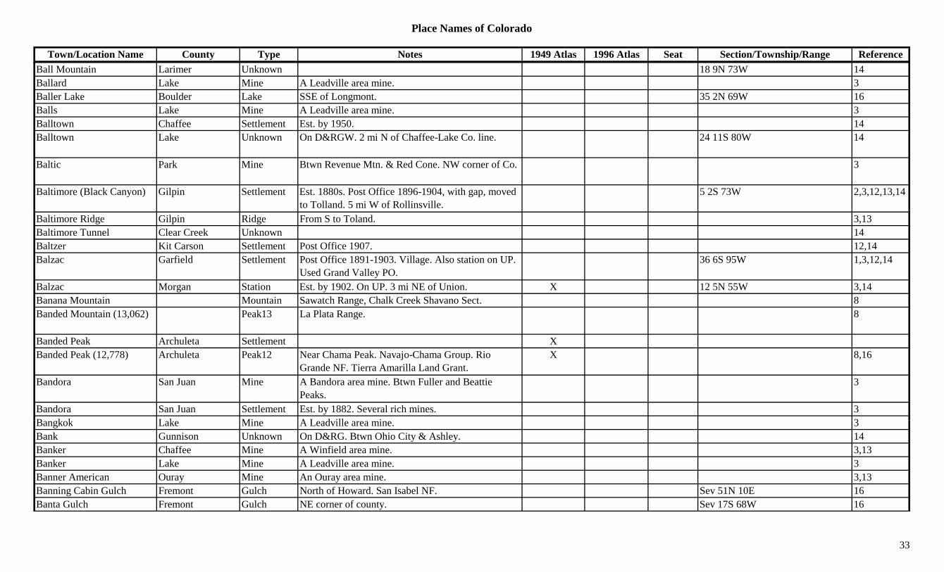
Place Names of Colorado
Town/Location Name County Type Notes 1949 Atlas 1996 Atlas Seat Section/Township/Range ReferenceBall Mountain Larimer Unknown 18 9N 73W 14Ballard Lake Mine A Leadville area mine. 3Baller Lake Boulder Lake SSE of Longmont. 35 2N 69W 16Balls Lake Mine A Leadville area mine. 3Balltown Chaffee Settlement Est. by 1950. 14Balltown Lake Unknown On D&RGW. 2 mi N of Chaffee-Lake Co. line. 24 11S 80W 14
Baltic Park Mine Btwn Revenue Mtn. & Red Cone. NW corner of Co. 3
Baltimore (Black Canyon) Gilpin Settlement Est. 1880s. Post Office 1896-1904, with gap, moved to Tolland. 5 mi W of Rollinsville.
5 2S 73W 2,3,12,13,14
Baltimore Ridge Gilpin Ridge From S to Toland. 3,13Baltimore Tunnel Clear Creek Unknown 14Baltzer Kit Carson Settlement Post Office 1907. 12,14Balzac Garfield Settlement Post Office 1891-1903. Village. Also station on UP.
Used Grand Valley PO.36 6S 95W 1,3,12,14
Balzac Morgan Station Est. by 1902. On UP. 3 mi NE of Union. X 12 5N 55W 3,14Banana Mountain Mountain Sawatch Range, Chalk Creek Shavano Sect. 8Banded Mountain (13,062) Peak13 La Plata Range. 8
Banded Peak Archuleta Settlement XBanded Peak (12,778) Archuleta Peak12 Near Chama Peak. Navajo-Chama Group. Rio
Grande NF. Tierra Amarilla Land Grant.X 8,16
Bandora San Juan Mine A Bandora area mine. Btwn Fuller and Beattie Peaks.
3
Bandora San Juan Settlement Est. by 1882. Several rich mines. 3B k k L k Mi A L d ill i 3Bangkok Lake Mine A Leadville area mine. 3Bank Gunnison Unknown On D&RG. Btwn Ohio City & Ashley. 14Banker Chaffee Mine A Winfield area mine. 3,13Banker Lake Mine A Leadville area mine. 3Banner American Ouray Mine An Ouray area mine. 3,13Banning Cabin Gulch Fremont Gulch North of Howard. San Isabel NF. Sev 51N 10E 16Banta Gulch Fremont Gulch NE corner of county. Sev 17S 68W 16
33
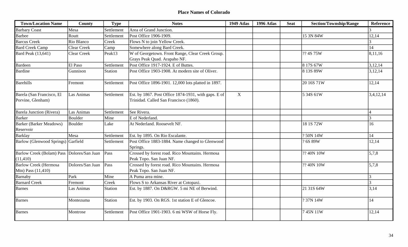
Place Names of Colorado
Town/Location Name County Type Notes 1949 Atlas 1996 Atlas Seat Section/Township/Range ReferenceBarbary Coast Mesa Settlement Area of Grand Junction. 3Barbee Routt Settlement Post Office 1906-1909. 15 3N 84W 12,14Barcus Creek Rio Blanco Creek Flows N to join Yellow Creek. 3Bard Creek Camp Clear Creek Camp Somewhere along Bard Creek. 14Bard Peak (13,641) Clear Creek Peak13 W of Georgetown. Front Range, Clear Creek Group.
Grays Peak Quad. Arapaho NF.?? 4S 75W 8,11,16
Bardeen El Paso Settlement Post Office 1917-1924. E of Buttes. 8 17S 67W 3,12,14Bardine Gunnison Station Post Office 1903-1908. At modern site of Oliver. 8 13S 89W 3,12,14
Barehills Fremont Settlement Post Office 1896-1901. 12,000 lots platted in 1897. 20 16S 71W 12,14
Barela (San Francisco, El Porvine, Glenham)
Las Animas Settlement Est. by 1867. Post Office 1874-1931, with gaps. E of Trinidad. Called San Francisco (1860).
X 5 34S 61W 3,4,12,14
Barela Junction (Rivera) Las Animas Settlement See Rivera. 4Barker Boulder Mine E of Nederland. 3Barker (Barker Meadows) Reservoir
Boulder Lake At Nederland. Roosevelt NF. 18 1S 72W 16
Barklay Mesa Settlement Est. by 1895. On Rio Escalante. ? 50N 14W 14Barlow (Glenwood Springs) Garfield Settlement Post Office 1883-1884. Name changed to Glenwood
Springs.? 6S 89W 12,14
Barlow Creek (Bolam) Pass (11,410)
Dolores/San Juan Pass Crossed by forest road. Rico Mountains. Hermosa Peak Topo. San Juan NF.
?? 40N 10W 5,7,8
Barlow Creek (Hermosa Mtn) Pass (11,410)
Dolores/San Juan Pass Crossed by forest road. Rico Mountains. Hermosa Peak Topo. San Juan NF.
?? 40N 10W 5,7,8
Barnaby Park Mine A Puma area mine. 3B d C k F t C k Fl S t A k Ri t C t i 3Barnard Creek Fremont Creek Flows S to Arkansas River at Cotopaxi. 3Barnes Las Animas Station Est. by 1887. On D&RGW. 5 mi NE of Berwind. 21 31S 64W 3,14
Barnes Montezuma Station Est. by 1903. On RGS. 1st station E of Glencoe. ? 37N 14W 14
Barnes Montrose Settlement Post Office 1901-1903. 6 mi WSW of Horse Fly. 7 45N 11W 12,14
34
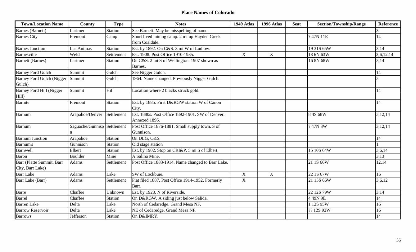
Place Names of Colorado
Town/Location Name County Type Notes 1949 Atlas 1996 Atlas Seat Section/Township/Range ReferenceBarnes (Barnett) Larimer Station See Barnett. May be misspelling of name. 3Barnes City Fremont Camp Short lived mining camp. 2 mi up Hayden Creek
from Coaldale.? 47N 11E 14
Barnes Junction Las Animas Station Est. by 1892. On C&S. 3 mi W of Ludlow. 19 31S 65W 3,14Barnesville Weld Settlement Est. 1908. Post Office 1910-1935. X X 18 6N 63W 3,6,12,14Barnett (Barnes) Larimer Station On C&S. 2 mi S of Wellington. 1907 shown as
Barnes.16 8N 68W 3,14
Barney Ford Gulch Summit Gulch See Nigger Gulch. 14Barney Ford Gulch (Nigger Gulch)
Summit Gulch 1964. Name changed. Previously Nigger Gulch. 3
Barney Ford Hill (Nigger Summit Hill Location where 2 blacks struck gold. 14y ( ggHill)
g
Barnite Fremont Station Est. by 1885. First D&RGW station W of Canon City.
14
Barnum Arapahoe/Denver Settlement Est. 1880s. Post Office 1892-1901. SW of Denver. Annexed 1896.
8 4S 68W 3,12,14
Barnum Saguache/Gunnison
Settlement Post Office 1876-1881. Small supply town. S of Gunnison.
? 47N 3W 3,12,14
Barnum Junction Arapahoe Station On DLG, C&S. 14Barnum's Gunnison Station Old stage station 1Barnwell Elbert Station Est. by 1902. Stop on CRI&P. 5 mi S of Elbert. 15 10S 64W 3,6,14Baron Boulder Mine A Salina Mine. 3,13Barr (Platte Summit, Barr City, Barr Lake)
Adams Settlement Post Office 1883-1914. Name changed to Barr Lake. 21 1S 66W 12,14
Barr Lake Adams Lake SW of Lockbuie. X X 22 1S 67W 16Barr Lake (Barr) Adams Settlement Plat filed 1887. Post Office 1914-1952. Formerly
BX 21 15S 66W 3,6,12
Barr.Barre Chaffee Unknown Est. by 1923. N of Riverside. 22 12S 79W 3,14Barrel Chaffee Station On D&RGW. A siding just below Salida. 4 49N 9E 14Barren Lake Delta Lake North of Cedaredge. Grand Mesa NF. 1 12S 95W 16Barrow Reservoir Delta Lake NE of Cedaredge. Grand Mesa NF. ?? 12S 92W 16Barrows Jefferson Station On D&IMRY. 14
35
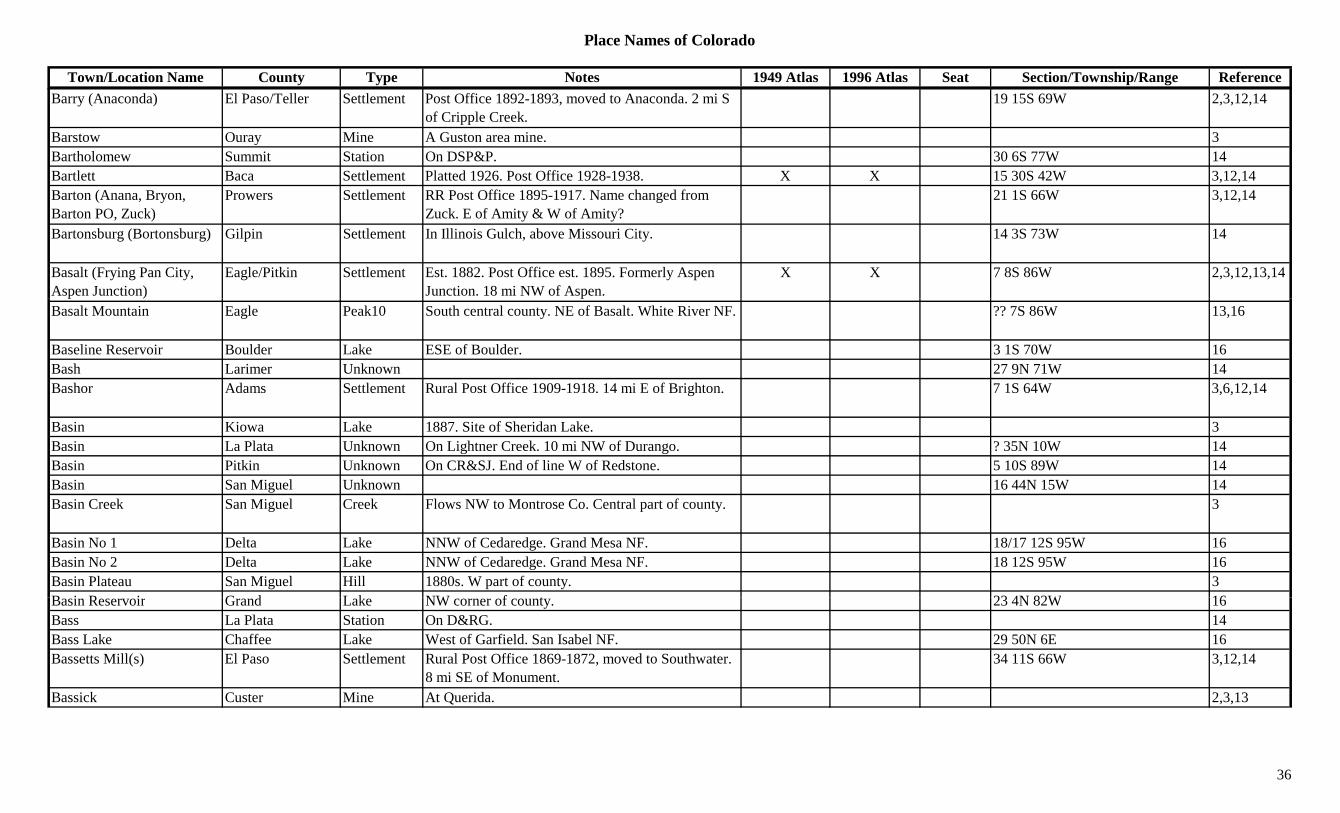
Place Names of Colorado
Town/Location Name County Type Notes 1949 Atlas 1996 Atlas Seat Section/Township/Range ReferenceBarry (Anaconda) El Paso/Teller Settlement Post Office 1892-1893, moved to Anaconda. 2 mi S
of Cripple Creek.19 15S 69W 2,3,12,14
Barstow Ouray Mine A Guston area mine. 3Bartholomew Summit Station On DSP&P. 30 6S 77W 14Bartlett Baca Settlement Platted 1926. Post Office 1928-1938. X X 15 30S 42W 3,12,14Barton (Anana, Bryon, Barton PO, Zuck)
Prowers Settlement RR Post Office 1895-1917. Name changed from Zuck. E of Amity & W of Amity?
21 1S 66W 3,12,14
Bartonsburg (Bortonsburg) Gilpin Settlement In Illinois Gulch, above Missouri City. 14 3S 73W 14
Basalt (Frying Pan City, Aspen Junction)
Eagle/Pitkin Settlement Est. 1882. Post Office est. 1895. Formerly Aspen Junction. 18 mi NW of Aspen.
X X 7 8S 86W 2,3,12,13,14
Basalt Mountain Eagle Peak10 South central county. NE of Basalt. White River NF. ?? 7S 86W 13,16
Baseline Reservoir Boulder Lake ESE of Boulder. 3 1S 70W 16Bash Larimer Unknown 27 9N 71W 14Bashor Adams Settlement Rural Post Office 1909-1918. 14 mi E of Brighton. 7 1S 64W 3,6,12,14
Basin Kiowa Lake 1887. Site of Sheridan Lake. 3Basin La Plata Unknown On Lightner Creek. 10 mi NW of Durango. ? 35N 10W 14Basin Pitkin Unknown On CR&SJ. End of line W of Redstone. 5 10S 89W 14Basin San Miguel Unknown 16 44N 15W 14Basin Creek San Miguel Creek Flows NW to Montrose Co. Central part of county. 3
Basin No 1 Delta Lake NNW of Cedaredge. Grand Mesa NF. 18/17 12S 95W 16Basin No 2 Delta Lake NNW of Cedaredge. Grand Mesa NF. 18 12S 95W 16Basin Plateau San Miguel Hill 1880s. W part of county. 3B i R i G d L k NW f t 23 4N 82W 16Basin Reservoir Grand Lake NW corner of county. 23 4N 82W 16Bass La Plata Station On D&RG. 14Bass Lake Chaffee Lake West of Garfield. San Isabel NF. 29 50N 6E 16Bassetts Mill(s) El Paso Settlement Rural Post Office 1869-1872, moved to Southwater.
8 mi SE of Monument.34 11S 66W 3,12,14
Bassick Custer Mine At Querida. 2,3,13
36

Place Names of Colorado
Town/Location Name County Type Notes 1949 Atlas 1996 Atlas Seat Section/Township/Range ReferenceBassick (Querida) Custer Settlement Post Office 1917-1920. N of Ilse. Renamed Querida
in 1878.21 22S 71W 3,12,14
Bassick City (Querida) Custer Settlement See Querida. 3Bassickville (Querida) Custer Settlement Post Office 1880-1906. 9 mi E of Westcliffe. 2,3,13Batchelder Larimer Settlement Est. by 1923. NW of Norfolk. E of Boxelder. 3Bates Gilpin Mine A Black Hawk area mine. NW of Black Hawk. 3
Bates Gilpin Unknown On C&S. 36 3S 72W 14Bates Pitkin Unknown On D&RGW. 26 8S 86W 14Batesville Boulder Settlement Est. by 1875. North Boulder Creek. At Blue Bird
Mine, near Nederland.1,14
Bath (Summit, Hilltop) Chaffee/Park Settlement Post Office 1893-1904, with gaps. Top of Trout Creek Pass. Also stop on D&SP.
14 13S 77W 1,12,14
Battle Creek Grand Mine At Lulu. 2Battle Creek Routt Settlement Post Office 1911-1938. NW corner of county. X 15 12N 88W 3,12,14Battle Mountain Eagle Mountain W of Vail Pass. 3,13Battle Mountain Teller Mine Teller mines not elsewhere specified. 3Battle Mountain Teller Mountain At Victor. 2,13Battle Mountain (Gilman, Rock Creek, Clinton)
Eagle Settlement Early name for Gilman. Other names Rock Creek & Clinton. See Gilman.
13 6S 81W 3,13,14
Battle Mountain Mining District
Eagle Mine At Redcliff. 2
Battle of Ludlow Las Animas Fight Immediately NW of Ludlow. 3Battle Rock Montezuma Hill 1885. N side of Sierea El Late and McElmo Creek. 3
Battlement Mesa Mesa Hill Landmark. N side of Plateau Valley. 3B h C k S h Mi A E b i 3Bauchmann Creek Saguache Mine An Embargo area mine. 3Baum Weld Station Est. by 1923. End of spurline. 1 mi W of Dacono. 6 1N 67W 3,14
Baxter Boulder Mine A Ward area mine. 1,3,13Baxter Pueblo Settlement Est. abt 1859. 7 mi E of Pueblo. X 36 20S 64W 3,14Baxter Pass Garfield Pass NW corner of county. Btwn Atchee and Columbine.
Crossed by county road.X 34 5S 103W 3,7,9,16
37

Place Names of Colorado
Town/Location Name County Type Notes 1949 Atlas 1996 Atlas Seat Section/Township/Range ReferenceBaxter Pass (Columbine) Garfield Station Est. by 1924. Same RR stop as Columbine. 34 5S 103W 3,14Baxter Peak Garfield Peak11 East central county. N of Glenwood Springs. 30 4S 88W 16Baxter Springs Moffat Unknown 12 3N 103W 14Baxterville Rio Grande Settlement 1 mi W of South Fork. See Derrick & Camp Loma. 33 40N 3E 3,14
Bayfield (Los Pinos) La Plata Settlement Est. 1886. Post Office est. 1899. Preceded by Los Pinos Post Office.
X X 11 34N 7W 3,12,14
Bayou Gulch Douglas Gulch NE corner of county. Runs WNW to Cherry Creek. Sev 7S 65/66W 16
Bayou Salado (South Park) Park Misc Early name for South Park. 1,3
Beacon Huerfano Unknown On C&S. 4 27S 67W 14Beacon (Brodhead) Las Animas Station Post Office 1910-1913. May be earlier name for
Brodhead. Moved from Green Cañon.33 30S 65W 3,12,14
Beacon Hill Teller Camp Small. Absorbed by Elkton. 25 15S 69W 3,14Beacon Hill Teller Hill Btwn Cripple Creek and Victor. 3Beacon Peak (12,072) Peak12 Front Range, James Peak Group. 8Beam Fremont Mill On F&CC. 9 19S 69W 14Beaqua Teller Station On CS&CC. 14Bear Gunnison Settlement On N fork of the Gunnison River. 9 13S 90W 14Bear Routt Unknown Est. by 1907. On D&RGW. On the Yampa River. 7 6N 85W 14
Bear Cañon Los Animas Station At Berwind location. May be earlier name or separate stop.
11 32S 65W 3,14
Bear Cañon (Bear Canyon) Douglas Settlement Post Office 1863-1867. 14 8S 68W 12
B C (B C ñ ) B ld C S f B ld 1Bear Canyon (Bear Cañon) Boulder Canyon S of Boulder. 1
Bear Canyon (Bear Cañon) Douglas Settlement Post Office 1869-1879. SW of Sedalia. Same location as Bear Cañon.
14 8S 68W 3,12,14
Bear Creek Baca Creek Flows E by Springfield to Kansas near Monon. 3Bear Creek Clear Creek Creek Runs through Brookvale. 3Bear Creek Clear Creek Settlement 14
38
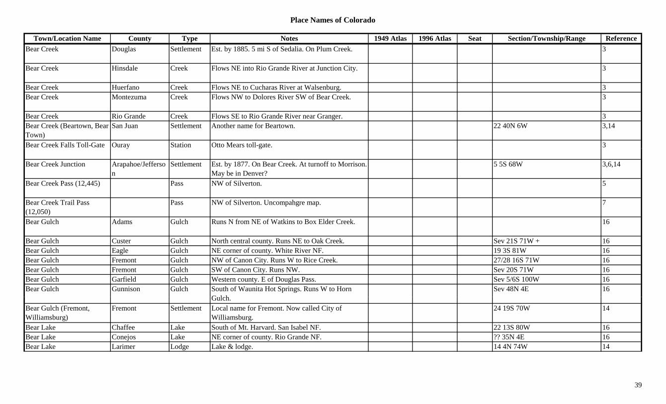
Place Names of Colorado
Town/Location Name County Type Notes 1949 Atlas 1996 Atlas Seat Section/Township/Range ReferenceBear Creek Douglas Settlement Est. by 1885. 5 mi S of Sedalia. On Plum Creek. 3
Bear Creek Hinsdale Creek Flows NE into Rio Grande River at Junction City. 3
Bear Creek Huerfano Creek Flows NE to Cucharas River at Walsenburg. 3Bear Creek Montezuma Creek Flows NW to Dolores River SW of Bear Creek. 3
Bear Creek Rio Grande Creek Flows SE to Rio Grande River near Granger. 3Bear Creek (Beartown, Bear Town)
San Juan Settlement Another name for Beartown. 22 40N 6W 3,14
Bear Creek Falls Toll-Gate Ouray Station Otto Mears toll-gate. 3y g
Bear Creek Junction Arapahoe/Jefferson
Settlement Est. by 1877. On Bear Creek. At turnoff to Morrison. May be in Denver?
5 5S 68W 3,6,14
Bear Creek Pass (12,445) Pass NW of Silverton. 5
Bear Creek Trail Pass (12,050)
Pass NW of Silverton. Uncompahgre map. 7
Bear Gulch Adams Gulch Runs N from NE of Watkins to Box Elder Creek. 16
Bear Gulch Custer Gulch North central county. Runs NE to Oak Creek. Sev 21S 71W + 16Bear Gulch Eagle Gulch NE corner of county. White River NF. 19 3S 81W 16Bear Gulch Fremont Gulch NW of Canon City. Runs W to Rice Creek. 27/28 16S 71W 16Bear Gulch Fremont Gulch SW of Canon City. Runs NW. Sev 20S 71W 16Bear Gulch Garfield Gulch Western county. E of Douglas Pass. Sev 5/6S 100W 16Bear Gulch Gunnison Gulch South of Waunita Hot Springs. Runs W to Horn
G l hSev 48N 4E 16
Gulch.Bear Gulch (Fremont, Williamsburg)
Fremont Settlement Local name for Fremont. Now called City of Williamsburg.
24 19S 70W 14
Bear Lake Chaffee Lake South of Mt. Harvard. San Isabel NF. 22 13S 80W 16Bear Lake Conejos Lake NE corner of county. Rio Grande NF. ?? 35N 4E 16Bear Lake Larimer Lodge Lake & lodge. 14 4N 74W 14
39

Place Names of Colorado
Town/Location Name County Type Notes 1949 Atlas 1996 Atlas Seat Section/Township/Range ReferenceBear Lakes Huerfano Lake Southern tip of county. W of Cucharas Pass. San
Isabel NF.30 31S 69W 16
Bear Mountain Douglas Mountain NE of Nighthawk. Pike NF. 8 8S 69W 16Bear Mountain Fremont Mountain North of Cotopaxi. 33 49N 12E 16Bear Mountain Grand/Jackson Mountain E of Rabbit Ears Pass. 30 5N 81W 13,16Bear Mountain Gunnison Peak12 NW of Scofield Pass. White River NF. ?? 12S 87W 16Bear Mountain (12,585) Peak12 Front Range, Southwest Section. 8Bear Mountain (8,420) Archuleta Mountain East central county. 16 34N 1E 16Bear Peak (8,461) Boulder Mountain South of Boulder. 13 1S 71W 16Bear Peak (9,577) Custer Mountain NE of Westcliffe. 28 21S 71W 13,16Bear River Routt Settlement Post Office 1914-1940. RR community. 8 mi E of X 11 6N 87W 3,12,14y
Hayden., ,
Bear Track Lakes Jefferson Lake Btwn Epaulet Mt & Rosalie Peak, near Evergreen 1
Bearcreek (Bear Creek) Montezuma Station Post Office 1899-1918, with gap. On D&RGW. 17 mi NE of Stoner.
X 8 38N 12W 3,12,14
Beard Jackson Settlement In NW corner of North Park. At or near Grange Valley.
14
Beard Place Mesa Ranch Homestead S of Fruita. 3Beards Corner San Miguel Unknown 23 44N 16W 14Bears Ears (Columbus Peak) (10,577 & 10,494)
Routt Peak Early name for Columbus Peak. Elkhead Mtns. W of Hahns Peak.
3,8,13
Beartown (Bear Creek, Cub Town, Gold Run)
Hinsdale/San Juan Settlement E base of Mt. Oso. Near county line. Also called Silver Tip, Sylvanite & Hines Fork.
22 40N 6W 3,14
Beartrack Lakes Clear Creek Lake South central county. Near Park Co. Arapaho NF. 31/32 5S 73W 16
B l B ld S ttl t NE f B ld 1Beasley Boulder Settlement NE of Boulder. 1Beasley Reservoir Boulder Lake Between Boulder and Longmont. 9/10 1N 70W 16Beattie Peak (13,342) Peak13 Silverton West Group. Ophir Quad. 8,11Beaty Dolores Settlement Post Office 1902-1903. 12,14Beaubien & Miranda Grant Las Animas Misc Large Spanish grant, stretching the width of county
in southern half.3
40
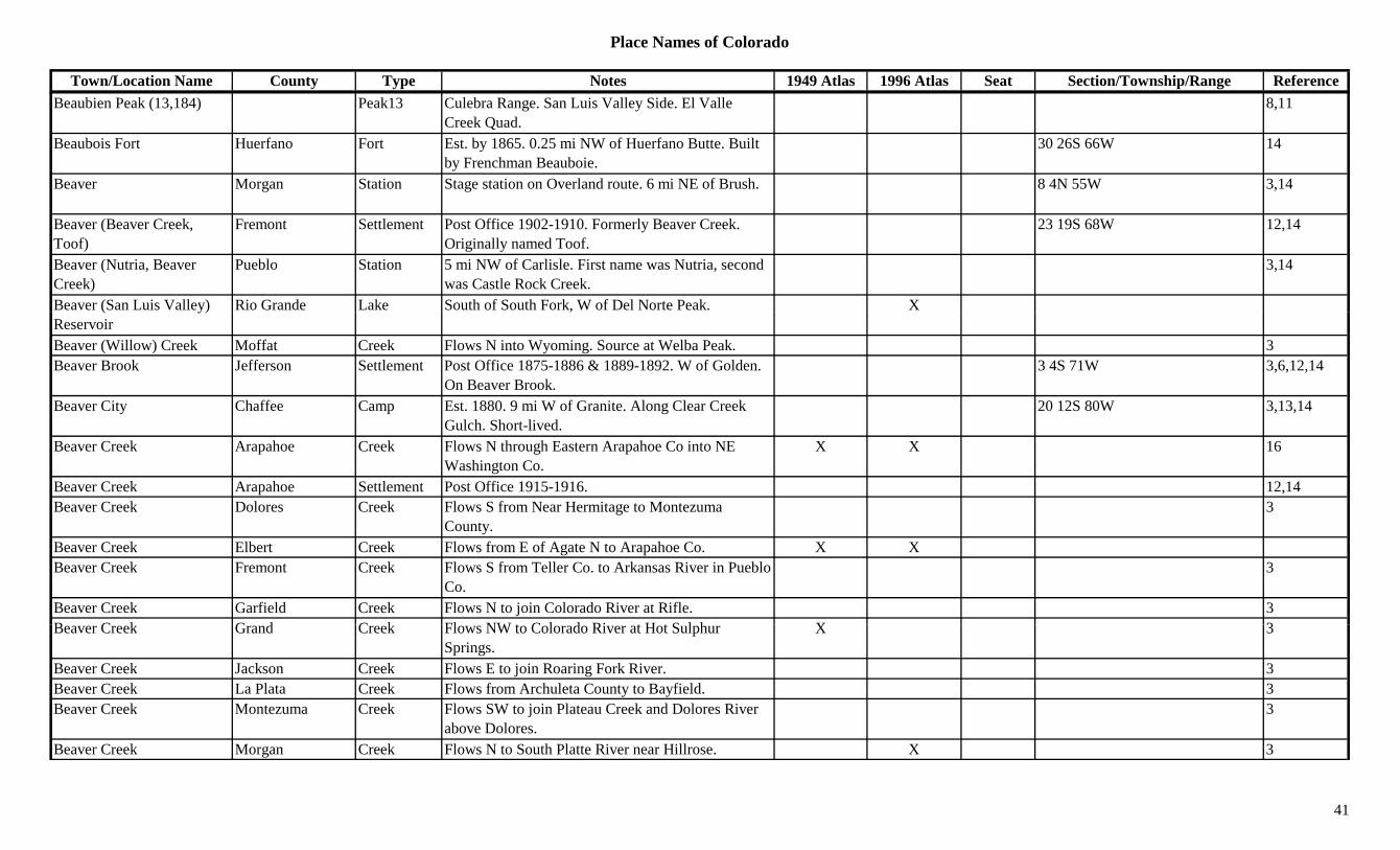
Place Names of Colorado
Town/Location Name County Type Notes 1949 Atlas 1996 Atlas Seat Section/Township/Range ReferenceBeaubien Peak (13,184) Peak13 Culebra Range. San Luis Valley Side. El Valle
Creek Quad.8,11
Beaubois Fort Huerfano Fort Est. by 1865. 0.25 mi NW of Huerfano Butte. Built by Frenchman Beauboie.
30 26S 66W 14
Beaver Morgan Station Stage station on Overland route. 6 mi NE of Brush. 8 4N 55W 3,14
Beaver (Beaver Creek, Toof)
Fremont Settlement Post Office 1902-1910. Formerly Beaver Creek. Originally named Toof.
23 19S 68W 12,14
Beaver (Nutria, Beaver Creek)
Pueblo Station 5 mi NW of Carlisle. First name was Nutria, second was Castle Rock Creek.
3,14
Beaver (San Luis Valley) Rio Grande Lake South of South Fork, W of Del Norte Peak. X( y)Reservoir
,
Beaver (Willow) Creek Moffat Creek Flows N into Wyoming. Source at Welba Peak. 3Beaver Brook Jefferson Settlement Post Office 1875-1886 & 1889-1892. W of Golden.
On Beaver Brook.3 4S 71W 3,6,12,14
Beaver City Chaffee Camp Est. 1880. 9 mi W of Granite. Along Clear Creek Gulch. Short-lived.
20 12S 80W 3,13,14
Beaver Creek Arapahoe Creek Flows N through Eastern Arapahoe Co into NE Washington Co.
X X 16
Beaver Creek Arapahoe Settlement Post Office 1915-1916. 12,14Beaver Creek Dolores Creek Flows S from Near Hermitage to Montezuma
County.3
Beaver Creek Elbert Creek Flows from E of Agate N to Arapahoe Co. X XBeaver Creek Fremont Creek Flows S from Teller Co. to Arkansas River in Pueblo
Co.3
Beaver Creek Garfield Creek Flows N to join Colorado River at Rifle. 3B C k G d C k Fl NW t C l d Ri t H t S l h X 3Beaver Creek Grand Creek Flows NW to Colorado River at Hot Sulphur
Springs.X 3
Beaver Creek Jackson Creek Flows E to join Roaring Fork River. 3Beaver Creek La Plata Creek Flows from Archuleta County to Bayfield. 3Beaver Creek Montezuma Creek Flows SW to join Plateau Creek and Dolores River
above Dolores.3
Beaver Creek Morgan Creek Flows N to South Platte River near Hillrose. X 3
41
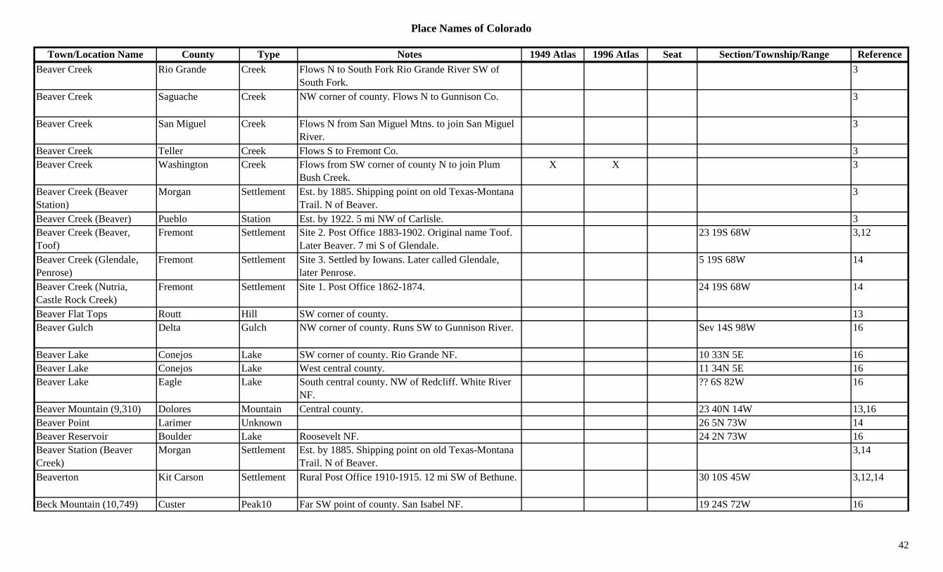
Place Names of Colorado
Town/Location Name County Type Notes 1949 Atlas 1996 Atlas Seat Section/Township/Range ReferenceBeaver Creek Rio Grande Creek Flows N to South Fork Rio Grande River SW of
South Fork.3
Beaver Creek Saguache Creek NW corner of county. Flows N to Gunnison Co. 3
Beaver Creek San Miguel Creek Flows N from San Miguel Mtns. to join San Miguel River.
3
Beaver Creek Teller Creek Flows S to Fremont Co. 3Beaver Creek Washington Creek Flows from SW corner of county N to join Plum
Bush Creek.X X 3
Beaver Creek (Beaver Station)
Morgan Settlement Est. by 1885. Shipping point on old Texas-Montana Trail. N of Beaver.
3
Beaver Creek (Beaver) Pueblo Station Est. by 1922. 5 mi NW of Carlisle. 3Beaver Creek (Beaver, Toof)
Fremont Settlement Site 2. Post Office 1883-1902. Original name Toof. Later Beaver. 7 mi S of Glendale.
23 19S 68W 3,12
Beaver Creek (Glendale, Penrose)
Fremont Settlement Site 3. Settled by Iowans. Later called Glendale, later Penrose.
5 19S 68W 14
Beaver Creek (Nutria, Castle Rock Creek)
Fremont Settlement Site 1. Post Office 1862-1874. 24 19S 68W 14
Beaver Flat Tops Routt Hill SW corner of county. 13Beaver Gulch Delta Gulch NW corner of county. Runs SW to Gunnison River. Sev 14S 98W 16
Beaver Lake Conejos Lake SW corner of county. Rio Grande NF. 10 33N 5E 16Beaver Lake Conejos Lake West central county. 11 34N 5E 16Beaver Lake Eagle Lake South central county. NW of Redcliff. White River
NF.?? 6S 82W 16
Beaver Mountain (9,310) Dolores Mountain Central county. 23 40N 14W 13,16B P i t L i U k 26 5N 73W 14Beaver Point Larimer Unknown 26 5N 73W 14Beaver Reservoir Boulder Lake Roosevelt NF. 24 2N 73W 16Beaver Station (Beaver Creek)
Morgan Settlement Est. by 1885. Shipping point on old Texas-Montana Trail. N of Beaver.
3,14
Beaverton Kit Carson Settlement Rural Post Office 1910-1915. 12 mi SW of Bethune. 30 10S 45W 3,12,14
Beck Mountain (10,749) Custer Peak10 Far SW point of county. San Isabel NF. 19 24S 72W 16
42
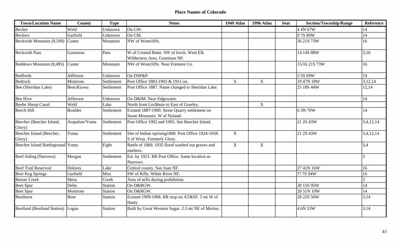
Place Names of Colorado
Town/Location Name County Type Notes 1949 Atlas 1996 Atlas Seat Section/Township/Range ReferenceBecker Weld Unknown On GW. 4 4N 67W 14Beckers Garfield Unknown On CM. 9 7S 89W 14Beckwith Mountain (8,549) Custer Mountain NW of Westcliffe. 26 21S 73W 16
Beckwith Pass Gunnison Pass W of Crested Butte. SW of Irwin. West Elk Wilderness Area. Gunnison NF.
14 14S 88W 3,16
Beddows Mountain (8,495) Custer Mountain NW of Westcliffe. Near Fremont Co. 15/16 21S 73W 16
Bedfords Jefferson Unknown On DSP&P. 3 5S 69W 14Bedrock Montrose Settlement Post Office 1883-1903 & 1911 on. X X 19 47N 18W 3,12,14Bee (Sheridan Lake) Bent/Kiowa Settlement Post Office 1887. Name changed to Sheridan Lake. 25 18S 44W 12,14( ) g ,
Bee Hive Jefferson Unknown On D&IM. Near Edgewater. 14Beebe Sheep Canal Weld Lake North from Lochbuie to East of Greeley. XBeech Hill Boulder Settlement Existed 1887-1900. Stone Quarry settlement on
Stone Mountain. W of Noland.6 3N 70W 14
Beecher (Beecher Island, Glory)
Arapahoe/Yuma Settlement Post Office 1902 and 1905. See Beecher Island. 21 2S 43W 3,4,12,14
Beecher Island (Beecher, Glory)
Yuma Settlement Site of Indian uprising1868. Post Office 1924-1958. S of Wray. Formerly Glory.
X 21 2S 43W 3,4,12,14
Beecher Island Battleground Yuma Fight Battle of 1868. 1935 flood washed out graves and markers.
X X 3,4
Beef Siding (Narrows) Morgan Settlement Est. by 1923. RR Post Office. Same location as Narrows.
3
Beef Trail Reservoir Dolores Lake Central county. San Juan NF. 27 41N 16W 16Beer Keg Springs Garfield Misc SW of Rifle. White River NF. ?? 7S 94W 16B C k M C k A f till d i hibiti 3Beeser Creek Mesa Creek Area of stills during prohibition. 3Beet Spur Delta Station On D&RGW. 30 15S 95W 14Beet Spur Montrose Station On D&RGW. 20 51N 10W 14Beethurst Bent Station Existed 1909-1968. RR stop on AT&SF. 5 mi W of
Hasty.28 22S 50W 3,14
Beetland (Beetland Station) Logan Station Built by Great Western Sugar. 2.5 mi NE of Merino. 4 6N 53W 3,14
43
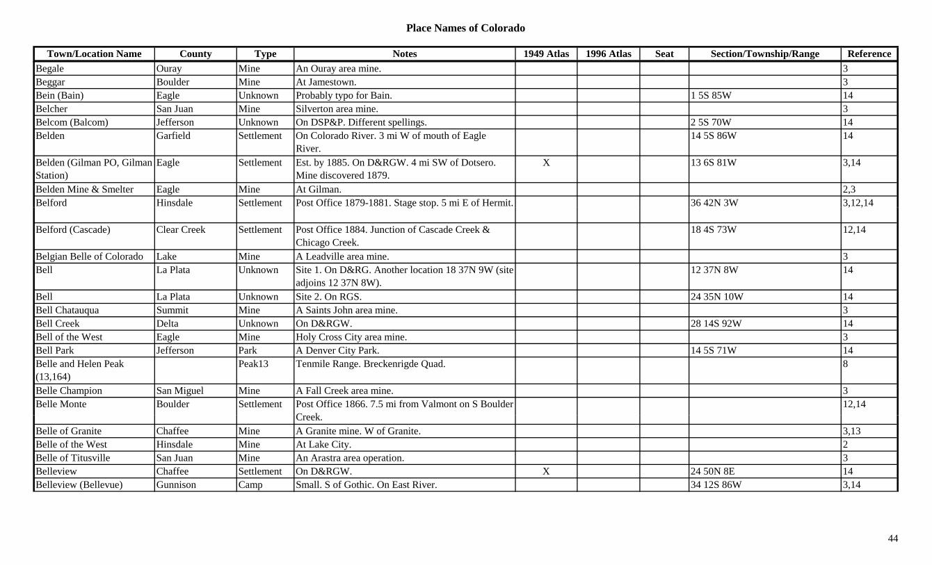
Place Names of Colorado
Town/Location Name County Type Notes 1949 Atlas 1996 Atlas Seat Section/Township/Range ReferenceBegale Ouray Mine An Ouray area mine. 3Beggar Boulder Mine At Jamestown. 3Bein (Bain) Eagle Unknown Probably typo for Bain. 1 5S 85W 14Belcher San Juan Mine Silverton area mine. 3Belcom (Balcom) Jefferson Unknown On DSP&P. Different spellings. 2 5S 70W 14Belden Garfield Settlement On Colorado River. 3 mi W of mouth of Eagle
River.14 5S 86W 14
Belden (Gilman PO, Gilman Station)
Eagle Settlement Est. by 1885. On D&RGW. 4 mi SW of Dotsero. Mine discovered 1879.
X 13 6S 81W 3,14
Belden Mine & Smelter Eagle Mine At Gilman. 2,3Belford Hinsdale Settlement Post Office 1879-1881. Stage stop. 5 mi E of Hermit. 36 42N 3W 3,12,14g p , ,
Belford (Cascade) Clear Creek Settlement Post Office 1884. Junction of Cascade Creek & Chicago Creek.
18 4S 73W 12,14
Belgian Belle of Colorado Lake Mine A Leadville area mine. 3Bell La Plata Unknown Site 1. On D&RG. Another location 18 37N 9W (site
adjoins 12 37N 8W).12 37N 8W 14
Bell La Plata Unknown Site 2. On RGS. 24 35N 10W 14Bell Chatauqua Summit Mine A Saints John area mine. 3Bell Creek Delta Unknown On D&RGW. 28 14S 92W 14Bell of the West Eagle Mine Holy Cross City area mine. 3Bell Park Jefferson Park A Denver City Park. 14 5S 71W 14Belle and Helen Peak (13,164)
Peak13 Tenmile Range. Breckenrigde Quad. 8
Belle Champion San Miguel Mine A Fall Creek area mine. 3Belle Monte Boulder Settlement Post Office 1866. 7.5 mi from Valmont on S Boulder
C k12,14
Creek.Belle of Granite Chaffee Mine A Granite mine. W of Granite. 3,13Belle of the West Hinsdale Mine At Lake City. 2Belle of Titusville San Juan Mine An Arastra area operation. 3Belleview Chaffee Settlement On D&RGW. X 24 50N 8E 14Belleview (Bellevue) Gunnison Camp Small. S of Gothic. On East River. 34 12S 86W 3,14
44
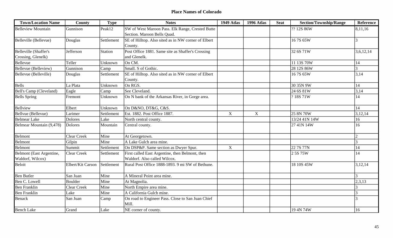
Place Names of Colorado
Town/Location Name County Type Notes 1949 Atlas 1996 Atlas Seat Section/Township/Range ReferenceBelleview Mountain Gunnison Peak12 SW of West Maroon Pass. Elk Range, Crested Butte
Section. Maroon Bells Quad.?? 12S 86W 8,11,16
Belleville (Bellevue) Douglas Settlement SE of Hilltop. Also sited as in NW corner of Elbert County.
16 7S 65W 3
Belleville (Shaffer's Crossing, Glenelk)
Jefferson Station Post Office 1881. Same site as Shaffer's Crossing and Glenelk.
32 6S 71W 3,6,12,14
Bellevue Teller Unknown On CM. 11 13S 70W 14Bellevue (Belleview) Gunnison Camp Small. S of Gothic. 28 12S 86W 3Bellevue (Belleville) Douglas Settlement SE of Hilltop. Also sited as in NW corner of Elbert
County.16 7S 65W 3,14
Bells La Plata Unknown On RGS. 30 35N 9W 14Bell's Camp (Cleveland) Eagle Camp See Cleveland. 24 6S 81W 3,14Bells Spring Fremont Unknown On N bank of the Arkansas River, in Gorge area. ? 18S 71W 14
Bellview Elbert Unknown On D&NO, DT&G, C&S. 14Bellvue (Bellevue) Larimer Settlement Est. 1882. Post Office 1887. X X 25 8N 70W 3,12,14Belmear Lake Dolores Lake North central county. 13/24 41N 14W 16Belmear Mountain (9,478) Dolores Mountain Central county. 27 41N 14W 16
Belmont Clear Creek Mine At Georgetown. 2Belmont Gilpin Mine A Lake Gulch area mine. 3Belmont Summit Settlement On DSP&P. Same section as Dwyer Spur. X 22 7S 77N 14Belmont (East Argentine, Waldorf, Wilcox)
Clear Creek Settlement First called East Argentine, then Belmont, then Waldorf. Also called Wilcox.
2 5S 75W 14
Beloit Elbert/Kit Carson Settlement Rural Post Office 1888-1893. 9 mi SW of Bethune. 18 10S 45W 3,12,14
B B tl S J Mi A Mi l P i t i 3Ben Butler San Juan Mine A Mineral Point area mine. 3Ben C. Lowell Boulder Mine At Magnolia. 2,3,13Ben Franklin Clear Creek Mine North Empire area mine. 3Ben Franklin Lake Mine A California Gulch mine. 3Benack San Juan Camp On road to Engineer Pass. Close to San Juan Chief
Mill.3
Bench Lake Grand Lake NE corner of county. 19 4N 74W 16
45

Place Names of Colorado
Town/Location Name County Type Notes 1949 Atlas 1996 Atlas Seat Section/Township/Range ReferenceBend Creek Jackson Creek Flows N into Rand. Joins Illinois River at Rand. 3Bendemeer Clear Creek Unknown On Bear Creek. 11 5S 72W 14Benham Arapahoe Station Stage station on Smoky Hill North stage route. 9 mi
SW of Deer Trail.11 5S 72W 3,14
Benham Springs Elbert Station Stage station on Smoky Hill North stage route. 7 mi S of Deer Trail.
3,6
Benko Elbert Settlement Post Office 1915-1917. Very SE corner of county. 12,14
Bennay Mountain Grand Peak11 NE corner of county. WNW of Grand Lake. Arapaho NF.
26/27 4N 77W 16
Bennet Gulch Eagle Gulch SE corner of county. White River NF. Sev 7S 80W 16g yBennet Springs Douglas Settlement Post Office 1862-1865. 12,14Bennet(t) Arapahoe/Adams Settlement Post Office est. 1877. Spelling changed to Bennett
(1907).X X 27 3S 63W 3,6,12,14
Bennets Dolores Settlement On Dolores River at mouths of Coke Oven & Barlow Creeks.
32 41N 10W 14
Bennets Ranch Dolores Ranch On RGS. 28 41N 10W 14Bennett Dry Placer Amalgamator
San Miguel Mill A Placerville mining operation. 13
Bennett Mountain Douglas Mountain NE of Nighthawk. Pike NF. 4 8S 69W 16Bennett Peak (Mountain) (13,203)
Rio Grande Peak13 Summitville Group. S of Del Norte. Jasper Quad. X X 3,8,11,13
Benson Larimer Station On C&S. 9 mi N of Wellington. 27 3S 63W 3,14Bensons Summit Station On D&RG. Next station S from Wheeler. 6 7S 78W 14Bent Canyon Las Animas Creek Flows E & S to Chacuaco Creek at Bent Canyon. 3
B t C L A i S ttl t R l P t Offi 1872 1902 20 i SE f Bl 23 28S 56W 3 12 14Bent Canyon Las Animas Settlement Rural Post Office 1872-1902. 20 mi SE of Bloom (Otero Co.)
23 28S 56W 3,12,14
Bent Peak Hinsdale Peak13 SSW of Lake City. San Juans, Lake City Group. Pole Creek Mtn. Quad. Gunnison/Rio Grande NF.
35 42N 5W 8,11,16
Benton Clear Creek Mine North Empire area mine. 3,13Benton Gunnison Station On D&RG. Near Glaciers. 20 14S 85W 14
46

Place Names of Colorado
Town/Location Name County Type Notes 1949 Atlas 1996 Atlas Seat Section/Township/Range ReferenceBenton Otero Station Est. by 1884. On AT&SF. 8 mi SW of La Junta. X 3 25S 56W 3,14
Bent's Fort Bent Fort Est. 1829/32. Trading post on Santa Fe Trail. 25 mi NW of Pueblo.
X 1,3,9
Bent's New Fort (Fort Lyon) Bent Fort Est. abt 1853. 3,9
Bents New Fort (Williams Fort)
Bent Settlement Built on Arkansas River in 1853. 35 22S 48W 12,14
Bents Old Fort (Fort Williams)
Otero Fort In 4 counties. First name Fort Williams, second Bents Fort, third Bents Old Fort.
X 23 23S 54W 14
Bents Road Crossing Bent Trail 3 mi SE of Kit Carson. 14gBent's Road Crossing Cheyenne Station Est. by 1882. Wagon road junction. 6 mi SW of Kit
Carson.3
Bent's Second Fort (Fort Lyon, Old Fort Lyon)
Bent Fort Est. abt 1860. Post Office 1863-1873. 3
Bent's Stockade (Old Bent's Fort)
Fremont Fort Built in 1826. Picket-post stockade. On Turkey Creek in foothills W of Pueblo.
3,9,14
Benuet Arapahoe Settlement Est. by 1887. 12 mi W of Byers. 3Berdella Lake Mine A Gleason Gulch mine. 3Bergan Park Jefferson Park X 20 4S 71WBergen Park (Bergen's Park) Jefferson Station Est. 1859. Hotel and stage station. SW of Golden. X 20 4S 71W 3,14
Bergen Peak (9,700) Clear Creek Mountain On Clear Creek & Jefferson Co border. 25/36 4S 72W 16Bergen Rock Douglas Hill SW of Castle Rock. Pike NF. 6 9S 68W 16Berkeley (Mountain View) Jefferson Settlement Platted 1888. See Mountain View. See Berkeley,
Arapahoe/Denver Co.13 3S 68W 3,6,14
B k l (N th D A h /D S ttl t P t Offi 1890 1896 I i 1892 Ch d t 3 12 14Berkeley (North Denver, Alcott)
Arapahoe/Denver Settlement Post Office 1890-1896. Inc. in 1892. Changed to Alcott in 1896.
3,12,14
Berlin Adams Settlement Platted 1890. No Post Office. 18 3S 66W 3,14Bernalillo Conejos Unknown On Conejos River. ? 32N 8E 14Bernard Mesa Settlement Post Office 1896-1905. On Grand Mesa. 7 mi S of
Collbran.22 10S 95W 3,12,14
Bernice Costilla Settlement Post Office 1901-1902. 12,14
47

Place Names of Colorado
Town/Location Name County Type Notes 1949 Atlas 1996 Atlas Seat Section/Township/Range ReferenceBerry Kit Carson Settlement Post Office 1911-1912. Very NW corner of county. ? 6S 51W 12,14
Berry Gulch Gunnison Gulch South of Waunita Hot Springs. Runs W to Horn Gulch.
Sev 49N 4E 16
Berry's Ranch (Edwards) Eagle Settlement See Edwards. 5 5S 82W 3,14Bertha Gulch Gunnison Gulch NE corner of county. N of Tincup. Runs E to Willow
Creek.Sev 15S 82W 16
Bertha Gulch (Tin Cup) Gunnison Settlement Early name for Tin Cup. 6 15S 81W 14Berthoud (Little Thompson) Larimer Settlement Est. 1877. Post Office est. 1878. Formerly Little
Thompson.X X 14 4N 69W 1,3,12,14
Berthoud Falls Clear Creek Settlement At foot of Berthoud Pass. A townsite and Inn. ? 3S 75W 14Berthoud Pass Clear Creek/Grand Pass Crossed by US 40. Berthoud Pass Topo. Arapaho
NF.X X 10 3S 75W 5,7,16
Bert's Corner Larimer Station Est. 1935. Near Berthoud. 22 4N 69W 3,14Bertschey's Gulch Chaffee Camp Near Cache Creek. 3Berwind (Tollerburg) Las Animas Settlement Est. by 1888. Post Office 1892-1931. 1 mi from
Tabasco and 17 mi NW of Trinidad.X 25 31S 65N 3,12,14
Beshoar (Beshoar Junction) Las Animas Settlement Est. 1888. Post Office on C&S 1901-1903. 4 mi E of El Moro.
X 25 32S 63W 3,12,14
Beshoar Junction Las Animas Station On C&S. 36 32S 63W 14Bessemer (Lake Minnequa, Minnequa)
Pueblo Settlement Platted 1886. Renamed and platted as Minnequa in 1891.
1 21S 65W 1,3,14
Bessemer Junction Pueblo Station On D&RGW. 14Bessie Pitkin Mine A Thomasville area mine. 3Bessie C. La Plata Mine A Parrott City area mine. 3Bessie Turner Boulder Mine A Salina Mine. 3,13B t L St ti E t b 1916 O BN 4 i SW f M i X 23 6N 54W 3 14Beta Logan Station Est. by 1916. On BN. 4 mi SW of Merino. X 23 6N 54W 3,14Beta Prowers Station Est. by 1924. On AT&SF. 4 mi W of Lamar. 33 22S 47W 3,14Bethel Bent Settlement Now only a cemetery. 13 26S 50W 14Bethesda (Nighthawk) Douglas Settlement On DSP&P. Post Office 1902-1909. NE of Deckers. 7 8S 69W 3,12,14
Bethune Elbert/Kit Carson Settlement RR Post Office 1889-1905 & 1906 on. On CRI&P. X X 34 8S 45W 3,12,14
48

Place Names of Colorado
Town/Location Name County Type Notes 1949 Atlas 1996 Atlas Seat Section/Township/Range ReferenceBetty Lake Boulder Lake SW corner of county. S of Devils Thumb Pass.
Roosevelt NF.16
Beuck (Buick) Elbert Settlement Post Office 1918. Formerly, and later, spelled Buick. 32 7S 58W 12,14
Beulah (Mace's Hole, Devil's Hole)
Pueblo Settlement Est. 1862. Post Office est. 1876. First called Devil's Hole, then Mace's Hole.
X X 3 23S 68W 3,12,14
Beulah Springs Pueblo Settlement Platted 1887. A resort town near Beulah. 14Biebles Gunnison Unknown On C&S. Just E of Gunnison. 4 49N 1E 14Biedell (Crystal Hill) Saguache Settlement Post Office 1883-1884, moved to Carnero. Gold
found in 1880.28 43N 6E 3,12,14
Biedell Creek Saguache Creek Flows E to Rio Grande Canal S of Russell Spring. 3g p g
Bierstadt El Paso Station Est. by 1887. Stop on C&S. 3 mi SW of Falcon. 36 13S 65W 3,14
Big 6 Tunnel Park Mine A Puma area mine. 3Big Agnes Mountain (12,059)
Jackson/Routt Peak12 North Park Range. 8
Big Alkali Lake Gunnison Lake Central county. North of Gunnison. Gunnison NF. 18 15S 85W 16
Big Baldy Fremont Hill N of Canon City. Near Park Co. 13Big Baldy Mountain Fremont Peak10 West central county. NNE of Wellsville. San Isabel
NF.29 50N 10E 16
Big Battlement Lake Delta Lake NW of Cedaredge. Grand Mesa NF. 19 12S 95W 16Big Bear Creek (Fall Creek) San Miguel Creek Flows N to join San Miguel River at Gold Run. 3
Big Bend Bent Station Est. by 1909. RR stop on AT&SF. 5 mi NW of Wil
X 24 21S 48W 3,14Wiley.
Big Bend Elbert Station Stage station on Smoky Hill Trail. 14Big Bend (Big Bent, Dolores)
Montezuma Settlement 1.5 mi from present site. Original name for Dolores. ? 37N 15W 1,3,14
Big Bend of Dolores (Dolores)
Montezuma Settlement First name of Dolores. 14
49
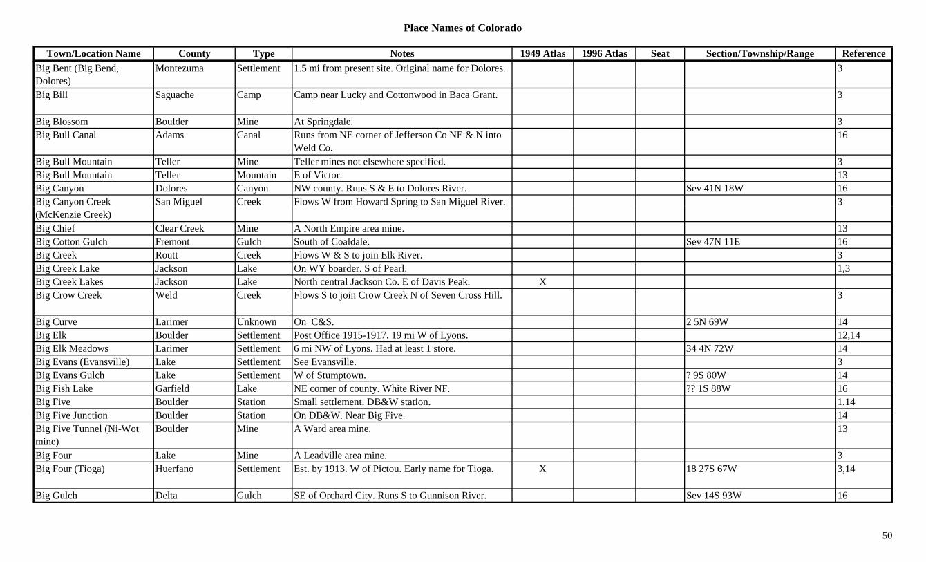
Place Names of Colorado
Town/Location Name County Type Notes 1949 Atlas 1996 Atlas Seat Section/Township/Range ReferenceBig Bent (Big Bend, Dolores)
Montezuma Settlement 1.5 mi from present site. Original name for Dolores. 3
Big Bill Saguache Camp Camp near Lucky and Cottonwood in Baca Grant. 3
Big Blossom Boulder Mine At Springdale. 3Big Bull Canal Adams Canal Runs from NE corner of Jefferson Co NE & N into
Weld Co.16
Big Bull Mountain Teller Mine Teller mines not elsewhere specified. 3Big Bull Mountain Teller Mountain E of Victor. 13Big Canyon Dolores Canyon NW county. Runs S & E to Dolores River. Sev 41N 18W 16Big Canyon Creek San Miguel Creek Flows W from Howard Spring to San Miguel River. 3g y(McKenzie Creek)
g p g g
Big Chief Clear Creek Mine A North Empire area mine. 13Big Cotton Gulch Fremont Gulch South of Coaldale. Sev 47N 11E 16Big Creek Routt Creek Flows W & S to join Elk River. 3Big Creek Lake Jackson Lake On WY boarder. S of Pearl. 1,3Big Creek Lakes Jackson Lake North central Jackson Co. E of Davis Peak. XBig Crow Creek Weld Creek Flows S to join Crow Creek N of Seven Cross Hill. 3
Big Curve Larimer Unknown On C&S. 2 5N 69W 14Big Elk Boulder Settlement Post Office 1915-1917. 19 mi W of Lyons. 12,14Big Elk Meadows Larimer Settlement 6 mi NW of Lyons. Had at least 1 store. 34 4N 72W 14Big Evans (Evansville) Lake Settlement See Evansville. 3Big Evans Gulch Lake Settlement W of Stumptown. ? 9S 80W 14Big Fish Lake Garfield Lake NE corner of county. White River NF. ?? 1S 88W 16Big Five Boulder Station Small settlement. DB&W station. 1,14Bi Fi J ti B ld St ti O DB&W N Bi Fi 14Big Five Junction Boulder Station On DB&W. Near Big Five. 14Big Five Tunnel (Ni-Wot mine)
Boulder Mine A Ward area mine. 13
Big Four Lake Mine A Leadville area mine. 3Big Four (Tioga) Huerfano Settlement Est. by 1913. W of Pictou. Early name for Tioga. X 18 27S 67W 3,14
Big Gulch Delta Gulch SE of Orchard City. Runs S to Gunnison River. Sev 14S 93W 16
50

Place Names of Colorado
Town/Location Name County Type Notes 1949 Atlas 1996 Atlas Seat Section/Township/Range ReferenceBig Gulch Gunnison Gulch SW of Ohio City. Runs S from Gunnison NF to
Quartz Creek.Sev 49/50N 3E 16
Big Gulch Moffat Gulch Flows S & W past Lay to Yampa River above Juniper Springs.
3
Big Gypsum Valley San Miguel Valley W central county. 13Big Hell Canyon Dolores Canyon South central county. SW of Rico. Runs W to Stoner
Creek.Sev 39N 12W 16
Big Hill (Placer Station, Russell Station)
Costilla Station Btwn Placer & Trinchera. ? 29S 71W 3,14
Big Hill (Roscoe) Jefferson Settlement Est. by 1885. 9 mi W of Golden. E of site of Forks Creek. Preceded by Roscoe.
6 4S 71W 3,6,14
Big Horn Boulder Mine A Gold Hill mine. 3Big Horn Conejos Station On D&RG. ? 32N 7E 14Big Horn Eagle Unknown 12 5S 80W 14Big Horn (Bighorn) Larimer/Jackson Settlement Post Office 1898-1900. 32 11N 81W 12,14Big Horn Mine Jackson Mine Near Pearl. Runs into Wyoming. 3Big Horn Pass (11,300) Rio Grande Pass W of Wolf Creek Pass. 7Big John Lake Jackson Lake W of Walden. 1Big John Mountain (8,827) Boulder Mountain NW corner of county. Roosevelt NF. 28 3N 72W 16
Big Johnson Reservoir El Paso Lake East of Security-Widefield. 8/17 15S 65W 16Big Lake Conejos Lake North of La Jara Reservoir. 23 36N 5E 16Big Marvine Peak (11,879) Peak Flattops (Range). 8
Big Mesa Gunnison Mesa SE of E end of Blue Mesa Res. Sev 48/49N 1W 16Big Mine Gunnison Mine Near Crested Butte. 2,13Bi M Gil i Mi SW f R lli ill 3Big Moon Gilpin Mine SW of Rollinsville. 3Big Mountain Garfield Ridge Runs SE to NW in corner near Rio Blanco Co. Sev 3S 93W 16Big Muddy Creek Adams Creek Flows N in Eastern county and into SW Morgan Co. 16
Big Park (Glade Park) Mesa Settlement Original name for Glade Park. 3Big Red Hill Eagle Peak10 NW corner of county. N of Gypsum. 29 3S 85W 16Big Reservoir Dolores Lake Central county. 9 40N 13W 16
51
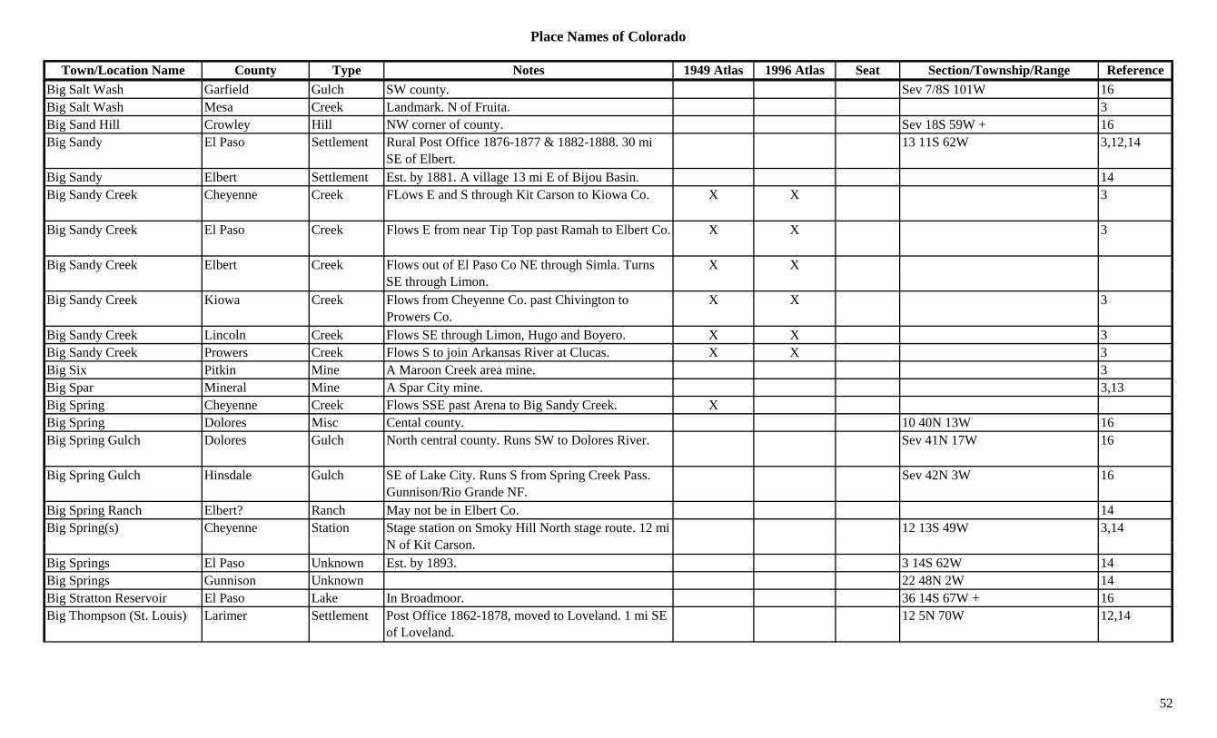
Place Names of Colorado
Town/Location Name County Type Notes 1949 Atlas 1996 Atlas Seat Section/Township/Range ReferenceBig Salt Wash Garfield Gulch SW county. Sev 7/8S 101W 16Big Salt Wash Mesa Creek Landmark. N of Fruita. 3Big Sand Hill Crowley Hill NW corner of county. Sev 18S 59W + 16Big Sandy El Paso Settlement Rural Post Office 1876-1877 & 1882-1888. 30 mi
SE of Elbert.13 11S 62W 3,12,14
Big Sandy Elbert Settlement Est. by 1881. A village 13 mi E of Bijou Basin. 14Big Sandy Creek Cheyenne Creek FLows E and S through Kit Carson to Kiowa Co. X X 3
Big Sandy Creek El Paso Creek Flows E from near Tip Top past Ramah to Elbert Co. X X 3
Big Sandy Creek Elbert Creek Flows out of El Paso Co NE through Simla. Turns X Xg y gSE through Limon.
Big Sandy Creek Kiowa Creek Flows from Cheyenne Co. past Chivington to Prowers Co.
X X 3
Big Sandy Creek Lincoln Creek Flows SE through Limon, Hugo and Boyero. X X 3Big Sandy Creek Prowers Creek Flows S to join Arkansas River at Clucas. X X 3Big Six Pitkin Mine A Maroon Creek area mine. 3Big Spar Mineral Mine A Spar City mine. 3,13Big Spring Cheyenne Creek Flows SSE past Arena to Big Sandy Creek. XBig Spring Dolores Misc Cental county. 10 40N 13W 16Big Spring Gulch Dolores Gulch North central county. Runs SW to Dolores River. Sev 41N 17W 16
Big Spring Gulch Hinsdale Gulch SE of Lake City. Runs S from Spring Creek Pass. Gunnison/Rio Grande NF.
Sev 42N 3W 16
Big Spring Ranch Elbert? Ranch May not be in Elbert Co. 14Big Spring(s) Cheyenne Station Stage station on Smoky Hill North stage route. 12 mi
N f Kit C12 13S 49W 3,14
N of Kit Carson.Big Springs El Paso Unknown Est. by 1893. 3 14S 62W 14Big Springs Gunnison Unknown 22 48N 2W 14Big Stratton Reservoir El Paso Lake In Broadmoor. 36 14S 67W + 16Big Thompson (St. Louis) Larimer Settlement Post Office 1862-1878, moved to Loveland. 1 mi SE
of Loveland.12 5N 70W 12,14
52
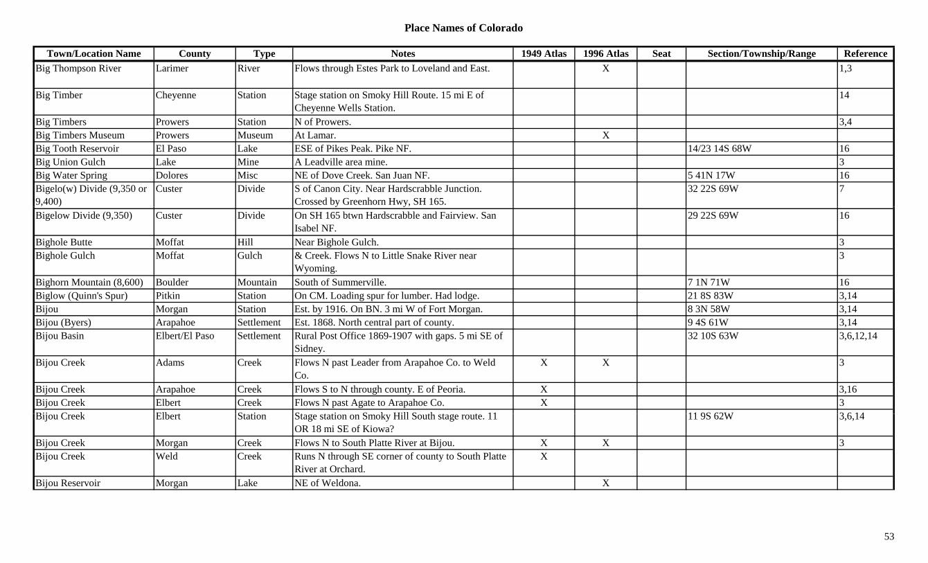
Place Names of Colorado
Town/Location Name County Type Notes 1949 Atlas 1996 Atlas Seat Section/Township/Range ReferenceBig Thompson River Larimer River Flows through Estes Park to Loveland and East. X 1,3
Big Timber Cheyenne Station Stage station on Smoky Hill Route. 15 mi E of Cheyenne Wells Station.
14
Big Timbers Prowers Station N of Prowers. 3,4Big Timbers Museum Prowers Museum At Lamar. XBig Tooth Reservoir El Paso Lake ESE of Pikes Peak. Pike NF. 14/23 14S 68W 16Big Union Gulch Lake Mine A Leadville area mine. 3Big Water Spring Dolores Misc NE of Dove Creek. San Juan NF. 5 41N 17W 16Bigelo(w) Divide (9,350 or 9,400)
Custer Divide S of Canon City. Near Hardscrabble Junction. Crossed by Greenhorn Hwy, SH 165.
32 22S 69W 7
Bigelow Divide (9,350) Custer Divide On SH 165 btwn Hardscrabble and Fairview. San Isabel NF.
29 22S 69W 16
Bighole Butte Moffat Hill Near Bighole Gulch. 3Bighole Gulch Moffat Gulch & Creek. Flows N to Little Snake River near
Wyoming.3
Bighorn Mountain (8,600) Boulder Mountain South of Summerville. 7 1N 71W 16Biglow (Quinn's Spur) Pitkin Station On CM. Loading spur for lumber. Had lodge. 21 8S 83W 3,14Bijou Morgan Station Est. by 1916. On BN. 3 mi W of Fort Morgan. 8 3N 58W 3,14Bijou (Byers) Arapahoe Settlement Est. 1868. North central part of county. 9 4S 61W 3,14Bijou Basin Elbert/El Paso Settlement Rural Post Office 1869-1907 with gaps. 5 mi SE of
Sidney.32 10S 63W 3,6,12,14
Bijou Creek Adams Creek Flows N past Leader from Arapahoe Co. to Weld Co.
X X 3
Bijou Creek Arapahoe Creek Flows S to N through county. E of Peoria. X 3,16Bijou Creek Elbert Creek Flows N past Agate to Arapahoe Co. X 3Bij C k Elb t St ti St t ti S k Hill S th t t 11 11 9S 62W 3 6 14Bijou Creek Elbert Station Stage station on Smoky Hill South stage route. 11
OR 18 mi SE of Kiowa?11 9S 62W 3,6,14
Bijou Creek Morgan Creek Flows N to South Platte River at Bijou. X X 3Bijou Creek Weld Creek Runs N through SE corner of county to South Platte
River at Orchard.X
Bijou Reservoir Morgan Lake NE of Weldona. X
53
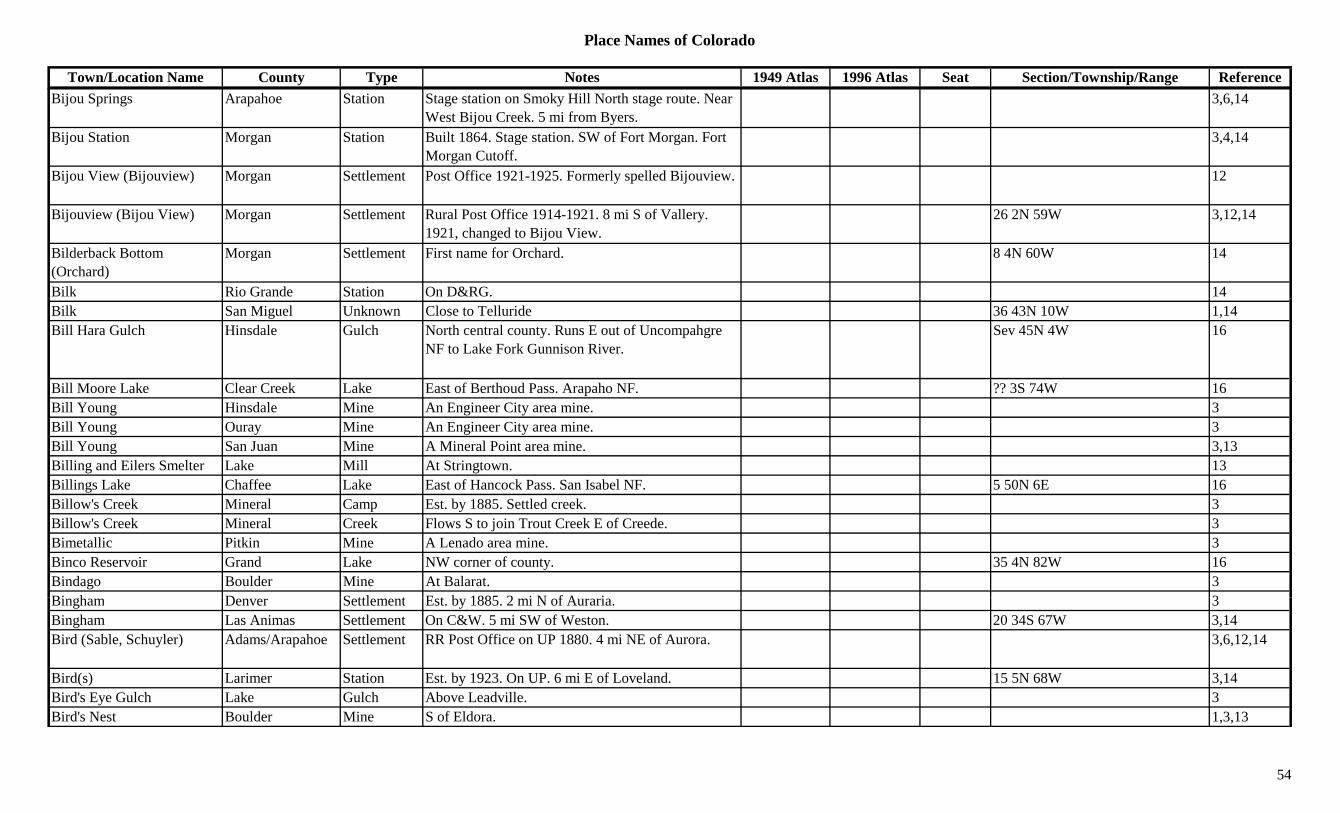
Place Names of Colorado
Town/Location Name County Type Notes 1949 Atlas 1996 Atlas Seat Section/Township/Range ReferenceBijou Springs Arapahoe Station Stage station on Smoky Hill North stage route. Near
West Bijou Creek. 5 mi from Byers.3,6,14
Bijou Station Morgan Station Built 1864. Stage station. SW of Fort Morgan. Fort Morgan Cutoff.
3,4,14
Bijou View (Bijouview) Morgan Settlement Post Office 1921-1925. Formerly spelled Bijouview. 12
Bijouview (Bijou View) Morgan Settlement Rural Post Office 1914-1921. 8 mi S of Vallery. 1921, changed to Bijou View.
26 2N 59W 3,12,14
Bilderback Bottom (Orchard)
Morgan Settlement First name for Orchard. 8 4N 60W 14
Bilk Rio Grande Station On D&RG. 14Bilk San Miguel Unknown Close to Telluride 36 43N 10W 1,14Bill Hara Gulch Hinsdale Gulch North central county. Runs E out of Uncompahgre
NF to Lake Fork Gunnison River.Sev 45N 4W 16
Bill Moore Lake Clear Creek Lake East of Berthoud Pass. Arapaho NF. ?? 3S 74W 16Bill Young Hinsdale Mine An Engineer City area mine. 3Bill Young Ouray Mine An Engineer City area mine. 3Bill Young San Juan Mine A Mineral Point area mine. 3,13Billing and Eilers Smelter Lake Mill At Stringtown. 13Billings Lake Chaffee Lake East of Hancock Pass. San Isabel NF. 5 50N 6E 16Billow's Creek Mineral Camp Est. by 1885. Settled creek. 3Billow's Creek Mineral Creek Flows S to join Trout Creek E of Creede. 3Bimetallic Pitkin Mine A Lenado area mine. 3Binco Reservoir Grand Lake NW corner of county. 35 4N 82W 16Bindago Boulder Mine At Balarat. 3Bi h D S ttl t E t b 1885 2 i N f A i 3Bingham Denver Settlement Est. by 1885. 2 mi N of Auraria. 3Bingham Las Animas Settlement On C&W. 5 mi SW of Weston. 20 34S 67W 3,14Bird (Sable, Schuyler) Adams/Arapahoe Settlement RR Post Office on UP 1880. 4 mi NE of Aurora. 3,6,12,14
Bird(s) Larimer Station Est. by 1923. On UP. 6 mi E of Loveland. 15 5N 68W 3,14Bird's Eye Gulch Lake Gulch Above Leadville. 3Bird's Nest Boulder Mine S of Eldora. 1,3,13
54
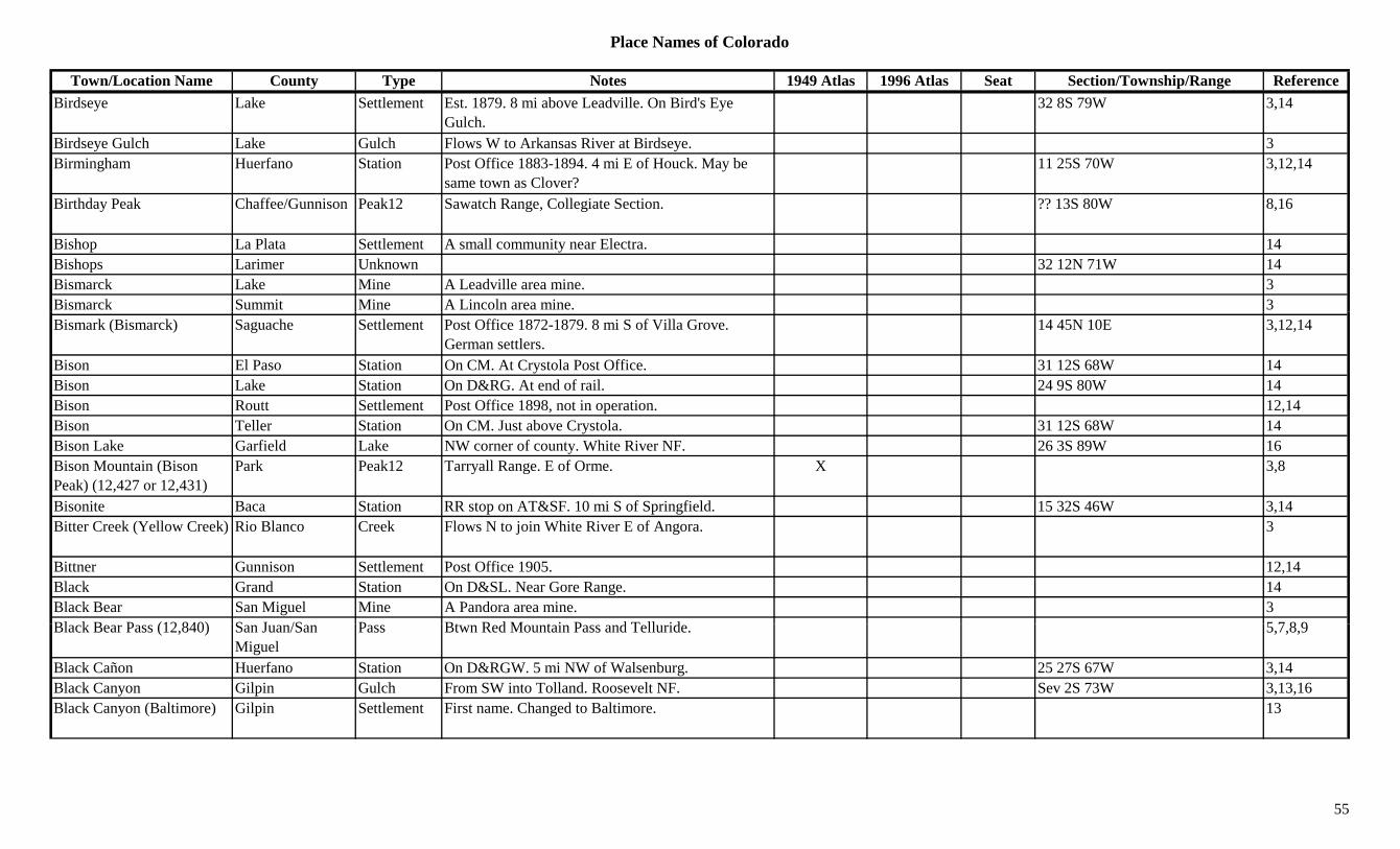
Place Names of Colorado
Town/Location Name County Type Notes 1949 Atlas 1996 Atlas Seat Section/Township/Range ReferenceBirdseye Lake Settlement Est. 1879. 8 mi above Leadville. On Bird's Eye
Gulch.32 8S 79W 3,14
Birdseye Gulch Lake Gulch Flows W to Arkansas River at Birdseye. 3Birmingham Huerfano Station Post Office 1883-1894. 4 mi E of Houck. May be
same town as Clover?11 25S 70W 3,12,14
Birthday Peak Chaffee/Gunnison Peak12 Sawatch Range, Collegiate Section. ?? 13S 80W 8,16
Bishop La Plata Settlement A small community near Electra. 14Bishops Larimer Unknown 32 12N 71W 14Bismarck Lake Mine A Leadville area mine. 3Bismarck Summit Mine A Lincoln area mine. 3Bismark (Bismarck) Saguache Settlement Post Office 1872-1879. 8 mi S of Villa Grove.
German settlers.14 45N 10E 3,12,14
Bison El Paso Station On CM. At Crystola Post Office. 31 12S 68W 14Bison Lake Station On D&RG. At end of rail. 24 9S 80W 14Bison Routt Settlement Post Office 1898, not in operation. 12,14Bison Teller Station On CM. Just above Crystola. 31 12S 68W 14Bison Lake Garfield Lake NW corner of county. White River NF. 26 3S 89W 16Bison Mountain (Bison Peak) (12,427 or 12,431)
Park Peak12 Tarryall Range. E of Orme. X 3,8
Bisonite Baca Station RR stop on AT&SF. 10 mi S of Springfield. 15 32S 46W 3,14Bitter Creek (Yellow Creek) Rio Blanco Creek Flows N to join White River E of Angora. 3
Bittner Gunnison Settlement Post Office 1905. 12,14Black Grand Station On D&SL. Near Gore Range. 14Black Bear San Miguel Mine A Pandora area mine. 3Bl k B P (12 840) S J /S P Bt R d M t i P d T ll id 5 7 8 9Black Bear Pass (12,840) San Juan/San
MiguelPass Btwn Red Mountain Pass and Telluride. 5,7,8,9
Black Cañon Huerfano Station On D&RGW. 5 mi NW of Walsenburg. 25 27S 67W 3,14Black Canyon Gilpin Gulch From SW into Tolland. Roosevelt NF. Sev 2S 73W 3,13,16Black Canyon (Baltimore) Gilpin Settlement First name. Changed to Baltimore. 13
55
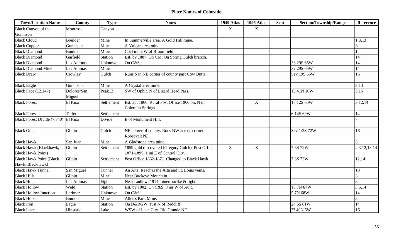
Place Names of Colorado
Town/Location Name County Type Notes 1949 Atlas 1996 Atlas Seat Section/Township/Range ReferenceBlack Canyon of the Gunnison
Montrose Canyon X X
Black Cloud Boulder Mine In Summerville area. A Gold Hill mine. 1,3,13Black Copper Gunnison Mine A Vulcan area mine. 3Black Diamond Boulder Mine Coal mine W of Broomfield 1Black Diamond Garfield Station Est. by 1887. On CM. On Spring Gulch branch. 14Black Diamond Las Animas Unknown On C&S. 33 29S 65W 14Black Diamond Mine Las Animas Mine 32 29S 65W 14Black Draw Crowley Gulch Runs S in NE corner of county past Cow Butte. Sev 19S 56W 16
Black Eagle Gunnison Mine A Crystal area mine. 3,13g y ,Black Face (12,147) Dolores/San
MiguelPeak12 SW of Ophir. N of Lizard Head Pass. 13 41N 10W 3,16
Black Forest El Paso Settlement Est. abt 1866. Rural Post Office 1960 on. N of Colorado Springs.
X 18 12S 65W 3,12,14
Black Forest Teller Settlement 6 14S 69W 14Black Forest Divide (7,340) El Paso Divide E of Monument Hill. 7
Black Gulch Gilpin Gulch NE corner of county. Runs NW across corner. Roosevelt NF.
Sev 1/2S 72W 16
Black Hawk San Juan Mine A Gladstone area mine. 3Black Hawk (Blackhawk, Black Hawk Point)
Gilpin Settlement 1859 gold discovered (Gregory Gulch). Post Office 1871-1895. 1 mi E of Central City.
X X 7 3S 72W 2,3,12,13,14
Black Hawk Point (Black Hawk, Blackhawk)
Gilpin Settlement Post Office 1862-1871. Changed to Black Hawk. 7 3S 72W 12,14
Black Hawk Tunnel San Miguel Tunnel An Alta. Reaches the Alta and St. Louis veins. 13Bl k Hill Gil i Mi N B k M t i 3Black Hills Gilpin Mine Near Buckeye Mountain. 3Black Hole Las Animas Fight Near Ludlow. 1914 miners strike & fight. 3Black Hollow Weld Station Est. by 1902. On C&S. 8 mi W of Ault. 15 7N 67W 3,6,14Black Hollow Junction Larimer Unknown On C&S. 5 7N 68W 14Black Horse Boulder Mine Allen's Park Mine. 3Black Iron Eagle Station On D&RGW. Just N of Redcliff. 24 6S 81W 14Black Lake Hinsdale Lake WSW of Lake City. Rio Grande NF. ?? 40N 5W 16
56
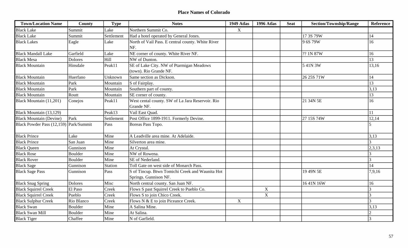
Place Names of Colorado
Town/Location Name County Type Notes 1949 Atlas 1996 Atlas Seat Section/Township/Range ReferenceBlack Lake Summit Lake Northern Summit Co. XBlack Lake Summit Settlement Had a hotel operated by General Jones. 17 3S 79W 14Black Lakes Eagle Lake North of Vail Pass. E central county. White River
NF.9 6S 79W 16
Black Mandall Lake Garfield Lake NE corner of county. White River NF. ?? 1N 87W 16Black Mesa Dolores Hill NW of Dunton. 13Black Mountain Hinsdale Peak11 SE of Lake City. NW of Ptarmigan Meadows
(town). Rio Grande NF.5 41N 3W 13,16
Black Mountain Huerfano Unknown Same section as Dickson. 26 25S 71W 14Black Mountain Park Mountain S of Fairplay. 13Black Mountain Park Mountain Southern part of county. 3,13p y ,Black Mountain Routt Mountain SE corner of county. 13Black Mountain (11,201) Conejos Peak11 West cental county. SW of La Jara Reservoir. Rio
Grande NF.21 34N 5E 16
Black Mountain (13,129) Peak13 Vail East Quad. 11Black Mountain (Devine) Park Settlement Post Office 1899-1911. Formerly Devine. 27 15S 74W 12,14Black Powder Pass (12,159) Park/Summit Pass Boreas Pass Topo. 5
Black Prince Lake Mine A Leadville area mine. At Adelaide. 3,13Black Prince San Juan Mine Silverton area mine. 3Black Queen Gunnison Mine At Crystal. 2,3,13Black Rose Boulder Mine NW of Rowena. 3Black Rover Boulder Mine SE of Nederland. 3Black Sage Gunnison Station Toll Gate on west side of Monarch Pass. 14Black Sage Pass Gunnison Pass S of Tincup. Btwn Tomichi Creek and Waunita Hot
Springs. Gunnison NF.19 49N 5E 7,9,16
Bl k S S i D l Mi N th t l t S J NF 16 41N 16W 16Black Snag Spring Dolores Misc North central county. San Juan NF. 16 41N 16W 16Black Squirrel Creek El Paso Creek Flows S past Squirrel Creek to Pueblo Co. X 3Black Squirrel Creek Pueblo Creek Flows S to join Chico Creek. X 3Black Sulphur Creek Rio Blanco Creek Flows N & E to join Piceance Creek. X 3Black Swan Boulder Mine A Salina Mine. 3,13Black Swan Mill Boulder Mine At Salina. 2Black Tiger Chaffee Mine N of Garfield. 3
57
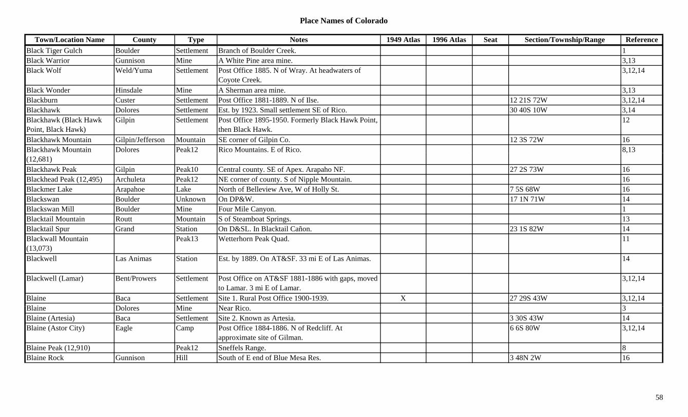
Place Names of Colorado
Town/Location Name County Type Notes 1949 Atlas 1996 Atlas Seat Section/Township/Range ReferenceBlack Tiger Gulch Boulder Settlement Branch of Boulder Creek. 1Black Warrior Gunnison Mine A White Pine area mine. 3,13Black Wolf Weld/Yuma Settlement Post Office 1885. N of Wray. At headwaters of
Coyote Creek.3,12,14
Black Wonder Hinsdale Mine A Sherman area mine. 3,13Blackburn Custer Settlement Post Office 1881-1889. N of Ilse. 12 21S 72W 3,12,14Blackhawk Dolores Settlement Est. by 1923. Small settlement SE of Rico. 30 40S 10W 3,14Blackhawk (Black Hawk Point, Black Hawk)
Gilpin Settlement Post Office 1895-1950. Formerly Black Hawk Point, then Black Hawk.
12
Blackhawk Mountain Gilpin/Jefferson Mountain SE corner of Gilpin Co. 12 3S 72W 16Blackhawk Mountain Dolores Peak12 Rico Mountains. E of Rico. 8,13(12,681)
,
Blackhawk Peak Gilpin Peak10 Central county. SE of Apex. Arapaho NF. 27 2S 73W 16Blackhead Peak (12,495) Archuleta Peak12 NE corner of county. S of Nipple Mountain. 16Blackmer Lake Arapahoe Lake North of Belleview Ave, W of Holly St. 7 5S 68W 16Blackswan Boulder Unknown On DP&W. 17 1N 71W 14Blackswan Mill Boulder Mine Four Mile Canyon. 1Blacktail Mountain Routt Mountain S of Steamboat Springs. 13Blacktail Spur Grand Station On D&SL. In Blacktail Cañon. 23 1S 82W 14Blackwall Mountain (13,073)
Peak13 Wetterhorn Peak Quad. 11
Blackwell Las Animas Station Est. by 1889. On AT&SF. 33 mi E of Las Animas. 14
Blackwell (Lamar) Bent/Prowers Settlement Post Office on AT&SF 1881-1886 with gaps, moved to Lamar. 3 mi E of Lamar.
3,12,14
Blaine Baca Settlement Site 1. Rural Post Office 1900-1939. X 27 29S 43W 3,12,14Bl i D l Mi N Ri 3Blaine Dolores Mine Near Rico. 3Blaine (Artesia) Baca Settlement Site 2. Known as Artesia. 3 30S 43W 14Blaine (Astor City) Eagle Camp Post Office 1884-1886. N of Redcliff. At
approximate site of Gilman.6 6S 80W 3,12,14
Blaine Peak (12,910) Peak12 Sneffels Range. 8Blaine Rock Gunnison Hill South of E end of Blue Mesa Res. 3 48N 2W 16
58

Place Names of Colorado
Town/Location Name County Type Notes 1949 Atlas 1996 Atlas Seat Section/Township/Range ReferenceBlainvale (Blainville) Rio Grande Settlement Post Office 1882-1884, with gap. Moved to Loyton
in Conejos Co.12,14
Blair (Roggen) Weld Settlement Roggen Post Office est. 1883. First name for Roggen.
3,14
Blair Lake Garfield Lake NW corner of county. White River NF. 8 3S 89W 16Blair Mountain Garfield Ridge NE county. Runs N to S. White River NF. Sev 3S 89W 16Blake City Eagle/Garfield Camp 2 mi below mouth of Eagle River. Near Glenwood
Springs.1 5S 87W 3,14
Blakeland Douglas Unknown On AT&SF. On D&RGW. 5 6S 68W 14Blanca Costilla Settlement Post Office 1894-1902 & 1908 on. X X 22 30S 73W 3,12,14Blanca (Blanco) Archuleta Settlement Est. by 1923. Along Rio Blanco River. 35 34N 1W 3,14( ) y g ,Blanca Mining Co. & Mill Saguache Mill A Crestone-Liberty area mine. 3Blanca Mutual Mining and Milling Co.
Saguache Mill A Liberty area operation. 13
Blanca Peak (14,345) Huerfano/Costilla Peak14 Sangre de Cristo Range, Sierra Blancas. Blanca Peak Quad.
X X ?? 28S 72W 8,11,16
Blanche Teller Mine A Cameron area mine. 3Bland Boulder Mine Allen's Park Mine. 3Bland Elbert Settlement Rural Post Office 1883-1921. 5 OR 9 mi N of Kuhn's
Crossing?20 8S 60W 3,6,12,14
Blandin Weld Station Est. by 1916. On DL&NW. 2 mi SW of Evans OR just NW of Evans?
26 5N 66W 3,6,14
Bledsaw Gulch Garfield Gulch South central county. Runs NE to North Dry Fork. Sev 7S 99W 16
Blende(r) Pueblo Unknown Pueblo suburb. X X 5 21S 64W 3,14Blinberry Gulch Gunnison Gulch NW of Gunnison. Runs E to Gunnison River. Sev 50N 1W 16Bli d H G l h S it S ttl t B t i l 1860 O Sh M t i 28 7S 79W (?) 14Blind Horse Gulch Summit Settlement Boomtown in early 1860s. On Sheep Mountain. 28 7S 79W (?) 14Blind Tom Lake Mine A Leadville area mine. 3Blind Tour Lake Mine A Leadville area mine. 3Blistered Horn Mine & Mill Gunnison Mine Near Tin Cup. 3,13
Blockhouse (Ostrander) Grand Settlement 8 mi NE of Frazer. Also called Ostrander. 14
59
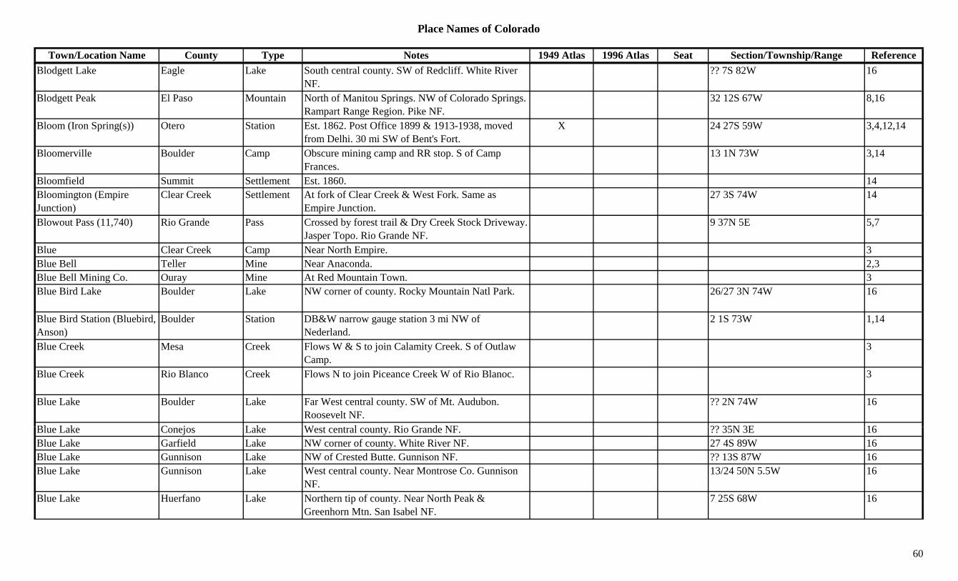
Place Names of Colorado
Town/Location Name County Type Notes 1949 Atlas 1996 Atlas Seat Section/Township/Range ReferenceBlodgett Lake Eagle Lake South central county. SW of Redcliff. White River
NF.?? 7S 82W 16
Blodgett Peak El Paso Mountain North of Manitou Springs. NW of Colorado Springs. Rampart Range Region. Pike NF.
32 12S 67W 8,16
Bloom (Iron Spring(s)) Otero Station Est. 1862. Post Office 1899 & 1913-1938, moved from Delhi. 30 mi SW of Bent's Fort.
X 24 27S 59W 3,4,12,14
Bloomerville Boulder Camp Obscure mining camp and RR stop. S of Camp Frances.
13 1N 73W 3,14
Bloomfield Summit Settlement Est. 1860. 14Bloomington (Empire Junction)
Clear Creek Settlement At fork of Clear Creek & West Fork. Same as Empire Junction.
27 3S 74W 14
Blowout Pass (11,740) Rio Grande Pass Crossed by forest trail & Dry Creek Stock Driveway. Jasper Topo. Rio Grande NF.
9 37N 5E 5,7
Blue Clear Creek Camp Near North Empire. 3Blue Bell Teller Mine Near Anaconda. 2,3Blue Bell Mining Co. Ouray Mine At Red Mountain Town. 3Blue Bird Lake Boulder Lake NW corner of county. Rocky Mountain Natl Park. 26/27 3N 74W 16
Blue Bird Station (Bluebird, Anson)
Boulder Station DB&W narrow gauge station 3 mi NW of Nederland.
2 1S 73W 1,14
Blue Creek Mesa Creek Flows W & S to join Calamity Creek. S of Outlaw Camp.
3
Blue Creek Rio Blanco Creek Flows N to join Piceance Creek W of Rio Blanoc. 3
Blue Lake Boulder Lake Far West central county. SW of Mt. Audubon. Roosevelt NF.
?? 2N 74W 16
Bl L k C j L k W t t l t Ri G d NF ?? 35N 3E 16Blue Lake Conejos Lake West central county. Rio Grande NF. ?? 35N 3E 16Blue Lake Garfield Lake NW corner of county. White River NF. 27 4S 89W 16Blue Lake Gunnison Lake NW of Crested Butte. Gunnison NF. ?? 13S 87W 16Blue Lake Gunnison Lake West central county. Near Montrose Co. Gunnison
NF.13/24 50N 5.5W 16
Blue Lake Huerfano Lake Northern tip of county. Near North Peak & Greenhorn Mtn. San Isabel NF.
7 25S 68W 16
60
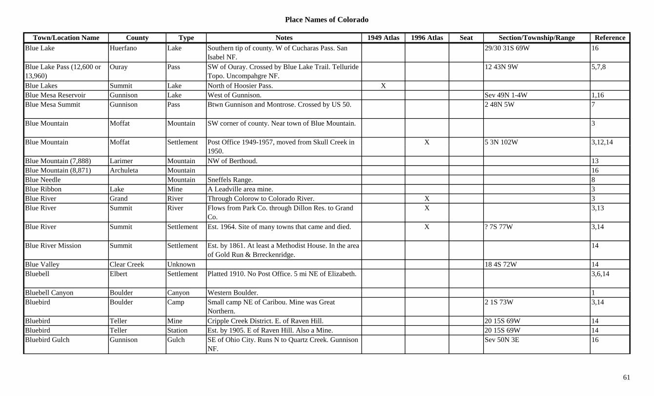
Place Names of Colorado
Town/Location Name County Type Notes 1949 Atlas 1996 Atlas Seat Section/Township/Range ReferenceBlue Lake Huerfano Lake Southern tip of county. W of Cucharas Pass. San
Isabel NF.29/30 31S 69W 16
Blue Lake Pass (12,600 or 13,960)
Ouray Pass SW of Ouray. Crossed by Blue Lake Trail. Telluride Topo. Uncompahgre NF.
12 43N 9W 5,7,8
Blue Lakes Summit Lake North of Hoosier Pass. XBlue Mesa Reservoir Gunnison Lake West of Gunnison. Sev 49N 1-4W 1,16Blue Mesa Summit Gunnison Pass Btwn Gunnison and Montrose. Crossed by US 50. 2 48N 5W 7
Blue Mountain Moffat Mountain SW corner of county. Near town of Blue Mountain. 3
Blue Mountain Moffat Settlement Post Office 1949-1957, moved from Skull Creek in X 5 3N 102W 3,12,14,1950.
, ,
Blue Mountain (7,888) Larimer Mountain NW of Berthoud. 13Blue Mountain (8,871) Archuleta Mountain 16Blue Needle Mountain Sneffels Range. 8Blue Ribbon Lake Mine A Leadville area mine. 3Blue River Grand River Through Colorow to Colorado River. X 3Blue River Summit River Flows from Park Co. through Dillon Res. to Grand
Co.X 3,13
Blue River Summit Settlement Est. 1964. Site of many towns that came and died. X ? 7S 77W 3,14
Blue River Mission Summit Settlement Est. by 1861. At least a Methodist House. In the area of Gold Run & Brreckenridge.
14
Blue Valley Clear Creek Unknown 18 4S 72W 14Bluebell Elbert Settlement Platted 1910. No Post Office. 5 mi NE of Elizabeth. 3,6,14
Bl b ll C B ld C W t B ld 1Bluebell Canyon Boulder Canyon Western Boulder. 1Bluebird Boulder Camp Small camp NE of Caribou. Mine was Great
Northern.2 1S 73W 3,14
Bluebird Teller Mine Cripple Creek District. E. of Raven Hill. 20 15S 69W 14Bluebird Teller Station Est. by 1905. E of Raven Hill. Also a Mine. 20 15S 69W 14Bluebird Gulch Gunnison Gulch SE of Ohio City. Runs N to Quartz Creek. Gunnison
NF.Sev 50N 3E 16
61

Place Names of Colorado
Town/Location Name County Type Notes 1949 Atlas 1996 Atlas Seat Section/Township/Range ReferenceBluff Hinsdale Mine Surveyed 1889. Adjoining Lake City. 27 44N 4W 14Bluff Lake Adams Lake East of Stapleton Airport. 26 3S 67W 16Bluff Spring Fremont Unknown On AT&SF. 6 20S 69W 14Bluff Spring Mine Fremont Mine 6 20S 69W 14Blumenau (Colfax) Custer Settlement Est. 1869. Post Office 1879-1890, moved from
Colfax.31 23S 71W 3,12,14
Blumer Boulder (?) Station On Colo & NW. At 8,914 ft. 14Boaz El Paso/Teller Settlement Post Office 1895-1898. 34 15S 68W 12,14Boaz Las Animas Station On D&RGW. 3 mi S of Huerfano Co. line. 36 29S 65W 3,14Bob Lake Boulder Lake SW corner of county. S of Devils Thumb Pass.
Roosevelt NF.16
Bob Tail Boulder Mine An Eldora area mine. 13Bob Tail Gilpin Mine A Gregory Gulch mine. 3Bobtail Hill Gilpin Hill S of Central City. 3Bobtail Lode Gilpin Mine Near Black Hawk. 13Bocca (La Boca) La Plata Settlement On D&RG. See La Boca. 2 34N 9W 3,14Bocea La Plata Station On D&RG. S & E of Durango. Probably typo for
Bocca.3
Bockers (Boker) Gunnison Station On D&RGW. Near Crested Butte. Could be same as Boker.
14
Boerns Dolores Unknown Another spelling for Burns. 13 40N 11W 14Boettcher Boulder Station Est. by 1909. 2 mi N of Longmont. Early RR stop on
C&S.27 3N 69W 1,6,14
Boettcher Larimer Station On UP. 6 mi NW of Fort Collins. 15 8N 69W 3,14Boggsville Bent Misc At Ft. Lyon. XBoggsville Bent Settlement Est. 1866. 3 mi SE Las Animas. Home of Kit Carson
d J h P E l t tx 14 23S 52W 1,3,14
and John Powers. Early county seat.Bohn Gulch Custer Gulch SW of Wetmore. NE corner of county. Runs E to
Hardscrabble Creek.Sev 21S 69W 16
Bohn Lake Boulder Lake West of Longmont. 10 2N 70W 16Boiler Larimer Settlement Post Office 1914-1915. 12,14Boiler Hill Larimer Unknown 31 7N 71W 14
62
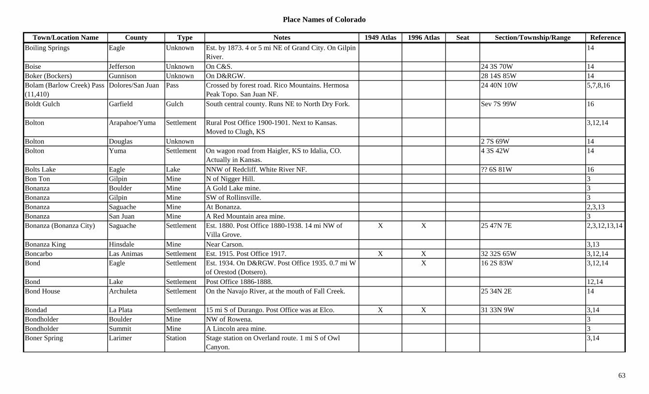
Place Names of Colorado
Town/Location Name County Type Notes 1949 Atlas 1996 Atlas Seat Section/Township/Range ReferenceBoiling Springs Eagle Unknown Est. by 1873. 4 or 5 mi NE of Grand City. On Gilpin
River.14
Boise Jefferson Unknown On C&S. 24 3S 70W 14Boker (Bockers) Gunnison Unknown On D&RGW. 28 14S 85W 14Bolam (Barlow Creek) Pass (11,410)
Dolores/San Juan Pass Crossed by forest road. Rico Mountains. Hermosa Peak Topo. San Juan NF.
24 40N 10W 5,7,8,16
Boldt Gulch Garfield Gulch South central county. Runs NE to North Dry Fork. Sev 7S 99W 16
Bolton Arapahoe/Yuma Settlement Rural Post Office 1900-1901. Next to Kansas. Moved to Clugh, KS
3,12,14
Bolton Douglas Unknown 2 7S 69W 14gBolton Yuma Settlement On wagon road from Haigler, KS to Idalia, CO.
Actually in Kansas.4 3S 42W 14
Bolts Lake Eagle Lake NNW of Redcliff. White River NF. ?? 6S 81W 16Bon Ton Gilpin Mine N of Nigger Hill. 3Bonanza Boulder Mine A Gold Lake mine. 3Bonanza Gilpin Mine SW of Rollinsville. 3Bonanza Saguache Mine At Bonanza. 2,3,13Bonanza San Juan Mine A Red Mountain area mine. 3Bonanza (Bonanza City) Saguache Settlement Est. 1880. Post Office 1880-1938. 14 mi NW of
Villa Grove.X X 25 47N 7E 2,3,12,13,14
Bonanza King Hinsdale Mine Near Carson. 3,13Boncarbo Las Animas Settlement Est. 1915. Post Office 1917. X X 32 32S 65W 3,12,14Bond Eagle Settlement Est. 1934. On D&RGW. Post Office 1935. 0.7 mi W
of Orestod (Dotsero).X 16 2S 83W 3,12,14
Bond Lake Settlement Post Office 1886-1888. 12,14B d H A h l t S ttl t O th N j Ri t th th f F ll C k 25 34N 2E 14Bond House Archuleta Settlement On the Navajo River, at the mouth of Fall Creek. 25 34N 2E 14
Bondad La Plata Settlement 15 mi S of Durango. Post Office was at Elco. X X 31 33N 9W 3,14Bondholder Boulder Mine NW of Rowena. 3Bondholder Summit Mine A Lincoln area mine. 3Boner Spring Larimer Station Stage station on Overland route. 1 mi S of Owl
Canyon.3,14
63
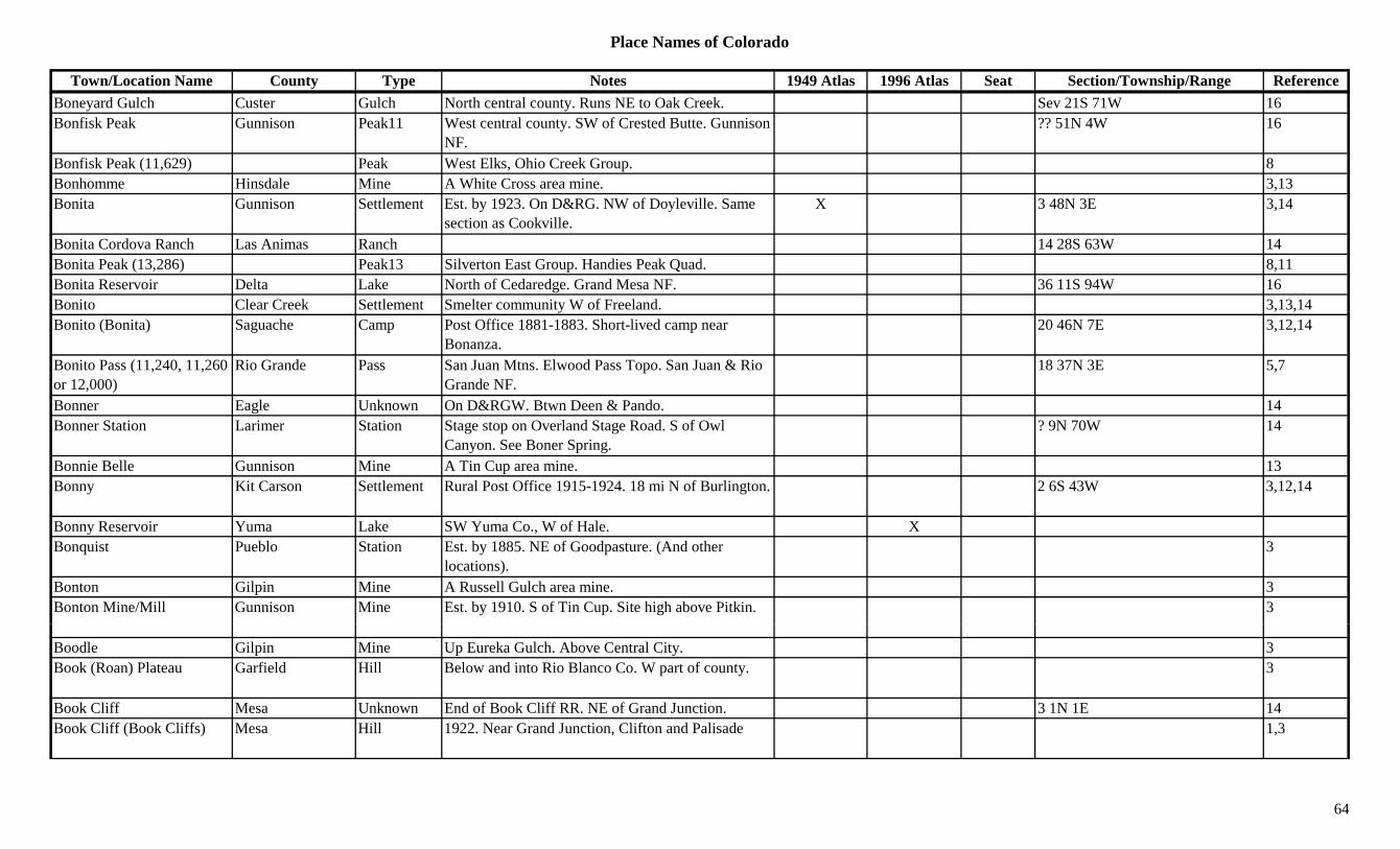
Place Names of Colorado
Town/Location Name County Type Notes 1949 Atlas 1996 Atlas Seat Section/Township/Range ReferenceBoneyard Gulch Custer Gulch North central county. Runs NE to Oak Creek. Sev 21S 71W 16Bonfisk Peak Gunnison Peak11 West central county. SW of Crested Butte. Gunnison
NF.?? 51N 4W 16
Bonfisk Peak (11,629) Peak West Elks, Ohio Creek Group. 8Bonhomme Hinsdale Mine A White Cross area mine. 3,13Bonita Gunnison Settlement Est. by 1923. On D&RG. NW of Doyleville. Same
section as Cookville.X 3 48N 3E 3,14
Bonita Cordova Ranch Las Animas Ranch 14 28S 63W 14Bonita Peak (13,286) Peak13 Silverton East Group. Handies Peak Quad. 8,11Bonita Reservoir Delta Lake North of Cedaredge. Grand Mesa NF. 36 11S 94W 16Bonito Clear Creek Settlement Smelter community W of Freeland. 3,13,14y , ,Bonito (Bonita) Saguache Camp Post Office 1881-1883. Short-lived camp near
Bonanza.20 46N 7E 3,12,14
Bonito Pass (11,240, 11,260 or 12,000)
Rio Grande Pass San Juan Mtns. Elwood Pass Topo. San Juan & Rio Grande NF.
18 37N 3E 5,7
Bonner Eagle Unknown On D&RGW. Btwn Deen & Pando. 14Bonner Station Larimer Station Stage stop on Overland Stage Road. S of Owl
Canyon. See Boner Spring.? 9N 70W 14
Bonnie Belle Gunnison Mine A Tin Cup area mine. 13Bonny Kit Carson Settlement Rural Post Office 1915-1924. 18 mi N of Burlington. 2 6S 43W 3,12,14
Bonny Reservoir Yuma Lake SW Yuma Co., W of Hale. XBonquist Pueblo Station Est. by 1885. NE of Goodpasture. (And other
locations).3
Bonton Gilpin Mine A Russell Gulch area mine. 3Bonton Mine/Mill Gunnison Mine Est. by 1910. S of Tin Cup. Site high above Pitkin. 3
Boodle Gilpin Mine Up Eureka Gulch. Above Central City. 3Book (Roan) Plateau Garfield Hill Below and into Rio Blanco Co. W part of county. 3
Book Cliff Mesa Unknown End of Book Cliff RR. NE of Grand Junction. 3 1N 1E 14Book Cliff (Book Cliffs) Mesa Hill 1922. Near Grand Junction, Clifton and Palisade 1,3
64
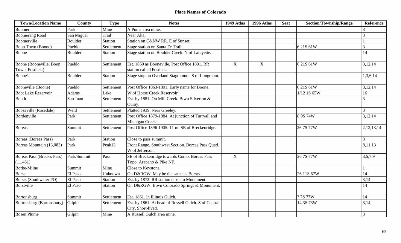
Place Names of Colorado
Town/Location Name County Type Notes 1949 Atlas 1996 Atlas Seat Section/Township/Range ReferenceBoomer Park Mine A Puma area mine. 3Boomerang Road San Miguel Trail Near Alta. 3Boomerville Boulder Station Station on C&NW RR. E of Sunset. 1Boon Town (Boone) Pueblo Settlement Stage station on Santa Fe Trail. 6 21S 61W 3Boone Boulder Station Stage station on Boulder Creek. N of Lafayette. 14
Boone (Booneville, Boon Town, Fosdick.)
Pueblo Settlement Est. 1860 as Booneville. Post Office 1891. RR station called Fosdick.
X X 6 21S 61W 3,12,14
Boone's Boulder Station Stage stop on Overland Stage route. S of Longmont. 1,3,6,14
Booneville (Boone) Pueblo Settlement Post Office 1863-1891. Early name for Boone. 6 21S 61W 3,12,14( ) y , ,Boot Lake Reservoir Adams Lake W of Horse Creek Reservoir. 1/12 1S 65W 16Booth San Juan Settlement Est. by 1881. On Mill Creek. Btwn Silverton &
Ouray.3
Boozeville (Rosedale) Weld Settlement Platted 1939. Near Greeley. 3Bordenville Park Settlement Post Office 1879-1884. At junction of Tarryall and
Michigan Creeks.8 9S 74W 3,12,14
Boreas Summit Settlement Post Office 1896-1905. 11 mi SE of Breckenridge. 26 7S 77W 2,12,13,14
Boreas (Boreas Pass) Park Station Close to pass summit. 3Boreas Mountain (13,082) Park Peak13 Front Range, Southwest Section. Boreas Pass Quad.
W of Jefferson.8,11,13
Boreas Pass (Breck's Pass) (11,481)
Park/Summit Pass SE of Breckenridge towards Como. Boreas Pass Topo. Arapaho & Pike NF.
X 26 7S 77W 3,5,7,9
Borke-Milne Summit Mine Close to Keystone 1Borst El Paso Unknown On D&RGW. May be the same as Borsts. 26 11S 67W 14B t (S th t PO) El P St ti E t b 1872 RR t ti l t M t 3 14Borsts (Southwater PO) El Paso Station Est. by 1872. RR station close to Monument. 3,14Borstville El Paso Station On D&RGW. Btwn Colorado Springs & Monument. 14
Bortonsburg Summit Settlement Est. 1861. In Illinois Gulch. ? 7S 77W 14Bortonsburg (Bartonsburg) Gilpin Settlement Est. by 1861. At head of Russell Gulch. S of Central
City. Short-lived.14 3S 73W 3,14
Bosen Plume Gilpin Mine A Russell Gulch area mine. 3
65

Place Names of Colorado
Town/Location Name County Type Notes 1949 Atlas 1996 Atlas Seat Section/Township/Range ReferenceBosler Jefferson Station On C&S. 14Boss Summit Mine A Lincoln area mine. 3Boston Baca/Las Animas Settlement Platted 1887. Post Office 1887-1893. Home of the
Jennings Gang.28 32S 44W 3,12,14
Boston Boulder Mine Ward area. 1,3Boston Las Animas/Baca Settlement Post Office 1887-1893. In Baca Co. when it was
formed.14
Boston Summit Mine Near Boston townsite. In Mayflower Gulch. 14Boston Summit Settlement In Mayflower Gulch. Near Boston Mine. 14Boston & Colorado Smelting Works
Gilpin Mill SE of Black Hawk. 3,13
Boston Peak Gunnison Peak11 West of Taylor Park Res. Gunnison NF. ?? 14S 84W 16Boston Silver Co. Summit Mine A Saints John area mining operation. 3Boston Silver Mining Assoc.
Summit Mine A Saints John area mining operation. 3
Boston-Occidental Mining Company
Gilpin Mine An American City operation. 13
Bottle Pass Grand Pass Crossed by Byers Peak Trail. Bottle Pass Topo. Arapaho NF.
6 2S 76W 5,7,16
Boughton (Sacramento City, Oro City, Leadville)
Lake Settlement Est. 1860. See Leadville. Absorbed by Leadville. 29 9S 79W 1,3,14
Boulder Lake Mine A Stumptown area mine. 13Boulder Pitkin Mine An Aspen area mine. 3Boulder (Boulder City) Boulder Settlement Post Office 1859 on. Also Eleven Cabins (first name
in 1858).X X 30 1N 70W 1,6,3,12
Boulder Canyon Boulder Canyon Along Boulder Creek to Nederland. 1,13B ld Cit (B ld ) B ld S ttl t F d d O t 1858 B B ld i 1865 30 1N 70W 14Boulder City (Boulder) Boulder Settlement Founded Oct 1858. Became Boulder in 1865. 30 1N 70W 14Boulder County Boulder Mine N of Old Cardinal. 3Boulder County Hill (10,215)
Boulder Peak10 NW of Nederland. Roosevelt NF. 9 1S 73W 16
Boulder Creek Boulder Creek Heads btwn Arapaho and Navajo peaks, & S of Moffat Tunnel.
1,3
66

Place Names of Colorado
Town/Location Name County Type Notes 1949 Atlas 1996 Atlas Seat Section/Township/Range ReferenceBoulder Creek Gilpin Creek Flows E from Continental Divide near East Portal to
Jefferson Co.3
Boulder Diggins Boulder Camp May have been early name for Gold Hill or at Gold Hill. 1st mine?
1
Boulder Falls Boulder Creek On Middle Boulder Creek. W of Eagle Rock. 3Boulder Gulch Gunnison Gulch North of Ohio City. Runs SE. Sev 51N 3E 16Boulder Gulch Hinsdale Gulch West central county. Runs ESE to Snare Creek. Sev 42N 6W 16
Boulder Gulch San Juan Gulch An Animas Forks area productive gulch. 3Boulder Junction Boulder Station On C&S. 29 1N 70W 14Boulder Lake Delta Lake NNW of Cedaredge. Grand Mesa NF. 16 12S 95W 16gBoulder Mountain San Juan Mountain NE of Silverton. 3Boulder Mountain (13,524) Chaffee Peak13 Sawatch Range, Chalk Creek Shavano Sect. St. Elmo
Quad. San Isabel NF.10 51N 6E 8,11,16
Boulder Mountain (8,500) Boulder Mountain S central part of county. NW of Eldorado Springs. 13/24 1S 71W 3,16
Boulder Reservoir Boulder Lake Between Boulder and Longmont. 3 1N 70W 16Boulder Siding Chaffee Station Est. by 1885. 1 mi NW of Buena Vista. 5 14S 78W 3,14Boulder Valley Weld Unknown On DL&NW. 36 1N 67W 14Boulder-Caribou Toll Road Boulder Trail Boulder to Caribou road. 13
Boulder-Grand Pass Boulder/Grand Pass Isolation Peak Topo. Rocky Mountain NP. 5,7Boulders Arapahoe Glacier Grand Misc N of Tabernash. X
Bountiful Conejos Settlement Est. in 1880s. Btwn La Jara and Romeo. Started as Mormon settlement.
X 34 35N 9E 3,14
B i Elb t/Li l S ttl t Pl tt d 1888 P t Offi 1899 1955 X 12 9S 54W 3 12 14Bovina Elbert/Lincoln Settlement Platted 1888. Post Office 1899-1955. X 12 9S 54W 3,12,14Bovina (Durham, Ute) Mesa Station Est. by 1923. On D&RGW. 2 mi NW of Grand
Junction.9 1S 1W 3,14
Bow Mar Arapahoe/Jefferson
Settlement 12 5S 69W (in Jefferson Co.) 7 5S 68W 14
Bowdish Gulch Garfield Gulch South central county. Runs W to Conn Creek. Sev 7S 97W 16
67

Place Names of Colorado
Town/Location Name County Type Notes 1949 Atlas 1996 Atlas Seat Section/Township/Range ReferenceBowen Dolores Settlement Est. by 1894. 14 mi W of Lizard Head RR Station. 14 41N 11W 14
Bowen Rio Grande Settlement Post Office 1883-1901. SE corner of county. 28 37N 8E 3,12,14Bowen (Aylmer) Las Animas Settlement RR Post Office 1906-1929. 3 mi NW of El Moro. On
C&S. Formerly Aylmer.X 19 32S 63W 3,12,14
Bowen Gulch Grand Gulch NE corner of county. Runs ESE to North Fork Colorado River. Arapaho NF.
Sev 4N 76W 3,16
Bowen Mountain Grand Peak12 North tip of county. Never Summer Range. Arapaho NF.
X 29 5N 76W 8,16
Bowen Pass Grand/Jackson Pass Btwn Tyner (Jackson County) & Ruby. Bowen Mtn. Topo. Routt & Arapaho NF.
29 5N 76W 3,5,7
Bowena Boulder Settlement 2 mi N of Gold Hill & a little W. Misspelled. See Rowena.
14
Bowens San Juan Station Est. in 1880s. Waystop btwn Cascade & Sliverton. 3
Bowen's Bonanza Rio Grande Mine Group of mines at Summitville. 2Bowenton Mineral Settlement Post Office 1881-1884. Mining venture. 13 mi W of
Summitville.35 37N 2E 3,12,14
Bowenton Rio Grande Settlement Post Office 1881-1884. 14Bowerman (Nugget City) Gunnison Settlement Post Office 1903-1910, moved to Waunita Hot
Springs. 35 mi E of Gunnison.28 51N 4E 2,3,12,13,14
Bowers Peak (12,449) Saguache Peak12 Cochetopa Hills. At source of La Garita Creek. 3,8,13Bowie (Wauneta, Reading) Delta Settlement Post Office 1907-1967. Was coal camp called
Reading.X X 15 13S 91W 3,12,14
Bowl of Tears Eagle Lake SW of Redcliff. White River NF. 5 7S 81W 16Bowles Lake Adams Lake NE of Barr Lake. 6 1S 65W 16B l L k A h L k B M bdi i i L k i t J ff C 18 5S 68W 16Bowles Lake Arapahoe Lake Bow Mar subdivision. Lake runs into Jefferson Co. 18 5S 68W 16
Bowles Park Arapahoe Unknown On D&SP. 19 5S 68W 14Bowman Archuleta Unknown On D&RG. On Pagosa Springs Branch. 16 34NU 3W 14Bowman Gunnison Camp Post Office 1880-1882. Last stop going over Taylor
Pass into Aspen.19 12S 83W 3,12,14
Bowman Pass (12,241) Pass In Sawatch Range. Near New York Pass. 5,7
68

Place Names of Colorado
Town/Location Name County Type Notes 1949 Atlas 1996 Atlas Seat Section/Township/Range ReferenceBowmar Arapahoe/Jefferso
nSettlement Inc. 1958. 12 5S 8W 6
Bowser Elbert/Kit Carson Settlement Post Office 1888. Moved to Flagler. 2 9S 51W 12,14
Box (Rock) Creek Montrose Creek From NW corner of county E to Dolores River. 3Box Canyon Alamosa Canyon Runs W from W of Little Bear Peak to Dry Lakes. 16
Box Canyon Gunnison Canyon West central county. Near Delta Co. Runs N to North Fork Gunnison River.
Sev 13S 90W 16
Box Canyon Gunnison Canyon West of Waunita Hot Springs. Runs S to Hot Spring Creek.
Sev 49N 4E 16
Box Elder Adams/Arapahoe Station Stage station on Smoky Hill North stage route. Near Box Elder Creek. 3 mi SE of Watkins.
29 3S 64W 3,6,14
Box Elder (Boxelder) Larimer Settlement Site 2. Post Office 1884-1894. Changed to Boxelder. 17 mi NW Fort Collins.
? 10N 69W 12,14
Box Elder (Bristol) Larimer Settlement Site 1. Rural Post Office 1876-1877. Name Changed to Bristol.
28 12N 70W 3,12,14
Box Lake Boulder Lake NW corner of county. Rocky Mountain Natl Park. 16
Box Prairie Larimer Unknown 16 7N 72W 14Boxelder Moffat Settlement On tributary of Red Wash Creek. 8 3N 100W 14Boxelder (Box Elder) Larimer Settlement Post Office 1894-1923, with gap. Formerly spelled
Box Elder.12
Boxelder (Box Elder) Creek Adams Creek Flows N from Watkins through Adams Co and into Weld Co.
X 16
Boxelder Creek Arapahoe Creek Flows N through county to Adams Co. ?? 4S 64W 16B ld C k Elb t C k Fl N W id f t 3Boxelder Creek Elbert Creek Flows N on W side of county. 3Boxelder Creek Weld Creek Flows N past Kuner to S. Platte River. X 3Boxwood Park Unknown On DSP&P. 20 7S 73W 14Boyce's (Badito) Huerfano Settlement See Badito. 4,14Boyd (Boyd Lake) Larimer Station Est. by 1909. On UP. 5 mi NE of Loveland. 3,14Boyd Lake (Boyd) Larimer Unknown On UP. Same as Boyd. 32 6N 68W 14Boyds Weld Spur Est. by 1909. On S&S. 1 mi NW of Greeley. 35 6N 66W 3,6,14
69
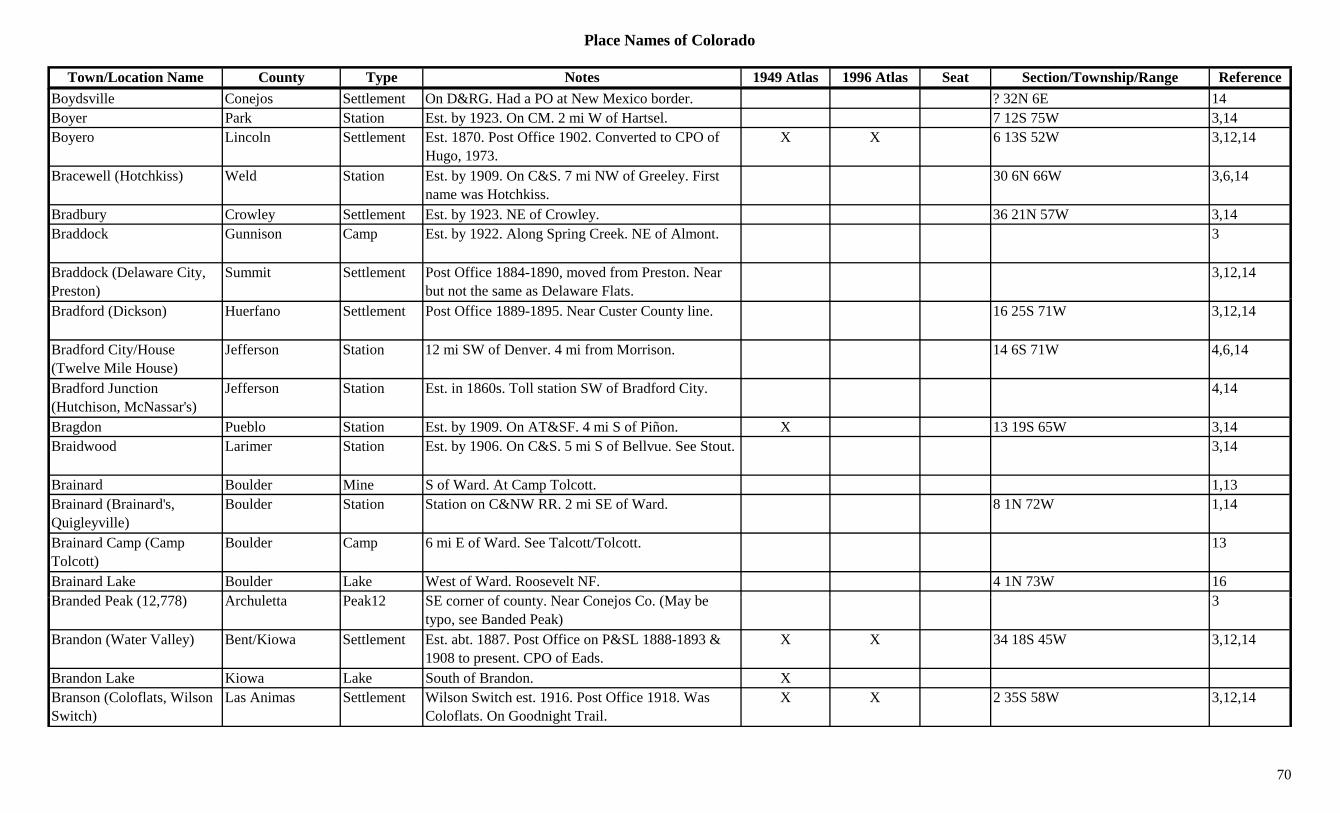
Place Names of Colorado
Town/Location Name County Type Notes 1949 Atlas 1996 Atlas Seat Section/Township/Range ReferenceBoydsville Conejos Settlement On D&RG. Had a PO at New Mexico border. ? 32N 6E 14Boyer Park Station Est. by 1923. On CM. 2 mi W of Hartsel. 7 12S 75W 3,14Boyero Lincoln Settlement Est. 1870. Post Office 1902. Converted to CPO of
Hugo, 1973.X X 6 13S 52W 3,12,14
Bracewell (Hotchkiss) Weld Station Est. by 1909. On C&S. 7 mi NW of Greeley. First name was Hotchkiss.
30 6N 66W 3,6,14
Bradbury Crowley Settlement Est. by 1923. NE of Crowley. 36 21N 57W 3,14Braddock Gunnison Camp Est. by 1922. Along Spring Creek. NE of Almont. 3
Braddock (Delaware City, Preston)
Summit Settlement Post Office 1884-1890, moved from Preston. Near but not the same as Delaware Flats.
3,12,14
Bradford (Dickson) Huerfano Settlement Post Office 1889-1895. Near Custer County line. 16 25S 71W 3,12,14
Bradford City/House (Twelve Mile House)
Jefferson Station 12 mi SW of Denver. 4 mi from Morrison. 14 6S 71W 4,6,14
Bradford Junction (Hutchison, McNassar's)
Jefferson Station Est. in 1860s. Toll station SW of Bradford City. 4,14
Bragdon Pueblo Station Est. by 1909. On AT&SF. 4 mi S of Piñon. X 13 19S 65W 3,14Braidwood Larimer Station Est. by 1906. On C&S. 5 mi S of Bellvue. See Stout. 3,14
Brainard Boulder Mine S of Ward. At Camp Tolcott. 1,13Brainard (Brainard's, Quigleyville)
Boulder Station Station on C&NW RR. 2 mi SE of Ward. 8 1N 72W 1,14
Brainard Camp (Camp Tolcott)
Boulder Camp 6 mi E of Ward. See Talcott/Tolcott. 13
Brainard Lake Boulder Lake West of Ward. Roosevelt NF. 4 1N 73W 16B d d P k (12 778) A h l tt P k12 SE f t N C j C (M b 3Branded Peak (12,778) Archuletta Peak12 SE corner of county. Near Conejos Co. (May be
typo, see Banded Peak)3
Brandon (Water Valley) Bent/Kiowa Settlement Est. abt. 1887. Post Office on P&SL 1888-1893 & 1908 to present. CPO of Eads.
X X 34 18S 45W 3,12,14
Brandon Lake Kiowa Lake South of Brandon. XBranson (Coloflats, Wilson Switch)
Las Animas Settlement Wilson Switch est. 1916. Post Office 1918. Was Coloflats. On Goodnight Trail.
X X 2 35S 58W 3,12,14
70

Place Names of Colorado
Town/Location Name County Type Notes 1949 Atlas 1996 Atlas Seat Section/Township/Range ReferenceBrayton Montezuma Unknown On RGS. 19 36N 12W 14Brazil Las Animas Settlement Post Office 1895-1899, 1911-1912. Preceded
Trinchera Plaza.1 35S 60W 3,12,14
Brazos Conejos Settlement Est. by 1858. On Conejos River. 14Breakneck (Warmsprings Pass) (10,900)
Park Pass Near Fairplay. Crossed by forest road. In Mosquito Range. Pike NF.
26 10S 78W 1,7,9
Breckenridge (Boreas) Pass (11,481)
Park/Summit Pass See Boreas Pass. Arapaho & Pike NF. 26 7S 77W
Breckenridge (Breckinridge, Fort Meribeh)
Summit Settlement Est. 1859. Post Office est. 1861. 81 mi W of Denver. 10 mi S of Frisco.
X X X 31 6S 77W 2,3,12,13,14
Breckinridge (Breckenridge)
Summit Settlement Post Office 1860-1861. Spelling changed to Breckenridge.
12
Breckinridge Peak (12,889) Summit Peak12 Front Range, James Peak Group. 8
Breck's Pass (Boreas Pass) Park/Summit Pass Est. by 1885. Near (same as) Boreas Pass. 26 7S 77W 3
Breece Hill Lake Hill E of Leadville. SW of Ibex City. 3Breece Junction Lake Station On D&RGW. 21 9S 79W 14Breed El Paso Station Est. by 1909. Stop on AT&SF. 8 mi N of Colorado
Springs.X 6 13S 66W 3,14
Breed and Cutter Silver Reduction Works
Boulder Mill A Nederland area operation. 13
Breen Huerfano Station On D&RGW. 1 mi W of Walsenburg. 8 28S 66W 3,14Breen La Plata Settlement Site 1. On 1913 map. 5 34N 11W 14Breen La Plata Settlement Site 2. Est. 1900. Post Office 1901-1954. At Fort
L i I di S h l18 34N 11W 3,12,14
Lewis Indian School.Breen Summit Station On DSP&P. 23 7S 79W 14Brennan Spur Chaffee Station 30 51N 9E 14Brennan Spur Huerfano Station Btwn Lester and Rouse. 14Brewer Reservoir Adams Lake East of Thornton. ?? 2S 68W 16Brewery Hill Hill N of Lincoln 1Brewster Fremont Settlement Post Office 1899-1900 & 1914-1916. 8 19S 69W 12,14
71
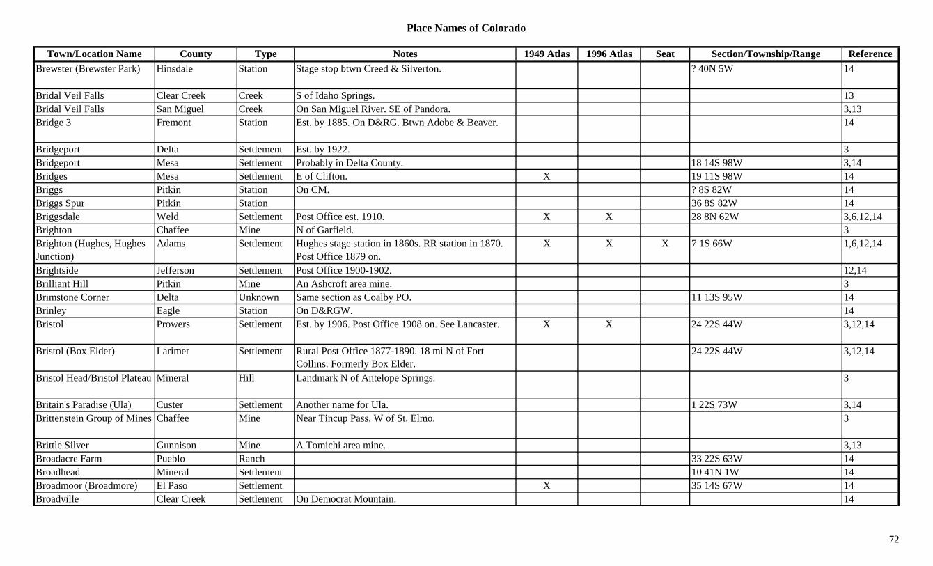
Place Names of Colorado
Town/Location Name County Type Notes 1949 Atlas 1996 Atlas Seat Section/Township/Range ReferenceBrewster (Brewster Park) Hinsdale Station Stage stop btwn Creed & Silverton. ? 40N 5W 14
Bridal Veil Falls Clear Creek Creek S of Idaho Springs. 13Bridal Veil Falls San Miguel Creek On San Miguel River. SE of Pandora. 3,13Bridge 3 Fremont Station Est. by 1885. On D&RG. Btwn Adobe & Beaver. 14
Bridgeport Delta Settlement Est. by 1922. 3Bridgeport Mesa Settlement Probably in Delta County. 18 14S 98W 3,14Bridges Mesa Settlement E of Clifton. X 19 11S 98W 14Briggs Pitkin Station On CM. ? 8S 82W 14Briggs Spur Pitkin Station 36 8S 82W 14gg pBriggsdale Weld Settlement Post Office est. 1910. X X 28 8N 62W 3,6,12,14Brighton Chaffee Mine N of Garfield. 3Brighton (Hughes, Hughes Junction)
Adams Settlement Hughes stage station in 1860s. RR station in 1870. Post Office 1879 on.
X X X 7 1S 66W 1,6,12,14
Brightside Jefferson Settlement Post Office 1900-1902. 12,14Brilliant Hill Pitkin Mine An Ashcroft area mine. 3Brimstone Corner Delta Unknown Same section as Coalby PO. 11 13S 95W 14Brinley Eagle Station On D&RGW. 14Bristol Prowers Settlement Est. by 1906. Post Office 1908 on. See Lancaster. X X 24 22S 44W 3,12,14
Bristol (Box Elder) Larimer Settlement Rural Post Office 1877-1890. 18 mi N of Fort Collins. Formerly Box Elder.
24 22S 44W 3,12,14
Bristol Head/Bristol Plateau Mineral Hill Landmark N of Antelope Springs. 3
Britain's Paradise (Ula) Custer Settlement Another name for Ula. 1 22S 73W 3,14B itt t i G f Mi Ch ff Mi N Ti P W f St El 3Brittenstein Group of Mines Chaffee Mine Near Tincup Pass. W of St. Elmo. 3
Brittle Silver Gunnison Mine A Tomichi area mine. 3,13Broadacre Farm Pueblo Ranch 33 22S 63W 14Broadhead Mineral Settlement 10 41N 1W 14Broadmoor (Broadmore) El Paso Settlement X 35 14S 67W 14Broadville Clear Creek Settlement On Democrat Mountain. 14
72

Place Names of Colorado
Town/Location Name County Type Notes 1949 Atlas 1996 Atlas Seat Section/Township/Range ReferenceBroadway Estates Arapahoe Settlement Unincorporated metro area E of Littleton. 14Brockston (Brocker Place) Jackson Settlement In Faulkner Draw. On Yampa River. 22 6N 78W 14
Brodhead Las Animas Mine Both a mine and a settlement. 21 30S 65W 14Brodhead Las Animas Settlement On C&S. RR Post Office 1902-1913, 1915-1939.
Btwn Aguilar & Green Canyon.X 21 30S 65W 3,12,14
Brodie Cyanide Mill Teller Mill A Mound City area operation. 3Broken Arrow Acres Jefferson Settlement Est. by 1979. A sub-division. 2 mi SW of Conifer. 27 6S 71W 6,14
Broken Hand Peak (13,573) Peak13 Sangre de Cristo Range, Main Section. Crestone Peak Quad.
8,11
Broken Hill (13,256) Peak13 Uncompahgre Peak Quad. 11Broken Spoke Fremont Settlement Town or Bar on the highway? 6 19S 68W 14Brolen Jefferson Settlement A village. 14Bromide (Douglas Smelter) Moffat Mill Another name for Douglas Smelter. 8 7N 100W 14
Bromley (Brumley, Bromley Station)
Lake Station 10 mi W of Twin Lakes. Stage stop on Independence Pass.
15 11S 82W 3,13,14
Broncho (Braddock) Summit Settlement On DSP&P. Same place as Braddock. 18 6S 77W 14Bronco Morgan Station Est. by 1916. On BN. 5 mi SW of Wiggins. 30 3N 60W 3,14Bronco Gulch Costilla Gulch North central county. Runs ESE to Sangre de Cristo
Creek.Sev 28S 71W 16
Bronco Mountain Gunnison Peak12 North of Ohio City. Gunnison NF. 23 51N 3E 16Bronco Mountain (12,845) Peak12 Sawatch Range, Fossil Group. 8
Bronquist Pueblo Settlement Post Office 1917-1925. 21 21S 67W 12,14B k (B k t R tt St ti O D&RGW St ti & idi 7 6N 85W 14Brook (Brookston, Brookstone)
Routt Station On D&RGW. Station & siding. 7 6N 85W 14
Brook Forest Jefferson Settlement Post Office 1921-1949. SW of Marshdale on Turkey Massey Draw. 24 mi SW of Evergreen.
X 31 5S 71W 3,6,12,14
Brookfield Los Animas/Baca Settlement Platted 1888. Post Office 1887-1902. 19 28S 48W 3,12
73

Place Names of Colorado
Town/Location Name County Type Notes 1949 Atlas 1996 Atlas Seat Section/Township/Range ReferenceBrooklyn Arapahoe Settlement Platted 1888. No Post Office. Absorbed by Aurora. 3,6,14
Brooklyn Routt Settlement Across the Yampa River from Steamboat Springs. A Red Light Suburb.
14
Brooklyn San Juan Mine Silverton area mine. 3Brooklyn San Juan Settlement 1 mi below Chattanooga & E 1.9 mi. 14Brooks Pueblo Station Est. by 1916. On C&S & D&RGW. SE of Marnel. X 36 23S 65W 3,14
Brookside El Paso Settlement Platted 1891. Absorbed by Colorado Springs. N of Ivywild.
3,14
Brookside Fremont Settlement Post Office 1888-1909. S of Canon City. X 11 19S 70W 3,12,14y , ,Brookside (Grousement, Kaiserheim)
Park Settlement On DSP&P. Same as Grousement, Kaiserheim was former name of G.
26 7S 73W 14
Brookside Junction Fremont Settlement SE part of Canon City. 14Brookston (Brookstone, Brook)
Routt Station On D&SL. Post Office 1914-1930. 7.6 mi W of Steamboat Springs.
X 7 6N 85W 3,12,14
Brookvale (Brook Vale) Clear Creek Settlement Post Office 1876-1942, with gaps. On Bear Creek. X X 11 5S 72W 3,12,14
Broomfield (Zang's Spur) Boulder/Jefferson Settlement Post Office 1884 on. X X 35 1S 69W 1,3,6,12,14
Broomfield Heights (Zang's Spur)
Jefferson Settlement 3
Broughton Delta Station On D&RGW. 23 14S 98W 14Brow (Olathe, Colorow) Montrose Settlement Also known as Colorow 1Brown Clear Creek Mine Silver Plume area mine. 3Brown Jefferson Settlement Near Ridge. 14B S Mi l S ttl t S ll it 5 i W & N f Pl ill 13 44N 11W 3 14Brown San Miguel Settlement Small community. 5 mi W & N of Placerville. 13 44N 11W 3,14Brown (Olathe, Colorow) Montrose Settlement Post Office 1883-1896, with gap, moved to
Menoken, later changed to Olathe.10 50N 10W 12,14
Brown Cañon (Browns Cañon)
Chaffee Settlement Post Office 1904-1908. Formerly Browns Cañon. 2 50N 8E 12,14
Brown Gulch Clear Creek Gulch Near Silver Plume. 13
74
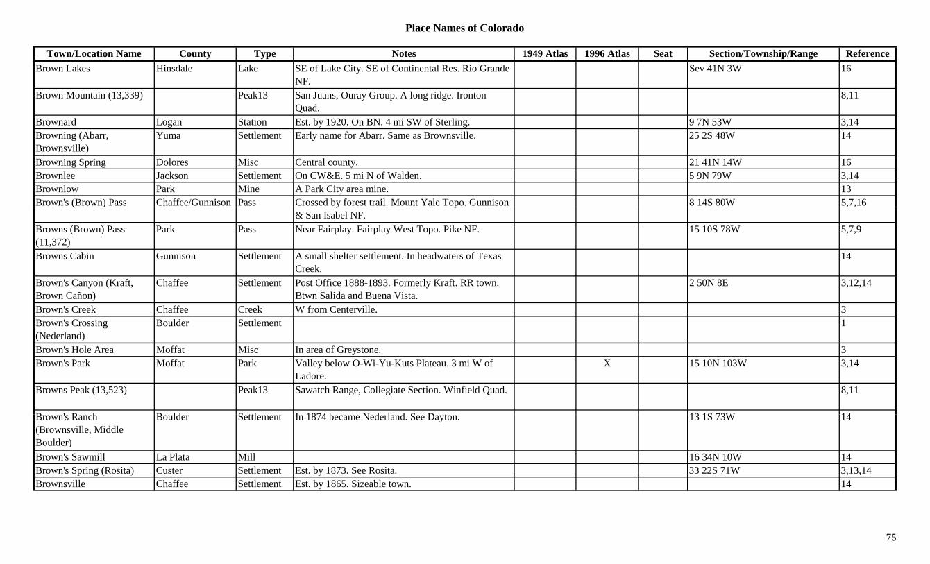
Place Names of Colorado
Town/Location Name County Type Notes 1949 Atlas 1996 Atlas Seat Section/Township/Range ReferenceBrown Lakes Hinsdale Lake SE of Lake City. SE of Continental Res. Rio Grande
NF.Sev 41N 3W 16
Brown Mountain (13,339) Peak13 San Juans, Ouray Group. A long ridge. Ironton Quad.
8,11
Brownard Logan Station Est. by 1920. On BN. 4 mi SW of Sterling. 9 7N 53W 3,14Browning (Abarr, Brownsville)
Yuma Settlement Early name for Abarr. Same as Brownsville. 25 2S 48W 14
Browning Spring Dolores Misc Central county. 21 41N 14W 16Brownlee Jackson Settlement On CW&E. 5 mi N of Walden. 5 9N 79W 3,14Brownlow Park Mine A Park City area mine. 13Brown's (Brown) Pass Chaffee/Gunnison Pass Crossed by forest trail. Mount Yale Topo. Gunnison 8 14S 80W 5,7,16( ) y p
& San Isabel NF., ,
Browns (Brown) Pass (11,372)
Park Pass Near Fairplay. Fairplay West Topo. Pike NF. 15 10S 78W 5,7,9
Browns Cabin Gunnison Settlement A small shelter settlement. In headwaters of Texas Creek.
14
Brown's Canyon (Kraft, Brown Cañon)
Chaffee Settlement Post Office 1888-1893. Formerly Kraft. RR town. Btwn Salida and Buena Vista.
2 50N 8E 3,12,14
Brown's Creek Chaffee Creek W from Centerville. 3Brown's Crossing (Nederland)
Boulder Settlement 1
Brown's Hole Area Moffat Misc In area of Greystone. 3Brown's Park Moffat Park Valley below O-Wi-Yu-Kuts Plateau. 3 mi W of
Ladore.X 15 10N 103W 3,14
Browns Peak (13,523) Peak13 Sawatch Range, Collegiate Section. Winfield Quad. 8,11
B ' R h B ld S ttl t I 1874 b N d l d S D t 13 1S 73W 14Brown's Ranch (Brownsville, Middle Boulder)
Boulder Settlement In 1874 became Nederland. See Dayton. 13 1S 73W 14
Brown's Sawmill La Plata Mill 16 34N 10W 14Brown's Spring (Rosita) Custer Settlement Est. by 1873. See Rosita. 33 22S 71W 3,13,14Brownsville Chaffee Settlement Est. by 1865. Sizeable town. 14
75
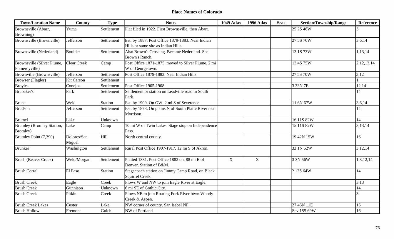
Place Names of Colorado
Town/Location Name County Type Notes 1949 Atlas 1996 Atlas Seat Section/Township/Range ReferenceBrownsville (Abarr, Browning)
Yuma Settlement Plat filed in 1922. First Brownsville, then Abarr. 25 2S 48W 3
Brownsville (Brownville) Jefferson Settlement Est. by 1887. Post Office 1879-1883. Near Indian Hills or same site as Indian Hills.
27 5S 70W 3,6,14
Brownsville (Nederland) Boulder Settlement Also Brown's Crossing. Became Nederland. See Brown's Ranch.
13 1S 73W 1,13,14
Brownsville (Silver Plume, Pomeroyville)
Clear Creek Camp Post Office 1871-1875, moved to Silver Plume. 2 mi W of Georgetown.
13 4S 75W 2,12,13,14
Brownville (Brownsville) Jefferson Settlement Post Office 1879-1883. Near Indian Hills. 27 5S 70W 3,12Browser (Flagler) Kit Carson Settlement 1Broyles Conejos Settlement Post Office 1905-1908. 3 33N 7E 12,14y j ,Brubaker's Park Settlement Settlement or station on Leadville road in South
Park.14
Bruce Weld Station Est. by 1909. On GW. 2 mi S of Severence. 11 6N 67W 3,6,14Brudson Jefferson Settlement Est. by 1873. On plains N of South Platte River near
Morrison.14
Brumel Lake Unknown 16 11S 82W 14Brumley (Bromley Station, Bromley)
Lake Camp 10 mi W of Twin Lakes. Stage stop on Independence Pass.
15 11S 82W 3,13,14
Brumley Point (7,390) Dolores/San Miguel
Hill North central county. 19 42N 15W 16
Brunker Washington Settlement Rural Post Office 1907-1917. 12 mi S of Akron. 33 1N 52W 3,12,14
Brush (Beaver Creek) Weld/Morgan Settlement Platted 1881. Post Office 1882 on. 88 mi E of Denver. Station of B&M.
X X 3 3N 56W 1,3,12,14
Brush Corral El Paso Station Stagecoach station on Jimmy Camp Road, on Black S i l C k
? 12S 64W 14Squirrel Creek.
Brush Creek Eagle Creek Flows W and NW to join Eagle River at Eagle. 3,13Brush Creek Gunnison Unknown 6 mi SE of Gothic City. 14Brush Creek Pitkin Creek Flows NE to join Roaring Fork River btwn Woody
Creek & Aspen.3
Brush Creek Lakes Custer Lake NW corner of county. San Isabel NF. 27 46N 11E 16Brush Hollow Fremont Gulch NW of Portland. Sev 18S 69W 16
76
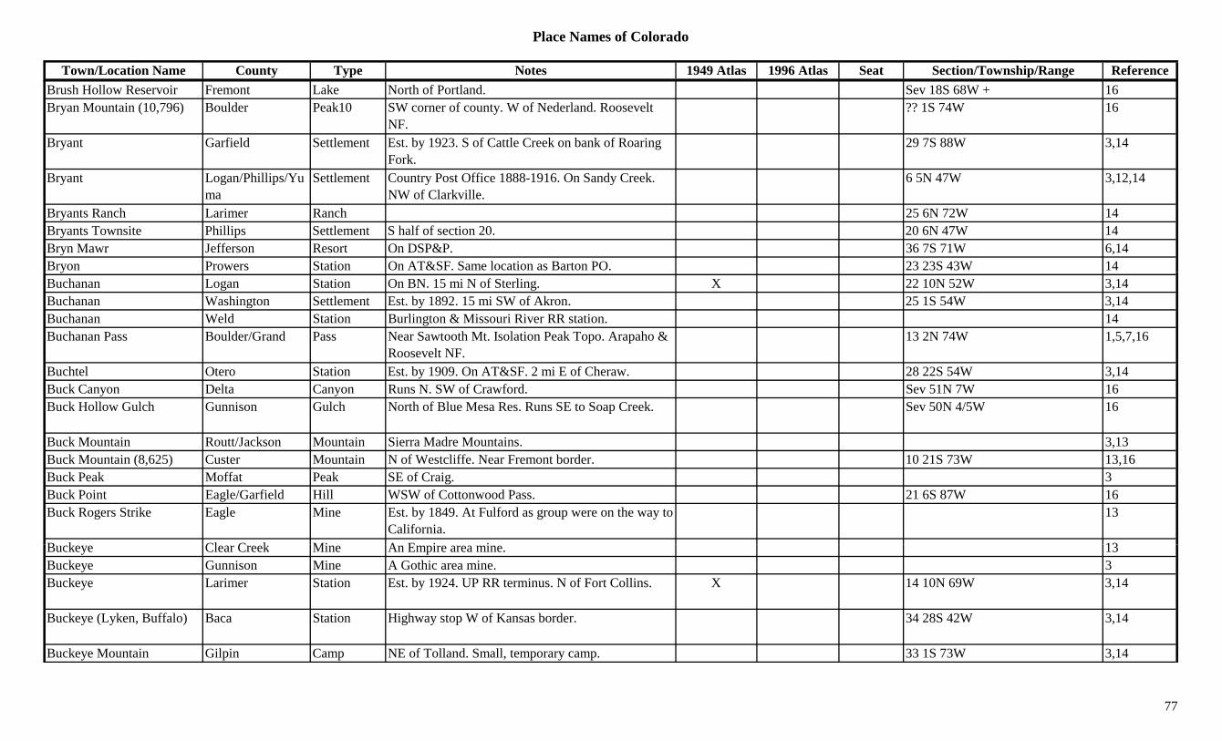
Place Names of Colorado
Town/Location Name County Type Notes 1949 Atlas 1996 Atlas Seat Section/Township/Range ReferenceBrush Hollow Reservoir Fremont Lake North of Portland. Sev 18S 68W + 16Bryan Mountain (10,796) Boulder Peak10 SW corner of county. W of Nederland. Roosevelt
NF.?? 1S 74W 16
Bryant Garfield Settlement Est. by 1923. S of Cattle Creek on bank of Roaring Fork.
29 7S 88W 3,14
Bryant Logan/Phillips/Yuma
Settlement Country Post Office 1888-1916. On Sandy Creek. NW of Clarkville.
6 5N 47W 3,12,14
Bryants Ranch Larimer Ranch 25 6N 72W 14Bryants Townsite Phillips Settlement S half of section 20. 20 6N 47W 14Bryn Mawr Jefferson Resort On DSP&P. 36 7S 71W 6,14Bryon Prowers Station On AT&SF. Same location as Barton PO. 23 23S 43W 14yBuchanan Logan Station On BN. 15 mi N of Sterling. X 22 10N 52W 3,14Buchanan Washington Settlement Est. by 1892. 15 mi SW of Akron. 25 1S 54W 3,14Buchanan Weld Station Burlington & Missouri River RR station. 14Buchanan Pass Boulder/Grand Pass Near Sawtooth Mt. Isolation Peak Topo. Arapaho &
Roosevelt NF.13 2N 74W 1,5,7,16
Buchtel Otero Station Est. by 1909. On AT&SF. 2 mi E of Cheraw. 28 22S 54W 3,14Buck Canyon Delta Canyon Runs N. SW of Crawford. Sev 51N 7W 16Buck Hollow Gulch Gunnison Gulch North of Blue Mesa Res. Runs SE to Soap Creek. Sev 50N 4/5W 16
Buck Mountain Routt/Jackson Mountain Sierra Madre Mountains. 3,13Buck Mountain (8,625) Custer Mountain N of Westcliffe. Near Fremont border. 10 21S 73W 13,16Buck Peak Moffat Peak SE of Craig. 3Buck Point Eagle/Garfield Hill WSW of Cottonwood Pass. 21 6S 87W 16Buck Rogers Strike Eagle Mine Est. by 1849. At Fulford as group were on the way to
California.13
B k Cl C k Mi A E i i 13Buckeye Clear Creek Mine An Empire area mine. 13Buckeye Gunnison Mine A Gothic area mine. 3Buckeye Larimer Station Est. by 1924. UP RR terminus. N of Fort Collins. X 14 10N 69W 3,14
Buckeye (Lyken, Buffalo) Baca Station Highway stop W of Kansas border. 34 28S 42W 3,14
Buckeye Mountain Gilpin Camp NE of Tolland. Small, temporary camp. 33 1S 73W 3,14
77

Place Names of Colorado
Town/Location Name County Type Notes 1949 Atlas 1996 Atlas Seat Section/Township/Range ReferenceBuckeye Mountain Gilpin Peak10 North central county. NE of Tolland. Roosevelt NF. 33 1S 73W 16
Buckeye Mountain Lake Mountain SW of Climax. 3Buckhorn Larimer Settlement Post Office 1878-1888. On Buckhorn Creek. 5 mi S
of Masonville.36 6N 70W 3,12,14
Buckhorn Saguache Mine A Carnero-Crystal Hill area mine. 3Buckhorn Creek Larimer Creek Flows E & S to Big Thompson near Wilds. 3Buckhorn Pass (7,700) El Paso Pass W on North Cheyenne Road. 7Buckingham Larimer Unknown 2 7N 69W 14Buckingham Weld Settlement Post Office 1888-1890 & 1910-1966. X 33 8N 59W 3,6,12,14Buckles Lake Archuleta Lake West of Chalk Mountains. 35 34N 1E 16Buckley Gilpin Station Est. by 1905. 11 3S 73W 14Buckley (Lycan) Baca Settlement Became Lycan Post Office in 1913. 3 29S 42W 14Buckley Naval Air Station Arapahoe Misc E of Denver and Aurora. 4 4S 67W + 16
Buckleys Montezuma Unknown 26 36N 13W 14Buckridge Douglas Unknown 29 9S 65W 14Buckskin Lake Camp Est. by 1885. N & E of Birdseye. 13 8N 79W 3,14Buckskin (Laurette, Buckskin Joe)
Park Settlement Post Office 1865-1873. NW of Fairplay. First strike 1859. Formerly Laurette.
x 3 9S 78W 1,2,3,12,13,14
Buckskin Creek Park Creek Flows E from Summit Co. to Alma. 3Buckskin Gulch Costilla Gulch Close to Grayback Gulch. NW of La Veta Pass. 3
Buckskin Gulch Fremont Gulch SW of Canon City. Runs W. Sev 20S 71/72W 16Buckskin Joe Fremont Settlement Post Office 1961-1966. Rural station near Canon
City. Near the Royal Gorge.15 18S 71W 12,14
B k ki J (B k ki ) P k S ttl t 2 i W f Al R d L tt L t 3 9S 78W 2 13 14Buckskin Joe (Buckskin) Park Settlement 2 mi W of Alma. Renamed Laurette or Lauret. 3 9S 78W 2,13,14Buckskin Mountain (13,370)
Peak13 Climax Quad. 11
Buckskin Pass Pitkin Pass SW part of Pitkin Co. Near Maroon Peak. Maroon Bells Topo. White River NF.
9 11S 86W 3,5,7,8,16
Bucktel (Buchtel) Otero Unknown On AT&SF. Same as Buchtel. 28 22S 54W 14
78

Place Names of Colorado
Town/Location Name County Type Notes 1949 Atlas 1996 Atlas Seat Section/Township/Range ReferenceBucktown Lake Settlement Existed 1879-1900. Cabin town close to Stringtown. 33 9S 80W 3,14
Buda Weld Station On GW. 3 mi W of Johnstown. 11 4N 68W 3,6,14Bueck (Buick) Elbert Settlement Second name for Buick. See Buick. 3Buena Boulder Mine At Jamestown. 2Buena Vista Teller Mine An Altman area mine. 3Buena Vista (Mahonville, Cottonwood)
Chaffee Settlement Est. 1879. Post Office 1879 on. 33 mi S of Leadville. Early county seat.
X X x 8 14S 78W 3,12,13,14
Buena Vista Peak Moffat Peak S of Castle Park. 3Bueno Mine (Wano sic) Mine/Mill
Boulder Mine 1 mi NW of Jamestown. 1,3,13
Bueno Mountian (8,662) Boulder Mountain NW of Jamestown. 23 2N 72W 3,13,16Buffalo (Buckeye, Lyken) Baca Settlement It was Buffalo, then Buckeye, then Lyken. 34 28S 42W 14
Buffalo (Buffalo Creek) Jefferson Settlement Est. abt 1877. SW of Waterton. 3Buffalo (Merino) Logan/Weld Settlement Post Office 1874-1883. First name for Merino. 13 6N 54W 3,12,14Buffalo Bills Grave Jefferson Museum X XBuffalo Boy San Juan Mine A Howardsville area mine. 3Buffalo Camp Logan Camp 6 7N 51W 14Buffalo Creek Jackson Creek Flows N & W into Coyote Creek. W of Rand. 3Buffalo Creek Park Creek Flows from Buffalo Peak E to Antero Res. 3Buffalo Creek Prowers Creek Flows S to Arkanas River near Granada. 3Buffalo Creek (Buffalo) Jefferson Settlement Est. 1877. Post Office est. 1878, became branch of
Pine. SW of Waterton.X X 6 8S 70W 3,6,12,14
Buffalo Creek Park Jefferson Settlement Platted 1888. 0.25 mi S of Buffalo. 31 7S 70W 6Buffalo Flats Summit Settlement In area of Lincoln City, Delaware & Georgia Gulch. 14
Buffalo Mountain (10,379) Routt Mountain E of Steamboat Springs. 13
Buffalo Pass (10,180 or 10,325)
Routt Pass Btwn Walden and Steamboat Springs. Routt NF X ?? 7N 83W 3,7,8,9
Buffalo Pass (11,000 or 11,440)
Chaffee/Park Pass Btwn Buena Vista and Fairplay. Crossed by forest trail.
19 12S 78W 7
79

Place Names of Colorado
Town/Location Name County Type Notes 1949 Atlas 1996 Atlas Seat Section/Township/Range ReferenceBuffalo Pass (8,768) Jackson Pass N of Rand. Crossed by county road. 20 6N 79W 7Buffalo Peak (9,443) Jackson Peak Btwn Spicer and Rand. 13Buffalo Slough Park Creek 1885. Flows N to South Platte River. W of
Spinney's.3
Buffalo Springs Park Settlement Post Office 1975? (1875)-1912. 20 mi S of Fairplay. 2 12S 77W 3,12,14
Buffam Place Moffat Settlement On the Green River. 8 9N 102W 14Buffer Summit Settlement Post Office 1917-1921. Near Kokomo-Robinson
tangle.3 8S 79W 3,12,14
Buford Rio Blanco Settlement Post Office 1890-1961, with gap. X X 9 1S 91W 3,12,14Bug Town (National City, Routt Camp Twin to Hahns Peak. 2 mi from Poverty Bar. 3,14g ( y,International Camp)
p y ,
Bugle Lake Garfield Lake NW corner of county. White River NF. 16 4S 89W 16Bugtown (Hahns Peak) Routt Settlement Became Hahns Peak (town). Probably same as
previous Bug Town?1
Bugtown (Valmont) Boulder Settlement Nickname for Valmont in 1860s. 22 1N 70W 14Buick (Godfrey, Beuck, Bueck)
Elbert Settlement Est. by 1873. RR Post Office 1916-1925. Formerly Godfrey, afterwards Bueck or Beuck.
X 32 7S 58W 3,6,12,14
Bulger (Bulger City) Larimer Settlement Post Office 1909-1912. Platted in 1912. 4 mi N of Bulger City. See Bulger City.
X 34 10N 68W 3,12,14
Bulger City (Bulger) Larimer Settlement Platted 1909. 4 mi N of Bulger. See Bulger. Both S of Benson.
3,14
Bulkley Boulder Settlement Post Office 1895-1901. 12,14Bulkley Gunnison Unknown On D&RGW. 11 14S 86W 14Bulkley San Miguel Settlement Post Office 1895. 14Bulkley Coal Mine Gunnison Mine Near Crested Butte. 2,3B ll C t Mi N f W t liff 3Bull Custer Mine N of Westcliffe. 3Bull Domingo Custer Mine At Silver Cliff. 2Bull Domingo Hills Custer Hill N of Silver Cliff. 3Bull Gulch Eagle Gulch NNW of Eagle. Runs W to Colorado River. Sev 3S 85W 16Bull Gulch Fremont Gulch Central county. Sev 18S 73/74W 16Bull Hill Teller Camp Small. NW of Goldfield. 20 15S 69W 3,14Bull Hill Teller Hill N of Victor. 2,3
80

Place Names of Colorado
Town/Location Name County Type Notes 1949 Atlas 1996 Atlas Seat Section/Township/Range ReferenceBull Hill (13,761) Peak13 Sawatch Range, Leadville Frying Pan Sect. Mt.
Elbert Quad.8,11
Bull Run Gulch Grand Gulch South of Williams Fork Res. Runs E toBattle Cr. Sev 1S 79W 16
Bulldog Mountain Mineral Mountain NW of Creede. 3Bull-Domingo Gunnison Mine NE of Dorchester. 3Bulldozer La Plata Mine A Parrott City area mine. 3Bullion Summit Mine A Franklin area mine. 3Bullion City Chaffee Camp Plat filed 1879. Transient camp near Monarch. 3,14Bullion City La Plata Settlement Est. by 1876. Along the Animas River. May be same
as San Juan location.14
Bullion City (Howardsville) San Juan Settlement Est. by 1874. Original name for Howardsville. Also shown 4 mi N of Howardsville.
3,14
Bullion King Gunnison Mine At Irwin. 2,3Bullion Mine & Tunnel San Miguel Mine A Pandora area mine. 3,13Bullion Mountain (13,182) Peak13 Columbine Pass Quad. 11Bullion Smelter Clear Creek Mill Large smelter at Bonito. 3Bull's Eye Huerfano Camp A mining camp. 3 mi from West Spanish Peak. 14Bullseye Lake Mine A Leadville area mine. 3Bumback Gulch Fremont Gulch NE of Parkdale. Runs SW. Sev 17/18S 71W 16Bummer Gulch Boulder Gulch W of Orodelfan. 2 mi upstream from Four Mile
Canyon.1
Bummerville Boulder Camp Lower Jimtown. 2Bunce Boulder Settlement Post Office 1895-1901. 32 3N 72W 14Bunell (Camp Speer) Adams Settlement Rural Post Office 1919-1921, moved to Fitzsimons.
Was Camp Speer. E of Aurora.36 3S 67W 3,6,12,14
B k R tt S ttl t E t b 1895 O Willi Ri ? 3N 87W 14Bunker Routt Settlement Est. by 1895. On Williams River. ? 3N 87W 14Bunker Hill (Lester) Huerfano Station Est. by 1923. C&S station for town of Lester. At
Rouse PO.19 29S 65W 3,14
Bunker Hill Station Huerfano Station Est. by 1913. On C&S. 2.5 mi E of Lester PO. 28 29S 65W 14Bunyan Weld Station Est. by 1920. On GW. 2 mi N of Walker. 29 4N 67W 3,6,14Burch Lake Boulder Lake NW of Longmont. 26 3N 70W 16Burchfield Lake Baca Lake East of Walsh. Near KS. 5 31S 41W 16
81

Place Names of Colorado
Town/Location Name County Type Notes 1949 Atlas 1996 Atlas Seat Section/Township/Range ReferenceBurchland (Burchs Lake) Boulder Station On B&M. Same as Burchs Lake. 25 3N 70W 14Burchs Lake (Burchland) Boulder Station On B&M. Same as Burchland. 25 3N 70W 14Burdett Washington Settlement Rural Post Office 1888-1937. 15 mi N of Otis. X 27 5N 50W 3,12,14Burgdorf (Ault, McAllister(s))
Weld Settlement Ault was first called McAllister, then Burgdorf. 12 7N 66W 3,14
Burial Place Dolores Misc NE of Ruins and Ojo Valecito. 3Burial Rock El Paso Hill 1885. S of Franceville 3Burial Rock El Paso Station On D&RG. 31 14S 64W 14Burke Lake Boulder Lake East of Boulder. 29 1N 69W 16Burke(s) Boulder Settlement Est. by 1923. SE of Valmont. 32 1N 69W 3,14Burleigh Clear Creek Mine A Silver Plume area mine. 13gBurlington Boulder Mine 1 mi NW of Jamestown. 1,3,13Burlington Boulder Settlement Post Office 1862-1873, moved to Longmont. 11 mi
N of Boulder.9 2N 69W 3,6,12,14
Burlington Kit Carson Settlement Platted 1886. Post Office 1887 on. 2 mi W of Old Burlington.
X X X 36 8S 44W 1,3,12,14
Burlington Ditch Adams Canal Runs NE along E side of South Platte River 16Burnham (Machine Shop) Denver Settlement First station on D&RG S of Denver. First called
Machine Shop.4 4S 68W 3,14
Burning Mountain Garfield Mountain NW of New Castle. 21 5S 91W 16Burnito Fremont Unknown Est. by 1923. On D&RG. Btwn Canon City and
Royal Gorge.32 18S 70W 3,14
Burns Eagle Settlement Post Office 1895 on. Active before 1895. Also shown as 8 2S 85W.
X X 15 2S 85W 3,12,14
Burns El Paso Unknown On CS&CCD. 14Burns (Boerns) Dolores Settlement Est. by 1923. N of Rico. On RGS RR. Another
lli B13 40N 11W 3,14
spelling - Boerns.Burns Gulch San Juan Gulch An Animas Forks area productive gulch. 3Burns Junction (Burns, Burns Spur)
Boulder Station Est. by 1923. NW of Broomfield. Junction of several railroads.
34 1S 69W 1,3,14
Burns Mountain Fremont Peak10 North of Cotopaxi. 15/14 50N 12E 16Burns Spur (Burns Junction)
Boulder Station NW of Broomfield. See Burns Junction. 1
82

Place Names of Colorado
Town/Location Name County Type Notes 1949 Atlas 1996 Atlas Seat Section/Township/Range ReferenceBurnt Mill (Kinkel) Pueblo Settlement Rural Post Office 1911-1921. 10 mi SE of
Goodpasture. Formerly Kinkel.17 23S 66W 3,12,14
Burnt Mill Gulch Gunnison Gulch West of Gunnison. Runs SSE to Willow Creek. Sev 50N 3W 16Burnt Mountain (9,353) Boulder Mountain East of Ward. Roosevelt NF. 5 1N 73W 16Burnt Rock Gulch Saguache Gulch 1885. Mining area near Tetons. 3Burnt Timber Gulch Fremont Gulch North of Howard. San Isabel NF. Sev 50N 10E 16Burrell Hill Clear Creek Unknown 14Burro Creek Ouray Camp Est. by 1885. E of Eldredge. 3Burro Creek Ouray Creek Flows SW to Uncompahgre River E of Eldredge. 3
Burro Lake Conejos Lake West central county. Rio Grande NF. ?? 34N 4E 16j yBurro Mountain Rio Blanco Mountain SE part of county. 3Burro Ridge (Burro Bridge) Ouray/San Juan Station Stage and RR Stop. On or near Ophir Pass. (Typo?) 3 41N 8W 1,3,14
Burroughs Gilpin Mine A Nevadaville mine. 3Burrows San Juan Mine A Mineral Point area mine. 3,13Burrows Park (Argentum, White Cross)
Hinsdale Camp Post Office 1876-1882, changed to White Cross. May have been 2 camps.
36 43N 6W 3,12,14
Burrows Spur Park Station On DSP&P. 11.9 mi from Como. 20 10S 76W 14Burt El Paso Settlement Rural Post Office 1910-1916. 10 mi S of Calhan. 26 13S 62W 3,12,14
Burtonville (Idaho Springs) Clear Creek Settlement Est. by 1859. On Payne's Bar. Payne's Bar is early name for Idaho Springs.
14
Burwell Peak (12,664) Peak12 La Plata Range. 8Bush (Adams) Larimer Settlement Post Office 1882-1885, changed or moved to Adams.
8 mi SW of The Forks.8 9N 71W 3,12,14
B h W k Pitki Mi A A i 13Bush Wacker Pitkin Mine An Aspen area mine. 13Bushnell Lakes Fremont Lake SW corner of county. WSW of Coaldale. NW of
Hayden Pass. San Isabel NF.?? 47N 10E 16
Bushnell Mines Mine In Sangre de Cristo Range, North Section. Near Bushnell Lakes.
8
Bushnell Peak Fremont/Saguache Peak13 Sangre de Cristo Range, North Section. Bushnell Peak Quad.
?? 47N 9E 8,11,16
83
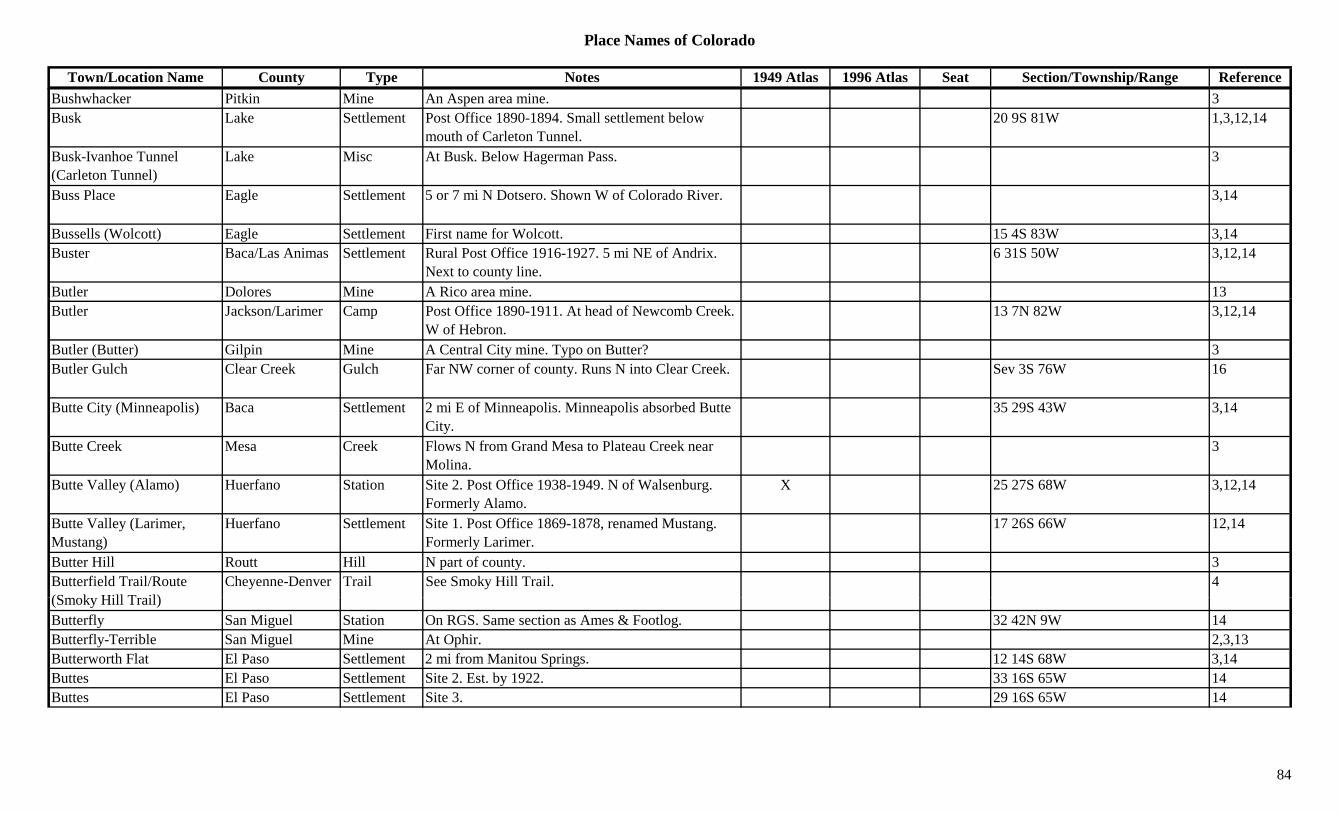
Place Names of Colorado
Town/Location Name County Type Notes 1949 Atlas 1996 Atlas Seat Section/Township/Range ReferenceBushwhacker Pitkin Mine An Aspen area mine. 3Busk Lake Settlement Post Office 1890-1894. Small settlement below
mouth of Carleton Tunnel.20 9S 81W 1,3,12,14
Busk-Ivanhoe Tunnel (Carleton Tunnel)
Lake Misc At Busk. Below Hagerman Pass. 3
Buss Place Eagle Settlement 5 or 7 mi N Dotsero. Shown W of Colorado River. 3,14
Bussells (Wolcott) Eagle Settlement First name for Wolcott. 15 4S 83W 3,14Buster Baca/Las Animas Settlement Rural Post Office 1916-1927. 5 mi NE of Andrix.
Next to county line.6 31S 50W 3,12,14
Butler Dolores Mine A Rico area mine. 13Butler Jackson/Larimer Camp Post Office 1890-1911. At head of Newcomb Creek.
W of Hebron.13 7N 82W 3,12,14
Butler (Butter) Gilpin Mine A Central City mine. Typo on Butter? 3Butler Gulch Clear Creek Gulch Far NW corner of county. Runs N into Clear Creek. Sev 3S 76W 16
Butte City (Minneapolis) Baca Settlement 2 mi E of Minneapolis. Minneapolis absorbed Butte City.
35 29S 43W 3,14
Butte Creek Mesa Creek Flows N from Grand Mesa to Plateau Creek near Molina.
3
Butte Valley (Alamo) Huerfano Station Site 2. Post Office 1938-1949. N of Walsenburg. Formerly Alamo.
X 25 27S 68W 3,12,14
Butte Valley (Larimer, Mustang)
Huerfano Settlement Site 1. Post Office 1869-1878, renamed Mustang. Formerly Larimer.
17 26S 66W 12,14
Butter Hill Routt Hill N part of county. 3Butterfield Trail/Route (S k Hill T il)
Cheyenne-Denver Trail See Smoky Hill Trail. 4(Smoky Hill Trail)Butterfly San Miguel Station On RGS. Same section as Ames & Footlog. 32 42N 9W 14Butterfly-Terrible San Miguel Mine At Ophir. 2,3,13Butterworth Flat El Paso Settlement 2 mi from Manitou Springs. 12 14S 68W 3,14Buttes El Paso Settlement Site 2. Est. by 1922. 33 16S 65W 14Buttes El Paso Settlement Site 3. 29 16S 65W 14
84
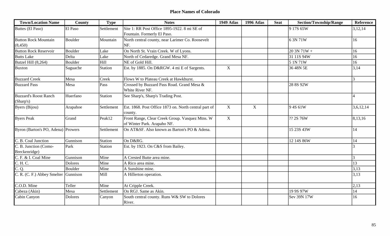
Place Names of Colorado
Town/Location Name County Type Notes 1949 Atlas 1996 Atlas Seat Section/Township/Range ReferenceButtes (El Paso) El Paso Settlement Site 1: RR Post Office 1895-1922. 8 mi SE of
Fountain. Formerly El Paso.9 17S 65W 3,12,14
Button Rock Mountain (8,450)
Boulder Mountain North central county, near Larimer Co. Roosevelt NF.
6 3N 71W 16
Button Rock Reservoir Boulder Lake On North St. Vrain Creek. W of Lyons. 20 3N 71W + 16Butts Lake Delta Lake North of Cedaredge. Grand Mesa NF. 31 11S 94W 16Butzel Hill (8,264) Boulder Hill NE of Gold Hill. 5 1N 71W 16Buxton Saguache Station Est. by 1885. On D&RGW. 4 mi E of Sargents. X 36 48N 5E 3,14
Buzzard Creek Mesa Creek Flows W to Plateau Creek at Hawkhurst. 3Buzzard Pass Mesa Pass Crossed by Buzzard Pass Road. Grand Mesa & 28 8S 92Wy
White River NF.Buzzard's Roost Ranch (Sharp's)
Huerfano Station See Sharp's, Sharp's Trading Post. 4
Byers (Bijou) Arapahoe Settlement Est. 1868. Post Office 1873 on. North central part of county.
X X 9 4S 61W 3,6,12,14
Byers Peak Grand Peak12 Front Range, Clear Creek Group. Vasquez Mtns. W of Winter Park. Arapaho NF.
X ?? 2S 76W 8,13,16
Byron (Barton's PO, Adena) Prowers Settlement On AT&SF. Also known as Barton's PO & Adena. 15 23S 43W 14
C. B. Coal Junction Gunnison Station On D&RG. 12 14S 86W 14C. B. Junction (Como-Breckenridge)
Park Station Est. by 1923. On C&S from Bailey. 3
C. F. & I. Coal Mine Gunnison Mine A Crested Butte area mine. 3C. H. C. Dolores Mine A Rico area mine. 13C. Q. Boulder Mine A Sunshine mine. 3,13C R (C F ) Abb S lt G i Mill A Hill t ti 3 13C. R. (C. F.) Abbey Smelter Gunnison Mill A Hillerton operation. 3,13
C.O.D. Mine Teller Mine At Cripple Creek. 2,13Cabeza (Akin) Mesa Settlement On RGJ. Same as Akin. 19 9S 97W 14Cabin Canyon Dolores Canyon South central county. Runs W& SW to Dolores
River.Sev 39N 17W 16
85
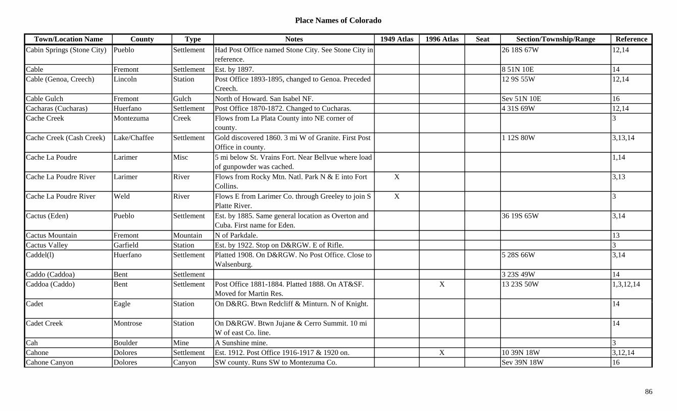
Place Names of Colorado
Town/Location Name County Type Notes 1949 Atlas 1996 Atlas Seat Section/Township/Range ReferenceCabin Springs (Stone City) Pueblo Settlement Had Post Office named Stone City. See Stone City in
reference.26 18S 67W 12,14
Cable Fremont Settlement Est. by 1897. 8 51N 10E 14Cable (Genoa, Creech) Lincoln Station Post Office 1893-1895, changed to Genoa. Preceded
Creech.12 9S 55W 12,14
Cable Gulch Fremont Gulch North of Howard. San Isabel NF. Sev 51N 10E 16Cacharas (Cucharas) Huerfano Settlement Post Office 1870-1872. Changed to Cucharas. 4 31S 69W 12,14Cache Creek Montezuma Creek Flows from La Plata County into NE corner of
county.3
Cache Creek (Cash Creek) Lake/Chaffee Settlement Gold discovered 1860. 3 mi W of Granite. First Post Office in county.
1 12S 80W 3,13,14
Cache La Poudre Larimer Misc 5 mi below St. Vrains Fort. Near Bellvue where load of gunpowder was cached.
1,14
Cache La Poudre River Larimer River Flows from Rocky Mtn. Natl. Park N & E into Fort Collins.
X 3,13
Cache La Poudre River Weld River Flows E from Larimer Co. through Greeley to join S Platte River.
X 3
Cactus (Eden) Pueblo Settlement Est. by 1885. Same general location as Overton and Cuba. First name for Eden.
36 19S 65W 3,14
Cactus Mountain Fremont Mountain N of Parkdale. 13Cactus Valley Garfield Station Est. by 1922. Stop on D&RGW. E of Rifle. 3Caddel(l) Huerfano Settlement Platted 1908. On D&RGW. No Post Office. Close to
Walsenburg.5 28S 66W 3,14
Caddo (Caddoa) Bent Settlement 3 23S 49W 14Caddoa (Caddo) Bent Settlement Post Office 1881-1884. Platted 1888. On AT&SF.
Moved for Martin Res.X 13 23S 50W 1,3,12,14
C d t E l St ti O D&RG Bt R d liff & Mi t N f K i ht 14Cadet Eagle Station On D&RG. Btwn Redcliff & Minturn. N of Knight. 14
Cadet Creek Montrose Station On D&RGW. Btwn Jujane & Cerro Summit. 10 mi W of east Co. line.
14
Cah Boulder Mine A Sunshine mine. 3Cahone Dolores Settlement Est. 1912. Post Office 1916-1917 & 1920 on. X 10 39N 18W 3,12,14Cahone Canyon Dolores Canyon SW county. Runs SW to Montezuma Co. Sev 39N 18W 16
86

Place Names of Colorado
Town/Location Name County Type Notes 1949 Atlas 1996 Atlas Seat Section/Township/Range ReferenceCain Otero Settlement 14Caisson Moffat Settlement Post Office 1920-1937. 1 mi E of Dinosaur. X 14 3N 103W 3,12,14Calahan (Calhan) El Paso Settlement See Calhan. 2 12S 62W 3Calamity Camp Mesa Camp 11 50N 18W 14Calamity Creek Mesa Creek Flows S to join Blue Creek. S of Outlaw Camp. 3Calamity Pass Jackson Pass Routt NF. ?? 6N 77WCalamity Ridge Rio Blanco Hill 1924. Landmark E of Rangely. 3Calcite Fremont Settlement Post Office 1904-1930. SW of Wellsville. X 5 48N 10E 3,12,14Calcium (Thomasville) Eagle/Pitkin Settlement Post Office 1888-1890, changed to Thomasville.
Early settlement in area.6 8S 83W 3,12,14
Caldonia Gilpin Mine A Lake Gulch mine. 3pCaldonia Lake Mine A Leadville area mine. 3Caledonia Gilpin Mine A Wide Awake area mine. 13Caledonia San Juan Mine Silverton area mine. 3Calf Creek Plateau Hinsdale Mesa NE of Lake City. From Gunnison NF North. Sev 44/45N 3W 16Calf Gulch Fremont Gulch North of Howard. San Isabel NF. Sev 51N 10E 16Calhan (Calahan) El Paso Settlement Platted 1885. Post Office 1888 on, moved from Big
Sandy.X X 2 12S 62W 3,12,14
Calhoun Gilpin Mine A Russell Gulch area mine. 3Calhoun Washington Settlement On CB&Q. 18 2N 49W 14Calico Mountain (12,944) Chaffee Peak12 Sawatch Range, Chalk Creek Shavano Sect. San
Isabel NF.4 50N 6E 8,11
Calico Pass (12,050 or 12,540)
Pass In Sawatch Range. From Grizzley Gulch. 5,7,8
Calico Peak (12,026) Dolores Peak12 NW of Rico. Rico Mountains. 20 40N 11W 8,16California Gilpin Mine SW of Nevadaville. 3C lif i Gil i S ttl t 1 i SW f C t l Cit 15 3S 73W 14California Gilpin Settlement 1 mi SW of Central City. 15 3S 73W 14California Bar (Parrott City) La Plata Camp See Parrott City. 33 36N 11W 3,14
California Crossing (Julesburg Site 1)
Sedgwick Settlement Est. by 1858. Name for first Julesburg site. 14
California Gulch Alamosa Gulch Runs W from Sangre de Cristo Range to Zapata Creek. W from California Peak.
16
87
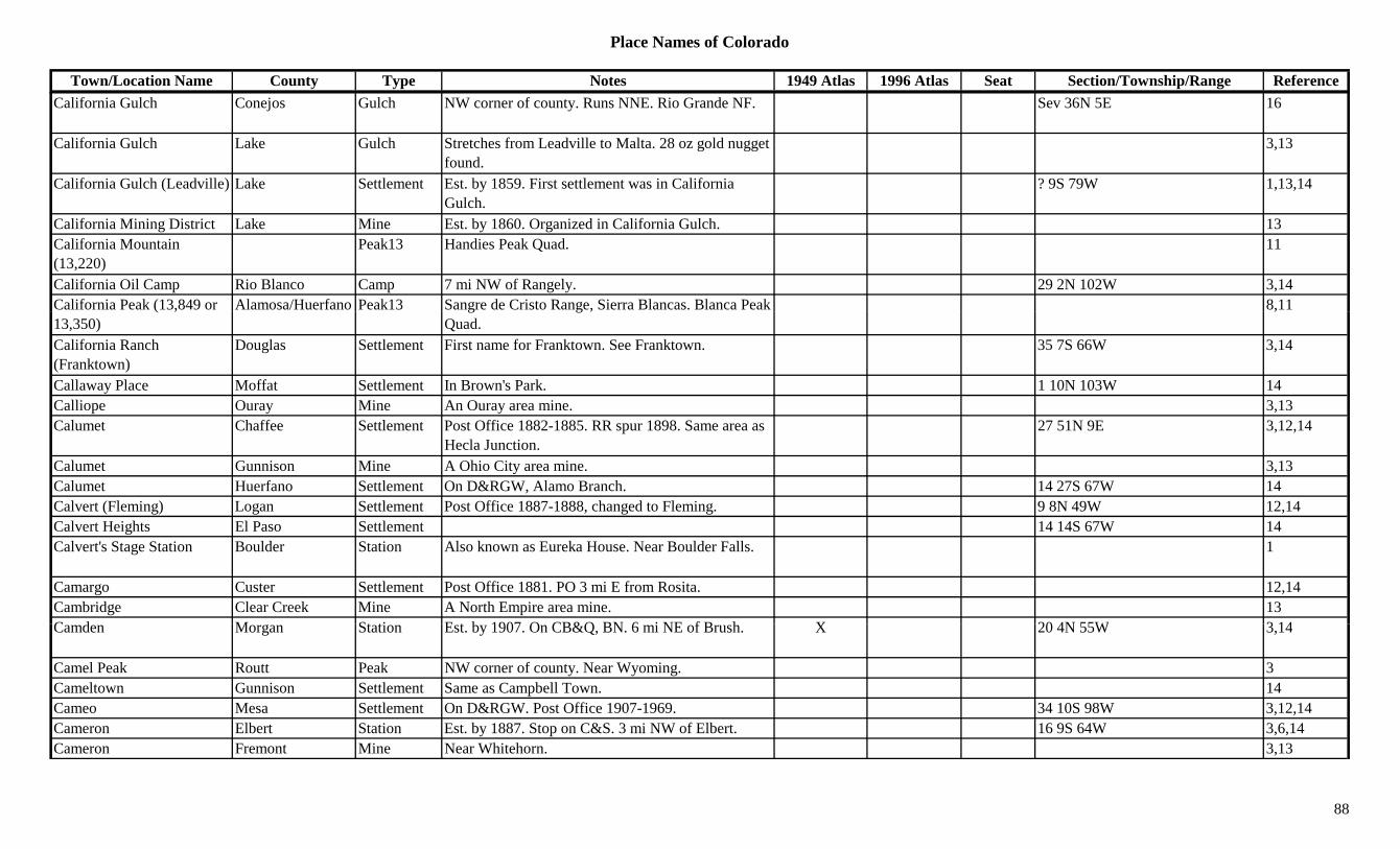
Place Names of Colorado
Town/Location Name County Type Notes 1949 Atlas 1996 Atlas Seat Section/Township/Range ReferenceCalifornia Gulch Conejos Gulch NW corner of county. Runs NNE. Rio Grande NF. Sev 36N 5E 16
California Gulch Lake Gulch Stretches from Leadville to Malta. 28 oz gold nugget found.
3,13
California Gulch (Leadville) Lake Settlement Est. by 1859. First settlement was in California Gulch.
? 9S 79W 1,13,14
California Mining District Lake Mine Est. by 1860. Organized in California Gulch. 13California Mountain (13,220)
Peak13 Handies Peak Quad. 11
California Oil Camp Rio Blanco Camp 7 mi NW of Rangely. 29 2N 102W 3,14California Peak (13,849 or Alamosa/Huerfano Peak13 Sangre de Cristo Range, Sierra Blancas. Blanca Peak 8,11( ,13,350)
g g ,Quad.
,
California Ranch (Franktown)
Douglas Settlement First name for Franktown. See Franktown. 35 7S 66W 3,14
Callaway Place Moffat Settlement In Brown's Park. 1 10N 103W 14Calliope Ouray Mine An Ouray area mine. 3,13Calumet Chaffee Settlement Post Office 1882-1885. RR spur 1898. Same area as
Hecla Junction.27 51N 9E 3,12,14
Calumet Gunnison Mine A Ohio City area mine. 3,13Calumet Huerfano Settlement On D&RGW, Alamo Branch. 14 27S 67W 14Calvert (Fleming) Logan Settlement Post Office 1887-1888, changed to Fleming. 9 8N 49W 12,14Calvert Heights El Paso Settlement 14 14S 67W 14Calvert's Stage Station Boulder Station Also known as Eureka House. Near Boulder Falls. 1
Camargo Custer Settlement Post Office 1881. PO 3 mi E from Rosita. 12,14Cambridge Clear Creek Mine A North Empire area mine. 13C d M St ti E t b 1907 O CB&Q BN 6 i NE f B h X 20 4N 55W 3 14Camden Morgan Station Est. by 1907. On CB&Q, BN. 6 mi NE of Brush. X 20 4N 55W 3,14
Camel Peak Routt Peak NW corner of county. Near Wyoming. 3Cameltown Gunnison Settlement Same as Campbell Town. 14Cameo Mesa Settlement On D&RGW. Post Office 1907-1969. 34 10S 98W 3,12,14Cameron Elbert Station Est. by 1887. Stop on C&S. 3 mi NW of Elbert. 16 9S 64W 3,6,14Cameron Fremont Mine Near Whitehorn. 3,13
88

Place Names of Colorado
Town/Location Name County Type Notes 1949 Atlas 1996 Atlas Seat Section/Township/Range ReferenceCameron Fremont Settlement On wagon road, 1 mi N of Nelson. 31 51N 10E 14Cameron Huerfano Station On C&S. 1 mi S of Walsenburg. X 21 28S 66W 3,14Cameron Teller Mine A Cameron area mine. 3Cameron (Gassy, Gassby) Teller Settlement Est. by 1892. Post Office 1901-1909, moved from
Touraine. First Gassy. 6 mi N of Victor.17 15S 69W 1,3,12,13
Cameron (Spencer) Gunnison Settlement See Spencer. 4 47N 2W 3,14Cameron Cone El Paso Peak10 SW of Manitou Springs. Pike NF. 13 14S 68W 16Cameron Mountain Chaffee/Fremont Peak10 NE of Salida. San Isabel NF. 31 51N 10E 16Cameron Mountain Fremont Mountain Near Whitehorn. 13Cameron Pass (10,276) Jackson/Larimer Pass At Michigan (Jackson County). Crossed by Cameron
Pass Road. Routt NF.X X 2 6N 76W 1,3,7
Cameron Pass (Cameron's Pass)
Larimer/Jackson Camp Est. by 1885 (population 25). Probably in Larimer County.
2 6N 76W 3,14
Cameron Peak (12,127) Larimer Peak12 W of Fort Collins near Jackson County border. 3,8Cameville Gunnison Camp Post Office 1882-1890. Small camp. 1,3,14Cameville Montrose Settlement Post Office 1882-1890. At junction of Tabeguache
Creek & San Miguel River.2 47N 17W 3,12,14
Camfield Weld Settlement Platted 1909. Post Office 1910-1921. 18 7N 64W 3,6,12,14Camp Chaffee Camp On road from Garfield, NW to Hancock. ? 50N 6E 14Camp Grand Settlement On D&RGW. Btwn Granby & Tabernash. 14Camp (Camp Nelson) Jackson Camp Est. by 1885. Same as Camp Nelson. 35 12N 79W 3, 14Camp Adams Denver Camp Btwn 26th & 27th Ave., W of Colorado Blvd. Camp
for Spanish-American War.36 3S 68W 14
Camp Albion (Albion) Boulder Camp Org. 1861. Snowy Range Mining District. 17 1N 73W 3,6,14Camp Amache Prowers Camp P.O.W. & Japanese Internment Camp, WWII. 14 23S 44W 14Camp Beshears Clear Creek Camp Btwn Empire & Georgetown. On Bard Creek. 14C Bi d L k Mi A Ad l id i 2 13Camp Bird Lake Mine An Adelaide area mine. 2,13Camp Bird Ouray Mine Famous mine, Ouray region. SW of Ouray. 1,2,3,8,13Camp Boericke Clear Creek Camp Early name for camp at Urade Mine. 14Camp Bowerman (Nugget City, Bowerman)
Gunnison Settlement First name proposed for Bowerman, rejected. Became Nugget City in 1903, then Bowerman.
28 51N 4E 14
89
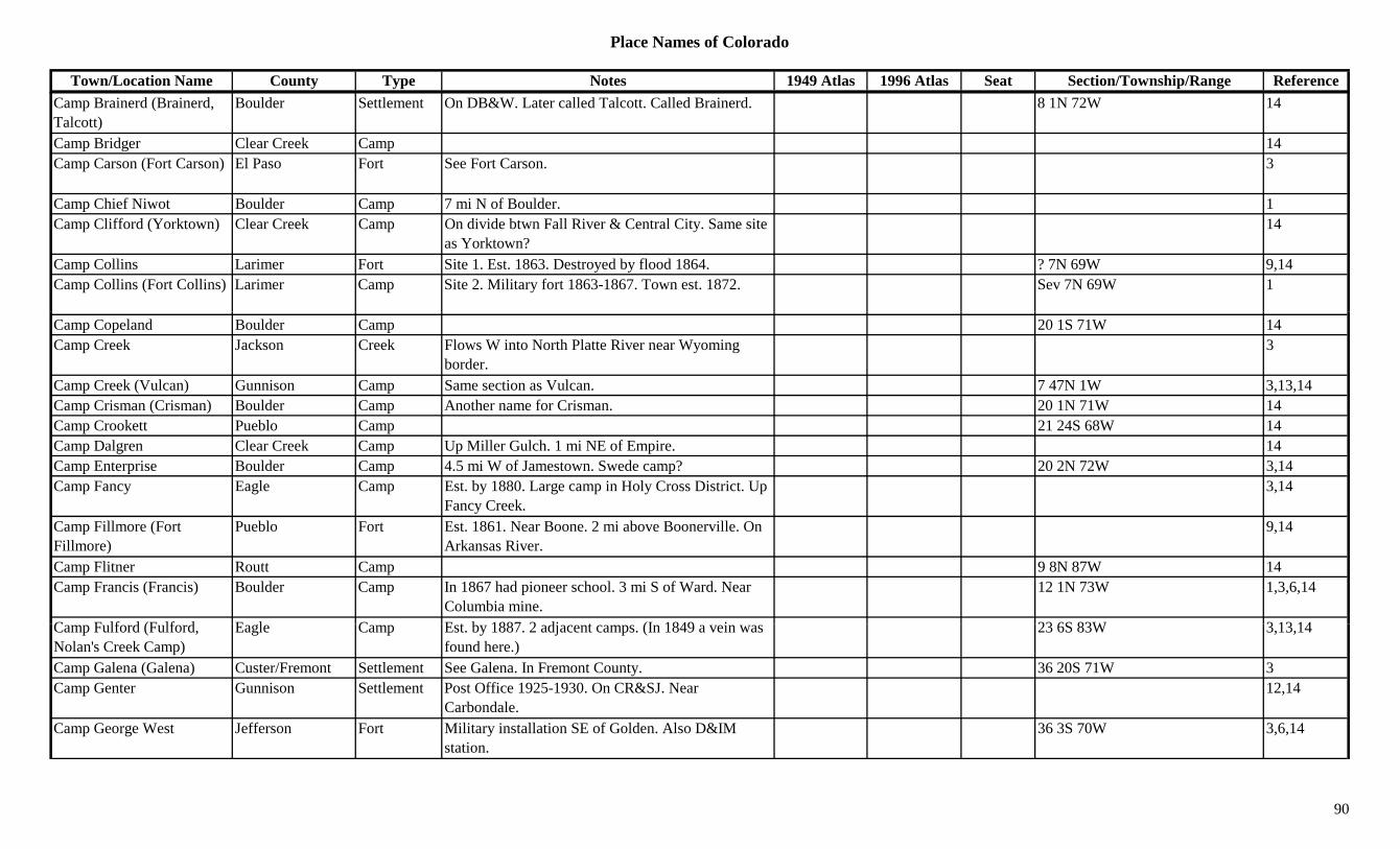
Place Names of Colorado
Town/Location Name County Type Notes 1949 Atlas 1996 Atlas Seat Section/Township/Range ReferenceCamp Brainerd (Brainerd, Talcott)
Boulder Settlement On DB&W. Later called Talcott. Called Brainerd. 8 1N 72W 14
Camp Bridger Clear Creek Camp 14Camp Carson (Fort Carson) El Paso Fort See Fort Carson. 3
Camp Chief Niwot Boulder Camp 7 mi N of Boulder. 1Camp Clifford (Yorktown) Clear Creek Camp On divide btwn Fall River & Central City. Same site
as Yorktown?14
Camp Collins Larimer Fort Site 1. Est. 1863. Destroyed by flood 1864. ? 7N 69W 9,14Camp Collins (Fort Collins) Larimer Camp Site 2. Military fort 1863-1867. Town est. 1872. Sev 7N 69W 1
Camp Copeland Boulder Camp 20 1S 71W 14Camp Creek Jackson Creek Flows W into North Platte River near Wyoming
border.3
Camp Creek (Vulcan) Gunnison Camp Same section as Vulcan. 7 47N 1W 3,13,14Camp Crisman (Crisman) Boulder Camp Another name for Crisman. 20 1N 71W 14Camp Crookett Pueblo Camp 21 24S 68W 14Camp Dalgren Clear Creek Camp Up Miller Gulch. 1 mi NE of Empire. 14Camp Enterprise Boulder Camp 4.5 mi W of Jamestown. Swede camp? 20 2N 72W 3,14Camp Fancy Eagle Camp Est. by 1880. Large camp in Holy Cross District. Up
Fancy Creek.3,14
Camp Fillmore (Fort Fillmore)
Pueblo Fort Est. 1861. Near Boone. 2 mi above Boonerville. On Arkansas River.
9,14
Camp Flitner Routt Camp 9 8N 87W 14Camp Francis (Francis) Boulder Camp In 1867 had pioneer school. 3 mi S of Ward. Near
Columbia mine.12 1N 73W 1,3,6,14
C F lf d (F lf d E l C E t b 1887 2 dj t (I 1849 i 23 6S 83W 3 13 14Camp Fulford (Fulford, Nolan's Creek Camp)
Eagle Camp Est. by 1887. 2 adjacent camps. (In 1849 a vein was found here.)
23 6S 83W 3,13,14
Camp Galena (Galena) Custer/Fremont Settlement See Galena. In Fremont County. 36 20S 71W 3Camp Genter Gunnison Settlement Post Office 1925-1930. On CR&SJ. Near
Carbondale.12,14
Camp George West Jefferson Fort Military installation SE of Golden. Also D&IM station.
36 3S 70W 3,6,14
90
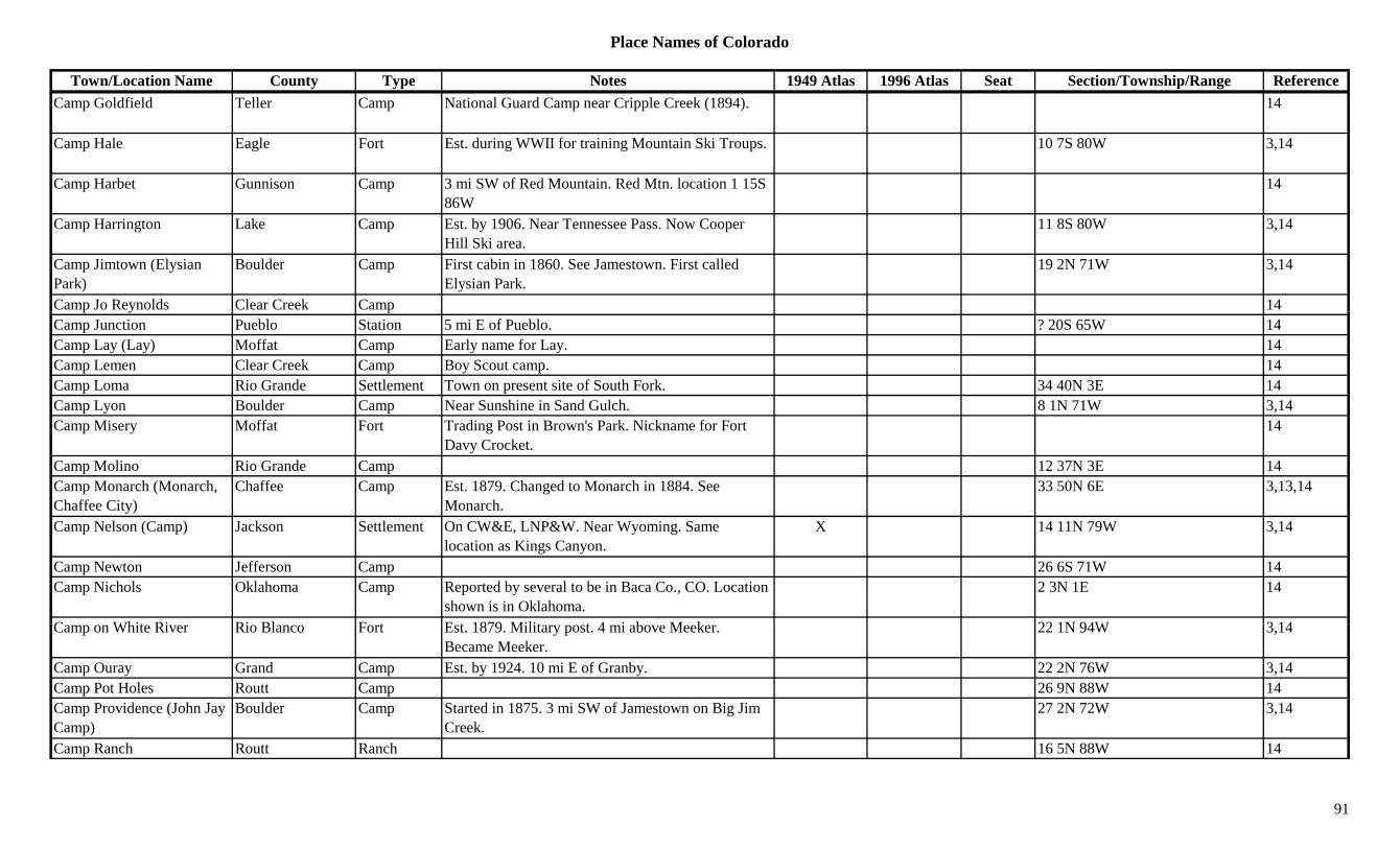
Place Names of Colorado
Town/Location Name County Type Notes 1949 Atlas 1996 Atlas Seat Section/Township/Range ReferenceCamp Goldfield Teller Camp National Guard Camp near Cripple Creek (1894). 14
Camp Hale Eagle Fort Est. during WWII for training Mountain Ski Troups. 10 7S 80W 3,14
Camp Harbet Gunnison Camp 3 mi SW of Red Mountain. Red Mtn. location 1 15S 86W
14
Camp Harrington Lake Camp Est. by 1906. Near Tennessee Pass. Now Cooper Hill Ski area.
11 8S 80W 3,14
Camp Jimtown (Elysian Park)
Boulder Camp First cabin in 1860. See Jamestown. First called Elysian Park.
19 2N 71W 3,14
Camp Jo Reynolds Clear Creek Camp 14p y pCamp Junction Pueblo Station 5 mi E of Pueblo. ? 20S 65W 14Camp Lay (Lay) Moffat Camp Early name for Lay. 14Camp Lemen Clear Creek Camp Boy Scout camp. 14Camp Loma Rio Grande Settlement Town on present site of South Fork. 34 40N 3E 14Camp Lyon Boulder Camp Near Sunshine in Sand Gulch. 8 1N 71W 3,14Camp Misery Moffat Fort Trading Post in Brown's Park. Nickname for Fort
Davy Crocket.14
Camp Molino Rio Grande Camp 12 37N 3E 14Camp Monarch (Monarch, Chaffee City)
Chaffee Camp Est. 1879. Changed to Monarch in 1884. See Monarch.
33 50N 6E 3,13,14
Camp Nelson (Camp) Jackson Settlement On CW&E, LNP&W. Near Wyoming. Same location as Kings Canyon.
X 14 11N 79W 3,14
Camp Newton Jefferson Camp 26 6S 71W 14Camp Nichols Oklahoma Camp Reported by several to be in Baca Co., CO. Location
shown is in Oklahoma.2 3N 1E 14
C Whit Ri Ri Bl F t E t 1879 Milit t 4 i b M k 22 1N 94W 3 14Camp on White River Rio Blanco Fort Est. 1879. Military post. 4 mi above Meeker. Became Meeker.
22 1N 94W 3,14
Camp Ouray Grand Camp Est. by 1924. 10 mi E of Granby. 22 2N 76W 3,14Camp Pot Holes Routt Camp 26 9N 88W 14Camp Providence (John Jay Camp)
Boulder Camp Started in 1875. 3 mi SW of Jamestown on Big Jim Creek.
27 2N 72W 3,14
Camp Ranch Routt Ranch 16 5N 88W 14
91
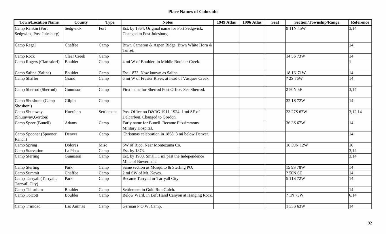
Place Names of Colorado
Town/Location Name County Type Notes 1949 Atlas 1996 Atlas Seat Section/Township/Range ReferenceCamp Rankin (Fort Sedgwick, Post Julesburg)
Sedgwick Fort Est. by 1864. Original name for Fort Sedgwick. Changed to Post Julesburg.
9 11N 45W 3,14
Camp Regal Chaffee Camp Btwn Cameron & Aspen Ridge. Btwn White Horn & Turret.
14
Camp Rock Clear Creek Camp 14 5S 73W 14Camp Rogers (Clarasdorf) Boulder Camp 4 mi W of Boulder, in Middle Boulder Creek. 1
Camp Salina (Salina) Boulder Camp Est. 1873. Now known as Salina. 18 1N 71W 14Camp Shaffer Grand Camp 6 mi W of Frasier River, at head of Vasques Creek. ? 2S 76W 14
Camp Sherrod (Sherrod) Gunnison Camp First name for Sherrod Post Office. See Sherrod. 2 50N 5E 3,14
Camp Shoshone (Camp Shoshoni)
Gilpin Camp 32 1S 72W 14
Camp Shumway (Shumway,Gordon)
Huerfano Settlement Post Office on D&RG 1911-1924. 1 mi SE of Delcarbon. Changed to Gordon.
23 27S 67W 3,12,14
Camp Speer (Bunell) Adams Camp Early name for Bunell. Became Fitzsimmons Military Hospital.
36 3S 67W 14
Camp Spooner (Spooner Ranch)
Denver Camp Christmas celebration in 1858. 3 mi below Denver. 14
Camp Spring Dolores Misc SW of Rico. Near Montezuma Co. 16 39N 12W 16Camp Starvation La Plata Camp Est. by 1873. 3,14Camp Sterling Gunnison Camp Est. by 1903. Small. 1 mi past the Independence
Mine of Bowerman.3,14
Camp Sterling Park Camp Same section as Mosquito & Sterling PO. 15 9S 78W 14C S it Ch ff C 2 i SW f Mt K ? 50N 6E 14Camp Summit Chaffee Camp 2 mi SW of Mt. Keyes. ? 50N 6E 14Camp Tarryall (Tarryall, Tarryall City)
Park Camp Became Tarryall or Tarryall City. 5 11S 72W 14
Camp Tellurium Boulder Camp Settlement in Gold Run Gulch. 14Camp Tolcott Boulder Camp Below Ward. In Left Hand Canyon at Hanging Rock. ? 1N 73W 6,14
Camp Trinidad Las Animas Camp German P.O.W. Camp. 1 33S 63W 14
92
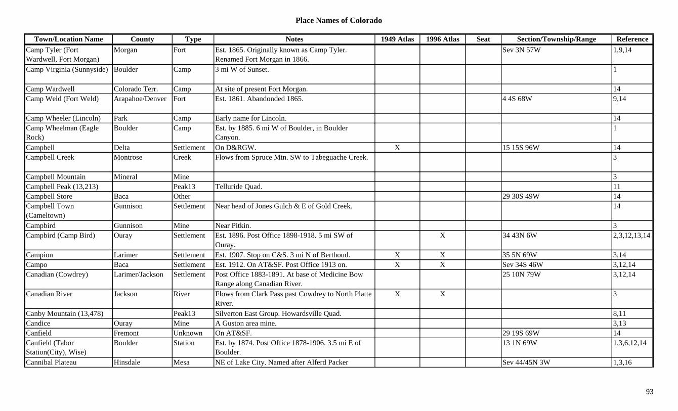
Place Names of Colorado
Town/Location Name County Type Notes 1949 Atlas 1996 Atlas Seat Section/Township/Range ReferenceCamp Tyler (Fort Wardwell, Fort Morgan)
Morgan Fort Est. 1865. Originally known as Camp Tyler. Renamed Fort Morgan in 1866.
Sev 3N 57W 1,9,14
Camp Virginia (Sunnyside) Boulder Camp 3 mi W of Sunset. 1
Camp Wardwell Colorado Terr. Camp At site of present Fort Morgan. 14Camp Weld (Fort Weld) Arapahoe/Denver Fort Est. 1861. Abandonded 1865. 4 4S 68W 9,14
Camp Wheeler (Lincoln) Park Camp Early name for Lincoln. 14Camp Wheelman (Eagle Rock)
Boulder Camp Est. by 1885. 6 mi W of Boulder, in Boulder Canyon.
1
Campbell Delta Settlement On D&RGW. X 15 15S 96W 14pCampbell Creek Montrose Creek Flows from Spruce Mtn. SW to Tabeguache Creek. 3
Campbell Mountain Mineral Mine 3Campbell Peak (13,213) Peak13 Telluride Quad. 11Campbell Store Baca Other 29 30S 49W 14Campbell Town (Cameltown)
Gunnison Settlement Near head of Jones Gulch & E of Gold Creek. 14
Campbird Gunnison Mine Near Pitkin. 3Campbird (Camp Bird) Ouray Settlement Est. 1896. Post Office 1898-1918. 5 mi SW of
Ouray.X 34 43N 6W 2,3,12,13,14
Campion Larimer Settlement Est. 1907. Stop on C&S. 3 mi N of Berthoud. X X 35 5N 69W 3,14Campo Baca Settlement Est. 1912. On AT&SF. Post Office 1913 on. X X Sev 34S 46W 3,12,14Canadian (Cowdrey) Larimer/Jackson Settlement Post Office 1883-1891. At base of Medicine Bow
Range along Canadian River.25 10N 79W 3,12,14
Canadian River Jackson River Flows from Clark Pass past Cowdrey to North Platte Ri
X X 3River.
Canby Mountain (13,478) Peak13 Silverton East Group. Howardsville Quad. 8,11Candice Ouray Mine A Guston area mine. 3,13Canfield Fremont Unknown On AT&SF. 29 19S 69W 14Canfield (Tabor Station(City), Wise)
Boulder Station Est. by 1874. Post Office 1878-1906. 3.5 mi E of Boulder.
13 1N 69W 1,3,6,12,14
Cannibal Plateau Hinsdale Mesa NE of Lake City. Named after Alferd Packer Sev 44/45N 3W 1,3,16
93

Place Names of Colorado
Town/Location Name County Type Notes 1949 Atlas 1996 Atlas Seat Section/Township/Range ReferenceCannon Mountain (8,615) Boulder Mountain ENE of Peacfull Valley. Roosevelt NF. 10/15 2N 72W + 16Cannons Garfield/Mesa Unknown 3 11S 98W 14Cañon Conejos Settlement 8 mi SW of Antonito. X 6 32N 8E 3,14Canon Bonito Conejos Canyon NW corner of county. Runs SSE to Hansen Creek.
Rio Grande NF.Sev 35N 4E 16
Cañon Butte Rio Blanco Hill W part of county. Near Utah. 3Canon City Fremont Settlement Post Office 1904 on. Formerly Cañon City. Renamed
Canon City.X X X Sev 18S 70W 1,3,12,14
Cañon City Fremont Settlement Est. 1859. Post Office 1860-1904, changed to Canon City. Pike's camp in 1806. Stage stop.
Sev 18S 70W 12
Cañon Colorado River Garfield Unknown On D&RGW. 6 6S 88W 14Cañon Creek Ouray Creek Btwn Ouray & Camp Bird. 3Canon Diablo Conejos Canyon Runs NNW into Platoro Reservoir. Rio Grande NF. Sev 35N 3E 16
Canon Escondido Conejos Canyon West central county. Runs NE to Conejos River. Rio Grande NF.
Sev 34N 4E 16
Cañon Junction Pueblo Station Connection btwn Colorado-Kansas RR & AT&SF. ? 20S 65W 14
Cañon Junction (Grape Creek Junction)
Fremont Station Est. by 1885. Same site as Grape Creek Junction. 6 19S 70W 3,14
Cañon Park Moffat Park 1885. 12 mi SW of Craig. 3Cañon Spur (Platte Cañon) Jefferson Station On DSP&P. At Waterton. Also called Platte Cañon. 26 6S 69W 14
Canon Verde Conejos Canyon West central county. Runs NE to Conejos River. Rio Grande NF.
Sev 34N 4E 16
Cañon Wye Fremont Unknown End of track on D&RGW for a time. 33 18S 70W 14C t W ld St ti E t b 1923 O BN 2 i E f H di 3 i NW f 17 4N 62W 3 6 14Canton Weld Station Est. by 1923. On BN. 2 mi E of Hardin. 3 mi NW of
Dearfield.17 4N 62W 3,6,14
Cantonment on the Uncompahgre (Fort Crawford)
Montrose Fort Est. 1880. Renamed Fort Crawford 1886. 26 48N 9W 9,14
Cantonment Stevens Huerfano Camp Army camp on Santa Clara Creek in 1866. 14Canyon Creek Garfield Creek Flows S to join Colorado River near Chacra. 3
94
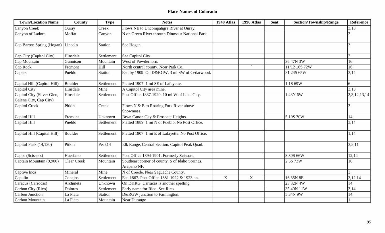
Place Names of Colorado
Town/Location Name County Type Notes 1949 Atlas 1996 Atlas Seat Section/Township/Range ReferenceCanyon Creek Ouray Creek Flows NE to Uncompahgre River at Ouray. 3,13Canyon of Ladore Moffat Canyon N on Green River throuth Dinosaur National Park. 3
Cap Barron Spring (Hogan) Lincoln Station See Hogan. 3
Cap City (Capitol City) Hinsdale Settlement See Capitol City. 3Cap Mountain Gunnison Mountain West of Powderhorn. 36 47N 3W 16Cap Rock Fremont Hill North central county. Near Park Co. ` 11/12 16S 72W 16Capers Pueblo Station Est. by 1909. On D&RGW. 3 mi SW of Cedarwood. 31 24S 65W 3,14
Capital Hill (Capitol Hill) Boulder Settlement Platted 1907. 1 mi SE of Lafayette. 1 1S 69W 6p ( p ) yCapitol City Hinsdale Mine A Capitol City area mine. 3,13Capitol City (Silver Glen, Galena City, Cap City)
Hinsdale Settlement Post Office 1887-1920. 10 mi W of Lake City. 1 43N 6W 2,3,12,13,14
Capitol Creek Pitkin Creek Flows N & E to Roaring Fork River above Snowmass.
3
Capitol Hill Fremont Unknown Btwn Canon City & Prospect Heights. 5 19S 70W 14Capitol Hill Pueblo Settlement Platted 1889. 1 mi N of Pueblo. No Post Office. 3,14
Capitol Hill (Capital Hill) Boulder Settlement Platted 1907. 1 mi E of Lafayette. No Post Office. 1,14
Capitol Peak (14,130) Pitkin Peak14 Elk Range, Central Section. Capitol Peak Quad. 3,8,11
Capps (Scissors) Huerfano Settlement Post Office 1894-1901. Formerly Scissors. 8 30S 66W 12,14Captain Mountain (9,900) Clear Creek Mountain Southeast corner of county. S of Idaho Springs.
Arapaho NF.2 5S 73W 16
C ti I Mi l Mi N f C d N S h C t 3Captive Inca Mineral Mine N of Creede. Near Saguache County. 3Capulin Conejos Settlement Est. 1867. Post Office 1881-1922 & 1923 on. X X 16 35N 8E 3,12,14Caracus (Carrocas) Archuleta Unknown On D&RG. Carracas is another spelling. 23 32N 4W 14Carbon City (Rico) Dolores Settlement Early name for Rico. See Rico. 35 40N 11W 3,14Carbon Junction La Plata Station D&RGW junction to Farmington. 5 34N 9W 14Carbon Mountain La Plata Mountain Near Durango 1
95
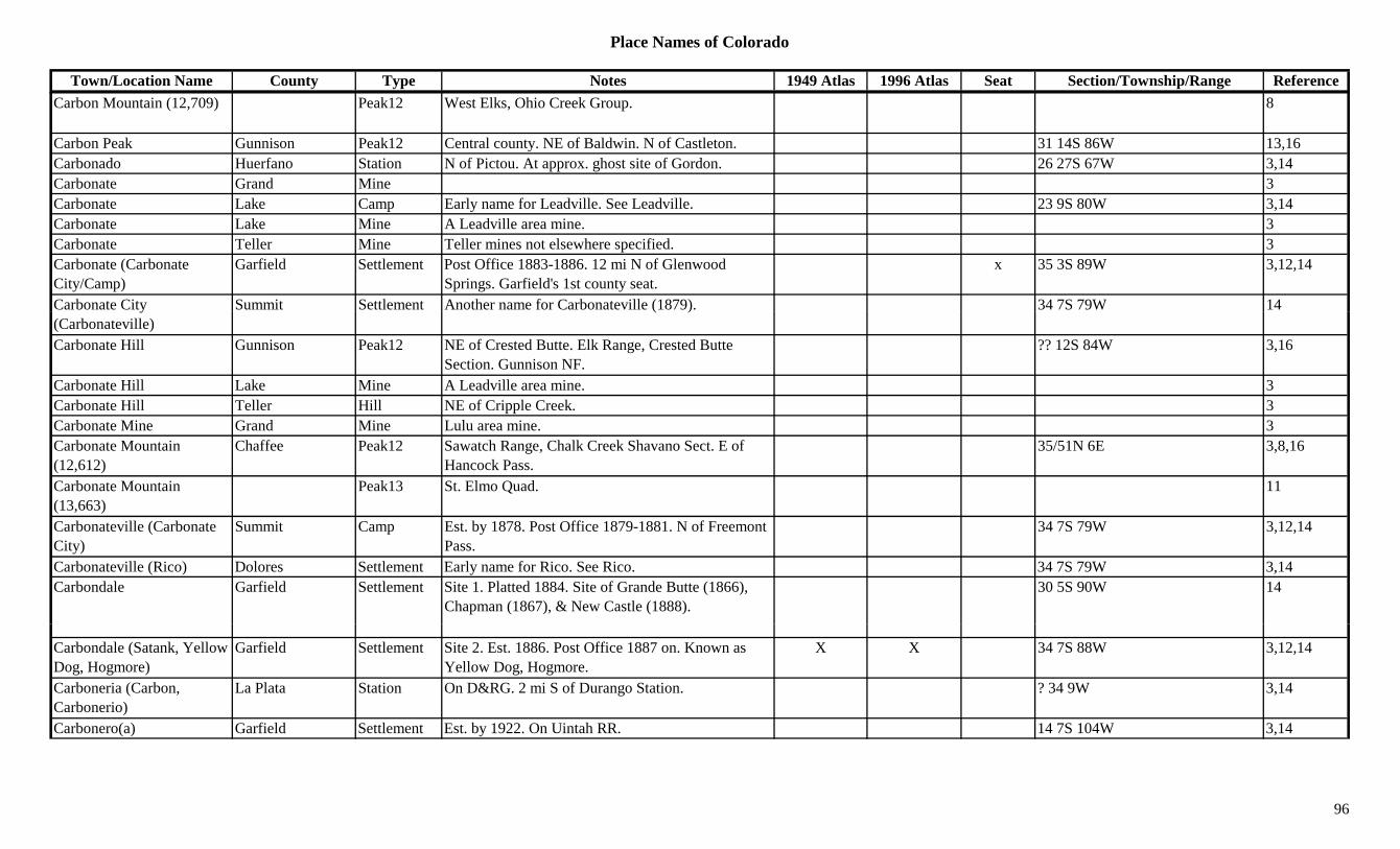
Place Names of Colorado
Town/Location Name County Type Notes 1949 Atlas 1996 Atlas Seat Section/Township/Range ReferenceCarbon Mountain (12,709) Peak12 West Elks, Ohio Creek Group. 8
Carbon Peak Gunnison Peak12 Central county. NE of Baldwin. N of Castleton. 31 14S 86W 13,16Carbonado Huerfano Station N of Pictou. At approx. ghost site of Gordon. 26 27S 67W 3,14Carbonate Grand Mine 3Carbonate Lake Camp Early name for Leadville. See Leadville. 23 9S 80W 3,14Carbonate Lake Mine A Leadville area mine. 3Carbonate Teller Mine Teller mines not elsewhere specified. 3Carbonate (Carbonate City/Camp)
Garfield Settlement Post Office 1883-1886. 12 mi N of Glenwood Springs. Garfield's 1st county seat.
x 35 3S 89W 3,12,14
Carbonate City Summit Settlement Another name for Carbonateville (1879). 34 7S 79W 14y(Carbonateville)
( )
Carbonate Hill Gunnison Peak12 NE of Crested Butte. Elk Range, Crested Butte Section. Gunnison NF.
?? 12S 84W 3,16
Carbonate Hill Lake Mine A Leadville area mine. 3Carbonate Hill Teller Hill NE of Cripple Creek. 3Carbonate Mine Grand Mine Lulu area mine. 3Carbonate Mountain (12,612)
Chaffee Peak12 Sawatch Range, Chalk Creek Shavano Sect. E of Hancock Pass.
35/51N 6E 3,8,16
Carbonate Mountain (13,663)
Peak13 St. Elmo Quad. 11
Carbonateville (Carbonate City)
Summit Camp Est. by 1878. Post Office 1879-1881. N of Freemont Pass.
34 7S 79W 3,12,14
Carbonateville (Rico) Dolores Settlement Early name for Rico. See Rico. 34 7S 79W 3,14Carbondale Garfield Settlement Site 1. Platted 1884. Site of Grande Butte (1866),
Chapman (1867), & New Castle (1888).30 5S 90W 14
Carbondale (Satank, Yellow Dog, Hogmore)
Garfield Settlement Site 2. Est. 1886. Post Office 1887 on. Known as Yellow Dog, Hogmore.
X X 34 7S 88W 3,12,14
Carboneria (Carbon, Carbonerio)
La Plata Station On D&RG. 2 mi S of Durango Station. ? 34 9W 3,14
Carbonero(a) Garfield Settlement Est. by 1922. On Uintah RR. 14 7S 104W 3,14
96
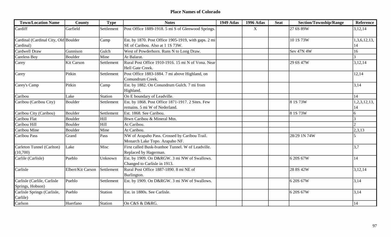
Place Names of Colorado
Town/Location Name County Type Notes 1949 Atlas 1996 Atlas Seat Section/Township/Range ReferenceCardiff Garfield Settlement Post Office 1889-1918. 5 mi S of Glenwood Springs. X 27 6S 89W 3,12,14
Cardinal (Cardinal City, Old Cardinal)
Boulder Camp Est. by 1870. Post Office 1905-1919, with gaps. 2 mi SE of Caribou. Also at 1 1S 73W.
10 1S 73W 1,3,6,12,13,14
Cardwell Draw Gunnison Gulch West of Powderhorn. Runs N to Long Draw. Sev 47N 4W 16Careless Boy Boulder Mine At Balarat. 3Carey Kit Carson Settlement Rural Post Office 1910-1916. 15 mi N of Vona. Near
Hell Gate Creek.29 6S 47W 3,12,14
Carey Pitkin Settlement Post Office 1883-1884. 7 mi above Highland, on Comundrum Creek.
12,14
Carey's Camp Pitkin Camp Est. by 1882. On Conundrum Gulch. 7 mi from 3,14y p p yHighland.
,
Caribou Lake Station On E boundary of Leadville. 14Caribou (Caribou City) Boulder Settlement Est. by 1868. Post Office 1871-1917. 2 Sites. Few
remains. 5 mi W of Nederland.8 1S 73W 1,2,3,12,13,
14Caribou City (Caribou) Boulder Settlement Est. 1868. See Caribou. 8 1S 73W 6Caribou Flat Boulder Hill Btwn Caribou & Mineral Mtn. 3Caribou Hill Boulder Hill At Caribou. 2Caribou Mine Boulder Mine At Caribou. 2,3,13Caribou Pass Grand Pass NW of Arapaho Pass. Crossed by Caribou Trail.
Monarch Lake Topo. Arapaho NF.28/29 1N 74W 5
Carleton Tunnel (Carlton) (10,700)
Lake Misc First called Busk-Ivanhoe Tunnel. W of Leadville. Replaced by Hagerman.
3,7
Carlile (Carlisle) Pueblo Unknown Est. by 1909. On D&RGW. 3 mi NW of Swallows. Changed to Carlisle in 1913.
6 20S 67W 14
Carlisle Elbert/Kit Carson Settlement Rural Post Office 1887-1890. 8 mi NE of B li t
28 8S 42W 3,12,14Burlington.
Carlisle (Carlile, Carlisle Springs, Hobson)
Pueblo Settlement Est. by 1909. On D&RGW. 3 mi NW of Swallows. 6 20S 67W 3,14
Carlisle Springs (Carlisle, Carlile)
Pueblo Station Est. in 1880s. See Carlisle. 6 20S 67W 3,14
Carlson Huerfano Station On C&S & D&RG. 14
97
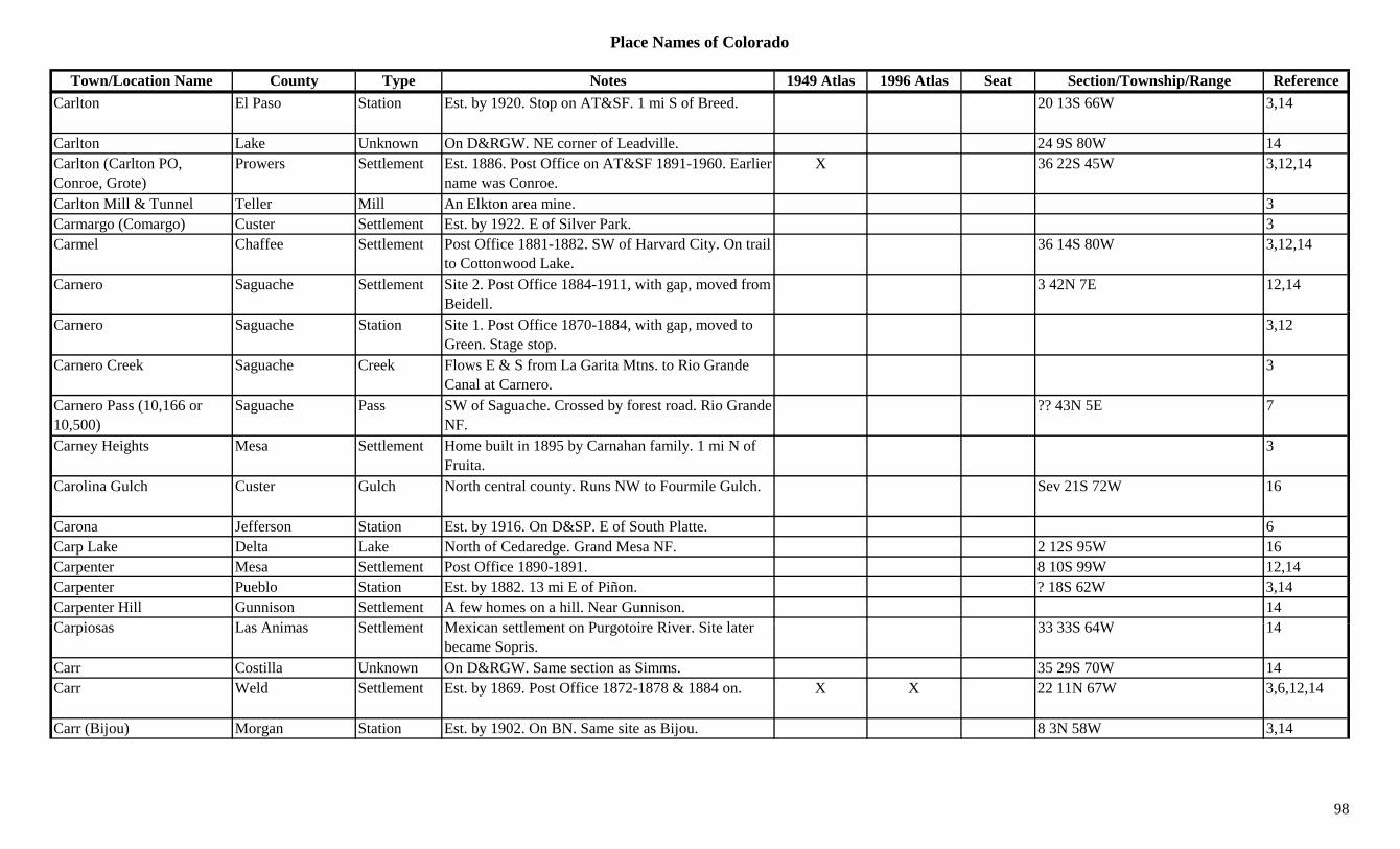
Place Names of Colorado
Town/Location Name County Type Notes 1949 Atlas 1996 Atlas Seat Section/Township/Range ReferenceCarlton El Paso Station Est. by 1920. Stop on AT&SF. 1 mi S of Breed. 20 13S 66W 3,14
Carlton Lake Unknown On D&RGW. NE corner of Leadville. 24 9S 80W 14Carlton (Carlton PO, Conroe, Grote)
Prowers Settlement Est. 1886. Post Office on AT&SF 1891-1960. Earlier name was Conroe.
X 36 22S 45W 3,12,14
Carlton Mill & Tunnel Teller Mill An Elkton area mine. 3Carmargo (Comargo) Custer Settlement Est. by 1922. E of Silver Park. 3Carmel Chaffee Settlement Post Office 1881-1882. SW of Harvard City. On trail
to Cottonwood Lake.36 14S 80W 3,12,14
Carnero Saguache Settlement Site 2. Post Office 1884-1911, with gap, moved from Beidell.
3 42N 7E 12,14
Carnero Saguache Station Site 1. Post Office 1870-1884, with gap, moved to Green. Stage stop.
3,12
Carnero Creek Saguache Creek Flows E & S from La Garita Mtns. to Rio Grande Canal at Carnero.
3
Carnero Pass (10,166 or 10,500)
Saguache Pass SW of Saguache. Crossed by forest road. Rio Grande NF.
?? 43N 5E 7
Carney Heights Mesa Settlement Home built in 1895 by Carnahan family. 1 mi N of Fruita.
3
Carolina Gulch Custer Gulch North central county. Runs NW to Fourmile Gulch. Sev 21S 72W 16
Carona Jefferson Station Est. by 1916. On D&SP. E of South Platte. 6Carp Lake Delta Lake North of Cedaredge. Grand Mesa NF. 2 12S 95W 16Carpenter Mesa Settlement Post Office 1890-1891. 8 10S 99W 12,14Carpenter Pueblo Station Est. by 1882. 13 mi E of Piñon. ? 18S 62W 3,14Carpenter Hill Gunnison Settlement A few homes on a hill. Near Gunnison. 14C i L A i S ttl t M i ttl t P t i Ri Sit l t 33 33S 64W 14Carpiosas Las Animas Settlement Mexican settlement on Purgotoire River. Site later
became Sopris.33 33S 64W 14
Carr Costilla Unknown On D&RGW. Same section as Simms. 35 29S 70W 14Carr Weld Settlement Est. by 1869. Post Office 1872-1878 & 1884 on. X X 22 11N 67W 3,6,12,14
Carr (Bijou) Morgan Station Est. by 1902. On BN. Same site as Bijou. 8 3N 58W 3,14
98
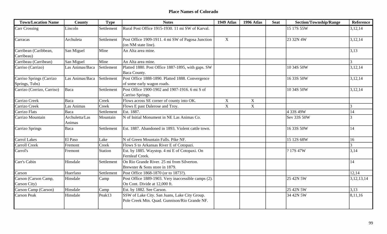
Place Names of Colorado
Town/Location Name County Type Notes 1949 Atlas 1996 Atlas Seat Section/Township/Range ReferenceCarr Crossing Lincoln Settlement Rural Post Office 1915-1930. 11 mi SW of Karval. 15 17S 55W 3,12,14
Carracas Archuleta Settlement Post Office 1909-1911. 4 mi SW of Pagosa Junction (on NM state line).
X 23 32N 4W 3,12,14
Carribean (Caribbean, Carribeau)
San Miguel Mine An Alta area mine. 3,13
Carribeau (Carribean) San Miguel Mine An Alta area mine. 3Carriso (Carrizo) Las Animas/Baca Settlement Platted 1880. Post Office 1887-1895, with gaps. SW
Baca County.10 34S 50W 3,12,14
Carriso Springs (Carrizo Springs, Tubs)
Las Animas/Baca Settlement Post Office 1888-1890. Platted 1888. Convergence of some early wagon roads.
16 33S 50W 3,12,14
Carrizo (Corrizo, Carriso) Baca Settlement Post Office 1900-1902 and 1907-1916. 6 mi S of Carriso Springs.
10 34S 50W 3,12,14
Carrizo Creek Baca Creek Flows across SE corner of county into OK. X XCarrizo Creek Las Animas Creek Flows E past Dalerose and Troy. X X 3Carrizo Flats Baca Settlement Est. 1887. 4 33S 49W 14Carrizo Mountain Archuletta/Las
AnimasMountain N of Initial Monument in NE Las Animas Co. Sev 33S 50W 3
Carrizo Springs Baca Settlement Est. 1887. Abandoned in 1893. Violent cattle town. 16 33S 50W 14
Carrol Lakes El Paso Lake N of Green Mountain Falls. Pike NF. 15 12S 68W 16Carroll Creek Fremont Creek Flows S to Arkansas River E of Cotopazi. 3Carrol's Fremont Station Est. by 1885. Waystop. 4 mi E of Cotopaxi. On
Fernleaf Creek.? 17S 47W 3,14
Carr's Cabin Hinsdale Settlement On Rio Grande River. 25 mi from Silverton. Brewster & Sons store in 1879.
14
C H f S ttl t P t Offi 1868 1870 ( t 1873?) 12 14Carson Huerfano Settlement Post Office 1868-1870 (or to 1873?). 12,14Carson (Carson Camp, Carson City)
Hinsdale Camp Post Office 1889-1903. Very inaccessible camps (2). On Cont. Divide at 12,000 ft.
25 42N 5W 3,12,13,14
Carson Camp (Carson) Hinsdale Camp Est. by 1882. See Carson. 25 42N 5W 3,13Carson Peak Hinsdale Peak13 SSW of Lake City. San Juans, Lake City Group.
Pole Creek Mtn. Quad. Gunnison/Rio Grande NF.34 42N 5W 8,11,16
99
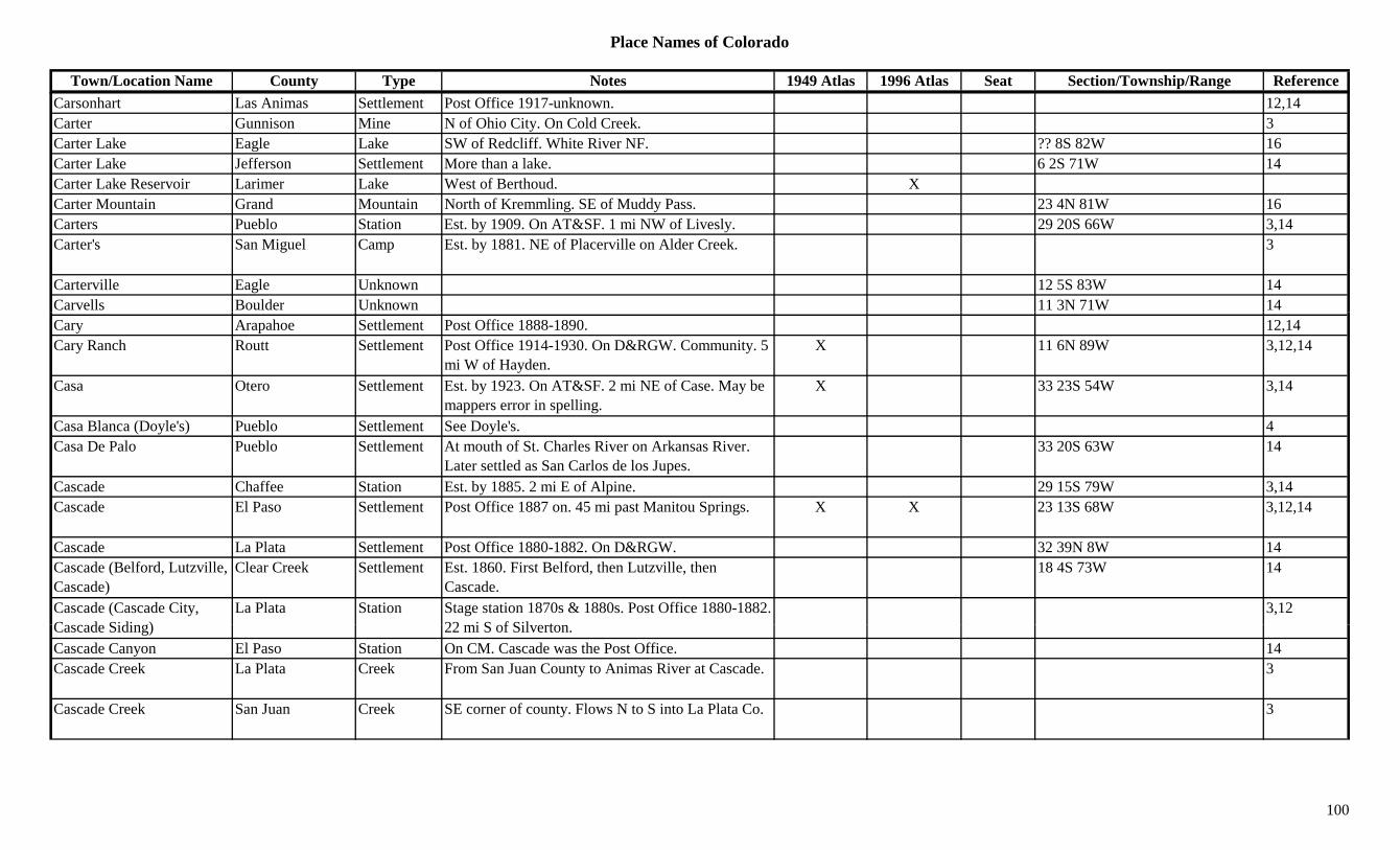
Place Names of Colorado
Town/Location Name County Type Notes 1949 Atlas 1996 Atlas Seat Section/Township/Range ReferenceCarsonhart Las Animas Settlement Post Office 1917-unknown. 12,14Carter Gunnison Mine N of Ohio City. On Cold Creek. 3Carter Lake Eagle Lake SW of Redcliff. White River NF. ?? 8S 82W 16Carter Lake Jefferson Settlement More than a lake. 6 2S 71W 14Carter Lake Reservoir Larimer Lake West of Berthoud. XCarter Mountain Grand Mountain North of Kremmling. SE of Muddy Pass. 23 4N 81W 16Carters Pueblo Station Est. by 1909. On AT&SF. 1 mi NW of Livesly. 29 20S 66W 3,14Carter's San Miguel Camp Est. by 1881. NE of Placerville on Alder Creek. 3
Carterville Eagle Unknown 12 5S 83W 14Carvells Boulder Unknown 11 3N 71W 14Cary Arapahoe Settlement Post Office 1888-1890. 12,14Cary Ranch Routt Settlement Post Office 1914-1930. On D&RGW. Community. 5
mi W of Hayden.X 11 6N 89W 3,12,14
Casa Otero Settlement Est. by 1923. On AT&SF. 2 mi NE of Case. May be mappers error in spelling.
X 33 23S 54W 3,14
Casa Blanca (Doyle's) Pueblo Settlement See Doyle's. 4Casa De Palo Pueblo Settlement At mouth of St. Charles River on Arkansas River.
Later settled as San Carlos de los Jupes.33 20S 63W 14
Cascade Chaffee Station Est. by 1885. 2 mi E of Alpine. 29 15S 79W 3,14Cascade El Paso Settlement Post Office 1887 on. 45 mi past Manitou Springs. X X 23 13S 68W 3,12,14
Cascade La Plata Settlement Post Office 1880-1882. On D&RGW. 32 39N 8W 14Cascade (Belford, Lutzville, Cascade)
Clear Creek Settlement Est. 1860. First Belford, then Lutzville, then Cascade.
18 4S 73W 14
Cascade (Cascade City, C d Sidi )
La Plata Station Stage station 1870s & 1880s. Post Office 1880-1882. 22 i S f Sil t
3,12Cascade Siding) 22 mi S of Silverton.Cascade Canyon El Paso Station On CM. Cascade was the Post Office. 14Cascade Creek La Plata Creek From San Juan County to Animas River at Cascade. 3
Cascade Creek San Juan Creek SE corner of county. Flows N to S into La Plata Co. 3
100
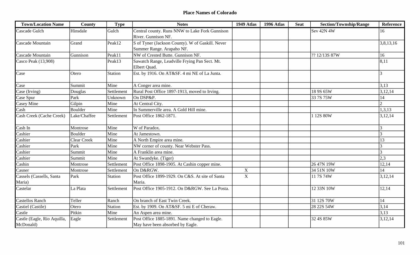
Place Names of Colorado
Town/Location Name County Type Notes 1949 Atlas 1996 Atlas Seat Section/Township/Range ReferenceCascade Gulch Hinsdale Gulch Central county. Runs NNW to Lake Fork Gunnison
River. Gunnison NF.Sev 42N 4W 16
Cascade Mountain Grand Peak12 S of Tyner (Jackson County). W of Gaskill. Never Summer Range. Arapaho NF.
3,8,13,16
Cascade Mountain Gunnison Peak11 NW of Crested Butte. Gunnison NF. ?? 12/13S 87W 16Casco Peak (13,908) Peak13 Sawatch Range, Leadville Frying Pan Sect. Mt.
Elbert Quad.8,11
Case Otero Station Est. by 1916. On AT&SF. 4 mi NE of La Junta. 3
Case Summit Mine A Conger area mine. 3,13Case (Irving) Douglas Settlement Rural Post Office 1897-1913, moved to Irving. 18 9S 65W 3,12,14( g) g , g , ,Case Spur Park Unknown On DSP&P. 33 7S 75W 14Casey Mine Gilpin Mine At Central City. 2Cash Boulder Mine In Summerville area. A Gold Hill mine. 1,3,13Cash Creek (Cache Creek) Lake/Chaffee Settlement Post Office 1862-1871. 1 12S 80W 3,12,14
Cash In Montrose Mine W of Paradox. 3Cashier Boulder Mine At Jamestown. 3Cashier Clear Creek Mine A North Empire area mine. 13Cashier Park Mine NW corner of county. Near Webster Pass. 3Cashier Summit Mine A Franklin area mine. 3Cashier Summit Mine At Swandyke. (Tiger) 2,3Cashin Montrose Settlement Post Office 1898-1905. At Cashin copper mine. 26 47N 19W 12,14Casner Montrose Settlement On D&RGW. X 34 51N 10W 14Cassels (Cassells, Santa Maria)
Park Station Post Office 1899-1929. On C&S. At site of Santa Maria.
X 11 7S 74W 3,12,14
C t l L Pl t S ttl t P t Offi 1905 1912 O D&RGW S L P t 12 33N 10W 12 14Castelar La Plata Settlement Post Office 1905-1912. On D&RGW. See La Posta. 12 33N 10W 12,14
Castellos Ranch Teller Ranch On branch of East Twin Creek. 31 12S 70W 14Castiel (Castile) Otero Station Est. by 1909. On AT&SF. 5 mi E of Cheraw. 28 22S 54W 3,14Castle Pitkin Mine An Aspen area mine. 3,13Castle (Eagle, Rio Aquilla, McDonald)
Eagle Settlement Post Office 1885-1891. Name changed to Eagle. May have been absorbed by Eagle.
32 4S 85W 3,12,14
101
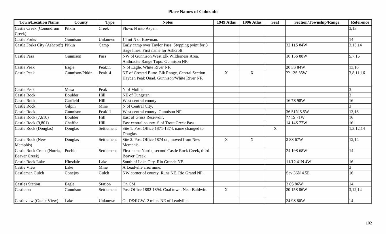
Place Names of Colorado
Town/Location Name County Type Notes 1949 Atlas 1996 Atlas Seat Section/Township/Range ReferenceCastle Creek (Conundrum Creek)
Pitkin Creek Flows N into Aspen. 3,13
Castle Forks Gunnison Unknown 14 mi N of Bowman. 14Castle Forks City (Ashcroft) Pitkin Camp Early camp over Taylor Pass. Stopping point for 3
stage lines. First name for Ashcroft.32 11S 84W 3,13,14
Castle Pass Gunnison Pass NW of Gunnison.West Elk Wilderness Area. Anthracite Range Topo. Gunnison NF.
10 15S 88W 5,7,16
Castle Peak Eagle Peak11 N of Eagle. White River NF. 20 3S 84W 13,16Castle Peak Gunnison/Pitkin Peak14 NE of Crested Butte. Elk Range, Central Section.
Hayden Peak Quad. Gunnison/White River NF.X X ?? 12S 85W 3,8,11,16
Castle Peak Mesa Peak N of Molina. 3Castle Rock Boulder Hill NE of Tungsten. 3Castle Rock Garfield Hill West central county. 16 7S 98W 16Castle Rock Gilpin Mine N of Central City. 3Castle Rock Gunnison Peak11 West central county. Gunnison NF. 36 51N 5.5W 13,16Castle Rock (7,610) Boulder Hill East of Gross Reservoir. ?? 1S 71W 16Castle Rock (9,801) Chaffee Hill East central county. S of Trout Creek Pass. 14 14S 77W 16Castle Rock (Douglas) Douglas Settlement Site 1. Post Office 1871-1874, name changed to
Douglas.X 1,3,12,14
Castle Rock (New Memphis)
Douglas Settlement Site 2. Post Office 1874 on, moved from New Memphis.
X X 2 8S 67W 12,14
Castle Rock Creek (Nutria, Beaver Creek)
Pueblo Settlement First name Nutria, second Castle Rock Creek, third Beaver Creek.
24 19S 68W 14
Castle Rock Lake Hinsdale Lake South of Lake City. Rio Grande NF. 11/12 41N 4W 16Castle View Lake Mine A Leadville area mine. 3C tl G l h C j G l h NW f t R NE Ri G d NF S 36N 4 5E 16Castleman Gulch Conejos Gulch NW corner of county. Runs NE. Rio Grand NF. Sev 36N 4.5E 16
Castles Station Eagle Station On CM. 2 8S 86W 14Castleton Gunnison Settlement Post Office 1882-1894. Coal town. Near Baldwin. X 20 15S 86W 3,12,14
Castleview (Castle View) Lake Unknown On D&RGW. 2 miles NE of Leadville. 24 9S 80W 14
102
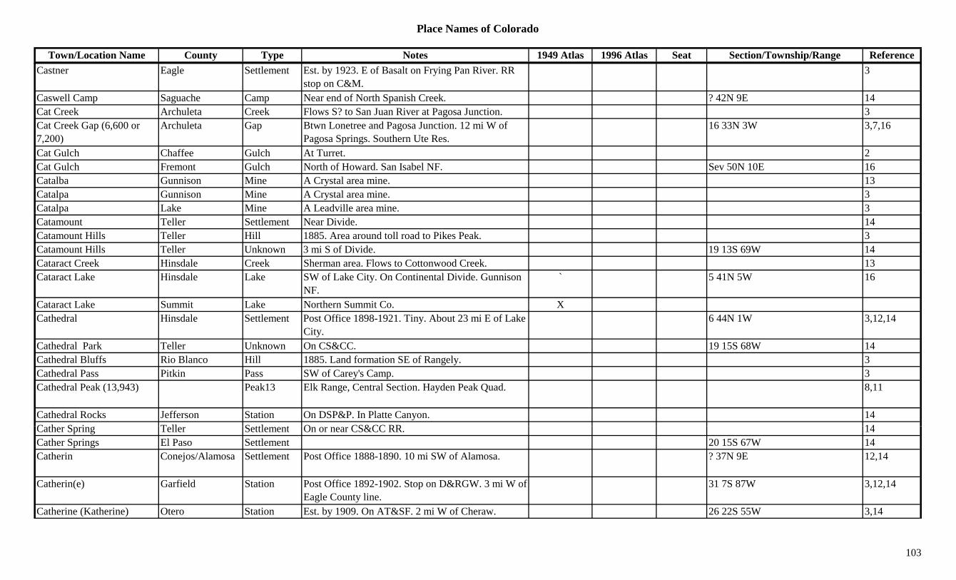
Place Names of Colorado
Town/Location Name County Type Notes 1949 Atlas 1996 Atlas Seat Section/Township/Range ReferenceCastner Eagle Settlement Est. by 1923. E of Basalt on Frying Pan River. RR
stop on C&M.3
Caswell Camp Saguache Camp Near end of North Spanish Creek. ? 42N 9E 14Cat Creek Archuleta Creek Flows S? to San Juan River at Pagosa Junction. 3Cat Creek Gap (6,600 or 7,200)
Archuleta Gap Btwn Lonetree and Pagosa Junction. 12 mi W of Pagosa Springs. Southern Ute Res.
16 33N 3W 3,7,16
Cat Gulch Chaffee Gulch At Turret. 2Cat Gulch Fremont Gulch North of Howard. San Isabel NF. Sev 50N 10E 16Catalba Gunnison Mine A Crystal area mine. 13Catalpa Gunnison Mine A Crystal area mine. 3Catalpa Lake Mine A Leadville area mine. 3pCatamount Teller Settlement Near Divide. 14Catamount Hills Teller Hill 1885. Area around toll road to Pikes Peak. 3Catamount Hills Teller Unknown 3 mi S of Divide. 19 13S 69W 14Cataract Creek Hinsdale Creek Sherman area. Flows to Cottonwood Creek. 13Cataract Lake Hinsdale Lake SW of Lake City. On Continental Divide. Gunnison
NF.` 5 41N 5W 16
Cataract Lake Summit Lake Northern Summit Co. XCathedral Hinsdale Settlement Post Office 1898-1921. Tiny. About 23 mi E of Lake
City.6 44N 1W 3,12,14
Cathedral Park Teller Unknown On CS&CC. 19 15S 68W 14Cathedral Bluffs Rio Blanco Hill 1885. Land formation SE of Rangely. 3Cathedral Pass Pitkin Pass SW of Carey's Camp. 3Cathedral Peak (13,943) Peak13 Elk Range, Central Section. Hayden Peak Quad. 8,11
Cathedral Rocks Jefferson Station On DSP&P. In Platte Canyon. 14C th S i T ll S ttl t O CS&CC RR 14Cather Spring Teller Settlement On or near CS&CC RR. 14Cather Springs El Paso Settlement 20 15S 67W 14Catherin Conejos/Alamosa Settlement Post Office 1888-1890. 10 mi SW of Alamosa. ? 37N 9E 12,14
Catherin(e) Garfield Station Post Office 1892-1902. Stop on D&RGW. 3 mi W of Eagle County line.
31 7S 87W 3,12,14
Catherine (Katherine) Otero Station Est. by 1909. On AT&SF. 2 mi W of Cheraw. 26 22S 55W 3,14
103
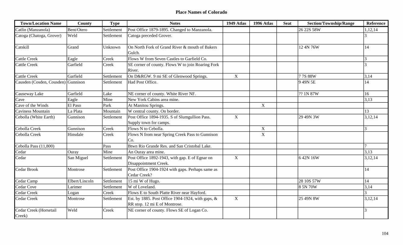
Place Names of Colorado
Town/Location Name County Type Notes 1949 Atlas 1996 Atlas Seat Section/Township/Range ReferenceCatlin (Manzanola) Bent/Otero Settlement Post Office 1879-1895. Changed to Manzanola. 26 22S 58W 1,12,14Catoga (Chatoga, Grover) Weld Settlement Catoga preceded Grover. 3
Catskill Grand Unknown On North Fork of Grand River & mouth of Bakers Gulch.
12 4N 76W 14
Cattle Creek Eagle Creek Flows W from Seven Castles to Garfield Co. 3Cattle Creek Garfield Creek SE corner of county. Flows W to join Roaring Fork
River.3
Cattle Creek Garfield Settlement On D&RGW. 9 mi SE of Glenwood Springs. X 7 7S 88W 3,14Causden (Cosden, Cousden) Gunnison Settlement Had Post Office. 9 49N 5E 14
Causeway Lake Garfield Lake NE corner of county. White River NF. ?? 1N 87W 16Cave Eagle Mine New York Cabins area mine. 3,13Cave of the Winds El Paso Park At Manitou Springs. XCaviness Mountain La Plata Mountain W central county. On border. 13Cebolla (White Earth) Gunnison Settlement Post Office 1894-1935. S of Slumgullion Pass.
Supply town for camps.X 29 49N 3W 3,12,14
Cebolla Creek Gunnison Creek Flows N to Cebolla. X 3Cebolla Creek Hinsdale Creek Flows N from near Spring Creek Pass to Gunnison
Co.X
Cebolla Pass (11,800) Pass Btwn Rio Grande Res. and San Cristobal Lake. 7Cedar Ouray Mine An Ouray area mine. 3,13Cedar San Miguel Settlement Post Office 1892-1943, with gap. E of Egnar on
Disappointment Creek.X 6 42N 16W 3,12,14
Cedar Brook Montrose Settlement Post Office 1904-1924 with gaps. Perhaps same as Cedar Creek?
14
C d C Elb t/Li l S ttl t 15 i W f H 28 10S 57W 14Cedar Camp Elbert/Lincoln Settlement 15 mi W of Hugo. 28 10S 57W 14Cedar Cove Larimer Settlement W of Loveland. 8 5N 70W 3,14Cedar Creek Logan Creek Flows E to South Platte River near Hayford. 3Cedar Creek Montrose Settlement Est. by 1885. Post Office 1904-1924, with gaps, &
RR stop. 12 mi E of Montrose.X 25 49N 8W 3,12,14
Cedar Creek (Horsetail Creek)
Weld Creek NE corner of county. Flows SE of Logan Co. 3
104

Place Names of Colorado
Town/Location Name County Type Notes 1949 Atlas 1996 Atlas Seat Section/Township/Range ReferenceCedar Creek Mine Moffat Mine At head of Cedar Creek. 35 4N 90W 14Cedar Creek Mine Moffat Settlement At head of Cedar Creek. At mine. 35 4N 90W 14Cedar Crest Pueblo Unknown ? 26S 62W 14Cedar Grove Pueblo Unknown 1 23S 67W 14Cedar Gulch Fremont Gulch Central county. Sev 18S 72W 16Cedar Gulch Fremont Gulch North of Canon City. Sev 16S 70/71W 16Cedar Hill Las Animas Settlement School & cemetery. 16 30S 52W 14Cedar Mesa Reservoir Delta Lake North of Cedaredge. Grand Mesa NF. 36 11S 94W 16Cedar Point Elbert Settlement Est. in 1860s. Settlement & station on Smoky Hill
North route. 3 mi NW of River Bend.15 8S 58W 3,4,6,14
Cedar Springs Gulch Fremont Gulch West of Cotopaxi. Sev 48N 11E 16p g pCedar Springs Mountain Fremont Mountain North of Cotopaxi. ?? 48N 11E 16Cedaredge Delta Settlement Est. 1882. Post Office 1894 on. Town grew up on H.
Kohler's Cedar Edge Ranch.X 20 13S 94W 3,12,14
Cedarhurst Huerfano Station Est. by 1923. Close to Las Animas Co. line. 3Cedarhurst Las Animas Settlement Post Office on C&S 1903-1913. 6 mi N of Aguilar. 27 29S 65W 3,12,14
Cedarmont Larimer Settlement 14Cedarwood Pueblo Settlement Post Office on C&S 1912-1943. 23 mi S of Pueblo. X 24 24S 65W 3,12,14
Cedro Pueblo Unknown On Colo-Kans RR. 29 19S 66W 14Celeryvale Adams Station Est. by 1916. RR stop on DL&NW. 1 mi W of
Brighton.1 1S 67W 3,6,14
Celeste (Stunner) Pass (10,541)
Conejos Pass Name on a county map. See Stunner Pass. NW corner of county. Rio Grande NF.
16 36N 4E 7
Cement Fremont Unknown On AT&SF, D&RGW. 17 19S 68W 14C t C k G i C k Fl S i t Sl t Ri O t 3Cement Creek Gunnison Creek Flows S into Slate River near Oversteg. 3Cement Creek San Juan Creek Flows from Gladstone S to Silverton. 1,3,13Cement Creek San Juan Settlement Post Office 1878-1879. 14Cement Creek Taylor River Pass
Gunnison? Pass Gunnison NF. 27 12S 84W
Cement Mountain Gunnison Peak12 SE of Crested Butte. Gunnison NF. ?? 14S 84W 13,16Cenicero (Lobatos) Conejos Settlement Post Office 1894-1902. Changed to Lobatos. 23 33N 9E 12,14
105
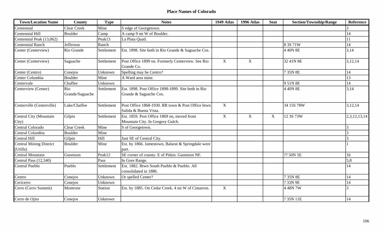
Place Names of Colorado
Town/Location Name County Type Notes 1949 Atlas 1996 Atlas Seat Section/Township/Range ReferenceCentennial Clear Creek Mine S edge of Georgetown. 3Centennial Hill Boulder Camp A camp 9 mi W of Boulder. 14Centennial Peak (13,062) Peak13 La Plata Quad. 11Centennial Ranch Jefferson Ranch 8 3S 71W 14Center (Centerview) Rio Grande Settlement Est. 1898. Site both in Rio Grande & Saguache Cos. 4 40N 8E 3,14
Center (Centerview) Saguache Settlement Post Office 1899 on. Formerly Centerview. See Rio Grande Co.
X X 32 41N 8E 3,12,14
Center (Centro) Conejos Unknown Spelling may be Centro? 7 35N 8E 14Center Columbia Boulder Mine A Ward area mine. 13Centervale Chaffee Unknown 9 51N 8E 14Centerview (Center) Rio
Grande/SaguacheSettlement Est. 1898. Post Office 1898-1899. Site both in Rio
Grande & Saguache Cos.4 40N 8E 3,14
Centerville (Centreville) Lake/Chaffee Settlement Post Office 1868-1930. RR town & Post Office btwn Salida & Buena Vista.
X 34 15S 78W 3,12,14
Central City (Mountain City)
Gilpin Settlement Est. 1859. Post Office 1869 on, moved from Mountain City. In Gregory Gulch.
X X X 12 3S 73W 2,3,12,13,14
Central Colorado Clear Creek Mine S of Georgetown. 3Central Columbia Boulder Mine 3Central Hill Gilpin Hill Just SE of Central City. 3Central Mining District (Utilla)
Boulder Mine Est. by 1866. Jamestown, Balarat & Springdale were part.
1
Central Mountain Gunnison Peak12 SE corner of county. E of Pitkin. Gunnison NF. ?? 50N 5E 16Central Pass (12,340) Pass In Gore Range. 5,8Central Pueblo Pueblo Settlement Est. 1882. Btwn South Pueblo & Pueblo. All
lid t d i 188614
consolidated in 1886.Centro Conejos Unknown Or spelled Center? 7 35N 8E 14Cericerro Conejos Unknown ? 33N 9E 14Cerro (Cerro Summit) Montrose Station Est. by 1885. On Cedar Creek. 4 mi W of Cimarron. X 4 48N 7W 3
Cerro de Ojito Conejos Unknown ? 35N 11E 14
106
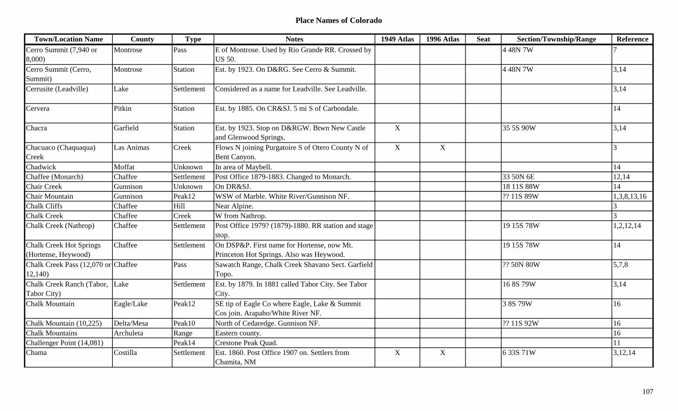
Place Names of Colorado
Town/Location Name County Type Notes 1949 Atlas 1996 Atlas Seat Section/Township/Range ReferenceCerro Summit (7,940 or 8,000)
Montrose Pass E of Montrose. Used by Rio Grande RR. Crossed by US 50.
4 48N 7W 7
Cerro Summit (Cerro, Summit)
Montrose Station Est. by 1923. On D&RG. See Cerro & Summit. 4 48N 7W 3,14
Cerrusite (Leadville) Lake Settlement Considered as a name for Leadville. See Leadville. 3,14
Cervera Pitkin Station Est. by 1885. On CR&SJ. 5 mi S of Carbondale. 14
Chacra Garfield Station Est. by 1923. Stop on D&RGW. Btwn New Castle and Glenwood Springs.
X 35 5S 90W 3,14
Chacuaco (Chaquaqua) Las Animas Creek Flows N joining Purgatoire S of Otero County N of X X 3( q q )Creek
j g g yBent Canyon.
Chadwick Moffat Unknown In area of Maybell. 14Chaffee (Monarch) Chaffee Settlement Post Office 1879-1883. Changed to Monarch. 33 50N 6E 12,14Chair Creek Gunnison Unknown On DR&SJ. 18 11S 88W 14Chair Mountain Gunnison Peak12 WSW of Marble. White River/Gunnison NF. ?? 11S 89W 1,3,8,13,16Chalk Cliffs Chaffee Hill Near Alpine. 3Chalk Creek Chaffee Creek W from Nathrop. 3Chalk Creek (Nathrop) Chaffee Settlement Post Office 1979? (1879)-1880. RR station and stage
stop.19 15S 78W 1,2,12,14
Chalk Creek Hot Springs (Hortense, Heywood)
Chaffee Settlement On DSP&P. First name for Hortense, now Mt. Princeton Hot Springs. Also was Heywood.
19 15S 78W 14
Chalk Creek Pass (12,070 or 12,140)
Chaffee Pass Sawatch Range, Chalk Creek Shavano Sect. Garfield Topo.
?? 50N 80W 5,7,8
Chalk Creek Ranch (Tabor, Tabor City)
Lake Settlement Est. by 1879. In 1881 called Tabor City. See Tabor City.
16 8S 79W 3,14
Ch lk M t i E l /L k P k12 SE ti f E l C h E l L k & S it 3 8S 79W 16Chalk Mountain Eagle/Lake Peak12 SE tip of Eagle Co where Eagle, Lake & Summit Cos join. Arapaho/White River NF.
3 8S 79W 16
Chalk Mountain (10,225) Delta/Mesa Peak10 North of Cedaredge. Gunnison NF. ?? 11S 92W 16Chalk Mountains Archuleta Range Eastern county. 16Challenger Point (14,081) Peak14 Crestone Peak Quad. 11Chama Costilla Settlement Est. 1860. Post Office 1907 on. Settlers from
Chamita, NMX X 6 33S 71W 3,12,14
107

Place Names of Colorado
Town/Location Name County Type Notes 1949 Atlas 1996 Atlas Seat Section/Township/Range ReferenceChama Huerfano Unknown 11 27S 71W 14Chama Lake Archuleta Lake In Tierra Amarilla Land Grant. N of Rio Grande NF. 16
Chama Peak (12,019) Archuleta Peak12 Navajo-Chama Group. SE corner of county. NW of Cresco. Rio Grande NF.
X 3,8,16
Chamberlin Huerfano Station On D&RGW. 14Chambers Larimer Settlement Post Office 1880-1886. Near Chambers Lake. 7 mi
SW of Home.6 7N 75W 3,12,14
Chambers (Gladwyn) Archuleta Settlement Est. by 1923. NW of Blanco on San Juan River. Same as Gladwyn.
15 34N 1W 3,14
Chambers Canal Boulder Canal At Valmont, 12 mi long. 1, gChambers' Fort (Fort Chambers)
Boulder Fort Est. by 1864. Near Valmont, on Chambers' farm. Quickly abandonded.
1,9
Chambers Lake Larimer Lake Far West Larimer Co near divide. XChambers Lake Larimer Settlement Post Office 1926-unknown. 7 mi NW of NW corner
of Rocky Mtn. Park.12,14
Chambers Smelter Custer Mine 3Chamblin Huerfano Station On D&RGW. Same as Chamberlin. 14Champagne Spring Dolores Misc SW corner of county. SSW of Dove Creek. 4 39N 19W 16Champion Gilpin Mine Phoenix area. 3Champion Hinsdale Mine A White Cross area mine. 3,13Champion Huerfano Station On D&RGW. 3 mi NW of Walsenburg. 31 27S 66W 3,14Champion Park Mine NW corner of county. Near Webster Pass. 3Champion San Juan Mine Silverton area mine. 3Champion Summit Mine A Franklin area mine. 3Champion Mine & Mill San Miguel Mine A Pandora area mine. 3Ch B ld C G b 1897 1Chance Boulder Camp Gone by 1897. 1Chance Gunnison Settlement Post Office 1894-1901. 1 mi from Iris (Saguache
County).10 48N 1E 3,12,13,14
Chandler Fremont Settlement Post Office 1890-1942. 4 mi S of Lincoln Park. Same section as Littell.
X 22 19S 70W 3,12,14
Chandler Hinsdale Mine A Carson area mine. 3,13Chaney Gunnison Settlement Post Office 1892-1894. 12,14
108

Place Names of Colorado
Town/Location Name County Type Notes 1949 Atlas 1996 Atlas Seat Section/Township/Range ReferenceChanning Prowers Station Est. by 1909. On AT&SF. 3 mi E of Kornman. 14 22S 46W 3,14Chapel (Graycreek) Las Animas Settlement Post Office 1894-1895. Changed to Graycreek. 35 33S 63W 12,14Chapelton Weld Settlement Rural Post Office 1917-1922. 8 mi W of Wiggins. 10 3N 61W 3,12,14
Chapeta Mountain Chaffee/Gunnison Peak12 SE tip of Gunnison Co. SE of Monarch Pass. Gunnison/San Isabel NF.
6 48N 7E 16
Chapin Kit Carson Settlement Rural Post Office 1890-1894. 6 mi NW of Avendale. 22 6S 49W 3,12,14
Chapin Pass (11,120, 11,140 or 11,550)
Larimer Pass ESE of Fall River Pass. Trail Ridge Topo. Rocky Mtn NP.
5 5N 74W 5,7
Chapleton Weld Settlement Est. by 1924. Rural Post Office 1917-1940. 8 mi W 6p yof Wiggins.
Chapman Boulder Station Est. by 1902. RR stop on BN. 2 mi NW of Hygiene. 23 3N 70W 1,3,6,14
Chapman Mineral Unknown On D&RGW. 15 41N 1E 14Chapman (Grand Butte, New Castle)
Garfield Settlement Post Office 1884-1888. Early name for New Castle (Newcastle). See New Castle.
31 5S 90W 3,12,14
Charcoal Chaffee Settlement Site 1. Est. by 1885. NE of Helena. SE of Midway. Just W of Trout Creek Pass.
23 14S 78W 3,14
Charcoal Chaffee Station Site 2. On D&RGW. Next station W of Poncha Junction.
5 49N 8E 14
Charcoal Center Eagle Unknown See Frying Pan City. 14Charles Mesa Station On D&RGW. 14Charles Baubien Claim No. 4
Costilla Misc Est. by 1885. Land Grant. SW of Fort Garland. 3
Charter Oak Clear Creek Mine Silver Creek area mine. 3Ch Gil i Mi A R ll G l h i 3Chase Gilpin Mine A Russell Gulch area mine. 3Chase (Chase Meadow) Park Settlement Post Office 1892-1911. RR station named Weller. 7 7S 73W 12,14
Chase Gulch Gilpin Gulch Runs E & S to North Clear Creek N of Central City. Arapaho NF.
Sev 3S 73W 16
Chasm Lake Boulder Lake Far NW corner of county. E of Longs Peak. Rocky Mountain Natl Park.
6 3N 73W 16
109
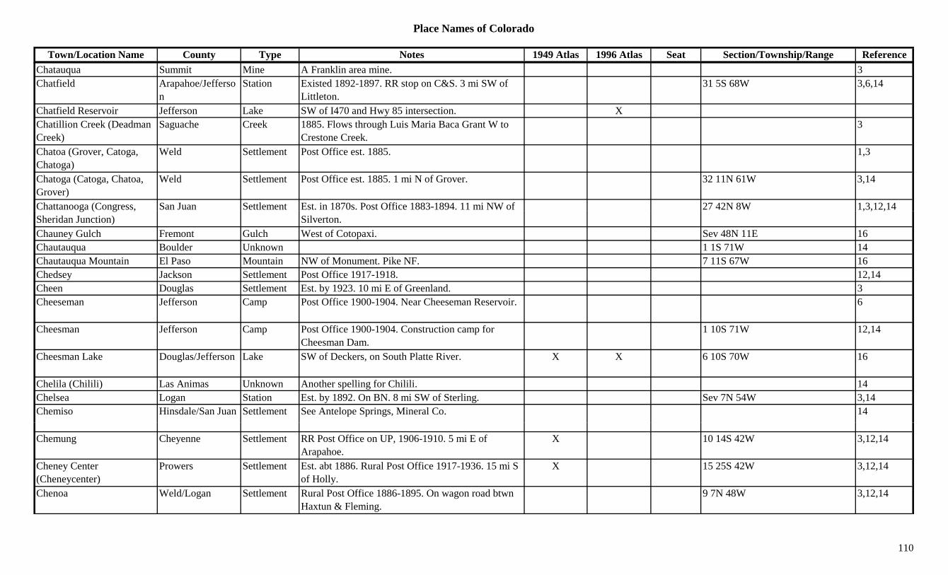
Place Names of Colorado
Town/Location Name County Type Notes 1949 Atlas 1996 Atlas Seat Section/Township/Range ReferenceChatauqua Summit Mine A Franklin area mine. 3Chatfield Arapahoe/Jefferso
nStation Existed 1892-1897. RR stop on C&S. 3 mi SW of
Littleton.31 5S 68W 3,6,14
Chatfield Reservoir Jefferson Lake SW of I470 and Hwy 85 intersection. XChatillion Creek (Deadman Creek)
Saguache Creek 1885. Flows through Luis Maria Baca Grant W to Crestone Creek.
3
Chatoa (Grover, Catoga, Chatoga)
Weld Settlement Post Office est. 1885. 1,3
Chatoga (Catoga, Chatoa, Grover)
Weld Settlement Post Office est. 1885. 1 mi N of Grover. 32 11N 61W 3,14
Chattanooga (Congress, San Juan Settlement Est. in 1870s. Post Office 1883-1894. 11 mi NW of 27 42N 8W 1,3,12,14g ( g ,Sheridan Junction) Silverton.
, , ,
Chauney Gulch Fremont Gulch West of Cotopaxi. Sev 48N 11E 16Chautauqua Boulder Unknown 1 1S 71W 14Chautauqua Mountain El Paso Mountain NW of Monument. Pike NF. 7 11S 67W 16Chedsey Jackson Settlement Post Office 1917-1918. 12,14Cheen Douglas Settlement Est. by 1923. 10 mi E of Greenland. 3Cheeseman Jefferson Camp Post Office 1900-1904. Near Cheeseman Reservoir. 6
Cheesman Jefferson Camp Post Office 1900-1904. Construction camp for Cheesman Dam.
1 10S 71W 12,14
Cheesman Lake Douglas/Jefferson Lake SW of Deckers, on South Platte River. X X 6 10S 70W 16
Chelila (Chilili) Las Animas Unknown Another spelling for Chilili. 14Chelsea Logan Station Est. by 1892. On BN. 8 mi SW of Sterling. Sev 7N 54W 3,14Chemiso Hinsdale/San Juan Settlement See Antelope Springs, Mineral Co. 14
Chemung Cheyenne Settlement RR Post Office on UP, 1906-1910. 5 mi E of Arapahoe.
X 10 14S 42W 3,12,14
Cheney Center (Cheneycenter)
Prowers Settlement Est. abt 1886. Rural Post Office 1917-1936. 15 mi S of Holly.
X 15 25S 42W 3,12,14
Chenoa Weld/Logan Settlement Rural Post Office 1886-1895. On wagon road btwn Haxtun & Fleming.
9 7N 48W 3,12,14
110

Place Names of Colorado
Town/Location Name County Type Notes 1949 Atlas 1996 Atlas Seat Section/Township/Range ReferenceChenoweth Elbert Settlement Rural Post Office 1897-1900. 5 mi W of Fondis.
(Some disagreement).? 9S 62W 3,6,12,14
Cheraw Otero Settlement Platted 1906. On AT&SF. Post Office 1910 on. X X 25 22S 55W 3,12,14
Cherokee (Stonewall, Ten-Mile)
Larimer Station Stage station on Overland route. See Stonewall. 6 mi N of The Forks.
3,14
Cherokee City (Agricola, Latham, Fort Latham)
Weld Settlement Post Office 1862-1863. First called Agricola, then Cherokee City, then Latham.
14 5N 65W 3,12,14
Cherokee Gulch Clear Creek Gulch Near Silver Plume. 13Cherokee Lake Hinsdale Lake SSE of Lake City. Near Continental Divide. Rio
Grande NF.?? 39N 3W 16
Cherokee Park (Saint Cloud)
Larimer Settlement Est. by 1885. Post Office 1913-1933, with gap. X 21 11N 72W 3,12,14
Cherrelyn (Cherrylyn) Arapahoe Settlement Post Office 1894-1916. S of Englewood. 10 5S 68W 3,12,14Cherry Douglas Settlement Rural Post Office 1900-1920. 10 mi E of Larkspur. 6 10S 65W 3,12,14
Cherry Creek Arapahoe Creek Flows from Douglas Co. NW through county to Denver.
X 3
Cherry Creek Arapahoe Creek Flows into and out of Cherry Creek Reservoir through Denver to South Platte River.
16
Cherry Creek Arapahoe Settlement Stage station (12-mile) & Post Office 1869-1886. Across creek from Melvin.
18 5S 66W 1,3,6,12,14
Cherry Creek Denver Creek Flows NW from SW corner of county to South Platte River.
X 3
Cherry Creek Douglas Creek Flows N through E side of county. X 3Cherry Creek La Plata Creek Flows S W of Fort Lewis. 3Ch C k (P l L k ) El P Di id Al ll d A k Pl tt Di idCherry Creek (Palmer Lake) Divide
El Paso Divide Also called Arkansa-Platte Divide.
Cherry Creek Lake (Reservoir)
Arapahoe Lake South of Aurora on Cherry Creek. X 16
Cherry Hills Village Arapahoe Settlement Est. 1940. Platted 1945. Sev 5S 68W 6,14Cherry Knolls Arapahoe Settlement Just E of Southglenn. 14
111

Place Names of Colorado
Town/Location Name County Type Notes 1949 Atlas 1996 Atlas Seat Section/Township/Range ReferenceCherry Valley Arapahoe Station Stage station on Smoky Hill South stage route.
Before 12 Mile House.19 5S 66W 3,6,14
Cherrydale La Plata Settlement Village. 14Cherrylyn (Cherrelyn) Arapahoe Settlement Post Office 1894-1916. See Cherrelyn. 6,14Cherrywood Village Arapahoe Settlement SE of Littleton & S of Southglenn. 14Chester Saguache Station Est. by 1923. On D&RGW. 7 mi E of Sargents. 33 48N 6E 3,14
Cheyenne Lake El Paso Lake At Broadmoor. 35 14S 67W 16Cheyenne Mountain El Paso Mountain SW of Colorado Springs. Pikes Peak Region. Pike
NF.15 15S 67W 8,16
Cheyenne Mountain Zoo El Paso Zoo SW of the Broadmore Hotel. XyCheyenne Pass El Paso Settlement 14Cheyenne Wells Douglas Settlement Site 1. Post Office 1869-1870. 5 mi N of present
town (Site 2).12,14
Cheyenne Wells Greenwood/Cheyenne
Settlement Site 2. Had stage station. Post Office 1876-1895 & 1895 on. Platted 1888.
X X X 20 14S 44W 3,12,14
Chicago Gunnison Mine At Ohio City. 2Chicago Bogs Conejos Lake SW of La Jara Reservoir. Sev 36 34N 5E 16Chicago Creek Clear Creek Creek Runs by Silver Plume, Georgetown. 3,13Chicago Lakes Clear Creek Lake Shown on 1885 map. N of Summit Lake. Arapaho
NF.14/13 5S 74W 3,16
Chicago Mountains Range Part of Front Range. 15Chicago Peak (13,385) Peak13 Telluride Group. Ironton Quad. 8,11Chicago-Colorado Colony (Longmont)
Boulder Settlement Organized in 1870. 50,000 acres. 1,14
Chicken Aspen Canyon Dolores Canyon Central county. Runs SW & S to Peeled Pine C
Sev 41N 17W 16Canyon.
Chicken Aspen Reservoir Dolores Lake East of Dove Creek. San Juan NF. 26 41N 17W 16Chicken Canyon Dolores Canyon Central county. Runs SW to Dolores River. Sev 41N 17W 16Chicken Creek Montezuma Creek Flows S to Mancos. 3Chicken Hill Lake Mine A Leadville area mine. 3Chicken Hill Lake Settlement Section of Leadville. Near California Gulch. 3
112
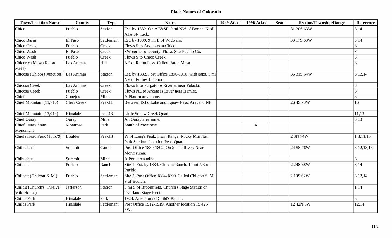
Place Names of Colorado
Town/Location Name County Type Notes 1949 Atlas 1996 Atlas Seat Section/Township/Range ReferenceChico Pueblo Station Est. by 1882. On AT&SF. 9 mi NW of Boone. N of
AT&SF track.31 20S 63W 3,14
Chico Basin El Paso Settlement Est. by 1909. 9 mi E of Wigwam. 33 17S 63W 3,14Chico Creek Pueblo Creek Flows S to Arkansas at Chico. 3Chico Wash El Paso Creek SW corner of county. Flows S to Pueblo Co. 3Chico Wash Pueblo Creek Flows S to Chico Creek. 3Chicorica Mesa (Raton Mesa)
Las Animas Hill NE of Raton Pass. Called Raton Mesa. 3
Chicosa (Chicosa Junction) Las Animas Station Est. by 1882. Post Office 1890-1910, with gaps. 1 mi NE of Forbes Junction.
35 31S 64W 3,12,14
Chicosa Creek Las Animas Creek Flows E to Purgatoire River at near Pulaski. 3gChicosa Creek Pueblo Creek Flows NE to Arkansas River near Hamlet. 3Chief Conejos Mine A Platoro area mine. 3Chief Mountain (11,710) Clear Creek Peak11 Between Echo Lake and Squaw Pass. Arapaho NF. 26 4S 73W 16
Chief Mountain (13,014) Hinsdale Peak13 Little Squaw Creek Quad. 11,13Chief Ouray Ouray Mine An Ouray area mine. 3,13Chief Ouray State Monument
Montrose Park South of Montrose. X
Chiefs Head Peak (13,579) Boulder Peak13 W of Long's Peak. Front Range, Rocky Mtn Natl Park Section. Isolation Peak Quad.
2 3N 74W 1,3,11,16
Chihuahua Summit Camp Post Office 1880-1892. On Snake River. Near Montezuma.
24 5S 76W 3,12,13,14
Chihuahua Summit Mine A Peru area mine. 3Chilcott Pueblo Ranch Site 1. Est. by 1884. Chilcott Ranch. 14 mi NE of
Pueblo.2 24S 68W 3,14
Chil tt (Chil tt S M ) P bl S ttl t Sit 2 P t Offi 1884 1890 C ll d Chil tt S M ? 19S 62W 3 12 14Chilcott (Chilcott S. M.) Pueblo Settlement Site 2. Post Office 1884-1890. Called Chilcott S. M. S of Beulah.
? 19S 62W 3,12,14
Child's (Church's, Twelve Mile House)
Jefferson Station 3 mi S of Broomfield. Church's Stage Station on Overland Stage Route.
1,14
Childs Park Hinsdale Park 1924. Area around Child's Ranch. 3Childs Park Hinsdale Settlement Post Office 1912-1919. Another location 15 42N
5W.12 42N 5W 12,14
113
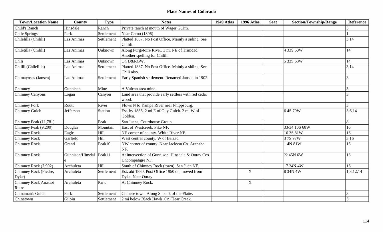
Place Names of Colorado
Town/Location Name County Type Notes 1949 Atlas 1996 Atlas Seat Section/Township/Range ReferenceChild's Ranch Hinsdale Ranch Private ranch at mouth of Wager Gulch. 3Chile Springs Park Settlement Near Como (1896) 1Chilelilla (Chilili) Las Animas Settlement Platted 1887. No Post Office. Mainly a siding. See
Chilili.3,14
Chiletilla (Chilili) Las Animas Unknown Along Purgotoire River. 3 mi NE of Trinidad. Another spelling for Chilili.
4 33S 63W 14
Chili Las Animas Unknown On D&RGW. 5 33S 63W 14Chilili (Chilelilla) Las Animas Settlement Platted 1887. No Post Office. Mainly a siding. See
Chili also.3,14
Chimayosas (Jansen) Las Animas Settlement Early Spanish settlement. Renamed Jansen in 1902. 3
Chimney Gunnison Mine A Vulcan area mine. 3Chimney Canyons Logan Canyon Land area that provide early settlers with red cedar
wood.3
Chimney Fork Routt River Flows N to Yampa River near Phippsburg. 3Chimney Gulch Jefferson Station Est. by 1885. 2 mi E of Guy Gulch. 2 mi W of
Golden.6 4S 70W 3,6,14
Chimney Peak (11,781) Peak San Juans, Courthouse Group. 8Chimney Peak (9,200) Douglas Mountain East of Westcreek. Pike NF. 33/34 10S 68W 16Chimney Rock Eagle Hill NE corner of county. White River NF. 16 3S 81W 16Chimney Rock Garfield Hill West central county. W of Balzac. 3 7S 97W 3,16Chimney Rock Grand Peak10 NW corner of county. Near Jackson Co. Arapaho
NF.1 4N 81W 16
Chimney Rock Gunnison/Hinsdale
Peak11 At intersection of Gunnison, Hinsdale & Ouray Cos. Uncompahgre NF.
?? 45N 6W 16
Chimney Rock (7,902) Archuleta Hill South of Chimney Rock (town). San Juan NF. 17 34N 4W 16Chi R k (Pi d A h l t S ttl t E t bt 1880 P t Offi 1950 d f X 8 34N 4W 1 3 12 14Chimney Rock (Piedre, Dyke)
Archuleta Settlement Est. abt 1880. Post Office 1950 on, moved from Dyke. Near Ouray.
X 8 34N 4W 1,3,12,14
Chimney Rock Anasazi Ruins
Archuleta Park At Chimney Rock. X
Chinaman's Gulch Park Settlement Chinese town. Along S. bank of the Platte. 3Chinatown Gilpin Settlement 2 mi below Black Hawk. On Clear Creek. 3
114

Place Names of Colorado
Town/Location Name County Type Notes 1949 Atlas 1996 Atlas Seat Section/Township/Range ReferenceChinn City (Silver Creek, Chinnston, Chinnton)
Clear Creek Settlement Also Chin Town. On Columbian Mountain near Lawson.
3,13,14
Chinns Lake Clear Creek Lake Northern county. Arapaho NF. ?? 3S 74W 16Chipeta Delta Settlement Post Office 1895. On D&RGW. 7 mi SE of Delta. X 17 51N 10W 3,12,14
Chipeta (Independence) Pitkin Settlement Post Office 1899. 17 mi SE of Aspen. Townsite of Independence.
12 11S 83W 2,12,14
Chipeta (Naturita) Montrose/Gunnison
Settlement Site 1. Post Office 1881-1882. Changed to Naturita. S of Naturita.
19 46N 15W 3,12,14
Chipeta (Vancorum) Montrose Settlement Site 2. On San Miguel River near mouth of Naturita River. Present location Vancorum.
23 46N 16W 14
Chipeta Mountain (12,853) Chaffee Peak12 SW corner of county. Sawatch Range, Fossil Group. San Isabel NF.
?? 48N 6E 8,16
Chipita Park El Paso Settlement Post Office 1935-ca1981. 1 mi SE of Green Mountain Falls.
X 16 13S 68W 3,12,14
Chippewa Lake Mine A Leadville area mine. 3Chiquito Peak (9,635) Conejos Mountain North central county. 19 36N 7E 16Chivington Kiowa Settlement Post Office 1887 on. Railroad boomtown. X X 3 19S 46W 3,12,14Chloride Summit Unknown 4 mi S of Breckenridge. 18 7S 77W 14Chloride (Ashcroft, Highland)
Lake/Pitkin Settlement Est. by 1879. Post Office 1881-1882. Formerly Ashcroft. Re-named Highland.
32 11S 84W 3,12,14
Chloride King Gunnison Mine A Pitkin area mine. 3Chris Mountain (8,800) Archuleta Mountain North of Dyke. San Juan NF. 22 35N 3W 16Christ of the Rockies Summit Misc At Grant. XChristione Saguache Settlement Est. by 1873. 5 mi S of San Isabel. Post Office
spelled Cristonie, also Christo.20 28S 70W 14
Ch (P i ) A h l t S ttl t P t Offi 1885 Fi t P i (b t X X 4 32N 1E 3 12 14Chromo (Price) Archuleta Settlement Post Office 1885 on. First name was Price (but a different location).
X X 4 32N 1E 3,12,14
Chromo Mountain (8,604) Archuleta Mountain NW of Chromo. 5 32N 1E 16Chrysolite Lake Mine A Leadville area mine. 2,3,13Chrysolite (Chrysolite Junction)
Lake Station On D&RG. NE corner of Leadville. 19 9S 79W 14
115
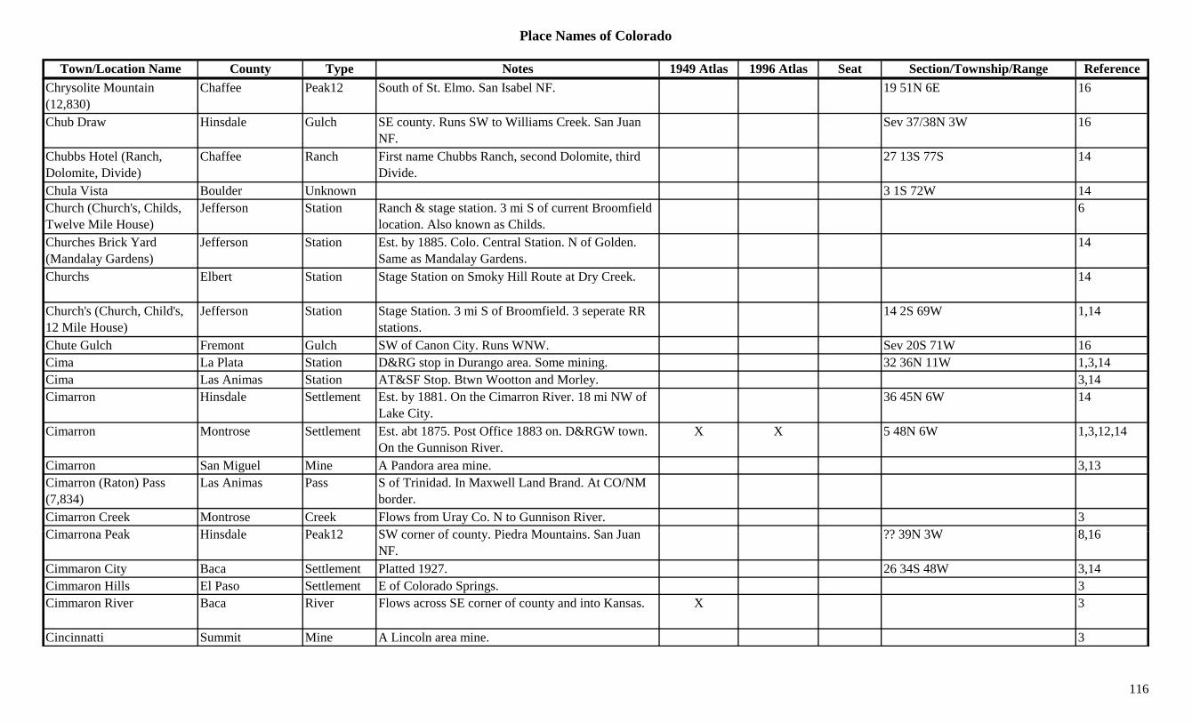
Place Names of Colorado
Town/Location Name County Type Notes 1949 Atlas 1996 Atlas Seat Section/Township/Range ReferenceChrysolite Mountain (12,830)
Chaffee Peak12 South of St. Elmo. San Isabel NF. 19 51N 6E 16
Chub Draw Hinsdale Gulch SE county. Runs SW to Williams Creek. San Juan NF.
Sev 37/38N 3W 16
Chubbs Hotel (Ranch, Dolomite, Divide)
Chaffee Ranch First name Chubbs Ranch, second Dolomite, third Divide.
27 13S 77S 14
Chula Vista Boulder Unknown 3 1S 72W 14Church (Church's, Childs, Twelve Mile House)
Jefferson Station Ranch & stage station. 3 mi S of current Broomfield location. Also known as Childs.
6
Churches Brick Yard (Mandalay Gardens)
Jefferson Station Est. by 1885. Colo. Central Station. N of Golden. Same as Mandalay Gardens.
14
Churchs Elbert Station Stage Station on Smoky Hill Route at Dry Creek. 14
Church's (Church, Child's, 12 Mile House)
Jefferson Station Stage Station. 3 mi S of Broomfield. 3 seperate RR stations.
14 2S 69W 1,14
Chute Gulch Fremont Gulch SW of Canon City. Runs WNW. Sev 20S 71W 16Cima La Plata Station D&RG stop in Durango area. Some mining. 32 36N 11W 1,3,14Cima Las Animas Station AT&SF Stop. Btwn Wootton and Morley. 3,14Cimarron Hinsdale Settlement Est. by 1881. On the Cimarron River. 18 mi NW of
Lake City.36 45N 6W 14
Cimarron Montrose Settlement Est. abt 1875. Post Office 1883 on. D&RGW town. On the Gunnison River.
X X 5 48N 6W 1,3,12,14
Cimarron San Miguel Mine A Pandora area mine. 3,13Cimarron (Raton) Pass (7,834)
Las Animas Pass S of Trinidad. In Maxwell Land Brand. At CO/NM border.
Cimarron Creek Montrose Creek Flows from Uray Co. N to Gunnison River. 3Ci P k Hi d l P k12 SW f t Pi d M t i S J ?? 39N 3W 8 16Cimarrona Peak Hinsdale Peak12 SW corner of county. Piedra Mountains. San Juan
NF.?? 39N 3W 8,16
Cimmaron City Baca Settlement Platted 1927. 26 34S 48W 3,14Cimmaron Hills El Paso Settlement E of Colorado Springs. 3Cimmaron River Baca River Flows across SE corner of county and into Kansas. X 3
Cincinnatti Summit Mine A Lincoln area mine. 3
116
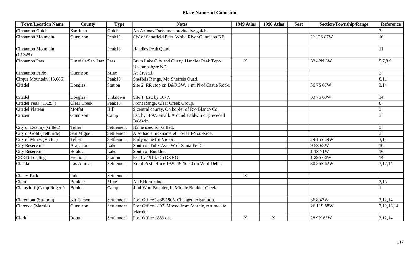
Place Names of Colorado
Town/Location Name County Type Notes 1949 Atlas 1996 Atlas Seat Section/Township/Range ReferenceCinnamon Gulch San Juan Gulch An Animas Forks area productive gulch. 3Cinnamon Mountain Gunnison Peak12 SW of Schofield Pass. White River/Gunnison NF. ?? 12S 87W 16
Cinnamon Mountain (13,328)
Peak13 Handies Peak Quad. 11
Cinnamon Pass Hinsdale/San Juan Pass Btwn Lake City and Ouray. Handies Peak Topo. Uncompahgre NF.
X 33 42N 6W 5,7,8,9
Cinnamon Pride Gunnison Mine At Crystal. 2Cirque Mountain (13,686) Peak13 Sneffels Range. Mt. Sneffels Quad. 8,11Citadel Douglas Station Site 2. RR stop on D&RGW. 1 mi N of Castle Rock. 36 7S 67W 3,14
Citadel Douglas Unknown Site 1. Est. by 1877. 33 7S 68W 14Citadel Peak (13,294) Clear Creek Peak13 Front Range, Clear Creek Group. 8Citadel Plateau Moffat Hill S central county. On border of Rio Blanco Co. 3Citizen Gunnison Camp Est. by 1897. Small. Around Baldwin or preceded
Baldwin.3
City of Destiny (Gillett) Teller Settlement Name used for Gillett. 3City of Gold (Telluride) San Miguel Settlement Also had a nickname of To-Hell-You-Ride. 3City of Mines (Victor) Teller Settlement Early name for Victor. 29 15S 69W 3,14City Reservoir Arapahoe Lake South of Tufts Ave, W of Santa Fe Dr. 9 5S 68W 16City Reservoir Boulder Lake South of Boulder. 1 1S 71W 16CK&N Loading Fremont Station Est. by 1913. On D&RG. 1 29S 66W 14Clanda Las Animas Settlement Rural Post Office 1920-1926. 20 mi W of Delhi. 30 26S 62W 3,12,14
Clanes Park Lake Settlement XClara Boulder Mine An Eldora mine. 3,13Cl d f (C R ) B ld C 4 i W f B ld i Middl B ld C k 1Clarasdorf (Camp Rogers) Boulder Camp 4 mi W of Boulder, in Middle Boulder Creek. 1
Claremont (Stratton) Kit Carson Settlement Post Office 1888-1906. Changed to Stratton. 36 8 47W 3,12,14Clarence (Marble) Gunnison Settlement Post Office 1892. Moved from Marble, returned to
Marble.26 11S 88W 3,12,13,14
Clark Routt Settlement Post Office 1889 on. X X 28 9N 85W 3,12,14
117
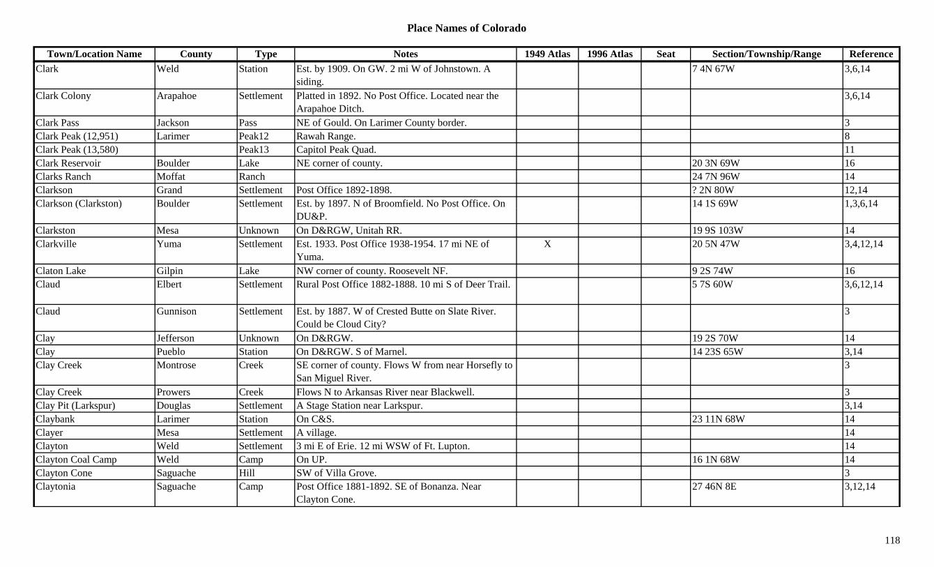
Place Names of Colorado
Town/Location Name County Type Notes 1949 Atlas 1996 Atlas Seat Section/Township/Range ReferenceClark Weld Station Est. by 1909. On GW. 2 mi W of Johnstown. A
siding.7 4N 67W 3,6,14
Clark Colony Arapahoe Settlement Platted in 1892. No Post Office. Located near the Arapahoe Ditch.
3,6,14
Clark Pass Jackson Pass NE of Gould. On Larimer County border. 3Clark Peak (12,951) Larimer Peak12 Rawah Range. 8Clark Peak (13,580) Peak13 Capitol Peak Quad. 11Clark Reservoir Boulder Lake NE corner of county. 20 3N 69W 16Clarks Ranch Moffat Ranch 24 7N 96W 14Clarkson Grand Settlement Post Office 1892-1898. ? 2N 80W 12,14Clarkson (Clarkston) Boulder Settlement Est. by 1897. N of Broomfield. No Post Office. On 14 1S 69W 1,3,6,14( ) y
DU&P., , ,
Clarkston Mesa Unknown On D&RGW, Unitah RR. 19 9S 103W 14Clarkville Yuma Settlement Est. 1933. Post Office 1938-1954. 17 mi NE of
Yuma.X 20 5N 47W 3,4,12,14
Claton Lake Gilpin Lake NW corner of county. Roosevelt NF. 9 2S 74W 16Claud Elbert Settlement Rural Post Office 1882-1888. 10 mi S of Deer Trail. 5 7S 60W 3,6,12,14
Claud Gunnison Settlement Est. by 1887. W of Crested Butte on Slate River. Could be Cloud City?
3
Clay Jefferson Unknown On D&RGW. 19 2S 70W 14Clay Pueblo Station On D&RGW. S of Marnel. 14 23S 65W 3,14Clay Creek Montrose Creek SE corner of county. Flows W from near Horsefly to
San Miguel River.3
Clay Creek Prowers Creek Flows N to Arkansas River near Blackwell. 3Clay Pit (Larkspur) Douglas Settlement A Stage Station near Larkspur. 3,14Cl b k L i St ti O C&S 23 11N 68W 14Claybank Larimer Station On C&S. 23 11N 68W 14Clayer Mesa Settlement A village. 14Clayton Weld Settlement 3 mi E of Erie. 12 mi WSW of Ft. Lupton. 14Clayton Coal Camp Weld Camp On UP. 16 1N 68W 14Clayton Cone Saguache Hill SW of Villa Grove. 3Claytonia Saguache Camp Post Office 1881-1892. SE of Bonanza. Near
Clayton Cone.27 46N 8E 3,12,14
118
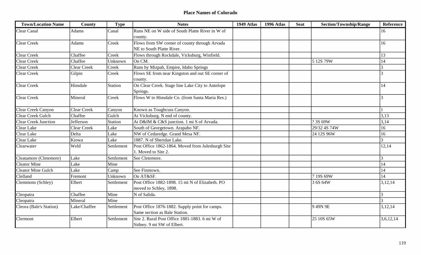
Place Names of Colorado
Town/Location Name County Type Notes 1949 Atlas 1996 Atlas Seat Section/Township/Range ReferenceClear Canal Adams Canal Runs NE on W side of South Platte River in W of
county.16
Clear Creek Adams Creek Flows from SW corner of county through Arvada NE to South Platte River.
16
Clear Creek Chaffee Creek Flows through Rockdale, Vicksburg, Winfield. 13Clear Creek Chaffee Unknown On CM. 5 12S 79W 14Clear Creek Clear Creek Creek Runs by Mizpah, Empire, Idaho Springs 3Clear Creek Gilpin Creek Flows SE from near Kingston and out SE corner of
county.3
Clear Creek Hinsdale Station On Clear Creek. Stage line Lake City to Antelope Springs.
14
Clear Creek Mineral Creek Flows W to Hinsdale Co. (from Santa Maria Res.) 3
Clear Creek Canyon Clear Creek Canyon Known as Toughcuss Canyon. 1Clear Creek Gulch Chaffee Gulch At Vicksburg. N end of county. 3,13Clear Creek Junction Jefferson Station At D&IM & C&S junction. 1 mi S of Arvada. ? 3S 69W 3,14Clear Lake Clear Creek Lake South of Georgetown. Arapaho NF. 29/32 4S 74W 16Clear Lake Delta Lake NW of Cedaredge. Grand Mesa NF. 24 12S 96W 16Clear Lake Kiowa Lake 1887. N of Sheridan Lake. 3Clearwater Weld Settlement Post Office 1862-1864. Moved from Julesburgh Site
1. Moved to Site 2.12,14
Cleatamore (Cletemore) Lake Settlement See Cletemore. 3Cleator Mine Lake Mine 14Cleator Mine Gulch Lake Camp See Finntown. 14Clelland Fremont Unknown On AT&SF. 7 19S 69W 14Clemmons (Schley) Elbert Settlement Post Office 1882-1898. 15 mi N of Elizabeth. PO
d t S hl 18983 6S 64W 3,12,14
moved to Schley, 1898.Cleopatra Chaffee Mine N of Salida. 3Cleopatra Mineral Mine 3Cleora (Bale's Station) Lake/Chaffee Settlement Post Office 1876-1882. Supply point for camps.
Same section as Bale Station.9 49N 9E 3,12,14
Clermont Elbert Settlement Site 2. Rural Post Office 1881-1883. 6 mi W of Sidney. 9 mi SW of Elbert.
25 10S 65W 3,6,12,14
119
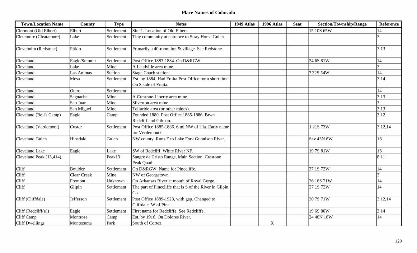
Place Names of Colorado
Town/Location Name County Type Notes 1949 Atlas 1996 Atlas Seat Section/Township/Range ReferenceClermont (Old Elbert) Elbert Settlement Site 1. Location of Old Elbert. 15 10S 65W 14Cletemore (Cleatamore) Lake Settlement Tiny community at entrance to Stray Horse Gulch. 3
Cleveholm (Redstone) Pitkin Settlement Primarily a 40-room inn & village. See Redstone. 3,13
Cleveland Eagle/Summit Settlement Post Office 1883-1884. On D&RGW. 24 6S 81W 14Cleveland Lake Mine A Leadville area mine. 3Cleveland Las Animas Station Stage Coach station. ? 32S 54W 14Cleveland Mesa Settlement Est. by 1884. Had Fruita Post Office for a short time.
On S side of Fruita.3,14
Cleveland Otero Settlement 14Cleveland Saguache Mine A Crestone-Liberty area mine. 3,13Cleveland San Juan Mine Silverton area mine. 3Cleveland San Miguel Mine Telluride area (or other mines). 3,13Cleveland (Bell's Camp) Eagle Camp Founded 1880. Post Office 1885-1886. Btwn
Redcliff and Gilman.3,12
Cleveland (Verdemont) Custer Settlement Post Office 1885-1886. 6 mi NW of Ula. Early name for Verdemont?
1 21S 73W 3,12,14
Cleveland Gulch Hinsdale Gulch NW county. Runs E to Lake Fork Gunnison River. Sev 43N 6W 16
Cleveland Lake Eagle Lake SW of Redcliff. White River NF. 19 7S 81W 16Cleveland Peak (13,414) Peak13 Sangre de Cristo Range, Main Section. Crestone
Peak Quad.8,11
Cliff Boulder Settlement On D&RGW. Name for Pinecliffe. 27 1S 72W 14Cliff Clear Creek Mine NW of Georgetown. 3Cliff Fremont Unknown On Arkansas River at mouth of Royal Gorge. 36 18S 71W 14Cliff Gil i S ttl t Th t f Pi liff th t i S f th Ri i Gil i 27 1S 72W 14Cliff Gilpin Settlement The part of Pinecliffe that is S of the River in Gilpin
Co.27 1S 72W 14
Cliff (Cliffdale) Jefferson Settlement Post Office 1889-1923, with gap. Changed to Cliffdale. W of Pine.
30 7S 71W 3,12,14
Cliff (Redcliff(e)) Eagle Settlement First name for Redcliffe. See Redcliffe. 19 6S 80W 3,14Cliff Camp Montrose Camp Est. by 1916. On Dolores River. 24 48N 18W 14Cliff Dwellings Montezuma Park South of Cortez. X
120

Place Names of Colorado
Town/Location Name County Type Notes 1949 Atlas 1996 Atlas Seat Section/Township/Range ReferenceCliff Lakes Conejos Lake NE of Cornwall Mountain. NW corner of county.
Rio Grande NF.11/12 36N 4.5E 16
Cliff Spring Garfield Creek 1885. 9 mi E of Spring. On the Book Plateau. 3Cliff Spur Larimer Station 2 mi N of Stout. 10 mi SW of Fort Collins. 14Cliffdale (Cliff) Jefferson Settlement Post Office 1923-1933. Formerly Cliff. 30 7S 71W 6,12,14Clifford (Bald Mountain) Gilpin Camp Est. by 1876. At head of York Gulch. SW of Central
City. Same as Bald Mtn.11 3S 73W 3,14
Clifford (Mirage) Lincoln Station Post Office 1908-1918. On UP. 8 mi SE of Hugo. Mirage was RR name.
X 32 11S 53W 3,12,14
Clifton Boulder Station Est. by 1884. RR stop on UP. 6 mi E of Boulder. 3,6,14
Clifton Lake Camp At Shields Mill on Sugar Loaf Mtn. 2.5 mi above Soda Springs.
22 8S 79W 3,14
Clifton Mesa Station Est. 1882. On D&RGW. Post Office 1900 on. X X 2 1S 1E 1,3,12,14Clifton (Westcliffe) Custer Settlement Post Office est. 1881. 46 mi SW of Canon City. First
name for Westcleffe.17 22S 72W 2,13,14
Clifton Camp (Shavano) Chaffee Camp Early name for Shavano. See Shavano. 10 50W 6E 3,14Climax Park Mine A Puma area mine. 3Climax (Fremont Pass) Lake Settlement Post Office 1887-1898 & 1917 on. Small camp
during Leadville boom.X X 11 8S 79W 1,3,12,14
Climax Camp Mesa Camp A Uranium Camp. 12 50N 18W 14Clinard Lake Garfield Lake NE corner of county. White River NF. ?? 1S 88W 16Clines Gunnison Unknown Est. by 1882. On the Cimarron River. 14Clinton Custer Settlement Post Office 1879-1881. Stage stop, Post Office,
sawmill. 9 mi NW of Sliver Park.? 21S 71W 3,12,14
Clinton Hinsdale Mine A Sherman area mine. 3,13Cli t (Gil ) E l S ttl t E l f Cli t S Gil 13 6S 81W 3 13 14Clinton (Gilman) Eagle Settlement Early name for Clinton. See Gilman. 13 6S 81W 3,13,14Clinton City Summit Settlement S of Kokomo. Absorbed. 23 7S 79W 3,14Clinton Peak (13,857) Peak13 Mosquito Range. Climax Quad. 8,11Clipper Ouray Mine An Ouray area mine. 3,13Clock Lake Garfield Lake NW corner of county. White River NF. 13 3S 89W 16Clonmell (Cramer) Fremont Settlement Post Office 1898-1901. Changed to Cramer. 3 18S 69W 12,14Cloud Larimer Unknown 28 11N 72W 14
121
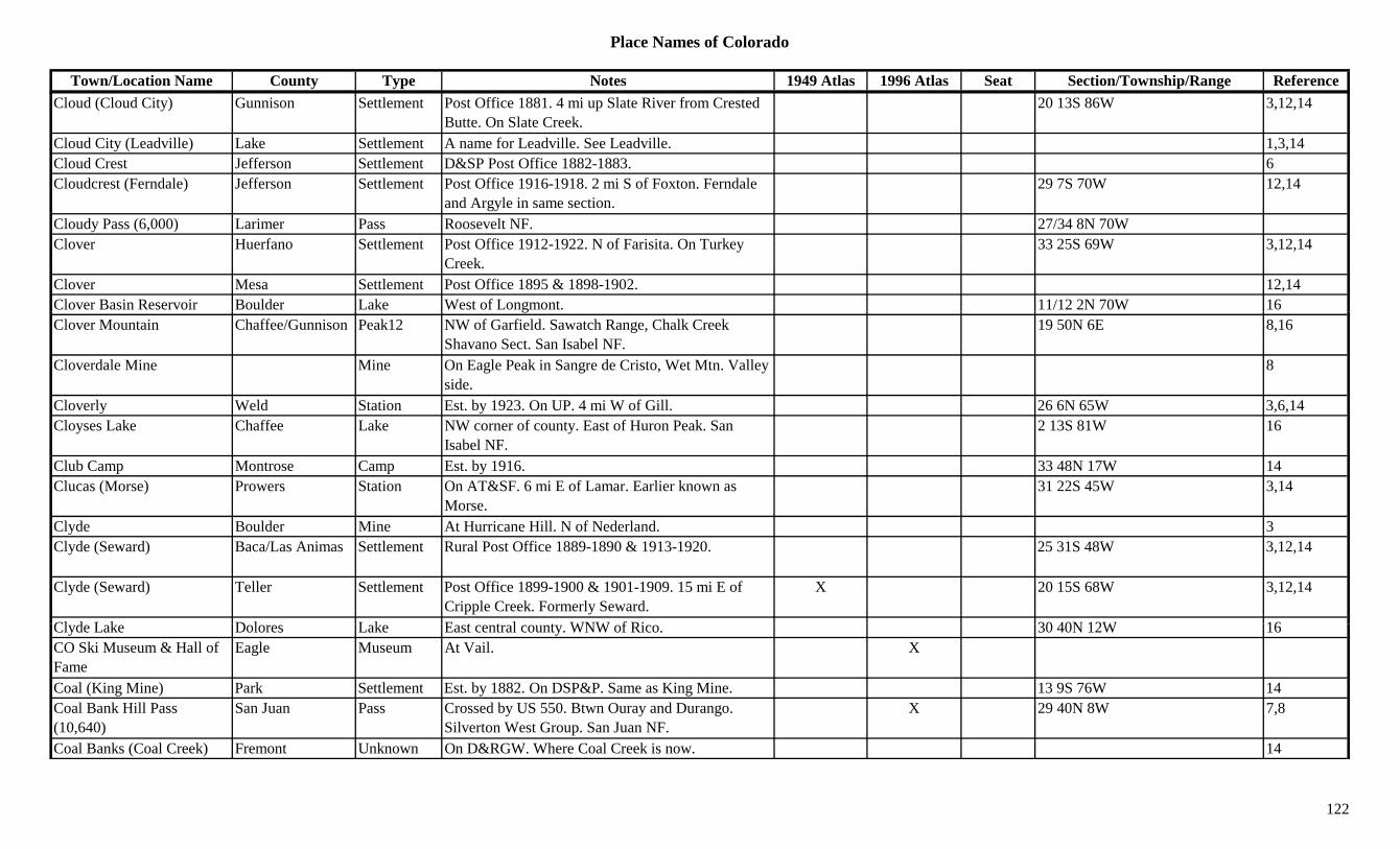
Place Names of Colorado
Town/Location Name County Type Notes 1949 Atlas 1996 Atlas Seat Section/Township/Range ReferenceCloud (Cloud City) Gunnison Settlement Post Office 1881. 4 mi up Slate River from Crested
Butte. On Slate Creek.20 13S 86W 3,12,14
Cloud City (Leadville) Lake Settlement A name for Leadville. See Leadville. 1,3,14Cloud Crest Jefferson Settlement D&SP Post Office 1882-1883. 6Cloudcrest (Ferndale) Jefferson Settlement Post Office 1916-1918. 2 mi S of Foxton. Ferndale
and Argyle in same section.29 7S 70W 12,14
Cloudy Pass (6,000) Larimer Pass Roosevelt NF. 27/34 8N 70WClover Huerfano Settlement Post Office 1912-1922. N of Farisita. On Turkey
Creek.33 25S 69W 3,12,14
Clover Mesa Settlement Post Office 1895 & 1898-1902. 12,14Clover Basin Reservoir Boulder Lake West of Longmont. 11/12 2N 70W 16gClover Mountain Chaffee/Gunnison Peak12 NW of Garfield. Sawatch Range, Chalk Creek
Shavano Sect. San Isabel NF.19 50N 6E 8,16
Cloverdale Mine Mine On Eagle Peak in Sangre de Cristo, Wet Mtn. Valley side.
8
Cloverly Weld Station Est. by 1923. On UP. 4 mi W of Gill. 26 6N 65W 3,6,14Cloyses Lake Chaffee Lake NW corner of county. East of Huron Peak. San
Isabel NF.2 13S 81W 16
Club Camp Montrose Camp Est. by 1916. 33 48N 17W 14Clucas (Morse) Prowers Station On AT&SF. 6 mi E of Lamar. Earlier known as
Morse.31 22S 45W 3,14
Clyde Boulder Mine At Hurricane Hill. N of Nederland. 3Clyde (Seward) Baca/Las Animas Settlement Rural Post Office 1889-1890 & 1913-1920. 25 31S 48W 3,12,14
Clyde (Seward) Teller Settlement Post Office 1899-1900 & 1901-1909. 15 mi E of Cripple Creek. Formerly Seward.
X 20 15S 68W 3,12,14
Cl d L k D l L k E t t l t WNW f Ri 30 40N 12W 16Clyde Lake Dolores Lake East central county. WNW of Rico. 30 40N 12W 16CO Ski Museum & Hall of Fame
Eagle Museum At Vail. X
Coal (King Mine) Park Settlement Est. by 1882. On DSP&P. Same as King Mine. 13 9S 76W 14Coal Bank Hill Pass (10,640)
San Juan Pass Crossed by US 550. Btwn Ouray and Durango. Silverton West Group. San Juan NF.
X 29 40N 8W 7,8
Coal Banks (Coal Creek) Fremont Unknown On D&RGW. Where Coal Creek is now. 14
122

Place Names of Colorado
Town/Location Name County Type Notes 1949 Atlas 1996 Atlas Seat Section/Township/Range ReferenceCoal Basin Pitkin Gulch 1881 3Coal Basin Coal Mine Pitkin Mine A Placita area mine. 3Coal Bed Canyon Dolores Canyon NW county. Runs S & SSW into UT. Sev 41N 20W 16Coal Branc Junction Park Station On C&S, DSP&P. Close to King Mine. 26 8S 76W 14Coal Camp Chaffee Camp Est. by 1882. On DSP&P. 27 15S 80W 14Coal Creek Adams Creek Flows N in SE corner of county and into Washington
Co.16
Coal Creek Arapahoe Creek Flows NW past NE side of Buckley Naval Air Station and into Adams Co.
16
Coal Creek Arapahoe Station Stage station on Smoky Hill North stage route. Btwn Box Elder & Toll Gate.
3,6,14
Coal Creek Boulder Settlement Post Office 1864-1873. Less than 1 mi W of Louisville.
5 1S 69W 3,6,12,14
Coal Creek Fremont Creek Flows N to Arkansas River at Florence. 3Coal Creek Gunnison Creek Flows E into Crested Butte. 3Coal Creek Jefferson Station Est. by 1909. On D&RG. 1 mi S of Plainview. 13 2S 71W 3,6Coal Creek Moffat Creek Flows S into Rio Blanco Co. E of Massadona. 3Coal Creek Rio Blanco Creek Flows W & S to join the White River E of Meeker. 3
Coal Creek Weld Creek Flows SE to join Crow Creek btwn Cornish and Fosston.
3
Coal Creek (Coalcreek) Fremont Settlement Post Office 1873-1894 & 1964 on. Formerly Coalcreek, changed to Coalcreek.
30 19S 69W 12,14
Coal Creek (Cold Creek) Boulder Creek SE Boulder County. 1Coal Creek Junction Fremont Station Est. by 1887. Stop on D&RG. 3 mi NE of Coal
Creek.3
C l C k PO (C d l J ff S ttl t 5 i W f Pl i i At it C d l 6Coal Creek PO (Copperdale PO)
Jefferson Settlement 5 mi W of Plainview. At same site as Copperdale PO.
6
Coal Creek Store Jefferson Store Same section as Crescent Park. 4 2S 71W 14Coal Lands El Paso Misc Btwn Manitou Junction and Bierstadt. 3Coal Mine Jefferson Settlement Est. by 1923. E of Plainview. Close to Rocky Flats. 3,6
123
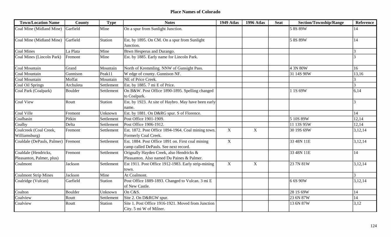
Place Names of Colorado
Town/Location Name County Type Notes 1949 Atlas 1996 Atlas Seat Section/Township/Range ReferenceCoal Mine (Midland Mine) Garfield Mine On a spur from Sunlight Junction. 5 8S 89W 14
Coal Mine (Midland Mine) Garfield Station Est. by 1895. On CM. On a spur from Sunlight Junction.
5 8S 89W 14
Coal Mines La Plata Mine Btwn Hesperus and Durango. 3Coal Mines (Lincoln Park) Fremont Mine Est. by 1885. Early name for Lincoln Park. 3
Coal Mountain Grand Mountain North of Kremmling. NNW of Gunsight Pass. 4 3N 80W 16Coal Mountain Gunnison Peak11 W edge of county. Gunnison NF. 31 14S 90W 13,16Coal Mountain Moffat Mountain NE of Price Creek. 3Coal Oil Springs Archuleta Settlement Est. by 1885. 7 mi E of Price. 3p g yCoal Park (Coalpark) Boulder Settlement On B&W. Post Office 1890-1895. Spelling changed
to Coalpark.1 1S 69W 6,14
Coal View Routt Station Est. by 1923. At site of Haybro. May have been early name.
3
Coal Ville Fremont Unknown Est. by 1881. On D&RG spur. S of Florence. 14Coalbasin Pitkin Settlement Post Office 1901-1909. 5 10S 89W 12,14Coalby Delta Settlement Post Office 1906-1912. 11 13S 95W 12,14Coalcreek (Coal Creek, Williamsburg)
Fremont Settlement Est. 1872. Post Office 1894-1964. Coal mining town. Formerly Coal Creek.
X X 30 19S 69W 3,12,14
Coaldale (DePauls, Palmer) Fremont Settlement Est. 1884. Post Office 1891 on. First coal mining camp called DePauls. See next record.
X 33 48N 11E 3,12,14
Coaldale (Hendricks, Pleasanton, Palmer, plus)
Fremont Settlement Orignally Hayden Creek, also Hendricks & Pleasanton. Also named Du Paines & Palmer.
33 48N 11E 14
Coalmont Jackson Settlement Est 1911. Post Office 1912-1983. Early strip-mining town.
X X 23 7N 81W 3,12,14
C l t St i Mi J k Mi At C l t 3Coalmont Strip Mines Jackson Mine At Coalmont. 3Coalridge (Vulcan) Garfield Station Post Office 1889-1893. Changed to Vulcan. 3 mi E
of New Castle.6 6S 90W 3,12,14
Coalton Boulder Unknown On C&S. 28 1S 69W 14Coalview Routt Settlement Site 2. On D&RGW spur. 23 6N 87W 14Coalview Routt Station Site 1. Post Office 1916-1921. Moved from Junction
City. 5 mi W of Milner.13 6N 87W 3,12
124
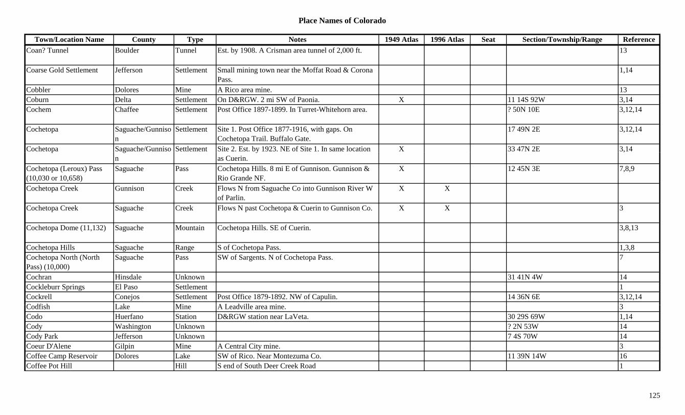
Place Names of Colorado
Town/Location Name County Type Notes 1949 Atlas 1996 Atlas Seat Section/Township/Range ReferenceCoan? Tunnel Boulder Tunnel Est. by 1908. A Crisman area tunnel of 2,000 ft. 13
Coarse Gold Settlement Jefferson Settlement Small mining town near the Moffat Road & Corona Pass.
1,14
Cobbler Dolores Mine A Rico area mine. 13Coburn Delta Settlement On D&RGW. 2 mi SW of Paonia. X 11 14S 92W 3,14Cochem Chaffee Settlement Post Office 1897-1899. In Turret-Whitehorn area. ? 50N 10E 3,12,14
Cochetopa Saguache/Gunnison
Settlement Site 1. Post Office 1877-1916, with gaps. On Cochetopa Trail. Buffalo Gate.
17 49N 2E 3,12,14
Cochetopa Saguache/Gunniso Settlement Site 2. Est. by 1923. NE of Site 1. In same location X 33 47N 2E 3,14p gn
yas Cuerin.
,
Cochetopa (Leroux) Pass (10,030 or 10,658)
Saguache Pass Cochetopa Hills. 8 mi E of Gunnison. Gunnison & Rio Grande NF.
X 12 45N 3E 7,8,9
Cochetopa Creek Gunnison Creek Flows N from Saguache Co into Gunnison River W of Parlin.
X X
Cochetopa Creek Saguache Creek Flows N past Cochetopa & Cuerin to Gunnison Co. X X 3
Cochetopa Dome (11,132) Saguache Mountain Cochetopa Hills. SE of Cuerin. 3,8,13
Cochetopa Hills Saguache Range S of Cochetopa Pass. 1,3,8Cochetopa North (North Pass) (10,000)
Saguache Pass SW of Sargents. N of Cochetopa Pass. 7
Cochran Hinsdale Unknown 31 41N 4W 14Cockleburr Springs El Paso Settlement 1Cockrell Conejos Settlement Post Office 1879-1892. NW of Capulin. 14 36N 6E 3,12,14C dfi h L k Mi A L d ill i 3Codfish Lake Mine A Leadville area mine. 3Codo Huerfano Station D&RGW station near LaVeta. 30 29S 69W 1,14Cody Washington Unknown ? 2N 53W 14Cody Park Jefferson Unknown 7 4S 70W 14Coeur D'Alene Gilpin Mine A Central City mine. 3Coffee Camp Reservoir Dolores Lake SW of Rico. Near Montezuma Co. 11 39N 14W 16Coffee Pot Hill Hill S end of South Deer Creek Road 1
125
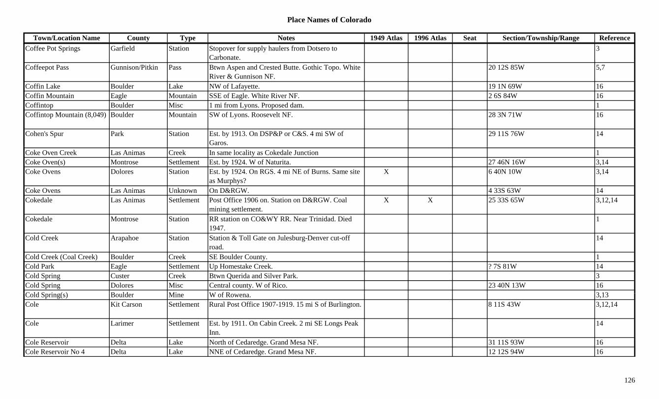
Place Names of Colorado
Town/Location Name County Type Notes 1949 Atlas 1996 Atlas Seat Section/Township/Range ReferenceCoffee Pot Springs Garfield Station Stopover for supply haulers from Dotsero to
Carbonate.3
Coffeepot Pass Gunnison/Pitkin Pass Btwn Aspen and Crested Butte. Gothic Topo. White River & Gunnison NF.
20 12S 85W 5,7
Coffin Lake Boulder Lake NW of Lafayette. 19 1N 69W 16Coffin Mountain Eagle Mountain SSE of Eagle. White River NF. 2 6S 84W 16Coffintop Boulder Misc 1 mi from Lyons. Proposed dam. 1Coffintop Mountain (8,049) Boulder Mountain SW of Lyons. Roosevelt NF. 28 3N 71W 16
Cohen's Spur Park Station Est. by 1913. On DSP&P or C&S. 4 mi SW of Garos.
29 11S 76W 14
Coke Oven Creek Las Animas Creek In same locality as Cokedale Junction 1Coke Oven(s) Montrose Settlement Est. by 1924. W of Naturita. 27 46N 16W 3,14Coke Ovens Dolores Station Est. by 1924. On RGS. 4 mi NE of Burns. Same site
as Murphys?X 6 40N 10W 3,14
Coke Ovens Las Animas Unknown On D&RGW. 4 33S 63W 14Cokedale Las Animas Settlement Post Office 1906 on. Station on D&RGW. Coal
mining settlement.X X 25 33S 65W 3,12,14
Cokedale Montrose Station RR station on CO&WY RR. Near Trinidad. Died 1947.
1
Cold Creek Arapahoe Station Station & Toll Gate on Julesburg-Denver cut-off road.
14
Cold Creek (Coal Creek) Boulder Creek SE Boulder County. 1Cold Park Eagle Settlement Up Homestake Creek. ? 7S 81W 14Cold Spring Custer Creek Btwn Querida and Silver Park. 3Cold Spring Dolores Misc Central county. W of Rico. 23 40N 13W 16C ld S i ( ) B ld Mi W f R 3 13Cold Spring(s) Boulder Mine W of Rowena. 3,13Cole Kit Carson Settlement Rural Post Office 1907-1919. 15 mi S of Burlington. 8 11S 43W 3,12,14
Cole Larimer Settlement Est. by 1911. On Cabin Creek. 2 mi SE Longs Peak Inn.
14
Cole Reservoir Delta Lake North of Cedaredge. Grand Mesa NF. 31 11S 93W 16Cole Reservoir No 4 Delta Lake NNE of Cedaredge. Grand Mesa NF. 12 12S 94W 16
126
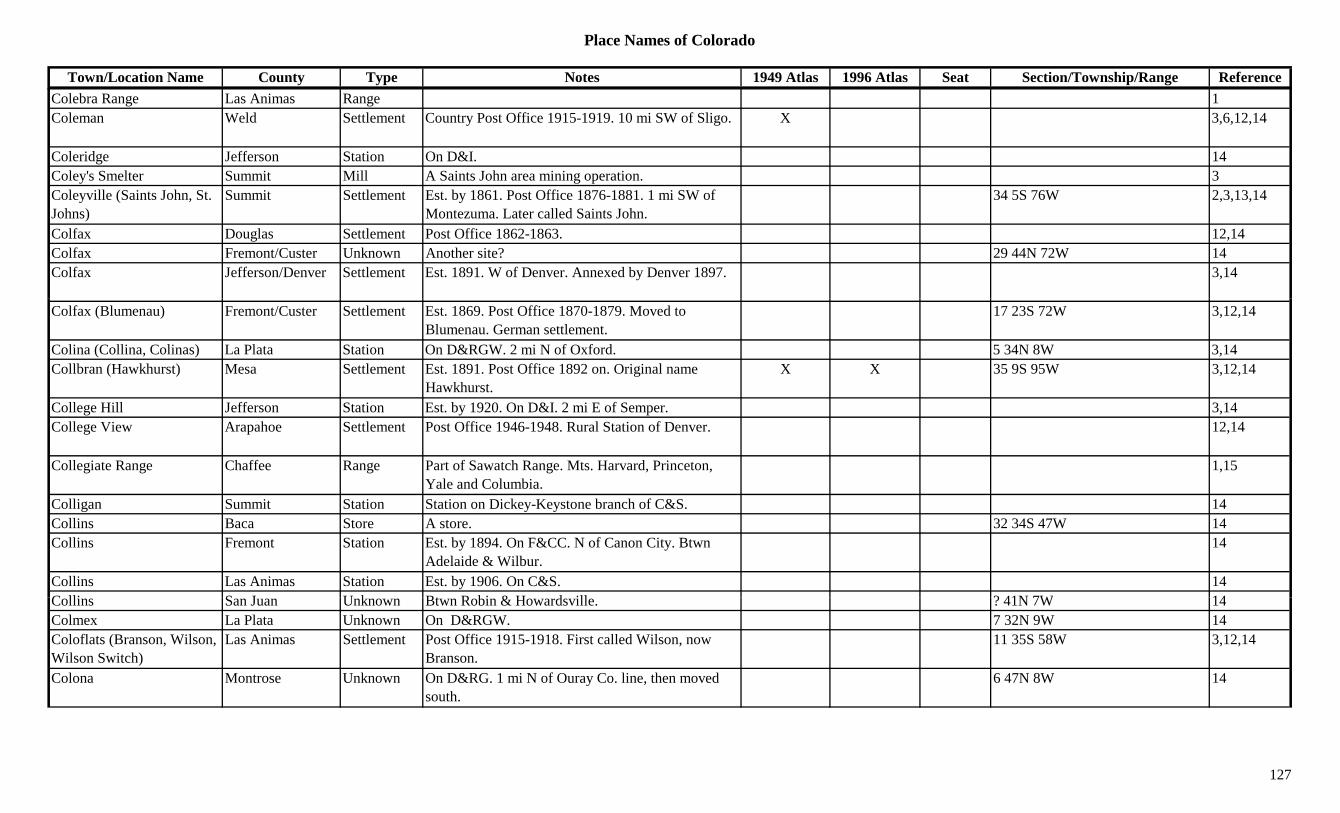
Place Names of Colorado
Town/Location Name County Type Notes 1949 Atlas 1996 Atlas Seat Section/Township/Range ReferenceColebra Range Las Animas Range 1Coleman Weld Settlement Country Post Office 1915-1919. 10 mi SW of Sligo. X 3,6,12,14
Coleridge Jefferson Station On D&I. 14Coley's Smelter Summit Mill A Saints John area mining operation. 3Coleyville (Saints John, St. Johns)
Summit Settlement Est. by 1861. Post Office 1876-1881. 1 mi SW of Montezuma. Later called Saints John.
34 5S 76W 2,3,13,14
Colfax Douglas Settlement Post Office 1862-1863. 12,14Colfax Fremont/Custer Unknown Another site? 29 44N 72W 14Colfax Jefferson/Denver Settlement Est. 1891. W of Denver. Annexed by Denver 1897. 3,14
Colfax (Blumenau) Fremont/Custer Settlement Est. 1869. Post Office 1870-1879. Moved to Blumenau. German settlement.
17 23S 72W 3,12,14
Colina (Collina, Colinas) La Plata Station On D&RGW. 2 mi N of Oxford. 5 34N 8W 3,14Collbran (Hawkhurst) Mesa Settlement Est. 1891. Post Office 1892 on. Original name
Hawkhurst.X X 35 9S 95W 3,12,14
College Hill Jefferson Station Est. by 1920. On D&I. 2 mi E of Semper. 3,14College View Arapahoe Settlement Post Office 1946-1948. Rural Station of Denver. 12,14
Collegiate Range Chaffee Range Part of Sawatch Range. Mts. Harvard, Princeton, Yale and Columbia.
1,15
Colligan Summit Station Station on Dickey-Keystone branch of C&S. 14Collins Baca Store A store. 32 34S 47W 14Collins Fremont Station Est. by 1894. On F&CC. N of Canon City. Btwn
Adelaide & Wilbur.14
Collins Las Animas Station Est. by 1906. On C&S. 14C lli S J U k Bt R bi & H d ill ? 41N 7W 14Collins San Juan Unknown Btwn Robin & Howardsville. ? 41N 7W 14Colmex La Plata Unknown On D&RGW. 7 32N 9W 14Coloflats (Branson, Wilson, Wilson Switch)
Las Animas Settlement Post Office 1915-1918. First called Wilson, now Branson.
11 35S 58W 3,12,14
Colona Montrose Unknown On D&RG. 1 mi N of Ouray Co. line, then moved south.
6 47N 8W 14
127

Place Names of Colorado
Town/Location Name County Type Notes 1949 Atlas 1996 Atlas Seat Section/Township/Range ReferenceColona (Auroria, Laporte) Nebraska Terr. Settlement Post Office 1860-1861. Moved from Auroria. See
Laporte.3,12,14
Colona (Hotchkiss) Ouray Settlement Post Office 1891-1943. 13 mi N of Ridgway. X X 17 47N 8W 3,14Colonel Settars Park Mine A Puma area mine. 3Colons Ferry Costilla Ferry Error in location which is listed 22 33N 11E. 14Colony Baldy (13,705) Peak13 Sangre de Cristo Range, Main Section. Mt. Harvard
Quad.8,11
Colony Bar (Masonville) Clear Creek Settlement First name for Masonville. 32 3S 72W 14Colora Gunnison Mine A Gothic area mine. 3Colorado Gilpin Mine A Rollinsville area mine. 13Colorado #2 Lake Mine A Leadville area mine. 3Colorado (Colorado City) El Paso Settlement Same as Colorado City. x Sev 14S 67W 14Colorado Canal Crowley Canal From Pueblo Co, N of Arkansas River, to Lake
Meredith.X
Colorado Canal Pueblo Canal Flows E from Avondale, N of Arkansas River, into Crowley Co.
X
Colorado Chief Lake Mine A Leadville area mine. 3Colorado City El Paso Settlement Est. 1859. Post Office 1860-1917. Replaced by West
End Station.x 1,3,12,14
Colorado City Pueblo Settlement Post Office est. in 1964. Rural branch of Pueblo. Btwn Greenhorn and Rye.
X Sev 24S 66W 3,12,14
Colorado City Fort El Paso Fort 1864 to 1868 was maintained. In vicinity of Colorado Springs.
9
Colorado Gulch Lake Gulch Near Clifton. 3Colorado Junction (Hazard) Larimer Station On UP. Just W of Cheyenne, Wyoming. 14
C l d M t i Gil i M t i NW f A 3Colorado Mountain Gilpin Mountain NW of Apex. 3Colorado National Monument
Mesa Park W of Grand Junction. X X 1
Colorado Prince Lake Mine A Stumptown area mine. 13Colorado Railroad Museum Jefferson Museum North of Golden. X
Colorado River Eagle River Flows across NW corner of county. X X 3
128

Place Names of Colorado
Town/Location Name County Type Notes 1949 Atlas 1996 Atlas Seat Section/Township/Range ReferenceColorado River Garfield River Flows from Eagle Co. past Glenwood Springs,
Balzac and into Mesa Co.X X 3
Colorado River Grand River Originates above Grand Lake. Out of county at Radium.
X X 3
Colorado River Regional River Grand Lake to Utah, W of Grand Junction. 3Colorado Salt Works Park Hotel Platted 1875. Hotel & Saloon. 6 13S 76W 14Colorado Seminary Arapahoe Other 24 4S 68W 14Colorado Sierra Gilpin Settlement Post Office 1966-1971 & 1977-1980. Branch of
Golden. Burned down.20 2S 72W 12,14
Colorado Springs (El Paso, Fountain Colony)
El Paso Settlement Post Office 1871 on. Platted 1871. Also known as El Paso and Fountain Colony.
X X X Sev 13S 67W 1,3,12,14
Colorado State Mill (Red Rocks Mill)
Boulder Mill Early flour mill. 1
Colorow (Brown, Olathe) Montrose Settlement On D&RGW. Btwn Montrose and Delta. First name Brown, second Olathe.
10 50N 10W 1,14
Colorow (Coloraw) Grand Settlement Est. by 1869. Post Office 1882-1903. 6 mi SE of Kremmling.
9 1S 80W 3,12,14
Colorow Peak Rio Blanco Peak In Gray Hills. N of White River. 3Colorow Plaza (Vigil) Las Animas Settlement Just W of Trinidad. On the Purgatoire. 14Colson Chaffee Station On D&RGW. 14Colton San Miguel Unknown 14Columbes (Columbus) Boulder Mine A Gold Hill mine. 3Columbia Gilpin Mine A Missouri City mine. 3Columbia Kit Carson Settlement CRI&P RR town. Platted 1888. No Post Office. 3,14
Columbia Ouray Settlement Est. by 1882. N of San Miguel River. Same as C l bi S Mi l C ?
14Columbia, San Miguel Co?
Columbia San Juan Mine An Animas Forks area mine. 3,13Columbia San Miguel Mine A Pandora area mine. 3,13Columbia #2 Lake Mine A California Gulch mine. 3Columbia (Columbia City, Ward)
Boulder Camp Once a settlement in Ward Dist. Another name for Ward. See Ward.
1,3,14
129
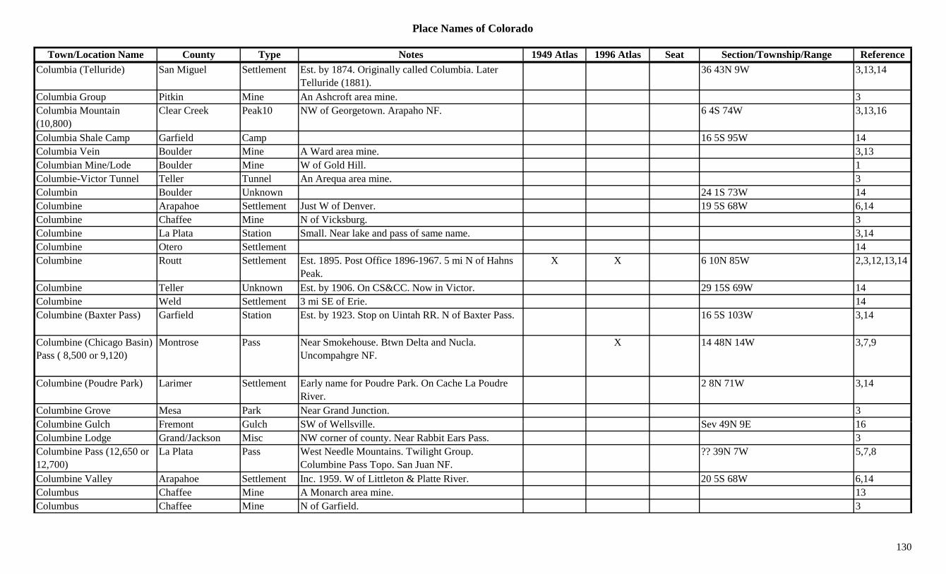
Place Names of Colorado
Town/Location Name County Type Notes 1949 Atlas 1996 Atlas Seat Section/Township/Range ReferenceColumbia (Telluride) San Miguel Settlement Est. by 1874. Originally called Columbia. Later
Telluride (1881).36 43N 9W 3,13,14
Columbia Group Pitkin Mine An Ashcroft area mine. 3Columbia Mountain (10,800)
Clear Creek Peak10 NW of Georgetown. Arapaho NF. 6 4S 74W 3,13,16
Columbia Shale Camp Garfield Camp 16 5S 95W 14Columbia Vein Boulder Mine A Ward area mine. 3,13Columbian Mine/Lode Boulder Mine W of Gold Hill. 1Columbie-Victor Tunnel Teller Tunnel An Arequa area mine. 3Columbin Boulder Unknown 24 1S 73W 14Columbine Arapahoe Settlement Just W of Denver. 19 5S 68W 6,14p ,Columbine Chaffee Mine N of Vicksburg. 3Columbine La Plata Station Small. Near lake and pass of same name. 3,14Columbine Otero Settlement 14Columbine Routt Settlement Est. 1895. Post Office 1896-1967. 5 mi N of Hahns
Peak.X X 6 10N 85W 2,3,12,13,14
Columbine Teller Unknown Est. by 1906. On CS&CC. Now in Victor. 29 15S 69W 14Columbine Weld Settlement 3 mi SE of Erie. 14Columbine (Baxter Pass) Garfield Station Est. by 1923. Stop on Uintah RR. N of Baxter Pass. 16 5S 103W 3,14
Columbine (Chicago Basin) Pass ( 8,500 or 9,120)
Montrose Pass Near Smokehouse. Btwn Delta and Nucla. Uncompahgre NF.
X 14 48N 14W 3,7,9
Columbine (Poudre Park) Larimer Settlement Early name for Poudre Park. On Cache La Poudre River.
2 8N 71W 3,14
Columbine Grove Mesa Park Near Grand Junction. 3C l bi G l h F t G l h SW f W ll ill S 49N 9E 16Columbine Gulch Fremont Gulch SW of Wellsville. Sev 49N 9E 16Columbine Lodge Grand/Jackson Misc NW corner of county. Near Rabbit Ears Pass. 3Columbine Pass (12,650 or 12,700)
La Plata Pass West Needle Mountains. Twilight Group. Columbine Pass Topo. San Juan NF.
?? 39N 7W 5,7,8
Columbine Valley Arapahoe Settlement Inc. 1959. W of Littleton & Platte River. 20 5S 68W 6,14Columbus Chaffee Mine A Monarch area mine. 13Columbus Chaffee Mine N of Garfield. 3
130

Place Names of Colorado
Town/Location Name County Type Notes 1949 Atlas 1996 Atlas Seat Section/Township/Range ReferenceColumbus Chaffee Station Post Office 1882-1884. RR station near Babcock. 2
mi N of Lapis.27 50N 6E 3,12,14
Columbus Gilpin Mine SW of Bortonsburg. 3Columbus La Plata Mine North of Eagle Pass. 3Columbus La Plata Settlement Post Office 1894-1903. 3 35N 7N 12,14Columbus Mountain (Anita Peak, Bears Ears)
Routt Mountain NW corner of county. 3,13
Colute (Coluta) Routt Station Est. by 1923. On Uintah RR. Possibly in Rio Blanco (or another site).
8 6N 87W 3,14
Comanche Adams Settlement Rural Post Office 1911-1923. 17 mi N of Strasburg. 2 1S 62W 3,6,12,14
Comanche Creek Adams Creek Flows from Arapahoe Co to join Kiowa Creek. X 16Comanche Creek Arapahoe Creek Flows N through Arapahoe Co to Adams Co. X 16Comanche Creek Elbert Creek Flows N from Fondis to Arapahoe Co. X 3Comanche Gulch Gunnison Gulch North of Ohio City. Runs SE. Gunnison NF. Sev 50/51N 3E 16Comanche Pass (12,700) Saguache Pass In Sangre de Cristo Range. S of Venable Pass. 5,7Comanche Peak (12,702) Larimer Peak12 Just N of Rocky Mtn. Natl. Park. Mummy Range. 3,8,13
Comanche Peak (13,227) Custer/Saguache Peak13 Sangre de Cristo Range, Main Section. Horn Peak Quad.
?? 23S 74W 8,11,16
Comargo (Camargo) Custer Settlement Est. by 1922. E of Silver Park. 36 21S 70W 3,14Combs Airport Denver Airfield East of Hwy 2 at 38th Ave. XCombs Junction Pueblo Station On MP. 32 20S 64W 14Comer Weld Station Est. by 1909. On C&S. 3 mi S of Windsor. 23 6N 67W 3,6,14Comet Clear Creek Mine A North Empire area mine. And/or E of
Georgetown.3,13
C f t (D R ) M S ttl t E t b 1887 S it l t k D R 3Comfort (Deer Run) Mesa Settlement Est. by 1887. Same site later known as Deer Run. 3
Comforter Mountain (8,215) Boulder Mountain West of Boulder. 35 1N 72W 16
Coming Wonder San Juan Mine Silverton area mine. 3Commador Alamosa Unknown 4 29S 73W 14
131
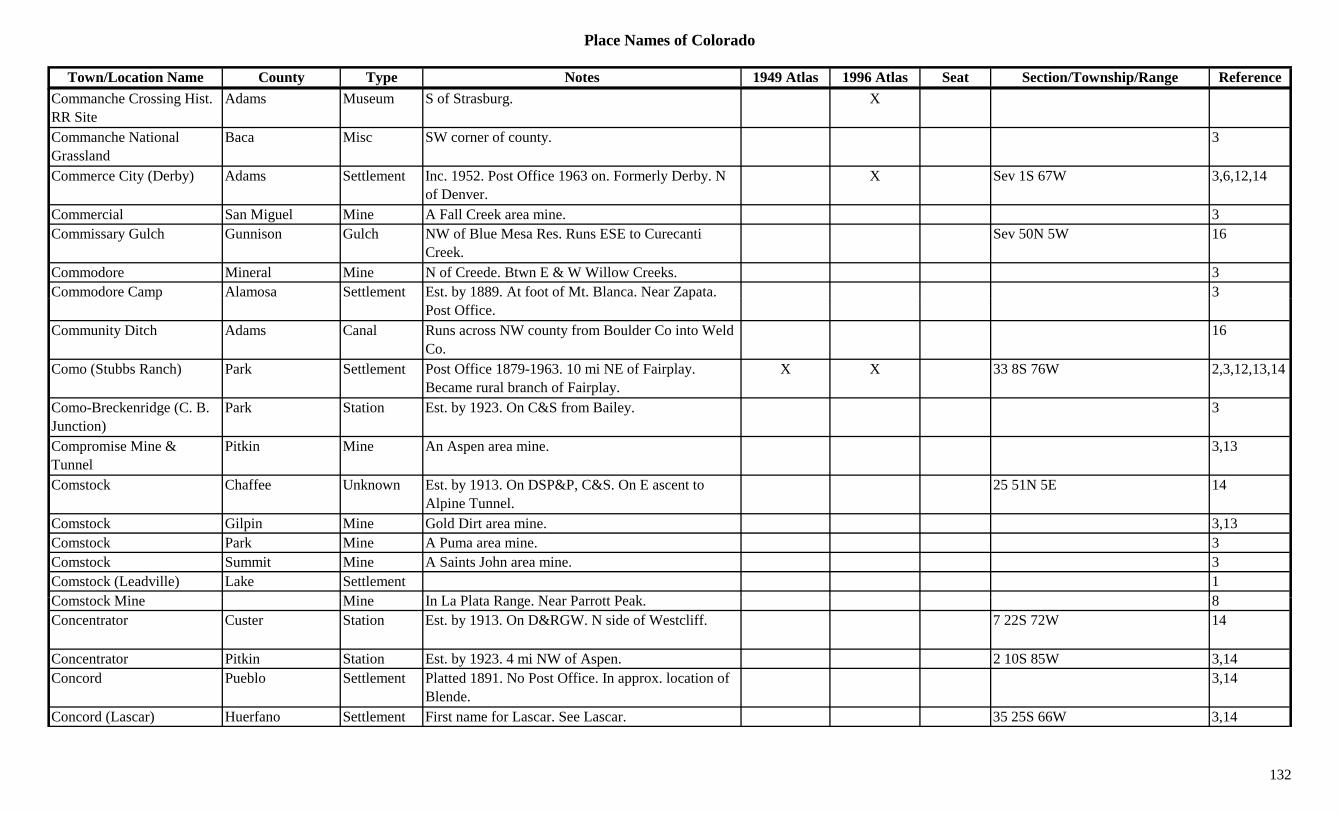
Place Names of Colorado
Town/Location Name County Type Notes 1949 Atlas 1996 Atlas Seat Section/Township/Range ReferenceCommanche Crossing Hist. RR Site
Adams Museum S of Strasburg. X
Commanche National Grassland
Baca Misc SW corner of county. 3
Commerce City (Derby) Adams Settlement Inc. 1952. Post Office 1963 on. Formerly Derby. N of Denver.
X Sev 1S 67W 3,6,12,14
Commercial San Miguel Mine A Fall Creek area mine. 3Commissary Gulch Gunnison Gulch NW of Blue Mesa Res. Runs ESE to Curecanti
Creek.Sev 50N 5W 16
Commodore Mineral Mine N of Creede. Btwn E & W Willow Creeks. 3Commodore Camp Alamosa Settlement Est. by 1889. At foot of Mt. Blanca. Near Zapata. 3p y p
Post Office. Community Ditch Adams Canal Runs across NW county from Boulder Co into Weld
Co.16
Como (Stubbs Ranch) Park Settlement Post Office 1879-1963. 10 mi NE of Fairplay. Became rural branch of Fairplay.
X X 33 8S 76W 2,3,12,13,14
Como-Breckenridge (C. B. Junction)
Park Station Est. by 1923. On C&S from Bailey. 3
Compromise Mine & Tunnel
Pitkin Mine An Aspen area mine. 3,13
Comstock Chaffee Unknown Est. by 1913. On DSP&P, C&S. On E ascent to Alpine Tunnel.
25 51N 5E 14
Comstock Gilpin Mine Gold Dirt area mine. 3,13Comstock Park Mine A Puma area mine. 3Comstock Summit Mine A Saints John area mine. 3Comstock (Leadville) Lake Settlement 1C t k Mi Mi I L Pl t R N P tt P k 8Comstock Mine Mine In La Plata Range. Near Parrott Peak. 8Concentrator Custer Station Est. by 1913. On D&RGW. N side of Westcliff. 7 22S 72W 14
Concentrator Pitkin Station Est. by 1923. 4 mi NW of Aspen. 2 10S 85W 3,14Concord Pueblo Settlement Platted 1891. No Post Office. In approx. location of
Blende.3,14
Concord (Lascar) Huerfano Settlement First name for Lascar. See Lascar. 35 25S 66W 3,14
132

Place Names of Colorado
Town/Location Name County Type Notes 1949 Atlas 1996 Atlas Seat Section/Township/Range ReferenceConcrete Fremont Settlement Post Office 1908-1921. E of Portland. X 21 19S 68W 3,12,14Concrete Gilpin Station Tram station in Prosser Gulch. 11 3S 73W 14Concrete Huerfano Settlement Est. by 1923. NW of La Veta. On D&RGW going
over La Veta Pass.3
Condon (Condon Corners, Congdon)
Arapahoe/Yuma Settlement 1880 homestead. Post Office 1888-1892. Replaced by Vernon Post Office.
10 1S 44W 3,12,14
Cone Mountain (12,230) Clear Creek Peak12 Between Empire and Berthoud Pass. Arapaho NF. ?? 3S 75W 16
Cone Pinnacle Pueblo Hill S part of county. Near Mustang Creek. 3Conehita Junction Huerfano Station Est. by 1907. On D&RG, Rouse branch. ? 28S 66W 14Conejos (Guadaloupita, Conejos Settlement Est. 1855. Post Office 1862 on. One of oldest towns X X X 19 33N 9E 3,12,14j ( p ,Guadalupe)
jin state.
, ,
Conejos Camp (Loynton, Stunner)
Conejos Camp 4 mi W of Platoro. See Loynton. 5 36N 4E 3,14
Conejos Ferry Conejos Station Est. by 1885. N of junction of Conejos River and the Rio Grande.
3
Conejos Mining District Rio Grande Mine Jasper area. 3Conejos Paisaje Conejos Settlement XConejos Peak (13,180) Conejos Peak13 NW corner of county. Summitville Group. S of
Platoro. Platoro Quad. Rio Grande NF.X X ?? 35N 4E 3,8,11,13,16
Conejos River Conejos River Platoro S & W to Las Mesitas to Conejos to Espinoza.
X X 3,16
Conell (Connell Creek) Lincoln Station On Smoky Hill South stage route. See Connell Creek.
3
Coney Cove La Plata Misc NE of Durango. XConey Lake Boulder Lake West central county. SE of Sawtooth Mountain.
R lt NF16
Roosevelt NF.Coney Mountain (13,334) Peak13 Finger Mesa Quad. 11Congdon (Condon) Arapahoe/Yuma Unknown Est. by 1913. Also known as Condon. 9 1S 44W 14Conger Gunnison Camp Est. by 1922. Along Spring Creek. NE of Almont. 3
Conger (Conger's Camp) Summit Settlement Est. by 1879. Post Office 1880-1881. Changed to Argentine. 3 mi S of Breckenridge.
3,12,13,14
133
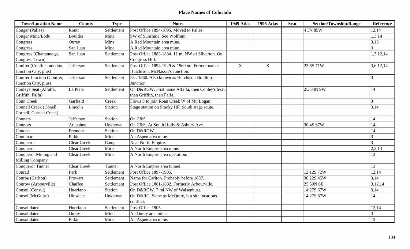
Place Names of Colorado
Town/Location Name County Type Notes 1949 Atlas 1996 Atlas Seat Section/Township/Range ReferenceConger (Pallas) Routt Settlement Post Office 1894-1895. Moved to Pallas. 4 3N 85W 12,14Conger Mine/Lode Boulder Mine SW of Sunshine. See Wolfram. 1,3,14Congress Ouray Mine A Red Mountain area mine. 3,13Congress San Juan Mine A Red Mountain area mine. 3Congress (Chattanooga, Congress Town)
San Juan Settlement Post Office 1883-1884. 11 mi NW of Silverton. On Congress Hill.
1,3,12,14
Conifer (Conifer Junction, Junction City, plus)
Jefferson Settlement Post Office 1894-1929 & 1960 on. Former names Hutchison, McNassar's Junction.
X X 23 6S 71W 3,6,12,14
Conifer Junction (Conifer, Junction City, plus)
Jefferson Settlement Est. 1860. Also known as Hutchison-Bradford Junction.
3
Conleys Seat (Alfalfa, La Plata Settlement On D&RGW. First name Alfalfa, then Conley's Seat, 2U 34N 9W 14y ( ,Griffith, Falfa)
, y ,then Griffith, then Falfa.
Conn Creek Garfield Creek Flows S to join Roan Creek W of Mt. Logan. 3Connell Creek (Conell, Cornell, Cornett Creek)
Lincoln Station Stage station on Smoky Hill South stage route. 3,14
Conners Jefferson Station On C&S. 14Connors Arapahoe Unknown On C&S. At South Holly & Asbury Ave. 30 4S 67W 14Conoco Fremont Station On D&RGW. 14Conomarr Pitkin Mine An Aspen area mine. 3Conqueror Clear Creek Camp Near North Empire. 3Conqueror Clear Creek Mine A North Empire area mine. 2,3,13Conqueror Mining and Milling Company
Clear Creek Mine A North Empire area operation. 13
Conqueror Tunnel Clear Creek Tunnel A North Empire area tunnel. 13Conrad Park Settlement Post Office 1897-1905. 12 12S 72W 12,14Conroe (Carlton) Prowers Settlement Name for Carlton. Probably before 1887. 36 22S 45W 3,14C (A b ill ) Ch ff S ttl t P t Offi 1881 1882 F l A b ill 25 50N 6E 3 12 14Conrow (Arbourville) Chaffee Settlement Post Office 1881-1882. Formerly Arbourville. 25 50N 6E 3,12,14Consol (Consul) Huerfano Station On D&RGW. 7 mi NW of Walsenburg. 14 27S 67W 3,14Consol (McGuire) Hinsdale Unknown On D&RG. Same as McQuire, but site locations
conflict.14 27S 67W 14
Consolidated Huerfano Settlement Post Office 1905. 12,14Consolidated Ouray Mine An Ouray area mine. 3Consolidated Pitkin Mine An Aspen area mine. 13
134
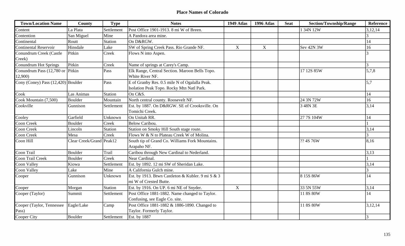
Place Names of Colorado
Town/Location Name County Type Notes 1949 Atlas 1996 Atlas Seat Section/Township/Range ReferenceContent La Plata Settlement Post Office 1901-1913. 8 mi W of Breen. 1 34N 12W 3,12,14Contention San Miguel Mine A Pandora area mine. 3Continental Routt Station On D&RGW. 14Continental Reservoir Hinsdale Lake SW of Spring Creek Pass. Rio Grande NF. X X Sev 42N 3W 16Conundrum Creek (Castle Creek)
Pitkin Creek Flows N into Aspen. 3
Conundrum Hot Springs Pitkin Creek Name of springs at Carey's Camp. 3Conundrum Pass (12,780 or 12,900)
Pitkin Pass Elk Range, Central Section. Maroon Bells Topo. White River NF.
17 12S 85W 5,7,8
Cony (Coney) Pass (12,420) Boulder Pass E of Granby Res. 0.5 mile N of Ogalalla Peak. Isolation Peak Topo. Rocky Mtn Natl Park.
5,7
Cook Las Animas Station On C&S. 14Cook Mountain (7,500) Boulder Mountain North central county. Roosevelt NF. 24 3N 72W 16Cookville Gunnison Settlement Est. by 1887. On D&RGW. SE of Crooksville. On
Tomichi Creek.3 48N 3E 3,14
Cooley Garfield Unknown On Unitah RR. 27 7S 104W 14Coon Creek Boulder Creek Below Caribou. 1Coon Creek Lincoln Station Station on Smoky Hill South stage route. 3,14Coon Creek Mesa Creek Flows W & N to Plateau Creek W of Molina. 3Coon Hill Clear Creek/Grand Peak12 South tip of Grand Co. Williams Fork Mountains.
Arapaho NF.?? 4S 76W 8,16
Coon Trail Boulder Trail Caribou through New Cardinal to Nederland. 3,13Coon Trail Creek Boulder Creek Near Cardinal. 1Coon Valley Kiowa Settlement Est. by 1892. 12 mi SW of Sheridan Lake. 3,14Coon Valley Lake Mine A California Gulch mine. 3Cooper Gunnison Unknown Est. by 1913. Btwn Castleton & Kubler. 9 mi S & 3
i W f C t d B tt8 15S 86W 14
mi W of Crested Butte.Cooper Morgan Station Est. by 1916. On UP. 6 mi NE of Snyder. X 33 5N 55W 3,14Cooper (Taylor) Summit Settlement Post Office 1881-1882. Name changed to Taylor.
Confusing, see Eagle Co. site.11 8S 80W 14
Cooper (Taylor, Tennessee Pass)
Eagle/Lake Camp Post Office 1881-1882 & 1886-1890. Changed to Taylor. Formerly Taylor.
11 8S 80W 3,12,14
Cooper City Boulder Settlement Est. by 1887 3
135

Place Names of Colorado
Town/Location Name County Type Notes 1949 Atlas 1996 Atlas Seat Section/Township/Range ReferenceCooper Hill Eagle/Lake Peak11 SE corner of Eagle Co. SE of Tennessee Pass. San
Isabel/White River NF.13 8S 80W 16
Cooper Lake Hinsdale Lake SW of Lake City. ?? 43N 5W 16Cooper Mountain Fremont Mountain NNE of Canon City. 7 17S 69W 16Cooper Mountain (12,792) Peak12 Front Range, Southwest Section. 8
Cooper Peak (12,296) Peak12 Front Range, Indian Section. 8Cooper's Camp Gunnison Camp Est. by 1922. On North Italian Mountain. NE of
Crested Butte.3
Cooper's Camp Pitkin Camp Est. in 1880s. Small camp around iron mines at Ashcroft. At head of Cooper's Creek.
? 11S 84W 3,14
Cooperstown (Cooperton, Satank, Carbondale)
Garfield Settlement Founded as Cooperstown in 1886. Renamed Satank, then Carbondale. See Satank.
34 7S 88W 3,14
Coopersville Gunnison Unknown In Galena Gulch near White Pine. 14Cooperton(Rockford) Garfield Settlement Est. by 1888. Another name for Rockford. 28 7S 88W. 14Cooperville Fremont Unknown 9 19S 72W 14Cope (Gray) Washington Settlement Post Office 1889 on. Moved from Gray. X X 34 4S 49W 3,12,14Copeland Mountain (13,176)
Boulder Peak13 Front Range, National Park Section. Rocky Mt. Natl. Park. Isolation Peak Quad.
X ?? 3N 74W 1,8,11,16
Copeland Park Boulder Unknown 14 3N 73W 14Coperville Custer Unknown Perhaps should be Cooperville? 10 21S 73W 14Copper (Ionia) Mesa Settlement Post Office 1898-1899. Changed to Ionia. 12,14Copper Blush Boulder Mine At Springdale. 3,13Copper Bottom Gunnison Mine A White Pine area mine. 3,13Copper Glen (Ironton) Ouray Station Stage & supply town. Preceded Ironton. 36 43N 8W 3,13,14Copper Gulch Dolores Gulch Central county. NW of Rico. Runs S to West Fork
D l Ri7/18 40N 12W 16
Dolores River.Copper Gulch Fremont Gulch South central county. SW of Texas Creek (town). Sev 19S 72/73W 16
Copper Gulch Fremont Gulch South of Parkdale. Runs NE. Sev 19S 72W 16Copper Gulch Gunnison Gulch NE of Gunnison. Runs W to Taylor River. 13 51N 1E 16Copper Gulch Hinsdale Gulch NW county. Runs N to Henson Creek. Sev 43N 5W 16
136

Place Names of Colorado
Town/Location Name County Type Notes 1949 Atlas 1996 Atlas Seat Section/Township/Range ReferenceCopper Gulch Hinsdale Gulch NW county. Runs SW to Lake Fork Gunnison River. Sev 43N 5W 16
Copper Gulch Saguache Gulch A Bonanza mining area. 3Copper Hill mining area Hinsdale Mine A Rose's Cabin area mine. 3Copper King Jackson Mine Near Helena. 3Copper Lake Gunnison Lake North central county. Near Pitkin Co. SE of East
Maroon Pass. Gunnison NF.?? 12S 86W 16
Copper Mountain Grand Peak10 SE of Kremmling. Arapaho NF. 19 1S 79W 16Copper Mountain Summit Settlement Post Office 1977 on. CPO of Frisco. 12Copper Mountain (11,955) Mineral Mountain W of Masonic Park. X
Copper Pass Gunnison/Pitkin Pass Maroon Bells-Snowmass Wilderness Area. Gothic Topo. Gunnison & White River NF.
19 12S 85W 5
Copper Queen Gunnison Mine A White Pine area mine. 3,13Copper Rock Boulder Camp Post Office 1892-1903 & 1915. 12 mi W of Boulder
in Four Mile Canyon.22 1N 72W 1,3,6,12,14
Copper Spur (Coppertown) Eagle Station Est. by 1924. Post Office 1929-1955. Formerly Coppertown. 2 mi SE of McCoy.
X 4 2S 83W 3,12,14
Copperdale Boulder Settlement Btwn Jefferson & Boulder counties. 33 1S 71W 1,14Copperdale Jefferson Settlement Post Office 1882-1883. In vicinity of modern town
of Twin Spruce.4 2S 71W 3,6,12,14
Copperfield Fremont Settlement Post Office 1907-1910. 25 49N 11E 12,14Copperton Eagle Settlement Post Office 1917. 12,14Coppertown Eagle Settlement Post Office 1922-1929. Changed to Copper Spur. 4 2S 83W 12,14
Copperville Custer Settlement Est. by 1882. 3 mi SE of Texas. ? 21S 73W 14C B ll O Mi A G t i 3 13Cora Belle Ouray Mine A Guston area mine. 3,13Coraville Boulder Settlement Post Office 1887-1888. 6,12,14Coraville Kansas Terr. Settlement Post Office 1859. Near the junction of Cherry Creek
& South Platte River.33 3S 68W 12,14
Corcoran Arapahoe Settlement Post Office 1889-1894. 12,14Corcoran Washington Settlement Country Post Office 1889-1894. 6 mi W of Cope. ? 4S 50W 3,14
137
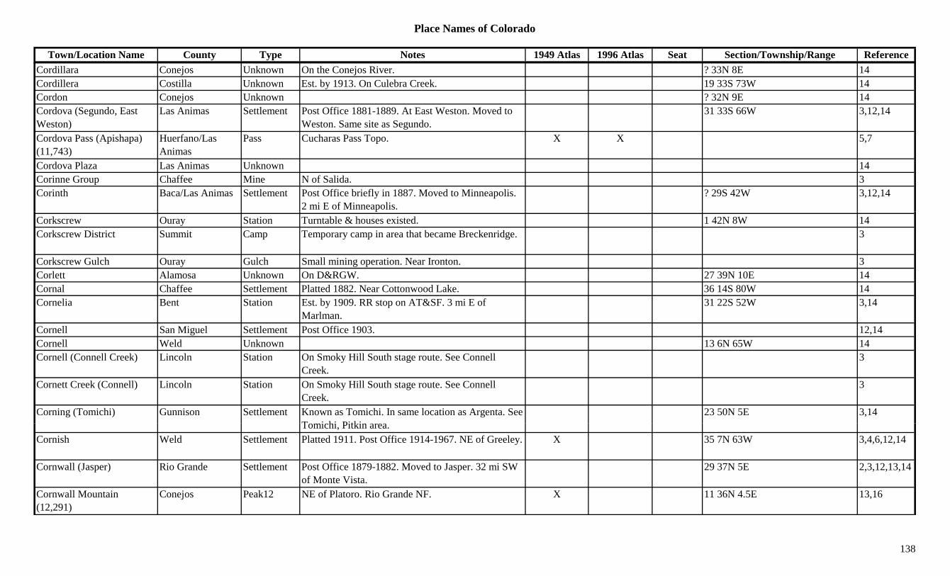
Place Names of Colorado
Town/Location Name County Type Notes 1949 Atlas 1996 Atlas Seat Section/Township/Range ReferenceCordillara Conejos Unknown On the Conejos River. ? 33N 8E 14Cordillera Costilla Unknown Est. by 1913. On Culebra Creek. 19 33S 73W 14Cordon Conejos Unknown ? 32N 9E 14Cordova (Segundo, East Weston)
Las Animas Settlement Post Office 1881-1889. At East Weston. Moved to Weston. Same site as Segundo.
31 33S 66W 3,12,14
Cordova Pass (Apishapa) (11,743)
Huerfano/Las Animas
Pass Cucharas Pass Topo. X X 5,7
Cordova Plaza Las Animas Unknown 14Corinne Group Chaffee Mine N of Salida. 3Corinth Baca/Las Animas Settlement Post Office briefly in 1887. Moved to Minneapolis.
2 mi E of Minneapolis.? 29S 42W 3,12,14
Corkscrew Ouray Station Turntable & houses existed. 1 42N 8W 14Corkscrew District Summit Camp Temporary camp in area that became Breckenridge. 3
Corkscrew Gulch Ouray Gulch Small mining operation. Near Ironton. 3Corlett Alamosa Unknown On D&RGW. 27 39N 10E 14Cornal Chaffee Settlement Platted 1882. Near Cottonwood Lake. 36 14S 80W 14Cornelia Bent Station Est. by 1909. RR stop on AT&SF. 3 mi E of
Marlman.31 22S 52W 3,14
Cornell San Miguel Settlement Post Office 1903. 12,14Cornell Weld Unknown 13 6N 65W 14Cornell (Connell Creek) Lincoln Station On Smoky Hill South stage route. See Connell
Creek.3
Cornett Creek (Connell) Lincoln Station On Smoky Hill South stage route. See Connell Creek.
3
Corning (Tomichi) Gunnison Settlement Known as Tomichi. In same location as Argenta. See T i hi Pitki
23 50N 5E 3,14Tomichi, Pitkin area.
Cornish Weld Settlement Platted 1911. Post Office 1914-1967. NE of Greeley. X 35 7N 63W 3,4,6,12,14
Cornwall (Jasper) Rio Grande Settlement Post Office 1879-1882. Moved to Jasper. 32 mi SW of Monte Vista.
29 37N 5E 2,3,12,13,14
Cornwall Mountain (12,291)
Conejos Peak12 NE of Platoro. Rio Grande NF. X 11 36N 4.5E 13,16
138
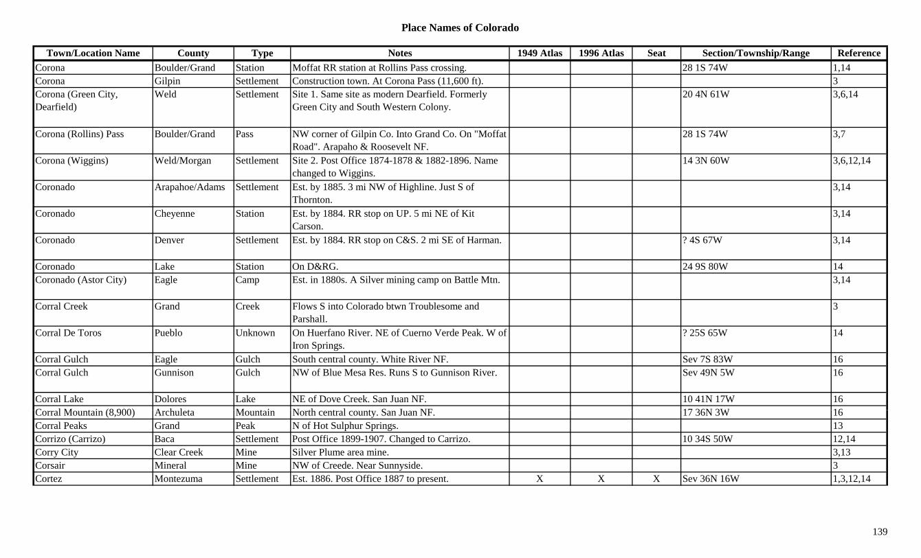
Place Names of Colorado
Town/Location Name County Type Notes 1949 Atlas 1996 Atlas Seat Section/Township/Range ReferenceCorona Boulder/Grand Station Moffat RR station at Rollins Pass crossing. 28 1S 74W 1,14Corona Gilpin Settlement Construction town. At Corona Pass (11,600 ft). 3Corona (Green City, Dearfield)
Weld Settlement Site 1. Same site as modern Dearfield. Formerly Green City and South Western Colony.
20 4N 61W 3,6,14
Corona (Rollins) Pass Boulder/Grand Pass NW corner of Gilpin Co. Into Grand Co. On "Moffat Road". Arapaho & Roosevelt NF.
28 1S 74W 3,7
Corona (Wiggins) Weld/Morgan Settlement Site 2. Post Office 1874-1878 & 1882-1896. Name changed to Wiggins.
14 3N 60W 3,6,12,14
Coronado Arapahoe/Adams Settlement Est. by 1885. 3 mi NW of Highline. Just S of Thornton.
3,14
Coronado Cheyenne Station Est. by 1884. RR stop on UP. 5 mi NE of Kit Carson.
3,14
Coronado Denver Settlement Est. by 1884. RR stop on C&S. 2 mi SE of Harman. ? 4S 67W 3,14
Coronado Lake Station On D&RG. 24 9S 80W 14Coronado (Astor City) Eagle Camp Est. in 1880s. A Silver mining camp on Battle Mtn. 3,14
Corral Creek Grand Creek Flows S into Colorado btwn Troublesome and Parshall.
3
Corral De Toros Pueblo Unknown On Huerfano River. NE of Cuerno Verde Peak. W of Iron Springs.
? 25S 65W 14
Corral Gulch Eagle Gulch South central county. White River NF. Sev 7S 83W 16Corral Gulch Gunnison Gulch NW of Blue Mesa Res. Runs S to Gunnison River. Sev 49N 5W 16
Corral Lake Dolores Lake NE of Dove Creek. San Juan NF. 10 41N 17W 16C l M t i (8 900) A h l t M t i N th t l t S J NF 17 36N 3W 16Corral Mountain (8,900) Archuleta Mountain North central county. San Juan NF. 17 36N 3W 16Corral Peaks Grand Peak N of Hot Sulphur Springs. 13Corrizo (Carrizo) Baca Settlement Post Office 1899-1907. Changed to Carrizo. 10 34S 50W 12,14Corry City Clear Creek Mine Silver Plume area mine. 3,13Corsair Mineral Mine NW of Creede. Near Sunnyside. 3Cortez Montezuma Settlement Est. 1886. Post Office 1887 to present. X X X Sev 36N 16W 1,3,12,14
139

Place Names of Colorado
Town/Location Name County Type Notes 1949 Atlas 1996 Atlas Seat Section/Township/Range ReferenceCortrite (Contrite) Park Settlement Post Office 1889-1892. Also spelled Contrite. At
head of Geneva Gulch.7 6S 75W 12,14
Corwina Park Jefferson Unknown 36 4S 70W 14Cory Delta Settlement Post Office 1895 to present. 3 mi S of Orchard City. X 35 14S 95W 3,12,14
Cory Station Delta Station Est. by 1923. 2 mi NE of Auston 3Corydon Gilpin Mine A Missouri City mine. 3Coryell (Stanley) Costilla/Alamosa Settlement Post Office 1887-1890. Changed to Stanley. ? 39N 9E 12,14Cosden (Wagontown, Causden, Cousden)
Gunnison Camp Post Office 1883-1885. At opening of Gulch. 3 mi below White Pine.
9 49N 5E 3,12,14
Cosseboom (Aspen Park) Pitkin Settlement Early name for Aspen Park. 14( p ) y pCosta Lake Gunnison Lake West central county. W of Castleton. Gunnison NF. ?? 15S 88W 16
Costellos Rancho (Florissant)
El Paso/Teller Ranch First name for Florissant. 1 13S 71W 14
Costilla (Garcia, Manzanores)
Costilla Settlement Post Office 1862. Shifted to Taos, NM, 1872, on re-survey.
33 35S 73W 12,14
Costilla Creek Costilla Creek Flows W past Garcia back to New Mexico. 3Costilla Ferry Costilla Station Est. by 1885. 20 mi SW of San Luis. Also shown in
Rio Grande Co.3
Cotopaxi (Saltiels) Fremont Settlement Est. abt 1873. On D&RGW. Post Office 1880 to present. First called Saltiels.
X X 31 48N 12E 3,12,14
Cotsworth Weld/Morgan Settlement Post Office on BN 1882-1883. 11 mi W of Fort Morgan.
8 3N 59W 3,12,14
Cottage Grove Park Camp Small camp. In Alma area. Had Post Office in 1880s. 3,14
C tt H (M i ) Kit C S ttl t M i th P t Offi S M i 10 6S 43W 3 14Cottage House (Morris) Kit Carson Settlement Morris was the Post Office. See Morris. 10 6S 43W 3,14Cottage Lane Grand Unknown 22 1N 77W 14Cotton Creek Saguache Creek Flows SW from Custer Co. to join San Luis Creek. 3
Cotton Creek (Mirage) Saguache Settlement Post Office 1875-1895. Changed to Mirage. Mining town at foot of Sangre de Cristo Range.
33 43N 11E 3,12,14
Cotton Spring Kiowa Unknown On Kansas-Pacific RR. 14
140
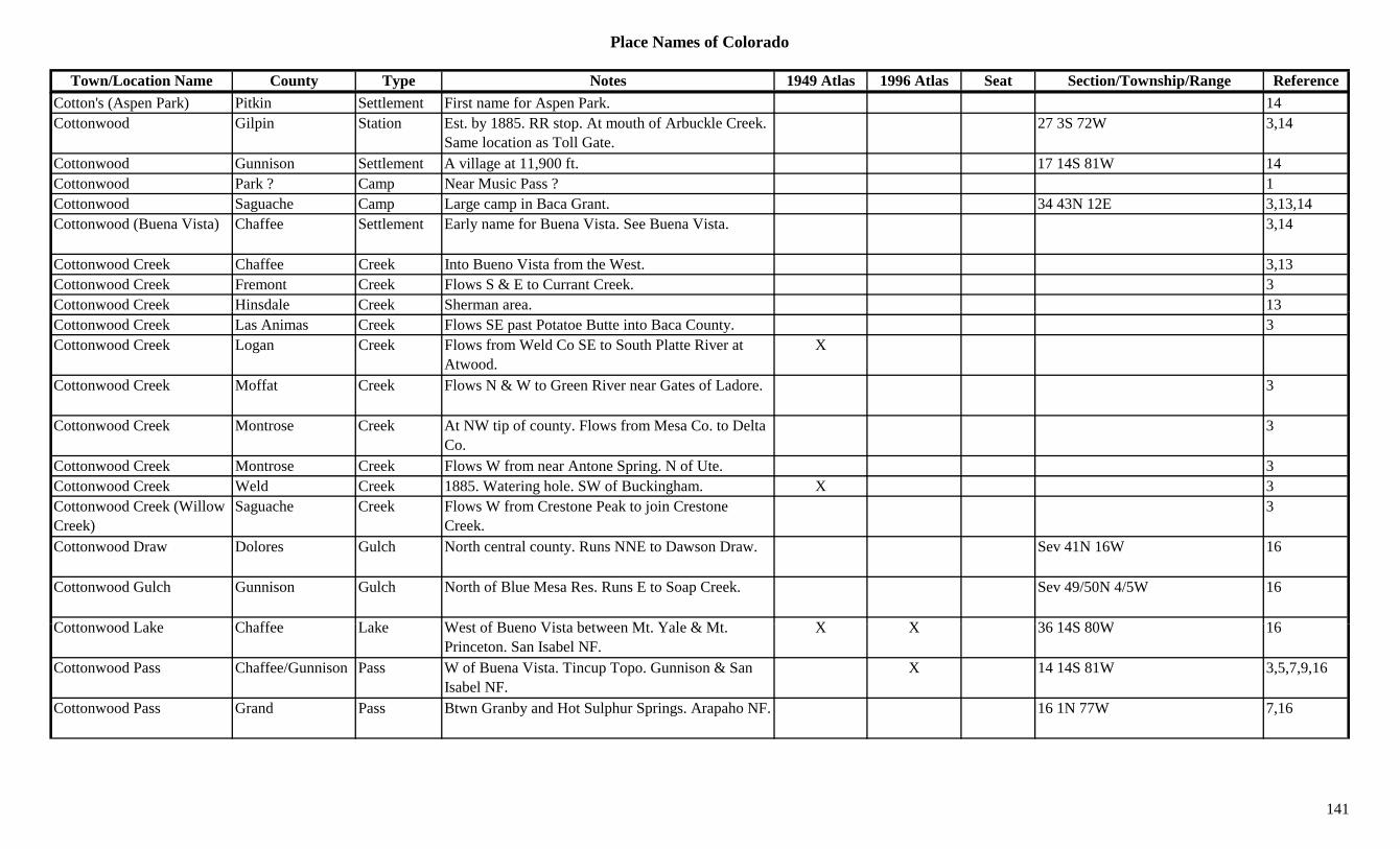
Place Names of Colorado
Town/Location Name County Type Notes 1949 Atlas 1996 Atlas Seat Section/Township/Range ReferenceCotton's (Aspen Park) Pitkin Settlement First name for Aspen Park. 14Cottonwood Gilpin Station Est. by 1885. RR stop. At mouth of Arbuckle Creek.
Same location as Toll Gate.27 3S 72W 3,14
Cottonwood Gunnison Settlement A village at 11,900 ft. 17 14S 81W 14Cottonwood Park ? Camp Near Music Pass ? 1Cottonwood Saguache Camp Large camp in Baca Grant. 34 43N 12E 3,13,14Cottonwood (Buena Vista) Chaffee Settlement Early name for Buena Vista. See Buena Vista. 3,14
Cottonwood Creek Chaffee Creek Into Bueno Vista from the West. 3,13Cottonwood Creek Fremont Creek Flows S & E to Currant Creek. 3Cottonwood Creek Hinsdale Creek Sherman area. 13Cottonwood Creek Las Animas Creek Flows SE past Potatoe Butte into Baca County. 3Cottonwood Creek Logan Creek Flows from Weld Co SE to South Platte River at
Atwood.X
Cottonwood Creek Moffat Creek Flows N & W to Green River near Gates of Ladore. 3
Cottonwood Creek Montrose Creek At NW tip of county. Flows from Mesa Co. to Delta Co.
3
Cottonwood Creek Montrose Creek Flows W from near Antone Spring. N of Ute. 3Cottonwood Creek Weld Creek 1885. Watering hole. SW of Buckingham. X 3Cottonwood Creek (Willow Creek)
Saguache Creek Flows W from Crestone Peak to join Crestone Creek.
3
Cottonwood Draw Dolores Gulch North central county. Runs NNE to Dawson Draw. Sev 41N 16W 16
Cottonwood Gulch Gunnison Gulch North of Blue Mesa Res. Runs E to Soap Creek. Sev 49/50N 4/5W 16
C tt d L k Ch ff L k W t f B Vi t b t Mt Y l & Mt X X 36 14S 80W 16Cottonwood Lake Chaffee Lake West of Bueno Vista between Mt. Yale & Mt. Princeton. San Isabel NF.
X X 36 14S 80W 16
Cottonwood Pass Chaffee/Gunnison Pass W of Buena Vista. Tincup Topo. Gunnison & San Isabel NF.
X 14 14S 81W 3,5,7,9,16
Cottonwood Pass Grand Pass Btwn Granby and Hot Sulphur Springs. Arapaho NF. 16 1N 77W 7,16
141

Place Names of Colorado
Town/Location Name County Type Notes 1949 Atlas 1996 Atlas Seat Section/Township/Range ReferenceCottonwood Pass (8,380) Eagle Pass SW corner of county. S of Dotsero. Crossed by
county road.13 6S 86W 3,7,16
Cottonwood Pass Toll Road Chaffee Trail Crosses the Continental Divide W of Harvard City. 13
Cottonwood Peak Eagle Mountain NE corner of county. White River NF. 26 2S 82W 16Cottonwood Peak (13,211) Custer/Saguache Peak Sangre de Cristo Range, San Luis Valley Side.
Valley View Hot Springs Quad.21 46N 11E 8,11,13,16
Cottonwood Smelter Saguache Mill A Crestone-Liberty area mine. 3Cottonwood Spring Morgan Creek 1885. 15 mi N of Weldona. 3Cottonwood Springs Chaffee Settlement Post Office 1879-1885 & 1890-1895. 6 mi W of
Buena Vista.22 14S 79W 3,12,14
Cottonwood Springs Morgan Unknown 3 mi E of NW corner of county. 1 6N 60W 14Couitopa Creek Gunnison Creek Flows N to W of Parlin. 3Coulter Grand Station Post Office 1884-1905. Stop on D&SL. 5 mi SE of
Granby.19 1N 76W 3,12,14
Coulter Lake Garfield Lake NNE of Rifle. White River NF. 27 3S 92W 16Country Boy Summit Mine A Lincoln area mine. 3County Farm (Denver Co. Poor Farm)
Adams Settlement On D&RGW. Same as Denver County Poor Farm. 27 1S 67W 14
County Line Jefferson Station On D&IM. 14Coupon Clear Creek Mine A North Empire area mine. 13Courthouse Mountain Hinsdale/Ouray Peak12 NW tip of Hinsdale Co. San Juans, Courthouse
Group. Uncompahgre NF.?? 45N 6W 8,16
Cousden (Causden, Cosden) Gunnison Same as Causden & Cosden. 14
Cousin Springs Pueblo Settlement Post Office 1914-1920. 6 mi S of Fremont-Pueblo li
12,14line.
Cove Lake Reservoir Conejos Lake SE of Conejos. Sev 5 32N 10E 16Coventry Montrose Settlement Post Office 1894-1917. Small. E of Redvale. 11 45N 14W 3,12,14Cover Mountain (10,165) Park Mountain SE of Guffey. XCovode Clear Creek Mine A North Empire area mine. 13Covode Mountain Clear Creek Mountain Near Empire. 13Cow Butte Crowley Hill NE corner of county. 25 18S 56W 3,16
142

Place Names of Colorado
Town/Location Name County Type Notes 1949 Atlas 1996 Atlas Seat Section/Township/Range ReferenceCow Camp Reservoir Dolores Lake South central county. 10 39N 15W 16Cow Canyon Dolores Canyon Central county. Runs SW & W to Lake Canyon. Sev 40N 17W 16
Cow Creek Ouray Creek Flows N & W to Uncompahgre River SE of Eldredge.
3
Cow Gulch Gunnison Gulch SE corner of county. Runs ESE to Tomichi Creek. Sev 48N 5E 16
Cow Lake Garfield Lake NW corner of county. White River NF. 2 3S 90W 16Cow Mountain (13,111) Peak13 Wetterhorn Peak Quad. 11Cow Ridge Book Cliffs Garfield Ridge South central county. Sev 7/8S 98/99W 16Cowan Jefferson Station Est. by 1920. On C&S. 3 mi E of Morrison. 5 5S 69W 3,6,14y , ,Cowans Lincoln Settlement Rural Post Office 1915-1929. 12 mi NW of Forder. 28 16S 58W 3,12,14
Cowdrey Larimer Settlement Post Office 1901-1907. Same location as Cowdrey, Jackson Co.
7 10N 79W 12
Cowdrey (Cowdry, Canadian, Ouray)
Jackson Settlement Est. 1882. Post Office 1915 to present. Early name was Canadian. Also Cow Creek Tank.
X X 17 46N 8W 3,12,14
Cowdrey Reservoir No 2 Boulder Lake SE of Boulder. 22 1S 70W 16Cowenhaven Tunnel Pitkin Tunnel An Aspen area mine. 3Cox Adams Station Est. by 1924. RR stop on BN. 4 mi NE of Derby. 3,6,14
Cox Gunnison Settlement Post Office 1903-1905. 4 mi WNW of Anthracite. 10 13S 87W 12,14
Cox & Wood Mine Las Animas Mine 10 32S 64W 14Cox & Wood Mine Las Animas Station On C&S. 10 32S 64W 14Cox Mine Las Animas Camp Est. by 1923. Same location as Forbes. Camp around
l i t F b ?3
coal mine at Forbes?Coxcomb Peak Hinsdale/Ouray Peak13 NW corner of Hinsdale Co. San Juans, Lake City
Group. Wetterhorn Peak Quad. Uncompahgre NF.X ?? 44N 6W 8,11,16
Coxo Conejos Settlement On D&RGW. X 12 32N 5E 14Coxo (Cresco) Archuleta Settlement Est. by 1885. Same location as Cresco. Another
location 12 32N 4E.24 32N 4E 3,14
143
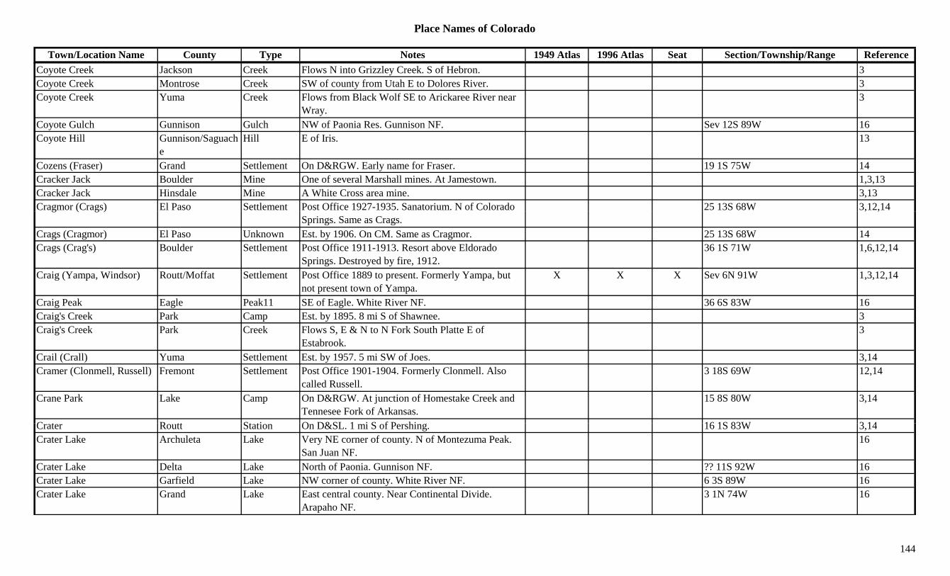
Place Names of Colorado
Town/Location Name County Type Notes 1949 Atlas 1996 Atlas Seat Section/Township/Range ReferenceCoyote Creek Jackson Creek Flows N into Grizzley Creek. S of Hebron. 3Coyote Creek Montrose Creek SW of county from Utah E to Dolores River. 3Coyote Creek Yuma Creek Flows from Black Wolf SE to Arickaree River near
Wray.3
Coyote Gulch Gunnison Gulch NW of Paonia Res. Gunnison NF. Sev 12S 89W 16Coyote Hill Gunnison/Saguach
eHill E of Iris. 13
Cozens (Fraser) Grand Settlement On D&RGW. Early name for Fraser. 19 1S 75W 14Cracker Jack Boulder Mine One of several Marshall mines. At Jamestown. 1,3,13Cracker Jack Hinsdale Mine A White Cross area mine. 3,13Cragmor (Crags) El Paso Settlement Post Office 1927-1935. Sanatorium. N of Colorado 25 13S 68W 3,12,14g ( g )
Springs. Same as Crags., ,
Crags (Cragmor) El Paso Unknown Est. by 1906. On CM. Same as Cragmor. 25 13S 68W 14Crags (Crag's) Boulder Settlement Post Office 1911-1913. Resort above Eldorado
Springs. Destroyed by fire, 1912.36 1S 71W 1,6,12,14
Craig (Yampa, Windsor) Routt/Moffat Settlement Post Office 1889 to present. Formerly Yampa, but not present town of Yampa.
X X X Sev 6N 91W 1,3,12,14
Craig Peak Eagle Peak11 SE of Eagle. White River NF. 36 6S 83W 16Craig's Creek Park Camp Est. by 1895. 8 mi S of Shawnee. 3Craig's Creek Park Creek Flows S, E & N to N Fork South Platte E of
Estabrook.3
Crail (Crall) Yuma Settlement Est. by 1957. 5 mi SW of Joes. 3,14Cramer (Clonmell, Russell) Fremont Settlement Post Office 1901-1904. Formerly Clonmell. Also
called Russell.3 18S 69W 12,14
Crane Park Lake Camp On D&RGW. At junction of Homestake Creek and Tennesee Fork of Arkansas.
15 8S 80W 3,14
C t R tt St ti O D&SL 1 i S f P hi 16 1S 83W 3 14Crater Routt Station On D&SL. 1 mi S of Pershing. 16 1S 83W 3,14Crater Lake Archuleta Lake Very NE corner of county. N of Montezuma Peak.
San Juan NF.16
Crater Lake Delta Lake North of Paonia. Gunnison NF. ?? 11S 92W 16Crater Lake Garfield Lake NW corner of county. White River NF. 6 3S 89W 16Crater Lake Grand Lake East central county. Near Continental Divide.
Arapaho NF.3 1N 74W 16
144

Place Names of Colorado
Town/Location Name County Type Notes 1949 Atlas 1996 Atlas Seat Section/Township/Range ReferenceCrater Reservoir Delta Lake NE of Cedaredge. Grand Mesa NF. ?? 12S 92W 16Cravens Lake Unknown Est. by 1907. On D&RG. Almost on Lake Co.,
Summit Co. line.14
Cravens Summit Unknown On D&RG. Btwn Pearl Spur & Robinson. 2 mi S of Robinson (Kokomo).
3 8S 79W 14
Crawford Delta Settlement Est. 1882. Post Office 1883 to present. X 31 5S 91W 3,12,14Crawford Reservoir Delta Lake South of Crawford. X 13 51N 7W 16Crazy Camp (Maysville) Chaffee Settlement Merged and crashed in 1893. Near but not the same
as Maysville.1,3,14
Cree Chaffee Unknown On Ridge btwn Lost Creek & Cree Creek. 22 50N 6E 14Creech (Cable, Genoa) Lincoln Settlement Est. by 1888. First name for Genoa. Second was 12 9S 54W 3,14( , ) y
Cable.,
Creede (Gateway to the San Juans)
Hinsdale/Mineral Settlement Site 2. Post Office 1909 to present. X X 36 42N 1W 12,14
Creede (Willow, Willow Creek, Amethyst)
Mineral Settlement Site 1. Post Office 1891-1908. Moved to North Creed. 55 mi S of Gunnison.
3,12,13,14
Creedemore (Jimtown, Gintown, and Amethyst)
Mineral Camp Near junction of Rio Grande and Willow Creek. Another name for Jimtown, Amethyst, etc.
36 42N 1W 3,14
Creedetown (North Creede, Upper Creede)
Mineral Settlement Same section as North Creede. See North Creede. 25 42N 1W 3,14
Creedmoor (Creedemore, Jimtown, Amethyst)
Mineral Settlement Post Office Est. 1891. 37 mi NW of Del Norte. X 36 42N 1W 2
Creedmore San Juan Mine Silverton area mine. 3Cree's Camp Chaffee Camp 3 mi N of Garfield. 3Crenshaw Montezuma Unknown 27 36N 13W 14Crescent Boulder Camp Close to Pinecliffe. 1,3,6C t B ld St ti RR P t Offi 1907 1922 & 1959 B h f 33 1S 71W 3 12 14Crescent Boulder Station RR Post Office 1907-1922 & 1959. Branch of
Golden. On line to Rollinsville.33 1S 71W 3,12,14
Crescent Custer Mine Westcliffe area mine. 3Crescent Grand Settlement Post Office 1889-1894. 10 mi N & 3 mi W of
Kremmling.? 3N 81W 12,14
Crescent Lake Mine A Leadville area mine. 3Crescent Larimer/Jackson Settlement Post Office 1880. A mine village. 7 5N 77W 12,14
145

Place Names of Colorado
Town/Location Name County Type Notes 1949 Atlas 1996 Atlas Seat Section/Township/Range ReferenceCrescent City (Crescent) Jackson Camp Est. in 1870s. Small. SW of Teller City. NW of
Willow Creek Pass.3
Crescent Park Jefferson Unknown Same section as Coal Creek Store. 4 2S 71W 14Crescent Peak Routt Peak NW corner of county. 3Crescent Village Boulder Settlement South central Jefferson Boulder line. 1Cresco Archuleta Settlement Est. by 1923. Just W of Cumbres. SE corner of
county, close to Chama Peak.3,14
Cresco Hinsdale Mine A Carson area mine. 3Cresent Lake Garfield Lake NE corner of county. White River NF. 4 2S 87W 16Cresson Teller Mine An Elkton area mine. Contained the Cresson Vug. 2,3,13
Crest Weld Settlement Est. 1907. Post Office 1909-1923. Btwn Roggen and Wiggins.
5 2N 61W 3,6,12,14
Crested Butte Gunnison Peak12 NE of Crested Butte. Elk Range, Crested Butte Section. Gunnison NF.
36 13S 86W 8,16
Crested Butte Gunnison Settlement Post Office est. 1879. 29 mi N of Gunnison. X X 3 14S 86W 2,3,12,13,14Crested Butte National Landmark
Gunnison Park SE of Crested Butte. X
Cresto Reservoir Dolores Lake Couth central county. 27 40N 13W 16Creston Las Animas Unknown Est. by 1897. 13 30S 64W 14Creston Park ? Camp Near Music Pass ? 1Crestone Huerfano Settlement First name suggested for PO at Red Wing. 2 27S 71W 14Crestone Saguache Settlement Site 2. 1879. Original site. 2 mi NE of modern site. 3,13
Crestone (Creston) Saguache Settlement Site 1. Post Office est. 1880. 13 mi W of Moffat. Known also as Creston.
X X 7 43N 12E 2,3,12,13,14
C t C k S h C k Fl W & S t j i S L i C k J 3Crestone Creek Saguache Creek Flows W & S to join San Luis Creek near January Cow Camp.
3
Crestone Junction Saguache Unknown On D&RGW. Within the city of Moffat. 6 43N 10E 14Crestone Needle (14,191) Saguache Peak14 SW part of county. Sangre de Cristo Range, Main
Section. Crestone Peak Quad.?? 24S 73W 3,8,11,16
Crestone Peak (14,294) Custer/Saguache Peak14 SW part of county. Sangre de Cristo Range, Main Section. Crestone Peak Quad.
X X ?? 24S 73W 3,8,11,16
146
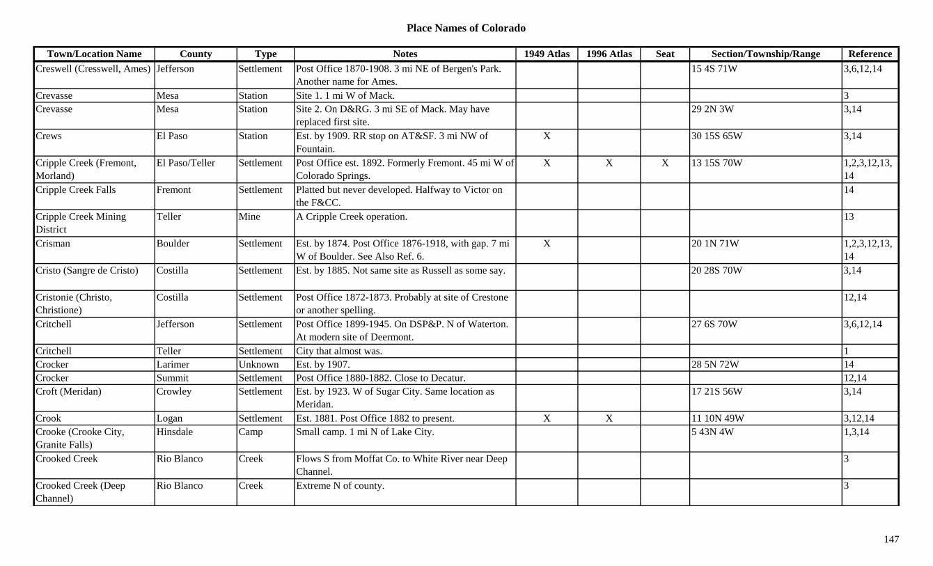
Place Names of Colorado
Town/Location Name County Type Notes 1949 Atlas 1996 Atlas Seat Section/Township/Range ReferenceCreswell (Cresswell, Ames) Jefferson Settlement Post Office 1870-1908. 3 mi NE of Bergen's Park.
Another name for Ames.15 4S 71W 3,6,12,14
Crevasse Mesa Station Site 1. 1 mi W of Mack. 3Crevasse Mesa Station Site 2. On D&RG. 3 mi SE of Mack. May have
replaced first site.29 2N 3W 3,14
Crews El Paso Station Est. by 1909. RR stop on AT&SF. 3 mi NW of Fountain.
X 30 15S 65W 3,14
Cripple Creek (Fremont, Morland)
El Paso/Teller Settlement Post Office est. 1892. Formerly Fremont. 45 mi W of Colorado Springs.
X X X 13 15S 70W 1,2,3,12,13,14
Cripple Creek Falls Fremont Settlement Platted but never developed. Halfway to Victor on the F&CC.
14
Cripple Creek Mining District
Teller Mine A Cripple Creek operation. 13
Crisman Boulder Settlement Est. by 1874. Post Office 1876-1918, with gap. 7 mi W of Boulder. See Also Ref. 6.
X 20 1N 71W 1,2,3,12,13,14
Cristo (Sangre de Cristo) Costilla Settlement Est. by 1885. Not same site as Russell as some say. 20 28S 70W 3,14
Cristonie (Christo, Christione)
Costilla Settlement Post Office 1872-1873. Probably at site of Crestone or another spelling.
12,14
Critchell Jefferson Settlement Post Office 1899-1945. On DSP&P. N of Waterton. At modern site of Deermont.
27 6S 70W 3,6,12,14
Critchell Teller Settlement City that almost was. 1Crocker Larimer Unknown Est. by 1907. 28 5N 72W 14Crocker Summit Settlement Post Office 1880-1882. Close to Decatur. 12,14Croft (Meridan) Crowley Settlement Est. by 1923. W of Sugar City. Same location as
Meridan.17 21S 56W 3,14
C k L S ttl t E t 1881 P t Offi 1882 t t X X 11 10N 49W 3 12 14Crook Logan Settlement Est. 1881. Post Office 1882 to present. X X 11 10N 49W 3,12,14Crooke (Crooke City, Granite Falls)
Hinsdale Camp Small camp. 1 mi N of Lake City. 5 43N 4W 1,3,14
Crooked Creek Rio Blanco Creek Flows S from Moffat Co. to White River near Deep Channel.
3
Crooked Creek (Deep Channel)
Rio Blanco Creek Extreme N of county. 3
147

Place Names of Colorado
Town/Location Name County Type Notes 1949 Atlas 1996 Atlas Seat Section/Township/Range ReferenceCrooked Creek Camp Chaffee Unknown 5 mi from Buena Vista. 14Crooked Creek Pass (9,995 or 10,020)
Eagle Pass Btwn Eagle and Hagerman Pass Road. Crossed by forest road. White River NF.
17 7S 83W 7,9
Crooked Wash Rio Blanco Creek Flows S to White River E of White River. 3Crooked Wash Creek Moffat Creek Flows S into Rio Blanco Co. W of Danforth Hills. 3
Crooks (Crookston, Crooksville)
Saguache Station Stage stop. Same as Crookston & Crooksville. 14
Crookstown (Crookston, Crooksville))
Saguache Settlement Post Office 1904-1906. Perhaps same as Crooksville, Crookston.
17 48N 4E 12,14
Crooksville (Crookton, Saguache/Gunniso Station Post Office 1878-1885. Station on D&RGW. 24 mi 35 48N 4E 3,12,14( ,Crookston, Crookstown)
gn from Gunnison on Tomichi Creek.
, ,
Crookton Saguache Unknown Site 2. 16 48N 4E 14Crookton (Crooksville) Saguache Station Site 1. Est. by 1887. Station on D&RGW. 24 mi
from Gunnison on Tomichi Creek.X 35 48N 4E 3,14
Cropsy Mountain (12,578) Peak12 Summitville Group. 8
Cross Boulder Mine W of Lakewood. 3Cross Canyon Dolores Canyon West central county. Runs SSW to Montezuma Co.
A big long canyon.Sev 40N 18W + 16
Cross Canyon Montezuma Canyon Runs SW into Utah. NW corner of county. By Spargo.
3
Cross Mountain Gunnison Peak12 WSW of Tin Cup. ?? 15S 82W 13,16Cross Mountain Moffat Settlement Post Office 1919-1943. NE of Elk Springs. X 5 5N 97W 3,12,14Cross Mountain (12,703) Dolores/San
MiguelPeak12 NE Dolores Co. NW of Rico. 9 41N 10W 1,16
C M t i (12 911) P k12 S t h R C ll i t S ti 8Cross Mountain (12,911) Peak12 Sawatch Range, Collegiate Section. 8Cross Mountain Junction Moffat Settlement Est. by 1913. Settlement on Little Snake River. ? 7N 98W 14Cross Tie Delta Settlement Est. by 1887. 6 mi NW of Delta. 3Crosson (Crossons) Jefferson Station Post Office 1879-1885. 5 mi W of Pine Grove. Btwn
Cliff & Estabrook.31 7S 71W 3,6,12,14
Crossons (Crosson) Jefferson Settlement Post Office 1920-1931. Same as Crosson. 31 7S 71W 6,12,14
148
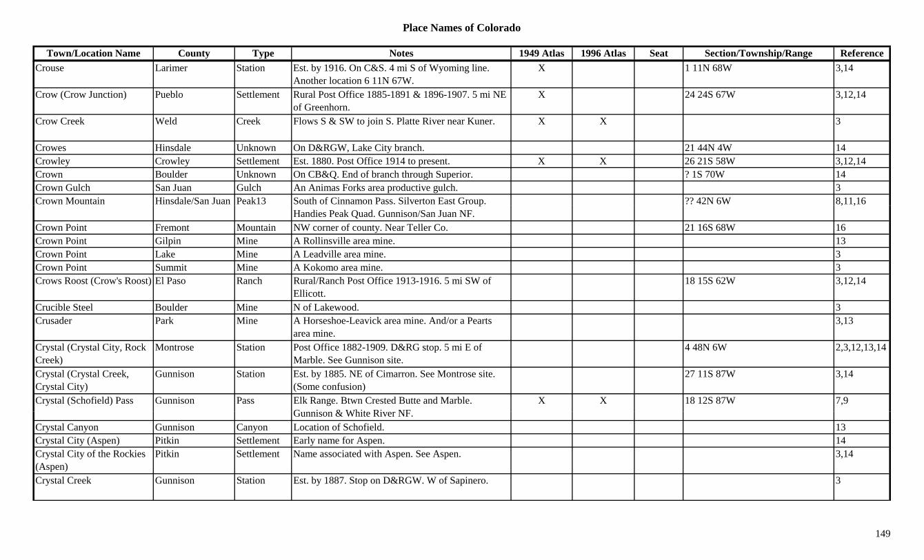
Place Names of Colorado
Town/Location Name County Type Notes 1949 Atlas 1996 Atlas Seat Section/Township/Range ReferenceCrouse Larimer Station Est. by 1916. On C&S. 4 mi S of Wyoming line.
Another location 6 11N 67W.X 1 11N 68W 3,14
Crow (Crow Junction) Pueblo Settlement Rural Post Office 1885-1891 & 1896-1907. 5 mi NE of Greenhorn.
X 24 24S 67W 3,12,14
Crow Creek Weld Creek Flows S & SW to join S. Platte River near Kuner. X X 3
Crowes Hinsdale Unknown On D&RGW, Lake City branch. 21 44N 4W 14Crowley Crowley Settlement Est. 1880. Post Office 1914 to present. X X 26 21S 58W 3,12,14Crown Boulder Unknown On CB&Q. End of branch through Superior. ? 1S 70W 14Crown Gulch San Juan Gulch An Animas Forks area productive gulch. 3Crown Mountain Hinsdale/San Juan Peak13 South of Cinnamon Pass. Silverton East Group. ?? 42N 6W 8,11,16p
Handies Peak Quad. Gunnison/San Juan NF., ,
Crown Point Fremont Mountain NW corner of county. Near Teller Co. 21 16S 68W 16Crown Point Gilpin Mine A Rollinsville area mine. 13Crown Point Lake Mine A Leadville area mine. 3Crown Point Summit Mine A Kokomo area mine. 3Crows Roost (Crow's Roost) El Paso Ranch Rural/Ranch Post Office 1913-1916. 5 mi SW of
Ellicott.18 15S 62W 3,12,14
Crucible Steel Boulder Mine N of Lakewood. 3Crusader Park Mine A Horseshoe-Leavick area mine. And/or a Pearts
area mine.3,13
Crystal (Crystal City, Rock Creek)
Montrose Station Post Office 1882-1909. D&RG stop. 5 mi E of Marble. See Gunnison site.
4 48N 6W 2,3,12,13,14
Crystal (Crystal Creek, Crystal City)
Gunnison Station Est. by 1885. NE of Cimarron. See Montrose site. (Some confusion)
27 11S 87W 3,14
Crystal (Schofield) Pass Gunnison Pass Elk Range. Btwn Crested Butte and Marble. G i & Whit Ri NF
X X 18 12S 87W 7,9Gunnison & White River NF.
Crystal Canyon Gunnison Canyon Location of Schofield. 13Crystal City (Aspen) Pitkin Settlement Early name for Aspen. 14Crystal City of the Rockies (Aspen)
Pitkin Settlement Name associated with Aspen. See Aspen. 3,14
Crystal Creek Gunnison Station Est. by 1887. Stop on D&RGW. W of Sapinero. 3
149
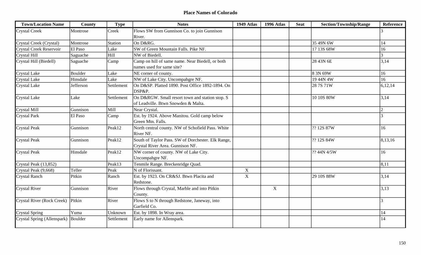
Place Names of Colorado
Town/Location Name County Type Notes 1949 Atlas 1996 Atlas Seat Section/Township/Range ReferenceCrystal Creek Montrose Creek Flows SW from Gunnison Co. to join Gunnison
River.3
Crystal Creek (Crystal) Montrose Station On D&RG. 35 49N 6W 14Crystal Creek Reservoir El Paso Lake SW of Green Mountain Falls. Pike NF. 17 13S 68W 16Crystal Hill Saguache Hill NW of Biedell. 3Crystal Hill (Biedell) Saguache Camp Camp on hill of same name. Near Biedell, or both
names used for same site?28 43N 6E 3,14
Crystal Lake Boulder Lake NE corner of county. 8 3N 69W 16Crystal Lake Hinsdale Lake NW of Lake City. Uncompahgre NF. 19 44N 4W 16Crystal Lake Jefferson Settlement On D&SP. Platted 1890. Post Office 1892-1894. On
DSP&P.28 7S 71W 6,12,14
Crystal Lake Lake Settlement On D&RGW. Small resort town and station stop. S of Leadville. Btwn Snowden & Malta.
10 10S 80W 3,14
Crystal Mill Gunnison Mill Near Crystal. 2Crystal Park El Paso Camp Est. by 1924. Above Manitou. Gold camp below
Green Mtn. Falls.3
Crystal Peak Gunnison Peak12 North central county. NW of Schofield Pass. White River NF.
?? 12S 87W 16
Crystal Peak Gunnison Peak12 South of Taylor Pass. SW of Dorchester. Elk Range, Crystal River Area. Gunnison NF.
?? 12S 84W 8,13,16
Crystal Peak Hinsdale Peak12 NW corner of county. NW of Lake City. Uncompahgre NF.
?? 44N 4/5W 16
Crystal Peak (13,852) Peak13 Tenmile Range. Breckenridge Quad. 8,11Crystal Peak (9,668) Teller Peak N of Florissant. XCrystal Ranch Pitkin Ranch Est. by 1923. On CR&SJ. Btwn Placita and
Redstone.X 29 10S 88W 3,14
C t l Ri G i Ri Fl th h C t l M bl d i t Pitki X 3 13Crystal River Gunnison River Flows through Crystal, Marble and into Pitkin County.
X 3,13
Crystal River (Rock Creek) Pitkin River Flows S to N through Redstone, Janeway, into Garfield Co.
3
Crystal Spring Yuma Unknown Est. by 1898. In Wray area. 14Crystal Spring (Allenspark) Boulder Settlement Early name for Allenspark. 14
150
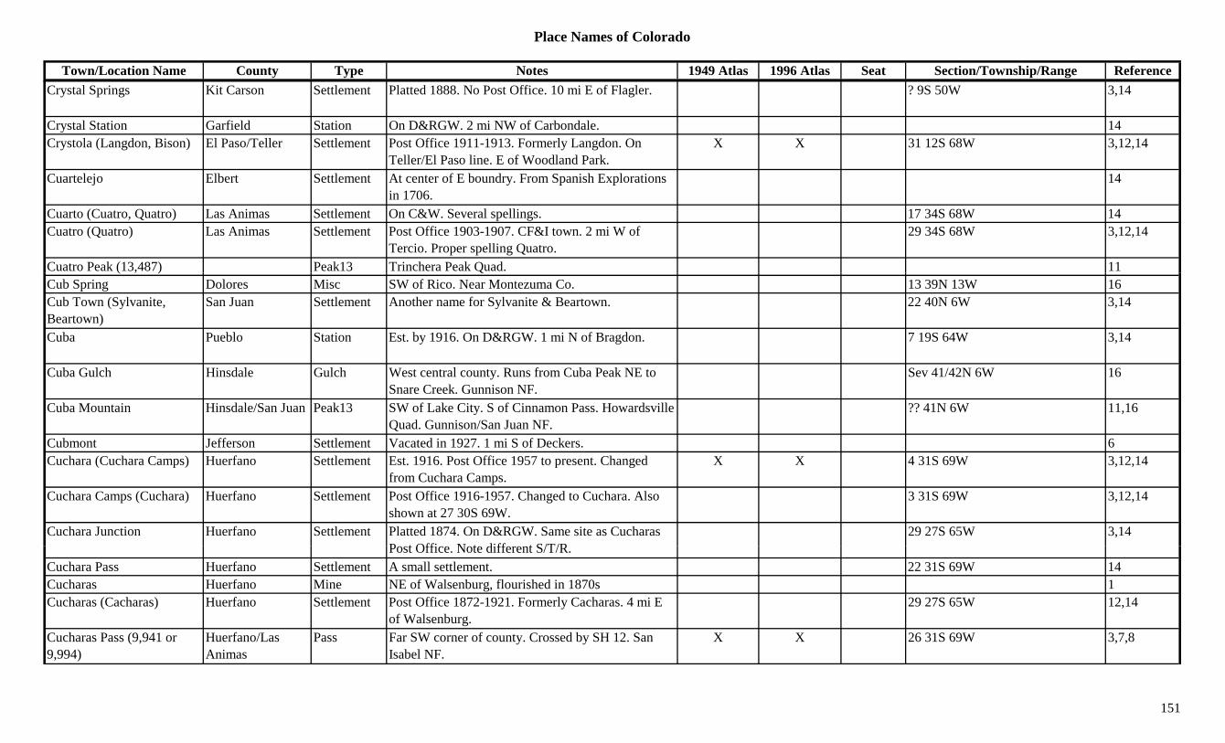
Place Names of Colorado
Town/Location Name County Type Notes 1949 Atlas 1996 Atlas Seat Section/Township/Range ReferenceCrystal Springs Kit Carson Settlement Platted 1888. No Post Office. 10 mi E of Flagler. ? 9S 50W 3,14
Crystal Station Garfield Station On D&RGW. 2 mi NW of Carbondale. 14Crystola (Langdon, Bison) El Paso/Teller Settlement Post Office 1911-1913. Formerly Langdon. On
Teller/El Paso line. E of Woodland Park.X X 31 12S 68W 3,12,14
Cuartelejo Elbert Settlement At center of E boundry. From Spanish Explorations in 1706.
14
Cuarto (Cuatro, Quatro) Las Animas Settlement On C&W. Several spellings. 17 34S 68W 14Cuatro (Quatro) Las Animas Settlement Post Office 1903-1907. CF&I town. 2 mi W of
Tercio. Proper spelling Quatro.29 34S 68W 3,12,14
Cuatro Peak (13,487) Peak13 Trinchera Peak Quad. 11( , ) QCub Spring Dolores Misc SW of Rico. Near Montezuma Co. 13 39N 13W 16Cub Town (Sylvanite, Beartown)
San Juan Settlement Another name for Sylvanite & Beartown. 22 40N 6W 3,14
Cuba Pueblo Station Est. by 1916. On D&RGW. 1 mi N of Bragdon. 7 19S 64W 3,14
Cuba Gulch Hinsdale Gulch West central county. Runs from Cuba Peak NE to Snare Creek. Gunnison NF.
Sev 41/42N 6W 16
Cuba Mountain Hinsdale/San Juan Peak13 SW of Lake City. S of Cinnamon Pass. Howardsville Quad. Gunnison/San Juan NF.
?? 41N 6W 11,16
Cubmont Jefferson Settlement Vacated in 1927. 1 mi S of Deckers. 6Cuchara (Cuchara Camps) Huerfano Settlement Est. 1916. Post Office 1957 to present. Changed
from Cuchara Camps.X X 4 31S 69W 3,12,14
Cuchara Camps (Cuchara) Huerfano Settlement Post Office 1916-1957. Changed to Cuchara. Also shown at 27 30S 69W.
3 31S 69W 3,12,14
Cuchara Junction Huerfano Settlement Platted 1874. On D&RGW. Same site as Cucharas P t Offi N t diff t S/T/R
29 27S 65W 3,14Post Office. Note different S/T/R.
Cuchara Pass Huerfano Settlement A small settlement. 22 31S 69W 14Cucharas Huerfano Mine NE of Walsenburg, flourished in 1870s 1Cucharas (Cacharas) Huerfano Settlement Post Office 1872-1921. Formerly Cacharas. 4 mi E
of Walsenburg.29 27S 65W 12,14
Cucharas Pass (9,941 or 9,994)
Huerfano/Las Animas
Pass Far SW corner of county. Crossed by SH 12. San Isabel NF.
X X 26 31S 69W 3,7,8
151
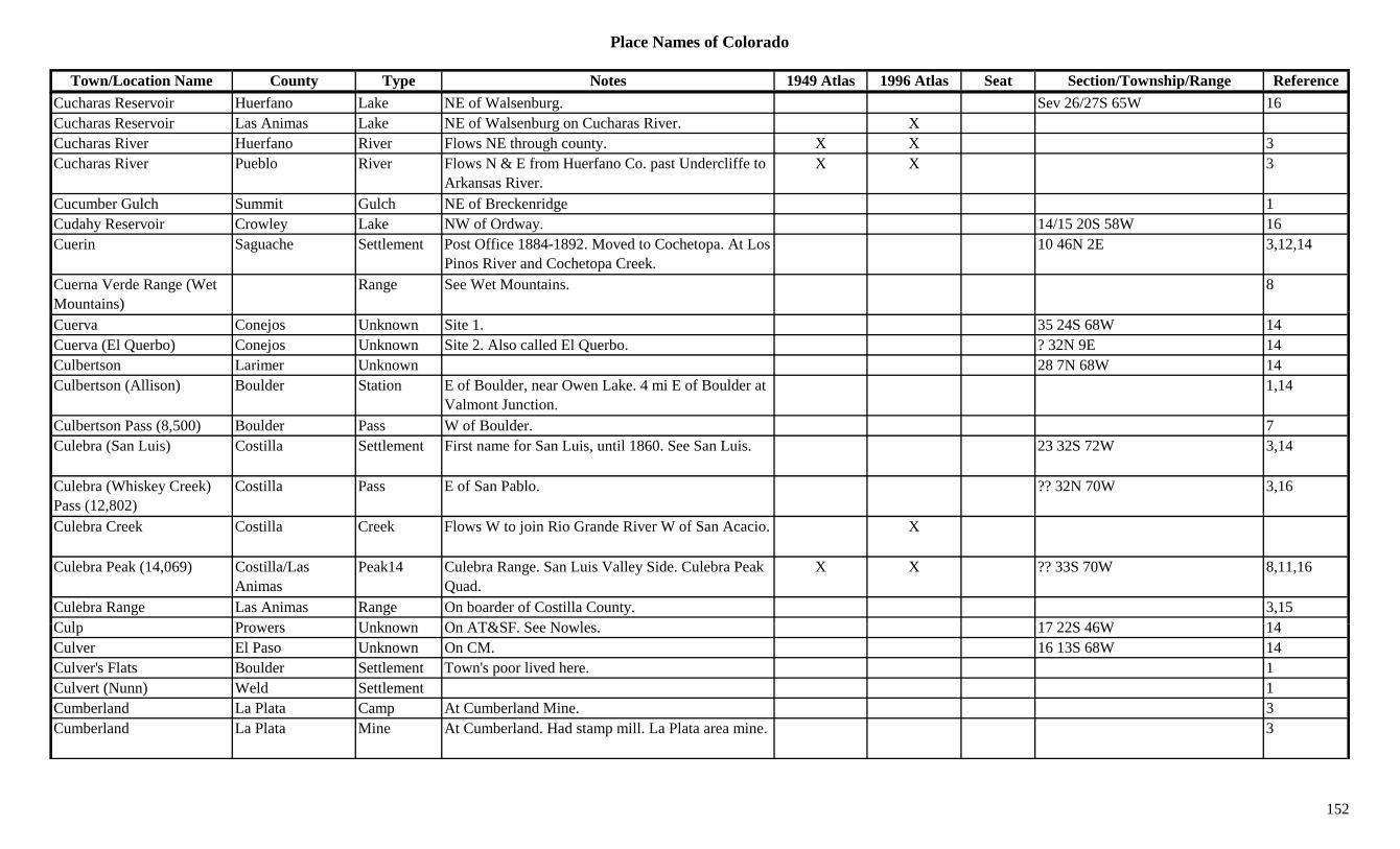
Place Names of Colorado
Town/Location Name County Type Notes 1949 Atlas 1996 Atlas Seat Section/Township/Range ReferenceCucharas Reservoir Huerfano Lake NE of Walsenburg. Sev 26/27S 65W 16Cucharas Reservoir Las Animas Lake NE of Walsenburg on Cucharas River. XCucharas River Huerfano River Flows NE through county. X X 3Cucharas River Pueblo River Flows N & E from Huerfano Co. past Undercliffe to
Arkansas River.X X 3
Cucumber Gulch Summit Gulch NE of Breckenridge 1Cudahy Reservoir Crowley Lake NW of Ordway. 14/15 20S 58W 16Cuerin Saguache Settlement Post Office 1884-1892. Moved to Cochetopa. At Los
Pinos River and Cochetopa Creek.10 46N 2E 3,12,14
Cuerna Verde Range (Wet Mountains)
Range See Wet Mountains. 8
Cuerva Conejos Unknown Site 1. 35 24S 68W 14Cuerva (El Querbo) Conejos Unknown Site 2. Also called El Querbo. ? 32N 9E 14Culbertson Larimer Unknown 28 7N 68W 14Culbertson (Allison) Boulder Station E of Boulder, near Owen Lake. 4 mi E of Boulder at
Valmont Junction.1,14
Culbertson Pass (8,500) Boulder Pass W of Boulder. 7Culebra (San Luis) Costilla Settlement First name for San Luis, until 1860. See San Luis. 23 32S 72W 3,14
Culebra (Whiskey Creek) Pass (12,802)
Costilla Pass E of San Pablo. ?? 32N 70W 3,16
Culebra Creek Costilla Creek Flows W to join Rio Grande River W of San Acacio. X
Culebra Peak (14,069) Costilla/Las Animas
Peak14 Culebra Range. San Luis Valley Side. Culebra Peak Quad.
X X ?? 33S 70W 8,11,16
Culebra Range Las Animas Range On boarder of Costilla County. 3,15C l P U k O AT&SF S N l 17 22S 46W 14Culp Prowers Unknown On AT&SF. See Nowles. 17 22S 46W 14Culver El Paso Unknown On CM. 16 13S 68W 14Culver's Flats Boulder Settlement Town's poor lived here. 1Culvert (Nunn) Weld Settlement 1Cumberland La Plata Camp At Cumberland Mine. 3Cumberland La Plata Mine At Cumberland. Had stamp mill. La Plata area mine. 3
152

Place Names of Colorado
Town/Location Name County Type Notes 1949 Atlas 1996 Atlas Seat Section/Township/Range ReferenceCumberland Mountain (12,388)
Peak12 La Plata Range. 8
Cumberland Pass Gunnison Pass Btwn Pitkin and Tincup. Cumberland Pass Topo. Gunnison NF.
11 51N 4E 3,7,8,9,16
Cumbres (Cumbries) Conejos Settlement Post Office 1889-1937, with gaps. On D&RG. At summit of Cumbres Pass.
X 18 32N 5E 3,12,14
Cumbres and Toltec RR Conejos Misc At Conejos. XCumbres Pass (10,022) Conejos Pass Btwn Antonito and Chama, NM. Crossed by SH 17.
Rio Grande NF.X X 17 32N 5E 7,9,16
Cummings Grand Camp Obscure camp in Lulu area. 3Cummings Jackson Camp Temporary. On old stage road from Cameron Pass to 3,14g p p y g
Teller City.,
Cummings Camp San Miguel Unknown Est. by 1916. 24 44N 17W 14Cunningham La Plata Unknown On D&RGW. 14Cunningham Mineral Unknown On D&RGW. Btwn Riverside Ranch, Rio Grande
Co. & Wagon Wheel Gap.14
Cunningham Summit Unknown Est. by 1913. On D&RG. 2 mi SW of Frisco. 32 5S 78W 14Cunningham (Stony) Pass Hinsdale/San Juan Pass Btwn Silverton and Creede. Howardsville Topo. San
Juan & Rio Grande NF.20 41N 6W 3,5,7,8,9
Cunningham Gulch Gunnison Gulch NW of Gunnison. Runs NE to Ohio Creek. Sev 51N 1/2W 16Cunningham Gulch San Juan Gulch Near Howardsville. 2,3Curecano (Currecanti) Gunnison Station See Currecanti. 3Curecanti Needle Gunnison Hill West of Blue Mesa Res. Curecanti Natl. Rec. Area. 3 48N 5W 16
Curecanti Pass Gunnison Pass NW of Gunnison. West Elk Range, Gunnison North Fork Group. Gunnison NF.
31 15S 89W 7,8,16
C f Cl C k Mi A Y k Hill i 3Curfew Clear Creek Mine A Yankee Hill mine. 3Curley Peak Fremont Mountain SSW of Canon City. San Isabel NF. ?? 20S 71W 13,16Curran Gunnison Settlement Post Office 1880. Possible same place as Curran,
Pitkin Co.12,14
Curran Pitkin Unknown Est. by 1898. Near Aspen. 14Currant (Currant Creek) Fremont Settlement Est. by 1881. Post Office 1894-1901. Formerly
Currant Creek.3 17S 72W 12,14
153

Place Names of Colorado
Town/Location Name County Type Notes 1949 Atlas 1996 Atlas Seat Section/Township/Range ReferenceCurrant Creek Delta Creek Flows S & SW to join Gunnison River near Read. 3
Currant Creek Fremont Creek Flows SE to Arkansas River. X 3Currant Creek Park Creek NW of Guffey. X 3Currant Creek (Currant) Fremont Settlement Post Office 1870-1894. Changed to Currant. At
Currant Creek. NW of Canon City.3 17S 72W 3,12,14
Currant Creek Junction (Parkdale)
Fremont Settlement See Parkdale. 3
Currant Creek Pass Park Settlement Est. by 1885. NW of Guffey on creek of same name. 3
Currant Creek Pass (9,654 Park Pass Btwn Hartsel and Canon City. Crossed by SH 9. Pike X 14 14S 74W 7( ,or 9,480)
y yNF.
Currecanti (Curecanti, Curecano)
Gunnison Station Est. by 1887. Stop on D&RGW. W of Sapinero. X 3 48N 5W 3,14
Curry Springs (Curie Springs)
Boulder Creek Near Jamestown. 1
Curt Beatty Pitkin Settlement 3 mi S of Eagle Co. line & 8 mi W of Lake Co. line. 14
Curtin Summit Station Est. by 1923. On C&S. S of Frisco. 5 6S 78W 3,14Curtis El Paso Settlement Post Office 1901-1915. E of Pikeview. 0.5 mi S of
Papeton.32 13S 66W 3,12,14
Curtis Mesa Settlement Incorp. 1907. 14Curtis Pueblo Unknown Est. by 1898. Near Pueblo 14Curtis Summit Unknown On D&RG. 14Curtis Washington Settlement Rural Post Office 1888-1901. 7 mi N of Platner. 3 3N 51W 3,12,14
C ti C k Ri Bl C k Fl S t j i th Whit Ri E f M k 3Curtis Creek Rio Blanco Creek Flows S to join the White River E of Meeker. 3Cushman Creek Montrose Creek Flows N & E to join Dry Creek W of Montrose. 3
Custer City Custer Settlement Est. by 1902. Between Rosita and Querida. 21 22S 71W 1,3,14Custro Las Animas Unknown Est. by 1930. On C&W spur. S of Primero. See
Cuatro.14
Cuthbertson Larimer Station Est. by 1909. On C&S. 3 mi NW of Timnath. 28 7N 68W 3,14
154
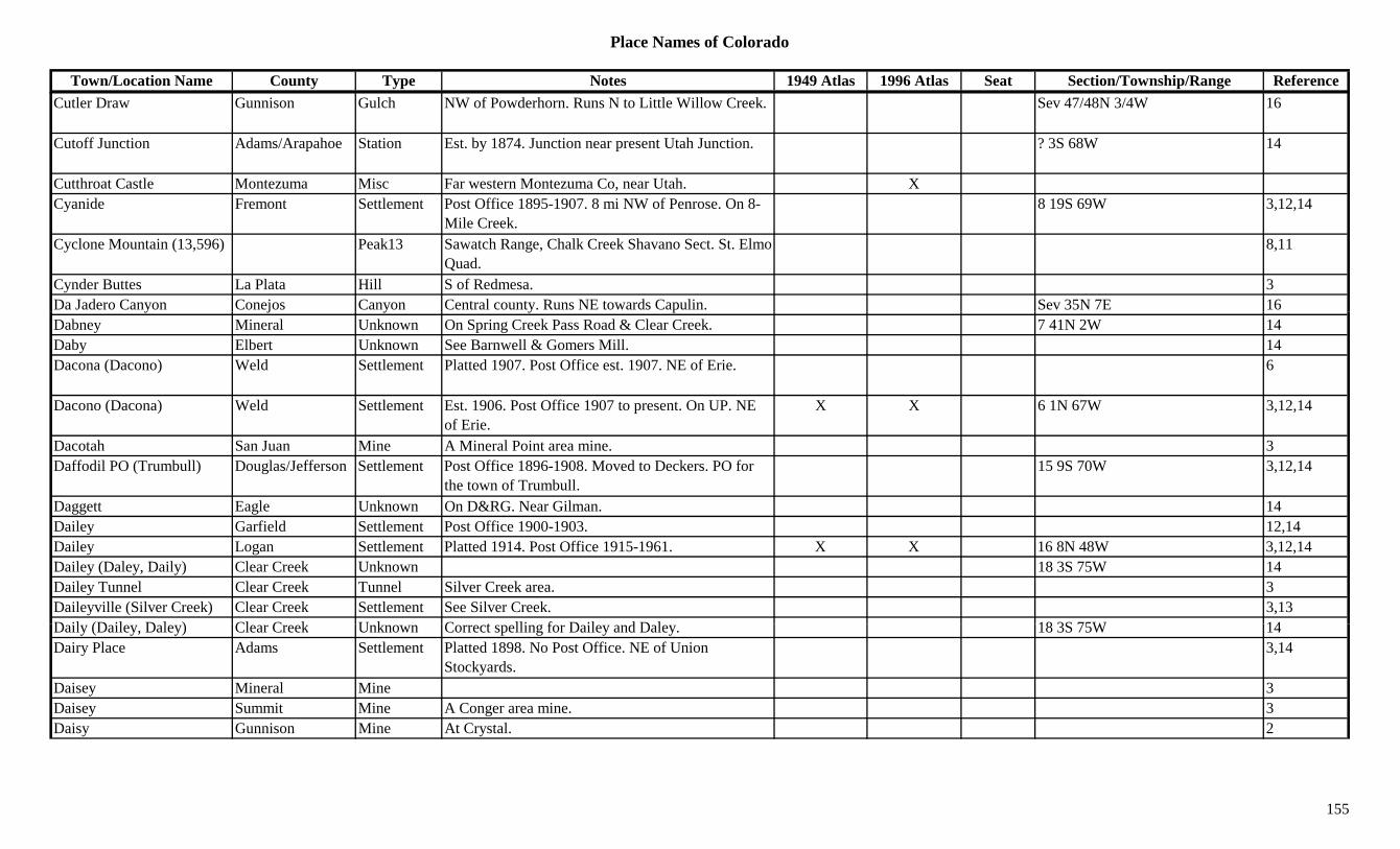
Place Names of Colorado
Town/Location Name County Type Notes 1949 Atlas 1996 Atlas Seat Section/Township/Range ReferenceCutler Draw Gunnison Gulch NW of Powderhorn. Runs N to Little Willow Creek. Sev 47/48N 3/4W 16
Cutoff Junction Adams/Arapahoe Station Est. by 1874. Junction near present Utah Junction. ? 3S 68W 14
Cutthroat Castle Montezuma Misc Far western Montezuma Co, near Utah. XCyanide Fremont Settlement Post Office 1895-1907. 8 mi NW of Penrose. On 8-
Mile Creek.8 19S 69W 3,12,14
Cyclone Mountain (13,596) Peak13 Sawatch Range, Chalk Creek Shavano Sect. St. Elmo Quad.
8,11
Cynder Buttes La Plata Hill S of Redmesa. 3Da Jadero Canyon Conejos Canyon Central county. Runs NE towards Capulin. Sev 35N 7E 16y j y y pDabney Mineral Unknown On Spring Creek Pass Road & Clear Creek. 7 41N 2W 14Daby Elbert Unknown See Barnwell & Gomers Mill. 14Dacona (Dacono) Weld Settlement Platted 1907. Post Office est. 1907. NE of Erie. 6
Dacono (Dacona) Weld Settlement Est. 1906. Post Office 1907 to present. On UP. NE of Erie.
X X 6 1N 67W 3,12,14
Dacotah San Juan Mine A Mineral Point area mine. 3Daffodil PO (Trumbull) Douglas/Jefferson Settlement Post Office 1896-1908. Moved to Deckers. PO for
the town of Trumbull.15 9S 70W 3,12,14
Daggett Eagle Unknown On D&RG. Near Gilman. 14Dailey Garfield Settlement Post Office 1900-1903. 12,14Dailey Logan Settlement Platted 1914. Post Office 1915-1961. X X 16 8N 48W 3,12,14Dailey (Daley, Daily) Clear Creek Unknown 18 3S 75W 14Dailey Tunnel Clear Creek Tunnel Silver Creek area. 3Daileyville (Silver Creek) Clear Creek Settlement See Silver Creek. 3,13D il (D il D l ) Cl C k U k C t lli f D il d D l 18 3S 75W 14Daily (Dailey, Daley) Clear Creek Unknown Correct spelling for Dailey and Daley. 18 3S 75W 14Dairy Place Adams Settlement Platted 1898. No Post Office. NE of Union
Stockyards.3,14
Daisey Mineral Mine 3Daisey Summit Mine A Conger area mine. 3Daisy Gunnison Mine At Crystal. 2
155

Place Names of Colorado
Town/Location Name County Type Notes 1949 Atlas 1996 Atlas Seat Section/Township/Range ReferenceDaisy Pass Gunnison Pass NW of Crested Butte. W of Pittsburg. Oh-be-Joyful
Topo. Gunnison NF.3 13S 87W 3,5,7
Dakan Douglas Settlement Post Office 1896-1898. 12,14Dakan Mountain (8,400) Douglas Mountain East of Deckers. NE of West Creek. Rampart Range.
Pike NF.25 9S 69W 13,16
Dake Park Settlement Post Office 1883-1892. 38 mi NE of Fairplay. May be same site as Hoosier.
22 7S 75W 1,3,12,14
Dakota Hill Gilpin Peak10 Central county. SW of Perigo. Roosevelt/Arapaho NF.
15 2S 73W 16
Dale Fremont Station Est. by 1913. In Phantom Canyon. 4 17S 69W 14Dale (Elk, Elkdale) Grand Unknown Same as Elk & Elkdale. 22 1N 76W 14( , )Dalerose Las Animas Settlement Rural Post Office 1916-1943. 7 mi SW of Kim. 14 33S 54W 3,12,14Daley (Daily, Dailey) Clear Creek Unknown Another spelling for Daily. 18 3S 75W 14Daley Headquarters Routt Unknown At the Wyoming line. 14 12N 85W 14Dallas (Dallas Station, Dallas City)
Ouray Station Site 2. Post Office 1884-1899. Moved from Lawrence. Stage and wagon train station.
X 4 45N 8W 3,12,14
Dallas (Gold City, Unaweep, Uniweep)
Ouray Camp Site 1. 1879. In Uniweep Valley. 3,14
Dallas (Leopard Creek) Divide (8,970)
Ouray/San Miguel Divide 1576. Site of 12-man expedition of Dominguez and Escalante. Crossed by SH 62.
X 6 44N 9W 1,7,3
Dallas Divide (Aurora) Ouray Station Post Office 1894-1909. Moved to Noel. On RGS. 15 mi SW of Ridgway.
6 44N 9W 3,12,14
Dallas Fork Ouray Creek 1885. Another name for Dallas Creek. 3Dallas Peak (13,809) Ouray/San Miguel Peak13 Sneffels Range. W of Ouray. Telluride Quad. 3,8,11
Dallasville (Aurora, Dallas Di id N l)
Ouray Settlement Post Office 1877-1879. 6 44N 9W 12,14Divide, Noel)Daly Lake Mine A Leadville area mine. 3Daly Gulch Gunnison Gulch SE corner of county. Runs ESE to Tomichi Creek. Sev 48N 5E 16
Daly-Capitol Ridge (13,600)
Peak13 Elk Range, Central Section. 8
156

Place Names of Colorado
Town/Location Name County Type Notes 1949 Atlas 1996 Atlas Seat Section/Township/Range ReferenceDamascus Lincoln Settlement Rural Post Office 1914-1917. 13 mi E of Karval. 3,12,14
Dan Douglas Unknown Est. by 1907. 2 miles NW of Perry Park. 1 9S 69W 14Dana (Kobe, Haydens) Lake Settlement On CM. Same as Kobe & Haydens. 2 11S 80W 14Danforth Hills Moffat Range SW of Price Creek. 3Daniels (Edgemont) Jefferson Settlement Post Office 1948-1954. Rural Branch of Golden.
Changed to Edgemont.6,12,14
Daniels Creek Moffat Creek Flows S to join Fortification Creek. 3Daniels Park Douglas Park 31 6S 67W 14Dannels Boulder Unknown Est. by 1911. On Fox Creek. 1.5 mi NW of Allens
Park.14
Dante Teller Mine Est. by 1906. On CS&CC. 20 15S 69W 14Darby Eagle Unknown On D&RGW. 14Darlington Archuleta Unknown On D&RG. 17 32N 5W 14Darlow Adams Station Est. by 1920. RR stop on UP. 6 mi W of Brighton. 12 1S 68W 3,6,14
Daton Peak Routt Peak SW corner of county. Near Pagoda. 3D'Aubrey's Trading Post Adams Store Est. by 1858. On Platte River. 6 mi below Denver
City.14
Dauntless Park Mine A Horseshoe-Leavick area mine. 13Davenport (Altona) Boulder Settlement Est. by 1859. At mouth of Left Hand Creek. 11 2N 69W 1,14Davenport (Linton) Saguache Settlement On D&RG. Just N of Villa Grove. Another name for
Linton.20 47N 9E 14
David Leavitt Ranch Logan Settlement Sterling Post Office est. here in 1874. 3David's Wells Cheyenne Station Stage station on Smoky Hill North stage route. 10 mi
from Aroya. Close to Wild Horse.3,14
D id B ld S ttl t P t Offi 1873 1878 N f L i ill S f 32 1N 69W 1 3 6 12 14Davidson Boulder Settlement Post Office 1873-1878. N of Louisville, S of Valmont on CC RR.
32 1N 69W 1,3,6,12,14
Davidson Canal Boulder Misc Off South Boulder Creek, 12 mi long. 1Davidson Mesa Boulder Hill W of Louisville. 1Davies Pitkin Settlement Post Office 1895. May have preceded Snowmass. 27 8S 86W 12,14
157
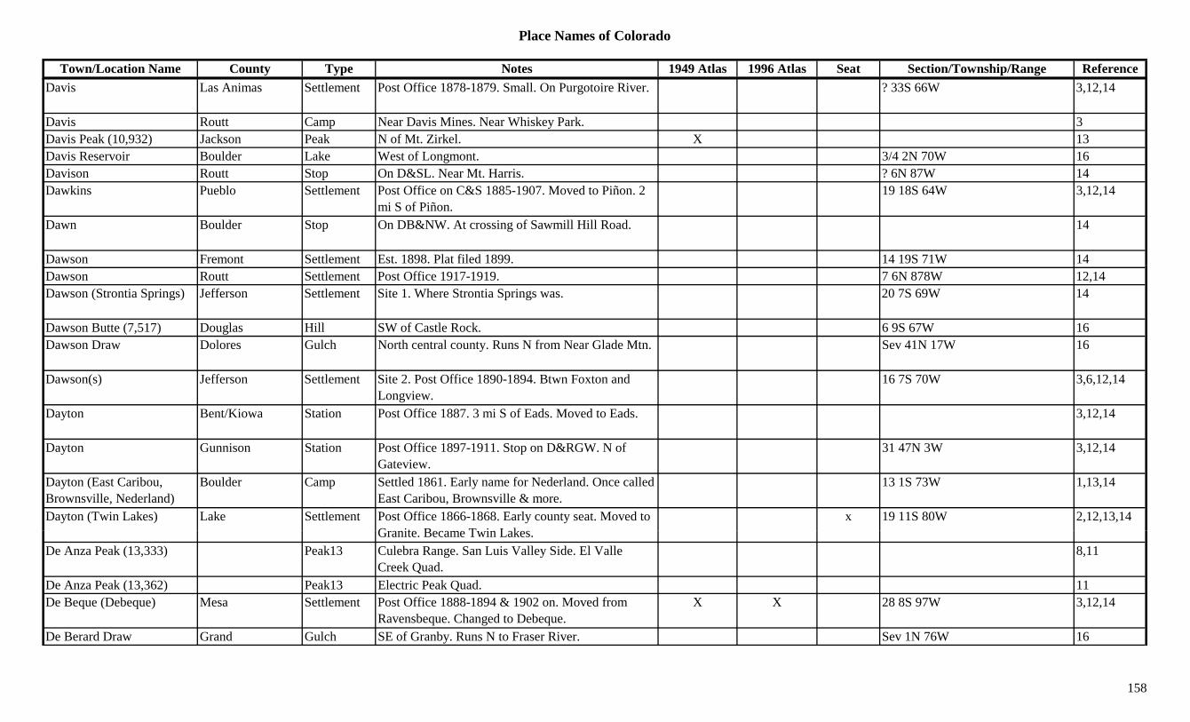
Place Names of Colorado
Town/Location Name County Type Notes 1949 Atlas 1996 Atlas Seat Section/Township/Range ReferenceDavis Las Animas Settlement Post Office 1878-1879. Small. On Purgotoire River. ? 33S 66W 3,12,14
Davis Routt Camp Near Davis Mines. Near Whiskey Park. 3Davis Peak (10,932) Jackson Peak N of Mt. Zirkel. X 13Davis Reservoir Boulder Lake West of Longmont. 3/4 2N 70W 16Davison Routt Stop On D&SL. Near Mt. Harris. ? 6N 87W 14Dawkins Pueblo Settlement Post Office on C&S 1885-1907. Moved to Piñon. 2
mi S of Piñon.19 18S 64W 3,12,14
Dawn Boulder Stop On DB&NW. At crossing of Sawmill Hill Road. 14
Dawson Fremont Settlement Est. 1898. Plat filed 1899. 14 19S 71W 14Dawson Routt Settlement Post Office 1917-1919. 7 6N 878W 12,14Dawson (Strontia Springs) Jefferson Settlement Site 1. Where Strontia Springs was. 20 7S 69W 14
Dawson Butte (7,517) Douglas Hill SW of Castle Rock. 6 9S 67W 16Dawson Draw Dolores Gulch North central county. Runs N from Near Glade Mtn. Sev 41N 17W 16
Dawson(s) Jefferson Settlement Site 2. Post Office 1890-1894. Btwn Foxton and Longview.
16 7S 70W 3,6,12,14
Dayton Bent/Kiowa Station Post Office 1887. 3 mi S of Eads. Moved to Eads. 3,12,14
Dayton Gunnison Station Post Office 1897-1911. Stop on D&RGW. N of Gateview.
31 47N 3W 3,12,14
Dayton (East Caribou, Brownsville, Nederland)
Boulder Camp Settled 1861. Early name for Nederland. Once called East Caribou, Brownsville & more.
13 1S 73W 1,13,14
Dayton (Twin Lakes) Lake Settlement Post Office 1866-1868. Early county seat. Moved to G it B T i L k
x 19 11S 80W 2,12,13,14Granite. Became Twin Lakes.
De Anza Peak (13,333) Peak13 Culebra Range. San Luis Valley Side. El Valle Creek Quad.
8,11
De Anza Peak (13,362) Peak13 Electric Peak Quad. 11De Beque (Debeque) Mesa Settlement Post Office 1888-1894 & 1902 on. Moved from
Ravensbeque. Changed to Debeque.X X 28 8S 97W 3,12,14
De Berard Draw Grand Gulch SE of Granby. Runs N to Fraser River. Sev 1N 76W 16
158

Place Names of Colorado
Town/Location Name County Type Notes 1949 Atlas 1996 Atlas Seat Section/Township/Range ReferenceDe Nova (Denova, Billingham)
Washington Settlement Rural Post Office 1916-1953. 20 mi S of Otis. Formerly Billingham.
X 28 2S 50W 12,14
De Reemer Forts Unknown Fort Barricades in or near Royal Gorge, 1878-1880. In Colorado??
14
De Spain Junction (Harris, Westminster)
Adams Station First name, second was Harris, then Harrisburg, Harris Park & last Westminster.
14
Dead Man Claim Summit Mine A Robinson area mine. 3Dead Man Hill Pass (10,272)
Larimer Pass Out of Red Feather Lakes. 7
Dead Pine Teller Mine 29 15S 69W 14Deadman Cow Camp Saguache Settlement SW portion of Baca Grant. Cabins were blown up. 3p g p p
Deadman Creek (Chatillion Creek)
Saguache Creek 1885. Flows through Luis Maria Baca Grant W to Crestone Creek.
3
Deadman Gulch Gunnison Gulch NW of Paonia Res. Gunnison NF. Sev 12S 89W 16Deadman Gulch Gunnison Gulch SE corner of county. Runs NW to Tomichi Creek. Sev 49N 5E 16
Deadman Gulch Gunnison Gulch West of Gunnison. Runs S to Stevens Creek. Sev 50N 2W 16Deadman Gulch Park Gulch Runs S to Jefferson (?) Creek. NW of Jefferson. 3
Deadwood Diggings (Gambell Gulch)
Gilpin Camp Early name for Gambell or Gamble Gulch. 3,14
Deadwood Gulch Dolores Gulch South of Rico. Runs W to Dolores River. Sev 39N 11W 16Deadwood Gulch Park Gulch On fork of Tarryall Creek. 7-8 men killed by Indians,
18591
Deadwood Gulch Park Mine A Tarryall area mine. 3D F t U k O D&RG AT&SF 13 19S 69W 14Dean Fremont Unknown On D&RG, AT&SF. 13 19S 69W 14Dean Las Animas Settlement Post Office 1900-1913. 5 mi SE of Apishapa Pass. 36 31S 69W 3,12,14
Deane (Deansbury, Strontia Springs)
Douglas/Jefferson Settlement Post Office 1879-1884. Moved from Platte Cañon. Changed to Deansbury.
20 7S 69W 3,6,12,14
Dean's Camp Pitkin Unknown Near head of Rocky Ford Creek. ? 9S 84W 14
159
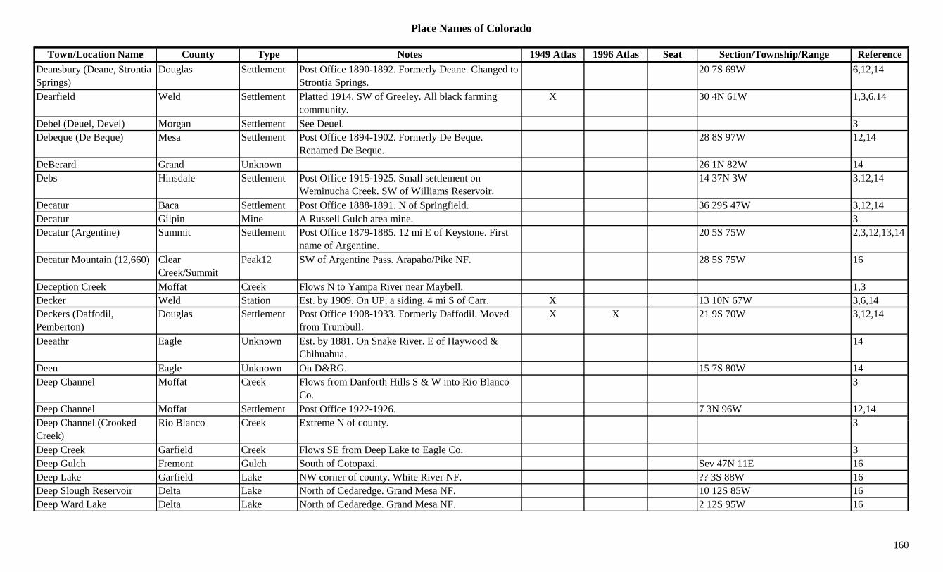
Place Names of Colorado
Town/Location Name County Type Notes 1949 Atlas 1996 Atlas Seat Section/Township/Range ReferenceDeansbury (Deane, Strontia Springs)
Douglas Settlement Post Office 1890-1892. Formerly Deane. Changed to Strontia Springs.
20 7S 69W 6,12,14
Dearfield Weld Settlement Platted 1914. SW of Greeley. All black farming community.
X 30 4N 61W 1,3,6,14
Debel (Deuel, Devel) Morgan Settlement See Deuel. 3Debeque (De Beque) Mesa Settlement Post Office 1894-1902. Formerly De Beque.
Renamed De Beque.28 8S 97W 12,14
DeBerard Grand Unknown 26 1N 82W 14Debs Hinsdale Settlement Post Office 1915-1925. Small settlement on
Weminucha Creek. SW of Williams Reservoir.14 37N 3W 3,12,14
Decatur Baca Settlement Post Office 1888-1891. N of Springfield. 36 29S 47W 3,12,14p g , ,Decatur Gilpin Mine A Russell Gulch area mine. 3Decatur (Argentine) Summit Settlement Post Office 1879-1885. 12 mi E of Keystone. First
name of Argentine.20 5S 75W 2,3,12,13,14
Decatur Mountain (12,660) Clear Creek/Summit
Peak12 SW of Argentine Pass. Arapaho/Pike NF. 28 5S 75W 16
Deception Creek Moffat Creek Flows N to Yampa River near Maybell. 1,3Decker Weld Station Est. by 1909. On UP, a siding. 4 mi S of Carr. X 13 10N 67W 3,6,14Deckers (Daffodil, Pemberton)
Douglas Settlement Post Office 1908-1933. Formerly Daffodil. Moved from Trumbull.
X X 21 9S 70W 3,12,14
Deeathr Eagle Unknown Est. by 1881. On Snake River. E of Haywood & Chihuahua.
14
Deen Eagle Unknown On D&RG. 15 7S 80W 14Deep Channel Moffat Creek Flows from Danforth Hills S & W into Rio Blanco
Co.3
Deep Channel Moffat Settlement Post Office 1922-1926. 7 3N 96W 12,14D Ch l (C k d Ri Bl C k E t N f t 3Deep Channel (Crooked Creek)
Rio Blanco Creek Extreme N of county. 3
Deep Creek Garfield Creek Flows SE from Deep Lake to Eagle Co. 3Deep Gulch Fremont Gulch South of Cotopaxi. Sev 47N 11E 16Deep Lake Garfield Lake NW corner of county. White River NF. ?? 3S 88W 16Deep Slough Reservoir Delta Lake North of Cedaredge. Grand Mesa NF. 10 12S 85W 16Deep Ward Lake Delta Lake North of Cedaredge. Grand Mesa NF. 2 12S 95W 16
160

Place Names of Colorado
Town/Location Name County Type Notes 1949 Atlas 1996 Atlas Seat Section/Township/Range ReferenceDeepcreek (Deep Creek) Routt Settlement Post Office 1900-1936. 12 mi SW of Clark. X 28 8N 86W 3,12,14Deer (Milner) Pass Grand/Larimer Pass Arapahos called Milner Pass Deer Pass. Crossed by
US 34.Deer Creek Mesa Creek Flows W & S to Gunnison River 3Deer Creek Park Creek Flows SE to Jefferson Co. In NE part of county. 3
Deer Creek Park Settlement Had Post Office. On Deer Creek. 14Deer Creek Lakes Hinsdale Lake NE corner of county. E of Lake City. Gunnison NF. 34 44N 3W 16
Deer Gulch Fremont Gulch North of Howard. San Isabel NF. Sev 50N 10E 16Deer Lake Garfield Lake NE corner of county. White River NF. ?? 1S 87W 16yDeer Mountain Fremont Mountain SE of Texas Creek (town). 12 20S 72W 16Deer Mountain Larimer Mountain 3Deer Mountain (13,761) Peak13 Sawatch Range, Leadville Frying Pan Sect. Mt.
Champion Quad.8,11
Deer Mountain (7,425) Routt Mountain S of Mad Creek. 13Deer Park Routt Station Est. by 1923. On D&SL. 3 mi N of Haybro. 33 5N 85W 3,14Deer Park Teller Unknown 10 15S 68W 14Deer Park Gulch Garfield Gulch Central county. Runs SW & W to Clear Creek. Sev 6S 98W 16Deer Peak (11,300) Custer Peak11 SW of Fairview. San Isabel NF. X 14 23S 70W 16Deer Ridge Larimer Trail Est. 1913. Trail to top of Deer Mountain. 3Deer Ridge Larimer Unknown 19 5N 73W 14Deer Run Garfield Unknown On Unitah RR. 22 5S 103W 14Deer Run (Comfort) Mesa Station Est. by 1922. Earlier settlement at Comfort. 9 mi SE
of Whitewater.35 13S 99W 3,14
Deer Trail (Deertrail) Arapahoe Settlement Post Office 1875-1894 & 1950 to present. Changed t D t il Pl tt d i 1875
13 5S 60W 3,6,12,14to Deertrail. Platted in 1875.
Deer Trail Creek Adams Creek Flows N in Eastern Adams Co into Morgan Co. XDeer Trail Creek Arapahoe Creek Flows N through Eastern Arapahoe Co into Adams
Co.X 16
Deer Trail Creek Elbert Creek Originates in Elbert Co, flows N into Arapahoe Co W of Deer Trail.
X
Deer Trail Creek Morgan Creek Flows N to join Bijou Creek S of Fort Morgan. X
161
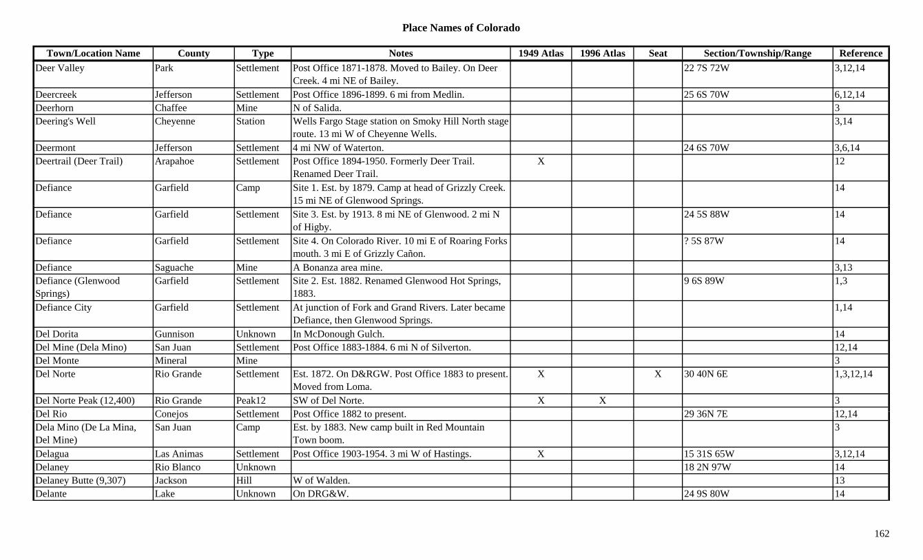
Place Names of Colorado
Town/Location Name County Type Notes 1949 Atlas 1996 Atlas Seat Section/Township/Range ReferenceDeer Valley Park Settlement Post Office 1871-1878. Moved to Bailey. On Deer
Creek. 4 mi NE of Bailey.22 7S 72W 3,12,14
Deercreek Jefferson Settlement Post Office 1896-1899. 6 mi from Medlin. 25 6S 70W 6,12,14Deerhorn Chaffee Mine N of Salida. 3Deering's Well Cheyenne Station Wells Fargo Stage station on Smoky Hill North stage
route. 13 mi W of Cheyenne Wells.3,14
Deermont Jefferson Settlement 4 mi NW of Waterton. 24 6S 70W 3,6,14Deertrail (Deer Trail) Arapahoe Settlement Post Office 1894-1950. Formerly Deer Trail.
Renamed Deer Trail.X 12
Defiance Garfield Camp Site 1. Est. by 1879. Camp at head of Grizzly Creek. 15 mi NE of Glenwood Springs.
14
Defiance Garfield Settlement Site 3. Est. by 1913. 8 mi NE of Glenwood. 2 mi N of Higby.
24 5S 88W 14
Defiance Garfield Settlement Site 4. On Colorado River. 10 mi E of Roaring Forks mouth. 3 mi E of Grizzly Cañon.
? 5S 87W 14
Defiance Saguache Mine A Bonanza area mine. 3,13Defiance (Glenwood Springs)
Garfield Settlement Site 2. Est. 1882. Renamed Glenwood Hot Springs, 1883.
9 6S 89W 1,3
Defiance City Garfield Settlement At junction of Fork and Grand Rivers. Later became Defiance, then Glenwood Springs.
1,14
Del Dorita Gunnison Unknown In McDonough Gulch. 14Del Mine (Dela Mino) San Juan Settlement Post Office 1883-1884. 6 mi N of Silverton. 12,14Del Monte Mineral Mine 3Del Norte Rio Grande Settlement Est. 1872. On D&RGW. Post Office 1883 to present.
Moved from Loma.X X 30 40N 6E 1,3,12,14
Del Norte Peak (12,400) Rio Grande Peak12 SW of Del Norte. X X 3D l Ri C j S ttl t P t Offi 1882 t t 29 36N 7E 12 14Del Rio Conejos Settlement Post Office 1882 to present. 29 36N 7E 12,14Dela Mino (De La Mina, Del Mine)
San Juan Camp Est. by 1883. New camp built in Red Mountain Town boom.
3
Delagua Las Animas Settlement Post Office 1903-1954. 3 mi W of Hastings. X 15 31S 65W 3,12,14Delaney Rio Blanco Unknown 18 2N 97W 14Delaney Butte (9,307) Jackson Hill W of Walden. 13Delante Lake Unknown On DRG&W. 24 9S 80W 14
162
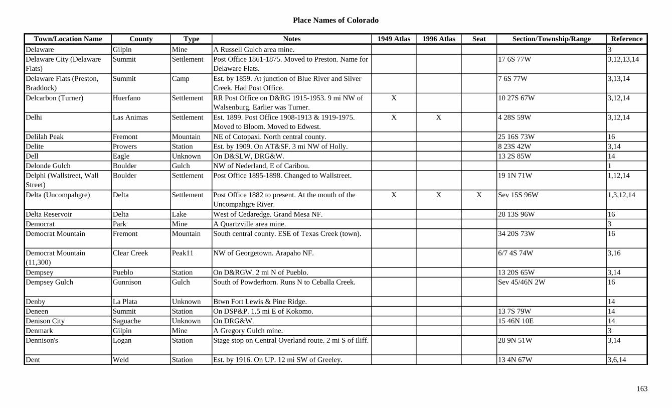
Place Names of Colorado
Town/Location Name County Type Notes 1949 Atlas 1996 Atlas Seat Section/Township/Range ReferenceDelaware Gilpin Mine A Russell Gulch area mine. 3Delaware City (Delaware Flats)
Summit Settlement Post Office 1861-1875. Moved to Preston. Name for Delaware Flats.
17 6S 77W 3,12,13,14
Delaware Flats (Preston, Braddock)
Summit Camp Est. by 1859. At junction of Blue River and Silver Creek. Had Post Office.
7 6S 77W 3,13,14
Delcarbon (Turner) Huerfano Settlement RR Post Office on D&RG 1915-1953. 9 mi NW of Walsenburg. Earlier was Turner.
X 10 27S 67W 3,12,14
Delhi Las Animas Settlement Est. 1899. Post Office 1908-1913 & 1919-1975. Moved to Bloom. Moved to Edwest.
X X 4 28S 59W 3,12,14
Delilah Peak Fremont Mountain NE of Cotopaxi. North central county. 25 16S 73W 16Delite Prowers Station Est. by 1909. On AT&SF. 3 mi NW of Holly. 8 23S 42W 3,14y y ,Dell Eagle Unknown On D&SLW, DRG&W. 13 2S 85W 14Delonde Gulch Boulder Gulch NW of Nederland, E of Caribou. 1Delphi (Wallstreet, Wall Street)
Boulder Settlement Post Office 1895-1898. Changed to Wallstreet. 19 1N 71W 1,12,14
Delta (Uncompahgre) Delta Settlement Post Office 1882 to present. At the mouth of the Uncompahgre River.
X X X Sev 15S 96W 1,3,12,14
Delta Reservoir Delta Lake West of Cedaredge. Grand Mesa NF. 28 13S 96W 16Democrat Park Mine A Quartzville area mine. 3Democrat Mountain Fremont Mountain South central county. ESE of Texas Creek (town). 34 20S 73W 16
Democrat Mountain (11,300)
Clear Creek Peak11 NW of Georgetown. Arapaho NF. 6/7 4S 74W 3,16
Dempsey Pueblo Station On D&RGW. 2 mi N of Pueblo. 13 20S 65W 3,14Dempsey Gulch Gunnison Gulch South of Powderhorn. Runs N to Ceballa Creek. Sev 45/46N 2W 16
D b L Pl t U k Bt F t L i & Pi Rid 14Denby La Plata Unknown Btwn Fort Lewis & Pine Ridge. 14Deneen Summit Station On DSP&P. 1.5 mi E of Kokomo. 13 7S 79W 14Denison City Saguache Unknown On DRG&W. 15 46N 10E 14Denmark Gilpin Mine A Gregory Gulch mine. 3Dennison's Logan Station Stage stop on Central Overland route. 2 mi S of Iliff. 28 9N 51W 3,14
Dent Weld Station Est. by 1916. On UP. 12 mi SW of Greeley. 13 4N 67W 3,6,14
163

Place Names of Colorado
Town/Location Name County Type Notes 1949 Atlas 1996 Atlas Seat Section/Township/Range ReferenceDenver Clear Creek Mine Silver Plume area mine. 3Denver (Mountain City, Auraria, Denver City)
Denver Settlement Est. 1858. Post Office 1866 to present. Also Montana City, St. Charles, Denver City, Highlands.
X X X Sev 3S 68W 1,3,12,14
Denver City Lake Mine A Leadville area mine. 3Denver City Saguache Mine An Iris area mine. 3,13Denver City (Auraria, Denver)
Denver Settlement Post Office 1860-1866. Formerly Auraria. Changed to Denver.
12,14
Denver County Poor Farm Adams Settlement On DL&NW. Same as County Farm. 27 1S 67W 14
Denver Hudson Canal Adams Canal Runs from Barr Lake NE and into Weld Co. 16Denver Junction (Julesburg) Logan/Sedgwick Station Post Office 1885-1886. Stage stop. Moved from
Julesburg (Site 1).27 12N 44W 1,12,14
Denver Mills (Sheffield) Denver Settlement Post Office 1892-1918. Formerly Sheffield. 29 12N 44W 3,12,14Denver Municiple Airport Denver Airfield Between 26th and 38th, E of Syracuse. NE of
Denver.X
Denver Pass Hinsdale/San Juan Pass W of Silverton, past Animas Forks. Silverton Quad. Handies Peak Topo.
29 43N 6W 5,7,16
Denver Tunnel Boulder Tunnel SW corner of county, near Caribou. 1Denver Tunnel Mineral Mine 3Deora Baca Settlement Rural Post Office 1920-1974. 4 mi NE of Frick.
Another location 25 28S 49W.5 28S 49W 3,12,14
DePauls (Coaldale) Fremont Settlement See Coaldale. 3Deplers Park Gunnison Park 13 50N 4E 14Derblay (Washburn) Arapahoe Settlement Post Office 1892. Formerly Washburn. Renamed
Washburn.10 2S 67W 12,14
D b E l S ttl t P t Offi 1888 1889 22 2S 85W 12 14Derby Eagle Settlement Post Office 1888-1889. 22 2S 85W 12,14Derby (Commerce City) Adams Settlement Platted in 1889. Post Office 1910-1963. Changed to
Commerce City.X 32 2S 67W 3,6,12,14
Derby Junction Eagle Unknown On D&RGW. 22 2S 85W 14Derby Lake Adams Lake In Rocky Mountain Arsenal. 1 3S 67W 16Derby Peak Garfield Peak12 NE corner of county. White River NF. ?? 1S 87W 16Derby Peak (12,186) Peak12 Flattops (Range). 8
164
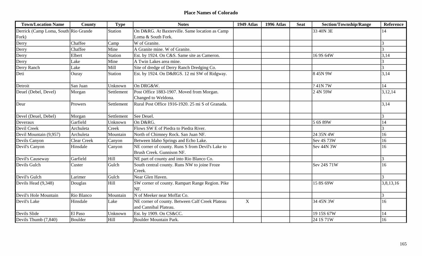
Place Names of Colorado
Town/Location Name County Type Notes 1949 Atlas 1996 Atlas Seat Section/Township/Range ReferenceDerrick (Camp Loma, South Fork)
Rio Grande Station On D&RG. At Baxterville. Same location as Camp Loma & South Fork.
33 40N 3E 14
Derry Chaffee Camp W of Granite. 3Derry Chaffee Mine A Granite mine. W of Granite. 3Derry Elbert Station Est. by 1924. On C&S. Same site as Cameron. 16 9S 64W 3,14Derry Lake Mine A Twin Lakes area mine. 3Derry Ranch Lake Mill Site of dredge of Derry Ranch Dredging Co. 3Deti Ouray Station Est. by 1924. On D&RGS. 12 mi SW of Ridgway. 8 45N 9W 3,14
Detroit San Juan Unknown On DRG&W. ? 41N 7W 14Deuel (Debel, Devel) Morgan Settlement Post Office 1883-1907. Moved from Morgan. 2 4N 59W 3,12,14( , ) g g
Changed to Weldona., ,
Deur Prowers Settlement Rural Post Office 1916-1920. 25 mi S of Granada. 3,14
Devel (Deuel, Debel) Morgan Settlement See Deuel. 3Deveraux Garfield Unknown On D&RG. 5 6S 89W 14Devil Creek Archuleta Creek Flows SW E of Piedra to Piedra River. 3Devil Mountain (9,957) Archuleta Mountain North of Chimney Rock. San Juan NF. 24 35N 4W 16Devils Canyon Clear Creek Canyon Between Idaho Springs and Echo Lake. Sev 4S 73W 16Devil's Canyon Hinsdale Canyon NE corner of county. Runs S from Devil's Lake to
Brush Creek. Gunnison NF.Sev 44N 3W 16
Devil's Causeway Garfield Hill NE part of county and into Rio Blanco Co. 3Devils Gulch Custer Gulch South central county. Runs NW to joine Froze
Creek.Sev 24S 71W 16
Devil's Gulch Larimer Gulch Near Glen Haven. 3Devils Head (9,348) Douglas Hill SW corner of county. Rampart Range Region. Pike
NF15 8S 69W 3,8,13,16
NF.Devil's Hole Mountain Rio Blanco Mountain N of Meeker near Moffat Co. 3Devil's Lake Hinsdale Lake NE corner of county. Between Calf Creek Plateau
and Cannibal Plateau.X 34 45N 3W 16
Devils Slide El Paso Unknown Est. by 1909. On CS&CC. 19 15S 67W 14Devils Thumb (7,840) Boulder Hill Boulder Mountain Park. 24 1S 71W 16
165
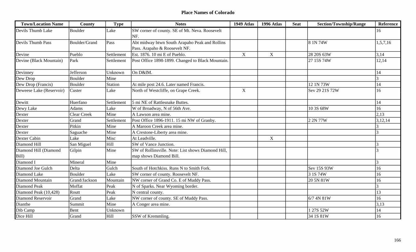
Place Names of Colorado
Town/Location Name County Type Notes 1949 Atlas 1996 Atlas Seat Section/Township/Range ReferenceDevils Thumb Lake Boulder Lake SW corner of county. SE of Mt. Neva. Roosevelt
NF.16
Devils Thumb Pass Boulder/Grand Pass Abt midway btwn South Arapaho Peak and Rollins Pass. Arapaho & Roosevelt NF.
8 1N 74W 1,5,7,16
Devine Pueblo Settlement Est. 1876. 10 mi E of Pueblo. X X 28 20S 63W 3,14Devine (Black Mountain) Park Settlement Post Office 1898-1899. Changed to Black Mountain. 27 15S 74W 12,14
Devinney Jefferson Unknown On D&IM. 14Dew Drop Boulder Mine 3Dew Drop (Francis) Boulder Station At mile post 24.6. Later named Francis. 12 1N 73W 14Deweese Lake (Reservoir) Custer Lake North of Westcliffe, on Grape Creek. X Sev 29 21S 72W 16( ) , p
Dewitt Huerfano Settlement 5 mi NE of Rattlesnake Buttes. 14Dewy Lake Adams Lake W of Broadway, N of 56th Ave. 10 3S 68W 16Dexter Clear Creek Mine A Lawson area mine. 2,13Dexter Grand Settlement Post Office 1896-1911. 15 mi NW of Granby. 2 2N 77W 3,12,14Dexter Pitkin Mine A Maroon Creek area mine. 3Dexter Saguache Mine A Crestone-Liberty area mine. 3Dexter Cabin Lake Misc At Leadville. XDiamond Hill San Miguel Hill SW of Vance Junction. 3Diamond Hill (Diamond Bill)
Gilpin Mine SW of Rollinsville. Note: List shows Diamond Hill, map shows Diamond Bill.
3
Diamond I Mineral Mine 3Diamond Joe Gulch Delta Gulch South of Hotchkiss. Runs N to Smith Fork. Sev 15S 93W 16Diamond Lake Boulder Lake SW corner of county. Roosevelt NF. 3 1S 74W 16Diamond Mountain Grand/Jackson Mountain NW corner of Grand Co. E of Muddy Pass. 20 5N 81W 16Di d P k M ff t P k N f S k N W i b d 3Diamond Peak Moffat Peak N of Sparks. Near Wyoming border. 3Diamond Peak (10,428) Routt Peak N central county. 13Diamond Reservoir Grand Lake NW corner of county. SE of Muddy Pass. 6/7 4N 81W 16Dianthe Summit Mine A Conger area mine. 3,13Dib Camp Bent Unknown 1 27S 52W 14Dice Hill Grand Hill SSW of Kremmling. 34 1S 81W 16
166
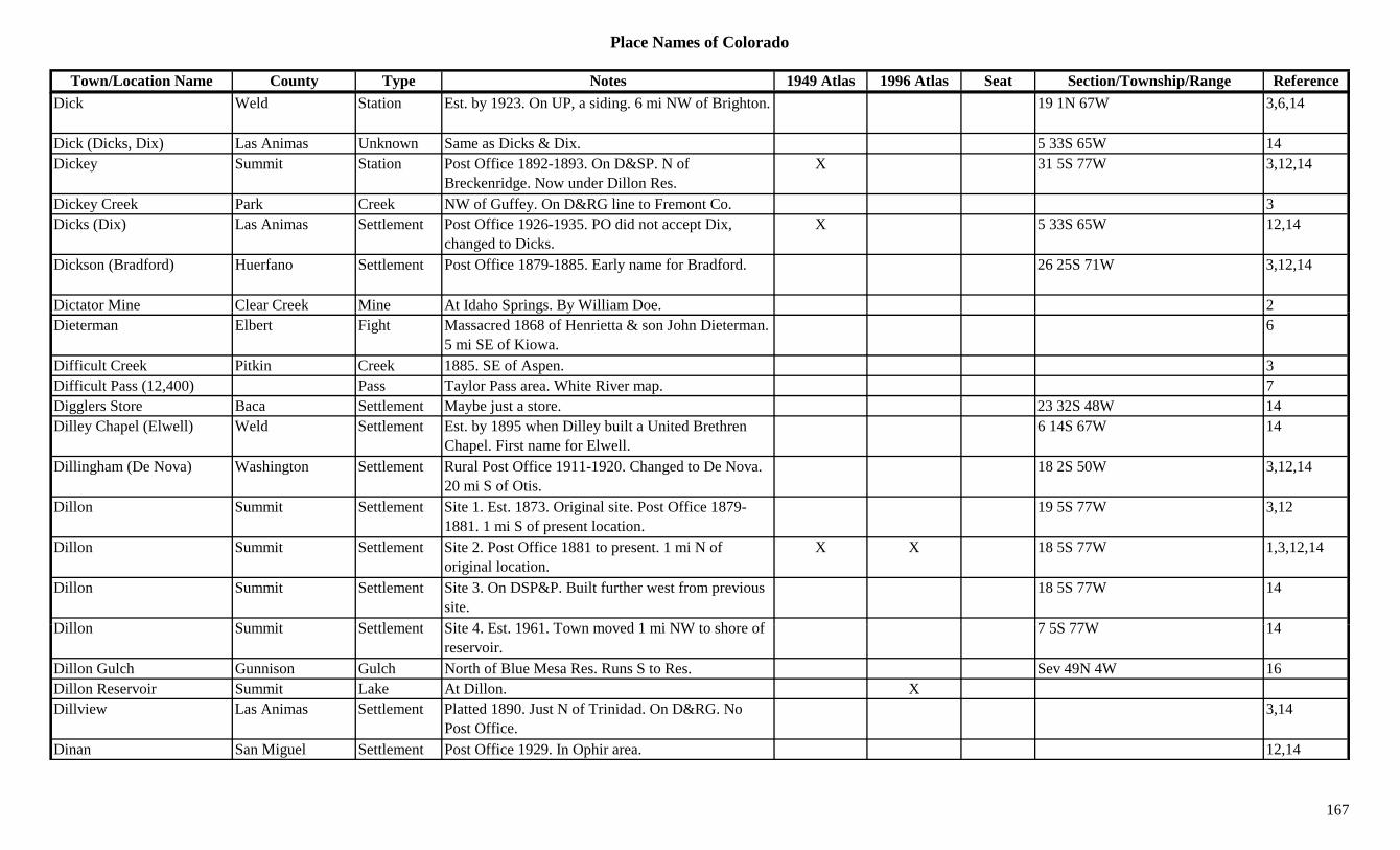
Place Names of Colorado
Town/Location Name County Type Notes 1949 Atlas 1996 Atlas Seat Section/Township/Range ReferenceDick Weld Station Est. by 1923. On UP, a siding. 6 mi NW of Brighton. 19 1N 67W 3,6,14
Dick (Dicks, Dix) Las Animas Unknown Same as Dicks & Dix. 5 33S 65W 14Dickey Summit Station Post Office 1892-1893. On D&SP. N of
Breckenridge. Now under Dillon Res.X 31 5S 77W 3,12,14
Dickey Creek Park Creek NW of Guffey. On D&RG line to Fremont Co. 3Dicks (Dix) Las Animas Settlement Post Office 1926-1935. PO did not accept Dix,
changed to Dicks.X 5 33S 65W 12,14
Dickson (Bradford) Huerfano Settlement Post Office 1879-1885. Early name for Bradford. 26 25S 71W 3,12,14
Dictator Mine Clear Creek Mine At Idaho Springs. By William Doe. 2p g yDieterman Elbert Fight Massacred 1868 of Henrietta & son John Dieterman.
5 mi SE of Kiowa.6
Difficult Creek Pitkin Creek 1885. SE of Aspen. 3Difficult Pass (12,400) Pass Taylor Pass area. White River map. 7Digglers Store Baca Settlement Maybe just a store. 23 32S 48W 14Dilley Chapel (Elwell) Weld Settlement Est. by 1895 when Dilley built a United Brethren
Chapel. First name for Elwell.6 14S 67W 14
Dillingham (De Nova) Washington Settlement Rural Post Office 1911-1920. Changed to De Nova. 20 mi S of Otis.
18 2S 50W 3,12,14
Dillon Summit Settlement Site 1. Est. 1873. Original site. Post Office 1879-1881. 1 mi S of present location.
19 5S 77W 3,12
Dillon Summit Settlement Site 2. Post Office 1881 to present. 1 mi N of original location.
X X 18 5S 77W 1,3,12,14
Dillon Summit Settlement Site 3. On DSP&P. Built further west from previous site.
18 5S 77W 14
Dill S it S ttl t Sit 4 E t 1961 T d 1 i NW t h f 7 5S 77W 14Dillon Summit Settlement Site 4. Est. 1961. Town moved 1 mi NW to shore of reservoir.
7 5S 77W 14
Dillon Gulch Gunnison Gulch North of Blue Mesa Res. Runs S to Res. Sev 49N 4W 16Dillon Reservoir Summit Lake At Dillon. XDillview Las Animas Settlement Platted 1890. Just N of Trinidad. On D&RG. No
Post Office.3,14
Dinan San Miguel Settlement Post Office 1929. In Ophir area. 12,14
167

Place Names of Colorado
Town/Location Name County Type Notes 1949 Atlas 1996 Atlas Seat Section/Township/Range ReferenceDingman Fremont Unknown On D&RGW. 3 19S 68W 14Dinkel's Garfield Unknown Est. by 1883. On the Roaring Fork. Below
Carbondale.14
Dinner Station Rio Blanco Station Stage coach station. 4 4S 94W 14Dinners Station Gunnison Station Stage coach station. Now a camp ground. 19 13S 82W 14Dinosaur (Artesia) Moffat Settlement Est. 1914 as Artesia. Post Office 1966 to present.
Formerly Artesia.X 12 3N 104W 3,12,14
Dinosaur National Monument/Park
Moffat Park Western Moffat Co. X X
Dinsmore (Haydon) Pueblo Station On AT&SF. Same as Haydon. 36 20 63W 14Disappointment Creek Dolores Creek Flows W by Lavender and into San Miguel County. X 3pp y g y
Disappointment Creek Moffat Creek Flows N from near Elk Springs into Yampa River W of Lily.
X 3
Disappointment Creek San Miguel Creek Flows NW from Dolores Co. to join Dolores River. X 3
Disappointment Vale Moffat Valley Wide inlet at mouth of Yampa Canyon. 3Disappointment Valley San Miguel Valley W part of county. 13Discovery Belt Summit Mine A Delaware Flats area mine. 3Dissappointment Dolores Settlement Post Office 1919-1920. 34 42N 14W 12,14Diston Kiowa Station Est. by 1882. Post Office 1908. On MP. 7 mi E of
Eads.X 26 18S 47W 3,12,14
Ditchfield Montezuma Station On RGS. On Dolores River. Btwn Muldoon & Bear Creek.
14
Dives Clear Creek Mine At Georgetown. 2Dives San Juan Mine A Silverton area mine. 13Di id M S ttl t S d f O h d 8 4N 60W 14Divide Morgan Settlement Second name for Orchard. 8 4N 60W 14Divide (Belleview, Theodore)
Teller Settlement Est. 1877. Post Office 1889 to present. First Belleview, then Theodore.
X X 6 13S 69W 3,12,14
Divide (Chubbs Ranch, Dolomite)
Lake/Chaffee Settlement Post Office 1874-1885. Close to Park County line. First Chubbs Ranch, then Dolomite.
27 13S 77W 3,12,14
Divide (Palmer Lake) El Paso Settlement First name for Palmer Lake. See Palmer Lake. 5 11S 67W 3,14
168
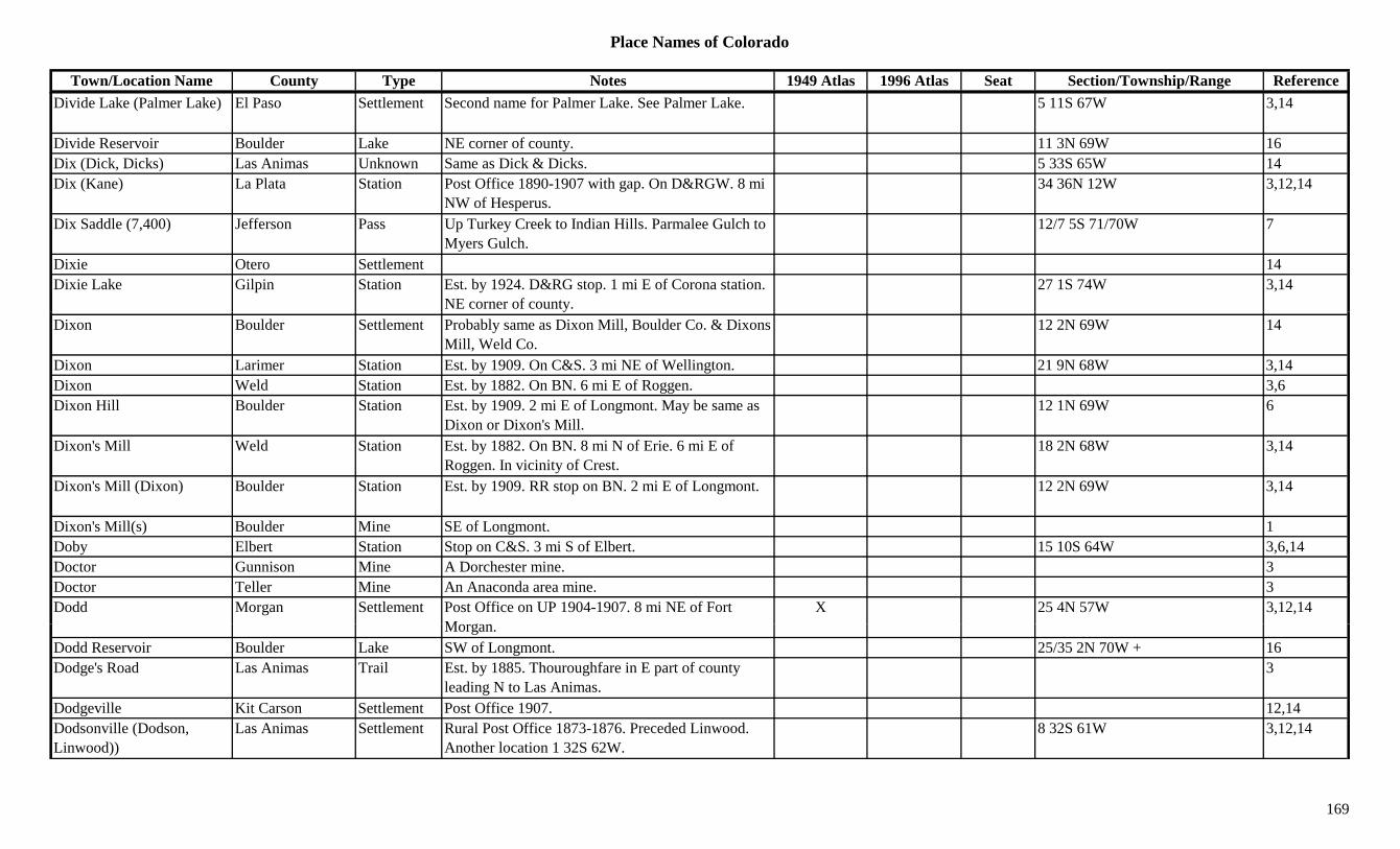
Place Names of Colorado
Town/Location Name County Type Notes 1949 Atlas 1996 Atlas Seat Section/Township/Range ReferenceDivide Lake (Palmer Lake) El Paso Settlement Second name for Palmer Lake. See Palmer Lake. 5 11S 67W 3,14
Divide Reservoir Boulder Lake NE corner of county. 11 3N 69W 16Dix (Dick, Dicks) Las Animas Unknown Same as Dick & Dicks. 5 33S 65W 14Dix (Kane) La Plata Station Post Office 1890-1907 with gap. On D&RGW. 8 mi
NW of Hesperus.34 36N 12W 3,12,14
Dix Saddle (7,400) Jefferson Pass Up Turkey Creek to Indian Hills. Parmalee Gulch to Myers Gulch.
12/7 5S 71/70W 7
Dixie Otero Settlement 14Dixie Lake Gilpin Station Est. by 1924. D&RG stop. 1 mi E of Corona station.
NE corner of county.27 1S 74W 3,14
Dixon Boulder Settlement Probably same as Dixon Mill, Boulder Co. & Dixons Mill, Weld Co.
12 2N 69W 14
Dixon Larimer Station Est. by 1909. On C&S. 3 mi NE of Wellington. 21 9N 68W 3,14Dixon Weld Station Est. by 1882. On BN. 6 mi E of Roggen. 3,6Dixon Hill Boulder Station Est. by 1909. 2 mi E of Longmont. May be same as
Dixon or Dixon's Mill.12 1N 69W 6
Dixon's Mill Weld Station Est. by 1882. On BN. 8 mi N of Erie. 6 mi E of Roggen. In vicinity of Crest.
18 2N 68W 3,14
Dixon's Mill (Dixon) Boulder Station Est. by 1909. RR stop on BN. 2 mi E of Longmont. 12 2N 69W 3,14
Dixon's Mill(s) Boulder Mine SE of Longmont. 1Doby Elbert Station Stop on C&S. 3 mi S of Elbert. 15 10S 64W 3,6,14Doctor Gunnison Mine A Dorchester mine. 3Doctor Teller Mine An Anaconda area mine. 3Dodd Morgan Settlement Post Office on UP 1904-1907. 8 mi NE of Fort
MX 25 4N 57W 3,12,14
Morgan.Dodd Reservoir Boulder Lake SW of Longmont. 25/35 2N 70W + 16Dodge's Road Las Animas Trail Est. by 1885. Thouroughfare in E part of county
leading N to Las Animas.3
Dodgeville Kit Carson Settlement Post Office 1907. 12,14Dodsonville (Dodson, Linwood))
Las Animas Settlement Rural Post Office 1873-1876. Preceded Linwood. Another location 1 32S 62W.
8 32S 61W 3,12,14
169
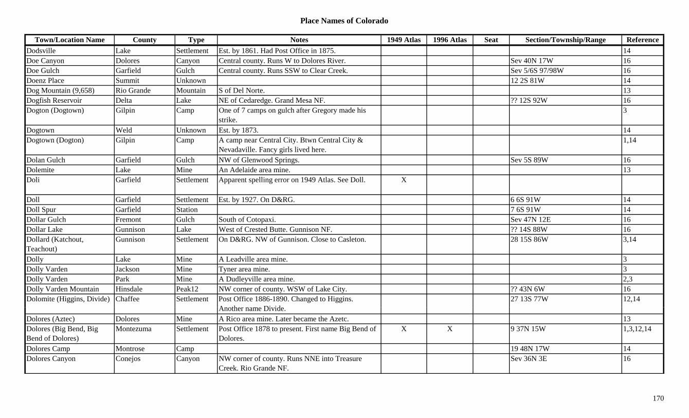
Place Names of Colorado
Town/Location Name County Type Notes 1949 Atlas 1996 Atlas Seat Section/Township/Range ReferenceDodsville Lake Settlement Est. by 1861. Had Post Office in 1875. 14Doe Canyon Dolores Canyon Central county. Runs W to Dolores River. Sev 40N 17W 16Doe Gulch Garfield Gulch Central county. Runs SSW to Clear Creek. Sev 5/6S 97/98W 16Doenz Place Summit Unknown 12 2S 81W 14Dog Mountain (9,658) Rio Grande Mountain S of Del Norte. 13Dogfish Reservoir Delta Lake NE of Cedaredge. Grand Mesa NF. ?? 12S 92W 16Dogton (Dogtown) Gilpin Camp One of 7 camps on gulch after Gregory made his
strike.3
Dogtown Weld Unknown Est. by 1873. 14Dogtown (Dogton) Gilpin Camp A camp near Central City. Btwn Central City &
Nevadaville. Fancy girls lived here.1,14
Dolan Gulch Garfield Gulch NW of Glenwood Springs. Sev 5S 89W 16Dolemite Lake Mine An Adelaide area mine. 13Doli Garfield Settlement Apparent spelling error on 1949 Atlas. See Doll. X
Doll Garfield Settlement Est. by 1927. On D&RG. 6 6S 91W 14Doll Spur Garfield Station 7 6S 91W 14Dollar Gulch Fremont Gulch South of Cotopaxi. Sev 47N 12E 16Dollar Lake Gunnison Lake West of Crested Butte. Gunnison NF. ?? 14S 88W 16Dollard (Katchout, Teachout)
Gunnison Settlement On D&RG. NW of Gunnison. Close to Casleton. 28 15S 86W 3,14
Dolly Lake Mine A Leadville area mine. 3Dolly Varden Jackson Mine Tyner area mine. 3Dolly Varden Park Mine A Dudleyville area mine. 2,3Dolly Varden Mountain Hinsdale Peak12 NW corner of county. WSW of Lake City. ?? 43N 6W 16Dolomite (Higgins, Divide) Chaffee Settlement Post Office 1886-1890. Changed to Higgins.
A th Di id27 13S 77W 12,14
Another name Divide.Dolores (Aztec) Dolores Mine A Rico area mine. Later became the Azetc. 13Dolores (Big Bend, Big Bend of Dolores)
Montezuma Settlement Post Office 1878 to present. First name Big Bend of Dolores.
X X 9 37N 15W 1,3,12,14
Dolores Camp Montrose Camp 19 48N 17W 14Dolores Canyon Conejos Canyon NW corner of county. Runs NNE into Treasure
Creek. Rio Grande NF.Sev 36N 3E 16
170

Place Names of Colorado
Town/Location Name County Type Notes 1949 Atlas 1996 Atlas Seat Section/Township/Range ReferenceDolores City (Rico) Dolores Settlement Early name for Rico. See Rico. 35 40N 11W 3,14Dolores Mountain (12,112) Dolores Peak12 East of Rico. 31 40N 10W 16
Dolores Peak (13,290) Dolores/San Miguel
Peak13 W of Mt. Wilson. Dolores Peak Quad. X 8 41N 11W 3,8,11,13,16
Dolores Plateau Dolores Hill W of Dolores River. N of Cahone. 3Dolores River Dolores River Runs S to Lone Dome where it flows into
Montezuma County.X X 3
Dolores River Mesa River Flows N & W from Montrose Co. to Utah W of Gateway.
X X 3
Dolores River Montezuma River Flows generally W from NE county through Dolores X X 3g y y gand into Utah.
Dolores River Montrose River Flows N from San Miguel Co. to Mesa Co. on W part of county.
X X 3
Dolores River San Miguel River Flows N from Dolores Co. to Montrose Co. W part of county.
X X 3
Dome Mountain (12,207) Peak12 Flattops (Range). 8Dome Mountain (13,370) Peak13 Howardsville Quad. 11Dome Peak Garfield Peak12 NE corner of county. White River NF. 9 1S 86W 3,16Dome Rock Teller Hill 8 mi N of Cripple Creek. 3Dome Rock (Longview) Jefferson Settlement Post Office 1880-1886 with gap & 1907-1911.
Moved to Longview.23 7S 70W 3,6,12,14
Domingo Custer Mine N of Westcliffe. 3Dominguez Delta Settlement Est. by 1887. On D&RGW. Post Office 1907-1913.
14 mi NW of Delta.35 14S 98W 3,12,14
Dominguez Creek Mesa Creek Flows N & E past Carson Hole and into Delta C t
X 3County.
Dominion Boulder Station On C&S. SW of Longmont. 16 2N 69W 6,14Dominquez Canyon Delta Canyon Far NW corner of county. Runs W & S to Gunnison
River.Sev 14S 98W 16
Donley Ouray Unknown 16 47N 11W 14Donner Pass (10,280) Larimer Pass Crossed by Donner Hill Trail. Roosevelt NF. 33 7N 72WDonovan Lake Mine A Leadville area mine. 3
171
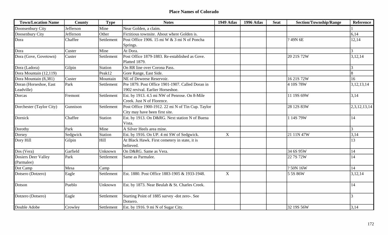
Place Names of Colorado
Town/Location Name County Type Notes 1949 Atlas 1996 Atlas Seat Section/Township/Range ReferenceDoonsenbury City Jefferson Mine Near Golden, a claim. 1Doosenbury City Jefferson Other Fictitious townsite. About where Golden is. 6,14Dora Chaffee Settlement Post Office 1906. 15 mi W & 3 mi N of Poncha
Springs.? 49N 6E 12,14
Dora Custer Mine At Dora. 3Dora (Gove, Govetown) Custer Settlement Post Office 1879-1883. Re-established as Gove.
Platted 1879.20 21S 72W 3,12,14
Dora (Ladora) Gilpin Station On RR line over Corona Pass. 3Dora Mountain (12,119) Peak12 Gore Range, East Side. 8Dora Mountain (8,381) Custer Mountain NE of Deweese Reservoir. 16 21S 72W 16Doran (Horseshoe, East Park Settlement Pre 1879. Post Office 1901-1907. Called Doran in 4 10S 78W 3,12,13,14( ,Leadville) 1902 revival. Earlier Horseshoe.
, , ,
Dorcas Fremont Settlement Est. by 1913. 4.5 mi NW of Penrose. On 8-Mile Creek. Just N of Florence.
11 19S 69W 3,14
Dorchester (Taylor City) Gunnison Settlement Post Office 1900-1912. 22 mi N of Tin Cup. Taylor City may have been first site.
28 12S 83W 2,3,12,13,14
Dornick Chaffee Station Est. by 1913. On D&RG. Next station N of Buena Vista.
1 14S 79W 14
Dorothy Park Mine A Silver Heels area mine. 3Dorsey Sedgwick Station Est. by 1916. On UP. 4 mi SW of Sedgwick. X 21 11N 47W 3,14Dory Hill Gilpin Hill At Black Hawk. First cemetery in state, it is
believed.13
Dos (Vera) Garfield Unknown On D&RG. Same as Vera. 34 6S 95W 14Dosiers Deer Valley (Parmalee)
Park Settlement Same as Parmalee. 22 7S 72W 14
Dot Camp Mesa Camp ? 50N 16W 14D t (D t ) E l S ttl t E t 1880 P t Offi 1883 1905 & 1933 1948 X 5 5S 86W 3 12 14Dotsero (Dotzero) Eagle Settlement Est. 1880. Post Office 1883-1905 & 1933-1948. X 5 5S 86W 3,12,14
Dotson Pueblo Unknown Est. by 1873. Near Beulah & St. Charles Creek. 14
Dotzero (Dotsero) Eagle Settlement Starting Point of 1885 survey -dot zero-. See Dotsero.
3
Double Adobe Crowley Settlement Est. by 1916. 9 mi N of Sugar City. 32 19S 56W 3,14
172
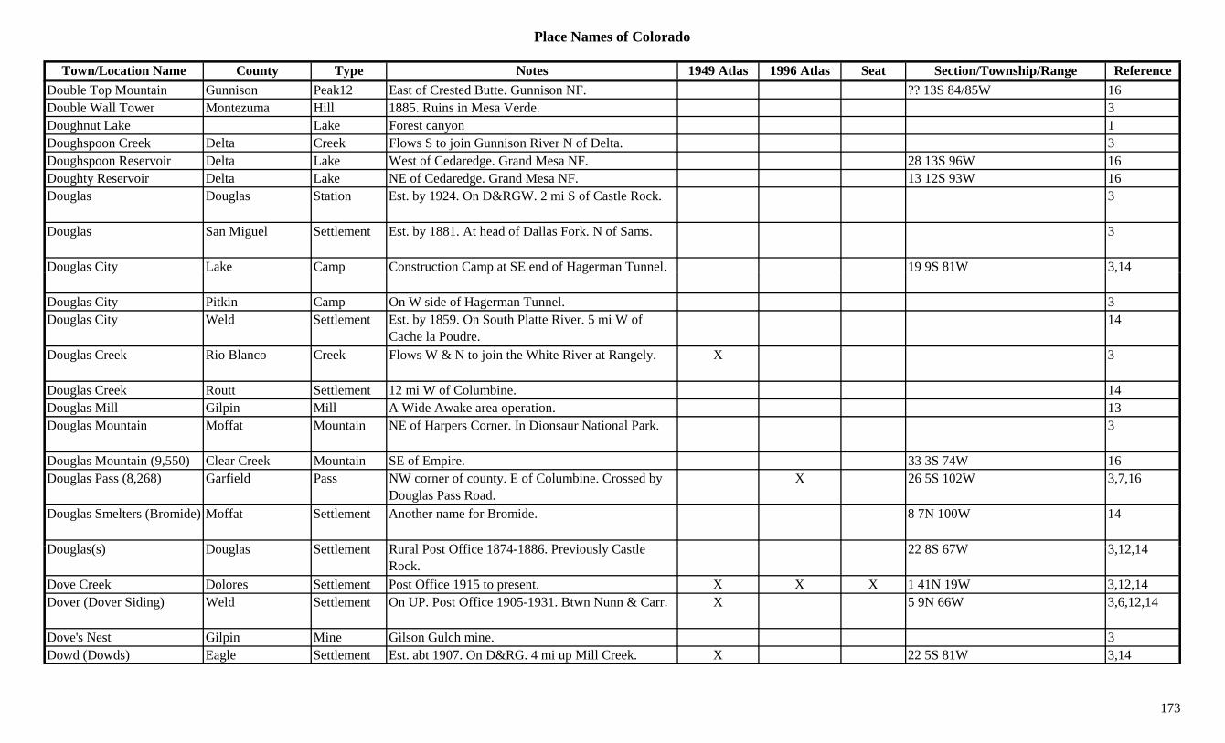
Place Names of Colorado
Town/Location Name County Type Notes 1949 Atlas 1996 Atlas Seat Section/Township/Range ReferenceDouble Top Mountain Gunnison Peak12 East of Crested Butte. Gunnison NF. ?? 13S 84/85W 16Double Wall Tower Montezuma Hill 1885. Ruins in Mesa Verde. 3Doughnut Lake Lake Forest canyon 1Doughspoon Creek Delta Creek Flows S to join Gunnison River N of Delta. 3Doughspoon Reservoir Delta Lake West of Cedaredge. Grand Mesa NF. 28 13S 96W 16Doughty Reservoir Delta Lake NE of Cedaredge. Grand Mesa NF. 13 12S 93W 16Douglas Douglas Station Est. by 1924. On D&RGW. 2 mi S of Castle Rock. 3
Douglas San Miguel Settlement Est. by 1881. At head of Dallas Fork. N of Sams. 3
Douglas City Lake Camp Construction Camp at SE end of Hagerman Tunnel. 19 9S 81W 3,14g y p p g ,
Douglas City Pitkin Camp On W side of Hagerman Tunnel. 3Douglas City Weld Settlement Est. by 1859. On South Platte River. 5 mi W of
Cache la Poudre.14
Douglas Creek Rio Blanco Creek Flows W & N to join the White River at Rangely. X 3
Douglas Creek Routt Settlement 12 mi W of Columbine. 14Douglas Mill Gilpin Mill A Wide Awake area operation. 13Douglas Mountain Moffat Mountain NE of Harpers Corner. In Dionsaur National Park. 3
Douglas Mountain (9,550) Clear Creek Mountain SE of Empire. 33 3S 74W 16Douglas Pass (8,268) Garfield Pass NW corner of county. E of Columbine. Crossed by
Douglas Pass Road.X 26 5S 102W 3,7,16
Douglas Smelters (Bromide) Moffat Settlement Another name for Bromide. 8 7N 100W 14
D l ( ) D l S ttl t R l P t Offi 1874 1886 P i l C tl 22 8S 67W 3 12 14Douglas(s) Douglas Settlement Rural Post Office 1874-1886. Previously Castle Rock.
22 8S 67W 3,12,14
Dove Creek Dolores Settlement Post Office 1915 to present. X X X 1 41N 19W 3,12,14Dover (Dover Siding) Weld Settlement On UP. Post Office 1905-1931. Btwn Nunn & Carr. X 5 9N 66W 3,6,12,14
Dove's Nest Gilpin Mine Gilson Gulch mine. 3Dowd (Dowds) Eagle Settlement Est. abt 1907. On D&RG. 4 mi up Mill Creek. X 22 5S 81W 3,14
173
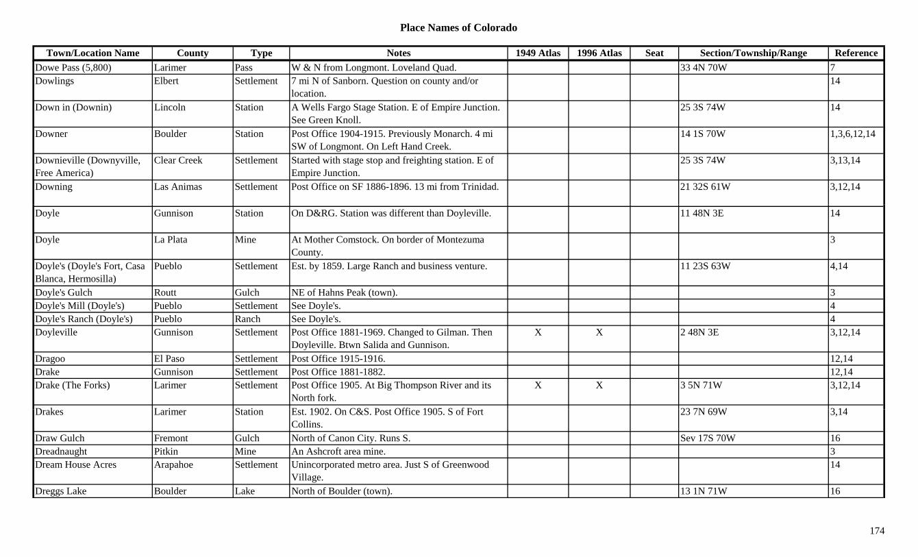
Place Names of Colorado
Town/Location Name County Type Notes 1949 Atlas 1996 Atlas Seat Section/Township/Range ReferenceDowe Pass (5,800) Larimer Pass W & N from Longmont. Loveland Quad. 33 4N 70W 7Dowlings Elbert Settlement 7 mi N of Sanborn. Question on county and/or
location.14
Down in (Downin) Lincoln Station A Wells Fargo Stage Station. E of Empire Junction. See Green Knoll.
25 3S 74W 14
Downer Boulder Station Post Office 1904-1915. Previously Monarch. 4 mi SW of Longmont. On Left Hand Creek.
14 1S 70W 1,3,6,12,14
Downieville (Downyville, Free America)
Clear Creek Settlement Started with stage stop and freighting station. E of Empire Junction.
25 3S 74W 3,13,14
Downing Las Animas Settlement Post Office on SF 1886-1896. 13 mi from Trinidad. 21 32S 61W 3,12,14
Doyle Gunnison Station On D&RG. Station was different than Doyleville. 11 48N 3E 14
Doyle La Plata Mine At Mother Comstock. On border of Montezuma County.
3
Doyle's (Doyle's Fort, Casa Blanca, Hermosilla)
Pueblo Settlement Est. by 1859. Large Ranch and business venture. 11 23S 63W 4,14
Doyle's Gulch Routt Gulch NE of Hahns Peak (town). 3Doyle's Mill (Doyle's) Pueblo Settlement See Doyle's. 4Doyle's Ranch (Doyle's) Pueblo Ranch See Doyle's. 4Doyleville Gunnison Settlement Post Office 1881-1969. Changed to Gilman. Then
Doyleville. Btwn Salida and Gunnison.X X 2 48N 3E 3,12,14
Dragoo El Paso Settlement Post Office 1915-1916. 12,14Drake Gunnison Settlement Post Office 1881-1882. 12,14Drake (The Forks) Larimer Settlement Post Office 1905. At Big Thompson River and its
North fork.X X 3 5N 71W 3,12,14
D k L i St ti E t 1902 O C&S P t Offi 1905 S f F t 23 7N 69W 3 14Drakes Larimer Station Est. 1902. On C&S. Post Office 1905. S of Fort Collins.
23 7N 69W 3,14
Draw Gulch Fremont Gulch North of Canon City. Runs S. Sev 17S 70W 16Dreadnaught Pitkin Mine An Ashcroft area mine. 3Dream House Acres Arapahoe Settlement Unincorporated metro area. Just S of Greenwood
Village.14
Dreggs Lake Boulder Lake North of Boulder (town). 13 1N 71W 16
174
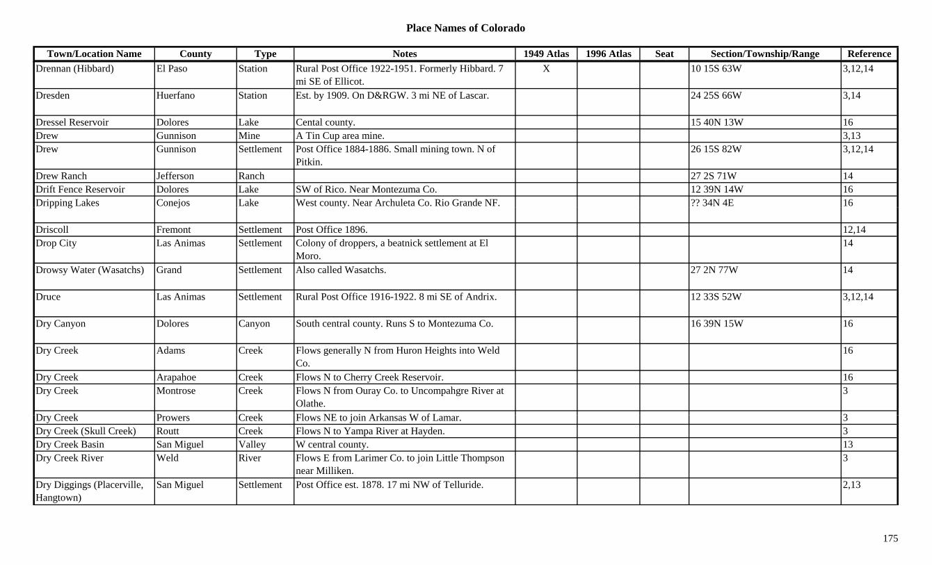
Place Names of Colorado
Town/Location Name County Type Notes 1949 Atlas 1996 Atlas Seat Section/Township/Range ReferenceDrennan (Hibbard) El Paso Station Rural Post Office 1922-1951. Formerly Hibbard. 7
mi SE of Ellicot.X 10 15S 63W 3,12,14
Dresden Huerfano Station Est. by 1909. On D&RGW. 3 mi NE of Lascar. 24 25S 66W 3,14
Dressel Reservoir Dolores Lake Cental county. 15 40N 13W 16Drew Gunnison Mine A Tin Cup area mine. 3,13Drew Gunnison Settlement Post Office 1884-1886. Small mining town. N of
Pitkin.26 15S 82W 3,12,14
Drew Ranch Jefferson Ranch 27 2S 71W 14Drift Fence Reservoir Dolores Lake SW of Rico. Near Montezuma Co. 12 39N 14W 16Dripping Lakes Conejos Lake West county. Near Archuleta Co. Rio Grande NF. ?? 34N 4E 16pp g j y
Driscoll Fremont Settlement Post Office 1896. 12,14Drop City Las Animas Settlement Colony of droppers, a beatnick settlement at El
Moro.14
Drowsy Water (Wasatchs) Grand Settlement Also called Wasatchs. 27 2N 77W 14
Druce Las Animas Settlement Rural Post Office 1916-1922. 8 mi SE of Andrix. 12 33S 52W 3,12,14
Dry Canyon Dolores Canyon South central county. Runs S to Montezuma Co. 16 39N 15W 16
Dry Creek Adams Creek Flows generally N from Huron Heights into Weld Co.
16
Dry Creek Arapahoe Creek Flows N to Cherry Creek Reservoir. 16Dry Creek Montrose Creek Flows N from Ouray Co. to Uncompahgre River at
Olathe.3
D C k P C k Fl NE t j i A k W f L 3Dry Creek Prowers Creek Flows NE to join Arkansas W of Lamar. 3Dry Creek (Skull Creek) Routt Creek Flows N to Yampa River at Hayden. 3Dry Creek Basin San Miguel Valley W central county. 13Dry Creek River Weld River Flows E from Larimer Co. to join Little Thompson
near Milliken.3
Dry Diggings (Placerville, Hangtown)
San Miguel Settlement Post Office est. 1878. 17 mi NW of Telluride. 2,13
175

Place Names of Colorado
Town/Location Name County Type Notes 1949 Atlas 1996 Atlas Seat Section/Township/Range ReferenceDry Fork Montrose River At NW tip of county. Flows from Mesa Co. to Delta
Co.3
Dry Fork Escalante River Delta River Flows N to join Escalante River S of Escalante. 3Dry Fork Roan Creek Garfield Creek Flows E to join Roan Creek W of Mt. Logan. 3Dry Gulch Clear Creek Gulch Far W of county. Runs E into Clear Creek. Sev 4S 76W 16Dry Gulch Clear Creek Unknown 14Dry Gulch Douglas Gulch West central county. Runs NE to West Plum Creek. Sev 9S 68W 16
Dry Gulch Gunnison Gulch North of Blue Mesa Res. Runs S to Res. Sev 49N 3W 16Dry Gulch Gunnison Gulch South of Powderhorn. Runs W to Ceballa Creek. Sev 45N 2W 16
Dry Gulch San Juan Gulch An Animas Forks area productive gulch. 3Dry Lake Boulder Lake SE of Boulder. 34/35 1S 70W 16Dry Lake Larimer Unknown 33 7N 69W 14Dry Lakes Alamosa Lake East central county. 12 38N 11E 16Dry Lakes Custer Lake West central county. Between Horn and Little Horn
Peaks.?? 23S 73W 16
Dry Mountain Moffat Mountain SE of Ladore. 3Dryer Jackson Settlement Post Office 1916-1917. 15 mi SE of Walden. 12,14Drygulch Routt Settlement Post Office 1896-1898. 12,14Du Paines (Coaldale) Fremont Settlement First name for Coaldale. Had other names. 33 48N 11E 14Du Queen Park Mine W of Fairplay. Near Sacramento. 3Dublin Bay Morgan Settlement Post Office 1916-? 12,14Dubois Cheyenne Station Est. by 1876. Stage station on Smoky Hill North
stage route. 6 mi SE of Kit Carson.3,14
Dubois Gunnison Camp Est. 1894. Post Office 1894-1910. In Gunnison Gold B lt
2 47N 3W 3,12,14Belt.
Ducey's Ranch Moffat Ranch 1 7N 92W 14Duck Lake Boulder Lake North of Ward. Roosevelt NF. 1 1N 73W 16Duck Lake Clear Creek Lake SW of Guanella Pass. Pike NF. 25 5S 75W 16Duck Lake Conejos Lake SW corner of county. Rio Grande NF. 9 33N 5E 16Duck Lake Garfield Lake NW corner of county. White River NF. 13 4S 89W 16Duck Springs Washington Unknown See Arickaree. 31 5S 51W 14
176

Place Names of Colorado
Town/Location Name County Type Notes 1949 Atlas 1996 Atlas Seat Section/Township/Range ReferenceDudley (Dudleyville) Park Camp Post Office 1872-1880. Moved from Montgomery
City. At Moose Mine. 2 mi N of Alma.2 9S 78W 3,12
Dudleyville (Dudley) Park Camp Camp at Moose Mine. 2 mi N of Alma. 2 9S 78W 3,14Dudleyville Smelter Park Mill A Dudleyville area operation. 3Duer Prowers Settlement Post Office 1916-1920. 23 mi S of Carlton. 12,14Duff Fremont Unknown On D&RG. E of Parkdale. 14Duff (Magnolia) Adams/Arapahoe Settlement RR Post Office 1884-1896. 6 mi E of Sable. Known
as Magnolia but different sections.3,6,12,14
Duffields El Paso Unknown On CS&CCD. 17 15S 67W 14Dugger Reservoir Delta Lake West of Cedaredge. Grand Mesa NF. 15/22 13S 96W 16gg gDuke Pueblo Settlement Post Office 1908. 12,14Duke of Wellington Gunnison Mine An Elko area mine. 3Dulaneyville Clear Creek Settlement N of Lawson. At Red Elephand Mine. 14Dumond (Dumont) Clear Creek Settlement Same as Dumont. Probably a typo? 3Dumont (Dumond, Mill City)
Clear Creek Settlement Post Office 1880 to present. Formerly Mill City. 5 mi NW of Idaho Springs.
X 30 3S 73W 2,3,12,13,14
Dumont Lake Grand Lake Far NW tip of county. NW of Rabbit Ears Pass. Routt NF.
8 5N 82W 16
Dun(c)kley Pass (9,763 or 9,990)
Rio Blanco Pass In White River Plateau area. Crossed by Dun(c)kley Pass Road. Routt NF.
?? 3N 87W 7,8
Dunaway Jefferson Unknown 34 8S 70W 14Duncan Delta Settlement Platted 1895. On D&RG. 24 15S 97W 14Duncan Park ? Camp Near Music Pass ? 1Duncan Saguache Settlement Post Office 1892-1900. Early gold discovery. Inside
Luis Maria Baca Grant No. 4.13 42N 12E 3,12,13,14
D W ld U k O CW 30 4N 67W 14Duncan Weld Unknown On CW. 30 4N 67W 14Duncan (Gotera) Las Animas Settlement Rural Post Office 1901-1916. Changed to Gotera.
On Mesa de Maya.12 35S 56W 3,12,14
Duncans Boulder Settlement Est. by 1906. A village. 14Dunckley Flat Tops Routt Hill SW corner of county. 13Dundee Pueblo Station Est. by 1892. On D&RGW. 1 mi N of Pueblo. 26 21S 65W 3,14Dunderberg Clear Creek Mine Silver Plume area mine. 3,13
177

Place Names of Colorado
Town/Location Name County Type Notes 1949 Atlas 1996 Atlas Seat Section/Township/Range ReferenceDunderberg Hinsdale Mine A Carson area mine. 3Dune (Gibson) Saguache Station Post Office 1891-1895. On D&RGW. 15 mi S of
Moffat. Early name or near Gibson.4 41N 10E 3,12,14
Dunkard Chaffee Mine N of Salida. 3Dunkin Eagle Unknown On DRG&W. Btwn Adnaw, Garfield Co. & Leon,
Eagle Co.4 8S 87W 14
Dunkley (Argo) Routt Settlement Post Office 1892-1942. 18 mi SE of Hayden. First name Argo.
X 20 4N 87W 3,12,14
Dunn Peak (12,595) Dolores/San Miguel
Peak12 NE county. NNW of Rico. 6 41N 11W 16
Dunn-Litts Chaffee Mine N of Salida. 3Dunraven Boulder Mine At Magnolia. 2,3,13Dunraven Mountain (12,571)
Larimer Peak12 1
Dunraven Park Larimer Unknown Est. by 1913. 17 6N 72W 14Dunsinane Mountain (12,742)
Peak12 San Juans, Courthouse Group. 8
Dunton Dolores Settlement Post Office 1892-1954. 36 mi NE of Dolores. X 33 41N 11W 2,3,12,13,14Dunul Rio Grande Station Est. by 1923. 4 mi S of Ansel. 33 40N 8E 3,14Dupont Adams Settlement Platted in 1925. Post Office 1926 to present. X 29 2S 67W 3,6,12,14Dupont Douglas Settlement On D&RG. Posder Works. 33 6S 68W 14Dupont Junction Las Animas Station On D&RG. 14 30S 65W 14Dupont Powder Works Las Animas Mill 13 30S 65W 14Durand Pitkin Unknown 3 10S 88W 14Durango La Plata Settlement On D&RGW. Post Office 1880 to present. Smelter
in 1882.X X X 17 35N 9W 1,3,12,14
D Pitki Mi A M C k i 3Durango Pitkin Mine A Maroon Creek area mine. 3Durango Silverton Narrow Gauge
La Plata Misc At Durango. X
Durant Pitkin Mine An Aspen area mine. 2,3,13Durham (Bovina, Ute) Mesa Settlement On DRG&W. Another name for Bovina & Ute. 9 1S 1W 14
Dutch Flats Gulch Gunnison Gulch East central county. SSW of Tincup. Runs W. Sev 50N 4E 16
178
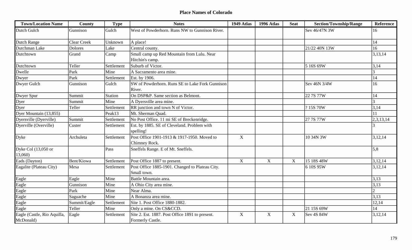
Place Names of Colorado
Town/Location Name County Type Notes 1949 Atlas 1996 Atlas Seat Section/Township/Range ReferenceDutch Gulch Gunnison Gulch West of Powderhorn. Runs NW to Gunnison River. Sev 46/47N 3W 16
Dutch Range Clear Creek Unknown A place! 14Dutchman Lake Dolores Lake Central county. 21/22 40N 13W 16Dutchtown Grand Camp Small camp up Red Mountain from Lulu. Near
Hitchin's camp.3,13,14
Dutchtown Teller Settlement Suburb of Victor. 5 16S 69W 3,14Dwelle Park Mine A Sacramento area mine. 3Dwyer Park Settlement Est. by 1906. 14Dwyer Gulch Gunnison Gulch SW of Powderhorn. Runs SE to Lake Fork Gunnison
River.Sev 46N 3/4W 16
Dwyer Spur Summit Station On DSP&P. Same section as Belmont. 22 7S 77W 14Dyer Summit Mine A Dyersville area mine. 3Dyer Teller Settlement RR junction and town N of Victor. ? 15S 70W 3,14Dyer Mountain (13,855) Peak13 Mt. Sherman Quad. 11Dyersville (Dyerville) Summit Settlement No Post Office. 11 mi SE of Breckenridge. 27 7S 77W 2,3,13,14Dyerville (Overville) Custer Settlement Est. by 1885. SE of Cleveland. Problem with
spelling!3
Dyke Archuleta Settlement Post Office 1901-1913 & 1917-1950. Moved to Chimney Rock.
X 10 34N 3W 3,12,14
Dyke Col (13,050 or 13,060)
Pass Sneffels Range. E of Mt. Sneffels. 5,8
Eads (Dayton) Bent/Kiowa Settlement Post Office 1887 to present. X X X 15 18S 48W 3,12,14Eagalite (Plateau City) Mesa Settlement Post Office 1885-1901. Changed to Plateau City.
Small town.6 10S 95W 3,12,14
Eagle Eagle Mine Battle Mountain area. 3,13E l G i Mi A Ohi Cit i 3 13Eagle Gunnison Mine A Ohio City area mine. 3,13Eagle Park Mine Near Alma. 2Eagle Saguache Mine A Bonanza area mine. 3,13Eagle Summit/Eagle Settlement Site 1. Post Office 1880-1882. 12,14Eagle Teller Mine Only a mine. On CS&CCD. 21 15S 69W 14Eagle (Castle, Rio Aquilla, McDonald)
Eagle Settlement Site 2. Est. 1887. Post Office 1891 to present. Formerly Castle.
X X X Sev 4S 84W 3,12,14
179

Place Names of Colorado
Town/Location Name County Type Notes 1949 Atlas 1996 Atlas Seat Section/Township/Range ReferenceEagle Bird Boulder Mine A Caribou mine. 3Eagle City (Mitchell) Eagle Camp Platted 1883. 2 mi N of Mitchell. 22 7S 80W 3,14Eagle City (Ohio City) Gunnison Settlement Post Office est. 1880 as Ohio. 28 mi NE of
Gunnison.26 50N 3E 2,3,13,14
Eagle Creek (Eagle Rock) Boulder Settlement See Eagle Rock. 12
Eagle Junction Teller Camp Near Eagle Sampler Mine. 3Eagle Jundtion Lake Station On D&RG. S of Cranes Park. 16 9S 80W 14Eagle Lake Boulder Lake NW corner of county. Rocky Mountain Natl Park. 23 3N 74W 16
Eagle Lake Eagle Lake South central county. SW of Redcliff. White River 24 7S 83W 16g g yNF.
Eagle Mine (National) Weld Station Est. by 1906. On UP. Same as National. 15 1N 68W 14Eagle Mining Co. Summit Mine A Kokomo area mining operation. 3Eagle Mountain El Paso Mountain West of Colorado Springs. 7 14S 67W 16Eagle Mountain Mineral Mountain SW corner of county. 3Eagle Mountain Saguache Mountain SW of La Garita. 13Eagle Park Eagle Settlement Est. by 1887. S of Redcliff. On D&RG. 3Eagle Pass (11,780 or 11,800)
La Plata Pass W of Durango. Rico Mountains or La Plata Mountains. La Plata Topo. San Juan NF.
1 36N 11W 3,5,8
Eagle Peak Eagle Peak13 SW of Redcliff. White River NF. ?? 7S 82W 16Eagle Peak (12,113) Dolores Peak12 Rico Mountains. WNW of Rico. 29 40N 11W 8,13,16Eagle Peak (13,043) Peak13 Sawatch Range, Holy Cross Section. Mt. Jackson
Quad.8,11
Eagle Peak (13,221) Custer Peak13 Sangre de Cristo Range, Main Section. Electric Peak Quad. San Isabel NF.
14 46N 11E 8,11,16
E l Ri E l Ri Fl W th h t f t 3Eagle River Eagle River Flows W through center of county. 3Eagle River Pass (11,000) Eagle Pass White River map. 7
Eagle Rock Boulder Mine At Eagle Rock. 3Eagle Rock Larimer Hill N of Loveland Heights. 3Eagle Rock (9,677) Park Hill SE of Jefferson. 13
180
Place Names of Colorado
Town/Location Name County Type Notes 1949 Atlas 1996 Atlas Seat Section/Township/Range ReferenceEagle Rock (Camp Wheelman, Eagle Creek)
Boulder Camp Post Office 1876-1877. Also shown as Eagle Creek (1876). 6 mi W of Boulder.
31 1N 71W 1,3,6,12,14
Eagle Rock Mine Boulder Mine Close to Eagle Rock. 3Eagle Rock(s) Boulder Station Post Office 1876-1877. 31 1N 71W 1,14Eagle Sampler Pitkin Camp Small camp close to Independence. Post Office. 3
Eagle Sampler Teller Mine An Anaconda area mine. 3Eagle Sampler Mill Pitkin Mill An Independence area mine. 3Eagle's Nest Weld Station Site 1. Central Overland State Station. Btwn
Fremont & Latham stations.14
Eagle's Nest (Hardin) Weld Station Site 2. Preceded Hardin. 34 5N 63W 3,14g ( ) ,Eagles Nest Mountain (13,420)
Peak13 Gore Range, East Side. Mt. Powell Quad. 8,11
Eaglite (Plateau City) Mesa Settlement Post Office 1885-1901. Changed to Plateau City, but in a different location. See Eagelite.
14
Earl Boulder Mine At Jamestown. 3,13Earl (Earle, Earles) Las Animas Settlement On AT&SF. Post Office 1895-1923, with gap. X 19 31S 61W 3,12,14Early Bird San Juan Mine An Animas Forks area mine. 3,13Early Spring Garfield Settlement Post Office 1883. 12,14East Alamosa Alamosa Station On D&RG. 14East Argentine (Belmont, Waldorf)
Clear Creek Settlement Post Office 1867. Later called Belmont, then Waldorf.
2 5S 75W 12,14
East Argentine Mining District
Summit Mine Argentine area mines. 3
East Aspen Pitkin Settlement On D&RGW. Joins Aspen on NE corner. 7 10S 84W 14East Aspen Mountain Pitkin Mountain SE of Aspen. 3E t B k ith M t i G i P k12 SW f I i G i NF ?? 14S 88W 13 16East Beckwith Mountain Gunnison Peak12 SW of Irwin. Gunnison NF. ?? 14S 88W 13,16East Bijou Creek Adams Creek Flows from Eastern Arapahoe Co to join Bijou
Creek.X X 16
East Bijou Creek Arapahoe Creek Flows from Elbert Co through Deer Trail N to Adams Co.
X X 16
East Bijou Creek Elbert Creek Flows N out of the county to Deer Trail. X XEast Boston Gilpin Mine A Central City mine. 3
181

Place Names of Colorado
Town/Location Name County Type Notes 1949 Atlas 1996 Atlas Seat Section/Township/Range ReferenceEast Branch Pine Arroyo Dolores Gulch North central county. Runs N to Pine Arroyo. Sev 41N 17W 16East Buffalo Peak (13,300) Peak13 Marmot Peak Quad. NW of Trout Creek Pass. 11,13
East Buffalo Peak (13,360) Park Peak13 Mosquito Range. West Central county. Near Chaffee Co.
3,8,16
East Bull Gulch Gunnison Gulch West of Gunnison. Runs S & E to Elk Creek. Sev 49/50N 3W 16East Cañon Fremont Settlement On D&RGW. E of Canon City. X 27 18S 70W 3,14East Canon Escondido Conejos Canyon West central county. Runs N to Canon Escondido.
Rio Grande NF.Sev 34N 4E 16
East Caribou Boulder Unknown See Dayton. 14East Cement Mountain Gunnison Peak12 SW of Taylor Park Res. Gunnison NF. ?? 14S 84W 16yEast Centennial Gilpin Mine A Russell Gulch area mine. 3East Columbia Boulder Mine Ward area 1,3,13East Creek Mesa Creek E of Unaweep. 3East Cripple Creek Teller Settlement Platted 1903. 24 15S 69W 14East Dempsey Gulch Gunnison Gulch South of Powderhorn. Runs W to Ceballa Creek. Sev 46N 2W 16
East Divide Creek Garfield Creek Flows W & N to Colorado River btwn Silt and New Castle.
3
East Fork Douglas Creek Rio Blanco Creek Flows N to join Douglas Creek S of Rangely. 3East Fork Escalante River Mesa River Flows N to join Middle Fork. 3
East Fork of Troublesome Creek (?)
Grand Creek Joins Troublesome Creek N of Troublesome. 3
East Fork Rifle Creek Garfield Creek Flows S to join Rifle Creek N of Cactus Valley. 3East Fork San Juan River Mineral River Flows SW into Archuleta Co. SE corner of Mineral
C3
Co.East Fork Stuart Gulch Garfield Gulch North central county. Runs NNE into Rio Blanco
Co. N of Grand Valley.Sev 4S 96W 16
East Fork Williams Fork Rio Blanco Creek Flows N from Pyramid Peak to Routt County. 3East Fork Williams Fork Routt River Flows W to Williams Fork from near Dunkley. 3East Gap (7,600) La Plata Gap Crossed by trail on Southern Ute Indian Reservation. 7U 34N 10W
182

Place Names of Colorado
Town/Location Name County Type Notes 1949 Atlas 1996 Atlas Seat Section/Township/Range ReferenceEast Gulch Fremont Gulch Central county. Sev 18S 73W + 16East Lake Boulder Settlement Est. by 1923. Btwn Broomfield & Lafayette. 3East LaSalle Weld Station Est. by 1950. On UP. 1 mi E of LaSalle. 32 5N 65W 3,6,14East Leadville (Doran, Horseshoe)
Park Settlement Pre 1879. Called Doran in 1902 revival. 5 mi WSW of Fairplay. See Horseshoe.
4 10S 78W 3,13,14
East Lost Lake Garfield Lake NE corner of county. White River NF. ?? 1N 88W 16East Mancos Montezuma Unknown On RGS. 20 36N 12W 14East Mancos River Montezuma River Flows W from Madden Peak to Mancos. 3East Maroon Creek Pitkin Creek Flows N to Maroon Lake. 3East Maroon Pass Gunnison/Pitkin Pass SW of Aspen. Elk Mountains. Maroon Bells Topo.
Gunnison & White River NF.13 12S 86W 5,7,16
East Mill Gulch Fremont Gulch NE corner of county. Sev 16S 68W + 16East Mitchell Eagle Unknown On D&RG. 10 8S 80W 14East Montezuma Creek Montezuma Creek Far NW corner of county. Flows from Dolores Co.
& into Utah.3
East Oil Creek Teller Creek Flows NE to join Rule Creek near Waters. 3East Paradox Creek Montrose Creek Flows NW to Dolores River near Bedrock. 3East Partner (13,057) Peak13 Gore Range, East Side. 8East Penobie Gilpin Station Tram station in Russell Gulch. 23 3S 73W 14East Pierce Gulch Fremont Gulch SW of Canon City. Runs E. Sev 20S 71W 16East Plum Creek Douglas Creek Flows N through county past Castle Rock. 3East Portal Gilpin Settlement Post Office 1923-1928 & 1933-1934. Construction
town for digging of Moffat Tunnel.X X 2 2S 74W 3,12,14
East River Gunnison Unknown On D&RGW. 3 15S 85W 14East River (Schofield) Pass Gunnison Pass Elk Range. Btwn Crested Butte and Marble.
G i & Whit Ri NFX X 18 12S 87W 7,9
Gunnison & White River NF.East Saint Louis Boulder Mine Btwn Caribou and Old Cardinal. 3East Salt Corral Canyon Garfield Canyon Western county. SE of Douglas Pass. Sev 6S 101/102W 16East Salt Creek Mesa Creek Joins West Salt Creek and flows into Colorado
River.3
East Sopris Creek Pitkin Creek Flows from N of Capitol Peak E & N to join Roaring Fork River.
3
183

Place Names of Colorado
Town/Location Name County Type Notes 1949 Atlas 1996 Atlas Seat Section/Township/Range ReferenceEast Spanish Peak (12,683) Las Animas Peak12 Spanish Peaks. X 8
East Sunset City Fremont Settlement Short lived. On Copper Gulch Road. Location is for Sunset City.
10 19S 72W 14
East Thorn (13,333) Peak13 Gore Range, East Side. 8East Tincup Jefferson Settlement Post Office 1960-1963. Rural station of Golden. At
Magic Mountain.11 4S 70W 6,12,14
East Toll Gate Creek Arapahoe Creek Flows NW through NW corner of Buckley Naval Air Station to Adams Co.
16
East Trinity Peak (13,745) Peak13 Needle Mountains. The Grenadiers. 8
East Vac Rio Blanco Unknown On Unitah. 18 4S 103W 14East Vancorum Montrose Unknown 23 46N 16W 14East Walsenburg Huerfano Settlement Just SE of Walsenburg. 10 28S 66W 14East Weston Las Animas Unknown On C&W. The PO for site was Cordova. 31 33S 66W 14East Willow Creek Mineral Creek Flows from Saguache Co. S through Creede to Rio
Grande River.3,13
East Wing Gunnison Mine A Gothic area mine. 3Eastdale Costilla Settlement Post Office 1895-1909. Mormon settlement on
Costilla Creek. Another loc. 23 32N 12E23 34S 74W 12,14
Eastdale Reservoir No 1 Costilla Lake SW corner of county. S of Mesita. 13 32N 12E + 16Eastdale Reservoir No 2 Costilla Lake SE of Mesita. 4/9 32N 73W 16Eastern CO Hist. Soc. Museum
Cheyenne Museum At Cheyenne Wells. X
Eastlake Adams Settlement Platted in 1911. On UP. Post Office 1912 to present. X 35 1S 68W 3,6,12,14
E t (F C ) G d S ttl t Fi t f F th C 19 1S 75W 14Eastom (Fraser, Cozens) Grand Settlement First name for Fraser, then Cozens. 19 1S 75W 14Easton (Eastonville) El Paso Settlement Post Office 1872-1883. Changed to Eastonville. 28 11S 64W 3,12,14Easton (Fraser) Grand Settlement See Fraser. 3Eastonville (Easton, McConnellsville)
El Paso Settlement Post Office 1883-1932. Platted 1886. First called Easton. 12 mi S of Elbert.
X 28 11S 64W 3,4,12,14
Easyville Washington Settlement Platted 1899. 7 mi NW of Akron. No Post Office. 6 3N 52W 3,14
184
Place Names of Colorado
Town/Location Name County Type Notes 1949 Atlas 1996 Atlas Seat Section/Township/Range ReferenceEaton (Eatonton) Weld Settlement Post Office 1883 to present. PO was formerly
Eatonton.X X 36 7N 66W 3,6,12,14
Eaton Park (Indian Hills) Jefferson Settlement Same area as Indian Hills. See Indian Hills. Sev 5S 70W 3,6,14Eatonton (Eaton) Weld Settlement Post Office opend 1882 as Eatonton. Name
shortened 1883.36 7N 66W 3,6,12,14
Ebert Adams Unknown 12 3N 66W 14Eccles Pass (11,900 or 12,600)
Summit Pass Crossed by Wheeler-Dillon Trail. Gore Range. Eagles Nest Primitive Area. Vail Pass Topo.
19 5S 78W 5
Echo Fremont Station Est. by 1923. Stop on D&RGW. 3 mi N of Texas Creek.
34 18S 73W 3,14
Echo Canyon Fremont Canyon Central county. N of Echo. Sev 18/19S 73W 16y y yEcho Creek Lake Creek SW of county. Near Everett. 3Echo Lake Clear Creek Lake At Echo Lake Park. SW of Idaho Springs. 31 4S 73W 16Echo Lake Clear Creek Lake On road near top of Mt. Evans. XEcho Lake Clear Creek Settlement Est. 1921. X 3Echo Mountain (13, 309) Peak13 Columbine Pass Quad. 11Echo Rock El Paso Hill NW of Colorado Springs. 27 13S 67W 16Eckert (Orchard City) Delta Settlement Post Office 1891 to abt 1965. Changed to Orchard
City. 2 mi N of Orchard City.X 12 14S 95W 3,12,14
Eckley Weld/Yuma Settlement Post Office 1883-1884 & 1885 to present. BN town in 1880s.
X X 27 2N 46W 3,12,14
Eclipse Boulder Mine S of Magnolia. 3Eclipse Chaffee Mine Near Monarch. 3,13Eclipse Lake Mine A California Gulch mine. 3Eclipse Lake Mine A Leadville area mine. Ibex area. 3Eclipse San Juan Mine An Animas Forks area mine. 13E li S J S ttl t E t b 1881 S f A i F k 3Eclipse San Juan Settlement Est. by 1881. S of Animas Forks. 3Eclipse Teller Camp On CS&CCD. At Eclipse Mine. Absorbed by
Elkton.25 15S 69W 3,14
Eclipse Teller Mine An Elkton area mine. 3Economic Gold Extraction Co. Mill
Teller Mill An Arequa area operation. 3
Economic Junction Teller Station Near Economic Mill. Mine & RR Junction. 31 15S 69W 3,14
185
Place Names of Colorado
Town/Location Name County Type Notes 1949 Atlas 1996 Atlas Seat Section/Township/Range ReferenceEddy Routt Settlement Post Office 1890-1913. 2 mi NW of Pinnacle. 18 5N 85W 3,12,14Eden (Cactus, Eden PO) Pueblo Settlement Post Office 1890-1914. 5 mi N of Pueblo. First name
Cactus. Early name for Bragdon?X 36 19S 65W 3,12,14
Edenview Las Animas Settlement Post Office 1919-1920. 21 31S 53W 12,14Edge Lake Garfield Lake NE corner of county. White River NF. ?? 1S 87W 16Edge Plain (Edgeplain) Pueblo Settlement Platted 1889. 1 mi N of Pueblo. No Post Office. 5 4S 69W 3
Edgemont (Daniels) Jefferson Settlement On D&IM. First named Daniels. 4 4S 69W 6Edgemoor (Leetsdale Farm) Denver Settlement Est. by 1899. E of Colorado Blvd. 14
Edgeplain (Edge Plain) Pueblo Settlement Plat filed 1889. 1 mi N of Pueblo. 14g p ( g )Edgerton El Paso Settlement RR Post Office on D&RG 1870-1902. Moved to
Pikeview. 8 mi N of Colorado Springs.36 12S 67W 3,12,14
Edgerton Monument El Paso Unknown Est. by 1881. Another name for Edgerton. 14Edgewater Jefferson Settlement Platted 1889. Post Office 1892-1937. Converted to
branch of Denver. Near Sloan's Lake.X Sev 4S 69W 3,6,12,14
Edingers Ranch Moffat Ranch 22 7N 92W 14Edison El Paso Settlement 8 mi S of Truckton. X 30 16S 60W 3,14Edith Archuleta Settlement Post Office 1895-1917. 5 mi W of Chromo. State
line bisected the main street.X 13 32N 1W 3,12,14
Edith Routt Settlement Post Office 1883-1885. Near modern site of Mystic. 31 7N 85W 3,12,14
Edith Lake Clear Creek Lake South of Georgetown. Arapaho NF. 27/28 4S 74W 16Edith Mountain Hinsdale Peak12 NW corner of county. NE of Cinnamon Pass. ?? 42N 6W 16Edler Baca Settlement Rural Post Office 1916-1947. 15 mi NW of Campo. X 14 33S 48W 3,12,14
Edlowe El Paso/Teller Station Post Office 1896-1899. On CM. 2 mi SW of Woodland Park.
X 34 12S 69W 3,12,14
Edmundville (Edneyville) Summit Settlement Est. by 1879. On Ten Mile Creek. Near Kokomo. Same as Edneyville.
14
Edna (Oakridge) Routt Unknown On D&RGW. Same as Oakridge. 19 4N 85W 14Edneyville (Edmundville) Summit Settlement Same as Edmundville. 19 4N 85W 14
186

Place Names of Colorado
Town/Location Name County Type Notes 1949 Atlas 1996 Atlas Seat Section/Township/Range ReferenceEdwards (Berry's Ranch) Eagle Settlement On D&RGW. Est. 1882. Post Office 1883 to present. X X 5 5S 82W 3,12,14
Edward's Placer Clear Creek Mine A Idaho Springs mine. 13Edwest (Houghton, West, West Houghton)
Las Animas Settlement On AT&SF. Post Office 1916-1919. Moved to Delhi.
19 28S 59W 3,12,14
Egeria Routt Station Site 2. Est. by 1923. On D&SL. 2 mi S of Toponas. 23 1N 84W 3,14
Egeria (Yampa) Routt Settlement Site 1. Post Office 1883-1900. Site in same location as Yampa.
X ? 3N 85W 3,12,14
Egeria Creek Routt Creek Flows N through Egeria Park then E to Chimney Fork.
3
Egeria Park Routt Park 1885. SW of Toponas. 3Eggers Larimer Settlement Post Office 1926-1944. X 5 8N 72W 12,14Eggleston Lake Delta Lake North of Cedaredge. Grand Mesa NF. 6 12S 94W 16Eggleston Reservoir No 4 Boulder Lake South of Marshall. 27 1S 70W 16Egnar San Miguel Settlement Post Office est. 1917. X X 10 42N 19W 3,12,14Egyptian Gilpin Mine Btwn Nevadaville and Bortonsburg. 3Egyptian Valley (Fairfield) Phillips Settlement First name for Fairfield. 14
Eightmile Mesa Archuleta Mesa South of Pagosa Springs. 16Eiler Junction Pueblo Station Est. by 1906. On D&RGW. 14Eilers Lake Settlement On D&RGW. X 28 9S 80W 14Eisenhower Tunnel Clear Creek Misc 1 & 7/10 mi 1Eisner Pueblo Settlement Small. On St. Charles River. 5 mi SW of Lime. See
Fisher.21 22S 65W 3,14
Ejan Gunnison Mine A Sherrod area mine. 3El A d l Pl t C j U k ? 35N 10E 14El Ancon del Plata Conejos Unknown ? 35N 10E 14El Brozo (Plaza de Brozes) Conejos Settlement Same place as Plaza de Brozes. ? 33N 9E 14
El Capitan Gunnison Mine A Tin Cup area mine. 13El Capitan Lake Mine S of Tennessee Pass. 3El Cedro Redondo Conejos Settlement Est. 1854. First settlement in Colorado. 4 mi above
later Guadalupe.14
187

Place Names of Colorado
Town/Location Name County Type Notes 1949 Atlas 1996 Atlas Seat Section/Township/Range ReferenceEl Cuervo (Crow's Nest, Buzzard Roost)
Fremont Fort Trading Post. Mexican Village. See Fort LeDuc. 34 20S 69W 9,14
El Diente, The Tooth (14,159)
San Miguel Peak14 San Juan Mountains. Dolores Peak Quad. 6/7 41N 10W 1,8,11,16
El Dorado Teller Mine Teller Co. mines not elsewhere specified. 3El Dorado (Colorado City) El Paso Settlement Est. by 1859. Short lived. 3 14S 67W 14
El Dorado Camp (Eldora) Boulder Camp Early name for Eldora. 21 1S 73W 14El Jebel Eagle Station Est. by 1923. SW corner of county. RR stop on
C&M.X 3 8S 87W 3,14
El Jebel Garfield Settlement Post Office est. 1973 as rural branch of Carbondale. 12
El Mahoi Ouray Mine An Ouray area mine. 3El Moro (Elmoro, Moro) Las Animas Settlement Platted 1876. Post Office 1876-1896. Changed to
Elmoro. CF&I coke (coal) camp.X X 28 32S 63W 3,12,14
El Paso El Paso Settlement Site 4. Est. by 1887. Settlement close to Wigwam. 3
El Paso Lake Mine A Leadville area mine. 3El Paso Teller Mine An Elkton area mine. Beacon Hill. 3El Paso (Buttes) El Paso Settlement Site 2. Post Office 1862-1893. Changed to Buttes. 3 14S 67W 12,14
El Paso (Colorado Springs) El Paso Settlement Site 3. Also known as Fountain Colony. See Colorado Springs.
Sev 13S 67W 1,3,14
El Paso (El Paso City) El Paso Settlement Site 1. Est. 1858. At base of Ute Pass. 3El Porviner (Barela) Las Animas Settlement See Barela. 4El Puebla (El Pueblo de L h )
Bent Settlement Also called El Pueblo de Leche. 14Leche)El Pueblo Pueblo Fort At present site of Pueblo. 14El Punto (13,280) Peak13 San Juans, Courthouse Group. 8El Querbo (Cuerva) Conejos Unknown Also called Cuerva. ? 32N 9E 14El Rancho Jefferson Settlement Post Office 1956 to present. Rural branch of Golden. 16 4S 71W 6,12,14
188

Place Names of Colorado
Town/Location Name County Type Notes 1949 Atlas 1996 Atlas Seat Section/Township/Range ReferenceEl Valle Del Gutierrez (Stonewall)
Las Animas Settlement Renamed Stonewall in 1878. 3
Elba Prowers Unknown Same as Ella. 29 22S 45W 14Elba Washington Settlement Rural Post Office 1910-1958. 15 mi S of Akron. X 20 1S 52W 3,12,14
Elbert Elbert Settlement Site 2. On C&S. 34 9S 64W 6,14Elbert La Plata Settlement Est. by 1877. 5 mi NE of Hermosa. 30 37N 8W 3,14Elbert (Old Elbert) Elbert Settlement Site 1. Post Office 1875-1880 & 1882 to present.
Moved from Gomers Mills.X X 15 10S 65W 3,12,14
Elbert Mills Elbert Unknown 25 10S 64W 14Elberta Delta Settlement On D&RGW. 3 mi NE of Hotchkiss. X 15 14S 92W 14Elbow Cañon Eagle Canyon Large bend in Eagle River. Btwn Gypsum and
Wolcutt.3
Elco La Plata Settlement Post Office 1905-1914. Elco was PO, Bondad was station on D&RGW. 2 mi S of Bondad.
36 33N 10W 3,12,14
Elco (Elko) Gunnison Settlement See Elko. 3Elder Baca Settlement A Post Office 12 mi NW of Campo. 14Elder Otero Station Est. by 1916. On AT&SF. 3 mi E of Fowler. X 23 22S 59W 3,14Eldora (Happy Valley, Eldorado Camp)
Boulder Settlement Post Office 1897-1977. 1967 became rural branch of Nederland. 4 mi W of Nederland.
X X 21 1S 73W 1,2,3,12,13,14
Eldorado Boulder Mine At Balarat. 3Eldorado Clear Creek Settlement Wells Fargo Stage Station. Btwn Downieville House
and Georgetown.14
Eldorado Jackson Mine Tyner area mine. 3Eldorado Camp (Eldora) Boulder Settlement Semi-Ghost town. 1,14Eldorado Gulch Gunnison Gulch SE corner of county. Runs SW to Stridiron Creek. Sev 49N 4-5E 16
Eldorado Mountain (8,335) Boulder Mountain South of Boulder. On Jefferson Co line. ?? 1S 71W 16
Eldorado Springs (Hawthorne)
Boulder Settlement Post Office est. 1930. Formerly Hawthorne. NW of Broomfield on South Boulder Creek.
X X 25 1S 70W 1,6,12,14
Eldordo West Summit Unknown 14Eldred Fremont Settlement Post Office 1892-1907. 9 17S 70W 12,14
189
Place Names of Colorado
Town/Location Name County Type Notes 1949 Atlas 1996 Atlas Seat Section/Township/Range ReferenceEldredge Ouray Station On D&RG. 10 mi N of Ridgeway. X 32 47N 8W 3,14Eleanor Jefferson Unknown 14Electra La Plata Station Est. by 1923. On D&RGW. 9 mi NE of Rockwood. 3
Electra Lake La Plata Lake Northern La Plata Co., N of Rockwood. X XElectric Park Mine A Puma area mine. 3Electric Light Dolores Mine Rico area mine. 3Electric Mountain (10,000) Delta Peak10 North of Paonia. Gunnison NF. ?? 11S 91W 16
Electric Pass (13,480 or 13,635)
Pitkin Pass S of Aspen. Near Cooper's Camp. Maroon Bells Snomass Wilderness Area. White River NF.
35 12S 85W 3,5,7,8
Electric Peak (13,292) Peak13 Needle Mountains. The Grenadiers. Storm King Peak Quad.
8,11
Electric Peak (13,621) Custer/Saguache Peak13 Sangre de Cristo Range, San Luis Valley Side. Electric Peak Quad. San Isabel NF.
1 45N 11E 8,11,13,16
Elelphant Rock El Paso Hill NW of Monument. 4 11S 67W 16Elephant Summit Mine A Lincoln area mine. 3Elephant (Red Elephant) Clear Creek Settlement Post Office 1881. See Red Elephant. 23 3S 74W 3,12,14Elephant Head Rock (10,400)
Archuleta Mountain SE county. 2/3 33N 2E 16
Elephant Rock Douglas Hill West of Castle Rock. 7 8S 68W 16Eleven Cabins (Boulder) Boulder Settlement Est. by 1858. First name of Boulder settlement. 23 3S 74W 1,14Eleven Mile Cañon Park Canyon S & W from Lake George area. 3Eleven Mile Reservoir Park Lake SW of Lake George, on South Platte River. X XElgin (Wauneta (Waunita) H t S i )
Gunnison Settlement Post Office 1882-1885. Changed to Waunita. Site of d W t H t S i
11 49N 4E 3,12,14Hot Springs) modern Wauneta Hot Springs.Elgin Mill Lake Mine A Leadville area mine. 3Elizabeth (Webber's Mill) Elbert Settlement Post Office 1882 to present. D&NO arrived 1881. X X 7 8S 64W 3,6,12,14
Elizabethtown (Elizabeth, Georgetown)
Clear Creek Settlement Est. in 1860s. See Georgetown. 8 4S 74W 3,13,14
Elk Lake Mine A Leadville area mine. 3
190
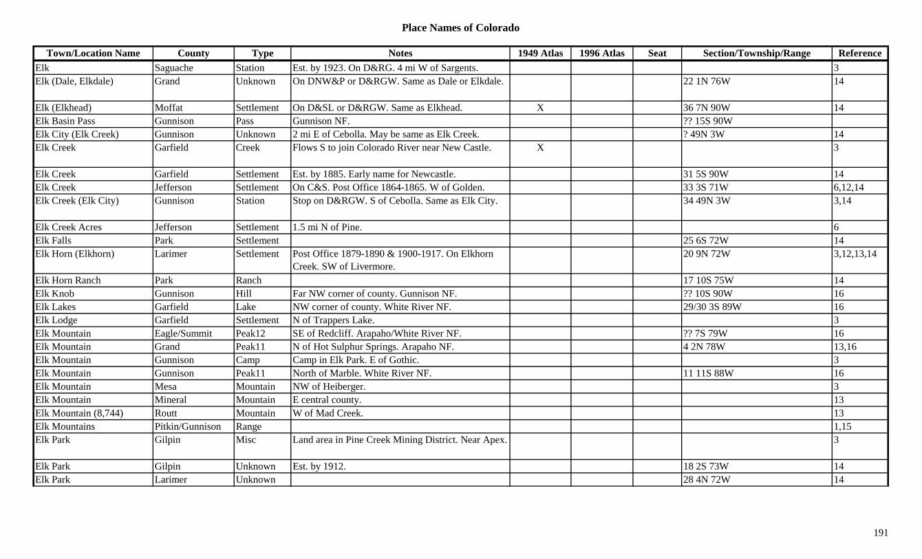
Place Names of Colorado
Town/Location Name County Type Notes 1949 Atlas 1996 Atlas Seat Section/Township/Range ReferenceElk Saguache Station Est. by 1923. On D&RG. 4 mi W of Sargents. 3Elk (Dale, Elkdale) Grand Unknown On DNW&P or D&RGW. Same as Dale or Elkdale. 22 1N 76W 14
Elk (Elkhead) Moffat Settlement On D&SL or D&RGW. Same as Elkhead. X 36 7N 90W 14Elk Basin Pass Gunnison Pass Gunnison NF. ?? 15S 90WElk City (Elk Creek) Gunnison Unknown 2 mi E of Cebolla. May be same as Elk Creek. ? 49N 3W 14Elk Creek Garfield Creek Flows S to join Colorado River near New Castle. X 3
Elk Creek Garfield Settlement Est. by 1885. Early name for Newcastle. 31 5S 90W 14Elk Creek Jefferson Settlement On C&S. Post Office 1864-1865. W of Golden. 33 3S 71W 6,12,14Elk Creek (Elk City) Gunnison Station Stop on D&RGW. S of Cebolla. Same as Elk City. 34 49N 3W 3,14( y) p y ,
Elk Creek Acres Jefferson Settlement 1.5 mi N of Pine. 6Elk Falls Park Settlement 25 6S 72W 14Elk Horn (Elkhorn) Larimer Settlement Post Office 1879-1890 & 1900-1917. On Elkhorn
Creek. SW of Livermore.20 9N 72W 3,12,13,14
Elk Horn Ranch Park Ranch 17 10S 75W 14Elk Knob Gunnison Hill Far NW corner of county. Gunnison NF. ?? 10S 90W 16Elk Lakes Garfield Lake NW corner of county. White River NF. 29/30 3S 89W 16Elk Lodge Garfield Settlement N of Trappers Lake. 3Elk Mountain Eagle/Summit Peak12 SE of Redcliff. Arapaho/White River NF. ?? 7S 79W 16Elk Mountain Grand Peak11 N of Hot Sulphur Springs. Arapaho NF. 4 2N 78W 13,16Elk Mountain Gunnison Camp Camp in Elk Park. E of Gothic. 3Elk Mountain Gunnison Peak11 North of Marble. White River NF. 11 11S 88W 16Elk Mountain Mesa Mountain NW of Heiberger. 3Elk Mountain Mineral Mountain E central county. 13Elk M t i (8 744) R tt M t i W f M d C k 13Elk Mountain (8,744) Routt Mountain W of Mad Creek. 13Elk Mountains Pitkin/Gunnison Range 1,15Elk Park Gilpin Misc Land area in Pine Creek Mining District. Near Apex. 3
Elk Park Gilpin Unknown Est. by 1912. 18 2S 73W 14Elk Park Larimer Unknown 28 4N 72W 14
191

Place Names of Colorado
Town/Location Name County Type Notes 1949 Atlas 1996 Atlas Seat Section/Township/Range ReferenceElk Park San Juan Station Est. by 1881. S of Silverton. Another location
shown, 17 40N 7W.14 40N 7W 3,14
Elk River Routt River Flows W & S to join Yampa River W of Steamboat Springs.
X X 3
Elk Springs Moffat Settlement Est. 1884. Post Office 1924-1944 & 1948-1983. 1966 became rural branch of Craig.
X 30 5N 98W 3,12,14
Elk Tooth (12,848) Boulder Peak12 NW corner of county. Roosevelt NF. ?? 2N 74W 16Elk Wallow Reservoir Delta Lake NE of Cedaredge. Grand Mesa NF. ?? 12S 92W 16Elkdale (Dale, Elk) Grand Station Post Office 1920-1925. On D&SL. 2 mi S of
Coulter. Same as Dale & Elk.22 1N 76W 3,12,14
Elkhead Moffat/Routt Settlement Post Office 1927-1929. 36 7N 90W 12,14,Elkhead Routt Settlement Post Office 1884-1885 & 1910-1924. Tiny
community 18 mi W of Clark.13 8N 88W 3,12,14
Elkhead Creek Routt Creek Originates in Elkhead Mtns. Flows W & S Yampa River W of Hayden.
3
Elkhead Mountains Moffat Range NE corner of county. 3,15Elkhead Pass (13,220 or 13,230)
Chaffee Pass Crossed by forest trail. Mt. Harvard Topo. San Isabel NF.
5 13S 80W 5,7,8
Elkhead Range Routt Range NW corner of county. W of Hahns Peak. 1,3Elkhorn Gunnison Station Stop on D&RGW. E of Iola. 22 49N 2W 3,14Elkhorn Larimer Settlement Post Office 1879-1890 & 1900-1917. 23 9N 73W 14Elkhorn Creek Larimer Creek Flows from Bellaire Lake E & S into Cache La
Poudre River.3
Elkhorn Mine Routt Mine At Elkhorn. On Wyoming border. NW of Whiskey Park.
3
Elko Saguache Settlement On D&RGW. On Tomichi Creek X 23 48N 4E 14Elk (El ) G i S ttl t P t Offi 1881 1884 5 i f G thi 7 12S 86W 3 12 14Elko (Elco) Gunnison Settlement Post Office 1881-1884. 5 mi from Gothic. 7 12S 86W 3,12,14Elkton El Paso/Teller Settlement Post Office 1895-1926. 2 mi N of Victor. See
Arequa.30 15S 69W 2,3,12,13,14
Elkton Gunnison Camp Post Office 1881-1882. W of Gothic. At end of Washington Gulch.
32 12S 86W 3,12,14
Elkton Teller Mine An Elkton area mine. 3,13Elkton Mine Teller Mine N of Victor. 2
192
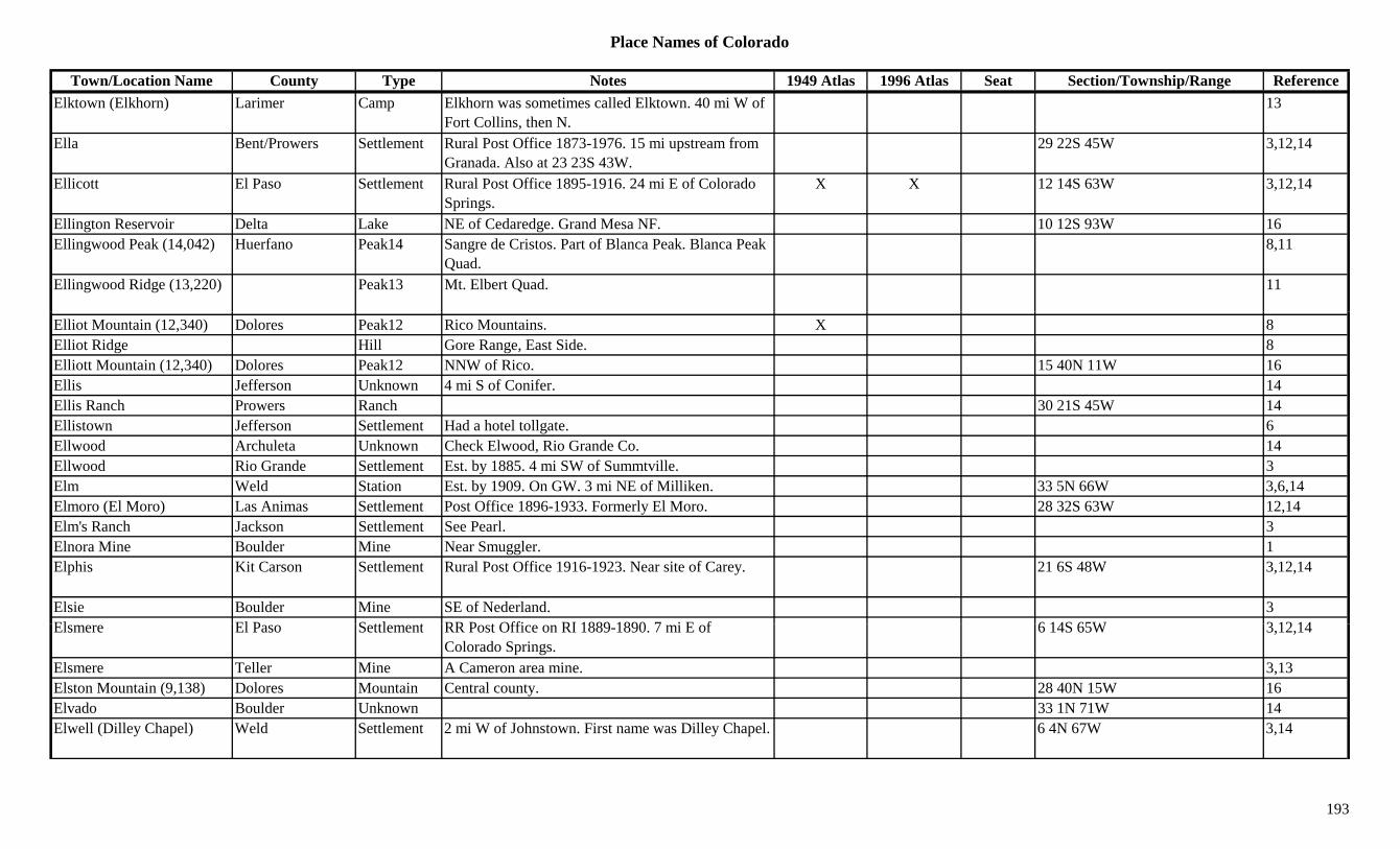
Place Names of Colorado
Town/Location Name County Type Notes 1949 Atlas 1996 Atlas Seat Section/Township/Range ReferenceElktown (Elkhorn) Larimer Camp Elkhorn was sometimes called Elktown. 40 mi W of
Fort Collins, then N.13
Ella Bent/Prowers Settlement Rural Post Office 1873-1976. 15 mi upstream from Granada. Also at 23 23S 43W.
29 22S 45W 3,12,14
Ellicott El Paso Settlement Rural Post Office 1895-1916. 24 mi E of Colorado Springs.
X X 12 14S 63W 3,12,14
Ellington Reservoir Delta Lake NE of Cedaredge. Grand Mesa NF. 10 12S 93W 16Ellingwood Peak (14,042) Huerfano Peak14 Sangre de Cristos. Part of Blanca Peak. Blanca Peak
Quad.8,11
Ellingwood Ridge (13,220) Peak13 Mt. Elbert Quad. 11
Elliot Mountain (12,340) Dolores Peak12 Rico Mountains. X 8Elliot Ridge Hill Gore Range, East Side. 8Elliott Mountain (12,340) Dolores Peak12 NNW of Rico. 15 40N 11W 16Ellis Jefferson Unknown 4 mi S of Conifer. 14Ellis Ranch Prowers Ranch 30 21S 45W 14Ellistown Jefferson Settlement Had a hotel tollgate. 6Ellwood Archuleta Unknown Check Elwood, Rio Grande Co. 14Ellwood Rio Grande Settlement Est. by 1885. 4 mi SW of Summtville. 3Elm Weld Station Est. by 1909. On GW. 3 mi NE of Milliken. 33 5N 66W 3,6,14Elmoro (El Moro) Las Animas Settlement Post Office 1896-1933. Formerly El Moro. 28 32S 63W 12,14Elm's Ranch Jackson Settlement See Pearl. 3Elnora Mine Boulder Mine Near Smuggler. 1Elphis Kit Carson Settlement Rural Post Office 1916-1923. Near site of Carey. 21 6S 48W 3,12,14
Elsie Boulder Mine SE of Nederland. 3El El P S ttl t RR P t Offi RI 1889 1890 7 i E f 6 14S 65W 3 12 14Elsmere El Paso Settlement RR Post Office on RI 1889-1890. 7 mi E of
Colorado Springs.6 14S 65W 3,12,14
Elsmere Teller Mine A Cameron area mine. 3,13Elston Mountain (9,138) Dolores Mountain Central county. 28 40N 15W 16Elvado Boulder Unknown 33 1N 71W 14Elwell (Dilley Chapel) Weld Settlement 2 mi W of Johnstown. First name was Dilley Chapel. 6 4N 67W 3,14
193
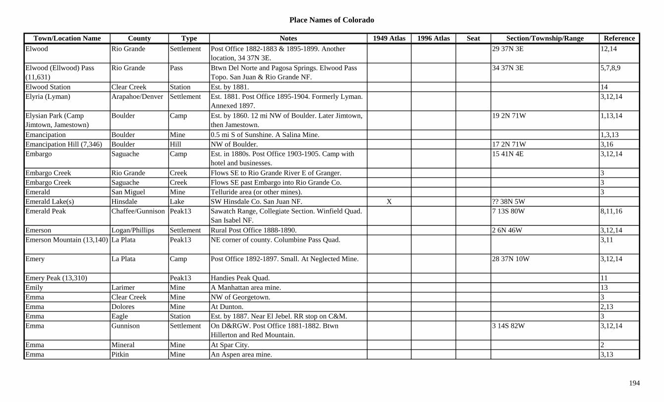
Place Names of Colorado
Town/Location Name County Type Notes 1949 Atlas 1996 Atlas Seat Section/Township/Range ReferenceElwood Rio Grande Settlement Post Office 1882-1883 & 1895-1899. Another
location, 34 37N 3E.29 37N 3E 12,14
Elwood (Ellwood) Pass (11,631)
Rio Grande Pass Btwn Del Norte and Pagosa Springs. Elwood Pass Topo. San Juan & Rio Grande NF.
34 37N 3E 5,7,8,9
Elwood Station Clear Creek Station Est. by 1881. 14Elyria (Lyman) Arapahoe/Denver Settlement Est. 1881. Post Office 1895-1904. Formerly Lyman.
Annexed 1897.3,12,14
Elysian Park (Camp Jimtown, Jamestown)
Boulder Camp Est. by 1860. 12 mi NW of Boulder. Later Jimtown, then Jamestown.
19 2N 71W 1,13,14
Emancipation Boulder Mine 0.5 mi S of Sunshine. A Salina Mine. 1,3,13Emancipation Hill (7,346) Boulder Hill NW of Boulder. 17 2N 71W 3,16p ( , ) ,Embargo Saguache Camp Est. in 1880s. Post Office 1903-1905. Camp with
hotel and businesses.15 41N 4E 3,12,14
Embargo Creek Rio Grande Creek Flows SE to Rio Grande River E of Granger. 3Embargo Creek Saguache Creek Flows SE past Embargo into Rio Grande Co. 3Emerald San Miguel Mine Telluride area (or other mines). 3Emerald Lake(s) Hinsdale Lake SW Hinsdale Co. San Juan NF. X ?? 38N 5WEmerald Peak Chaffee/Gunnison Peak13 Sawatch Range, Collegiate Section. Winfield Quad.
San Isabel NF.7 13S 80W 8,11,16
Emerson Logan/Phillips Settlement Rural Post Office 1888-1890. 2 6N 46W 3,12,14Emerson Mountain (13,140) La Plata Peak13 NE corner of county. Columbine Pass Quad. 3,11
Emery La Plata Camp Post Office 1892-1897. Small. At Neglected Mine. 28 37N 10W 3,12,14
Emery Peak (13,310) Peak13 Handies Peak Quad. 11Emily Larimer Mine A Manhattan area mine. 13E Cl C k Mi NW f G t 3Emma Clear Creek Mine NW of Georgetown. 3Emma Dolores Mine At Dunton. 2,13Emma Eagle Station Est. by 1887. Near El Jebel. RR stop on C&M. 3Emma Gunnison Settlement On D&RGW. Post Office 1881-1882. Btwn
Hillerton and Red Mountain.3 14S 82W 3,12,14
Emma Mineral Mine At Spar City. 2Emma Pitkin Mine An Aspen area mine. 3,13
194
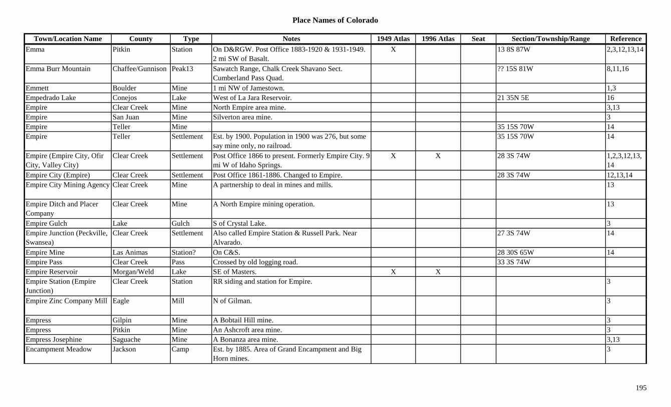
Place Names of Colorado
Town/Location Name County Type Notes 1949 Atlas 1996 Atlas Seat Section/Township/Range ReferenceEmma Pitkin Station On D&RGW. Post Office 1883-1920 & 1931-1949.
2 mi SW of Basalt.X 13 8S 87W 2,3,12,13,14
Emma Burr Mountain Chaffee/Gunnison Peak13 Sawatch Range, Chalk Creek Shavano Sect. Cumberland Pass Quad.
?? 15S 81W 8,11,16
Emmett Boulder Mine 1 mi NW of Jamestown. 1,3Empedrado Lake Conejos Lake West of La Jara Reservoir. 21 35N 5E 16Empire Clear Creek Mine North Empire area mine. 3,13Empire San Juan Mine Silverton area mine. 3Empire Teller Mine 35 15S 70W 14Empire Teller Settlement Est. by 1900. Population in 1900 was 276, but some
say mine only, no railroad.35 15S 70W 14
Empire (Empire City, Ofir City, Valley City)
Clear Creek Settlement Post Office 1866 to present. Formerly Empire City. 9 mi W of Idaho Springs.
X X 28 3S 74W 1,2,3,12,13,14
Empire City (Empire) Clear Creek Settlement Post Office 1861-1886. Changed to Empire. 28 3S 74W 12,13,14Empire City Mining Agency Clear Creek Mine A partnership to deal in mines and mills. 13
Empire Ditch and Placer Company
Clear Creek Mine A North Empire mining operation. 13
Empire Gulch Lake Gulch S of Crystal Lake. 3Empire Junction (Peckville, Swansea)
Clear Creek Settlement Also called Empire Station & Russell Park. Near Alvarado.
27 3S 74W 14
Empire Mine Las Animas Station? On C&S. 28 30S 65W 14Empire Pass Clear Creek Pass Crossed by old logging road. 33 3S 74WEmpire Reservoir Morgan/Weld Lake SE of Masters. X XEmpire Station (Empire Junction)
Clear Creek Station RR siding and station for Empire. 3
E i Zi C Mill E l Mill N f Gil 3Empire Zinc Company Mill Eagle Mill N of Gilman. 3
Empress Gilpin Mine A Bobtail Hill mine. 3Empress Pitkin Mine An Ashcroft area mine. 3Empress Josephine Saguache Mine A Bonanza area mine. 3,13Encampment Meadow Jackson Camp Est. by 1885. Area of Grand Encampment and Big
Horn mines.3
195
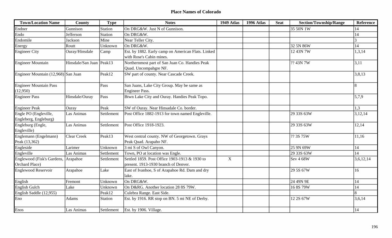
Place Names of Colorado
Town/Location Name County Type Notes 1949 Atlas 1996 Atlas Seat Section/Township/Range ReferenceEndner Gunnison Station On DRG&W. Just N of Gunnison. 35 50N 1W 14Endo Jefferson Station On DRG&W. 14Endomile Jackson Mine Near Teller City. 3Energy Routt Unknown On DRG&W. 32 5N 86W 14Engineer City Ouray/Hinsdale Camp Est. by 1882. Early camp on American Flats. Linked
with Rose's Cabin mines.12 43N 7W 1,3,14
Engineer Mountain Hinsdale/San Juan Peak13 Northernmost part of San Juan Co. Handies Peak Quad. Uncompahgre NF.
?? 43N 7W 3,11
Engineer Mountain (12,968) San Juan Peak12 SW part of county. Near Cascade Creek. 3,8,13
Engineer Mountain Pass Pass San Juans, Lake City Group. May be same as 8g(12,950)
, y p yEngineer Pass.
Engineer Pass Hinsdale/Ouray Pass Btwn Lake City and Ouray. Handies Peak Topo. 5,7,9
Engineer Peak Ouray Peak SW of Ouray. Near Hinsadale Co. border. 1,3Engle PO (Engleville, Engleberg, Engleburg)
Las Animas Settlement Post Office 1882-1913 for town named Engleville. 29 33S 63W 3,12,14
Engleburg (Engle, Engleville)
Las Animas Settlement Post Office 1918-1923. 29 33S 63W 12,14
Englemann (Engelmann) Peak (13,362)
Clear Creek Peak13 West central county. NW of Georgetown. Grays Peak Quad. Arapaho NF.
?? 3S 75W 11,16
Engleside Larimer Unknown 3 mi S of Owl Canyon. 25 9N 69W 14Engleville Las Animas Settlement Town, PO at location was Engle. 29 33S 63W 14Englewood (Fisk's Gardens, Orchard Place)
Arapahoe Settlement Settled 1859. Post Office 1903-1913 & 1930 to present. 1913-1930 branch of Denver.
X Sev 4 68W 3,6,12,14
Englewood Reservoir Arapahoe Lake East of Ivanhoe, S of Arapahoe Rd. Dam and dry l k
29 5S 67W 16lake.
English Fremont Unknown On DRG&W. 24 49N 9E 14English Gulch Lake Unknown On D&RG. Another location 28 8S 79W. 16 8S 79W 14English Saddle (12,955) Peak12 Culebra Range. East Side. 8Eno Adams Station Est. by 1916. RR stop on BN. 5 mi NE of Derby. 12 2S 67W 3,6,14
Enos Las Animas Settlement Est. by 1906. Village. 14
196
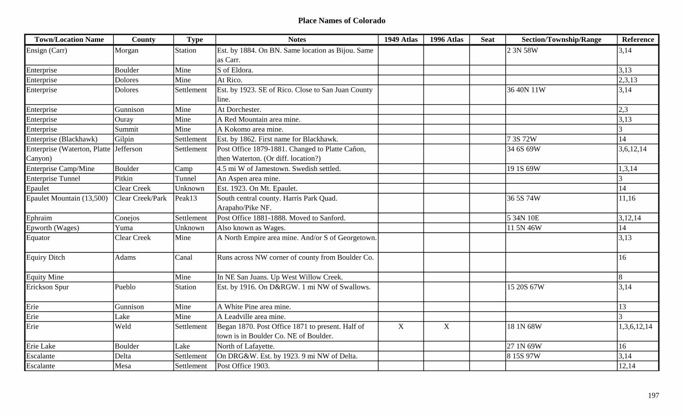
Place Names of Colorado
Town/Location Name County Type Notes 1949 Atlas 1996 Atlas Seat Section/Township/Range ReferenceEnsign (Carr) Morgan Station Est. by 1884. On BN. Same location as Bijou. Same
as Carr.2 3N 58W 3,14
Enterprise Boulder Mine S of Eldora. 3,13Enterprise Dolores Mine At Rico. 2,3,13Enterprise Dolores Settlement Est. by 1923. SE of Rico. Close to San Juan County
line.36 40N 11W 3,14
Enterprise Gunnison Mine At Dorchester. 2,3Enterprise Ouray Mine A Red Mountain area mine. 3,13Enterprise Summit Mine A Kokomo area mine. 3Enterprise (Blackhawk) Gilpin Settlement Est. by 1862. First name for Blackhawk. 7 3S 72W 14Enterprise (Waterton, Platte Jefferson Settlement Post Office 1879-1881. Changed to Platte Cañon, 34 6S 69W 3,6,12,14p ( ,Canyon)
g ,then Waterton. (Or diff. location?)
, , ,
Enterprise Camp/Mine Boulder Camp 4.5 mi W of Jamestown. Swedish settled. 19 1S 69W 1,3,14Enterprise Tunnel Pitkin Tunnel An Aspen area mine. 3Epaulet Clear Creek Unknown Est. 1923. On Mt. Epaulet. 14Epaulet Mountain (13,500) Clear Creek/Park Peak13 South central county. Harris Park Quad.
Arapaho/Pike NF.36 5S 74W 11,16
Ephraim Conejos Settlement Post Office 1881-1888. Moved to Sanford. 5 34N 10E 3,12,14Epworth (Wages) Yuma Unknown Also known as Wages. 11 5N 46W 14Equator Clear Creek Mine A North Empire area mine. And/or S of Georgetown. 3,13
Equiry Ditch Adams Canal Runs across NW corner of county from Boulder Co. 16
Equity Mine Mine In NE San Juans. Up West Willow Creek. 8Erickson Spur Pueblo Station Est. by 1916. On D&RGW. 1 mi NW of Swallows. 15 20S 67W 3,14
E i G i Mi A Whit Pi i 13Erie Gunnison Mine A White Pine area mine. 13Erie Lake Mine A Leadville area mine. 3Erie Weld Settlement Began 1870. Post Office 1871 to present. Half of
town is in Boulder Co. NE of Boulder.X X 18 1N 68W 1,3,6,12,14
Erie Lake Boulder Lake North of Lafayette. 27 1N 69W 16Escalante Delta Settlement On DRG&W. Est. by 1923. 9 mi NW of Delta. 8 15S 97W 3,14Escalante Mesa Settlement Post Office 1903. 12,14
197
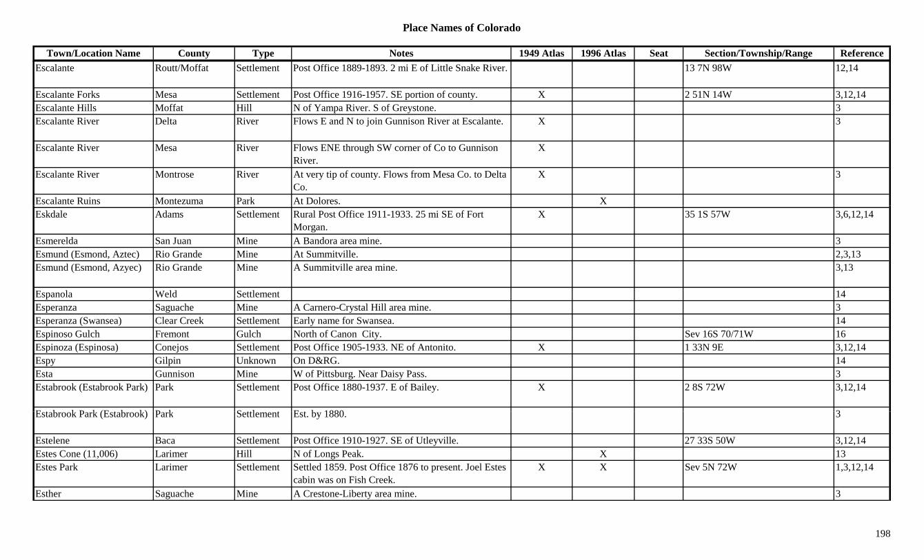
Place Names of Colorado
Town/Location Name County Type Notes 1949 Atlas 1996 Atlas Seat Section/Township/Range ReferenceEscalante Routt/Moffat Settlement Post Office 1889-1893. 2 mi E of Little Snake River. 13 7N 98W 12,14
Escalante Forks Mesa Settlement Post Office 1916-1957. SE portion of county. X 2 51N 14W 3,12,14Escalante Hills Moffat Hill N of Yampa River. S of Greystone. 3Escalante River Delta River Flows E and N to join Gunnison River at Escalante. X 3
Escalante River Mesa River Flows ENE through SW corner of Co to Gunnison River.
X
Escalante River Montrose River At very tip of county. Flows from Mesa Co. to Delta Co.
X 3
Escalante Ruins Montezuma Park At Dolores. XEskdale Adams Settlement Rural Post Office 1911-1933. 25 mi SE of Fort
Morgan.X 35 1S 57W 3,6,12,14
Esmerelda San Juan Mine A Bandora area mine. 3Esmund (Esmond, Aztec) Rio Grande Mine At Summitville. 2,3,13Esmund (Esmond, Azyec) Rio Grande Mine A Summitville area mine. 3,13
Espanola Weld Settlement 14Esperanza Saguache Mine A Carnero-Crystal Hill area mine. 3Esperanza (Swansea) Clear Creek Settlement Early name for Swansea. 14Espinoso Gulch Fremont Gulch North of Canon City. Sev 16S 70/71W 16Espinoza (Espinosa) Conejos Settlement Post Office 1905-1933. NE of Antonito. X 1 33N 9E 3,12,14Espy Gilpin Unknown On D&RG. 14Esta Gunnison Mine W of Pittsburg. Near Daisy Pass. 3Estabrook (Estabrook Park) Park Settlement Post Office 1880-1937. E of Bailey. X 2 8S 72W 3,12,14
E t b k P k (E t b k) P k S ttl t E t b 1880 3Estabrook Park (Estabrook) Park Settlement Est. by 1880. 3
Estelene Baca Settlement Post Office 1910-1927. SE of Utleyville. 27 33S 50W 3,12,14Estes Cone (11,006) Larimer Hill N of Longs Peak. X 13Estes Park Larimer Settlement Settled 1859. Post Office 1876 to present. Joel Estes
cabin was on Fish Creek.X X Sev 5N 72W 1,3,12,14
Esther Saguache Mine A Crestone-Liberty area mine. 3
198

Place Names of Colorado
Town/Location Name County Type Notes 1949 Atlas 1996 Atlas Seat Section/Township/Range ReferenceEstrella Alamosa Settlement On D&RGW. 7 mi SW of Alamosa. X 18 36N 10E 3,14Ethel Mineral Mine At Creede. 2Ethel Mineral Mine 3Ethel Lake Clear Creek Lake Northern county. Between Witter Peak and Mt.
Flora. Arapaho NF.?? 2S 74W 16
Ethel Peak (Mount Ethel) (11,924)
Jackson/Routt Peak S of Mt. Zirkel. At head of Roaring Fork. 3,8,13
Ethel Rivers Chaffee Mine N of Salida. 3Eula Routt Settlement Post Office 1900-1902. 12,14Eureka Baca Unknown 15 31S 44W 14Eureka Bent Unknown 29 14S 47W 14Eureka Boulder Mine At Jamestown. 3Eureka Cheyenne Settlement Site 2. Est. by 1882. On UP. 8 mi NE of Kit Carson. 33 14S 47W 14
Eureka Cheyenne Station Site 1. Est. by 1882. RR stop on UP. 8 mi NE of Kit Carson.
31 14S 47W 3,14
Eureka Clear Creek Mine An Empire area mine. 13Eureka Gilpin Camp In Eureka Gulch. 0.5 mi W of Central City.
Absorbed.3,14
Eureka Gilpin Mine SW of Eureka. 3Eureka Grand Mine Lulu area mine. 3Eureka Gunnison Mine A Tomichi area mine. 13Eureka Lake Mine A Leadville area mine. On Stray Horse Gulch. 3,13Eureka Lake Mine Bromley area. 3Eureka Park Mine A Silver Heels area mine. 3Eureka Saguache Mine An Iris area mine. 3,13E k (B k Cit ) S J /L Pl t S ttl t E t b 1873 P t Offi 1875 1942 8 i NE f X 19 42N 6W 2 3 12 13 14Eureka (Baker City) San Juan/La Plata Settlement Est. by 1873. Post Office 1875-1942. 8 mi NE of
Silverton.X 19 42N 6W 2,3,12,13,14
Eureka Gulch Gilpin Gulch Runs NW of Erueka. 3Eureka Gulch Lake Gulch Off California Gulch. 3Eureka Gulch Lake Mine A Leadville area mine. 3Eureka Gulch San Juan Gulch Runs NW from Eureka. 3Eureka Hill Cheyenne Hill North of Kit Carson. Near Kit Carson Co. 26 12S 49W 16
199
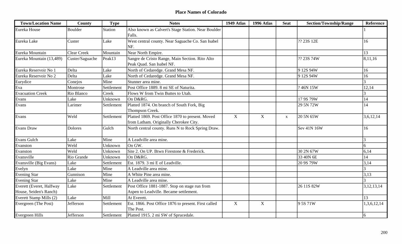
Place Names of Colorado
Town/Location Name County Type Notes 1949 Atlas 1996 Atlas Seat Section/Township/Range ReferenceEureka House Boulder Station Also known as Calvert's Stage Station. Near Boulder
Falls.1
Eureka Lake Custer Lake West central county. Near Saguache Co. San Isabel NF.
?? 23S 12E 16
Eureka Mountain Clear Creek Mountain Near North Empire. 13Eureka Mountain (13,489) Custer/Saguache Peak13 Sangre de Cristo Range, Main Section. Rito Alto
Peak Quad. San Isabel NF.?? 23S 74W 8,11,16
Eureka Reservoir No 1 Delta Lake North of Cedaredge. Grand Mesa NF. 9 12S 94W 16Eureka Reservoir No 2 Delta Lake North of Cedaredge. Grand Mesa NF. 9 12S 94W 16Eurydice Conejos Mine Stunner area mine. 3Eva Montrose Settlement Post Office 1889. 8 mi SE of Naturita. ? 46N 15W 12,14,Evacuation Creek Rio Blanco Creek Flows W from Twin Buttes to Utah. 3Evans Lake Unknown On D&RG. 17 9S 79W 14Evans Larimer Settlement Platted 1874. On branch of South Fork, Big
Thompson Creek.29 5N 72W 14
Evans Weld Settlement Platted 1869. Post Office 1870 to present. Moved from Latham. Originally Cherokee City.
X X x 20 5N 65W 3,6,12,14
Evans Draw Dolores Gulch North central county. Runs N to Rock Spring Draw. Sev 41N 16W 16
Evans Gulch Lake Mine A Leadville area mine. 3Evanston Weld Unknown On GW. 6Evanston Weld Unknown Site 2. On UP. Btwn Firestone & Frederick. 30 2N 67W 6,14Evansville Rio Grande Unknown On D&RG. 33 40N 6E 14Evansville (Big Evans) Lake Settlement Est. 1879. 3 mi E of Leadville. 20 9S 79W 3,14Evelyn Lake Mine A Leadville area mine. 3Evening Star Gunnison Mine A White Pine area mine. 3,13E i St L k Mi A L d ill i 3Evening Star Lake Mine A Leadville area mine. 3Everett (Everet, Halfway House, Seiden's Ranch)
Lake Settlement Post Office 1881-1887. Stop on stage run from Aspen to Leadville. Became settlement.
26 11S 82W 3,12,13,14
Everett Stamp Mills (2) Lake Mill At Everett. 13Evergreen (The Post) Jefferson Settlement Est. 1866. Post Office 1876 to present. First called
The Post.X X 9 5S 71W 1,3,6,12,14
Evergreen Hills Jefferson Settlement Platted 1915. 2 mi SW of Sprucedale. 6
200
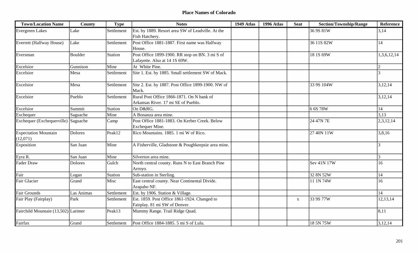
Place Names of Colorado
Town/Location Name County Type Notes 1949 Atlas 1996 Atlas Seat Section/Township/Range ReferenceEvergreen Lakes Lake Settlement Est. by 1889. Resort area SW of Leadville. At the
Fish Hatchery.36 9S 81W 3,14
Everrett (Halfway House) Lake Settlement Post Office 1881-1887. First name was Halfway House.
36 11S 82W 14
Eversman Boulder Station Post Office 1899-1900. RR stop on BN. 3 mi S of Lafayette. Also at 14 1S 69W.
18 1S 69W 1,3,6,12,14
Excelsior Gunnison Mine At White Pine. 2Excelsior Mesa Settlement Site 1. Est. by 1885. Small settlement SW of Mack. 3
Excelsior Mesa Settlement Site 2. Est. by 1887. Post Office 1899-1900. NW of Mack.
33 9S 104W 3,12,14
Excelsior Pueblo Settlement Rural Post Office 1866-1871. On N bank of Arkansas River. 17 mi SE of Pueblo.
3,12,14
Excelsior Summit Station On D&RG. 6 6S 78W 14Exchequer Saguache Mine A Bonanza area mine. 3,13Exchequer (Exchequerville) Saguache Camp Post Office 1881-1883. On Kerber Creek. Below
Exchequer Mine.24 47N 7E 2,3,12,14
Expectation Mountain (12,071)
Dolores Peak12 Rico Mountains. 1885. 1 mi W of Rico. 27 40N 11W 3,8,16
Exposition San Juan Mine A Fisherville, Gladstone & Poughkeepsie area mine. 3
Eyra R. San Juan Mine Silverton area mine. 3Fader Draw Dolores Gulch North central county. Runs N to East Branch Pine
Arroyo.Sev 41N 17W 16
Fair Logan Station Sub-station in Sterling. 32 8N 52W 14Fair Glacier Grand Misc East central county. Near Continental Divide.
A h NF11 1N 74W 16
Arapaho NF.Fair Grounds Las Animas Settlement Est. by 1906. Station & Village. 14Fair Play (Fairplay) Park Settlement Est. 1859. Post Office 1861-1924. Changed to
Fairplay. 81 mi SW of Denver.x 33 9S 77W 12,13,14
Fairchild Mountain (13,502) Larimer Peak13 Mummy Range. Trail Ridge Quad. 8,11
Fairfax Grand Settlement Post Office 1884-1885. 5 mi S of Lulu. 18 5N 75W 3,12,14
201

Place Names of Colorado
Town/Location Name County Type Notes 1949 Atlas 1996 Atlas Seat Section/Township/Range ReferenceFairfield (Egyptian Valley) Phillips Settlement Est. by 1940. 12 mi NW of Holyoke. No Post Office. X 3,14
Fairhaven Gilpin Mine Phoenix area. 3Fairmont Elbert Station Stage station on Smoky Hill North stage route. 2 mi
NW of Buick.3,6,14
Fairmont Park Reservoir Delta Lake NE of Cedaredge. Grand Mesa NF. ?? 11S 92W 16Fairmount (Swink) Otero Settlement Post Office 1900-1906. Changed to Swink. 25 23S 56W 3,12,14Fairplay (Fair Play, Platte City, Sacramento Flats)
Park Settlement Est. 1859. Post Office 1924 to present. Changed to Fair Play. 81 mi SW of Denver.
X X X 33 9S 77W 2,3,12,13,14
Fairview Custer Settlement Post Office 1882-1893 & 1907-1913. Btwn Greenwood and Sliver Cliff.
10 23S 69W 3,12,14
Fairview Garfield Settlement On Halls Gulch Road. X 14 7S 92W 14Fairview Gunnison Mine An Elko area mine. 3Fairview Gunnison Mine At Pitkin. 2,3,13Fairview Gunnison Settlement Est. in 1878. 8 50N 4E 14Fairview Logan Station Wells Fargo Stage Station on Platte Route. 59 mi
SW of Julesburg.14
Fairview Mineral Mine 3Fairview Montrose Station On D&RG. 6 mi E of Montrose. X 19 49N 8W 3,14Fairview Pueblo Settlement Est. by 1885. Village NW of Rye. 3Fairview (Amitie) Phillips Settlement First called Fairview. Changed to Amitie in 1866. 14
Fairview (Badger) Teller Unknown An early name for Badger. 18 15S 69W 14Fairview (Fairville) Park Unknown Est. by 1881. On DSP&P. 3 mi NW of Bailey. 14Fairview (Fruita) Mesa Settlement Started and failed on same site as Fruita. See Fruita. X X 17 1N 2W 3,14
F i i (G d i ) B ld S ttl t S b b f B ld 1Fairview (Goodview) Boulder Settlement Suburb of Boulder. 1Fairview (Ivywild) El Paso Settlement Est. by 1924. On CS&CCD. Same site as Ivywild. 4 15S 67W 3,14
Fairview (Winnview) Arapahoe Unknown First name for Winnview. 2 4S 57W 14Fairview Lake Eagle Lake South central county. SW of Redcliff. White River
NF.?? 7S 82W 16
202

Place Names of Colorado
Town/Location Name County Type Notes 1949 Atlas 1996 Atlas Seat Section/Township/Range ReferenceFairview Mountain Gunnison Peak13 SW of Tincup. Sawatch Range, Fossil Group.
Fairview Peak Quad. Gunnison NF.16/17 51N 4E 3,16
Fairview Peak (13,214) Peak13 Sawatch Range, Fossil Group. Fairview Peak Quad. 8,11
Fairview Peak (8,561) Boulder Mountain West of Altona. NE of Jamestown. Roosevelt NF. 16 2N 71W 3,16
Fairville (Altruria, Slaghts, Shawnee)
Park Settlement Post Office 1878-1882. First Altruria, then Fairville, then Slaghts, then Shawnee.
21 7S 77W 3,12,14
Fairy Fremont Settlement Post Office 1881. 2 mi SE of Soda Springs. 8 20S 71W 3,12,14Fairy Glen Fremont Unknown On D&RGW. 19 20S 71W 14Falcon El Paso Settlement Platted 1888. Post Office 1888-1942. On CRI&P, X X 7 13S 64W 3,12,14,
C&S. , ,
Falcon Lake Boulder Lake NW corner of county. Rocky Mountain Natl Park. 16
Falfa (Alfalfa, Conley's Seat, Griffith)
La Plata Settlement Post Office 1924-1954. Formerly Griffith. 8 mi SE of Durango.
X 2U 34N 9W 1,3,12,14
Fall Creek Larimer River Flows SE into Estes Park. 3Fall Creek San Miguel Creek Smaller shorter creek NW of other once known as
Big Bear Creek.3
Fall Creek (Big Bear Creek) San Miguel Creek Flows N to join San Miguel River at Gold Run. 3
Fall Creek (Seymour, Silver Pick)
San Miguel Settlement Est. in 1880s. Busy camp called Seymour. Name came 1922. Post Office 1933-1943.
X 1 43N 11W 3,12,14
Fall Creek Pass (12,560) Eagle Pass SW of Minturn. Mt. of the Holy Cross Topo. White River NF.
17 7S 81W 5,7,8
Fall Mountain (12,258) Larimer Peak12 Mummy Range. 8F ll Ri Cl C k Ri R f Ali t F ll Ri 3Fall River Clear Creek River Runs from Alice to Fall River. 3Fall River Clear Creek Settlement Wells Fargo Stage Station. Near Fall River and Clear
Creek junction.28 3S 73W 3,13,14
Fall River River Near St. Mary's Glacier 1Fall River Pass (11,796) Larimer Pass Btwn Estes Park and Grand Lake. Fall River Pass
Topo. Rocky Mountain Natl Park.X 5,7,9
203

Place Names of Colorado
Town/Location Name County Type Notes 1949 Atlas 1996 Atlas Seat Section/Township/Range ReferenceFalling Rock Gulch Fremont Gulch South central county. SE of Texas Creek (town). Sev 20S 72W 16
Falls Gulch Fremont Gulch East of Howard. Sev 48/49N 11E 16Falls Gulch Fremont Gulch SE of Coaldale. Sev 47N 11E 16Falls Gulch Mountain Fremont Mountain North of Cotopaxi. ?? 48N 11E 16Famous Lake Mine A Leadville area mine. 3Fan Gulch Gunnison Gulch North of Blue Mesa Res. Runs S to West Elk Creek. Sev 49N 4W 16
Fancy Lake Eagle Lake SW of Redcliff. White River NF. 36 7S 82W 16Fancy Pass (12,380) Eagle Pass SW of Minturn. Mount Jackson Topo. White River
NF.25 7S 81W 5,7
Fannie Rawlings Lake Mine A Leadville area mine. 3Fanny Barrett Park Mine An Alma area mine. 3Fare Huerfano Settlement Not on RR. 21 28S 66W 14Farisita (Huerfano Canyon, Talpa)
Huerfano Settlement Est. 1855 abt. Post Office 1923-1988. Called Huerfano Canyon as early as 1850.
X X 35 26S 69W 3,12,14
Farley Kit Carson Settlement Post Office 1908. 12,14Farmers Garfield Settlement On D&RGW. 26 7S 88W 14Farmers (Farmers Spur) Weld Station Est. by 1909. On C&S, a spur. 5 mi NW of Greeley. 26 7S 88W 3,6,14
Farmers Highline Canal Adams Canal Runs E & NE from Jefferson Co in NE corner of Adams Co.
16
Farnam Park Unknown Est. by 1882. On Tarryall Creek. ? 10S 72W 14Farncomb Hill Summit Hill E of Breckenridge. Near Lincoln. 2,3Farncomb Hill (Paige City, Lincoln City)
Summit Settlement See Lincoln or Paige City. 3
F h (F h S ) S it St ti P t Offi 1881 1895 O DSP&P O B P 23 7S 77W 3 12 14Farnham (Farnham Spur) Summit Station Post Office 1881-1895. On DSP&P. On Boreas Pass. 23 7S 77W 3,12,14
Farnum Peak (11,377) Park Peak NW of Tarryall. 13Farr Huerfano Settlement Post Office on D&RG 1907-1946. S of Rouse
Junction.X 10 29S 65W 3,12,14
Farwell Pitkin Mine An Independence area mine. 3,13Farwell Rio Blanco Settlement Site 2. Post Office 1892-1894. 4 4S 94W 12,14
204

Place Names of Colorado
Town/Location Name County Type Notes 1949 Atlas 1996 Atlas Seat Section/Township/Range ReferenceFarwell (Independence) Garfield/Rio
BlancoSettlement Site 1. Post Office 1888. See Independence (townsite
name).4 4S 94W 12,14
Farwell (Independence) Pitkin Settlement Post Office 1881-1882. 12 11S 83W 3,12,14Farwell City Gunnison Unknown Surveyed in 1880. No plat on file. 14Farwell Mountain Routt Mountain NW corner of county. 13Faternide de Nuestro, etc. Las Animas Settlement Like a fort. Fraternide de Nuestro Padre Jesus Mi
Senora Del Carmel (full name).6 34S 64W 14
Father Dyer Peak (13,615) Peak13 Breckenridge Quad. 11
Faust Clear Creek Mine A Yankee Hill mine. 3Favorite Lake Mine A Leadville area mine. At Stumptown. 3,13p ,Fawn Creek Grand Unknown On D&SL. 11 2S 75W 14Fawn Creek Pass (10,200) Pass SW of Rollins Pass. On top of Moffat Tunnel. 7
Fawn Hollow Fremont Gulch SE of Canon City. Sev 19S 70W 16Fawn Springs Montrose Unknown Est. by 1916. 31 46N 17W 14Fawns Creek Rio Blanco Creek Flows N to join Piceance Creek. 3Fayette Otero Settlement On AT&SF. See La Fayette. X 3 23S 57W 14Fearnowville Pueblo Unknown 28 20S 64W 14Feathers Ranch (Maysville) Chaffee Ranch Post Office 1879-1893. 11 mi W of Salida. 2
Federal Center Jefferson/Denver Misc. Taken over in 1946. Government installation. 8 4S 69W 6
Federal Heights Adams Settlement Platted 1940. On UP. X 17 2S 68W 6,14Federal Lode Clear Creek Mine Silver Creek area mine. 3Fenders Jefferson Settlement On Turkey Creek. S of Tinytown. 34 5S 70W 3,6,14F t Ot St ti E t b 1916 O AT&SF 2 i E f R k F d 12 23S 56W 3 14Fenton Otero Station Est. by 1916. On AT&SF. 2 mi E of Rocky Ford. 12 23S 56W 3,14
Ferberite (Nederland) Boulder Settlement Site 2. Post Office 1916-1918. 1,12,14Ferberite (Steven's Camp, Tungsten)
Boulder Settlement Site 1. Partly covered by Barkers Res. 1,3
Fergus (Stevens Camp, Hawkins)
Kiowa Settlement Post Office on P&SL 1888-1890. Originally Hawkins. First called Stevens Camp.
17 18S 49W 3,12,14
205

Place Names of Colorado
Town/Location Name County Type Notes 1949 Atlas 1996 Atlas Seat Section/Township/Range ReferenceFerguson (Antlers, Silt) Garfield Settlement Post Office 1883-1891. Changed to Antlers. RR
station known as Ives.12 6S 93W 3,12,14
Fergusonville (Oak Grove) Montrose Unknown Same as Oak Grove. 36 49N 10W 14
Ferncliff Boulder Settlement 1 mi SE of Allenspark. X 25 3N 73W 1,6,14Ferndale Jefferson Settlement Est. by 1923. Near Foxton, Argyle & Cloudcrest. 29 7S 70W 3,6,14
Fernleaf Fremont Station Stop on D&RGW. 2 mi W of Texas Creek. 22 48N 12E 3,14Fernleaf Gulch Fremont Gulch Btwn Texas Creek and Cotopaxi. Sev 48N 12E 16Fernleaf Gulch Fremont Gulch North of Cotopaxi. Sev 50N 11E 16Ferris Reservoir Dolores Lake South central county. 10 39N 16W 16yFidler Fremont Station Post Office 1881-1882. ? 20S 71W 12,14Fields Montezuma Station On RGS. 14Fields Trading Post Jefferson Settlement W of Conifer. 3,6Fife Larimer Station Est. by 1910. On C&S. 3 mi S of Berthoud. 26 4N 69W 3,14Fifteen Mile House (Pierson)
Adams Station On Overland Stage Route. 2 mi NE of Henderson. Same as Pierson.
14
Filger City Summit Settlement Est. 1880s. N of Montezuma. Near Winning Card Mine. On Lenowea Mtn., at 12 5S 76W.
1,3,14
Finch Lake Boulder Lake NW corner of county. Rocky Mountain Natl Park. 32 3N 73W 16
Findale Larimer Settlement Post Office 1891-1893. 14Findlay Teller Mine A Goldfield area mine. 3Finger Mesa Hinsdale Mesa Central county. S of Lake City. Rio Grande NF. Sev 41N 4W 16
Fink Fremont Unknown On D&RG. 7 18S 71W 14Fi l L i U k O C&S 23 6N 69W 14Finley Larimer Unknown On C&S. 23 6N 69W 14Finnback Knob (13,409) Peak13 Mt. Sherman Quad. 11Finntown (Adelaide, Adelaide City, Park City)
Lake Settlement In Stray Horse Gulch, near Ibex. 19 9S 79W 1,3,14
Fir Costilla Unknown On D&RG. At La Veta Pass. 35 29S 70W 14Fire Clay Jefferson Unknown On D&RG. 7 mi NW of Arvada. 29 2S 70W 6,14
206

Place Names of Colorado
Town/Location Name County Type Notes 1949 Atlas 1996 Atlas Seat Section/Township/Range ReferenceFirestone Weld Settlement Post Office 1907 to present. On UP. W of Fort
Lupton.X X 30 2N 67W 3,6,12,14
First Colorado Custer Mine 3First Creek Adams Creek Flows NW through Rocky Mountain Arsenal to join
Quicny Ditch N of RM Arsenal.16
First National Bank Boulder Mine A Gold Hill mine. 3Firstview Cheyenne Settlement Post Office 1907-1961. Platted 1911. On UP. Once
in Greenwood Co.X 22 14S 46W 3,12,14
Fish Rio Grande Unknown ? 39N 8E 14Fish (Apishapa) Pass (11,743)
Huerfano/Las Animas
Pass Cucharas Pass Topo. X X 5,7
Fish (Mosca) Pass (9,713 or 9,740)
Alamosa/Huerfano Pass Btwn Gardner and Gr. Sand Dunes. Sangre de Cristo Range. San Isabel & Rio Grande NF.
X 4 27S 72W 1,3,7,9
Fish Canyon Hinsdale Canyon NE corner of county. Runs NNE to E into Pasture Creek.
Sev 45N 2W 16
Fish Creek Dolores Creek Flows S & W from Dolores Peak to West Dolores. 3
Fish Creek Park Creek Flows N to 11-Mile Canyon. 3Fish Creek (Ladd's Creek) Routt Creek NE of Dunkley. Later name for Ladd's Creek. 3
Fish Hatchery Conejos Settlement Est. by 1924. On Conejos River. SE of Conejos Peak.
3
Fish Hatchery Gulch Gunnison Gulch SW of Pitkin. Runs E to Quartz Creek. Sev 50N 4E 16Fish Pond Lake Eagle Lake West central county. S of Gypsum. White River NF. 13 6S 86W 16
Fisher Chaffee Settlement Site 2. Post Office 1889-1890. Btwn Mt. Princeton H t S i & St El
27 12S 79W 3,12,14Hot Springs & St. Elmo.
Fisher Chaffee Unknown Site 1. On DSP&P. A Post Office at the location was Alpine.
25 15S 80W 14
Fisher Pueblo Settlement Rural Post Office 1895-1908. 12 mi SW of Pueblo. 21 22S 65W 3,12,14
Fisher (Fisher City, Spar City)
Mineral Settlement Post Office 1892-1895. 14 mi S of Creede. Name changed to Spar City.
22 40N 1W 2,13,14
207
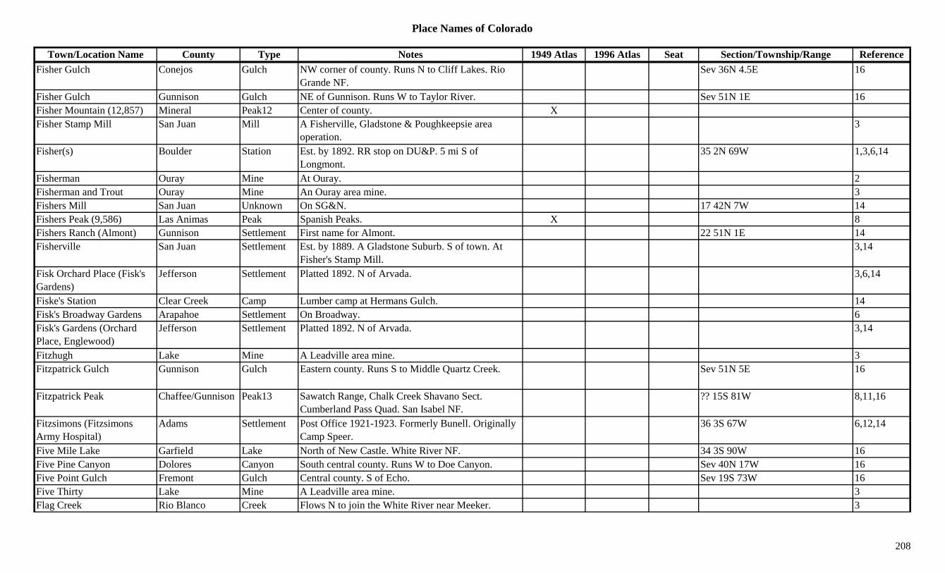
Place Names of Colorado
Town/Location Name County Type Notes 1949 Atlas 1996 Atlas Seat Section/Township/Range ReferenceFisher Gulch Conejos Gulch NW corner of county. Runs N to Cliff Lakes. Rio
Grande NF.Sev 36N 4.5E 16
Fisher Gulch Gunnison Gulch NE of Gunnison. Runs W to Taylor River. Sev 51N 1E 16Fisher Mountain (12,857) Mineral Peak12 Center of county. XFisher Stamp Mill San Juan Mill A Fisherville, Gladstone & Poughkeepsie area
operation.3
Fisher(s) Boulder Station Est. by 1892. RR stop on DU&P. 5 mi S of Longmont.
35 2N 69W 1,3,6,14
Fisherman Ouray Mine At Ouray. 2Fisherman and Trout Ouray Mine An Ouray area mine. 3Fishers Mill San Juan Unknown On SG&N. 17 42N 7W 14Fishers Peak (9,586) Las Animas Peak Spanish Peaks. X 8Fishers Ranch (Almont) Gunnison Settlement First name for Almont. 22 51N 1E 14Fisherville San Juan Settlement Est. by 1889. A Gladstone Suburb. S of town. At
Fisher's Stamp Mill.3,14
Fisk Orchard Place (Fisk's Gardens)
Jefferson Settlement Platted 1892. N of Arvada. 3,6,14
Fiske's Station Clear Creek Camp Lumber camp at Hermans Gulch. 14Fisk's Broadway Gardens Arapahoe Settlement On Broadway. 6Fisk's Gardens (Orchard Place, Englewood)
Jefferson Settlement Platted 1892. N of Arvada. 3,14
Fitzhugh Lake Mine A Leadville area mine. 3Fitzpatrick Gulch Gunnison Gulch Eastern county. Runs S to Middle Quartz Creek. Sev 51N 5E 16
Fitzpatrick Peak Chaffee/Gunnison Peak13 Sawatch Range, Chalk Creek Shavano Sect. Cumberland Pass Quad. San Isabel NF.
?? 15S 81W 8,11,16
Fit i (Fit i Ad S ttl t P t Offi 1921 1923 F l B ll O i i ll 36 3S 67W 6 12 14Fitzsimons (Fitzsimons Army Hospital)
Adams Settlement Post Office 1921-1923. Formerly Bunell. Originally Camp Speer.
36 3S 67W 6,12,14
Five Mile Lake Garfield Lake North of New Castle. White River NF. 34 3S 90W 16Five Pine Canyon Dolores Canyon South central county. Runs W to Doe Canyon. Sev 40N 17W 16Five Point Gulch Fremont Gulch Central county. S of Echo. Sev 19S 73W 16Five Thirty Lake Mine A Leadville area mine. 3Flag Creek Rio Blanco Creek Flows N to join the White River near Meeker. 3
208

Place Names of Colorado
Town/Location Name County Type Notes 1949 Atlas 1996 Atlas Seat Section/Township/Range ReferenceFlag Mountain Hinsdale Peak12 Southern county. San Juan NF. ?? 38N 5W 16Flagler (Malowe, Bowser) Kit Carson Settlement Est. 1887. Post Office 1888 to present. First called
Malowe, then Bowser.X X 2 9S 51W 3,12,14
Flagstaff Mountain (12,072) Saguache Peak12 At Bonanza. 13
Flagstaff Mountain (7,260) Boulder Mountain SW of Boulder. 35 1N 71W 16
Flanders Summit Settlement On DSP&P. Short lived. 23 7S 77W 1,14Flat Grand Unknown On D&RG. 11 1N 79W 14Flat Broke San Juan Mine A Howardsville area mine. 3Flat Top Washington Settlement Country Post Office 1915-1921. 11 mi S of Last X 24 5S 56W 3,12,14p g y
Chance., ,
Flat Top Mountain Garfield Peak11 NE corner of county. White River/Routt NF. 31 1N 86W 16Flat Top Mountain (12,098) Peak12 Rico Mountains. 8
Flat Tops (The Flat Tops, Flattops)
Garfield Range Land area around site of Carbonate City. 3,15
Flattop Mountain Grand/Larimer Peak12 Front Range, National Park Section. Rocky Mountain Natl Park.
17 4N 74W 8,16
Flattop Mountain (11,460) Archuleta Mountain East central county. 10 34N 2E 16Flattop Mountain (12,098) Dolores Peak12 E part of county. NE of Rico. 10 40N 10W 13,16Flattop Mountain (12,354) Peak12 Flattops (Range). 8Flattop Mountain (9,742) Dolores Mountain Central county. W of Groundhog Reservoir. 19 41N 13W 16Flaugh Archuleta Settlement Est. by 1923. On RG&PS. 5 mi SE of Pagosa
Springs.19 35N 1W 3,14
Fleming Denver Station Est. by 1906. On D&RG. 14Fl i (C l t T t L S ttl t P t Offi 1888 t t F l C l t X X 9 8N 49W 3 12 14Fleming (Calvert, Twenty-Nine Mile Siding)
Logan Settlement Post Office 1888 to present. Formerly Calvert. Original site, Twenty-Nine Mile Siding.
X X 9 8N 49W 3,12,14
Fleming Junction San Miguel Settlement Founded in 1879. 14Fleming Mountain Fremont Mountain West of Coaldale. ?? 47N 11E 16Flemming's Ranch Weld Station Country Post Office 1863-1875. 5 mi E of
Longmont.5 2N 68W 3,12,14
Fletcher Arapahoe Settlement Part of Aurora plat in 1890. 6
209

Place Names of Colorado
Town/Location Name County Type Notes 1949 Atlas 1996 Atlas Seat Section/Township/Range ReferenceFletcher Mountain (13,951) Peak13 Tenmile Range. Copper Mtn. Quad. 8,11
Fletcher Mountain Mines Summit Mine A Kokomo area mine. 3Flick Gulch Gunnison Gulch NW of Ohio City. Runs SE to Left Fork Glick
Creek. Gunnison NF.Sev 50N 3E 16
Flick, John Ranch Gunnison Ranch On Williams Pass Road. 7 mi above Parlin. See Toll Gate, Gunnison Co., Site 3.
34 50N 3E 14
Flint Conejos Unknown ? 36N 9E 14Flint Lakes Hinsdale Lake SW of Lake City. Just S of Continental Divide. San
Juan NF.?? 39N 5W 16
Flint Pass (11,620) Larimer Pass Abt 1 mi S of Mummy Pass. Comanche Peak Topo. 5,7( , ) y pRocky Mountain Natl Park.
,
Flirtation Peak Clear Creek Peak S of Idaho Springs. 8Flora Sedgwick Settlement Rural Post Office 1889-1894. 14 mi S of Julesburg.
Another location in T9N.? 11N 44W. 3,12,14
Flora Bell Chaffee Mine A Romley area mine. 3,13Flora Bell Chaffee Unknown On DSP&P. 13 51N 5E 14Floral Denver Station On C&S. 14Florence (Frazerville) Fremont Settlement On DRG&W. Founded 1860 as Frazerville. Post
Office 1873 to present.X X 16 19S 69W 1,3,12,14
Florence Lake Garfield Lake NE corner of county. White River NF. ?? 1S 88W 16Floresta Gunnison Settlement Post Office 1897-1919. NW of Gunnison. Close to
Kebler Pass.16 14S 87W 3,12,14
Florida La Plata Settlement 2 sites. Post Office 1877-1881. Stop 7 mi SE of Durango. Town 5 mi N of stop.
5U 34N 8W 3,12,14
Florida Mountain (13,076) Peak13 Needle Mountains. The Grenadiers. Columbine Pass Q d
8,11Quad.
Florida River La Plata River Flows from Upper Park Res. (Hewit) S to Animas River at Elco.
X X 3
Florissant (Costellos Rancho)
Teller Settlement Est. 1870. Post Office 1872 to present. Originally Costellos Rancho.
X X 1 13S 71W 3,12,14
Florissant Fossil Beds Teller Park At Florissant. X
210
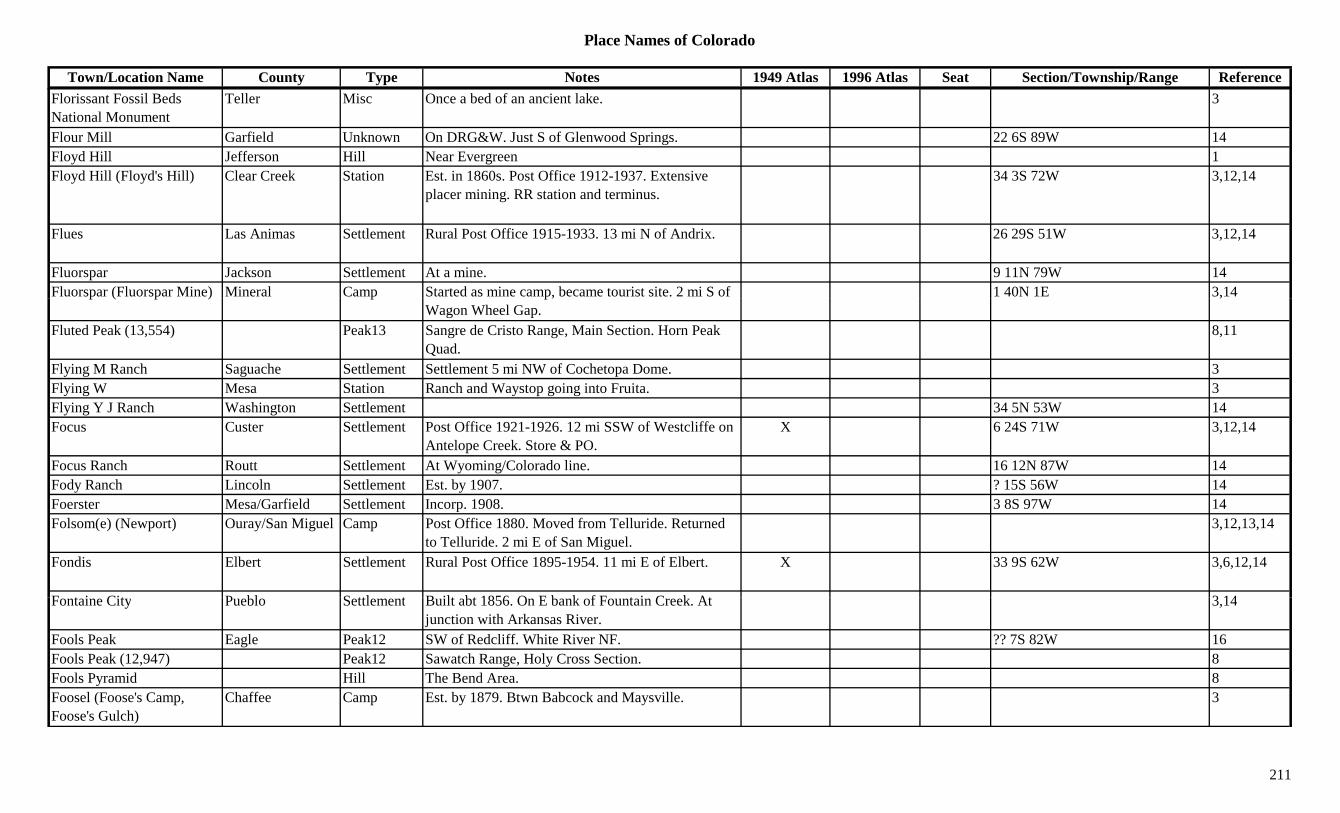
Place Names of Colorado
Town/Location Name County Type Notes 1949 Atlas 1996 Atlas Seat Section/Township/Range ReferenceFlorissant Fossil Beds National Monument
Teller Misc Once a bed of an ancient lake. 3
Flour Mill Garfield Unknown On DRG&W. Just S of Glenwood Springs. 22 6S 89W 14Floyd Hill Jefferson Hill Near Evergreen 1Floyd Hill (Floyd's Hill) Clear Creek Station Est. in 1860s. Post Office 1912-1937. Extensive
placer mining. RR station and terminus.34 3S 72W 3,12,14
Flues Las Animas Settlement Rural Post Office 1915-1933. 13 mi N of Andrix. 26 29S 51W 3,12,14
Fluorspar Jackson Settlement At a mine. 9 11N 79W 14Fluorspar (Fluorspar Mine) Mineral Camp Started as mine camp, became tourist site. 2 mi S of 1 40N 1E 3,14p ( p ) p p,
Wagon Wheel Gap.,
Fluted Peak (13,554) Peak13 Sangre de Cristo Range, Main Section. Horn Peak Quad.
8,11
Flying M Ranch Saguache Settlement Settlement 5 mi NW of Cochetopa Dome. 3Flying W Mesa Station Ranch and Waystop going into Fruita. 3Flying Y J Ranch Washington Settlement 34 5N 53W 14Focus Custer Settlement Post Office 1921-1926. 12 mi SSW of Westcliffe on
Antelope Creek. Store & PO.X 6 24S 71W 3,12,14
Focus Ranch Routt Settlement At Wyoming/Colorado line. 16 12N 87W 14Fody Ranch Lincoln Settlement Est. by 1907. ? 15S 56W 14Foerster Mesa/Garfield Settlement Incorp. 1908. 3 8S 97W 14Folsom(e) (Newport) Ouray/San Miguel Camp Post Office 1880. Moved from Telluride. Returned
to Telluride. 2 mi E of San Miguel.3,12,13,14
Fondis Elbert Settlement Rural Post Office 1895-1954. 11 mi E of Elbert. X 33 9S 62W 3,6,12,14
F t i Cit P bl S ttl t B ilt bt 1856 O E b k f F t i C k At 3 14Fontaine City Pueblo Settlement Built abt 1856. On E bank of Fountain Creek. At junction with Arkansas River.
3,14
Fools Peak Eagle Peak12 SW of Redcliff. White River NF. ?? 7S 82W 16Fools Peak (12,947) Peak12 Sawatch Range, Holy Cross Section. 8Fools Pyramid Hill The Bend Area. 8Foosel (Foose's Camp, Foose's Gulch)
Chaffee Camp Est. by 1879. Btwn Babcock and Maysville. 3
211
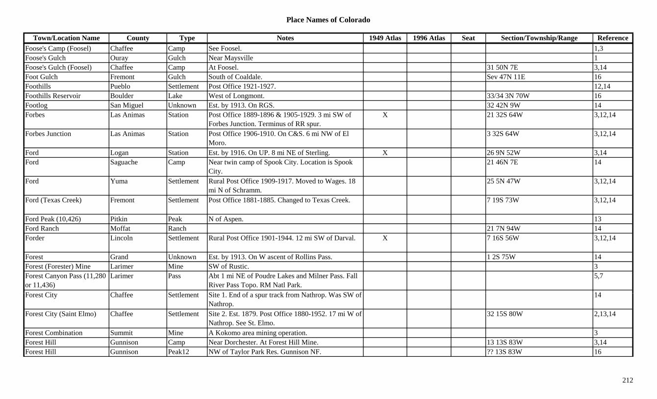
Place Names of Colorado
Town/Location Name County Type Notes 1949 Atlas 1996 Atlas Seat Section/Township/Range ReferenceFoose's Camp (Foosel) Chaffee Camp See Foosel. 1,3Foose's Gulch Ouray Gulch Near Maysville 1Foose's Gulch (Foosel) Chaffee Camp At Foosel. 31 50N 7E 3,14Foot Gulch Fremont Gulch South of Coaldale. Sev 47N 11E 16Foothills Pueblo Settlement Post Office 1921-1927. 12,14Foothills Reservoir Boulder Lake West of Longmont. 33/34 3N 70W 16Footlog San Miguel Unknown Est. by 1913. On RGS. 32 42N 9W 14Forbes Las Animas Station Post Office 1889-1896 & 1905-1929. 3 mi SW of
Forbes Junction. Terminus of RR spur.X 21 32S 64W 3,12,14
Forbes Junction Las Animas Station Post Office 1906-1910. On C&S. 6 mi NW of El Moro.
3 32S 64W 3,12,14
Ford Logan Station Est. by 1916. On UP. 8 mi NE of Sterling. X 26 9N 52W 3,14Ford Saguache Camp Near twin camp of Spook City. Location is Spook
City.21 46N 7E 14
Ford Yuma Settlement Rural Post Office 1909-1917. Moved to Wages. 18 mi N of Schramm.
25 5N 47W 3,12,14
Ford (Texas Creek) Fremont Settlement Post Office 1881-1885. Changed to Texas Creek. 7 19S 73W 3,12,14
Ford Peak (10,426) Pitkin Peak N of Aspen. 13Ford Ranch Moffat Ranch 21 7N 94W 14Forder Lincoln Settlement Rural Post Office 1901-1944. 12 mi SW of Darval. X 7 16S 56W 3,12,14
Forest Grand Unknown Est. by 1913. On W ascent of Rollins Pass. 1 2S 75W 14Forest (Forester) Mine Larimer Mine SW of Rustic. 3Forest Canyon Pass (11,280 or 11,436)
Larimer Pass Abt 1 mi NE of Poudre Lakes and Milner Pass. Fall River Pass Topo. RM Natl Park.
5,7
F t Cit Ch ff S ttl t Sit 1 E d f t k f N th W SW f 14Forest City Chaffee Settlement Site 1. End of a spur track from Nathrop. Was SW of Nathrop.
14
Forest City (Saint Elmo) Chaffee Settlement Site 2. Est. 1879. Post Office 1880-1952. 17 mi W of Nathrop. See St. Elmo.
32 15S 80W 2,13,14
Forest Combination Summit Mine A Kokomo area mining operation. 3Forest Hill Gunnison Camp Near Dorchester. At Forest Hill Mine. 13 13S 83W 3,14Forest Hill Gunnison Peak12 NW of Taylor Park Res. Gunnison NF. ?? 13S 83W 16
212
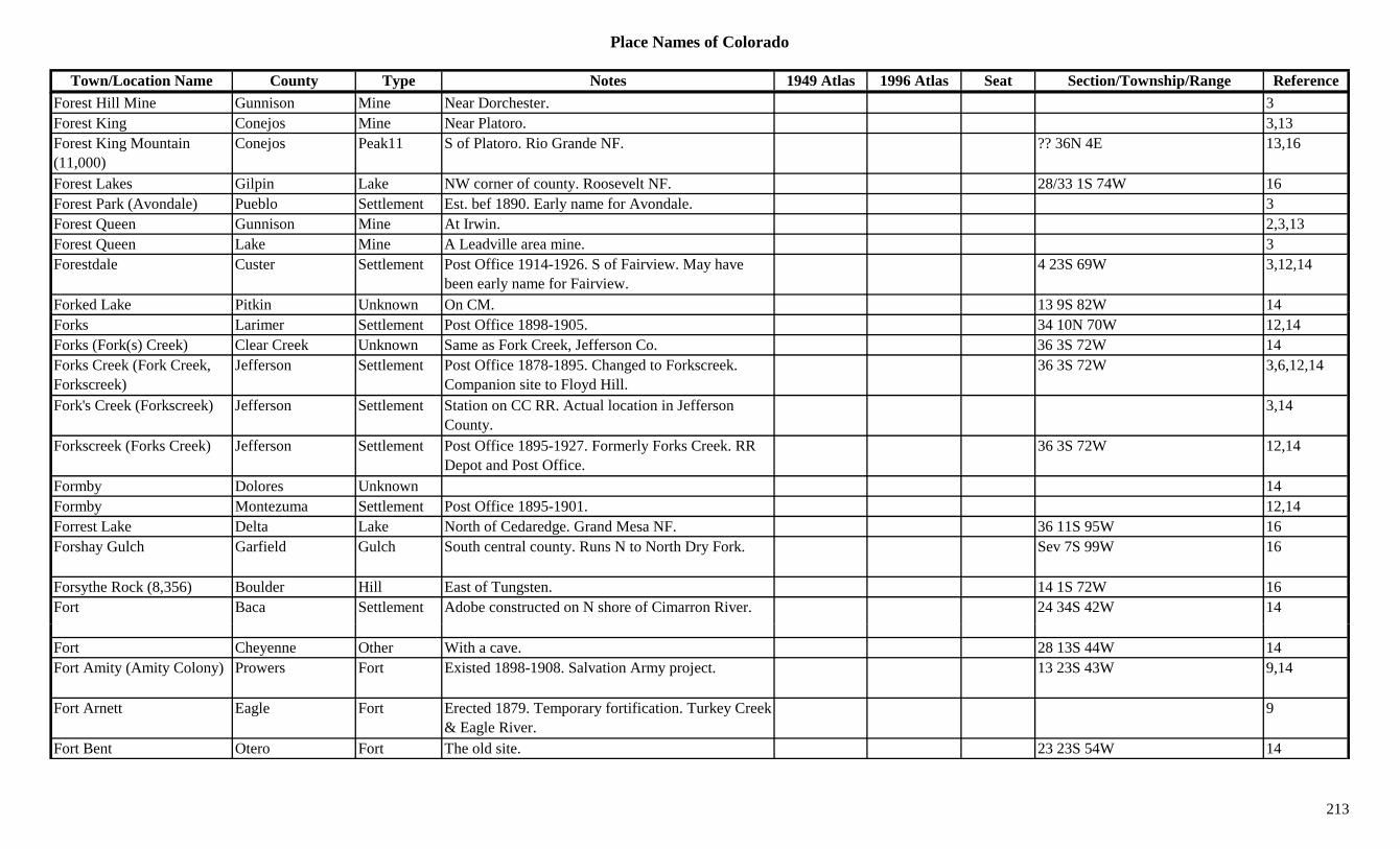
Place Names of Colorado
Town/Location Name County Type Notes 1949 Atlas 1996 Atlas Seat Section/Township/Range ReferenceForest Hill Mine Gunnison Mine Near Dorchester. 3Forest King Conejos Mine Near Platoro. 3,13Forest King Mountain (11,000)
Conejos Peak11 S of Platoro. Rio Grande NF. ?? 36N 4E 13,16
Forest Lakes Gilpin Lake NW corner of county. Roosevelt NF. 28/33 1S 74W 16Forest Park (Avondale) Pueblo Settlement Est. bef 1890. Early name for Avondale. 3Forest Queen Gunnison Mine At Irwin. 2,3,13Forest Queen Lake Mine A Leadville area mine. 3Forestdale Custer Settlement Post Office 1914-1926. S of Fairview. May have
been early name for Fairview.4 23S 69W 3,12,14
Forked Lake Pitkin Unknown On CM. 13 9S 82W 14Forks Larimer Settlement Post Office 1898-1905. 34 10N 70W 12,14Forks (Fork(s) Creek) Clear Creek Unknown Same as Fork Creek, Jefferson Co. 36 3S 72W 14Forks Creek (Fork Creek, Forkscreek)
Jefferson Settlement Post Office 1878-1895. Changed to Forkscreek. Companion site to Floyd Hill.
36 3S 72W 3,6,12,14
Fork's Creek (Forkscreek) Jefferson Settlement Station on CC RR. Actual location in Jefferson County.
3,14
Forkscreek (Forks Creek) Jefferson Settlement Post Office 1895-1927. Formerly Forks Creek. RR Depot and Post Office.
36 3S 72W 12,14
Formby Dolores Unknown 14Formby Montezuma Settlement Post Office 1895-1901. 12,14Forrest Lake Delta Lake North of Cedaredge. Grand Mesa NF. 36 11S 95W 16Forshay Gulch Garfield Gulch South central county. Runs N to North Dry Fork. Sev 7S 99W 16
Forsythe Rock (8,356) Boulder Hill East of Tungsten. 14 1S 72W 16Fort Baca Settlement Adobe constructed on N shore of Cimarron River. 24 34S 42W 14
Fort Cheyenne Other With a cave. 28 13S 44W 14Fort Amity (Amity Colony) Prowers Fort Existed 1898-1908. Salvation Army project. 13 23S 43W 9,14
Fort Arnett Eagle Fort Erected 1879. Temporary fortification. Turkey Creek & Eagle River.
9
Fort Bent Otero Fort The old site. 23 23S 54W 14
213
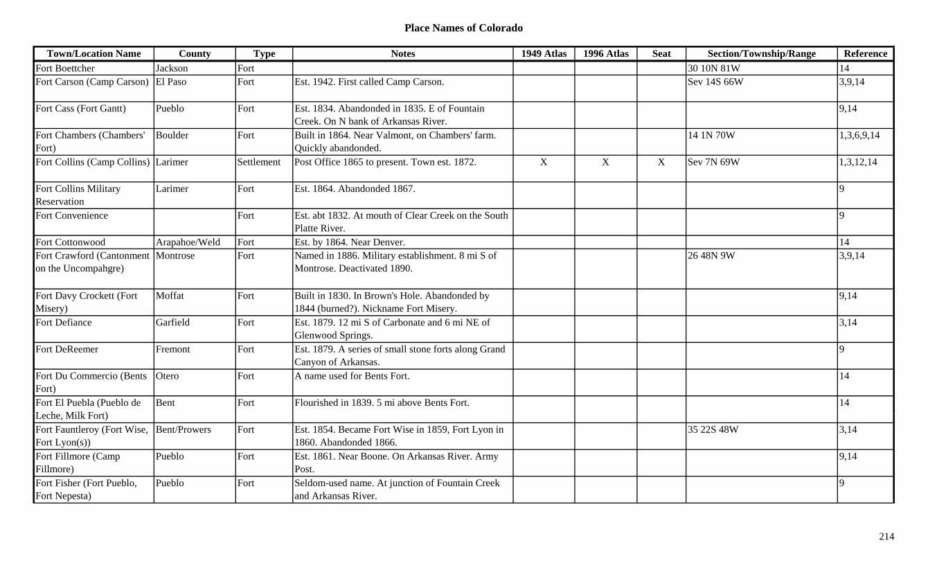
Place Names of Colorado
Town/Location Name County Type Notes 1949 Atlas 1996 Atlas Seat Section/Township/Range ReferenceFort Boettcher Jackson Fort 30 10N 81W 14Fort Carson (Camp Carson) El Paso Fort Est. 1942. First called Camp Carson. Sev 14S 66W 3,9,14
Fort Cass (Fort Gantt) Pueblo Fort Est. 1834. Abandonded in 1835. E of Fountain Creek. On N bank of Arkansas River.
9,14
Fort Chambers (Chambers' Fort)
Boulder Fort Built in 1864. Near Valmont, on Chambers' farm. Quickly abandonded.
14 1N 70W 1,3,6,9,14
Fort Collins (Camp Collins) Larimer Settlement Post Office 1865 to present. Town est. 1872. X X X Sev 7N 69W 1,3,12,14
Fort Collins Military Reservation
Larimer Fort Est. 1864. Abandonded 1867. 9
Fort Convenience Fort Est. abt 1832. At mouth of Clear Creek on the South Platte River.
9
Fort Cottonwood Arapahoe/Weld Fort Est. by 1864. Near Denver. 14Fort Crawford (Cantonment on the Uncompahgre)
Montrose Fort Named in 1886. Military establishment. 8 mi S of Montrose. Deactivated 1890.
26 48N 9W 3,9,14
Fort Davy Crockett (Fort Misery)
Moffat Fort Built in 1830. In Brown's Hole. Abandonded by 1844 (burned?). Nickname Fort Misery.
9,14
Fort Defiance Garfield Fort Est. 1879. 12 mi S of Carbonate and 6 mi NE of Glenwood Springs.
3,14
Fort DeReemer Fremont Fort Est. 1879. A series of small stone forts along Grand Canyon of Arkansas.
9
Fort Du Commercio (Bents Fort)
Otero Fort A name used for Bents Fort. 14
Fort El Puebla (Pueblo de L h Milk F t)
Bent Fort Flourished in 1839. 5 mi above Bents Fort. 14Leche, Milk Fort)Fort Fauntleroy (Fort Wise, Fort Lyon(s))
Bent/Prowers Fort Est. 1854. Became Fort Wise in 1859, Fort Lyon in 1860. Abandonded 1866.
35 22S 48W 3,14
Fort Fillmore (Camp Fillmore)
Pueblo Fort Est. 1861. Near Boone. On Arkansas River. Army Post.
9,14
Fort Fisher (Fort Pueblo, Fort Nepesta)
Pueblo Fort Seldom-used name. At junction of Fountain Creek and Arkansas River.
9
214
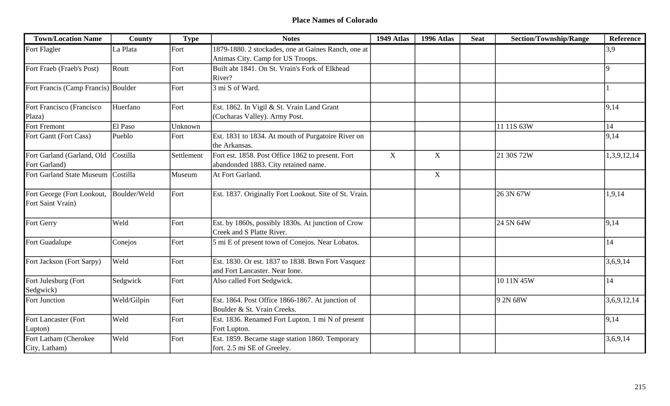
Place Names of Colorado
Town/Location Name County Type Notes 1949 Atlas 1996 Atlas Seat Section/Township/Range ReferenceFort Flagler La Plata Fort 1879-1880. 2 stockades, one at Gaines Ranch, one at
Animas City. Camp for US Troops.3,9
Fort Fraeb (Fraeb's Post) Routt Fort Built abt 1841. On St. Vrain's Fork of Elkhead River?
9
Fort Francis (Camp Francis) Boulder Fort 3 mi S of Ward. 1
Fort Francisco (Francisco Plaza)
Huerfano Fort Est. 1862. In Vigil & St. Vrain Land Grant (Cucharas Valley). Army Post.
9,14
Fort Fremont El Paso Unknown 11 11S 63W 14Fort Gantt (Fort Cass) Pueblo Fort Est. 1831 to 1834. At mouth of Purgatoire River on
the Arkansas.9,14
Fort Garland (Garland, Old Fort Garland)
Costilla Settlement Fort est. 1858. Post Office 1862 to present. Fort abandonded 1883. City retained name.
X X 21 30S 72W 1,3,9,12,14
Fort Garland State Museum Costilla Museum At Fort Garland. X
Fort George (Fort Lookout, Fort Saint Vrain)
Boulder/Weld Fort Est. 1837. Originally Fort Lookout. Site of St. Vrain. 26 3N 67W 1,9,14
Fort Gerry Weld Fort Est. by 1860s, possibly 1830s. At junction of Crow Creek and S Platte River.
24 5N 64W 9,14
Fort Guadalupe Conejos Fort 5 mi E of present town of Conejos. Near Lobatos. 14
Fort Jackson (Fort Sarpy) Weld Fort Est. 1830. Or est. 1837 to 1838. Btwn Fort Vasquez and Fort Lancaster. Near Ione.
3,6,9,14
Fort Julesburg (Fort Sedgwick)
Sedgwick Fort Also called Fort Sedgwick. 10 11N 45W 14
F t J ti W ld/Gil i F t E t 1864 P t Offi 1866 1867 At j ti f 9 2N 68W 3 6 9 12 14Fort Junction Weld/Gilpin Fort Est. 1864. Post Office 1866-1867. At junction of Boulder & St. Vrain Creeks.
9 2N 68W 3,6,9,12,14
Fort Lancaster (Fort Lupton)
Weld Fort Est. 1836. Renamed Fort Lupton. 1 mi N of present Fort Lupton.
9,14
Fort Latham (Cherokee City, Latham)
Weld Fort Est. 1859. Became stage station 1860. Temporary fort. 2.5 mi SE of Greeley.
3,6,9,14
215

Place Names of Colorado
Town/Location Name County Type Notes 1949 Atlas 1996 Atlas Seat Section/Township/Range ReferenceFort LeDuc (Maurice's Fort, El Cuervo)
Huerfano? Fort Est. abt 1835. S of the Arkansas and in Mexican Territory.
9
Fort Lewis La Plata Settlement Est. 1877. Post Office 1880-1891. Moved to Hesperus. 12 mi SW of Durango.
X 36 35N 11W 3,12,14
Fort Lewis La Plata Station On RGW. 36 35N 11W 14Fort Lewis (Pagosa Springs Military Reservation)
Archuleta Fort Est. 1878. Originally at site of Pagosa Springs. Relocated 1880.
3 34N 11W 9,14
Fort Logan (Fort Sheridan) Arapahoe Fort Est. 1887 as Fort Sheridan. Post Office 1889-1971. Became branch of Denver.
X 6 5S 68W 3,9,12
Fort Lookout (Fort Saint Boulder Fort Est. 1837. Name changed to Fort George, then Fort 1,9,14(Vrain)
g g ,St. Vrain.
, ,
Fort Lupton Weld Settlement Site 2. Post Office 1869 to present. X X Sev 2N 66W 6,12,14Fort Lupton (Fort Lancaster)
Nebraska Terr. Fort Site 1. Est. 1836. Post Office 1861-1869. 1 mi N of present Fort Lupton.
6,14
Fort Lupton (Fort Lancaster)
Weld Settlement Site 1. Post Office 1861-1869. Fur trading post in 1835. 1 mi N of present town.
X X 1,3,9,12
Fort Lyon Bent Settlement Site 2. Post Office 1919-1924 abt. 4 mi NE of Las Anamis.
4 23S 51W 12
Fort Lyon Bent Unknown On AT&SF. 29 22S 51W 14Fort Lyon (Bents (Second) Fort, Fort Wise)
Bent Fort Est. 1866?. Rebuilt after first fort washed out by 1867 flood.
3,9
Fort Lyon (Fort Wise) Huerfano/Bent Settlement Site 1. Est. 1860. Post Office 1862-1889. (Bent's Second Fort). Formerly Fort Wise.
X x 35 22S 66W 3,12
Fort Lyon National Monument
Bent Museum At Ft. Lyon. X
F t L N S it i B t Oth 5 23S 51W 14Fort Lyon Navy Sanitorium Bent Other 5 23S 51W 14
Fort Lyon(s) (Bent's Second Fort)
Bent Fort Bent's New Fort(1853), Fort Fauntleroy(1853), Fort Wise(1859).
X 3
Fort Marbury ( Fort Mabery, Fort Mary Bigelow)
Summit Fort Close to Parkville campsite. Also Fort Meriby, Fort Maribeh, Fort Mary B. Maribeh.
30 6S 77W 3,9
216
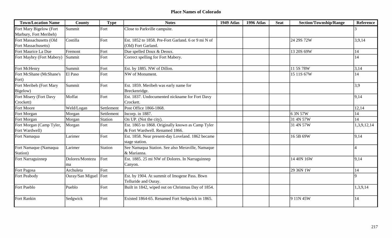
Place Names of Colorado
Town/Location Name County Type Notes 1949 Atlas 1996 Atlas Seat Section/Township/Range ReferenceFort Mary Bigelow (Fort Marbury, Fort Meribeh)
Summit Fort Close to Parkville campsite. 3
Fort Massachusetts (Old Fort Massachusetts)
Costilla Fort Est. 1852 to 1858. Pre-Fort Garland. 6 or 9 mi N of (Old) Fort Garland.
24 29S 72W 3,9,14
Fort Maurice La Due Fremont Fort Due spelled Doux & Deoux. 13 20S 69W 14Fort Maybry (Fort Mabery) Summit Fort Correct spelling for Fort Mabery. 14
Fort McHenry Summit Fort Est. by 1885. NW of Dillon. 11 5S 78W 3,14Fort McShane (McShane's Fort)
El Paso Fort NW of Monument. 15 11S 67W 14
Fort Meribeh (Fort Mary Summit Fort Est. 1859. Meribeh was early name for 3,9( yBigelow)
yBreckenridge.
,
Fort Misery (Fort Davy Crockett)
Moffat Fort Est. 1837. Undocumented nickname for Fort Davy Crockett.
9,14
Fort Moore Weld/Logan Settlement Post Office 1866-1868. 12,14Fort Morgan Morgan Settlement Incorp. in 1887. 6 3N 57W 14Fort Morgan Morgan Station On UP. (Not the city). 31 4N 57W 14Fort Morgan (Camp Tyler, Fort Wardwell)
Morgan Fort Est. 1865 to 1868. Originally known as Camp Tyler & Fort Wardwell. Renamed 1866.
31 4N 57W 1,3,9,12,14
Fort Namaqua Larimer Fort Est. 1858. Near present-day Loveland. 1862 became stage station.
16 5B 69W 9,14
Fort Namaque (Namaqua Station)
Larimer Station See Namaqua Station. See also Meraville, Namaque & Marianna.
4
Fort Narraguinnep Dolores/Montezuma
Fort Est. 1885. 25 mi NW of Dolores. In Narraguinnep Canyon.
14 40N 16W 9,14
Fort Pagosa Archuleta Fort 29 36N 1W 14F t P b d O /S Mi l F t E t b 1904 At it f I P Bt 9Fort Peabody Ouray/San Miguel Fort Est. by 1904. At summit of Imogene Pass. Btwn
Telluride and Ouray.9
Fort Pueblo Pueblo Fort Built in 1842, wiped out on Christmas Day of 1854. 1,3,9,14
Fort Rankin Sedgwick Fort Existed 1864-65. Renamed Fort Sedgwick in 1865. 9 11N 45W 14
217
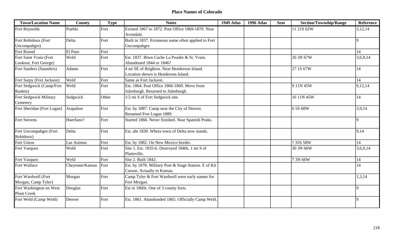
Place Names of Colorado
Town/Location Name County Type Notes 1949 Atlas 1996 Atlas Seat Section/Township/Range ReferenceFort Reynolds Pueblo Fort Existed 1867 to 1872. Post Office 1869-1870. Near
Avondale.11 21S 62W 3,12,14
Fort Robidoux (Fort Uncompahgre)
Delta Fort Built in 1837. Erroneous name often applied to Fort Uncompahgre.
9
Fort Round El Paso Fort 14Fort Saint Vrain (Fort Lookout, Fort George)
Weld Fort Est. 1837. Btwn Cache La Poudre & St. Vrain. Abandoned 1844 or 1846?
26 3N 67W 3,6,9,14
Fort Sanders (Saunders) Adams Fort 4 mi SE of Brighton. Near Henderson Island. Location shown is Henderson Island.
27 1S 67W 14
Fort Sarpy (Fort Jackson) Weld Fort Same as Fort Jackson. 14Fort Sedgwick (Camp/Fort Weld Fort Est. 1864. Post Office 1866-1869. Move from 9 11N 45W 9,12,14g ( pRankin) Julesburgh. Returned to Julesburgh.
, ,
Fort Sedgwick Military Cemetery
Sedgwick Other 1/2 mi S of Fort Sedgwick site. 16 11N 45W 14
Fort Sheridan (Fort Logan) Arapahoe Fort Est. by 1887. Camp near the City of Denver. Renamed Fort Logan 1889.
6 5S 68W 3,9,14
Fort Stevens Huerfano? Fort Started 1866. Never finished. Near Spanish Peaks. 9
Fort Uncompahgre (Fort Robidoux)
Delta Fort Est. abt 1830. Where town of Delta now stands. 9,14
Fort Union Las Animas Fort Est. by 1882. On New Mexico border. ? 35S 58W 14Fort Vasquez Weld Fort Site 1. Est. 1835-6. Destroyed 1840s. 1 mi S of
Platteville.30 3N 66W 3,6,9,14
Fort Vasquez Weld Fort Site 2. Built 1842. 7 3N 66W 14Fort Wallace Cheyenne/Kansas Fort Est. by 1878. Military Post & Stage Station. E of Kit
Carson. Actually in Kansas.14
F t W d ll (F t M F t C T l & F t W d ll l f 1 3 14Fort Wardwell (Fort Morgan, Camp Tyler)
Morgan Fort Camp Tyler & Fort Wardwell were early names for Fort Morgan.
1,3,14
Fort Washington on West Plum Creek
Douglas Fort Est in 1860s. One of 3 county forts. 9
Fort Weld (Camp Weld) Denver Fort Est. 1861. Abandonded 1865. Officially Camp Weld. 9
218
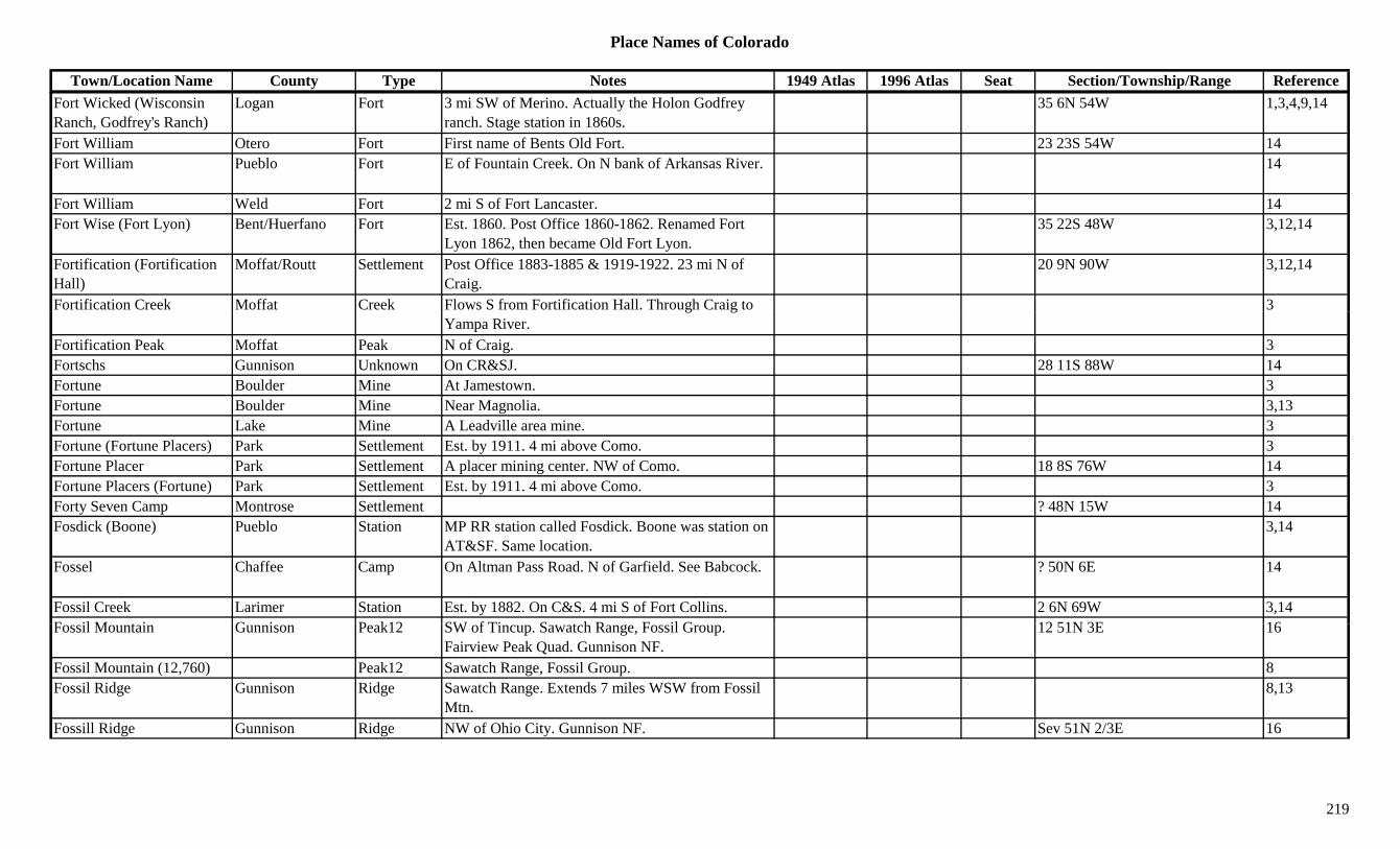
Place Names of Colorado
Town/Location Name County Type Notes 1949 Atlas 1996 Atlas Seat Section/Township/Range ReferenceFort Wicked (Wisconsin Ranch, Godfrey's Ranch)
Logan Fort 3 mi SW of Merino. Actually the Holon Godfrey ranch. Stage station in 1860s.
35 6N 54W 1,3,4,9,14
Fort William Otero Fort First name of Bents Old Fort. 23 23S 54W 14Fort William Pueblo Fort E of Fountain Creek. On N bank of Arkansas River. 14
Fort William Weld Fort 2 mi S of Fort Lancaster. 14Fort Wise (Fort Lyon) Bent/Huerfano Fort Est. 1860. Post Office 1860-1862. Renamed Fort
Lyon 1862, then became Old Fort Lyon.35 22S 48W 3,12,14
Fortification (Fortification Hall)
Moffat/Routt Settlement Post Office 1883-1885 & 1919-1922. 23 mi N of Craig.
20 9N 90W 3,12,14
Fortification Creek Moffat Creek Flows S from Fortification Hall. Through Craig to 3g gYampa River.
Fortification Peak Moffat Peak N of Craig. 3Fortschs Gunnison Unknown On CR&SJ. 28 11S 88W 14Fortune Boulder Mine At Jamestown. 3Fortune Boulder Mine Near Magnolia. 3,13Fortune Lake Mine A Leadville area mine. 3Fortune (Fortune Placers) Park Settlement Est. by 1911. 4 mi above Como. 3Fortune Placer Park Settlement A placer mining center. NW of Como. 18 8S 76W 14Fortune Placers (Fortune) Park Settlement Est. by 1911. 4 mi above Como. 3Forty Seven Camp Montrose Settlement ? 48N 15W 14Fosdick (Boone) Pueblo Station MP RR station called Fosdick. Boone was station on
AT&SF. Same location.3,14
Fossel Chaffee Camp On Altman Pass Road. N of Garfield. See Babcock. ? 50N 6E 14
Fossil Creek Larimer Station Est. by 1882. On C&S. 4 mi S of Fort Collins. 2 6N 69W 3,14F il M t i G i P k12 SW f Ti S t h R F il G 12 51N 3E 16Fossil Mountain Gunnison Peak12 SW of Tincup. Sawatch Range, Fossil Group.
Fairview Peak Quad. Gunnison NF.12 51N 3E 16
Fossil Mountain (12,760) Peak12 Sawatch Range, Fossil Group. 8Fossil Ridge Gunnison Ridge Sawatch Range. Extends 7 miles WSW from Fossil
Mtn.8,13
Fossill Ridge Gunnison Ridge NW of Ohio City. Gunnison NF. Sev 51N 2/3E 16
219

Place Names of Colorado
Town/Location Name County Type Notes 1949 Atlas 1996 Atlas Seat Section/Township/Range ReferenceFosston Weld Settlement Platted 1909. Post Office 1910-1941. NE of Greeley. X 18 7N 62W 3,6,12,14
Foster Weld Station On GW. Just N of Liberty OR 3 mi S of Liberty? 21 3N 68W 6,14
Foster (Fowler) Otero Unknown Est. by 1885. On AT&SF. 2 mi E of county line. Same place as Fowler.
14
Foster Gulch Custer Gulch Far S central county. Runs NE. Sev 24S 72W 16Foster Gulch Pitkin Settlement 31 8S 83W 14Foster Hotel & Stage Station
Las Animas Station On S bank of Apishapa River. 4 mi E of Aguilar. 14
Foster Lake Arapahoe Lake SE of E Hampden Ave and S University Blvd 1 5S 68W 16p p yintersection.
Foster's Place Huerfano Station Est. abt 1862. Stage station. 4 mi E of Aguilar. 4Fountain (Fort Pueblo) Pueblo Settlement Est. by 1858. Formerly Fort Pueblo. 14Fountain (La Fontaine Qui Bouille)
El Paso Settlement Settled in 1858. Post Office 1864 to present. At Arkansas and Fountain Rivers.
X X Sev 16S 65W 1,3,12,14
Fountain City Kansas Terr. Settlement Same as Fountain, Pueblo Co. 14Fountain Colony (Colorado Springs, El Paso)
El Paso Settlement Also known as El Paso. First name for Colorado Springs. See Colorado Springs.
1,3,14
Fountain River El Paso River Flows S through Colorado Springs. X 3Fountain River El Paso Settlement Est. by 1882. ? 13S 69W 14Fountain River Pueblo River Flows S from Colorado Springs to join Arkansas at
Pueblo.X
Fountain River Pueblo Unknown 6 20S 64W 14Fountain Valley School El Paso Unknown 18 15S 65W 14F B F R h G d St ti St t ti W f F V ll 14Four Bar Four Ranch Grand Station Stage station. W of Frazer Valley. 14Four Corners Larimer Unknown Same as Glendevey Post Office. 3 10N 76W 14Four Corners Montezuma Unknown 20 miles SW of Cortez 1Four Corners Crossing Bent Settlement Est. by 1868. 4 mi S of Prowers. 3,14Four Mile Canyon Boulder Canyon NW of Boulder. 3Four Mile House Arapahoe/Denver Station Stage station on Smoky Hill stage route. At Forest
Street & Cherry Creek.3,4,14
220
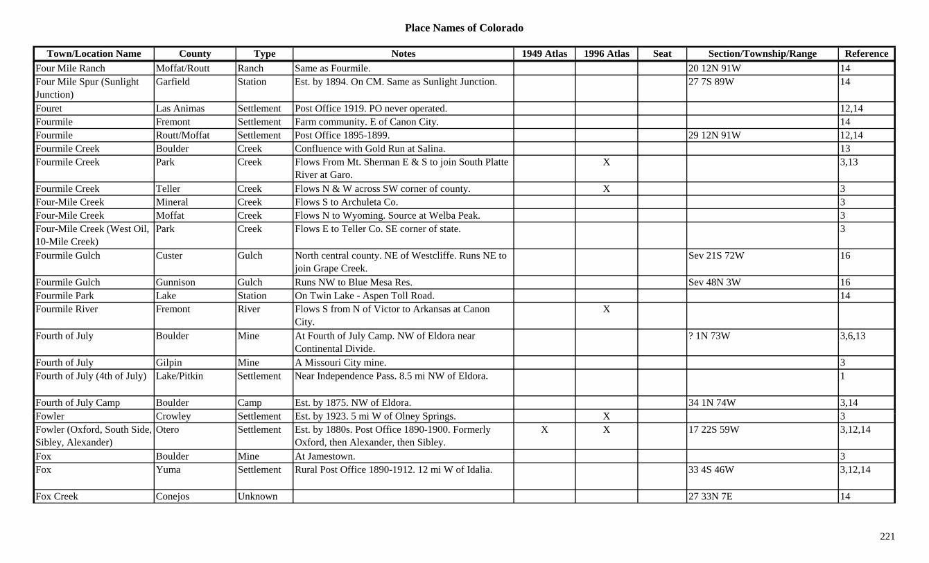
Place Names of Colorado
Town/Location Name County Type Notes 1949 Atlas 1996 Atlas Seat Section/Township/Range ReferenceFour Mile Ranch Moffat/Routt Ranch Same as Fourmile. 20 12N 91W 14Four Mile Spur (Sunlight Junction)
Garfield Station Est. by 1894. On CM. Same as Sunlight Junction. 27 7S 89W 14
Fouret Las Animas Settlement Post Office 1919. PO never operated. 12,14Fourmile Fremont Settlement Farm community. E of Canon City. 14Fourmile Routt/Moffat Settlement Post Office 1895-1899. 29 12N 91W 12,14Fourmile Creek Boulder Creek Confluence with Gold Run at Salina. 13Fourmile Creek Park Creek Flows From Mt. Sherman E & S to join South Platte
River at Garo.X 3,13
Fourmile Creek Teller Creek Flows N & W across SW corner of county. X 3Four-Mile Creek Mineral Creek Flows S to Archuleta Co. 3Four-Mile Creek Moffat Creek Flows N to Wyoming. Source at Welba Peak. 3Four-Mile Creek (West Oil, 10-Mile Creek)
Park Creek Flows E to Teller Co. SE corner of state. 3
Fourmile Gulch Custer Gulch North central county. NE of Westcliffe. Runs NE to join Grape Creek.
Sev 21S 72W 16
Fourmile Gulch Gunnison Gulch Runs NW to Blue Mesa Res. Sev 48N 3W 16Fourmile Park Lake Station On Twin Lake - Aspen Toll Road. 14Fourmile River Fremont River Flows S from N of Victor to Arkansas at Canon
City.X
Fourth of July Boulder Mine At Fourth of July Camp. NW of Eldora near Continental Divide.
? 1N 73W 3,6,13
Fourth of July Gilpin Mine A Missouri City mine. 3Fourth of July (4th of July) Lake/Pitkin Settlement Near Independence Pass. 8.5 mi NW of Eldora. 1
Fourth of July Camp Boulder Camp Est. by 1875. NW of Eldora. 34 1N 74W 3,14F l C l S ttl t E t b 1923 5 i W f Ol S i X 3Fowler Crowley Settlement Est. by 1923. 5 mi W of Olney Springs. X 3Fowler (Oxford, South Side, Sibley, Alexander)
Otero Settlement Est. by 1880s. Post Office 1890-1900. Formerly Oxford, then Alexander, then Sibley.
X X 17 22S 59W 3,12,14
Fox Boulder Mine At Jamestown. 3Fox Yuma Settlement Rural Post Office 1890-1912. 12 mi W of Idalia. 33 4S 46W 3,12,14
Fox Creek Conejos Unknown 27 33N 7E 14
221
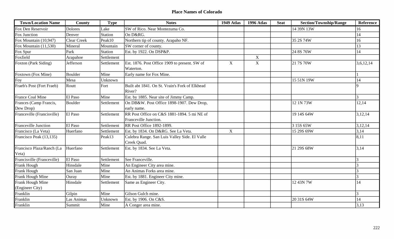
Place Names of Colorado
Town/Location Name County Type Notes 1949 Atlas 1996 Atlas Seat Section/Township/Range ReferenceFox Den Reservoir Dolores Lake SW of Rico. Near Montezuma Co. 14 39N 13W 16Fox Junction Denver Station On D&RG. 14Fox Mountain (10,947) Clear Creek Peak10 Northern tip of county. Arapaho NF. 35 2S 74W 16Fox Mountain (11,530) Mineral Mountain SW corner of county. 13Fox Spur Park Station Est. by 1922. On DSP&P. 24 8S 76W 14Foxfield Arapahoe Settlement XFoxton (Park Siding) Jefferson Settlement Est. 1876. Post Office 1909 to present. SW of
Waterton.X X 21 7S 70W 3,6,12,14
Foxtown (Fox Mine) Boulder Mine Early name for Fox Mine. 1Foy Mesa Unknown 15 51N 19W 14Fraeb's Post (Fort Fraeb) Routt Fort Built abt 1841. On St. Vrain's Fork of Elkhead 9( )
River?France Coal Mine El Paso Mine Est. by 1885. Near site of Jimmy Camp. 3Frances (Camp Francis, Dew Drop)
Boulder Settlement On DB&W. Post Office 1898-1907. Dew Drop, early name.
12 1N 73W 12,14
Franceville (Francisville) El Paso Settlement RR Post Office on C&S 1881-1894. 5 mi NE of Franceville Junction.
19 14S 64W 3,12,14
Franceville Junction El Paso Settlement RR Post Office 1892-1899. 3 15S 65W 3,12,14Francisco (La Veta) Huerfano Settlement Est. by 1834. On D&RG. See La Veta. X 15 29S 69W 3,14Francisco Peak (13,135) Peak13 Culebra Range. San Luis Valley Side. El Valle
Creek Quad.8,11
Francisco Plaza/Ranch (La Veta)
Huerfano Settlement Est. by 1834. See La Veta. 21 29S 68W 3,14
Francisville (Franceville) El Paso Settlement See Franceville. 3Frank Hough Hinsdale Mine An Engineer City area mine. 3Frank Hough San Juan Mine An Animas Forks area mine. 3F k H h Mi O Mi E t b 1881 E i Cit i 3Frank Hough Mine Ouray Mine Est. by 1881. Engineer City mine. 3Frank Hough Mine (Engineer City)
Hinsdale Settlement Same as Engineer City. 12 43N 7W 14
Franklin Gilpin Mine Gilson Gulch mine. 3Franklin Las Animas Unknown Est. by 1906. On C&S. 20 31S 64W 14Franklin Summit Mine A Conger area mine. 3,13
222
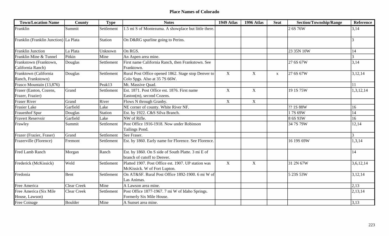
Place Names of Colorado
Town/Location Name County Type Notes 1949 Atlas 1996 Atlas Seat Section/Township/Range ReferenceFranklin Summit Settlement 1.5 mi S of Montezuma. A showplace but little there. 2 6S 76W 3,14
Franklin (Franklin Junction) La Plata Station On D&RG spurline going to Perins. 3
Franklin Junction La Plata Unknown On RGS. 23 35N 10W 14Franklin Mine & Tunnel Pitkin Mine An Aspen area mine. 3Frankstown (Franktown, California Ranch)
Douglas Settlement First name California Ranch, then Frankstown. See Franktown.
27 6S 67W 3,14
Franktown (California Ranch, Frankstown)
Douglas Settlement Rural Post Office opened 1862. Stage stop Denver to Colo Spgs. Also at 35 7S 66W.
X X x 27 6S 67W 3,12,14
Frasco Mountain (13,876) Peak13 Mt. Massive Quad. 11( , ) QFraser (Easton, Cozens, Frazer, Frazier)
Grand Settlement Est. 1871. Post Office est. 1876. First name Easton(m), second Cozens.
X X 19 1S 75W 1,3,12,14
Fraser River Grand River Flows N through Granby. X XFrasier Lake Garfield Lake NE corner of county. White River NF. ?? 1S 88W 16Frauenhof Spur Douglas Station Est. by 1922. C&S Silva Branch. 1 7S 69W 14Fravert Reservoir Garfield Lake NW of Rifle. 8 6S 93W 16Frawley Summit Settlement Post Office 1916-1918. Now under Robinson
Tailings Pond.34 7S 79W 12,14
Frazer (Frazier, Fraser) Grand Settlement See Fraser. 3Frazerville (Florence) Fremont Settlement Est. by 1860. Early name for Florence. See Florence. 16 19S 69W 1,3,14
Fred Lamb Ranch Morgan Ranch Est. by 1860. On S side of South Platte. 3 mi E of branch of cutoff to Denver.
14
Frederick (McKissick) Weld Settlement Platted 1907. Post Office est. 1907. UP station was McKissick. W of Fort Lupton.
X X 31 2N 67W 3,6,12,14
F d i B t S ttl t O AT&SF R l P t Offi 1892 1900 6 i W f 5 23S 53W 3 12 14Fredonia Bent Settlement On AT&SF. Rural Post Office 1892-1900. 6 mi W of Las Animas.
5 23S 53W 3,12,14
Free America Clear Creek Mine A Lawson area mine. 2,13Free America (Six Mile House, Lawson)
Clear Creek Settlement Post Office 1877-1967. 7 mi W of Idaho Springs. Formerly Six Mile House.
2,13,14
Free Coinage Boulder Mine A Sunset area mine. 3,13
223

Place Names of Colorado
Town/Location Name County Type Notes 1949 Atlas 1996 Atlas Seat Section/Township/Range ReferenceFree Gold Chaffee Camp Post Office 1880-1881. 1.5 mi S of Buena Vista. On
E bank of Arkansas River.21 14S 78W 1,3,12,14
Free Gold Gilpin Mine Perigo mine. 3Free Silver Pitkin Mine An Aspen area mine. 3,13Freedom Gilpin Settlement In Chase Gulch. 12 3S 73W 14Freedom (Morgan) Conejos Settlement Post Office 1901-1905. Formerly Morgan. 29 36N 9E 12,14Freeks Ranch Fremont Ranch Est. by 1932. 9 mi N & 3 mi E of Canon City. 14Freeland Clear Creek Mine At Dumont. 2,13Freeland Clear Creek Mine At Freeland. 2,3Freeland (Trail Creek Camp)
Clear Creek Settlement Post Office 1879-1908. 5 mi W of Idaho Springs. 31 3S 73W 2,3,12,13,14
Freeman Rio Grande Settlement On D&RG. 5 mi SE of Del Norte. 6 39N 7E 3,14Freeman Gulch Delta Gulch North of Paonia. Gunnison NF. Sev 13S 91W 16Freeman Gulch Gunnison Gulch SE of Ohio City. Runs N to Quartz Creek. Gunnison
NF.Sev 50N 3.5E 16
Freeman Peak (11,589) Peak Platte River Mtns. and Kenosha Mtns. 8Freemans Spur Eagle Station Est. by 1906. On CM. 14Freese Boulder Station Flag stop on DB&W. Just W of Doud Mt. & E of
Copper Rock.14
Freeze-Out Creek Baca Creek 1885. Flows to Two Buttes Creek. 3Freighters Friend Gilpin Mine Gilson Gulch mine. 3Fremont Eagle Unknown On D&RG. 14Fremont Fremont Unknown On AT&SF. 24 19S 70W 14Fremont Morgan Station Stage station on Overland route. Near Fremont's
Orchard.3,14
Fremont Washington Settlement Rural Post Office 1908-1914. 7 mi SW of Cope. 15 5S 50W 3,12,14
Fremont (Morland, Cripple Creek)
El Paso/Teller Settlement Est. by 1893. Consolidated with Hayden Placer to become Cripple Creek.
13 15S 70W 1,3,12,14
Fremont (Tenmile) Pass (11,318)
Lake Pass N of Climax. Crossed by SH 91. Climax Topo. Arapaho & San Isabel NF.
X X 11 8S 79W 3,5,7
Fremont Junction Fremont Station Est. by 1906. On D&RG. S of Chandler Junction. 14
224
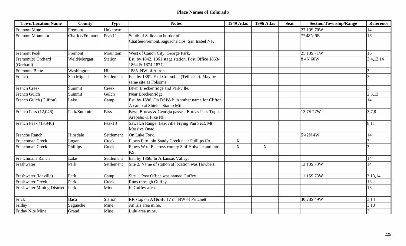
Place Names of Colorado
Town/Location Name County Type Notes 1949 Atlas 1996 Atlas Seat Section/Township/Range ReferenceFremont Mine Fremont Unknown 27 19S 70W. 14Fremont Mountain Chaffee/Fremont Peak11 South of Salida on border of
Chaffee/Fremont/Saguache Cos. San Isabel NF.?? 48N 9E 16
Fremont Peak Fremont Mountain West of Canon City. George Park. 25 18S 71W 16Fremont(s) Orchard (Orchard)
Weld/Morgan Station Est. by 1842. 1861 stage station. Post Office 1863-1864 & 1874-1877.
8 4N 60W 3,4,12,14
Fremonts Butte Washington Hill 1885. NW of Akron. 3French San Miguel Settlement Est. by 1881. E of Columbia (Telluride). May be
same site as Folsome.3
French Creek Summit Creek Btwn Breckenridge and Parkville. 3gFrench Gulch Summit Gulch Near Breckenridge. 2,3,13French Gulch (Clifton) Lake Camp Est. by 1880. On DSP&P. Another name for Clifton.
A camp at Shields Stamp Mill.14
French Pass (12,046) Park/Summit Pass Btwn Boreas & Georgia passes. Boreas Pass Topo. Arapaho & Pike NF.
13 7S 77W 3,7,8
French Peak (13,940) Peak13 Sawatch Range, Leadville Frying Pan Sect. Mt. Massive Quad.
8,11
Frenche Ranch Hinsdale Settlement On Lake Fork. 5 42N 4W 14Frenchman Creek Logan Creek Flows E to join Sandy Creek near Phillips Co. X 3Frenchman Creek Phillips Creek Flows W to E across county S of Holyoke and into
KS.X X 3
Frenchmans Ranch Lake Settlement Est. by 1866. In Arkansas Valley. 14Freshwater Park Settlement Site 2. Name of station at location was Howbert. 13 13S 73W 14
Freshwater (Idaville) Park Camp Site 1. Post Office was named Guffey. 11 15S 73W 3,13,14F h t C k P k C k R th h G ff 13Freshwater Creek Park Creek Runs through Guffey. 13Freshwater Mining District Park Mine In Guffey area. 13
Frick Baca Station RR stop on AT&SF. 17 mi NW of Pritchett. 30 28S 49W 3,14Friday Saguache Mine An Iris area mine. 3,13Friday Nite Mine Grand Mine Lulu area mine. 3
225
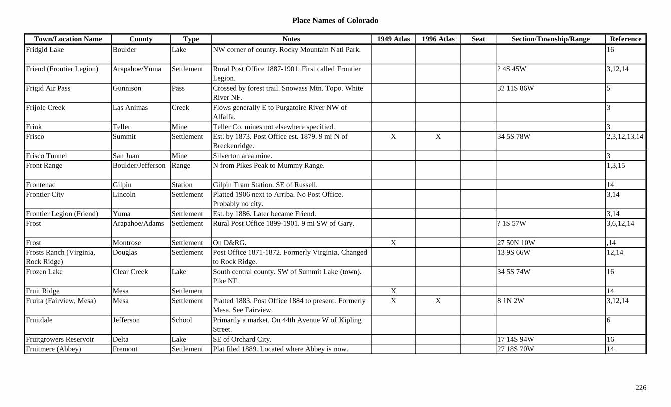
Place Names of Colorado
Town/Location Name County Type Notes 1949 Atlas 1996 Atlas Seat Section/Township/Range ReferenceFridgid Lake Boulder Lake NW corner of county. Rocky Mountain Natl Park. 16
Friend (Frontier Legion) Arapahoe/Yuma Settlement Rural Post Office 1887-1901. First called Frontier Legion.
? 4S 45W 3,12,14
Frigid Air Pass Gunnison Pass Crossed by forest trail. Snowass Mtn. Topo. White River NF.
32 11S 86W 5
Frijole Creek Las Animas Creek Flows generally E to Purgatoire River NW of Alfalfa.
3
Frink Teller Mine Teller Co. mines not elsewhere specified. 3Frisco Summit Settlement Est. by 1873. Post Office est. 1879. 9 mi N of
Breckenridge.X X 34 5S 78W 2,3,12,13,14
Frisco Tunnel San Juan Mine Silverton area mine. 3Front Range Boulder/Jefferson Range N from Pikes Peak to Mummy Range. 1,3,15
Frontenac Gilpin Station Gilpin Tram Station. SE of Russell. 14Frontier City Lincoln Settlement Platted 1906 next to Arriba. No Post Office.
Probably no city.3,14
Frontier Legion (Friend) Yuma Settlement Est. by 1886. Later became Friend. 3,14Frost Arapahoe/Adams Settlement Rural Post Office 1899-1901. 9 mi SW of Gary. ? 1S 57W 3,6,12,14
Frost Montrose Settlement On D&RG. X 27 50N 10W ,14Frosts Ranch (Virginia, Rock Ridge)
Douglas Settlement Post Office 1871-1872. Formerly Virginia. Changed to Rock Ridge.
13 9S 66W 12,14
Frozen Lake Clear Creek Lake South central county. SW of Summit Lake (town). Pike NF.
34 5S 74W 16
Fruit Ridge Mesa Settlement X 14F it (F i i M ) M S ttl t Pl tt d 1883 P t Offi 1884 t t F l X X 8 1N 2W 3 12 14Fruita (Fairview, Mesa) Mesa Settlement Platted 1883. Post Office 1884 to present. Formerly
Mesa. See Fairview.X X 8 1N 2W 3,12,14
Fruitdale Jefferson School Primarily a market. On 44th Avenue W of Kipling Street.
6
Fruitgrowers Reservoir Delta Lake SE of Orchard City. 17 14S 94W 16Fruitmere (Abbey) Fremont Settlement Plat filed 1889. Located where Abbey is now. 27 18S 70W 14
226
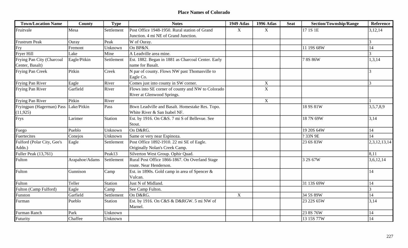
Place Names of Colorado
Town/Location Name County Type Notes 1949 Atlas 1996 Atlas Seat Section/Township/Range ReferenceFruitvale Mesa Settlement Post Office 1948-1950. Rural station of Grand
Junction. 4 mi NE of Grand Junction.X X 17 1S 1E 3,12,14
Frustrum Peak Ouray Peak W of Ouray. 3Fry Fremont Unknown On BP&N. 11 19S 68W 14Fryer Hill Lake Mine A Leadville area mine. 3Frying Pan City (Charcoal Center, Basalt)
Eagle/Pitkin Settlement Est. 1882. Began in 1881 as Charcoal Center. Early name for Basalt.
7 8S 86W 1,3,14
Frying Pan Creek Pitkin Creek N par of county. Flows NW past Thomasville to Eagle Co.
3
Frying Pan River Eagle River Comes just into county in SW corner. X 3Frying Pan River Garfield River Flows into SE corner of county and NW to Colorado Xy g y
River at Glenwood Springs.Frying Pan River Pitkin River X 1Fryingpan (Hagerman) Pass (11,925)
Lake/Pitkin Pass Btwn Leadville and Basalt. Homestake Res. Topo. White River & San Isabel NF.
18 9S 81W 3,5,7,8,9
Frys Larimer Station Est. by 1916. On C&S. 7 mi S of Bellevue. See Stout.
18 7N 69W 3,14
Fuego Pueblo Unknown On D&RG. 19 20S 64W 14Fuertecites Conejos Unknown Same or very near Espinoza. ? 33N 9E 14Fulford (Polar City, Gee's Addn.)
Eagle Settlement Post Office 1892-1910. 22 mi SE of Eagle. Originally Nolan's Creek Camp.
23 6S 83W 2,3,12,13,14
Fuller Peak (13,761) Peak13 Silverton West Group. Ophir Quad. 8,11Fulton Arapahoe/Adams Settlement Rural Post Office 1866-1867. On Overland Stage
route. Near Henderson.3 2S 67W 3,6,12,14
Fulton Gunnison Camp Est. in 1890s. Gold camp in area of Spencer & Vulcan.
14
F lt T ll St ti J t N f Midl d 31 13S 69W 14Fulton Teller Station Just N of Midland. 31 13S 69W 14Fulton (Camp Fulford) Eagle Camp See Camp Fulton. 3Funston Garfield Settlement On D&RG. X 34 5S 89W 14Furman Pueblo Station Est. by 1916. On C&S & D&RGW. 5 mi NW of
Marnel.23 22S 65W 3,14
Furman Ranch Park Unknown 23 8S 76W 14Futurity Chaffee Unknown 13 15S 77W 14
227
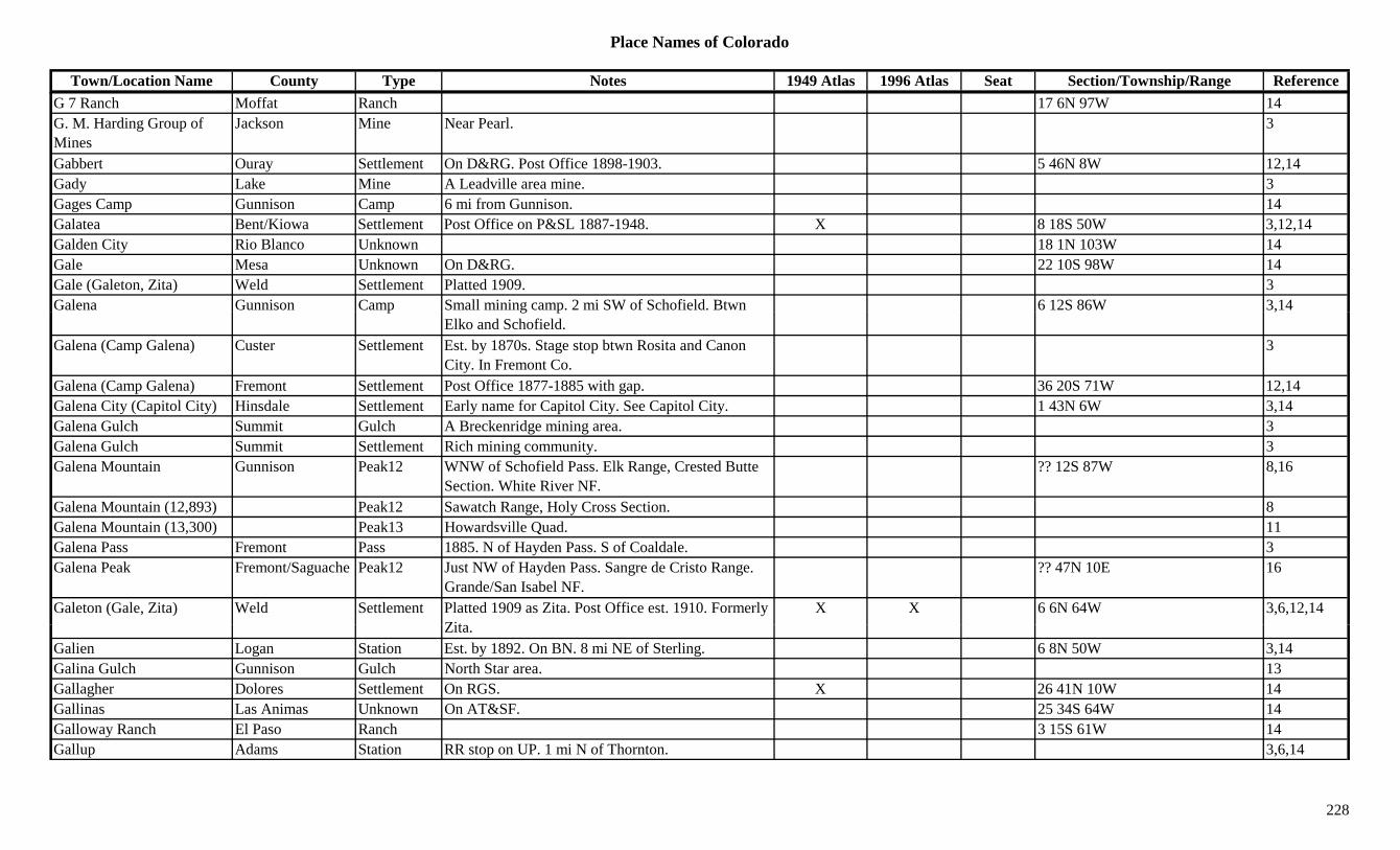
Place Names of Colorado
Town/Location Name County Type Notes 1949 Atlas 1996 Atlas Seat Section/Township/Range ReferenceG 7 Ranch Moffat Ranch 17 6N 97W 14G. M. Harding Group of Mines
Jackson Mine Near Pearl. 3
Gabbert Ouray Settlement On D&RG. Post Office 1898-1903. 5 46N 8W 12,14Gady Lake Mine A Leadville area mine. 3Gages Camp Gunnison Camp 6 mi from Gunnison. 14Galatea Bent/Kiowa Settlement Post Office on P&SL 1887-1948. X 8 18S 50W 3,12,14Galden City Rio Blanco Unknown 18 1N 103W 14Gale Mesa Unknown On D&RG. 22 10S 98W 14Gale (Galeton, Zita) Weld Settlement Platted 1909. 3Galena Gunnison Camp Small mining camp. 2 mi SW of Schofield. Btwn 6 12S 86W 3,14p g p
Elko and Schofield.,
Galena (Camp Galena) Custer Settlement Est. by 1870s. Stage stop btwn Rosita and Canon City. In Fremont Co.
3
Galena (Camp Galena) Fremont Settlement Post Office 1877-1885 with gap. 36 20S 71W 12,14Galena City (Capitol City) Hinsdale Settlement Early name for Capitol City. See Capitol City. 1 43N 6W 3,14Galena Gulch Summit Gulch A Breckenridge mining area. 3Galena Gulch Summit Settlement Rich mining community. 3Galena Mountain Gunnison Peak12 WNW of Schofield Pass. Elk Range, Crested Butte
Section. White River NF.?? 12S 87W 8,16
Galena Mountain (12,893) Peak12 Sawatch Range, Holy Cross Section. 8Galena Mountain (13,300) Peak13 Howardsville Quad. 11Galena Pass Fremont Pass 1885. N of Hayden Pass. S of Coaldale. 3Galena Peak Fremont/Saguache Peak12 Just NW of Hayden Pass. Sangre de Cristo Range.
Grande/San Isabel NF.?? 47N 10E 16
Galeton (Gale, Zita) Weld Settlement Platted 1909 as Zita. Post Office est. 1910. Formerly Zit
X X 6 6N 64W 3,6,12,14Zita.
Galien Logan Station Est. by 1892. On BN. 8 mi NE of Sterling. 6 8N 50W 3,14Galina Gulch Gunnison Gulch North Star area. 13Gallagher Dolores Settlement On RGS. X 26 41N 10W 14Gallinas Las Animas Unknown On AT&SF. 25 34S 64W 14Galloway Ranch El Paso Ranch 3 15S 61W 14Gallup Adams Station RR stop on UP. 1 mi N of Thornton. 3,6,14
228
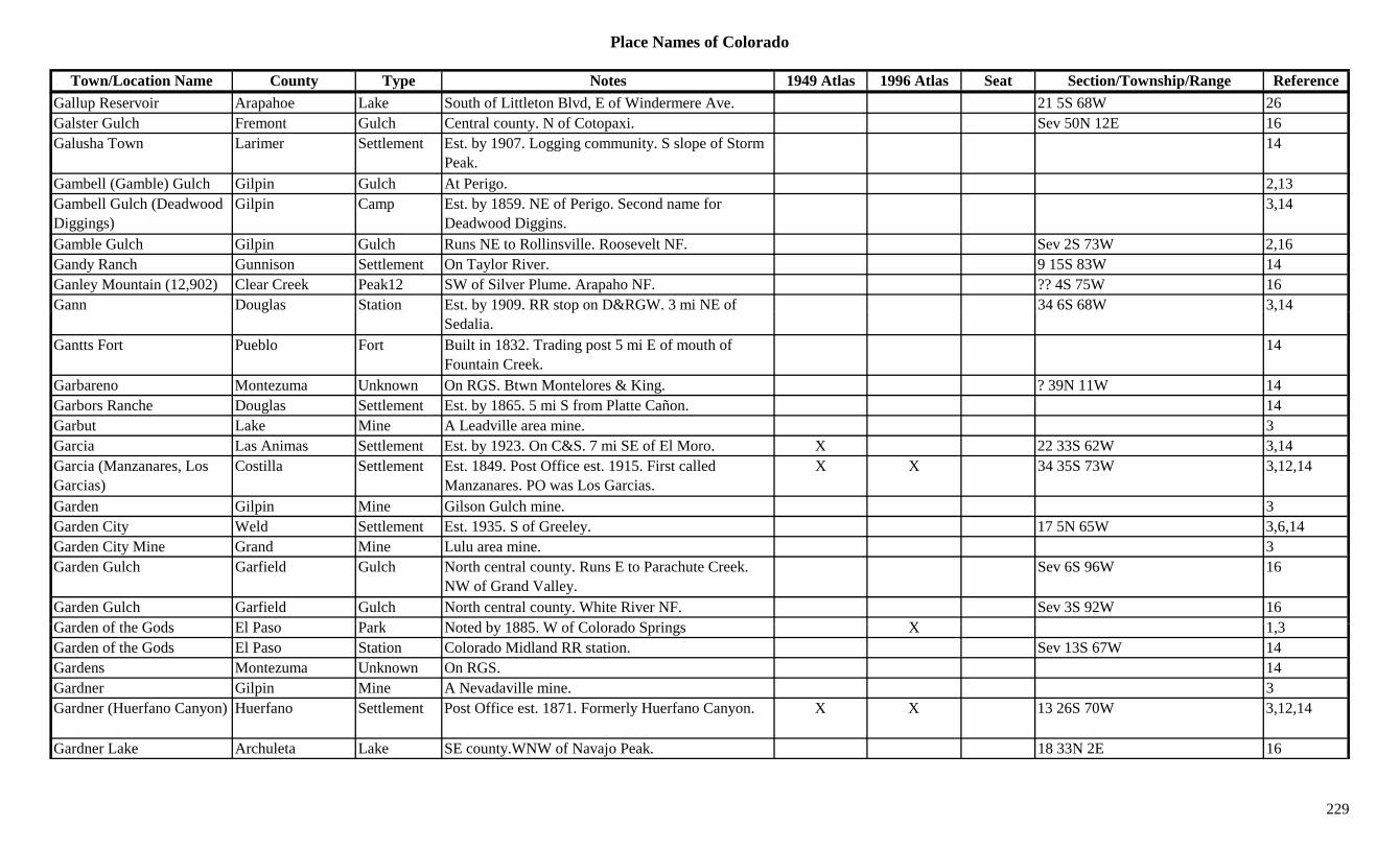
Place Names of Colorado
Town/Location Name County Type Notes 1949 Atlas 1996 Atlas Seat Section/Township/Range ReferenceGallup Reservoir Arapahoe Lake South of Littleton Blvd, E of Windermere Ave. 21 5S 68W 26Galster Gulch Fremont Gulch Central county. N of Cotopaxi. Sev 50N 12E 16Galusha Town Larimer Settlement Est. by 1907. Logging community. S slope of Storm
Peak.14
Gambell (Gamble) Gulch Gilpin Gulch At Perigo. 2,13Gambell Gulch (Deadwood Diggings)
Gilpin Camp Est. by 1859. NE of Perigo. Second name for Deadwood Diggins.
3,14
Gamble Gulch Gilpin Gulch Runs NE to Rollinsville. Roosevelt NF. Sev 2S 73W 2,16Gandy Ranch Gunnison Settlement On Taylor River. 9 15S 83W 14Ganley Mountain (12,902) Clear Creek Peak12 SW of Silver Plume. Arapaho NF. ?? 4S 75W 16Gann Douglas Station Est. by 1909. RR stop on D&RGW. 3 mi NE of 34 6S 68W 3,14g y p
Sedalia.,
Gantts Fort Pueblo Fort Built in 1832. Trading post 5 mi E of mouth of Fountain Creek.
14
Garbareno Montezuma Unknown On RGS. Btwn Montelores & King. ? 39N 11W 14Garbors Ranche Douglas Settlement Est. by 1865. 5 mi S from Platte Cañon. 14Garbut Lake Mine A Leadville area mine. 3Garcia Las Animas Settlement Est. by 1923. On C&S. 7 mi SE of El Moro. X 22 33S 62W 3,14Garcia (Manzanares, Los Garcias)
Costilla Settlement Est. 1849. Post Office est. 1915. First called Manzanares. PO was Los Garcias.
X X 34 35S 73W 3,12,14
Garden Gilpin Mine Gilson Gulch mine. 3Garden City Weld Settlement Est. 1935. S of Greeley. 17 5N 65W 3,6,14Garden City Mine Grand Mine Lulu area mine. 3Garden Gulch Garfield Gulch North central county. Runs E to Parachute Creek.
NW of Grand Valley.Sev 6S 96W 16
Garden Gulch Garfield Gulch North central county. White River NF. Sev 3S 92W 16G d f th G d El P P k N t d b 1885 W f C l d S i X 1 3Garden of the Gods El Paso Park Noted by 1885. W of Colorado Springs X 1,3Garden of the Gods El Paso Station Colorado Midland RR station. Sev 13S 67W 14Gardens Montezuma Unknown On RGS. 14Gardner Gilpin Mine A Nevadaville mine. 3Gardner (Huerfano Canyon) Huerfano Settlement Post Office est. 1871. Formerly Huerfano Canyon. X X 13 26S 70W 3,12,14
Gardner Lake Archuleta Lake SE county.WNW of Navajo Peak. 18 33N 2E 16
229
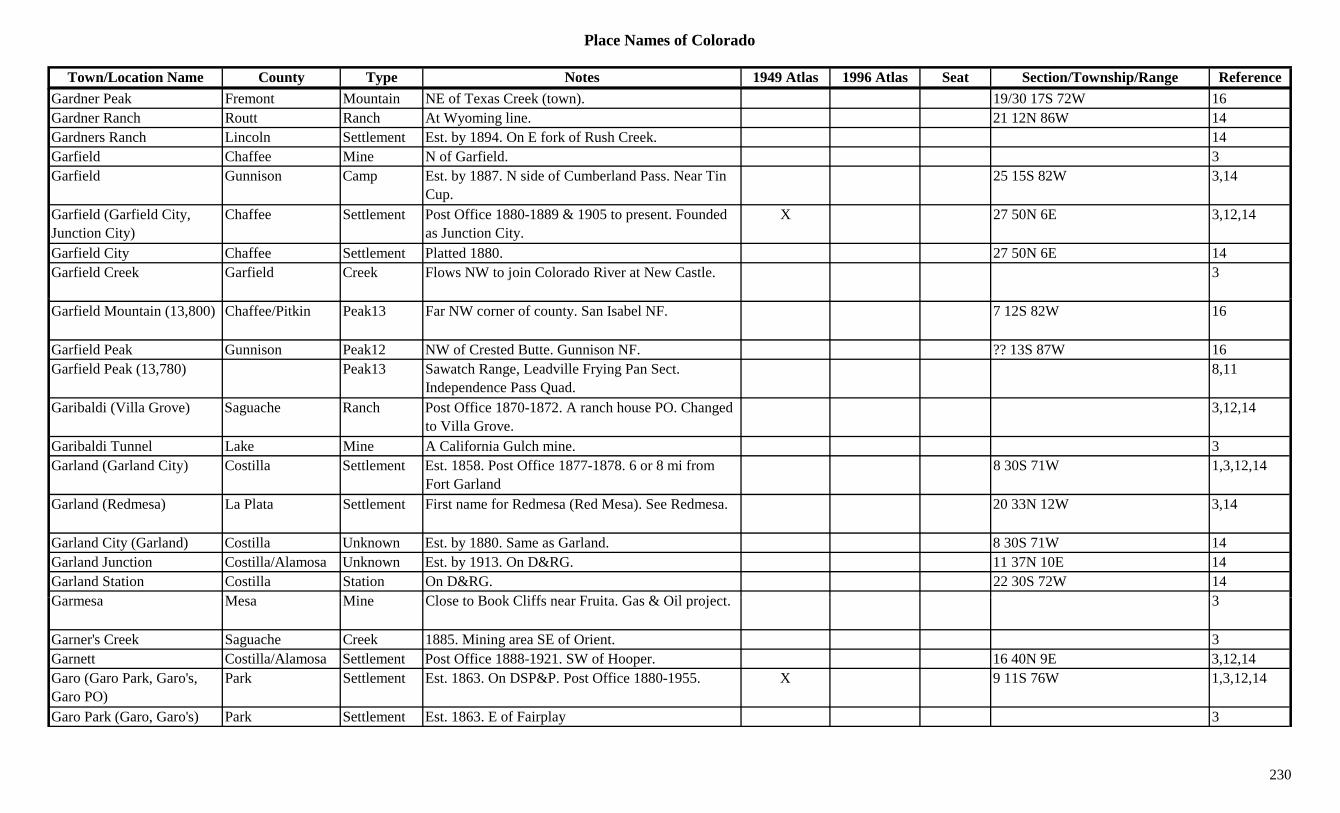
Place Names of Colorado
Town/Location Name County Type Notes 1949 Atlas 1996 Atlas Seat Section/Township/Range ReferenceGardner Peak Fremont Mountain NE of Texas Creek (town). 19/30 17S 72W 16Gardner Ranch Routt Ranch At Wyoming line. 21 12N 86W 14Gardners Ranch Lincoln Settlement Est. by 1894. On E fork of Rush Creek. 14Garfield Chaffee Mine N of Garfield. 3Garfield Gunnison Camp Est. by 1887. N side of Cumberland Pass. Near Tin
Cup.25 15S 82W 3,14
Garfield (Garfield City, Junction City)
Chaffee Settlement Post Office 1880-1889 & 1905 to present. Founded as Junction City.
X 27 50N 6E 3,12,14
Garfield City Chaffee Settlement Platted 1880. 27 50N 6E 14Garfield Creek Garfield Creek Flows NW to join Colorado River at New Castle. 3
Garfield Mountain (13,800) Chaffee/Pitkin Peak13 Far NW corner of county. San Isabel NF. 7 12S 82W 16
Garfield Peak Gunnison Peak12 NW of Crested Butte. Gunnison NF. ?? 13S 87W 16Garfield Peak (13,780) Peak13 Sawatch Range, Leadville Frying Pan Sect.
Independence Pass Quad.8,11
Garibaldi (Villa Grove) Saguache Ranch Post Office 1870-1872. A ranch house PO. Changed to Villa Grove.
3,12,14
Garibaldi Tunnel Lake Mine A California Gulch mine. 3Garland (Garland City) Costilla Settlement Est. 1858. Post Office 1877-1878. 6 or 8 mi from
Fort Garland8 30S 71W 1,3,12,14
Garland (Redmesa) La Plata Settlement First name for Redmesa (Red Mesa). See Redmesa. 20 33N 12W 3,14
Garland City (Garland) Costilla Unknown Est. by 1880. Same as Garland. 8 30S 71W 14Garland Junction Costilla/Alamosa Unknown Est. by 1913. On D&RG. 11 37N 10E 14Garland Station Costilla Station On D&RG. 22 30S 72W 14G M Mi Cl t B k Cliff F it G & Oil j t 3Garmesa Mesa Mine Close to Book Cliffs near Fruita. Gas & Oil project. 3
Garner's Creek Saguache Creek 1885. Mining area SE of Orient. 3Garnett Costilla/Alamosa Settlement Post Office 1888-1921. SW of Hooper. 16 40N 9E 3,12,14Garo (Garo Park, Garo's, Garo PO)
Park Settlement Est. 1863. On DSP&P. Post Office 1880-1955. X 9 11S 76W 1,3,12,14
Garo Park (Garo, Garo's) Park Settlement Est. 1863. E of Fairplay 3
230
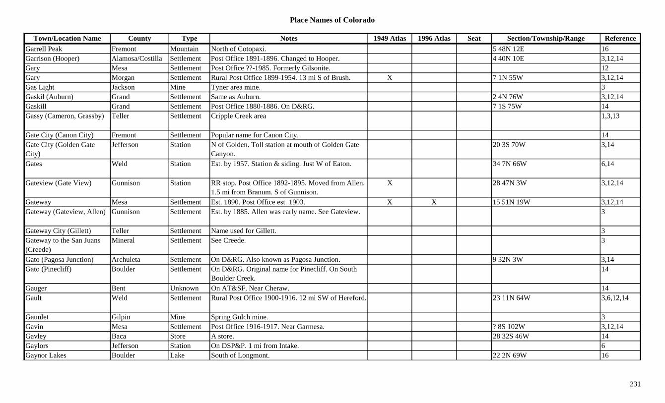
Place Names of Colorado
Town/Location Name County Type Notes 1949 Atlas 1996 Atlas Seat Section/Township/Range ReferenceGarrell Peak Fremont Mountain North of Cotopaxi. 5 48N 12E 16Garrison (Hooper) Alamosa/Costilla Settlement Post Office 1891-1896. Changed to Hooper. 4 40N 10E 3,12,14Gary Mesa Settlement Post Office ??-1985. Formerly Gilsonite. 12Gary Morgan Settlement Rural Post Office 1899-1954. 13 mi S of Brush. X 7 1N 55W 3,12,14Gas Light Jackson Mine Tyner area mine. 3Gaskil (Auburn) Grand Settlement Same as Auburn. 2 4N 76W 3,12,14Gaskill Grand Settlement Post Office 1880-1886. On D&RG. 7 1S 75W 14Gassy (Cameron, Grassby) Teller Settlement Cripple Creek area 1,3,13
Gate City (Canon City) Fremont Settlement Popular name for Canon City. 14Gate City (Golden Gate Jefferson Station N of Golden. Toll station at mouth of Golden Gate 20 3S 70W 3,14y (City) Canyon.
,
Gates Weld Station Est. by 1957. Station & siding. Just W of Eaton. 34 7N 66W 6,14
Gateview (Gate View) Gunnison Station RR stop. Post Office 1892-1895. Moved from Allen. 1.5 mi from Branum. S of Gunnison.
X 28 47N 3W 3,12,14
Gateway Mesa Settlement Est. 1890. Post Office est. 1903. X X 15 51N 19W 3,12,14Gateway (Gateview, Allen) Gunnison Settlement Est. by 1885. Allen was early name. See Gateview. 3
Gateway City (Gillett) Teller Settlement Name used for Gillett. 3Gateway to the San Juans (Creede)
Mineral Settlement See Creede. 3
Gato (Pagosa Junction) Archuleta Settlement On D&RG. Also known as Pagosa Junction. 9 32N 3W 3,14Gato (Pinecliff) Boulder Settlement On D&RG. Original name for Pinecliff. On South
Boulder Creek.14
Gauger Bent Unknown On AT&SF. Near Cheraw. 14G lt W ld S ttl t R l P t Offi 1900 1916 12 i SW f H f d 23 11N 64W 3 6 12 14Gault Weld Settlement Rural Post Office 1900-1916. 12 mi SW of Hereford. 23 11N 64W 3,6,12,14
Gaunlet Gilpin Mine Spring Gulch mine. 3Gavin Mesa Settlement Post Office 1916-1917. Near Garmesa. ? 8S 102W 3,12,14Gavley Baca Store A store. 28 32S 46W 14Gaylors Jefferson Station On DSP&P. 1 mi from Intake. 6Gaynor Lakes Boulder Lake South of Longmont. 22 2N 69W 16
231
Place Names of Colorado
Town/Location Name County Type Notes 1949 Atlas 1996 Atlas Seat Section/Township/Range ReferenceGearhart (Gearheart) Weld Settlement Est. by 1934. 13 mi E of Cornish. 6Gearheart (Gearhart) Weld Settlement Est. by 1934. 13 mi E of Cornish. 3,14Geary (Geary's Ranch) Weld Settlement Est. by 1881. Rural Post Office 1888-1894. 10 mi SE
of Greeley.13 5N 64W 3,6,12,14
Geary Creek Weld Creek Flows SE to join Little Crow Creek. 3Geary's Fort Weld Fort Est. by 1885. At junction of Boxelder Creek and
South Platte River.3
Gebhard (Agate) Elbert Settlement Post Office 1881-1882. Changed to Agate, 1882. 3,12,14
Geer Ranch Jackson Settlement 8 7N 81W 14Gee's Addition (Fulford) Eagle Settlement Became part of Fulford. 2( ) g pGeigers El Paso Station On D&RG. 14Geisller Mountain East (13,380)
Peak13 Sawatch Range, Leadville Frying Pan Sect. Mt. Champion Quad.
8,11
Geissler Mountain West (13,301)
Peak13 Mt. Champion Quad. 11
Gem Bent Settlement RR Post Office on Santa Fe RR 1907-1913. 4 mi W of McClave.
17 22S 49W 3,12,14
Gem Gilpin Mine A Russell Gulch area mine. 3Gem City (Ouray) Ouray Settlement Popular name for Ouray. 14Gem Lake Larimer Lake Mummy Range, Estes Park. 1Gem Mountain Fremont Mountain ESE of Texas Creek. 28 20S 73W 16Gem Village La Plata Settlement Est. 1942. Artistic colony. 16 34N 7W 3,14Gemini Peak (13,951) Peak13 Mt. Sherman Quad. 11General Logan Dolores Mine A Rico area mine. 13Genesee-Vanderbilt Ouray Mine A Guston area mine. 13G V d bilt O Mi A G t i 3Genessee-Vanderbilt Ouray Mine A Guston area mine. 3Geneva Clear Creek Unknown 13 mi from Grants. 13 mi SW of Georgetown. ? 5S 76W 14Geneva (Geneva Creek, Geneva Gulch)
Park Camp Small. Served miners above timberline. 3,14
Geneva Creek Park Creek Flows E from Geneva Creek (town) to N Fork S Platte River.
3
232
Place Names of Colorado
Town/Location Name County Type Notes 1949 Atlas 1996 Atlas Seat Section/Township/Range ReferenceGeneva Creek (Geneva, Geneva Gulch)
Park Camp Small. Served miners above timberline. 3
Geneva Gulch Park Gulch N of county. Near Clear Creek Co. 3Geneva Lake Clear Creek Lake SW tip of county. E of Santa Fe Peak. Pike NF. ?? 5S 75W 16
Geneva Mining District Park Mine Geneva area. 13Geneva Peak (13,266) Peak13 Montezuma Quad. 11Genoa (Cable, Creech) Lincoln Settlement Est. 1888. Post Office 1895 & 1903 to present.
Orginally Creech, then Cable.X X 12 9S 55W 3,12,14
George III Hinsdale Mine A Carson area mine. 3George Washington Hinsdale Mine SE of Sherman. 3,13g g ,George's Town (Georgetown)
Clear Creek Camp Est. by 1859. Early name for first cabin(s) at Georgetown.
8 4S 74W 13
Georgetown (Elizabethtown, George's Town)
Clear Creek Settlement Post Office est. 1866. 45 mi W of Denver. Known as Silver Queen of the Rockies.
X X X 8 4S 74W 1,2,3,12,13,14
Georgetown Loop Clear Creek Misc Btwn Georgetown and Silver Plume. RR loop to climb 638 ft. in 2 mi.
13
Georgia Summit Unknown On Swan River. 6 mi NE of Breckenridge. 26 6S 77W 14Georgia (Jefferson) Pass (11,585)
Park/Summit Pass Was Swan River Pass. NW of Michigan Creek. Boreas Pass Topo. Arapaho & Pike NF.
8 7S 76W 3,5,7,8,9
Georgia Bar Chaffee Camp Est. by 1860. On Arknsas River. 2 mi S of Granite. 2 mi N of Kelleys Bar.
? 12S 79W 3,14
Georgia Gulch Lake Mine A Leadville area mine. 3Georgia Gulch Summit Gulch At Parkville. 2,3,13G i G l h (P k ill S it S ttl t E t i 1860 B 1880 it b i d b i 3Georgia Gulch (Parkville, Park City)
Summit Settlement Est. in 1860s. By 1880s city was buried by mine tailings.
3
Georgiana Grand Mine At Lulu. 2Gerauds Park Unknown On DSP&P. 10 mi SE of Fairplay. 8 11S 76W 14Gerbazdale (Watson) Pitkin Settlement Post Office 1918. Formerly Watson. 6 9S 85W 12,14Geren Reservoir Dolores Lake South central county. 32 40N 13W 16Gerham Boulder Unknown 5 mi SE of Boulder. 14
233

Place Names of Colorado
Town/Location Name County Type Notes 1949 Atlas 1996 Atlas Seat Section/Township/Range ReferenceGerman Gulch Routt Gulch NE of Hahns Peak (town). 3German Reservoir Adams Lake E of Brighton. 6 1S 67W 16Germantown Clear Creek Settlement At location of Big Chief Mill. 14Gern Village La Plata Settlement XGerrard Rio Grande Unknown On D&RGW. 36 40N 3E 14Gertrude Ouray Mine A Camp Bird area mine. 3Gertrude Park Mine Near Alma. 2Gettysburg Gilpin Mine A Black Hawk area mine. NW of Black Hawk. 3
Gettysburg Gilpin Mine A Bortonsburg area mine. 3Gettysburg Gilpin Mine A Gilpin area mine. S of Gilpin. 3,13y g p p p ,Gettysburg Gilpin Station Gilpin Tram Station 1887-1917 in Leavenworth
Gulch.14 3S 73W 14
Ghost Mine Saguache Mine On La Garita Creek. W of La Garita. 3Giant Track Mountain (9,091)
Peak 1
Gibbs Summit Mine A Swandyke area mine. 3,13Gibbs Peak (12,286) Peak12 La Plata Range. 8Gibbs Peak (13,575) Custer Peak13 Sangre de Cristo Range, Main Section. Electric Peak
Quad. San Isabel NF.8 45N 12E 8,11,16
Gibson Delta Station D&RG Spur. 16 14S 92W 14Gibson (Wabash) Saguache Station Post Office 1911-1923. On D&RGW. 15 mi S of
Moffat.X 4 41N 10E 3,12,14
Gibson Gulch Chaffee Camp Near Cache Creek. 3Gibson Gulch Summit Gulch A Breckenridge mining area. 3Gibson Hill Summit Hill Near Preston. 13Gib P k (12 878) S h P k12 E t l t C t C 3 13Gibson Peak (12,878) Saguache Peak12 E central county near Custer Co. 3,13Giddings Larimer Station Est. by 1909. On C&S. 4 mi NE of Fort Collins. X 33 8N 68W 3,14
Giese Morgan Station Est. by 1870. On BN. 1 mi NE of Hillrose. 3,14Giggey Lake Boulder Lake NW of Pinecliffe. 20/21 1S 72W 16Giggey Ranch Boulder Ranch 15 1S 72W 14Gilchrist Washington Unknown 10 5S 55W 14
234
Place Names of Colorado
Town/Location Name County Type Notes 1949 Atlas 1996 Atlas Seat Section/Township/Range ReferenceGilcrest (Nantes, Nantz) Weld Settlement Post Office est. 1907. Platted 1907. Earlier known as
Nantz & Nantes.X X 28 4N 66W 3,6,12,14
Gile Station Elbert Settlement Est. by 1866. On Gile Station Wagon Road. 14Giles Boulder Mine A Camp Tolcott area mine. 13Gilkison Larimer Unknown On C&S. 5 7N 68W 14Gill (Greeley Junction) Weld Settlement Platted 1909. Post Office est. 1910. On UP stubline
to Briggsdale.X 27 6N 64W 3,6,12,14
Gill Creek Divide (7,000) Mesa Divide NE of Gateway. 7Gillard Boulder Mine At Wall Street. 3Gillespie Jefferson Settlement Post Office 1890-1894. 3 mi above Nighthawk. 3 mi
below Deckers.? 8S 70W 6,12,14
Gillett (Gateway City, City of Destiny)
El Paso/Teller Settlement Post Office 1894-1913. 7 mi N of Victor. X 4 15S 69W 2,3,12,13
Gillett Reduction Works Teller Mill A Gillett area operation. 3Gillette Las Animas Settlement Rural Post Office 1888. 16 mi NE of Branson. 3,12,14Gillette Sedgwick Station Wells Fargo Stage Station. 9 mi SW of Julesburg. 14
Gillispie (Gillespie) Jefferson Unknown On DSP&P. See Gillespie. 35 8S 70W 14Gillman Fremont Unknown Est. by 1925. On D&RG. Just N of Texas Creek. 7 19S 73W 14
Gills Crossing (Shaugert, Saugert)
Washington Unknown Near Messex. 14
Gilman Gilpin Camp Camp of Perigo and Gold Dirt boom. 3Gilman Jefferson Settlement Post Office on DSP&P 1874-1876. 3 mi W of Bear
Creek Jct.2 5S 69W 3,6,12,14
Gilman (Clinton, Battle M t i R k C k)
Eagle Settlement Post Office 1886-1986. 5 mi N of Redcliff. X X 13 6S 81W 2,3,12,13,14Mountain, Rock Creek)Gilman (Doyleville) Gunnison Station Post Office 1882-1883. Formerly Doyleville.
Renamed Doyleville. RR stop. E of Parlin.2 48N 3E 3,12,14
Gilman Mine & Mill Eagle Mine Gilman area mine. 3Gilman PO (Gilman Station)
Eagle Settlement See also Gilman. See Belden. 3
235

Place Names of Colorado
Town/Location Name County Type Notes 1949 Atlas 1996 Atlas Seat Section/Township/Range ReferenceGilman Station (Gilman PO)
Eagle Settlement See also Gilman. See Belden. 3
Gilmore Conejos Camp Began 1913. 1 mi SW of Stunner. 4.5 mi S of Summitville.
? 36N 4E 3,14
Gilmore Conejos Mine At Gilmore. 3Gilmores Lake Settlement 5 mi from Independence. At E foot of Independence
Pass.14
Gilpin Bent Station RR stop on AT&SF. 9 mi S of Las Animas. 24 24S 52W 3,14Gilpin Gilpin Settlement Post Office 1897-1917. 6 mi S of Rollinsville. In
Lump Gulch.12 2S 73W 2,12,13,14
Gilpin Jefferson Settlement Est. by 1887. E of Morrison. 3p yGilpin Summit Mine A Kokomo area mine. 3Gilpin Peak (13,694) Peak13 Sneffels Range. Telluride Quad. 8,11Gilson Gulch Gilpin Camp In Gilson Gulch. Btwn Central City and Idaho
Springs. Large camp & supply center.25 3S 73W 3,14
Gilsonite Mesa Settlement On D&RG. Post office est. 1957. Called Gary Community Rural Branch.
11 1N 3W 12,14
Gilt Edge Lake Mine A California Gulch mine. 3Ginger Rock / Peaks Chaffee/Gunnison Peak In Monarch District 1
Ginther Logan Unknown On CB&Q. 16 9N 52W 14Gintown (Jimtown) Mineral Settlement Another name for Jimtown. 36 42N 1W 1,3,14Giradots Quarry Douglas Mine 6 8S 67W 14Girard Lincoln Settlement Rural Post Office 1912-1917. 1 mi NE of Kendrick.
10 mi SW of Kutch.4 15S 59W 3,12,14
Given Douglas Camp Est. by 1924. Small Westcreek mining camp. 27 9S 70W 3,14Gi G i C E f Pitki Bt Sh d d B 3Givens Gunnison Camp E of Pitkin. Btwn Sherrod and Bowerman. 3Given's Ranch Douglas Ranch Early ranch in West Creek area. 13Glacier Lake Boulder Lake South of Ward. Roosevelt NF. 25 1N 73W 16Glacier Lake Boulder Settlement Post Office 1906-1908. Tiny settlement.
Approximate area of Williamsburg.30 1N 72W 3,6,12,14
Glacier Lake Conejos Lake West central county. SSW of Conejos Peak. Rio Grande NF.
?? 35N 3E 16
236

Place Names of Colorado
Town/Location Name County Type Notes 1949 Atlas 1996 Atlas Seat Section/Township/Range ReferenceGlacier Lake Station Boulder Station DB&W RR, near Glacier Lake. 1Glacier Mountain (12,443) Summit Peak12 Front Range, Southwest Section. Near Saints John. 3,8
Glacier Point (13,704) Peak13 Needle Mountains. The Grenadiers. Storm King Peak Quad.
8,11
Glacier(s) Gunnison Station Post Office 1914-1915. Station on D&RG. Near Crested Butte.
X 3,12,14
Glade Douglas Station Est. by 1882. RR stop on D&RGW. 4 mi N of Larkspur.
3 9S 67W 3,14
Glade Lake Dolores Lake Central county. San Juan NF. 32 41N 16W 16Glade Mountain (9,161) Dolores Mountain Central county. 34 41N 16W 13,16( , ) y ,Glade Park (Big Park) Mesa Settlement Post Office est. 1910. 1986, became CPO of Grand
Junction.X 24 12S 102W 3,12,14
Glade Point Canyon Dolores Canyon Central county. Runs SW to Dolores River. Sev 41N 17W 16Glade Point Reservoir Dolores Lake NE of Dove Creek. San Juan NF. ?? 41N 17W 16Gladel (Slick Rock) San Miguel Settlement Post Office 1922-1929. Est. 1879 as Snyder's Camp.
Later Gladel and Slick Rock.X 31 44N 18W 3,12,14
Gladiator Boulder Mine At Springdale. 3Gladstone San Juan Mine A Fisherville, Gladstone & Poughkeepsie area mine. 3
Gladstone San Juan Settlement Post Office 1878-1912 with gaps. 7 mi N of Silverton.
X 16 42N 7W 2,3,12,13,14
Gladstone Peak (13,913) Dolores/San Miguel
Peak13 San Miguel Range. Mt. Wilson Quad. 4 41N 10W 8,11,16
Gladstone Ridge (13,209) Peak13 Sawatch Range, Collegiate Section. Mt. Yale Quad. 8,11
Gl d A h l t S ttl t P t Offi 1885 1890 S ll ttl t 15 34N 1W 3 12 14Gladwyn Archuleta Settlement Post Office 1885-1890. Small settlement. 15 34N 1W 3,12,14Glass Lake Mine A Leadville area mine. 3Glasson Spur Summit Station On C&S. 14Glass-Pendery Lake Mine A Leadville area mine. 3Glazier Boulder Settlement W of Sugarloaf. 1Gleason Gulch Lake Gulch Scattering of dwellings. N of St. Kevins. Large mill. 3
237
Place Names of Colorado
Town/Location Name County Type Notes 1949 Atlas 1996 Atlas Seat Section/Township/Range ReferenceGleason Gulch Mine Lake Mine A Gleason Gulch mine. 3Glen Eagle Unknown Est. by 1929. On D&SLW. 3 2S 84W 14Glen Lincoln/Washingt
onSettlement Rural Post Office 1905-1920. 4 mi NW of Shaw.
Also at 34 5S 54W (Washington Co.).X 2 6S 54W 3,12,14
Glen Arbor Clear Creek Settlement Est. by 1865. Within 1 mi of Empire. 14Glen Chapel Washington Unknown 28 5S 54W 14Glen Comfort Larimer Unknown 14 5N 72W 14Glen Cove Teller Settlement On creek of same name. Up the toll road from
Cascade.35 13S 69W 3,14
Glen Echo Larimer Settlement 1 mi W of Rustic. 33 9N 73W 3,14Glen Eden Routt Unknown 27 9N 88W 14Glen Eyrie El Paso Settlement W of Garden of the Gods. 27 13S 67W 3,14Glen Eyrie Reservoir El Paso Lake NW of Colorado Springs. 27 13S 67W 16Glen Grove Douglas Settlement Post Office 1869-1877. 4 mi W of Larkspur. 24 9S 68W 3,12,14Glen Haven Larimer Settlement Post Office est. 1917. At foot of Devil's Gulch. NE
of Estes Park.X X 27 6N 72W 3,12,14
Glen Mountain Fremont Mountain S central county. [Perhaps should be Gem Mtn.] 13
Glen Park El Paso Settlement Est. by 1922. On D&RG. Close to, or same as, Palmer Lake.
5 11S 67W 3,14
Glen Summit Jefferson Unknown 22 5S 70W 14Glenard City Clear Creek Settlement Est. by 1860. 14Glenbrook Fremont Unknown On F&CC. 5 17S 69W 14Glencliff (Alpine, Cascade) Chaffee Settlement Same site as Alpine. Same site as Cascade. By the
Chalk Cliffs.29 15S 79W 3,14
Glencoe Jefferson Station Est. by 1892. On UPD&G. 7 mi NW of Golden. 5 3S 70W 3,6,14
Glencoe (Arloa, Glenco PO's)
Montezuma Settlement Est. by 1920s. Name for Arloa used by RR in 1911. 22 37N 14W 3,14
Glendale Arapahoe Settlement Platted 1882. S of Lowry Air Force Base. 18 4S 67W 3,6,14Glendale Boulder Camp Est. by 1881. On Left Hand Creek. 2 mi beyond
Jamestown turn-off.5 1N 71W 1,3,14
238

Place Names of Colorado
Town/Location Name County Type Notes 1949 Atlas 1996 Atlas Seat Section/Township/Range ReferenceGlendale Fremont Settlement Post Office 1877-1909. Moved to Penrose. On
Pueblo Co. line.21 18S 68W 3,12,14
Glendevey Larimer Settlement Site 2 (or last site). Post Office 1902-1975. Post Office moved 4 times then closed.
X 3 10N 76W 3,12,14
Glendevy Larimer Settlement Site 1. Old Lodge & first Post Office. 29 10N 76W 14Gleneath El Paso Settlement Rural Post Office 1910-1916. 13 mi NE of Fountain. 31 15S 63W 3,12,14
Glenelk Jefferson Settlement SW of Conifer. On Elk Creek. SE of Shaffers Crossing.
5 7S 71W 3,6,14
Gleneyre Larimer Settlement Post Office 1895-1912. NW of Glendevey. 17 11N 76W 3,12,14Glenham (Barela, Rivera) Las Animas Settlement Post Office 1873-1874. Changed to Barela. 5 34S 61W 4,12,14( , ) g , ,Glenisle Park Settlement On DSP&P. Btwn Bailey and Shawnee. 25 7S 73W 3,14Glenmore Lake(s) Jefferson Unknown Est. by 1915. On C&S. Btwn Cliff & Crystal Lake. 6,14
Glenn El Paso Settlement Rural Post Office 1896-1901 & 1903. 10 mi SE of Ramah.
10 12S 60W 3,12,14
Glenrock Fremont Unknown On Eight Mile Creek. A Glenbrook is at 5 17S 69W. ??
? 17S 69W 14
Glenside El Paso Settlement Platted in 1883. An addition to Palmer Lake. 5 11S 67W 14Glentivar (Sulphur Springs) Park Settlement Crossroad, had Post Office 1921-1929 & 1935-1955.
11 mi E of Hartsel.X 31 11S 73W 1,3,12,14
Glenwood Hot Springs Garfield Settlement Before 1883. Became Glenwood Springs. 14Glenwood Junction (Basalt) Eagle Station Est. by 1888. Same as Basalt. 14
Glenwood Springs (Defiance, Barlow)
Garfield Settlement Est. 1882. Post Office est. 1884. Formerly Barlow. First called Glenwood Hot Springs.
X X X Sev 6S 89W 1,3,12,14
Gli k W ld St ti E t b 1916 O C&S 3 i W f Bl k H ll 17 7N 67W 3 6 14Glick Weld Station Est. by 1916. On C&S. 3 mi W of Black Hollow. 17 7N 67W 3,6,14
Glider Training School Morgan Camp WWII Military installation. N of Fort Morgan. 14Globe Huerfano Station On C&S. 2 mi SW of Walsenburg. 20 28S 66W 3,14Globe Hill Teller Hill E of Cripple Creek. 3Globe Hill Teller Mine 18 15S 69W 14
239
Place Names of Colorado
Town/Location Name County Type Notes 1949 Atlas 1996 Atlas Seat Section/Township/Range ReferenceGlobeville (Holdenville) Arapahoe/Denver Settlement Post Office 1890-1900. Became station of Denver.
First name was Holdenville.16 38S 68W 12,14
Glory (Beecher Island) Yuma Settlement Glory Post Office at site 1924-1925. Changed to Beecher Island.
21 2S 43W 3,4,12,14
Glory Hole Gilpin Mine At Nevadaville, 1 mi W of Central City 1,3Glory Hole Teller Mine A Winfield area mine. At the top of Squaw Gulch. 3
Glory Hole (Alice Glory Hole)
Clear Creek Mine At Alice. 3
Glover Huerfano Unknown ? 25S 69W 14Glovers Larimer Station Est. by 1923. On C&S. 1 mi SE of LaPorte. 3 7N 69W 3,14y ,Gnacio (Ignacio) La Plata Settlement See Ignacio. 3Gnome Lake Mine A Leadville area mine. 3Goat Park Gulch Fremont Gulch South of Parkdale. Runs NE & E. Sev 19S 72W 16Goat Ranch Rio Grande Ranch 6 37N 7E 14Goblin City Summit/Rio
BlancoSettlement Est. by 1866. On N side of White River. On Utah
State line.27 1N 104W 14
Goblin Gulch Mesa Gulch Close to Utah. 12 miles from end of road at Devil's Canyon Ranch.
3
Godfrey Delta Unknown On D&RG. 14Godfrey (Buick) Elbert Settlement Est. by 1887. Post Office 1908. First name for
Buick. See Buick.32 7S 58W 3,12,14
Godfreys Park Unknown In South Platte Canyon. 7 mi NE of Kenosha Pass. 3 mi E of Webster on DSP&P.
9 7S 74W 14
Godfrey's Ranch (Fort Wicked)
Logan Ranch Site of 1864 battle with Indians. See Fort Wicked. 69 mi SW of Julesburg.
35 6N 54W 3,4,14
G di Rid M ff t S ttl t SE f Littl S k Ri 3Godiva Ridge Moffat Settlement SE of Little Snake River. 3Godo Huerfano Station Est. by 1923. On D&RG, going over La Veta Pass. 3
Goff Elbert/Kit Carson Settlement Rural Post Office 1888-1910. 18 mi NW of Bethune. 12 6S 44W 3,12,14
Goff Ranch Rio Blanco Ranch Est. by 1912. On Sulphur Creek. 23 2N 94W 14Golconda Montezuma Settlement Post Office 1894-1895. 23 37N 12W 12,14
240

Place Names of Colorado
Town/Location Name County Type Notes 1949 Atlas 1996 Atlas Seat Section/Township/Range ReferenceGolconda (Elko) Gunnison Settlement Est. by 1880. 6 mi NW of Gothic City. Name
changed to Elko, 1880.7 12S 86W 14
Golconda Mine & Mill Rio Grande Mine A Summitville area mine. 3Gold Anchor Clear Creek Mine A Yankee area mine. 13Gold Basin Gunnison Gulch East of Blue Mesa Res. Runs N. Sev 48/49N 1W 16Gold Basin Lake Mine A Leadville area mine. 3Gold Basin Lake Unknown 22 10S 79W 14Gold Bond Adams Unknown On C&S. 5 3S 68W 14Gold Brick Mining District Gunnison Mine At Ohio City. 2
Gold Bug Chaffee Mine At Turret. 2,3,13g , ,Gold Bug La Plata Mine A Beartown area mine. 3Gold Bug San Juan Mine A Beartown area mine. 3Gold Camp Road Teller Trail Road from Colorado Springs. 3Gold City Park Unknown Est. by 1898. 3 mi NW of Lake George. On Links
Creek. Also shown at 12 12S 72W.19 12S 71W 14
Gold City (Dallas) Ouray Camp Est. 1887, died in August. 1 year later site became Dallas.
4 45N 8W 3,14
Gold Coin Teller Mine A Victor area mine. 2,3,13Gold Collar Gilpin Mine SW of Eureka. 3Gold Creek Gunnison Creek Flows S through Pitkin to Gilman. 3,13Gold Creek (Ohio City) Gunnison Settlement Early name for Ohio City. See Ohio City. 26 50N 3E 3,14Gold Cross Boulder Mine At Jamestown. 3,13Gold Crown San Miguel Mine An Alta area mine. 3Gold Cup Mine Gunnison Mine Est. by 1878. At Tin Cup. 2,3,13Gold Dirt Clear Creek Mine North Empire area mine. 3G ld Di t (G ld D t) Gil i C P t Offi 1861 1867 1 i N f P i D 3 12 14Gold Dirt (Gold Dust) Gilpin Camp Post Office 1861-1867. 1 mi N of Perigo. Down
Gamble Gulch.3,12,14
Gold Dirt (Gold Dust) Gilpin Mine Est. 1860 or 1861. At Perigo. 2,3,13Gold Dollar Gilpin Mine A Russell Gulch area mine. 3Gold Dredge Spur Park Unknown On DSP&P. 113.8 mi from Denver on RR. Near
Fairplay? 14
Gold Dust Summit Mine A Laurium area mine. 3
241

Place Names of Colorado
Town/Location Name County Type Notes 1949 Atlas 1996 Atlas Seat Section/Township/Range ReferenceGold Dust (Gold Dirt) Gilpin Settlement See Gold Dirt. 12Gold Dust Peak Eagle Peak13 SWS of Redcliff. White River NF. ?? 6S 82W 16Gold Dust Peak (13,382) Peak13 Sawatch Range, Holy Cross Section. Mt. Jackson
Quad.8,11
Gold Eagle Boulder Mine Near Wallstreet. 2,3Gold Farm Boulder Mine Near Jackson's Camp. 3,13Gold Field Lake Mine An Alicante area mine. 3Gold Fissure Clear Creek Mine North Empire area mine. 3,13Gold Globe Teller Mine Teller Co. mines not elsewhere specified. 3Gold Hill Chaffee Mine At Free Gold. SE of Buena Vista. 3Gold Hill Gunnison/Pitkin Peak12 North central county. N of Taylor Pass. ?? 11S 84W 16y y
Gunnison/White River NF.Gold Hill Saguache Mine An Iris area mine. 3,13Gold Hill Teller Hill E of Cripple Creek. 3Gold Hill Boulder Hill At Gold Hill settlement. 13Gold Hill (Goldhill) Boulder Settlement Est. by 1859. Post Office 1863-1866 & 1879-1894.
Became Goldhill. 11 mi W of Boulder.X 11 1N 72W 1,2,3,6,12,1
3Gold Hill Mining District Boulder Mine At Gold Hill. 13Gold Hill Station (Goldhill Station)
Boulder Station RR stop for tracks that were never built. 3
Gold King La Plata Mine Near Eagle Pass. A La Plata area mine & mill. In La Plata Range.
3,8
Gold King San Juan Mine A Silverton area mine. At Gladstone. 2,13Gold King San Miguel Mine Est. by 1879. Near Alta. 2,3,13Gold King Teller Mine A Cripple Creek area mine. El Paso. 17 16S 69W 3,13Gold King Teller Station Est. by 1905. On CS&CCD. Just S of Gold King
Mi17 16S 69W 14
Mine.Gold King Mine & Smelter San Juan Mine At Gladstone. 2,3
Gold King Tunnel San Juan Tunnel At Gladstone. 13Gold Knob Teller Mine Teller Co. mines not elsewhere specified. 3Gold Lake Boulder Lake East of Ward. Roosevelt NF. 4/3 1N 72W 16
242
Place Names of Colorado
Town/Location Name County Type Notes 1949 Atlas 1996 Atlas Seat Section/Township/Range ReferenceGold Lake (Camp Newaka) Boulder Camp Est. by 1861. 2 mi NE of Ward. Town never built.
Also shown at 16 1N 72W.33 1N 72W 1,3,6,14
Gold Link Mining Company Gunnison Mine At Ohio City. Had 6,000 acres of claims, a forty-stamp mill, a 4,000 ft. tunnel, etc.
13
Gold Links Gunnison Mine N of Ohio City. On Cold Creek. 3Gold Lions Mining Co. Ouray Mine At Red Mountain Town. 3Gold Medal Gilpin Mine Gilson Gulch mine. 3Gold Metal Lake Mine On Birdseye Gulch. 3Gold Nugget Boulder Mine Rowena area. 1Gold Pan Summit Station Est. by 1913. On DSP&P. Just S of Breckenridge. 32 6S 77W 14
Gold Park Eagle Settlement Post Office 1881-1883. 26 mi NW of Leadville. On Homestake Creek.
34 7S 81W 2,12,13,14
Gold Park Mining Company & Mill
Eagle Mine At Gold Park. 3,13
Gold Prince San Juan Misc Large, splendid boarding house. At mine & mill above Animas Forks.
3
Gold Prince Mine & Mill San Juan Mine An Animas Forks area mine. 3,13Gold Run Boulder Camp At Gold Hill. 13Gold Run Chaffee Camp Near Cache Creek. 3Gold Run La Plata Camp Rich mining area. SW of Parrott City. 3Gold Run La Plata Mine W of Mayday. 3Gold Run San Miguel Settlement Est. by 1881. E of Placerville. 3Gold Run Summit Unknown Est. by 1870. In a gulch running up from Swan River
& Buffalo Flats.17 6S 77W 14
Gold Run (Beartown) San Juan Settlement Early name for Beartown, Bear Creek, Cub Town, Sil Ti & S l it
22 40N 6W 3,14Silver Tip & Sylvanite.
Gold Run Creek Boulder Creek Confluence with Fourmile Creek at Salina. 13Gold Run Gulch Boulder Gulch At Salina. To Gold Hill and to Crisman. 2Gold Run Gulch Summit Gulch Btwn Delaware Flats and Lincoln. 3,13Gold Run Mill San Miguel Mill A Fall Creek area operation. 3Gold Sterling Saguache Mine An Iris area mine. 3,13
243
Place Names of Colorado
Town/Location Name County Type Notes 1949 Atlas 1996 Atlas Seat Section/Township/Range ReferenceGolddale Douglas Settlement Rural Post Office 1882-1885. Near Russellville. 6 mi
SE of Franktown.3,12,14
Golddale Gunnison Settlement Est. by 1887. Settlement. 3Golden (Golden City) Jefferson Settlement Est. 1859. Post Office est. 1876. Formerly Golden
City. 21 mi S of Boulder.X X X Sev 3S 70W 3,6,12,14
Golden Age Boulder Mine At Jamestown. 2,3,13Golden Age Dolores Mine A Rico area mine. 13Golden Age Hill (8,400) Boulder Hill N of Springdale. NE of Jamestown. Roosevelt NF. 20 2N 71W 3,16
Golden Chief Boulder Mine 1Golden City Denver Settlement Name proposed for St. Charles. 33 3S 68W 14y p pGolden City Larimer Settlement Platted 1861. Also shown at 3 4N 70W. 28 3N 70W 14Golden City Rio Blanco Settlement Est. 1880s. RR settlement. W of Rangely. On S bank
of White River. 4 mi E of Utah line.27 1N 102W 3,14
Golden City (Golden) Jefferson/KT Settlement Wells Fargo Stage Station. Post Office 1860-1876. Changed to Golden.
x 6,12,14
Golden Cycle Teller Mine A Goldfield area mine. 3Golden Eagle Fremont Mine At Whitehorn. 3,13Golden Eagle Gilpin Mine A Gregory Hill mine. 3Golden Fleece San Juan Mine An Eureka area mine. 3Golden Fleece (Hotchkiss) Hinsdale Mine S of Lake City. Near Lake San Cristobal. 2,3,13
Golden Gate Saguache Mine A Crestone-Liberty area mine. 3Golden Gate (Baled Hay City)
Jefferson/KT Station Est. 1859. Post Office 1860-1863. At mouth of Golden Gate Canyon.
20 3S 70W 3,4,6,12,14
Golden Gate Pass Gilpin Pass In area of Crawford Gulch. 7G ld H (13 780) P k13 Sil t W t G O hi Q d 8 11Golden Horn (13,780) Peak13 Silverton West Group. Ophir Quad. 8,11Golden Income Saguache Mine An Embargo area mine. 3Golden Junction (Wanamaker Junction)
Jefferson Station Est. by 1885. E of Golden. Also called Wanamaker Junction.
24 3S 70W 14
Golden Ledge Park Mine A Silver Heels area mine. 3Golden Nugget Boulder Mine W of Glendale. 3Golden Nugget San Juan Mine A Middleton area mine. 3
244
Place Names of Colorado
Town/Location Name County Type Notes 1949 Atlas 1996 Atlas Seat Section/Township/Range ReferenceGolden Ram Hinsdale Mine NE of Henson. 3Golden Reservoir Clear Creek Lake Eastern edge of county. South of Black Hawk. 14 4S 72W 16Golden Rule Boulder Mine At Wall Street. 3Golden Rule Ditch Boulder Canal N of Little James Creek. 1Golden Star Rio Grande Mine A Summitville area mine. 3Golden Sun Gilpin Mine Perigo mine. 3Golden Treasure Gilpin Mine Nevadaville area mine. 3Golden Wonder Chaffee Mine At Turret. 2,3Golden's Camp Jefferson Camp Est. 1858. Near mouth of Clear Creek Canyon. 3,6Goldfield Teller Settlement Post Office 1894-1932. 1 mi NE of Victor. X X 28 15S 69W 2,3,12,13,14Goldhill Teller Unknown On CC&CC. 19 15S 69W 14Goldhill (Gold Hill) Boulder Settlement Post Office 1895-1920 & 1923-1952. Formerly Gold
Hill.11 1N 72W 12,14
Goldhill Station Boulder Station On DB&W. 16 1N 72W 14Goldrock El Paso Settlement Post Office 1896. 12,14Goldstone Camp Garfield Camp On the east fork of Elk Creek. 29 4S 90W 14Goldview (Fairview) Boulder Settlement Suburb of Boulder. 1Golf Chaffee/Park Unknown On DSP&P. 156.3 mi to Denver. 14Golf Club Jefferson Unknown On D&IM. 14Goliath Peak (12,200) Clear Creek Peak12 S of Echo Lake. Arapaho NF. 6 5S 73W 3,16Gomer Gilpin Mine A Russell Gulch area mine. 3Gomers Mills Elbert Settlement Rural Post Office 1870-1882. Moved to Elbert. Saw
mills, 1869. 6 mi E of Old Elbert.15 10S 62W 3,6,12,14
Gomez (Plaza de Alamosa) Conejos Settlement Plaza de Alamosa. ? 35N 8E 14
Gonora Mesa Station Est. by 1895. A Rio Grande Junction/Station. ? 10S 97W 14G l (A il ) L A i S ttl t E t b 1885 S l ti A il Al h 26 30S 65W 3 14Gonzales (Aguilar) Las Animas Settlement Est. by 1885. Same location as Aguilar. Also shown
at 19 30S 65W.26 30S 65W 3,14
Good (Willow Creek) Pass Grand/Jackson Pass W of Tyner. Crossed by SH 125. Routt & Arapaho NF.
X X 2 5N 78W 3,7
Good Friday Boulder Mine Btwn Eagle Rock & Sugarloaf. 3Good Hope Gunnison Mine A Pitkin area mine. 3Good Hope Gunnison Mine A Vulcan area mine. 3,13
245
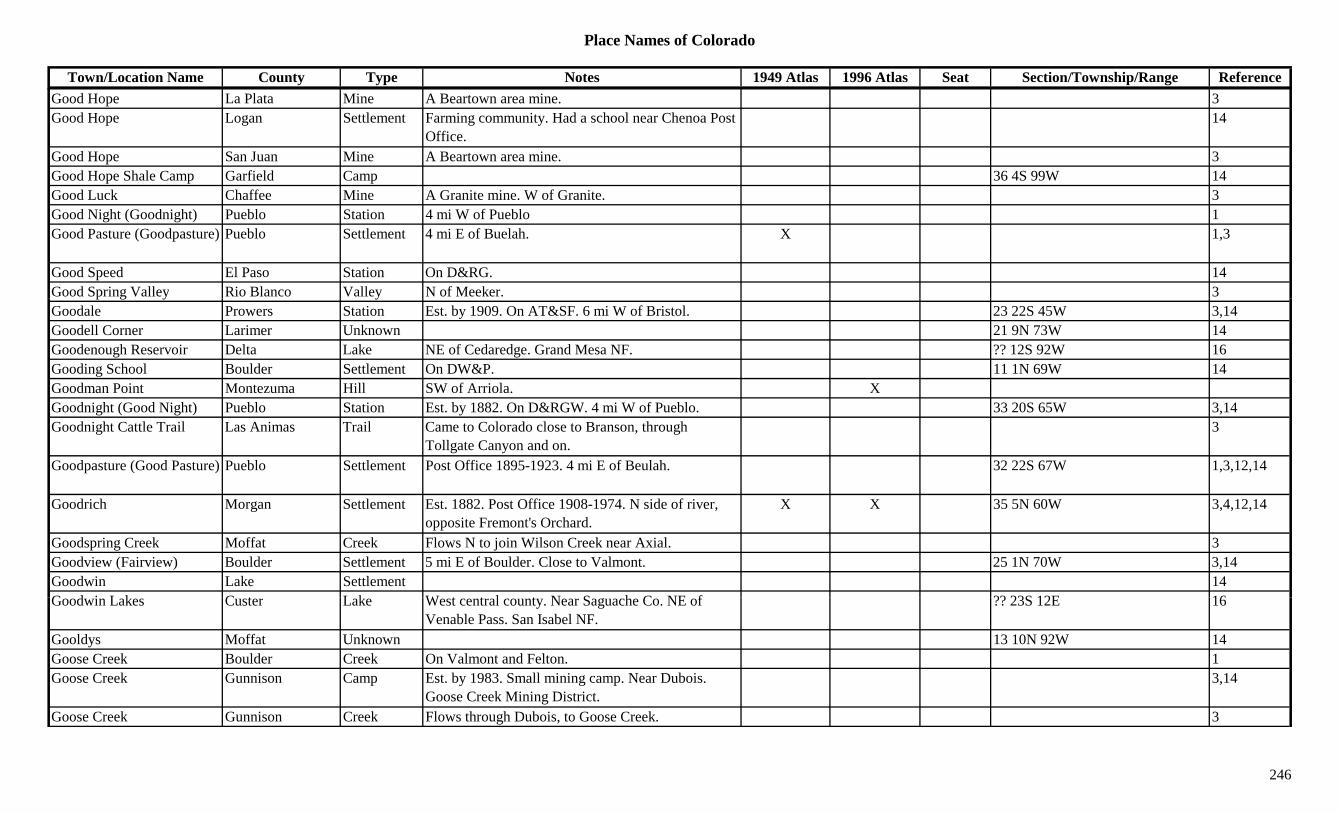
Place Names of Colorado
Town/Location Name County Type Notes 1949 Atlas 1996 Atlas Seat Section/Township/Range ReferenceGood Hope La Plata Mine A Beartown area mine. 3Good Hope Logan Settlement Farming community. Had a school near Chenoa Post
Office.14
Good Hope San Juan Mine A Beartown area mine. 3Good Hope Shale Camp Garfield Camp 36 4S 99W 14Good Luck Chaffee Mine A Granite mine. W of Granite. 3Good Night (Goodnight) Pueblo Station 4 mi W of Pueblo 1Good Pasture (Goodpasture) Pueblo Settlement 4 mi E of Buelah. X 1,3
Good Speed El Paso Station On D&RG. 14Good Spring Valley Rio Blanco Valley N of Meeker. 3p g y yGoodale Prowers Station Est. by 1909. On AT&SF. 6 mi W of Bristol. 23 22S 45W 3,14Goodell Corner Larimer Unknown 21 9N 73W 14Goodenough Reservoir Delta Lake NE of Cedaredge. Grand Mesa NF. ?? 12S 92W 16Gooding School Boulder Settlement On DW&P. 11 1N 69W 14Goodman Point Montezuma Hill SW of Arriola. XGoodnight (Good Night) Pueblo Station Est. by 1882. On D&RGW. 4 mi W of Pueblo. 33 20S 65W 3,14Goodnight Cattle Trail Las Animas Trail Came to Colorado close to Branson, through
Tollgate Canyon and on.3
Goodpasture (Good Pasture) Pueblo Settlement Post Office 1895-1923. 4 mi E of Beulah. 32 22S 67W 1,3,12,14
Goodrich Morgan Settlement Est. 1882. Post Office 1908-1974. N side of river, opposite Fremont's Orchard.
X X 35 5N 60W 3,4,12,14
Goodspring Creek Moffat Creek Flows N to join Wilson Creek near Axial. 3Goodview (Fairview) Boulder Settlement 5 mi E of Boulder. Close to Valmont. 25 1N 70W 3,14Goodwin Lake Settlement 14G d i L k C t L k W t t l t N S h C NE f ?? 23S 12E 16Goodwin Lakes Custer Lake West central county. Near Saguache Co. NE of
Venable Pass. San Isabel NF.?? 23S 12E 16
Gooldys Moffat Unknown 13 10N 92W 14Goose Creek Boulder Creek On Valmont and Felton. 1Goose Creek Gunnison Camp Est. by 1983. Small mining camp. Near Dubois.
Goose Creek Mining District.3,14
Goose Creek Gunnison Creek Flows through Dubois, to Goose Creek. 3
246
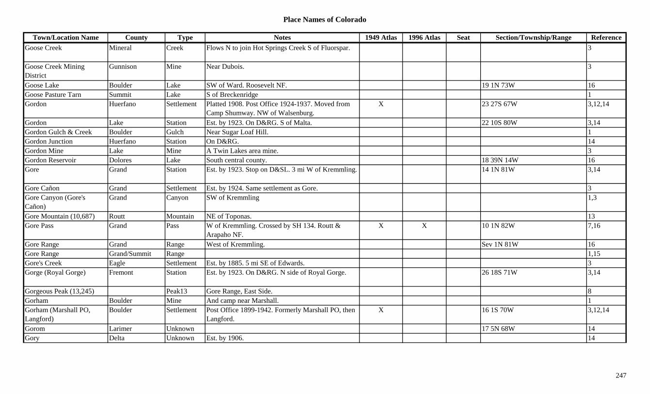
Place Names of Colorado
Town/Location Name County Type Notes 1949 Atlas 1996 Atlas Seat Section/Township/Range ReferenceGoose Creek Mineral Creek Flows N to join Hot Springs Creek S of Fluorspar. 3
Goose Creek Mining District
Gunnison Mine Near Dubois. 3
Goose Lake Boulder Lake SW of Ward. Roosevelt NF. 19 1N 73W 16Goose Pasture Tarn Summit Lake S of Breckenridge 1Gordon Huerfano Settlement Platted 1908. Post Office 1924-1937. Moved from
Camp Shumway. NW of Walsenburg.X 23 27S 67W 3,12,14
Gordon Lake Station Est. by 1923. On D&RG. S of Malta. 22 10S 80W 3,14Gordon Gulch & Creek Boulder Gulch Near Sugar Loaf Hill. 1Gordon Junction Huerfano Station On D&RG. 14Gordon Mine Lake Mine A Twin Lakes area mine. 3Gordon Reservoir Dolores Lake South central county. 18 39N 14W 16Gore Grand Station Est. by 1923. Stop on D&SL. 3 mi W of Kremmling. 14 1N 81W 3,14
Gore Cañon Grand Settlement Est. by 1924. Same settlement as Gore. 3Gore Canyon (Gore's Cañon)
Grand Canyon SW of Kremmling 1,3
Gore Mountain (10,687) Routt Mountain NE of Toponas. 13Gore Pass Grand Pass W of Kremmling. Crossed by SH 134. Routt &
Arapaho NF.X X 10 1N 82W 7,16
Gore Range Grand Range West of Kremmling. Sev 1N 81W 16Gore Range Grand/Summit Range 1,15Gore's Creek Eagle Settlement Est. by 1885. 5 mi SE of Edwards. 3Gorge (Royal Gorge) Fremont Station Est. by 1923. On D&RG. N side of Royal Gorge. 26 18S 71W 3,14
G P k (13 245) P k13 G R E t Sid 8Gorgeous Peak (13,245) Peak13 Gore Range, East Side. 8Gorham Boulder Mine And camp near Marshall. 1Gorham (Marshall PO, Langford)
Boulder Settlement Post Office 1899-1942. Formerly Marshall PO, then Langford.
X 16 1S 70W 3,12,14
Gorom Larimer Unknown 17 5N 68W 14Gory Delta Unknown Est. by 1906. 14
247
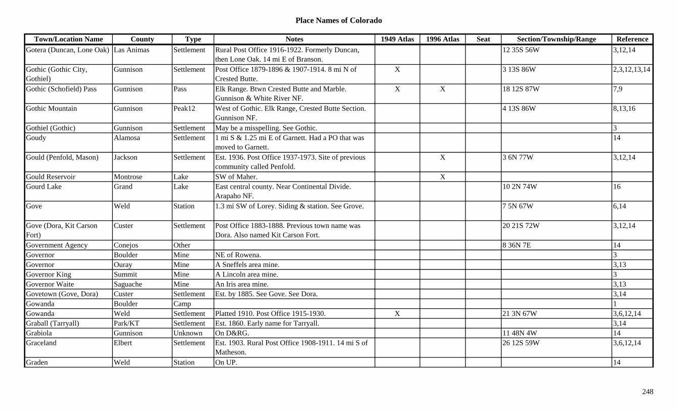
Place Names of Colorado
Town/Location Name County Type Notes 1949 Atlas 1996 Atlas Seat Section/Township/Range ReferenceGotera (Duncan, Lone Oak) Las Animas Settlement Rural Post Office 1916-1922. Formerly Duncan,
then Lone Oak. 14 mi E of Branson.12 35S 56W 3,12,14
Gothic (Gothic City, Gothiel)
Gunnison Settlement Post Office 1879-1896 & 1907-1914. 8 mi N of Crested Butte.
X 3 13S 86W 2,3,12,13,14
Gothic (Schofield) Pass Gunnison Pass Elk Range. Btwn Crested Butte and Marble. Gunnison & White River NF.
X X 18 12S 87W 7,9
Gothic Mountain Gunnison Peak12 West of Gothic. Elk Range, Crested Butte Section. Gunnison NF.
4 13S 86W 8,13,16
Gothiel (Gothic) Gunnison Settlement May be a misspelling. See Gothic. 3Goudy Alamosa Settlement 1 mi S & 1.25 mi E of Garnett. Had a PO that was
moved to Garnett.14
Gould (Penfold, Mason) Jackson Settlement Est. 1936. Post Office 1937-1973. Site of previous community called Penfold.
X 3 6N 77W 3,12,14
Gould Reservoir Montrose Lake SW of Maher. XGourd Lake Grand Lake East central county. Near Continental Divide.
Arapaho NF.10 2N 74W 16
Gove Weld Station 1.3 mi SW of Lorey. Siding & station. See Grove. 7 5N 67W 6,14
Gove (Dora, Kit Carson Fort)
Custer Settlement Post Office 1883-1888. Previous town name was Dora. Also named Kit Carson Fort.
20 21S 72W 3,12,14
Government Agency Conejos Other 8 36N 7E 14Governor Boulder Mine NE of Rowena. 3Governor Ouray Mine A Sneffels area mine. 3,13Governor King Summit Mine A Lincoln area mine. 3Governor Waite Saguache Mine An Iris area mine. 3,13Govetown (Gove, Dora) Custer Settlement Est. by 1885. See Gove. See Dora. 3,14G d B ld C 1Gowanda Boulder Camp 1Gowanda Weld Settlement Platted 1910. Post Office 1915-1930. X 21 3N 67W 3,6,12,14Graball (Tarryall) Park/KT Settlement Est. 1860. Early name for Tarryall. 3,14Grabiola Gunnison Unknown On D&RG. 11 48N 4W 14Graceland Elbert Settlement Est. 1903. Rural Post Office 1908-1911. 14 mi S of
Matheson.26 12S 59W 3,6,12,14
Graden Weld Station On UP. 14
248
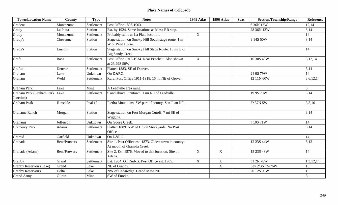
Place Names of Colorado
Town/Location Name County Type Notes 1949 Atlas 1996 Atlas Seat Section/Township/Range ReferenceGradens Montezuma Settlement Post Office 1896-1903. 6 36N 13W 12,14Grady La Plata Station Est. by 1924. Same locations as Mesa RR stop. 28 36N 12W 3,14Grady Montezuma Settlement Probably same as La Plata location. X 14Grady's Cheyenne Station Stage station on Smoky Hill South stage route. 1 m
W of Wild Horse.9 14S 50W 3,14
Grady's Lincoln Station Stage station on Smoky Hill Stage Route. 18 mi E of Big Sandy Creek.
14
Graft Baca Settlement Post Office 1916-1934. Near Pritchett. Also shown at 23 29S 50W.
X 10 30S 49W 3,12,14
Grafton Denver Settlement Platted 1883. SE of Denver. 3,14Graham Lake Unknown On D&RG. 24 9S 79W 14Graham Weld Settlement Rural Post Office 1911-1918. 16 mi NE of Grover. 12 11N 60W 3,6,12,14
Graham Park Lake Mine A Leadville area mine. 3Graham Park (Graham Park Junction)
Lake Settlement S and above Finntown. 1 mi NE of Leadville. 19 9S 79W 3,14
Graham Peak Hinsdale Peak12 Piedra Mountains. SW part of county. San Juan NF. ?? 37N 5W 3,8,16
Grahame Ranch Morgan Station Stage station on Fort Morgan Cutoff. 7 mi SE of Wiggins.
3,14
Grahams Jefferson Unknown On Goose Creek. ? 10S 71W 14Gramercy Park Adams Settlement Platted 1889. NW of Union Stockyards. No Post
Office.3,14
Gramid Garfield Unknown On D&RG. 14Granada Bent/Prowers Settlement Site 1. Post Office est. 1873. Oldest town in county.
At mouth of Granada Creek.12 23S 44W 3,12
G d (Ad ) B t/P S ttl t Sit 2 E t 1876 M d t thi l ti Sit f X X 15 23S 43W 14Granada (Adana) Bent/Prowers Settlement Site 2. Est. 1876. Moved to this location. Site of Adana.
X X 15 23S 43W 14
Granby Grand Settlement Est. 1904. On D&RG. Post Office est. 1905. X X 31 2N 76W 1,3,12,14Granby Reservoir (Lake) Grand Lake NE of Granby. X Sev 2/3N 75/76W 16Granby Reservoirs Delta Lake NW of Cedaredge. Grand Mesa NF. 20 12S 95W 16Grand Army Gilpin Mine SW of Eureka. 3
249
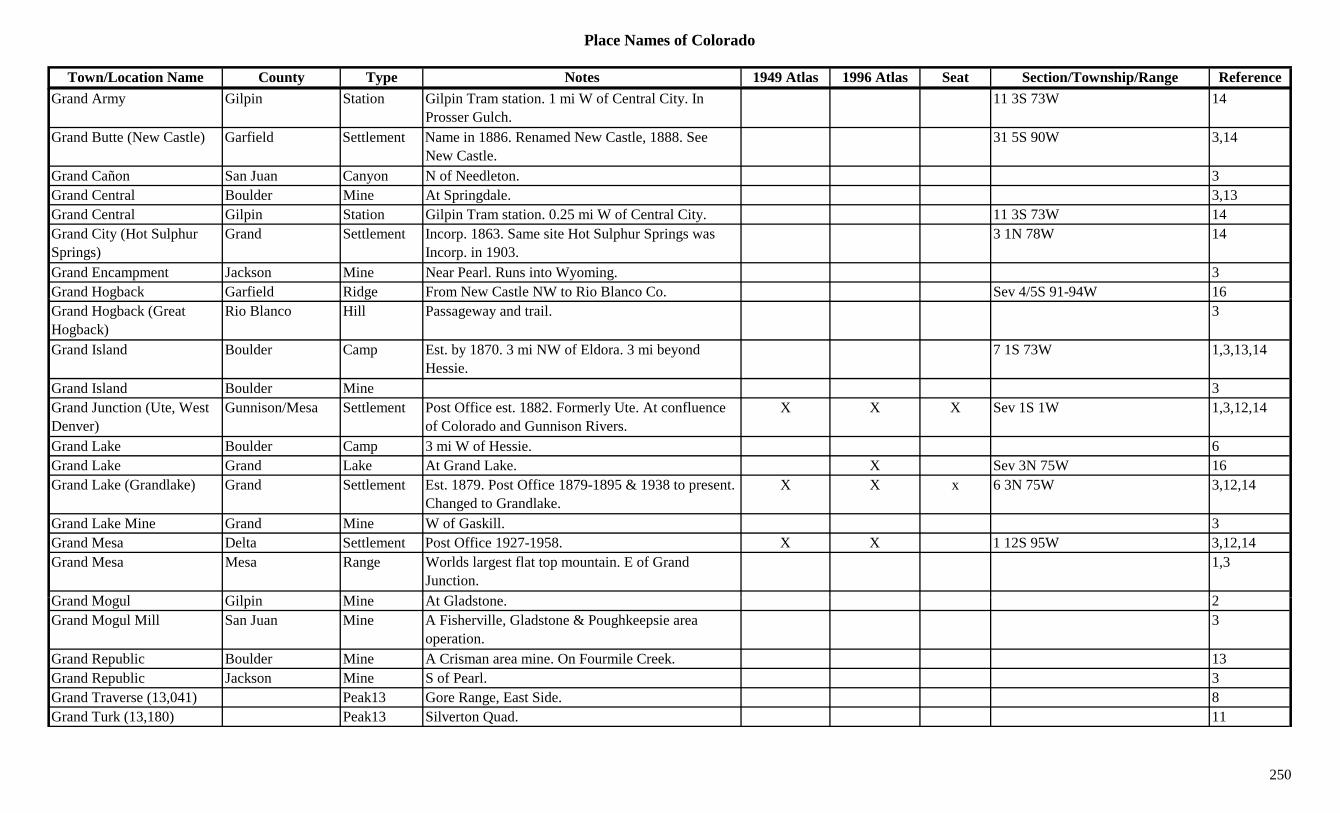
Place Names of Colorado
Town/Location Name County Type Notes 1949 Atlas 1996 Atlas Seat Section/Township/Range ReferenceGrand Army Gilpin Station Gilpin Tram station. 1 mi W of Central City. In
Prosser Gulch.11 3S 73W 14
Grand Butte (New Castle) Garfield Settlement Name in 1886. Renamed New Castle, 1888. See New Castle.
31 5S 90W 3,14
Grand Cañon San Juan Canyon N of Needleton. 3Grand Central Boulder Mine At Springdale. 3,13Grand Central Gilpin Station Gilpin Tram station. 0.25 mi W of Central City. 11 3S 73W 14Grand City (Hot Sulphur Springs)
Grand Settlement Incorp. 1863. Same site Hot Sulphur Springs was Incorp. in 1903.
3 1N 78W 14
Grand Encampment Jackson Mine Near Pearl. Runs into Wyoming. 3Grand Hogback Garfield Ridge From New Castle NW to Rio Blanco Co. Sev 4/5S 91-94W 16g gGrand Hogback (Great Hogback)
Rio Blanco Hill Passageway and trail. 3
Grand Island Boulder Camp Est. by 1870. 3 mi NW of Eldora. 3 mi beyond Hessie.
7 1S 73W 1,3,13,14
Grand Island Boulder Mine 3Grand Junction (Ute, West Denver)
Gunnison/Mesa Settlement Post Office est. 1882. Formerly Ute. At confluence of Colorado and Gunnison Rivers.
X X X Sev 1S 1W 1,3,12,14
Grand Lake Boulder Camp 3 mi W of Hessie. 6Grand Lake Grand Lake At Grand Lake. X Sev 3N 75W 16Grand Lake (Grandlake) Grand Settlement Est. 1879. Post Office 1879-1895 & 1938 to present.
Changed to Grandlake.X X x 6 3N 75W 3,12,14
Grand Lake Mine Grand Mine W of Gaskill. 3Grand Mesa Delta Settlement Post Office 1927-1958. X X 1 12S 95W 3,12,14Grand Mesa Mesa Range Worlds largest flat top mountain. E of Grand
Junction.1,3
G d M l Gil i Mi At Gl d t 2Grand Mogul Gilpin Mine At Gladstone. 2Grand Mogul Mill San Juan Mine A Fisherville, Gladstone & Poughkeepsie area
operation.3
Grand Republic Boulder Mine A Crisman area mine. On Fourmile Creek. 13Grand Republic Jackson Mine S of Pearl. 3Grand Traverse (13,041) Peak13 Gore Range, East Side. 8Grand Turk (13,180) Peak13 Silverton Quad. 11
250
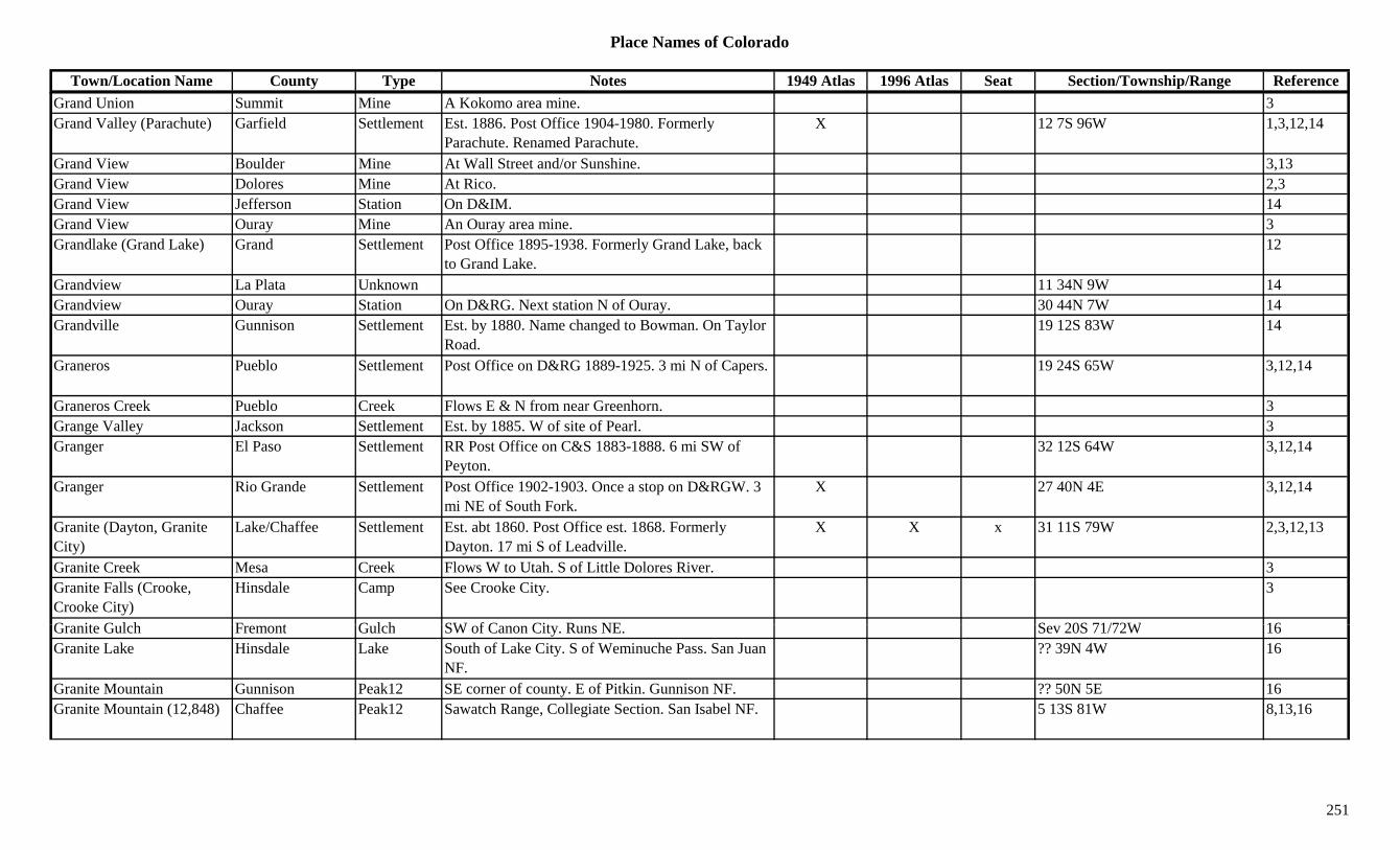
Place Names of Colorado
Town/Location Name County Type Notes 1949 Atlas 1996 Atlas Seat Section/Township/Range ReferenceGrand Union Summit Mine A Kokomo area mine. 3Grand Valley (Parachute) Garfield Settlement Est. 1886. Post Office 1904-1980. Formerly
Parachute. Renamed Parachute.X 12 7S 96W 1,3,12,14
Grand View Boulder Mine At Wall Street and/or Sunshine. 3,13Grand View Dolores Mine At Rico. 2,3Grand View Jefferson Station On D&IM. 14Grand View Ouray Mine An Ouray area mine. 3Grandlake (Grand Lake) Grand Settlement Post Office 1895-1938. Formerly Grand Lake, back
to Grand Lake.12
Grandview La Plata Unknown 11 34N 9W 14Grandview Ouray Station On D&RG. Next station N of Ouray. 30 44N 7W 14y yGrandville Gunnison Settlement Est. by 1880. Name changed to Bowman. On Taylor
Road.19 12S 83W 14
Graneros Pueblo Settlement Post Office on D&RG 1889-1925. 3 mi N of Capers. 19 24S 65W 3,12,14
Graneros Creek Pueblo Creek Flows E & N from near Greenhorn. 3Grange Valley Jackson Settlement Est. by 1885. W of site of Pearl. 3Granger El Paso Settlement RR Post Office on C&S 1883-1888. 6 mi SW of
Peyton.32 12S 64W 3,12,14
Granger Rio Grande Settlement Post Office 1902-1903. Once a stop on D&RGW. 3 mi NE of South Fork.
X 27 40N 4E 3,12,14
Granite (Dayton, Granite City)
Lake/Chaffee Settlement Est. abt 1860. Post Office est. 1868. Formerly Dayton. 17 mi S of Leadville.
X X x 31 11S 79W 2,3,12,13
Granite Creek Mesa Creek Flows W to Utah. S of Little Dolores River. 3Granite Falls (Crooke, Crooke City)
Hinsdale Camp See Crooke City. 3
G it G l h F t G l h SW f C Cit R NE S 20S 71/72W 16Granite Gulch Fremont Gulch SW of Canon City. Runs NE. Sev 20S 71/72W 16Granite Lake Hinsdale Lake South of Lake City. S of Weminuche Pass. San Juan
NF.?? 39N 4W 16
Granite Mountain Gunnison Peak12 SE corner of county. E of Pitkin. Gunnison NF. ?? 50N 5E 16Granite Mountain (12,848) Chaffee Peak12 Sawatch Range, Collegiate Section. San Isabel NF. 5 13S 81W 8,13,16
251
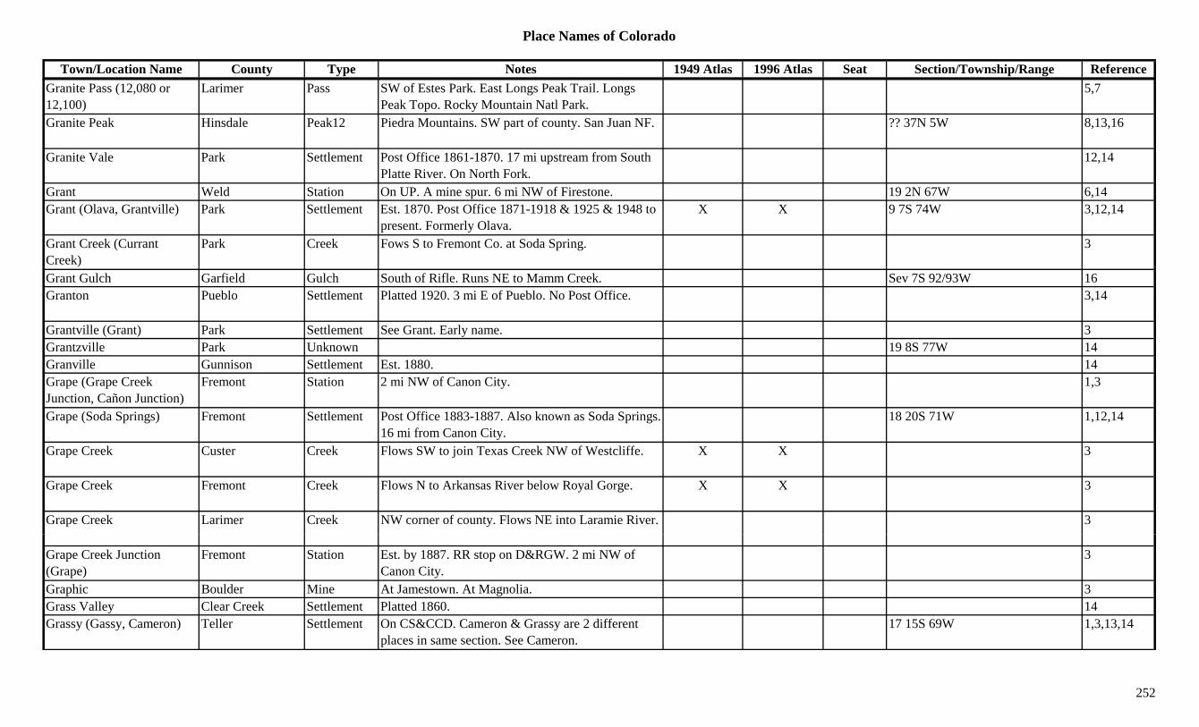
Place Names of Colorado
Town/Location Name County Type Notes 1949 Atlas 1996 Atlas Seat Section/Township/Range ReferenceGranite Pass (12,080 or 12,100)
Larimer Pass SW of Estes Park. East Longs Peak Trail. Longs Peak Topo. Rocky Mountain Natl Park.
5,7
Granite Peak Hinsdale Peak12 Piedra Mountains. SW part of county. San Juan NF. ?? 37N 5W 8,13,16
Granite Vale Park Settlement Post Office 1861-1870. 17 mi upstream from South Platte River. On North Fork.
12,14
Grant Weld Station On UP. A mine spur. 6 mi NW of Firestone. 19 2N 67W 6,14Grant (Olava, Grantville) Park Settlement Est. 1870. Post Office 1871-1918 & 1925 & 1948 to
present. Formerly Olava.X X 9 7S 74W 3,12,14
Grant Creek (Currant Creek)
Park Creek Fows S to Fremont Co. at Soda Spring. 3
Grant Gulch Garfield Gulch South of Rifle. Runs NE to Mamm Creek. Sev 7S 92/93W 16Granton Pueblo Settlement Platted 1920. 3 mi E of Pueblo. No Post Office. 3,14
Grantville (Grant) Park Settlement See Grant. Early name. 3Grantzville Park Unknown 19 8S 77W 14Granville Gunnison Settlement Est. 1880. 14Grape (Grape Creek Junction, Cañon Junction)
Fremont Station 2 mi NW of Canon City. 1,3
Grape (Soda Springs) Fremont Settlement Post Office 1883-1887. Also known as Soda Springs. 16 mi from Canon City.
18 20S 71W 1,12,14
Grape Creek Custer Creek Flows SW to join Texas Creek NW of Westcliffe. X X 3
Grape Creek Fremont Creek Flows N to Arkansas River below Royal Gorge. X X 3
Grape Creek Larimer Creek NW corner of county. Flows NE into Laramie River. 3
Grape Creek Junction (Grape)
Fremont Station Est. by 1887. RR stop on D&RGW. 2 mi NW of Canon City.
3
Graphic Boulder Mine At Jamestown. At Magnolia. 3Grass Valley Clear Creek Settlement Platted 1860. 14Grassy (Gassy, Cameron) Teller Settlement On CS&CCD. Cameron & Grassy are 2 different
places in same section. See Cameron.17 15S 69W 1,3,13,14
252
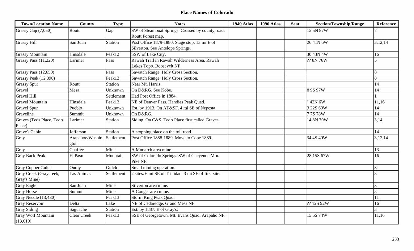
Place Names of Colorado
Town/Location Name County Type Notes 1949 Atlas 1996 Atlas Seat Section/Township/Range ReferenceGrassy Gap (7,050) Routt Gap SW of Steamboat Springs. Crossed by county road.
Routt Forest map.15 5N 87W 7
Grassy Hill San Juan Station Post Office 1879-1880. Stage stop. 13 mi E of Silverton. See Antelope Springs.
26 41N 6W 3,12,14
Grassy Mountain Hinsdale Peak12 SSW of Lake City. 30 43N 4W 16Grassy Pass (11,220) Larimer Pass Rawah Trail in Rawah Wilderness Area. Rawah
Lakes Topo. Roosevelt NF.?? 8N 76W 5
Grassy Pass (12,650) Pass Sawatch Range, Holy Cross Section. 8Grassy Peak (12,390) Peak12 Sawatch Range, Holy Cross Section. 8Grassy Spur Routt Station Near Mt. Harris. 14Gravel Mesa Unknown On D&RG. See Kobe. 8 9S 97W 14Gravel Hill Settlement Had Post Office in 1884. 1Gravel Mountain Hinsdale Peak13 NE of Denver Pass. Handies Peak Quad. " 43N 6W 11,16Gravel Spur Pueblo Unknown Est. by 1913. On AT&SF. 4 mi SE of Nepesta. 3 22S 60W 14Graveline Summit Unknown On D&RG. 7 7S 78W 14Graves (Teds Place, Ted's Place)
Larimer Station Siding. On C&S. Ted's Place first called Graves. 14 8N 70W 3,14
Grave's Cabin Jefferson Station A stopping place on the toll road. 14Gray Arapahoe/Washin
gtonSettlement Post Office 1888-1889. Move to Cope 1889. 34 4S 49W 3,12,14
Gray Chaffee Mine A Monarch area mine. 13Gray Back Peak El Paso Mountain SW of Colorado Springs. SW of Cheyenne Mtn.
Pike NF.28 15S 67W 16
Gray Copper Gulch Ouray Gulch Small mining operation. 3Gray Creek (Graycreek, Gray's Mine)
Las Animas Settlement 2 sites. 6 mi SE of Trinidad. 3 mi SE of first site. 3
G E l S J Mi Sil t i 3Gray Eagle San Juan Mine Silverton area mine. 3Gray Horse Summit Mine A Conger area mine. 3Gray Needle (13,430) Peak13 Storm King Peak Quad. 11Gray Reservoir Delta Lake NE of Cedaredge. Grand Mesa NF. ?? 12S 92W 16Gray Siding Saguache Station Est. by 1887. E of Gray's. 3Gray Wolf Mountain (13,610)
Clear Creek Peak13 SSE of Georgetown. Mt. Evans Quad. Arapaho NF. 15 5S 74W 11,16
253

Place Names of Colorado
Town/Location Name County Type Notes 1949 Atlas 1996 Atlas Seat Section/Township/Range ReferenceGrayback Costilla Settlement Est. by 1895. ? 28S 71W 14Grayback Gulch Costilla Gulch North central county. Runs SE to Placer Creek. Sev 28N 71W 16
Grayback Gulch Costilla Settlement Est. by 1923. NW of La Veta Pass. 3Grayback Mountain Rio Grande Mountain SW corner of county. N of Summitville. 3Graycreek (Chapel) Las Animas Settlement Post Office 1895-1921. Formerly Chapel. 35 33S 63W 12,14Graylin Logan Settlement Rural Post Office 1910-1917. 12 mi NW of Sterling. 20 9N 54W 3,12,14
Graymont (Graymount) Clear Creek Camp Post Office 1884. Stage stop, then RR stop, then resort.
20 4S 75W 3,12,14
Grayrock Peak (12,486) San Juan Peak12 SW corner of county. Xy ( , ) yGrays Chaffee Station Est. by 1923. RR stop on D&RG. S part of county. 11 48N 7E 3,14
Grays Las Animas Unknown On UP Denver & Gulf. ? 33S 63W 14Gray's Saguache Settlement Est. by 1885. On Tomichi Creek. 6 mi E of Marshall
Pass RR stop.3
Grays (Greys) Larimer Station Est. by 1909. On C&S. 4 mi SW of Fort Collins. See Stout.
20 7N 69W 3,14
Gray's Landing (Grays Ranch)
Las Animas Station Est. by 1860. Stage station on Santa Fe Trail. At site of El Moro.
28 32S 63W 3,14
Gray's Mine (Gray Creek) Las Animas Camp Est. by 1887. First site of Gray Creek. 3
Grays Peak (14,270) Clear Creek Peak14 NW of Argentine Pass. Front Range, Grays-Evans Group. Grays Peak Quad.
X X 8 5S 75W 3,8,11,16
Grays Ranch Huerfano Settlement Post Office 1863-1866. Moved to Trinidad. 12,14Graystone Peak (13,489) Peak13 Storm King Peak Quad. 11G B ld S ttl t Sh t li d i i ttl t 1Greaser Boulder Settlement Short lived mining settlement 1Greasewood Flats (Avalo) Weld Unknown Around site of Osgood. Later known as Avalo. 28 11N 56W 3,14
Greaswood Creek Rio Blanco Creek Flows NE to join Yellow Creek S of the White River.
3
Great Amphitheatre Ouray Hill 1881. Land formation. W of Ouray. 3Great Britain Boulder Mine Near Wall Street. 3
254
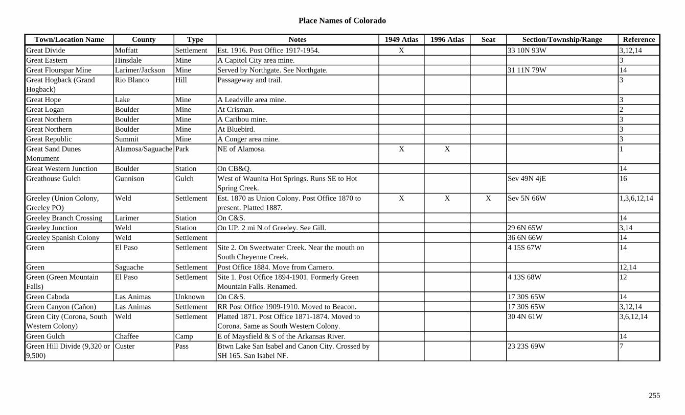
Place Names of Colorado
Town/Location Name County Type Notes 1949 Atlas 1996 Atlas Seat Section/Township/Range ReferenceGreat Divide Moffatt Settlement Est. 1916. Post Office 1917-1954. X 33 10N 93W 3,12,14Great Eastern Hinsdale Mine A Capitol City area mine. 3Great Flourspar Mine Larimer/Jackson Mine Served by Northgate. See Northgate. 31 11N 79W 14Great Hogback (Grand Hogback)
Rio Blanco Hill Passageway and trail. 3
Great Hope Lake Mine A Leadville area mine. 3Great Logan Boulder Mine At Crisman. 2Great Northern Boulder Mine A Caribou mine. 3Great Northern Boulder Mine At Bluebird. 3Great Republic Summit Mine A Conger area mine. 3Great Sand Dunes Alamosa/Saguache Park NE of Alamosa. X X 1Monument
g
Great Western Junction Boulder Station On CB&Q. 14Greathouse Gulch Gunnison Gulch West of Waunita Hot Springs. Runs SE to Hot
Spring Creek.Sev 49N 4jE 16
Greeley (Union Colony, Greeley PO)
Weld Settlement Est. 1870 as Union Colony. Post Office 1870 to present. Platted 1887.
X X X Sev 5N 66W 1,3,6,12,14
Greeley Branch Crossing Larimer Station On C&S. 14Greeley Junction Weld Station On UP. 2 mi N of Greeley. See Gill. 29 6N 65W 3,14Greeley Spanish Colony Weld Settlement 36 6N 66W 14Green El Paso Settlement Site 2. On Sweetwater Creek. Near the mouth on
South Cheyenne Creek.4 15S 67W 14
Green Saguache Settlement Post Office 1884. Move from Carnero. 12,14Green (Green Mountain Falls)
El Paso Settlement Site 1. Post Office 1894-1901. Formerly Green Mountain Falls. Renamed.
4 13S 68W 12
Green Caboda Las Animas Unknown On C&S. 17 30S 65W 14G C (C ñ ) L A i S ttl t RR P t Offi 1909 1910 M d t B 17 30S 65W 3 12 14Green Canyon (Cañon) Las Animas Settlement RR Post Office 1909-1910. Moved to Beacon. 17 30S 65W 3,12,14Green City (Corona, South Western Colony)
Weld Settlement Platted 1871. Post Office 1871-1874. Moved to Corona. Same as South Western Colony.
30 4N 61W 3,6,12,14
Green Gulch Chaffee Camp E of Maysfield & S of the Arkansas River. 14Green Hill Divide (9,320 or 9,500)
Custer Pass Btwn Lake San Isabel and Canon City. Crossed by SH 165. San Isabel NF.
23 23S 69W 7
255
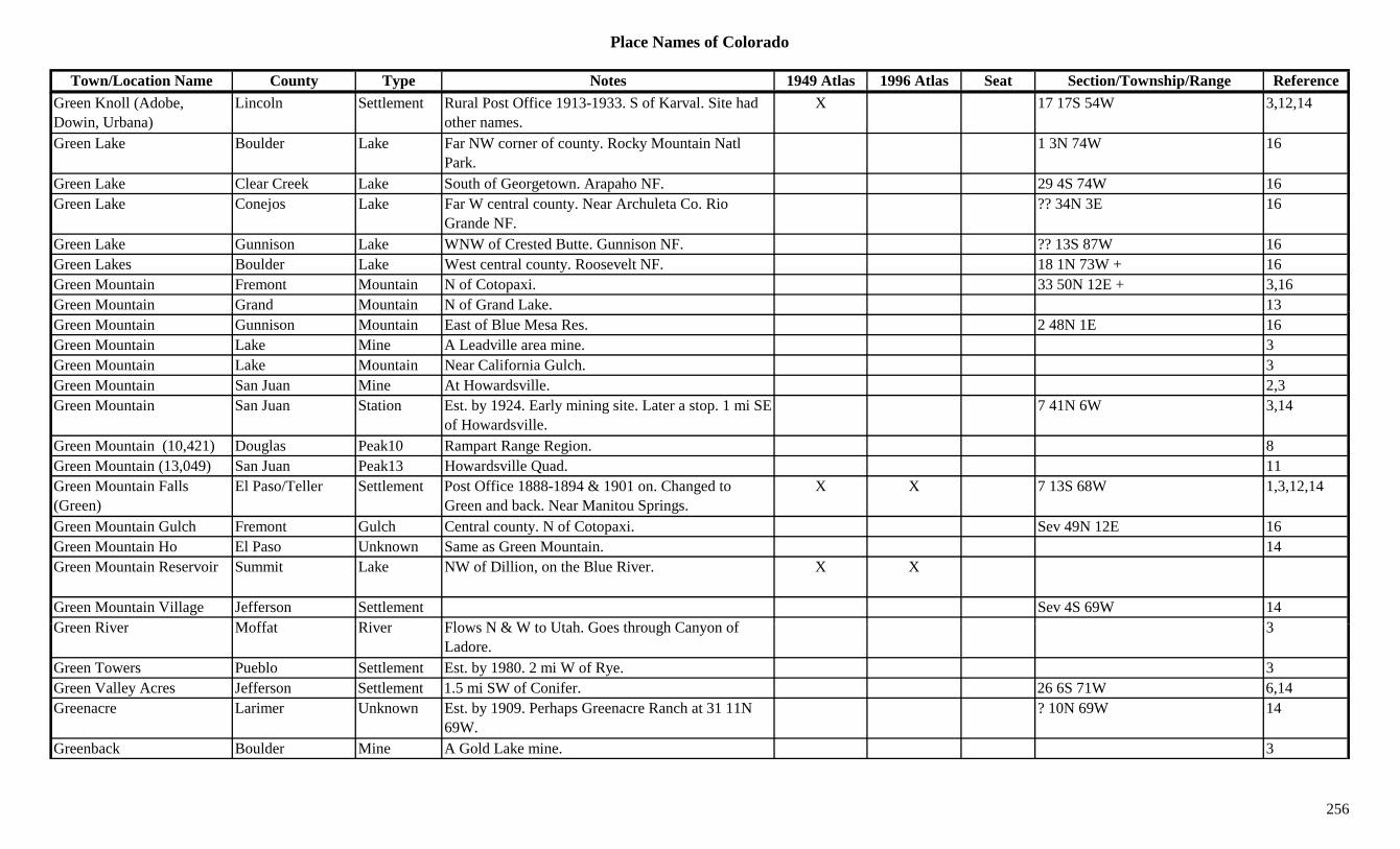
Place Names of Colorado
Town/Location Name County Type Notes 1949 Atlas 1996 Atlas Seat Section/Township/Range ReferenceGreen Knoll (Adobe, Dowin, Urbana)
Lincoln Settlement Rural Post Office 1913-1933. S of Karval. Site had other names.
X 17 17S 54W 3,12,14
Green Lake Boulder Lake Far NW corner of county. Rocky Mountain Natl Park.
1 3N 74W 16
Green Lake Clear Creek Lake South of Georgetown. Arapaho NF. 29 4S 74W 16Green Lake Conejos Lake Far W central county. Near Archuleta Co. Rio
Grande NF.?? 34N 3E 16
Green Lake Gunnison Lake WNW of Crested Butte. Gunnison NF. ?? 13S 87W 16Green Lakes Boulder Lake West central county. Roosevelt NF. 18 1N 73W + 16Green Mountain Fremont Mountain N of Cotopaxi. 33 50N 12E + 3,16Green Mountain Grand Mountain N of Grand Lake. 13Green Mountain Gunnison Mountain East of Blue Mesa Res. 2 48N 1E 16Green Mountain Lake Mine A Leadville area mine. 3Green Mountain Lake Mountain Near California Gulch. 3Green Mountain San Juan Mine At Howardsville. 2,3Green Mountain San Juan Station Est. by 1924. Early mining site. Later a stop. 1 mi SE
of Howardsville.7 41N 6W 3,14
Green Mountain (10,421) Douglas Peak10 Rampart Range Region. 8Green Mountain (13,049) San Juan Peak13 Howardsville Quad. 11Green Mountain Falls (Green)
El Paso/Teller Settlement Post Office 1888-1894 & 1901 on. Changed to Green and back. Near Manitou Springs.
X X 7 13S 68W 1,3,12,14
Green Mountain Gulch Fremont Gulch Central county. N of Cotopaxi. Sev 49N 12E 16Green Mountain Ho El Paso Unknown Same as Green Mountain. 14Green Mountain Reservoir Summit Lake NW of Dillion, on the Blue River. X X
Green Mountain Village Jefferson Settlement Sev 4S 69W 14G Ri M ff t Ri Fl N & W t Ut h G th h C f 3Green River Moffat River Flows N & W to Utah. Goes through Canyon of
Ladore.3
Green Towers Pueblo Settlement Est. by 1980. 2 mi W of Rye. 3Green Valley Acres Jefferson Settlement 1.5 mi SW of Conifer. 26 6S 71W 6,14Greenacre Larimer Unknown Est. by 1909. Perhaps Greenacre Ranch at 31 11N
69W.? 10N 69W 14
Greenback Boulder Mine A Gold Lake mine. 3
256

Place Names of Colorado
Town/Location Name County Type Notes 1949 Atlas 1996 Atlas Seat Section/Township/Range ReferenceGreenback Lake Mine A Leadville area mine. 3Greenback Lake Station On D&RG. 30 9S 79W 14Greenback Mineral Mine 3Greenback Mountain San Miguel Mountain N of San Miguel. Near Ouray Co. 3Greendale Fremont Unknown On Beaver Creek. 15 mi N of its mouth. ? 17S 68W 14Greene & Co. Smelter San Juan Mill Silverton area mill. 3Greenfield Las Animas Settlement Platted 1922. 9 mi SW of Tobe. No Post Office. 3,14
Greenhalgh Mountain (13,220)
Peak13 Howardsville Quad. 11
Greenhorn Boulder Mine N of Nederland. 3Greenhorn Pueblo Settlement Site 3. Post Office 1866-1911. Also shown at 32 24S
65W.X 2 23S 67W 14
Greenhorn (Hicklin's) Pueblo Station Site 1. 1846-7. Small Post Office. 2 25S 67W 3,4,14Greenhorn Creek Pueblo Creek Flows E from Rye to join Graneros Creek. 3Greenhorn Mountain (12,349)
Huerfano Peak12 Wet Mountains (Cuerna Verde Range). X X 3,8
Greenhorn Station Pueblo Station Site 2. Est. by 1882. On D&RGW. 2 mi NW of Marnel.
3 23S 65W 3,14
Greenlake (Green Lake) Clear Creek Camp Up from Silver Dale. On Green Lake. 29 4S 74W 3,14Greenland Douglas Settlement Post Office 1873-1959. Began as D&RG RR town. X 2 25S 67W 3,14
Greenlee's Creek Custer Creek 1885. W of Dyerville (Overville). 3Green's Gulch Chaffee Camp Babcock area. 3,14Greensboro (Green City, Corona)
Weld Settlement First name of Southwestern Colony. Renamed Green City, then Corona.
? 4N 61W 14
G ill L A i U k O C&S 29 31S 64W 14Greenville Las Animas Unknown On C&S. 29 31S 64W 14Greenville Routt Camp At Greenville Mine. SE of Clark. On Big Creek. 18 8N 84W 3,14
Greenville (Silverton) San Juan Settlement Early name for Silverton (before 1875). 1,14Greenville Mine Routt Mine At Greenville. SE of Clark. 3Greenwood Fremont/Custer Settlement Post Office 1872-1918. RR town and Post Office. X X 22 21S 69W 3,12,14
257

Place Names of Colorado
Town/Location Name County Type Notes 1949 Atlas 1996 Atlas Seat Section/Township/Range ReferenceGreenwood Pueblo Settlement 1 25S 68W 14Greenwood Summit Mine A Conger area mine. 3Greenwood Village Arapahoe Settlement Est. 1850. Sev 5S 68W 6,14Greer Smelter Summit Mill A Kokomo area mining operation. 3Gregoria Creek Costilla Creek Flows W to San Pablo. 3Gregory Gilpin Camp One of 7 camps on Gregory Gulch. 3Gregory Gilpin Mine A Gregory Gulch mine. 3Gregory Canyon Boulder Canyon Once an old stage road. SW of Boulder. 1,3Gregory Gulch Gilpin Gulch 1859 gold disc.by John Gregory. Btwn Black Hawk
& Central City.2
Gregory Hill Gilpin Hill SE of Central City. 3g y p yGregory II Gilpin Mine A Gregory Gulch mine. 3Gregory Point Gilpin Camp Obscure camp on the gulch. Close to Central City. 3
Gregory's Diggings Gilpin Settlement Early name for Central City-Blackhawk area. 7 3S 72W 14Grenada (Granada) Bent/Prowers Settlement Post Office est. 1873. Name changed to Granada. 15 23S 43W 14
Grenadiers San Juan Misc In the San Juan mountains. 1Grenadiers Range Part of San Juans. 15Grenfell Boulder Station SW of Longmont. Also shown at 16 2N 69W. 26 3N 69W 6,14Gresham Boulder Camp Post Office 1895-1912. 3.5 mi NW of Jamestown. 15 2N 72W 1,3,6,12,14
Gresham Garfield Settlement Post Office 1883-1884. Settlement NE of New Castle.
13 4S 90W 3,12,14
Grey Creek Las Animas Settlement Est. by 1895. A coal mining town on Gray Creek. ? 33S 65W 14
G b k G l h C till U k 9 28S 71W 14Greyback Gulch Costilla Unknown 9 28S 71W 14Greylock Mountain (13,575)
Peak13 Columbine Pass Quad. 11
Greys (Grays) Larimer Station Est. by 1909. On C&S. 4 mi SW of Fort Collins. See Stout.
3
Greystone Moffat Settlement Est. abt 1882. Post Office 1921-1975. In Brown's Hole area.
X X 30 8N 100W 3,12,14
258
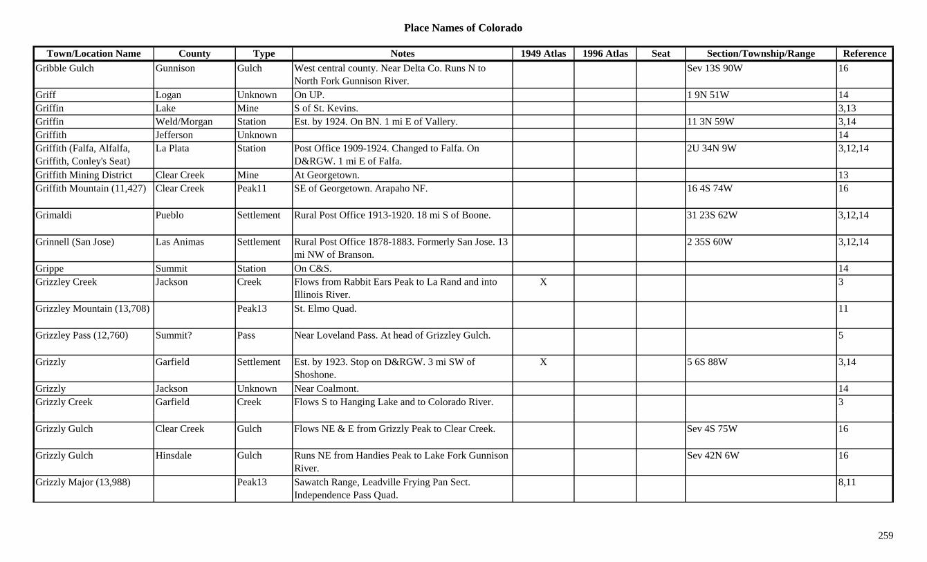
Place Names of Colorado
Town/Location Name County Type Notes 1949 Atlas 1996 Atlas Seat Section/Township/Range ReferenceGribble Gulch Gunnison Gulch West central county. Near Delta Co. Runs N to
North Fork Gunnison River.Sev 13S 90W 16
Griff Logan Unknown On UP. 1 9N 51W 14Griffin Lake Mine S of St. Kevins. 3,13Griffin Weld/Morgan Station Est. by 1924. On BN. 1 mi E of Vallery. 11 3N 59W 3,14Griffith Jefferson Unknown 14Griffith (Falfa, Alfalfa, Griffith, Conley's Seat)
La Plata Station Post Office 1909-1924. Changed to Falfa. On D&RGW. 1 mi E of Falfa.
2U 34N 9W 3,12,14
Griffith Mining District Clear Creek Mine At Georgetown. 13Griffith Mountain (11,427) Clear Creek Peak11 SE of Georgetown. Arapaho NF. 16 4S 74W 16
Grimaldi Pueblo Settlement Rural Post Office 1913-1920. 18 mi S of Boone. 31 23S 62W 3,12,14
Grinnell (San Jose) Las Animas Settlement Rural Post Office 1878-1883. Formerly San Jose. 13 mi NW of Branson.
2 35S 60W 3,12,14
Grippe Summit Station On C&S. 14Grizzley Creek Jackson Creek Flows from Rabbit Ears Peak to La Rand and into
Illinois River.X 3
Grizzley Mountain (13,708) Peak13 St. Elmo Quad. 11
Grizzley Pass (12,760) Summit? Pass Near Loveland Pass. At head of Grizzley Gulch. 5
Grizzly Garfield Settlement Est. by 1923. Stop on D&RGW. 3 mi SW of Shoshone.
X 5 6S 88W 3,14
Grizzly Jackson Unknown Near Coalmont. 14Grizzly Creek Garfield Creek Flows S to Hanging Lake and to Colorado River. 3
Grizzly Gulch Clear Creek Gulch Flows NE & E from Grizzly Peak to Clear Creek. Sev 4S 75W 16
Grizzly Gulch Hinsdale Gulch Runs NE from Handies Peak to Lake Fork Gunnison River.
Sev 42N 6W 16
Grizzly Major (13,988) Peak13 Sawatch Range, Leadville Frying Pan Sect. Independence Pass Quad.
8,11
259
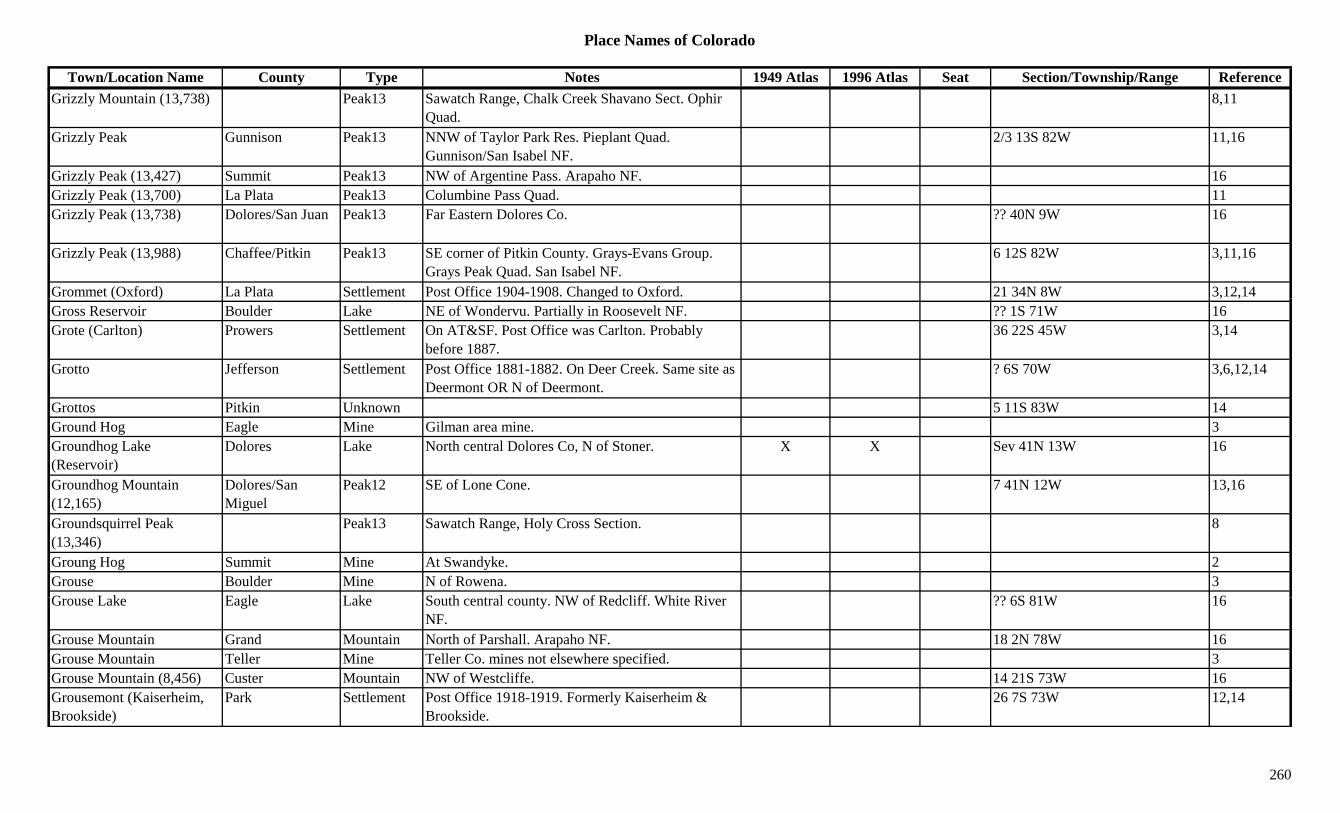
Place Names of Colorado
Town/Location Name County Type Notes 1949 Atlas 1996 Atlas Seat Section/Township/Range ReferenceGrizzly Mountain (13,738) Peak13 Sawatch Range, Chalk Creek Shavano Sect. Ophir
Quad.8,11
Grizzly Peak Gunnison Peak13 NNW of Taylor Park Res. Pieplant Quad. Gunnison/San Isabel NF.
2/3 13S 82W 11,16
Grizzly Peak (13,427) Summit Peak13 NW of Argentine Pass. Arapaho NF. 16Grizzly Peak (13,700) La Plata Peak13 Columbine Pass Quad. 11Grizzly Peak (13,738) Dolores/San Juan Peak13 Far Eastern Dolores Co. ?? 40N 9W 16
Grizzly Peak (13,988) Chaffee/Pitkin Peak13 SE corner of Pitkin County. Grays-Evans Group. Grays Peak Quad. San Isabel NF.
6 12S 82W 3,11,16
Grommet (Oxford) La Plata Settlement Post Office 1904-1908. Changed to Oxford. 21 34N 8W 3,12,14( ) g , ,Gross Reservoir Boulder Lake NE of Wondervu. Partially in Roosevelt NF. ?? 1S 71W 16Grote (Carlton) Prowers Settlement On AT&SF. Post Office was Carlton. Probably
before 1887.36 22S 45W 3,14
Grotto Jefferson Settlement Post Office 1881-1882. On Deer Creek. Same site as Deermont OR N of Deermont.
? 6S 70W 3,6,12,14
Grottos Pitkin Unknown 5 11S 83W 14Ground Hog Eagle Mine Gilman area mine. 3Groundhog Lake (Reservoir)
Dolores Lake North central Dolores Co, N of Stoner. X X Sev 41N 13W 16
Groundhog Mountain (12,165)
Dolores/San Miguel
Peak12 SE of Lone Cone. 7 41N 12W 13,16
Groundsquirrel Peak (13,346)
Peak13 Sawatch Range, Holy Cross Section. 8
Groung Hog Summit Mine At Swandyke. 2Grouse Boulder Mine N of Rowena. 3G L k E l L k S th t l t NW f R d liff Whit Ri ?? 6S 81W 16Grouse Lake Eagle Lake South central county. NW of Redcliff. White River
NF.?? 6S 81W 16
Grouse Mountain Grand Mountain North of Parshall. Arapaho NF. 18 2N 78W 16Grouse Mountain Teller Mine Teller Co. mines not elsewhere specified. 3Grouse Mountain (8,456) Custer Mountain NW of Westcliffe. 14 21S 73W 16Grousemont (Kaiserheim, Brookside)
Park Settlement Post Office 1918-1919. Formerly Kaiserheim & Brookside.
26 7S 73W 12,14
260
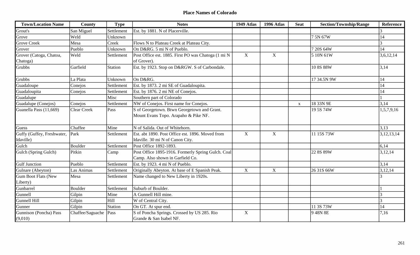
Place Names of Colorado
Town/Location Name County Type Notes 1949 Atlas 1996 Atlas Seat Section/Township/Range ReferenceGrout's San Miguel Settlement Est. by 1881. N of Placerville. 3Grove Weld Unknown 7 5N 67W 14Grove Creek Mesa Creek Flows N to Plateau Creek at Plateau City. 3Grover Pueblo Unknown On D&RG. 5 mi N of Pueblo. 7 20S 64W 14Grover (Catoga, Chatoa, Chatoga)
Weld Settlement Post Office est. 1885. First PO was Chatoga (1 mi N of Grover).
X X 5 10N 61W 3,6,12,14
Grubbs Garfield Station Est. by 1923. Stop on D&RGW. S of Carbondale. 10 8S 88W 3,14
Grubbs La Plata Unknown On D&RG. 17 34.5N 9W 14Guadaloupe Conejos Settlement Est. by 1873. 2 mi SE of Guadaloupita. 14Guadaloupita Conejos Settlement Est. by 1876. 2 mi NE of Conejos. 14p j y jGuadalupe Misc Southern part of Colorado 1Guadalupe (Conejos) Conejos Settlement NW of Conejos. First name for Conejos. x 18 33N 9E 3,14Guanella Pass (11,669) Clear Creek Pass S of Georgetown. Btwn Georgetown and Grant.
Mount Evans Topo. Arapaho & Pike NF.19 5S 74W 1,5,7,9,16
Guess Chaffee Mine N of Salida. Out of Whitehorn. 3,13Guffy (Guffey, Freshwater, Idaville)
Park Settlement Est. abt 1890. Post Office est. 1896. Moved from Idaville. 30 mi N of Canon City.
X X 11 15S 73W 3,12,13,14
Gulch Boulder Settlement Post Office 1892-1893. 6,14Gulch (Spring Gulch) Pitkin Camp Post Office 1895-1916. Formerly Spring Gulch. Coal
Camp. Also shown in Garfield Co.22 8S 89W 3,12,14
Gulf Junction Pueblo Settlement Est. by 1923. 4 mi N of Pueblo. 3,14Gulnare (Abeyton) Las Animas Settlement Originally Abeyton. At base of E Spanish Peak. X X 26 31S 66W 3,12,14Gum Boot Flats (New Liberty)
Mesa Settlement Name changed to New Liberty in 1920s. 3
G b l B ld S ttl t S b b f B ld 1Gunbarrel Boulder Settlement Suburb of Boulder. 1Gunnell Gilpin Mine A Gunnell Hill mine. 3Gunnell Hill Gilpin Hill W of Central City. 3Gunner Gilpin Station On GT. At spur end. 11 3S 73W 14Gunnison (Poncha) Pass (9,010)
Chaffee/Saguache Pass S of Poncha Springs. Crossed by US 285. Rio Grande & San Isabel NF.
X 9 48N 8E 7,16
261
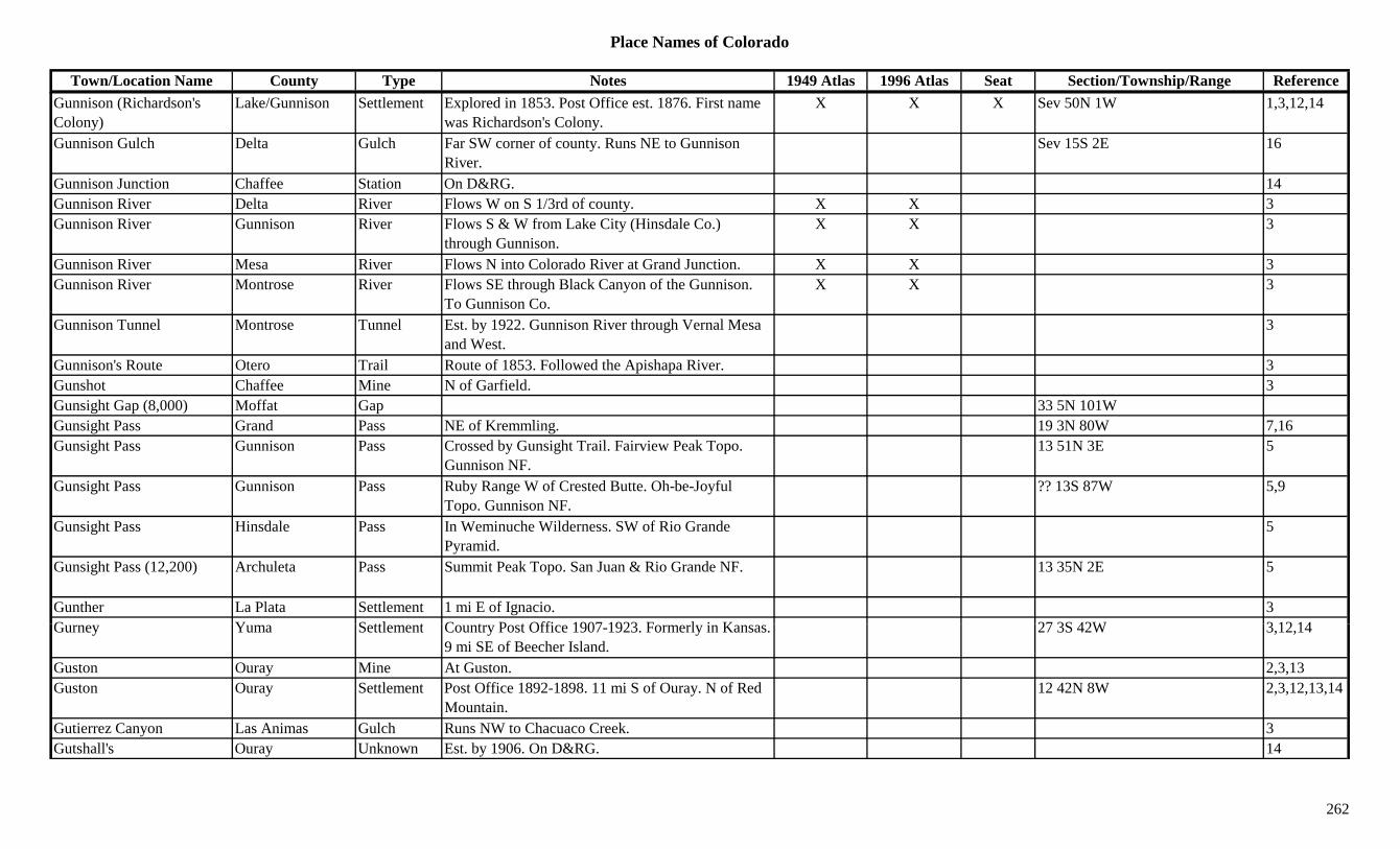
Place Names of Colorado
Town/Location Name County Type Notes 1949 Atlas 1996 Atlas Seat Section/Township/Range ReferenceGunnison (Richardson's Colony)
Lake/Gunnison Settlement Explored in 1853. Post Office est. 1876. First name was Richardson's Colony.
X X X Sev 50N 1W 1,3,12,14
Gunnison Gulch Delta Gulch Far SW corner of county. Runs NE to Gunnison River.
Sev 15S 2E 16
Gunnison Junction Chaffee Station On D&RG. 14Gunnison River Delta River Flows W on S 1/3rd of county. X X 3Gunnison River Gunnison River Flows S & W from Lake City (Hinsdale Co.)
through Gunnison.X X 3
Gunnison River Mesa River Flows N into Colorado River at Grand Junction. X X 3Gunnison River Montrose River Flows SE through Black Canyon of the Gunnison.
To Gunnison Co.X X 3
Gunnison Tunnel Montrose Tunnel Est. by 1922. Gunnison River through Vernal Mesa and West.
3
Gunnison's Route Otero Trail Route of 1853. Followed the Apishapa River. 3Gunshot Chaffee Mine N of Garfield. 3Gunsight Gap (8,000) Moffat Gap 33 5N 101WGunsight Pass Grand Pass NE of Kremmling. 19 3N 80W 7,16Gunsight Pass Gunnison Pass Crossed by Gunsight Trail. Fairview Peak Topo.
Gunnison NF.13 51N 3E 5
Gunsight Pass Gunnison Pass Ruby Range W of Crested Butte. Oh-be-Joyful Topo. Gunnison NF.
?? 13S 87W 5,9
Gunsight Pass Hinsdale Pass In Weminuche Wilderness. SW of Rio Grande Pyramid.
5
Gunsight Pass (12,200) Archuleta Pass Summit Peak Topo. San Juan & Rio Grande NF. 13 35N 2E 5
Gunther La Plata Settlement 1 mi E of Ignacio. 3G Y S ttl t C t P t Offi 1907 1923 F l i K 27 3S 42W 3 12 14Gurney Yuma Settlement Country Post Office 1907-1923. Formerly in Kansas.
9 mi SE of Beecher Island.27 3S 42W 3,12,14
Guston Ouray Mine At Guston. 2,3,13Guston Ouray Settlement Post Office 1892-1898. 11 mi S of Ouray. N of Red
Mountain.12 42N 8W 2,3,12,13,14
Gutierrez Canyon Las Animas Gulch Runs NW to Chacuaco Creek. 3Gutshall's Ouray Unknown Est. by 1906. On D&RG. 14
262
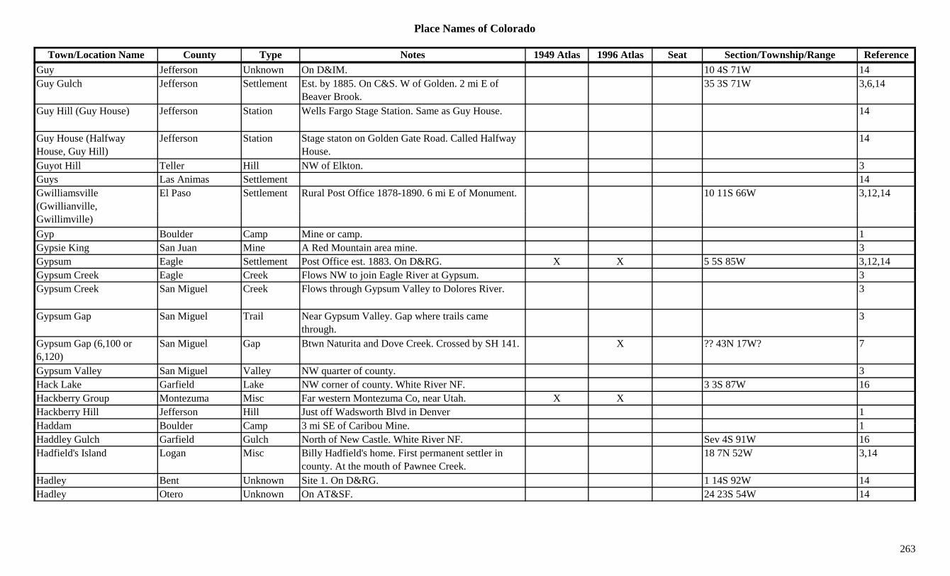
Place Names of Colorado
Town/Location Name County Type Notes 1949 Atlas 1996 Atlas Seat Section/Township/Range ReferenceGuy Jefferson Unknown On D&IM. 10 4S 71W 14Guy Gulch Jefferson Settlement Est. by 1885. On C&S. W of Golden. 2 mi E of
Beaver Brook.35 3S 71W 3,6,14
Guy Hill (Guy House) Jefferson Station Wells Fargo Stage Station. Same as Guy House. 14
Guy House (Halfway House, Guy Hill)
Jefferson Station Stage staton on Golden Gate Road. Called Halfway House.
14
Guyot Hill Teller Hill NW of Elkton. 3Guys Las Animas Settlement 14Gwilliamsville (Gwillianville,
El Paso Settlement Rural Post Office 1878-1890. 6 mi E of Monument. 10 11S 66W 3,12,14
Gwillimville)Gyp Boulder Camp Mine or camp. 1Gypsie King San Juan Mine A Red Mountain area mine. 3Gypsum Eagle Settlement Post Office est. 1883. On D&RG. X X 5 5S 85W 3,12,14Gypsum Creek Eagle Creek Flows NW to join Eagle River at Gypsum. 3Gypsum Creek San Miguel Creek Flows through Gypsum Valley to Dolores River. 3
Gypsum Gap San Miguel Trail Near Gypsum Valley. Gap where trails came through.
3
Gypsum Gap (6,100 or 6,120)
San Miguel Gap Btwn Naturita and Dove Creek. Crossed by SH 141. X ?? 43N 17W? 7
Gypsum Valley San Miguel Valley NW quarter of county. 3Hack Lake Garfield Lake NW corner of county. White River NF. 3 3S 87W 16Hackberry Group Montezuma Misc Far western Montezuma Co, near Utah. X XHackberry Hill Jefferson Hill Just off Wadsworth Blvd in Denver 1H dd B ld C 3 i SE f C ib Mi 1Haddam Boulder Camp 3 mi SE of Caribou Mine. 1Haddley Gulch Garfield Gulch North of New Castle. White River NF. Sev 4S 91W 16Hadfield's Island Logan Misc Billy Hadfield's home. First permanent settler in
county. At the mouth of Pawnee Creek.18 7N 52W 3,14
Hadley Bent Unknown Site 1. On D&RG. 1 14S 92W 14Hadley Otero Unknown On AT&SF. 24 23S 54W 14
263
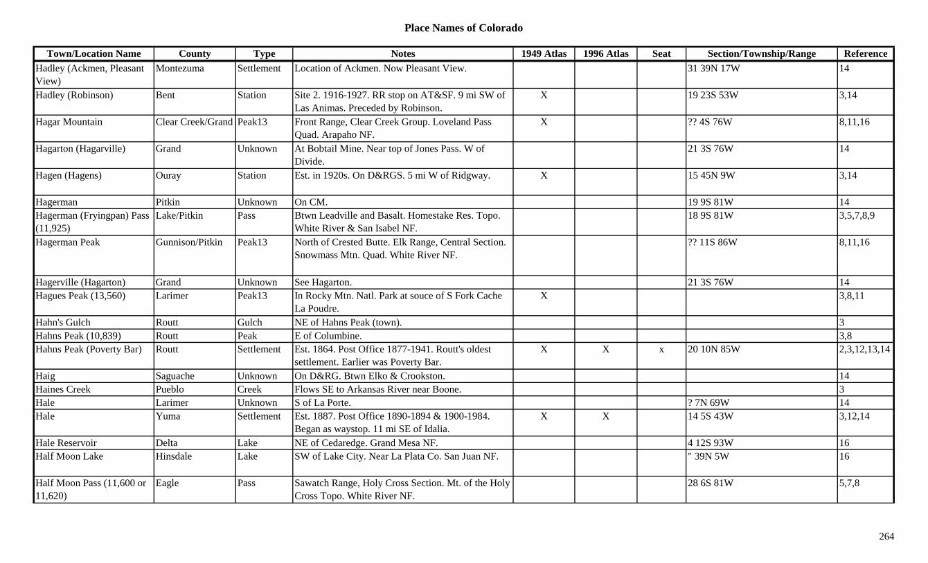
Place Names of Colorado
Town/Location Name County Type Notes 1949 Atlas 1996 Atlas Seat Section/Township/Range ReferenceHadley (Ackmen, Pleasant View)
Montezuma Settlement Location of Ackmen. Now Pleasant View. 31 39N 17W 14
Hadley (Robinson) Bent Station Site 2. 1916-1927. RR stop on AT&SF. 9 mi SW of Las Animas. Preceded by Robinson.
X 19 23S 53W 3,14
Hagar Mountain Clear Creek/Grand Peak13 Front Range, Clear Creek Group. Loveland Pass Quad. Arapaho NF.
X ?? 4S 76W 8,11,16
Hagarton (Hagarville) Grand Unknown At Bobtail Mine. Near top of Jones Pass. W of Divide.
21 3S 76W 14
Hagen (Hagens) Ouray Station Est. in 1920s. On D&RGS. 5 mi W of Ridgway. X 15 45N 9W 3,14
Hagerman Pitkin Unknown On CM. 19 9S 81W 14gHagerman (Fryingpan) Pass (11,925)
Lake/Pitkin Pass Btwn Leadville and Basalt. Homestake Res. Topo. White River & San Isabel NF.
18 9S 81W 3,5,7,8,9
Hagerman Peak Gunnison/Pitkin Peak13 North of Crested Butte. Elk Range, Central Section. Snowmass Mtn. Quad. White River NF.
?? 11S 86W 8,11,16
Hagerville (Hagarton) Grand Unknown See Hagarton. 21 3S 76W 14Hagues Peak (13,560) Larimer Peak13 In Rocky Mtn. Natl. Park at souce of S Fork Cache
La Poudre.X 3,8,11
Hahn's Gulch Routt Gulch NE of Hahns Peak (town). 3Hahns Peak (10,839) Routt Peak E of Columbine. 3,8Hahns Peak (Poverty Bar) Routt Settlement Est. 1864. Post Office 1877-1941. Routt's oldest
settlement. Earlier was Poverty Bar.X X x 20 10N 85W 2,3,12,13,14
Haig Saguache Unknown On D&RG. Btwn Elko & Crookston. 14Haines Creek Pueblo Creek Flows SE to Arkansas River near Boone. 3Hale Larimer Unknown S of La Porte. ? 7N 69W 14H l Y S ttl t E t 1887 P t Offi 1890 1894 & 1900 1984 X X 14 5S 43W 3 12 14Hale Yuma Settlement Est. 1887. Post Office 1890-1894 & 1900-1984.
Began as waystop. 11 mi SE of Idalia.X X 14 5S 43W 3,12,14
Hale Reservoir Delta Lake NE of Cedaredge. Grand Mesa NF. 4 12S 93W 16Half Moon Lake Hinsdale Lake SW of Lake City. Near La Plata Co. San Juan NF. " 39N 5W 16
Half Moon Pass (11,600 or 11,620)
Eagle Pass Sawatch Range, Holy Cross Section. Mt. of the Holy Cross Topo. White River NF.
28 6S 81W 5,7,8
264
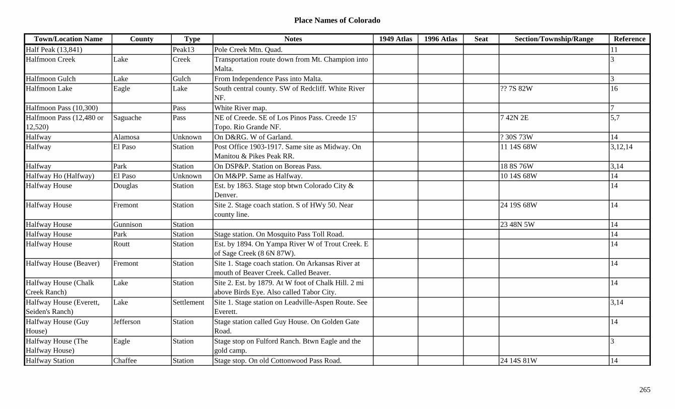
Place Names of Colorado
Town/Location Name County Type Notes 1949 Atlas 1996 Atlas Seat Section/Township/Range ReferenceHalf Peak (13,841) Peak13 Pole Creek Mtn. Quad. 11Halfmoon Creek Lake Creek Transportation route down from Mt. Champion into
Malta.3
Halfmoon Gulch Lake Gulch From Independence Pass into Malta. 3Halfmoon Lake Eagle Lake South central county. SW of Redcliff. White River
NF.?? 7S 82W 16
Halfmoon Pass (10,300) Pass White River map. 7Halfmoon Pass (12,480 or 12,520)
Saguache Pass NE of Creede. SE of Los Pinos Pass. Creede 15' Topo. Rio Grande NF.
7 42N 2E 5,7
Halfway Alamosa Unknown On D&RG. W of Garland. ? 30S 73W 14Halfway El Paso Station Post Office 1903-1917. Same site as Midway. On 11 14S 68W 3,12,14y y
Manitou & Pikes Peak RR., ,
Halfway Park Station On DSP&P. Station on Boreas Pass. 18 8S 76W 3,14Halfway Ho (Halfway) El Paso Unknown On M&PP. Same as Halfway. 10 14S 68W 14Halfway House Douglas Station Est. by 1863. Stage stop btwn Colorado City &
Denver.14
Halfway House Fremont Station Site 2. Stage coach station. S of HWy 50. Near county line.
24 19S 68W 14
Halfway House Gunnison Station 23 48N 5W 14Halfway House Park Station Stage station. On Mosquito Pass Toll Road. 14Halfway House Routt Station Est. by 1894. On Yampa River W of Trout Creek. E
of Sage Creek (8 6N 87W).14
Halfway House (Beaver) Fremont Station Site 1. Stage coach station. On Arkansas River at mouth of Beaver Creek. Called Beaver.
14
Halfway House (Chalk Creek Ranch)
Lake Station Site 2. Est. by 1879. At W foot of Chalk Hill. 2 mi above Birds Eye. Also called Tabor City.
14
H lf H (E tt L k S ttl t Sit 1 St t ti L d ill A R t S 3 14Halfway House (Everett, Seiden's Ranch)
Lake Settlement Site 1. Stage station on Leadville-Aspen Route. See Everett.
3,14
Halfway House (Guy House)
Jefferson Station Stage station called Guy House. On Golden Gate Road.
14
Halfway House (The Halfway House)
Eagle Station Stage stop on Fulford Ranch. Btwn Eagle and the gold camp.
3
Halfway Station Chaffee Station Stage stop. On old Cottonwood Pass Road. 24 14S 81W 14
265
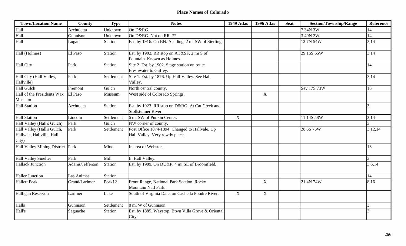
Place Names of Colorado
Town/Location Name County Type Notes 1949 Atlas 1996 Atlas Seat Section/Township/Range ReferenceHall Archuletta Unknown On D&RG. 7 34N 3W 14Hall Gunnison Unknown On D&RG. Not on RR. ?? 3 49N 2W 14Hall Logan Station Est. by 1916. On BN. A siding. 2 mi SW of Sterling. 13 7N 54W 3,14
Hall (Holmes) El Paso Station Est. by 1902. RR stop on AT&SF. 2 mi S of Fountain. Known as Holmes.
29 16S 65W 3,14
Hall City Park Station Site 2. Est. by 1902. Stage station on route Freshwater to Guffey.
14
Hall City (Hall Valley, Hallville)
Park Settlement Site 1. Est. by 1876. Up Hall Valley. See Hall Valley.
3,14
Hall Gulch Fremont Gulch North central county. Sev 17S 73W 16yHall of the Presidents Wax Museum
El Paso Museum West side of Colorado Springs. X
Hall Station Archuleta Station Est. by 1923. RR stop on D&RG. At Cat Creek and Stollsteimer River.
3
Hall Station Lincoln Settlement 6 mi SW of Punkin Center. X 11 14S 58W 3,14Hall Valley (Hall's Gulch) Park Gulch NW corner of county. 3Hall Valley (Hall's Gulch, Hallvale, Hallville, Hall City)
Park Settlement Post Office 1874-1894. Changed to Hallvale. Up Hall Valley. Very rowdy place.
28 6S 75W 3,12,14
Hall Valley Mining District Park Mine In area of Webster. 13
Hall Valley Smelter Park Mill In Hall Valley. 3Hallack Junction Adams/Jefferson Station Est. by 1909. On DU&P. 4 mi SE of Broomfield. 3,6,14
Haller Junction Las Animas Station 14H ll tt P k G d/L i P k12 F t R N ti l P k S ti R k X 21 4N 74W 8 16Hallett Peak Grand/Larimer Peak12 Front Range, National Park Section. Rocky
Mountain Natl Park.X 21 4N 74W 8,16
Halligan Reservoir Larimer Lake South of Virginia Dale, on Cache la Poudre River. X X
Halls Gunnison Settlement 8 mi W of Gunnison. 3Hall's Saguache Station Est. by 1885. Waystop. Btwn Villa Grove & Oriental
City.3
266
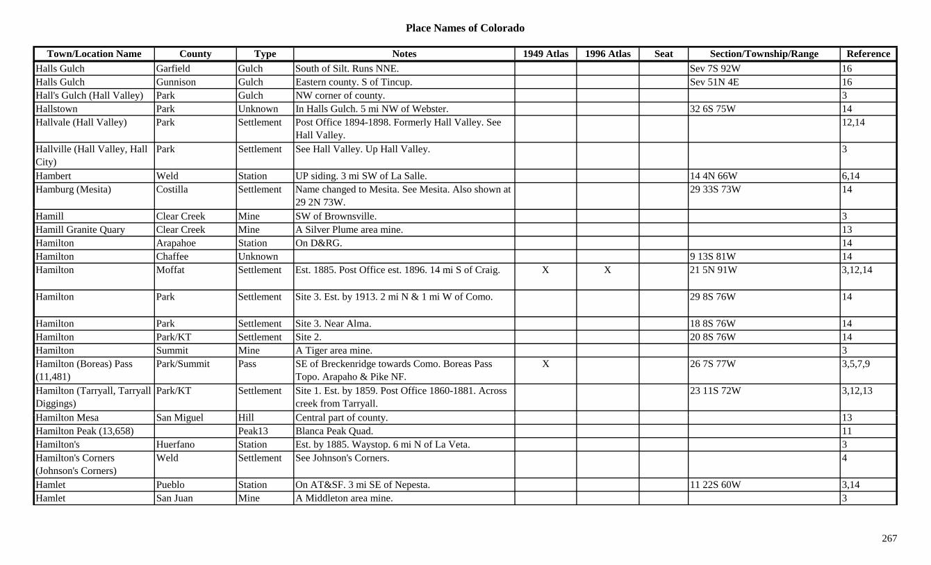
Place Names of Colorado
Town/Location Name County Type Notes 1949 Atlas 1996 Atlas Seat Section/Township/Range ReferenceHalls Gulch Garfield Gulch South of Silt. Runs NNE. Sev 7S 92W 16Halls Gulch Gunnison Gulch Eastern county. S of Tincup. Sev 51N 4E 16Hall's Gulch (Hall Valley) Park Gulch NW corner of county. 3Hallstown Park Unknown In Halls Gulch. 5 mi NW of Webster. 32 6S 75W 14Hallvale (Hall Valley) Park Settlement Post Office 1894-1898. Formerly Hall Valley. See
Hall Valley.12,14
Hallville (Hall Valley, Hall City)
Park Settlement See Hall Valley. Up Hall Valley. 3
Hambert Weld Station UP siding. 3 mi SW of La Salle. 14 4N 66W 6,14Hamburg (Mesita) Costilla Settlement Name changed to Mesita. See Mesita. Also shown at
29 2N 73W.29 33S 73W 14
Hamill Clear Creek Mine SW of Brownsville. 3Hamill Granite Quary Clear Creek Mine A Silver Plume area mine. 13Hamilton Arapahoe Station On D&RG. 14Hamilton Chaffee Unknown 9 13S 81W 14Hamilton Moffat Settlement Est. 1885. Post Office est. 1896. 14 mi S of Craig. X X 21 5N 91W 3,12,14
Hamilton Park Settlement Site 3. Est. by 1913. 2 mi N & 1 mi W of Como. 29 8S 76W 14
Hamilton Park Settlement Site 3. Near Alma. 18 8S 76W 14Hamilton Park/KT Settlement Site 2. 20 8S 76W 14Hamilton Summit Mine A Tiger area mine. 3Hamilton (Boreas) Pass (11,481)
Park/Summit Pass SE of Breckenridge towards Como. Boreas Pass Topo. Arapaho & Pike NF.
X 26 7S 77W 3,5,7,9
Hamilton (Tarryall, Tarryall Diggings)
Park/KT Settlement Site 1. Est. by 1859. Post Office 1860-1881. Across creek from Tarryall.
23 11S 72W 3,12,13
H ilt M S Mi l Hill C t l t f t 13Hamilton Mesa San Miguel Hill Central part of county. 13Hamilton Peak (13,658) Peak13 Blanca Peak Quad. 11Hamilton's Huerfano Station Est. by 1885. Waystop. 6 mi N of La Veta. 3Hamilton's Corners (Johnson's Corners)
Weld Settlement See Johnson's Corners. 4
Hamlet Pueblo Station On AT&SF. 3 mi SE of Nepesta. 11 22S 60W 3,14Hamlet San Juan Mine A Middleton area mine. 3
267
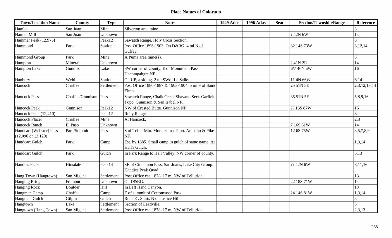
Place Names of Colorado
Town/Location Name County Type Notes 1949 Atlas 1996 Atlas Seat Section/Township/Range ReferenceHamlet San Juan Mine Silverton area mine. 3Hamlet Mill San Juan Unknown ? 42N 6W 14Hammer Peak (12,975) Peak12 Sawatch Range, Holy Cross Section. 8Hammond Park Station Post Office 1896-1903. On D&RG. 4 mi N of
Guffey.32 14S 73W 3,12,14
Hammond Group Park Mine A Puma area mine(s). 3Hampton Mineral Unknown ? 41N 2E 14Hampton Lake Gunnison Lake SW corner of county. E of Monument Pass.
Uncompahgre NF.6/7 46N 6W 16
Hanbury Weld Station On UP, a siding. 2 mi SWof La Salle. 11 4N 66W 6,14Hancock Chaffee Settlement Post Office 1880-1887 & 1903-1904. 5 mi S of Saint 25 51N 5E 2,3,12,13,14
Elmo., , , ,
Hancock Pass Chaffee/Gunnison Pass Sawatch Range, Chalk Creek Shavano Sect. Garfield Topo. Gunnison & San Isabel NF.
35 51N 5E 5,8,9,16
Hancock Peak Gunnison Peak12 NW of Crested Butte. Gunnison NF. ?? 13S 87W 16Hancock Peak (12,410) Peak12 Ruby Range. 8Hancock Placer Chaffee Mine At Hancock. 2,3Hancock Ranch El Paso Unknown 7 16S 61W 14Handcart (Webster) Pass (12,096 or 12,120)
Park/Summit Pass S of Teller Mtn. Montezuma Topo. Arapaho & Pike NF.
12 6S 75W 3,5,7,8,9
Handcart Gulch Park Camp Est. by 1885. Small camp in gulch of same name. At Hall's Gulch.
1,3,14
Handcart Gulch Park Gulch In Park Range to Hall Valley. NW corner of county. 3,13
Handies Peak Hinsdale Peak14 SE of Cinnamon Pass. San Juans, Lake City Group. Handies Peak Quad.
?? 42N 6W 8,11,16
H T (H t ) S Mi l S ttl t P t Offi t 1878 17 i NW f T ll id 13Hang Town (Hangtown) San Miguel Settlement Post Office est. 1878. 17 mi NW of Telluride. 13Hanging Bridge Fremont Unknown On D&RG. 22 18S 71W 14Hanging Rock Boulder Hill In Left Hand Canyon. 13Hangman Camp Chaffee Camp E of summit of Cottonwood Pass 24 14S 81W 1,3,14Hangman Gulch Gilpin Gulch Runs E . Starts N of Justice Hill. 3Hangtown Lake Settlement Section of Leadville. 3Hangtown (Hang Town) San Miguel Settlement Post Office est. 1878. 17 mi NW of Telluride. 2,3,13
268
Place Names of Colorado
Town/Location Name County Type Notes 1949 Atlas 1996 Atlas Seat Section/Township/Range ReferenceHankins Pass (10,000 or 10,200)
Jefferson Pass Near Tarryall (town). In Tarryall Mountains. Pike NF.
22 10S 72W 7
Hanna (Hannah) Rio Grande Settlement On D&RG. X 29 40N 5E 14Hannah (Hanna) Rio Grande Unknown On D&RG. 29 40N 5E 14Hanover El Paso Settlement Rural Post Office 1913-1921. 26 mi SE of Colorado
Springs.X 8 17S 63W 3,12,14
Hanover Kit Carson Settlement Post Office 1908. 12,14Hanson Peak (13,454) Peak13 Silverton East Group. Handies Peak Quad. 8,11Hanson Reservoir Delta Lake NE of Cedaredge. Grand Mesa NF. 11 12S 93W 16Happy Canyon Douglas Canyon Northern county. Runs NE into Arapahoe Co. Sev 6S 67W 16Happy Canyon Douglas Unknown 15 7S 67W 14ppy y gHappy Canyon Creek Montrose Creek Flows N from Ouray Co. S of Montrose. 3Happy Canyon Creek Ouray Creek NW county. Flows N to Montrose Co. 3Happy Hollow Gilpin Mine Gambell Gulch area. 3Happy Thought Mineral Mine N of Creede. Near Saguache Co. On W Willow
Creek.3
Happy Valley (Eldora) Boulder Settlement Semi-Ghost town. Early name for Eldora. 21 1S 73W 1,14Happy Valley Placer Boulder Mine An Eldora mine. 3,13Happyville Yuma Settlement Post Office 1910-1922. 12 mi S of Eckley. Most
moved to Heartstrong abt 1915.29 1S 46W 3,4,12,14
Harbet Camp Gunnison Camp 3 mi SW of Red Mountain. 14Harbord Baca Station RR stop on AT&SF. A section house. 10 mi NW of
Springfield.28 29S 48W 3,14
Harbourdale (Harbourville) Bent Settlement Post Office 1915-1925. Same as Harbourville? 32 27S 53W 3,12,14
Harbourville (Harbourdale) Bent Settlement Rural Post Office 1915-1925. 8 mi SW of Ninaview. 3
Hard Cash Gunnison Mine An Elko area mine. 3Hard Cash Lake Mine A Leadville area mine. 3Hard Money Gilpin Mine Silver Hill area mine. 3Hard to Beat Park Mine A Puma area mine. 3Hardin (Eagle's Nest, Platte Valley)
Weld Settlement Post Office 1881-1955. First called Eagle's Nest. Moved from Platte Valley.
X 34 5N 63W 3,6,12,14
269
Place Names of Colorado
Town/Location Name County Type Notes 1949 Atlas 1996 Atlas Seat Section/Township/Range ReferenceHarding Routt Unknown On D&RG. 14Hardman Weld Station Est. by 1909. On GW. 2 mi N of Johnstown. 29 5N 67W 3,6,14Hardscrabble Fremont Station Site 2. Est. by 1874. Btwn Pueblo & Canon City. 14
Hardscrabble Pueblo Unknown Est. by 1847. 75 mi above Bents Fort (in 1847). About the site of El Pueblo.
14
Hardscrabble Routt Settlement Post Office 1925. 12,14Hardscrabble (Placita de Penaseo Amarillo)
Fremont Settlement Site 1. Est. by 1844. In Hardscrabble Canyon. First called Placita de Penaseo Amarillo.
33 20S 69W 14
Hardscrabble Creek Custer Creek Flows N and E past Greenwood to Fremont Co. 3
Hardscrabble Creek Fremont Creek Near Wetmore, in Canon City area 1Hardscrabble Mountain Eagle Ridge SW corner of county. White River NF. Sev 6S 84W 16Hardscrabble Mountain (10,402)
Custer Peak10 North of Hardscrabble. San Isabel NF. 27 21S 70W 16
Hardscrabble Pass (9,000) Fremont Pass San Isabel map. 7
Hardscrabble Plaza (Plaza) Fremont Settlement Same as Hardscrabble. 14
Hardscrabble Saddle (8,800) Eagle Pass Crossed by trail. 35 5S 85W
Hargisville Elbert Store Rural Post Office 1908-1915. 8 mi NE of Kiowa. In a country store.
20 7S 62W 3,6,12,14
Harker Lake Mine A Leadville area mine. 3Harland Cabin Moffat Settlement 30 6N 103W 14Harlem Pueblo Settlement Platted 1889. S of South Pueblo. No Post Office. 3,14
Harlequin Creek Montezuma Creek Flows S through Cortex to McElmo Creek. 3Harlow Mesa Settlement Post Office 1890-1891. 12,14Harman Arapahoe/Denver Settlement Platted 1882. Post Office 1887-1904. Annexed 1895. 12 4S 68W 3,12,14
Harmon (Millet, Platner) Washington Station On CB&Q. E of Akron. First called Harmon, then Millet, renamed Platner.
10 2N 51W 4,14
270

Place Names of Colorado
Town/Location Name County Type Notes 1949 Atlas 1996 Atlas Seat Section/Township/Range ReferenceHarmony Larimer Station Est. by 1916. On UP. 4 mi SE of Fort Collins. 31 7N 68W 3,14Harney Weld Station Est. by 1924. On UP. 3 mi N of Firestone. X 7 2N 67W 3,6,14Harp(s) Chaffee Settlement Est. by 1887. N of Poncha Springs. 26 51N 8E 3,14Harper Lake Boulder Lake SE of Boulder. 7 1S 69W 16Harrell Costilla Unknown On D&RG. W of La Veta. ? 30S 70W 14Harris Routt Unknown On D&RG. RR name for Mt. Harris. 16 6N 87W 14Harris (De Spain Junction, Westminster, plus)
Adams Settlement Post Office 1890-1908. First De Spain, then Harris, then Harrisburg, then Westminster.
6 2S 68W 12,14
Harris Gulch Garfield Gulch NW of Rifle. Runs from White River NF to West Rifle Creek.
Sev 10N 93W 16
Harris Lake Archuleta Lake West of Chalk Mountains. 26 34N 1E 16Harris Park Park Unknown 23 6S 73W 14Harris Park (Westminster) Arapahoe/Adams Settlement Early name for Westminster. X 6 2S 68W 3,14
Harris Reservoir Garfield Lake NNW of Rifle. 18 4S 93W 16Harrisburg Washington Settlement Site 1. Post Office 1887-1955 with gaps. Changed
to Lindon. 9 mi NE of Anton.3 3S 52W 3,12
Harrisburg Washington Settlement Site 2. 1916. 12 mi N of Anton. X 32 2S 52W 3,14Harrison Routt Settlement Post Office 1901-1908. 3 mi NE of Oak Creek. 4 4N 84W 3,12,14Harrison San Juan Mine A Fisherville, Gladstone & Poughkeepsie area mine. 3
Harrison Summit Unknown Est. by 1906. On C&S. 14Harrison (Leadville) Lake Settlement Early name for Leadville. See Leadville. 1,3,14Harrison Creek Routt Creek Flows W to Yampa River S of Steamboat Springs. 3
H i F l G i Mi A C t l i 3Harrison Furley Gunnison Mine A Crystal area mine. 3Harrison Junction Lake Unknown Est. by 1906. On D&RG. 14Harrison Peak (11,598) Costilla Peak E central county. 13Harry S. Porter Mine Grand Mine At Radium. 3Harshy Gulch Grand Gulch SE of Kremmling. S of Lawson Ridge. Sev 1S 80W 16Hart Camp Montrose Camp Est. by 1916. 10 47N 17W 14Harten Stein Lake Chaffee Lake East of Cottonwood Pass. San Isabel NF. 17 14S 80W 16
271

Place Names of Colorado
Town/Location Name County Type Notes 1949 Atlas 1996 Atlas Seat Section/Township/Range ReferenceHartford Clear Creek Camp Near North Empire. 3Hartman (Lancaster) Prowers Settlement Est. 1906. On AT&SF. Post Office est. 1908. First
name was Lancaster.X X 23 22S 43W 3,12,14
Hartman Divide Grand Pass Btwn State Bridge and Walcott. X 7Hartman Gulch Gunnison Gulch NW of Gunnison. Runs E to Antelope Creek. Sev 50N 1W 16Hartner Alamosa Unknown On D&RG. 5 36N 10E 14Hartsel (Hartsell) Park Settlement Est. 1866. Post Office est. 1875. X X 8 12S 75W 1,3,12,14Hartstrong Yuma Settlement Post Office 1921-1940. Same as Heartstrong &
Happyville.30 1S 46W 14
Hartville (Hartsville) Chaffee Camp 1.5 mi from Monarch. 1.5 mi above Garfield. Location shown is Garfield.
27 50N 6E 3,14
Hartwig Hinsdale Unknown Est. by 1896. Was at least a mine & mill. 14Hartwig Mine & Mill Hinsdale Mine Est. by 1896. 14Hartz Chaffee Camp Late 1870s. Silver camp near Babcock. See
Babcock.3,14
Harvard Lake Mine A Leadville area mine. 3Harvard Lake Settlement On D&RG. X 24 11S 80W 14Harvard City Chaffee Settlement Est. in 1860s. 6 mi W of Buena Vista. 28 14S 79W 3,13,14Harvey Gap (6,400) Garfield Pass N of Silt. 7Harvey Gap Reservoir Garfield Lake North of Silt. 13 5S 92W 16Harvey Lake Eagle Lake South central county. SW of Redcliff. White River
NF.?? 7S 82W 16
Haskell Gulch Conejos Gulch NW corner of county. Rusn NE to Adams Fork Conejos River. Rio Grande NF.
Sev 35N 3E 16
Haskill San Miguel Settlement Post Office 1888-1907. 4 mi N of Sams. 25 45N 11W 3,12,14Haskins Gulch Douglas Gulch Central county. Runs W & SW to Plum Creek. Sev 7S 67W 16H l B i G i G l h NE f t R N t N th F k C t l S 11S 86W 16Hasley Basin Gunnison Gulch NE corner of county. Runs N to North Fork Crystal
River.White River NF.Sev 11S 86W 16
Hassell Lake Clear Creek Lake Far W side of county. NE of Pettingell Peak. Arapaho NF.
?? 3S 76W 16
Hastings Las Animas Settlement RR Post Office 1889-1939. 3 mi W of Ludlow. Victor was the RR station.
X 24 31S 65W 3,12,14
272
Place Names of Colorado
Town/Location Name County Type Notes 1949 Atlas 1996 Atlas Seat Section/Township/Range ReferenceHastings San Miguel Station Est. in 1880s. On toll road from Keystone to Oaks. 3
Hasty Bent Settlement Platted 1907. On AT&SF. Post Office est. 1910. X X 25 22S 49W 3,12,14
Haswell Kiowa Settlement Post Office on P&SL est. 1903. X X 30 18S 51W 3,12,14Hatch Gulch Douglas Gulch West central county. Runs NW to South Platte
River.Sev 9S 70W 16
Hatcher Archuleta Unknown On D&RG. 30 35N 2.5W 14Hatcher Reservoir Archuleta Lake S of Winter Hill. 36 36N 2.5W 16Hatchery Adams Settlement Est. by 1885. 1 mi W of Derby. 32 2S 67W 3,14Hathaways Summit Unknown On DSP&P. 8.3 mi N of Breckenridge. Btwn Dickey 14y g y
& Braddock.Hathaway's Quarry Douglas Station Est. by 1892. RR stop on D&RGW. 5 mi SE of
Castle Rock.3,14
Hattie K. Lake Mine A Swede's Gulch mine. 3Hatton Fremont Settlement Post Office 1882-1887. 5 mi N of Glendale. 20 17S 68W 3,12,14Hauck (Houck, Hawley) Otero Station First name of Hawley. On AT&SF. 5 mi S of Rocky
Ford.6 24S 56W 3,14
Hauck Milk House Boulder Misc Est. by 1860. 1Hauman(n) (Orient, Iron Mine Hot Springs)
Saguache Settlement Post Office 1882-1885. Preceded town of Orient. Or early name for Orient.
36 46N 10E 3,12,14
Hauser Archuleta Unknown On D&RG. 16 35N 2W 14Haver Park Station Est. by 1923. On CM. 4 mi NE of Antero Junction.
Also shown at 4 13S 76W.31 12S 76W 3,14
Haverly Gunnison Station Site 2. Stop on D&RGW. 3 mi E of Gunnison. 5 49N 1E 3,14Haverly (Haverly City) El Paso/Teller Settlement Est. 1899. Town that never existed (or flourished).
J t t id C i l C k Di t i t3,14
Just outside Cripple Creek District.Haverly (Ruby, Ruby Camp, Silver Gate)
Gunnison Camp Site 1. Post Office 1880. Absorbed by Ruby before Ruby became Irwin.
? 13S 87W 3,12,14
Haverlys San Miguel Settlement Est. in 1880s. S of Telluride on Bear Creek. 3Haviland Jefferson Unknown On DSP&P. 29 7S 71W 14Hawhurst (Hawxhurst, Hawkhurst, Collbran)
Mesa Settlement Est. by 1887. Original name for Collbran. 35 9S 95W 3
273
Place Names of Colorado
Town/Location Name County Type Notes 1949 Atlas 1996 Atlas Seat Section/Township/Range ReferenceHawkeye Lake Mine A Leadville area mine. 3Hawkhurst (Hawhurst, Collbran)
Gunnison/Mesa Settlement Post Office 1882-1892. Became Collbran, 1891. See Hawkhurst and Collbran.
35 9S 95W 3,14
Hawkins (Fergus) Kiowa Settlement Original name for Fergus. See Fergus. X 17 18S 49W 3,14Hawkinsville Chaffee Camp Est. by 1867. E of Arkansas River. 1 mi W of
Granite.3,14
Hawkinsville Chaffee Mine A Granite mine. E of Granite. 3Hawley (Hauck) Otero Station On AT&SF. First called Hauck. Changed to Hawley.
5 mi S of Rocky Ford.X X 6 24S 56W 3,14
Haworth Larimer/Jackson Settlement Post Office 1884-1898 & 1905-1906. SE of Walden. Also shown at 23 & 36 8N 78W.
28 8N 78W 3,12,14
Hawthorn Arapahoe Settlement Platted 1887. No Post Office. Absorbed by Englewood.
3,6,14
Hawthorne (Eldorado Springs)
Boulder Settlement Post Office 1906-1930. Changed to Eldorado Springs. W of Broomfield.
25 1S 70W 1,12,14
Hawxhurst (Hawkhurst) Mesa Settlement Post Office 1882-1892. See Hawkhurst and Collbran.
3,12
Haxtum (Haxtun, Haxton) Logan/Phillips Settlement Platted 1888. Post Office 1888-1922. Changed to Haxtun. Apparently mispelled at times.
X X 20 8N 47W 3,12,14
Haxtun (Haxtum) Phillips Settlement On CB&Q. Post Office est. 1922. Formerly Haxtum. 20 8N 47W 12,14
Hay Claim Park Jefferson Park Shown on 1885 map. W of Grotto. 3Hay Creek Park Creek Shown in1880s N of Tarryall. 3Hay Creek (Oaks) San Miguel Station Est. by 1885. Shown at Oaks RR stop. 3Hay Gulch Arapahoe Gulch Runs E to N. S of Peoria. 16Hay Gulch Grand Gulch North of Kremmling. Runs W to Big Muddy Creek. Sev 2N 80W 16
Hay Park Reservoir No 1 Delta Lake North of Cedaredge. Grand Mesa NF. 4/9 12S 94W 16Hay Ranch Park Station Est. by 1923. On C&S. 5 mi S of Red Hill. 7 10S 76W 3,14Hay Siding Alamosa Station Est. by 1887. 3 mi E of Alamosa. 3Hay Spur Gunnison Unknown On D&RG. 8 50N 1E 14Haybro (Haybro PO, Junction City)
Routt Station Post Office 1918-1951. Place named Junction City. On D&SL. 11 mi SW of Sidney.
X 17 4N 85W 3,12,14
274

Place Names of Colorado
Town/Location Name County Type Notes 1949 Atlas 1996 Atlas Seat Section/Township/Range ReferenceHayden Grand/Routt Settlement On D&RG. Post Office 1875-1881. First houses
built 1875. First county seat.X X x 9 6N 88W 3,12,14
Hayden Lake Mine A Leadville area mine. 3Hayden (Dana, Kobe) Lake Settlement Est. by 1885. 8 mi S of Malta. On D&RG. Same as
Dana & Kobe.3 11S 80W 3,14
Hayden (Dinsmore) Pueblo Station Est. by 1916. On AT&SF. 3 mi E of Devine. Same as Dinsmore.
36 20S 63W 3,14
Hayden Creek (Palmer) Fremont Settlement Post Office 1878-1880. Changed to Palmer. See Coaldale.
33 48N 11E 12,14
Hayden Field Adams Airfield At intersection of highways 2, 6 & 83, NE of Denver.
X
Hayden Gulch Lake Gulch SW of county. Near Everett. 3Hayden Lake Boulder Lake NE of Boulder. 21 1N 70W 16Hayden Mountain North (13,139)
Peak13 Ironton Quad. 11
Hayden Mountain South (13,206)
Peak13 San Juans, Ouray Group. Ironton Quad. 8,11
Hayden Park Teller Park Shown on 1885 map. Btwn Divide and Woodland Park.
3
Hayden Pass Fremont/Saguache Pass Btwn Coaldale and Villa Grove. Crossed by 4WD road. San Isabel & Rio Grande NF.
27 47N 10E 3,7,9,16
Hayden Peak (12,987) Peak12 Sneffels Range. 8Hayden Peak (13,561) Peak13 Elk Range, Central Section. Hayden Peak Quad. 8,11
Hayden Placer Teller Mine A Cripple Creek area mine. 13Hayden Placer Teller Settlement Est. 1891. Rival township of Fremont. 3H d R h L k R h 3 11S 80W 14Hayden Ranch Lake Ranch 3 11S 80W 14Hayes Jefferson Unknown 14Hayes (Hays) Alamosa Settlement Est. by 1923. E of Alamosa. See Hays. 8 37N 11E 3,14Hayford Logan Station Est. by 1909. On BN. 4 mi NE of Sterling. X 10 8N 52W 3,14Haymaker Gunnison Unknown On D&RG. 33 51N 1E 14Hayman Park Settlement Rural Post Office 1904-1918. 5 mi W of Lake
George.2 12S 72W 3,12,14
275
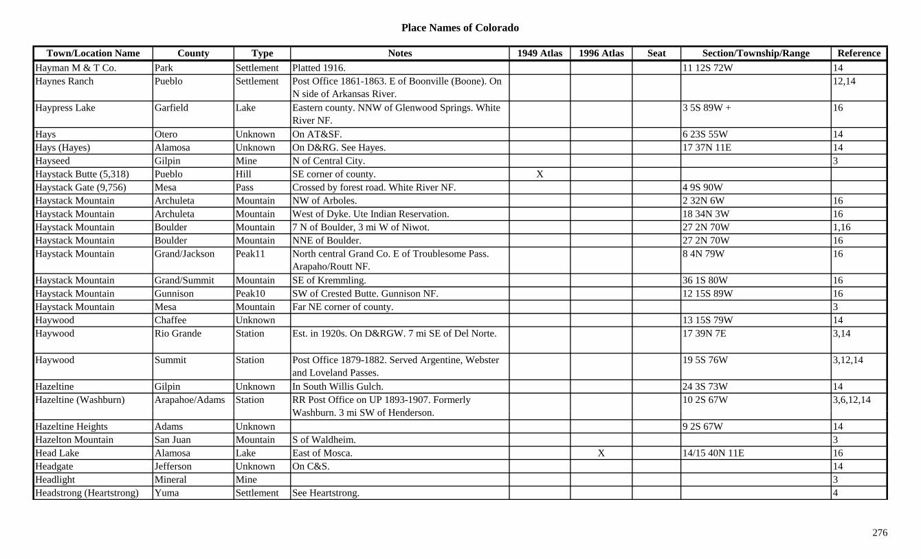
Place Names of Colorado
Town/Location Name County Type Notes 1949 Atlas 1996 Atlas Seat Section/Township/Range ReferenceHayman M & T Co. Park Settlement Platted 1916. 11 12S 72W 14Haynes Ranch Pueblo Settlement Post Office 1861-1863. E of Boonville (Boone). On
N side of Arkansas River.12,14
Haypress Lake Garfield Lake Eastern county. NNW of Glenwood Springs. White River NF.
3 5S 89W + 16
Hays Otero Unknown On AT&SF. 6 23S 55W 14Hays (Hayes) Alamosa Unknown On D&RG. See Hayes. 17 37N 11E 14Hayseed Gilpin Mine N of Central City. 3Haystack Butte (5,318) Pueblo Hill SE corner of county. XHaystack Gate (9,756) Mesa Pass Crossed by forest road. White River NF. 4 9S 90WHaystack Mountain Archuleta Mountain NW of Arboles. 2 32N 6W 16yHaystack Mountain Archuleta Mountain West of Dyke. Ute Indian Reservation. 18 34N 3W 16Haystack Mountain Boulder Mountain 7 N of Boulder, 3 mi W of Niwot. 27 2N 70W 1,16Haystack Mountain Boulder Mountain NNE of Boulder. 27 2N 70W 16Haystack Mountain Grand/Jackson Peak11 North central Grand Co. E of Troublesome Pass.
Arapaho/Routt NF.8 4N 79W 16
Haystack Mountain Grand/Summit Mountain SE of Kremmling. 36 1S 80W 16Haystack Mountain Gunnison Peak10 SW of Crested Butte. Gunnison NF. 12 15S 89W 16Haystack Mountain Mesa Mountain Far NE corner of county. 3Haywood Chaffee Unknown 13 15S 79W 14Haywood Rio Grande Station Est. in 1920s. On D&RGW. 7 mi SE of Del Norte. 17 39N 7E 3,14
Haywood Summit Station Post Office 1879-1882. Served Argentine, Webster and Loveland Passes.
19 5S 76W 3,12,14
Hazeltine Gilpin Unknown In South Willis Gulch. 24 3S 73W 14Hazeltine (Washburn) Arapahoe/Adams Station RR Post Office on UP 1893-1907. Formerly
W hb 3 i SW f H d10 2S 67W 3,6,12,14
Washburn. 3 mi SW of Henderson.Hazeltine Heights Adams Unknown 9 2S 67W 14Hazelton Mountain San Juan Mountain S of Waldheim. 3Head Lake Alamosa Lake East of Mosca. X 14/15 40N 11E 16Headgate Jefferson Unknown On C&S. 14Headlight Mineral Mine 3Headstrong (Heartstrong) Yuma Settlement See Heartstrong. 4
276

Place Names of Colorado
Town/Location Name County Type Notes 1949 Atlas 1996 Atlas Seat Section/Township/Range ReferenceHealy House State Monument
Lake Museum At Leadville. X
Heart Lake Garfield Lake NW corner of county. White River NF. 24/25 3S 89W 16Heart Lake Gilpin Lake NW corner of county. Roosevelt NF. 17 2S 74W 16Heart Lake Hinsdale Lake South of Lake City. Rio Grande NF. 7/8 41N 4W 16Heartstrong (Headstrong) Yuma Settlement Post Office 1921-1940. 3 mi W of Happyville. Site
of Happyville PO.X 30 1S 46W 3,4,12,14
Heath Kiowa Settlement X 32 20S 54W 14Heathermeade Boulder Settlement Just SW of Raymond. 8 2N 72W 6Heatherton Fremont Unknown 1 mi S of Chandler. 27 19S 70W 14Heathton Fremont Settlement Post Office 1906-1908. 12,14,Hebron Larimer/Jackson Settlement Post Office 1884-1922. N of Colmont. On CW&E. X 7 7N 80W 3,12,14
Heck Gulch Fremont Gulch South central county. S of Texas Creek (town). Sev 20S 73W 16Heckert Pass (12,540 or 12,700)
Pitkin Pass Capitol Peak Topo. White River NF. ?? 11S 86W 5
Hecla Garfield Settlement Post Office 1891-1895. 12,14Hecla Junction Chaffee Station Est. by 1923. On D&RG. Railroad junction. 26 51N 8E 1,3,14Hecla Mine Boulder Mine Louisville area. 1Hedinger('s) Lake (Lake Station)
Lincoln Station Stage station at junction of Smoky Hill South & Smoky Hill North. See Lake Station.
4,14
Hedinger's Ranch (Lake Station)
Lincoln Station See Lake Station. 4
Heelsburg (Wagontown, Cosden)
Gunnison Settlement First name was Wagontown, then Heelsburg, then Cosden.
9 49N 5E 14
Heeney Summit Settlement Est. 1938. Post Office 1939-1974. A rural station of K li
14 2S 80W 3,12,14Kremmling.
Hegeman Lake Mine A Leadville area mine. 3Heiberger Mesa Settlement Post Office 1908-1925. Small settlement on Buzzard
Creek. E of Collbran.19 9S 93W 3,12,14
Heisshorn (13,411) Peak13 San Juans, Courthouse Group. 8Heisspitz, The (13,262) Peak13 Storm King Peak Quad. 11Heister Gulch Fremont Gulch North of Howard. San Isabel NF. Sev 50N 10E 16
277
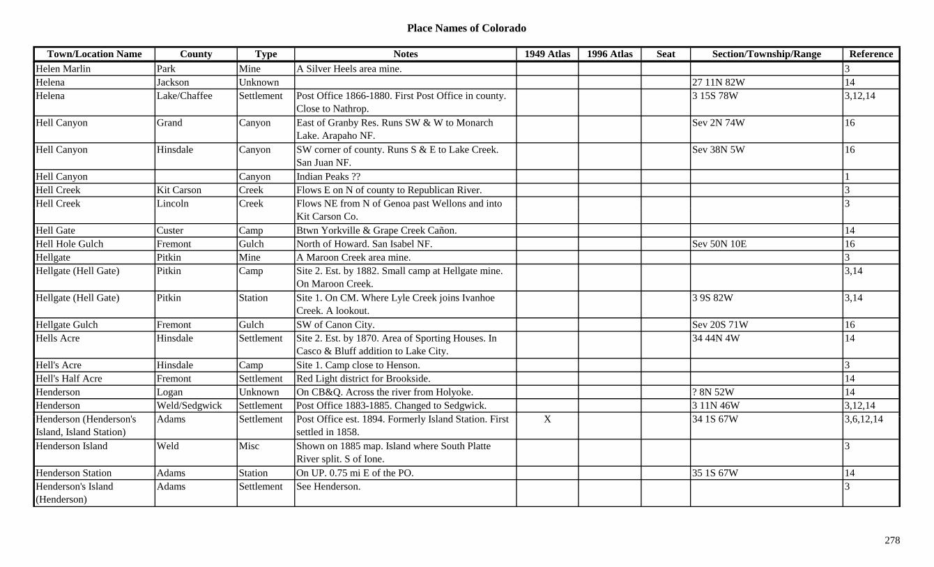
Place Names of Colorado
Town/Location Name County Type Notes 1949 Atlas 1996 Atlas Seat Section/Township/Range ReferenceHelen Marlin Park Mine A Silver Heels area mine. 3Helena Jackson Unknown 27 11N 82W 14Helena Lake/Chaffee Settlement Post Office 1866-1880. First Post Office in county.
Close to Nathrop.3 15S 78W 3,12,14
Hell Canyon Grand Canyon East of Granby Res. Runs SW & W to Monarch Lake. Arapaho NF.
Sev 2N 74W 16
Hell Canyon Hinsdale Canyon SW corner of county. Runs S & E to Lake Creek. San Juan NF.
Sev 38N 5W 16
Hell Canyon Canyon Indian Peaks ?? 1Hell Creek Kit Carson Creek Flows E on N of county to Republican River. 3Hell Creek Lincoln Creek Flows NE from N of Genoa past Wellons and into 3p
Kit Carson Co.Hell Gate Custer Camp Btwn Yorkville & Grape Creek Cañon. 14Hell Hole Gulch Fremont Gulch North of Howard. San Isabel NF. Sev 50N 10E 16Hellgate Pitkin Mine A Maroon Creek area mine. 3Hellgate (Hell Gate) Pitkin Camp Site 2. Est. by 1882. Small camp at Hellgate mine.
On Maroon Creek.3,14
Hellgate (Hell Gate) Pitkin Station Site 1. On CM. Where Lyle Creek joins Ivanhoe Creek. A lookout.
3 9S 82W 3,14
Hellgate Gulch Fremont Gulch SW of Canon City. Sev 20S 71W 16Hells Acre Hinsdale Settlement Site 2. Est. by 1870. Area of Sporting Houses. In
Casco & Bluff addition to Lake City.34 44N 4W 14
Hell's Acre Hinsdale Camp Site 1. Camp close to Henson. 3Hell's Half Acre Fremont Settlement Red Light district for Brookside. 14Henderson Logan Unknown On CB&Q. Across the river from Holyoke. ? 8N 52W 14Henderson Weld/Sedgwick Settlement Post Office 1883-1885. Changed to Sedgwick. 3 11N 46W 3,12,14H d (H d ' Ad S ttl t P t Offi t 1894 F l I l d St ti Fi t X 34 1S 67W 3 6 12 14Henderson (Henderson's Island, Island Station)
Adams Settlement Post Office est. 1894. Formerly Island Station. First settled in 1858.
X 34 1S 67W 3,6,12,14
Henderson Island Weld Misc Shown on 1885 map. Island where South Platte River split. S of Ione.
3
Henderson Station Adams Station On UP. 0.75 mi E of the PO. 35 1S 67W 14Henderson's Island (Henderson)
Adams Settlement See Henderson. 3
278

Place Names of Colorado
Town/Location Name County Type Notes 1949 Atlas 1996 Atlas Seat Section/Township/Range ReferenceHendersonville Gunnison Unknown On D&RG. E of Cebolla. 14Hendricks Fremont Settlement Post Office 1887-1891. Was Palmer. Originally
Hayden Creek. Changed to Coaldale.33 48N 11E 14
Hendricks Mining Company Boulder Mine A Caribou area operation. 13
Hendrie Brothers Foundry Gilpin Mill Established at Black Hawk. First in Colorado. 13
Henkel El Paso Station Est. by 1909. Stop on D&RGW. 2 mi NW of Buttes. 26 17S 65W 3,14
Henkel Pueblo Settlement Est. by 1924. On AT&SF. Close to El Paso Co. X 2 18S 65W 3,14
Henrick's Corner Custer Unknown Down South Colony Creek on route to Humbolt Peak.
14
Henrietta Lake Unknown On D&RG. At E edge of Leadville. 19 9S 79W 14Henrietta San Juan Mine Silverton area mine. 3Henry Conejos/Alamosa Settlement Post Office 1889-1892 & 1895-1896. S of Estrella. X 5 36N 10E 3,12,14
Henry Lake Settlement Post Office 1880-1882. 3.5 mi NE of Leadville. 3,12,14Henry Washington Settlement Rural Post Office 1907-1917. 14 mi SE of Akron. 7 1S 51W 3,12,14
Henry (Lariat, Monte Vista) Rio Grande Settlement Post Office 1884-1886. Formerly Lariat. Changed to Monte Vista.
Sev 39N 7E 1,3,12,14
Henry Mountain Gunnison Peak13 SW of Tincup. Sawatch Range, Fossil Group. Fairview Peak Quad. Gunnison NF.
10 51N 3E 8,11,13,16
Henry Station (Monument) El Paso Settlement See Monument. 3
H (' ) (M t) El P S ttl t P t Offi i 1869 3 i SE f Di id L k (P l 15 11S 67W 3 14Henry('s) (Monument) El Paso Settlement Post Office in 1869. 3 mi SE of Divide Lake (Palmer Lake). See Monument.
15 11S 67W 3,14
Henson Hinsdale Settlement Est. by 1871. Post Office 1883-1884 & 1892-1913. 5 mi W of Lake City.
36 44N 5W 2,3,12,13,14
Henson Creek Hinsdale Creek Flows E to Gunnison River at Lake City. 3,13Henson Creek Smelter Hinsdale Mill At Capitol City. 3Henthorn Gulch Fremont Gulch NW of Cotopaxi. Sev 48N 11E 16
279

Place Names of Colorado
Town/Location Name County Type Notes 1949 Atlas 1996 Atlas Seat Section/Township/Range ReferenceHepburn Park Unknown On old South Park Stage Road. Just S of Geneva
Gulch.14
Hepburn's Pass (10,700) Pass Arapahoe map. 7Herard Saguache Settlement Post Office 1905-1912. 7 26S 72W 12,14Herbert (Lost Park) Gunnison Unknown First name was Lost Park. 14Hercules Boulder Mine At Jamestown. 3Hercules San Juan Unknown On D&RG. See Kanes. 20 41N 7W 14Hereford Mesa Settlement Est. by 1887. 4 mi SE of Loma. 3Hereford Weld Settlement Site 1. Post Office 1888-1894. Started as RR station
on BN in 1886.3,12,14
Hereford Weld Settlement Site 2. Post Office est. 1909. X X 27 12N 62W 6,12,14, ,Heritage Arapahoe Settlement Post Office 1976-1978. CPO of Englewood. 12Heritage Square Jefferson Misc. Hi-Country Railroad. S of Golden. 10 4S 70W 6,14Herman Summit Mine A Saints John area mine. 3Herman Gulch Clear Creek Gulch Far W in county. Runs E & SE into Clear Creek. Sev 4S 76W 16
Hermanes Plaza (Walsenburg)
Huerfano Settlement Est. by 1873. Changed to La Plaza de Las Leones & Walsenburg.
14
Hermano Peak (8,959) Peak Southwest Corner. On Sentinel Peak NE Quad. 8Herman's Peak Montezuma Peak In Sierra El Late. W of Towaoc. 3Hermello Huerfano Unknown Est. by 1873. 14Hermes Yuma Settlement Rural Post Office 1908-1919. 21 mi NW of Joes. 34 5S 45W 3,12,14
Hermit Hinsdale Settlement Post Office in 1880 and Post Office 1904-1920. (2 sites?)
17 41N 3W 3,12,14
Hermit Lake Custer Lake West central county. Near Saguache Co. San Isabel NF
?? 23S 12E 16NF.
Hermit Lakes Hinsdale Lake At Hermit. W of Belford. Rio Grande NF. Sev 41N 3W 3,16Hermit Park Larimer Unknown 5 4N 72W 14Hermit Pass (13,040) Custer/Saguache Pass Crossed by Hermit Lake Trail. Rio Alto Peak Topo.
Rio Grande & San Isabel NF.33 45N 12E 5,8,9,16
Hermit Peak Hinsdale Peak10 SSE of Lake City. W of Ptarmigan Meadows (town). 18 41N 3W 16
280

Place Names of Colorado
Town/Location Name County Type Notes 1949 Atlas 1996 Atlas Seat Section/Township/Range ReferenceHermit Peak (13,350) Peak13 Sangre de Cristo Range, Main Section. Rito Alto
Peak Quad.8,11
Hermitage Dolores Settlement Post Office 1904-1907. Near Groundhog Reservoir. 18 40N 12W 3,12,14
Hermitage Grand Settlement Post Office 1878-1884. Close to DU&P RR where it cuts through Pass Creek.
1 2N 81W 3,12,14
Hermosa La Plata Settlement First a stage station. Est. 1874 by D&RG as station & Post Office 1876-1900.
X X 3 36N 9W 3,12,14
Hermosa Cliffs La Plata/San Juan Hill NW part of La Plata, SW part of San Juan. 3
Hermosa Creek La Plata Creek Flows S from San Juan County to Animas River. 3y
Hermosa Creek San Juan Creek NW corner of county. Flows N to S to La Plata Co. 3
Hermosa Peak (12,574) Dolores/San Juan Peak12 West of Rico. Rico Mountains. 26 40N 10W 8,16
Hermosa-Barlow Creek Lode
San Miguel Mine A Vanadium area mine. 3
Hermose Huerfano Settlement Est. by 1869. Post Office in Hermosa. Hermosilla, another name?
14
Hermoseita Pueblo Unknown Est. by 1877. 6 23S 62W 14Hermosilla Huerfano Settlement Post Office 1867-1870. Second county seat of
Huerfano County, prior to 1868.x 14
Hermosilla (Hermosillo, Doyle's)
Pueblo Settlement Post Office 1867-1872. 3 mi SW of Undercliffe. See Doyle's. Also shown at 32 23S 63W.
21 23S 63W 3,4,12,14
H ill (H ill H f S ttl t P t Offi 1871 S H ill & H 14Hermosville (Hermosilla, Hermosa)
Huerfano Settlement Post Office 1871. Same as Hermosilla & Hermosa. 14
Herndon Jefferson Settlement Post Office 1884. 6.5 mi SW of Morrison. 6,14Hero Ouray Mine An Ouray area mine. 3Heron Prowers Station Est. by 1902. On AT&SF. Barton was the PO. 14Herrick Pueblo Unknown On AT&SF. Also shown at 13 20S 65W 10 20S 65W 14
281

Place Names of Colorado
Town/Location Name County Type Notes 1949 Atlas 1996 Atlas Seat Section/Township/Range ReferenceHerring's Creek (Agate Creek)
Park Creek 1885. SE of Antero Junction. 3
Hershberger Flats Lincoln Settlement Early name for Karval. See Karval. 14 15S 55W 14Herzman Mesa Jefferson Unknown 14 5S 71W 14Hesperus La Plata Settlement Est. 1882. Post Office est. 1891. Moved from Fort
Lewis. 11 mi W of Durango.X X 14 35N 11W 2,3,12,14
Hesperus Coal La Plata Mine At Hesperus. 3Hesperus Pass (7,700) Montezuma Pass N of Hesperus. 7Hesperus Peak (13,232) Montezuma Peak13 La Plata Range. NE of Mancos near La Plata Co. La
Plata Quad.X X 3,8,11
Hessie Boulder Settlement Post Office 1898-1902. 2 mi W of Eldora. 18 1S 73W 1,3,6,12,13,, , , , ,14
Hester Otero/Crowley Settlement Rural Post Office 1905-1912. 15 mi N of Ordway. 30 19S 56W 3,12,14
Heston Larimer Station Est. by 1920. On C&S. 10 mi N of Wellington. X 35 11N 68W 3,14Hewes-Kirkwood Boulder Settlement No Post Office. 10 mi N of Meeker Park. 2 3N 73W 6Hewit La Plata Settlement Post Office 1882-1885. 16 mi E of Rockwood. 22 38N 7W 3,12,14Heywood (Haywood, Hortense)
Chaffee Settlement Post Office 1884-1888. Formerly Hortense. 1885, shown as Haywood.
19 15S 78W 12,14
Heywood Hot Springs Chaffee Settlement Same as Mount Princeton Hot Springs. 19 15S 78W 14Hezron Huerfano Station Post Office 1902-1912. On D&RG. 7 mi SE of
Walsenburg.13 29S 66W 3,12,14
Hezron Junction Huerfano Station On D&RG. 7 mi from Walsenburg. 7 29S 65W 3,14Hiamovi Mountain Grand Peak12 East of Granby Res. Front Range, Indian Section.
Arapaho NF.4/5 2N 74W 1,8,16
Hiawatha Park Mine Near Alma. 2Hi th (Hi th C ) M ff t C E t bt 1926 X 22 12N 100W 3 14Hiawatha (Hiawatha Camp) Moffat Camp Est. abt 1926. X 22 12N 100W 3,14
Hibbard (Drennan) El Paso Settlement Post Office 1920-1922. Changed to Drennan Rural Station.
12
Hicklin Huerfano Unknown Est. by 1873. 14Hicklin('s) (Greenhorn) Pueblo Station Est. 1859. First name for Greenhorn. See Greenhorn. 4,14
282
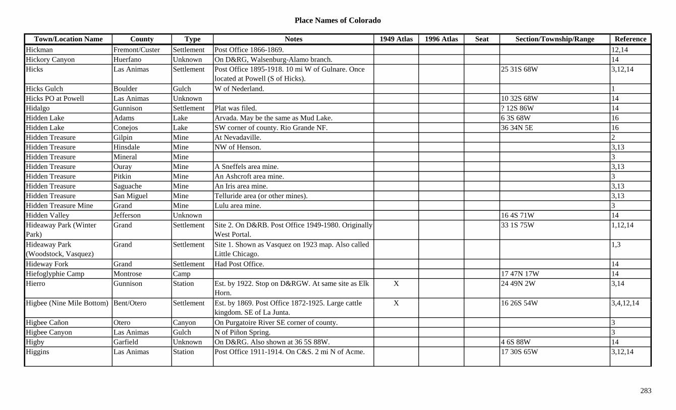
Place Names of Colorado
Town/Location Name County Type Notes 1949 Atlas 1996 Atlas Seat Section/Township/Range ReferenceHickman Fremont/Custer Settlement Post Office 1866-1869. 12,14Hickory Canyon Huerfano Unknown On D&RG, Walsenburg-Alamo branch. 14Hicks Las Animas Settlement Post Office 1895-1918. 10 mi W of Gulnare. Once
located at Powell (S of Hicks).25 31S 68W 3,12,14
Hicks Gulch Boulder Gulch W of Nederland. 1Hicks PO at Powell Las Animas Unknown 10 32S 68W 14Hidalgo Gunnison Settlement Plat was filed. ? 12S 86W 14Hidden Lake Adams Lake Arvada. May be the same as Mud Lake. 6 3S 68W 16Hidden Lake Conejos Lake SW corner of county. Rio Grande NF. 36 34N 5E 16Hidden Treasure Gilpin Mine At Nevadaville. 2Hidden Treasure Hinsdale Mine NW of Henson. 3,13,Hidden Treasure Mineral Mine 3Hidden Treasure Ouray Mine A Sneffels area mine. 3,13Hidden Treasure Pitkin Mine An Ashcroft area mine. 3Hidden Treasure Saguache Mine An Iris area mine. 3,13Hidden Treasure San Miguel Mine Telluride area (or other mines). 3,13Hidden Treasure Mine Grand Mine Lulu area mine. 3Hidden Valley Jefferson Unknown 16 4S 71W 14Hideaway Park (Winter Park)
Grand Settlement Site 2. On D&RB. Post Office 1949-1980. Originally West Portal.
33 1S 75W 1,12,14
Hideaway Park (Woodstock, Vasquez)
Grand Settlement Site 1. Shown as Vasquez on 1923 map. Also called Little Chicago.
1,3
Hideway Fork Grand Settlement Had Post Office. 14Hiefoglyphie Camp Montrose Camp 17 47N 17W 14Hierro Gunnison Station Est. by 1922. Stop on D&RGW. At same site as Elk
Horn.X 24 49N 2W 3,14
Hi b (Ni Mil B tt ) B t/Ot S ttl t E t b 1869 P t Offi 1872 1925 L ttl X 16 26S 54W 3 4 12 14Higbee (Nine Mile Bottom) Bent/Otero Settlement Est. by 1869. Post Office 1872-1925. Large cattle kingdom. SE of La Junta.
X 16 26S 54W 3,4,12,14
Higbee Cañon Otero Canyon On Purgatoire River SE corner of county. 3Higbee Canyon Las Animas Gulch N of Piñon Spring. 3Higby Garfield Unknown On D&RG. Also shown at 36 5S 88W. 4 6S 88W 14Higgins Las Animas Station Post Office 1911-1914. On C&S. 2 mi N of Acme. 17 30S 65W 3,12,14
283

Place Names of Colorado
Town/Location Name County Type Notes 1949 Atlas 1996 Atlas Seat Section/Township/Range ReferenceHiggins (Dolomite, Newett, Divide)
Chaffee Settlement Post Office 1890-1895. Formerly Dolomite, also called Divide. Changed to Newett.
27 13S 77W 12,14
Higgins Lime Spur Chaffee Station On CM. At milepost 90.5. Newett is close at milepost 90.3.
3 14S 77W 14
Higgins Spur Garfield Unknown On D&RG. Near Sopris. ? 7S 88W 14High Bridge Gulch Hinsdale Gulch North central county. Runs E out of Uncompahgre
NF to Lake Fork Gunnison River.Sev 45N 4W 16
High Creek Park Creek Flows SE to join South Platte River near Hartsel. 3
High Line Summit Mine A Conger area mine. 3g gHigh Line Junction Teller Unknown On C&S. 14High Muck-a-Muck Hinsdale Mine A Capitol City area mine. 3High Point Mesa Settlement In 1894 had claim and cabin. N of High Point Hill. 3
Highest Road in U. S. Clear Creek Misc To Mount Evans. XHighland Denver Settlement Est. by 1861. Incorp. 1885. NW edge of Denver.
Became part of Denver, 1896.16+ 3S 68W 14
Highland (Castle Forks, Chloride)
Pitkin Settlement Est. by 1879. Near Aspen. Now Asen Highlands Ski Area.
1 11S 85W 3,13,14
Highland (Highland Lake Station)
Boulder Station Est. by 1882. RR stop on C&S. 6 mi N (or NW) of Longmont.
X 11 3N 69W 1,3,6,14
Highland Lake Boulder Lake North of Longmont. NE corner of county. 5 3N 69W 16Highland Lake (Highlandlake)
Weld Settlement Rural Post Office 1910-1913. Changed to Highlandlake. 2 mi NW of Mead.
9 3N 69W 3,6,12,14
Highland Mary Lake Mine A Leadville area mine. 3Hi hl d M S J S ttl t P t Offi 1878 1885 At d f C i h 25 41N 7W 3 12 14Highland Mary San Juan Settlement Post Office 1878-1885. At end of Cunningham
Gulch. Around mine & mill.25 41N 7W 3,12,14
Highland Mary Mine & Mill
San Juan Mine At Howardsville. 2,3
Highland No 2 Reservoir Boulder Lake North of Longmont. NE corner of county. 5 3N 69W 16Highland Park (Ranch Estates)
Park Settlement N of Bailey. X 3
284

Place Names of Colorado
Town/Location Name County Type Notes 1949 Atlas 1996 Atlas Seat Section/Township/Range ReferenceHighland Tunnel Pitkin Mine A Highland area operation. By Hope Mining,
Milling and Leasing Co.13
Highlandlake (Highland Lake)
Weld Settlement Post Office 1883-1910. Changed to Highland Lake. 6,12
Highlands (Highlandtown, Denver)
Arapahoe/Denver Settlement Est. 1875. Post Office 1884-1897. Formerly Highlandtown. Annexed 1888. See Denver.
34 4S 67W 3,12,14
Highlandtown (Highlands, Denver)
Arapahoe Settlement Post Office 1883-1884. Changed to Highlands. 3,12,14
Highline Arapahoe Station RR stop close to Clark Colony. 3Highline Summit Mine A Conger Camp area mine. 13Highline Lateral Adams Canal Runs NE to Derby Lake from from W of Sky Ranch 16g y y
Airport and Arapahoe Co.Highline Reservoir El Paso Lake Colorado Springs West. 35 13S 67W 16Highmore Garfield Settlement Site 2. Post Office 1889-1931. Up Roan Creek. 30
mi W of Rulison.X 20 6S 99W 3,12,14
Highmore (Old Highmore) Garfield Settlement Site 1. 25 6S 99W 14
Higho Jackson/Larimer Settlement Post Office 1889-1930. On Lone Pine Creek. W of Lake John.
X 16 9N 81W 3,12,14
Highpark El Paso/Teller Settlement Post Office 1896-1899 & 1902-1917. 25 15S 71W 12,14Hightower Mountain Mesa Mountain E of Heiberger. 3Hilaris Conejos Unknown Est. by 1866. On Rio Conejos. E of Servielta. 6 33N 10E 14Hildebrand Siding Jefferson Station See Crystal Lake. 6Hilden (Hillden) Saugache Unknown On D&RGW. Btwn Marshall Pass & Shawano. 26 48N 6E 14
Hilderbrand Jefferson Unknown On DSP&P. 28 7S 71W 14Hill B ld St ti O DB&W S f W d 25 1N 73W 6 14Hill Boulder Station On DB&W. S of Ward. 25 1N 73W 6,14Hill City Clear Creek Settlement Began 1881. 3Hill City Jefferson Settlement Site 1. Began in 1881, gone by 1882. 2 mi S of
Phillipsburg.6,14
Hill City Jefferson Settlement Site 2. Built in 1896. 2 mi S of Phillipsburg. See Hilltown.
14
Hill Top Park Mine A Horseshoe-Leavick area mine. 13
285
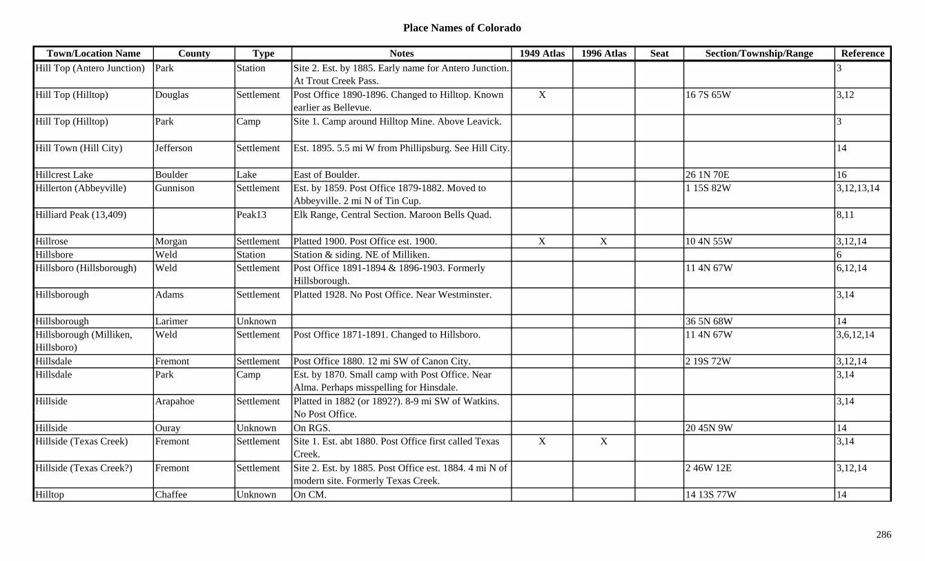
Place Names of Colorado
Town/Location Name County Type Notes 1949 Atlas 1996 Atlas Seat Section/Township/Range ReferenceHill Top (Antero Junction) Park Station Site 2. Est. by 1885. Early name for Antero Junction.
At Trout Creek Pass.3
Hill Top (Hilltop) Douglas Settlement Post Office 1890-1896. Changed to Hilltop. Known earlier as Bellevue.
X 16 7S 65W 3,12
Hill Top (Hilltop) Park Camp Site 1. Camp around Hilltop Mine. Above Leavick. 3
Hill Town (Hill City) Jefferson Settlement Est. 1895. 5.5 mi W from Phillipsburg. See Hill City. 14
Hillcrest Lake Boulder Lake East of Boulder. 26 1N 70E 16Hillerton (Abbeyville) Gunnison Settlement Est. by 1859. Post Office 1879-1882. Moved to
Abbeyville. 2 mi N of Tin Cup.1 15S 82W 3,12,13,14
Hilliard Peak (13,409) Peak13 Elk Range, Central Section. Maroon Bells Quad. 8,11
Hillrose Morgan Settlement Platted 1900. Post Office est. 1900. X X 10 4N 55W 3,12,14Hillsbore Weld Station Station & siding. NE of Milliken. 6Hillsboro (Hillsborough) Weld Settlement Post Office 1891-1894 & 1896-1903. Formerly
Hillsborough.11 4N 67W 6,12,14
Hillsborough Adams Settlement Platted 1928. No Post Office. Near Westminster. 3,14
Hillsborough Larimer Unknown 36 5N 68W 14Hillsborough (Milliken, Hillsboro)
Weld Settlement Post Office 1871-1891. Changed to Hillsboro. 11 4N 67W 3,6,12,14
Hillsdale Fremont Settlement Post Office 1880. 12 mi SW of Canon City. 2 19S 72W 3,12,14Hillsdale Park Camp Est. by 1870. Small camp with Post Office. Near
Alma. Perhaps misspelling for Hinsdale.3,14
Hillside Arapahoe Settlement Platted in 1882 (or 1892?). 8-9 mi SW of Watkins. N P t Offi
3,14No Post Office.
Hillside Ouray Unknown On RGS. 20 45N 9W 14Hillside (Texas Creek) Fremont Settlement Site 1. Est. abt 1880. Post Office first called Texas
Creek.X X 3,14
Hillside (Texas Creek?) Fremont Settlement Site 2. Est. by 1885. Post Office est. 1884. 4 mi N of modern site. Formerly Texas Creek.
2 46W 12E 3,12,14
Hilltop Chaffee Unknown On CM. 14 13S 77W 14
286
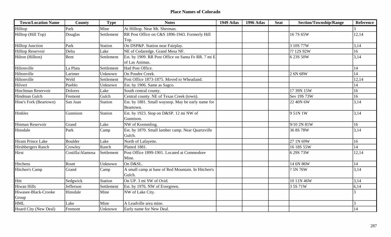
Place Names of Colorado
Town/Location Name County Type Notes 1949 Atlas 1996 Atlas Seat Section/Township/Range ReferenceHilltop Park Mine At Hilltop. Near Mt. Sherman. 3Hilltop (Hill Top) Douglas Settlement RR Post Office on C&S 1896-1943. Formerly Hill
Top.16 7S 65W 12,14
Hilltop Junction Park Station On DSP&P. Station near Fairplay. 3 10S 77W 3,14Hilltop Reservoir Delta Lake NE of Cedaredge. Grand Mesa NF. ?? 12S 92W 16Hilton (Hillton) Bent Settlement Est. by 1909. RR Post Office on Santa Fe RR. 7 mi E
of Las Animas.6 23S 50W 3,14
Hiltonville La Plata Settlement Had Post Office. 14Hiltonville Larimer Unknown On Poudre Creek. 2 6N 68W 14Hiltonville Weld Settlement Post Office 1873-1875. Moved to Wheatland. 12,14Hilvert Pueblo Unknown Est. by 1906. Same as Sagco. 14y gHinchman Reservoir Dolores Lake South central county. 17 39N 15W 16Hindman Gulch Fremont Gulch Central county. NE of Texas Creek (town). Sev 19S 73W 16Hine's Fork (Beartown) San Juan Station Est. by 1881. Small waystop. May be early name for
Beartown.22 40N 6W 3,14
Hinkles Gunnison Station Est. by 1923. Stop on D&SP. 12 mi NW of Gunnison.
9 51N 1W 3,14
Hinman Reservoir Grand Lake NW of Kremmling. 9/10 2N 81W 16Hinsdale Park Camp Est. by 1870. Small lumber camp. Near Quartzville
Gulch.36 8S 78W 3,14
Hiram Prince Lake Boulder Lake North of Lafayette. 27 1N 69W 16Hirshbergers Ranch Crowley Ranch Platted 1881. 16 18S 55W 14Hirst Costilla/Alamosa Settlement Post Office 1899-1901. Located at Commodore
Mine.6 29S 73W 12,14
Hitchens Routt Unknown On D&SL. 14 6N 86W 14Hitchen's Camp Grand Camp A small camp at base of Red Mountain. In Hitchen's
G l h? 5N 76W 3,14
Gulch.Hitt Sedgwick Station On UP. 3 mi SW of Ovid. 10 11N 46W 3,14Hiwan Hills Jefferson Settlement Est. by 1976. NW of Evergreen. 3 5S 71W 6,14Hiwasee-Black-Crooke Group
Hinsdale Mine NW of Lake City. 3
HML Lake Mine A Leadville area mine. 3Hoard City (New Deal) Fremont Unknown Early name for New Deal. 14
287

Place Names of Colorado
Town/Location Name County Type Notes 1949 Atlas 1996 Atlas Seat Section/Township/Range ReferenceHobart Teller Settlement Post Office 1900-1902. 12,14Hobo Gulch Hinsdale Gulch North central county. Runs E out of Uncompahgre
NF to Lake Fork Gunnison River.Sev 45N 4W 16
Hobsen Reservoir Delta Lake NE of Cedaredge. Grand Mesa NF. ?? 12S 92W 16Hobson (Carlisle Springs, Carlisle)
Pueblo Settlement On D&RG. First named Carlisle Springs, then Carlisle, then Hobson.
X 6 20S 67W 14
Hock-Hocking Park Mine A Park City area mine. 13Hodges (Hodgson) Weld Unknown On DL&NW. Misspelled Hodgson on a RR map. 11 3N 67W 14
Hodgson Weld Station Est. by 1913. On GW. 4 mi NW of Platteville. 14 3N 67W 3,6,14g y , ,Hoehne Las Animas Station Site 1. Stage station. 1.5 mi E of town of Hoehne.
On Santa Fe Trail.3,14
Hoehne Las Animas Station Site 3. On AT&SF. 6 32S 62W 14Hoehne (Pulaski) Las Animas Settlement Site 2. Post Office est. 1886. Moved from Pulaski. X X 3 32S 62W 3,12,14
Hoffman Bros. Smelter Gunnison Mill Marble area. 3,13Hoffman Lake Boulder Lake NW of Lafayette. 20 1N 69W 16Hog Back Dolores Mine At Rico. 2Hog Back Las Animas Station Stage station on Purgatoire branch of Santa Fe Trail. 3 31S 60W 3,14
Hogan Jefferson Unknown 14Hogan (Cap Barron Spring) Lincoln Station Stage station on Smoky Hill North stage route. Near
Cap Barron Spring.3,14
Hogback Alley Rio Blanco Range 1885. Land formation and trail down from the Yampa River.
3
H b k C M G l h 1885 O Pl t C k N P li d d C 3Hogback Canyon Mesa Gulch 1885. On Plateau Creek. Near Palisade and Cameo. 3
Hogback Mesa Rio Grande Hill S & W of Del Norte. 3Hogg PO (Stapleton) Montezuma Settlement Post Office 1903-1906. Stop & RR Post Office that
preceded Stapleton.9 37N 14W 3,12,14
Hogland Creek Saguache Creek 1885. SW of Saguache. 3Hohnville Adams Settlement Platted 1887. No Post Office. 3,14
288

Place Names of Colorado
Town/Location Name County Type Notes 1949 Atlas 1996 Atlas Seat Section/Township/Range ReferenceHoil Group Park Mine A Quartzville area mine. 3Holbert Fremont Settlement A village. 14Holbrook Otero Settlement Post Office 1906-1907. 12,14Holden Lake Unknown On D&RGW. On the Iron Silver Mine Branch. Near
Arkansas Valley Sampler.14
Holden Pueblo Settlement Post Office 1892-1893. 12,14Holdenville (Globeville) Denver Settlement First name for Globeville. 14Holdville Boulder Unknown On Colo NW RR. 17 1N 72W 14Hole in the Rock Gulch Fremont Gulch North central county. N of Canon City. Sev 16S 71W 16Hole-in-the-Prairie Las Animas Station Fourth stage station on the Santa Fe Trail up Timpas
Creek. On Goodnight Cattle Trail.3,14
Hole-in-the-Rock Las Animas Station Third stage station on Timpas Creek Stage Route. Close to Thatcher.
3,14
Holey Montrose Unknown Est. by 1895. Could be Haley? ? 48N 13W 14Holland Gunnison Unknown On CR&SJ. 29 11S 88W 14Holland Mesa Settlement X 14Holland Park Settlement Post Office 1874. At Holland Reduction Works? 22 9S 78W 3,12,14
Holland Reduction Works Park Mill At Holland. 3Hollands Camp Mesa Camp ? 51N 16W 14Holloway Las Animas Station Est. by 1930. On D&RG. 14Holly (Holleys) Bent/Prowers Settlement Post Office est. 1880. Lowest point in CO. is near
Holly (3,350 ft).X X 10 23S 42W 3,12,14
Holly Group Montezuma Misc Far western Montezuma Co, near Utah. XHollywood Teller Settlement Residential and milling suburb of Victor. Absorbed
by Victor.32 15S 69W 1,3,14
H l L i U k 3 i W f H & littl S 14Holmes Larimer Unknown 3 mi W of Home & a little S. 14Holmes (Hall, Holmes City) El Paso Station Stop on AT&SF. Known as Hall, also Holmes City. 29 16S 65W 3,14
Holmes City (Holmes) El Paso Unknown See Holmes. 14Holmes City (Homes City) Baca Settlement Platted 1887. Near Carrizo Springs. Said to be
misspelling of Homes City.29 33S 47W 3,14
Holmesville Washington Settlement 6 mi S of Otis. 3,14
289
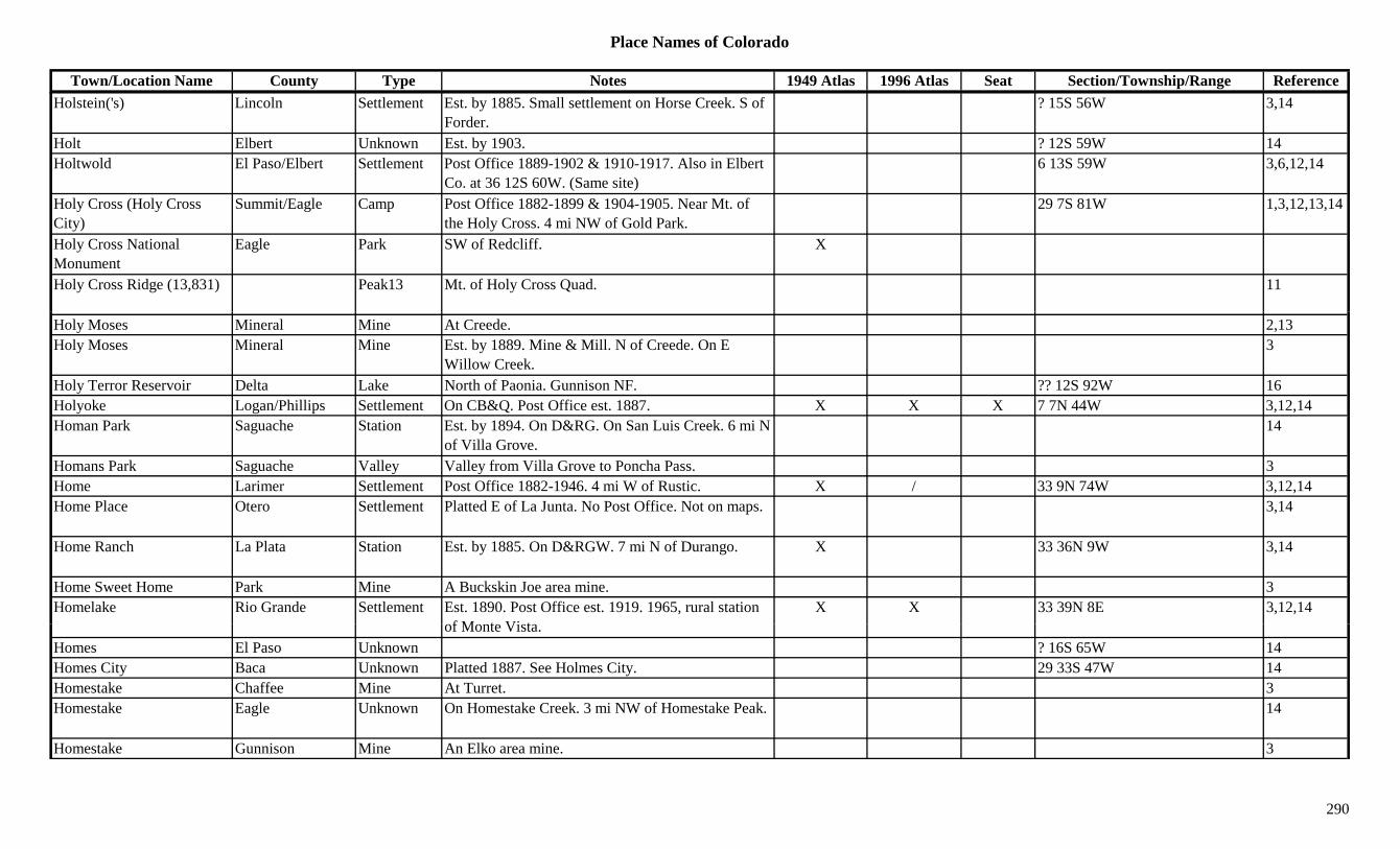
Place Names of Colorado
Town/Location Name County Type Notes 1949 Atlas 1996 Atlas Seat Section/Township/Range ReferenceHolstein('s) Lincoln Settlement Est. by 1885. Small settlement on Horse Creek. S of
Forder.? 15S 56W 3,14
Holt Elbert Unknown Est. by 1903. ? 12S 59W 14Holtwold El Paso/Elbert Settlement Post Office 1889-1902 & 1910-1917. Also in Elbert
Co. at 36 12S 60W. (Same site)6 13S 59W 3,6,12,14
Holy Cross (Holy Cross City)
Summit/Eagle Camp Post Office 1882-1899 & 1904-1905. Near Mt. of the Holy Cross. 4 mi NW of Gold Park.
29 7S 81W 1,3,12,13,14
Holy Cross National Monument
Eagle Park SW of Redcliff. X
Holy Cross Ridge (13,831) Peak13 Mt. of Holy Cross Quad. 11
Holy Moses Mineral Mine At Creede. 2,13Holy Moses Mineral Mine Est. by 1889. Mine & Mill. N of Creede. On E
Willow Creek.3
Holy Terror Reservoir Delta Lake North of Paonia. Gunnison NF. ?? 12S 92W 16Holyoke Logan/Phillips Settlement On CB&Q. Post Office est. 1887. X X X 7 7N 44W 3,12,14Homan Park Saguache Station Est. by 1894. On D&RG. On San Luis Creek. 6 mi N
of Villa Grove.14
Homans Park Saguache Valley Valley from Villa Grove to Poncha Pass. 3Home Larimer Settlement Post Office 1882-1946. 4 mi W of Rustic. X / 33 9N 74W 3,12,14Home Place Otero Settlement Platted E of La Junta. No Post Office. Not on maps. 3,14
Home Ranch La Plata Station Est. by 1885. On D&RGW. 7 mi N of Durango. X 33 36N 9W 3,14
Home Sweet Home Park Mine A Buckskin Joe area mine. 3Homelake Rio Grande Settlement Est. 1890. Post Office est. 1919. 1965, rural station
f M t Vi tX X 33 39N 8E 3,12,14
of Monte Vista.Homes El Paso Unknown ? 16S 65W 14Homes City Baca Unknown Platted 1887. See Holmes City. 29 33S 47W 14Homestake Chaffee Mine At Turret. 3Homestake Eagle Unknown On Homestake Creek. 3 mi NW of Homestake Peak. 14
Homestake Gunnison Mine An Elko area mine. 3
290

Place Names of Colorado
Town/Location Name County Type Notes 1949 Atlas 1996 Atlas Seat Section/Township/Range ReferenceHomestake Lake Camp Est. by 1871. 12 mi NW of Leadville. 7 8S 80W 3,14Homestake Pitkin Mine An Aspen area mine. 3Homestake Creek Eagle Creek Flows through Gold Park to NE. 3Homestake Creek Lake Creek Lake City to Tennessee Fork of the Arkansas River. 3
Homestake Creek Pitkin Creek NE corner of county. Flows N to Eagle Co. 3Homestake Lake Eagle/Pitkin Lake West of Tennessee Pass. On Homestake Creek.
White River/San Isabel NF.?? 8S 81W 16
Homestake Lakes Eagle Lake SW of Redcliff. On Sopris Creek. White River NF. ?? 8S 82W 16
Homestake Peak Eagle/Lake Peak13 Sawatch Range, Holy Cross Section. Btwn ?? 7S 81W 3,8,11,16g g , yHomestake and Lake City.
, , ,
Homewood Park Jefferson Settlement Est. in 1920s. Private homes. 0.5 mi NW of Phillipsburg.
11 6S 70W 6,14
Hondius Larimer Settlement On Fall River. 4 mi NW of Estes Park. ? 5N 73W 14Honest Dollar Lake Mine A Swede's Gulch mine. 3Honnold (Honnald) Routt Settlement Post Office 1890-1904. On Independence Creek.
Near Wyoming.18 12N 86W 3,12,14
Hoodoo Summit Mine A Kokomo area mine. 3Hoodoo Gap (10,240 or 10,500)
Gunnison Gap SW of Mt. Gunnison. Gunnison NF. 36 14S 90W 7
Hooks Eagle Station On D&RGW. A siding. 10 8S 87W 14Hooks Pitkin Station Est. by 1906. On D&RGW. 14Hooper (Garrison) Costilla/Alamosa Settlement Post Office est. 1896. Formerly Garrison. RR &
trading town (early).X 4 40N 10E 3,12,14
Hooper Lake Garfield Lake NE corner of county. White River NF. ?? 1S 87W 16H L A i S ttl t R l P t Offi 1919 1937 8 i NW f A d i X 14 30S 53W 3 12 14Hoopup Las Animas Settlement Rural Post Office 1919-1937. 8 mi NW of Andrix X 14 30S 53W 3,12,14
Hoosier Park Station Est. in 1920s. RR stop and Post Office on Kenosha Pass.
22 7S 75W 3,14
Hoosier Teller Camp On CS&CCD. Near Hoosier Mine. 18 15S 69W 3,14Hoosier Teller Mine A Cameron area mine. 3Hoosier Boy San Juan Mine A Red Mountain area mine. (Chattanooga) 3
291
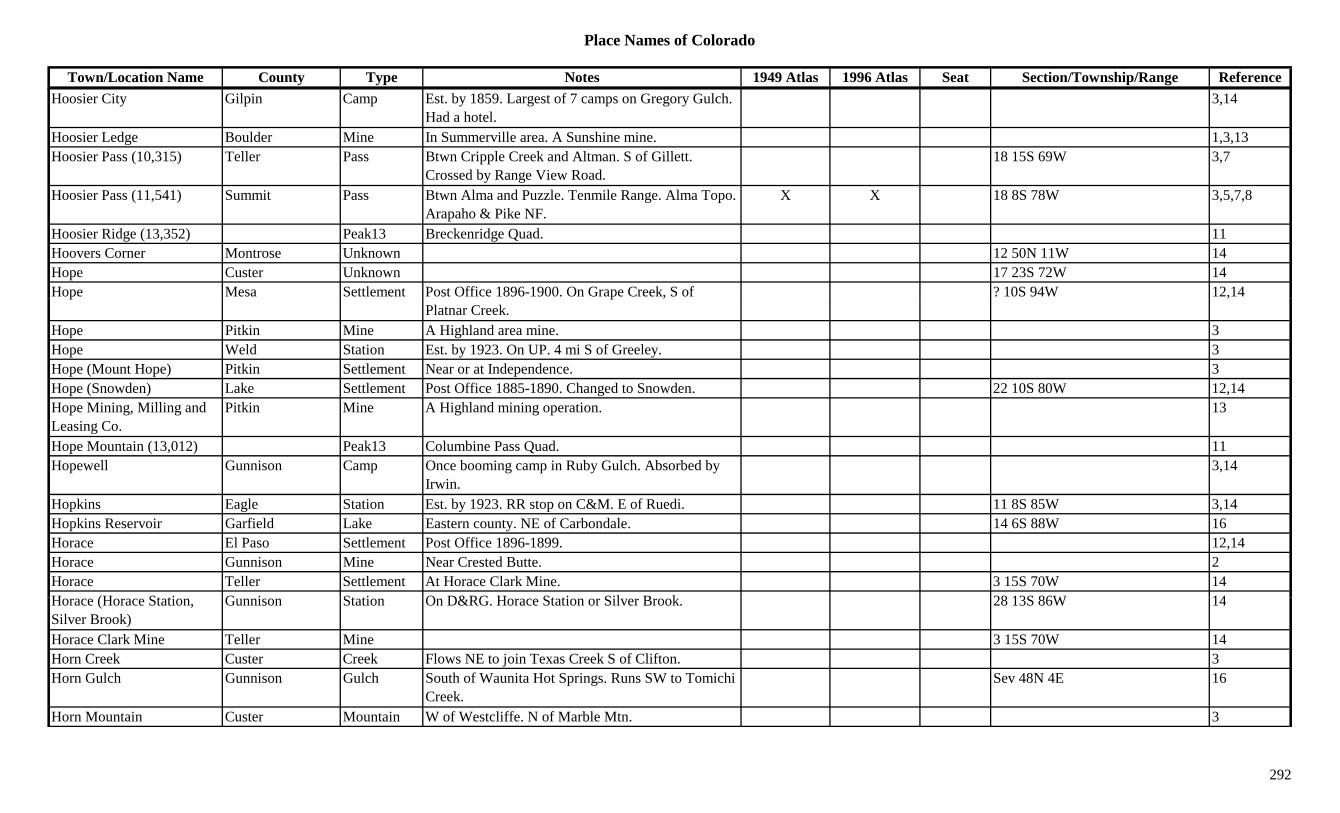
Place Names of Colorado
Town/Location Name County Type Notes 1949 Atlas 1996 Atlas Seat Section/Township/Range ReferenceHoosier City Gilpin Camp Est. by 1859. Largest of 7 camps on Gregory Gulch.
Had a hotel.3,14
Hoosier Ledge Boulder Mine In Summerville area. A Sunshine mine. 1,3,13Hoosier Pass (10,315) Teller Pass Btwn Cripple Creek and Altman. S of Gillett.
Crossed by Range View Road.18 15S 69W 3,7
Hoosier Pass (11,541) Summit Pass Btwn Alma and Puzzle. Tenmile Range. Alma Topo. Arapaho & Pike NF.
X X 18 8S 78W 3,5,7,8
Hoosier Ridge (13,352) Peak13 Breckenridge Quad. 11Hoovers Corner Montrose Unknown 12 50N 11W 14Hope Custer Unknown 17 23S 72W 14Hope Mesa Settlement Post Office 1896-1900. On Grape Creek, S of ? 10S 94W 12,14p p ,
Platnar Creek.,
Hope Pitkin Mine A Highland area mine. 3Hope Weld Station Est. by 1923. On UP. 4 mi S of Greeley. 3Hope (Mount Hope) Pitkin Settlement Near or at Independence. 3Hope (Snowden) Lake Settlement Post Office 1885-1890. Changed to Snowden. 22 10S 80W 12,14Hope Mining, Milling and Leasing Co.
Pitkin Mine A Highland mining operation. 13
Hope Mountain (13,012) Peak13 Columbine Pass Quad. 11Hopewell Gunnison Camp Once booming camp in Ruby Gulch. Absorbed by
Irwin.3,14
Hopkins Eagle Station Est. by 1923. RR stop on C&M. E of Ruedi. 11 8S 85W 3,14Hopkins Reservoir Garfield Lake Eastern county. NE of Carbondale. 14 6S 88W 16Horace El Paso Settlement Post Office 1896-1899. 12,14Horace Gunnison Mine Near Crested Butte. 2Horace Teller Settlement At Horace Clark Mine. 3 15S 70W 14H (H St ti G i St ti O D&RG H St ti Sil B k 28 13S 86W 14Horace (Horace Station, Silver Brook)
Gunnison Station On D&RG. Horace Station or Silver Brook. 28 13S 86W 14
Horace Clark Mine Teller Mine 3 15S 70W 14Horn Creek Custer Creek Flows NE to join Texas Creek S of Clifton. 3Horn Gulch Gunnison Gulch South of Waunita Hot Springs. Runs SW to Tomichi
Creek.Sev 48N 4E 16
Horn Mountain Custer Mountain W of Westcliffe. N of Marble Mtn. 3
292

Place Names of Colorado
Town/Location Name County Type Notes 1949 Atlas 1996 Atlas Seat Section/Township/Range ReferenceHorn Mountain Eagle Mountain Redcliff area. 13Horn Peak (13,450) Custer Peak13 SE of Venable Pass. Sangre de Cristo Range, Main
Section. Horn Peak Quad.?? 23S 73W 8,11,13,16
Horn Silver Eagle Camp Est. 1880s. A silver camp. On Battle Mountain. District location: 31 6S 80W & 4 7S 80W.
14
Horn Silver (Hornsilver) Mountain
Eagle Peak11 SW of Vail Pass. White River NF. 27 6S 80W 3,13,16
Hornbaker Boulder Unknown On Horse Creek. E of Deer Ridge. 14Hornville Baca Unknown 6 28S 46W 14Horse & Black Creek Reservoir
Crowley Lake East of Ordway. In SE corner of county. 21 21S 55W 16
Horse Camp Garfield Camp 14 5S 99W 14Horse Creek Adams Creek Flows N from central central county into Horse
Creek Reservoir.16
Horse Creek Baca Creek Flows E by Two Buttes to join Bear Creek at Monon.
3
Horse Creek Bent Creek Flows into county W of Las Animas and into Arkansas River.
X X
Horse Creek Crowley Creek Flows S from Lincoln Co. and out SE corner of county.
X X 3
Horse Creek Douglas Creek At West Creek. 2Horse Creek El Paso Creek Flows SE from near Glenn to Elbert Co. X X 3Horse Creek Elbert Creek Flows SE past Kutch and into Linclon Co. X X 3Horse Creek Lincoln Creek Flows out of Elbert Co. past Hall Station. E & S to
Crowley Co.X X 3
Horse Creek Otero Creek Flows from SE corner of Crowley Co. SE to A k Ri
X X 3Arkansas River.
Horse Creek Reservoir Adams/Weld Lake East of Lochbuie, on Adams & Weld county line. X 5/8 1S 64W
Horse Creek Reservoir Bent/Otero Lake NW Bent Co. on Otero Co border. X X Sev 21S 53W 16Horse Iron Gulch Dolores Gulch Shown on 1885 map. N of Expectation Mtn. 3Horse Lake Eagle Lake NW corner of county. Partially in White River NF. 36 2S 87W 16
293

Place Names of Colorado
Town/Location Name County Type Notes 1949 Atlas 1996 Atlas Seat Section/Township/Range ReferenceHorse Mountain Eagle Mountain SE of Eagle. 30 5S 83W 16Horse Mountain (9,289) Mesa Mountain XHorse Mountain (9,600) Archuleta Mountain NW corner of county. N of Piedra. 10 35N 4W 3Horse Ranch Pass (8,600) Larimer Pass 4 11N 76W
Horse Range Mesa San Miguel Hill W part of county. 13Horse Shoe Park Settlement Post Office 1880-1886. 12Horse Thief Canyon Mesa Gulch S of Loma. Narrow spot in canyon. 3Horsechief Gulch Fremont Gulch North central county. Sev 16S 72W 16Horsefly Montrose Settlement Post Office 1886-1888 & 1912-1915. Near Horsefly
Mtn. SE corner of county.32 45N 10W 1,3,12,14
Horsefly Creek Montrose Creek Flows NE to join Uncompahgre River at Uncompahgre.
3
Horsefly Creek Montrose Creek SE corner. Flows from Ouray Co. W to join San Miguel River.
3
Horsefly Creek Ouray Creek Flows NE to Montrose Co. 3Horsefly Peak (10,347) Montrose/Ouray Peak SE corner of Montrose County. NW of Ridgway. 3,13
Horseshoe Costilla Unknown 2 32S 75W 14Horseshoe (Doran, East Leadville)
Park Settlement Pre 1879. Post Office 1890-1894. Called Doran in 1902 revival.
4 10S 78W 3,12,13,14
Horseshoe Gulch Park Gulch Runs through Horseshoe. W of Fairplay. 3,13Horseshoe Lake Custer Lake West central county. Near Saguache Co. San Isabel
NF.?? 23W 12E 16
Horseshoe Lake Garfield Lake NE corner of county. White River NF. ?? 2S 89W 16Horseshoe Mountain Fremont Mountain SW of Canon City. 17 19S 71W 13,16H h M t i L k /P k P k13 M it R SE f L d ill W f F i l 3 8 11Horseshoe Mountain (13,898)
Lake/Park Peak13 Mosquito Range. SE of Leadville. W of Fairplay. Mt. Sherman Quad.
3,8,11
Horseshoe Pass (13,180) Lake/Park Pass Btwn Horseshoe Mtn. and Mt. Sheridan. Mosquito Range. San Isabel & Pike NF.
12 10S 79W 5,7
Horseshoe Smelter Park Mill A Horseshoe area operation. 3Horsetail Creek (Cedar Creek)
Weld Creek NE corner of county. Flows SE of Logan Co. 3
294

Place Names of Colorado
Town/Location Name County Type Notes 1949 Atlas 1996 Atlas Seat Section/Township/Range ReferenceHorsethief Mountain Hinsdale Peak11 SE of Lake City. N of E endo fo Continental Res.
Rio Grande NF.21 424N 3W 16
Horsethief Pass (5,640) Larmier Pass 8 9N 69WHorsetooth Heights Larimer Settlement 7 6N 69W 14Horsetooth Peak Boulder Peak NW corner of county. Rocky Mountain Natl Park. 15 3N 73W 16
Horsetooth Reservoir Larimer Lake W of Fort Collins. XHorsfal (Horsfel) Boulder Mine At Gold Hill. Left Hand and Gold Hill area. 1,2,3,13Horsfel Mountain Boulder Mountain Near Gold Hill. 13Hortense Chaffee Mine N of Hortense. Mt. Princeton mine. 3,8Hortense (Heywood, Chalk Lake/Chaffee Settlement Est. 1871. Post Office 1877-1884 & 1901-1907. 9 mi 19 15S 78W 3,12,13,14( y ,Creek Hot Springs) S of Buena Vista.
, , ,
Horton Jefferson Unknown On C&S. 16 3S 69W 14Horton(s)ville (Orodelfan, Orodelphan))
Boulder Settlement Also called Hunts Concentration Works, Maxwells Mill & Orodelfan.
27 1N 71W 1,14
Hossick Peak (12,967) Peak12 Piedra Mountains. 8Hot Spring(s) Ouray Station Post Office 1877-1879. On D&RG. 6 mi N of
Portland.? 45N 8W 3,12,14
Hot Springs Gunnison Settlement Site 1. Est. by 1885. At site of Doyleville. 3Hot Springs Gunnison Settlement Site 2. Est. by 1885. 7 mi E of Waunita. 3Hot Springs Pitkin Unknown Est. by 1885. At mouth of Avalanche Creek. On the
Crystal River.28 9S 88W 14
Hot Springs Saguache Settlement Site 1. Became Mineral Hot Springs. 3Hot Springs Saguache Settlement Site 2. NE of Orient. 12 45N 9E 3,14Hot Springs (Hot Springs Creek)
Mineral Camp Est. by 1885. S of Wagon Wheel Gap. On Cimarron Creek.
23 38N 1W 3,14
H t S i (P H t Pitki C k Sh 1885 S f A l h O C t l 3Hot Springs (Penny Hot Springs)
Pitkin Creek Shown on 1885 map. S of Avalanche. On Crystal River.
3
Hot Springs (Pinkerton Hot Springs)
La Plata Settlement On D&RG. Also known as Pinkerton Hot Springs. 25 37N 9W 14
Hot Springs Creek Mineral Creek Flows N to join Rio Grande River near Hot Springs. 3
Hot Springs Hotel Mineral Unknown 2 40N 1E 14
295

Place Names of Colorado
Town/Location Name County Type Notes 1949 Atlas 1996 Atlas Seat Section/Township/Range ReferenceHot Sulphur Springs (Sulphur Springs)
Grand Settlement Est. 1860. Post Office 1874-1894 & 1912 on. Changed to Sulphur Springs. Renamed.
X X X 3 1N 78W 1,3,12,14
Hotchkiss Delta Settlement Est. 1881. Post Office est. 1882. X X 3,12Hotchkiss Jefferson Settlement Est. by 1884. 6 mi S of Evergreen. At head of
Turkey Creek.6
Hotchkiss Mine (Golden Fleece)
Hinsdale Mine Est. by 1874. At Lake City. 2,13
Hotel de Paris Clear Creek Misc In Georgetown 1Hotel Twin Lake Delta Lake North of Cedaredge. Grand Mesa NF. 1/2 12S 95W 16Houck Huerfano Settlement Post Office 1883. Next to Promentory Bluff. 3,12,14Houck (Hauck, Hawley) Otero Station On AT&SF branch to Newdale. Also called Hauck 6 24S 56W 14( , y)
& Hawley.Houghton Las Animas Station On AT&SF. 7 mi NE of Thacher. 19 28S 59W 3,14Houghton Mountain (13,052)
Peak13 Handies Peak Quad. 11
Hourglass Lake Conejos Lake West central county. Rio Grande NF. ?? 34N 4E 16House Canyon Hinsdale Canyon Central county. Runs NE to N of Shotgun Mtn. Rio
Grande NF.Sev 41N 3W 16
House Gulch Gunnison Gulch South of Powderhorn. Runs W to Ceballa Creek. Sev 45N 2W 16
House Log Gulch Garfield Gulch North central county. Runs NE to Red Gulch. NW of Grand Valley.
Sev 5/6S 96W 16
Housels Moffat Unknown 9 9N 92W 14Houston Weld Settlement Post Office on UP 1910-1913. N of Platteville. 5 3N 66W 3,6,14Houston Peak (Mountain) Garfield Mountain S of Rifle. Near Mesa Co. ?? 7S 94W 3,16Hovenweep (Yellowjacket) C
Montezuma Canyon Runs SW and into Utah. 3CanyonHovenweep Castle Montezuma Misc Shown on 1885 map. Ruins. 3Hovenweep National Monument
Montezuma Park Cliff dwellings and pueblos of 1100 AD 1,3
Howard (Howard's, Pleasant Valley)
Fremont Station Est. abt 1880. Post Office est. 1882. Formerly Pleasant Valley. Waystop.
X X 2 48N 10E 3,12,14
Howard Extension Gunnison Mine At Irwin. 2
296

Place Names of Colorado
Town/Location Name County Type Notes 1949 Atlas 1996 Atlas Seat Section/Township/Range ReferenceHoward Mountain Grand/Jackson Peak12 North tip of Grand Co. Never Summer Range. Rocky
Mountain Natl Park. Routt NF.3 5N 76W 8,16
Howard Place Jackson Unknown On Willow Creek. 14 6N 79W 14Howard Spring San Miguel Settlement Est. by 1885. At mouth of McKenzie (Big Canyon)
Creek.3
Howard Spring Weld Creek 1885. 17 mi NW of Keota. 3Howard Stevens (Prairie Dream, Punkin Center)
Lincoln Settlement Called Prairie Dream, then Howard Stevens, then Punkin Center.
5 14S 56W 3,14
Howard's Fork (Ophir) San Miguel Settlement Est. by 1876. First name for Ophir. 33 42N 9W 3,14Howardsville San Juan/La Plata Settlement Est. by 1874. Post Office 1874-1939. 4 mi NE of
Silverton. Also shown at 12 41N 7W.X x 2 41N 7W 2,3,12,13,14
Howbert Eagle Unknown Est. by 1887. On CM. Btwn Sloane & Aspen Junction. Location shown is for Sloane.
9 8S 85W 14
Howbert (Freshwater) Park Station Post Office 1887-1933. On CM. Now covered by Eleven-Mile Res.
13 13S 73W 3,12,14
Howell's Boulder Unknown On DL&NW. 11 1N 69W 14Howeville (Jacks Cabin) Gunnison Settlement Post Office 1879-1880 & 1900-1904. Became Jacks
Cabin. See Jacks Cabin.23 15S 85W 3,12,14
Howey Reservoir Garfield Lake NNE of Rifle. In corner near Blanco Co. White River NF.
16/17 3S 93W 16
Howland Lake Camp Post Office 1879-1882. Small. 7 mi NE of Leadville. 5 9S 79W 3,12,14
Hoyt Elbert/Kit Carson Settlement Post Office 1888. 5 mi N of Seibert. ? 8S 49W 3,12,14
Hoyt Gunnison Mine A Gothic area mine. 3Hoyt Morgan Settlement Est. in 1880s. Rural Post Office est. 1906. X X 35 1N 60W 3,12,14H b T ll Mi T ll C i t l h ifi d 3Hub Teller Mine Teller Co. mines not elsewhere specified. 3Hubbard Creek Delta Creek Flows S and W from NE part of county past Bowie. 3
Huberknocker Gilpin Mine At Apex. 2Hubert Gilpin Mine Nevadaville area mine. 3Huckleberry Lake Mine A Gleason Gulch mine. 3
297
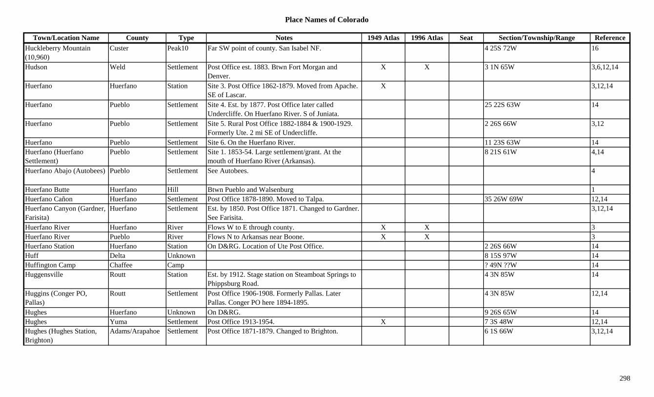
Place Names of Colorado
Town/Location Name County Type Notes 1949 Atlas 1996 Atlas Seat Section/Township/Range ReferenceHuckleberry Mountain (10,960)
Custer Peak10 Far SW point of county. San Isabel NF. 4 25S 72W 16
Hudson Weld Settlement Post Office est. 1883. Btwn Fort Morgan and Denver.
X X 3 1N 65W 3,6,12,14
Huerfano Huerfano Station Site 3. Post Office 1862-1879. Moved from Apache. SE of Lascar.
X 3,12,14
Huerfano Pueblo Settlement Site 4. Est. by 1877. Post Office later called Undercliffe. On Huerfano River. S of Juniata.
25 22S 63W 14
Huerfano Pueblo Settlement Site 5. Rural Post Office 1882-1884 & 1900-1929. Formerly Ute. 2 mi SE of Undercliffe.
2 26S 66W 3,12
Huerfano Pueblo Settlement Site 6. On the Huerfano River. 11 23S 63W 14Huerfano (Huerfano Settlement)
Pueblo Settlement Site 1. 1853-54. Large settlement/grant. At the mouth of Huerfano River (Arkansas).
8 21S 61W 4,14
Huerfano Abajo (Autobees) Pueblo Settlement See Autobees. 4
Huerfano Butte Huerfano Hill Btwn Pueblo and Walsenburg 1Huerfano Cañon Huerfano Settlement Post Office 1878-1890. Moved to Talpa. 35 26W 69W 12,14Huerfano Canyon (Gardner, Farisita)
Huerfano Settlement Est. by 1850. Post Office 1871. Changed to Gardner. See Farisita.
3,12,14
Huerfano River Huerfano River Flows W to E through county. X X 3Huerfano River Pueblo River Flows N to Arkansas near Boone. X X 3Huerfano Station Huerfano Station On D&RG. Location of Ute Post Office. 2 26S 66W 14Huff Delta Unknown 8 15S 97W 14Huffington Camp Chaffee Camp ? 49N ??W 14Huggensville Routt Station Est. by 1912. Stage station on Steamboat Springs to
Phippsburg Road.4 3N 85W 14
H i (C PO R tt S ttl t P t Offi 1906 1908 F l P ll L t 4 3N 85W 12 14Huggins (Conger PO, Pallas)
Routt Settlement Post Office 1906-1908. Formerly Pallas. Later Pallas. Conger PO here 1894-1895.
4 3N 85W 12,14
Hughes Huerfano Unknown On D&RG. 9 26S 65W 14Hughes Yuma Settlement Post Office 1913-1954. X 7 3S 48W 12,14Hughes (Hughes Station, Brighton)
Adams/Arapahoe Settlement Post Office 1871-1879. Changed to Brighton. 6 1S 66W 3,12,14
298
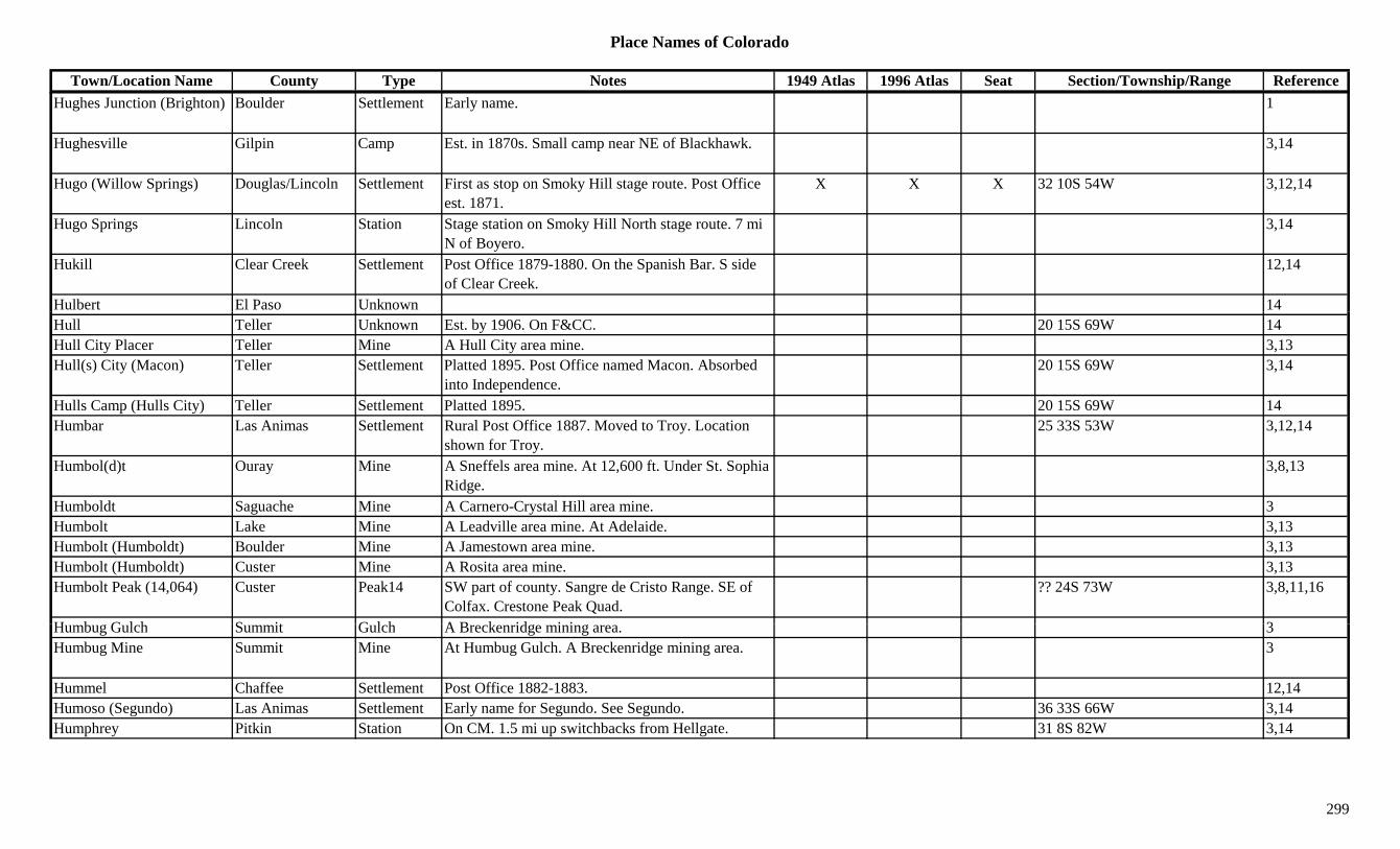
Place Names of Colorado
Town/Location Name County Type Notes 1949 Atlas 1996 Atlas Seat Section/Township/Range ReferenceHughes Junction (Brighton) Boulder Settlement Early name. 1
Hughesville Gilpin Camp Est. in 1870s. Small camp near NE of Blackhawk. 3,14
Hugo (Willow Springs) Douglas/Lincoln Settlement First as stop on Smoky Hill stage route. Post Office est. 1871.
X X X 32 10S 54W 3,12,14
Hugo Springs Lincoln Station Stage station on Smoky Hill North stage route. 7 mi N of Boyero.
3,14
Hukill Clear Creek Settlement Post Office 1879-1880. On the Spanish Bar. S side of Clear Creek.
12,14
Hulbert El Paso Unknown 14Hull Teller Unknown Est. by 1906. On F&CC. 20 15S 69W 14Hull City Placer Teller Mine A Hull City area mine. 3,13Hull(s) City (Macon) Teller Settlement Platted 1895. Post Office named Macon. Absorbed
into Independence.20 15S 69W 3,14
Hulls Camp (Hulls City) Teller Settlement Platted 1895. 20 15S 69W 14Humbar Las Animas Settlement Rural Post Office 1887. Moved to Troy. Location
shown for Troy.25 33S 53W 3,12,14
Humbol(d)t Ouray Mine A Sneffels area mine. At 12,600 ft. Under St. Sophia Ridge.
3,8,13
Humboldt Saguache Mine A Carnero-Crystal Hill area mine. 3Humbolt Lake Mine A Leadville area mine. At Adelaide. 3,13Humbolt (Humboldt) Boulder Mine A Jamestown area mine. 3,13Humbolt (Humboldt) Custer Mine A Rosita area mine. 3,13Humbolt Peak (14,064) Custer Peak14 SW part of county. Sangre de Cristo Range. SE of
Colfax. Crestone Peak Quad.?? 24S 73W 3,8,11,16
H b G l h S it G l h A B k id i i 3Humbug Gulch Summit Gulch A Breckenridge mining area. 3Humbug Mine Summit Mine At Humbug Gulch. A Breckenridge mining area. 3
Hummel Chaffee Settlement Post Office 1882-1883. 12,14Humoso (Segundo) Las Animas Settlement Early name for Segundo. See Segundo. 36 33S 66W 3,14Humphrey Pitkin Station On CM. 1.5 mi up switchbacks from Hellgate. 31 8S 82W 3,14
299

Place Names of Colorado
Town/Location Name County Type Notes 1949 Atlas 1996 Atlas Seat Section/Township/Range ReferenceHunchback Mountain (13,136)
Peak13 Storm King Peak Quad. 11
Hunchback Pass (12,487 or 12,493)
San Juan Pass Needle Mtns, Vallecito Basin. Storm King Peak Topo. San Juan & Rio Grande NF.
35 40N 5W 5,7,8
Hunchback Peak (Mount Oso) (13,684)
La Plata Peak13 NE corner of county. Emerald Lake Quad. 3,11
Hungate Elbert Massacre In 1864 the Hungate family were massacred. Nathan, Ellen and children. Northern Elbert Co.
6
Hungerford Kit Carson Unknown On CRI&P. 1 9S 45W 14Hungerford (Purcell) Weld Settlement Est. 1910 as Purcell. 9 mi E of Pierce. 19 8N 64W 3,14Hungry Gulch Custer Gulch W of Custer City. 3g y yHunkidori Eagle Mine Holy Cross City area mine. 3Hunky Dory Gilpin Mine S of Black Hawk. 3Hunky Dory Lake Eagle Lake SW of Redcliff. White River NF. 19 7S 81W 16Hunkydory Gulch Chaffee Gulch High on N Fork of S Arkansas River. At site of
Shavano.13
Hunns Peak Garfield Peak11 NE county. White River NF. 13 3S 89W 16Hunt La Plata Unknown On D&RG. 26 39N 8W 14Hunt Creek Rio Blanco Creek NE corner of county. Flows E to Routt Co. 3Hunt Creek Routt Creek Flows NE to join Yampa River at Phippsburg. 3Hunt Lake Chaffee Lake West of Garfield. San Isabel NF. ?? 50N 6E 16Hunter Mesa Settlement Small. N & E of Fruita. 3Hunter Creek Pitkin Creek Flows W to Roaring Fork River in Aspen. 3Hunter Hill Gunnison Peak12 South of Taylor Pass. Gunnison NF. ?? 13S 84W 16Hunter Peak (13,497) Peak13 Elk Range, Central Section. Maroon Bells Quad. 8,11
H t ( ) (I d d ) L k /Pitki P Whit Ri & S I b l NF 9 11S 82W 1Hunter(s) (Independence) (12,095)
Lake/Pitkin Pass White River & San Isabel NF. 9 11S 82W 1
Hunt's Concentration Works Boulder Mill At Orodelfan. 3
Hunt's Concentration Works Boulder Settlement Also called Hortonsville, Maxwells Mill & Orodelfan.
27 1N 71W 14
300

Place Names of Colorado
Town/Location Name County Type Notes 1949 Atlas 1996 Atlas Seat Section/Township/Range ReferenceHunts Lake Fremont Lake West of Coaldale. NW of Hayden Pass. San Isabel
NF.?? 48N 9E 16
Hunts Peak Fremont/Saguache Peak13 Sangre de Cristo Range, North Section. Wellsville Quad. San Isabel/Grande NF.
?? 48N 9E 8,11,16
Hunt's Spring Saguache Station Waystop. 4 mi E of Saguache. 2 44N 8E 3,14Huntsman Jefferson Station On C&S. 14Huntsman Mountain Pitkin/Gunnison Mountain W of Redstone. 13Huntsville Douglas Station Site 2. Est. by 1860. Rural Post Office 1862-1871.
PO went to Larkspur.33 8S 67W 3
Huntsville KT/Douglas Settlement Site 1. Post Office 1860-1861. 33 9S 67W 12,14Hurich Larimer/Weld Unknown ? 7N 67W 14Hurley Morgan Station On UP. 3 mi NE of Fort Morgan. X 33 4N 57W 3,14Huron Lode Boulder Mine An Eldora mine. 3,13Huron Peak (14,005) Chaffee Peak14 Sawatch Range, Collegiate Section. Winfield Quad.
San Isabel NF.3 13S 81W 8,11,16
Hurricane Hill Boulder Hill Btwn Lakewood and Tungsten. 3Hurricane Mill Boulder Mine NE of Nederland. 1Hurricane Peak (13,447) Peak13 Handies Peak Quad. 11Hurrich (Hurich) Weld Station On GW, station & siding. 5 mi W of Eaton. 32 7N 66W 3,6,14Husted (Husteds, Southwater)
El Paso Settlement RR Post Office on D&RG 1878-1920. Moved from Southwater.
X 12 12S 67W 3,12,14
Hutchinson Rio Grande Unknown On D&RG. 36 40N 3E 14Hutchinson (Bradford Jct., Hutchison, Conifer)
Jefferson Settlement Post Office 1865-1869 & 1872-1894. Changed to Conifer. N of Conifer.
23 6S 71W 3,4,6,12,14
Hutchinson-Bradford Junction (Conifer)
Jefferson Settlement See Conifer, Hutchinson. 23 6S 71W 3,6
H i P k J k P k S t l t 13Hyannis Peak Jackson Peak S central county. 13Hyde (New Hyde) Weld/Yuma Settlement Post Office 1882-1940 with gaps. Btwn Otis and
Yuma. See New Hyde.X 15 2N 49W 3,4,12
Hyde Park Pueblo Unknown Now within the City of Pueblo. 27 20S 65W 14Hyde's San Miguel Camp Small camp near Haverly's. In La Junta Basin. S of
Telluride.3
301

Place Names of Colorado
Town/Location Name County Type Notes 1949 Atlas 1996 Atlas Seat Section/Township/Range ReferenceHydrate (Hydrata) Routt Station Post Office 1920-1937. On D&SL. 4 mi NW of
Pershing.X 5 1S 83W 3,12,14
Hydraulic Montrose Settlement Post Office 1888-1893 & 1901-1905. 35 49N 18W 12,14Hygiene (Pella) Boulder Settlement Est. 1861. Post Office est. 1883. NW of Longmont.
Btwn Pella & North Pella.X X 25 3N 70W 1,3,6,12,14
Hyman Creek Dolores Creek Flows N to Disappointment Creek and into San Miguel Co.
3
Hynes La Plata Settlement Post Office 1884-1885. 14Ibex Pueblo Unknown ? 24S 67W 14Ibex #1 to #5 Lake Mine A Leadville area mine. At Ibex. 3Ibex (Ibex City, Ibex Camp) Lake Settlement Post Office 1896 & 1898-1905. Up Stray Horse 28 9S 79W 3,12,14( y, p) p y
Gulch. Site of Little Jonny Mine., ,
Ibex Mining Company Lake Mine Served Ibex Camp area. 13Ice Lake Clear Creek Lake Northern tip of county. NW of Alice. Arapaho NF. 29 2S 74W 16
Ice Lake District San Juan Gulch A Bandora mining area. 3Ice Mountain Chaffee/Gunnison Peak13 Sawatch Range, Collegiate Section. One of The
Three Apostles.15 13S 81W 8,11
Iceberg Lakes Gilpin Lake NW corner of county. Roosevelt NF. 8 2S 74W 16Iceburg Pass (11,287 or 11,827)
Larimer Pass Btwn Estes Park and Grand Lake. Trail Ridge Topo. Rocky Mountain Natl Park.
X 5,7
Icefield Pass (11,840 or 11,860)
Larimer Pass NW of Estes Park. SE of Mummy Pass. Comanche Peak Topo. Rocky Mtn Natl Park.
5,7
Ida Chaffee Mine N of Salida. Out of Whitehorn. 3,13Ida Bell Summit Mine A Haywood area mine. 3Ida Silver Clear Creek Mine A North Empire area mine. 13Id h B ld Mi W d A C ib i 1 3 13Idaho Boulder Mine Ward area. A Caribou mine. 1,3,13Idaho La Plata Mine A La Plata area mine. 3Idaho Lake Mine A Leadville area mine. 3Idaho (Idahoe, Idaho Springs)
Clear Creek Settlement Post Office 1862-1876. Changed to Idaho Springs. Also spelled Idahoe.
x 35 3S 73W 3,12,14
Idaho Bar Clear Creek Creek At site of Idaho Springs. 13
302
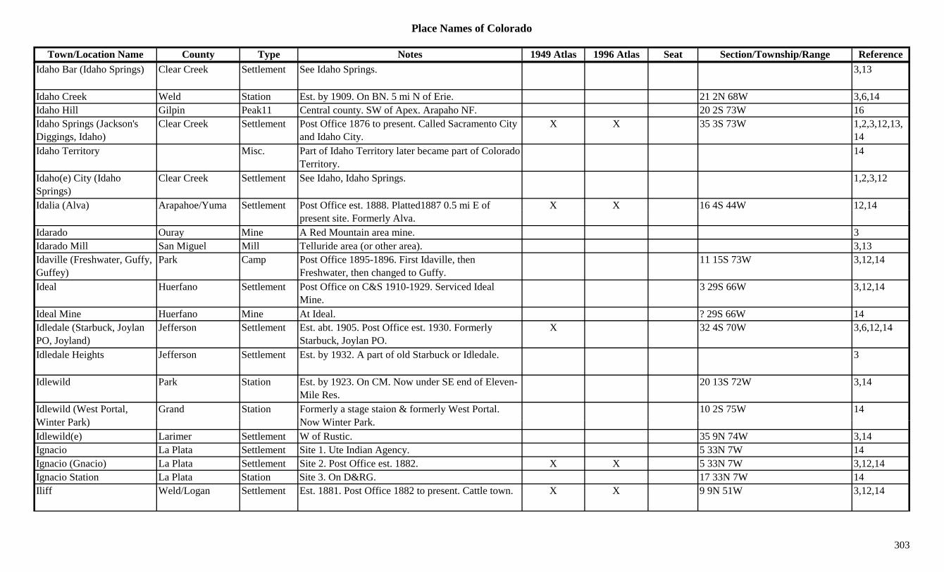
Place Names of Colorado
Town/Location Name County Type Notes 1949 Atlas 1996 Atlas Seat Section/Township/Range ReferenceIdaho Bar (Idaho Springs) Clear Creek Settlement See Idaho Springs. 3,13
Idaho Creek Weld Station Est. by 1909. On BN. 5 mi N of Erie. 21 2N 68W 3,6,14Idaho Hill Gilpin Peak11 Central county. SW of Apex. Arapaho NF. 20 2S 73W 16Idaho Springs (Jackson's Diggings, Idaho)
Clear Creek Settlement Post Office 1876 to present. Called Sacramento City and Idaho City.
X X 35 3S 73W 1,2,3,12,13,14
Idaho Territory Misc. Part of Idaho Territory later became part of Colorado Territory.
14
Idaho(e) City (Idaho Springs)
Clear Creek Settlement See Idaho, Idaho Springs. 1,2,3,12
Idalia (Alva) Arapahoe/Yuma Settlement Post Office est. 1888. Platted1887 0.5 mi E of X X 16 4S 44W 12,14( ) ppresent site. Formerly Alva.
,
Idarado Ouray Mine A Red Mountain area mine. 3Idarado Mill San Miguel Mill Telluride area (or other area). 3,13Idaville (Freshwater, Guffy, Guffey)
Park Camp Post Office 1895-1896. First Idaville, then Freshwater, then changed to Guffy.
11 15S 73W 3,12,14
Ideal Huerfano Settlement Post Office on C&S 1910-1929. Serviced Ideal Mine.
3 29S 66W 3,12,14
Ideal Mine Huerfano Mine At Ideal. ? 29S 66W 14Idledale (Starbuck, Joylan PO, Joyland)
Jefferson Settlement Est. abt. 1905. Post Office est. 1930. Formerly Starbuck, Joylan PO.
X 32 4S 70W 3,6,12,14
Idledale Heights Jefferson Settlement Est. by 1932. A part of old Starbuck or Idledale. 3
Idlewild Park Station Est. by 1923. On CM. Now under SE end of Eleven-Mile Res.
20 13S 72W 3,14
Idlewild (West Portal, Wi t P k)
Grand Station Formerly a stage staion & formerly West Portal. N Wi t P k
10 2S 75W 14Winter Park) Now Winter Park.Idlewild(e) Larimer Settlement W of Rustic. 35 9N 74W 3,14Ignacio La Plata Settlement Site 1. Ute Indian Agency. 5 33N 7W 14Ignacio (Gnacio) La Plata Settlement Site 2. Post Office est. 1882. X X 5 33N 7W 3,12,14Ignacio Station La Plata Station Site 3. On D&RG. 17 33N 7W 14Iliff Weld/Logan Settlement Est. 1881. Post Office 1882 to present. Cattle town. X X 9 9N 51W 3,12,14
303

Place Names of Colorado
Town/Location Name County Type Notes 1949 Atlas 1996 Atlas Seat Section/Township/Range ReferenceIlium (Illium) San Miguel Settlement Post Office 1891-1894 & 1910-1917. X 6 42N 9W 12Illinois Boulder Mine NW of Nederland. 3Illinois Clear Creek Mine Silver Plume area mine. 3Illinois Gilpin Mine Btwn Nevadaville and Bortonsburg. 3Illinois Creek Jackson Creek Flows N from near Rand to North Platte River W of
Cowdrey.X
Illinois Gulch Douglas Gulch SW corner of county. Runs W to Trout Creek. Sev 10S 69W 16Illinois Gulch Gilpin Gulch S of Central City. Runs SE into Russell Gulch. 3Illinois Gulch Gunnison Gulch NW of Ohio City. Runs S to Quartz Creek. Gunnison
NF.Sev 50N 3E 16
Illinois Ho Park Unknown On a wagon road. 15 11S 73W 14gIllinois Pass Grand/Jackson Pass Btwn Willow Creek Pass and Tyner. Routt &
Arapaho NF.27 5N 77W 3,7,16
Illinois River Jackson River Flows N from Rand to La Rand. X 3Illium (Ilium) San Miguel Station Junction on Mears' RR. S of Vance Junction. 6 42N 9W 3,14Ilse Custer Settlement Began 1878. Post Office 1884-1891 & 1895-1929.
28 mi SW of Florence.X 17 21S 70W 3,12,13,14
Ilse Grove Moffat Settlement 19 mi SW of Craig. X 3Ilse Grove Moffat Unknown 35 5N 92W 14Imer Las Animas Unknown On D&RG. 16 32S 64W 14Imogene Basin Ouray Gulch S of Camp Bird Mine. 2,3,13Imogene Pass (13,114) Ouray/San Miguel Pass NW of Red Mountain Pass. Btwn Ouray and
Telluride. Uncompahgre NF.3 42N 8W 1,5,8,9
Imperial Weld Settlement On UP. 10 mi W of Fort Lupton. 10 1N 68W 3,14Incas Hinsdale Mine A Capitol City area mine. 3Incas La Plata Mine E of La Plata. 3I h A h S ttl t P t Offi 1891 12 14Inche Arapahoe Settlement Post Office 1891. 12,14Incinerator Lake Arapahoe Lake At Fort Logan Natl Cemetery. 6 5S 68W 16Independence Adams Station Site 2. On CE. 15 3S 67W 14Independence Adams/Denver Settlement Site 1. Platted 1886. N of Denver airport. No Post
Office.3,14
Independence Arapahoe Station Golden Circle RR station. 14Independence Chaffee Mine Near Turret. 3,13
304

Place Names of Colorado
Town/Location Name County Type Notes 1949 Atlas 1996 Atlas Seat Section/Township/Range ReferenceIndependence Fremont Mine A Whitehorn area mine. 13Independence Pitkin Mine At Independence. 2,3,13Independence San Juan Mine Silverton area mine. 3Independence Summit Settlement Platted 1879. 14Independence Teller Mine A Winfield area mine. 2,3,13Independence (Chipeta, Sparkill, Farwell)
Pitkin Settlement 17 mi SE of Aspen. Went by Chipeta, Sparkill and Farwell, Mammoth City, Mount Hope.
12 11S 83W 2,3,12,13,14
Independence (Hunter(s)) Pass (12,095)
Lake/Pitkin Pass Shown on 1881 map. 14 mi S of Leadville. White River & San Isabel NF.
X X 9 11S 82W 1,3,5,7
Independence (Macon) Teller Settlement Post Office 1899-1954. Formerly Macon. 2 mi N of Victor.
20 15S 69W 2,3,12,13,14
Independence (Pueblo) Pueblo Settlement Est. by 1858. Became Pueblo by 1860. At Junction of Arkansas & Fountain Rivers.
6 21S 64W 1,14
Independence Creek Routt Creek Flows N from Hahns Peak into Wyoming. 3Independence Gulch Hinsdale Gulch North central county. Runs E out of Uncompahgre
NF to Lake Fork Gunnison River.Sev 44N 4W 16
Independent Clear Creek Unknown 14Independent Gunnison Mine A Bowerman area mine. Near Pitkin. 3,13Independent Gunnison Mine A Gothic area mine. 3Independent Saguache Mine A Crestone-Liberty area mine. 3Independent Mining District Gilpin Mine The Perigo and Gold Dirt mines were part of district. 13
Independent Reservoir Boulder Lake NW of Longmont. 26 3N 70W 16India Montezuma Station Est. by 1885. Waystop. W of Cortez. 3Indian Camp Pass (9,175 or 9 715)
Garfield Pass NW of Dotsero. Crossed by forest trail. White River NF
5 3S 88W 79,715) NF.Indian Creek Costilla Creek 1885. E of Trinchera. Had trail going over to La
Veta.3
Indian Creek Mesa Creek Flows W to Gunnison River near Kahnah. 3Indian Creek Pass (9,775) Costilla Pass Shown on 1885 map. E of Trinchera. San Isabel
map.3,7
Indian Fort at Franktown Douglas Fort Existed in 1860s. One of 3 county forts. 9
305
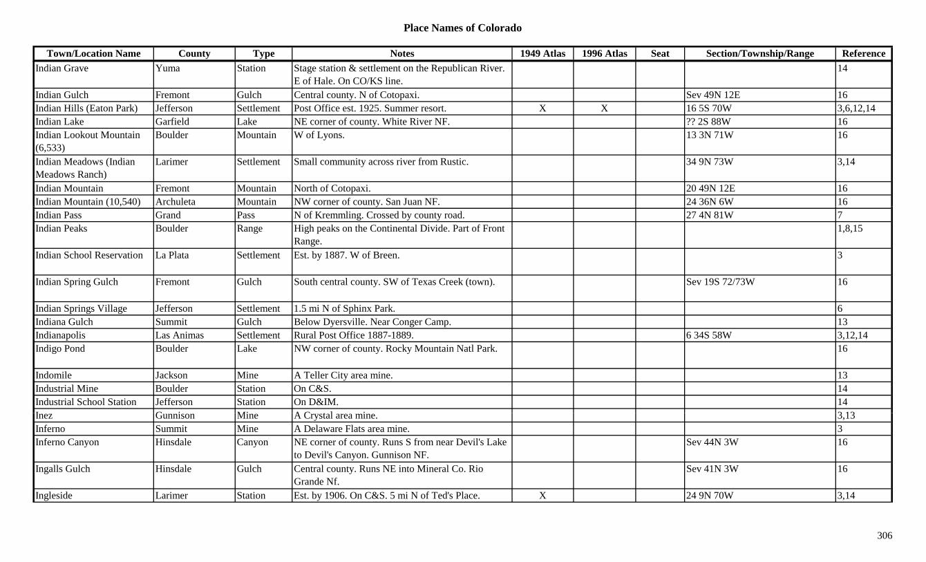
Place Names of Colorado
Town/Location Name County Type Notes 1949 Atlas 1996 Atlas Seat Section/Township/Range ReferenceIndian Grave Yuma Station Stage station & settlement on the Republican River.
E of Hale. On CO/KS line.14
Indian Gulch Fremont Gulch Central county. N of Cotopaxi. Sev 49N 12E 16Indian Hills (Eaton Park) Jefferson Settlement Post Office est. 1925. Summer resort. X X 16 5S 70W 3,6,12,14Indian Lake Garfield Lake NE corner of county. White River NF. ?? 2S 88W 16Indian Lookout Mountain (6,533)
Boulder Mountain W of Lyons. 13 3N 71W 16
Indian Meadows (Indian Meadows Ranch)
Larimer Settlement Small community across river from Rustic. 34 9N 73W 3,14
Indian Mountain Fremont Mountain North of Cotopaxi. 20 49N 12E 16Indian Mountain (10,540) Archuleta Mountain NW corner of county. San Juan NF. 24 36N 6W 16( , ) yIndian Pass Grand Pass N of Kremmling. Crossed by county road. 27 4N 81W 7Indian Peaks Boulder Range High peaks on the Continental Divide. Part of Front
Range.1,8,15
Indian School Reservation La Plata Settlement Est. by 1887. W of Breen. 3
Indian Spring Gulch Fremont Gulch South central county. SW of Texas Creek (town). Sev 19S 72/73W 16
Indian Springs Village Jefferson Settlement 1.5 mi N of Sphinx Park. 6Indiana Gulch Summit Gulch Below Dyersville. Near Conger Camp. 13Indianapolis Las Animas Settlement Rural Post Office 1887-1889. 6 34S 58W 3,12,14Indigo Pond Boulder Lake NW corner of county. Rocky Mountain Natl Park. 16
Indomile Jackson Mine A Teller City area mine. 13Industrial Mine Boulder Station On C&S. 14Industrial School Station Jefferson Station On D&IM. 14I G i Mi A C t l i 3 13Inez Gunnison Mine A Crystal area mine. 3,13Inferno Summit Mine A Delaware Flats area mine. 3Inferno Canyon Hinsdale Canyon NE corner of county. Runs S from near Devil's Lake
to Devil's Canyon. Gunnison NF.Sev 44N 3W 16
Ingalls Gulch Hinsdale Gulch Central county. Runs NE into Mineral Co. Rio Grande Nf.
Sev 41N 3W 16
Ingleside Larimer Station Est. by 1906. On C&S. 5 mi N of Ted's Place. X 24 9N 70W 3,14
306
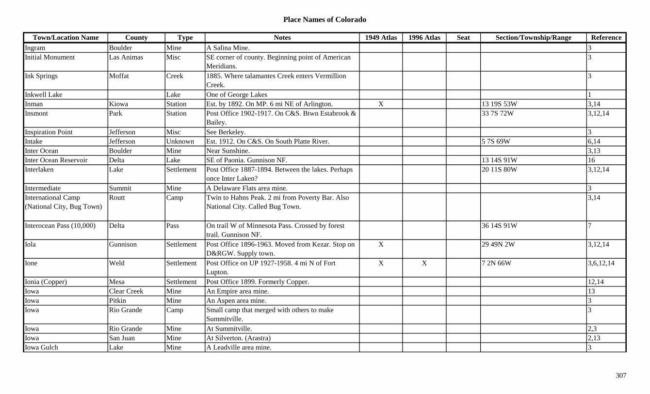
Place Names of Colorado
Town/Location Name County Type Notes 1949 Atlas 1996 Atlas Seat Section/Township/Range ReferenceIngram Boulder Mine A Salina Mine. 3Initial Monument Las Animas Misc SE corner of county. Beginning point of American
Meridians.3
Ink Springs Moffat Creek 1885. Where talamantes Creek enters Vermillion Creek.
3
Inkwell Lake Lake One of George Lakes 1Inman Kiowa Station Est. by 1892. On MP. 6 mi NE of Arlington. X 13 19S 53W 3,14Insmont Park Station Post Office 1902-1917. On C&S. Btwn Estabrook &
Bailey.33 7S 72W 3,12,14
Inspiration Point Jefferson Misc See Berkeley. 3Intake Jefferson Unknown Est. 1912. On C&S. On South Platte River. 5 7S 69W 6,14,Inter Ocean Boulder Mine Near Sunshine. 3,13Inter Ocean Reservoir Delta Lake SE of Paonia. Gunnison NF. 13 14S 91W 16Interlaken Lake Settlement Post Office 1887-1894. Between the lakes. Perhaps
once Inter Laken?20 11S 80W 3,12,14
Intermediate Summit Mine A Delaware Flats area mine. 3International Camp (National City, Bug Town)
Routt Camp Twin to Hahns Peak. 2 mi from Poverty Bar. Also National City. Called Bug Town.
3,14
Interocean Pass (10,000) Delta Pass On trail W of Minnesota Pass. Crossed by forest trail. Gunnison NF.
36 14S 91W 7
Iola Gunnison Settlement Post Office 1896-1963. Moved from Kezar. Stop on D&RGW. Supply town.
X 29 49N 2W 3,12,14
Ione Weld Settlement Post Office on UP 1927-1958. 4 mi N of Fort Lupton.
X X 7 2N 66W 3,6,12,14
Ionia (Copper) Mesa Settlement Post Office 1899. Formerly Copper. 12,14I Cl C k Mi A E i i 13Iowa Clear Creek Mine An Empire area mine. 13Iowa Pitkin Mine An Aspen area mine. 3Iowa Rio Grande Camp Small camp that merged with others to make
Summitville.3
Iowa Rio Grande Mine At Summitville. 2,3Iowa San Juan Mine At Silverton. (Arastra) 2,13Iowa Gulch Lake Mine A Leadville area mine. 3
307
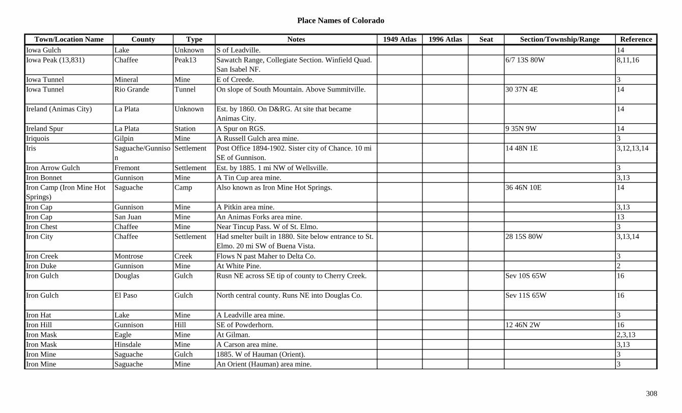
Place Names of Colorado
Town/Location Name County Type Notes 1949 Atlas 1996 Atlas Seat Section/Township/Range ReferenceIowa Gulch Lake Unknown S of Leadville. 14Iowa Peak (13,831) Chaffee Peak13 Sawatch Range, Collegiate Section. Winfield Quad.
San Isabel NF.6/7 13S 80W 8,11,16
Iowa Tunnel Mineral Mine E of Creede. 3Iowa Tunnel Rio Grande Tunnel On slope of South Mountain. Above Summitville. 30 37N 4E 14
Ireland (Animas City) La Plata Unknown Est. by 1860. On D&RG. At site that became Animas City.
14
Ireland Spur La Plata Station A Spur on RGS. 9 35N 9W 14Iriquois Gilpin Mine A Russell Gulch area mine. 3Iris Saguache/Gunniso Settlement Post Office 1894-1902. Sister city of Chance. 10 mi 14 48N 1E 3,12,13,14g
ny
SE of Gunnison., , ,
Iron Arrow Gulch Fremont Settlement Est. by 1885. 1 mi NW of Wellsville. 3Iron Bonnet Gunnison Mine A Tin Cup area mine. 3,13Iron Camp (Iron Mine Hot Springs)
Saguache Camp Also known as Iron Mine Hot Springs. 36 46N 10E 14
Iron Cap Gunnison Mine A Pitkin area mine. 3,13Iron Cap San Juan Mine An Animas Forks area mine. 13Iron Chest Chaffee Mine Near Tincup Pass. W of St. Elmo. 3Iron City Chaffee Settlement Had smelter built in 1880. Site below entrance to St.
Elmo. 20 mi SW of Buena Vista.28 15S 80W 3,13,14
Iron Creek Montrose Creek Flows N past Maher to Delta Co. 3Iron Duke Gunnison Mine At White Pine. 2Iron Gulch Douglas Gulch Rusn NE across SE tip of county to Cherry Creek. Sev 10S 65W 16
Iron Gulch El Paso Gulch North central county. Runs NE into Douglas Co. Sev 11S 65W 16
Iron Hat Lake Mine A Leadville area mine. 3Iron Hill Gunnison Hill SE of Powderhorn. 12 46N 2W 16Iron Mask Eagle Mine At Gilman. 2,3,13Iron Mask Hinsdale Mine A Carson area mine. 3,13Iron Mine Saguache Gulch 1885. W of Hauman (Orient). 3Iron Mine Saguache Mine An Orient (Hauman) area mine. 3
308

Place Names of Colorado
Town/Location Name County Type Notes 1949 Atlas 1996 Atlas Seat Section/Township/Range ReferenceIron Mine Hot Springs (Iron Camp)
Saguache Camp Also known as Iron Camp & Haumann. 36 46N 10E 14
Iron Mines #1-#3 Park Mine A Silver Heels area mine. 3Iron Mountain El Paso Mountain South of Manitou Springs. 8 14S 67W 16Iron Mountain Fremont Mountain SW of Canon City. ?? 19S 72W 16Iron Mountain San Miguel Mountain NE of Vance Junction. Near Ouray Co. 3Iron Mountain (11,400) Costilla Peak11 NW of Sangre de Cristo Pass. Sangre de Cristo
Grant.?? 28S 71W 16
Iron Nipple (13,500) Peak13 Sangre de Cristo Range, Sierra Blancas. Blanca Peak Quad.
8,11
Iron Point Gulch Delta Gulch North of Paonia. Gunnison NF. Sev 12S 91W 16Iron Springs Las Animas Unknown Est. by 1873. On Timpas Creek. S of Delhi. 14Iron Springs Otero Fort Site 3. Est. by 1923. A stockade. 21 27S 58W 14Iron Springs Otero Station Site 1. Est. by 1881. Stage station on Timpas Creek
route. 3 mi SE of Mindeman.16 27S 58W 3,4,14
Iron Springs San Miguel Settlement Near Old Ophir. Mining and resort village. 3,14Iron Springs (Bloom) Otero Settlement Site 2. Est. by 1884. RR & PO first called Iron
Springs. Changed to Bloom.14
Iron Springs Divide Moffat Range S of Great Divide. 3Iron Springs Mesa San Miguel Hill E of Norwood. 13Ironclad Teller Mine Teller Co. mines not elsewhere specified. 3Ironclad Hill Teller Hill E of Cripple Creek. 3Irondale Adams/Arapahoe Settlement Platted in 1889. On CB&Q. Post Office 1889-1895. X 28 2S 67W 3,6,12,14
Ironhill Lake Settlement Post Office 1883. 12,14Ironhill (Iron Hill) Lake Hill S of Adelaide. Rich mines. 3I Gil i U k O GT J t SE f R ll G l h (th t ) N 23 3S 73W 14Irons Gilpin Unknown On GT. Just SE of Russell Gulch (the town). Near
Old Town.23 3S 73W 14
Ironsides Boulder Settlement Post Office 1898. 12,14Ironton (Copper Glen) Ouray Settlement Post Office 1883-1920. 8 mi S of Ouray. Early name
was Copper Glen.X 36 43N 8W 2,3,12,13,14
Irvin (West Portal) Grand Unknown On D&RG. Same as West Portal. Also see Idlewild & Irving Spur.
10 2S 75W 14
309
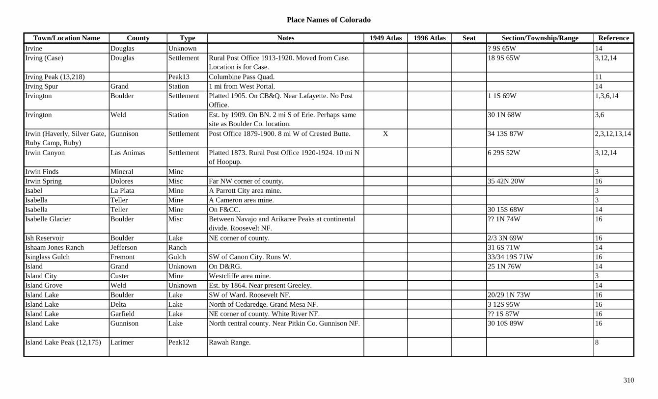
Place Names of Colorado
Town/Location Name County Type Notes 1949 Atlas 1996 Atlas Seat Section/Township/Range ReferenceIrvine Douglas Unknown ? 9S 65W 14Irving (Case) Douglas Settlement Rural Post Office 1913-1920. Moved from Case.
Location is for Case.18 9S 65W 3,12,14
Irving Peak (13,218) Peak13 Columbine Pass Quad. 11Irving Spur Grand Station 1 mi from West Portal. 14Irvington Boulder Settlement Platted 1905. On CB&Q. Near Lafayette. No Post
Office.1 1S 69W 1,3,6,14
Irvington Weld Station Est. by 1909. On BN. 2 mi S of Erie. Perhaps same site as Boulder Co. location.
30 1N 68W 3,6
Irwin (Haverly, Silver Gate, Ruby Camp, Ruby)
Gunnison Settlement Post Office 1879-1900. 8 mi W of Crested Butte. X 34 13S 87W 2,3,12,13,14
Irwin Canyon Las Animas Settlement Platted 1873. Rural Post Office 1920-1924. 10 mi N of Hoopup.
6 29S 52W 3,12,14
Irwin Finds Mineral Mine 3Irwin Spring Dolores Misc Far NW corner of county. 35 42N 20W 16Isabel La Plata Mine A Parrott City area mine. 3Isabella Teller Mine A Cameron area mine. 3Isabella Teller Mine On F&CC. 30 15S 68W 14Isabelle Glacier Boulder Misc Between Navajo and Arikaree Peaks at continental
divide. Roosevelt NF.?? 1N 74W 16
Ish Reservoir Boulder Lake NE corner of county. 2/3 3N 69W 16Ishaam Jones Ranch Jefferson Ranch 31 6S 71W 14Isinglass Gulch Fremont Gulch SW of Canon City. Runs W. 33/34 19S 71W 16Island Grand Unknown On D&RG. 25 1N 76W 14Island City Custer Mine Westcliffe area mine. 3Island Grove Weld Unknown Est. by 1864. Near present Greeley. 14I l d L k B ld L k SW f W d R lt NF 20/29 1N 73W 16Island Lake Boulder Lake SW of Ward. Roosevelt NF. 20/29 1N 73W 16Island Lake Delta Lake North of Cedaredge. Grand Mesa NF. 3 12S 95W 16Island Lake Garfield Lake NE corner of county. White River NF. ?? 1S 87W 16Island Lake Gunnison Lake North central county. Near Pitkin Co. Gunnison NF. 30 10S 89W 16
Island Lake Peak (12,175) Larimer Peak12 Rawah Range. 8
310
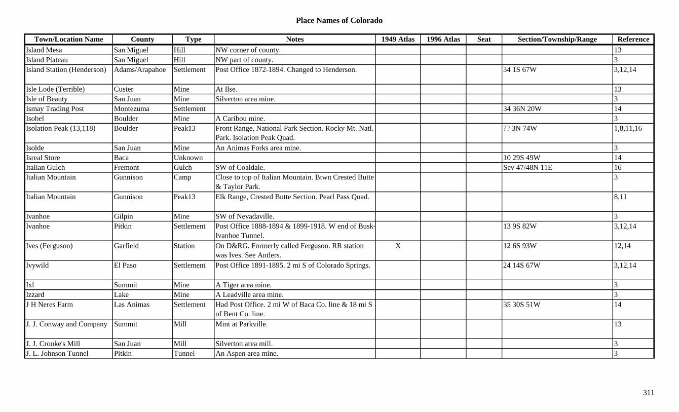
Place Names of Colorado
Town/Location Name County Type Notes 1949 Atlas 1996 Atlas Seat Section/Township/Range ReferenceIsland Mesa San Miguel Hill NW corner of county. 13Island Plateau San Miguel Hill NW part of county. 3Island Station (Henderson) Adams/Arapahoe Settlement Post Office 1872-1894. Changed to Henderson. 34 1S 67W 3,12,14
Isle Lode (Terrible) Custer Mine At Ilse. 13Isle of Beauty San Juan Mine Silverton area mine. 3Ismay Trading Post Montezuma Settlement 34 36N 20W 14Isobel Boulder Mine A Caribou mine. 3Isolation Peak (13,118) Boulder Peak13 Front Range, National Park Section. Rocky Mt. Natl.
Park. Isolation Peak Quad.?? 3N 74W 1,8,11,16
Isolde San Juan Mine An Animas Forks area mine. 3Isreal Store Baca Unknown 10 29S 49W 14Italian Gulch Fremont Gulch SW of Coaldale. Sev 47/48N 11E 16Italian Mountain Gunnison Camp Close to top of Italian Mountain. Btwn Crested Butte
& Taylor Park.3
Italian Mountain Gunnison Peak13 Elk Range, Crested Butte Section. Pearl Pass Quad. 8,11
Ivanhoe Gilpin Mine SW of Nevadaville. 3Ivanhoe Pitkin Settlement Post Office 1888-1894 & 1899-1918. W end of Busk-
Ivanhoe Tunnel.13 9S 82W 3,12,14
Ives (Ferguson) Garfield Station On D&RG. Formerly called Ferguson. RR station was Ives. See Antlers.
X 12 6S 93W 12,14
Ivywild El Paso Settlement Post Office 1891-1895. 2 mi S of Colorado Springs. 24 14S 67W 3,12,14
Ixl Summit Mine A Tiger area mine. 3Izzard Lake Mine A Leadville area mine. 3J H N F L A i S ttl t H d P t Offi 2 i W f B C li & 18 i S 35 30S 51W 14J H Neres Farm Las Animas Settlement Had Post Office. 2 mi W of Baca Co. line & 18 mi S
of Bent Co. line.35 30S 51W 14
J. J. Conway and Company Summit Mill Mint at Parkville. 13
J. J. Crooke's Mill San Juan Mill Silverton area mill. 3J. L. Johnson Tunnel Pitkin Tunnel An Aspen area mine. 3
311
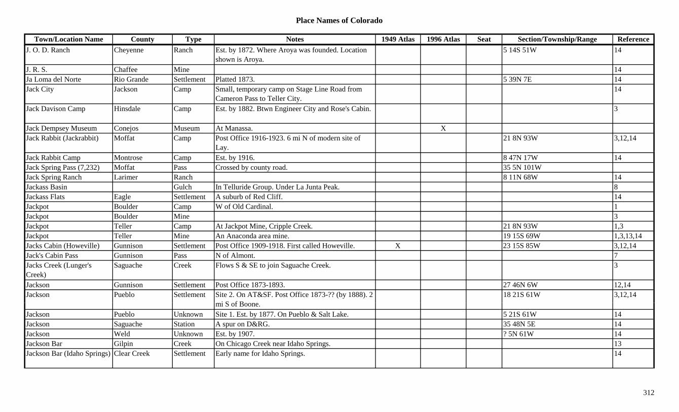
Place Names of Colorado
Town/Location Name County Type Notes 1949 Atlas 1996 Atlas Seat Section/Township/Range ReferenceJ. O. D. Ranch Cheyenne Ranch Est. by 1872. Where Aroya was founded. Location
shown is Aroya.5 14S 51W 14
J. R. S. Chaffee Mine 14Ja Loma del Norte Rio Grande Settlement Platted 1873. 5 39N 7E 14Jack City Jackson Camp Small, temporary camp on Stage Line Road from
Cameron Pass to Teller City.14
Jack Davison Camp Hinsdale Camp Est. by 1882. Btwn Engineer City and Rose's Cabin. 3
Jack Dempsey Museum Conejos Museum At Manassa. XJack Rabbit (Jackrabbit) Moffat Camp Post Office 1916-1923. 6 mi N of modern site of
Lay.21 8N 93W 3,12,14
Jack Rabbit Camp Montrose Camp Est. by 1916. 8 47N 17W 14Jack Spring Pass (7,232) Moffat Pass Crossed by county road. 35 5N 101WJack Spring Ranch Larimer Ranch 8 11N 68W 14Jackass Basin Gulch In Telluride Group. Under La Junta Peak. 8Jackass Flats Eagle Settlement A suburb of Red Cliff. 14Jackpot Boulder Camp W of Old Cardinal. 1Jackpot Boulder Mine 3Jackpot Teller Camp At Jackpot Mine, Cripple Creek. 21 8N 93W 1,3Jackpot Teller Mine An Anaconda area mine. 19 15S 69W 1,3,13,14Jacks Cabin (Howeville) Gunnison Settlement Post Office 1909-1918. First called Howeville. X 23 15S 85W 3,12,14Jack's Cabin Pass Gunnison Pass N of Almont. 7Jacks Creek (Lunger's Creek)
Saguache Creek Flows S & SE to join Saguache Creek. 3
Jackson Gunnison Settlement Post Office 1873-1893. 27 46N 6W 12,14Jackson Pueblo Settlement Site 2. On AT&SF. Post Office 1873-?? (by 1888). 2
i S f B18 21S 61W 3,12,14
mi S of Boone.Jackson Pueblo Unknown Site 1. Est. by 1877. On Pueblo & Salt Lake. 5 21S 61W 14Jackson Saguache Station A spur on D&RG. 35 48N 5E 14Jackson Weld Unknown Est. by 1907. ? 5N 61W 14Jackson Bar Gilpin Creek On Chicago Creek near Idaho Springs. 13Jackson Bar (Idaho Springs) Clear Creek Settlement Early name for Idaho Springs. 14
312

Place Names of Colorado
Town/Location Name County Type Notes 1949 Atlas 1996 Atlas Seat Section/Township/Range ReferenceJackson Mountain (8,852) Archuleta Mountain N central part of county. W of Eastfork. 20 36N 1W 3,16Jackson Reservoir Morgan Lake North of Goodrich. X XJackson's Butte Montezuma Hill 1885. 27 mi NE of 4 Corners. On Wagon trail from
New Mexico.3
Jackson's Camp (Jackson Camp)
Boulder Camp Est. by 1878. Near Magnolia. 1,6,13,14
Jackson's Diggings (Idaho Springs)
Clear Creek Settlement Named in 1859. Another name for Idaho Springs. 1,2,14
Jacksonville Montrose Settlement On Cimarron Creek. 28 mi up Cimarron River from Hwy 50.
14
Jackstraw Mountain Peak Never Summer Range 1gJacktown Lake Settlement Leadville suburb in Smelter Alley. 3Jacktown (Kellogg) Pitkin Settlement Est. by 1882. Later called Kellogg. 2 mi N of Iron
Mountain. S of Ashcroft.14
Jacobs Hill (9,443) Conejos Hill North central county. W of Morgan. Rio Grande NF. 25 36N 6E 13,16
Jacob's Ladder Road Mesa Trail Fruita to Glade Park. 3Jacona Unknown On D&RG. At 6,270 ft. elevation. 14Jacot Park Unknown Est. by 1922. On DSP&P. 1.2 mi above Riceville.
0.3 mi below Longmeadow.? 7S 73W 14
Jacque Peak (13,205) Summit Peak13 Gore Range, South Gore Group. Copper Mtn. Quad. 8,11,13
Jagged Mountain (13,824) Peak13 Needle Mountains. The Grenadiers. Storm King Peak Quad.
8,11
Jailbird Lake Mine A California Gulch mine. 3Jakemans Pitkin Unknown On CM. 12 8S 84W 14J li L St ti E t b 1907 O B li t & Mi i N ? 8N 50W 14Jalien Logan Station Est. by 1907. On Burlington & Missouri. Now
spelled Galien.? 8N 50W 14
James Canyon Boulder Canyon NW of Jamestown. 1James Creek Boulder Creek Flows E past Jamestown. 3,13James Creek Boulder Mine Through Jamestown & Springdale. 3James Peak (Jim Peak) Boulder/Grand Peak13 NW Gilpin Co. Where Clear Creek, Grand & Gilpin
Cos join. Arapaho/Roosevelt NF.29 2S 74W 8,11,16
313

Place Names of Colorado
Town/Location Name County Type Notes 1949 Atlas 1996 Atlas Seat Section/Township/Range ReferenceJames Peak Lake Gilpin Lake NW corner of county. Roosevelt NF. 21 2S 74W 16Jamestown (Jimtown, Elysian Park)
Boulder Settlement Est. 1864. Post Office 1867-1930 & 1934 on. Called Jimtown. 13 mi NW of Boulder.
X X 19 2N 71W 1,2,3,12,13,14
Jamie Lee Lake Mine A Leadville area mine. 3Jamie Lee Lake Settlement Had a Post Office? 14Janeway (Mobley's Camp) Pitkin Settlement Est. by 1880. Post Office and store 1887-1900.
Earlier named Mobley's Camp.X 16 9S 88W 3,12,14
Jansen (Chimayosas) Las Animas Settlement Post Office 1902-1913 & 1932-1974. Renamed Jansen, 1902. Early Spanish settlement.
X 23 33S 64W 3,12,14
January Teller Settlement Est. by 1894. 3 mi N of Victor. Post Office 1894-1911.
2
January Cow Camp Saguache Camp SW corner of Grant land (Baca Grant #4). 36 42N 10E 3,14Japan San Miguel Mine At Telluride. 2,3,13Jarosa Mesa Hinsdale Peak12 SE of Lake City. Gunnison/Rio Grande NF. 5/8 42N 3W 16Jarosa Peak (11,680) Conejos Peak11 SW corner of county. Rio Grande NF. 30 33N 5E 16Jaroso Las Animas Settlement Post Office 1890-1894. 12,14Jaroso (Jarosa) Costilla Settlement Post Office est. 1911. X X 35 1N 74W 3,12,14Jason Lake Unknown On D&RG. 24 9S 80W 14Jasper Park Settlement Est. by 1902. Had a stage to & from Lake George. 14
Jasper (Jaspar, Cornwall) Rio Grande Settlement Est. by 1874. Post Office 1882-1927 with gaps. 32 mi SW of Monte Vista.
X 29 37N 5E 2,3,12,13,14
Jasper Lake Boulder Lake SW corner of county. Roosevelt NF. 10 1S 74W 16Jay Ouray Settlement On RGS. X 7 45N 8W 14Jebel Huerfano Station Est. by 1920. On D&RG, Alamo branch. NW of
Walsenburg.14
J ff B ld Mi A M li i 3 13Jefferson Boulder Mine A Magnolia area mine. 3,13Jefferson Gilpin Mine A Russell Gulch area mine. 3Jefferson Kansas Terr. Settlement Post Office 1860. Location unknown. 12,14Jefferson Park Settlement Post Office 1861-1863 & 1879 to present. 16 mi NE
of Fairplay.X X 5 8S 75W 2,3,12,13,14
Jefferson Teller Station Est. by 1906. On CS&CCD. Shown a mine. 27 15S 69W 14
314
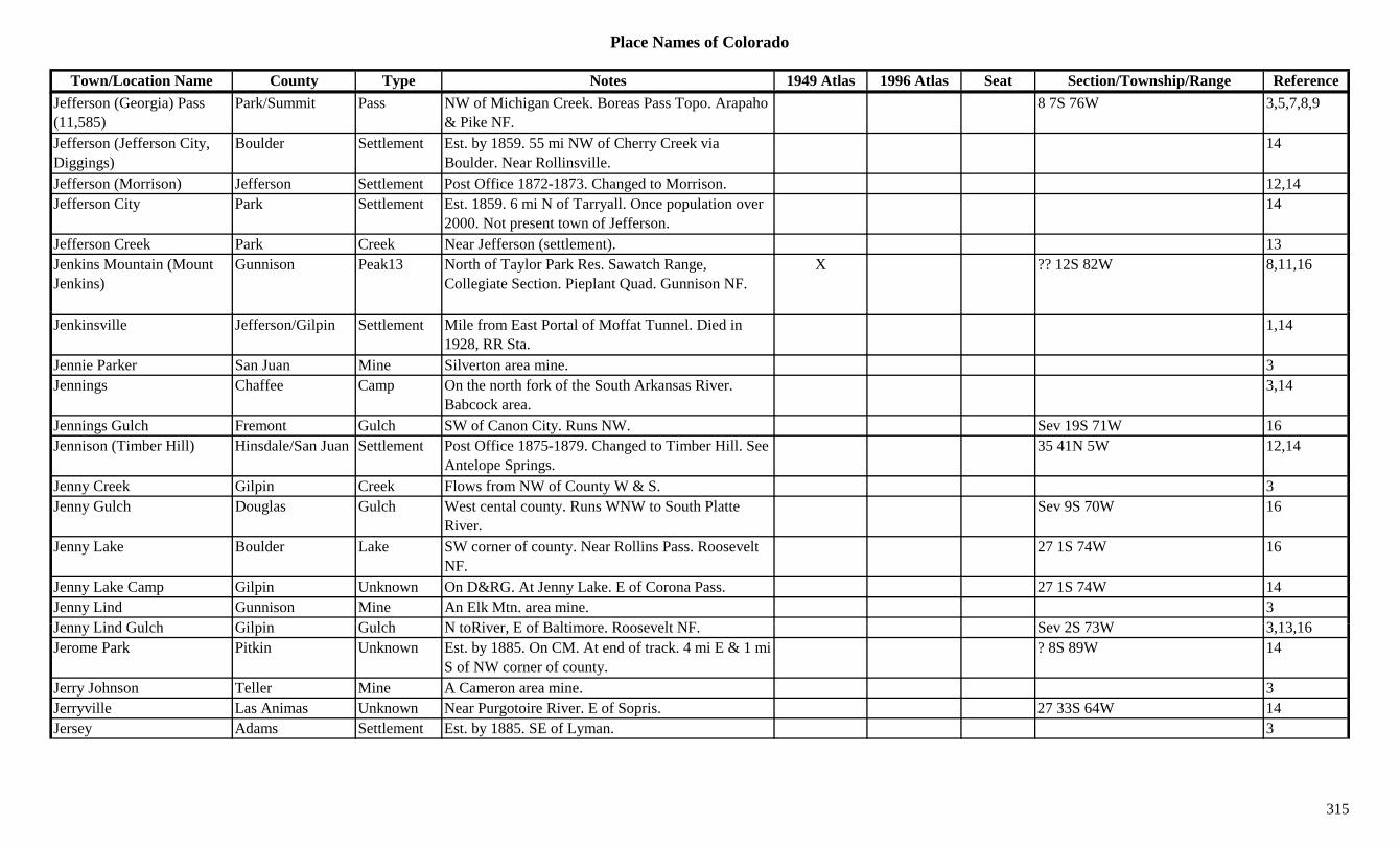
Place Names of Colorado
Town/Location Name County Type Notes 1949 Atlas 1996 Atlas Seat Section/Township/Range ReferenceJefferson (Georgia) Pass (11,585)
Park/Summit Pass NW of Michigan Creek. Boreas Pass Topo. Arapaho & Pike NF.
8 7S 76W 3,5,7,8,9
Jefferson (Jefferson City, Diggings)
Boulder Settlement Est. by 1859. 55 mi NW of Cherry Creek via Boulder. Near Rollinsville.
14
Jefferson (Morrison) Jefferson Settlement Post Office 1872-1873. Changed to Morrison. 12,14Jefferson City Park Settlement Est. 1859. 6 mi N of Tarryall. Once population over
2000. Not present town of Jefferson.14
Jefferson Creek Park Creek Near Jefferson (settlement). 13Jenkins Mountain (Mount Jenkins)
Gunnison Peak13 North of Taylor Park Res. Sawatch Range, Collegiate Section. Pieplant Quad. Gunnison NF.
X ?? 12S 82W 8,11,16
Jenkinsville Jefferson/Gilpin Settlement Mile from East Portal of Moffat Tunnel. Died in 1928, RR Sta.
1,14
Jennie Parker San Juan Mine Silverton area mine. 3Jennings Chaffee Camp On the north fork of the South Arkansas River.
Babcock area.3,14
Jennings Gulch Fremont Gulch SW of Canon City. Runs NW. Sev 19S 71W 16Jennison (Timber Hill) Hinsdale/San Juan Settlement Post Office 1875-1879. Changed to Timber Hill. See
Antelope Springs.35 41N 5W 12,14
Jenny Creek Gilpin Creek Flows from NW of County W & S. 3Jenny Gulch Douglas Gulch West cental county. Runs WNW to South Platte
River.Sev 9S 70W 16
Jenny Lake Boulder Lake SW corner of county. Near Rollins Pass. Roosevelt NF.
27 1S 74W 16
Jenny Lake Camp Gilpin Unknown On D&RG. At Jenny Lake. E of Corona Pass. 27 1S 74W 14Jenny Lind Gunnison Mine An Elk Mtn. area mine. 3J Li d G l h Gil i G l h N t Ri E f B lti R lt NF S 2S 73W 3 13 16Jenny Lind Gulch Gilpin Gulch N toRiver, E of Baltimore. Roosevelt NF. Sev 2S 73W 3,13,16Jerome Park Pitkin Unknown Est. by 1885. On CM. At end of track. 4 mi E & 1 mi
S of NW corner of county.? 8S 89W 14
Jerry Johnson Teller Mine A Cameron area mine. 3Jerryville Las Animas Unknown Near Purgotoire River. E of Sopris. 27 33S 64W 14Jersey Adams Settlement Est. by 1885. SE of Lyman. 3
315
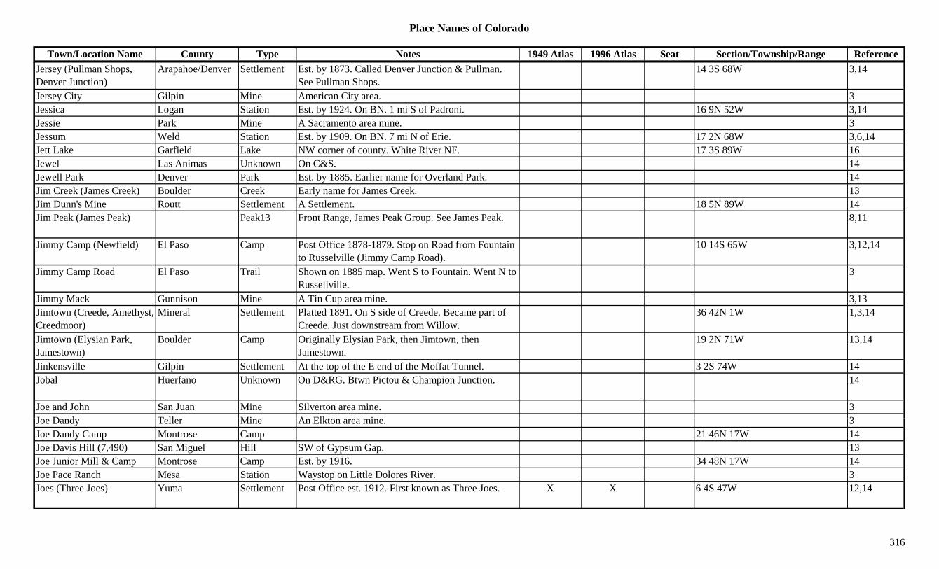
Place Names of Colorado
Town/Location Name County Type Notes 1949 Atlas 1996 Atlas Seat Section/Township/Range ReferenceJersey (Pullman Shops, Denver Junction)
Arapahoe/Denver Settlement Est. by 1873. Called Denver Junction & Pullman. See Pullman Shops.
14 3S 68W 3,14
Jersey City Gilpin Mine American City area. 3Jessica Logan Station Est. by 1924. On BN. 1 mi S of Padroni. 16 9N 52W 3,14Jessie Park Mine A Sacramento area mine. 3Jessum Weld Station Est. by 1909. On BN. 7 mi N of Erie. 17 2N 68W 3,6,14Jett Lake Garfield Lake NW corner of county. White River NF. 17 3S 89W 16Jewel Las Animas Unknown On C&S. 14Jewell Park Denver Park Est. by 1885. Earlier name for Overland Park. 14Jim Creek (James Creek) Boulder Creek Early name for James Creek. 13Jim Dunn's Mine Routt Settlement A Settlement. 18 5N 89W 14Jim Peak (James Peak) Peak13 Front Range, James Peak Group. See James Peak. 8,11
Jimmy Camp (Newfield) El Paso Camp Post Office 1878-1879. Stop on Road from Fountain to Russelville (Jimmy Camp Road).
10 14S 65W 3,12,14
Jimmy Camp Road El Paso Trail Shown on 1885 map. Went S to Fountain. Went N to Russellville.
3
Jimmy Mack Gunnison Mine A Tin Cup area mine. 3,13Jimtown (Creede, Amethyst, Creedmoor)
Mineral Settlement Platted 1891. On S side of Creede. Became part of Creede. Just downstream from Willow.
36 42N 1W 1,3,14
Jimtown (Elysian Park, Jamestown)
Boulder Camp Originally Elysian Park, then Jimtown, then Jamestown.
19 2N 71W 13,14
Jinkensville Gilpin Settlement At the top of the E end of the Moffat Tunnel. 3 2S 74W 14Jobal Huerfano Unknown On D&RG. Btwn Pictou & Champion Junction. 14
Joe and John San Juan Mine Silverton area mine. 3J D d T ll Mi A Elkt i 3Joe Dandy Teller Mine An Elkton area mine. 3Joe Dandy Camp Montrose Camp 21 46N 17W 14Joe Davis Hill (7,490) San Miguel Hill SW of Gypsum Gap. 13Joe Junior Mill & Camp Montrose Camp Est. by 1916. 34 48N 17W 14Joe Pace Ranch Mesa Station Waystop on Little Dolores River. 3Joes (Three Joes) Yuma Settlement Post Office est. 1912. First known as Three Joes. X X 6 4S 47W 12,14
316
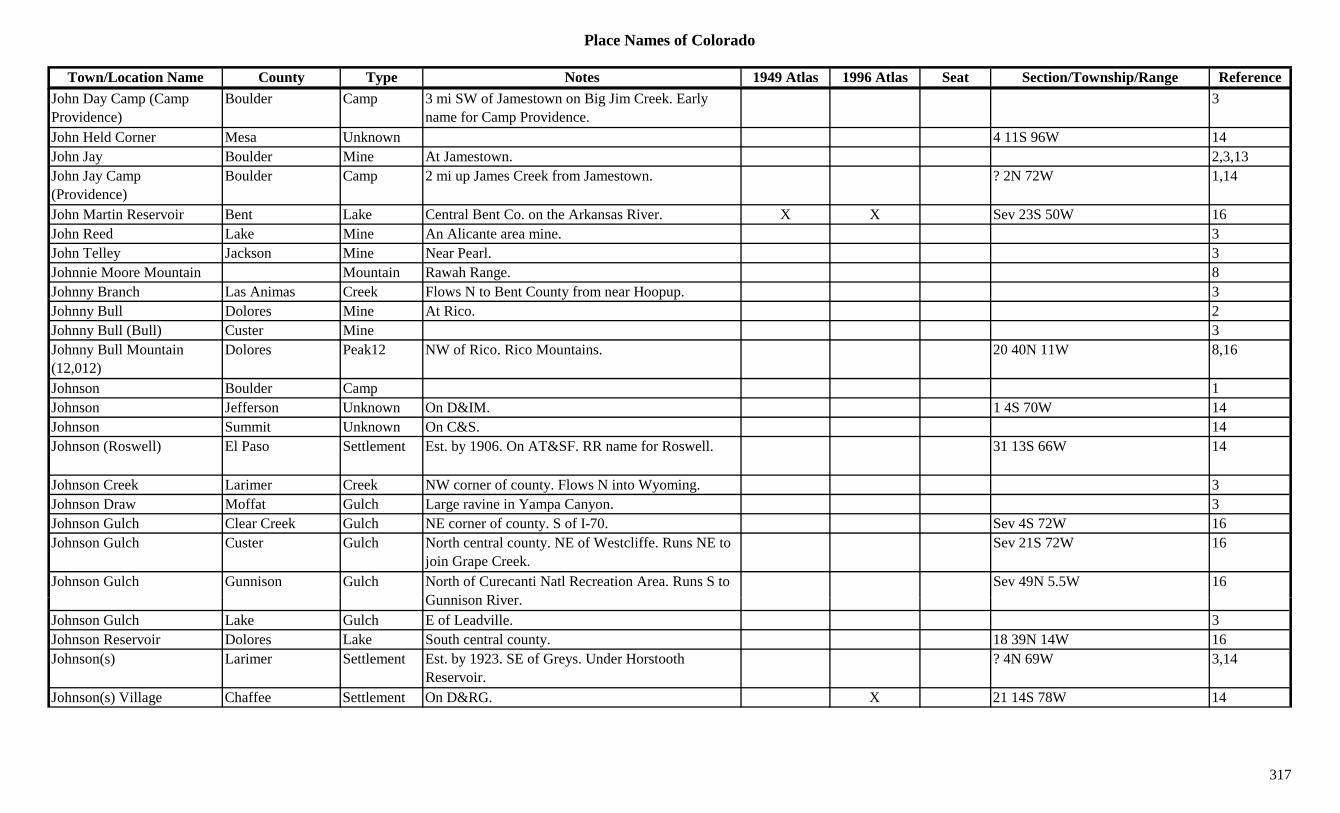
Place Names of Colorado
Town/Location Name County Type Notes 1949 Atlas 1996 Atlas Seat Section/Township/Range ReferenceJohn Day Camp (Camp Providence)
Boulder Camp 3 mi SW of Jamestown on Big Jim Creek. Early name for Camp Providence.
3
John Held Corner Mesa Unknown 4 11S 96W 14John Jay Boulder Mine At Jamestown. 2,3,13John Jay Camp (Providence)
Boulder Camp 2 mi up James Creek from Jamestown. ? 2N 72W 1,14
John Martin Reservoir Bent Lake Central Bent Co. on the Arkansas River. X X Sev 23S 50W 16John Reed Lake Mine An Alicante area mine. 3John Telley Jackson Mine Near Pearl. 3Johnnie Moore Mountain Mountain Rawah Range. 8Johnny Branch Las Animas Creek Flows N to Bent County from near Hoopup. 3y y p pJohnny Bull Dolores Mine At Rico. 2Johnny Bull (Bull) Custer Mine 3Johnny Bull Mountain (12,012)
Dolores Peak12 NW of Rico. Rico Mountains. 20 40N 11W 8,16
Johnson Boulder Camp 1Johnson Jefferson Unknown On D&IM. 1 4S 70W 14Johnson Summit Unknown On C&S. 14Johnson (Roswell) El Paso Settlement Est. by 1906. On AT&SF. RR name for Roswell. 31 13S 66W 14
Johnson Creek Larimer Creek NW corner of county. Flows N into Wyoming. 3Johnson Draw Moffat Gulch Large ravine in Yampa Canyon. 3Johnson Gulch Clear Creek Gulch NE corner of county. S of I-70. Sev 4S 72W 16Johnson Gulch Custer Gulch North central county. NE of Westcliffe. Runs NE to
join Grape Creek.Sev 21S 72W 16
Johnson Gulch Gunnison Gulch North of Curecanti Natl Recreation Area. Runs S to G i Ri
Sev 49N 5.5W 16Gunnison River.
Johnson Gulch Lake Gulch E of Leadville. 3Johnson Reservoir Dolores Lake South central county. 18 39N 14W 16Johnson(s) Larimer Settlement Est. by 1923. SE of Greys. Under Horstooth
Reservoir.? 4N 69W 3,14
Johnson(s) Village Chaffee Settlement On D&RG. X 21 14S 78W 14
317
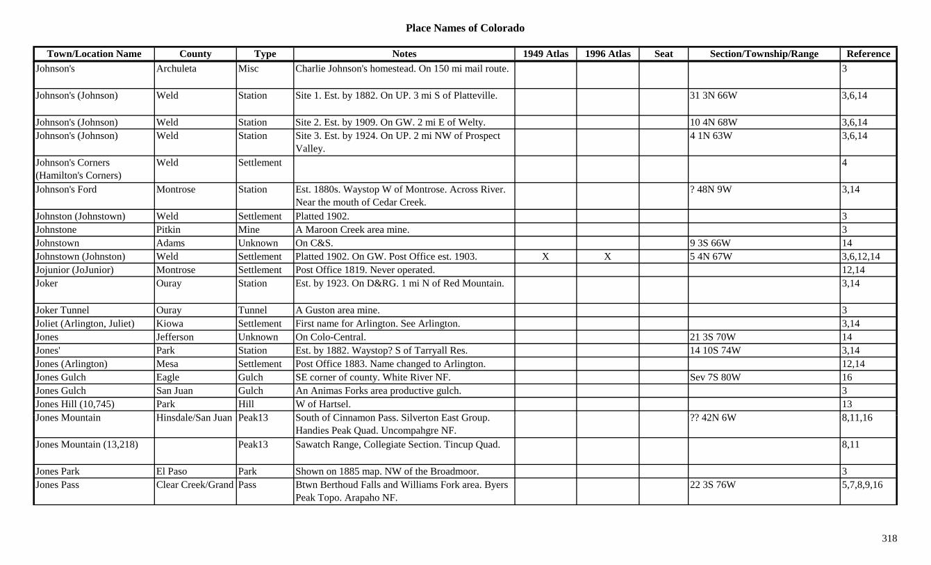
Place Names of Colorado
Town/Location Name County Type Notes 1949 Atlas 1996 Atlas Seat Section/Township/Range ReferenceJohnson's Archuleta Misc Charlie Johnson's homestead. On 150 mi mail route. 3
Johnson's (Johnson) Weld Station Site 1. Est. by 1882. On UP. 3 mi S of Platteville. 31 3N 66W 3,6,14
Johnson's (Johnson) Weld Station Site 2. Est. by 1909. On GW. 2 mi E of Welty. 10 4N 68W 3,6,14Johnson's (Johnson) Weld Station Site 3. Est. by 1924. On UP. 2 mi NW of Prospect
Valley.4 1N 63W 3,6,14
Johnson's Corners (Hamilton's Corners)
Weld Settlement 4
Johnson's Ford Montrose Station Est. 1880s. Waystop W of Montrose. Across River. Near the mouth of Cedar Creek.
? 48N 9W 3,14
Johnston (Johnstown) Weld Settlement Platted 1902. 3Johnstone Pitkin Mine A Maroon Creek area mine. 3Johnstown Adams Unknown On C&S. 9 3S 66W 14Johnstown (Johnston) Weld Settlement Platted 1902. On GW. Post Office est. 1903. X X 5 4N 67W 3,6,12,14Jojunior (JoJunior) Montrose Settlement Post Office 1819. Never operated. 12,14Joker Ouray Station Est. by 1923. On D&RG. 1 mi N of Red Mountain. 3,14
Joker Tunnel Ouray Tunnel A Guston area mine. 3Joliet (Arlington, Juliet) Kiowa Settlement First name for Arlington. See Arlington. 3,14Jones Jefferson Unknown On Colo-Central. 21 3S 70W 14Jones' Park Station Est. by 1882. Waystop? S of Tarryall Res. 14 10S 74W 3,14Jones (Arlington) Mesa Settlement Post Office 1883. Name changed to Arlington. 12,14Jones Gulch Eagle Gulch SE corner of county. White River NF. Sev 7S 80W 16Jones Gulch San Juan Gulch An Animas Forks area productive gulch. 3Jones Hill (10,745) Park Hill W of Hartsel. 13J M t i Hi d l /S J P k13 S th f Ci P Sil t E t G ?? 42N 6W 8 11 16Jones Mountain Hinsdale/San Juan Peak13 South of Cinnamon Pass. Silverton East Group.
Handies Peak Quad. Uncompahgre NF.?? 42N 6W 8,11,16
Jones Mountain (13,218) Peak13 Sawatch Range, Collegiate Section. Tincup Quad. 8,11
Jones Park El Paso Park Shown on 1885 map. NW of the Broadmoor. 3Jones Pass Clear Creek/Grand Pass Btwn Berthoud Falls and Williams Fork area. Byers
Peak Topo. Arapaho NF.22 3S 76W 5,7,8,9,16
318
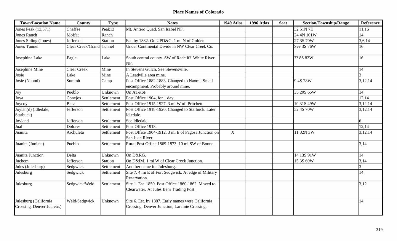
Place Names of Colorado
Town/Location Name County Type Notes 1949 Atlas 1996 Atlas Seat Section/Township/Range ReferenceJones Peak (13,571) Chaffee Peak13 Mt. Antero Quad. San Isabel NF. 32 51N 7E 11,16Jones Ranch Moffat Ranch 24 4N 101W 14Jones Siding (Jones) Jefferson Station Est. by 1882. On UPD&G. 1 mi N of Golden. 27 3S 70W 3,6,14Jones Tunnel Clear Creek/Grand Tunnel Under Continental Divide in NW Clear Creek Co. Sev 3S 76W 16
Josephine Lake Eagle Lake South central county. SW of Redcliff. White River NF.
?? 8S 82W 16
Josephine Mine Clear Creek Mine In Stevens Gulch. See Stevensville. 14Josie Lake Mine A Leadville area mine. 3Josie (Naomi) Summit Camp Post Office 1882-1883. Changed to Naomi. Small
encampment. Probably around mine.9 4S 78W 3,12,14
Joy Pueblo Unknown On AT&SF. 35 20S 65W 14Joya Conejos Settlement Post Office 1904, for 1 day. 12,14Joycoy Baca Settlement Post Office 1915-1927. 3 mi W of Pritchett. 10 31S 49W 3,12,14Joylan(d) (Idledale, Starbuck)
Jefferson Settlement Post Office 1918-1920. Changed to Starbuck. Later Idledale.
32 4S 70W 3,12,14
Joyland Jefferson Settlement See Idledale. 6Jual Dolores Settlement Post Office 1918. 12,14Juanita Archuleta Settlement Post Office 1904-1912. 3 mi E of Pagosa Junction on
San Juan River.X 11 32N 3W 3,12,14
Juanita (Juniata) Pueblo Settlement Rural Post Office 1869-1873. 10 mi SW of Boone. 3,14
Juanita Junction Delta Unknown On D&RG. 14 13S 91W 14Juchem Jefferson Station On D&IM. 1 mi W of Clear Creek Junction. 15 3S 69W 3,14Jules (Julesburg) Sedgwick Settlement Another name for Julesburg. 3Julesburg Sedgwick Settlement Site 7. 4 mi E of Fort Sedgwick. At edge of Military
R ti14
Reservation.Julesburg Sedgwick/Weld Settlement Site 1. Est. 1850. Post Office 1860-1862. Moved to
Clearwater. At Jules Beni Trading Post.3,12
Julesburg (California Crossing, Denver Jct, etc.)
Weld/Sedgwick Unknown Site 6. Est. by 1887. Early names were California Crossing, Denver Junction, Laramie Crossing.
14
319
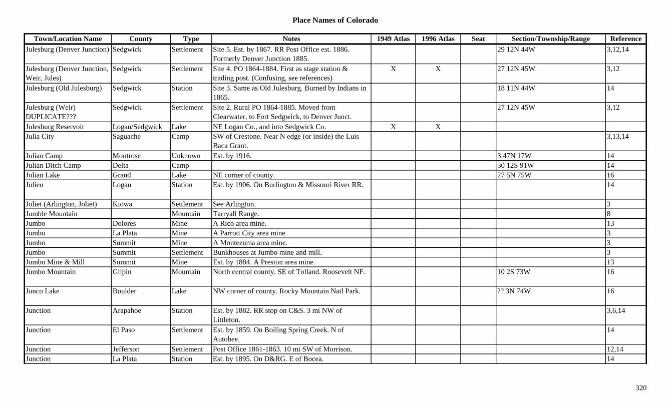
Place Names of Colorado
Town/Location Name County Type Notes 1949 Atlas 1996 Atlas Seat Section/Township/Range ReferenceJulesburg (Denver Junction) Sedgwick Settlement Site 5. Est. by 1867. RR Post Office est. 1886.
Formerly Denver Junction 1885.29 12N 44W 3,12,14
Julesburg (Denver Junction, Weir, Jules)
Sedgwick Settlement Site 4. PO 1864-1884. First as stage station & trading post. (Confusing, see references)
X X 27 12N 45W 3,12
Julesburg (Old Julesburg) Sedgwick Station Site 3. Same as Old Julesburg. Burned by Indians in 1865.
18 11N 44W 14
Julesburg (Weir) DUPLICATE???
Sedgwick Settlement Site 2. Rural PO 1864-1885. Moved from Clearwater, to Fort Sedgwick, to Denver Junct.
27 12N 45W 3,12
Julesburg Reservoir Logan/Sedgwick Lake NE Logan Co., and into Sedgwick Co. X XJulia City Saguache Camp SW of Crestone. Near N edge (or inside) the Luis
Baca Grant.3,13,14
Julian Camp Montrose Unknown Est. by 1916. 3 47N 17W 14Julian Ditch Camp Delta Camp 30 12S 91W 14Julian Lake Grand Lake NE corner of county. 27 5N 75W 16Julien Logan Station Est. by 1906. On Burlington & Missouri River RR. 14
Juliet (Arlington, Joliet) Kiowa Settlement See Arlington. 3Jumble Mountain Mountain Tarryall Range. 8Jumbo Dolores Mine A Rico area mine. 13Jumbo La Plata Mine A Parrott City area mine. 3Jumbo Summit Mine A Montezuma area mine. 3Jumbo Summit Settlement Bunkhouses at Jumbo mine and mill. 3Jumbo Mine & Mill Summit Mine Est. by 1884. A Preston area mine. 13Jumbo Mountain Gilpin Mountain North central county. SE of Tolland. Roosevelt NF. 10 2S 73W 16
Junco Lake Boulder Lake NW corner of county. Rocky Mountain Natl Park. ?? 3N 74W 16
Junction Arapahoe Station Est. by 1882. RR stop on C&S. 3 mi NW of Littleton.
3,6,14
Junction El Paso Settlement Est. by 1859. On Boiling Spring Creek. N of Autobee.
14
Junction Jefferson Settlement Post Office 1861-1863. 10 mi SW of Morrison. 12,14Junction La Plata Station Est. by 1895. On D&RG. E of Bocea. 14
320
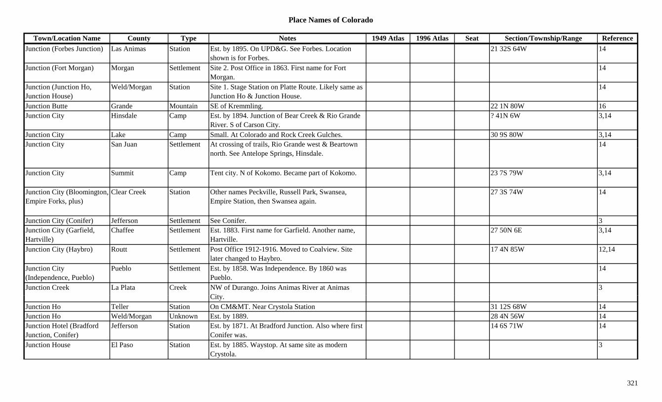
Place Names of Colorado
Town/Location Name County Type Notes 1949 Atlas 1996 Atlas Seat Section/Township/Range ReferenceJunction (Forbes Junction) Las Animas Station Est. by 1895. On UPD&G. See Forbes. Location
shown is for Forbes.21 32S 64W 14
Junction (Fort Morgan) Morgan Settlement Site 2. Post Office in 1863. First name for Fort Morgan.
14
Junction (Junction Ho, Junction House)
Weld/Morgan Station Site 1. Stage Station on Platte Route. Likely same as Junction Ho & Junction House.
14
Junction Butte Grande Mountain SE of Kremmling. 22 1N 80W 16Junction City Hinsdale Camp Est. by 1894. Junction of Bear Creek & Rio Grande
River. S of Carson City.? 41N 6W 3,14
Junction City Lake Camp Small. At Colorado and Rock Creek Gulches. 30 9S 80W 3,14Junction City San Juan Settlement At crossing of trails, Rio Grande west & Beartown 14y g ,
north. See Antelope Springs, Hinsdale.
Junction City Summit Camp Tent city. N of Kokomo. Became part of Kokomo. 23 7S 79W 3,14
Junction City (Bloomington, Empire Forks, plus)
Clear Creek Station Other names Peckville, Russell Park, Swansea, Empire Station, then Swansea again.
27 3S 74W 14
Junction City (Conifer) Jefferson Settlement See Conifer. 3Junction City (Garfield, Hartville)
Chaffee Settlement Est. 1883. First name for Garfield. Another name, Hartville.
27 50N 6E 3,14
Junction City (Haybro) Routt Settlement Post Office 1912-1916. Moved to Coalview. Site later changed to Haybro.
17 4N 85W 12,14
Junction City (Independence, Pueblo)
Pueblo Settlement Est. by 1858. Was Independence. By 1860 was Pueblo.
14
Junction Creek La Plata Creek NW of Durango. Joins Animas River at Animas Cit
3City.
Junction Ho Teller Station On CM&MT. Near Crystola Station 31 12S 68W 14Junction Ho Weld/Morgan Unknown Est. by 1889. 28 4N 56W 14Junction Hotel (Bradford Junction, Conifer)
Jefferson Station Est. by 1871. At Bradford Junction. Also where first Conifer was.
14 6S 71W 14
Junction House El Paso Station Est. by 1885. Waystop. At same site as modern Crystola.
3
321
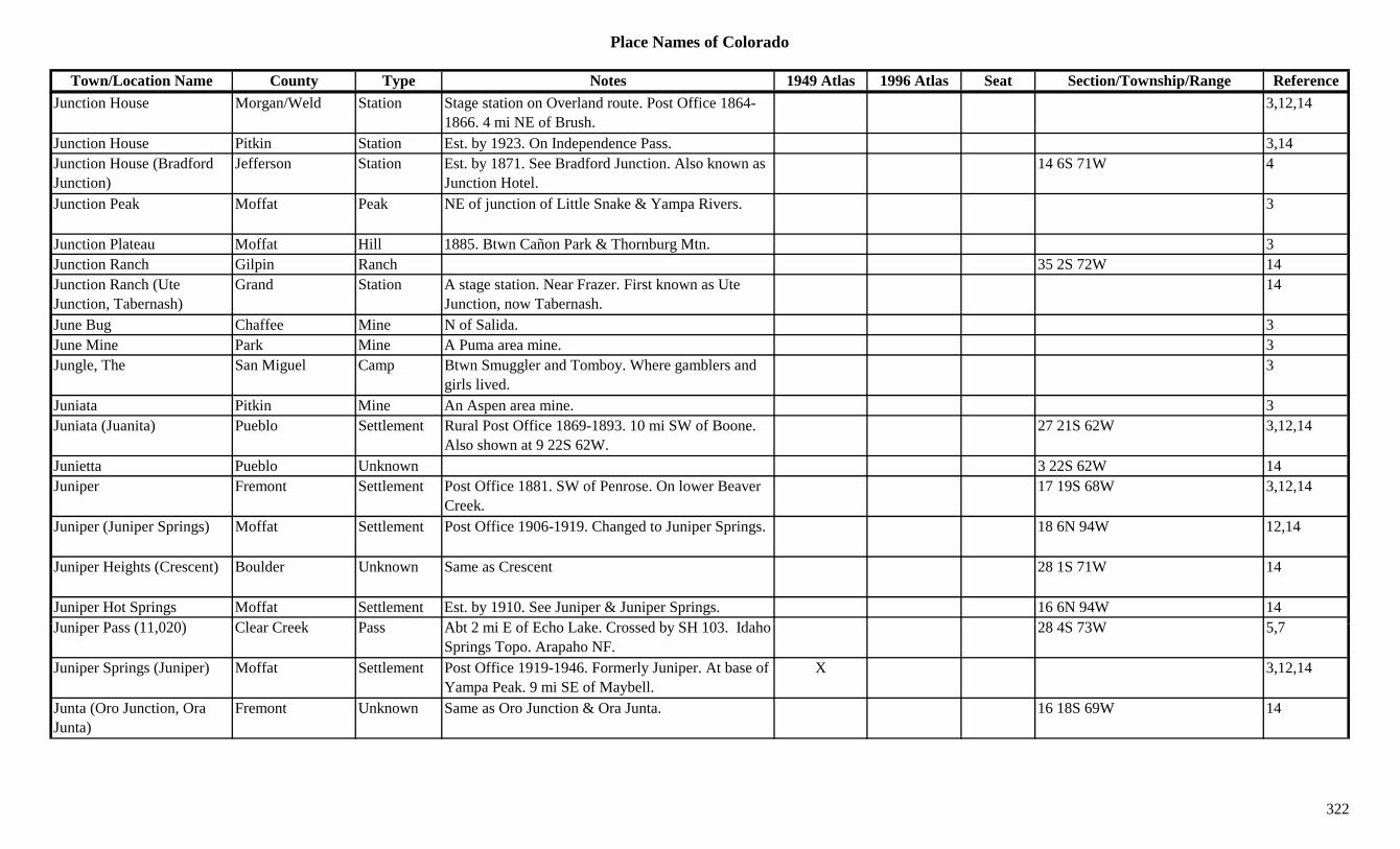
Place Names of Colorado
Town/Location Name County Type Notes 1949 Atlas 1996 Atlas Seat Section/Township/Range ReferenceJunction House Morgan/Weld Station Stage station on Overland route. Post Office 1864-
1866. 4 mi NE of Brush.3,12,14
Junction House Pitkin Station Est. by 1923. On Independence Pass. 3,14Junction House (Bradford Junction)
Jefferson Station Est. by 1871. See Bradford Junction. Also known as Junction Hotel.
14 6S 71W 4
Junction Peak Moffat Peak NE of junction of Little Snake & Yampa Rivers. 3
Junction Plateau Moffat Hill 1885. Btwn Cañon Park & Thornburg Mtn. 3Junction Ranch Gilpin Ranch 35 2S 72W 14Junction Ranch (Ute Junction, Tabernash)
Grand Station A stage station. Near Frazer. First known as Ute Junction, now Tabernash.
14
June Bug Chaffee Mine N of Salida. 3June Mine Park Mine A Puma area mine. 3Jungle, The San Miguel Camp Btwn Smuggler and Tomboy. Where gamblers and
girls lived.3
Juniata Pitkin Mine An Aspen area mine. 3Juniata (Juanita) Pueblo Settlement Rural Post Office 1869-1893. 10 mi SW of Boone.
Also shown at 9 22S 62W.27 21S 62W 3,12,14
Junietta Pueblo Unknown 3 22S 62W 14Juniper Fremont Settlement Post Office 1881. SW of Penrose. On lower Beaver
Creek.17 19S 68W 3,12,14
Juniper (Juniper Springs) Moffat Settlement Post Office 1906-1919. Changed to Juniper Springs. 18 6N 94W 12,14
Juniper Heights (Crescent) Boulder Unknown Same as Crescent 28 1S 71W 14
Juniper Hot Springs Moffat Settlement Est. by 1910. See Juniper & Juniper Springs. 16 6N 94W 14J i P (11 020) Cl C k P Abt 2 i E f E h L k C d b SH 103 Id h 28 4S 73W 5 7Juniper Pass (11,020) Clear Creek Pass Abt 2 mi E of Echo Lake. Crossed by SH 103. Idaho
Springs Topo. Arapaho NF.28 4S 73W 5,7
Juniper Springs (Juniper) Moffat Settlement Post Office 1919-1946. Formerly Juniper. At base of Yampa Peak. 9 mi SE of Maybell.
X 3,12,14
Junta (Oro Junction, Ora Junta)
Fremont Unknown Same as Oro Junction & Ora Junta. 16 18S 69W 14
322
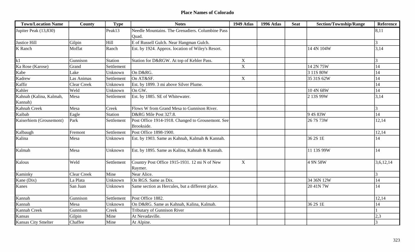
Place Names of Colorado
Town/Location Name County Type Notes 1949 Atlas 1996 Atlas Seat Section/Township/Range ReferenceJupiter Peak (13,830) Peak13 Needle Mountains. The Grenadiers. Columbine Pass
Quad.8,11
Justice Hill Gilpin Hill E of Russell Gulch. Near Hangman Gulch. 3K Ranch Moffat Ranch Est. by 1924. Approx. location of Wiley's Resort. 14 4N 104W 3,14
k1 Gunnison Station Station for D&RGW. At top of Kebler Pass. X 3Ka Rose (Karose) Grand Settlement X 14 2N 75W 14Kabe Lake Unknown On D&RG. 3 11S 80W 14Kadrew Las Animas Settlement On AT&SF. X 35 31S 62W 14Kaffir Clear Creek Unknown Est. by 1899. 3 mi above Silver Plume. 14Kahler Weld Unknown On GW. 10 4N 68W 14Kahnah (Kalina, Kalmah, Kannah)
Mesa Settlement Est. by 1885. SE of Whitewater. 2 13S 99W 3,14
Kahnah Creek Mesa Creek Flows W from Grand Mesa to Gunnison River. 3Kaibab Eagle Station D&RG Mile Post 327.8. 9 4S 83W 14Kaiserhiem (Grousemont) Park Settlement Post Office 1914-1918. Changed to Grousemont. See
Brookside.26 7S 73W 12,14
Kalbaugh Fremont Settlement Post Office 1898-1900. 12,14Kalina Mesa Unknown Est. by 1903. Same as Kahnah, Kalmah & Kannah. 36 2S 1E 14
Kalmah Mesa Unknown Est. by 1895. Same as Kalina, Kahnah & Kannah. 11 13S 99W 14
Kalous Weld Settlement Country Post Office 1915-1931. 12 mi N of New Raymer.
X 4 9N 58W 3,6,12,14
Kaminky Clear Creek Mine Near Alice. 3Kane (Dix) La Plata Unknown On RGS. Same as Dix. 34 36N 12W 14K S J U k S ti H l b t diff t l 20 41N 7W 14Kanes San Juan Unknown Same section as Hercules, but a different place. 20 41N 7W 14
Kannah Gunnison Settlement Post Office 1882. 12,14Kannah Mesa Unknown On D&RG. Same as Kahnah, Kalina, Kalmah. 36 2S 1E 14Kannah Creek Gunnison Creek Tributary of Gunnison River 1Kansas Gilpin Mine At Nevadaville. 2,3Kansas City Smelter Chaffee Mine At Alpine. 3
323
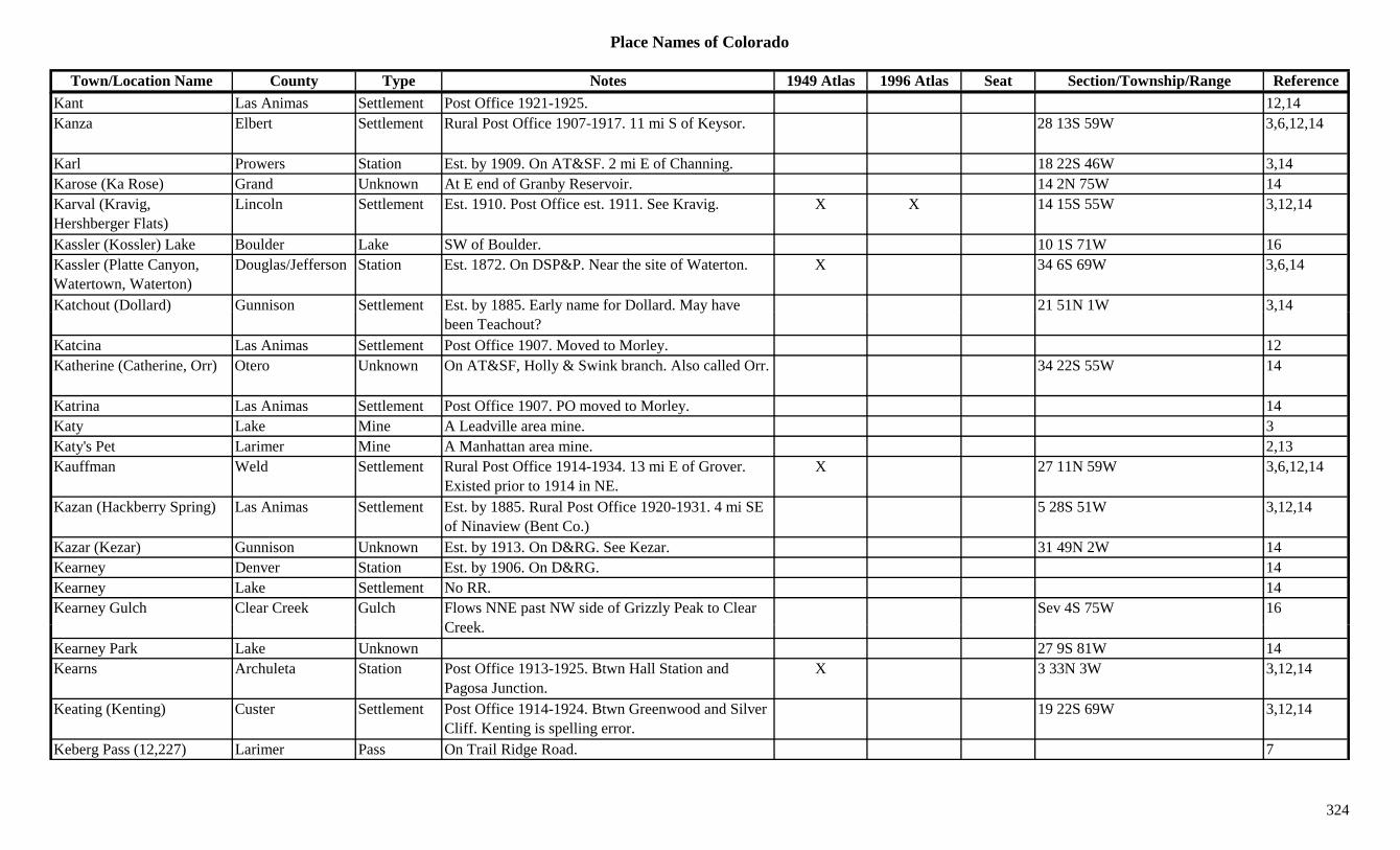
Place Names of Colorado
Town/Location Name County Type Notes 1949 Atlas 1996 Atlas Seat Section/Township/Range ReferenceKant Las Animas Settlement Post Office 1921-1925. 12,14Kanza Elbert Settlement Rural Post Office 1907-1917. 11 mi S of Keysor. 28 13S 59W 3,6,12,14
Karl Prowers Station Est. by 1909. On AT&SF. 2 mi E of Channing. 18 22S 46W 3,14Karose (Ka Rose) Grand Unknown At E end of Granby Reservoir. 14 2N 75W 14Karval (Kravig, Hershberger Flats)
Lincoln Settlement Est. 1910. Post Office est. 1911. See Kravig. X X 14 15S 55W 3,12,14
Kassler (Kossler) Lake Boulder Lake SW of Boulder. 10 1S 71W 16Kassler (Platte Canyon, Watertown, Waterton)
Douglas/Jefferson Station Est. 1872. On DSP&P. Near the site of Waterton. X 34 6S 69W 3,6,14
Katchout (Dollard) Gunnison Settlement Est. by 1885. Early name for Dollard. May have 21 51N 1W 3,14( ) y y ybeen Teachout?
,
Katcina Las Animas Settlement Post Office 1907. Moved to Morley. 12Katherine (Catherine, Orr) Otero Unknown On AT&SF, Holly & Swink branch. Also called Orr. 34 22S 55W 14
Katrina Las Animas Settlement Post Office 1907. PO moved to Morley. 14Katy Lake Mine A Leadville area mine. 3Katy's Pet Larimer Mine A Manhattan area mine. 2,13Kauffman Weld Settlement Rural Post Office 1914-1934. 13 mi E of Grover.
Existed prior to 1914 in NE.X 27 11N 59W 3,6,12,14
Kazan (Hackberry Spring) Las Animas Settlement Est. by 1885. Rural Post Office 1920-1931. 4 mi SE of Ninaview (Bent Co.)
5 28S 51W 3,12,14
Kazar (Kezar) Gunnison Unknown Est. by 1913. On D&RG. See Kezar. 31 49N 2W 14Kearney Denver Station Est. by 1906. On D&RG. 14Kearney Lake Settlement No RR. 14Kearney Gulch Clear Creek Gulch Flows NNE past NW side of Grizzly Peak to Clear
C kSev 4S 75W 16
Creek.Kearney Park Lake Unknown 27 9S 81W 14Kearns Archuleta Station Post Office 1913-1925. Btwn Hall Station and
Pagosa Junction.X 3 33N 3W 3,12,14
Keating (Kenting) Custer Settlement Post Office 1914-1924. Btwn Greenwood and Silver Cliff. Kenting is spelling error.
19 22S 69W 3,12,14
Keberg Pass (12,227) Larimer Pass On Trail Ridge Road. 7
324
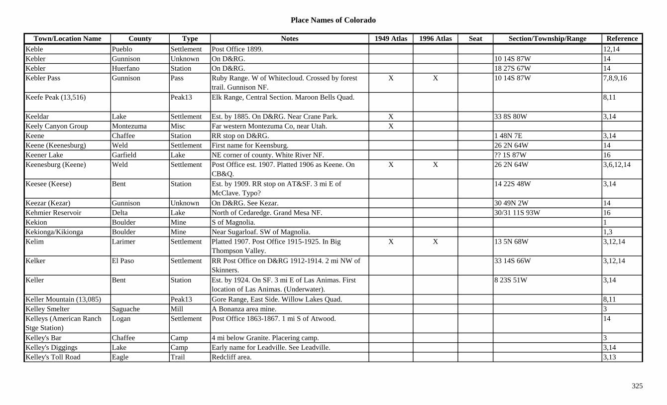
Place Names of Colorado
Town/Location Name County Type Notes 1949 Atlas 1996 Atlas Seat Section/Township/Range ReferenceKeble Pueblo Settlement Post Office 1899. 12,14Kebler Gunnison Unknown On D&RG. 10 14S 87W 14Kebler Huerfano Station On D&RG. 18 27S 67W 14Kebler Pass Gunnison Pass Ruby Range. W of Whitecloud. Crossed by forest
trail. Gunnison NF.X X 10 14S 87W 7,8,9,16
Keefe Peak (13,516) Peak13 Elk Range, Central Section. Maroon Bells Quad. 8,11
Keeldar Lake Settlement Est. by 1885. On D&RG. Near Crane Park. X 33 8S 80W 3,14Keely Canyon Group Montezuma Misc Far western Montezuma Co, near Utah. XKeene Chaffee Station RR stop on D&RG. 1 48N 7E 3,14Keene (Keenesburg) Weld Settlement First name for Keensburg. 26 2N 64W 14( g) gKeener Lake Garfield Lake NE corner of county. White River NF. ?? 1S 87W 16Keenesburg (Keene) Weld Settlement Post Office est. 1907. Platted 1906 as Keene. On
CB&Q.X X 26 2N 64W 3,6,12,14
Keesee (Keese) Bent Station Est. by 1909. RR stop on AT&SF. 3 mi E of McClave. Typo?
14 22S 48W 3,14
Keezar (Kezar) Gunnison Unknown On D&RG. See Kezar. 30 49N 2W 14Kehmier Reservoir Delta Lake North of Cedaredge. Grand Mesa NF. 30/31 11S 93W 16Kekion Boulder Mine S of Magnolia. 1Kekionga/Kikionga Boulder Mine Near Sugarloaf. SW of Magnolia. 1,3Kelim Larimer Settlement Platted 1907. Post Office 1915-1925. In Big
Thompson Valley.X X 13 5N 68W 3,12,14
Kelker El Paso Settlement RR Post Office on D&RG 1912-1914. 2 mi NW of Skinners.
33 14S 66W 3,12,14
Keller Bent Station Est. by 1924. On SF. 3 mi E of Las Animas. First location of Las Animas. (Underwater).
8 23S 51W 3,14
K ll M t i (13 085) P k13 G R E t Sid Will L k Q d 8 11Keller Mountain (13,085) Peak13 Gore Range, East Side. Willow Lakes Quad. 8,11Kelley Smelter Saguache Mill A Bonanza area mine. 3Kelleys (American Ranch Stge Station)
Logan Settlement Post Office 1863-1867. 1 mi S of Atwood. 14
Kelley's Bar Chaffee Camp 4 mi below Granite. Placering camp. 3Kelley's Diggings Lake Camp Early name for Leadville. See Leadville. 3,14Kelley's Toll Road Eagle Trail Redcliff area. 3,13
325
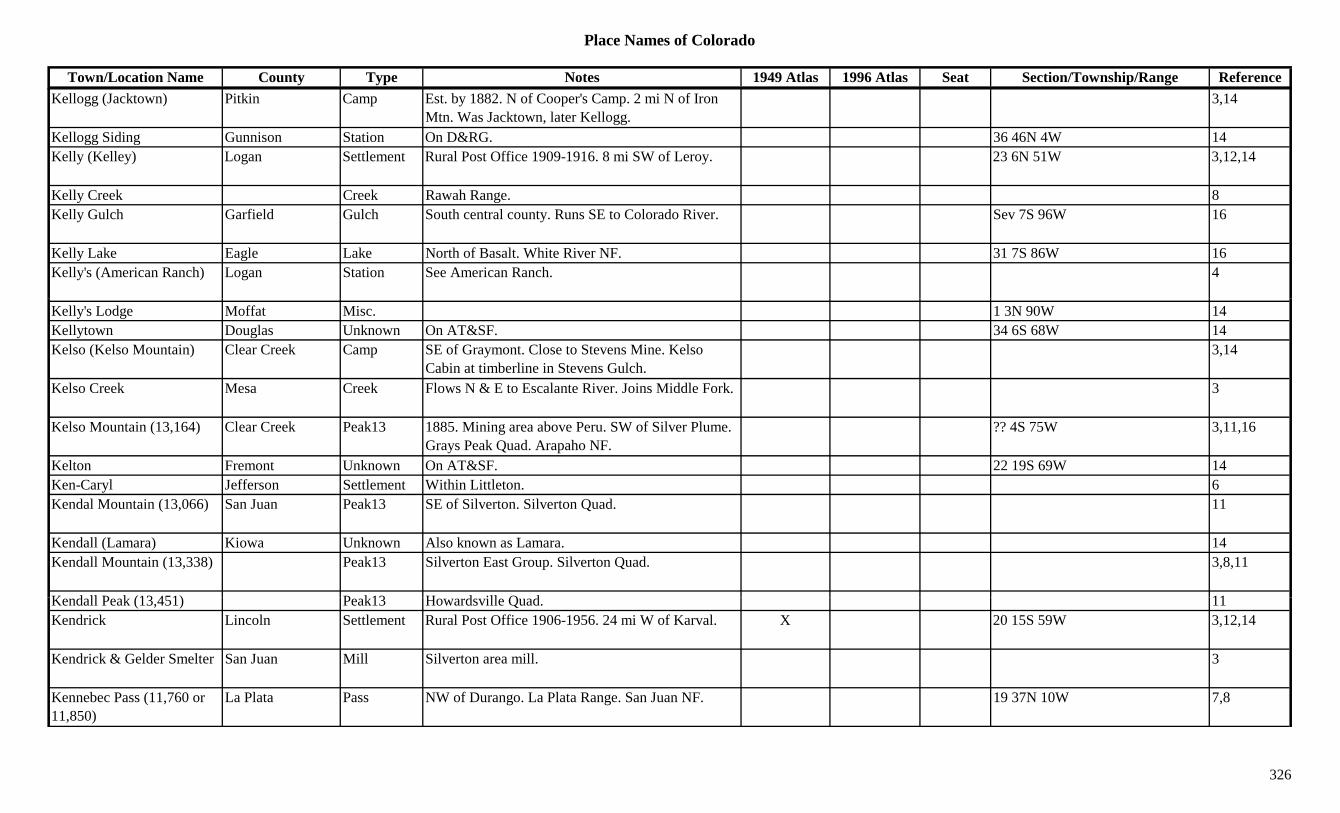
Place Names of Colorado
Town/Location Name County Type Notes 1949 Atlas 1996 Atlas Seat Section/Township/Range ReferenceKellogg (Jacktown) Pitkin Camp Est. by 1882. N of Cooper's Camp. 2 mi N of Iron
Mtn. Was Jacktown, later Kellogg.3,14
Kellogg Siding Gunnison Station On D&RG. 36 46N 4W 14Kelly (Kelley) Logan Settlement Rural Post Office 1909-1916. 8 mi SW of Leroy. 23 6N 51W 3,12,14
Kelly Creek Creek Rawah Range. 8Kelly Gulch Garfield Gulch South central county. Runs SE to Colorado River. Sev 7S 96W 16
Kelly Lake Eagle Lake North of Basalt. White River NF. 31 7S 86W 16Kelly's (American Ranch) Logan Station See American Ranch. 4
Kelly's Lodge Moffat Misc. 1 3N 90W 14Kellytown Douglas Unknown On AT&SF. 34 6S 68W 14Kelso (Kelso Mountain) Clear Creek Camp SE of Graymont. Close to Stevens Mine. Kelso
Cabin at timberline in Stevens Gulch.3,14
Kelso Creek Mesa Creek Flows N & E to Escalante River. Joins Middle Fork. 3
Kelso Mountain (13,164) Clear Creek Peak13 1885. Mining area above Peru. SW of Silver Plume. Grays Peak Quad. Arapaho NF.
?? 4S 75W 3,11,16
Kelton Fremont Unknown On AT&SF. 22 19S 69W 14Ken-Caryl Jefferson Settlement Within Littleton. 6Kendal Mountain (13,066) San Juan Peak13 SE of Silverton. Silverton Quad. 11
Kendall (Lamara) Kiowa Unknown Also known as Lamara. 14Kendall Mountain (13,338) Peak13 Silverton East Group. Silverton Quad. 3,8,11
K d ll P k (13 451) P k13 H d ill Q d 11Kendall Peak (13,451) Peak13 Howardsville Quad. 11Kendrick Lincoln Settlement Rural Post Office 1906-1956. 24 mi W of Karval. X 20 15S 59W 3,12,14
Kendrick & Gelder Smelter San Juan Mill Silverton area mill. 3
Kennebec Pass (11,760 or 11,850)
La Plata Pass NW of Durango. La Plata Range. San Juan NF. 19 37N 10W 7,8
326

Place Names of Colorado
Town/Location Name County Type Notes 1949 Atlas 1996 Atlas Seat Section/Township/Range ReferenceKennedy Hinsdale Unknown On D&RG, Lake City Branch. 23 45N 4W 14Kennedy Gulch Costilla Gulch North central county. Runs ESE to Sangre de Cristo
Creek.Sev 28S 71W 16
Keno Gunnsion Mine A Gothic area mine. 3Kenosha (Kenosha Summit, Summit)
Park Station DSP&P stop & Post Office 1891-1893. At summit of Kenosha Pass.
X 27 7S 75W 3,12,14
Kenosha House Park Settlement Est. by 1881. 2 mi N of Kenosha Pass. Close to Hoosier.
23 6S 68W 14
Kenosha Mountains El Paso Range Part of Front Range. 1,15Kenosha Pass (10,001) Park Pass NE of Jefferson. Crossed by US 285. Pike NF. X X 23 7S 75W 3,7
Kenosha Summit (Kenosha, Summit)
Park Station RR stop & Post Office on Kenosha Pass. 3
Kent Eagle Unknown On D&RG. 17 4S 83W 14Kent's Fort Chaffee Fort Near Salida & Mt. Yale. 14Kents Gulch Gunnison Settlement Est. by 1861. A promising mining district. 14Kenwood Arapahoe Station Est. by 1901. RR stop on C&S. Near Cherry Creek
Dam.3 5S 67W 3,6,14
Kenwood (Radiant, Pyrolite)
Fremont Settlement Post Office 1926-1929. Formerly Pyrolite. First name was Radiant.
7 20S 69W 12,14
Kenyon Corner Larimer Station On road from Fort Collins to Wellington. 24 8N 69W 3,14Keokuk Hydraulic Mining Co.
San Miguel Mine A Placerville operation. 3
Keota Weld Settlement Post Office 1888-1890 & 1909-1973. 40 mi NE of Greeley (Model for Centennial??)
X X 34 9N 60W 3,4,6,12,14
Kepner Las Animas Settlement Est. by 1906. On C&S. RR name for Rugby PO. 3 30S 65W 14
Kerber City Saguache Camp Est. by 1865. Absorbed by Bonanza. Twin city of Sedgwick.
36 47N 7E 3,14
Kerber Creek Saguache Creek Shown on 1880 map. Flows SE & E from above Bonanza to Villa Grove.
3
Kerber Creek Saguache Mine A Bonanza area mine. 3Kerby Placers Lake Mine A Clifton area mine. 3
327

Place Names of Colorado
Town/Location Name County Type Notes 1949 Atlas 1996 Atlas Seat Section/Township/Range ReferenceKerns Larimer Station Est. by 1920. On C&S. 9 mi SE of Fort Collins. 12 6N 68W 3,14Kerns Weld Station Est. by 1909. On C&S. 4 mi NW of Windsor. See
Larimer Co. location.3
Kerr Rio Grande Settlement Now part of Monte Vista, on the south. 14Kerr Gulch Fremont Gulch SE of Howard. Sev 48N 11E 16Kerr Lake Conejos Lake NE corner of county. Between Telluride and
Cornwall Mtns. Rio Grande NF.?? 36N 4E 16
Kerr's San Miguel Settlement W of Aurora. On road down to Placerville. 3Kersey (Orr) Weld Settlement Post Office est. 1894. Formerly Orr. Replatted 1896
as Kersey.X 21 5N 64W 3,6,12,14
Keser (Kester, Guffey) Park Settlement 1880s site. Same location as Guffey. 6 15S 73W 3,14( , y) y ,Kester (Keser, Guffey) Park Settlement Post Office 1874-1891. Same location as Guffey.
Also shown at 4 15S 72W, 36 15S 73W.15 15S 73W 3,12,14
Kesters Moffat Settlement On Little Snake River. 14Kewuneeche Visitor Center Grand Museum At Grand Lake. X
Key West Summit Mine A Lincoln area mine. 3Keyhole, The Larimer Pass See The Keyhole. 5Keyson Elbert Settlement Post Office 1906-1938. 10 12S 59W 14Keysor Elbert Settlement Rural Post Office 1906-1938. 10 mi S of Matheson. X 3 12S 59W 3,6,12
Keysport Boulder Settlement Near Caribou. 1Keystone Boulder Camp Est. by 1878. Magnolia consisted of Keystone &
Jacksons Camps.14
Keystone Boulder Mine Near Magnolia. 1,2,3,13K t G fi ld U k O RGJ 6 6S 91W 14Keystone Garfield Unknown On RGJ. 6 6S 91W 14Keystone Routt Station On D&RG. 19 4N 85W 14Keystone San Miguel Settlement Est. by 1881. On RGS. W of San Miguel. 32 43N 9W 3,14Keystone Summit Settlement Site 2. Est. by 1923. Post Office est. 1979. E from
Site 1.22 5S 77W 3,13,14
Keystone Summit Station Site 1. On C&S. Loading station on Keystone Gulch. X 2,3
328
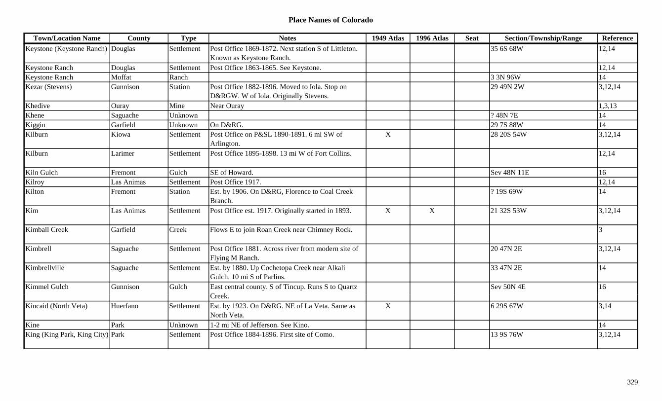
Place Names of Colorado
Town/Location Name County Type Notes 1949 Atlas 1996 Atlas Seat Section/Township/Range ReferenceKeystone (Keystone Ranch) Douglas Settlement Post Office 1869-1872. Next station S of Littleton.
Known as Keystone Ranch.35 6S 68W 12,14
Keystone Ranch Douglas Settlement Post Office 1863-1865. See Keystone. 12,14Keystone Ranch Moffat Ranch 3 3N 96W 14Kezar (Stevens) Gunnison Station Post Office 1882-1896. Moved to Iola. Stop on
D&RGW. W of Iola. Originally Stevens.29 49N 2W 3,12,14
Khedive Ouray Mine Near Ouray 1,3,13Khene Saguache Unknown ? 48N 7E 14Kiggin Garfield Unknown On D&RG. 29 7S 88W 14Kilburn Kiowa Settlement Post Office on P&SL 1890-1891. 6 mi SW of
Arlington.X 28 20S 54W 3,12,14
Kilburn Larimer Settlement Post Office 1895-1898. 13 mi W of Fort Collins. 12,14
Kiln Gulch Fremont Gulch SE of Howard. Sev 48N 11E 16Kilroy Las Animas Settlement Post Office 1917. 12,14Kilton Fremont Station Est. by 1906. On D&RG, Florence to Coal Creek
Branch.? 19S 69W 14
Kim Las Animas Settlement Post Office est. 1917. Originally started in 1893. X X 21 32S 53W 3,12,14
Kimball Creek Garfield Creek Flows E to join Roan Creek near Chimney Rock. 3
Kimbrell Saguache Settlement Post Office 1881. Across river from modern site of Flying M Ranch.
20 47N 2E 3,12,14
Kimbrellville Saguache Settlement Est. by 1880. Up Cochetopa Creek near Alkali Gulch. 10 mi S of Parlins.
33 47N 2E 14
Kimmel Gulch Gunnison Gulch East central county. S of Tincup. Runs S to Quartz C k
Sev 50N 4E 16Creek.
Kincaid (North Veta) Huerfano Settlement Est. by 1923. On D&RG. NE of La Veta. Same as North Veta.
X 6 29S 67W 3,14
Kine Park Unknown 1-2 mi NE of Jefferson. See Kino. 14King (King Park, King City) Park Settlement Post Office 1884-1896. First site of Como. 13 9S 76W 3,12,14
329

Place Names of Colorado
Town/Location Name County Type Notes 1949 Atlas 1996 Atlas Seat Section/Township/Range ReferenceKing (Kings) Montezuma Station Est. in 1920s. On D&RGW. 2 mi NE of Bear Creek. X 31 39N 11W 3,14
King (Orsa) Douglas Unknown On AT&SF. First name was Orsa. 20 7S 67W 14King Center Crowley Settlement Est. by 1923. RR stop on MP. 3 mi SW of Crowley. X 33 21S 58W 3,14
King City (King, King Park) Park Settlement First site of Como. 3
King Cole Coal Mines #1-#7
Park Mine A Como (King Park) area mine. 3,13
King Lake Boulder Lake Far SW corner of county. N of Rollins Pass. Roosevelt NF.
16
King Mine Park Mine At Coal. 13 9S 76W 14King Mine San Juan Station On D&RG. Next station from Ross. 14King Park (King, King City) Park Settlement First site of Como. 3
King Ranch (Lehman PO) Grand Ranch Former site of Lehman PO. 2 mi W of Monarch. Now under Granby Lake.
7 2N 75W 14
King Solomon Chaffee Mine N of Salida. 3King Solomon Mineral Mine 19 42N 1E 14King Solomon Park Mine A Silver Heels area mine. 3King Solomon San Juan Camp Around mine and mountain of same name. N of
Silverton.3
King Solomon San Miguel Mine A Ophir area mine. 13King Solomon Summit Settlement On C&S. A mine, settlement & spur on Leadville-
Como RR. 4 mi W of Frisco.14
King Solomon Mountain (13 220)
Peak13 Howardsville Quad. 11(13,220)King William Boulder Mine At Springdale. 3,13King William San Juan Mine A Howardsville area mine. 3Kings (King) Douglas Station Est. by 1887. RR stop on AT&SF. 4 mi E of Sedalia. 20 7S 67W 3
Kings Canyon Jackson Settlement Post Office 1928-1936. At same location as Camp Nelson.
X 14 11N 79W 3,12,14
330
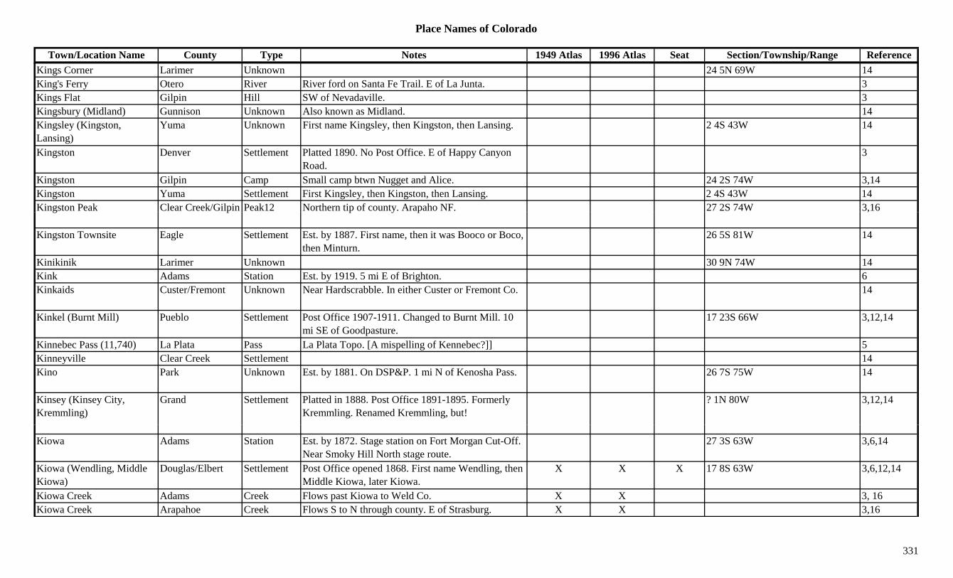
Place Names of Colorado
Town/Location Name County Type Notes 1949 Atlas 1996 Atlas Seat Section/Township/Range ReferenceKings Corner Larimer Unknown 24 5N 69W 14King's Ferry Otero River River ford on Santa Fe Trail. E of La Junta. 3Kings Flat Gilpin Hill SW of Nevadaville. 3Kingsbury (Midland) Gunnison Unknown Also known as Midland. 14Kingsley (Kingston, Lansing)
Yuma Unknown First name Kingsley, then Kingston, then Lansing. 2 4S 43W 14
Kingston Denver Settlement Platted 1890. No Post Office. E of Happy Canyon Road.
3
Kingston Gilpin Camp Small camp btwn Nugget and Alice. 24 2S 74W 3,14Kingston Yuma Settlement First Kingsley, then Kingston, then Lansing. 2 4S 43W 14Kingston Peak Clear Creek/Gilpin Peak12 Northern tip of county. Arapaho NF. 27 2S 74W 3,16g p p y p ,
Kingston Townsite Eagle Settlement Est. by 1887. First name, then it was Booco or Boco, then Minturn.
26 5S 81W 14
Kinikinik Larimer Unknown 30 9N 74W 14Kink Adams Station Est. by 1919. 5 mi E of Brighton. 6Kinkaids Custer/Fremont Unknown Near Hardscrabble. In either Custer or Fremont Co. 14
Kinkel (Burnt Mill) Pueblo Settlement Post Office 1907-1911. Changed to Burnt Mill. 10 mi SE of Goodpasture.
17 23S 66W 3,12,14
Kinnebec Pass (11,740) La Plata Pass La Plata Topo. [A mispelling of Kennebec?]] 5Kinneyville Clear Creek Settlement 14Kino Park Unknown Est. by 1881. On DSP&P. 1 mi N of Kenosha Pass. 26 7S 75W 14
Kinsey (Kinsey City, Kremmling)
Grand Settlement Platted in 1888. Post Office 1891-1895. Formerly Kremmling. Renamed Kremmling, but!
? 1N 80W 3,12,14
Kiowa Adams Station Est. by 1872. Stage station on Fort Morgan Cut-Off. Near Smoky Hill North stage route.
27 3S 63W 3,6,14
Kiowa (Wendling, Middle Kiowa)
Douglas/Elbert Settlement Post Office opened 1868. First name Wendling, then Middle Kiowa, later Kiowa.
X X X 17 8S 63W 3,6,12,14
Kiowa Creek Adams Creek Flows past Kiowa to Weld Co. X X 3, 16Kiowa Creek Arapahoe Creek Flows S to N through county. E of Strasburg. X X 3,16
331

Place Names of Colorado
Town/Location Name County Type Notes 1949 Atlas 1996 Atlas Seat Section/Township/Range ReferenceKiowa Creek Elbert Creek Flows N past Kiowa to Arapahoe Co. X X 3Kiowa Creek Morgan Creek Flows from Weld Co to join South Platte River near
Wiggins.X X
Kiowa Creek Weld Creek SE corner of county. X X 3Kiowa Peak (13,276) Boulder Peak13 E of Arickaree Peak. Ward Quad. Roosevelt NF. ?? 1N 74W 1,11,13,16
Kiowa Station Greenwood/Kiowa Unknown Est. by 1874. 30 mi NNE of Las Animas. 10 mi NNE of Wool Station.
14
Kipling Kit Carson Unknown On CRI&P. 1 9S 50W 14Kirberville Saguache Settlement Also called Kerber City. 1.5 mi from Sedgwick. See
Kerber City.36 47N 7E 14
Kirk Arapahoe/Yuma Settlement Site 1. Est. 1883. Rural Post Office est. 1887. 4 mi N of site 2. Location may be Site 2.
24 5S 47W 3,12,14
Kirk Yuma Settlement Site 2. 4 mi S of site 1. X X 3Kirkland Denver Settlement Platted 1890. E of Englewood. No Post Office. 3Kirkland Lincoln Unknown Perhaps only a cemetery? 232 16S 58W 14Kirkland Weld Station Est. by 1909. On GW. 6 mi NE of Longmont. 33 3N 68W 3,6,14Kirkpatricks La Plata Unknown 2 36N 6W 14Kirkwell Baca Settlement Post Office 1917-1921. X 29 33S 49W 3,12,14Kirtley Clear Creek Mine S of Georgetown. 3Kismet Peak (13,694) Peak13 Sneffels Range. 8Kit Carson Cheyenne Settlement Site 1. Post Office est. 1869. Platted 1888. Original
site 3 mi W of present site.X X x 7 15S 48W 3,12,14
Kit Carson Greenwood/Cheyenne
Settlement Site 2. Est. by 1889. Moved after RR arrived. 4 15S 48W 14
Kit Carson Hinsdale Mine A Carson area mine. 3,13Kit C C l Kit C Mi At B li t XKit Carson Carousel Kit Carson Misc At Burlington. XKit Carson Fort (Gove) Custer Fort Near Dora. Name changed to Gove. 20 21S 72W 14Kit Carson Mountain (14,165)
Custer/Saguache Peak14 SW section of county. Sangre de Cristo Range, Main Section. Crestone Peak Quad.
?? 24S 73W 8,11,16
Kit Carson Museum Bent Museum At Ft. Lyon. XKittie B. Eagle Mine New York Cabins area mine. 3,13Kittimac San Juan Station 7 mi N of Silverton. 14
332

Place Names of Colorado
Town/Location Name County Type Notes 1949 Atlas 1996 Atlas Seat Section/Township/Range ReferenceKittimac Group San Juan Mine A Middleton area operation. 3Kittredge (Luther Ranch) Jefferson Settlement Est. 1920. Post Office est. 1923. X 35 4S 71W 3,6,12,14Kizer Slough Reservoir Delta Lake North of Cedaredge. Grand Mesa NF. 7 12S 94W 16Kliesen City (Kleison City) Baca Settlement Platted near Vilas? or Same as Vilas? No Post
Office.1 31S 45W 3,14
Kline Archuleta Settlement On D&RG. Btwn Noland & Nutria. X 14Kline La Plata Settlement Site 1? Post Office 1904-1953. PO moved to Marvel.
Marvel location shown.X 10 33N 12W 3,12,14
Kline La Plata Settlement Site 2? Platted 1908. 35 34N 12W 14Kline Prowers Station Est. by 1902. Waystop btwn Barton and
Minneapolis.33 24S 43W 3,14
Kline (Singleton) Park Unknown On DSP&P. Another name for Singleton. 18 7S 73W 14Kline Ranch Prowers Ranch 33 24S 43W 14Klink Adams Station Est. by 1909. RR stop on BN. 5 mi E of Brighton. X 14 1S 66W 3,14
Klondike Boulder Mine A Gold Hill mine. 3Klondike San Miguel Mine At Ophir. 2Klondike Mountain (10,758)
Boulder Peak10 N of Grand Island. WNW of Nederland. Roosevelt NF.
7 1S 73W 3,16
Klondike Mountain (11,400)
Conejos Peak11 West of Platoro. Rio Grande NF. ?? 36N 4E 16
Klondyke Tunnel Clear Creek Mine Yankee Hill area. 3Klutter Mountain (8,724) Archuleta Mountain East of Trujillo. 22 33N 1W 16Kluver Larimer Station Est. by 1916. On C&S. 7 mi E of Fort Collins.
Actually in Weld County.18 7N 67W 3,14
Kluver Weld Station Est. by 1916. On C&S, a siding. 5 mi NE of Ti th
18 7N 67W 3,6,14Timnath.
Knapps Rio Blanco Settlement Settlement on White River. 11 1N 103W 14Knife Point (13,265) Peak13 Needle Mountains. The Grenadiers. Storm King
Peak Quad.8,11
Knife Point Pass (12,860) Pass In Weminuche Wilderness. Btwn Knife Point and Jagged Mtn.
5
333
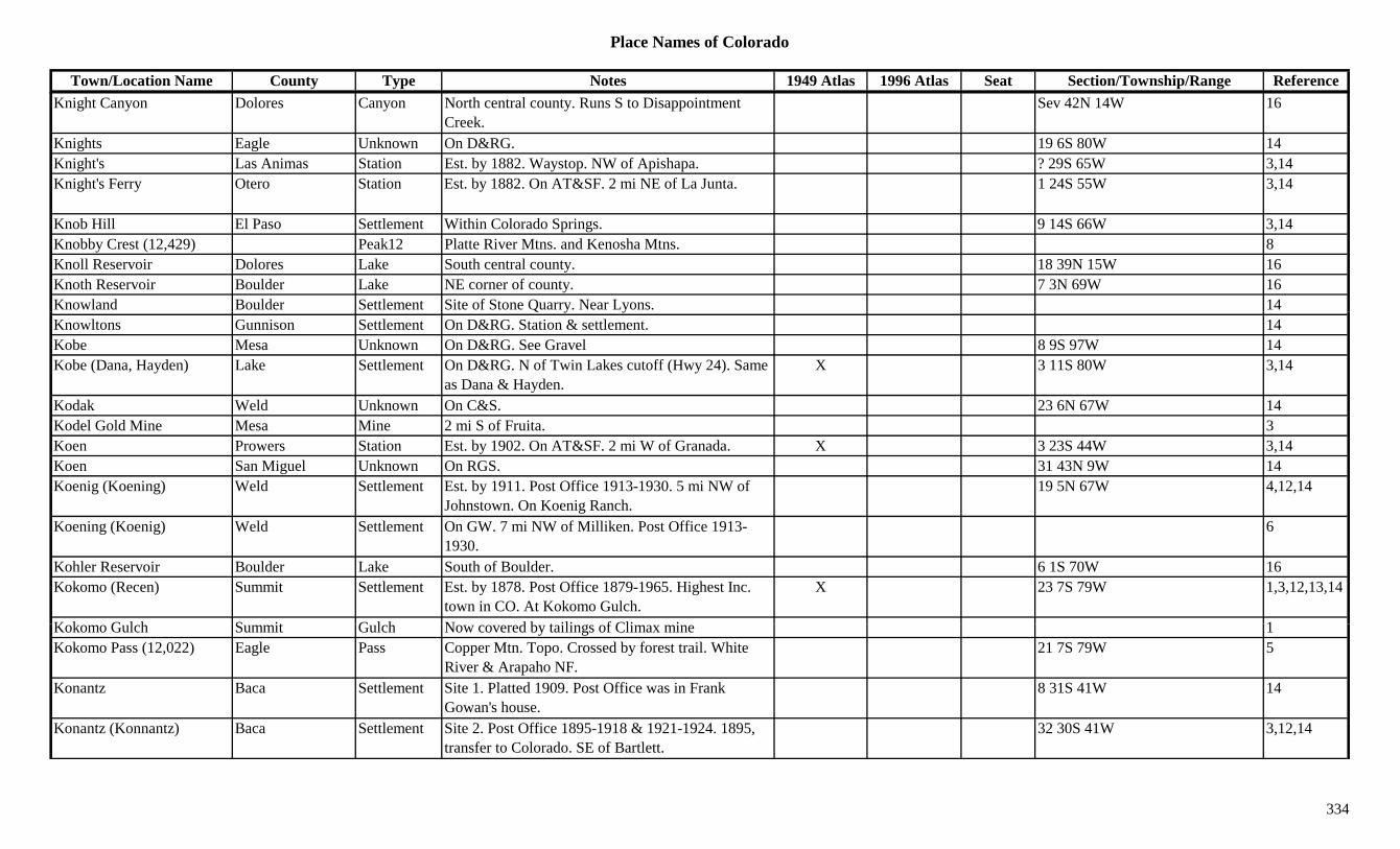
Place Names of Colorado
Town/Location Name County Type Notes 1949 Atlas 1996 Atlas Seat Section/Township/Range ReferenceKnight Canyon Dolores Canyon North central county. Runs S to Disappointment
Creek.Sev 42N 14W 16
Knights Eagle Unknown On D&RG. 19 6S 80W 14Knight's Las Animas Station Est. by 1882. Waystop. NW of Apishapa. ? 29S 65W 3,14Knight's Ferry Otero Station Est. by 1882. On AT&SF. 2 mi NE of La Junta. 1 24S 55W 3,14
Knob Hill El Paso Settlement Within Colorado Springs. 9 14S 66W 3,14Knobby Crest (12,429) Peak12 Platte River Mtns. and Kenosha Mtns. 8Knoll Reservoir Dolores Lake South central county. 18 39N 15W 16Knoth Reservoir Boulder Lake NE corner of county. 7 3N 69W 16Knowland Boulder Settlement Site of Stone Quarry. Near Lyons. 14Q y yKnowltons Gunnison Settlement On D&RG. Station & settlement. 14Kobe Mesa Unknown On D&RG. See Gravel 8 9S 97W 14Kobe (Dana, Hayden) Lake Settlement On D&RG. N of Twin Lakes cutoff (Hwy 24). Same
as Dana & Hayden.X 3 11S 80W 3,14
Kodak Weld Unknown On C&S. 23 6N 67W 14Kodel Gold Mine Mesa Mine 2 mi S of Fruita. 3Koen Prowers Station Est. by 1902. On AT&SF. 2 mi W of Granada. X 3 23S 44W 3,14Koen San Miguel Unknown On RGS. 31 43N 9W 14Koenig (Koening) Weld Settlement Est. by 1911. Post Office 1913-1930. 5 mi NW of
Johnstown. On Koenig Ranch.19 5N 67W 4,12,14
Koening (Koenig) Weld Settlement On GW. 7 mi NW of Milliken. Post Office 1913-1930.
6
Kohler Reservoir Boulder Lake South of Boulder. 6 1S 70W 16Kokomo (Recen) Summit Settlement Est. by 1878. Post Office 1879-1965. Highest Inc.
town in CO. At Kokomo Gulch.X 23 7S 79W 1,3,12,13,14
K k G l h S it G l h N d b t ili f Cli i 1Kokomo Gulch Summit Gulch Now covered by tailings of Climax mine 1Kokomo Pass (12,022) Eagle Pass Copper Mtn. Topo. Crossed by forest trail. White
River & Arapaho NF.21 7S 79W 5
Konantz Baca Settlement Site 1. Platted 1909. Post Office was in Frank Gowan's house.
8 31S 41W 14
Konantz (Konnantz) Baca Settlement Site 2. Post Office 1895-1918 & 1921-1924. 1895, transfer to Colorado. SE of Bartlett.
32 30S 41W 3,12,14
334

Place Names of Colorado
Town/Location Name County Type Notes 1949 Atlas 1996 Atlas Seat Section/Township/Range ReferenceKornman Prowers Station Est. 1908. On AT&SF. 3 mi N of Lamar. X 7 22S 46W 3,14Kornman Junction Prowers Station On AT&SF. Also called Wilson Junction. 8 22S 46W 14Kortz Chaffee Settlement On D&RG. First name for Smeltertown. 31 50N 9E 14Koshare Indian Museum & Kiva
Otero Museum At La Junta. X
Kraft (Brown's Cañon, Brown Cañon)
Chaffee Settlement Post Office 1882-1888. Became Browns Cañon, later Brown Cañon. N of Poncha Springs.
2 50N 8E 3,12,14
Krain Chaffee Settlement Post Office 1917-1919. 12,14Kramer Creek Pueblo Creek Flows S to Arkansas River at Nepesta. 3Krammes (Kremis, Krenes) Otero Unknown Same as Kremis & Krenes. 16 23S 56W 14( , )
Krauss Weld Station Est. by 1924. On BN. 3 mi NW of Prospect Valley. 28 2N 63W 3,6,14
Kravig (Karval, Hershberger Flats)
Lincoln Settlement Platted. Name changed to Karval. First name was Hershberger Flats. See Karval.
14 15S 55W 3,14
Kremis (Krammes, Krenes) Otero Station Est. by 1913. On AT&SF. 2 mi SE of Rocky Ford. Same as Krammes, Krenes.
17 23S 56W 3,14
Kremmling (Kinsey) Grand Settlement Post Office 1885-1891. Changed to Kinsey. Renamed Kremmling.
X X 7 1N 80W 1,3,12,14
Krenes (Kremis, Krammes) Otero Unknown Another spelling for Kremis. See Krammes. 17 23S 56W 14
Kreutzer Peak Gunnison Mountain Tin Cup area. 13Kreutzer Sonata #1 & #2 Mineral Mine NW of Creede. Near Miner's Creek. 3Kreybill Bent Station Est. by 1909. RR stop on AT&SF. 4 mi W of
Beethurst.26 22S 51W 3,14
K k L k Ch ff L k NE f C tt d P S I b l NF 3 14S 80W 16Kroenke Lake Chaffee Lake NE of Cottonwood Pass. San Isabel NF. 3 14S 80W 16K-T Ranch Rio Blanco Ranch 28 1N 93W 14Kubler Mine (Kubler) Gunnison Camp On D&RG. SW of Crested Butte. At Kubler Mine. X 5 15S 86W 3,14
Kubler Mine (Mines) Gunnison Mine At Kubler. 3Kuhns Crossing (Kuhn's Crossing)
Elbert Settlement Post Office 1879-1920. 18 mi W of River Bend. 8 9S 60W 3,6,12,14
335
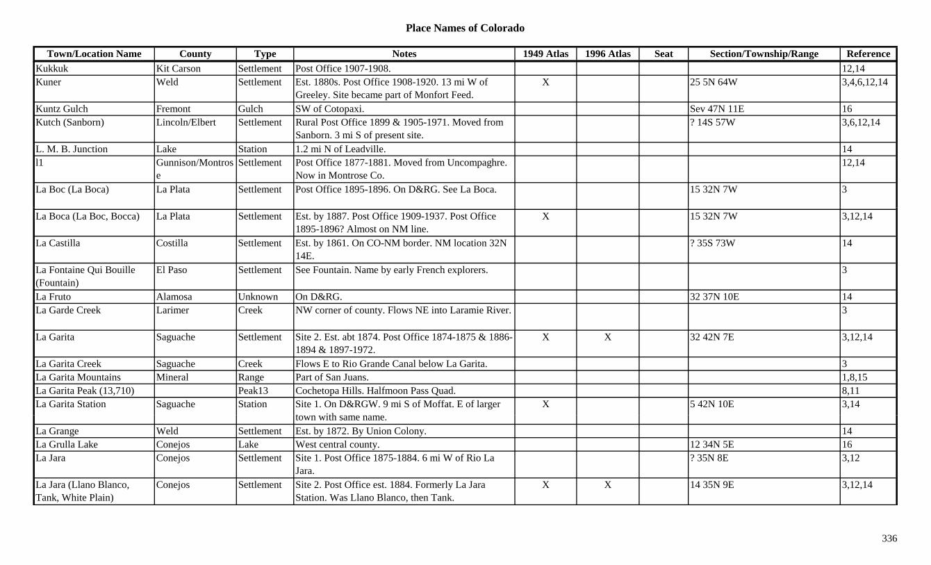
Place Names of Colorado
Town/Location Name County Type Notes 1949 Atlas 1996 Atlas Seat Section/Township/Range ReferenceKukkuk Kit Carson Settlement Post Office 1907-1908. 12,14Kuner Weld Settlement Est. 1880s. Post Office 1908-1920. 13 mi W of
Greeley. Site became part of Monfort Feed.X 25 5N 64W 3,4,6,12,14
Kuntz Gulch Fremont Gulch SW of Cotopaxi. Sev 47N 11E 16Kutch (Sanborn) Lincoln/Elbert Settlement Rural Post Office 1899 & 1905-1971. Moved from
Sanborn. 3 mi S of present site.? 14S 57W 3,6,12,14
L. M. B. Junction Lake Station 1.2 mi N of Leadville. 14l1 Gunnison/Montros
eSettlement Post Office 1877-1881. Moved from Uncompaghre.
Now in Montrose Co.12,14
La Boc (La Boca) La Plata Settlement Post Office 1895-1896. On D&RG. See La Boca. 15 32N 7W 3
La Boca (La Boc, Bocca) La Plata Settlement Est. by 1887. Post Office 1909-1937. Post Office 1895-1896? Almost on NM line.
X 15 32N 7W 3,12,14
La Castilla Costilla Settlement Est. by 1861. On CO-NM border. NM location 32N 14E.
? 35S 73W 14
La Fontaine Qui Bouille (Fountain)
El Paso Settlement See Fountain. Name by early French explorers. 3
La Fruto Alamosa Unknown On D&RG. 32 37N 10E 14La Garde Creek Larimer Creek NW corner of county. Flows NE into Laramie River. 3
La Garita Saguache Settlement Site 2. Est. abt 1874. Post Office 1874-1875 & 1886-1894 & 1897-1972.
X X 32 42N 7E 3,12,14
La Garita Creek Saguache Creek Flows E to Rio Grande Canal below La Garita. 3La Garita Mountains Mineral Range Part of San Juans. 1,8,15La Garita Peak (13,710) Peak13 Cochetopa Hills. Halfmoon Pass Quad. 8,11La Garita Station Saguache Station Site 1. On D&RGW. 9 mi S of Moffat. E of larger
t ithX 5 42N 10E 3,14
town with same name.La Grange Weld Settlement Est. by 1872. By Union Colony. 14La Grulla Lake Conejos Lake West central county. 12 34N 5E 16La Jara Conejos Settlement Site 1. Post Office 1875-1884. 6 mi W of Rio La
Jara.? 35N 8E 3,12
La Jara (Llano Blanco, Tank, White Plain)
Conejos Settlement Site 2. Post Office est. 1884. Formerly La Jara Station. Was Llano Blanco, then Tank.
X X 14 35N 9E 3,12,14
336
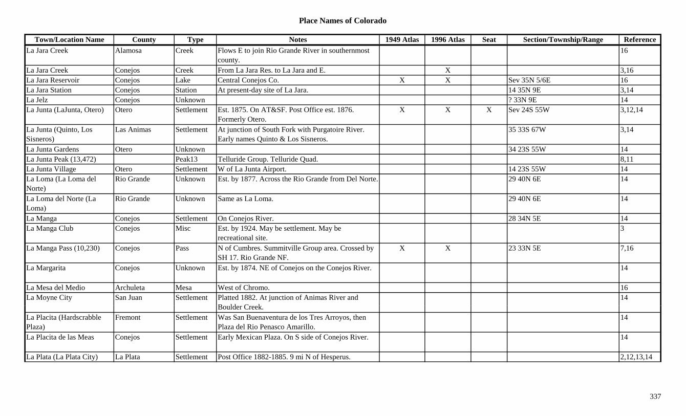
Place Names of Colorado
Town/Location Name County Type Notes 1949 Atlas 1996 Atlas Seat Section/Township/Range ReferenceLa Jara Creek Alamosa Creek Flows E to join Rio Grande River in southernmost
county.16
La Jara Creek Conejos Creek From La Jara Res. to La Jara and E. X 3,16La Jara Reservoir Conejos Lake Central Conejos Co. X X Sev 35N 5/6E 16La Jara Station Conejos Station At present-day site of La Jara. 14 35N 9E 3,14La Jelz Conejos Unknown ? 33N 9E 14La Junta (LaJunta, Otero) Otero Settlement Est. 1875. On AT&SF. Post Office est. 1876.
Formerly Otero.X X X Sev 24S 55W 3,12,14
La Junta (Quinto, Los Sisneros)
Las Animas Settlement At junction of South Fork with Purgatoire River. Early names Quinto & Los Sisneros.
35 33S 67W 3,14
La Junta Gardens Otero Unknown 34 23S 55W 14La Junta Peak (13,472) Peak13 Telluride Group. Telluride Quad. 8,11La Junta Village Otero Settlement W of La Junta Airport. 14 23S 55W 14La Loma (La Loma del Norte)
Rio Grande Unknown Est. by 1877. Across the Rio Grande from Del Norte. 29 40N 6E 14
La Loma del Norte (La Loma)
Rio Grande Unknown Same as La Loma. 29 40N 6E 14
La Manga Conejos Settlement On Conejos River. 28 34N 5E 14La Manga Club Conejos Misc Est. by 1924. May be settlement. May be
recreational site.3
La Manga Pass (10,230) Conejos Pass N of Cumbres. Summitville Group area. Crossed by SH 17. Rio Grande NF.
X X 23 33N 5E 7,16
La Margarita Conejos Unknown Est. by 1874. NE of Conejos on the Conejos River. 14
La Mesa del Medio Archuleta Mesa West of Chromo. 16La Moyne City San Juan Settlement Platted 1882. At junction of Animas River and
B ld C k14
Boulder Creek.La Placita (Hardscrabble Plaza)
Fremont Settlement Was San Buenaventura de los Tres Arroyos, then Plaza del Rio Penasco Amarillo.
14
La Placita de las Meas Conejos Settlement Early Mexican Plaza. On S side of Conejos River. 14
La Plata (La Plata City) La Plata Settlement Post Office 1882-1885. 9 mi N of Hesperus. 2,12,13,14
337
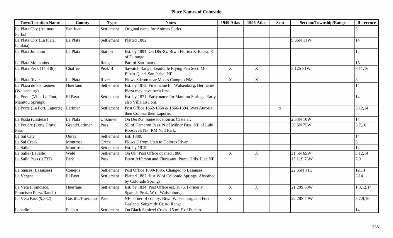
Place Names of Colorado
Town/Location Name County Type Notes 1949 Atlas 1996 Atlas Seat Section/Township/Range ReferenceLa Plata City (Animas Forks)
San Juan Settlement Original name for Animas Forks. 3
La Plata City (La Plata, Laplata)
La Plata Settlement Platted 1882. 9 36N 11W 14
La Plata Junction La Plata Station Est. by 1894. On D&RG. Btwn Florida & Bacea. E of Durango.
14
La Plata Mountains Range Part of San Juans. 15La Plata Peak (14,336) Chaffee Peak14 Sawatch Range, Leadville Frying Pan Sect. Mt.
Elbert Quad. San Isabel NF.X X 5 12S 81W 8,11,16
La Plata River La Plata River Flows S from near Moses Camp to NM. X X 3La Plaza de los Leones Huerfano Settlement Est. by 1873. First name for Walsenburg. Hermanes 14(Walsenburg)
y gPlaza may have been first.
La Ponte (Villa La Font, Manitou Springs)
El Paso Settlement Est. by 1871. Early name for Manitou Springs. Early also Villa La Font.
14
La Porte (La Port, Laporte) Larimer Settlement Post Office 1862-1864 & 1866-1894. Was Auroria, then Colona, then Laporte.
x 3,12,14
La Posta (Castelar) La Plata Unknown On D&RG. Same location as Castelar. 2 33N 10W 14La Poudre (Long Draw) Pass
Grand/Larimer Pass SE of Cameron Pass. N of Milner Pass. NE of Lulu. Roosevelt NF, RM Natl Park.
20 6N 75W 3,7,16
La Sal City Ouray Settlement Est. 1880. 14La Sal Creek Montrose Creek Flows E from Utah to Dolores River. 3La Salle Montrose Settlement Est. by 1919. 14La Salle (LaSalle) Weld Settlement On UP. Post Office opened 1886. X X 31 5N 65W 3,12,14La Salle Pass (9,733) Park Pass Btwn Jefferson and Florissant. Puma Hills. Pike NF. 15 11S 73W 7,9
La Sauses (Lasauses) Conejos Settlement Post Office 1890-1895. Changed to Lasauses. 22 35N 11E 12,14L V El P S ttl t Pl tt d 1887 J t W f C l d S i Ab b d 3 14La Vergne El Paso Settlement Platted 1887. Just W of Colorado Springs. Absorbed
by Colorado Springs.3,14
La Veta (Francisco, Francisco Plaza/Ranch)
Huerfano Settlement Est. by 1834. Post Office est. 1876. Formerly Spanish Peak. W of Walsenburg.
X X 21 29S 68W 1,3,12,14
La Veta Pass (9,382) Costilla/Huerfano Pass NE corner of county. Btwn Walsenburg and Fort Garland. Sangre de Cristo Range.
X 22 28S 70W 3,7,9,16
Labadie Pueblo Settlement On Black Squirrel Creek. 15 mi E of Pueblo. 14
338
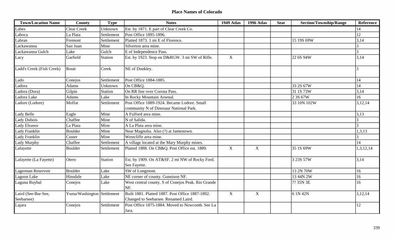
Place Names of Colorado
Town/Location Name County Type Notes 1949 Atlas 1996 Atlas Seat Section/Township/Range ReferenceLabes Clear Creek Unknown Est. by 1871. E part of Clear Creek Co. 14Laboca La Plata Settlement Post Office 1895-1896. 12Labran Fremont Settlement Platted 1873. 1 mi E of Florence. 15 19S 69W 3,14Lackawanna San Juan Mine Silverton area mine. 3Lackawanna Gulch Lake Gulch E of Independence Pass. 3Lacy Garfield Station Est. by 1923. Stop on D&RGW. 3 mi SW of Rifle. X 22 6S 94W 3,14
Ladd's Creek (Fish Creek) Routt Creek NE of Dunkley. 3
Lado Conejos Settlement Post Office 1884-1885. 14Ladora Adams Unknown On CB&Q. 33 2S 67W 14QLadora (Dora) Gilpin Station On RR line over Corona Pass. 31 1S 73W 3,14Ladora Lake Adams Lake In Rocky Mountain Arsenal. 2 3S 67W 16Ladore (Lodore) Moffat Settlement Post Office 1889-1924. Became Lodore. Small
community N of Dinosaur National Park.33 10N 102W 3,12,14
Lady Belle Eagle Mine A Fulford area mine. 3,13Lady Dubois Chaffee Mine N of Salida. 3Lady Eleanor La Plata Mine A La Plata area mine. 3Lady Franklin Boulder Mine Near Magnolia. Also (?) at Jamestown. 1,3,13Lady Franklin Custer Mine Westcliffe area mine. 3Lady Murphy Chaffee Settlement A village located at the Mary Murphy mines. 14Lafayette Boulder Settlement Platted 1888. On CB&Q. Post Office est. 1889. X X 35 1S 69W 1,3,12,14
Lafayette (La Fayette) Otero Station Est. by 1909. On AT&SF. 2 mi NW of Rocky Ford. See Fayette.
3 23S 57W 3,14
Lagerman Reservoir Boulder Lake SW of Longmont. 13 2N 70W 16L L k Hi d l L k NE f t G i NF 13 44N 2W 16Lagoon Lake Hinsdale Lake NE corner of county. Gunnison NF. 13 44N 2W 16Laguna Ruybal Conejos Lake West central county. S of Conejos Peak. Rio Grande
NF.?? 35N 3E 16
Laird (See-Bar-See, Seebarsee)
Yuma/Washington Settlement Built 1881. Platted 1887. Post Office 1887-1892. Changed to Seebarsee. Renamed Laird.
X X 6 1N 42N 3,12,14
Lajara Conejos Settlement Post Office 1875-1884. Moved to Newcomb. See La Jara.
12
339
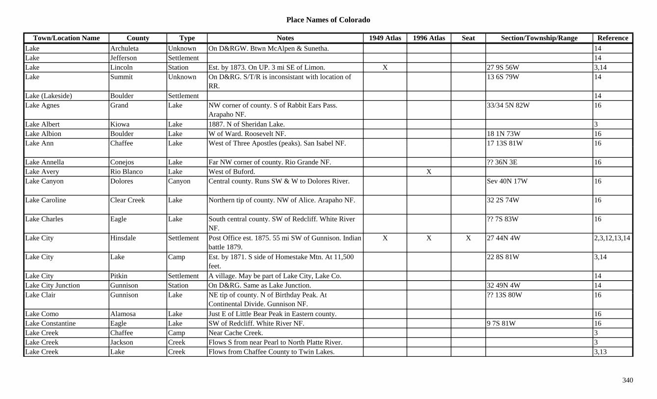
Place Names of Colorado
Town/Location Name County Type Notes 1949 Atlas 1996 Atlas Seat Section/Township/Range ReferenceLake Archuleta Unknown On D&RGW. Btwn McAlpen & Sunetha. 14Lake Jefferson Settlement 14Lake Lincoln Station Est. by 1873. On UP. 3 mi SE of Limon. X 27 9S 56W 3,14Lake Summit Unknown On D&RG. S/T/R is inconsistant with location of
RR.13 6S 79W 14
Lake (Lakeside) Boulder Settlement 14Lake Agnes Grand Lake NW corner of county. S of Rabbit Ears Pass.
Arapaho NF.33/34 5N 82W 16
Lake Albert Kiowa Lake 1887. N of Sheridan Lake. 3Lake Albion Boulder Lake W of Ward. Roosevelt NF. 18 1N 73W 16Lake Ann Chaffee Lake West of Three Apostles (peaks). San Isabel NF. 17 13S 81W 16p (p )
Lake Annella Conejos Lake Far NW corner of county. Rio Grande NF. ?? 36N 3E 16Lake Avery Rio Blanco Lake West of Buford. XLake Canyon Dolores Canyon Central county. Runs SW & W to Dolores River. Sev 40N 17W 16
Lake Caroline Clear Creek Lake Northern tip of county. NW of Alice. Arapaho NF. 32 2S 74W 16
Lake Charles Eagle Lake South central county. SW of Redcliff. White River NF.
?? 7S 83W 16
Lake City Hinsdale Settlement Post Office est. 1875. 55 mi SW of Gunnison. Indian battle 1879.
X X X 27 44N 4W 2,3,12,13,14
Lake City Lake Camp Est. by 1871. S side of Homestake Mtn. At 11,500 feet.
22 8S 81W 3,14
Lake City Pitkin Settlement A village. May be part of Lake City, Lake Co. 14Lake City Junction Gunnison Station On D&RG. Same as Lake Junction. 32 49N 4W 14L k Cl i G i L k NE ti f t N f Bi thd P k At ?? 13S 80W 16Lake Clair Gunnison Lake NE tip of county. N of Birthday Peak. At
Continental Divide. Gunnison NF.?? 13S 80W 16
Lake Como Alamosa Lake Just E of Little Bear Peak in Eastern county. 16Lake Constantine Eagle Lake SW of Redcliff. White River NF. 9 7S 81W 16Lake Creek Chaffee Camp Near Cache Creek. 3Lake Creek Jackson Creek Flows S from near Pearl to North Platte River. 3Lake Creek Lake Creek Flows from Chaffee County to Twin Lakes. 3,13
340

Place Names of Colorado
Town/Location Name County Type Notes 1949 Atlas 1996 Atlas Seat Section/Township/Range ReferenceLake Creek Rio Blanco Creek Flows N to join Douglas Creek NW of Old Bobcat
Ranch.3
Lake De Nolda Conejos Lake Far NE corner of county. Rio Grande NF. ?? 36N 3E 16Lake Devore Kiowa Lake 1887. S of Sheridan Lake. 3Lake Dorothy Boulder Lake Near Continental Divide at Arapaho Pass. Roosevelt
NF.33 1N 74W 16
Lake Eldora Boulder Lake SW corner of county. S of Eldora. Roosevelt NF. 33 1S 73W 16
Lake Eldora Boulder Unknown On DB&W. 22 1S 73W 14Lake Envy Boulder Lake Far W county, just below RMNP. Roosevelt NF. 12 2N 74W 16
Lake Erwin Gunnison Lake West of Crested Butte. Gunnison NF. ?? 13S 87W 16Lake Esther Eagle Lake SW of Redcliff. White River NF. ?? 8S 81W 16Lake Evelyn Grand Lake SE corner of county. SW of Fraser. Arapaho NF. ?? 2S 77W 16
Lake Fork Lake Station Est. by 1906. On CM. 14Lake Fork Gunnison River Gunnison River Flows N from Hinsdale Co to Gunnison River at
Sapinero.X X
Lake Fork Gunnison River? Hinsdale River Flows E and N through Lake City to Gunnison Co. X X 3,13
Lake Fork of the Arkansas Lake River Flows E into Tennessee Fork of the Arkansas near Leadville Junct.
3
Lake George (Shepston) Park Settlement Est. abt 1886. Post Office 1891-1905 & 1910 to present. Originally a stage stop.
X X 29 12S 71W 3,12,14
Lake Gilbraltar Boulder Lake Far W of county, just below RMNP. Roosevelt NF. 11 2N 74W 16
L k G t G i L k E t f C t d B tt 1 14S 86W 16Lake Grant Gunnison Lake East of Crested Butte. 1 14S 86W 16Lake Gulch Gilpin Gulch Runs E from near Bobtail Hill. 3Lake Gulch Gilpin Settlement Est. by 1864. Site of first Gilpin Co. school house. 18 3S 72W 3,14
Lake Gulch Gunnison Gulch NW of Powderhorn. Runs N & W to Gunnison River.
Sev 47/48N 3W 16
Lake Henry Crowley Lake NW of Sugar City. X Sev 21S 56W + 16
341

Place Names of Colorado
Town/Location Name County Type Notes 1949 Atlas 1996 Atlas Seat Section/Township/Range ReferenceLake House Park Settlement Probably Toll Gate at top of Kenosha Pass. 27 7S 75W 14Lake House Teller Misc Est. by 1885. Near Seven Lakes. 3Lake Hughes Ouray Station Est. by 1923. On D&RG. At site of Portland. 11 44N 8W 3,14Lake Isabel Boulder Lake West of Ward. Roosevelt NF. 7 1N 73W 16Lake John Jackson Lake North of Highho, W of Walden. XLake John Jackson Settlement Est. by 1887. Small. E side of lake of same name. 3
Lake Junction Boulder Station On C&S. 14Lake Junction (Lake City Junction)
Gunnison Station Est. by 1923. Stop on D&RGW. W of Sapinero. See Lake City Junction.
32 49N 4W 3,14
Lake Meredith Crowley Lake SE of Ordway. X X Sev 21S 56W 16y yLake Minnequa (Minnequa, Bessemer)
Pueblo Settlement Platted 1891. Next to Lake Minnequa. See Bessemer or Minnequa. Location is for lake.
11 21S 65W 3,14
Lake Moraine El Paso Lake SE of Pikes Peak. Pike NF. 28 14S 68W 16Lake Mountain Saguache Mountain N of Storm King. 3Lake Nanita Grand Lake NE corner of county. Near Boulder Co. 5/6 3N 74W + 16Lake Nokoni Grand Lake NE corner of county. 31 4N 74W 16Lake of the Woods Garfield Lake NE corner of county. White River NF. ?? 1N 88W 16Lake Park San Juan Settlement Est. by 1881. Small settlement N of Poughkeepsie. 3
Lake Pass Chaffee/Gunnison Pass S of Independence Pass. Elk Range. Pieplant Topo. Gunnison & San Isabel NF.
17 12S 82W 5,7,8,16
Lake Rebecca Gunnison Lake NE tip of county. N of Birthday Peak. At Continental Divide. Gunnison NF.
?? 13S 80W 16
Lake Sangraco Adams Lake South of Westminster. 8 3S 68W 16Lake Shore (Lakeshore) Hinsdale Camp Camp for Golden Fleece mines. 3 mi S of Lake City. 22 43N 4W 3
Lake Site Grand Settlement Est. by 1909. On N side of Easton (later Frazer). 19 1S 75W 14
Lake Station El Paso Station Est. by 1881. On D&RG. 3 mi NW of Monument. 14
Lake Station (Hedinger's Lake Station +)
Greenwood/Lincoln
Station Post Office 1870-1871. 3 mi S of Limon. Known as Station Number 24 (Stage station).
27 9S 56W 3,4,12,14
342
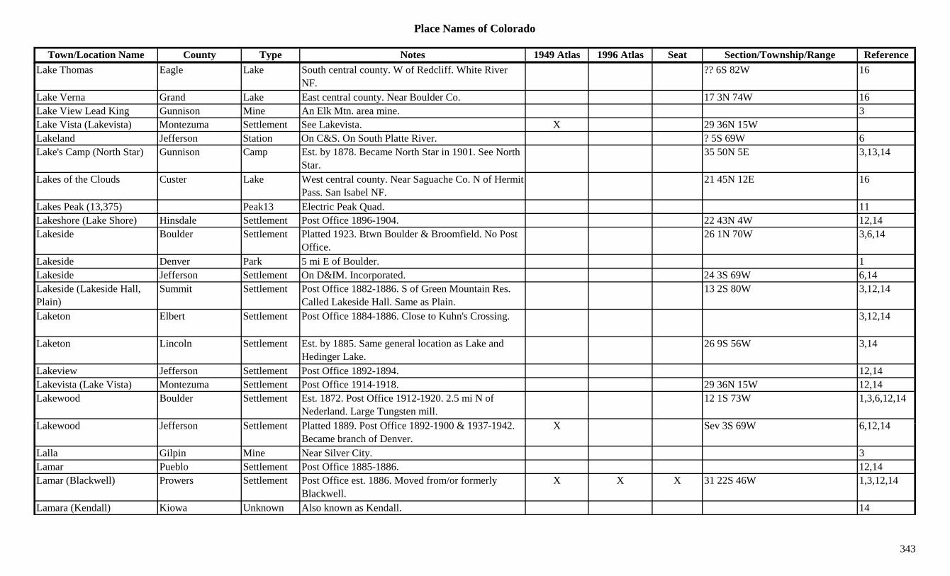
Place Names of Colorado
Town/Location Name County Type Notes 1949 Atlas 1996 Atlas Seat Section/Township/Range ReferenceLake Thomas Eagle Lake South central county. W of Redcliff. White River
NF.?? 6S 82W 16
Lake Verna Grand Lake East central county. Near Boulder Co. 17 3N 74W 16Lake View Lead King Gunnison Mine An Elk Mtn. area mine. 3Lake Vista (Lakevista) Montezuma Settlement See Lakevista. X 29 36N 15WLakeland Jefferson Station On C&S. On South Platte River. ? 5S 69W 6Lake's Camp (North Star) Gunnison Camp Est. by 1878. Became North Star in 1901. See North
Star.35 50N 5E 3,13,14
Lakes of the Clouds Custer Lake West central county. Near Saguache Co. N of Hermit Pass. San Isabel NF.
21 45N 12E 16
Lakes Peak (13,375) Peak13 Electric Peak Quad. 11( , ) QLakeshore (Lake Shore) Hinsdale Settlement Post Office 1896-1904. 22 43N 4W 12,14Lakeside Boulder Settlement Platted 1923. Btwn Boulder & Broomfield. No Post
Office.26 1N 70W 3,6,14
Lakeside Denver Park 5 mi E of Boulder. 1Lakeside Jefferson Settlement On D&IM. Incorporated. 24 3S 69W 6,14Lakeside (Lakeside Hall, Plain)
Summit Settlement Post Office 1882-1886. S of Green Mountain Res. Called Lakeside Hall. Same as Plain.
13 2S 80W 3,12,14
Laketon Elbert Settlement Post Office 1884-1886. Close to Kuhn's Crossing. 3,12,14
Laketon Lincoln Settlement Est. by 1885. Same general location as Lake and Hedinger Lake.
26 9S 56W 3,14
Lakeview Jefferson Settlement Post Office 1892-1894. 12,14Lakevista (Lake Vista) Montezuma Settlement Post Office 1914-1918. 29 36N 15W 12,14Lakewood Boulder Settlement Est. 1872. Post Office 1912-1920. 2.5 mi N of
Nederland. Large Tungsten mill.12 1S 73W 1,3,6,12,14
L k d J ff S ttl t Pl tt d 1889 P t Offi 1892 1900 & 1937 1942 X S 3S 69W 6 12 14Lakewood Jefferson Settlement Platted 1889. Post Office 1892-1900 & 1937-1942. Became branch of Denver.
X Sev 3S 69W 6,12,14
Lalla Gilpin Mine Near Silver City. 3Lamar Pueblo Settlement Post Office 1885-1886. 12,14Lamar (Blackwell) Prowers Settlement Post Office est. 1886. Moved from/or formerly
Blackwell.X X X 31 22S 46W 1,3,12,14
Lamara (Kendall) Kiowa Unknown Also known as Kendall. 14
343

Place Names of Colorado
Town/Location Name County Type Notes 1949 Atlas 1996 Atlas Seat Section/Township/Range ReferenceLamartine Clear Creek Mine At Lamartine. 3,13Lamartine Clear Creek Settlement Post Office 1889-?? (by 1910). 8 mi W of Idaho
Springs.1 4S 74W 1,3,12,13,14
Lamb Jefferson Settlement Post Office 1890-1908. SE of Critchell. Btwn Foxton and Waterton.
2 7S 70W 3,6,12,14
Lamb Larimer Unknown 1 mi N of Longs Peak Inn. 0.5 mi S of Lilly Lake. 14
Lamb Morgan Station Est. by 1924. On BN. 3 mi W of Fort Morgan. 11 3N 58W 3,14Lambert Morgan Unknown On CB&Q. 16 3N 60W 14Lambertson Peak (13,051) Peak13 Pearl Pass Quad. 11
Lamborn Kit Carson Unknown On CRI&P. 14Lambs Weld Unknown On CB&Q. ? 1N 68W 14Lamport Baca Settlement Site 2. Post Office 1908-1927. 18 mi SE of
Stonington.13 34S 43W 3,12,14
Lamport Baca Unknown Site 1. Also shown at 26 33S 42W. 28 33S 42W 14Lanark Saguache Settlement Post Office 1898. On D&RG. At end of Moffat-
Crestone branch.? 43N 12E 12,14
Lancaster (Hartman, Bristol)
Prowers Settlement Est. by 1907. Preceded Hartman or first name for Hartman, then was Bristol. (ERROR)
3,14
Landon Hills Jefferson Unknown On D&IM. 14Land's End Delta Settlement Est. by 1887. NE of Crawford. 3Lands End Shelter House Mesa Misc SW of Skyway. XLandsend Peak (10,634) Delta Peak10 SE of Paonia. Gunnison NF. 3 15S 91W 16Landsend Peak (10,806) Peak West Elk Range, Gunnison North Fork Group. 8Landslide Peak (13,238) Peak13 Montezuma Quad. 11L d Kit C S ttl t R l P t Offi L d C k 1883 1918 30 5S 44W 3Landsman Kit Carson Settlement Rural Post Office near Landsman Creek 1883-1918.
(In many counties, see Yuma Co.)30 5S 44W 3
Landsman Yuma Settlement Rural Post Office 1883-1918. 10 mi S of Idalia. 30 5S 44W 3,12,14Landsman Creek Kit Carson Creek Flows from S county NE to Bonny Reservoir. X XLandsman Hill Cheyenne Hill North central county. 5 13S 46W 16Lane Range Mesa Range Up Salt Wash. 3
344
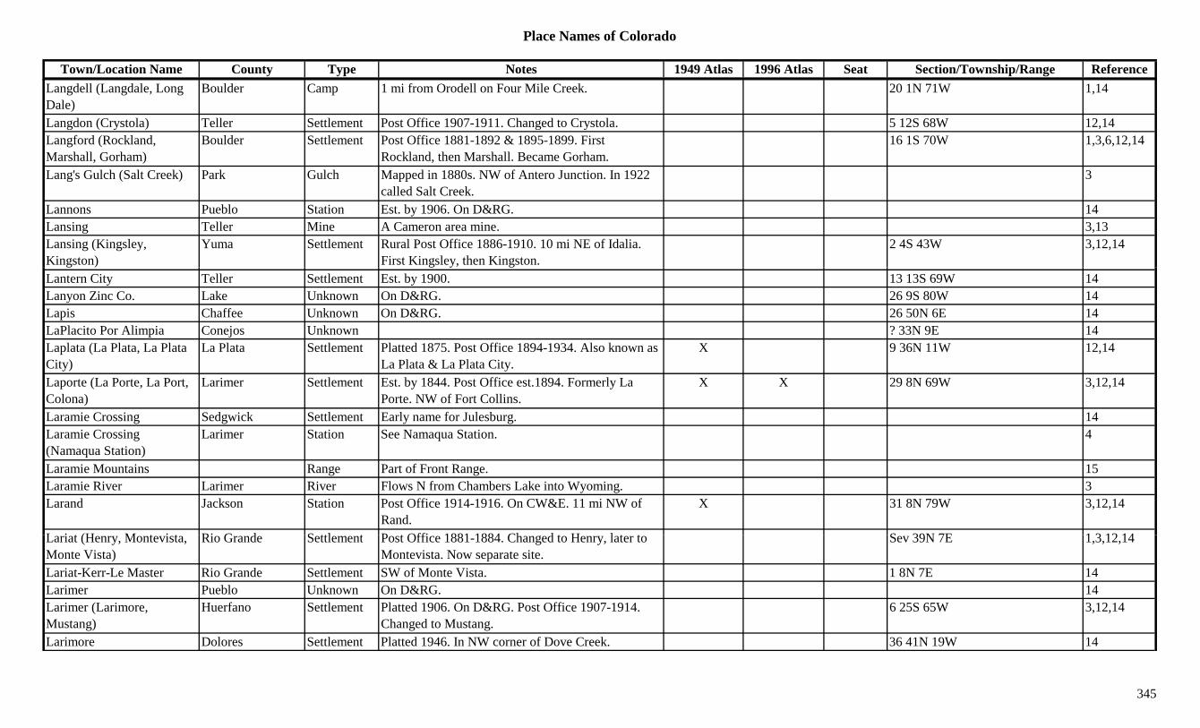
Place Names of Colorado
Town/Location Name County Type Notes 1949 Atlas 1996 Atlas Seat Section/Township/Range ReferenceLangdell (Langdale, Long Dale)
Boulder Camp 1 mi from Orodell on Four Mile Creek. 20 1N 71W 1,14
Langdon (Crystola) Teller Settlement Post Office 1907-1911. Changed to Crystola. 5 12S 68W 12,14Langford (Rockland, Marshall, Gorham)
Boulder Settlement Post Office 1881-1892 & 1895-1899. First Rockland, then Marshall. Became Gorham.
16 1S 70W 1,3,6,12,14
Lang's Gulch (Salt Creek) Park Gulch Mapped in 1880s. NW of Antero Junction. In 1922 called Salt Creek.
3
Lannons Pueblo Station Est. by 1906. On D&RG. 14Lansing Teller Mine A Cameron area mine. 3,13Lansing (Kingsley, Kingston)
Yuma Settlement Rural Post Office 1886-1910. 10 mi NE of Idalia. First Kingsley, then Kingston.
2 4S 43W 3,12,14
Lantern City Teller Settlement Est. by 1900. 13 13S 69W 14Lanyon Zinc Co. Lake Unknown On D&RG. 26 9S 80W 14Lapis Chaffee Unknown On D&RG. 26 50N 6E 14LaPlacito Por Alimpia Conejos Unknown ? 33N 9E 14Laplata (La Plata, La Plata City)
La Plata Settlement Platted 1875. Post Office 1894-1934. Also known as La Plata & La Plata City.
X 9 36N 11W 12,14
Laporte (La Porte, La Port, Colona)
Larimer Settlement Est. by 1844. Post Office est.1894. Formerly La Porte. NW of Fort Collins.
X X 29 8N 69W 3,12,14
Laramie Crossing Sedgwick Settlement Early name for Julesburg. 14Laramie Crossing (Namaqua Station)
Larimer Station See Namaqua Station. 4
Laramie Mountains Range Part of Front Range. 15Laramie River Larimer River Flows N from Chambers Lake into Wyoming. 3Larand Jackson Station Post Office 1914-1916. On CW&E. 11 mi NW of
Rand.X 31 8N 79W 3,12,14
L i t (H M t i t Ri G d S ttl t P t Offi 1881 1884 Ch d t H l t t S 39N 7E 1 3 12 14Lariat (Henry, Montevista, Monte Vista)
Rio Grande Settlement Post Office 1881-1884. Changed to Henry, later to Montevista. Now separate site.
Sev 39N 7E 1,3,12,14
Lariat-Kerr-Le Master Rio Grande Settlement SW of Monte Vista. 1 8N 7E 14Larimer Pueblo Unknown On D&RG. 14Larimer (Larimore, Mustang)
Huerfano Settlement Platted 1906. On D&RG. Post Office 1907-1914. Changed to Mustang.
6 25S 65W 3,12,14
Larimore Dolores Settlement Platted 1946. In NW corner of Dove Creek. 36 41N 19W 14
345
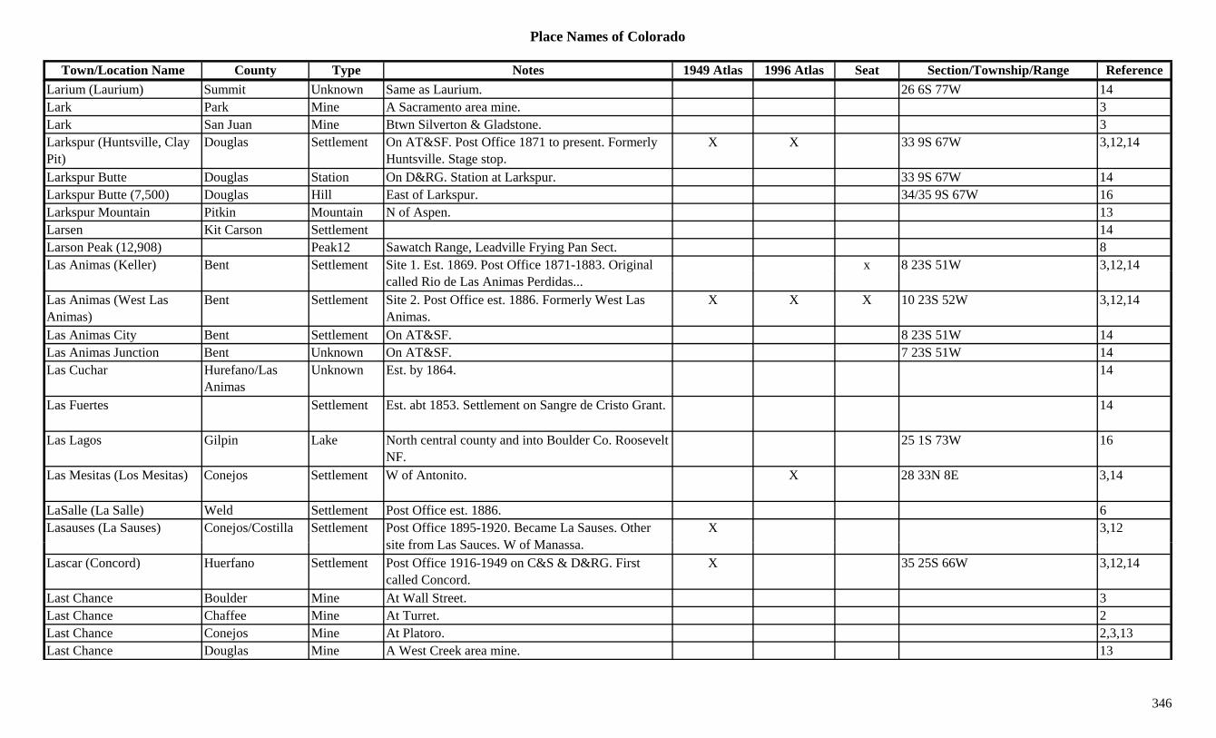
Place Names of Colorado
Town/Location Name County Type Notes 1949 Atlas 1996 Atlas Seat Section/Township/Range ReferenceLarium (Laurium) Summit Unknown Same as Laurium. 26 6S 77W 14Lark Park Mine A Sacramento area mine. 3Lark San Juan Mine Btwn Silverton & Gladstone. 3Larkspur (Huntsville, Clay Pit)
Douglas Settlement On AT&SF. Post Office 1871 to present. Formerly Huntsville. Stage stop.
X X 33 9S 67W 3,12,14
Larkspur Butte Douglas Station On D&RG. Station at Larkspur. 33 9S 67W 14Larkspur Butte (7,500) Douglas Hill East of Larkspur. 34/35 9S 67W 16Larkspur Mountain Pitkin Mountain N of Aspen. 13Larsen Kit Carson Settlement 14Larson Peak (12,908) Peak12 Sawatch Range, Leadville Frying Pan Sect. 8Las Animas (Keller) Bent Settlement Site 1. Est. 1869. Post Office 1871-1883. Original x 8 23S 51W 3,12,14( ) g
called Rio de Las Animas Perdidas..., ,
Las Animas (West Las Animas)
Bent Settlement Site 2. Post Office est. 1886. Formerly West Las Animas.
X X X 10 23S 52W 3,12,14
Las Animas City Bent Settlement On AT&SF. 8 23S 51W 14Las Animas Junction Bent Unknown On AT&SF. 7 23S 51W 14Las Cuchar Hurefano/Las
AnimasUnknown Est. by 1864. 14
Las Fuertes Settlement Est. abt 1853. Settlement on Sangre de Cristo Grant. 14
Las Lagos Gilpin Lake North central county and into Boulder Co. Roosevelt NF.
25 1S 73W 16
Las Mesitas (Los Mesitas) Conejos Settlement W of Antonito. X 28 33N 8E 3,14
LaSalle (La Salle) Weld Settlement Post Office est. 1886. 6Lasauses (La Sauses) Conejos/Costilla Settlement Post Office 1895-1920. Became La Sauses. Other
it f L S W f MX 3,12
site from Las Sauces. W of Manassa.Lascar (Concord) Huerfano Settlement Post Office 1916-1949 on C&S & D&RG. First
called Concord.X 35 25S 66W 3,12,14
Last Chance Boulder Mine At Wall Street. 3Last Chance Chaffee Mine At Turret. 2Last Chance Conejos Mine At Platoro. 2,3,13Last Chance Douglas Mine A West Creek area mine. 13
346

Place Names of Colorado
Town/Location Name County Type Notes 1949 Atlas 1996 Atlas Seat Section/Township/Range ReferenceLast Chance Lake Mine A Leadville area mine. 3Last Chance Mineral Camp N of Creede. On W Willow Creek. 3Last Chance Mineral Mine N of Creede (Bachelor Mountain). 2,3,13Last Chance Washington Settlement Est. 1926. A waystop on Hwy. 36. 20 mi W of
Anton.X X 1 3S 55W 1,3,14
Last Chance Mine & Mill Park Mine A Horseshoe area operation. 3,13Last Chance Reservoir Delta Lake NE of Cedaredge. Grand Mesa NF. 33 11S 93W 16Last Chip Junction Lake Station On D&RG. 24 9S 80W 14Last Chip Mine Lake Mine Mine plus ? 24 9S 80W 14Last Dollar Teller Mine On GC. Mine plus ? 29 15S 69W 14Last Dollar Pass (10,663) Pass Sneffels Range. 8( , ) gLast Resort (Park Siding) Jefferson Station Also called Park Siding. 21 7S 70W 14Last Resort Creek Jefferson Creek 1885. Close to ghost site of Resort. 3Latham (Agricola, Cherokee City)
Weld Settlement Est. 1861. Post Office 1863-1864 & 1867-1870. Formerly Cherokee City. Moved to Evans.
x 14 5N 65W 6,12,14
Latham (Fort Latham, Cherokee City)
Weld Fort Est. 1861. Became stage station 1863. Temporary fort.
3
Latham Reservoir Weld Lake East of La Salle. XLaub (Nola Siding) Las Animas Settlement Post Office on C&S 1916-1923. Same spot as Nola
Siding.15 34S 60W 3,12,14
Laugh-a-lot Larimer Mine At Manhattan. 2Laughren La Plata Settlement Platted 1914. 2U 34N 9W 14Laura Gunnison Mine At Crystal. 2Laura Logan Settlement BN Post Office 1908-1916. N of Peetz. 29 12N 51W 3,12,14Laurette (Lauret, Buckskin, B k ki J )
Park Settlement Est. 1859. Post Office 1861-1865. Changed to B k ki NW f F i l
3 9S 78W 1,12,13,14Buckskin Joe) Buckskin. NW of Fairplay.Laurium Gunnison Camp Est. by 1922. NE of Almont, along Spring Creek. 3
Laurium Summit Mine A Laurium area mine. 3Laurium (Larium) Summit Camp Post Office 1895-1899. 3 mi NE of Breckenridge.
Near mine of same name.26 6S 77W 3,12,14
Lava Conejos Unknown Est. by 1895. On D&RG. At CO-NM line. ? 32N 8E 14
347
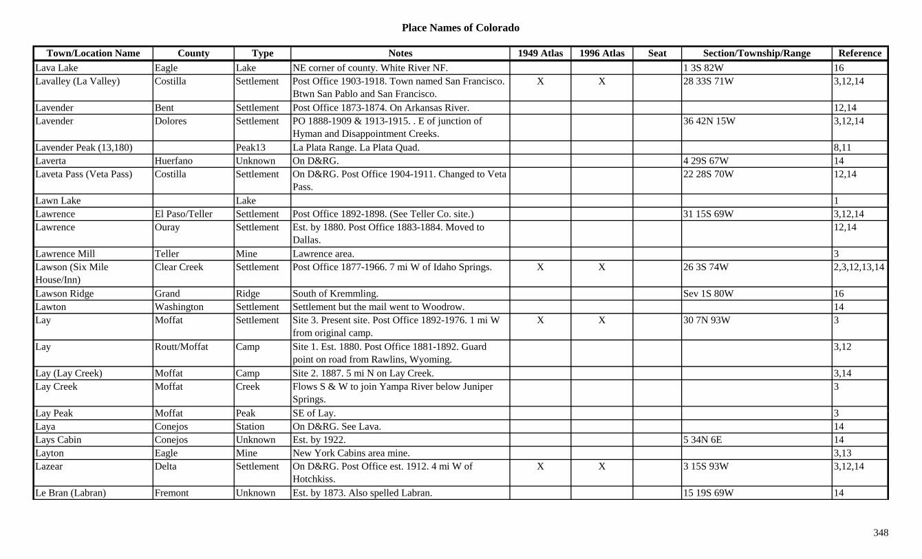
Place Names of Colorado
Town/Location Name County Type Notes 1949 Atlas 1996 Atlas Seat Section/Township/Range ReferenceLava Lake Eagle Lake NE corner of county. White River NF. 1 3S 82W 16Lavalley (La Valley) Costilla Settlement Post Office 1903-1918. Town named San Francisco.
Btwn San Pablo and San Francisco.X X 28 33S 71W 3,12,14
Lavender Bent Settlement Post Office 1873-1874. On Arkansas River. 12,14Lavender Dolores Settlement PO 1888-1909 & 1913-1915. . E of junction of
Hyman and Disappointment Creeks.36 42N 15W 3,12,14
Lavender Peak (13,180) Peak13 La Plata Range. La Plata Quad. 8,11Laverta Huerfano Unknown On D&RG. 4 29S 67W 14Laveta Pass (Veta Pass) Costilla Settlement On D&RG. Post Office 1904-1911. Changed to Veta
Pass.22 28S 70W 12,14
Lawn Lake Lake 1Lawrence El Paso/Teller Settlement Post Office 1892-1898. (See Teller Co. site.) 31 15S 69W 3,12,14Lawrence Ouray Settlement Est. by 1880. Post Office 1883-1884. Moved to
Dallas.12,14
Lawrence Mill Teller Mine Lawrence area. 3Lawson (Six Mile House/Inn)
Clear Creek Settlement Post Office 1877-1966. 7 mi W of Idaho Springs. X X 26 3S 74W 2,3,12,13,14
Lawson Ridge Grand Ridge South of Kremmling. Sev 1S 80W 16Lawton Washington Settlement Settlement but the mail went to Woodrow. 14Lay Moffat Settlement Site 3. Present site. Post Office 1892-1976. 1 mi W
from original camp.X X 30 7N 93W 3
Lay Routt/Moffat Camp Site 1. Est. 1880. Post Office 1881-1892. Guard point on road from Rawlins, Wyoming.
3,12
Lay (Lay Creek) Moffat Camp Site 2. 1887. 5 mi N on Lay Creek. 3,14Lay Creek Moffat Creek Flows S & W to join Yampa River below Juniper
Springs.3
L P k M ff t P k SE f L 3Lay Peak Moffat Peak SE of Lay. 3Laya Conejos Station On D&RG. See Lava. 14Lays Cabin Conejos Unknown Est. by 1922. 5 34N 6E 14Layton Eagle Mine New York Cabins area mine. 3,13Lazear Delta Settlement On D&RG. Post Office est. 1912. 4 mi W of
Hotchkiss.X X 3 15S 93W 3,12,14
Le Bran (Labran) Fremont Unknown Est. by 1873. Also spelled Labran. 15 19S 69W 14
348
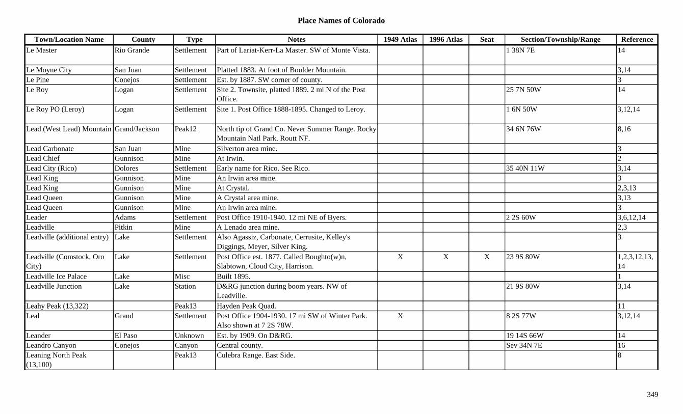
Place Names of Colorado
Town/Location Name County Type Notes 1949 Atlas 1996 Atlas Seat Section/Township/Range ReferenceLe Master Rio Grande Settlement Part of Lariat-Kerr-La Master. SW of Monte Vista. 1 38N 7E 14
Le Moyne City San Juan Settlement Platted 1883. At foot of Boulder Mountain. 3,14Le Pine Conejos Settlement Est. by 1887. SW corner of county. 3Le Roy Logan Settlement Site 2. Townsite, platted 1889. 2 mi N of the Post
Office.25 7N 50W 14
Le Roy PO (Leroy) Logan Settlement Site 1. Post Office 1888-1895. Changed to Leroy. 1 6N 50W 3,12,14
Lead (West Lead) Mountain Grand/Jackson Peak12 North tip of Grand Co. Never Summer Range. Rocky Mountain Natl Park. Routt NF.
34 6N 76W 8,16
Lead Carbonate San Juan Mine Silverton area mine. 3Lead Chief Gunnison Mine At Irwin. 2Lead City (Rico) Dolores Settlement Early name for Rico. See Rico. 35 40N 11W 3,14Lead King Gunnison Mine An Irwin area mine. 3Lead King Gunnison Mine At Crystal. 2,3,13Lead Queen Gunnison Mine A Crystal area mine. 3,13Lead Queen Gunnison Mine An Irwin area mine. 3Leader Adams Settlement Post Office 1910-1940. 12 mi NE of Byers. 2 2S 60W 3,6,12,14Leadville Pitkin Mine A Lenado area mine. 2,3Leadville (additional entry) Lake Settlement Also Agassiz, Carbonate, Cerrusite, Kelley's
Diggings, Meyer, Silver King.3
Leadville (Comstock, Oro City)
Lake Settlement Post Office est. 1877. Called Boughto(w)n, Slabtown, Cloud City, Harrison.
X X X 23 9S 80W 1,2,3,12,13,14
Leadville Ice Palace Lake Misc Built 1895. 1Leadville Junction Lake Station D&RG junction during boom years. NW of
Leadville.21 9S 80W 3,14
L h P k (13 322) P k13 H d P k Q d 11Leahy Peak (13,322) Peak13 Hayden Peak Quad. 11Leal Grand Settlement Post Office 1904-1930. 17 mi SW of Winter Park.
Also shown at 7 2S 78W.X 8 2S 77W 3,12,14
Leander El Paso Unknown Est. by 1909. On D&RG. 19 14S 66W 14Leandro Canyon Conejos Canyon Central county. Sev 34N 7E 16Leaning North Peak (13,100)
Peak13 Culebra Range. East Side. 8
349

Place Names of Colorado
Town/Location Name County Type Notes 1949 Atlas 1996 Atlas Seat Section/Township/Range ReferenceLeaning South Peak (13,320)
Peak13 Culebra Range. East Side. 8
Leaps Gulch Gunnison Gulch NE of Gunnison. Runs W to Taylor River. Sev 51N 1E 16Leavenworth Gilpin Mine A Russell Gulch area mine. 3Leavenworth Creek Clear Creek Creek Near Georgetown. Flows into Clear Creek. 13Leavenworth Gulch Gilpin Station Wells Fargo Stage Station on Mountain Route. Btwn
Missouri City & Bortenburgh.14
Leavenworth Siding Gilpin Station In Leavenworth Gulch. 2 mi SSW of Central City. 14 3S 73W 14
Leavick Lake Settlement 7 mi from Leadville 1Leavick Park Settlement Est. by 1873. Post Office 1896-1899. At mill 8 10S 78W 3,12,13,14y
servicing Hilltop and Last Chance Mines., , ,
Lebanon Montezuma Settlement Post Office 1908-1939. 5 mi SW of Dolores. X X 15 37N 16W 1,12,14Lebanon Pueblo Settlement Post Office 1875-1876. 35 23S 66W 12,14Lechner's Park Settlement 10 mi E of Leadville. 14Lede Reservoir Eagle Lake North of Ruedi. White River NF. ?? 7S 84W 16Leduc Park Mine A Sacramento area mine. 3Lee Jefferson Station Est. by 1882. On DSP&P. A siding on Morrison
Branch.3 5S 69W 14
Lee Hill Boulder Settlement Est. by 1904. 9 1N 71W 14Lee Hill (7,900) Boulder Hill NW of Boulder. 4 1N 71W 16Lee Lateral Adams Canal Runs NE from East Lake. 16Leeds Pueblo Unknown On D&RG. 19 20S 64W 14Lees Pueblo Settlement Post Office 1897-1904. 28 21S 67W 12,14Lee's San Miguel Station Est. by 1880s. Waystop. NE of Oaks. 3Lee's Siding Jefferson Station Est. by 1882. On C&S. 6 mi E of Morrison. 3,6L t d l (Ed ) D S ttl t Pl tt d 1892 E f Gl d l P i l ll d 3 14Leetsdale (Edgemoor) Denver Settlement Platted 1892. E of Glendale. Previously called
Edgemoor.3,14
Left Hand (Altona, Utilla) Boulder Settlement Post Office 1872-1879. Moved to Gold Hill. Also known as Altona & Utilla.
13 2N 71W 1,6,12,14
Left Hand Canyon Boulder Canyon Near Ward. 13Left Hand Creek/Canyon Boulder Canyon Leaves mountains at Altona. 1,13Lefthand Creek Boulder Creek Flows E past Altona and Modoc. 3
350
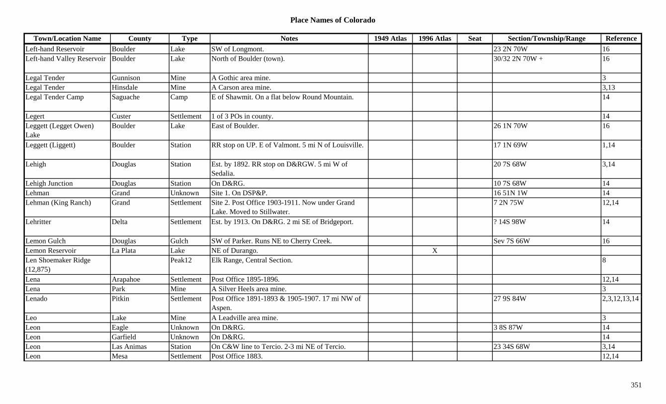
Place Names of Colorado
Town/Location Name County Type Notes 1949 Atlas 1996 Atlas Seat Section/Township/Range ReferenceLeft-hand Reservoir Boulder Lake SW of Longmont. 23 2N 70W 16Left-hand Valley Reservoir Boulder Lake North of Boulder (town). 30/32 2N 70W + 16
Legal Tender Gunnison Mine A Gothic area mine. 3Legal Tender Hinsdale Mine A Carson area mine. 3,13Legal Tender Camp Saguache Camp E of Shawmit. On a flat below Round Mountain. 14
Legert Custer Settlement 1 of 3 POs in county. 14Leggett (Legget Owen) Lake
Boulder Lake East of Boulder. 26 1N 70W 16
Leggett (Liggett) Boulder Station RR stop on UP. E of Valmont. 5 mi N of Louisville. 17 1N 69W 1,14gg ( gg ) p ,
Lehigh Douglas Station Est. by 1892. RR stop on D&RGW. 5 mi W of Sedalia.
20 7S 68W 3,14
Lehigh Junction Douglas Station On D&RG. 10 7S 68W 14Lehman Grand Unknown Site 1. On DSP&P. 16 51N 1W 14Lehman (King Ranch) Grand Settlement Site 2. Post Office 1903-1911. Now under Grand
Lake. Moved to Stillwater.7 2N 75W 12,14
Lehritter Delta Settlement Est. by 1913. On D&RG. 2 mi SE of Bridgeport. ? 14S 98W 14
Lemon Gulch Douglas Gulch SW of Parker. Runs NE to Cherry Creek. Sev 7S 66W 16Lemon Reservoir La Plata Lake NE of Durango. XLen Shoemaker Ridge (12,875)
Peak12 Elk Range, Central Section. 8
Lena Arapahoe Settlement Post Office 1895-1896. 12,14Lena Park Mine A Silver Heels area mine. 3L d Pitki S ttl t P t Offi 1891 1893 & 1905 1907 17 i NW f 27 9S 84W 2 3 12 13 14Lenado Pitkin Settlement Post Office 1891-1893 & 1905-1907. 17 mi NW of
Aspen.27 9S 84W 2,3,12,13,14
Leo Lake Mine A Leadville area mine. 3Leon Eagle Unknown On D&RG. 3 8S 87W 14Leon Garfield Unknown On D&RG. 14Leon Las Animas Station On C&W line to Tercio. 2-3 mi NE of Tercio. 23 34S 68W 3,14Leon Mesa Settlement Post Office 1883. 12,14
351
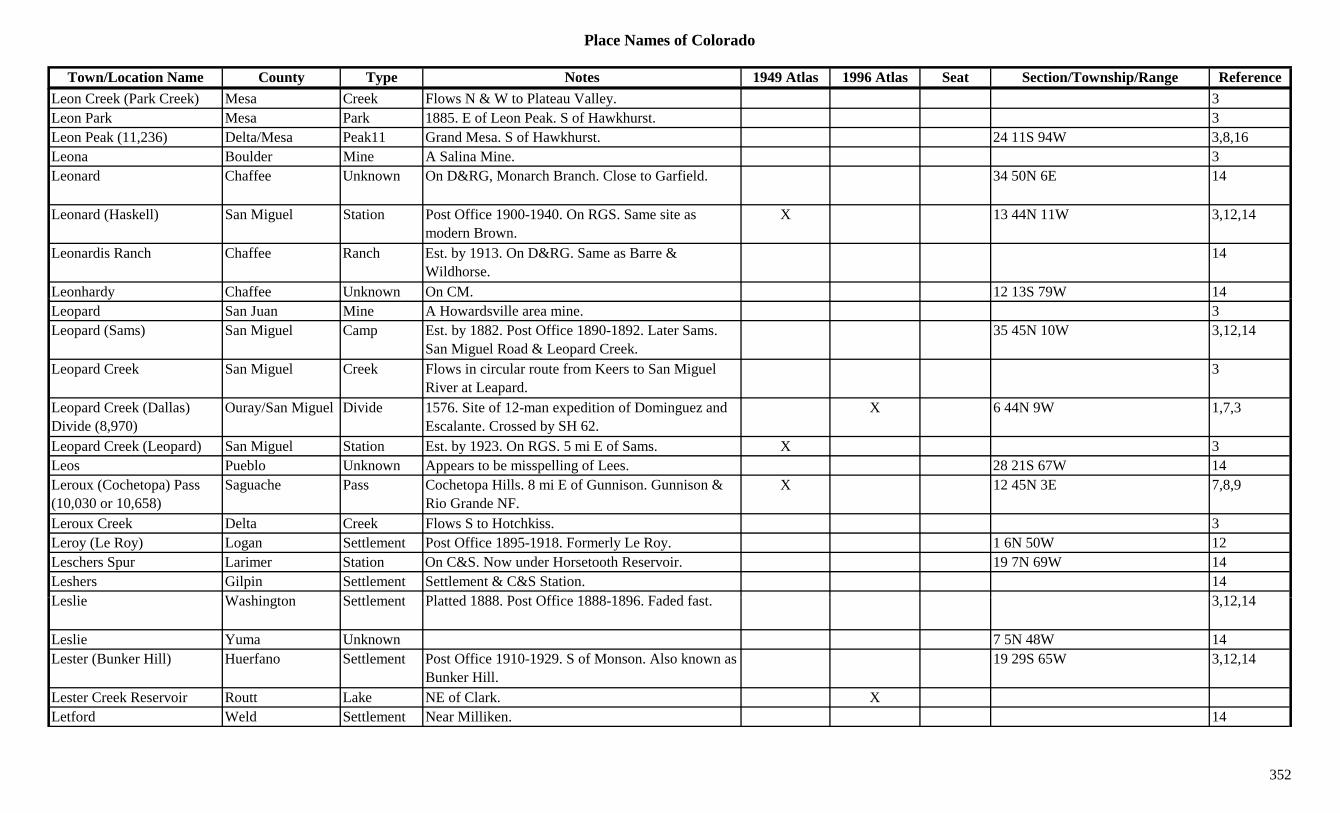
Place Names of Colorado
Town/Location Name County Type Notes 1949 Atlas 1996 Atlas Seat Section/Township/Range ReferenceLeon Creek (Park Creek) Mesa Creek Flows N & W to Plateau Valley. 3Leon Park Mesa Park 1885. E of Leon Peak. S of Hawkhurst. 3Leon Peak (11,236) Delta/Mesa Peak11 Grand Mesa. S of Hawkhurst. 24 11S 94W 3,8,16Leona Boulder Mine A Salina Mine. 3Leonard Chaffee Unknown On D&RG, Monarch Branch. Close to Garfield. 34 50N 6E 14
Leonard (Haskell) San Miguel Station Post Office 1900-1940. On RGS. Same site as modern Brown.
X 13 44N 11W 3,12,14
Leonardis Ranch Chaffee Ranch Est. by 1913. On D&RG. Same as Barre & Wildhorse.
14
Leonhardy Chaffee Unknown On CM. 12 13S 79W 14yLeopard San Juan Mine A Howardsville area mine. 3Leopard (Sams) San Miguel Camp Est. by 1882. Post Office 1890-1892. Later Sams.
San Miguel Road & Leopard Creek.35 45N 10W 3,12,14
Leopard Creek San Miguel Creek Flows in circular route from Keers to San Miguel River at Leapard.
3
Leopard Creek (Dallas) Divide (8,970)
Ouray/San Miguel Divide 1576. Site of 12-man expedition of Dominguez and Escalante. Crossed by SH 62.
X 6 44N 9W 1,7,3
Leopard Creek (Leopard) San Miguel Station Est. by 1923. On RGS. 5 mi E of Sams. X 3Leos Pueblo Unknown Appears to be misspelling of Lees. 28 21S 67W 14Leroux (Cochetopa) Pass (10,030 or 10,658)
Saguache Pass Cochetopa Hills. 8 mi E of Gunnison. Gunnison & Rio Grande NF.
X 12 45N 3E 7,8,9
Leroux Creek Delta Creek Flows S to Hotchkiss. 3Leroy (Le Roy) Logan Settlement Post Office 1895-1918. Formerly Le Roy. 1 6N 50W 12Leschers Spur Larimer Station On C&S. Now under Horsetooth Reservoir. 19 7N 69W 14Leshers Gilpin Settlement Settlement & C&S Station. 14L li W hi t S ttl t Pl tt d 1888 P t Offi 1888 1896 F d d f t 3 12 14Leslie Washington Settlement Platted 1888. Post Office 1888-1896. Faded fast. 3,12,14
Leslie Yuma Unknown 7 5N 48W 14Lester (Bunker Hill) Huerfano Settlement Post Office 1910-1929. S of Monson. Also known as
Bunker Hill.19 29S 65W 3,12,14
Lester Creek Reservoir Routt Lake NE of Clark. XLetford Weld Settlement Near Milliken. 14
352
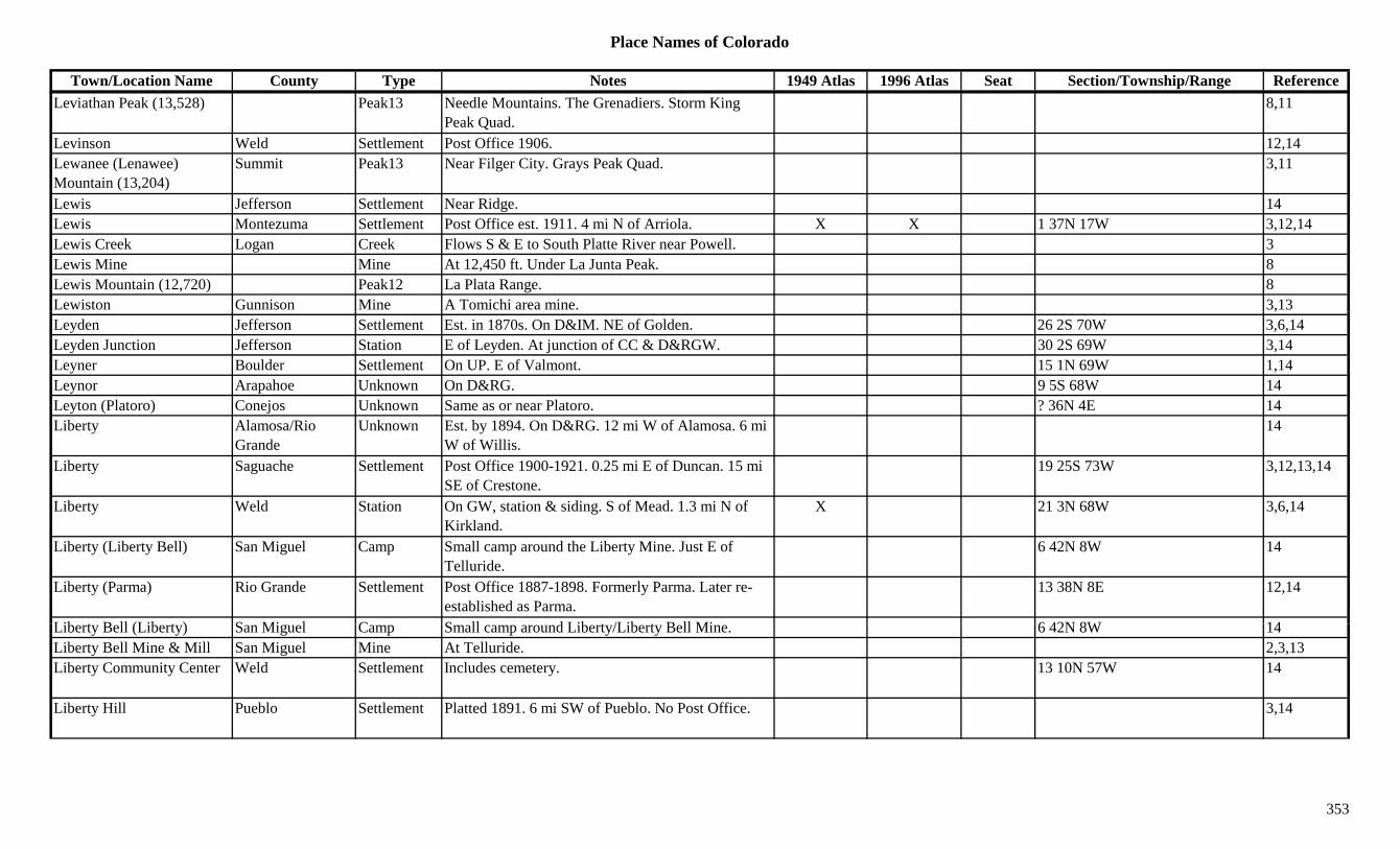
Place Names of Colorado
Town/Location Name County Type Notes 1949 Atlas 1996 Atlas Seat Section/Township/Range ReferenceLeviathan Peak (13,528) Peak13 Needle Mountains. The Grenadiers. Storm King
Peak Quad.8,11
Levinson Weld Settlement Post Office 1906. 12,14Lewanee (Lenawee) Mountain (13,204)
Summit Peak13 Near Filger City. Grays Peak Quad. 3,11
Lewis Jefferson Settlement Near Ridge. 14Lewis Montezuma Settlement Post Office est. 1911. 4 mi N of Arriola. X X 1 37N 17W 3,12,14Lewis Creek Logan Creek Flows S & E to South Platte River near Powell. 3Lewis Mine Mine At 12,450 ft. Under La Junta Peak. 8Lewis Mountain (12,720) Peak12 La Plata Range. 8Lewiston Gunnison Mine A Tomichi area mine. 3,13,Leyden Jefferson Settlement Est. in 1870s. On D&IM. NE of Golden. 26 2S 70W 3,6,14Leyden Junction Jefferson Station E of Leyden. At junction of CC & D&RGW. 30 2S 69W 3,14Leyner Boulder Settlement On UP. E of Valmont. 15 1N 69W 1,14Leynor Arapahoe Unknown On D&RG. 9 5S 68W 14Leyton (Platoro) Conejos Unknown Same as or near Platoro. ? 36N 4E 14Liberty Alamosa/Rio
GrandeUnknown Est. by 1894. On D&RG. 12 mi W of Alamosa. 6 mi
W of Willis.14
Liberty Saguache Settlement Post Office 1900-1921. 0.25 mi E of Duncan. 15 mi SE of Crestone.
19 25S 73W 3,12,13,14
Liberty Weld Station On GW, station & siding. S of Mead. 1.3 mi N of Kirkland.
X 21 3N 68W 3,6,14
Liberty (Liberty Bell) San Miguel Camp Small camp around the Liberty Mine. Just E of Telluride.
6 42N 8W 14
Liberty (Parma) Rio Grande Settlement Post Office 1887-1898. Formerly Parma. Later re-established as Parma.
13 38N 8E 12,14
Lib t B ll (Lib t ) S Mi l C S ll d Lib t /Lib t B ll Mi 6 42N 8W 14Liberty Bell (Liberty) San Miguel Camp Small camp around Liberty/Liberty Bell Mine. 6 42N 8W 14Liberty Bell Mine & Mill San Miguel Mine At Telluride. 2,3,13Liberty Community Center Weld Settlement Includes cemetery. 13 10N 57W 14
Liberty Hill Pueblo Settlement Platted 1891. 6 mi SW of Pueblo. No Post Office. 3,14
353
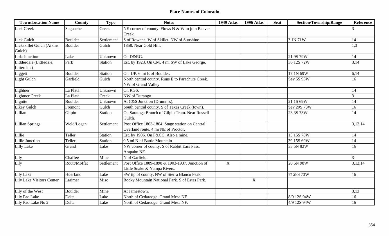
Place Names of Colorado
Town/Location Name County Type Notes 1949 Atlas 1996 Atlas Seat Section/Township/Range ReferenceLick Creek Saguache Creek NE corner of county. Flows N & W to join Beaver
Creek.3
Lick Gulch Boulder Settlement S of Rowena. W of Skillet. NW of Sunshine. ? 1N 71W 14Lickskillet Gulch (Aikins Gulch)
Boulder Gulch 1858. Near Gold Hill. 1,3
Lida Junction Lake Unknown On D&RG. 21 9S 79W 14Lidderdale (Littledale, Litterdale)
Park Station Est. by 1923. On CM. 4 mi SW of Lake George. 36 12S 72W 3,14
Liggett Boulder Station On UP. 6 mi E of Boulder. 17 1N 69W 6,14Light Gulch Garfield Gulch North central county. Runs E to Parachute Creek.
NW of Grand Valley.Sev 5S 96W 16
Lightner La Plata Unknown On RGS. 14Lightner Creek La Plata Creek NW of Durango. 3Lignite Boulder Unknown At C&S Junction (Drumm's). 21 1S 69W 14Likey Gulch Fremont Gulch South central county. S of Texas Creek (town). Sev 20S 73W 16Lillian Gilpin Station On Saratoga Branch of Gilpin Tram. Near Russell
Gulch.23 3S 73W 14
Lillian Springs Weld/Logan Settlement Post Office 1863-1864. Stage station on Central Overland route. 4 mi NE of Proctor.
3,12,14
Lillie Teller Station Est. by 1906. On F&CC. Also a mine. 13 15S 70W 14Lillie Junction Teller Station 0.5 mi N of Battle Mountain. 29 15S 69W 14Lilly Lake Grand Lake NW corner of county. S of Rabbit Ears Pass.
Arapaho NF.33 5N 82W 16
Lily Chaffee Mine N of Garfield. 3Lily Routt/Moffat Settlement Post Office 1889-1898 & 1903-1937. Junction of
Little Snake & Yampa Rivers.X 20 6N 98W 3,12,14
Lil L k H f L k SW ti f t NW f Si Bl P k ?? 28S 73W 16Lily Lake Huerfano Lake SW tip of county. NW of Sierra Blanco Peak. ?? 28S 73W 16Lily Lake Visitors Center Larimer Misc Rocky Mountain National Park. S of Estes Park. X
Lily of the West Boulder Mine At Jamestown. 3,13Lily Pad Lake Delta Lake North of Cedaredge. Grand Mesa NF. 8/9 12S 94W 16Lily Pad Lake No 2 Delta Lake North of Cedaredge. Grand Mesa NF. 4/9 12S 94W 16
354
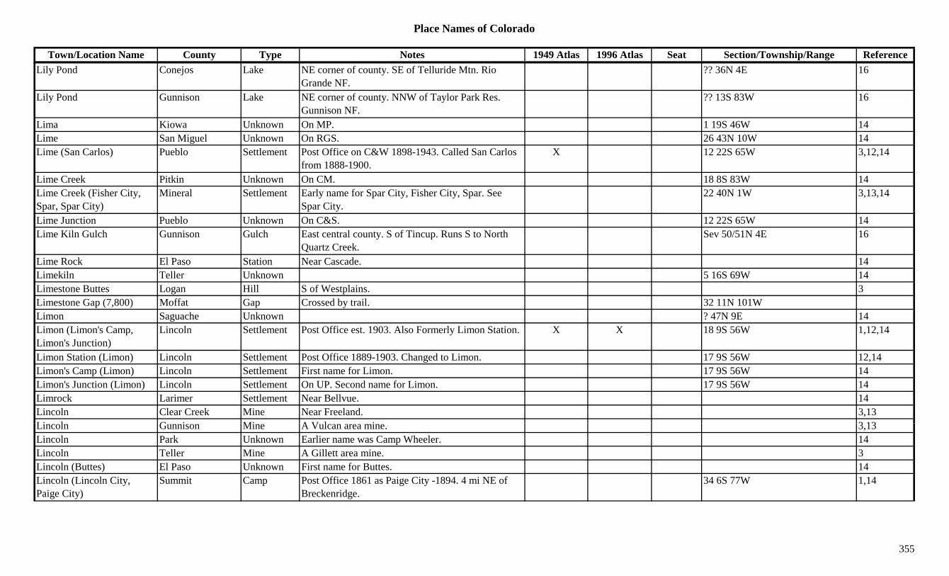
Place Names of Colorado
Town/Location Name County Type Notes 1949 Atlas 1996 Atlas Seat Section/Township/Range ReferenceLily Pond Conejos Lake NE corner of county. SE of Telluride Mtn. Rio
Grande NF.?? 36N 4E 16
Lily Pond Gunnison Lake NE corner of county. NNW of Taylor Park Res. Gunnison NF.
?? 13S 83W 16
Lima Kiowa Unknown On MP. 1 19S 46W 14Lime San Miguel Unknown On RGS. 26 43N 10W 14Lime (San Carlos) Pueblo Settlement Post Office on C&W 1898-1943. Called San Carlos
from 1888-1900.X 12 22S 65W 3,12,14
Lime Creek Pitkin Unknown On CM. 18 8S 83W 14Lime Creek (Fisher City, Spar, Spar City)
Mineral Settlement Early name for Spar City, Fisher City, Spar. See Spar City.
22 40N 1W 3,13,14
Lime Junction Pueblo Unknown On C&S. 12 22S 65W 14Lime Kiln Gulch Gunnison Gulch East central county. S of Tincup. Runs S to North
Quartz Creek.Sev 50/51N 4E 16
Lime Rock El Paso Station Near Cascade. 14Limekiln Teller Unknown 5 16S 69W 14Limestone Buttes Logan Hill S of Westplains. 3Limestone Gap (7,800) Moffat Gap Crossed by trail. 32 11N 101WLimon Saguache Unknown ? 47N 9E 14Limon (Limon's Camp, Limon's Junction)
Lincoln Settlement Post Office est. 1903. Also Formerly Limon Station. X X 18 9S 56W 1,12,14
Limon Station (Limon) Lincoln Settlement Post Office 1889-1903. Changed to Limon. 17 9S 56W 12,14Limon's Camp (Limon) Lincoln Settlement First name for Limon. 17 9S 56W 14Limon's Junction (Limon) Lincoln Settlement On UP. Second name for Limon. 17 9S 56W 14Limrock Larimer Settlement Near Bellvue. 14Lincoln Clear Creek Mine Near Freeland. 3,13Li l G i Mi A V l i 3 13Lincoln Gunnison Mine A Vulcan area mine. 3,13Lincoln Park Unknown Earlier name was Camp Wheeler. 14Lincoln Teller Mine A Gillett area mine. 3Lincoln (Buttes) El Paso Unknown First name for Buttes. 14Lincoln (Lincoln City, Paige City)
Summit Camp Post Office 1861 as Paige City -1894. 4 mi NE of Breckenridge.
34 6S 77W 1,14
355

Place Names of Colorado
Town/Location Name County Type Notes 1949 Atlas 1996 Atlas Seat Section/Township/Range ReferenceLincoln City (Farncomb Hill, Paige City)
Summit Settlement Post Office 1861-1894. Preceded by Paige City. 34 6S 77W 3,12,13,14
Lincoln City Smelting Co. Summit Mill A Lincoln area mining operation. 3Lincoln County Reservoir Lincoln Lake SE of Limon. XLincoln Creek Pitkin Creek Below Ruby. 13Lincoln Fort in Spring Valley
Douglas Fort Est. in 1860s. One of 3 county forts. 9
Lincoln Gulch Lake Gulch Near Leadville. 3Lincoln Hills Gilpin Settlement On D&RG. 33 1S 72W 14Lincoln Lake Clear Creek Lake South central county. NE of Summit Lake Park.
Arapaho NF.18 5S 73W 16
Lincoln Park (Coal Mines) Fremont Settlement Est. by 1885. SE of Canon City. X 4 19S 70W 3,14
Lindemeier Site Larimer Park Important archeological site. Near Fort Collins 1Linder Camp Las Animas Camp 21 31S 56W 14Linderman Lake Unknown On DSP&P. 27 8S 79W 14Lindland Jackson Settlement Post Office 1922-1937. NW of Gould. X 7 7N 77W 3,12,14Lindon (Harrisburg, Linden) Washington Settlement Rural Post Office 1888 on. 10 mi W of Anton. Also
shown at 7 4S 53W & 34 3S 54W.X X 11 4S 54W 3,12,14
Lindsey Jefferson Unknown On D&RG. 27 2S 70W 14Link Las Animas Settlement Post Office 1910-1912. 26 31S 68W 12,14Link's Creek Park Creek Shown on 1885 map. N of Lake George. 3Links Ranch Park Ranch 2 mi NE of Lake George. 4 12S 71W 14Linton Saguache Station Est. by 1920s. On D&RGW. 4 mi SE of Alder. X 17 47N 9E 3,14Linwood (Dodson, Dodsonville)
Las Animas Settlement Rural Post Office 1876-1886. Was Dodsonville. 5 mi E of Hoehne. Also at 1 32S 62W.
8 32S 62W 3,12,14
Li G l h G fi ld G l h S th t l t R N t N th D F k S 7S 99W 16Lion Gulch Garfield Gulch South central county. Runs N to North Dry Fork. Sev 7S 99W 16
Lion Gulch Gunnison Gulch North of Blue Mesa Res. Runs E to Soap Creek. Sev 50N 4/5W 16
Lion Gulch Gunnison Gulch West of Gunnison. Runs SSE to Red Creek. Sev 49/50N 3W 16Lion Lake No 1 Boulder Lake Far NW corner of county. Rocky Mountain Natl
Park.16
356
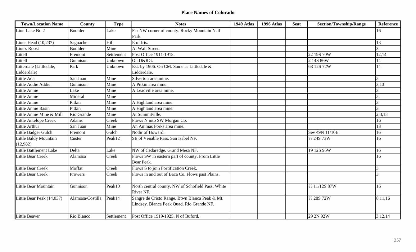
Place Names of Colorado
Town/Location Name County Type Notes 1949 Atlas 1996 Atlas Seat Section/Township/Range ReferenceLion Lake No 2 Boulder Lake Far NW corner of county. Rocky Mountain Natl
Park.16
Lions Head (10,237) Saguache Hill E of Iris. 13Lion's Roost Boulder Mine At Wall Street. 3Littell Fremont Settlement Post Office 1911-1915. 22 19S 70W 12,14Littell Gunnison Unknown On D&RG. 2 14S 86W 14Litterdale (Littledale, Lidderdale)
Park Unknown Est. by 1906. On CM. Same as Littledale & Lidderdale.
63 12S 72W 14
Little Ada San Juan Mine Silverton area mine. 3Little Addie Addie Gunnison Mine A Pitkin area mine. 3,13Little Annie Lake Mine A Leadville area mine. 3Little Annie Mineral Mine 3Little Annie Pitkin Mine A Highland area mine. 3Little Annie Basin Pitkin Mine A Highland area mine. 3Little Annie Mine & Mill Rio Grande Mine At Summitville. 2,3,13Little Antelope Creek Adams Creek Flows N into SW Morgan Co. 16Little Arthur San Juan Mine An Animas Forks area mine. 13Little Badger Gulch Fremont Gulch Nothr of Howard. Sev 49N 11/10E 16Little Baldy Mountain (12,982)
Custer Peak12 SE of Venable Pass. San Isabel NF. ?? 24S 73W 16
Little Battlement Lake Delta Lake NW of Cedaredge. Grand Mesa NF. 19 12S 95W 16Little Bear Creek Alamosa Creek Flows SW in eastern part of county. From Little
Bear Peak.16
Little Bear Creek Moffat Creek Flows S to join Fortification Creek. 3Little Bear Creek Prowers Creek Flows in and out of Baca Co. Flows past Plains. 3
Littl B M t i G i P k10 N th t l t NW f S h fi ld P Whit ?? 11/12S 87W 16Little Bear Mountain Gunnison Peak10 North central county. NW of Schofield Pass. White River NF.
?? 11/12S 87W 16
Little Bear Peak (14,037) Alamosa/Costilla Peak14 Sangre de Cristo Range. Btwn Blanca Peak & Mt. Lindsey. Blanca Peak Quad. Rio Grande NF.
?? 28S 72W 8,11,16
Little Beaver Rio Blanco Settlement Post Office 1919-1925. N of Buford. 29 2N 92W 3,12,14
357

Place Names of Colorado
Town/Location Name County Type Notes 1949 Atlas 1996 Atlas Seat Section/Township/Range ReferenceLittle Beaver Creek Larimer Creek Flows from near Comanche Peak E into S Fork
Cache La Poudre.3
Little Beaver Reservoir Dolores Lake South central county. 7 39N 14W 16Little Bill Spring Dolores Misc East of Dove Creek. San Juan NF. 35 41N 17W 16Little Bob Lake Mine A Stumptown area mine. 13Little Buttes El Paso Station Stage station on the Cherokee Trail stage route. On
D&RG. S of Buttes.33 16S 65W 3,14
Little Carrie Gunnison Mine A Tomichi area mine. 3,13Little Causeway Lake Garfield Lake NE corner of county. White River NF. ?? 1N 87W 16Little Charm Chaffee Mine Near Monarch. 3,13Little Chicago Lake Settlement N of Stringtown. 3g gLittle Chicago Summit Mine A Kokomo area mine. 3Little Chicago (Hideaway Park)
Grand Settlement See Hideaway Park. 3
Little Chief Lake Mine A Leadville area mine. 3Little Comanche Creek Arapahoe Creek Flows N to join Comanche Creek at Strasburg. 16Little Cone (11,981) San Miguel Hill S of Placerville. 13Little Dolores River Mesa River Flows N & W to Utah near Joe Pace Ranch. X 3Little Dominguez Creek Mesa Creek Flows N & E E of Carson Hole and into Delta
County.3
Little Dora San Juan Mine Silverton area mine. 3Little Doty Lake Mine S of Birdseye. 3Little Dry Creek Arapahoe Creek Flows NW through Greenwood Village to South
Platte River in Englewood.16
Little Earl Gunnison Mine A Hillerton mine. 3,13Little Echo Lake Gilpin Lake NW corner of county. Roosevelt NF. 21 2S 74W 16Littl Eddi B ld Mi At B l t 3Little Eddie Boulder Mine At Balarat. 3Little Elk Park Larimer Unknown 33 4N 71W 14Little Ellen Lake Mine A Leadville area mine. At Stumptown. 3,13Little Evans Gulch Lake Mine Leadville area. Runs N of Leadville mining area. 3
Little Fanny San Juan Mine Silverton area mine. 3Little Finger (13,220) Peak13 Snowdon Peak Quad. 11
358
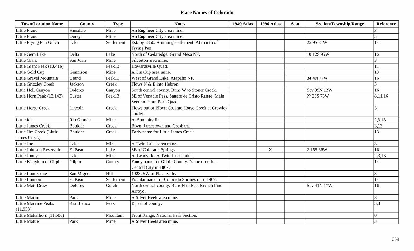
Place Names of Colorado
Town/Location Name County Type Notes 1949 Atlas 1996 Atlas Seat Section/Township/Range ReferenceLittle Fraud Hinsdale Mine An Engineer City area mine. 3Little Fraud Ouray Mine An Engineer City area mine. 3Little Frying Pan Gulch Lake Settlement Est. by 1860. A mining settlement. At mouth of
Frying Pan.25 9S 81W 14
Little Gem Lake Delta Lake North of Cedaredge. Grand Mesa NF. 10 12S 95W 16Little Giant San Juan Mine Silverton area mine. 3Little Giant Peak (13,416) Peak13 Howardsville Quad. 11Little Gold Cup Gunnison Mine A Tin Cup area mine. 13Little Gravel Mountain Grand Peak11 West of Grand Lake. Arapaho NF. 34 4N 77W 16Little Grizzley Creek Jackson Creek Flows N & E into Hebron. 3Little Hell Canyon Dolores Canyon South central county. Runs W to Stoner Creek. Sev 39N 12W 16y y yLittle Horn Peak (13,143) Custer Peak13 SE of Venable Pass. Sangre de Cristo Range, Main
Section. Horn Peak Quad.?? 23S 73W 8,11,16
Little Horse Creek Lincoln Creek Flows out of Elbert Co. into Horse Creek at Crowley border.
3
Little Ida Rio Grande Mine At Summitville. 2,3,13Little James Creek Boulder Creek Btwn. Jamestown and Gresham. 3,13Little Jim Creek (Little James Creek)
Boulder Creek Early name for Little James Creek. 13
Little Joe Lake Mine A Twin Lakes area mine. 3Little Johnson Reservoir El Paso Lake SE of Colorado Springs. X 2 15S 66W 16Little Jonny Lake Mine At Leadville. A Twin Lakes mine. 2,3,13Little Kingdom of Gilpin Gilpin County Fancy name for Gilpin County. Name used for
Central City in 1867.14
Little Lone Cone San Miguel Hill 1923. SW of Placerville. 3Little Lunnon El Paso Settlement Popular name for Colorado Springs until 1907. 14Littl M i D D l G l h N th t l t R N t E t B h Pi S 41N 17W 16Little Mair Draw Dolores Gulch North central county. Runs N to East Branch Pine
Arroyo.Sev 41N 17W 16
Little Marlin Park Mine A Silver Heels area mine. 3Little Marvine Peaks (11,933)
Rio Blanco Peak E part of county. 3,8
Little Matterhorn (11,586) Mountain Front Range, National Park Section. 8Little Mattie Park Mine A Silver Heels area mine. 3
359
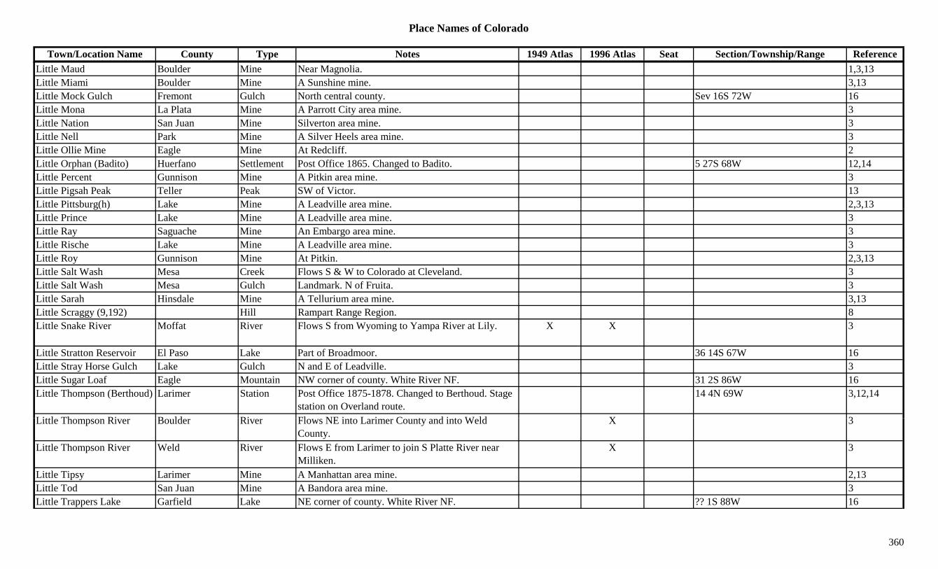
Place Names of Colorado
Town/Location Name County Type Notes 1949 Atlas 1996 Atlas Seat Section/Township/Range ReferenceLittle Maud Boulder Mine Near Magnolia. 1,3,13Little Miami Boulder Mine A Sunshine mine. 3,13Little Mock Gulch Fremont Gulch North central county. Sev 16S 72W 16Little Mona La Plata Mine A Parrott City area mine. 3Little Nation San Juan Mine Silverton area mine. 3Little Nell Park Mine A Silver Heels area mine. 3Little Ollie Mine Eagle Mine At Redcliff. 2Little Orphan (Badito) Huerfano Settlement Post Office 1865. Changed to Badito. 5 27S 68W 12,14Little Percent Gunnison Mine A Pitkin area mine. 3Little Pigsah Peak Teller Peak SW of Victor. 13Little Pittsburg(h) Lake Mine A Leadville area mine. 2,3,13g( ) , ,Little Prince Lake Mine A Leadville area mine. 3Little Ray Saguache Mine An Embargo area mine. 3Little Rische Lake Mine A Leadville area mine. 3Little Roy Gunnison Mine At Pitkin. 2,3,13Little Salt Wash Mesa Creek Flows S & W to Colorado at Cleveland. 3Little Salt Wash Mesa Gulch Landmark. N of Fruita. 3Little Sarah Hinsdale Mine A Tellurium area mine. 3,13Little Scraggy (9,192) Hill Rampart Range Region. 8Little Snake River Moffat River Flows S from Wyoming to Yampa River at Lily. X X 3
Little Stratton Reservoir El Paso Lake Part of Broadmoor. 36 14S 67W 16Little Stray Horse Gulch Lake Gulch N and E of Leadville. 3Little Sugar Loaf Eagle Mountain NW corner of county. White River NF. 31 2S 86W 16Little Thompson (Berthoud) Larimer Station Post Office 1875-1878. Changed to Berthoud. Stage
station on Overland route.14 4N 69W 3,12,14
Littl Th Ri B ld Ri Fl NE i t L i C t d i t W ld X 3Little Thompson River Boulder River Flows NE into Larimer County and into Weld County.
X 3
Little Thompson River Weld River Flows E from Larimer to join S Platte River near Milliken.
X 3
Little Tipsy Larimer Mine A Manhattan area mine. 2,13Little Tod San Juan Mine A Bandora area mine. 3Little Trappers Lake Garfield Lake NE corner of county. White River NF. ?? 1S 88W 16
360
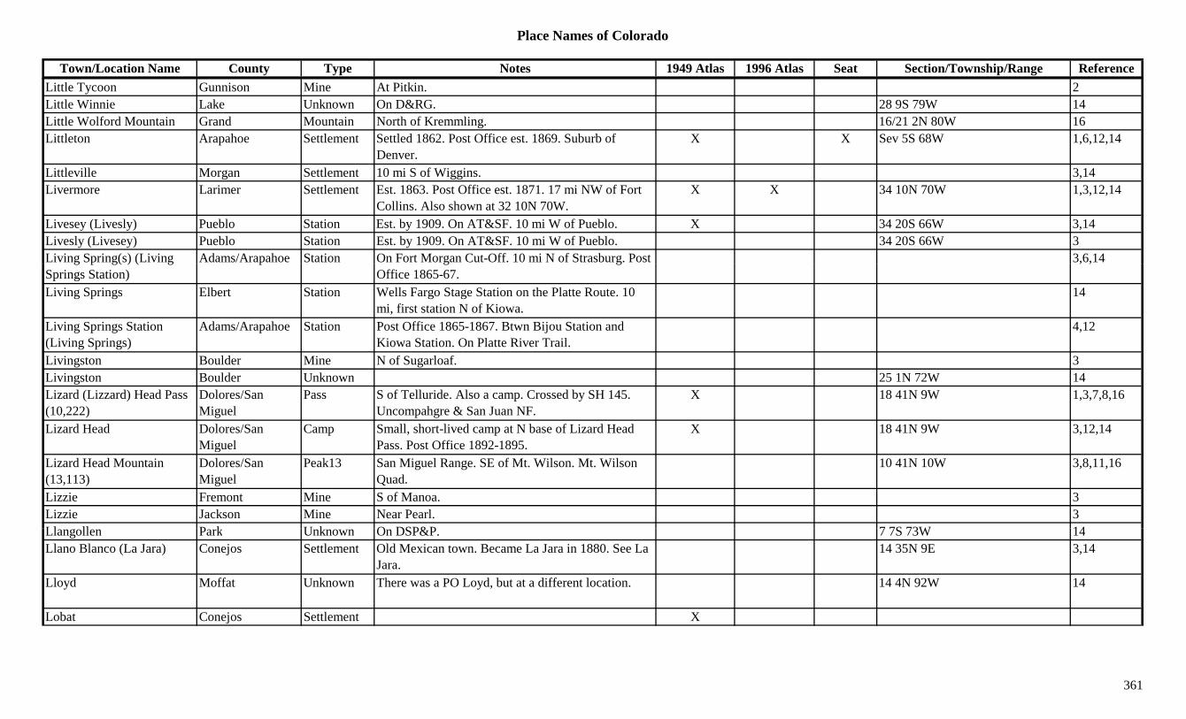
Place Names of Colorado
Town/Location Name County Type Notes 1949 Atlas 1996 Atlas Seat Section/Township/Range ReferenceLittle Tycoon Gunnison Mine At Pitkin. 2Little Winnie Lake Unknown On D&RG. 28 9S 79W 14Little Wolford Mountain Grand Mountain North of Kremmling. 16/21 2N 80W 16Littleton Arapahoe Settlement Settled 1862. Post Office est. 1869. Suburb of
Denver.X X Sev 5S 68W 1,6,12,14
Littleville Morgan Settlement 10 mi S of Wiggins. 3,14Livermore Larimer Settlement Est. 1863. Post Office est. 1871. 17 mi NW of Fort
Collins. Also shown at 32 10N 70W.X X 34 10N 70W 1,3,12,14
Livesey (Livesly) Pueblo Station Est. by 1909. On AT&SF. 10 mi W of Pueblo. X 34 20S 66W 3,14Livesly (Livesey) Pueblo Station Est. by 1909. On AT&SF. 10 mi W of Pueblo. 34 20S 66W 3Living Spring(s) (Living Adams/Arapahoe Station On Fort Morgan Cut-Off. 10 mi N of Strasburg. Post 3,6,14g p g( ) ( gSprings Station)
p g gOffice 1865-67.
, ,
Living Springs Elbert Station Wells Fargo Stage Station on the Platte Route. 10 mi, first station N of Kiowa.
14
Living Springs Station (Living Springs)
Adams/Arapahoe Station Post Office 1865-1867. Btwn Bijou Station and Kiowa Station. On Platte River Trail.
4,12
Livingston Boulder Mine N of Sugarloaf. 3Livingston Boulder Unknown 25 1N 72W 14Lizard (Lizzard) Head Pass (10,222)
Dolores/San Miguel
Pass S of Telluride. Also a camp. Crossed by SH 145. Uncompahgre & San Juan NF.
X 18 41N 9W 1,3,7,8,16
Lizard Head Dolores/San Miguel
Camp Small, short-lived camp at N base of Lizard Head Pass. Post Office 1892-1895.
X 18 41N 9W 3,12,14
Lizard Head Mountain (13,113)
Dolores/San Miguel
Peak13 San Miguel Range. SE of Mt. Wilson. Mt. Wilson Quad.
10 41N 10W 3,8,11,16
Lizzie Fremont Mine S of Manoa. 3Lizzie Jackson Mine Near Pearl. 3Ll ll P k U k O DSP&P 7 7S 73W 14Llangollen Park Unknown On DSP&P. 7 7S 73W 14Llano Blanco (La Jara) Conejos Settlement Old Mexican town. Became La Jara in 1880. See La
Jara.14 35N 9E 3,14
Lloyd Moffat Unknown There was a PO Loyd, but at a different location. 14 4N 92W 14
Lobat Conejos Settlement X
361
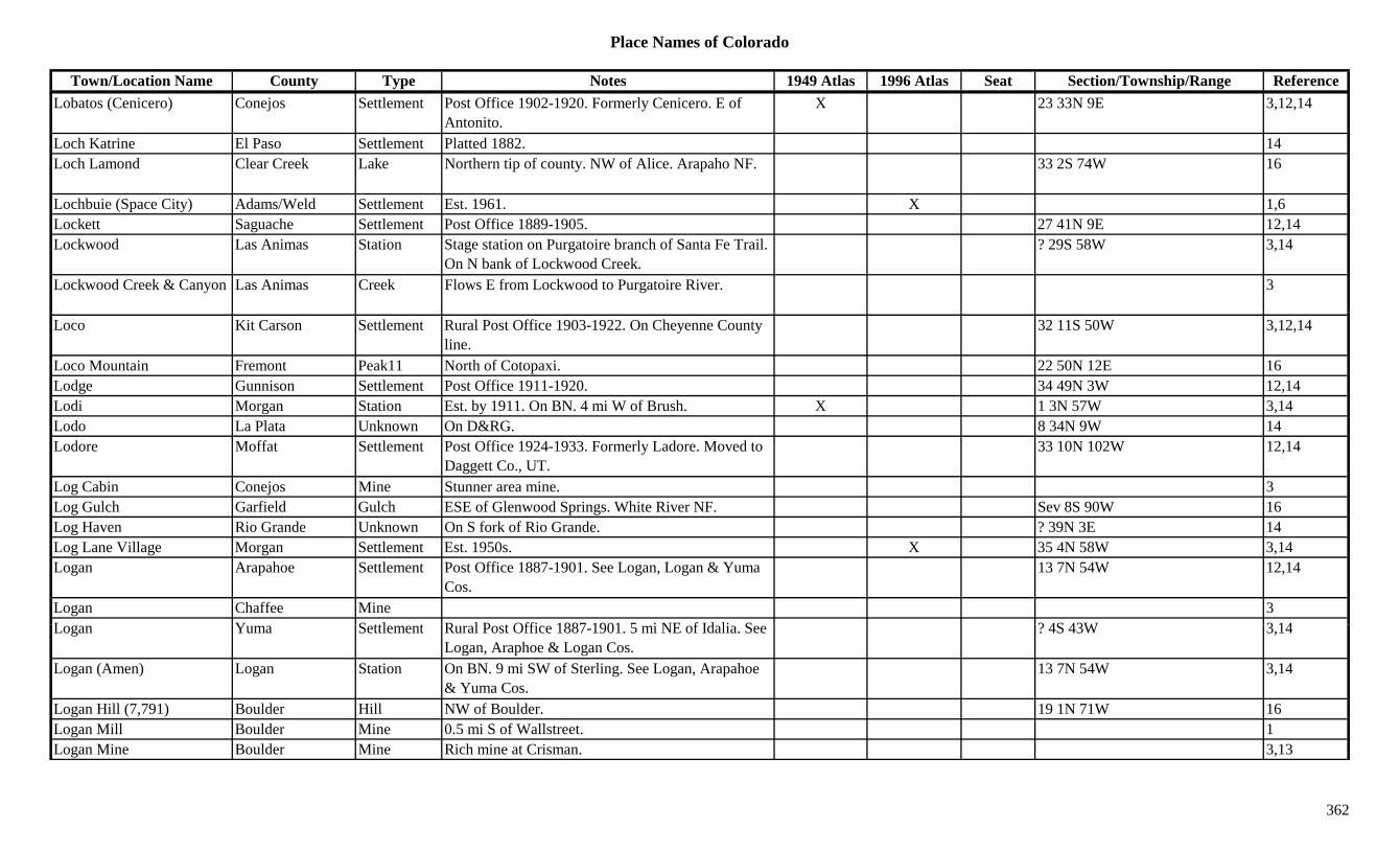
Place Names of Colorado
Town/Location Name County Type Notes 1949 Atlas 1996 Atlas Seat Section/Township/Range ReferenceLobatos (Cenicero) Conejos Settlement Post Office 1902-1920. Formerly Cenicero. E of
Antonito.X 23 33N 9E 3,12,14
Loch Katrine El Paso Settlement Platted 1882. 14Loch Lamond Clear Creek Lake Northern tip of county. NW of Alice. Arapaho NF. 33 2S 74W 16
Lochbuie (Space City) Adams/Weld Settlement Est. 1961. X 1,6Lockett Saguache Settlement Post Office 1889-1905. 27 41N 9E 12,14Lockwood Las Animas Station Stage station on Purgatoire branch of Santa Fe Trail.
On N bank of Lockwood Creek.? 29S 58W 3,14
Lockwood Creek & Canyon Las Animas Creek Flows E from Lockwood to Purgatoire River. 3
Loco Kit Carson Settlement Rural Post Office 1903-1922. On Cheyenne County line.
32 11S 50W 3,12,14
Loco Mountain Fremont Peak11 North of Cotopaxi. 22 50N 12E 16Lodge Gunnison Settlement Post Office 1911-1920. 34 49N 3W 12,14Lodi Morgan Station Est. by 1911. On BN. 4 mi W of Brush. X 1 3N 57W 3,14Lodo La Plata Unknown On D&RG. 8 34N 9W 14Lodore Moffat Settlement Post Office 1924-1933. Formerly Ladore. Moved to
Daggett Co., UT.33 10N 102W 12,14
Log Cabin Conejos Mine Stunner area mine. 3Log Gulch Garfield Gulch ESE of Glenwood Springs. White River NF. Sev 8S 90W 16Log Haven Rio Grande Unknown On S fork of Rio Grande. ? 39N 3E 14Log Lane Village Morgan Settlement Est. 1950s. X 35 4N 58W 3,14Logan Arapahoe Settlement Post Office 1887-1901. See Logan, Logan & Yuma
Cos.13 7N 54W 12,14
Logan Chaffee Mine 3L Y S ttl t R l P t Offi 1887 1901 5 i NE f Id li S ? 4S 43W 3 14Logan Yuma Settlement Rural Post Office 1887-1901. 5 mi NE of Idalia. See
Logan, Araphoe & Logan Cos.? 4S 43W 3,14
Logan (Amen) Logan Station On BN. 9 mi SW of Sterling. See Logan, Arapahoe & Yuma Cos.
13 7N 54W 3,14
Logan Hill (7,791) Boulder Hill NW of Boulder. 19 1N 71W 16Logan Mill Boulder Mine 0.5 mi S of Wallstreet. 1Logan Mine Boulder Mine Rich mine at Crisman. 3,13
362
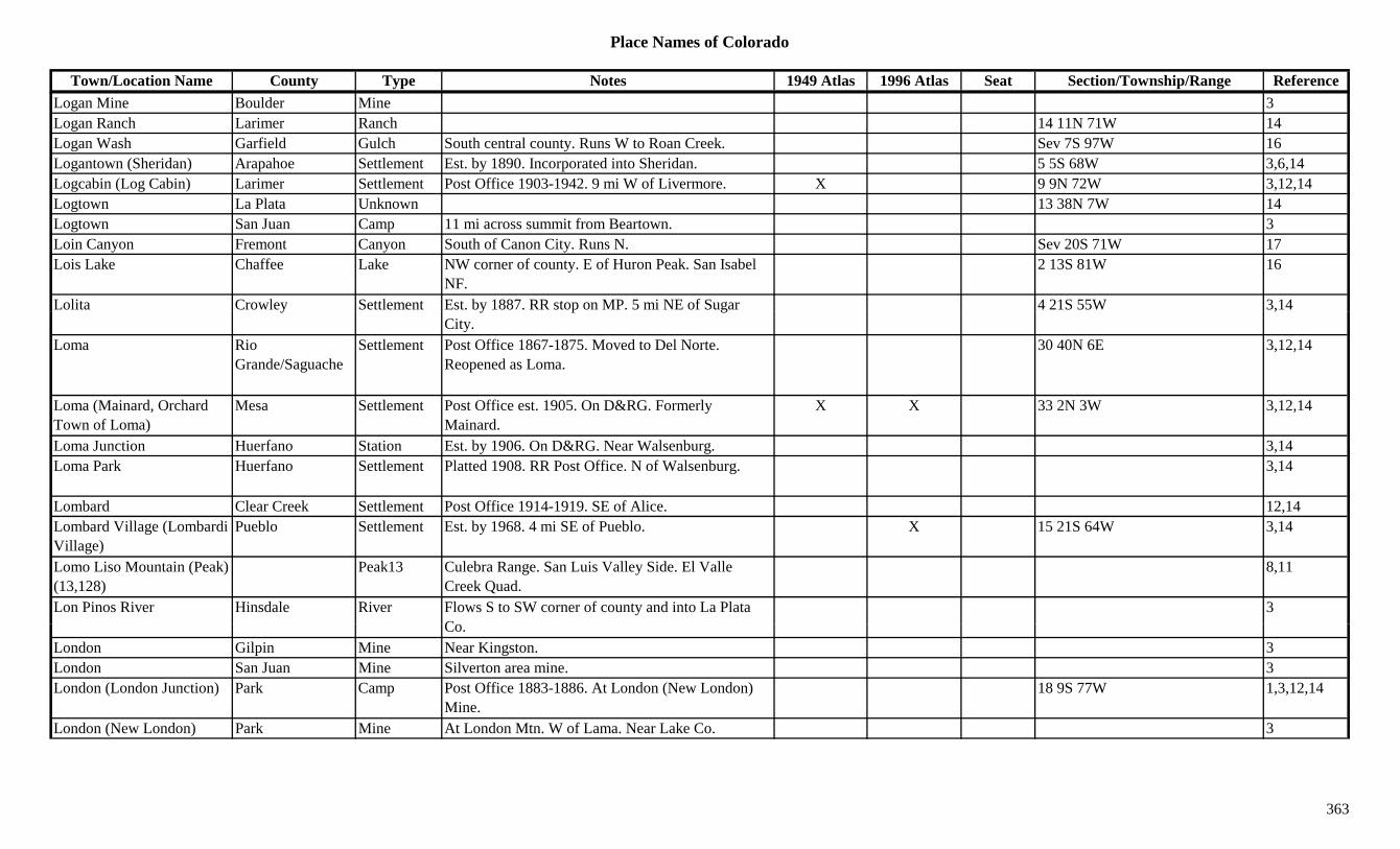
Place Names of Colorado
Town/Location Name County Type Notes 1949 Atlas 1996 Atlas Seat Section/Township/Range ReferenceLogan Mine Boulder Mine 3Logan Ranch Larimer Ranch 14 11N 71W 14Logan Wash Garfield Gulch South central county. Runs W to Roan Creek. Sev 7S 97W 16Logantown (Sheridan) Arapahoe Settlement Est. by 1890. Incorporated into Sheridan. 5 5S 68W 3,6,14Logcabin (Log Cabin) Larimer Settlement Post Office 1903-1942. 9 mi W of Livermore. X 9 9N 72W 3,12,14Logtown La Plata Unknown 13 38N 7W 14Logtown San Juan Camp 11 mi across summit from Beartown. 3Loin Canyon Fremont Canyon South of Canon City. Runs N. Sev 20S 71W 17Lois Lake Chaffee Lake NW corner of county. E of Huron Peak. San Isabel
NF.2 13S 81W 16
Lolita Crowley Settlement Est. by 1887. RR stop on MP. 5 mi NE of Sugar 4 21S 55W 3,14y y p gCity.
,
Loma Rio Grande/Saguache
Settlement Post Office 1867-1875. Moved to Del Norte. Reopened as Loma.
30 40N 6E 3,12,14
Loma (Mainard, Orchard Town of Loma)
Mesa Settlement Post Office est. 1905. On D&RG. Formerly Mainard.
X X 33 2N 3W 3,12,14
Loma Junction Huerfano Station Est. by 1906. On D&RG. Near Walsenburg. 3,14Loma Park Huerfano Settlement Platted 1908. RR Post Office. N of Walsenburg. 3,14
Lombard Clear Creek Settlement Post Office 1914-1919. SE of Alice. 12,14Lombard Village (Lombardi Village)
Pueblo Settlement Est. by 1968. 4 mi SE of Pueblo. X 15 21S 64W 3,14
Lomo Liso Mountain (Peak) (13,128)
Peak13 Culebra Range. San Luis Valley Side. El Valle Creek Quad.
8,11
Lon Pinos River Hinsdale River Flows S to SW corner of county and into La Plata C
3Co.
London Gilpin Mine Near Kingston. 3London San Juan Mine Silverton area mine. 3London (London Junction) Park Camp Post Office 1883-1886. At London (New London)
Mine.18 9S 77W 1,3,12,14
London (New London) Park Mine At London Mtn. W of Lama. Near Lake Co. 3
363
Place Names of Colorado
Town/Location Name County Type Notes 1949 Atlas 1996 Atlas Seat Section/Township/Range ReferenceLondon Junction (Alma Station)
Park Station Est. by 1884. Junction S of Alma. 3,13
London Mountain (13,194) Park Peak13 Mosquito Range. W of Alma. Near Lake Co. Climax Quad.
3,8,11
Lone (Last) Mountain Moffat Mountain Near Little Snake River N of Disappointment Vale. 3
Lone Basin Ouray Gulch 1881. Mining area near Engineer City. 3Lone Cabin Reservoir Delta Lake SE of Paonia. Gunnison NF. 13 14S 91W 16Lone Chimney Park Unknown ? 13S 71 or 72W 14Lone Cone (12,761) Dolores/San
MiguelPeak12 On Dolores Co. border in S central part of county. 24 42N 13W 3,8,13,16
Lone Creek Montrose Creek N central county. Flows NE to Roubideau Creek. 3
Lone Dome Dolores Settlement Est. by 1922. 8 mi SE of Cahone. 11 39N 17W 3Lone Dome (Lonedome) Montezuma Settlement Post Office 1883-1894. Changed to Lonedome. On
Dolores River. In or near Dolores Co.23 39N 17W 3,12,14
Lone Eagle Peak Grand Mountain East central county. Near Boulder Co. Arapaho NF. 10 1N 74W 16
Lone Eagle Peak (11,920) Boulder Peak Front Range, Indian Section. 8
Lone Gulch Boulder Gulch Runs through Balarat. 3Lone Home Montezuma Unknown Est. by 1885. On N bank of Dolores River. 13 mi NE
of Dolores.23 39N 17W 14
Lone Jack Summit Mine At Swandyke. 2Lone Mountain Gunnison Mountain Btwn Jack's Cabin and Dorchester. 3Lone Oak (Gotera) Las Animas Settlement Post Office 1922-1928. PO's formerly Duncan &
G t L ti i f D12 35S 56W 12,14
Gotera. Location is for Duncan.Lone Peak Eagle Peak11 E of State Bridge. XLone Peak Eagle Settlement XLone Pine Pitkin Mine An Aspen area mine. 3,13Lone Pine Creek Jackson Creek Flows E to North Fork (of North Platte River?). 3
364
Place Names of Colorado
Town/Location Name County Type Notes 1949 Atlas 1996 Atlas Seat Section/Township/Range ReferenceLone Pine Gulch Gunnison Gulch West central county. Near Delta Co. Runs NW to
North Fork Gunnison River.Sev 13S 90W 16
Lone Rock Douglas Hill SW corner of county. SW of Deckers. 3Lone Rock Saguache Settlement On Boughman Creek. ? 41N 4E 14Lone Star Gilpin Mine Phoenix area. 3Lone Star Washington Settlement 15 mi NW of Hyde. 4 4N 49W 3,14Lone Tree Boulder Mine SW of Lakewood. 3Lone Tree Clear Creek Mine At Dumont. 2,3,13Lone Tree Clear Creek Mine At Freeland. 2Lone Tree (Lonetree Site 1) Weld Station Est. by 1882. On CC. Near Wyoming border. X 29 12N 67W 3,6,14
Lone Tree (Lonetree) Archuleta Settlement On D&RG. 10 mi N of Pagosa Junction. Above Cat Creek Gap.
28 34S 3W 3,14
Lone Tree Creek Arapahoe Creek Runs N to join Dry Creek before entrance into Cherry Creek Reservoir.
16
Lone Tree Creek Weld Creek Flows S from near Wyoming. Past Dover, Pierce, Ault.
X X 3
Lone Tree Ranch Crowley Ranch Est. by 1903. Had Post Office. 29 18S 57W 14Lone Tree Reservoir Fremont Lake North of Canon City. 16 18S 70W 16Lonedome (Lone Dome) Montezuma Settlement Post Office 1894-1907. Formerly Lone Dome. 12Lonesome Peak Grand Peak10 SE of Granby Res. Arapaho NF. 1 1N 75W 16Lonetree Gilpin Unknown Site 1. Est. by 1913. 31 2S 72W 14Lonetree Gilpin Unknown Site 2. Est. by 1906. On C&S. 14Lonetree Weld Unknown Site 1. Est. by 1882. On CC. 29 12N 67W 14Lonetree Weld Unknown Site 2. 32 11N 66W 14Lonetree (Lone Tree) Archuleta Unknown On D&RG. 28 34S 3W 14L M t S ttl t XLong Montezuma Settlement XLong Branch Baldy (11,974)
Mountain Cochetopa Hills. 8
Long Canyon Conejos Canyon South central county. Runs E. Sev 33N 6E 16Long Canyon Hinsdale Canyon Central county. Runs ENE to Road Canyon Res. Rio
Grande NF.Sev 40/41N 3/4W 16
Long Draw Dolores Gulch South central county. Runs SW. Sev 39N 14W 16
365
Place Names of Colorado
Town/Location Name County Type Notes 1949 Atlas 1996 Atlas Seat Section/Township/Range ReferenceLong Draw Grand Gulch North of Parshall. Near Jackson Co. Runs SE to
Haystack Creek. Arapaho NF.Sev 4N 79W 16
Long Draw Gunnison Gulch West of Powderhorn. Runs N to Willow Creek. Sev 46/47N 4W 16Long Draw (La Poudre) Pass
Grand/Larimer Pass SE of Cameron Pass. N of Milner Pass. NE of Lulu. Roosevelt NF, RM Natl Park.
3,7
Long Draw Reservoir Dolores Lake SW of Rico. Near Montezuma Co. 2 39N 14W 16Long Draw Reservoir Jackson Lake NW of Rocky Mountain National Park. XLong Gulch Boulder Gulch Many by name. 1Long Gulch Fremont Gulch Central county. N of Cotopaxi. Sev 49/50N 12E 16Long Gulch Fremont Gulch North central county. Sev 17/18S 73W 16Long Gulch Fremont Gulch North of Canon City. Sev 16S 70/71W 16g yLong Hollow Douglas Gulch SW corner of county. Runs W to Trout Creek. Sev 10S 69W 16Long Lake Boulder Lake West of Ward. Roosevelt NF. 5/8 1N 73W 16Long Lake Garfield Lake NE corner of county. White River NF. ?? 1N 88W 16Long Meadow Park Unknown On DSP&P. 18 7S 73W 14Long Park Montrose Unknown Est. by 1922. 28 47N 17W 14Long Park Lake Dolores Lake South central county. 35 40N 16W + 16Long Park Reservoir Dolores Lake South central county. 27 40N 16W 16Long Point Garfield Hill West central county. W of Grand Valley. 7/18 7S 97W 16Longfellow Boulder Mine At Jamestown. 3,13Longfellow Chaffee Unknown NE up Longfellow Gulch, 2-3 mi. 2 49N 9E 14Longfellow San Juan Mine A Red Mountain area mine. 3Longfellow Teller Unknown Est. by 1894. 2 mi S of Grassy on Beaver Creek.
Grassy location 17 15S 69W.14
Longmont (Chicago-Colo Colony)
Boulder Settlement Colony town est. 1871. 1872 platted. Post Office est. 1873. Moved from Burlington.
X X Sev 3N 69W 1,3,6,12,14
L t R i B ld L k O N th ST V i C k W f L 16 3N 71W 16Longmont Reservoir Boulder Lake On North ST. Vrain Creek. W of Lyons. 16 3N 71W 16Longridge Dyke (7,480) Boulder Hill SW of Boulder. ?? 1S 71W 16Longs Montezuma Unknown On RGS. 8 36N 13W 14Longs Junction Las Animas Unknown On C&W. 31 33S 64W 14Longs Peak Boulder Station Est. 1889. On CC. Highland Lake Station on this
site.? 3N 69W 14
Longs Peak Larimer Settlement Post Office 1909-1936. 27 4N 73W 12,14
366
Place Names of Colorado
Town/Location Name County Type Notes 1949 Atlas 1996 Atlas Seat Section/Township/Range ReferenceLongs Peak (14,251 or 14,255)
Boulder Peak14 Front Range, National Park Section. Rocky Mountain Natl. Park.
X ?? 3N 73W 1,3,8,11,16
Longsdale Garfield Station Est. by 1923. Stop on Uintah RR. 3Longspeak Inn Larimer Settlement Est. by 1922. At base of Longs Peak. S of Estes
Park. Early settlement.3
Longview (Dome Rock) Jefferson Settlement Post Office 1911-1937. Moved from Dome Rock. Btwn Buffalo Creek and Waterton.
X 26 7S 70W 3,6,12,14
Lookout Mountain Garfield Mountain East of Glenwood Springs. 12 6S 89W 16Lookout Mountain Gunnison Mountain N of Waunita Hot Springs. 13Lookout Mountain Jefferson Mountain Out of Golden. Buffalo Bill's grave. 1Lookout Mountain Larimer Mountain N of Estes Park. 3,13,Lookout Mountain Moffat Mountain W of Ink Springs. 3Lookout Mountain Saguache Mountain NW of La Garita. 13Lookout Mountain (10,715) Boulder Peak10 NW corner of county. Rocky Mountain Natl Park. 16 3N 73W 16
Lookout Mountain (12,448) Conejos Peak12 NW of Platoro in NW corner of county. Rio Grande NF.
?? 36N 4E 8,16
Lookout Mouuntain Fremont Mountain ESE of Texas Creek (town). 4 20S 73W 16Lookout Peak (13,661) Peak13 Telluride Group. Also Silverton West Group. Ophir
Quad.8,11
Lookout Point Montezuma Hill 1885. SW of Mancos. Near Mesa Verde Natl. Park. 3
Lookout Point (Point Lookout)
Montezuma Unknown Same as Point Lookout. 32 36N 14W 14
Loomis Boulder Settlement Est. by 1924. On C&S. SW of Niwot. 3Loop Grand Unknown On D&RG. 6 2S 74W 14L T ll U k O F&CC 16 16S 69W 14Loop Teller Unknown On F&CC. 16 16S 69W 14Lopez Gunnison Mine A Sherrod area mine. 3Loraine El Paso Settlement Platted 1888. No Post Office. Just N of Broadmore
Hotel.3,14
Lords Larimer Station Est. by 1909. On C&S. 5 mi SW of Fort Collins. See Stout.
5 6N 69W 3,14
367
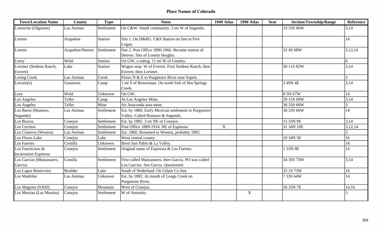
Place Names of Colorado
Town/Location Name County Type Notes 1949 Atlas 1996 Atlas Seat Section/Township/Range ReferenceLorencito (Olguines) Las Animas Settlement On C&W. Small community. 3 mi W of Segunda. 33 33S 66W 3,14
Loretto Arapahoe Station Site 1. On D&RG. C&S Station on line to Fort Logan.
14
Loretto Arapahoe/Denver Settlement Site 2. Post Office 1896-1966. Became station of Denver. Site of Loretto Heights.
32 4S 68W 3,12,14
Lorey Weld Station On GW, a siding. 11 mi W of Greeley. 6Lorimer (Seidens Ranch, Everett)
Lake Station Wagon stop. W of Everett. First Seidens Ranch, then Everett, then Lorimer.
36 11S 82W 3,14
Loring Creek Las Animas Creek Flows N & E to Purgatoire River near Sopris. 3Lorrain(e) Gunnison Camp 1 mi S of Bowerman. On north fork of Hot Springs 3 49N 4E 3,14( ) p p g
Creek.,
Lory Weld Unknown On GW. 8 5N 67W 14Los Angeles Teller Camp At Los Angeles Mine. 29 15S 69W 3,14Los Angeles Teller Mine An Anaconda area mine. 36 33S 66W 3Los Baros (Humoso, Segundo)
Las Animas Settlement Est. by 1860. Early Mexican settlement in Purgotoire Valley. Called Humoso & Segundo.
36 33S 66W 14
Los Brazos Conejos Settlement Est. by 1885. 3 mi NE of Conejos. 15 33N 9E 3,14Los Cerritos Conejos Settlement Post Office 1889-1914. NE of Espinosa X 31 34N 10E 3,12,14Los Cisneros (Weston) Las Animas Settlement Est. 1860. Renamed to Weston, probably 1892. 3Los Flores Lake Conejos Lake West central county. 10 34N 5E 16Los Fuertes Costilla Unknown Btwn San Pablo & La Valley. 14Los Fuerticitos de Incarnation Espinosa
Conejos Settlement Original name of Espinoza & Los Fuertes. 1 33N 9E 14
Los Garcias (Manzanares, Garcia)
Costilla Settlement First called Manzanares, then Garcia. PO was called Los Garcias. See Garcia. Questioned.
34 35S 73W 3,14
L L R i B ld L k S th f N d l d O Gil i C li 25 1S 73W 16Los Lagos Reservoirs Boulder Lake South of Nederland. On Gilpin Co line. 25 1S 73W 16Los Madriles Las Animas Unknown Est. by 1882. At mouth of Longs Creek on
Purgotoire River.? 33S 64W 14
Los Magotes (9,820) Conejos Mountain West of Conejos. 26 33N 7E 14,16Los Mesitas (Las Mesitas) Conejos Settlement W of Antonito. X 3
368

Place Names of Colorado
Town/Location Name County Type Notes 1949 Atlas 1996 Atlas Seat Section/Township/Range ReferenceLos Mogotes Saguache Settlement Post Office 1888-1890. On road E of La Garita Hills. ? 42N 7E 12,14
Los Mogotes (9,820) Conejos Mountain West of Conejos. 26 33N 7E 16Los Pinos Conejos Settlement Est. by 1887. On D&RG, a section house. E of
Cumbres.3 32N 5E 3,14
Los Pinos (Bayfield) La Plata Settlement Post Office 1889-1899. PO 3 mi N of Bayfield. Changed to Bayfield.
3,12,14
Los Pinos (Los Pinos Indian Agency)
Saguache Settlement Post Office 1872-1877. Moved to Cochetopa. Indian Agency on Cochetopa Creek.
35 46N 1E 12,14
Los Pinos Agency (Los Pinos, Old Los Pinos)
Montrose/La Plata Settlement Platted 1881. Btwn Uncompahgre and Ouray Co. line.
5 33N 7W 3,14
Los Pinos Creek Saguache Creek Flows NE to join Cochetopa Creek near Cuerin. 3
Los Pinos Pass (10,514) Saguache Pass W central county. Btwn Gunnison area and Lake City. Gunnison NF.
X X 2 44N 1W 3,7,9
Los Pinos River Conejos Creek Through (near) Los Pinos SE into NM. 3,16Los Pinos River Hinsdale River Flows SW to La Plata Co at very SW corner of
Hinsdale Co.X X
Los Pinos River La Plata River Flows S and W from Hinsdale County to near La Boca.
X X 3
Los Pinos Siding Conejos Station On D&RG. Same as Los Pinos. 3 32N 5E 14Los Rincones Conejos Settlement Est. by 1849. ? 34N 10E 14Los San Jose Conejos Unknown Est. by 1895. On Rio Conejos. ? 33N 9E 14Los Sauses (Los Sauces) Conejos Settlement Post Office 1882-1883. See La Sauses. 17 mi E of
La Jara. Not same as Lasauses.X 14 35N 11E 3,12,14
Los Sisneros Las Animas Settlement Est. by 1880. A plaza at present site of Weston. 35 33S 67W 14
Los Valdezes Rio Grande Unknown ? 40N 6E 14Los Varros Las Animas Unknown On C&S. Primero Junction & Olguine at this site,
but Olguine site is 32 33S 66W.36 33S 66W 14
Lost Acres Park Settlement Sub-division. 13 8S 72W 14Lost Canyon Chaffee Canyon W of Granite. 3Lost Canyon Montezuma Canyon E of Dolores. 3
369

Place Names of Colorado
Town/Location Name County Type Notes 1949 Atlas 1996 Atlas Seat Section/Township/Range ReferenceLost Canyon (Cañon) Montezuma Station Est. by 1923. On D&RGW. At mount of Lost
Canyon Creek.16 37N 15W 3,14
Lost Canyon Creek Montezuma Creek Flows S & W to Dolores River at Dolores. 3Lost Canyon Gulch Gunnison Gulch NE of Gunnison. Runs NE to Leaps Gulch. Sev 50N 1E 16Lost Canyon Placers Chaffee Camp Est. in 1860s. 3.5 mi up gulch from Granite. 3Lost Creek Adams Creek Flows N through central county into Weld Co. 16Lost Day Ouray Mine A Guston area mine. 3,13Lost Gulch Grand Gulch North of Parshall near Jackson Co. Arapaho NF. Sev 4N 79W 16
Lost Hunter Reservoir Delta Lake NE of Cedaredge. Grand Mesa NF. 24 12S 93W 16Lost Lake Boulder Lake SW corner of county. Roosevelt NF. 24 1S 74W 16yLost Lake Boulder Mine At Lost Lake Camp. W of Eldora. 3Lost Lake Chaffee Lake South of Cottonwood Pass. San Isabel NF. ?? 14S 81W 16Lost Lake Conejos Lake West central county. W of La Jara Reservoir. 29 35N 5E 16Lost Lake Eagle Lake NE corner of county. White River NF. 18 4S 80W 16Lost Lake Grand Lake NW of Grand Lake. Arapaho NF. 24 4N 77W 16Lost Lake Gunnison Lake West of Crested Butte. Gunnison NF. ?? 14S 88W 16Lost Lake Camp Boulder Camp At Lost Lake. SW of Hessie. 3,6,13Lost Lake City Boulder Unknown On South Fork of Middle Boulder Creek. 2 mi W of
Hessie.? 1S 74W 14
Lost Lake Slough Gunnison Lake West of Crested Butte. Gunnison NF. ?? 14S 88W 16Lost Lakes Eagle Lake West of Tennessee Pass. White River NF. ?? 8S 81W 16Lost Lakes Hinsdale Lake South of Lake City. N of Rio Grande Res. Rio
Grande NF.4/33 40/41N 4W 16
Lost Man Pass (12,820) Pass In Sawatch Range. Near Independence Pass (above Lost Man Lake).
5
L t P k P k S ttl t E t b 1885 S ll NE f O N L t P k 36 7S 74W 3 14Lost Park Park Settlement Est. by 1885. Small. NE of Orme. Near Lost Park Creek. At head of Craig Creek.
36 7S 74W 3,14
Lost Park (Herbert) Gunnison Unknown First name for Herbert. 14Lost Park Creek Park Creek NE of Orme. Flows SE to Jefferson Co. 3Lost Ranger Peak (11,932) Jackson/Routt Peak 8
370
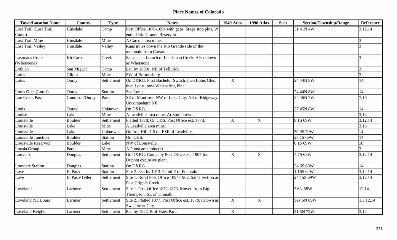
Place Names of Colorado
Town/Location Name County Type Notes 1949 Atlas 1996 Atlas Seat Section/Township/Range ReferenceLost Trail (Lost Trail Camp)
Hinsdale Camp Post Office 1878-1894 with gaps. Stage stop plus. W end of Rio Grande Reservoir.
31 41N 4W 3,12,14
Lost Trail Mine Hinsdale Mine A Carson area mine. 3Lost Trail Valley Hinsdale Valley Runs miles down the Rio Grande side of the
mountain from Carson.3
Lostmans Creek (Whetstone)
Kit Carson Creek Same as or branch of Landsman Creek. Also shown as Whetstone.
3
Lothian San Miguel Camp Est. by 1880s. NE of Telluride. 3Lotus Gilpin Mine SW of Bortonsburg. 3Lotus Ouray Settlement On D&RG. First Bachelor Switch, then Lotus Glen,
then Lotus, now Whispering Pine.X 24 44N 8W 14
Lotus Glen (Lotus) Ouray Station See Lotus. 24 44N 8W 14Lou Creek Pass Gunnison/Ouray Pass SE of Montrose. NW of Lake City. NE of Ridgeway.
Uncompahgre NF.24 46N 7W 7,16
Louis Ouray Unknown On D&RG. 27 45N 8W 14Louise Lake Mine A Leadville area mine. At Stumptown. 3,13Louisville Boulder Settlement Platted 1878. On C&S. Post Office est. 1878. X X 8 1S 69W 3,12,14Louisville Lake Mine A Leadville area mine. 3,13Louisville Lake Unknown On Iron Hill. 1.5 mi ESE of Leadville. 30 9S 79W 14Louisville Junction Boulder Station On C&S. 28 1S 69W 14Louisville Reservoir Boulder Lake NW of Louisville. 6 1S 69W 16Lousia Group Park Mine A Puma area mine(s). 3Louviers Douglas Settlement On D&RG. Company Post Office est. 1907 for
Dupont explosive plant.X X 4 7S 68W 3,12,14
Louviers Station Douglas Station On D&RG. 34 6S 68W 14Love El Paso Station Site 2. Est. by 1913. 22 mi E of Fountain. 1 16S 62W 3,12,14L El P /T ll S ttl t Sit 1 R l P t Offi 1894 1902 S ti 24 15S 69W 3 12 14Love El Paso/Teller Settlement Site 1. Rural Post Office 1894-1902. Same section as
East Cripple Creek.24 15S 69W 3,12,14
Loveland Larimer Settlement Site 1. Post Office 1872-1873. Moved from Big Thompson. SE of Timnath.
? 6N 68W 12,14
Loveland (St. Louis) Larimer Settlement Site 2. Platted 1877. Post Office est. 1878. Known as Sweetheart City.
X X Sev 5N 69W 1,3,12,14
Loveland Heights Larimer Settlement Est. by 1922. E of Estes Park. X 21 5N 72W 3,14
371
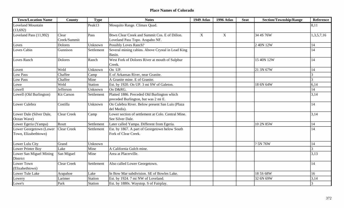
Place Names of Colorado
Town/Location Name County Type Notes 1949 Atlas 1996 Atlas Seat Section/Township/Range ReferenceLoveland Mountain (13,692)
Peak13 Mosquito Range. Climax Quad. 8,11
Loveland Pass (11,992) Clear Creek/Summit
Pass Btwn Clear Creek and Summit Cos. E of Dillon. Loveland Pass Topo. Arapaho NF.
X X 34 4S 76W 1,3,5,7,16
Loves Dolores Unknown Possibly Loves Ranch? 2 40N 12W 14Loves Cabin Gunnison Settlement Several mining cabins. Above Crystal in Lead King
Basin.14
Loves Ranch Dolores Ranch West Fork of Dolores River at mouth of Sulphur Creek.
15 40N 12W 14
Lovett Weld Unknown On UP. 21 3N 67W 14Low Pass Chaffee Camp E of Arkansas River, near Granite. 3p ,Low Pass Chaffee Mine A Granite mine. E of Granite. 3Lowe Weld Station Est. by 1920. On UP. 3 mi SW of Galeton. 18 6N 64W 6,14Lowell Jefferson Unknown On D&RG. 14Lowell (Old Burlington) Kit Carson Settlement Platted 1886. Preceded Old Burlington which
preceded Burlington, but was 2 mi E.3,14
Lower Culebra Costilla Unknown On Culebra River. Below present San Luis (Plaza del Medis).
14
Lower Dale (Silver Dale, Ocean Wave)
Clear Creek Camp Lower section of settlement at Colo. Central Mine. See Silver Dale.
3,14
Lower Egeria (Yampa) Routt Settlement Later called Yampa. Different from Egeria. 10 2N 85W 14Lower Georgetown (Lower Town, Elizabethtown)
Clear Creek Settlement Est. by 1867. A part of Georgetown below South Fork of Clear Creek.
14
Lower Lulu City Grand Unknown ? 5N 76W 14Lower Printer Boy Lake Mine A California Gulch mine. 3L S Mi l Mi i S Mi l Mi A t Pl ill 3 13Lower San Miguel Mining District
San Miguel Mine Area at Placerville. 3,13
Lower Town (Elizabethtown)
Clear Creek Settlement Also called Lower Georgetown. 14
Lower Tule Lake Arapahoe Lake In Bow Mar subdivision. SE of Bowles Lake. 18 5S 68W 16Lowery Larimer Station Est. by 1924. 7 mi NW of Loveland. 32 6N 69W 3,14Lowe's Park Station Est. by 1880s. Waystop. S of Fairplay. 3
372
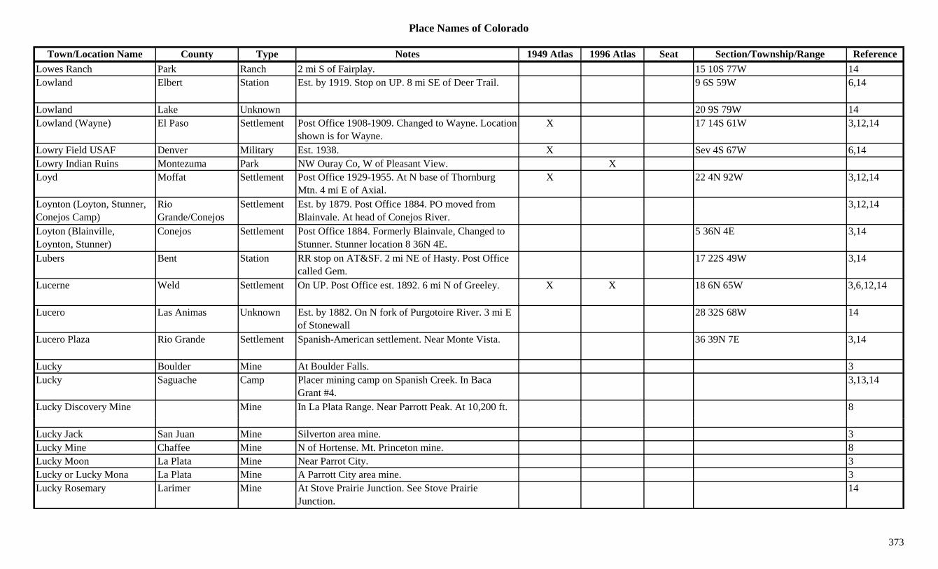
Place Names of Colorado
Town/Location Name County Type Notes 1949 Atlas 1996 Atlas Seat Section/Township/Range ReferenceLowes Ranch Park Ranch 2 mi S of Fairplay. 15 10S 77W 14Lowland Elbert Station Est. by 1919. Stop on UP. 8 mi SE of Deer Trail. 9 6S 59W 6,14
Lowland Lake Unknown 20 9S 79W 14Lowland (Wayne) El Paso Settlement Post Office 1908-1909. Changed to Wayne. Location
shown is for Wayne.X 17 14S 61W 3,12,14
Lowry Field USAF Denver Military Est. 1938. X Sev 4S 67W 6,14Lowry Indian Ruins Montezuma Park NW Ouray Co, W of Pleasant View. XLoyd Moffat Settlement Post Office 1929-1955. At N base of Thornburg
Mtn. 4 mi E of Axial.X 22 4N 92W 3,12,14
Loynton (Loyton, Stunner, Rio Settlement Est. by 1879. Post Office 1884. PO moved from 3,12,14y ( y , ,Conejos Camp) Grande/Conejos
yBlainvale. At head of Conejos River.
, ,
Loyton (Blainville, Loynton, Stunner)
Conejos Settlement Post Office 1884. Formerly Blainvale, Changed to Stunner. Stunner location 8 36N 4E.
5 36N 4E 3,14
Lubers Bent Station RR stop on AT&SF. 2 mi NE of Hasty. Post Office called Gem.
17 22S 49W 3,14
Lucerne Weld Settlement On UP. Post Office est. 1892. 6 mi N of Greeley. X X 18 6N 65W 3,6,12,14
Lucero Las Animas Unknown Est. by 1882. On N fork of Purgotoire River. 3 mi E of Stonewall
28 32S 68W 14
Lucero Plaza Rio Grande Settlement Spanish-American settlement. Near Monte Vista. 36 39N 7E 3,14
Lucky Boulder Mine At Boulder Falls. 3Lucky Saguache Camp Placer mining camp on Spanish Creek. In Baca
Grant #4.3,13,14
Lucky Discovery Mine Mine In La Plata Range. Near Parrott Peak. At 10,200 ft. 8
Lucky Jack San Juan Mine Silverton area mine. 3Lucky Mine Chaffee Mine N of Hortense. Mt. Princeton mine. 8Lucky Moon La Plata Mine Near Parrot City. 3Lucky or Lucky Mona La Plata Mine A Parrott City area mine. 3Lucky Rosemary Larimer Mine At Stove Prairie Junction. See Stove Prairie
Junction.14
373
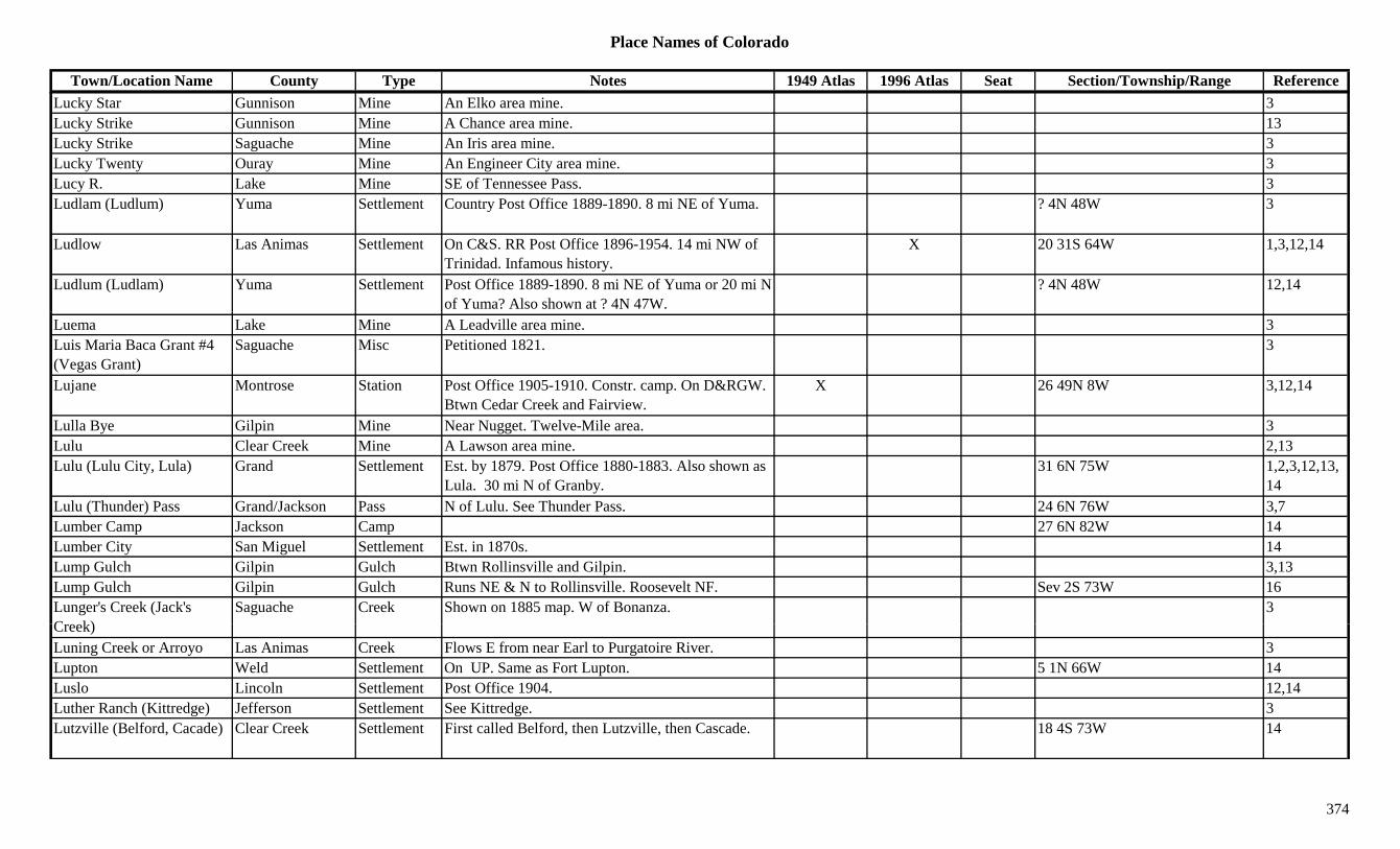
Place Names of Colorado
Town/Location Name County Type Notes 1949 Atlas 1996 Atlas Seat Section/Township/Range ReferenceLucky Star Gunnison Mine An Elko area mine. 3Lucky Strike Gunnison Mine A Chance area mine. 13Lucky Strike Saguache Mine An Iris area mine. 3Lucky Twenty Ouray Mine An Engineer City area mine. 3Lucy R. Lake Mine SE of Tennessee Pass. 3Ludlam (Ludlum) Yuma Settlement Country Post Office 1889-1890. 8 mi NE of Yuma. ? 4N 48W 3
Ludlow Las Animas Settlement On C&S. RR Post Office 1896-1954. 14 mi NW of Trinidad. Infamous history.
X 20 31S 64W 1,3,12,14
Ludlum (Ludlam) Yuma Settlement Post Office 1889-1890. 8 mi NE of Yuma or 20 mi N of Yuma? Also shown at ? 4N 47W.
? 4N 48W 12,14
Luema Lake Mine A Leadville area mine. 3Luis Maria Baca Grant #4 (Vegas Grant)
Saguache Misc Petitioned 1821. 3
Lujane Montrose Station Post Office 1905-1910. Constr. camp. On D&RGW. Btwn Cedar Creek and Fairview.
X 26 49N 8W 3,12,14
Lulla Bye Gilpin Mine Near Nugget. Twelve-Mile area. 3Lulu Clear Creek Mine A Lawson area mine. 2,13Lulu (Lulu City, Lula) Grand Settlement Est. by 1879. Post Office 1880-1883. Also shown as
Lula. 30 mi N of Granby.31 6N 75W 1,2,3,12,13,
14Lulu (Thunder) Pass Grand/Jackson Pass N of Lulu. See Thunder Pass. 24 6N 76W 3,7Lumber Camp Jackson Camp 27 6N 82W 14Lumber City San Miguel Settlement Est. in 1870s. 14Lump Gulch Gilpin Gulch Btwn Rollinsville and Gilpin. 3,13Lump Gulch Gilpin Gulch Runs NE & N to Rollinsville. Roosevelt NF. Sev 2S 73W 16Lunger's Creek (Jack's C k)
Saguache Creek Shown on 1885 map. W of Bonanza. 3Creek)Luning Creek or Arroyo Las Animas Creek Flows E from near Earl to Purgatoire River. 3Lupton Weld Settlement On UP. Same as Fort Lupton. 5 1N 66W 14Luslo Lincoln Settlement Post Office 1904. 12,14Luther Ranch (Kittredge) Jefferson Settlement See Kittredge. 3Lutzville (Belford, Cacade) Clear Creek Settlement First called Belford, then Lutzville, then Cascade. 18 4S 73W 14
374
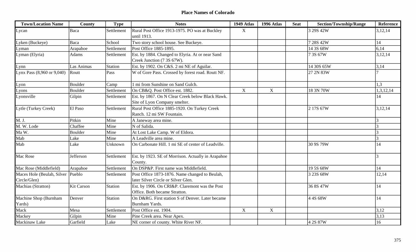
Place Names of Colorado
Town/Location Name County Type Notes 1949 Atlas 1996 Atlas Seat Section/Township/Range ReferenceLycan Baca Settlement Rural Post Office 1913-1975. PO was at Buckley
until 1913.X 3 29S 42W 3,12,14
Lyken (Buckeye) Baca School Two story school house. See Buckeye. 7 28S 42W 14Lyman Arapahoe Settlement Post Office 1885-1895. 14 3S 68W 6,14Lyman (Elyria) Adams Settlement Est. by 1884. Changed to Elyria. At or near Sand
Creek Junction (7 3S 67W).7 3S 67W 3,12,14
Lynn Las Animas Station Est. by 1902. On C&S. 2 mi NE of Aguilar. 14 30S 65W 3,14Lynx Pass (8,960 or 9,040) Routt Pass W of Gore Pass. Crossed by forest road. Routt NF. 27 2N 83W 7
Lyon Boulder Camp 1 mi from Sunshine on Sand Gulch. 1,3Lyons Boulder Settlement On CB&Q. Post Office est. 1882. X X 18 3N 70W 1,3,12,14y Q , , ,Lyonsville Gilpin Settlement Est. by 1867. On N Clear Creek below Black Hawk.
Site of Lyon Company smelter.14
Lytle (Turkey Creek) El Paso Settlement Rural Post Office 1885-1920. On Turkey Creek Ranch. 12 mi SW Fountain.
2 17S 67W 3,12,14
M. J. Pitkin Mine A Janeway area mine. 3M. W. Lode Chaffee Mine N of Salida. 3Ma W. Boulder Mine At Lost Lake Camp. W of Eldora. 3Mab Lake Mine A Leadville area mine. 3Mab Lake Unknown On Carbonate Hill. 1 mi SE of center of Leadville. 30 9S 79W 14
Mac Rose Jefferson Settlement Est. by 1923. SE of Morrison. Actually in Arapahoe County.
3
Mac Rose (Middlefield) Arapahoe Settlement On DSP&P. First name was Middlefield. 19 5S 68W 14Maces Hole (Beulah, Silver Circle/Glen)
Pueblo Settlement Post Office 1873-1876. Name changed to Beulah, later Silver Circle or Silver Glen.
3 23S 68W 12,14
M hi (St tt ) Kit C St ti E t b 1906 O CRI&P Cl t th P t 36 8S 47W 14Machias (Stratton) Kit Carson Station Est. by 1906. On CRI&P. Claremont was the Post Office. Both became Stratton.
36 8S 47W 14
Machine Shop (Burnham Yards)
Denver Station On D&RG. First station S of Denver. Later became Burnham Yards.
4 4S 68W 14
Mack Mesa Settlement Post Office est. 1904. X X 3,12Mackey Gilpin Mine Pine Creek area. Near Apex. 3,13Mackinaw Lake Garfield Lake NE corner of county. White River NF. 4 2S 87W 16
375

Place Names of Colorado
Town/Location Name County Type Notes 1949 Atlas 1996 Atlas Seat Section/Township/Range ReferenceMacomber Peak (13,222) Peak13 Howardsville Quad. 11Macon (Hull City, Hulls Camp, Independence)
El Paso/Teller Settlement Hull City/Camp Platted 1895. Post Office 1895-1899. Moved from Altman.
20 15S 69W 3,12,14
Macrose (Mac Rose, Middlefield)
Arapahoe Station Existed 1909-1920. RR stop on C&S. 2 mi W of Littleton.
19 5S 68W 3,6
Macune (Arkansas Station) Chaffee Settlement On DSP&P. 1 mi SE of Buena Vista. Same as Arkansas Station.
21 14S 78W 3,14
Mad Creek Routt Creek Flows W & S to join Elk River at Mad Creek Village.
3
Mad Creek Village Routt Settlement 7 mi NW of Steamboat Springs. 14 7N 85W 3,14Madden Peak (11,972) La Plata Peak La Plata Range. W of Mayday on Montezuma 3,8( , ) g y y
County border.,
Maddox Park Station Est. by 1924. On C&S. At same site as Glenisle. 22 7S 73W 3,14
Maddux Weld Unknown On UP. 30 3N 66W 14Madera (Allen, Madera Siding)
Gunnison Station Stop on D&RG. First name was Allen. X 16 47N 3W 3,14
Madera Siding (Madera) Gunnison Station Est. by 1923. Stop on D&RG. 16 47N 3W 3Madge (Madge Quarry) Douglas Station Est. by 1916. RR stop on D&RGW. 5 mi S of Castle
Rock.23 8S 67W 3
Madge Quarry Douglas Mine On D&RG. 23 8S 67W 14Madonna Chaffee Mine Near Monarch. 3,13Madrid Las Animas Settlement Post Office 1882-1917 with gap. Moved to Smith
Canyon, then Madrid. 5 mi W of Sopris.34 33S 65W 1,3,12,14
Maes Hole Pueblo Unknown 34 22S 68W 14Magazine Douglas Unknown On AT&SF, D&RG. 33 6S 68W 14M d l G l h G i G l h NE f t R S t T C k S 13S 80W 16Magdalene Gulch Gunnison Gulch NE corner of county. Runs S to Texas Creek. Sev 13S 80W 16Magee Adams Station RR stop on UP. 3 mi E of Aurora. Also shown 5 mi
E of Brighton.28 3S 66W 3,6,14
Magentie (Ridgway) Ouray Settlement First name for Ridgeway. See Ridgway. 17 45N 8W 3,14Maggie Gulch San Juan Gulch An Animas Forks area productive gulch. 3Maggie Gulch San Juan Unknown Close to Middleton, but not the same. 36 42N 7W 14Magic Mountain (Apex) Jefferson Station Post Office 1960-1962. See Apex. 10 4S 70W 4,6,12,14
376
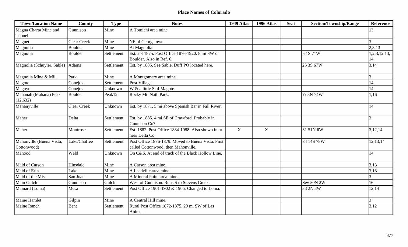
Place Names of Colorado
Town/Location Name County Type Notes 1949 Atlas 1996 Atlas Seat Section/Township/Range ReferenceMagna Charta Mine and Tunnel
Gunnison Mine A Tomichi area mine. 13
Magnet Clear Creek Mine NE of Georgetown. 3Magnolia Boulder Mine At Magnolia. 2,3,13Magnolia Boulder Settlement Est. abt 1875. Post Office 1876-1920. 8 mi SW of
Boulder. Also in Ref. 6.5 1S 71W 1,2,3,12,13,
14Magnolia (Schuyler, Sable) Adams Settlement Est. by 1885. See Sable. Duff PO located here. 25 3S 67W 3,14
Magnolia Mine & Mill Park Mine A Montgomery area mine. 3Magote Conejos Settlement Post Village. 14Magoyo Conejos Unknown W & a little S of Magote. 14g y j gMahanah (Mahana) Peak (12,632)
Boulder Peak12 Rocky Mt. Natl. Park. ?? 3N 74W 1,16
Mahanyville Clear Creek Unknown Est. by 1871. 5 mi above Spanish Bar in Fall River. 14
Maher Delta Settlement Est. by 1885. 4 mi SE of Crawford. Probably in Gunnison Co?
3
Maher Montrose Settlement Est. 1882. Post Office 1884-1988. Also shown in or near Delta Co.
X X 31 51N 6W 3,12,14
Mahonville (Buena Vista, Cottonwood)
Lake/Chaffee Settlement Post Office 1876-1879. Moved to Buena Vista. First called Cottonwood, then Mahonville.
34 14S 78W 12,13,14
Mahood Weld Unknown On C&S. At end of track of the Black Hollow Line. 14
Maid of Carson Hinsdale Mine A Carson area mine. 3,13Maid of Erin Lake Mine A Leadville area mine. 3,13Maid of the Mist San Juan Mine A Mineral Point area mine. 3M i G l h G i G l h W t f G i R S t St C k S 50N 2W 16Main Gulch Gunnison Gulch West of Gunnison. Runs S to Stevens Creek. Sev 50N 2W 16Mainard (Loma) Mesa Settlement Post Office 1901-1902 & 1905. Changed to Loma. 33 2N 3W 12,14
Maine Hamlet Gilpin Mine A Central Hill mine. 3Maine Ranch Bent Settlement Rural Post Office 1872-1875. 20 mi SW of Las
Animas.3,12
377

Place Names of Colorado
Town/Location Name County Type Notes 1949 Atlas 1996 Atlas Seat Section/Township/Range ReferenceMaine Ranch (Vogel) Otero Settlement Est. by 1885. Same location as Vogel. Shown
separate places. On Purgotoire Stage Route.1 27S 55W 3,14
Mains Gulch Custer Gulch North central county. Runs NNE to Oak Creek. Sev 21S 71W 16
Maitland Huerfano Settlement Post Office on D&RG 1898-1935. Near Pictou. 31 27S 66W 3,12,14
Maitland Junction Huerfano Station On D&RG. 31 27S 66W 14Majestic Las Animas Settlement Post Office 1900-1914. Small village. 3 mi SW of
Chicosa Junction.9 32S 64W 3,12,14
Major Rio Grande Mine At Summitville. 2,3,13Majors El Paso Settlement Rural Post Office 1911-1912. 14 mi SW of Rush. 21 15S 60W 3,12,14j , ,
Malabys Larimer Station Est. by 1906. On C&S. 2 mi S of Bellvue. See Stout. 3,14
Malachite Huerfano Settlement Post Office 1880-1915. SW of Gardner. X 30 26S 70W 3,12,14Malary Spur Larimer Station Est. by 1894. Btwn Bellevue PO & Stout. 2 mi S of
Bellevue PO & Cache la Poudre.14
Maldonado (Maldanado) Las Animas Settlement Rural Post Office 1901-1905. In area known as San Miguel or same site as San Miguel.
7 34S 62W 3,12,14
Malemute Peak (13,348) Peak13 Hayden Peak Quad. 11Mallon Pitkin Unknown On CM. 31 8S 82W 14Malock Fremont Ranch Perhaps a ranch. 20 16S 75W 14Malone(s) Ranch Mesa Ranch Became Garmesa. 26 8S 102W 3,14Malone's Village Arapahoe Settlement SW of Denver. 14Malowe (Browserville, Browser, Flagler)
Kit Carson Settlement First Browserville or Browser, later Malowe, finally Flagler.
2 9S 51W 1,14
M l (D k ) W ld St ti O GW 2 i E f M d P i l d D k 11 3N 68W 6 14Maloy (Duke) Weld Station On GW. 2 mi E of Mead. Previously named Duke. 11 3N 68W 6,14
Malta (Swilltown) Lake Settlement Post Office 1875-1887 & 1890-1955. 4 mi SW of Leadville. First known as Swilltown.
X 32 9S 80W 2,3,12,14
Malvane (Mulvane) Prowers Settlement Est. by 1895. Correctly spelled Mulvane. ? 27S 47W 14Mammoth Clear Creek Mine Silver Plume area mine. 3Mammoth Conejos Mine At Platoro. 3,13
378
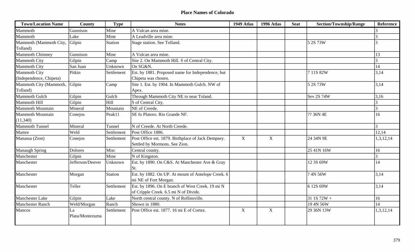
Place Names of Colorado
Town/Location Name County Type Notes 1949 Atlas 1996 Atlas Seat Section/Township/Range ReferenceMammoth Gunnison Mine A Vulcan area mine. 3Mammoth Lake Mine A Leadville area mine. 3Mammoth (Mammoth City, Tolland)
Gilpin Station Stage station. See Tolland. 5 2S 73W 3
Mammoth Chimney Gunnison Mine A Vulcan area mine. 13Mammoth City Gilpin Camp Site 2. On Mammoth Hill. S of Central City. 3Mammoth City San Juan Unknown On SG&N. 14Mammoth City (Independence, Chipeta)
Pitkin Settlement Est. by 1881. Proposed name for Independence, but Chipeta was chosen.
7 11S 82W 3,14
Mammoth City (Mammoth, Tolland)
Gilpin Camp Site 1. Est. by 1904. In Mammoth Gulch. NW of Apex.
5 2S 73W 3,14
Mammoth Gulch Gilpin Gulch Through Mammoth City NE to near Toland. Sev 2S 74W 3,16Mammoth Hill Gilpin Hill S of Central City. 3Mammoth Mountain Mineral Mountain NE of Creede. 3Mammoth Mountain (11,340)
Conejos Peak11 SE fo Platoro. Rio Grande NF. ?? 36N 4E 16
Mammoth Tunnel Mineral Tunnel N of Creede. At North Creede. 3Mamre Weld Settlement Post Office 1886. 12,14Manassa (Zion) Conejos Settlement Post Office est. 1879. Birthplace of Jack Dempsey.
Settled by Mormons. See Zion.X X 24 34N 9E 1,3,12,14
Manaugh Spring Dolores Misc Central county. 25 41N 16W 16Manchester Gilpin Mine N of Kingston. 3Manchester Jefferson/Denver Unknown Est. by 1890. On C&S. At Manchester Ave & Gray
St.12 3S 69W 14
Manchester Morgan Station Est. by 1882. On UP. At mount of Antelope Creek. 6 mi NE of Fort Morgan.
? 4N 56W 3,14
M h t T ll S ttl t E t b 1896 O E b h f W t C k 19 i N 6 12S 69W 3 14Manchester Teller Settlement Est. by 1896. On E branch of West Creek. 19 mi N of Cripple Creek. 6.5 mi N of Divide.
6 12S 69W 3,14
Manchester Lake Gilpin Lake North central county. N of Rollinsville. 31 1S 72W + 16Manchester Ranch Weld/Morgan Ranch Shown in 1880. 19 4N 56W 14Mancos La
Plata/MontezumaSettlement Post Office est. 1877. 16 mi E of Cortez. X X 29 36N 13W 1,3,12,14
379
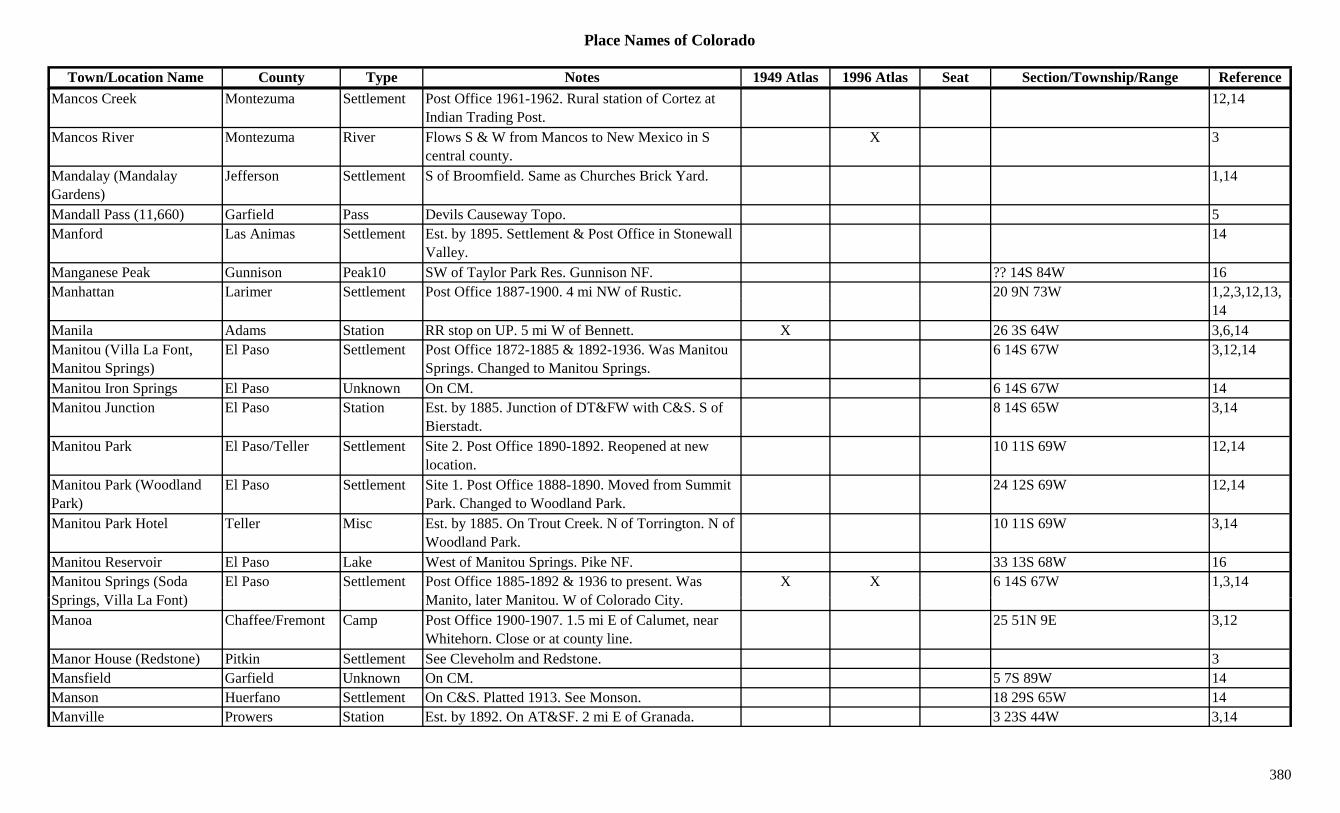
Place Names of Colorado
Town/Location Name County Type Notes 1949 Atlas 1996 Atlas Seat Section/Township/Range ReferenceMancos Creek Montezuma Settlement Post Office 1961-1962. Rural station of Cortez at
Indian Trading Post.12,14
Mancos River Montezuma River Flows S & W from Mancos to New Mexico in S central county.
X 3
Mandalay (Mandalay Gardens)
Jefferson Settlement S of Broomfield. Same as Churches Brick Yard. 1,14
Mandall Pass (11,660) Garfield Pass Devils Causeway Topo. 5Manford Las Animas Settlement Est. by 1895. Settlement & Post Office in Stonewall
Valley.14
Manganese Peak Gunnison Peak10 SW of Taylor Park Res. Gunnison NF. ?? 14S 84W 16Manhattan Larimer Settlement Post Office 1887-1900. 4 mi NW of Rustic. 20 9N 73W 1,2,3,12,13,, , , , ,
14Manila Adams Station RR stop on UP. 5 mi W of Bennett. X 26 3S 64W 3,6,14Manitou (Villa La Font, Manitou Springs)
El Paso Settlement Post Office 1872-1885 & 1892-1936. Was Manitou Springs. Changed to Manitou Springs.
6 14S 67W 3,12,14
Manitou Iron Springs El Paso Unknown On CM. 6 14S 67W 14Manitou Junction El Paso Station Est. by 1885. Junction of DT&FW with C&S. S of
Bierstadt.8 14S 65W 3,14
Manitou Park El Paso/Teller Settlement Site 2. Post Office 1890-1892. Reopened at new location.
10 11S 69W 12,14
Manitou Park (Woodland Park)
El Paso Settlement Site 1. Post Office 1888-1890. Moved from Summit Park. Changed to Woodland Park.
24 12S 69W 12,14
Manitou Park Hotel Teller Misc Est. by 1885. On Trout Creek. N of Torrington. N of Woodland Park.
10 11S 69W 3,14
Manitou Reservoir El Paso Lake West of Manitou Springs. Pike NF. 33 13S 68W 16Manitou Springs (Soda S i Vill L F t)
El Paso Settlement Post Office 1885-1892 & 1936 to present. Was M it l t M it W f C l d Cit
X X 6 14S 67W 1,3,14Springs, Villa La Font) Manito, later Manitou. W of Colorado City.Manoa Chaffee/Fremont Camp Post Office 1900-1907. 1.5 mi E of Calumet, near
Whitehorn. Close or at county line.25 51N 9E 3,12
Manor House (Redstone) Pitkin Settlement See Cleveholm and Redstone. 3Mansfield Garfield Unknown On CM. 5 7S 89W 14Manson Huerfano Settlement On C&S. Platted 1913. See Monson. 18 29S 65W 14Manville Prowers Station Est. by 1892. On AT&SF. 2 mi E of Granada. 3 23S 44W 3,14
380

Place Names of Colorado
Town/Location Name County Type Notes 1949 Atlas 1996 Atlas Seat Section/Township/Range ReferenceManzanares (Los Garcias, Garcia)
Costilla Settlement Post Office 1901-1902. See Garcia. First name Los Garcias, later Garcia.
34 35S 73W 3,12,14
Manzaneres Rio Grande Unknown ? 40N 6E 14Manzaneres Pass (9,800) Pass SW of Gardener. 7Manzanola (Catlin) Otero Settlement Est. 1869. Post Office est. 1895. First named Catlin. X X 26 22S 58W 1,3,12,14
Marble (Yule Creek, Marble City, Clarence)
Gunnison Settlement Est. abt 1880. Post Office 1890-1942. Moved to Clarence & back. 28 mi S of Carbondale.
X X 26 11S 88W 1,2,3,12,13,14
Marble Mountain (13,266) Custer Peak13 Sangre de Cristo Range, Main Section. W of Westcliffe. Crestone Peak Quad.
?? 24S 73W 3,8,11,16
Marcellina Mountain Gunnison Peak11 WNW of Crested Butte. Gunnison NF. 8/17 13S 88W 16Marcellina Mountain (11,348)
Mountain West Elk Range, Gunnison North Fork Group. NW of Irwin.
8,13
Marcellina Pass Gunnison Pass W of Crested Butte. W of Kebler Pass. X 7Marcott Logan Station On BN and/or UP. 4 mi NE of Crook. X 4 10N 48W 3,14Marcy Gulch Douglas Gulch Runs NW to NW corner of county. Sev 6S 68W 16Mareau Gilpin Mine Near Perigo. 3Margaret (La Margarita) Costilla Settlement Post Office 1899-1900. Same as La Margarita. 12,14Marguerite Las Animas Settlement Platted 1927. 1 mi W of Barela. No Post Office. 3,14
Marguerite Teller Mine Teller Co. mines not elsewhere specified. 3Marianna (Miraville, Namaqua)
Larimer Settlement At a stage coach road of the Big Thompson River. (Marker exists at side of road.)
16 5N 69W 14
Mariano's Crossing (Namaqua Station)
Larimer Station See Namaqua Station & Marianna. 16 5N 69W 4
Maribeh Summit Fort Same as Fort Mary B. Maribeh. 30 6S 77W 14M i ld (S l) F t/T ll S ttl t P t Offi 1895 1902 Al ll d S l Al 15 16S 70W 12 14Marigold (Sunol) Fremont/Teller Settlement Post Office 1895-1902. Also called Sunol. Also
shown at 9 16S 70W.15 16S 70W 12,14
Marion Delta Settlement Post Office 1885-1886. Btwn Cory and Austin. 6 15S 94W 3,12,14Marion Gunnison Station Est. by 1923. Stop on D&RG. N of Madera Siding. 29 48N 3W 3,14
Marion Larimer Station Est. by 1909. On C&S. 3 mi N of Loveland. 26 6N 69W 3,14
381
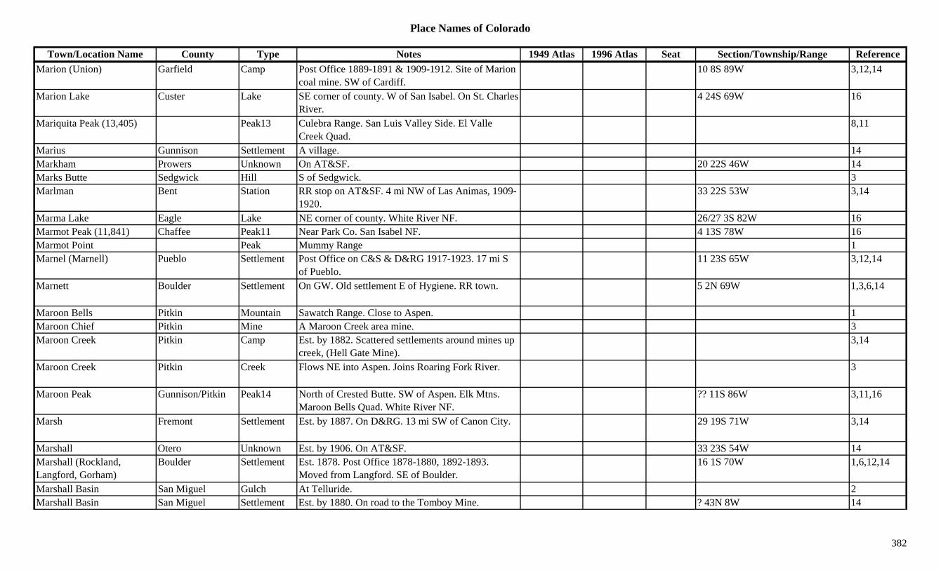
Place Names of Colorado
Town/Location Name County Type Notes 1949 Atlas 1996 Atlas Seat Section/Township/Range ReferenceMarion (Union) Garfield Camp Post Office 1889-1891 & 1909-1912. Site of Marion
coal mine. SW of Cardiff.10 8S 89W 3,12,14
Marion Lake Custer Lake SE corner of county. W of San Isabel. On St. Charles River.
4 24S 69W 16
Mariquita Peak (13,405) Peak13 Culebra Range. San Luis Valley Side. El Valle Creek Quad.
8,11
Marius Gunnison Settlement A village. 14Markham Prowers Unknown On AT&SF. 20 22S 46W 14Marks Butte Sedgwick Hill S of Sedgwick. 3Marlman Bent Station RR stop on AT&SF. 4 mi NW of Las Animas, 1909-
1920.33 22S 53W 3,14
Marma Lake Eagle Lake NE corner of county. White River NF. 26/27 3S 82W 16Marmot Peak (11,841) Chaffee Peak11 Near Park Co. San Isabel NF. 4 13S 78W 16Marmot Point Peak Mummy Range 1Marnel (Marnell) Pueblo Settlement Post Office on C&S & D&RG 1917-1923. 17 mi S
of Pueblo.11 23S 65W 3,12,14
Marnett Boulder Settlement On GW. Old settlement E of Hygiene. RR town. 5 2N 69W 1,3,6,14
Maroon Bells Pitkin Mountain Sawatch Range. Close to Aspen. 1Maroon Chief Pitkin Mine A Maroon Creek area mine. 3Maroon Creek Pitkin Camp Est. by 1882. Scattered settlements around mines up
creek, (Hell Gate Mine).3,14
Maroon Creek Pitkin Creek Flows NE into Aspen. Joins Roaring Fork River. 3
Maroon Peak Gunnison/Pitkin Peak14 North of Crested Butte. SW of Aspen. Elk Mtns. Maroon Bells Quad. White River NF.
?? 11S 86W 3,11,16
M h F t S ttl t E t b 1887 O D&RG 13 i SW f C Cit 29 19S 71W 3 14Marsh Fremont Settlement Est. by 1887. On D&RG. 13 mi SW of Canon City. 29 19S 71W 3,14
Marshall Otero Unknown Est. by 1906. On AT&SF. 33 23S 54W 14Marshall (Rockland, Langford, Gorham)
Boulder Settlement Est. 1878. Post Office 1878-1880, 1892-1893. Moved from Langford. SE of Boulder.
16 1S 70W 1,6,12,14
Marshall Basin San Miguel Gulch At Telluride. 2Marshall Basin San Miguel Settlement Est. by 1880. On road to the Tomboy Mine. ? 43N 8W 14
382
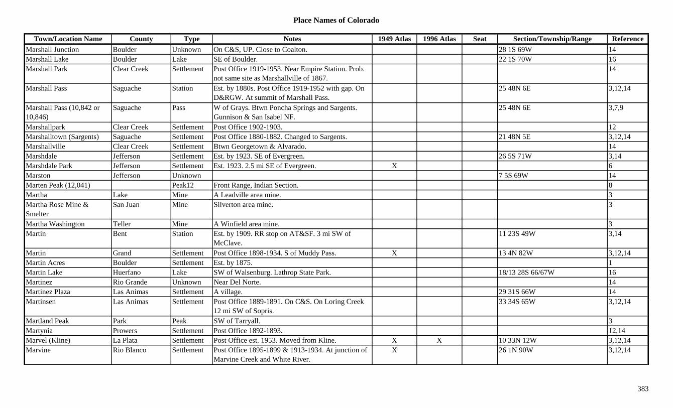
Place Names of Colorado
Town/Location Name County Type Notes 1949 Atlas 1996 Atlas Seat Section/Township/Range ReferenceMarshall Junction Boulder Unknown On C&S, UP. Close to Coalton. 28 1S 69W 14Marshall Lake Boulder Lake SE of Boulder. 22 1S 70W 16Marshall Park Clear Creek Settlement Post Office 1919-1953. Near Empire Station. Prob.
not same site as Marshallville of 1867.14
Marshall Pass Saguache Station Est. by 1880s. Post Office 1919-1952 with gap. On D&RGW. At summit of Marshall Pass.
25 48N 6E 3,12,14
Marshall Pass (10,842 or 10,846)
Saguache Pass W of Grays. Btwn Poncha Springs and Sargents. Gunnison & San Isabel NF.
25 48N 6E 3,7,9
Marshallpark Clear Creek Settlement Post Office 1902-1903. 12Marshalltown (Sargents) Saguache Settlement Post Office 1880-1882. Changed to Sargents. 21 48N 5E 3,12,14Marshallville Clear Creek Settlement Btwn Georgetown & Alvarado. 14gMarshdale Jefferson Settlement Est. by 1923. SE of Evergreen. 26 5S 71W 3,14Marshdale Park Jefferson Settlement Est. 1923. 2.5 mi SE of Evergreen. X 6Marston Jefferson Unknown 7 5S 69W 14Marten Peak (12,041) Peak12 Front Range, Indian Section. 8Martha Lake Mine A Leadville area mine. 3Martha Rose Mine & Smelter
San Juan Mine Silverton area mine. 3
Martha Washington Teller Mine A Winfield area mine. 3Martin Bent Station Est. by 1909. RR stop on AT&SF. 3 mi SW of
McClave.11 23S 49W 3,14
Martin Grand Settlement Post Office 1898-1934. S of Muddy Pass. X 13 4N 82W 3,12,14Martin Acres Boulder Settlement Est. by 1875. 1Martin Lake Huerfano Lake SW of Walsenburg. Lathrop State Park. 18/13 28S 66/67W 16Martinez Rio Grande Unknown Near Del Norte. 14Martinez Plaza Las Animas Settlement A village. 29 31S 66W 14M ti L A i S ttl t P t Offi 1889 1891 O C&S O L i C k 33 34S 65W 3 12 14Martinsen Las Animas Settlement Post Office 1889-1891. On C&S. On Loring Creek
12 mi SW of Sopris.33 34S 65W 3,12,14
Martland Peak Park Peak SW of Tarryall. 3Martynia Prowers Settlement Post Office 1892-1893. 12,14Marvel (Kline) La Plata Settlement Post Office est. 1953. Moved from Kline. X X 10 33N 12W 3,12,14Marvine Rio Blanco Settlement Post Office 1895-1899 & 1913-1934. At junction of
Marvine Creek and White River.X 26 1N 90W 3,12,14
383
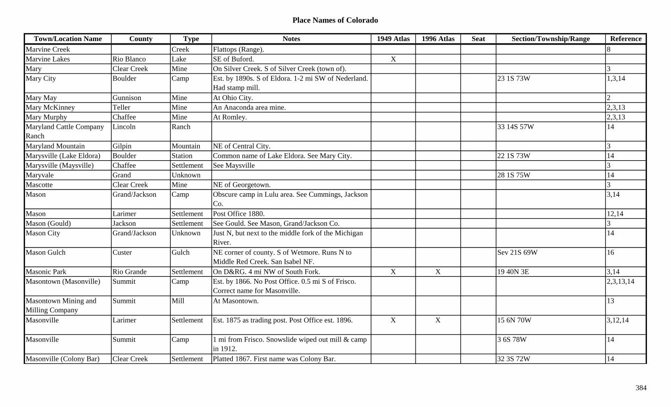
Place Names of Colorado
Town/Location Name County Type Notes 1949 Atlas 1996 Atlas Seat Section/Township/Range ReferenceMarvine Creek Creek Flattops (Range). 8Marvine Lakes Rio Blanco Lake SE of Buford. XMary Clear Creek Mine On Silver Creek. S of Silver Creek (town of). 3Mary City Boulder Camp Est. by 1890s. S of Eldora. 1-2 mi SW of Nederland.
Had stamp mill.23 1S 73W 1,3,14
Mary May Gunnison Mine At Ohio City. 2Mary McKinney Teller Mine An Anaconda area mine. 2,3,13Mary Murphy Chaffee Mine At Romley. 2,3,13Maryland Cattle Company Ranch
Lincoln Ranch 33 14S 57W 14
Maryland Mountain Gilpin Mountain NE of Central City. 3y p yMarysville (Lake Eldora) Boulder Station Common name of Lake Eldora. See Mary City. 22 1S 73W 14Marysville (Maysville) Chaffee Settlement See Maysville 3Maryvale Grand Unknown 28 1S 75W 14Mascotte Clear Creek Mine NE of Georgetown. 3Mason Grand/Jackson Camp Obscure camp in Lulu area. See Cummings, Jackson
Co.3,14
Mason Larimer Settlement Post Office 1880. 12,14Mason (Gould) Jackson Settlement See Gould. See Mason, Grand/Jackson Co. 3Mason City Grand/Jackson Unknown Just N, but next to the middle fork of the Michigan
River.14
Mason Gulch Custer Gulch NE corner of county. S of Wetmore. Runs N to Middle Red Creek. San Isabel NF.
Sev 21S 69W 16
Masonic Park Rio Grande Settlement On D&RG. 4 mi NW of South Fork. X X 19 40N 3E 3,14Masontown (Masonville) Summit Camp Est. by 1866. No Post Office. 0.5 mi S of Frisco.
Correct name for Masonville.2,3,13,14
M t Mi i d S it Mill At M t 13Masontown Mining and Milling Company
Summit Mill At Masontown. 13
Masonville Larimer Settlement Est. 1875 as trading post. Post Office est. 1896. X X 15 6N 70W 3,12,14
Masonville Summit Camp 1 mi from Frisco. Snowslide wiped out mill & camp in 1912.
3 6S 78W 14
Masonville (Colony Bar) Clear Creek Settlement Platted 1867. First name was Colony Bar. 32 3S 72W 14
384
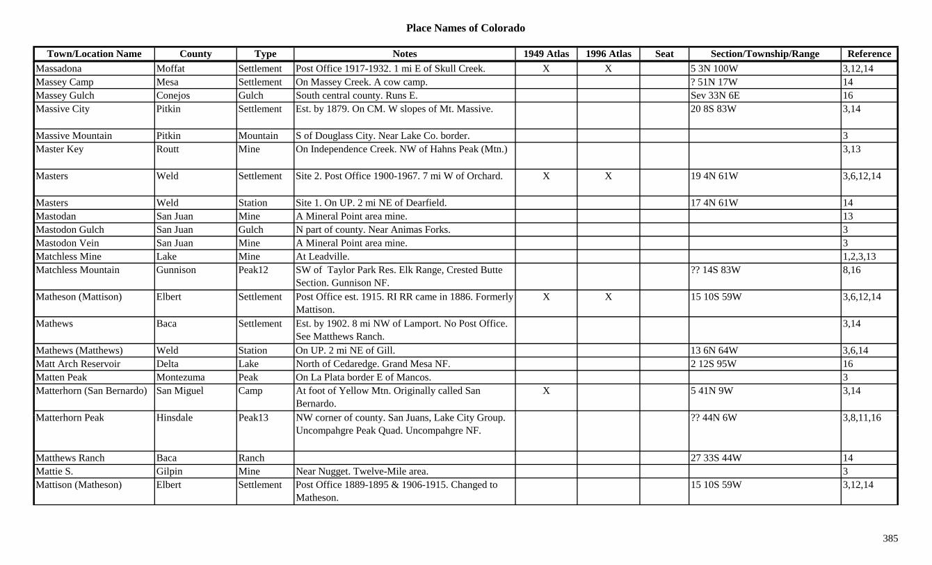
Place Names of Colorado
Town/Location Name County Type Notes 1949 Atlas 1996 Atlas Seat Section/Township/Range ReferenceMassadona Moffat Settlement Post Office 1917-1932. 1 mi E of Skull Creek. X X 5 3N 100W 3,12,14Massey Camp Mesa Settlement On Massey Creek. A cow camp. ? 51N 17W 14Massey Gulch Conejos Gulch South central county. Runs E. Sev 33N 6E 16Massive City Pitkin Settlement Est. by 1879. On CM. W slopes of Mt. Massive. 20 8S 83W 3,14
Massive Mountain Pitkin Mountain S of Douglass City. Near Lake Co. border. 3Master Key Routt Mine On Independence Creek. NW of Hahns Peak (Mtn.) 3,13
Masters Weld Settlement Site 2. Post Office 1900-1967. 7 mi W of Orchard. X X 19 4N 61W 3,6,12,14
Masters Weld Station Site 1. On UP. 2 mi NE of Dearfield. 17 4N 61W 14Mastodan San Juan Mine A Mineral Point area mine. 13Mastodon Gulch San Juan Gulch N part of county. Near Animas Forks. 3Mastodon Vein San Juan Mine A Mineral Point area mine. 3Matchless Mine Lake Mine At Leadville. 1,2,3,13Matchless Mountain Gunnison Peak12 SW of Taylor Park Res. Elk Range, Crested Butte
Section. Gunnison NF.?? 14S 83W 8,16
Matheson (Mattison) Elbert Settlement Post Office est. 1915. RI RR came in 1886. Formerly Mattison.
X X 15 10S 59W 3,6,12,14
Mathews Baca Settlement Est. by 1902. 8 mi NW of Lamport. No Post Office. See Matthews Ranch.
3,14
Mathews (Matthews) Weld Station On UP. 2 mi NE of Gill. 13 6N 64W 3,6,14Matt Arch Reservoir Delta Lake North of Cedaredge. Grand Mesa NF. 2 12S 95W 16Matten Peak Montezuma Peak On La Plata border E of Mancos. 3Matterhorn (San Bernardo) San Miguel Camp At foot of Yellow Mtn. Originally called San
Bernardo.X 5 41N 9W 3,14
M tt h P k Hi d l P k13 NW f t S J L k Cit G ?? 44N 6W 3 8 11 16Matterhorn Peak Hinsdale Peak13 NW corner of county. San Juans, Lake City Group. Uncompahgre Peak Quad. Uncompahgre NF.
?? 44N 6W 3,8,11,16
Matthews Ranch Baca Ranch 27 33S 44W 14Mattie S. Gilpin Mine Near Nugget. Twelve-Mile area. 3Mattison (Matheson) Elbert Settlement Post Office 1889-1895 & 1906-1915. Changed to
Matheson.15 10S 59W 3,12,14
385
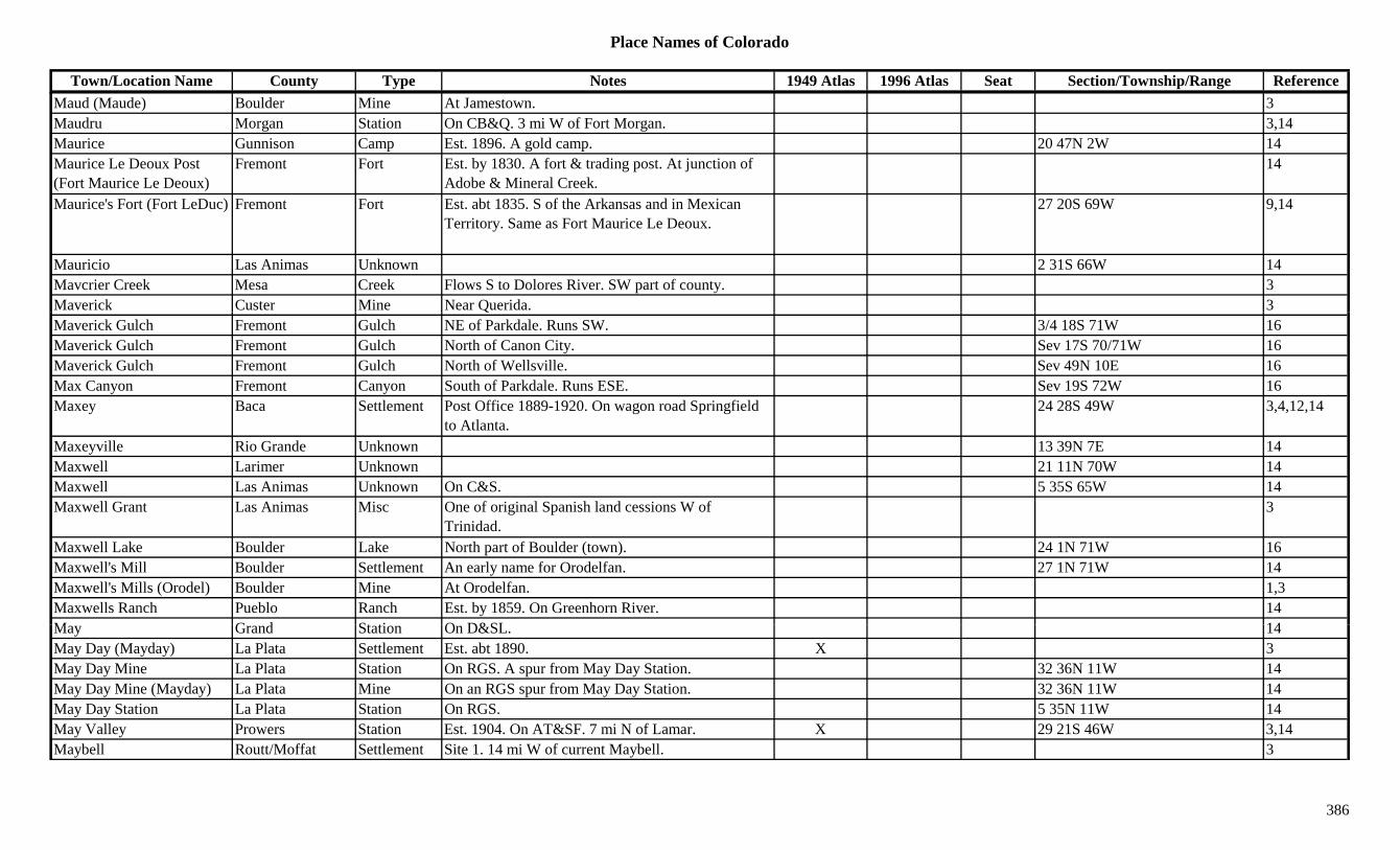
Place Names of Colorado
Town/Location Name County Type Notes 1949 Atlas 1996 Atlas Seat Section/Township/Range ReferenceMaud (Maude) Boulder Mine At Jamestown. 3Maudru Morgan Station On CB&Q. 3 mi W of Fort Morgan. 3,14Maurice Gunnison Camp Est. 1896. A gold camp. 20 47N 2W 14Maurice Le Deoux Post (Fort Maurice Le Deoux)
Fremont Fort Est. by 1830. A fort & trading post. At junction of Adobe & Mineral Creek.
14
Maurice's Fort (Fort LeDuc) Fremont Fort Est. abt 1835. S of the Arkansas and in Mexican Territory. Same as Fort Maurice Le Deoux.
27 20S 69W 9,14
Mauricio Las Animas Unknown 2 31S 66W 14Mavcrier Creek Mesa Creek Flows S to Dolores River. SW part of county. 3Maverick Custer Mine Near Querida. 3QMaverick Gulch Fremont Gulch NE of Parkdale. Runs SW. 3/4 18S 71W 16Maverick Gulch Fremont Gulch North of Canon City. Sev 17S 70/71W 16Maverick Gulch Fremont Gulch North of Wellsville. Sev 49N 10E 16Max Canyon Fremont Canyon South of Parkdale. Runs ESE. Sev 19S 72W 16Maxey Baca Settlement Post Office 1889-1920. On wagon road Springfield
to Atlanta.24 28S 49W 3,4,12,14
Maxeyville Rio Grande Unknown 13 39N 7E 14Maxwell Larimer Unknown 21 11N 70W 14Maxwell Las Animas Unknown On C&S. 5 35S 65W 14Maxwell Grant Las Animas Misc One of original Spanish land cessions W of
Trinidad.3
Maxwell Lake Boulder Lake North part of Boulder (town). 24 1N 71W 16Maxwell's Mill Boulder Settlement An early name for Orodelfan. 27 1N 71W 14Maxwell's Mills (Orodel) Boulder Mine At Orodelfan. 1,3Maxwells Ranch Pueblo Ranch Est. by 1859. On Greenhorn River. 14M G d St ti O D&SL 14May Grand Station On D&SL. 14May Day (Mayday) La Plata Settlement Est. abt 1890. X 3May Day Mine La Plata Station On RGS. A spur from May Day Station. 32 36N 11W 14May Day Mine (Mayday) La Plata Mine On an RGS spur from May Day Station. 32 36N 11W 14May Day Station La Plata Station On RGS. 5 35N 11W 14May Valley Prowers Station Est. 1904. On AT&SF. 7 mi N of Lamar. X 29 21S 46W 3,14Maybell Routt/Moffat Settlement Site 1. 14 mi W of current Maybell. 3
386

Place Names of Colorado
Town/Location Name County Type Notes 1949 Atlas 1996 Atlas Seat Section/Township/Range ReferenceMaybell Routt/Moffat Settlement Site 2. Post Office est. 1884. X X 32 7N 95W 3,12,14Mayday La Plata Mine A La Plata area mine. At May Day (Mayday). 3Mayday (May Day) La Plata Settlement Post Office 1913-1914. 28 36N 11W 12,14Mayday Spur La Plata Station RGS spur to Mayday Mine. S of Mayday. 3Mayfield Ouray Settlement On D&RG. X 8 46N 8W 14Mayfield (Peyton) El Paso Settlement Early name for Peyton. Post Office refused name.
See Peyton.6 12S 63W 3,14
Mayfield's Las Animas Station Stage station at Mountain Ranch (Woottens). 2.5 mi N of Raton Pass.
14
Mayflower Boulder Mine 3Mayflower Gunnison Mine A Tin Cup area mine. 3,13y p ,Mayflower San Juan Mine Silverton area mine. In Silverton East Mtns. 3,8Mayflower Summit Mine A Kokomo area mine. 3Mayflower Summit Settlement On a rise above Mayflower Lake. Many cabins. 14
Mayflower Gulch Fremont Gulch North of Howard. San Isabel NF. Sev 50N 10E 16May-Mazeppa Gunnison Mine At North Star. 2,3,13Maynard Fremont Settlement Suburb of Canon City. 14Maynard (Nunn) Weld Settlement Est. 1904. Named for Maynard Flats until 1904. 33 9N 66W 3,14Mayne Huerfano Settlement On D&RG, C&S. RR Post Office 1905-1907. 6 29S 65W 3,12,14Mayo Summit Unknown On DSP&P. 5 7S 77W 14Mayo Gulch Summit Settlement Mining community near Breckenridge. 3Mayol's (Red Hill) Park Settlement Est. by 1880. 4 mi NE of Fairplay. 3Mayol's (Riverside) Chaffee Settlement First name for Riverside. 11 13S 79W 14Mayol's Trenchards Ouray Settlement Est. by 1881. W of Aurora on road to placerville. 3
M P k El P M t i SW f C l d S i Pik NF 28 14S 67W 16Mays Peak El Paso Mountain SW of Colorado Springs. Pike NF. 28 14S 67W 16Maysville Chaffee Mine At Tollgate. 3Maysville Chaffee Settlement Site 2. Post Office 1879-1893. 11 mi W of Salida. X X 34 50N 7E 2,3,12,13,14
Maysville (Feathers Ranch, Crazy Camp)
Chaffee Unknown Site 1. Est. by 1870. Site was on Amosa Feathers Ranch.
35 49N 7E 14
387
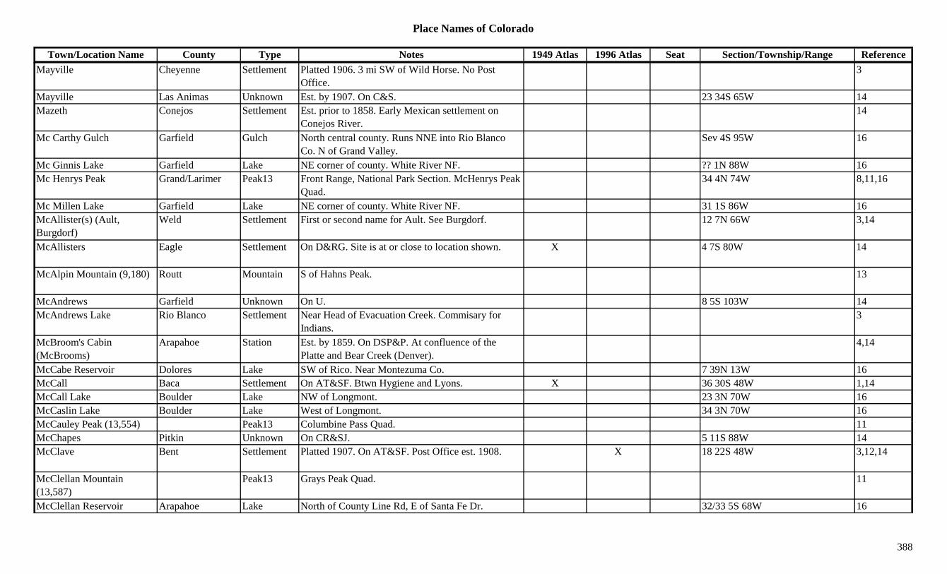
Place Names of Colorado
Town/Location Name County Type Notes 1949 Atlas 1996 Atlas Seat Section/Township/Range ReferenceMayville Cheyenne Settlement Platted 1906. 3 mi SW of Wild Horse. No Post
Office.3
Mayville Las Animas Unknown Est. by 1907. On C&S. 23 34S 65W 14Mazeth Conejos Settlement Est. prior to 1858. Early Mexican settlement on
Conejos River.14
Mc Carthy Gulch Garfield Gulch North central county. Runs NNE into Rio Blanco Co. N of Grand Valley.
Sev 4S 95W 16
Mc Ginnis Lake Garfield Lake NE corner of county. White River NF. ?? 1N 88W 16Mc Henrys Peak Grand/Larimer Peak13 Front Range, National Park Section. McHenrys Peak
Quad.34 4N 74W 8,11,16
Mc Millen Lake Garfield Lake NE corner of county. White River NF. 31 1S 86W 16yMcAllister(s) (Ault, Burgdorf)
Weld Settlement First or second name for Ault. See Burgdorf. 12 7N 66W 3,14
McAllisters Eagle Settlement On D&RG. Site is at or close to location shown. X 4 7S 80W 14
McAlpin Mountain (9,180) Routt Mountain S of Hahns Peak. 13
McAndrews Garfield Unknown On U. 8 5S 103W 14McAndrews Lake Rio Blanco Settlement Near Head of Evacuation Creek. Commisary for
Indians.3
McBroom's Cabin (McBrooms)
Arapahoe Station Est. by 1859. On DSP&P. At confluence of the Platte and Bear Creek (Denver).
4,14
McCabe Reservoir Dolores Lake SW of Rico. Near Montezuma Co. 7 39N 13W 16McCall Baca Settlement On AT&SF. Btwn Hygiene and Lyons. X 36 30S 48W 1,14McCall Lake Boulder Lake NW of Longmont. 23 3N 70W 16McCaslin Lake Boulder Lake West of Longmont. 34 3N 70W 16M C l P k (13 554) P k13 C l bi P Q d 11McCauley Peak (13,554) Peak13 Columbine Pass Quad. 11McChapes Pitkin Unknown On CR&SJ. 5 11S 88W 14McClave Bent Settlement Platted 1907. On AT&SF. Post Office est. 1908. X 18 22S 48W 3,12,14
McClellan Mountain (13,587)
Peak13 Grays Peak Quad. 11
McClellan Reservoir Arapahoe Lake North of County Line Rd, E of Santa Fe Dr. 32/33 5S 68W 16
388
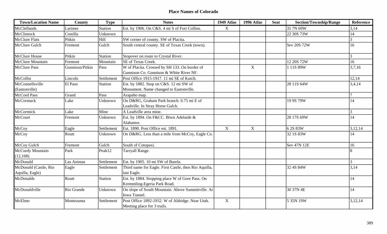
Place Names of Colorado
Town/Location Name County Type Notes 1949 Atlas 1996 Atlas Seat Section/Township/Range ReferenceMcClellands Larimer Station Est. by 1906. On C&S. 4 mi S of Fort Collins. X 35 7N 69W 3,14McClintock Costilla Unknown 22 30S 73W 14McClure Flats Pitkin Hill SW corner of county. SW of Placita. 3McClure Gulch Fremont Gulch South central county. SE of Texas Creek (town). Sev 20S 72W 16
McClure House Pitkin Station Stopover on route to Crystal River. 3McClure Mountain Fremont Mountain SE of Texas Creek. 12 20S 72W 16McClure Pass Gunnison/Pitkin Pass W of Placita. Crossed by SH 133. On border of
Gunnison Co. Gunnison & White River NF.X 1 11S 89W 3,7,16
McCollin Lincoln Settlement Post Office 1915-1917. 11 mi SE of Kutch. 12,14McConnellsville El Paso Station Est. by 1882. Stop on C&S. 12 mi SW of 28 11S 64W 3,4,14(Eastonville)
y pMonument. Name changed to Eastonville.
, ,
McCord Pass Grand Pass Arapaho map. 7McCormack Lake Unknown On D&RG, Graham Park branch. 0.75 mi E of
Leadville. In Stray Horse Gulch.19 9S 79W 14
McCormick Lake Mine A Leadville area mine. 3McCourt Fremont Unknown Est. by 1894. On F&CC. Btwn Adelaide &
Alabastor.28 17S 69W 14
McCoy Eagle Settlement Est. 1890. Post Office est. 1891. X X 6 2S 83W 3,12,14McCoy Routt Unknown On D&RG. Less than a mile from McCoy, Eagle Co. 32 1S 83W 14
McCoy Gulch Fremont Gulch South of Cotopaxi. Sev 47N 12E 16McCurdy Mountain (12,168)
Park Peak12 Tarryall Range. 8
McDonald Las Animas Settlement Est. by 1905. 10 mi SW of Barela. 3McDonald (Castle, Rio A ill E l )
Eagle Settlement Third name for Eagle. First Castle, then Rio Aquilla, l t E l
32 4S 84W 3,14Aquilla, Eagle) last Eagle.McDonalds Routt Station Est. by 1884. Stopping place W of Gore Pass. On
Kremmling-Egeria Park Road.14
McDonaldville Rio Grande Unknown On slope of South Mountain. Above Summitville. At Iowa Tunnel.
30 37N 4E 14
McElmo Montezuma Settlement Post Office 1892-1932. W of Aldridge. Near Utah. Meeting place for 3 trails.
X 5 35N 19W 3,12,14
389
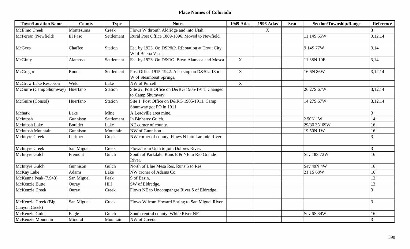
Place Names of Colorado
Town/Location Name County Type Notes 1949 Atlas 1996 Atlas Seat Section/Township/Range ReferenceMcElmo Creek Montezuma Creek Flows W throuth Aldridge and into Utah. X 3McFerran (Newfield) El Paso Settlement Rural Post Office 1889-1896. Moved to Newfield. 11 14S 65W 3,12,14
McGees Chaffee Station Est. by 1923. On DSP&P. RR station at Trout City. W of Buena Vista.
9 14S 77W 3,14
McGinty Alamosa Settlement Est. by 1923. On D&RG. Btwn Alamosa and Mosca. X 11 38N 10E 3,14
McGregor Routt Settlement Post Office 1915-1942. Also stop on D&SL. 13 mi W of Steamboat Springs.
X 16 6N 86W 3,12,14
McGrew Lake Reservoir Weld Lake NW of Purcell. XMcGuire (Camp Shumway) Huerfano Station Site 2?. Post Office on D&RG 1905-1911. Changed 26 27S 67W 3,12,14( p y) g
to Camp Shumway., ,
McGuire (Consol) Huerfano Station Site 1. Post Office on D&RG 1905-1911. Camp Shumway got PO in 1911.
14 27S 67W 3,12,14
Mchark Lake Mine A Leadville area mine. 3McIntosh Gunnison Settlement In Binberry Gulch. ? 50N 1W 14McIntosh Lake Boulder Lake NE corner of county. 29/30 3N 69W 16McIntosh Mountain Gunnison Mountain NW of Gunnison. 19 50N 1W 16McIntyre Creek Larimer Creek NW corner of county. Flows N into Laramie River. 3
McIntyre Creek San Miguel Creek Flows from Utah to join Dolores River. 3McIntyre Gulch Fremont Gulch South of Parkdale. Runs E & NE to Rio Grande
River.Sev 18S 72W 16
McIntyre Gulch Gunnison Gulch North of Blue Mesa Res. Runs S to Res. Sev 49N 4W 16McKay Lake Adams Lake NW croner of Adams Co. 21 1S 68W 16McKenna Peak (7,943) San Miguel Peak S of Basin. 13M K i B tt O Hill SW f Eld d 13McKenzie Butte Ouray Hill SW of Eldredge. 13McKenzie Creek Ouray Creek Flows NE to Uncompahgre River S of Eldredge. 3
McKenzie Creek (Big Canyon Creek)
San Miguel Creek Flows W from Howard Spring to San Miguel River. 3
McKenzie Gulch Eagle Gulch South central county. White River NF. Sev 6S 84W 16McKenzie Mountain Mineral Mountain NW of Creede. 3
390
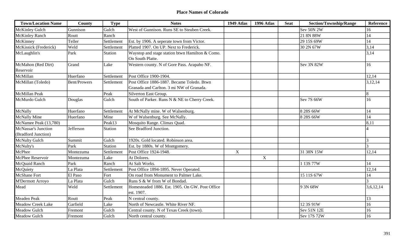
Place Names of Colorado
Town/Location Name County Type Notes 1949 Atlas 1996 Atlas Seat Section/Township/Range ReferenceMcKinley Gulch Gunnison Gulch West of Gunnison. Runs SE to Steuben Creek. Sev 50N 2W 16McKinley Ranch Routt Ranch 21 8N 88W 14McKinney Teller Settlement Est. by 1906. A seperate town from Victor. 29 15S 69W 14McKissick (Frederick) Weld Settlement Platted 1907. On UP. Next to Frederick. 30 2N 67W 3,14McLaughlin's Park Station Waystop and stage station btwn Hamilton & Como.
On South Platte.3,14
McMahon (Red Dirt) Reservoir
Grand Lake Western county. N of Gore Pass. Arapaho NF. Sev 3N 82W 16
McMillan Huerfano Settlement Post Office 1900-1904. 12,14McMillan (Toledo) Bent/Prowers Settlement Post Office 1886-1887. Became Toledo. Btwn
Granada and Carlton. 3 mi NW of Granada.3,12,14
McMillan Peak Peak Silverton East Group. 8McMurdo Gulch Douglas Gulch South of Parker. Runs N & NE to Cherry Creek. Sev 7S 66W 16
McNally Huerfano Settlement At McNally mine. W of Walsenburg. 8 28S 66W 14McNally Mine Huerfano Mine W of Walsenburg. See McNally. 8 28S 66W 14McNamee Peak (13,780) Peak13 Mosquito Range. Climax Quad. 8,11McNassar's Junction (Bradford Junction)
Jefferson Station See Bradford Junction. 4
McNulty Gulch Summit Gulch 1920s. Gold located. Robinson area. 3McNulty's Park Station Est. by 1880s. W of Montgomery. 3McPhee Montezuma Settlement Post Office 1924-1948. X 31 38N 15W 12,14McPhee Reservoir Montezuma Lake At Dolores. XMcQuaid Ranch Park Ranch At Salt Works. 1 13S 77W 14McQuiety La Plata Settlement Post Office 1894-1895. Never Operated. 12,14McShane Fort El Paso Fort On road from Monument to Palmer Lake. 15 11S 67W 14M'D tt A L Pl t G l h R S & W f W f B d d 3M'Dermott Arroyo La Plata Gulch Runs S & W from W of Bondad. 3Mead Weld Settlement Homesteaded 1886. Est. 1905. On GW. Post Office
est. 1907.9 3N 68W 3,6,12,14
Meaden Peak Routt Peak N central county. 13Meadow Creek Lake Garfield Lake North of Newcastle. White River NF. 12 3S 91W 16Meadow Gulch Fremont Gulch Central county. N of Texas Creek (town). Sev 51N 12E 16Meadow Gulch Fremont Gulch North central county. Sev 17S 72W 16
391

Place Names of Colorado
Town/Location Name County Type Notes 1949 Atlas 1996 Atlas Seat Section/Township/Range ReferenceMeadow Mountain Gunnison Peak12 North central county. NE of Marble. White River
NF.?? 11S 87W 16
Meadow Mountain (11,632) Boulder Peak11 NW corner of county. Rocky Mountain Natl Park. 33 3N 73W 16
Meadow Mountain (11,632) Larimer Peak Between Rocky Mountain National Park and Roosevelt National Forest.
X
Meadow Mountain (11,853) Mountain Elk Range, Crystal River Area. 8
Meadow Pass (10,200) Rio Grande Pass S of South Fork. NE of Wolf Creek Pass. SE of Creede. Rio Grande NF.
?? 38N 3E 7
Meadowlark Clear Creek Mine A Yankee Hill mine. 3Meadows Park Unknown On DSP&P. Btwn Slaughts & Grant. 18 7S 73W 14Meadows Pueblo Station Est. by 1882. On D&RGW. 10 mi W of Pueblo. 34 20S 66W 3,14
Meadows (The Meadows, Prowers)
Bent Settlement Post Office 1873-1875. 2 mi S of Old Fort Lyon (across the river). See Prowers.
12 23S 48W 3,14
Mears Chaffee Settlement Post Office 1879-1888 & 1907 to ?? 5 48N 8E 12,14Mears Junction Chaffee Settlement Est. by 1887. RR stop on D&RGW. S of Poncha
Springs.X 3
Mears Peak (13,496) Peak13 Sneffels Range. Mt. Sneffels Quad. 8,11Mecitas Conejos Unknown 28 33N 8E 14Medana Creek Alamosa Creek Flows SW from Saguache Co to Dry Lakes in central
county.16
Medano Pass (Sandhill Pass) (9,950)
Huerfano/Saguache
Pass SE county. Btwn Wet Mtn Valley & Great Sand Dunes. Rio Grande & San Isabel NF.
22 25S 72W 3,7,8,9
Medano Springs Alamosa/Costilla Settlement Post Office 1874-1879 with gap. NW of Zapato. On M C k P t f M d R h
17 40N 12E 3,12,14Mosca Creek. Part of Medano Ranch.
Medberry Boulder Unknown On CB&Q. 21 3N 70W 14Medbury Boulder Station ? 3N 70W 6Medford Springs Bent Settlement Rural Post Office 1916-1922. 18 mi S of Caddoa. 17 26S 49W 3,12,14
Media Las Animas Settlement Platted 1887. N of Trinidad. No Post Office. 3
392
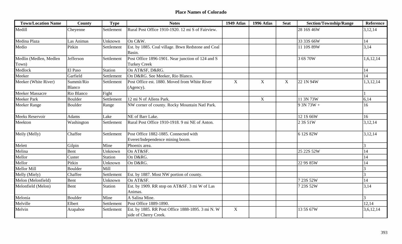
Place Names of Colorado
Town/Location Name County Type Notes 1949 Atlas 1996 Atlas Seat Section/Township/Range ReferenceMedill Cheyenne Settlement Rural Post Office 1910-1920. 12 mi S of Fairview. 28 16S 46W 3,12,14
Medina Plaza Las Animas Unknown On C&W. 33 33S 66W 14Medio Pitkin Settlement Est. by 1885. Coal village. Btwn Redstone and Coal
Basin.11 10S 89W 3,14
Medlin (Medlen, Medlen Town)
Jefferson Settlement Post Office 1896-1901. Near junction of 124 and S Turkey Creek
3 6S 70W 1,6,12,14
Medlock El Paso Station On AT&SF, D&RG. 14Meeker Garfield Settlement On D&RG. See Meeker, Rio Blanco. 14Meeker (White River) Summit/Rio
BlancoSettlement Post Office est. 1880. Moved from White River
(Agency).X X X 22 1N 94W 1,3,12,14
Meeker Massacre Rio Blanco Fight 1Meeker Park Boulder Settlement 12 mi N of Allens Park. X 11 3N 73W 6,14Meeker Range Boulder Range NW corner of county. Rocky Mountain Natl Park. 9 3N 73W + 16
Meeks Reservoir Adams Lake NE of Barr Lake. 12 1S 66W 16Meekton Washington Settlement Rural Post Office 1910-1918. 9 mi NE of Anton. 2 3S 51W 3,12,14
Meily (Melly) Chaffee Settlement Post Office 1882-1885. Connected with Everet/Independence mining boom.
6 12S 82W 3,12,14
Melett Gilpin Mine Phoenix area. 3Melina Bent Unknown On AT&SF. 25 22S 52W 14Mellor Custer Station On D&RG. 14Mellor Pitkin Unknown On D&RG. 22 9S 85W 14Mellor Mill Boulder Mill 3Melly (Miely) Chaffee Settlement Est. by 1887. Most NW portion of county. 3M l (M l fi ld) B t U k O AT&SF 7 23S 52W 14Melon (Melonfield) Bent Unknown On AT&SF. 7 23S 52W 14Melonfield (Melon) Bent Station Est. by 1909. RR stop on AT&SF. 3 mi W of Las
Animas.7 23S 52W 3,14
Melonia Boulder Mine A Salina Mine. 3Melville Elbert Settlement Post Office 1889-1890. 12,14Melvin Arapahoe Settlement Est. by 1885. RR Post Office 1888-1895. 3 mi N. W
side of Cherry Creek.X 13 5S 67W 3,6,12,14
393

Place Names of Colorado
Town/Location Name County Type Notes 1949 Atlas 1996 Atlas Seat Section/Township/Range ReferenceMelvina Boulder Mine W of Salina. 3,13Melvina Hill Boulder Mine On Salina Mt. 1Melvind Hill (7,440) Boulder Hill SE of Gold Hill. 18 1N 71W 16Memphis (Towner) Kiowa Settlement Earliest name for Towner. See Towner. 24 18S 42W 3,14Mendota Clear Creek Mine Silver Plume area mine. 3,13Mendota Eagle Mine New York Cabins area mine. 3,13Mendota San Miguel Mine A Pandora area mine. 3,13Mendota Peak (13,275) Peak13 Telluride Quad. 11Menefee Montezuma Station Est. by 1923. On D&RG. 3 mi NE of Mancos. X 23 36N 13W 3,14Menger (Wenger) Las Animas Settlement Post Office 1891-1901. Formerly Wenger. 11 31S 67W 12,14Menk Haven Conejos Unknown On Conejos River. ? 33N 6E 14j jMenoken (Brown) Montrose Settlement Post Office 1891-1892. Moved from Brown,
returned to Brown. Btwn Olathe and Montrose.X 2 49N 10W 3,12,14
Menonite Camp Teller Camp 29 13S 69W 14Mercer (Peetz) Logan Settlement Est. 1889. First name for Peetz, until 1908. 6 11N 51W 3,14Mercier Pueblo Settlement Rural Post Office 1906-1913. Near Otero Co. line. 24 25S 60W 3,12,14
Meredith (Miller Creek) Pitkin Settlement Post Office est. 1893. Lumber camp, quarry town. Same location as Miller Creek.
X 14 8S 84W 3,12,14
Merer Logan Unknown Est. by 1907. On CB&Q. ? 10N 52W 14Meridian (Croft) Crowley Settlement Est. by 1897. RR stop on MP. Same location as
Croft.17 21S 56W 3,14
Meridian Lake Gunnison Lake North of Crested Butte. Partly in Gunnison NF. 21 13S 86W 16Meridith Otero/Crowley Settlement Post Office 1889-1890. Moved to Ordway. Location
is for Sugar City.10 21S 56W 12,14
Merino (Buffalo) Weld/Logan Settlement Post Office est. 1883. Formerly called Buffalo. X X 13 6N 54W 3,12M i l L i S ttl t L id t i 1860 S Mi ill 14Merival Larimer Settlement Laid out in 1860. Same as Miraville. 14Merno Pueblo Unknown ? 24S 65W 14Merrick Pueblo Station Est. by 1902. On AT&SF. 4 mi N of Pueblo. 3,14Merrimac Conejos Mine Stunner area mine. 3Merritt Huerfano Unknown On D&RG. Btwn Shumway & Calumet. 14Merritts Montezuma Unknown Est. by 1881. At junction of N & S forks of Mancos
River? Mancos seems near.? 36N 13W 14
394
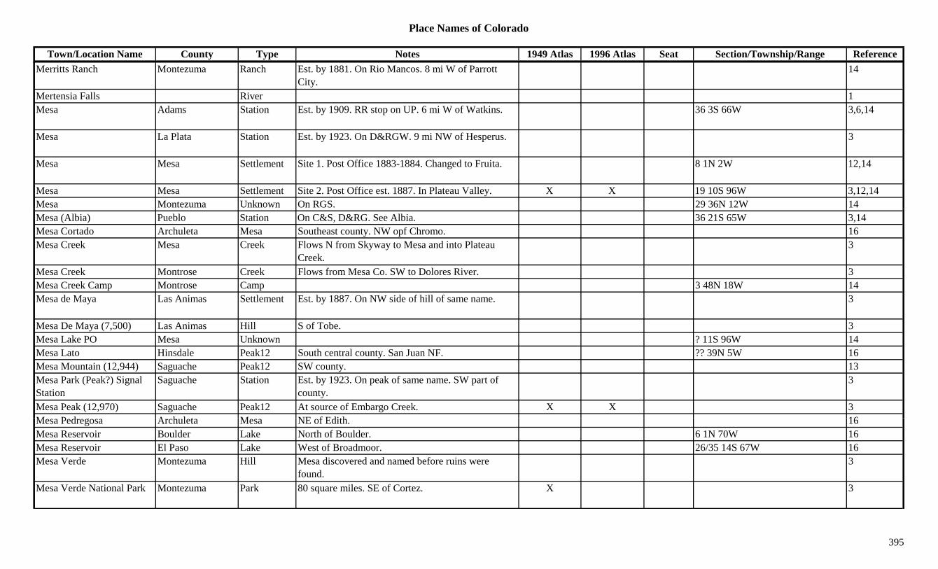
Place Names of Colorado
Town/Location Name County Type Notes 1949 Atlas 1996 Atlas Seat Section/Township/Range ReferenceMerritts Ranch Montezuma Ranch Est. by 1881. On Rio Mancos. 8 mi W of Parrott
City.14
Mertensia Falls River 1Mesa Adams Station Est. by 1909. RR stop on UP. 6 mi W of Watkins. 36 3S 66W 3,6,14
Mesa La Plata Station Est. by 1923. On D&RGW. 9 mi NW of Hesperus. 3
Mesa Mesa Settlement Site 1. Post Office 1883-1884. Changed to Fruita. 8 1N 2W 12,14
Mesa Mesa Settlement Site 2. Post Office est. 1887. In Plateau Valley. X X 19 10S 96W 3,12,14Mesa Montezuma Unknown On RGS. 29 36N 12W 14Mesa (Albia) Pueblo Station On C&S, D&RG. See Albia. 36 21S 65W 3,14Mesa Cortado Archuleta Mesa Southeast county. NW opf Chromo. 16Mesa Creek Mesa Creek Flows N from Skyway to Mesa and into Plateau
Creek.3
Mesa Creek Montrose Creek Flows from Mesa Co. SW to Dolores River. 3Mesa Creek Camp Montrose Camp 3 48N 18W 14Mesa de Maya Las Animas Settlement Est. by 1887. On NW side of hill of same name. 3
Mesa De Maya (7,500) Las Animas Hill S of Tobe. 3Mesa Lake PO Mesa Unknown ? 11S 96W 14Mesa Lato Hinsdale Peak12 South central county. San Juan NF. ?? 39N 5W 16Mesa Mountain (12,944) Saguache Peak12 SW county. 13Mesa Park (Peak?) Signal Station
Saguache Station Est. by 1923. On peak of same name. SW part of county.
3
Mesa Peak (12,970) Saguache Peak12 At source of Embargo Creek. X X 3M P d A h l t M NE f Edith 16Mesa Pedregosa Archuleta Mesa NE of Edith. 16Mesa Reservoir Boulder Lake North of Boulder. 6 1N 70W 16Mesa Reservoir El Paso Lake West of Broadmoor. 26/35 14S 67W 16Mesa Verde Montezuma Hill Mesa discovered and named before ruins were
found.3
Mesa Verde National Park Montezuma Park 80 square miles. SE of Cortez. X 3
395

Place Names of Colorado
Town/Location Name County Type Notes 1949 Atlas 1996 Atlas Seat Section/Township/Range ReferenceMesa Verde National Park Montezuma Settlement Post Office est. 1924. Sev 34N 15W 12,14
Mesaview Las Animas Settlement Post Office 1921-1922. 12,14Meserole La Plata Station Post Office 1882-1884. Stage stop? Along Hermosa
Creek and Pinkerton Trail.25 39N 10W 3,12,14
Mesita (Hamburg) Costilla Settlement Post Office est. 1910. Was Hamburg? Another location shown: 29 33S 73W.
X X 29 2N 73W 3,12,14
Messex Washington Settlement Platted 1909. Post Office 1907-1942. UP town in NW corner.
X 5 5N 54W 3,12,14
Messler Montrose Unknown Est. by 1895. On E branch of Rio Escalante. ? 50N 14W 14Metalloid Fremont Unknown On D&RG. Mail went to Howard. 14Metcalf Park/Teller Station Est. by 1923. On CM. 1 mi E of Lake George. 4 13S 71W 3,14Methodist Mountain (11,600)
Chaffee Mountain SW of Salida. Sangre de Cristo Range, San Luis Side. San Isabel NF.
25/36 49N 8E 8,16
Metropolitan Group Clear Creek Mine On Silver Creek. S of Silver Creek (town of). 3Mexican Plaza Las Animas Settlement 13 33S 68W 14Mexican Town Saguache Camp Very small. Up gulch from Embargo. 3Mexican Village Weld Settlement 4 1N 65W 14Mexico Clear Creek Unknown Est. by 1867. Btwn Alvarado & Georgetown. 14Meyer Costilla Settlement Post Office 1885. 12,14Meyer Lake Camp See Leadville. 3Meyer Weld Station Est. by 1924. On UP. 2 mi S of Purcell. X 6 7N 64W 3,6,14Meyer Ferry Conejos Misc. On the Rio Grande River. ? 33N 11E 14Meyers Corner Larimer Unknown 8 8N 68W 14Mica Butte Las Animas Hill W of Thatcher. 3Mica City Park Settlement Est. by 1880. 40 mi NW of Canon City. 2 mi W of
K t PO L ti i f K t4 15S 72W 14
Kester PO. Location is for Kester.Mica Lake Lake On continental divide 1Micanite Fremont Settlement Post Office 1904-1925. Near Park County line. 6 16S 72W 3,12,14Micheols Montrose Settlement Post Office 1919-?? May not have operated. 12,14Michigan Hinsdale Mine S of Lake City. 3Michigan Park Station Est. by 1923. On C&S. 5 mi S of Jefferson. Near
Michigan Creek.24 8S 76W 3,14
396
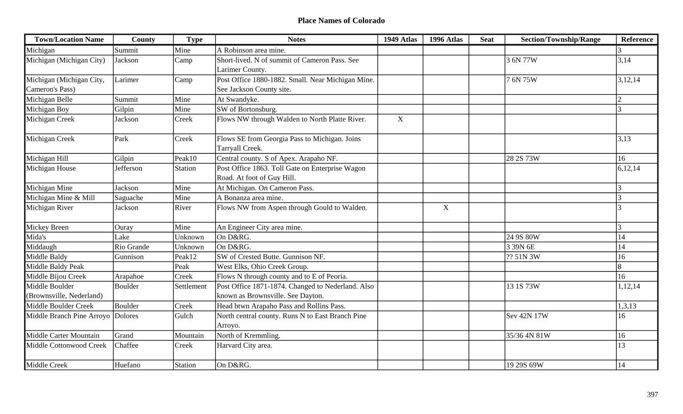
Place Names of Colorado
Town/Location Name County Type Notes 1949 Atlas 1996 Atlas Seat Section/Township/Range ReferenceMichigan Summit Mine A Robinson area mine. 3Michigan (Michigan City) Jackson Camp Short-lived. N of summit of Cameron Pass. See
Larimer County.3 6N 77W 3,14
Michigan (Michigan City, Cameron's Pass)
Larimer Camp Post Office 1880-1882. Small. Near Michigan Mine. See Jackson County site.
7 6N 75W 3,12,14
Michigan Belle Summit Mine At Swandyke. 2Michigan Boy Gilpin Mine SW of Bortonsburg. 3Michigan Creek Jackson Creek Flows NW through Walden to North Platte River. X
Michigan Creek Park Creek Flows SE from Georgia Pass to Michigan. Joins Tarryall Creek.
3,13
Michigan Hill Gilpin Peak10 Central county. S of Apex. Arapaho NF. 28 2S 73W 16Michigan House Jefferson Station Post Office 1863. Toll Gate on Enterprise Wagon
Road. At foot of Guy Hill.6,12,14
Michigan Mine Jackson Mine At Michigan. On Cameron Pass. 3Michigan Mine & Mill Saguache Mine A Bonanza area mine. 3Michigan River Jackson River Flows NW from Aspen through Gould to Walden. X 3
Mickey Breen Ouray Mine An Engineer City area mine. 3Mida's Lake Unknown On D&RG. 24 9S 80W 14Middaugh Rio Grande Unknown On D&RG. 3 39N 6E 14Middle Baldy Gunnison Peak12 SW of Crested Butte. Gunnison NF. ?? 51N 3W 16Middle Baldy Peak Peak West Elks, Ohio Creek Group. 8Middle Bijou Creek Arapahoe Creek Flows N through county and to E of Peoria. 16Middle Boulder (Brownsville, Nederland)
Boulder Settlement Post Office 1871-1874. Changed to Nederland. Also known as Brownsville. See Dayton.
13 1S 73W 1,12,14
Middl B ld C k B ld C k H d bt A h P d R lli P 1 3 13Middle Boulder Creek Boulder Creek Head btwn Arapaho Pass and Rollins Pass. 1,3,13Middle Branch Pine Arroyo Dolores Gulch North central county. Runs N to East Branch Pine
Arroyo.Sev 42N 17W 16
Middle Carter Mountain Grand Mountain North of Kremmling. 35/36 4N 81W 16Middle Cottonwood Creek Chaffee Creek Harvard City area. 13
Middle Creek Huefano Station On D&RG. 19 29S 69W 14
397
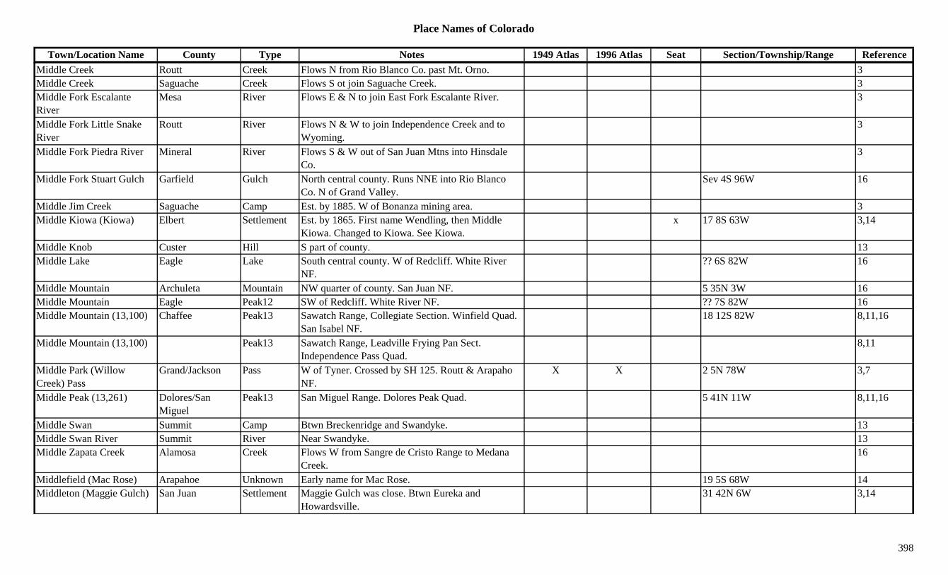
Place Names of Colorado
Town/Location Name County Type Notes 1949 Atlas 1996 Atlas Seat Section/Township/Range ReferenceMiddle Creek Routt Creek Flows N from Rio Blanco Co. past Mt. Orno. 3Middle Creek Saguache Creek Flows S ot join Saguache Creek. 3Middle Fork Escalante River
Mesa River Flows E & N to join East Fork Escalante River. 3
Middle Fork Little Snake River
Routt River Flows N & W to join Independence Creek and to Wyoming.
3
Middle Fork Piedra River Mineral River Flows S & W out of San Juan Mtns into Hinsdale Co.
3
Middle Fork Stuart Gulch Garfield Gulch North central county. Runs NNE into Rio Blanco Co. N of Grand Valley.
Sev 4S 96W 16
Middle Jim Creek Saguache Camp Est. by 1885. W of Bonanza mining area. 3g p y gMiddle Kiowa (Kiowa) Elbert Settlement Est. by 1865. First name Wendling, then Middle
Kiowa. Changed to Kiowa. See Kiowa.x 17 8S 63W 3,14
Middle Knob Custer Hill S part of county. 13Middle Lake Eagle Lake South central county. W of Redcliff. White River
NF.?? 6S 82W 16
Middle Mountain Archuleta Mountain NW quarter of county. San Juan NF. 5 35N 3W 16Middle Mountain Eagle Peak12 SW of Redcliff. White River NF. ?? 7S 82W 16Middle Mountain (13,100) Chaffee Peak13 Sawatch Range, Collegiate Section. Winfield Quad.
San Isabel NF.18 12S 82W 8,11,16
Middle Mountain (13,100) Peak13 Sawatch Range, Leadville Frying Pan Sect. Independence Pass Quad.
8,11
Middle Park (Willow Creek) Pass
Grand/Jackson Pass W of Tyner. Crossed by SH 125. Routt & Arapaho NF.
X X 2 5N 78W 3,7
Middle Peak (13,261) Dolores/San Miguel
Peak13 San Miguel Range. Dolores Peak Quad. 5 41N 11W 8,11,16
Middl S S it C Bt B k id d S d k 13Middle Swan Summit Camp Btwn Breckenridge and Swandyke. 13Middle Swan River Summit River Near Swandyke. 13Middle Zapata Creek Alamosa Creek Flows W from Sangre de Cristo Range to Medana
Creek.16
Middlefield (Mac Rose) Arapahoe Unknown Early name for Mac Rose. 19 5S 68W 14Middleton (Maggie Gulch) San Juan Settlement Maggie Gulch was close. Btwn Eureka and
Howardsville.31 42N 6W 3,14
398
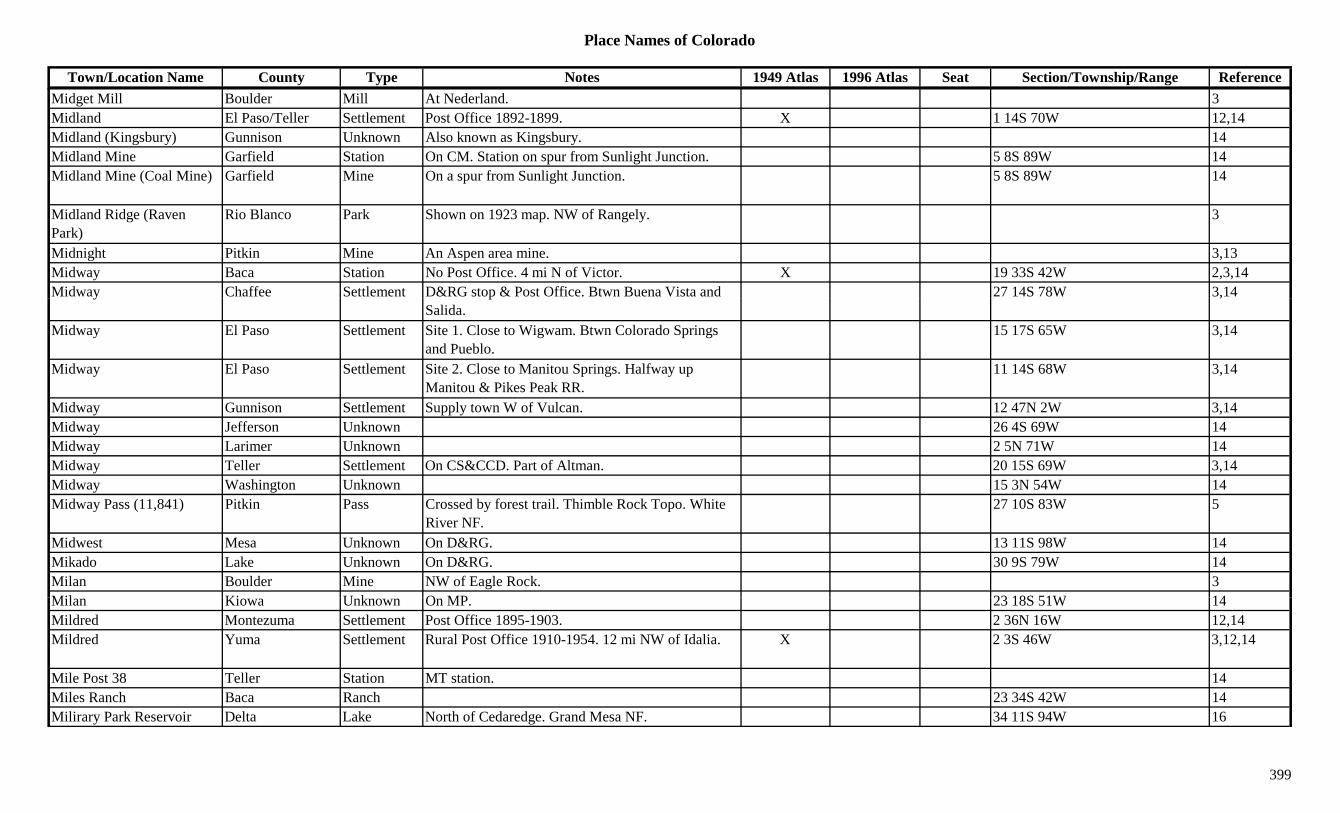
Place Names of Colorado
Town/Location Name County Type Notes 1949 Atlas 1996 Atlas Seat Section/Township/Range ReferenceMidget Mill Boulder Mill At Nederland. 3Midland El Paso/Teller Settlement Post Office 1892-1899. X 1 14S 70W 12,14Midland (Kingsbury) Gunnison Unknown Also known as Kingsbury. 14Midland Mine Garfield Station On CM. Station on spur from Sunlight Junction. 5 8S 89W 14Midland Mine (Coal Mine) Garfield Mine On a spur from Sunlight Junction. 5 8S 89W 14
Midland Ridge (Raven Park)
Rio Blanco Park Shown on 1923 map. NW of Rangely. 3
Midnight Pitkin Mine An Aspen area mine. 3,13Midway Baca Station No Post Office. 4 mi N of Victor. X 19 33S 42W 2,3,14Midway Chaffee Settlement D&RG stop & Post Office. Btwn Buena Vista and 27 14S 78W 3,14y p
Salida.,
Midway El Paso Settlement Site 1. Close to Wigwam. Btwn Colorado Springs and Pueblo.
15 17S 65W 3,14
Midway El Paso Settlement Site 2. Close to Manitou Springs. Halfway up Manitou & Pikes Peak RR.
11 14S 68W 3,14
Midway Gunnison Settlement Supply town W of Vulcan. 12 47N 2W 3,14Midway Jefferson Unknown 26 4S 69W 14Midway Larimer Unknown 2 5N 71W 14Midway Teller Settlement On CS&CCD. Part of Altman. 20 15S 69W 3,14Midway Washington Unknown 15 3N 54W 14Midway Pass (11,841) Pitkin Pass Crossed by forest trail. Thimble Rock Topo. White
River NF.27 10S 83W 5
Midwest Mesa Unknown On D&RG. 13 11S 98W 14Mikado Lake Unknown On D&RG. 30 9S 79W 14Milan Boulder Mine NW of Eagle Rock. 3Mil Ki U k O MP 23 18S 51W 14Milan Kiowa Unknown On MP. 23 18S 51W 14Mildred Montezuma Settlement Post Office 1895-1903. 2 36N 16W 12,14Mildred Yuma Settlement Rural Post Office 1910-1954. 12 mi NW of Idalia. X 2 3S 46W 3,12,14
Mile Post 38 Teller Station MT station. 14Miles Ranch Baca Ranch 23 34S 42W 14Milirary Park Reservoir Delta Lake North of Cedaredge. Grand Mesa NF. 34 11S 94W 16
399
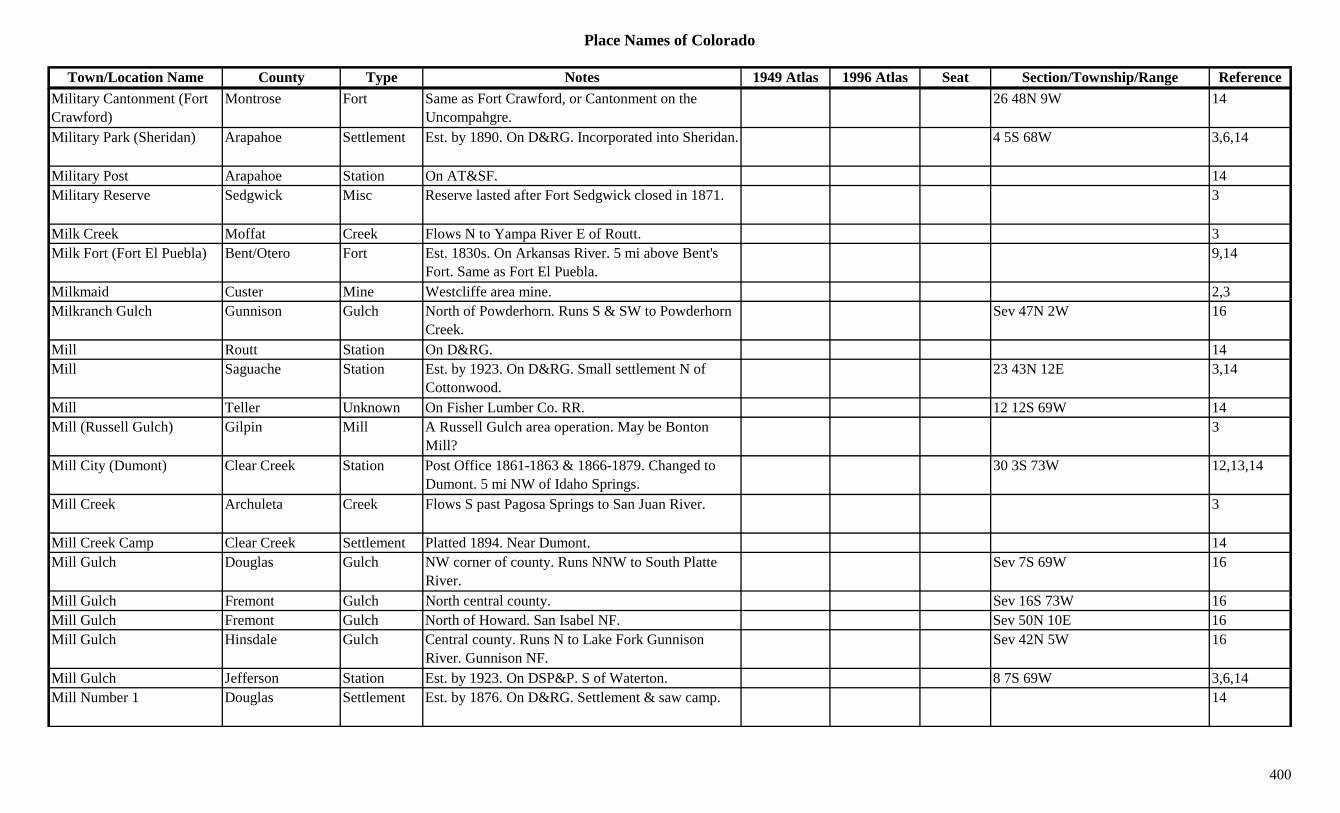
Place Names of Colorado
Town/Location Name County Type Notes 1949 Atlas 1996 Atlas Seat Section/Township/Range ReferenceMilitary Cantonment (Fort Crawford)
Montrose Fort Same as Fort Crawford, or Cantonment on the Uncompahgre.
26 48N 9W 14
Military Park (Sheridan) Arapahoe Settlement Est. by 1890. On D&RG. Incorporated into Sheridan. 4 5S 68W 3,6,14
Military Post Arapahoe Station On AT&SF. 14Military Reserve Sedgwick Misc Reserve lasted after Fort Sedgwick closed in 1871. 3
Milk Creek Moffat Creek Flows N to Yampa River E of Routt. 3Milk Fort (Fort El Puebla) Bent/Otero Fort Est. 1830s. On Arkansas River. 5 mi above Bent's
Fort. Same as Fort El Puebla.9,14
Milkmaid Custer Mine Westcliffe area mine. 2,3,Milkranch Gulch Gunnison Gulch North of Powderhorn. Runs S & SW to Powderhorn
Creek.Sev 47N 2W 16
Mill Routt Station On D&RG. 14Mill Saguache Station Est. by 1923. On D&RG. Small settlement N of
Cottonwood.23 43N 12E 3,14
Mill Teller Unknown On Fisher Lumber Co. RR. 12 12S 69W 14Mill (Russell Gulch) Gilpin Mill A Russell Gulch area operation. May be Bonton
Mill?3
Mill City (Dumont) Clear Creek Station Post Office 1861-1863 & 1866-1879. Changed to Dumont. 5 mi NW of Idaho Springs.
30 3S 73W 12,13,14
Mill Creek Archuleta Creek Flows S past Pagosa Springs to San Juan River. 3
Mill Creek Camp Clear Creek Settlement Platted 1894. Near Dumont. 14Mill Gulch Douglas Gulch NW corner of county. Runs NNW to South Platte
River.Sev 7S 69W 16
Mill G l h F t G l h N th t l t S 16S 73W 16Mill Gulch Fremont Gulch North central county. Sev 16S 73W 16Mill Gulch Fremont Gulch North of Howard. San Isabel NF. Sev 50N 10E 16Mill Gulch Hinsdale Gulch Central county. Runs N to Lake Fork Gunnison
River. Gunnison NF.Sev 42N 5W 16
Mill Gulch Jefferson Station Est. by 1923. On DSP&P. S of Waterton. 8 7S 69W 3,6,14Mill Number 1 Douglas Settlement Est. by 1876. On D&RG. Settlement & saw camp. 14
400
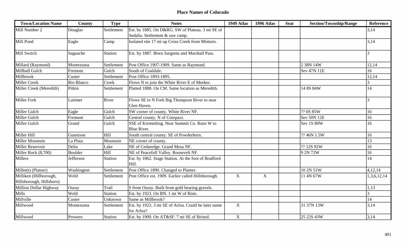
Place Names of Colorado
Town/Location Name County Type Notes 1949 Atlas 1996 Atlas Seat Section/Township/Range ReferenceMill Number 2 Douglas Settlement Est. by 1885. On D&RG. SW of Plateau. 3 mi SE of
Sedalia. Settlement & saw camp.3,14
Mill Pond Eagle Camp Isolated site 17 mi up Cross Creek from Minturn. 3,14
Mill Switch Saguache Station Est. by 1887. Btwn Sargents and Marshall Pass. 3
Millard (Raymond) Montezuma Settlement Post Office 1907-1909. Same as Raymond. 2 38N 14W 12,14Millball Gulch Fremont Gulch South of Coaldale. Sev 47N 11E 16Millbrook Custer Settlement Post Office 1893-1895. 12,14Miller Creek Rio Blanco Creek Flows N to join the White River E of Meeker. 3Miller Creek (Meredith) Pitkin Settlement Platted 1888. On CM. Same location as Meredith. 14 8S 84W 14( )
Miller Fork Larimer River Flows SE to N Fork Big Thompson River to near Glen Haven.
3
Miller Gulch Eagle Gulch SW corner of county. White River NF. ?? 6S 85W 16Miller Gulch Fremont Gulch Central county. N of Cotopaxi. Sev 50N 12E 16Miller Gulch Grand Gulch SSE of Kremmling. Near Summit Co. Runs W to
Blue River.Sev 1S 80W 16
Miller Hill Gunnison Hill South central county. SE of Powderhorn. ?? 46N 1.5W 16Miller Mountain La Plata Mountain NE corner of county. 13Miller Reservoir Delta Lake NE of Cedaredge. Grand Mesa NF. ?? 12S 92W 16Miller Rock (8,700) Boulder Hill NE of Peacefull Valley. Roosevelt NF. 9 2N 72W 16Millers Jefferson Station Est. by 1862. Stage Station. At the foot of Bradford
Hill.14
Millet(t) (Platner) Washington Settlement Post Office 1890. Changed to Platner. 10 2N 51W 4,12,14Milliken (Hillborough, Hill b h Hill b )
Weld Settlement Post Office est. 1909. Earlier called Hillsborough. X X 11 4N 67W 1,3,6,12,14Hillsborough, Hillsboro)Million Dollar Highway Ouray Trail S from Ouray. Built from gold bearing gravels. 1,13Mills Weld Station Est. by 1923. On BN. 1 mi W of Rinn. 3Millville Custer Unknown Same as Millbrook? 14Millwood Montezuma Settlement Est. by 1923. 3 mi SE of Arloa. Could be later name
for Arloa?X 31 37N 13W 3,14
Millwood Prowers Station Est. by 1909. On AT&SF. 7 mi SE of Bristol. X 25 22S 43W 3,14
401

Place Names of Colorado
Town/Location Name County Type Notes 1949 Atlas 1996 Atlas Seat Section/Township/Range ReferenceMilner (Deer) Pass Grand/Larimer Pass Where Trail Ridge crosses Continental Divide on US
34. Rocky Mountain Natl Park.X X 9 5N 75W 7,16
Milner (Pool) Routt Settlement Est. 1917. Post Office 1920-1988. Formerly Pool. X X 15 6N 86W 3,12,14
Milner Mountain (6,881) Larimer Mountain SW of Fort Collins. 13Milton Eagle Station On D&RG. 14Milton Saguache Settlement Est. by 1885. Settlement & RR stop. 1 mi SE of
Saguache.18 44N 8E 3,14
Milton Reservoir Weld Lake North of Hudson, on Beebe Sheep Canal. X XMilwaukee Hill Saguache Mine A Crestone-Liberty area mine. 3Milwaukee Peak (13,190) Custer/Saguache Peak13 SW part of county. Sangre de Cristo Range, Main ?? 24S 73W 8,11,16( , ) g p y g g ,
Section. Crestone Peak Quad., ,
Minaret Gunnison Settlement Post Office 1890-1896. RR town serving Baldwin area. SE of Baldwin.
28 15S 86W 3,12,14
Mindeman (Symons) Otero Settlement Post Office on AT&SF 1917-1934. Formerly Symons. 5 mi SW of Ayer.
X 8 27S 58W 3,12,14
Mine El Paso Settlement XMine Gulch Fremont Gulch NNW of Cotopaxi. Sev 48N 11E 16Miner Larimer Settlement Post Office 1888-1894. 13 9N 69W 12,14Miner Mesa Unknown On D&RG. Btwn Tunnel & Gale. ? 10S 98W 14Miner Boy Lake Mine A Stumptown area mine. 13Mineral Teller Mine Teller Co. mines not elsewhere specified. 3Mineral Chief Clear Creek Mine NW of Georgetown. 3Mineral City La Plata Settlement In 1875 had 20 cabins. 3Mineral City San Juan Settlement Site 1. Another name for Mineral Point. (PO was
Mineral Point)25 43N 7W 3,14
Mi l Cit S J S ttl t Sit 2 E t b 1887 SW f Sil t At th f 3Mineral City San Juan Settlement Site 2. Est. by 1887. SW of Silverton. At mouth of Mineral Creek.
3
Mineral Farm Ouray Mine At Ouray. 2,3,13Mineral Hill Teller Hill N of Cripple Creek. 3Mineral Hill Group Saguache Mine An Iris area mine. 3Mineral Hot Springs Saguache Settlement Est. 1880. Post Office 1911-1947. X 12 45N 9E 3,12,14Mineral Mountain Boulder Mountain NW of Eldora. 3
402

Place Names of Colorado
Town/Location Name County Type Notes 1949 Atlas 1996 Atlas Seat Section/Township/Range ReferenceMineral Mountain Hinsdale Peak12 East of Lake City. On Saguache Co boarder.
Gunnison NF.29 44N 1W 16
Mineral Mountain (12,097) Ouray/San Juan Peak12 Northeast San Juans. SE of Ouray. On San Juan Co. border.
3,8
Mineral Park Park Unknown 35 8S 78W 14Mineral Point Gunnison Peak11 North central county. E of Marble. White River NF. ?? 11S 87W 16
Mineral Point Gunnison Peak12 NW of Crested Butte. Gunnison NF. ?? 12S 87W 16Mineral Point La Plata/San Juan Settlement Post Office 1875-1897. At 11,474 ft. Post Office for
Mineral City. 8 mi SE of Ouray.25 43N 7W 3,12,13,14
Mineral Point (11,025) Mountain Elk Range, Crystal River Area. 8( , ) g , yMineral Point (12,506) Peak12 Ruby Range. 8Mineral Ranch #1 & #2 Park Mine A Silver Heels area mine. 3Mineral Ranch Hill Park Mine A Silver Heels area mine. 3Mineral Springs (Idaho Springs)
Clear Creek Settlement Early name for Idaho Springs. 14
Miner-Boy Lake Mine A Leadville area mine. 3Miners Camp Gilpin Camp On Ralston Creek. Prob. 7 mi W of junction of
Ralston & Clear Creek.14
Miner's College Lake Mine An Alicante area mine. 3Miner's Creek Mineral Creek Flows out of Saguache Co. Joins Rio Grande River
S of Creede.3
Minersville Custer Settlement Est. by 1884. Near junction of N & S Hardscrable Creeks.
3
Minersville Gunnison Camp Est. by 1861. In Washington Gulch. Near what was to become Gothic.
3,14
Mi (K bl Mi ) G i Mi E t b 1885 A th f K bl Mi 3Mines (Kubler Mine) Gunnison Mine Est. by 1885. Another name for Kubler Mine. 3Mining Camp Gunnison Camp Est. by 1873. An unnamed camp in Elk Mountains. 14
Minion Boulder Station Stop on old DB&W RR. 1Minneapolis Chaffee Camp Est. by 1924. Btwn Turret and the Calumet Mine. 29 51N 9E 3,14
403
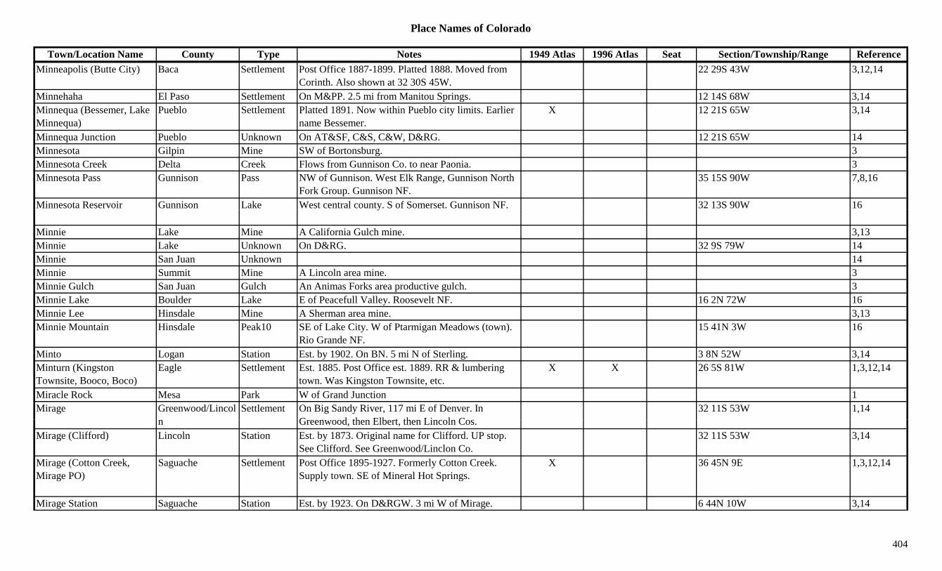
Place Names of Colorado
Town/Location Name County Type Notes 1949 Atlas 1996 Atlas Seat Section/Township/Range ReferenceMinneapolis (Butte City) Baca Settlement Post Office 1887-1899. Platted 1888. Moved from
Corinth. Also shown at 32 30S 45W.22 29S 43W 3,12,14
Minnehaha El Paso Settlement On M&PP. 2.5 mi from Manitou Springs. 12 14S 68W 3,14Minnequa (Bessemer, Lake Minnequa)
Pueblo Settlement Platted 1891. Now within Pueblo city limits. Earlier name Bessemer.
X 12 21S 65W 3,14
Minnequa Junction Pueblo Unknown On AT&SF, C&S, C&W, D&RG. 12 21S 65W 14Minnesota Gilpin Mine SW of Bortonsburg. 3Minnesota Creek Delta Creek Flows from Gunnison Co. to near Paonia. 3Minnesota Pass Gunnison Pass NW of Gunnison. West Elk Range, Gunnison North
Fork Group. Gunnison NF.35 15S 90W 7,8,16
Minnesota Reservoir Gunnison Lake West central county. S of Somerset. Gunnison NF. 32 13S 90W 16y
Minnie Lake Mine A California Gulch mine. 3,13Minnie Lake Unknown On D&RG. 32 9S 79W 14Minnie San Juan Unknown 14Minnie Summit Mine A Lincoln area mine. 3Minnie Gulch San Juan Gulch An Animas Forks area productive gulch. 3Minnie Lake Boulder Lake E of Peacefull Valley. Roosevelt NF. 16 2N 72W 16Minnie Lee Hinsdale Mine A Sherman area mine. 3,13Minnie Mountain Hinsdale Peak10 SE of Lake City. W of Ptarmigan Meadows (town).
Rio Grande NF.15 41N 3W 16
Minto Logan Station Est. by 1902. On BN. 5 mi N of Sterling. 3 8N 52W 3,14Minturn (Kingston Townsite, Booco, Boco)
Eagle Settlement Est. 1885. Post Office est. 1889. RR & lumbering town. Was Kingston Townsite, etc.
X X 26 5S 81W 1,3,12,14
Miracle Rock Mesa Park W of Grand Junction 1Mirage Greenwood/Lincol Settlement On Big Sandy River, 117 mi E of Denver. In
G d th Elb t th Li l C32 11S 53W 1,14
n Greenwood, then Elbert, then Lincoln Cos.Mirage (Clifford) Lincoln Station Est. by 1873. Original name for Clifford. UP stop.
See Clifford. See Greenwood/Linclon Co.32 11S 53W 3,14
Mirage (Cotton Creek, Mirage PO)
Saguache Settlement Post Office 1895-1927. Formerly Cotton Creek. Supply town. SE of Mineral Hot Springs.
X 36 45N 9E 1,3,12,14
Mirage Station Saguache Station Est. by 1923. On D&RGW. 3 mi W of Mirage. 6 44N 10W 3,14
404

Place Names of Colorado
Town/Location Name County Type Notes 1949 Atlas 1996 Atlas Seat Section/Township/Range ReferenceMiramonte Boulder Settlement Est. by 1924. On D&RG. W of Crescent. 30 1S 71W 3,14Miranda Peak (13,468) Peak13 Culebra Range. San Luis Valley Side. El Valle
Creek Quad.8,11
Miravalle City Larimer Unknown Est. by 1860. On Big Thompson. See Merival & Miraville.
14
Miraville Larimer Settlement Laid out in 1860. At crossing of Big Thompson River & old Larimer Road.
16 5N 69W 14
Miser Rio Grande Mine A Jasper area mine. 3Miser's Dream Boulder Mine A Ward area mine. 3,13Mishawaka Larimer Settlement 7 mi W of Poudre Gateway. 5 8N 71W 3,14Misquito Park Unknown 1.5 mi SE of Buckskin Joe. 14qMissouri Gilpin Mine S of Bortonsburg. 3Missouri Park Mine NW corner of county. Up Hall Valley. 3Missouri Camp (Missouri City)
Eagle Camp Est. 1880. 6 mi from Holy Cross City. 3,14
Missouri Center La Plata Unknown 9U 34NU 7W 14Missouri City (Missouri Flats)
KT/Gilpin Settlement Post Office 1860-1863. SE of Central City. In or near Missouri Gulch.
? 3S 73W 3,12,14
Missouri Creek Gilpin Creek At Wide Awake. 13Missouri Flats (Missouri City)
Gilpin Settlement Est. by 1860. SE of Central City. 3,14
Missouri Gulch Douglas Gulch SW corner of county. Runs W to Trout Creek. Sev 10S 69W 16Missouri Heights Reservoir Eagle Lake SW corner of county. NW of Basalt. Sev 7S 87W 16
Missouri Hill (12,707) Peak12 Sawatch Range, Chalk Creek Shavano Sect. 8Missouri Lake Gilpin Lake North of Central City. 35 2S 73W 16Mi i M t i (14 067) Ch ff P k14 S t h R C ll i t S ti Wi fi ld Q d 6 13S 80W 3 8 11 16Missouri Mountain (14,067) Chaffee Peak14 Sawatch Range, Collegiate Section. Winfield Quad.
San Isabel NF.6 13S 80W 3,8,11,16
Mitchell Weld/Boulder Station Est. by 1892. RR stop on DU&P. 1 mi S of Erie. 25 1N 69W 1,3,6,14
Mitchell (Monarch, Downer)
Boulder Unknown On C&S. Same as Monarch & Downer. 14 1S 70W 14
405
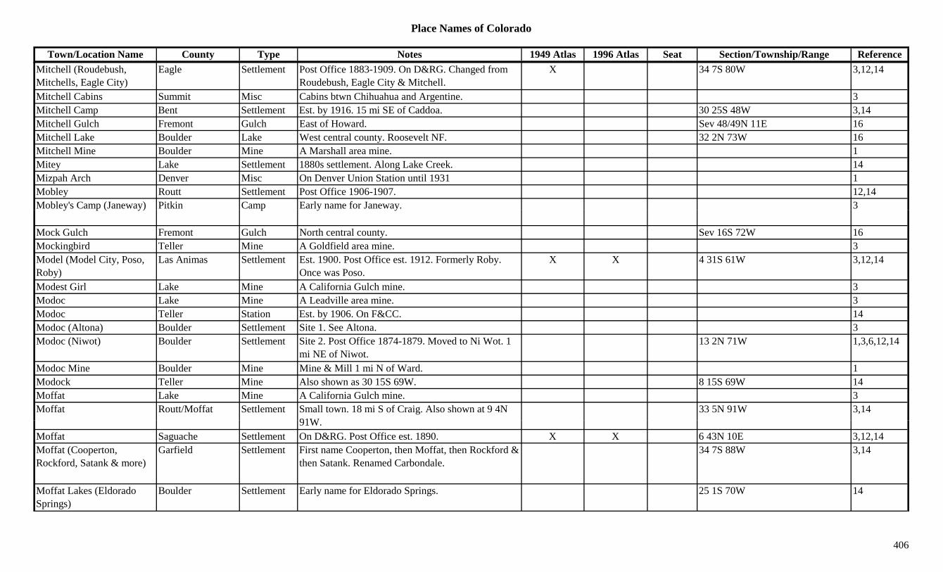
Place Names of Colorado
Town/Location Name County Type Notes 1949 Atlas 1996 Atlas Seat Section/Township/Range ReferenceMitchell (Roudebush, Mitchells, Eagle City)
Eagle Settlement Post Office 1883-1909. On D&RG. Changed from Roudebush, Eagle City & Mitchell.
X 34 7S 80W 3,12,14
Mitchell Cabins Summit Misc Cabins btwn Chihuahua and Argentine. 3Mitchell Camp Bent Settlement Est. by 1916. 15 mi SE of Caddoa. 30 25S 48W 3,14Mitchell Gulch Fremont Gulch East of Howard. Sev 48/49N 11E 16Mitchell Lake Boulder Lake West central county. Roosevelt NF. 32 2N 73W 16Mitchell Mine Boulder Mine A Marshall area mine. 1Mitey Lake Settlement 1880s settlement. Along Lake Creek. 14Mizpah Arch Denver Misc On Denver Union Station until 1931 1Mobley Routt Settlement Post Office 1906-1907. 12,14Mobley's Camp (Janeway) Pitkin Camp Early name for Janeway. 3y p ( y) p y y
Mock Gulch Fremont Gulch North central county. Sev 16S 72W 16Mockingbird Teller Mine A Goldfield area mine. 3Model (Model City, Poso, Roby)
Las Animas Settlement Est. 1900. Post Office est. 1912. Formerly Roby. Once was Poso.
X X 4 31S 61W 3,12,14
Modest Girl Lake Mine A California Gulch mine. 3Modoc Lake Mine A Leadville area mine. 3Modoc Teller Station Est. by 1906. On F&CC. 14Modoc (Altona) Boulder Settlement Site 1. See Altona. 3Modoc (Niwot) Boulder Settlement Site 2. Post Office 1874-1879. Moved to Ni Wot. 1
mi NE of Niwot.13 2N 71W 1,3,6,12,14
Modoc Mine Boulder Mine Mine & Mill 1 mi N of Ward. 1Modock Teller Mine Also shown as 30 15S 69W. 8 15S 69W 14Moffat Lake Mine A California Gulch mine. 3Moffat Routt/Moffat Settlement Small town. 18 mi S of Craig. Also shown at 9 4N
91W33 5N 91W 3,14
91W.Moffat Saguache Settlement On D&RG. Post Office est. 1890. X X 6 43N 10E 3,12,14Moffat (Cooperton, Rockford, Satank & more)
Garfield Settlement First name Cooperton, then Moffat, then Rockford & then Satank. Renamed Carbondale.
34 7S 88W 3,14
Moffat Lakes (Eldorado Springs)
Boulder Settlement Early name for Eldorado Springs. 25 1S 70W 14
406
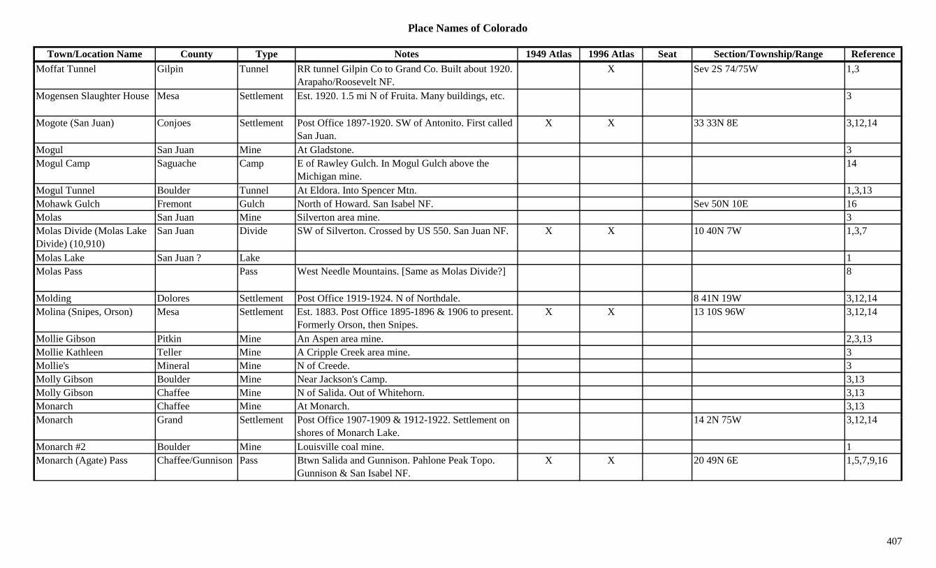
Place Names of Colorado
Town/Location Name County Type Notes 1949 Atlas 1996 Atlas Seat Section/Township/Range ReferenceMoffat Tunnel Gilpin Tunnel RR tunnel Gilpin Co to Grand Co. Built about 1920.
Arapaho/Roosevelt NF.X Sev 2S 74/75W 1,3
Mogensen Slaughter House Mesa Settlement Est. 1920. 1.5 mi N of Fruita. Many buildings, etc. 3
Mogote (San Juan) Conjoes Settlement Post Office 1897-1920. SW of Antonito. First called San Juan.
X X 33 33N 8E 3,12,14
Mogul San Juan Mine At Gladstone. 3Mogul Camp Saguache Camp E of Rawley Gulch. In Mogul Gulch above the
Michigan mine.14
Mogul Tunnel Boulder Tunnel At Eldora. Into Spencer Mtn. 1,3,13Mohawk Gulch Fremont Gulch North of Howard. San Isabel NF. Sev 50N 10E 16Molas San Juan Mine Silverton area mine. 3Molas Divide (Molas Lake Divide) (10,910)
San Juan Divide SW of Silverton. Crossed by US 550. San Juan NF. X X 10 40N 7W 1,3,7
Molas Lake San Juan ? Lake 1Molas Pass Pass West Needle Mountains. [Same as Molas Divide?] 8
Molding Dolores Settlement Post Office 1919-1924. N of Northdale. 8 41N 19W 3,12,14Molina (Snipes, Orson) Mesa Settlement Est. 1883. Post Office 1895-1896 & 1906 to present.
Formerly Orson, then Snipes.X X 13 10S 96W 3,12,14
Mollie Gibson Pitkin Mine An Aspen area mine. 2,3,13Mollie Kathleen Teller Mine A Cripple Creek area mine. 3Mollie's Mineral Mine N of Creede. 3Molly Gibson Boulder Mine Near Jackson's Camp. 3,13Molly Gibson Chaffee Mine N of Salida. Out of Whitehorn. 3,13Monarch Chaffee Mine At Monarch. 3,13M h G d S ttl t P t Offi 1907 1909 & 1912 1922 S ttl t 14 2N 75W 3 12 14Monarch Grand Settlement Post Office 1907-1909 & 1912-1922. Settlement on
shores of Monarch Lake.14 2N 75W 3,12,14
Monarch #2 Boulder Mine Louisville coal mine. 1Monarch (Agate) Pass Chaffee/Gunnison Pass Btwn Salida and Gunnison. Pahlone Peak Topo.
Gunnison & San Isabel NF.X X 20 49N 6E 1,5,7,9,16
407
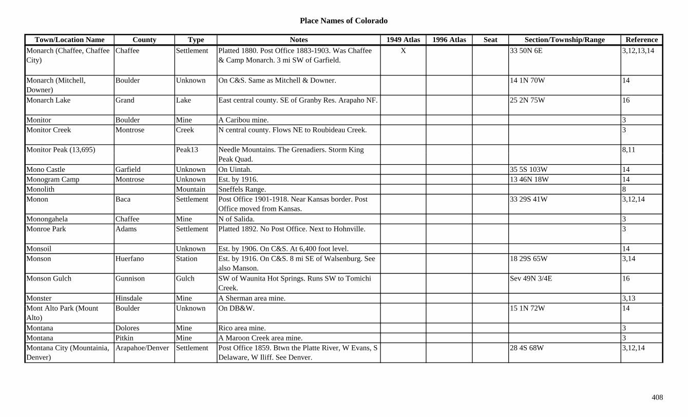
Place Names of Colorado
Town/Location Name County Type Notes 1949 Atlas 1996 Atlas Seat Section/Township/Range ReferenceMonarch (Chaffee, Chaffee City)
Chaffee Settlement Platted 1880. Post Office 1883-1903. Was Chaffee & Camp Monarch. 3 mi SW of Garfield.
X 33 50N 6E 3,12,13,14
Monarch (Mitchell, Downer)
Boulder Unknown On C&S. Same as Mitchell & Downer. 14 1N 70W 14
Monarch Lake Grand Lake East central county. SE of Granby Res. Arapaho NF. 25 2N 75W 16
Monitor Boulder Mine A Caribou mine. 3Monitor Creek Montrose Creek N central county. Flows NE to Roubideau Creek. 3
Monitor Peak (13,695) Peak13 Needle Mountains. The Grenadiers. Storm King 8,11( , ) gPeak Quad.
,
Mono Castle Garfield Unknown On Uintah. 35 5S 103W 14Monogram Camp Montrose Unknown Est. by 1916. 13 46N 18W 14Monolith Mountain Sneffels Range. 8Monon Baca Settlement Post Office 1901-1918. Near Kansas border. Post
Office moved from Kansas.33 29S 41W 3,12,14
Monongahela Chaffee Mine N of Salida. 3Monroe Park Adams Settlement Platted 1892. No Post Office. Next to Hohnville. 3
Monsoil Unknown Est. by 1906. On C&S. At 6,400 foot level. 14Monson Huerfano Station Est. by 1916. On C&S. 8 mi SE of Walsenburg. See
also Manson.18 29S 65W 3,14
Monson Gulch Gunnison Gulch SW of Waunita Hot Springs. Runs SW to Tomichi Creek.
Sev 49N 3/4E 16
Monster Hinsdale Mine A Sherman area mine. 3,13M t Alt P k (M t B ld U k O DB&W 15 1N 72W 14Mont Alto Park (Mount Alto)
Boulder Unknown On DB&W. 15 1N 72W 14
Montana Dolores Mine Rico area mine. 3Montana Pitkin Mine A Maroon Creek area mine. 3Montana City (Mountainia, Denver)
Arapahoe/Denver Settlement Post Office 1859. Btwn the Platte River, W Evans, S Delaware, W Iliff. See Denver.
28 4S 68W 3,12,14
408
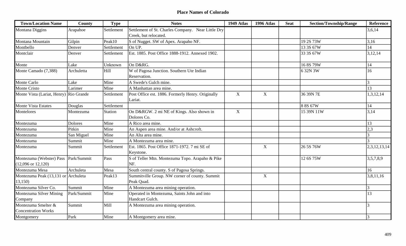
Place Names of Colorado
Town/Location Name County Type Notes 1949 Atlas 1996 Atlas Seat Section/Township/Range ReferenceMontana Diggins Arapahoe Settlement Settlement of St. Charles Company. Near Little Dry
Creek, but relocated.3,6,14
Montana Mountain Gilpin Peak10 S of Nugget. SW of Apex. Arapaho NF. 19 2S 73W 3,16Montbello Denver Settlement On UP. 13 3S 67W 14Montclair Denver Settlement Est. 1885. Post Office 1888-1912. Annexed 1902. 33 3S 67W 3,12,14
Monte Lake Unknown On D&RG. 16 8S 79W 14Monte Camado (7,388) Archuletta Hill W of Pagosa Junction. Southern Ute Indian
Reservation.6 32N 3W 16
Monte Carlo Lake Mine A Swede's Gulch mine. 3Monte Cristo Larimer Mine A Manhattan area mine. 13Monte Vista (Lariat, Henry) Rio Grande Settlement Post Office est. 1886. Formerly Henry. Originally
Lariat.X X 36 39N 7E 1,3,12,14
Monte Vista Estates Douglas Settlement 8 8S 67W 14Montelores Montezuma Station On D&RGW. 2 mi NE of Kings. Also shown in
Dolores Co.X 15 39N 11W 3,14
Montezuma Dolores Mine A Rico area mine. 13Montezuma Pitkin Mine An Aspen area mine. And/or at Ashcroft. 2,3Montezuma San Miguel Mine An Alta area mine. 3Montezuma Summit Mine A Montezuma area mine. 3Montezuma Summit Settlement Est. 1865. Post Office 1871-1972. 7 mi SE of
Keystone.X 26 5S 76W 2,3,12,13,14
Montezuma (Webster) Pass (12,096 or 12,120)
Park/Summit Pass S of Teller Mtn. Montezuma Topo. Arapaho & Pike NF.
12 6S 75W 3,5,7,8,9
Montezuma Mesa Archuleta Mesa South central county. S of Pagosa Springs. 16Montezuma Peak (13,131 or 13 150)
Archuleta Peak13 Summitville Group. NW corner of county. Summit P k Q d
X 3,8,11,1613,150) Peak Quad.Montezuma Silver Co. Summit Mine A Montezuma area mining operation. 3Montezuma Silver Mining Company
Park/Summit Mine Operated in Montezuma, Saints John and into Handcart Gulch.
13
Montezuma Smelter & Concentration Works
Summit Mill A Montezuma area mining operation. 3
Montgomery Park Mine A Montgomery area mine. 3
409
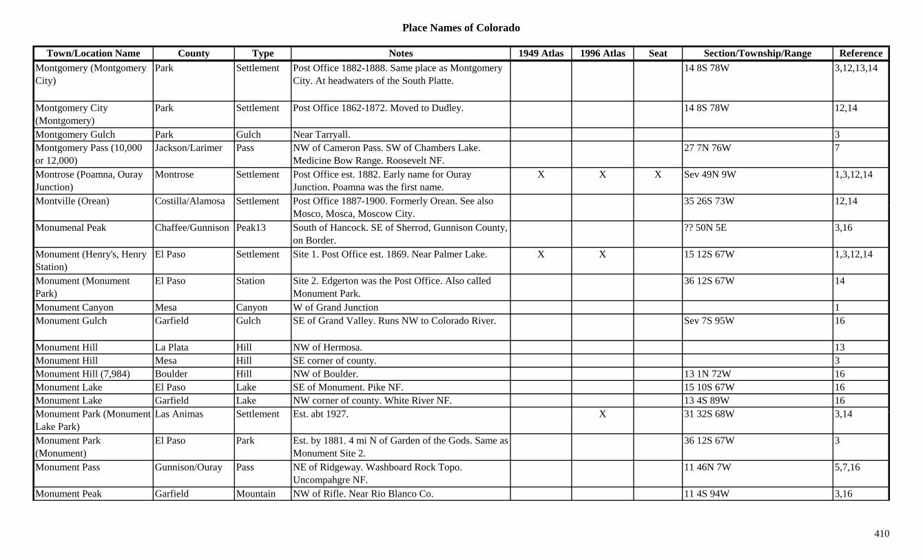
Place Names of Colorado
Town/Location Name County Type Notes 1949 Atlas 1996 Atlas Seat Section/Township/Range ReferenceMontgomery (Montgomery City)
Park Settlement Post Office 1882-1888. Same place as Montgomery City. At headwaters of the South Platte.
14 8S 78W 3,12,13,14
Montgomery City (Montgomery)
Park Settlement Post Office 1862-1872. Moved to Dudley. 14 8S 78W 12,14
Montgomery Gulch Park Gulch Near Tarryall. 3Montgomery Pass (10,000 or 12,000)
Jackson/Larimer Pass NW of Cameron Pass. SW of Chambers Lake. Medicine Bow Range. Roosevelt NF.
27 7N 76W 7
Montrose (Poamna, Ouray Junction)
Montrose Settlement Post Office est. 1882. Early name for Ouray Junction. Poamna was the first name.
X X X Sev 49N 9W 1,3,12,14
Montville (Orean) Costilla/Alamosa Settlement Post Office 1887-1900. Formerly Orean. See also 35 26S 73W 12,14( ) yMosco, Mosca, Moscow City.
,
Monumenal Peak Chaffee/Gunnison Peak13 South of Hancock. SE of Sherrod, Gunnison County, on Border.
?? 50N 5E 3,16
Monument (Henry's, Henry Station)
El Paso Settlement Site 1. Post Office est. 1869. Near Palmer Lake. X X 15 12S 67W 1,3,12,14
Monument (Monument Park)
El Paso Station Site 2. Edgerton was the Post Office. Also called Monument Park.
36 12S 67W 14
Monument Canyon Mesa Canyon W of Grand Junction 1Monument Gulch Garfield Gulch SE of Grand Valley. Runs NW to Colorado River. Sev 7S 95W 16
Monument Hill La Plata Hill NW of Hermosa. 13Monument Hill Mesa Hill SE corner of county. 3Monument Hill (7,984) Boulder Hill NW of Boulder. 13 1N 72W 16Monument Lake El Paso Lake SE of Monument. Pike NF. 15 10S 67W 16Monument Lake Garfield Lake NW corner of county. White River NF. 13 4S 89W 16M t P k (M t L A i S ttl t E t bt 1927 X 31 32S 68W 3 14Monument Park (Monument Lake Park)
Las Animas Settlement Est. abt 1927. X 31 32S 68W 3,14
Monument Park (Monument)
El Paso Park Est. by 1881. 4 mi N of Garden of the Gods. Same as Monument Site 2.
36 12S 67W 3
Monument Pass Gunnison/Ouray Pass NE of Ridgeway. Washboard Rock Topo. Uncompahgre NF.
11 46N 7W 5,7,16
Monument Peak Garfield Mountain NW of Rifle. Near Rio Blanco Co. 11 4S 94W 3,16
410
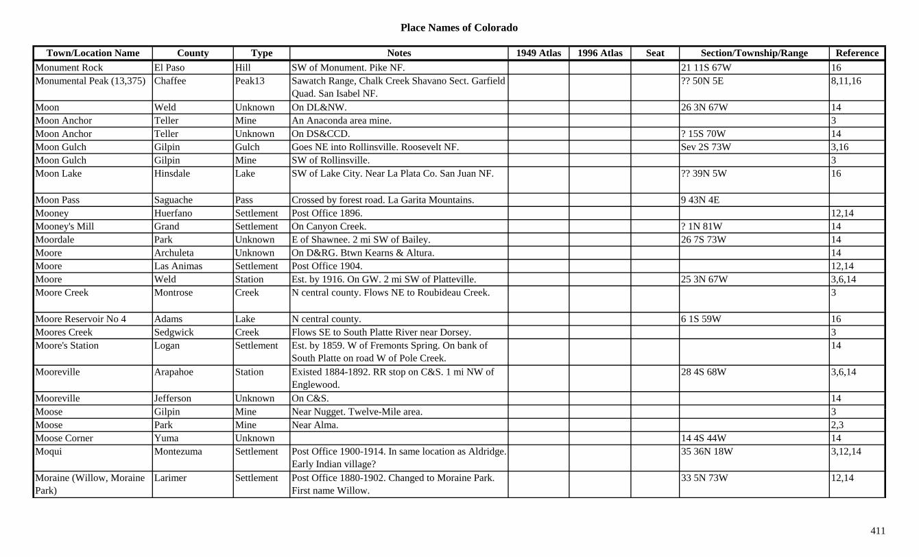
Place Names of Colorado
Town/Location Name County Type Notes 1949 Atlas 1996 Atlas Seat Section/Township/Range ReferenceMonument Rock El Paso Hill SW of Monument. Pike NF. 21 11S 67W 16Monumental Peak (13,375) Chaffee Peak13 Sawatch Range, Chalk Creek Shavano Sect. Garfield
Quad. San Isabel NF.?? 50N 5E 8,11,16
Moon Weld Unknown On DL&NW. 26 3N 67W 14Moon Anchor Teller Mine An Anaconda area mine. 3Moon Anchor Teller Unknown On DS&CCD. ? 15S 70W 14Moon Gulch Gilpin Gulch Goes NE into Rollinsville. Roosevelt NF. Sev 2S 73W 3,16Moon Gulch Gilpin Mine SW of Rollinsville. 3Moon Lake Hinsdale Lake SW of Lake City. Near La Plata Co. San Juan NF. ?? 39N 5W 16
Moon Pass Saguache Pass Crossed by forest road. La Garita Mountains. 9 43N 4Eg yMooney Huerfano Settlement Post Office 1896. 12,14Mooney's Mill Grand Settlement On Canyon Creek. ? 1N 81W 14Moordale Park Unknown E of Shawnee. 2 mi SW of Bailey. 26 7S 73W 14Moore Archuleta Unknown On D&RG. Btwn Kearns & Altura. 14Moore Las Animas Settlement Post Office 1904. 12,14Moore Weld Station Est. by 1916. On GW. 2 mi SW of Platteville. 25 3N 67W 3,6,14Moore Creek Montrose Creek N central county. Flows NE to Roubideau Creek. 3
Moore Reservoir No 4 Adams Lake N central county. 6 1S 59W 16Moores Creek Sedgwick Creek Flows SE to South Platte River near Dorsey. 3Moore's Station Logan Settlement Est. by 1859. W of Fremonts Spring. On bank of
South Platte on road W of Pole Creek.14
Mooreville Arapahoe Station Existed 1884-1892. RR stop on C&S. 1 mi NW of Englewood.
28 4S 68W 3,6,14
Mooreville Jefferson Unknown On C&S. 14M Gil i Mi N N t T l Mil 3Moose Gilpin Mine Near Nugget. Twelve-Mile area. 3Moose Park Mine Near Alma. 2,3Moose Corner Yuma Unknown 14 4S 44W 14Moqui Montezuma Settlement Post Office 1900-1914. In same location as Aldridge.
Early Indian village?35 36N 18W 3,12,14
Moraine (Willow, Moraine Park)
Larimer Settlement Post Office 1880-1902. Changed to Moraine Park. First name Willow.
33 5N 73W 12,14
411

Place Names of Colorado
Town/Location Name County Type Notes 1949 Atlas 1996 Atlas Seat Section/Township/Range ReferenceMoraine Park (Moraine) Larimer Settlement Post Office 1902-1921. Formerly Moraine. X 33 5N 73W 12,14Moraine Park Museum Larimer Museum Rocky Mountain National Park. At Moraine Park,
SW of Estes Park.X
Morapos Moffat Settlement Post Office 1912-1931. ? 3N 91W 14Morapos Rio Blanco Settlement Est. by 1885. Post Office 1912-1931. E of
Thornburg. Agricultural community.X 24 3N 91W 3,12,14
Morapos Creek Moffat Creek Flows N to join Yampa River near Hamilton. 3Morapos Creek Rio Blanco Creek Flows N past Morapos to Routt Co. 3Moray (Morey) Boulder Station Est. by 1909. RR stop on C&S. 3 mi N of Longmont. 23 3N 69W 3
Morey (Moray) Boulder Station Existed 1909-1916. 3 mi N of Longmont. RR stop. 23 3N 69W 1,6,14y ( y) g p , ,
Morfield Village Montezuma Settlement 8 35N 14W 14Morgan Delta Unknown On D&RG. 14Morgan Montezuma Settlement Post Office 1887-1891. N of Mancos. ? 37N 13W 12,14Morgan Morgan Settlement Est. by 1887. N of Fort Morgan. Across river. 3Morgan Summit Mine A Franklin area mine. 3Morgan Weld Settlement Post Office 1879-1883. Moved to Deuel. 12,14Morgan (Freedom) Conejos Settlement Post Office 1900-1901. Changed to Freedom. 29 36N 9E 12,14Morgan Camp Dolores Camp 24 41N 11W 14Morgan Creek Moffat Creek Flows N to Yampa near Routt. 3Morgan Gulch Grand Gulch South central county. W of Fraser. Runs SW to
Williams Fork River.Sev 1S 78W 16
Morison Huerfano Unknown ? 29S 65W 14Morland (Fremont, Cripple Creek)
El Paso/Teller Settlement Post Office 1891-1892. Was Fremont. Renamed Fremont. Early name for Cripple Creek.
13 15S 70W 12,14
Morley (Raton Pass) Las Animas Settlement Post Office 1882-1956 with gaps. Moved from Katcina. 1906 became coal town.
X 6 35S 63W 3,12,14
Morley (Romley, Murphy's Switch)
Chaffee Settlement Post Office 1886-1924. 3 mi S of Saint Elmo. 2,3
Mormon Town Pueblo Settlement Est. by 1846. Settled by 43 persons from Fort Laramie. S side of Arkansas River.
14
412
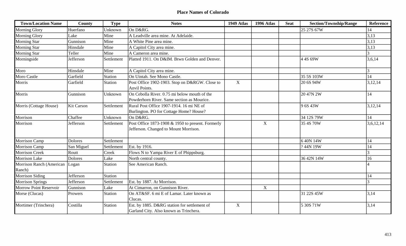
Place Names of Colorado
Town/Location Name County Type Notes 1949 Atlas 1996 Atlas Seat Section/Township/Range ReferenceMorning Glory Huerfano Unknown On D&RG. 25 27S 67W 14Morning Glory Lake Mine A Leadville area mine. At Adelaide. 3,13Morning Star Gunnison Mine A White Pine area mine. 3,13Morning Star Hinsdale Mine A Capitol City area mine. 3,13Morning Star Teller Mine A Cameron area mine. 3Morningside Jefferson Settlement Platted 1911. On D&IM. Btwn Golden and Denver. 4 4S 69W 3,6,14
Moro Hinsdale Mine A Capitol City area mine. 3Moro Castle Garfield Station On Uintah. See Mono Castle. 35 5S 103W 14Morris Garfield Station Post Office 1902-1903. Stop on D&RGW. Close to
Anvil Points.X 20 6S 94W 3,12,14
Morris Gunnison Unknown On Cebolla River. 0.75 mi below mouth of the Powderhorn River. Same section as Mourice.
20 47N 2W 14
Morris (Cottage House) Kit Carson Settlement Rural Post Office 1907-1914. 16 mi NE of Burlington. PO for Cottage Home? House?
9 6S 43W 3,12,14
Morrison Chaffee Unknown On D&RG. 34 12S 79W 14Morrison Jefferson Settlement Post Office 1873-1908 & 1950 to present. Formerly
Jefferson. Changed to Mount Morrison.X 35 4S 70W 3,6,12,14
Morrison Camp Dolores Settlement 6 40N 14W 14Morrison Camp San Miguel Settlement Est. by 1916. ? 44N 19W 14Morrison Creek Routt Creek Flows N to Yampa River E of Phippsburg. 3Morrison Lake Dolores Lake North central county. 36 42N 14W 16Morrison Ranch (American Ranch)
Logan Station See American Ranch. 4
Morrison Siding Jefferson Station 14M i S i J ff S ttl t E t b 1887 At M i 3Morrison Springs Jefferson Settlement Est. by 1887. At Morrison. 3Morrow Point Reservoir Gunnison Lake At Cimarron, on Gunnison River. XMorse (Clucas) Prowers Station On AT&SF. 6 mi E of Lamar. Later known as
Clucas.31 22S 45W 3,14
Mortimer (Trinchera) Costilla Station Est. by 1885. D&RG station for settlement of Garland City. Also known as Trinchera.
X 5 30S 71W 3,14
413

Place Names of Colorado
Town/Location Name County Type Notes 1949 Atlas 1996 Atlas Seat Section/Township/Range ReferenceMosby El Paso Settlement Rural Post Office 1910-1913. 8 mi NE of Ellicott. 17 13S 61W 3,12,14
Mosca Gunnison Unknown Est. by 1937. 14 14S 84W 14Mosca (Fish) Pass (9,713 or 9,740)
Alamosa/Huerfano Pass Btwn Gardner and Gr. Sand Dunes. Sangre de Cristo Range. San Isabel & Rio Grande NF.
X 4 27S 72W 1,3,7,9
Mosca (Streator) Alamosa Settlement Site 2. Post Office est. 1890. Formerly Streator. X 3 39N 10E 1,3,12,14
Mosca Creek Alamosa Creek In far NE corner of county flows from Mosca Pass. 16
Mosca Station (Orean, Moscow City)
Alamosa Station Site 1. Est. by 1848. Stage station and supply center at foot of Mosca Pass.
3,14
Mosco Costilla/Alamosa Settlement Post Office 1880-1882. Also shown at 15 40N 11E. 15 27S 75W 12,14
Moscow Chaffee Unknown Est. by 1881. In Clear Creek District, W of Granite. 14
Moscow (Orean, Montville) Alamosa Station Stage station & 3 stores in 1880. Called Orean & Montville.
14
Moscow (Petersburgh) Gunnison Settlement Platted 1881. Also called Petersburgh. 24 14S 84W 14Moscow City (Mosca, Mosco)
Alamosa Settlement Same as Mosca & Mosco. 14
Moseley Morgan Station Est. by 1916. On BN. 2 mi E of Fort Morgan. 4 3N 57W 3,14Moseley Ranch Lincoln Ranch 3 17S 54W 14Mosquito (Musquito) Park Settlement Est. by 1861. Stage and wagon stop. Near Mosquito
Pass.10 9S 78W 3,14
Mosquito Creek Park Creek Near Park City. Runs through Mosquito Gulch. 13Mosquito Creek Creek Never Summer area 1M it G l h P k G l h SW f Al 3 13Mosquito Gulch Park Gulch SW of Alma. 3,13Mosquito Lake Garfield Lake NE corner of county. White River NF. ?? 1N 87W 16Mosquito Pass (13,181 or 13,188)
Lake/Park Pass In Mosquito Range. Btwn Leadville and Fairplay. X 11 9S 79W 3,5,7,9
Mosquito Peak (13,781) Peak13 Mosquito Range. Climax Quad. 8,11Mosquito Range Chaffee Range E of Sawatch Range. 1,15
414

Place Names of Colorado
Town/Location Name County Type Notes 1949 Atlas 1996 Atlas Seat Section/Township/Range ReferenceMoss Camp (Parrott City) La Plata Camp See Parrott City. 3
Moss Lake Garfield Lake NW corner of county. White River NF. 26 3S 90W 16Mother Comstock La Plata Mine A Parrott City area mine. 3Mound (Mound City) El Paso/Teller Settlement Post Office 1893-1894. 25 15S 70W 12,14Mound City (Mound) Teller Camp Near Rosebud and Brodie Mines. Same as Mound. 25 15S 70W 3,14
Mound Station Logan Station Wells Fargo Stage Station on the Platte Route. 29 mi, 3rd station, SW of Julesburg.
14
Mounds Gunnison Unknown On D&RG, DSP&P. Same section as Steele. 12 49N 1E 14Mount Abrams (12,801) Ouray/San Juan Peak12 SE of Ouray. San Juans, Ouray Group. 3,8( , ) y y , y p ,Mount Achonee Grand Peak12 East central county. Near Boulder Co. Arapaho NF. 4 1N 74W 16
Mount Acoma Grand Peak10 East of Granby Res. Rocky Mtn Natl Park. 34 3N 75W 16Mount Adams Grand Peak12 NE of Granby Res. Front Range, National Park
Section. Rocky Mtn Natl Park.36 3N 75W 8,16
Mount Adams (13,931) Peak13 Sangre de Cristo Range, Main Section. Norn Peak Quad.
8,11
Mount Aetna (13,771) Chaffee Peak13 Sawatch Range, Chalk Creek Shavano Sect. Garfield Quad. San Isabel NF.
17 50N 6E 8,11,16
Mount Alice (13,310) Boulder/Grand Peak13 NW corner of Boulder County. Isolation Peak Quad. ?? 3N 74W 1,8,11,16
Mount Alta (Mount Alta Park)
Boulder Settlement On DB&W. A resort. 15 1N 72W 3,6,14
Mount Alto Boulder Mountain Btwn Four Mile and Left Hand Creeks. 2 mi E of Sunset.
1
M t A t (14 269) Ch ff P k14 S t h R Ch lk C k Sh S t Mt X X 13 51N 6E 1 8 11 16Mount Antero (14,269) Chaffee Peak14 Sawatch Range, Chalk Creek Shavano Sect. Mt. Antero Quad.
X X 13 51N 6E 1,8,11,16
Mount Arkansas (13,795) Peak13 Climax Quad. 11Mount Arthur El Paso Peak10 South of Manitou Springs. Pike NF. 24 14S 68W 16Mount Ashley (12,376) Larimer Peak12 Rawah Range. 8Mount Audubon (13,223) Boulder Peak13 Front Range, Indian Section. 1 mi E of Continental
Divide. Ward Quad.X 31 2N 73W 1,3,8,11,16
415
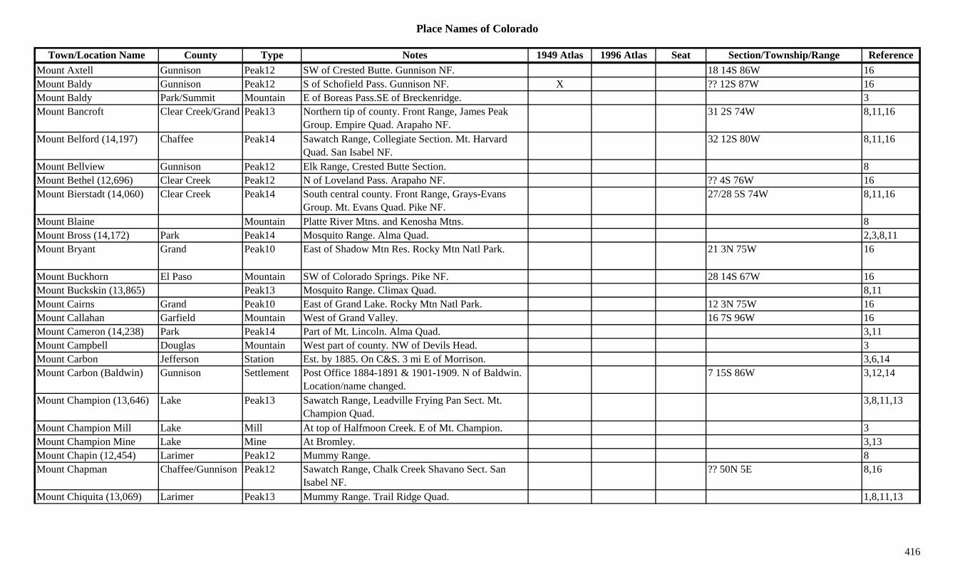
Place Names of Colorado
Town/Location Name County Type Notes 1949 Atlas 1996 Atlas Seat Section/Township/Range ReferenceMount Axtell Gunnison Peak12 SW of Crested Butte. Gunnison NF. 18 14S 86W 16Mount Baldy Gunnison Peak12 S of Schofield Pass. Gunnison NF. X ?? 12S 87W 16Mount Baldy Park/Summit Mountain E of Boreas Pass.SE of Breckenridge. 3Mount Bancroft Clear Creek/Grand Peak13 Northern tip of county. Front Range, James Peak
Group. Empire Quad. Arapaho NF.31 2S 74W 8,11,16
Mount Belford (14,197) Chaffee Peak14 Sawatch Range, Collegiate Section. Mt. Harvard Quad. San Isabel NF.
32 12S 80W 8,11,16
Mount Bellview Gunnison Peak12 Elk Range, Crested Butte Section. 8Mount Bethel (12,696) Clear Creek Peak12 N of Loveland Pass. Arapaho NF. ?? 4S 76W 16Mount Bierstadt (14,060) Clear Creek Peak14 South central county. Front Range, Grays-Evans
Group. Mt. Evans Quad. Pike NF.27/28 5S 74W 8,11,16
Mount Blaine Mountain Platte River Mtns. and Kenosha Mtns. 8Mount Bross (14,172) Park Peak14 Mosquito Range. Alma Quad. 2,3,8,11Mount Bryant Grand Peak10 East of Shadow Mtn Res. Rocky Mtn Natl Park. 21 3N 75W 16
Mount Buckhorn El Paso Mountain SW of Colorado Springs. Pike NF. 28 14S 67W 16Mount Buckskin (13,865) Peak13 Mosquito Range. Climax Quad. 8,11Mount Cairns Grand Peak10 East of Grand Lake. Rocky Mtn Natl Park. 12 3N 75W 16Mount Callahan Garfield Mountain West of Grand Valley. 16 7S 96W 16Mount Cameron (14,238) Park Peak14 Part of Mt. Lincoln. Alma Quad. 3,11Mount Campbell Douglas Mountain West part of county. NW of Devils Head. 3Mount Carbon Jefferson Station Est. by 1885. On C&S. 3 mi E of Morrison. 3,6,14Mount Carbon (Baldwin) Gunnison Settlement Post Office 1884-1891 & 1901-1909. N of Baldwin.
Location/name changed.7 15S 86W 3,12,14
Mount Champion (13,646) Lake Peak13 Sawatch Range, Leadville Frying Pan Sect. Mt. Champion Quad.
3,8,11,13
M t Ch i Mill L k Mill At t f H lf C k E f Mt Ch i 3Mount Champion Mill Lake Mill At top of Halfmoon Creek. E of Mt. Champion. 3Mount Champion Mine Lake Mine At Bromley. 3,13Mount Chapin (12,454) Larimer Peak12 Mummy Range. 8Mount Chapman Chaffee/Gunnison Peak12 Sawatch Range, Chalk Creek Shavano Sect. San
Isabel NF.?? 50N 5E 8,16
Mount Chiquita (13,069) Larimer Peak13 Mummy Range. Trail Ridge Quad. 1,8,11,13
416

Place Names of Colorado
Town/Location Name County Type Notes 1949 Atlas 1996 Atlas Seat Section/Township/Range ReferenceMount Cirrus Grand/Jackson Peak12 North tip of Grand Co. Never Summer Range. Rocky
Mountain Natl Park. Routt NF.3 5N 76W 1,8,16
Mount Columbia Chaffee Peak14 Sawatch Range, Collegiate Section. Mt. Harvard Quad.
24 13S 80W 1,8,11,16
Mount Conundrum (14,060) Pitkin Peak14 Elk Mountains. Part of Castle Peak. Hayden Peak Quad.
11
Mount Craig Grand Peak12 Front Range, National Park Section. SE of Grand Lake. Rocky Mtn Natl Park.
18 3N 74W 8,13,16
Mount Crested Butte Gunnison Settlement Post Office est. 1981. CPO of Crested Butte. X 23 13S 86W 12,14Mount Cullom Moffat Mountain N of Dionsaur National Park. 3Mount Cumulus Grand/Jackson Peak12 North tip of Grand Co. Never Summer Range. Rocky 10 5N 76W 1,16p g y
Mountain Natl Park. Routt NF.,
Mount Daly (13,300) Peak13 Elk Range, Central Section. Capitol Peak Quad. 8,11
Mount Deception (9,363) Teller Mountain Very NE corner of county. 3,13Mount Democrat (14,148) Park Peak14 Mosquito Range. Climax Quad. 3,8,11
Mount Dickinson (11,831) Larimer Peak Rocky Mountain National Park, NE corner. XMount Edwards (13,850) Clear Creek Peak13 NNW of Argentine Pass. Front Range, Grays-Evans
Group. Grays Peak Quad.9 5S 75W 8,11,16
Mount Elbert (14,431 or 14,433)
Lake Peak14 Sawatch Range. SW of Leadville. Mt. Elbert Quad. X X 1,3,8,11
Mount Emma (13,581) Peak13 Sneffels Range. Telluride Quad. 8,11Mount Emmons Gunnison Peak12 WNW of Crested Butte. Gunnison NF. 29 13S 86W 16Mount Emmons (12,392) Peak12 Ruby Range. 8Mount Enentah Grand Peak10 East of Grand Lake. Rocky Mtn Natl Park. 3 3N 75W 16M t E l (14 083) L Pl t P k14 N dl M t i Th G di C l bi P 8 11Mount Eolus (14,083) La Plata Peak14 Needle Mountains. The Grenadiers. Columbine Pass
Quad.8,11
Mount Epworth Grand Peak11 SE county. SW of Rollins Pass. Arapaho NF. 29/32 1S 74W 16Mount Ethel Larimer Mountain S of Poudre Park. 13Mount Ethel (Ethel Peak) (11,924)
Jackson/Routt Mountain S of Mt. Zirkel. At head of Roaring Fork. X X 8
417
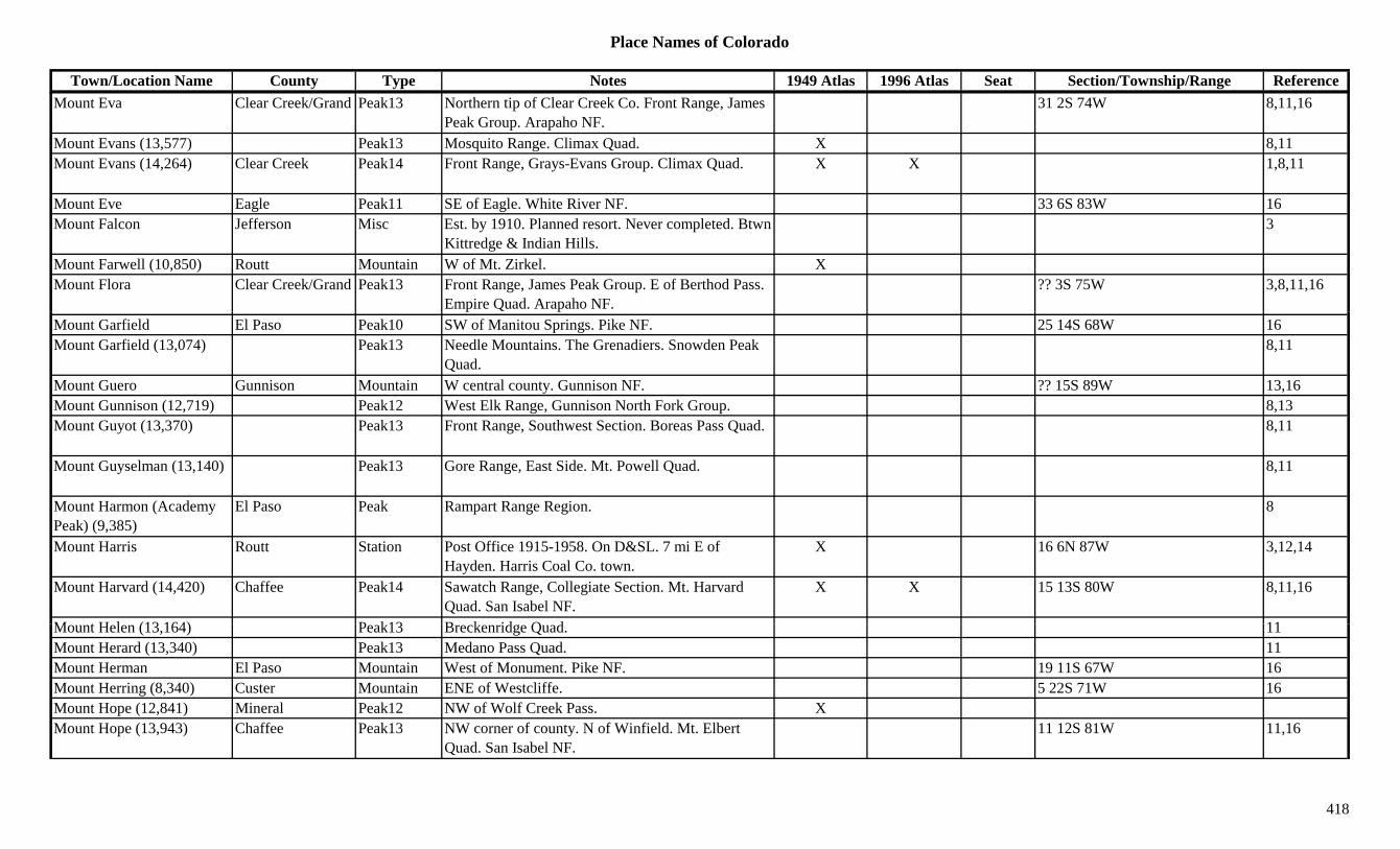
Place Names of Colorado
Town/Location Name County Type Notes 1949 Atlas 1996 Atlas Seat Section/Township/Range ReferenceMount Eva Clear Creek/Grand Peak13 Northern tip of Clear Creek Co. Front Range, James
Peak Group. Arapaho NF.31 2S 74W 8,11,16
Mount Evans (13,577) Peak13 Mosquito Range. Climax Quad. X 8,11Mount Evans (14,264) Clear Creek Peak14 Front Range, Grays-Evans Group. Climax Quad. X X 1,8,11
Mount Eve Eagle Peak11 SE of Eagle. White River NF. 33 6S 83W 16Mount Falcon Jefferson Misc Est. by 1910. Planned resort. Never completed. Btwn
Kittredge & Indian Hills.3
Mount Farwell (10,850) Routt Mountain W of Mt. Zirkel. XMount Flora Clear Creek/Grand Peak13 Front Range, James Peak Group. E of Berthod Pass.
Empire Quad. Arapaho NF.?? 3S 75W 3,8,11,16
Mount Garfield El Paso Peak10 SW of Manitou Springs. Pike NF. 25 14S 68W 16Mount Garfield (13,074) Peak13 Needle Mountains. The Grenadiers. Snowden Peak
Quad.8,11
Mount Guero Gunnison Mountain W central county. Gunnison NF. ?? 15S 89W 13,16Mount Gunnison (12,719) Peak12 West Elk Range, Gunnison North Fork Group. 8,13Mount Guyot (13,370) Peak13 Front Range, Southwest Section. Boreas Pass Quad. 8,11
Mount Guyselman (13,140) Peak13 Gore Range, East Side. Mt. Powell Quad. 8,11
Mount Harmon (Academy Peak) (9,385)
El Paso Peak Rampart Range Region. 8
Mount Harris Routt Station Post Office 1915-1958. On D&SL. 7 mi E of Hayden. Harris Coal Co. town.
X 16 6N 87W 3,12,14
Mount Harvard (14,420) Chaffee Peak14 Sawatch Range, Collegiate Section. Mt. Harvard Quad. San Isabel NF.
X X 15 13S 80W 8,11,16
M t H l (13 164) P k13 B k id Q d 11Mount Helen (13,164) Peak13 Breckenridge Quad. 11Mount Herard (13,340) Peak13 Medano Pass Quad. 11Mount Herman El Paso Mountain West of Monument. Pike NF. 19 11S 67W 16Mount Herring (8,340) Custer Mountain ENE of Westcliffe. 5 22S 71W 16Mount Hope (12,841) Mineral Peak12 NW of Wolf Creek Pass. XMount Hope (13,943) Chaffee Peak13 NW corner of county. N of Winfield. Mt. Elbert
Quad. San Isabel NF.11 12S 81W 11,16
418

Place Names of Colorado
Town/Location Name County Type Notes 1949 Atlas 1996 Atlas Seat Section/Township/Range ReferenceMount Hope (Hope, Independence)
Pitkin Settlement Est. by 1887. Separate site but some called it early name for Independence.
12 11S 83W 3,14
Mount Ida (12,880) Peak12 Front Range, National Park Section. 8Mount Irving Hale Grand Peak11 East central county. E of Granby Res. Front Range,
Indian Section. Arapaho NF.18 2N 74W 8,16
Mount Jackson Eagle Peak13 Sawatch Range, Holy Cross Section. NW of Mt. of the Holy Cross. White River NF.
?? 6S 82W 3,8,11,16
Mount Jasper (12,923) Boulder Peak12 Front Range, James Peak Group. 8Mount Jenkins (Jenkins Mountain)
Chaffee/Gunnison Peak13 Sawatch Range, Collegiate Section. Pieplant Quad. X 8,11
Mount Judge (10,301) Clear Creek Mountain E Clear Creek Co. 13g ( , )Mount Julian (12,928) Peak12 Front Range, National Park Section. 8Mount Justice Gunnison Peak11 NW of Crested Butte. White River/Gunnison NF. ?? 12S 88W 16
Mount Kennedy (13,125) Peak13 Mtn. View Crest Quad. 11Mount Keyer Chaffee Unknown 20 50N 6E 14Mount Kreutzer (13,095) Peak13 Sawatch Range, Collegiate Section. Tincup Quad. 8,11
Mount Lady Washington (13,281)
Peak13 Longs Peak Quad. 11
Mount Lamborn (11,337) Delta Peak11 SE of Paonia. Gunnison NF. 26 14S 91W 16Mount Lamborn (11,395) Mountain West Elk Range, Gunnison North Fork Group. 8Mount Lincoln (14,284 or 14,286)
Park Peak14 Mosquito Range. Alma Quad. X 3,8,11
Mount Lindsey (Old Baldy) (14,042)
Costilla Peak14 Sangre de Cristo Range, Sierra Blancas. Blanca Peak Quad.
?? 28S 72W 3,8,11,16
M t L G fi ld M t i SW f B l N M C 35 7S 97W 3 16Mount Logan Garfield Mountain SW of Balzac. Near Mesa Co. 35 7S 97W 3,16Mount Mamma (13,543) Chaffee Peak13 Sawatch Range, Chalk Creek Shavano Sect. St. Elmo
Quad. San Isabel NF.8 51N 6E 8,11,16
Mount Manitou El Paso Mountain West of Colorado Springs. 2 14S 68W 16Mount Marcy (13,490) Peak13 Sangre de Cristo Range, Main Section. Electric Peak
Quad.8,11
419

Place Names of Colorado
Town/Location Name County Type Notes 1949 Atlas 1996 Atlas Seat Section/Township/Range ReferenceMount Massive (14,418 or 14,421)
Lake Peak14 Sawatch Range. SW of Leadville. Mt. Massive Quad.
X 3,8,11
Mount Maxwell (13,335) Peak13 Culebra Range. East Side. El Valle Creek Quad. 8,11
Mount McClellan Clear Creek/Summit
Settlement Est. by 1924. At summit of Argentine Pass. 33 4S 75W 3,14
Mount McClellan (13,587) Clear Creek Peak13 North of Argentine Pass. Arapaho NF. 4 5S 75W 13,16
Mount Meeker (13,911) Boulder Peak13 Front Range, National Park Section. 1 mi SE of Long's Peak. Allens Park Quad.
?? 3N 73W 1,8,11,16
Mount Meridian Eagle/Summit Peak12 Gore Range, East Side. NE corner of Eagle Co. 30 3S 80W 8,16g g , gArapaho/White River NF.
,
Mount Mestas (11,569) Mountain Sangre de Cristo Range, Sierra Blancas. 8Mount Morrison (Morrison) Jefferson Settlement Post Office 1908-1950. Formerly Morrison.
Renamed Morrison.X 35 4S 70W 3,12,14
Mount Moss (13,192) Peak13 La Plata Range. La Plata Quad. 8,11Mount Nebo (13,205) Peak13 Storm King Peak Quad. 11Mount Nevo (Mt. Neva) Boulder/Grand Peak12 Front Range, James Peak Group. SW corner of
county. Roosevelt NF.32 1N 74W 1,8,16
Mount Niedhardt (12,863) Peak12 Sangre de Cristo Range, San Luis Valley Side. 8Mount Nimbus Grand/Jackson Peak12 North tip of Grand Co. Never Summer Range. Rocky
Mountain Natl Park. Arapaho NF.15 5N 76W 1,8,16
Mount Nystrom Grand Peak12 Front Range, Clear Creek Group. W of Berthoud Pass. Arapaho NF.
?? 3S 76W 8,16
Mount of the Holy Cross Eagle Peak14 Sawatch Range. SW of Redcliff. Mt. of Holy Cross Quad. White River NF.
X 6 7S 81W 1,8,11,16
M t Okl h (13 845) P k13 Mt Ch i Q d 11Mount Oklahoma (13,845) Peak13 Mt. Champion Quad. 11
Mount Olivet Jefferson Station Est. by 1920. On D&IM. 4 mi W of Clear Creek Junction.
17 3S 69W 3,14
Mount Orno Garfield Peak12 NE corner of county. Routt NF. 1 1N 87W 16Mount Orno Routt Mountain On southern border near Rio Blanco Co. S of
Dunkley.3
420

Place Names of Colorado
Town/Location Name County Type Notes 1949 Atlas 1996 Atlas Seat Section/Township/Range ReferenceMount Orton (11,682) Boulder Peak11 NW corner of county. Rocky Mountain Natl Park. 13 3N 74W 16
Mount Oso (Hunchback Peak) (13,684)
La Plata Peak13 NE corner of county. Emerald Lake Quad. 3,11
Mount Ouzel (Ouzel Peak) (12,979 or 12,716)
Boulder Peak12 Front Range, National Park Section. In Rocky Mt. Natl. Park.
?? 3N 74W 1,8,16
Mount Owen Gunnison Peak13 NW of Crested Butte. Gunnison NF. ?? 13S 87W 16Mount Owen (13,058) Peak13 Ruby Range. Oh Be Joyful Quad. 8,11Mount Owen (13,387) Saguache Peak13 Sangre de Cristo Range, San Luis Valley Side.
Electric Peak Quad.8,11,13
Mount Oxford (14,153) Chaffee Peak14 Sawatch Range, Collegiate Section. Mt. Harvard 33 12S 80W 8,11,16( , ) g , gQuad. San Isabel NF.
, ,
Mount Patterson Grand Peak11 NE of Grand Lake. Rocky Mtn Natl Park. 16/21 4N 75W 16Mount Pearl Cheyenne Settlement Rural Post Office 1911-1923. 15 mi N of Kit Carson. 32 12S 48W 3,12,14
Mount Pisgah (Pisgha) Clear Creek/Gilpin Mountain N of Fall River. NW of Russell Gulch. Borders Gilpin County. Arapaho NF.
?? 3S 73W 3,16
Mount Pittsburg El Paso/Fremont Mountain NW corner of Fremont Co. SW corner of El Paso Co.
31 16S 67W 16
Mount Pleasant Dolores Mine Near Dunton. 3Mount Powell Eagle/Summit Peak13 Gore Range, East Side. S of Heeney. Mt. Powell
Quad. Arapaho/White River NF.X ?? 3S 80W 3,8,11,16
Mount Powell (13,208) Peak13 Front Range, National Park Section. McHenrys Peak Quad.
8,11
Mount Princeton Chaffee Settlement Post Office 1889-1899. At Mt. Princeton Hot Springs. Hotel Post Office.
19 15S 78W 12,14
M t P i t (14 197) Ch ff P k14 S t h R Ch lk C k Sh S t Mt X X 17 15S 79W 8 11 16Mount Princeton (14,197) Chaffee Peak14 Sawatch Range, Chalk Creek Shavano Sect. Mt. Antero Quad. San Isabel NF.
X X 17 15S 79W 8,11,16
Mount Princeton Hot Springs
Chaffee Settlement Post Office 1926-1936. Also called Haywood Hot Springs, Heywood, Hayword & more.
X X 19 15S 78W 3,12,14
Mount Rhoda (13,402) Peak13 Howardsville Quad. 11Mount Richthofen Grand/Jackson Peak12 North tip of Grand Co. Never Summer Range. Rocky
Mountain Natl Park.X 23 6N 76W 8,16
421

Place Names of Colorado
Town/Location Name County Type Notes 1949 Atlas 1996 Atlas Seat Section/Township/Range ReferenceMount Ridgway (13,468) Peak13 Sneffels Range. Mt. Sneffels Quad. 8,11Mount Ritchey Gunnison Peak12 North central county. White River NF. ?? 11S 87W 16Mount Rosa Placer Teller Mine A Victor area mine. 3,13Mount Rosa Placer Claim Teller Settlement Original name for Victor, before 1893. 29 15S 69W 14Mount Saint Vrain (12,162) Boulder Peak12 NW corner of county. SW of Allenspark. Roosevelt
NF.5 2N 73W 3,16
Mount Seven (13,350) Peak13 Sangre de Cristo Range, Main Section. 8Mount Shavano (14,229) Chaffee Peak14 Sawatch Range, Chalk Creek Shavano Sect.
Maysville Quad. San Isabel NF.X X 6 50N 7E 1,8,11,16
Mount Sheridan (13,748) Peak13 Mosquito Range. Mt. Sherman Quad. 8,11Mount Sherman (14,036) Lake/Park Peak14 Mosquito Range. Mt. Sherman Quad. 3,8,11( , ) q g Q , ,Mount Silex (13,628) Peak13 Needle Mountains. The Grenadiers. Storm King
Peak Quad.8,11
Mount Silverheels (13,822) Park Peak13 Front Range, Southwest Section. N of Fairplay. Alma Quad.
3,8,11
Mount Sneffels (14,150) Ouray Peak14 Sneffels Range. Mt. Sneffels Quad. 1,3,8,11Mount Sneffels (Sneffels) Ouray Settlement Post Office 1879-1895. Changed to Sneffels. 15 43N 8W 3,12,14Mount Sneffels Mining District
Ouray Mine At Ouray. 2
Mount Sniktau (13,234) Clear Creek Peak13 NE of Loveland Pass. Grays Peak Quad. Arapaho NF.
?? 4S 76W 3,11,16
Mount Sopris (Sopris Peak) (12,823)
Pitkin Peak12 Elk Range, Crystal River Area. Near Aspen. Discovered in July 1860.
1,3,8
Mount Spaulding (13,842) Peak13 Mt. Evans Quad. 11Mount St. Francis El Paso Unknown 3 13S 67W 14Mount Stratus (12,520) Larimer Peak12 Never Summer Range. 1,8M t St t M ff t S ttl t P t Offi 1919 1921 S ll t 1 i E f 2 3N 93W 3 12 14Mount Streeter Moffat Settlement Post Office 1919-1921. Small town 1 mi E of
modern site of Streeter.2 3N 93W 3,12,14
Mount Sunflower (4,025) Cheyenne Hill NE corner of county. On KA border. 18/19 12S 41W 16Mount Susan (8,467) Clear Creek Mountain Southeastern corner of county. W of Brookvale. 8 5S 72W 16
Mount Thomas Eagle Peak11 S of Eagle. Near Pitkin Co. White River NF. ?? 7S 83W 3,16
422

Place Names of Colorado
Town/Location Name County Type Notes 1949 Atlas 1996 Atlas Seat Section/Township/Range ReferenceMount Toll Boulder/Grand Peak12 Front Range, Indian Section. Btwn Piaute and
Pawnee Peaks. Arapaho/Roosevelt NF.1 1N 74W 1,8,16
Mount Trelease (12,503) Clear Creek Peak12 NW of Loveland Pass. Arapaho NF. ?? 4S 76W 16Mount Tweto (13,672) Peak13 Climax Quad. 11Mount Valois (13,185) Peak13 Columbine Pass Quad. 11Mount Vernon KT/Jefferson Settlement Post Office 1860-1885 with gaps. At mouth of
Mount Vernon Canyon. Also at 22 4S 70W.12 4S 71W 3,6,12,14
Mount Vigil El Paso Peak10 SW of Colorado Springs. WSW of Cheyenne Mtn. Pike NF.
19 15S 67W 16
Mount Warren (13,330) Clear Creek Peak13 South of Echo Park. Mt. Evans Quad. Arapaho NF. 23 5S 74W 11,16
Mount Watanga Grand Peak12 East of Granby Reservoir. Arapaho NF. 6 2N 74W 16Mount Wescott Grand Peak10 East of Shadow Mtn Res. Rocky Mtn Natl Park. 14 3N 75W 16
Mount Wheatstone (Whetstone Mountain)
Gunnison Peak12 South of Crested Butte. Gunnison NF. 23 14S 86W 16
Mount White (13,667) Peak13 Sawatch Range, Chalk Creek Shavano Sect. Mt. Antero Quad.
8,11
Mount Whitely Grand Mountain NW parto of county. 3Mount Wilcox (13,412) Clear Creek Peak13 East of Argentine Pass. Montezuma Quad. Arapaho
NF.14 5S 75W 11,13,16
Mount Willoughby (13,142) Peak13 Elk Range, Central Section. Highland Park Quad. 8,11
Mount Wilson (14,246) Dolores Peak14 San Juan Mountains. Mt. Wilson Quad. X 5 41N 10W 3,8,11,16Mount Wilson Placer Mining Co.
San Miguel Mine A Placerville operation. 3
M t Y l (14 196) Ch ff P k14 S t h R C ll i t S ti Mt Y l Q d X X 11 14S 80W 8 11 16Mount Yale (14,196) Chaffee Peak14 Sawatch Range, Collegiate Section. Mt. Yale Quad. San Isabel NF.
X X 11 14S 80W 8,11,16
Mount Zion Lake Mountain E of Keeldar. 3Mount Zirkel (12,180) Jackson/Routt Peak12 SW of Helena. X X 3,8Mountain Boy Park/Gulch Lake Gulch S of Independence Pass. 3
Mountain Chief Chaffee Mine At Babcock. 3,13
423

Place Names of Colorado
Town/Location Name County Type Notes 1949 Atlas 1996 Atlas Seat Section/Township/Range ReferenceMountain City (Central City)
KT/Gilpin Settlement Post Office 1860-1869. Changed to Central City. 0.5 mi E of Central City.
x 2,3,12,13,14
Mountain City (Denver) Denver Settlement Denver first known as Mountain City. 1Mountain Home Costilla Unknown 31 30S 71W 14Mountain Home Reservoir Costilla Lake SE of Fort Garland, on Trinchera River. X X 36 30S 72W + 16
Mountain King Hinsdale Mine A Tellurium area mine. 3,13Mountain King Ouray Mine A Guston area mine. 3,13Mountain Lion Boulder Mine Near Magnolia. 1,2,3,13Mountain Lion Saguache Mine An Oriental area mine. 3Mountain Meadows Park Park 1885. S of Shawnee. 3Mountain Monarch Gilpin Mine Gambell Gulch area. 3Mountain Park Jefferson Settlement Post Office 1966-1978. 12Mountain Queen San Juan Mine Silverton area mine. 3Mountain Ranch Las Animas Ranch See Mayfield's. 14Mountain Springs Dolores Mine Near Rico. 3Mountain View El Paso Station Stop on Pikes Peak Railway. 10 14S 68W 3,14Mountain View Hinsdale Mine A Sherman area mine. 3,13Mountain View Larimer Unknown 9 7N 69W 14Mountain View (Berkeley) Jefferson Settlement Platted 1888 (as Berkeley). N of Inspiration Point. 24 3S 69W 3,6,14
Mountain View Townsite Fremont Settlement 1 mi NE of New Hope Church. Didn't develop. Location shown is New Hope.
35 20S 69W 14
Mountaindale Park Settlement Site 1. Post Office 1880-1899. 12 mi SE of Como. 13 10S 73W 3,12,14
Mountaindale Park Settlement Site 2. Est. by 1887. Same general location as d T ll
3modern Tarryall.
Mountaineer Boulder Mine At Wall Street. 3Mountaineer San Juan Mine A Howardsville area mine. 3Mountainia Denver Settlement Early name for Montana City. 5.5 mi above Cherry
Creek on South Platte River.28 4S 68W 14
Mountaintop Ouray Mine W of Ouray. Near Dallas Peak. 3Mountainvale Jefferson Settlement Est. 1858. At Table Mountain. 14
424
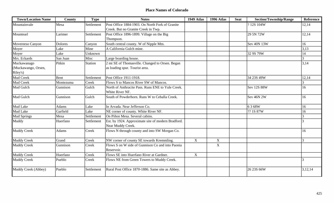
Place Names of Colorado
Town/Location Name County Type Notes 1949 Atlas 1996 Atlas Seat Section/Township/Range ReferenceMountainvale Mesa Settlement Post Office 1884-1903. On North Fork of Granite
Creek. But no Granite Creek in Twp.? 12S 104W 12,14
Mountearl Larimer Settlement Post Office 1896-1899. Village on the Big Thompson.
29 5N 72W 12,14
Movereeso Canyon Dolores Canyon South central county. W of Nipple Mtn. Sev 40N 13W 16Moyer Lake Mine A California Gulch mine. 3,13Moyer Lake Unknown 32 9S 79W 14Mrs. Eckards San Juan Misc Large boarding house. 3Muckawanago (Muckawango, Orsen, Riley's)
Pitkin Station 2 mi SE of Thomasville. Changed to Orsen. Began as loading spur. Tourist area.
3,14
Mud Creek Bent Settlement Post Office 1911-1918. 34 23S 49W 12,14Mud Creek Montezuma Creek Flows S to Mancos River SW of Mancos. 3Mud Gulch Gunnison Gulch North of Anthracite Pass. Runs ENE to Yule Creek.
White River NF.Sev 12S 88W 16
Mud Gulch Gunnison Gulch South of Powderhorn. Runs W to Ceballa Creek. Sev 46N 2W 16
Mud Lake Adams Lake In Arvada. Near Jefferson Co. 6 3 68W 16Mud Lake Garfield Lake NE corner of county. White River NF. ?? 1S 87W 16Mud Springs Mesa Settlement On Piñon Mesa. Several cabins. 3Muddy Huerfano Settlement Est. by 1924. Approximate site of modern Bradford.
Near Muddy Creek.3
Muddy Creek Adams Creek Flows N through county and into SW Morgan Co. 16
Muddy Creek Grand Creek NW corner of county SE towards Kremmling. X X 3Muddy Creek Gunnison Creek Flows S on W side of Gunnison Co and into Paonia
R iX
Reservoir.Muddy Creek Huerfano Creek Flows SE into Huerfano River at Gardner. XMuddy Creek Pueblo Creek Flows NE from Green Towers to Muddy Creek. 3
Muddy Creek (Abbey) Pueblo Settlement Rural Post Office 1870-1886. Same site as Abbey. 26 23S 66W 3,12,14
425
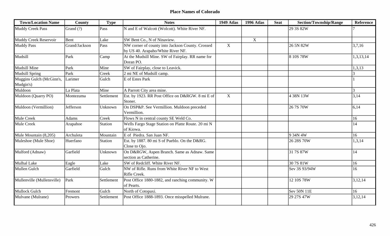
Place Names of Colorado
Town/Location Name County Type Notes 1949 Atlas 1996 Atlas Seat Section/Township/Range ReferenceMuddy Creek Pass Grand (?) Pass N and E of Walcott (Wolcott). White River NF. 29 3S 82W 7
Muddy Creek Reservoir Bent Lake SW Bent Co., N of Ninaview. XMuddy Pass Grand/Jackson Pass NW corner of county into Jackson County. Crossed
by US 40. Arapaho/White River NF.X 26 5N 82W 3,7,16
Mudsill Park Camp At the Mudsill Mine. SW of Fairplay. RR name for Doran PO.
8 10S 78W 1,3,13,14
Mudsill Mine Park Mine SW of Fairplay, close to Leavick. 1,3,13Mudsill Spring Park Creek 2 mi NE of Mudsill camp. 3Muggins Gulch (McGinn's, Mudgin's)
Larimer Gulch E of Estes Park 1
Muldoon La Plata Mine A Parrott City area mine. 3Muldoon (Quarry PO) Montezuma Settlement Est. by 1923. RR Post Office on D&RGW. 8 mi E of
Stoner.X 4 38N 13W 3,14
Muldoon (Vermillion) Jefferson Unknown On DSP&P. See Vermillion. Muldoon preceded Vermillion.
26 7S 70W 6,14
Mule Creek Adams Creek Flows N in central county SE Weld Co. 16Mule Creek Arapahoe Station Wells Fargo Stage Station on Platte Route. 20 mi N
of Kiowa.14
Mule Mountain (8,205) Archuleta Mountain E of Piedra. San Juan NF. 9 34N 4W 16Muleshoe (Mule Shoe) Huerfano Station Est. by 1887. 80 mi S of Pueblo. On the D&RG.
Close to Ojo.26 28S 70W 1,3,14
Mulford (Adnaw) Garfield Unknown On D&RGW, Aspen Branch. Same as Adnaw. Same section as Catherine.
31 7S 87W 14
Mulhal Lake Eagle Lake SW of Redcliff. White River NF. 30 7S 81W 16Mullen Gulch Garfield Gulch NW of Rifle. Runs from White River NF to West
Rifl C kSev 3S 93/94W 16
Rifle Creek.Mullenville (Mullensville) Park Settlement Post Office 1880-1882, and ranching community. W
of Pearts.12 10S 78W 3,12,14
Mullock Gulch Fremont Gulch North of Cotopaxi. Sev 50N 11E 16Mulvane (Mulrane) Prowers Settlement Post Office 1888-1893. Once misspelled Mulrane. 29 27S 47W 3,12,14
426

Place Names of Colorado
Town/Location Name County Type Notes 1949 Atlas 1996 Atlas Seat Section/Township/Range ReferenceMummy Mountain (13,425) Larimer Peak13 Mummy Range. Estes Park Quad. X 8,11
Mummy Pass (11,260 or 11,280)
Larimer Pass E of Cameron Pass. NW of Estes Park. Comanche Peak Topo. Rocky Mtn Natl Park.
5,7
Mummy Range Larimer Range W of Loveland. 1,15Munger Garfield Unknown On East Salt Creek on Douglas Pass Road. ? 7S 102W 14Munroe Park Adams Settlement Platted 1892. Next to Hohnville. 14Muriel Huerfano Settlement Post Office 1903-1906. On D&RG. At Rouse
Junction.33 28S 65W 3,12,14
Murnane (Marnane) La Plata Settlement Post Office 1882-1886. 5 mi S of San Juan County. Same section as Young.
2 38N 9W 3,12,14
Murpheys Jefferson Station Est. by 1876. On CC. N of Golden. 14Murphy Teller Settlement X 19 13S 69W 14Murphy (Murphy's Switch) Chaffee Station On DSP&P. 2.3 mi W of St. Elmo. Same as
Murphy's Switch.14
Murphy Creek Arapahoe Creek Flows N to join Sand Creek NE of Buckley Naval Air Station.
16
Murphy Mine Chaffee Mine Pomeroy Gulch. Near Pomery Mtn. 8Murphys Dolores Settlement Est. by 1923. 4 mi N of Rico. On RGS RR. 26 41N 10W 3,14Murphy's Switch (Murphy, Romley)
Chaffee Settlement Post Office 1886-1924. 3 mi S of Saint Elmo. See Murphy.
13 51N 6E 2,3,14
Murray Lake Clear Creek Lake SW corner of county. W of Guanella Pass. Arapaho NF.
23 5S 75W 16
Murray's Morgan Station Wells Fargo Stage Station on Platte Route. 14Murray's San Miguel Station Waystop. On San Miguel Road. W of Placerville. 3
M ll S J U k O D&RG 29 41N 7W 14Murrell San Juan Unknown On D&RG. 29 41N 7W 14Music City (Sand Creek) Saguache Camp At foot of Music Pass. N of the Sand Dunes. 2.5 mi
E of Liberty.1,3,14
Music Mountain (Peak) (13,380)
Peak13 Sangre de Cristo Range, Main Section. Crestone Peak Quad.
8,11
427

Place Names of Colorado
Town/Location Name County Type Notes 1949 Atlas 1996 Atlas Seat Section/Township/Range ReferenceMusic Pass (11,800) Custer/Saguache Pass Btwn Wet Mtn Valley and San Luis Valley.
Crestone Peak Topo. Rio Grande & San Isabel NF.25 24S 73W 3,5,7,9,16
Muskeg Teller Unknown On CM. 10 13S 70W 14Muskoka Kit Carson Station Est. by 1916. RR Stop. 6 mi W of Bethune. X 35 8S 46W 3,14Muskrat Lake Garfield Lake NE corner of county. White River NF. ?? 1S 87W 16Musquito (Mosquito) Park Settlement Est. by 1861. Near Mosquito Pass. 3Musser Camp Mesa Settlement ? 50N 16SW 14Mustang Lincoln Unknown On CRI&P. 13 9S 56W 14Mustang Pueblo Settlement Site of Standard Fire Brick Co. 14Mustang (Larimer) Huerfano Settlement Post Office on C&S & D&RG 1914-1940. Formerly X 8 25S 65W 3,12,14g ( ) y
Larimer. 4 mi NE of Lascar., ,
Mustang Creek Las Animas Creek Flows N from near Patt and into NE Baca County. 3
Mustang Creek Otero Creek Flows N & E to join Apishapa River S of Fowler. 3
Mustang Creek Pueblo Creek Flows from Las Animas Co. NE to Hardesty Res. 3
Mutual Huerfano Unknown On D&RG. 18 28S 66W 14Myers El Paso Settlement Post Office 1891-1894. 12,14Myers Gulch Gunnison Gulch NW of Blue Mesa Res. Runs S to Gunnison River. Sev 49N 5W 16
Myrtle Pueblo Settlement Rural Post Office 1906-1913. 3 mi SE of Stone City. 19 18S 66W 3,12,14
Mystery San Juan Mine Silverton area mine. 3Mystic Routt Settlement Post Office 1910-1942. NW of Steamboat Springs.
Al h t 2 7N 86W14 7N 86W 3,12,14
Also shown at 2 7N 86W.Mystic Island Lake Eagle Lake South central county. SW of Redcliff. White River
NF.?? 7S 82W 16
N. Y. Tunnel Pitkin Tunnel An Aspen area mine. 3Nada Garfield Settlement On D&RG. Station & settlement. 14Nada Pueblo Station Est. by 1885. On D&RGW. 4 mi N of Pueblo. 13 20S 65W 3,14
428
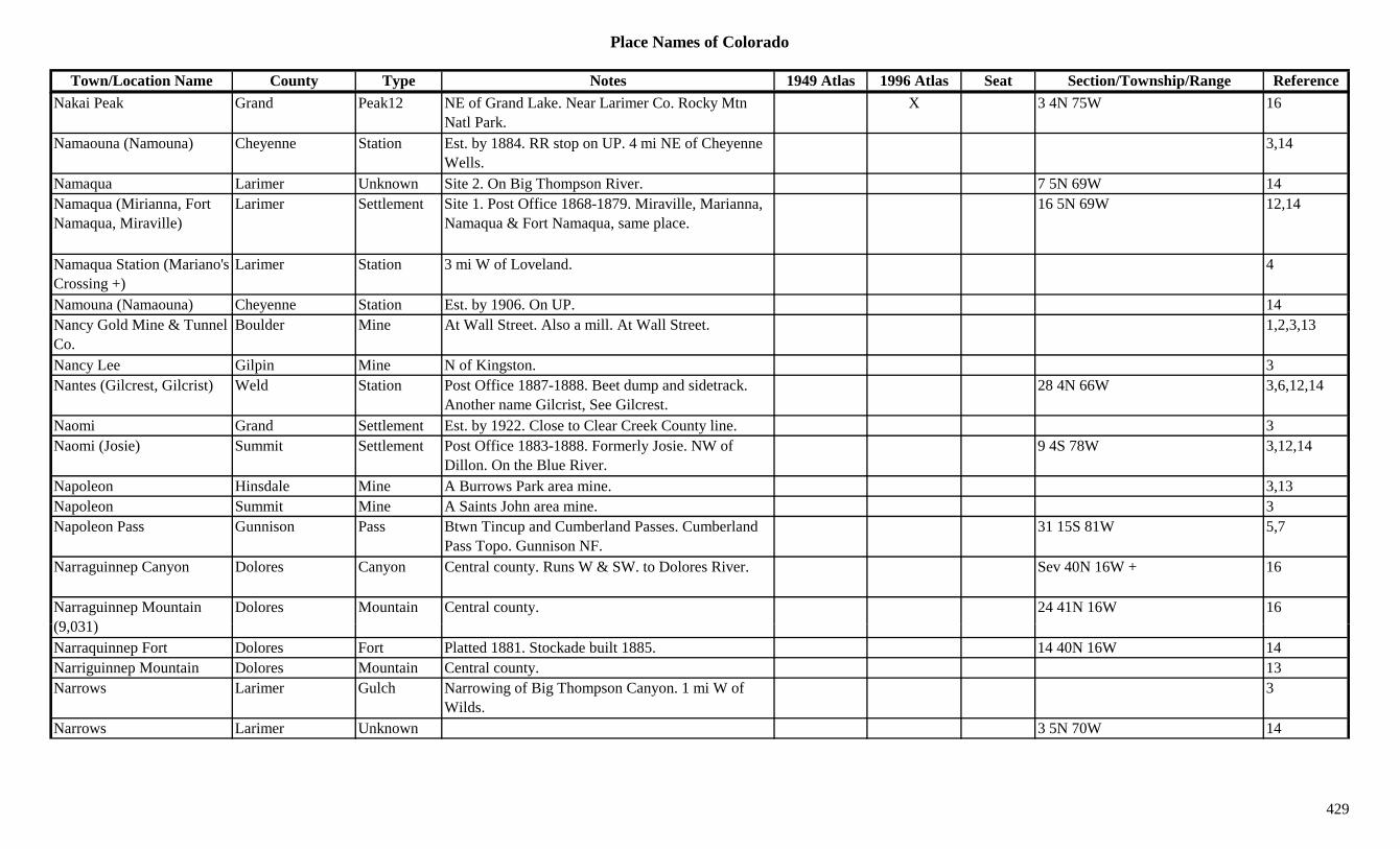
Place Names of Colorado
Town/Location Name County Type Notes 1949 Atlas 1996 Atlas Seat Section/Township/Range ReferenceNakai Peak Grand Peak12 NE of Grand Lake. Near Larimer Co. Rocky Mtn
Natl Park.X 3 4N 75W 16
Namaouna (Namouna) Cheyenne Station Est. by 1884. RR stop on UP. 4 mi NE of Cheyenne Wells.
3,14
Namaqua Larimer Unknown Site 2. On Big Thompson River. 7 5N 69W 14Namaqua (Mirianna, Fort Namaqua, Miraville)
Larimer Settlement Site 1. Post Office 1868-1879. Miraville, Marianna, Namaqua & Fort Namaqua, same place.
16 5N 69W 12,14
Namaqua Station (Mariano's Crossing +)
Larimer Station 3 mi W of Loveland. 4
Namouna (Namaouna) Cheyenne Station Est. by 1906. On UP. 14( ) y yNancy Gold Mine & Tunnel Co.
Boulder Mine At Wall Street. Also a mill. At Wall Street. 1,2,3,13
Nancy Lee Gilpin Mine N of Kingston. 3Nantes (Gilcrest, Gilcrist) Weld Station Post Office 1887-1888. Beet dump and sidetrack.
Another name Gilcrist, See Gilcrest.28 4N 66W 3,6,12,14
Naomi Grand Settlement Est. by 1922. Close to Clear Creek County line. 3Naomi (Josie) Summit Settlement Post Office 1883-1888. Formerly Josie. NW of
Dillon. On the Blue River.9 4S 78W 3,12,14
Napoleon Hinsdale Mine A Burrows Park area mine. 3,13Napoleon Summit Mine A Saints John area mine. 3Napoleon Pass Gunnison Pass Btwn Tincup and Cumberland Passes. Cumberland
Pass Topo. Gunnison NF.31 15S 81W 5,7
Narraguinnep Canyon Dolores Canyon Central county. Runs W & SW. to Dolores River. Sev 40N 16W + 16
Narraguinnep Mountain (9 031)
Dolores Mountain Central county. 24 41N 16W 16(9,031)Narraquinnep Fort Dolores Fort Platted 1881. Stockade built 1885. 14 40N 16W 14Narriguinnep Mountain Dolores Mountain Central county. 13Narrows Larimer Gulch Narrowing of Big Thompson Canyon. 1 mi W of
Wilds.3
Narrows Larimer Unknown 3 5N 70W 14
429

Place Names of Colorado
Town/Location Name County Type Notes 1949 Atlas 1996 Atlas Seat Section/Township/Range ReferenceNarrows Morgan Station Est. by 1916. On UP. 8 mi NW of Fort Morgan. 7 4N 58W 3,14
Nast Pitkin Station Post Office 1909-1918. On CM. 6 9S 82W 3,12,14Nathrop Boulder Unknown Just N of Lafayette. ? 1N 69W 14Nathrop (Chalk Creek) Chaffee Settlement Post Office est. 1880. RR station and stage stop. 8
mi S Buena Vista. Formerly Chalk Creek.X X 14 15S 78W 2,12,14
National Weld Station On UP. 5 mi SE of Lafayette. 15 1N 68W 6,14National Belle Ouray Mine At Red Mountain. 2,3,13National Carvers Museum El Paso Museum At Monument. X
National City Lake Camp Gold Mining Camp. Near Leadville. 1National City (Bug Town, International Camp)
Routt Camp Twin to Hahns Peak. 2 mi from Poverty Bar. In Ways Gulch.
3,14
National Company Gilpin Unknown Est. by 1866. On E side of Mammouth Gulch. Near Mammouth & Morse Hill.
14
Native Silver Boulder Mine A Caribou area mine. 13Native Silver Gunnison Mine A Gothic area mine. 3Natural Fort Larimer Hill Natural Fort 3 mi S CO/WY border. Near I-25.
Natural outcropping.1,9
Natural Hot Springs Pool Eagle Misc At Glenwood Springs. XNaturita (Chipeta) Montrose Settlement Post Office est. 1882. Formerly Chipeta. X X 19 46N 15W 3,12,14Naturita Creek Montrose Creek Flows NW to join San Miguel River W of Naturita. 3
Naturita Creek San Miguel Creek Flows N through county. Past Norwood. 3Naturita Ridge San Miguel Hill N central county. 13N h P k A h l t P k SE f t NE f Ch 3Navaho Peak Archuleta Peak SE corner of county. NE of Chromo. 3Navaho Springs (Navajo Springs, Towaoc)
Montezuma Settlement Post Office 1910-1915. Changed to Towaoc. See Navajo Springs.
14
Navajo Archuleta Unknown Est. by 1881. On Rio Navajo. 2 mi N of the RR. ? 32N 1E 14
Navajo Basin Dolores Lake NE corner of county. N of Rico, near San Miguel Co.
5 41N 10W 16
430
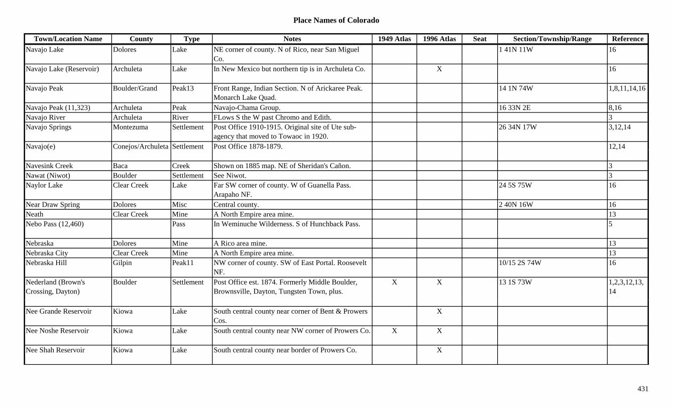
Place Names of Colorado
Town/Location Name County Type Notes 1949 Atlas 1996 Atlas Seat Section/Township/Range ReferenceNavajo Lake Dolores Lake NE corner of county. N of Rico, near San Miguel
Co.1 41N 11W 16
Navajo Lake (Reservoir) Archuleta Lake In New Mexico but northern tip is in Archuleta Co. X 16
Navajo Peak Boulder/Grand Peak13 Front Range, Indian Section. N of Arickaree Peak. Monarch Lake Quad.
14 1N 74W 1,8,11,14,16
Navajo Peak (11,323) Archuleta Peak Navajo-Chama Group. 16 33N 2E 8,16Navajo River Archuleta River FLows S the W past Chromo and Edith. 3Navajo Springs Montezuma Settlement Post Office 1910-1915. Original site of Ute sub-
agency that moved to Towaoc in 1920.26 34N 17W 3,12,14
Navajo(e) Conejos/Archuleta Settlement Post Office 1878-1879. 12,14j ( ) j ,
Navesink Creek Baca Creek Shown on 1885 map. NE of Sheridan's Cañon. 3Nawat (Niwot) Boulder Settlement See Niwot. 3Naylor Lake Clear Creek Lake Far SW corner of county. W of Guanella Pass.
Arapaho NF.24 5S 75W 16
Near Draw Spring Dolores Misc Central county. 2 40N 16W 16Neath Clear Creek Mine A North Empire area mine. 13Nebo Pass (12,460) Pass In Weminuche Wilderness. S of Hunchback Pass. 5
Nebraska Dolores Mine A Rico area mine. 13Nebraska City Clear Creek Mine A North Empire area mine. 13Nebraska Hill Gilpin Peak11 NW corner of county. SW of East Portal. Roosevelt
NF.10/15 2S 74W 16
Nederland (Brown's Crossing, Dayton)
Boulder Settlement Post Office est. 1874. Formerly Middle Boulder, Brownsville, Dayton, Tungsten Town, plus.
X X 13 1S 73W 1,2,3,12,13,14
Nee Grande Reservoir Kiowa Lake South central county near corner of Bent & Prowers Cos.
X
Nee Noshe Reservoir Kiowa Lake South central county near NW corner of Prowers Co. X X
Nee Shah Reservoir Kiowa Lake South central county near border of Prowers Co. X
431
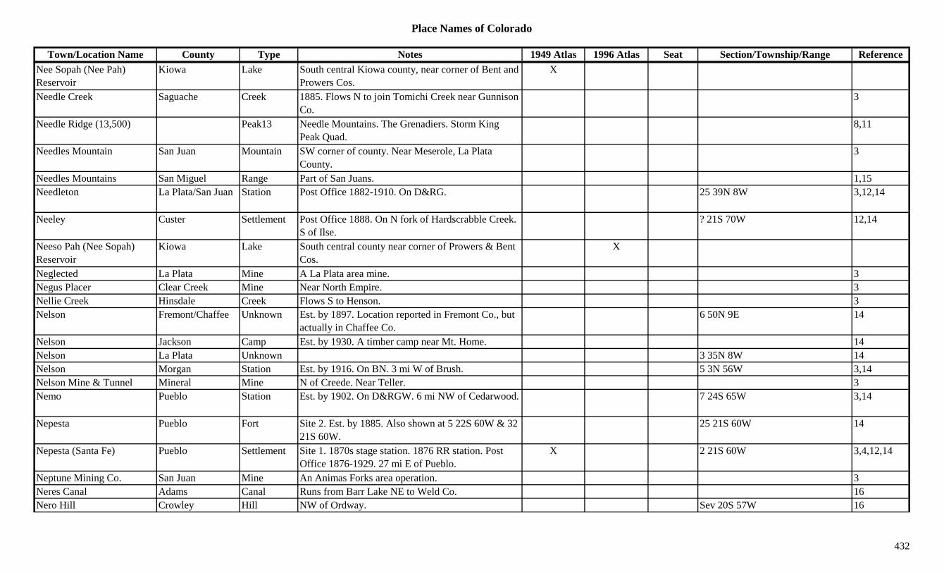
Place Names of Colorado
Town/Location Name County Type Notes 1949 Atlas 1996 Atlas Seat Section/Township/Range ReferenceNee Sopah (Nee Pah) Reservoir
Kiowa Lake South central Kiowa county, near corner of Bent and Prowers Cos.
X
Needle Creek Saguache Creek 1885. Flows N to join Tomichi Creek near Gunnison Co.
3
Needle Ridge (13,500) Peak13 Needle Mountains. The Grenadiers. Storm King Peak Quad.
8,11
Needles Mountain San Juan Mountain SW corner of county. Near Meserole, La Plata County.
3
Needles Mountains San Miguel Range Part of San Juans. 1,15Needleton La Plata/San Juan Station Post Office 1882-1910. On D&RG. 25 39N 8W 3,12,14
Neeley Custer Settlement Post Office 1888. On N fork of Hardscrabble Creek. S of Ilse.
? 21S 70W 12,14
Neeso Pah (Nee Sopah) Reservoir
Kiowa Lake South central county near corner of Prowers & Bent Cos.
X
Neglected La Plata Mine A La Plata area mine. 3Negus Placer Clear Creek Mine Near North Empire. 3Nellie Creek Hinsdale Creek Flows S to Henson. 3Nelson Fremont/Chaffee Unknown Est. by 1897. Location reported in Fremont Co., but
actually in Chaffee Co.6 50N 9E 14
Nelson Jackson Camp Est. by 1930. A timber camp near Mt. Home. 14Nelson La Plata Unknown 3 35N 8W 14Nelson Morgan Station Est. by 1916. On BN. 3 mi W of Brush. 5 3N 56W 3,14Nelson Mine & Tunnel Mineral Mine N of Creede. Near Teller. 3Nemo Pueblo Station Est. by 1902. On D&RGW. 6 mi NW of Cedarwood. 7 24S 65W 3,14
N t P bl F t Sit 2 E t b 1885 Al h t 5 22S 60W & 32 25 21S 60W 14Nepesta Pueblo Fort Site 2. Est. by 1885. Also shown at 5 22S 60W & 32 21S 60W.
25 21S 60W 14
Nepesta (Santa Fe) Pueblo Settlement Site 1. 1870s stage station. 1876 RR station. Post Office 1876-1929. 27 mi E of Pueblo.
X 2 21S 60W 3,4,12,14
Neptune Mining Co. San Juan Mine An Animas Forks area operation. 3Neres Canal Adams Canal Runs from Barr Lake NE to Weld Co. 16Nero Hill Crowley Hill NW of Ordway. Sev 20S 57W 16
432
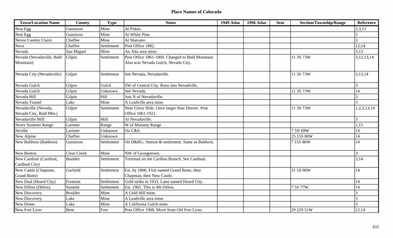
Place Names of Colorado
Town/Location Name County Type Notes 1949 Atlas 1996 Atlas Seat Section/Township/Range ReferenceNest Egg Gunnison Mine At Pitkin. 2,3,13Nest Egg Gunnison Mine At White Pine. 2Netsie Castley Claim Chaffee Mine At Shavano. 3Neva Chaffee Settlement Post Office 1882. 12,14Nevada San Miguel Mine An Alta area mine. 3,13Nevada (Nevadaville, Bald Mountain)
Gilpin Settlement Post Office 1861-1869. Changed to Bald Mountain. Also was Nevada Gulch, Nevada City.
11 3S 73W 3,12,13,14
Nevada City (Nevadaville) Gilpin Settlement See Nevada, Nevadaville. 11 3S 73W 3,13,14
Nevada Gulch Gilpin Gulch SW of Central City. Runs into Nevadville. 3p yNevada Gulch Gilpin Unknown See Nevada. 11 3S 73W 14Nevada Hill Gilpin Hill Just N of Nevadaville. 3Nevada Tunnel Lake Mine A Leadville area mine. 3Nevadaville (Nevada, Nevada City, Bald Mtn.)
Gilpin Settlement Near Glory Hole. Once larger than Denver. Post Office 1861-1921.
11 3S 73W 1,2,3,13,14
Nevadaville Mill Gilpin Mill At Nevadaville. 3Never Summer Range Larimer Range W of Mummy Range 1,15Neville Larimer Unknown On C&S. 7 5N 69W 14New Alpine Chaffee Unknown 25 15S 80W 14New Baldwin (Baldwin) Gunnison Settlement On D&RG. Station & settlement. Same as Baldwin. 7 15S 86W 14
New Boston Clear Creek Mine NW of Georgetown. 3New Cardinal (Cardinal, Cardinal City)
Boulder Settlement Terminal on the Caribou Branch. See Cardinal. 3,14
New Castle (Chapman, G d B tt )
Garfield Settlement Est. by 1866. First named Grand Butte, then Ch th N C tl
31 5S 90W 14Grand Butte) Chapman, then New Castle.New Deal (Hoard City) Fremont Settlement Gold strike in 1933. Later named Hoard City. 14New Dillon (Dillon) Summit Settlement Est. 1965. This is 4th Dillon. 7 5S 77W 14New Discovery Boulder Mine A Gold Hill mine. 3New Discovery Lake Mine A Leadville area mine. 3New Dome Lake Mine A California Gulch mine. 3New Fort Lyon Bent Fort Post Office 1908. Move from Old Fort Lyon. 29 22S 51W 12,14
433
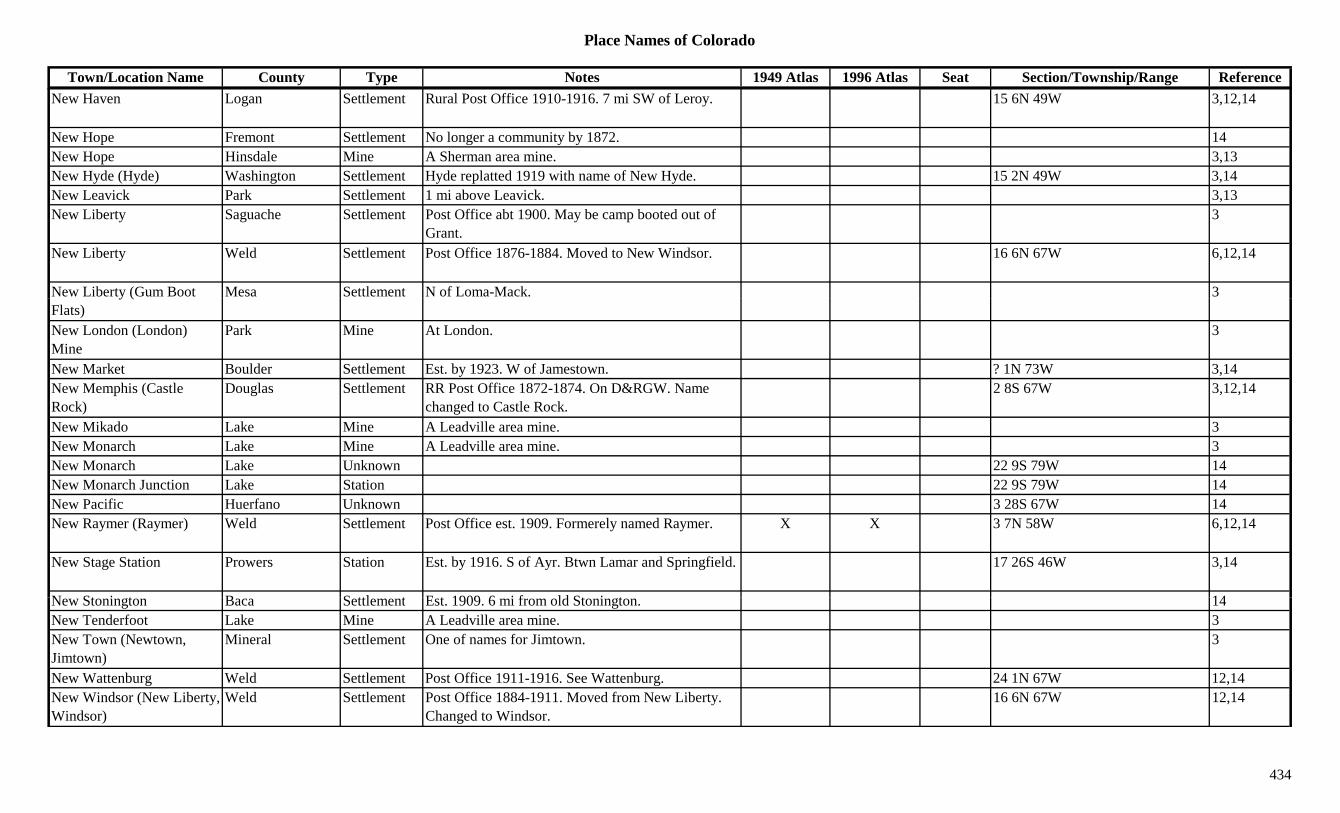
Place Names of Colorado
Town/Location Name County Type Notes 1949 Atlas 1996 Atlas Seat Section/Township/Range ReferenceNew Haven Logan Settlement Rural Post Office 1910-1916. 7 mi SW of Leroy. 15 6N 49W 3,12,14
New Hope Fremont Settlement No longer a community by 1872. 14New Hope Hinsdale Mine A Sherman area mine. 3,13New Hyde (Hyde) Washington Settlement Hyde replatted 1919 with name of New Hyde. 15 2N 49W 3,14New Leavick Park Settlement 1 mi above Leavick. 3,13New Liberty Saguache Settlement Post Office abt 1900. May be camp booted out of
Grant.3
New Liberty Weld Settlement Post Office 1876-1884. Moved to New Windsor. 16 6N 67W 6,12,14
New Liberty (Gum Boot Mesa Settlement N of Loma-Mack. 3y (Flats)New London (London) Mine
Park Mine At London. 3
New Market Boulder Settlement Est. by 1923. W of Jamestown. ? 1N 73W 3,14New Memphis (Castle Rock)
Douglas Settlement RR Post Office 1872-1874. On D&RGW. Name changed to Castle Rock.
2 8S 67W 3,12,14
New Mikado Lake Mine A Leadville area mine. 3New Monarch Lake Mine A Leadville area mine. 3New Monarch Lake Unknown 22 9S 79W 14New Monarch Junction Lake Station 22 9S 79W 14New Pacific Huerfano Unknown 3 28S 67W 14New Raymer (Raymer) Weld Settlement Post Office est. 1909. Formerely named Raymer. X X 3 7N 58W 6,12,14
New Stage Station Prowers Station Est. by 1916. S of Ayr. Btwn Lamar and Springfield. 17 26S 46W 3,14
N St i t B S ttl t E t 1909 6 i f ld St i t 14New Stonington Baca Settlement Est. 1909. 6 mi from old Stonington. 14New Tenderfoot Lake Mine A Leadville area mine. 3New Town (Newtown, Jimtown)
Mineral Settlement One of names for Jimtown. 3
New Wattenburg Weld Settlement Post Office 1911-1916. See Wattenburg. 24 1N 67W 12,14New Windsor (New Liberty, Windsor)
Weld Settlement Post Office 1884-1911. Moved from New Liberty. Changed to Windsor.
16 6N 67W 12,14
434

Place Names of Colorado
Town/Location Name County Type Notes 1949 Atlas 1996 Atlas Seat Section/Township/Range ReferenceNew York Eagle Mine New York Cabins area mine. 3,13New York Gilpin Mine A Rollinsville area mine. 13New York Gunnison Mine An Elko area mine. 3New York Mineral Mine 3New York Summit Mine At Montezuma. 2,3New York Cabins Eagle Camp Near mines on New York Mountains. In Bowman
Gulch.12 6S 82.5W 3,14
New York Lake Eagle Lake South central county. W of Redcliff. White River NF.
?? 6S 82W 16
New York Mountain Eagle Peak12 Sawatch Range, Holy Cross Section. 8,13New York Mountains Range Part of Sawatch Range. 15g gNew York Pass (12,460) Pass In Sawatch Range. W of Independence Pass. 5,7New York Peak (12,811) Peak12 Elk Range, Central Section. 8Newark City Summit Mine A Conger area mine. 3,13Newberry (Strontia Springs) Douglas/Jefferson Unknown On DSP&P. Early name for Strontia Springs. 20 7S 69W 6,14
Newberry Gulch Fremont Gulch North central county. Sev 16S 72W 16Newcastle (New Castle, Grand Butte, Chapman)
Garfield Settlement Est. 1884. Post Office est. 1888. Formerly Chapman. X X 3,12
Newcomb Conejos Settlement Post Office 1884-1886. Moved from Old La Jara. 2 mi NE of original La Jara.
7 35N 9E 3,12,14
Newcomb (East Portal) Gilpin Station Est. by 1924. On D&RG. Name for East Portal. 1 mi W of Ladora.
2 2S 74W 3,14
Newcomb Creek Jackson Creek Flows E to Hebron & La Rand. 3Newdale Otero Station Est. by 1909. On AT&SF. 2 mi NW of Swink. 22 23S 56W 3,14Newell Lake Station Est. by 1913. On D&RG. On Orange St. in
L d ill24 9S 80W 14
Leadville.Newett Chaffee Unknown Site 2. On CM. 28 13S 77W 14Newett (Higgins) Chaffee Settlement Site 1. Post Office 1895-1893 & 1903-1918.
Formerly Higgins. On Trout Creek.3 14S 77W 3,12,14
Newfield (McFerran) El Paso Settlement Post Office 1896-1898. Moved from McFerran. 1 mi S Franceville.
11 14S 65W 3,12,14
Newfoundland Gilpin Mine A Central City mine. 3
435
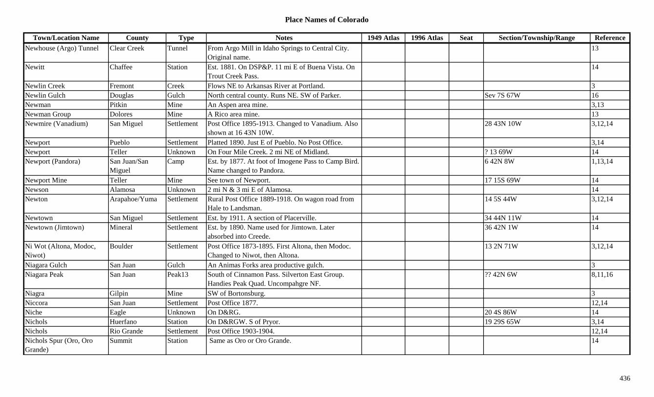
Place Names of Colorado
Town/Location Name County Type Notes 1949 Atlas 1996 Atlas Seat Section/Township/Range ReferenceNewhouse (Argo) Tunnel Clear Creek Tunnel From Argo Mill in Idaho Springs to Central City.
Original name.13
Newitt Chaffee Station Est. 1881. On DSP&P. 11 mi E of Buena Vista. On Trout Creek Pass.
14
Newlin Creek Fremont Creek Flows NE to Arkansas River at Portland. 3Newlin Gulch Douglas Gulch North central county. Runs NE. SW of Parker. Sev 7S 67W 16Newman Pitkin Mine An Aspen area mine. 3,13Newman Group Dolores Mine A Rico area mine. 13Newmire (Vanadium) San Miguel Settlement Post Office 1895-1913. Changed to Vanadium. Also
shown at 16 43N 10W.28 43N 10W 3,12,14
Newport Pueblo Settlement Platted 1890. Just E of Pueblo. No Post Office. 3,14p ,Newport Teller Unknown On Four Mile Creek. 2 mi NE of Midland. ? 13 69W 14Newport (Pandora) San Juan/San
MiguelCamp Est. by 1877. At foot of Imogene Pass to Camp Bird.
Name changed to Pandora.6 42N 8W 1,13,14
Newport Mine Teller Mine See town of Newport. 17 15S 69W 14Newson Alamosa Unknown 2 mi N & 3 mi E of Alamosa. 14Newton Arapahoe/Yuma Settlement Rural Post Office 1889-1918. On wagon road from
Hale to Landsman.14 5S 44W 3,12,14
Newtown San Miguel Settlement Est. by 1911. A section of Placerville. 34 44N 11W 14Newtown (Jimtown) Mineral Settlement Est. by 1890. Name used for Jimtown. Later
absorbed into Creede.36 42N 1W 14
Ni Wot (Altona, Modoc, Niwot)
Boulder Settlement Post Office 1873-1895. First Altona, then Modoc. Changed to Niwot, then Altona.
13 2N 71W 3,12,14
Niagara Gulch San Juan Gulch An Animas Forks area productive gulch. 3Niagara Peak San Juan Peak13 South of Cinnamon Pass. Silverton East Group.
Handies Peak Quad. Uncompahgre NF.?? 42N 6W 8,11,16
Ni Gil i Mi SW f B t b 3Niagra Gilpin Mine SW of Bortonsburg. 3Niccora San Juan Settlement Post Office 1877. 12,14Niche Eagle Unknown On D&RG. 20 4S 86W 14Nichols Huerfano Station On D&RGW. S of Pryor. 19 29S 65W 3,14Nichols Rio Grande Settlement Post Office 1903-1904. 12,14Nichols Spur (Oro, Oro Grande)
Summit Station Same as Oro or Oro Grande. 14
436

Place Names of Colorado
Town/Location Name County Type Notes 1949 Atlas 1996 Atlas Seat Section/Township/Range ReferenceNicholson Lake Gunnison Lake North of Crested Butte. 28 13S 86W 16Niegoldstown San Juan Settlement Post Office 1878-1881. 18 41N 6W 12,14Niegoldtown (Niegoldston) San Juan Settlement 7.5 mi from Silverton. Had Post Office. 3
Nigger Baby Hill Dolores Camp At Phoenix Mine. A mining area rather than a town, although listed as a settlement.
24 40N 11W 14
Nigger Baby Hill Dolores Mine Mining area at Rico. 3Nigger Gulch Gunnison Camp Est. by 1922. Along Spring Creek. NE of Almont. 3
Nigger Gulch (Barney Ford Gulch)
Summit Camp 1 mi E of Breckenridge. On French Ridge. Name changed to Barney Ford Gulch.
1,14
Nigger Gulch (Barney Ford Gulch)
Summit Gulch 1 mi E of Breckenridge. On French Gulch. 3
Nigger Hill Gilpin Hill NW of Central City. 3Nigger Mountain (11,195) Conejos Mountain Center of county. XNiggerhead Huerfano Settlement On D&RG. Post Office 1913-?? 24 28S 67W 12,14Night Hawk Jefferson Settlement Est. by 1923. S of South Platte. 3Nighthawk (Bethesda) Douglas/Jefferson Station On DSP&P. End of branch. Also known as
Bethesda.7 8S 69W 14
Nile Reservoir Adams Lake Essentially a dry lake bed. N central county. 15/22 1S 60W 16Nile's Lake Mine A Leadville area mine. 3Ninaview Bent Settlement Rural Post Office 1915-1965. 30 mi S of Las
Animas.X 33 27S 52W 3,12,14
Nine Mile Bottom (Higbee) Otero Settlement First name for Higbee. See Higbee. 16 26S 54W 4,14
Nine Mile Camp Otero/Crowley Camp Est. by 1893. 6 19S 58W 14Ni Mil C M U k 18 2N 55W 14Nine Mile Corner Morgan Unknown 18 2N 55W 14Nine Mile Gap Rio Blanco Settlement Settlement 12 mi N of Meeker. X 9 2N 93W 3,14Nine Mile House Arapahoe Station Stage station on Smoky Hill South Stage Route.
Under water (Cherry Creek Reservoir).3,6,14
Nine Mile House Chaffee Station Stop on Cottonwood Pass Trail. 3,14Nine Mile House Lake Station Est. by 1887. 6 mi S & 1 mi W of Leadville. In
Empire Gulch.? 10S 80W 3,14
437
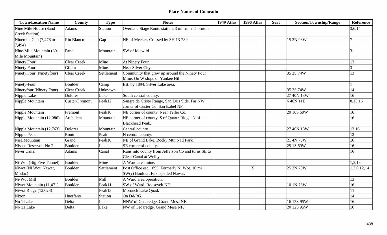
Place Names of Colorado
Town/Location Name County Type Notes 1949 Atlas 1996 Atlas Seat Section/Township/Range ReferenceNine Mile House (Sand Creek Station)
Adams Station Overland Stage Route station. 3 mi from Thornton. 3,6,14
Ninemile Gap (7,476 or 7,494)
Rio Blanco Gap NE of Meeker. Crossed by SH 13-789. 15 2N 98W 7
Nine-Mile Mountain (39-Mile Mountain)
Park Mountain SW of Idlewild. 3
Ninety Four Clear Creek Mine At Ninety Four. 13Ninety Four Gilpin Mine Near Silver City. 3Ninety Four (Ninetyfour) Clear Creek Settlement Community that grew up around the Ninety Four
Mine. On W slope of Yankee Hill.35 2S 74W 13
Ninety-Four Boulder Camp Est. by 1894. Silver Lake area. 1y p yNinetyfour (Ninety Four) Clear Creek Unknown 35 2S 74W 14Nipple Lake Dolores Lake South central county. 27 40N 13W 16Nipple Mountain Custer/Fremont Peak12 Sangre de Cristo Range, San Luis Side. Far NW
corner of Custer Co. San Isabel NF.6 46N 11E 8,13,16
Nipple Mountain Fremont Peak10 NE corner of county. Near Teller Co. 20 16S 69W 16Nipple Mountain (12,086) Archuleta Mountain NE corner of county. S of Quartz Ridge. N of
Blackhead Peak.16
Nipple Mountain (12,763) Dolores Mountain Central county. 27 40N 13W 13,16Nipple Peak Routt Peak N central county. 13Nisa Mountain Grand Peak10 NE of Grand Lake. Rocky Mtn Natl Park. 21 4N 75W 16Nissen Reservoir No 2 Boulder Lake SE corner of county. 25 1S 69W 16Niver Canal Adams Canal Runs into county from Jefferson Co and turns SE to
Clear Canal at Welby.16
Ni-Wot (Big Five Tunnel) Boulder Mine A Ward area mine. 1,3,13Niwot (Ni Wot, Nawat, M d )
Boulder Settlement Post Office est. 1895. Formerly Ni Wot. 10 mi SW(?) B ld Fi t ll d N t
X 25 2N 70W 1,3,6,12,14Modoc) SW(?) Boulder. First spelled Nawat.Ni-Wot Mill Boulder Mill A Ward area operation. 13Niwot Mountain (11,471) Boulder Peak11 SW of Ward. Roosevelt NF. 10 1N 73W 16Niwot Ridge (13,023) Peak13 Monarch Lake Quad. 11Nixon Huerfano Station On D&RG. 14No 1 Lake Delta Lake NNW of Cedaredge. Grand Mesa NF. 16 12S 95W 16No 11 Lake Delta Lake NW of Cedaredge. Grand Mesa NF. 20 12S 95W 16
438

Place Names of Colorado
Town/Location Name County Type Notes 1949 Atlas 1996 Atlas Seat Section/Township/Range ReferenceNo 12 Lake Delta Lake NW of Cedaredge. Grand Mesa NF. 20 12S 95W 16No 2 Lake Delta Lake NNW of Cedaredge. Grand Mesa NF. 16 12S 95W 16No 4 Lake Delta Lake NNW of Cedaredge. Grand Mesa NF. 21/16 12S 95W 16No 6 Lake Delta Lake NNW of Cedaredge. Grand Mesa NF. 20 12S 95W 16No Name Boulder Camp N of Caribou. Settlement & mine. 1,3No Name Boulder Mine A Caribou mine. 3,13No Name Park Mine A Puma area mine. 3No Name Gulch Eagle Gulch SE corner of county. White River NF. Sev 7S 80W 16No Name Lake Conejos Lake West central county. Rio Grande NF. ?? 34N 4E 16No Name Pass (10,100) Huerfano Pass Btwn Cuchara and San Luis Valley. 9No Name Resort Larimer Unknown 35 10N 76W 14No Thoroughfare Cañon Mesa Canyon Shown on 1885 map. From Glade Park NE to Grand
Junction.3
Nob Hill Arapahoe Settlement Est. by 1875. Unincorp. metro area. SE of Cherry Knolls.
14
Noel (Aurora, Dallas Divide)
San Miguel Settlement Post Office 1909-1923. Moved from Dallas Divide. On RGS. E of Sams.
X 1 44N 10W 3,12,14
Nokhu Crags (12,485) Larimer Peak12 Near Cameron Pass. Never Summer Range. 1,8Nola (Adair, Laub) Las Animas Unknown On C&S. Also called Adair & Laub. 15 34S 60W 14Nola Siding (Laub) Las Animas Station Same location as Laub. 3Nolan Grant Pueblo Misc Est. by 1885. Land grant surrounding Pueblo (city). 3
Noland Archuleta Unknown On D&RG. Also shown at 11 34N 3W. 26 35N 3W 14Noland (Tower) Boulder Settlement Post Office 1890-1901. Stone Quary NE of Lyons.
First called Tower. Shown at 13 1N 69W.5 3N 70W 3,6,12,14
N l ' C k C E l C E l f F lf d S C F lf d 35 10N 76W 3 14Nolan's Creek Camp (Fulford, Camp Fulford)
Eagle Camp Early name for Fulford. See Camp Fulford. 35 10N 76W 3,14
Noodle Heads Douglas Hill 3 Mountains. SE of Nighthawk. Pike NF. 19/30 8S 69W 16Nor. Farm Rio Grande Settlement Est. by 1923. 5 mi N of Monte Vista. 3Norfolk Larimer Station Est. by 1916. On C&S. 6 mi S of Wyoming line. X 23 11N 68W 3,14
439

Place Names of Colorado
Town/Location Name County Type Notes 1949 Atlas 1996 Atlas Seat Section/Township/Range ReferenceNorfolk Creek Ouray Creek Flows E to Uncompahgre River btwn Ouray and
Portland.3
Norfolk Creek Ouray Settlement Est. by 1885. N of Ouray. 3Norfolk Smelter Ouray Unknown On D&RG. 24 44N 8W 14Norland Conejos Unknown ? 36N 8E 14Norma Rio Grande Settlement Post Office 1896-1899. 10 mi N of Monte Vista. ? 40N 8E 12,14
Normal Weld Unknown On DL&NW, GW. Now part of Greeley. 8 5N 65W 14Norman Costilla Settlement Post Office 1890. 12,14Norrie Pitkin Settlement Post Office 1894-1918. Started as 1890s lumber
camp.28 8S 83W 3,12,14
Norris Garfield Unknown On D&RG. Btwn Rulison & Lacy. Misspelling of Morris. See Morris.
30 6S 94W 14
Norris Vein San Juan Mine A Mineral Point area mine. 3North American Pitkin Mine At Ashcroft. 2North Arapaho Peak (13,502)
Boulder Peak13 Front Range, Indian Section. Near Arapaho Pass. Monarch Lake Quad.
?? 1N 74W 1,8,11,16
North Avondale (Avondale Station)
Pueblo Settlement Post Office 1917-1976. Became rural station of Pueblo. Post Office on MP. N of Avondale.
X 32 20S 62W 3,12,14
North Baldy Gunnison Peak12 West central county. SW of Crested Butte. Gunnison NF.
?? 51N 3W 16
North Baldy Mountain (12,850)
Peak12 West Elks, Ohio Creek Group. 8
North Cheyenne El Paso Unknown On CS&CCD. 32 15S 67W 14North Cheyenne Canyon El Paso Canyon SW of Colorado Springs. North Cheyenne Park. Pike
NF.Sev 14S 67W 16
N th C d (C d t Mi l S ttl t E t b 1891 P t Offi 1908 1919 M d f X 25 42N 1W 3 12 13 14North Creede (Creedetown, Upper Creede)
Mineral Settlement Est. by 1891. Post Office 1908-1919. Moved from Creede. Continuation of Willow. Annexed.
X 25 42N 1W 3,12,13,14
North Creek Douglas Camp Est. by 1924. Small Westcreek mining camp. 3North Creek Mesa Creek Flows S to West Creek. 3North Crestone Saguache Settlement On Post Office directory around 1900. 6 43N 12E 3,14North Cripple Creek Douglas Camp Est. by 1924. Small Westcreek mining camp. 1 11S 69W 3,14
440
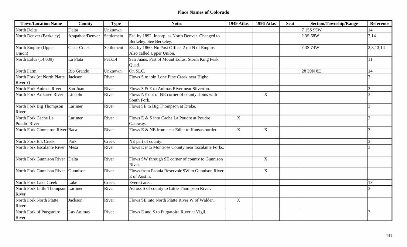
Place Names of Colorado
Town/Location Name County Type Notes 1949 Atlas 1996 Atlas Seat Section/Township/Range ReferenceNorth Delta Delta Unknown 7 15S 95W 14North Denver (Berkeley) Arapahoe/Denver Settlement Est. by 1892. Incorp. as North Denver. Changed to
Berkeley. See Berkeley.? 3S 68W 3,14
North Empire (Upper Union)
Clear Creek Settlement Est. by 1860. No Post Office. 2 mi N of Empire. Also called Upper Union.
? 3S 74W 2,3,13,14
North Eolus (14,039) La Plata Peak14 San Juans. Part of Mount Eolus. Storm King Peak Quad.
11
North Farm Rio Grande Unknown On SLC. 28 39N 8E 14North Fork (of North Platte River ?)
Jackson River Flows S to join Lone Pine Creek near Higho. 3
North Fork Animas River San Juan River Flows S & E to Animas River near Silverton. 3North Fork Arikaree River Lincoln River Flows NE out of NE corner of county. Joins with
South Fork.X 3
North Fork Big Thompson River
Larimer River Flows SE to Big Thompson at Drake. 3
North Fork Cache La Poudre River
Larimer River Flows E & S into Cache La Poudre at Poudre Gateway.
X 3
North Fork Cimmaron River Baca River Flows E & NE from near Edler to Kansas border. X X 3
North Fork Elk Creek Park Creek NE part of county. 3North Fork Escalante River Mesa River Flows E into Montrose County near Escalante Forks. 3
North Fork Gunnison River Delta River Flows SW through SE corner of county to Gunnison River.
X
North Fork Gunnison River Gunnison River Flows from Paonia Reservoir SW to Gunnison River E of Austin.
X
N th F k L k C k L k C k E tt 13North Fork Lake Creek Lake Creek Everett area. 13North Fork Little Thompson River
Larimer River Across S of county to Little Thompson River. 3
North Fork North Platte River
Jackson River Flows SE into North Platte River W of Walden. X
North Fork of Purgatoire River
Las Animas River Flows E and S to Purgatoire River at Vigil. 3
441

Place Names of Colorado
Town/Location Name County Type Notes 1949 Atlas 1996 Atlas Seat Section/Township/Range ReferenceNorth Fork Republican River
Yuma River From SW of Wray, through Wray and E into KS. X
North Fork Smoky Hill Kit Carson Creek Flows out of Cheyenne Co ENE through S Kit Carson to KS.
X X
North Fork South Platte River
Park River Flows SE through Bailey to Jefferson Co. 3
North Fork Store Baca Unknown 22 33S 46W 14North Fort Morgan Morgan Station Est. by 1902. On UP. 1 mi N of Fort Morgan. See
Deuel.6 3N 57W 3,14
North Foster Gulch Custer Gulch Far S central county. Runs NE. Sev 24S 72W 16North Fowler Crowley Unknown On MP. 4 22S 59W 14yNorth Italian Mountain Gunnison Mountain N part of county. Btwn Gothic and Dorchester.
Gunnison NF.?? 13S 84W 3,16
North Junction Baca Station On AT&SF. 14North La Junta Otero Settlement N of La Junta. 35 23S 55W 3,14North La Veta Pass (9,413) Costilla/Huerfano Pass Crossed by US 160. X 14 28S 70W 16
North London Mine & Mill Park Mine An Alma area mine. 3,13
North Mamm Peak Garfield Peak10 South central county. Near Mesa Co. White River NF.
X ?? 8S 94W 16
North Maroon Peak Pitkin Peak14 North of Crested Butte. Elk Range, Central Section. Maroon Bells Quad. White River NF.
?? 11S 86W 8,11,16
North Mountain (10,500) San Miguel Mountain S central county. On border. XNorth Mountain (12,754) Rio Grande Mountain N of Summitville. 13North Moyer Lake Mine A Leadville area mine. 3N th M L k U k O D&RG 30 9S 79W 14North Moyer Lake Unknown On D&RG. 30 9S 79W 14North Near Draw Spring Dolores Misc Central county. 36 41N 16W 16North Park Range Jackson Range 1North Pass Pitkin/Gunnison Pass Btwn E & W Maroon Passes. N of Crested Butte. 7
442

Place Names of Colorado
Town/Location Name County Type Notes 1949 Atlas 1996 Atlas Seat Section/Township/Range ReferenceNorth Pass (Cochetopa North) (10,149)
Saguache Pass SW of Sargents. N of Cochetopa Pass. Crossed by SH 114. Gunnison & Rio Grande NF.
X 30 46N 4E 7
North Pawnee Creek Logan Creek Flows S & E to South Platte River near Hatfield's Island.
3
North Pawnee Creek Weld Creek NE corner of county. Flows SE of Logan Co. 3North Pawnee Pass (4,411) Logan Pass Crossed by county road. Pawnee Hills. 26 8N 55W
North Pella (Hygiene) Boulder Settlement Est. by 1885. 5 mi N of present site of Hygiene. 3,14
North Platte River Jackson River Flows into Wyoming near Pinkhamton. X X 3y gNorth Plum Gulch Delta Gulch South & SW of Hotchkiss. Runs WNW. Sev 15S 93W + 16North Pole El Paso Settlement Post Office est. 1956. Rural branch of Colorado
Springs, then Cascade.22 13S 68W 12,14
North Pole Mountain (12,208)
Peak12 Sneffels Range. 8
North Rawah Peak (12,473) Boulder Peak12 Rawah Range. 8
North Rush Creek Lincoln Creek Flows out of Elbert Co. E of Amy to join Rush Creek N of Wezel.
3
North Ryder Peak Grand/Jackson Mountain NW corner of Grand Co. SE of Arapaho Pass. Arapaho NF.
27 5N 81W 16
North Saddle Peak (10,000) Delta Peak10 East of Crawford. Gunnison NF. 26 15S 91W 16
North Saddle Peak (9,728) Peak West Elk Range, Gunnison North Fork Group. 8
N th S i t V i B ld C k Fl E N t f t t L 3North Saint Vrain Boulder Creek Flows E across N part of county to Lyons. 3North Sheep Mountian Eagle/Summit Peak12 NE of Tennesee Pass. Arapaho/White River NF. ?? 7S 79W 16
North Star Grand Mine At Lulu. 2North Star Gunnison Mine A Gothic area mine. 3North Star Park Mine A Silver Heels area mine. 3North Star San Juan Mine A Middleton area mine. (King Solomon) 3
443
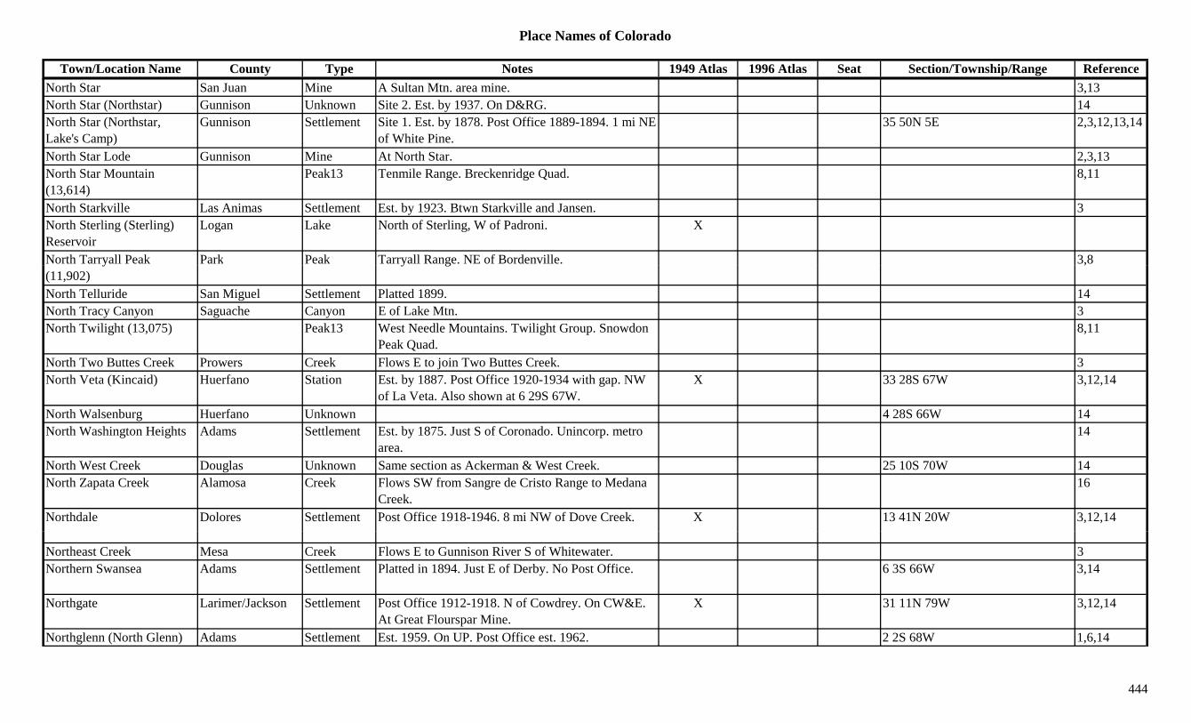
Place Names of Colorado
Town/Location Name County Type Notes 1949 Atlas 1996 Atlas Seat Section/Township/Range ReferenceNorth Star San Juan Mine A Sultan Mtn. area mine. 3,13North Star (Northstar) Gunnison Unknown Site 2. Est. by 1937. On D&RG. 14North Star (Northstar, Lake's Camp)
Gunnison Settlement Site 1. Est. by 1878. Post Office 1889-1894. 1 mi NE of White Pine.
35 50N 5E 2,3,12,13,14
North Star Lode Gunnison Mine At North Star. 2,3,13North Star Mountain (13,614)
Peak13 Tenmile Range. Breckenridge Quad. 8,11
North Starkville Las Animas Settlement Est. by 1923. Btwn Starkville and Jansen. 3North Sterling (Sterling) Reservoir
Logan Lake North of Sterling, W of Padroni. X
North Tarryall Peak Park Peak Tarryall Range. NE of Bordenville. 3,8y(11,902)
y g ,
North Telluride San Miguel Settlement Platted 1899. 14North Tracy Canyon Saguache Canyon E of Lake Mtn. 3North Twilight (13,075) Peak13 West Needle Mountains. Twilight Group. Snowdon
Peak Quad.8,11
North Two Buttes Creek Prowers Creek Flows E to join Two Buttes Creek. 3North Veta (Kincaid) Huerfano Station Est. by 1887. Post Office 1920-1934 with gap. NW
of La Veta. Also shown at 6 29S 67W.X 33 28S 67W 3,12,14
North Walsenburg Huerfano Unknown 4 28S 66W 14North Washington Heights Adams Settlement Est. by 1875. Just S of Coronado. Unincorp. metro
area.14
North West Creek Douglas Unknown Same section as Ackerman & West Creek. 25 10S 70W 14North Zapata Creek Alamosa Creek Flows SW from Sangre de Cristo Range to Medana
Creek.16
Northdale Dolores Settlement Post Office 1918-1946. 8 mi NW of Dove Creek. X 13 41N 20W 3,12,14
Northeast Creek Mesa Creek Flows E to Gunnison River S of Whitewater. 3Northern Swansea Adams Settlement Platted in 1894. Just E of Derby. No Post Office. 6 3S 66W 3,14
Northgate Larimer/Jackson Settlement Post Office 1912-1918. N of Cowdrey. On CW&E. At Great Flourspar Mine.
X 31 11N 79W 3,12,14
Northglenn (North Glenn) Adams Settlement Est. 1959. On UP. Post Office est. 1962. 2 2S 68W 1,6,14
444
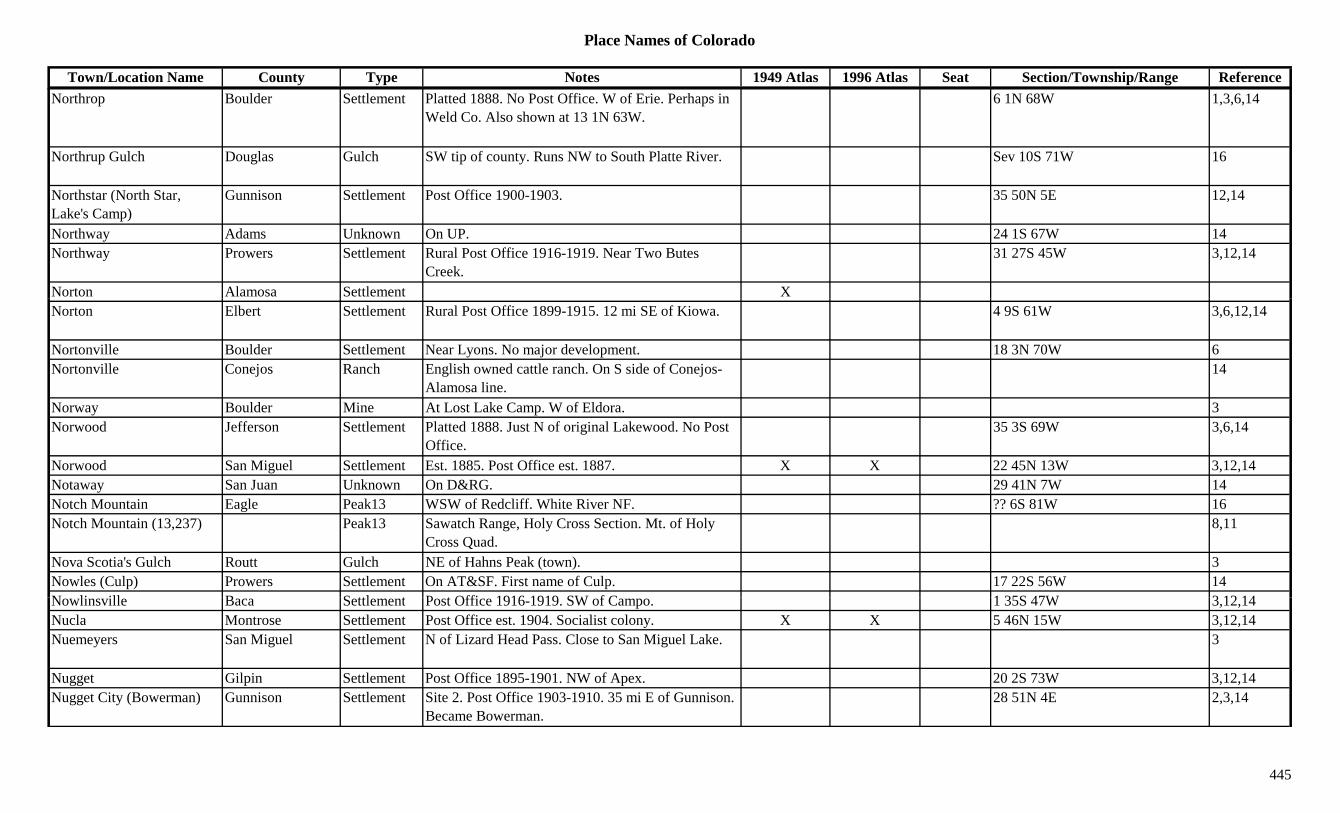
Place Names of Colorado
Town/Location Name County Type Notes 1949 Atlas 1996 Atlas Seat Section/Township/Range ReferenceNorthrop Boulder Settlement Platted 1888. No Post Office. W of Erie. Perhaps in
Weld Co. Also shown at 13 1N 63W.6 1N 68W 1,3,6,14
Northrup Gulch Douglas Gulch SW tip of county. Runs NW to South Platte River. Sev 10S 71W 16
Northstar (North Star, Lake's Camp)
Gunnison Settlement Post Office 1900-1903. 35 50N 5E 12,14
Northway Adams Unknown On UP. 24 1S 67W 14Northway Prowers Settlement Rural Post Office 1916-1919. Near Two Butes
Creek.31 27S 45W 3,12,14
Norton Alamosa Settlement XNorton Elbert Settlement Rural Post Office 1899-1915. 12 mi SE of Kiowa. 4 9S 61W 3,6,12,14
Nortonville Boulder Settlement Near Lyons. No major development. 18 3N 70W 6Nortonville Conejos Ranch English owned cattle ranch. On S side of Conejos-
Alamosa line.14
Norway Boulder Mine At Lost Lake Camp. W of Eldora. 3Norwood Jefferson Settlement Platted 1888. Just N of original Lakewood. No Post
Office.35 3S 69W 3,6,14
Norwood San Miguel Settlement Est. 1885. Post Office est. 1887. X X 22 45N 13W 3,12,14Notaway San Juan Unknown On D&RG. 29 41N 7W 14Notch Mountain Eagle Peak13 WSW of Redcliff. White River NF. ?? 6S 81W 16Notch Mountain (13,237) Peak13 Sawatch Range, Holy Cross Section. Mt. of Holy
Cross Quad.8,11
Nova Scotia's Gulch Routt Gulch NE of Hahns Peak (town). 3Nowles (Culp) Prowers Settlement On AT&SF. First name of Culp. 17 22S 56W 14N li ill B S ttl t P t Offi 1916 1919 SW f C 1 35S 47W 3 12 14Nowlinsville Baca Settlement Post Office 1916-1919. SW of Campo. 1 35S 47W 3,12,14Nucla Montrose Settlement Post Office est. 1904. Socialist colony. X X 5 46N 15W 3,12,14Nuemeyers San Miguel Settlement N of Lizard Head Pass. Close to San Miguel Lake. 3
Nugget Gilpin Settlement Post Office 1895-1901. NW of Apex. 20 2S 73W 3,12,14Nugget City (Bowerman) Gunnison Settlement Site 2. Post Office 1903-1910. 35 mi E of Gunnison.
Became Bowerman.28 51N 4E 2,3,14
445
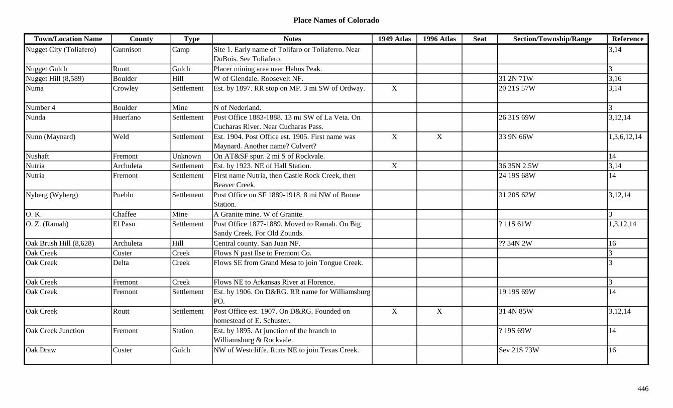
Place Names of Colorado
Town/Location Name County Type Notes 1949 Atlas 1996 Atlas Seat Section/Township/Range ReferenceNugget City (Toliafero) Gunnison Camp Site 1. Early name of Tolifaro or Toliaferro. Near
DuBois. See Toliafero.3,14
Nugget Gulch Routt Gulch Placer mining area near Hahns Peak. 3Nugget Hill (8,589) Boulder Hill W of Glendale. Roosevelt NF. 31 2N 71W 3,16Numa Crowley Settlement Est. by 1897. RR stop on MP. 3 mi SW of Ordway. X 20 21S 57W 3,14
Number 4 Boulder Mine N of Nederland. 3Nunda Huerfano Settlement Post Office 1883-1888. 13 mi SW of La Veta. On
Cucharas River. Near Cucharas Pass.26 31S 69W 3,12,14
Nunn (Maynard) Weld Settlement Est. 1904. Post Office est. 1905. First name was Maynard. Another name? Culvert?
X X 33 9N 66W 1,3,6,12,14
Nushaft Fremont Unknown On AT&SF spur. 2 mi S of Rockvale. 14Nutria Archuleta Settlement Est. by 1923. NE of Hall Station. X 36 35N 2.5W 3,14Nutria Fremont Settlement First name Nutria, then Castle Rock Creek, then
Beaver Creek.24 19S 68W 14
Nyberg (Wyberg) Pueblo Settlement Post Office on SF 1889-1918. 8 mi NW of Boone Station.
31 20S 62W 3,12,14
O. K. Chaffee Mine A Granite mine. W of Granite. 3O. Z. (Ramah) El Paso Settlement Post Office 1877-1889. Moved to Ramah. On Big
Sandy Creek. For Old Zounds.? 11S 61W 1,3,12,14
Oak Brush Hill (8,628) Archuleta Hill Central county. San Juan NF. ?? 34N 2W 16Oak Creek Custer Creek Flows N past Ilse to Fremont Co. 3Oak Creek Delta Creek Flows SE from Grand Mesa to join Tongue Creek. 3
Oak Creek Fremont Creek Flows NE to Arkansas River at Florence. 3Oak Creek Fremont Settlement Est. by 1906. On D&RG. RR name for Williamsburg
PO19 19S 69W 14
PO.Oak Creek Routt Settlement Post Office est. 1907. On D&RG. Founded on
homestead of E. Schuster.X X 31 4N 85W 3,12,14
Oak Creek Junction Fremont Station Est. by 1895. At junction of the branch to Williamsburg & Rockvale.
? 19S 69W 14
Oak Draw Custer Gulch NW of Westcliffe. Runs NE to join Texas Creek. Sev 21S 73W 16
446
Place Names of Colorado
Town/Location Name County Type Notes 1949 Atlas 1996 Atlas Seat Section/Township/Range ReferenceOak Grove (Fergusonville) Montrose Settlement SW of Montrose. Same as Fergusonville. X X 36 49N 10W 3,14
Oak Hills Routt Settlement Site 1. Est. by 1923. 1 mi S of Oak Creek. X 32 4N 85W 3,14Oak Hills Routt Station Site 2. Est. by 1924. On D&SL. 1 mi N of Oak
Creek.3
Oak Reservoir Dolores Lake SW of Rico. Near Montezuma Co. 1 39N 14W 16Oakdale (Tropic) Huerfano Settlement On D&RG. Station & Settlement. Also called
Tropic.15 29S 69W 14
Oakes Arapahoe Settlement Post Office 1890-1905. 28 4S 67W 12,14Oakes Mill KT/Douglas Settlement Same as or near Huntsville? 33 8S 67W 14Oakesdale Arapahoe Settlement Platted 1890. Post Office closed in 1905. NW of 3,6,14p
Cherry Creek Dam., ,
Oakridge (Edna) Routt Settlement Same as Edna. 14Oaks Mesa Unknown On D&RG. ? 10S 98W 14Oaks (Hay Creek) San Miguel Station Est. by 1881. Site of Hay Creek. On toll road to
Keystone.3
Oakton Las Animas Unknown On C&S. 17 33S 62W 14Oakview (Tropic) Huerfano Station Post Office 1907-1930. Also known as Tropic. RR
stop. 1 mi N of Francisco stop.9 29S 69W 3,12,14
O'Brien Jackson Station Est. by 1885. Waystop. Btwn Hebron and Spicer. On Buffalo Creek.
? 7N 80W 3,14
O'Brien Park Station Est. by 1902. On stage line from Lake George. 14O'Briens (O'Briens Junction)
Douglas Station Est. by 1892. RR stop on D&RGW. 6 mi SE Castle Rock. At Rock Quarry.
3,14
O'Briens Quarry Douglas Mine A rock quarry. 24 8S 67W 14Observatory Rock Park Hill SE of Jefferson. 13O id t l H f U k O D&RG 21 29S 69W 14Occidental Huerfano Unknown On D&RG. 21 29S 69W 14Occidental Pitkin Mine A Maroon Creek area mine. 3Ocean Wave Clear Creek Settlement Early name for Silver Dale. 20 4S 74W 14Ocean Wave Hinsdale Mine A Capitol City area mine. 2,3,13O'Connel Tunnel Clear Creek Mine Silver Creek area. 3O'Connell Lake Archuleta Lake North central county. 15 36N 3W 16October Mine Park Mine A Sacramento area mine. 3
447
Place Names of Colorado
Town/Location Name County Type Notes 1949 Atlas 1996 Atlas Seat Section/Township/Range ReferenceOcumpaugh Camp San Miguel Camp Est. by 1916. 30 44N 18W 14Odin (10,493) Boulder Mountain Front Range, Boulder Group. 8Odin Co. Rio Grande Mine A Summitville area mine. 3Oehlmann Park Jefferson Settlement 2 mi SE of Aspen Park. 19 6S 70W 6,14O'Fallon Park Jefferson Unknown 1 5S 71W 14Ofer City (Empire) Clear Creek Settlement Est. by 1860. In Empire Mining Dist. Early name for
Empire.14
Officer Larimer Unknown On GW. 13 5N 68W 14Officer Las Animas Settlement Rural Post Office 1917-1938. 20 mi NW of Kim. 18 30S 54W 3,12,14
Officer Junction Weld Station Est. by 1924. At UP and GW junction. SW of 3,6y jWindsor. 7 mi NE of Longmont.
,
Officers Summit Unknown On D&RG. 19 6S 78W 14Ogalalla Peak Boulder/Grand Peak13 Front Range, Indian Section. Isolation Peak Quad. 3/4 2N 74W 1,8,11,16
Ogilvy Weld Station Est. by 1920. A siding. 2 mi NE of Dent. 7 4N 66W 3,6,14Oh Be Joyful (12,400) Peak12 Ruby Range. 8Oh My God Road Clear Creek Misc Through Virginia Canyon. From Idaho Springs to
Central City.13
O'Haver Lake Chaffee Lake Far South near Saguache Co. W of Poncha Pass. San Isabel NF.
?? 48N 7E 16
Oh-Be-Joyful Gulch Gunnison Gulch W of Cloud City. 3Oh-be-Joyful Pass Gunnison Pass Oh-be-joyful Topo. Gunnison NF. ?? 13S 87W 5Oh-be-joyful Peak Gunnison Peak12 NW of Crested Butte. Gunnison NF. ?? 13S 87W 16Ohio Boulder Mine A Salina Mine. 3Ohio Gunnison Settlement Site 2. On DSP&P. Name of Post Office. 26 50N 3E 14Ohi G i U k Sit 1 E t b 1894 4 i W f B ld i 6 i NE f 14Ohio Gunnison Unknown Site 1. Est. by 1894. 4 mi W of Baldwin. 6 mi NE of
West Elk Mountain.14
Ohio Canyon Fremont Canyon North of Canon City. Sev 18S 70W 16Ohio City (Ohio Creek, Gold Creek, Eagle City)
Gunnison Settlement Gold found 1860s. Post Office est. 1880 as Ohio. 20 mi E of Gunnison.
X X 26 50W 3E 2,3,12,13,14
Ohio Creek (Ohio City) Gunnison Camp Gold found 1860s. Post Office est. 1880 as Ohio. 20 mi E of Gunnison.
13
448
Place Names of Colorado
Town/Location Name County Type Notes 1949 Atlas 1996 Atlas Seat Section/Township/Range ReferenceOhio Pass Gunnison Pass West Elks, Ohio Creek Group. S of Kebler Pass.
Gunnison NF.15 14S 87W 3,7,8,9,16
Ohio Peak Gunnison Peak12 SW of Crested Butte. West Elks, Ohio Creek Group. Gunnison NF.
?? 14S 87W 8,16
Ohlwiler (Ahlwiler's) Ouray Camp Est. by 1881. Small camp. S of Virginus Basin. 3Ohman Lake Clear Creek Lake Northern tip of county. NW of Alice. Arapaho NF. 29 2S 74W 16
Oil Creek Teller Creek SW corner of county. 3Oil Creek Canyon Fremont Canyon Shown on 1885 map. 7 mi NE of Canon City. 3Oil Well Camp Mesa Camp On Buzzard Creek. 24 10S 92W 14Oil Well Mountain (10,085) Delta/Mesa Peak10 North of Cedaredge. Gunnison NF. ?? 10S 91W 16( , ) g
Oil Works Fremont Settlement Est. by 1882. On Oil Creek. 7 mi NE of Canon City. ? 17S 70W 3,14
Ojito Costilla Station Est. by 1924. 7 mi S of Blanca. X 22 31S 73W 3,14Ojo Huerfano Station Site 2. Post Office 1880-1881 & 1913-1928. Stop on
D&RGW going over La Veta Pass.X 6 29S 69W 3,12,14
Ojo Hurefano Station Site 1. W of La Veta. 14Ojo de San Francisco Rio Grande Settlement ? 39N 5E 14Ojo Vallecito Dolores Settlement Est. by 1884. 7 39N 18W 14Ojo Viejecito Dolores Settlement Est. by 1885. E of the Ruins. SW corner of county. 3
Okanela Ranch Garfield Settlement 6 mi NE of New Castle. 3Oklarado Baca Settlement Post Office 1916-1935. Also shown at 32 32S 49W.
Reported as 2 locations.X 29 32S 49W 3,12,14
Okomo Gunnison Unknown Btwn Lorrain & Waunita Hot Springs. 11 49N 4E 14Ol th (B C l ) M t S ttl t E t 1881 P t Offi t 1896 Ch d f X X 10 50N 10W 1 3 12 14Olathe (Brown, Colorow) Montrose Settlement Est. 1881. Post Office est. 1896. Changed from
Brown. Originally Colorow.X X 10 50N 10W 1,3,12,14
Olava (Grant) Park Settlement Post Office 1936-1948. Changed to Grant. 9 7S 74W 12,14Old Arickaree City Washington Settlement E of Thurman in south-central Washington County.
Nothing remains.4
Old Baca House Museum Las Animas Museum At Trinidad. X
449

Place Names of Colorado
Town/Location Name County Type Notes 1949 Atlas 1996 Atlas Seat Section/Township/Range ReferenceOld Baldy Grand Peak11 South tip of county. N of Ptarmigan Pass. Arapaho
NF.?? 3S 77W 16
Old Baldy Ouray Hill SW of Ridgway. 3Old Baldy (Mount Lindsey) (14,125)
Costilla Peak14 Sangre de Cristo Range. X
Old Beckwith Place Custer Settlement Est. by 1886. Showplace. 3Old Bent's Fort (Bent's Stockade)
Pueblo Fort On Turkey Creek in foothills W of Pueblo. 3
Old Bobcat Ranch Rio Blanco Ranch At base of Cathedral Bluffs. 3Old Burlington (Lowell) Kit Carson Settlement Platted 1887. 2 mi E of present Burlington. Preceded
by Lowell.3,14
Old Cardinal (Cardinal, Cardinal City)
Boulder Camp Est. by 1870. NE of Caribou. 1,6,13
Old Cheyenne Wells Cheyenne Station Stage station, junction of Smoky Hill N & S routes. 5 mi N.
3
Old Cochetopa Agency Saguache Settlement 26 46N 1E 14Old Congress Town Ouray Settlement Near Red Mountain City. See Congress, San Juan
Co.14
Old Congress Town (Congress)
San Juan Settlement See Congresstown. 3
Old Easton El Paso Settlement Post Office est. 1872. 6 mi SW of what was later Eastonville.
14
Old Eastonville El Paso Settlement See Eastonville. 4Old Elbert Elbert Settlement See Elbert. 14Old Fort Garland (Fort Garland)
Costilla Fort Est. 1858. Kit Carson's frontier fort. Fort abandoned in 1883.
3
Old F t L (F t L B t F t E t b 1885 O AT&SF N id f A k Ri 3 23S 49W 3 14Old Fort Lyon (Fort Lyon, Bent's Second Fort)
Bent Fort Est. by 1885. On AT&SF. N side of Arkansas River. 3 23S 49W 3,14
Old Fort Massachusetts (Fort Massachusetts)
Costilla Fort Pre-Fort Garland. 9 mi N of (Old) Fort Garland. 13 29S 72W 3,14
Old Fort Morgan Morgan Settlement 1 mi N of present Fort Morgan. On S side of the river.
? 4N 57W 14
450

Place Names of Colorado
Town/Location Name County Type Notes 1949 Atlas 1996 Atlas Seat Section/Township/Range ReferenceOld Fort Sedgwick Sedgwick Fort Est. 1864. Besieged by Indians in 1865. Survived. 3
Old Hammer San Juan Mine A Howardsville area mine. 3Old Homestead Jackson Unknown 33 6N 78W 14Old Hundred San Juan Mine S of Howardsville. 1 41N 7W 14Old Hundred San Juan Settlement S of Howardsville. Possibly just a mine. 1 41N 7W 14Old Hundred Mine & Mill San Juan Mine On Cunningham Gulch. 3Old Indian Fort Montezuma Fort Est. by 1895. Ruins. N of Dolores. SW of Raymond.
Also shown at 23 38N 15W.14 38N 15W 3,14
Old Ladore School Moffat Misc National Landmark. NW of Geystone. XOld Los Pinos Agency Montrose Settlement 17 47N 8W 14g yOld Lout Ouray Mine An Engineer City area mine. 3,13Old Man's Cabin (Denny's) Gunnison Unknown S terminus of Taylor Pass Toll Road. Also called
Denny's.14
Old Mans Gulch Eagle Gulch SW corner of county. Runs N to Gypsum Creek. White River NF.
Sev 6S 86W 16
Old Mikado Lake Mine A Leadville area mine. 3,13Old Monarch Pass Chaffee/Gunnison Pass W of Monarch. Pahlone Peak Topo. Gunnison & San
Isabel NF.18 49N 6E 3,5,7,16
Old Mountain View El Paso Unknown On Cog RR. At Lion Creek. 15 14S 68W 14Old Newman Property Pitkin Mill Close to Aspen. On Castle Creek. Large mill. 3Old Ophir San Miguel Settlement Post Office 1878-1921. Founded before Ophir. 2 mi
E of more recent Ophir.35 42N 9W 3,12,13,14
Old Oro Lake Unknown In California Gulch. 2.5 mi below Oro City. See Oro Site 2.
14
Old Orodell Boulder Unknown On DB&W. 27 1N 71W 14Old P d Cit L i S ttl t Si St t Hi h 14 k th it 36 9N 74W 14Old Poudre City Larimer Settlement Sign on State Highway 14 marks the site. 36 9N 74W 14Old Quarry Spur Jefferson Station Est. by 1922. On DSP&P, Morrison Branch. 14Old Reliable Park Mine A Silver Heels area mine. 3Old Riverbend Elbert Station Existed in 1860s. Stage station. 2 mi NW of
Riverbend (new).30 8S 59W 4,14
Old Roach Larimer Unknown 14 11N 78W 14Old Road Chaffee Trail Over Trout Creek Pass. 3
451
Place Names of Colorado
Town/Location Name County Type Notes 1949 Atlas 1996 Atlas Seat Section/Township/Range ReferenceOld Rockwood Stage Road Dolores Trail Near Rico. 3
Old Rouse Huerfano Settlement Est. 1880s. 5 mi S of Walsenburg. See Rouse. 2 29S 66W 3,14Old San Acacio Costilla Settlement 24 3N 73W 14Old Spur Las Animas Station Est. by 1923. N of Gray Creek & Gray's Mine. 24 33S 63W 3,14Old St. Louis (Winona) Larimer Unknown See Winona. 15 5N 70W 14Old Stage Station Prowers Station Est. by 1916. 2 mi S of New Stage Station. 29 26S 46W 3,14Old Tenderfoot Lake Mine A Leadville area mine. 3Old Toll Road Park Trail Shown on 1885 map. SW of Guffey. 3Old Town Gilpin Settlement On GT. 23 3S 73W 14Old Town Teller Settlement Est. by 1900. A name for a section of Cripple Creek. 14y pp
NE corner of town.Old Trail City Prowers Unknown On AT&SF. 17 23S 41W 14Old White Earth (Powderhorn)
Gunnison Settlement See Powderhorn. 3
Old White River Agency Rio Blanco Misc Est. by 1885. In Agency Park. Upriver from Meeker. 3
Old Wootton's Las Animas Station Est. by 1866. On AT&SF. Toll gate & stage coach station.
? 35S 63W 14
Old Zounds (O.Z., Ramah) El Paso Settlement See Ramah. 3
Oleson Adams Settlement Rural Post Office 1916-1931. 25 mi S of Fort Morgan.
X 34 1S 58W 3,6,12,14
Olguine(s) (Los Varros, Lorencito)
Las Animas Settlement Est. by 1885. Same site as Los Varrow. Same site as Lorencito.
32 33S 66W 3,14
Olin Weld Station On GW. SW of Fort Lupton. 3Oli J ff S ttl t P t Offi 1872 S f Mt V 6 12 14Olio Jefferson Settlement Post Office 1872. S of Mt. Vernon. 6,12,14Oliver Gunnison Settlement D&RG stop. 2 mi W of Somerset. 10 13S 90W 3,14Oliver Hot Springs Park Unknown Est. by 1873. E of Middle Fork of South Platte
River.11 12S 74W 14
Olivet Yuma Unknown 20 4S 46W 14Ollie Reed Lake Mine A Leadville area mine. At Stumptown. 3,13
452
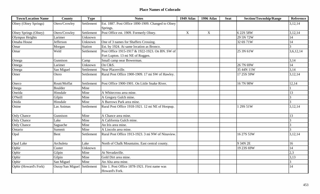
Place Names of Colorado
Town/Location Name County Type Notes 1949 Atlas 1996 Atlas Seat Section/Township/Range ReferenceOlney (Olney Springs) Otero/Crowley Settlement Est. 1887. Post Office 1890-1909. Changed to Olney
Springs.3,12,14
Olney Springs (Olney) Otero/Crowley Settlement Post Office est. 1909. Formerly Olney. X X 6 22S 58W 3,12,14Olympus Heights Larimer Unknown 29 5N 72W 14Omaha House Jefferson Unknown One of 3 names for Shaffers Crossing. 32 6S 71W 14Omar Morgan Station Est. by 1924. At same location as Bronco. 3Omar Weld Settlement Post Office 1915-1917 & 1922-1923. On BN. SW of
Fort Lupton. 13 mi NE of Roggen.25 3N 61W 3,6,12,14
Omega Gunnison Camp Small camp near Bowerman. 3,14Omega Larimer Unknown On C&S. 26 7N 69W 14Omega San Miguel Settlement Near Placerville. 35 44N 11W 3,14g g ,Omer Otero Settlement Rural Post Office 1900-1909. 17 mi SW of Hawley. 17 25S 59W 3,12,14
Oneco Routt/Moffat Settlement Post Office 1900-1901. On Little Snake River. 16 7N 98W 12,14Onega Boulder Mine 1Oneida Hinsdale Mine A Whitecross area mine. 13O'Neill Gilpin Mine A Gregory Gulch mine. 3Onida Hinsdale Mine A Burrows Park area mine. 3Onine Las Animas Settlement Rural Post Office 1918-1921. 12 mi NE of Hoopup. 1 29S 51W 3,12,14
Only Chance Gunnison Mine A Chance area mine. 13Only Chance Lake Mine A California Gulch mine. 3Only Chance Saguache Mine An Iris area mine. 3Ontario Summit Mine A Lincoln area mine. 3Opal Bent Settlement Rural Post Office 1913-1923. 3 mi NW of Ninaview. 16 27S 53W 3,12,14
O l L k A h l t L k N th f Ch lk M t i E t t l t 9 34N 2E 16Opal Lake Archuleta Lake North of Chalk Mountains. East central county. 9 34N 2E 16Ophir Custer Unknown 19 23S 69W 14Ophir Gilpin Mine At Nevadaville. 2,3Ophir Gilpin Mine Gold Dirt area mine. 3,13Ophir San Miguel Mine An Alta area mine. 3Ophir (Howard's Fork) Ouray/San Miguel Settlement Site 1. Post Office 1878-1921. First name was
Howard's Fork.14
453
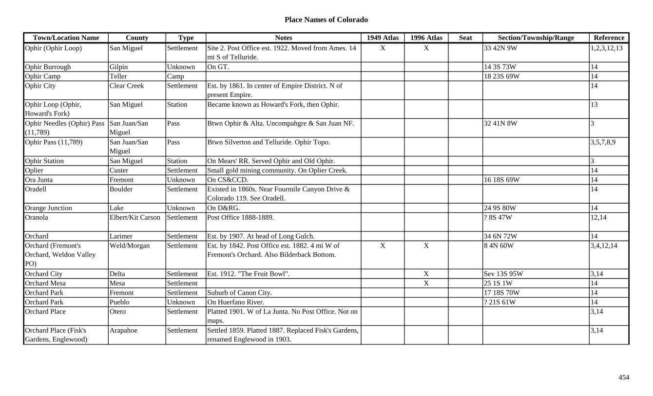
Place Names of Colorado
Town/Location Name County Type Notes 1949 Atlas 1996 Atlas Seat Section/Township/Range ReferenceOphir (Ophir Loop) San Miguel Settlement Site 2. Post Office est. 1922. Moved from Ames. 14
mi S of Telluride.X X 33 42N 9W 1,2,3,12,13
Ophir Burrough Gilpin Unknown On GT. 14 3S 73W 14Ophir Camp Teller Camp 18 23S 69W 14Ophir City Clear Creek Settlement Est. by 1861. In center of Empire District. N of
present Empire.14
Ophir Loop (Ophir, Howard's Fork)
San Miguel Station Became known as Howard's Fork, then Ophir. 13
Ophir Needles (Ophir) Pass (11,789)
San Juan/San Miguel
Pass Btwn Ophir & Alta. Uncompahgre & San Juan NF. 32 41N 8W 3
Ophir Pass (11,789) San Juan/San Pass Btwn Silverton and Telluride. Ophir Topo. 3,5,7,8,9p ( , )Miguel
p p , , , ,
Ophir Station San Miguel Station On Mears' RR. Served Ophir and Old Ophir. 3Oplier Custer Settlement Small gold mining community. On Oplier Creek. 14Ora Junta Fremont Unknown On CS&CCD. 16 18S 69W 14Oradell Boulder Settlement Existed in 1860s. Near Fourmile Canyon Drive &
Colorado 119. See Oradell.14
Orange Junction Lake Unknown On D&RG. 24 9S 80W 14Oranola Elbert/Kit Carson Settlement Post Office 1888-1889. ? 8S 47W 12,14
Orchard Larimer Settlement Est. by 1907. At head of Long Gulch. 34 6N 72W 14Orchard (Fremont's Orchard, Weldon Valley PO)
Weld/Morgan Settlement Est. by 1842. Post Office est. 1882. 4 mi W of Fremont's Orchard. Also Bilderback Bottom.
X X 8 4N 60W 3,4,12,14
Orchard City Delta Settlement Est. 1912. "The Fruit Bowl". X Sev 13S 95W 3,14Orchard Mesa Mesa Settlement X 25 1S 1W 14O h d P k F t S ttl t S b b f C Cit 17 18S 70W 14Orchard Park Fremont Settlement Suburb of Canon City. 17 18S 70W 14Orchard Park Pueblo Unknown On Huerfano River. ? 21S 61W 14Orchard Place Otero Settlement Platted 1901. W of La Junta. No Post Office. Not on
maps.3,14
Orchard Place (Fisk's Gardens, Englewood)
Arapahoe Settlement Settled 1859. Platted 1887. Replaced Fisk's Gardens, renamed Englewood in 1903.
3,14
454
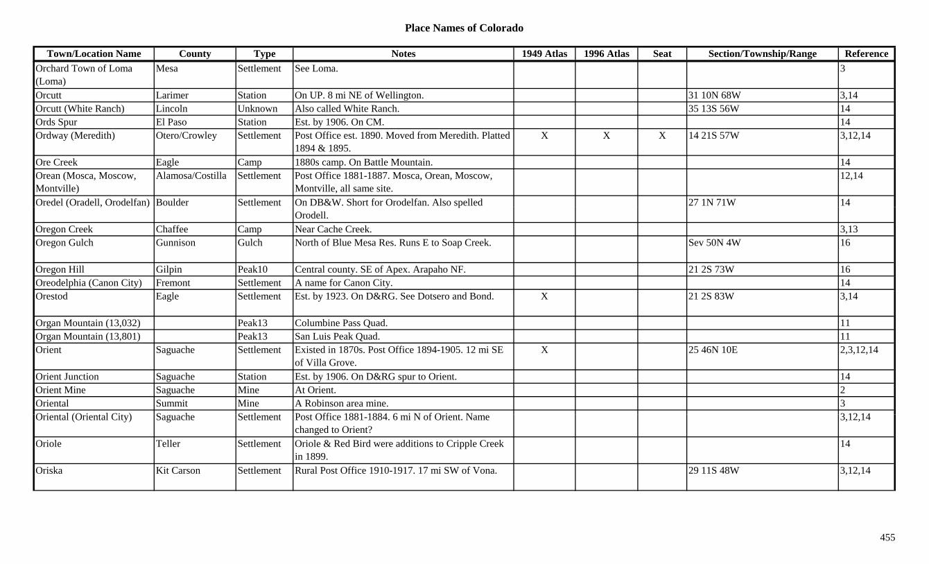
Place Names of Colorado
Town/Location Name County Type Notes 1949 Atlas 1996 Atlas Seat Section/Township/Range ReferenceOrchard Town of Loma (Loma)
Mesa Settlement See Loma. 3
Orcutt Larimer Station On UP. 8 mi NE of Wellington. 31 10N 68W 3,14Orcutt (White Ranch) Lincoln Unknown Also called White Ranch. 35 13S 56W 14Ords Spur El Paso Station Est. by 1906. On CM. 14Ordway (Meredith) Otero/Crowley Settlement Post Office est. 1890. Moved from Meredith. Platted
1894 & 1895.X X X 14 21S 57W 3,12,14
Ore Creek Eagle Camp 1880s camp. On Battle Mountain. 14Orean (Mosca, Moscow, Montville)
Alamosa/Costilla Settlement Post Office 1881-1887. Mosca, Orean, Moscow, Montville, all same site.
12,14
Oredel (Oradell, Orodelfan) Boulder Settlement On DB&W. Short for Orodelfan. Also spelled 27 1N 71W 14( , ) pOrodell.
Oregon Creek Chaffee Camp Near Cache Creek. 3,13Oregon Gulch Gunnison Gulch North of Blue Mesa Res. Runs E to Soap Creek. Sev 50N 4W 16
Oregon Hill Gilpin Peak10 Central county. SE of Apex. Arapaho NF. 21 2S 73W 16Oreodelphia (Canon City) Fremont Settlement A name for Canon City. 14Orestod Eagle Settlement Est. by 1923. On D&RG. See Dotsero and Bond. X 21 2S 83W 3,14
Organ Mountain (13,032) Peak13 Columbine Pass Quad. 11Organ Mountain (13,801) Peak13 San Luis Peak Quad. 11Orient Saguache Settlement Existed in 1870s. Post Office 1894-1905. 12 mi SE
of Villa Grove.X 25 46N 10E 2,3,12,14
Orient Junction Saguache Station Est. by 1906. On D&RG spur to Orient. 14Orient Mine Saguache Mine At Orient. 2Oriental Summit Mine A Robinson area mine. 3O i t l (O i t l Cit ) S h S ttl t P t Offi 1881 1884 6 i N f O i t N 3 12 14Oriental (Oriental City) Saguache Settlement Post Office 1881-1884. 6 mi N of Orient. Name
changed to Orient?3,12,14
Oriole Teller Settlement Oriole & Red Bird were additions to Cripple Creek in 1899.
14
Oriska Kit Carson Settlement Rural Post Office 1910-1917. 17 mi SW of Vona. 29 11S 48W 3,12,14
455
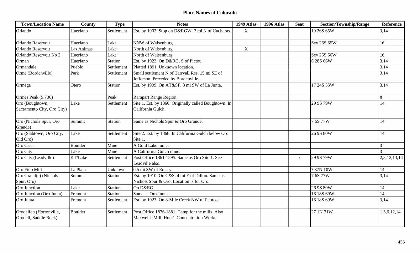
Place Names of Colorado
Town/Location Name County Type Notes 1949 Atlas 1996 Atlas Seat Section/Township/Range ReferenceOrlando Huerfano Settlement Est. by 1902. Stop on D&RGW. 7 mi N of Cucharas. X 19 26S 65W 3,14
Orlando Reservoir Huerfano Lake NNW of Walsenburg. Sev 26S 65W 16Orlando Reservoir Las Animas Lake North of Walsenburg. XOrlando Reservoir No 2 Huerfano Lake North of Walsenburg. Sev 26S 66W 16Orman Huerfano Station Est. by 1923. On D&RG. S of Pictou. 6 28S 66W 3,14Ormandale Pueblo Settlement Platted 1891. Unknown location. 3,14Orme (Bordenville) Park Settlement Small settlement N of Tarryall Res. 15 mi SE of
Jefferson. Preceded by Bordenville.3,14
Ormega Otero Station Est. by 1909. On AT&SF. 3 mi SW of La Junta. 17 24S 55W 3,14
Ormes Peak (9,730) Peak Rampart Range Region. 8Oro (Boughtown, Sacramento City, Oro City)
Lake Settlement Site 1. Est. by 1860. Originally called Boughtown. In California Gulch.
29 9S 79W 14
Oro (Nichols Spur, Oro Grande)
Summit Station Same as Nichols Spur & Oro Grande. 7 6S 77W 14
Oro (Slabtown, Oro City, Old Oro)
Lake Settlement Site 2. Est. by 1868. In California Gulch below Oro Site 1.
26 9S 80W 14
Oro Cash Boulder Mine A Gold Lake mine. 3Oro City Lake Mine A California Gulch mine. 3Oro City (Leadville) KT/Lake Settlement Post Office 1861-1895. Same as Oro Site 1. See
Leadville also.x 29 9S 79W 2,3,12,13,14
Oro Fino Mill La Plata Unknown 0.5 mi SW of Emery. ? 37N 10W 14Oro Grand(e) (Nichols Spur, Oro)
Summit Station Est. by 1910. On C&S. 4 mi E of Dillon. Same as Nichols Spur & Oro. Location is for Oro.
7 6S 77W 3,14
O J ti L k St ti O D&RG 26 9S 80W 14Oro Junction Lake Station On D&RG. 26 9S 80W 14Oro Junction (Oro Junta) Fremont Station Same as Oro Junta. 16 18S 69W 14Oro Junta Fremont Settlement Est. by 1923. On 8-Mile Creek NW of Penrose. 16 18S 69W 3,14
Orodelfan (Hortonville, Orodell, Saddle Rock)
Boulder Settlement Post Office 1876-1881. Camp for the mills. Also Maxwell's Mill, Hunt's Concentration Works.
27 1N 71W 1,3,6,12,14
456
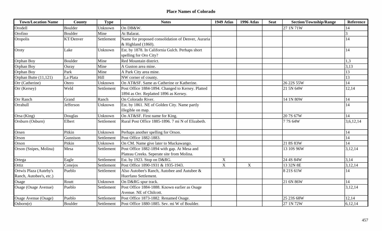
Place Names of Colorado
Town/Location Name County Type Notes 1949 Atlas 1996 Atlas Seat Section/Township/Range ReferenceOrodell Boulder Unknown On DB&W. 27 1N 71W 14Orofino Boulder Mine At Balarat. 3Oropolis KT/Denver Settlement Name for proposed consolidation of Denver, Auraria
& Highland (1860).14
Oroty Lake Unknown Est. by 1878. In California Gulch. Perhaps short spelling for Oro City?
14
Orphan Boy Boulder Mine Red Mountain district. 1,3Orphan Boy Ouray Mine A Guston area mine. 3,13Orphan Boy Park Mine A Park City area mine. 13Orphan Butte (11,121) La Plata Hill NW corner of county. 13Orr (Catherine) Otero Unknown On AT&SF. Same as Catherine or Katherine. 26 22S 55W 14( )Orr (Kersey) Weld Settlement Post Office 1884-1894. Changed to Kersey. Platted
1894 as Orr. Replatted 1896 as Kersey.21 5N 64W 12,14
Orr Ranch Grand Ranch On Colorado River. 14 1N 80W 14Orrahull Jefferson Unknown Est. by 1861. NE of Golden City. Name partly
illegible on map.14
Orsa (King) Douglas Unknown On AT&SF. First name for King. 20 7S 67W 14Orsburn (Osburn) Elbert Settlement Rural Post Office 1885-1896. 7 mi N of Elizabeth. 7 7S 64W 3,6,12,14
Orsen Pitkin Unknown Perhaps another spelling for Orson. 14Orson Gunnison Settlement Post Office 1882-1883. 14Orson Pitkin Unknown On CM. Name give later to Muckawango. 21 8S 83W 14Orson (Snipes, Molina) Mesa Settlement Post Office 1882-1894 with gap. At Mesa and
Plateau Creeks. Seperate site from Molina.13 10S 96W 3,12,14
Ortega Eagle Settlement Est. by 1923. Stop on D&RG. X 24 4S 84W 3,14Ortiz Conejos Settlement Post Office 1890-1931 & 1935-1943. X X 13 32N 8E 3,12,14O t i Pl (A t b ' P bl S ttl t Al A t b ' R h A t b d A t b & 8 21S 61W 14Ortwis Plaza (Auteby's Ranch, Autobee's, etc.)
Pueblo Settlement Also Autobee's Ranch, Autobee and Autubee & Huerfano Settlement.
8 21S 61W 14
Osage Routt Unknown On D&RG spur track. 21 6N 86W 14Osage (Osage Avenue) Pueblo Settlement Post Office 1884-1888. Known earlier as Osage
Avenue. NE of Chilcott.3,12,14
Osage Avenue (Osage) Pueblo Settlement Post Office 1873-1882. Renamed Osage. 25 23S 68W 12,14Osborn(e) Boulder Settlement Post Office 1880-1885. Sev. mi W of Boulder. 27 1N 72W 6,12,14
457
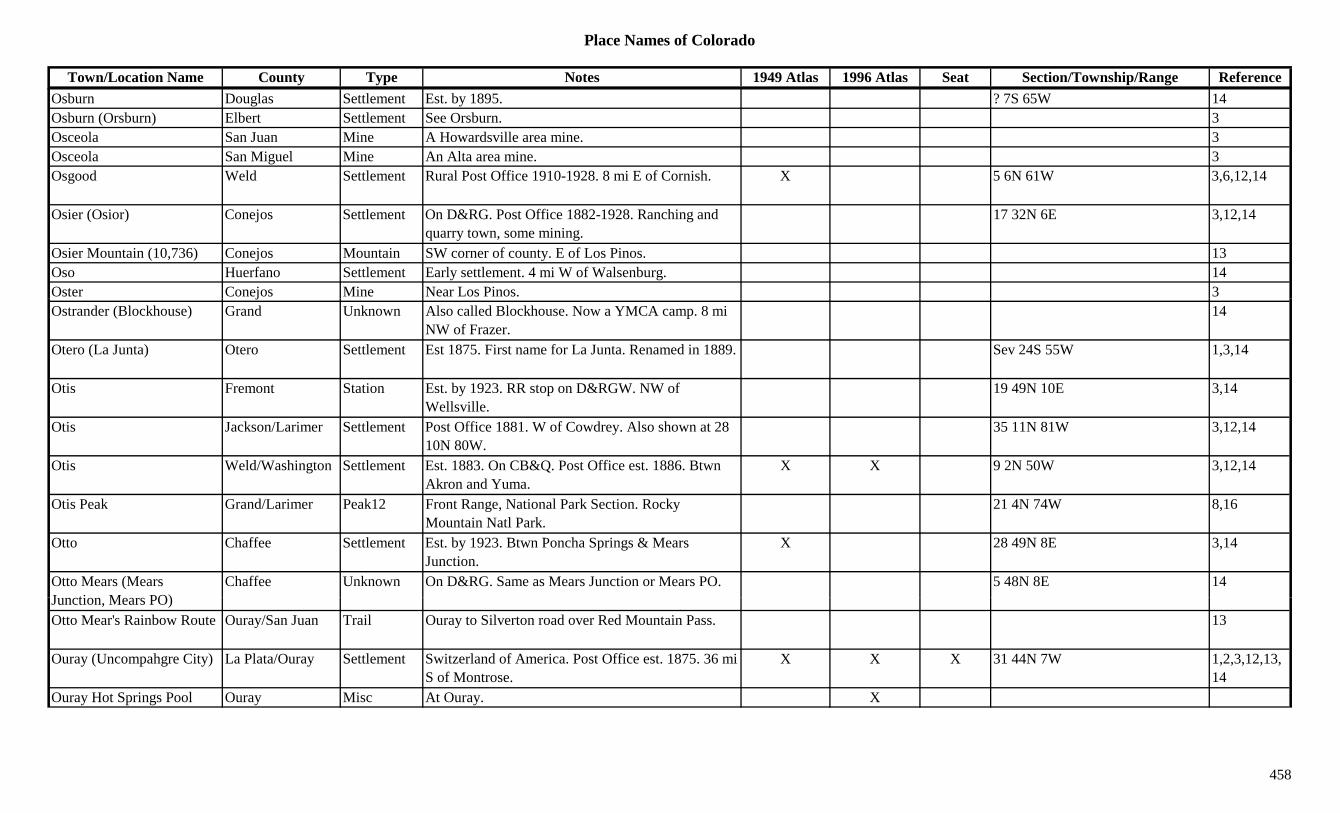
Place Names of Colorado
Town/Location Name County Type Notes 1949 Atlas 1996 Atlas Seat Section/Township/Range ReferenceOsburn Douglas Settlement Est. by 1895. ? 7S 65W 14Osburn (Orsburn) Elbert Settlement See Orsburn. 3Osceola San Juan Mine A Howardsville area mine. 3Osceola San Miguel Mine An Alta area mine. 3Osgood Weld Settlement Rural Post Office 1910-1928. 8 mi E of Cornish. X 5 6N 61W 3,6,12,14
Osier (Osior) Conejos Settlement On D&RG. Post Office 1882-1928. Ranching and quarry town, some mining.
17 32N 6E 3,12,14
Osier Mountain (10,736) Conejos Mountain SW corner of county. E of Los Pinos. 13Oso Huerfano Settlement Early settlement. 4 mi W of Walsenburg. 14Oster Conejos Mine Near Los Pinos. 3jOstrander (Blockhouse) Grand Unknown Also called Blockhouse. Now a YMCA camp. 8 mi
NW of Frazer.14
Otero (La Junta) Otero Settlement Est 1875. First name for La Junta. Renamed in 1889. Sev 24S 55W 1,3,14
Otis Fremont Station Est. by 1923. RR stop on D&RGW. NW of Wellsville.
19 49N 10E 3,14
Otis Jackson/Larimer Settlement Post Office 1881. W of Cowdrey. Also shown at 28 10N 80W.
35 11N 81W 3,12,14
Otis Weld/Washington Settlement Est. 1883. On CB&Q. Post Office est. 1886. Btwn Akron and Yuma.
X X 9 2N 50W 3,12,14
Otis Peak Grand/Larimer Peak12 Front Range, National Park Section. Rocky Mountain Natl Park.
21 4N 74W 8,16
Otto Chaffee Settlement Est. by 1923. Btwn Poncha Springs & Mears Junction.
X 28 49N 8E 3,14
Otto Mears (Mears J ti M PO)
Chaffee Unknown On D&RG. Same as Mears Junction or Mears PO. 5 48N 8E 14Junction, Mears PO)Otto Mear's Rainbow Route Ouray/San Juan Trail Ouray to Silverton road over Red Mountain Pass. 13
Ouray (Uncompahgre City) La Plata/Ouray Settlement Switzerland of America. Post Office est. 1875. 36 mi S of Montrose.
X X X 31 44N 7W 1,2,3,12,13,14
Ouray Hot Springs Pool Ouray Misc At Ouray. X
458

Place Names of Colorado
Town/Location Name County Type Notes 1949 Atlas 1996 Atlas Seat Section/Township/Range ReferenceOuray Junction (Montrose) Montrose Station Est. by 1920s. On D&RG junction at Montrose. First
name for Montrose.34 49N 9W 1,3,14
Ouray Peak (Mount Ouray) (13,955)
Chaffee/Saguache Peak13 SW corner of county. Sawatch Range, Fossil Group. Mt. Ouray Quad. San Isabel NF.
X X ?? 48N 7E 8,11,16
Ouray's Home Montrose Settlement Est. by 1885. NW of Uncompahgre. 3Outlaw Camp Mesa Camp In S part of county. On Uncompahgre Plateau. 7 50N 17W 3,14Outlaw Camp Montrose Settlement Est. 1916. 11 47N 17W 14Ovens Las Animas Unknown On C&W. Just W of Segundo. 36 33S 66W 14Overall Camp San Miguel Camp Est. by 1916. ? 43N 19W 14Overland Boulder Mine At Gresham. 3Overland Garfield Unknown On CM. 8 7S 89W 14Overland (Overland Park) Arapahoe/Denver Settlement On C&S. Post Office 1892-1920. Located within
Denver. RR called it Overland Park.21 4S 68W 12,14
Overland City Sedgwick Settlement Early name for Julesburg. 14Overland Mountain (8,715) Boulder Mountain NW of Jamestown. Roosevelt NF. 23 2N 72W 3,16
Overland Park Larimer Station Wells Fargo Stage Station on Overland Route. 10 mi N of La Porte.
14
Overland Park (Jewell Park) Denver Park Est. by 1885. Amusement park called Jewell Park. 21 4S 68W 14
Overland Park Junction Denver Station On D&RG. 14Overland Reservoir Delta Lake North of Paonia. Gunnison NF. X ?? 11S 92W 16Oversteeg Gulch Gunnison Gulch NNE of Gunnison. Runs NE to East River. Sev 14S 85W 16Oversteg Gunnison Station Post Office 1882-1905. Stop on D&SP. N of Jack's
Cabin.2 15S 85W 3,12,14
Overton Pueblo Settlement Platted 1891. Post Office 1892-1900. 19 19S 64W 3,12,14O ill (D ill ) C t S ttl t E t b 1885 SE f Cl l d P bl i lli ! 3Overville (Dyerville) Custer Settlement Est. by 1885. SE of Cleveland. Problem in spelling! 3
Ovid Sedgwick Settlement Post Office est. 1907. Platted 1908. Originally a RR siding.
X X 5 11N 45W 3,12,14
Owen Lincoln Settlement Post Office 1908-1915. 32 10S 56W 12,14Owen Lake Kiowa Lake 1887. N of Sheridan Lake. 3Owens Reservoir Delta Lake NE of Cedaredge. Grand Mesa NF. 14 12S 93W 16
459

Place Names of Colorado
Town/Location Name County Type Notes 1949 Atlas 1996 Atlas Seat Section/Township/Range ReferenceO-Wi-Yu-Kuts Plateau Moffat Hill Large land mass in NW part of county. 3Owl Larimer/Jackson Settlement Post Office 1899-1918. W of Lindland. 15 7N 78W 3,12,14Owl Canyon Larimer Station On C&S. 7 mi N of Ted's Place. X 12 9N 70W 3,14Owl Creek Weld Creek Flows S from near Wyoming. E of Rockport, Nunn. X X 3
Owl Creek Pass Gunnison/Ouray Pass Btwn Ridgway and Cimarron. Crossed by forest road. Uncompahgre NF.
X 18 46N 6W 7,8,9,16
Owl Mountain Jackson Mountain SW of Owl. E of Rand. 3,13Owl Ridge Jackson Hill SE of Walden. 13Ox Yolk Douglas Settlement Freight route btwn Leadville & Denver. 5 mi from
Deckers.35 8S 70W 1,14
Oxford (Fowler, South Side, Sibley, Alexander)
Bent/Otero Settlement Post Office 1882-1890. Changed to Fowler. Also South Side, Alexander PO & Sibley.
Sev 22S 59W 1,3,12,14
Oxford (Grommet) La Plata Settlement Post Office 1908-1954. Formerly Grommet. Changed to Oxford.
X X 21 34N 8W 3,12,14
P.O.W. Camp Las Animas Camp Same as Camp Trinidad. 11 33S 63W 14Pacahontas Garfield Unknown On CM. 15 7S 89W 14Pacific El Paso Settlement Post Office 1880-?? 12,14Pacific Grand Unknown On D&RG. 34 1S 75W 14Pacific Huerfano Unknown On D&RG. 14Pacific Peak (13,950) Peak13 Tenmile Range. Breckenridge Quad. 8,11Pacific Spur Eagle Unknown On D&RG. 19 6S 80W 14Pactolus Gilpin Station On D&RG., D&SL. Post Office 1911-1912. 32 1S 72W 12,14Padri Jesus Mi Las Animas Unknown 14Padroni Logan Settlement Est. by 1899. Post Office est. 1909. Early a section
house.X X 3 9N 52W 3,12,14
P d R tt S ttl t E t 1890 P t Offi 1890 1947 X 31 5N 89W 3 12 14Pagoda Routt Settlement Est. 1890. Post Office 1890-1947. X 31 5N 89W 3,12,14Pagoda Mountain (13,497) Boulder Peak13 Rocky Mt. Nat. Park. Front Range, Rocky Mountain
Natl Park. Isolation Peak Quad.?? 3N 73W 1,8,11,16
Pagoda Peak (11,120) Rio Blanco Peak E side of county. X X 3,8Pagosa Junction (Gato) Archuleta Settlement Post Office 1899-1954. Also known as Gato. X X 8 32N 3W 3,12,14Pagosa Peak (12,634 or 12,640)
Mineral Peak12 Piedra Mountains. SW corner of county. X 3,8
460
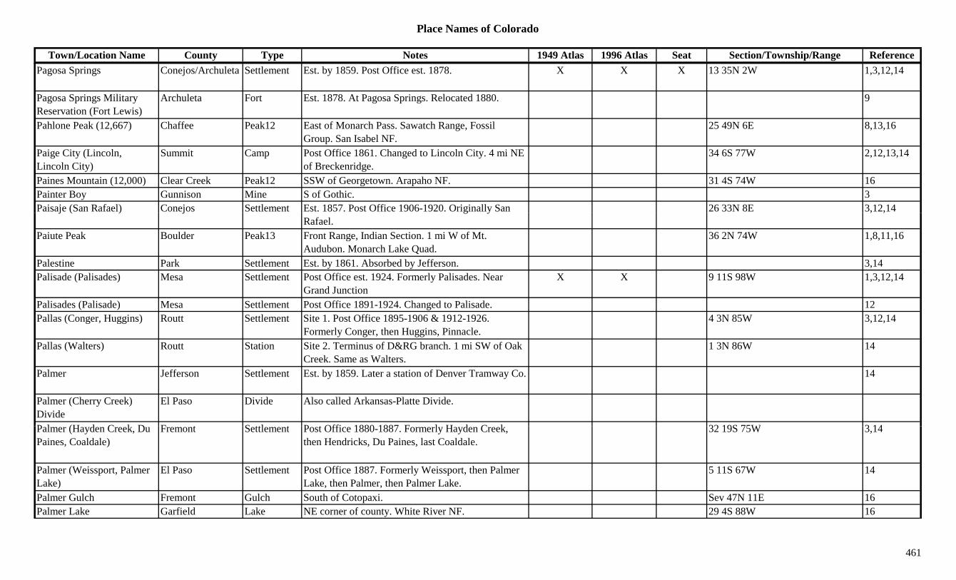
Place Names of Colorado
Town/Location Name County Type Notes 1949 Atlas 1996 Atlas Seat Section/Township/Range ReferencePagosa Springs Conejos/Archuleta Settlement Est. by 1859. Post Office est. 1878. X X X 13 35N 2W 1,3,12,14
Pagosa Springs Military Reservation (Fort Lewis)
Archuleta Fort Est. 1878. At Pagosa Springs. Relocated 1880. 9
Pahlone Peak (12,667) Chaffee Peak12 East of Monarch Pass. Sawatch Range, Fossil Group. San Isabel NF.
25 49N 6E 8,13,16
Paige City (Lincoln, Lincoln City)
Summit Camp Post Office 1861. Changed to Lincoln City. 4 mi NE of Breckenridge.
34 6S 77W 2,12,13,14
Paines Mountain (12,000) Clear Creek Peak12 SSW of Georgetown. Arapaho NF. 31 4S 74W 16Painter Boy Gunnison Mine S of Gothic. 3Paisaje (San Rafael) Conejos Settlement Est. 1857. Post Office 1906-1920. Originally San 26 33N 8E 3,12,14j ( ) j g y
Rafael., ,
Paiute Peak Boulder Peak13 Front Range, Indian Section. 1 mi W of Mt. Audubon. Monarch Lake Quad.
36 2N 74W 1,8,11,16
Palestine Park Settlement Est. by 1861. Absorbed by Jefferson. 3,14Palisade (Palisades) Mesa Settlement Post Office est. 1924. Formerly Palisades. Near
Grand JunctionX X 9 11S 98W 1,3,12,14
Palisades (Palisade) Mesa Settlement Post Office 1891-1924. Changed to Palisade. 12Pallas (Conger, Huggins) Routt Settlement Site 1. Post Office 1895-1906 & 1912-1926.
Formerly Conger, then Huggins, Pinnacle.4 3N 85W 3,12,14
Pallas (Walters) Routt Station Site 2. Terminus of D&RG branch. 1 mi SW of Oak Creek. Same as Walters.
1 3N 86W 14
Palmer Jefferson Settlement Est. by 1859. Later a station of Denver Tramway Co. 14
Palmer (Cherry Creek) Divide
El Paso Divide Also called Arkansas-Platte Divide.
P l (H d C k D F t S ttl t P t Offi 1880 1887 F l H d C k 32 19S 75W 3 14Palmer (Hayden Creek, Du Paines, Coaldale)
Fremont Settlement Post Office 1880-1887. Formerly Hayden Creek, then Hendricks, Du Paines, last Coaldale.
32 19S 75W 3,14
Palmer (Weissport, Palmer Lake)
El Paso Settlement Post Office 1887. Formerly Weissport, then Palmer Lake, then Palmer, then Palmer Lake.
5 11S 67W 14
Palmer Gulch Fremont Gulch South of Cotopaxi. Sev 47N 11E 16Palmer Lake Garfield Lake NE corner of county. White River NF. 29 4S 88W 16
461

Place Names of Colorado
Town/Location Name County Type Notes 1949 Atlas 1996 Atlas Seat Section/Township/Range ReferencePalmer Lake (Palmero, Divide, Divide Lake)
El Paso Settlement Est. by 1871. First station called Divide. Long list of names before Palmer Lake.
X X 5 11S 67W 1,3,14
Palmer Reservoir El Paso Lake East of Green Mountain Falls. Pike NF. 12 13S 68W 16Palmero (Palmer Lake) El Paso Settlement See Palmer Lake. 3Palmetto Hinsdale Mine An Engineer City area mine. 3Palmetto Ouray Camp Camp linked with Rose's Cabin. 3Palmetto Ouray Mine An Engineer City area mine. 3Palmyra Peak (13,319) Peak13 Telluride Group. Telluride Quad. 8,11Palo Fremont Station Est. by 1923. RR stop on D&RGW. 2 mi N of
Hillside.24 47N 12E 3,14
Palo Alto Saguache Settlement Est. by 1873. Possibly should be Rito Alto? 14g y yPalsaje Conejos Unknown 26 33N 8E 14Pamona Park Mesa Settlement 5 mi N of Grand Junction. 10 mi W of Palisade. 14Panama Reservoir No 1 Boulder Lake SSE of Longmont. 35 2N 69W 16Pando Eagle Settlement Est. by 1922. N of Mitchell. See Camp Hale. X 9 7S 80W 3,14Pandora Lake Mine A Leadville area mine. 3Pandora San Juan Unknown Up South Mineral Creek. 25 41N 9W 14Pandora (Folsome, Newport)
Ouray/San Miguel Settlement Est. by 1875. Post Office 1881-1902. 1 mi E of Telluride.
X X 6 42N 8W 1,2,3,13,14
Pandora Mine San Miguel Mine At Pandora. 2,3,13Pandora Sampling Works & Mill
San Miguel Mill A Pandora area operation. 3
Panorama Peak Larimer Peak E of Estes Park. 13Paol (Paoli) Phillips Settlement RR spelling for Paoli. 14Paoli Phillips Settlement Est. by 1889. X X 2 7N 46W 1,3,14Paonia (Wades, Red Rock Cit P P )
Delta Settlement Est. 1881. PO wouldn't accept Peony. First name W d E l R d R k Cit
X X 6 14S 91W 1,3,14City, Peona, Peony) Wades. Early name Red Rock City.Paonia Reservoir Gunnison Lake E of Paonia. XPapeton (Papetown) El Paso Settlement Platted 1901. N of Colorado Springs. 32 13S 66W 3,14Papoose Canyon Dolores Canyon SE county. Runs SW to UT. Sev 38N 20W 16Papoose Peak (11,866) Dolores Peak11 NNE of Rico. 10 40N 11W 16Parachute (Grand Valley) Garfield Settlement On D&RG. First name was Parachute, second Grand
Valley, then Parachute.X 12 7S 96W 1,14
462
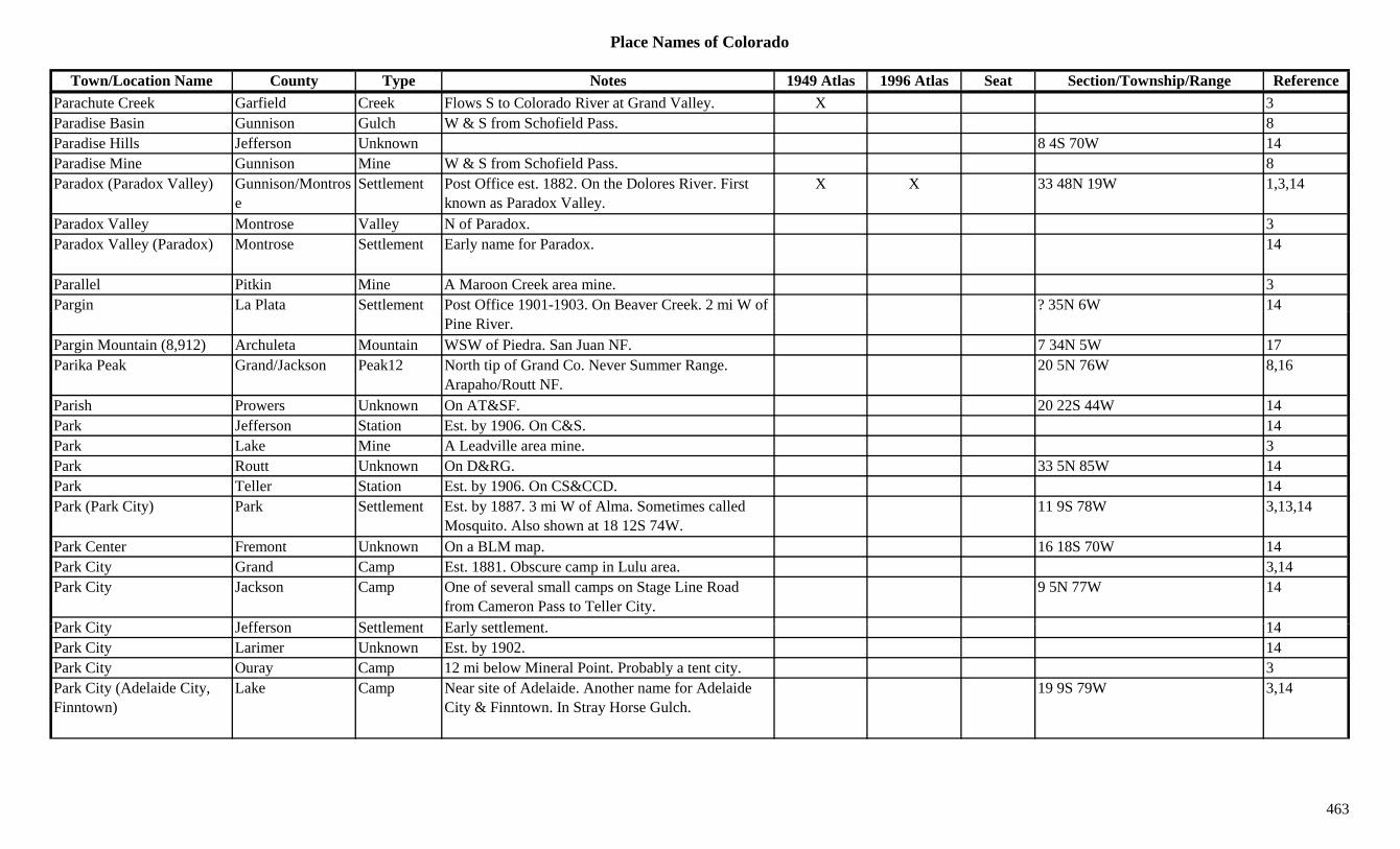
Place Names of Colorado
Town/Location Name County Type Notes 1949 Atlas 1996 Atlas Seat Section/Township/Range ReferenceParachute Creek Garfield Creek Flows S to Colorado River at Grand Valley. X 3Paradise Basin Gunnison Gulch W & S from Schofield Pass. 8Paradise Hills Jefferson Unknown 8 4S 70W 14Paradise Mine Gunnison Mine W & S from Schofield Pass. 8Paradox (Paradox Valley) Gunnison/Montros
eSettlement Post Office est. 1882. On the Dolores River. First
known as Paradox Valley.X X 33 48N 19W 1,3,14
Paradox Valley Montrose Valley N of Paradox. 3Paradox Valley (Paradox) Montrose Settlement Early name for Paradox. 14
Parallel Pitkin Mine A Maroon Creek area mine. 3Pargin La Plata Settlement Post Office 1901-1903. On Beaver Creek. 2 mi W of ? 35N 6W 14g
Pine River.Pargin Mountain (8,912) Archuleta Mountain WSW of Piedra. San Juan NF. 7 34N 5W 17Parika Peak Grand/Jackson Peak12 North tip of Grand Co. Never Summer Range.
Arapaho/Routt NF.20 5N 76W 8,16
Parish Prowers Unknown On AT&SF. 20 22S 44W 14Park Jefferson Station Est. by 1906. On C&S. 14Park Lake Mine A Leadville area mine. 3Park Routt Unknown On D&RG. 33 5N 85W 14Park Teller Station Est. by 1906. On CS&CCD. 14Park (Park City) Park Settlement Est. by 1887. 3 mi W of Alma. Sometimes called
Mosquito. Also shown at 18 12S 74W.11 9S 78W 3,13,14
Park Center Fremont Unknown On a BLM map. 16 18S 70W 14Park City Grand Camp Est. 1881. Obscure camp in Lulu area. 3,14Park City Jackson Camp One of several small camps on Stage Line Road
from Cameron Pass to Teller City.9 5N 77W 14
P k Cit J ff S ttl t E l ttl t 14Park City Jefferson Settlement Early settlement. 14Park City Larimer Unknown Est. by 1902. 14Park City Ouray Camp 12 mi below Mineral Point. Probably a tent city. 3Park City (Adelaide City, Finntown)
Lake Camp Near site of Adelaide. Another name for Adelaide City & Finntown. In Stray Horse Gulch.
19 9S 79W 3,14
463

Place Names of Colorado
Town/Location Name County Type Notes 1949 Atlas 1996 Atlas Seat Section/Township/Range ReferencePark City (Park) Park Settlement Est. by 1887. 3 mi W of Alma. Stage center and RR
terminus. See Park.10 9S 78W 3,14
Park City (Parkville, Georgia Gulch)
Summit Settlement Existed in 1860s. By 1880s city was buried by mine tailings. Same as Parkville.
26 6S 77W 3,14
Park Cone Gunnison Peak12 South of Taylor Park Res. Elk Range, Crested Butte Section. Gunnison NF.
?? 14S 82W 8,13,16
Park Creek Larimer Station On Overland Stage Route from LaPorte. 2 mi SE of Owl Canyon Store.
14
Park Creek Rio Grande Creek Flows NW from Summitville to Mineral Co. 3Park Creek (Leon Creek) Mesa Creek Flows N & W to Plateau Valley. 3Park Gulch Creek (Tarryall Park Creek W of Orme. Same as Tarryall Creek? 3( yCreek)
y
Park Lake Gilpin Lake NW corner of county. N of Tolland. Roosevelt NF. 5 2S 73W 16
Park Mountain Fremont Peak10 NE of Howard. 15 49N 11E 16Park Mountian Rio Blanco Mountain SW corner of county. 3Park Plateau Las Animas Hill N & E of North Fork of Purgatoire River. 3Park Range Routt Range S & E of Steamboat Springs. On Grand Co. border. 3,15
Park Regent Mineral Mine N of Creede. Near Saguache Co. On W Willow Creek.
3
Park Regent Pitkin Mine An Aspen area mine. 3,13Park Siding (Foxton) Jefferson Settlement Post Office 1890-1896. Original name for Foxton.
Another name Last Resort. See Foxton.21 7S 70W 3,6,14
Park View Grand Settlement Est. by 1923. At base of Parkview Mountain. 3P kd l W ld St ti E t b 1916 O UP j ti 3 i E f E i 9 1N 68W 3 6 14Parkdale Weld Station Est. by 1916. On UP, a junction. 3 mi E of Erie. 9 1N 68W 3,6,14Parkdale (Currant Creek Junction)
Fremont Settlement Est. abt 1878. Post Office 1880-1970. Formerly Currant Creek Junction, Twelve Mile Ford..
X 13 18S 72W 3,14
Parkdale Junction Weld Unknown On UP. 9 1N 68W 14Parker (Twenty Mile House, Pine Grove)
Douglas Settlement Stage and RR Post Office. First name was Pine Grove. Name chg to Parker 1882.
X X 22 6S 66W 3,14
Parker City San Juan Mine Silverton area mine. 3
464
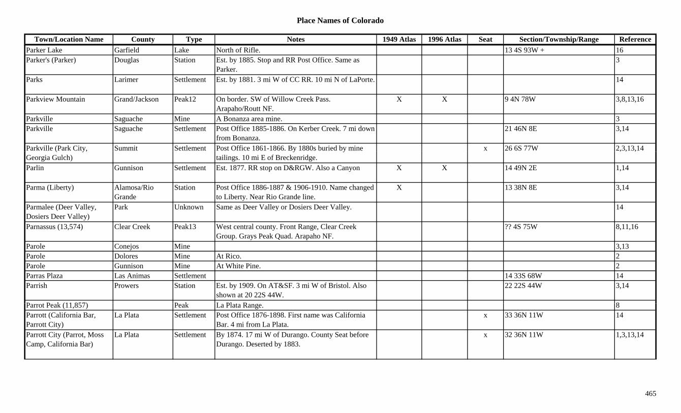
Place Names of Colorado
Town/Location Name County Type Notes 1949 Atlas 1996 Atlas Seat Section/Township/Range ReferenceParker Lake Garfield Lake North of Rifle. 13 4S 93W + 16Parker's (Parker) Douglas Station Est. by 1885. Stop and RR Post Office. Same as
Parker.3
Parks Larimer Settlement Est. by 1881. 3 mi W of CC RR. 10 mi N of LaPorte. 14
Parkview Mountain Grand/Jackson Peak12 On border. SW of Willow Creek Pass. Arapaho/Routt NF.
X X 9 4N 78W 3,8,13,16
Parkville Saguache Mine A Bonanza area mine. 3Parkville Saguache Settlement Post Office 1885-1886. On Kerber Creek. 7 mi down
from Bonanza.21 46N 8E 3,14
Parkville (Park City, Summit Settlement Post Office 1861-1866. By 1880s buried by mine x 26 6S 77W 2,3,13,14( y,Georgia Gulch)
y ytailings. 10 mi E of Breckenridge.
, , ,
Parlin Gunnison Settlement Est. 1877. RR stop on D&RGW. Also a Canyon X X 14 49N 2E 1,14
Parma (Liberty) Alamosa/Rio Grande
Station Post Office 1886-1887 & 1906-1910. Name changed to Liberty. Near Rio Grande line.
X 13 38N 8E 3,14
Parmalee (Deer Valley, Dosiers Deer Valley)
Park Unknown Same as Deer Valley or Dosiers Deer Valley. 14
Parnassus (13,574) Clear Creek Peak13 West central county. Front Range, Clear Creek Group. Grays Peak Quad. Arapaho NF.
?? 4S 75W 8,11,16
Parole Conejos Mine 3,13Parole Dolores Mine At Rico. 2Parole Gunnison Mine At White Pine. 2Parras Plaza Las Animas Settlement 14 33S 68W 14Parrish Prowers Station Est. by 1909. On AT&SF. 3 mi W of Bristol. Also
shown at 20 22S 44W.22 22S 44W 3,14
P t P k (11 857) P k L Pl t R 8Parrot Peak (11,857) Peak La Plata Range. 8Parrott (California Bar, Parrott City)
La Plata Settlement Post Office 1876-1898. First name was California Bar. 4 mi from La Plata.
x 33 36N 11W 14
Parrott City (Parrot, Moss Camp, California Bar)
La Plata Settlement By 1874. 17 mi W of Durango. County Seat before Durango. Deserted by 1883.
x 32 36N 11W 1,3,13,14
465

Place Names of Colorado
Town/Location Name County Type Notes 1949 Atlas 1996 Atlas Seat Section/Township/Range ReferenceParry Peak Clear Creek/Grand Peak13 Front Range, James Peak Group. W of Alice.
Arapaho NF.32 2S 74W 3,8,11,16
Parshall Grand Settlement Est. 1907. On D&RG. X X 7 1N 78W 3,14Parsons Mint Park Mine A Tarryall area mine. 3Pass Creek Pass (9,400) Costilla/Huerfano Pass Btwn Gardner and W of North La Vita Pass. Sangre
de Cristo Range.9 28S 70W 7,9
Pass of the Rio Del Norte (Spring Creek Pass)
Hinsdale Pass See Spring Creek Pass.
Pass-Me-By Conejos Mine At Platoro. 2,3,13Pat Canyon Dolores Canyon North central county. Runs N to San Miguel Co. Sev 42N 16W 16y y y g
Pat Murphy Mine Chaffee Mine At Romley. 2,3Patches Huerfano Settlement 24 mi NE of Cucharas. Post Office 1917-1928. 1Patches Las Animas Settlement Rural Post Office 1917-1928. 24 mi NE of Cucharas. 18 27S 61W 3,14
Pate Adams Station Est. by 1924. RR stop on BN. 6 mi NE of Adams City.
3,6,14
Patent Creek Phillips Creek 1885. In SW corner. 3Patent Creek Yuma Creek Flows NW into Phillips Co. 3Pater Noster Lakes Lake George Lakes. Forest Canyon 1Patron Adams Station RR stop on DL&NW. 2 mi W of Hazeltine. 8 2S 67W 3,6,14Patsey Clear Creek Mine A North Empire area mine. 13Patt Las Animas Settlement Rural Post Office 1919-1944. 6 mi N of Andrix. 7 31S 52W 3,14
Pattison (Streeter) Moffat Settlement Incorp. 1918 as Streeter. Renamed Pattison abt 1935. C l t
X 2 3N 93W 14Coal town.
Pauley Huerfano Settlement Rural Post Office 1920-1929. 13 mi SE of Walsenburg.
29 28S 64W 3,14
Pauline Clear Creek Mine A North Empire area mine. 13Pauline Pitkin Mine An Ashcroft area mine. 3Paulus Jackson Settlement Post Office 1920-1933. 2nd location at 30 12N 80W. 35 12N 81W 14
466

Place Names of Colorado
Town/Location Name County Type Notes 1949 Atlas 1996 Atlas Seat Section/Township/Range ReferencePavilion Point (Scenic City) Clear Creek Station Station & resort on Leavenworth Mountain. Same as
Scenic City.14
Pawholds Lake Mine A Leadville area mine. 3Pawnee (Union, Union Junction)
Morgan Settlement RR Post Office 1903-1944. Renamed Union. X 26 5N 55W 3,14
Pawnee Buttes Weld Hill NE corner of county. S of Kauffman. 3Pawnee Buttes Natl Grasslands
Logan Park Near Sterling. 1
Pawnee Creek Logan Creek Flows from Weld Co E and SE to join South Platte River at Atwood.
X
Pawnee Creek Weld Creek Flows E from near Keota into Logan Co. XgPawnee Fort Prowers Fort Est. by 1861. On Arkansas River, S bank. 14Pawnee National Grassland Weld Misc NE corner of county. X 3
Pawnee Pass Boulder/Grand Pass S of Pawnee Peak. Monarch Lake Topo. Arapaho & Roosevelt NF.
?? 1N 73W 1,5,7,16
Pawnee Pass Logan Pass Crossed by county road. 36 8N 55WPawnee Peak Boulder Peak12 East Grand Co. Front Range, Indian Section. S of
Paiute Peak. Arapaho/Roosevelt NF.11 1N 74W 1,8,16
Paxton Bent Unknown On AT&SF. 3 23S 51W 14Paxton Montrose Settlement Post Office 1905-1907. 6 47N 10W 14Paymaster Clear Creek Mine A North Empire area mine. 2,13Paymaster Clear Creek Mine At Georgetown. 3,13Paymaster Montezuma Settlement Post Office 1900. 14Paymaster Ouray Mine A Guston area mine. 3,13Paymaster Ouray Unknown 1 42N 8W 14P D lt S ttl t E t b 1923 O D&RG 6 i E f A ti X 28 14S 94W 3 14Payne Delta Settlement Est. by 1923. On D&RG. 6 mi E of Austin. X 28 14S 94W 3,14Payne's Bar Clear Creek Creek Along Clear Creek. 13Payne's Bar (Idaho Springs) Clear Creek Settlement Est. by 1859. Early name for Idaho Springs. See
Idaho Springs. See also Burtonville.3,14
Payrock Clear Creek Mine Silver Plume area mine. And/or Georgetown area. 2,3,13
Paywell Gunnison Mine A Sherrod area mine. 3
467

Place Names of Colorado
Town/Location Name County Type Notes 1949 Atlas 1996 Atlas Seat Section/Township/Range ReferencePea Green Corner Montrose Unknown Built in 1887. 34 51N 11W 14Peabody (Peabody's) Park Station On DSP&P. On Boreas Pass. 19 8S 76W 3,14Peabody's Hot Springs (Springdale)
Boulder Settlement 2 mi E of Jamestown. 1894 flood destroyed settlement. Also Peabody's Mineral Springs.
29 2N 71W 1,3,14
Peaceful Valley Boulder Settlement Post Office 1917-1935. X 18 2N 72W 6,14Peaceful Valley Boulder Valley Along St. Vrain Creek. 1Peachblow (Peach Blow, Wilson's Quarries)
Eagle Station Post Office 1890-1909. Settlement for workers at quarries. Stop on C&M RR
8 8S 85W 1,3,14
Peacock Pool Boulder Lake NW corner of county. On border of Larimer Co. Rocky Mountain Natl Park.
5 3N 73W 16
Peak San Miguel Unknown On RGS. Same as Dallas Divide. 6 44N 9W 14gPeak #7 Summit Peak W of Breckenridge. 3Peak #8 Summit Peak W of Breckenridge. 3Peak 1 (Peak One) (13,589) Peak13 Storm King Peak Quad. 8,11
Peak 10 (Peak Ten) (13,420)
Peak13 Needle Mountains. The Grenadiers. Storm King Peak Quad.
8,11
Peak 11 (Peak Eleven) (13,540)
Peak13 Needle Mountains. The Grenadiers. Storm King Peak Quad.
8,11
Peak 12 (Peak Twelve) (13,140)
Peak13 Needle Mountains. The Grenadiers. Storm King Peak Quad.
8,11
Peak 13 (Peak Thirteen) (13,705)
Peak13 Needle Mountains. The Grenadiers. Storm King Peak Quad.
8,11
Peak 15 (Peak Fifteen) (13,700)
Peak13 Snowdon Peak Quad. 11
Peak 16 (Peak Sixteen) (13 500)
Peak13 Snowdon Peak Quad. 11(13,500)Peak 18 (Peak Eighteen) Peak Needle Mountains. The Grenadiers. 8Peak 2 (Peak Two) (13,475) Peak13 Needle Mountains. The Grenadiers. Storm King
Peak Quad.8,11
Peak 3 (Peak Three) (13,478)
Peak13 Needle Mountains. The Grenadiers. Storm King Peak Quad.
8,11
468

Place Names of Colorado
Town/Location Name County Type Notes 1949 Atlas 1996 Atlas Seat Section/Township/Range ReferencePeak 4 (Peak Four) (13,410) Peak13 Needle Mountains. The Grenadiers. Storm King
Peak Quad.8,11
Peak 5 (Peak Five) (13,283) Peak13 Needle Mountains. The Grenadiers. Storm King Peak Quad.
8,11
Peak 6 (Peak Six) (13,705) Peak13 Needle Mountains. The Grenadiers. Storm King Peak Quad.
8,11
Peak 7 (Peak Seven) (13,682)
Peak13 Needle Mountains. The Grenadiers. Storm King Peak Quad.
8,11
Peak 8 (Peak Eight) (13,228)
Peak13 Tenmile Range. Storm King Peak Quad. 8,11
Peak N Peak Culebra Range. East Side. 8gPeak Nine (13,195) Peak13 Tenmile Range. Breckenridge Quad. 8,11Peak Nine (13,402) Peak13 Storm King Peak Quad. See other Peak Nine? 11Peak Ten (13,633) Peak13 Tenmile Range. Breckenridge Quad. 8,11Peanut Coal Gunnison Mine A Crested Butte area mine. 3Pear Reservoir Boulder Lake NW corner of county. Rocky Mountain Natl Park. ?? 3N 74W 16
Pearl Larimer/Jackson Settlement Est. by 1884. Post Office 1889-1919. 19 Mi NW of Cowdrey.
X 25 12N 82W 1,2,3,13,14
Pearl City Larimer Unknown 8 9N 73W 14Pearl Mining & Smelting Co.
Jackson Mine Near Pearl. 3
Pearl Mountain Gunnison/Pitkin Peak13 NW of Crested Butte. Pearl Pass Quad. Gunnison/White River NF.
?? 12S 85W 11,16
Pearl Pass Gunnison/Pitkin Pass Btwn Crested Butte and Aspen. Pearl Pass Topo. White River & Gunnison NF.
25 12S 85W 3,5,7,8,9,16
P l Mi B ld Mi M h ll 1Pearless Mine Boulder Mine Marshall area. 1Pearmont Grand Settlement Post Office 1907-1918. N of Kremmling. 25 3N 80W 3,14Pearson Point Gunnison Mountain North of W end of Blue Mesa Reservoir. Gunnison
NF.4 49N 4W 16
Pearts Park Camp Obscure camp close to Crusader Mine on Horseshoe Mtn.
18 10S 77W 3,14
Pease Kansas Gilpin Unknown On GT. 11 3S 73W 14
469

Place Names of Colorado
Town/Location Name County Type Notes 1949 Atlas 1996 Atlas Seat Section/Township/Range ReferencePeck Glacier Grand Misc East central county. Near Continental Divide.
Arapaho NF.3/4 1N 74W 16
Peck Gold Mining Company Clear Creek Mine Operated Gold Dirt and Equator. 13
Peck House Clear Creek Station Stage stop in Empire, 1860. 1Peck Mills Clear Creek Camp Near North Empire. 3Peckham Weld Station Est. by 1902. On UP. 6Peckham (Nantes) Weld Settlement Post Office 1898-1911 & 1924-1934. 2 mi NE of
Gilcrest.X X 23 4N 66W 3,6,14
Pecks Camp Teller Unknown Est. by 1909. 9 16S 68W 14Pecks Creek Pueblo Creek Flows NE from Pecks Lake Res. to Arkansas River. 3
Peck's Flat Gilpin Hill NW of Central City. 3Pecks Gulch Gilpin Gulch Runs E to North Clear Creek N of Central City.
Arapaho NF.Sev 2/3S 73W 16
Pecks Peak (13,270) Peak13 Mt. Harvard Quad. 11Peckville (Empire Junction, Alvarado)
Clear Creek Settlement Est. by 1867. At Empire Junction. 14
Peconic Kit Carson Station Est. by 1923. On CRI&P. 6 mi NE of Burlington. X 25 8S 43W 3,14
Pecos Siding Jefferson Station On D&RG. 14Peeble's Fort Otero Fort Est. by 1839. 4 mi W of Bents Fort (1839). 14Peekaboo Gulch Pitkin Gulch Ruby area. 13Peeled Pine Canyon Dolores Canyon Central county. Runs WSW to Delores River. Sev 41N 17W 16Peeled Pine Reservoir Dolores Lake East of Dove Creek. San Juan NF 2 41N 17W 16Peeled Pine Spring Dolores Misc East of Dove Creek. San Juan NF. 36 41N 17W 16P l P k G i P k12 NW f C t d B tt G i NF ?? 13S 87W 16Peeler Peak Gunnison Peak12 NW of Crested Butte. Gunnison NF. ?? 13S 87W 16Peeler Peak (12,227) Peak12 Ruby Range. 8Peeples Delta Unknown On D&RG. 21 14S 98W 14Peerless Lake Mine A Swede's Gulch mine. 3Peerless Park Mine N of Horseshoe Mtn. W of Fairplay. Near Lake Co. 3
470
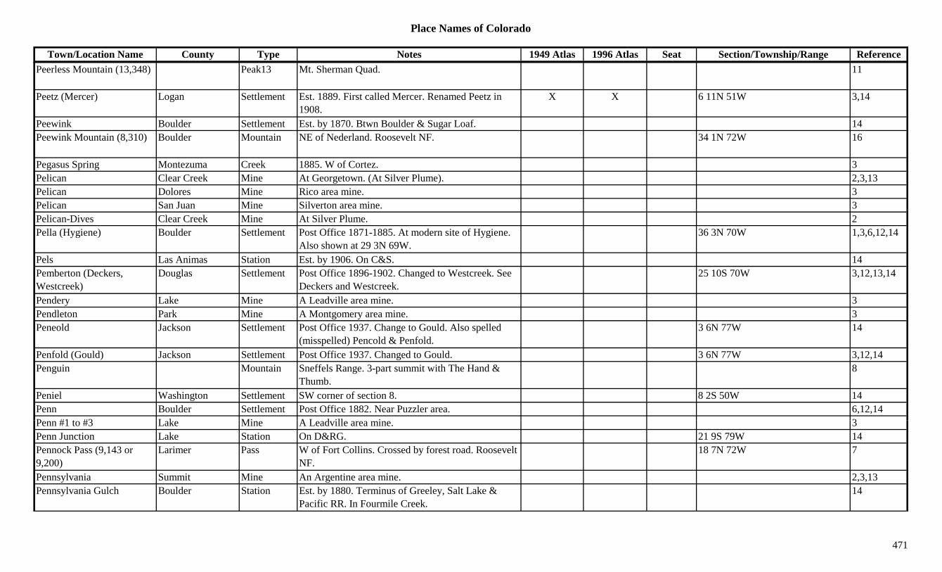
Place Names of Colorado
Town/Location Name County Type Notes 1949 Atlas 1996 Atlas Seat Section/Township/Range ReferencePeerless Mountain (13,348) Peak13 Mt. Sherman Quad. 11
Peetz (Mercer) Logan Settlement Est. 1889. First called Mercer. Renamed Peetz in 1908.
X X 6 11N 51W 3,14
Peewink Boulder Settlement Est. by 1870. Btwn Boulder & Sugar Loaf. 14Peewink Mountain (8,310) Boulder Mountain NE of Nederland. Roosevelt NF. 34 1N 72W 16
Pegasus Spring Montezuma Creek 1885. W of Cortez. 3Pelican Clear Creek Mine At Georgetown. (At Silver Plume). 2,3,13Pelican Dolores Mine Rico area mine. 3Pelican San Juan Mine Silverton area mine. 3Pelican-Dives Clear Creek Mine At Silver Plume. 2Pella (Hygiene) Boulder Settlement Post Office 1871-1885. At modern site of Hygiene.
Also shown at 29 3N 69W.36 3N 70W 1,3,6,12,14
Pels Las Animas Station Est. by 1906. On C&S. 14Pemberton (Deckers, Westcreek)
Douglas Settlement Post Office 1896-1902. Changed to Westcreek. See Deckers and Westcreek.
25 10S 70W 3,12,13,14
Pendery Lake Mine A Leadville area mine. 3Pendleton Park Mine A Montgomery area mine. 3Peneold Jackson Settlement Post Office 1937. Change to Gould. Also spelled
(misspelled) Pencold & Penfold.3 6N 77W 14
Penfold (Gould) Jackson Settlement Post Office 1937. Changed to Gould. 3 6N 77W 3,12,14Penguin Mountain Sneffels Range. 3-part summit with The Hand &
Thumb.8
Peniel Washington Settlement SW corner of section 8. 8 2S 50W 14Penn Boulder Settlement Post Office 1882. Near Puzzler area. 6,12,14P #1 t #3 L k Mi A L d ill i 3Penn #1 to #3 Lake Mine A Leadville area mine. 3Penn Junction Lake Station On D&RG. 21 9S 79W 14Pennock Pass (9,143 or 9,200)
Larimer Pass W of Fort Collins. Crossed by forest road. Roosevelt NF.
18 7N 72W 7
Pennsylvania Summit Mine An Argentine area mine. 2,3,13Pennsylvania Gulch Boulder Station Est. by 1880. Terminus of Greeley, Salt Lake &
Pacific RR. In Fourmile Creek.14
471

Place Names of Colorado
Town/Location Name County Type Notes 1949 Atlas 1996 Atlas Seat Section/Township/Range ReferencePennsylvania Gulch (Sunset)
Boulder Gulch Close to Sunset, later called Sunset. 1,13
Pennsylvania Lake (Glacier Lake)
Boulder Station Stop & station on C&NW. First name for Glacier Lake.
14
Pennsylvania Mountain (13,006)
Park Peak13 SW of Alma. Near Lake Co. Climax Quad. 3,11
Penny Hot Springs Pitkin Settlement 4 10S 88W 14Penny Hot Springs (Hot Springs)
Pitkin Creek 1885. S of Avalanche. On Crystal River. 3
Penrose Lake Mine A Leadville area mine. 3Penrose (Beaver Creek, Fremont Settlement Est. 1908. Post Office est. 1909. First name Beaver X X 5 19S 68W 3,12,14( ,Glendale) Creek. Moved from Glendale.
, ,
Peon Pass (10,336) Saguache Pass Crossed by county road. Gunnison & Rio Grande NF.
17 46N 4E 16
Peona (Paonia) Delta Settlement Est. by 1882. Proposed name for PO, changed to Paonia. See Paonia.
6 14S 91W 14
Peony (Paonia) Delta Settlement 1,3Peoples Delta Unknown On D&RG. Btwn Delta & Grand Junction. 14Peoples Fort Douglas Fort Stockade built in 1868. 2 mi N of Larkspur. 14Peoria Arapahoe Settlement RR Post Office 1906-1914. 6 mi SE of Byers. X 29 4S 60W 3,6,12,14Perfecto Creek Saguache Creek SW corner of county. Flows NE. 3Perigo Boulder Settlement Post Office 1895-1905. 4 mi SW of Rollinsville.
Several mines.1,2
Perigo Gilpin Mine At Perigo. 2,3,13Perigo Gilpin Settlement Gold found in 1859. Post Office 1895-1905. 14 2S 73W 3,12,13,14Perigo Stamp Mill Gilpin Mill At Perigo. 3,13P i (P i ) L Pl t St ti P t Offi 1902 1903 S P i N f 14 35N 10W 3 12 14Perin (Perins) La Plata Station Post Office 1902-1903. Same as Perins. N of
Franklin Junction. Small resort or mining town?14 35N 10W 3,12,14
Perins (Perin) La Plata Settlement Post Office 1907-1926. Same as Perin. N of Franklin Junction. Small resort or mining town?
14 35N 10W 12,14
Perkins Moffat Unknown 5 10N 89W 14Perl-Mack Adams Other Post Office just SE of Westminster 1960-1965. 6Perrin Denver Unknown 14
472
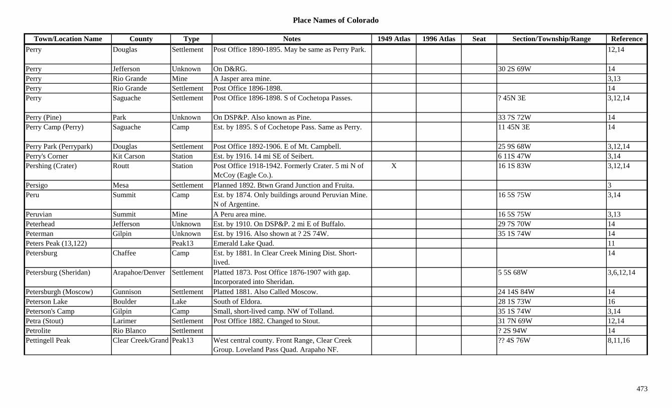
Place Names of Colorado
Town/Location Name County Type Notes 1949 Atlas 1996 Atlas Seat Section/Township/Range ReferencePerry Douglas Settlement Post Office 1890-1895. May be same as Perry Park. 12,14
Perry Jefferson Unknown On D&RG. 30 2S 69W 14Perry Rio Grande Mine A Jasper area mine. 3,13Perry Rio Grande Settlement Post Office 1896-1898. 14Perry Saguache Settlement Post Office 1896-1898. S of Cochetopa Passes. ? 45N 3E 3,12,14
Perry (Pine) Park Unknown On DSP&P. Also known as Pine. 33 7S 72W 14Perry Camp (Perry) Saguache Camp Est. by 1895. S of Cochetope Pass. Same as Perry. 11 45N 3E 14
Perry Park (Perrypark) Douglas Settlement Post Office 1892-1906. E of Mt. Campbell. 25 9S 68W 3,12,14y ( yp ) g p , ,Perry's Corner Kit Carson Station Est. by 1916. 14 mi SE of Seibert. 6 11S 47W 3,14Pershing (Crater) Routt Station Post Office 1918-1942. Formerly Crater. 5 mi N of
McCoy (Eagle Co.).X 16 1S 83W 3,12,14
Persigo Mesa Settlement Planned 1892. Btwn Grand Junction and Fruita. 3Peru Summit Camp Est. by 1874. Only buildings around Peruvian Mine.
N of Argentine.16 5S 75W 3,14
Peruvian Summit Mine A Peru area mine. 16 5S 75W 3,13Peterhead Jefferson Unknown Est. by 1910. On DSP&P. 2 mi E of Buffalo. 29 7S 70W 14Peterman Gilpin Unknown Est. by 1916. Also shown at ? 2S 74W. 35 1S 74W 14Peters Peak (13,122) Peak13 Emerald Lake Quad. 11Petersburg Chaffee Camp Est. by 1881. In Clear Creek Mining Dist. Short-
lived.14
Petersburg (Sheridan) Arapahoe/Denver Settlement Platted 1873. Post Office 1876-1907 with gap. Incorporated into Sheridan.
5 5S 68W 3,6,12,14
Petersburgh (Moscow) Gunnison Settlement Platted 1881. Also Called Moscow. 24 14S 84W 14P t L k B ld L k S th f Eld 28 1S 73W 16Peterson Lake Boulder Lake South of Eldora. 28 1S 73W 16Peterson's Camp Gilpin Camp Small, short-lived camp. NW of Tolland. 35 1S 74W 3,14Petra (Stout) Larimer Settlement Post Office 1882. Changed to Stout. 31 7N 69W 12,14Petrolite Rio Blanco Settlement ? 2S 94W 14Pettingell Peak Clear Creek/Grand Peak13 West central county. Front Range, Clear Creek
Group. Loveland Pass Quad. Arapaho NF.?? 4S 76W 8,11,16
473

Place Names of Colorado
Town/Location Name County Type Notes 1949 Atlas 1996 Atlas Seat Section/Township/Range ReferencePeyton (Mayfield) El Paso Settlement Post Office est. 1889. Platted 1889. Name changed
from Mayfield 1888.X X 6 12S 63W 3,12,14
Phantom (Spook City) Saguache Camp Once called Spook City. 12.5 mi N of Grand Lake. S of Lulu City. Twin camp of Ford.
21 46N 7E 14
Phantom Canyon Road Teller Trail From S to Victor. 3Phantom Valley Ranch Grand Ranch Ranch S of Lulu. 3Pharmacist Teller Mine A Victor area mine. Above Altman. 2,3,13Philadelphia Land Co. Montrose Unknown 4 47N 13W 14Philips Montezuma Station 1880s wagon stop. At junction of road from Mancos
and trail from Rico.3
Phillips Rio Grande Unknown On D&RG. 30 40N 3E 14pPhillips Lode Park Mine Est. by 1861. A Buckskin Joe area mine. 3,13Phillipsburg (Pop Zero) Jefferson Settlement Post Office 1896. SE of Fenders. Also shown at 11
5S 70W.11 6S 70W 1,3,6,12,14
Phippsburg Routt Settlement Est. 1905. On D&RG. Post Office est. 1909. Btwn Kremmling and Steamboat Springs.
X X 17 3N 85W 3,12,14
Phoenix Dolores Mine Rico area mine. In Nigger Baby Hill district. 24 40N 11W 3,14Phoenix (Phoenixville) Boulder Camp Est. by 1890s. NW of Rollinsville. Probably
correctly in Gilpin Co.1,3
Phoenix (Phoenixville) Gilpin Settlement Same as Phoenixville. 26 1S 73W 14Phoenixville (Phoenix) Gilpin Camp Btwn Rollinsville and Eldora. 26 1S 73W 3,14Picayune Gulch San Juan Gulch An Animas Forks area productive gulch. 3Piceance Rio Blanco Settlement Post Office 1892-1926. Settlement on Pi-Ce-Ance
Creek.4 2S 97W 3,12,14
Piceance Creek Rio Blanco Creek Flows W & N past Rio Blanco to join White River. X 3
Pi k Wi k B ld Mi At J t N M li 3Pick Wick Boulder Mine At Jamestown. Near Magnolia. 3Picketwire River Local name for Purgatoire River 1Pickle Gulch Gilpin Gulch Runs SE & S to North Clear Creek. NW of Black
Hawk.Sev 2S 73W 16
Pickletown Arapahoe Settlement N of Broadway Estates. 14Pico Isolado (13,611) Peak13 Sangre de Cristo Range, Main Section. Crestone
Peak Quad.8,11
474

Place Names of Colorado
Town/Location Name County Type Notes 1949 Atlas 1996 Atlas Seat Section/Township/Range ReferencePico Mountains Range Part of San Juans. 15Pictou (Sulphur Springs) Huerfano Settlement RR Post Office 1889-1932. 3 mi NW of Walsenburg.
Originally Sulphur Springs.X 6 28S 66W 3,12,14
Pie Plant (Pieplant) Gunnison Camp Post Office 1904-1906. Part of Dorchester, near Taylor Reservoir. N of Tincup.
1,3,12
Pie Plant Mine/Mill Gunnison Mine At Pie Plant. 3Piedmont El Paso Settlement Platted 1891. No Post Office. NE of Broadmoor
Hotel.3,14
Piedmont Jefferson Unknown Est. 1859. 3 mi N of mouth of Platte Canyon. Inside of Deer Creek Gap in the Hogback.
4 6S 69W 6,14
Piedmont Ouray Station Est. by 1923. On D&RG. 4 mi S of Ridgway. 34 45N 8W 3,14y y g y ,Piedmont (St. Thomas) Las Animas Unknown On C&W. Once called St. Thomas. 27 33S 64W 14Piedmont Junction Las Animas Station Est. by 1906. On C&W. 14Piedra Conejos/Archuleta Settlement Post Office 1879-1927. 4 mi W of Chimney Rock. X 8 34N 4W 3,12,14
Piedra Rio Grande Settlement Post Office 1875-1878. 10 37N 8E 12,14Piedra Mountains Range Part of San Juans. 15Piedra Pass (11,420) Mineral Pass SW of Creede. Palomino Mtn. Topo. 5,7Piedra Peak (12,328) Archuleta Peak12 Piedra Mounstains. SW corner of county. NW of
Arboles.3,8
Piedra Peak (8,551) Archuleta Peak North of Arboles. Southern Ute Indian Reservation. 24 33N 6W 16
Piedra Peak No 2 (8,169) Archuleta Peak North of Arboles. Southern Ute Indian Reservation. 25 33N 6W 16
Piedra River Archuleta River Flows S from Hinsdale Co to Navajo Lake near NM. X
Pi d Ri Hi d l Ri Fl S f Mi l C t A h l t C XPiedra River Hinsdale River Flows S from near Mineral Co to Archuleta Co. X
Piedra River Mineral River Flows SW our of San Juan Mtns into Hinsdale Co. 3
Piedre (Chimney Rock) Archuleta Settlement See Chimney Rock. 3Piedrosa Canyon Conejos Canyon North central county. Runs SE to Hot Creek. Sev 36N 6E 16Pieplant (Pie Plant) Gunnison Settlement Post Office 1904-1906. 15 mi N of Tin Cup. 5 13S 82W 2,14
475
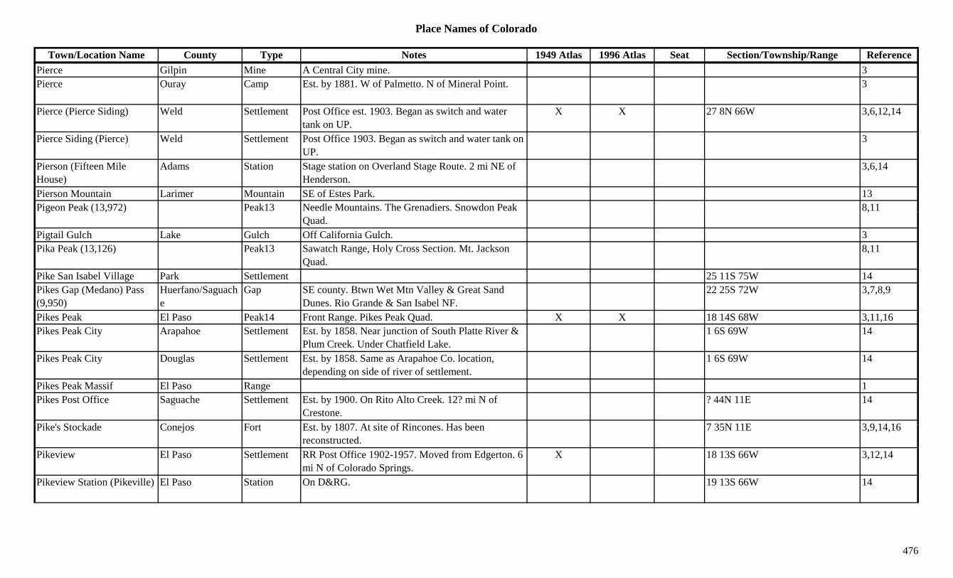
Place Names of Colorado
Town/Location Name County Type Notes 1949 Atlas 1996 Atlas Seat Section/Township/Range ReferencePierce Gilpin Mine A Central City mine. 3Pierce Ouray Camp Est. by 1881. W of Palmetto. N of Mineral Point. 3
Pierce (Pierce Siding) Weld Settlement Post Office est. 1903. Began as switch and water tank on UP.
X X 27 8N 66W 3,6,12,14
Pierce Siding (Pierce) Weld Settlement Post Office 1903. Began as switch and water tank on UP.
3
Pierson (Fifteen Mile House)
Adams Station Stage station on Overland Stage Route. 2 mi NE of Henderson.
3,6,14
Pierson Mountain Larimer Mountain SE of Estes Park. 13Pigeon Peak (13,972) Peak13 Needle Mountains. The Grenadiers. Snowdon Peak 8,11g ( , )
Quad.,
Pigtail Gulch Lake Gulch Off California Gulch. 3Pika Peak (13,126) Peak13 Sawatch Range, Holy Cross Section. Mt. Jackson
Quad.8,11
Pike San Isabel Village Park Settlement 25 11S 75W 14Pikes Gap (Medano) Pass (9,950)
Huerfano/Saguache
Gap SE county. Btwn Wet Mtn Valley & Great Sand Dunes. Rio Grande & San Isabel NF.
22 25S 72W 3,7,8,9
Pikes Peak El Paso Peak14 Front Range. Pikes Peak Quad. X X 18 14S 68W 3,11,16Pikes Peak City Arapahoe Settlement Est. by 1858. Near junction of South Platte River &
Plum Creek. Under Chatfield Lake.1 6S 69W 14
Pikes Peak City Douglas Settlement Est. by 1858. Same as Arapahoe Co. location, depending on side of river of settlement.
1 6S 69W 14
Pikes Peak Massif El Paso Range 1Pikes Post Office Saguache Settlement Est. by 1900. On Rito Alto Creek. 12? mi N of
Crestone.? 44N 11E 14
Pik ' St k d C j F t E t b 1807 At it f Ri H b 7 35N 11E 3 9 14 16Pike's Stockade Conejos Fort Est. by 1807. At site of Rincones. Has been reconstructed.
7 35N 11E 3,9,14,16
Pikeview El Paso Settlement RR Post Office 1902-1957. Moved from Edgerton. 6 mi N of Colorado Springs.
X 18 13S 66W 3,12,14
Pikeview Station (Pikeville) El Paso Station On D&RG. 19 13S 66W 14
476
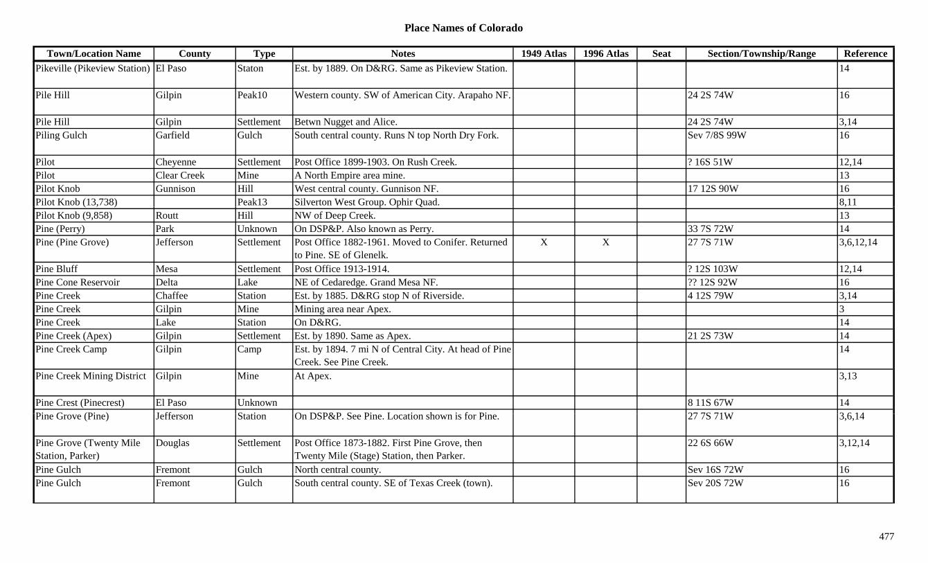
Place Names of Colorado
Town/Location Name County Type Notes 1949 Atlas 1996 Atlas Seat Section/Township/Range ReferencePikeville (Pikeview Station) El Paso Staton Est. by 1889. On D&RG. Same as Pikeview Station. 14
Pile Hill Gilpin Peak10 Western county. SW of American City. Arapaho NF. 24 2S 74W 16
Pile Hill Gilpin Settlement Betwn Nugget and Alice. 24 2S 74W 3,14Piling Gulch Garfield Gulch South central county. Runs N top North Dry Fork. Sev 7/8S 99W 16
Pilot Cheyenne Settlement Post Office 1899-1903. On Rush Creek. ? 16S 51W 12,14Pilot Clear Creek Mine A North Empire area mine. 13Pilot Knob Gunnison Hill West central county. Gunnison NF. 17 12S 90W 16Pilot Knob (13,738) Peak13 Silverton West Group. Ophir Quad. 8,11( , ) p p Q ,Pilot Knob (9,858) Routt Hill NW of Deep Creek. 13Pine (Perry) Park Unknown On DSP&P. Also known as Perry. 33 7S 72W 14Pine (Pine Grove) Jefferson Settlement Post Office 1882-1961. Moved to Conifer. Returned
to Pine. SE of Glenelk.X X 27 7S 71W 3,6,12,14
Pine Bluff Mesa Settlement Post Office 1913-1914. ? 12S 103W 12,14Pine Cone Reservoir Delta Lake NE of Cedaredge. Grand Mesa NF. ?? 12S 92W 16Pine Creek Chaffee Station Est. by 1885. D&RG stop N of Riverside. 4 12S 79W 3,14Pine Creek Gilpin Mine Mining area near Apex. 3Pine Creek Lake Station On D&RG. 14Pine Creek (Apex) Gilpin Settlement Est. by 1890. Same as Apex. 21 2S 73W 14Pine Creek Camp Gilpin Camp Est. by 1894. 7 mi N of Central City. At head of Pine
Creek. See Pine Creek.14
Pine Creek Mining District Gilpin Mine At Apex. 3,13
Pine Crest (Pinecrest) El Paso Unknown 8 11S 67W 14Pi G (Pi ) J ff St ti O DSP&P S Pi L ti h i f Pi 27 7S 71W 3 6 14Pine Grove (Pine) Jefferson Station On DSP&P. See Pine. Location shown is for Pine. 27 7S 71W 3,6,14
Pine Grove (Twenty Mile Station, Parker)
Douglas Settlement Post Office 1873-1882. First Pine Grove, then Twenty Mile (Stage) Station, then Parker.
22 6S 66W 3,12,14
Pine Gulch Fremont Gulch North central county. Sev 16S 72W 16Pine Gulch Fremont Gulch South central county. SE of Texas Creek (town). Sev 20S 72W 16
477

Place Names of Colorado
Town/Location Name County Type Notes 1949 Atlas 1996 Atlas Seat Section/Township/Range ReferencePine Gulch Fremont Gulch South of Parkdale. Runs ENE. Sev 19S 72W 16Pine Knott Larimer Settlement 14Pine Nook Douglas Unknown 1 8S 69W 14Pine Ridge La Plata Settlement Est. by 1923. 5 mi W of Durango. 5 34N 10W 3,14Pine River La Plata Station Site 2. Est. by 1903. On D&RG. Btwn Oxford and
Ignacio. 2 sites, but confusing.35 34N 8W 3,14
Pine River (Pineriver) La Plata Settlement Site 1. Post Office 1878-1894. Changed to Pineriver. 9 mi up Los Pinos Canyon.
26 35N 7W 3,12,14
Pine Springs Jefferson Settlement 14Pine Valley Heights Clear Creek Settlement Platted 1949. 23 4S 72W 14Pinecliffe (Pinecliff, Gato) Boulder/Gilpin Settlement Est. 1900. Post Office est. 1909. In Coal Creek X 27 1S 72W 1,3,6,12,14( , ) p
Canyon. Part is in Gilpin Co., , , ,
Pinecrest (Pine Crest) El Paso Settlement Est. by 1924. Same site as Weissport. 8 11S 67W 3Pineland Douglas Station Est. by 1877. On D&RG. 10 mi S of Larkspur. 14Pineriver (Pine River) La Plata Settlement Post Office 1894-1895. Changed from Pine River. 26 35N 7W 12
Pines Custer Unknown 6 22S 73W 14Pineview Jefferson Unknown 6Pinewood Larimer Settlement Post Office 1879-1921. 31 5N 70W 12,14Pinewood Springs (Little Elk Park)
Larimer Settlement Est. 1903 as Little Elk Park. Name change in 1960. X 3
Piney Creek Arapahoe Creek Runs WNW. Flows into Cherry Creek Reservoir. 16
Piney Creek Eagle Creek Flows NW past State Bridge to join Colorado River. 3
Piney Lake Eagle Lake NE corner of county. White River NF. 12 4S 81W + 16Pi P k E l P k11 NE f t Whit Ri NF 7 3S 81W 13 16Piney Peak Eagle Peak11 NE corner of county. White River NF. 7 3S 81W 13,16Pinkerton Hot Springs La Plata Settlement Est. by 1908. On D&RG. Site near old Animas City. 25 37N 9W 3,14
Pinkerton Trail La Plata Creek Trail S from San Juan County to Durango. Follows Hermosa Creek.
3
Pinkham Pass (9,600) Jackson Pass N of Walden. 7Pinkhampton Grand Unknown ? 11N 79W 14
478
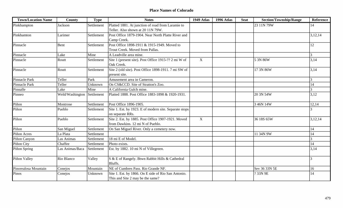
Place Names of Colorado
Town/Location Name County Type Notes 1949 Atlas 1996 Atlas Seat Section/Township/Range ReferencePinkhampton Jackson Settlement Platted 1881. At junction of road from Laramie to
Teller. Also shown at 20 11N 79W.23 11N 79W 14
Pinkhamton Larimer Settlement Post Office 1879-1904. Near North Platte River and Camp Creek.
3,12,14
Pinnacle Bent Settlement Post Office 1898-1911 & 1915-1949. Moved to Trout Creek. Moved from Pallas.
12
Pinnacle Lake Mine A Leadville area mine. 3Pinnacle Routt Settlement Site 1 (present site). Post Office 1915-?? 2 mi W of
Oak Creek.X 5 3N 86W 3,14
Pinnacle Routt Settlement Site 2 (old site). Post Office 1898-1911. 7 mi SW of present site.
17 3N 86W 3,14
Pinnacle Park Teller Park Amusement area in Cameron. 3Pinnacle Park Teller Unknown On CS&CCD. Site of Stratton's Zoo. 14Pinnalle Lake Mine A California Gulch mine. 3Pinneo Weld/Washington Settlement Platted 1888. Post Office 1883-1898 & 1920-1931. 20 3N 54W 3,12
Piñon Montrose Settlement Post Office 1896-1905. 3 46N 14W 12,14Piñon Pueblo Settlement Site 1. Est. by 1923. E of modern site. Separate stops
on separate RRs.3
Piñon Pueblo Settlement Site 2. Est. by 1885. Post Office 1907-1921. Moved from Dawkins. 12 mi N of Pueblo.
X 36 18S 65W 3,12,14
Piñon San Miguel Settlement On San Miguel River. Only a cemetery now. 14Piñon Acres La Plata Settlement 11 34N 9W 14Piñon Canyon Las Animas Settlement 18 mi E of Model. 3Piñon City Chaffee Settlement Photo exists. 14Piñon Spring Las Animas/Baca Settlement Est. by 1882. 10 mi N of Villegreen. 3,14
Piñon Valley Rio Blanco Valley S & E of Rangely. Btwn Rabbit Hills & Cathedral Bluffs.
3
Pinorealosa Mountain Conejos Mountain NE of Cumbres Pass. Rio Grande NF. Sev 36 33N 5E 16Pinos Conejos Unknown Site 1. Est. by 1866. On E side of Rio San Antonio.
This and Site 2 may be the same?? 33N 9E 14
479

Place Names of Colorado
Town/Location Name County Type Notes 1949 Atlas 1996 Atlas Seat Section/Township/Range ReferencePinos Conejos Unknown Site 2. Est. by 1881. On D&RG. On Piñon Creek. ? 33N 5E 14
Pinos Creek Rio Grande Creek Flows NE to Rio Grande River near Del Norte. 3Pinto Creek Grand Creek Flows from W into Muddy Creek above Kremmling. 3
Pioneer Chaffee Mine Near Tincup Pass. W of St. Elmo. 3Pioneer Creek Alamosa Creek Eastern county flows W to Dry Lakes. 16Pioneer Mill Clear Creek Mill A North Empire area mine. And/or Yankee Hill area. 3,13
Pioneer Mine Clear Creek Mine A North Empire area mine. 13Pipit Lake Boulder Lake NW corner of county. Rocky Mountain Natl Park. 27 3N 74W 16p y y
Pipit Peak (12,433) Larimer Peak12 Rawah Range. 8Pisgah Teller Station Est. by 1923. On CM. 4 mi E of Florissant. 6 13S 70W 3,14Pisgah Junction Teller Station On SE corner of Cripple Creek. 24 15S 70W 3,14Pisgah Peak Teller Peak E of Cripple Creek. 3Pitkin (Quartzville, Quartz) Gunnison Settlement Post Office est. 1879. Formerly Quartzville. 6 mi NE
of Ohio City.X X 9 50N 4E 2,3,12,13,14
Pittsburg San Juan Mine A Red Mountain area mine. 3Pittsburgh Montrose Camp Est. by 1916. Mill & camp. 6 47N 17W 14Pittsburgh (Pittsburg) Clear Creek Mine A North Empire area mine. 13Pittsburgh (Pittsburg) Gunnison Camp Post Office 1881-1896. SW of Gothic. Served
Augusta Mine.X 1 13S 87W 3,12,14
Placer (Dickey) Summit Unknown On DSP&P. 6 mi N of Breckenridge. 2 mi S of Dillon (1883). At the location of Dickey.
31 5S 77W 14
Placer (Placerville) Jefferson Settlement On Clear Creek. On US 6. 14Pl (R ll St ti Bi C till St ti E t b 1881 RR d t D&RG N t i t d 3Placer (Russell Station, Big Hill)
Costilla Station Est. by 1881. RR depot on D&RG. Not associated with Placer (PO near Russell).
3
Placer (Russell) Costilla Settlement N of Russell. First name for Russell. Note: Some confusion between authors.
1 29S 71W 3,14
Placer Camp Arapahoe Camp At the mouth of Dry Creek & the Platte River. 7 mi S of mouth of Cherry Creek.
14
Placer Creek Costilla Creek Russell area. 13
480

Place Names of Colorado
Town/Location Name County Type Notes 1949 Atlas 1996 Atlas Seat Section/Township/Range ReferencePlacer Valley Clear Creek Settlement Platted 1951. Note: No such sub-division in Clear
Creek Co., but one in Park Co.14
Placerville (Dry Diggings, Hangtown)
Ouray/San Miguel Settlement Site 1. Post Office est. 1878. 1 mi N of present Placerville. Note: Some confusion on sites.
14
Placerville (Dry Diggings, Hangtown)
San Miguel Settlement Site 2. 17 mi NW of Telluride. 2 sites 0.5 mi apart. See Newtown & Site 1.
X X 34 44N 11W 2,3,12,13,14
Placerville (Placer) Jefferson Settlement See Placer. 14Placier Costilla Settlement See Placer. 14Placita Huerfano Station Est. by 1881. Stop on D&RG. In same vicinity as
Walsenburg Junction.10 28S 66W 3,14
Placita Las Animas Settlement Est. by 1884. 11 mi W of Tyrone. 6 mi NE of 10 30S 63W 3,14y yApishapa.
,
Placita Pitkin Settlement Est. 1899. Post Office 1899-1903 & 1928-1934. Coal town.
X 6 11S 88W 3,12,14
Placita Coal Pitkin Mine A Placita area mine. 3Placita De Los Meas (La Placita De Los Meas)
Conejos Settlement Early Mexican Plaza. S side of Conejos River. Same as La Placita De Los Meas.
? 33N 8E 14
Placita De Penasco Amarillo (Hardscrabble)
Fremont Settlement Another name for Hardscrabble. See Hardscrabble. 33 20S 69W 14
Placito Huerfano Settlement See Placita. 14Plain Jefferson Unknown On D&RG. 7 2S 70W 14Plain (Lakeside) Summit Settlement Post Office 1898-1899. On the Blue River. Same site
as Lakeside.13 2S 80W 12,14
Plainer (Platner) Washington Settlement See Platner. May be typo. 4Plains Prowers Settlement Rural Post Office 1908-1921. 5 mi SW of Webb.
Also shown at 15 27S 43W.24 27S 43W 3,12,14
Pl i i J ff S ttl t O D&RG R l P t Offi 1909 1952 4 i S f 12 2S 71W 3 6 12 14Plainview Jefferson Settlement On D&RG. Rural Post Office 1909-1952. 4 mi S of Eldorado Springs.
12 2S 71W 3,6,12,14
Plano Vista Conejos Unknown ? 35N 9E 14Plastic Jefferson Station On D&RG. 20 2S 70W 14Plata Verde Custer Mine Westcliffe area mine. 2,3Plateau Douglas Settlement Est. by 1892. Stop on D&RGW. 5 mi E of Sedalia. X 21 7S 67W 3,14
481
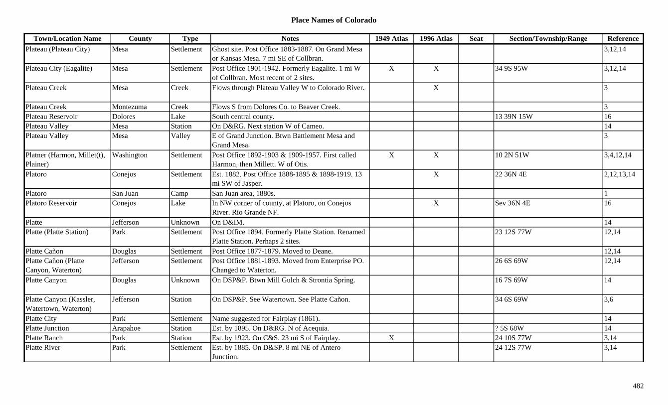
Place Names of Colorado
Town/Location Name County Type Notes 1949 Atlas 1996 Atlas Seat Section/Township/Range ReferencePlateau (Plateau City) Mesa Settlement Ghost site. Post Office 1883-1887. On Grand Mesa
or Kansas Mesa. 7 mi SE of Collbran.3,12,14
Plateau City (Eagalite) Mesa Settlement Post Office 1901-1942. Formerly Eagalite. 1 mi W of Collbran. Most recent of 2 sites.
X X 34 9S 95W 3,12,14
Plateau Creek Mesa Creek Flows through Plateau Valley W to Colorado River. X 3
Plateau Creek Montezuma Creek Flows S from Dolores Co. to Beaver Creek. 3Plateau Reservoir Dolores Lake South central county. 13 39N 15W 16Plateau Valley Mesa Station On D&RG. Next station W of Cameo. 14Plateau Valley Mesa Valley E of Grand Junction. Btwn Battlement Mesa and
Grand Mesa.3
Platner (Harmon, Millet(t), Plainer)
Washington Settlement Post Office 1892-1903 & 1909-1957. First called Harmon, then Millett. W of Otis.
X X 10 2N 51W 3,4,12,14
Platoro Conejos Settlement Est. 1882. Post Office 1888-1895 & 1898-1919. 13 mi SW of Jasper.
X 22 36N 4E 2,12,13,14
Platoro San Juan Camp San Juan area, 1880s. 1Platoro Reservoir Conejos Lake In NW corner of county, at Platoro, on Conejos
River. Rio Grande NF.X Sev 36N 4E 16
Platte Jefferson Unknown On D&IM. 14Platte (Platte Station) Park Settlement Post Office 1894. Formerly Platte Station. Renamed
Platte Station. Perhaps 2 sites.23 12S 77W 12,14
Platte Cañon Douglas Settlement Post Office 1877-1879. Moved to Deane. 12,14Platte Cañon (Platte Canyon, Waterton)
Jefferson Settlement Post Office 1881-1893. Moved from Enterprise PO. Changed to Waterton.
26 6S 69W 12,14
Platte Canyon Douglas Unknown On DSP&P. Btwn Mill Gulch & Strontia Spring. 16 7S 69W 14
Pl tt C (K l J ff St ti O DSP&P S W t t S Pl tt C ñ 34 6S 69W 3 6Platte Canyon (Kassler, Watertown, Waterton)
Jefferson Station On DSP&P. See Watertown. See Platte Cañon. 34 6S 69W 3,6
Platte City Park Settlement Name suggested for Fairplay (1861). 14Platte Junction Arapahoe Station Est. by 1895. On D&RG. N of Acequia. ? 5S 68W 14Platte Ranch Park Station Est. by 1923. On C&S. 23 mi S of Fairplay. X 24 10S 77W 3,14Platte River Park Settlement Est. by 1885. On D&SP. 8 mi NE of Antero
Junction.24 12S 77W 3,14
482
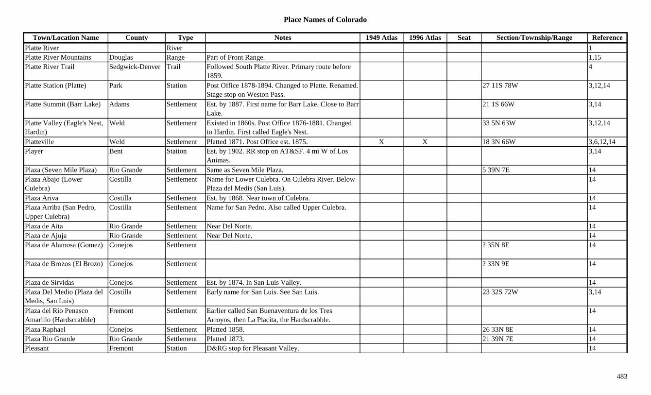
Place Names of Colorado
Town/Location Name County Type Notes 1949 Atlas 1996 Atlas Seat Section/Township/Range ReferencePlatte River River 1Platte River Mountains Douglas Range Part of Front Range. 1,15Platte River Trail Sedgwick-Denver Trail Followed South Platte River. Primary route before
1859.4
Platte Station (Platte) Park Station Post Office 1878-1894. Changed to Platte. Renamed. Stage stop on Weston Pass.
27 11S 78W 3,12,14
Platte Summit (Barr Lake) Adams Settlement Est. by 1887. First name for Barr Lake. Close to Barr Lake.
21 1S 66W 3,14
Platte Valley (Eagle's Nest, Hardin)
Weld Settlement Existed in 1860s. Post Office 1876-1881. Changed to Hardin. First called Eagle's Nest.
33 5N 63W 3,12,14
Platteville Weld Settlement Platted 1871. Post Office est. 1875. X X 18 3N 66W 3,6,12,14, , ,Player Bent Station Est. by 1902. RR stop on AT&SF. 4 mi W of Los
Animas.3,14
Plaza (Seven Mile Plaza) Rio Grande Settlement Same as Seven Mile Plaza. 5 39N 7E 14Plaza Abajo (Lower Culebra)
Costilla Settlement Name for Lower Culebra. On Culebra River. Below Plaza del Medis (San Luis).
14
Plaza Ariva Costilla Settlement Est. by 1868. Near town of Culebra. 14Plaza Arriba (San Pedro, Upper Culebra)
Costilla Settlement Name for San Pedro. Also called Upper Culebra. 14
Plaza de Aita Rio Grande Settlement Near Del Norte. 14Plaza de Ajuja Rio Grande Settlement Near Del Norte. 14Plaza de Alamosa (Gomez) Conejos Settlement ? 35N 8E 14
Plaza de Brozos (El Brozo) Conejos Settlement ? 33N 9E 14
Plaza de Sirvidas Conejos Settlement Est. by 1874. In San Luis Valley. 14Pl D l M di (Pl d l C till S ttl t E l f S L i S S L i 23 32S 72W 3 14Plaza Del Medio (Plaza del Medis, San Luis)
Costilla Settlement Early name for San Luis. See San Luis. 23 32S 72W 3,14
Plaza del Rio Penasco Amarillo (Hardscrabble)
Fremont Settlement Earlier called San Buenaventura de los Tres Arroyos, then La Placita, the Hardscrabble.
14
Plaza Raphael Conejos Settlement Platted 1858. 26 33N 8E 14Plaza Rio Grande Rio Grande Settlement Platted 1873. 21 39N 7E 14Pleasant Fremont Station D&RG stop for Pleasant Valley. 14
483
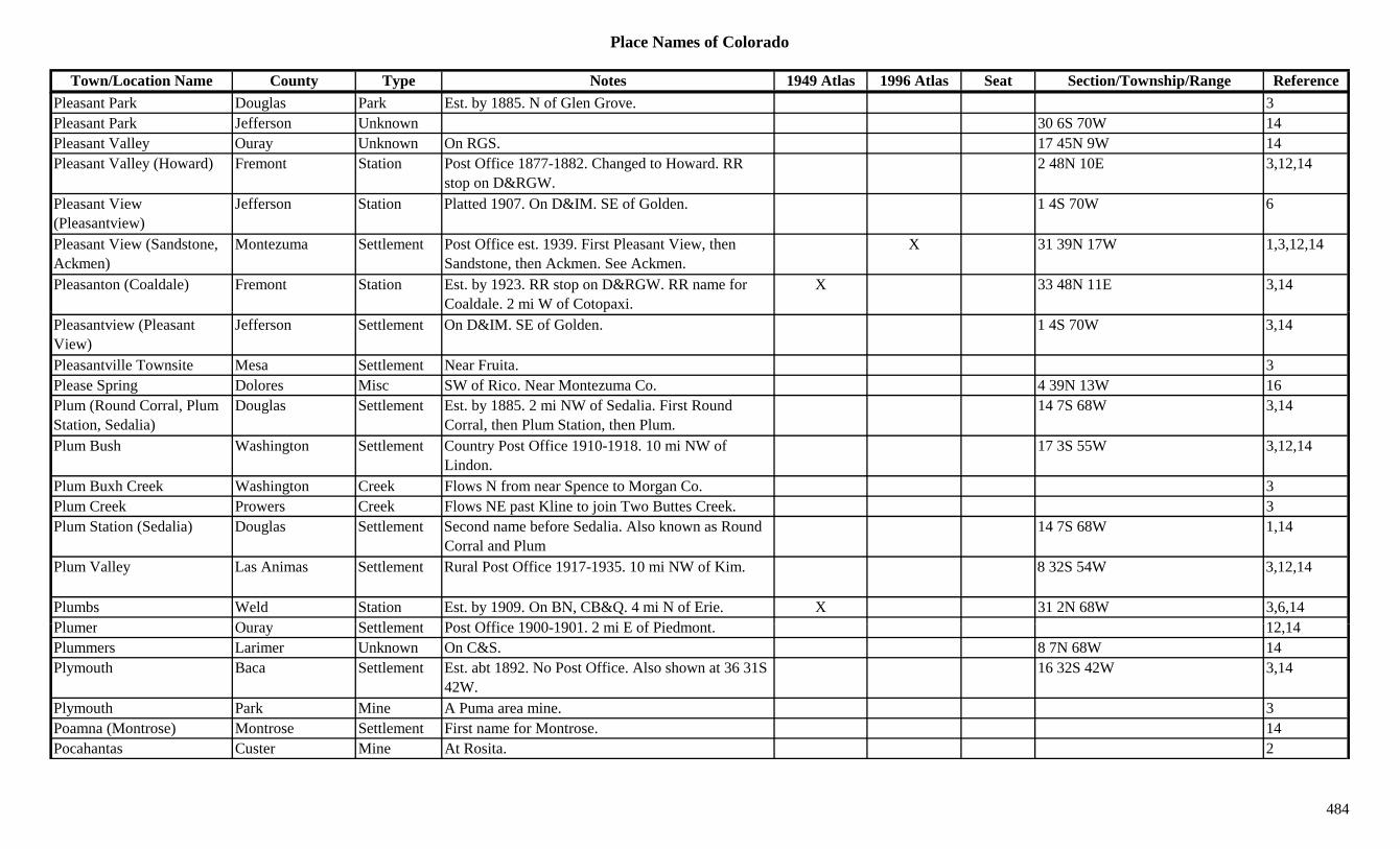
Place Names of Colorado
Town/Location Name County Type Notes 1949 Atlas 1996 Atlas Seat Section/Township/Range ReferencePleasant Park Douglas Park Est. by 1885. N of Glen Grove. 3Pleasant Park Jefferson Unknown 30 6S 70W 14Pleasant Valley Ouray Unknown On RGS. 17 45N 9W 14Pleasant Valley (Howard) Fremont Station Post Office 1877-1882. Changed to Howard. RR
stop on D&RGW.2 48N 10E 3,12,14
Pleasant View (Pleasantview)
Jefferson Station Platted 1907. On D&IM. SE of Golden. 1 4S 70W 6
Pleasant View (Sandstone, Ackmen)
Montezuma Settlement Post Office est. 1939. First Pleasant View, then Sandstone, then Ackmen. See Ackmen.
X 31 39N 17W 1,3,12,14
Pleasanton (Coaldale) Fremont Station Est. by 1923. RR stop on D&RGW. RR name for Coaldale. 2 mi W of Cotopaxi.
X 33 48N 11E 3,14
Pleasantview (Pleasant View)
Jefferson Settlement On D&IM. SE of Golden. 1 4S 70W 3,14
Pleasantville Townsite Mesa Settlement Near Fruita. 3Please Spring Dolores Misc SW of Rico. Near Montezuma Co. 4 39N 13W 16Plum (Round Corral, Plum Station, Sedalia)
Douglas Settlement Est. by 1885. 2 mi NW of Sedalia. First Round Corral, then Plum Station, then Plum.
14 7S 68W 3,14
Plum Bush Washington Settlement Country Post Office 1910-1918. 10 mi NW of Lindon.
17 3S 55W 3,12,14
Plum Buxh Creek Washington Creek Flows N from near Spence to Morgan Co. 3Plum Creek Prowers Creek Flows NE past Kline to join Two Buttes Creek. 3Plum Station (Sedalia) Douglas Settlement Second name before Sedalia. Also known as Round
Corral and Plum14 7S 68W 1,14
Plum Valley Las Animas Settlement Rural Post Office 1917-1935. 10 mi NW of Kim. 8 32S 54W 3,12,14
Plumbs Weld Station Est. by 1909. On BN, CB&Q. 4 mi N of Erie. X 31 2N 68W 3,6,14Pl O S ttl t P t Offi 1900 1901 2 i E f Pi d t 12 14Plumer Ouray Settlement Post Office 1900-1901. 2 mi E of Piedmont. 12,14Plummers Larimer Unknown On C&S. 8 7N 68W 14Plymouth Baca Settlement Est. abt 1892. No Post Office. Also shown at 36 31S
42W.16 32S 42W 3,14
Plymouth Park Mine A Puma area mine. 3Poamna (Montrose) Montrose Settlement First name for Montrose. 14Pocahantas Custer Mine At Rosita. 2
484
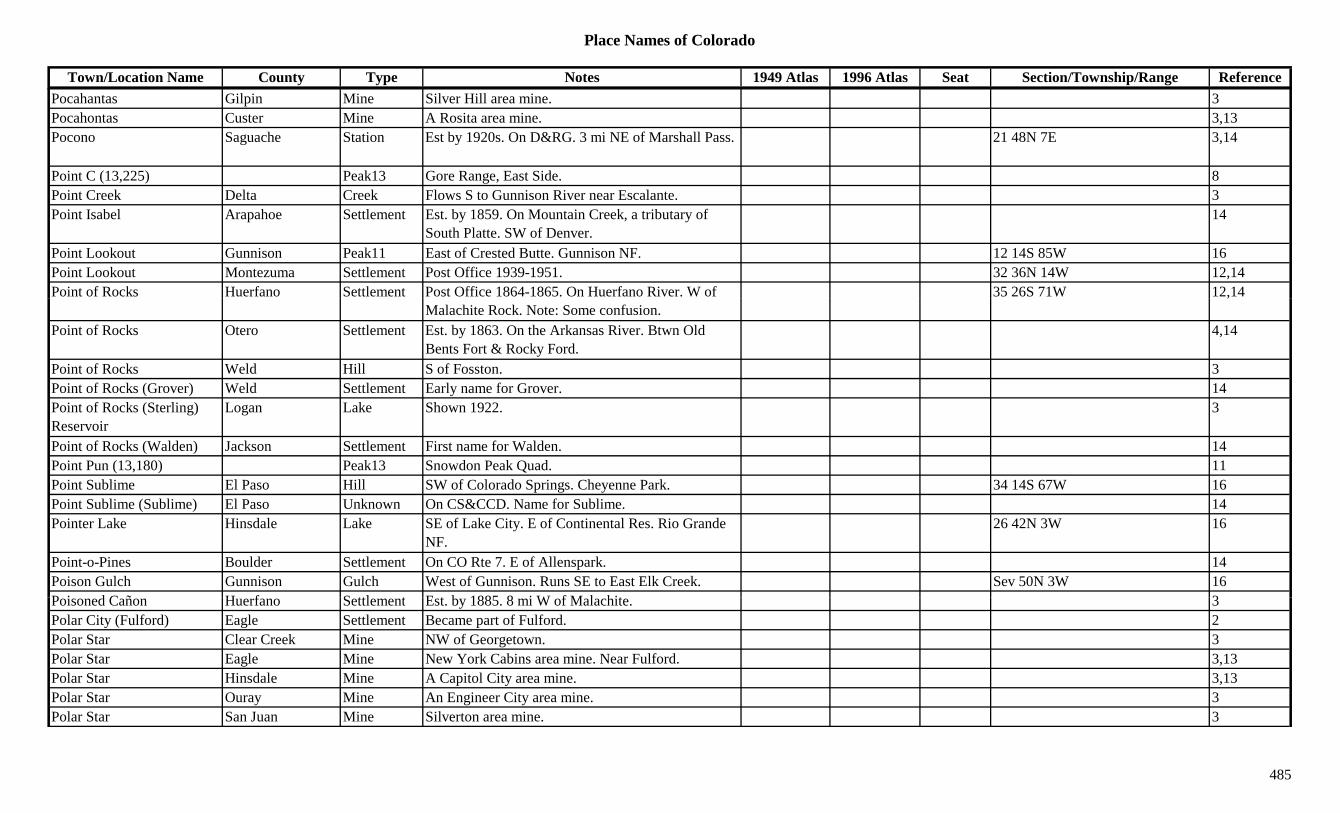
Place Names of Colorado
Town/Location Name County Type Notes 1949 Atlas 1996 Atlas Seat Section/Township/Range ReferencePocahantas Gilpin Mine Silver Hill area mine. 3Pocahontas Custer Mine A Rosita area mine. 3,13Pocono Saguache Station Est by 1920s. On D&RG. 3 mi NE of Marshall Pass. 21 48N 7E 3,14
Point C (13,225) Peak13 Gore Range, East Side. 8Point Creek Delta Creek Flows S to Gunnison River near Escalante. 3Point Isabel Arapahoe Settlement Est. by 1859. On Mountain Creek, a tributary of
South Platte. SW of Denver.14
Point Lookout Gunnison Peak11 East of Crested Butte. Gunnison NF. 12 14S 85W 16Point Lookout Montezuma Settlement Post Office 1939-1951. 32 36N 14W 12,14Point of Rocks Huerfano Settlement Post Office 1864-1865. On Huerfano River. W of 35 26S 71W 12,14
Malachite Rock. Note: Some confusion.,
Point of Rocks Otero Settlement Est. by 1863. On the Arkansas River. Btwn Old Bents Fort & Rocky Ford.
4,14
Point of Rocks Weld Hill S of Fosston. 3Point of Rocks (Grover) Weld Settlement Early name for Grover. 14Point of Rocks (Sterling) Reservoir
Logan Lake Shown 1922. 3
Point of Rocks (Walden) Jackson Settlement First name for Walden. 14Point Pun (13,180) Peak13 Snowdon Peak Quad. 11Point Sublime El Paso Hill SW of Colorado Springs. Cheyenne Park. 34 14S 67W 16Point Sublime (Sublime) El Paso Unknown On CS&CCD. Name for Sublime. 14Pointer Lake Hinsdale Lake SE of Lake City. E of Continental Res. Rio Grande
NF.26 42N 3W 16
Point-o-Pines Boulder Settlement On CO Rte 7. E of Allenspark. 14Poison Gulch Gunnison Gulch West of Gunnison. Runs SE to East Elk Creek. Sev 50N 3W 16P i d C ñ H f S ttl t E t b 1885 8 i W f M l hit 3Poisoned Cañon Huerfano Settlement Est. by 1885. 8 mi W of Malachite. 3Polar City (Fulford) Eagle Settlement Became part of Fulford. 2Polar Star Clear Creek Mine NW of Georgetown. 3Polar Star Eagle Mine New York Cabins area mine. Near Fulford. 3,13Polar Star Hinsdale Mine A Capitol City area mine. 3,13Polar Star Ouray Mine An Engineer City area mine. 3Polar Star San Juan Mine Silverton area mine. 3
485

Place Names of Colorado
Town/Location Name County Type Notes 1949 Atlas 1996 Atlas Seat Section/Township/Range ReferencePole Canyon Dolores Canyon North central county. Runs NE to San Miguel Co. Sev 42N 17W 16
Pole Creek Saguache Camp Active camp. 2.5 mi S of Cottonwood. Town evicted from Luis Maria Baca Grant.
3,14
Pole Creek Mountain (13,716)
Hinsdale Peak13 SW of Carson. Pole Creek Mtn. Quad. SW of Carson.
X X 3,11,13
Pole Gulch Fremont Gulch South of Coaldale. Sev 47N 11E 16Pole Mountain Hinsdale Peak13 West central county. Rio Grande NF. 20/21 41N 5W 16Pole Mountain (9,234) Jackson Mountain S of Coalmont. 13Polhemus Gulch Douglas Gulch SW corner of county. Runs SW & W to Trout Creek. Sev 9S 69W 16
Pollock Larmier Unknown Est. by 1894. On unnamed fork of Cache la Poudre. Also shown at 1 9N 70W.
16 9N 69W 14
Pomeroy Lake Chaffee Lake South of St. Elmo. San Isabel NF. 26 51N 6E 16Pomeroy Mountain (13,139) Chaffee Peak13 Sawatch Range, Chalk Creek Shavano Sect. San
Isabel NF.31 51N 6E 16
Pomeroy Mountain (13,151) Boulder Peak13 N of Caribou. St. Elmo Quad. 3,11
Pomeroy Pass (12,740) Pass Btwn N Fork Arkansas River and Chalk Creek area. 5,7
Pomeroyville (Brownsville) Clear Creek Camp Construction camp for Pomeroy's Atlantic-Pacific Tunnel. Close to Bakersville.
3,14
Pomona Mesa Unknown At the edge of Grand Junction. 14Pompeii San Juan Mine Silverton area mine. 3Poncha (Gunnison) Pass (9,010)
Chaffee/Saguache Pass S of Poncha Springs. Crossed by US 285. Rio Grande & San Isabel NF.
X 9 48N 8E 7,16
P h J ti Ch ff St ti E t b 1924 S it P h S i D&RG 3Poncha Junction Chaffee Station Est. by 1924. Same site as Poncha Springs. D&RG name for Poncha Springs.
3
Poncha Mountain (10,135) Chaffee Peak10 SW of Salida. San Isabel NF. 22/27 49N 8E 16
Poncha Pass Chaffee Station Est. by 1924. May be same site as Shirley Station. 3
486
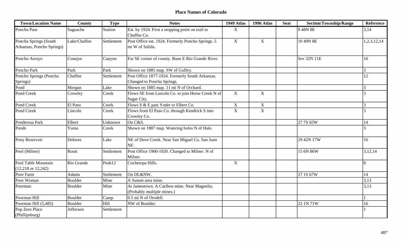
Place Names of Colorado
Town/Location Name County Type Notes 1949 Atlas 1996 Atlas Seat Section/Township/Range ReferencePoncha Pass Saguache Station Est. by 1924. First a stopping point on trail to
Chaffee Co.X 9 48N 8E 3,14
Poncha Springs (South Arkansas, Poncho Springs)
Lake/Chaffee Settlement Post Office est. 1924. Formerly Poncho Springs. 5 mi W of Salida.
X X 10 49N 8E 1,2,3,12,14
Poncho Arroyo Conejos Canyon Far SE corner of county. Runs E Rio Grande River. Sev 32N 11E 16
Poncho Park Park Park Shown on 1885 map. SW of Guffey. 3Poncho Springs (Poncha Springs)
Chaffee Settlement Post Office 1877-1924. Formerly South Arkansas. Changed to Poncha Springs.
12
Pond Morgan Lake Shown on 1885 map. 11 mi N of Orchard. 3g pPond Creek Crowley Creek Flows SE from Lincoln Co. to join Horse Creek N of
Sugar City.X X 3
Pond Creek El Paso Creek Flows S & E past Yoder to Elbert Co. X X 3Pond Creek Lincoln Creek Flows from El Paso Co. through Kendrick S into
Crowley Co.X X 3
Ponderosa Park Elbert Unknown On C&S. 27 7S 65W 14Ponds Yuma Creek Shown on 1887 map. Watering holes N of Hale. 3
Pony Reservoir Dolores Lake NE of Dove Creek. Near San Miguel Co. San Juan NF.
29 42N 17W 16
Pool (Milner) Routt Settlement Post Office 1900-1920. Changed to Milner. N of Milner.
15 6N 86W 3,12,14
Pool Table Mountain (12,218 or 12,242)
Rio Grande Peak12 Cochetopa Hills. X 8
Poor Farm Adams Settlement On DL&NW. 27 1S 67W 14P W B ld Mi A S t i 3 13Poor Woman Boulder Mine A Sunset area mine. 3,13Poorman Boulder Mine At Jamestown. A Caribou mine. Near Magnolia.
(Probably multiple mines.)3,13
Poorman Hill Boulder Camp 0.5 mi N of Orodell. 1Poorman Hill (5,485) Boulder Hill NW of Boulder. 22 1N 71W 16Pop Zero Place (Phillipsburg)
Jefferson Settlement 1
487

Place Names of Colorado
Town/Location Name County Type Notes 1949 Atlas 1996 Atlas Seat Section/Township/Range ReferencePopes Nose Hinsdale Peak13 Southern county. San Juan NF. ?? 39N 5W 16Pope's Nose (Sawtooth Mountain)
Saguache Mountain Shown on 1885 map. W side of county. 3
Porcupine San Juan Mine A Mineral Point area mine. 3Porcupine Corner Boulder Station 1Porcupine Gulch Hinsdale Gulch SE of Lake City. Runs E. Rio Grande NF. Sev 41N 3W 16Porcupine Gulch San Juan Unknown On SG&N. 19 42N 7W 14Porcupine Hill (10,200) Clear Creek Peak10 Southeast corner of county. S of Idaho Springs.
Arapaho NF.2 5S 73W 16
Pordonia Point (8,472) Archuleta Hill Cental county. San Juan NF. ?? 34N 2W 16Porphyry Mountain Eagle Mountain NW corner of county. 2 3S 86W 16p y y g yPorphyry Mountain Eagle Mountain SE of Eagle. White River NF. 15 6S 83W 16Porphyry Mountain Pitkin Mountain East of Woody Creek. 3,13Porphyry Mountain (8,300) Boulder Mountain NE of Jamestown. 19 2N 72W 3,13,16
Porphyry Peaks (No 1) Grand Peak11 NE corner of county. Arapaho NF. 30 4N 76W 16Porphyry Peaks (No 2) Grand Peak11 NE corner of county. Arapaho NF. 30 4N 76W 16Portal Montrose Unknown On D&RG. West Portal of Gunnison River
Diversion Water Tunnel.26 49N 8W 14
Porter La Plata Settlement Post Office 1891-1908. X 34 35N 10W 12,14Porter Reservoir Delta Lake West of Cedaredge. Grand Mesa NF. 15 13S 96W 16Porter Reservoir No 1 Delta Lake West of Cedaredge. Grand Mesa NF. 14 13S 96W 16Porter's (Sneffels) Ouray Settlement Original name of Sneffels. 3Portland Fremont Settlement On D&RG, AT&SF. Post Office 1900-1952.
Company town built by Portland Cement Co.X 17 19S 68W 3,12,14
Portland Gilpin Mine N of Kingston. 3P tl d #1 Cl C k Mi A Y k Hill i 3Portland #1 Clear Creek Mine A Yankee Hill mine. 3Portland (Partland) Ouray Settlement Post Office 1878-1896. 5 mi NW of Ouray. Partland,
a misspelling on 1881 map.X 11 44N 8W 3,12,14
Portland Group (Portland Gold Mining Co.)
Teller Mine A Victor area operation. 3,13
Portland Junction Teller Station N of Victor. Close to Dyer. 3Portland Mine Teller Mine At Goldfield. 2,13
488
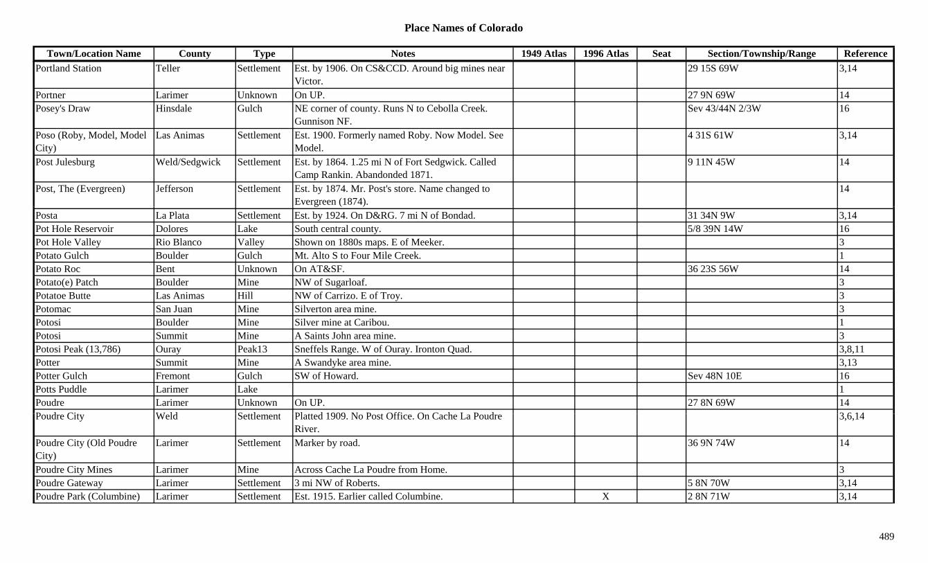
Place Names of Colorado
Town/Location Name County Type Notes 1949 Atlas 1996 Atlas Seat Section/Township/Range ReferencePortland Station Teller Settlement Est. by 1906. On CS&CCD. Around big mines near
Victor.29 15S 69W 3,14
Portner Larimer Unknown On UP. 27 9N 69W 14Posey's Draw Hinsdale Gulch NE corner of county. Runs N to Cebolla Creek.
Gunnison NF.Sev 43/44N 2/3W 16
Poso (Roby, Model, Model City)
Las Animas Settlement Est. 1900. Formerly named Roby. Now Model. See Model.
4 31S 61W 3,14
Post Julesburg Weld/Sedgwick Settlement Est. by 1864. 1.25 mi N of Fort Sedgwick. Called Camp Rankin. Abandonded 1871.
9 11N 45W 14
Post, The (Evergreen) Jefferson Settlement Est. by 1874. Mr. Post's store. Name changed to Evergreen (1874).
14
Posta La Plata Settlement Est. by 1924. On D&RG. 7 mi N of Bondad. 31 34N 9W 3,14Pot Hole Reservoir Dolores Lake South central county. 5/8 39N 14W 16Pot Hole Valley Rio Blanco Valley Shown on 1880s maps. E of Meeker. 3Potato Gulch Boulder Gulch Mt. Alto S to Four Mile Creek. 1Potato Roc Bent Unknown On AT&SF. 36 23S 56W 14Potato(e) Patch Boulder Mine NW of Sugarloaf. 3Potatoe Butte Las Animas Hill NW of Carrizo. E of Troy. 3Potomac San Juan Mine Silverton area mine. 3Potosi Boulder Mine Silver mine at Caribou. 1Potosi Summit Mine A Saints John area mine. 3Potosi Peak (13,786) Ouray Peak13 Sneffels Range. W of Ouray. Ironton Quad. 3,8,11Potter Summit Mine A Swandyke area mine. 3,13Potter Gulch Fremont Gulch SW of Howard. Sev 48N 10E 16Potts Puddle Larimer Lake 1Poudre Larimer Unknown On UP. 27 8N 69W 14P d Cit W ld S ttl t Pl tt d 1909 N P t Offi O C h L P d 3 6 14Poudre City Weld Settlement Platted 1909. No Post Office. On Cache La Poudre
River.3,6,14
Poudre City (Old Poudre City)
Larimer Settlement Marker by road. 36 9N 74W 14
Poudre City Mines Larimer Mine Across Cache La Poudre from Home. 3Poudre Gateway Larimer Settlement 3 mi NW of Roberts. 5 8N 70W 3,14Poudre Park (Columbine) Larimer Settlement Est. 1915. Earlier called Columbine. X 2 8N 71W 3,14
489
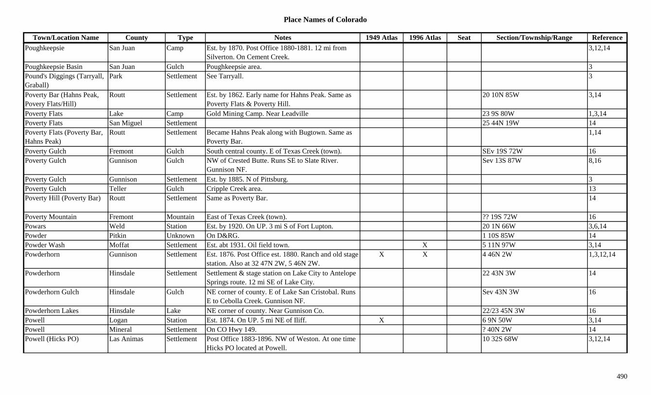
Place Names of Colorado
Town/Location Name County Type Notes 1949 Atlas 1996 Atlas Seat Section/Township/Range ReferencePoughkeepsie San Juan Camp Est. by 1870. Post Office 1880-1881. 12 mi from
Silverton. On Cement Creek.3,12,14
Poughkeepsie Basin San Juan Gulch Poughkeepsie area. 3Pound's Diggings (Tarryall, Graball)
Park Settlement See Tarryall. 3
Poverty Bar (Hahns Peak, Povery Flats/Hill)
Routt Settlement Est. by 1862. Early name for Hahns Peak. Same as Poverty Flats & Poverty Hill.
20 10N 85W 3,14
Poverty Flats Lake Camp Gold Mining Camp. Near Leadville 23 9S 80W 1,3,14Poverty Flats San Miguel Settlement 25 44N 19W 14Poverty Flats (Poverty Bar, Hahns Peak)
Routt Settlement Became Hahns Peak along with Bugtown. Same as Poverty Bar.
1,14
Poverty Gulch Fremont Gulch South central county. E of Texas Creek (town). SEv 19S 72W 16Poverty Gulch Gunnison Gulch NW of Crested Butte. Runs SE to Slate River.
Gunnison NF.Sev 13S 87W 8,16
Poverty Gulch Gunnison Settlement Est. by 1885. N of Pittsburg. 3Poverty Gulch Teller Gulch Cripple Creek area. 13Poverty Hill (Poverty Bar) Routt Settlement Same as Poverty Bar. 14
Poverty Mountain Fremont Mountain East of Texas Creek (town). ?? 19S 72W 16Powars Weld Station Est. by 1920. On UP. 3 mi S of Fort Lupton. 20 1N 66W 3,6,14Powder Pitkin Unknown On D&RG. 1 10S 85W 14Powder Wash Moffat Settlement Est. abt 1931. Oil field town. X 5 11N 97W 3,14Powderhorn Gunnison Settlement Est. 1876. Post Office est. 1880. Ranch and old stage
station. Also at 32 47N 2W, 5 46N 2W.X X 4 46N 2W 1,3,12,14
Powderhorn Hinsdale Settlement Settlement & stage station on Lake City to Antelope Springs route. 12 mi SE of Lake City.
22 43N 3W 14
P d h G l h Hi d l G l h NE f t E f L k S C i t b l R S 43N 3W 16Powderhorn Gulch Hinsdale Gulch NE corner of county. E of Lake San Cristobal. Runs E to Cebolla Creek. Gunnison NF.
Sev 43N 3W 16
Powderhorn Lakes Hinsdale Lake NE corner of county. Near Gunnison Co. 22/23 45N 3W 16Powell Logan Station Est. 1874. On UP. 5 mi NE of Iliff. X 6 9N 50W 3,14Powell Mineral Settlement On CO Hwy 149. ? 40N 2W 14Powell (Hicks PO) Las Animas Settlement Post Office 1883-1896. NW of Weston. At one time
Hicks PO located at Powell.10 32S 68W 3,12,14
490

Place Names of Colorado
Town/Location Name County Type Notes 1949 Atlas 1996 Atlas Seat Section/Township/Range ReferencePowell's Park Rio Blanco Park Shown on 1870s maps. E of White River. N of the
bend in the river.3
Power San Juan Unknown Perhaps a power plant NE of Silverton? ? 41N 7W 14Power Peak Rio Blanco Peak SE part of county. 3Powers Bent Settlement Est. by 1882. On AT&SF. ? 23S 48W 14Powers Dolores Unknown Est. by 1906. 14Powers Gilpin Mine A Russell Gulch area mine. 3Prairie Fremont Mine S of Manoa. 3Prairie Washington Settlement Rural Post Office 1910-1917. 12 mi SW of Akron. 34 1N 53W 3,12,14
Prairie Canyon Las Animas Settlement Near Trinidad. 14yPrairie Divide (7,905) Larimer Divide Btwn Ted's Place and Red Feather Lakes. 7Prairie Dream (Punkin Center)
Lincoln Settlement See Punkin Center. 1,3,14
Prairie Mountain Grand/Summit Mountain NW of Ute Pass. Williams Fork Mtns. Arapaho NF. ?? 2S 78W 16
Precarious Peak Gunnison Peak13 Elk Range, Crested Butte Section. Maroon Bells Quad.
8,11
Precipice Peak (13,144) Peak13 San Juans, Courthouse Group. Wetterhorn Peak Quad.
8,11
Prendery Lake Mine E of Tennessee Pass. 3President Lake Mine A Leadville area mine. NW of Ibex City. 3President Lake Mine S of St. Kevins. 3,13Preston Summit Camp Site 2. Different site from early name for Delaware
Flats. N of Gibson Hill.3,13
Preston (Delaware Flats, B dd k)
Summit Settlement Site 1. Post Office 1875-1889. Moved from D l Cit th B dd k
16 6S 77W 3,12,14Braddock) Delaware City, then Braddock.Prewit Reservoir Washington Lake NW corner of Washington Co. X XPrice Lake Mine A Leadville area mine. 3Price (Chromo) Conejos/Archuleta Settlement Post Office 1880-1882. First name for Chromo, but
Chromo is 9 mi W.1 32N 2E 3,12,14
Price Creek Moffat Settlement Post Office 1912-1942. 20 mi S of Maybell. Also shown at 31 4N 95W.
X 18 4N 95W 3,12,14
491

Place Names of Colorado
Town/Location Name County Type Notes 1949 Atlas 1996 Atlas Seat Section/Township/Range ReferencePrice Lakes Archuleta Lake SE county. S of Navajo Lake. 27 33N 2E 16Pride Baca Settlement Post Office 1914-1920. Near Cimmaron River. 3,12,14Pride Ouray Mine An Engineer City area mine. 3Pride of Cinnamon Gunnison Mine An Elko area mine. 3Pride of the West Chaffee Mine E of Hancock. Near Pomeroy Mtn. 3,8Pride of the West San Juan Mine At Gladstone. Near Howardsville. 2,3Priest Gulch Dolores Gulch SW of Rico. Runs SW & S to Montezuma Co. Sev 39N 12W 16Primero Las Animas Settlement Began 1901. Post Office 1901-1933. 17 mi W of
Trinidad.X 26 33S 66W 3,12,14
Primero Junction (Los Varros)
Las Animas Station Est. by 1924. W of Segundo. At or near location Los Varros.
35 33S 66W 3,14
Primos Boulder Camp Post Office 1907-1913. Gold camp 2 mi NE of Lakewood.
34 1N 72W 1,3,6,12,14
Primos Mill Boulder Mill At Lakewood. 3Primrose Las Animas Settlement Est. by 1910. SW of Rugby. 5 30S 65W 3,14Prince Lake No 1 Boulder Lake At Ninemile corner. NW of Lafayette. 34 1S 69W 16Prince Lake No 2 Boulder Lake SW of Erie. 27 1N 69W 16Princess Alice Gilpin Mine Near Silver City. 3Princeton Chaffee Station Site 1. Est. by 1923. RR stop on D&RG. NW of
Buena Vista.22 12S 79W 3,14
Princeton Chaffee Unknown Site 2. On CM. 29 13S 78W 14Princeton Chaffee Unknown Site 3. On CM. Milepost 106.7. 13 13S 79W 14Pring El Paso Station Est. by 1902. Stop on AT&SF. 4 mi SE of
Monument.X 35 11S 67W 3,14
Pringle Custer Mine 3Pringle Hill Custer Hill NW of Rosita. 3P i t B Hill L k Hill S f C lif i G l h 3Printer Boy Hill Lake Hill S of California Gulch. 3Pritchett (Joycoy) Baca Settlement Est. 1920. Post Office est. 1927. Moved from
Joycoy. Joycoy was 3 mi W until 1926.X X 6 31S 48W 3,12,14
Prize Mountain (13,384) Peak13 Pieplant Quad. 11Proctor (Proctor Siding) Logan Settlement Post Office 1908-1963. Once only a siding. Platted
as town 1909.X X 28 10N 50W 3,12,14
492
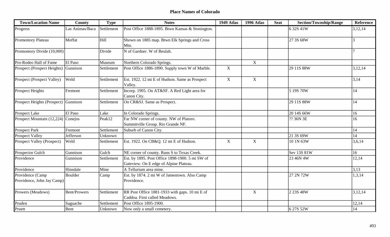
Place Names of Colorado
Town/Location Name County Type Notes 1949 Atlas 1996 Atlas Seat Section/Township/Range ReferenceProgress Las Animas/Baca Settlement Post Office 1888-1895. Btwn Kansas & Stonington. 6 32S 41W 3,12,14
Promentory Plateau Moffat Hill Shown on 1885 map. Btwn Elk Springs and Cross Mtn.
27 3S 68W 3
Promontory Divide (10,000) Divide N of Gardner. W of Beulah. 7
Pro-Rodeo Hall of Fame El Paso Museum Northern Colorado Springs. XProspect (Prospect Heights) Gunnison Settlement Post Office 1886-1890. Supply town W of Marble. X 29 11S 88W 3,12,14
Prospect (Prospect Valley) Weld Settlement Est. 1922. 12 mi E of Hudson. Same as Prospect Valley.
X X 3,14
Prospect Heights Fremont Settlement Incorp. 1905. On AT&SF. A Red Light area for Canon City.
5 19S 70W 14
Prospect Heights (Prospect) Gunnison Settlement On CR&SJ. Same as Prospect. 29 11S 88W 14
Prospect Lake El Paso Lake In Colorado Springs. 20 14S 66W 16Prospect Mountain (12,224) Conejos Peak12 Far NW corner of county. NW of Platoro.
Summitville Group. Rio Grande NF.?? 36N 3E 16
Prospect Park Fremont Settlement Suburb of Canon City. 14Prospect Valley Jefferson Unknown 21 3S 69W 14Prospect Valley (Prospect) Weld Settlement Est. 1922. On CB&Q. 12 mi E of Hudson. X X 10 1N 63W 3,6,14
Prospector Gulch Gunnison Gulch NE corner of county. Runs S to Texas Creek. Sev 13S 81W 16Providence Gunnison Settlement Est. by 1895. Post Office 1898-1900. 5 mi SW of
Gateview. On E edge of Alpine Plateau.23 46N 4W 12,14
Providence Hinsdale Mine A Tellurium area mine. 3,13P id (C B ld C E t b 1874 2 i W f J t Al C 27 2N 72W 1 3 14Providence (Camp Providence, John Jay Camp)
Boulder Camp Est. by 1874. 2 mi W of Jamestown. Also Camp Providence.
27 2N 72W 1,3,14
Prowers (Meadows) Bent/Prowers Settlement RR Post Office 1881-1933 with gaps. 10 mi E of Caddoa. First called Meadows.
X 2 23S 48W 3,12,14
Pruden Saguache Settlement Post Office 1895-1900. 12,14Pruett Bent Unknown Now only a small cemetery. 6 27S 52W 14
493

Place Names of Colorado
Town/Location Name County Type Notes 1949 Atlas 1996 Atlas Seat Section/Township/Range ReferencePrussian Boulder Mine A Gold Hill mine. 3Pryolite (Pyrolite, Radiant, Kenwood)
Fremont Settlement Est. by 1915. On AT&SF. First Radiant, then Pryolite, later Kenwood.
7 20S 69W 14
Pryor Huerfano Settlement D&RG Post Office est. 1898. X X 19 29S 65W 3,12,14Ptarmigan Grand Mine Lulu area mine. 3Ptarmigan Hill Eagle Peak12 SSW of Vail Pass. ESE of Redcliff. White River NF. 30/29 6S 79W 16
Ptarmigan Lake Chaffee Lake South of Cottonwood Pass. San Isabel NF. 6 15S 80W 16Ptarmigan Mountain (12,324)
Peak12 Front Range, National Park Section. 8
Ptarmigan Pass Grand/Larimer Pass Btwn Estes Park and Grand Lake. McHenrys Peak 5,7g yTopo. Rocky Mountain Natl Park.
,
Ptarmigan Pass Grand/Summit Pass NNE of Dillon. NW of Loveland Pass. Dillon Topo. Arapaho NF.
22 4S 77W 5,7,16
Ptarmigan Pass (11,765 or 11,777)
Eagle/Summit Pass Btwn Camp Hale and Shrine Pass. Pando Topo. White River & Arapaho NF.
29 6S 79W 5,9
Ptarmigan Peak Grand/Summit Peak12 N of Dillon. South tip of Grand Co. Arapaho NF. ?? 4S 77W 3,8,16
Ptarmigan Peak (13,739) Peak13 Mosquito Range. Mt. Sherman Quad. 8,11Pueblo (Fort Pueblo, Independence & more)
KT/Pueblo Settlement Est. by 1858. Site occupied long before. Post Office est. 1860. Early name Puerta Juana.
X X X Sev 20S 64W 1,3,12,14
Pueblo Army Depot Pueblo Misc At North Avondale. XPueblo De Leche (El Puebla, Milk Fort)
Bent/Otero Fort Also known as Milk Fort or El Puebla. 5 mi W of Bents Fort.
14
Pueblo de San Carlos (Hardscrabble Settlement)
Pueblo Settlement On Arkansas River. 10 mi W of Pueblo & mouth of Fountain Creek.
14
Pueblo Junction Pueblo Station Est. by 1906. On AT&SF, C&S. 14Pueblo Mountain Park Pueblo Settlement Same location as earlier site of Valley View. 3Pueblo Reservoir Pueblo Lake West of Pueblo. XPueblo West Pueblo Settlement Post Office est. 1969. 10 mi W of Pueblo. X Sev 20S 66W 3,12,14Puerta Juana (Pueblo) Pueblo Settlement The first name for Pueblo. 14Puerto Blanco (11,900) Mineral Pass Palomino Mtn. Topo. 5
494

Place Names of Colorado
Town/Location Name County Type Notes 1949 Atlas 1996 Atlas Seat Section/Township/Range ReferencePugh Camp Moffat Camp 3 8N 89W 14Pulaski Clear Creek Mine SW of Georgetown. 3Pulaski Las Animas Settlement Rural Post Office 1874-1886. 2 mi NE of Hoehne.
Also shown at 6 32S 62W (1877).3 32S 62W 3,12,14
Pullen Larimer Settlement Post Office 1888-1894. 29 4N 71W 12,14Pulliam Weld Station Est. by 1909. On GW. 2 mi W of Johnstown. 12 4N 68W 3,6,14Pullman Camp Lake Camp 4 10S 81W 14Pullman Shops (Elyria, Jersey, Jersey Junction)
Denver Settlement RR stop on UP. Shown as Jersey (1882-1892). Same as Jersey Junction, Elyria.
23 3S 68W 3,14
Pullman's Mill Gilpin Mill Mill & store of George M. Pullman. 14Pulpit Rock El Paso Hill Shown on 1885 map. 3 mi S of Edgerton. 3p p gPulpit Rock El Paso Station Est. by 1873. On D&RG. Btwn Colorado Springs &
Edgerton.14
Pultney Otero/Crowley Settlement Post Office 1890. W of Olney Springs. X 6 22S 59W 3,12,14Pulver's Park Station Est. by 1882. Terminus of stage line from Garon. 14
Puma (Trull) Routt Settlement Post Office 1896-1897. Formerly Trull. Renamed Trull.
32 7N 85W 12,14
Puma City Park Settlement Est. by 1896. W of Tarryall. In Puma Hills. 5 11S 72W 3,14Puma Hills Park Range W & S of Tarryall. 3Pump House Mesa Unknown On D&RG. 27 1S 1W 14Punble Pueblo Settlement Est. by 1847. Reported 75 mi above Bents Fort.
Perhaps site where Mormans built El Pueblo.14
Punch Bowl Fremont Station Est. by 1923. Stop on D&RGW. 1 mi N of Texas Creek.
3
Punkin Center (Prairie D H d St )
Lincoln Settlement Est. abt 1918. 11 mi NW of Karval. X 5 14S 56W 1,3,14Dream, Howard Stevens)Purcell (Hungerford) Weld Settlement Est. 1910 as Purcell. Post Office 1911-1951. 9 mi E
of Pierce. Called Hungerford by UP.X X 19 8N 64W 3,6,12,14
Purgatoire Peak (13,676) Costilla Peak13 SE corner of county. 13Purgatoire River Bent River Flows NE to John Martin Res. near Las Animas. X X 3
495
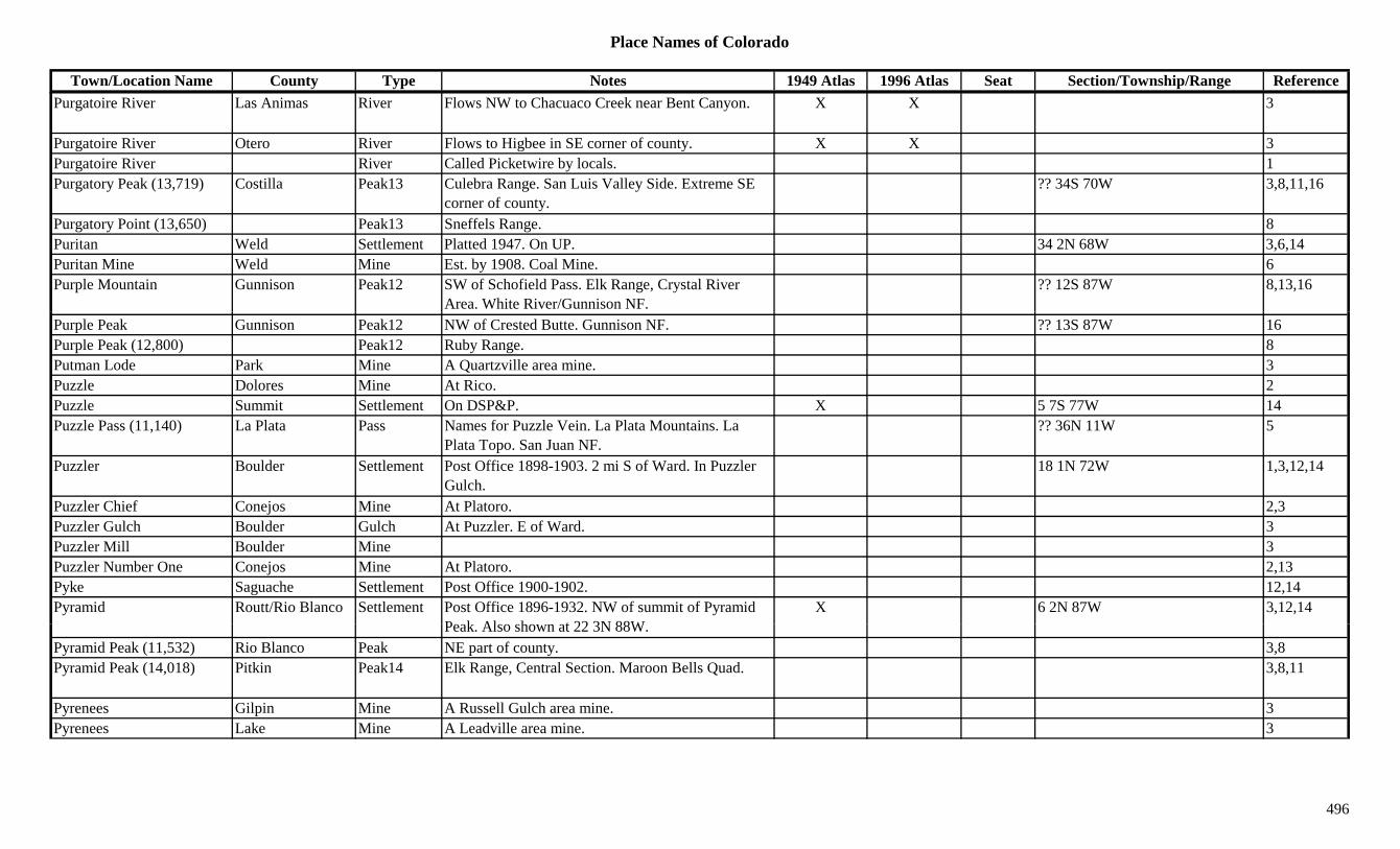
Place Names of Colorado
Town/Location Name County Type Notes 1949 Atlas 1996 Atlas Seat Section/Township/Range ReferencePurgatoire River Las Animas River Flows NW to Chacuaco Creek near Bent Canyon. X X 3
Purgatoire River Otero River Flows to Higbee in SE corner of county. X X 3Purgatoire River River Called Picketwire by locals. 1Purgatory Peak (13,719) Costilla Peak13 Culebra Range. San Luis Valley Side. Extreme SE
corner of county.?? 34S 70W 3,8,11,16
Purgatory Point (13,650) Peak13 Sneffels Range. 8Puritan Weld Settlement Platted 1947. On UP. 34 2N 68W 3,6,14Puritan Mine Weld Mine Est. by 1908. Coal Mine. 6Purple Mountain Gunnison Peak12 SW of Schofield Pass. Elk Range, Crystal River
Area. White River/Gunnison NF.?? 12S 87W 8,13,16
Purple Peak Gunnison Peak12 NW of Crested Butte. Gunnison NF. ?? 13S 87W 16Purple Peak (12,800) Peak12 Ruby Range. 8Putman Lode Park Mine A Quartzville area mine. 3Puzzle Dolores Mine At Rico. 2Puzzle Summit Settlement On DSP&P. X 5 7S 77W 14Puzzle Pass (11,140) La Plata Pass Names for Puzzle Vein. La Plata Mountains. La
Plata Topo. San Juan NF.?? 36N 11W 5
Puzzler Boulder Settlement Post Office 1898-1903. 2 mi S of Ward. In Puzzler Gulch.
18 1N 72W 1,3,12,14
Puzzler Chief Conejos Mine At Platoro. 2,3Puzzler Gulch Boulder Gulch At Puzzler. E of Ward. 3Puzzler Mill Boulder Mine 3Puzzler Number One Conejos Mine At Platoro. 2,13Pyke Saguache Settlement Post Office 1900-1902. 12,14Pyramid Routt/Rio Blanco Settlement Post Office 1896-1932. NW of summit of Pyramid
P k Al h t 22 3N 88WX 6 2N 87W 3,12,14
Peak. Also shown at 22 3N 88W.Pyramid Peak (11,532) Rio Blanco Peak NE part of county. 3,8Pyramid Peak (14,018) Pitkin Peak14 Elk Range, Central Section. Maroon Bells Quad. 3,8,11
Pyrenees Gilpin Mine A Russell Gulch area mine. 3Pyrenees Lake Mine A Leadville area mine. 3
496
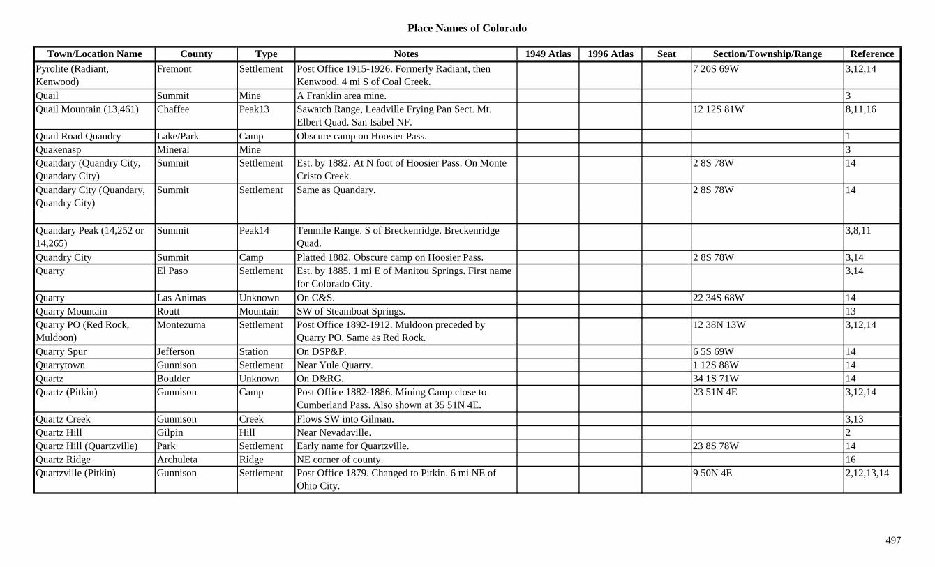
Place Names of Colorado
Town/Location Name County Type Notes 1949 Atlas 1996 Atlas Seat Section/Township/Range ReferencePyrolite (Radiant, Kenwood)
Fremont Settlement Post Office 1915-1926. Formerly Radiant, then Kenwood. 4 mi S of Coal Creek.
7 20S 69W 3,12,14
Quail Summit Mine A Franklin area mine. 3Quail Mountain (13,461) Chaffee Peak13 Sawatch Range, Leadville Frying Pan Sect. Mt.
Elbert Quad. San Isabel NF.12 12S 81W 8,11,16
Quail Road Quandry Lake/Park Camp Obscure camp on Hoosier Pass. 1Quakenasp Mineral Mine 3Quandary (Quandry City, Quandary City)
Summit Settlement Est. by 1882. At N foot of Hoosier Pass. On Monte Cristo Creek.
2 8S 78W 14
Quandary City (Quandary, Quandry City)
Summit Settlement Same as Quandary. 2 8S 78W 14
Quandary Peak (14,252 or 14,265)
Summit Peak14 Tenmile Range. S of Breckenridge. Breckenridge Quad.
3,8,11
Quandry City Summit Camp Platted 1882. Obscure camp on Hoosier Pass. 2 8S 78W 3,14Quarry El Paso Settlement Est. by 1885. 1 mi E of Manitou Springs. First name
for Colorado City.3,14
Quarry Las Animas Unknown On C&S. 22 34S 68W 14Quarry Mountain Routt Mountain SW of Steamboat Springs. 13Quarry PO (Red Rock, Muldoon)
Montezuma Settlement Post Office 1892-1912. Muldoon preceded by Quarry PO. Same as Red Rock.
12 38N 13W 3,12,14
Quarry Spur Jefferson Station On DSP&P. 6 5S 69W 14Quarrytown Gunnison Settlement Near Yule Quarry. 1 12S 88W 14Quartz Boulder Unknown On D&RG. 34 1S 71W 14Quartz (Pitkin) Gunnison Camp Post Office 1882-1886. Mining Camp close to
Cumberland Pass. Also shown at 35 51N 4E.23 51N 4E 3,12,14
Q t C k G i C k Fl SW i t Gil 3 13Quartz Creek Gunnison Creek Flows SW into Gilman. 3,13Quartz Hill Gilpin Hill Near Nevadaville. 2Quartz Hill (Quartzville) Park Settlement Early name for Quartzville. 23 8S 78W 14Quartz Ridge Archuleta Ridge NE corner of county. 16Quartzville (Pitkin) Gunnison Settlement Post Office 1879. Changed to Pitkin. 6 mi NE of
Ohio City.9 50N 4E 2,12,13,14
497
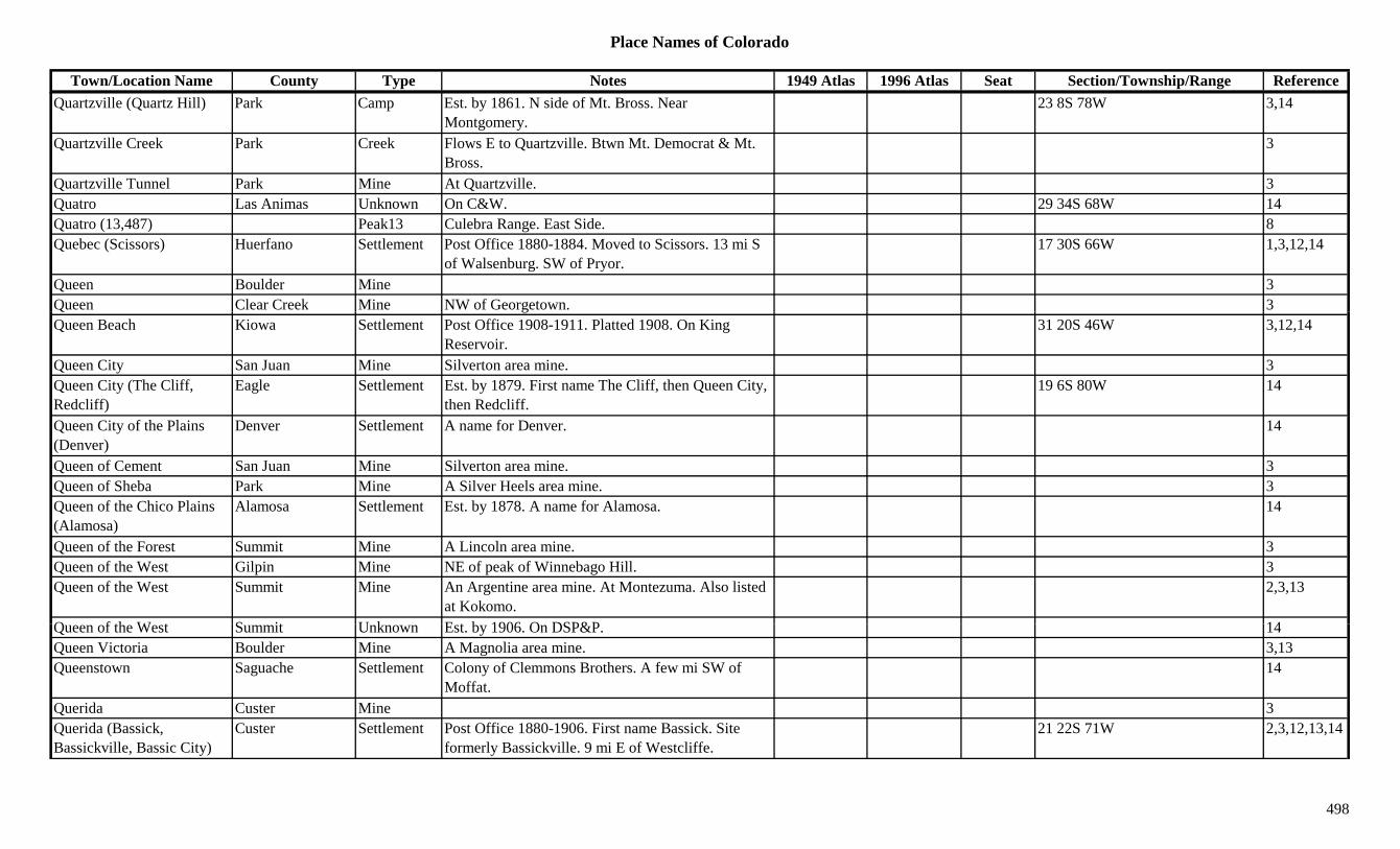
Place Names of Colorado
Town/Location Name County Type Notes 1949 Atlas 1996 Atlas Seat Section/Township/Range ReferenceQuartzville (Quartz Hill) Park Camp Est. by 1861. N side of Mt. Bross. Near
Montgomery.23 8S 78W 3,14
Quartzville Creek Park Creek Flows E to Quartzville. Btwn Mt. Democrat & Mt. Bross.
3
Quartzville Tunnel Park Mine At Quartzville. 3Quatro Las Animas Unknown On C&W. 29 34S 68W 14Quatro (13,487) Peak13 Culebra Range. East Side. 8Quebec (Scissors) Huerfano Settlement Post Office 1880-1884. Moved to Scissors. 13 mi S
of Walsenburg. SW of Pryor.17 30S 66W 1,3,12,14
Queen Boulder Mine 3Queen Clear Creek Mine NW of Georgetown. 3Q gQueen Beach Kiowa Settlement Post Office 1908-1911. Platted 1908. On King
Reservoir.31 20S 46W 3,12,14
Queen City San Juan Mine Silverton area mine. 3Queen City (The Cliff, Redcliff)
Eagle Settlement Est. by 1879. First name The Cliff, then Queen City, then Redcliff.
19 6S 80W 14
Queen City of the Plains (Denver)
Denver Settlement A name for Denver. 14
Queen of Cement San Juan Mine Silverton area mine. 3Queen of Sheba Park Mine A Silver Heels area mine. 3Queen of the Chico Plains (Alamosa)
Alamosa Settlement Est. by 1878. A name for Alamosa. 14
Queen of the Forest Summit Mine A Lincoln area mine. 3Queen of the West Gilpin Mine NE of peak of Winnebago Hill. 3Queen of the West Summit Mine An Argentine area mine. At Montezuma. Also listed
at Kokomo.2,3,13
Q f th W t S it U k E t b 1906 O DSP&P 14Queen of the West Summit Unknown Est. by 1906. On DSP&P. 14Queen Victoria Boulder Mine A Magnolia area mine. 3,13Queenstown Saguache Settlement Colony of Clemmons Brothers. A few mi SW of
Moffat.14
Querida Custer Mine 3Querida (Bassick, Bassickville, Bassic City)
Custer Settlement Post Office 1880-1906. First name Bassick. Site formerly Bassickville. 9 mi E of Westcliffe.
21 22S 71W 2,3,12,13,14
498

Place Names of Colorado
Town/Location Name County Type Notes 1949 Atlas 1996 Atlas Seat Section/Township/Range ReferenceQuerido Gulch Custer Gulch North central county. Runs N to Johnson Gulch. Sev 22S 71W 16
Quigleyville (Quiggleyville, Brainard's)
Boulder Settlement 1 mi NE of Ward. Near Mellor Mill. ? 1N 73W 1,6,14
Quimby Adams Settlement Post Office 1895-1900. 2 mi SW of Eastlake. 3 2S 68W 6,14Quimby Arapahoe Settlement Rural Post Office 1895-1900. On D&RG. 2 mi SW
of Eastlake.1,12,14
Quimby Station (Quinby Station)
Adams Station RR stop on UP. 4 mi N of Welby. 13 2S 68W 3,6,14
Quinby Station (Quimby Station)
Adams Station See Quimby Station. 14
Quincy (Quincy City) Gilpin Camp One of 7 camps along the gulch after Gregory's strike.
3
Quincy City (Quincy) Gilpin Settlement Est. by 1861. Election precinct in Gregory District. 14
Quincy Ditch Adams Canal Runs along E side of Burlington Canal on E side of South Platte River.
16
Quinns Pitkin Station On CM. 9 8S 83W 14Quinn's Spur (Biglow) Pitkin Station Est. by 1890s. Loading spur for lumber. Had lodge.
Renamed Bigelow.21 8S 83W 3,14
Quinto (Weston PO, La Junta, Los Sisnereos)
Las Animas Settlement On C&W. Same as Weston PO. Formerly Quinto & La Junta. Early name Los Sisneros.
35 33S 67W 14
Quito (Silverton) San Juan Settlement Est. by 1875. Early name for Silverton. 1,14R. A. M. Lake Unknown On D&RG, Graham Park Branch. 30 9S 79W 14R. F. Mine Routt Mine At head of Independence Creek. N of Hahns Peak
(town).3
R bbit E Mi G d Mi L l i 3Rabbit Ear Mine Grand Mine Lulu area mine. 3Rabbit Ears Pass Grand/Jackson Pass Btwn Steamboat Springs and Muddy Pass. Crossed
by US 40. Rabbit Ears Range. Routt NF.X X 8 5N 82W 1,7,16
Rabbit Ears Peak (10,654) Jackson Peak N of Columbine Lodge. 3,8,13
499

Place Names of Colorado
Town/Location Name County Type Notes 1949 Atlas 1996 Atlas Seat Section/Township/Range ReferenceRabbit Ears Range Jackson Range Runs E along Continental Divide from Rabbit Ears
Pass.1,3,15
Rabbit Mountain (6,015) Boulder Mountain NE corner of county. NW of Longmont. 11/14 3N 70W 16Race Path Gulch Fremont Gulch SW of Texas Creek (town). Sev 48N 12E 16Racene City Summit Settlement Est. by 1897. Also known as Racene & Recen. Later
became part of Kokomo.23 7S 79W 14
Racine Boy Custer Mine At Silver Cliff. (N of Westcliffe). 2,13Radcliff Lake Station Est. by 1880. On D&RG. Terminus of branch. 10 mi
from Malta.14
Rader Mesa Settlement 14Radial Mountain (11,241) Grand/Jackson Mountain S of Teller City. 13( , ) yRadiant (Pyrolite, Kenwood)
Fremont Settlement Post Office 1904-1915. Changed to Pyrolite, then Kenwood.
7 20S 69W 12,14
Radium Grand Settlement On D&RG. Post Office 1906-1974. 1963, became rural station of Kremmling.
X 22 1S 82W 3,12,14
Rag Town Gilpin Unknown 4 2S 73W 14Ragans Gunnison Unknown Est. by 1906. On D&RG. 14Ragans Weld Station Est. by 1909. On GW, a siding. 12 mi SW of
Greeley.18 5N 67W 3,6,14
Ragged Mountain Gunnison Camp Post Office 1919-1956. SW of McClure Pass. On Clear Fork of Muddy Creek.
11 11S 90W 3,12,14
Ragged Mountain Gunnison Peak12 SW of Marble. Gunnison NF. ?? 12S 88W 16Ragged Peak (12,641) Peak12 Elk Range, Crystal River Area. 8Rago Washington Settlement Rural Post Office 1912-1951. 14 mi SW of Akron. X 3 1S 54W 3,12,14
Railroad Pass (10, 960 or 12 000)
Mineral Pass SE of Wolf Creek Pass. On Continental Divide. San J & Ri G d NF
11/14 37N 2E 7, 1612,000) Juan & Rio Grande NF.Rainbow Eagle Station On D&RG. 19 2S 83W 14Rainbow Lake Chaffee Lake Between Princeton (town) and Mt. Harvard (peak).
San Isabel NF.6 13S 79W 16
Rainbow Lake Chaffee Lake West of Buena Vista on SH 306. San Isabel NF. 13 14S 79W 16
Rainbow Lake Custer Lake Far NW corner of county. San Isabel NF. 12 46N 11E 16
500
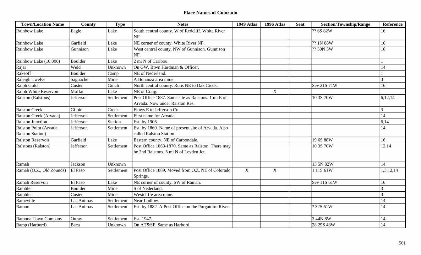
Place Names of Colorado
Town/Location Name County Type Notes 1949 Atlas 1996 Atlas Seat Section/Township/Range ReferenceRainbow Lake Eagle Lake South central county. W of Redcliff. White River
NF.?? 6S 82W 16
Rainbow Lake Garfield Lake NE corner of county. White River NF. ?? 1N 88W 16Rainbow Lake Gunnison Lake West central county. NW of Gunnison. Gunnison
NF.?? 50N 3W 16
Rainbow Lake (10,000) Boulder Lake 2 mi N of Caribou. 1Rajar Weld Unknown On GW. Btwn Hardman & Officer. 14Rakeoff Boulder Camp NE of Nederland. 1Raleigh Twelve Saguache Mine A Bonanza area mine. 3Ralph Gulch Custer Gulch North central county. Runs NE to Oak Creek. Sev 21S 71W 16Ralph White Reservoir Moffat Lake NE of Craig. Xp gRalston (Ralstons) Jefferson Settlement Post Office 1887. Same site as Ralstons. 1 mi E of
Arvada. Now under Ralston Res.10 3S 70W 6,12,14
Ralston Creek Gilpin Creek Flows E to Jefferson Co. 3Ralston Creek (Arvada) Jefferson Settlement First name for Arvada. 14Ralston Junction Jefferson Station Est. by 1906. 6,14Ralston Point (Arvada, Ralston Station)
Jefferson Settlement Est. by 1860. Name of present site of Arvada. Also called Ralston Station.
14
Ralston Reservoir Garfield Lake Eastern county. NE of Carbondale. 19 6S 88W 16Ralstons (Ralston) Jefferson Settlement Post Office 1863-1870. Same as Ralston. There may
be 2nd Ralstons, 3 mi N of Leyden Jct.10 3S 70W 12,14
Ramah Jackson Unknown 13 5N 82W 14Ramah (O.Z., Old Zounds) El Paso Settlement Post Office 1889. Moved from O.Z. NE of Colorado
Springs.X X 1 11S 61W 1,3,12,14
Ramah Reservoir El Paso Lake NE corner of county. SW of Ramah. Sev 11S 61W 16R bl B ld Mi S f N d l d 3Rambler Boulder Mine S of Nederland. 3Rambler Custer Mine Westcliffe area mine. 3Rameville Las Animas Settlement Near Ludlow. 14Ramon Las Animas Settlement Est. by 1882. A Post Office on the Purgatoire River. ? 32S 61W 14
Ramona Town Company Ouray Settlement Est. 1947. 3 44N 8W 14Ramp (Harbord) Baca Unknown On AT&SF. Same as Harbord. 28 29S 48W 14
501
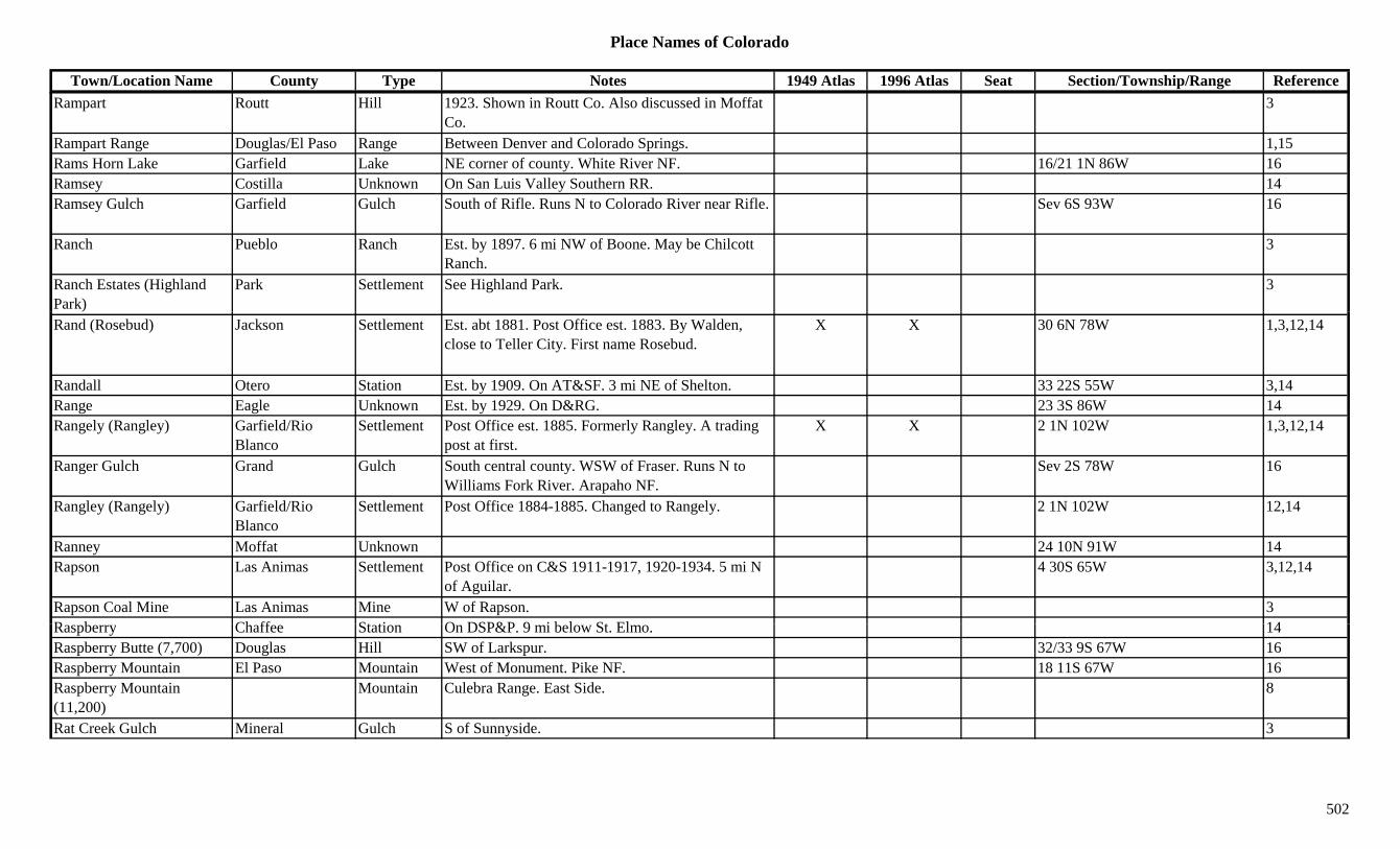
Place Names of Colorado
Town/Location Name County Type Notes 1949 Atlas 1996 Atlas Seat Section/Township/Range ReferenceRampart Routt Hill 1923. Shown in Routt Co. Also discussed in Moffat
Co.3
Rampart Range Douglas/El Paso Range Between Denver and Colorado Springs. 1,15Rams Horn Lake Garfield Lake NE corner of county. White River NF. 16/21 1N 86W 16Ramsey Costilla Unknown On San Luis Valley Southern RR. 14Ramsey Gulch Garfield Gulch South of Rifle. Runs N to Colorado River near Rifle. Sev 6S 93W 16
Ranch Pueblo Ranch Est. by 1897. 6 mi NW of Boone. May be Chilcott Ranch.
3
Ranch Estates (Highland Park)
Park Settlement See Highland Park. 3
Rand (Rosebud) Jackson Settlement Est. abt 1881. Post Office est. 1883. By Walden, close to Teller City. First name Rosebud.
X X 30 6N 78W 1,3,12,14
Randall Otero Station Est. by 1909. On AT&SF. 3 mi NE of Shelton. 33 22S 55W 3,14Range Eagle Unknown Est. by 1929. On D&RG. 23 3S 86W 14Rangely (Rangley) Garfield/Rio
BlancoSettlement Post Office est. 1885. Formerly Rangley. A trading
post at first.X X 2 1N 102W 1,3,12,14
Ranger Gulch Grand Gulch South central county. WSW of Fraser. Runs N to Williams Fork River. Arapaho NF.
Sev 2S 78W 16
Rangley (Rangely) Garfield/Rio Blanco
Settlement Post Office 1884-1885. Changed to Rangely. 2 1N 102W 12,14
Ranney Moffat Unknown 24 10N 91W 14Rapson Las Animas Settlement Post Office on C&S 1911-1917, 1920-1934. 5 mi N
of Aguilar.4 30S 65W 3,12,14
Rapson Coal Mine Las Animas Mine W of Rapson. 3R b Ch ff St ti O DSP&P 9 i b l St El 14Raspberry Chaffee Station On DSP&P. 9 mi below St. Elmo. 14Raspberry Butte (7,700) Douglas Hill SW of Larkspur. 32/33 9S 67W 16Raspberry Mountain El Paso Mountain West of Monument. Pike NF. 18 11S 67W 16Raspberry Mountain (11,200)
Mountain Culebra Range. East Side. 8
Rat Creek Gulch Mineral Gulch S of Sunnyside. 3
502
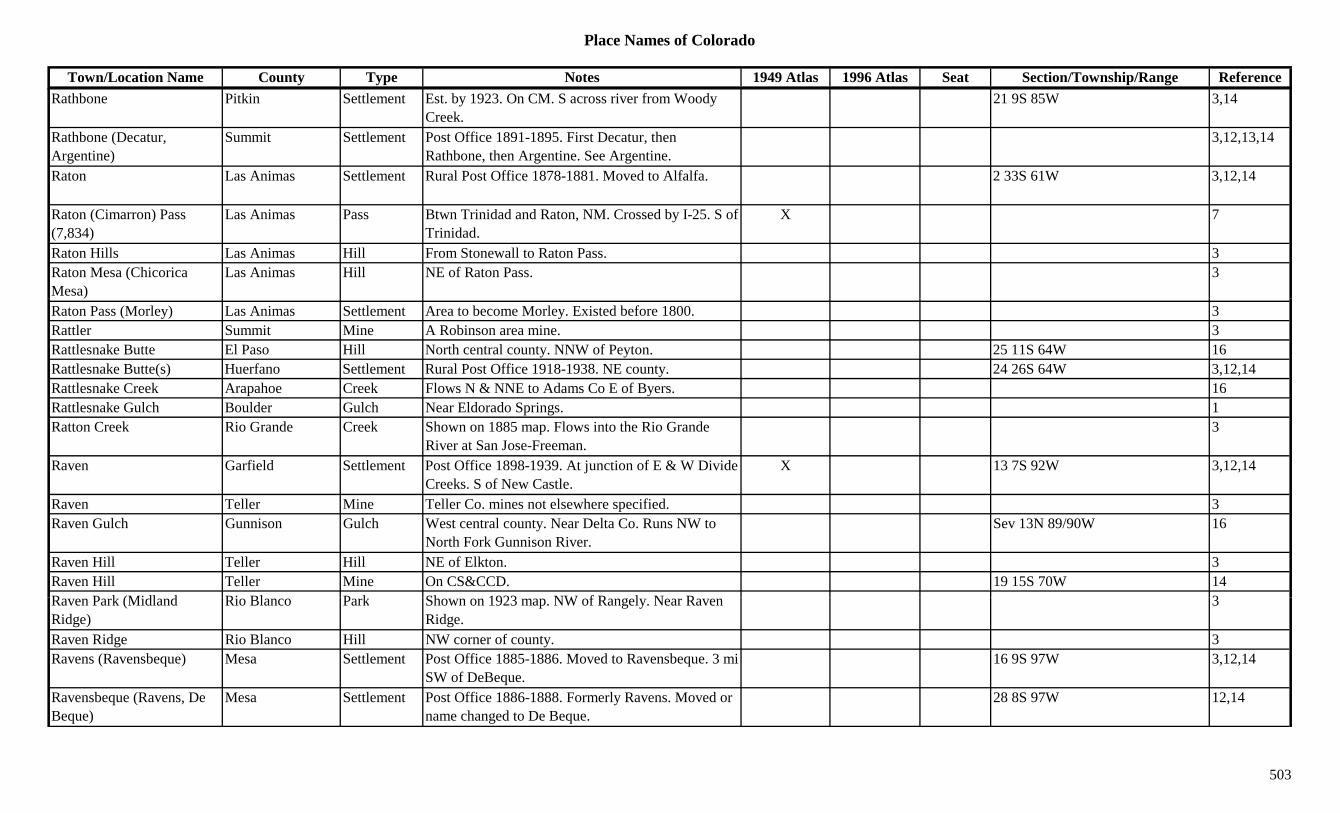
Place Names of Colorado
Town/Location Name County Type Notes 1949 Atlas 1996 Atlas Seat Section/Township/Range ReferenceRathbone Pitkin Settlement Est. by 1923. On CM. S across river from Woody
Creek.21 9S 85W 3,14
Rathbone (Decatur, Argentine)
Summit Settlement Post Office 1891-1895. First Decatur, then Rathbone, then Argentine. See Argentine.
3,12,13,14
Raton Las Animas Settlement Rural Post Office 1878-1881. Moved to Alfalfa. 2 33S 61W 3,12,14
Raton (Cimarron) Pass (7,834)
Las Animas Pass Btwn Trinidad and Raton, NM. Crossed by I-25. S of Trinidad.
X 7
Raton Hills Las Animas Hill From Stonewall to Raton Pass. 3Raton Mesa (Chicorica Mesa)
Las Animas Hill NE of Raton Pass. 3
Raton Pass (Morley) Las Animas Settlement Area to become Morley. Existed before 1800. 3Rattler Summit Mine A Robinson area mine. 3Rattlesnake Butte El Paso Hill North central county. NNW of Peyton. 25 11S 64W 16Rattlesnake Butte(s) Huerfano Settlement Rural Post Office 1918-1938. NE county. 24 26S 64W 3,12,14Rattlesnake Creek Arapahoe Creek Flows N & NNE to Adams Co E of Byers. 16Rattlesnake Gulch Boulder Gulch Near Eldorado Springs. 1Ratton Creek Rio Grande Creek Shown on 1885 map. Flows into the Rio Grande
River at San Jose-Freeman.3
Raven Garfield Settlement Post Office 1898-1939. At junction of E & W Divide Creeks. S of New Castle.
X 13 7S 92W 3,12,14
Raven Teller Mine Teller Co. mines not elsewhere specified. 3Raven Gulch Gunnison Gulch West central county. Near Delta Co. Runs NW to
North Fork Gunnison River.Sev 13N 89/90W 16
Raven Hill Teller Hill NE of Elkton. 3Raven Hill Teller Mine On CS&CCD. 19 15S 70W 14R P k (Midl d Ri Bl P k Sh 1923 NW f R l N R 3Raven Park (Midland Ridge)
Rio Blanco Park Shown on 1923 map. NW of Rangely. Near Raven Ridge.
3
Raven Ridge Rio Blanco Hill NW corner of county. 3Ravens (Ravensbeque) Mesa Settlement Post Office 1885-1886. Moved to Ravensbeque. 3 mi
SW of DeBeque.16 9S 97W 3,12,14
Ravensbeque (Ravens, De Beque)
Mesa Settlement Post Office 1886-1888. Formerly Ravens. Moved or name changed to De Beque.
28 8S 97W 12,14
503
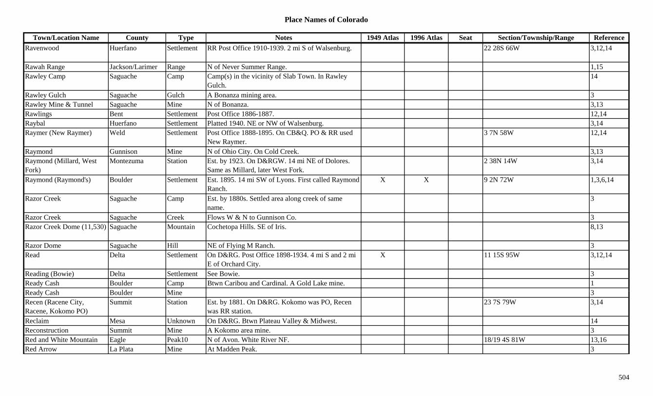
Place Names of Colorado
Town/Location Name County Type Notes 1949 Atlas 1996 Atlas Seat Section/Township/Range ReferenceRavenwood Huerfano Settlement RR Post Office 1910-1939. 2 mi S of Walsenburg. 22 28S 66W 3,12,14
Rawah Range Jackson/Larimer Range N of Never Summer Range. 1,15Rawley Camp Saguache Camp Camp(s) in the vicinity of Slab Town. In Rawley
Gulch.14
Rawley Gulch Saguache Gulch A Bonanza mining area. 3Rawley Mine & Tunnel Saguache Mine N of Bonanza. 3,13Rawlings Bent Settlement Post Office 1886-1887. 12,14Raybal Huerfano Settlement Platted 1940. NE or NW of Walsenburg. 3,14Raymer (New Raymer) Weld Settlement Post Office 1888-1895. On CB&Q. PO & RR used
New Raymer.3 7N 58W 12,14
Raymond Gunnison Mine N of Ohio City. On Cold Creek. 3,13Raymond (Millard, West Fork)
Montezuma Station Est. by 1923. On D&RGW. 14 mi NE of Dolores. Same as Millard, later West Fork.
2 38N 14W 3,14
Raymond (Raymond's) Boulder Settlement Est. 1895. 14 mi SW of Lyons. First called Raymond Ranch.
X X 9 2N 72W 1,3,6,14
Razor Creek Saguache Camp Est. by 1880s. Settled area along creek of same name.
3
Razor Creek Saguache Creek Flows W & N to Gunnison Co. 3Razor Creek Dome (11,530) Saguache Mountain Cochetopa Hills. SE of Iris. 8,13
Razor Dome Saguache Hill NE of Flying M Ranch. 3Read Delta Settlement On D&RG. Post Office 1898-1934. 4 mi S and 2 mi
E of Orchard City.X 11 15S 95W 3,12,14
Reading (Bowie) Delta Settlement See Bowie. 3Ready Cash Boulder Camp Btwn Caribou and Cardinal. A Gold Lake mine. 1R d C h B ld Mi 3Ready Cash Boulder Mine 3Recen (Racene City, Racene, Kokomo PO)
Summit Station Est. by 1881. On D&RG. Kokomo was PO, Recen was RR station.
23 7S 79W 3,14
Reclaim Mesa Unknown On D&RG. Btwn Plateau Valley & Midwest. 14Reconstruction Summit Mine A Kokomo area mine. 3Red and White Mountain Eagle Peak10 N of Avon. White River NF. 18/19 4S 81W 13,16Red Arrow La Plata Mine At Madden Peak. 3
504
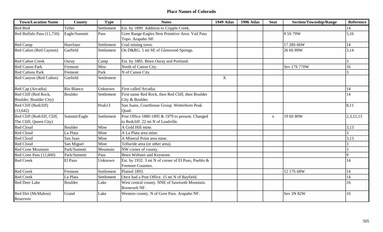
Place Names of Colorado
Town/Location Name County Type Notes 1949 Atlas 1996 Atlas Seat Section/Township/Range ReferenceRed Bird Teller Settlement Est. by 1899. Addition to Cripple Creek. 14Red Buffalo Pass (11,750) Eagle/Summit Pass Gore Range-Eagles Nest Primitive Area. Vail Pass
Topo. Arapaho NF.8 5S 79W 5,16
Red Camp Huerfano Settlement Coal mining town. 17 28S 66W 14Red Cañon (Red Caynon) Garfield Settlement On D&RG. 5 mi SE of Glenwood Springs. 26 6S 89W 3,14
Red Cañon Creek Ouray Camp Est. by 1885. Btwn Ouray and Portland. 3Red Canon Park Fremont Misc North of Canon City. Sev 17S 770W 16Red Cañons Park Fremont Park N of Canon City. 3Red Canyon (Red Cañon) Garfield Settlement X
Red Cap (Arcadia) Rio Blanco Unknown First called Arcadia. 14Red Cliff (Red Rock, Boulder, Boulder City)
Boulder Settlement First name Red Rock, then Red Cliff, then Boulder City & Boulder.
14
Red Cliff (Redcliff) (13,642)
Peak13 San Juans, Courthouse Group. Wetterhorn Peak Quad.
8,11
Red Cliff (Redcliff, Cliff, The Cliff, Queen City)
Summit/Eagle Settlement Post Office 1880-1895 & 1979 to present. Changed to Redcliff. 22 mi N of Leadville.
x 19 6S 80W 2,3,12,13
Red Cloud Boulder Mine A Gold Hill mine. 3,13Red Cloud La Plata Mine A La Plata area mine. 3Red Cloud San Juan Mine A Mineral Point area mine. 3,13Red Cloud San Miguel Mine Telluride area (or other area). 3Red Cone Mountain Park/Summit Mountain NW corner of county. 3Red Cone Pass (12,600) Park/Summit Pass Btwn Webster and Keystone. 9Red Creek El Paso Unknown Est. by 1932. 3 mi N of corner of El Paso, Pueblo &
Fremont Counties.14
R d C k F t S ttl t Pl tt d 1893 12 17S 68W 14Red Creek Fremont Settlement Platted 1893. 12 17S 68W 14Red Creek La Plata Settlement Once had a Post Office. 15 mi N of Bayfield. 14Red Deer Lake Boulder Lake West central county. NNE of Sawtooth Mountain.
Roosevelt NF.16
Red Dirt (McMahon) Reservoir
Grand Lake Western county. N of Gore Pass. Arapaho NF. Sev 3N 82W 16
505
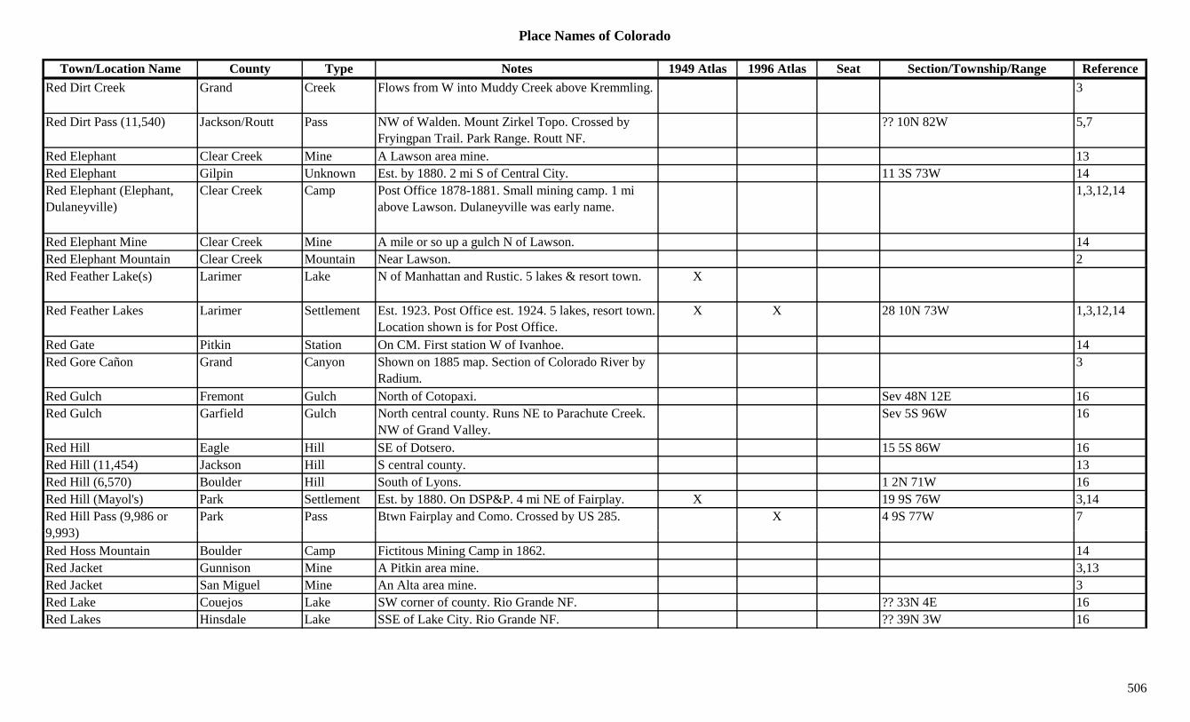
Place Names of Colorado
Town/Location Name County Type Notes 1949 Atlas 1996 Atlas Seat Section/Township/Range ReferenceRed Dirt Creek Grand Creek Flows from W into Muddy Creek above Kremmling. 3
Red Dirt Pass (11,540) Jackson/Routt Pass NW of Walden. Mount Zirkel Topo. Crossed by Fryingpan Trail. Park Range. Routt NF.
?? 10N 82W 5,7
Red Elephant Clear Creek Mine A Lawson area mine. 13Red Elephant Gilpin Unknown Est. by 1880. 2 mi S of Central City. 11 3S 73W 14Red Elephant (Elephant, Dulaneyville)
Clear Creek Camp Post Office 1878-1881. Small mining camp. 1 mi above Lawson. Dulaneyville was early name.
1,3,12,14
Red Elephant Mine Clear Creek Mine A mile or so up a gulch N of Lawson. 14Red Elephant Mountain Clear Creek Mountain Near Lawson. 2pRed Feather Lake(s) Larimer Lake N of Manhattan and Rustic. 5 lakes & resort town. X
Red Feather Lakes Larimer Settlement Est. 1923. Post Office est. 1924. 5 lakes, resort town. Location shown is for Post Office.
X X 28 10N 73W 1,3,12,14
Red Gate Pitkin Station On CM. First station W of Ivanhoe. 14Red Gore Cañon Grand Canyon Shown on 1885 map. Section of Colorado River by
Radium.3
Red Gulch Fremont Gulch North of Cotopaxi. Sev 48N 12E 16Red Gulch Garfield Gulch North central county. Runs NE to Parachute Creek.
NW of Grand Valley.Sev 5S 96W 16
Red Hill Eagle Hill SE of Dotsero. 15 5S 86W 16Red Hill (11,454) Jackson Hill S central county. 13Red Hill (6,570) Boulder Hill South of Lyons. 1 2N 71W 16Red Hill (Mayol's) Park Settlement Est. by 1880. On DSP&P. 4 mi NE of Fairplay. X 19 9S 76W 3,14Red Hill Pass (9,986 or 9 993)
Park Pass Btwn Fairplay and Como. Crossed by US 285. X 4 9S 77W 79,993)Red Hoss Mountain Boulder Camp Fictitous Mining Camp in 1862. 14Red Jacket Gunnison Mine A Pitkin area mine. 3,13Red Jacket San Miguel Mine An Alta area mine. 3Red Lake Couejos Lake SW corner of county. Rio Grande NF. ?? 33N 4E 16Red Lakes Hinsdale Lake SSE of Lake City. Rio Grande NF. ?? 39N 3W 16
506

Place Names of Colorado
Town/Location Name County Type Notes 1949 Atlas 1996 Atlas Seat Section/Township/Range ReferenceRed Lion Logan Settlement Site 1. Est. 1879. Post Office 1886-1890. Addition to
Sterling. Not site of modern town.3,14
Red Lion Logan Settlement Site 2. Post Office 1910-1935. X 35 11N 48W 3,12,14Red Mesa (Garland) La Plata Settlement Post Office 1907-1954. Original name was Garland.
Est. by Mormons.20 33N 12W 12,14
Red Mountain Eagle Peak13 Near Eagle/Summit border. N of Vail Pass. XRed Mountain El Paso Mountain South of Manitou Springs. 8 14S 67W 16Red Mountain Fremont/Saguache Peak12 Sangre de Cristo Range, North Section. NW of
Hayden Pass. San Isabel/Grande NF.?? 48N 9E 8,16
Red Mountain Grand Peak11 North tip of county. Rocky Mtn Natl Park. 14 5N 76W 3,16Red Mountain Grand Settlement Post Office 1878. On Colorado River. 2-3 mi E of 19 1N 80W 12,14
mouth of Blue River.,
Red Mountain Gunnison Camp Post Office 1880-1881. Early camp on Red Mountain Trail. Deserted before 1873. 2 sites?
8 13S 82W 3,12,14
Red Mountain Gunnison Peak11 South of Crested Butte. Gunnison NF. 6 15S 85W 16Red Mountain Hinsdale Peak12 SSW of Lake City. San Juans, Lake City Group. 20 43N 4W 3,8,16
Red Mountain Pitkin Mountain N of Aspen. 3Red Mountain #1 San Juan Mountain Btwn San Juan and Ouray Cos. 3Red Mountain #2 (12,219) Ouray Peak12 San Juans, Ouray Group. SE of Guston. 3,8
Red Mountain #3 (12,890) Ouray/San Juan Peak12 San Juans, Ouray Group. S of Guston. On San Juan Co. border.
3,8,15
Red Mountain (12,006) Conejos Peak12 East of Platoro. Rio Grande NF. 29 36N 5E 16Red Mountain (12,309) Clear Creek Peak12 West central county. SW of Mizpah. Arapaho NF. ?? 3S 76W 3,16
R d M t i (13 229) P k13 B k id Q d 11Red Mountain (13,229) Peak13 Breckenridge Quad. 11Red Mountain (13,500) Chaffee/Pitkin Peak13 SE corner of Pitkin Co. San Isabel NF. 7 12S 82W 3,16Red Mountain (13,500) Peak13 Independence Pass Quad. 11Red Mountain (13,908) Peak13 Culebra Peak Quad. 11Red Mountain (High Line Camp, Sky City, +)
Ouray/San Juan Settlement Post Office 1883-1913. N of summit or Red Mountain Pass. Also known as King of the Hill.
X 11 42N 8W 1,3,12,14
507
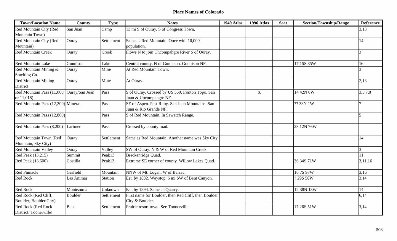
Place Names of Colorado
Town/Location Name County Type Notes 1949 Atlas 1996 Atlas Seat Section/Township/Range ReferenceRed Mountain City (Red Mountain Town)
San Juan Camp 13 mi S of Ouray. S of Congress Town. 3,13
Red Mountain City (Red Mountain)
Ouray Settlement Same as Red Mountain. Once with 10,000 population.
14
Red Mountain Creek Ouray Creek Flows N to join Uncompahgre River S of Ouray. 3
Red Mountain Lake Gunnison Lake Central county. N of Gunnison. Gunnison NF. 17 15S 85W 16Red Mountain Mining & Smelting Co.
Ouray Mine At Red Mountain Town. 3
Red Mountain Mining District
Ouray Mine At Ouray. 2,13
Red Mountain Pass (11,008 or 11,018)
Ouray/San Juan Pass S of Ouray. Crossed by US 550. Ironton Topo. San Juan & Uncompahgre NF.
X 14 42N 8W 3,5,7,8
Red Mountain Pass (12,200) Mineral Pass SE of Aspen. Past Ruby. San Juan Mountains. San Juan & Rio Grande NF.
?? 38N 1W 7
Red Mountain Pass (12,860) Pass S of Red Mountain. In Sawatch Range. 5
Red Mountain Pass (8,200) Larimer Pass Crossed by county road. 28 12N 76W
Red Mountain Town (Red Mountain, Sky City)
Ouray Settlement Same as Red Mountain. Another name was Sky City. 14
Red Mountain Valley Ouray Valley SW of Ouray. N & W of Red Mountain Creek. 3Red Peak (13,215) Summit Peak13 Breckenridge Quad. 11Red Peak (13,600) Costilla Peak13 Extreme SE corner of county. Willow Lakes Quad. 36 34S 71W 3,11,16
Red Pinnacle Garfield Mountain NNW of Mt. Logan. W of Balzac. 16 7S 97W 3,16R d R k L A i St ti E t b 1882 W t 6 i SW f B t C ? 29S 56W 3 14Red Rock Las Animas Station Est. by 1882. Waystop. 6 mi SW of Bent Canyon. ? 29S 56W 3,14
Red Rock Montezuma Unknown Est. by 1894. Same as Quarry. 12 38N 13W 14Red Rock (Red Cliff, Boulder, Boulder City)
Boulder Settlement First name for Boulder, then Red Cliff, then Boulder City & Boulder.
6,14
Red Rock (Red Rock District, Toonerville)
Bent Settlement Prairie resort town. See Toonerville. 17 26S 51W 3,14
508

Place Names of Colorado
Town/Location Name County Type Notes 1949 Atlas 1996 Atlas Seat Section/Township/Range ReferenceRed Rock Canyon Las Animas Gulch W of Red Rock. 3Red Rock City Delta Settlement Est. by 1883. Early name for Paonia. 14Red Rock City El Paso Settlement Est. 1859. In valley of Monument Creek. Near
present Roswell.14
Red Rock Lake Boulder Lake WNW of Ward. Roosevelt NF. 2 1N 73W 16Red Rocks (Gold Camp) Boulder Camp First white camp in Boulder Co., Oct. 17, 1858. 1,3Red Rocks Park Jefferson Park W of Morrison. 1Red Roger San Juan Mine A Red Mountain area mine. 3Red Sand Creek Montrose Creek Flows SW from near Ouray Co. to join Horsefly
Creek.3
Red Skin Mining Co. Park Mine A Puma area mine. 3gRed Slide Mountain Grand Peak10 Near Jackson Co in NW corner of county. Arapaho
NF.6 4N 80W 16
Red Spring Huerfano Misc NW corner of county. NW of Black Mtn. NW of Gardner. San Isabel NF.
12 25S 71W 16
Red Spruce Boulder Mine At Jamestown. 3,13Red Table Mountain Eagle Peak11 South of Eagle. Near Pitkin Co. White River NF. ?? 7S 84W 16
Red Table Mountain Mountain Red Table Mountain Range. 8Red Top Station Larimer Unknown 15 11N 71W 14Red Wash Moffat Creek Flows S & E into Rio Blanco Co. Btwn Blue Mtn. &
Massadona.3
Red Wash (Weary Mule Creek)
Rio Blanco Creek Flows S from Moffat Co. to White River E of Rangely.
3
Red Willow Creek Yuma Creek Flows W to E from near Ludlam past Alvin and into Nebraska.
3
R d Wi H f S ttl t E t 1913 X X 2 27S 71W 3 14Red Wing Huerfano Settlement Est. 1913. X X 2 27S 71W 3,14Red Works Fremont Unknown Est. by 1895. On F&CC. ? 19S 69W 14Redcliff (Red Cliff, The Cliff, Queen City)
Summit/Eagle Settlement Post Office 1895-1979. Formerly Red Cliff. Changed to Red Cliff. 22 mi N of Leadville.
X X 19 6S 80W 2,12,13,14
Redcloud Peak Hinsdale Peak14 SW of Lake City. San Juans, Lake City Group. Redcloud Peak Quad.
X X ?? 43N 5W 3,8,11,16
Redlands Mesa Settlement Est. by 1905. At base of National Monument. 17 1S 1W 3,14
509
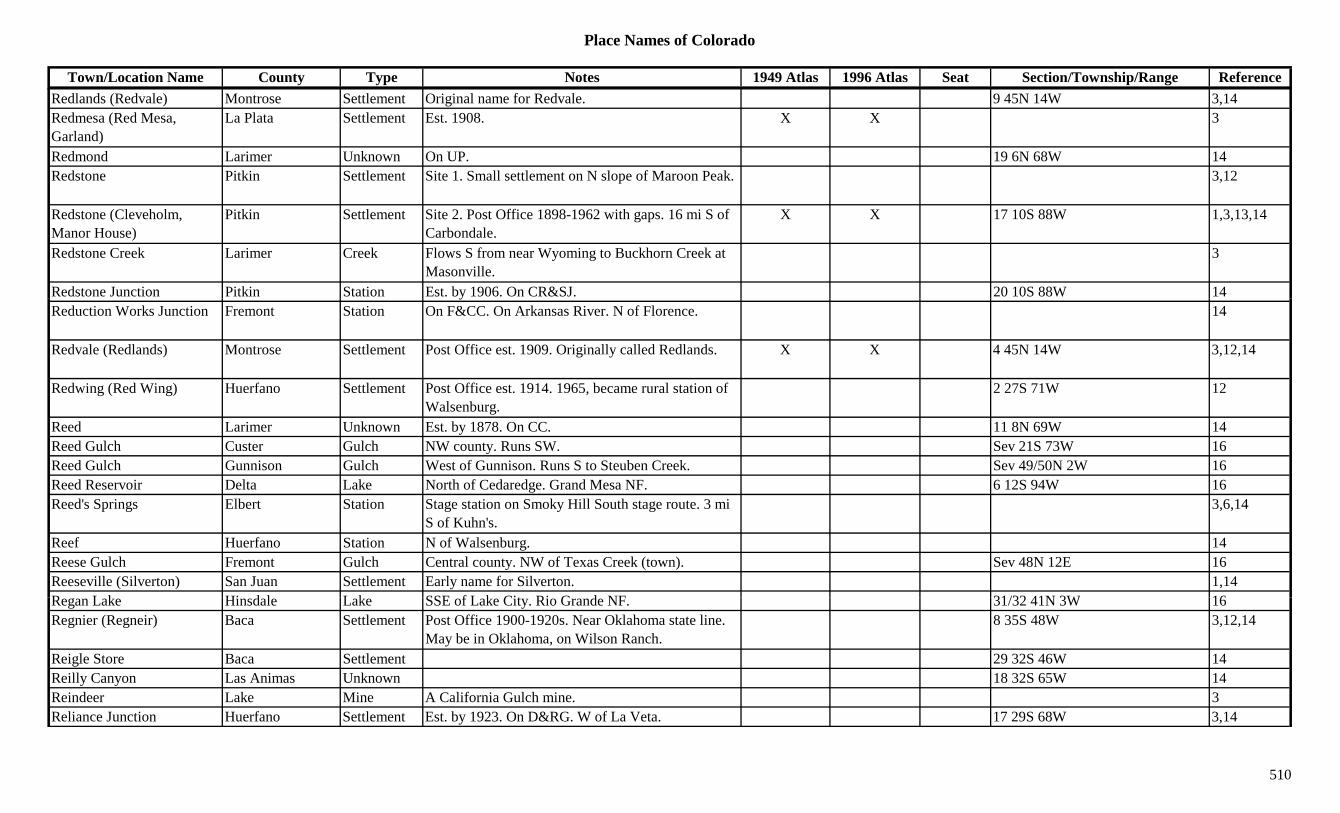
Place Names of Colorado
Town/Location Name County Type Notes 1949 Atlas 1996 Atlas Seat Section/Township/Range ReferenceRedlands (Redvale) Montrose Settlement Original name for Redvale. 9 45N 14W 3,14Redmesa (Red Mesa, Garland)
La Plata Settlement Est. 1908. X X 3
Redmond Larimer Unknown On UP. 19 6N 68W 14Redstone Pitkin Settlement Site 1. Small settlement on N slope of Maroon Peak. 3,12
Redstone (Cleveholm, Manor House)
Pitkin Settlement Site 2. Post Office 1898-1962 with gaps. 16 mi S of Carbondale.
X X 17 10S 88W 1,3,13,14
Redstone Creek Larimer Creek Flows S from near Wyoming to Buckhorn Creek at Masonville.
3
Redstone Junction Pitkin Station Est. by 1906. On CR&SJ. 20 10S 88W 14yReduction Works Junction Fremont Station On F&CC. On Arkansas River. N of Florence. 14
Redvale (Redlands) Montrose Settlement Post Office est. 1909. Originally called Redlands. X X 4 45N 14W 3,12,14
Redwing (Red Wing) Huerfano Settlement Post Office est. 1914. 1965, became rural station of Walsenburg.
2 27S 71W 12
Reed Larimer Unknown Est. by 1878. On CC. 11 8N 69W 14Reed Gulch Custer Gulch NW county. Runs SW. Sev 21S 73W 16Reed Gulch Gunnison Gulch West of Gunnison. Runs S to Steuben Creek. Sev 49/50N 2W 16Reed Reservoir Delta Lake North of Cedaredge. Grand Mesa NF. 6 12S 94W 16Reed's Springs Elbert Station Stage station on Smoky Hill South stage route. 3 mi
S of Kuhn's.3,6,14
Reef Huerfano Station N of Walsenburg. 14Reese Gulch Fremont Gulch Central county. NW of Texas Creek (town). Sev 48N 12E 16Reeseville (Silverton) San Juan Settlement Early name for Silverton. 1,14R L k Hi d l L k SSE f L k Cit Ri G d NF 31/32 41N 3W 16Regan Lake Hinsdale Lake SSE of Lake City. Rio Grande NF. 31/32 41N 3W 16Regnier (Regneir) Baca Settlement Post Office 1900-1920s. Near Oklahoma state line.
May be in Oklahoma, on Wilson Ranch.8 35S 48W 3,12,14
Reigle Store Baca Settlement 29 32S 46W 14Reilly Canyon Las Animas Unknown 18 32S 65W 14Reindeer Lake Mine A California Gulch mine. 3Reliance Junction Huerfano Settlement Est. by 1923. On D&RG. W of La Veta. 17 29S 68W 3,14
510
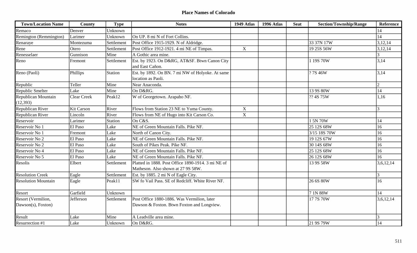
Place Names of Colorado
Town/Location Name County Type Notes 1949 Atlas 1996 Atlas Seat Section/Township/Range ReferenceRemaco Denver Unknown 14Remington (Remmington) Larimer Unknown On UP. 8 mi N of Fort Collins. 14Renaraye Montezuma Settlement Post Office 1915-1929. N of Aldridge. 33 37N 17W 3,12,14Rene Otero Settlement Post Office 1912-1921. 4 mi NE of Timpas. X 19 25S 56W 3,12,14Renesselaer Gunnison Mine A Gothic area mine. 3Reno Fremont Settlement Est. by 1923. On D&RG, AT&SF. Btwn Canon City
and East Cañon.1 19S 70W 3,14
Reno (Paoli) Phillips Station Est. by 1892. On BN. 7 mi NW of Holyoke. At same location as Paoli.
? 7S 46W 3,14
Republic Teller Mine Near Anaconda. 2Republic Smelter Lake Mine On D&RG. 13 9S 80W 14pRepublican Mountain (12,393)
Clear Creek Peak12 W of Georgetown. Arapaho NF. ?? 4S 75W 1,16
Republican River Kit Carson River Flows from Station 23 NE to Yuma County. X 3Republican River Lincoln River Flows from NE of Hugo into Kit Carson Co. XReservoir Larimer Station On C&S. 1 5N 70W 14Reservoir No 1 El Paso Lake NE of Green Mountain Falls. Pike NF. 25 12S 68W 16Reservoir No 1 Fremont Lake North of Canon City. 3/15 18S 70W 16Reservoir No 2 El Paso Lake NE of Green Mountain Falls. Pike NF. 19 12S 67W 16Reservoir No 2 El Paso Lake South of Pikes Peak. Pike NF. 30 14S 68W 16Reservoir No 4 El Paso Lake NE of Green Mountain Falls. Pike NF. 25 12S 68W 16Reservoir No 5 El Paso Lake NE of Green Mountain Falls. Pike NF. 26 12S 68W 16Resolis Elbert Settlement Platted in 1888. Post Office 1890-1914. 3 mi NE of
Matheson. Also shown at 27 9S 58W.13 9S 58W 3,6,12,14
Resolution Creek Eagle Settlement Est. by 1885. 2 mi N of Eagle City. 3Resolution Mountain Eagle Peak11 SW fo Vail Pass. SE of Redcliff. White River NF. 26 6S 80W 16
Resort Garfield Unknown 7 1N 88W 14Resort (Vermilion, Dawson(s), Foxton)
Jefferson Settlement Post Office 1880-1886. Was Vermilion, later Dawson & Foxton. Btwn Foxton and Longview.
17 7S 70W 3,6,12,14
Result Lake Mine A Leadville area mine. 3Resurrection #1 Lake Unknown On D&RG. 21 9S 79W 14
511

Place Names of Colorado
Town/Location Name County Type Notes 1949 Atlas 1996 Atlas Seat Section/Township/Range ReferenceResurrection #1 & #2 Lake Mine A Leadville area mine. 3Resurrection #2 Lake Unknown On D&RG. 21 9S 79W 14Retreat Creek Jackson Settlement Est. by 1885. Btwn Pinkhampton and Canadian. 3
Retreat Park Adams Unknown On C&S. 14 3S 68W 14Reudi Eagle/Pitkin Settlement On CM. Under water in Reudi Reservoir. 14Revenge Boulder Camp Near Lost Lake. 1Revenge Boulder Mine At Lost Lake Camp. W of Eldora. 3,13Revenue Lake Mine A California Gulch mine. 3Revenue Park Mine W of Revenue Mtn. May be in Clear Creek Co. 3
Revenue Gulch Gunnison Gulch SE of Ohio City. Runs N to Quartz Creek. Gunnison NF.
Sev 50N 3.5E 16
Revenue Mountain (12,903) Clear Creek/Summit
Peak12 On border of Summit and Clear Creek counties. SW of Argentine Pass. Arapaho/Pike NF.
29 5S 75W 3,16
Revenue Tunnel Ouray Mine Cut into mtn. for 3 mi. Below Sneffels Mine. 2,3,13Revenue-Tariff Summit Mine An Argentine area mine. 3Review Gilpin Mine N of Central City. 3Rex Eagle Settlement Est. by 1923. N of Gilman on D&RG. 1 6S 81W 3,14Rex Larimer Station On C&S. 10 mi N of Ted's Place. 36 10N 70W 3,14Rex No. 1 Boulder Mine Coal mine in Louisville group. 1Rexford Summit Settlement Post Office 1882-1883. 14 mi NE of Breckenridge.
Near Tiger.8 6S 76W 3,12,13,14
Rexford Mine & Mining Corp.
Summit Mine A Rexford area mine. 3
R ld L k Cl C k L k N th ti f t NW f Ali A h NF 33 2S 74W + 16Reynolds Lake Clear Creek Lake Northern tip of county. NW of Alice. Arapaho NF. 33 2S 74W + 16
Reynolds Reservoir Delta Lake NE of Cedaredge. Grand Mesa NF. 3 12S 93W 16Rezago Las Animas Unknown On C&W. 32 33S 65W 14Rhodes Gulch Conejos Gulch NW corner of county. Runs NNE. Rio Grande NF. Sev 35N 5E 16
512
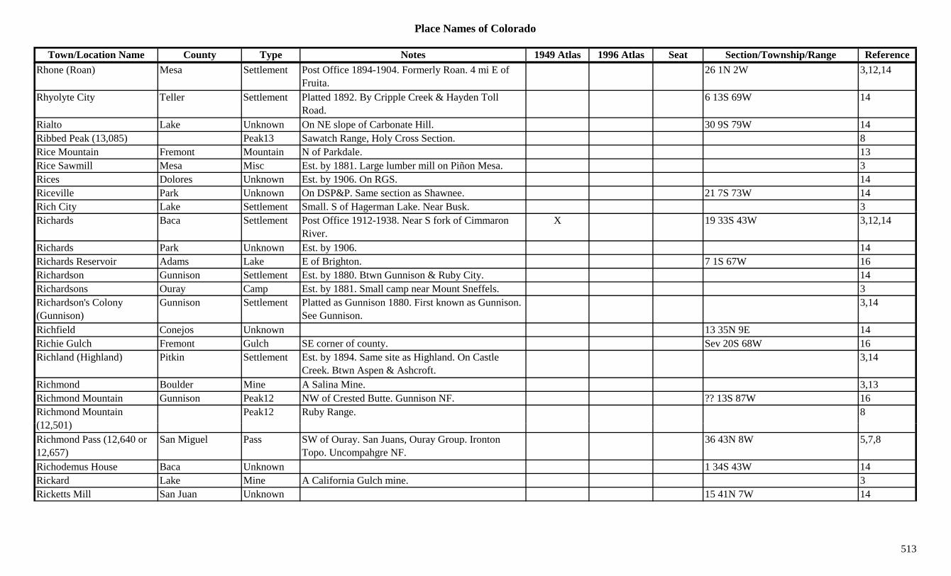
Place Names of Colorado
Town/Location Name County Type Notes 1949 Atlas 1996 Atlas Seat Section/Township/Range ReferenceRhone (Roan) Mesa Settlement Post Office 1894-1904. Formerly Roan. 4 mi E of
Fruita.26 1N 2W 3,12,14
Rhyolyte City Teller Settlement Platted 1892. By Cripple Creek & Hayden Toll Road.
6 13S 69W 14
Rialto Lake Unknown On NE slope of Carbonate Hill. 30 9S 79W 14Ribbed Peak (13,085) Peak13 Sawatch Range, Holy Cross Section. 8Rice Mountain Fremont Mountain N of Parkdale. 13Rice Sawmill Mesa Misc Est. by 1881. Large lumber mill on Piñon Mesa. 3Rices Dolores Unknown Est. by 1906. On RGS. 14Riceville Park Unknown On DSP&P. Same section as Shawnee. 21 7S 73W 14Rich City Lake Settlement Small. S of Hagerman Lake. Near Busk. 3y gRichards Baca Settlement Post Office 1912-1938. Near S fork of Cimmaron
River.X 19 33S 43W 3,12,14
Richards Park Unknown Est. by 1906. 14Richards Reservoir Adams Lake E of Brighton. 7 1S 67W 16Richardson Gunnison Settlement Est. by 1880. Btwn Gunnison & Ruby City. 14Richardsons Ouray Camp Est. by 1881. Small camp near Mount Sneffels. 3Richardson's Colony (Gunnison)
Gunnison Settlement Platted as Gunnison 1880. First known as Gunnison. See Gunnison.
3,14
Richfield Conejos Unknown 13 35N 9E 14Richie Gulch Fremont Gulch SE corner of county. Sev 20S 68W 16Richland (Highland) Pitkin Settlement Est. by 1894. Same site as Highland. On Castle
Creek. Btwn Aspen & Ashcroft.3,14
Richmond Boulder Mine A Salina Mine. 3,13Richmond Mountain Gunnison Peak12 NW of Crested Butte. Gunnison NF. ?? 13S 87W 16Richmond Mountain (12 501)
Peak12 Ruby Range. 8(12,501)Richmond Pass (12,640 or 12,657)
San Miguel Pass SW of Ouray. San Juans, Ouray Group. Ironton Topo. Uncompahgre NF.
36 43N 8W 5,7,8
Richodemus House Baca Unknown 1 34S 43W 14Rickard Lake Mine A California Gulch mine. 3Ricketts Mill San Juan Unknown 15 41N 7W 14
513
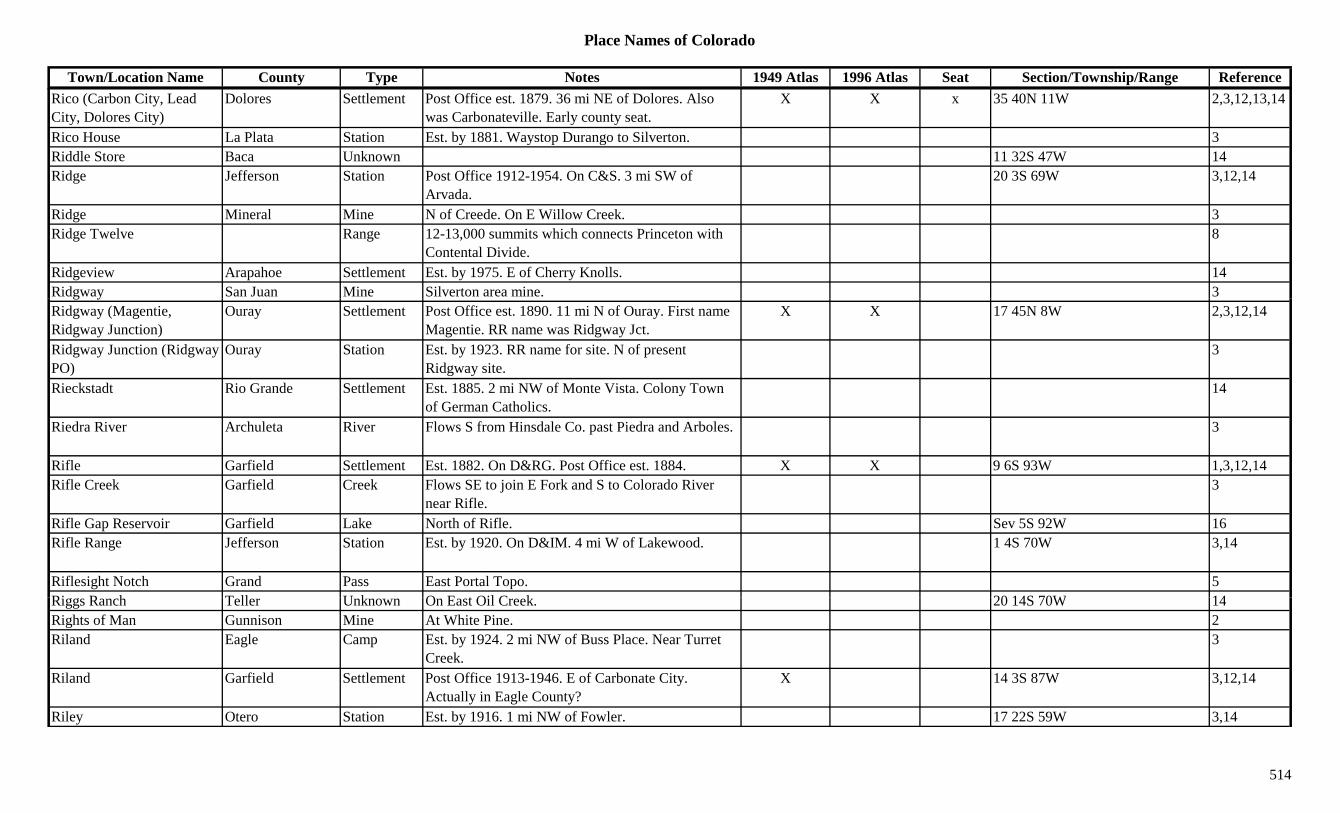
Place Names of Colorado
Town/Location Name County Type Notes 1949 Atlas 1996 Atlas Seat Section/Township/Range ReferenceRico (Carbon City, Lead City, Dolores City)
Dolores Settlement Post Office est. 1879. 36 mi NE of Dolores. Also was Carbonateville. Early county seat.
X X x 35 40N 11W 2,3,12,13,14
Rico House La Plata Station Est. by 1881. Waystop Durango to Silverton. 3Riddle Store Baca Unknown 11 32S 47W 14Ridge Jefferson Station Post Office 1912-1954. On C&S. 3 mi SW of
Arvada.20 3S 69W 3,12,14
Ridge Mineral Mine N of Creede. On E Willow Creek. 3Ridge Twelve Range 12-13,000 summits which connects Princeton with
Contental Divide.8
Ridgeview Arapahoe Settlement Est. by 1975. E of Cherry Knolls. 14Ridgway San Juan Mine Silverton area mine. 3g yRidgway (Magentie, Ridgway Junction)
Ouray Settlement Post Office est. 1890. 11 mi N of Ouray. First name Magentie. RR name was Ridgway Jct.
X X 17 45N 8W 2,3,12,14
Ridgway Junction (Ridgway PO)
Ouray Station Est. by 1923. RR name for site. N of present Ridgway site.
3
Rieckstadt Rio Grande Settlement Est. 1885. 2 mi NW of Monte Vista. Colony Town of German Catholics.
14
Riedra River Archuleta River Flows S from Hinsdale Co. past Piedra and Arboles. 3
Rifle Garfield Settlement Est. 1882. On D&RG. Post Office est. 1884. X X 9 6S 93W 1,3,12,14Rifle Creek Garfield Creek Flows SE to join E Fork and S to Colorado River
near Rifle.3
Rifle Gap Reservoir Garfield Lake North of Rifle. Sev 5S 92W 16Rifle Range Jefferson Station Est. by 1920. On D&IM. 4 mi W of Lakewood. 1 4S 70W 3,14
Riflesight Notch Grand Pass East Portal Topo. 5Ri R h T ll U k O E t Oil C k 20 14S 70W 14Riggs Ranch Teller Unknown On East Oil Creek. 20 14S 70W 14Rights of Man Gunnison Mine At White Pine. 2Riland Eagle Camp Est. by 1924. 2 mi NW of Buss Place. Near Turret
Creek.3
Riland Garfield Settlement Post Office 1913-1946. E of Carbonate City. Actually in Eagle County?
X 14 3S 87W 3,12,14
Riley Otero Station Est. by 1916. 1 mi NW of Fowler. 17 22S 59W 3,14
514

Place Names of Colorado
Town/Location Name County Type Notes 1949 Atlas 1996 Atlas Seat Section/Township/Range ReferenceRiley Gulch Garfield Gulch Central county. Runs NE to Parachuet Creek. NW of
Grand Valley.Sev 7S 96W 16
Riley's (Muckawanago) Pitkin Station Began as loading spur. Tourist area. 3Rim Lake Garfield Lake NE corner of county. White River NF. ?? 2S 88W 16Rimrock Lake Delta Lake North of Cedaredge. Grand Mesa NF. 9 12S 95W 16Rincon (Tercio) Las Animas Settlement On C&W. Spanish village. See Tercio. 27 34S 68W 3,14Rincon La Osa Hinsdale Gulch Central county. Runs E to Los Pinos River. San Juan
NF.Sev 39N 4/5W 16
Rincones Conejos Settlement Est. by 1885. 4 mi NE of Los Brazos. 5 33N 10E 3,14Rinker Peak (13,783) Peak13 Mt. Elbert Quad. 11Rinn Weld Settlement Existed in 1860s. Rural Post Office 1901-1907. 10 16 2N 68W 3,4,6,12,14
mi SE of Longmont., , , ,
Rio Almo (Sheep Creek) Saguache Gulch Shown on 1880s maps. Mining area W of Bonanza. 3
Rio Alto Saguache Settlement Post Office in 1880. On Rio Alto Creek. 3Rio Alto Creek Saguache Creek Flows SW to join San Luis Creek near Moffat. 3Rio Aquilla (Eagle, Castle, McDonald)
Eagle Settlement First name was Castle, then Rio Aquilla, then McDonald & last Eagle.
32 4S 84W 3,14
Rio Blanco (Rioblanco) Rio Blanco Settlement Post Office 1950-1975. Formerly Rioblanco. 1964, became rural station of Rifle.
X 33 3S 94W 3,12,14
Rio Blanco Creek Archuleta Creek Flows S & W to join San Juan River near Chambers. 3
Rio Culebra Costilla River Flows W from Whiskey Creek Pass to Conejos Co. 3
Rio de las Animas (Trinidad)
Las Animas Settlement First permanent settlement 1859. First name of Trinidad. See Trinidad.
3,14
Ri G d C till /Al S ttl t P t Offi 1874 1877 8 i SE f Al Al 11 37N 11E 3 12 14Rio Grande Costilla/Alamosa Settlement Post Office 1874-1877. 8 mi SE of Alamosa. Also shown at 33 37N 11E & 33 38N 10E.
11 37N 11E 3,12,14
Rio Grande (Stony) Pass Hinsdale/San Juan Pass Btwn Silverton and Creede. Howardsville Topo. San Juan & Rio Grande NF.
20 41N 6W 3,5,7,8,9
Rio Grande Canal Hinsdale Canal Flows W into Rio Grande Reservoir. XRio Grande Canal Mineral Canal Flows E into Hinsdale Co through Creede. XRio Grande Canal Rio Grande Canal Flows W from Del Norte into Mineral Co. X
515
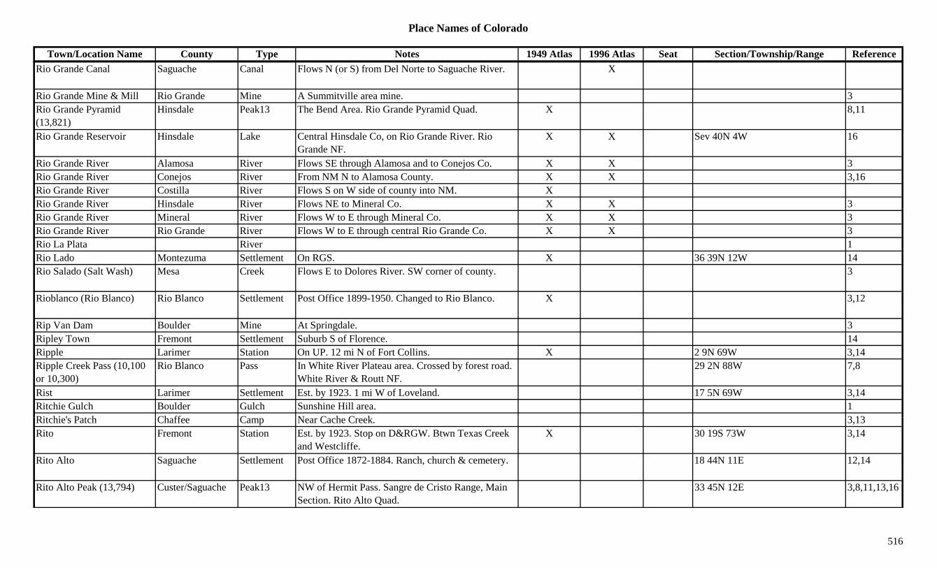
Place Names of Colorado
Town/Location Name County Type Notes 1949 Atlas 1996 Atlas Seat Section/Township/Range ReferenceRio Grande Canal Saguache Canal Flows N (or S) from Del Norte to Saguache River. X
Rio Grande Mine & Mill Rio Grande Mine A Summitville area mine. 3Rio Grande Pyramid (13,821)
Hinsdale Peak13 The Bend Area. Rio Grande Pyramid Quad. X 8,11
Rio Grande Reservoir Hinsdale Lake Central Hinsdale Co, on Rio Grande River. Rio Grande NF.
X X Sev 40N 4W 16
Rio Grande River Alamosa River Flows SE through Alamosa and to Conejos Co. X X 3Rio Grande River Conejos River From NM N to Alamosa County. X X 3,16Rio Grande River Costilla River Flows S on W side of county into NM. XRio Grande River Hinsdale River Flows NE to Mineral Co. X X 3Rio Grande River Mineral River Flows W to E through Mineral Co. X X 3Rio Grande River Rio Grande River Flows W to E through central Rio Grande Co. X X 3Rio La Plata River 1Rio Lado Montezuma Settlement On RGS. X 36 39N 12W 14Rio Salado (Salt Wash) Mesa Creek Flows E to Dolores River. SW corner of county. 3
Rioblanco (Rio Blanco) Rio Blanco Settlement Post Office 1899-1950. Changed to Rio Blanco. X 3,12
Rip Van Dam Boulder Mine At Springdale. 3Ripley Town Fremont Settlement Suburb S of Florence. 14Ripple Larimer Station On UP. 12 mi N of Fort Collins. X 2 9N 69W 3,14Ripple Creek Pass (10,100 or 10,300)
Rio Blanco Pass In White River Plateau area. Crossed by forest road. White River & Routt NF.
29 2N 88W 7,8
Rist Larimer Settlement Est. by 1923. 1 mi W of Loveland. 17 5N 69W 3,14Ritchie Gulch Boulder Gulch Sunshine Hill area. 1Rit hi ' P t h Ch ff C N C h C k 3 13Ritchie's Patch Chaffee Camp Near Cache Creek. 3,13Rito Fremont Station Est. by 1923. Stop on D&RGW. Btwn Texas Creek
and Westcliffe.X 30 19S 73W 3,14
Rito Alto Saguache Settlement Post Office 1872-1884. Ranch, church & cemetery. 18 44N 11E 12,14
Rito Alto Peak (13,794) Custer/Saguache Peak13 NW of Hermit Pass. Sangre de Cristo Range, Main Section. Rito Alto Quad.
33 45N 12E 3,8,11,13,16
516

Place Names of Colorado
Town/Location Name County Type Notes 1949 Atlas 1996 Atlas Seat Section/Township/Range ReferenceRito Gulch Fremont Gulch Central county. S of Texas Creek (town). Sev 19S 73W 16Rito Hondo Reservoir Hinsdale Lake SSE of Spring Creek Pass. Rio Grande NF. 15/22 42N 3W 16Rito Selo Costilla Creek Flows W from Whiskey Creek Pass to join Rio
Culebra.3
Rivas Moffat Settlement Post Office 1924-1925. 12,14River Bend (Riverbend) Elbert Settlement Post Office 1875-1939. K&P RR terminus. See Old
Riverbend. Also shown at 5 9S 63W.X 5 9S 57W 3,4,6,12,14
River Portal Montrose Settlement Post Office 1906-1910. At NE end of Gunnison Tunnel.
9 49N 7W 12,14
Rivera Las Animas Station Site 2. Est. by 1916. On C&S. 3 mi NE of El Moro. 27 32S 63W 3,14
Rivera (San Francisco Plaza, Glenham)
Las Animas Settlement Site 1. Est. by 1884. Second "castle" of Barela. 6 mi NE of Trinidad.
4
Riverdale Adams Unknown 18 2S 67W 14Riverdale Bent Station Est. by 1909. RR stop on AT&SF. 6 mi W of Las
Animas.11 23S 53W 3,14
Riverdale Pitkin Station Est. by 1880s. Barlow & Sanderson Stage Station on Aspen-Glenwood Road.
14
Rivers Weld Unknown On UP. 9 3N 67W 14Riverside Boulder Settlement NE of Raymond, up South St. Vrain. X 34 3N 72W 1,6,14Riverside Douglas Unknown Now under water. 12 6S 68W 14Riverside Lake/Chaffee Settlement Post Office 1872-1905. On D&RG route to
Leadville.X 11 13S 79W 3,12,14
Riverside Logan Settlement Est. by 1881. Shown at site of Powell. At mouth of Lewis Creek. 15 mi NW of Sterling.
3,14
Riverside Mineral Unknown On D&RG. 11 40N 2E 14Ri id O C E t b 1881 O R d M t i C k O C 3Riverside Ouray Camp Est. by 1881. On Red Mountain Creek. On Curran
Gulch.3
Riverside Reservation Weld Misc 20 mi E of Greeley. 1Riverside Reservoir Weld Lake NW of Masters. X XRiverside Station (Riverside)
Logan Station Wells Fargo Stage Staton on the Platte River Route. 39 mi SSW of Julesburg.
14
517
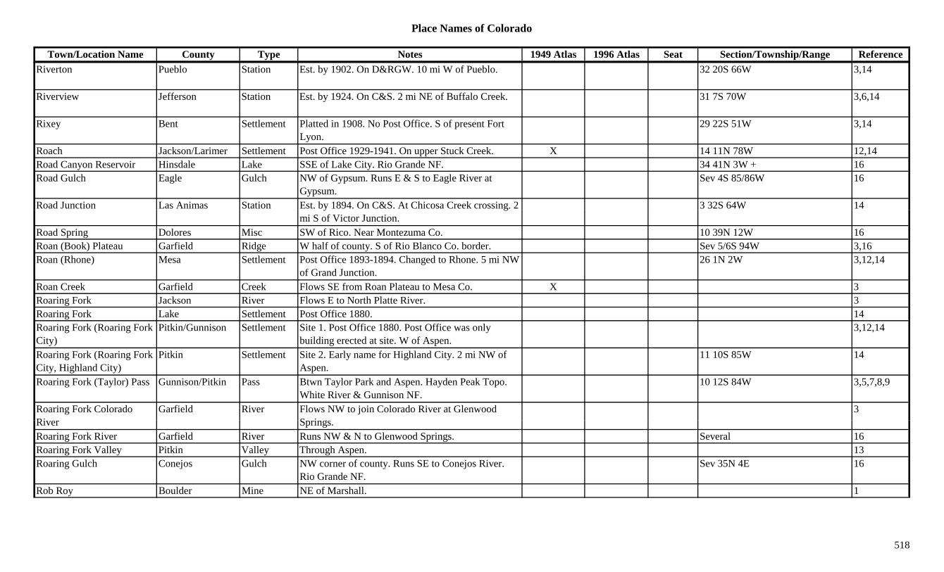
Place Names of Colorado
Town/Location Name County Type Notes 1949 Atlas 1996 Atlas Seat Section/Township/Range ReferenceRiverton Pueblo Station Est. by 1902. On D&RGW. 10 mi W of Pueblo. 32 20S 66W 3,14
Riverview Jefferson Station Est. by 1924. On C&S. 2 mi NE of Buffalo Creek. 31 7S 70W 3,6,14
Rixey Bent Settlement Platted in 1908. No Post Office. S of present Fort Lyon.
29 22S 51W 3,14
Roach Jackson/Larimer Settlement Post Office 1929-1941. On upper Stuck Creek. X 14 11N 78W 12,14Road Canyon Reservoir Hinsdale Lake SSE of Lake City. Rio Grande NF. 34 41N 3W + 16Road Gulch Eagle Gulch NW of Gypsum. Runs E & S to Eagle River at
Gypsum.Sev 4S 85/86W 16
Road Junction Las Animas Station Est. by 1894. On C&S. At Chicosa Creek crossing. 2 3 32S 64W 14y gmi S of Victor Junction.
Road Spring Dolores Misc SW of Rico. Near Montezuma Co. 10 39N 12W 16Roan (Book) Plateau Garfield Ridge W half of county. S of Rio Blanco Co. border. Sev 5/6S 94W 3,16Roan (Rhone) Mesa Settlement Post Office 1893-1894. Changed to Rhone. 5 mi NW
of Grand Junction.26 1N 2W 3,12,14
Roan Creek Garfield Creek Flows SE from Roan Plateau to Mesa Co. X 3Roaring Fork Jackson River Flows E to North Platte River. 3Roaring Fork Lake Settlement Post Office 1880. 14Roaring Fork (Roaring Fork City)
Pitkin/Gunnison Settlement Site 1. Post Office 1880. Post Office was only building erected at site. W of Aspen.
3,12,14
Roaring Fork (Roaring Fork City, Highland City)
Pitkin Settlement Site 2. Early name for Highland City. 2 mi NW of Aspen.
11 10S 85W 14
Roaring Fork (Taylor) Pass Gunnison/Pitkin Pass Btwn Taylor Park and Aspen. Hayden Peak Topo. White River & Gunnison NF.
10 12S 84W 3,5,7,8,9
Roaring Fork Colorado Ri
Garfield River Flows NW to join Colorado River at Glenwood S i
3River Springs.Roaring Fork River Garfield River Runs NW & N to Glenwood Springs. Several 16Roaring Fork Valley Pitkin Valley Through Aspen. 13Roaring Gulch Conejos Gulch NW corner of county. Runs SE to Conejos River.
Rio Grande NF.Sev 35N 4E 16
Rob Roy Boulder Mine NE of Marshall. 1
518
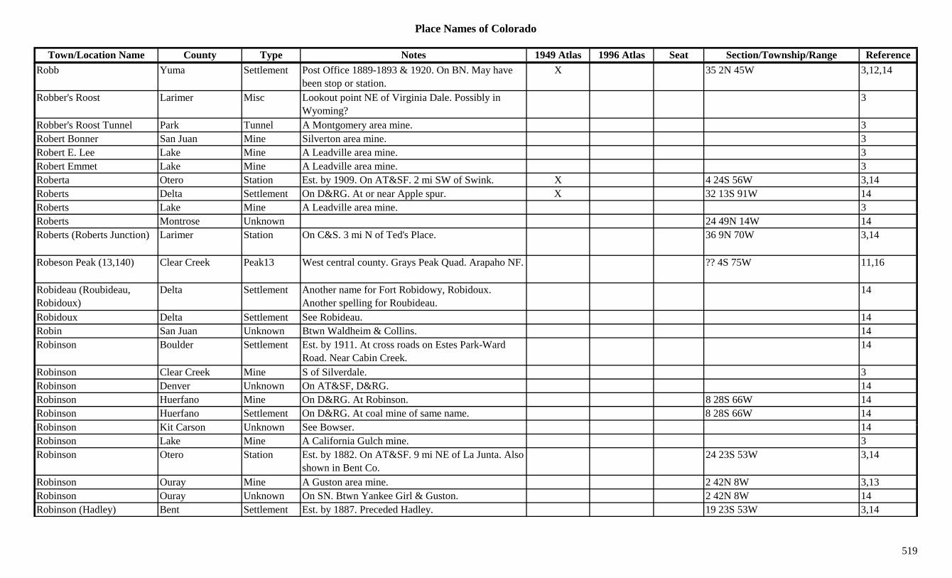
Place Names of Colorado
Town/Location Name County Type Notes 1949 Atlas 1996 Atlas Seat Section/Township/Range ReferenceRobb Yuma Settlement Post Office 1889-1893 & 1920. On BN. May have
been stop or station.X 35 2N 45W 3,12,14
Robber's Roost Larimer Misc Lookout point NE of Virginia Dale. Possibly in Wyoming?
3
Robber's Roost Tunnel Park Tunnel A Montgomery area mine. 3Robert Bonner San Juan Mine Silverton area mine. 3Robert E. Lee Lake Mine A Leadville area mine. 3Robert Emmet Lake Mine A Leadville area mine. 3Roberta Otero Station Est. by 1909. On AT&SF. 2 mi SW of Swink. X 4 24S 56W 3,14Roberts Delta Settlement On D&RG. At or near Apple spur. X 32 13S 91W 14Roberts Lake Mine A Leadville area mine. 3Roberts Montrose Unknown 24 49N 14W 14Roberts (Roberts Junction) Larimer Station On C&S. 3 mi N of Ted's Place. 36 9N 70W 3,14
Robeson Peak (13,140) Clear Creek Peak13 West central county. Grays Peak Quad. Arapaho NF. ?? 4S 75W 11,16
Robideau (Roubideau, Robidoux)
Delta Settlement Another name for Fort Robidowy, Robidoux. Another spelling for Roubideau.
14
Robidoux Delta Settlement See Robideau. 14Robin San Juan Unknown Btwn Waldheim & Collins. 14Robinson Boulder Settlement Est. by 1911. At cross roads on Estes Park-Ward
Road. Near Cabin Creek.14
Robinson Clear Creek Mine S of Silverdale. 3Robinson Denver Unknown On AT&SF, D&RG. 14Robinson Huerfano Mine On D&RG. At Robinson. 8 28S 66W 14Robinson Huerfano Settlement On D&RG. At coal mine of same name. 8 28S 66W 14R bi Kit C U k S B 14Robinson Kit Carson Unknown See Bowser. 14Robinson Lake Mine A California Gulch mine. 3Robinson Otero Station Est. by 1882. On AT&SF. 9 mi NE of La Junta. Also
shown in Bent Co.24 23S 53W 3,14
Robinson Ouray Mine A Guston area mine. 2 42N 8W 3,13Robinson Ouray Unknown On SN. Btwn Yankee Girl & Guston. 2 42N 8W 14Robinson (Hadley) Bent Settlement Est. by 1887. Preceded Hadley. 19 23S 53W 3,14
519

Place Names of Colorado
Town/Location Name County Type Notes 1949 Atlas 1996 Atlas Seat Section/Township/Range ReferenceRobinson (Ten Mile, Frawley plus)
Summit/Eagle Settlement Post Office 1881-1911. Was Ten Mile. Covered by Climax tailing ponds. 15 mi S of Frisco.
X 27 7S 79W 3,12,13
Robinson Hill Custer Hill W of Querida. 3Robinson's Camp Summit Camp Co-camp with Ten-Mile City and Summit City. Near
Kokomo.3
Roby El Paso Unknown On D&RG. 14Roby (Poso, Model) Las Animas Settlement Post Office 1911-1912. Site formerly Poso. Changed
to Model.4 31S 61W 12,14
Rochester (Arrastra) Queen Summit Mine A Rexford area mine. 3,13
Rochester King Summit Mine A Rexford area mine. 13Rock Lake Mine A Leadville area mine. 3Rock (Box) Creek Montrose Creek Flows from NW corner of county E to Doloresl
River.3
Rock Bluffs Arapahoe Station Wells Fargo Stage Station on Platte Route. 30 mi & 3rd station NNE of Kiowa.
14
Rock Butte Douglas/Elbert Station Post Office 1869-1874. Stop on C&S. 8 mi SW of Kiowa.
4 9S 64W 3,6,12,14
Rock Cañon Pueblo Unknown Est. by 1891. On N side of Arkansas River. 1.5 mi NW of Goodnight. Just E of Veges.
14
Rock Cliff Saguache Settlement Post Office 1874-1880. 11 mi E of Cochetopa Pass. Also shown at 3 44N 4E.
23 45N 5E 3,12,14
Rock Creek Alamosa Creek Flows SE to join Alamosa Creek S of Alamosa. 3,16Rock Creek Boulder Creek S of Longmont. 1Rock Creek Gunnison Creek Schofield area. 13R k C k L k C k Fl NE i t M lt 3Rock Creek Lake Creek Flows NE into Malta. 3Rock Creek Morgan Station Stage station on Fort Morgan Cutoff, Overland
route. 4 mi NW of Hoyt.3,14
Rock Creek Park Creek Flows S to Tarryall Creek at Bordenville. 3Rock Creek Pueblo Settlement Post Office 1909-1915. Also shown at 20 22S 66W. 31 22S 67W 12,14
Rock Creek Rio Grande Creek Flows E through SE corner of county. X 3
520

Place Names of Colorado
Town/Location Name County Type Notes 1949 Atlas 1996 Atlas Seat Section/Township/Range ReferenceRock Creek Rio Grande Unknown 19 38N 8E 14Rock Creek Routt Creek Flows SW to Chimney Fork near Pershing. 3Rock Creek Routt Unknown On D&RG. 14Rock Creek (Crystal River) Pitkin River Flows S to N through Redstone, Janeway, into
Garfield Co.3
Rock Creek (Crystal) Gunnison Camp Same as or near Scofield. At head of Rock Creek. Rock Creek location ? 12S 86W.
3,14
Rock Creek (Gilman) Eagle Settlement Est. by 1906. On D&RG. Third name for Gilman. See Gilman.
13 6S 81W 3,13,14
Rock Creek (White Earth Creek)
Saguache Creek Flows SE to Hinsdale Co. 3
Rock Creek Park El Paso Settlement On Rock Creek where it crosses CO Hwy 115. 36 15S 67W 14Rock Creek Trail Pass (10,600)
Douglas Pass Near Deckers. Pike map. 7
Rock Crusher (Weidman) Jefferson Unknown On D&IM. Renamed Weidman. 14Rock Island Lake Mine A Swede's Gulch mine. 3Rock King Chaffee Mine N of Salida. 3Rock Lake Boulder Lake West of Jamestown. Roosevelt NF. 28/27 2N 72W 16Rock Lake Conejos Lake SW corner of county. Rio Grande NF. 9 33N 5E 16Rock Lake Hinsdale Lake SW of Lake City. Near La Plata Co. San Juan NF. ?? 39N 5W 16
Rock Rest Jefferson Settlement Est. by 1950. 14Rock Ridge (Frosts Ranch) Douglas Settlement Post Office 1872-1892. Originally Virginia, renamed
Frost(s) Ranch.13 9S 66W 12,14
Rock Spring Draw Dolores Gulch North central county. Runs N to Dawson Draw. Sev 41N 16W 16
R k S E l U k O D&RG 4 4S 83W 14Rock Spur Eagle Unknown On D&RG. 4 4S 83W 14Rockdale Bent Unknown 23 22S 59W 14Rockdale Jefferson Settlement 14Rockdale Otero Settlement Est. by 1882. At junction of Apishapa and Arkansas
Rivers.23 22S 59W 3,14
Rockdale (Rockvale) Chaffee/Fremont Settlement Post Office 1882. Changed to Rockvale. 3 mi up Clear Creek Gulch from Vicksburg.
23 12S 81W 3,12,13,14
521

Place Names of Colorado
Town/Location Name County Type Notes 1949 Atlas 1996 Atlas Seat Section/Township/Range ReferenceRockefeller Gunnison Unknown On D&RG. Also shown at 11 14S 87W. 28 7S 88W 14Rockford Douglas Settlement Est. by 1897. Stopover on wagon road Franktown to
Castle Rock.3,14
Rockford Gilpin Mine A Russell Gulch area mine. 3Rockford (Cooperton, Moffat, Satank)
Garfield Settlement Est. by 1888. First was Cooperton. Also Moffat. See Satank.
28 7S 88W 3,14
Rockhole Lake Boulder Lake At foot of S Rawah Peak. 1Rockland Logan Settlement Platted 1888. Post Office 1888-1891. Far SE corner
of county. 35 6N 48W 3,12,14
Rockland (Marshall) Boulder Settlement First name for Marshall. 16 1S 70W 14Rockland (Solar) Huerfano Settlement Post Office 1914-1915. Changed to Solar. 18 28S 66W 12,14( ) g ,Rockland Lake Delta Lake North of Cedaredge. Grand Mesa NF. 31 11S 94W 16Rockport Weld Settlement Est. 1926. 5 mi E of Carr. X 20 11N 66W 3,6,14Rockvale Fremont Settlement Est. by 1911. 0.5 mi S of Mary's Lake. ? 2 4N 73W 14Rockvale (Rockdale, Rockwell)
Fremont Settlement Post Office est. 1882. Formerly Rockdale. Once listed as Rockwell.
X X 25 19S 70W 3,12,14
Rockville (Rowens, Rowena)
Boulder Camp Post Office 1877-1878. Later known as Rowens/Rowena. 1.5 mi W of Glendale.
6 1N 71W 1,12,14
Rockwell (Rockvale) Fremont Settlement Rockwell may be misprint in source (3). See Rockvale.
3
Rockwood La Plata Settlement On D&RG. Post Office 1878-1917 & 1923-1940. May not have discontinued.
X 12 37N 9W 3,12,14
Rocky Gunnison Settlement Mail went to Crested Butte. 14Rocky Jefferson Unknown On D&RG. Same section as Arena. 20 2S 70W 14Rocky Mesa Settlement Post Office 1905. 12,14Rocky Park Settlement Post Office 1874-1898. Moved from Sulphur
S i Cl t T ll C23 12S 72W 3,12,14
Springs. Close to Teller Co.Rocky Draw Dolores Gulch South central county. Sev 39N 14W 16Rocky Ford Otero Settlement On AT&SF. Post Office est. 1871. X X 7 23S 56W 1,3,12,14Rocky Ford of the Arkansas Otero River N of Old Rocky Ford. 3
Rocky Mountain Huerfano Unknown On D&RG. 14Rocky Mountain Arsenal Adams Military Est. 1942. On CB&Q. Sev 2S 67W 6,14
522
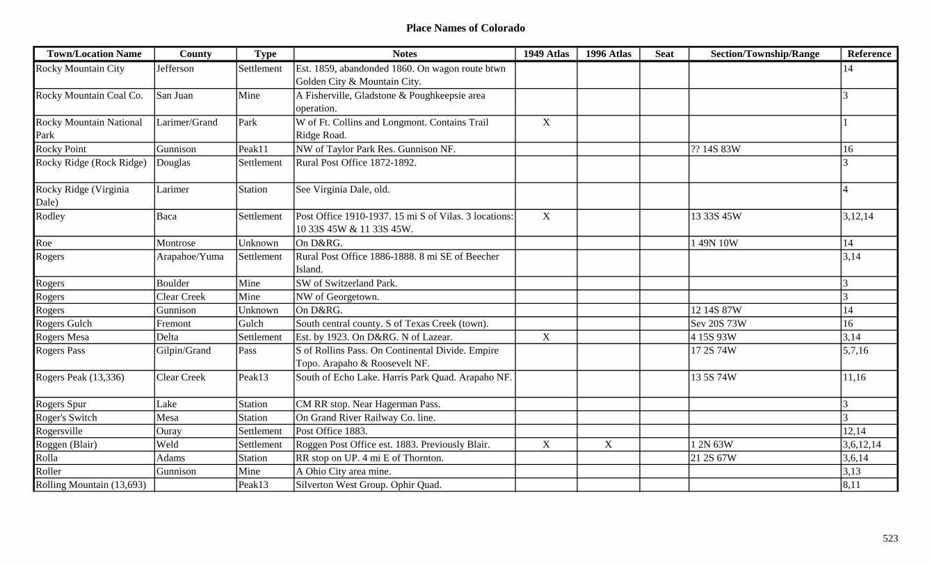
Place Names of Colorado
Town/Location Name County Type Notes 1949 Atlas 1996 Atlas Seat Section/Township/Range ReferenceRocky Mountain City Jefferson Settlement Est. 1859, abandonded 1860. On wagon route btwn
Golden City & Mountain City.14
Rocky Mountain Coal Co. San Juan Mine A Fisherville, Gladstone & Poughkeepsie area operation.
3
Rocky Mountain National Park
Larimer/Grand Park W of Ft. Collins and Longmont. Contains Trail Ridge Road.
X 1
Rocky Point Gunnison Peak11 NW of Taylor Park Res. Gunnison NF. ?? 14S 83W 16Rocky Ridge (Rock Ridge) Douglas Settlement Rural Post Office 1872-1892. 3
Rocky Ridge (Virginia Dale)
Larimer Station See Virginia Dale, old. 4
Rodley Baca Settlement Post Office 1910-1937. 15 mi S of Vilas. 3 locations: 10 33S 45W & 11 33S 45W.
X 13 33S 45W 3,12,14
Roe Montrose Unknown On D&RG. 1 49N 10W 14Rogers Arapahoe/Yuma Settlement Rural Post Office 1886-1888. 8 mi SE of Beecher
Island.3,14
Rogers Boulder Mine SW of Switzerland Park. 3Rogers Clear Creek Mine NW of Georgetown. 3Rogers Gunnison Unknown On D&RG. 12 14S 87W 14Rogers Gulch Fremont Gulch South central county. S of Texas Creek (town). Sev 20S 73W 16Rogers Mesa Delta Settlement Est. by 1923. On D&RG. N of Lazear. X 4 15S 93W 3,14Rogers Pass Gilpin/Grand Pass S of Rollins Pass. On Continental Divide. Empire
Topo. Arapaho & Roosevelt NF.17 2S 74W 5,7,16
Rogers Peak (13,336) Clear Creek Peak13 South of Echo Lake. Harris Park Quad. Arapaho NF. 13 5S 74W 11,16
Rogers Spur Lake Station CM RR stop. Near Hagerman Pass. 3R ' S it h M St ti O G d Ri R il C li 3Roger's Switch Mesa Station On Grand River Railway Co. line. 3Rogersville Ouray Settlement Post Office 1883. 12,14Roggen (Blair) Weld Settlement Roggen Post Office est. 1883. Previously Blair. X X 1 2N 63W 3,6,12,14Rolla Adams Station RR stop on UP. 4 mi E of Thornton. 21 2S 67W 3,6,14Roller Gunnison Mine A Ohio City area mine. 3,13Rolling Mountain (13,693) Peak13 Silverton West Group. Ophir Quad. 8,11
523

Place Names of Colorado
Town/Location Name County Type Notes 1949 Atlas 1996 Atlas Seat Section/Township/Range ReferenceRollins (Boulder) Pass Boulder/Grand Pass Btwn Rollinsville and Winter Park. East Portal
Topo. Arapaho & Roosevelt NF.X 28 1S 74W 1,5,7,9
Rollins Stamp Mill Gilpin Mill At Gold Dirt. 3Rollins Steam Quartz Mill Gilpin Mill A Rollinsville area operation. 13Rollinsville Gilpin Settlement On D&RG. Post Office est. 1871. 14 mi N of Black
Hawk.X X 36 1S 73W 1,2,3,12,13,
14Romance Gunnison Mine At White Pine. 2Romeo (Sunflower, Romero)
Conejos Settlement Est. 1899. Post Office 1901 to present. S of Alamosa. First known as Sunflower.
X X 21 34S 9E 1,3,12,14
Romero (Sunflower, Romeo)
Conejos Settlement First spelling of Romeo. See Romeo. 21 34S 9E 3,14
Romero Canyon Conejos Canyon Central county. Runs ESE. Sev 34N 6E 16Romley (Murphy's Switch, Morley)
Chaffee Settlement On DSP&P. Post Office 1886-1893 & 1914-1924. 3 mi S of Saint Elmo.
13 51N 6E 2,3,12,14
Ronarks (Maddox) Park Unknown On DSP&P. At or near location of Maddox. ? 7S 73W 14Rondebush (Eagle City, Mitchell)
Summit/Eagle Settlement Post Office 1880-1883. Early name for Eagle City, later Mitchell.
34 7S 80W 14
Roof Huerfano Station Site 1. Est. by 1885. On D&RG. Btwn Boaz & Rouse Junction.
26 26S 66W 3,14
Roof Huerfano Unknown Site 2. Est. by 1885. On D&RG. 5 mi S of Concord & 5 mi W of Orlando.
14
Rook Eagle Unknown Near Piney River. ? 3S 82W 14Roosevelt Gunnison Station On D&RG. Station & settlement. Only a mine? 14Roosevelt Drainage Tunnel Teller Tunnel An Elkton area operation. 3
Roosevelt Lake Clear Creek Lake South central county. Arapaho NF. 33 5S 73W 16R lt G l h G i G l h SW f Pitki NW t Q t C k S 50N 4E 16Roosevlt Gulch Gunnison Gulch SW of Pitkin. runs NW to Quartz Creek. Sev 50N 4E 16Rooster Gilpin Mine American City area. 3Rosa El Paso Settlement Post Office 1895. 12,14Rosalie Peak (13,575) Peak13 Front Range, Grays-Evans Group. Harris Park Quad. 8,11
Roscoe Clear Creek Settlement In Clear Creek Canyon. 3
524
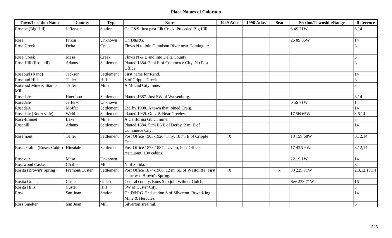
Place Names of Colorado
Town/Location Name County Type Notes 1949 Atlas 1996 Atlas Seat Section/Township/Range ReferenceRoscoe (Big Hill) Jefferson Station On C&S. Just past Elk Creek. Preceded Big Hill. 6 4S 71W 6,14
Rose Pitkin Unknown On D&RG. 26 8S 86W 14Rose Creek Delta Creek Flows N to join Gunnison River near Dominguez. 3
Rose Creek Mesa Creek Flows N & E and into Delta County. 3Rose Hill (Rosehill) Adams Settlement Platted 1884. 2 mi E of Commerce City. No Post
Office.3
Rosebud (Rand) Jackson Settlement First name for Rand. 14Rosebud Hill Teller Hill S of Cripple Creek. 3Rosebud Mine & Stamp Teller Mine A Mound City mine. 3pMill
y
Rosedale Huerfano Settlement Platted 1887. Just SW of Walsenburg. 3,14Rosedale Jefferson Unknown 6 5S 71W 14Rosedale Moffat Settlement Est. by 1908. A town that joined Craig. 14Rosedale (Boozeville) Weld Settlement Platted 1939. On UP. Near Greeley. 17 5N 65W 3,6,14Rose-Emmet Lake Mine A California Gulch mine. 3Rosehill Adams Settlement Platted 1884. 5 mi ENE of Derby. 2 mi E of
Commerce City.14
Rosemont Teller Settlement Post Office 1903-1926. Tiny. 18 mi E of Cripple Creek.
X 13 15S 68W 3,12,14
Roses Cabin (Rose's Cabin) Hinsdale Settlement Post Office 1878-1887. Tavern, Post Office, restaurant, 100 cabins.
17 43N 6W 3,12,14
Rosevale Mesa Unknown 22 1S 1W 14Rosewood Casket Chaffee Mine N of Salida. 3Rosita (Brown's Spring) Fremont/Custer Settlement Post Office 1874-1966. 12 mi SE of Westcliffe. First
B ' S iX x 33 22S 71W 2,3,12,13,14
name was Brown's Spring.Rosita Gulch Custer Gulch Central county. Runs S to join Wilmer Gulch. Sev 23S 71W 16Rosita Hills Custer Hill SW of Custer City. 3Ross San Juan Station On D&RG. 2nd station S of Silverton. Btwn King
Mine & Hercules.14
Ross Smelter San Juan Mill Silverton area mill. 3
525
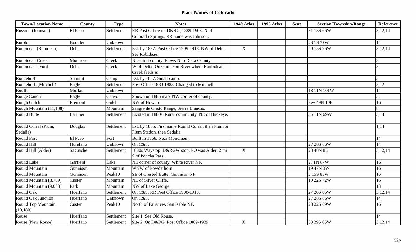
Place Names of Colorado
Town/Location Name County Type Notes 1949 Atlas 1996 Atlas Seat Section/Township/Range ReferenceRoswell (Johnson) El Paso Settlement RR Post Office on D&RG, 1889-1908. N of
Colorado Springs. RR name was Johnson.31 13S 66W 3,12,14
Rotolo Boulder Unknown 28 1S 72W 14Roubideau (Robideau) Delta Settlement Est. by 1887. Post Office 1909-1918. NW of Delta.
See Robideau.X 20 15S 96W 3,12,14
Roubideau Creek Montrose Creek N central county. Flows N to Delta County. 3Roubideau's Ford Delta Creek W of Delta. On Gunnison River where Roubideau
Creek feeds in.3
Roudebush Summit Camp Est. by 1887. Small camp. 3Roudebush (Mitchell) Eagle Settlement Post Office 1880-1883. Changed to Mitchell. 3,12Rouffs Moffat Unknown 18 11N 101W 14Rouge Cañon Eagle Canyon Shown on 1885 map. NW corner of county. 3Rough Gulch Fremont Gulch NW of Howard. Sev 49N 10E 16Rough Mountain (11,138) Mountain Sangre de Cristo Range, Sierra Blancas. 8Round Butte Larimer Settlement Existed in 1880s. Rural community. NE of Buckeye. 35 11N 69W 3,14
Round Corral (Plum, Sedalia)
Douglas Settlement Est. by 1865. First name Round Corral, then Plum or Plum Station, then Sedalia.
1,14
Round Fort El Paso Fort Built in 1868. Near Monument. 14Round Hill Hurefano Unknown On C&S. 27 28S 66W 14Round Hill (Alder) Saguache Settlement 1880s Waystop. D&RGW stop. PO was Alder. 2 mi
S of Poncha Pass.X 23 48N 8E 3,12,14
Round Lake Garfield Lake NE corner of county. White River NF. ?? 1N 87W 16Round Mountain Gunnison Mountain WNW of Powderhorn. 19 47N 3W 16Round Mountain Gunnison Peak10 SE of Crested Butte. Gunnison NF. 2 15S 85W 16Round Mountain (8,709) Custer Mountain NE of Silver Cliffe. 10 22S 72W 16R d M t i (9 033) P k M t i NW f L k G 13Round Mountain (9,033) Park Mountain NW of Lake George. 13Round Oak Huerfano Settlement On C&S. RR Post Office 1908-1910. 27 28S 66W 3,12,14Round Oak Junction Huerfano Unknown On C&S. 27 28S 66W 14Round Top Mountain (10,180)
Custer Peak10 North of Fairview. San Isable NF. 28 22S 69W 16
Rouse Huerfano Settlement Site 1. See Old Rouse. 14Rouse (New Rouse) Huerfano Settlement Site 2. On D&RG. Post Office 1889-1929. X 30 29S 65W 3,12,14
526
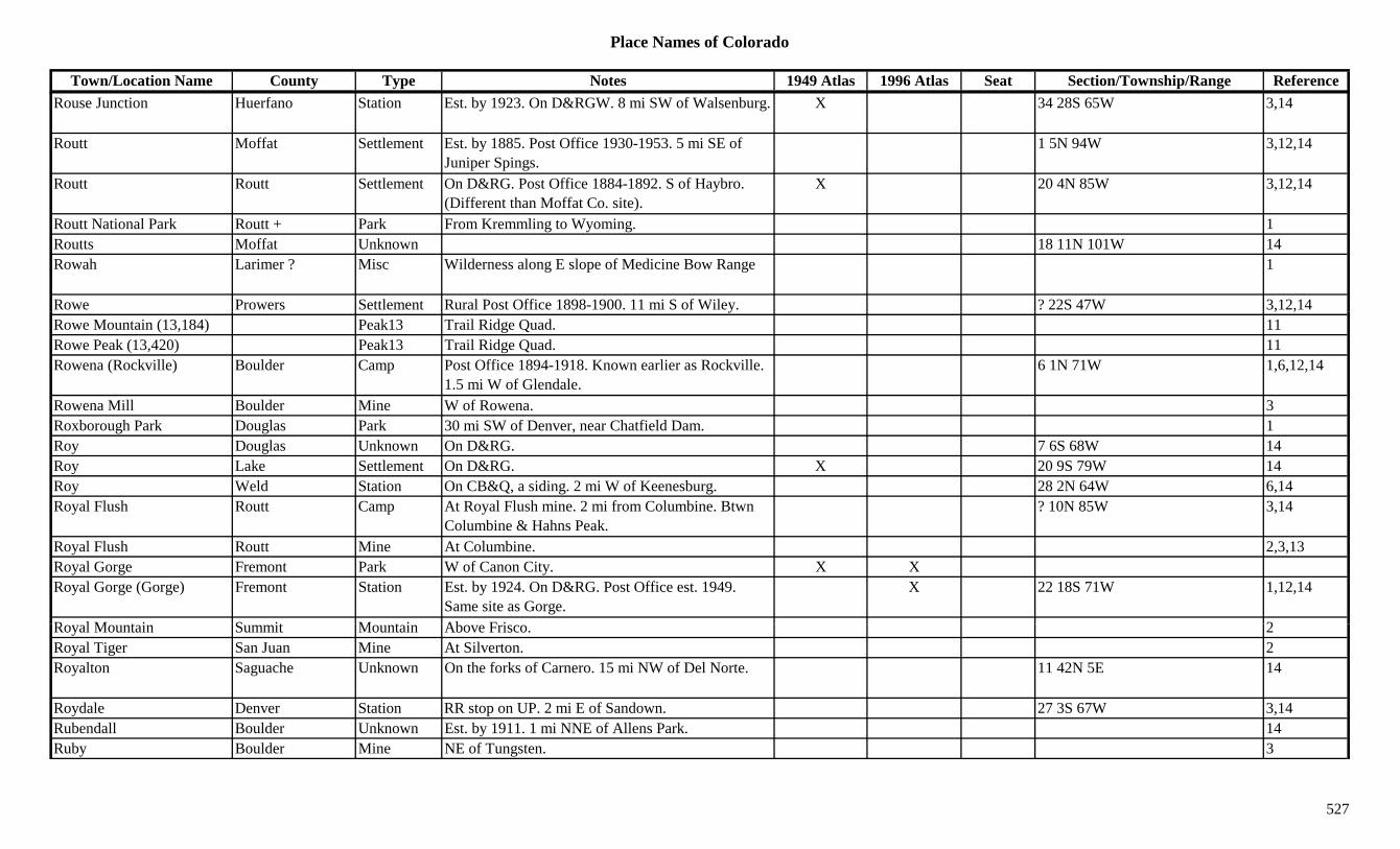
Place Names of Colorado
Town/Location Name County Type Notes 1949 Atlas 1996 Atlas Seat Section/Township/Range ReferenceRouse Junction Huerfano Station Est. by 1923. On D&RGW. 8 mi SW of Walsenburg. X 34 28S 65W 3,14
Routt Moffat Settlement Est. by 1885. Post Office 1930-1953. 5 mi SE of Juniper Spings.
1 5N 94W 3,12,14
Routt Routt Settlement On D&RG. Post Office 1884-1892. S of Haybro. (Different than Moffat Co. site).
X 20 4N 85W 3,12,14
Routt National Park Routt + Park From Kremmling to Wyoming. 1Routts Moffat Unknown 18 11N 101W 14Rowah Larimer ? Misc Wilderness along E slope of Medicine Bow Range 1
Rowe Prowers Settlement Rural Post Office 1898-1900. 11 mi S of Wiley. ? 22S 47W 3,12,14y , ,Rowe Mountain (13,184) Peak13 Trail Ridge Quad. 11Rowe Peak (13,420) Peak13 Trail Ridge Quad. 11Rowena (Rockville) Boulder Camp Post Office 1894-1918. Known earlier as Rockville.
1.5 mi W of Glendale.6 1N 71W 1,6,12,14
Rowena Mill Boulder Mine W of Rowena. 3Roxborough Park Douglas Park 30 mi SW of Denver, near Chatfield Dam. 1Roy Douglas Unknown On D&RG. 7 6S 68W 14Roy Lake Settlement On D&RG. X 20 9S 79W 14Roy Weld Station On CB&Q, a siding. 2 mi W of Keenesburg. 28 2N 64W 6,14Royal Flush Routt Camp At Royal Flush mine. 2 mi from Columbine. Btwn
Columbine & Hahns Peak.? 10N 85W 3,14
Royal Flush Routt Mine At Columbine. 2,3,13Royal Gorge Fremont Park W of Canon City. X XRoyal Gorge (Gorge) Fremont Station Est. by 1924. On D&RG. Post Office est. 1949.
Same site as Gorge.X 22 18S 71W 1,12,14
R l M t i S it M t i Ab F i 2Royal Mountain Summit Mountain Above Frisco. 2Royal Tiger San Juan Mine At Silverton. 2Royalton Saguache Unknown On the forks of Carnero. 15 mi NW of Del Norte. 11 42N 5E 14
Roydale Denver Station RR stop on UP. 2 mi E of Sandown. 27 3S 67W 3,14Rubendall Boulder Unknown Est. by 1911. 1 mi NNE of Allens Park. 14Ruby Boulder Mine NE of Tungsten. 3
527

Place Names of Colorado
Town/Location Name County Type Notes 1949 Atlas 1996 Atlas Seat Section/Township/Range ReferenceRuby Grand Camp Small camp at Ruby Mine. 3Ruby Grand Mine See Ruby Camp. W of Gaskill. 3Ruby Lake Mine An Everett area mine. 13Ruby Mesa Station Est. by 1923. On D&RGW. 4 mi SW of Mack. 7 10S 103W 3,14Ruby Ouray Unknown Est. by 1881. On Cow Creek. ? 44N 6W 14Ruby Pitkin Mine A Ruby area mine. 13Ruby (Floresta) Gunnison Settlement Site 2. Est. by 1895. RR name for Floresta. 16 14S 87W 14Ruby (Irwin) Gunnison Camp Site 1. Post Office 1879-1880 & 1893-1895.
Absorbed by Irwin. 8 mi W of Crested Butte.3 14S 87W 2,12
Ruby (Ruby City Site 2) Ouray Settlement See Ruby City, Site 2. 14Ruby (South Independence) Pitkin Settlement Existed in 1890s. 10 mi S of Independence. On 12 12S 83W 3,13,14y ( p ) p
Lincoln Gulch., ,
Ruby Camp (Ruby, Haverly, Silver Gate)
Gunnison Settlement 3,14
Ruby Chief Gunnison Mine At Irwin. 2,3Ruby City Ouray Camp Site 1. Post Office 1878-1879. Small camp near
Sneffels.3,12,14
Ruby City (Decatur) Summit Settlement Surveyed in 1879. Decatur was chosen for the name. 20 5S 75W 14
Ruby City (Ruby) Ouray Settlement Site 2. Est. by 1885. NE of Ouray. 3Ruby Gulch Douglas Gulch SW corner of county. Runs S to Horse Creek. Sev 9S 70W 16Ruby Lake Hinsdale/Mineral Lake SSE of Lake City. Rio Grande NF. 25 40N 3W 16Ruby Mountain (13,277) Summit Peak13 Front Range, Southwest Section. NW of Argentine
Pass. Montezuma Quad.3,8,11
Ruby of the Rockies (Redstone)
Pitkin Settlement Name used for Redstone. 3
R b P k G i P k12 WNW f C t d B tt G i NF ?? 13S 87W 16Ruby Peak Gunnison Peak12 WNW of Crested Butte. Gunnison NF. ?? 13S 87W 16Ruby Peak (12,644) Peak12 Ruby Range. 8Ruby Range Pitkin Range Part of Elk Mountains. 15Ruby Red Mountain Mountain Sawatch Range, Leadville Frying Pan Sect. 8Ruby Silver Summit Mine A Kokomo area mine. 3Ruby Trust Ouray Mine At Sneffels. 2,3,13Rucker Lake Alamosa Lake East of Sheridan Blvd. Nof Wagon Trail Drive. 7 5S 68W 16
528

Place Names of Colorado
Town/Location Name County Type Notes 1949 Atlas 1996 Atlas Seat Section/Township/Range ReferenceRuction Larimer/Jackson Settlement Post Office 1889. In North Park. ? 9N 79W 12,14Rudolph Montrose Settlement Post Office 1886. 12,14Rudolph Gulch Gunnison Gulch South of Powderhorn. Runs NNE to Ceballa Creek. Sev 45/46N 2W 16
Rudolph Hill Gunnison Peak10 South central county. SE of Powderhorn. 24 46N 2W 13,16Rudolph Mountain (10,034) Custer Peak10 SE of Hardscrabble. San Isabel NF. 8 22S 69W 16
Ruedi Eagle Settlement On CM. Post Office 1889-1941. On Frying Pan River.
X 8 8S 84W 3,12,14
Ruff Baca Settlement Post Office 1889-1896. On Old Wagon Road from Oklahoma to Progress.
? 33S 42W 3,12,14
Ruffner Mountain (13,003) Peak13 Sneffels Range. Sams Quad. 8,11
Rugby Huerfano Settlement XRugby Las Animas Settlement Site 1. Post Office on C&S 1900-1947. Also shown
at 34 29S 65WX 5 30S 65W. 3,12,14
Rugby (Kepner) Las Animas Station Site 2. On C&S. RR name was Kepner. 3 30S 65W 14Rugby Coal Mine Las Animas Mine Near Rugby. 3Ruin Canyon Montezuma Settlement Post Office 1920-1928. Small settlement at site of
Lowry Indian Ruins.X 8 38N 18W 3,12,14
Ruins Dolores Misc Shown on 1887 map. Near Squaw Point. Possibly Indian ruins.
3
Ruins Montezuma Misc Shown on 1887 map. Hackberry, Keely & Holly groups of ruins.
3
Rule Bent Settlement Rural Post Office 1909-1921. 8 mi NW of Opal. 24 27S 51W 3,12,14
R l C k B t C k Fl N f L A i C t T ill X 3Rule Creek Bent Creek Flows N from near Las Animas Co. past Toonerville. X 3
Rule Creek Las Animas Creek Flows N in NE corner of county into Bent Co. XRule Creek Teller Creek Flows N to join Trout Creek in NE part of Co. 3Rule Gulch Eagle Gulch SE corner of county. White River NF. Sev 7S 80W 16Rules Hill (8,222) La Plata Hill E of Durango. 13Rulison Garfield Settlement 10 mi SW of Rifle. X 25 6S 95W 3,14
529
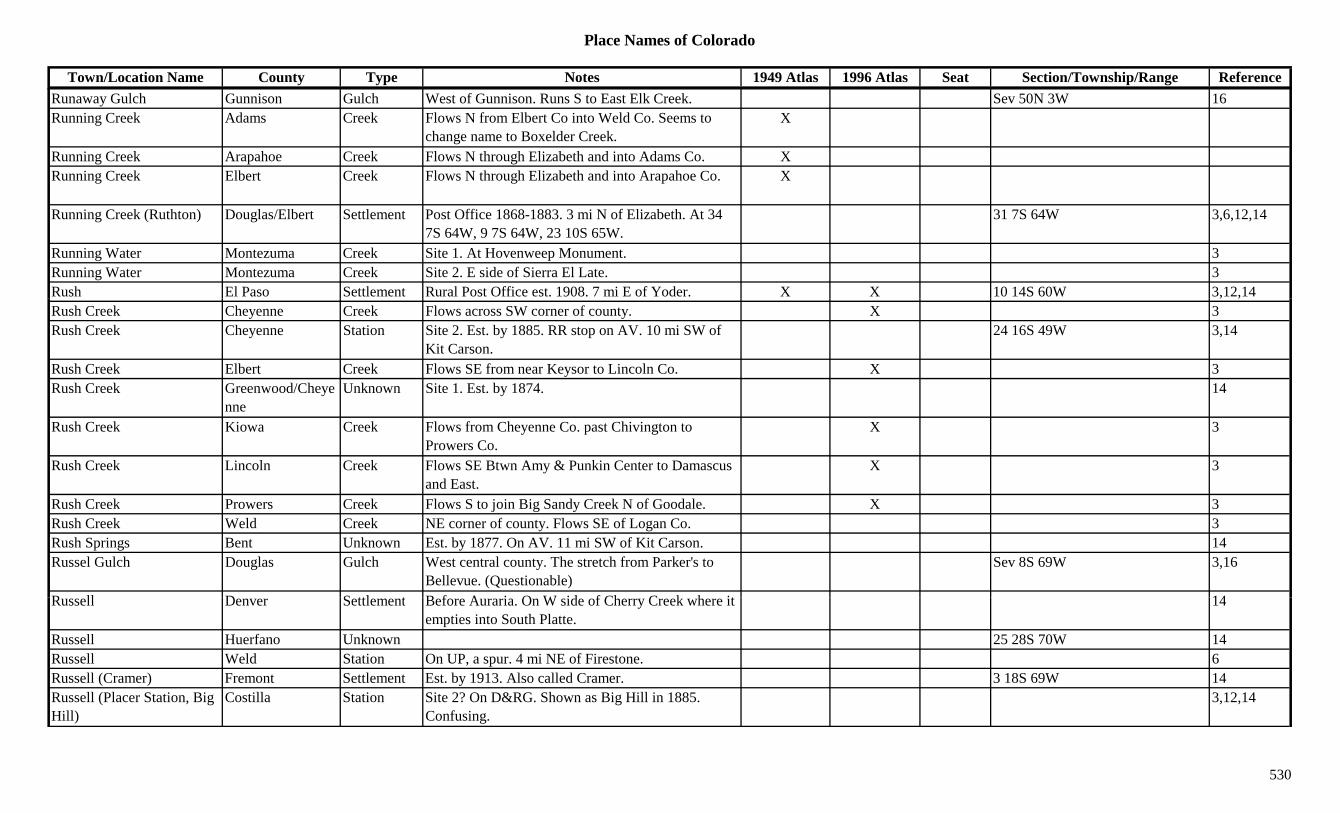
Place Names of Colorado
Town/Location Name County Type Notes 1949 Atlas 1996 Atlas Seat Section/Township/Range ReferenceRunaway Gulch Gunnison Gulch West of Gunnison. Runs S to East Elk Creek. Sev 50N 3W 16Running Creek Adams Creek Flows N from Elbert Co into Weld Co. Seems to
change name to Boxelder Creek.X
Running Creek Arapahoe Creek Flows N through Elizabeth and into Adams Co. XRunning Creek Elbert Creek Flows N through Elizabeth and into Arapahoe Co. X
Running Creek (Ruthton) Douglas/Elbert Settlement Post Office 1868-1883. 3 mi N of Elizabeth. At 34 7S 64W, 9 7S 64W, 23 10S 65W.
31 7S 64W 3,6,12,14
Running Water Montezuma Creek Site 1. At Hovenweep Monument. 3Running Water Montezuma Creek Site 2. E side of Sierra El Late. 3Rush El Paso Settlement Rural Post Office est. 1908. 7 mi E of Yoder. X X 10 14S 60W 3,12,14, ,Rush Creek Cheyenne Creek Flows across SW corner of county. X 3Rush Creek Cheyenne Station Site 2. Est. by 1885. RR stop on AV. 10 mi SW of
Kit Carson.24 16S 49W 3,14
Rush Creek Elbert Creek Flows SE from near Keysor to Lincoln Co. X 3Rush Creek Greenwood/Cheye
nneUnknown Site 1. Est. by 1874. 14
Rush Creek Kiowa Creek Flows from Cheyenne Co. past Chivington to Prowers Co.
X 3
Rush Creek Lincoln Creek Flows SE Btwn Amy & Punkin Center to Damascus and East.
X 3
Rush Creek Prowers Creek Flows S to join Big Sandy Creek N of Goodale. X 3Rush Creek Weld Creek NE corner of county. Flows SE of Logan Co. 3Rush Springs Bent Unknown Est. by 1877. On AV. 11 mi SW of Kit Carson. 14Russel Gulch Douglas Gulch West central county. The stretch from Parker's to
Bellevue. (Questionable)Sev 8S 69W 3,16
R ll D S ttl t B f A i O W id f Ch C k h it 14Russell Denver Settlement Before Auraria. On W side of Cherry Creek where it empties into South Platte.
14
Russell Huerfano Unknown 25 28S 70W 14Russell Weld Station On UP, a spur. 4 mi NE of Firestone. 6Russell (Cramer) Fremont Settlement Est. by 1913. Also called Cramer. 3 18S 69W 14Russell (Placer Station, Big Hill)
Costilla Station Site 2? On D&RG. Shown as Big Hill in 1885. Confusing.
3,12,14
530

Place Names of Colorado
Town/Location Name County Type Notes 1949 Atlas 1996 Atlas Seat Section/Township/Range ReferenceRussell (Sangre de Cristo, Placer)
Costilla Settlement Site 1? Post Office 1876-1931 & 1936-1956. Known as Placer. 14 mi NE of Fort Garland.
X 1 29S 71W 3,13
Russell Gulch Gilpin Gulch S of Central City. Runs ESE to North Clear Creek. Sev 3S 72W 3,13,16
Russell Gulch Gilpin Settlement Est. by 1859. Post Office est. 1879-1943. 3 mi SW of Central City.
X 14 3S 73W 2,12,13,14
Russell Park (Empire Junction)
Clear Creek Station Same as Empire Junction. 14
Russell Ranch Lincoln Ranch 17 7S 58W 14Russell Spring Saguache Station Est. by 1873. NE of Biedell. May be covered by
Russell Lakes.23 43N 7E 3,14
Russell Station Costilla Station On D&RG. At Wagon Creek Junction. 22 29S 71W 14Russellville Douglas Settlement Post Office 1862. Moved to Franktown. Stage
station Jimmy Camp & Cherokee routes.2 or 17 8S 65W 3,12,14
Russellville Gulch Douglas Gulch East central county. Runs W & NW through Russellville.
Sev 8S 65W 16
Russia Park Mine A Quartzville area mine. 3Rust Montezuma Unknown 17 37N 14W 14Rustic (Rustic Camp) Larimer Settlement Post Office 1880-1887. X X 33 9N 73W 3,12,13,14Rustic Hotel Larimer Settlement Est. by 1907. 4 5N 72W 14Rustic Mine Grand Mine Lulu area mine. 3Rusty Spring Dolores Misc South central county. 12 39N 15W 16Ruthton Elbert Station Stage station on Smoky Hill South stage route. See
Running Creek.3,6
Ruxton Bent Station RR stop on AT&SF. 3 mi SE of Toonerville. 28 26S 51W 3,14Ruxton Park El Paso Station On M&PP. 14R G l h Ri Bl G l h Sh 1885 W f it f S l h 3Ryan Gulch Rio Blanco Gulch Shown on 1885 map. W of site of Sulphur. 3Ryan Shaft Garfield Mine Near headwaters of Deep Creek. 3Ryan(s) Lake Settlement Est. by 1887. On D&RG. Near site of Leadville
Junction.29 9S 80W 3,14
Rye (Table Mountain PO) Pueblo Settlement Post Office est. 1881. Called Table Mountain PO. S of Pueblo.
X X 31 24S 67W 1,3,12,14
531
Place Names of Colorado
Town/Location Name County Type Notes 1949 Atlas 1996 Atlas Seat Section/Township/Range ReferenceRyon Gulch Rio Blanco Creek Flows N & E to join Black Sulphur Creek near
Sulphur.3
Ryssby Boulder Settlement Est. 1869. Swedish settlement. 6 mi SW of Longmont.
1,3,6,14
S 10 (13,020) Peak13 Sams Quad. 11S 3 (13,410) Peak13 Sneffels Range. 8S 4 (13,242) Peak13 Mt. Sneffels Quad. 11S 5 (13,363) Peak13 Sneffels Range. 8S 6 (13,441) Peak13 Sneffels Range. Mt. Sneffels Quad. 8,11S 7 (13,220) Peak13 Sams Quad. 11S 8 (13,252) Peak13 Sneffels Range. Part of Hayden Peak. Sams Quad. 8,11( , ) g y Q ,
S 9 (13,134) Peak13 Sneffels Range. Part of Hayden Peak. Sams Quad. 8,11
S Lazy U Reservoir Hinsdale Lake SE of Lake City. Rio Grande NF. 30 41N 3W 16S. J. Tilden Clear Creek Mine At Silverdale. 3S. M. Huerfano Settlement Est. by 1885. Btwn Houck and Birmingham. 3Sabbert Ouray Unknown On D&RG. 9 46N 8W 14Sable (Schuyler, Magnolia) Adams Settlement Est. by 1892. No Post Office. Now within the City of
Aurora.25 3S 67W 3,6,14
Sac Boulder Mine At Jamestown. 3Saco Pitkin Unknown On D&RG. 20 8S 86W 14Sacramento Park Settlement Est. by 1878. 34 9S 78W 3,14Sacramento City Lake Settlement First name was Boughton. Consolated with Oro City,
1860.14
Sacramento City (Idaho S i )
Clear Creek Settlement Est. 1859. Early name for Idaho Springs. 1,2,3,14Springs)Sacramento Flats (Sacramento City)
Lake Settlement Name attributed to Sacramento City. 14
Sacramento Gulch Park Gulch W of Fairplay. 3Saddle (Saddle Ho, Saddle House)
El Paso Unknown On M&PP. 20 14S 68W 14
Saddle Mountain (10,801) Park Mountain S of Idlewild. X X 3,13
532
Place Names of Colorado
Town/Location Name County Type Notes 1949 Atlas 1996 Atlas Seat Section/Township/Range ReferenceSaddle Rock (Orodelfan) Boulder Settlement First name was Orodelfan. 14Saddle, The Garfield Pass In Cow Ridge. 22 7S 99WSaddle, The (12,500) Larimer Pass See The Saddle. Mummy Range. Rocky Mountain
Natl Park.5,7
Saddleback Mountain (9,568)
Clear Creek Mountain East central county. SE of Idaho Springs. 10 4S 72W 16
Saderlind (Saderund) Teller Unknown On CS&CCD. Same as Saderund. 22 15S 68W 14Saderlund (Saderlind) Teller Unknown On CS&DDC. Same as Saderlind. 22 15S 68W 14Sag Teller Mine Possibly more than a mine. 8 15S 69W 14Sagco (Hilvert) Pueblo Unknown Est. by 1906. Same as Hilvert. 14Sage Delta Settlement XgSage Eagle Unknown On D&RG. 1 5S 85W 14Sage Gunnison Settlement Post Office 1880-1882. 16 49N 5E 12,14Sage Teller Unknown Est. by 1906. On CS&CCD. 14Sage Creek Routt Creek Flows N to Yampa River E of Hayden. 8 6N 87W 3Sage Hen (Sage Hen Springs)
Jackson Settlement Est. by 1882. 4 mi SE of Walden. 1 8N 79W 14
Sage Hen Springs (Sagebrush, Sage Hen)
Jackson Settlement Est. by 1882. 4 mi SW of Walden. First name Sagebrush, then Sage Hen.
1 8N 79W 3,14
Sagebrush (Walden) Jackson Settlement Other names Sage Hen & Sage Hen Springs. See Walden.
1 8N 79W 3,14
Sago Montezuma Settlement Post Office 1922-1925. 12,14Saguache Saguache Settlement Post Office est. 1867. X X X 1 44N 7E 3,12,14Saguache River Saguache River Flows ENE through Saguache Co to Rio Grande
Canal.X X
Sagude Christo Saguache Unknown Est. by 1877. On N side of Rio Grande River. 29 40N 6E 14S i t A t Hi hl d B ld S ttl t 3 i t B ld F ll E l ttl t 1Saint Anton Highlands Boulder Settlement 3 mi past Boulder Falls. Early settlement. 1Saint Charles Pueblo Settlement Site 1. Rural Post Office 1866-1881. 15 mi SW of
Pueblo. Also shown at 14 22S 66W.12 22S 65W 3,12,14
Saint Charles Pueblo Settlement Site 2. Est. by 1894. 2 mi NW of St. Charles River & 6 mi SW of San Carlos.
3,14
Saint Charles (Denver) Arapahoe/Denver Settlement First named St. Charles, 1858. E of the mouth of Cherry Creek. Became part of Denver City.
33 3S 68W 3,14
533

Place Names of Colorado
Town/Location Name County Type Notes 1949 Atlas 1996 Atlas Seat Section/Township/Range ReferenceSaint Charles Peak (11,600) Custer Peak11 NW of San Isable. Wet Mountains (Cuerna Verde
Range).28 23S 69W 8,16
Saint Charles River Pueblo River Flows NE to Arkansas River E of Pueblo (at Baxter). X 3
Saint Cloud Summit Mine A Tiger area mine. 3Saint Cloud (Cherokee Park)
Larimer Settlement Post Office 1884-1913. Changed to Cherokee Park. 21 11N 72W 3,12,14
Saint Elmo (Forest City) Chaffee Settlement Existed in 1870s. Post Office 1880-1952. 17 mi W of Nathrop. First named Forest City.
X 32 15S 80W 1,2,3,12,13,14
Saint Francis Falls San Miguel Camp Est. by 1881. Near San Bernardo Mtn. 3Saint Jacob's Hinsdale Mine A Carson area mine. 36 42N 5W 3,13,Saint James Clear Creek Mine A Lawson area mine. 2,13Saint James Gilpin Mine Silver Hill area mine. 3Saint John's Hinsdale Mine A Carson area mine. 3Saint Johns (Saints John, Coleyville)
Summit Settlement Est. by 1861. First called Coleyville. 9 mi SE of Keystone.
3,13
Saint Joseph Lake Kiowa Lake 1887. At site of Chivington Reservoir. 3Saint Kevin(s) Lake Camp Post Office 1886-1890. Major camp. 7 mi NW of
Leadville. N of Turquoise Lake.9 9S 80W 3,12,13,14
Saint Kevins Lake Mine At St. Kevins. 3,13Saint Louis Boulder Mine A Caribou mine. 3Saint Louis Gilpin Mine A Central City mine. 3Saint Louis Lake Mine A Stumptown area mine. 13Saint Louis & Colorado Smelter
Pitkin Mill A Thomasville operation. 3
Saint Louis & San Miguel C
San Miguel Mine A Placerville operation. 3Co.Saint Louis (Winona, Loveland)
Larimer Settlement Est. by 1876. Early settlement preceded Loveland. First name Winona, then Loveland.
14 5N 69W 1,3,14
Saint Louis Pass Grand Pass W of Berthoud Pass. SW of Fraser. Byers Peak Topo. Arapaho NF.
18 3S 76W 5,7,16
Saint Louis Peak (12,246) Peak12 Front Range, Clear Creek Group. Vasquez Mtns. 8
534

Place Names of Colorado
Town/Location Name County Type Notes 1949 Atlas 1996 Atlas Seat Section/Township/Range ReferenceSaint Louis Tunnel Lake Tunnel A Leadville area mine. 3Saint Mary Glacier Gilpin Misc NW of Silver City. 3Saint Mary's Custer Mine Westcliffe area mine. 3Saint Marys (Saint Mary's) Huerfano Settlement Post Office 1867-1907 with gaps. NW of
Walsenburg. On Huerfano River.29 26S 67W 3,12,14
Saint Marys Glacier Clear Creek Glacier Northern tip of county. N of Alice. Arapaho NF. 27 2S 74W 16
Saint Marys Lake Clear Creek Lake Northern tip of county. N of Alice. Arapaho NF. 34 2S 74W 16
Saint Patrick Gunnison Mine A Vulcan area mine. 3,13Saint Peter(s) El Paso Settlement On CS&CCD. Post Office 1905-1907. W of 17 15S 67W 3,12,14( )
Broadmoor Hotel., ,
Saint Peters (Saint Petersburg)
Logan Settlement Est. by 1934. No Post Office. 10 mi SE of Fleming. 23 7N 49W 3,14
Saint Peters Dome El Paso Mountain SW of Colorado Springs. Pike NF. 17 15S 67W 16Saint Sophia Ridge (13,060) Peak13 Sneffels Range. Several pinnacles. Telluride Quad. 8,11
Saint Vrain Boulder Station Est. by 1887. Stage station on Overland stage route. 9 2N 69W 3,6,14
Saint Vrain Weld Settlement Post Office 1859-1875. Near Fort St. Vrain. PO moved to Platteville in 1875. See St. Vrain.
6
Saint Vrain (Potera's Creek) Boulder Creek 1
Saint Vrain Mountain (12,162)
Boulder Peak12 Front Range, Indian Section. Btwn North and Mittle St. Vrain Creeks.
1,8
Saint Vrains Weld Station Existed in 1880s. On DBV. Post Office 1915-1918. N t St V i (B ld C )
24 1N 68W 3,6,12,14Not same as St. Vrain (Boulder Co.).
Saint Vrains Fort (Fort Lookout, Fort George)
Weld Fort Est. by 1859. No Post Office. At St. Vrain Creek. Below Fort Lancaster.
X 26 3N 67W 1,3
Saints John Summit Mine A Saints John area mine. 3Saints John (St. Johns, Coleyville)
Summit Settlement Est. 1867. Post Office 1876-1881. 1 mi SW of Montezuma. Called Coleyville.
34 5S 76W 2,3,12,14
Salado Creek Las Animas Creek Flows W to E through Boaz. 3
535
Place Names of Colorado
Town/Location Name County Type Notes 1949 Atlas 1996 Atlas Seat Section/Township/Range ReferenceSale Lake Boulder Lake North of Boulder. 20 1N 70W 16Salem Arapahoe Settlement Rural Post Office 1894-1919. 7 mi SW of Watkins. 35 4S 65W 3,6,12,14
Salida (Arkansas, South Arkansas)
Chaffee Settlement Post Office est. 1881. Formerly Arkansas. Est. 1880 as South Arkansas.
X X X 31 50N 9E 1,3,12,14
Salina Boulder Settlement On DB&W. Post Office 1874-1925. 8 mi W of Boulder. Also Ref. 6.
18 1N 71W 1,2,3,12,13,14
Salina Park Station Est. by 1906. On CM. 4 mi SW of Boyer. 23 12S 76W 3,14Saline Pond Park Lake Shown on 1885 map. 7 mi SE of Antero Junction. 3
Saling La Plata Settlement Est. by 1887. 13 mi E of Cascade. 3g ySalis Cheyenne Settlement Est. by 1916. RR stop on UP. 4 mi W of Arapahoe.
See Salls.X 18 14S 43W 3,14
Salisbury Weld Station Est. 1871. 2 mi from St. Vrain. 14Salls Cheyenne Unknown On UP. Appears Salls & Salis are 2 different places. 14
Salmon Custer Unknown On D&RG. Btwn Palo, Fremont Co. & Hillside, Custer Co.
14
Salmon Fremont Unknown Just N of Hillside. 14Salmon Spur Fremont Unknown On D&RG. 36 47N 12E 14Salt Creek Garfield Creek Flows S from Douglas Pass area to Mesa Co. 3Salt Creek Kiowa Station On AV. 19 18S 49W 14Salt Creek Pueblo Settlement Post Office on D&RG 1880-1893 & 1904-1908. 4
mi NE of Graneros. Also at 9 24S 65W.5 21S 64W 3,12,14
Salt Creek (Lang's Gulch) Park Creek Shown on 1922 map. NW of Antero Junction. In 1980 ll d L ' G l h
31980s called Lang's Gulch.
Salt House Pass (10,500) Pass Gunnison Forests. 7Salt Lake Kiowa Lake 1887. Near Hawkins. 3Salt Lake Park Lake 1885. W of Salina. 3Salt Lake Wagon Road Mesa Trail 1885. Major thoroughfare. Followed Colorado
(Grand) River.3
Salt Marsh Mesa Station On U. ? 8S 103W 14
536

Place Names of Colorado
Town/Location Name County Type Notes 1949 Atlas 1996 Atlas Seat Section/Township/Range ReferenceSalt Spring Bent Unknown 16 19S 50W 14Salt Spring Greenwood/Kiowa Unknown Est. by 1870. On AV. 19 18S 49W 14
Salt Springs Kiowa Creek 1882. 7 mi S of Galatea. 3Salt Wash Mesa Unknown On Unitah. 27 8S 104W 14Salt Wash (Rio Salado) Mesa Creek Flows E to Dolores River. SW corner of county. 3
Salt Works (Colorado Salt Works)
Park Settlement Est. by 1885. 4 mi NE of Antero Junction. Also known as Colorado Salt Works.
36 12S 77W 3,14
Saltado Creek San Miguel Creek Flows N from San Miguel Mtns. to join San Miguel River.
3
Salter Junction Dolores Station 7 39N 15W 14Saltiels (Cotopaxi) Fremont Settlement Est. in 1882. Organized colony. Renamed Cotopaxi. 31 48N 12E 14
Sample Fremont Station Est. by 1923. RR stop on D&RGW. 5 mi E of Parkdale.
20 18S 71W 3,14
Sampler Teller Settlement Village, not listed as a mine. 14Sampson San Juan Mine A Fisherville, Gladstone & Poughkeepsie area mine. 3,13
Sampson Gulch Arapahoe Gulch Runs NW to Piney Creek. 16Sams Montrose Settlement Post Office 1903. Rescinded as error in county listed
(Montrose).12
Sams (Sam, Leopard) San Miguel Settlement Post Office 1903-1919 & 1927-1950. 9 mi NE of Placerville. Early name Leopard.
X 34 45N 10W 3,12,14
Sams Divide (7,600) Delta Divide Gunnison NF. 14 14S 91WSan Acacio (San Luis) Costilla Settlement Post Office est. 1909. See San Luis. Also shown at
24 3N 73W & 16 3N 73WX X 20 3N 72W 3,12,14
24 3N 73W & 16 3N 73W.San Antonia (Augusta, Apishapa)
Las Animas Settlement Post Office 1875-1876. Moved to Apishapa. Changed to Augusta.
20 30S 64W 3,12,14
San Antonio Las Animas Settlement Site 1. Est. by 1876. On Apishapa River. 14San Antonio Las Animas Settlement Site 2. Est. by 1878. 2 mi S of Apishapa River. 3 mi
SW of Apishapa.25 30S 65W 14
537

Place Names of Colorado
Town/Location Name County Type Notes 1949 Atlas 1996 Atlas Seat Section/Township/Range ReferenceSan Antonio (Aguilar) Las Animas Settlement Site 3. Est. by 1860. Early Mexican settlement. Later
called Aguilar.27 30S 65W 14
San Antonio (Antonito) Conejos Settlement Est. by 1866. Post Office 1880-1881. 4 mi S of Conejos. Became Antonito, at 20 33N 9E.
X 25 33N 9E 12,14
San Antonio Creek Conejos Creek From close to NM N to Conejos River. 3San Arroya Creek Adams Creek Runs NE & N into Morgan Co. 16San Bernardo San Miguel Mine An Alta area mine. 3San Bernardo (Matterhorn) San Miguel Camp Post Office 1892-1907. Formerly Trout Lake.
Originally Matterhorn. At foot of Yellow Mtn.5 41N 9W 3,12,14
San Bernardo Mountain San Miguel Mountain W of Ophir. 3San Bruno Hinsdale Mine A Capitol City area mine. 3p ySan Buena Ventura de los Tres Arrollas
Fremont Settlement Called Hardscrabble, later Plaza del Rio Renasco Amarillo, La Placita & Hardscrabble Plaza.
33 20S 69W 14
San Carlos (Lime) Pueblo Station Site 2. Est. by 1882. On D&RGW. S of Lime. Name changed to Lime.
12 22S 65W 3,14
San Carlos (San Carlos de los Jupes, Casa de Palo)
Pueblo Settlement Site 1. Est. by 1787. Comanche settlement. Same as San Carlos de los Jupes & Casa de Palo.
33 20S 63W 14
San Carlos de los Jupes (San Carlos)
Pueblo Settlement Built 1787. Aband. 1788. Indian Village E of Pueblo. Same as San Carlos, Casa de Palo.
4,14
San Cristobal Lake Hinsdale Lake South of Lake City. X X Sev 43N 4W 16San Francisco Conejos Settlement Est. 1842. On Conejos River. A Mexican settlement. ? 34N 10E 14
San Francisco Costilla Settlement Site 2. Est. by 1894. 3 mi NE of San Pedro & 6 mi NE of San Pablo.
3,14
S F i L A i S ttl t E i t d i 1860 M i Pl M b li 27 34S 68W 3 14San Francisco Las Animas Settlement Existed in 1860s. Mexican Plaza. May be earlier name for site of Tercio.
27 34S 68W 3,14
San Francisco (Lavalley PO)
Costilla Settlement Site 1. Or Lavalley PO. 28 32N 71W 14
San Francisco Creek Las Animas Creek Flows NE past Barela to Purgatoire River at Raton. 3
San Francisco Creek Rio Grande Creek Flows N to Rio Grande River near Del Norte. 3
538

Place Names of Colorado
Town/Location Name County Type Notes 1949 Atlas 1996 Atlas Seat Section/Township/Range ReferenceSan Francisco Pass (8,200) Las Animas Pass Btwn Trinidad and Raton, NM. 7
San Francisco Pass (8,400) Las Animas Pass On Beaubien and Miranda (Maxwell) Land Grant. 13 miles SE of Trinidad.
San Francisco Pass (8,560) Costilla Pass 3 mi SW of Purgatoire Peak. Btwn Sangre de Cristo and Maxwell Land Grants.
?? 34S 70W 16
San Francisco Pass (9,000) Las Animas Pass SW of Stonewall. 7
San Francisco Pass (9,150) Las Animas Pass On Maxwell Land Grant, 4 miles SW of Torres. At head of Bonito Canyon.
San Francisco Plaza Las Animas Settlement See Rivera. 4(Rivera)San Isabel Custer Settlement Post Office 1936-1938. SE part of county. X X 1 24S 69W 3,12,14San Isabel Saguache Settlement Site 3. 6 43N 11E 14San Isabel Saguache Settlement Site 4. 34 44N 11E 14San Isabel Saguache Station Site 2. Est. by 1924. 36 44N 10E 3,14San Isabel (San Isabella) Saguache Settlement Site 1. Post Office 1872-1912. Also shown at 36
44N 10E, 6 43N 11E, 34 44N 11E.1 43N 10E 3,12
San Isabel Creek Saguache Creek E central part of county. S of Gibson Peak. 3San Isidro Las Animas Settlement Site 1. On C&W. Another name for Vigil. 24 33S 68W 14San Isidro (Abeyta) Las Animas Settlement Site 2. Preceded Abeyta Post Office 1882-1902. 13 34S 61W 3,12,14
San Joaquin Ridge (13,460) Peak13 Telluride Quad. 11
San Jose Conejos Settlement Est. by 1885. Spanish village. 5 mi NE of Conejos. Also shown at 17 33N 10E.
11 33N 9E 3,14
S J (F ) Ri G d S ttl t E t b 1885 S it t d F S f ? 39N 7E 3 14San Jose (Freeman) Rio Grande Settlement Est. by 1885. Same site as present-day Freeman. S of Rio Grande River.
? 39N 7E 3,14
San Jose (Grinnell) Las Animas Settlement Rural Post Office 1873-1878. Changed to Grinnell. Also shown at 29 34S 59W.
2 35S 60W 3,12,14
San Joseville Otero Settlement Est. by 1927. 13 mi SE of Ayer. 3,14San Juan Las Animas Unknown On C&W. On Purgotoire River. ? 33S 66W 14San Juan (Mogote) Conejos Settlement Est. by 1854. First name for Mogote. 33 33N 8E 14
539

Place Names of Colorado
Town/Location Name County Type Notes 1949 Atlas 1996 Atlas Seat Section/Township/Range ReferenceSan Juan (San Juan City) Hinsdale Settlement Post Office 1874-1923 with gaps. On stage route to
Silverton. Not in Mineral Co.x 25 41N 3W 3,12,14
San Juan Chief Mine & Mill San Juan Mine Mine, mill, boarding house and cabins. 0.5 mi E of Mineral Point.
3,13
San Juan Consolidated Mining Co.
Rio Grande Mine A Summitville area operation. 3
San Juan Mountains Mineral Range S central Mineral Co. 3San Juan River Archuleta River Flows SW past Trujillo to Juanita. X X 3San Juans Ouray/San Juan Range N, NE and E of Durango. 1,15San Lorenzo (Grey Creek, Rito de Grey)
Las Animas Settlement Existed in 1860s. Early Mexican settlement. Also called Grey Creek & Rito de Grey.
14
San Luis (Culebra, San Luis De Culebra)
Costilla Settlement Est. 1851. Post Office est. 1862. Also Plaza Del Medis.
X X X 23 32S 72W 3,12,14
San Luis Creek Saguache Creek Flows S through Villa Grove, Mineral Host Springs to Alamosa Co.
X X 3
San Luis de Culebra (San Luis)
Costilla Settlement See San Luis. 3
San Luis de la Culebra (Ulatz)
NM Terr. Settlement The Post Office in Ulatz, which was in New Mexico Territory prior to Colorado Territory.
14
San Luis Hot Springs Saguache Unknown On D&RG. 12 45N 9E 14San Luis Lakes Alamosa Lake East of Mosca. X 25/36 40N 11E 16San Luis Lumber Company Rio Grande Station Est. by 1925. On D&RG. W of Granger. 14
San Luis Park (Homan Park)
Saguache Unknown Also called Homan Park. 14
San Luis Pass Hinsdale/Saguache Pass Crossed by Creede Trail. Gunnison & Rio Grande NF
15 43N 1WNF.
San Luis Pass (11,960 or 12,000)
Mineral/Saguache Pass NNW of Creede. Northeast San Juans. Creede 15' Topo.
5,7,8
San Luis Peak (14,014) Saguache Peak14 NE San Juan Mountains. SW corner of county. San Luis Peak Quad.
X X 3,8,11
San Luis Valley (Beaver) Reservoir
Rio Grande Lake South of South Fork, W of Del Norte Peak. X
540
Place Names of Colorado
Town/Location Name County Type Notes 1949 Atlas 1996 Atlas Seat Section/Township/Range ReferenceSan Margarita Conejos Settlement Est. by 1866. In San Luis Valley. ? 34N 10E 14San Miguel Costilla Settlement Shown as being a county seat. x 14San Miguel Las Animas Hill 8 mi SE of Trinidad. 3San Miguel Las Animas Unknown 7 34jS 62W 14San Miguel (Columbia, Telluride)
Ouray/San Miguel Settlement Post Office 1877-1895. First name Columbia, then San Miguel City, then Telluride.
X x 36 43N 9W 3,12,14
San Miguel Lake (Trout Lake)
San Miguel Lake On way up to Lizard Head Pass. 3
San Miguel Peak (13,752) Dolores/San Miguel
Peak13 Silverton West Group. Ophir Quad. ?? 41N 9W 8,11,16
San Miguel Plateau Montrose Hill SW corner of county. 3g ySan Miguel Range Montrose/San
MiguelRange 15
San Miguel River Montrose River Flows from SE corner of county NW to Dolores River.
X X 3
San Miguel River San Miguel River Flows W & N from above Telluride to Montrose Co. X X 3,13
San Pablo (San Pedro) Costilla Settlement Est. 1851. Post Office est. 1893. Post Office at San Pedro.
X X 12 33S 72W 3,12,14
San Pedro (Plaza Arriba, Upper Culebra)
Costilla Settlement Other names were Plaza Arriba & Upper Culebra. X 12 33S 72W 14
San Pedro (Starkville) Las Animas Settlement Post Office 1879. Changed to Starkville. 2 34S 64W 3,12,14San Pedro Mesa Costilla Range South central county. S from San Luis to NM border. 16
San Rafael (Paisaje) Conejos Settlement Est. 1857. Post Office 1890-1895. First name for Paisaje. Paisaje site: 26 33N 8E.
15 33N 9E 14
S R h l C j S ttl t E t b 1885 P t Offi 1890 1895 2 i SW f 15 33N 9E 3 12San Raphael Conejos Settlement Est. by 1885. Post Office 1890-1895. 2 mi SW of Conejos. See San Rafael.
15 33N 9E 3,12
Sanatorium (Spivak) Jefferson Settlement Post Office 1923-1928. Changed to Spivak. 36 3S 69W 12,14Sanborn (Kutch) Bent/Lincoln Settlement Rural Post Office 1878-1905. Moved to Kutch. Also
shown at 20 14S 58W.17 15S 58W 3,12,14
Sanborn (Kutch) Elbert Settlement See Lincoln Co. site. 3Sanchez Reservoir Costilla Lake South of San Luis. X X Sev 33N 72W 16
541
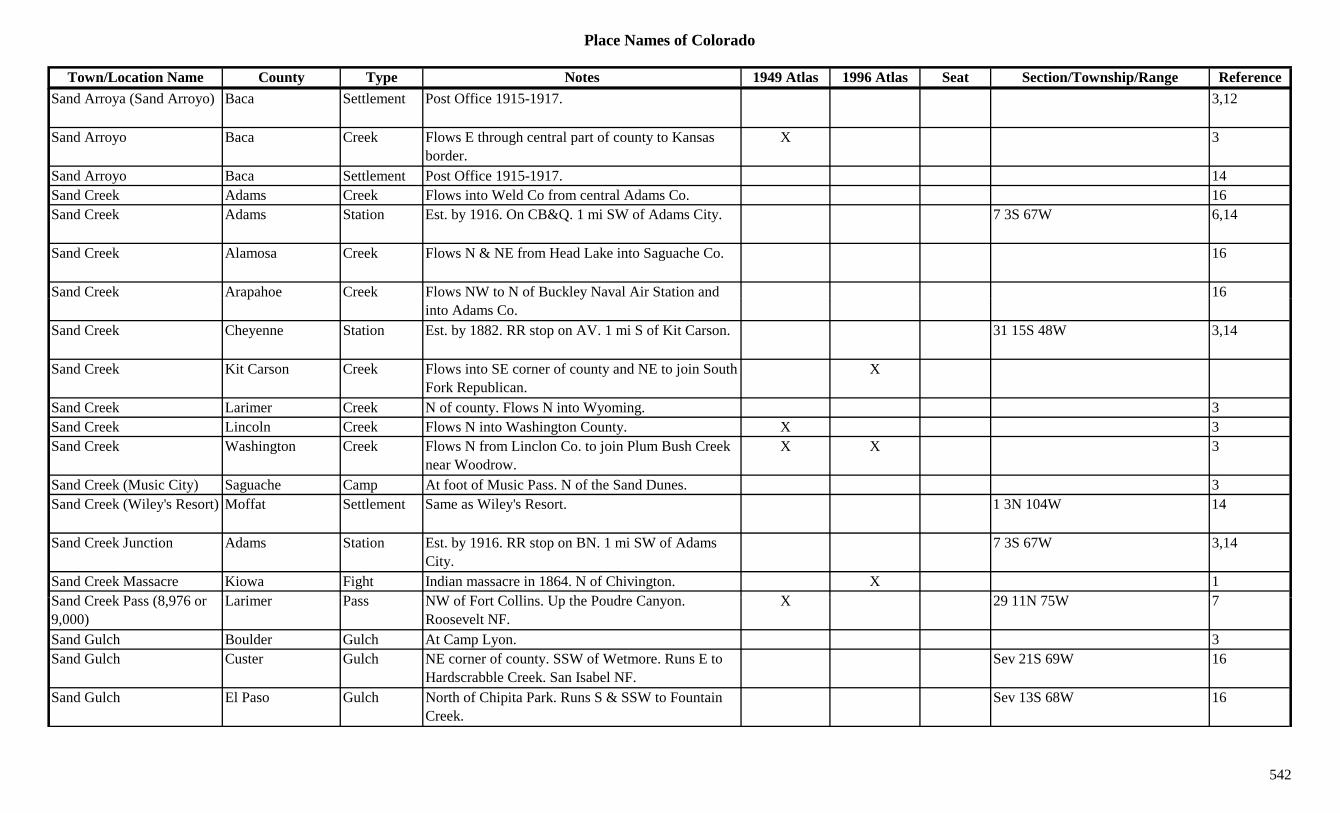
Place Names of Colorado
Town/Location Name County Type Notes 1949 Atlas 1996 Atlas Seat Section/Township/Range ReferenceSand Arroya (Sand Arroyo) Baca Settlement Post Office 1915-1917. 3,12
Sand Arroyo Baca Creek Flows E through central part of county to Kansas border.
X 3
Sand Arroyo Baca Settlement Post Office 1915-1917. 14Sand Creek Adams Creek Flows into Weld Co from central Adams Co. 16Sand Creek Adams Station Est. by 1916. On CB&Q. 1 mi SW of Adams City. 7 3S 67W 6,14
Sand Creek Alamosa Creek Flows N & NE from Head Lake into Saguache Co. 16
Sand Creek Arapahoe Creek Flows NW to N of Buckley Naval Air Station and 16p yinto Adams Co.
Sand Creek Cheyenne Station Est. by 1882. RR stop on AV. 1 mi S of Kit Carson. 31 15S 48W 3,14
Sand Creek Kit Carson Creek Flows into SE corner of county and NE to join South Fork Republican.
X
Sand Creek Larimer Creek N of county. Flows N into Wyoming. 3Sand Creek Lincoln Creek Flows N into Washington County. X 3Sand Creek Washington Creek Flows N from Linclon Co. to join Plum Bush Creek
near Woodrow.X X 3
Sand Creek (Music City) Saguache Camp At foot of Music Pass. N of the Sand Dunes. 3Sand Creek (Wiley's Resort) Moffat Settlement Same as Wiley's Resort. 1 3N 104W 14
Sand Creek Junction Adams Station Est. by 1916. RR stop on BN. 1 mi SW of Adams City.
7 3S 67W 3,14
Sand Creek Massacre Kiowa Fight Indian massacre in 1864. N of Chivington. X 1S d C k P (8 976 L i P NW f F t C lli U th P d C X 29 11N 75W 7Sand Creek Pass (8,976 or 9,000)
Larimer Pass NW of Fort Collins. Up the Poudre Canyon. Roosevelt NF.
X 29 11N 75W 7
Sand Gulch Boulder Gulch At Camp Lyon. 3Sand Gulch Custer Gulch NE corner of county. SSW of Wetmore. Runs E to
Hardscrabble Creek. San Isabel NF.Sev 21S 69W 16
Sand Gulch El Paso Gulch North of Chipita Park. Runs S & SSW to Fountain Creek.
Sev 13S 68W 16
542

Place Names of Colorado
Town/Location Name County Type Notes 1949 Atlas 1996 Atlas Seat Section/Township/Range ReferenceSand Gulch Fremont Gulch NE of Howard. Sev 49N 10/11E 16Sand Gulch Fremont Gulch North central county. Sev 17S 72W 16Sand Gulch Fremont Gulch North central county. N of Canon City. Sev 16S 70W 16Sand Gulch Fremont Gulch South of Cotopaxi. Sev 47N 12E 16Sand Mountain (10,817) Routt Mountain W of Clark. XSand Peak Rio Blanco Peak E part of county. 3Sand Pit Spur Weld Unknown On UP. 28 5N 63W 14Sand Spring Moffat Unknown 4 6N 92W 14Sand Spur Summit Station Est. by 1922. On DSP&P, a siding. W of Robinson.
Robinson locations is:27 7S 79W 14
Sand Spur Weld Unknown On UP. 31 5N 63W 14pSandbeach Lake Boulder Lake Far NW corner of county. Rocky Mountain Natl
Park.18 3N 74W 16
Sander Montrose Unknown 1 48N 14W 14Sander's Post Adams Settlement Trading post on South Platte River. 10 mi N of
D'Abreys Post. At mouth of Clear Creek.36 2S 68W 14
Sanders Ranch Adams Ranch Est. by 1858. 5 mi above Fort Lancaster. 9 mi below D'Aubrays Ranch.
14
Sanderson (Argentine) Pass (13,132)
Clear Creek/Summit
Pass Shown on 1860s map. Original name for Argentine Pass.
3
Sandhill Pass (Medano Pass) (9,920)
Huerfano/Saguache
Pass E of Great Sand Dunes. Later called Medano Pass. Rio Grande & San Isabel NF.
22 25S 72W 3
Sandown Denver Station RR stop on UP. NW of Stapleton Airport. 21 3S 67W 3,14Sandown Junction Denver Unknown On CRI&P. 21 3S 67W 14Sands (Bryant) Garfield Settlement Platted 1888. Later called Bryant. 29 7S 88W 14Sandstone Montezuma Settlement Known earlier as Pleasant View, then Sandstone,
th A k N Pl t Vi i31 39N 17W 14
then Ackmen. Now Pleasant View again.
Sandstone Arch El Paso Hill Shown on 1885 map. 2 mi E of Weissport. 3Sandstone Creek Montezuma Creek Flows SW to Yellowjacket Canyon/Creek. 3Sandy Huerfano Station Est. by 1916. On C&S & D&RGW. 5 mi N of
Walsenburg.15 27S 66W 3,14
543
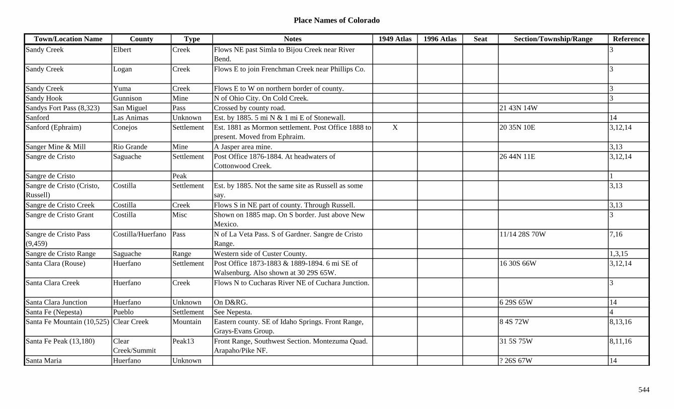
Place Names of Colorado
Town/Location Name County Type Notes 1949 Atlas 1996 Atlas Seat Section/Township/Range ReferenceSandy Creek Elbert Creek Flows NE past Simla to Bijou Creek near River
Bend.3
Sandy Creek Logan Creek Flows E to join Frenchman Creek near Phillips Co. 3
Sandy Creek Yuma Creek Flows E to W on northern border of county. 3Sandy Hook Gunnison Mine N of Ohio City. On Cold Creek. 3Sandys Fort Pass (8,323) San Miguel Pass Crossed by county road. 21 43N 14WSanford Las Animas Unknown Est. by 1885. 5 mi N & 1 mi E of Stonewall. 14Sanford (Ephraim) Conejos Settlement Est. 1881 as Mormon settlement. Post Office 1888 to
present. Moved from Ephraim.X 20 35N 10E 3,12,14
Sanger Mine & Mill Rio Grande Mine A Jasper area mine. 3,13g p ,Sangre de Cristo Saguache Settlement Post Office 1876-1884. At headwaters of
Cottonwood Creek.26 44N 11E 3,12,14
Sangre de Cristo Peak 1Sangre de Cristo (Cristo, Russell)
Costilla Settlement Est. by 1885. Not the same site as Russell as some say.
3,13
Sangre de Cristo Creek Costilla Creek Flows S in NE part of county. Through Russell. 3,13Sangre de Cristo Grant Costilla Misc Shown on 1885 map. On S border. Just above New
Mexico.3
Sangre de Cristo Pass (9,459)
Costilla/Huerfano Pass N of La Veta Pass. S of Gardner. Sangre de Cristo Range.
11/14 28S 70W 7,16
Sangre de Cristo Range Saguache Range Western side of Custer County. 1,3,15Santa Clara (Rouse) Huerfano Settlement Post Office 1873-1883 & 1889-1894. 6 mi SE of
Walsenburg. Also shown at 30 29S 65W.16 30S 66W 3,12,14
Santa Clara Creek Huerfano Creek Flows N to Cucharas River NE of Cuchara Junction. 3
S t Cl J ti H f U k O D&RG 6 29S 65W 14Santa Clara Junction Huerfano Unknown On D&RG. 6 29S 65W 14Santa Fe (Nepesta) Pueblo Settlement See Nepesta. 4Santa Fe Mountain (10,525) Clear Creek Mountain Eastern county. SE of Idaho Springs. Front Range,
Grays-Evans Group.8 4S 72W 8,13,16
Santa Fe Peak (13,180) Clear Creek/Summit
Peak13 Front Range, Southwest Section. Montezuma Quad. Arapaho/Pike NF.
31 5S 75W 8,11,16
Santa Maria Huerfano Unknown ? 26S 67W 14
544
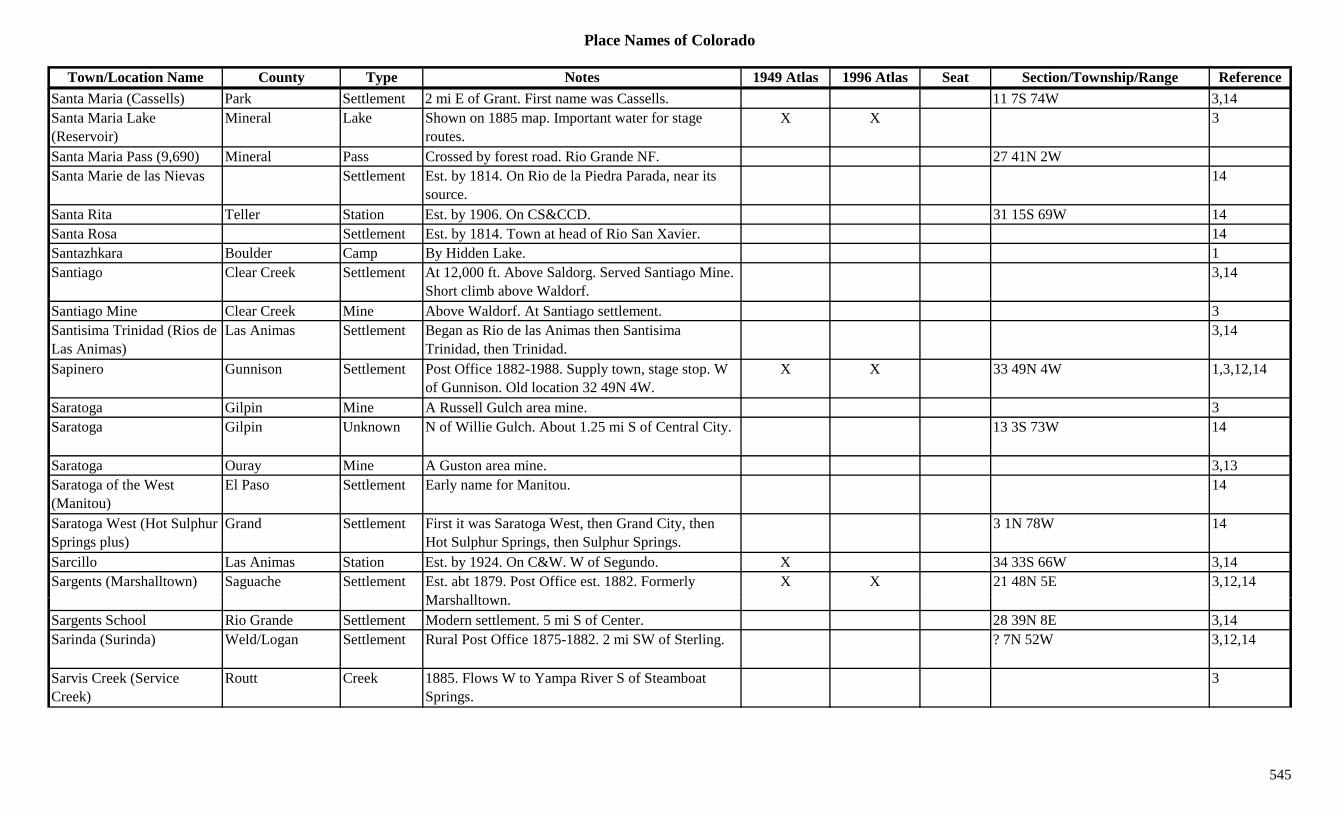
Place Names of Colorado
Town/Location Name County Type Notes 1949 Atlas 1996 Atlas Seat Section/Township/Range ReferenceSanta Maria (Cassells) Park Settlement 2 mi E of Grant. First name was Cassells. 11 7S 74W 3,14Santa Maria Lake (Reservoir)
Mineral Lake Shown on 1885 map. Important water for stage routes.
X X 3
Santa Maria Pass (9,690) Mineral Pass Crossed by forest road. Rio Grande NF. 27 41N 2WSanta Marie de las Nievas Settlement Est. by 1814. On Rio de la Piedra Parada, near its
source.14
Santa Rita Teller Station Est. by 1906. On CS&CCD. 31 15S 69W 14Santa Rosa Settlement Est. by 1814. Town at head of Rio San Xavier. 14Santazhkara Boulder Camp By Hidden Lake. 1Santiago Clear Creek Settlement At 12,000 ft. Above Saldorg. Served Santiago Mine.
Short climb above Waldorf.3,14
Santiago Mine Clear Creek Mine Above Waldorf. At Santiago settlement. 3Santisima Trinidad (Rios de Las Animas)
Las Animas Settlement Began as Rio de las Animas then Santisima Trinidad, then Trinidad.
3,14
Sapinero Gunnison Settlement Post Office 1882-1988. Supply town, stage stop. W of Gunnison. Old location 32 49N 4W.
X X 33 49N 4W 1,3,12,14
Saratoga Gilpin Mine A Russell Gulch area mine. 3Saratoga Gilpin Unknown N of Willie Gulch. About 1.25 mi S of Central City. 13 3S 73W 14
Saratoga Ouray Mine A Guston area mine. 3,13Saratoga of the West (Manitou)
El Paso Settlement Early name for Manitou. 14
Saratoga West (Hot Sulphur Springs plus)
Grand Settlement First it was Saratoga West, then Grand City, then Hot Sulphur Springs, then Sulphur Springs.
3 1N 78W 14
Sarcillo Las Animas Station Est. by 1924. On C&W. W of Segundo. X 34 33S 66W 3,14Sargents (Marshalltown) Saguache Settlement Est. abt 1879. Post Office est. 1882. Formerly
M h lltX X 21 48N 5E 3,12,14
Marshalltown.Sargents School Rio Grande Settlement Modern settlement. 5 mi S of Center. 28 39N 8E 3,14Sarinda (Surinda) Weld/Logan Settlement Rural Post Office 1875-1882. 2 mi SW of Sterling. ? 7N 52W 3,12,14
Sarvis Creek (Service Creek)
Routt Creek 1885. Flows W to Yampa River S of Steamboat Springs.
3
545
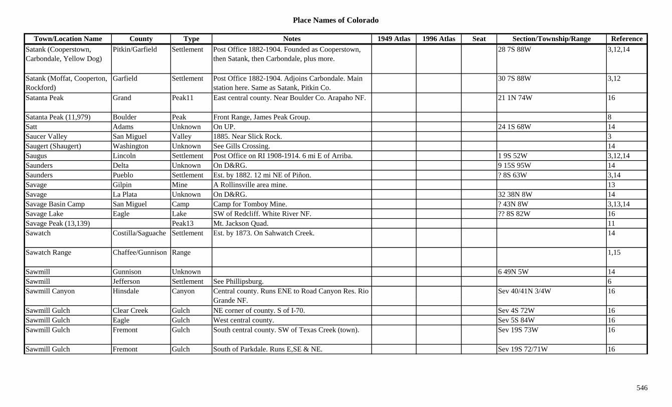
Place Names of Colorado
Town/Location Name County Type Notes 1949 Atlas 1996 Atlas Seat Section/Township/Range ReferenceSatank (Cooperstown, Carbondale, Yellow Dog)
Pitkin/Garfield Settlement Post Office 1882-1904. Founded as Cooperstown, then Satank, then Carbondale, plus more.
28 7S 88W 3,12,14
Satank (Moffat, Cooperton, Rockford)
Garfield Settlement Post Office 1882-1904. Adjoins Carbondale. Main station here. Same as Satank, Pitkin Co.
30 7S 88W 3,12
Satanta Peak Grand Peak11 East central county. Near Boulder Co. Arapaho NF. 21 1N 74W 16
Satanta Peak (11,979) Boulder Peak Front Range, James Peak Group. 8Satt Adams Unknown On UP. 24 1S 68W 14Saucer Valley San Miguel Valley 1885. Near Slick Rock. 3Saugert (Shaugert) Washington Unknown See Gills Crossing. 14g ( g ) g gSaugus Lincoln Settlement Post Office on RI 1908-1914. 6 mi E of Arriba. 1 9S 52W 3,12,14Saunders Delta Unknown On D&RG. 9 15S 95W 14Saunders Pueblo Settlement Est. by 1882. 12 mi NE of Piñon. ? 8S 63W 3,14Savage Gilpin Mine A Rollinsville area mine. 13Savage La Plata Unknown On D&RG. 32 38N 8W 14Savage Basin Camp San Miguel Camp Camp for Tomboy Mine. ? 43N 8W 3,13,14Savage Lake Eagle Lake SW of Redcliff. White River NF. ?? 8S 82W 16Savage Peak (13,139) Peak13 Mt. Jackson Quad. 11Sawatch Costilla/Saguache Settlement Est. by 1873. On Sahwatch Creek. 14
Sawatch Range Chaffee/Gunnison Range 1,15
Sawmill Gunnison Unknown 6 49N 5W 14Sawmill Jefferson Settlement See Phillipsburg. 6Sawmill Canyon Hinsdale Canyon Central county. Runs ENE to Road Canyon Res. Rio
G d NFSev 40/41N 3/4W 16
Grande NF.Sawmill Gulch Clear Creek Gulch NE corner of county. S of I-70. Sev 4S 72W 16Sawmill Gulch Eagle Gulch West central county. Sev 5S 84W 16Sawmill Gulch Fremont Gulch South central county. SW of Texas Creek (town). Sev 19S 73W 16
Sawmill Gulch Fremont Gulch South of Parkdale. Runs E,SE & NE. Sev 19S 72/71W 16
546
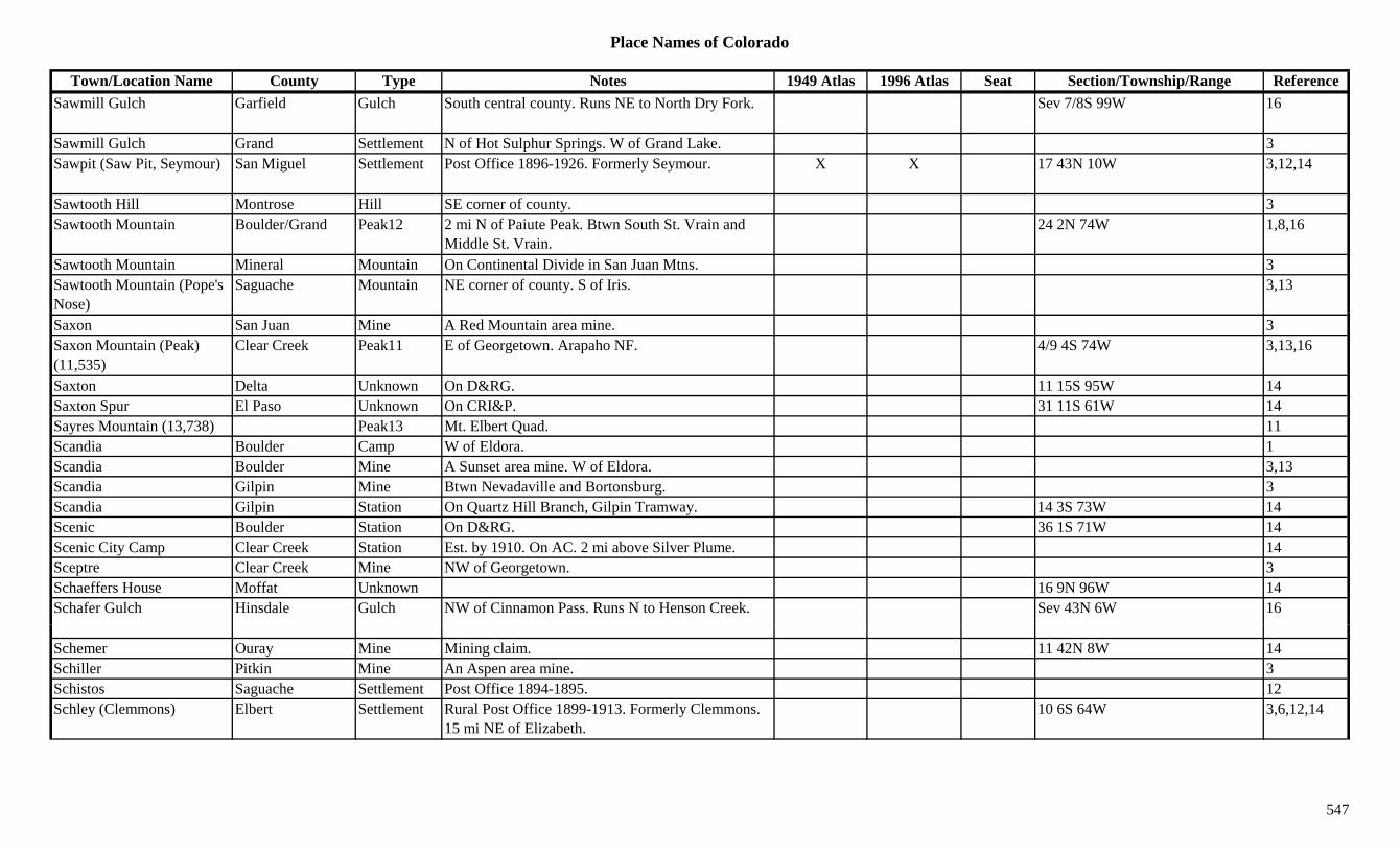
Place Names of Colorado
Town/Location Name County Type Notes 1949 Atlas 1996 Atlas Seat Section/Township/Range ReferenceSawmill Gulch Garfield Gulch South central county. Runs NE to North Dry Fork. Sev 7/8S 99W 16
Sawmill Gulch Grand Settlement N of Hot Sulphur Springs. W of Grand Lake. 3Sawpit (Saw Pit, Seymour) San Miguel Settlement Post Office 1896-1926. Formerly Seymour. X X 17 43N 10W 3,12,14
Sawtooth Hill Montrose Hill SE corner of county. 3Sawtooth Mountain Boulder/Grand Peak12 2 mi N of Paiute Peak. Btwn South St. Vrain and
Middle St. Vrain.24 2N 74W 1,8,16
Sawtooth Mountain Mineral Mountain On Continental Divide in San Juan Mtns. 3Sawtooth Mountain (Pope's Nose)
Saguache Mountain NE corner of county. S of Iris. 3,13
Saxon San Juan Mine A Red Mountain area mine. 3Saxon Mountain (Peak) (11,535)
Clear Creek Peak11 E of Georgetown. Arapaho NF. 4/9 4S 74W 3,13,16
Saxton Delta Unknown On D&RG. 11 15S 95W 14Saxton Spur El Paso Unknown On CRI&P. 31 11S 61W 14Sayres Mountain (13,738) Peak13 Mt. Elbert Quad. 11Scandia Boulder Camp W of Eldora. 1Scandia Boulder Mine A Sunset area mine. W of Eldora. 3,13Scandia Gilpin Mine Btwn Nevadaville and Bortonsburg. 3Scandia Gilpin Station On Quartz Hill Branch, Gilpin Tramway. 14 3S 73W 14Scenic Boulder Station On D&RG. 36 1S 71W 14Scenic City Camp Clear Creek Station Est. by 1910. On AC. 2 mi above Silver Plume. 14Sceptre Clear Creek Mine NW of Georgetown. 3Schaeffers House Moffat Unknown 16 9N 96W 14Schafer Gulch Hinsdale Gulch NW of Cinnamon Pass. Runs N to Henson Creek. Sev 43N 6W 16
Schemer Ouray Mine Mining claim. 11 42N 8W 14Schiller Pitkin Mine An Aspen area mine. 3Schistos Saguache Settlement Post Office 1894-1895. 12Schley (Clemmons) Elbert Settlement Rural Post Office 1899-1913. Formerly Clemmons.
15 mi NE of Elizabeth.10 6S 64W 3,6,12,14
547
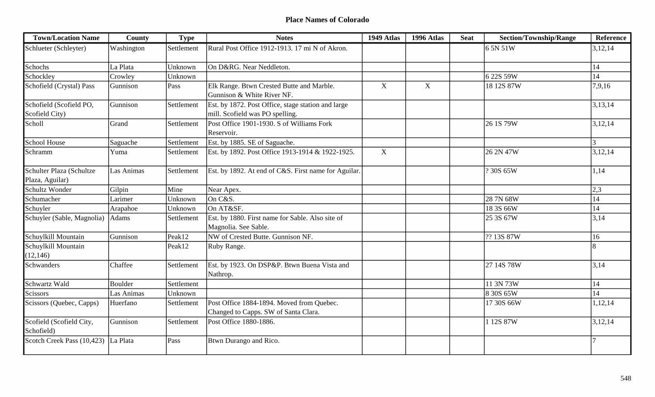
Place Names of Colorado
Town/Location Name County Type Notes 1949 Atlas 1996 Atlas Seat Section/Township/Range ReferenceSchlueter (Schleyter) Washington Settlement Rural Post Office 1912-1913. 17 mi N of Akron. 6 5N 51W 3,12,14
Schochs La Plata Unknown On D&RG. Near Neddleton. 14Schockley Crowley Unknown 6 22S 59W 14Schofield (Crystal) Pass Gunnison Pass Elk Range. Btwn Crested Butte and Marble.
Gunnison & White River NF.X X 18 12S 87W 7,9,16
Schofield (Scofield PO, Scofield City)
Gunnison Settlement Est. by 1872. Post Office, stage station and large mill. Scofield was PO spelling.
3,13,14
Scholl Grand Settlement Post Office 1901-1930. S of Williams Fork Reservoir.
26 1S 79W 3,12,14
School House Saguache Settlement Est. by 1885. SE of Saguache. 3g y gSchramm Yuma Settlement Est. by 1892. Post Office 1913-1914 & 1922-1925. X 26 2N 47W 3,12,14
Schulter Plaza (Schultze Plaza, Aguilar)
Las Animas Settlement Est. by 1892. At end of C&S. First name for Aguilar. ? 30S 65W 1,14
Schultz Wonder Gilpin Mine Near Apex. 2,3Schumacher Larimer Unknown On C&S. 28 7N 68W 14Schuyler Arapahoe Unknown On AT&SF. 18 3S 66W 14Schuyler (Sable, Magnolia) Adams Settlement Est. by 1880. First name for Sable. Also site of
Magnolia. See Sable.25 3S 67W 3,14
Schuylkill Mountain Gunnison Peak12 NW of Crested Butte. Gunnison NF. ?? 13S 87W 16Schuylkill Mountain (12,146)
Peak12 Ruby Range. 8
Schwanders Chaffee Settlement Est. by 1923. On DSP&P. Btwn Buena Vista and Nathrop.
27 14S 78W 3,14
Schwartz Wald Boulder Settlement 11 3N 73W 14S i L A i U k 8 30S 65W 14Scissors Las Animas Unknown 8 30S 65W 14Scissors (Quebec, Capps) Huerfano Settlement Post Office 1884-1894. Moved from Quebec.
Changed to Capps. SW of Santa Clara.17 30S 66W 1,12,14
Scofield (Scofield City, Schofield)
Gunnison Settlement Post Office 1880-1886. 1 12S 87W 3,12,14
Scotch Creek Pass (10,423) La Plata Pass Btwn Durango and Rico. 7
548
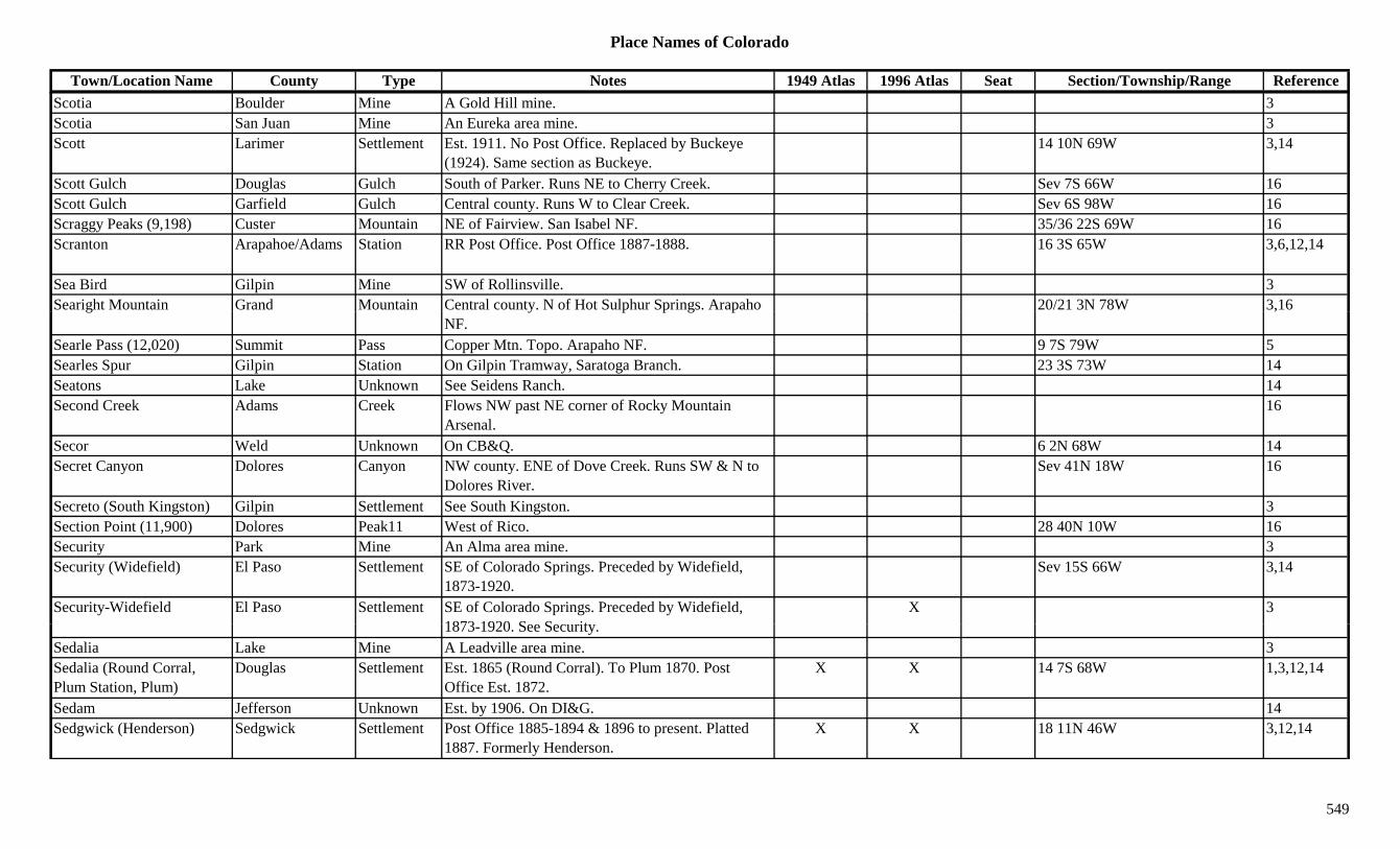
Place Names of Colorado
Town/Location Name County Type Notes 1949 Atlas 1996 Atlas Seat Section/Township/Range ReferenceScotia Boulder Mine A Gold Hill mine. 3Scotia San Juan Mine An Eureka area mine. 3Scott Larimer Settlement Est. 1911. No Post Office. Replaced by Buckeye
(1924). Same section as Buckeye.14 10N 69W 3,14
Scott Gulch Douglas Gulch South of Parker. Runs NE to Cherry Creek. Sev 7S 66W 16Scott Gulch Garfield Gulch Central county. Runs W to Clear Creek. Sev 6S 98W 16Scraggy Peaks (9,198) Custer Mountain NE of Fairview. San Isabel NF. 35/36 22S 69W 16Scranton Arapahoe/Adams Station RR Post Office. Post Office 1887-1888. 16 3S 65W 3,6,12,14
Sea Bird Gilpin Mine SW of Rollinsville. 3Searight Mountain Grand Mountain Central county. N of Hot Sulphur Springs. Arapaho 20/21 3N 78W 3,16g y p p g p
NF.,
Searle Pass (12,020) Summit Pass Copper Mtn. Topo. Arapaho NF. 9 7S 79W 5Searles Spur Gilpin Station On Gilpin Tramway, Saratoga Branch. 23 3S 73W 14Seatons Lake Unknown See Seidens Ranch. 14Second Creek Adams Creek Flows NW past NE corner of Rocky Mountain
Arsenal.16
Secor Weld Unknown On CB&Q. 6 2N 68W 14Secret Canyon Dolores Canyon NW county. ENE of Dove Creek. Runs SW & N to
Dolores River.Sev 41N 18W 16
Secreto (South Kingston) Gilpin Settlement See South Kingston. 3Section Point (11,900) Dolores Peak11 West of Rico. 28 40N 10W 16Security Park Mine An Alma area mine. 3Security (Widefield) El Paso Settlement SE of Colorado Springs. Preceded by Widefield,
1873-1920.Sev 15S 66W 3,14
Security-Widefield El Paso Settlement SE of Colorado Springs. Preceded by Widefield, 1873 1920 S S it
X 31873-1920. See Security.
Sedalia Lake Mine A Leadville area mine. 3Sedalia (Round Corral, Plum Station, Plum)
Douglas Settlement Est. 1865 (Round Corral). To Plum 1870. Post Office Est. 1872.
X X 14 7S 68W 1,3,12,14
Sedam Jefferson Unknown Est. by 1906. On DI&G. 14Sedgwick (Henderson) Sedgwick Settlement Post Office 1885-1894 & 1896 to present. Platted
1887. Formerly Henderson.X X 18 11N 46W 3,12,14
549
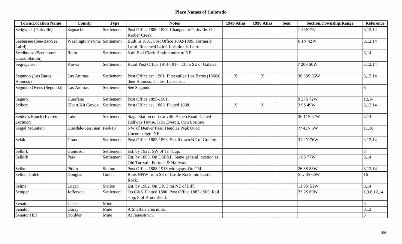
Place Names of Colorado
Town/Location Name County Type Notes 1949 Atlas 1996 Atlas Seat Section/Township/Range ReferenceSedgwick (Parkville) Saguache Settlement Post Office 1880-1885. Changed to Parkville. On
Kerber Creek.1 46N 7E 3,12,14
Seebarsee (See-Bar-See, Laird)
Washington/Yuma Settlement Built in 1881. Post Office 1892-1899. Formerly Laird. Renamed Laird. Location is Laird.
6 1N 42W 3,12,14
Seedhouse (Seedhouse Guard Station)
Routt Settlement 8 mi E of Clark. Station more to NE. 3,14
Segreganset Kiowa Settlement Rural Post Office 1914-1917. 13 mi SE of Galatea. ? 20S 50W 3,12,14
Segundo (Los Baros, Humoso)
Las Animas Settlement Post Office est. 1901. First called Los Baros (1860s), then Humoso. 2 sites. Latest is...
X X 36 33S 66W 3,12,14
Segundo Ovens (Segundo) Las Animas Settlement See Segundo. 3g ( g ) g
Seguro Huerfano Settlement Post Office 1895-1901. 9 27S 72W 12,14Seibert Elbert/Kit Carson Settlement Post Office est. 1888. Platted 1888. X X 3 9S 49W 3,12,14
Seiden's Ranch (Everett, Lorimer)
Lake Settlement Stage Station on Leadville-Aspen Road. Called Halfway House, later Everett, then Lorimer.
36 11S 82W 3,14
Seigal Mountain Hinsdale/San Juan Peak13 NW of Denver Pass. Handies Peak Quad. Uncompahgre NF.
?? 43N 6W 11,16
Selak Grand Settlement Post Office 1883-1893. Small town NE of Granby. 31 2N 76W 3,12,14
Selkirk Gunnison Settlement Est. by 1922. SW of Tin Cup. 3Selkirk Park Settlement Est. by 1885. On DSP&P. Same general location as
Old Tarryall, Fortune & Halfway.1 8S 77W 3,14
Sellar Pitkin Station Post Office 1888-1918 with gaps. On CM. 26 8S 83W 3,12,14Sellers Gulch Douglas Gulch Runs NNW from SE of Castle Rock into Castle
R kSev 8S 66W 16
Rock.Selma Logan Station Est. by 1902. On UP. 3 mi NE of Iliff. 11 9N 51W 3,14Semper Jefferson Settlement On C&S. Platted 1886. Post Office 1882-1900. Rail
stop, S of Broomfield.23 2S 69W 1,3,6,12,14
Senator Custer Mine 3Senator Ouray Mine A Sneffels area mine. 3,13Senator Hill Boulder Mine At Jamestown. 3
550
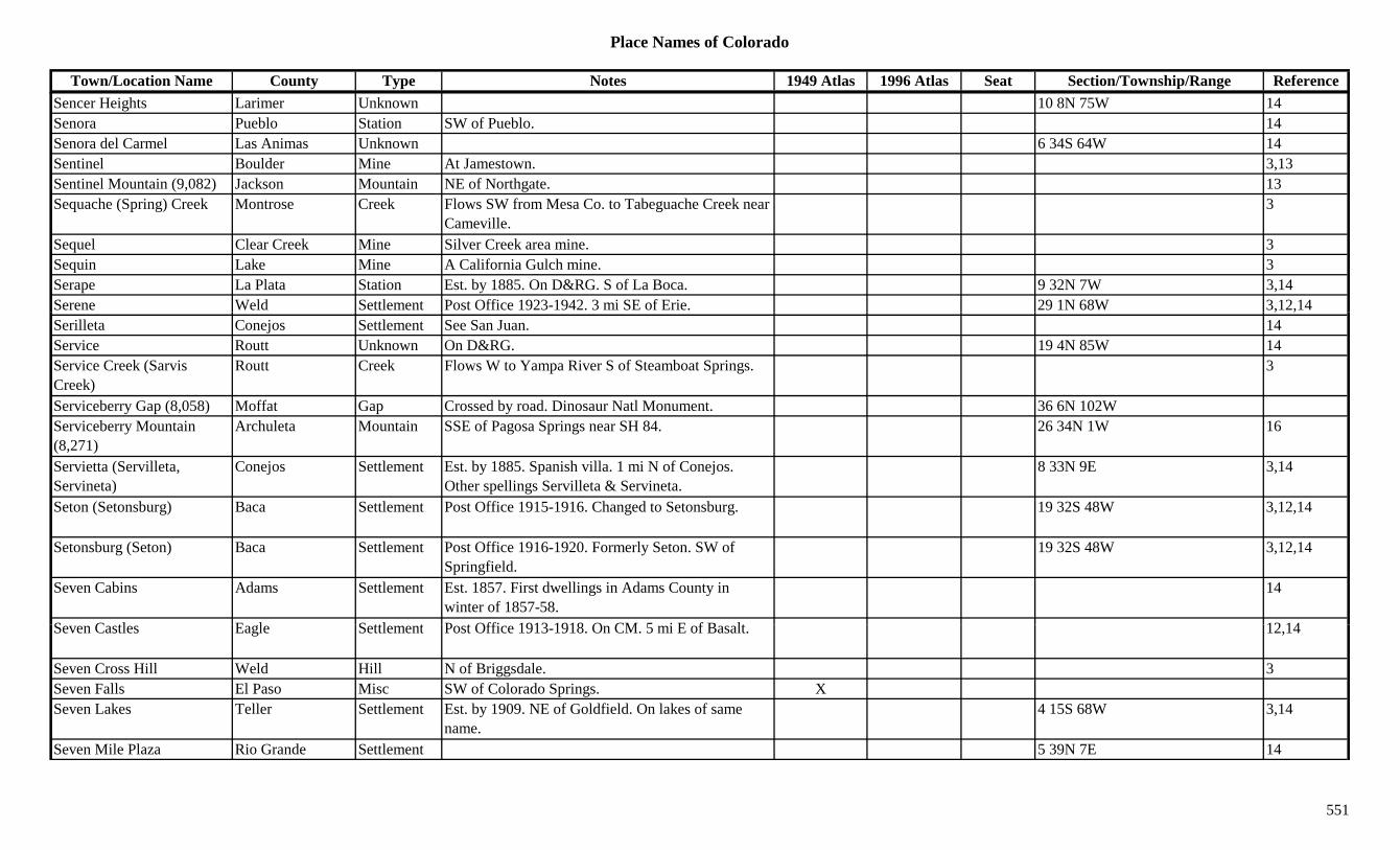
Place Names of Colorado
Town/Location Name County Type Notes 1949 Atlas 1996 Atlas Seat Section/Township/Range ReferenceSencer Heights Larimer Unknown 10 8N 75W 14Senora Pueblo Station SW of Pueblo. 14Senora del Carmel Las Animas Unknown 6 34S 64W 14Sentinel Boulder Mine At Jamestown. 3,13Sentinel Mountain (9,082) Jackson Mountain NE of Northgate. 13Sequache (Spring) Creek Montrose Creek Flows SW from Mesa Co. to Tabeguache Creek near
Cameville.3
Sequel Clear Creek Mine Silver Creek area mine. 3Sequin Lake Mine A California Gulch mine. 3Serape La Plata Station Est. by 1885. On D&RG. S of La Boca. 9 32N 7W 3,14Serene Weld Settlement Post Office 1923-1942. 3 mi SE of Erie. 29 1N 68W 3,12,14, ,Serilleta Conejos Settlement See San Juan. 14Service Routt Unknown On D&RG. 19 4N 85W 14Service Creek (Sarvis Creek)
Routt Creek Flows W to Yampa River S of Steamboat Springs. 3
Serviceberry Gap (8,058) Moffat Gap Crossed by road. Dinosaur Natl Monument. 36 6N 102WServiceberry Mountain (8,271)
Archuleta Mountain SSE of Pagosa Springs near SH 84. 26 34N 1W 16
Servietta (Servilleta, Servineta)
Conejos Settlement Est. by 1885. Spanish villa. 1 mi N of Conejos. Other spellings Servilleta & Servineta.
8 33N 9E 3,14
Seton (Setonsburg) Baca Settlement Post Office 1915-1916. Changed to Setonsburg. 19 32S 48W 3,12,14
Setonsburg (Seton) Baca Settlement Post Office 1916-1920. Formerly Seton. SW of Springfield.
19 32S 48W 3,12,14
Seven Cabins Adams Settlement Est. 1857. First dwellings in Adams County in winter of 1857-58.
14
S C tl E l S ttl t P t Offi 1913 1918 O CM 5 i E f B lt 12 14Seven Castles Eagle Settlement Post Office 1913-1918. On CM. 5 mi E of Basalt. 12,14
Seven Cross Hill Weld Hill N of Briggsdale. 3Seven Falls El Paso Misc SW of Colorado Springs. XSeven Lakes Teller Settlement Est. by 1909. NE of Goldfield. On lakes of same
name.4 15S 68W 3,14
Seven Mile Plaza Rio Grande Settlement 5 39N 7E 14
551

Place Names of Colorado
Town/Location Name County Type Notes 1949 Atlas 1996 Atlas Seat Section/Township/Range ReferenceSeven Thirty Boulder Camp S and E of Caribou. 1Seventeen Mile House Arapahoe Station Existed in 1870s. Rural tavern on Smoky Hill South
stage route.3,6,14
Seven-Thirty Clear Creek Mine Silver Plume area mine. And/or Georgetown area. 2,3,13
Seven-thirty (7-30) Boulder Mine A Caribou mine. 3,13Severence (Severance, Tailholt)
Weld Settlement Post Office 1894-1902 & 1907 to present. First name was Tailholt. Btwn Eaton & Timnath.
X X 35 7N 67W 3,6,12,14
Sewall Garfield Settlement On Uintah. See Sewell. Note: Confusing, but note 2 different locations shown.
X 5 5S 103W 14
Sewall Gulch Gunnison Gulch North of Parlin. Runs SW to Tomichi Creek. Sev 49N 2E 16Sewanee Peak (13,259) Chaffee Peak13 Sawatch Range, Chalk Creek Shavano Sect. Garfield
Quad. San Isabel NF.7 50N 6E 8,11,16
Seward (Clyde) El Paso/Teller Settlement Post Office 1896-1899. Changed to Clyde. 20 15S 68W 12,14Sewell Rio Blanco Unknown On Unitah. 32 4S 103W 14Sewell (Thompson) Pitkin Settlement Est. by 1922. S of Carbondale. See Sewall, Garfield
Co. Confusing!27 8S 88W 3,14
Seymour San Juan Mine Silverton area mine. 3Seymour (Sawpit, Fall Creek)
San Miguel Camp Post Office 1892-1896. Changed to Sawpit. Later (1922) named Fall Creek.
17 43N 10W 3,12,14
Seymour Gulch Fremont Gulch North central county. Sev 16S 72W 16Shadow Lake Garfield Lake NW corner of county. White River NF. 8 3S 89W 16Shadow Mountain Grand Peak10 East of Shadow Mtn Res. Rocky Mtn Natl Park. 16 3N 75W 16
Shadow Mountain Grand Settlement Newer settlement on NW banks of lake. X 3Shadow Mountain Lake Grand Lake Between Lake Granby and Grand Lake. X Sev 3N 75/76W 16Sh d M t i N ti l G d P k Bt G d L k d G b L k 1Shadow Mountain National Recr Area
Grand Park Btwn Grand Lake and Granby Lake. 1
Shaefer Mountain La Plata Mountain E central county. 13Shaffer Hill (8,423) Clear Creek Hill Very eastern part of county. Against Jefferson Co. 13 4S 72W 16
552

Place Names of Colorado
Town/Location Name County Type Notes 1949 Atlas 1996 Atlas Seat Section/Township/Range ReferenceShaffers Crossing (Omaha House, Belleville +)
Jefferson Station Est. abt. 1865. Stage stop. Called Omaha House, Belleville & Urmiston.
X 32 6S 71W 3,6,14
Shakespeare Gunnison Mine A Gothic area mine. 3Shale Boulder Unknown On DB&W. At milestone 12.5. 14Shale Garfield Unknown On Uintah. 26 5S 103W 14Shale Mesa Camp Site 1. 1885. 5 mi NW of Mack. 29 8S 95W 3Shale Mesa Station Site 2. Est. by 1923. On D&RGW. 7 mi SW of
Mack.26 10S 104W 3,14
Shalloway's Gulch Rio Blanco Creek Flows E to join Black Sulphur Creek near Sulphur. 3
Shalloway's Gulch Rio Blanco Gulch N of Ryon's Gulch. 3Shamballa Ashrama Douglas Settlement SW of Sedalia. 19 8S 68W 3,14Shamos O'Brien Boulder Mine A Salina Mine. 3,13Shamrock Adams Unknown 12 2S 58W 14Shamrock Gilpin Mine A Justice Hill area mine. 3Shamrock Weld Station On UP. Just W of Dacona. 34 2N 68W 6,14Shamrock Camp Montrose Unknown Est. by 1916. 29 48N 17W 14Shanty Town Lake Settlement In Ten Mile Gulch. A section of Leadville. 3Sharkstooth Peak (12,462) Peak12 La Plata Range. 8
Sharp's (Buzzard's Roost Ranch)
Huerfano Station Also Sharp's Trading Post & Buzzard Roost Ranch. 25 mi WNW of Walsenburg.
4
Sharp's Trading Post (Sharp's)
Huerfano Station Trading Post. 25 mi WNW of Walsenburg. Lived in today (1986).
4,14
Sharpsdale Huerfano Settlement Post Office 1883-1934. SW of Red Wing. 7 27S 71W 3,12,14Sh t W hi t U k S Gill C i 14Shaugert Washington Unknown See Gills Crossing. 14Shavano Chaffee Settlement Site 2. Post Office 1930. 10 50N 6E 12,14Shavano (Clifton, Clifton Camp)
Chaffee Settlement Site 1. Est. by 1879. Post Office 1880. 10 mi NW of Maysville. Called Clifton Camp or Clifton.
3,12,13
Shavano Lake Chaffee Lake Between Shavano Peak and Jones Peak. San Isabel NF.
5 50N 7E 16
553
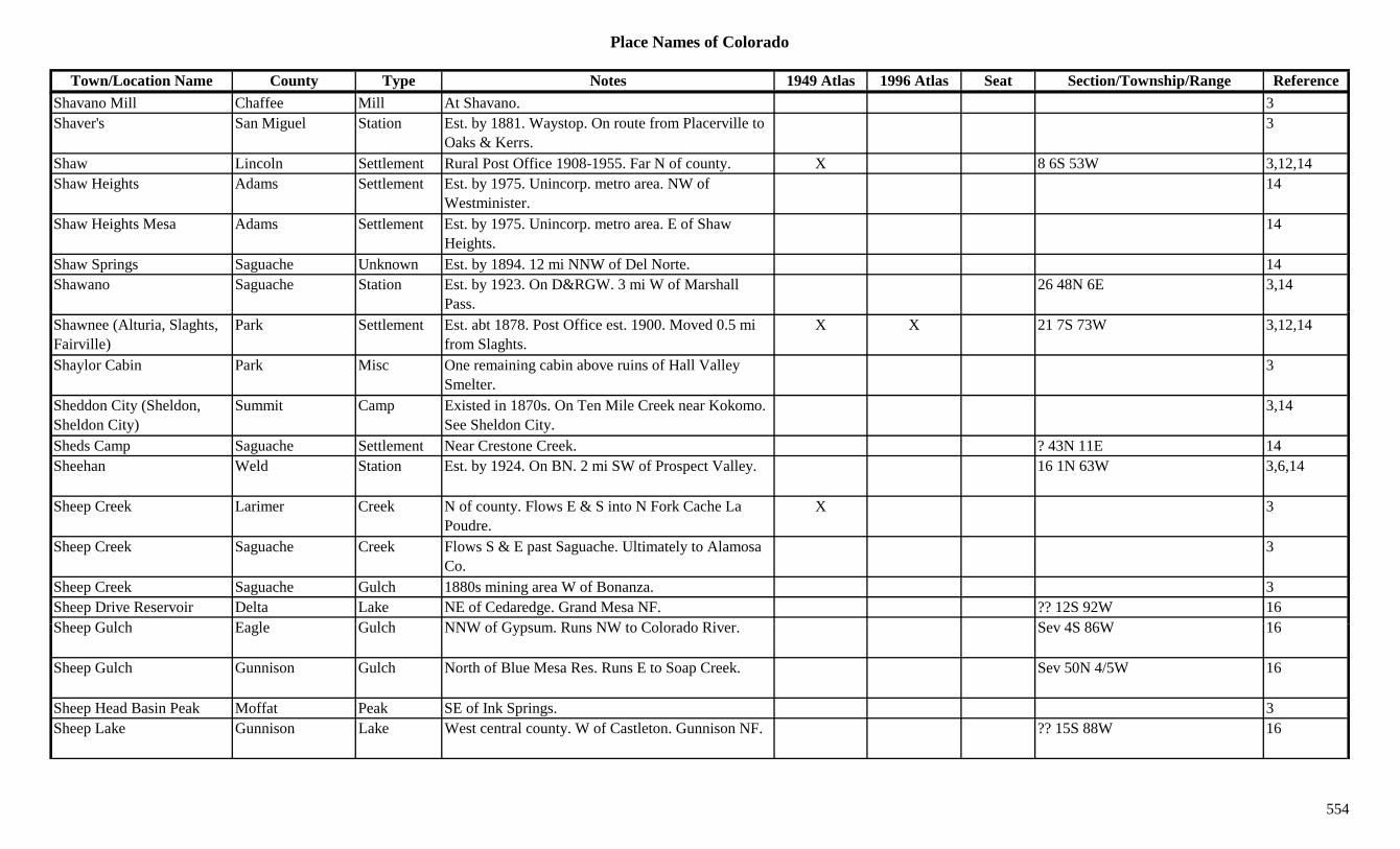
Place Names of Colorado
Town/Location Name County Type Notes 1949 Atlas 1996 Atlas Seat Section/Township/Range ReferenceShavano Mill Chaffee Mill At Shavano. 3Shaver's San Miguel Station Est. by 1881. Waystop. On route from Placerville to
Oaks & Kerrs.3
Shaw Lincoln Settlement Rural Post Office 1908-1955. Far N of county. X 8 6S 53W 3,12,14Shaw Heights Adams Settlement Est. by 1975. Unincorp. metro area. NW of
Westminister.14
Shaw Heights Mesa Adams Settlement Est. by 1975. Unincorp. metro area. E of Shaw Heights.
14
Shaw Springs Saguache Unknown Est. by 1894. 12 mi NNW of Del Norte. 14Shawano Saguache Station Est. by 1923. On D&RGW. 3 mi W of Marshall
Pass.26 48N 6E 3,14
Shawnee (Alturia, Slaghts, Fairville)
Park Settlement Est. abt 1878. Post Office est. 1900. Moved 0.5 mi from Slaghts.
X X 21 7S 73W 3,12,14
Shaylor Cabin Park Misc One remaining cabin above ruins of Hall Valley Smelter.
3
Sheddon City (Sheldon, Sheldon City)
Summit Camp Existed in 1870s. On Ten Mile Creek near Kokomo. See Sheldon City.
3,14
Sheds Camp Saguache Settlement Near Crestone Creek. ? 43N 11E 14Sheehan Weld Station Est. by 1924. On BN. 2 mi SW of Prospect Valley. 16 1N 63W 3,6,14
Sheep Creek Larimer Creek N of county. Flows E & S into N Fork Cache La Poudre.
X 3
Sheep Creek Saguache Creek Flows S & E past Saguache. Ultimately to Alamosa Co.
3
Sheep Creek Saguache Gulch 1880s mining area W of Bonanza. 3Sheep Drive Reservoir Delta Lake NE of Cedaredge. Grand Mesa NF. ?? 12S 92W 16Sh G l h E l G l h NNW f G R NW t C l d Ri S 4S 86W 16Sheep Gulch Eagle Gulch NNW of Gypsum. Runs NW to Colorado River. Sev 4S 86W 16
Sheep Gulch Gunnison Gulch North of Blue Mesa Res. Runs E to Soap Creek. Sev 50N 4/5W 16
Sheep Head Basin Peak Moffat Peak SE of Ink Springs. 3Sheep Lake Gunnison Lake West central county. W of Castleton. Gunnison NF. ?? 15S 88W 16
554

Place Names of Colorado
Town/Location Name County Type Notes 1949 Atlas 1996 Atlas Seat Section/Township/Range ReferenceSheep Lake Lake Near Fall River entrance. 1Sheep Mountain Eagle/Summit Peak11 SW of Wheeler. NE corner of Eagle Co.
Arapaho/White River NF.23 2S 81W 3,16
Sheep Mountain Eagle/Summit Peak12 NE of Tennessee Pass. Arapaho/White River NF. ?? 7S 79W 16
Sheep Mountain Garfield Peak12 NE corner of county. White River NF. 3 2S 87W 8,16Sheep Mountain Grand Mountain North central county. SW of Troublesome Pass.
Arapaho NF.16 4N 79W 13,16
Sheep Mountain Grand Peak10 SW of Tabernash. 17 1S 76W 13,16Sheep Mountain Grand/Jackson Peak11 North central Grand Co. NW of Troublesome Pass.
Arapaho/Routt NF.?? 5N 79W 16
Sheep Mountain Gunnison Mountain NW corner of county. Gunnison NF. 21 11S 90W 16Sheep Mountain Gunnison Peak11 North central county. East of Marble. White River
NF.?? 11S 87W 16
Sheep Mountain Gunnison Peak11 SW of Crested Butte. Gunnison NF. ?? 15S 89W 16Sheep Mountain Gunnison Peak12 North of Ohio City. Gunnison NF. 25 51N 3E 16Sheep Mountain Gunnison Peak13 San Juans, Courthouse Group. Columbine Pass
Quad.X 8,11
Sheep Mountain Gunnison Peak13 Sheep Mtn. Quad. SW corner of county. Uncompahgre NF.
X X ?? 45N 5/6W 11,13,16
Sheep Mountain Huerfano Mountain NW of Ojo. Near Costilla Co. 3Sheep Mountain Mineral Mountain Near Wolf Creek. 3Sheep Mountain Teller Mountain S of Pikes Peak. 13Sheep Mountain (12,085) Saguache Peak12 SW county. 13Sheep Mountain (13,188) Dolores/San
MiguelPeak13 NE of Rico. Mt. Wilson Quad. San Miguel NF. ?? 41N 9W 11,16
Sh M t i (13 292) P k13 H d ill Q d 11Sheep Mountain (13,292) Peak13 Howardsville Quad. 11Sheep Mountain (8,700) Archuleta Mountain NW corner of county. San Juan NF. 23 36N 5W 16Sheep Mountain Tunnel Gunnison Mine At Crystal. 2,3,13Sheep Nose (8,500) Douglas Mountain SW of Westcreek. Pike NF. 35 10S 70W 16Sheephorn Eagle Settlement Post Office 1895-1951. E of State Bridge. Many
locations shown, 16 2S 81W, 36 1S 82W.X 6 2S 81W 3,12,14
Sheephorn Mountain Grand Mountain SSW of Kremmling. 21 1S 81W 13,16
555
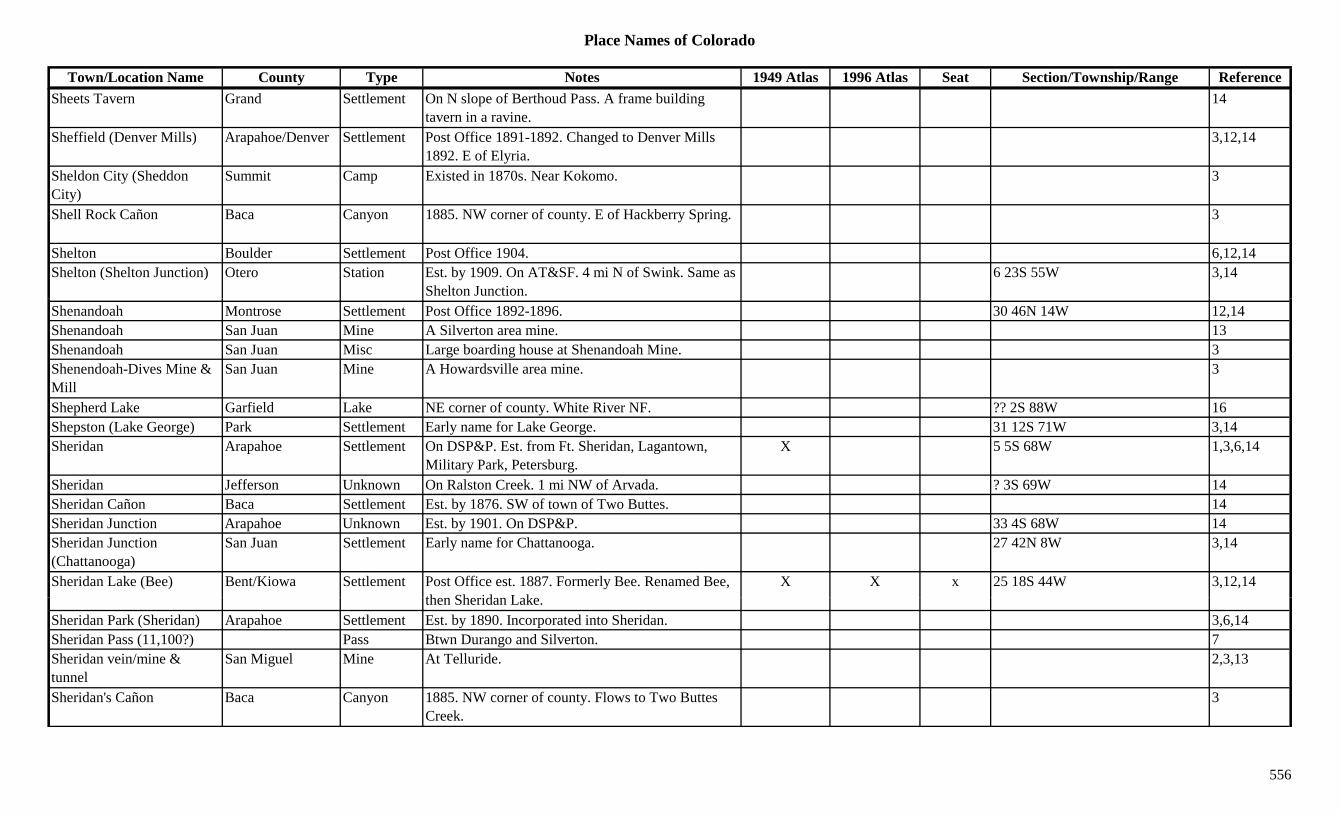
Place Names of Colorado
Town/Location Name County Type Notes 1949 Atlas 1996 Atlas Seat Section/Township/Range ReferenceSheets Tavern Grand Settlement On N slope of Berthoud Pass. A frame building
tavern in a ravine.14
Sheffield (Denver Mills) Arapahoe/Denver Settlement Post Office 1891-1892. Changed to Denver Mills 1892. E of Elyria.
3,12,14
Sheldon City (Sheddon City)
Summit Camp Existed in 1870s. Near Kokomo. 3
Shell Rock Cañon Baca Canyon 1885. NW corner of county. E of Hackberry Spring. 3
Shelton Boulder Settlement Post Office 1904. 6,12,14Shelton (Shelton Junction) Otero Station Est. by 1909. On AT&SF. 4 mi N of Swink. Same as
Shelton Junction.6 23S 55W 3,14
Shenandoah Montrose Settlement Post Office 1892-1896. 30 46N 14W 12,14Shenandoah San Juan Mine A Silverton area mine. 13Shenandoah San Juan Misc Large boarding house at Shenandoah Mine. 3Shenendoah-Dives Mine & Mill
San Juan Mine A Howardsville area mine. 3
Shepherd Lake Garfield Lake NE corner of county. White River NF. ?? 2S 88W 16Shepston (Lake George) Park Settlement Early name for Lake George. 31 12S 71W 3,14Sheridan Arapahoe Settlement On DSP&P. Est. from Ft. Sheridan, Lagantown,
Military Park, Petersburg.X 5 5S 68W 1,3,6,14
Sheridan Jefferson Unknown On Ralston Creek. 1 mi NW of Arvada. ? 3S 69W 14Sheridan Cañon Baca Settlement Est. by 1876. SW of town of Two Buttes. 14Sheridan Junction Arapahoe Unknown Est. by 1901. On DSP&P. 33 4S 68W 14Sheridan Junction (Chattanooga)
San Juan Settlement Early name for Chattanooga. 27 42N 8W 3,14
Sheridan Lake (Bee) Bent/Kiowa Settlement Post Office est. 1887. Formerly Bee. Renamed Bee, th Sh id L k
X X x 25 18S 44W 3,12,14then Sheridan Lake.
Sheridan Park (Sheridan) Arapahoe Settlement Est. by 1890. Incorporated into Sheridan. 3,6,14Sheridan Pass (11,100?) Pass Btwn Durango and Silverton. 7Sheridan vein/mine & tunnel
San Miguel Mine At Telluride. 2,3,13
Sheridan's Cañon Baca Canyon 1885. NW corner of county. Flows to Two Buttes Creek.
3
556
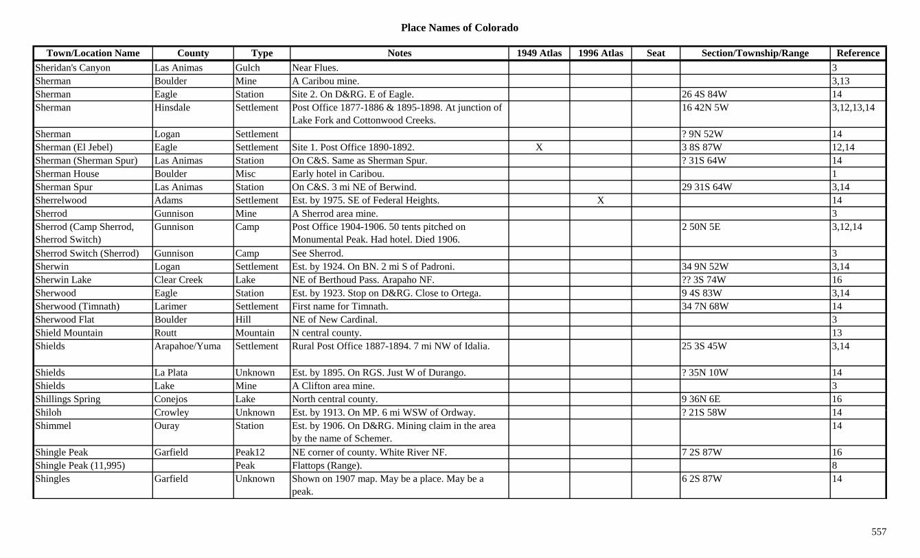
Place Names of Colorado
Town/Location Name County Type Notes 1949 Atlas 1996 Atlas Seat Section/Township/Range ReferenceSheridan's Canyon Las Animas Gulch Near Flues. 3Sherman Boulder Mine A Caribou mine. 3,13Sherman Eagle Station Site 2. On D&RG. E of Eagle. 26 4S 84W 14Sherman Hinsdale Settlement Post Office 1877-1886 & 1895-1898. At junction of
Lake Fork and Cottonwood Creeks.16 42N 5W 3,12,13,14
Sherman Logan Settlement ? 9N 52W 14Sherman (El Jebel) Eagle Settlement Site 1. Post Office 1890-1892. X 3 8S 87W 12,14Sherman (Sherman Spur) Las Animas Station On C&S. Same as Sherman Spur. ? 31S 64W 14Sherman House Boulder Misc Early hotel in Caribou. 1Sherman Spur Las Animas Station On C&S. 3 mi NE of Berwind. 29 31S 64W 3,14Sherrelwood Adams Settlement Est. by 1975. SE of Federal Heights. X 14y gSherrod Gunnison Mine A Sherrod area mine. 3Sherrod (Camp Sherrod, Sherrod Switch)
Gunnison Camp Post Office 1904-1906. 50 tents pitched on Monumental Peak. Had hotel. Died 1906.
2 50N 5E 3,12,14
Sherrod Switch (Sherrod) Gunnison Camp See Sherrod. 3Sherwin Logan Settlement Est. by 1924. On BN. 2 mi S of Padroni. 34 9N 52W 3,14Sherwin Lake Clear Creek Lake NE of Berthoud Pass. Arapaho NF. ?? 3S 74W 16Sherwood Eagle Station Est. by 1923. Stop on D&RG. Close to Ortega. 9 4S 83W 3,14Sherwood (Timnath) Larimer Settlement First name for Timnath. 34 7N 68W 14Sherwood Flat Boulder Hill NE of New Cardinal. 3Shield Mountain Routt Mountain N central county. 13Shields Arapahoe/Yuma Settlement Rural Post Office 1887-1894. 7 mi NW of Idalia. 25 3S 45W 3,14
Shields La Plata Unknown Est. by 1895. On RGS. Just W of Durango. ? 35N 10W 14Shields Lake Mine A Clifton area mine. 3Shillings Spring Conejos Lake North central county. 9 36N 6E 16Shil h C l U k E t b 1913 O MP 6 i WSW f O d ? 21S 58W 14Shiloh Crowley Unknown Est. by 1913. On MP. 6 mi WSW of Ordway. ? 21S 58W 14Shimmel Ouray Station Est. by 1906. On D&RG. Mining claim in the area
by the name of Schemer.14
Shingle Peak Garfield Peak12 NE corner of county. White River NF. 7 2S 87W 16Shingle Peak (11,995) Peak Flattops (Range). 8Shingles Garfield Unknown Shown on 1907 map. May be a place. May be a
peak.6 2S 87W 14
557
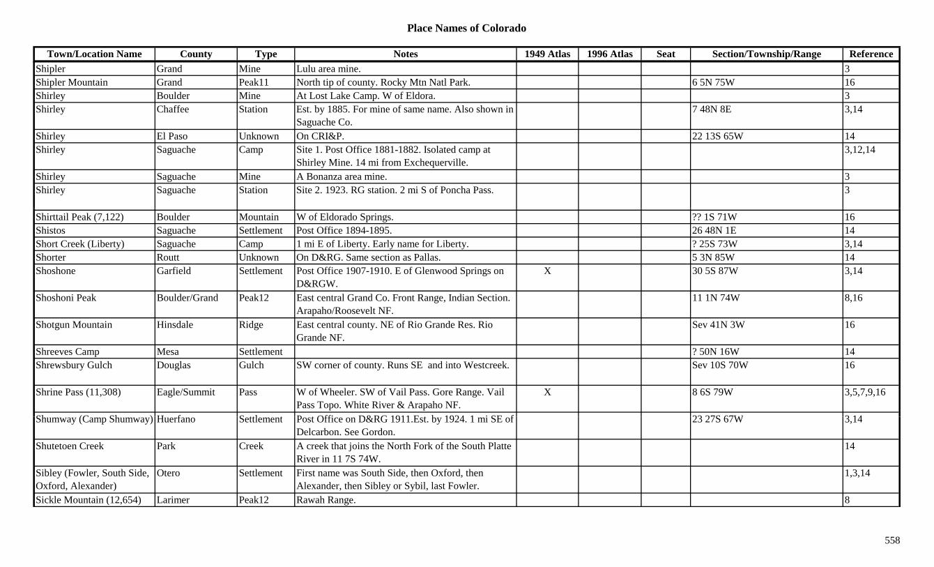
Place Names of Colorado
Town/Location Name County Type Notes 1949 Atlas 1996 Atlas Seat Section/Township/Range ReferenceShipler Grand Mine Lulu area mine. 3Shipler Mountain Grand Peak11 North tip of county. Rocky Mtn Natl Park. 6 5N 75W 16Shirley Boulder Mine At Lost Lake Camp. W of Eldora. 3Shirley Chaffee Station Est. by 1885. For mine of same name. Also shown in
Saguache Co.7 48N 8E 3,14
Shirley El Paso Unknown On CRI&P. 22 13S 65W 14Shirley Saguache Camp Site 1. Post Office 1881-1882. Isolated camp at
Shirley Mine. 14 mi from Exchequerville.3,12,14
Shirley Saguache Mine A Bonanza area mine. 3Shirley Saguache Station Site 2. 1923. RG station. 2 mi S of Poncha Pass. 3
Shirttail Peak (7,122) Boulder Mountain W of Eldorado Springs. ?? 1S 71W 16Shistos Saguache Settlement Post Office 1894-1895. 26 48N 1E 14Short Creek (Liberty) Saguache Camp 1 mi E of Liberty. Early name for Liberty. ? 25S 73W 3,14Shorter Routt Unknown On D&RG. Same section as Pallas. 5 3N 85W 14Shoshone Garfield Settlement Post Office 1907-1910. E of Glenwood Springs on
D&RGW.X 30 5S 87W 3,14
Shoshoni Peak Boulder/Grand Peak12 East central Grand Co. Front Range, Indian Section. Arapaho/Roosevelt NF.
11 1N 74W 8,16
Shotgun Mountain Hinsdale Ridge East central county. NE of Rio Grande Res. Rio Grande NF.
Sev 41N 3W 16
Shreeves Camp Mesa Settlement ? 50N 16W 14Shrewsbury Gulch Douglas Gulch SW corner of county. Runs SE and into Westcreek. Sev 10S 70W 16
Shrine Pass (11,308) Eagle/Summit Pass W of Wheeler. SW of Vail Pass. Gore Range. Vail Pass Topo. White River & Arapaho NF.
X 8 6S 79W 3,5,7,9,16
Sh (C Sh ) H f S ttl t P t Offi D&RG 1911 E t b 1924 1 i SE f 23 27S 67W 3 14Shumway (Camp Shumway) Huerfano Settlement Post Office on D&RG 1911.Est. by 1924. 1 mi SE of Delcarbon. See Gordon.
23 27S 67W 3,14
Shutetoen Creek Park Creek A creek that joins the North Fork of the South Platte River in 11 7S 74W.
14
Sibley (Fowler, South Side, Oxford, Alexander)
Otero Settlement First name was South Side, then Oxford, then Alexander, then Sibley or Sybil, last Fowler.
1,3,14
Sickle Mountain (12,654) Larimer Peak12 Rawah Range. 8
558
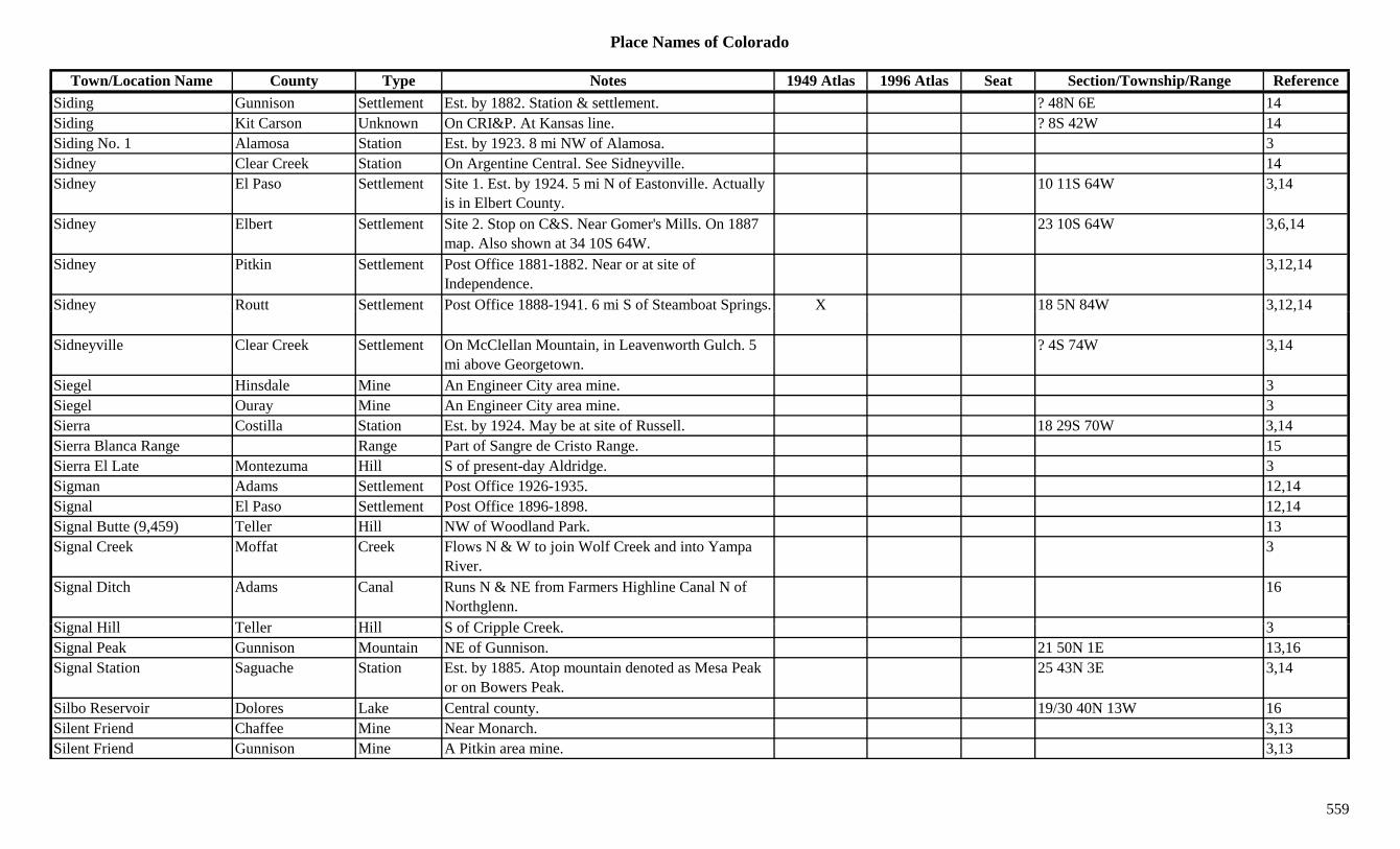
Place Names of Colorado
Town/Location Name County Type Notes 1949 Atlas 1996 Atlas Seat Section/Township/Range ReferenceSiding Gunnison Settlement Est. by 1882. Station & settlement. ? 48N 6E 14Siding Kit Carson Unknown On CRI&P. At Kansas line. ? 8S 42W 14Siding No. 1 Alamosa Station Est. by 1923. 8 mi NW of Alamosa. 3Sidney Clear Creek Station On Argentine Central. See Sidneyville. 14Sidney El Paso Settlement Site 1. Est. by 1924. 5 mi N of Eastonville. Actually
is in Elbert County.10 11S 64W 3,14
Sidney Elbert Settlement Site 2. Stop on C&S. Near Gomer's Mills. On 1887 map. Also shown at 34 10S 64W.
23 10S 64W 3,6,14
Sidney Pitkin Settlement Post Office 1881-1882. Near or at site of Independence.
3,12,14
Sidney Routt Settlement Post Office 1888-1941. 6 mi S of Steamboat Springs. X 18 5N 84W 3,12,14y p g , ,
Sidneyville Clear Creek Settlement On McClellan Mountain, in Leavenworth Gulch. 5 mi above Georgetown.
? 4S 74W 3,14
Siegel Hinsdale Mine An Engineer City area mine. 3Siegel Ouray Mine An Engineer City area mine. 3Sierra Costilla Station Est. by 1924. May be at site of Russell. 18 29S 70W 3,14Sierra Blanca Range Range Part of Sangre de Cristo Range. 15Sierra El Late Montezuma Hill S of present-day Aldridge. 3Sigman Adams Settlement Post Office 1926-1935. 12,14Signal El Paso Settlement Post Office 1896-1898. 12,14Signal Butte (9,459) Teller Hill NW of Woodland Park. 13Signal Creek Moffat Creek Flows N & W to join Wolf Creek and into Yampa
River.3
Signal Ditch Adams Canal Runs N & NE from Farmers Highline Canal N of Northglenn.
16
Si l Hill T ll Hill S f C i l C k 3Signal Hill Teller Hill S of Cripple Creek. 3Signal Peak Gunnison Mountain NE of Gunnison. 21 50N 1E 13,16Signal Station Saguache Station Est. by 1885. Atop mountain denoted as Mesa Peak
or on Bowers Peak.25 43N 3E 3,14
Silbo Reservoir Dolores Lake Central county. 19/30 40N 13W 16Silent Friend Chaffee Mine Near Monarch. 3,13Silent Friend Gunnison Mine A Pitkin area mine. 3,13
559
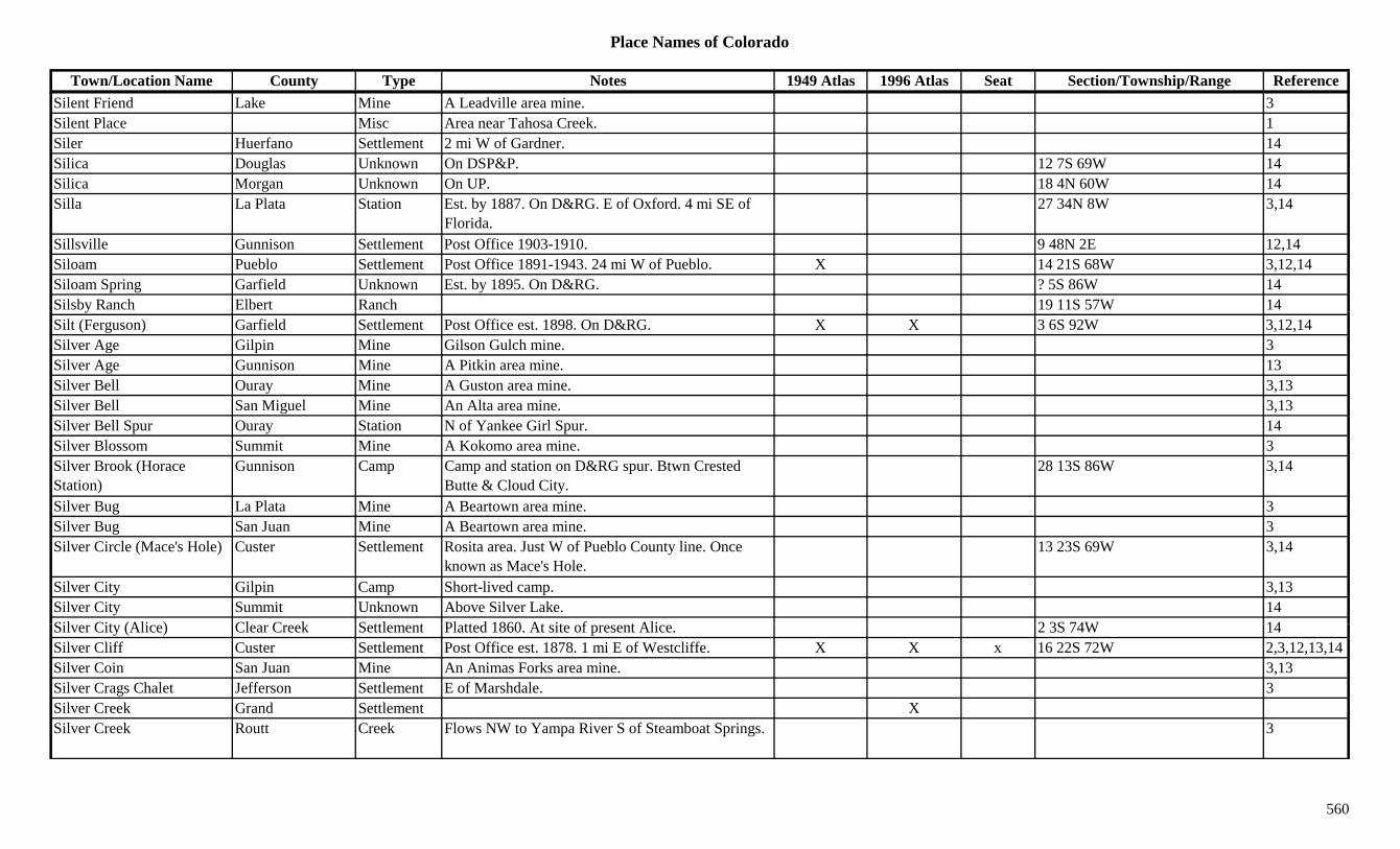
Place Names of Colorado
Town/Location Name County Type Notes 1949 Atlas 1996 Atlas Seat Section/Township/Range ReferenceSilent Friend Lake Mine A Leadville area mine. 3Silent Place Misc Area near Tahosa Creek. 1Siler Huerfano Settlement 2 mi W of Gardner. 14Silica Douglas Unknown On DSP&P. 12 7S 69W 14Silica Morgan Unknown On UP. 18 4N 60W 14Silla La Plata Station Est. by 1887. On D&RG. E of Oxford. 4 mi SE of
Florida.27 34N 8W 3,14
Sillsville Gunnison Settlement Post Office 1903-1910. 9 48N 2E 12,14Siloam Pueblo Settlement Post Office 1891-1943. 24 mi W of Pueblo. X 14 21S 68W 3,12,14Siloam Spring Garfield Unknown Est. by 1895. On D&RG. ? 5S 86W 14Silsby Ranch Elbert Ranch 19 11S 57W 14ySilt (Ferguson) Garfield Settlement Post Office est. 1898. On D&RG. X X 3 6S 92W 3,12,14Silver Age Gilpin Mine Gilson Gulch mine. 3Silver Age Gunnison Mine A Pitkin area mine. 13Silver Bell Ouray Mine A Guston area mine. 3,13Silver Bell San Miguel Mine An Alta area mine. 3,13Silver Bell Spur Ouray Station N of Yankee Girl Spur. 14Silver Blossom Summit Mine A Kokomo area mine. 3Silver Brook (Horace Station)
Gunnison Camp Camp and station on D&RG spur. Btwn Crested Butte & Cloud City.
28 13S 86W 3,14
Silver Bug La Plata Mine A Beartown area mine. 3Silver Bug San Juan Mine A Beartown area mine. 3Silver Circle (Mace's Hole) Custer Settlement Rosita area. Just W of Pueblo County line. Once
known as Mace's Hole.13 23S 69W 3,14
Silver City Gilpin Camp Short-lived camp. 3,13Silver City Summit Unknown Above Silver Lake. 14Sil Cit (Ali ) Cl C k S ttl t Pl tt d 1860 At it f t Ali 2 3S 74W 14Silver City (Alice) Clear Creek Settlement Platted 1860. At site of present Alice. 2 3S 74W 14Silver Cliff Custer Settlement Post Office est. 1878. 1 mi E of Westcliffe. X X x 16 22S 72W 2,3,12,13,14Silver Coin San Juan Mine An Animas Forks area mine. 3,13Silver Crags Chalet Jefferson Settlement E of Marshdale. 3Silver Creek Grand Settlement XSilver Creek Routt Creek Flows NW to Yampa River S of Steamboat Springs. 3
560
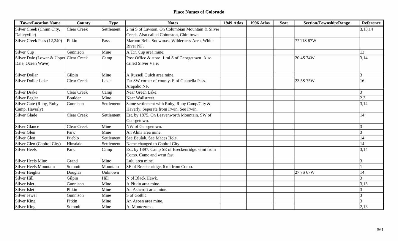
Place Names of Colorado
Town/Location Name County Type Notes 1949 Atlas 1996 Atlas Seat Section/Township/Range ReferenceSilver Creek (Chinn City, Daileyville)
Clear Creek Settlement 2 mi S of Lawson. On Columbian Mountain & Silver Creek. Also called Chinnston, Chin-town.
3,13,14
Silver Creek Pass (12,240) Pitkin Pass Maroon Bells-Snowmass Wilderness Area. White River NF.
?? 11S 87W
Silver Cup Gunnison Mine A Tin Cup area mine. 13Silver Dale (Lower & Upper Dale, Ocean Wave)
Clear Creek Camp Post Office & store. 1 mi S of Georgetown. Also called Silver Vale.
20 4S 74W 3,14
Silver Dollar Gilpin Mine A Russell Gulch area mine. 3Silver Dollar Lake Clear Creek Lake Far SW corner of county. E of Guanella Pass.
Arapaho NF.23 5S 75W 16
Silver Drake Clear Creek Camp Near Green Lake. 3Silver Eaglet Boulder Mine Near Wallstreet. 2,3Silver Gate (Ruby, Ruby Camp, Haverly)
Gunnison Settlement Same settlement with Ruby, Ruby Camp/City & Haverly. Seperate from Irwin. See Irwin.
3,14
Silver Glade Clear Creek Settlement Est. by 1875. On Leavenworth Mountain. SW of Georgetown.
14
Silver Glance Clear Creek Mine NW of Georgetown. 3Silver Glen Park Mine An Alma area mine. 3Silver Glen Pueblo Settlement See Beulah. See Maces Hole. 14Silver Glen (Capitol City) Hinsdale Settlement Name changed to Capitol City. 14Silver Heels Park Camp Est. by 1897. Camp SE of Breckenridge. 6 mi from
Como. Came and went fast.3,14
Silver Heels Mine Grand Mine Lulu area mine. 3Silver Heels Mountain Summit Mountain SE of Breckenridge, 6 mi from Como. 1Silver Heights Douglas Unknown 27 7S 67W 14Sil Hill Gil i Hill N f Bl k H k 3Silver Hill Gilpin Hill N of Black Hawk. 3Silver Islet Gunnison Mine A Pitkin area mine. 3,13Silver Islet Pitkin Mine An Ashcroft area mine. 3Silver Jewel Gunnison Mine S of Gothic. 3Silver King Pitkin Mine An Aspen area mine. 3Silver King Summit Mine At Montezuma. 2,13
561
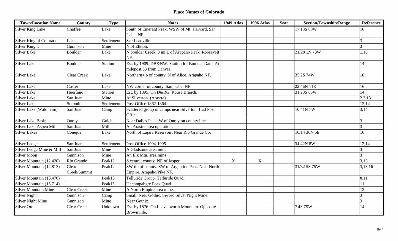
Place Names of Colorado
Town/Location Name County Type Notes 1949 Atlas 1996 Atlas Seat Section/Township/Range ReferenceSilver King Lake Chaffee Lake South of Emerald Peak. WSW of Mt. Harvard. San
Isabel NF.17 13S 80W 16
Silver King of Colorado Lake Settlement See Leadville. 3Silver Knight Gunnison Mine N of Elkton. 3Silver Lake Boulder Lake N boulder Creek, 3 mi E of Arapaho Peak. Roosevelt
NF.21/28 1N 73W 1,16
Silver Lake Boulder Station Est. by 1909. DB&NW. Station for Boulder Dam. At milepost 53 from Denver.
14
Silver Lake Clear Creek Lake Northern tip of county. N of Alice. Arapaho NF. 35 2S 74W 16
Silver Lake Custer Lake NW corner of county. San Isabel NF. 22 46N 11E 16ySilver Lake Huerfano Station Est. by 1895. On D&RG, Rouse Branch. 31 28S 65W 14Silver Lake San Juan Mine At Silverton. (Arastra) 2,3,13Silver Lake Summit Settlement Post Office 1862-1864. 12,14Silver Lake (Waldheim) San Juan Camp Scattered group of camps near Silverton. Had Post
Office.10 41N 7W 3,14
Silver Lake Basin Ouray Gulch Near Dallas Peak. W of Ouray on county line. 3Silver Lake-Aspen Mill San Juan Mill An Arastra area operation. 3Silver Lakes Conejos Lake North of Lajara Reservoir. Near Rio Grande Co. 10/14 36N 5E 16
Silver Ledge San Juan Settlement Post Office 1904-1905. 34 42N 8W 12,14Silver Ledge Mine & Mill San Juan Mine A Gladstone area mine. 3Silver Moon Gunnison Mine An Elk Mtn. area mine. 3Silver Mountain (12,420) Rio Grande Peak12 S central county. NE of Jasper. X X 3,13Silver Mountain (12,813) Clear
Creek/SummitPeak12 SW tip of county. SW of Argentine Pass. Near North
Empire. Arapaho/Pike NF.31/32 5S 75W 3,13,16
Sil M t i (13 470) P k13 T ll id G T ll id Q d 8 11Silver Mountain (13,470) Peak13 Telluride Group. Telluride Quad. 8,11Silver Mountain (13,714) Peak13 Uncompahgre Peak Quad. 11Silver Mountain Mine Clear Creek Mine A North Empire area mine. 13Silver Night Gunnison Camp Small. Near Gothic. Served Silver Night Mine. 3Silver Night Mine Gunnison Mine Near Gothic. 3Silver Ore Clear Creek Unknown Est. by 1876. On Leavenworth Mountain. Opposite
Brownville.? 4S 75W 14
562
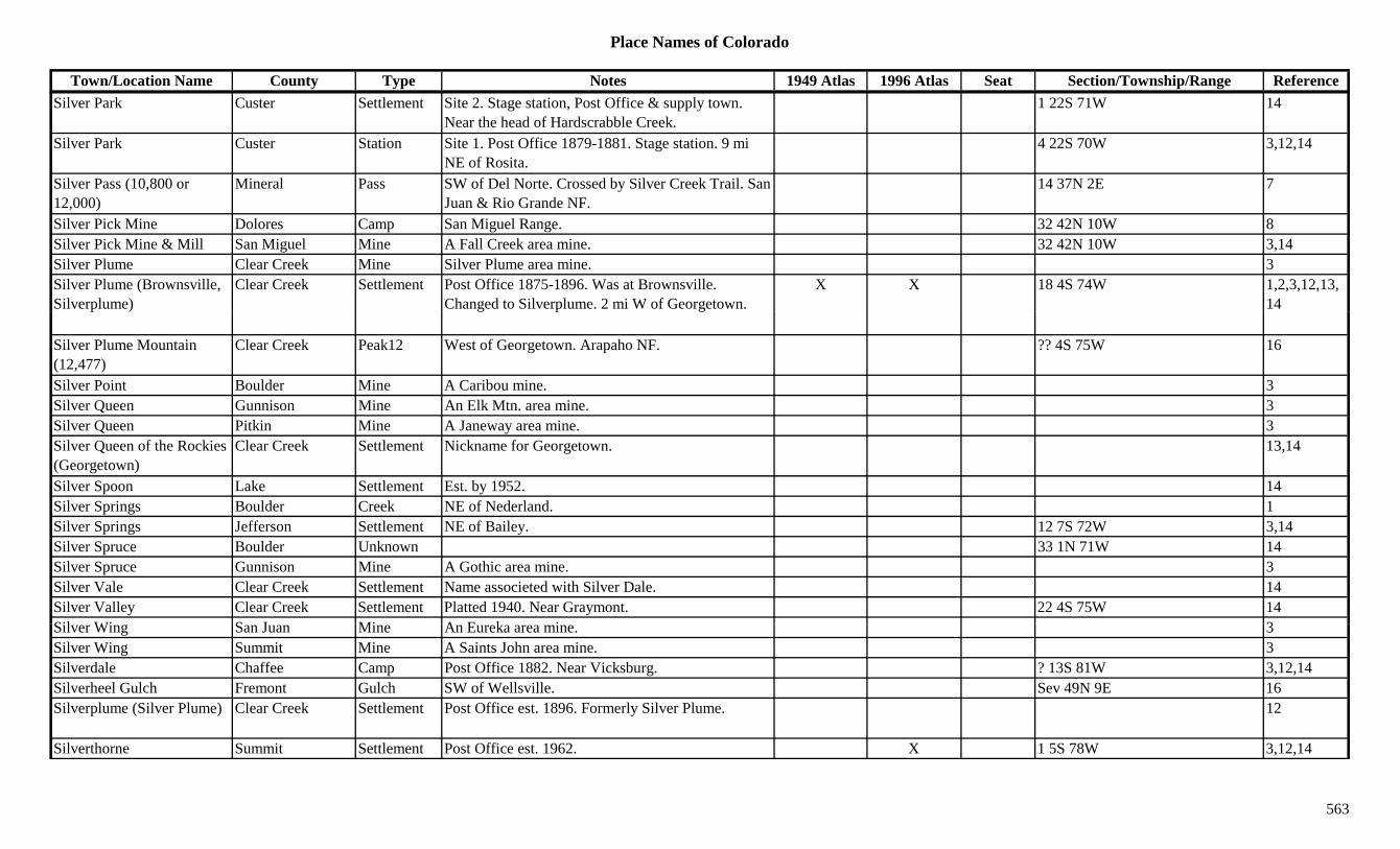
Place Names of Colorado
Town/Location Name County Type Notes 1949 Atlas 1996 Atlas Seat Section/Township/Range ReferenceSilver Park Custer Settlement Site 2. Stage station, Post Office & supply town.
Near the head of Hardscrabble Creek.1 22S 71W 14
Silver Park Custer Station Site 1. Post Office 1879-1881. Stage station. 9 mi NE of Rosita.
4 22S 70W 3,12,14
Silver Pass (10,800 or 12,000)
Mineral Pass SW of Del Norte. Crossed by Silver Creek Trail. San Juan & Rio Grande NF.
14 37N 2E 7
Silver Pick Mine Dolores Camp San Miguel Range. 32 42N 10W 8Silver Pick Mine & Mill San Miguel Mine A Fall Creek area mine. 32 42N 10W 3,14Silver Plume Clear Creek Mine Silver Plume area mine. 3Silver Plume (Brownsville, Silverplume)
Clear Creek Settlement Post Office 1875-1896. Was at Brownsville. Changed to Silverplume. 2 mi W of Georgetown.
X X 18 4S 74W 1,2,3,12,13,14
Silver Plume Mountain (12,477)
Clear Creek Peak12 West of Georgetown. Arapaho NF. ?? 4S 75W 16
Silver Point Boulder Mine A Caribou mine. 3Silver Queen Gunnison Mine An Elk Mtn. area mine. 3Silver Queen Pitkin Mine A Janeway area mine. 3Silver Queen of the Rockies (Georgetown)
Clear Creek Settlement Nickname for Georgetown. 13,14
Silver Spoon Lake Settlement Est. by 1952. 14Silver Springs Boulder Creek NE of Nederland. 1Silver Springs Jefferson Settlement NE of Bailey. 12 7S 72W 3,14Silver Spruce Boulder Unknown 33 1N 71W 14Silver Spruce Gunnison Mine A Gothic area mine. 3Silver Vale Clear Creek Settlement Name associeted with Silver Dale. 14Silver Valley Clear Creek Settlement Platted 1940. Near Graymont. 22 4S 75W 14Sil Wi S J Mi A E k i 3Silver Wing San Juan Mine An Eureka area mine. 3Silver Wing Summit Mine A Saints John area mine. 3Silverdale Chaffee Camp Post Office 1882. Near Vicksburg. ? 13S 81W 3,12,14Silverheel Gulch Fremont Gulch SW of Wellsville. Sev 49N 9E 16Silverplume (Silver Plume) Clear Creek Settlement Post Office est. 1896. Formerly Silver Plume. 12
Silverthorne Summit Settlement Post Office est. 1962. X 1 5S 78W 3,12,14
563

Place Names of Colorado
Town/Location Name County Type Notes 1949 Atlas 1996 Atlas Seat Section/Township/Range ReferenceSilverthorne Peak (13,357) Peak13 Gore Range, East Side. 8
Silvertip (Beartown) San Juan Settlement Another name for Beartown. 3Silverton (Baker's Park, Baker's City, Reeseville)
La Plata/San Juan Settlement Post Office est. 1875. Also named Quito and Greenville. 49 mi N of Durango.
X X X 18 41N 7W 1,3,12,13,14
Silvertown Clear Creek Settlement Names associated with Georgetown were Silvertown & Silver Queen.
14
Silveys Pocket Camp Montrose Unknown Est. by 1916. 33 46N 19W 14Silvia Las Animas Station Est. by 1902. On D&RG. 3 mi N of El Moro. 18 32S 63W 3,14Simla Elbert Settlement Est. 1907. On CRI&P. Post Office est. 1909. X X 26 10S 60W 3,6,12,14Simmons Peak Fremont/Saguache Peak12 Sangre de Cristo Range, San Luis Side. San ?? 48N 9E 8,13,16g g g ,
Isabel/Grande NF., ,
Simms Costilla Unknown On D&RG. Same section as Carr. 35 29S 70W 14Simons Rio Grande Station Est. by 1906. On D&RG. 14Simpson Adams Settlement Rural Post Office 1910-1943. 11 mi NW of Last
Chance. Also shown at 34 2S 57W.X 14 3S 57W 3,6,12,14
Simpson (Simpton, Wormington)
Las Animas Station On AT&SF. 6 mi SW of Thatcher. Had RR Post Office.
19 29S 60W 3,14
Simpson Creek Weld Creek Flows E near Wyoming border then SE to join Little Crow Creek.
3
Simpson Mountain Hinsdale Peak12 South central county. SW of Rio Grande Res. Rio Grande NF.
Sev 40N 4W 13,16
Simpson Park Pass (8,300) Pass Routt Forest. 7
Simpton (Simpson, Wormington)
Las Animas Station See Simpson. 3
Si b d M /M t S ttl t P t Offi 1914 1933 NW f t I X 16 49N 19W 3 12 14Sinbad Mesa/Montrose Settlement Post Office 1914-1933. NW corner of county. In Sinbad's Valley. Also at 29 49N 19W.
X 16 49N 19W 3,12,14
Sinbad Mining District Mesa Mine Est. by 1926. May have been more than mines. 5 49N 19W 14Sinbad's Valley Mesa Valley 1885. Far SW part of county. Into Montrose Co. 3
Sinbad's Valley Montrose Valley Lies in both Mesa and Montrose Cos. 3Single Dobe Crowley Settlement Est. by 1895. ? 18S 56W 14
564

Place Names of Colorado
Town/Location Name County Type Notes 1949 Atlas 1996 Atlas Seat Section/Township/Range ReferenceSingleton Park Settlement Est. by 1924. On DSP&P. Btwn Shawnee and Grant. X X 18 7S 73W 3,14
Sink Yuma Creek 1887. Land formation. NW of Yuma. 3Sinnard Larimer Station Est. by 1916. On C&S. 4 mi E of Fort Collins. 9 7N 68W 3,14Sisty's (Brookvale PO) Clear Creek Unknown Original name of Brookvale. PO was named
Brookvale, not Sisty's. PO moved several times.11 5S 72W 14
Sitton (Sitton Corner) Pueblo Settlement Countryside Post Office 1906-1917. 5 mi SE of Goodpasture. Also shown at 24 23S 67W.
22 23S 67W 3,12,14
Six Mile Canyon Boulder Canyon E of Glendale. 3Six Mile House/Inn Clear Creek Settlement Est. 1876. Began with a solitary inn. Early name for 3,14(Lawson)
g y yLawson. See Lawson.
,
Six-Mile Creek Pueblo Creek Flows NE to Arkansas River E of Pueblo. 3Sixmile Gulch Gunnison Gulch West of Gunnison. Runs SE. Sev 50N 3W 16Sixmile Reservoir Boulder Lake Between Boulder and Longmont. 9/10/1N 70W 16Sixty-Two Mile Lane Weld Station Est. by 1923. Probably a waystop. S of Fort Lupton. 3
Skate Ranch Boulder Ranch 12 1S 72W 14Skee Reservoir Adams Lake SE Brighton. 8 1S 66W 16Skeel Reservoir Arapahoe Lake On Wellshire Country Club. NW of intersection
Colorado Blvd and Hampden Ave.36 4S 68W 16
Skelton Ranch Douglas Settlement Est. by 1924. Old dude ranch. E of Westcreek. Had Post Office.
3
Ski City Ouray Settlement Another name for Red Mountain Town. 14Ski Town, U.S.A. (Steamboat Springs)
Routt Settlement Another name for Steamboat Springs. 14
Skid B ld S ttl t E t b 1886 14Skidmore Boulder Settlement Est. by 1886. 14Skillet Lake Garfield Lake NE corner of county. White River NF. ?? 1N 87W 16Skimmed Milk Reservoir Delta Lake NE of Cedaredge. Grand Mesa NF. ?? 12S 92W 16Skinned Horse Lake Delta Lake North of Cedaredge. Grand Mesa NF. 11 12S 95W 16Skinner Chaffee/Fremont Settlement Post Office 1897-1899. Site actually in Fremont Co.
Post Office error. On Badger Creek.? 15N 11W 12,14
Skinner Ridge Garfield Ridge Central county. Sev 5/6S 98/99W 16
565
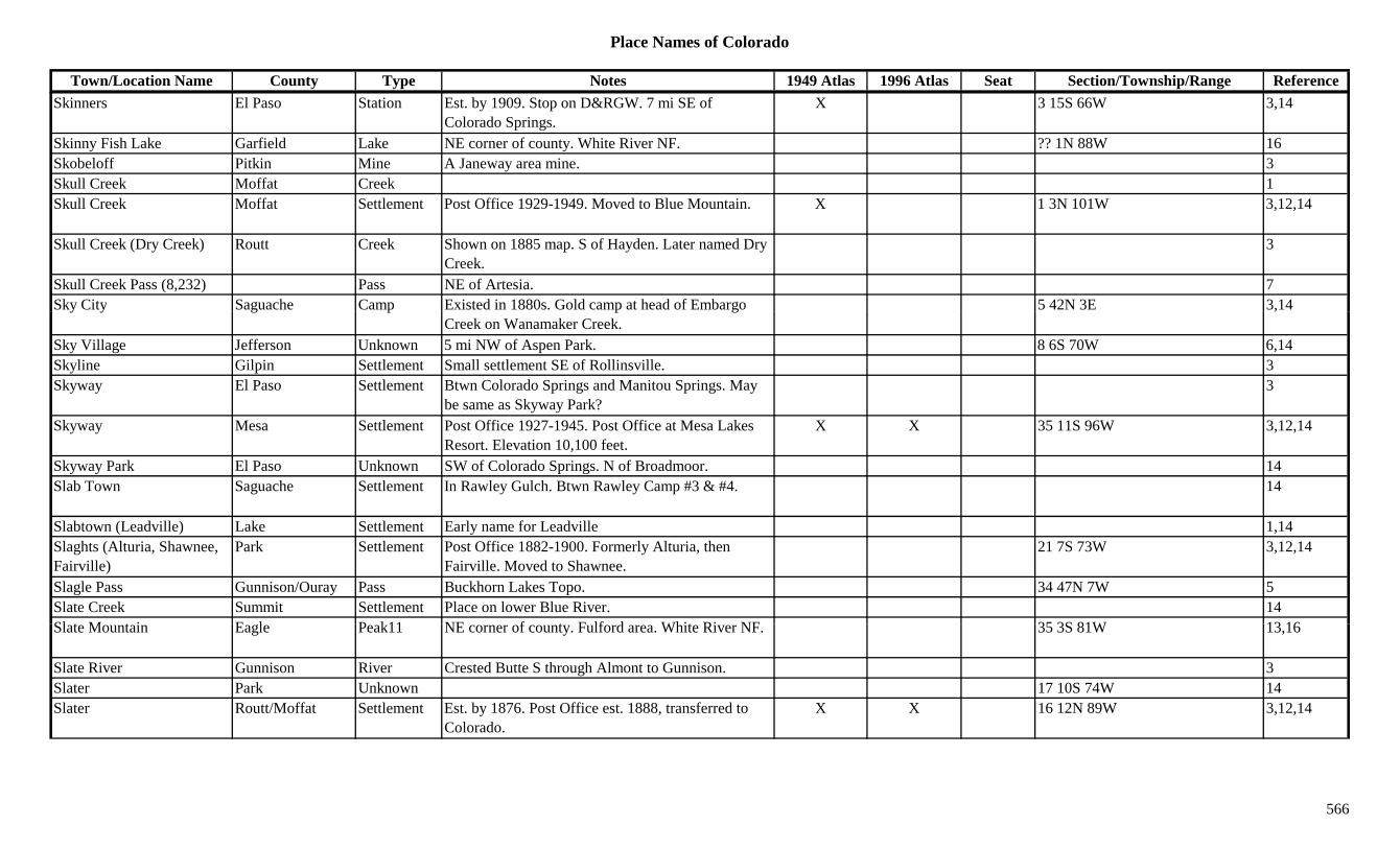
Place Names of Colorado
Town/Location Name County Type Notes 1949 Atlas 1996 Atlas Seat Section/Township/Range ReferenceSkinners El Paso Station Est. by 1909. Stop on D&RGW. 7 mi SE of
Colorado Springs.X 3 15S 66W 3,14
Skinny Fish Lake Garfield Lake NE corner of county. White River NF. ?? 1N 88W 16Skobeloff Pitkin Mine A Janeway area mine. 3Skull Creek Moffat Creek 1Skull Creek Moffat Settlement Post Office 1929-1949. Moved to Blue Mountain. X 1 3N 101W 3,12,14
Skull Creek (Dry Creek) Routt Creek Shown on 1885 map. S of Hayden. Later named Dry Creek.
3
Skull Creek Pass (8,232) Pass NE of Artesia. 7Sky City Saguache Camp Existed in 1880s. Gold camp at head of Embargo 5 42N 3E 3,14y y g p p g
Creek on Wanamaker Creek.,
Sky Village Jefferson Unknown 5 mi NW of Aspen Park. 8 6S 70W 6,14Skyline Gilpin Settlement Small settlement SE of Rollinsville. 3Skyway El Paso Settlement Btwn Colorado Springs and Manitou Springs. May
be same as Skyway Park?3
Skyway Mesa Settlement Post Office 1927-1945. Post Office at Mesa Lakes Resort. Elevation 10,100 feet.
X X 35 11S 96W 3,12,14
Skyway Park El Paso Unknown SW of Colorado Springs. N of Broadmoor. 14Slab Town Saguache Settlement In Rawley Gulch. Btwn Rawley Camp #3 & #4. 14
Slabtown (Leadville) Lake Settlement Early name for Leadville 1,14Slaghts (Alturia, Shawnee, Fairville)
Park Settlement Post Office 1882-1900. Formerly Alturia, then Fairville. Moved to Shawnee.
21 7S 73W 3,12,14
Slagle Pass Gunnison/Ouray Pass Buckhorn Lakes Topo. 34 47N 7W 5Slate Creek Summit Settlement Place on lower Blue River. 14Sl t M t i E l P k11 NE f t F lf d Whit Ri NF 35 3S 81W 13 16Slate Mountain Eagle Peak11 NE corner of county. Fulford area. White River NF. 35 3S 81W 13,16
Slate River Gunnison River Crested Butte S through Almont to Gunnison. 3Slater Park Unknown 17 10S 74W 14Slater Routt/Moffat Settlement Est. by 1876. Post Office est. 1888, transferred to
Colorado.X X 16 12N 89W 3,12,14
566
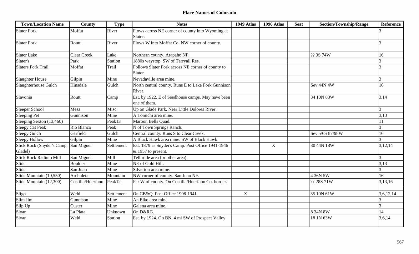
Place Names of Colorado
Town/Location Name County Type Notes 1949 Atlas 1996 Atlas Seat Section/Township/Range ReferenceSlater Fork Moffat River Flows across NE corner of county into Wyoming at
Slater.3
Slater Fork Routt River Flows W into Moffat Co. NW corner of county. 3
Slater Lake Clear Creek Lake Northern county. Arapaho NF. ?? 3S 74W 16Slater's Park Station 1880s waystop. SW of Tarryall Res. 3Slaters Fork Trail Moffat Trail Follows Slater Fork across NE corner of county to
Slater.3
Slaughter House Gilpin Mine Nevadaville area mine. 3Slaughterhouse Gulch Hinsdale Gulch North central county. Runs E to Lake Fork Gunnison
River.Sev 44N 4W 16
Slavonia Routt Camp Est. by 1922. E of Seedhouse camps. May have been one of them.
34 10N 83W 3,14
Sleeper School Mesa Misc Up on Glade Park. Near Little Dolores River. 3Sleeping Pet Gunnison Mine A Tomichi area mine. 3,13Sleeping Sexton (13,460) Peak13 Maroon Bells Quad. 11Sleepy Cat Peak Rio Blanco Peak N of Town Springs Ranch. 3Sleepy Gulch Garfield Gulch Central county. Runs S to Clear Creek. Sev 5/6S 87/98W 16Sleepy Hollow Gilpin Mine A Black Hawk area mine. SW of Black Hawk. 3Slick Rock (Snyder's Camp, Gladel)
San Miguel Settlement Est. 1879 as Snyder's Camp. Post Office 1941-1946 & 1957 to present.
X 30 44N 18W 3,12,14
Slick Rock Radium Mill San Miguel Mill Telluride area (or other area). 3Slide Boulder Mine NE of Gold Hill. 3,13Slide San Juan Mine Silverton area mine. 3Slide Mountain (10,550) Archuleta Mountain NW corner of county. San Juan NF. 4 36N 5W 16Slide Mountain (12,300) Costilla/Huerfano Peak12 Far W of county. On Costilla/Huerfano Co. border. ?? 28S 71W 3,13,16
Sligo Weld Settlement On CB&Q. Post Office 1908-1941. X 35 10N 61W 3,6,12,14Slim Jim Gunnison Mine An Elko area mine. 3Slip Up Custer Mine Galena area mine. 3Sloan La Plata Unknown On D&RG. 8 34N 8W 14Sloan Weld Station Est. by 1924. On BN. 4 mi SW of Prospect Valley. 18 1N 63W 3,6,14
567
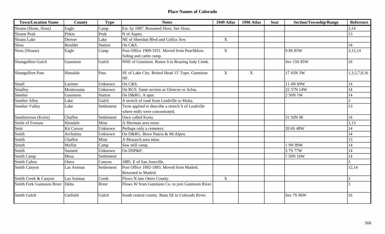
Place Names of Colorado
Town/Location Name County Type Notes 1949 Atlas 1996 Atlas Seat Section/Township/Range ReferenceSloane (Slone, Sloss) Eagle Camp Est. by 1887. Renamed Sloss. See Sloss. 3,14Sloane Peak Pitkin Peak N of Aspen. 13Sloans Lake Denver Lake NE of Sheridan Blvd and Colfax Ave. XSloss Boulder Station On C&S. 14Sloss (Sloane) Eagle Camp Post Office 1909-1931. Moved from Peachblow.
Siding and cattle camp.X 9 8S 85W 3,12,14
Slumgullion Gulch Gunnison Gulch NNE of Gunnison. Runse S to Roaring Judy Creek. Sev 15S 85W 16
Slumgullion Pass Hinsdale Pass SE of Lake City. Bristol Head 15' Topo. Gunnison NF.
X X 17 43N 3W 1,3,5,7,8,16
Small Larimer Unknown On C&S. 11 4N 69W 14Smalley Montezuma Unknown On RGS. Same section as Glencoe or Arloa. 22 37N 14W 14Smelter Gunnison Station On D&RG. A spur. 2 50N 1W 14Smelter Alley Lake Gulch A stretch of road from Leadville to Malta. 3Smelter Valley Lake Settlement Term applied to describe a stretch S of Leadville
where mills were concentrated.13
Smeltertown (Kortz) Chaffee Settlement Once called Kortz. 31 50N 9E 14Smile of Fortune Hinsdale Mine A Sherman area mine. 3,13Smit Kit Carson Unknown Perhaps only a cemetery. 20 6S 48W 14Smith Archuleta Unknown On D&RG. Btwn Nutria & McAlpen. 14Smith Chaffee Mine A Monarch area mine. 13Smith Moffat Camp Saw mill camp. 1 9N 89W 14Smith Summit Unknown On DSP&P. 5 7S 77W 14Smith Camp Mesa Settlement ? 50N 16W 14Smith Cañon Otero Canyon 1885. E of San Joseville. 3Smith Canyon Las Animas Settlement Post Office 1892-1893. Moved from Madrid.
R t d t M d id12,14
Returned to Madrid.Smith Creek & Canyon Las Animas Creek Flows N into Otero County. X 3Smith Fork Gunnsion River Delta River Flows W from Gunnison Co. to join Gunnison River. 3
Smith Gulch Garfield Gulch South central county. Runs SE to Colorado River. Sev 7S 96W 16
568

Place Names of Colorado
Town/Location Name County Type Notes 1949 Atlas 1996 Atlas Seat Section/Township/Range ReferenceSmith Gulch Gunnison Gulch South of Powderhorn. Runs NE to Ceballa Creek. Sev 46N 2W 16
Smith Hill Gilpin Hill SE corner of county. 21 3S 72W 16Smith Hill Gilpin Station Est. by 1882. RR stop. X 21 3S 72W 3,14Smith Hill Jefferson Station Est. by 1885. On CC. See Smith Hill, Gilpin Co. 14Smith Hill (Anthracite) Gunnison Camp Est. by 1876. Company town at Smith-Anthracite
Mine.20 13S 86W 3,14
Smith Lake Garfield Lake NE corner of county. White River NF. ?? 1N 87W 16Smith Reservoir Adams Lake E of Brighton. 9 1S 67W 16Smith Reservoir Costilla Lake SW of Fort Garland, on Trinchera River. X X 34 37N 73W 16Smith Sput Summit Station On DSP&P. 1.6 mi S of Breckenridge. 6 7S 77W 14p gSmith's Fork Canyon Delta Canyon Shown on 1885 map. From Crawford W to Gunnison
River's Grand Canyon.Sev 15S 92W 3
Smith's Spur Mesa Station On D&RG. 34 10S 98W 14Smithville (Exchequer) Saguache Camp Once part of Exchequer. 14Smithy Mountain (7,134) Boulder Mountain West of Lyons. Roosevelt NF. 19 3N 71W 16Smoky Hill Cheyenne Creek Flows E through northern Cheyenne Co into KS. X
Smoky Hill Trail (Butterfield Trail)
Cheyenne-Denver Trail Kansas to Denver. Est. abt 1864. Last stage in 1870. 4
Smoky Hill Trail Monument Cheyenne Museum W of Cheyenne Wells. X
Smuggler Clear Creek Mine Silver Plume area mine. 3,13Smuggler Gilpin Mine SW of Rollinsville. 3Smuggler Pitkin Camp Site 1. Around Smuggler Mine. Absorbed by Aspen. 3
S l Pitki Mi A A i 2 3 13Smuggler Pitkin Mine An Aspen area mine. 2,3,13Smuggler Pitkin Station Site 2. Est. by 1895. Just E of Aspen. On Hunter
Creek.14
Smuggler San Miguel Camp Post Office 1895-1928. Large camp. Near Smuggler Mine.
28 43N 8W 3,12,14
Smuggler San Miguel Mine Above Pandora. 2,3,13Smuggler Summit Mine A Robinson area mine. 3
569
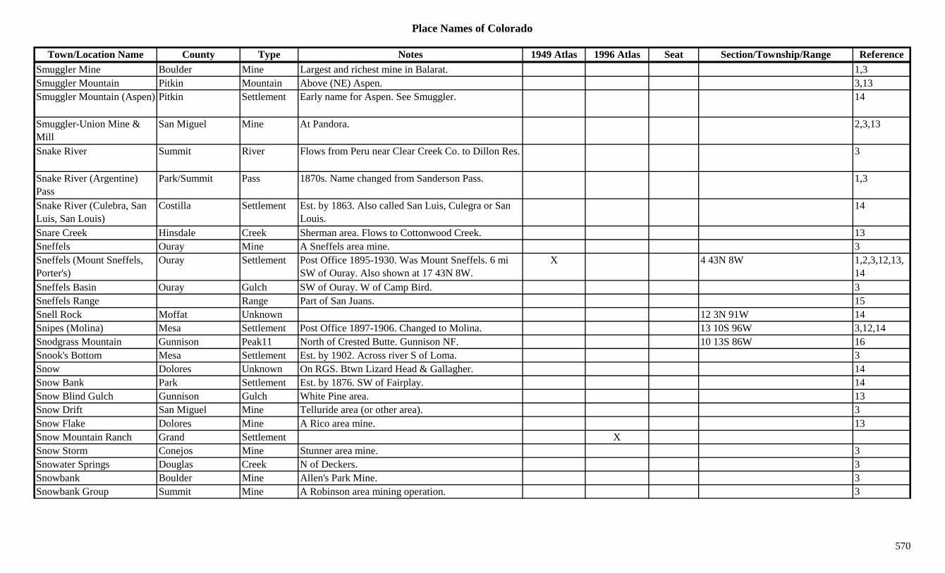
Place Names of Colorado
Town/Location Name County Type Notes 1949 Atlas 1996 Atlas Seat Section/Township/Range ReferenceSmuggler Mine Boulder Mine Largest and richest mine in Balarat. 1,3Smuggler Mountain Pitkin Mountain Above (NE) Aspen. 3,13Smuggler Mountain (Aspen) Pitkin Settlement Early name for Aspen. See Smuggler. 14
Smuggler-Union Mine & Mill
San Miguel Mine At Pandora. 2,3,13
Snake River Summit River Flows from Peru near Clear Creek Co. to Dillon Res. 3
Snake River (Argentine) Pass
Park/Summit Pass 1870s. Name changed from Sanderson Pass. 1,3
Snake River (Culebra, San Costilla Settlement Est. by 1863. Also called San Luis, Culegra or San 14( ,Luis, San Louis)
y , gLouis.
Snare Creek Hinsdale Creek Sherman area. Flows to Cottonwood Creek. 13Sneffels Ouray Mine A Sneffels area mine. 3Sneffels (Mount Sneffels, Porter's)
Ouray Settlement Post Office 1895-1930. Was Mount Sneffels. 6 mi SW of Ouray. Also shown at 17 43N 8W.
X 4 43N 8W 1,2,3,12,13,14
Sneffels Basin Ouray Gulch SW of Ouray. W of Camp Bird. 3Sneffels Range Range Part of San Juans. 15Snell Rock Moffat Unknown 12 3N 91W 14Snipes (Molina) Mesa Settlement Post Office 1897-1906. Changed to Molina. 13 10S 96W 3,12,14Snodgrass Mountain Gunnison Peak11 North of Crested Butte. Gunnison NF. 10 13S 86W 16Snook's Bottom Mesa Settlement Est. by 1902. Across river S of Loma. 3Snow Dolores Unknown On RGS. Btwn Lizard Head & Gallagher. 14Snow Bank Park Settlement Est. by 1876. SW of Fairplay. 14Snow Blind Gulch Gunnison Gulch White Pine area. 13Snow Drift San Miguel Mine Telluride area (or other area). 3S Fl k D l Mi A Ri i 13Snow Flake Dolores Mine A Rico area mine. 13Snow Mountain Ranch Grand Settlement XSnow Storm Conejos Mine Stunner area mine. 3Snowater Springs Douglas Creek N of Deckers. 3Snowbank Boulder Mine Allen's Park Mine. 3Snowbank Group Summit Mine A Robinson area mining operation. 3
570
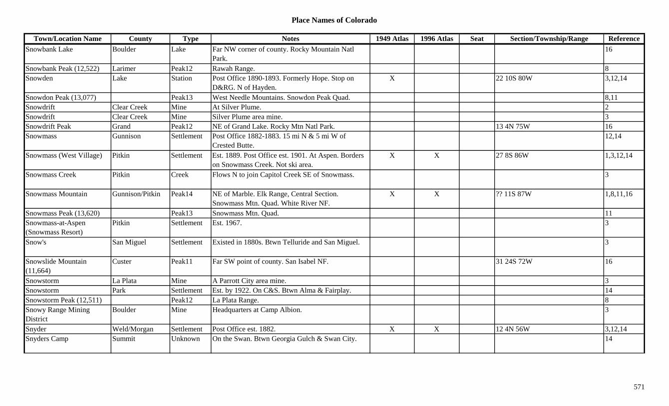
Place Names of Colorado
Town/Location Name County Type Notes 1949 Atlas 1996 Atlas Seat Section/Township/Range ReferenceSnowbank Lake Boulder Lake Far NW corner of county. Rocky Mountain Natl
Park.16
Snowbank Peak (12,522) Larimer Peak12 Rawah Range. 8Snowden Lake Station Post Office 1890-1893. Formerly Hope. Stop on
D&RG. N of Hayden.X 22 10S 80W 3,12,14
Snowdon Peak (13,077) Peak13 West Needle Mountains. Snowdon Peak Quad. 8,11Snowdrift Clear Creek Mine At Silver Plume. 2Snowdrift Clear Creek Mine Silver Plume area mine. 3Snowdrift Peak Grand Peak12 NE of Grand Lake. Rocky Mtn Natl Park. 13 4N 75W 16Snowmass Gunnison Settlement Post Office 1882-1883. 15 mi N & 5 mi W of
Crested Butte.12,14
Snowmass (West Village) Pitkin Settlement Est. 1889. Post Office est. 1901. At Aspen. Borders on Snowmass Creek. Not ski area.
X X 27 8S 86W 1,3,12,14
Snowmass Creek Pitkin Creek Flows N to join Capitol Creek SE of Snowmass. 3
Snowmass Mountain Gunnison/Pitkin Peak14 NE of Marble. Elk Range, Central Section. Snowmass Mtn. Quad. White River NF.
X X ?? 11S 87W 1,8,11,16
Snowmass Peak (13,620) Peak13 Snowmass Mtn. Quad. 11Snowmass-at-Aspen (Snowmass Resort)
Pitkin Settlement Est. 1967. 3
Snow's San Miguel Settlement Existed in 1880s. Btwn Telluride and San Miguel. 3
Snowslide Mountain (11,664)
Custer Peak11 Far SW point of county. San Isabel NF. 31 24S 72W 16
Snowstorm La Plata Mine A Parrott City area mine. 3Snowstorm Park Settlement Est. by 1922. On C&S. Btwn Alma & Fairplay. 14S t P k (12 511) P k12 L Pl t R 8Snowstorm Peak (12,511) Peak12 La Plata Range. 8Snowy Range Mining District
Boulder Mine Headquarters at Camp Albion. 3
Snyder Weld/Morgan Settlement Post Office est. 1882. X X 12 4N 56W 3,12,14Snyders Camp Summit Unknown On the Swan. Btwn Georgia Gulch & Swan City. 14
571
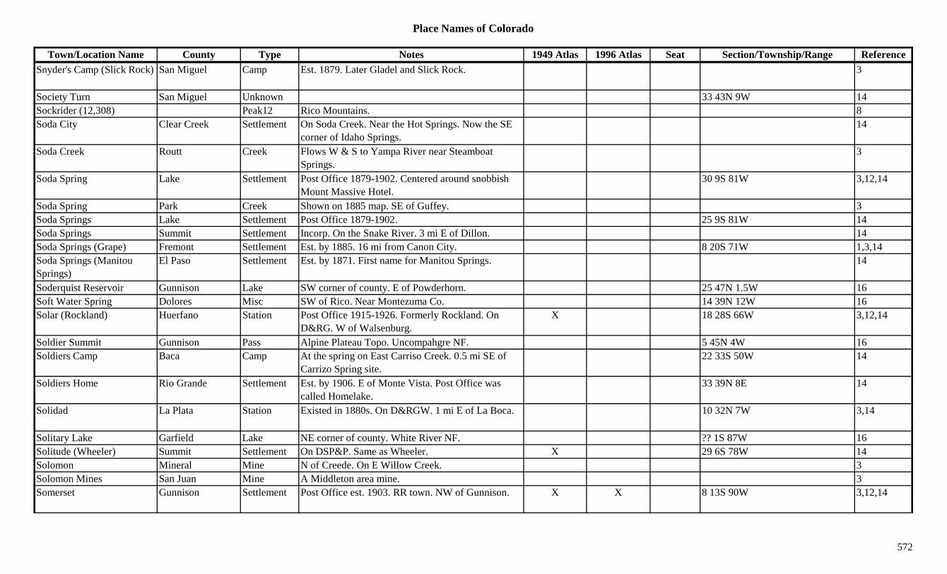
Place Names of Colorado
Town/Location Name County Type Notes 1949 Atlas 1996 Atlas Seat Section/Township/Range ReferenceSnyder's Camp (Slick Rock) San Miguel Camp Est. 1879. Later Gladel and Slick Rock. 3
Society Turn San Miguel Unknown 33 43N 9W 14Sockrider (12,308) Peak12 Rico Mountains. 8Soda City Clear Creek Settlement On Soda Creek. Near the Hot Springs. Now the SE
corner of Idaho Springs.14
Soda Creek Routt Creek Flows W & S to Yampa River near Steamboat Springs.
3
Soda Spring Lake Settlement Post Office 1879-1902. Centered around snobbish Mount Massive Hotel.
30 9S 81W 3,12,14
Soda Spring Park Creek Shown on 1885 map. SE of Guffey. 3p g p ySoda Springs Lake Settlement Post Office 1879-1902. 25 9S 81W 14Soda Springs Summit Settlement Incorp. On the Snake River. 3 mi E of Dillon. 14Soda Springs (Grape) Fremont Settlement Est. by 1885. 16 mi from Canon City. 8 20S 71W 1,3,14Soda Springs (Manitou Springs)
El Paso Settlement Est. by 1871. First name for Manitou Springs. 14
Soderquist Reservoir Gunnison Lake SW corner of county. E of Powderhorn. 25 47N 1.5W 16Soft Water Spring Dolores Misc SW of Rico. Near Montezuma Co. 14 39N 12W 16Solar (Rockland) Huerfano Station Post Office 1915-1926. Formerly Rockland. On
D&RG. W of Walsenburg.X 18 28S 66W 3,12,14
Soldier Summit Gunnison Pass Alpine Plateau Topo. Uncompahgre NF. 5 45N 4W 16Soldiers Camp Baca Camp At the spring on East Carriso Creek. 0.5 mi SE of
Carrizo Spring site.22 33S 50W 14
Soldiers Home Rio Grande Settlement Est. by 1906. E of Monte Vista. Post Office was called Homelake.
33 39N 8E 14
Solidad La Plata Station Existed in 1880s. On D&RGW. 1 mi E of La Boca. 10 32N 7W 3,14
Solitary Lake Garfield Lake NE corner of county. White River NF. ?? 1S 87W 16Solitude (Wheeler) Summit Settlement On DSP&P. Same as Wheeler. X 29 6S 78W 14Solomon Mineral Mine N of Creede. On E Willow Creek. 3Solomon Mines San Juan Mine A Middleton area mine. 3Somerset Gunnison Settlement Post Office est. 1903. RR town. NW of Gunnison. X X 8 13S 90W 3,12,14
572
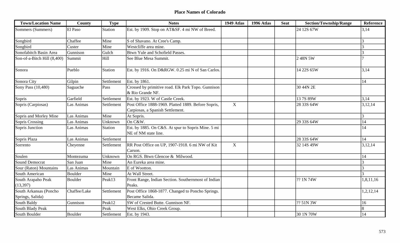
Place Names of Colorado
Town/Location Name County Type Notes 1949 Atlas 1996 Atlas Seat Section/Township/Range ReferenceSommers (Summers) El Paso Station Est. by 1909. Stop on AT&SF. 4 mi NW of Breed. 24 12S 67W 3,14
Songbird Chaffee Mine S of Shavano. At Cree's Camp. 3Songbird Custer Mine Westcliffe area mine. 3Sonofabitch Basin Area Gunnison Gulch Btwn Yule and Schofield Passes. 3Son-of-a-Bitch Hill (8,400) Summit Hill See Blue Mesa Summit. 2 48N 5W 7
Sonora Pueblo Station Est. by 1916. On D&RGW. 0.25 mi N of San Carlos. 14 22S 65W 3,14
Sonora City Gilpin Settlement Est. by 1861. 14Sony Pass (10,480) Saguache Pass Crossed by primitive road. Elk Park Topo. Gunnison 30 44N 2Ey ( , ) g y p p
& Rio Grande NF.Sopris Garfield Settlement Est. by 1923. W of Castle Creek. 13 7S 89W 3,14Sopris (Carpiosas) Las Animas Settlement Post Office 1888-1969. Platted 1889. Before Sopris,
Carpiosas, a Spanish Settlement.X 28 33S 64W 3,12,14
Sopris and Morley Mine Las Animas Mine At Sopris. 3Sopris Crossing Las Animas Unknown On C&W. 29 33S 64W 14Sopris Junction Las Animas Station Est. by 1885. On C&S. At spur to Sopris Mine. 5 mi
NE of NM state line.14
Sopris Plaza Las Animas Settlement 28 33S 64W 14Sorrento Cheyenne Settlement RR Post Office on UP, 1907-1918. 6 mi NW of Kit
Carson.X 32 14S 49W 3,12,14
Soulen Montezuma Unknown On RGS. Btwn Glencoe & Milwood. 14Sound Democrat San Juan Mine An Eureka area mine. 3Sour (Raton) Mountains Las Animas Mountain E of Wootton. 3South American Boulder Mine At Wall Street. 3S th A h P k B ld P k13 F t R I di S ti S th t f I di ?? 1N 74W 1 8 11 16South Arapaho Peak (13,397)
Boulder Peak13 Front Range, Indian Section. Southernmost of Indian Peaks.
?? 1N 74W 1,8,11,16
South Arkansas (Poncho Springs, Salida)
Chaffee/Lake Settlement Post Office 1868-1877. Changed to Poncho Springs. Became Salida.
1,2,12,14
South Baldy Gunnison Peak12 SW of Crested Butte. Gunnison NF. ?? 51N 3W 16South Blady Peak Peak West Elks, Ohio Creek Group. 8South Boulder Boulder Settlement Est. by 1943. 30 1N 70W 14
573
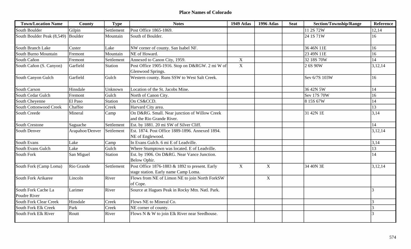
Place Names of Colorado
Town/Location Name County Type Notes 1949 Atlas 1996 Atlas Seat Section/Township/Range ReferenceSouth Boulder Gilpin Settlement Post Office 1865-1869. 11 2S 72W 12,14South Boulder Peak (8,549) Boulder Mountain South of Boulder. 24 1S 71W 16
South Branch Lake Custer Lake NW corner of county. San Isabel NF. 36 46N 11E 16South Burno Mountain Fremont Mountain NE of Howard. 23 49N 11E 16South Cañon Fremont Settlement Annexed to Canon City, 1959. X 32 18S 70W 14South Cañon (S. Canyon) Garfield Station Post Office 1905-1916. Stop on D&RGW. 2 mi W of
Glenwood Springs.X 2 6S 90W 3,12,14
South Canyon Gulch Garfield Gulch Western county. Runs SSW to West Salt Creek. Sev 6/7S 103W 16
South Carson Hinsdale Unknown Location of the St. Jacobs Mine. 36 42N 5W 14South Cedar Gulch Fremont Gulch North of Canon City. Sev 17S 70W 16South Cheyenne El Paso Station On CS&CCD. 8 15S 67W 14South Cottonwood Creek Chaffee Creek Harvard City area. 13South Creede Mineral Camp On D&RG. Small. Near junction of Willow Creek
and the Rio Grande River.31 42N 1E 3,14
South Crestone Saguache Settlement Est. by 1881. 20 mi SW of Silver Cliff. 14South Denver Arapahoe/Denver Settlement Est. 1874. Post Office 1889-1896. Annexed 1894.
NE of Englewood.3,12,14
South Evans Lake Camp In Evans Gulch. 6 mi E of Leadville. 3,14South Evans Gulch Lake Gulch Where Stumptown was located. E of Leadville. 13South Fork San Miguel Station Est. by 1906. On D&RG. Near Vance Junction.
Below Ophir.14
South Fork (Camp Loma) Rio Grande Settlement Post Office 1876-1883 & 1892 to present. Early stage station. Early name Camp Loma.
X X 34 40N 3E 3,12,14
South Fork Arikaree Lincoln River Flows from NE of Limon NE to join North ForkSW f C
Xof Cope.
South Fork Cache La Poudre River
Larimer River Source at Hagues Peak in Rocky Mtn. Natl. Park. 3
South Fork Clear Creek Hinsdale Creek Flows NE to Mineral Co. 3South Fork Elk Creek Park Creek NE corner of county. 3South Fork Elk River Routt River Flows N & W to join Elk River near Seedhouse. 3
574
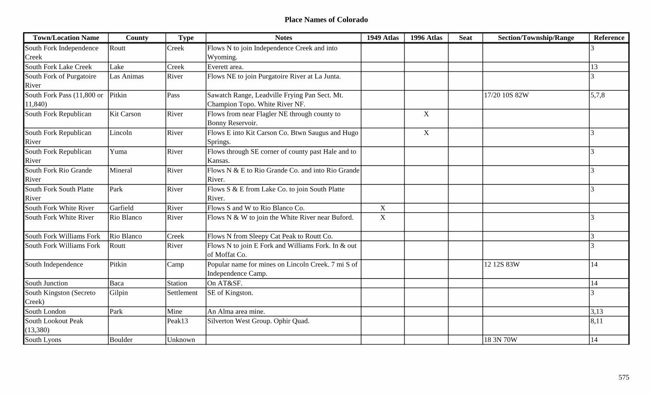
Place Names of Colorado
Town/Location Name County Type Notes 1949 Atlas 1996 Atlas Seat Section/Township/Range ReferenceSouth Fork Independence Creek
Routt Creek Flows N to join Independence Creek and into Wyoming.
3
South Fork Lake Creek Lake Creek Everett area. 13South Fork of Purgatoire River
Las Animas River Flows NE to join Purgatoire River at La Junta. 3
South Fork Pass (11,800 or 11,840)
Pitkin Pass Sawatch Range, Leadville Frying Pan Sect. Mt. Champion Topo. White River NF.
17/20 10S 82W 5,7,8
South Fork Republican Kit Carson River Flows from near Flagler NE through county to Bonny Reservoir.
X
South Fork Republican River
Lincoln River Flows E into Kit Carson Co. Btwn Saugus and Hugo Springs.
X 3
South Fork Republican River
Yuma River Flows through SE corner of county past Hale and to Kansas.
3
South Fork Rio Grande River
Mineral River Flows N & E to Rio Grande Co. and into Rio Grande River.
3
South Fork South Platte River
Park River Flows S & E from Lake Co. to join South Platte River.
3
South Fork White River Garfield River Flows S and W to Rio Blanco Co. XSouth Fork White River Rio Blanco River Flows N & W to join the White River near Buford. X 3
South Fork Williams Fork Rio Blanco Creek Flows N from Sleepy Cat Peak to Routt Co. 3South Fork Williams Fork Routt River Flows N to join E Fork and Williams Fork. In & out
of Moffat Co.3
South Independence Pitkin Camp Popular name for mines on Lincoln Creek. 7 mi S of Independence Camp.
12 12S 83W 14
South Junction Baca Station On AT&SF. 14S th Ki t (S t Gil i S ttl t SE f Ki t 3South Kingston (Secreto Creek)
Gilpin Settlement SE of Kingston. 3
South London Park Mine An Alma area mine. 3,13South Lookout Peak (13,380)
Peak13 Silverton West Group. Ophir Quad. 8,11
South Lyons Boulder Unknown 18 3N 70W 14
575

Place Names of Colorado
Town/Location Name County Type Notes 1949 Atlas 1996 Atlas Seat Section/Township/Range ReferenceSouth Maroon Peak (14,156)
Peak14 Elk Range, Central Section. 8
South Matchless Mountain Gunnison Peak12 SW of Taylor Park Res. Gunnison NF. ?? 14S 83W 16
South Mountain Rio Grande Mountain Summitville area. 13South Oak Creek Huerfano Creek Flow NE to Hurefano River E of Farisita. 3South Park (South Park City)
Park Settlement Post Office 1874-1879. Recent suburb to Fairplay. 34 7S 75W 3,12,14
South Park City (Fairplay) Park Settlement Est. by 1869. The renaming of Fairplay. Post Office did not change. Renamed Fairplay.
33 9S 77W 14
South Park Junction Arapahoe Unknown On C&S, AT&SF. Now within Sheridan. 5 5S 68W 14p ,South Park Junction Denver Station Est. by 1906. On C&S, AT&SF & DSP&P. Same
location as Arapahoe Co. site?14
South Park Smelting and Reduction Works
Park Mill Est. by 1879. A Horseshoe area operation. 13
South Peak (12,892) Peak12 Mosquito Range. 8South Pine Cliff Gilpin Unknown 27 1S 72W 14South Platte Douglas Settlement X XSouth Platte (Godfreys Stage Station)
Logan/Weld Settlement Existed in 1860s. Post Office 1873-1883. Earlier Godfreys. 3 mi SW of Merino.
24 6N 54W 3,4,12,14
South Platte (Symes) Jefferson Settlement Post Office 1899-1937. Formerly Symes. S of Waterton. On C&S.
X X 25 7S 70W 3,6,12,14
South Platte River Adams River Flows through W county from Commerce City through Brighton.
X X 16
South Platte River Denver River Flows N through W side of county. X X 3South Platte River Douglas River Flows up W boundry of county. X X 3S th Pl tt Ri L Ri Fl NE th h St li X XSouth Platte River Logan River Flows NE through Sterling. X XSouth Platte River Morgan River Flows NE through Fort Morgan to Sterling. X XSouth Platte River Park River Flows from Summit Co. through Fairplay, Como,
Hartsel, Lake George.X X 3
South Platte River Sedgwick River Flows from Logan Co. past Julesburg to Nebraska. X X 3
576
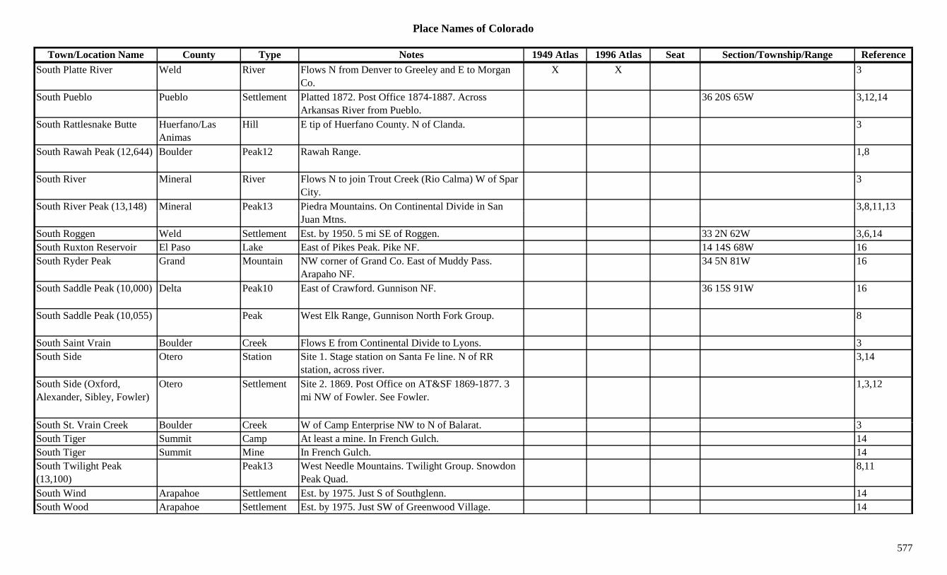
Place Names of Colorado
Town/Location Name County Type Notes 1949 Atlas 1996 Atlas Seat Section/Township/Range ReferenceSouth Platte River Weld River Flows N from Denver to Greeley and E to Morgan
Co.X X 3
South Pueblo Pueblo Settlement Platted 1872. Post Office 1874-1887. Across Arkansas River from Pueblo.
36 20S 65W 3,12,14
South Rattlesnake Butte Huerfano/Las Animas
Hill E tip of Huerfano County. N of Clanda. 3
South Rawah Peak (12,644) Boulder Peak12 Rawah Range. 1,8
South River Mineral River Flows N to join Trout Creek (Rio Calma) W of Spar City.
3
South River Peak (13,148) Mineral Peak13 Piedra Mountains. On Continental Divide in San 3,8,11,13( , )Juan Mtns.
, , ,
South Roggen Weld Settlement Est. by 1950. 5 mi SE of Roggen. 33 2N 62W 3,6,14South Ruxton Reservoir El Paso Lake East of Pikes Peak. Pike NF. 14 14S 68W 16South Ryder Peak Grand Mountain NW corner of Grand Co. East of Muddy Pass.
Arapaho NF.34 5N 81W 16
South Saddle Peak (10,000) Delta Peak10 East of Crawford. Gunnison NF. 36 15S 91W 16
South Saddle Peak (10,055) Peak West Elk Range, Gunnison North Fork Group. 8
South Saint Vrain Boulder Creek Flows E from Continental Divide to Lyons. 3South Side Otero Station Site 1. Stage station on Santa Fe line. N of RR
station, across river.3,14
South Side (Oxford, Alexander, Sibley, Fowler)
Otero Settlement Site 2. 1869. Post Office on AT&SF 1869-1877. 3 mi NW of Fowler. See Fowler.
1,3,12
S th St V i C k B ld C k W f C E t i NW t N f B l t 3South St. Vrain Creek Boulder Creek W of Camp Enterprise NW to N of Balarat. 3South Tiger Summit Camp At least a mine. In French Gulch. 14South Tiger Summit Mine In French Gulch. 14South Twilight Peak (13,100)
Peak13 West Needle Mountains. Twilight Group. Snowdon Peak Quad.
8,11
South Wind Arapahoe Settlement Est. by 1975. Just S of Southglenn. 14South Wood Arapahoe Settlement Est. by 1975. Just SW of Greenwood Village. 14
577

Place Names of Colorado
Town/Location Name County Type Notes 1949 Atlas 1996 Atlas Seat Section/Township/Range ReferenceSouthern Cross Mine Grand Mine At Lulu. 2,3Southern Junction La Plata Station Est. by 1906. On D&RG. Near Durango. 14Southern Junction Pueblo Station Est. by 1916. On D&RGW. 4 mi S of Pueblo. 24 21S 65W 3,14Southern Moon Gilpin Mine Gilson Gulch mine. 3Southern Ute Agency (Ignacio Ute Agency)
La Plata Settlement Same as Ignacio Ute Agency. 5 33N 7W 14
Southern Ute Indian Res. (Ute Mountain Res.)
Montezuma Misc Early name for Ute Mountain Indian Res. 3
Southglenn Arapahoe Settlement Near South University Avenue & Arapahoe Road. 14
Southwater (Borsts) El Paso Station RR Post Office on D&RG 1872-1878. Moved from 1 12S 67W 3,12,14( )Bassetts Mills. 4 mi S of Monument.
, ,
Southwestern Colony (Corona, Green City)
Weld Settlement Est. by 1880. Same as Corona & Green City. 30 4N 61W 14
Southwestern Mine Las Animas Unknown On C&S. 15 30S 65W 14Sovereign People Boulder Mine A Caribou mine. 3Sowbelly Gulch Gulch Unknown location 1Spa, The (Glenwood Springs)
Garfield Settlement Est. in 1880s. Popular name for Glenwood Springs. 14
Space City (Lochbuie) Adams Settlement 1Spanish Saguache Camp Post Office 1898. At headwaters of Spanish Creek.
Inside Baca Grant.28 43N 12E 3,12,13,14
Spanish Bar Chaffee Unknown Est. by 1863. At fork of Chalk Creek & Arkansas River.
14
Spanish Bar Clear Creek Creek Along Clear Creek. 13Spanish Bar (Fall River) Clear Creek Settlement Post Office 1860-1885. 2 mi W of Idaho Springs.
Al h t 36 3S 73W33 3S 73W 3,12,14
Also shown at 36 3S 73W.Spanish Colony Weld Unknown 36 6N 66W 14Spanish Creek Saguache Settlement Est. by 1885. W of Bonanza and E of Cochetopa
Passes.16 43N 12E 3,14
Spanish Fort Huerfano Fort Erected 1819. On eastern side of Sangre de Cristo (La Veta) Pass.
9,14
Spanish Peak (La Veta) Huerfano Settlement Post Office 1871-1876. Changed to La Veta. 12,14
578
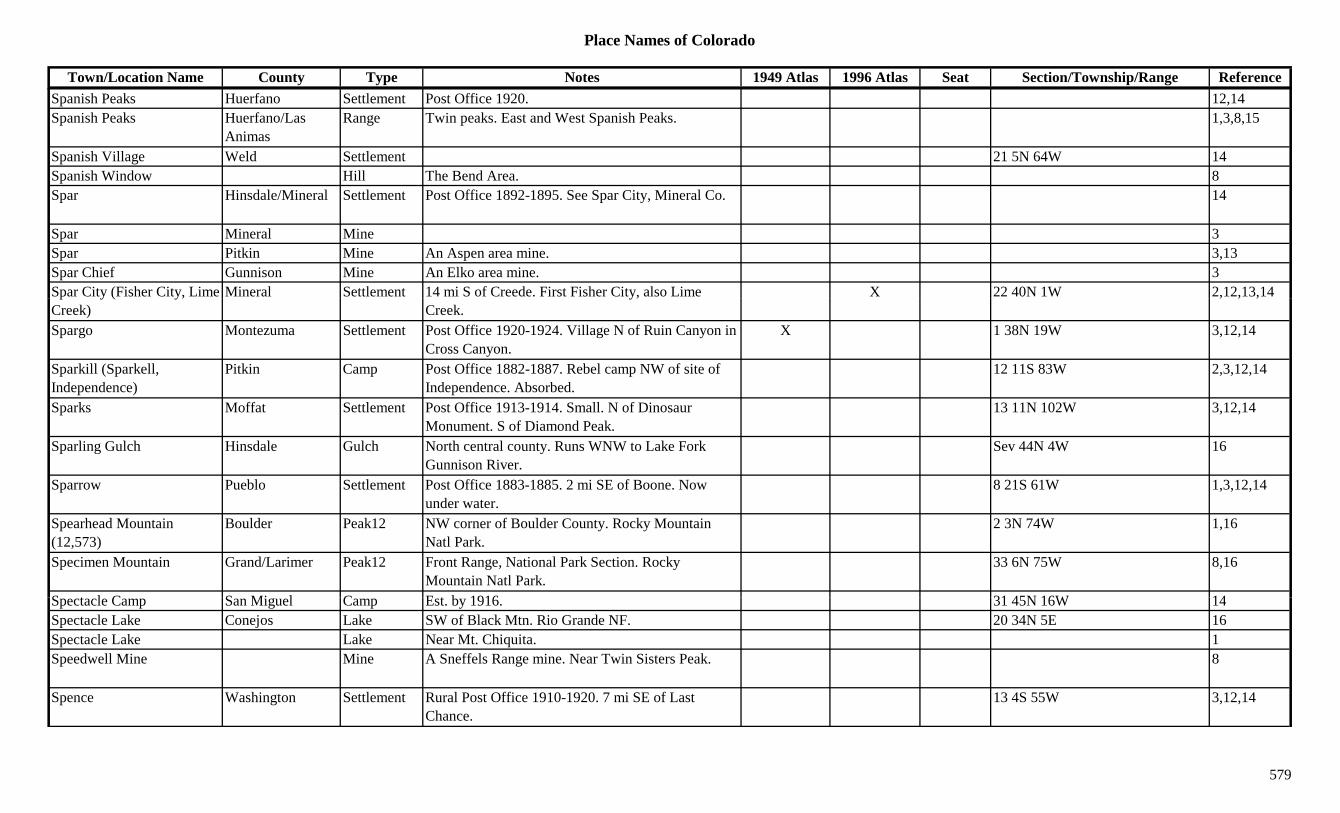
Place Names of Colorado
Town/Location Name County Type Notes 1949 Atlas 1996 Atlas Seat Section/Township/Range ReferenceSpanish Peaks Huerfano Settlement Post Office 1920. 12,14Spanish Peaks Huerfano/Las
AnimasRange Twin peaks. East and West Spanish Peaks. 1,3,8,15
Spanish Village Weld Settlement 21 5N 64W 14Spanish Window Hill The Bend Area. 8Spar Hinsdale/Mineral Settlement Post Office 1892-1895. See Spar City, Mineral Co. 14
Spar Mineral Mine 3Spar Pitkin Mine An Aspen area mine. 3,13Spar Chief Gunnison Mine An Elko area mine. 3Spar City (Fisher City, Lime Mineral Settlement 14 mi S of Creede. First Fisher City, also Lime X 22 40N 1W 2,12,13,14p y ( y,Creek)
y,Creek.
, , ,
Spargo Montezuma Settlement Post Office 1920-1924. Village N of Ruin Canyon in Cross Canyon.
X 1 38N 19W 3,12,14
Sparkill (Sparkell, Independence)
Pitkin Camp Post Office 1882-1887. Rebel camp NW of site of Independence. Absorbed.
12 11S 83W 2,3,12,14
Sparks Moffat Settlement Post Office 1913-1914. Small. N of Dinosaur Monument. S of Diamond Peak.
13 11N 102W 3,12,14
Sparling Gulch Hinsdale Gulch North central county. Runs WNW to Lake Fork Gunnison River.
Sev 44N 4W 16
Sparrow Pueblo Settlement Post Office 1883-1885. 2 mi SE of Boone. Now under water.
8 21S 61W 1,3,12,14
Spearhead Mountain (12,573)
Boulder Peak12 NW corner of Boulder County. Rocky Mountain Natl Park.
2 3N 74W 1,16
Specimen Mountain Grand/Larimer Peak12 Front Range, National Park Section. Rocky Mountain Natl Park.
33 6N 75W 8,16
S t l C S Mi l C E t b 1916 31 45N 16W 14Spectacle Camp San Miguel Camp Est. by 1916. 31 45N 16W 14Spectacle Lake Conejos Lake SW of Black Mtn. Rio Grande NF. 20 34N 5E 16Spectacle Lake Lake Near Mt. Chiquita. 1Speedwell Mine Mine A Sneffels Range mine. Near Twin Sisters Peak. 8
Spence Washington Settlement Rural Post Office 1910-1920. 7 mi SE of Last Chance.
13 4S 55W 3,12,14
579

Place Names of Colorado
Town/Location Name County Type Notes 1949 Atlas 1996 Atlas Seat Section/Township/Range ReferenceSpencer Archuleta Unknown 24 35N 2W 14Spencer Boulder Mine A Caribou mine. 3Spencer (Cameron) Gunnison Settlement Post Office 1894-1907. 4 47N 2W 3,12,14Spencer Lake Conejos Lake North of La Jara Reservoir. 22 36N 5E 16Spencer Mountain Boulder Mountain Near Eldora. 13Spencerville Summit Camp Est. 1860. Near Georgia Gulch. In Day Gulch. 3,14Sperry Mountain (10,735) Custer Peak10 East of Rosita. 31 22S 70W 16Sperryvale Pueblo Settlement Post Office 1901. 12,14Sphinx Park (Sphinx Lodge Park)
Jefferson Camp Est. in 1925. Btwn Glenelk and Pine. Also shown at 1 4S 70W.
23 7S 71W 3,6,14
Spicer Grand/Jackson Settlement Post Office 1884-1954. X 23 6N 81W 3,12,14p , ,Spicer Peak Jackson Peak E of Spicer. 3,13Spike Buck (Spikebuck) Fremont Station Est. by 1922. Stop on D&RGW. 4 mi W of Parkdale. 20 18S 72W 3
Spike Buck Gulch Fremont Gulch Central county. Sev 18S 72/73W 16Spikebuck (Spike Buck) Fremont Unknown On D&RG. 20 18S 72W 14Spiler Lake Archuleta Lake 1 33N 1W 16Spiller Peak (13,123) Peak13 La Plata Range. La Plata Quad. 8,11Spinney (Spinney's) Park Station Site 1. Post Office 1889-1908. Waystop at junction
of South Platte and Three-Mile Creek.31 12S 74W 3,12,14
Spinney (Spinney's) Park Station Site 2. Est. by 1923. On CM. 25 12S 74W 1,3,14Spinney Mountain (9,524) Park Mountain S of Glentivar. 13Spinney Mountain Reservoir
Park Lake East of Hartsel, on South Platte River. X
Spitze Place Moffat Unknown 35 11N 103W 14Spitzer Grand Unknown Est. by 1921. On Grand River. 3 mi N of Grandby. 21 2N 76W 14
Spivak (Sanatorium) Jefferson Settlement Post Office 1928-1967. Formerly Sanatorium. 36 3S 69W 6,12,14Sponsel La Plata Unknown On RGS. 36 36N 12W 14Spook City Gunnison Settlement 2 mi from Bonita. Nothing remains. 1Spook City (Phantom) Saguache Camp Est. after 1893. 2 mi from Bonita. Twin camp of
Ford.21 46N 7E 3,14
Spook Lode Saguache Mine A Bonanza area mine. 3
580
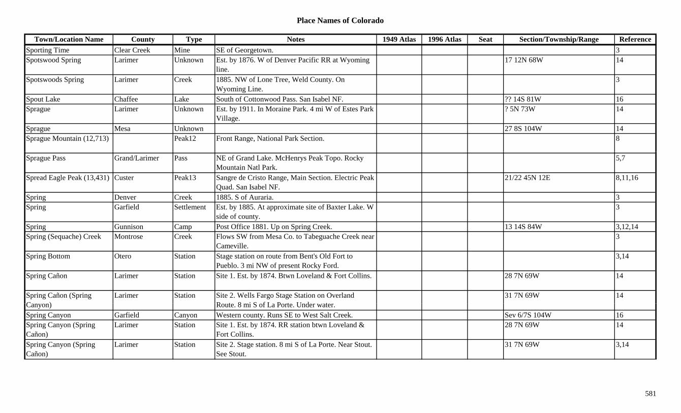
Place Names of Colorado
Town/Location Name County Type Notes 1949 Atlas 1996 Atlas Seat Section/Township/Range ReferenceSporting Time Clear Creek Mine SE of Georgetown. 3Spotswood Spring Larimer Unknown Est. by 1876. W of Denver Pacific RR at Wyoming
line.17 12N 68W 14
Spotswoods Spring Larimer Creek 1885. NW of Lone Tree, Weld County. On Wyoming Line.
3
Spout Lake Chaffee Lake South of Cottonwood Pass. San Isabel NF. ?? 14S 81W 16Sprague Larimer Unknown Est. by 1911. In Moraine Park. 4 mi W of Estes Park
Village.? 5N 73W 14
Sprague Mesa Unknown 27 8S 104W 14Sprague Mountain (12,713) Peak12 Front Range, National Park Section. 8
Sprague Pass Grand/Larimer Pass NE of Grand Lake. McHenrys Peak Topo. Rocky Mountain Natl Park.
5,7
Spread Eagle Peak (13,431) Custer Peak13 Sangre de Cristo Range, Main Section. Electric Peak Quad. San Isabel NF.
21/22 45N 12E 8,11,16
Spring Denver Creek 1885. S of Auraria. 3Spring Garfield Settlement Est. by 1885. At approximate site of Baxter Lake. W
side of county.3
Spring Gunnison Camp Post Office 1881. Up on Spring Creek. 13 14S 84W 3,12,14Spring (Sequache) Creek Montrose Creek Flows SW from Mesa Co. to Tabeguache Creek near
Cameville.3
Spring Bottom Otero Station Stage station on route from Bent's Old Fort to Pueblo. 3 mi NW of present Rocky Ford.
3,14
Spring Cañon Larimer Station Site 1. Est. by 1874. Btwn Loveland & Fort Collins. 28 7N 69W 14
Spring Cañon (Spring C )
Larimer Station Site 2. Wells Fargo Stage Station on Overland R t 8 i S f L P t U d t
31 7N 69W 14Canyon) Route. 8 mi S of La Porte. Under water.Spring Canyon Garfield Canyon Western county. Runs SE to West Salt Creek. Sev 6/7S 104W 16Spring Canyon (Spring Cañon)
Larimer Station Site 1. Est. by 1874. RR station btwn Loveland & Fort Collins.
28 7N 69W 14
Spring Canyon (Spring Cañon)
Larimer Station Site 2. Stage station. 8 mi S of La Porte. Near Stout. See Stout.
31 7N 69W 3,14
581

Place Names of Colorado
Town/Location Name County Type Notes 1949 Atlas 1996 Atlas Seat Section/Township/Range ReferenceSpring Creek Alamosa Creek Flows NE from San Luis Lake into Saguache Co. 16
Spring Creek Gunnison Creek Flows S into Taylor River at Braddock (E of Almont).
3
Spring Creek Gunnison Settlement Est. by 1881. On D&RG. Settlement & camp near Ruby.
27 51N 1E 14
Spring Creek Kit Carson Creek Flows from Vona NE and joins Republican River W of Tuttle.
3
Spring Creek La Plata Creek Flows S & W from Archuleta County to Los Pinos River.
3
Spring Creek Logan Creek Flows out of Weld Co. to North Pawnee Creek. 3p g g
Spring Creek Moffat Creek Flows S from near Great Divide to join Yampa River at Maybell.
3
Spring Creek Montrose Creek Flows N from Ouray Co. SW of Montrose. 3Spring Creek Ouray Creek Across NW corner of county. Flows N to Montrose
Co.3
Spring Creek Rio Blanco Creek Flows N to join the White River E of Rangely. 3Spring Creek Rio Grande Creek Flows E to Rock Creek near Alamosa Co. 3Spring Creek Saguache Camp Est. by 1885. NW of Saguache. 3Spring Creek Saguache Creek SW corner of county. Flows NW into Hinsdale Co. 3
Spring Creek Weld Creek NE corner of county. Flows SE of Logan Co. 3Spring Creek (Summer) Pass
Hinsdale Pass Btwn Lake City & Creede. On Continental Divide. Northeast San Juans. Gunnison NF.
X X 35 43N 3W 7,8,16
Spring Creek Lakes Archuleta Lake SE county. 12 33N 1E 16S i C k P Hi d l S ttl t N f B lf d S f Sl lli P X 3Spring Creek Pass Hinsdale Settlement N of Belford. S of Slumgullion Pass. X 3Spring Creek Reservoir Gunnison Lake NE corner of county. W of Taylor Park Res.
Gunnison NF.?? 13/14S 83W 16
Spring Gulch Boulder Gulch 2.5 mi E of Ward. 1Spring Gulch Clear Creek Gulch S of Freeland to Chicago Creek S of Idaho Springs. Sev 3S 73W 3,16
Spring Gulch Clear Creek Unknown Near Freeland. 3 mi above Idaho Springs. 14
582

Place Names of Colorado
Town/Location Name County Type Notes 1949 Atlas 1996 Atlas Seat Section/Township/Range ReferenceSpring Gulch Douglas Gulch Runs NW to NW corner of county. Sev 6S 68W 16Spring Gulch Douglas Gulch West central county. Runs NE & N to join Dry
Gulch.Sev 9S 68W 16
Spring Gulch Fremont Gulch South central county. SE of Texas Creek (town). Sev 20S 72W 16
Spring Gulch Fremont Gulch SW of Wellsville. Sev 49N 9E 16Spring Gulch Gilpin Gulch S of Central City. 3Spring Gulch (Gulch) Pitkin Camp Site 1. Post Office 1891-1895. Changed to Gulch.
Coal Camp. Also shown in Garfield Co.28 8S 89W 3,12,14
Spring Gulch (Gulch) Pitkin Settlement Site 2. Est. by 1922. W of Carbondale. 3,14Spring Hill Logan Station Stage station on Central Overland route. 4 mi SE of 3,14p g g g
Crook.,
Spring Hill Sedgwick Setlement Est. by 1863. Stop on Denver-Julesburg Road. 36 mi W of Julesburg.
? 10N 48W 14
Spring Mountain (13,244) Peak13 Sangre de Cristo Range, Main Section. Horn Peak Quad.
8,11
Spring Park Garfield Unknown 12 7S 95W 14Spring Ranch Park Ranch Est. by 1881. On middle fork of South Platte. 12 mi
SE of Fairplay.14
Spring Siding Huerfano Unknown Est. by 1878. On D&RG. 31 28S 69W 14Spring Valley Douglas Settlement Post Office 1865-1885. W of Greenland on W
Cherry Creek. Also shown at 34 10S 66W.1 10S 66W 3,12,14
Spring Valley Park Settlement Near Horseshoe. 33 9S 78W 14Spring Valley Park Valley Meadow above Sacramento Gulch. 3Springdale Routt Settlement Est. by 1893. SE of Steamboat Springs. 14Springdale (Peabody's Hot S i )
Boulder Settlement Post Office 1881-1911. 2 mi E of Jamestown. 1894 fl d d t d ttl t
29 2N 71W 1,3,6,12,14Springs) flood destroyed settlement.Springer Park Settlement Post Office 1901-1902. 14 13S 72W 12,14Springfield Fremont Settlement Site 1. Platted 1887. 2 19S 70W 14Springfield Fremont Unknown Site 2. In Red Gulch area. 9 mi N of Cotopaxi. 14Springfield Gilpin Camp Located in Spring Gulch. One of 7 camps in Gregory
Gulch. S of Central City.3,14
583
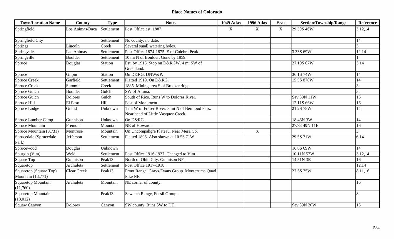
Place Names of Colorado
Town/Location Name County Type Notes 1949 Atlas 1996 Atlas Seat Section/Township/Range ReferenceSpringfield Los Animas/Baca Settlement Post Office est. 1887. X X X 29 30S 46W 3,12,14
Springfield City Settlement No county, no date. 14Springs Lincoln Creek Several small watering holes. 3Springvale Las Animas Settlement Post Office 1874-1875. E of Culebra Peak. 3 33S 69W 12,14Springville Boulder Settlement 10 mi N of Boulder. Gone by 1859. 1Spruce Douglas Station Est. by 1916. Stop on D&RGW. 4 mi SW of
Greenland.27 10S 67W 3,14
Spruce Gilpin Station On D&RG, DNW&P. 36 1S 74W 14Spruce Creek Garfield Settlement Platted 1919. On D&RG. 15 5S 878W 14Spruce Creek Summit Creek 1885. Mining area S of Breckenridge. 3p g gSpruce Gulch Boulder Gulch SW of Altona. 3Spruce Gulch Dolores Gulch South of Rico. Runs W to Dolores River. Sev 39N 11W 16Spruce Hill El Paso Hill East of Monument. 12 11S 66W 16Spruce Lodge Grand Unknown 1 mi W of Fraser River. 3 mi N of Berthoud Pass.
Near head of Little Vasquez Creek.21 2S 75W 14
Spruce Lumber Camp Gunnison Unknown On D&RG. 18 46N 3W 14Spruce Mountain Fremont Mountain NE of Howard. 27/34 49N 11E 16Spruce Mountain (9,731) Montrose Mountain On Uncompahgre Plateau. Near Mesa Co. X 3Sprucedale (Sprucedale Park)
Jefferson Settlement Platted 1895. Also shown at 10 5S 71W. 29 5S 71W 6,14
Sprucewood Douglas Unknown 16 8S 69W 14Spurgin (Vim) Weld Settlement Post Office 1916-1927. Changed to Vim. 10 11N 57W 3,12,14Square Top Gunnison Peak13 North of Ohio City. Gunnison NF. 14 51N 3E 16Squaretop Archuleta Settlement Post Office 1917-1918. 12,14Squaretop (Square Top) M t i (13 771)
Clear Creek Peak13 Front Range, Grays-Evans Group. Montezuma Quad. Pik NF
27 5S 75W 8,11,16Mountain (13,771) Pike NF.Squaretop Mountain (11,760)
Archuleta Mountain NE corner of county. 16
Squaretop Mountain (13,012)
Peak13 Sawatch Range, Fossil Group. 8
Squaw Canyon Dolores Canyon SW county. Runs SW to UT. Sev 39N 20W 16
584
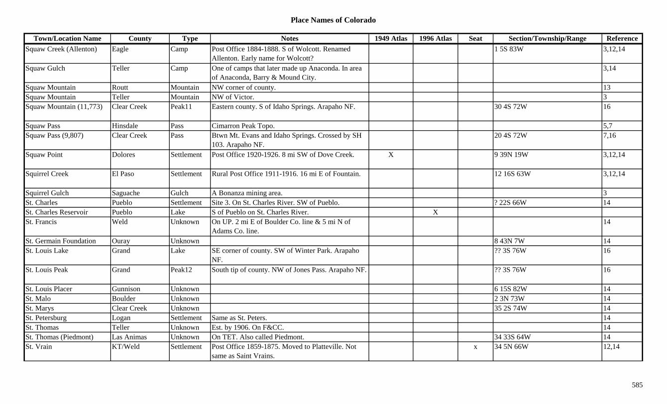
Place Names of Colorado
Town/Location Name County Type Notes 1949 Atlas 1996 Atlas Seat Section/Township/Range ReferenceSquaw Creek (Allenton) Eagle Camp Post Office 1884-1888. S of Wolcott. Renamed
Allenton. Early name for Wolcott?1 5S 83W 3,12,14
Squaw Gulch Teller Camp One of camps that later made up Anaconda. In area of Anaconda, Barry & Mound City.
3,14
Squaw Mountain Routt Mountain NW corner of county. 13Squaw Mountain Teller Mountain NW of Victor. 3Squaw Mountain (11,773) Clear Creek Peak11 Eastern county. S of Idaho Springs. Arapaho NF. 30 4S 72W 16
Squaw Pass Hinsdale Pass Cimarron Peak Topo. 5,7Squaw Pass (9,807) Clear Creek Pass Btwn Mt. Evans and Idaho Springs. Crossed by SH
103. Arapaho NF.20 4S 72W 7,16
Squaw Point Dolores Settlement Post Office 1920-1926. 8 mi SW of Dove Creek. X 9 39N 19W 3,12,14
Squirrel Creek El Paso Settlement Rural Post Office 1911-1916. 16 mi E of Fountain. 12 16S 63W 3,12,14
Squirrel Gulch Saguache Gulch A Bonanza mining area. 3St. Charles Pueblo Settlement Site 3. On St. Charles River. SW of Pueblo. ? 22S 66W 14St. Charles Reservoir Pueblo Lake S of Pueblo on St. Charles River. XSt. Francis Weld Unknown On UP. 2 mi E of Boulder Co. line & 5 mi N of
Adams Co. line.14
St. Germain Foundation Ouray Unknown 8 43N 7W 14St. Louis Lake Grand Lake SE corner of county. SW of Winter Park. Arapaho
NF.?? 3S 76W 16
St. Louis Peak Grand Peak12 South tip of county. NW of Jones Pass. Arapaho NF. ?? 3S 76W 16
St. Louis Placer Gunnison Unknown 6 15S 82W 14St M l B ld U k 2 3N 73W 14St. Malo Boulder Unknown 2 3N 73W 14St. Marys Clear Creek Unknown 35 2S 74W 14St. Petersburg Logan Settlement Same as St. Peters. 14St. Thomas Teller Unknown Est. by 1906. On F&CC. 14St. Thomas (Piedmont) Las Animas Unknown On TET. Also called Piedmont. 34 33S 64W 14St. Vrain KT/Weld Settlement Post Office 1859-1875. Moved to Platteville. Not
same as Saint Vrains.x 34 5N 66W 12,14
585

Place Names of Colorado
Town/Location Name County Type Notes 1949 Atlas 1996 Atlas Seat Section/Township/Range ReferenceSt. Vrain Glaciers Boulder Misc SE slope of Mt. Ogalalla. 3 2N 74W 16St. Vrain-Bent Stockade Fremont Fort Built 1826. On Arkansas River. Just below mouth of
Hardscrabble Creek.17 19S 68W 14
Stacey Gulch Fremont Gulch South central county. S of Texas Creek (town). Sev 19S 73W 16Stage Weld Station On UP. 2 mi NW of Ault. 2 7N 66W 6,14Stage Barn Clear Creek Station Wells Fargo Stage Station on Mountain Route. 14Stage Canyon Post Office Las Animas Settlement Rural Post Office 1919-1920. 1 mi W of stage
station of same name.3,12,14
Stage Canyon Stage Station Las Animas Station Stage station on Purgatoire branch of Santa Fe Trail. At head of Bent Canyon.
? 29S 56W 3,14
Stage Station Prowers Station 28 26S 46W 14gStage Station Saguache Station 15 45N 4E 14Stamford Las Animas Settlement Post Office 1883-1902 & 1905-1920. 5 mi N of
Stonewall.36 32S 69W 3,12,14
Stamp Mill Teller Settlement Est. by 1895. Had a Post Office. ? 15S 69W 14Stanco Pueblo Settlement Near Fowler. 14Standard Boulder Mine At Jamestown. 3Standish Gunnison Settlement Post Office 1885-1886. 15 mi E & 1 mi N of Crested
Butte. 2 mi W of Bowman.12,14
Standley Crossing (Raymond's)
Boulder Settlement 1
Standley Lake Jefferson Station Est. by 1920. On D&I. 1 mi NW of Semper. ? 2S 69W 3,6,14Stanley Boulder Mine At Jamestown. 3,13Stanley Clear Creek Settlement On C&S. Mine, mill & hotel. 34 3S 73W 14Stanley Dolores Mine A Rico area mine. 13Stanley El Paso Unknown ? 12S 67W 14St l L A i U k O D&RG N B b 14Stanley Las Animas Unknown On D&RG. Near Boncarbo. 14Stanley (Coryell) Costilla Settlement Post Office 1890-1891. Formerly Coryell. 8 39N 9E 12,14Stanley Mountain Clear Creek Peak12 NW corner of county. Front Range, Clear Creek
Group. Arapaho NF.?? 3S 75W 8,16
Stanley Park Jefferson Unknown 13 5S 71W 14Stapleton (Hogg PO) Montezuma Settlement Stop & RR Post Office on D&RGW. 7 mi NE of
Dolores.X 4 37N 14W 3,14
586
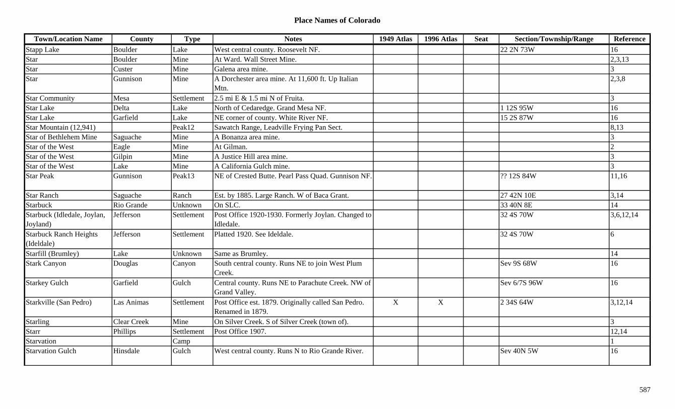
Place Names of Colorado
Town/Location Name County Type Notes 1949 Atlas 1996 Atlas Seat Section/Township/Range ReferenceStapp Lake Boulder Lake West central county. Roosevelt NF. 22 2N 73W 16Star Boulder Mine At Ward. Wall Street Mine. 2,3,13Star Custer Mine Galena area mine. 3Star Gunnison Mine A Dorchester area mine. At 11,600 ft. Up Italian
Mtn.2,3,8
Star Community Mesa Settlement 2.5 mi E & 1.5 mi N of Fruita. 3Star Lake Delta Lake North of Cedaredge. Grand Mesa NF. 1 12S 95W 16Star Lake Garfield Lake NE corner of county. White River NF. 15 2S 87W 16Star Mountain (12,941) Peak12 Sawatch Range, Leadville Frying Pan Sect. 8,13Star of Bethlehem Mine Saguache Mine A Bonanza area mine. 3Star of the West Eagle Mine At Gilman. 2gStar of the West Gilpin Mine A Justice Hill area mine. 3Star of the West Lake Mine A California Gulch mine. 3Star Peak Gunnison Peak13 NE of Crested Butte. Pearl Pass Quad. Gunnison NF. ?? 12S 84W 11,16
Star Ranch Saguache Ranch Est. by 1885. Large Ranch. W of Baca Grant. 27 42N 10E 3,14Starbuck Rio Grande Unknown On SLC. 33 40N 8E 14Starbuck (Idledale, Joylan, Joyland)
Jefferson Settlement Post Office 1920-1930. Formerly Joylan. Changed to Idledale.
32 4S 70W 3,6,12,14
Starbuck Ranch Heights (Ideldale)
Jefferson Settlement Platted 1920. See Ideldale. 32 4S 70W 6
Starfill (Brumley) Lake Unknown Same as Brumley. 14Stark Canyon Douglas Canyon South central county. Runs NE to join West Plum
Creek.Sev 9S 68W 16
Starkey Gulch Garfield Gulch Central county. Runs NE to Parachute Creek. NW of Grand Valley.
Sev 6/7S 96W 16
St k ill (S P d ) L A i S ttl t P t Offi t 1879 O i i ll ll d S P d X X 2 34S 64W 3 12 14Starkville (San Pedro) Las Animas Settlement Post Office est. 1879. Originally called San Pedro. Renamed in 1879.
X X 2 34S 64W 3,12,14
Starling Clear Creek Mine On Silver Creek. S of Silver Creek (town of). 3Starr Phillips Settlement Post Office 1907. 12,14Starvation Camp 1Starvation Gulch Hinsdale Gulch West central county. Runs N to Rio Grande River. Sev 40N 5W 16
587
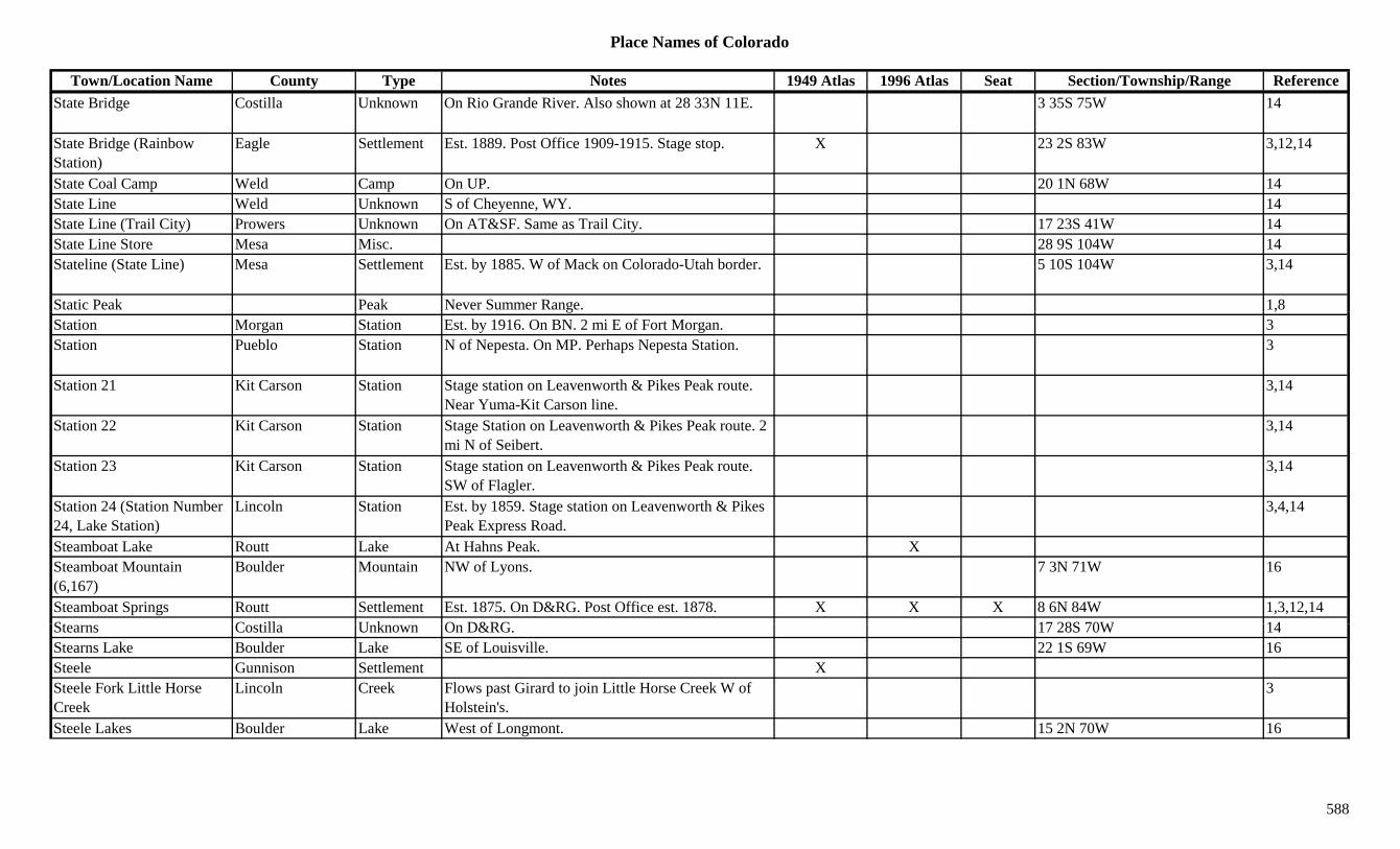
Place Names of Colorado
Town/Location Name County Type Notes 1949 Atlas 1996 Atlas Seat Section/Township/Range ReferenceState Bridge Costilla Unknown On Rio Grande River. Also shown at 28 33N 11E. 3 35S 75W 14
State Bridge (Rainbow Station)
Eagle Settlement Est. 1889. Post Office 1909-1915. Stage stop. X 23 2S 83W 3,12,14
State Coal Camp Weld Camp On UP. 20 1N 68W 14State Line Weld Unknown S of Cheyenne, WY. 14State Line (Trail City) Prowers Unknown On AT&SF. Same as Trail City. 17 23S 41W 14State Line Store Mesa Misc. 28 9S 104W 14Stateline (State Line) Mesa Settlement Est. by 1885. W of Mack on Colorado-Utah border. 5 10S 104W 3,14
Static Peak Peak Never Summer Range. 1,8g ,Station Morgan Station Est. by 1916. On BN. 2 mi E of Fort Morgan. 3Station Pueblo Station N of Nepesta. On MP. Perhaps Nepesta Station. 3
Station 21 Kit Carson Station Stage station on Leavenworth & Pikes Peak route. Near Yuma-Kit Carson line.
3,14
Station 22 Kit Carson Station Stage Station on Leavenworth & Pikes Peak route. 2 mi N of Seibert.
3,14
Station 23 Kit Carson Station Stage station on Leavenworth & Pikes Peak route. SW of Flagler.
3,14
Station 24 (Station Number 24, Lake Station)
Lincoln Station Est. by 1859. Stage station on Leavenworth & Pikes Peak Express Road.
3,4,14
Steamboat Lake Routt Lake At Hahns Peak. XSteamboat Mountain (6,167)
Boulder Mountain NW of Lyons. 7 3N 71W 16
Steamboat Springs Routt Settlement Est. 1875. On D&RG. Post Office est. 1878. X X X 8 6N 84W 1,3,12,14St C till U k O D&RG 17 28S 70W 14Stearns Costilla Unknown On D&RG. 17 28S 70W 14Stearns Lake Boulder Lake SE of Louisville. 22 1S 69W 16Steele Gunnison Settlement XSteele Fork Little Horse Creek
Lincoln Creek Flows past Girard to join Little Horse Creek W of Holstein's.
3
Steele Lakes Boulder Lake West of Longmont. 15 2N 70W 16
588
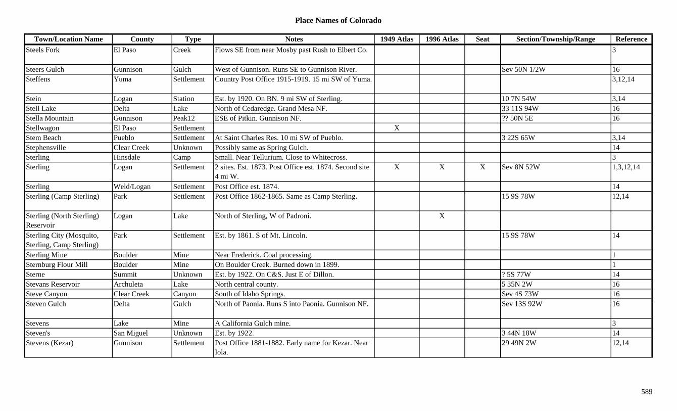
Place Names of Colorado
Town/Location Name County Type Notes 1949 Atlas 1996 Atlas Seat Section/Township/Range ReferenceSteels Fork El Paso Creek Flows SE from near Mosby past Rush to Elbert Co. 3
Steers Gulch Gunnison Gulch West of Gunnison. Runs SE to Gunnison River. Sev 50N 1/2W 16Steffens Yuma Settlement Country Post Office 1915-1919. 15 mi SW of Yuma. 3,12,14
Stein Logan Station Est. by 1920. On BN. 9 mi SW of Sterling. 10 7N 54W 3,14Stell Lake Delta Lake North of Cedaredge. Grand Mesa NF. 33 11S 94W 16Stella Mountain Gunnison Peak12 ESE of Pitkin. Gunnison NF. ?? 50N 5E 16Stellwagon El Paso Settlement XStem Beach Pueblo Settlement At Saint Charles Res. 10 mi SW of Pueblo. 3 22S 65W 3,14Stephensville Clear Creek Unknown Possibly same as Spring Gulch. 14p y p gSterling Hinsdale Camp Small. Near Tellurium. Close to Whitecross. 3Sterling Logan Settlement 2 sites. Est. 1873. Post Office est. 1874. Second site
4 mi W.X X X Sev 8N 52W 1,3,12,14
Sterling Weld/Logan Settlement Post Office est. 1874. 14Sterling (Camp Sterling) Park Settlement Post Office 1862-1865. Same as Camp Sterling. 15 9S 78W 12,14
Sterling (North Sterling) Reservoir
Logan Lake North of Sterling, W of Padroni. X
Sterling City (Mosquito, Sterling, Camp Sterling)
Park Settlement Est. by 1861. S of Mt. Lincoln. 15 9S 78W 14
Sterling Mine Boulder Mine Near Frederick. Coal processing. 1Sternburg Flour Mill Boulder Mine On Boulder Creek. Burned down in 1899. 1Sterne Summit Unknown Est. by 1922. On C&S. Just E of Dillon. ? 5S 77W 14Stevans Reservoir Archuleta Lake North central county. 5 35N 2W 16Steve Canyon Clear Creek Canyon South of Idaho Springs. Sev 4S 73W 16St G l h D lt G l h N th f P i R S i t P i G i NF S 13S 92W 16Steven Gulch Delta Gulch North of Paonia. Runs S into Paonia. Gunnison NF. Sev 13S 92W 16
Stevens Lake Mine A California Gulch mine. 3Steven's San Miguel Unknown Est. by 1922. 3 44N 18W 14Stevens (Kezar) Gunnison Settlement Post Office 1881-1882. Early name for Kezar. Near
Iola.29 49N 2W 12,14
589
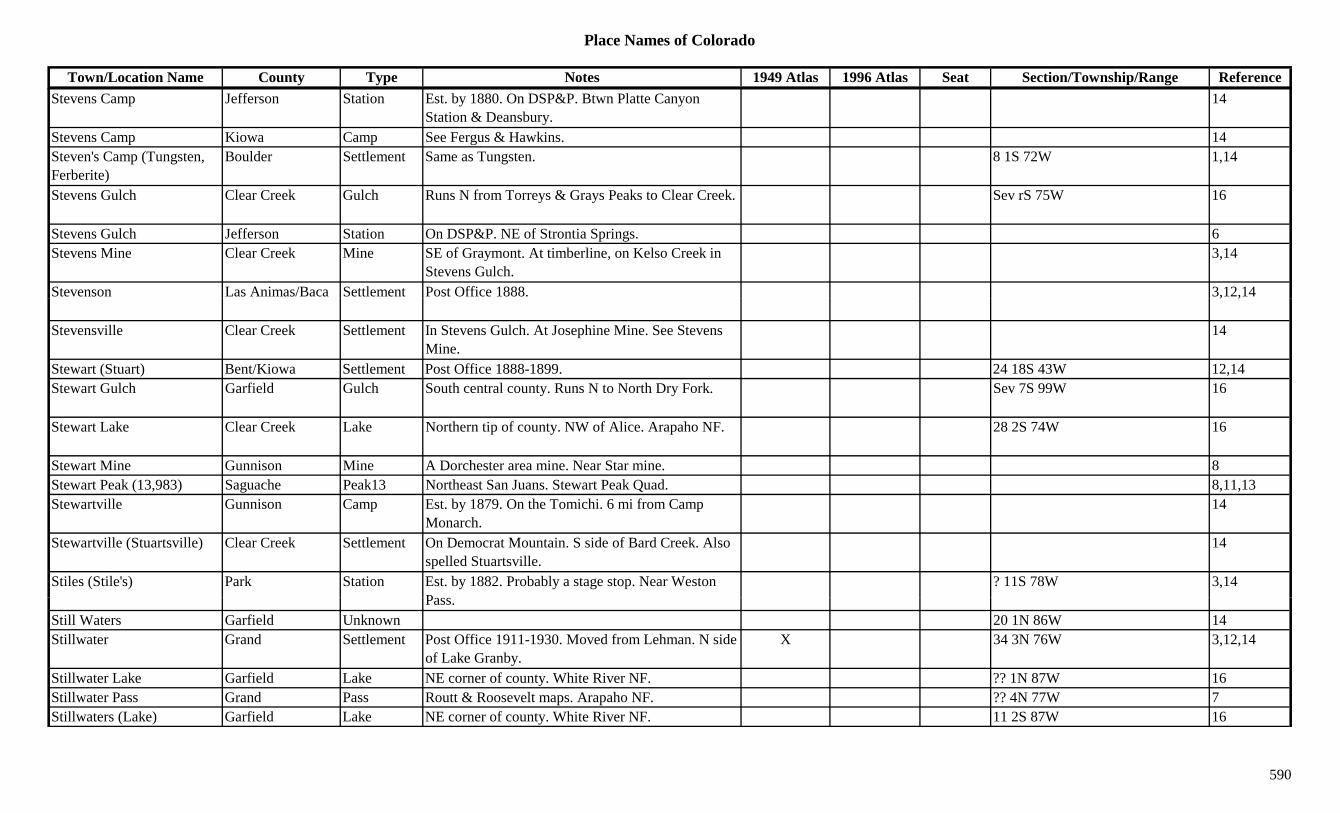
Place Names of Colorado
Town/Location Name County Type Notes 1949 Atlas 1996 Atlas Seat Section/Township/Range ReferenceStevens Camp Jefferson Station Est. by 1880. On DSP&P. Btwn Platte Canyon
Station & Deansbury.14
Stevens Camp Kiowa Camp See Fergus & Hawkins. 14Steven's Camp (Tungsten, Ferberite)
Boulder Settlement Same as Tungsten. 8 1S 72W 1,14
Stevens Gulch Clear Creek Gulch Runs N from Torreys & Grays Peaks to Clear Creek. Sev rS 75W 16
Stevens Gulch Jefferson Station On DSP&P. NE of Strontia Springs. 6Stevens Mine Clear Creek Mine SE of Graymont. At timberline, on Kelso Creek in
Stevens Gulch.3,14
Stevenson Las Animas/Baca Settlement Post Office 1888. 3,12,14, ,
Stevensville Clear Creek Settlement In Stevens Gulch. At Josephine Mine. See Stevens Mine.
14
Stewart (Stuart) Bent/Kiowa Settlement Post Office 1888-1899. 24 18S 43W 12,14Stewart Gulch Garfield Gulch South central county. Runs N to North Dry Fork. Sev 7S 99W 16
Stewart Lake Clear Creek Lake Northern tip of county. NW of Alice. Arapaho NF. 28 2S 74W 16
Stewart Mine Gunnison Mine A Dorchester area mine. Near Star mine. 8Stewart Peak (13,983) Saguache Peak13 Northeast San Juans. Stewart Peak Quad. 8,11,13Stewartville Gunnison Camp Est. by 1879. On the Tomichi. 6 mi from Camp
Monarch.14
Stewartville (Stuartsville) Clear Creek Settlement On Democrat Mountain. S side of Bard Creek. Also spelled Stuartsville.
14
Stiles (Stile's) Park Station Est. by 1882. Probably a stage stop. Near Weston P
? 11S 78W 3,14Pass.
Still Waters Garfield Unknown 20 1N 86W 14Stillwater Grand Settlement Post Office 1911-1930. Moved from Lehman. N side
of Lake Granby.X 34 3N 76W 3,12,14
Stillwater Lake Garfield Lake NE corner of county. White River NF. ?? 1N 87W 16Stillwater Pass Grand Pass Routt & Roosevelt maps. Arapaho NF. ?? 4N 77W 7Stillwaters (Lake) Garfield Lake NE corner of county. White River NF. 11 2S 87W 16
590

Place Names of Colorado
Town/Location Name County Type Notes 1949 Atlas 1996 Atlas Seat Section/Township/Range ReferenceStinking Creek Rio Blanco Creek Flows S from Moffat Co. to White River W of
Rangely.3
Stockade Bent Settlement Post Office 1873-1874. 12,14Stockbridge El Paso Unknown On D&RG. Near Manitou Springs. 14Stockville Las Animas Settlement Rural Post Office 1873-1875. 5 mi NE of Trinchera.
Also shown at 14 33S 59W.4 34S 59W 3,12,14
Stockyards Arapahoe/Denver Settlement Post Office 1898-1904. 12,14
Stockyards Archuleta Station Site 1. Est. by 1937. N of Pagosa Junction. 14Stockyards Archuleta Station Site 2. Est. by 1927. S of Pagosa Springs. 14Stollsteimer River Archuleta River Flows SW past Pagosa Springs to Piedra River. 3p g p gStone City (Cabin Springs) Pueblo Settlement Post Office 1912-1957. At place named Cabin
Springs.X 26 18S 67W 3,12,14
Stone City (Thurman) Washington Settlement Est. 1888. Name changed to Thurman. See Thurman. 21 5S 52W 3,14
Stone Man Pass Boulder/Grand Pass S of Bear Lake. On Continental Divide. McHenrys Peak Topo. Rocky Mtn Natl Park.
5,7
Stone Quarry Gunnison Unknown On DSP&P. 7 49N 3E 14Stoneham Weld Settlement Site 1. 2.5 mi NW of site 2. Destroyed by fire. 3Stoneham Weld Settlement Site 2. Est. 1888. Post Office 1888-1910 with gaps.
On CB&Q, BN.X X 5 7N 56W 3,6,12
Stoner (Stoner Creek) Montezuma Settlement Est. abt 1890. Post Office 1917-1954. NE of Dolores. Same as Stoner Creek.
X X 5 38N 13W 3,12,14
Stoner Creek Dolores Creek Flows SW to near West Dolores and into Montezuma County.
3
Stoner Creek Montezuma Creek Flows from Dolores Co. to Dolores River near St
3Stoner.
Stoner Creek Montezuma Unknown On RGS. 32 39N 13W 14Stoner Mesa Reservoir Dolores Lake SW of Rico. Near Montezuma Co. 15 39N 13W 16Stones Peak (12,922) Larimer Peak12 Front Range, National Park Section. 8,13Stonewall Chaffee Camp 1 mi S of Hancock. 13Stonewall Chaffee Mine Btwn Atlantic and Hancock. At Stonewall. 3,13Stonewall Clear Creek Mine A Yankee Hill mine. 3
591
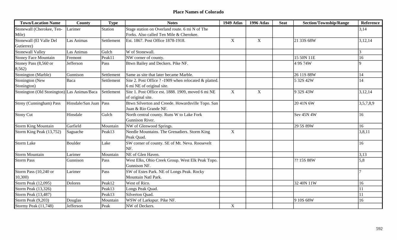
Place Names of Colorado
Town/Location Name County Type Notes 1949 Atlas 1996 Atlas Seat Section/Township/Range ReferenceStonewall (Cherokee, Ten-Mile)
Larimer Station Stage station on Overland route. 6 mi N of The Forks. Also called Ten Mile & Cherokee.
3,14
Stonewall (El Valle Del Gutierrez)
Las Animas Settlement Est. 1867. Post Office 1878-1918. X X 21 33S 68W 3,12,14
Stonewall Valley Las Animas Gulch W of Stonewall. 3Stoney Face Mountain Fremont Peak11 NW corner of county. 15 50N 11E 16Stoney Pass (8,560 or 8,562)
Jefferson Pass Btwn Bailey and Deckers. Pike NF. 4 9S 74W 9
Stonington (Marble) Gunnison Settlement Same as site that later became Marble. 26 11S 88W 14Stonington (New Stonington)
Baca Settlement Site 2. Post Office ? -1909 when relocated & platted. 6 mi NE of original site.
5 32S 42W 14
Stonington (Old Stonington) Las Animas/Baca Settlement Site 1. Post Office est. 1888. 1909, moved 6 mi NE of original site.
X X 9 32S 43W 3,12,14
Stony (Cunningham) Pass Hinsdale/San Juan Pass Btwn Silverton and Creede. Howardsville Topo. San Juan & Rio Grande NF.
20 41N 6W 3,5,7,8,9
Stony Cut Hinsdale Gulch North central county. Runs W to Lake Fork Gunnison River.
Sev 45N 4W 16
Storm King Mountain Garfield Mountain NW of Glenwood Springs. 29 5S 89W 16Storm King Peak (13,752) Saguache Peak13 Needle Mountains. The Grenadiers. Storm King
Peak Quad.X 3,8,11
Storm Lake Boulder Lake SW corner of county. SE of Mt. Neva. Roosevelt NF.
16
Storm Mountain Larimer Mountain NE of Glen Haven. 3,13Storm Pass Gunnison Pass West Elks, Ohio Creek Group. West Elk Peak Topo.
Gunnison NF.?? 15S 88W 5,8
Storm Pass (10,240 or 10 300)
Larimer Pass SW of Estes Park. NE of Longs Peak. Rocky M t i N tl P k
710,300) Mountain Natl Park.Storm Peak (12,095) Dolores Peak12 West of Rico. 32 40N 11W 16Storm Peak (13,326) Peak13 Longs Peak Quad. 11Storm Peak (13,487) Peak13 Silverton Quad. 11Storm Peak (9,203) Douglas Mountain WSW of Larkspur. Pike NF. 9 10S 68W 16Stormy Peak (11,748) Jefferson Peak NW of Deckers. X
592
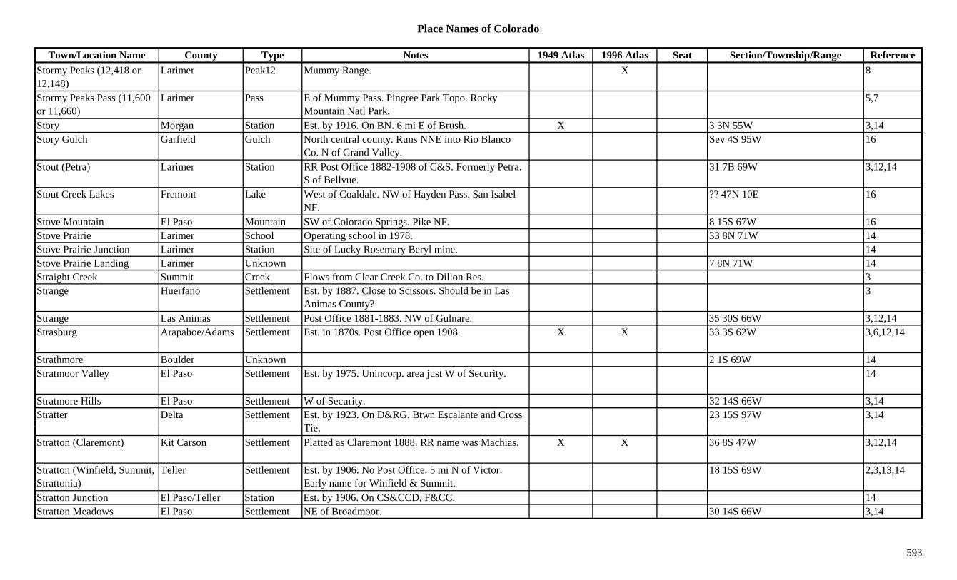
Place Names of Colorado
Town/Location Name County Type Notes 1949 Atlas 1996 Atlas Seat Section/Township/Range ReferenceStormy Peaks (12,418 or 12,148)
Larimer Peak12 Mummy Range. X 8
Stormy Peaks Pass (11,600 or 11,660)
Larimer Pass E of Mummy Pass. Pingree Park Topo. Rocky Mountain Natl Park.
5,7
Story Morgan Station Est. by 1916. On BN. 6 mi E of Brush. X 3 3N 55W 3,14Story Gulch Garfield Gulch North central county. Runs NNE into Rio Blanco
Co. N of Grand Valley.Sev 4S 95W 16
Stout (Petra) Larimer Station RR Post Office 1882-1908 of C&S. Formerly Petra. S of Bellvue.
31 7B 69W 3,12,14
Stout Creek Lakes Fremont Lake West of Coaldale. NW of Hayden Pass. San Isabel NF.
?? 47N 10E 16
Stove Mountain El Paso Mountain SW of Colorado Springs. Pike NF. 8 15S 67W 16Stove Prairie Larimer School Operating school in 1978. 33 8N 71W 14Stove Prairie Junction Larimer Station Site of Lucky Rosemary Beryl mine. 14Stove Prairie Landing Larimer Unknown 7 8N 71W 14Straight Creek Summit Creek Flows from Clear Creek Co. to Dillon Res. 3Strange Huerfano Settlement Est. by 1887. Close to Scissors. Should be in Las
Animas County?3
Strange Las Animas Settlement Post Office 1881-1883. NW of Gulnare. 35 30S 66W 3,12,14Strasburg Arapahoe/Adams Settlement Est. in 1870s. Post Office open 1908. X X 33 3S 62W 3,6,12,14
Strathmore Boulder Unknown 2 1S 69W 14Stratmoor Valley El Paso Settlement Est. by 1975. Unincorp. area just W of Security. 14
Stratmore Hills El Paso Settlement W of Security. 32 14S 66W 3,14Stratter Delta Settlement Est. by 1923. On D&RG. Btwn Escalante and Cross
Ti23 15S 97W 3,14
Tie.Stratton (Claremont) Kit Carson Settlement Platted as Claremont 1888. RR name was Machias. X X 36 8S 47W 3,12,14
Stratton (Winfield, Summit, Strattonia)
Teller Settlement Est. by 1906. No Post Office. 5 mi N of Victor. Early name for Winfield & Summit.
18 15S 69W 2,3,13,14
Stratton Junction El Paso/Teller Station Est. by 1906. On CS&CCD, F&CC. 14Stratton Meadows El Paso Settlement NE of Broadmoor. 30 14S 66W 3,14
593

Place Names of Colorado
Town/Location Name County Type Notes 1949 Atlas 1996 Atlas Seat Section/Township/Range ReferenceStratton Park El Paso Unknown Est. by 1909. 35 14S 67W 14Straub Mountain Teller Mine Teller Co. mines not elsewhere specified. 3Straus Mountain Teller Mountain S of Victor. 3Strauss Gunnison Unknown On TM. 6 12S 87W 14Strawberry Creek Rio Blanco Creek Flows S from Danforth Hills to White River near
Meeker Monument.3
Strawberry Lake Grand Lake SE of Granby Res. 27 2N 75W 16Strawberry Lakes Eagle Lake South central county. SW of Redcliff. White River
NF.?? 7S 82W 16
Stray Horse Gulch Lake Gulch From Leadville E to Ibex. 3,13Stray Horse Ridge Lake Hill Ridge E of Leadville. 3y g gStreams Corner Prowers Unknown 18 21S 46W 14Streater (Mosca) Costilla/Alamosa Settlement Post Office 1888-1890. Change to Mosca. 1 mi N &
0.5 mi W of present Mosca.12,14
Streeter (Pattison) Moffat Settlement In Axial Valley. 2 mi S of Axial. Same as present Pattison.
2 3N 93W 3,14
Stringtown Fremont Settlement On AT&SF. Italian section in N Rockvale. 21 19S 69W 14Stringtown Larimer Settlement On NE slope of Storm Peak. 7 6N 71W 14Stringtown Mineral Settlement Section of North Creede. 3Stringtown (Leadville) Lake Settlement On D&RG. No Post Office. 1 mi S of Leadville.
Now part of Leadville.X 27 9S 80W 1,3,13,14
Strong Huerfano Settlement On D&RG. Post Office 1905-1929. NW of Walsenburg.
9 27S 67W 3,12,14
Strong Teller Mine A Victor area mine. 3,13Strong Junction Teller Station On CM. S of Goldfield. 29 15S 69W 14Strong's Camp Teller Camp Around Victor's bigger mines. 1 mi N of Victor. 3,14
Strontia Douglas Settlement Post Office 1903. See Strontia Springs. 12,14Strontia Springs (Deane, Deansbury)
Jefferson Station On DSP&P. Post Office 1911-1932. RR station named Newberry at one time.
20 7S 69W 3,6,12,14
Strosson Park Unknown Est. by 1913. On DSP&P. Close to Crosson. 14Strouseville (Strousville) Jefferson Settlement Platted 1874. E of Morrison. ? 4S 70W 3,6,14
594

Place Names of Colorado
Town/Location Name County Type Notes 1949 Atlas 1996 Atlas Seat Section/Township/Range ReferenceStruby Douglas Station Est. by 1909. Stop on D&RGW. 5 mi SW of
Littleton.6 6S 68W 3,14
Strutsell Sawmill Grand Mill 7 1N 82W 14Stuart (Stewart PO) Kiowa Settlement Post Office on P&SL 1888-1889, 1911-1912. 4 mi
W of Towner. Stewart PO at site.X 24 18S 43W 3,12,14
Stuartsville (Stewartville) Clear Creek Settlement Est. by 1886. On Democrat Mountain. Abandonded in 1886.
6 4S 74W 14
Stubbs El Paso Unknown Est. by 1876. SE of Colorado Springs. 14Stubbs Ranch (Como) Park Settlement 10 mi NE of Fairplay. Early stage station. 2,3,13Stubs Gulch Gunnison Gulch East of Blue Mesa Reservoir. Runs NNW. Sev 48/49N 1E 16Stuck Creek Larimer Creek NW corner of county. Flows NE into Laramie River. 3y
Stull Mountain (9,600) Custer Mountain North of Hardscrabble. W of Wetmore. San Isabel NF.
15 21S 70W 16
Stultz Gulch Fremont Gulch South of Canon City. San Isabel NF. Sev 20S 70W 16Stump Gulch Garfield Gulch North central county. White River NF. Sev 3S 92W 16Stumpftown (Stumptown) Lake Settlement 3 mi E of Leadville. 5 mi above Evansville. Also
shown at ? 9S 79W.14 9S 80W 3,13,14
Stunner (Celeste) Pass (10,541)
Conejos Pass Btwn Alamosa River and Conejos River. Rio Grande NF.
16 36N 4E 7,9,16
Stunner (Loynton, Blainvale)
Conejos Settlement Post Office 1886-1894 & 1913-1914. Near head of Conejos River. Formerly Loynton.
8 36N 4E 1,3,12,14
Suaso Las Animas Settlement Existed in 1860s. Early Mexican settlement. Near Trinidad.
14
Subbette (Sublette) Conejos Settlement Est. by 1885. On D&RG. Incorrectly spelled. See Sublette & Subletter.
3
S bl tt W ld St ti O UP 3 i SW f O h d 14 4N 61W 3 6 14Sublette Weld Station On UP. 3 mi SW of Orchard. 14 4N 61W 3,6,14Sublette (Subbette) Conejos Station Est. by 1885. Really in New Mexico. 14 4N 61W 3Subletter Conejos Unknown Est. by 1906. On D&RG. Near S line of Conejos Co. 14
Subletter Weld Unknown On UP. 14 4N 61W 14Sublime (Point Sublime) El Paso Settlement Post Office 1903-1909. At Point Sublime on
CS&CCD. W of Ivywild.34 14S 67W 3,12,14
595

Place Names of Colorado
Town/Location Name County Type Notes 1949 Atlas 1996 Atlas Seat Section/Township/Range ReferenceSuffield Las Animas Station Est. by 1902. On C&S. 4 mi NW of El Moro. 13 32S 64W 3,14Suffolk San Miguel Mine An Alta area mine. 3Suffolk San Miguel Unknown 32 42N 8W 14Suffolk (Suffork) El Paso Settlement Rural Post Office 1879-1886. May be same site as
Ellicot.4 14S 62W 3,12,14
Sufton Pueblo Unknown ? 23S 67W 14Sugar (Sugardale) Prowers Settlement On AT&SF. Same as Sugardale. X 10 22S 47W 14Sugar City (Meredith, Wait) Otero/Crowley Settlement Est. 1891. Platted 1899. Post Office est. 1900.
Formerly Wait. First name was Meredith.X X 10 21S 56W 3,12,14
Sugar Junction Rio Grande Station Est. by 1923. On D&RGW. 1 mi W of Parma. 5 38N 8E 3,14Sugar Loaf Lake Station Est. by 1925. On D&RG. N of Malta. 14g ySugar Loaf (8,718) Jackson Hill N central county. 13Sugar Loaf (Sugarloaf) Boulder Camp Est. by 1860. On DB&W. Post Office 1867-1944.
Surface gold found.25 1N 72W 3,12,14
Sugar Loaf Mountain Eagle Mountain NW corner of county. 5 3S 86W 16Sugardale Prowers Station Est. by 1909. 2 mi E of Wiley. 3Sugarloaf (Sugar Loaf) Boulder Settlement Post Office 1867-1944. 25 1N 72W 6Sugarloaf Butte Moffat Hill E of Sparks. 3Sugarloaf Mountain Eagle/Summit Peak12 SE of Redcliff. Arapaho/White River NF. ?? 7S 79W 16Sugarloaf Mountain El Paso Mountain South of Manitou Springs. 8 14S 67W 16Sugarloaf Mountain Grand Mountain South tip of county. N of Ptarmigan Pass. Arapaho
NF.?? 3S 77W 16
Sugarloaf Mountain (12,130)
Larimer Peak12 Mummy Range. 8
Sugarloaf Mountain (12,513)
Clear Creek Peak12 South of Georgetown. Arapaho NF. 5/4 5S 74W 16
S l f M t i (8 406) Ch ff M t i NE f N th 12 15S 78W 16Sugarloaf Mountain (8,406) Chaffee Mountain NE of Nathrop. 12 15S 78W 16
Sugarloaf Mountain (8,917) Boulder Mountain SE of Ward. Roosevelt NF. 26 1N 72W 16
Sugarloaf Peak Moffat Peak NW of Lay. 3Sugarloaf Rock Hinsdale Hill NW corner of county. W of Lake City.
Uncompahgre NF.29/32 44N 4W 16
596

Place Names of Colorado
Town/Location Name County Type Notes 1949 Atlas 1996 Atlas Seat Section/Township/Range ReferenceSukey Summit Mine A Saints John area mine. 3Sulfer Gulch Delta Gulch SE of Orchard City. Runs S to Gunnison River. Sev 14S 93W 16Sullenburger Reservoir Archuleta Lake North central county. 6 35N 2W 16Sullivan Lake Mine A California Gulch mine. 3Sullivan Lake Mine A Leadville area mine. 3Sullivan Washington Unknown 23.75 mi SW of Yuma. 14Sullivan (Oakes) Arapahoe Settlement Platted 1891. Station name for the UPD&G. No Post
Office.28 4S 67W 3,6,14
Sullivan Mountain (13,134) Peak13 Montezuma Quad. 11
Sulphide Boulder Unknown On DB&W. Same as Sulphide Flats. AT mile post ? 1S 73W 14p p p32.1.
Sulphide Flats (Sulphide) Boulder Camp Est. by 1890. 1 mi E of Eldora. ? 1S 73W 1,3,14Sulphide Park Boulder Unknown On DB&W. 22 1S 73W 14Sulphur (Sulpher) Rio Blanco Settlement Post Office 1902-1926. Settlement on Black Sulphur
Creek. SW of White River.28 2S 98W 3,12,14
Sulphur Beds Mineral Unknown 16 39N 2W 14Sulphur Gulch Douglas Gulch East of Parker. Runs W to Cherry Creek. Sev 6S 65/66W 16Sulphur Gulch Douglas Station Stage station. 1 mi SW of Parker. Replaced by
Twelve & Twenty Mile Houses.3,14
Sulphur Gulch Fremont Gulch Central county. Sev 18S 72W 16Sulphur Mountain (9,339) Park Mountain SW of Glentivar. 13Sulphur Spring Las Animas Creek E of Chicosa. 3Sulphur Spring Pueblo Creek 1885. Close to headwaters of Mustang Creek. 3Sulphur Springs Eagle Settlement Est. by 1885. 1 mi N of Belden. N side of Eagle
River.3
S l h S i H f U k 10 30S 69W 14Sulphur Springs Huerfano Unknown 10 30S 69W 14Sulphur Springs Routt Settlement Site 1. 1885. 1 mi NW of Steamboat Springs. 3Sulphur Springs Routt Settlement Site 2. 1885. 1 mi SE of Steamboat. 3Sulphur Springs (Glentivar) Park Settlement Post Office 1873-1874. Moved to Rocky. 11 12S 74W 3,12,14
Sulphur Springs (Hot Sulphur Springs)
Grand Settlement Post Office 1894-1912. Formerly Hot Sulphur Springs. Renamed Hot Sulphur Springs.
3 1N 78W 12,14
597
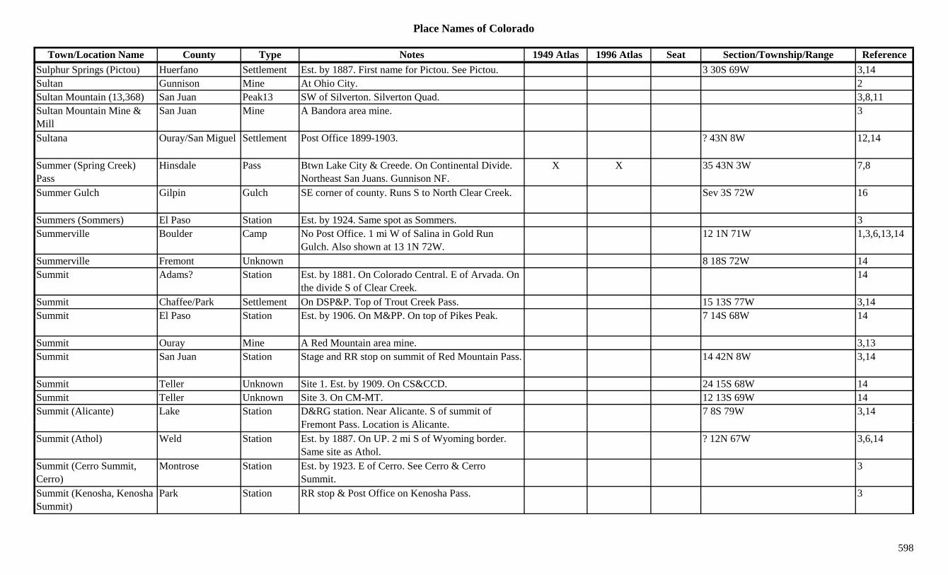
Place Names of Colorado
Town/Location Name County Type Notes 1949 Atlas 1996 Atlas Seat Section/Township/Range ReferenceSulphur Springs (Pictou) Huerfano Settlement Est. by 1887. First name for Pictou. See Pictou. 3 30S 69W 3,14Sultan Gunnison Mine At Ohio City. 2Sultan Mountain (13,368) San Juan Peak13 SW of Silverton. Silverton Quad. 3,8,11Sultan Mountain Mine & Mill
San Juan Mine A Bandora area mine. 3
Sultana Ouray/San Miguel Settlement Post Office 1899-1903. ? 43N 8W 12,14
Summer (Spring Creek) Pass
Hinsdale Pass Btwn Lake City & Creede. On Continental Divide. Northeast San Juans. Gunnison NF.
X X 35 43N 3W 7,8
Summer Gulch Gilpin Gulch SE corner of county. Runs S to North Clear Creek. Sev 3S 72W 16
Summers (Sommers) El Paso Station Est. by 1924. Same spot as Sommers. 3Summerville Boulder Camp No Post Office. 1 mi W of Salina in Gold Run
Gulch. Also shown at 13 1N 72W.12 1N 71W 1,3,6,13,14
Summerville Fremont Unknown 8 18S 72W 14Summit Adams? Station Est. by 1881. On Colorado Central. E of Arvada. On
the divide S of Clear Creek.14
Summit Chaffee/Park Settlement On DSP&P. Top of Trout Creek Pass. 15 13S 77W 3,14Summit El Paso Station Est. by 1906. On M&PP. On top of Pikes Peak. 7 14S 68W 14
Summit Ouray Mine A Red Mountain area mine. 3,13Summit San Juan Station Stage and RR stop on summit of Red Mountain Pass. 14 42N 8W 3,14
Summit Teller Unknown Site 1. Est. by 1909. On CS&CCD. 24 15S 68W 14Summit Teller Unknown Site 3. On CM-MT. 12 13S 69W 14Summit (Alicante) Lake Station D&RG station. Near Alicante. S of summit of
F t P L ti i Ali t7 8S 79W 3,14
Fremont Pass. Location is Alicante.Summit (Athol) Weld Station Est. by 1887. On UP. 2 mi S of Wyoming border.
Same site as Athol.? 12N 67W 3,6,14
Summit (Cerro Summit, Cerro)
Montrose Station Est. by 1923. E of Cerro. See Cerro & Cerro Summit.
3
Summit (Kenosha, Kenosha Summit)
Park Station RR stop & Post Office on Kenosha Pass. 3
598
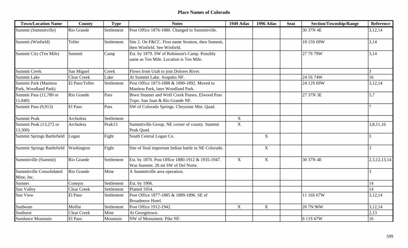
Place Names of Colorado
Town/Location Name County Type Notes 1949 Atlas 1996 Atlas Seat Section/Township/Range ReferenceSummit (Summitville) Rio Grande Settlement Post Office 1876-1880. Changed to Summitville. 30 37N 4E 3,12,14
Summit (Winfield) Teller Settlement Site 2. On F&CC. First name Stratton, then Summit, then Winfield. See Winfield.
18 15S 69W 3,14
Summit City (Ten Mile) Summit Camp Est. by 1879. SW of Robinson's Camp. Possibly same as Ten Mile. Location is Ten Mile.
27 7S 79W 3,14
Summit Creek San Miguel Creek Flows from Utah to join Dolores River. 3Summit Lake Clear Creek Lake At Summit Lake. Arapaho NF. 24 5S 74W 16Summit Park (Manitou Park, Woodland Park)
El Paso/Teller Settlement Post Office 1873-1888 & 1890-1892. Moved to Manitou Park, later Woodland Park.
24 12S 69W 3,12,14
Summit Pass (11,780 or 11,840)
Rio Grande Pass Btwn Stunner and Wolf Creek Passes. Elwood Pass Topo. San Juan & Rio Grande NF.
27 37N 3E 5,7
Summit Pass (9,913) El Paso Pass SW of Colorado Springs. Cheyenne Mtn. Quad. 7
Summit Peak Archuleta Settlement XSummit Peak (13,272 or 13,300)
Archuleta Peak13 Summitville Group. NE corner of county. Summit Peak Quad.
X 3,8,11,16
Summit Springs Battlefield Logan Fight South Central Logan Co. X 3
Summit Springs Battlefield Washington Fight Site of final important Indian battle in NE Colorado. X 3
Summitville (Summit) Rio Grande Settlement Est. by 1870. Post Office 1880-1912 & 1935-1947. Was Summit. 26 mi SW of Del Norte.
X X 30 37N 4E 2,3,12,13,14
Summitville Consolidated Mine, Inc.
Rio Grande Mine A Summitville area operation. 3
S C j S ttl t E t b 1906 14Sumner Conejos Settlement Est. by 1906. 14Sun Valley Clear Creek Settlement Platted 1954. 14Sun View El Paso Settlement Post Office 1877-1885 & 1889-1896. SE of
Broadmoor Hotel.11 16S 67W 3,12,14
Sunbeam Moffat Settlement Post Office 1912-1942. X X 20 7N 96W 3,12,14Sunburst Clear Creek Mine At Georgetown. 2,13Sundance Mountain El Paso Mountain NW of Monument. Pike NF. 6 11S 67W 16
599

Place Names of Colorado
Town/Location Name County Type Notes 1949 Atlas 1996 Atlas Seat Section/Township/Range ReferenceSunday Boulder Mine S of Nederland. 3Sunday Park Mine A Puma area mine. 3Sunday #1 Lake Mine A California Gulch mine. 3Sunday #2 Lake Mine A California Gulch mine. 3Sunetha Archuleta Settlement Est. by 1923. On D&RG. 2 mi E of Nutria. X 21 35N 2W 3,14Sunflower (Romeo, Romero)
Conejos Settlement Post Office 1889-1892. Name of nearby PO & spur was Romeo.
21 34S 9E 3,12,14
Sunflower Valley La Plata Gulch 1885. W of Fort Lewis. 3Sunlight (Sunshine) Garfield Settlement Est. by 1887. Post Office 1897-1912. W of
Carbondale.34 7S 89W 3,12,14
Sunlight Junction (Four Garfield Settlement Est. by 1894. NE of Sunlight. Same as Four Mile 27 7S 89W 3,14g (Mile Spur)
y gSpur.
,
Sunlight Peak Garfield Peak10 SE corner of county. White River NF. 19 7S 89W 16Sunlight Peak (14,059) La Plata Peak14 San Juan Mountains. NE corner. Storm King Peak
Quad.X 3,8,11
Sunny Jim Camp Montrose Unknown Est. by 1916. 28 47N 17W 14Sunny Peak (The Nipple) Moffat Peak S of Bagby. 3Sunnydale Adams Unknown 15 1S 63W 14Sunnyside Boulder Unknown Platted 1874. On Four Mile Creek. Also shown at 31
1N 71W.23 1N 73W 14
Sunnyside Hinsdale Settlement Post Office 1886-1891. 12,14Sunnyside Jefferson Unknown W of Wheatridge. 14Sunnyside La Plata Unknown On D&RG. 31 34N 9W 14Sunnyside Mineral Camp Est. by 1881. Over the hill from Bachelor. 2 mi W of
Creede.34 42N 1W 3,14
Sunnyside Mineral Mine At Sunnyside. 3S id Ri G d C A th t d t b S it ill 3Sunnyside Rio Grande Camp A camp that merged to become Summitville. 3Sunnyside San Juan Mine Est. by 1873. A Silverton area mine. At Eureka. 2,13
Sunnyside (Camp Virginia) Boulder Camp 3 mi W of Sunset. 1
Sunnyside Mill San Juan Mill At Eureka. 2Sunnyside Mine & Mill San Juan Mine At Eureka. 2,3
600
Place Names of Colorado
Town/Location Name County Type Notes 1949 Atlas 1996 Atlas Seat Section/Township/Range ReferenceSunnyside Saddle (12,780 or 12,800)
San Juan Pass Handies Peak Topo. Crossed by trail. 11 42N 7W 5
Sunol Fremont Settlement Post Office 1892-1894. Also called Marigold. On Oil Creek. Also located at 15 16S 70W.
? 51N 70W 12,14
Sunset Pitkin Mine A Maroon Creek area mine. 3Sunset (Pennsylvania or Penn Gulch)
Boulder Settlement Post Office 1883-1921. In 1890, a boom town. 13 mi from Boulder on Four Mile Creek.
20 1N 72W 1,2,3,12,13,14
Sunset City Fremont Unknown Near the junction of E Sunset City Gulch & Copper Gulch.
11 19S 72W 14
Sunset Gulch Fremont Gulch South of Parkdale. Runs N. Sev 19S 72W 16Sunset Lake Boulder Lake On Larimer Co border. Roosevelt NF. 3 3N 72W 16Sunset Lake No 2 Delta Lake NNW of Cedaredge. Grand Mesa NF. 21/22 12S 95W 16Sunshine Boulder Settlement Strike in 1873. Post Office 1875-1913. Btwn Gold
Hill and Niwot.8 1N 71W 1,2,3,12,13,
14Sunshine Huerfano Station On D&RGW. 3 mi NW of Walsenburg. 31 27S 66W 3,14Sunshine (Sunlight) Garfield Settlement On CM. See Sunlight. 5 8S 89W 3,14Sunshine Canyon Boulder Canyon Near Gold Hill. 13Sunshine Mine Boulder Mine At Sunshine. 2,3,13Sunshine Mine Garfield Mine Near Sunlight. 3Sunshine Mountain (12,930) Peak12 San Miguel Range. 8
Sunshine Peak Hinsdale Peak14 SW of Lake City. San Juans, Lake City Group. Redcloud Peak Quad.
9 42N 5W 3,8,11,16
Sunshine Saddle (7,480) Boulder Pass Crossed by county road. 5 1N 71WSuperior Boulder Settlement Platted 1895. On C&S. Post Office 1896-1955. Also
shown at 24 1S 71W.X 24 1S 70W 1,3,6,12,14
S b El P S ttl t R l P t Offi 1895 1916 6 i NW f Elli tt 22 13S 63W 3 12 14Surber El Paso Settlement Rural Post Office 1895-1916. 6 mi NW of Ellicott. 22 13S 63W 3,12,14
Surface Creek Delta Creek Flows SW to join Tongue Creek W of Orchard City. 3
Surinda (Sarinda) Logan Settlement Rural Post Office 1875-1882. 2 mi SW of Sterling. 7 7N 52W 3,14
Surles Summit Mine A Delaware Flats area mine. 3
601
Place Names of Colorado
Town/Location Name County Type Notes 1949 Atlas 1996 Atlas Seat Section/Township/Range ReferenceSuroura Montezuma Unknown Est. by 1881. 8 mi NW of Dolores. At head of
Hovenweep Creek.? 38N 17W 14
Surprise Clear Creek Mine A Yankee Hill mine. 3Surprise Lake Mine A Leadville area mine. 3Surprise Lake Garfield Lake NE corner of county. White River NF. ?? 1S 88W 16Surrey Gulch Fremont Gulch South central county. SW of Texas Creek (town). Sev 19S 72W 16
Surveyor's Creek Washington Settlement Est. by 1885. At same site as modern site of Platner. 11 2N 51W 3,14
Susquehanna San Juan Mine Silverton area mine. 3Suttle Delta Settlement Est. by 1885. Btwn headwaters of Surface and 26 12S 94W 3,14y
Currant Creeks.,
Suttle Gunnison Settlement Post Office 1882-1883. 12,14Swadley Jefferson Unknown 10 3S 69W 14Swallows Pueblo Settlement Post Office on RG 1892-1947. Moved from
Taylorville. 8 mi NW of Livesly.14 20S 67W 3,12,14
Swamp Angel La Plata Mine A La Plata area mine. 3Swampy Pass Gunnison Pass NW of Gunnison. SW of Floresta. Gunnison NF. 26 14S 88W 3,7
Swan Chaffee Unknown On D&RG. Same section as Arena. 14 51N 8E 14Swan (Swan City) Summit Settlement Post Office 1880-1898. Downriver from Tiger. 3,12,14Swan Camp (Swan City, Swanville)
Summit Camp On Swan River. Near Tiger. 23 6S 77W 3,14
Swan City (Swan, Swan Camp)
Summit Settlement Platted 1882. Same as Swan & Swan Camp. 14 6S 77W 14
Swan River Summit River Near Delaware Flats. 13S Ri (G i ) P P k/S it P W S Ri P NW f Mi hi C k 8 7S 76W 3 5 7 8 9Swan River (Georgia) Pass (11,585)
Park/Summit Pass Was Swan River Pass. NW of Michigan Creek. Boreas Pass Topo. Arapaho & Pike NF.
8 7S 76W 3,5,7,8,9
Swandyke Summit Camp Post Office 1898-1910. 13 mi NE of Breckenridge. 21 6S 76W 2,3,12,13,14
Swan's Nest Summit Misc Est. by 1898. Large red and white house. In tailings at mouth of Swan River.
3
602
Place Names of Colorado
Town/Location Name County Type Notes 1949 Atlas 1996 Atlas Seat Section/Township/Range ReferenceSwansea Arapahoe Unknown E of York St. Btwn 40th & 48th Ave, Denver. 13 3S 68W 14Swansea Elbert Unknown Est. by 1873. 2 mi out of Denver. 14Swansea (Empire Junction) Clear Creek Settlement Laid out 1878. Site of Richard Pearce Mill. Now
Empire Junction. See Junction City.27 3S 74W 14
Swanson Lake Gunnison Lake Western county. Near Montrose Co. 5 47N 5W 16Swansons Summit Station Site 2. On D&RG. 8 6S 78W 14Swansons Summit Unknown Site 1. On DSP&P, Keystone Branch. 20 5S 77W 14Swansons Summit Unknown Site 3. On DSP&P. 13 6S 77W 14Swantine Pitkin Unknown On CM. E of Mallon. 14Swanville (Swan Camp) Summit Camp On Swan River. Near Tiger. Same as Swan Camp. 3,14
Swede Corners Saguache Ranch 3 ranches on 3 corners of intersection. 6 43N 8E 14Swede Lake Boulder Lake West of Longmont. 14 2N 70W 16Swede's Gulch Lake Gulch W of Tennessee Park. 3Swede's Gulch Lake Settlement Existed in 1890s. W of Tennessee Park. 14Sweet Home Park Mine An Alma area mine. 3Sweetheart Town (Loveland)
Larimer Settlement Popular name for Loveland. 14
Sweetville San Juan Settlement Est. by 1887. Tiny settlement. 3Sweetwater Eagle Settlement On D&RG. X 3 4S 86W 14Sweetwater Kiowa Settlement Rural Post Office 1908-1918. 13 mi S of Eads. 28 20S 48W 3,12,14Sweetwater Creek Eagle Creek Flows SE through Riland to Colorado River near
Sweetwater.X
Sweetwater Creek Garfield Creek Flows SE through Riland to Colorado River near Sweetwater.
X
Sweetwater Lake Garfield Lake NW corner of county. White River NF. 9/16 3S 87W 16S it L k D lt L k SE f D lt 29 15S 95W 16Sweitzer Lake Delta Lake SE of Delta. 29 15S 95W 16Swift Jefferson Settlement Near Arvada. 14Swift Lincoln Settlement Rural Post Office 1910-1919. 8 mi SE of Karval. 30 15S 53W 3,12,14
Swilltown (Malta) Lake Settlement 4 mi SW of Leadville. Became Malta. 2,3,13,14Swilltown Smelter Lake Mill A Malta area operation. 13
603

Place Names of Colorado
Town/Location Name County Type Notes 1949 Atlas 1996 Atlas Seat Section/Township/Range ReferenceSwinehart Gulch Gunnison Gulch South of Powderhorn. Runs W to Ceballa Creek. Sev 45N 2W 16
Swinford (Swimford) Adams Settlement Rural Post Office 1912-1913. 10 mi N of Strasburg. 14 2S 62W 3,6,12,14
Swink (Fairmount) Otero Settlement Post Office est. 1906. Formerly Fairmount. X X 25 23S 56W 1,3,12,14Swink Reservoir Otero Lake SW of Rocky Ford. XSwishers Ranch Park Ranch Est. by 1913. On Buffalo Creek. Same as Platte
River, the place.24 12S 77W 14
Swiss Boy Teller Mine At Vicksburg. 2Swissvale (Swissvale Manor)
Fremont Settlement Est. by 1923. On D&RG. Close to Wellsville. X 19 49N 10E 3,14
Swissvale Manor (Swissvale)
Fremont Settlement See Swissvale. 3
Switchville (Williamsburg) Boulder Station RR stop 6 mi S of Ward. Same as Williamsburg. 25 1N 73W 1,14
Switzer Lode Mine One of most valuable in the region 1Switzerland Boulder Camp Near Sugarloaf. 6Switzerland Park Boulder Camp 2.5 mi from Boulder Falls. 34 1N 72W 1,14Sybil (Fowler) Otero Settlement Name for Fowler. See Fowler. Sev 22S 59W 14Sylavanite Teller Unknown On CM-MY. 9 15S 69W 14Sylvan Eagle Unknown On D&RG. 5 3S 85W 14Sylvan Lake Eagle Lake SSE of Eagle. White River NF. 6 7S 83W 16Sylvan Reservoir Grand Lake Central county. Arapaho NF. 4 1S 78W 16Sylvanite Chaffee Settlement Post Office 1898. 12,14Sylvanite La Plata Mine A Beartown area mine. 3Sylvanite Teller Station On MT. Or perhaps only a mine. 18 15S 69W 14S l it (B t ) S J S ttl t P t Offi 1893 1894 A th f B t 22 40N 6W 3 12 14Sylvanite (Beartown) San Juan Settlement Post Office 1893-1894. Another name for Beartown. 22 40N 6W 3,12,14
Sylvanite Mine Gunnison Mine At Gothic. 2Sylvanite Mine San Juan Mine A Beartown area mine. 3Sylvester Gulch Gunnison Gulch West central county. Near Delta Co. Runs N to
North Fork Gunnison River.Sev 13S 90W 16
Sylveys Pocket Camp Montrose Unknown 33 46N 19W 14
604
Place Names of Colorado
Town/Location Name County Type Notes 1949 Atlas 1996 Atlas Seat Section/Township/Range ReferenceSyman (Symon) Otero Settlement Platted 1921. Same as Symon. 9 27S 58W 14Symes (South Platte) Jefferson Settlement On DSP&P. Post Office 1887-1899. Changed to
South Platte.6,12,14
Symons (Mindeman) Otero Settlement Est. by 1909. First called Symons, then Mindeman. Name changed in 1917.
9 27S 58W 3,14
Syracuse Ouray Mine An Engineer City area mine. 3Syracuse Park Hinsdale Mine An Engineer City area mine. 3T 0 (13,735) Peak13 Telluride Quad. 11T 10 (13,477) Peak13 Telluride Group. Twin summits. Ironton Quad. 8,11T 11 (13,510) Peak13 Telluride Group. Telluride Quad. 8,11T 12 (13,614) Peak13 Telluride Group. 8( , ) pT 5 (13,436) Peak13 Telluride Group. Telluride Quad. 8,11T 7 (13,359) Peak13 San Juans, Ouray Group. Ironton Quad. 8,11T 8 (13,315) Peak13 San Juans, Ouray Group. Ironton Quad. 8,11T. L. Welch Lake Mine A Clifton area mine. 3Tabasca Las Animas Settlement Another spelling of Tabasco. See Tobasco. 25 31S 65W 14Tabasco (Tobasca) Las Animas Settlement On C&S. Post Office 1901-1925. Also spelled
Tobasca. 1 mi from Berwind in Road Canyon.3,12
Tabeguache Huerfano Settlement Post Office 1869. Also spelled Tebequache. 17 mi NW of Walsenburg.
12,14
Tabeguache Creek Montrose Creek Flows W to San Miguel River at Cameville. 3Tabeguache Mountain (Peak) (14,155)
Chaffee Peak14 Sawatch Range. W of Mt. Shavano. St. Elmo Quad. San Isabel NF.
36 51N 6E 3,8,11,16
Tabernash Grand Settlement Est. abt 1879. Post Office est. 1905. First known as Ute Junction, then Junction Ranch.
X X 1 1S 76W 1,3,12,14
Table Mountain Boulder Mountain NW of Longmont. 18 3N 70W 16T bl M t i (12 688) Mi l P k12 N f W lf C k P 13Table Mountain (12,688) Mineral Peak12 N of Wolf Creek Pass. 13Table Mountain PO (Rye) Pueblo Settlement Post Office 1879-1880. Early name for Rye. 25 24S 68W 3,12,14
Table Rock Douglas Hill 1902. 6 mi E of Greenland. 3Table Rock Douglas Unknown 21 10S 66W 14Table Rock El Paso Settlement Rural Post Office 1873-1893. NW of Gwillimville. 4 11S 65W 3,12,14
605
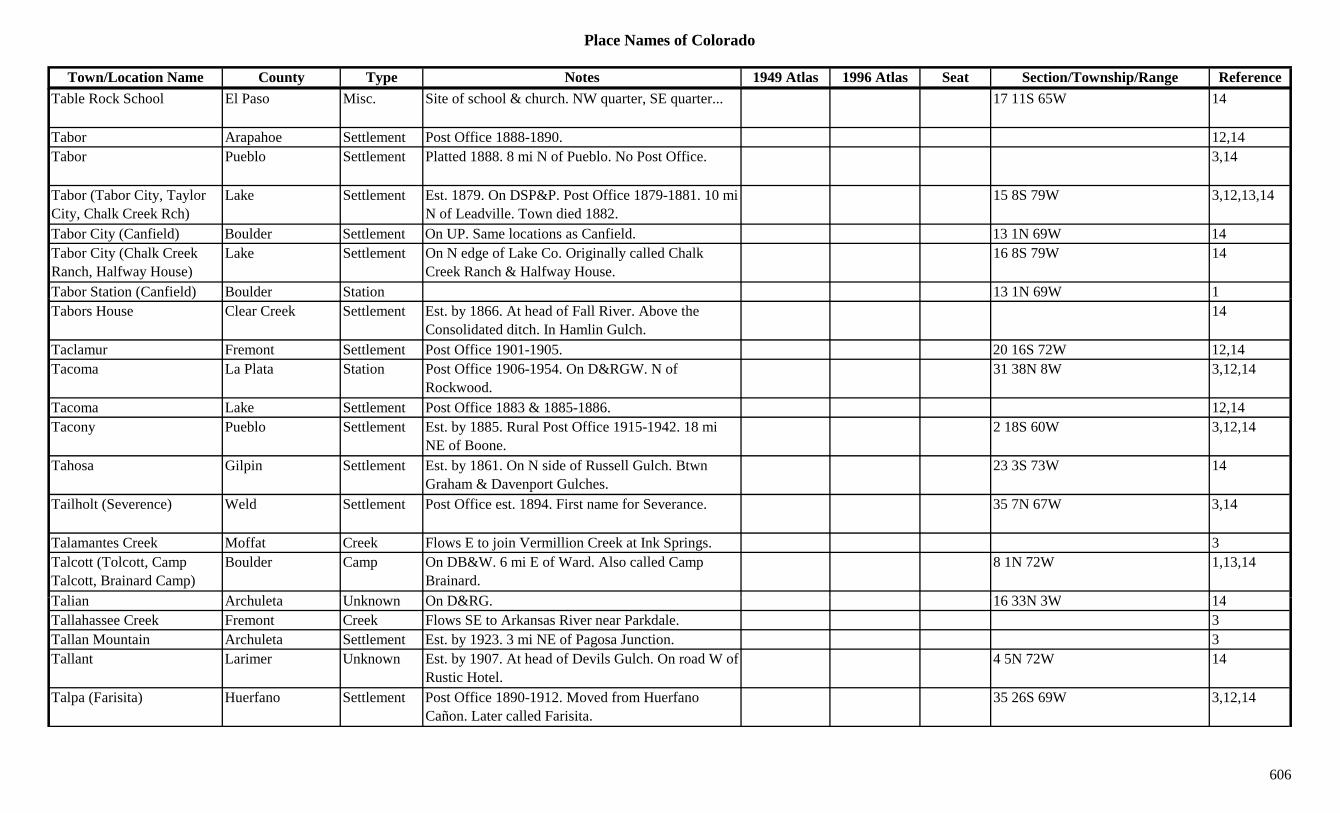
Place Names of Colorado
Town/Location Name County Type Notes 1949 Atlas 1996 Atlas Seat Section/Township/Range ReferenceTable Rock School El Paso Misc. Site of school & church. NW quarter, SE quarter... 17 11S 65W 14
Tabor Arapahoe Settlement Post Office 1888-1890. 12,14Tabor Pueblo Settlement Platted 1888. 8 mi N of Pueblo. No Post Office. 3,14
Tabor (Tabor City, Taylor City, Chalk Creek Rch)
Lake Settlement Est. 1879. On DSP&P. Post Office 1879-1881. 10 mi N of Leadville. Town died 1882.
15 8S 79W 3,12,13,14
Tabor City (Canfield) Boulder Settlement On UP. Same locations as Canfield. 13 1N 69W 14Tabor City (Chalk Creek Ranch, Halfway House)
Lake Settlement On N edge of Lake Co. Originally called Chalk Creek Ranch & Halfway House.
16 8S 79W 14
Tabor Station (Canfield) Boulder Station 13 1N 69W 1( )Tabors House Clear Creek Settlement Est. by 1866. At head of Fall River. Above the
Consolidated ditch. In Hamlin Gulch.14
Taclamur Fremont Settlement Post Office 1901-1905. 20 16S 72W 12,14Tacoma La Plata Station Post Office 1906-1954. On D&RGW. N of
Rockwood.31 38N 8W 3,12,14
Tacoma Lake Settlement Post Office 1883 & 1885-1886. 12,14Tacony Pueblo Settlement Est. by 1885. Rural Post Office 1915-1942. 18 mi
NE of Boone.2 18S 60W 3,12,14
Tahosa Gilpin Settlement Est. by 1861. On N side of Russell Gulch. Btwn Graham & Davenport Gulches.
23 3S 73W 14
Tailholt (Severence) Weld Settlement Post Office est. 1894. First name for Severance. 35 7N 67W 3,14
Talamantes Creek Moffat Creek Flows E to join Vermillion Creek at Ink Springs. 3Talcott (Tolcott, Camp Talcott, Brainard Camp)
Boulder Camp On DB&W. 6 mi E of Ward. Also called Camp Brainard.
8 1N 72W 1,13,14
T li A h l t U k O D&RG 16 33N 3W 14Talian Archuleta Unknown On D&RG. 16 33N 3W 14Tallahassee Creek Fremont Creek Flows SE to Arkansas River near Parkdale. 3Tallan Mountain Archuleta Settlement Est. by 1923. 3 mi NE of Pagosa Junction. 3Tallant Larimer Unknown Est. by 1907. At head of Devils Gulch. On road W of
Rustic Hotel.4 5N 72W 14
Talpa (Farisita) Huerfano Settlement Post Office 1890-1912. Moved from Huerfano Cañon. Later called Farisita.
35 26S 69W 3,12,14
606
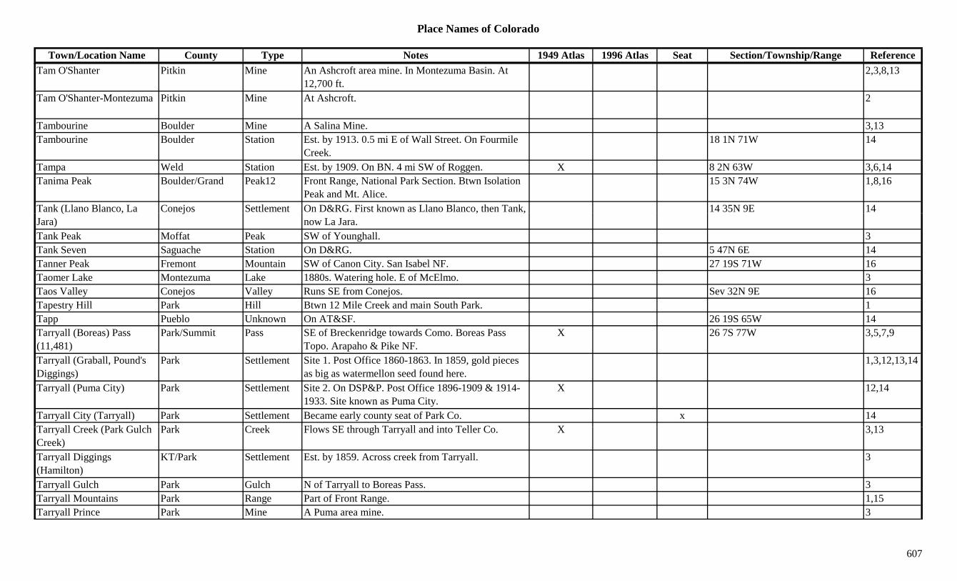
Place Names of Colorado
Town/Location Name County Type Notes 1949 Atlas 1996 Atlas Seat Section/Township/Range ReferenceTam O'Shanter Pitkin Mine An Ashcroft area mine. In Montezuma Basin. At
12,700 ft.2,3,8,13
Tam O'Shanter-Montezuma Pitkin Mine At Ashcroft. 2
Tambourine Boulder Mine A Salina Mine. 3,13Tambourine Boulder Station Est. by 1913. 0.5 mi E of Wall Street. On Fourmile
Creek.18 1N 71W 14
Tampa Weld Station Est. by 1909. On BN. 4 mi SW of Roggen. X 8 2N 63W 3,6,14Tanima Peak Boulder/Grand Peak12 Front Range, National Park Section. Btwn Isolation
Peak and Mt. Alice.15 3N 74W 1,8,16
Tank (Llano Blanco, La Conejos Settlement On D&RG. First known as Llano Blanco, then Tank, 14 35N 9E 14( ,Jara)
j , ,now La Jara.
Tank Peak Moffat Peak SW of Younghall. 3Tank Seven Saguache Station On D&RG. 5 47N 6E 14Tanner Peak Fremont Mountain SW of Canon City. San Isabel NF. 27 19S 71W 16Taomer Lake Montezuma Lake 1880s. Watering hole. E of McElmo. 3Taos Valley Conejos Valley Runs SE from Conejos. Sev 32N 9E 16Tapestry Hill Park Hill Btwn 12 Mile Creek and main South Park. 1Tapp Pueblo Unknown On AT&SF. 26 19S 65W 14Tarryall (Boreas) Pass (11,481)
Park/Summit Pass SE of Breckenridge towards Como. Boreas Pass Topo. Arapaho & Pike NF.
X 26 7S 77W 3,5,7,9
Tarryall (Graball, Pound's Diggings)
Park Settlement Site 1. Post Office 1860-1863. In 1859, gold pieces as big as watermellon seed found here.
1,3,12,13,14
Tarryall (Puma City) Park Settlement Site 2. On DSP&P. Post Office 1896-1909 & 1914-1933. Site known as Puma City.
X 12,14
Tarryall City (Tarryall) Park Settlement Became early county seat of Park Co. x 14T ll C k (P k G l h P k C k Fl SE th h T ll d i t T ll C X 3 13Tarryall Creek (Park Gulch Creek)
Park Creek Flows SE through Tarryall and into Teller Co. X 3,13
Tarryall Diggings (Hamilton)
KT/Park Settlement Est. by 1859. Across creek from Tarryall. 3
Tarryall Gulch Park Gulch N of Tarryall to Boreas Pass. 3Tarryall Mountains Park Range Part of Front Range. 1,15Tarryall Prince Park Mine A Puma area mine. 3
607

Place Names of Colorado
Town/Location Name County Type Notes 1949 Atlas 1996 Atlas Seat Section/Township/Range ReferenceTarryall Reservoir Park Lake NW of Lake George, on Tarryall River. XTasmania Chaffee Mine At Winfield. 2Tass Butte Rio Blanco Hill 1879. N of battlefield of Thornburgh & the Utes. 3
Tattle Kit Carson Settlement A Post Office just S of the Yuma Co. line. 24 mi W of Kansas-Colorado line.
14
Taussig Reservoir No 1 Grand Lake West of Williams Fork Res. 29 1N 79W 16Tayler Waterwheel Clear Creek Misc At Idaho Springs. Relocated to present site in 1945. 13
Taylor Archuleta Unknown On D&RG. 17 34N 3W 14Taylor (Roaring Fork) Pass Gunnison/Pitkin Pass Btwn Taylor Park and Aspen. Hayden Peak Topo. 10 12S 84W 3,5,7,8,9,16y ( g ) y p y p
White River & Gunnison NF., , , , ,
Taylor (Taylor City, Cooper)
Summit/Eagle Settlement Post Office 1882-1886. Was Cooper. Renamed Cooper. 2 mi S of present site of Mitchell.
11 8S 80W 3,12,14
Taylor (Taylors) Larimer Station Est. by 1882. On UPD&G. 4 mi S of Wyoming line. 9 11N 68W 3,14
Taylor (Warren) Weld Station Est. by 1922. On UP. Same site as Warren. 3Taylor City (Dorchester) Gunnison Settlement Platted near Dorchester. On Taylor River Road. Not
built, but first site of Dorchester.3,14
Taylor City (Tabor, Chalk Creek Ranch)
Lake Mine See Tabor City. 3
Taylor Creek Eagle Station Est. by 1906. On CM. 12 8S 86W 14Taylor Creek Montezuma Creek Flows from Dolores Co. to Dolores River near
Muldoon.3
Taylor Creek Rio Blanco Creek Flows N from Garfield Co. to Piceance Creek. 3Taylor Creek Pass (9,640 or 10 200)
Eagle Pass NE of Basalt. S of Gypsum. White River NF. 24 7S 86W 710,200)Taylor Gulch Fremont Gulch South of Wellsville. Sev 49N 10E 16Taylor Hill Eagle Peak11 Far SE corner of county. White River NF. 1 8S 80W 16Taylor Hill Eagle Settlement On Taylor Hill in Gore Range. 1 8S 80W 14Taylor Mesa Dolores/Montezu
maHill E part of county. 13
608
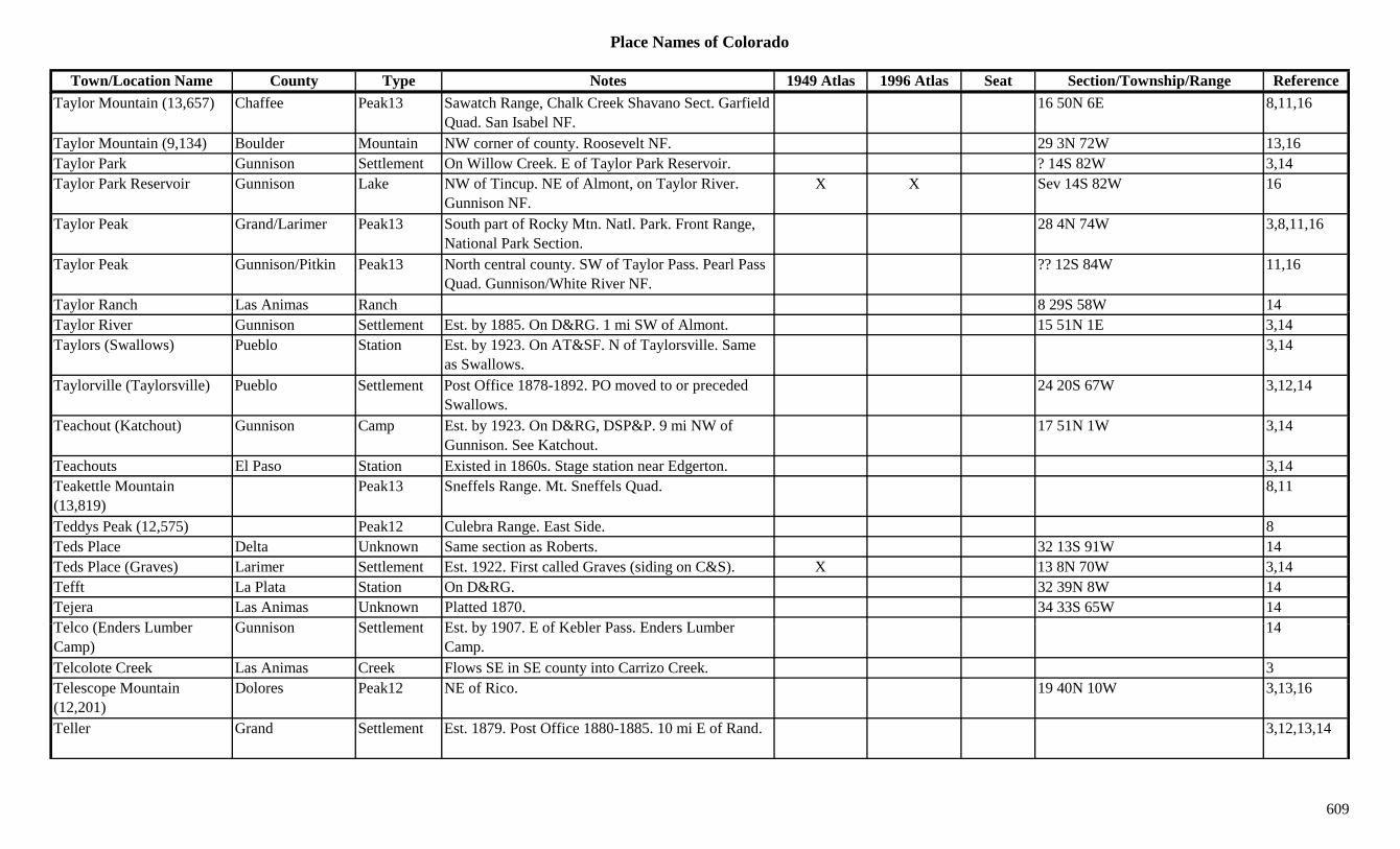
Place Names of Colorado
Town/Location Name County Type Notes 1949 Atlas 1996 Atlas Seat Section/Township/Range ReferenceTaylor Mountain (13,657) Chaffee Peak13 Sawatch Range, Chalk Creek Shavano Sect. Garfield
Quad. San Isabel NF.16 50N 6E 8,11,16
Taylor Mountain (9,134) Boulder Mountain NW corner of county. Roosevelt NF. 29 3N 72W 13,16Taylor Park Gunnison Settlement On Willow Creek. E of Taylor Park Reservoir. ? 14S 82W 3,14Taylor Park Reservoir Gunnison Lake NW of Tincup. NE of Almont, on Taylor River.
Gunnison NF.X X Sev 14S 82W 16
Taylor Peak Grand/Larimer Peak13 South part of Rocky Mtn. Natl. Park. Front Range, National Park Section.
28 4N 74W 3,8,11,16
Taylor Peak Gunnison/Pitkin Peak13 North central county. SW of Taylor Pass. Pearl Pass Quad. Gunnison/White River NF.
?? 12S 84W 11,16
Taylor Ranch Las Animas Ranch 8 29S 58W 14yTaylor River Gunnison Settlement Est. by 1885. On D&RG. 1 mi SW of Almont. 15 51N 1E 3,14Taylors (Swallows) Pueblo Station Est. by 1923. On AT&SF. N of Taylorsville. Same
as Swallows.3,14
Taylorville (Taylorsville) Pueblo Settlement Post Office 1878-1892. PO moved to or preceded Swallows.
24 20S 67W 3,12,14
Teachout (Katchout) Gunnison Camp Est. by 1923. On D&RG, DSP&P. 9 mi NW of Gunnison. See Katchout.
17 51N 1W 3,14
Teachouts El Paso Station Existed in 1860s. Stage station near Edgerton. 3,14Teakettle Mountain (13,819)
Peak13 Sneffels Range. Mt. Sneffels Quad. 8,11
Teddys Peak (12,575) Peak12 Culebra Range. East Side. 8Teds Place Delta Unknown Same section as Roberts. 32 13S 91W 14Teds Place (Graves) Larimer Settlement Est. 1922. First called Graves (siding on C&S). X 13 8N 70W 3,14Tefft La Plata Station On D&RG. 32 39N 8W 14Tejera Las Animas Unknown Platted 1870. 34 33S 65W 14T l (E d L b G i S ttl t E t b 1907 E f K bl P E d L b 14Telco (Enders Lumber Camp)
Gunnison Settlement Est. by 1907. E of Kebler Pass. Enders Lumber Camp.
14
Telcolote Creek Las Animas Creek Flows SE in SE county into Carrizo Creek. 3Telescope Mountain (12,201)
Dolores Peak12 NE of Rico. 19 40N 10W 3,13,16
Teller Grand Settlement Est. 1879. Post Office 1880-1885. 10 mi E of Rand. 3,12,13,14
609
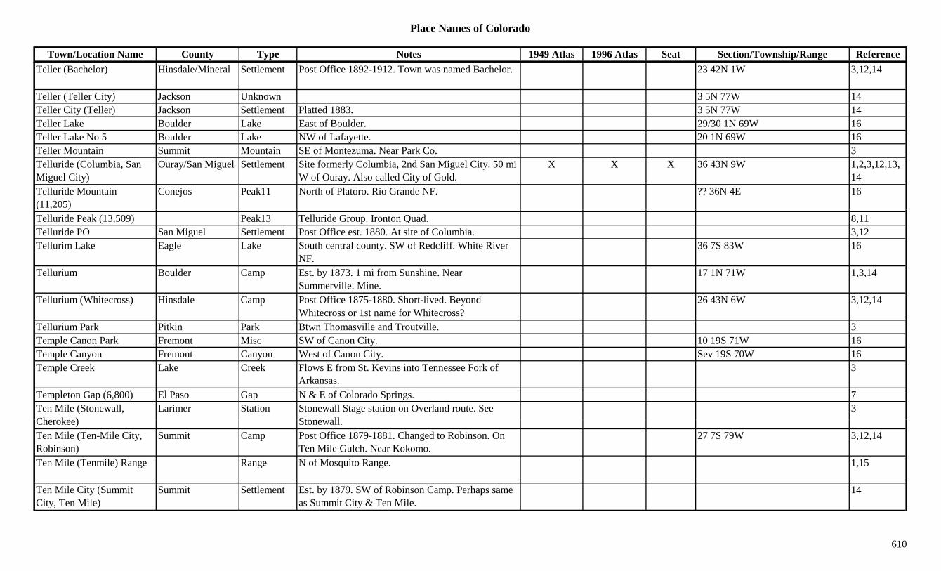
Place Names of Colorado
Town/Location Name County Type Notes 1949 Atlas 1996 Atlas Seat Section/Township/Range ReferenceTeller (Bachelor) Hinsdale/Mineral Settlement Post Office 1892-1912. Town was named Bachelor. 23 42N 1W 3,12,14
Teller (Teller City) Jackson Unknown 3 5N 77W 14Teller City (Teller) Jackson Settlement Platted 1883. 3 5N 77W 14Teller Lake Boulder Lake East of Boulder. 29/30 1N 69W 16Teller Lake No 5 Boulder Lake NW of Lafayette. 20 1N 69W 16Teller Mountain Summit Mountain SE of Montezuma. Near Park Co. 3Telluride (Columbia, San Miguel City)
Ouray/San Miguel Settlement Site formerly Columbia, 2nd San Miguel City. 50 mi W of Ouray. Also called City of Gold.
X X X 36 43N 9W 1,2,3,12,13,14
Telluride Mountain (11,205)
Conejos Peak11 North of Platoro. Rio Grande NF. ?? 36N 4E 16
Telluride Peak (13,509) Peak13 Telluride Group. Ironton Quad. 8,11Telluride PO San Miguel Settlement Post Office est. 1880. At site of Columbia. 3,12Tellurim Lake Eagle Lake South central county. SW of Redcliff. White River
NF.36 7S 83W 16
Tellurium Boulder Camp Est. by 1873. 1 mi from Sunshine. Near Summerville. Mine.
17 1N 71W 1,3,14
Tellurium (Whitecross) Hinsdale Camp Post Office 1875-1880. Short-lived. Beyond Whitecross or 1st name for Whitecross?
26 43N 6W 3,12,14
Tellurium Park Pitkin Park Btwn Thomasville and Troutville. 3Temple Canon Park Fremont Misc SW of Canon City. 10 19S 71W 16Temple Canyon Fremont Canyon West of Canon City. Sev 19S 70W 16Temple Creek Lake Creek Flows E from St. Kevins into Tennessee Fork of
Arkansas.3
Templeton Gap (6,800) El Paso Gap N & E of Colorado Springs. 7Ten Mile (Stonewall, Ch k )
Larimer Station Stonewall Stage station on Overland route. See St ll
3Cherokee) Stonewall.Ten Mile (Ten-Mile City, Robinson)
Summit Camp Post Office 1879-1881. Changed to Robinson. On Ten Mile Gulch. Near Kokomo.
27 7S 79W 3,12,14
Ten Mile (Tenmile) Range Range N of Mosquito Range. 1,15
Ten Mile City (Summit City, Ten Mile)
Summit Settlement Est. by 1879. SW of Robinson Camp. Perhaps same as Summit City & Ten Mile.
14
610
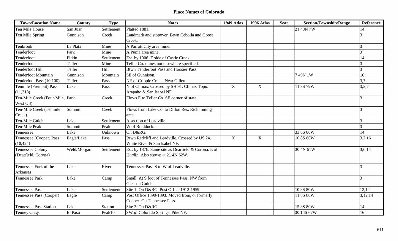
Place Names of Colorado
Town/Location Name County Type Notes 1949 Atlas 1996 Atlas Seat Section/Township/Range ReferenceTen Mile House San Juan Settlement Platted 1881. 21 40N 7W 14Ten Mile Spring Gunnison Creek Landmark and stopover. Btwn Cebolla and Goose
Creek.3
Tenbrook La Plata Mine A Parrott City area mine. 3Tenderfoot Park Mine A Puma area mine. 3Tenderfoot Pitkin Settlement Est. by 1906. E side of Castle Creek. 14Tenderfoot Teller Mine Teller Co. mines not elsewhere specified. 3Tenderfoot Hill Teller Hill Btwn Tenderfoot Pass and Hoosier Pass. 3Tenderfoot Mountain Gunnison Mountain SE of Gunnison. 7 49N 1W 16Tenderfoot Pass (10,100) Teller Pass NE of Cripple Creek. Near Gillett. 3,7Tenmile (Fremont) Pass Lake Pass N of Climax. Crossed by SH 91. Climax Topo. X X 11 8S 79W 3,5,7( )(11,318)
y pArapaho & San Isabel NF.
, ,
Ten-Mile Creek (Four-Mile, West Oil)
Park Creek Flows E to Teller Co. SE corner of state. 3
Ten-Mile Creek (Tenmile Creek)
Summit Creek Flows from Lake Co. to Dillon Res. Rich mining area.
3
Ten-Mile Gulch Lake Settlement A section of Leadville. 3Ten-Mile Peak Summit Peak W of Braddock. 3Tennessee Lake Unknown On D&RG. 33 8S 80W 14Tennessee (Cooper) Pass (10,424)
Eagle/Lake Pass Btwn Redcliff and Leadville. Crossed by US 24. White River & San Isabel NF.
X X 10 8S 80W 3,7,16
Tennessee Colony (Dearfield, Corona)
Weld/Morgan Settlement Est. by 1876. Same site as Dearfield & Corona. E of Hardin. Also shown at 21 4N 62W.
30 4N 61W 3,6,14
Tennessee Fork of the Arkansas
Lake River Tennessee Pass S to W of Leadville. 3
T P k L k C S ll At S f t f T P NW f 3Tennessee Park Lake Camp Small. At S foot of Tennessee Pass. NW from Gleason Gulch.
3
Tennessee Pass Lake Settlement Site 1. On D&RG. Post Office 1912-1959. 10 8S 80W 12,14Tennessee Pass (Cooper) Eagle Camp Post Office 1890-1893. Moved from, or formerly
Cooper. On Tennessee Pass.11 8S 80W 3,12,14
Tennessee Pass Station Lake Station Site 2. On D&RG. 15 8S 80W 14Tenney Crags El Paso Peak10 SW of Colorado Springs. Pike NF. 30 14S 67W 16
611
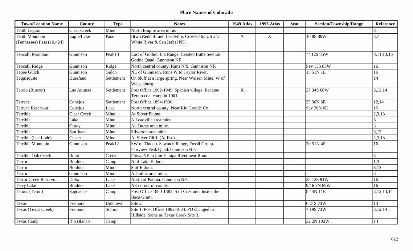
Place Names of Colorado
Town/Location Name County Type Notes 1949 Atlas 1996 Atlas Seat Section/Township/Range ReferenceTenth Legion Clear Creek Mine North Empire area mine. 3Tenth Mountain (Tennessee) Pass (10,424)
Eagle/Lake Pass Btwn Redcliff and Leadville. Crossed by US 24. White River & San Isabel NF.
X X 10 8S 80W 3,7
Teocalli Mountain Gunnison Peak13 East of Gothic. Elk Range, Crested Butte Section. Gothic Quad. Gunnison NF.
?? 12S 85W 8,11,13,16
Teocalli Ridge Gunnison Ridge North central county. Runs N/S. Gunnison NF. Sev 13S 85W 16Tepee Gulch Gunnison Gulch NE of Gunnison. Runs W to Taylor River. 13 51N 1E 16Tequisquite Huerfano Settlement On bluff at a large spring. Near Walsen Mine. W of
Walsenburg.14
Tercio (Rincon) Las Animas Settlement Post Office 1902-1949. Spanish village. Became X 27 34S 68W 3,12,14( ) p gTercio coal camp in 1901.
, ,
Terrace Conejos Settlement Post Office 1894-1900. 25 36N 6E 12,14Terrace Reservoir Conejos Lake North central county. Near Rio Grande Co. Sev 36N 6E 16Terrible Clear Creek Mine At Silver Plume. 2,3,13Terrible Lake Mine A Leadville area mine. 3Terrible Ouray Mine An Ouray area mine. 3Terrible San Juan Mine Silverton area mine. 3,13Terrible (Isle Lode) Custer Mine At Silver Cliff. (At Ilse). 2,3,13Terrible Mountain Gunnison Peak12 SW of Tincup. Sawatch Range, Fossil Group.
Fairview Peak Quad. Gunnison NF.20 51N 4E 16
Terrible Oak Creek Routt Creek Flows NE to join Yampa River near Routt. 3Terror Boulder Camp N of Lake Eldora. 1,3Terror Boulder Mine S of Eldora. 3,13Terror Gunnison Mine A Gothic area mine. 3Terror Creek Reservoir Delta Lake North of Paonia. Gunnison NF. 28 12S 91W 16T L k B ld L k NE f t 9/16 3N 69W 16Terry Lake Boulder Lake NE corner of county. 9/16 3N 69W 16Tetons (Teton) Saguache Camp Post Office 1880-1881. S of Crestone. Inside the
Baca Grant.8 44N 11E 3,12,13,14
Texas Fremont Unknown Site 2. 6 21S 73W 14Texas (Texas Creek) Fremont Station Site 1. Post Office 1882-1884. PO changed to
Hillside. Same as Texas Creek Site 3.7 19S 73W 3,12,14
Texas Camp Rio Blanco Camp 32 2N 102W 14
612
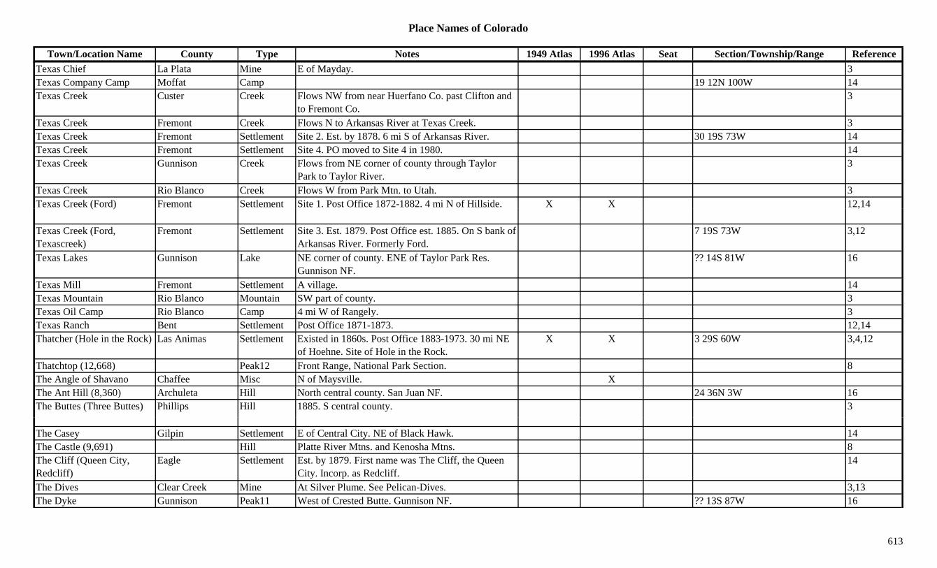
Place Names of Colorado
Town/Location Name County Type Notes 1949 Atlas 1996 Atlas Seat Section/Township/Range ReferenceTexas Chief La Plata Mine E of Mayday. 3Texas Company Camp Moffat Camp 19 12N 100W 14Texas Creek Custer Creek Flows NW from near Huerfano Co. past Clifton and
to Fremont Co.3
Texas Creek Fremont Creek Flows N to Arkansas River at Texas Creek. 3Texas Creek Fremont Settlement Site 2. Est. by 1878. 6 mi S of Arkansas River. 30 19S 73W 14Texas Creek Fremont Settlement Site 4. PO moved to Site 4 in 1980. 14Texas Creek Gunnison Creek Flows from NE corner of county through Taylor
Park to Taylor River.3
Texas Creek Rio Blanco Creek Flows W from Park Mtn. to Utah. 3Texas Creek (Ford) Fremont Settlement Site 1. Post Office 1872-1882. 4 mi N of Hillside. X X 12,14( ) ,
Texas Creek (Ford, Texascreek)
Fremont Settlement Site 3. Est. 1879. Post Office est. 1885. On S bank of Arkansas River. Formerly Ford.
7 19S 73W 3,12
Texas Lakes Gunnison Lake NE corner of county. ENE of Taylor Park Res. Gunnison NF.
?? 14S 81W 16
Texas Mill Fremont Settlement A village. 14Texas Mountain Rio Blanco Mountain SW part of county. 3Texas Oil Camp Rio Blanco Camp 4 mi W of Rangely. 3Texas Ranch Bent Settlement Post Office 1871-1873. 12,14Thatcher (Hole in the Rock) Las Animas Settlement Existed in 1860s. Post Office 1883-1973. 30 mi NE
of Hoehne. Site of Hole in the Rock.X X 3 29S 60W 3,4,12
Thatchtop (12,668) Peak12 Front Range, National Park Section. 8The Angle of Shavano Chaffee Misc N of Maysville. XThe Ant Hill (8,360) Archuleta Hill North central county. San Juan NF. 24 36N 3W 16The Buttes (Three Buttes) Phillips Hill 1885. S central county. 3
The Casey Gilpin Settlement E of Central City. NE of Black Hawk. 14The Castle (9,691) Hill Platte River Mtns. and Kenosha Mtns. 8The Cliff (Queen City, Redcliff)
Eagle Settlement Est. by 1879. First name was The Cliff, the Queen City. Incorp. as Redcliff.
14
The Dives Clear Creek Mine At Silver Plume. See Pelican-Dives. 3,13The Dyke Gunnison Peak11 West of Crested Butte. Gunnison NF. ?? 13S 87W 16
613
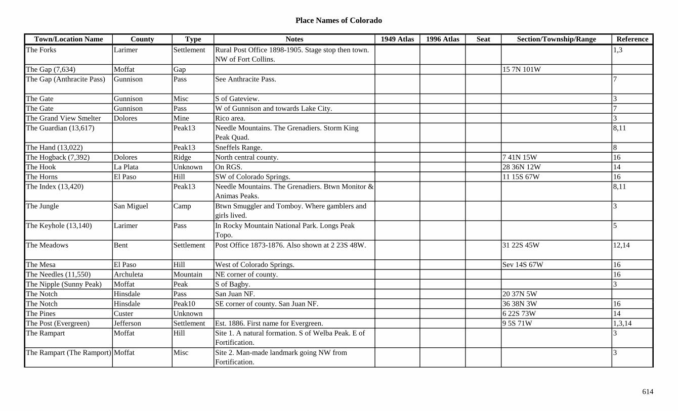
Place Names of Colorado
Town/Location Name County Type Notes 1949 Atlas 1996 Atlas Seat Section/Township/Range ReferenceThe Forks Larimer Settlement Rural Post Office 1898-1905. Stage stop then town.
NW of Fort Collins.1,3
The Gap (7,634) Moffat Gap 15 7N 101WThe Gap (Anthracite Pass) Gunnison Pass See Anthracite Pass. 7
The Gate Gunnison Misc S of Gateview. 3The Gate Gunnison Pass W of Gunnison and towards Lake City. 7The Grand View Smelter Dolores Mine Rico area. 3The Guardian (13,617) Peak13 Needle Mountains. The Grenadiers. Storm King
Peak Quad.8,11
The Hand (13,022) Peak13 Sneffels Range. 8( , ) gThe Hogback (7,392) Dolores Ridge North central county. 7 41N 15W 16The Hook La Plata Unknown On RGS. 28 36N 12W 14The Horns El Paso Hill SW of Colorado Springs. 11 15S 67W 16The Index (13,420) Peak13 Needle Mountains. The Grenadiers. Btwn Monitor &
Animas Peaks.8,11
The Jungle San Miguel Camp Btwn Smuggler and Tomboy. Where gamblers and girls lived.
3
The Keyhole (13,140) Larimer Pass In Rocky Mountain National Park. Longs Peak Topo.
5
The Meadows Bent Settlement Post Office 1873-1876. Also shown at 2 23S 48W. 31 22S 45W 12,14
The Mesa El Paso Hill West of Colorado Springs. Sev 14S 67W 16The Needles (11,550) Archuleta Mountain NE corner of county. 16The Nipple (Sunny Peak) Moffat Peak S of Bagby. 3The Notch Hinsdale Pass San Juan NF. 20 37N 5WTh N t h Hi d l P k10 SE f t S J NF 36 38N 3W 16The Notch Hinsdale Peak10 SE corner of county. San Juan NF. 36 38N 3W 16The Pines Custer Unknown 6 22S 73W 14The Post (Evergreen) Jefferson Settlement Est. 1886. First name for Evergreen. 9 5S 71W 1,3,14The Rampart Moffat Hill Site 1. A natural formation. S of Welba Peak. E of
Fortification.3
The Rampart (The Ramport) Moffat Misc Site 2. Man-made landmark going NW from Fortification.
3
614

Place Names of Colorado
Town/Location Name County Type Notes 1949 Atlas 1996 Atlas Seat Section/Township/Range ReferenceThe Ramport (The Rampart?)
Moffat Unknown Est. by 1881. On Fortification Creek. 20 mi N of Windsor.
14
The Rook La Plata Unknown On RGS. 27 36N 12W 14The Saddle (12,398) Larimer Pass NW of Estes Park. N of Trail Ridge Road. Trail
Ridge Topo.5,7
The Spider (12,697) Peak12 Gore Range, East Side. 8The Wheel Mill Eagle Mill S of Fulford. A large arastra. 3,13The Wild Irishman Summit Camp SW of Montezuma. At site of Wild Irishman Mine. 3
The Window Hinsdale Pass Rio Grande & San Juan NF.Thedalund Adams Settlement Rural Post Office 1917-1926. 5 mi NE of Byers. 26 2S 61W 3,6,12,14y , , ,
Theisen (Thiesen) Routt Station Post Office 1909-1911. On D&SL. Same area as site of Volcano.
8 1S 83W 3,12,14
Theodore (Divide) Teller Settlement Early name for Divide. 14Thespian Lake Mine A California Gulch mine. 3Third Creek Adams Creek Flows NW from E of Rocky Mountain Arsenal to
Barr Lake.16
Third Gulch Eagle Gulch West central county. Sev 5S 84W 16Thirsty Peak (13,213) Peak13 Sangre de Cristo Range, San Luis Valley Side.
Electric Peak Quad.8,11
Thirty-Mile Camp Hinsdale Camp E end of Rio Grande Reservoir. 3Thirty-Nine Mile Mountain (9-Mile Mountain)
Park Mountain SW of Idlewild. 3
Thirty-One Mile Creek Park Creek 1885. Flows E to Grant Creek above Soda Spring. 3
Thistledown Ouray Unknown 12 43N 8W 14Thomas Jefferson Station Est. by 1920. On C&S. 6 mi SW of Littleton. 14 6S 69W 3,6,14Thomas Mountain (8,760) Dolores Mountain Central county. 23 41N 15W 16Thomasville Pitkin Settlement Post Office 1890-1918. Formerly Calcium.
Settlement around mine & smelter.X 18 8S 83W 3,12,14
Thomos Gulch Fremont Gulch Central county. S of Texas Creek (town). Sev 19S 73W 16
615

Place Names of Colorado
Town/Location Name County Type Notes 1949 Atlas 1996 Atlas Seat Section/Township/Range ReferenceThompson Fremont Station Est. by 1885. On D&RGW. 2 mi E of Beaver Creek. 14 19S 68W 3,14
Thompson Jefferson Settlement On DSP&P. Located prior to Cliff & Cliffdale. 32 2S 69W 6,14Thompson Las Animas Unknown On C&W. 30 33S 64W 14Thompson Summit Mine A Dyersville area mine. 3Thompson (Thompson Creek, Sewell-Thompson)
Pitkin Station Called Thompson Creek, Sewell-Thompson. Where the A&W (RR) joined the CR&SJ.
27 8S 88W 14
Thompson Claim Summit Mine Near Dyersville. 13Thompson Creek (Thompson)
Pitkin Station See Thompson. 27 8S 88W 14
Thompson Creek Mine Pitkin Mine 21 9S 89W 14Thompson Creek Mine Pitkin Station On A&W. 21 9S 89W 14Thompson's Gulch Lake Gulch Near Crystal Lake. 3Thor Hinsdale Mine A Carson area mine. 3,13Thor Las Animas Unknown 13 32S 64W 14Thorn Lake Gilpin Lake NE of Central City. 16 2S 72W 16Thornburg (Thornburgh) Rio Blanco Settlement Post Office 1900-1937. Settlement in area of
Thornburgh's battle.X 25 3N 92W 3,12,14
Thornburg Massacre Grand ? Fight 1Thornburg Mountain Moffat Mountain S of Loyd. Near Rio Blanco Co. 3Thornton Adams Settlement Built 1952. X Sev 2S 68W 1,3,6,14Thornton Teller Unknown 15 11S 69W 14Thornton (Wagon Wheel Gap)
Mineral Settlement On D&RG. Post Office 1895-1901. Changed to Wagon Wheel Gap.
36 41N 1E 12,14
Thorodin Mountain Gilpin Peak10 South of Wondervu. Roosevelt NF. 11 2S 72W 16Th di M t i B ld M t i F t R B ld G 8Thorodin Mountain (10,555)
Boulder Mountain Front Range, Boulder Group. 8
Thorpe Park Settlement W of Tarryall. ? 11S 72W 14Three Apostles (Center) Gunnison Peak13 Sawatch Range, Collegiate Section. Winfield Quad. 15 13S 81W 8,11,16
Three Apostles (East) Gunnison Peak13 Sawatch Range, Collegiate Section. San Isabel NF. 15 13S 81W 16
616

Place Names of Colorado
Town/Location Name County Type Notes 1949 Atlas 1996 Atlas Seat Section/Township/Range ReferenceThree Apostles (West) Chaffee Peak13 Sawatch Range, Collegiate Section. San Isabel NF. 16 13S 81W 8,11,16
Three Buttes (The Buttes) Phillips Hill 1885. S central county. 3
Three Faces Mountain (13,688)
Peak13 San Juans, Lake City Group. 8
Three Joes (Joes) Yuma Settlement Est. 1912 6 4S 47W 1,14Three Kings Summit Mine At Swandyke. 2,3,13Three Needles (13,481) Peak13 Telluride Group. Telluride Quad. 8,11Three Sisters (Center) Hinsdale Peak11 SW corner of county. San Juan NF. ?? 37N 5W 16Three Sisters (North) Hinsdale Peak11 SW corner of county. San Juan NF. ?? 37N 5W 16( ) yThree Sisters (South) Hinsdale Peak11 SW corner of county. San Juan NF. ?? 37N 5W 16Three-Corner Table (13,841)
Peak13 The Bend Area. 8
Three-Mile Creek Park Creek Flows N to South Platte River at Spinney's. 3Thumb Mountain Sneffels Range. A 3-part summit with The Hand &
Penguin.8
Thunder (Lulu) Pass Grand/Jackson Pass S of Cameron Pass. Fall River Pass Topo. Routt NF. Rocky Mountain Natl Park.
24 6N 76W 5,7,16
Thunder Butte (9,779) Douglas Hill NW of Westcreek. Rampart Range Region. Pike NF. 14 10S 70W 8,13,16
Thunder Mountain (13,108) Peak13 Columbine Pass Quad. 11
Thunder Pyramid (13,932) Peak13 Elk Range, Central Section. 8
Thunderbolt Camp Montrose Camp Est. by 1916. 23 46N 17W 14Th d b lt P k G d P k11 E t t l t N B ld C A h NF 27 2N 74W 16Thunderbolt Peak Grand Peak11 East central county. Near Boulder Co. Arapaho NF. 27 2N 74W 16
Thurman (Stone City) Washington Settlement Rural Post Office 1888-1955. Platted as Stone City, quickly changed. 10 mi S of Anton.
X 21 5S 52W 3,12,14
Thurman's Creek Rio Blanco Creek 1920s. S of White River. 3Tibbits Garfield Station On D&RG. Near New Castle. 14
617
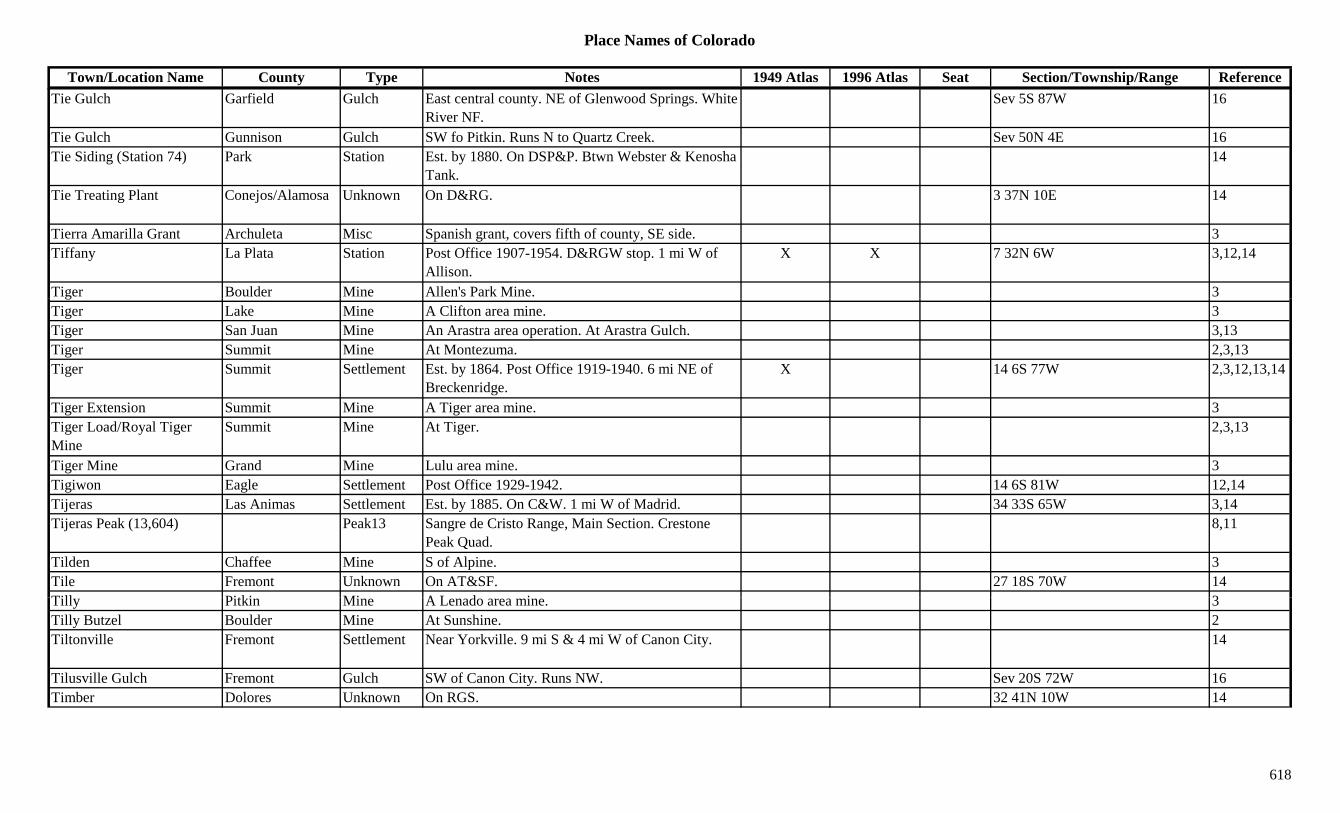
Place Names of Colorado
Town/Location Name County Type Notes 1949 Atlas 1996 Atlas Seat Section/Township/Range ReferenceTie Gulch Garfield Gulch East central county. NE of Glenwood Springs. White
River NF.Sev 5S 87W 16
Tie Gulch Gunnison Gulch SW fo Pitkin. Runs N to Quartz Creek. Sev 50N 4E 16Tie Siding (Station 74) Park Station Est. by 1880. On DSP&P. Btwn Webster & Kenosha
Tank.14
Tie Treating Plant Conejos/Alamosa Unknown On D&RG. 3 37N 10E 14
Tierra Amarilla Grant Archuleta Misc Spanish grant, covers fifth of county, SE side. 3Tiffany La Plata Station Post Office 1907-1954. D&RGW stop. 1 mi W of
Allison.X X 7 32N 6W 3,12,14
Tiger Boulder Mine Allen's Park Mine. 3gTiger Lake Mine A Clifton area mine. 3Tiger San Juan Mine An Arastra area operation. At Arastra Gulch. 3,13Tiger Summit Mine At Montezuma. 2,3,13Tiger Summit Settlement Est. by 1864. Post Office 1919-1940. 6 mi NE of
Breckenridge.X 14 6S 77W 2,3,12,13,14
Tiger Extension Summit Mine A Tiger area mine. 3Tiger Load/Royal Tiger Mine
Summit Mine At Tiger. 2,3,13
Tiger Mine Grand Mine Lulu area mine. 3Tigiwon Eagle Settlement Post Office 1929-1942. 14 6S 81W 12,14Tijeras Las Animas Settlement Est. by 1885. On C&W. 1 mi W of Madrid. 34 33S 65W 3,14Tijeras Peak (13,604) Peak13 Sangre de Cristo Range, Main Section. Crestone
Peak Quad.8,11
Tilden Chaffee Mine S of Alpine. 3Tile Fremont Unknown On AT&SF. 27 18S 70W 14Till Pitki Mi A L d i 3Tilly Pitkin Mine A Lenado area mine. 3Tilly Butzel Boulder Mine At Sunshine. 2Tiltonville Fremont Settlement Near Yorkville. 9 mi S & 4 mi W of Canon City. 14
Tilusville Gulch Fremont Gulch SW of Canon City. Runs NW. Sev 20S 72W 16Timber Dolores Unknown On RGS. 32 41N 10W 14
618
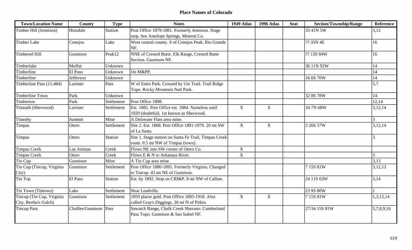
Place Names of Colorado
Town/Location Name County Type Notes 1949 Atlas 1996 Atlas Seat Section/Township/Range ReferenceTimber Hill (Jennison) Hinsdale Station Post Office 1879-1881. Formerly Jennison. Stage
stop. See Antelope Springs, Mineral Co.35 41N 5W 3,12
Timber Lake Conejos Lake West central county. S of Conejos Peak. Rio Grande NF.
?? 35N 4E 16
Timbered Hill Gunnison Peak12 NNE of Crested Butte. Elk Range, Crested Butte Section. Gunnison NF.
?? 13S 84W 16
Timberlake Moffat Unknown 36 11N 92W 14Timberline El Paso Unknown On M&PP. 14Timberline Jefferson Unknown 16 6S 70W 14Timberline Pass (11,484) Larimer Pass W of Estes Park. Crossed by Ute Trail. Trail Ridge
Topo. Rocky Mountain Natl Park.5,7
Timberline Town Park Unknown 32 8S 78W 14Timberton Park Settlement Post Office 1898. 12,14Timnath (Sherwood) Larimer Settlement Est. 1882. Post Office est. 1884. Nameless until
1920 (doubtful). 1st known as Sherwood.X X 34 7N 68W 3,12,14
Timothy Summit Mine A Delaware Flats area mine. 3Timpas Otero Settlement Site 2. Est. 1868. Post Office 1891-1970. 20 mi SW
of La Junta.X X 3 26S 57W 3,12,14
Timpas Otero Station Site 1. Stage station on Santa Fe Trail, Timpas Creek route. 0.5 mi NW of Timpas (town).
3
Timpas Creek Las Animas Creek Flows NE into SW corner of Otero Co. XTimpas Creek Otero Creek Flows E & N to Arkanasa River. X 3Tin Cup Gunnison Mine A Tin Cup area mine. 3,13Tin Cup (Tincup, Virginia City)
Gunnison Settlement Post Office 1880-1895. Formerly Virginia. Changed to Tincup. 43 mi NE of Gunnison.
7 15S 81W 3,12,13
Tin Top El Paso Station Est. by 1892. Stop on CRI&P. 8 mi NW of Calhan. 24 11S 63W 3,14
Tin Town (Tintown) Lake Settlement Near Leadville. 23 9S 80W 1Tincup (Tin Cup, Virginia City, Bertha's Gulch)
Gunnison Settlement 1859 placer gold. Post Office 1895-1918. Also called Gray's Diggings. 26 mi N of Pitkin.
X X 7 15S 81W 1,3,12,14
Tincup Pass Chaffee/Gunnison Pass Sawatch Range, Chalk Creek Shavano. Cumberland Pass Topo. Gunnison & San Isabel NF.
27/34 15S 81W 5,7,8,9,16
619

Place Names of Colorado
Town/Location Name County Type Notes 1949 Atlas 1996 Atlas Seat Section/Township/Range ReferenceTindale (Tinsdale) Jefferson Settlement Post Office 1891-1893. 12,14Tiner (Tyne, Tyner) Jackson Unknown S of Teller & Park City. Another spelling for Tyne
or Tyner?14
Tinsdale (Tindale) Jefferson Settlement Post Office 1891-1983. 6 mi N of Golden. Authors error, should be 1891-1893.
6
Tinser Rio Grande Settlement 14Tintown (Tin Town) Lake Settlement Near D&RG. N edge of Leadville. 23 9S 80W 3,14Tinytown (Tiny Town) Jefferson Other Est. 1915. Miniature city. On Turkey Creek. Near
Morrison.21 5S 70W 3,6,14
Tioga Huerfano Settlement Site 1. On D&RG. 11 mi NW of Walsenburg. 10 29S 65W 3Tioga (Big Four) Huerfano Settlement Site 2. Post Office on D&RGW 1907-1954. S of X 18 27S 67W 3,12,14g ( g )
Cucharas. Early name was Big Four., ,
Tip Top Gilpin Mine Apex area. 3Tipperary Weld Settlement Post Office 1915-1917. It's a long way to. 12,14Tiptop Gilpin Settlement Post Office 1890. N of Washington Hill at head of
Moon Gulch.12,14
Tiptop Grand Settlement Post Office 1909-1910. 12,14Tip-top Eagle Mine Holy Cross City area mine. 3Tirrietta Conejos Unknown Est. by 1876. 3 mi NE of Conejos. 14Tirvietta Costilla Unknown Est. by 1866. 10 33N 9E 14Titusville Fremont Station Existed in 1870s. Post Office 1881-1883. Stage stop
btwn Canon City and Silver Cliff.34 20S 72W 3,12,14
Titusville San Juan Camp On Kendall Mountain. SE of Silverton. Short-lived. ? 41N 7W 3,14
Titusville San Juan Mine An Arastra area operation. 3Tobacco Lake Conejos Lake NE corner of county. NE of Conejos Peak. Rio
G d NF?? 35N 4E 16
Grande NF.Tobasca (Tabasco) Las Animas Settlement On C&S. See Tabasco. 25 31S 65W 3,14Tobasco Hinsdale Camp Around mine/mill. On hill above Whitecross. 3Tobasco Mine/Mill Hinsdale Mine A White Cross area mine. 3,13Tobe Las Animas Settlement Post Office 1910-1960. Near Mesa de Maya. X 30 32S 55W 3,12,14Toben (Tobin) Logan Station On UP. 4 mi SW of Crook. X 3Tobin Logan Unknown On UP. 19 10N 49W 14
620

Place Names of Colorado
Town/Location Name County Type Notes 1949 Atlas 1996 Atlas Seat Section/Township/Range ReferenceToby Park Mine A Sacramento area mine. 3Todd Creek Adams Creek NE county. Flose E into Smith Reservoir and to
South Platte River.16
Todd Point Crowley Hill ENE of Ordway. Near Kiowa Co. 25/26 20S 55W 16Tolcott (Talcott, Camp Tolcott)
Boulder Camp SW of Ward. In Left Hand Canyon at Hanging Rock. 1,3,14
Toledo Custer Mine At Querida. 3Toledo Summit Mine Close to Keystone 1Toledo (McMillin) Bent/Prowers Settlement Post Office 1887-1889. Formerly McMillin. 12,14Toliafero (Nugget City) Gunnison Camp Post Office 1896-1898. Small camp in Dubois area.
Called Nugget City.? 50N 4E 3,12,14
Tolifaro (Toliafero, Tolliver)
Gunnison Settlement Post Office 1896-1898. Same as Toliafero & Tolliver.
14
Toll Gate Clear Creek Station Wells Fargo Stage Station on Mountain Route. Btwn Mill City & Downieville House.
14
Toll Gate Fremont Station On D&RG. On Grape Creek Road. 10 19S 71W 14Toll Gate Gunnison Settlement Site 1. Platted 1881. 4 14S 82W 14Toll Gate Gunnison Station Site 2. Platted 1880. On Marshall Pass Toll Road.
Same section as Sargents.21 48N 5E 14
Toll Gate Gunnison Station Site 3. On Williams Pass Road. 7 mi above Parlin on the John Flick Ranch.
34 50N 3E 14
Toll Gate La Plata Station Est. 1898. Road was on East Fork of Hermosa Creek.
14
Toll Gate Larimer Station Est. by 1872. On Bradford Road. 27 6S 71W 14Toll Gate Las Animas Station On Wooten Ranch. 11 mi SW of Trinidad. 14Toll Gate Ouray Settlement Est. by 1881. W of Ouray in Cañon Creek. 3T ll G t S h St ti O S id f B & Ott M R d 16 45N 4E 14Toll Gate Saguache Station On S side of Bonanza & Otto Mears Road. 16 45N 4E 14Toll Gate San Miguel Station N of Keystone on toll road to Oaks. 3Toll Gate Summit Station Est. by 1882. On Montezuma Road. 12 6S 76W 14Toll Gate (Cottonwood) Gilpin Station On North Clear Creek. At mouth of Arbuckle Creek.
Same as Cottonwood.27 3S 72W 14
Toll Gate (Eight Mile Creek)
Arapahoe Station Stage station on Cut-Off of Overland stage route. At Eight Mile Creek or Toll Gate Creek.
3,6,14
621
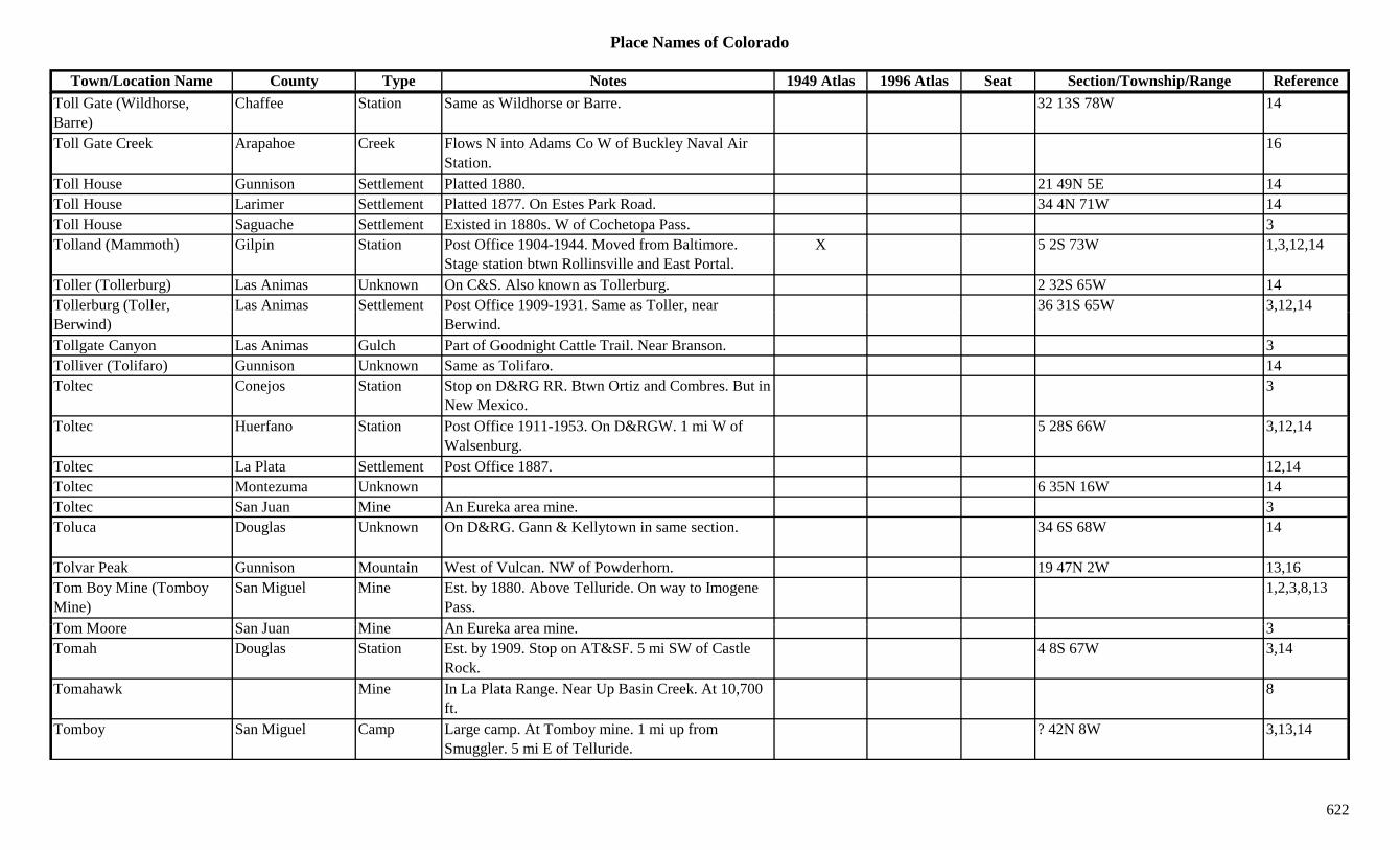
Place Names of Colorado
Town/Location Name County Type Notes 1949 Atlas 1996 Atlas Seat Section/Township/Range ReferenceToll Gate (Wildhorse, Barre)
Chaffee Station Same as Wildhorse or Barre. 32 13S 78W 14
Toll Gate Creek Arapahoe Creek Flows N into Adams Co W of Buckley Naval Air Station.
16
Toll House Gunnison Settlement Platted 1880. 21 49N 5E 14Toll House Larimer Settlement Platted 1877. On Estes Park Road. 34 4N 71W 14Toll House Saguache Settlement Existed in 1880s. W of Cochetopa Pass. 3Tolland (Mammoth) Gilpin Station Post Office 1904-1944. Moved from Baltimore.
Stage station btwn Rollinsville and East Portal.X 5 2S 73W 1,3,12,14
Toller (Tollerburg) Las Animas Unknown On C&S. Also known as Tollerburg. 2 32S 65W 14Tollerburg (Toller, Las Animas Settlement Post Office 1909-1931. Same as Toller, near 36 31S 65W 3,12,14g ( ,Berwind)
,Berwind.
, ,
Tollgate Canyon Las Animas Gulch Part of Goodnight Cattle Trail. Near Branson. 3Tolliver (Tolifaro) Gunnison Unknown Same as Tolifaro. 14Toltec Conejos Station Stop on D&RG RR. Btwn Ortiz and Combres. But in
New Mexico.3
Toltec Huerfano Station Post Office 1911-1953. On D&RGW. 1 mi W of Walsenburg.
5 28S 66W 3,12,14
Toltec La Plata Settlement Post Office 1887. 12,14Toltec Montezuma Unknown 6 35N 16W 14Toltec San Juan Mine An Eureka area mine. 3Toluca Douglas Unknown On D&RG. Gann & Kellytown in same section. 34 6S 68W 14
Tolvar Peak Gunnison Mountain West of Vulcan. NW of Powderhorn. 19 47N 2W 13,16Tom Boy Mine (Tomboy Mine)
San Miguel Mine Est. by 1880. Above Telluride. On way to Imogene Pass.
1,2,3,8,13
T M S J Mi A E k i 3Tom Moore San Juan Mine An Eureka area mine. 3Tomah Douglas Station Est. by 1909. Stop on AT&SF. 5 mi SW of Castle
Rock.4 8S 67W 3,14
Tomahawk Mine In La Plata Range. Near Up Basin Creek. At 10,700 ft.
8
Tomboy San Miguel Camp Large camp. At Tomboy mine. 1 mi up from Smuggler. 5 mi E of Telluride.
? 42N 8W 3,13,14
622
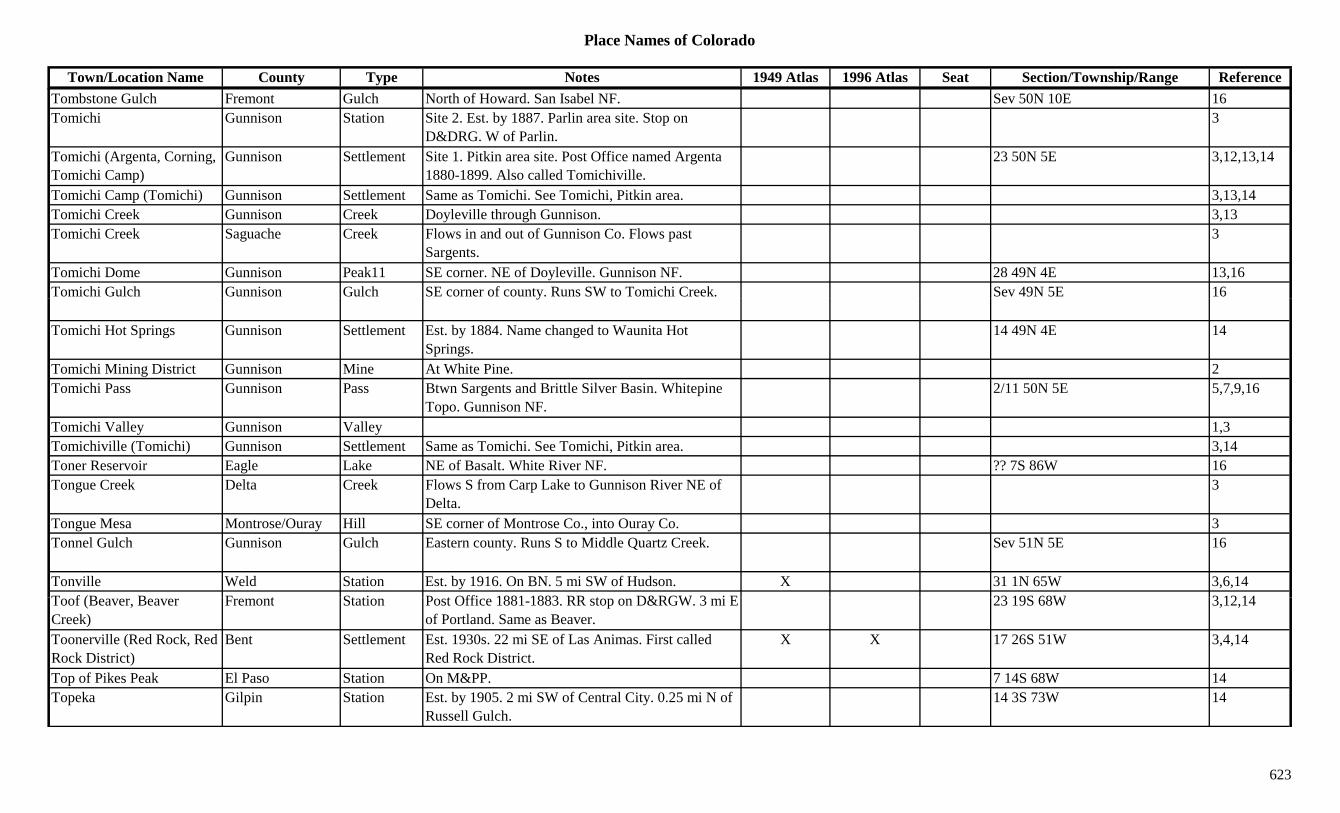
Place Names of Colorado
Town/Location Name County Type Notes 1949 Atlas 1996 Atlas Seat Section/Township/Range ReferenceTombstone Gulch Fremont Gulch North of Howard. San Isabel NF. Sev 50N 10E 16Tomichi Gunnison Station Site 2. Est. by 1887. Parlin area site. Stop on
D&DRG. W of Parlin.3
Tomichi (Argenta, Corning, Tomichi Camp)
Gunnison Settlement Site 1. Pitkin area site. Post Office named Argenta 1880-1899. Also called Tomichiville.
23 50N 5E 3,12,13,14
Tomichi Camp (Tomichi) Gunnison Settlement Same as Tomichi. See Tomichi, Pitkin area. 3,13,14Tomichi Creek Gunnison Creek Doyleville through Gunnison. 3,13Tomichi Creek Saguache Creek Flows in and out of Gunnison Co. Flows past
Sargents.3
Tomichi Dome Gunnison Peak11 SE corner. NE of Doyleville. Gunnison NF. 28 49N 4E 13,16Tomichi Gulch Gunnison Gulch SE corner of county. Runs SW to Tomichi Creek. Sev 49N 5E 16y
Tomichi Hot Springs Gunnison Settlement Est. by 1884. Name changed to Waunita Hot Springs.
14 49N 4E 14
Tomichi Mining District Gunnison Mine At White Pine. 2Tomichi Pass Gunnison Pass Btwn Sargents and Brittle Silver Basin. Whitepine
Topo. Gunnison NF.2/11 50N 5E 5,7,9,16
Tomichi Valley Gunnison Valley 1,3Tomichiville (Tomichi) Gunnison Settlement Same as Tomichi. See Tomichi, Pitkin area. 3,14Toner Reservoir Eagle Lake NE of Basalt. White River NF. ?? 7S 86W 16Tongue Creek Delta Creek Flows S from Carp Lake to Gunnison River NE of
Delta.3
Tongue Mesa Montrose/Ouray Hill SE corner of Montrose Co., into Ouray Co. 3Tonnel Gulch Gunnison Gulch Eastern county. Runs S to Middle Quartz Creek. Sev 51N 5E 16
Tonville Weld Station Est. by 1916. On BN. 5 mi SW of Hudson. X 31 1N 65W 3,6,14T f (B B F t St ti P t Offi 1881 1883 RR t D&RGW 3 i E 23 19S 68W 3 12 14Toof (Beaver, Beaver Creek)
Fremont Station Post Office 1881-1883. RR stop on D&RGW. 3 mi E of Portland. Same as Beaver.
23 19S 68W 3,12,14
Toonerville (Red Rock, Red Rock District)
Bent Settlement Est. 1930s. 22 mi SE of Las Animas. First called Red Rock District.
X X 17 26S 51W 3,4,14
Top of Pikes Peak El Paso Station On M&PP. 7 14S 68W 14Topeka Gilpin Station Est. by 1905. 2 mi SW of Central City. 0.25 mi N of
Russell Gulch.14 3S 73W 14
623
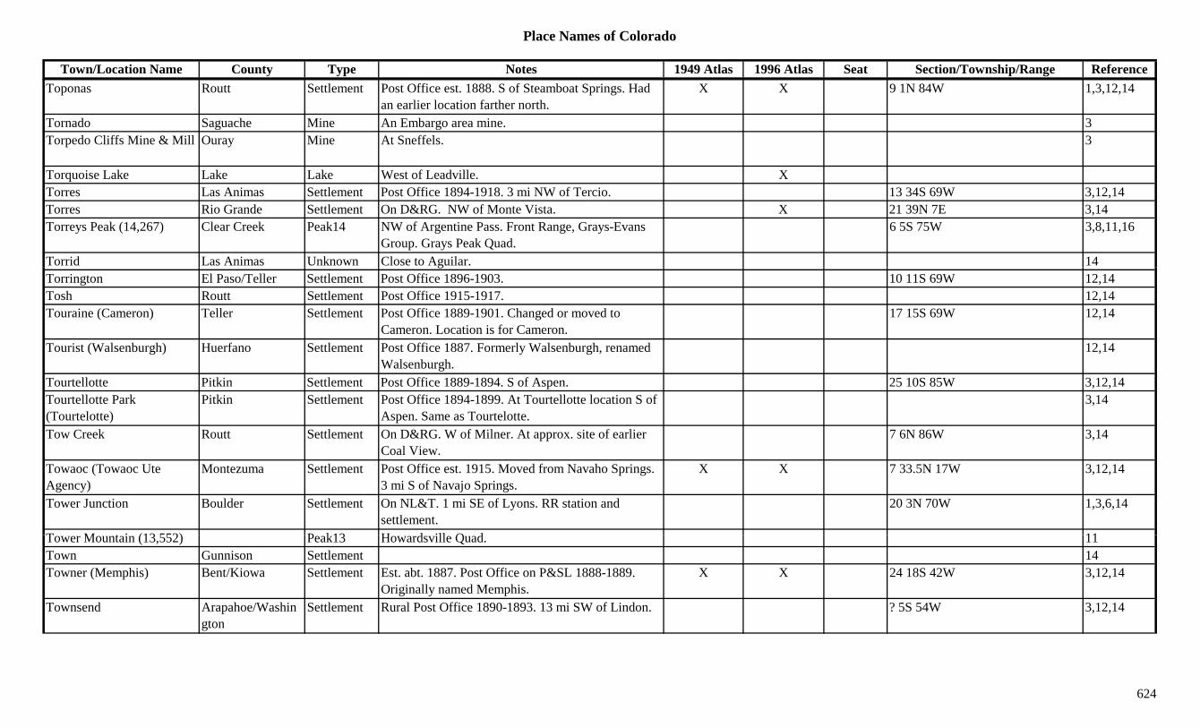
Place Names of Colorado
Town/Location Name County Type Notes 1949 Atlas 1996 Atlas Seat Section/Township/Range ReferenceToponas Routt Settlement Post Office est. 1888. S of Steamboat Springs. Had
an earlier location farther north.X X 9 1N 84W 1,3,12,14
Tornado Saguache Mine An Embargo area mine. 3Torpedo Cliffs Mine & Mill Ouray Mine At Sneffels. 3
Torquoise Lake Lake Lake West of Leadville. XTorres Las Animas Settlement Post Office 1894-1918. 3 mi NW of Tercio. 13 34S 69W 3,12,14Torres Rio Grande Settlement On D&RG. NW of Monte Vista. X 21 39N 7E 3,14Torreys Peak (14,267) Clear Creek Peak14 NW of Argentine Pass. Front Range, Grays-Evans
Group. Grays Peak Quad.6 5S 75W 3,8,11,16
Torrid Las Animas Unknown Close to Aguilar. 14gTorrington El Paso/Teller Settlement Post Office 1896-1903. 10 11S 69W 12,14Tosh Routt Settlement Post Office 1915-1917. 12,14Touraine (Cameron) Teller Settlement Post Office 1889-1901. Changed or moved to
Cameron. Location is for Cameron.17 15S 69W 12,14
Tourist (Walsenburgh) Huerfano Settlement Post Office 1887. Formerly Walsenburgh, renamed Walsenburgh.
12,14
Tourtellotte Pitkin Settlement Post Office 1889-1894. S of Aspen. 25 10S 85W 3,12,14Tourtellotte Park (Tourtelotte)
Pitkin Settlement Post Office 1894-1899. At Tourtellotte location S of Aspen. Same as Tourtelotte.
3,14
Tow Creek Routt Settlement On D&RG. W of Milner. At approx. site of earlier Coal View.
7 6N 86W 3,14
Towaoc (Towaoc Ute Agency)
Montezuma Settlement Post Office est. 1915. Moved from Navaho Springs. 3 mi S of Navajo Springs.
X X 7 33.5N 17W 3,12,14
Tower Junction Boulder Settlement On NL&T. 1 mi SE of Lyons. RR station and settlement.
20 3N 70W 1,3,6,14
T M t i (13 552) P k13 H d ill Q d 11Tower Mountain (13,552) Peak13 Howardsville Quad. 11Town Gunnison Settlement 14Towner (Memphis) Bent/Kiowa Settlement Est. abt. 1887. Post Office on P&SL 1888-1889.
Originally named Memphis.X X 24 18S 42W 3,12,14
Townsend Arapahoe/Washington
Settlement Rural Post Office 1890-1893. 13 mi SW of Lindon. ? 5S 54W 3,12,14
624
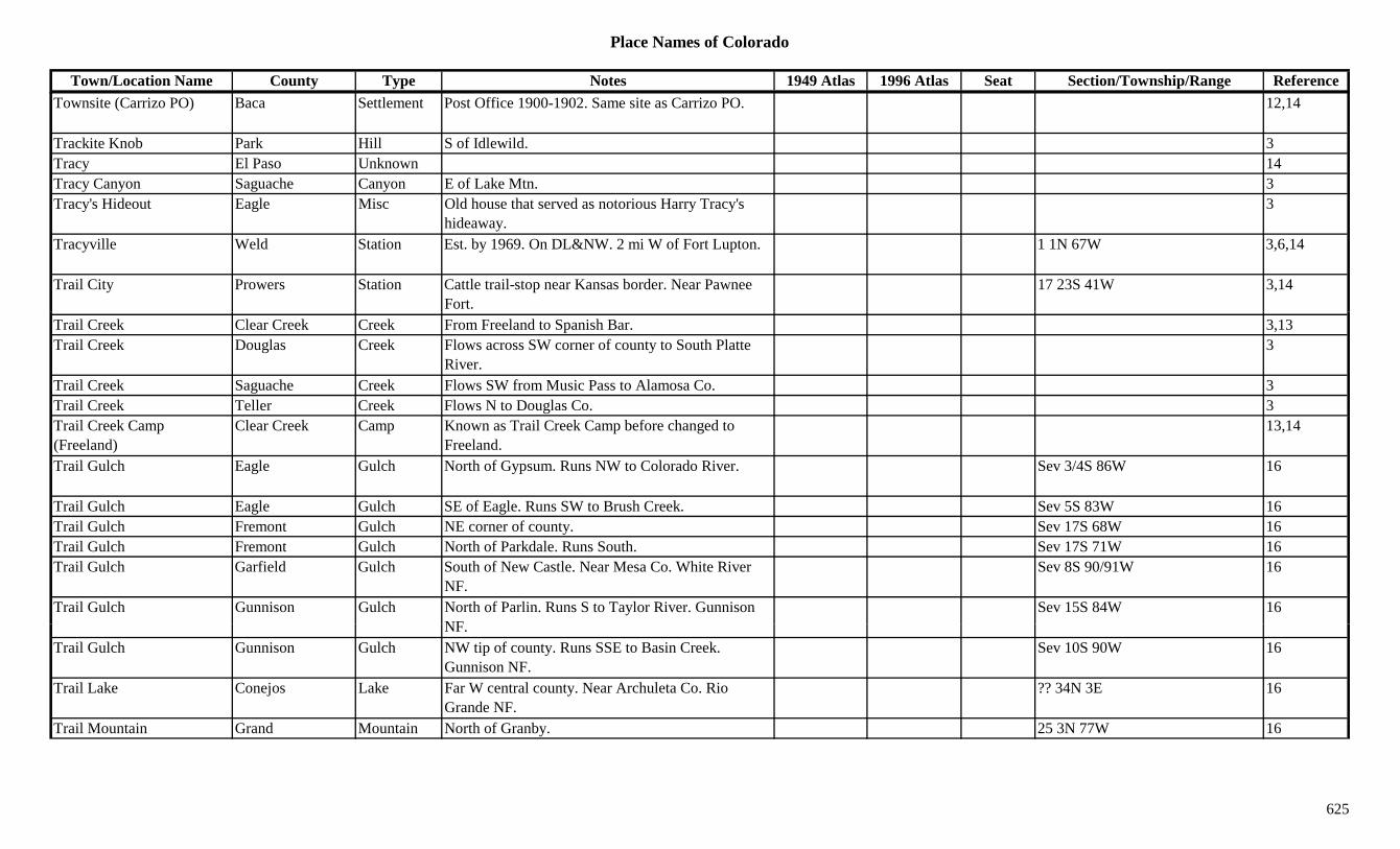
Place Names of Colorado
Town/Location Name County Type Notes 1949 Atlas 1996 Atlas Seat Section/Township/Range ReferenceTownsite (Carrizo PO) Baca Settlement Post Office 1900-1902. Same site as Carrizo PO. 12,14
Trackite Knob Park Hill S of Idlewild. 3Tracy El Paso Unknown 14Tracy Canyon Saguache Canyon E of Lake Mtn. 3Tracy's Hideout Eagle Misc Old house that served as notorious Harry Tracy's
hideaway.3
Tracyville Weld Station Est. by 1969. On DL&NW. 2 mi W of Fort Lupton. 1 1N 67W 3,6,14
Trail City Prowers Station Cattle trail-stop near Kansas border. Near Pawnee Fort.
17 23S 41W 3,14
Trail Creek Clear Creek Creek From Freeland to Spanish Bar. 3,13Trail Creek Douglas Creek Flows across SW corner of county to South Platte
River.3
Trail Creek Saguache Creek Flows SW from Music Pass to Alamosa Co. 3Trail Creek Teller Creek Flows N to Douglas Co. 3Trail Creek Camp (Freeland)
Clear Creek Camp Known as Trail Creek Camp before changed to Freeland.
13,14
Trail Gulch Eagle Gulch North of Gypsum. Runs NW to Colorado River. Sev 3/4S 86W 16
Trail Gulch Eagle Gulch SE of Eagle. Runs SW to Brush Creek. Sev 5S 83W 16Trail Gulch Fremont Gulch NE corner of county. Sev 17S 68W 16Trail Gulch Fremont Gulch North of Parkdale. Runs South. Sev 17S 71W 16Trail Gulch Garfield Gulch South of New Castle. Near Mesa Co. White River
NF.Sev 8S 90/91W 16
Trail Gulch Gunnison Gulch North of Parlin. Runs S to Taylor River. Gunnison NF
Sev 15S 84W 16NF.
Trail Gulch Gunnison Gulch NW tip of county. Runs SSE to Basin Creek. Gunnison NF.
Sev 10S 90W 16
Trail Lake Conejos Lake Far W central county. Near Archuleta Co. Rio Grande NF.
?? 34N 3E 16
Trail Mountain Grand Mountain North of Granby. 25 3N 77W 16
625

Place Names of Colorado
Town/Location Name County Type Notes 1949 Atlas 1996 Atlas Seat Section/Township/Range ReferenceTrail Rider (Trailrider) Pass Gunnison/Pitkin Pass SW of Aspen. Snowmass Mtn. Topo. White River
NF.12 11S 86W 5,7,8,16
Trail Ridge Larimer Settlement Post Office 1937-1953. Summer post office. 12,14Trail Ridge Road Larimer/Grand Trail To 12,183 feet. From Estes Park to Grand Lake. 1,3
Trail Run Clear Creek Settlement Est. by 1881. Settlement & station. At the mouth of Trail Creek. On Clear Creek.
28 3S 73W 14
Trails End Larimer Unknown 28 11N 72W 14Transfer Rio Blanco Settlement Site 1. ? 2N 88W 14Transfer Rio Blanco Settlement Site 2. Est. by 1912. On Coal Creek. 30 2N 92W 14Trap Gulch Fremont Gulch North of Howard. San Isabel NF. Sev 50N 10E 16pTrapper Routt Station Est. by 1923. On D&SL. 3 mi NW of Toponas. X 36 2N 85W 3,14Trappers Lake Garfield Lake Northern tip of Garfield Co. White River NF. X X ?? 1S 88W 16Trappers Lake Garfield Settlement Post Office 1927-1934. X ? 1N 88W 12,14Trappers Peak Garfield Peak11 NE corner of county. White River NF. ?? 1S 88W 3,8,16Trappist Monastery Pitkin Settlement 21 9S 86W 14Traver Peak (13,852) Peak13 Mosquito Range. Climax Quad. 8,11Travis Baca Settlement 9 mi NE of Vilas. 4 mi S of Two Buttes. 3,14Travis Saguache Settlement On D&RG. 2 mi W of Crestone. May have been
further to SE.2 43N 10E 3,14
Treasure Mountain Archuleta/Mineral Mountain NW corner of Archuleta Co. On border. 3
Treasure Mountain Gunnison Peak13 SE of Marble. White River NF. ?? 12S 87W 16Treasure Mountain San Juan Mine Silverton area mine. 3Treasure Mountain (13,528) Peak13 Elk Range, Crystal River Area. Snowmass Mtn.
Quad.8,11
T P (11 720) Mi l P W lf C k P 15' T C d b T Mt 7 37N 2E 5 7Treasure Pass (11,720) Mineral Pass Wolf Creek Pass 15' Topo. Crossed by Treasure Mtn Trail. San Juan & Rio Grande NF.
7 37N 2E 5,7
Treasure Vault Lake Eagle Lake South central county. SW of Redcliff. White River NF.
?? 7S 82W 16
Treasure Vault Mountain (13,701)
Peak13 Climax Quad. 1,11
626
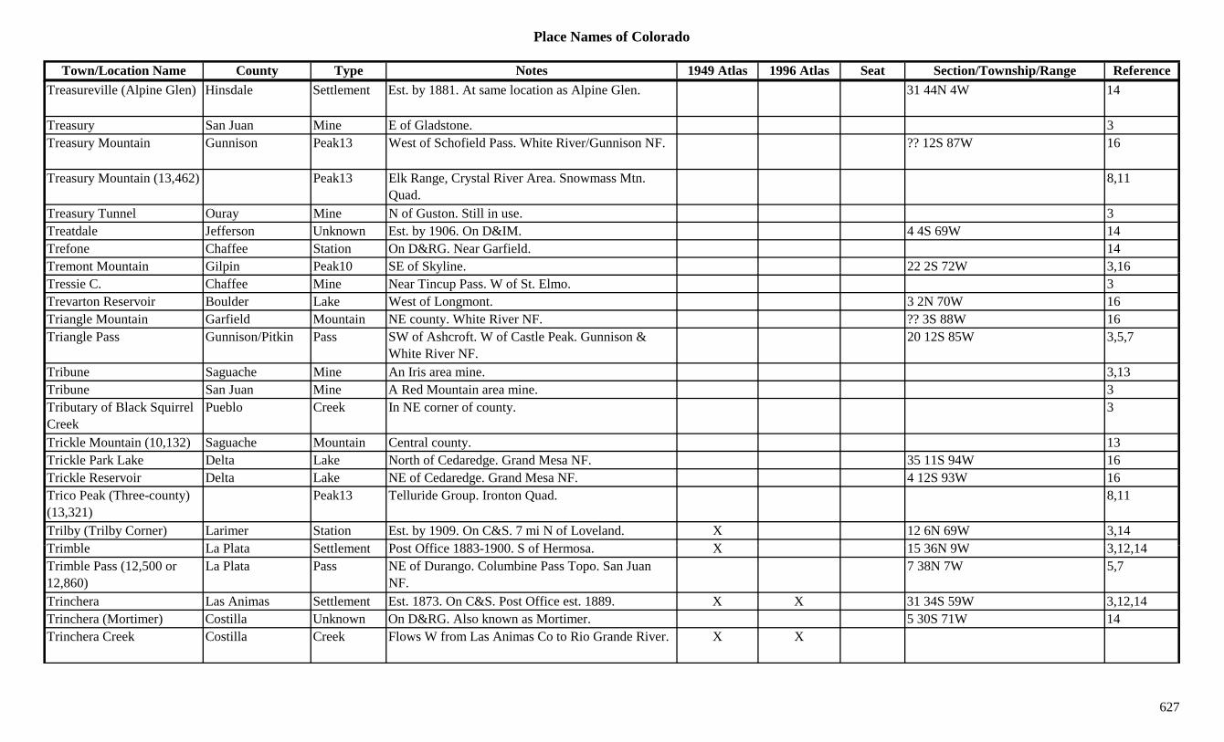
Place Names of Colorado
Town/Location Name County Type Notes 1949 Atlas 1996 Atlas Seat Section/Township/Range ReferenceTreasureville (Alpine Glen) Hinsdale Settlement Est. by 1881. At same location as Alpine Glen. 31 44N 4W 14
Treasury San Juan Mine E of Gladstone. 3Treasury Mountain Gunnison Peak13 West of Schofield Pass. White River/Gunnison NF. ?? 12S 87W 16
Treasury Mountain (13,462) Peak13 Elk Range, Crystal River Area. Snowmass Mtn. Quad.
8,11
Treasury Tunnel Ouray Mine N of Guston. Still in use. 3Treatdale Jefferson Unknown Est. by 1906. On D&IM. 4 4S 69W 14Trefone Chaffee Station On D&RG. Near Garfield. 14Tremont Mountain Gilpin Peak10 SE of Skyline. 22 2S 72W 3,16p y ,Tressie C. Chaffee Mine Near Tincup Pass. W of St. Elmo. 3Trevarton Reservoir Boulder Lake West of Longmont. 3 2N 70W 16Triangle Mountain Garfield Mountain NE county. White River NF. ?? 3S 88W 16Triangle Pass Gunnison/Pitkin Pass SW of Ashcroft. W of Castle Peak. Gunnison &
White River NF.20 12S 85W 3,5,7
Tribune Saguache Mine An Iris area mine. 3,13Tribune San Juan Mine A Red Mountain area mine. 3Tributary of Black Squirrel Creek
Pueblo Creek In NE corner of county. 3
Trickle Mountain (10,132) Saguache Mountain Central county. 13Trickle Park Lake Delta Lake North of Cedaredge. Grand Mesa NF. 35 11S 94W 16Trickle Reservoir Delta Lake NE of Cedaredge. Grand Mesa NF. 4 12S 93W 16Trico Peak (Three-county) (13,321)
Peak13 Telluride Group. Ironton Quad. 8,11
Trilby (Trilby Corner) Larimer Station Est. by 1909. On C&S. 7 mi N of Loveland. X 12 6N 69W 3,14T i bl L Pl t S ttl t P t Offi 1883 1900 S f H X 15 36N 9W 3 12 14Trimble La Plata Settlement Post Office 1883-1900. S of Hermosa. X 15 36N 9W 3,12,14Trimble Pass (12,500 or 12,860)
La Plata Pass NE of Durango. Columbine Pass Topo. San Juan NF.
7 38N 7W 5,7
Trinchera Las Animas Settlement Est. 1873. On C&S. Post Office est. 1889. X X 31 34S 59W 3,12,14Trinchera (Mortimer) Costilla Unknown On D&RG. Also known as Mortimer. 5 30S 71W 14Trinchera Creek Costilla Creek Flows W from Las Animas Co to Rio Grande River. X X
627

Place Names of Colorado
Town/Location Name County Type Notes 1949 Atlas 1996 Atlas Seat Section/Township/Range ReferenceTrinchera Creek Las Animas Creek Flows N to Purgatoire River W of Gillette. X 3Trinchera Grant Costilla Misc Est. by 1840s. NE corner of county. To Narcisco
Beaubien & Stephen Lee.3,8
Trinchera Pass (6,000) Las Animas Pass Btwn Trinidad and Raton and Folsom, NM. 7Trinchera Peak (13,546) Costilla/Huerfano Peak13 Culebra Range. East Side. Trinchera Peak Quad. ?? 32S 70W 8,11,16
Trinchera Plaza Las Animas Hill 4 mi SW of Trinchera. 3Trinchera Plaza (Brazil PO) Las Animas Settlement Brazil PO was at same site. 1 35S 60W 14
Trinidad (Rio de Las Animas, Santisima
Huerfano/Las Animas
Settlement Est. 1859. Post Office 1862-1864 & 1866 to present. Moved from Grays Ranch.
X X X Sev 33S 64W 1,3,12,14
Trinidad)Trinidad Junction Las Animas Station Est. by 1906. On D&RG. 14Trinity Peak (13,805) Peak13 Needle Mountains. The Grenadiers. Storm King
Peak Quad.8,11
Trinity Peak East (13,745) Peak13 Storm King Peak Quad. 11
Trinity Peak West (13,765) Peak13 Storm King Peak Quad. 11
Trio Reservoir Delta Lake North of Cedaredge. Grand Mesa NF. 31 11S 93W 16Triple Lakes Boulder Lake SW of Ward, near Continental Divide. Roosevelt
NF.24 1N 74W 16
Triumph Gunnison Mine A Gothic area mine. 3Triumph Lake Mine A Leadville area mine. 3Trojan Boulder Mine A Caribou mine. 3Trojan Lake Garfield Lake North of Rifle. Near Rio Blanco Co. White River
NF7 3S 92W 16
NF.Tropic (Oakview PO) Huerfano Station Est. by 1923. On D&RGW. On line going toward La
Veta Pass. Same as Oakview PO.9 29S 69W 3,14
Tropic Junction Huerfano Station On D&RG. Same as Oakdale Station. 15 29S 69W 14Troublesome Grand Settlement Post Office 1878-1908 & 1914-1935. 12 mi W of
Hot Sulphur Springs.X 11 1N 80W 1,3,12,14
628
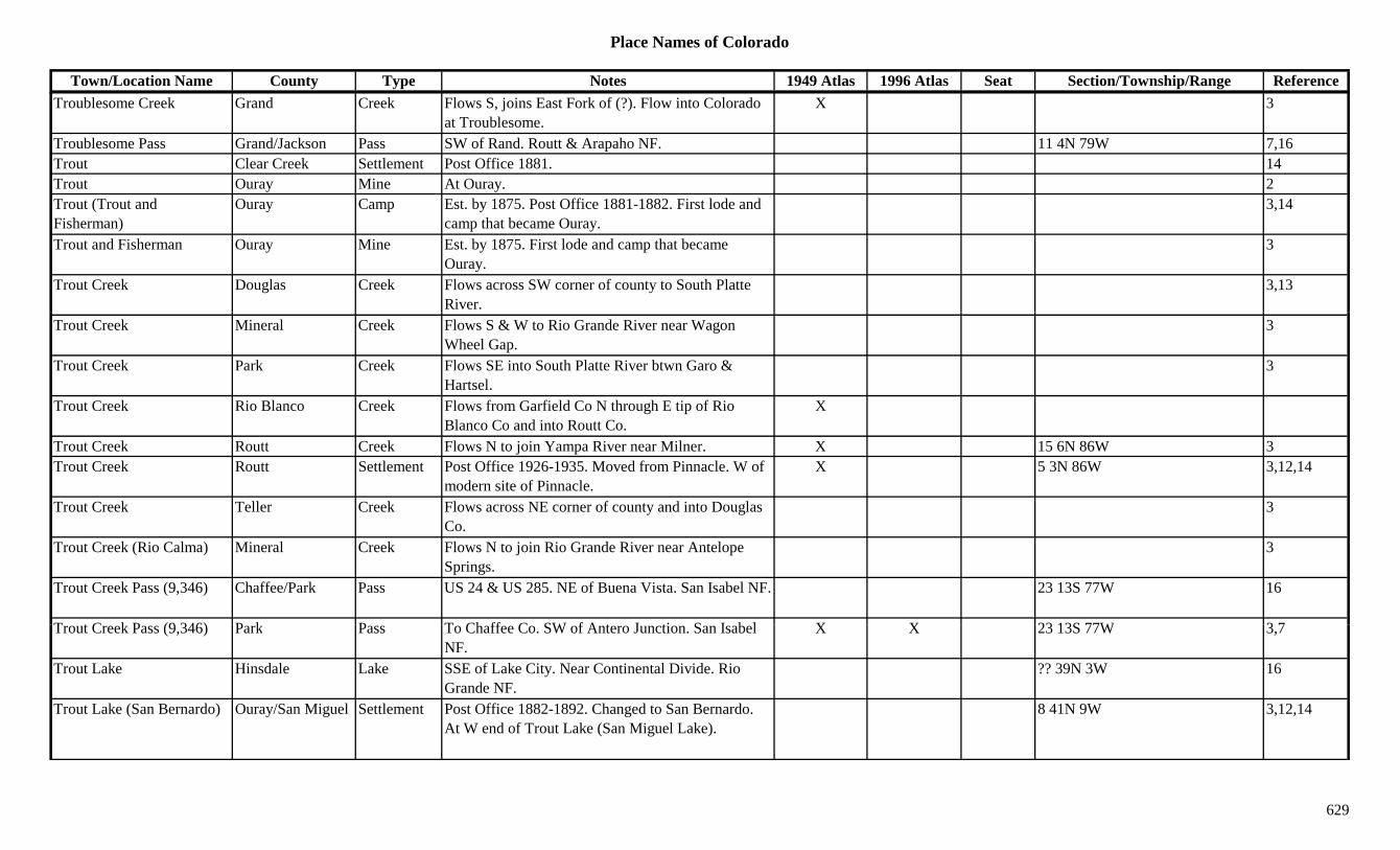
Place Names of Colorado
Town/Location Name County Type Notes 1949 Atlas 1996 Atlas Seat Section/Township/Range ReferenceTroublesome Creek Grand Creek Flows S, joins East Fork of (?). Flow into Colorado
at Troublesome.X 3
Troublesome Pass Grand/Jackson Pass SW of Rand. Routt & Arapaho NF. 11 4N 79W 7,16Trout Clear Creek Settlement Post Office 1881. 14Trout Ouray Mine At Ouray. 2Trout (Trout and Fisherman)
Ouray Camp Est. by 1875. Post Office 1881-1882. First lode and camp that became Ouray.
3,14
Trout and Fisherman Ouray Mine Est. by 1875. First lode and camp that became Ouray.
3
Trout Creek Douglas Creek Flows across SW corner of county to South Platte River.
3,13
Trout Creek Mineral Creek Flows S & W to Rio Grande River near Wagon Wheel Gap.
3
Trout Creek Park Creek Flows SE into South Platte River btwn Garo & Hartsel.
3
Trout Creek Rio Blanco Creek Flows from Garfield Co N through E tip of Rio Blanco Co and into Routt Co.
X
Trout Creek Routt Creek Flows N to join Yampa River near Milner. X 15 6N 86W 3Trout Creek Routt Settlement Post Office 1926-1935. Moved from Pinnacle. W of
modern site of Pinnacle.X 5 3N 86W 3,12,14
Trout Creek Teller Creek Flows across NE corner of county and into Douglas Co.
3
Trout Creek (Rio Calma) Mineral Creek Flows N to join Rio Grande River near Antelope Springs.
3
Trout Creek Pass (9,346) Chaffee/Park Pass US 24 & US 285. NE of Buena Vista. San Isabel NF. 23 13S 77W 16
T t C k P (9 346) P k P T Ch ff C SW f A t J ti S I b l X X 23 13S 77W 3 7Trout Creek Pass (9,346) Park Pass To Chaffee Co. SW of Antero Junction. San Isabel NF.
X X 23 13S 77W 3,7
Trout Lake Hinsdale Lake SSE of Lake City. Near Continental Divide. Rio Grande NF.
?? 39N 3W 16
Trout Lake (San Bernardo) Ouray/San Miguel Settlement Post Office 1882-1892. Changed to San Bernardo. At W end of Trout Lake (San Miguel Lake).
8 41N 9W 3,12,14
629

Place Names of Colorado
Town/Location Name County Type Notes 1949 Atlas 1996 Atlas Seat Section/Township/Range ReferenceTrout Lake (San Miguel Lake)
San Miguel Lake On way up to Lizard Head Pass. 3
Troutville Eagle Settlement Post Office 1909-1954. 27 mi SE of Eagle. X 24 7S 83W 3,12,14Trowel Ranch Morgan Station Est. by 1902. On BN. 2 mi N of Hillrose. X 2 4N 55W 3,14Troy Hinsdale Mine A Tellurium area mine. 3,13Troy Las Animas Settlement Site 2. Rural Post Office 1887-1942. Moved from
Humbar. 12 mi SE of Kim.X 25 33S 53W 3,12,14
Troy Las Animas Unknown Site 1. 21 32S 55W 14Truckton El Paso Settlement 8 mi SE of Yoder. X 13 15S 61W 3,14True Blue Park Mine Near Alma. 2Trujillo Archuleta Settlement Post Office 1900-1905. 15 mi S of Pagosa Springs. 14 33N 2W 3,12,14j g p g , ,
Trujillo Meadows Reservoir Conejos Lake SW corner of county. S of Jarosa Peak. Rio Grande NF.
31 33N 5E 16
Trujillo Plaza Las Animas Settlement 11 31S 66W 14Trull (Puma) Routt Settlement Post Office 1888-1922. Changed to Puma. Renamed
Trull. S of Mad Creek Village.32 7N 85W 3,12,14
Trumbull Douglas Camp Est. by 1924. Small Westcreek mining camp. 3Trumbull Jefferson Settlement Town name for the PO Daffodil. 15 9S 70W 6,14Trump Park Settlement Post Office 1928-1931. Town of short duration? But
still shown on 1949 Atlas.X 10 14S 76W 1,12,14
Truro Park Settlement Post Office 1887-1895. On Four Mile Creek & Slater Creek. 11 mi WNW of Cripple Creek.
5 15S 71W 12,14
Truro Peak (13,282) Peak13 Sawatch Range, Leadville Frying Pan Sect. New York Peak Quad.
8,11
Tuber(s) Weld Station On GW. 2 mi W of Eaton. 34 7N 66W 6,14T b (C i S i ) B S ttl t Ni k f C i S i f l d 3Tubs (Carriso Springs) Baca Settlement Nickname for Carriso Springs for large wooden
watering tanks.3
Tuck (Utleyville) Baca Settlement Post Office 1916-1917. Changed or moved to Utleyville.
1 32S 50W 12,14
Tucker Gilpin Mine N of Central City. 1 3S 73W 3,14Tucker Gilpin Station Est. by 1905. At the end of GT track. In Chase
Gulch. Probably at Tucker Mine.1 3S 73W 14
630
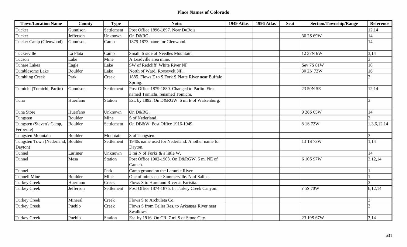
Place Names of Colorado
Town/Location Name County Type Notes 1949 Atlas 1996 Atlas Seat Section/Township/Range ReferenceTucker Gunnison Settlement Post Office 1896-1897. Near DuBois. 12,14Tucker Jefferson Unknown On D&RG. 30 2S 69W 14Tucker Camp (Glenwood) Gunnison Camp 1879-1873 name for Glenwood. 14
Tuckerville La Plata Camp Small. S side of Needles Mountain. 12 37N 6W 3,14Tucson Lake Mine A Leadville area mine. 3Tuhare Lakes Eagle Lake SW of Redcliff. White River NF. Sev 7S 81W 16Tumblesome Lake Boulder Lake North of Ward. Roosevelt NF. 30 2N 72W 16Tumbling Creek Park Creek 1885. Flows E to S Fork S Platte River near Buffalo
Spring.3
Tumichi (Tomichi, Parlin) Gunnison Settlement Post Office 1879-1880. Changed to Parlin. First 23 50N 5E 12,14( , ) gnamed Tomichi, renamed Tomichi.
,
Tuna Huerfano Station Est. by 1892. On D&RGW. 6 mi E of Walsenburg. 3
Tuna Store Huerfano Unknown On D&RG. 9 28S 65W 14Tungsten Boulder Mine S of Nederland. 3Tungsten (Steven's Camp, Ferberite)
Boulder Settlement On DB&W. Post Office 1916-1949. 8 1S 72W 1,3,6,12,14
Tungsten Mountain Boulder Mountain S of Tungsten. 3Tungsten Town (Nederland, Dayton)
Boulder Settlement 1940s name used for Nederland. Another name for Dayton.
13 1S 73W 1,14
Tunnel Larimer Unknown 3 mi N of Forks & a little W. 14Tunnel Mesa Station Post Office 1902-1903. On D&RGW. 5 mi NE of
Cameo.6 10S 97W 3,12,14
Tunnel Park Camp ground on the Laramie River. 1Tunnell Mine Boulder Mine One of mines near Summerville. N of Salina. 1T k C k H f C k Fl S t H f Ri t F i it 3Turkey Creek Huerfano Creek Flows S to Hurefano River at Farisita. 3Turkey Creek Jefferson Settlement Post Office 1874-1875. In Turkey Creek Canyon. ? 5S 70W 6,12,14
Turkey Creek Mineral Creek Flows S to Archuleta Co. 3Turkey Creek Pueblo Creek Flows S from Teller Res. to Arkansas River near
Swallows.3
Turkey Creek Pueblo Station Est. by 1916. On CR. 7 mi S of Stone City. 23 19S 67W 3,14
631
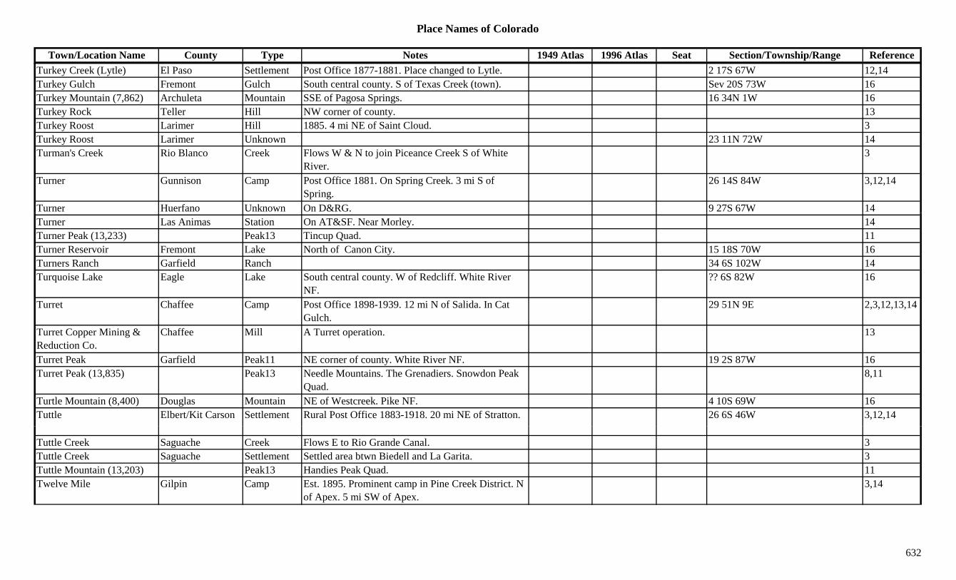
Place Names of Colorado
Town/Location Name County Type Notes 1949 Atlas 1996 Atlas Seat Section/Township/Range ReferenceTurkey Creek (Lytle) El Paso Settlement Post Office 1877-1881. Place changed to Lytle. 2 17S 67W 12,14Turkey Gulch Fremont Gulch South central county. S of Texas Creek (town). Sev 20S 73W 16Turkey Mountain (7,862) Archuleta Mountain SSE of Pagosa Springs. 16 34N 1W 16Turkey Rock Teller Hill NW corner of county. 13Turkey Roost Larimer Hill 1885. 4 mi NE of Saint Cloud. 3Turkey Roost Larimer Unknown 23 11N 72W 14Turman's Creek Rio Blanco Creek Flows W & N to join Piceance Creek S of White
River.3
Turner Gunnison Camp Post Office 1881. On Spring Creek. 3 mi S of Spring.
26 14S 84W 3,12,14
Turner Huerfano Unknown On D&RG. 9 27S 67W 14Turner Las Animas Station On AT&SF. Near Morley. 14Turner Peak (13,233) Peak13 Tincup Quad. 11Turner Reservoir Fremont Lake North of Canon City. 15 18S 70W 16Turners Ranch Garfield Ranch 34 6S 102W 14Turquoise Lake Eagle Lake South central county. W of Redcliff. White River
NF.?? 6S 82W 16
Turret Chaffee Camp Post Office 1898-1939. 12 mi N of Salida. In Cat Gulch.
29 51N 9E 2,3,12,13,14
Turret Copper Mining & Reduction Co.
Chaffee Mill A Turret operation. 13
Turret Peak Garfield Peak11 NE corner of county. White River NF. 19 2S 87W 16Turret Peak (13,835) Peak13 Needle Mountains. The Grenadiers. Snowdon Peak
Quad.8,11
Turtle Mountain (8,400) Douglas Mountain NE of Westcreek. Pike NF. 4 10S 69W 16Tuttle Elbert/Kit Carson Settlement Rural Post Office 1883-1918. 20 mi NE of Stratton. 26 6S 46W 3,12,14
Tuttle Creek Saguache Creek Flows E to Rio Grande Canal. 3Tuttle Creek Saguache Settlement Settled area btwn Biedell and La Garita. 3Tuttle Mountain (13,203) Peak13 Handies Peak Quad. 11Twelve Mile Gilpin Camp Est. 1895. Prominent camp in Pine Creek District. N
of Apex. 5 mi SW of Apex.3,14
632
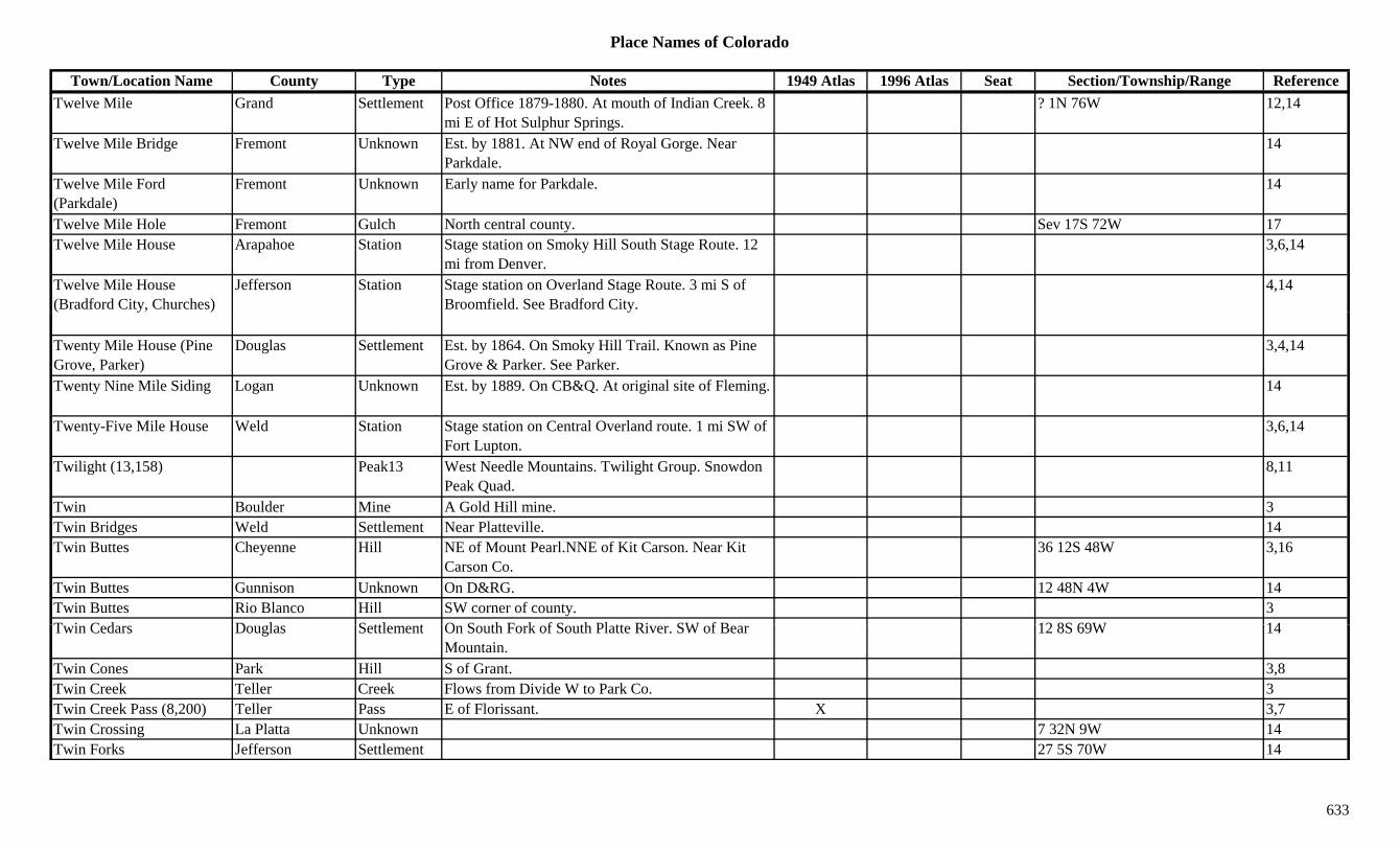
Place Names of Colorado
Town/Location Name County Type Notes 1949 Atlas 1996 Atlas Seat Section/Township/Range ReferenceTwelve Mile Grand Settlement Post Office 1879-1880. At mouth of Indian Creek. 8
mi E of Hot Sulphur Springs.? 1N 76W 12,14
Twelve Mile Bridge Fremont Unknown Est. by 1881. At NW end of Royal Gorge. Near Parkdale.
14
Twelve Mile Ford (Parkdale)
Fremont Unknown Early name for Parkdale. 14
Twelve Mile Hole Fremont Gulch North central county. Sev 17S 72W 17Twelve Mile House Arapahoe Station Stage station on Smoky Hill South Stage Route. 12
mi from Denver.3,6,14
Twelve Mile House (Bradford City, Churches)
Jefferson Station Stage station on Overland Stage Route. 3 mi S of Broomfield. See Bradford City.
4,14
Twenty Mile House (Pine Grove, Parker)
Douglas Settlement Est. by 1864. On Smoky Hill Trail. Known as Pine Grove & Parker. See Parker.
3,4,14
Twenty Nine Mile Siding Logan Unknown Est. by 1889. On CB&Q. At original site of Fleming. 14
Twenty-Five Mile House Weld Station Stage station on Central Overland route. 1 mi SW of Fort Lupton.
3,6,14
Twilight (13,158) Peak13 West Needle Mountains. Twilight Group. Snowdon Peak Quad.
8,11
Twin Boulder Mine A Gold Hill mine. 3Twin Bridges Weld Settlement Near Platteville. 14Twin Buttes Cheyenne Hill NE of Mount Pearl.NNE of Kit Carson. Near Kit
Carson Co.36 12S 48W 3,16
Twin Buttes Gunnison Unknown On D&RG. 12 48N 4W 14Twin Buttes Rio Blanco Hill SW corner of county. 3T i C d D l S ttl t O S th F k f S th Pl tt Ri SW f B 12 8S 69W 14Twin Cedars Douglas Settlement On South Fork of South Platte River. SW of Bear
Mountain.12 8S 69W 14
Twin Cones Park Hill S of Grant. 3,8Twin Creek Teller Creek Flows from Divide W to Park Co. 3Twin Creek Pass (8,200) Teller Pass E of Florissant. X 3,7Twin Crossing La Platta Unknown 7 32N 9W 14Twin Forks Jefferson Settlement 27 5S 70W 14
633

Place Names of Colorado
Town/Location Name County Type Notes 1949 Atlas 1996 Atlas Seat Section/Township/Range ReferenceTwin Gulch Fremont Gulch North of Canon City. Sev 18S 70/71W 16Twin Lake Boulder Lake Between Boulder and Longmont. 11 1N 70W 16Twin Lakes Archuleta Lake SE county. 15 33N 1E 16Twin Lakes Chaffee Lake SE of Emerald Peak and WSW of Mt. Harvard. San
Isabel NF.17 13S 80W 16
Twin Lakes Conejos Lake SE of Conejos. In SE corner of county. 13 32N 10E 16Twin Lakes Conejos Lake West central county. SW of La Jara Reservoir. 1 34N 5E 16Twin Lakes Garfield Lake NE corner of county. White River NF. ?? 1S 88W 16Twin Lakes Hinsdale Lake SW of Lake City. Just N of Continental Divide. Rio
Grande NF.?? 39N 5W 16
Twin Lakes Lake Unknown Site 2. Harvard & Ball Town are in the same section. 24 11S 80W 14
Twin Lakes (Dayton) Lake Station Site 1. Post Office est. 1879. Formerly Dayton. RR stop. E of town of Twin Lakes.
19 11S 80W 2,3,12,13,14
Twin Lakes No 1 Delta Lake North of Cedaredge. Grand Mesa NF. 25 11S 94W 16Twin Lakes No 2 Delta Lake North of Cedaredge. Grand Mesa NF. 25 11S 94W 16Twin Lakes Reservoir Lake Lake At Twin Lakes, W of Harvard. X XTwin Lakes Station Lake Station Another name for Twin Lakes, Site 2. 14Twin Mountain Fremont Mountain NW of Canon City. 13Twin Peaks (13,333) Peak13 Mt. Elbert Quad. 11Twin Peaks (13,580) Peak13 Sangre de Cristo Range, Sierra Blancas. Twin Peaks
Quad.8,11
Twin Peaks 1 (13,780) Chaffee Peak13 NW corner of county. N of Winfield. San Isabel NF. 3 12S 81W 16
Twin Peaks 2 (13,278) Chaffee Peak13 NW corner of county. N of Winfield. San Isabel NF. 35 12S 81W 16
T i R k J ff S ttl t Th i il t t G ld 14Twin Rock Jefferson Settlement Their mail went to Golden. 14Twin Sisters Gilpin Mine SW of Rollinsville. 3Twin Sisters Larimer Hill SW corner of county. 3Twin Sisters San Juan Hill SW of Silverton. 13Twin Sisters (8,741) Boulder Hill SW of Boulder. N of Wondervu. Roosevelt NF. 13 1S 71W 16
634

Place Names of Colorado
Town/Location Name County Type Notes 1949 Atlas 1996 Atlas Seat Section/Township/Range ReferenceTwin Sisters East (13,432) Peak13 Ophir Quad. 11
Twin Sisters Peak Fremont/Saguache Peak13 Sangre de Cristo Range. Bushnell Peak Quad. NW of Hayden Pass. San Isabel NF.
?? 47N 9E 8,11,16
Twin Sisters West (13,374) Peak13 Ophir Quad. 11
Twin Springs Rio Blanco Settlement 21 1N 90W 14Twin Springs Ranch Rio Blanco Settlement Est. by 1964. Settlement at junction of White River
and Marvine Creek.3
Twin Spruce (Twin Spruce Park)
Jefferson Settlement Platted 1920. NW of Leyden. 8 2S 71W 3,6,14
Twin Thumbs Pass (13,050 or 13,060)
Pass Needle Mountains. The Grenadiers. In Weminuche Wilderness.
5,7,8
Twin Thumbs Peak (13,420) Peak13 Needle Mountains. The Grenadiers. Storm King Peak Quad.
8,11
Twining Peak (13,711) Peak13 Sawatch Range, Leadville Frying Pan Sect. Mt. Champion Quad.
8,11
Twins Boulder Mine A Gold Hill area mine. 13Two Bar Ranch Moffat Ranch 31 8N 97W 14Two Bit Gulch Lake Unknown 31 11S 79W 14Two Bit Gulch Gulch Close to Twin Lakes. 1Two Bridges Grand Settlement Settlement & stage station. On N slope of Berthoud
Pass. Below Sheets Tavern.14
Two Brothers Boulder Station Est. by 1913. At milepost 5.9. On Fourmile Creek. 2.4 mi above Old Orodell.
20 1N 71W 14
Two Butte(s) Creek Baca Creek Flows across NW corner of county. X X 3T B tt ( ) C k L A i C k Fl N f Ki t j i M t C k X X 3Two Butte(s) Creek Las Animas Creek Flows N from near Kim to join Mustang Creek near
Flues.X X 3
Two Butte(s) Creek Prowers Creek Flows E & N to Arkansas River near Holly. X X 3Two Buttes Baca Settlement Platted 1909. Post Office est. 1910. X X 32 28S 44W 3,12,14Two Buttes Prowers Hill 1887. S part of county. 3Two Buttes Reservoir Baca Lake North central county, near border of Prowers Co. X X Sev 28S 46W
635

Place Names of Colorado
Town/Location Name County Type Notes 1949 Atlas 1996 Atlas Seat Section/Township/Range ReferenceTwo Elk Pass (11,000) Eagle Pass Crossed by Two Elk Trail. White River NF. 25 5S 80WTwo Mile Canyon Boulder Canyon NW of Boulder. 3Two Mile Creek Logan Creek Flows out of Weld Co, through Sterling Reservoir
and into the South Platte.X X
Two Mile Creek Weld Creek From eastern Weld Co into Logan Co and into Sterling Reservoir.
X X
Two Peak Mesa Peak SE of Heiberger. 3Two Sisters Gilpin Mine N of Nigger Hill. 3Two-bit Gulch Lake Gulch S of Crystal Lake. 3Two-Circle Bar Ranch Elbert Ranch First name was Gebhard, then Two-Circle Bar, then
Agate.1 7S 59W 14
Twolon Gilpin Station On GT. At spur end S from Saratoga Branch. 23 3S 73W 14Tycoon Gunnison Mine A Pitkin area mine. 3,13Tyler Douglas Camp Post Office 1895-1897. Small Westcreek mining
camp.3,12,14
Tyler Summit Mine A Swandyke area mine. 3,13Tyndall Mountain (9,510) Custer Mountain E of Westcliffe. 15 22S 71W 13,16Tyne Jackson Unknown 13 5N 77W 14Tyner Jackson/Larimer Camp Post Office 1879-1881. Short-lived. SE of Teller
City.3,12,14
Tyner City Jackson Settlement Platted 1883. 13 5N 77W 14Tyrone (Yetta) Las Animas Settlement Post Office 1929-1968. On SF RR. Formerly Yetta. X X 2 30S 61W 3,12,14
U 3 (13,241) Peak13 Wetterhorn Peak Quad. 11U S Grant Peak (13,767) Peak13 Silverton West Group. Ophir Quad. 8,11U. P. Boulder Mine 3U S B d B ld Mi C ld b t (U S B k) A S hi i 3U. S. Band Boulder Mine Could be typo (U.S. Bank). A Sunshine mine. 3U.S. Bank Boulder Mine In Summerville area. (See U. S. Band). 1,13U.S. Olympic Complex El Paso Misc At Colorado Springs. XUcaipa Settlement 1Ula (Ure, Britain's Paradise) Fremont/Custer Settlement Post Office 1871-1891. First county seat of Custer
Co. Also shown at 12 22S 73W.x 2 22S 73W 3,12,14
Ulay vein Hinsdale Mine At Henson. 2
636
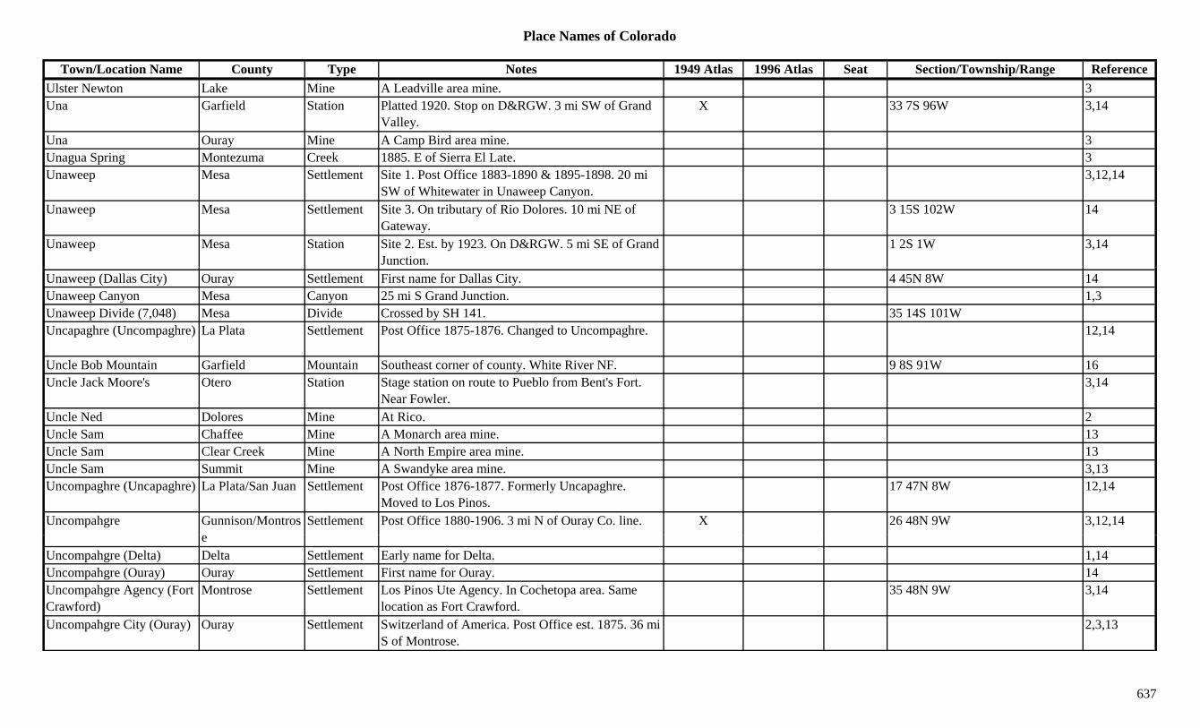
Place Names of Colorado
Town/Location Name County Type Notes 1949 Atlas 1996 Atlas Seat Section/Township/Range ReferenceUlster Newton Lake Mine A Leadville area mine. 3Una Garfield Station Platted 1920. Stop on D&RGW. 3 mi SW of Grand
Valley.X 33 7S 96W 3,14
Una Ouray Mine A Camp Bird area mine. 3Unagua Spring Montezuma Creek 1885. E of Sierra El Late. 3Unaweep Mesa Settlement Site 1. Post Office 1883-1890 & 1895-1898. 20 mi
SW of Whitewater in Unaweep Canyon.3,12,14
Unaweep Mesa Settlement Site 3. On tributary of Rio Dolores. 10 mi NE of Gateway.
3 15S 102W 14
Unaweep Mesa Station Site 2. Est. by 1923. On D&RGW. 5 mi SE of Grand Junction.
1 2S 1W 3,14
Unaweep (Dallas City) Ouray Settlement First name for Dallas City. 4 45N 8W 14Unaweep Canyon Mesa Canyon 25 mi S Grand Junction. 1,3Unaweep Divide (7,048) Mesa Divide Crossed by SH 141. 35 14S 101WUncapaghre (Uncompaghre) La Plata Settlement Post Office 1875-1876. Changed to Uncompaghre. 12,14
Uncle Bob Mountain Garfield Mountain Southeast corner of county. White River NF. 9 8S 91W 16Uncle Jack Moore's Otero Station Stage station on route to Pueblo from Bent's Fort.
Near Fowler.3,14
Uncle Ned Dolores Mine At Rico. 2Uncle Sam Chaffee Mine A Monarch area mine. 13Uncle Sam Clear Creek Mine A North Empire area mine. 13Uncle Sam Summit Mine A Swandyke area mine. 3,13Uncompaghre (Uncapaghre) La Plata/San Juan Settlement Post Office 1876-1877. Formerly Uncapaghre.
Moved to Los Pinos.17 47N 8W 12,14
Uncompahgre Gunnison/Montros Settlement Post Office 1880-1906. 3 mi N of Ouray Co. line. X 26 48N 9W 3,12,14e
Uncompahgre (Delta) Delta Settlement Early name for Delta. 1,14Uncompahgre (Ouray) Ouray Settlement First name for Ouray. 14Uncompahgre Agency (Fort Crawford)
Montrose Settlement Los Pinos Ute Agency. In Cochetopa area. Same location as Fort Crawford.
35 48N 9W 3,14
Uncompahgre City (Ouray) Ouray Settlement Switzerland of America. Post Office est. 1875. 36 mi S of Montrose.
2,3,13
637

Place Names of Colorado
Town/Location Name County Type Notes 1949 Atlas 1996 Atlas Seat Section/Township/Range ReferenceUncompahgre Hot Springs Ouray Settlement Platted 1884. 21 45N 8W 14
Uncompahgre Mining District
Ouray Mine At Ouray. 2
Uncompahgre Park Ouray Park 1885. W of Dallas. 3Uncompahgre Peak Hinsdale Peak14 NW corner of county. San Juans, Lake City Group.
Uncompahgre Peak Quad. Uncompahgre NF.X X ?? 44N 5W 8,11,16
Uncompahgre Plateau Mesa/Montrose Hill 90-mile ridge NW from Dallas Divide to W of Grand Juction.
3,8
Uncompahgre River Delta River Near Ouray. 1p g yUncompahgre River Montrose River Flows N from Ouray Co. to Delta Co through
Montrose.3
Uncompahgre River Ouray River Flows N through center of county to Montrose Co. 3
Uncompahgre Valley Montrose Valley NW of Olathe. 3Undercliffe (Huerfano) Pueblo Settlement Post Office 1879-1925. Changed to or moved from
Huerfano. 11 mi E of Marnel.X 25 22S 63W 3,12,14
Underhill Costilla Settlement Post Office 1872-1873. 12,14Undine Hinsdale Mine A Burrows Park area mine. 3,13Uneva Summit Unknown On DSP&P. 18 6S 73W 14Uneva Lake Summit Settlement Incorp. 1903. 5 6S 78W 14Uneva Pass (11,900 or 12,600)
Summit Pass Crossed by Wheeler-Dillon Trail. Vail Pass Topo. Arapaho NF.
11 6S 79W 5
Uneva Peak Eagle/Summit Peak12 Gore Range, East Side. NE of Vail Pass. Arapaho/White River NF.
2 6S 79W 8,16
U t d Pitki Mi A A h ft i 3Unexpected Pitkin Mine An Ashcroft area mine. 3Unicorn Pitkin Mine An Ashcroft area mine. 3Union Fremont Mill Est. by 1923. On F&CC. N of Labran on 8-Mile
Creek.2 19S 69W 3,14
Union San Miguel Mine Above Pandora. 2,3,13Union Park Cow Camp Gunnison Camp On Lottis Creek. 5 15S 82W 14Union (Marion) Garfield Settlement Est. by 1887. On CM. Also called Marion. 10 8S 89W 14
638
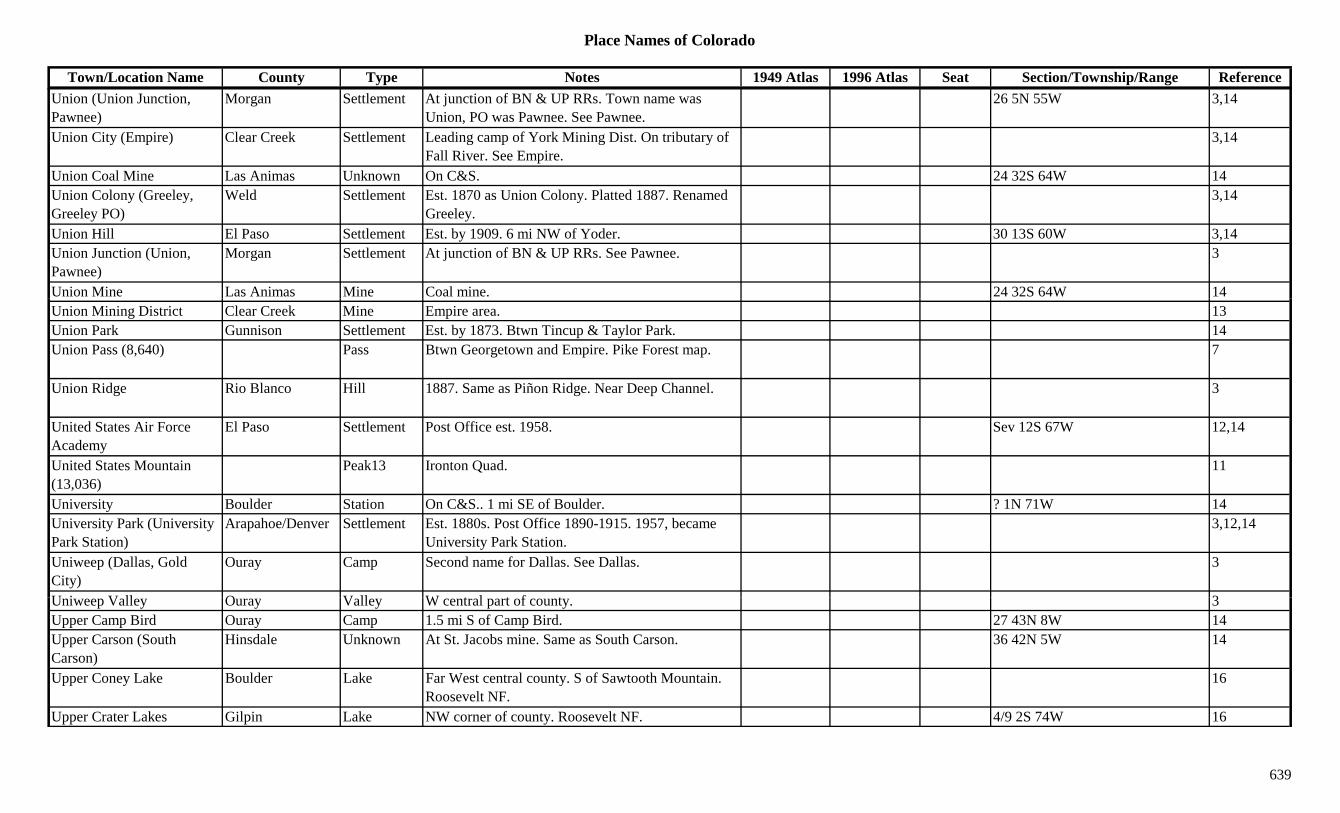
Place Names of Colorado
Town/Location Name County Type Notes 1949 Atlas 1996 Atlas Seat Section/Township/Range ReferenceUnion (Union Junction, Pawnee)
Morgan Settlement At junction of BN & UP RRs. Town name was Union, PO was Pawnee. See Pawnee.
26 5N 55W 3,14
Union City (Empire) Clear Creek Settlement Leading camp of York Mining Dist. On tributary of Fall River. See Empire.
3,14
Union Coal Mine Las Animas Unknown On C&S. 24 32S 64W 14Union Colony (Greeley, Greeley PO)
Weld Settlement Est. 1870 as Union Colony. Platted 1887. Renamed Greeley.
3,14
Union Hill El Paso Settlement Est. by 1909. 6 mi NW of Yoder. 30 13S 60W 3,14Union Junction (Union, Pawnee)
Morgan Settlement At junction of BN & UP RRs. See Pawnee. 3
Union Mine Las Animas Mine Coal mine. 24 32S 64W 14Union Mining District Clear Creek Mine Empire area. 13Union Park Gunnison Settlement Est. by 1873. Btwn Tincup & Taylor Park. 14Union Pass (8,640) Pass Btwn Georgetown and Empire. Pike Forest map. 7
Union Ridge Rio Blanco Hill 1887. Same as Piñon Ridge. Near Deep Channel. 3
United States Air Force Academy
El Paso Settlement Post Office est. 1958. Sev 12S 67W 12,14
United States Mountain (13,036)
Peak13 Ironton Quad. 11
University Boulder Station On C&S.. 1 mi SE of Boulder. ? 1N 71W 14University Park (University Park Station)
Arapahoe/Denver Settlement Est. 1880s. Post Office 1890-1915. 1957, became University Park Station.
3,12,14
Uniweep (Dallas, Gold City)
Ouray Camp Second name for Dallas. See Dallas. 3
U i V ll O V ll W t l t f t 3Uniweep Valley Ouray Valley W central part of county. 3Upper Camp Bird Ouray Camp 1.5 mi S of Camp Bird. 27 43N 8W 14Upper Carson (South Carson)
Hinsdale Unknown At St. Jacobs mine. Same as South Carson. 36 42N 5W 14
Upper Coney Lake Boulder Lake Far West central county. S of Sawtooth Mountain. Roosevelt NF.
16
Upper Crater Lakes Gilpin Lake NW corner of county. Roosevelt NF. 4/9 2S 74W 16
639

Place Names of Colorado
Town/Location Name County Type Notes 1949 Atlas 1996 Atlas Seat Section/Township/Range ReferenceUpper Creede (North Creede)
Mineral Settlement Same as North Creede. See North Creede. 3,13,14
Upper Culebra (San Pedro, Plaza Arriba)
Costilla Settlement Present name for San Pedro. Also called Plaza Arriba.
33 33S 71W 14
Upper Dale (Silver Dale) Clear Creek Camp Upper section of Silver Dale. See Silver Dale. 3,14Upper Diamond Lake Boulder Lake SW corner of county. SE of Mt. Neva. Roosevelt
NF.16
Upper Empire (North Empire)
Clear Creek Settlement Est. by 1864. Same as North Empire. ? 3S 74W 14
Upper Georgetown (Upper Town)
Clear Creek Settlement S of South Clear Creek. E of Clear Creek. Also called Upper Town.
14
Upper Gold King San Juan Mine At Gladstone. 3Upper Lake Gulch Douglas Gulch SE corner of county. Runs NE & N to Cherry Creek. Sev 9S 66W 16
Upper Printer Boy Lake Mine A California Gulch mine. 3Upper Red Mountain Town Ouray Camp Short-lived camp. Above Red Mountain Town. On
the Pass.3,14
Upper Storm Lake Boulder Lake SW corner of county. SE of Mt. Neva. Roosevelt NF.
16
Upper Swandyke Summit Camp Above Swandike. 3Upper Tow Creek Routt Unknown 5 6N 86W 14Upper Town (Upper Georgetown)
Clear Creek Settlement Same as Upper Georgetown. 14
Upper Tule Lake Arapahoe Lake S of Bowles Lake in Bow Mar subdivision. 18 5S 68W 16Upper Union (North Empire)
Clear Creek Settlement Same as North Empire. 14
U il L k (Y il ) L k M R 1Upsilon Lake (Ypsilon) Lake Mummy Range 1Urade Mine Clear Creek Mine Near Camp Boericke. 14Urado Rio Blanco Unknown On Unitah. 34 3S 104W 14Uranium Montrose Settlement Post Office 1900-1922. 4 mi N of Paradox. 12 48N 19W 3,12,14Uravan Montrose Settlement Est. abt 1912. Post Office 1936-1988. Big radium
producer.X X 33 48N 17W 3,12,14
Urbana Mesa Unknown 6 10S 95W 14
640

Place Names of Colorado
Town/Location Name County Type Notes 1949 Atlas 1996 Atlas Seat Section/Township/Range ReferenceUrbana (Green Knoll, Downin, Adobe)
Lincoln Settlement Est. by 1885. Was to be first name for a settlement. Green Knoll PO opened there 1916.
17 17S 54W 14
Ure (Ula, Britain's Paradise) Custer Settlement Another name for Ula. See Ula. 1 22S 73W 3,14
Urmston (Shaffers Crossing)
Jefferson Settlement Post Office 1891-1900. Same as Shaffers Crossing. 31 6S 71W 6,12,14
Urraca Alamosa Settlement Cemetery remains. 20 28S 73W 14Urraca Creek Alamosa Creek Flows W from Sangre de Cristo Range to Medana
Creek.16
US Gold Corp. Cyanide Mill
Boulder Mill At Sugarloaf. 3
USAF Academy El Paso Settlement See United States Air Force Academy. XUtah Clear Creek Mine A North Empire area mine. 13Utah Junction Adams Station Est. by 1924. RR stop on BN. 6 mi E of Arvada. 9 3S 68W 3,6,14
Utah Line (Utaline) Mesa Station On D&RG. Now called Unaline. 8 11S 104W 14Utah Mountain (9,774) Boulder Mountain SW corner of county. W of Nederland. Roosevelt
NF.20 1S 73W 16
Utaline (Utah Line) Mesa Station On D&RGW. SW of Mack on state line. Same as Utah Line.
8 11S 104W 3
Ute Gilpin Mine A Nevadaville mine. 3Ute La Plata Mine A La Plata area mine. NE of Hesperus. 3Ute Montrose Settlement Post Office 1912-1951. Central county. X 13 46N 13W 3,12,14Ute Park Mine Up Montgomery Gulch. 3Ute (Durham, Bovina) Mesa Station Site 2. Est. by 1923. Stop on D&RG. 5 mi NW of
Grand Junction.9 1N 1W 3,14
Ut (G d J ti W t G i /M S ttl t Sit 1 P t Offi 1882 Ch d t G d J ti S 1S 1W 3 12Ute (Grand Junction, West Denver)
Gunnison/Mesa Settlement Site 1. Post Office 1882. Changed to Grand Junction. Also called West Denver.
Sev 1S 1W 3,12
Ute (Huerfano) Huerfano Settlement On D&RG. Post Office 1888-1900. Ute PO at Huerfano Station. Changed to Huerfano.
2 26S 66W 12,14
Ute (Ute City, Aspen) Pitkin Settlement Early name for Aspen. Same as Ute City. 14Ute Agency (Cochetopa, Los Pinos)
Saguache Settlement Est. by 1883. Same as Cochetopa. Same as Los Pinos.
35 46N 1E 14
641

Place Names of Colorado
Town/Location Name County Type Notes 1949 Atlas 1996 Atlas Seat Section/Township/Range ReferenceUte Agency (Navajo Springs)
Montezuma Unknown Also known as Navajo Springs. 26 34N 17W 14
Ute City (Aspen) Pitkin Settlement Est. 1879. First name of Aspen. Tent city on Roaring Fork.
3,13,14
Ute Coal Mine La Plata Station On RGS. Spur from Ute Junction. 12 35N 11W 14Ute Creek Clear Creek Creek Lamartine to S to Chicago Creek. 3,13Ute Creek Costilla Creek Flows S to Fort Massachusetts. 3Ute Creek Hinsdale Creek Flows NE into Rio Grande Reservoir. 3Ute Creek Canyon Clear Creek Canyon Near Lamartine. 13Ute Indian Agency La Plata Settlement 5 33N 7W 14Ute Indian Museum Montrose Museum At Montrose. XUte Junction La Plata Station On D&RG. Spur to Ute Mine. 24 35N 11W 3,14Ute Junction (Tabernash) Grand Station First name for Tabernash. 1 1S 76W 14Ute Lake Hinsdale Lake SW of Lake City. Just N of Continental Divide. Rio
Grande NF.?? 39N 5W 16
Ute Mountain Indian Res. (Southern Ute)
Montezuma Misc SW corner of county. 3
Ute Park El Paso Unknown On CM. 10 13S 68W 14Ute Park Grand Unknown On Williams Fork River. ? 2S 78W 14Ute Pass Grand/Summit Pass N of Dillon. Btwn Fraser and Colorado Hwy 9.
Williams Fork Mtns. Arapaho NF.2 3S 78W 7,9,16
Ute Pass Teller Pass 1885. Same area as present-day Divide. 3Ute Pass (11,000) Routt/Jackson Pass Crossed by Ute Pass Trail. NNW of Walden. On
Continental Divide. Routt NF.32 9N 82W 7
Ute Pass (12,702) Pass In Weminuche Wilderness. E of Hunchback Pass. 5,8
Ut P (6 800) El P P Bt M it S i d C d X 3 7Ute Pass (6,800) El Paso Pass Btwn Manitou Springs and Cascade. X 3,7Ute Pass (7,300) Pass NE of Durango. San Juan Forest. 7Ute Pass (9,869) Jackson/Larimer Pass NE of Walden and W of Glendevey. Medicine Bow
Range. Routt & Roosevelt NF.29 10N 77W 3,7
Ute Pass (9,944) Saguache Pass Crossed by 4WD road. Rio Grande NF. 7 45N 8EUte Peak Grand/Summit Peak12 Williams Fork Mountains. Arapaho NF. 14 3S 78W 8,16Ute Peak (9,977) Montezuma Peak In Sierra El Late area. SW of Aldridge. 3,8
642
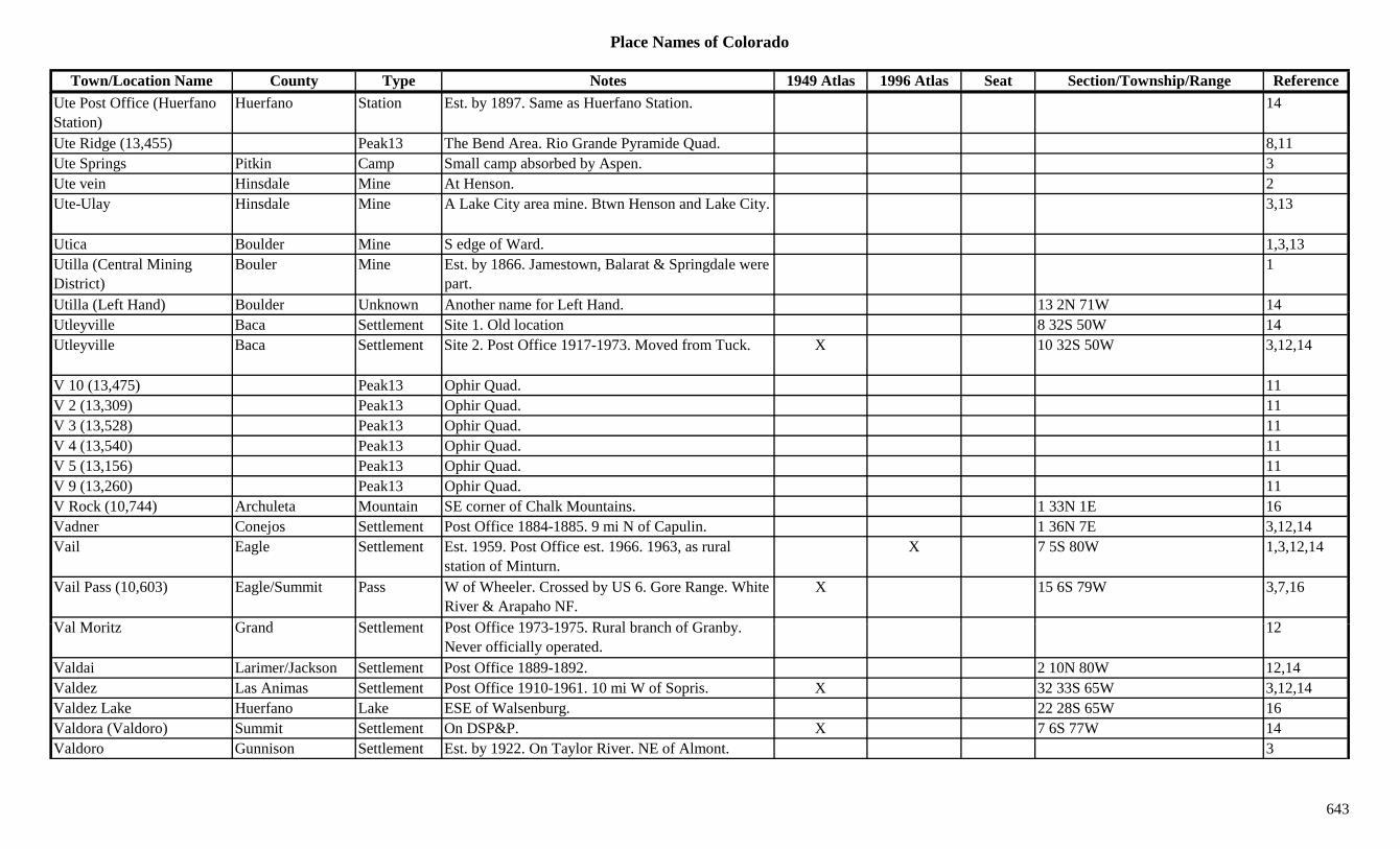
Place Names of Colorado
Town/Location Name County Type Notes 1949 Atlas 1996 Atlas Seat Section/Township/Range ReferenceUte Post Office (Huerfano Station)
Huerfano Station Est. by 1897. Same as Huerfano Station. 14
Ute Ridge (13,455) Peak13 The Bend Area. Rio Grande Pyramide Quad. 8,11Ute Springs Pitkin Camp Small camp absorbed by Aspen. 3Ute vein Hinsdale Mine At Henson. 2Ute-Ulay Hinsdale Mine A Lake City area mine. Btwn Henson and Lake City. 3,13
Utica Boulder Mine S edge of Ward. 1,3,13Utilla (Central Mining District)
Bouler Mine Est. by 1866. Jamestown, Balarat & Springdale were part.
1
Utilla (Left Hand) Boulder Unknown Another name for Left Hand. 13 2N 71W 14( )Utleyville Baca Settlement Site 1. Old location 8 32S 50W 14Utleyville Baca Settlement Site 2. Post Office 1917-1973. Moved from Tuck. X 10 32S 50W 3,12,14
V 10 (13,475) Peak13 Ophir Quad. 11V 2 (13,309) Peak13 Ophir Quad. 11V 3 (13,528) Peak13 Ophir Quad. 11V 4 (13,540) Peak13 Ophir Quad. 11V 5 (13,156) Peak13 Ophir Quad. 11V 9 (13,260) Peak13 Ophir Quad. 11V Rock (10,744) Archuleta Mountain SE corner of Chalk Mountains. 1 33N 1E 16Vadner Conejos Settlement Post Office 1884-1885. 9 mi N of Capulin. 1 36N 7E 3,12,14Vail Eagle Settlement Est. 1959. Post Office est. 1966. 1963, as rural
station of Minturn.X 7 5S 80W 1,3,12,14
Vail Pass (10,603) Eagle/Summit Pass W of Wheeler. Crossed by US 6. Gore Range. White River & Arapaho NF.
X 15 6S 79W 3,7,16
V l M it G d S ttl t P t Offi 1973 1975 R l b h f G b 12Val Moritz Grand Settlement Post Office 1973-1975. Rural branch of Granby. Never officially operated.
12
Valdai Larimer/Jackson Settlement Post Office 1889-1892. 2 10N 80W 12,14Valdez Las Animas Settlement Post Office 1910-1961. 10 mi W of Sopris. X 32 33S 65W 3,12,14Valdez Lake Huerfano Lake ESE of Walsenburg. 22 28S 65W 16Valdora (Valdoro) Summit Settlement On DSP&P. X 7 6S 77W 14Valdoro Gunnison Settlement Est. by 1922. On Taylor River. NE of Almont. 3
643

Place Names of Colorado
Town/Location Name County Type Notes 1949 Atlas 1996 Atlas Seat Section/Township/Range ReferenceValdoro (Valdora) Summit Settlement Town on side track of C&S. 7 6S 77W 3Valentines Larimer Station Est. by 1909. On C&S. 4 mi S of Bellvue. 18 7N 69W 3,14Valesquez (Lorencito) Las Animas Settlement On C&W. Another name for Lorencito. 33 33S 66W 14Valhalla Mountain (13,180) Peak13 Gore Range, East Side. 8
Vallecito (Viceto) La Plata Settlement Post Office 1901-1917 & 1939-1942. Site known as Viceto. NE of Bayfield.
5 36N 6W 3,12,14
Vallecito Creek La Plata Creek E side of county. Flows S to Bayfield. X 3Vallecito Mountain (13,428)
Peak13 Needle Mountains. The Grenadiers. Storm King Peak Quad.
8,11
Vallecito Reservoir La Plata Lake West central La Plata Co. X XVallejo La Plata/Archuleta Settlement Est. by 1885. 5 mi W of Arboles. Atlases show
Vallejo in each county. La Plata is correct.X X 10 32N 6W 3,14
Vallejo Pitkin Mine An Aspen area mine. 3,13Vallery Morgan Settlement Post Office 1907-1919. Early name for Wiggins? 11 3N 59W 3,12,14
Valles Costilla Settlement Est. by 1885. Spanish settlement. 1 mi SE of San Pedro.
12 33S 72W 3,14
Valleview (Valley View) Ouray Station Est. by 1923. On D&RGS. 2 mi N of Dallas Divide. 3
Valley Jefferson Unknown On D&IM. ? 3S 69W 14Valley Kit Carson Settlement Rural Post Office 1898-1901. 17 mi N of Flagler. 9 6S 51W 3,12,14
Valley Lake Mine A Leadville area mine. 3Valley Logan Station Site 1. Stage station on Central Overland route. SE
of Sterling.3,14
V ll L St ti Sit 2 W ll F St St ti Pl tt R t 14Valley Logan Station Site 2. Wells Fargo Stage Station on Platte Route. Btwn River Side & Fairview.
14
Valley City Boulder Settlement Est. by 1860. On Middle Boulder Creek. By Andree Party.
14
Valley City (Empire) Clear Creek Settlement Est. by 1860. First name for Empire. See Empire. 3,14
Valley City Company Clear Creek Mine An Empire mining operation. 13
644
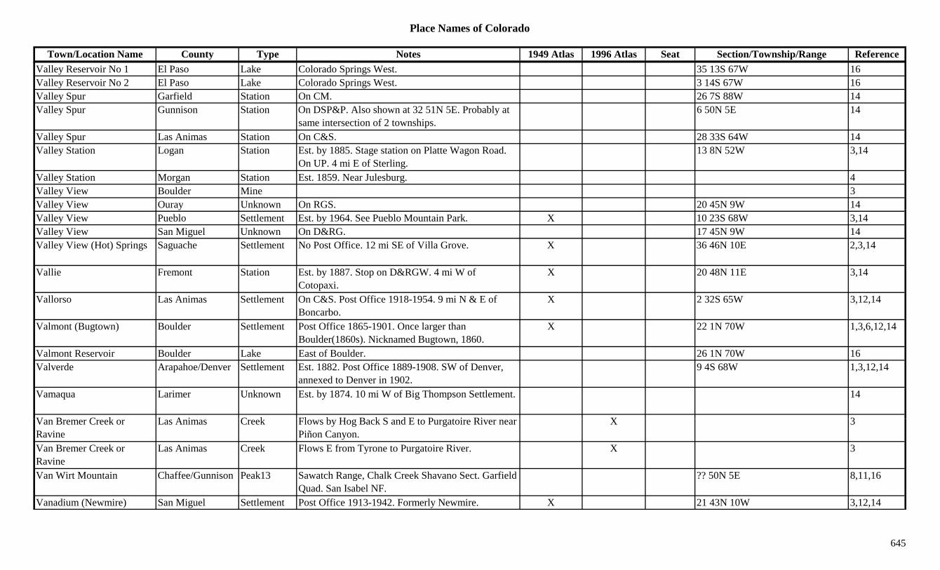
Place Names of Colorado
Town/Location Name County Type Notes 1949 Atlas 1996 Atlas Seat Section/Township/Range ReferenceValley Reservoir No 1 El Paso Lake Colorado Springs West. 35 13S 67W 16Valley Reservoir No 2 El Paso Lake Colorado Springs West. 3 14S 67W 16Valley Spur Garfield Station On CM. 26 7S 88W 14Valley Spur Gunnison Station On DSP&P. Also shown at 32 51N 5E. Probably at
same intersection of 2 townships.6 50N 5E 14
Valley Spur Las Animas Station On C&S. 28 33S 64W 14Valley Station Logan Station Est. by 1885. Stage station on Platte Wagon Road.
On UP. 4 mi E of Sterling.13 8N 52W 3,14
Valley Station Morgan Station Est. 1859. Near Julesburg. 4Valley View Boulder Mine 3Valley View Ouray Unknown On RGS. 20 45N 9W 14y yValley View Pueblo Settlement Est. by 1964. See Pueblo Mountain Park. X 10 23S 68W 3,14Valley View San Miguel Unknown On D&RG. 17 45N 9W 14Valley View (Hot) Springs Saguache Settlement No Post Office. 12 mi SE of Villa Grove. X 36 46N 10E 2,3,14
Vallie Fremont Station Est. by 1887. Stop on D&RGW. 4 mi W of Cotopaxi.
X 20 48N 11E 3,14
Vallorso Las Animas Settlement On C&S. Post Office 1918-1954. 9 mi N & E of Boncarbo.
X 2 32S 65W 3,12,14
Valmont (Bugtown) Boulder Settlement Post Office 1865-1901. Once larger than Boulder(1860s). Nicknamed Bugtown, 1860.
X 22 1N 70W 1,3,6,12,14
Valmont Reservoir Boulder Lake East of Boulder. 26 1N 70W 16Valverde Arapahoe/Denver Settlement Est. 1882. Post Office 1889-1908. SW of Denver,
annexed to Denver in 1902.9 4S 68W 1,3,12,14
Vamaqua Larimer Unknown Est. by 1874. 10 mi W of Big Thompson Settlement. 14
V B C k L A i C k Fl b H B k S d E t P t i Ri X 3Van Bremer Creek or Ravine
Las Animas Creek Flows by Hog Back S and E to Purgatoire River near Piñon Canyon.
X 3
Van Bremer Creek or Ravine
Las Animas Creek Flows E from Tyrone to Purgatoire River. X 3
Van Wirt Mountain Chaffee/Gunnison Peak13 Sawatch Range, Chalk Creek Shavano Sect. Garfield Quad. San Isabel NF.
?? 50N 5E 8,11,16
Vanadium (Newmire) San Miguel Settlement Post Office 1913-1942. Formerly Newmire. X 21 43N 10W 3,12,14
645

Place Names of Colorado
Town/Location Name County Type Notes 1949 Atlas 1996 Atlas Seat Section/Township/Range ReferenceVanadium Junction (Vance Junction, Vance PO)
San Miguel Station Est. by 1923. On Mear's RR. 6 mi below Telluride. 3
Vanadium Mill San Miguel Mill A Vanadium area operation. 3Vance Junction (Vance PO, Vanadium Junction)
San Miguel Station On Mear's RR. 6 mi below Telluride. X 3,12,14
Vance PO (Vance's, Vance Junction)
San Miguel Station Post Office 1894-1909. Waystop. Settlement N of Ames on Turkey Creek.
6 42N 9W 3,12,14
Vancorum Montrose Settlement Est. 1930. Housing development. No Post Office or business.
X 23 46N 16W 3,14
Vanderbilt Custer Mine Westcliffe area mine. 3Vanderbilt Ouray Unknown 36 43N 8W 14Vanderbilt Saguache Mine An Oriental area mine. 3Vandium San Miguel Unknown On RGS. 15 43N 10W 14Vanguard Gunnison Unknown On D&RG. 32 48N 3W 14Vans Point Kit Carson Unknown 19 10S 45W 14Van's Point Kit Carson Hill 1916. 11 mi SW of Bethune. 3Vansville Kit Carson Settlement Post Office 1907. 12,14Varney Mines & Tunnel Co. Pitkin Mine A Lenado area mine. 3
Varros Las Animas Settlement Post Office 1902-1903. Spanish town. 0.25 mi Segundo. Absorbed by Segundo.
3,12,14
Vasco Boulder Mine NE of Nederland. 3Vasquez Adams Settlement Est. by 1885. In same vicinity as Hillsborough. W of
Adams City.3
Vasquez Jefferson Unknown Est. by 1876. On CC. On Clear Creek. E of Arvada. ? 3S 68W 14
Vasquez (Hideaway Park) Grand Settlement On D&RG. See Hideaway Park. X 4 2S 75W 3,14
Vasquez Fort Weld Fort Site 1. Built 1832. Fur fort built by Louis Vasquez. At junction of Clear Creek & South Platte.
30 3N 66W 14
Vasquez Fort Weld Fort Site 2. Built 1842. Now on Hwy 85. 7 3N 66W 14
646
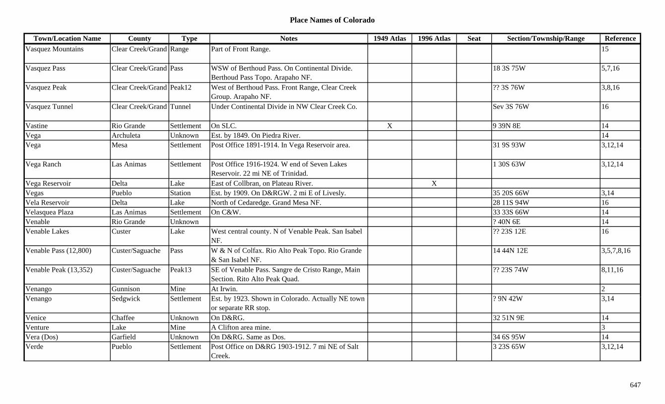
Place Names of Colorado
Town/Location Name County Type Notes 1949 Atlas 1996 Atlas Seat Section/Township/Range ReferenceVasquez Mountains Clear Creek/Grand Range Part of Front Range. 15
Vasquez Pass Clear Creek/Grand Pass WSW of Berthoud Pass. On Continental Divide. Berthoud Pass Topo. Arapaho NF.
18 3S 75W 5,7,16
Vasquez Peak Clear Creek/Grand Peak12 West of Berthoud Pass. Front Range, Clear Creek Group. Arapaho NF.
?? 3S 76W 3,8,16
Vasquez Tunnel Clear Creek/Grand Tunnel Under Continental Divide in NW Clear Creek Co. Sev 3S 76W 16
Vastine Rio Grande Settlement On SLC. X 9 39N 8E 14Vega Archuleta Unknown Est. by 1849. On Piedra River. 14Vega Mesa Settlement Post Office 1891-1914. In Vega Reservoir area. 31 9S 93W 3,12,14g g , ,
Vega Ranch Las Animas Settlement Post Office 1916-1924. W end of Seven Lakes Reservoir. 22 mi NE of Trinidad.
1 30S 63W 3,12,14
Vega Reservoir Delta Lake East of Collbran, on Plateau River. XVegas Pueblo Station Est. by 1909. On D&RGW. 2 mi E of Livesly. 35 20S 66W 3,14Vela Reservoir Delta Lake North of Cedaredge. Grand Mesa NF. 28 11S 94W 16Velasquea Plaza Las Animas Settlement On C&W. 33 33S 66W 14Venable Rio Grande Unknown ? 40N 6E 14Venable Lakes Custer Lake West central county. N of Venable Peak. San Isabel
NF.?? 23S 12E 16
Venable Pass (12,800) Custer/Saguache Pass W & N of Colfax. Rio Alto Peak Topo. Rio Grande & San Isabel NF.
14 44N 12E 3,5,7,8,16
Venable Peak (13,352) Custer/Saguache Peak13 SE of Venable Pass. Sangre de Cristo Range, Main Section. Rito Alto Peak Quad.
?? 23S 74W 8,11,16
Venango Gunnison Mine At Irwin. 2V S d i k S ttl t E t b 1923 Sh i C l d A t ll NE t ? 9N 42W 3 14Venango Sedgwick Settlement Est. by 1923. Shown in Colorado. Actually NE town
or separate RR stop.? 9N 42W 3,14
Venice Chaffee Unknown On D&RG. 32 51N 9E 14Venture Lake Mine A Clifton area mine. 3Vera (Dos) Garfield Unknown On D&RG. Same as Dos. 34 6S 95W 14Verde Pueblo Settlement Post Office on D&RG 1903-1912. 7 mi NE of Salt
Creek.3 23S 65W 3,12,14
647
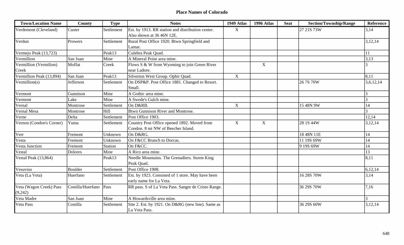
Place Names of Colorado
Town/Location Name County Type Notes 1949 Atlas 1996 Atlas Seat Section/Township/Range ReferenceVerdemont (Cleveland) Custer Settlement Est. by 1913. RR station and distribution center.
Also shown at 36 46N 12E.X 27 21S 73W 3,14
Verdun Prowers Settlement Rural Post Office 1920. Btwn Springfield and Lamar.
3,12,14
Vermejo Peak (13,723) Peak13 Culebra Peak Quad. 11Vermillion San Juan Mine A Mineral Point area mine. 3,13Vermillion (Vermilion) Creek
Moffat Creek Flows S & W from Wyoming to join Green River near Ladore.
X 3
Vermillion Peak (13,894) San Juan Peak13 Silverton West Group. Ophir Quad. X 8,11Vermillion(s) Jefferson Settlement On DSP&P. Post Office 1881. Changed to Resort.
Small.26 7S 70W 3,6,12,14
Vermont Gunnison Mine A Gothic area mine. 3Vermont Lake Mine A Swede's Gulch mine. 3Vernal Montrose Settlement On D&RB. X 15 48N 9W 14Vernal Mesa Montrose Hill Btwn Gunnison River and Montrose. 3Verne Delta Settlement Post Office 1903. 12,14Vernon (Condon's Corner) Yuma Settlement Country Post Office opened 1892. Moved from
Condon. 8 mi NW of Beecher Island.X X 28 1S 44W 3,12,14
Verr Fremont Unknown On D&RG. 18 48N 11E 14Vesta Fremont Unknown On F&CC Branch to Dorcas. 11 19S 69W 14Vesta Junction Fremont Station On F&CC. 9 19S 69W 14Vestal Dolores Mine A Rico area mine. 13Vestal Peak (13,864) Peak13 Needle Mountains. The Grenadiers. Storm King
Peak Quad.8,11
Vesuvius Boulder Settlement Post Office 1908. 6,12,14Veta (La Veta) Huerfano Settlement Est. by 1923. Consisted of 1 store. May have been
l f L V t16 28S 70W 3,14
early name for La Veta.Veta (Wagon Creek) Pass (9,242)
Costilla/Huerfano Pass RR pass. S of La Veta Pass. Sangre de Cristo Range. 36 29S 70W 7,16
Veta Madre San Juan Mine A Howardsville area mine. 3Veta Pass Costilla Settlement Site 2. Est. by 1921. On D&RG (new line). Same as
La Veta Pass.36 29S 60W 3,12,14
648

Place Names of Colorado
Town/Location Name County Type Notes 1949 Atlas 1996 Atlas Seat Section/Township/Range ReferenceVeta Pass Costilla Station Site 1. Est. by 1885. On D&RG. Post Office 1911-
1935.22 28S 70W 3,12,14
Veta Pass Huerfano Settlement Post Office 1889-1890. Same as Veta Pass that had Post Office 1911-1935.
22 28S 70W 14
Veteran Saguache Settlement Post Office 1888-1894. On Carnero Creek. ? 42N 7E 12,14Veteran Tunnel Pitkin Tunnel An Aspen area mine. 3Viceto (Vallecito) La Plata Settlement Post Office 1890-1891. Same site as Vallecito. 5 36N 6W 12,14Vicksburg Chaffee Settlement Post Office 1881-1885. 11 mi W of Granite. Clear
Creek Gulch.19 12S 80W 2,3,12,13,14
Victor Las Animas Station Hastings was the PO name. Victor the RR name. Location shown is for Hastings.
24 31S 65W 14
Victor Teller Mine An Altman area mine. 3Victor (City of Mines, Victory)
Teller Settlement Est. 1893. On CS&CCD. Post Office est. 1894. 6 mi SE of Cripple Creek.
X X 29 15S 69W 1,2,3,12,13,14
Victor Junction Las Animas Station On C&S. Where branch line goes W to Hastings or Victor.
20 31S 64W 14
Victor Junction Teller Station On MT. 31 15S 69W 14Victor Pass (10,202) Teller Pass NE of Victor. SE of Cripple Creek. 7Victor Station Las Animas Station On C&SE. See Victor. 13 31S 65W 14Victoria Boulder Mine In Summerville area. A Sunshine mine. A Gold Hill
mine.1,2,3,13
Victoria Conejos Unknown ? 35N 7E 14Victoria Gilpin Mine A Gilpin area mine. S of Gilpin. 3,13Victoria Gulch Conejos Gulch West central county. Runs S to Elk Creek. Rio
Grande NF.Sev 34N 4E 16
Victoria Lake Conejos Lake West central county. Rio Grande NF. ?? 34N 4E 16Vi t i Mi S it Mi At M t 2Victoria Mine Summit Mine At Masontown. 2Vidal Gunnison Unknown On DSP&P. 26 50N 1W 14Vidler Clear Creek Unknown On AC. 10 5S 75W 14Viejo San Acacio Costilla Settlement 5 mi W by N of San Luis & 4 mi ESE of San Acacio. X ? 33S 73W 14
Viele Lake Boulder Lake SE of Boulder. 8 1S 70W 16Viena Baca Settlement No Post Office. 20 mi SW of Vilas, near Ruff. 32 33S 46W 3,14
649
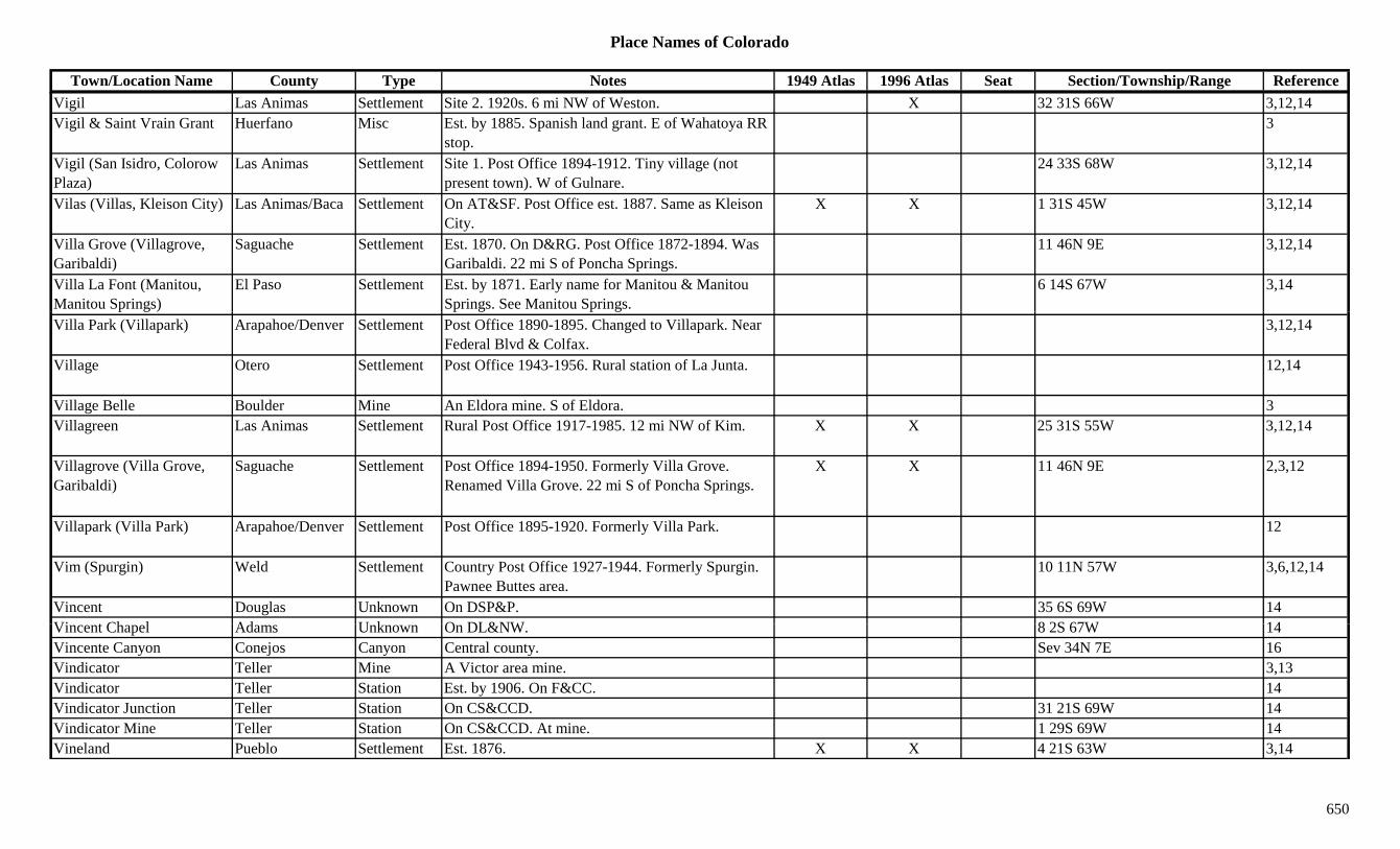
Place Names of Colorado
Town/Location Name County Type Notes 1949 Atlas 1996 Atlas Seat Section/Township/Range ReferenceVigil Las Animas Settlement Site 2. 1920s. 6 mi NW of Weston. X 32 31S 66W 3,12,14Vigil & Saint Vrain Grant Huerfano Misc Est. by 1885. Spanish land grant. E of Wahatoya RR
stop.3
Vigil (San Isidro, Colorow Plaza)
Las Animas Settlement Site 1. Post Office 1894-1912. Tiny village (not present town). W of Gulnare.
24 33S 68W 3,12,14
Vilas (Villas, Kleison City) Las Animas/Baca Settlement On AT&SF. Post Office est. 1887. Same as Kleison City.
X X 1 31S 45W 3,12,14
Villa Grove (Villagrove, Garibaldi)
Saguache Settlement Est. 1870. On D&RG. Post Office 1872-1894. Was Garibaldi. 22 mi S of Poncha Springs.
11 46N 9E 3,12,14
Villa La Font (Manitou, Manitou Springs)
El Paso Settlement Est. by 1871. Early name for Manitou & Manitou Springs. See Manitou Springs.
6 14S 67W 3,14
Villa Park (Villapark) Arapahoe/Denver Settlement Post Office 1890-1895. Changed to Villapark. Near Federal Blvd & Colfax.
3,12,14
Village Otero Settlement Post Office 1943-1956. Rural station of La Junta. 12,14
Village Belle Boulder Mine An Eldora mine. S of Eldora. 3Villagreen Las Animas Settlement Rural Post Office 1917-1985. 12 mi NW of Kim. X X 25 31S 55W 3,12,14
Villagrove (Villa Grove, Garibaldi)
Saguache Settlement Post Office 1894-1950. Formerly Villa Grove. Renamed Villa Grove. 22 mi S of Poncha Springs.
X X 11 46N 9E 2,3,12
Villapark (Villa Park) Arapahoe/Denver Settlement Post Office 1895-1920. Formerly Villa Park. 12
Vim (Spurgin) Weld Settlement Country Post Office 1927-1944. Formerly Spurgin. Pawnee Buttes area.
10 11N 57W 3,6,12,14
Vincent Douglas Unknown On DSP&P. 35 6S 69W 14Vi t Ch l Ad U k O DL&NW 8 2S 67W 14Vincent Chapel Adams Unknown On DL&NW. 8 2S 67W 14Vincente Canyon Conejos Canyon Central county. Sev 34N 7E 16Vindicator Teller Mine A Victor area mine. 3,13Vindicator Teller Station Est. by 1906. On F&CC. 14Vindicator Junction Teller Station On CS&CCD. 31 21S 69W 14Vindicator Mine Teller Station On CS&CCD. At mine. 1 29S 69W 14Vineland Pueblo Settlement Est. 1876. X X 4 21S 63W 3,14
650

Place Names of Colorado
Town/Location Name County Type Notes 1949 Atlas 1996 Atlas Seat Section/Township/Range ReferenceVineland Station (Devine) Pueblo Station On AT&SF. 2 mi N of Vineland. First name was
Devine.28 20S 63W 14
Vining Lake Mine A California Gulch mine. 3Viola Las Animas Unknown 31 33S 64W 14Virgil Las Animas Unknown Est. by 1885. 7 mi W of Hastings & S on same creek
with Hastings.14
Virginia Boulder Mine An Eldora mine. 3Virginia Gilpin Mine Gold Dirt area mine. 3Virginia (Frosts Ranch, Rock Ridge)
Douglas Settlement Post Office 1869-1871. Changed to Frosts Ranch. Stage station on Cherokee stage route.
13 9S 66W 3,12,14
Virginia (Tin Cup) Gunnison Settlement Post Office 1879-1880. Changed to Tin Cup. 12,14g ( p) g p ,Virginia Belle Boulder Mine An Eldora mine. 3Virginia Canyon (Canon) Clear Creek Canyon Btwn Idaho Springs and Central City. Sev 3S 73W 13,16Virginia City (Tin Cup) Gunnison Settlement Platted 1879. Renamed Tin Cup. See Tin Cup. 7 15S 81W 3,14Virginia Dale Larimer Station Site 2. Post Office 1868 & 1871 to present. N of Fort
Collins. Not at original Virginia Dale site.X X 4 11N 71W 1,3,4,12,14
Virginia Dale (Rocky Ridge)
Larimer Station Site 1. 4.5 mi S of Wyoming. 1 mi E of present Virginia Dale. Stage station. Has other locations.
24 12N 72W 3,4,14
Virginia Gulch Routt Gulch NE of Hahns Peak (town). 3Virginia Mine Gunnison Mine N from Gothic towards Avery Peak. 8Virginia Peak (13,088) Peak13 Sawatch Range, Collegiate Section. Winfield Quad. 8,11
Virginius (Virginus) Ouray Camp Post Office 1887-1894. PO & bunkhouse at Virginus Mine. In Mountain Top Basin.
2,3,12,14
Vi i i (Vi i ) Mi O Mi A S ff l B i i 2 3 13Virginius (Virginus) Mine Ouray Mine A Sneffels Basin mine. 2,3,13Virginius Basin Ouray Gulch SE of Ouray. SW of Camp Bird. 3Virginus Lake Mine A Leadville area mine. 3Vista Grande Teller Settlement On GC. Terminus & RR settlement. W of Midway. 20 15S 69W 3,14
Vivandiere Chaffee Mine At Turret. 2,3,13
651
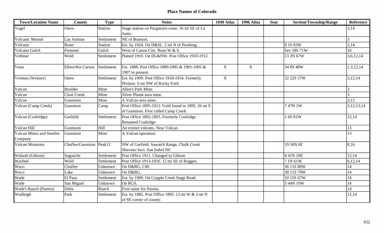
Place Names of Colorado
Town/Location Name County Type Notes 1949 Atlas 1996 Atlas Seat Section/Township/Range ReferenceVogel Otero Station Stage station on Purgatoire route. 16 mi SE of La
Junta.3,14
Volcanic Mound Las Animas Settlement NE of Branson. 3Volcano Routt Station Est. by 1924. On D&SL. 2 mi N of Pershing. 8 1S 83W 3,14Volcano Gulch Fremont Gulch West of Canon City. Runs W & S. Sev 18S 71W 16Vollmar Weld Settlement Platted 1910. On DL&NW. Post Office 1910-1912. 13 2N 67W 3,6,12,14
Vona Elbert/Kit Carson Settlement Est. 1888. Post Office 1889-1895 & 1901-1905 & 1907 to present.
X X 34 8S 48W 1,3,12,14
Vroman (Weitzer) Otero Settlement Est. by 1909. Post Office 1918-1954. Formerly Weitzer. 6 mi NW of Rocky Ford.
X 32 22S 57W 3,12,14
Vulcan Boulder Mine Allen's Park Mine. 3Vulcan Clear Creek Mine Silver Plume area mine. 3Vulcan Gunnison Mine A Vulcan area mine. 3,13Vulcan (Camp Creek) Gunnison Camp Post Office 1895-1912. Gold found in 1895. 26 mi S
of Gunnison. First called Camp Creek.7 47N 1W 3,12,13,14
Vulcan (Coalridge) Garfield Settlement Post Office 1892-1893. Formerly Coalridge. Renamed Coalridge.
1 6S 91W 12,14
Vulcan Hill Gunnison Hill An extinct volcano. Near Vulcan. 13Vulcan Mines and Smelter Company
Gunnison Mine A Vulcan operation. 13
Vulcan Mountain Chaffee/Gunnison Peak12 NW of Garfield. Sawatch Range, Chalk Creek Shavano Sect. San Isabel NF.
19 50N 6E 8,16
Wabash (Gibson) Saguache Settlement Post Office 1911. Changed to Gibson. 4 41N 10E 12,14Wachtel Weld Settlement Post Office 1913-1916. 12 mi SE of Roggen. ? 1N 61W 6,12,14Waco Chaffee Unknown On D&RG, CM. 36 11S 80W 14W L k U k O D&RG 30 11S 79W 14Waco Lake Unknown On D&RG. 30 11S 79W 14Wade El Paso Settlement Est. by 1909. On Cripple Creek Stage Road. 10 15S 67W 14Wade San Miguel Unknown On RGS. 5 44N 10W 14Wade's Ranch (Paonia) Delta Ranch First name for Paonia. 14Wadleigh Park Settlement Est. by 1885. Post Office 1895. 12 mi W & 3 mi N
of SE corner of county.12,14
652

Place Names of Colorado
Town/Location Name County Type Notes 1949 Atlas 1996 Atlas Seat Section/Township/Range ReferenceWages Yuma Settlement Post Office 1917-1950. Moved from Ford. Also
shown at 11 5N 46W.X 9 5N 45W 3,12,14
Wagner Boulder Mine Near Jackson's Camp. 3,13Wagner Washington Settlement Est. by 1942. 19 mi S of Otis. 3,14Wagon Creek (Veta) Pass (9,242)
Costilla/Huerfano Pass RR pass. S of La Veta Pass. Sangre de Cristo Range. 36 29S 70W 7
Wagon Creek Junction (Russell Junction)
Costilla Station On D&RG. Also called Russell Station. 22 29S 71W 14
Wagon Gulch Garfield Gulch ENE of Glenwood Springs. Sev 5S 88W 16Wagon Wheel Gap Mineral Gulch 1Wagon Wheel Gap Saguache/Mineral Settlement Site 1. Est. 1872. Post Office 1875-1895. 36 41N 1E 2,3,12,14g p g , , ,
Wagon Wheel Gap (8,424) Mineral Gap 1 mi W of Wagon Wheel Gap (town). 7
Wagon Wheel Gap (Thornton)
Mineral Settlement Site 2. Post Office 1901-1957. Formerly Thornton. X X 30 41N 2E 14
Wagon Wheel Springs Washington Unknown 2 4S 54W 14Wagontown (Heelsburg, Cosden)
Gunnison Settlement Early 1880s. Former names Heelsburg & Cosden. 9 49N 5E 14
Wahatoya (Wahotoya) Huerfano Station Est. by 1887. On D&RG. SW of Walsenburg. See Wahotoya.
23 30S 68W 3
Wahkeeney Park Unknown 33 4S 71W 14Wahotoya (Wahatoya) Huerfano Unknown Est. by 1880. On D&RG. 32 28S 67W 14Wainwright Draw Hinsdale Gulch SE county. Runs SW to East Fork Williams Creek.
San Juan NF.Sev 37N 3W 16
Wait (Sugar City) Otero Settlement Post Office 1900. Changed to Sugar City. 12,14W itl W hi t S ttl t R l P t Offi 1915 1936 12 i SE f M X 30 5N 52W 3 12 14Waitley Washington Settlement Rural Post Office 1915-1936. 12 mi SE of Messex. X 30 5N 52W 3,12,14
Wakelands Ranch Moffat Ranch 7 7N 93W 14Wakeman Logan/Phillips Settlement Rural Post Office 1887-1897. 8 mi SE of Holyoke. 28 7N 43W 3,12,14
Walden (Point of Rocks, Sagebrush)
Jackson Settlement Site 1, of Post Office. First name was Point of Rocks, then Sagebrush until 1882.
6 8N 78W 14
653

Place Names of Colorado
Town/Location Name County Type Notes 1949 Atlas 1996 Atlas Seat Section/Township/Range ReferenceWalden (Sage Hen) Jackson Settlement Site 2, of Post Office. Sage Hen was location of
second PO.1 8N 79W 14
Walden (Sagebrush) Jackson Settlement Site 3. Post Office est. 1881 at first location. NW of Fort Collins.
X X X 20 9N 79W 1,3,12,14
Walden Creek Hollow Grand Gulch South of Granby Res. Runs NW to Colorado River. Source in Arapaho NF.
Sev 2N 75/76W 16
Waldens Mill (Mill Creek Camp)
Clear Creek Camp First name for Mill Creek Camp. 14
Waldheim San Juan Settlement Site 1. Above Silverton. X 3Waldheim San Juan Station Site 2. Est. by 1923. 2 mi E of Silverton. 3,14Waldo Fremont Unknown On D&RG. 14Waldora Summit Unknown Est. by 1913. On DSP&P. 7 6S 77W 14Waldorf (Wilcox, East Argentine)
Clear Creek Settlement Est. by 1868. Post Office 1906-1912. Mining area. Stage stop for Argentine Pass.
X 2 5S 75W 3,12,13,14
Waldorf Mining and Milling Company
Clear Creek Mine A Waldorf mining operation. 13
Wales Arapahoe/Yuma Settlement Rural Post Office 1887-1888. See Condon. 29 2S 44W 3,12,14Walgro Otero Unknown On AT&SF. 4 23S 57W 14Walker Weld Station Est. by 1909. On GW, a siding. 4 mi NE of Mead. X 36 4N 68W 3,6,14
Walker Mountain (8,825) Boulder Mountain NW of Glendale. 36 2N 72W 3,16Walker Reservoir Boulder Lake NE corner of county. 14 3N 69W 16Walk's Camp Lincoln Settlement Est. by 1894. On Arickare River. 12 mi SSW of
Thurman. 12 mi N of Arriba.? 6S 53W 14
Wall Lake Garfield Lake NE corner of county. White River NF. ?? 1S 88W 16Wall Rock (Wallrock) Moffat/Routt Settlement Post Office 1902-1903. 26 12N 102W 14W ll St t (W ll t t B ld S ttl t P t Offi 1895 D l hi t 1921 10 i W f 19 1N 71W 2 6 13Wall Street (Wallstreet, Delphi)
Boulder Settlement Post Office 1895 as Delphi to 1921. 10 mi W of Boulder.
19 1N 71W 2,6,13
Wall Street Gold Extraction Co. Mill
Boulder Mill At Wall Street. 3,13
Wallace Gunnison Unknown On DSP&P, Baldwin Branch. 18 15S 86W 14Wallers Camp Gunnison Station Stage stop btwn Gunnison & Irvin. 14Wallers Lake Eagle Lake NE corner of county. White River NF. 6 3S 81W 16
654

Place Names of Colorado
Town/Location Name County Type Notes 1949 Atlas 1996 Atlas Seat Section/Township/Range ReferenceWallett Kit Carson Settlement Rural Post Office 1890-1907. 14 mi NE of
Burlington.9 7S 42W 3,12,14
Wallrock (Wall Rock) Moffat/Routt Settlement Post Office 1902-1903. Transferred to CO from WY. 26 12N 102W 12,14
Walls La Plata Settlement Post Office 1896. 12,14Wallstreet (Wall Street, Delphi)
Boulder Camp On DB&W. Post Office 1898-1921. Formerly Delphi. 2 mi SW of Salina.
19 1N 71W 1,3,12,14
Walsen Huerfano Settlement Site 2. Post Office on D&RG 1902-1932. SW of Walsenburg. Coal mining company town.
X 8 28S 66W 3,12,14
Walsen Camp Huerfano Camp Site 1. On D&RG. 17 28S 66W 14Walsen Mine Huerfano Mine See Tequisquite. W of Walsenburg. 14q q gWalsenburg (Hermanes Plaza, Walsenburgh)
Huerfano Settlement Post Office 1870-1892. Formerly Walsenburgh. Formerly called La Plaza de Los Leones.
X X X Sev 28S 66W 1,3,12,14
Walsenburg Junction Huerfano Station D&RG stop btwn Cucharas and Walsenburg. 3 28S 66W 3,14Walsenburgh (Walsenburg) Huerfano Settlement Post Office est. 1892. Post Office named Tourist.
Changed to Walsenburg.12
Walsens Spring Huerfano Unknown 20 29S 66W 14Walsen's Spring Huerfano Creek 1885. 5 mi SW of Santa Clara. 3Walsh Baca Settlement Est. 1914. On AT&SF. Platted 1926. Post Office est.
1926.X X 32 30S 43W 3,12,14
Walsh House San Juan Misc Large house in Animas Forks. 3Walsh Quarry Gunnison Station Est. by 1885. On D&RG. First station N of
Gunnison, 4 mi.14
Walsh Smelter San Juan Mill Silverton area mill. 3Walson Prowers Settlement Est. by 1895. ? 21S 42W 14Walter Scott Lake Mine An Alicante area mine. 3W lt (P ll ) R tt St ti O D&RG S P ll 1 3N 86W 14Walters (Pallas) Routt Station On D&RG. Same as Pallas. 1 3N 86W 14Walters Lake Eagle Lake NE corner of county. White River NF. 6 3S 81W 16Waltham Gilpin Mine A Russell Gulch area mine. 3Waltham Gilpin Unknown On a branch S from Saratoga Branch of GT. In
Willis Gulch.24 3S 73W 14
Walton Jackson Settlement NE of Walden. E of Canadian River. May be spelling error?
3
655

Place Names of Colorado
Town/Location Name County Type Notes 1949 Atlas 1996 Atlas Seat Section/Township/Range ReferenceWalton Creek Routt Creek Flows W to Yampa River S of Steamboat Springs. 3
Walton Creek (Watson Creek)
Routt Settlement Existed in 1880s. First name was Watson Creek. 3
Walton Peak Routt Peak SE of Steamboat Springs. 13Waltonia Larimer Unknown 9 5N 71W 14Walts Corner Las Animas Unknown 14 11S 59W 14Wampum Gunnison Mine A Pitkin area mine. 3,13Wanakah Ouray Unknown On D&RG. 30 44N 7W 14Wanamaker Junction (Golden Junction)
Jefferson Station On CC. 13.1 mi W of Union Depot. 2.6 mi E of Golden. Called Golden Junction.
24 3S 70W 14
Wand Mill Boulder Mill At Jamestown. 3Wandcrest Park Jefferson Unknown 13 7S 72W 14Wandell El Paso Unknown On CM. 18 14S 66W 14Wane Mesa Unknown On D&RG. Btwn Palisade & Bridges. 14Wanfano Huerfano Settlement Founded by Charles Autobee. 14Wanika Ouray Unknown On D&RG. 25 44N 8W 14Wano (Bueno) Boulder Mine A Jamestown area mine. 13Wantland Moffat Unknown 25 11N 96W 14Wapiti Summit Camp Post Office 1894-1903. 4 mi E of Breckenridge. 24 6S 77W 3,12,14
Wapiti Peak Moffat Peak S central county. SE of Cross Mountain. 3War Eagle Gilpin Mine A Gilpin area mine. 3,13Ward Jefferson Station 14Ward (Columbia, Columbia City)
Boulder Station Site 1. Est. by 1892. RR stop 4 mi S of Longmont. 1,3,6
W d (W d Di t i t) B ld S ttl t Sit 2 P t Offi t 1894 F l W d X X 1 1N 73W 1 6 12 13 14Ward (Ward District) Boulder Settlement Site 2. Post Office est. 1894. Formerly Ward District. 14 mi N of Nederland.
X X 1 1N 73W 1,6,12,13,14
Ward District (Ward) Boulder Settlement Post Office 1863-1894. Changed to Ward. 1 1N 73W 12,14Ward Gulch Garfield Gulch North central county. Runs S to Rifle Gap Reservoir. Sev 4/5S 92W 16
Ward Reservoir Delta Lake NNW of Cedaredge. Grand Mesa NF. 15/10 12S 95W 16Ward Reservoir No 5 Arapahoe Lake East of Sheridan Blvd. N of US 285. 30 4S 68W 16
656

Place Names of Colorado
Town/Location Name County Type Notes 1949 Atlas 1996 Atlas Seat Section/Township/Range ReferenceWard Rose Boulder Mine 3Wardance Gilpin Mine A Russell Gulch area mine. 3Wards Boulder Unknown On DL&NW, C&S. 26 2N 69W 14Waremont Pueblo Settlement Countryside Post Office 1916-1922. 17 mi S of
Nepesta.5 24S 60W 3,12,14
Wareville Ouray/San Miguel Settlement Est. by 1874. Post Office 1877. 10 mi NW of Ouray. S of San Miguel River.
12,14
Warm Spring Fremont Settlement Est. by 1885. 1 mi W of Wellsville. 3Warmsprings (Breakneck) Pass (10,910)
Park Pass See Breakneck Pass. Pike NF. 26 10S 78W 7
Warrantsville Huerfano Settlement On D&RG. Post Office 1876-1877. 35 25S 66W 12,14Warren (Taylor) Weld Station Est. by 1909. On UP. 2 mi S of Wyoming border.
Near or same as Summit & Athol.33 12N 67W 3,6,14
Warren Gulch Clear Creek Gulch South of Idaho Springs. Sev 4S 73W 16Warrens Ranch Larimer Ranch 36 11N 69W 14Warren's Station Summit Station Est. by 1880. Stage stop. W side of Loveland Pass, at
the foot.3,14
Warrior Eagle Unknown Est. by 1906. On D&RG. 14Warrior Mountain (11,710) Clear Creek Peak11 East of Echo Lake. Arapaho NF. 27 4S 73W 16
Warriors Eagle Unknown Est. by 1936. 14Warrior's Mark Mine Summit Mine At Dyersville. 2,3,13Warsaw Rio Blanco Settlement Est. by 1964. 25 mi NW of Meeker. On S side of
Danforth Hills.3,14
Warwick Prowers Station Est. by 1916. On AT&SF. 3 mi E of Bristol. 20 22S 43W 3,14W i k S h Mi A B i 3Warwick Saguache Mine A Bonanza area mine. 3Wasatch (Drowsy Water) Grand Unknown On D&RG. Another name for Drowsy Water. 27 2N 77W 14
Wasatch Mountain (13,555) Peak13 Telluride Group. Telluride Quad. 8,11
Washburn Adams Unknown On UP. 3 mi SW of Henderson. 14
657
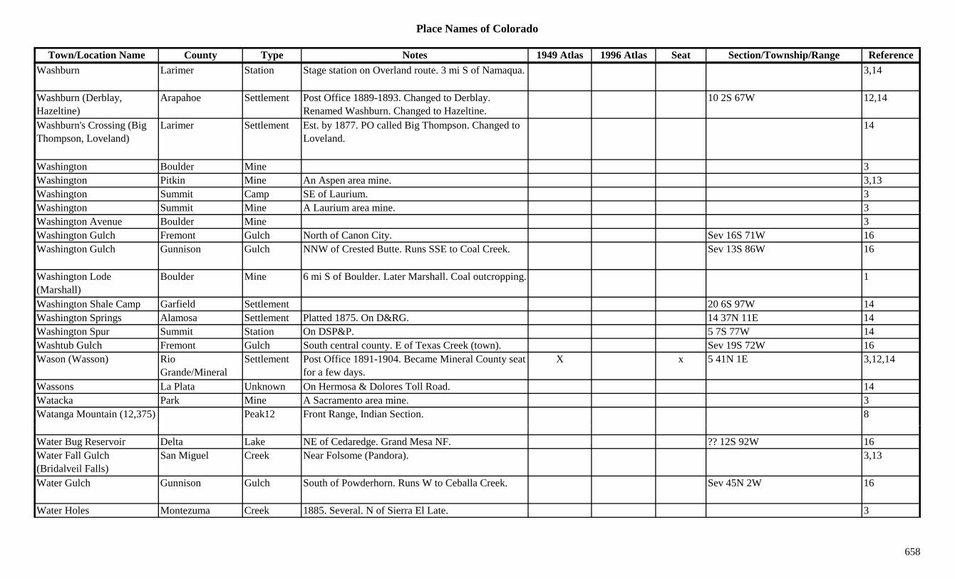
Place Names of Colorado
Town/Location Name County Type Notes 1949 Atlas 1996 Atlas Seat Section/Township/Range ReferenceWashburn Larimer Station Stage station on Overland route. 3 mi S of Namaqua. 3,14
Washburn (Derblay, Hazeltine)
Arapahoe Settlement Post Office 1889-1893. Changed to Derblay. Renamed Washburn. Changed to Hazeltine.
10 2S 67W 12,14
Washburn's Crossing (Big Thompson, Loveland)
Larimer Settlement Est. by 1877. PO called Big Thompson. Changed to Loveland.
14
Washington Boulder Mine 3Washington Pitkin Mine An Aspen area mine. 3,13Washington Summit Camp SE of Laurium. 3Washington Summit Mine A Laurium area mine. 3gWashington Avenue Boulder Mine 3Washington Gulch Fremont Gulch North of Canon City. Sev 16S 71W 16Washington Gulch Gunnison Gulch NNW of Crested Butte. Runs SSE to Coal Creek. Sev 13S 86W 16
Washington Lode (Marshall)
Boulder Mine 6 mi S of Boulder. Later Marshall. Coal outcropping. 1
Washington Shale Camp Garfield Settlement 20 6S 97W 14Washington Springs Alamosa Settlement Platted 1875. On D&RG. 14 37N 11E 14Washington Spur Summit Station On DSP&P. 5 7S 77W 14Washtub Gulch Fremont Gulch South central county. E of Texas Creek (town). Sev 19S 72W 16Wason (Wasson) Rio
Grande/MineralSettlement Post Office 1891-1904. Became Mineral County seat
for a few days.X x 5 41N 1E 3,12,14
Wassons La Plata Unknown On Hermosa & Dolores Toll Road. 14Watacka Park Mine A Sacramento area mine. 3Watanga Mountain (12,375) Peak12 Front Range, Indian Section. 8
Water Bug Reservoir Delta Lake NE of Cedaredge. Grand Mesa NF. ?? 12S 92W 16Water Fall Gulch (Bridalveil Falls)
San Miguel Creek Near Folsome (Pandora). 3,13
Water Gulch Gunnison Gulch South of Powderhorn. Runs W to Ceballa Creek. Sev 45N 2W 16
Water Holes Montezuma Creek 1885. Several. N of Sierra El Late. 3
658

Place Names of Colorado
Town/Location Name County Type Notes 1949 Atlas 1996 Atlas Seat Section/Township/Range ReferenceWater Spout Gunnison Unknown On D&RG. 13 14S 86W 14Water Valley Bent/Kiowa Settlement Rural Post Office 1887-1894. 12 mi NW of Sheridan
Lake. 12 mi SE of Roggen.3,12,14
Waterdog Lake Hinsdale Lake NE corner of county. ENE of Lake City. Gunnison NF.
30 44N 3W 16
Waterdog Lakes Chaffee Lake WSW of Garfield. San Isabel NF. 31 50N 6E 16Waterfall Gulch San Miguel Gulch On Yellow Mtn. Near Ophir. Trail ran up gulch. 3
Waterhole Bent Settlement Est. by 1907. Settlement on Mud Creek. ? 26S 48W 14Waterloo Gulch Gunnison Gulch NE corner of county. Runs S to Texas Creek. Sev 13S 81W 16Waterman Garfield Settlement Post Office 1888-?? 12,14,Waters Teller Station Est. by 1924. On CM. 7 mi N of Gillett. X 17 14S 69W 3,14Watersville Fremont Unknown On F&CC. S of Oro Junta. 14Waterton (Enterprise, Platte Cañon/Canyon)
Jefferson Settlement Post Office on DSP&P 1881-1893. Originally Platte Cañon.
26 6S 69W 3,6,14
Watertown (Kassler, Platte Canyon, Waterton)
Jefferson Station See Kassler. Legally renamed Watertown in 1916. Also called Cañon Spur.
3
Watervale Las Animas Settlement Post Office on C&S 1888-1921 with gaps. 5 mi W of Branson.
X 1 35S 59W 3,12,14
Watkins (Box Elder) Adams Settlement Est. by 1873. Post Office est. 1878. Plat filed in 1888. NE of Aurora. First called Box Elder.
X X 36 3S 65W 3,6,12,14
Watonga Saguache Settlement On D&RG. Post Office 1910-1911. 25 45N 9E 12,14Watson (Gerbazdale) Pitkin Settlement Post Office 1889-1918. Changed to Gerbazdale. 2 mi
N of Woody Creek.6 9S 85W 3,12,14
Watson Creek Routt Creek Flows E to Yampa River above Yampa. 3Watson Creek (Walton C k)
Routt Settlement Existed in 1880s. Along creek of same name. R d W lt C k
3Creek) Renamed Walton Creek.Watson Gulch Custer Gulch NE corner of county. SW of Wetmore. Runs E to
Hardscrabble Creek.Sev 21S 69W 16
Watsons Delta Unknown On D&RG. 32 15S 95W 14Wattenberg Weld Settlement Est. 1909. On DL&NW. No Post Office. X X 24 1N 67W 3,14Wattenburg Weld Settlement Est. 1909. NW of Fort Lupton. 6Watts (Dowd) Eagle Camp Est. by 1923. S of Vail. Also known as Dowd. 16 5S 81W 3,14
659

Place Names of Colorado
Town/Location Name County Type Notes 1949 Atlas 1996 Atlas Seat Section/Township/Range ReferenceWaugh Gulch Fremont Gulch Central county. N of Cotopaxi. Sev 50N 12E 16Waugh Mountain Fremont Peak11 North of Cotopaxi. 10 50N 12E 16Waumega Boulder Mine At Balarat. 3Wauneta Yuma Settlement Est. by 1943. 16 mi N of Wray. X 26 4N 44W 3,14Waunita Gunnison Settlement Post Office 1885-1908 with gaps. 10 49N 4E 14Waunita Hot Springs (Wauneta Hot Springs, Elgin)
Gunnison Settlement Post Office 1910-1942. Moved from Bowerman. Formerly Elgin. Camping spot by 1880.
X 11 49N 4E 3,12,14
Waunita Pass Gunnison Pass Btwn Waunita Hot Springs and Pitkin. Gunnison NF.
22 50N 4E 7,9,16
Wautauga Gilpin Unknown On GT. 23 3S 73W 14g pWaveland (Waveland Junction)
Bent Station Est. by 1909. RR stop on AT&SF. N of Las Animas. 35 22S 52W 3,14
Waverly Alamosa Unknown 20 37N 9E 14Waverly El Paso Settlement Post Office 1897. 12,14Waverly Larimer Station On C&S. Post Office 1906-1912. Terminus of
spurline. Built 1905.X 23 9N 69W 3,12,14
Waverly Yuma Unknown 35 4N 47W 14Waverly Mountain (13,292) Peak13 Mt. Harvard Quad. 11
Wayne Huerfano Unknown Est. by 1916. ? 29S 66W 14Wayne (Lowland) El Paso Settlement Rural Post Office 1909-1912. Formerly Lowland. 8
mi NW of Rush.17 14S 61W 3,12,14
Way's Gulch Routt Gulch NE of Hahns Peak (town). 3Wayside Costilla Settlement Post Office 1875-1878. First site with Post Office
was in Costilla Co. 15 mi S of present site.20 38N 10E 12,14
Wayside (Alamosa) Alamosa Settlement Est. by 1876. Originally 15 mi. south of present town. Stage station. Confusing, see Costilla Co.
20 38N 10E 3,14
Way-up Gunnison Mine At Ohio City. 2Weary Mule Creek (Red Wash)
Rio Blanco Creek Flows S from Moffat Co. to White River E of Rangely.
3
660
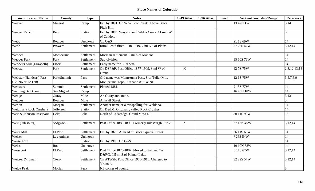
Place Names of Colorado
Town/Location Name County Type Notes 1949 Atlas 1996 Atlas Seat Section/Township/Range ReferenceWeaver Mineral Camp Est. by 1891. On W Willow Creek. Above Black
Pitch Hill.13 42N 1W 3,14
Weaver Ranch Bent Station Est. by 1885. Waystop on Caddoa Creek. 11 mi SW of Caddoa.
3
Webb Boulder Unknown On C&S 21 1S 69W 14Webb Prowers Settlement Rural Post Office 1910-1919. 7 mi NE of Plains. 27 26S 42W 3,12,14
Webber Montezuma Settlement Morman settlement. 2 mi S of Mancos. 14Webber Park Park Settlement Sub-division. 35 10S 73W 14Webber's Mill (Elizabeth) Elbert Settlement Early name for Elizabeth. 14Webster Park Settlement On DSP&P. Post Office 1877-1909. 3 mi W of X 12 7S 75W 2,3,12,13,14
Grant., , , ,
Webster (Handcart) Pass (12,096 or 12,120)
Park/Summit Pass Old name was Montezuma Pass. S of Teller Mtn. Montezuma Topo. Arapaho & Pike NF.
12 6S 75W 3,5,7,8,9
Websters Summit Settlement Platted 1881. 21 5S 77W 14Wedding Bell Camp San Miguel Camp 16 45N 18W 14Wedge Ouray Mine An Ouray area mine. 3,13Wedges Boulder Mine At Wall Street. 3Wedon Morgan Settlement Another name or a misspelling for Weldona. 14Weidman (Rock Crusher) Jefferson Station On D&IM. Originally called Rock Crusher. 14Weir & Johnson Reservoir Delta Lake North of Cedaredge. Grand Mesa NF. 30 11S 93W 16
Weir (Julesburg) Sedgwick Settlement Post Office 1889-1890. Formerly Julesburgh Site 2. X 27 12N 45W 3,12,14
Weirs Mill El Paso Settlement Est. by 1873. At head of Black Squirrel Creek. 26 11S 66W 14Weiser Las Animas Unknown ? 28S 54W 14W i h St ti E t b 1906 O C&S 14Weiserhorn Station Est. by 1906. On C&S. 14Weiss Routt Unknown 10 10N 88W 14Weissport El Paso Settlement Post Office 1875-1887. Moved to Palmer. On
D&RG. 0.5 mi S of Palmer Lake.5 11S 67W 3,12,14
Weitzer (Vroman) Otero Settlement On AT&SF. Post Office 1908-1918. Changed to Vroman.
32 22S 57W 3,12,14
Welba Peak Moffat Peak NE corner of county. 3
661
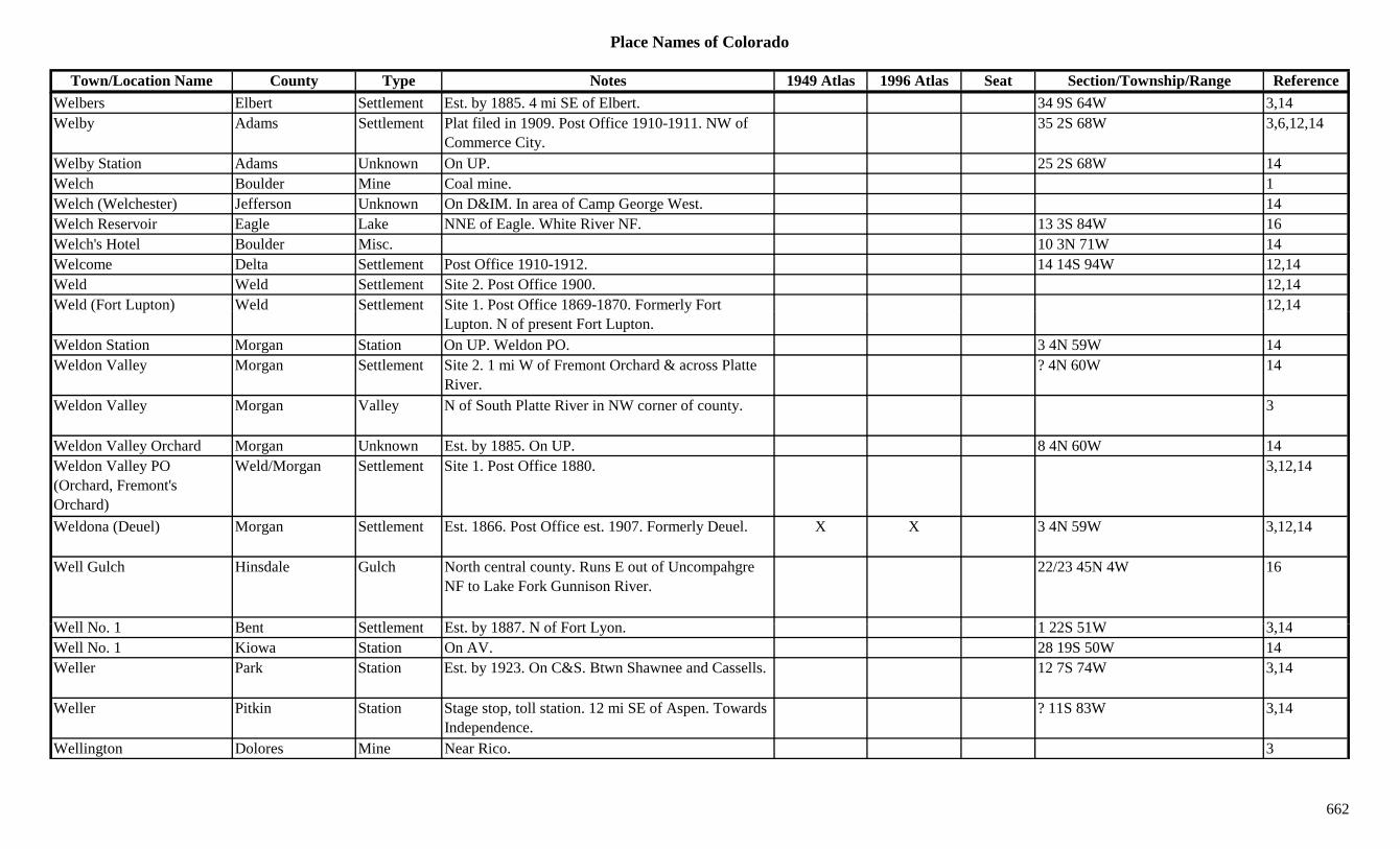
Place Names of Colorado
Town/Location Name County Type Notes 1949 Atlas 1996 Atlas Seat Section/Township/Range ReferenceWelbers Elbert Settlement Est. by 1885. 4 mi SE of Elbert. 34 9S 64W 3,14Welby Adams Settlement Plat filed in 1909. Post Office 1910-1911. NW of
Commerce City.35 2S 68W 3,6,12,14
Welby Station Adams Unknown On UP. 25 2S 68W 14Welch Boulder Mine Coal mine. 1Welch (Welchester) Jefferson Unknown On D&IM. In area of Camp George West. 14Welch Reservoir Eagle Lake NNE of Eagle. White River NF. 13 3S 84W 16Welch's Hotel Boulder Misc. 10 3N 71W 14Welcome Delta Settlement Post Office 1910-1912. 14 14S 94W 12,14Weld Weld Settlement Site 2. Post Office 1900. 12,14Weld (Fort Lupton) Weld Settlement Site 1. Post Office 1869-1870. Formerly Fort 12,14( p ) y
Lupton. N of present Fort Lupton.,
Weldon Station Morgan Station On UP. Weldon PO. 3 4N 59W 14Weldon Valley Morgan Settlement Site 2. 1 mi W of Fremont Orchard & across Platte
River.? 4N 60W 14
Weldon Valley Morgan Valley N of South Platte River in NW corner of county. 3
Weldon Valley Orchard Morgan Unknown Est. by 1885. On UP. 8 4N 60W 14Weldon Valley PO (Orchard, Fremont's Orchard)
Weld/Morgan Settlement Site 1. Post Office 1880. 3,12,14
Weldona (Deuel) Morgan Settlement Est. 1866. Post Office est. 1907. Formerly Deuel. X X 3 4N 59W 3,12,14
Well Gulch Hinsdale Gulch North central county. Runs E out of Uncompahgre NF to Lake Fork Gunnison River.
22/23 45N 4W 16
W ll N 1 B t S ttl t E t b 1887 N f F t L 1 22S 51W 3 14Well No. 1 Bent Settlement Est. by 1887. N of Fort Lyon. 1 22S 51W 3,14Well No. 1 Kiowa Station On AV. 28 19S 50W 14Weller Park Station Est. by 1923. On C&S. Btwn Shawnee and Cassells. 12 7S 74W 3,14
Weller Pitkin Station Stage stop, toll station. 12 mi SE of Aspen. Towards Independence.
? 11S 83W 3,14
Wellington Dolores Mine Near Rico. 3
662

Place Names of Colorado
Town/Location Name County Type Notes 1949 Atlas 1996 Atlas Seat Section/Township/Range ReferenceWellington Jefferson Unknown 32 8S 71W 14Wellington Larimer Settlement Est. 1902. Post Office est. 1903. X X 33 9N 68W 3,12,14Wellington Summit Mine A Lincoln area mine. 13Wellington Mine & Mill Summit Mine In French Gulch. 2,3Wellons Lincoln Settlement Rural Post Office 1908-1916. 15 mi NE of Arriba. 4 7S 52W 3,12,14
Wells Conejos Unknown On D&RG. 26 38N 9E 14Wells Gulch Delta Gulch NW corner of county. Runs SSW to Gunnison River. Sev 14S 97W 16
Wells Gulch Fremont Gulch North of Wellsville. Sev 49N 9/10E 16Well's Ranch Elbert Station Stage station on Smoky Hill South stage route. 1 mi 3,6,14g y g
S of Resolis., ,
Wells Station Bent Station Est. by 1874. 5 mi NE of Fort Lyon. 15 mi SSW of Wool Station.
14
Wellsville Fremont Settlement Post Office 1880-1896. Almost to Chaffee County line.
19 49N 10E 3,12,14
Welty Weld Station Est. by 1909. On GW, a siding. 6 mi W of Johnstown.
9 4N 68W 3,6,14
Weminucha Creek Hinsdale Creek SE corner of county. Flows S to Archuleta Co. 3Weminucha Pass Hinsdale Pass 1885. E of Mt. Oso. The Bend Area. [Same as
Wenimuche?]3,8
Weminuche Pass Hinsdale Pass SW of Creede. S of Lake City. San Juan Mtns. San Juan & Rio Grande NF.
33 40N 4W 7,16
Wendelia Garfield Unknown On Unitah. 5 5S 103W 14Wendlings Kiowa Settlement Est. by 1865. First name was Wendling, then Middle
Kiowa, then Kiowa.17 8S 63W 14
W (M ) L A i S ttl t P t Offi 1891 Ch d t M 11 31S 67W 12 14Wenger (Menger) Las Animas Settlement Post Office 1891. Changed to Menger. 11 31S 67W 12,14Wensville Fremont Settlement XWentworth (Wentsworth) Baca Settlement Post Office 1911-1921. 28 32S 42W 3,12,14Wentz Weld Settlement Rural Post Office 1891-1903. 10 mi N of Hudson. 14 3N 65W 3,6,12,14
Weshall Gulch Fremont Gulch SW of Canon City. Runs NW. Sev 20S 72W 16
663
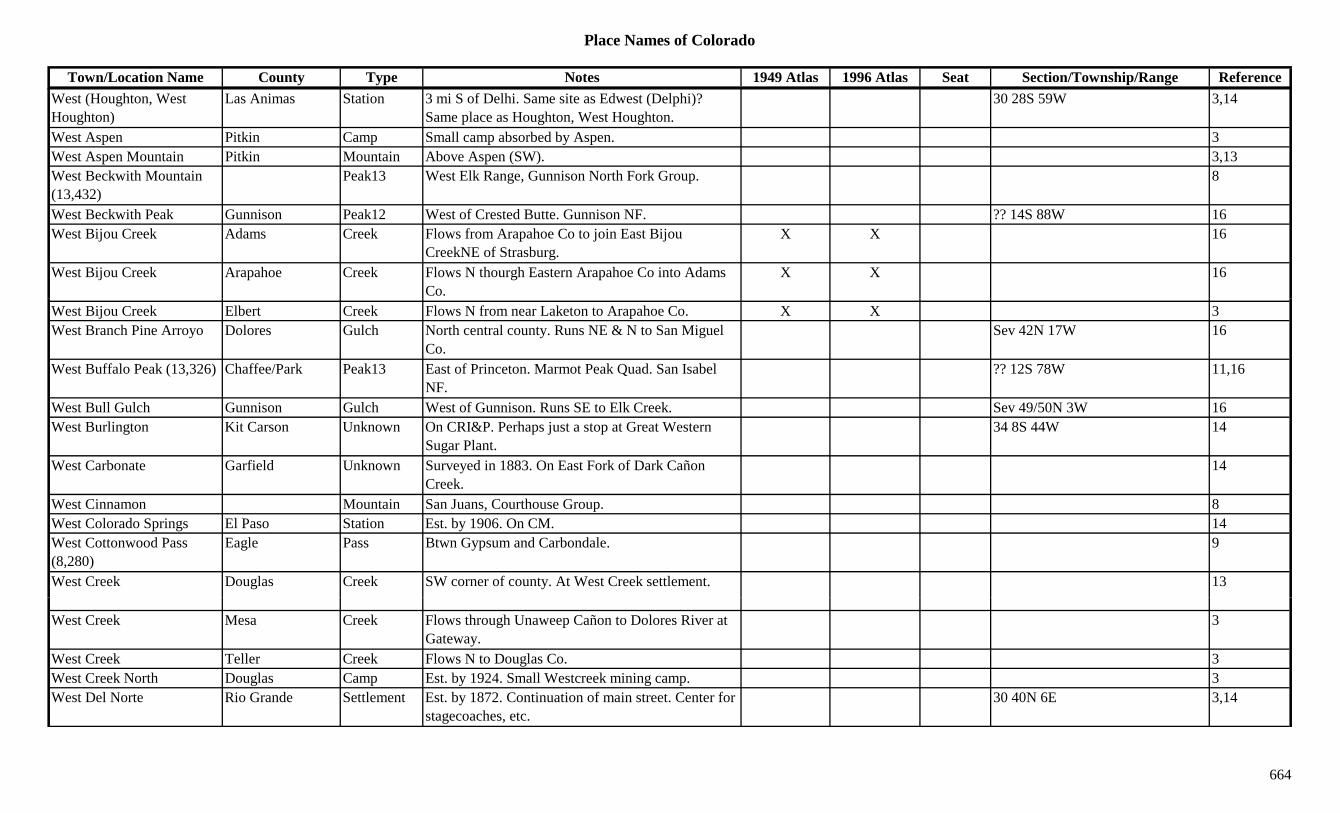
Place Names of Colorado
Town/Location Name County Type Notes 1949 Atlas 1996 Atlas Seat Section/Township/Range ReferenceWest (Houghton, West Houghton)
Las Animas Station 3 mi S of Delhi. Same site as Edwest (Delphi)? Same place as Houghton, West Houghton.
30 28S 59W 3,14
West Aspen Pitkin Camp Small camp absorbed by Aspen. 3West Aspen Mountain Pitkin Mountain Above Aspen (SW). 3,13West Beckwith Mountain (13,432)
Peak13 West Elk Range, Gunnison North Fork Group. 8
West Beckwith Peak Gunnison Peak12 West of Crested Butte. Gunnison NF. ?? 14S 88W 16West Bijou Creek Adams Creek Flows from Arapahoe Co to join East Bijou
CreekNE of Strasburg.X X 16
West Bijou Creek Arapahoe Creek Flows N thourgh Eastern Arapahoe Co into Adams Co.
X X 16
West Bijou Creek Elbert Creek Flows N from near Laketon to Arapahoe Co. X X 3West Branch Pine Arroyo Dolores Gulch North central county. Runs NE & N to San Miguel
Co.Sev 42N 17W 16
West Buffalo Peak (13,326) Chaffee/Park Peak13 East of Princeton. Marmot Peak Quad. San Isabel NF.
?? 12S 78W 11,16
West Bull Gulch Gunnison Gulch West of Gunnison. Runs SE to Elk Creek. Sev 49/50N 3W 16West Burlington Kit Carson Unknown On CRI&P. Perhaps just a stop at Great Western
Sugar Plant.34 8S 44W 14
West Carbonate Garfield Unknown Surveyed in 1883. On East Fork of Dark Cañon Creek.
14
West Cinnamon Mountain San Juans, Courthouse Group. 8West Colorado Springs El Paso Station Est. by 1906. On CM. 14West Cottonwood Pass (8,280)
Eagle Pass Btwn Gypsum and Carbondale. 9
West Creek Douglas Creek SW corner of county. At West Creek settlement. 13
West Creek Mesa Creek Flows through Unaweep Cañon to Dolores River at Gateway.
3
West Creek Teller Creek Flows N to Douglas Co. 3West Creek North Douglas Camp Est. by 1924. Small Westcreek mining camp. 3West Del Norte Rio Grande Settlement Est. by 1872. Continuation of main street. Center for
stagecoaches, etc.30 40N 6E 3,14
664

Place Names of Colorado
Town/Location Name County Type Notes 1949 Atlas 1996 Atlas Seat Section/Township/Range ReferenceWest Denver Denver Unknown On DSP&P. 1.1 mi from Denver Depot. 14West Denver (Ute, Grand Junction)
Mesa Settlement First name was Ute, then West Denver, then Grand Junction.
14
West Divide Creek Garfield Creek Flows N to join East Divide Creek N of Raven. 3West Divide Creek Mesa Creek Flows NW into Garfield Co. Far NE corner of
county.3
West Dolores River Dolores River Flows SW from btwn Dolores Peak & Mt. Wilson to West Dolores.
X 3,13
West Dolores River Montezuma River Flows out of Dolores Co. to Dolores near Raymond. X 3
West Dyer Mountain Peak13 Mt. Sherman Quad. 11y(13,047)
Q
West Elk Mountains Delta/Gunnison Range 1West Elk Peak Gunnison Peak12 SW of Crested Butte. Gunnison NF. ?? 15S 88W 16West Elk Peak (13,035) Peak13 West Elks, Ohio Creek Group. West Elk Peak Quad.
SW of Baldwin.8,11,13
West Elk Range Pitkin/Gunnison Range Part of Elk Mountains. 15West Elk Reservoir Garfield Lake North of Silt. White River NF. 19/30 4S 91W 16West End El Paso Station On MT. Station for Colorado City. 14West Flatiron Mesa Gunnison Mesa ESE of Somerset. Gunnison NF. Sev 13S 90W 16West Fork Montezuma Unknown 18 39N 13W 14West Fork Douglas Creek Rio Blanco Creek Flows N to join Douglas Creek S of Rangely. 3
West Fork San Juan River Mineral River Flows S ot join San Juan River near West Fork (town).
3
West Fork Stuart Gulch Garfield Gulch North central county. Runs NNE into Rio Blanco C NW f G d V ll
Sev 4S 97W 16Co. NW of Grand Valley.
West Gap (7,640) La Plata Pass 18 34N 10WWest Glenwood (Chacra) Garfield Settlement Est. by 1923. On D&RG. W of Glenwood Springs.
Same site as Chacra.9 6S 89W 3,14
West Gunnison Gunnison Settlement One time population of 200. W & S of Gunnison. 2 49N 1W 3,14
West Hayden Routt Unknown On DNW&P, D&RG. 9 6N 88W 14
665

Place Names of Colorado
Town/Location Name County Type Notes 1949 Atlas 1996 Atlas Seat Section/Township/Range ReferenceWest Houghton (West, Houghton)
Las Animas Unknown Same as West & Houghton. 14
West Junction Huerfano Unknown 14West Lake Hinsdale Unknown Surveyed 1883. Same place a Bluff. W side of Lake
City.14
West Las Animas (Las Animas)
Bent Settlement Post Office 1873-1886. Site of present Las Animas site. County seat prior to being renamed.
x 10 23S 52W 3,12,14
West Lost Lake Garfield Lake NE corner of county. White River NF. ?? 1N 88W 16West Mancos River Montezuma River Flows from Hesperus Mtn. W & S through Mancos. 3
West Marigold Teller Unknown Est. by 1899. Same section as Marigold. 9 16S 70W 14West Maroon Pass Pitkin/Gunnison Pass Elk Range, Crested Butte Section. Maroon Bells
Topo. White River NF.4 12S 86W 5,7,8,16
West McCoy Gulch Fremont Gulch SE of Cotopaxi. Sev 48/49S 12E 16West Mill Gulch Fremont Gulch NE corner of county. Sev 17S 68W 16West Mill Gulch Fremont Gulch SW of Canon City. Runs WNW. Sev 20S 72W 16West Mitchell Eagle Unknown On D&RG. 14West Needle Mountain (13,062)
Peak13 West Needle Mountains. Twilight Group. Snowdon Peak Quad.
8,11
West Needle Mountains Range Part of San Juans. 15West Newcastle Garfield Unknown Est. by 1906. On D&RG. 14West Oil Creek (Four-Mile, 10-Mile)
Park Creek Flows E to Teller Co. SE corner of state. 3
West Paradox Creek Montrose Creek Flows from Buckeye Res. SE to Dolores River at Bedrock.
3
W t P t (13 041) P k13 G R E t Sid 8West Partner (13,041) Peak13 Gore Range, East Side. 8West Peak Eagle Mountain NE corner of county. White River NF. 27 2S 82W 16West Plum Creek Douglas Creek Flows N through county past Sedalia. 3West Point Saguache Mine An Iris area mine. 3,13West Portal Montrose Unknown On D&RG. 27 49N 8W 14West Portal (Irvin, Winter Park)
Grand Settlement Post Office 1923-1939. Moved to Winter Park. Also known as Hideaway Park, Irvin.
10 2S 75W 1,12,14
666
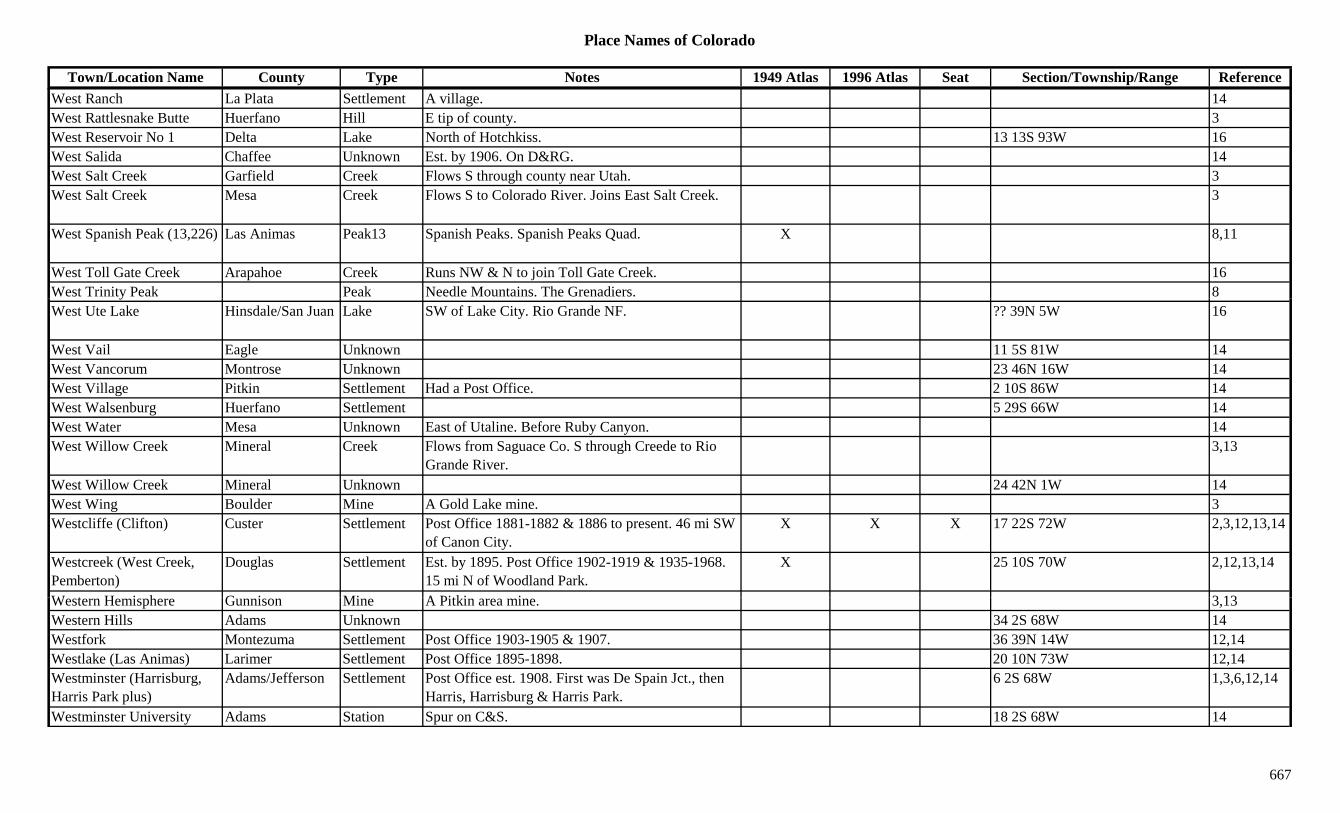
Place Names of Colorado
Town/Location Name County Type Notes 1949 Atlas 1996 Atlas Seat Section/Township/Range ReferenceWest Ranch La Plata Settlement A village. 14West Rattlesnake Butte Huerfano Hill E tip of county. 3West Reservoir No 1 Delta Lake North of Hotchkiss. 13 13S 93W 16West Salida Chaffee Unknown Est. by 1906. On D&RG. 14West Salt Creek Garfield Creek Flows S through county near Utah. 3West Salt Creek Mesa Creek Flows S to Colorado River. Joins East Salt Creek. 3
West Spanish Peak (13,226) Las Animas Peak13 Spanish Peaks. Spanish Peaks Quad. X 8,11
West Toll Gate Creek Arapahoe Creek Runs NW & N to join Toll Gate Creek. 16West Trinity Peak Peak Needle Mountains. The Grenadiers. 8yWest Ute Lake Hinsdale/San Juan Lake SW of Lake City. Rio Grande NF. ?? 39N 5W 16
West Vail Eagle Unknown 11 5S 81W 14West Vancorum Montrose Unknown 23 46N 16W 14West Village Pitkin Settlement Had a Post Office. 2 10S 86W 14West Walsenburg Huerfano Settlement 5 29S 66W 14West Water Mesa Unknown East of Utaline. Before Ruby Canyon. 14West Willow Creek Mineral Creek Flows from Saguace Co. S through Creede to Rio
Grande River.3,13
West Willow Creek Mineral Unknown 24 42N 1W 14West Wing Boulder Mine A Gold Lake mine. 3Westcliffe (Clifton) Custer Settlement Post Office 1881-1882 & 1886 to present. 46 mi SW
of Canon City.X X X 17 22S 72W 2,3,12,13,14
Westcreek (West Creek, Pemberton)
Douglas Settlement Est. by 1895. Post Office 1902-1919 & 1935-1968. 15 mi N of Woodland Park.
X 25 10S 70W 2,12,13,14
W t H i h G i Mi A Pitki i 3 13Western Hemisphere Gunnison Mine A Pitkin area mine. 3,13Western Hills Adams Unknown 34 2S 68W 14Westfork Montezuma Settlement Post Office 1903-1905 & 1907. 36 39N 14W 12,14Westlake (Las Animas) Larimer Settlement Post Office 1895-1898. 20 10N 73W 12,14Westminster (Harrisburg, Harris Park plus)
Adams/Jefferson Settlement Post Office est. 1908. First was De Spain Jct., then Harris, Harrisburg & Harris Park.
6 2S 68W 1,3,6,12,14
Westminster University Adams Station Spur on C&S. 18 2S 68W 14
667
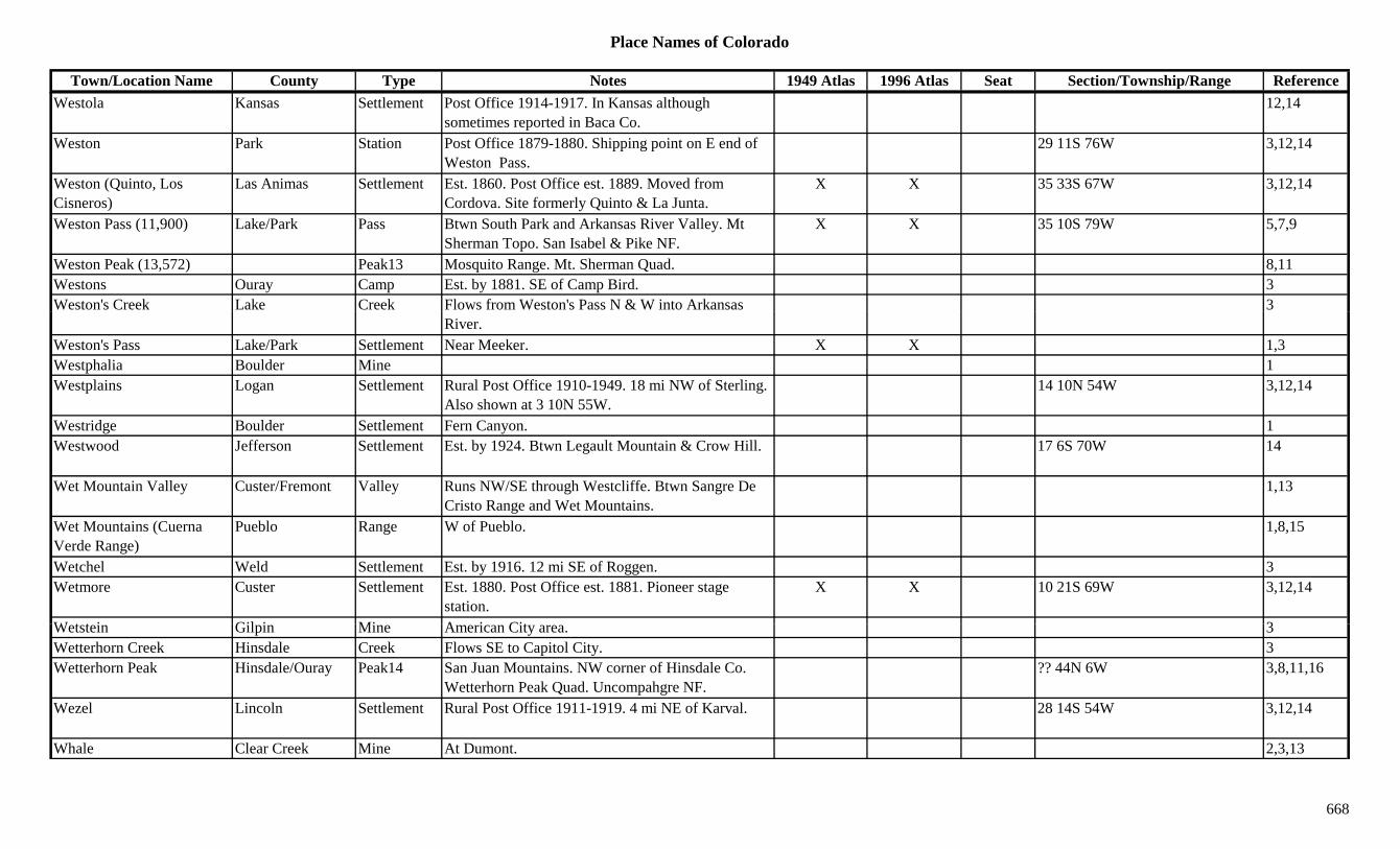
Place Names of Colorado
Town/Location Name County Type Notes 1949 Atlas 1996 Atlas Seat Section/Township/Range ReferenceWestola Kansas Settlement Post Office 1914-1917. In Kansas although
sometimes reported in Baca Co.12,14
Weston Park Station Post Office 1879-1880. Shipping point on E end of Weston Pass.
29 11S 76W 3,12,14
Weston (Quinto, Los Cisneros)
Las Animas Settlement Est. 1860. Post Office est. 1889. Moved from Cordova. Site formerly Quinto & La Junta.
X X 35 33S 67W 3,12,14
Weston Pass (11,900) Lake/Park Pass Btwn South Park and Arkansas River Valley. Mt Sherman Topo. San Isabel & Pike NF.
X X 35 10S 79W 5,7,9
Weston Peak (13,572) Peak13 Mosquito Range. Mt. Sherman Quad. 8,11Westons Ouray Camp Est. by 1881. SE of Camp Bird. 3Weston's Creek Lake Creek Flows from Weston's Pass N & W into Arkansas 3
River.Weston's Pass Lake/Park Settlement Near Meeker. X X 1,3Westphalia Boulder Mine 1Westplains Logan Settlement Rural Post Office 1910-1949. 18 mi NW of Sterling.
Also shown at 3 10N 55W.14 10N 54W 3,12,14
Westridge Boulder Settlement Fern Canyon. 1Westwood Jefferson Settlement Est. by 1924. Btwn Legault Mountain & Crow Hill. 17 6S 70W 14
Wet Mountain Valley Custer/Fremont Valley Runs NW/SE through Westcliffe. Btwn Sangre De Cristo Range and Wet Mountains.
1,13
Wet Mountains (Cuerna Verde Range)
Pueblo Range W of Pueblo. 1,8,15
Wetchel Weld Settlement Est. by 1916. 12 mi SE of Roggen. 3Wetmore Custer Settlement Est. 1880. Post Office est. 1881. Pioneer stage
station.X X 10 21S 69W 3,12,14
W t t i Gil i Mi A i Cit 3Wetstein Gilpin Mine American City area. 3Wetterhorn Creek Hinsdale Creek Flows SE to Capitol City. 3Wetterhorn Peak Hinsdale/Ouray Peak14 San Juan Mountains. NW corner of Hinsdale Co.
Wetterhorn Peak Quad. Uncompahgre NF.?? 44N 6W 3,8,11,16
Wezel Lincoln Settlement Rural Post Office 1911-1919. 4 mi NE of Karval. 28 14S 54W 3,12,14
Whale Clear Creek Mine At Dumont. 2,3,13
668
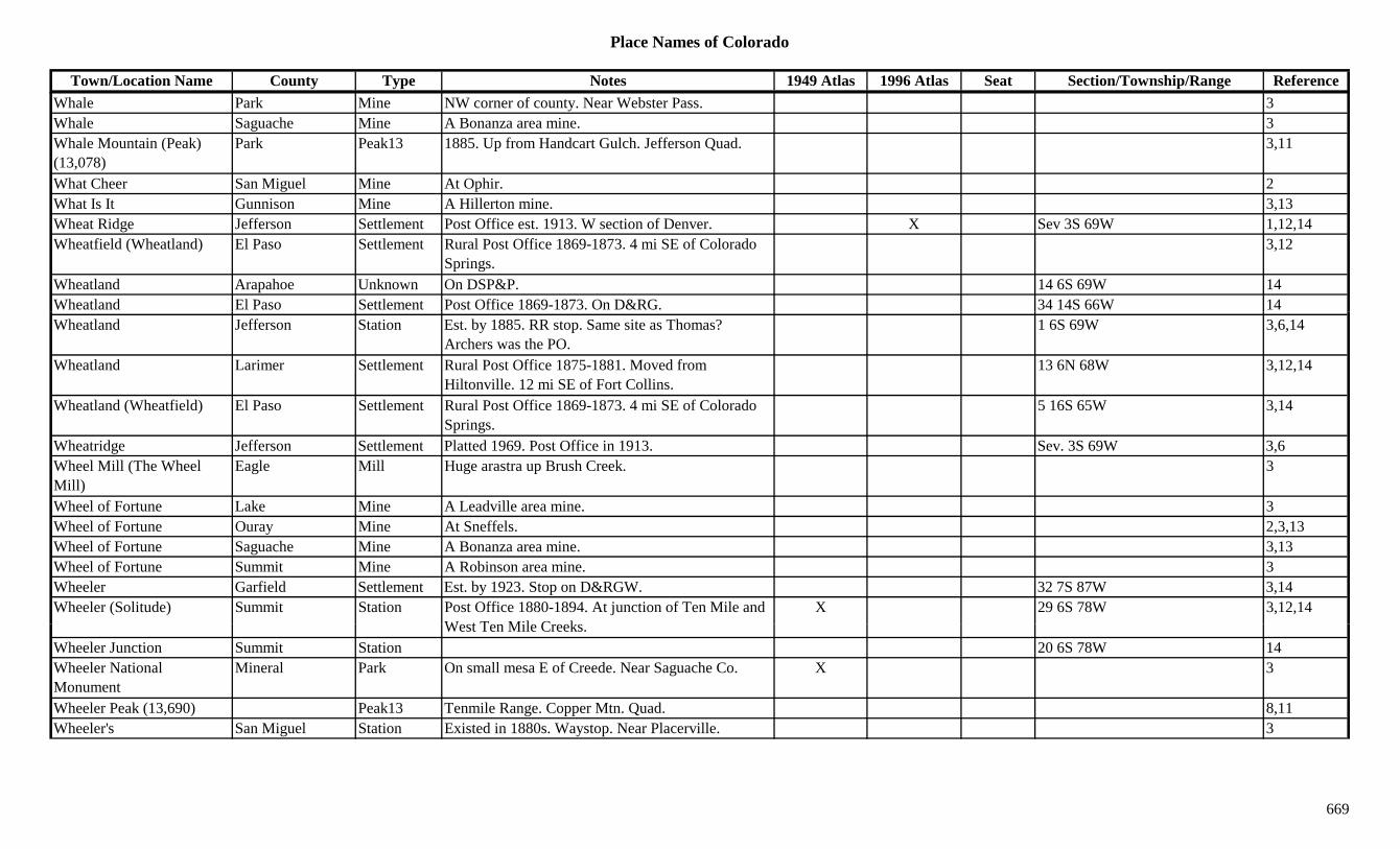
Place Names of Colorado
Town/Location Name County Type Notes 1949 Atlas 1996 Atlas Seat Section/Township/Range ReferenceWhale Park Mine NW corner of county. Near Webster Pass. 3Whale Saguache Mine A Bonanza area mine. 3Whale Mountain (Peak) (13,078)
Park Peak13 1885. Up from Handcart Gulch. Jefferson Quad. 3,11
What Cheer San Miguel Mine At Ophir. 2What Is It Gunnison Mine A Hillerton mine. 3,13Wheat Ridge Jefferson Settlement Post Office est. 1913. W section of Denver. X Sev 3S 69W 1,12,14Wheatfield (Wheatland) El Paso Settlement Rural Post Office 1869-1873. 4 mi SE of Colorado
Springs.3,12
Wheatland Arapahoe Unknown On DSP&P. 14 6S 69W 14Wheatland El Paso Settlement Post Office 1869-1873. On D&RG. 34 14S 66W 14Wheatland Jefferson Station Est. by 1885. RR stop. Same site as Thomas?
Archers was the PO.1 6S 69W 3,6,14
Wheatland Larimer Settlement Rural Post Office 1875-1881. Moved from Hiltonville. 12 mi SE of Fort Collins.
13 6N 68W 3,12,14
Wheatland (Wheatfield) El Paso Settlement Rural Post Office 1869-1873. 4 mi SE of Colorado Springs.
5 16S 65W 3,14
Wheatridge Jefferson Settlement Platted 1969. Post Office in 1913. Sev. 3S 69W 3,6Wheel Mill (The Wheel Mill)
Eagle Mill Huge arastra up Brush Creek. 3
Wheel of Fortune Lake Mine A Leadville area mine. 3Wheel of Fortune Ouray Mine At Sneffels. 2,3,13Wheel of Fortune Saguache Mine A Bonanza area mine. 3,13Wheel of Fortune Summit Mine A Robinson area mine. 3Wheeler Garfield Settlement Est. by 1923. Stop on D&RGW. 32 7S 87W 3,14Wheeler (Solitude) Summit Station Post Office 1880-1894. At junction of Ten Mile and
W t T Mil C kX 29 6S 78W 3,12,14
West Ten Mile Creeks.Wheeler Junction Summit Station 20 6S 78W 14Wheeler National Monument
Mineral Park On small mesa E of Creede. Near Saguache Co. X 3
Wheeler Peak (13,690) Peak13 Tenmile Range. Copper Mtn. Quad. 8,11Wheeler's San Miguel Station Existed in 1880s. Waystop. Near Placerville. 3
669
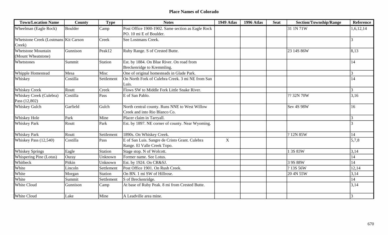
Place Names of Colorado
Town/Location Name County Type Notes 1949 Atlas 1996 Atlas Seat Section/Township/Range ReferenceWheelman (Eagle Rock) Boulder Camp Post Office 1900-1902. Same section as Eagle Rock
PO. 10 mi E of Boulder.31 1N 71W 1,6,12,14
Whetstone Creek (Lostmans Creek)
Kit Carson Creek See Lostmans Creek. 3
Whetstone Mountain (Mount Wheatstone)
Gunnison Peak12 Ruby Range. S of Crested Butte. 23 14S 86W 8,13
Whetstones Summit Station Est. by 1884. On Blue River. On road from Breckenridge to Kremmling.
14
Whipple Homestead Mesa Misc One of original homesteads in Glade Park. 3Whiskey Costilla Settlement On North Fork of Culebra Creek. 3 mi NE from San
Luis.14
Whiskey Creek Routt Creek Flows SW to Middle Fork Little Snake River. 3Whiskey Creek (Culebra) Pass (12,802)
Costilla Pass E of San Pablo. ?? 32N 70W 3,16
Whiskey Gulch Garfield Gulch North central county. Runs NNE to West Willow Creek and into Rio Blanco Co.
Sev 4S 98W 16
Whiskey Hole Park Mine Placer claim in Tarryall. 3Whiskey Park Routt Park Est. by 1897. NE corner of county. Near Wyoming. 3
Whiskey Park Routt Settlement 1890s. On Whiskey Creek. ? 12N 85W 14Whiskey Pass (12,540) Costilla Pass E of San Luis. Sangre de Cristo Grant. Culebra
Range. El Valle Creek Topo.X 5,7,8
Whiskey Springs Eagle Station Stage stop. N of Wolcott. 1 3S 83W 3,14Whispering Pine (Lotus) Ouray Unknown Former name. See Lotus. 14Whitbeck Pitkin Unknown Est. by 1924. On CR&SJ. 3 9S 88W 14White Lincoln Settlement Post Office 1901. On Rush Creek. ? 13S 56W 12,14Whit M St ti O BN 1 i SW f Hill 20 4N 55W 3 14White Morgan Station On BN. 1 mi SW of Hillrose. 20 4N 55W 3,14White Summit Settlement S of Breckenridge. 14White Cloud Gunnison Camp At base of Ruby Peak. 8 mi from Crested Butte. 3,14
White Cloud Lake Mine A Leadville area mine. 3
670
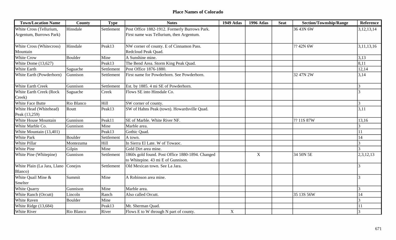
Place Names of Colorado
Town/Location Name County Type Notes 1949 Atlas 1996 Atlas Seat Section/Township/Range ReferenceWhite Cross (Tellurium, Argentum, Burrows Park)
Hinsdale Settlement Post Office 1882-1912. Formerly Burrows Park. First name was Tellurium, then Argentum.
36 43N 6W 3,12,13,14
White Cross (Whitecross) Mountain
Hinsdale Peak13 NW corner of county. E of Cinnamon Pass. Redcloud Peak Quad.
?? 42N 6W 3,11,13,16
White Crow Boulder Mine A Sunshine mine. 3,13White Dome (13,627) Peak13 The Bend Area. Storm King Peak Quad. 8,11White Earth Saguache Settlement Post Office 1876-1880. 12,14White Earth (Powderhorn) Gunnison Settlement First name for Powderhorn. See Powderhorn. 32 47N 2W 3,14
White Earth Creek Gunnison Settlement Est. by 1885. 4 mi SE of Powderhorn. 3yWhite Earth Creek (Rock Creek)
Saguache Creek Flows SE into Hinsdale Co. 3
White Face Butte Rio Blanco Hill SW corner of county. 3White Head (Whitehead) Peak (13,259)
Routt Peak13 SW of Hahns Peak (town). Howardsville Quad. 3,11
White House Mountain Gunnison Peak11 SE of Marble. White River NF. ?? 11S 87W 13,16White Marble Co. Gunnison Mine Marble area. 3White Mountain (13,401) Peak13 Gothic Quad. 11White Park Boulder Settlement A town. 14White Pillar Montezuma Hill In Sierra El Late. W of Towaoc. 3White Pine Gilpin Mine Gold Dirt area mine. 3White Pine (Whitepine) Gunnison Settlement 1860s gold found. Post Office 1880-1894. Changed
to Whitepine. 43 mi E of Gunnison.X 34 50N 5E 2,3,12,13
White Plain (La Jara, Llano Blanco)
Conejos Settlement Old Mexican town. See La Jara. 3
Whit Q il Mi & S it Mi A R bi i 3White Quail Mine & Smelter
Summit Mine A Robinson area mine. 3
White Quarry Gunnison Mine Marble area. 3White Ranch (Orcutt) Lincoln Ranch Also called Orcutt. 35 13S 56W 14White Raven Boulder Mine 3White Ridge (13,684) Peak13 Mt. Sherman Quad. 11White River Rio Blanco River Flows E to W through N part of county. X 3
671
Place Names of Colorado
Town/Location Name County Type Notes 1949 Atlas 1996 Atlas Seat Section/Township/Range ReferenceWhite River Rio Blanco Settlement Post Office 1888-1908. Settlement at junction of
White River and Piceance Creek.1 1N 97W 3,12,14
White River Summit Settlement Post Office 1871-1880. Moved to Meeker (From White River Indian Agency).
12,14
White River Agency Settlement Est. by 1878. In the Confederate Ute Indian Reservation.
14
White River Flattops Garfield Range 1White River Museum Rio Blanco Museum At Meeker. XWhite River Plateau (Flattops)
Rio Blanco Range NE corner of county. See Flat Tops. 3,8
White Rock Boulder Unknown On UP. 16 1N 69W 14White Rock Pueblo Settlement Rural Post Office 1909-1927. 22 mi SE of Nepesta. X 16 25S 60W 1,3,12,14
White Rock (Whiterock) Mountain
Gunnison Peak13 NNE of Crested Butte. Elk Range, Crested Butte Section. Gunnison NF.
?? 12S 85W 16
White Rock Mountain (13,540)
Peak13 Gothic Quad. 11
White Sands Draw Dolores Gulch North central county. Runs N to Dawson Draw. Sev 41N 16W 16
White Slide Mountain Grand Peak10 NW corner of county. Near Jackson Co. Arapaho NF.
7 4N 80W 16
White Station El Paso Settlement Est. by 1924. Same site as Truckton. 3White Sulphur Springs Pitkin Unknown Est. by 1887. On CM. Btwn Norris & Ruedi. 14Whitecap Mountain (12,376)
Dolores Peak12 SE of Rico. 5 39N 10W 16
Whitecrown (12,440) Larimer Peak12 Rawah Range. 8Whit h F t S ttl t P t Offi 1897 1916 C t 1897 15 i NE f 28 51N 10E 3 12 13 14Whitehorn Fremont Settlement Post Office 1897-1916. Camp est. 1897. 15 mi NE of
Salida.28 51N 10E 3,12,13,14
Whitehorn Mill Fremont Mine At Whitehorn. 3Whitehouse Mountain Gunnison Mountain E of Marble. 13Whitehouse Peak (Mountain) (13,492)
Ouray Peak13 Sneffels Range. W of Ouray. Ouray Quad. 3,8,11
Whiteley Peak Grand Peak10 North Park Range. SE of Rabbit Ears Pass. 8 4N 81W 8,13,16
672
Place Names of Colorado
Town/Location Name County Type Notes 1949 Atlas 1996 Atlas Seat Section/Township/Range ReferenceWhitepine (White Pine) Gunnison Settlement Post Office 1894-1928 & 1949-1954. Formerly
White Pine.34 50N 5E 12,14
Whiterock Boulder Station Est. by 1892. RR stop on UP. 7 mi E of Boulder. 3,6
Whiterock (White Rock) Mountain
Gunnison Peak13 Elk Range, Crested Butte Section. ?? 12S 85W 8
White's Gulch Lake Gulch Off California Gulch. Near Oro City. 3White's Gulch Lake Mine A California Gulch mine. 3White's Hill Lake Mine NE of Oro City. 3Whitewater Mesa Settlement On D&RG. Post Office est. 1884. X X 14 2S 1E 3,12,14Whitewater Creek Mesa Creek Flows W to Gunnison River near Whitewater. 3Whitford Las Animas Unknown On AT&SF. 35 29S 61W 14Whiting Gilpin Mine A Gunnell Hill mine. 3Whitman Weld Settlement Rural Post Office 1882. Btwn Wellington &
Cheyenne.19 11N 67W 3,6,12,14
Whitney Boulder Settlement Post Office 1868-1871. 11 mi E of Boulder & S of Burlington.
6,12,14
Whitney Lake Eagle Lake SW of Redcliff. White River NF. 21 7S 81W 16Whitney Peak Eagle Peak13 SW of Redcliff. White River NF. 21 7S 81W 16Whitney Peak (13,271) Peak13 Sawatch Range, Holy Cross Section. Mt. of Holy
Cross Quad.8,11
Whittaker Larimer Unknown On C&S. 21 8N 68W 14Whopper Gunnison Mine A Gothic area mine. 3Whopper Gunnison Mine At Crystal. 2Wide Awake Gilpin Camp Est. abt 1860. Beyond Missouri Lake. At head of
Mission Creek. On Wide Awake Hill.3,13,14
Wid G l h Hi d l G l h N th t l t R N & E t L k F k S 43/44N 4W 16Wide Gulch Hinsdale Gulch North central county. Runs N & E to Lake Fork Gunnison River.
Sev 43/44N 4W 16
Wide West Clear Creek Mine S of Georgetown. 3Wideacres Jefferson Unknown On D&IM. 6 4S 69W 14Widefield El Paso Station Est. by 1873. Stage station, Cherokee route. Stop on
D&RGW. 5 mi NW of Fountain.X 24 15S 65W 3,14
Widow Creek Ouray Creek 1885. SE of Eldredge. 3
673
Place Names of Colorado
Town/Location Name County Type Notes 1949 Atlas 1996 Atlas Seat Section/Township/Range ReferenceWietzer Otero Unknown On AT&SF. 14Wiggington Jefferson Unknown On C&S. 24 3S 70W 14Wiggins (Corona) Morgan Settlement Post Office est. 1896. Formerly Corona. First called
Vallery, then Corona.X X 10 3N 60W 3,12,14
Wiggins Creek Pueblo Creek 1885. S of Piñon. 3Wightman Creek Rio Grande Camp Est. by 1870. Gold discovered in gulch. Near
Summitville.3
Wigwam (Henkel) El Paso Settlement 24 mi S of Colorado Springs. RR Post Office from 1882-1922. RR name was Henkel.
X 26 17S 65W 1,3,12,14
Wigwam Creek Park Creek Flows W to join Lost Park Creek N of Bison Peak. 3
Wigwam Park Park Unknown 14 9S 72W 14Wiladel Washington Unknown 6 4S 50W 14Wilbur Fremont Settlement Post Office 1894-1913. 28 16S 69W 12,14Wilcox Saguache Camp Existed in 1890s. Short-lived. N of Crestone. Around
Crestone mines.3,14
Wilcox (Waldorf) Clear Creek Station Early name for terminus of Argentine Central. Later called Waldorf.
14
Wild Basin Larimer Gulch E of RMNP on Highway 7 to Estes. 1Wild Bill Spring Dolores Misc East of Dove Creek. San Juan NF. ?? 41N 17W 16Wild Cat Weld Settlement Est. by 1916. On UP. 11 mi SW of LaSalle. X 3 3N 67W 3,14Wild Cat Creek Morgan Creek Flows S from Weld Co. to South Platte River near
Dodd.3
Wild Cherry Creek Saguache Creek Flows SW from Custer Co. 3Wild Horse Bent Settlement Post Office 1877. 12 14S 51W 14Wild Horse Chaffee Station Est. by 1923. RR stop N of Buena Vista. 32 13S 78W 3,14Wild H G d/Ch S ttl t P t Offi & l d 1877 R d 1904 X X 16 14S 50W 1 3 12 14Wild Horse Greenwood/Cheye
nneSettlement Post Office open & closed 1877. Reopened 1904. X X 16 14S 50W 1,3,12,14
Wild Horse Pueblo Unknown 9 20S 65W 14Wild Horse Teller Mine A Cameron area mine. 3,13Wild Horse Creek Prowers Creek Flows S to Arkansas River near Amity. 3Wild Horse Reservoir Dolores Lake NE of Dove Creek. Near San Miguel Co. San Juan
NF.30 42N 17W 16
674

Place Names of Colorado
Town/Location Name County Type Notes 1949 Atlas 1996 Atlas Seat Section/Township/Range ReferenceWild Irishman Summit Mine A Rexford area mine. 3Wild Irishman, The Summit Camp SW of Montezuma. At site of Wild Irishman Mine. 3
Wild Mountain Moffat Mountain In Dinosaur National Park. 3Wild Oat Gunnison Mine A Gothic area mine. 3Wild Rose Camp El Paso Camp 20 15S 67W 14Wild Rose Gulch Gunnison Settlement Platted. 14Wild Steer Camp Montrose Camp Est. by 1916. 11 46N 18W 14Wildcat Weld Station Est. by 1916. 11 mi SW of LaSalle. 6Wildcat Camp Montrose Unknown Est. by 1916. 14 48N 18W 14Wildcat Gulch Gunnison Gulch North of Powderhorn. Runs N & NW to Wolf Creek. Sev 47N 2W 16
Wilde Prowers Settlement Rural Post Office 1887-1893. 28 27S 46W 3,12,14Wildes (Wilds) Larimer Settlement Est. by 1923. Rural Post Office 1926-1934. Different
than Apgar/Wilds.7 5N 69W 3
Wildhorse (13,266) Peak13 San Juans, Lake City Group. Wetterhorn Peak Quad. 8,11
Wildhorse Creek Pass (12,660)
Ouray Pass San Juans, Ouray Group. W of Wildhorse Peak. 5,8
Wilds (Apgar) Larimer Settlement Site 1. May have been named for site before Apgar. See Apgar.
3
Wilds (Wildes) Larimer Settlement Site 2. Rural Post Office 1926-1934. Different than Apgar/Wilds.
7 5N 69W 3,12,14
Wiley Mineral Unknown On D&RG. At Wagon Wheel Gap. ? 41N 1E 14Wiley Prowers Settlement Est. 1899. Post Office est. 1907. X X 8 22S 47W 3,12,14Wileys Resort Moffat Settlement Est. by 1964. 1 mi NW of Dinosaur. 1 3N 104W 3,14Wilfl S it Mi A R bi i 3Wilfley Summit Mine A Robinson area mine. 3Wilfleys Summit Unknown On DSP&P. 22 7S 79W 14Wilkerson Pass (12,000) Summit Pass W of Dillon. N of Vail Pass. 7Wilkerson Pass (9,507) Park Pass Crossed by US 24. E of Glentivar. Puma Hills. Pike
NF.X X 2 12S 73W 3,7,8
Wilkesbarre Pitkin Settlement Founded in 1898. On Crystal River. Existed abt 1 year.
14
675
Place Names of Colorado
Town/Location Name County Type Notes 1949 Atlas 1996 Atlas Seat Section/Township/Range ReferenceWill Rogers Shrine of the Sun
El Paso Museum SW of the Broadmore Hotel. X
Willard Gunnison Unknown 15 48N 2E 14Willard Jefferson Station On DSP&P. Near Mac Rose. 14 6S 69W 6,14Willard (Arnold) Logan Settlement Post Office 1888-1894 & 1900-1901 & 1910-1967.
Formerly Arnold.X X 23 7N 55W 3,12,14
Willehan Gulch Clear Creek Gulch Near Silver Plume. 13William Wallace Lake Mine A Leadville area mine. 3Williams Delta Unknown On D&RG. ? 15S 97W 14Williams Pueblo Station Est. by 1916. Station on C&S & D&RGW. 1 mi N of
Cedarwood.24 24S 65W 3,14
Williams (Fork) River Grand River Flows N into Colorado River at Parshall. 3Williams Creek Custer Creek Flows W and S to join Huerfano River at Gardner. X
Williams Creek Huerfano Creek Flows S to Huerfano River at Gardner. X 3Williams Creek Reservoir Hinsdale Lake SSE of Lake City. San Juan NF. Sev 38N 3W 16Williams Fork Mountains Grand/Summit Range South central Grand Co. Arapaho NF. Sev 2S 79W 16Williams Fork Mountains Routt/Summit Range W of Hamilton. Near and into Routt Co. 1,3,15Williams Fork Reservoir Grand Lake SW of Hot Sulphur Springs, on Williams Fork of the
Colorado River.X Sev 1N 79W 16
Williams Fork Yampa River Moffat River Flows W to join Yampa River SW of Craig. X 3
Williams Fort (Fort William, Bent's Fort)
Otero Fort Est. 1829. First name for Bents Old Fort. See Bent's Fort.
3,9,14
Williams Lakes Hinsdale Lake SSE of Lake City. Near Continental Divide. San Juan NF.
?? 39N 3W 16
Willi L k Hi d l L k SSE f L k Cit W t f Willi C k R S 22 38N 3W 16Williams Lakes Hinsdale Lake SSE of Lake City. West of Williams Creek Res. San Juan NF.
22 38N 3W 16
Williams Mountain (13,382) Peak13 Mt. Champion Quad. 11
Williams Mountain North (13,108)
Peak13 Mt. Champion Quad. 11
676
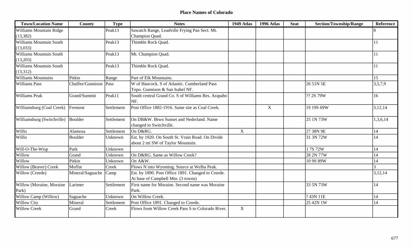
Place Names of Colorado
Town/Location Name County Type Notes 1949 Atlas 1996 Atlas Seat Section/Township/Range ReferenceWilliams Mountain Ridge (13,382)
Peak13 Sawatch Range, Leadville Frying Pan Sect. Mt. Champion Quad.
8
Williams Mountain South (13,033)
Peak13 Thimble Rock Quad. 11
Williams Mountain South (13,203)
Peak13 Mt. Champion Quad. 11
Williams Mountain South (13,312)
Peak13 Thimble Rock Quad. 11
Williams Mountains Pitkin Range Part of Elk Mountains. 15Williams Pass Chaffee/Gunnison Pass W of Hancock. S of Atlantic. Cumberland Pass
Topo. Gunnison & San Isabel NF.26 51N 5E 3,5,7,9
Williams Peak Grand/Summit Peak11 South central Grand Co. S of Williams Res. Arapaho NF.
?? 2S 79W 16
Williamsburg (Coal Creek) Fremont Settlement Post Office 1882-1916. Same site as Coal Creek. X 19 19S 69W 3,12,14
Williamsburg (Switchville) Boulder Settlement On DB&W. Btwn Sunset and Nederland. Name changed to Switchville.
25 1N 73W 1,3,6,14
Willis Alamosa Settlement On D&RG. X 27 38N 9E 14Willis Boulder Unknown Est. by 1920. On South St. Vrain Road. On Divide
about 2 mi SW of Taylor Mountain.31 3N 72W 14
Will-O-The-Wisp Park Unknown 1 7S 72W 14Willow Grand Unknown On D&RG. Same as Willow Creek? 28 2N 77W 14Willow Pitkin Unknown On A&W. 10 9S 89W 14Willow (Beaver) Creek Moffat Creek Flows N into Wyoming. Source at Welba Peak. 3Willow (Creede) Mineral/Saguache Camp Est. by 1890. Post Office 1891. Changed to Creede.
At base of Campbell Mtn. (3 towns)3,12,14
Will (M i M i L i S ttl t Fi t f M i S d M i 33 5N 73W 14Willow (Moraine, Moraine Park)
Larimer Settlement First name for Moraine. Second name was Moraine Park.
33 5N 73W 14
Willow Camp (Willow) Saguache Unknown On Willow Creek. ? 43N 11E 14Willow City Mineral Settlement Post Office 1891. Changed to Creede. 25 42N 1W 14Willow Creek Grand Creek Flows from Willow Creek Pass S to Colorado River. X
677
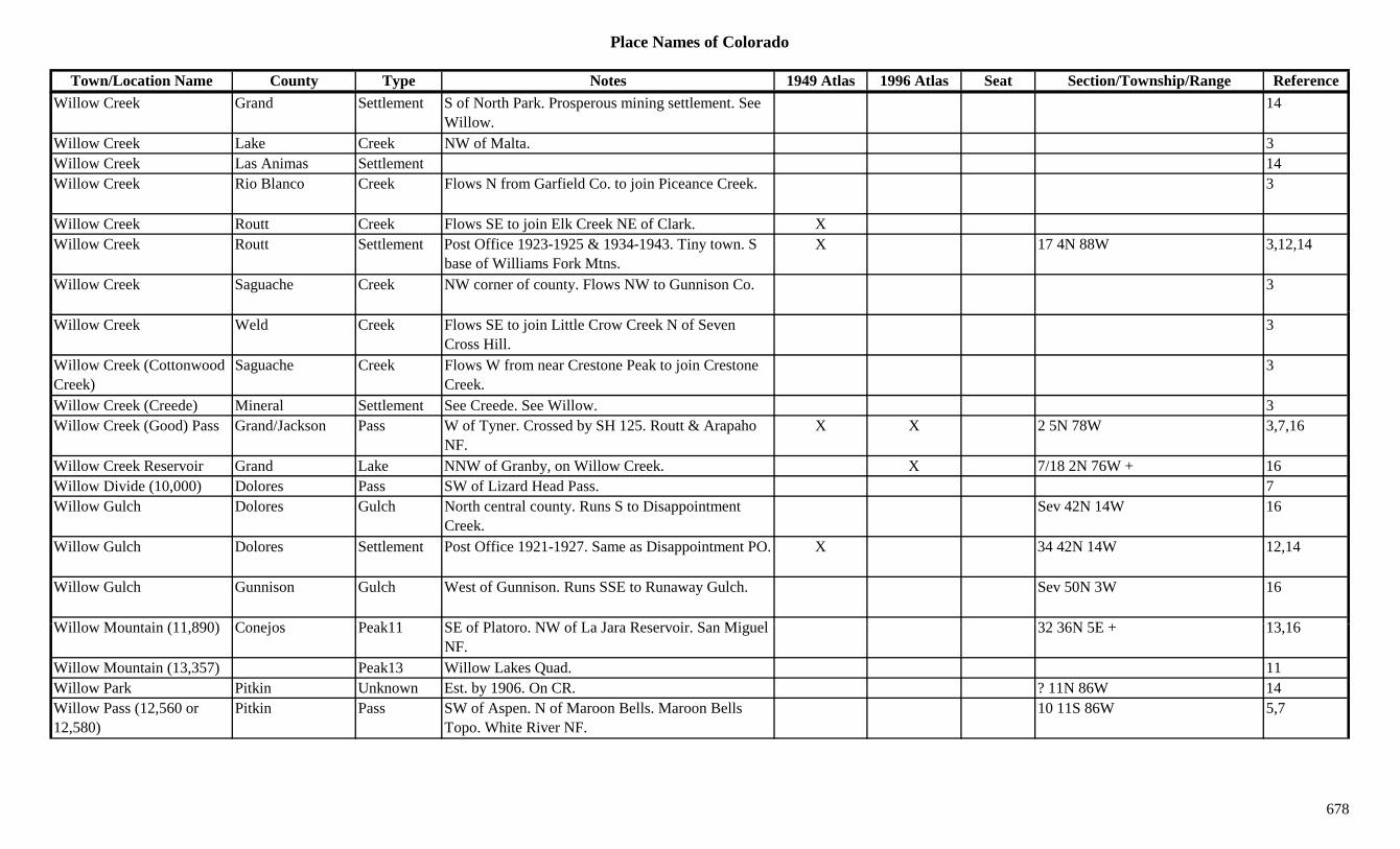
Place Names of Colorado
Town/Location Name County Type Notes 1949 Atlas 1996 Atlas Seat Section/Township/Range ReferenceWillow Creek Grand Settlement S of North Park. Prosperous mining settlement. See
Willow.14
Willow Creek Lake Creek NW of Malta. 3Willow Creek Las Animas Settlement 14Willow Creek Rio Blanco Creek Flows N from Garfield Co. to join Piceance Creek. 3
Willow Creek Routt Creek Flows SE to join Elk Creek NE of Clark. XWillow Creek Routt Settlement Post Office 1923-1925 & 1934-1943. Tiny town. S
base of Williams Fork Mtns.X 17 4N 88W 3,12,14
Willow Creek Saguache Creek NW corner of county. Flows NW to Gunnison Co. 3
Willow Creek Weld Creek Flows SE to join Little Crow Creek N of Seven Cross Hill.
3
Willow Creek (Cottonwood Creek)
Saguache Creek Flows W from near Crestone Peak to join Crestone Creek.
3
Willow Creek (Creede) Mineral Settlement See Creede. See Willow. 3Willow Creek (Good) Pass Grand/Jackson Pass W of Tyner. Crossed by SH 125. Routt & Arapaho
NF.X X 2 5N 78W 3,7,16
Willow Creek Reservoir Grand Lake NNW of Granby, on Willow Creek. X 7/18 2N 76W + 16Willow Divide (10,000) Dolores Pass SW of Lizard Head Pass. 7Willow Gulch Dolores Gulch North central county. Runs S to Disappointment
Creek.Sev 42N 14W 16
Willow Gulch Dolores Settlement Post Office 1921-1927. Same as Disappointment PO. X 34 42N 14W 12,14
Willow Gulch Gunnison Gulch West of Gunnison. Runs SSE to Runaway Gulch. Sev 50N 3W 16
Will M t i (11 890) C j P k11 SE f Pl t NW f L J R i S Mi l 32 36N 5E + 13 16Willow Mountain (11,890) Conejos Peak11 SE of Platoro. NW of La Jara Reservoir. San Miguel NF.
32 36N 5E + 13,16
Willow Mountain (13,357) Peak13 Willow Lakes Quad. 11Willow Park Pitkin Unknown Est. by 1906. On CR. ? 11N 86W 14Willow Pass (12,560 or 12,580)
Pitkin Pass SW of Aspen. N of Maroon Bells. Maroon Bells Topo. White River NF.
10 11S 86W 5,7
678
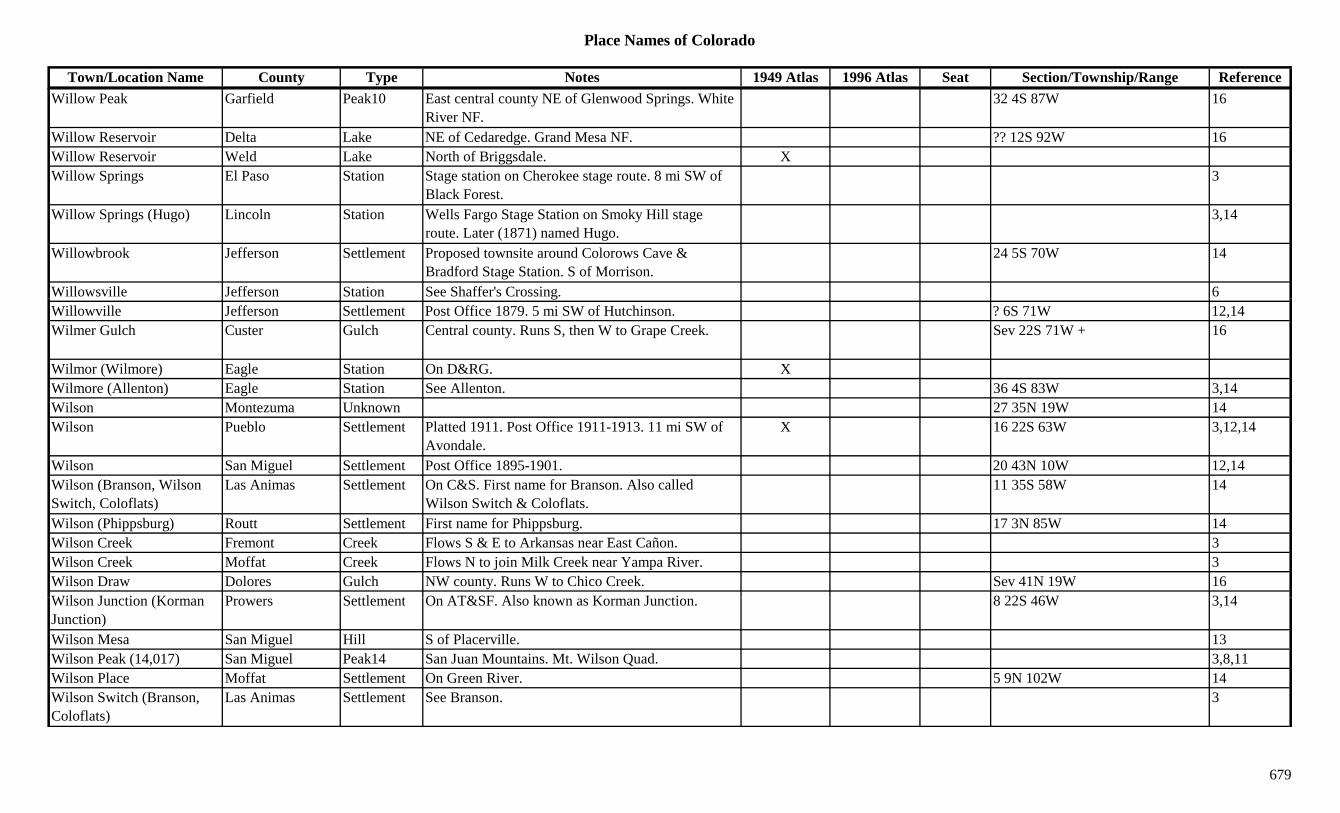
Place Names of Colorado
Town/Location Name County Type Notes 1949 Atlas 1996 Atlas Seat Section/Township/Range ReferenceWillow Peak Garfield Peak10 East central county NE of Glenwood Springs. White
River NF.32 4S 87W 16
Willow Reservoir Delta Lake NE of Cedaredge. Grand Mesa NF. ?? 12S 92W 16Willow Reservoir Weld Lake North of Briggsdale. XWillow Springs El Paso Station Stage station on Cherokee stage route. 8 mi SW of
Black Forest.3
Willow Springs (Hugo) Lincoln Station Wells Fargo Stage Station on Smoky Hill stage route. Later (1871) named Hugo.
3,14
Willowbrook Jefferson Settlement Proposed townsite around Colorows Cave & Bradford Stage Station. S of Morrison.
24 5S 70W 14
Willowsville Jefferson Station See Shaffer's Crossing. 6gWillowville Jefferson Settlement Post Office 1879. 5 mi SW of Hutchinson. ? 6S 71W 12,14Wilmer Gulch Custer Gulch Central county. Runs S, then W to Grape Creek. Sev 22S 71W + 16
Wilmor (Wilmore) Eagle Station On D&RG. XWilmore (Allenton) Eagle Station See Allenton. 36 4S 83W 3,14Wilson Montezuma Unknown 27 35N 19W 14Wilson Pueblo Settlement Platted 1911. Post Office 1911-1913. 11 mi SW of
Avondale.X 16 22S 63W 3,12,14
Wilson San Miguel Settlement Post Office 1895-1901. 20 43N 10W 12,14Wilson (Branson, Wilson Switch, Coloflats)
Las Animas Settlement On C&S. First name for Branson. Also called Wilson Switch & Coloflats.
11 35S 58W 14
Wilson (Phippsburg) Routt Settlement First name for Phippsburg. 17 3N 85W 14Wilson Creek Fremont Creek Flows S & E to Arkansas near East Cañon. 3Wilson Creek Moffat Creek Flows N to join Milk Creek near Yampa River. 3Wilson Draw Dolores Gulch NW county. Runs W to Chico Creek. Sev 41N 19W 16Wil J ti (K P S ttl t O AT&SF Al k K J ti 8 22S 46W 3 14Wilson Junction (Korman Junction)
Prowers Settlement On AT&SF. Also known as Korman Junction. 8 22S 46W 3,14
Wilson Mesa San Miguel Hill S of Placerville. 13Wilson Peak (14,017) San Miguel Peak14 San Juan Mountains. Mt. Wilson Quad. 3,8,11Wilson Place Moffat Settlement On Green River. 5 9N 102W 14Wilson Switch (Branson, Coloflats)
Las Animas Settlement See Branson. 3
679
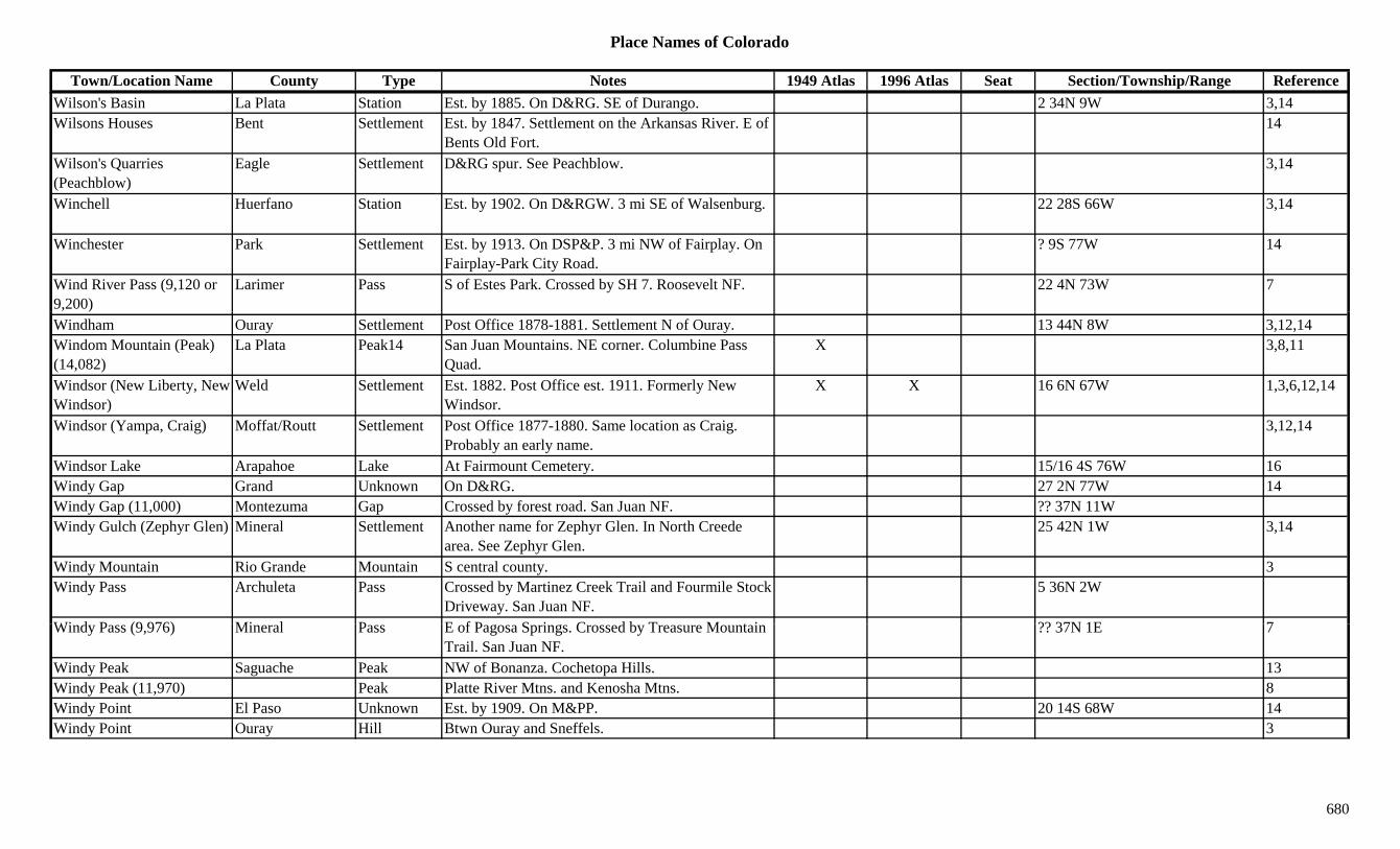
Place Names of Colorado
Town/Location Name County Type Notes 1949 Atlas 1996 Atlas Seat Section/Township/Range ReferenceWilson's Basin La Plata Station Est. by 1885. On D&RG. SE of Durango. 2 34N 9W 3,14Wilsons Houses Bent Settlement Est. by 1847. Settlement on the Arkansas River. E of
Bents Old Fort.14
Wilson's Quarries (Peachblow)
Eagle Settlement D&RG spur. See Peachblow. 3,14
Winchell Huerfano Station Est. by 1902. On D&RGW. 3 mi SE of Walsenburg. 22 28S 66W 3,14
Winchester Park Settlement Est. by 1913. On DSP&P. 3 mi NW of Fairplay. On Fairplay-Park City Road.
? 9S 77W 14
Wind River Pass (9,120 or 9,200)
Larimer Pass S of Estes Park. Crossed by SH 7. Roosevelt NF. 22 4N 73W 7
Windham Ouray Settlement Post Office 1878-1881. Settlement N of Ouray. 13 44N 8W 3,12,14Windom Mountain (Peak) (14,082)
La Plata Peak14 San Juan Mountains. NE corner. Columbine Pass Quad.
X 3,8,11
Windsor (New Liberty, New Windsor)
Weld Settlement Est. 1882. Post Office est. 1911. Formerly New Windsor.
X X 16 6N 67W 1,3,6,12,14
Windsor (Yampa, Craig) Moffat/Routt Settlement Post Office 1877-1880. Same location as Craig. Probably an early name.
3,12,14
Windsor Lake Arapahoe Lake At Fairmount Cemetery. 15/16 4S 76W 16Windy Gap Grand Unknown On D&RG. 27 2N 77W 14Windy Gap (11,000) Montezuma Gap Crossed by forest road. San Juan NF. ?? 37N 11WWindy Gulch (Zephyr Glen) Mineral Settlement Another name for Zephyr Glen. In North Creede
area. See Zephyr Glen.25 42N 1W 3,14
Windy Mountain Rio Grande Mountain S central county. 3Windy Pass Archuleta Pass Crossed by Martinez Creek Trail and Fourmile Stock
Driveway. San Juan NF.5 36N 2W
Wi d P (9 976) Mi l P E f P S i C d b T M t i ?? 37N 1E 7Windy Pass (9,976) Mineral Pass E of Pagosa Springs. Crossed by Treasure Mountain Trail. San Juan NF.
?? 37N 1E 7
Windy Peak Saguache Peak NW of Bonanza. Cochetopa Hills. 13Windy Peak (11,970) Peak Platte River Mtns. and Kenosha Mtns. 8Windy Point El Paso Unknown Est. by 1909. On M&PP. 20 14S 68W 14Windy Point Ouray Hill Btwn Ouray and Sneffels. 3
680
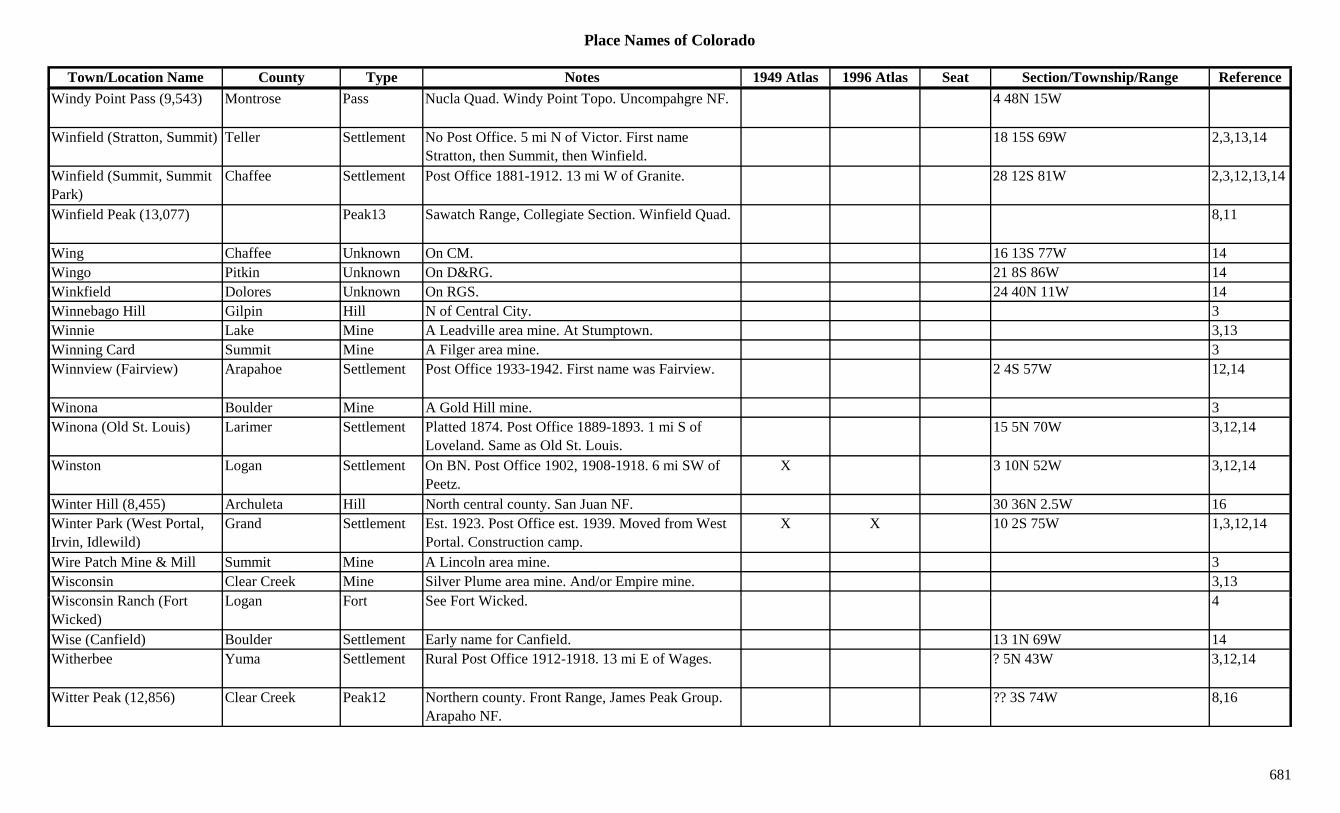
Place Names of Colorado
Town/Location Name County Type Notes 1949 Atlas 1996 Atlas Seat Section/Township/Range ReferenceWindy Point Pass (9,543) Montrose Pass Nucla Quad. Windy Point Topo. Uncompahgre NF. 4 48N 15W
Winfield (Stratton, Summit) Teller Settlement No Post Office. 5 mi N of Victor. First name Stratton, then Summit, then Winfield.
18 15S 69W 2,3,13,14
Winfield (Summit, Summit Park)
Chaffee Settlement Post Office 1881-1912. 13 mi W of Granite. 28 12S 81W 2,3,12,13,14
Winfield Peak (13,077) Peak13 Sawatch Range, Collegiate Section. Winfield Quad. 8,11
Wing Chaffee Unknown On CM. 16 13S 77W 14Wingo Pitkin Unknown On D&RG. 21 8S 86W 14Winkfield Dolores Unknown On RGS. 24 40N 11W 14Winnebago Hill Gilpin Hill N of Central City. 3Winnie Lake Mine A Leadville area mine. At Stumptown. 3,13Winning Card Summit Mine A Filger area mine. 3Winnview (Fairview) Arapahoe Settlement Post Office 1933-1942. First name was Fairview. 2 4S 57W 12,14
Winona Boulder Mine A Gold Hill mine. 3Winona (Old St. Louis) Larimer Settlement Platted 1874. Post Office 1889-1893. 1 mi S of
Loveland. Same as Old St. Louis.15 5N 70W 3,12,14
Winston Logan Settlement On BN. Post Office 1902, 1908-1918. 6 mi SW of Peetz.
X 3 10N 52W 3,12,14
Winter Hill (8,455) Archuleta Hill North central county. San Juan NF. 30 36N 2.5W 16Winter Park (West Portal, Irvin, Idlewild)
Grand Settlement Est. 1923. Post Office est. 1939. Moved from West Portal. Construction camp.
X X 10 2S 75W 1,3,12,14
Wire Patch Mine & Mill Summit Mine A Lincoln area mine. 3Wisconsin Clear Creek Mine Silver Plume area mine. And/or Empire mine. 3,13Wi i R h (F t L F t S F t Wi k d 4Wisconsin Ranch (Fort Wicked)
Logan Fort See Fort Wicked. 4
Wise (Canfield) Boulder Settlement Early name for Canfield. 13 1N 69W 14Witherbee Yuma Settlement Rural Post Office 1912-1918. 13 mi E of Wages. ? 5N 43W 3,12,14
Witter Peak (12,856) Clear Creek Peak12 Northern county. Front Range, James Peak Group. Arapaho NF.
?? 3S 74W 8,16
681
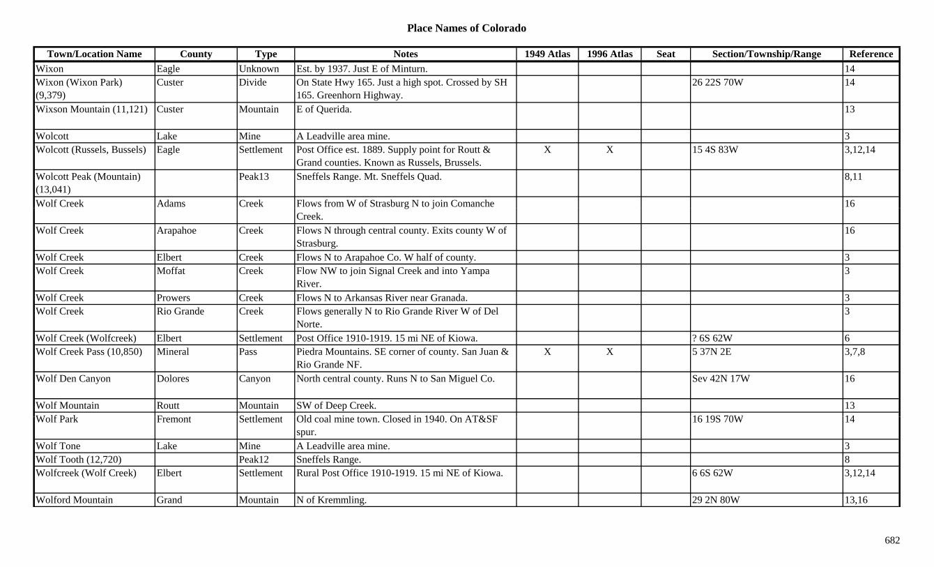
Place Names of Colorado
Town/Location Name County Type Notes 1949 Atlas 1996 Atlas Seat Section/Township/Range ReferenceWixon Eagle Unknown Est. by 1937. Just E of Minturn. 14Wixon (Wixon Park) (9,379)
Custer Divide On State Hwy 165. Just a high spot. Crossed by SH 165. Greenhorn Highway.
26 22S 70W 14
Wixson Mountain (11,121) Custer Mountain E of Querida. 13
Wolcott Lake Mine A Leadville area mine. 3Wolcott (Russels, Bussels) Eagle Settlement Post Office est. 1889. Supply point for Routt &
Grand counties. Known as Russels, Brussels.X X 15 4S 83W 3,12,14
Wolcott Peak (Mountain) (13,041)
Peak13 Sneffels Range. Mt. Sneffels Quad. 8,11
Wolf Creek Adams Creek Flows from W of Strasburg N to join Comanche 16g jCreek.
Wolf Creek Arapahoe Creek Flows N through central county. Exits county W of Strasburg.
16
Wolf Creek Elbert Creek Flows N to Arapahoe Co. W half of county. 3Wolf Creek Moffat Creek Flow NW to join Signal Creek and into Yampa
River.3
Wolf Creek Prowers Creek Flows N to Arkansas River near Granada. 3Wolf Creek Rio Grande Creek Flows generally N to Rio Grande River W of Del
Norte.3
Wolf Creek (Wolfcreek) Elbert Settlement Post Office 1910-1919. 15 mi NE of Kiowa. ? 6S 62W 6Wolf Creek Pass (10,850) Mineral Pass Piedra Mountains. SE corner of county. San Juan &
Rio Grande NF.X X 5 37N 2E 3,7,8
Wolf Den Canyon Dolores Canyon North central county. Runs N to San Miguel Co. Sev 42N 17W 16
Wolf Mountain Routt Mountain SW of Deep Creek. 13W lf P k F t S ttl t Old l i t Cl d i 1940 O AT&SF 16 19S 70W 14Wolf Park Fremont Settlement Old coal mine town. Closed in 1940. On AT&SF
spur.16 19S 70W 14
Wolf Tone Lake Mine A Leadville area mine. 3Wolf Tooth (12,720) Peak12 Sneffels Range. 8Wolfcreek (Wolf Creek) Elbert Settlement Rural Post Office 1910-1919. 15 mi NE of Kiowa. 6 6S 62W 3,12,14
Wolford Mountain Grand Mountain N of Kremmling. 29 2N 80W 13,16
682
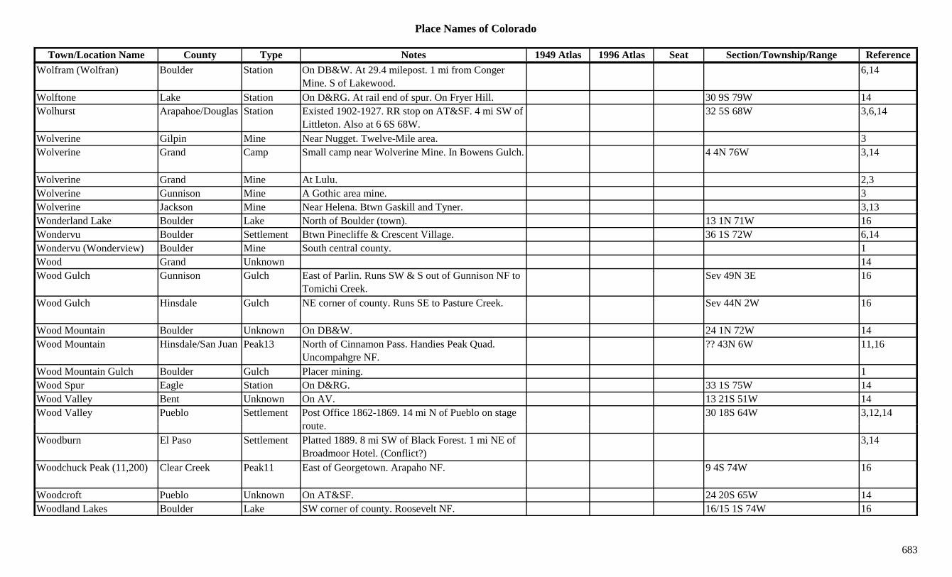
Place Names of Colorado
Town/Location Name County Type Notes 1949 Atlas 1996 Atlas Seat Section/Township/Range ReferenceWolfram (Wolfran) Boulder Station On DB&W. At 29.4 milepost. 1 mi from Conger
Mine. S of Lakewood.6,14
Wolftone Lake Station On D&RG. At rail end of spur. On Fryer Hill. 30 9S 79W 14Wolhurst Arapahoe/Douglas Station Existed 1902-1927. RR stop on AT&SF. 4 mi SW of
Littleton. Also at 6 6S 68W.32 5S 68W 3,6,14
Wolverine Gilpin Mine Near Nugget. Twelve-Mile area. 3Wolverine Grand Camp Small camp near Wolverine Mine. In Bowens Gulch. 4 4N 76W 3,14
Wolverine Grand Mine At Lulu. 2,3Wolverine Gunnison Mine A Gothic area mine. 3Wolverine Jackson Mine Near Helena. Btwn Gaskill and Tyner. 3,13y ,Wonderland Lake Boulder Lake North of Boulder (town). 13 1N 71W 16Wondervu Boulder Settlement Btwn Pinecliffe & Crescent Village. 36 1S 72W 6,14Wondervu (Wonderview) Boulder Mine South central county. 1Wood Grand Unknown 14Wood Gulch Gunnison Gulch East of Parlin. Runs SW & S out of Gunnison NF to
Tomichi Creek.Sev 49N 3E 16
Wood Gulch Hinsdale Gulch NE corner of county. Runs SE to Pasture Creek. Sev 44N 2W 16
Wood Mountain Boulder Unknown On DB&W. 24 1N 72W 14Wood Mountain Hinsdale/San Juan Peak13 North of Cinnamon Pass. Handies Peak Quad.
Uncompahgre NF.?? 43N 6W 11,16
Wood Mountain Gulch Boulder Gulch Placer mining. 1Wood Spur Eagle Station On D&RG. 33 1S 75W 14Wood Valley Bent Unknown On AV. 13 21S 51W 14Wood Valley Pueblo Settlement Post Office 1862-1869. 14 mi N of Pueblo on stage
t30 18S 64W 3,12,14
route.Woodburn El Paso Settlement Platted 1889. 8 mi SW of Black Forest. 1 mi NE of
Broadmoor Hotel. (Conflict?)3,14
Woodchuck Peak (11,200) Clear Creek Peak11 East of Georgetown. Arapaho NF. 9 4S 74W 16
Woodcroft Pueblo Unknown On AT&SF. 24 20S 65W 14Woodland Lakes Boulder Lake SW corner of county. Roosevelt NF. 16/15 1S 74W 16
683
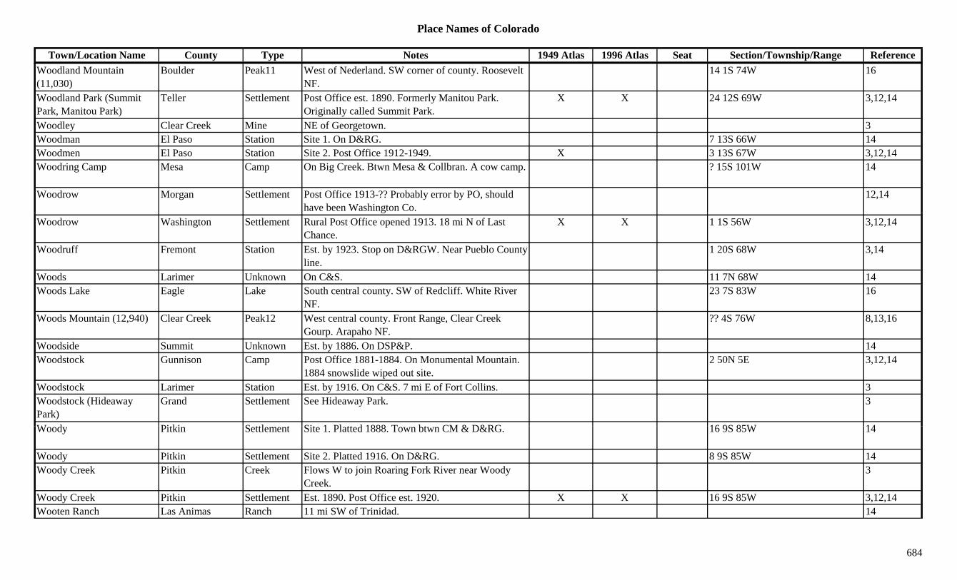
Place Names of Colorado
Town/Location Name County Type Notes 1949 Atlas 1996 Atlas Seat Section/Township/Range ReferenceWoodland Mountain (11,030)
Boulder Peak11 West of Nederland. SW corner of county. Roosevelt NF.
14 1S 74W 16
Woodland Park (Summit Park, Manitou Park)
Teller Settlement Post Office est. 1890. Formerly Manitou Park. Originally called Summit Park.
X X 24 12S 69W 3,12,14
Woodley Clear Creek Mine NE of Georgetown. 3Woodman El Paso Station Site 1. On D&RG. 7 13S 66W 14Woodmen El Paso Station Site 2. Post Office 1912-1949. X 3 13S 67W 3,12,14Woodring Camp Mesa Camp On Big Creek. Btwn Mesa & Collbran. A cow camp. ? 15S 101W 14
Woodrow Morgan Settlement Post Office 1913-?? Probably error by PO, should have been Washington Co.
12,14
Woodrow Washington Settlement Rural Post Office opened 1913. 18 mi N of Last Chance.
X X 1 1S 56W 3,12,14
Woodruff Fremont Station Est. by 1923. Stop on D&RGW. Near Pueblo County line.
1 20S 68W 3,14
Woods Larimer Unknown On C&S. 11 7N 68W 14Woods Lake Eagle Lake South central county. SW of Redcliff. White River
NF.23 7S 83W 16
Woods Mountain (12,940) Clear Creek Peak12 West central county. Front Range, Clear Creek Gourp. Arapaho NF.
?? 4S 76W 8,13,16
Woodside Summit Unknown Est. by 1886. On DSP&P. 14Woodstock Gunnison Camp Post Office 1881-1884. On Monumental Mountain.
1884 snowslide wiped out site.2 50N 5E 3,12,14
Woodstock Larimer Station Est. by 1916. On C&S. 7 mi E of Fort Collins. 3Woodstock (Hideaway Park)
Grand Settlement See Hideaway Park. 3
W d Pitki S ttl t Sit 1 Pl tt d 1888 T bt CM & D&RG 16 9S 85W 14Woody Pitkin Settlement Site 1. Platted 1888. Town btwn CM & D&RG. 16 9S 85W 14
Woody Pitkin Settlement Site 2. Platted 1916. On D&RG. 8 9S 85W 14Woody Creek Pitkin Creek Flows W to join Roaring Fork River near Woody
Creek.3
Woody Creek Pitkin Settlement Est. 1890. Post Office est. 1920. X X 16 9S 85W 3,12,14Wooten Ranch Las Animas Ranch 11 mi SW of Trinidad. 14
684

Place Names of Colorado
Town/Location Name County Type Notes 1949 Atlas 1996 Atlas Seat Section/Township/Range ReferenceWooton Pueblo Settlement Est. 1853. On S side of Arkansas River. 1 mi above
the mouth of the Huerfano River.7 21S 61W 14
Wootton (Wooton) Las Animas Settlement Est. by 1865. Post Office 1908-1922. S of Morley. Site of Uncle Dick Wootton's toll gate.
X 9 35S 63W 3,12,14
Work Teller Unknown Est. by 1906. On CS&CCD. 14World Figure Skating Hall of Fame
El Paso Museum SW part of Colorado Springs. X
Wormington (Simpson, Simpton)
Las Animas Settlement RR Post Office on Simpson Siding 1919-1934. Called Simpson. On AT&SF RR.
X 19 29S 60W 3,12,14
Worthington Pitkin Mine An Ashcroft area mine. 3Wortman (Wortsman, Lake Camp On C&S. Post Office 1900-1908 & 1916-1919. 13 8S 79W 3,12,14( ,Wortmans)
pCamp at John Reed Mine. Near Alicante.
, ,
Woutougo Gilpin Unknown On GT. In Russell Gulch. 14Wray Weld/Yuma Settlement Post Office est. 1882. Platted 1886. S of Julesburg,
near Nebraska line.X X X Sev 1N 44W 1,3,12,14
Wren Gulch Douglas Gulch SW corner of county. Runs NNW to Horse Creek. Sev 10S 70W 16
Wright Lake Mine A Leadville area mine. By Denver City. 3Wright Camp Montrose Camp Est. by 1916. 34 48N 17W 14Wright's Spring San Miguel Settlement Est. by 1885. On same site as present-day Norwood. 3
Wulfekuler Weld Station On GW. 2.6 mi S of Moore. 6Wulsten Baldy (12,820) Peak12 Sangre de Cristo Range, Main Section. 8Wulstenville Fremont/Custer Settlement Post Office 1871. 12,14Wyberg (Nyberg) Pueblo Settlement See Nyberg. No doubt a spelling error. 3Wylies Gunnison Unknown On DSP&P or C&S. 34 51N 1W 14W (W ) J ff St ti O D&IM 5 i W f L k d 2 4S 70W 3 14Wyman (Wymans) Jefferson Station On D&IM. 5 mi W of Lakewood. 2 4S 70W 3,14Wynetka Arapahoe Settlement Platted 1890. W of Littleton. No Post Office. 19 5S 68W 3,6,14Wyocolo Jackson Settlement Est. by 1923. On Colorado/Wyoming border. Is in
Wyoming.3
Xenia Washington Station Est. by 1909. On BN. 6 mi W of Akron. 7 2N 53W 3,14Y & S Reservoir Delta Lake North of Cedaredge. Grand Mesa NF. 32 11S 93W 16
685
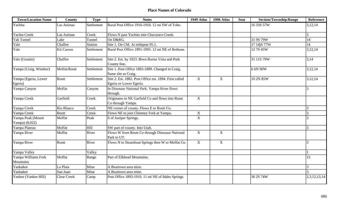
Place Names of Colorado
Town/Location Name County Type Notes 1949 Atlas 1996 Atlas Seat Section/Township/Range ReferenceYachita Las Animas Settlement Rural Post Office 1916-1918. 12 mi SW of Tobe. 16 33S 57W 3,12,14
Yachta Creek Las Animas Creek Flows N past Yachita into Chacuraco Creek. 3Yak Tunnel Lake Tunnel On D&RG. 31 9S 79W 14Yale Chaffee Station Site 1. On CM. At milepost 95.1. 17 14jS 77W 14Yale Kit Carson Settlement Rural Post Office 1891-1905. 12 mi NE of Bethune. 12 7S 45W 3,12,14
Yale (Granite) Chaffee Settlement Site 2. Est. by 1923. Btwn Buena Vista and Park County line.
31 11S 79W 3,14
Yampa (Craig, Windsor) Moffat/Routt Settlement Site 1. Post Office 1883-1889. Changed to Craig. Same site as Craig.
6 6N 90W 3,12,14
Yampa (Egeria, Lower Egeria)
Routt Settlement Site 2. Est. 1882. Post Office est. 1894. First called Egeria or Lower Egeria.
X X 10 2N 85W 3,12,14
Yampa Canyon Moffat Canyon In Dinosaur National Park. Yampa River flows through.
3
Yampa Creek Garfield Creek Originates in NE Garfield Co and flows into Routt Co through Yampa.
X
Yampa Creek Rio Blanco Creek NE corner of county. Flows E to Routt Co. 3Yampa Creek Routt Creek Flows NE to join Chimney Fork at Yampa. X 3Yampa Peak (Mount Yampa) (8,022)
Moffat Peak S of Juniper Springs. X 3
Yampa Plateau Moffat Hill SW part of county. Into Utah. 3Yampa River Moffat River Flows W from Routt Co through Dinosaur National
Park to UT.X X
Yampa River Routt River Flows N to Steamboat Springs then W to Moffat Co. X X 3
Y V ll V ll 1Yampa Valley Valley 1Yampa Williams Fork Mountains
Moffat Range Part of Elkhead Mountains. 15
Yankakee La Plata Mine A Beartown area mine. 3Yankakee San Juan Mine A Beartown area mine. 3Yankee (Yankee Hill) Clear Creek Camp Post Office 1893-1910. 11 mi NE of Idaho Springs. 36 2S 74W 2,3,12,13,14
686
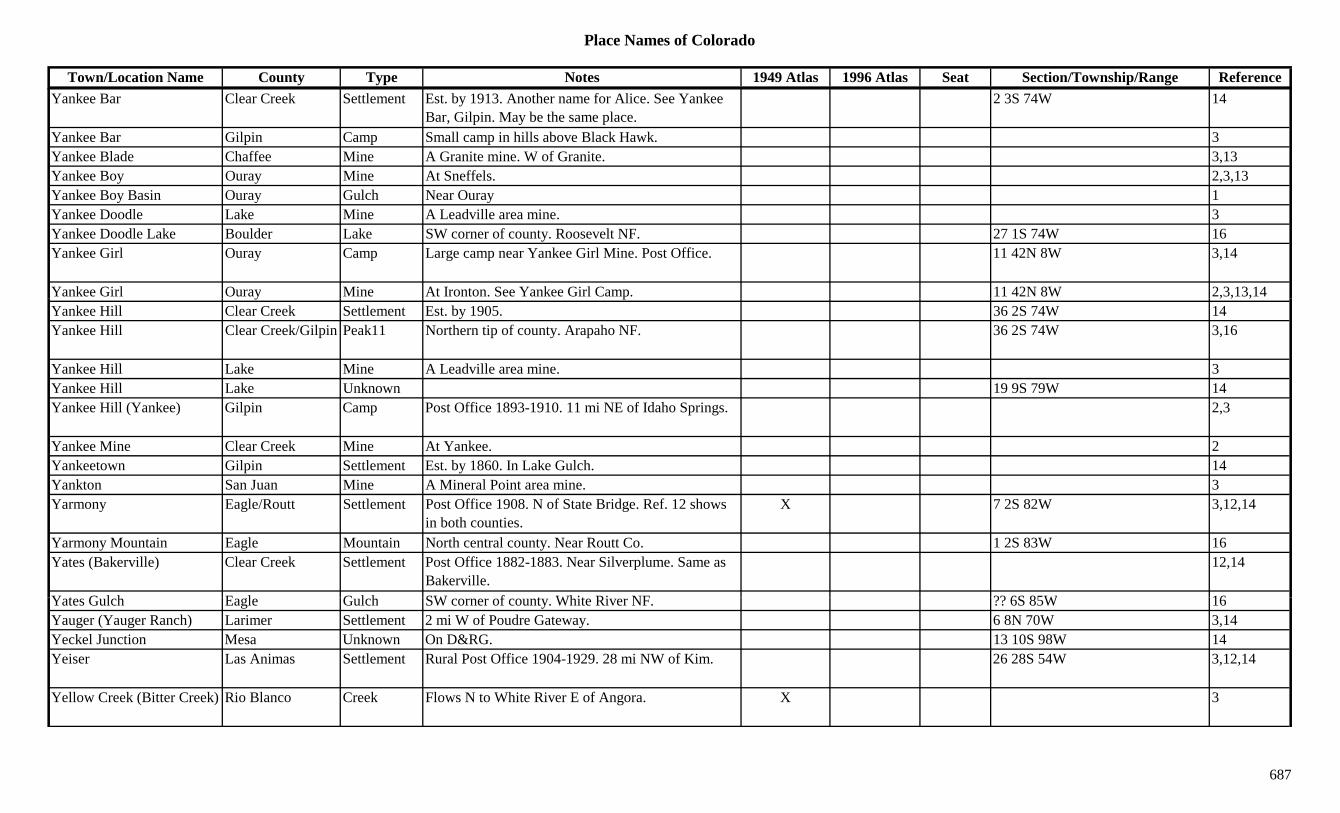
Place Names of Colorado
Town/Location Name County Type Notes 1949 Atlas 1996 Atlas Seat Section/Township/Range ReferenceYankee Bar Clear Creek Settlement Est. by 1913. Another name for Alice. See Yankee
Bar, Gilpin. May be the same place.2 3S 74W 14
Yankee Bar Gilpin Camp Small camp in hills above Black Hawk. 3Yankee Blade Chaffee Mine A Granite mine. W of Granite. 3,13Yankee Boy Ouray Mine At Sneffels. 2,3,13Yankee Boy Basin Ouray Gulch Near Ouray 1Yankee Doodle Lake Mine A Leadville area mine. 3Yankee Doodle Lake Boulder Lake SW corner of county. Roosevelt NF. 27 1S 74W 16Yankee Girl Ouray Camp Large camp near Yankee Girl Mine. Post Office. 11 42N 8W 3,14
Yankee Girl Ouray Mine At Ironton. See Yankee Girl Camp. 11 42N 8W 2,3,13,14y p , , ,Yankee Hill Clear Creek Settlement Est. by 1905. 36 2S 74W 14Yankee Hill Clear Creek/Gilpin Peak11 Northern tip of county. Arapaho NF. 36 2S 74W 3,16
Yankee Hill Lake Mine A Leadville area mine. 3Yankee Hill Lake Unknown 19 9S 79W 14Yankee Hill (Yankee) Gilpin Camp Post Office 1893-1910. 11 mi NE of Idaho Springs. 2,3
Yankee Mine Clear Creek Mine At Yankee. 2Yankeetown Gilpin Settlement Est. by 1860. In Lake Gulch. 14Yankton San Juan Mine A Mineral Point area mine. 3Yarmony Eagle/Routt Settlement Post Office 1908. N of State Bridge. Ref. 12 shows
in both counties.X 7 2S 82W 3,12,14
Yarmony Mountain Eagle Mountain North central county. Near Routt Co. 1 2S 83W 16Yates (Bakerville) Clear Creek Settlement Post Office 1882-1883. Near Silverplume. Same as
Bakerville.12,14
Y t G l h E l G l h SW f t Whit Ri NF ?? 6S 85W 16Yates Gulch Eagle Gulch SW corner of county. White River NF. ?? 6S 85W 16Yauger (Yauger Ranch) Larimer Settlement 2 mi W of Poudre Gateway. 6 8N 70W 3,14Yeckel Junction Mesa Unknown On D&RG. 13 10S 98W 14Yeiser Las Animas Settlement Rural Post Office 1904-1929. 28 mi NW of Kim. 26 28S 54W 3,12,14
Yellow Creek (Bitter Creek) Rio Blanco Creek Flows N to White River E of Angora. X 3
687
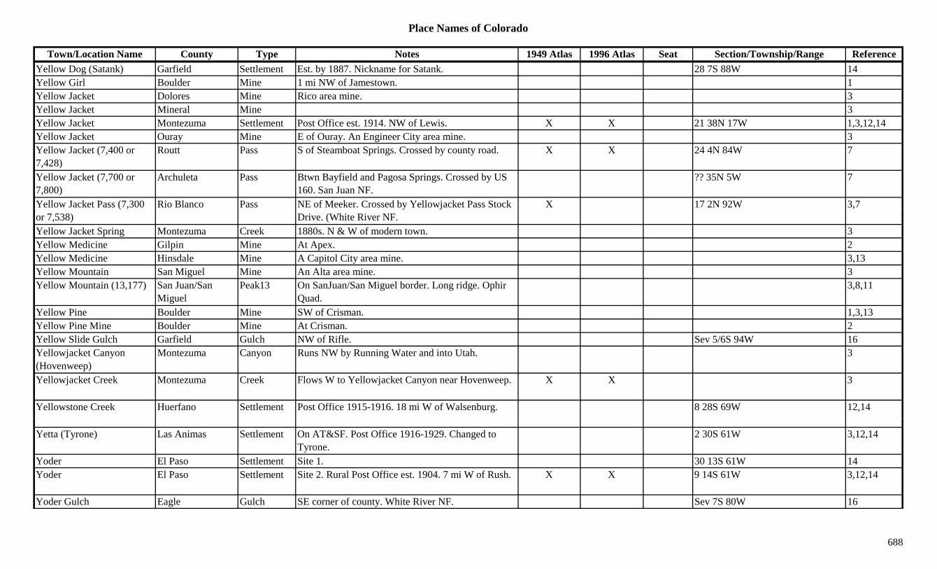
Place Names of Colorado
Town/Location Name County Type Notes 1949 Atlas 1996 Atlas Seat Section/Township/Range ReferenceYellow Dog (Satank) Garfield Settlement Est. by 1887. Nickname for Satank. 28 7S 88W 14Yellow Girl Boulder Mine 1 mi NW of Jamestown. 1Yellow Jacket Dolores Mine Rico area mine. 3Yellow Jacket Mineral Mine 3Yellow Jacket Montezuma Settlement Post Office est. 1914. NW of Lewis. X X 21 38N 17W 1,3,12,14Yellow Jacket Ouray Mine E of Ouray. An Engineer City area mine. 3Yellow Jacket (7,400 or 7,428)
Routt Pass S of Steamboat Springs. Crossed by county road. X X 24 4N 84W 7
Yellow Jacket (7,700 or 7,800)
Archuleta Pass Btwn Bayfield and Pagosa Springs. Crossed by US 160. San Juan NF.
?? 35N 5W 7
Yellow Jacket Pass (7,300 Rio Blanco Pass NE of Meeker. Crossed by Yellowjacket Pass Stock X 17 2N 92W 3,7( ,or 7,538)
y jDrive. (White River NF.
,
Yellow Jacket Spring Montezuma Creek 1880s. N & W of modern town. 3Yellow Medicine Gilpin Mine At Apex. 2Yellow Medicine Hinsdale Mine A Capitol City area mine. 3,13Yellow Mountain San Miguel Mine An Alta area mine. 3Yellow Mountain (13,177) San Juan/San
MiguelPeak13 On SanJuan/San Miguel border. Long ridge. Ophir
Quad.3,8,11
Yellow Pine Boulder Mine SW of Crisman. 1,3,13Yellow Pine Mine Boulder Mine At Crisman. 2Yellow Slide Gulch Garfield Gulch NW of Rifle. Sev 5/6S 94W 16Yellowjacket Canyon (Hovenweep)
Montezuma Canyon Runs NW by Running Water and into Utah. 3
Yellowjacket Creek Montezuma Creek Flows W to Yellowjacket Canyon near Hovenweep. X X 3
Yellowstone Creek Huerfano Settlement Post Office 1915-1916. 18 mi W of Walsenburg. 8 28S 69W 12,14
Yetta (Tyrone) Las Animas Settlement On AT&SF. Post Office 1916-1929. Changed to Tyrone.
2 30S 61W 3,12,14
Yoder El Paso Settlement Site 1. 30 13S 61W 14Yoder El Paso Settlement Site 2. Rural Post Office est. 1904. 7 mi W of Rush. X X 9 14S 61W 3,12,14
Yoder Gulch Eagle Gulch SE corner of county. White River NF. Sev 7S 80W 16
688
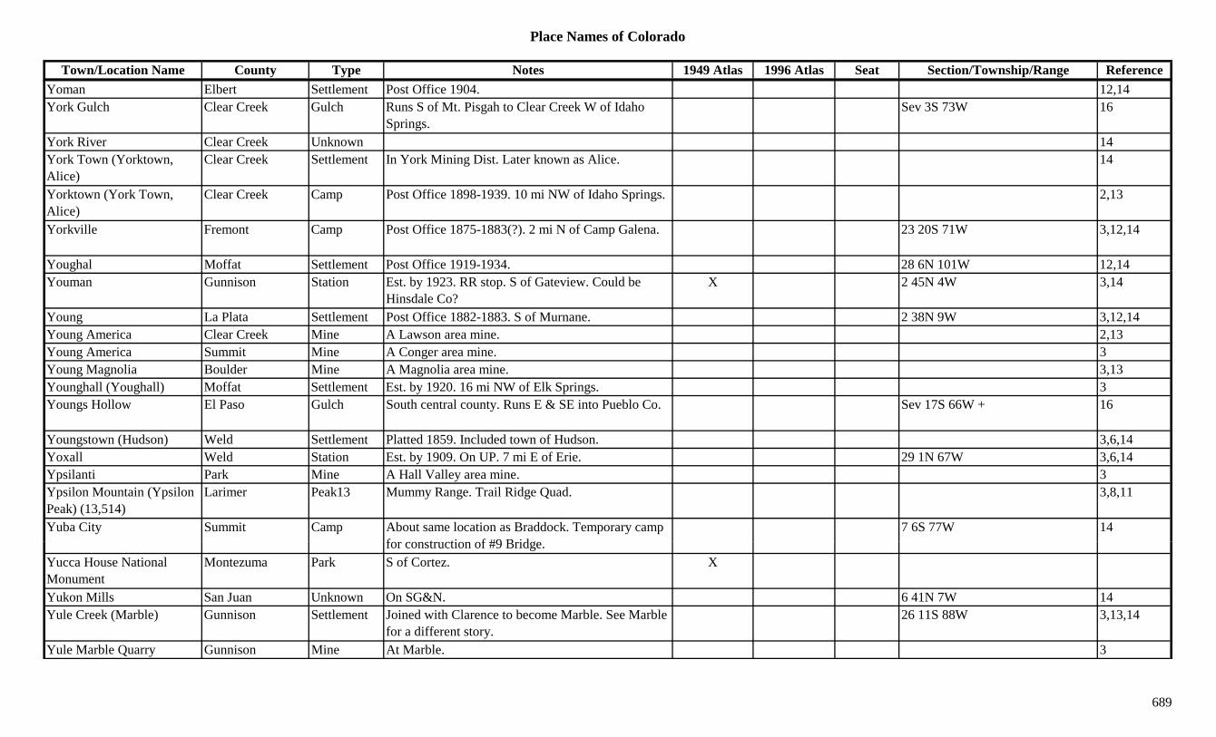
Place Names of Colorado
Town/Location Name County Type Notes 1949 Atlas 1996 Atlas Seat Section/Township/Range ReferenceYoman Elbert Settlement Post Office 1904. 12,14York Gulch Clear Creek Gulch Runs S of Mt. Pisgah to Clear Creek W of Idaho
Springs.Sev 3S 73W 16
York River Clear Creek Unknown 14York Town (Yorktown, Alice)
Clear Creek Settlement In York Mining Dist. Later known as Alice. 14
Yorktown (York Town, Alice)
Clear Creek Camp Post Office 1898-1939. 10 mi NW of Idaho Springs. 2,13
Yorkville Fremont Camp Post Office 1875-1883(?). 2 mi N of Camp Galena. 23 20S 71W 3,12,14
Youghal Moffat Settlement Post Office 1919-1934. 28 6N 101W 12,14g ,Youman Gunnison Station Est. by 1923. RR stop. S of Gateview. Could be
Hinsdale Co?X 2 45N 4W 3,14
Young La Plata Settlement Post Office 1882-1883. S of Murnane. 2 38N 9W 3,12,14Young America Clear Creek Mine A Lawson area mine. 2,13Young America Summit Mine A Conger area mine. 3Young Magnolia Boulder Mine A Magnolia area mine. 3,13Younghall (Youghall) Moffat Settlement Est. by 1920. 16 mi NW of Elk Springs. 3Youngs Hollow El Paso Gulch South central county. Runs E & SE into Pueblo Co. Sev 17S 66W + 16
Youngstown (Hudson) Weld Settlement Platted 1859. Included town of Hudson. 3,6,14Yoxall Weld Station Est. by 1909. On UP. 7 mi E of Erie. 29 1N 67W 3,6,14Ypsilanti Park Mine A Hall Valley area mine. 3Ypsilon Mountain (Ypsilon Peak) (13,514)
Larimer Peak13 Mummy Range. Trail Ridge Quad. 3,8,11
Yuba City Summit Camp About same location as Braddock. Temporary camp f t ti f #9 B id
7 6S 77W 14for construction of #9 Bridge.
Yucca House National Monument
Montezuma Park S of Cortez. X
Yukon Mills San Juan Unknown On SG&N. 6 41N 7W 14Yule Creek (Marble) Gunnison Settlement Joined with Clarence to become Marble. See Marble
for a different story.26 11S 88W 3,13,14
Yule Marble Quarry Gunnison Mine At Marble. 3
689
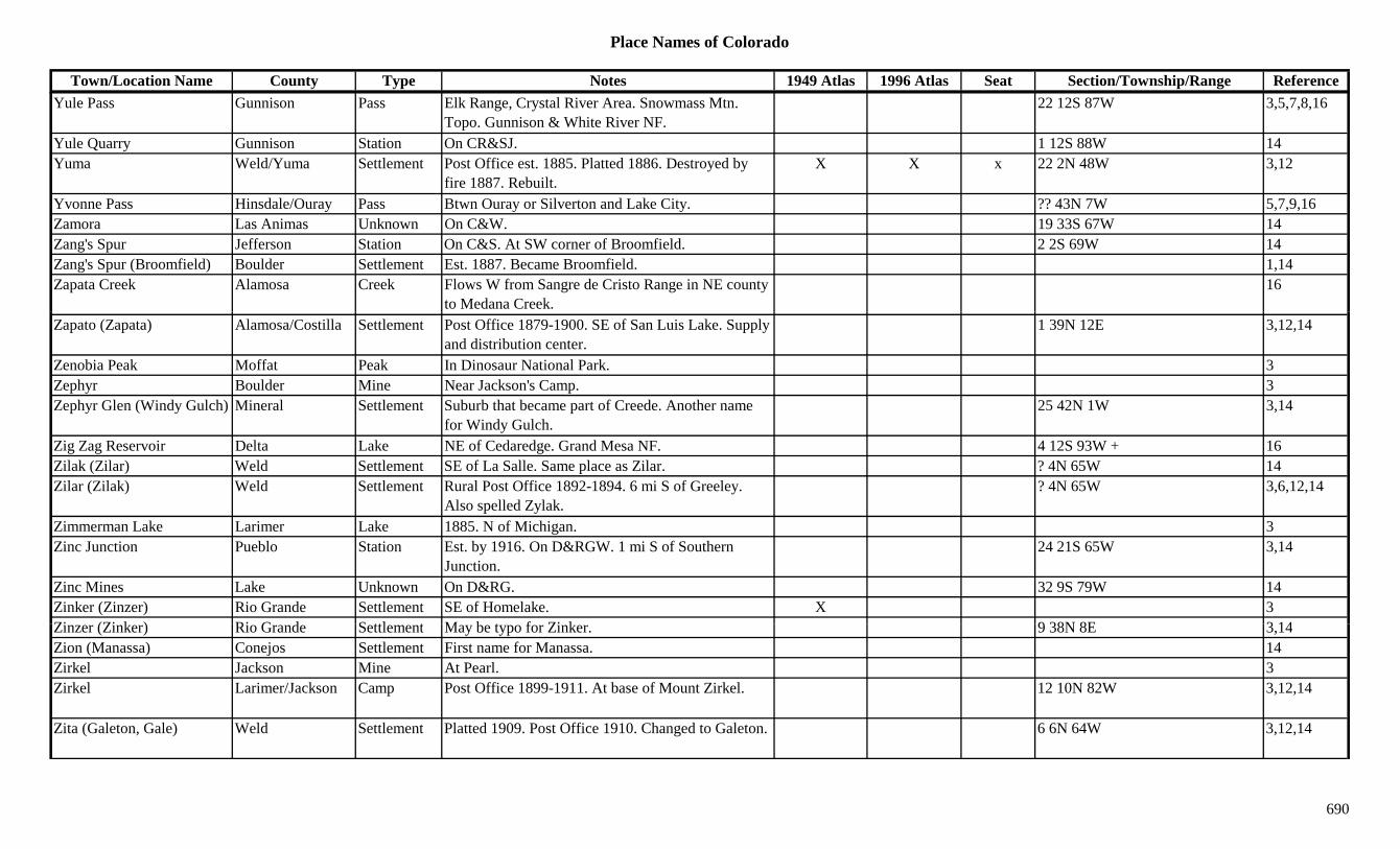
Place Names of Colorado
Town/Location Name County Type Notes 1949 Atlas 1996 Atlas Seat Section/Township/Range ReferenceYule Pass Gunnison Pass Elk Range, Crystal River Area. Snowmass Mtn.
Topo. Gunnison & White River NF.22 12S 87W 3,5,7,8,16
Yule Quarry Gunnison Station On CR&SJ. 1 12S 88W 14Yuma Weld/Yuma Settlement Post Office est. 1885. Platted 1886. Destroyed by
fire 1887. Rebuilt.X X x 22 2N 48W 3,12
Yvonne Pass Hinsdale/Ouray Pass Btwn Ouray or Silverton and Lake City. ?? 43N 7W 5,7,9,16Zamora Las Animas Unknown On C&W. 19 33S 67W 14Zang's Spur Jefferson Station On C&S. At SW corner of Broomfield. 2 2S 69W 14Zang's Spur (Broomfield) Boulder Settlement Est. 1887. Became Broomfield. 1,14Zapata Creek Alamosa Creek Flows W from Sangre de Cristo Range in NE county
to Medana Creek.16
Zapato (Zapata) Alamosa/Costilla Settlement Post Office 1879-1900. SE of San Luis Lake. Supply and distribution center.
1 39N 12E 3,12,14
Zenobia Peak Moffat Peak In Dinosaur National Park. 3Zephyr Boulder Mine Near Jackson's Camp. 3Zephyr Glen (Windy Gulch) Mineral Settlement Suburb that became part of Creede. Another name
for Windy Gulch.25 42N 1W 3,14
Zig Zag Reservoir Delta Lake NE of Cedaredge. Grand Mesa NF. 4 12S 93W + 16Zilak (Zilar) Weld Settlement SE of La Salle. Same place as Zilar. ? 4N 65W 14Zilar (Zilak) Weld Settlement Rural Post Office 1892-1894. 6 mi S of Greeley.
Also spelled Zylak.? 4N 65W 3,6,12,14
Zimmerman Lake Larimer Lake 1885. N of Michigan. 3Zinc Junction Pueblo Station Est. by 1916. On D&RGW. 1 mi S of Southern
Junction.24 21S 65W 3,14
Zinc Mines Lake Unknown On D&RG. 32 9S 79W 14Zinker (Zinzer) Rio Grande Settlement SE of Homelake. X 3Zi (Zi k ) Ri G d S ttl t M b t f Zi k 9 38N 8E 3 14Zinzer (Zinker) Rio Grande Settlement May be typo for Zinker. 9 38N 8E 3,14Zion (Manassa) Conejos Settlement First name for Manassa. 14Zirkel Jackson Mine At Pearl. 3Zirkel Larimer/Jackson Camp Post Office 1899-1911. At base of Mount Zirkel. 12 10N 82W 3,12,14
Zita (Galeton, Gale) Weld Settlement Platted 1909. Post Office 1910. Changed to Galeton. 6 6N 64W 3,12,14
690

Place Names of Colorado
Town/Location Name County Type Notes 1949 Atlas 1996 Atlas Seat Section/Township/Range ReferenceZuck (Barton PO, Byron) Prowers Settlement Post Office 1891-1895. Name changed to Barton.
Barton PO & Byron Sta. as same site.? 23S 43W 12,14
Zuni Adams Unknown On D&RG. 10 3S 68W 14
691