place-names of the cairngorms national park · place-names of the cairngorms national park....
TRANSCRIPT
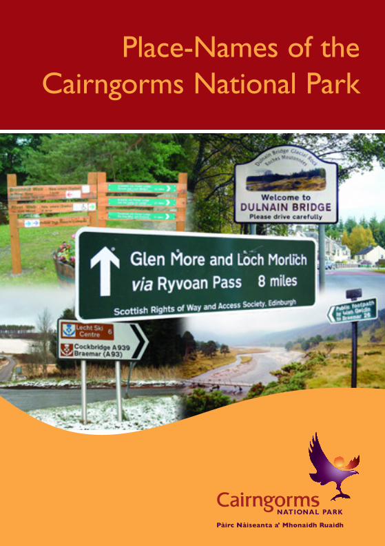
Place-Names of theCairngorms National Park
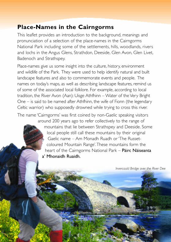
Place-Names in the CairngormsThis leaflet provides an introduction to the background, meanings andpronunciation of a selection of the place-names in the CairngormsNational Park including some of the settlements, hills, woodlands, riversand lochs in the Angus Glens, Strathdon, Deeside, Glen Avon, Glen Livet,Badenoch and Strathspey.
Place-names give us some insight into the culture, history, environmentand wildlife of the Park. They were used to help identify natural and builtlandscape features and also to commemorate events and people. Thenames on today’s maps, as well as describing landscape features, remind usof some of the associated local folklore. For example, according to localtradition, the River Avon (Aan): Uisge Athfhinn – Water of the Very BrightOne – is said to be named after Athfhinn, the wife of Fionn (the legendaryCeltic warrior) who supposedly drowned while trying to cross this river.
The name ‘Cairngorms’ was first coined by non-Gaelic speaking visitorsaround 200 years ago to refer collectively to the range of
mountains that lie between Strathspey and Deeside. Somelocal people still call these mountains by their originalGaelic name – Am Monadh Ruadh or ‘The Russet-coloured Mountain Range’.These mountains form the
heart of the Cairngorms National Park – Pàirc Nàiseantaa’ Mhonaidh Ruaidh.
Invercauld Bridge over the River Dee
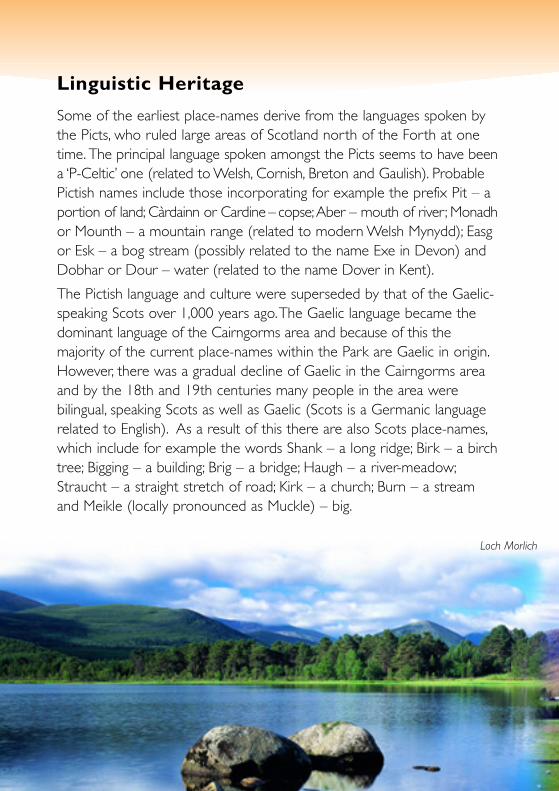
Linguistic Heritage
Some of the earliest place-names derive from the languages spoken bythe Picts, who ruled large areas of Scotland north of the Forth at onetime. The principal language spoken amongst the Picts seems to have beena ‘P-Celtic’ one (related to Welsh, Cornish, Breton and Gaulish). ProbablePictish names include those incorporating for example the prefix Pit – aportion of land; Càrdainn or Cardine – copse;Aber – mouth of river; Monadhor Mounth – a mountain range (related to modern Welsh Mynydd); Easgor Esk – a bog stream (possibly related to the name Exe in Devon) andDobhar or Dour – water (related to the name Dover in Kent).
The Pictish language and culture were superseded by that of the Gaelic-speaking Scots over 1,000 years ago.The Gaelic language became thedominant language of the Cairngorms area and because of this themajority of the current place-names within the Park are Gaelic in origin.However, there was a gradual decline of Gaelic in the Cairngorms areaand by the 18th and 19th centuries many people in the area werebilingual, speaking Scots as well as Gaelic (Scots is a Germanic languagerelated to English). As a result of this there are also Scots place-names,which include for example the words Shank – a long ridge; Birk – a birchtree; Bigging – a building; Brig – a bridge; Haugh – a river-meadow;Straucht – a straight stretch of road; Kirk – a church; Burn – a streamand Meikle (locally pronounced as Muckle) – big.
Loch Morlich

The Gaelic dialects of Strathspey and Badenoch survived to a limited extentinto the 21st century. In Aberdeenshire, the last native Gaelic speaker diedas recently as 1984.Today, ‘Doric’ – a rich dialect of Scots – is still spokenin the east of the Park, while there is a revival of Gaelic in the west of thePark. The Gaelic pronunciation given in this leaflet, which is explained inthe gazetteer, is based on the local dialects spoken in the Park area.
Glens and lochs usually take their names from the rivers and streams thatflow through them or from them, but there are some exceptions such asGlen Geusachan: Gleann Giùthsachain (glown GYOOsachen) – Glen ofthe Little Pine Wood; Glen Einich: Gleann Eanaich (glown ENeech) –Glen of the Boggy Place and Glenmore: An Gleann Mòr (in glownMOAR) – The Big Glen.
Gaelic has a more complex colour system than English, since the coloursare what linguists call ‘attributive’.This means that the words for colours varyin meaning, depending on what they are describing. For example, whenthe word gorm is used in reference to a mountain, it usually means ‘blue’,but when gorm is used in reference to a corrie, it usually means ‘green’.
Recording Place-NamesThe Ordnance Survey has done a great deal of valuable work throughoutScotland in recording place-names for posterity. However, the collectionprocess over the years has involved many challenges, in particular recording
Glen Doll in upper Glen Clova
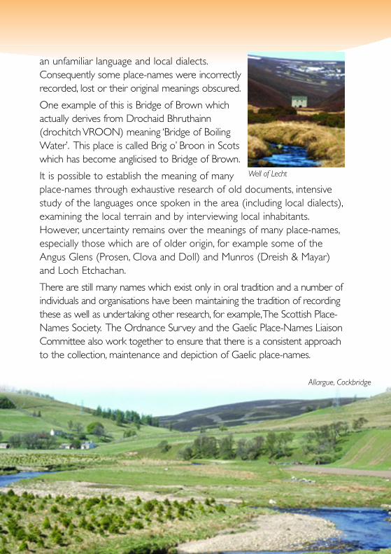
an unfamiliar language and local dialects.Consequently some place-names were incorrectlyrecorded, lost or their original meanings obscured.
One example of this is Bridge of Brown whichactually derives from Drochaid Bhruthainn(drochitch VROON) meaning ‘Bridge of BoilingWater’. This place is called Brig o’ Broon in Scotswhich has become anglicised to Bridge of Brown.
It is possible to establish the meaning of manyplace-names through exhaustive research of old documents, intensivestudy of the languages once spoken in the area (including local dialects),examining the local terrain and by interviewing local inhabitants.However, uncertainty remains over the meanings of many place-names,especially those which are of older origin, for example some of theAngus Glens (Prosen, Clova and Doll) and Munros (Dreish & Mayar)and Loch Etchachan.
There are still many names which exist only in oral tradition and a number ofindividuals and organisations have been maintaining the tradition of recordingthese as well as undertaking other research, for example,The Scottish Place-Names Society. The Ordnance Survey and the Gaelic Place-Names LiaisonCommittee also work together to ensure that there is a consistent approachto the collection, maintenance and depiction of Gaelic place-names.
Well of Lecht
Allargue, Cockbridge
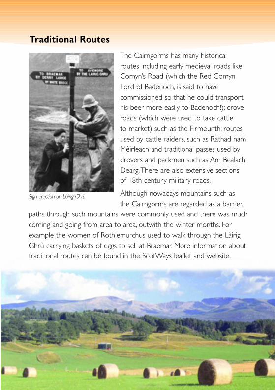
Traditional Routes
The Cairngorms has many historicalroutes including early medieval roads likeComyn’s Road (which the Red Comyn,Lord of Badenoch, is said to havecommissioned so that he could transporthis beer more easily to Badenoch!); droveroads (which were used to take cattleto market) such as the Firmounth; routesused by cattle raiders, such as Rathad namMèirleach and traditional passes used bydrovers and packmen such as Am BealachDearg.There are also extensive sectionsof 18th century military roads.
Although nowadays mountains such asthe Cairngorms are regarded as a barrier,
paths through such mountains were commonly used and there was muchcoming and going from area to area, outwith the winter months. Forexample the women of Rothiemurchus used to walk through the LàirigGhrù carrying baskets of eggs to sell at Braemar. More information abouttraditional routes can be found in the ScotWays leaflet and website.
Sign erection on Làirig Ghrù
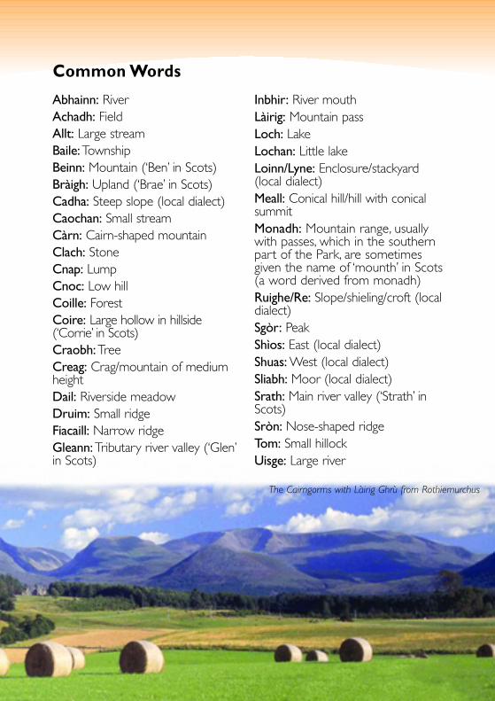
Common Words
Abhainn: RiverAchadh: FieldAllt: Large streamBaile:TownshipBeinn: Mountain (‘Ben’ in Scots)Bràigh: Upland (‘Brae’ in Scots) Cadha: Steep slope (local dialect)Caochan: Small streamCàrn: Cairn-shaped mountain Clach: StoneCnap: LumpCnoc: Low hillCoille: ForestCoire: Large hollow in hillside(‘Corrie’ in Scots)Craobh:TreeCreag: Crag/mountain of mediumheightDail: Riverside meadow Druim: Small ridgeFiacaill: Narrow ridgeGleann:Tributary river valley (‘Glen’in Scots)
Inbhir: River mouthLàirig: Mountain passLoch: LakeLochan: Little lakeLoinn/Lyne: Enclosure/stackyard(local dialect)Meall: Conical hill/hill with conicalsummitMonadh: Mountain range, usuallywith passes, which in the southernpart of the Park, are sometimesgiven the name of ‘mounth’ in Scots(a word derived from monadh)Ruighe/Re: Slope/shieling/croft (localdialect)Sgòr: PeakShìos: East (local dialect)Shuas: West (local dialect)Sliabh: Moor (local dialect)Srath: Main river valley (‘Strath’ inScots)Sròn: Nose-shaped ridgeTom: Small hillock Uisge: Large river
The Cairngorms with Làirig Ghrù from Rothiemurchus
RiverSpey
AlltDrùidh
March
1
14 5
17 28 19
30 21 255
1222
23
4652
38
273
Làir igGhrù
2
26 8
12
5
Crannaich
Glenmore Forest
RothiemurchusForest
LochGartenLoch
Vaa Loch Mallachie
LochPityoulish
Loch anEilein
LochAlvie
LochInsh
LochAvon
LochMorlich
GRANT-ON-SPEY
DulnainBridge
Carrbridge
Neth
AVIEMORE
Coylumbridge
Kincraig
Boat ofGarten
Beum a’Chaidheimh
Thieves' Road(Rathad nam Mèirleach)
P
L
Slochd(Pass)
PRyvoan
Am
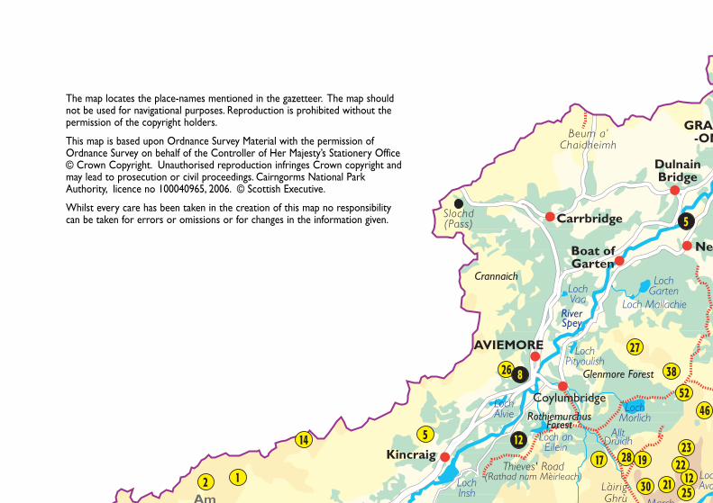
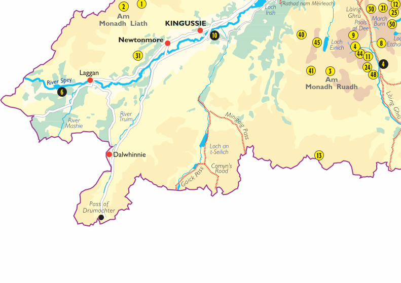
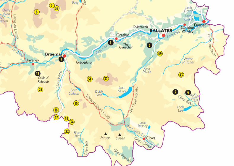
The map locates the place-names mentioned in the gazetteer. The map shouldnot be used for navigational purposes. Reproduction is prohibited without thepermission of the copyright holders.
This map is based upon Ordnance Survey Material with the permission ofOrdnance Survey on behalf of the Controller of Her Majesty’s Stationery Office© Crown Copyright. Unauthorised reproduction infringes Crown copyright andmay lead to prosecution or civil proceedings. Cairngorms National ParkAuthority, licence no 100040965, 2006. © Scottish Executive.
Whilst every care has been taken in the creation of this map no responsibilitycan be taken for errors or omissions or for changes in the information given.

RiverAvon
River Don
255
12223
4652
3 33
35
20
7
10
18
42
5
11
3
Loch Mallachie
LochAvon Loch
Builg
GRANTOWN-ON-SPEY
DulnainBridge
Nethy Bridge
Cockbridge
Bellabeg
Newe
Kirkton ofGlenbuchat
Tomintoul
Tomnavoulin
Corgarff
Cromdale
Bridge ofBrown
Glenlivet
Làir igan
Laoigh
Lecht(Pass)
TheLadder Road
AmBealach
Dearg
Pass ofRyvoan
Settlements
Topographic Features
Traditional Routes
Rivers
Lochs
A Roads
Minor Roads
Forests and Woods
0 – 300
300 – 600
600 – 1000
Over 1000
KEY
Cairngorms NationalPark Boundary
Places of Interest11
1
River Spey
MarchBurn
RiverTruimRiver
Mashie
31
1
4045
41
13
4824
444
98
30 21 2550
1222
2
11
Làir igGhrù
3
2
4
10
6
LochInsh
Poolsof Dee
Loch ant-Seilich
LochEinich
A
LochEtchachan
KINGUSSIE
Newtonmore
Laggan
Dalwhinnie
Làir igG
hrùThieves' Road
(Rathad nam Mèirleach)
Pass ofDrumochter
MinigaigPass
Comyn’sRoad
Gaick Pa
ss
AmMonadh Liath
AmMonadh Ruadh
DerryBurn
Lui WaterCl
unie
Wat
er
RiverIsla
River South Esk
River
NorthEsk
RiverMuick
Waterof Tanar
River Dee
River
Dee
367
29
16
47 3934
15
32
37
1
4351
49
6
3
2 9
7
1
13Coille a'Phìobair
Ballochbuie
TheGenechal
Coilacriech
LochBrandy
Avon
LochEtchachan
LochBuilg
LochCallater Dubh
Loch
LochMuick
LochLee
LochDavanLoch
Kinord
InvereyBraemar
BALLATERDinnet
CambusO’May
Crathie
Glen ClovaGlen Prosen
Glen Esk
Gle
n Is
la
Ghrù
Làirigan
Laoigh
earg
Tolmount (Jock’s Road)
The
Cape
l Mou
nth
Fir mounth
Road
Mayar Dreish Clova
GAZETTEERThe gazetteer gives the pronunciation and meanings of a selection of the many thousands of place-names in the Park associated with its settlements, glens, hills, woodlands, rivers and lochs. Moreinformation can be found in some of the literature and websites listed.The gazetteer includes place-names which appear on maps in their original Gaelic form and names ofmain features which were Gaelic in origin, but which have been anglicised or translated intoEnglish/Scots over the years. Spelling follows accepted conventions.The pronunciation of the Gaelic place-names is based on that found in the local Gaelic dialects of theCairngorm area. One characteristic of these dialects is the tendency to drop final unstressed syllables,so ‘monadh’ tends to be shortened to mon’ and ‘uisge’ to uisg’.In the phonetic system below, the letters are to be pronounced as in Scottish English.The syllables onwhich the main stress or emphasis lies will be shown in capital letters.The following indicates how thedifferent sounds are to be pronounced: y in by, gy, cy, ly & ny: y in ‘yard’
ay : ‘may’a : ‘car’e : ‘bell’ei : ‘height’
ey : ‘eye’ee : ‘keen’i : ‘tin’oa : ‘soar’
ow : ‘cow’oy : ‘boy’o : ‘cord’oo : ‘moon’
u : ‘sun’ch : ‘loch’tch : ‘itch’ng : ‘sing’
SettlementsAviemore (avee MOAR): An Aghaidh Mhòr (inackee VOAR) - this may be connected with the oldGaelic word adhbhadh meaning ‘a dwelling place’.Ballater (BALitir): Bealadair (BYALtir) - may befrom Bealach Dobhar - Pass Water.Bellabeg (belliBEG): Am Baile Beag (im bali BECK)- The Little Town.Boat of Garten (boat i GARTin): Coit a’ Ghartain(cochtch GARSHTen) - ferry-place of the area calledGartan.Braemar (BriMAR): Bràigh Mhàrr (brey VAR) - TheUpland of Mar - the town of Braemar consists oftwo settlements, Baile a’ Chaisteil (Castleton) andAchadh an Droighinn (The Field of the Thornbush).Cambus O’May (camis i MEI): Camas a’ Mhaigh(camis i VEI) - The River Bend of the Plain.Carrbridge (CARbridge): Drochaid Chàrr(drochitch CHAR) - Bridge of the Boggy Place.Cockbridge: Drochaid a’ Choilich (droycht iCHILeech) - was also referred to locally as CeannDrochaid - Bridge-end.Corgarff (corGARF): pronounced (cor GARee) inGaelic, possibly from Coire a’ Gharaidh - Corrie ofthe Animal’s Den.
Coylumbridge: Locally known as Coylum (COlyum)probably from Gaelic Comh-Leum - Double Leap (lit.leaping together).Crathie (CRATHay): Craichidh (CRACHee) -Shaking (boggy) Place.Cromdale (CROM dayl): pronounced CROWMbilin Gaelic, probably from Crom-Dhail - CrookedRiver Meadow.Dalwhinnie: Dail Chuinnidh (dal CHOONyee) -probably means ‘River Meadow of Champions’Dinnet (DINit): possibly from Duinnid(DOOEENitch) meaning ‘Brown Place’.Dulnain Bridge (DULnin): Drochaid Thuilnean(drochitch HOOLnyin) - Bridge of the Floody River.Grantown-on-Spey: Baile nan Granndach (balning GROWNtach) - Town of the Grants. Oftenreferred to locally as Am Baile Ùr (im bal OOR)meaning ‘The New Town’.Inverey (invirEI): Inbhir Èidh (inir EI) - The Mouthof the Ey (river).Kincraig (cinCRAYG): Ceann na Creige (cyown niCRAeeg) - The End of the Rock.Kingussie (cinYOOSee): Ceann a’ Ghiùthsaich(kyown i YOOseech) - The End of the Pine Wood.Kirkton of Glenbuchat (glenBUCKit): The
Churchtown of Buichead’s Glen. (Buichead is an oldGaelic personal name).Laggan (LAGin): Lagan (LAKan) originally LaganChoinnich - St Kenneth’s HollowNethy Bridge: Locally known in Gaelic as ObarNeithich (oabir NYAYeech) - The Mouth of theNethy (river).Newe (nyow): locally known as The Newe - from AnNeimheadh (in NYOW) - The Sacred Place.Newtonmore (nyoo tin MOAR): Baile Ùr an t-Slèibh (bal oor an TLAYee) - The New Town of theMoor. Often referred to locally as An Sliabh (inSLEEow) meaning ‘The Moor’.Tomintoul (taminTOWil): Tom an t-Sabhail (tomin TOWil) - The Knoll of the Barn.Tomnavoulin (tam ni VOOLin): Toman a’ Mhuilinn(toman i VOOLeen) - The Little Knoll of the Mill.
Rivers and BurnsAllt Drùidh: Allt Drù (alt DROO) - probably means‘The Stream of the Drenching/Oozing’.Avon (Aan): Uisge Athfhinn (ooshk Aeeng) - Water ofthe Very Bright One.Callater Burn (CALiter BURN): Uisge Chaladair(ooshk CHALatir) - Caladair may mean ‘Hard Water’or ‘Calling Water’.Clunie Water (CLOONee): Uisge Chluanaidh(ooshk CHLOOANee) - Water of the pasture.Dee: Uisge Dhè (ooshk YAY) - Water of Dè (possiblya deity).Derry Burn: Uisge an Doire (ooshk in DIR) - Waterof the Copse.Don: Uisge Dheathain (ooshk YEN) - Water ofDeathan (possibly a deity).Isla (EILi):Uisge Ìle (ooshk EEL) - Water of the High Bank.Lee: Uisge Lì (ooshk LEE) - possibly Water of Flood.Livet (LEEVit): Lìomhaid (LEEVitch) - Shining orFlooding one.Lui (LOOee): Laoigh - Calf one (possibly a deity).March Burn: Allt na Crìche (alt ni CREECH) - Streamof the Boundary/March. Marks the old boundarybetween Strathspey and Deeside.Mashie: Mathaisidh - Good Meadow River.Muick (mick): Uisge Muice (ooshk MOOichk) -
Water of Pig One (possibly a deity).North/South Esk: Easg Thuath/Easg Dheas (eskHOOa / esk YAYs)- North/South Bog Stream.Spey (spay): Uisge Spè (ooshk SPEI) - possibly Riverof Hawthorn.Tanar (TANir): Uisge Thannar (ooshk HANGir) -possibly connected to Tanaros, a British/Gaulishthunder-god.Truim (TROOeem): Elder Tree River.
LochsLoch Alvie (ALvee): Loch Allmhaigh (loch ALavee) -possibly means ‘Loch of the Rock Plain’.Loch an Eilein: (loch in YAYlen): The Loch of the Island.Loch an t-Seilich (loch inTCHAYleech): The Lochof the Willow tree.Loch Brandy: Loch Branduibh (loch BRANdooee) -Brandubh’s Loch. (Brandubh is an old Gaelic personalname).Loch Builg (loch BOOleeck): Loch of Bag (i.e. bag-shaped).Loch Davan (DAwin): Loch an Dàbhain (loch inDAVin) - Loch of the area called Davan.Loch Einich (loch ENeech): should be Loch Eanaich- Loch of the Boggy Area.Loch Garten (GARtin): Loch a’ Ghartain (lochGARSHTen) - Loch of the area called Gartan.Loch Insh: Loch Innse (loch EEnsh) - Loch of theIsland or Loch of the Water Meadow.Loch Kinord (loch cinORD): Loch Ceanndair (lochKYANir) - Loch of Head-WaterLoch Mallachie (MALachee): Loch Mallachaidh -The Loch of the Curse.Loch Morlich (loch MORleech): may be from LochMòr-Thulaich - Loch of the Big HillockLoch Pityoulish (loch pitYOOLish): Loch PeitGheollais - The Loch of the Settlement of theBright Place.Loch Vaa: Loch a’ Bhàtha - The Loch of the Drowning.Pools of Dee: locally Lochanan Dubha na Làirige(lochan doo ni LAAReek) - The Little Black Lochs ofthe Pass.
Traditional RoutesAm Bealach Dearg (im byalach JERick): The Red Pass.Beum a’ Chlaidheimh (bem i CHLEYee): The Gashof the Sword.Comyn’s Road (CUMeens road): Rathad nanCuimeineach (rat ning Coomeenyach).Gaick Pass: Gàig (GAeeck) - a cleft.Làirig an Laoigh: should be Làirig Laoigh (lareeckLOOee) - Pass of Lui. Also known locally as An LàirigShìos (The Eastern Pass).Làirig Ghrù: should be Làirig Dhrù (lareeck GROO) -The Pass of Drù.Also known locally as An Làirig Shuas(The Western Pass).Rathad nam Mèirleach (rat nim MYARlach): TheThieves’ Road (ie cattle raiders). Includes the Pass ofRyvoan, from Ruighe a’ Bhothain (ree VOAen) - TheSlope of the BothySlochd (slochk): An Sloc (in SLOCHK) - The Pit/Den.Also known as Sloc Muice (The Wild Pig’s Den).The Capel Mounth (CAYpil munth): MonadhChapall (mon i CHAPil) - The Mounth of Horses.The Firmounth (FERmunth): Am Monadh Giuthais(i moni GYOOish) - The Mounth of Pine.The Ladder Road (LAYdir): Monadh an Fhàraidh(mon in ARee) - The Mounth of the Ladder.The Lecht: An Leac (in LYECHK) - The Declivity.The Minigaig Pass: Minigaig is locally Monadh Ghàig(mooni GAeeck) - The Mountain Range of Gaick.The Pass of Drumochter (drimOOCHtir): DruimUachdair (drooeem OOACHKir) - Ridge of the HighGround. Often referred to in Gaelic poetry as DruimUachdair nam Bò (Druim Uachdair of the Cows) orDruim Uachdair an Fheòir (Druim Uachdair of theGrass).The Tolmount (TOLmunth): An Dul Monadh (inDOOLi mon) - meaning uncertain.This is also knownas Jock’s Road - named after John Winter, who foughtfor the right to walk over these mountains.
Forests and WoodsBallochbuie (balichBOOEE): Am Bealach Buidhe(im BYALach BOOee) - The Yellow Pass.Coilacriech (ceil i CHREECH): probably Coille a’Chrithich (ceil i CHREECH) - The Wood of the Aspen.Coille a’ Phìobair (ceil i FEEpir): The Piper’s Wood.Crannaich (CRANeech): A’ Chrannaich (iCHRANeech) - The Place of Straight Trees.Glenmore Forest: (glenMOAR): Coille a’ GhlinneMhòir (ceil i gleenyi VOAR) - The Forest of the Big Glen.Rothiemurchus Forest: (rotheeMURchis): Coille RàtMhurchais (ceil racht VOORichish) - The Forest of thePlace of Murchas’ Fort.The Genechal (JENichil): An t-Seann-Choille (inJOONG ichil) - The Old Wood.
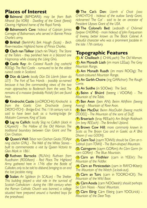
Places of Interestl1 Balmoral (BilMOARil): may be from BothMhorail (ba VORil) - Dwelling of the Great (forest)Clearing. Highland home of the Royal Family.l2 Balnamoon’s Cave: hideout of Captain JamesCarnegie of Balnamoon, who served in Bonnie PrinceCharlie’s army.l3 Birkhall (BerkHA): Birk Haugh (Scots) - BirchRiver-meadow. Highland home of Prince Charles.l4 Clach nan Tàillear (clach nin TAlyir): The Stoneof the Tailors - they perished here in a blizzard oneHogmanay while crossing the Làirig Ghrù.l5 Castle Roy: An Caisteal Ruadh (ing cashtchilROOig)- The Red Castle - rumoured to be the oldestruined castle in Scotland.l6 Dùn dà Làmh: locally Dùn Dà Làimh (doon daLEY) - The Fort of Two Hands - possibly so-namedbecause it has fine commanding views of the twomain approaches to Badenoch from the west. Theremains of a massive (probably Pictish) fort are foundhere.l7 Kindrochit Castle (cinDROCHit): Kindrochit isfrom the Gaelic Cinn Drochaide (ceengDROYCHTCH) - Bridge-End. This 11th century ruin issaid to have been built as a hunting-lodge forMalcolm Canmore, King of Scotsl8 Lag na Caillich: locally Slag na Caillich (slack niCALyeech) - The Hollow of the Old Woman. Thetraditional boundary between Clan Grant and TheClan Chattan.l9 Queen’s Well: Tobar nan Clachan Geala (TOApirning clachin GYAL) - The Well of the White Stones -built to commemorate a visit by Queen Victoria toGlen Mark in 1861.l10 Ruthven Barracks (RUVin): Ruthven fromRuadhainn (ROOAeen) - Red Place. The HighlandArmy gathered here in 1746 after the Battle ofCulloden, only to be told to disband, bringing to an endthe last Jacobite rising.l11 Scalan: An Sgàilean (in SCALan) - The Shelter.This building played a vital role in the survival ofScottish Catholicism - during the 18th century whenthe Roman Catholic Church was banned, a collegesituated here prepared around a hundred boys forthe priesthood.
l12 The Cat’s Den: Uamh a’ Chait (ooaCHACHTCH) - hideout of the outlaw Sandy Grant,nicknamed ‘The Cat’ - said to be an ancestor ofPresident Ulysses Grant of the USA.l13 The Colonel’s Bed: Leabaidh a’ Chòirneil(lyepee CHORNil) - main hideout of John Farquarsonof Inverey, better known as The Black Colonel. Acolourful character who was a prominent Jacobite inthe late 17th century.
Topographic Features1 A’ Chailleach (i CHALyach): The Old Woman.2 Am Monadh Liath (im moni LEEaa): The Grey
Mountain Range.3 Am Monadh Ruadh (im moni ROOig): The
Russet-coloured Mountain Range.4 An Garbh-Choire (ing GARichor): The Rough
Corrie.5 An Suidhe (in SOOee): The Seat.6 Beinn a’ Bhùird (beeng i VOORd) - The
Mountain of the Table.7 Ben Avon (ben AN): Beinn Athfhinn (beeng
Aeeng) - Mountain of River Avon.8 Ben MacDui: Beinn MacDuibh (beeng machk
DOOEE) - The Mountain of the sons of Duff.9 Braeriach (bray REEach): Am Bràigh Riabhach
(im brey REEach) - The Brindled Upland.10 Brown Cow Hill: more commonly known inScots as The Broon Coo and in Gaelic as A’ BhòDhonn (i voa GOON).11 Cairn Toul (cayrn TOWil): should be Càrn an t-Sabhail (carn TOWil) - The Barn-shaped Mountain.12 Cairngorm (cayrn GORim): An Càrn Gorm (incarn GORim) - The Blue Mountain.13 Càrn an Fhìdhleir (carn in YEElir): TheMountain of the Fiddler.14 Càrn an Fhreiceadain (carn in RAYCHKiten):The Mountain of the Watch (i.e.look-out).15 Càrn an Tuirc (carn in TOORCHCK): TheMountain of the Wild Boar.16 Càrn Aosda (carn NOOeesh): should perhapsbe Càrn Naois - Naois’ Mountain.17 Càrn Eilrig: Càrn Eileirg (carn YOOLirick) -Mountain of the Deer Trap.
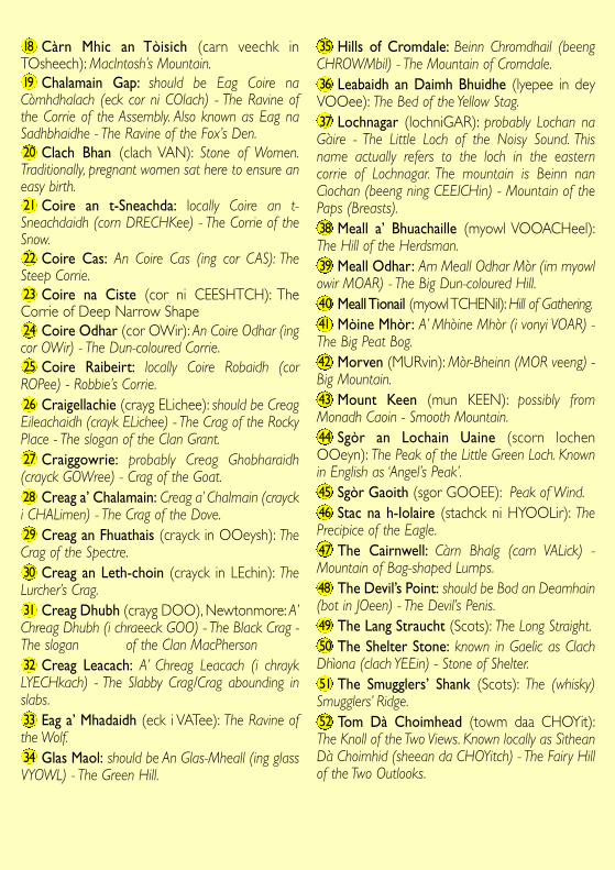
18 Càrn Mhic an Tòisich (carn veechk inTOsheech): MacIntosh’s Mountain.19 Chalamain Gap: should be Eag Coire naCòmhdhalach (eck cor ni COlach) - The Ravine ofthe Corrie of the Assembly. Also known as Eag naSadhbhaidhe - The Ravine of the Fox’s Den.20 Clach Bhan (clach VAN): Stone of Women.Traditionally, pregnant women sat here to ensure aneasy birth.21 Coire an t-Sneachda: locally Coire an t-Sneachdaidh (corn DRECHKee) - The Corrie of theSnow.22 Coire Cas: An Coire Cas (ing cor CAS): TheSteep Corrie.23 Coire na Ciste (cor ni CEESHTCH): TheCorrie of Deep Narrow Shape24 Coire Odhar (cor OWir): An Coire Odhar (ingcor OWir) - The Dun-coloured Corrie.25 Coire Raibeirt: locally Coire Robaidh (corROPee) - Robbie’s Corrie.26 Craigellachie (crayg ELichee): should be CreagEileachaidh (crayk ELichee) - The Crag of the RockyPlace - The slogan of the Clan Grant.27 Craiggowrie: probably Creag Ghobharaidh(crayck GOWree) - Crag of the Goat.28 Creag a’ Chalamain: Creag a’ Chalmain (craycki CHALimen) - The Crag of the Dove.29 Creag an Fhuathais (crayck in OOeysh): TheCrag of the Spectre.30 Creag an Leth-choin (crayck in LEchin): TheLurcher’s Crag.31 Creag Dhubh (crayg DOO), Newtonmore: A’Chreag Dhubh (i chraeeck GOO) - The Black Crag -The slogan of the Clan MacPherson32 Creag Leacach: A’ Chreag Leacach (i chraykLYECHkach) - The Slabby Crag/Crag abounding inslabs.33 Eag a’ Mhadaidh (eck i VATee): The Ravine ofthe Wolf.34 Glas Maol: should be An Glas-Mheall (ing glassVYOWL) - The Green Hill.
35 Hills of Cromdale: Beinn Chromdhail (beengCHROWMbil) - The Mountain of Cromdale.36 Leabaidh an Daimh Bhuidhe (lyepee in deyVOOee): The Bed of the Yellow Stag.37 Lochnagar (lochniGAR): probably Lochan naGàire - The Little Loch of the Noisy Sound. Thisname actually refers to the loch in the easterncorrie of Lochnagar. The mountain is Beinn nanCìochan (beeng ning CEEICHin) - Mountain of thePaps (Breasts).38 Meall a’ Bhuachaille (myowl VOOACHeel):The Hill of the Herdsman.39 Meall Odhar: Am Meall Odhar Mòr (im myowlowir MOAR) - The Big Dun-coloured Hill.40 Meall Tionail (myowl TCHENil): Hill of Gathering.41 Mòine Mhòr: A’ Mhòine Mhòr (i vonyi VOAR) -The Big Peat Bog.42 Morven (MURvin): Mòr-Bheinn (MOR veeng) -Big Mountain.43 Mount Keen (mun KEEN): possibly fromMonadh Caoin - Smooth Mountain.44 Sgòr an Lochain Uaine (scorn lochenOOeyn): The Peak of the Little Green Loch. Knownin English as ‘Angel’s Peak’.45 Sgòr Gaoith (sgor GOOEE): Peak of Wind.46 Stac na h-Iolaire (stachck ni HYOOLir): ThePrecipice of the Eagle.47 The Cairnwell: Càrn Bhalg (carn VALick) -Mountain of Bag-shaped Lumps.48 The Devil’s Point: should be Bod an Deamhain(bot in JOeen) - The Devil’s Penis.49 The Lang Straucht (Scots): The Long Straight.50 The Shelter Stone: known in Gaelic as ClachDhìona (clach YEEin) - Stone of Shelter.51 The Smugglers’ Shank (Scots): The (whisky)Smugglers’ Ridge.52 Tom Dà Choimhead (towm daa CHOYit):The Knoll of the Two Views. Known locally as SìtheanDà Choimhid (sheean da CHOYitch) - The Fairy Hillof the Two Outlooks.
Further Information
Alexander,W.M., (1952). The Place-names of Aberdeenshire. The Third Spalding Club.
Dorward, D., (2001). The Glens of Angus: Names, Places and People.The Pinkfoot Press.
Grant, I., (1999). Tales of the Braes of Glenlivet. Birlinn.
Grant, J. H., (1999). Gaelic Heritage of Rothiemurchus. Rothiemurchus: Nature andPeople On A Highland Estate, 1500-2000. Scottish Cultural Press.
Macgregor, N., (1992-94). Gaelic Place-Names in Strathspey. Transactions of theGaelic Society of Inverness,Vol. 58.
Nicolaisen,W.F.H., (1976). Scottish Place-Names: their Study and Significance.
Watson, A., (1992). The Cairngorms. The Scottish Mountaineering Trust.
Watson, A., (1984). The Place Names of Upper Deeside. Aberdeen University Press
Watson,W.J., (2002). Scottish Place-Name Papers. Steve Savage.
Watson,W.J., (2004). The Celtic Placenames of Scotland. Birlinn.
Ordnance Survey www.ordnancesurvey.co.uk
Scottish Place-Names Society www.st-andrews.ac.uk/institutes/sassi/spns
Am Baile – The Gaelic Village www.ambaile.org.uk
ScotWays (The Scottish Rights of Way and Access Society) www.scotways.com
This leaflet is produced by theCairngorms National Park Authority14 The Square, Grantown-on-Spey PH26 3HGTel: 01479 873535email: [email protected]
For a large print version of this leaflet, please contactthe CNPA at the above address
Research and text: Dr.Alison M. G. Diackwith Dr. James H. GrantPhotography: Raymond Falconer,David Gowans, Dougie Gibson,Jimmy Mitchell and ScotWaysDesigned and produced by ‘Its All Good’,[email protected]