photo credits - s3.ap-southeast-2.amazonaws.com · web viewthe coastal spaces landscape study...
TRANSCRIPT

Draft Marine and Coastal Policy Photo credits
Marcia Riederer, Phillip Wierzbowski, Nicola Waldron, Chris Pape, Great Ocean Road Coast Committee, Moyne Shire Council, Visit Victoria, Department of Transport, Sean McPhillips
© The State of Victoria Department of Environment, Land, Water and Planning 2019
This work is licensed under a Creative Commons Attribution 4.0 International licence. You are free to re-use the work under that licence, on the condition that you credit the State of Victoria as author. The licence does not apply to any images, photographs or branding, including the Victorian Coat of Arms, the Victorian Government logo and the Department of Environment, Land, Water and Planning (DELWP) logo. To view a copy of this licence, visit http://creativecommons.org/licenses/by/4.0/
Printed by Waratah Group, Port Melbourne
ISBN 978-1-76077-609-1 (Print)
ISBN 978-1-76077-610-7 (pdf/online/MS word)
Disclaimer
This publication may be of assistance to you but the State of Victoria and its employees do not guarantee that the publication is without flaw of any kind or is wholly appropriate for your particular purposes and therefore disclaims all liability for any error, loss or other consequence which may arise from you relying on any information in this publication.
Accessibility
If you would like to receive this publication in an alternative format, please telephone the DELWP Customer Service Centre on 136186, email [email protected] , or via the National Relay Service on 133 677 www.relayservice.com.au. This document is also available on the internet at www.delwp.vic.gov.au.
1

ContentsAcknowledgement of Aboriginal Victorians................................................................................................3
Minister’s Foreword....................................................................................................................................... 4
Executive Summary....................................................................................................................................... 5
Introduction.................................................................................................................................................... 7
Threats and drivers of change.................................................................................................................... 10
How to use the Marine and Coastal Policy................................................................................................13
Planning and Decision Pathway.......................................................................................................13
Chapter 1 - Traditional Owners Rights, Aspirations and Knowledge......................................................17
Chapter 2 - Ecosystems and Habitats........................................................................................................19
Chapter 3 - Natural Features and Landscapes..........................................................................................22
Chapter 4 - Heritage and Cultural Values..................................................................................................23
Chapter 5 - Value of Marine and Coastal Crown Land..............................................................................24
Chapter 6 - Managing Coastal Hazard Risk...............................................................................................25
Chapter 7 - Emergency Response and Preparedness..............................................................................28
Chapter 8 - Ecologically Sustainable Use and Development...................................................................29
Chapter 9 - Coastal Settlements.................................................................................................................31
Chapter 10 - Buildings, Structures and Access........................................................................................33
Chapter 11 - Marine and Coastal Industries..............................................................................................36
Chapter 12 - Recreation and Tourism........................................................................................................38
Chapter 13 - Stewardship and Collaborative Management......................................................................40
Chapter 14 - Funding................................................................................................................................... 43
Chapter 15 - A Marine Spatial Planning Framework for Victoria.............................................................46
PART A - Guidance............................................................................................................................ 52
PART B - Initiating marine spatial planning....................................................................................57
PART C – The marine spatial planning process.............................................................................61
Appendix 1................................................................................................................................................... 70
Appendix 2................................................................................................................................................... 72
Definitions.................................................................................................................................................... 74
2

Acknowledgement of Aboriginal Victorians The Victorian Government acknowledges Aboriginal people as Australia’s first people, and as the Traditional Owners and custodians of the land on which we work and live. We recognise the strength of Aboriginal people and the need for reconciliation and genuine partnerships to address the negative impacts of the past.
We recognise and value the ongoing contribution of Aboriginal people and communities to Victorian life and how this enriches us all.
We recognise that Aboriginal cultures and communities are diverse, and the value we gain in celebrating these cultures and communities. We acknowledge that the land and sea is of spiritual, cultural and economic importance to Aboriginal people. We also recognise the intrinsic connection of Traditional Owners to Country and acknowledge their contribution in the management of land, water, the natural landscape and our built environments.
We embrace the spirit of reconciliation, working towards the equality of outcomes and ensuring an equal voice.
We have distinct legislative obligations to Traditional Land Owner groups that are paramount in our responsibilities in managing Victoria’s resources.
3

Minister’s ForewordVictorians love to live near, visit and use the marine and coastal environment. The things we value, like walking on the beach, fishing, swimming, surfing, camping, eating local seafood, boating, looking at the ocean, and making spiritual connections, all depend on a healthy marine and coastal environment.
The marine and coastal environment is a resource for industries such as tourism, boating, fishing, aquaculture, shipping, renewable energy and oil and gas that all significantly benefit regional and state economies, service communities and support employment. Many industries depend on a healthy environment for their products to be viable and by protecting and sustainably managing the marine and coastal environment this policy will support long-term economic growth for the benefit of current and future generations.
The draft Marine and Coastal Policy complements the United Nations 2030 Sustainable Development Goals that focus on sustainable management and protection of marine and coastal ecosystems, protection of cultural heritage, increasing the resilience of communities and the natural environment, climate change response, and sustainable use and development.
Providing a better future for Victoria’s marine and coastal environment is a priority for this Government and this draft policy links and integrates all these uses and users together to sustainably plan for and manage the marine and coastal environment.
Thank you to those people and groups who have contributed their time and effort to developing this draft policy. The collaborative processes you participated in demonstrate the much-needed commitment of working together towards achieving improved outcomes in this shared space. I particularly thank the members of the Victorian Marine and Coastal Council.
I encourage every Victorian to participate in the development of the Marine and Coastal Policy and strengthening Victoria’s position as a leader in marine and coastal management.
The Hon. Lily D’Ambrosio MP
Minister for Energy, Environment and Climate Change
4

Executive SummaryVictoria’s marine and coastal environment is a special and unique place that provides enormous social, cultural and economic benefits to our communities in addition to its intrinsic natural values. These benefits contribute to the health, wellbeing and prosperity of Victorian communities.
A diverse range of economic activity is supported by the Victorian marine and coastal environment, including tourism, boating, shipping, petroleum extraction, renewable energy, commercial fishing and aquaculture and recreational fishing. Each of these activities has direct and indirect benefit to the local, regional and national economies and provide essential community services.
The marine and coastal environment also provides a wide range of experiences from busy city beaches and regional centres to smaller seaside towns and remote wilderness areas. Public land and waters provide a large area for communities to use and enjoy. It contains important cultural heritage values and allows a continuation of traditional practices.
The draft Marine and Coastal Policy puts forward a vision of “a healthy, dynamic and biodiverse marine and coastal environment that benefits the Victorian community now and in the future”. A series of outcomes (what success looks like) and policies (set of rules) drive the planning and management of this special area. A Marine Spatial Planning Framework guides how the many sectors in the marine environment can work together to provide for existing and future uses and overcome challenges.
The draft Policy has been prepared with key government and non-government groups with representation across various sectors (e.g. Traditional Owners, conservation, heritage, industry). It builds on the merits of the Victorian Coastal Strategy 2014 and fills identified gaps.
Significant new or changed areas proposed within the draft Policy include:
Recognising Traditional Owners’ ongoing connection to Country and supporting a self-determination model that facilitates current and future generations to have their voices heard in planning and management decisions, and to care for land and Sea Country.
Acknowledging the importance of use and development of the marine and coastal environment to people, groups, communities and industries and the Victorian economy and providing direction on how to use and develop sustainably in appropriate locations.
Developing Victoria’s first Marine Spatial Planning Framework for achieving integrated and coordinated planning and management of the marine environment. Co-developed with marine sector stakeholders it sets out a process for creating marine plans.
Providing strong direction on climate change including a focus on embedding adaptation in all planning processes and decision making and building the resilience of people and communities and the natural environment to climate impacts.
Retaining the current planning benchmark, to plan for not less than 0.8m sea level rise by 2100. (This may be revised following Intergovernmental Panel on Climate Change report to be released in September 2019).
Clarifying that the state will prioritise actions strategically and using a risk-based approach to protect public values. Promoting a sustainable funding process to improve marine and coastal planning and management that articulates
that funding is a shared responsibility of all levels of government, beneficiaries and users. Enshrining the ongoing public ownership of
marine and coastal Crown land for the benefit for all Victorians.
Supporting the consistent application of ecosystem-based management to enable marine and coastal ecosystems to be healthy, functioning, resilient, and to provide goods and services to Victorian’s now and in the future.
A Marine and Coastal Strategy will be developed in 2020 to outline the priority actions to achieve the Policy’s objectives.
Have your sayNow we need your input and ideas to ensure that the Marine and Coastal Policy reflects the Victorian community’s views on how the marine and coastal environment should be planned and managed.
5

We seek your comments and responses to the series of questions posed throughout this draft document. These may be useful to prompt your thinking in forming your views or help guide writing a submission.
We encourage you to allow your submission to be made available to promote discussion. This means your name would be included in the list of submissions on the website and provided to external parties on request. Submissions may be subject to Freedom of Information and other laws. DELWP reserves the right to not publish information that could be seen to be defamatory or discriminatory.
If you make a submission to the draft Policy, parts of your submission may be used in subsequent reports or summaries. If you wish, we can do this in a way that does not identify you. If you prefer your name and submission to be confidential, you can specify this when you make your submission.
How you can get involved –
Visit the consultation website - Engage Victoria https://engage.vic.gov.au/ - to provide feedback or upload a submission
Email a submission to [email protected] Send a submission to:
Draft Marine and Coastal PolicyPolicy and Strategy UnitDepartment of Environment, Land, Water and PlanningPO Box 500East Melbourne VIC 3002
You can make a submission until 15 August 2019
6

Introduction Our vision is for a healthy, dynamic and biodiverse marine and coastal environment that benefits the Victorian community now and in the future
The Marine and Coastal Act 2018 (the Act) sets objectives and guiding principles for the planning and management of the marine and coastal environment. It establishes an integrated and coordinated whole-of-government approach to work with Traditional Owners, industry, and the community to protect and manage the marine and coastal environment and better manage many of the uses within it.
The Act requires a Marine and Coastal Policy to set out policies for planning and managing the marine and coastal environment, and to provide guidance to decision makers in achieving the Act’s objectives. The Policy must also include a Marine Spatial Planning Framework; this will set out steps for achieving integrated and coordinated planning and management of Victorian’s marine environment.
The Policy is a long-term approach intended to last for the next 10-15 years that will enable us to meet our vision of a healthy, dynamic and biodiverse marine and coastal environment that benefits the Victorian community now and in the future.
Where the Marine and Coastal Policy appliesThe Policy applies to the planning and management of matters relating to and affecting the marine and coastal environment. As defined in the Marine and Coastal Act 2018 the marine and coastal environment includes all private and public land and waters between the outer limit of Victorian coastal water and five kilometres inland of the high-water mark of the sea, including:
a) The land (whether or not covered by water) to a depth of 200 metres below the surface of that land.
b) Any water covering the land referred to in paragraph (a) above from time to time.
c) The biodiversity associated with the land and water referred to in paragraphs (a) and (b).
All policy directions apply to the above area unless otherwise indicated.
Where a particular Policy references marine and coastal Crown land (public land) the policy applies to that area only (refer to the Definitions section of this Policy).
7

Figure 1: Area where this Marine and Coastal Policy applies
What a ‘healthy’ marine and coastal environment meansA healthy marine and coastal environment is biodiverse and dynamic. It contains functioning biological, physical and chemical interactions that support the many and varied plants and animals. It is able to operate as a dynamic, constantly changing system. Natural processes continue to shape landforms. Ecosystems (vegetation and other living communities) are in a constant state of flux in response to processes like sea and air temperature, nutrient flows and ocean currents.
A healthy marine and coastal environment is able to support the full range of environmental, social, cultural and economic values that benefit the Victorian community (see Figure 2 and Figure 3). It also provides for the intrinsic value of the marine and coastal environment (the value it has in itself regardless of its value to humans).
Questions:
1. Is the draft vision “A healthy, dynamic and biodiverse marine and coastal environment that benefits the Victorian community now and in the future” appropriate for the new Marine and Coastal Policy?
2. What elements of the vision do you think are important to keep, remove or add?
8
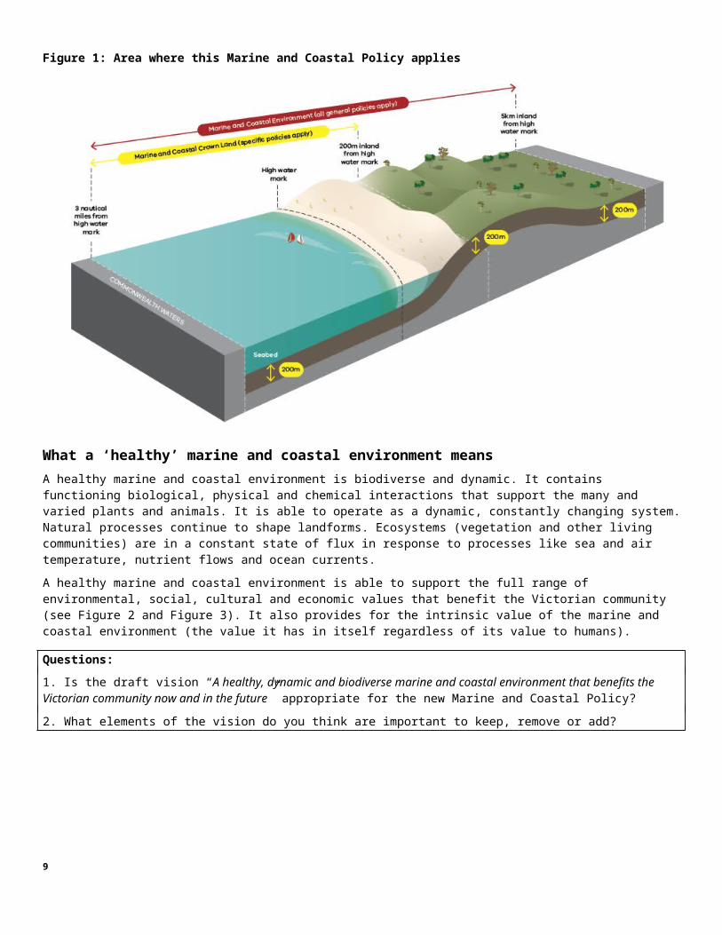
Figure 2: Importance of a healthy marine and coastal environment
Figure 3: Marine and coastal environment activities and values
9

Threats and drivers of changeThreats to marine and coastal health The health of the marine and coastal environment is under threat from the way we use it, coastal processes, climate change, and the impacts of growing towns, cities and industries that interact with it.
These threats result in impacts on water quality and quantity, pollution and debris, invasive pests and diseases, disturbance and loss of plants and animals, loss of access to beaches from the effects of sea walls, infrastructure and erosion, loss of township character from inappropriate development and the increasing number of people visiting and using the marine and coastal environment.
Degradation occurs over time and space and the impacts in marine and coastal areas are varied and complex.
This document sets policies to guide decision making for planning and management of the marine and coastal environment to reduce degradation and enable a healthy and dynamic environment now and in the future.
Drivers of changeDevelopment of the Marine and Coastal Act 2018 identified three key drivers for change in the marine and coastal environment: climate change, population growth and ageing infrastructure. These drivers of change are exacerbating existing threats and bring new challenges for Victoria’s marine and coastal environment.
Climate changeClimate change is increasing the pressure on Victoria’s marine and coastal environment by exacerbating existing threats and introducing new ones, such as:
rising sea levels leading to more inundation and erosion increased frequency and severity of extreme weather events and storms changes in ocean temperatures, currents and ocean acidification changes to waterway flows, levels and regimes changes in the range, distribution and abundance of both introduced and native plants and animals, including new
pests taking advantage of a changed climate coastal squeeze as coastal ecosystems are forced inland with sea level rise and meet man-made barriers such as
roads and housing.
Coastal settlements are exposed to a range of climate change impacts. This is highly pronounced around the coast of Port Phillip Bay, which is experiencing significant increases in population and density, exposing large numbers of people to increasing risk from climate change impacts. Industries such as fishing and tourism will be affected by changing species distribution and increasing storm and erosion events. Recreational opportunities on the coast will change as beaches and cliffs erode.
10

Figure 4: Impacts of climate change on the marine and coastal environment
Population growthVictoria’s population has been growing at record levels over the past decade (DELWP 2018). Population size and density has been increasing, particularly in municipalities around Port Phillip Bay and within two hours’ drive of Melbourne (notably the Bellarine Peninsula, the Mornington Peninsula, the Bass Coast and the Surf Coast). The Victoria in Future 2016 Report found the population of Victoria is forecast to grow at an average rate of 1.5% per year to almost 8 million by 2031, and 10 million by 2051. Growth in the permanent population has been accompanied by an increase in domestic, national and international visitor population along the Victorian coast.
Increasing numbers and density of residents and visitors puts pressure on the health of marine and coastal environment. Direct impacts include:
loss of coastal character of townships habitat loss and degradation increased introduction of invasive and pest species increased pollutants e.g. litter, stormwater runoff, wastewater discharges erosion of dunes.
It also increases pressure on access infrastructure, such as walking tracks, visitor facilities, lifesaving clubs and recreational club houses, boat ramps and marinas. This, in turn, leads to more demand for alterations to the beach, foreshore, wetlands and natural processes through groynes, sea walls and dredging to support use and development.
More people are wanting to use a limited space and access marine resources. If not managed, this will lead to greater conflict between users and exceed the carrying capacity of sites.
Increased populations also increase the demand for marine and coastal based industries to grow. This includes seafood, energy generation, resource extraction and transportation of these goods to populations across Australia and the world.
11

Ageing and inappropriate infrastructureVictoria has a legacy of coastal assets (sea walls, groynes, piers and jetties), particularly in its embayments and estuaries (Port Phillip, Western Port, Gippsland Lakes and Corner Inlet), that have been constructed over the past 100 years.
Many of these assets are ageing and without regular maintenance or upgrade will no longer provide the service for which they were originally built. In 2018 the Victorian Auditor General’s office estimated that between 20 and 30% of coastal assets are in poor condition, and between 30 and 50% are estimated to have less than 10 years’ useful life remaining. Increasing storms and erosion under climate change will further undermine the integrity of many assets.
Community and government values and priorities change. Some coastal infrastructure is no longer required as the need for the infrastructure no longer exists. Because of this, assets that have been protected in the past will not necessarily continue to be protected in the future.
Addressing the drivers of changeThe drivers of change in the marine and coastal environment are complex and their underlying causes cannot all be managed through this Policy (e.g. population growth is influenced by many external factors including demographic changes, national policy settings, and international, national and state economic conditions). The Marine and Coastal Policy does however play a lead role in managing the impacts of those drivers in the marine and coastal environment.
Where possible drivers of change and their impacts are managed through policies that provide strategic direction as well as value and use specific considerations for planning, management and decision-making in the marine and coastal environment.
Resilience and a healthy environment An important focus of this Policy is to manage the health of the marine and coastal environment so that ecosystems, communities and built assets are as resilient as they can be in the face of future change. Change could be from natural hazards, climate change, population growth or, most likely, a combination of these factors.
A healthy marine and coastal environment will promote resilience for industries and communities that rely on its resources from a liveability and economic perspective.
Resilience is the ability of a system to adapt to or tolerate change without losing its original function. It is also the ability of a system to overcome or bounce back from a disruption.
12

How to use the Marine and Coastal PolicyThe Marine and Coastal Act 2018 includes objectives and guiding principles to be considered in planning and managing the marine and coastal environment.
Policies to provide guidance to achieve the objectives of the Act are grouped through a Planning and Decision Pathway to assist clear and consistent decision-making.
Marine and Coastal Act 2018 objectives The Marine and Coastal Act 2018 outlines the following objectives for the planning and management of the marine and coastal environment in Victoria:
a) to protect and enhance the marine and coastal environment
b) to promote the resilience of marine and coastal ecosystems, communities and assets to climate change
c) to respect natural processes in planning for and managing current and future risks to people and assets from coastal hazards and climate change
d) to acknowledge Traditional Owner groups’ knowledge, rights and aspirations for land and Sea Country
e) to promote a diversity of experience in the marine and coastal environment
f) to promote the ecologically sustainable use and development of the marine and coastal environment and its resources in appropriate areas
g) to improve community, user group and industry stewardship and understanding of the marine and coastal environment
h) to engage with specified Aboriginal parties, the community, user groups and industry in marine and coastal planning, management and protection
i) to build scientific understanding of the marine and coastal environment.
Planning and Decision PathwayDecision makers need to consider many priorities and demands that, at times, can be competing or conflicting, e.g. recreational opportunities, providing for industries, housing growing populations and maintaining a healthy environment.
The natural marine and coastal environment is often the most compromised in these decisions. Any resulting deterioration tends to lead to a deterioration of social, cultural and economic values as well as the environment’s intrinsic value.
The following ‘Planning and Decision Pathway’ is based on the objectives and guiding principles of the Act. Planning, management and decision-making under the Act must apply the policies within the steps of the Planning and Decision Pathway e.g. when developing a Marine and Coastal Strategy, a Regional and Strategic Partnership product such as a Marine Spatial Plan, an Environmental Management Plan, a strategic recreational plan (e.g. Boating Facilities Framework), a Coastal and Marine Management Plan or assessing a consent application for use and development.
13

Figure 5: The Planning and Decision Pathway sets out how the guiding principles and policy (grouped under the Planning and Decision Pathway steps) must be considered in decision-making
Policies that provide guidance in achieving the nine objectives of the Marine and Coastal Act 2018 are grouped under the following Planning and Decision Pathway steps:
1. Acknowledge – understand and acknowledge the rights and aspirations of the Traditional Owner groups for that land and Sea Country.
2. Protect and enhance – protect and if possible enhance environmental and cultural and values.
3. Respect natural processes – understand the dynamic natural processes of the marine and coastal environment.
4. Strengthen resilience to climate change – understand the current and future stressors from climate change and assess how well the marine and coastal environment can cope with and adapt to change and how that can be strengthened.
5. Use and develop sustainably – consider the impacts and benefits of existing and new use and development on the environment, other users and the prosperity of current and future generations.
These steps should be considered through:
Taking a stewardship approach to how we care for and manage the marine and coastal environment.
Building knowledge and understanding of the condition and values of the marine and coastal environment.
Collaborating across the breadth of people and organisations involved in marine and coastal management to deliver an integrated and coordinated approach.
Engaging with the wide variety of communities and user groups that value the marine and coastal environment.
14

The Planning and Decision Pathway uses a similar concept to the ‘hierarchy of principles’ in the Victorian Coastal Strategy 2014 (and previous editions) to give structure to interpreting the objectives of the Act. Targeted consultation on the draft Policy revealed strong support for retaining this concept.
Questions:
3. Do you think that using a Planning and Decision Pathway approach will assist clear and consistent decision-making? Why?
4. Do you agree with the order of the steps and/or design of the Planning and Decision Pathway? What would you keep, change or add?
How to consider the Marine and Coastal Act 2018 principles The principles provide a long-term guide to how we think and approach our planning and decision making, irrespective of changes in strategies and government focus.
Table 1: Checklist for how the principles can be considered
Principle What this means for planning and decision making
Integrated coastal zone management
Integrated coastal zone management is the process for managing all coastal issues in a framework integrated across biota and habitats, time and space, and levels of government. To achieve this planning and decision making should consider:
impacts on the whole physical system from the catchment to the coast, along the coast, out to sea, and within and under land and water
impacts and issues across different land tenures and reservations (public and private) different organisations’ responsibilities and roles (national, state, regional, local) other polices, plans and planning process applying to the area the impact on different users and between different users of this area long and short-term impacts on the environment, society and economy.
Ecosystem-based management
The structure and function of marine and coastal ecosystems is fundamental to the current and future use and enjoyment of the marine and coastal environment, its resources, and the goods and benefits the ecosystem provides. To achieve this planning and decision making should consider:
ecosystem connections connections across space and time dynamic nature of ecosystems scientific and cultural knowledge the impacts both cumulative and incremental on ecosystems of many decisions (small and
large)
Ecologically sustainable development
Use and development that affects the marine and coastal environment focuses on improving the total quality of life of Victorians for current and future generations in a way that maintains the ecological processes on which life depends.
Use and development will affect (positively or negatively) environmental, social, cultural and economic values. In making decisions around what is appropriate any adverse impacts on values, including cumulative effects, need to be weighed against the benefits of the use and development.
One tool that may assist decision-makers with this assessment is a system of environmental economic accounting. Victoria is adopting such a system to measure the condition of the state’s environmental assets and transparently value their goods and benefits alongside more traditional accounting for economic and social goods and benefits.
Evidence-based decision making
Utilise best available and relevant scientific, social, cultural and economic knowledge and physical evidence as the basis for decision making, recognising that information will be limited.
15

Precautionary If there are threats of serious or irreversible environmental or other damage, lack of full certainty should not be used as a reason for postponing measures to prevent environmental or other degradation.
Any precautionary measures adopted should be proportionate to the risk from the threat.
Proportionate and risk-based
Actions should be proportionate to the risk.
Risks should be assessed considering the likelihood and consequence of a threat affecting a value in the marine and coastal environment.
Risk assessment should be in accordance with international standards.
Management and regulatory processes should be proportionate to the risks involved.
Adaptive management
Mechanisms or processes should allow for monitoring and reporting of condition and pre-empts changes in the future. Adaptive management improves the situation based on the reporting information or acting once pre-emptive triggers are reached.
Question:
5. Do you think Table 1 provides clear and helpful guidance for applying the guiding principles? If not, where is greater guidance needed and do you have any suggestions?
16

Planning and Decision Pathway Step 1: Acknowledge Traditional Owner rights, aspirations and knowledge
Chapter 1 - Traditional Owners Rights, Aspirations and Knowledge OutcomeCurrent and future generations of Traditional Owners care for and respect land and Sea Country through self-determination and two-way learning.
ContextThe Traditional Owners of Victoria have lived in this region for tens of thousands of years. Their management and use of land and Sea Country for millennia provides an enduring model of sustainable use and stewardship; one that is still practiced today.
Institutional barriers have limited the opportunities for many Traditional Owners to manage and use land and Sea Country, and to have their voices heard in planning and decision-making processes.
Recognising this history, these polices do not attempt to speak on behalf of Traditional Owners. They support a broader self-determination approach that emphasises the need to listen to and respect Traditional Owners’ voices and knowledge throughout planning, management and decision-making in the marine and coastal environment.
These policies recognise and support Traditional Owners’ role in leading sustainable management and use of land and Sea Country across Victoria. They reflect that there is not a one size fits all approach, and that objectives and partnership arrangements will need to be tailored to the different cultural landscapes across the State.
These policies do not affect existing State or Commonwealth processes and requirements such as those under the Traditional Owner Settlement Act 2010, Aboriginal Heritage Act 2006 or Native Title Act 1993.
Policies1.1 Respect Traditional Owners’ ongoing and enduring connection to the marine and coastal environment.
1.2 Recognise, reference and give effect, where possible, to the priorities aims and aspirations of applicable land and Sea Country plans.
1.3 Support Traditional Owners in restoring and revitalising marine and coastal cultural knowledge and practices through two-way learning.
1.4 Integrate Traditional Owner knowledge and practices into marine and coastal planning and management through partnership.
1.5 Support collaborative management of land and Sea Country with Traditional Owners.
1.6 Support Traditional Owners to lead the identification, planning and implementation of natural resource management programs, and cultural heritage protection and restoration.
1.7 Support two-way capability and capacity-building to improve the effectiveness of working relationships and build a shared understanding between Traditional Owners and other marine and coastal land managers.
17

The draft outcome and policies were developed through engagement with Traditional Owners.
Questions for Planning and Decision Pathway Step 1 – Acknowledge Traditional Owner rights, aspirations and knowledge
6. Do you support the outcome and policies as written? Why?
7. Are there any additional areas / matters where policy could provide guidance for Traditional Owners’ involvement in marine and coastal planning and management?
18
Planning and Decision Pathway Step 2: Protect and enhance environmental and cultural values
Chapter 2 - Ecosystems and HabitatsOutcomesEcosystem-based management is consistently applied so that Victoria’s marine and coastal ecosystems:
are healthy, functioning, resilient and valued in their own right; provide goods and services to Victorians now and in the future.
Victoria’s marine and coastal environment contains a healthy, diverse and connected range of habitats.
ContextVictoria’s marine and coastal environment contains a diverse and unique mix of plants, animals, soils, seas and waterways that function together as ecosystems (e.g. heathlands, intertidal mudflats, sponge gardens and kelp forests). Within ecosystems, geological features form the underlying structure for a range of habitat types (places where an organism or population naturally occurs). These ecosystems and associated habitats are home to more than 12,000 plant and animal species, many not found elsewhere in the world.
Ecosystems have value in their own right (intrinsic value) regardless of their value to humans. This includes the diversity of their genetic information, and the components that make up their structure and function (e.g. native flora and fauna).
Marine and coastal ecosystems provide a vast range of values and benefits, known as ecosystem goods and services, that Victorians rely on to lead healthy and prosperous lives (e.g. clean air, food, nutrient cycling processes, cultural practices, industry, and recreational opportunities).
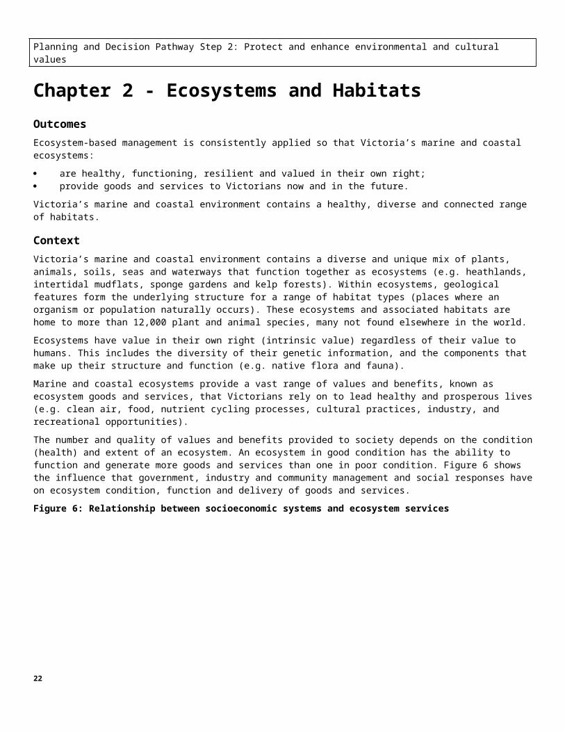
The number and quality of values and benefits provided to society depends on the condition (health) and extent of an ecosystem. An ecosystem in good condition has the ability to function and generate more goods and services than one in poor condition. Figure 6 shows the influence that government, industry and community management and social responses have on ecosystem condition, function and delivery of goods and services.
Figure 6: Relationship between socioeconomic systems and ecosystem services
19

Ecosystem-based management and biodiversity protection
“Biodiversity protection is most efficiently achieved in natural habitats, because the needs of species, and their capacity to persist, are most likely to be met in the ecosystems where they have evolved.”
(Protecting Victoria’s Environment - Biodiversity 2037)
Ecosystem health and function are critical to safeguarding the intrinsic values of ecosystems and protecting biodiversity.
The health and function of marine and coastal ecosystems and associated habitats are being threatened by human uses and developments. Population growth and urbanisation is reducing and fragmenting surviving habitats, pollution of waterways and soils is disrupting ecosystems processes, and invasive species and increasing extraction of natural resources are changing ecosystem species composition.
We can directly manage some threats and their impacts, but it is not always possible to do so. Marine and coastal ecosystems need to be resilient to prevent permanent structural change and maintain ecosystem function (e.g. through internal reorganisation to adapt to climate change). Mechanisms such as improving understanding of ecosystem functions, allowing natural processes to operate and improving the extent and condition of habitat can increase ecosystem resilience and maintain ecosystem function.
Protecting Victoria’s Environment – Biodiversity 2037 is the long-term strategy for the management of biodiversity in Victoria and identifies statewide goals and targets for biodiversity. Policies in this document complement the biodiversity strategy and assist with the protection of biodiversity when planning and decision-making in the marine and coastal environment.
A number of pieces of legislation protect and manage nationally and internationally important flora, fauna, ecological communities and protected areas (e.g. marine and coastal national parks, Ramsar sites). These include the Environmental Protection and Biodiversity Conservation Act 1999 and the Native Vegetation Removal Regulations.
Water quality is a critical issue affecting the health of marine and coastal environments across Victoria, particularly from catchment-based pollution. The Victorian Waterway Management Strategy and the State Environment Protection Policy (Waters) provide the strategic direction and policies for the management of water quality. The Marine and Coastal Policy does not affect that current management regime, rather it ensures that water quality impacts are managed during planning and decision-making under the Marine and Coastal Act 2018, e.g. in developing an Environmental Management Plan or processing a consent (Note: specific policies relating to managing water quality impacts from marine and coastal development are set out in Chapter 8 - Ecologically Sustainable Use and Development).
Policies 2.1 Use an ecosystems-based approach to manage Victoria’s marine and coastal environment in a way that sustains ecosystems to meet both their intrinsic needs and the needs of humans.
2.2 Protect and enhance the values of significant ecosystems and habitats in the marine and coastal environment.
2.3 Maintain and enhance the ability of marine and coastal ecosystems to provide the full range of goods and services identified in Appendix 2.
2.4 Maintain, and seek to increase, the overall extent and condition of native habitats across public and private land in the marine and coastal environment.
2.5 Maintain ecological corridors and promote linkages (e.g. migration pathways) across public and private land and between the marine and coastal environment.
2.6 Maintain water and soil (including sediment) quality in the marine and coastal environment where it is good and seek to enhance it where it has degraded (e.g. as a result of nutrients, plastics, litter, sediment, pathogens and chemical pollutants).
2.7 Manage the health of coastal wetlands (including lakes) and estuaries through implementation of the Victorian Waterway Management Strategy and regional waterway strategies.
2.8 Manage the introduction and spread of invasive and pest species across public and private land in the marine and coastal environment by following the principles of the Invasive Plants and Animals Policy Framework.
20

2.9 Take into account and seek to minimise current and future cumulative and synergistic effects on ecosystems and habitats in the marine and coastal environment.
Significant ecosystems and habitats
While Victoria’s entire marine and coastal environment is ecologically important, some areas contain ecosystems and habitats that are of significant value at a state or bioregional level. For example, areas that support native and migratory species at a critical stage of their life cycle (e.g. migration stopover, spawning), areas where nutrient rich waters create high species diversity, and areas that perform nutrient-cycling processes that protect the environment from harmful algal blooms.
A number of tools support the identification and management of significant ecosystems and habitats (e.g. Victoria’s Marine Knowledge Framework, Strategic Management Prospects).
Cumulative effects
'Death by a thousand cuts' is an analogy often used to describe cumulative effects. Each cut may seem inconsequential on its own but together they may be catastrophic. In the environmental context, each decision may result in an increment of change that is individually insignificant but if repeated over time may accumulate and contribute to significant environmental change.
Synergistic effects
Some threats may interact synergistically in that their combined effect is greater than the sum of their individual effects (e.g. combination of climate change and overfishing on marine species populations and ecosystem dynamics; the creation of smog from the interaction of air pollutants with sunlight and its heat).
This is different to cumulative effects in that the interplaying effects are not just additive, i.e. the nature of the final impact is different to the nature of the individual impacts.
Managing cumulative and synergistic effects
Methods and techniques for assessing both cumulative and synergistic effects are constantly developing.
Cumulative and synergistic effects may be considered at either a project level (i.e. case by case) or at a strategic assessment level (whichever is appropriate).
Managing cumulative and synergistic effects involves understanding the capacity of a resource, identifying its sustainable limits and drawing the line before effects become unacceptable. Whether any effects will bring receptors, such as wildlife habitat, close to their capacity or threshold to remain functioning or sustainable must be taken into account. There is also a need to be aware of the level of uncertainty in identifying cumulative or synergistic effects.
21
Chapter 3 - Natural Features and LandscapesOutcomeSignificant natural features and landscapes (including seascapes) in the marine and coastal environment are protected and enhanced recognising that marine and coastal processes will cause change.
ContextVictoria has some spectacular and well recognised coastal landscapes that are integral to the identity of the state and its people. They contain important ecological, cultural and social values and are also a base for tourism. This includes the rugged wilderness of Wilsons Promontory and the Croajingolong coast, the unparalleled landscape of the Ninety Mile Beach and the iconic offshore rock formations of the Twelve Apostles and Bay of Islands in the Great Ocean Road region.
There is an increasing awareness and appreciation of underwater seascapes and plants and animals that inhabit these submerged terrains. The 90-metre deep underwater canyon at the Port Phillip Heads supports a spectacular garden of sponges, encrusting algae, soft corals, ascidians and anemone, and is highly valued by the diving community.
Some of Victoria’s unique natural features provide an insight into historic landscape formation processes, and the animals and plants that once lived there, e.g. Beaumaris Cliffs, a significant fossil site.
Impacts from population growth and marine and coastal developments are key threats to landscapes, natural features and seascapes. Degradation of their values and characteristics can occur from substantial day tourist visitor numbers, and built infrastructure directly affecting the landscape itself or restricting important public views.
This Policy seeks to protect these areas from such threats. In doing so, it must be recognised that natural features and landscapes (including seascapes) were shaped by marine and coastal processes and are subject to ongoing change.
Other key relevant legislation includes the Planning and Environment Amendment (Distinctive Areas and Landscapes) Act 2018 which enables the government to declare and protect a distinctive area and landscape subject to meeting strict criteria.
Policies3.1 Protect, and seek to enhance and restore, the values and characteristics that contribute to significant landscapes (including seascapes) and features in the marine and coastal environment including by managing cumulative effects.
3.2 Maintain important public visual corridors associated with significant landscapes in the marine and coastal environment, including views from within the landscapes and views of the landscapes.
Significant natural features and landscapes (including seascapes)
A number of tools support the identification of significant natural features and landscapes/seascapes, the values and characteristics that contribute to their significance and approaches to manage them. For example:
The Coastal Spaces Landscape Study 2006 and the Great Ocean Road Region Landscape Assessment Study 2004 identify significant natural landscapes and features (e.g. headlands) in the coastal environment across the entire state (excluding metropolitan Melbourne).
Sites of Geological and Geomorphological Significance identifies significant natural features (e.g. fossil sites, unique geological sites).
The Marine Knowledge Framework identifies significant ecosystems and habitats that include significant seascapes.
22

Chapter 4 - Heritage and Cultural ValuesOutcomeCultural values and sites of heritage significance in the marine and coastal environment are protected for current and future generations.
ContextThe heritage and cultural values of the marine and coastal environment play an important role in creating a sense of place and telling Victoria’s unique stories. Connection to and use of the marine and coastal environment has strong social value and forms a core part of the cultural identity for many Victorians.
Traditional Owners' connection to Country, their languages, dreaming stories, knowledge and practices are enduring and rich living cultural values of the marine and coastal environment. Heritage places in the marine and coastal environment encompass a wide range of sites, including buildings, trees, archaeological sites, shipwrecks, piers and lighthouses.
The dynamic nature of the coast can present a challenge for preserving heritage and cultural values. Marine and coastal processes can lead to physical and chemical damage to heritage sites, some of which will be exacerbated by climate change (such as increased erosion and heightened sea levels) and inappropriate use and management can negatively impact cultural values.
The Aboriginal Heritage Act 2006 provides for the protection of Aboriginal cultural heritage in Victoria. Other heritage and cultural values in Victoria’s marine and coastal environment are primarily managed under the Heritage Act 2017, and the Commonwealth’s Underwater Cultural Heritage Act 2018. In addition to this overarching legislative framework, these policies help ensure cultural and heritage values are protected during planning and decision making in the marine and coastal environment.
Policies4.1 Identify, interpret and manage tangible and intangible heritage values to reflect and protect them.
4.2 Manage sites of historic and cultural significance for Traditional Owners in a culturally appropriate manner.
4.3 Encourage adaptive re-use of heritage places that are no longer required for their original purpose in a way that maintains their values and character and enhances their contribution to community activities, coastal tourism and sense of place.
4.4 Consider carrying capacity and the cumulative impacts of use and visitation on heritage sites and culturally significant sites.
4.5 Ensure memorials in the marine and coastal environment are relevant and non-intrusive to the surrounding environment.
23
Chapter 5 - Value of Marine and Coastal Crown Land OutcomeThe benefits of marine and coastal public land are available to current generations without compromising the ability of future generations to enjoy similar benefits.
ContextSome 96% of the 2000 kilometres of Victoria’s coastline and all its marine areas is Crown land and waters. Public land and waters are held in trust for the benefit of the Victorian community. Public ownership has ensured that Victorians enjoy free and open access to coastal and marine areas.
Crown land on the coast in Victoria is a precious and finite natural asset. Coastal Crown land reserves and foreshores are important spaces. They provide extensive environmental, social and economic values and along most of the coastline allows space for natural dynamics of the coastal processes (wind waves and sediments) to occur without causing hazards to assets and values on land and in the sea. This land will be further reduced as sea levels rise and the coastline retreats.
Marine Spatial Planning FrameworkAll of Victoria’s marine environment is Crown land for the benefit of all Victorians. This common ownership means that there are many users of the values and resources in the marine environment. In Victoria management of the marine environment has been by designating marine space for human activities such as fishing, aquaculture, shipping, boating, nature conservation and oil and gas extraction. Planning and management of these uses has been pursued on a sectorial basis. However, with increasing use and pressure on the marine environment there is a need to better integrate and coordinate planning and management efforts across marine sectors.
The draft Policy contains a Marine Spatial Planning Framework that is an agreed process to plan for Victoria’s marine environment in an integrated, coordinated, sustainable and equitable way. Marine spatial planning can have significant benefits including identifying and reducing conflicts between human uses and the impact of those uses on the natural values, greater certainty of access for new private sector investment and identifying and protecting social and cultural value linked to marine waters.
Policies 5.1 Ensure marine and coastal Crown land remains in public ownership for the benefit of all Victorians.
5.2 Maintain and monitor a comprehensive, adequate and representative system of well-managed Marine and Coastal National Parks, sanctuaries, nature conservation reserves and coastal Crown land reserves, including minimising the impact of activities on those waters and lands and managing for their legislated purposes.
5.3 Consider incorporating any increase in beach or foreshore through coastal accretion into the marine and coastal Crown land estate to ensure benefit for all Victorians.
5.4 Encourage active participation of multiple users of the marine environment, including industry, government, Traditional Owners, conservation and recreation, in marine spatial planning processes.
Questions for Planning and Decision Pathway Step 2 – Protect and enhance environmental and cultural values
8. Do you agree with the outcomes under the chapters Ecosystems and Habitats, Natural Features and Landscapes, Heritage and Cultural Values and Value of Marine and Coastal Crown Land? If not, please identify what changes should be made.
9. Do you think that the policies will achieve the outcomes (either as written or with the changes you have suggested)? If not, please identify where improvements could be made.
24

Planning and Decision Pathway Steps 3 and 4: Respect natural processes and strengthen resilience to climate change
Chapter 6 - Managing Coastal Hazard Risk Outcomes Risks from coastal hazards are understood and managed.
Climate change impacts are understood and their negative impacts on the environmental, social, and economic values of the marine and coastal environment are minimised.
Adaptation is integrated as a core component of planning in the marine and coastal environment, and is used to improve decision-making, manage uncertainty and build resilience.
ContextMarine and coastal processes are the wide range of processes (physical, chemical, and geological) that interact with each other in the marine and coastal environment over both short and long-timescales. They include the ebb and flow of tides, the changing profile of beaches, and the movement of the coastline over time. These processes are not static, they shift and evolve, creating highly dynamic and complex systems.
When marine and coastal processes have the potential to negatively affect environmental, social, cultural and economic values they pose a coastal hazard risk (e.g. flooding of coastal settlements, storms damaging coastal habitats, development disturbing coastal acid sulfate soils, and erosion). Not all coastal processes pose a coastal hazard risk, and not all coastal hazard risk is the same. Some coastal hazard risks are more detrimental to environmental values while others can pose threats to human life and the built environment.
Because of the dynamic nature of marine and coastal processes exposure to coastal hazard risk will change over time. The impacts of climate change add to that already dynamic state. Managing coastal hazard risk requires considering and managing current risks as well as possible future states and the risks they may pose. Managing coastal hazard risk will need to evolve in the face of climate change. All levels of government will need to work collaboratively with communities and industries to develop and implement management solutions that are appropriate and effective in local contexts.
The long-term health and functioning of marine and coastal communities and environments relies on building resilience and adapting to change. Adaptation needs to be a core component of any planning process in the marine and coastal environment.
The Climate Change Act 2017 provides the statewide framework for climate change management and adaptation planning including guiding principles (informed and integrated decision-making, risk management, equity, community engagement including with Traditional Owners, and compatibility). It notes that responding to climate change is a responsibility shared by all levels of government, industry, communities and the people of Victoria. Victoria’s Climate Change Adaptation Plan 2017-2020 also provides a clear outline of roles and responsibilities for adaptation.
The following policies support that wider framework, and have a particular focus on improving understanding, taking a system-wide approach, avoiding future risk, and responding to new information. They are also supported by other policies within the Marine and Coastal Policy that enable and support increasing resilience in the marine and coastal environment.
Through identifying trigger points for decision-making, minimising future exposure to risk, continually monitoring, and building in multiple pathways of action now, these policies support current and future generations to manage current and future risks.
Policies[NOTE: The Intergovernmental Panel on Climate Change will release a special report on the Ocean and Cryosphere in September 2019. This report will represent the most up-to-date and respected science on sea level rise and may result in a revision of the current 0.8m by 2100 minimum planning benchmark]
6.1 Plan for sea level rise of not less than 0.8 metres by 2100, and allow for the combined effects of tides, storm surges, flooding, coastal processes and local conditions such as topography and geology, when assessing risks and coastal impacts associated with climate change.
25

6.2 Plan for not less than 0.8m sea level rise by 2100 in new greenfield development outside of town boundaries.
6.3 In planning for sea level rise, an increase of 0.2m over current 1 in 100-year flood levels by 2040 may be used for new development in close proximity to existing development (urban infill).
6.4 Planning must consider and seek to manage the impacts and threats to the health and functioning of marine and coastal ecosystems and habitats caused by climate change (including the landward movement of habitats in response to sea level rise).
6.5 Consider the impacts of increased sea-surface temperature, ocean acidification, and changed distribution of native and invasive marine species as a result of climate change in marine spatial, sector-based, and adaptation planning.
6.6 Take a pathway approach to planning that:
a) considers the full suite of adaptation actions including: non-intervention, avoid, nature-based methods, retreat, accommodate, and protect
b) assesses costs, effectiveness, benefits, impacts, and path-dependency of those adaptation actions.
Adaptation actions:
Non-intervention: allow marine and coastal processes, and the hazards they may pose, to occur.
Avoid: locate new uses, development, and redevelopment away from areas that are or will be negatively impacted by coastal hazards.
Nature-based methods: enhance or restore natural features to mitigate or provide protection from coastal hazards caused by marine and coastal process. For example, restoring mangrove systems to lessen the impact of sea level rise and storm surge.
Retreat: remove / relocate uses, structures, or assets away from areas that are or will be negatively impacted. Retreat of natural systems may also be required, for example saltmarsh habitat that would naturally migrate landward in response to sea level rise may be obstructed by the built environment, and corridors of undeveloped land may be required to allow landward movement of species and habitats.
Accommodate: change the design of structures to lessen the impact of changed condition. For example, raising minimum floor heights of dwellings to reduce the impact of current and future coastal flooding.
Protect: construct, maintain or enhance existing physical barriers to mitigate the impact of coastal hazards caused by marine and coastal processes. For example, soft protective measures such as beach renourishment to restore foreshore following erosion events, or hard-protection such as sea wall to protect from sea-level rise and storm surge.
6.7 Marine and coastal adaptation planning should:
a) be conducted and implemented at a multi-jurisdictional level
b) take a flexible, responsive, and iterative pathways approach, supported by ongoing monitoring
c) identify trigger points at which decisions or actions need to be taken
d) cut across different land tenure types, including public and private land
e) be compatible with climate change mitigation efforts
f) enable a shared understanding of the risks, opportunities and potential changes to the marine and coastal environment
g) identify roles and responsibilities
h) ensure risks are addressed by those who are best-placed to manage them and those most impacted by decisions have an opportunity to be involved in decision-making processes.
6.8 Consider the relevant marine and coastal processes at the most appropriate coastal compartment scale in planning for, and any management of, coastal hazard risks.
26

Primary, secondary and tertiary coastal compartments are sections of coastline defined by landform and the sediment transportation processes that occur within that compartment. These compartments along the Victorian coast provide a framework for planning and managing coastal hazards.
Responsibilities 6.9 The State government will support ongoing improvements to, and sharing of, scientific understanding and guidance on marine and coastal processes and coastal hazard risk.
6.10 The State Government will support and enable adaptation planning in the marine and coastal environment.
6.11 Planning, assessing, and managing coastal hazard risk (including for coastal acid sulfate soils, coastal flooding and coastal erosion) must follow State government guidance where available.
6.12 Advice on coastal erosion provided in accordance with the Marine and Coastal Act 2018 should be informed by State guidance on best available science and decision support tools.
6.13 The State Government will prioritise coastal hazard management activities strategically, using a risk-based approach and in accordance with this Policy and tools in the Marine and Coastal Act 2018 in partnership with affected parties.
6.14 Owners of property or assets exposed to coastal hazard risk, including state government, have a responsibility to understand that risk and act responsibly in light of that risk and in accordance with this Policy.
6.15 State government and marine and coastal Crown land managers will not manage marine and coastal Crown land and/or coastal processes for the primary purpose of protecting private property.
27

Chapter 7 - Emergency Response and PreparednessOutcome Emergencies in the marine and coastal environment are effectively planned for to prevent or minimise immediate and long-term impact on human health and safety, property, the environment and local values, and to enable recovery from emergency events and reduce future risk.
ContextAn “emergency” as defined under the Emergency Management Act 2013 encompasses actual or imminent events that may endanger the health or safety of any person in Victoria, destroy, damage property or endangers or threatens to endanger the environment.
Emergencies in the marine and coastal environment are wide ranging, including coastal flooding, bushfires, marine wildlife stranding and entanglements, oil spills, water contamination and outbreaks of invasive species. Many coastal hazards will increase in severity as a result of climate change (e.g. flooding and erosion events) and the changing risk profile for emergency events needs to be taken into account and planned for.
Emergencies can cause direct negative impact on local values and emergency responses need to be carefully managed to minimise further impacts.
The Emergency Management Act 2013 provides the legislative direction and basis for emergency management in Victoria. It is supported by the State emergency management priorities, sub-plans for specific emergencies, state guidelines, and other topic-specific Acts such as managing oil spills under the Pollution of Waters by Oils and Noxious Substances Act 1986.
These policies do not affect the existing overarching emergency management framework or any existing emergency management plans. They provide considerations for future emergency response and recovery planning that supports the adaptive, evidence-based management approach of the Marine and Coastal Act 2018.
Policies 7.1 Emergency management response planning takes a least overall harm approach to detrimental marine and coastal environmental impacts resulting from the emergency and any response activities.
7.2 Recovery planning from emergencies and natural hazard events in the marine and coastal environment:
a) assesses the long-term suitability of affected uses and assets in that location
b) where viable, seeks to restore environment values lost or damaged through the emergency event and emergency response activities.
7.3 Seek, during planning, to minimise the risk of and impacts from marine and coastal emergencies.
Questions for Planning and Decision Pathway Steps 3 and 4 – Respect natural processes and strengthen resilience to climate change
10. Do you agree with the outcomes under the chapters Managing Coastal Hazard Risk and Emergency Response and Preparedness? If not, please identify what changes should be made.
11. Do you think that the policies will achieve the outcomes (either as written or with the changes you have suggested)? If not, please identify where improvements could be made.
12. What further policy guidance or clarification would assist local government, communities, and industry in managing climate change impacts and coastal hazard risk?
28

Planning and Decision Pathway Step 5: Use and develop sustainably
Chapter 8 - Ecologically Sustainable Use and Development OutcomesVictoria’s marine and coastal environment hosts a diverse range of uses and experiences that do not compromise the values of this finite area.
Use and development of the marine and coastal environment:
is ecologically sustainable is equitable occurs in appropriate locations minimises impacts on environmental values and other uses improves the total quality of life of Victorians, across current and future generations.
Context The Victorian marine and coastal environment is used by a wide range of people, groups, communities and industries. These uses include: living on the coast, going to the beach, walking, fishing, boating, swimming, diving, surfing, camping, eating local seafood, tourism, aquaculture, shipping, renewable energy and oil and gas.
These uses require a large range of buildings, infrastructure and development (e.g. houses, life-saving clubs, yacht clubs, port facilities, marinas, piers, access paths and stairs, toilet blocks, car parks, tourist developments and stormwater infrastructure).
Sustainable and appropriate use and development provides significant benefit to the Victorian community.
In making decisions around what is appropriate any adverse impacts on values, including cumulative effects, need to be weighed against the benefits of the use and development.
This is not easy, and trade-offs will need to be made. The principles (Table 1), the Planning and Decision Pathway (Figure 5) and policies in this document should be used as a guide in determining those trade-offs.
Other measures that will assist decision makers include a system of environmental economic accounting. Victoria is adopting such a system to measure the condition of the state’s environmental assets and transparently value their goods and benefits alongside more traditional accounting for economic and social goods and benefits. This reporting in a more coherent and consistent manner will support policy, planning and investment decision that affect the marine and coastal environment.
Applying these principles and policies through strategic planning for use and development allows sustainable responses to increasing demand, prioritisation of funding, adaptation to future risks and can prevent ad hoc or unsustainable activities and developments.
Developments on the coast and in marine waters are exposed to dynamic processes and are at high risk of suffering storm damage, erosion and inundation. Development in these locations can also impede natural processes (e.g. erosion and accretion cycles) and the ability of the natural environment to respond and adapt to change. For these reasons, use and development needs to have a functional dependence to be located near or in the water.
Policies
Strategic planning and management
8.1 Strategically plan and manage use and development in the marine and coastal environment in an integrated and coordinated way to ensure:
a) community and industry uses are provided for in appropriate locations
29

b) competing or conflicting uses are appropriately managed
c) coexistence of compatible activities is facilitated
d) cumulative impacts of many and varied uses and developments are taken into account and minimised.
8.2 Use buffers or overlays where required to protect environmental, heritage and cultural values and enable the co-existence of compatible activities.
8.3 Monitor the use of facilities in the marine and coastal environment to estimate and manage the carrying capacity of sites and inform adaptive management and decision-making.
Appropriate location, form and limits
8.4 Design and construct development in the context of the proposed site, its values and uses and consider alternative options that minimise the impacts on those values and uses.
8.5 Locate, design and operate uses and development to minimise exposure to public health and safety risks and not exacerbate coastal hazard risk.
8.6 Avoid development in low-lying coastal areas, and areas that are vulnerable to coastal hazard risk, also considering how that risk will change over time.
8.7 Respect marine and coastal functions and processes.
8.8 Avoid disturbing acid sulphate soils.
8.9 Minimise polluting marine and coastal waters by:
a) minimising disturbance of sediments and associated turbidity effects
b) ensuring that any drainage or discharge infrastructure (e.g. ocean outfall) is appropriately located in relation to the receiving environment and its associated uses and values.
Siting and Design for Structures on the Victorian Coast provides specific guidance and examples
30

Chapter 9 - Coastal SettlementsOutcomeGrowth of coastal settlements is ecologically, socially and economically sustainable.
Context Victoria’s diverse coastal settlements include major urban centres, iconic coastal towns with large tourism sectors, rural towns and smaller coastal hamlets. Population pressures vary. The permanent population is growing in some locations, with increasing density of development. In other areas there has been a significant increase in visitor population and the population is declining in some remote areas.
Where population growth is occurring, the increasing demand for housing and infrastructure needs to be accommodated while balancing the social and environmental values that make coastal settlements desirable places to live in and visit.
Most of Victoria has avoided sprawling linear coastal development, allowing our distinct coastal settlements to retain their highly valued character. Non-urban breaks between settlements also play an essential role in providing:
biodiversity buffers and habitat corridors for wildlife maintenance and enhancement of resilience and adaptative capacity for the natural environment recreational opportunities in the coastal environment preservation of significant landscape and aesthetic values of the coast.
A number of strategic and legislative frameworks guide the determination of coastal settlement boundaries and management of land use and growth along Victoria’s coast.
The Planning and Environment Act 1987 establishes the statutory framework for the Victorian planning system. Planning schemes provide the framework for coastal settlements and manage growth and land use. They play an important role in reinforcing clear settlement boundaries, non-urban breaks between settlements and the hierarchy and relationships between settlements. The Planning and Environment Act 1987 also provides the machinery that gives effect to state planning strategies and policies, including Plan Melbourne and Regional Growth Plans.
Other considerations for coastal settlements include distinctive areas and landscapes declared under the Planning and Environment Amendment (Distinctive Areas and Landscapes) Act 2018 and the Great Ocean Road Action Plan.
The following policies support that wider framework and enable sustainable growth in Victoria’s coastal environment.
Policies 9.1 Identify clear settlement boundaries around coastal settlements to plan for growth and protect coastal values; and direct growth to within these boundaries.
9.2 Where no settlement boundary is identified, identify the extent of the settlement by the existing urban zoned land and land identified in the planning scheme for future urban settlement.
9.3 Define and redefine settlement boundaries to:
a) minimise and seek to avoid negative impact on ecosystems and habitats, local values, and landscape features
b) not increase exposure to current or future coastal hazard risk, including risks posed by climate change.
9.4 Avoid development on ridgelines, primary coastal dune systems, shorelines of estuaries, wetlands and low-lying coastal areas.
9.5 Avoid linear urban sprawl along the coast and within rural landscapes.
9.6 Retain and protect existing non-urban breaks and uses between all coastal settlements.
9.7 Avoid development that adversely affects the values and characteristics that contribute to significant landscapes and important public views.
31

9.8 Consider and manage the impacts of hinterland growth on the marine and coastal environment, including impacts on flooding and water quality.
9.9 Use water-sensitive urban design practices to reduce environmental impacts on the beach and ocean (e.g. litter, water quality, erosion and scour).
9.10 Prohibit the development of new residential canal estates.
9.11 Prohibit creating an access point from private residential land to abutting marine and coastal Crown land.
32

Chapter 10 - Buildings, Structures and AccessOutcomes Buildings, structures and facilities on public and private land in the marine and coastal environment exhibit excellence in siting and design that is sympathetic to the coastal and marine landscape context and minimise impacts on the environment.
Buildings, structures and facilities on marine and coastal Crown land are functionally dependent on being near or in the water and provide significant public benefit.
Access to marine and coastal Crown land is developed and located to enable safe public access and protect environmental and cultural values.
Context Buildings, structures and facilities in the marine and coastal environment support the functioning of communities and industries. They include, port facilities, transport docks, jetties, boat ramps, beach and water structures, paths, toilet blocks, picnic facilities, structures to maintain public safety, oil and gas rigs, wind farms and buildings to enhance recreation opportunities e.g. clubs and cafes.
The demand for improved and new structures that help Victorians access and use the coast and marine resources will continue to increase as population grows. Increased sea levels and more frequent storms as a result of climate change will test the resilience and effectiveness of existing buildings, structures and facilities and highlight the need for durable, sustainable and adaptive design, siting and location of any new structures.
Planning schemes, made in accordance with the Planning and Environment Act 1987, provide for the appropriate use and development of public and private land including land covered by water. Planning schemes geographically cover municipal districts and any other area specified in a planning scheme.
The Building Act 1993 and associated building standards set engineering and safety requirements for all buildings, structures and facilities. This Policy provides mechanisms for strategic spatial planning for the location of buildings, structures and facilities in the marine and coastal environment. Their siting and design must also follow state guidance in Siting and Design for Structures on the Victorian Coast.
Victoria’s marine and coastal Crown land is important public space owned by all Victorians that provides access and use of the marine and coastal environment. This public estate is limited in size and may be reduced over time as sea levels rise and the coastline retreats. It is a finite resource that contains unique values and characteristics not found elsewhere.
Crown land in Victoria is managed on an equitable basis. Use and development on marine and coastal Crown land should balance the interests of individual users with the needs of the greater Victorian community.
33

Table 2: Types of structures that are functionally dependent on being located near or on the water, and types of structures that are not appropriate to be located there
Usually located on coastal Crown land because of direct support of coastal activities
Jetty Pier Marina Mooring Boat ramp Harbour Navigation aids Life saving observation tower
Not necessary to be on coastal Crown land but provide some support to the functioning of coastal activities and therefore may be appropriate
Toilet facilities Shared trails, boardwalks and stairs Car parking Equipment storage facilities Marine rescue facility Lifesaving club rooms Multi-functional facilities Public lookouts Barbecue, picnic and play equipment Kiosk/café/restaurant (in an urban setting)
Coastal Crown land location not necessary and no provision of support to coastal activity, to be removed/relocated as the opportunity arises
Non-water-based sporting facilities Non-maritime industrial plant and storage Private infrastructure (e.g. jetties, beach access paths,
bathing boxes, fishing huts) Community hall Commercial function centre Memorial plaques
Policies
Buildings and structures
10.1 Avoid the development of buildings, structures and facilities in sand dunes, low-lying areas and areas susceptible to coastal hazard risk including future coastal hazard risk.
10.2 Require buildings, structures and facilities on or in marine and coastal Crown land to have a functional need to be located near or in the water and ensure that they provide significant public benefit.
10.3 Relocate existing buildings, structures and facilities that do not need to be on marine and coastal Crown land away from that land when suitable opportunities arise.
10.4 Prohibit new private buildings or structures on marine and coastal Crown land that provide primarily private benefit (e.g. private jetties, bathing boxes, boat sheds, protective structures).
10.5 Design, locate and maintain buildings, structures and facilities to effectively manage:
a) any increase in exposure to coastal hazard risk including increased rates of sea level rise, erosion, accretion or inundation
b) any detrimental impacts (in particular increased hazard risk) on neighbouring Crown or private land
c) adverse effects on the environment and associated uses and values, including cumulative effects.
10.6 Design, locate and maintain buildings, structures and facilities to:
a) minimise impacts on native flora and fauna
b) avoid impacts on cultural and archaeological sites
c) avoid impacts on sites of geomorphological significance and fossils
34

d) accommodate and maintain the natural drainage patterns and hydrology of the area
e) use materials that respond to the geology and substrate of the site and surrounding area
f) avoid dominant structures that are not sympathetic to the local heritage or character
g) maintain, complement and enhance the surrounding landscape and coastal character of the area (the line and form of the structure should be sympathetic to the surrounding landscape and context)
h) retain important public views to and from the water or along the coast.
10.7 Require construction, extension or alteration of buildings, structures and facilities on marine and coastal Crown land to:
a) make efficient use of the site
b) facilitate multiple use and sharing of sites and infrastructure
c) provide increased public functions and adaptability
d) not impede access to marine and coastal Crown land except where access control is the main purpose
e) use materials and finishes that are sympathetic to the coastal environment and durable in the long-term
f) minimise the environmental footprint.
10.8 Maintain or reduce the existing footprint when structures and facilities on marine and coastal Crown land are replaced or modified.
10.9 Ensure use and development on marine and coastal Crown land does not unreasonably affect the amenity of other uses or restrict or prevent access for other users of marine and coastal Crown land.
10.10 Invest in new and existing structures and facilities based on a life cycle planning approach that:
a) identifies future operation and maintenance accountabilities and costs, including the effects of climate change
b) identifies and considers ongoing ability to function due to changed conditions from the impacts of climate change
c) plans decommissioning and removal or repurposing as part of the initial design and installation or alteration (unless inappropriate, e.g. the structure contains historic heritage value).
Access
10.11 Ensure new development does not impede existing access to marine and coastal Crown land.
10.12 Formalise (e.g. paths) or control public access to marine and coastal Crown land to minimise risk to public safety, protect cultural values and promote the health of the marine and coastal environment.
10.13 Prohibit off-road access to marine and coastal Crown land and beaches by private vehicles in accordance with the Land Conservation (Vehicle Control) Act 1972 and the Land Conservation (Vehicle Control) Regulations 2013.
10.14 Provide, where practical, access to marine and coastal Crown land that meets the needs of people with varied levels of ability or physical capability.
10.15 Control domestic animal access to marine and coastal Crown land to locations and times that minimise risks to public safety and amenity and protects environmental values.
35

Chapter 11 - Marine and Coastal IndustriesOutcomeMarine and coastal industries are valued for their contribution to the well-being and function of Victorian communities and the economy.
ContextCommercial fishing, aquaculture, shipping and ports, gas and petroleum extraction and renewable energy generation are current and emerging marine and coastal based industries that benefit regional and state economies and support employment. These industries rely on a location in the marine and coastal environment or depend on the use of coastal and marine resources.
The introduction of marine pests and diseases can lead to changes in or loss of habitat, changes to marine communities (e.g. consuming or competing with native species) and food-chains, and pathogens and parasites. Industries may be negatively affected by marine pests and diseases and can unintentionally contribute to their introduction and spread throughout Victoria. Marine industries can also contribute to negative water quality affects if their activities are not managed well. Marine spatial planning is a key tool for marine managers, industries and users to collaboratively manage impacts and conflicting uses, particularly where management under standalone acts is not effective.
Fishing and aquaculture
Commercial fishing and aquaculture are significant contributors to the Victorian economy and are particularly important sources of employment in regional areas along the coast.
The threats to sustainable seafood stocks are numerous and complex. On-land activities can degrade water quality and important spawning and hatching sites. Aquaculture plays a role in preventing over-fishing of wild stocks but brings its own challenges.
Climate change impacts, such as increased temperature and acidity, will alter the distribution of native and invasive species, and biosecurity risks can bring disease and pests. The impacts and opportunities that climate change presents to fishing and aquaculture industries need to be considered.
The Fisheries Act 1995 sets the overarching legislative framework for sustainably managing fisheries in Victoria and takes an ecosystem-based approach. It uses statutory mechanisms including the Fisheries Regulations 2009, management plans, monitoring and research of key fish species, compliance and education programs to achieve its purpose.
Ports and shipping
Victoria’s commercial trading and local ports make important contributions to the Victorian and Australian economy, and they are of great importance to the local and regional communities. Effective coordination of the ports system, including the Ports of Melbourne, Hastings, Geelong, Portland and the 14 local ports is required to optimise benefits to local communities and the Victorian economy.
Victoria’s commercial ports provide access for exporters and importers in more than 300 markets internationally and interstate and for passenger services, including cruise shipping and Bass Strait ferries. Victoria’s freight volume is predicted to increase from around 360 million tonnes in 2014 to nearly 900 million tonnes in 2051. Delivering the Goods – Victorian Freight Plan (DEDJTR 2018) and Plan Melbourne 2017-2050 (DELWP 2017) plan for sufficient gateway capacity through commercial ports to accommodate this growth.
By servicing a wide range of users, local ports play a vital role in local communities and support commercial fishing industry, charter boats, and recreational fishing and boating interests. They are also key recreation and tourist assets and contribute significantly to the regional economies.
Port managers need to understand the potential impacts of climate change and develop mitigation and adaptation responses.
Population growth, recreational boat ownership, tourism and the expansion of the aquaculture industry all affect the management of local ports and maintenance and development of associated infrastructure.
36

The operation and management of commercial and local ports are regulated through the: Ports Management Act 1995, Transport Integration Act 2010, Marine Safety Act 2010 and Marine Safety Regulations 2012.
Renewable energy
Victoria’s coast has potential to provide a variety of renewable energy sources including wind, wave and tidal energy. Marine energy infrastructure requires the use of marine and coastal Crown land to access resources. Renewable energy generation can help meet the demand for energy from growing Victorian populations, reduce carbon emissions into the atmosphere, contribute to meeting Victoria’s renewable energy targets, and encourage new coastal industries that contribute to local and regional development. Prototypes of wave-energy and tidal-power capture technologies have been trialled in Victoria and offshore wind proposals are being developed in Commonwealth waters. Infrastructure to connect to the grid would need to cross into Victorian waters.
Petroleum and gas
Victoria’s petroleum (oil and gas) industries are primarily in the Gippsland and Otway Basins. While much of their activity occurs in Commonwealth waters, the products are brought onshore via pipelines into Victoria for refining, storage and distribution. Acreage for exploration in Victorian waters has recently been released opening the possibility for future production if deemed viable. Offshore Petroleum & Greenhouse Gas Storage Act 2010 and the Offshore Petroleum and Greenhouse Gas Storage Regulations 2011 regulate use and occupation rights through leases, licences and permits.
The following policies do not affect existing legislation for these industries. They provide considerations for future planning and management that supports an integrated, coordinated adaptive, evidence-based management approach of the Marine and Coastal Act 2018.
Policies11.1 Use the Marine Spatial Planning Framework (Chapter 15) to guide planning, management and decision making across marine sectors in Victoria to enable ecologically sustainable marine uses and industries, and to coordinate and integrate managing risks, impacts, and change in the marine and coastal environment.
11.2 Consider how to manage and minimise risk from the introduction and spread of marine pests and diseases from use and development in the marine environment (e.g. fishing, marine industries, structures).
11.3 Minimise the negative environmental impacts of dredging and spoil disposal by following State and national best-practice guidelines.
11.4 Ensure leasing and licensing arrangements for industry infrastructure on marine and coastal Crown land maximise the public benefit derived from private use of the land and minimise speculative behaviour.
11.5 Use and development of marine and coastal Crown land for energy extraction, renewable energy generation or energy transportation must:
a) minimise and seek to avoid negative impacts on environment, social, cultural, and economic values
b) give preference to private land to locate above-ground infrastructure.
37

Chapter 12 - Recreation and Tourism OutcomeThe marine and coastal environment hosts a diverse range of recreation and tourism experiences strategically planned and located to be safe, equitable and sustainable now and in the future.
ContextRecreational use of the marine and coastal environment and its resources is highly valued by Victorians and visitors alike, with tourism a key economic driver for Victoria. It is also an important means of connecting people with the marine and coastal environment and fostering a sense of stewardship. Recreation activities provide tourist opportunities supporting tourist and commercial industries across Victoria.
People recreate on and in the marine and coastal environment in many and varied ways, from passive (beach walking) to very active (kite surfing), urban and rural, on the water (boating) in the water (swimming) and harvesting its resources (fishing).
Boating, fishing and water-based activities
In 2018, recreational boating alone was estimated to contribute $4.5 billion a year to the Victorian economy with 197,000 registered vessels and 417,000 boating licence holders. Recreational fishing is one of Victoria’s most popular pastimes with more than 800,000 recreational fishers in 2015 and around 300,000 recreational fishing licences sold each year.
The overarching legislative framework for managing fisheries in Victoria, including recreational fishing is the Fisheries Act 1995. Boating and water-based activities are primarily managed through the Marine Safety Act 2010 and Marine Safety Regulations 2012.
These recreational activities are supported by a variety of water-based clubs including angling, sailing, boating and life saving clubs, and structures and facilities such as jetties, boat ramps and toilet blocks.
In many instances, access to and within the marine environment requires dredging to provide safe navigational channels and access for shipping, commercial and recreational fishing, water-based tourism and recreational boating. If not managed well, dredging can have significant negative impacts on the marine and coastal environment through increasing sedimentation, disturbing habitats, disrupting natural coastal processes and potentially exposing acid sulfate soils. Pollution from dredging activities is regulated under the Environment Protection Act 1970.
Camping and caravan parks
Camping and caravanning on marine and coastal Crown land provide an affordable opportunity for many people to visit and access the coast and enjoy safe holiday experiences. Victorians want fair and equitable access to camping and caravan parks in coastal locations, however the demand for sites at peak holiday times is far more than the capacity of sites. Marine and coastal managers generate revenue from caravan and camping parks, and the demand for well-maintained and improved facilities continues to grow. Expenditure on these facilities needs to be balanced with other management priorities, such as environmental management, emergency management and waste water management.
As populations increase, more people will want to access, recreate and tour in the marine and coastal environment, which will lead to an increase in demand for buildings, structures and facilities to support safe, equitable and sustainable recreational and tourist activities. If not managed well, increasing visitor demand could degrade values that make the marine and coastal environment a desirable place to visit, and see conflict between different uses.
Strategic planning for recreational access for swimming, boating, fishing and tourism infrastructure allows sustainable responses to increasing demand, prioritisation of funding, and can prevent ad hoc or unsustainable activities and developments.
Policies 12.1 Promote recreation uses and activities that strengthen peoples’ connection with the marine and coastal environment.
38

12.2 Use strategic and spatial planning to locate opportunities for safe, sustainable and equitable recreation and tourism developments in the marine and coastal environment that:
a) responds to an identified and increasing demand
b) minimises impacts on environmental and cultural values
c) minimise impacts on other users
d) maintains public safety
e) respond to the carrying capacity of the site.
12.3 Locate recreational access points and supporting infrastructure in recreation nodes
12.4 Locate tourism developments within activity nodes and preferably on private land.
12.5 Tourist developments outside settlement boundaries must:
a) protect non-urban breaks between settlements and their important values
b) not compromise the broader open space characteristics of the coast
c) not become new settlements or create linear coastal development.
12.6 When designing and locating new marine-based facilities, infrastructure and access points (including boat ramps, ports, marinas):
a) consider sediment movement processes
b) minimise the need for capital and maintenance dredging
c) minimise sedimentation through catchment-based management activities (such as revegetation and erosion control).
Activity and recreation nodes
In coastal communities’ recreation and tourist development are focused around recreation and activity nodes identified in coastal and marine management plans. These create efficient relationships between buildings and structures and minimise development impacts on the coast.
Activity nodes – provide for community recreation facilities and tourism activities. They are within settlements and are adjacent to activity centres in planning schemes. They include public and private land.
Recreation nodes – are located on marine and coastal Crown land outside activity nodes. They provide access and infrastructure for recreation and water related activities. Use and development that supports access or the functioning of coastal-dependent activities may be sited in recreation nodes.
Questions for Planning and Decision Pathway step 5 – Use and Develop Sustainably
13. The concept of activity and recreational nodes has been retained from the Victorian Coastal Strategy 2014. Do you think it is still a useful tool to maintain in statewide policy?
14. Do you agree with the outcomes under the chapters Ecologically Sustainable Development, Coastal Settlements, Buildings Structures and Access, Marine and Coastal Industries, Recreation and Tourism? If not, please identify what changes should be made.
15. Do you think that the policies will achieve the outcomes (either as written or the changes you have suggested)? If not, please identify where improvements could be made.
39

Planning and Decision Pathway: Stewardship, Knowledge, Collaborate and Engage
Chapter 13 - Stewardship and Collaborative ManagementOutcomesCommunity and user groups are actively engaged and empowered to care for, protect and improve the health of the marine and coastal environment.
Communities, organisations and user groups as stewards collaborate to deliver integrated and coordinated planning and management of the marine and coastal environment.
Marine and coastal managers have the knowledge, skills and capacity to manage current and future challenges.
Improved access to and quality of knowledge and understanding of the marine and coastal environment is used to inform evidence-based decision making and evaluate the effectiveness of those decisions.
ContextThousands of Victorians make significant contributions to protecting and improving the health and values of the marine and coastal environment. They include Aboriginal Victorians, volunteers, Committees of Management, Coastcare and Landcare groups, conservation management networks, community groups, boating and fishing groups, industry groups, management agencies, and local and state governments.
Community stewardship
Victorians can act in ways that benefit the marine and coastal environment. This requires understanding and overcoming barriers that prevent action (Biodiversity 2037). To create community stewardship Victorians should:
feel connected and involved in marine and coastal management feel connected as a community be involved in marine and coastal management and decision-making.
The breadth of people, organisations, challenges and opportunities involved in marine and coastal management means that a collaborative approach is vital. No single agency can deliver an integrated response. Informal and formal collaboration arrangements will be required to deliver coordinated and integrated planning and management of the marine and coastal environment.
Managers as stewards
Victoria’s marine and coastal managers are stewards of the marine and coastal environment. Marine and coastal managers include all organisations responsible for the on ground, on water or sector-based management of the marine and coastal environment in Victoria. All marine and coastal managers are facing increased pressures from climate change, population growth, ageing infrastructure, habitat loss and fragmentation and changing community management expectations. The skills and capacity of managers to deal with these issues varies. To be effective, management arrangements need to align responsibility with capacity and expertise, have better coordination of investment, and support marine and coastal managers to be efficient and sustainable in the long term.
Knowledge
Building knowledge and understanding of the marine and coastal environment can improve how we manage it, help us identify threats, initiate responses and monitor the effectiveness of those responses (adaptive management). It will build a story that allows more accurate prediction of emergencies, plan more effective responses to these events and avoid development in high-risk areas. Information combined with knowledge will enable modelling of future climate change scenarios and setting trigger points for action. Using this knowledge will allow our management to adapt to future needs.
40

Marine and Coastal Crown land management arrangements
Ninety-six percent of Victoria’s coast and all Victorian marine waters are Crown land administered by DELWP on behalf of the Crown.
More than two-thirds of coastal Crown land and parts of the marine environment have been declared as national park, coastal park, marine national park or marine sanctuary. These areas are protected under the National Parks Act 1975 and managed by Parks Victoria.
Much of the remaining foreshore Crown land above the high water mark is reserved under the Crown Land (Reserves) Act 1978 for various public purposes and it is largely managed by Committees of Management (CoM). All 23 local governments along the coast have responsibilities as a CoM. Councils in urban areas usually manage the foreshore. Outside urban areas, foreshores tend to managed by a mix of volunteer CoMs, local government and Parks Victoria. Local ports managers are also appointed as CoMs.
Traditional Owner Land Management Boards increasingly have a more formal role in coastal management. For example, the recently established Gunaikurnai Traditional Owner Land Management Board delivers joint management of a number of coastal parks and reserves in Gunaikurnai Country.
Some small areas of Crown land above the high water mark and most marine areas within Victorian waters are technically ‘unreserved’ Crown land under the control of the Land Act 1958. These are under the administrative control of Department of Environment, Land, Water and Planning (DELWP).
In marine areas, issues and activities are usually managed as specific sectors focused on resource use, extraction activities and industries, e.g. shipping, fisheries, aquaculture, oil and gas extraction. These management entities are established under legislation other than the Marine and Coastal Act 2018 and most of these sectors have their own legislative, policy and management frameworks.
For example, commercial and recreational fishing and Fisheries reserves are managed by the Victorian Fisheries Authority (VFA) under the Fisheries Act 1995. Aquaculture fisheries reserves on land and in marine areas are administered by the VFA.
The Victorian Ports Corporation (Melbourne) manages commercial navigation of the channels in Melbourne port waters, waterside emergency and marine pollution response and the management of Station Pier as Victoria’s premier cruise shipping facility.
The Victorian Regional Channels Authority manages commercial navigation of the channels in Geelong port waters and oversees channel management for the Port of Portland and Port of Hastings.
Policies
Engage
13.1 Engagement on planning and decision making under the Marine and Coastal Act 2018:
a) recognises the wide variety of community values
b) is inclusive and provides opportunities for a broad and diverse participation
c) builds on existing programs of community engagement
d) engages and partners with Traditional Owners, the community, and industry.
13.2 Support marine and coastal community groups and networks (e.g. through Coastcare and citizen science programs) to educate and engage the community about the values of the marine and coastal environment and encourage their protection.
13.3 Ensure individuals, user groups and the community are:
a) informed and encouraged to actively participate (formally and informally) in the care, protection, management and monitoring of marine and coastal environments
b) enabled to improve their understanding and appreciation of the marine and coastal environment
c) recognised for their involvement in caring for and managing the marine and coastal environment.
41
Collaborate
13.4 Coordinate marine and coastal planning and management across government agencies and integrate scientific, environmental, social, cultural and economic knowledge.
13.5 A marine plan must be developed through a Regional and Strategic Partnership (RASP) and be consistent with the guidance in the Marine Spatial Planning Framework to establish a coordinated approach to marine and coastal planning and management.
13.6 Recognise opportunities to strengthen shared marine and coastal management outcomes through partnering with marine and coastal industries.
13.7 Strengthen collaboration in marine and coastal planning and management by partnering with a diversity of skill sets and interests.
13.8 Strengthen marine and coastal communities, networks and industries to maximise knowledge transfer and practice around catchment and marine and coastal planning and management.
13.9 Coordinate collection of information on habitats, physical processes, hazards and built assets to share an understanding of the condition of the marine and coastal environment across the state.
13.10 Coordinate and align investment in community and marine and coastal manager capacity building and volunteer programs in the marine and coastal environment.
Build capacity
13.11 Support marine and coastal managers to integrate planning and management of the marine and coastal environment through mechanisms outlined in the Marine and Coastal Act 2018 or through relevant mechanism under applicable Acts.
13.12 Support marine and coastal managers with the necessary knowledge, information, skills and resources to effectively manage current and future challenges as stewards of the marine and coastal environment.
13.13 Use evidence and decision support tools (such as the Marine Knowledge Framework and Strategic Management Prospects) to guide management practice and decision making.
13.14 Ensure plans (e.g. Regional and Strategic Partnerships) consistent with the Marine Spatial Planning Framework will be the primary tool to guide integration and coordination of use and development in the marine environment.
13.15 Align institutional arrangements for the management of marine and coastal Crown land to ensure local managers have the capacity and capability to effectively meet current and future challenges (e.g. climate change and changing community expectations).
13.16 Support decision makers to build their capacity on coastal erosion through state guidance on the best available science, adaptive evidence and decision support tools.
Knowledge
13.17 Decision making is informed by state guidance on the best available peer reviewed science.
13.18 Support technical expertise within government and complement with advice from a diverse network of independent experts, Traditional Owners and industry to:
a) build understanding and knowledge base
b) monitor existing and emerging issues
c) identify knowledge and information gaps, and current and future research needs
d) share and communicate information
e) effectively translate knowledge into decision-making.
13.19 Use citizen science programs to:
a) increase understanding and identification of coastal and marine environments and ecosystem functions
b) build community stewardship, understanding and appreciation of natural coastal and marine ecosystems.
42

43

Chapter 14 - FundingOutcomesPlanning and management of marine and coastal Crown land is strategically funded and resourced to effectively manage current and future challenges.
ContextTo achieve integrated, coordinated and ecologically sustainable protection and management of Victoria’s marine and coastal environment sustainable funding for its planning and management is vital.
In 2018 the Victorian Auditor General’s Office found that funding models for marine and coastal management have at times been uncertain, inconsistent, restricted in application, unequally distributed, and inadequate.
The process in Figure 7 can be used to build a sustainable funding model for improved marine and coastal planning and management, based around the strategic planning framework outlined in the Marine and Coastal Act 2018.
Figure 7: Framework for sustainable funding
The following policies align with this sustainable funding process.
Policies14.1 Planning to identify current and future activities and needs (Figure 7, Step 1) for management of marine and coastal Crown land should:
a) use planning tools under the Marine and Coastal Act 2018
b) identify the ‘business as usual’ actions such as day-to-day management and maintenance of marine and coastal values and assets
c) identify new actions and expenditure to meet the demands of growing populations, ageing infrastructure and building resilience to climate change. Actions identified must be consistent with this Policy
44

d) identify the level of service required and performance outcomes for management, maintenance and new actions
e) identify opportunities to share and integrate service provision between marine and coastal land managers
f) take a multi-year, long-term approach.
14.2 To better understand and align investment revenues and costs, accounting and reporting systems, for marine and coastal management should be:
a) consistent
b) fit for purpose
c) efficient
d) avoid unnecessary burden
e) administratively efficient
f) flexible between levels of government and marine and coastal managers.
Funding
14.3 Funding marine and coastal management is a shared responsibility of all levels of government, beneficiaries and users of the marine and coastal environment.
14.4 Consider funding options that can distribute costs and spending burden over time to allow for intergenerational equity.
14.5 The State and other marine and coastal Crown land managers will collaborate in developing funding options for plans developed under the Marine and Coastal Act 2018.
14.6 State investment in capital costs of marine and coastal assets (in particular coastal protective structures) located on marine and coastal Crown land will be prioritised using a transparent risk-based approach, informed by an understanding of coastal hazard information, known values and favouring works of statewide importance.
14.7 Marine and coastal managers are responsible for the costs of ongoing and/or periodic maintenance of marine and coastal assets (business as usual) to the level of service identified through the processes under Policy 14.1.
14.8 Co-investment arrangements are encouraged for asset renewal, major repair, replacement and removal, and new investments.
Co-investment arrangements
14.9 Those who share the risk and benefit from an asset (beneficiaries) are partners in co-investment.
14.10 Partner co-investment contribution should be proportionate to the benefit a partner gains from the asset and their capacity to contribute (e.g a single coastal protection structure may provide all of the following: significant public benefit, protection of infrastructure such as roads and utilities, and protection of private properties).
14.11 All beneficiaries of assets on marine and coastal Crown land should contribute (through co-investment arrangements) to the capital and ongoing maintenance costs of works.
14.12 Consider how ongoing management, maintenance, auditing costs, decommissioning and reuse costs will be met in any co-investment arrangement
14.13 Ensure fees and charges are:
a) consistent with State Cost-Recovery Guidelines
b) reflective of the value and benefit provided by the private asset and compensate for any exclusion of public access or public amenity on marine and coastal Crown land
c) set to maintain fairness and equity for the use and enjoyment of the marine and coastal environment
d) in line with similar rates in the area, so that the maximum public benefit is gained for use of a public asset.
45

Questions for how to consider Planning and Decision Pathway steps 1-5 – Stewardship, Knowledge, Collaborate and Engage
16. Do you think that the sustainable funding process (Figure 7) will assist as the basis of developing sustainable funding models for marine and coastal management? If not, please identify where changes should be made.
17. Do you agree with the outcomes under the chapters Stewardship and Collaborative Management and Sustainable Funding? If not, please identify what changes should be made.
18. Do you think that the policies will achieve the outcomes (either as written or the changes you have suggested)? If not, please identify where improvements could be made.
46

MSP Framework
Chapter 15 - A Marine Spatial Planning Framework for VictoriaBackgroundAs Crown land, the marine environment is managed to provide environmental, social, cultural and economic benefits to the people of Victoria. Space in the marine environment is already designated for activities such as fishing, maritime transportation, oil and gas development, aquaculture and conservation. While there are some exceptions, the general approach of planning and management has been through an individual sector or activity focus, with responsibility shared across government agencies and bodies.
Common uses of Victoria’s marine environment, such as fishing, boating, shipping, recreation and tourism, are changing and expanding, and new industries and uses are developing. As use of the marine area increases, so too does the potential for conflict over marine space or resources, and cumulative pressures on marine ecosystems.
With increasing use and pressures on the marine environment, there is a need to better integrate and coordinate our planning and management efforts across marine sectors. This will enable Victoria to better prepare for, and balance, current and future uses of the marine environment and to support healthy and resilient marine ecosystems.
Marine spatial planning is a process that:
brings together multiple users, in a collaborative approach, to inform decision making about sustainable use of marine resources and space;
assesses current and future human activities, informing the management and allocation of space to meet ecological, economic and social objectives. It is an iterative process that promotes adaptive management across sectors; and
requires an approach that is ecosystem-based, strategic, and participatory. It draws on a range of sources of information.
Purpose of the Marine Spatial Planning FrameworkThe Marine and Coastal Act 2018 requires the development of a statewide Marine and Coastal Policy that includes a Marine Spatial Planning Framework (MSP Framework). The MSP Framework provides overarching guidance and details the essential elements and steps to achieve integrated and coordinated planning and management of Victoria’s marine environment.
The MSP Framework has:
an aspiration for integrated and coordinated planning and management of the marine environment goals and a set of principles to guide integrated planning and management of the marine environment a description of the authority required to commence and implement marine spatial planning a process for determining when to undertake marine spatial planning the steps required to complete a marine spatial planning process and develop a marine plan.
The MSP Framework does not replace single-sector planning and management and does not make changes to existing management tools. It provides guidance and a series of steps for how to undertake a marine spatial planning process and produce a marine plan. A marine plan is a comprehensive strategic document that provides the structure and direction for marine spatial management decisions.
Authority for Marine Spatial Planning in VictoriaThe Minister responsible for the Marine and Coastal Act 2018 is designated as the lead Minister responsible for marine spatial planning in Victoria. Given the range of interests and activities associated with the marine environment, the Minister will seek approval from other potentially affected Ministers prior to authorising the commencement of a marine spatial planning process.
47

Process to develop the draft MSP Framework
Reflecting the participatory and collaborative nature of marine spatial planning, the draft MSP Framework was developed using the input of stakeholders from across marine sectors. Two stages of engagement were completed:
Stage 1 – Exploring marine spatial planning
A Marine Spatial Planning Summit was held on 31 January 2019 to provide marine stakeholders with the opportunity to build a shared understanding of marine spatial planning in the Victorian context. The Summit attracted more than 120 participants from a range of marine sectors, government and agency partners. Several ‘dialogue’ interviews were also conducted to further explore the perspectives of different marine sectors.
The information and views gathered through the Summit and dialogue interviews, as well as research into MSP frameworks and examples from other jurisdictions (both in Australia and internationally), was then used to inform development of the draft MSP Framework through a ‘co-design’ type process.
Stage 2 – Co-designing the draft MSP Framework
A diverse co-design team was convened that included individuals with understanding and experience from different marine sectors. Through a series of iterative workshops, the co-design team was given responsibility to develop key elements of the draft MSP Framework.
Using the process of co-designing the MSP Framework with marine stakeholders was intended to model and practise ways of working together that reflect how marine spatial planning should take place under the guidance of the MSP Framework. It also built and strengthened collaborative relationships between marine stakeholders.
Lifespan of the MSP FrameworkAs part of the Marine and Coastal Policy, the MSP Framework is a long-term approach intended to last for the next 10-15 years. However, marine spatial planning is a new concept for Victoria, so it will be important for the MSP Framework to be piloted and for the knowledge gained through its application to inform subsequent planning processes.
Using the MSP FrameworkThe MSP Framework consists of three parts that together provide guidance and a process to achieve integrated planning and management of Victoria’s marine environment:
Part A – guidance for planning and management of the marine environment to promote integration across sectoral activities. It includes an aspiration, goals and principles that guide:
planning and management activities and decision making by marine sectors marine spatial planning processes, outputs (marine plans) and implementation in Victoria.
Whilst the MSP Framework does not replace sectoral planning and management, Part A provides statewide guidance to promote integration across sectors.
Part B – Initiating a marine spatial planning process. It includes guidance for determining where and when marine spatial planning is required, and the steps to seek authorisation to proceed. It describes the formal mechanism under the Marine and Coastal Act 2018 to give effect to the process, and provides information on convening partners, gathering evidence, and securing financial support.
Part C – How to undertake a marine spatial planning process. When determined that a marine spatial planning process is required, it details the steps to complete the process. The steps are indicative and intended to guide practice, rather than be prescriptive.
48

Figure 8: Overview of the Marine Spatial Planning Framework
Victoria’s Marine Environment
Where the MSP Framework applies
The Marine and Coastal Act 2018 defines the ‘marine environment’ as extending from the high-water mark out to the boundary of Victoria’s state jurisdiction of three nautical miles or 5.5 km (see Figure 9 and Definitions section). It includes all bays, inlets, estuaries and the Gippsland Lakes. The marine environment also extends to a depth of 200 metres below the surface of the seabed and includes the biodiversity associated with the land and water.
While this is the formal area subject to the MSP Framework, the planning process may extend beyond Victorian coastal waters to include assessment and analysis of adjacent jurisdictions (Commonwealth waters and coastal waters of New South Wales, South Australia and Tasmania).
Another key component of marine spatial planning is the integration with land and catchment planning. To support integration and coordination across the land-sea interface, marine spatial planning should consider and complement land and catchment planning and management.
49

Figure 9: Extent of Victoria’s marine environment
Natural characteristicsAt the meeting point of the Southern and Pacific Oceans, Victoria’s marine environment covers more than 10,000 square kilometres and is home to more than 12,000 species of animals and plants, most of which are found only in the waters of South Eastern Australia.
Habitats such as open water, rocky reefs, sandy plains, underwater canyons and cliffs, kelp forests and sponge gardens, intertidal mudflats, tidal channels and sheltered bays and estuaries make up a diverse environment across the state’s waters. Parts of the marine environment, such as Westernport, Corner Inlet and the near-shore areas along the western shore of Port Phillip Bay, are internationally recognised Ramsar sites. These areas are important fish nurseries or spawning grounds and support shorebirds and other aquatic flora and fauna.
In addition to their intrinsic value, marine environments provide goods and services that provide values and benefits to the Victorian community. These values and benefits depend on ecologically healthy and resilient marine ecosystems. A system of protected areas was established in 2002 to cover representative samples of Victoria’s marine biodiversity. Victoria’s ‘no-take’ protected areas include 13 marine national parks and 11 marine sanctuaries. No extractive uses are allowed in these highly protected areas and they are managed primarily for ecosystem protection, conservation of natural features and recreation. The marine national parks and sanctuaries cover about 63,000 hectares or 5.3% of Victorian coastal waters.
50

Ecosystem based management and marine ecosystem classification
Ecosystem based management is a guiding principle in the Marine and Coastal Act 2018 and central to marine spatial planning. Marine ecosystems are complex and interlinked. They are also influenced by land and catchment based processes and activities.
Ecosystem based management requires decisions to be made about the appropriate scale at which planning and management should be organised. These decisions are not only limited to the spatial dimensions of ecosystems, but also the jurisdiction of the various management agencies and the distribution of marine activities. Within the marine environment, administrative boundaries are unlikely to correspond precisely to those of ecosystem boundaries.
For Victoria’s marine environment, existing designations to delineate ecosystem boundaries should be used to inform an integrated and coordinated approach to planning and management, and when defining the boundaries of a marine planning area. Australia’s marine environment has been classified into bioregions through the Integrated Marine and Coastal Regionalisation of Australia (IMCRA). These bioregions are relevant from an ecological perspective and are at a scale useful for regional planning. Victoria has five bioregions according to this nationally agreed scheme and these bioregions are based on physical and biological attributes.
The delineation of ecosystems in Victoria’s marine environment has been further refined into bioregional units (biounits) through the Combined Biotope Classification Scheme (CBiCS). These biounits are distinct with respect to physiographic settings and biogeography. Biounits are generally characterised by one or more dominant geomorphological features, such as an upwelling zone or large embayment. Victoria has 26 biounits and each is comprised of several habitat types.
Biounits contribute to an improved understanding of the wide variety of marine environments in Victoria and form an important input to planning and management decisions that may be made at different spatial scales. They should be considered when defining the boundaries of a marine planning area and the boundaries of a planning area should incorporate ecological and jurisdictional boundaries alongside spatial distribution of uses.
Figure 10: Biounits in Victoria’s marine environment
51

Use and activityVictoria’s marine environment provides for diverse recreational, economic and cultural activities, which use marine space and resources in varying patterns across coastal waters. These activities provide social and economic benefits to communities. Cultural sites include important Indigenous and maritime heritage sites.
Commercial activities include: shipping and ports; commercial fishing and aquaculture; marine and coastal tourism; and oil and gas extraction. Possible future industries may include marine renewable energy (wind, wave and tidal) and carbon dioxide storage and sequestration.
Infrastructure and coastal development are also associated with use of the marine environment and resources. Some infrastructure and development may be specifically related to access to the marine environment (such as piers, seawalls, boat ramps and marinas) or seawater extraction for desalination or industrial cooling. Other significant infrastructure includes pipelines and telecommunications cables.
Land and catchment-based use and activity (including urban pollution, litter and runoff, sewage and waste-water outfalls, and visitation pressures) are also important to consider due to the interconnected nature of natural systems.
52
MSP Framework - Part A
PART A - Guidance This part of the MSP Framework provides statewide guidance for achieving integrated and coordinated planning and management of the marine environment across sectors. It includes:
an aspiration for integrated and coordinated planning and management of the marine environment goals and a set of principles to guide integrated planning and management of the marine environment an indication of available statewide data and sources of information legislative and policy context guidance on integration with land-based planning and across jurisdictions.
Marine sectors should refer to this guidance when undertaking planning, management and decision making to support a holistic approach to protection and use of the marine environment. It should also be used to guide any marine spatial planning processes in Victoria, outputs (e.g. marine plans) and implementation.
AspirationPlanning and management of Victoria’s marine environment is integrated, coordinated, collaborative and evidence based. It promotes healthy, resilient and functioning ecosystems, supporting diverse and ecologically sustainable use that benefits the Victorian community, now and in the future.
This aligns with the vision of the Marine and Coastal Policy: “A healthy, dynamic and biodiverse marine and coastal environment that benefits the Victorian community now and in the future.”
GoalsTogether with the MSP Framework’s aspiration and principles, the following four goals guide Victoria in achieving integrated and coordinated planning and management of the marine environment and the process of marine spatial planning. They describe the outcomes being pursued for our marine environment and for how marine planning and management is undertaken.
Goal 1: Marine ecosystems are healthy, resilient and functional
This goal aims to protect the intrinsic value of the marine environment and the ecosystem goods and services it provides. To achieve this goal, planning and management must:
Protect and conserve biodiversity, and where appropriate recover and enhance. Support habitat and species diversity, distribution and abundance at levels capable of ensuring the long-term
provision of ecosystem goods and services. Encourage marine ecosystems’ contribution to climate change mitigation and adaptation. Identify and manage high conservation value areas.
Goal 2: Ecologically sustainable use and activity provides social, cultural and economic benefits
This goal supports use of the marine environment in a way that provides social, cultural and economic benefits, and minimises negative impacts on values. To achieve this goal, planning and management must:
Support and enhance opportunities for use and activity, including commercial, industrial, recreational and cultural uses, and scientific research.
Assess and manage compatibility and conflict between use and activities, and with the environment. Incorporate the non-use values of the marine environment, including the aesthetic quality of locations, cultural and
identity links with maritime activities and Sea Country, appropriate seascape and sense of place. Recognise and consider the social and economic contribution of current and emerging activities in the marine
environment, including recognising and considering existing rights of users. Appropriately locate and manage marine use and activity, with space and resources used within ecological limits to
minimise deleterious and cumulative impacts on ecosystem goods and services, and values associated with the marine environment.
53

Provide for Traditional Owners’ contribution to resilient regional communities and healthy resilient cultural landscapes, with opportunities to pursue economic opportunities through Sea Country practice.
Promote and support long-term strategic planning by marine sectors. Consider potential future uses in planning processes, including the possible extent, benefits and adverse impacts
on existing uses and the environment.
Goal 3: Good governance and inclusivity
This goal requires a collaborative approach and good governance in marine planning and management, that is integrated across boundaries and provides opportunities for Traditional Owner and stakeholder participation. To achieve this goal, planning and management must:
Provide Traditional Owners, marine users and the broader public with opportunities for involvement and engagement in marine planning, management and associated decision-making.
Support collaboration and cooperation within and between sectors, and between governmental agencies (including with adjacent states and the Commonwealth).
Ensure transparency in planning and management processes supports sectoral decision making and investment. Consider and complement land-use and catchment planning and management at the local and regional level,
supporting integration and coordination across the land-sea interface.
Goal 4: Proactive and adaptive planning and management, supported by evidence and information
This goal supports evidence-based and adaptive marine planning and management that is proactive and forward-thinking, and uses the best available science, information and knowledge. To achieve this goal, marine planning and management must:
Utilise the best available evidence and information (including scientific and socio-economic research, local user and Traditional Owner knowledge and practices) and identify key information and knowledge gaps and priorities actions to meet information needs.
Ensure processes and outputs are adaptive and responsive to changing circumstances and environmental processes, including new ecological challenges, climate change processes, social and economic factors.
Assess and consider the cumulative impact of use and activities (beyond individual sector or activity impacts) including climate and environmental change.
Include timely, adequate and responsive monitoring, evaluation, reporting and improvement tools. These tools support refining and adapting planning outputs (including goals, objectives and management approaches for the planning area) and the planning process itself.
Be supported by evidence and information that is transparent, accessible and maintained to enable collaborative research and analysis, ongoing learning, adaptive management and decision-making.
PrinciplesThe Marine and Coastal Act 2018 provides objectives and guiding principles for the planning and management of the marine and coastal environment (set out in full in the Introduction). These are fundamental to achieving integrated and coordinated planning and management of the marine environment.
Guiding Principles of the Marine and Coastal Act 2018
Integrated coastal zone management Ecosystem-based management Ecologically sustainable development Adaptive management
Evidence-based decision making Precautionary principle Proportionate and risk-based principle
Together with the principles in the Marine and Coastal Act 2018, the following five principles will guide integrated and coordinated planning and management of Victoria’s marine environment and the process of marine spatial planning.
Proactive, future-oriented and iterative
Planning and management should not only be responsive to present conditions and challenges but also include future scenarios and possible new uses. Marine space without any visible problems or conflicts today may be subject to future pressures or conflict between uses.
54

Forward-thinking helps to anticipate and manage conflict and address the cumulative impacts of multiple activities. Marine spatial planning can enable proactive decision-making in the short term to achieve desired long-term outcomes.
Marine spatial planning does not seek to create a one-off ‘master plan’. Rather, it is a continuous, iterative process that will adapt according to new knowledge or needs (including threats, challenges and new activities).
Inclusion, collaboration and transparency
Integration of activities and management strategies associated with the marine environment requires participation and collaboration from all level of government, marine sectors, Traditional Owners, stakeholders and the public. This extends to adjacent jurisdictions to ensure coherence across ecosystems and administrative boundaries.
Traditional Owner and stakeholder involvement is also a source of knowledge that can significantly raise the quality the process and the subsequent outputs. Information and data (including scientific and socioeconomic research, Traditional Owner knowledge and practice, and local user knowledge) should be utilised.
Decisions made through the process of marine spatial planning should be transparent, understood by stakeholders and the public, and reflect the principles within the MSP Framework.
Recognition and integration of Sea Country knowledge and practice
For Victorian Traditional Owners, the Sea Country is not separate from coastal or associated catchment values and includes all sentient and non-sentient parts of the natural world and the interactions between them.
Through self determination and two-way learning, the importance of Sea Country should be recognised and integrated into marine planning and management. This includes recognising and respecting Traditional Owners’ cultural responsibility to manage Country, the contribution of Traditional Owner knowledge to planning and management, Sea Country practice as living knowledge, and the need for a holistic approach to the management of multiple values and objectives to heal both Country and culture.
Optimal and equitable use of marine space and resources
Victoria’s marine environment and resources are a common resource, held in trust by the State for the benefit of current and future generations. Pursuing the optimal use of marine space and resources involves balancing multiple objectives, including socioeconomic benefits from use and activity, conservation outcomes, and the distribution of positive and negative outcomes that might arise from a management decision.
This principle requires that decision-making processes minimise negative economic, social or environmental impacts arising from the use and management of marine space. It also recognises the need to balance the valuable contribution of activities to society, while considering the long-term benefits or impacts on future generations. The existing rights of marine users must also be recognised and considered.
Appropriate and specific in scale, space and time
Planning and management of marine space should reflect existing and future activities, their impact on the environment, and the ecological characteristics and challenges of a given area. Consequently, responsibility for planning and management of different human activities should be at the relevant administrative level, depending on the geographical scale and impact of the activity.
Marine spatial planning operates within the three-dimensional nature of the marine environment, addressing activities on the seabed, in the water column and on the surface. This allows the same space to be used for multiple activities. Time should be considered as a fourth dimension because the compatibility of uses, management activities, issues and challenges are not static.
Question:
19. Do you support the aspiration, goals and principles for integrated planning and management of the marine environment? Why?
Statewide data and information sourcesAchieving integrated and coordinated planning and management of the marine environment requires access to relevant datasets, decision support tools and other sources of information, from local scale through to national or international
55

scale. Currently, there is no central repository in Victoria that captures and collates the diverse sources of information and tools that may be of benefit for planning and decision making. Below are two statewide resources that can help as a starting point.
VEAC Assessment of the Values of Victoria’s Marine Environment
The Assessment of the Values of Victoria’s Marine Environment - Report 2019 completed by the Victorian Environment Assessment Council (VEAC) is a significant resource to support marine planning and management that:
identifies current environmental, economic, social and cultural values of Victoria’s marine environment, including their spatial distribution where relevant
identifies current and likely future threats to these values provides independent advice on future patterns, trends and directions related to existing and emerging uses discusses processes to systematically classify data and approaches to describe social and economic values and
uses of Victoria’s marine environment provides an inventory of available knowledge and data on existing values, uses and threats and advises on any
significant gaps.
The Report provides a detailed inventory of available knowledge and data relevant to specific values or sectors and acknowledges significant gaps and challenges in access to information. Chapter 15 of the Report provides an overview of some key resources, acknowledging the need for a statewide process for data collection, management and analysis, and decision support systems to support planning and management. The atlas component of the Report is broken down by marine bioregional units (refer Figure 10), providing a useful starting point for assessment of possible issues and defining the planning area (see Part B of the MSP Framework).
Marine Knowledge Framework
The Victorian Government is leading the development of a Marine Knowledge Framework that:
provides for marine research and monitoring efforts to be integrated and directed towards sustainable management priorities driven by policy
provides ready access to data through web-based portals and queries can be used to identify knowledge gaps and reduce uncertainties unifies and standardises marine mapping and monitoring data and imagery in a central database provides reporting tools on the status of biotopes, ecosystems and areas.
The Marine Knowledge Framework builds on the existing CoastKit Resources system, which is a central repository of Victorian marine and coastal scientific projects. Scientific observations and monitoring data, information sources and supporting materials, including imagery, will continue to be collated and stored in a centralised relational database with access provided through a variety of web interfaces. This tool will be of benefit to individual sectors in marine planning and management, and the process of marine spatial planning (see Part C of the Framework).
Question:
20. Are there additional sources of information that would be valuable to refer to in the MSP Framework?
Legislative and policy contextVictoria’s marine environment is governed by a complex and diverse range of legislation derived from international, Commonwealth and State law. While sectoral activities operate within their own legislative and policy context, achieving integration and coordination requires an understanding of existing legislation and policy that governs all activities, interests and rights associated with the marine environment.
Understanding the issues and activities occurring within the marine environment, and their legislative and policy context, is a key step in the process of marine spatial planning (see Part C of the MSP Framework). The outputs of a marine spatial planning process (e.g. a marine plan) should provide for integrated and coordinated planning and management within these existing arrangements.
56

Integration with land-based planningLand and catchment processes, activities and development, can have implications for the marine environment, and vice versa. As a guiding principle of the Marine and Coastal Act 2018, Integrated Coastal Zone Management (ICZM) requires planning and management to span the land-sea interface, sectors and users, and land tenures.
Land planning and catchment management authorities must be informed and invited to participate in the marine spatial planning process and the development of any outputs, including marine plans, to support a coordinated and integrated approach to planning and management across the land-sea interface. Similarly, land planning and catchment management authorities must consider relevant marine plans when conducting terrestrial and catchment planning
Liaison between agencies responsible for onshore and offshore planning will help ensure that marine developments are supported by land-based infrastructure and plans. Marine planning and management must be consistent with the Marine and Coastal Policy, Coastal and Marine Management Plans, Environmental Management Plans and Regional Catchment Strategies and consider other relevant planning tools such as Victorian Traditional Owner Country Plans and local council strategic plans.
Interjurisdictional planningWhen completing a marine spatial planning process, planning and management in adjoining New South Wales, South Australia, Tasmania and Commonwealth waters must be considered. As the marine environment is interconnected, there is a need to consider activities and environmental processes occurring across jurisdictional boundaries. Additionally, information and knowledge held by other jurisdictions can support marine planning and management within Victoria’s jurisdiction.
Neighbouring authorities must be informed and invited to participate in a marine spatial planning process that intersects with, or affects, marine and coastal environments in adjacent states or Commonwealth waters, or where the neighbouring authority would have an interest.
Part A Questions:
21. Do you think Part A of the MSP Framework provides appropriate guidance to marine sectors to support Victoria in achieving more integrated and coordinated planning and management of the marine environment? What improvements could be made?
22. Is further guidance required about integration with land-based planning and/or across jurisdictional boundaries? If so, what is needed?
57

MSP Framework - Part B
PART B - Initiating marine spatial planningThis part of the MSP Framework provides a process to determine under what circumstances marine spatial planning is initiated.
A Regional and Strategic Partnership (RASP), which is provided for under the Marine and Coastal Act 2018, will be used to complete a marine spatial planning process under this Framework. The RASP mechanism provides flexibility in terms of the product being created (e.g. a marine plan). It enables all appropriate partners to be involved, and mandates consultation with key stakeholders and the public. Once a marine plan produced by a RASP is approved by the Minister, it must then be considered by agencies responsible for onshore and offshore planning and management.
In preparing a marine plan, the parties to the RASP must ensure that the plan is developed in accordance with the Marine and Coastal Act 2018 and any legislation that applies to the marine environment within the planning area.
The procedure for establishing a RASP is outlined in the Marine and Coastal Act 2018. The RASP will consist of several partners, including a lead, that will be responsible for coordinating and completing the marine spatial planning process and the preparation, implementation and reporting on a marine plan produced.
There are several ways in which marine spatial planning might be initiated:
the Minister responsible for the Marine and Coastal Act 2018 may direct that a RASP be established for the purposes of undertaking a marine planning process and creating a marine plan
the Victorian Marine and Coastal Council (VMaCC) or a partner agency (as defined in the Act) may request the Minister to establish a RASP for the purpose of undertaking a marine planning process and creating a marine plan.
undertaking a marine spatial planning process may be an action in the Marine and Coastal Strategy or be deemed necessary following the findings of a State of the Marine and Coastal Environment Report.
Initiating a marine spatial planning process involves three steps:
1. Identify the problem and determine whether marine spatial planning would be an effective tool to solve the problem. Gather the minimum evidence to describe the problem (note, only minimal evidence is needed at this point; more can be collected and utilised during the actual marine spatial planning process)
2. Gain the support of partners to conduct a marine spatial planning process
3. Seek authority to proceed with the process.
Steps 1 and 2 do not need to be completed in sequential order, in fact it may be beneficial to work on those concurrently and use the outputs of those steps to help gain authority at Step 3.
Step 1: Identify need, define the planning area and gather supporting evidence
1.1 Identify need
The first step in initiating a marine spatial planning process is to clearly identify why it is needed. Completing a marine spatial planning process may be beneficial if there are, or it is expected there will be, incompatible uses of the marine environment or uses that may have a negative impact (including cumulative impacts) on values. It may also be beneficial where there is an opportunity to develop a new industry or use of the marine environment.
Anticipating and addressing potential conflicts and opportunities through marine spatial planning can help avoid problems in the future and provide certainty and clarity for users of the marine environment, industry and the community. Plan ahead as far as possible, based on the available information.
Clearly defining the problems to be addressed or the opportunities to be harnessed will help to keep the process focused. It will also help when defining the vision, goals and objectives for the planning area and completing other steps in the marine planning process, which are described in Part C of this Framework.
58

Guidance for determining when an MSP process is needed
Consider the following questions to help determine whether a marine spatial planning process is needed.
Are there multiple stakeholders with interest in the area? Is there a clearly identifiable issue or opportunity? For example:
o marine environmental values are being degradedo a new/emerging use or activity is proposed and there is a need to decide on an appropriate location to
enable sustainable and long-term developmento there is an existing or anticipated threat to environmental, economic, social or cultural sustainabilityo conflict is occurring, or is likely to occur, between existing and/or emerging human activities/useso uses of the marine environment are altering in response to the impacts of climate change, for example
shifting species distribution or increasing storm and erosion eventso improved integration and coordination could help to address a problem/s that affects multiple sectors.
Is the focus on an area or site of recognised significance?
If the answer is ‘yes’ to any of these questions, a marine spatial planning process completed at an appropriate geographical scale will be beneficial.
1.2 Define the planning area
For the purposes of gaining authorisation to begin a marine spatial planning process, the proposed planning area must be defined and described at a high-level. The step ‘Defining the planning area’ in Part C of the MSP Framework provides further guidance on how to complete this process.
1.3 Gather supporting evidence
High-level evidence that may support the request to initiate a marine spatial planning process using the RASP mechanism could include:
Traditional Owners’ knowledge of the marine environment latest scientific data and supporting independent advice, e.g. a State of Marine and Coastal Environment report,
Assessment of the Values of Victoria’s Marine Environment (VEAC, 2019), habitat mapping and water quality data communities’ desire for access to the marine environment and values associated with the marine environment management arrangements currently in place economic data on the value of relevant industries and uses predicted growth of existing and emerging industries and uses analysis of population and demographic change statistics on demand on resources and trends over time the interactions between various marine activities.
In line with the precautionary principle of the Marine and Coastal Act 2018, a lack of information should not be a barrier to initiating a marine spatial planning process.
Step 2: Convene partners and obtain financial support
2.1 Convene partners
A RASP established under the Marine and Coastal Act 2018 will be used to complete a marine spatial planning process under this Framework. In forming a RASP, one of the partners must be specified as the lead partner.
Partners that should be involved in a marine spatial planning process are government and non-government bodies that:
have an interest in or connection with the marine and coastal environment relevant to the particular issue/s that needs to be addressed
have planning and management responsibility for the marine and coastal environment or associated uses.
When considering potential partners identify organisations or groups that are likely to:
have an interest in the outcome of the planning process have existing rights to use the marine environment benefit from the process
59

be able to provide resources (not all partners will be able to contribute funding resources but this should not disqualify them from being a partner organisation)
have a role or responsibility for implementing the outputs of the process.
Consider all relevant and impacted users, such as community, industry, existing rights holders, research institutes, non-government organisations, Ministers of applicable Acts (as defined in the Marine and Coastal Act 2018), and local, state and federal government departments and agencies.
Some of these organisations will have the capacity and interest in becoming partners in the RASP; others will be more appropriately engaged during the marine spatial planning process (see Part C of the MSP Framework). Using an engagement framework such as the International Association for Public Participation (IAP2) Public Participation Spectrum will help determine which engagement methods are appropriate to various stakeholders.
Traditional Owners and rights holders, as the recognised custodians of the land and Sea Country, must be invited to be part of the process. Participation in a marine spatial planning process could be through being a party to a RASP or through other mechanisms. The method of participation should be determined by the Traditional Owner group itself. Refer to Aboriginal Victoria for guidance material on the most appropriate engagement methods and for information about relevant local traditional owner groups.
2.2 Obtain financial support
To seek approval to begin a marine spatial planning process, the partners forming the RASP need to demonstrate to the Minister responsible for the Marine and Coastal Act 2018 how the planning process, and implementation of any resulting marine plan, will be financed. The task of securing financial support for marine spatial planning should be done in alignment with the sustainable funding principles outlined in the Marine and Coastal Policy.
Detailed funding information should be developed when completing the actual marine spatial planning process (see project planning). However, it is important to consider how the process of marine spatial planning and the implementation of any resulting marine plan will be financed prior to commencing the process. It is helpful to have multiple sources of revenue to support marine spatial planning activities, rather than relying on one source, as the availability of funds can change over time. Activities within the marine environment are inter-connected, so financing should come from a range of sources.
Step 3: Seek authorisation to commence a marine spatial planning processApproval from the Minister responsible for the Marine and Coastal Act 2018 is required to authorise a marine spatial planning process under this Framework. Given the range of interests and activities in the marine environment, the Minister will seek approval from other potentially affected ministers prior to authorising the commencement of a planning process.
When seeking authorisation, a clear indication of the need for a marine spatial planning process to be undertaken in the proposed location should be provided including a brief outline of:
the problem being addressed and how marine spatial planning will help solve it partners who have agreed to complete the marine spatial planning process together the extent and scale of the planning area known interests and key stakeholders (including those with existing planning and management responsibilities) uses of the marine environment values, threats and risks a high-level project plan, including resources and a timeline how implementation of the outputs of the process (e.g. a marine plan) will be funded.
More detail should be developed when undertaking the marine spatial planning process.
Authority to implement the outputs of a marine spatial planning process
The partner organisations that comprise the RASP will be the most effective bodies to implement the outputs of the marine spatial planning process (e.g. a marine plan). Implementation may be through existing sectoral legislation, planning and management mechanisms. Involving non-partner organisations in implementation may also be beneficial.
These organisations would need to be engaged in the marine spatial planning process early on to ensure there is the capacity and commitment to implement the actions they are responsible for. Examples from other countries indicate that implementation of the outputs of a marine spatial planning process is most effective when the authorities responsible for a
60

different marine sectors, concerns or activities maintain their current management responsibilities and are required to make decisions consistent with the outputs of the process and any resulting marine plan.
A marine plan created by a RASP can be approved for implementation under the Marine and Coastal Act 2018. A RASP submitting a marine plan will need to demonstrate the plan is supported by those ministers with responsibility for an applicable Act (as defined in the Marine and Coastal Act 2018).
Part B Question:
23. Is the pathway for initiating a marine spatial planning process detailed in Part B of the MSP Framework clear? If not, what changes are required? Could it be simplified?
61

MSP Framework - Part C
PART C – The marine spatial planning processOnce approval has been given to form a RASP for the purposes of completing a marine spatial planning process, the following steps should be used to guide the process. The steps outlined are indicative and provide guidance, rather than a strict sequence with prescriptive requirements. The Marine and Coastal Act 2018 also outlines specific requirements that need to be met when undertaking a RASP process. These must be addressed as part of the marine spatial planning process.
Figure 11 shows a suggested order of steps, recognising various levels of feedback loops where aspects of planning may need to be revisited, as new information or circumstances are revealed through the process. Throughout, the planning process is guided by the aspiration, goals and principles from Part A of the Framework, and must be supported by stakeholder engagement and participation, the best available evidence and information, and decision support tools. Marine spatial planning is an iterative process, with monitoring and evaluation to support the adaption and refinement of marine plans (developed as an output of the process) over time.
Figure 11: The marine spatial planning process
Planning and organising
Organising the planning process
This step involves completing initial planning for how to undertake the marine spatial planning process, including: setting timeframes and defining the required resources; creating a project team with appropriate skills and expertise; outlining project governance arrangements (including roles and decision making responsibilities); defining the project scope; and outlining a process to ensure collaboration across all partner agencies and organisations.
62
Defining the planning area
This step involves defining the boundaries of the marine planning area. These boundaries will guide the entire marine spatial planning process. The planning area is the specific area to which a marine plan and its identified actions will apply.
When defining the boundaries of the marine planning area it is important to incorporate ecological and jurisdictional boundaries alongside the spatial distribution of use and activity. Victoria’s marine environment has already been divided into marine bioregions and biounits (refer Figure 11) and these should be used to assist in setting the boundaries of the planning area.
The boundaries of the planning area are unlikely to coincide with the boundaries of a single ecosystem, as multiple ecosystems of varying sizes may exist within, or extend beyond, the designated planning area. Additionally, these boundaries will likely differ from the geographic spread of human activity (such as fishing or siting of marine infrastructure) and will not align neatly with natural processes that are external to the designated marine planning area (such as sediment processes or larval dispersion).
It is important to consider processes, resources, uses and threats that occur outside the planning area but have influence on the marine environment or use/activities within the planning area. For instance, while a marine plan can only apply to the marine environment in Victoria, assessment of activity and processes on land and in adjacent states or Commonwealth waters will be important for developing the plan.
Identifying stakeholders and planning engagement
This step involves identifying all agencies and stakeholders with an interest in, or relevant to, the marine planning area, and determining when and how to engage them in the process. Involving stakeholders in marine spatial planning is critical. Some initial assessment will have already taken place when completing Part B of the MSP Framework to initiate the marine spatial planning process. Using a framework such as IAP2 Public Participation Spectrum can help identify who the stakeholders are and how to engage with them. Public consultation should be consistent with the Victoria Auditor General’s Office’s Public Participation in Government Decision-Making: A Better Practice Guide.
The Marine and Coastal Act 2018 requires that in preparing a product (in this case a marine plan), a RASP must consult with:
the Victorian Marine and Coastal Council any of the following persons or bodies whose interests may be affected by the marine plan—
o the responsible Minister of an applicable Acto a municipal council (if the municipal council is not one of the parties)o a specified Aboriginal party with responsibility for areas in and adjacent to the planning area (if not
already RASP partners)o a public authority.
Additional groups to engage with include:
those who will be affected by marine spatial planning decisions those with an existing role in planning and management of activities in the planning area individuals and sectors dependent on the space and resources within the planning area those with claims, obligations or usage rights over areas or resources within the planning area those who conduct activities that impact on areas or resources within the planning area those who have a special interest in the management of the area (such as environmental NGOs and cultural
advocacy groups).
This analysis will include planning for opportunities to engage stakeholders throughout the marine spatial planning process, including identification of key stakeholders who may need to be more deeply involved in the capture and analysis of information, and decision making. The varying capacities of different groups to be involved needs to be recognised. This is not only related to the time and resources available to individuals or groups, but also considers the mode and method of collaborative activities.
The involvement of all stakeholders also enhances opportunities to integrate existing policy and management and explore compatibility or conflicts of activities or planning objectives. Diversity of input and involvement also allows for multiple forms of knowledge to be included in decision making.
63

Setting a vision, goals and objectives
Visioning
This step involves developing a vision for the planning area, that is consistent with the aspiration, goals and principles of this Framework but also specific to the characteristics and needs of the planning area. In setting a vision for the planning area and deciding about a desired spatial future, alternative futures and scenario planning at different horizons (e.g. 20 and 50 years) should be explored. The completion of other steps in the marine spatial planning process can generate information that supports the development and refinement of a vision for the planning area.
Specifying goals and objectives
Specifying goals and objectives for the planning area enable efforts and management approaches to be focused on achieving results. These goals and objectives must be consistent with the vision and outcomes of the Marine and Coastal Policy, should complement the aspiration and goals for integrated and coordinated planning and management of the marine environment set out in Part A of the MSP Framework, whilst also being specific to the needs, challenges and drivers identified for the planning area.
For consistent interpretation when undertaking marine spatial planning in Victoria, this Framework distinguishes a ‘goal’ from an ‘objective’. Specifically, a goal is a high-level statement of the outcomes being pursued through marine spatial planning, while an objective is a more focused outcome that can be achieved over a specified timeframe.
The following hypothetical examples provide a guide for developing goals for a planning area:
Accommodate [proposed new marine industry] within the planning area Protect endangered ecological communities Promote and enhance existing uses
The objectives for the planning area should cover a range of economic, social and environmental issues, reflecting the priorities for activity, use and conservation that are most important for the planning area. Characteristics of good objectives are that they are ‘SMART’: specific, measurable, achievable, relevant and time-bound.
The following hypothetical examples provide a guide for developing objectives for a planning area:
Ensure that a minimum of [percentage] of marine space is available for [industry] by [year] Extend [seagrass coverage] to [acres] within the planning area by [year] Reduce [marine plastic pollution] within planning area by [percentage] by [year].
Assessment and analysis
Defining and analysing current and future characteristics
This step involves gathering, collating and analysing all available information relevant to the planning area. Information relating to processes, resources, uses and threats that occur outside the planning area, but have influence on the planning area, should be considered.
An initial evidence-gathering exercise will have been undertaken when outlining the need for marine spatial planning in Part B of the MSP Framework. That information should be used as a starting point for investigation and analysis to be completed during this step. However, more detailed assessment and analysis of the planning area may be required and should be guided by the goals and objectives set for the planning area.
At a high level, the information required includes:
A description and representation of the key environmental features of the area, including mapping of key ecological values and sites of significance.
A description and representation of the extent and distribution of human activities in the marine area with associated socioeconomic data. This should include an overview and assessment of existing permitted use (e.g. licences), sectoral growth and development plans over the plan period.
An analysis of possible future uses of the marine area, including extent and distribution and possible interactions with other uses and ecosystems, and cost-benefit analysis, where appropriate.
Assessment and mapping of threats, trends and projections of certain environmental indicators in response to human activities (direct or cumulative) and climate change.
64

The distribution of environmental assets and maritime activities, including identification of ‘hotspots’ or sites of significant priority for a user (such as a recreation activity, important habitat or siting of a commercial activity).
Description of existing management activities and policies guiding decision making within the planning area, including spatial designations utilised by sectoral activities. This will include capturing the locations of existing ‘fixed’ designations such as marine protected areas, shipping lanes, aquaculture reserves and exclusion zones around infrastructure (such as offshore platforms, pipelines and cables).
Existing and potential areas of spatial conflict (between different human uses, and between human uses and the environment, including cumulative impacts of multiple uses) and opportunity/compatibility.
A description of relevant land-sea and cross-border issues including socioeconomic data of adjacent areas.
The information and analysis completed in this step forms the basis for considering alternative scenarios, including modelling for the outcome of possible management approaches. The completion of this step can also support the development and refinement of the vision for the planning area.
Databases, atlas and decision support tools
Many steps in the marine spatial planning process involve drawing on datasets, decision support tools and other sources of information across local to national scales. Existing sources of information and decision support tools can assist in various aspects of the marine planning process, e.g. in the analysis of issues, considering alternative scenarios, and evaluating management approaches. However, more detailed studies may be required specific to the planning area.
Marine spatial planning also requires data and information sharing across government departments, marine sectors and the community. A collaborative approach to assessing this information can better identify gaps in information, and any additional data gathering activities that may be required. Part A of this Framework describes two statewide resources that can help as a starting point for this step in the marine spatial planning process.
Question:
24. The co-design process used to develop the draft MSP Framework identified the benefit of collecting and collating existing data in a central repository that can be drawn upon in undertaking marine spatial planning. Do you agree a central repository of data is needed? If yes, what might it look like?
Data portals used in marine spatial planning share three basic characteristics. They are: marine-focused, map-based and accessible to the public. This enables planners, managers and stakeholders to access common sets of sector-specific, place-based information that help to visualise and analyse spatial relationships (e.g. overlap) and potential interactions (e.g. synergies or conflicts) among various uses and the marine environment. This data accessibility enhances the transparency of the planning process, a contributing factor for its overall success.
Assessing conflict, compatibility and environmental impacts
Victoria’s marine waters are active places. Common uses, such as fishing, boating, shipping, recreation and tourism, are changing and expanding alongside the development of emerging industries. This increasingly busy marine space heightens the potential for conflict between different uses and activities, and between uses and natural values. Marine spatial planning provides a systematic process for assessing where activities may be compatible or incompatible, and where activities (either individually or cumulatively) conflict with the objectives of the marine planning area.
Identifying conflict and compatibility of use and activity
A systematic approach to assessing compatibility between different marine uses and activities should be taken. An overlap of activities in an area does not necessarily represent a conflict, and issues may not always be straightforward. Additionally, there are timing aspects to incorporate when assessing conflict and compatibility. For instance, an activity might be short term (e.g. offshore seismic surveys could be timed to avoid or limit impact on important ecological processes, such as spawning, or peak fishing seasons). Other temporal factors might include seasonal considerations, such as the migration patterns or calving period of whales (managed in western Victoria through seasonal exclusions around important ‘nursery’ areas). Additionally, anticipating possible future conflicts and challenges is a key feature of marine spatial planning.
While this Framework does not prescribe a specific tool or matrix be employed in this analysis, it recognises that tools used should:
65

capture and represent overlap, compatibility and conflict between various activities and values within the planning area
be based on sound scientific evidence, alongside other forms of knowledge and information be user-friendly, with a considered and consistent system for assessment provide both spatial and temporal context indicate where interactions may require careful management include all appropriate sectors, activities and values act as an engagement and communication tool for stakeholder and community consultation inform and reflect the scope of data collection within the planning process include a cost-benefit analysis where appropriate.
Managing conflicts and dispute resolution
While the process of marine spatial planning can further the pursuit of win-win outcomes, there are inherent trade-offs. Decisions around any compromise should clearly reflect the goals and objectives set for the planning area, which should align with the aspiration, goals and principles for integrated planning and management of the marine environment (outlined in Part A of the MSP Framework). Transparency in this regard will help in communicating such compromises with stakeholders and the community.
It should be recognised that it may not possible or feasible to alter an existing use or activity in the marine planning area. In effect, some spatial allocations are ‘fixed’. For instance, it is not anticipated that a marine spatial planning process would seek to relocate existing infrastructure such as offshore platforms, pipelines or cables. Other ‘fixed’ spatial designations may include fisheries reserves, shipping channels, marine protected areas and safety exclusion zones.
The earlier step of ‘organising the planning process’ included defining a governance structure to guide completion of the marine spatial planning process. It is important that responsibilities for decision making are agreed and documented, including an avenue for escalation where the planning team has not been able to agree on a conflict or decision point.
Assessing environmental impacts
Cumulative and synergistic consequences of different human activities may be overlooked in marine planning and management, if the focus is only on a single sector and its impacts. The process of marine spatial planning enables a more integrated and coordinated approach to planning and management across sectors and can assist in assessing cumulative and synergistic consequences of different activities.
Since most human activities interact with one another, managing each activity in isolation is insufficient to conserve marine ecosystems or even to meet individual sector goals and objectives. While some activities have direct effects on ecosystem components, others may have more indirect consequences. This makes detection and assessment of interactions more complex than simple cause-effect mechanisms and is compounded by processes at other scales, including climate change.
Together, natural variability and human influence can decrease the ability of marine ecosystems to deliver ecosystem goods and services, impacting on the range of values and benefits the marine environment provides to marine users and sectors. While cumulative and synergistic impacts of natural variability and human influence on marine ecosystems can be complex and difficult to assess, ecosystem-based management requires that these interactions be examined and incorporated into marine planning and decision making (refer Chapter 2 - Ecosystems and Habitats).
Management approaches and marine plan development
Selecting management approaches
Decisions about management approaches required to achieve the goals and objectives for the planning area will be informed through completion of the process of marine spatial planning. Management approaches influence human activity within the planning area and are not limited to spatial or temporal measures. Examples of different types of management approaches are shown in Table 3.
It is possible that new arrangements may not be required to implement the goals and objectives for the planning area and that management can be best achieved through existing sectoral management approaches. Examples from other countries indicate that implementation of management approaches is most effective when the existing authorities responsible for a single sector, concern or activity maintain their current management responsibilities and are required to make decisions consistent with a marine plan for an area.
66

67
Table 3: Examples of management approaches
Spatial/temporal approaches
Approaches that specify the spatial / temporal distribution of human activities, for example:
specification of areas closed to specific activities seasonal closure of an area to a specific activity (e.g. rock lobster closed season, boating exclusion during
whale calving) designation/zoning of areas for specific uses (e.g. aquaculture reserve, shipwreck protected zone) designation of precautionary or safety areas (e.g. shipping lanes, anchorages, exclusion zones around offshore
rigs) designation of marine protected areas zoning of areas by objective (e.g. development areas, conservation areas, multiple-use areas).
Input approaches
Approaches that specify the inputs to human activities in an area, for example:
limitations on fishing activity and capacity (e.g. licences and transferrable fishing quotas) petroleum exploration permits and licences limits on number of vessels in an area
Process approaches
Approaches that specify the nature of the production process of human activities, for example:
specification of fishing gear type State Environment Protection Policy (Waters) measures on practice and standards industry best practice and regulations (e.g. National Dredging Guidelines) improvement of charts, navigation aids and other information services within the area
Output approaches
Approaches that specify the outputs of human activities in an area, for example:
limitations on allowable catch/by-catch ballast water discharge measures limitations of the amount of pollutants discharged to a marine area
A marine spatial planning process, with the participation of key sectors and stakeholders, should identify appropriate management approaches to address the goals and objectives for the planning area. In completing this step, informal management approaches, such as voluntary sector commitments to undertake a specific action, as well as formal approaches such as incentives or concessions, should be considered. Communication and information tools to convey the intent and application of management approaches, should also be considered in this step.
As the marine spatial planning process examines multiple human activities, this typically involves multiple management agencies. Defining the institutional arrangements for management in the marine planning area is therefore a key requirement. This includes designation of the agencies and actors responsible for implementing the management approaches and outlining how these agencies and actions are integrated.
Criteria to be used in evaluating alternative management approaches should be agreed through the marine planning process and with the partners involved. At a minimum, this should consider:
the implications for other interests and for the marine planning area objectives as a whole the risk of negative consequences of the management approach and capacity to manage legislative or regulatory process required to implement and enforce the management approach cost of the management approach and the feasibility of securing financing timescale to implement the management approach and for expecting results acceptability of the management approach to stakeholders and community likelihood of success of the approach in meeting plan objectives compatibility with other management approaches and existing sectoral management.
68
In selecting and evaluating management approaches, other processes of assessment may be beneficial to consider in addition to the points above. Examples of such processes are cost-benefit analysis and strategic environmental assessment.
Cost-benefit analysis provides a mechanism to evaluate the positive outcomes of a proposed tool or action, alongside the possible costs (including economic, social and negative environmental outcomes). Strategic environmental assessment is a systematic process for evaluating the environmental consequences of proposed policy, plan or program initiatives.
Employing a strategic approach to evaluating the relative merits of different actions, and mechanisms to rank alternatives is useful when completing a marine spatial planning process. If used, the outcomes of such approaches should be transparent and communicated through the public consultation on a draft marine plan.
Developing a marine plan
This section describes the required content and format of a marine plan. While there may be aspects unique to a marine planning area, the following outlines minimum requirements and a consistent format for marine plans that will promote integration across boundaries and provide consistency for stakeholders and the public.
A marine plan is a comprehensive strategic document that provides the structure and direction for marine spatial management decisions. It should identify when, where, and how the goals and objectives for the planning area will be met and must include the following elements:
introduction overview of the process to develop plan, including stakeholder engagement a description of the planning area, including biophysical features and administrative context the vision, goals and objectives for the planning area a description of the current and expected future uses of the planning area, including social and economic data and
mapping of distribution and extent of activity the key issues arising out of the assessment and analysis completed for the planning area the management approaches that will be used to address the key issues and achieve the goals and objectives for
the planning area, including assigning responsibility to the agencies or sectors responsible for implementation a zoning plan, where it has been decided one is required a plan and timeline for implementing the management approaches a monitoring evaluation reporting and improvement (MERI) strategy for the plan (further guidance on MERI is
provided in the implementation section) funding requirements and a provisional financial plan.
Marine plans must be written in an accessible format and include appropriate graphics and maps for clear communication to a diverse audience. In producing a plan, consideration should be given to accompanying communication and visualisation tools (e.g. an online portal, interactive mapping platform) to make information easily accessible for users and the wider community, and to information management tools for storing and updating information associated with the plan.
Public consultation on a draft marine plan
In accordance with the requirements of the Marine and Coastal Act 2018 relating to RASPs, a draft marine plan must be released for public comment. While the community and key stakeholders will have had opportunity to participate in the development of the plan, this phase of broader consultation will help further refine the plan. Public consultation should be consistent with the Victoria Auditor General’s Office’s Public Participation in Government Decision-Making: A Better Practice Guide 2017.
Implementation
Approval and implementation
Approval of a marine plan resides with the Minister responsible for the Marine and Coastal Act 2018 in consultation with responsible ministers of other applicable Acts (as defined in the Marine and Coastal Act 2018). The RASP mechanism gives effect to the commitment from the various partners and responsible agencies to ensure implementation of the marine plan. Part 6 of the Marine and Coastal Act 2018 outlines the formal process for approval and implementation of products prepared by a RASP.
The RASP mechanism provides the tool to formalise the plan, however the implementation of management approaches identified in the plan will depend on the various approaches selected. This may include those that are enforced through
69

other legislation (beyond the Marine and Coastal Act 2018) governing use and activity associated with the marine environment. The marine plan should identify agencies or partners responsible for implementing specific actions.
Where appropriate, the marine plan should also provide instruction on how existing planning and management (such as within a sector, or land-based planning) should reference the plan and action any commitments or requirements. Information and communications strategies to increase community awareness and understanding of the marine plan should follow best practice methods.
Additionally, the marine plan should designate the agent responsible for implementing each of the management approaches of the marine plan, including:
communicating the outputs of the marine plan across government and to stakeholders, including clarity around the requirements of the plan and sources for information on specific details (e.g. spatial coordinates)
informing government departments and agencies with responsibilities to implement and enforce compliance with approaches identified in the plan
working with marine sectors to facilitate private investment in development opportunities identified in the plan educating users to comply with the management approaches and any accompanying guidelines or best practice
information coordinating implementation, reporting and review of the plan compliance and enforcement actions in relation to specific management approaches.
To increase the success of compliance and enforcement, it is important that the marine plan is clear, indicating what needs to be done, by whom and by when. This should be accompanied by a detailed timeline distinguishing between short-term, and long-term actions and amendments.
Monitoring, Evaluation, Reporting and Improvement (MERI)
Marine spatial planning is a continuous, adaptive process that includes performance monitoring and evaluation as essential elements of the overall process. Monitoring and evaluation should be considered from the beginning of the marine spatial planning process to ensure that implementation of management approaches, and progress towards achieving defined goals and objectives for the planning area, can be assessed.
This section provides guidance on the MERI requirements of the marine spatial planning process and any resulting marine plan, including assigning responsibility and required components for:
monitoring that assesses the state of the system, e.g. “What is the status of current conditions in the marine planning area?” This includes environmental conditions but also monitoring of use and activity and progress in resolving conflict between uses.
monitoring that measures the performance of management approaches, e.g. “Are the management approaches we have taken producing the outcomes we desire, and supporting progress in achieving the vision, goals and objectives for the planning area?”
The MERI strategy for a marine plan should outline performance indicators that correlate to the goals and objectives defined for the planning area (refer to Table 4).
Table 4: Characteristics of good performance indicators
Readily measurable On the time scales needed to support marine spatial planning, using existing instruments, monitoring programs and available analytical tools
Cost-effective Monitoring resources are usually limited; how can effective monitoring be accomplished at least cost?
Concrete Indicators that are directly observable and measurable are desirable because they are more readily interpretable and accepted by diverse stakeholder groups
Interpretable Indicators should reflect properties of concern to stakeholders; their meaning should be understood by as wide a range of stakeholders as possible
Grounded in theory Indicators should be based on well-accepted scientific theory
Sensitive Indicators should be sensitive to changes in the properties being monitored, e.g. able to detect trends in the properties or impacts
Responsive Indicators should be able to measure the effects of management approaches to provide rapid
70

and reliable feedback on their performance and consequences
Specific Indicators should respond to the properties they are intended to measure rather than to other factors, i.e. it should be possible to distinguish the effects of other factors from the observed response
Refining and adapting
This section provides guidance on refining and adapting the marine plan. An adaptive approach involves:
exploring alternative ways to meet the goals and objectives for the planning area predicting the outcomes of alternatives based on the current state of knowledge monitoring the impact and effectiveness of management approaches using the results to update knowledge and adjust management approaches as required.
In addition to responding to issues and changes as they arise through adaptive management, implementation of the marine plan should include a formal process for regular review and refinement over specified time periods. The results of monitoring and evaluation can and should be used to modify the components of the marine plan, including goals, objectives and management approaches.
The implementation section of the marine plan should outline appropriate instructions regarding timeframes or thresholds for formal review of the plan, as well as guidance for assigning responsibility for this process. Following the principle of adaptability, once a marine plan has been approved, consideration may be given at any stage to making amendments to the plan. This may be considered necessary if, for example:
monitoring and evaluating the plan brings to light any shortfall in the plan’s performance environmental conditions undergo an unexpected change opportunities for development unexpectedly diminish or arise.
Marine plans should be reviewed regularly to allow for new knowledge and data about the marine areas and to take account of changing priorities for the protection and use of marine resources. Governance arrangements established during the marine planning process should include formal mechanisms for planning partners to monitor and refine the implementation of management measures, including appropriate engagement and communication with stakeholders to maintain transparency in decision making.
Part C Questions:
25. Is the process for undertaking marine spatial planning detailed in Part C of the MSP Framework clear? If not, what changes are required?
26. Could the process for undertaking marine spatial planning be simplified? Are any steps missing?
General Questions:
27. Does the MSP Framework provide guidance and a clear process for achieving integrated and coordinated planning and management of the marine environment? If not, what changes, improvements or additions could be made?
28. Is the MSP Framework easy to follow? If not, what could be improved?
29. What do you see are the opportunities and/or challenges relating to implementation of the MSP Framework? How could the opportunities be harnessed and/ or challenges addressed?
30. Do you think it would be beneficial for a statewide marine plan (that identifies values, stakeholders and priority locations for potential regional and local marine plans) to be developed as a first step towards implementing marine spatial planning in Victoria?
31. Currently, the MSP Framework is a chapter within the Marine and Coastal Policy. From a usability and practical perspective, is this appropriate or would it benefit from being presented in an alternative format (e.g. as an appendix or stand-alone companion to the Policy)?
71

Appendix 1Marine and Coastal hierarchyTable 5: Marine and Coastal Act 2018 planning hierarchy and application of each document
Marine and Coastal Act 2018 Planning Hierarchy
Purpose Who makes the plan
Applies to
State Marine and Coastal Policy (including the Marine Spatial Planning Framework)
Long-term policy guidance
Minister/ Whole of Government
Marine and Coastal Environment (including all public and private land)
Marine and Coastal Strategy – with implementation plan
Actions to achieve policy – reviewed every 5 years
Minister/ Whole of Government
State of the Marine and Coastal Environment Report
Track the health and condition of marine and coastal environment over time – prepared every 5 years
Minister/ Commissioner Environmental Sustainability
Regional Regional and Strategic Partnerships Product
Mechanism to respond to an identified regional issue affecting the marine and coastal environment.
Partners
Regional Catchment Strategies (CALP Act)
Strengthened consideration of catchment impacts on marine and coastal environment
Catchment Management Authorities
Environmental Management Plans
Actions to improve water quality, protect beneficial uses and address threats
Minister Marine Environment
Local Coastal and Marine Management Plans
Translate marine and coastal policy and strategy to on-ground action.
Marine and coastal manager/s
Marine and Coastal Crown Land
Site Consent provisions for use and development on marine and coastal Crown land. – enable regulations to - specify exemptions, strengthen enforcement, and apply penalties, charges and bonds.
Give the Minister the opportunity as land owner to assess proposals against policy and strategy and ensure public values are protected.
Minister
Advice on coastal erosion Provide technical advice on any matters relating to or affecting coastal erosion.
Coastal Catchment Management Authorities and Melbourne Water
Marine and coastal environment
72

The broader land use planning system is important for the implementation of the Marine and Coastal Policy, Marine and Coastal Strategy, Regional and Strategic Partnership products and Coastal and Marine Management Plans. The relationship between these policies and plans is outlined in the diagram below:
Figure 12: Relationship between the Marine and Coastal Act 2018 planning hierarchy and broader land use planning system
73
Appendix 2Marine and coastal ecosystem goods and services
Ecosystem goods and services
Description Example
Provisioning services – material products obtained from ecosystems that benefit humans
1. Food All legally available flora and fauna extracted from coastal/marine environments for consumption by humans
Wild capture and farmed fish and shellfish, seaweed
2. Water Water extracted from the marine/coastal environment for human, industrial or shipping use
Seawater desalination for drinking water supply, cooling water for industrial processes, land-based aquaculture, ballast water for shipping
3. Raw materials Extraction of any renewable material from coastal/marine environments
Sand, salt, seaweed for fertiliser, oil and gas
4. Genetic resources
Provision/extraction of genetic material from marine/coastal flora and fauna for use in non-medicinal contexts
Use of marine flora/fauna-derived genetic material to improve agricultural crop resistance to saline conditions
5. Medicinal resources
Any material extracted from or used in the marine/coastal environment for its ability to provide medicinal benefits
Medicine plants and pharmaceutical products
6. Ornamental resources
Any material extracted for use in decoration, fashion, handicrafts, souvenirs etc
Shells, mother of pearl
Regulating services – the regulation of natural processes by ecosystems that benefit humans
7. Air purification Influence of a marine/coastal ecosystem on air quality
Wetlands, trees and soil filter air pollutants (e.g. carbon monoxide, nitrogen oxides, particulate matter)
8. Climate regulation
Contribution of a marine/coastal ecosystem to the maintenance of a favourable climate
Blue carbon ecosystems (saltmarsh, mangroves and seagrasses) capture and store carbon from the atmosphere
9. Disturbance prevention or moderation
Contribution of marine/coastal ecosystem structures and functions to preventing coastal erosion and dampening the impacts of coastal hazards and sea level rise
Natural features/habitats (e.g. coastal cliffs, wetlands, mangroves, kelp forests) absorb or reduce energy and/or provide a physical barrier
Vegetated land cover intercepts and absorbs water retaining it and slowing its movement
Coastal vegetation maintains dunes and other natural shoreline structures
10. Regulation of water flows
Contribution of marine/coastal ecosystems to the maintenance of localised hydrological processes and coastal current structures
Transportation of sediments by river and coastal currents
The effect of kelp forests on localised current intensity
Coastal currents maintaining deep channels used for shipping
74

11. Waste treatment and assimilation
Removal of contaminant and organic nutrient inputs to marine/coastal environments from humans
Nutrient-cycling processes (which prevent harmful algal blooms),
Breakdown of chemical pollutants by microorganisms,
Filtering of water by riparian vegetation and wetlands
12. Biological control
Contribution of marine/coastal ecosystems to the maintenance of population dynamics, resilience through food web dynamics, disease and pest control
Support of reef ecosystems by herbivorous fish that keep algae populations in check
The role that top predators play in limiting population numbers of opportunistic species like jellyfish
13. Gene pool protection
Contribution of marine/coastal habitats to the maintenance of viable gene pools through natural selection/evolutionary processes
Genetic diversity that enhances adaptability of species to environmental changes, contributing to ecosystem resilience and maintenance of ecosystem function
Cultural services – the contribution of ecosystems to non-material human benefits
14. Leisure, recreation and tourism
Provision of opportunities for tourism, recreation and leisure that depend on a particular state of marine/coastal ecosystems
Bird/whale watching, beachcombing, sailing, recreational fishing, diving, swimming
15. Aesthetic experience
Contribution of a marine/coastal ecosystem to the existence of a landscape or seascape that generates a noticeable emotional response within the observer
Visual and other experiential values provided by a landscape/seascape’s uniqueness
Wild and scenic values
Presence of key species or habitats of interest
16. Inspiration for culture, art and design
Contribution of a marine/coastal ecosystem to the existence of environmental features that inspire elements of culture, art and/or design
Coastal/marine scenes or features portrayed in artwork or jewellery
Architecturally designed buildings and bridges based on a marine inspired theme
Films/animations based on marine ecosystems
17. Cultural heritage Contribution of a marine/coastal ecosystem to the maintenance of cultural heritage and identity, and providing a ‘sense of place’
Custodianship, cultural knowledge and practices based around marine and coastal ecosystems
18. Spiritual experience
Contribution of a marine/coastal ecosystem to formal and informal collective religious experiences
Indigenous and other religious beliefs centred on Gods or ancestral linkages connected to the sea, sky, earth, forests and forces of nature
19. Information for cognitive development
Contribution of a marine ecosystem to education, research, and individual and collective cognitive development
Environmental education of adults/children/communities
The contribution of a marine/coastal ecosystem to research and development or scientific understanding
Supporting services – ecosystem functions that support and enable the maintenance and delivery of final services
20. Migratory and resident species’ habitat
Contribution of a particular marine/coastal habitat to migratory and resident species’ populations through the provision of critical habitat for feeding, or
Natural habitats and nutrient rich waters important for supporting commercial and recreational fisheries
75

reproduction and juvenile maturation
DefinitionsBuffers – Adequate separation distances between potentially conflicting or incompatible values and/or uses e.g. between environmental/cultural values and development impacts, between different recreational users, and industry and recreational users.
Coastal acid sulfate soils – These soils are found in low-lying coastal areas and the marine environment, and contain high concentrations of iron sulfates. Relatively harmless in their undisturbed (submerged) state, these soils produce and release large quantities of sulfuric acid when exposed to oxygen through excavation, dredging or drainage, detrimentally affecting coastal and marine environments.
Cumulative effects – the impact on the environment resulting from the effects of one or more impacts, and the interactions between those impacts, added to other past, present, and reasonably foreseeable future pressures.
Reasonably foreseeable future pressures include future permitted activities (i.e. activities allowed without the need for consent), granted but not yet implemented consents, and environmental change (e.g. climate change impacts).
Ecosystem – All living things in a given area, as well as their interactions with each other, and with their non-living environments (e.g. weather, earth, sun, soil, climate, atmosphere).
Habitat - The place or type of site where an organism or population naturally occurs.
Invasive species – A species occurring, as a result of human activities, beyond its accepted normal distribution that threatens valued environmental, agricultural or other social resources by the damage it causes.
Iterative Pathway approach – a conceptual planning approach of a series of interlinked pathways where the course can change at agreed trigger or decision points within the context of a range of future scenarios.
Least overall harm – the scenario that has the least negative environmental impact.
Marine and coastal Crown land – Is defined in the Marine and Coastal Act 2018 as all Crown land and waters between the outer limit of Victorian coastal waters and 200 metres inland of the high-water mark of the sea, including:
a) Crown land (whether or not covered by water) to a depth of 200 metres below the surface of that land
b) any water covering the land referred to in paragraph (a) from time to time.
In addition, marine and coastal Crown land includes Crown land that extends more than 200 metres inland of the high-water mark of the sea where it has been reserved under the Crown Land (Reserves) Act 1978 for the purposes of the protection of the coastline.
For this purpose, it includes land (whether or not covered by water) and any water covering that land to a depth of 200 metres below the surface of that land.
Marine and coastal environment – Is defined in the Marine and Coastal Act 2018 as the following between the outer limit of Victorian coastal waters and 5 kilometres inland of the high-water mark of the sea –
a) the land (whether or not covered by water) to a depth of 200 metres below the surface of that land
b) any water covering the land referred to in paragraph (a) from time to time
c) the biodiversity associated with the land and water referred to in paragraphs (a) and (b).
Marine and coastal processes – The physical, chemical and biological processes that occur in the marine and coastal environment over both long and short timescales. For example, the natural accretion and erosion of beaches, nutrient cycling and soil formation processes, the structure and functioning of ecological communities.
Marine environment – Is defined in the Marine and Coastal Act 2018 as the following between the outer limit of Victorian coastal waters and the high-water mark of the sea –
a) the land (whether or not covered by water) to a depth of 200 metres below the surface of that land
b) any water covering the land referred to in paragraph (a) from time to time
76

c) the biodiversity associated with the land and water referred to in paragraphs (a) and (b).
Natural features and landscapes – specific natural components within a landscape (features) or large subsets of the environment (landscapes) which involve the physical character of the area, the perception of that character (e.g. memorable, wild and scenic) and the associations with that area (including cultural, spiritual, historic and heritage associations).
Path dependency – where decisions, events or outcomes at one point in time constrain adaptation, mitigation or other actions or options at a later point in time.
Significant public benefit – is demonstrated by the following criteria:
‘public benefit’ should be defined as relevant to each individual case based on an understanding of public values of the site in question
there must be a need for the identified value to be protected in order to provide significant public benefit protection of private property should not be the only purpose of a structure on marine and coastal Crown land.
Benefit should be in the least access and amenity to the broader local community it is not enough to show that there is no public detriment as a result of a proposal. ‘Significant’ public benefit must
be demonstrated (e.g. protection of environmental and cultural features of the coast).
Synergistic effects – synergism occurs when the total effect of an interaction between two or more processes is greater than the sum of the effects of each individual process.
77