phil nichols bill chambers b. dann t. smith...bill chambers phil nichols b. dann 103 natural...
TRANSCRIPT

AFFECTEDENVIRONMENT
T. S
mith
Bill
Cha
mbe
rsPh
il N
icho
ls
B. D
ann

103
NATURAL RESOURCES
SETTING
Big Bend National Park comprises 801,000 acres in southern Brewster County in southwestern Texas in the northernmost portion of the Chihuahuan Desert. The Chihuahuan is the largest of North America’s four deserts. The name Big Bend is applied to the area that is bordered on three sides by the Rio Grande. The park is only a part of this area. The elevation ranges from about 1,700 feet at the point where the Rio Grande leaves the park to 7,825 feet on top of Emory Peak. Big Bend National Park is known for its scenic beauty, which ranges from stark seemingly barren wastelands to majestic forested mountains to gigantic canyons. Visitors also come to observe the flora and fauna, much of which is typical of the Chihuahuan Desert. Although water resources dot the landscape and flash floods occur after heavy rains, the Rio Grande provides the park’s most prominent source of water (http://www.nps.gov/bibe/ riogrand.htm 8/20/01). The Rio Grande defines the park’s southern boundary for 118 miles. A 196-mile portion of the Rio Grande, designated as part of the Wild and Scenic River system, is administered by the park. Only 69 miles of the Wild and Scenic River are within the park boundary. The remaining 127 miles are downstream of the park. Big Bend National Park is a UNESCO-designated Man and the Biosphere (MAB) Reserve representing the Chihuahuan Desert.
SOILS
The following discussion describes the soils in the areas that would be affected by imple-menting actions proposed in the alternatives of this general management plan. All of the infor-mation regarding soil resources came from the Soil Survey of Big Bend National Park, Part of Brewster County, Texas (U.S. Soil Conservation Service 1985).
The soils in Big Bend National Park occur in an orderly pattern that is related to the geology, landforms, relief, climate, and natural vegetation of the area. These soils are delineated on soil survey maps and depicted as soil map units. For each soil map unit the soil survey provides specific information regarding a wide variety of uses and management issues. Topsoil in the park is virtually nonexistent. Instead, subsoils, containing higher concentra-tions of calcium carbonate and sodium, are exposed. This is an important factor in efforts to revegetate disturbed areas, especially in the extremely arid conditions at the park. In the following descriptions of limitations of soils at specific locations in the park, only those limitations that apply to actions in one or more alternatives are discussed. For example, because no campground is considered in any alternative for Panther Junction, no soil limitations for campgrounds are described for Panther Junction. However, because buildings are proposed for Panther Junction in one or more alternatives, limitations for building foundations are described. Chisos Basin According to the soil survey, one soil map unit occurs within the developed area: LMF Liv-Mainstay-Rock Outcrop Complex, steep. The Liv-Mainstay-Rock Outcrop Complex, steep, covers all of the developed area except the route of the road to the Basin; it consists of shallow and deep, very cobbly, and very gravelly soils with areas of exposed rock outcrop on igneous hills and mountains. Slopes are steep, generally ranging from 20% to 45%, although they can range from 8% to vertical rock walls. Elevation of this soil ranges from 5,000 to about 6,200 feet. Stones and large boulders that have fallen from igneous rock ledges are scattered across the surface of these areas. The soils are well drained. Surface runoff is rapid. Water

AFFECTED ENVIRONMENT
104
erosion is a severe hazard because of steep slopes. Slopes, stones, and depth to bedrock make excavating for foundations, septic systems, and underground utilities difficult. Panther Junction At this area near the base of the Chisos Moun-tains, soils are CMD-Chilicotal-Monterosa association, rolling. They consist of deep, shallow and very shallow, very gravelly and cobbly soils on rolling uplands. They are on ballenas, or rounded ridges, partial ballenas, and piedmont slopes of 3% to 8% . The landscape is incised with frequent drainage ways that have side slopes of mostly 8% to 20%. The soil surface has a desert pavement of igneous gravel. Chilicotal soils make up about 60% of the map unit, and occur on concave side slopes of drain-ageways and the concave and more sloping parts of ridges. Monterosa soils, located on convex ridgetops, make up about 20% of the unit. The remaining 20% of the soil map unit is Pantera and Tornillo soils in drainage ways; reddish colored shales and clays along side slopes of larger drainageways; sandstone outcrops along drains; and igneous rock dikes and outcrops. Chilocotal soils are well drained. Surface runoff is medium. Wind and water erosion are only slight hazards because of gravel on the surface. Limitations for excavating for foundations are moderate because of slope; for septic systems slight. No data is provided for limitations for underground utilities. Monterosa soils are well drained. Surface runoff is medium. Because of the gravel and cobbles on the surface, wind and water erosion are only slight hazards. The cemented pan of the Monte-rosa soils presents some problems in excavating for foundations, septic systems, and under-ground utilities. The short, steep slopes present problems in leveling areas for building sites.
Rio Grande Village There are two soil map units that might be affected at Rio Grande Village: GHA-Glendale-Harkey and TOA-Tornillo loam, occasionally flooded. Glendale-Harkey soils are deep, well drained, and located on the floodplain of the Rio Grande, along the southern border of the park. Slopes range from 0% to 2%. Heavy rains on the Rio Conchos in Mexico and other watersheds cause the Rio Grande, to overflow its banks and flood areas with these soils with 1 to 10 feet of water. Flooding occurs about once every three to five years. Inundation usually lasts from 2 to 20 days. Thin layers of fresh alluvium are deposited during each flood. The mapped areas are long and narrow. The ranger station and campground are located in this soil type. Both Glendale and Harkey soils are well drained with slow to medium surface runoff and moderate wind erosion hazard. Occasional flooding is the major limitation for campsites and picnic areas. The soils are highly erodible if used for paths and trails. The major limitation for building sites is the hazard of flooding, which is difficult to overcome. Tornillo loam, occasionally flooded, consists of a deep, nearly level and gently sloping soil on broad alluvial flats on valley floors. Slopes range from 0% to 3%. Tornillo soil is well drained. Surface runoff is slow to medium. This soil receives runoff from areas higher on the landscape, and during high intensity rainstorms it is flooded by sheet water as much as several inches deep. This brief flash flooding occurs about once every three to eight years. The surface of the soil crusts and seals over so that most of the rainfall runs off and water enters the soil very slowly. This soil is very erosive and has narrow, deep arroyos in many areas. Wind erosion is a moderate hazard, and water erosion is a severe hazard. The possibility of flash flooding precludes the use of these areas for building sites. Dirt roads that cross arroyos are difficult to maintain.

Natural Resources
105
Flooding makes limitations for camping areas severe and slight for picnic areas, paths, and trails. Limitations for shallow excavations are slight. Limitations for dwellings and small buildings are severe because of flooding. The picnic area, visitor center, gas station, maintenance area, employee housing, and sewage lagoons at Rio Grande Village are in this soil type. Since the 1985 soils survey, several dams have been constructed on the Rio Conchos in Mexico. Because the Rio Conchos is the source of most of the water in the Rio Grande at Big Bend National Park, these dams make the danger of flooding at Rio Grande Village and Cottonwood Campground much smaller than it was at the time of preparation of the soil survey. Castolon The soil map unit is CHD-Chamberino very gravelly loam. Most areas are between the Chisos Mountains and the Rio Grande on fan piedmonts, or broad alluvial fans that have many shallow drainageways from 3 to 10 feet deep and 10 to 60 feet wide. Slopes are dominantly 1% to-4% and several hundred feet long. Short slopes along drainageways are as much as 8%. The Chamberino soil is well drained. Surface runoff is medium. Wind and water erosion are only slight hazards because of the cobbles and gravel on the surface. The existing employee housing and historic district are in this soil type. Limitations for shallow excavations and dwellings without basements are moderate because of slope. Cottonwood Campground The soil map unit at Cottonwood Campground is GHA-Glendale-Harkey (floodplain). For a discussion of this soil type, including flood hazard, see “Soils, Rio Grande Village” above.
North Rosillos/Harte Ranch This area, added to the park since 1985, was not mapped as part of the park soil survey. It is, however, being mapped by the 2002 soil mapping project. Persimmon Gap The visitor contact station at Persimmon gap is in the PAA —Pajarito-Agustin map unit, gently sloping, and the trailer is in the UNC —Upton-Nickel map unit. The Pajarito-Agustin association consists of deep, well-drained soils on uplands. No depend-able water sources are available. Pajarito soils make up 40% of this soil map unit, Agustin 40%, and other types 20%. Pajarito and Agustin soils are well drained. Surface runoff is very slow in Pajarito and slow in Agustin. Water erosion is moderate in Pajarito and slight in Agustin. Wind erosion is a moderate hazard in both types. These soils have few or no limitations for building sites. Seepage can be a problem for septic systems in some areas. The Upton-Nickel map unit, undulating, con-sists of deep, shallow, and very shallow, gravelly and very gravelly soils on broad dissected piedmont slopes. Slopes are mostly 1%-6%. Upton and similar soils make up about 80% of the map unit, Nickel about 15%, and other types about 5%. Upton soils are on gently sloping piedmont ridges. Nickel soils are along the gently sloping to strongly sloping drainageways. Both soils are well drained, and surface runoff is medium. For both Upton and Nickel, wind and water erosion are only slight hazards because of gravel on the surface. The major limitations for building sites are the small stones and the cemented caliche layer at a shallow depth in the Upton soils, which makes excavating for foundations, septic systems, and underground utilities difficult.

AFFECTED ENVIRONMENT
106
Maverick and Potential Site for New Entrance Station Soil here is in the VBD–Vieja-Badland, rolling map unit. These soils are very shallow and shallow, very gravelly clayey soils and badland in areas where geologic materials are exposed. They are on uplands and in valleys. Slopes are mostly 2%-15% but are as much as 35%. Vieja soils make up about 65% of this map unit, Badland about 15%, and other types about 20%. Vieja soils are well drained. Surface runoff is rapid. Wind and water erosion are moderate hazards. Badland soils consist of barren, eroding geologic exposures. Surface runoff is very rapid, and little or no water enters the soil. Wind erosion is a slight hazard. Water erosion is a severe hazard. Badland soils produce much sediment. Limitations for small commercial buildings are severe for Vieja soils because of slope and severe for Badland soils because of slope and depth to rock. Limitations for dwellings without base-ments are moderate for Vieja soils because of slope and depth to rock and severe for Badland soils because of slope and depth to rock. Limitations for septic tank absorption fields are severe for both soil types because of depth to rock. In Badland soils limitations are also severe because of slope.
VEGETATION
Chisos Basin The Chisos Basin is an intermountain basin with woodland-grassland vegetation. Many endemic and unusual species of trees, such as the drooping juniper, grow here. Vegetation on Liv-Mainstay-Rock Outcrop Complex soils includes pinyon pine, gray oak, Graves oak, Emory oak, Chisos red oak, drooping juniper, oneseed juniper, alligator juniper, Texas madrone, green agave, sotol, lechuguilla, prickly pear, skeleton-leaf goldeneye, whitethorn acacia, sideoats grama, cane bluestem, buffalograss, green sprangletop, dropseeds, and tridens.
On Hurd soils, the vegetation includes Mexican pinyon pine, redberry juniper, Gambel oak, catclaw, foothill basketgrass, Mexican sagewort, wolftail, deer muhly, bracken fern, little bluestem, hairy grama, and cane bluestem. There are a few of the scarce Texas madrone trees. Trees and other mixed prairie-type vegetation make this one of the most beautiful and scenic units in the park. Panther Junction Vegetation in the Panther Junction area is brush grassland. Sotol and ceniza are the major brush species. Chino grama is the dominant grass. Other vegetation is lechuguilla, ocotillo, white-thorn acacia, mariola, prickly pear, ephedra, skeletonleaf goldeneye, guayacan, red grama, and sideoats grama. Rio Grande Village At Rio Grande Village on Glendale-Harkey soils vegetation includes saltcedar, mesquite, cotton-wood, willow, tree tobacco, whitebrush, spiny aster, Bermudagrass, and common and giant reed. The vegetation is dense in most areas. At Rio Grande Village, Tornillo soils cover broad, gently sloping areas that are mostly bare except for creosotebush. Some of the low, nearly level areas, where water stands after rains, support pockets of grass. Vegetation includes creosotebush, mesquite, lechuguilla, mariola, fourwing saltbrush, and tasajillo. The brush is scattered and much of the surface is bare. Grasses are scattered tobosa, burrograss, fluff-grass, threeawns, and sixweeks grama. There are small coppice dunes around the bases of the brushy plants. Castolon On Chamberino-Chilocotal-Upton soils at Castolon, much of the surface is bare. Creosote-bush, generally small and stunted, is the domi-nant vegetation. Clumps of dog cacti and patches of lechuguilla are scattered across the surface. This soil supports a sparse stand of

Natural Resources
107
vegetation. The woody vegetation includes lechuguilla, dog cacti, creosote bush, leather-stem, prickly pear, and range ratany. Grasses are chino grama, threeawns, fluffgrass, and slim tridens. The lack of available seed sources, the dominance of creosotebush, and high ground temperatures during the summer make reestablishment of grasses difficult. Cottonwood Campground For a description of vegetation in this area, see “Vegetation at Rio Grande Village on Glendale-Harkey Soils” above. North Rosillos/Harte Ranch The following description comes from the “Draft Wilderness Suitability Assessment, Appendix E. Three vegetation communities dominate the area — desert shrublands, remnant grasslands, and degraded former-grasslands. Much of the area consists of shallow, rocky soils that support native Chihuahuan Desert shrublands dominated by creosote bush (Larrea tridentata), with varying amounts of interspersed grama (Bouteloua spp.) grass. Small patches of intact Tornillo loam flatlands support native grasslands dominated by tobosa (Hilaria mutica), Chloris, and bluestem (Bouteloua spp.) grasses. Over large areas, the organic horizon of Tornillo loam soil has been lost to erosion and vegetation is sparse or absent. In gully systems and associated man-made diversions and water catchment structures, exotic Johnsongrass (Sorghum halapense) is prevalent. Well-developed native riparian plant communities can be found at several natural springs in the North Rosillos area, most notably at the Buttrill Spring complex. These riparian islands are important for maintaining landscape-level biodiversity in the area.
Persimmon Gap The Pajarito-Agustin association, gently sloping soil type (visitor contact station) is dominated by shrub vegetation, mostly creosotebush. Other vegetation is lechuguilla, tasajillo, prickly pear, dog cacti, and mariola and some scattered chino grama and threeawns. The dominant plant on the Upton-Nickel soil association (trailer) is creosote bush. The sparse vegetation also includes lechuguilla, mariola, ceniza, candelilla, dog cacti, prickly pear, and ephedra, as well as grasses such as chino grama, threeawn, fluffgrass, slim tridens, and sixweeks grama. Maverick and Potential Site for New Entrance Station The Vieja soils have sparse vegetation of stunted creosotebush, fluffgrass, dog cacti, and sixweek grama. Various fast-growing, short-lived annuals appear after rainstorms in some areas. Badland soils are mostly barren of vegetation.
WILDLIFE
The following describes wildlife at areas that may be impacted by actions of alternatives in this general management plan. Chisos Basin Areas with Liv-Mainstay-Rock Outcrop Com-plex soils are used by the endemic Carmen Mountains whitetail deer for food and shelter. Javelina make limited use of areas along drainages. Mountain lions use some areas for hunting and dens. Fox, ringtails, and rock squirrels den in the area. Raptors use the high mountains for food, cover, lookout points, and nesting. Peregrine falcons sometimes nest on the high rocky cliffs. Perching (passerine) birds, including the black-capped vireo, use portions of the Chisos Basin for food, cover, and nesting. On Hurd soils, mule deer range at lower eleva-tions and Carmen Mountains whitetail deer at

AFFECTED ENVIRONMENT
108
higher ones. There is a good variety and quantity of forage for deer. Mountain lions hunt here, and many perching birds nest and feed in the area. A few springs in the Chisos Basin provide water for wildlife. On the Hurd soil type there are no springs. Panther Junction Mule deer and javelina use the Panther Junction area as home ranges. The lechuguilla and other shrubs provide a good variety and quantity of food. Coyote and fox use the area for hunting and dens. Rodents, snakes, and lizards also den here. Perching birds use the area for food, cover, and nesting. Springs in at various places throughout the Panther Junction area provide water for wildlife. Rio Grande Village On the Glendale-Harkey soils map unit, the Rio Grande, which forms one boundary of the Rio Grande Village, provides ample water for wildlife. A few mule deer and javelina use the areas of these soils at Rio Grande Village for food and shelter. Mexican beaver burrow in the riverbank and feed on willows and other trees. Coyotes hunt and make dens. Rodents, snakes, and lizards den here. Many perching birds use the soils map unit for food, shelter, and nesting. Where there are Tornillo soils, there are no springs or other permanent water sources, causing the area to have limited use by most wildlife. Mule deer and javelina occasionally cross areas of Tornillo soils, but do not use them for home ranges. Rodents, snakes, and lizards use the area for dens. A few perching birds use the area for food and nesting. Castolon Use by wildlife is limited. A few mule deer and javelina feed on lechuguilla and woody shrubs, but do not make these areas their normal home
range. Rodents, snakes, and lizards use these desert areas for food and shelter, and a few passerine birds use this area for food, shelter, and nesting sites. There are no springs or other permanent water sources for wildlife. Cottonwood Campground For a description of wildlife in this area, see “Wildlife, Rio Grande Village on Glendale-Harkey soils” above. North Rosillos/Harte Ranch The following description comes from the “Draft Wilderness Suitability Assessment” (appendix E). Desert and mountain transition zones of the area provide suitable habitat for a suite of Chihuahuan desert wildlife, including desert mule deer, Carmen white-tail deer, mountain lion, bobcat, coyote, fox, occasional black bear, and numerous other mammals. Higher elevations of the Rosillos Mountains contain one of the few small populations of Carmen white-tailed deer, and the area is expected to host an expanding population of desert bighorn sheep being reintroduced to the nearby Black Gap Wildlife Management Area. The lowland Tornillo soils are habitat for the park’s greatest diversity of amphibian species. At least six species are adapted to reproducing in the area’s intermittent pools and surviving long dry periods underground. Three additional species associate with permanent springs and rocky habitats of the Rosillos Mountains. Habitat diversity of the North Rosillos area makes reptiles the most abundant terrestrial vertebrate group. The 37 documented reptile species include 17 lizards, 19 snakes, and one turtle. Included in this group is the rare Texas horned lizard. Numerous resident and migratory birds find necessary desert scrub and grassland habitat on

Natural Resources
109
the North Rosillos. Typical desert species such as cactus wren, mockingbird, scaled quail, turkey vulture, and black-throated sparrow are common. Persimmon Gap Mule deer and javelina sometimes travel across areas of Pajarito-Agustin soils (visitor contact station) but do not use them for home ranges. Rodents, snakes and lizards use the areas for shelter, food, and nesting. On the Upton-Nickel soils map unit, mule deer and javelina use the lechuguilla and other woody shrubs for food. Shrubs and woody vegetation along drainageways provide shelter and travelways. Rodents, snakes, and lizards use this unit for food and dens. Coyotes and foxes hunt across the soil map unit and passerine birds use it for food and nesting. Maverick and Potential Site for New Entrance Station Lizards and rodents are about the only wildlife in this area. Mule deer and javelina occasionally cross areas of this soil type, but because there is little food and cover, they do not use areas with this soil type as home ranges.
WATER QUANTITY
Water — its presence or absence — affects every aspect of Big Bend National Park. It sculpts the landscape and controls vegetation and wildlife. It affects visitor use and places severe restrict-ions on development. Water conservation measures are required throughout the park. At times, the park has come close to not having enough water available for resource protection, and park visitor and staff use. Water for Chisos Basin is pumped from the perennial Oak Spring about 2 miles west of the Basin. During the high visitor use season, the quantity of water available from the spring is barely adequate to meet the needs of visitors and
staff. Little, if any water is left for vegetation and wildlife at the spring. At Panther Junction, an extensive water system contains six water wells (three on standby), four observation wells, two water reservoirs, pumps and 7 miles of water lines. At Rio Grande Village water for human use comes from a spring. The endangered Big Bend gambusia also depends on this spring. Water from the Rio Grande is used to water lawns and trees in the developed area, providing very unnatural conditions in this desert environment. Water for Persimmon Gap is trucked from Panther Junction and stored in a 5,000-gallon holding tank. Water supplies appear to be suffi-cient for the present but could not accommo-date a significant increase in visitation (NPS 1986). Upstream impoundments and diversions, com-pounded by additional development and culti-vated lands along the Mexican Rio Conchos, and the Rio Grande and their tributaries severely reduce river flows reaching the park. These conditions, exacerbated by recurring droughts, have effectively eliminated river recreation for parts of the year from 1994 through 2002. The park’s previous management plan refers to river recreation, but the river’s minimum flow to sustain riparian and aquatic habitat and river recreation has yet to be determined.
THREATENED, ENDANGERED, AND CANDIDATE SPECIES
Although the U.S. Fish and Wildlife Service has listed multiple species as occurring in Brewster County and potentially occurring in the park, black-capped vireo and Big Bend gambusia are the only ones of those species occurring in the park that would be potentially impacted by actions proposed in the alternatives in this general management plan. These species are listed as endangered (see “Impacts Considered But Dismissed” and appendix C).

AFFECTED ENVIRONMENT
110
The black-capped vireo (Vireo atricapillus) can be found in mountain habitats and mid elevation drainages from the Chisos Mountains. The Chisos Basin is a very important part of their habitat. The vireo lives in areas with scattered trees and numerous dense clumps of shrubs growing to ground level, interspersed with open areas of bare ground, rock, grasses, or forbs. Foliage that extends to ground level is the most important requirement for nesting. Most nests are well-screened by foliage. Territories can be on steep slopes, such as heads of ravines or along sides of arroyos. In such areas, the slow succes-sion of the shallow soils and the microclimates provided by the rugged terrain perpetuates clumping of vegetation, thus sustaining an area suitable for the vireo. In west Texas, the vireo occurs in more stable shrub associations adapted to dry conditions consisting of littleleaf ash, mountain laurel, evergreen sumac, cacti, century plant, sotol, ocotillo, and beard grass, and is located primarily along steep canyons. Threats to and reasons for decline of the species are habitat loss to urbanization, browsing by herbivores, brush clearing, natural succession, brown-headed cowbird (Molothrus ater) brood parasitism, and human disturbance. A recovery plan was prepared by the U.S. Fish and Wildlife Service in 1991. Big Bend gambusia (Gambusia gaigei) lives in spring-fed marshes with dense aquatic vegetation (submerged and emergent), primarily Chara and cat-tail. Presumably its habitat is clear, shallow water fed by warm springs. The Bid Bend gambusia is located in the wild at only one site — Rio Grande Village in the park. (There is a small population being maintained at the U.S. Fish and Wildlife Service fish hatchery in Dexter, New Mexico.) The Big Bend gambusia is threatened by habitat alteration, groundwater pumping, declining spring flows, and competition with introduced nonnative species such as the western mosquito fish (G. affinis). A recovery plan was prepared for Big Bend gambusia by the U.S. Fish and Wildlife Service in 1984. This fish has been threatened with extinction on several occasions. The refugium habitat (spring 1) at Rio Grande Village has experienced extreme variation in groundwater levels during
the past decade, resulting in concerns for the well being of this population.
FLOODPLAINS
Dams on the Rio Grande upstream of the park are one factor regulating river flows. Water is released from various dams in response to irrigation and flood control needs. River regulation and heavy use have severely damaged the riparian woodland system and geomorphological processes in the park. The National Park Service does not possess water rights for maintaining minimum flows in the river. Floodplains in areas that might be affected by actions in the alternatives in this plan are those at Panther Junction and the Rio Grande at Rio Grande Village and Cottonwood Campground. Panther Junction Information in this section is mainly from two documents prepared by the NPS Water Resources Division: a memorandum, “Summary of Panther Junction flood hazard,” dated April 2000, and “Estimation of Flood and Geomor-phic Hazard in the Panther Canyon Area of Big Bend National Park, Texas” dated 1995. The main park housing area is about 0.25 mile southwest of park headquarters. The housing facility contains more than 40 residence structures, an elementary school, and a resource management building. Most structures are between the Panther Canyon drainage and the Mouse Canyon drainage on the upper end of an alluvial fan. The structure used for storing museum artifacts is adjacent to the Panther Canyon drainage. Panther Canyon drains a watershed of just over 2 square miles, and Mouse Canyon drains about 0.65 square mile. Both watersheds are underlain by bedrock composed of Chisos limestone in the lower portion of the catchment and Panther laccolith rhyolite in the upper catchment. The upper canyons are steep with a large proportion of exposed bedrock and therefore have high runoff capabilities. The lower canyons have a more

Natural Resources
111
gentle slope, where relatively thick deposits of alluvium have accumulated. The drainages themselves are intermittent streams, supporting flow only in response to rainfall. No base flow exists between runoff periods. Because of the physical characteristics of the watersheds and the possibility of intense summer thunderstorms, it is likely that these drainages are capable of producing flash floods. All of the structures at Panther Junction are on the uppermost end of an extensive bajada, or a series of coalescing alluvial fans. There are three specific flood-related hazards associated with this location: bank loss from erosion, inundation from floodwaters, and destruction from debris flows. Additionally, an overriding hazard exists in the long periods between devastating events, which may create the illusion of inactivity. Lastly, hazardous flood events, when they do take place, may occur in a very short time period due to the relatively small and steep watershed, allowing little opportunity for warning or evacuation. Consequently, this area is considered flash flood prone, and the resulting regulatory floodplain is the maximum estimated flood (Qme). Bank loss in the housing area during times of moderate to high flows may pose a serious threat to structures near the channel. The fan deposit where the development is located is composed of unconsolidated material underlain by bedrock at a shallow depth. Consequently, downward incision is inhibited and lateral migration of the channel is occurring. Examination of the cross-section surveyed in 1995 through the area of greatest bank loss indicates that the cross-channel gradient is toward the housing area. This general tilt of the channel, coupled with the shallow bedrock, strongly indicates that bank loss will be an ongoing problem without mitigating measures. Structures near the incised channel have the highest degree of risk from bank collapse. Any site farther from the channel is less likely to suffer foundation collapse due to erosion, but for long time periods all structures on the fan are potentially at some risk, as the primary channel may be expected to migrate. During the early 1990s, during large discharge events, large portions of one bank were lost through erosion, and several park residences were threatened.
High magnitude, clearwater flows pose a risk, primarily to structures near the major, active channel where it is not deeply incised, specifically in the area of the museum storage and resources building. Other structures on the lower portion of the fan are at moderate risk because flooding of the many distributary channels is likely during a high magnitude event. However, flow on the lower fan would likely spread out, resulting in shallow depths and modest velocities. The incised channel in the upper portion of the fan is capable of containing high magnitude flows up to and including the estimated 500-year flood. The regulatory flood (the Qme), however, will overtop channel banks and likely inundate the entire housing area. The flood hazard of different portions of the fan may be quantified in terms of depth by comparing land elevation with the floodplain elevation depicted on the floodplain map. A quantitative analysis of flood depth will allow park staff to develop appropriate mitigation measures. A detailed reconnaissance of the upper water-shed was conducted to determine whether a debris flow threat exists. Despite large amounts of alluvium and colluvium in Bovarc Canyon upstream of the confluence of Panther and Bovarc Canyons, given the low channel gradient and the relatively great distance, it is unlikely that a destructive debris flow could travel to the Panther Junction housing area. However, the large amount of available material could be transported downstream in moderate to high magnitude floods, aggrading the incised channel and reducing flood conveyance capacity. Aggra-dation of the incised channel in the Panther Junction area would increase the flood hazard. Rio Grande Village The NPS Water Resources Division, during a reconnaissance in 1992, found the Rio Grande to be functioning in a manner normal for a large river in a fairly natural setting. There was abundant evidence of erosion on the outside of bends, apparently caused by two fairly large floods in 1991-1992. Channel instability of this type is a natural process and should not neces-sarily be considered a man-caused problem. Placement of riprap or other structural

AFFECTED ENVIRONMENT
112
stabilization techniques were not recommended because they would make the Rio Grande function less naturally and might cause problems in other locations. Developments at Big Bend in the greater floodplain of the Rio Grande will experience flooding only in extremely large (and rare) events. Furthermore, flow velocities can be expected to be very low because of hydraulic conditions along the river. The gradient of the Rio Grande is low, about 5 feet per mile, and the floodplain is very wide. These factors make rapid and dangerous flooding in the areas of visitor and concession use almost impossible. The largest floods that occur in the Rio Grande originate from precipitation over a large area and can usually be observed upstream, well in advance of arrival at Big Bend. Even a very large tributary flood will result in a much smaller relative event in the main river. For these reasons, flash flooding on the main river is not a great concern. Cottonwood Campground Park developments along the Rio Grande, though within the 100-year floodplain according to flood insurance rate maps, are well located from a flood hazard perspective. Bank failure will continue to occur and may eventually lead to the need to relocate certain facilities at Cottonwood Campground. However, if unstable bank areas are clearly marked, they are of little risk to visitors. Bank stabilization, such as placement of riprap, is not recommended because it would make the Rio Grande less natural and may cause problems at other locations.
WETLANDS
Wetlands at the park have not been inventoried by the U.S. Fish and Wildlife Service or other agencies, and there is no wetlands map. There is a map of springs. Two areas with wetlands that might be impacted by plan alternatives are Oak Spring and Rio Grande Village.
The water supply for development at Chisos Basin comes from Oak Spring. During periods of low spring flow much of the water from the spring is collected and used at the Basin. This leaves little water for the wetland plants at the spring. Before establishment of the park, farm develop-ment destroyed Big Bend’s most extensive wetlands at Rio Grande Village. These wetlands were created by four warm springs emanating within 0.5 mile of the Rio Grande near what is now Rio Grande Village. Pre-park agricultural development resulted in containment of springs, diversion into irrigation systems, and virtual removal of beaver populations. When Rio Grande Village campground, roads, and maintenance facilities were established, they were placed in areas cleared by decades of agricultural use. Five decades of protection have allowed some natural establishment of wetlands in the area. However, a paved 0.75-mile service road to an abandoned NPS maintenance facility, a powerline corridor, an unpaved water reservoir access road, and a water pipeline across sections of the recovering wetland prevent the Park Service from allowing or fostering recovery of half the approximately 10-acre potential wetland. The warm springs supply two artificial ponds with water to support the only habitat of the endangered Gambusia gaigei (Big Bend mosquitofish). The artificial ponds also displace potential natural wetlands, although Gambusia gaigei exists in the warm springs and associated beaver ponds. Restoration of the wetlands displaced by nonessential NPS facilities would approximately double the available habitat of Gambusia gaigei. The riparian zone along the Rio Grande is heavily impacted by grazing as evidenced by the lack of typical riparian tree species repro-duction, areas of vegetation trampling, stock trails, and the spread of exotics through fecal material.

113
CULTURAL RESOURCES
INTRODUCTION
Big Bend National Park is a land of borders. Situated on the boundary with Mexico along the Rio Grande, it is a place where countries and cultures meet. It is also a place that merges natural environments, from desert to mountains. It is a place where south meets north and east meets west, creating a great diversity of plants and animals. The park covers more than 801,000 acres of west Texas in the place where the Rio Grande makes a sharp turn — the Big Bend.
ARCHEOLOGICAL AND HISTORICAL RESOURCES
Although Big Bend is famous for its natural resources and recreational opportunities, the park is rich in cultural history. Native peoples lived in and/or passed through this area for thousands of years. Pictographs and archeo-logical sites evidence their presence. In more recent history (the last 500 years), six different nations — Spain, France, Mexico, the Republic of Texas, the Confederate States of America, and the United States of America have claimed Texas. The pre- and proto-historic indigenous people of Big Bend were culturally related to other Uto-Aztecan cultures of northern Mexico. Through-out the prehistoric period, humans found shelter and maintained open campsites throughout the present-day park. The archeological record reveals an Archaic desert culture whose inhabitants developed a nomadic hunting and gathering lifestyle that remained virtually unchanged for several thousand years. Archeo-logical discoveries indicate an Archaic period occupation in the high Chisos Mountains. Past human inhabitants used all portions of the park but were particularly attracted to the river corridor during the most recent prehistory due to the increasing climatic aridity and the need for more moist conditions in which to practice horticulture and agriculture.
One chronological sequence proposed for the park is based on archeological studies from surrounding cultural regions. Many chronologi-cal schemes have been suggested that attempt to organize the existing archeological data into meaningful temporal sequences. Although these chronological sequences often conflict, four broad categories are most commonly accepted: Late Paleo-Indian (ca. 8000 – 6500 B.C.) Archaic (ca. 6500 B.C. – A.D. 1000) Late Prehistoric (ca. A.D. 1000 – 1535) Historic (ca. A.D. 1500 – present) The duration of each period and time of transi-tion from one period to the next remains speculative. Late Paleo-Indian Period (ca. 8000 - 6500 B.C.) At the end of the last ice age, the climate was much cooler and wetter, and woodlands covered much of the Big Bend. Since about 9000 B.C. the climate has gradually become warmer and drier, and there has been a gradual influx of heat- and drought-adapted plants. Evidence of Paleo-Indian presence has been recorded in the park, but no studies have been done that explain local human adaptation during this period. The earliest inhabitants lived a nomadic hunting and gathering lifestyle that was adapted to the cooler and wetter climate that prevailed in that age. Throughout the Paleo-Indian period, people hunted large game animals as their primary source of materials for food, clothing, and shelter. Archaic Period (ca. 6500 B.C. - A.D. 1000) After the last glacial episode, woodlands gave way to arid-adapted plant communities at lower elevations. The slowly changing climate caused a decline in the numbers of large game animals, primarily bison. American Indian groups of the Archaic period adapted to the changing climate

AFFECTED ENVIRONMENT
114
by developing a hunting and gathering lifestyle so successful that it remained virtually unchanged for about 7,500 years. The Archaic Period people hunted smaller game with a spear that was propelled by a spear-thrower called an atlatl. A strong dependence on plant foods and a more structured social organization characterize this period. People learned skillful ways to exploit the environment and developed a rich material culture that involved the intensive use of plants and animals. A higher density of late Archaic sites indicates a more efficient adaptation and larger, denser population. An expansion of the Jornada Mogollon culture from southeastern New Mexico into extreme West Texas occurred at the close of the Archaic period. Late Prehistoric Period (ca. A.D. 1000 - 1535) By 1000 A.D. the native people of the Big Bend had come under the influence of the Jornada Mogollon, with its ceramics, agriculture, and sedentary lifestyle. During the Late Prehistoric, American Indians of the Big Bend began using the bow and arrow, and groups northwest of the area were producing pottery. Agricultural villages existed near present-day Presidio, Texas, and Indian groups in the area that is now the park practiced horticulture or simple agricul-ture. In most areas to the east, the Late Archaic hunting and gathering lifeway persisted into the Historic Period. The period is characterized by increased interregional trading. The Historic Period (1535 A.D. - present) During the early Historic Period several Indian groups were recorded as inhabiting the Big Bend. The Chisos Indians were a loosely organized group of nomadic hunters and gatherers who probably practiced limited agri-culture. The name Chiso (Chizo) originally referred to one band (also known as the Cauitaome or Taquitatome), but the Spaniards extended it to include at least six closely associated bands. Their origin is not known, but they were associated with the Concho speaking Indians of northeastern Chihuahua and north-western Coahuila. Their language group is a
variation of Uto-Aztecan, a language whose speakers ranged from central Mexico to the Great Basin of the United States and includes the Aztec, Toltec, and the modern Hopi. The Jumano were a nomadic people who traveled and traded throughout western Texas and southeastern New Mexico, but some historic records indicate they were enemies of the Chisos. Around the beginning of the 18th century (1700 A.D.), the Mescalero Apaches began to invade the Big Bend region, eventually displacing or absorbing the Chisos Indians. The last aboriginal group to use the Big Bend was the Comanche who passed through along the Great Comanche Trail on their way to and from periodic raids into the Mexican interior. These raids continued until the mid-1800s. In roughly 1535 A.D. the first Spanish explora-tions came into this portion of North America. The expedition of Alvar Nunez Cabeza de Vaca passed near the Big Bend, and was followed by other expeditions in the search for gold and silver, farm and ranch land, and Indian slaves. In an attempt to protect the northern frontier of Mexico, a line of “presidios,” or forts, was established along the Rio Grande in the late 1700s. The Presidio de San Vicente was built near present-day San Vicente, Coahuila, and the Presidio de San Carlos was built near present-day Manuel Benavides, Chihuahua, both in Mexico. These presidios were soon abandoned, however, because of financial difficulties and because they could not effectively stop Indian intrusions into Mexico. Very little study has been made of the Mexican occupation of the Big Bend following the aban-donment of the presidios. In 1805 the Mexican settlement called Altares existed 30 miles south of the Rio Grande. Mexican families lived in the Big Bend area when Anglo settlers began moving in during the latter half of the 1800s. Following the war between Mexico and the United States, which ended in 1849, military surveys were made of the uncharted land of the Big Bend. Military forts and outposts were established across West Texas to protect migrating settlers from the Indians. Around 1870 ranchers began to migrate into the Big Bend, and by 1900 sheep, goat, and cattle ranches occupied the Big Bend

Cultural Resources
115
area. The delicate desert environment, however, was soon overgrazed. In the early 1900s, the discovery of valuable mineral deposits brought more settlers who worked in the mines or supported the mines by farming or by cutting timber for use in the mines and smelters. Communities sprang up around the mines; development of Boquillas and Ter-lingua directly resulted from mining operations. During this period, farmers settled the Rio Grande floodplain. Settlements developed with names like Terlingua Abajo, San Vicente, Coyote, and Castolon. These were often no more than clusters of families living and farming in the same area, and they were successful only to the degree that the land was able to support them. From about 1915 to 1920, revolution raged in Mexico. Many Mexican families moved north of the river to avoid the bloodshed and bandit raids. The raids, including the Glenn Springs raid in 1916, brought the U.S. military to defend the border. The National Guard established camps at Glenn Springs, La Noria (northeast of Rio Grande Village), Lajitas (west of the park), and Castolon (Camp Santa Helena). In response to a later revolution (the Escobar Rebellion of 1929), the Air Corps established a landing field at nearby Johnson’s Ranch. Camp Santa Helena, established in 1916, used troops from the 5th, 6th, and 8th cavalries. The men lived in tents and the construction of a permanent post began in 1919. By the time the buildings were completed in 1920, the Revolution was over and the men were ordered to roll up their tents and take new assignments elsewhere. The soldiers probably never occupied the new buildings. They included an enlisted men’s barrack, officers' and non-commissioned officers' quarters, a latrine, a granary and tack shed, and a stable (which burned sometime before 1933). In the 1930s many people who loved the Big Bend country saw that it was a land of unique contrast and beauty that was worth preserving for future generations. The state of Texas passed legislation to acquire land in the area that was to become the Texas Canyons State Park. In 1935,
the federal government passed legislation that would enable the acquisition of the land for a national park. The state deeded the land that they had acquired to the federal government, and on June 12, 1944, Big Bend National Park became a reality.
ARCHEOLOGICAL RESOURCES
There still is much to learn about the prehistory and history of Big Bend National Park. A com-plete understanding of people’s past depends on the scientific study of the sites and artifacts that have survived the ravages of time. Archeological research in Big Bend National Park is scanty with only 3% of the park surveyed. Two early archeological surveys (1936-37 and 1966-67) sampled only a portion of the park. However, the two surveys recorded 628 sites. The latter survey revealed that the park probably contains more than 5,000 localities. Archeological surveys conducted after 1982 have added significantly to the archeological inventory, which now contains information on more than 1,500 sites. Extant data suggest that the park contains more than 26,000 archeological sites. These sites contain more than 200 prehistoric to proto-historic structures and more than 400 historic period structures. Only three archeological properties have been through the national register review. Park archeological studies have been adding more than 100 new sites a year. At Big Bend National Park, only two prehistoric archeolog-ical sites are currently considered “public” — the Hot Spring pictograph site and the Chimneys. As research is completed on other archeological sites, they may be opened to the public. The park staff continues to update inventories of archeological sites into the Archeological Sites Management Information System. In 1995 the park began a multiyear archeological survey to sample 12%-15% of the park, which will ulti-mately enable management to predict where archeological sites may occur. The project heavily involves the park Geographic Infor-mation System (GIS) for spatial analysis of the survey field data. Already the survey has added significantly to the cultural resources inventory, and data is being used for assisting with the park’s fire management program.

AFFECTED ENVIRONMENT
116
Two of the archeological sites and one archeo-logical district (Burro Mesa) are listed on the National Register of Historic Places. The Glenn Spring Cavalry Outpost and an individual arche-ological site are in the process of nomination to the national register. Other archeological sites consisting of prehistoric sites might be nomina-ted pending further survey and evaluation. Fifteen sites on the North Rosillos Ranch addition are currently Texas State Archeological Landmarks.
HISTORIC STRUCTURES
There are eight National Register of Historic Places sites or districts containing structures in Big Bend National Park. They are Burro Mesa Archeological District, Castolon Historic District, Hot Springs Historic District, the Mariscal Mining District, the Homer Wilson Blue Creek Ranch Site, Rancho Estelle, Daniel’s Farmhouse, and Luna's Jacal. The park contains 76 historic structures. When properly studied, these sites and structures can provide valuable information about past lifeways. The Barker Lodge, Neville Spring, and Glenn Spring Cavalry Outpost are in the process of being nominated to the national register. Additional sites that may be nominated pending further survey and evaluation are Terlingua Abaja, Johnson Ranch, ore tramway, McKinney Spring Ranch, La Noria, and Indian Head Mountain. The park contains structures associated with Mission 66 work that need to be identified and evaluated. The park continues to evaluate structures in various areas to determine their national register eligibility. Currently, the park has listed 69 structures in Big Bend National Park on the List of Classified Structures. Of the 69 structures, 26 were considered in good condition. The category of good condition is defined as a level at which the structure and significant features need no repair, but only routine or cyclic maintenance. The park’s goal is to increase the number of structures in good condition to 50% of those listed. This action would result in a long-term, minor, beneficial impact. In addition, the park is revising the list, which could result in
the evaluation and possible listing of more park structures. All national register sites or districts receive preservation maintenance, and interpretation is currently provided for all sites and districts as well. The park also preserves and interprets all significant cultural properties as time and funding permit. All buildings on the List of Classified Structures receive preservation treatment as staff time and funding allow.
CULTURAL LANDSCAPES
Big Bend has many cultural landscapes, relating to various classic themes of the West (Indian use, Spanish colonial military/exploration, Mexican settlement, U.S. exploration/military, ranching, floodplain agriculture, mining, and the development of tourism) and time periods from prehistory to the 20th century. Big Bend’s cultural landscapes are under threat by the usual culprits such as erosion and weathering, vandalism, collectors, flooding, collapse, and benign neglect due to insufficient funding and personnel. In addition, there are other threats like the collapse of stone and adobe structures due to constant heavy truck traffic routed to nearby roads during con-struction. All management decisions having potential to affect a cultural landscape must be made in consultation with appropriate cultural resource specialists (historic landscape archi-tects, historians, archeologists, historical architects, etc.) and through concurrent review and agreement by the Texas state historic preservation office. No cultural landscapes have been officially identified and designated for Big Bend National Park, but a Level 0 reconnaissance cultural landscape inventory has identified a number of potential cultural landscapes. (A cultural landscape inventory Level 0 reconnaissance study identifies cultural landscape needs, information requirements, and immediate threats, and establishes priorities for Level 1 and 2 inventories.) Most cultural landscapes in the
Cultural Resources
117
park would either be considered as historic vernacular landscapes or associated with historic sites. Many areas of the park have a record of repeated use by many groups of people over 10,000 years, and each group leaves its layers of effects. Some locations exhibit numerous layers of reuse during the prehistoric period, with subsequent use during the Historic Period. Park facilities create an additional cultural overlay. The park is preparing to undertake a landscape reconnaissance survey that would identify what is known about a specific cultural landscape, identify information needs, and establish priorities for a Level 2 inventory. The Level 2 inventory would result in establishing the character-defining landscape features and evaluate the landscapes for eligibility to the National Register of Historic Places. In 1999, a “Cultural Landscape Inventory Level 0 Reconnaissance Study” of 11 major cultural landscapes (or component landscapes) was conducted (see following list). It appears that these cultural landscapes have the potential for eligibility to the National Register of Historic Places as cultural landscapes (districts). These should be within the first cut for more in-depth cultural landscape inventory work and possibly cultural landscape reports. Castolon Valley Themes: U.S. Military, Trade, Floodplain
agriculture, and Mexican-U.S. relations Historic properties: Castolon Historic District, El
Ojito, Old Castolon, La Coyota, Rancho Estelle (Sublett-Dorgan farm), and perhaps up Alamo Creek to Luna’s Jacal
Boundaries: CaZon de Santa Elena to El Ojito to Cerro Castellan to the Rio Grande and Santa Elena Crossing
Contributing adjacent lands: Santa Elena, Mexico Terlingua Abajo Themes: Floodplain agriculture, mining trade,
and Mexican-U.S. relations Historic properties: Terlingua Abajo, Molinar,
and vicinity (perhaps to Luna’s Jacal)
Boundaries: South and East to CaZon de Santa Elena, north along Terlingua Creek to park boundary, west to base of Mesa Anguila
Contributing adjacent lands: Terlingua Boquillas Valley Themes: Native American occupation (Hot
Springs), floodplain agriculture, mining, Mexican-U.S. relations/conflicts
Historic properties: Ore tramway, Barker Lodge, Boquillas community (with Sada home and restaurant site), Daniel’s farm, Deemer store site, Rio Grande Village Mission 66 area, Hot Springs Historic District
Boundaries: Boquillas Canyon to Boquillas Hot Springs, Boquillas Crossing to Lower Tornillo, Rio Grande Overlook and northern tramway terminus
Contributing adjacent lands: Boquillas, Mexico and the Puerto Rico Mine
San Vicente Themes: Floodplain agriculture, Mexican-U.S.
relations, and Spanish period Historic properties: San Vicente site, Comptons,
San Vicente Crossing and vicinity. Outliers may include Solis, Rooneys, and Casa de Piedra
Boundaries: The immediate vicinity/viewshed of San Vicente
Contributing adjacent lands: San Vicente, Mexico, notably Presidio de San Vicente
Chisos Basin Themes: Native American occupation, CCC
development and the Park Historic properties: CCC-built road, trails, and
cottages, CCC-related features, Chisos Basin site, the historic viewshed (ex: the Window)
Boundaries: Viewshed to the surrounding peaks that define the Basin, including Panther Pass and Green Gulch road
Contributing adjacent lands: None (Chisos Mountains NPS-managed)

AFFECTED ENVIRONMENT
118
Mariscal Mining District Themes: Mining Historic Properties: Mariscal Mine, prospects,
surrounding settlement, brick kiln, red-light district
Boundaries: To base of Talley Mountain, up to cessation of prospects on Mariscal Mountain, to back portion of mining area (area of brick kiln and dwellings)
Contributing adjacent lands: None (vicinity NPS-managed)
Comanche Trail (Linear Landscape) Themes: Native American occupation, military Historic Properties: Persimmon Gap, Comanche
Trail, La Noria, Glenn Spring, Paso de Chisos (there were several branches; more research needed)
Boundaries: Linear landscape, viewshed/ occupation sites along trail
Contributing adjacent lands: From beyond Marathon and Fort Stockton, south to the trail as it crosses through Lajitas and Paso de Chisos into Coahuila and Chihuahua, Mexico
Cottonwood Creek Valley Themes: Native American occupation, ranching Historic Properties: Prehistoric Native American
archaeological landscape, with lithic quarries, campsites, springs, and trails. Also includes far corner of G-4 Ranch, with Gano Ranch site at Gano Spring, the first ranch in this valley. Finally, includes Homer Wilson Blue Creek Ranch (headquarters at base of Chisos Window) and Line Camp, and Sam Nail Ranch.
Boundaries: From Chisos Mountains to Burro Mesa, from the head of Cottonwood Creek to the canyon.
Contributing adjacent lands: None (vicinity NPS-managed)
Glenn Spring Themes: Native American occupation, U.S.
military and Mexican conflict, candelilla processing
Historic properties: Glenn Spring campsite (Indian site), Glenn Spring village (military camp/battlefield, candelilla wax plant, about five jacals, ranch)
Boundaries: Up to divide and Indian campsite, to clay canyon draining the springs, village defined by surrounding, close hills
Contributing adjacent lands: None (vicinity NPS-managed)
Neville Spring Theme: U.S. Military Historic properties: Neville Spring Cavalry
Outpost (including oldest datable structure in park)
Johnson Ranch Themes: Ranching, U.S. military Historic properties: sloping plain south of Punta
de la Sierra on Rio Grande was used as farm and landing field. Farm begun in 1924 by Graddy and Williams; started trading post; Johnsons bought it in 1928 — post good but the cotton and goats not profitable. In 1929, U.S. Army dedicated landing field, which was used for training and lookout/checkpoint on international boundary. Training included flying between the Mule Ear Peaks
The reconnaissance identified the following eight landscapes as having good potential according to the literature, park files, and staff, but further investigation is needed to develop boundaries and interrelationships with other elements. Dugout Wells Themes: Ranching Historic properties: Dugout Well, W. A. Green
ranch and school, garden, fruit trees, flowers (palms, oleanders survive); important

Cultural Resources
119
overnight campout on Marathon-Boquillas road
Boundaries: Immediate vicinity of Dugout Well or legal boundaries of Green ranch
Contributing adjacent lands: None (vicinity NPS-managed)
Indian Head Mountain Theme: Native American occupation La Noria (“The Well”) Historic properties: Army camp and “Old
Boquillas.” Nearby road led to Hannold’s store (1930s trading post)
McKinney Spring Historic properties: McKinney Spring Ranch and
village, candelilla wax processing plant (one of two largest in park)
Government Spring (Burnham) Ranch Historic properties: Government surveyor camp,
Government Spring (Burnham) Ranch Hannold Ranch Historic properties: Hannold Ranch, Hannold
grave, Hannold store, site (landscape scar) of Texas Highway Department’s Big Bend-Marathon road building/maintenance (1936-39)
K-Bar Ranch Theme: Ranching Tornillo Flat Themes: Native American occupation, ranching,
overgrazing
Historic Properties: Now a wasteland, previously (before 1918-20) covered by tobosa grass (named for Tobosa Indians). Was good antelope range and probably used as hunting grounds. Sandstone ridges (cuestas) were good for ambush, and some, especially with shelters, have archaeological sites. Hornfels quarry at Banta Shut-In near south end of the flat. Grass cut by early settlers for hay, and there were parts of old mowing machine. Grass was killed by drought and overgrazing; excellent potential for interpreting overgrazing.
There are other potential cultural landscapes, notably the many small ranching operations throughout the park (perhaps two thematic landscapes might be developed, one on ranching and one on Native American occupation). Forty-eight landscapes or landscape-related elements were noted in the literature but were not investigated in the 1999 reconnaissance due to time limitations. This list can be found in appendix G. After the Second World War, the National Park Service undertook a building program to accom-modate the growing demand for better visitor facilities and to update park infrastructure neglected during the war. This program was known as Mission 66, and its period of signifi-cance was from after World War II until 1967. In this period a substantial amount of development occurred in the park. On April 27, 1998, the NPS Director of the Intermountain Region sent a memorandum to all superintendents of the Intermountain Region imposing a moratorium on development effecting Mission 66 structures and stipulating that “any construction, repair, or rehabilitation activity that may effect any struc-ture built after World War II to 1967 be subject to provisions of Section 106 of the National Historic Preservation Act. To comply with this directive, park staff has made a preliminary determination of which structures and land-scapes associated with the Mission 66 era could potentially be eligible for listing on the National Register of Historic Place. This list does not represent a formal or complete identification of all structures and landscapes associated with Mission 66 in the park. The park staff has
AFFECTED ENVIRONMENT
120
determined the following structures and landscapes as potentially eligible:
Chisos Basin — structures (housing) and landscapes (upper Basin parking layout, campground layout, infrastructure, and some road)
Panther Junction — structures (the existing visitor center and some housing) and landscapes (street layout and views of the visitor center)
Rio Grande Village — structures (housing) and landscapes (road system, some parts of the irrigation system to the camping areas and roadsides, reflection pond in the group campground, and infrastructure for the campgrounds and restroom) area
Some work may have occurred in the Castolon area in the Cottonwood Campground, but additional research is needed to make this determination. The Comanche Trail is a Historic Period cultural landscape that is being interpreted through a park brochure. This trail is known from written documents and historic maps, but has been mostly obliterated from the landscape by natural erosion. It is physically evident at only a few locations in the park. One landscape that is actively interpreted at Big Bend is an undesirable landscape of human misuse — the alteration of natural vegetation communities by overgrazing between the 1850s and the 1940s. Fifty years of land dormancy since park establishment has allowed the grassland to recover to its approximate pre-1850s level in the higher, more moist elevations.
ETHNOGRAPHIC RESOURCES
Historical documents by the Spanish in the 1600s reveal that a variety of ethnic groups used or occupied the Big Bend National Park region. These accounts indicate an early indigenous occupation of the Chisos Mountains and sur-roundings by the Chizo (Chisos) Indians during the 17th century, reaching back through an unknown span of time. This group was apparently linked with cultures in northern
Mexico. Linguistically, the Chisos spoke the Concho dialect of the Uto-Aztecan language. Their material culture, evident from compara-tive archeological studies in the early 20th century, is very similar to that of cave and desert dwellers of northern Chihuahua and north-western Coahuila. The final status and location of the Chisos Indians is unknown. Neighboring bands fled the intrusion of Apache invaders, escaping southward to security within their cultural kindred. The same is probably true of the Chisos. Some historians suggest that the Lipan Apache occupied the Big Bend, but most reliable sources point out that the Lipan occupied land east of the Pecos River. There is documented use of the Big Bend area by Apache groups, primarily the Mescalero, during the 18th century. Spanish accounts mention raids by small bands of Apache, who wandered throughout New Mexico, Arizona, Texas, and northern Mexico. These were essentially nomadic transients who lived off of plunder taken during their wander-ings. Some accounts describe renegade Apache bands escaping pursuit by Spanish soldiers, fleeing to the safety of the mountainous regions of west Texas and northern Chihuahua, Mexico. The Comanche and possibly the Kiowa passed through the Big Bend during their annual raiding forays into northern Mexico during the 19th century. Hispanic communities or rancherias arose in the northern states of Coahuila and Chihuahua, Mexico, during the 18th and 19th centuries. Hispanic sites of 18th and early 19th century may exist in the park, but archeological research is needed to identify sites specifically attributable to any particular Indian, Hispanic, or Anglo ethnic group. Hispanic and Anglo ranches and farmers were forced out of the area when land was being acquired for Big Bend National Park. There may be traditional ties of these affected people with the communities, cemeteries, and farms and homesteads that they were forced to abandon. Ethnographic resources may include subsistence items such as plant materials used in healing or ceremonial activities. The only tribal group to

Cultural Resources
121
request specific use of such resources was the Crow Chapter of the Native American Church, who asked for permission to hunt for and gather peyote cactus for ritual use. At Big Bend National Park, American Indian consultation has been conducted with tribal representatives from the Comanche, Cheyenne, and Blackfeet. The Blackfeet have expressed an affiliation with the park. The park consults with local American Indian tribes and councils to update park inventories.
COLLECTIONS
Park collections inventory lists almost 121,500 items, including archeological, historical, archival, biological, paleontological, and geological items. About 46,087 of those items
have not yet been catalogued. Although about 60% of the collection remains in the park, many objects relating to the park have been placed in various repositories outside the park, including the University of Arizona, the Lajitas Museum, the Barton Warnock Environmental Education Center, Texas Tech University, and Texas A & M University. The park collection is valuable for the information for research and interpretation that it provides about processes, events, and interactions among cultures, individuals, and the environment. The collection contains diagnostic and site-specific artifacts, NAGPRA-related objects, threatened and endangered species specimens, voucher specimens, administrative reports, historic maps, papers, photographs, and one-of-a-kind items.

122
VISITOR UNDERSTANDING — EXPERIENCING THE RESOURCES
During the 1980s the average annual recreation visits to Big Bend National Park was about 180,400 people. In the 1990s the average rose to 305,400 recreation visits per year, representing an increase of about 70%. Figure 1 shows the total annual recreation visits from 1980-2000. On a monthly basis (see figure 2) most visitation occurs from September through April, with November, February, and March receiving the highest number of visitors. Due to the high heat, summer is the least visited season of the year. In April 1992 the University of Idaho Coopera-tive Park Studies Unit (CPSU) conducted a survey of park visitors. The purpose of the study was to get a better understanding of park visitors, and to learn more about what experiences visitors looked for and attained. Information was gathered about demographics, the activities visitors engaged in, their opinions about the quality and adequacy of facilities, etc. The results of this survey of visitors to Big Bend National Park showed that: • Visitors were often families (62%) and in
groups of two (60%). Forty-four percent of visitors were 56-70 years old; 20% were aged 41-55. Most (60%) were first-time visitors.
• Visitors from foreign countries comprised 10% of the visitation, with 48% of the international visitors from Germany.
• Most visitors (76%) spent one or two nights at Big Bend. This is further illustrated in figure 3, which shows the relationship of overnight stays to the total annual recreational visits.
• In assessing the types of activities engaged in, most visitors saw the scenery (985), visited the visitor center(s) (88%), and went on day hikes (53%). Panther Junction Visitor Center was the most visited park site (87%), followed by the Chisos Basin (80%), CaZon de Santa Elena (68%), and Rio Grande Village (62%).
• Highway directional signs and restrooms were rated as the most important mainten-ance services/facilities. Directional signs
along trails received the highest quality ratings.
• A number of visitors expressed the need for more overnight accommodations, although others felt there should be no additional overnight facilities in the park.
A number of conflicts exist between various recreational activities and efforts to protect park resources. These conflicts include camping near springs, off-road travel, and bear-human encounters. Big Bend is a large park, 801,000 acres, with relatively low visitation. In the last 10 years visitation has fluctuated from a high of 340,806 in 1998 to a low of 264,684 in 2001. The park has not shown the ever-increasing numbers of visitors that are so common in other units of the national park system. This is due to a number of factors, the most important being geographical isolation. The park is in one of the most isolated, least populated areas in the continental United States. The nearest airport is a four-hour drive; the nearest town of any size is more than 100 miles away from park headquarters. The park is not “on the way” to anywhere else. Park roads dead-end at the Mexican border on the Rio Grande. The park does have times when it is busy, but they are the same periods every year. Thanks-giving week, Christmas and New Years, and the busiest period of every year, two to three weeks of Spring Break in March and April. The rest of the time the park is not very busy, and during the summer months visitation drops dramatically due to the heat. Holiday weekends are busier than other times, but are not as busy as the periods mentioned above. Visitor comments rarely, if ever, mention crowding. Visitors who seek solitude, and are familiar with the park’s visitation patterns, simply visit when the park is not crowded. It is not at all unusual for hikers or river runners to not encounter another person on trips through-out much of the year.

Visitor Understanding — Experiencing the Resources
123
Figure 1. Total Annual Visitation, 1980-2000
05,000
10,00015,00020,00025,00030,00035,00040,000
Jan
Feb
Mar Apr
May Jun
Jul
Aug
Sep Oct
Nov
Dec
Monthly Visitation 2000
Figure 2. Monthly Visitation, 2000
050,000
100,000150,000200,000250,000300,000350,000
1980
1982
1984
1986
1988
1990
1992
1994
1996
1998
2000
Total Annual Visitation 1980-2000

AFFECTED ENVIRONMENT
124
0
50,000
100,000
150,000
200,000
250,000
300,000
350,000
1991 1992 1993 1994 1995 1996 1997 1998 1999 2000
Overnight Stays 1991-2000
Total Visits Overnight Stays Figure 3. Overnight Stays 1991-2000 Visitor comments tend to focus on such issues as generator noise and the lack of campsites at very specific times of the year. Most of the time visitors can arrive at any time of the day and easily get a frontcountry or backcountry campsite. It is the same situation for river permits — a visitor can arrive, pick up a free permit, and get on the river within hours. Parking can be a problem during the busy times of the year. It is adequate most of the year. There are areas of concern. The park has seen a return of black bears primarily to the Chisos Mountains and surrounding areas. Incidents between humans and large mammals are infrequent but do occur. The park has been very proactive in terms of installing steel, bear-proof storage boxes in front- and backcountry campsites as well as at trailheads. Regulations in campgrounds concerning the proper storage of food and other mammal attractants are quite strict and enforced. Information about proper procedures and behavior are available at visitor
centers, in park publications such as the park newspaper, on bulletin boards, and at trailheads. As these large mammal populations grow, particularly black bears, there may be areas of the park where management changes may be necessary. The on-going drought has had severe impacts on the bear population, and it is unclear how many bears the park could support in years with normal precipitation. The bear population is being studied and monitored, which should provide the necessary information to make informed decisions on when, where, and what changes are appropriate.
ORIENTATION AND INTERPRETATION
In the 1992 visitor survey, visitors most used maps, advice from friends and relatives, and travel guides/tour books as sources of informa-tion about the park. Visitors came to the park for many reasons, but the most often identified was the scenic views and drives.

Visitor Understanding — Experiencing the Resources
125
The most used visitor services were the park brochure/map and the visitor center personnel. The park brochure/map, visitor center person-nel and safety information brochures were listed as the most important services. Visitor center sales publications and ranger/volunteer-led programs received the highest quality ratings. The Panther Junction Visitor Center is inade-quate in size to serve visitors during peak periods. The visitor center also lacks sufficient space to adequately introduce the park’s primary interpretive themes and provide trip-planning information. At peak periods, considerable congestion exists between visitors seeking to purchase items and those trying to see the exhibits. The various informational and interpretive media and programs do not adequately address diverse visitor populations or the cultural diversity reflected in the park themes.
SAFETY
The campground, store, and gas station at Rio Grande Village are in the 100-year floodplain. This poses a potential hazard to visitors and employees in this area of the park. Some of the buildings at Panther Junction are in a flash-flood-hazard area, posing a potential hazard to employees and employee families in this area of the park.
FACILITIES
Chisos Basin The comparatively cool climate and dramatic scenery make the Chisos Mountains a primary destination for park visitors. The Chisos Basin, a bowl-shaped depression within the mountains, has long been a focal point. Facilities include a visitor center, the open-year-round Chisos Mountain Lodge (cottages and lodge units offering a total of 72 rooms as well as a restaurant, and gift shop), a 65-site campground operated on first-come-first serve basis, a group campground available by reservation for parties of 10 or more, a store, a visitor center, six
employee housing units, two employee dorms, parking, and trails. Evening programs are offered in an amphitheater. Panther Junction Visitor facilities include a visitor center and bookstore, post office, and gasoline station. Park collections are in the floodplain, placing them at risk of damage or loss. Rio Grande Village This area has a visitor center, a 100-site NPS campground, a concessioner-operated 25-site RV full hook-up campground, a picnic area, a group campground, an amphitheater, a general store, a gasoline pump, and a self-guiding nature trail. The area is open year-round. Campsites have a parking space, grill, picnic table, and access to sanitary facilities and potable water. Castolon Castolon contains a ranger station that is open intermittently. The Castolon Historic District contains housing for park staff (permanent and seasonal), researchers, and the concessioner. The historic La Harmonia Store in the Castolon Historic District is open daily and offers groceries and supplies. The Castolon Historic District contains structures that have interpretive exhibits and an amphitheater. Interpretive programs and guided walks are given from November to April. Cottonwood Campground The campground has 35 sites, operated on a first-come, first-served basis, and chemical toilets. Its sites are suitable for tents and RVs. Each site has a picnic table and grill. Group camping is available for groups of 10 or more by reservation. There is an amphitheater near the campground in which interpretive programs are occasionally conducted from November to

AFFECTED ENVIRONMENT
126
April. Nearby, at Castolon, are a general store and gasoline pump. Persimmon Gap A visitor center and entrance station are at Persimmon Gap.
Maverick There is an entrance station and interpretive exhibit at Maverick.

127
SOCIOECONOMIC ENVIRONMENT
BUSINESSES AND PARK NEIGHBORS
The study area for this Big Bend National Park General Management Plan / Environmental Impact Statement has been defined as Brewster and Presidio Counties. In addition, the affected environment is also described for the Mexican states of Chihuahua and Coahuila (located across the international border and south of the Rio Grande). The “Affected Environment” section describes economic conditions through-out the study area with particular emphasis on park tourism. Rio Grande tourism is limited to the park and is not described for the lower canyons. The Lower Canyons refers to portions of the river below the Heath Canyon boat put-in area. This area is downstream and outside the park. There are many businesses near the park’s west entrance, including campgrounds, commercial river runners and outfitters, stores, restaurants, motels, gas stations, a bank, a post office, and gift shops. There is a privately owned campground and store near the park’s north entrance. Most other adjacent lands are working ranches or small “ranchettes” on the Terlingua Ranch development. Brewster County The 2000 household population of Brewster County was 8,466. In 2000, about 43% of county residents were of Hispanic descent. County public school enrollment in 1995 was 1,520 students. The median household income was about $18,000 (U.S. Bureau of the Census 1998). The 1999 per capita income of $20,111 ranked Brewster County 148th in the state. This was 75% of the statewide average and 70% of the national average. Since 1989, the average annual growth rate in per capita income has been about 5.9% (by comparison, the statewide growth rate for per capita income was 5.1%). The total earnings of persons employed in Brewster County were $176.8 million in 1999.
During the preceding 10 years, earnings increased by 5.6% per year and about 22.7% of all residents had 1997 incomes below the poverty line. About 16% of all Hispanic individuals were below the poverty line (U.S. Bureau of the Census 1998 and 2000). There were an average of 5,440 persons in the 2000 civilian labor force, and an average of 5,320 were employed (an unemployment rate of 2.2%). Most employment was associated with retail trade, and services. Alpine is the largest community in Brewster County, with a 2000 population of 5,672 persons. There were 2,772 persons of Hispanic origin in that year. Brewster County had total of 4,614 housing units in 2000, 3,669 of which were occupied. About 60% of the occupied units were owner occupied. The 1997 median rent in town was $294 per month, and the median home value was $46,900 (U.S. Bureau of the Census 1998 and 2000). Presidio County The 2000 population of Presidio County in households was 7,208. In 2000 about 84% of county residents were of Hispanic descent. County public school enrollment in 1995 totaled 1,650 students. About 1,700 persons over 25 years of age had completed less than the 9th grade in 1990 (U.S. Bureau of the Census 1990). The 1999 per capita income of $10,739 is 40% of the statewide average and 38% of the national average. Since 1989 the average annual growth rate in per capita income has been 2.7% (by comparison, the statewide growth rate for per capita income was 5.1%). Total earnings of persons employed in Presidio County were $96.2 million in 1998 (Bureau of Economic Affairs 1999). Earnings increased by 6.1% per year compared to the previous 10 years. About 35.6% of all residents had 1997 incomes below the poverty line. In 1990 about 45% of all Hispanic individuals in Presidio County were below the poverty line (U.S. Bureau of the Census 1990 and 2000).
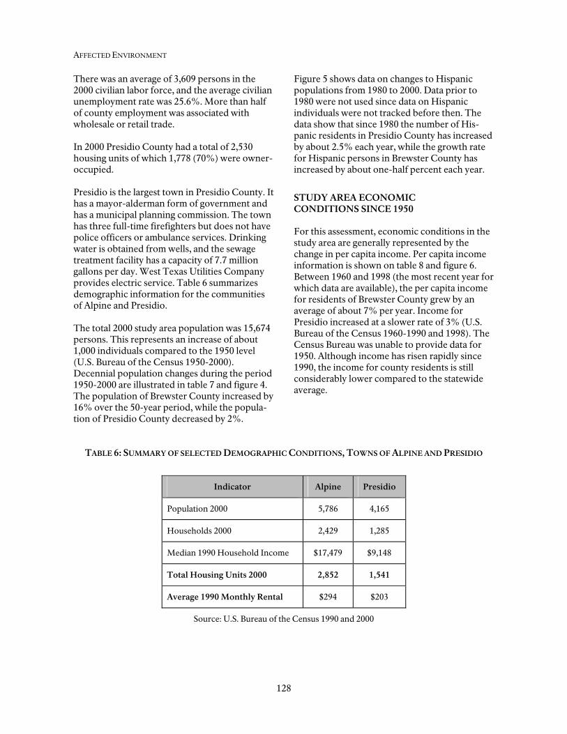
AFFECTED ENVIRONMENT
128
There was an average of 3,609 persons in the 2000 civilian labor force, and the average civilian unemployment rate was 25.6%. More than half of county employment was associated with wholesale or retail trade. In 2000 Presidio County had a total of 2,530 housing units of which 1,778 (70%) were owner-occupied. Presidio is the largest town in Presidio County. It has a mayor-alderman form of government and has a municipal planning commission. The town has three full-time firefighters but does not have police officers or ambulance services. Drinking water is obtained from wells, and the sewage treatment facility has a capacity of 7.7 million gallons per day. West Texas Utilities Company provides electric service. Table 6 summarizes demographic information for the communities of Alpine and Presidio. The total 2000 study area population was 15,674 persons. This represents an increase of about 1,000 individuals compared to the 1950 level (U.S. Bureau of the Census 1950-2000). Decennial population changes during the period 1950-2000 are illustrated in table 7 and figure 4. The population of Brewster County increased by 16% over the 50-year period, while the popula-tion of Presidio County decreased by 2%.
Figure 5 shows data on changes to Hispanic populations from 1980 to 2000. Data prior to 1980 were not used since data on Hispanic individuals were not tracked before then. The data show that since 1980 the number of His-panic residents in Presidio County has increased by about 2.5% each year, while the growth rate for Hispanic persons in Brewster County has increased by about one-half percent each year.
STUDY AREA ECONOMIC CONDITIONS SINCE 1950
For this assessment, economic conditions in the study area are generally represented by the change in per capita income. Per capita income information is shown on table 8 and figure 6. Between 1960 and 1998 (the most recent year for which data are available), the per capita income for residents of Brewster County grew by an average of about 7% per year. Income for Presidio increased at a slower rate of 3% (U.S. Bureau of the Census 1960-1990 and 1998). The Census Bureau was unable to provide data for 1950. Although income has risen rapidly since 1990, the income for county residents is still considerably lower compared to the statewide average.
TABLE 6: SUMMARY OF SELECTED DEMOGRAPHIC CONDITIONS, TOWNS OF ALPINE AND PRESIDIO
Indicator Alpine Presidio
Population 2000 5,786 4,165
Households 2000 2,429 1,285
Median 1990 Household Income $17,479 $9,148
Total Housing Units 2000 2,852 1,541
Average 1990 Monthly Rental $294 $203
Source: U.S. Bureau of the Census 1990 and 2000

Socioeconomic Environment
129
TABLE 7: STUDY AREA POPULATION TRENDS, 1950-2000
County 1950 1960 1970 1980 1990 2000 Change 1950-2000
Brewster 7,309 6,434 7,780 7,573 8,681 8,466 16% Presidio 7,354 5,460 4,842 5,188 6,637 7,208 -2% Total 14,663 11,894 12,622 12,761 15,318 15,674 7 %
Source: Bureau of the Census, 1950-2000.
TABLE 8: STUDY AREA PER CAPITA INCOME, 1960-1998
County 1960 1970 1980 1990 1998
Change 1960-1998
Brewster $5,035 $6,279 $8,105 $10,730 $18,729 272 %
Presidio $4,854 $5,054 $6,285 $6,347 $10,296 112 %
Source: U.S. Bureau of the Census, 1960-1990 and 1998.
Figure 4 Population 1950-2000
4,000
5,000
6,000
7,000
8,000
9,000
1950 1960 1970 1980 1990 2000
Brewster CountyPresidio County

AFFECTED ENVIRONMENT
130
Figure 5Persons of Hispanic Origin By County
0
1000
2000
3000
4000
5000
6000
7000
1980 1990 2000
His
pani
c Pe
rson
s
Brewster County Presidio County
Figure 6Per Capita Income 1980-1998
$0
$2,000
$4,000
$6,000
$8,000
$10,000
$12,000
$14,000
$16,000
$18,000
$20,000
1960 1970 1980 1990 1998
Per C
apita
Inco
me
By
Cou
nty
Brewster County Presidio County

Socioeconomic Environment
131
Recreation Use at Big Bend National Park The Big Bend National Park was authorized on June 20, 1935, and was established in 1944. There were 264,864 total visitors in 2000. Park campgrounds include Chisos Basin, Cotton-wood, Rio Grande Village, Rio Grande Village Trailer Park, and numerous backcountry sites with a total of 335 campground/backcountry sites. Major activities at the park include hiking/backpacking, rafting and canoeing, exploring, birding, and camping. Canyons in the park include Santa Elena (20 miles), Mariscal (10 miles) and Boquillas (33 miles in length) on the Rio Grande. Since 1988, total park use has increased by 23,000 visitors, equivalent to a growth rate of about 1% per year for the 12-year period. However, park use showed a strong increase in the period 1989 through 1994 with an overall growth rate of 4% in that time frame. Park use then fell during 1995 and 1996, to rise again to a peak of 340,806 in 1998. Since then annual visits have fallen back to nearly 1988 levels, reflecting larger national and statewide economic trends. Annual park visitation for the period 1988-2000 is shown in figure 7. A total of 44,627 visitors stayed in concessions lodging and 10,473 in the concessions
campgrounds in 2000. The total number of overnight stays at the park in 2000 was 184,880. Current Impact of Recreation Spending in Study Area In 1996, the Big Bend National Park and the Rio Grande Wild and Scenic River generated more than $51 million to the economy of Brewster County (National Park Service, 1996). This was based on a 1996 tourism level of 279,952 individuals. This figure included the combined sales benefits associated with tourism (all purchases and expenditures), as well as Federal government expenditures (such as road construction). The combined job bene-fits from these expenditures totaled 1,789 positions. Within the park, there are currently 72 rooms, which include the Chisos Mountains Lodge, the motel, the lodge unit, and the Stone Cottages. Park concessions staff indicated that there are 65 employees. The three motor inns and lodges contacted outside the park reported a combined number of about 160 rooms and a total number of about 130 employees. A survey of selected motel
Figure 7Total Park Visitors
1988-2000
150000
200000
250000
300000
350000
400000
1988
1989
1990
1991
1992
1993
1994
1995
1996
1997
1998
1999
2000
Tota
l Par
k Vi
sito
rs
Source: National Park Service, April 24, 2002.

132
operators in Brewster and Presidio Counties showed that there are at least 500 motel/hotel rooms with around 90 to 100 employees. Based on this representative facility survey (both inside and outside the Park in the study area), it is estimated that there are currently more than 200 employees of hotels, motels, or lodges. This is only an approximation, and the actual number could be higher if a 100% inventory of all facilities was conducted. Conditions in Chihuahua and Coahuila The Mexican states of Chihuahua and Coahuila are immediately south of the Big Bend National Park and the Rio Grande. The socioeconomic conditions in these states are briefly described in this document because they may benefit economically from proposed NPS management programs.
The current (year 2000) population of Chihuahua is estimated to be 3,047,867 individuals (XII Censo General De Poblacion Y Vivienda, Resultados Preliminares). This represents an increase of 606,000 persons compared to 1990 (a 25% increase). Also between 1990 and 2000, the population of Mexico grew by about 20%. The population of Chihuahua is evenly split between males and females. In 1998 there were 79,336 births and 15,753 deaths in the state. Table 9shows selected statistics for Chihuahua and the largest several towns or cities within the state. The current population of Coahuila is 2,295,808, which represents an increase of 323,000 persons (16%) compared to the 1990 census figures. This was a somewhat slower growth rate relative to Chihuahua. In 1998 there were 57,541 births and 10,276 deaths in the state. Table 10 summarizes selected socioeconomic indicators for Coahuila.
TABLE 9: COMPARISON OF SELECTED ECONOMIC INDICATORS, STATE OF CHIHUAHUA
State or City Population 2000 (a)
Total Employment
1998 (b)
Individuals per House
2000 (a)
Number Businesses 1998
(b) State of Chihuahua 3,047,867 744,450 4.0 88,803 Juarez 1,217,818 393,867 4.1 32,068 Chihuahua 670,208 194,783 3.9 23,276 Cuauhtemoc 124,279 22,327 3.9 4,465 Delicias 116,132 29,778 3.9 5,219 Hidalgo 100,881 21,902 4.1 4,928 Nuevo Casas Grandes
54,226 13,100 3.9 2,300
Guadeloupe 48,226 630 5.3 122 Sources: (a) Preliminary data are for year 2000 (XII Censo General De Poblacion Y Vivienda, Resultados
Preliminares). (b) Data are for 1998 (Aspectos Economicas de Chihuahua)
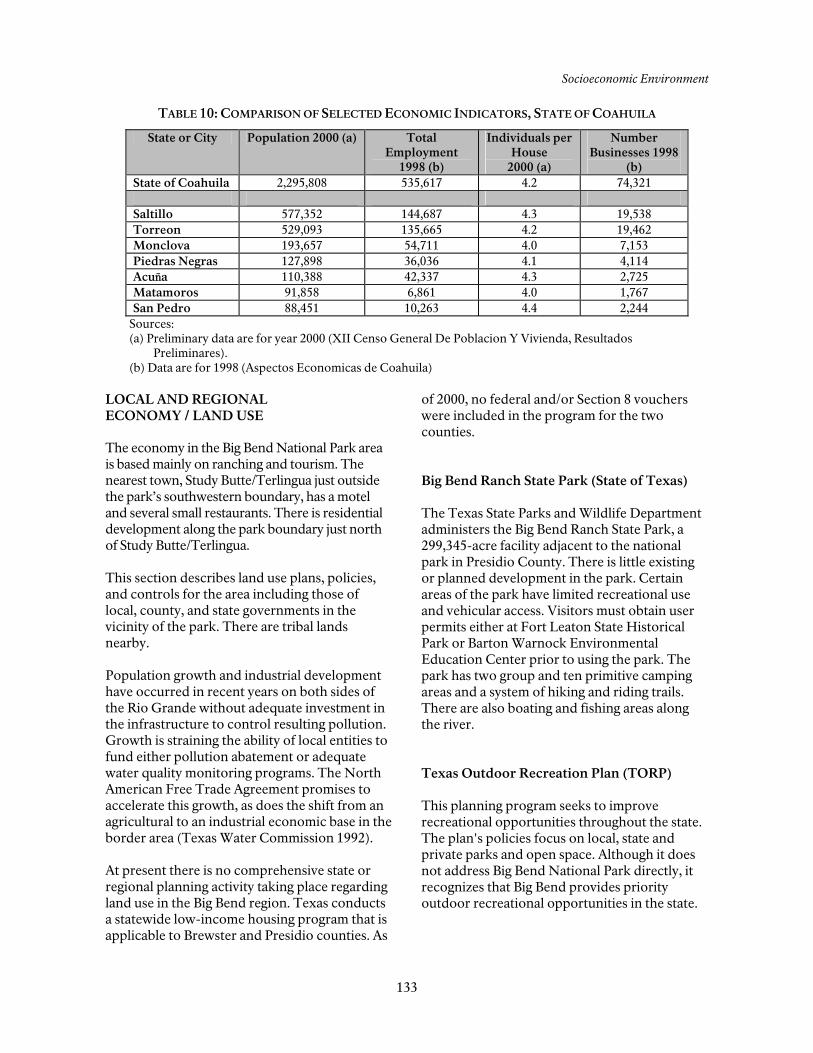
Socioeconomic Environment
133
TABLE 10: COMPARISON OF SELECTED ECONOMIC INDICATORS, STATE OF COAHUILA
State or City Population 2000 (a) Total Employment
1998 (b)
Individuals per House
2000 (a)
Number Businesses 1998
(b) State of Coahuila 2,295,808 535,617 4.2 74,321 Saltillo 577,352 144,687 4.3 19,538 Torreon 529,093 135,665 4.2 19,462 Monclova 193,657 54,711 4.0 7,153 Piedras Negras 127,898 36,036 4.1 4,114 AcuZa 110,388 42,337 4.3 2,725 Matamoros 91,858 6,861 4.0 1,767 San Pedro 88,451 10,263 4.4 2,244
Sources: (a) Preliminary data are for year 2000 (XII Censo General De Poblacion Y Vivienda, Resultados
Preliminares). (b) Data are for 1998 (Aspectos Economicas de Coahuila)
LOCAL AND REGIONAL ECONOMY / LAND USE
The economy in the Big Bend National Park area is based mainly on ranching and tourism. The nearest town, Study Butte/Terlingua just outside the park’s southwestern boundary, has a motel and several small restaurants. There is residential development along the park boundary just north of Study Butte/Terlingua. This section describes land use plans, policies, and controls for the area including those of local, county, and state governments in the vicinity of the park. There are tribal lands nearby. Population growth and industrial development have occurred in recent years on both sides of the Rio Grande without adequate investment in the infrastructure to control resulting pollution. Growth is straining the ability of local entities to fund either pollution abatement or adequate water quality monitoring programs. The North American Free Trade Agreement promises to accelerate this growth, as does the shift from an agricultural to an industrial economic base in the border area (Texas Water Commission 1992). At present there is no comprehensive state or regional planning activity taking place regarding land use in the Big Bend region. Texas conducts a statewide low-income housing program that is applicable to Brewster and Presidio counties. As
of 2000, no federal and/or Section 8 vouchers were included in the program for the two counties. Big Bend Ranch State Park (State of Texas) The Texas State Parks and Wildlife Department administers the Big Bend Ranch State Park, a 299,345-acre facility adjacent to the national park in Presidio County. There is little existing or planned development in the park. Certain areas of the park have limited recreational use and vehicular access. Visitors must obtain user permits either at Fort Leaton State Historical Park or Barton Warnock Environmental Education Center prior to using the park. The park has two group and ten primitive camping areas and a system of hiking and riding trails. There are also boating and fishing areas along the river. Texas Outdoor Recreation Plan (TORP) This planning program seeks to improve recreational opportunities throughout the state. The plan's policies focus on local, state and private parks and open space. Although it does not address Big Bend National Park directly, it recognizes that Big Bend provides priority outdoor recreational opportunities in the state.

AFFECTED ENVIRONMENT
134
Texas Parks and Wildlife Department has prepared a “Land and Water Resources Conservation and Recreation Plan” (2002) addressing state, local, and private open space, conservation, and recreation programs. It is summarized in the “Introduction to the Alternatives.” Black Gap Wildlife Management Area (State of Texas) The Black Gap has 25 campsites along the river that are used primarily for fishing and hunting. Two areas at Black Gap are available for launching rafts and canoes, Horse Canyon and Maravillas Canyon. To enter the wildlife management area one must acquire one of three kinds of permit. Hunters must have an annual hunting permit, fishermen a limited use permit, and non consumptive users, such as campers, bird watchers, hikers, and river users, a Texas Conservation Passport. No permits are sold in the wildlife management area, but they may be purchased at other locations before arrival at Black Gap. Most of the wildlife management area is closed from March 1 to August 31 each year for road and habitat maintenance. The roads to Horse and Maravillas Canyons remain open. The entire Black Gap is closed October 7-11, 21-25; November 12 to December 12; December 26-29; and January 13-16. Those with special hunting permits may use the area during the closures. Brewster County Texas counties do not have zoning authority; however, they can promulgate various kinds of regulations that affect land use. These regula-tions serve some of the same purposes as a master plan for land use. The county has subdivision and platting regulations particularly along the border in southern Brewster County that would prevent dense subdivisions from being placed next to the park. They have regula-tions for permitting septic tanks. Manufactured homes and manufactured home rental com-munities are highly regulated in Brewster County. The county has shortages of both
housing and office space. (County Judge, Val Beard, pers. comm. 9/28/01) City of Alpine The Texas Municipal Code grants home rule cities broad planning and zoning powers. The City of Alpine has a planning and zoning com-mission that oversees implementation of the city's zoning and subdivision ordinances. Alpine shares with Brewster County concerns about housing and office space shortages. (City of Alpine, pers. comm. 4/23/02). Christmas Mountains Adjacent to this privately owned area on the park’s western boundary increased subdivision of land is occurring (primarily the Terlingua Ranch development). The issue of the park’s viewshed has emerged as a prime concern. The owner of the Christmas Mountains has a long-term goal of preserving the area from the escalating subdivision. The owner would also like to preserve the viewshed from Big Bend National Park, and toward the park from the Christmas Mountains and Terlingua Ranch area. Subsurface ownership is divided between the present owner and numerous prior owners who wholly or partially retain the mineral rights. As far as the Park Service knows, only fluorspar has been actively extracted from the Christmas Mountains in the past three decades. The success of the mineral extraction was influenced by three factors: fluctuating market prices; remoteness of the mineral source from paved roads and rail service; and richness of the mineral deposits. The mines stopped operation because these factors made mining costs prohibitive. The Christmas Mountains property is bordered on three and one-half sides by the subdivided Terlingua Ranch development. The Terlingua Ranch headquarters, lodge, and landing strip are about 2.5 miles from the west boundary of the park. One mile of the Christmas Mountains boundary along the southeast side adjoins the

Socioeconomic Environment
135
park near Christmas Spring, which is within the park. Terlingua Ranch The Terlingua Ranch development, about 220,000 acres in size, is primarily composed of 10-acre to 40-acre parcels that contain varying degrees of development. The rural and extremely remote nature of the area makes it impractical for working people to live in and commute to a limited job market. Most residents are either retired or are part-time residents. The Terlingua Ranch Lodge is a motel and restaurant resort that is at the end of a 16-mile dirt road, and it provides services to a limited clientele. It is estimated that about 400 residents live on about 220,000 acres of the Terlingua Ranch property (NPS 1989); more than half of them are full-time residents. The development has roughly 5,000 landowners.
Lajitas In 2000, SRS Properties purchased the Lajitas Resort and 25,000 acres of surrounding land. Austin businessman Steve Smith is attempting to develop a world-class golf resort on the property. This will include two championship golf courses, 800 homes, an RV park, condominiums, an equestrian center, a private airport capable of landing large jets, a hotel and restaurants. Part of the development borders the park, and some of it may already infringe on park land. It will use enormous amounts of water — 700,000 gallons per day alone to water one of the golf courses. It blocks access to park trails on Mesa de Anguila. The park is very concerned about this development, particularly the water use; its location directly adjacent to the park, and the fact that the main put-in for Santa Elena Canyon river trips is also on the Smith property. The park will monitor the develop-ment closely and take appropriate action if the park and/or river are threatened or damaged in any way.