phase ii environmental site assessment historic waste
TRANSCRIPT

Unit 107, 2719 - 7 Avenue NE, Calgary, Alberta T2A 2L9 T. 403-640-9009 F. 403-640-9006
Phase II Environmental Site Assessment Historic Waste Disposal Site Riverside Heavy Dry Waste
The City of Red Deer
Prepared For: The City of Red Deer Prepared By: Tiamat Environmental Consultants Ltd. Date: February 26, 2014 File: 12-435

12-435 Page i Phase II ESA – Riverside Heavy Dry Waste Site Historic Waste Disposal Sites, The City of Red Deer
Tiamat Environmental Consultants Ltd. Electronic Version 03
EXECUTIVE SUMMARY On behalf of the City of Red Deer, Tiamat Environmental Consultants Ltd. (Tiamat) has conducted a Phase II Environmental Site Assessment on a parcel of land utilized for the disposal of dry waste. The waste site lies within the Waskasoo Park System and is bounded on the east by the Riverside Heavy Industrial Park. The objective of this Phase II ESA is to assess the environmental quality of the subsurface soil and groundwater underlying the site. This report presents the scope of work, a summary of the results and our professional opinion respecting the environmental quality of the site. This report is intended to complement the Phase I ESA dated September 24, 2013, prepared by Tiamat. The key results of this Phase II ESA are as follow:
Waste materials were encountered in a series of testholes advanced at various points along the hill slope through the fill material.
Laboratory results of groundwater samples show elevated concentrations of routine water parameters and metals exceeding the Alberta Tier 1 Guidelines.
Laboratory results of soil vapour show trace amounts of volatile organic compounds (VOCs) and siloxanes.
This Phase II ESA confirmed the presence of MSW in the upper central section of the hill slope. The thickness of the MSW deposit is about 6 m, more or less. The soil cover is a relatively permeable mix of sand and silt with a discontinuous unit of clay fill. The initial test results indicate the local groundwater has been mildly impacted as characterised by the presence of leachate constituents and comparative quality of the groundwater between the top of the hill and the toe of the hill slope. The results indicate the leachate constituents to be principally composed of nutrient type compounds of a mild strength.

12-435 Phase II ESA – Riverside Heavy Dry Waste Site Historic Waste Disposal Sites, The City of Red Deer
Tiamat Environmental Consultants Ltd. Electronic Version 03
Page ii
TABLE OF CONTENTS
Executive Summary …………………………………………………………… i
1.0 Introduction …………………………………………………………… 1
1.1 Scope of Work …………………………………………… 1
2.0 Site Description & Environmental Setting …………………………… 2
2.1 Site Description and Environmental Setting …………………… 2
2.2 Notable Environmental Conditions for Special Consideration … 3
2.3 Regional Geology and Hydrogeology …………………… 4
2.4 Previous Investigations and Historic Perspective …………… 4
3.0 Fieldwork …………………………………………………………… 6
3.1 Underground Line Locates and Testhole Drilling …………… 6
3.2 Site Monitoring and Groundwater Sampling …………..…..…… 8
4.0 Results ……………………………………………………………. 8
4.1 Soil Profile ……………………………………………………. 8
4.2 Groundwater Conditions ……………………………………. 9
4.3 Headspace Vapours ……………………………………………. 9
5.0 Summary of Assessment ……………………………………………. 10
5.1 Quality of Subsurface Soil …………………………………… 10
5.2 Quality of Local Groundwater ……………………………. 10
5.3 Interpretation of Soil Vapours ……………………………. 11
6.0 Conclusions and Recommendations ……………………………………. 13
7.0 Statement of Limitations ……………………………………………. 14
8.0 Closure ……………………………………………………………. 15
References ……………………………………………………………………. 16
Table 1 Soil Vapour and Groundwater Monitoring Well Elevations Table 2 Site Monitoring Results Table 3A Analytical Results – Soil – Drill Cuttings (Soil Bag) Table 3B Analytical Results – Soil – General Indices and Heavy Metals Table 3C Analytical Results – Soil – VOCs Table 4A Groundwater Indices at Time of Sampling Table 4B Analytical Results – Groundwater – General Water Quality Table 4C Analytical Results – Groundwater – Metals

12-435 Phase II ESA – Riverside Heavy Dry Waste Site Historic Waste Disposal Sites, The City of Red Deer
Tiamat Environmental Consultants Ltd. Electronic Version 03
Page iii
TABLE OF CONTENTS Continued…
Table 4D Analytical Results – Groundwater – VOCs Table 5A Summary of Parameters Measured During Sampling of Soil Vapour Table 5B Analytical Results – Soil Vapour – General Indices Table 5C Analytical Results – Soil Vapour – VOCs Table 5D Analytical Results – Soil Vapour – Siloxanes Figure 1 Site Plan Showing Surrounding Land Use Figure 2 Test Locations and Interpreted Extent of Waste Figure 3A Cross Section A-A’ Figure 3B Cross Sections B-B’ Figure 4 Interpreted Groundwater Elevations Appendix A Field Protocols and Analytical Data, ASCM Information and
Laboratory Reports Appendix B Testhole Logs Appendix C Select Photographs

12-435 Phase II ESA – Riverside Heavy Dry Waste Site Historic Waste Disposal Sites, The City of Red Deer
Tiamat Environmental Consultants Ltd. Electronic Version 03
Page 1
1.0 INTRODUCTION
On behalf of The City of Red Deer, Tiamat Environmental Consultants Ltd. (Tiamat) presents this Phase II Environmental Site Assessment (ESA) report for a potential historic waste disposal site designated as the Riverside Heavy Dry Waste Site.
The objectives of this Phase II ESA are to better understand the areal extent and the composition of the waste material. This report presents the scope of work, a summary of the results and our professional opinion respecting the subsurface environmental conditions associated with the historic waste materials. This report is intended to complement the Phase I ESA dated September 24, 2013. 1.1 Scope of Work A summary of the key tasks for this Phase II ESA are outlined below: Fieldwork Identify and locate underground utilities within the work areas on the site;
Supervise the drilling of testholes (THs) located within the legal property lines of the
site;
Collect the soil samples for laboratory analyses of benzene, toluene, ethylbenzene, xylenes (BTEX), petroleum hydrocarbon fractions F1 (C6-C10), F2 (>C10-C16), F3 (>C16-C34), F4 (>C34), EPA 8260 list of volatile organic compounds (VOCs), metals, chlorides (Cl-) and nitrates/nitrites (NO3
-/NO2-);
Screen the soil cuttings to determine the feasibility to dispose of drill cuttings at a
Class II landfill facility. Acceptance parameters for disposal include laboratory analyses of pH, soil flash point, paint filter, total organic carbon (TOC) and TCLP assay for BTEX compounds and metals;
Each TH is completed with either a groundwater (MW) or vapour (VW) monitoring well or backfilled and abandoned;
Collect groundwater samples for laboratory analyses of BTEX, hydrocarbon fractions F1, F2, VOCs, total and dissolved metals, Cl-, sulfate (SO4), ammonium (NH4-N), phosphorus (P), TOC, chemical oxygen demand (COD), biochemical oxygen demand (BOD), NO3
-/NO2-, total nitrogen (N), pH, electrical conductivity (EC), adsorbable
organic halides (AOXs) and volatile fatty acids;
Collect vapour samples for laboratory analyses of VOCs, oxygen (O2), carbon monoxide (CO), carbon dioxide (CO2), methane (CH4), nitrogen (N), volatile hydrocarbons and siloxanes or volatile organic silicon compounds (VOSCs);

12-435 Phase II ESA – Riverside Heavy Dry Waste Site Historic Waste Disposal Sites, The City of Red Deer
Tiamat Environmental Consultants Ltd. Electronic Version 03
Page 2
Survey each test location for horizontal and vertical control relative to established ASCM (Alberta Survey Control Marker) datums within The City of Red Deer.
Report Prepare a report summarising the results including figures, tabulated data and our
interpretation of the subsurface environmental conditions resulting from the historic waste disposal site.
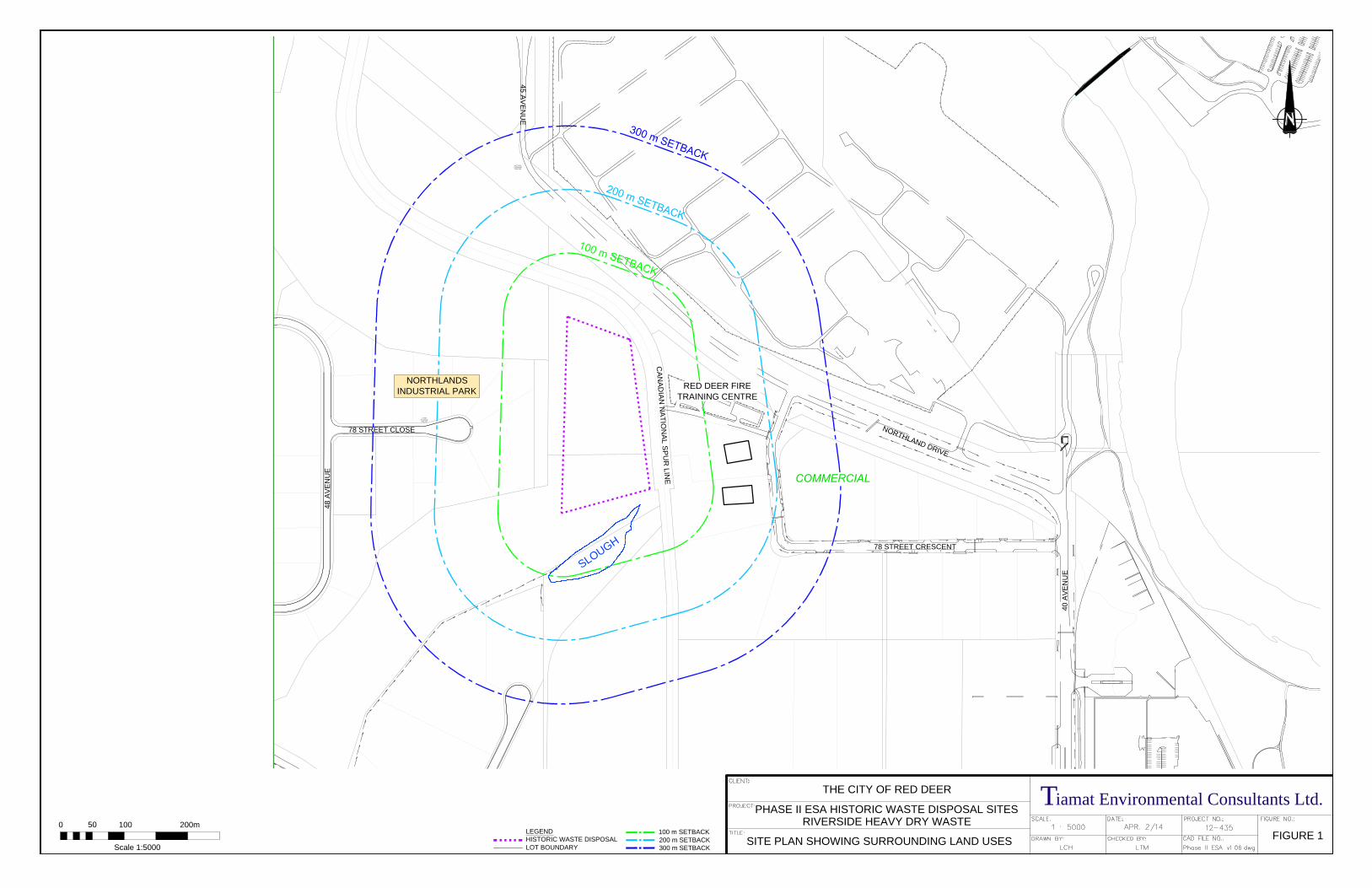
2.0 SITE DESCRIPTION & ENVIRONMENTAL SETTING This section provides general information of the site including a brief description of the location, surrounding land use(s), regional geology, hydrogeology and notable environmental conditions specific to the site. 2.1 Site Description and Environmental Setting The potential historic waste material has been suspected to lie within two legal land descriptions. The larger portion to the north is situated within the NE 33-38-27 W4M and the smaller portion to the south lies within the SE 33-38-27 W4M. These two areas are contiguous and define the Riverside Heavy Dry Waste Site. The site is currently designated A2 – Environmental Preservation (Land Use Bylaw #3357/2006) and the municipal address is 4240 Northland Drive. The site is situated on a hill slope in the northwest quadrant of the Riverside Heavy Industrial Park. The waste material lies within the east face slope that is landscaped by a mix of prairie fescue grasses, prairie wildflowers and weeds. It overlooks the river valley of the Red Deer River. Vehicular access onto the site is via a secured gate within the Red Deer Fire Training Centre. A mountain bike trail from the north side of 77 Street traverses the hill top along the entire westerly margin of the site. The east and north boundary of the site is bounded by a rail spur line operated by Canadian National Railway. On the north side of the site across the rail spur line is Northland Drive followed by the Red Deer Waste Water Treatment Plant. A permanent slough is situated at the base of the hill on the south. Various commercial/industrial businesses and the Fire Training Centre are in the vicinity of the site to the west and east. The nearest residential development is located west of Gaetz (50) Avenue, approximately 1,200 m from the site. A site plan showing the site and the surrounding land uses is presented as Figure 1. A review of historical information indicates the historical waste disposal activity was conducted with agreement between the regulatory authorities and The City of Red Deer, refer to the September 24, 2013 Phase I ESA. Historical information suggests disposal activities of dry waste occurred on the site from 1994 to approximately 2007.

12-435 Phase II ESA – Riverside Heavy Dry Waste Site Historic Waste Disposal Sites, The City of Red Deer
Tiamat Environmental Consultants Ltd. Electronic Version 03
Page 3
2.2 Notable Environmental Conditions for Special Consideration In the early 1990s to about 2007, The City of Red Deer undertook corrective measures to stabilize the east slope by placing inert construction material (dry waste) onto the slope and seeding the reclaimed slope. The reclaimed hill slope is completed as a natural area with limited access to the public. The slope across the hill side varies somewhat between the north and the south sections. The south side exhibits a steeper slope relative to the north side. The east slope mimics the south slope. The slough is utilized by wildlife. The area is mapped outside of the 100-year flood fringe (Environment Canada and Alberta Environmental Protection, Edition 1, 1995). Following the recent severe June 2013 flood event, it is recognized the flood fringe may be updated following a review by the provincial authority. There are no underground municipal utilities identified in the area of the historic waste site. The relative locations of nearby underground municipal utilities are shown on Figure 2. Generally, potential environmental concerns arising from this historic waste site are grouped into three broad categories:
Ground stability issue where the historic waste lies;
Continual generation of soil vapour from the decomposing waste materials; and
Lateral transport of groundwater, which passes through the waste material and ultimately migrates down to the Riverside Heavy Industrial Park in the Red Deer River Valley.
Several geochemical processes and physical settlement occurs as the buried historic waste materials decompose. At this site, there is some minor visual indicator for the ground cover on the hill slope to settle in a non-uniform or irregular manner. The testhole observations indicate the vegetation and underlying the loam appears to be variable across the site. Landfill gas is a by-product of a geochemical process associated with the decomposing waste materials. The soil vapours comprising of constituents from landfill gas can migrate in the subsurface. The geochemical process also yields soluble hydrocarbons to the groundwater system with some volatile components capable of degassing into the soil vapour regime.

12-435 Phase II ESA – Riverside Heavy Dry Waste Site Historic Waste Disposal Sites, The City of Red Deer
Tiamat Environmental Consultants Ltd. Electronic Version 03
Page 4
As surface infiltration percolates through the historic waste materials and contacts the groundwater table, leachate is formed. This leachate is a potentially polluting liquid that can adversely affect the local groundwater system. Elements of testing in this Phase II ESA is an initial assessment of the subsurface conditions for soil vapour and leachate near the perimeter of the historic waste site relative to existing and potential future land developments. 2.3 Regional Geology and Hydrogeology A summary of the published geological and hydrogeological information is presented in the September 24, 2013 Phase I ESA report. Within the immediate area of the historic waste, the Red Deer River is located approximately 800 m east of the site. The slough, at its closest position, lies within 15 m, more or less south of the site. The CN spur line includes a drainage ditch along the west side of the track. The drainage ditch appears to channel surface run-off in two directions; the south portion to the slough and the north section to the north, towards Northland Drive. Previous mitigative actions to stabilize the hill slope include the installation of a gravity drainage system to collect and direct surface infiltration from the hill slope to a drainage swale that is situated along the toe of the slope. The swale appears to divert the surface run-off to a drainage channel along the south side of Northland Drive. This gravity drainage system was installed, circa September 2000. There are no obvious environmental concerns for surface water run-on at the site. Based on a local topographic map for this area, regional groundwater flow is expected to be east-northeast towards the Red Deer River. There may also be some local flow to the slough located south of the site. It should be noted that local topography, geology, land development and soil disturbances might influence the local movement and pattern of groundwater. Furthermore, groundwater may also fluctuate from seasonal and climatic conditions. 2.4 Previous Investigations and Historic Perspective Information obtained from The City of Red Deer indicates several past environmental investigations for the site. The past investigations were performed by various consultants to address the slope stability and proposal for dry waste disposal at the site.

12-435 Phase II ESA – Riverside Heavy Dry Waste Site Historic Waste Disposal Sites, The City of Red Deer
Tiamat Environmental Consultants Ltd. Electronic Version 03
Page 5
The specific assessments that have been obtained as a part of the environmental assessment:
Summary Report Former City Landfill Riverside Dry Waste, Part of 33-38-27-W4M, Red Deer, Alberta, April 2007. Prepared by Stantec Inc. and Parkland Geotechnical Consulting Ltd.
Geotechnical Investigation – Slope Failure Investigation, Red Deer Riverside Industrial Park, Red Deer, Alberta, December 1993. Prepared by HBT AGRA Ltd.
Geotechnical Investigation – Proposed Dry Waste Disposal Facility, Section 33-38-27-W4M, Red Deer, Alberta, January 1994. Prepared by HBT AGRA Ltd.
The above noted documents, as provided by The City of Red Deer were perused and discussed in the Phase I ESA report (Tiamat, 2013). The potential historic waste disposal activity was suspected to have occurred over a period of about fourteen years, between 1994 and 2007. Documentation available to Tiamat indicates the Red Deer Regional Health Unit, Red Deer City Council and the Red Deer Planning Commission granted approval to place concrete and asphalt debris at the site. The reader should note, limited documentation and records during this period was made available to Tiamat. The key results of the 2013 Phase I ESA are as follows:
Historical records indicate the present configuration of the site has been largely unchanged. Currently, the site is zoned as environmental preservation and no municipal infrastructure lies on the site.
Historic information suggests this landfill site has been used for the disposal of inert materials such as concrete, asphalt and soil since 1994 with disposal activities ending on or about the fall of 2007.
Anecdotal information provided by The City of Red Deer suggests contaminated soils due to clean up of a gas station, drums of oil and contaminated soil from a city storm detention pond may have been placed at this waste disposal site.
Records from regulatory agencies do not indicate any outstanding environmental concern on the site.
The site is surrounded by the Northland Industrial Park, the Riverside Heavy Industrial Park and the Waskasoo Park. Utility right-of-ways border the west and east side of the site, respectively. There are presently no obvious activities on the adjacent lands that are interpreted as an environmental concern relative to the site.

12-435 Phase II ESA – Riverside Heavy Dry Waste Site Historic Waste Disposal Sites, The City of Red Deer
Tiamat Environmental Consultants Ltd. Electronic Version 03
Page 6
Adjacent and nearby developments include public parks, municipal reserves, residential homes and light commercial businesses. There are presently no obvious activities on the adjacent lands that are interpreted as an environmental concern relative to the site.
At this time, there is no data to suggest an adverse impact has occurred to the water quality in the slough or to the wildlife within the Waskasoo Park. There is a potential for leachate to flow in a radial pattern from the site to the slough and river valley.
The findings of the 2013 Phase I ESA identify several uncertainties associated with this historic waste disposal site. In consultation with the Management of The City of Red Deer, a Phase II ESA should include an attempt to determine whether waste material is present in the hill and its composition. It is understood this information would assist the City to identify whether further efforts are necessary to manage environmental risks associated with historic waste material at this site relative to existing and future land uses in the vicinity of this site. 3.0 FIELD WORK This section describes the fieldwork for this Phase II ESA. A description of the field methods and data quality assurance implemented by Tiamat for this Phase II ESA is provided in Appendix A. Testhole logs describing the subsurface stratigraphy and monitoring instrumentation are provided in Appendix B. Select photographs of testholes and groundwater monitoring wells are presented in Appendix C. 3.1 Underground Line Locates and Testhole Drilling Prior to drilling, public and private underground utilities within the work area were confirmed to not be present within the site. The steepness of the hill slope required a track-mounted drill to navigate the hill side. The subsurface investigation commenced in the afternoon of Thursday, July 11 and was completed on Saturday, July 13, 2013. A representative of Tiamat supervised an auger drill mounted on a track rig from Earth Drilling Co. of Calgary, Alberta to advance 152 mm diameter test holes at various locations across the site. The testhole locations were selected with consideration of access for the drill rig. The drilling program is intended to determine whether subsurface waste material is present, its composition and areal footprint. Information concerning the potential locations of the historic waste from previous investigations (by others) was reviewed in the context to assist with drilling program.

12-435 Phase II ESA – Riverside Heavy Dry Waste Site Historic Waste Disposal Sites, The City of Red Deer
Tiamat Environmental Consultants Ltd. Electronic Version 03
Page 7
Each testhole was drilled vertically to depths ranging between 3.7 m to 19.5 m below the ground surface. On completion of drilling either a groundwater monitoring well or soil vapour well was installed, or the testhole was backfilled and abandoned. Each monitoring well consists of a 51 mm diameter PVC machine slotted screen section and a solid section of pipe. The annulus of the borehole was backfilled with Sil-9 sand to approximately 0.3 m above the screen section followed by granular bentonite to about 0.3 m from the surface. An above ground lockable protective steel well protector was installed at each well location. Subsequent to establishing the depth of the testhole for a soil vapour well, a dedicated soil vapour well was assembled. Typically the soil vapour well consists of a 30 cm 0.020 machine slotted PVC screen and a 25 mm diameter PVC solid stand pipe. The screen section and brass valve assembly are mechanically threaded with stainless steel locking set screws. A summary of the well completion details is presented in Table 1 and shown on the testhole logs in Appendix B. Each test location and monitoring well was surveyed for horizontal and vertical control by MRAC Surveys Ltd. of Red Deer, Alberta. Multiple ASCM points within The City of Red Deer were utilized to reduce survey errors. The specific ASCM points applied are listed in Table 1 and a copy of the specified ASCM information sheets are provided in Appendix A. The relative locations of each testhole are shown in Figure 2. The soil profile was visually classified during drilling and bulk grab samples were retrieved at approximately 0.6 m intervals for field screening. In the event significant MSW (municipal solid waste) material is encountered an RKI Eagle 2 capable of simultaneously measuring the combustible and volatile vapour in the testhole at the surface was used. This was to assess whether potential methane and other VOCs were emanating from the testhole at concentrations deemed potentially hazardous for drilling operations. For example, should combustible vapours exceed the lower explosive limit or elevated VOCs greater than 35 ppm is encountered, drilling would temporarily cease until the level of vapours have subsided. Each on-site worker had a dedicated half-mask respirator with organic vapour filter as part of their respective personal protective equipment during drilling. The drilling protocol for testhole(s) encountering MSW was to advance the drill such that contact is made with the underlying native soil. At locations where MSW was not found, the testhole was advanced to an appropriate depth to install either a soil vapour well or a groundwater well. Drill cuttings were stored in 1 cubic meter capacity tote bags for off-site disposal.

12-435 Phase II ESA – Riverside Heavy Dry Waste Site Historic Waste Disposal Sites, The City of Red Deer
Tiamat Environmental Consultants Ltd. Electronic Version 03
Page 8
3.2 Site Monitoring and Groundwater Sampling On Saturday, August 17, 2013, monitoring wells were field tested. Field measurements consisted of measurement of headspace vapours and the depth to liquid in each well. Groundwater samples were collected from the three newly installed monitoring wells, one located (MW-01) in an interpreted up-gradient position and two located (MW-02 and MW-03) on the down gradient margin relative to the site. 4.0 RESULTS The area of the past backfilling activity for slope stabilization was referenced as the east facing slope. Accordingly, the commercial/industrial criteria have been referenced to assess the environmental quality of the subsurface soil and groundwater beneath the site. It should be noted the assessment is to illustrate the relative environmental quality and is not intended to infer remedial objectives. This section summarizes the field observations during drilling and field testing for this Phase II ESA. For clarity, the analytical results for soil, groundwater and soil vapours are discussed in Section 5. 4.1 Soil Profile Testholes which did not encounter buried waste material generally exhibited a variable soil texture of sand, clay and minor amount of gravel. Following surficial fill material (prairie vegetation over loamy soil), the soil encountered was either a clay or sand material to a depth of 4.6 m to 7 m. Native clay underlies the fill material. At MW-02, a siltstone unit was identified to be bedrock. Where found, the thickness of the soil cover (predominantly organic silt and sand) ranged from approximately 15 cm to 45 cm. In general, relatively inert construction debris (brick, concrete, asphalt, timber and minor amounts of glass and metal) was encountered across the majority of the site. The debris is combined with a mix of sand, silt and clay. MSW was encountered at some testholes in the central portion of the site. The MSW was a mixture of silty sand combined with typical dry construction waste (heavy wire, plastic, brick and concrete fragments, glass and wood). Auger refusal was encountered at two testholes (TH-03 and TH-07), at an approximate depth of 3.4 m to 3.7 m, respectively. The refusal was suspected to be hard concrete. TH-03 and TH-07 were relocated north and re-drilled; MSW was encountered with clay fill to a depth of 7.6 m. Native clay was encountered at a depth of about 18 m below the ground surface.

12-435 Phase II ESA – Riverside Heavy Dry Waste Site Historic Waste Disposal Sites, The City of Red Deer
Tiamat Environmental Consultants Ltd. Electronic Version 03
Page 9
Select cross sections of the site depicting the interpreted soil stratigraphy are presented as Figures 3A and 3B. A copy of the testhole logs is presented in Appendix B. Select photographs of the drilling are presented in Appendix C. To verify the environmental quality of the drill cuttings, soil samples from each soil bag were submitted for laboratory testing. The soil tests performed were to ensure the soil can be disposed at The City Waste Management Facility. The analytical results are discussed in Section 5.1. 4.2 Groundwater Conditions Static depth to groundwater was measured at each accessible monitoring well. The relative groundwater elevations are presented on Table 2. The groundwater elevations are plotted and the interpreted contours are illustrated as Figure 4. The depth to the groundwater at MW-01, near the crest of the hill was about 10.4 m below the ground surface while at MW-03, near the base of the slope, the groundwater was at a depth of about 2.6 m. Please note, MW-01 is about 24 m above MW-03. The measured groundwater elevations suggest a local groundwater flow pattern to the northeast, towards the Red Deer River. The purged water was clear to mildly murky with no obvious hydrocarbon sheen. A trace humic-type odour was noted from the purged water at MW-03. General water quality indices were measured during purging and at the time of sampling. A summary of the field measured indices is presented as Table 4A. Water samples were preserved and submitted to the laboratory for analysis. The results of groundwater tests are discussed in Section 5.2. 4.3 Headspace Vapours A summary of the concentration of soil vapours as interpreted from headspace measurements from the existing monitoring wells is tabulated in Table 2. The headspace vapours were measured in the groundwater monitoring wells and the soil vapour well. Combustible vapours from the headspace of the groundwater monitoring wells ranged between 20 ppm (MW-02) to 1,100 ppm (MW-01). Volatile vapours from the headspace ranged from non-detect, less than 0.1 ppm (MW-03) to 30 ppm (MW-01). At soil vapour well VW-01, combustible and volatile vapours were 185 ppm and 1 ppm respectively. Laboratory results for the soil vapour sample are discussed in Section 5.3.

12-435 Phase II ESA – Riverside Heavy Dry Waste Site Historic Waste Disposal Sites, The City of Red Deer
Tiamat Environmental Consultants Ltd. Electronic Version 03
Page 10
5.0 SUMMARY OF ASSESSMENT This section further discusses our observations during the fieldwork along with an interpretation of the laboratory results in respect to potentials for an adverse environmental impact. Buried waste materials were encountered in six of the nine testholes advanced across the site. The waste material is present within the hill slope and is predominantly construction type waste materials. MSW was encountered in the central section of the site. The relative location of the noted MSW during drilling along with observations from aerial photographs between 1993 and 1997 showing the observed ground disturbance in this area appears to explain the presence of MSW. The presence of MSW is considered contrary to previous information for this site. The interpreted plan area with the MSW is estimated to be 5,135 m2 or about 16% of the total area of the historic waste site. 5.1 Quality of Subsurface Soil The drill cuttings for this Phase II ESA were stored into three soil bags. A soil sample from each soil bag was submitted for laboratory testing. Analytical results indicate the drill cuttings satisfy the acceptance guidelines for disposal at The City of Red Deer Class II Waste Management Facility, refer to Table 3A. For this Phase II ESA, samples were analyzed following the laboratory package using the US EPA 8260 list of VOCs. This list includes a greater number of VOCs relative to the VOC list published in the referenced Tier 1 Guideline. A summary of the soil test results are presented in Tables 3B to 3C. A copy of the laboratory reports for soil are provided in Appendix A. 5.2 Quality of Local Groundwater For this initial Phase II ESA, three test locations were sampled for groundwater, namely MW-01 to MW-03. MW-01 was located in the interpreted upgradient location and MW-02 and MW-03 are located in down gradient locations. Calculated elevations of the groundwater is presented as Figure 4. On Saturday, August 17, 2013, the depth to the groundwater ranges from about 10.4 m at MW-01 to 2.6 m at MW-03. The interpreted pattern of the local groundwater inferred from the three groundwater monitoring wells suggests an east-northeast direction of flow towards the Red Deer River. The horizontal gradient varies from approximately 7 cm/m (easterly component) to 10 cm/m (northeast component). Field measured water quality indices were recorded during purging and at the time of sampling (August 17, 2013, sunny, no precipitation prior to or during). The acidity of the

12-435 Phase II ESA – Riverside Heavy Dry Waste Site Historic Waste Disposal Sites, The City of Red Deer
Tiamat Environmental Consultants Ltd. Electronic Version 03
Page 11
local groundwater varied from an alkaline condition at MW-01 (pH 7.91) to a near neutral or slightly acidic condition at MW-03 (pH 6.99). Relative to the other well locations, the greatest negative redox potential (-106.7 mV) was measured at MW-03. Similarly, the dissolved oxygen measured at the three well locations exhibit a consistent pattern, with the lowest value at MW-03. General Water Quality parameters are tabulated in Table 4B, with the exceptions of cadmium and ammonia (as nitrogen) exceeding the referenced Tier 1 Guideline. The relative concentration of ammonia at MW-03 was between 6 to 7 times the concentration at MW-01 and MW-02. The reported alkalinity ranges from 570 mg/L to 860 mg/L while the field measured pH was less than 8. Typical groundwater has an alkalinity not more than 100 mg/L and seldom exceeds 300 mg/L in a natural setting. Similarly, the concentration of bicarbonates in the groundwater samples may also infer a higher concentration of carbon dioxide in the subsurface. Table 4C is a tabulation of total and dissolved metals from each groundwater sample. The concentrations of specific metals exceed the referenced Alberta Tier 1 Guideline. The companion dissolved concentration of heavy metals shown in Table 4C were low or not detected, suggesting the reported total concentration as likely naturally occurring in the soil and not in soluble forms. The exceptions are boron and some common cations where the relative concentrations between total and dissolved are of relative magnitude. VOCs in groundwater were not detected in the monitoring wells. The results are tabulated in Table 4D and the laboratory reports are presented in Appendix A, attached. 5.3 Interpretation of Soil Vapours Previous procedures and methods to assess soil vapours (constituents of landfill gas) at this site as described in the referenced reports by others, illustrate several data quality issues and the resulting uncertainties of previous results. For this Phase II ESA, an initial evaluation of the soil vapour was performed at locations analogous to the groundwater tests. This approach was undertaken to develop a “snap-shot assessment” of the local groundwater and soil vapour relationship, specifically at the interpreted down gradient margin of the historic area of the waste materials. To reduce uncertainties concerning the assessment of soil vapour, the construction of soil vapour wells, sample collection and laboratory testing of soil vapour was performed in accordance with a standardized practice. Specifically, ASTM D5314-92(2006) Standard Guide for Soil Gas Monitoring in the vadose zone.

12-435 Phase II ESA – Riverside Heavy Dry Waste Site Historic Waste Disposal Sites, The City of Red Deer
Tiamat Environmental Consultants Ltd. Electronic Version 03
Page 12
Field headspace vapour measurements were performed by a RKI Eagle 2 equipped with dual sensors to concurrently measure combustible and volatile vapours. The combustible vapours from the groundwater monitoring wells (MW-01 to MW-03) ranged between 20 to 1,100 ppm and at the soil vapour well (VW-01) the combustible vapour was 185 ppm. Volatile vapours were detected at MW-01 (30 ppm), MW-02 (1 ppm) and VW-01 (3 ppm). The soil vapour pressure (15.05 psig) measured at VW-01 relative to the ambient barometric pressure (15.03 psig) was within the margin of error of the digital pressure gauge (+/- 0.25% full scale at greater than 0.04 psig). There was no notable pressure gradient in the vapour well relative to atmospheric pressure on the day of testing (Saturday, August 17, 2013). Thus, the soil vapour is interpreted to be in a steady-state level relative to the ambient atmospheric pressure. A summary of the field measurements are presented in Table 5A. The soil vapour sample collected by the Summa Canister® was analysed for general air indices (oxygen, carbon dioxide, carbon monoxide, nitrogen and methane) and a suite of VOCs in accordance with US EPA TO14A for toxic organic compounds in air. The sample collected in the Tedlar Bag® was analysed for volatile organic silicon compounds (VOSCs) or commonly referred as siloxanes. Table 5B summarises the general indices for soil vapour from the sample collected by Summa Canister®. The results indicate nitrogen to be the predominant component in the soil vapour with proportional concentrations of oxygen and carbon dioxide. The volume fraction of subsurface methane was less than the limit of method detection (0.3% v/v). The composition of other volatiles measured from the soil vapour sample from VW-01 is presented in Table 5C. Small amounts of aliphatic hydrocarbons having a carbon range between C5 to C16, aromatic hydrocarbons with a carbon range between C8 and C12 and an assortment of trace VOCs were detected. Table 5D presents the results of analyses of the soil vapour sample for siloxanes. The laboratory results indicate negligible organosilicon compounds. The reported aggregate mass was 0.2722 mg/m3 and the calculated volume fraction was 0.0288 ppmv. Presently, there is no regulatory guideline for exposure to organosilicon compounds. However, ongoing toxicity studies have implicated exposure to siloxanes by inhalation to be linked to adverse effects to humans. It is anticipated, regulatory guidelines will be developed in the future as further research and toxicity information becomes available. Overall, the field measured headspace vapours and the results of laboratory testing of a soil vapour sample exhibit no notable concern for the environmental quality of the subsurface soil vapour.

12-435 Phase II ESA – Riverside Heavy Dry Waste Site Historic Waste Disposal Sites, The City of Red Deer
Tiamat Environmental Consultants Ltd. Electronic Version 03
Page 13
6.0 CONCLUSIONS AND RECOMMENDATIONS The results of this Phase II ESA confirmed the presence of MSW in the upper central section of the hill slope. The thickness of the MSW deposit is about 6 m, more or less. The soil cover is a relatively permeable mix of sand and silt with a discontinuous unit of clay fill. The initial test results indicate the local groundwater has been mildly impacted as characterised by the presence of leachate constituents and comparative quality of the groundwater between the MW-01 near the top of the hill and MW-02 and MW-03 at the toe of the hill slope. The results indicate the leachate constituents to be principally composed of weak nutrient type compounds. Various VOCs and hydrocarbons were not detected in the local groundwater during this sampling event. The results for soil vapour indicate trace or low concentration of petroleum hydrocarbon vapours with total BTEX at 6.26 ppbv and 124.9 ppbv aliphatic hydrocarbons. It must be acknowledged, this summer sampling event likely reflects muted concentrations which may increase when the lack of natural venting from the soil occurs under frozen ground conditions. In order to better understand the off-site environmental risks associated with this historic waste disposal site, several aspects of the data presented in this Phase II ESA deserve some further attention. It is recommended Management at The City of Red Deer consider the following actions:
Collect groundwater elevations and soil vapour data at quarterly intervals for at least one standard hydrogeological cycle. This information is to better understand the local flow pattern and what risks may be present for areas hydraulically down gradient of the site.
There is no obvious evidence the local groundwater is affecting the slough that is south of the site. Should conditions of the groundwater change, the water quality at the slough should be reviewed.
Collect a second data set consisting of soil vapour and groundwater chemistry, groundwater levels and headspace measurements during the winter period. The information obtained from this second event would attempt to illustrate the best/worst case for seasonal variability of the soil vapours.
Develop a site specific risk management plan (RMP) addressing the identified environmental concerns with consideration of the potential future land development opportunities with an emphasis on lands which are deemed down gradient and on lands in proximity to the historic waste disposal area.
Review all additional data to develop and (when necessary) update/amend the site specific RMP in light of new information.

12-435 Phase II ESA – Riverside Heavy Dry Waste Site Historic Waste Disposal Sites, The City of Red Deer
Tiamat Environmental Consultants Ltd. Electronic Version 03
Page 14
7.0 STATEMENT OF LIMITATIONS This Phase II Environmental Site Assessment was conducted on the dates presented within this report. The conditions prevalent and noted at this time must be recognized as having a limited life. Should activities be introduced or practices change, either of which may not be deemed to comply with generally accepted environmental practices, the site conditions would be altered sufficiently for this report to be invalid. This report has been prepared for the use of The City of Red Deer and the approved designates for the specific application described in Section 1.0. The report has been based in part with information obtained by others. Verification of the results presented by others has not been done. This report has been prepared in accordance with generally accepted environmental engineering practice and no other warranty is made, either expressed or implied. The opinions, conclusions and recommendations presented herein reflect the best judgment of Tiamat ©2014, all rights reserved. As such, Tiamat reserves the right to re-evaluate our conclusions and recommendations presented in this report should new information become available. Any use by a third party of this report or any reliance by a third party upon the information, records or documents in this report is undertaken solely at the risk and responsibility of such third party. Tiamat shall not in any way be responsible for any damages suffered by a third party due to decisions or actions taken by a third party on the basis of this report. This report was issued electronically in an encrypted PDF format. Notwithstanding, the file encryption, Tiamat cannot guarantee the contents of this report has not been altered. Should an authenticated copy be required, the reader should contact The City of Red Deer and our office.

12-435 Phase II ESA – Riverside Heavy Dry Waste Site Historic Waste Disposal Sites, The City of Red Deer
Tiamat Environmental Consultants Ltd. Electronic Version 03
Page 15
8.0 CLOSURE We trust the information presented herein satisfies your present requirements. Should you have any questions, we invite the reader to contact our office at (403) 640-9009. Respectfully submitted, Tiamat Environmental Consultants Ltd. Per: Jessica A.C. Lee, E.I.T. Per: Kristen E. Sanger, G.I.T. Environmental Engineer Environmental Geoscientist Per: Leon T. Mah, P.Eng. Senior Project Engineer /kjs The Association of Professional Engineers and Geoscientists of Alberta Permit To Practice No.: P 7109

12-435 Phase II ESA – Riverside Heavy Dry Waste Site Historic Waste Disposal Sites, The City of Red Deer
Tiamat Environmental Consultants Ltd. Electronic Version 03
Page 16
References
1. Standard Guide for Soil Gas Monitoring in the Vadose Zone, ASTM D5314-92(2006).
2. Summary Report Former City Landfill Riverside Dry Waste, Part of 33-38-27-
W4M, Red Deer, Alberta, April 2007, Stantec Inc. and Parkland Geotechnical Consulting Ltd.
3. Geotechnical Investigation – Slope Failure Investigation, Red Deer Riverside
Industrial Park, Red Deer, Alberta, December 1993, HBT AGRA Ltd.
4. Geotechnical Investigation – Proposed Dry Waste Disposal Facility, Section 33-38-27-W4M, Red Deer, Alberta, January 1994, HBT AGRA Ltd.
5. Phase I Environmental Site Assessment, Historic Waste Disposal Sites, Riverside Dry Waste, The City of Red Deer, September 24 2013.
12-435 Phase II ESA – Riverside Heavy Dry Waste Site Historic Waste Disposal Sites, The City of Red Deer
Tiamat Environmental Consultants Ltd. Electronic Version 03
TABLES

12-435Phase II ESA - Riverside Heavy Dry Waste SiteHistoric Waste Disposal Sites, The City of Red Deer
Test Well ScreenLocation Depth Ground Top of Pipe Length
(m) (m) (m) From To (m)
MW-01 14.9 871.813 872.559 856.913 859.913 3.0MW-02 6.1 848.556 849.294 842.456 845.456 3.0MW-03 6.1 847.734 848.466 841.634 846.234 4.6
VW-01 7.3 871.261 NA 863.961 864.261 0.3
TH-03 NA 868.951 NA NA NA NATH-04 NA 868.686 NA NA NA NATH-05 NA 869.951 NA NA NA NATH-06 NA 866.315 NA NA NA NATH-07 NA 863.026 NA NA NA NA
Notes:1) Geodetic elevations are determined from multiple datums, ASCM Nos. 36574, 170910 and 124339.2) MW - Monitoring Well.3) VW - Soil Vapour Well.4) TH- Testhole.5) NA - Not Applicable.
Table 1Soil Vapour and Groundwater Monitoring Well Elevations
ElevationsScreen Interval
Tiamat Environmental Consultants Ltd. Electronic Version 03

12-435Phase II ESA - Riverside Heavy Dry Waste SiteHistoric Waste Disposal Sites, The City of Red Deer
TestLocation Ground Top of Pipe
(m) (m) 08/17/2013 Combustible Volatile Combustile Volatile
MW-01 871.813 872.559 862.180 1,100 30MW-02 848.556 849.294 844.568 20 1MW-03 847.734 848.466 845.831 230 ND
VW-01 871.261 NA - - - - 185 3
Notes:
1) Measurement of combustible and volatile vapours by RKI Eagle 2.Combustible vapour sensor calibrated to hexane and photoionization detector calibrated to isobutylene.
2) NA - Not Applicable.3) ND - Not Detected, less than the limit of instrument detection.4) - - No value established.
(m) 08/17/2013
Table 2Site Monitoring Results
Elevation Groundwater Elevation Headspace Vapour
Tiamat Environmental Consultants Ltd. Electronic Version 03

12-435Phase II ESA - Riverside Heavy Dry Waste SiteHistoric Waste Disposal Sites, The City of Red Deer
Detection Class II LandfillLimit 1 of 3 2 of 3 3 of 3 Acceptance Criteria
pH 0.10 8.42 7.90 7.74 2-12.5Flash Point (°C) 30.0 >75 >75 >75 >61Paint Filter Test - PASS PASS PASS PASSTotal Carbon by Combustion 0.1 3.5 2.8 1.8 - -Total Organic Carbon 0.10 0.86 1.99 0.84 - -
TCLP HydrocarbonsBenzene 0.0050 ND ND ND 0.5Toluene 0.0050 ND ND ND 0.5Ethylbenzene 0.0050 ND ND ND 0.5Xylenes 0.0050 ND ND ND 0.5
TCLP Leachable MetalsAntimony (Sb) 5.0 ND ND ND 500Arsenic (As) 0.20 ND ND ND 5Barium (Ba) 5.0 ND ND ND 100Beryllium (Be) 0.50 ND ND ND 5Boron (B) 5.0 ND ND ND 500
Cadmium (Cd) 0.050 ND ND ND 1Chromium (Cr) 0.50 ND ND ND 5Cobalt (Co) 5.0 ND ND ND 100Copper (Cu) 5.0 ND ND ND 100
Table 3AAnalytical Results - Soil - Drill Cuttings (Soil Bag)
Parameter Soil Bag
pp ( )Iron (Fe) 5.0 ND ND ND 1,000
Lead (Pb) 0.50 ND ND ND 5Mercury (Hg) 0.010 ND ND ND 0.2Nickel (Ni) 0.50 ND ND ND 5Selenium (Se) 0.20 ND ND ND 1Silver (Ag) 0.50 ND ND ND 5
Thallium (Tl) 0.50 ND ND ND 5Uranium (U) 1.0 ND ND ND 2Vanadium (V) 5.0 ND ND ND 100Zinc (Zn) 5.0 ND ND ND 500Zirconium (Zr) 5.0 ND ND ND 500
Notes:1) Class II Landfill Acceptance Criteria - per Table 2, Part 4 Schedule to the Alberta User Guide for Waste
Managers 3/95. Applicable waste screening for The City of Red Deer Class II Waste Managment Facility.2) All units are mg/L unless otherwise stated.3) ND - Not Detected, less than the limit of method detection.4) - - No value established.5) Soil bags were sampled on Friday, June 28, Saturday, June 29 and Wednesday, July 10, 2013.6) For further information, refer to the specific laboratory report in Appendix A.
Tiamat Environmental Consultants Ltd. Electronic Version 03

12-435Phase II ESA - Riverside Heavy Dry Waste SiteHistoric Waste Disposal Sites, The City of Red Deer
Unit Detection TH-01 TH-03 TH-06 TH-06 TH-08 TH-09 Tier 1Limit @ 13.1 m @ 5.5 m @ 12.8 - 13.4 m @ 17.7 m @ 4.6 m @ 4.6 m Guideline
Chloride (Cl) mg/kg 3.7 - 16 ND 29 ND ND 20 26 - -Nitrate-N mg/kg 0.19 - 0.80 ND ND ND ND ND ND - -Nitrite-N mg/kg 0.19 - 0.80 ND ND ND ND ND ND - -
MetalsAntimony (Sb) mg/kg 0.20 ND 0.36 0.33 0.40 0.68 0.58 40Arsenic (As) mg/kg 0.20 1.86 5.85 15.90 6.54 9.24 6.98 26Barium (Ba) mg/kg 5.0 54.4 223 93.5 213 728 315 2,000Beryllium (Be) mg/kg 1.0 ND ND ND ND ND ND 8Cadmium (Cd) mg/kg 0.50 ND ND ND ND ND ND 22
Chromium (Cr) mg/kg 0.50 5.76 18.6 19.6 18.6 23.2 30.2 87Cobalt (Co) mg/kg 1.0 2.2 7.3 7.6 7.4 6.7 9.9 300Copper (Cu) mg/kg 2.0 3.7 16.4 10.2 15.8 17.7 23.0 91Lead (Pb) mg/kg 5.0 ND 8.4 7.4 8.7 10.9 11.2 260Mercury (Hg) mg/kg 0.050 ND ND ND ND ND ND 24
Molybdenum (Mo) mg/kg 1.0 ND ND ND 1.1 7 4.9 40Nickel (Ni) mg/kg 2.0 5.7 21.1 22.8 20.2 23.9 32.1 50Selenium (Se) mg/kg 0.50 ND ND ND ND ND ND 2.9Silver (Ag) mg/kg 1.0 ND ND ND ND ND ND 40Thallium (Tl) mg/kg 0.50 ND ND ND ND ND ND 1.0
Table 3BAnalytical Results - Soil - General Indices and Heavy Metals
Parameter
12/07/13 07/13/2013
Tin (Sn) mg/kg 2.0 ND ND ND ND ND ND 300Uranium (U) mg/kg 2.0 ND ND ND ND ND ND 33Vanadium (V) mg/kg 1.0 8.4 29.2 21.9 31.1 30.5 39.1 130Zinc (Zn) mg/kg 10 15 58 65 56 67 76 360Hexavalent Chromium mg/kg 0.10 ND ND ND ND ND ND 1.4
Boron (B), Hot Water Ext. mg/kg 0.10 0.21 0.12 0.22 0.87 0.42 0.62 2
Notes:1) Tier 1 Guideline - Alberta Tier 1 Soil and Groundwater Remediation Guidelines, December 2010
and amendments. Coarse-grained criteria for industrial/commercial land use.2) ND - Not Detected, less than the limit of method detection.3) - - No value established in the reference criteria.4) Bold & Shaded - Exceeds the referenced Alberta Tier 1 Guideline.5) For further laboratory information, refer to the specific laboratory report in Appendix A.
Tiamat Environmental Consultants Ltd. Electronic Version 03

12-435Phase II ESA - Riverside Heavy Dry Waste SiteHistoric Waste Disposal Sites, The City of Red Deer
Detection TH-01 TH-03 TH-06 TH-06 TH-08 TH-09 Tier 1Limit @ 13.1 m @ 5.5 m @ 12.8 - 13.4 m @ 17.7 m @ 4.6 m @ 4.6 m Guideline
HydrocarbonsF1 (C6-C10) 10 ND ND ND ND ND ND 270
F2 (C10-C16) 25 ND ND ND ND ND ND 260
F3 (C16-C34) 50 ND ND ND 271 ND ND 1,700
F4 (C34-C50) 50 ND ND ND 148 ND ND 3,300
Total Hydrocarbons (C6-C50) 50 ND ND ND 419 ND ND - -
Volatile Organic CompoundsBenzene 0.0050 ND ND ND ND ND ND 0.078Bromobenzene 0.010 ND ND ND ND ND ND - -Bromochloromethane 0.010 ND ND ND ND ND ND - -Bromodichloromethane 0.010 ND ND ND ND ND ND - -Bromoform 0.010 ND ND ND ND ND ND - -
Bromomethane 0.10 ND ND ND ND ND ND - -n-Butylbenzene 0.010 ND ND ND ND ND ND - -
B t lb 0 010 ND ND ND ND ND ND
Table 3CAnalytical Results - Soil - VOCs
Parameter
12/07/13 07/13/2013
sec-Butylbenzene 0.010 ND ND ND ND ND ND - -tert-Butylbenzene 0.010 ND ND ND ND ND ND - -Carbon tetrachloride 0.010 ND ND ND ND ND ND 0.0068
Chlorobenzene 0.010 ND ND ND ND ND ND 0.22Dibromochloromethane 0.010 ND ND ND ND ND ND 1.5Chloroethane 0.10 ND ND ND ND ND ND - -Chloroform 0.010 ND ND ND ND ND ND 0.003Chloromethane 0.10 ND ND ND ND ND ND - -
2-Chlorotoluene 0.010 ND ND ND ND ND ND - -4-Chlorotoluene 0.010 ND ND ND ND ND ND - -1,2-Dibromo-3-chloropropane 0.010 ND ND ND ND ND ND - -1,2-Dibromoethane 0.010 ND ND ND ND ND ND - -Dibromomethane 0.010 ND ND ND ND ND ND - -
1,2-Dichlorobenzene 0.010 ND ND ND ND ND ND 0.181,3-Dichlorobenzene 0.010 ND ND ND ND ND ND - -1,4-Dichlorobenzene 0.010 ND ND ND ND ND ND 0.098Dichlorodifluoromethane 0.010 ND ND ND ND ND ND - -1,1-Dichloroethane 0.010 ND ND ND ND ND ND - -
1,2-Dichloroethane 0.010 ND ND ND ND ND ND 0.0331,1-Dichloroethene 0.010 ND ND ND ND ND ND 0.24cis-1,2-Dichloroethene 0.010 ND ND ND ND ND ND - -trans-1,2-Dichloroethene 0.010 ND ND ND ND ND ND - -Methylene chloride 0.010 ND ND ND ND ND 0.039 0.095
1,2-Dichloropropane 0.010 ND ND ND ND ND ND - -1,3-Dichloropropane 0.010 ND ND ND ND ND ND - -2,2-Dichloropropane 0.010 ND ND ND ND ND ND - -1,1-Dichloropropene 0.010 ND ND ND ND ND ND - -cis-1,3-Dichloropropene 0.010 ND ND ND ND ND ND - -
trans-1,3-Dichloropropene 0.010 ND ND ND ND ND ND - -Ethylbenzene 0.015 ND ND ND ND ND ND 0.21Hexachlorobutadiene 0.010 ND ND ND ND ND ND 0.031Isopropylbenzene 0.010 ND ND ND ND ND ND - -p-Isopropyltoluene 0.010 ND ND ND ND ND ND - -
n-Propylbenzene 0.010 ND ND ND ND ND ND - -Styrene 0.050 ND ND ND ND ND ND 0.801,1,1,2-Tetrachloroethane 0.010 ND ND ND ND ND ND - -1,1,2,2-Tetrachloroethane 0.050 ND ND ND ND ND ND - -Tetrachloroethene 0.010 ND ND ND ND ND ND 0.77
Toluene 0.050 ND ND ND ND ND ND 0.491,2,3-Trichlorobenzene 0.010 ND ND ND ND ND ND 0.311,2,4-Trichlorobenzene 0.010 ND ND ND ND ND ND 0.931,1,1-Trichloroethane 0.010 ND ND ND ND ND ND - -1,1,1 Trichloroethane 0.010 ND ND ND ND ND ND 1,1,2-Trichloroethane 0.010 ND ND ND ND ND ND - -
Trichloroethene 0.010 ND ND ND ND ND ND 0.081Trichlorofluoromethane 0.010 ND ND ND ND ND ND - -1,2,3-Trichloropropane 0.020 ND ND ND ND ND ND - -1,2,4-Trimethylbenzene 0.010 ND ND ND ND ND ND - -1,3,5-Trimethylbenzene 0.010 ND ND ND ND ND ND - -
Vinyl chloride 0.20 ND ND ND ND ND ND 0.0043Xylenes 0.10 ND ND ND ND ND ND 28
Notes:1) Tier 1 Guideline - Alberta Tier 1 Soil and Groundwater Remediation Guidelines, December 2010 and amendments. Coarse-grained criteria for
industrial/commercial land use.2) ND - Not Detected, less than the limit of method detection.3) - - No value established in the reference criteria.4) Bold & Shaded - Exceeds the referenced Alberta Tier 1 Guideline.5) Units are in mg/kg unless otherwise noted.6) For further laboratory information, refer to the specific laboratory report in Appendix A.
Tiamat Environmental Consultants Ltd. Electronic Version 03

12-435Phase II ESA - Riverside Heavy Dry Waste SiteHistoric Waste Disposal Sites, The City of Red Deer
Monitoring pH Electrical Conductivity Temperature Dissolved Oxygen Total Dissolved Solid RedoxWell (µg/cm) (°C) (mg/L) (mg/L) (±mV)
MW-01 7.91 1,239 7.6 2.6 1,202.50 -12.5MW-02 7.50 2,021 7.3 1.83 1,976.00 +33.7MW-03 6.99 1,909 11.9 0.81 1,644.50 -106.7
Notes:1) Measurement of groundwater indices by YSI Pro Plus multimeter.2) Wells sampled on Saturday, August 17, 2013.
Table 4AGroundwater Indices at Time of Sampling
Tiamat Environmental Consultants Ltd. Electronic Version 03

12-435Phase II ESA - Riverside Heavy Dry Waste SiteHistoric Waste Disposal Sites, The City of Red Deer
Unit Detection MW-01 MW-02 MW-03 Tier 1Limit Guideline
General Water QualityBiochemical Oxygen Demand mg/L 2.0 3.5 2 4.3 - -Total Chemical Oxygen Demand mg/L 5.0 - 50.0 100 310 460 - -Conductivity μS/cm 1.0 1,900 3,200 2,700 - -pH Unitless NA 7.71 6.78 7.55 6.5-8.5Total Organic Carbon (C) mg/L 0.50 - 2.5 14 20 46 - -
Dissolved Cadmium (Cd) μg/L 0.0050 - 0.013 0.087 0.12 0.039 - -Total Cadmium (Cd) μg/L 0.0050 - 0.013 0.60 5.5 5.0 0.060*Alkalinity (CaCO3) mg/L 0.50 570 550 860 - -
Bicarbonate (HCO3) mg/L 0.50 690 670 1,100 - -
Carbonate (CO3) mg/L 0.50 ND ND ND - -
Hydroxide (OH) mg/L 0.50 ND ND ND - -Sulphate (SO4) mg/L 1.0 - 5.0 510 690 ND - -Chloride (Cl) mg/L 1.0 - 5.0 4.7 360 360 - -Total Ammonia (N) mg/L 0.050 - 0.50 0.64 0.76 4.6 1.37*Total Phosphorus (P) mg/L 0.030 - 0.15 0.54 6.2 4.8 - -
Total Nitrogen (N) mg/L 0.050 1.1 4.1 6.4 - -Total Kjeldahl Nitrogen mg/L 0.050 - 0.50 0.98 4.1 6.3 - -Nitrite (NO2) mg/L 0.0030 0.010 ND 0.0090 - -
Table 4BAnalytic Results - Groundwater - General Water Quality
08/17/2013Parameter
Nitrate (NO3) mg/L 0.0030 0.067 0.030 0.11 - -Nitrate plus Nitrite (N) mg/L 0.0030 0.077 0.030 0.12 - -
Trace OrganicsAcetic Acid mg/L 50 ND ND ND - -Formic Acid mg/L 50 ND ND ND - -Propionic Acid mg/L 50 ND ND ND - -Adsorbable Organic Halogen mg/L 0.002 - 0.02 0.05 0.023 0.13 - -
Notes:1) Tier 1 Guideline - Alberta Tier 1 Soil and Groundwater Remediation Guidelines, December 2010
and amendments. Coarse-grained criteria for commercial/industrial land use.2) * Surface Water Quality Guidelines for Use in Alberta (AENV, 1999) on aquatic life pathway.
Canadian Council of Ministers of the Environment (CCME) guidelines are referenced.3) ND - Not Detected, less than the limit of method detection.4) - - No value established in the reference criteria.5) Bold & Shaded - Exceeds the referenced Alberta Tier 1 and CCME guidelines.6) For further laboratory information, refer to the specific laboratory report in Appendix A.
Tiamat Environmental Consultants Ltd. Electronic Version 03

12-435Phase II ESA - Riverside Heavy Dry Waste SiteHistoric Waste Disposal Sites, The City of Red Deer
Unit Detection MW-01 MW-02 MW-03 Tier 1Limit Guideline
Total MetalsAluminum (Al) mg/L 0.0030 - 0.0075 4.3 100 74 0.1*Antimony (Sb) mg/L 0.00060 - 0.0015 0.00074 ND ND 0.006Arsenic (As) mg/L 0.00020 - 0.00050 0.011 0.066 0.069 0.005Barium (Ba) mg/L 0.010 0.320 3.3 3.5 1Beryllium (Be) mg/L 0.0010 - 0.0025 ND 0.0099 0.0072 - -
Boron (B) mg/L 0.020 0.28 0.11 0.13 1.5Calcium (Ca) mg/L 0.30 - 1.5 270 730 1,000 - -Chromium (Cr) mg/L 0.0010 - 0.0025 0.010 0.19 0.14 0.001*Cobalt (Co) mg/L 0.00030 - 0.00075 0.014 0.12 0.13 - -Copper (Cu) mg/L 0.00020 - 0.00050 0.025 0.25 0.23 0.003*
Iron (Fe) mg/L 0.060 - 0.30 20 330 260 0.3Lead (Pb) mg/L 0.00020 - 0.00050 0.0068 0.11 0.11 0.004*Lithium (Li) mg/L 0.020 0.093 0.32 0.15 - -Magnesium (Mg) mg/L 0.20 62 230 330 - -Manganese (Mn) mg/L 0.0040 1.4 13.0 15.0 0.05
Table 4CAnalytic Results - Groundwater - Metals
08/17/2013Parameter
Manganese (Mn) mg/L 0.0040 1.4 13.0 15.0 0.05
Molybdenum (Mo) mg/L 0.00020 - 0.00050 0.0021 0.012 0.0036 0.073*Nickel (Ni) mg/L 0.00050 - 0.0013 0.033 0.29 0.29 0.11*Phosphorus (P) mg/L 0.10 0.68 11 7.2 - -Potassium (K) mg/L 0.30 8.4 20 21 - -Selenium (Se) mg/L 0.00020 - 0.00050 0.0007 0.0031 0.0014 0.001
Silicon (Si) mg/L 0.10 17 94 87 - -Silver (Ag) mg/L 0.00010 - 0.00025 ND 0.001 0.0016 0.0001*Sodium (Na) mg/L 0.50 160 230 160 - -Strontium (Sr) mg/L 0.020 1.4 3.7 2.5 - -Sulphur (S) mg/L 0.20 180 230 7.8 - -
Thallium (Tl) mg/L 0.00020 - 0.00050 ND 0.0011 0.00087 0.0008*Tin (Sn) mg/L 0.0010 - 0.0025 0.0029 0.0044 ND - -Titanium (Ti) mg/L 0.0010 - 0.0025 0.19 0.96 0.45 - -Uranium (U) mg/L 0.00010 - 0.00025 0.012 0.045 0.0075 0.02Vanadium (V) mg/L 0.0010 - 0.0025 0.018 0.300 0.200 - -
Zinc (Zn) mg/L 0.0030 - 0.0075 0.057 0.73 0.67 0.03
Dissolved MetalsAluminum (Al) mg/L 0.0030 - 0.0075 0.0044 0.017 0.088 - -Antimony (Sb) mg/L 0.00060 - 0.0015 ND 0.002 ND - -Arsenic (As) mg/L 0 00020 0 00050 0 0027 0 0061 0 024Arsenic (As) mg/L 0.00020 - 0.00050 0.0027 0.0061 0.024 - -Barium (Ba) mg/L 0.010 0.083 0.081 0.72 - -Beryllium (Be) mg/L 0.0010 - 0.0025 ND ND ND - -
Boron (B) mg/L 0.020 0.27 0.12 0.12 - -Calcium (Ca) mg/L 0.30 220 310 210 - -Chromium (Cr) mg/L 0.0010 - 0.0025 ND ND ND - -Cobalt (Co) mg/L 0.00030 - 0.00075 0.0043 0.0045 0.012 - -Copper (Cu) mg/L 0.00020 - 0.00050 0.0023 0.0021 0.0013 - -
Iron (Fe) mg/L 0.060 0.19 0.24 27 - -Lead (Pb) mg/L 0.00020 - 0.00050 ND ND ND - -Lithium (Li) mg/L 0.020 0.091 0.130 0.034 - -Magnesium (Mg) mg/L 0.20 56 110 120 - -Manganese (Mn) mg/L 0.0040 0.7 0.78 3.6 - -
Molybdenum (Mo) mg/L 0.00020 - .00050 0.0015 0.0059 0.0021 - -Nickel (Ni) mg/L 0.00050 - 0.0013 0.011 0.013 0.016 - -Phosphorus (P) mg/L 0.10 ND ND ND - -Potassium (K) mg/L 0.30 6.9 8.6 9.8 - -Selenium (Se) mg/L 0.00020 - 0.00050 0.00028 0.00050 ND - -
Silicon (Si) mg/L 0.10 7.4 6.5 15 - -Silver (Ag) mg/L 0.00010 - 0.00025 ND ND ND - -Sodium (Na) mg/L 0.50 170 250 160 - -Strontium (Sr) mg/L 0.020 1.3 2.7 1.4 - -Sulphur (S) mg/L 0.20 180 220 3.9 - -
Thallium (Tl) mg/L 0.00020 - 0.00050 ND ND ND - -Tin (Sn) mg/L 0.0010 - 0.0025 ND ND ND - -Titanium (Ti) mg/L 0.0010 - 0.0025 ND ND ND - -Uranium (U) mg/L 0.00010 - 0.00025 0.011 0.021 0.0014 - -Vanadium (V) mg/L 0.0010 - 0.0025 ND ND ND - -
Zinc (Zn) mg/L 0.0030 - 0.0075 ND ND ND - -
Notes:1) Tier 1 Guideline - Alberta Tier 1 Soil and Groundwater Remediation Guidelines, December 2010
and amendments. Coarse-grained criteria for commercial/industrial land use.2) * Surface Water Quality Guidelines for Use in Alberta (AENV, 1999) on aquatic life pathway.
Canadian Council of Ministers of the Environment (CCME) guidelines are referenced.3) ND - Not Detected, less than the limit of method detection.4) - - No value established in the reference criteria.5) Bold & Shaded - Exceeds the referenced Alberta Tier 1 and CCME guidelines.6) For further laboratory information, refer to the specific laboratory report in Appendix A.
Tiamat Environmental Consultants Ltd. Electronic Version 03

12-435Phase II ESA - Riverside Heavy Dry Waste SiteHistoric Waste Disposal Sites, The City of Red Deer
Unit Detection MW-01 MW-02 MW-03 Tier 1Limit Guideline
VolatilesBenzene mg/L 0.00040 ND ND ND 0.005Toluene mg/L 0.00040 ND ND ND 0.024Ethylbenzene mg/L 0.00040 ND ND ND 0.0024Xylenes (Total) mg/L 0.00080 ND ND ND 0.3
F1 (C6-C10) mg/L 0.10 ND ND ND 2.2
F2 (C10-C16) mg/L 0.10 ND ND ND 1.1
Total Trihalomethanes mg/L 0.0020 ND ND ND 0.1Bromodichloromethane mg/L 0.00050 ND ND ND - -Bromoform mg/L 0.00050 ND ND ND - -Bromomethane mg/L 0.0020 ND ND ND - -Carbon tetrachloride mg/L 0.00050 ND ND ND 0.005
Chlorobenzene mg/L 0.00050 ND ND ND 0.0013Chlorodibromomethane mg/L 0.0010 ND ND ND - -Chloroethane mg/L 0.0010 ND ND ND - -Chloroform mg/L 0.00050 ND ND ND 0.0018Chloromethane mg/L 0.0020 ND ND ND - -
1,2-dibromoethane mg/L 0.00050 ND ND ND - -1 2-dichlorobenzene mg/L 0 00050 ND ND ND 0 0007
Table 4DAnalytical Results - Groundwater - VOCs
08/17/2013Parameter
1,2-dichlorobenzene mg/L 0.00050 ND ND ND 0.00071,3-dichlorobenzene mg/L 0.00050 ND ND ND - -1,4-dichlorobenzene mg/L 0.00050 ND ND ND 0.0011,1-dichloroethane mg/L 0.00050 ND ND ND - -
1,2-dichloroethane mg/L 0.00050 ND ND ND 0.0051,1-dichloroethene mg/L 0.00050 ND ND ND 0.014cis-1,2-dichloroethene mg/L 0.00050 ND ND ND - -trans-1,2-dichloroethene mg/L 0.00050 ND ND ND - -Dichloromethane mg/L 0.0020 ND ND ND 0.05
1,2-dichloropropane mg/L 0.00050 ND ND ND - -cis-1,3-dichloropropene mg/L 0.00050 ND ND ND - -trans-1,3-dichloropropene mg/L 0.00050 ND ND ND - -Methyl methacrylate mg/L 0.00050 ND ND ND 0.47Methyl-tert-butylether (MTBE) mg/L 0.00050 ND ND ND 0.015
Styrene mg/L 0.00050 ND ND ND 0.0721,1,1,2-tetrachloroethane mg/L 0.0020 ND ND ND - -1,1,2,2-tetrachloroethane mg/L 0.0020 ND ND ND - -Tetrachloroethene mg/L 0.00050 ND ND ND 0.031,2,3-trichlorobenzene mg/L 0.0010 ND ND ND 0.008
1,2,4-trichlorobenzene mg/L 0.0010 ND ND ND 0.0151,3,5-trichlorobenzene mg/L 0.00050 ND ND ND 0.0141,1,1-trichloroethane mg/L 0.00050 ND ND ND - -1,1,2-trichloroethane mg/L 0.00050 ND ND ND - -Trichloroethene mg/L 0.00050 ND ND ND 0.005
Trichlorofluoromethane mg/L 0.00050 ND ND ND - -g1,2,4-trimethylbenzene mg/L 0.00050 ND ND ND - -1,3,5-trimethylbenzene mg/L 0.00050 ND ND ND - -Vinyl chloride mg/L 0.00050 ND ND ND 0.002
Notes:1) Tier 1 Guideline - Alberta Tier 1 Soil and Groundwater Remediation Guidelines, December 2010
and amendments. Coarse-grained criteria for commercial/industrial land use.2) ND - Not Detected, less than the limit of method detection.3) - - No value established in the reference criteria.4) Bold & Shaded - Exceeds the referenced Alberta Tier 1 and CCME guidelines.5) For further laboratory information, refer to the specific laboratory report in Appendix A.
Tiamat Environmental Consultants Ltd. Electronic Version 03

12-435Phase II ESA - Riverside Heavy Dry Waste SiteHistoric Waste Disposal Sites, The City of Red Deer
Parameter Well Diameter Screen Length Well Depth Headspace Volume Purge Rate Purge Time
(mm) (cm) (m) (cm3) (cm3/min) (min) Ambient (psi) Vapour Well (psi)
VW-01 25 30 7.3 3,583.4 943.3 9 15.03 15.05
Notes:1) Measurement of pressure by digital Cole-Parmer absolute pressure gauge.2) Purge time is elapsed time prior to the collection of a soil vapour sample.3) Screen set at base of well.4) Soil vapour sampling was completed Saturday, August 17, 2013.
Table 5A
Pressure
Summary of Parameters Measured During Sampling of Soil Vapour
Tiamat Environmental Consultants Ltd. Electronic Version 03
12-435Phase II ESA - Riverside Heavy Dry Waste SiteHistoric Waste Disposal Sites, The City of Red Deer
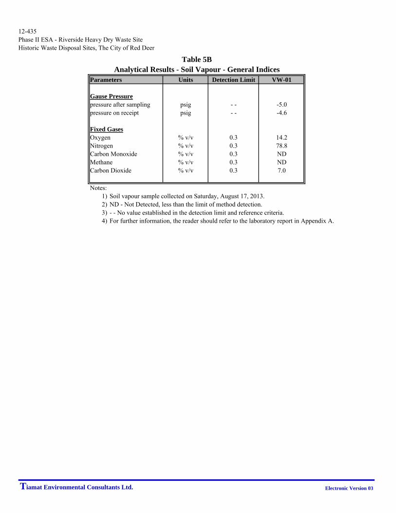
Parameters Units Detection Limit VW-01
Gause Pressurepressure after sampling psig - - -5.0pressure on receipt psig - - -4.6
Fixed GasesOxygen % v/v 0.3 14.2Nitrogen % v/v 0.3 78.8Carbon Monoxide % v/v 0.3 NDMethane % v/v 0.3 NDCarbon Dioxide % v/v 0.3 7.0
Notes:1) Soil vapour sample collected on Saturday, August 17, 2013.2) ND - Not Detected, less than the limit of method detection.3) - - No value established in the detection limit and reference criteria.4) For further information, the reader should refer to the laboratory report in Appendix A.
Table 5BAnalytical Results - Soil Vapour - General Indices
Tiamat Environmental Consultants Ltd. Electronic Version 03

12-435Phase II ESA - Riverside Heavy Dry Waste SiteHistoric Waste Disposal Sites, The City of Red Deer
Unit Detection VW-01Limit 08/17/13
Hydrocarbon Fractions
Aliphatic >C5-C6 μg/m35.0 7.3
Aliphatic >C6-C8 μg/m35.0 34.9
Aliphatic >C8-C10 μg/m35.0 27.8
Aliphatic >C10-C12 μg/m35.0 39.7
Aliphatic >C12-C16 μg/m35.0 15.2
Aromatic >C7-C8 (TEX Excluded) μg/m35.0 ND
Aromatic >C8-C10 μg/m35.0 6.7
Aromatic >C10-C12 μg/m35.0 6.1
Aromatic >C12-C16 μg/m35.0 ND
Select Volatile GasesAcetylene ppm 0.26 NDEthane ppm 0.26 NDEthylene ppm 0.26 NDMethane ppm 5.1 NDn-Butane ppm 0.51 ND
n-Pentane ppm 0.26 NDPropane ppm 0.26 ND
Table 5CAnalytical Results - Soil Vapour - VOCs
Parameters
Propane ppm 0.26 NDPropene ppm 0.26 NDPropyne ppm 0.51 ND
Volatile Organic CompoundsDichlorodifluoromethane (FREON 12) ppbv 0.20 1.081,2-Dichlorotetrafluoroethane ppbv 0.17 NDChloromethane ppbv 0.30 1.21Vinyl Chloride ppbv 0.18 NDChloroethane ppbv 0.30 ND
1,3-Butadiene ppbv 0.50 NDTrichlorofluoromethane (FREON 11) ppbv 0.20 0.40Ethanol (ethyl alcohol) ppbv 2.3 21.8Trichlorotrifluoroethane ppbv 0.15 ND2-propanol ppbv 3.0 3.2
2-Propanone ppbv 0.80 22.8Methyl Ethyl Ketone (2-Butanone) ppbv 5.0 NDMethyl Isobutyl Ketone ppbv 3.2 NDMethyl Butyl Ketone (2-Hexanone) ppbv 2.0 NDMethyl t-butyl ether (MTBE) ppbv 0.20 ND
Ethyl Acetate ppbv 2.2 ND1,1-Dichloroethylene ppbv 0.25 NDcis-1,2-Dichloroethylene ppbv 0.19 NDtrans-1,2-Dichloroethylene ppbv 0.20 NDMethylene Chloride(Dichloromethane) ppbv 0.80 ND
Chloroform ppbv 0.15 0.33Carbon Tetrachloride ppbv 0.30 ND1,1-Dichloroethane ppbv 0.20 ND1,2-Dichloroethane ppbv 0.20 NDEthylene Dibromide ppbv 0.17 ND
1,1,1-Trichloroethane ppbv 0.30 ND1,1,2-Trichloroethane ppbv 0.15 ND1,1,2,2-Tetrachloroethane ppbv 0.20 NDcis-1,3-Dichloropropene ppbv 0.18 NDtrans-1,3-Dichloropropene ppbv 0.17 ND
1,2-Dichloropropane ppbv 0.40 NDBromomethane ppbv 0.18 NDBromoform ppbv 0.20 NDBromodichloromethane ppbv 0.20 NDDibromochloromethane ppbv 0.20 ND
Trichloroethylene ppbv 0.30 NDTetrachloroethylene ppbv 0.20 NDBenzene ppbv 0.18 0.48Toluene ppbv 0.20 1.86Ethylbenzene ppbv 0.20 0.55
p+m-Xylene ppbv 0.37 2.53o-Xylene ppbv 0.20 0.84Styrene ppbv 0.20 ND4-ethyltoluene ppbv 2.2 ND1,3,5-Trimethylbenzene ppbv 0.50 ND
1,2,4-Trimethylbenzene ppbv 0.50 NDChlorobenzene ppbv 0.20 NDBenzyl chloride ppbv 1 0 NDBenzyl chloride ppbv 1.0 ND1,3-Dichlorobenzene ppbv 0.40 ND1,4-Dichlorobenzene ppbv 0.40 ND
1,2-Dichlorobenzene ppbv 0.40 ND1,2,4-Trichlorobenzene ppbv 2.0 NDHexachlorobutadiene ppbv 3.0 NDHexane ppbv 0.30 3.44Heptane ppbv 0.30 0.49
Cyclohexane ppbv 0.20 0.40Tetrahydrofuran ppbv 0.40 3.491,4-Dioxane ppbv 2.0 NDXylene (Total) ppbv 0.60 3.37Vinyl Bromide ppbv 0.20 ND
Propene ppbv 0.30 1.292,2,4-Trimethylpentane ppbv 0.20 0.25Carbon Disulfide ppbv 0.50 6.98Vinyl Acetate ppbv 0.20 ND
Notes:1) Results are from sampling performed on Saturday, August 17, 2013.2) ND - Not Detected, less than the limit of method detection.3) - - No value established in the detection limit and reference criteria.4) For further information, the reader should refer to the laboratory report in Appendix A.
Tiamat Environmental Consultants Ltd. Electronic Version 03

12-435Phase II ESA - Riverside Heavy Dry Waste SiteHistoric Waste Disposal Sites, The City of Red Deer
mg/m³ ppm mg/m³ ppm
Trimethylsilyl Fluoride - - - - 0.0011 0.0003Tetramethylsilane 0.0001 0.0001 ND NDMethoxytrimethylsilane 0.0019 0.0004 ND NDEthoxytrimethylsilane 0.0018 0.0004 ND NDTrimethylsilanol - - - - 0.0526 0.0143
Isopropoxytrimethylsilane 0.0008 0.0001 ND NDTrimethoxymethyl Silane # - - - - ND NDHexamethyl Disiloxane - L2 - - - - 0.0006 0.0001Propoxytrimethylsilane 0.0021 0.0004 ND ND1-Methylbutoxytrimethylsilane * - - - - ND ND
Butoxytrimethylsilane * - - - - ND NDTrimethoxyvinyl Silane # - - - - ND NDHexamethyl Cyclotrisiloxane - D3 - - - - 0.0111 0.0012Octamethyl Trisiloxane - L3 0.0001 0.0001 ND NDTriethoxyvinyl Silane # - - - - ND ND
Triethoxyethyl Silane # - - - - ND NDOctamethyl Cyclotetrasiloxane - D4 - - - - 0.0090 0.0007Decamethyl Tetrasiloxane - L4 0.0002 0.0001 ND NDTetraethylsilicate # - - - - ND NDDecamethyl Cyclopentasiloxane D5 0 0236 0 0016
Table 5DAnalytical Results - Soil Vapour - Siloxanes
Detection VW-01Parameter Limit 08/17/2013
Decamethyl Cyclopentasiloxane - D5 - - - - 0.0236 0.0016
Dodecamethyl Pentasiloxane - L5 0.0018 0.0001 ND NDDodecamethyl Cyclohexasiloxane - D6 - - - - 0.1655 0.0091Sum - - - - 0.2722 0.0288
Notes:1) Soil vapour samples collected on Saturday, August 17, 2013.2) ND - Not Detected, less than the limit of method detection.3) - - No value established in the detection limit and reference criteria.4) V=200 mL, where V is volume of air/gas sampled.5) * - Semiquanititative (response factor set at 5).6) # - Unstable, poor detectability, commercial standards tested.7) For further information, the reader should refer to the laboratory report in Appendix A.
Tiamat Environmental Consultants Ltd. Electronic Version 03

12-435 Phase II ESA – Riverside Heavy Dry Waste Site Historic Waste Disposal Sites, The City of Red Deer
Tiamat Environmental Consultants Ltd. Electronic Version 03
FIGURES
iamat Environmental Consultants Ltd.TPHASE II ESA HISTORIC WASTE DISPOSAL SITES
THE CITY OF RED DEER
FIGURE 1
SITE PLAN SHOWING SURROUNDING LAND USES
RED DEER FIRE
TRAINING CENTRE
COMMERCIAL
S
L
O
U
G
H
RIVERSIDE HEAVY DRY WASTE
CA
NA
DIA
N N
AT
IO
NA
L S
PU
R LIN
E
N
O
R
T
H
L
A
N
D
D
R
I
V
E
78 STREET CRESCENT
45 A
VE
NU
E
48 A
VE
NU
E
78 STREET CLOSE
100 m SETBACK
200 m SETBACK
300 m SETBACK
LEGEND
HISTORIC WASTE DISPOSAL
LOT BOUNDARY
40 A
VE
NU
E
NORTHLANDS
INDUSTRIAL PARK
0 50
Scale 1:5000
100 200m

ELECTRICAL
SANITARY
STORM
WATER
iamat Environmental Consultants Ltd.TPHASE II ESA HISTORIC WASTE DISPOSAL SITES
THE CITY OF RED DEER
FIGURE 2
PHASE II TEST LOCATIONS
GROUNDWATER MONITORING WELL (3)
TESTHOLE (9)
SOIL VAPOUR MONITORING WELL (2)
SOURCE
2010 ORTHOGRAPHIC IMAGE © COPYRIGHT WITH
PERMISSION FROM THE CITY OF RED DEER.
MW-##
TH-##
VW-##
0 20
Scale 1:1500
80m40
COMMERCIAL
RED DEER FIRE
TRAINING CENTRE
COMMERCIAL
NORTHLANDS
INDUSTRIAL PARK
SLOUGH
LEGEND
HISTORIC WASTE DISPOSAL
MUNICIPAL SANITARY WASTE AREA
LOT BOUNDARY
CROSS SECTION LOCATION
PHASE II ESA TEST LOCATIONS AND
INTERPRETED EXTENT OF WASTE
RIVERSIDE HEAVY DRY WASTE
NOTE:
LOCATION OF BURIED UTILITIES ARE APPROXIMATE,
ACTUAL LOCATIONS OF THE SHALLOW UTILITIES
AND ANY OTHER UTILITIES SHOULD BE VERIFIED
PRIOR TO ANY GROUND DISTURBANCE ACTIVITY.

870
868
866
864
862
872
VW-01
A
WEST
860
858
856
854
852
850
848
846
844
TH-06
MW-03
866
864
862
860
858
856
854
852
850
848
846
844
842
840
EOH
EOH
MUNICIPAL
SOLID
WASTE
SAND
(FILL)
MUNICIPAL
SOLID WASTE
CLAY (FILL)
CLAY
(FILL)
SAND (FILL)
SAND
(NATIVE)
CLAY
(NATIVE)
PRAIRIE VEGETATION/
LOAM/SAND
A'
EAST
845.731 m
AUG. 17/13
SILT
PROJECTED
GROUNDWATER LEVEL IS
EXPECTED TO BE SIMILAR
TO WATER LEVEL IN MW-01
G
R
O
U
N
D
W
A
T
E
R
F
L
O
W
D
I
R
E
C
T
I
O
N
CLAY
(NATIVE)
0 2
Vertical Scale 1:200
10m5
NOTE:
THE GEOLOGIC AND STRATIGRAPHIC SECTIONS SHOWN ON THIS
DRAWING ARE INTERPRETED FROM BOREHOLE LOGS. STRATIGRAPHY
IS KNOWN WITH CERTAINTY ONLY AT THE BOREHOLE LOCATIONS.
ACTUAL STRATIGRAPHY AND GEOLOGIC CONDITIONS BETWEEN
BOREHOLES MAY VARY FROM THAT INDICATED ON THIS DRAWING.
CROSS SECTION A - A'
iamat Environmental Consultants Ltd.TPHASE II ESA HISTORIC WASTE DISPOSAL SITES
THE CITY OF RED DEER
FIGURE 3A
0 10
Horizontal Scale 1:1000
30 50m RIVERSIDE HEAVY DRY WASTE

870
868
866
864
862
872
MW-01
B
SOUTH
860
858
856
854
852
850
848
TH-06
MW-02
866
864
862
860
858
856
854
852
850
848
846
844
842
EOH
EOH
MUNICIPAL
SOLID WASTE
CLAY
(NATIVE)
SILT
SILTSTONE
(BEDROCK)
PRAIRIE VEGETATION/
LOAM/SAND
B'
NORTH
TH-06
EOH
EOH
CLAY
(FILL)
CLAY
(FILL)
SAND
(NATIVE)
CLAY
(FILL)
CLAY
(NATIVE)
874
SANDY
CLAY (FILL)
862.180 m
AUG. 17/13
G
R
O
U
N
D
W
A
T
E
R
F
L
O
W
D
I
R
E
C
T
I
O
N
862.180 m
AUG. 17/13
0 2
Vertical Scale 1:200
10m5
NOTE:
THE GEOLOGIC AND STRATIGRAPHIC SECTIONS SHOWN ON THIS
DRAWING ARE INTERPRETED FROM BOREHOLE LOGS. STRATIGRAPHY
IS KNOWN WITH CERTAINTY ONLY AT THE BOREHOLE LOCATIONS.
ACTUAL STRATIGRAPHY AND GEOLOGIC CONDITIONS BETWEEN
BOREHOLES MAY VARY FROM THAT INDICATED ON THIS DRAWING.
CROSS SECTION B - B'
iamat Environmental Consultants Ltd.TPHASE II ESA HISTORIC WASTE DISPOSAL SITES
THE CITY OF RED DEER
FIGURE 3B
0 10
Horizontal Scale 1:1000
30 50m RIVERSIDE HEAVY DRY WASTE

NOTE:
LOCATION OF BURIED UTILITIES ARE APPROXIMATE,
ACTUAL LOCATIONS OF THE SHALLOW UTILITIES
AND ANY OTHER UTILITIES SHOULD BE VERIFIED
PRIOR TO ANY GROUND DISTURBANCE ACTIVITY.
ELECTRICAL
SANITARY
STORM
WATER
LEGEND
HISTORIC WASTE DISPOSAL
LOT BOUNDARY
iamat Environmental Consultants Ltd.TPHASE II ESA HISTORIC WASTE DISPOSAL SITES
THE CITY OF RED DEER
FIGURE 4
PHASE II TEST LOCATIONS
GROUNDWATER MONITORING WELL (3)
TESTHOLE (9)
SOIL VAPOUR MONITORING WELL (2)
SOURCE
2010 ORTHOGRAPHIC IMAGE © COPYRIGHT WITH
PERMISSION FROM THE CITY OF RED DEER.
MW-##
TH-##
VW-##
RIVERSIDE HEAVY DRY WASTE
0 20
Scale 1:1500
80m40
COMMERCIAL
RED DEER FIRE
TRAINING CENTRE
COMMERCIAL
NORTHLANDS
INDUSTRIAL PARK
SLOUGH
INTERPRETED GROUNDWATER ELEVATIONS
AUGUST 17, 2013
GROUNDWATER DATA
GROUNDWATER ELEVATION (m) AUGUST 1, 2013
INTERPRETED GROUNDWATER CONTOUR (m)
INTERPRETED GROUNDWATER FLOW DIRECTION
(850.150)

12-435 Phase II ESA – Riverside Heavy Dry Waste Site Historic Waste Disposal Sites, The City of Red Deer
Tiamat Environmental Consultants Ltd. Electronic Version 03
APPENDIX A
FIELD PROTOCOLS AND ANALYTICAL DATA, ASCM INFORMATION
AND LABORATORY REPORTS

12-435 A-1 of 9 Phase II ESA – Riverside Heavy Dry Waste Site Historic Waste Disposal Sites, The City of Red Deer
Tiamat Environmental Consultants Ltd. Electronic Version 03
Field Protocols for Soil, Groundwater and Soil Vapour Monitoring Headspace Vapours and Liquid Levels Headspace Vapours Headspace vapours were measured with an RKI Eagle II portable dual sensor gas meter. The combustible vapour sensor is calibrated to hexane; the volatile vapour sensor is calibrated to isobutylene. The sample pump operates at a flow rate of about 944 ml/minute and the instrument response time is rated at 90% reading within 30 seconds, more or less. Below is a list of the general headspace vapour monitoring protocol employed by Tiamat staff.
1. Allow the combustible and volatile sensors in the RKI Eagle II to stabilize after turning the instrument on. Typically, the instrument will stabilize within 3 to 5 minutes. Check the display voltage for the instrument is within the specified normal operating range. Should the display not show zero in ambient air, verify there are no interfering sources of Volatile Organic Compound (VOC) or combustible vapours and perform an instrument "fresh air zero" in a fresh air environment.
2. Prior to measuring headspace vapours, the monitoring well screw caps were loosened just before monitoring was conducted.
3. The probe tip of the RKI Eagle II was inserted into the top section of the monitoring well using a gloved hand. The gloved hand is held against the top of the monitoring well to limit influences of air currents at the ground surface mixing with the headspace during the period of measurement. Measurement is for a minimum of 30 seconds and maximum of approximately 2 minutes.
4. The highest reading from each sensor of the RKI Eagle was recorded in ppm, unless otherwise noted.
5. Should a low oxygen alarm activate during the measurement period, monitor the display and withdraw the probe tip once the reading has peaked. Observe the reading while the probe draws fresh air. Record the maximum reading. Repeat this if necessary.
Liquid Levels Liquid levels are measured by a Heron H.01L oil-water interface meter. The interface probe is lowered into the monitoring well until an audible signal is established by the probe. Liquid readings are taken during the lowering of the probe to minimize effects of surface tension and potential erroneous readings. The measurement is taken to the highest point on the monitoring well pipe.

12-435 A-2 of 9 Phase II ESA – Riverside Heavy Dry Waste Site Historic Waste Disposal Sites, The City of Red Deer
Tiamat Environmental Consultants Ltd. Electronic Version 03
The interface probe is washed with a detergent solution and thoroughly rinsed with clean water between each monitoring well. Measurement of Water Quality Indices Standard water quality parameters (pH, electrical conductivity, temperature, dissolved oxygen, total dissolved solids and redox potential) were field measured by a YSI Pro Plus multi-meter. The multi-meter is calibrated prior to each sampling event. Calibration is performed and documented in-house at Tiamat and re-checked by an independent third-party service provider between every third or fourth in-house instrument calibration event. Calibration and service records are maintained on file. Groundwater Sampling Groundwater sampling is conducted using either a disposable polyethylene bailer or portable stainless steel submersible pump. The specific sample pump utilizes a low flow sampling technique to minimize losses of VOCs by degassing during collection of water sample. In circumstances where insufficient water is present in a groundwater monitoring well, a dedicated polyethylene bailer is used. Sampling by Disposable Polyethylene Bailer Field procedures to perform groundwater sampling using a disposable polyethylene bailer are as follow:
1. Loosen the well screw caps and measure the liquid level with a Heron interface probe. Lower the interface probe to the highest side of the monitoring well pipe and take the first reading when an audible signal is established. The probe is rinsed with a detergent solution and clean water between each well.
2. Measure the nylon string to an approximate length of about 1 m or so greater than
the expected sampling depth.
3. Tie the string to the bailer, make a big loop at the other end of the string and tie it to the sampler’s hand.
4. Lower the bailer into the well, bail the stagnant water and dispose into a pail.
Note subjectively any attributes of the purged ground water such as, odour, colour and phase-separate liquid.
5. During and following purging, the water indices (pH, electrical conductivity,
temperature, dissolved O2, total dissolved solids, and redox) are measured by a YSI multi-meter using a sample container and bailer or a flow cell and pump combination.
6. Repeat steps 4-5 until pH, electrical conductivity and temperature exhibit less
than 10% variation, indicating a stabilized groundwater condition.

12-435 A-3 of 9 Phase II ESA – Riverside Heavy Dry Waste Site Historic Waste Disposal Sites, The City of Red Deer
Tiamat Environmental Consultants Ltd. Electronic Version 03
7. Once the indices indicate a stabilized state, water samples are bottled into laboratory supplied bottles and preservatives as per the laboratory instruction.
8. Note the approximate volume of water extracted, the visual quality of water, any unusual odour or discolouration and the water indices at the time of sample collection.
9. New bailer, nylon string and disposable nitrile gloves are used at each well to
prevent cross contamination and preserve sample integrity. Low Flow Sampling Field procedures to perform low flow sampling are as follow:
1. Loosen the well screw caps and measure the liquid level with a Heron interface probe. Lower the interface probe to the highest side of the monitoring well pipe and take the first reading when an audible signal is established. The probe will be rinsed with a detergent solution and clean water between each well.
2. Once the liquid level is measured, the distance between the bottom of the
monitoring well and the liquid level is calculated. The pump will be set near the middle of the water column in order to avoid stirring of sediments at the bottom of the well.
3. The required length of the Teflon tubing is determined by adding the length of the middle water column and an additional length to allow for water discharge into a pail. If the monitoring well is an aboveground casing, the length of the aboveground casing will be added as well.
4. New Teflon tubing is used at each well to avoid cross contamination.
5. Set up 12 V Monsoon stainless steel submersible pump and flow controller with Teflon tubing. Slowly lower the pump to the middle of the water column.
6. Adjust the voltage on the flow controller to acquire the required flow rate.
Measure the liquid level using the interface probe from time to time. Minimal drawdown is attained once the liquid level drops and stays within the 10% range of the first measurement.
7. Once the required flow rate is achieved, attach the Teflon tubing to the inlet of the
flow cell with the YSI multi-meter probe and measure the indices with the YSI multi-meter. Connect a discharge Teflon tube to the outlet of the flow cell to allow for water to discharge from the flow cell into a pail.
8. Collect groundwater samples after pH, electrical conductivity and temperature
stabilize within 10% variation. Apply preservatives as per the laboratory instruction.

12-435 A-4 of 9 Phase II ESA – Riverside Heavy Dry Waste Site Historic Waste Disposal Sites, The City of Red Deer
Tiamat Environmental Consultants Ltd. Electronic Version 03
9. After collecting samples, transfer the pump into a clean pail filled with clean water and let it run for a moment to remove entrapped sediments. Then run the pump in a second pail to ensure thorough flush following the first rinse.
10. To avoid confusion, label pails in the sequence where the pump is rinsed. Replace with clean water in the pail as required.
Groundwater Sample Handling The laboratory requires six (6) 40 ml clear glass vials and two (2) 250 ml amber bottles for analyses of Volatile Organic Compounds (VOCs), Benzene, Toluene, Ethylbenzene, Xylenes (BTEX), petroleum hydrocarbon fractions F1 and F2. Check the white preservative tablets are present in each 40 ml vial and 250 ml amber bottle. As well, once filled and capped, confirm each vial and bottle exhibits no notable headspace. If necessary, discard and resample with new vials and bottles. A 45 micron filter is used to field filter groundwater for analyses of dissolved metals. The filter outlet is placed on top of a sample bottle while water is decanted through a dedicated Teflon tubing attached to the inlet of the filter. Laboratory provided nitric acid is used to preserve the sample. New filter and Teflon tubing are used for each well location. During field sampling disposable nitrile gloves are worn during sampling and changed between wells. In the event where suspicious cross-contamination occurs, nitrile gloves and sampling bottles are discarded and replaced. Each set of samples is properly labelled and bagged into a dedicated poly bag to prevent potential cross contamination between sample bottles from different well locations. Samples are stored in a cooler with ice to maintain temperature at about 5o C. The coolers are dropped off at a secure laboratory depot with a completed chain of custody at the end of each sampling day for delivery to the laboratory in Calgary, Alberta. Soil Sampling During Drilling Soil samples were collected during the advancement of testholes using solid stem auger, hollow stem auger or ODEX tooling. A Geoprobe or small track or truck-mounted drill rig was determined pending the presence of soft ground and the ability to access test locations in a confined or steep slope (more than 10%).
Solid stem auger was used at most of the sites to enable collection of representative soil samples. However, in cases where the test location lies near the river bank or on top of gravels, hollow stem auger or ODEX was employed to drill through the hard sediments and prevent sloughing and enable the installation of a groundwater or soil vapour monitoring well. When waste material is noted in soil, the drilling continues to the depth where the waste ends and/or the native soil is encountered to ensure complete profiling of the waste

12-435 A-5 of 9 Phase II ESA – Riverside Heavy Dry Waste Site Historic Waste Disposal Sites, The City of Red Deer
Tiamat Environmental Consultants Ltd. Electronic Version 03
material. Bulk soil samples underlying the waste were collected for laboratory analyses; soil samples from each soil bag were also submitted for laboratory analyses. Pending laboratory results, drill cuttings in the soil bags may be disposed at The City of Red Deer Waste Management Facility. Sampling Soil Vapour Using Summa Canister®
1. Unlock the steel well casing and remove the brass cap from the vapour probe valve. Connect the lab provided Teflon tubing with Swagelok® fitting to the probe valve. Hand-tighten the fitting plus ¼ additional turn using a 9/16 inch wrench. To avoid damage and short circuit of the Swagelok®, care should be taken to avoid over tightening the Swagelok® fitting.
2. Connect the probe tip of the RKI Eagle II with the Teflon tubing attached to the vapour probe. Open the vapour valve to allow the vapour to flow into the monitoring instrument.
3. Start the stop watch to count the purge time. The purge time is calculated by
dividing the volume of the 1 inch PVC pipe with the flow rate of the RKI Eagle II.
4. For sites with heavy municipal solid waste (MSW) i.e. Lindsay Thurber
Comprehensive High School, McKenzie Trail, Montfort, Red Deer College and Red Deer Motors, a minimum of three (3) equivalent volumes of soil vapour are purged prior to collecting a well vapour sample.
5. Record combustible and volatile vapours between the initial 30 seconds to two (2)
minutes during purging.
6. Using the digital Cole-Palmer absolute pressure gauge, record the ambient and probe barometric pressures. The probe pressure is measured by connecting the gauge tip with the Teflon tubing attached to the vapour probe. The vapour probe and the pressure gauge should be on during the measurement.
7. Remove the brass cap from the 1.4 L Summa Canister® valve with a 9/16 inch
wrench.
8. Attach the flow controller to the canister and remove the brass cap from the gauge adapter. Hand tighten the fittings and tighten another ¼ turn using a 9/16 wrench.
9. Open the valve, record the canister vacuum (this should read between -29 to -25
in Hg and close the valve.
10. Connect the adapter with the Teflon tubing to the vapour probe. Hand-tighten the fitting and tighten another ¼ turn using a 9/16 inch wrench.

12-435 A-6 of 9 Phase II ESA – Riverside Heavy Dry Waste Site Historic Waste Disposal Sites, The City of Red Deer
Tiamat Environmental Consultants Ltd. Electronic Version 03
11. Open the vapour probe and open the canister valve. Check the gauge periodically to ensure sample flow rate is acceptable.
12. When the vacuum reads about -5 inches Hg, close the vapour probe and the valve, disassemble the flow controller and the Teflon tubing, then place the protective brass cap back on the canister valve. Hand tighten the cap and perform another ¼ turn using a 9/16 inch wrench.
13. It is always a good practice to maintain some vacuum in the canister following sampling. The residual vacuum serves as a check for the integrity of the canister during transport to the laboratory.
14. Record the canister and the flow controller serial numbers on the field sheet and the chain of custody.
15. A dedicated set of Teflon tubing, Swagelok® fitting and gauge with flow controller assembly must be used at each sample well location to prevent cross contamination.
Sampling Soil Vapour Using Tedlar Bag®
1. Place the 1 L Tedlar Bag® inside the lung box. Connect the Tedlar Bag® nozzle with the tubing attached to the brass nipple inside the lung box.
2. Perform a full turn counter clockwise to open the valve and go another ¼ turn clockwise. This is to ensure that the valve is properly opened for sampling.
3. Connect the Teflon tubing attached to the vapour probe with the exterior brass nipple on the lung box.
4. Connect the other exterior brass nipple of the lung box to the SKC pump. Ensure
the lung box is closed to prevent air leak during sampling.
5. Open the vapour probe valve and activate the SKC pump. The pump will evacuate the lung box causing the Tedlar Bag® to expand drawing a sample of soil vapour.
6. The SKC pump was set at a flow rate of 0.5 L/min and the volume of the lung box is 4 L. The estimated sampling time is approximately 8 minutes. Check the Tedlar Bag® at about 8 minutes or periodically to verify the progress of sample collection.
7. When the Tedlar Bag® is approximately 80% full, close the bag valve by turning it clockwise until it is tight. Then turn off the SKC pump and close the vapour probe. To ensure the bag is sufficiently filled, repeat steps 5-7, if necessary.

12-435 A-7 of 9 Phase II ESA – Riverside Heavy Dry Waste Site Historic Waste Disposal Sites, The City of Red Deer
Tiamat Environmental Consultants Ltd. Electronic Version 03
8. Avoid over filling the Tedlar Bag®. This will prevent damage to the bag if exposure to change of temperature, altitude and barometric pressure occurs during transport by ground and/or air.
Validation of Analytical Data Alberta Environment and Sustainable Resource Development (ESRD), formerly Alberta Environment, implemented a Laboratory Data Quality Assurance Policy in October 2001. This policy requires laboratories providing environmental analytical data to meet the accreditation standards set by ESRD. ALS Canada Ltd. and Maxxam Analytics are each accredited by Standards Council of Canada (SCC), which is administered by the Canadian Association for Laboratory Accreditation Inc. (CALA). This accreditation demonstrates ALS Canada Ltd. Laboratories and Maxxam Analytics have consistent laboratory procedures and quality controls meeting national and international standards for staff training, equipment maintenance and documentation of parameters. The laboratory protocols must be maintained to demonstrate the in lab quality assurance/quality control (QA/QC) procedures are consistently maintained and are paramount to the integrity and reliability of the reported results. A data quality review was performed for all analytical results reported. The data quality review comprised of the following actions by Tiamat.
Ensure the Chain of Custody form are properly completed and signed;
Ensure the requested analyses were performed and reported for the correct samples;
Calculate and review relative percent differences (RPD), where available, to assess the laboratory precision and analytical variability for each batch of samples;
Perform independent review of the internal quality control (QC) and quality assurance (QA) practices for the laboratory;
Confirm the applicable holding times and extraction times for each sample have been met by the laboratory;
Identify and resolve additional data quality issues with the laboratory. The Chain of Custody forms submitted for each work order for this project appeared to be properly completed. The Chain of Custody forms show the sample temperature (where applicable) upon receipt at the laboratory and the appropriate sample custody signatures. Laboratory QC protocols include surrogate recoveries, laboratory duplicates, method blanks, matrix spikes and reference materials, where applicable. QC results published

12-435 A-8 of 9 Phase II ESA – Riverside Heavy Dry Waste Site Historic Waste Disposal Sites, The City of Red Deer
Tiamat Environmental Consultants Ltd. Electronic Version 03
with the sample report comply with the prescribed laboratory QC limits. Thus, analytical results are deemed to be within acceptable variability and a corresponding acceptable level of precision and accuracy. Tiamat reviews all QA/QC outcomes published with the respective laboratory reports. Discrepancies are reported to the laboratory for follow-up. The laboratory’s analytical processes for the specific testing program for this project appear to be acceptable. The holding times experienced by all samples submitted met the recommended holding time limit for the specified parameter where applicable. Overall, the review and data validation process indicates the analytical results are valid and reliable. For the Riverside Heavy Dry Waste Site, a total of 3 groundwater samples, 1 Summa Canister® and 1 Tedlar Bag® was collected for this Phase II ESA. Note, a duplicate Tedlar Bag® sample was collected for QA/QC purposes. Sample containers were provided by the laboratory. Collected samples are appropriately packed in sample coolers and shipped from Red Deer to Calgary by a third-party courier contracted by the respective laboratory. It is presumed the courier handles the sample coolers with appropriate care. There were no reported issues with the samples upon receipt at the laboratory. Tiamat applies a uniform field protocol consistent with industry practice to ensure the integrity of each sample collected for laboratory analysis. Coupled with the in-house laboratory control measures implemented by each laboratory, the overall QA/QC objectives are deemed to be satisfied. Field Duplicate Evaluation An evaluation of duplicate variation is undertaken to assess the precision of field sampling and laboratory analyses. For comparison, the relative percent difference (RPD) is calculated. RPD is defined as the absolute difference between two results divided by the average of the two results multiplied by one hundred. Where one result is below detection limit, and its duplicate result is above detection limit, the non-detect concentration is assigned the detection limit for the purposes of calculating RPD. Groundwater duplicates should be taken during groundwater sampling events at an average of every ten (10) samples or about 10% of the sample set. For groundwater samples, the objective for RPD values is to be not more than 20%. Field Blank Assessment A field blank is a sample of laboratory-supplied reverse osmosis water poured into a laboratory supplied sample container in the field and shipped to the laboratory with the field samples using a unique sample identifier. The purpose of a field blank is to assess

12-435 A-9 of 9 Phase II ESA – Riverside Heavy Dry Waste Site Historic Waste Disposal Sites, The City of Red Deer
Tiamat Environmental Consultants Ltd. Electronic Version 03
potential cross contamination from field conditions during sampling. For this initial assessment, no previous site specific analyte data was available, thus field blanks were not deemed to be necessary. Trip Blank Assessment A trip blank is a clean sample container of reverse osmosis water that is taken to the sampling site and transported back to the laboratory for analysis without having been exposed to sampling procedures. The trip blanks prepared by the laboratory are kept within the sample containers at all times and never opened in the field. Analyses of trip blanks indicate whether a sample was contaminated during shipment from the laboratory to the field and from the field to the laboratory. Tiamat’s standard sample bottle procedure is to have each set of sample bottles placed into clean new plastic bags. This prevents direct contact between other sample bottles in the sample cooler. Field Duplicates Duplicate samples are samples collected sequentially at the time of sampling. Generally the same compounds should be detected in both samples. For this initial assessment, there have been no history of problematic analytical parameters and field duplicates were not warranted. Laboratory Quality Control The following sections outline the quality control measures which the laboratory implements. Generally, Maxxam’s and ALS’s QA/QC samples were tested at least once per analytical batch. Laboratory Duplicate Assessment Lab duplicates are two separate aliquots of water (from one location but from different vials) that are analysed in the laboratory to assess laboratory analytical precision. For comparison between duplicates a calculation of relative percent difference (RPD) was carried out by the laboratory. No laboratory duplicate had any analytes with an RPD greater than the laboratory control limits. This quantitatively affirms the QA/QC and the precision of a sample result. Matrix Spike Assessment A matrix spike is a sample prepared by adding a known mass of a target analyte(s) to a specified amount of sample (matrix). Spiked samples are used to determine the effect of the matrix on a method’s recovery efficiency. The laboratory states their control limits based on 99% confidence interval in the quality control report section of the laboratory analytical report. Control limits for recoveries are often statistically determined by the method, but under some conditions may revert to standard method limits. Generally, matrix spike recoveries for groundwater tests were within laboratory control limits. The results of matrix spike recovery confirm the protocols and the acceptable limits established by the laboratory for precision and accuracy was met.
Terms and Conditions for use of Alberta Survey Control Marker Data
1. The distribution of this digital data is provided as a service to the user and is under copyright to the Government of Alberta.
2. Redistribution of the data in whole or in part, whether alone or part of a value added product, is not permitted without the prior written consent of Alberta Sustainable Resource Development on behalf of the Minister of Alberta Sustainable Resource Development, Government of Alberta.
3. In view of the dated nature of the data, it is the responsibility of the user of the data: a) Confirm with the Alberta Sustainable Resource Development whether later versions are available before making use of the data. b) Advise users of the age and status of the data if the Minister permits the user to provide the data to other users.
4. The user agrees that the data and each part thereof, any formatting or presentation thereof, any storage media on which it is provided, and any communication of any kind, incidental or in relation thereto, is provided to the user by the Minister and the Crown without warranty or representation as to any matter including but not limited to whether the data and storage media is correct, accurate or free from error, defect, danger, or hazard, and whether it is otherwise useful or suitable for any use the user may make of it.
5. The Crown in right of Alberta, the Minister and their employees and agents, shall not be liable for any claims, costs, losses, or damages, including any special, indirect, incidental or consequential loss or damage, which the user may incur or experience as a result of the use or possession of the data or associated storage media.

SURVEYING AND MAPPING DIVISION Alberta Survey Control Marker (ASCM) Information MASCOT DSS-1Horz Datum NAD83 Updated: 1994-05-24 ASCM 36574Latitude 52 17 43.12829 dms Marker Installed 67-03Longitude 113 47 52.26311 dms Tablet Markings 793+16.23.4Horz Class INTEGRATED , ORDER 2 Date Printed 2013-08-21 Last Updated 2003-03-12 Mapsheet Name RED DEERVert Datum CVD28 Updated: 1983-12-08 Mapsheet Number 5793 + 016Elevation 850.471 m For current information call Geodetic SurveyVert Class INTEGRATED , SPIRIT LEVELS (780) 427-3143 FAX: (780) 427-1493 Marker Condition GOOD 92-02-20------------------------------------------------------------------------------------------------------------------------------------3TM COORDINATES ADJACENT MARKERS (calculated) Updated: 1994-06-07
Scale Factor 0.999900 At Ref Mer 114 ASCM Tablet Horizontal Std PPM/ Grid/ Grnd Grid Std T-t To Markings Distance Dev Order Factor Bearing Dev CorrNorthing 5795642.746 m (m)(cm) (dms) (s) (s)Easting 13790.274 m 67884 793+16.23.3 427.874 1 28/1 0.999774 29 42 37.77 2.4 0.01Convergence 0 09 35.77 dms 14266 793+16.24.3 444.161 1 40/2 0.999769 297 38 36.48 3.4 0.01Station Ellipsoid Factor 0.999870 39024 793+16.91 474.231 1 38/2 0.999770 292 23 06.92 3.2 0.01Station Combined Factor 0.999772 124339 793+16.103 483.134 1 29/2 0.999771 186 38 49.27 2.5 -0.02--------------------------------------------- 225466 793+16.96 491.603 1 45/2 0.999770 249 07 53.21 3.6 -0.01GEOID DATA (GSD95) Updated: 96-01-06 266627 793+16.90 530.988 1 38/2 0.999770 301 13 12.35 3.1 0.01 ----------------------------------------------------------------------------------Component Magnitude Std Dev MARKER TYPE Updated: 1992-03-27
Meridian Defl,XI(+N) 2.1 s 2 s ASC BRASS TABLET MKD 793+16.23.4 ON 7.0CM HEAVY WALL STEEL PIPE.Prime Vert Defl,ETA(+E) 4.4 s 2 s 9 CM BGL IN A MH & COVER, LANDSCAPEDGeoid_Ellip Separation -18.29 m 1 m ------------------------------------------------------------------------------------------------------------------------------- MARKER LOCATION Updated: 1988-12-01COORDINATE HISTORY HORZ VERT LOCATED ON THE WEST SIDE OF RIVERSIDE DRIVE - SOUTH OF 42 AVENUE SHOWN ON PLANOriginating Project 70033 70033 #5495 MCL; 7.0 M NORTH OF CENTRE LINE OF RIVERSIDE DRIVE; 117.7 M SOUTH OF Published 83-12-08 83-12-08 CENTRE LINE OF STORM SEWER CROSSING MARKED WITH SIGN "AUTHORIZED VEHICLES ONLY BEYOND THIS POINT"; COUNTER SUNK IN STEEL SLEEVE WITH REMOVABLE LID. Revising Project NAD83 Published 94-05-24 Revising Project Published Revising Project Published---------------------------------------------NON COORDINATE REVISIONS ----------------------------------------------------------------------------------1971-05-19 FIRST MARKER LOCATION MARKER CONDITION COMMENTS Inspected Updated DESCRIPTION ENTERED2003-03-12 "MAPSHEET NAME" AND/OR MARKER REPORTED IN GOOD CONDITION 1992-02-20 1992-03-27 "MAPSHEET NO" CHANGED MARKER REPORTED IN GOOD CONDITION. 1989-02-08 1989-06-07 MARKER REPORTED IN GOOD CONDITION. 1988-11-24 1988-12-01
---------------------------------------------------------------------------------- COORDINATE HISTORY COMMENTS
HORZ 94-05-24 ALBERTA NAD83 READJUSTMENT---------------------------------------------HISTORICAL/OTHER MARKER NAMES VERTOLD ASC # 57933 16 62
HISTORY 57933 16 62

SURVEYING AND MAPPING DIVISION Alberta Survey Control Marker (ASCM) Information MASCOT DSS-1Horz Datum NAD83 Updated: 1994-05-24 ASCM 124339Latitude 52 17 27.60973 dms Marker Installed 82-12Longitude 113 47 55.28404 dms Tablet Markings 793+16.103Horz Class INTEGRATED , ORDER 2 Date Printed 2013-08-21 Last Updated 2003-03-12 Mapsheet Name RED DEERVert Datum CVD28 Updated: 1984-07-04 Mapsheet Number 5793 + 016Elevation 854.345 m For current information call Geodetic SurveyVert Class INTEGRATED , SPIRIT LEVELS (780) 427-3143 FAX: (780) 427-1493 Marker Condition GOOD 92-02-20------------------------------------------------------------------------------------------------------------------------------------3TM COORDINATES ADJACENT MARKERS (calculated) Updated: 1994-06-06
Scale Factor 0.999900 At Ref Mer 114 ASCM Tablet Horizontal Std PPM/ Grid/ Grnd Grid Std T-t To Markings Distance Dev Order Factor Bearing Dev CorrNorthing 5795162.970 m (m)(cm) (dms) (s) (s)Easting 13734.363 m 109843 793+16.104 314.801 1 73/2 0.999771 271 14 35.24 6.1 0.00Convergence 0 09 33.34 dms 257030 085220 323.950 1 52/2 0.999769 216 07 36.98 4.3 -0.01Station Ellipsoid Factor 0.999869 424036 424036 342.931 1 38/2 0.999769 177 09 24.74 3.1 -0.01Station Combined Factor 0.999771 84251 793+16.13.2 373.193 1 40/2 0.999770 132 41 32.09 3.3 -0.01--------------------------------------------- 41491 793+16.105 389.892 1 51/2 0.999771 243 18 24.12 4.3 -0.01GEOID DATA (GSD95) Updated: 96-01-06 119826 793+16.97 473.445 1 40/2 0.999771 292 28 34.59 3.4 0.01 ----------------------------------------------------------------------------------Component Magnitude Std Dev MARKER TYPE Updated: 1992-03-27
Meridian Defl,XI(+N) 2.1 s 2 s ASC BRASS TABLET ON A 5CM X 250CM HEAVY WALL SQ STEEL PIPE WITH HELIX.Prime Vert Defl,ETA(+E) 4.3 s 2 s FLUSH WITH GROUND. 1 GP, LANDSCAPEDGeoid_Ellip Separation -18.28 m 1 m ------------------------------------------------------------------------------------------------------------------------------- MARKER LOCATION Updated: 1989-06-07COORDINATE HISTORY HORZ VERT LOCATED ON THE WEST SIDE OF RIVERSIDE DRIVE AND NORTH OF 67 STREET (BRIDGE)Originating Project 82042 82042 RIGHT OF WAY NEAR THE NORTH SIDE OF CURVE IN RIVERSIDE DRIVE; ON THE EAST SIDE Published 84-07-04 84-07-04 OF RAIL ROAD ABUTMENT IN GRAVEL; 3.0 M EAST OF EAST RAIL; 25.35 M SOUTH OF ANCHOR POLE FOR POWER POLE #856; 34.0 M WEST OF CENTRE LINE OF RIVERSIDE DRIVE; Revising Project NAD83 52.4 M SOUTH OF FD I AT SOUTH POINT OF LOT 21, BLOCK 1, PLAN #782-2383; 23.3 M Published 94-05-24 WEST OF THIRD LIGHT STANDARD NORTH OF BRIDGE ON OFF RAMP. Revising Project Published Revising Project Published---------------------------------------------NON COORDINATE REVISIONS ----------------------------------------------------------------------------------1984-07-04 FIRST MARKER LOCATION MARKER CONDITION COMMENTS Inspected Updated DESCRIPTION ENTERED2003-03-12 "MAPSHEET NAME" AND/OR MARKER REPORTED IN GOOD CONDITION 1992-02-20 1992-03-27 "MAPSHEET NO" CHANGED MARKER REPORTED IN GOOD CONDITION. 1989-02-08 1989-06-07 MARKER REPORTED IN GOOD CONDITION. 1988-11-24 1988-12-01
---------------------------------------------------------------------------------- COORDINATE HISTORY COMMENTS
HORZ 94-05-24 ALBERTA NAD83 READJUSTMENT---------------------------------------------HISTORICAL/OTHER MARKER NAMES VERTOLD ASC # 57933 16 103
HISTORY 57933 16 103

SURVEYING AND MAPPING DIVISION Alberta Survey Control Marker (ASCM) Information MASCOT DSS-1Horz Datum NAD83 Updated: 1994-05-24 ASCM 170910Latitude 52 18 43.04220 dms Marker Installed 82-12Longitude 113 47 51.41204 dms Tablet Markings 796+16.33Horz Class INTEGRATED , ORDER 2 Date Printed 2013-08-21 Last Updated 2003-03-12 Mapsheet Name RED DEERVert Datum CVD28 Updated: 1984-07-04 Mapsheet Number 5796 + 016Elevation 848.688 m For current information call Geodetic SurveyVert Class INTEGRATED , SPIRIT LEVELS (780) 427-3143 FAX: (780) 427-1493 Marker Condition GOOD 82-12-01------------------------------------------------------------------------------------------------------------------------------------3TM COORDINATES ADJACENT MARKERS (calculated) Updated: 1994-06-07
Scale Factor 0.999900 At Ref Mer 114 ASCM Tablet Horizontal Std PPM/ Grid/ Grnd Grid Std T-t To Markings Distance Dev Order Factor Bearing Dev CorrNorthing 5797494.494 m (m)(cm) (dms) (s) (s)Easting 13801.226 m 74005 796+16.38 398.598 1 40/2 0.999771 192 10 32.39 2.9 -0.01Convergence 0 09 36.57 dms 69476 796+16.7.2 515.645 1 37/2 0.999769 239 44 03.25 3.2 -0.01Station Ellipsoid Factor 0.999870 136630 796+16.13.3 527.995 1 32/2 0.999774 88 13 33.81 2.7 0.00Station Combined Factor 0.999772 41335 796+16.18.1 613.459 1 29/2 0.999773 355 01 45.10 2.4 0.02--------------------------------------------- 194324 796+16.39 615.482 1 31/2 0.999773 120 49 54.11 2.5 -0.01GEOID DATA (GSD95) Updated: 96-01-06 218081 796+16.37 628.577 1 35/2 0.999769 256 24 28.97 3.0 -0.01 ----------------------------------------------------------------------------------Component Magnitude Std Dev MARKER TYPE Updated: 1984-07-04
Meridian Defl,XI(+N) 2.0 s 2 s ASC CAP ON 5 CM SQ HEAVY WALL STEEL PIPE 2.4 M LONG WITH HELIX BASEPrime Vert Defl,ETA(+E) 4.5 s 2 sGeoid_Ellip Separation -18.30 m 1 m ------------------------------------------------------------------------------------------------------------------------------- MARKER LOCATION Updated: 1984-07-04COORDINATE HISTORY HORZ VERT ON N/S OF NORTHLAND DR W OF 78 ST CRES NEAR SEWAGE TREATMENT PLANT;Originating Project 82042 82042 IN BERM; 7.900 S OF & 13.840 E OF CHAIN LINK FE COR POST; 17.700 W Published 84-07-04 84-07-04 OF OVERHEAD POW.P #8/768L; 51.450 E OF N FD I & 58.900 E OF S FD I OF UTILITY RIGHT-OF-WAY AT INT WITH BEGINNING OF CURVE OF NORTHLAND Revising Project NAD83 DR W OF 78 ST CRES (FD I'S 21.16 APART); AS SHOWN ON PLAN 812-2987; Published 94-05-24 0.500 S OF MP. Revising Project Published Revising Project Published---------------------------------------------NON COORDINATE REVISIONS ----------------------------------------------------------------------------------1984-07-04 FIRST MARKER LOCATION MARKER CONDITION COMMENTS Inspected Updated DESCRIPTION ENTERED2003-03-12 "MAPSHEET NAME" AND/OR "MAPSHEET NO" CHANGED
---------------------------------------------------------------------------------- COORDINATE HISTORY COMMENTS
HORZ 94-05-24 ALBERTA NAD83 READJUSTMENT---------------------------------------------HISTORICAL/OTHER MARKER NAMES VERTOLD ASC # 57963 16 33
HISTORY 57963 16 33

12-435 Phase II ESA – Riverside Heavy Dry Waste Site Historic Waste Disposal Sites, The City of Red Deer
Tiamat Environmental Consultants Ltd. Electronic Version 03
SOIL REPORTS


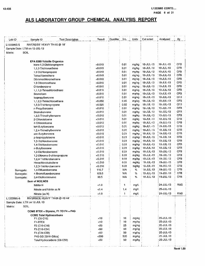


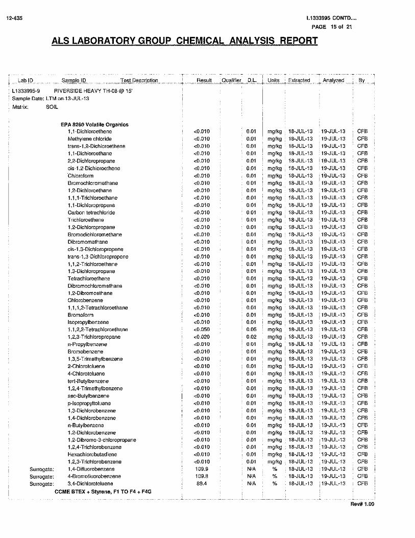


12-435 Phase II ESA – Riverside Heavy Dry Waste Site Historic Waste Disposal Sites, The City of Red Deer
Tiamat Environmental Consultants Ltd. Electronic Version 03
GROUNDWATER REPORTS

MAXXAM JOB #: B372952Received: 2013/08/18, 16:35
CERTIFICATE OF ANALYSIS
Your Project #: 12-435
Report Date: 2013/12/11This report supersedes all previous reports with the same Maxxam job number
Attention:JESSICA LEE
TIAMAT ENVIRONMENTAL CONSULTANTSUnit #107,2719-7 Avenue NECALGARY, ABCANADA T2A 2L9
Your C.O.C. #: N/A
RIVERSIDE HEAVYSite Location:
Sample Matrix: Water# Samples Received: 3
Analytical MethodLaboratory MethodDateAnalyzed
DateExtractedQuantityAnalyses
Dionex #031181, R05CAL SOP-000632013/08/23N/A2Acetic Acid, Formic Acid, Propionic Acid
Dionex #031181, R05CAL SOP-000632013/09/06N/A1Acetic Acid, Formic Acid, Propionic Acid
SM 2320-BAB SOP-000052013/08/22N/A2Alkalinity @25C (pp, total), CO3,HCO3,OH
SM 2320-BAB SOP-000052013/09/06N/A1Alkalinity @25C (pp, total), CO3,HCO3,OH
Coulometric - Titr.EINDSOP-000562013/08/26N/A3Organic Halogen (Adsorbable) (1)
SM 5210 BAB SOP-000172013/08/242013/08/192Biochemical Oxygen Demand
SM 5210 BAB SOP-000172013/08/252013/08/201Biochemical Oxygen Demand
CCME, EPA 8260CAB SOP-000392013/08/23N/A3BTEX/F1 in Water by HS GC/MS
EPA 200.8AB SOP-000432013/09/04N/A2Cadmium - low level CCME - Dissolved
EPA 200.8AB SOP-000432013/09/05N/A1Cadmium - low level CCME - Dissolved
EPA 200.8AB SOP-000432013/09/052013/08/213Cadmium - low level CCME (Total)
SM 4500 Cl-GAB SOP-000202013/08/31N/A2Chloride by Automated Colourimetry
SM 4500 Cl-GAB SOP-000202013/09/07N/A1Chloride by Automated Colourimetry
SM 5220-DAB SOP-000162013/09/04N/A3Chemical Oxygen Demand
SM 2510-BAB SOP-000052013/08/22N/A2Conductivity @25C
SM 2510-BAB SOP-000052013/09/06N/A1Conductivity @25C
EPA3510C/CCME PHCCWSAB SOP-00040AB SOP-0002013/08/242013/08/233CCME Hydrocarbons in Water (F2; C10-C16)
EPA 200.7AB SOP-000422013/09/05N/A3Elements by ICP - Dissolved
EPA 200.7AB SOP-000422013/09/032013/08/303Elements by ICP - Total
EPA 200.8AB SOP-000432013/09/03N/A2Elements by ICPMS - Dissolved
EPA 200.8AB SOP-000432013/09/05N/A1Elements by ICPMS - Dissolved
EPA 200.8AB SOP-000432013/09/032013/08/302Elements by ICPMS - Total
EPA 200.8AB SOP-000432013/09/052013/08/301Elements by ICPMS - Total
SM 4500-N AAB WI-000652013/09/04N/A2Nitrogen (total), Calc. TKN, NO3, NO2
SM 4500-N AAB WI-000652013/09/06N/A1Nitrogen (total), Calc. TKN, NO3, NO2
EPA 350.1AB SOP-000072013/08/28N/A3Ammonia-N (Total)
SM4110BAB SOP-000232013/08/23N/A2Nitrate and Nitrite
SM4110BAB SOP-000232013/09/06N/A1Nitrate and Nitrite
SM 4110-BAB SOP-000232013/08/23N/A2Nitrate + Nitrite-N (calculated)
SM 4110-BAB SOP-000232013/09/06N/A1Nitrate + Nitrite-N (calculated)
SM 4110-BAB SOP-000232013/08/22N/A2Nitrogen, (Nitrite, Nitrate) by IC
SM 4110-BAB SOP-000232013/09/06N/A1Nitrogen, (Nitrite, Nitrate) by IC
SM 4500-H+BAB SOP-000052013/08/22N/A2pH @25°C (Alkalinity titrator)
SM 4500-H+BAB SOP-000052013/09/06N/A1pH @25°C (Alkalinity titrator)
Page 1 of 25
Maxxam Analytics International Corporation o/a Maxxam Analytics Calgary: 2021 - 41st Avenue N.E. T2E 6P2 Telephone (403) 291-3077 Fax (403) 291-9468

MAXXAM JOB #: B372952Received: 2013/08/18, 16:35
CERTIFICATE OF ANALYSIS
Your Project #: 12-435
Report Date: 2013/12/11This report supersedes all previous reports with the same Maxxam job number
Attention:JESSICA LEE
TIAMAT ENVIRONMENTAL CONSULTANTSUnit #107,2719-7 Avenue NECALGARY, ABCANADA T2A 2L9
Your C.O.C. #: N/A
RIVERSIDE HEAVYSite Location:
Sample Matrix: Water# Samples Received: 3
Analytical MethodLaboratory MethodDateAnalyzed
DateExtractedQuantityAnalyses
SM 4500 SO4-EAB SOP-000182013/08/31N/A2Sulphate by Automated Colourimetry
SM 4500 SO4-EAB SOP-000182013/09/07N/A1Sulphate by Automated Colourimetry
EPA 8260 CCAL SOP-001042013/08/26N/A3Total Trihalomethanes Calculation
EPA 351.1, 351.2AB SOP-000082013/09/042013/09/043Total Kjeldahl Nitrogen
MMCW 119CAL SOP-000772013/09/02N/A3Carbon (Total Organic) (2)
SM 4500-PAB SOP-000242013/09/042013/09/043Total Phosphorus
EPA 8260 CCAL SOP-002272013/08/24N/A3VOCs in Water by HS GC/MS (Std List)
All Blank values are reported. Associated data are not blank corrected.'MDL' = Method Detection Limit, '<' = Less than MDL, '---' Not AnalyzedSolids results are based on dry weight except Biota Analyses & Special Waste Oil & GreaseOrganic analyses are not corrected for extraction recovery standards except for Isotope Dilution methods, (i.e. CARB 429 PAH, all PCDD/F and DBD/DBFanalyses)All CCME results met required criteria unless otherwise stated in the report. All data on final reports are validated by technical personnel. Signature on fileat the laboratory. Deviations from Reference Method for the Canada-wide Standard for Petroleum Hydrocarbons in Soil-Tier 1 Method:F2/F3/F4 data reported using validated cold solvent extraction instead of Soxhlet extractionAll Groundwater samples except BTEX/VOC's or Purgeable Hydrocarbons are decanted and/or filtered prior to analysis unless otherwise mandated byregulatory agencyAll analysis data reported was generated when the analytical methods were in statistical control and criteria for spike recoveries, reference materialrecoveries, method blanks data and duplicate precision were met unless otherwise statedThis report shall not be reproduced except in full, without the written approval of the laboratory
Reporting results to two significant figures at the RDL is to permit statistical evaluation and is not intended to be an indication of analytical precision.
Methods used by Maxxam are based upon those found in 'Standard Methods for the Examination of Water and Wastewater', 22nd Edition, published bythe American Public Health Association, or on US EPA, protocols found in the ' Test Methods for Evaluating Solid Waste, Physical/Chemical Method, SW846,3rd Edition. Other procedures are based on the methodologies accepted by the appropriate regulatory agency. Methodology briefs are available bywritten request.
All work recorded herein has been done in accordance with normal professional standards using accepted testing methodologies, quality assurance andquality control procedures except where otherwise agreed to by the client and testing company in writing. Liability for any and all use of these test resultsshall be limited to the actual cost of the pertinent analysis done. There is no other warranty expressed or implied. Your samples will be retained atMaxxam for a period of 60 days from receipt of data or as per contract.
Remarks:
* RPDs calculated using raw data. The rounding of final results may result in the apparent difference.
Page 2 of 25
Maxxam Analytics International Corporation o/a Maxxam Analytics Calgary: 2021 - 41st Avenue N.E. T2E 6P2 Telephone (403) 291-3077 Fax (403) 291-9468

MAXXAM JOB #: B372952Received: 2013/08/18, 16:35
CERTIFICATE OF ANALYSIS
Your Project #: 12-435
Report Date: 2013/12/11This report supersedes all previous reports with the same Maxxam job number
Attention:JESSICA LEE
TIAMAT ENVIRONMENTAL CONSULTANTSUnit #107,2719-7 Avenue NECALGARY, ABCANADA T2A 2L9
Your C.O.C. #: N/A
RIVERSIDE HEAVYSite Location:
(1) This test was performed by Maxxam Edmonton Petroleum(2) TOC present in the sample should be considered as non-purgeable TOC.
Encryption Key
Please direct all questions regarding this Certificate of Analysis to your Project Manager.Kayla Brassard, Project ManagerEmail: [email protected]# (403)735-2258==================================================================== This report has been generated and distributed using a secure automated process.Maxxam has procedures in place to guard against improper use of the electronic signature and have the required "signatories", as per section 5.10.2 of ISO/IEC 17025:2005(E), signing the reports. For Service Group specific validation please refer to the Validation Signature Page.
Total Cover Pages : 3Page 3 of 25
Maxxam Analytics International Corporation o/a Maxxam Analytics Calgary: 2021 - 41st Avenue N.E. T2E 6P2 Telephone (403) 291-3077 Fax (403) 291-9468

Maxxam Job #: B372952Report Date: 2013/12/11
TIAMAT ENVIRONMENTAL CONSULTANTSClient Project #: 12-435
RIVERSIDE HEAVYSite Location:
AT1 BTEX AND F1-F2 (WATER)
RDL = Reportable Detection Limit
7104191838383%O-TERPHENYL (sur.)
7106093104105104%D4-1,2-DICHLOROETHANE (sur.)
7106093102103101%4-BROMOFLUOROBENZENE (sur.)
7106093112113113%1,4-Difluorobenzene (sur.)
7106093100<100<100<100ug/L(C6-C10)
7106093100<100<100<100ug/LF1 (C6-C10) - BTEX
71060930.80<0.80<0.80<0.80ug/LXylenes (Total)
71060930.40<0.40<0.40<0.40ug/Lo-Xylene
71060930.80<0.80<0.80<0.80ug/Lm & p-Xylene
71060930.40<0.40<0.40<0.40ug/LEthylbenzene
71060930.40<0.40<0.40<0.40ug/LToluene
71060930.40<0.40<0.40<0.40ug/LBenzene
Volatiles
71041910.10<0.10<0.10<0.10mg/LF2 (C10-C16 Hydrocarbons)
Hydrocarbons
QC BatchRDLMW-03MW-02MW-01Units
N/AN/AN/ACOC Number
2013/08/172013/08/172013/08/17Sampling Date
HF9791HF9790HF9789Maxxam ID
Page 4 of 25
Maxxam Analytics International Corporation o/a Maxxam Analytics Calgary: 2021 - 41st Avenue N.E. T2E 6P2 Telephone (403) 291-3077 Fax (403) 291-9468

Maxxam Job #: B372952Report Date: 2013/12/11
TIAMAT ENVIRONMENTAL CONSULTANTSClient Project #: 12-435
RIVERSIDE HEAVYSite Location:
REGULATED METALS (CCME/AT1) - DISSOLVED
(2) Dissolved greater than total. Results within acceptable limits of precision.
(1) Dissolved greater than total. Results are within limits of uncertainty(MU).
RDL = Reportable Detection Limit
70987690.0130.0390.120.00500.087ug/LCadmium (Cd)
Low Level Elements
71366200.0075<0.0075<0.00750.0030<0.0030mg/LZinc (Zn)
71366200.0025<0.0025<0.00250.0010<0.0010mg/LVanadium (V)
71366200.000250.00140.0210.000100.011mg/LUranium (U)
71366200.0025<0.0025<0.00250.0010<0.0010mg/LTitanium (Ti)
71366200.0025<0.0025<0.00250.0010<0.0010mg/LTin (Sn)
71366200.00050<0.00050<0.000500.00020<0.00020mg/LThallium (Tl)
71392630.203.92200.20180mg/LSulphur (S)
71392630.0201.42.70.0201.3mg/LStrontium (Sr)
71392630.50160250 (2)0.50170 (2)mg/LSodium (Na)
71366200.00025<0.00025<0.000250.00010<0.00010mg/LSilver (Ag)
71392630.10156.50.107.4mg/LSilicon (Si)
71366200.00050<0.000500.000500.000200.00028mg/LSelenium (Se)
71392630.309.88.60.306.9mg/LPotassium (K)
71392630.10<0.10<0.100.10<0.10mg/LPhosphorus (P)
71366200.00130.0160.0130.000500.011mg/LNickel (Ni)
71366200.000500.00210.00590.000200.0015mg/LMolybdenum (Mo)
71392630.00403.60.780.00400.70mg/LManganese (Mn)
71392630.201201100.2056mg/LMagnesium (Mg)
71392630.0200.0340.130.0200.091mg/LLithium (Li)
71366200.00050<0.00050<0.000500.00020<0.00020mg/LLead (Pb)
71392630.060270.240.0600.19mg/LIron (Fe)
71366200.000500.00130.00210.000200.0023mg/LCopper (Cu)
71366200.000750.0120.00450.000300.0043mg/LCobalt (Co)
71366200.0025<0.0025<0.00250.0010<0.0010mg/LChromium (Cr)
71392630.302103100.30220mg/LCalcium (Ca)
71392630.0200.120.12 (2)0.0200.27mg/LBoron (B)
71366200.0025<0.0025<0.00250.0010<0.0010mg/LBeryllium (Be)
71392630.0100.720.0810.0100.083mg/LBarium (Ba)
71366200.000500.0240.00610.000200.0027mg/LArsenic (As)
71366200.0015<0.00150.0020 (1)0.00060<0.00060mg/LAntimony (Sb)
71366200.00750.0880.0170.00300.0044mg/LAluminum (Al)
Elements
QC BatchRDLMW-03MW-02RDLMW-01Units
N/AN/AN/ACOC Number
2013/08/172013/08/172013/08/17Sampling Date
HF9791HF9790HF9789Maxxam ID
Page 5 of 25
Maxxam Analytics International Corporation o/a Maxxam Analytics Calgary: 2021 - 41st Avenue N.E. T2E 6P2 Telephone (403) 291-3077 Fax (403) 291-9468

Maxxam Job #: B372952Report Date: 2013/12/11
TIAMAT ENVIRONMENTAL CONSULTANTSClient Project #: 12-435
RIVERSIDE HEAVYSite Location:
REGULATED METALS (CCME/AT1) - TOTAL
(1) Detection limits raised due to dilution to bring analyte within the calibrated range.
RDL = Reportable Detection Limit
70995250.0135.05.50.00500.60ug/LCadmium (Cd)
Low Level Elements
71311920.00750.670.730.00300.057mg/LZinc (Zn)
71311920.00250.200.300.00100.018mg/LVanadium (V)
71311920.000250.00750.0450.000100.012mg/LUranium (U)
71311920.00250.450.960.00100.19mg/LTitanium (Ti)
71311920.0025<0.00250.00440.00100.0029mg/LTin (Sn)
71311920.000500.000870.00110.00020<0.00020mg/LThallium (Tl)
71312330.207.82300.20180mg/LSulphur (S)
71312330.0202.53.70.0201.4mg/LStrontium (Sr)
71312330.501602300.50160mg/LSodium (Na)
71311920.000250.00160.00100.00010<0.00010mg/LSilver (Ag)
71312330.1087940.1017mg/LSilicon (Si)
71311920.000500.00140.00310.000200.00070mg/LSelenium (Se)
71312330.3021200.308.4mg/LPotassium (K)
71312330.107.2110.100.68mg/LPhosphorus (P)
71311920.00130.290.290.000500.033mg/LNickel (Ni)
71311920.000500.00360.0120.000200.0021mg/LMolybdenum (Mo)
71312330.004015130.00401.4mg/LManganese (Mn)
71312330.203302300.2062mg/LMagnesium (Mg)
71312330.0200.150.320.0200.093mg/LLithium (Li)
71311920.000500.110.110.000200.0068mg/LLead (Pb)
71312330.30260 (1)330 (1)0.06020mg/LIron (Fe)
71311920.000500.230.250.000200.025mg/LCopper (Cu)
71311920.000750.130.120.000300.014mg/LCobalt (Co)
71311920.00250.140.190.00100.010mg/LChromium (Cr)
71312331.51000 (1)730 (1)0.30270mg/LCalcium (Ca)
71312330.0200.130.110.0200.28mg/LBoron (B)
71311920.00250.00720.00990.0010<0.0010mg/LBeryllium (Be)
71312330.0103.53.30.0100.32mg/LBarium (Ba)
71311920.000500.0690.0660.000200.011mg/LArsenic (As)
71311920.0015<0.0015<0.00150.000600.00074mg/LAntimony (Sb)
71311920.0075741000.00304.3mg/LAluminum (Al)
Elements
QC BatchRDLMW-03MW-02RDLMW-01Units
N/AN/AN/ACOC Number
2013/08/172013/08/172013/08/17Sampling Date
HF9791HF9790HF9789Maxxam ID
Page 6 of 25
Maxxam Analytics International Corporation o/a Maxxam Analytics Calgary: 2021 - 41st Avenue N.E. T2E 6P2 Telephone (403) 291-3077 Fax (403) 291-9468

Maxxam Job #: B372952Report Date: 2013/12/11
TIAMAT ENVIRONMENTAL CONSULTANTSClient Project #: 12-435
RIVERSIDE HEAVYSite Location:
RESULTS OF CHEMICAL ANALYSES OF WATER
(3) Detection limits raised due to dilution to bring analyte within the calibrated range.
(2) Sample ran past hold time.
(1) Due to the sample matrix, sample required dilution. Detection limit was adjusted accordingly
Lab-Dup = Laboratory Initiated Duplicate
RDL = Reportable Detection Limit
71054060.0020.02371054060.020.05mg/LOrganic halogen
Misc. Organics
715085650<50710856450<50mg/LPropionic Acid
715085650<50710856450<50mg/LFormic Acid
715085650<50710856450<50mg/LAcetic Acid
Organic Acids
71496510.00300.03071067700.0030.067mg/LNitrate (N)
71496510.0030<0.003071067700.0030.010mg/LNitrite (N)
71417630.504.1 (1)71417630.0500.98mg/LTotal Kjeldahl Nitrogen
71418440.156.2 (3)71418440.0300.54 (1)mg/LPhosphorus (P)
71003560.0504.171003560.0501.1mg/LNitrogen (N)
71223070.0500.7671223070.0500.64mg/LAmmonia (N)
Nutrients
71522685.0360 (3)71340601.04.7mg/LChloride (Cl)
71522705.0690 (3)71340625.0510 (3)mg/LSulphate (SO4)
71497840.50<0.50 (2)71062260.50<0.50mg/LHydroxide (OH)
71497840.50<0.50 (2)71062260.50<0.50mg/LCarbonate (CO3)
71497840.50670 (2)71062260.50690mg/LBicarbonate (HCO3)
71497840.50550 (2)71062260.50570mg/LAlkalinity (Total as CaCO3)
71497840.50<0.50 (2)71062260.50<0.50mg/LAlkalinity (PP as CaCO3)
Anions
71356860.502071356860.5014mg/LOrganic Carbon (C)
71497936.78 (2)71062307.71pHpH
71497911.0320071062281.01900uS/cmConductivity
Misc. Inorganics
714082950310 (1)714082925100 (1)mg/LChemical Oxygen Demand
70953962.02.070953962.03.13.5mg/LBiochemical Oxygen Demand
Demand Parameters
71498980.0099<0.009970995270.0090.033mg/LNitrite (NO2)
71498990.00300.03070995280.0030.077mg/LNitrate plus Nitrite (N)
71498980.0130.1370995270.0130.30mg/LNitrate (NO3)
Calculated Parameters
QC BatchRDLMW-02QC BatchRDLMW-01Lab-Dup
MW-01Units
N/AN/AN/ACOC Number
2013/08/172013/08/172013/08/17Sampling Date
HF9790HF9789HF9789Maxxam ID
Page 7 of 25
Maxxam Analytics International Corporation o/a Maxxam Analytics Calgary: 2021 - 41st Avenue N.E. T2E 6P2 Telephone (403) 291-3077 Fax (403) 291-9468

Maxxam Job #: B372952Report Date: 2013/12/11
TIAMAT ENVIRONMENTAL CONSULTANTSClient Project #: 12-435
RIVERSIDE HEAVYSite Location:
RESULTS OF CHEMICAL ANALYSES OF WATER
(3) Detection limits raised due to dilution to bring analyte within the calibratedrange.
(2) Due to the sample matrix, sample required dilution. Detection limit wasadjusted accordingly
(1) Sample was originally processed within hold time. Data quality requiredinvestigation. Re-analysis was completed past recommended hold time. Sampleanalyzed 64.0 hrs. after sample collection. Sample analysis is recommendedwithin 48 hrs. of sampling.
RDL = Reportable Detection Limit
710856450<50mg/LPropionic Acid
710856450<50mg/LFormic Acid
710856450<50mg/LAcetic Acid
Organic Acids
71067700.00300.11mg/LNitrate (N)
71067700.00300.0090mg/LNitrite (N)
71417630.506.3 (2)mg/LTotal Kjeldahl Nitrogen
71418440.0304.8 (2)mg/LPhosphorus (P)
71003560.0506.4mg/LNitrogen (N)
71263990.504.6 (3)mg/LAmmonia (N)
Nutrients
71340605.0360 (3)mg/LChloride (Cl)
71340621.0<1.0mg/LSulphate (SO4)
71062260.50<0.50mg/LHydroxide (OH)
71062260.50<0.50mg/LCarbonate (CO3)
71062260.501100mg/LBicarbonate (HCO3)
71062260.50860mg/LAlkalinity (Total as CaCO3)
71062260.50<0.50mg/LAlkalinity (PP as CaCO3)
Anions
71356862.546 (3)mg/LOrganic Carbon (C)
71062307.55pHpH
71062281.02700uS/cmConductivity
Misc. Inorganics
714082950460 (2)mg/LChemical Oxygen Demand
70964092.04.3 (1)mg/LBiochemical Oxygen Demand
Demand Parameters
70995270.00990.030mg/LNitrite (NO2)
70995280.00300.12mg/LNitrate plus Nitrite (N)
70995270.0130.47mg/LNitrate (NO3)
Calculated Parameters
QC BatchRDLMW-03Units
N/ACOC Number
2013/08/17Sampling Date
HF9791Maxxam ID
Page 8 of 25
Maxxam Analytics International Corporation o/a Maxxam Analytics Calgary: 2021 - 41st Avenue N.E. T2E 6P2 Telephone (403) 291-3077 Fax (403) 291-9468

Maxxam Job #: B372952Report Date: 2013/12/11
TIAMAT ENVIRONMENTAL CONSULTANTSClient Project #: 12-435
RIVERSIDE HEAVYSite Location:
RESULTS OF CHEMICAL ANALYSES OF WATER
RDL = Reportable Detection Limit
71054060.020.13mg/LOrganic halogen
Misc. Organics
QC BatchRDLMW-03Units
N/ACOC Number
2013/08/17Sampling Date
HF9791Maxxam ID
Page 9 of 25
Maxxam Analytics International Corporation o/a Maxxam Analytics Calgary: 2021 - 41st Avenue N.E. T2E 6P2 Telephone (403) 291-3077 Fax (403) 291-9468

Maxxam Job #: B372952Report Date: 2013/12/11
TIAMAT ENVIRONMENTAL CONSULTANTSClient Project #: 12-435
RIVERSIDE HEAVYSite Location:
VOLATILE ORGANICS BY GC-MS (WATER)
RDL = Reportable Detection Limit
71067630.50<0.50<0.50<0.50ug/LTrichlorofluoromethane
71067630.50<0.50<0.50<0.50ug/LTrichloroethene
71067630.50<0.50<0.50<0.50ug/L1,1,2-trichloroethane
71067630.50<0.50<0.50<0.50ug/L1,1,1-trichloroethane
71067630.50<0.50<0.50<0.50ug/L1,3,5-trichlorobenzene
71067631.0<1.0<1.0<1.0ug/L1,2,4-trichlorobenzene
71067631.0<1.0<1.0<1.0ug/L1,2,3-trichlorobenzene
71067630.50<0.50<0.50<0.50ug/LTetrachloroethene
71067632.0<2.0<2.0<2.0ug/L1,1,2,2-tetrachloroethane
71067632.0<2.0<2.0<2.0ug/L1,1,1,2-tetrachloroethane
71067630.50<0.50<0.50<0.50ug/LStyrene
71067630.50<0.50<0.50<0.50ug/LMethyl-tert-butylether (MTBE)
71067630.50<0.50<0.50<0.50ug/LMethyl methacrylate
71067630.50<0.50<0.50<0.50ug/Ltrans-1,3-dichloropropene
71067630.50<0.50<0.50<0.50ug/Lcis-1,3-dichloropropene
71067630.50<0.50<0.50<0.50ug/L1,2-dichloropropane
71067632.0<2.0<2.0<2.0ug/LDichloromethane
71067630.50<0.50<0.50<0.50ug/Ltrans-1,2-dichloroethene
71067630.50<0.50<0.50<0.50ug/Lcis-1,2-dichloroethene
71067630.50<0.50<0.50<0.50ug/L1,1-dichloroethene
71067630.50<0.50<0.50<0.50ug/L1,2-dichloroethane
71067630.50<0.50<0.50<0.50ug/L1,1-dichloroethane
71067630.50<0.50<0.50<0.50ug/L1,4-dichlorobenzene
71067630.50<0.50<0.50<0.50ug/L1,3-dichlorobenzene
71067630.50<0.50<0.50<0.50ug/L1,2-dichlorobenzene
71067630.50<0.50<0.50<0.50ug/L1,2-dibromoethane
71067632.0<2.0<2.0<2.0ug/LChloromethane
71067630.50<0.50<0.50<0.50ug/LChloroform
71067631.0<1.0<1.0<1.0ug/LChloroethane
71067631.0<1.0<1.0<1.0ug/LChlorodibromomethane
71067630.50<0.50<0.50<0.50ug/LChlorobenzene
71067630.50<0.50<0.50<0.50ug/LCarbon tetrachloride
71067632.0<2.0<2.0<2.0ug/LBromomethane
71067630.50<0.50<0.50<0.50ug/LBromoform
71067630.50<0.50<0.50<0.50ug/LBromodichloromethane
70992732.0<2.0<2.0<2.0ug/LTotal Trihalomethanes
Volatiles
QC BatchRDLMW-03MW-02MW-01Units
N/AN/AN/ACOC Number
2013/08/172013/08/172013/08/17Sampling Date
HF9791HF9790HF9789Maxxam ID
Page 10 of 25
Maxxam Analytics International Corporation o/a Maxxam Analytics Calgary: 2021 - 41st Avenue N.E. T2E 6P2 Telephone (403) 291-3077 Fax (403) 291-9468

Maxxam Job #: B372952Report Date: 2013/12/11
TIAMAT ENVIRONMENTAL CONSULTANTSClient Project #: 12-435
RIVERSIDE HEAVYSite Location:
VOLATILE ORGANICS BY GC-MS (WATER)
RDL = Reportable Detection Limit
7106763959296%D4-1,2-DICHLOROETHANE (sur.)
7106763104100104%4-BROMOFLUOROBENZENE (sur.)
7106763989898%1,4-Difluorobenzene (sur.)
71067630.50<0.50<0.50<0.50ug/LVinyl chloride
71067630.50<0.50<0.50<0.50ug/L1,3,5-trimethylbenzene
71067630.50<0.50<0.50<0.50ug/L1,2,4-trimethylbenzene
QC BatchRDLMW-03MW-02MW-01Units
N/AN/AN/ACOC Number
2013/08/172013/08/172013/08/17Sampling Date
HF9791HF9790HF9789Maxxam ID
Page 11 of 25
Maxxam Analytics International Corporation o/a Maxxam Analytics Calgary: 2021 - 41st Avenue N.E. T2E 6P2 Telephone (403) 291-3077 Fax (403) 291-9468

Maxxam Job #: B372952Report Date: 2013/12/11
TIAMAT ENVIRONMENTAL CONSULTANTSClient Project #: 12-435
RIVERSIDE HEAVYSite Location:
GENERAL COMMENTS
Each temperature is the average of up to three cooler temperatures taken at receipt
3.7°CPackage 1
Sample HF9790-04 Elements by ICPMS - Dissolved: Detection limits raised due to matrix interference.Sample HF9791-04 Elements by ICPMS - Dissolved: Due to the sample matrix, sample required dilution. Detection limit was adjusted accordingly
REGULATED METALS (CCME/AT1) - DISSOLVED Comments
Sample HF9790-03 Elements by ICPMS - Total: Detection limits raised due to matrix interference.Sample HF9791-03 Elements by ICPMS - Total: Due to the sample matrix, sample required dilution. Detection limit was adjusted accordingly
REGULATED METALS (CCME/AT1) - TOTAL Comments
Sample HF9741-01 Acetic Acid, Formic Acid, Propionic Acid: Detection limits raised due to sample matrix.Sample HF9789-01 Acetic Acid, Formic Acid, Propionic Acid: Detection limits raised due to sample matrix.Sample HK0079-02 Acetic Acid, Formic Acid, Propionic Acid: Detection limits raised due to sample matrix.Sample HF9790-01 Acetic Acid, Formic Acid, Propionic Acid: Detection limits raised due to sample matrix. Sample was past hold time when received.Sample HF9791-01 Acetic Acid, Formic Acid, Propionic Acid: Detection limits raised due to sample matrix.
RESULTS OF CHEMICAL ANALYSES OF WATER Comments
Results relate only to the items tested.
Page 12 of 25
Maxxam Analytics International Corporation o/a Maxxam Analytics Calgary: 2021 - 41st Avenue N.E. T2E 6P2 Telephone (403) 291-3077 Fax (403) 291-9468

Maxxam Job #: B372952Report Date: 2013/12/11
TIAMAT ENVIRONMENTAL CONSULTANTSClient Project #: 12-435
RIVERSIDE HEAVYSite Location:
QUALITY ASSURANCE REPORT
QC LimitsUnits RecoveryValueDate
AnalyzedParameterQC TypeInitQA/QCBatch
85 - 115%1032013/08/24Biochemical Oxygen DemandSpiked BlankLS07095396mg/L<2.02013/08/24Biochemical Oxygen DemandBlankLS0
20%NC2013/08/24Biochemical Oxygen DemandRPD [HF9789]85 - 115%882013/08/25Biochemical Oxygen DemandSpiked Blank7096409
mg/L<2.02013/08/25Biochemical Oxygen DemandBlankLS020%42013/08/25Biochemical Oxygen DemandRPD
50 - 130%902013/08/24O-TERPHENYL (sur.)Matrix SpikeDO1710419150 - 130%992013/08/24F2 (C10-C16 Hydrocarbons)Matrix SpikeDO150 - 130%912013/08/24O-TERPHENYL (sur.)Spiked Blank70 - 130%972013/08/24F2 (C10-C16 Hydrocarbons)50 - 130%872013/08/24O-TERPHENYL (sur.)Blank
mg/L<0.102013/08/24F2 (C10-C16 Hydrocarbons)40%NC2013/08/24F2 (C10-C16 Hydrocarbons)RPD
84 - 111%892013/08/26Organic halogenQC StandardMN27105406mg/L<0.52013/08/26Organic halogenBlankMN2
70 - 130%1182013/08/231,4-Difluorobenzene (sur.)Matrix SpikeGP4710609370 - 130%1112013/08/234-BROMOFLUOROBENZENE (sur.)Matrix SpikeGP470 - 130%1052013/08/23D4-1,2-DICHLOROETHANE (sur.)70 - 130%872013/08/23Benzene70 - 130%892013/08/23Toluene70 - 130%922013/08/23Ethylbenzene70 - 130%982013/08/23m & p-Xylene70 - 130%942013/08/23o-Xylene70 - 130%922013/08/23(C6-C10)70 - 130%1182013/08/231,4-Difluorobenzene (sur.)Spiked Blank70 - 130%1142013/08/234-BROMOFLUOROBENZENE (sur.)70 - 130%1042013/08/23D4-1,2-DICHLOROETHANE (sur.)70 - 130%802013/08/23Benzene70 - 130%842013/08/23Toluene70 - 130%892013/08/23Ethylbenzene70 - 130%952013/08/23m & p-Xylene70 - 130%902013/08/23o-Xylene70 - 130%1002013/08/23(C6-C10)70 - 130%1142013/08/231,4-Difluorobenzene (sur.)Blank70 - 130%1002013/08/234-BROMOFLUOROBENZENE (sur.)70 - 130%1032013/08/23D4-1,2-DICHLOROETHANE (sur.)
ug/L<0.402013/08/23Benzeneug/L<0.402013/08/23Tolueneug/L<0.402013/08/23Ethylbenzeneug/L<0.802013/08/23m & p-Xyleneug/L<0.402013/08/23o-Xyleneug/L<0.802013/08/23Xylenes (Total)ug/L<1002013/08/23F1 (C6-C10) - BTEXug/L<1002013/08/23(C6-C10)
40%NC2013/08/23BenzeneRPD40%NC2013/08/23Toluene40%NC2013/08/23Ethylbenzene40%NC2013/08/23m & p-Xylene40%NC2013/08/23o-Xylene40%NC2013/08/23Xylenes (Total)40%NC2013/08/23F1 (C6-C10) - BTEX40%NC2013/08/23(C6-C10)
80 - 120%942013/08/22Alkalinity (Total as CaCO3)Spiked BlankFT27106226mg/L<0.502013/08/22Alkalinity (PP as CaCO3)BlankFT2mg/L<0.502013/08/22Alkalinity (Total as CaCO3)mg/L<0.502013/08/22Bicarbonate (HCO3)mg/L<0.502013/08/22Carbonate (CO3)mg/L<0.502013/08/22Hydroxide (OH)
20%NC2013/08/22Alkalinity (PP as CaCO3)RPD20%12013/08/22Alkalinity (Total as CaCO3)20%12013/08/22Bicarbonate (HCO3)20%NC2013/08/22Carbonate (CO3)20%NC2013/08/22Hydroxide (OH)
90 - 110%1012013/08/22ConductivitySpiked Blank7106228
Page 13 of 25
Maxxam Analytics International Corporation o/a Maxxam Analytics Calgary: 2021 - 41st Avenue N.E. T2E 6P2 Telephone (403) 291-3077 Fax (403) 291-9468

Maxxam Job #: B372952Report Date: 2013/12/11
TIAMAT ENVIRONMENTAL CONSULTANTSClient Project #: 12-435
RIVERSIDE HEAVYSite Location:
QUALITY ASSURANCE REPORT(CONT'D)
QC LimitsUnits RecoveryValueDate
AnalyzedParameterQC TypeInitQA/QCBatch
uS/cm<1.02013/08/22ConductivityBlankFT220%02013/08/22ConductivityRPD
97 - 102%1002013/08/22pHSpiked Blank71062305%0.42013/08/22pHRPDFT2
70 - 130%1202013/08/221,4-Difluorobenzene (sur.)Matrix SpikeMJ0710676370 - 130%1062013/08/224-BROMOFLUOROBENZENE (sur.)Matrix SpikeMJ070 - 130%1202013/08/22D4-1,2-DICHLOROETHANE (sur.)70 - 130%1162013/08/22Bromodichloromethane70 - 130%1002013/08/22Bromoform70 - 130%942013/08/22Bromomethane70 - 130%1172013/08/22Carbon tetrachloride70 - 130%942013/08/22Chlorobenzene70 - 130%962013/08/22Chlorodibromomethane70 - 130%992013/08/22Chloroethane70 - 130%1112013/08/22Chloroform70 - 130%65(1)2013/08/22Chloromethane70 - 130%962013/08/221,2-dibromoethane70 - 130%962013/08/221,2-dichlorobenzene70 - 130%932013/08/221,3-dichlorobenzene70 - 130%912013/08/221,4-dichlorobenzene70 - 130%1112013/08/221,1-dichloroethane70 - 130%1152013/08/221,2-dichloroethane70 - 130%1082013/08/221,1-dichloroethene70 - 130%1082013/08/22cis-1,2-dichloroethene70 - 130%1072013/08/22trans-1,2-dichloroethene70 - 130%1042013/08/22Dichloromethane70 - 130%1152013/08/221,2-dichloropropane70 - 130%1182013/08/22cis-1,3-dichloropropene70 - 130%1162013/08/22trans-1,3-dichloropropene70 - 130%1292013/08/22Methyl methacrylate70 - 130%1212013/08/22Methyl-tert-butylether (MTBE)70 - 130%1072013/08/22Styrene70 - 130%972013/08/221,1,1,2-tetrachloroethane70 - 130%932013/08/221,1,2,2-tetrachloroethane70 - 130%942013/08/22Tetrachloroethene70 - 130%952013/08/221,2,3-trichlorobenzene70 - 130%992013/08/221,2,4-trichlorobenzene70 - 130%992013/08/221,3,5-trichlorobenzene70 - 130%1142013/08/221,1,1-trichloroethane70 - 130%1172013/08/221,1,2-trichloroethane70 - 130%1082013/08/22Trichloroethene70 - 130%1002013/08/22Trichlorofluoromethane70 - 130%982013/08/221,2,4-trimethylbenzene70 - 130%992013/08/221,3,5-trimethylbenzene70 - 130%862013/08/22Vinyl chloride70 - 130%1082013/08/221,4-Difluorobenzene (sur.)Spiked Blank70 - 130%1072013/08/224-BROMOFLUOROBENZENE (sur.)70 - 130%1062013/08/22D4-1,2-DICHLOROETHANE (sur.)70 - 130%952013/08/22Bromodichloromethane70 - 130%902013/08/22Bromoform70 - 130%792013/08/22Bromomethane70 - 130%972013/08/22Carbon tetrachloride70 - 130%862013/08/22Chlorobenzene70 - 130%932013/08/22Chlorodibromomethane70 - 130%822013/08/22Chloroethane70 - 130%922013/08/22Chloroform70 - 130%802013/08/22Chloromethane70 - 130%882013/08/221,2-dibromoethane70 - 130%872013/08/221,2-dichlorobenzene70 - 130%862013/08/221,3-dichlorobenzene70 - 130%832013/08/221,4-dichlorobenzene70 - 130%922013/08/221,1-dichloroethane70 - 130%932013/08/221,2-dichloroethane70 - 130%902013/08/221,1-dichloroethene
Page 14 of 25
Maxxam Analytics International Corporation o/a Maxxam Analytics Calgary: 2021 - 41st Avenue N.E. T2E 6P2 Telephone (403) 291-3077 Fax (403) 291-9468

Maxxam Job #: B372952Report Date: 2013/12/11
TIAMAT ENVIRONMENTAL CONSULTANTSClient Project #: 12-435
RIVERSIDE HEAVYSite Location:
QUALITY ASSURANCE REPORT(CONT'D)
QC LimitsUnits RecoveryValueDate
AnalyzedParameterQC TypeInitQA/QCBatch
70 - 130%882013/08/22cis-1,2-dichloroetheneSpiked Blank70 - 130%892013/08/22trans-1,2-dichloroethene70 - 130%852013/08/22Dichloromethane70 - 130%952013/08/221,2-dichloropropane70 - 130%962013/08/22cis-1,3-dichloropropene70 - 130%952013/08/22trans-1,3-dichloropropene70 - 130%1042013/08/22Methyl methacrylate70 - 130%982013/08/22Methyl-tert-butylether (MTBE)70 - 130%992013/08/22Styrene70 - 130%902013/08/221,1,1,2-tetrachloroethane70 - 130%842013/08/221,1,2,2-tetrachloroethane70 - 130%882013/08/22Tetrachloroethene70 - 130%842013/08/221,2,3-trichlorobenzene70 - 130%872013/08/221,2,4-trichlorobenzene70 - 130%882013/08/221,3,5-trichlorobenzene70 - 130%952013/08/221,1,1-trichloroethane70 - 130%942013/08/221,1,2-trichloroethane70 - 130%872013/08/22Trichloroethene70 - 130%832013/08/22Trichlorofluoromethane70 - 130%912013/08/221,2,4-trimethylbenzene70 - 130%922013/08/221,3,5-trimethylbenzene70 - 130%722013/08/22Vinyl chloride70 - 130%982013/08/231,4-Difluorobenzene (sur.)Blank70 - 130%982013/08/234-BROMOFLUOROBENZENE (sur.)70 - 130%922013/08/23D4-1,2-DICHLOROETHANE (sur.)
ug/L<0.502013/08/23Bromodichloromethaneug/L<0.502013/08/23Bromoformug/L<2.02013/08/23Bromomethaneug/L<0.502013/08/23Carbon tetrachlorideug/L<0.502013/08/23Chlorobenzeneug/L<1.02013/08/23Chlorodibromomethaneug/L<1.02013/08/23Chloroethaneug/L<0.502013/08/23Chloroformug/L<2.02013/08/23Chloromethaneug/L<0.502013/08/231,2-dibromoethaneug/L<0.502013/08/231,2-dichlorobenzeneug/L<0.502013/08/231,3-dichlorobenzeneug/L<0.502013/08/231,4-dichlorobenzeneug/L<0.502013/08/231,1-dichloroethaneug/L<0.502013/08/231,2-dichloroethaneug/L<0.502013/08/231,1-dichloroetheneug/L<0.502013/08/23cis-1,2-dichloroetheneug/L<0.502013/08/23trans-1,2-dichloroetheneug/L<2.02013/08/23Dichloromethaneug/L<0.502013/08/231,2-dichloropropaneug/L<0.502013/08/23cis-1,3-dichloropropeneug/L<0.502013/08/23trans-1,3-dichloropropeneug/L<0.502013/08/23Methyl methacrylateug/L<0.502013/08/23Methyl-tert-butylether (MTBE)ug/L<0.502013/08/23Styreneug/L<2.02013/08/231,1,1,2-tetrachloroethaneug/L<2.02013/08/231,1,2,2-tetrachloroethaneug/L<0.502013/08/23Tetrachloroetheneug/L<1.02013/08/231,2,3-trichlorobenzeneug/L<1.02013/08/231,2,4-trichlorobenzeneug/L<0.502013/08/231,3,5-trichlorobenzeneug/L<0.502013/08/231,1,1-trichloroethaneug/L<0.502013/08/231,1,2-trichloroethaneug/L<0.502013/08/23Trichloroetheneug/L<0.502013/08/23Trichlorofluoromethaneug/L<0.502013/08/231,2,4-trimethylbenzeneug/L<0.502013/08/231,3,5-trimethylbenzeneug/L<0.502013/08/23Vinyl chloride
40%NC2013/08/23BromodichloromethaneRPD
Page 15 of 25
Maxxam Analytics International Corporation o/a Maxxam Analytics Calgary: 2021 - 41st Avenue N.E. T2E 6P2 Telephone (403) 291-3077 Fax (403) 291-9468

Maxxam Job #: B372952Report Date: 2013/12/11
TIAMAT ENVIRONMENTAL CONSULTANTSClient Project #: 12-435
RIVERSIDE HEAVYSite Location:
QUALITY ASSURANCE REPORT(CONT'D)
QC LimitsUnits RecoveryValueDate
AnalyzedParameterQC TypeInitQA/QCBatch
40%NC2013/08/23BromoformRPD40%NC2013/08/23Bromomethane40%NC2013/08/23Carbon tetrachloride40%NC2013/08/23Chlorobenzene40%NC2013/08/23Chlorodibromomethane40%NC2013/08/23Chloroethane40%NC2013/08/23Chloroform40%NC2013/08/23Chloromethane40%NC2013/08/231,2-dibromoethane40%NC2013/08/231,2-dichlorobenzene40%NC2013/08/231,3-dichlorobenzene40%NC2013/08/231,4-dichlorobenzene40%NC2013/08/231,1-dichloroethane40%NC2013/08/231,2-dichloroethane40%NC2013/08/231,1-dichloroethene40%152013/08/23cis-1,2-dichloroethene40%NC2013/08/23trans-1,2-dichloroethene40%NC2013/08/23Dichloromethane40%NC2013/08/231,2-dichloropropane40%NC2013/08/23cis-1,3-dichloropropene40%NC2013/08/23trans-1,3-dichloropropene40%NC2013/08/23Methyl methacrylate40%NC2013/08/23Methyl-tert-butylether (MTBE)40%NC2013/08/23Styrene40%NC2013/08/231,1,1,2-tetrachloroethane40%NC2013/08/231,1,2,2-tetrachloroethane40%0.32013/08/23Tetrachloroethene40%NC2013/08/231,2,3-trichlorobenzene40%NC2013/08/231,2,4-trichlorobenzene40%NC2013/08/231,3,5-trichlorobenzene40%NC2013/08/231,1,1-trichloroethane40%NC2013/08/231,1,2-trichloroethane40%NC2013/08/23Trichloroethene40%NC2013/08/23Trichlorofluoromethane40%NC2013/08/231,2,4-trimethylbenzene40%NC2013/08/231,3,5-trimethylbenzene40%NC2013/08/23Vinyl chloride
80 - 120%1002013/08/22Nitrite (N)Matrix SpikeRP0710677080 - 120%1012013/08/22Nitrate (N)Matrix SpikeRP090 - 110%992013/08/22Nitrite (N)Spiked Blank90 - 110%1012013/08/22Nitrate (N)
mg/L<0.00302013/08/22Nitrite (N)Blankmg/L0.0030, RDL=0.0032013/08/22Nitrate (N)
20%NC2013/08/22Nitrite (N)RPD20%NC2013/08/22Nitrate (N)
70 - 130%942013/08/23Acetic AcidMatrix SpikeFM0710856470 - 130%972013/08/23Formic AcidMatrix SpikeFM070 - 130%872013/08/23Propionic Acid70 - 130%962013/08/23Acetic AcidSpiked Blank70 - 130%1042013/08/23Formic Acid70 - 130%862013/08/23Propionic Acid
mg/L<0.502013/08/23Acetic AcidBlankmg/L<0.502013/08/23Formic Acidmg/L<0.502013/08/23Propionic Acid
40%NC2013/08/23Acetic AcidRPD40%NC2013/08/23Formic Acid40%NC2013/08/23Propionic Acid
80 - 120%1012013/08/28Ammonia (N)Matrix SpikeRM9712230780 - 120%1022013/08/28Ammonia (N)Spiked BlankRM9
mg/L<0.0502013/08/28Ammonia (N)Blank20%NC2013/08/28Ammonia (N)RPD
80 - 120%902013/08/28Ammonia (N)Matrix SpikeSK9712639980 - 120%1002013/08/28Ammonia (N)Spiked BlankSK9
mg/L<0.0502013/08/28Ammonia (N)Blank
Page 16 of 25
Maxxam Analytics International Corporation o/a Maxxam Analytics Calgary: 2021 - 41st Avenue N.E. T2E 6P2 Telephone (403) 291-3077 Fax (403) 291-9468

Maxxam Job #: B372952Report Date: 2013/12/11
TIAMAT ENVIRONMENTAL CONSULTANTSClient Project #: 12-435
RIVERSIDE HEAVYSite Location:
QUALITY ASSURANCE REPORT(CONT'D)
QC LimitsUnits RecoveryValueDate
AnalyzedParameterQC TypeInitQA/QCBatch
20%NC2013/08/28Ammonia (N)RPD80 - 120%1012013/09/03Aluminum (Al)Matrix SpikeMB5713119280 - 120%1192013/09/03Antimony (Sb)Matrix SpikeMB580 - 120%1092013/09/03Arsenic (As)80 - 120%1082013/09/03Beryllium (Be)80 - 120%1072013/09/03Chromium (Cr)80 - 120%1092013/09/03Cobalt (Co)80 - 120%1092013/09/03Copper (Cu)80 - 120%1082013/09/03Lead (Pb)80 - 120%1102013/09/03Molybdenum (Mo)80 - 120%1082013/09/03Nickel (Ni)80 - 120%1062013/09/03Selenium (Se)80 - 120%1102013/09/03Silver (Ag)80 - 120%1042013/09/03Thallium (Tl)80 - 120%1062013/09/03Tin (Sn)80 - 120%982013/09/03Titanium (Ti)80 - 120%1092013/09/03Uranium (U)80 - 120%1042013/09/03Vanadium (V)80 - 120%1042013/09/03Zinc (Zn)80 - 120%1002013/09/03Aluminum (Al)Spiked Blank80 - 120%1112013/09/03Antimony (Sb)80 - 120%1032013/09/03Arsenic (As)80 - 120%1052013/09/03Beryllium (Be)80 - 120%1042013/09/03Chromium (Cr)80 - 120%1072013/09/03Cobalt (Co)80 - 120%1062013/09/03Copper (Cu)80 - 120%1002013/09/03Lead (Pb)80 - 120%1042013/09/03Molybdenum (Mo)80 - 120%1032013/09/03Nickel (Ni)80 - 120%992013/09/03Selenium (Se)80 - 120%1032013/09/03Silver (Ag)80 - 120%992013/09/03Thallium (Tl)80 - 120%1032013/09/03Tin (Sn)80 - 120%972013/09/03Titanium (Ti)80 - 120%1022013/09/03Uranium (U)80 - 120%1032013/09/03Vanadium (V)80 - 120%1082013/09/03Zinc (Zn)
mg/L<0.00302013/09/03Aluminum (Al)Blankmg/L<0.000602013/09/03Antimony (Sb)mg/L<0.000202013/09/03Arsenic (As)mg/L<0.00102013/09/03Beryllium (Be)mg/L<0.00102013/09/03Chromium (Cr)mg/L<0.000302013/09/03Cobalt (Co)mg/L<0.000202013/09/03Copper (Cu)mg/L<0.000202013/09/03Lead (Pb)mg/L<0.000202013/09/03Molybdenum (Mo)mg/L<0.000502013/09/03Nickel (Ni)mg/L<0.000202013/09/03Selenium (Se)mg/L<0.000102013/09/03Silver (Ag)mg/L<0.000202013/09/03Thallium (Tl)mg/L<0.00102013/09/03Tin (Sn)mg/L<0.00102013/09/03Titanium (Ti)mg/L<0.000102013/09/03Uranium (U)mg/L<0.00102013/09/03Vanadium (V)mg/L<0.00302013/09/03Zinc (Zn)
20%NC2013/09/03Aluminum (Al)RPD20%NC2013/09/03Antimony (Sb)20%NC2013/09/03Arsenic (As)20%NC2013/09/03Beryllium (Be)20%NC2013/09/03Chromium (Cr)20%NC2013/09/03Cobalt (Co)20%NC2013/09/03Copper (Cu)20%NC2013/09/03Lead (Pb)20%NC2013/09/03Molybdenum (Mo)
Page 17 of 25
Maxxam Analytics International Corporation o/a Maxxam Analytics Calgary: 2021 - 41st Avenue N.E. T2E 6P2 Telephone (403) 291-3077 Fax (403) 291-9468

Maxxam Job #: B372952Report Date: 2013/12/11
TIAMAT ENVIRONMENTAL CONSULTANTSClient Project #: 12-435
RIVERSIDE HEAVYSite Location:
QUALITY ASSURANCE REPORT(CONT'D)
QC LimitsUnits RecoveryValueDate
AnalyzedParameterQC TypeInitQA/QCBatch
20%NC2013/09/03Nickel (Ni)RPD20%NC2013/09/03Selenium (Se)20%NC2013/09/03Silver (Ag)20%NC2013/09/03Thallium (Tl)20%NC2013/09/03Tin (Sn)20%NC2013/09/03Titanium (Ti)20%NC2013/09/03Uranium (U)20%NC2013/09/03Vanadium (V)20%NC2013/09/03Zinc (Zn)
80 - 120%962013/09/03Barium (Ba)Matrix SpikePK0713123380 - 120%1142013/09/03Boron (B)Matrix SpikePK080 - 120%1012013/09/03Calcium (Ca)80 - 120%952013/09/03Iron (Fe)80 - 120%1012013/09/03Lithium (Li)80 - 120%1002013/09/03Magnesium (Mg)80 - 120%982013/09/03Manganese (Mn)80 - 120%1002013/09/03Phosphorus (P)80 - 120%1042013/09/03Potassium (K)80 - 120%1112013/09/03Silicon (Si)80 - 120%1022013/09/03Sodium (Na)80 - 120%982013/09/03Strontium (Sr)80 - 120%962013/09/03Barium (Ba)Spiked Blank80 - 120%1142013/09/03Boron (B)80 - 120%1012013/09/03Calcium (Ca)80 - 120%962013/09/03Iron (Fe)80 - 120%1022013/09/03Lithium (Li)80 - 120%1002013/09/03Magnesium (Mg)80 - 120%982013/09/03Manganese (Mn)80 - 120%1002013/09/03Phosphorus (P)80 - 120%1052013/09/03Potassium (K)80 - 120%1122013/09/03Silicon (Si)80 - 120%1022013/09/03Sodium (Na)80 - 120%982013/09/03Strontium (Sr)
mg/L<0.0102013/09/03Barium (Ba)Blankmg/L<0.0202013/09/03Boron (B)mg/L<0.302013/09/03Calcium (Ca)mg/L<0.0602013/09/03Iron (Fe)mg/L<0.0202013/09/03Lithium (Li)mg/L<0.202013/09/03Magnesium (Mg)mg/L<0.00402013/09/03Manganese (Mn)mg/L<0.102013/09/03Phosphorus (P)mg/L<0.302013/09/03Potassium (K)mg/L<0.102013/09/03Silicon (Si)mg/L<0.502013/09/03Sodium (Na)mg/L<0.0202013/09/03Strontium (Sr)mg/L<0.202013/09/03Sulphur (S)
20%NC2013/09/03Barium (Ba)RPD20%NC2013/09/03Boron (B)20%NC2013/09/03Calcium (Ca)20%NC2013/09/03Iron (Fe)20%NC2013/09/03Lithium (Li)20%NC2013/09/03Magnesium (Mg)20%NC2013/09/03Manganese (Mn)20%NC2013/09/03Potassium (K)20%NC2013/09/03Silicon (Si)20%NC2013/09/03Sodium (Na)20%NC2013/09/03Strontium (Sr)20%NC2013/09/03Sulphur (S)
80 - 120%1102013/08/31Chloride (Cl)Matrix SpikeZI713406080 - 120%1042013/08/31Chloride (Cl)Spiked BlankZI
mg/L<1.02013/08/31Chloride (Cl)Blank20%4.92013/08/31Chloride (Cl)RPD
80 - 120%NC2013/08/31Sulphate (SO4)Matrix SpikeZI713406280 - 120%1082013/08/31Sulphate (SO4)Spiked BlankZI
Page 18 of 25
Maxxam Analytics International Corporation o/a Maxxam Analytics Calgary: 2021 - 41st Avenue N.E. T2E 6P2 Telephone (403) 291-3077 Fax (403) 291-9468

Maxxam Job #: B372952Report Date: 2013/12/11
TIAMAT ENVIRONMENTAL CONSULTANTSClient Project #: 12-435
RIVERSIDE HEAVYSite Location:
QUALITY ASSURANCE REPORT(CONT'D)
QC LimitsUnits RecoveryValueDate
AnalyzedParameterQC TypeInitQA/QCBatch
mg/L<1.02013/08/31Sulphate (SO4)Blank20%2.32013/08/31Sulphate (SO4)RPD
80 - 120%NC2013/09/02Organic Carbon (C)Matrix SpikeAP1713568680 - 120%1072013/09/02Organic Carbon (C)Spiked BlankAP1
mg/L<0.502013/09/02Organic Carbon (C)Blank20%2.32013/09/02Organic Carbon (C)RPD
80 - 120%1072013/09/04Aluminum (Al)Matrix SpikeTDB713662080 - 120%832013/09/04Antimony (Sb)Matrix SpikeTDB80 - 120%982013/09/04Arsenic (As)80 - 120%1042013/09/04Beryllium (Be)80 - 120%982013/09/04Chromium (Cr)80 - 120%952013/09/04Cobalt (Co)80 - 120%962013/09/04Copper (Cu)80 - 120%952013/09/04Lead (Pb)80 - 120%1002013/09/04Molybdenum (Mo)80 - 120%942013/09/04Nickel (Ni)80 - 120%1012013/09/04Selenium (Se)80 - 120%932013/09/04Silver (Ag)80 - 120%942013/09/04Thallium (Tl)80 - 120%862013/09/04Tin (Sn)80 - 120%982013/09/04Titanium (Ti)80 - 120%992013/09/04Uranium (U)80 - 120%1002013/09/04Vanadium (V)80 - 120%902013/09/04Zinc (Zn)80 - 120%1082013/09/03Aluminum (Al)Spiked Blank80 - 120%912013/09/03Antimony (Sb)80 - 120%1032013/09/03Arsenic (As)80 - 120%1012013/09/03Beryllium (Be)80 - 120%1002013/09/03Chromium (Cr)80 - 120%1002013/09/03Cobalt (Co)80 - 120%1002013/09/03Copper (Cu)80 - 120%982013/09/03Lead (Pb)80 - 120%992013/09/03Molybdenum (Mo)80 - 120%1002013/09/03Nickel (Ni)80 - 120%1032013/09/03Selenium (Se)80 - 120%982013/09/03Silver (Ag)80 - 120%972013/09/03Thallium (Tl)80 - 120%942013/09/03Tin (Sn)80 - 120%1032013/09/03Titanium (Ti)80 - 120%1032013/09/03Uranium (U)80 - 120%1012013/09/03Vanadium (V)80 - 120%962013/09/03Zinc (Zn)
mg/L0.0031, RDL=0.0032013/09/03Aluminum (Al)Blankmg/L<0.000602013/09/03Antimony (Sb)mg/L<0.000202013/09/03Arsenic (As)mg/L<0.00102013/09/03Beryllium (Be)mg/L<0.00102013/09/03Chromium (Cr)mg/L<0.000302013/09/03Cobalt (Co)mg/L<0.000202013/09/03Copper (Cu)mg/L<0.000202013/09/03Lead (Pb)mg/L<0.000202013/09/03Molybdenum (Mo)mg/L<0.000502013/09/03Nickel (Ni)mg/L<0.000202013/09/03Selenium (Se)mg/L<0.000102013/09/03Silver (Ag)mg/L<0.000202013/09/03Thallium (Tl)mg/L<0.00102013/09/03Tin (Sn)mg/L<0.00102013/09/03Titanium (Ti)mg/L<0.000102013/09/03Uranium (U)mg/L<0.00102013/09/03Vanadium (V)mg/L<0.00302013/09/03Zinc (Zn)
20%NC2013/09/03Aluminum (Al)RPD20%NC2013/09/03Antimony (Sb)20%NC2013/09/03Arsenic (As)20%NC2013/09/03Beryllium (Be)
Page 19 of 25
Maxxam Analytics International Corporation o/a Maxxam Analytics Calgary: 2021 - 41st Avenue N.E. T2E 6P2 Telephone (403) 291-3077 Fax (403) 291-9468

Maxxam Job #: B372952Report Date: 2013/12/11
TIAMAT ENVIRONMENTAL CONSULTANTSClient Project #: 12-435
RIVERSIDE HEAVYSite Location:
QUALITY ASSURANCE REPORT(CONT'D)
QC LimitsUnits RecoveryValueDate
AnalyzedParameterQC TypeInitQA/QCBatch
20%NC2013/09/03Chromium (Cr)RPD20%NC2013/09/03Cobalt (Co)20%NC2013/09/03Copper (Cu)20%NC2013/09/03Lead (Pb)20%NC2013/09/03Molybdenum (Mo)20%NC2013/09/03Nickel (Ni)20%NC2013/09/03Selenium (Se)20%NC2013/09/03Silver (Ag)20%NC2013/09/03Thallium (Tl)20%NC2013/09/03Tin (Sn)20%NC2013/09/03Titanium (Ti)20%NC2013/09/03Uranium (U)20%NC2013/09/03Vanadium (V)20%NC2013/09/03Zinc (Zn)
80 - 120%932013/09/05Barium (Ba)Matrix SpikePK0713926380 - 120%992013/09/05Boron (B)Matrix SpikePK080 - 120%982013/09/05Calcium (Ca)80 - 120%972013/09/05Iron (Fe)80 - 120%992013/09/05Lithium (Li)80 - 120%1002013/09/05Magnesium (Mg)80 - 120%972013/09/05Manganese (Mn)80 - 120%1002013/09/05Phosphorus (P)80 - 120%1012013/09/05Potassium (K)80 - 120%982013/09/05Silicon (Si)80 - 120%982013/09/05Sodium (Na)80 - 120%942013/09/05Strontium (Sr)80 - 120%852013/09/04Barium (Ba)Spiked Blank80 - 120%922013/09/04Boron (B)80 - 120%1092013/09/04Calcium (Ca)80 - 120%962013/09/04Iron (Fe)80 - 120%832013/09/04Lithium (Li)80 - 120%952013/09/04Magnesium (Mg)80 - 120%982013/09/04Manganese (Mn)80 - 120%972013/09/04Phosphorus (P)80 - 120%932013/09/04Potassium (K)80 - 120%952013/09/04Silicon (Si)80 - 120%982013/09/04Sodium (Na)80 - 120%892013/09/04Strontium (Sr)
mg/L<0.0102013/09/05Barium (Ba)Blankmg/L<0.0202013/09/05Boron (B)mg/L<0.302013/09/05Calcium (Ca)mg/L<0.0602013/09/05Iron (Fe)mg/L<0.0202013/09/05Lithium (Li)mg/L<0.202013/09/05Magnesium (Mg)mg/L<0.00402013/09/05Manganese (Mn)mg/L<0.102013/09/05Phosphorus (P)mg/L<0.302013/09/05Potassium (K)mg/L<0.102013/09/05Silicon (Si)mg/L<0.502013/09/05Sodium (Na)mg/L<0.0202013/09/05Strontium (Sr)mg/L<0.202013/09/05Sulphur (S)
20%NC2013/09/05Barium (Ba)RPD20%NC2013/09/05Boron (B)20%NC2013/09/05Calcium (Ca)20%NC2013/09/05Iron (Fe)20%NC2013/09/05Lithium (Li)20%NC2013/09/05Magnesium (Mg)20%NC2013/09/05Manganese (Mn)20%NC2013/09/05Silicon (Si)20%NC2013/09/05Sodium (Na)20%NC2013/09/05Strontium (Sr)20%NC2013/09/05Sulphur (S)
80 - 120%992013/09/04Chemical Oxygen DemandMatrix SpikeLY714082980 - 120%1012013/09/04Chemical Oxygen DemandSpiked BlankLY
Page 20 of 25
Maxxam Analytics International Corporation o/a Maxxam Analytics Calgary: 2021 - 41st Avenue N.E. T2E 6P2 Telephone (403) 291-3077 Fax (403) 291-9468

Maxxam Job #: B372952Report Date: 2013/12/11
TIAMAT ENVIRONMENTAL CONSULTANTSClient Project #: 12-435
RIVERSIDE HEAVYSite Location:
QUALITY ASSURANCE REPORT(CONT'D)
QC LimitsUnits RecoveryValueDate
AnalyzedParameterQC TypeInitQA/QCBatch
mg/L9.0, RDL=5.02013/09/04Chemical Oxygen DemandBlank20%3.62013/09/04Chemical Oxygen DemandRPD
80 - 120%1052013/09/04Total Kjeldahl NitrogenMatrix SpikeRM9714176375 - 125%1112013/09/04Total Kjeldahl NitrogenQC StandardRM980 - 120%872013/09/04Total Kjeldahl NitrogenSpiked Blank
mg/L<0.0502013/09/04Total Kjeldahl NitrogenBlank20%3.52013/09/04Total Kjeldahl NitrogenRPD
80 - 120%1002013/09/04Phosphorus (P)Matrix Spike714184480 - 120%962013/09/04Phosphorus (P)QC StandardRM983 - 111%1022013/09/04Phosphorus (P)Spiked Blank
mg/L<0.00302013/09/04Phosphorus (P)Blank20%NC2013/09/04Phosphorus (P)RPD
80 - 120%1002013/09/06Nitrite (N)Matrix SpikeDA4714965180 - 120%1012013/09/06Nitrate (N)Matrix SpikeDA490 - 110%1012013/09/06Nitrite (N)Spiked Blank90 - 110%1012013/09/06Nitrate (N)
mg/L<0.00302013/09/06Nitrite (N)Blankmg/L<0.00302013/09/06Nitrate (N)
20%NC2013/09/06Nitrite (N)RPD20%NC2013/09/06Nitrate (N)
80 - 120%992013/09/06Alkalinity (Total as CaCO3)Spiked BlankJLD7149784mg/L<0.502013/09/06Alkalinity (PP as CaCO3)BlankJLDmg/L<0.502013/09/06Alkalinity (Total as CaCO3)mg/L<0.502013/09/06Bicarbonate (HCO3)mg/L<0.502013/09/06Carbonate (CO3)mg/L<0.502013/09/06Hydroxide (OH)
20%NC2013/09/06Alkalinity (PP as CaCO3)RPD20%9.22013/09/06Alkalinity (Total as CaCO3)20%9.22013/09/06Bicarbonate (HCO3)20%NC2013/09/06Carbonate (CO3)20%NC2013/09/06Hydroxide (OH)
90 - 110%1002013/09/06ConductivitySpiked Blank7149791uS/cm<1.02013/09/06ConductivityBlankJLD
20%2.12013/09/06ConductivityRPD97 - 102%992013/09/06pHSpiked Blank7149793
5%0.92013/09/06pHRPDJLD70 - 130%972013/09/06Acetic AcidMatrix SpikeFM0715085670 - 130%992013/09/06Formic AcidMatrix SpikeFM070 - 130%942013/09/06Propionic Acid70 - 130%962013/09/06Acetic AcidSpiked Blank70 - 130%1012013/09/06Formic Acid70 - 130%872013/09/06Propionic Acid
mg/L<0.502013/09/06Acetic AcidBlankmg/L<0.502013/09/06Formic Acidmg/L<0.502013/09/06Propionic Acid
40%NC2013/09/06Acetic AcidRPD40%NC2013/09/06Formic Acid40%NC2013/09/06Propionic Acid
80 - 120%NC2013/09/07Chloride (Cl)Matrix SpikeZI715226880 - 120%1032013/09/07Chloride (Cl)Spiked BlankZI
mg/L<1.02013/09/07Chloride (Cl)Blank20%2.12013/09/07Chloride (Cl)RPD
80 - 120%125(1)2013/09/07Sulphate (SO4)Matrix SpikeZI715227080 - 120%1062013/09/07Sulphate (SO4)Spiked BlankZI
mg/L<1.02013/09/07Sulphate (SO4)Blank
Page 21 of 25
Maxxam Analytics International Corporation o/a Maxxam Analytics Calgary: 2021 - 41st Avenue N.E. T2E 6P2 Telephone (403) 291-3077 Fax (403) 291-9468

Maxxam Job #: B372952Report Date: 2013/12/11
TIAMAT ENVIRONMENTAL CONSULTANTSClient Project #: 12-435
RIVERSIDE HEAVYSite Location:
QUALITY ASSURANCE REPORT(CONT'D)
QC LimitsUnits RecoveryValueDate
AnalyzedParameterQC TypeInitQA/QCBatch
20%NC2013/09/07Sulphate (SO4)RPD
(1) Recovery or RPD for this parameter is outside control limits. The overall quality control for this analysis meets acceptability criteria.
NC (RPD): The RPD was not calculated. The level of analyte detected in the parent sample and its duplicate was not sufficiently significant to permit areliable calculation.
NC (Matrix Spike): The recovery in the matrix spike was not calculated. The relative difference between the concentration in the parent sample and thespiked amount was not sufficiently significant to permit a reliable recovery calculation.
Surrogate: A pure or isotopically labeled compound whose behavior mirrors the analytes of interest. Used to evaluate extraction efficiency.
Method Blank: A blank matrix containing all reagents used in the analytical procedure. Used to identify laboratory contamination.
Spiked Blank: A blank matrix sample to which a known amount of the analyte, usually from a second source, has been added. Used to evaluate methodaccuracy.
QC Standard: A sample of known concentration prepared by an external agency under stringent conditions. Used as an independent check of methodaccuracy.
Matrix Spike: A sample to which a known amount of the analyte of interest has been added. Used to evaluate sample matrix interference.
Duplicate: Paired analysis of a separate portion of the same sample. Used to evaluate the variance in the measurement.
Page 22 of 25
Maxxam Analytics International Corporation o/a Maxxam Analytics Calgary: 2021 - 41st Avenue N.E. T2E 6P2 Telephone (403) 291-3077 Fax (403) 291-9468

Maxxam Job #: B372952Report Date: 2013/12/11
TIAMAT ENVIRONMENTAL CONSULTANTSClient Project #: 12-435
RIVERSIDE HEAVYSite Location:
VALIDATION SIGNATURE PAGE
The analytical data and all QC contained in this report were reviewed and validated by the following individual(s).
Ghayasuddin Khan, M.Sc., B.Ed., P.Chem, Scientific Specialist
Luba Shymushovska, Senior Analyst, Organic Department
Michael Sheppard, Organics Supervisor
Peng Liang, Analyst II
Rebecca Nguyen, Analyst II
Maxxam has procedures in place to guard against improper use of the electronic signature and have the required "signatories", as per section 5.10.2 of ISO/IEC17025:2005(E), signing the reports. For Service Group specific validation please refer to the Validation Signature Page.
Page 23 of 25
Maxxam Analytics International Corporation o/a Maxxam Analytics Calgary: 2021 - 41st Avenue N.E. T2E 6P2 Telephone (403) 291-3077 Fax (403) 291-9468

Page 24 of 25

Page 25 of 25

PAGE: 1
CONFIRMATION-RECEIPT OF SAMPLES FOR ANALYSIS
Maxxam Job # B372952Client Project #: 12-435 3 Samples Samples Received 2013/08/18Quote #: B30736 Client Confirmation 2013/08/21
Expected Report Delivery 2013/09/05 18:00
Report will be sent to: Invoice will be sent to: Copy of Reportwill be sent to:JESSICA LEE JESSICA LEE
TIAMAT ENVIRONMENTAL CONSULTANTS TIAMAT ENVIRONMENTAL CONSULTANTS KELLYUnit #107, 2719-7 Avenue NE Unit #107, 2719-7 Avenue NECALGARY CALGARYT2A 2L9 T2A 2L9Ph 403-640-9009 [email protected] [email protected]
We have received the following samples:Sampled 2013/08/17 COC# N/A Matrix: WATERMW-01
Maxxam #: HF9789AT1 BTEX and F1-F2*Regulated Metals (CCME/AT1) - Dissolved*Regulated Metals (CCME/AT1) - TotalAcetic Acid, Formic Acid, Propionic AcidAcid Digestion for Total Metals - WatersAlkalinity @25C (pp, total), CO3,HCO3,OHAmmonia-N (Total)Biochemical Oxygen DemandCarbon (Total Organic)Chemical Oxygen DemandChloride by Automated ColourimetryConductivity @25CEnvironmental Sample Disposal FeeNitrate + Nitrite-N (calculated)Nitrate and NitriteNitrogen (total), Calc. TKN, NO3, NO2Nitrogen, (Nitrite, Nitrate) by ICOrganic Halogen (Adsorbable)pH @25°C (Alkalinity titrator)Sulphate by Automated ColourimetryTotal Kjeldahl NitrogenTotal PhosphorusTotal Trihalomethanes Calculation*VOCs in Water by HS GC/MS (Std List)
Sampled 2013/08/17 MW-02Maxxam #: HF9790AT1 BTEX and F1-F2

PAGE: 2
*Regulated Metals (CCME/AT1) - Dissolved*Regulated Metals (CCME/AT1) - TotalAcid Digestion for Total Metals - WatersAmmonia-N (Total)Biochemical Oxygen DemandCarbon (Total Organic)Chemical Oxygen DemandEnvironmental Sample Disposal FeeNitrogen (total), Calc. TKN, NO3, NO2Organic Halogen (Adsorbable)Send Part to ArchiveTotal Kjeldahl NitrogenTotal PhosphorusTotal Trihalomethanes Calculation*VOCs in Water by HS GC/MS (Std List)
Sampled 2013/08/17 MW-03Maxxam #: HF9791AT1 BTEX and F1-F2*Regulated Metals (CCME/AT1) - Dissolved*Regulated Metals (CCME/AT1) - TotalAcetic Acid, Formic Acid, Propionic AcidAcid Digestion for Total Metals - WatersAlkalinity @25C (pp, total), CO3,HCO3,OHAmmonia-N (Total)Biochemical Oxygen DemandCarbon (Total Organic)Chemical Oxygen DemandChloride by Automated ColourimetryConductivity @25CEnvironmental Sample Disposal FeeNitrate + Nitrite-N (calculated)Nitrate and NitriteNitrogen (total), Calc. TKN, NO3, NO2Nitrogen, (Nitrite, Nitrate) by ICOrganic Halogen (Adsorbable)pH @25°C (Alkalinity titrator)Sulphate by Automated ColourimetryTotal Kjeldahl NitrogenTotal PhosphorusTotal Trihalomethanes Calculation*VOCs in Water by HS GC/MS (Std List)
Comments:• Unless special storage arrangements are made, all samples will be discarded 60 days after receipt of samples.• Non-regular samples are flagged as (C) Composite by lab, (H) Hold, or (L) Leachate.• If there are any problems with the submitted samples, a Sample Integrity Form (SIF) detailing conditions will be
included in this confirmation.• For revisions please contact your Maxxam Project Management team at Ph (403) 291-3077 or Fax (403) 291-9468.
Your Project Manager is: Kayla Brassard


12-435 Phase II ESA – Riverside Heavy Dry Waste Site Historic Waste Disposal Sites, The City of Red Deer
Tiamat Environmental Consultants Ltd. Electronic Version 03
SOIL VAPOUR REPORTS
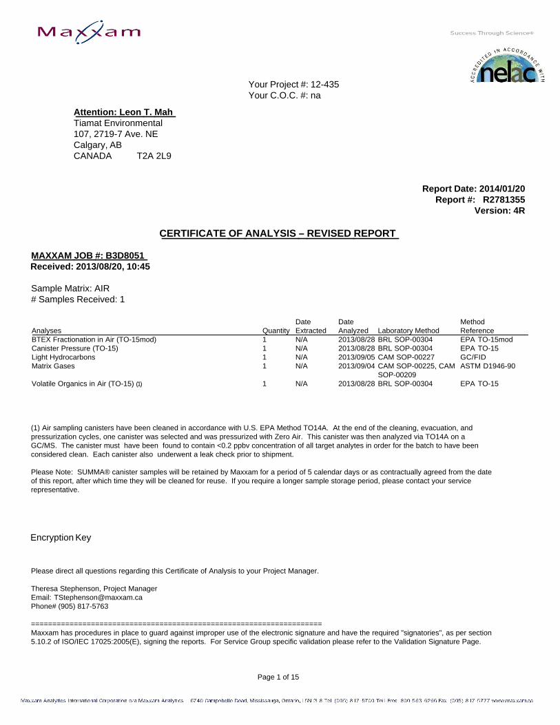
Your Project #: 12-435 Your C.O.C. #: na
Attention: Leon T. MahTiamat Environmental107, 2719-7 Ave. NECalgary, ABCANADA T2A 2L9
Report Date: 2014/01/20Report #: R2781355
Version: 4R
CERTIFICATE OF ANALYSIS – REVISED REPORT
MAXXAM JOB #: B3D8051Received: 2013/08/20, 10:45
Sample Matrix: AIR# Samples Received: 1
Date Date MethodAnalyses Quantity Extracted Analyzed Laboratory Method ReferenceBTEX Fractionation in Air (TO-15mod) 1 N/A 2013/08/28 BRL SOP-00304 EPA TO-15mod Canister Pressure (TO-15) 1 N/A 2013/08/28 BRL SOP-00304 EPA TO-15 Light Hydrocarbons 1 N/A 2013/09/05 CAM SOP-00227 G C / F I D Matrix Gases 1 N/A 2013/09/04 CAM SOP-00225, CAM ASTM D1946-90
SOP-00209Volatile Organics in Air (TO-15) ( 1 ) 1 N/A 2013/08/28 BRL SOP-00304 EPA TO-15
(1) Air sampling canisters have been cleaned in accordance with U.S. EPA Method TO14A. At the end of the cleaning, evacuation, andpressurization cycles, one canister was selected and was pressurized with Zero Air. This canister was then analyzed via TO14A on aGC/MS. The canister must have been found to contain <0.2 ppbv concentration of all target analytes in order for the batch to have beenconsidered clean. Each canister also underwent a leak check prior to shipment.
Please Note: SUMMA® canister samples will be retained by Maxxam for a period of 5 calendar days or as contractually agreed from the dateof this report, after which time they will be cleaned for reuse. If you require a longer sample storage period, please contact your servicerepresentative.
Encryption Key
Please direct all questions regarding this Certificate of Analysis to your Project Manager.
Theresa Stephenson, Project ManagerEmail: [email protected]# (905) 817-5763
====================================================================Maxxam has procedures in place to guard against improper use of the electronic signature and have the required "signatories", as per section5.10.2 of ISO/IEC 17025:2005(E), signing the reports. For Service Group specific validation please refer to the Validation Signature Page.
Page 1 of 15

Your Project #: 12-435 Your C.O.C. #: na
Attention: Leon T. MahTiamat Environmental107, 2719-7 Ave. NECalgary, ABCANADA T2A 2L9
Report Date: 2014/01/20Report #: R2781355
Version: 4R
CERTIFICATE OF ANALYSIS – REVISED REPORT-2-
Maxxam Analytics Inc. is a NELAC accredited laboratory. Certificate # CANA001. Use of the NELAC logo however does not insure thatMaxxam is accredited for all of the methods indicated. This certificate shall not be reproduced except in full, without the written approval ofMaxxam Analytics Inc. Maxxam has procedures in place to guard against improper use of the electronic signature and have the required"signatories", as per section.
Total cover pages: 2
Page 2 of 15

Tiamat EnvironmentalMaxxam Job #: B3D8051 Client Project #: 12-435Report Date: 2014/01/20
Sampler Initials: JAL
RESULTS OF ANALYSES OF AIR
Maxxam ID S S 7 1 5 8Sampling Date 2013/08/17COC Number na U n i t s RIVERSIDE RDL QC Batch MDL
HEAVT/ 2067
Gas
Acetylene ppm ND 0.26 3338537 0.02
Ethane ppm ND 0.26 3338537 0.02
Ethylene ppm ND 0.26 3338537 0.02
Methane ppm ND 5.1 3338537 0.4
n-Butane ppm ND 0.51 3338537 0.02
n-Pentane ppm ND 0.26 3338537 0.02
Propane ppm ND 0.26 3338537 0.02
Propene ppm ND 0.26 3338537 0.02
Propyne ppm ND 0.51 3338537 0.02
Volatile Organics
Pressure on Receipt psig (-4.6) N/A 3333394 N/A
ND = Not detectedRDL = Reportable Detection LimitQC Batch = Quality Control Batch
Page 3 of 15

Tiamat EnvironmentalMaxxam Job #: B3D8051 Client Project #: 12-435Report Date: 2014/01/20
Sampler Initials: JAL
COMPRESSED GAS PARAMETERS (AIR)
Maxxam ID S S 7 1 5 8Sampling Date 2013/08/17COC Number na U n i t s RIVERSIDE RDL QC Batch MDL
HEAVT/ 2067
Fixed Gases
Oxygen % v/v 14.2 0.3 3337413 0.02
Nitrogen % v/v 78.8 0.3 3337413 0.02
Carbon Monoxide % v/v ND 0.3 3337413 0.02
Carbon Dioxide % v/v 7.0 0.3 3337413 0.02
ND = Not detectedRDL = Reportable Detection LimitQC Batch = Quality Control Batch
Page 4 of 15

Tiamat EnvironmentalMaxxam Job #: B3D8051 Client Project #: 12-435Report Date: 2014/01/20
Sampler Initials: JAL
VOLATILE ORGANIC HYDROCARBONS BY GC/MS (AIR)
Maxxam ID S S 7 1 5 8Sampling Date 2013/08/17COC Number na U n i t s RIVERSIDE RDL QC Batch MDL
HEAVT/ 2067
Volatile Organics
Aliphatic >C5-C6 ug/m3 7.3 5.0 3333554 1.0
Aliphatic >C6-C8 ug/m3 34.9 5.0 3333554 1.0
Aliphatic >C8-C10 ug/m3 27.8 5.0 3333554 1.0
Aliphatic >C10-C12 ug/m3 39.7 5.0 3333554 1.0
Aliphatic >C12-C16 ug/m3 15.2 5.0 3333554 1.0
Aromatic >C7-C8 (TEX Excluded) ug/m3 ND 5.0 3333554 1.0
Aromatic >C8-C10 ug/m3 6.7 5.0 3333554 1.0
Aromatic >C10-C12 ug/m3 6.1 5.0 3333554 1.0
Aromatic >C12-C16 ug/m3 ND 5.0 3333554 1.0
ND = Not detectedRDL = Reportable Detection LimitQC Batch = Quality Control Batch
Page 5 of 15

Tiamat EnvironmentalMaxxam Job #: B3D8051 Client Project #: 12-435Report Date: 2014/01/20
Sampler Initials: JAL
VOLATILE ORGANICS BY GC/MS (AIR)
Maxxam ID S S 7 1 5 8Sampling Date 2013/08/17COC Number na U n i t s RIVERSIDE RDL ug/m3 DL (ug/m3) QC Batch MDL
HEAVT/ 2067
Volatile Organics
Dichlorodifluoromethane (FREON 12) ppbv 1.08 0.20 5.33 0.989 3333448 0.10
1,2-Dichlorotetrafluoroethane ppbv <0.17 0.17 <1.19 1.19 3333448 0.10
Chloromethane ppbv 1.21 0.30 2.49 0.620 3333448 0.10
Vinyl Chloride ppbv <0.18 0.18 <0.460 0.460 3333448 0.10
Chloroethane ppbv <0.30 0.30 <0.792 0.792 3333448 0.10
1,3-Butadiene ppbv <0.50 0.50 <1.11 1.11 3333448 0.10
Trichlorofluoromethane (FREON 11) ppbv 0.40 0.20 2.25 1.12 3333448 0.10
Ethanol (ethyl alcohol) ppbv 21.8 2.3 41.1 4.33 3333448 0.50
Trichlorotrifluoroethane ppbv <0.15 0.15 <1.15 1.15 3333448 0.10
2-propanol ppbv 3.2 3.0 7.83 7.37 3333448 0.60
2-Propanone ppbv 22.8 0.80 54.3 1.90 3333448 0.20
Methyl Ethyl Ketone (2-Butanone) ppbv <5.0 5.0 <14.7 14.7 3333448 0.60
Methyl Isobutyl Ketone ppbv <3.2 3.2 <13.1 13.1 3333448 0.70
Methyl Butyl Ketone (2-Hexanone) ppbv <2.0 2.0 <8.19 8.19 3333448 0.40
Methyl t-butyl ether (MTBE) ppbv <0.20 0.20 <0.721 0.721 3333448 0.10
Ethyl Acetate ppbv <2.2 2.2 <7.93 7.93 3333448 0.50
1,1-Dichloroethylene ppbv <0.25 0.25 <0.991 0.991 3333448 0.10
cis-1,2-Dichloroethylene ppbv <0.19 0.19 <0.753 0.753 3333448 0.10
trans-1,2-Dichloroethylene ppbv <0.20 0.20 <0.793 0.793 3333448 0.10
Methylene Chloride(Dichloromethane) ppbv <0.80 0.80 <2.78 2.78 3333448 0.10
Chloroform ppbv 0.33 0.15 1.59 0.732 3333448 0.10
Carbon Tetrachloride ppbv <0.30 0.30 <1.89 1.89 3333448 0.10
1,1-Dichloroethane ppbv <0.20 0.20 <0.809 0.809 3333448 0.10
1,2-Dichloroethane ppbv <0.20 0.20 <0.809 0.809 3333448 0.10
Ethylene Dibromide ppbv <0.17 0.17 <1.31 1.31 3333448 0.10
1,1,1-Trichloroethane ppbv <0.30 0.30 <1.64 1.64 3333448 0.10
1,1,2-Trichloroethane ppbv <0.15 0.15 <0.818 0.818 3333448 0.10
1,1,2,2-Tetrachloroethane ppbv <0.20 0.20 <1.37 1.37 3333448 0.10
cis-1,3-Dichloropropene ppbv <0.18 0.18 <0.817 0.817 3333448 0.10
trans-1,3-Dichloropropene ppbv <0.17 0.17 <0.772 0.772 3333448 0.10
1,2-Dichloropropane ppbv <0.40 0.40 <1.85 1.85 3333448 0.10
RDL = Reportable Detection LimitQC Batch = Quality Control Batch
Page 6 of 15

Tiamat EnvironmentalMaxxam Job #: B3D8051 Client Project #: 12-435Report Date: 2014/01/20
Sampler Initials: JAL
VOLATILE ORGANICS BY GC/MS (AIR)
Maxxam ID S S 7 1 5 8Sampling Date 2013/08/17COC Number na U n i t s RIVERSIDE RDL ug/m3 DL (ug/m3) QC Batch MDL
HEAVT/ 2067
Bromomethane ppbv <0.18 0.18 <0.699 0.699 3333448 0.10
Bromoform ppbv <0.20 0.20 <2.07 2.07 3333448 0.10
Bromodichloromethane ppbv <0.20 0.20 <1.34 1.34 3333448 0.10
Dibromochloromethane ppbv <0.20 0.20 <1.70 1.70 3333448 0.10
Trichloroethylene ppbv <0.30 0.30 <1.61 1.61 3333448 0.10
Tetrachloroethylene ppbv <0.20 0.20 <1.36 1.36 3333448 0.10
Benzene ppbv 0.48 0.18 1.55 0.575 3333448 0.10
Toluene ppbv 1.86 0.20 7.01 0.753 3333448 0.10
Ethylbenzene ppbv 0.55 0.20 2.38 0.868 3333448 0.10
p+m-Xylene ppbv 2.53 0.37 11.0 1.61 3333448 0.10
o-Xylene ppbv 0.84 0.20 3.67 0.868 3333448 0.10
Styrene ppbv <0.20 0.20 <0.852 0.852 3333448 0.10
4-ethyltoluene ppbv <2.2 2.2 <10.8 10.8 3333448 0.50
1,3,5-Trimethylbenzene ppbv <0.50 0.50 <2.46 2.46 3333448 0.10
1,2,4-Trimethylbenzene ppbv <0.50 0.50 <2.46 2.46 3333448 0.10
Chlorobenzene ppbv <0.20 0.20 <0.921 0.921 3333448 0.10
Benzyl chloride ppbv <1.0 1.0 <5.18 5.18 3333448 0.20
1,3-Dichlorobenzene ppbv <0.40 0.40 <2.40 2.40 3333448 0.10
1,4-Dichlorobenzene ppbv <0.40 0.40 <2.40 2.40 3333448 0.10
1,2-Dichlorobenzene ppbv <0.40 0.40 <2.40 2.40 3333448 0.10
1,2,4-Trichlorobenzene ppbv <2.0 2.0 <14.8 14.8 3333448 0.40
Hexachlorobutadiene ppbv <3.0 3.0 <32.0 32.0 3333448 0.60
Hexane ppbv 3.44 0.30 12.1 1.06 3333448 0.10
Heptane ppbv 0.49 0.30 1.99 1.23 3333448 0.10
Cyclohexane ppbv 0.40 0.20 1.39 0.688 3333448 0.10
Tetrahydrofuran ppbv 3.49 0.40 10.3 1.18 3333448 0.10
1,4-Dioxane ppbv <2.0 2.0 <7.21 7.21 3333448 0.40
Xylene (Total) ppbv 3.37 0.60 14.7 2.61 3333448 0.10
Vinyl Bromide ppbv <0.20 0.20 <0.875 0.875 3333448 0.10
Propene ppbv 1.29 0.30 2.22 0.516 3333448 0.10
2,2,4-Trimethylpentane ppbv 0.25 0.20 1.18 0.934 3333448 0.10
Carbon Disulfide ppbv 6.98 0.50 21.7 1.56 3333448 0.10
Vinyl Acetate ppbv <0.20 0.20 <0.704 0.704 3333448 0.10
QC Batch = Quality Control Batch
Page 7 of 15

Tiamat EnvironmentalMaxxam Job #: B3D8051 Client Project #: 12-435Report Date: 2014/01/20
Sampler Initials: JAL
VOLATILE ORGANICS BY GC/MS (AIR)
Maxxam ID S S 7 1 5 8Sampling Date 2013/08/17COC Number na U n i t s RIVERSIDE RDL ug/m3 DL (ug/m3) QC Batch MDL
HEAVT/ 2067
Surrogate Recovery (%)
Bromochloromethane % 84 N/A N/A 3333448
D5-Chlorobenzene % 67 N/A N/A 3333448
Difluorobenzene % 83 N/A N/A 3333448
N/A = Not ApplicableQC Batch = Quality Control Batch
Page 8 of 15

Tiamat EnvironmentalMaxxam Job #: B3D8051 Client Project #: 12-435Report Date: 2014/01/20
Sampler Initials: JAL
Test Summary
Maxxam ID SS7158 Collected 2013/08/17Sample ID RIVERSIDE HEAVT / 2067 Shipped
Matrix AIR Received 2013/08/20
Test Description Instrumentation Batch Extracted Analyzed AnalystBTEX Fractionation in Air (TO-15mod) GC/MS 3333554 N/A 2013/08/28 Diane TemniukCanister Pressure (TO-15) PRES 3333394 N/A 2013/08/28 Diane TemniukLight Hydrocarbons GC/FID 3338537 N/A 2013/09/05 Vijay LadMatrix Gases GC/TCD 3337413 N/A 2013/09/04 Vijay LadVolatile Organics in Air (TO-15) GC/MS 3333448 N/A 2013/08/28 Diane Temniuk
Maxxam ID SS7158 D u p Collected 2013/08/17Sample ID RIVERSIDE HEAVT / 2067 Shipped
Matrix AIR Received 2013/08/20
Test Description Instrumentation Batch Extracted Analyzed AnalystBTEX Fractionation in Air (TO-15mod) GC/MS 3333554 N/A 2013/08/28 Diane TemniukVolatile Organics in Air (TO-15) GC/MS 3333448 N/A 2013/08/28 Diane Temniuk
Page 9 of 15

Tiamat EnvironmentalMaxxam Job #: B3D8051 Client Project #: 12-435Report Date: 2014/01/20
Sampler Initials: JAL
GENERAL COMMENTS
WS#33334481,2,4-Trichlorobenzene exceeds 150% in the Reference Spike. No positives were found, therefore Data was accepted.
Matrix Gas Analysis: Canisters were pressurized with Helium to enable sampling. Results and DLs adjusted accordingly.
Matrix Gas Analysis: Results normalized to 100% dry volume.
Sample SS7158-01: DL raised for 2-Butanone due to matrix interference.
Page 10 of 15

Tiamat EnvironmentalAttention: Leon T. Mah Client Project #: 12-435P.O. #: Site Location:
Quality Assurance ReportMaxxam Job Number: GB3D8051
QA/QC DateBatch AnalyzedNum Init QC Type Parameter yyyy/mm/dd Value %Recovery Units QC Limits
3333448 DVO Spiked Blank Bromochloromethane 2013/08/28 93 % 60 - 140D5-Chlorobenzene 2013/08/28 96 % 60 - 140Difluorobenzene 2013/08/28 95 % 60 - 140Dichlorodifluoromethane (FREON 12) 2013/08/28 112 % 70 - 1301,2-Dichlorotetrafluoroethane 2013/08/28 123 % 70 - 130Chloromethane 2013/08/28 115 % 70 - 130Vinyl Chloride 2013/08/28 109 % 70 - 130Chloroethane 2013/08/28 108 % 70 - 1301,3-Butadiene 2013/08/28 107 % 70 - 130Trichlorofluoromethane (FREON 11) 2013/08/28 114 % 70 - 130Ethanol (ethyl alcohol) 2013/08/28 124 % 70 - 130Trichlorotrifluoroethane 2013/08/28 106 % 70 - 1302-propanol 2013/08/28 109 % 70 - 1302-Propanone 2013/08/28 120 % 70 - 130Methyl Ethyl Ketone (2-Butanone) 2013/08/28 113 % 70 - 130Methyl Isobutyl Ketone 2013/08/28 117 % 70 - 130Methyl Butyl Ketone (2-Hexanone) 2013/08/28 123 % 70 - 130Methyl t-butyl ether (MTBE) 2013/08/28 109 % 70 - 130Ethyl Acetate 2013/08/28 113 % 70 - 1301,1-Dichloroethylene 2013/08/28 109 % 70 - 130cis-1,2-Dichloroethylene 2013/08/28 112 % 70 - 130trans-1,2-Dichloroethylene 2013/08/28 110 % 70 - 130Methylene Chloride(Dichloromethane) 2013/08/28 109 % 70 - 130Chloroform 2013/08/28 112 % 70 - 130Carbon Tetrachloride 2013/08/28 109 % 70 - 1301,1-Dichloroethane 2013/08/28 112 % 70 - 1301,2-Dichloroethane 2013/08/28 116 % 70 - 130Ethylene Dibromide 2013/08/28 113 % 70 - 1301,1,1-Trichloroethane 2013/08/28 112 % 70 - 1301,1,2-Trichloroethane 2013/08/28 113 % 70 - 1301,1,2,2-Tetrachloroethane 2013/08/28 110 % 70 - 130cis-1,3-Dichloropropene 2013/08/28 116 % 70 - 130trans-1,3-Dichloropropene 2013/08/28 117 % 70 - 1301,2-Dichloropropane 2013/08/28 113 % 70 - 130Bromomethane 2013/08/28 107 % 70 - 130Bromoform 2013/08/28 104 % 70 - 130Bromodichloromethane 2013/08/28 112 % 70 - 130Dibromochloromethane 2013/08/28 110 % 70 - 130Trichloroethylene 2013/08/28 108 % 70 - 130Tetrachloroethylene 2013/08/28 109 % 70 - 130Benzene 2013/08/28 110 % 70 - 130Toluene 2013/08/28 111 % 70 - 130Ethylbenzene 2013/08/28 110 % 70 - 130p+m-Xylene 2013/08/28 108 % 70 - 130o-Xylene 2013/08/28 110 % 70 - 130Styrene 2013/08/28 107 % 70 - 1304-ethyltoluene 2013/08/28 111 % 70 - 1301,3,5-Trimethylbenzene 2013/08/28 112 % 70 - 1301,2,4-Trimethylbenzene 2013/08/28 113 % 70 - 130Chlorobenzene 2013/08/28 110 % 70 - 130Benzyl chloride 2013/08/28 103 % 70 - 1301,3-Dichlorobenzene 2013/08/28 115 % 70 - 1301,4-Dichlorobenzene 2013/08/28 113 % 70 - 1301,2-Dichlorobenzene 2013/08/28 110 % 70 - 1301,2,4-Trichlorobenzene 2013/08/28 153 ( 1 ) % 70 - 130
Page 11 of 15
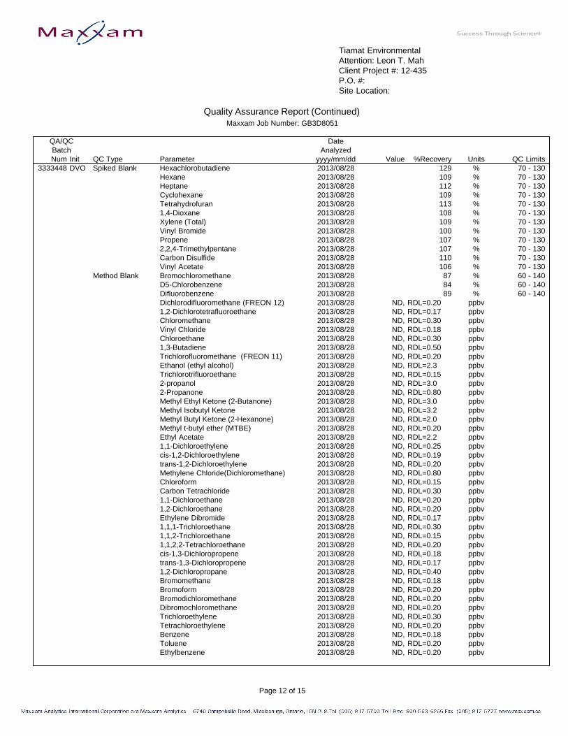
Tiamat EnvironmentalAttention: Leon T. Mah Client Project #: 12-435P.O. #: Site Location:
Quality Assurance Report (Continued)Maxxam Job Number: GB3D8051
QA/QC DateBatch AnalyzedNum Init QC Type Parameter yyyy/mm/dd Value %Recovery Units QC Limits
3333448 DVO Spiked Blank Hexachlorobutadiene 2013/08/28 129 % 70 - 130Hexane 2013/08/28 109 % 70 - 130Heptane 2013/08/28 112 % 70 - 130Cyclohexane 2013/08/28 109 % 70 - 130Tetrahydrofuran 2013/08/28 113 % 70 - 1301,4-Dioxane 2013/08/28 108 % 70 - 130Xylene (Total) 2013/08/28 109 % 70 - 130Vinyl Bromide 2013/08/28 100 % 70 - 130Propene 2013/08/28 107 % 70 - 1302,2,4-Trimethylpentane 2013/08/28 107 % 70 - 130Carbon Disulfide 2013/08/28 110 % 70 - 130Vinyl Acetate 2013/08/28 106 % 70 - 130
Method Blank Bromochloromethane 2013/08/28 87 % 60 - 140D5-Chlorobenzene 2013/08/28 84 % 60 - 140Difluorobenzene 2013/08/28 89 % 60 - 140Dichlorodifluoromethane (FREON 12) 2013/08/28 ND, RDL=0.20 ppbv1,2-Dichlorotetrafluoroethane 2013/08/28 ND, RDL=0.17 ppbvChloromethane 2013/08/28 ND, RDL=0.30 ppbvVinyl Chloride 2013/08/28 ND, RDL=0.18 ppbvChloroethane 2013/08/28 ND, RDL=0.30 ppbv1,3-Butadiene 2013/08/28 ND, RDL=0.50 ppbvTrichlorofluoromethane (FREON 11) 2013/08/28 ND, RDL=0.20 ppbvEthanol (ethyl alcohol) 2013/08/28 ND, RDL=2.3 ppbvTrichlorotrifluoroethane 2013/08/28 ND, RDL=0.15 ppbv2-propanol 2013/08/28 ND, RDL=3.0 ppbv2-Propanone 2013/08/28 ND, RDL=0.80 ppbvMethyl Ethyl Ketone (2-Butanone) 2013/08/28 ND, RDL=3.0 ppbvMethyl Isobutyl Ketone 2013/08/28 ND, RDL=3.2 ppbvMethyl Butyl Ketone (2-Hexanone) 2013/08/28 ND, RDL=2.0 ppbvMethyl t-butyl ether (MTBE) 2013/08/28 ND, RDL=0.20 ppbvEthyl Acetate 2013/08/28 ND, RDL=2.2 ppbv1,1-Dichloroethylene 2013/08/28 ND, RDL=0.25 ppbvcis-1,2-Dichloroethylene 2013/08/28 ND, RDL=0.19 ppbvtrans-1,2-Dichloroethylene 2013/08/28 ND, RDL=0.20 ppbvMethylene Chloride(Dichloromethane) 2013/08/28 ND, RDL=0.80 ppbvChloroform 2013/08/28 ND, RDL=0.15 ppbvCarbon Tetrachloride 2013/08/28 ND, RDL=0.30 ppbv1,1-Dichloroethane 2013/08/28 ND, RDL=0.20 ppbv1,2-Dichloroethane 2013/08/28 ND, RDL=0.20 ppbvEthylene Dibromide 2013/08/28 ND, RDL=0.17 ppbv1,1,1-Trichloroethane 2013/08/28 ND, RDL=0.30 ppbv1,1,2-Trichloroethane 2013/08/28 ND, RDL=0.15 ppbv1,1,2,2-Tetrachloroethane 2013/08/28 ND, RDL=0.20 ppbvcis-1,3-Dichloropropene 2013/08/28 ND, RDL=0.18 ppbvtrans-1,3-Dichloropropene 2013/08/28 ND, RDL=0.17 ppbv1,2-Dichloropropane 2013/08/28 ND, RDL=0.40 ppbvBromomethane 2013/08/28 ND, RDL=0.18 ppbvBromoform 2013/08/28 ND, RDL=0.20 ppbvBromodichloromethane 2013/08/28 ND, RDL=0.20 ppbvDibromochloromethane 2013/08/28 ND, RDL=0.20 ppbvTrichloroethylene 2013/08/28 ND, RDL=0.30 ppbvTetrachloroethylene 2013/08/28 ND, RDL=0.20 ppbvBenzene 2013/08/28 ND, RDL=0.18 ppbvToluene 2013/08/28 ND, RDL=0.20 ppbvEthylbenzene 2013/08/28 ND, RDL=0.20 ppbv
Page 12 of 15

Tiamat EnvironmentalAttention: Leon T. Mah Client Project #: 12-435P.O. #: Site Location:
Quality Assurance Report (Continued)Maxxam Job Number: GB3D8051
QA/QC DateBatch AnalyzedNum Init QC Type Parameter yyyy/mm/dd Value %Recovery Units QC Limits
3333448 DVO Method Blank p+m-Xylene 2013/08/28 ND, RDL=0.37 ppbvo-Xylene 2013/08/28 ND, RDL=0.20 ppbvStyrene 2013/08/28 ND, RDL=0.20 ppbv4-ethyltoluene 2013/08/28 ND, RDL=2.2 ppbv1,3,5-Trimethylbenzene 2013/08/28 ND, RDL=0.50 ppbv1,2,4-Trimethylbenzene 2013/08/28 ND, RDL=0.50 ppbvChlorobenzene 2013/08/28 ND, RDL=0.20 ppbvBenzyl chloride 2013/08/28 ND, RDL=1.0 ppbv1,3-Dichlorobenzene 2013/08/28 ND, RDL=0.40 ppbv1,4-Dichlorobenzene 2013/08/28 ND, RDL=0.40 ppbv1,2-Dichlorobenzene 2013/08/28 ND, RDL=0.40 ppbv1,2,4-Trichlorobenzene 2013/08/28 ND, RDL=2.0 ppbvHexachlorobutadiene 2013/08/28 ND, RDL=3.0 ppbvHexane 2013/08/28 ND, RDL=0.30 ppbvHeptane 2013/08/28 ND, RDL=0.30 ppbvCyclohexane 2013/08/28 ND, RDL=0.20 ppbvTetrahydrofuran 2013/08/28 ND, RDL=0.40 ppbv1,4-Dioxane 2013/08/28 ND, RDL=2.0 ppbvXylene (Total) 2013/08/28 ND, RDL=0.60 ppbvVinyl Bromide 2013/08/28 ND, RDL=0.20 ppbvPropene 2013/08/28 ND, RDL=0.30 ppbv2,2,4-Trimethylpentane 2013/08/28 ND, RDL=0.20 ppbvCarbon Disulfide 2013/08/28 ND, RDL=0.50 ppbvVinyl Acetate 2013/08/28 ND, RDL=0.20 ppbv
RPD -Sample/SampleDup Dichlorodifluoromethane (FREON 12) 2013/08/28 5.3 % 25
1,2-Dichlorotetrafluoroethane 2013/08/28 NC % 25Chloromethane 2013/08/28 NC % 25Vinyl Chloride 2013/08/28 NC % 25Chloroethane 2013/08/28 NC % 251,3-Butadiene 2013/08/28 NC % 25Trichlorofluoromethane (FREON 11) 2013/08/28 NC % 25Ethanol (ethyl alcohol) 2013/08/28 10.1 % 25Trichlorotrifluoroethane 2013/08/28 NC % 252-propanol 2013/08/28 NC % 252-Propanone 2013/08/28 4.0 % 25Methyl Ethyl Ketone (2-Butanone) 2013/08/28 NC % 25Methyl Isobutyl Ketone 2013/08/28 NC % 25Methyl Butyl Ketone (2-Hexanone) 2013/08/28 NC % 25Methyl t-butyl ether (MTBE) 2013/08/28 NC % 25Ethyl Acetate 2013/08/28 NC % 251,1-Dichloroethylene 2013/08/28 NC % 25cis-1,2-Dichloroethylene 2013/08/28 NC % 25trans-1,2-Dichloroethylene 2013/08/28 NC % 25Methylene Chloride(Dichloromethane) 2013/08/28 NC % 25Chloroform 2013/08/28 NC % 25Carbon Tetrachloride 2013/08/28 NC % 251,1-Dichloroethane 2013/08/28 NC % 251,2-Dichloroethane 2013/08/28 NC % 25Ethylene Dibromide 2013/08/28 NC % 251,1,1-Trichloroethane 2013/08/28 NC % 251,1,2-Trichloroethane 2013/08/28 NC % 251,1,2,2-Tetrachloroethane 2013/08/28 NC % 25cis-1,3-Dichloropropene 2013/08/28 NC % 25
Page 13 of 15

Tiamat EnvironmentalAttention: Leon T. Mah Client Project #: 12-435P.O. #: Site Location:
Quality Assurance Report (Continued)Maxxam Job Number: GB3D8051
QA/QC DateBatch AnalyzedNum Init QC Type Parameter yyyy/mm/dd Value %Recovery Units QC Limits
3333448 DVO RPD -Sample/SampleDup trans-1,3-Dichloropropene 2013/08/28 NC % 25
1,2-Dichloropropane 2013/08/28 NC % 25Bromomethane 2013/08/28 NC % 25Bromoform 2013/08/28 NC % 25Bromodichloromethane 2013/08/28 NC % 25Dibromochloromethane 2013/08/28 NC % 25Trichloroethylene 2013/08/28 NC % 25Tetrachloroethylene 2013/08/28 NC % 25Benzene 2013/08/28 NC % 25Toluene 2013/08/28 2.4 % 25Ethylbenzene 2013/08/28 NC % 25p+m-Xylene 2013/08/28 0.5 % 25o-Xylene 2013/08/28 NC % 25Styrene 2013/08/28 NC % 254-ethyltoluene 2013/08/28 NC % 251,3,5-Trimethylbenzene 2013/08/28 NC % 251,2,4-Trimethylbenzene 2013/08/28 NC % 25Chlorobenzene 2013/08/28 NC % 25Benzyl chloride 2013/08/28 NC % 251,3-Dichlorobenzene 2013/08/28 NC % 251,4-Dichlorobenzene 2013/08/28 NC % 251,2-Dichlorobenzene 2013/08/28 NC % 251,2,4-Trichlorobenzene 2013/08/28 NC % 25Hexachlorobutadiene 2013/08/28 NC % 25Hexane 2013/08/28 6.6 % 25Heptane 2013/08/28 NC % 25Cyclohexane 2013/08/28 NC % 25Tetrahydrofuran 2013/08/28 7.2 % 251,4-Dioxane 2013/08/28 NC % 25Xylene (Total) 2013/08/28 0.03 % 25Vinyl Bromide 2013/08/28 NC % 25Propene 2013/08/28 NC % 252,2,4-Trimethylpentane 2013/08/28 NC % 25Carbon Disulfide 2013/08/28 2.0 % 25Vinyl Acetate 2013/08/28 NC % 25
3333554 DVO Method Blank Aliphatic >C5-C6 2013/08/28 ND, RDL=5.0 ug/m3Aliphatic >C6-C8 2013/08/28 ND, RDL=5.0 ug/m3Aliphatic >C8-C10 2013/08/28 ND, RDL=5.0 ug/m3Aliphatic >C10-C12 2013/08/28 ND, RDL=5.0 ug/m3Aliphatic >C12-C16 2013/08/28 ND, RDL=5.0 ug/m3Aromatic >C7-C8 (TEX Excluded) 2013/08/28 ND, RDL=5.0 ug/m3Aromatic >C8-C10 2013/08/28 ND, RDL=5.0 ug/m3Aromatic >C10-C12 2013/08/28 ND, RDL=5.0 ug/m3Aromatic >C12-C16 2013/08/28 ND, RDL=5.0 ug/m3
RPD -Sample/SampleDup Aliphatic >C5-C6 2013/08/28 NC % 25
Aliphatic >C6-C8 2013/08/28 6.2 % 25Aliphatic >C8-C10 2013/08/28 6.3 % 25Aliphatic >C10-C12 2013/08/28 6.6 % 25Aliphatic >C12-C16 2013/08/28 NC % 25Aromatic >C7-C8 (TEX Excluded) 2013/08/28 NC % 25Aromatic >C8-C10 2013/08/28 NC % 25
Page 14 of 15

Tiamat EnvironmentalAttention: Leon T. Mah Client Project #: 12-435P.O. #: Site Location:
Quality Assurance Report (Continued)Maxxam Job Number: GB3D8051
QA/QC DateBatch AnalyzedNum Init QC Type Parameter yyyy/mm/dd Value %Recovery Units QC Limits
3333554 DVO RPD -Sample/SampleDup Aromatic >C10-C12 2013/08/28 NC % 25
Aromatic >C12-C16 2013/08/28 NC % 153337413 VLA Method Blank Oxygen 2013/09/04 ND, RDL=0.1 % v/v
Nitrogen 2013/09/04 ND, RDL=0.1 % v/vCarbon Monoxide 2013/09/04 ND, RDL=0.1 % v/vCarbon Dioxide 2013/09/04 ND, RDL=0.1 % v/v
RPD -Sample/SampleDup Oxygen 2013/09/04 0 % 20
Nitrogen 2013/09/04 0 % 20Carbon Monoxide 2013/09/04 NC % 20Carbon Dioxide 2013/09/04 NC % 20
3338537 VLA Method Blank Acetylene 2013/09/05 ND, RDL=0.1 ppmEthane 2013/09/05 ND, RDL=0.1 ppmEthylene 2013/09/05 ND, RDL=0.1 ppmMethane 2013/09/05 ND, RDL=2 ppmn-Butane 2013/09/05 ND, RDL=0.2 ppmn-Pentane 2013/09/05 ND, RDL=0.1 ppmPropane 2013/09/05 ND, RDL=0.1 ppmPropene 2013/09/05 ND, RDL=0.1 ppmPropyne 2013/09/05 ND, RDL=0.2 ppm
RPD -Sample/SampleDup Methane 2013/09/05 14.9 % 20
Spiked Blank: A blank matrix sample to which a known amount of the analyte, usually from a second source, has been added. Used to evaluate methodaccuracy.Method Blank: A blank matrix containing all reagents used in the analytical procedure. Used to identify laboratory contamination.Surrogate: A pure or isotopically labeled compound whose behavior mirrors the analytes of interest. Used to evaluate extraction efficiency.NC (RPD): The RPD was not calculated. The level of analyte detected in the parent sample and its duplicate was not sufficiently significant to permit areliable calculation.( 1 ) Recovery or RPD for this parameter is outside control limits. The overall quality control for this analysis meets acceptability criteria.
Page 15 of 15

REPORT OF ANALYSIS: Maxxam Analytics - B3D7417- Selected Siloxanes (TIVA)
REPORT: 13045si (Method - SCAN ATD-GC-MSD Cryogenic Oven Control)
DESCRIPTION 13091207 13091207 13091207 13091207
CAS # COMPOUND
SS4575-01R VW-01 (RIVERSIDE
HEAVY) V=200mL
SS4575-01R VW-01 (RIVERSIDE
HEAVY) V=200mL
Silicon Equivalent Silicon Equivalent
mg/m³ ppm mg/m³ ppm
420-56-4 Trimethylsilyl Fluoride 0.0011 0.0003 0.0003 0.0003
75-76-3 Tetramethylsilane <0.0001 <0.0001 <0.0001 <0.0001
1825-61-2 Methoxytrimethylsilane <0.0019 <0.0004 <0.0005 <0.0004
1825-62-3 Ethoxytrimethylsilane <0.0018 <0.0004 <0.0004 <0.0004
1066-40-6 Trimethylsilanol 0.0526 0.0143 0.0164 0.0143
1825-64-5 Isopropoxytrimethylsilane <0.0008 <0.0001 <0.0002 <0.0001
1185-55-3 Trimethoxymethyl Silane # ND ND ND ND
107-46-0 Hexamethyl Disiloxane - L2 0.0006 0.0001 0.0002 0.0002
1825-63-4 Propoxytrimethylsilane <0.0021 <0.0004 <0.0004 <0.0004
1825-67-8 1-Methylbutoxytrimethylsilane * ND ND ND ND
1825-65-6 Butoxytrimethylsilane * ND ND ND ND
2768-02-7 Trimethoxyvinyl Silane # ND ND ND ND
541-05-9 Hexamethyl Cyclotrisiloxane - D3 0.0111 0.0012 0.0042 0.0037
107-51-7 Octamethyl Trisiloxane - L3 <0.0001 <0.0001 <0.0001 <0.0001
78-08-0 Triethoxyvinyl Silane # ND ND ND ND
78-07-9 Triethoxyethyl Silane # ND ND ND ND
556-67-2 Octamethyl Cyclotetrasiloxane - D4 0.0090 0.0007 0.0034 0.0030
141-62-8 Decamethyl Tetrasiloxane - L4 <0.0002 <0.0001 <0.0001 <0.0001
78-10-4 Tetraethylsilicate # ND ND ND ND
541-02-6 Decamethyl Cyclopentasiloxane - D 0.0236 0.0016 0.0089 0.0078
141-63-9 Dodecamethyl Pentasiloxane - L5 <0.0018 <0.0001 <0.0006 <0.0006
540-97-6 Dodecamethyl Cyclohexasiloxane - 0.1655 0.0091 0.0627 0.0546
Sum 0.2722 0.0288 0.0985 0.0858
< (ND) = Characteristic ions are not present therefore Not Detected
< (TRACE) = Characteristic ions present but too low to be quantified
V = Volume of air/gas sampled
* = Semiquantitative (Response Factor set at 5)# = Unstable, poor detectability, commercial standards tested

12-435 Phase II ESA – Riverside Heavy Dry Waste Site Historic Waste Disposal Sites, The City of Red Deer
Tiamat Environmental Consultants Ltd. Electronic Version 03
APPENDIX B
TESTHOLE LOGS

TERMS USED ON BOREHOLE LOGS
Tiamat Environmental Consultants Ltd.
Terminology Common Soil Genesis Rootmat vegetation roots and moss with organic matter and topsoil typically forming a mattress at the
ground surface. Topsoil mixture of soil and humus capable of supporting good vegetative growth
Peat fibrous aggregate of visible and invisible fragments of decayed organic matter
Loam silty sand or sand mixed with silt and organics
Till unstratified glacial deposit which may range from clay to boulders
Fill any materials below the surface identified as placed by excavation activities (excluding buried services)
Common Soil Structure Slickensided Having inclined planes of weakness that are slick and glossy in appearance.
Fissured Containing shrinkage cracks, frequently filled with fine sand or silt; usually more or less vertical. Laminated Composed of thin layers of varying color and texture.
Interbedded Composed of alternate layers of different soil types.
Calcareous Containing appreciable quantities of calcium carbonate.
Well Graded Having wide range in grain sizes and substantial amounts of intermediate particle sizes.
Poorly graded Predominantly of one grain size, or having a range of sizes with some intermediate sizes missing.
Homogeneous same color and appearance throughout
Stratified composed of alternating successions of different soil types, eg. silt and sand
Lensed inclusion of small pockets of different soils
Laminated alternating layers of varying material or color with the layers less than 6 mm thick
Layer thickness > 75mm
Seam thickness between 2 mm and 75 mm
Parting thickness <2 mm Grain Size and Plasticity Description of soils on the basis of grain size and plasticity is based on the Unified Soil Classification System (USCS) (ASTM D-2487). The classification excludes particles larger than 76 mm (3 inches). This system provides a ground symbol (eg., SM) and group name (eg., silty SAND) for identification. Note: terminology describing materials in the absence of laboratory analysis is based on a visual method (ASTM D-2488). Descriptors for soil materials outside the USCS (eg., particles larger that 76 mm, visible organic matter, construction debris) is based on the (visually estimated) proportion of these materials present: Trace, or occasional Less than approximately 10%
Some Approximately 10 – 20%
Frequent Greater than approximately 20% Solid lines between soil strata indicate the interpreted boundary between different soil types. Dashed line between soil strata indicates the contact between different soil units has been inferred.

Tiamat Environmental Consultants Ltd.
Consistency of Cohesive Soils (Fine-Grained Soils) Fine-grained soils (major portion passing 0.075mm sieve): includes (1) inorganic and organic silts and clays. (2) gravelly, sandy, or silty clays, and (3) clayey silts. Consistency is rated according to shearing strength, as estimated from laboratory or in-situ tests. The standard nomenclature to describe cohesive soils includes the consistency, which is based on undrained shear strength as measured by in situ tests, penetrometer tests, unconfined compression tests, or occasionally by standard penetration tests. Standard Penetration Test ‘N-Value’ The Standard Penetration Test provides an “N-value; the number of blows of a 64 kg (140 pound) hammer falling 760 mm (30 inches) required to drive a 51 mm (2 inch) O.D. split spoon sampler 305 mm (one foot) into the soil. For split spoon samples where insufficient penetration is achieved and ‘N’ values cannot be determined, the number of blows is reported over sampler penetration in millimeters; e.g. blows/penetration = 50/75.
Consistency Unconfined Compressive Strength (kPa) N-Value Very Soft <25 <2
Soft 25-50 2-4 Firm 50-100 4-8 Stiff 100-200 8-15
Very Stiff 200-400 15-30 Hard >400 >30
NOTE: Slackened and fissured clays may have lower unconfined compressive strengths than shown above, because of naturally occurring planes of weakness or cracks in the soil. Density of Cohesionless Soils (Coarse-grained Soils) Coarse-grained soils (major portion retained on 0.075 mm sieve): includes (1) clean gravels and sands, and (2) silty or clayey gravels and sands. Condition is rated according to relative density, as inferred from laboratory or in-situ tests. The standard terminology to describe cohesionless soils includes the compactness (former “relative density”), as determined by laboratory test or by the Standard Penetration Test ‘N-Value’.
Density N Value (Blows per 0.3m) Relative Density - % Compactness Very Loose 0-4 0-20
Loose 4-10 20-40 Compact 10-30 40-75
Dense 30-50 75-90 Very Dense >50 90-100

PROJECT: Phase II ESA Historic Waste Disposal Sites BOREHOLE No.: MW-01PROJECT No.: 12-435 DRILL TYPE: SS AugerLOCATION: Riverside Heavy Dry Waste Site GROUND ELEVATION: 871.813 mCLIENT: The City of Red Deer COMPLETION DATE: 07/12/2013Sample Type: Shelby Tube Split Spoon Core Disturbed No Recovery
Backfill Type: Bentonite Silica Sand Grout Pea Gravel Drill Cuttings Bentonite : Sand
Notes: Groundwater Monitoring Well is located at southwest corner at the top of the hill
Dep
th (
m)
Sam
ple
Typ
e
Sam
ple
No.
SP
T (
N)
Com
bu
stib
le S
oil
Vap
ours
(p
pm
)
W
ell D
etai
ls
0.0 Field vegetation(weeds/mixed grasses/prairie wildflowers) - loam, sand, silty, trace rootlets, trace wood fragments, damp to moist, olive.concrete debris at 0.1 m.Sandy clay (fill) - firm, silty, trace fine rounded gravel, trace organics, trace wood fragments, moist, dark olive.
1.0
2.0
3.0 No obvious waste material below 3.1 m.Clay (fill) - firm, trace silts, trace oxides, moist, light olive brown.
4.0
Soil Description
5.0
6.0 some organics at 6.1 m.Clay (lacustrine) - soft to firm, medium plastic, trace silt, trace sand, moist, olive.
7.0
8.0
9.0
10.0
11.0
12.0
Slough : Completion Depth (m): 14.9
Depth to Groundwater : Checked By: LTM
Logged By: LTM Page: 1 of 2
Tiamat Environmental Consultants Ltd.gg y g

PROJECT: Phase II ESA Historic Waste Disposal Sites BOREHOLE No.: MW-01PROJECT No.: 12-435 DRILL TYPE: SS AugerLOCATION: Riverside Heavy Dry Waste Site GROUND ELEVATION: 871.813 mCLIENT: The City of Red Deer COMPLETION DATE: 07/12/2013Sample Type: Shelby Tube Split Spoon Core Disturbed No Recovery
Backfill Type: Bentonite Silica Sand Grout Pea Gravel Drill Cuttings Bentonite : Sand
Notes: Groundwater Monitoring Well is located at southwest corner at the top of the hill
Dep
th (
m)
Sam
ple
Typ
e
Sam
ple
No.
SP
T (
N)
Com
bu
stib
le S
oil
Vap
ours
(p
pm
)
W
ell D
etai
ls
13.0 Sand - compact, some clay nodules, wet, olive grey.
14.0
15.0 End of hole at 14.9 m.51 mm diameter 3 m length 010 PVC screen.Aboveground lockable steel casing set in concrete.
16.0
17.0
Soil Description
18.0
19.0
20.0
21.0
22.0
23.0
24.0
25.0
Slough : Completion Depth (m): 14.9
Depth to Groundwater : Checked By: LTM
Logged By: LTM Page: 2 of 2
Tiamat Environmental Consultants Ltd.gg y g

PROJECT: Phase II ESA Historic Waste Disposal Sites BOREHOLE No.: VW-01PROJECT No.: 12-435 DRILL TYPE: SS AugerLOCATION: Riverside Heavy Dry Waste Site GROUND ELEVATION: 871.261 mCLIENT: The City of Red Deer COMPLETION DATE: 07/12/2013Sample Type: Shelby Tube Split Spoon Core Disturbed No Recovery
Backfill Type: Bentonite Silica Sand Grout Pea Gravel Drill Cuttings Bentonite : Sand
Notes: Soil Vapour Well is located about 125 m north of MW-01 in the central portion, on the west side of the site at the top of the hill.
Dep
th (
m)
Sam
ple
Typ
e
Sam
ple
No.
SP
T (
N)
Com
bu
stib
le S
oil
Vap
ours
(p
pm
)
W
ell D
etai
ls
0.0 Field vegetation(weeds/mixed grasses/prairie wildflowers) - loam, sand, silty, some organics, moist dark olive. (~ 15 cm.)Sand - loose, trace silt, trace gravel, damp, light grey.
1.0
2.0Clay (fill) - firm, silty, some sand, moist, light olive brown.
3.0
becomes stiff, trace silt, trace sand, trace oxides, trace coal, moist, olive at 3.7 m.
4.0
Soil Description
5.0
6.0
some grey clay at 6.7 m.
7.0 No obvious waste material.
End of hole at 7.3 m.25 mm diameter 020 PVC screen.Aboveground lockable steel casing set in concrete.
8.0
9.0
10.0
11.0
12.0
Slough : Completion Depth (m): 7.3
Depth to Groundwater : Checked By: LTM
Logged By: LTM Page: 1 of 1
Tiamat Environmental Consultants Ltd.Logged By: LTM Page: 1 of 1

PROJECT: Phase II ESA Historic Waste Disposal Sites BOREHOLE No.: TH-03PROJECT No.: 12-435 DRILL TYPE: SS AugerLOCATION: Riverside Heavy Dry Waste Site GROUND ELEVATION: 868.951 mCLIENT: The City of Red Deer COMPLETION DATE: 07/12/2013Sample Type: Shelby Tube Split Spoon Core Disturbed No Recovery
Backfill Type: Bentonite Silica Sand Grout Pea Gravel Drill Cuttings Bentonite : Sand
Notes: Testhole is located about 49 m southeast of VW-01 on the slope, in the west central area of the site.
Dep
th (
m)
Sam
ple
Typ
e
Sam
ple
No.
SP
T (
N)
Com
bu
stib
le S
oil
Vap
ours
(p
pm
)
W
ell D
etai
ls
0.0 Field vegetation(weeds/mixed grasses/prairie wildflowers) - loam. (~ 15 cm.)Sand & Clay (fill) - firm, trace organics, trace gravel, moist, olive.
Clay (fill) - stiff, trace silts, trace gravel, damp, olive brown.Sand (fill) mixed with MSW - heavy wire, brick fragments, concrete fragments, gravel,
1.0 some clay, trace organics.
2.0
3.0
refusal on concrete debris at 3.4 m. TH-03 relocated ~ 2 m north and re-drilled.
4.0
Soil Description
5.0
Clay mixed with MSW - some glass fragments, plastic pieces, trace wood fragments, soft to firm.
6.0
7.0No obvious waste material at 7.3 m.
End of hole at 7.6 m.Backfilled with ~ 50:50 bentonite and silica sand.
8.0
9.0
10.0
11.0
12.0
Slough : Completion Depth (m): 7.6
Depth to Groundwater : Checked By: LTM
Logged By: LTM Page: 1 of 1
Tiamat Environmental Consultants Ltd.gg y g

PROJECT: Phase II ESA Historic Waste Disposal Sites BOREHOLE No.: TH-04PROJECT No.: 12-435 DRILL TYPE: SS AugerLOCATION: Riverside Heavy Dry Waste Site GROUND ELEVATION: 868.686 mCLIENT: The City of Red Deer COMPLETION DATE: 07/12/2013Sample Type: Shelby Tube Split Spoon Core Disturbed No Recovery
Backfill Type: Bentonite Silica Sand Grout Pea Gravel Drill Cuttings Bentonite : Sand
Notes: Testhole is located ~ 45 m southeast of TH-03 on hill slope within the south half of the site.
Dep
th (
m)
Sam
ple
Typ
e
Sam
ple
No.
SP
T (
N)
Com
bu
stib
le S
oil
Vap
ours
(p
pm
)
W
ell D
etai
ls
0.0 Field vegetation(weeds/mixed grasses/prairie wildflowers) - loam, sand, gravel, some organics. (~ 5 cm thick).Sand (fill) mixed with MSW - brick fragments, trace masonry, trace plastic, trace concrete fragments, trace wood fragments, silty, loamy, trace gravel, damp to moist, light grey to dark olive.
1.0 plastic bits at 0.8 m.concrete rubble at 1.1 m.
2.0
3.0
4.0
Soil Description
5.0
6.0
7.0
8.0
9.0
10.0
11.0
12.0
Slough : Completion Depth (m): 18.3
Depth to Groundwater : Checked By: LTM
Logged By: LTM Page: 1 of 2
Tiamat Environmental Consultants Ltd.gg y g
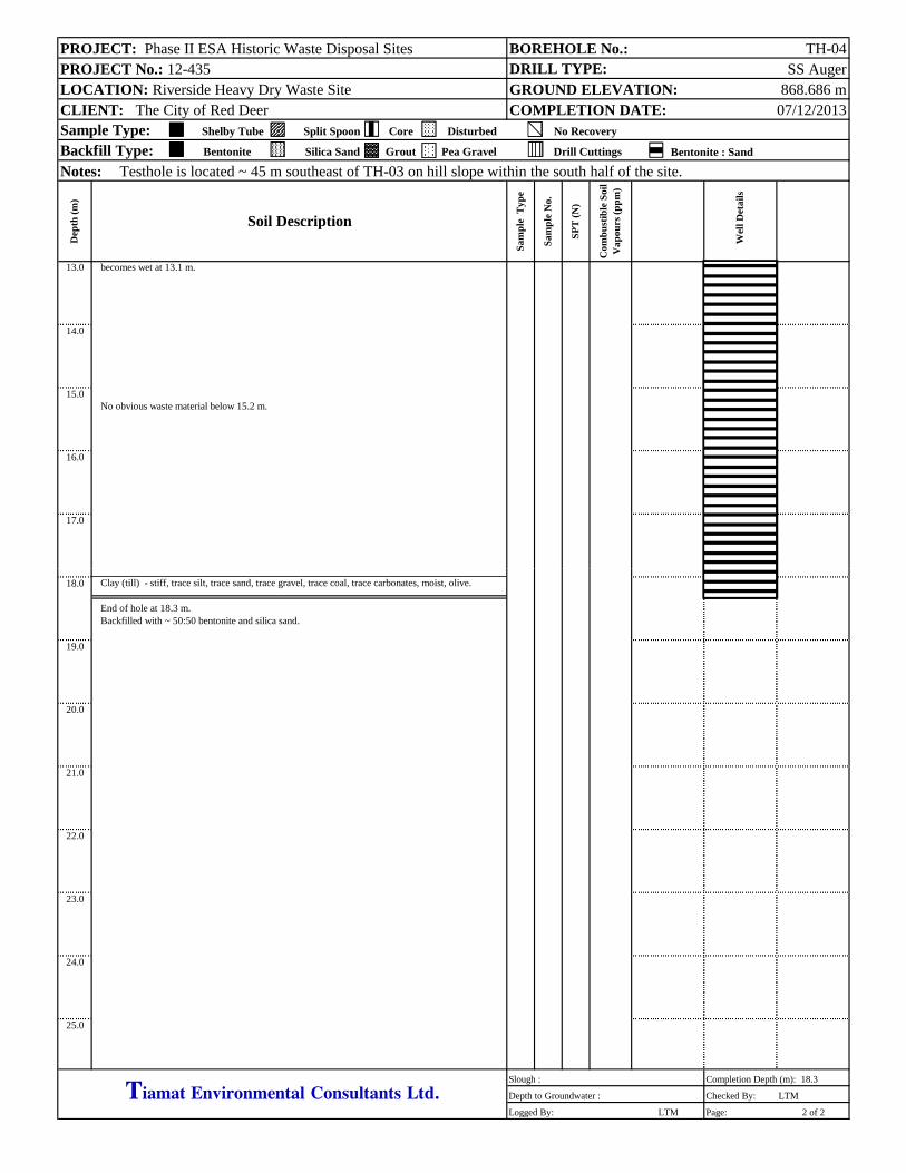
PROJECT: Phase II ESA Historic Waste Disposal Sites BOREHOLE No.: TH-04PROJECT No.: 12-435 DRILL TYPE: SS AugerLOCATION: Riverside Heavy Dry Waste Site GROUND ELEVATION: 868.686 mCLIENT: The City of Red Deer COMPLETION DATE: 07/12/2013Sample Type: Shelby Tube Split Spoon Core Disturbed No Recovery
Backfill Type: Bentonite Silica Sand Grout Pea Gravel Drill Cuttings Bentonite : Sand
Notes: Testhole is located ~ 45 m southeast of TH-03 on hill slope within the south half of the site.
Dep
th (
m)
Sam
ple
Typ
e
Sam
ple
No.
SP
T (
N)
Com
bu
stib
le S
oil
Vap
ours
(p
pm
)
W
ell D
etai
ls
13.0 becomes wet at 13.1 m.
14.0
15.0No obvious waste material below 15.2 m.
16.0
17.0
Soil Description
18.0 Clay (till) - stiff, trace silt, trace sand, trace gravel, trace coal, trace carbonates, moist, olive.
End of hole at 18.3 m.Backfilled with ~ 50:50 bentonite and silica sand.
19.0
20.0
21.0
22.0
23.0
24.0
25.0
Slough : Completion Depth (m): 18.3
Depth to Groundwater : Checked By: LTM
Logged By: LTM Page: 2 of 2
Tiamat Environmental Consultants Ltd.gg y g

PROJECT: Phase II ESA Historic Waste Disposal Sites BOREHOLE No.: TH-05PROJECT No.: 12-435 DRILL TYPE: SS AugerLOCATION: Riverside Heavy Dry Waste Site GROUND ELEVATION: 869.951 mCLIENT: The City of Red Deer COMPLETION DATE: 07/12/2013Sample Type: Shelby Tube Split Spoon Core Disturbed No Recovery
Backfill Type: Bentonite Silica Sand Grout Pea Gravel Drill Cuttings Bentonite : Sand
Notes: Testhole is located about 24 m east of MW-01 on the hill slope near the south margin of a steep slope.
Dep
th (
m)
Sam
ple
Typ
e
Sam
ple
No.
SP
T (
N)
Com
bu
stib
le S
oil
Vap
ours
(p
pm
)
W
ell D
etai
ls
0.0 Field vegetation(weeds/mixed grasses/prairie wildflowers) - compact, loamy, sandy, silty, trace gravel, moist, olive.Sand (fill) - loose, silty, silty, loamy, moist, dark olive.
some clay at 0.9 m.1.0
2.0 heavy wire and plastic bits at 2.1 m.
3.0
4.0
refusal on concrete debris at 4.9 m.
Soil Description
5.0 End of hole at 4.9 m.Backfilled with ~ 50:50 bentonite and silica sand.
6.0
7.0
8.0
9.0
10.0
11.0
12.0
Slough : Completion Depth (m): 4.9
Depth to Groundwater : Checked By: LTM
Logged By: LTM Page: 1 of 1
Tiamat Environmental Consultants Ltd.gg y g

PROJECT: Phase II ESA Historic Waste Disposal Sites BOREHOLE No.: TH-06PROJECT No.: 12-435 DRILL TYPE: SS AugerLOCATION: Riverside Heavy Dry Waste Site GROUND ELEVATION: 866.315 mCLIENT: The City of Red Deer COMPLETION DATE: 07/13/2013Sample Type: Shelby Tube Split Spoon Core Disturbed No Recovery
Backfill Type: Bentonite Silica Sand Grout Pea Gravel Drill Cuttings Bentonite : Sand
Notes: Testhole is located about 48 m northeast of VW-01 in the north central portion of the site.
Dep
th (
m)
Sam
ple
Typ
e
Sam
ple
No.
SP
T (
N)
Com
bu
stib
le S
oil
Vap
ours
(p
pm
)
W
ell D
etai
ls
0.0 Field vegetation(weeds/mixed grasses/prairie wildflowers) - loamy, sandy, moist, dark olive.(~ 15 cm thick).Sand mixed with MSW - trace wood fragments, masonry brick, concrete pieces, organic loam,wire, firm, loamy, sand, some clay, trace gravel, trace organics, moist, dark olive.
1.0
2.0
3.0
Clay (fill) - soft, silty, trace sand, moist, olive.4.0
Sandy clay (fill) mixed with MSW - brick, concrete pieces, trace glass, firm, silty, some loam,i t d k li
Soil Description
moist, dark olive.5.0
some blue foam at 5.5 m.
6.0
moderate slough and humic odour at 6.4 m.
7.0
8.0
9.0 pockets of loam at 9.1 m to 10.7 m.
Sand (fill) - soft, loamy, silty, clayey, trace gravel, moist, olive.10.0 light grey sand appears partially cemented at 10.1 m to 13.4 m.
Clay (fill) - firm, silty, loamy, moist, olive brown.No obvious waste material below 10 m.
11.0
12.0
Slough : Completion Depth (m): 19.5
Depth to Groundwater : Checked By: LTM
Logged By: LTM Page: 1 of 2
Tiamat Environmental Consultants Ltd.gg y g

PROJECT: Phase II ESA Historic Waste Disposal Sites BOREHOLE No.: TH-06PROJECT No.: 12-435 DRILL TYPE: SS AugerLOCATION: Riverside Heavy Dry Waste Site GROUND ELEVATION: 866.315 mCLIENT: The City of Red Deer COMPLETION DATE: 07/13/2013Sample Type: Shelby Tube Split Spoon Core Disturbed No Recovery
Backfill Type: Bentonite Silica Sand Grout Pea Gravel Drill Cuttings Bentonite : Sand
Notes: Testhole is located about 48 m northeast of VW-01 in the north central portion of the site.
Dep
th (
m)
Sam
ple
Typ
e
Sam
ple
No.
SP
T (
N)
Com
bu
stib
le S
oil
Vap
ours
(p
pm
)
W
ell D
etai
ls
13.0
14.0
15.0
16.0
17.0
Clay (till) - stiff, trace silt, trace sand, trace gravel, trace coal, moist, olive.
Soil Description
18.0
19.0
End of hole at 19.5 m.Backfilled with ~ 50:50 bentonite and silica sand.
20.0
21.0
22.0
23.0
24.0
25.0
Slough : Completion Depth (m): 19.5
Depth to Groundwater : Checked By: LTM
Logged By: LTM Page: 2 of 2
Tiamat Environmental Consultants Ltd.gg y g

PROJECT: Phase II ESA Historic Waste Disposal Sites BOREHOLE No.: TH-07PROJECT No.: 12-435 DRILL TYPE: SS AugerLOCATION: Riverside Heavy Dry Waste Site GROUND ELEVATION: 863.026 mCLIENT: The City of Red Deer COMPLETION DATE: 07/13/2013Sample Type: Shelby Tube Split Spoon Core Disturbed No Recovery
Backfill Type: Bentonite Silica Sand Grout Pea Gravel Drill Cuttings Bentonite : Sand
Notes: Testhole is located about 42 m north of TH-06 within the north half of the site.
Dep
th (
m)
Sam
ple
Typ
e
Sam
ple
No.
SP
T (
N)
Com
bu
stib
le S
oil
Vap
ours
(p
pm
)
W
ell D
etai
ls
0.0 Loam - sandy, silty, trace rootlets, moist, dark olive. (~ 45 cm.)
Loamy sand - silty, trace gravel, trace wood fragments, moist, dark olive.
1.0 trace clay at 1.1 m.
2.0
3.0
refusal (possibly on concrete) at 3.7 m. TH-07 relocated ~ 2 m north and re-drilled.
4.0
No obvious waste material at 4.6 m.
Soil Description
5.0
6.0
End of hole at 6.1 m.Backfilled with ~ 50:50 bentonite and silica sand.
7.0
8.0
9.0
10.0
11.0
12.0
Slough : Completion Depth (m): 6.1
Depth to Groundwater : Checked By: LTM
Logged By: LTM Page: 1 of 1
Tiamat Environmental Consultants Ltd.gg y g

PROJECT: Phase II ESA Historic Waste Disposal Sites BOREHOLE No.: MW-02PROJECT No.: 12-435 DRILL TYPE: SS AugerLOCATION: Riverside Heavy Dry Waste Site GROUND ELEVATION: 848.556 mCLIENT: The City of Red Deer COMPLETION DATE: 07/13/2013Sample Type: Shelby Tube Split Spoon Core Disturbed No Recovery
Backfill Type: Bentonite Silica Sand Grout Pea Gravel Drill Cuttings Bentonite : Sand
Notes: Groundwater Monitoring Well is located at the base of the hill, near the northeast corner of the site.
Dep
th (
m)
Sam
ple
Typ
e
Sam
ple
No.
SP
T (
N)
Com
bu
stib
le S
oil
Vap
ours
(p
pm
)
W
ell D
etai
ls
0.0 Field vegetation(weeds/mixed grasses/prairie wildflowers) and loam - sand, silty, trace rootlets, moist, dark olive. (~ 15 cm thick).Clay (till) - silty, trace sand, trace gravel, trace carbonates, trace coal, moist, olive.
1.0
2.0
Sand about 0.15 m thick.
3.0
No obvious waste material.Silt (till) - stiff, sandy, trace clay, trace gravel, trace oxides, damp, light olive.
4.0
Siltstone (bedrock) - very weak, highly weathered, moist, light grey.
Soil Description
5.0
6.0End of hole at 6.1 m.
51 mm diameter 3 m length 010 PVC screen.Aboveground lockable steel casing set in concrete.
7.0
8.0
9.0
10.0
11.0
12.0
Slough : Completion Depth (m): 6.1
Depth to Groundwater : Checked By: LTM
Logged By: LTM Page: 1 of 1
Tiamat Environmental Consultants Ltd.gg y g

PROJECT: Phase II ESA Historic Waste Disposal Sites BOREHOLE No.: MW-03PROJECT No.: 12-435 DRILL TYPE: SS AugerLOCATION: Riverside Heavy Dry Waste Site GROUND ELEVATION: 847.734 mCLIENT: The City of Red Deer COMPLETION DATE: 07/13/2013Sample Type: Shelby Tube Split Spoon Core Disturbed No Recovery
Backfill Type: Bentonite Silica Sand Grout Pea Gravel Drill Cuttings Bentonite : Sand
Notes: Groundwater Monitoring Well is located on the south side of the access road on the site, near the east perimeter.
Dep
th (
m)
Sam
ple
Typ
e
Sam
ple
No.
SP
T (
N)
Com
bu
stib
le S
oil
Vap
ours
(p
pm
)
W
ell D
etai
ls
0.0 Field vegetation(weeds/mixed grasses/prairie wildflowers) and loam - sand, silty, trace rootlets, moist, olive brown. (~ 10 cm thick).Sand (fill) - firm, silty, trace fine rounded pebbles, moist, olive brown.
1.0 wet from drainage ditch for rail track.Silt (fill) - soft, some clay, some organics, moist, olive brown to grey.
No obvious waste material.2.0 Clay (lacusturine) - soft, silty, wet, olive grey.
3.0
4.0
Sand (native) - compact, silty, trace clay, moist, grey.
Soil Description
5.0
6.0End of hole at 6.1 m.
51 mm diameter 4.6 m length 010 PVC screen.Aboveground lockable steel casing set in concrete.
7.0
8.0
9.0
10.0
11.0
12.0
Slough : 1 m Completion Depth (m): 6.1
Depth to Groundwater : Checked By: LTM
Logged By: LTM Page: 1 of 1
Tiamat Environmental Consultants Ltd.gg y g

12-435 Phase II ESA – Riverside Heavy Dry Waste Site Historic Waste Disposal Sites, The City of Red Deer
Tiamat Environmental Consultants Ltd. Electronic Version 03
APPENDIX C
SELECT PHOTOGRAPHS
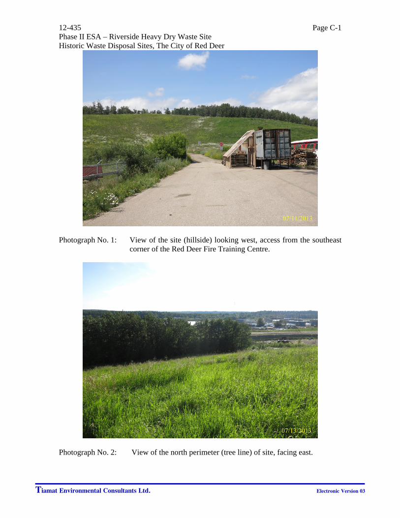
12-435 Phase II ESA – Riverside Heavy Dry Waste Site Historic Waste Disposal Sites, The City of Red Deer
Tiamat Environmental Consultants Ltd. Electronic Version 03
Page C-1
Photograph No. 1: View of the site (hillside) looking west, access from the southeast
corner of the Red Deer Fire Training Centre.
Photograph No. 2: View of the north perimeter (tree line) of site, facing east.

12-435 Phase II ESA – Riverside Heavy Dry Waste Site Historic Waste Disposal Sites, The City of Red Deer
Tiamat Environmental Consultants Ltd. Electronic Version 03
Page C-2
Photograph No. 3: View of the south perimeter of the site. Note slough located just north of the rail tracks.
Photograph No. 4: View of the west perimeter of the site along the top of the slope,
facing south.
“Slough”
CN Track
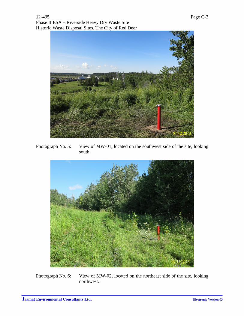
12-435 Phase II ESA – Riverside Heavy Dry Waste Site Historic Waste Disposal Sites, The City of Red Deer
Tiamat Environmental Consultants Ltd. Electronic Version 03
Page C-3
Photograph No. 5: View of MW-01, located on the southwest side of the site, looking
south.
Photograph No. 6: View of MW-02, located on the northeast side of the site, looking
northwest.

12-435 Phase II ESA – Riverside Heavy Dry Waste Site Historic Waste Disposal Sites, The City of Red Deer
Tiamat Environmental Consultants Ltd. Electronic Version 03
Page C-4
Photograph No. 7: View of MW-03, located on the east perimeter of the site, looking
southeast.
Photograph No. 8: View of VP-01, located on the west perimeter of the site, looking
southeast.

12-435 Phase II ESA – Riverside Heavy Dry Waste Site Historic Waste Disposal Sites, The City of Red Deer
Tiamat Environmental Consultants Ltd. Electronic Version 03
Page C-5
Photograph No. 9: View of the location of TH-03 and soil bag, looking northwest.
Photograph No. 10: View of MSW on the auger from a depth of 1.5 m to 3.0 m in
depth at TH-03.

12-435 Phase II ESA – Riverside Heavy Dry Waste Site Historic Waste Disposal Sites, The City of Red Deer
Tiamat Environmental Consultants Ltd. Electronic Version 03
Page C-6
Photograph No. 11: View of drill rig at location of TH-06, looking north.
Photograph No. 12: View of soil bags after drilling, located by the entrance to the Fire Training Centre.