historic resource survey report phase i: downtown core
TRANSCRIPT

Historic Resource Survey Report
Phase I: Downtown Core
Longview, Gregg County, Texas
Prepared for
The City of Longview, Texas
and
The Texas Historical Commission
Certified Local Government Program
by
Preservation Central, Inc.,
Historic Preservation Consultants
September 30, 2016

Historic Resource Survey Report
Phase I: Downtown Core
Longview, Gregg County, Texas
Prepared for
The City of Longview, Texas
and
The Texas Historical Commission
Certified Local Government Program
by
Preservation Central, Inc.
Author: Terri Myers, Historian
Contributors: Karen McGraw
Kristen Brown
September 30, 2016

2016 Historic Resource Survey: Longview, Gregg County, Texas
i
Table of Contents
Abstract .................................................................................................................................... iii
Map of Longview, Gregg County, Texas .......................................................................... iv
Introduction ............................................................................................................................... v
Map of Sector 1 Survey Area ............................................................................................. vi
Professional and Public Input ................................................................................................. vii
Historic Context Organization .................................................................................................. x
HISTORIC CONTEXT ............................................................................................................... 1
Historic and Architectural Resources of Longview: 1870-1970 .............................................. 2
1) The Railroad Comes to East Texas................................................................................. 2
Longview Townsite: 1870 ............................................................................................ 4
The County Seat ............................................................................................................ 6
Rebuilding: 1877-1880 ................................................................................................. 7
2) Period of Growth and Prosperity: 1880-1900................................................................. 9
Residential Development ............................................................................................ 10
African-American Presence in Longview ................................................................... 11
The Junction ................................................................................................................ 12
Early Additions to the City of Longview .................................................................... 15
3) Longview’s Progressive Era: 1900-1919 ..................................................................... 15
Bodie .......................................................................................................................... 16
Business and Industrial Expansion ............................................................................. 17
Residential Growth, Architectural Trends, and Additions .......................................... 19
African-American Additions: Mobberly’s South and Rembert’s “Old Field” ........... 21
Civic Progress ............................................................................................................. 23
4) Longview in Decline: 1919-1929 ................................................................................. 24
Longview Race Riot of 1919 ...................................................................................... 24
Lingering Malaise in the 1920s................................................................................... 26
5) Oil!: 1931-1941 ............................................................................................................ 27
Suburban Expansion in the 1920s ............................................................................... 31
North Longview Additions ................................................................................... 32
Southside Additions .............................................................................................. 34
6) World War II Projects: 1941-1945 ............................................................................... 37
7) Postwar Development Boom: 1945-1966..................................................................... 38
Housing and Suburban Development ......................................................................... 40
Downtown Longview in the Postwar Era ................................................................... 43
REFERENCES, SURVEY, METHODOLOGY, DELIVERABLES,
AND SPECIFICATIONS .......................................................................................................... 46
References Cited ..................................................................................................................... 47
Historic Resources Survey ...................................................................................................... 49

2016 Historic Resource Survey: Longview, Gregg County, Texas
ii
Research Methods ................................................................................................................... 49
General Research .............................................................................................................. 50
Advanced Research ........................................................................................................... 52
Survey Methods ...................................................................................................................... 53
Windshield Survey ............................................................................................................ 53
Map of “Downtown Core” Survey Area .................................................................... 55
The Downtown Core Project Area ............................................................................. 56
Field Investigations .................................................................................................... 58
Reconnaissance-Level Survey ......................................................................................... 59
Map of Survey Sectors ............................................................................................... 61
Results ..................................................................................................................................... 62
Property Types .................................................................................................................. 62
Construction Dates ............................................................................................................ 62
Architectural Styles ........................................................................................................... 63
Priority Assessments ......................................................................................................... 63
Potential Historic Districts ................................................................................................ 64
Map of Propsed South Main and White City Historic Districts ................................. 65
Map of Proposed Junction Historic District................................................................ 67
Recommendations ................................................................................................................... 68
Future Survey Efforts ........................................................................................................ 68
Historic Designations ........................................................................................................ 68
High Priority Resources .................................................................................................... 68
Table: High Preservation Priority Properties .................................................................... 69
Potential Historic Districts ................................................................................................ 72
The “Hundred Acres” ....................................................................................................... 72
Deliverables ............................................................................................................................ 73
Specifications .......................................................................................................................... 74
APPENDICES ............................................................................................................................. 75
Appendix A .................................................................................................. (Appendix Binder)
Appendix B ........................................................................................... (Survey Form Binders)
Appendix C .................................................................................................. (Appendix Binder)
Appendix D .................................................................................................. (Appendix Binder)

2016 Historic Resource Survey: Longview, Gregg County, Texas
iii
Abstract
This Historic Resource Survey Report describes the activities, findings, and recommendations of an
intensive-level survey of historic resources conducted in downtown Longview, Texas, in the spring
and summer of 2016. The city undertook the survey to fulfill its obligation as a Certified Local
Government (CLG), an inter-governmental program that provides funding and professional expertise
for qualified historic preservation projects. As a CLG, the city is required to establish and maintain
a system for identifying, documenting, and evaluating historic resources within its jurisdiction. This
survey was part of a two-tiered project to begin that process.
The city hired Preservation Central, Inc., a historic preservation consulting firm, to complete a two-
part historic resource survey project. The first task was to develop a Historic Resource Survey Plan
that would outline the steps and procedures needed to complete the citywide survey. The Survey
Plan organized the city into survey sectors and set priorities for conducting field investigations. The
second part of the project was to implement the first phase of the plan by conducting a survey of the
city’s downtown core.
This Historic Resource Survey Report documents the activities and findings of the survey. It
contains a Historic Context that briefly describes the city’s growth and development from its
inception as a railroad stop to its emergence as a regional leader in East Texas. It describes the
research methods, field investigations, and findings of the downtown survey and recommends a
course of action for preserving and protecting significant historic resources.
Historian Terri Myers served as Project Director for both the Survey Plan and the Survey of
Longview’s downtown core. She is the principal author of this report. Historic preservation
consultants, Architect Karen McGraw, and Architectural Historian Kristen Brown, contributed to the
survey project and this report.
This project was funded in part through a Certified Local Government Grant from the National Park Service, U.S.
Department of the Interior, as administered by the Texas Historical Commission.
The contents and opinions, however, do not necessarily reflect the views and policies of the Department of the Interior,
nor does the mention of trade names or commercial products constitute endorsement or recommendation by the
Department of the Interior.
This program receives Federal funds from the National Park Service. Regulations of the U.S. Department of the Interior
strictly prohibit unlawful discrimination in departmental Federally Assisted Programs on the basis of race, color,
national origin, age or handicap. Any person who believes he or she has been discriminated against in any program,
activity, or facility operated by a recipient of Federal assistance should write to: Director, Equal Opportunity Program,
U.S. Department of the Interior, National Park Service, P.O. Box 37127, Washington, D.C. 20013-7127.

2016 Historic Resource Survey: Longview, Gregg County, Texas
iv
Figure 1: Longview, Gregg County, Texas

2016 Historic Resource Survey: Longview, Gregg County, Texas
v
Introduction
On February 17, 2016, the City of Longview, Gregg County, Texas contracted with
Preservation Central, Inc., an Austin-based historic preservation consulting firm, to undertake
preservation planning and architectural survey activities as part of a citywide effort to
document all historic-age resources (buildings, structures, objects, and sites 50 or more years
of age) within its corporate limits. The two-part project consisted of: 1) the development of a
Historic Resource Survey Plan to guide the comprehensive survey program; and 2) a Historic
Resource Survey of one or more areas identified by the plan as having high historic and/or
architectural significance.
The Historic Resource Survey Plan is a separate document that outlines the steps and
procedures necessary to complete a citywide survey of Longview’s historic resources. In
brief, the plan recommends a multi-year, multi-phase program of field investigations to be
implemented over a period of six years. The consultants divided the city into six sectors
based on location, geographic boundaries, numbers and distribution of historic-age resources,
and shared historic or thematic development. They prioritized the sectors based on historic
associations, architectural merit, and potential threats to their preservation. The Survey Plan
identified three adjacent parts of the city’s downtown core as the first priority for survey and
the consultants documented properties in that sector, designated Sector 1, for this initial
phase of the project.
This Historic Resource Survey Report describes the activities, research methods, field
investigations, results, and recommendations of the intensive-level survey of the downtown
core in Phase I of the proposed multi-phase project. The downtown core includes the original
“Hundred Acre” Longview townsite, the adjoining South Main residential district, and the
area known as “the Junction” east of downtown. These areas were assessed as high priorities
for survey based on the age and historic and/or architectural significance of their resources
and the potential for loss due to neglect, unsympathetic renovation, demolition,
redevelopment, or other threats.
Sector 1 – the “downtown core” – is roughly bounded by Marshall Avenue/E. Methvin Street
on the north, the I.&G.N. railroad tracks/E. Cotton Street on the south, High Street on the
west, and Green/S. Ninth Street on the east. Two teams conducted a pedestrian survey within
the sector where they identified and recorded 353 historic-age resources. Of the total, 41
properties were evaluated as high preservation priorities based on their known historic
associations and/or architectural significance. The consultants also identified three potential
historic districts in Sector 1; they are White City, the South Main residential district, and the
800 block of E. Methvin Street in “the Junction.” The report recommends further research to
designate high priority sites and districts to appropriate levels of distinction.

2016 Historic Resource Survey: Longview, Gregg County, Texas
vi
Figure 2: The Sector 1 survey area - the "downtown core” (base map from mapquest.com)

2016 Historic Resource Survey: Longview, Gregg County, Texas
vii
Professional and Public Input
Professional Contacts
Upon Notice-to-Proceed, the consultant arranged a meeting with Leslie Wolfenden, Survey
Coordinator for the Texas Historical Commission (THC), and a telephone conference with
Angela Choy, Planner for the City of Longview and liaison to the city’s Historic Preservation
Commission. The consultant maintained contact with Ms. Wolfenden and Ms. Choy
throughout the course of the project.
On February 3, 2016, the consultant met with Ms. Wolfenden to discuss the types and
distribution of historic properties in Longview. Most particularly, they looked at potential
survey areas for intensive-level documentation as part of the current Survey Project. Ms.
Wolfenden expressed a preference for surveying the downtown business district where many
historic properties still exist though their original brick facades have been obscured by the
application of “slipcovers” in modernization efforts. She also provided the consultant with
some preliminary information on the origins and early growth of the city.
Before making her first site visit to Longview, the Project Director consulted with Ms. Choy
to address details of the survey project and plan a “kick-off” meeting with the city’s Historic
Preservation Commission and other interested parties. Ms. Choy echoed the THC Survey
Coordinator’s recommendation to document the downtown business district in the initial
phase of the project because property owners in the area were interested in restoring and
revitalizing their buildings. The identification and assessment of historic properties in the
area could help in funding such projects through tax credits and other preservation incentives.
The consultant also met with Historic Architect Karen McGraw on February 7, 2016, before
traveling to Longview. They discussed the goals and desired outcome of the public meeting
and Ms. McGraw’s role as a survey team leader following Ms. Myers’ initial Windshield
Survey.
The Project Director traveled to Longview for a “kick-off” meeting with the city’s
Preservation Commission and to conduct a Windshield Survey to identify a project area for
the initial survey.

2016 Historic Resource Survey: Longview, Gregg County, Texas
viii
Public Meeting
The public meeting was held in the city’s Planning and Development conference room on
February 11, 2016. It was attended by members of the city’s Historic Preservation
Commission, members of the Gregg County Historical Commission, and other local parties
interested in the preservation of historic properties in Longview. Those present included Lori
Keebaugh, Chairman of the Longview Preservation Commission, Debbie Hancock, Vice-
chairman, Ann Heaston, Cherry Sikes, Chuck Vanderbilt, Nancy B. Griffin, Ellen Gordon,
Gerald Bratz, and Gem Mecham. Representing the City Planning and Zoning Department
were Angela Choy and Sharon McCord. Angela Choy, City Planner and staff liaison for this
project, helped guide the discussion.
The consultant introduced the project and opened the meeting with a PowerPoint presentation
produced by Preservation Central on different types of surveys such as “landmark,”
“windshield,” reconnaissance-level, and intensive-level documentation projects, their goals
and uses, methods of identifying and documenting historic resources, and the benefits of a
comprehensive cultural resources survey to a citywide preservation plan.
The consultant distributed a questionnaire that solicited volunteers to accompany team
leaders for the intensive-level survey and asked for feedback on the current state of historic
preservation in the city. She led a discussion on the following topics:
Types of historic properties: buildings, structures, objects, sites, and districts
Types of historic designations: National Register, Recorded Texas Historic
Landmarks, Official Texas Historic Markers, etc.
Names and locations of individual historic properties in Longview
Areas that are considered “historic”
Obstacles to preservation in Longview
Areas or locations historically associated with particular ethnic groups or minorities
Much of the discussion involved identifying historic properties, historic commercial and
residential areas, and establishing priorities for the initial survey. Properties considered to be
high priorities for documentation included the brewery on W. Cotton Street, the home of
H.G. Moseley House, a Prairie School style house on the south side of Highway 80 near
Fisher Road, the old ice house in “the Junction,” Anne Lohman’s red brick house in the
downtown core, and a frame I-House on Teague Street which was believed to be one of the
city’s oldest buildings, pre-dating the founding of Longview.
The group discussed particular historic neighborhoods or concentrations of historic resources
including the historic “Hundred Acre” Longview townsite and commercial and industrial
properties located in “the Junction.” Older residential areas in the central city included the
South Main district which lies adjacent of the original townsite on the south, White City, a

2016 Historic Resource Survey: Longview, Gregg County, Texas
ix
block of similar frame houses associated with railroad construction, and the Bivens Addition,
east of downtown. Several agreed that the South Main residential district should be
considered a high priority for survey because it contains a good concentration of Victorian-
era houses, some of which are architecturally significant and because it faces potential threats
from the expansion of Kilgore College and area churches.
Most of those present felt that more historic properties were to be found to the
south/southwest of downtown Longview. Among places mentioned as high priorities for
documentation were Electra Street, Covington (Surrey Place), and Brownwood, an upscale
subdivision developed in the 1960s. Mobberly Place, however, was generally considered to
be the area’s most significant historic neighborhood due to its good concentration of fine,
architect-designed homes associated with the oil boom of the 1930s.
Historic areas north of downtown included Northcutt Heights, to the north of Highway 80
around Edith Street, and Nuggett Hill, just northeast of the central business district. While all
agreed that Nuggett Hill, a National Register historic district, is a premier historic
neighborhood in Longview, it should not be considered as a high priority for survey in this
initial effort. It has been thoroughly documented for the National Register and is not in any
danger from demolition or redevelopment. Preacher’s Hill was another area suggested for
documentation.
The group discussed “hot button” issues including obstacles to historic preservation in
Longview. Nearly everyone agreed that apathy was the greatest impediment to preservation
that the city faced in trying to preserve and promote its historic and architectural resources.
Many local residents simply lacked interest in preservation. There was consensus that most
city residents had little need or opportunity to spend time in the downtown section; they lived
in newer neighborhoods far from the center of town. They shopped, banked, and attended
school in their suburban neighborhoods and had little concern for the city’s historic
properties or downtown core. Neglect was mentioned as an obstacle that accompanied
apathy or lack of education about the benefits of preservation; many property owners lacked
an interest in preserving their properties which were neglected as a result. Still, some
thought that preservation issues had gained ground in the city in recent years.
The discussion shifted to areas that were threatened due to redevelopment, neglect, severe
alterations, or demolitions. South Main was again mentioned as a neighborhood that was
threatened by the expansion plans of nearby institutions where houses were being demolished
for parking lot construction. There was also concern about the Greggton area along Highway
80 at Loop 281 West, and about “the Junction” where abandoned industrial and commercial
resources suffered from neglect and vandalism. Participants also noted places that associated

2016 Historic Resource Survey: Longview, Gregg County, Texas
x
with the city’s African American and Hispanic communities, including St. Mark’s CME
Church, Temple Terrace, near Sapphire Street and MLK, and Sapphire and Rayburn streets.
Attendees also identified the Longview Public Library’s genealogy room and the Gregg
County Historical Museum as good sources for archival information, historic documents, and
other research materials. They identified books on Longview and Gregg County history by
Eugene McWhorter and Van Craddock, Jr. as good general sources on the city’s founding,
growth, and development.
Historic Context Organization
A Historic Context entitled Historic and Architectural Resources of Longview, Texas: 1870-
1970, was developed for the city and is included in this report. The context describes
Longview’s growth and development from its origins as a railroad town in 1870, to its role as
a regional leader in industry, medicine, education, and government by 1970. The context is
intended to be used as a tool to evaluate the significance of historic properties in this and
subsequent phases of the comprehensive survey effort.
This context is organized chronologically and divided into seven sections reflecting major historic
development trends in Longview (1870-1970). These sections are further organized according to
historic themes, significant people or events, and characteristic development campaigns of the
period. Some overlap exists between the following seven sections:
1) Railroad and Early Development: 1870-1880
2) Growth and Prosperity: 1880-1900
3) Longview’s Progressive Era: 1900-1919
4) Decline and Stasis: 1919-1929
5) East Texas Oil Boom: 1930-1941
6) World War II Projects: 1941-1945
7) Postwar Development Trends: 1945-1970

2016 Historic Resource Survey: Longview, Gregg County, Texas
1
Historic Context

2016 Historic Resource Survey: Longview, Gregg County, Texas
2
Historic and Architectural Resources of Longview,
Texas: 1870-1970
Longview is a classic example of a 19th century Texas railroad town. It was created, platted, and
initially promoted and developed by the Southern Pacific Railroad Company which began laying
track through the thick woods of East Texas after the Civil War. In the spring of 1870, the railroad
halted at O. H. Methvin’s farm in what was then part of Upshur County. There, Methvin and the
railroad officials hammered out an arrangement by which the farmer gifted 100 acres of land to the
company which would, in turn, build its depot and plat a townsite on the tract. Both parties stood to
gain from the deal; the railroad would profit from the sale of its town lots and Methvin would benefit
as one of the town’s founding investors in what promised to become a regional transportation and
agricultural hub. According to local lore, railroad company surveyors climbed to the top of Rock
Hill1 where they were struck by the “long view” from that vantage point. Thus, they named the town
“Longview.”
1) The Railroad Comes to East Texas
In the late 1860s, when Southern Pacific Railroad officials were planning their route across rural
Upshur County, they had not yet chosen a site for its terminus. Several locations were considered,
including the existing hamlet of Earpville, about a mile east of present Longview, but local farmer
O. H. Methvin presented the railroad company with a tempting offer. A Georgia native, Methvin
and his wife had lived and farmed in Upshur County since the 1840s, making them among the
earliest settlers in the region. They lived in a three-story house on the side of Rock Hill, the highest
point for miles around, and raised corn on the flat land that would become the courthouse square.
Upon learning of the railroads plan to push into the county, Methvin offered to give the company
100 acres of his farm land for townsite and depot development. Methvin correctly predicted that his
remaining property would increase in value with the development and the railroad company stood to
profit from lot sales in the new town. The deal was struck.
The arrangement was typical of the time. As railroad companies began laying track across Texas in
the 1870s and 1880s, they wielded extraordinary power over land development in their paths.
Speculators, government entities, and individual property owners competed to attract rail
transportation to their doors and thus ensure their success. They generally offered free land and
development rights to railroad companies in exchange for rail access. In town-building, railroad
1 Also known as “Methvin Hill” for O. H. Methvin. Methvin’s nephew, William Wyatt Pierce, later recalled “…I often heard
him say that the name of Longview was applied to the newly platted townsite from the fact that standing on Rock Hill, as it
was commonly called, a long distance view could be seen . . . “ (Centennial Book Committee, Longview, Texas Centennial:
The Long View of a Hundred Years: 1870-1970 (Longview: n.p., 1980): 4.

2016 Historic Resource Survey: Longview, Gregg County, Texas
3
companies enriched themselves from lot sales in the new towns that sprang along their tracks, while
area landowners realized the benefit of easy and inexpensive rail transportation in their midst. Many
towns and cities throughout Texas owe their existence to the railroads and many others disappeared
from the landscape when they were bypassed in favor of more lucrative land deals. Longview is a
good example of how such gambits played out; Southern Pacific officials readily accepted Methvin’s
offer, an act that almost guaranteed success for the as-yet-unnamed townsite. On May 17, 1871, less
than a year after it was surveyed, the railroad settlement was officially chartered as the Town of
Longview.2
When the Southern Pacific railroad steamed in to
present Gregg County in November of 1870, it
passed through an almost entirely rural landscape
dotted with solitary homesteads surrounded by
cultivated fields, pastureland, and unimproved
timber tracts. The tracks bypassed the tiny
community of Earpville, which consisted of only
a few frame houses, one of which survives at 322
Teague Street (Figure 3) and came to a stop in the
middle of Methvin’s farm. The terminus lay one
mile east of P. Pipkin’s fields, a mile south of L.
T. Butts’ farm, and a mile west of T. Dudley’s
farm. There, the company established a depot
(Figure 4) and its surveyors platted the 100-acre
townsite around the terminal station, its extent
“being one half mile North, South, East and West
from the centre of the depot.”3 The original
townsite came to be known as “the 100 acres”
and Longview residents still use that term to
describe their original downtown business
district.
2 Eugene McWhorter, Traditions of the Land: The History of Gregg County, Texas (Longview, Texas: Gregg County
Historical Foundation, 1989), 53. 3 Centennial Book Committee, Longview Texas Centennial (Longview, Texas: Longview Chamber of Commerce, 1970), 9.
Figure 3: Teague House, Earpville (photo from
Craddock, Longview, pg. 10)
Figure 4: S&P Depot, c. 1874, photo c. 1908 (photo
from Craddock, Longview, pg. 9)
2016 Historic Resource Survey: Longview, Gregg County, Texas
4
Longview Townsite: 1870
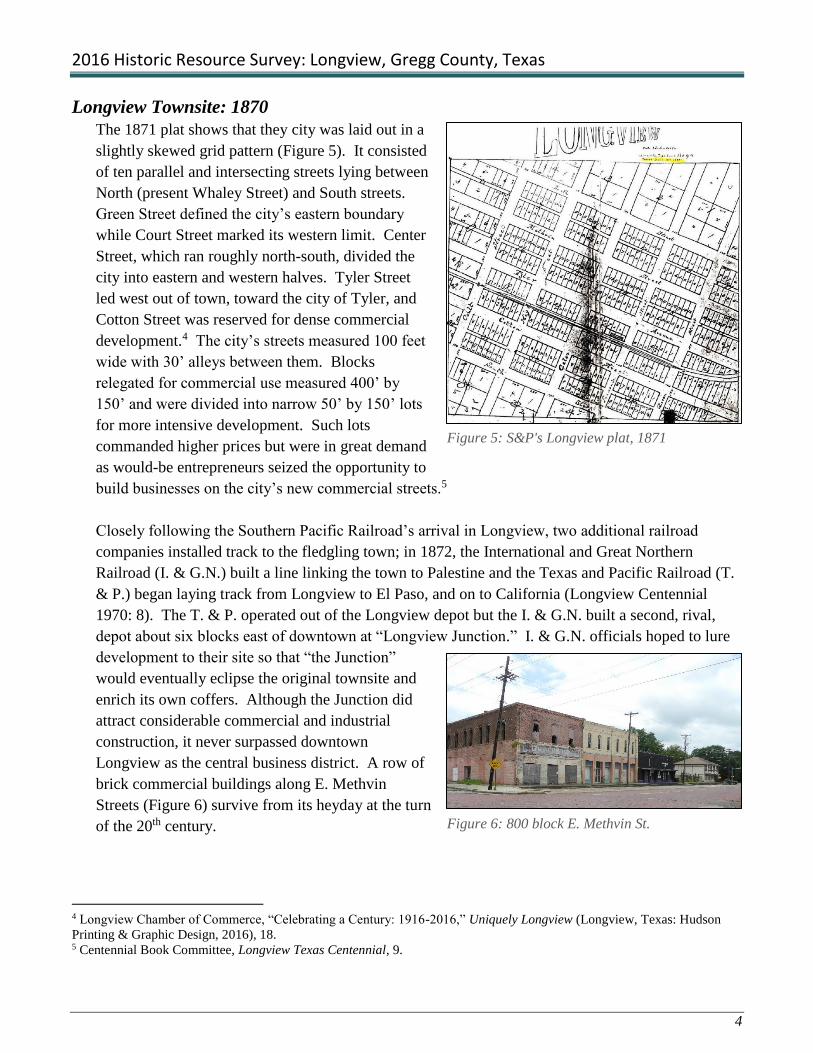
The 1871 plat shows that they city was laid out in a
slightly skewed grid pattern (Figure 5). It consisted
of ten parallel and intersecting streets lying between
North (present Whaley Street) and South streets.
Green Street defined the city’s eastern boundary
while Court Street marked its western limit. Center
Street, which ran roughly north-south, divided the
city into eastern and western halves. Tyler Street
led west out of town, toward the city of Tyler, and
Cotton Street was reserved for dense commercial
development.4 The city’s streets measured 100 feet
wide with 30’ alleys between them. Blocks
relegated for commercial use measured 400’ by
150’ and were divided into narrow 50’ by 150’ lots
for more intensive development. Such lots
commanded higher prices but were in great demand
as would-be entrepreneurs seized the opportunity to
build businesses on the city’s new commercial streets.5
Closely following the Southern Pacific Railroad’s arrival in Longview, two additional railroad
companies installed track to the fledgling town; in 1872, the International and Great Northern
Railroad (I. & G.N.) built a line linking the town to Palestine and the Texas and Pacific Railroad (T.
& P.) began laying track from Longview to El Paso, and on to California (Longview Centennial
1970: 8). The T. & P. operated out of the Longview depot but the I. & G.N. built a second, rival,
depot about six blocks east of downtown at “Longview Junction.” I. & G.N. officials hoped to lure
development to their site so that “the Junction”
would eventually eclipse the original townsite and
enrich its own coffers. Although the Junction did
attract considerable commercial and industrial
construction, it never surpassed downtown
Longview as the central business district. A row of
brick commercial buildings along E. Methvin
Streets (Figure 6) survive from its heyday at the turn
of the 20th century.
4 Longview Chamber of Commerce, “Celebrating a Century: 1916-2016,” Uniquely Longview (Longview, Texas: Hudson
Printing & Graphic Design, 2016), 18. 5 Centennial Book Committee, Longview Texas Centennial, 9.
Figure 5: S&P's Longview plat, 1871
Figure 6: 800 block E. Methvin St.

2016 Historic Resource Survey: Longview, Gregg County, Texas
5
The railroad presence only heightened excitement about
Longview’s prospects, drawing many to invest in its
future growth. Some, including Jere Clemens Turner,
Jackson Connor Howard, John S. Lacy, and Oliver
Hazard Perry Pegues, purchased large tracts of real
estate adjoining the railroad town in hopes that their
land would appreciate as the city expanded beyond its
townsite boundaries. Turner bought land just northeast
of the city where the Nugget Hill Addition would one
day be developed. Howard came to the area in 1870
and bought up several farms north and west of the
proposed townsite in anticipation of Longview’s
success. He cultivated cotton and peanuts on his farms
before eventually selling them for suburban
development. Lacy established a 19-acre homestead
tract just south of the city; it would become one of
Longview’s first additions in 1909 (Figure 7). The area
was developed over several decades and is probably the city’s best concentrations of historic houses,
including Victorian-era frame dwellings, Craftsman bungalows, and Tudor Revival cottages.
Some early settlers formed banks and stockholding companies, gambling large that the city would
exceed expectations. Thomas A. Flewellen, who came to Longview in 1871, was such a man. He
was an original stockholder in several enterprises including the First National Bank, the city’s first
electric company, and the Longview Cotton Oil Mill. He was also a partner in the Brown and
Flewellen Lumber Company. Philip Arthur Pegues was one of the largest stockholders of the
Commercial Guaranty State Bank and later served as a member of the board of directors of the
Rembert National Bank. Pegues hedged his bets by building the Pegues Cash Store, a variety store,
and by developing Gregg County’s the first commercial nursery.6 A. A. Womack opened a
mercantile business in the heart of the business district and served as an officer and director of the
First National Bank. In 1876, he built a large Victorian style house on S. Center St.7
Others were content to build successful businesses. Willis Early Booth, who arrived as the tracks
were being laid, established a hardware and buggy store. William George Northcutt came to
Longview the very month the city was platted. He established Northcutt Hardware and Furniture
Company which was a huge success. The impressive 2-story building drew people from miles
around to gaze at its well-stocked storefronts. Northcutt also owned the brickyard where the first
6 Pegues later became known for establishing the city’s first auto dealership, a business that is still in existence. 7 Centennial Book Committee, Longview Texas Centennial, various references.
Figure 7: Lacy and Bass Addition, 1909

2016 Historic Resource Survey: Longview, Gregg County, Texas
6
bricks in Longview were made. Franklin
Lucilius Whaley also arrived in Longview in
1870 and the following year he built one of the
first houses in the city (Figure 8). He was in the
hardware business and was elected mayor in
1891. North Street was renamed Whaley Street
in his honor.8 The newspaper was also an early
business in Longview. The Longview News, a
tri-weekly, three-column paper was edited by
former Texas governor, Stephen H. Hogg. The
first issue came out on September 1, 1871.9
The County Seat
As Texas’ population increased dramatically after the Civil War, there was a movement to create
new counties to better serve a greater constituency. On January 17, 1873, Bluford W. Brown
introduced a bill into the state legislature to create a new county he named “Roanoke” from parts of
Upshur, Rusk, and Harrison counties. Political wrangling and amendments followed, but Brown’s
House Bill 23 ultimately passed with several noteworthy changes. The new county was formed
solely from Upshur County and its name was changed to “Gregg County” in honor of secessionist
John B. Gregg who rose to the rank of brigadier general before dying for the Confederate cause.
Texas Governor Edmund J. Davis approved the bill on May 21, 1873. The following year, Rusk
County contributed another 141 square miles to Gregg County.10
In their first county election, Gregg County voters overwhelmingly chose Longview as the county
seat, an act that almost guaranteed its success. As the center of county government and at the
junction of competing railroad lines, Longview immediately attracted a horde of government
workers and businessmen to its door. Among them were civil servants, attorneys, and the so-called
“terminal merchants” who set up retail stores in promising stops along Texas’ newly-laid railroad
lines. Frame houses appeared throughout the city; among the first were the F. L. Whaley House,
built in 1871 at 101 E. North (Whaley) Street (Figure 8), and the Brown Birdsong House, built in
1873 at 104 E. North (Whaley) (house relocated in 2011).11 Government offices, hotels, livery
stables, grocery and dry goods stores, pharmacies and restaurants, flew up along the city’s main
commercial streets, Tyler and Fredonia. Within a year of Longview’s incorporation, the Methodist,
Presbyterian, Baptist, and Christian congregations had formed and erected houses of worship. About
the same time, educators built the Longview Male and Female Institute in a predominantly
residential section on the east side of Green Street.12
8 Ibid, 4. 9 Ibid,10. 10 McWhorter, Traditions of the Land, 64. 11 Ibid, 54, 59. 12 Ibid, 69.
Figure 8: Whaley House, 101 E. Whaley St.

2016 Historic Resource Survey: Longview, Gregg County, Texas
7
Longview owed its initial success to its status as county seat and its position as the local railroad
hub, but its continued growth and prosperity rested on the region’s ability to develop its agricultural
and industrial potential. As luck would have it, a surge in national demand for cloth and lumber
coincided with local gains in cotton production and timber industries just as Longview was getting
off the ground. At the same time, cattle ranching increased in the region; Longview shipped some
200,000 hides from its rail yards in 1876 alone.13 At the time, Longview was far and away the
county’s most important town both as the county seat and as the shipping center for local agricultural
products and manufacturing goods. Supported by a relatively diverse and stable economy,
Longview’s prospects for the future appeared to be excellent.
Hopes for the new town fell, however, when an early morning fire broke out in a local restaurant on
October 4, 1877. Fanned by strong winds, and feeding on stacks of dry lumber and cotton bales
piled along the railroad siding, the flames quickly spread to neighboring buildings, nearly all of
which were built of wood. A bucket brigade saved the Longview depot and several businesses near
the courthouse square, but more than half of the buildings in the downtown district burned to the
ground. Among the losses were the Nelms Hotel, John Maddin’s restaurant, a dry goods store, two
drug stores, two groceries, and a jewelry store. Damages were estimated at $100,000. Though
deeply discouraged, the population of about 1,000 vowed to rebuild the central business district, this
time with brick and stone.14
Rebuilding: 1877-1880
Longview recovered quickly from the fire, and within a few years its 100-acre downtown district
was repopulated with new commercial buildings, most of them built with brick or stone. An October
1877 article published in the Texas New Yorker, a railroad-backed periodical that promoted Texas
lands to potential investors, reported favorably on Longview’s prospects only months after the fire
destroyed much of the central business district. It declared that Longview had some 30 brick and
stone commercial buildings, a brick courthouse and jail, and four churches. The article touted
Longview as a regional shipping hub for the booming East Texas timber industry, with some 50
carloads of milled lumber leaving the city by rail each day. 15 In fact, one of the county’s largest
early timber operations was Longview Junction’s Barner Brothers’ sawmill which produced as much
as 20,000 board feet per day in 1877.16 Longview was also heralded as a shipping point for the
county’s agricultural products including corn, cotton, sugar cane, potatoes, ground peas (peanuts),
artichokes, tobacco, cattle, and hogs. Cotton and livestock were the mainstays of Gregg County’s
early economy with 200,000 hides and 18,000 bales of locally-compressed cotton shipped from
13 Ibid. 14 Van Craddock, Jr., Historic Gregg County: An Illustrated History (San Antonio: Historical Publishing Network, 2006), 17. 15 McWhorter, 69. 16 Ibid, 75.

2016 Historic Resource Survey: Longview, Gregg County, Texas
8
Longview’s rail yards in 1876 alone, but by 1880, lumber had risen to become the county’s top
exports.17
As investment capital, manufactured
goods, and immigrants poured into the city
after the fire, its streets filled with new
businesses and new construction. In 1879,
the county dedicated a new brick
courthouse on the former site of O. H.
Methvin’s corn field, in the center-north
block of the city (Figure 9). To the south
of the courthouse lay the city’s principal
commercial zone, concentrated in a 10-
block area roughly bounded by Tyler on
the north, Cotton Street on the south,
Fredonia Street on the east, and High
Street on the west. The main shopping
district lay at the intersection of Tyler and Fredonia streets where several dozen closely-packed 1-
and 2-story commercial buildings lined the streets for two or three continuous blocks. On those
narrow lots, retail merchants sold a wide variety of goods and wares, including groceries, fancy
foods, books, meats, drugs, hats, jewelry, and toys. Travelers could find lodging in boarding houses
and meals in the restaurants wedged between retail stores in the district, as well. Entertainment was
also available in the form of an opera house, numerous saloons and billiards parlors, and even a
roller skating rink.18
By 1880, most of the county’s urban population lived in Longview. While Gregg County’s early
residents were largely Protestant farm families with roots in Virginia and North Carolina, its postwar
composition was a varied mix of refugees from the war-ravaged South, Northerners who gravitated
to Texas for new opportunities, and European immigrants. Many of these newcomers settled in
Longview where they assimilated into the local Southern Democrat culture, established businesses,
opened banks, invested in real estate, and worked in its small industries. After a few years, they
were distinguished more by their religious affiliations than by their origins.
Four Protestant churches were among Longview’s earliest landmarks, occupying prominent corner
lots at the edges of the central business district.19 At least six Jewish families lived in Longview by
1880. In 1888, Catholic residents founded St. Anthony’s Parish on the city’s east side, where its
descendant church remains at the edge of the Nuggett Hill neighborhood.20
17 Ibid, 69. 18 Sanborn Fire Insurance Company, City of Longview, maps: 1885, 1890, (New York: Sanborn Map Company). 19 Ibid, 1885. 20 McWhorter, Traditions of the Land, 71.
Figure 9: 1879 Courthouse (photo from Craddock,
Longview, pg. 13)

2016 Historic Resource Survey: Longview, Gregg County, Texas
9
2) Period of Growth and Prosperity: 1880-1900
After the heady days of the railroad boom, Longview settled into a period of slow, but steady,
growth and modest prosperity in the 1880s. As a regional transportation hub, the city naturally
attracted industries to locate alongside its railroad sidings and loading docks. The dominant industry
in all of East Texas in the 1880s was timber. By 1884, several saw and planing mills lay just inside
the city limits, and six others operated in the woods nearby and shipped from Longview’s railyards.
By the late 1880s, sprawling lumber yards with boards stacked 5’ high shared rail frontage with
warehouses filled with baled hay and cotton.21 Their close proximity to the city’s many frame
dwellings may have compelled residents to finally form a volunteer fire company in 1885.
Longview’s most enduring
industry came to the city by
accident. In 1882, after fire
destroyed his plow
manufacturing plant in
Jefferson, Marion County, G.
A. Kelly relocated his
business to the up and coming
city of Longview (Figure 10).
Jefferson’s loss was
Longview’s good fortune.
With only minor exceptions,
the Kelly Plow Works was considered to be Gregg County’s only industry that was not timber-
related as late as 1890. The company grew to become a national leader in the manufacture of plows
and other agricultural implements, as well as tools and various machines. The Kelly Plow Works
was a major employer in Longview and contributed greatly to its economic health until closing in the
1970s, nearly 100 years after it was founded.22
In the 1880s and 1890, industries in Longview generally occupied large lots on the north side of the
railroad tracks, beyond the high-value commercial blocks at the intersection of Tyler and Fredonia
streets. Kelly Plow Works replaced the former Southern Pacific terminus complex bounded by
Center, Cotton, and High streets. The manufacturer filled an entire city block and eventually
extended west past High Street. Several smaller industries and building trades, including a marble
works, a sash and door factory, and a plumbing store, located on or close by the railroad tracks.23
21 Sanborn Fire Insurance Company, City of Longview maps: 1889. 22 Craddock, Historic Gregg County, 17. 23 Sanborn Fire Insurance Company, City of Longview maps: 1885.
Figure 10: Kelly Plow Works, c. 1908 (photo from Craddock, Longview,
pg. 11)

2016 Historic Resource Survey: Longview, Gregg County, Texas
10
Residential Development
While the commercial node was well-defined and essentially built-out along Tyler and Fredonia
streets, residential areas were not clearly delineated and remained only sparsely developed by 1885.
Small groupings of a few houses apiece appeared to be scattered almost randomly around the outer
edges of the central business district. By 1890, however, residential enclaves became more evident,
especially in the northern and southern sections of the city. Homes on the north side of town largely
survived the fire and subsequent residential development occurred around the Whaley and Brown-
Birdsong homes on North (Whaley) and Methvin streets. Methvin Street, in particular, emerged as
an almost exclusively residential street; it had grown from only eight houses in 1885, to eighteen by
1890.24
At the same time, adjacent Cotton and South streets, on the city’s south side, also developed almost
exclusively as a residential section. By 1890, Cotton and South streets were entirely built out with
dozens of single-family homes and the 50-room Magnolia Hotel complex. Most of the early houses
in both sections were modest 1-story frame dwellings consisting of only two or three rooms and a
front porch. The more fashionable among them
sported bay windows and Folk Victorian
“gingerbread” porch rails and posts. Among
the early Folk Victorian style houses in the
southern section were the J. J. Flewellen House,
on S. Green at its intersection with South Street
(demolished), the Thomas A. Flewellen House,
built in 1879 at 206 S. Center Street, and the F.
T. Rembert home at 316 S. Fredonia Street
(Figure 11). The house named for Rembert was
actually built by John W. Bateman and
Rembert, an early cotton merchant, developer,
and entrepreneur, purchased the house in
1879.25.
Even so, there was little distance between these residential enclaves and the commercial and
industrial zones with their noise, smells, and congestion. Livery stables and wagon yards could be
found in the same block as family houses and hotels in the 1880s and 1890s. This inhospitable
living situation may account for the number of noteworthy Longview-area homes built just beyond
the city limits during this period. Some pre-dated the city’s founding, including local farm houses
and the Teague House (see Figure 3), which was part of the former community of Earpville, to the
east of the town boundaries. Others, though, were built by members of Longview’s newly-
established business class who set their impressive houses on large “suburban” lots or multi-acre
24 Sanborn Fire Insurance Company, City of Longview maps: 1885, 1890. 25 Centennial Book Committee, Longview Texas Centennial, 31.
Figure 11: Rembert-Harrison House, 316 S. Fredonia
St.

2016 Historic Resource Survey: Longview, Gregg County, Texas
11
parcels that served as a “buffer” from the city proper. Early “suburban” neighborhoods of this type
developed to the east of the city, stretching toward Longview Junction, and south of South Street,
which was already residential in character.
Among the early east side attractions was the city’s public high school, a ten-room, three-story,
Second-Empire style edifice built near the intersection of Green and College streets in 1884. The
school was an instant draw to families with school-aged children and the blocks between downtown
Longview and the Junction quickly filled with substantial frame houses in the years that followed.
Among them was the W. E. Booth House at the corner of Teague Street and Marshall Avenue.26
Suburban growth also spread south below Cotton and South streets, in what is now known as the
“South Main” district. Some of the city’s earliest homes, including the 1876 house built by A.A.
Womack at 411 S. Center Street, lie in the
area.27 One of the oldest and most
impressive in the South Main district is the
Rucker-Campbell house, built in the Queen
Anne style by Asa and Mary Welborne
Rucker in 1872 (Figure 12). It was
purchased by Judge James Nathaniel
Campbell and his wife Lottie Isham in 1898.
In 1903, the Campbells extensively
remodeled the house, replacing the one-story
Folk Victorian style porch with a grand two-
story portico supported by full-height fluted
columns. In 2008, Preservation Longview
rescued the house from demolition. The
organization is currently undertaking its
restoration.28
African American Presence in Longview
African Americans actually pre-date the arrival of the railroad and the establishment of Longview.
About 1867, former slaves organized St. Mark CME Church (Colored Methodist Episcopal, changed
to Christian Methodist Episcopal in 1954) and worshipped in a brush arbor on present Magrill Plaza,
north of the original Longview townsite. In 1871, landowner John R. Magrill sold the one-acre
natural timber tract known as “the Grove” to church trustees O. J. Taylor, Silas Billup, and Alick
Berry for use by the congregation. By 1876-1877, the congregation built a two-story church
26 Ibid, 14. 27 Ibid, 27. 28 Preservation Longview, Preservation Newsletter (Longview: November 2015), 1-2.
Figure 12: Campbell House, 433 S. Center St., under
restoration by Preservation Longview

2016 Historic Resource Survey: Longview, Gregg County, Texas
12
building on the site and a substantial
African American community grew
up around it.29 They likely lived
and worked on area farms as did
most African Americans in Gregg
County after Emancipation. In
1888, Longview school officials
authorized the construction of a
four-room frame school building for
the black community on nearby E.
Marshall Avenue. It was eventually
enlarged to two stories and became
known as the Longview Colored
High School (Figure 13).30 The
presence of the church and school in the area attracted more black residents to the north side, which
grew to become the largest African American community in the Longview area by the turn of the
century.
African Americans who gravitated to the city of Longview by the 1880s, found jobs in sawmills and
other small industries, or as domestic help. Sanborn maps from 1890 show small clusters of
“Negro” dwellings scattered throughout the city, mostly on the outskirts of town or behind work
places such as hotels, boarding houses, and restaurants. Some lived in marginal areas close to the
railroad tracks or in commercial nodes. No “Negro” institutions had been established within the city
limits by the end of the 19th century.31
The Junction
As Longview’s downtown merchants were rebuilding after the fire, a second, competing commercial
district began to develop half a mile to the east at “the Junction”. When it laid track and built a
depot east of the Longview townsite, the International &Great Northern (I. & G.N.) Railroad
Company also platted an addition that stretched east from Green Street, Longview’s eastern
boundary, to Eighth Street (Figure 14). The 30-block addition was laid out in a grid pattern at a
slight angle to the Longview townsite, with numbered streets running north and south and named
streets extending east along the established Marshall, North (Whaley), and Methvin streets. A
drawing done in 1881 showed only two buildings at the Junction that year, but after a mule-drawn
29 Texas Historical Commission, Official Texas Historical Marker, “The Grove” and “St. Mark CME Church”; Sanborn Fire
Insurance Company, City of Longview maps: 1916. 30 McWhorter, Traditions of the Land, 70, 86. 31 Sanborn Fire Insurance Company, City of Longview maps: 1885,1890, 1903.
Figure 13: Longview Colored High School (photo from Craddock,
Longview, pg. 15)

2016 Historic Resource Survey: Longview, Gregg County, Texas
13
streetcar line was installed along Methvin
and Fredonia streets, linking the two depots
in 1883, development really took off in the
area.32 By 1885, scores of small frame L-
plan houses lined North and Methvin
streets.33
Though development increased at the
Junction, it appeared to be a rather motley
collection of dwellings, saloons, and hotels
that had coalesced on E. Methvin, between
Fifth and Seventh streets. Commercial
buildings included several mercantile stores
and groceries, billiard parlors, saloons, drug
stores, and boarding houses. Several frame
houses denoted as “Negro tenements” lay
along Methvin, in the commercial zone, and
near the railroad tracks.34
Several sets of railroad tracks cut across
Methvin Street on the east. Loading docks,
freight and passenger depots, oil and water
storage structures, and the round house lay
along the rails. Immediately south of the
tracks several hotels and boarding houses
shared space with saloons and stock pens in
a tract called Oak Grove. In their midst,
Sam Mobberly built his lavish Mobberly
Hotel in 1884 (Figure 15). It was said to be
the finest hotel between New Orleans and El
Paso. Mobberly may have built it in part to
showcase the property he owned and would
soon develop for housing starts in the area.
By 1890, the city’s original 100-acre site was largely built out, with few vacant lots to be found in
the downtown district. Early development in the city appeared haphazard, an incompatible mix of
commercial, industrial, and residential properties. Single-family residences could be found among
32 McWhorter, Traditions of the Land, 79. 33 Sanborn Fire Insurance Company, City of Longview maps: 1885. 34 Ibid, 1885, 1890.
Figure 14: I. & G.N. Railroad Addition - "The Junction"
Figure 15: 1884 Mobberly Hotel (photo from Craddock,
Longview, pg. 15)

2016 Historic Resource Survey: Longview, Gregg County, Texas
14
commercial and industrial properties and open-flame industrial works, like foundries and blacksmith
shops, lay perilously close to residential enclaves filled with frame houses and outbuildings.35
On closer examination, however, the city appeared to follow some basic “zoning” tenets. At its core
was a dense concentration of commercial buildings along its main east-west (Tyler Street) and north-
south (Fredonia Street) corridors (Figure 16). These streets were packed with retail stores and
service businesses such as restaurants and saloons. The adjacent blocks were also largely
commercial in nature, but they were less densely developed. Building supply businesses requiring
more space, such as the marble works, sash and door manufacturers, and plumbing supply
companies, lay at the periphery of the business district, possibly to facilitate loading. Lumber yards,
cotton compresses, gins, and foundries lay along the railroad tracks that divided the city into
northern and southern halves.36
Still, although the residential areas lay primarily at the city’s outer edges, most houses lay within a
block or half-block of commercial and even industrial enterprises. Within a single block face one
could find a wagon yard, a couple of houses, and a meat market or grocery. Around and among the
dwellings and commercial buildings were large manufacturing businesses and storage warehouses
including L. Letcher’s wagon yard at the northeast corner of Fredonia and Methvin, J. M. Johnson’s
cotton yard, lumber planing operation and corn mill on West Tyler Street, and G. A. Kelley’s
Foundary and Machine shop at the corner of Central and Cotton streets. Several large, open, lumber
yards fronted onto the railroad tracks that ran east to west through the center of the city.37
35 Ibid. 36 Ibid, various dates. 37 Sanborn Fire Insurance Company, City of Longview maps: 1890.
Figure 16: 1885 Sanborn Map showing dense commercial development along Tyler Ave.

2016 Historic Resource Survey: Longview, Gregg County, Texas
15
Early Additions to the City of Longview
The city’s initial expansion beyond its original townsite boundaries and the I. & G.N. Addition, was
primarily to the south. Early Longview real estate mogul Sam Mobberly was at the forefront of this
southward expansion. In the 1880s, he began buying up large tracts of land south of the railroad
tracts, between S. High and S. Green streets, where he later platted Mobberly’s South Addition to the
city of Longview. He may have built his Mobberly Hotel in 1884, in part, to attract development to
his property on the south side of the Junction. In 1895, Mobberly purchased a 117-acre farm tract
below the railroad tracks. It stretched from S. Green/First Street on the west, to what ultimately
became S. Sixteenth Street on the east. Mobberly and his son, H. G., platted part of the tract as
Mobberly’s East Addition and construction commenced there by the turn of the 20th century. As the
original section filled, the Mobberlys opened subsequent phases of Mobberly’s East Addition to
development. In the 1930s, they developed the exclusive Mobberly Place additions between S. Fifth
(Mobberly) and S. Sixteenth streets.
By the close of the 19th century, Longivew was a typical East Texas county seat with a busy
commercial district, small but thriving industries, and expanding residential districts. Apparently the
city was successful enough in 1894 to entice the Dalton Gang to hold up the First National Bank in
one of its last heists, ending in a shoot-out in the streets. More positive indicators of the town’s
achievements at the time were the establishment of the Lacy Telephone Company, in 1896, and the
completion of a new, larger, courthouse in 1897.38 Designed by Fort Worth architect, Marshall
Sanquinet, the dark redbrick Romanesque-style courthouse served the county until the oil boom of
the 1930s warranted a larger building on the same site.39
3) Longview’s Progressive Era: 1900-1919
As the 20th century dawned, cotton remained the largest cash crop in Gregg County, followed by
cattle, but the timber industry had come to dominate the county’s economy (McWhorter 1989: 73).
Since the 1870s, the East Texas timber industry had grown in response to the increased national
demand for lumber in the expanding post-Civil War economy. By 1900, an army of lumber men
were working to clear the region’s old growth forests such that ten years later, Gregg County
sawmills and planing mills produced more than 370,000 board feet per day, or 111,000,000 per
year.40 Timber remained the county’s most valuable industry, in terms of product value, until oil
was discovered in 1931.41 The city of Longview prospered along with it.
38 McWhorter, Traditions of the Land, 81. 39 Craddock, Historic Gregg County, 20. 40 McWhorter, 73. 41 Ibid, 75.

2016 Historic Resource Survey: Longview, Gregg County, Texas
16
As the regional shipping point for lumber and other timber products, Longview enjoyed steady
growth and continued prosperity at the turn of the century. By 1910, two sawmills lay within the
city limits and six others operated nearby, shipping from its many rail sidings. The largest among
them was the R. G. Brown & Company sawmill, near the intersection of present W. Cotton and
Grigsby streets. Other Longview industries at the turn of the century included a Coca-Cola bottling
plant, Graham Manufacturing Company, the state’s largest box and crate manufacturer, and the
locally-famed Atkinson Pickling Company.42 All made use of the rail lines for statewide
distribution.
The rise of timber did not entirely diminish the importance of agriculture in Gregg County but as
more land was cultivated in the early 20th century, the soil became depleted, yielding less product
per acre. The big money to be made in cotton was found further west, on the Texas blackland
prairie, and the crop began to diminish in importance in the eastern part of the state. As cotton
declined in the early 20th century, Longview boosters promoted the county’s other crops, including
corn, alfalfa, sweet potatoes, peaches, and other fruits instead.43
Bodie
In the new century’s first decade, Longview
made considerable progress to becoming a
modern city. Its population had grown from
1,525, in 1880, to 2,700 in 1900. That
number nearly doubled over the next ten
years, reaching 5,155 by 1910. Much of the
increase came from expanding the city
boundaries to include the Junction in 1904,
but the rest resulted from commercial and
industrial growth during the decade.44 The
general prosperity led to the construction of
grand new houses, impressive schools and
churches, multi-story bank buildings, and a
multitude of brick commercial buildings (Figure 17). Longview made great strides toward civic
improvement during this period, as well, with improved city services and amenities. Social welfare
issues were also addressed as the national spirit of progressivism gained traction at this time; citizens
against liquor scored a victory for their cause when the county voted to “go dry”, putting twelve
Longview saloons out of business in 1903.45
42 McWhorter, Traditions of the Land, 75. 43 Ibid, 76. 44 Ibid, 79. 45 Ibid, 81.
Figure 17: Downtown Longview in c. 1904 (photo from
Craddock, Longview, pg. 22)

2016 Historic Resource Survey: Longview, Gregg County, Texas
17
In this climate of relative growth and prosperity,
Longview elected a charismatic and enlightened leader
who initiated a series of civic improvements for the city.
Gabriel August Bodenheim “Bodie” (1873-1957) took
office in 1904 and, except for two years in the middle,
served in that position until he stepped down in 1920
(Figure 18). Bodie was a charming and energetic Jewish
cotton broker who moved to Longview from Vicksburg
in 1898. He reportedly converted to Methodism after
meeting his future wife, local girl Willie Bass. In his first
year as mayor, Bodie negotiated to annex the Junction
and expand the city limits to a radius of one mile around
the downtown depot, an act that increased the city’s
population by 1,000 people.46
Under Bodie’s leadership, the city embarked on a
modernization campaign that included a municipal water
works below “Rock Hill” (1904), a sanitary sewer system
(1910), a program to pave streets and erect streetlights in
the central business district, and a baseball field and
grandstand for its semipro team, the Longview
Cannibals.47 Bodie also led the charge to establish a paid municipal fire department and to purchase
the state’s first automobile fire engine.48 The mayor so inspired the city’s citizens that they named
the park at the corner of Fredonia and Tyler streets “Bodie Park” in his honor.49
Business and Industrial Expansion
By 1910, Longview claimed a total of 14 downtown commercial blocks, with another six at the
Junction. As a whole, the city boasted six department stores, three hardware stores, three furniture
stores, three groceries, three jewelry stores, three millinery stores, six drug stores, four cafes, two
noteworthy hotels, four “lesser” hotels, six law firms, three banks, an opera house, a motion picture
theater, and a number of “miscellaneous businesses.”50 Among the larger downtown retail stores
were T.D. Coupland’s Dry Goods, advertised as the “Fashion Headquarters – If it is new, it is here”,
and Pinkham Merchandise, which sold everything from “milk pails to birdcages”.51
46 Ibid, 82. 47 The team name came from a newspaper article that reported its defeat of a professional Texas League club 7-0. Reporter
C. B. Cunningham wrote, “The Longview Cannibals ate up the San Antonio Missionaries here today” and the name stuck. 48 Craddock, Historic Gregg County, 23-24, 49 A 35’ monument with a marble statue of a Confederate soldier was placed in the park on June 3, 1911. The park was
redeveloped in 1931 during the oil boom to make room for an office building. The monument was moved to the lawn of the
new county courthouse when it was completed in 1932. 50 McWhorter, Traditions of the Land, 82. 51 Craddock, Longview, (Charleston, South Carolina: Arcadia Publishing, 2010), 24-25.
Figure 18: Mayor Bodie, photo c. 1915
(photo from Craddock, Longview, pg. 44)

2016 Historic Resource Survey: Longview, Gregg County, Texas
18
Longview attracted more industry in this decade,
as well. In 1900, the Longview Ice and Light
Company supplied electricity to the city for the
first time. In 1903, the Graham Box Factory
opened on the railroad siding west of downtown,
between the Kelly Plow Works and R. G.
Brown’s sawmill (Figure 19). The company
used local timber to make wooden crates and
baskets for shipping fruit and vegetables. It was
described as “the biggest and best box and crate
factory west of the Mississippi River.” That
same year, the Longview Iron Works was
founded in the city. It manufactured sawmill
machinery, gasoline engines, and general
foundry products. The Longview Mattress and
Bedding Company, which made the “Rip Van
Winkle” brand, opened for business in 1910.52
Major additions to Longview’s industrial
development were the Longview Cotton
Compress Company and the Longview Cotton
Oil Company, located on Cotton Street near the
I. & G.N. railroad tracks. Established in 1909,
the Cotton Compress produced 35,000 bales of
cotton for shipment in its first year of operation
(Figure 20). 53
The city’s prosperity in the decade was reflected in the
construction of two new bank buildings, the People’s State
Bank, built in 1908, and Citizens National, which became
known as the Everett Building, completed on Fredonia Street
in 1910 (Figure 21). Two years later, the five-story First
National Bank, rose in the heart of the business district, at
the intersection of Tyler and Fredonia streets.54
Other signs of progress during the period included road
improvements. Automobiles made their appearance in
52 McWhorter, 78. 53 Craddock, Longview,30. 54 Ibid, 43.
Figure 19: Graham Box Factory, photo c. 1911
(photo from Craddock, Longview, pg. 25)
Figure 20: Longview Cotton Compress, photo c.
1912 (photo from Craddock, Longview, pg. 30)
Figure 20: Everett Building, 214-216 N.
Fredonia St.
2016 Historic Resource Survey: Longview, Gregg County, Texas
19
Longview during this era. F. T. Rembert reportedly brought the first car – a Buick – to town in
1903. At the time, Longview’s streets – and cities throughout much of East Texas – were merely
packed earth that turned to mud in wet weather. The advent of the automobile and the great
popularity of “pleasure touring”, or Sunday driving, led to street paving projects in the city and the
construction of new and better highways
throughout the county. Road improvements
included paving the first mile of the
Jefferson Highway (along Marshall Avenue,
now U.S. Highway 80) along the city’s
northern periphery in 1914.55 Within a few
years, the road was paved with gravel across
the county (Figure 22). Other county roads
were graded. Other transportation advances
included the replacement of the city’s mule-
drawn streetcar with an electric line in
1912.56
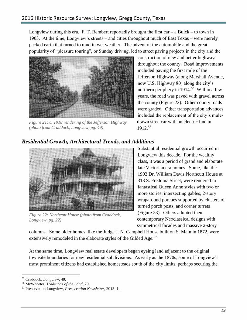
Residential Growth, Architectural Trends, and Additions
Substantial residential growth occurred in
Longview this decade. For the wealthy
class, it was a period of grand and elaborate
late Victorian era homes. Some, like the
1902 Dr. William Davis Northcutt House at
313 S. Fredonia Street, were rendered in
fantastical Queen Anne styles with two or
more stories, intersecting gables, 2-story
wraparound porches supported by clusters of
turned porch posts, and corner turrets
(Figure 23). Others adopted then-
contemporary Neoclassical designs with
symmetrical facades and massive 2-story
columns. Some older homes, like the Judge J. N. Campbell House built on S. Main in 1872, were
extensively remodeled in the elaborate styles of the Gilded Age.57
At the same time, Longview real estate developers began eyeing land adjacent to the original
townsite boundaries for new residential subdivisions. As early as the 1870s, some of Longview’s
most prominent citizens had established homesteads south of the city limits, perhaps securing the
55 Craddock, Longview, 49. 56 McWhorter, Traditions of the Land, 79. 57 Preservation Longview, Preservation Newsletter, 2015: 1.
Figure 21: c. 1918 rendering of the Jefferson Highway
(photo from Craddock, Longview, pg. 49)
Figure 22: Northcutt House (photo from Craddock,
Longview, pg. 22)

2016 Historic Resource Survey: Longview, Gregg County, Texas
20
area’s reputation as a desirable residential district. Confederate veteran and early mercantile
businessman, John S. Lacy, was typical of the trend, building on his 19-acre homestead on present S.
Center Street about 1873. Other influential men who built south of the city included Judge
Campbell (S. Main, moved to 433 S. Center Street in 2008, see Figure 12), cotton merchant F. T.
Rembert (316 S. Fredonia), and First National Bank director, A. A. Womack (411 S. Center).58 By
the turn of the century, the south side “suburban” zone was nearly built out with Queen Anne style
frame houses sporting wraparound porches, turned porch posts, and decorative woodwork. Some
large lots were subdivided to make room for new housing starts between the older pioneer homes on
College, S. Fredonia, and S. Main streets.
The area’s continued reputation as an exclusive,
upscale neighborhood in the 1900s prompted John
Lacy and his neighbor to subdivide their homestead
tracts to the south as an addition to the city of
Longview. In 1909, Lacy and his neighbor, a Mr.
Bass, hired S. F. Blocker to survey and map the
“Lacy and Bass Addition” for residential
development (see Figure 7).59 The irregular-shaped
addition was wedged between the Lacy homestead
on the northwest and the Bass place on the east. It
commenced at College Street and extended from the
east side of S. Fredonia to the east side of S. High
Street. Within a few years, from about 1910-1915,
the addition filled with 1- and 2-story frame Classical
Revival houses and early Craftsman style bungalows.
Good, extant Classical Revival style houses survive
at 406 S. Center, 434 S. Center, 424 S. Main, and
443 S. Main (Figure 24). Early Craftsman style
bungalows appeared in the addition by 1910 and
excellent examples include those at 437 S. Center
Street and 408 S. Fredonia Street (Figure 25).
By 1916, the Northcutt Heights Addition was platted on former farmland northwest of downtown
Longview. The sprawling addition was bounded by W. Marshall Avenue on the south, Yale Street
on the north, N. Center Street on the east and McCann Road on the west. At its center was Northcutt
Heights School, an elementary school built on a block at the T-intersection of Northcutt Avenue and
N. Court Street in 1912. Expecting continued growth in the city, its developers carved out more than
58 Centennial Book Committee, Longview Texas Centennial, various references. 59 S. F. Blocker, Lacy and Bass Addition plat, March 1909.
Figure 24: Craftsman house at 437 S. Center St.
Figure 23: Classical Revival house at 424 S.
Main St.

2016 Historic Resource Survey: Longview, Gregg County, Texas
21
200 building lots in the section. 60 As Longview’s economy took a turn for the worse toward the end
of the 1910s, however, the addition remained only modestly developed until the oil boom of the
1930s.61
Another addition was in the works to the west, this time
with an added attraction. In 1909, the same year that
Lacy and Bass filed their plat, Longview businessmen F.
T. Rembert, R. F. Echols, and Echols’ son Hugh, formed
the Lomond Lake Corporation to develop a tract of land
about a mile west of the city limits. Because it was so
far from city employment and services, they built a lake
to draw prospective builders and homebuyers to their
new addition (Figure 26). Lake Lomond, named for
Scotland’s Loch Lomond, was built in 1909 and 1910
and featured a bath house and pavilion, motor launch rides, and fishing.62 The lake became a
popular local recreation spot but the addition didn’t draw many prospective homeowners at the time,
probably due to its distant location.
Closer to the center of town, H. P. Mobberly and wife Laura platted the first of what would become
several phases of Mobberly’s East Addition, in June, 1911. The addition was carved from the 117-
acre farm tract Sam Mobberly had acquired in 1895. The tract lay south of Longview Junction and
east of S. Fifth Street, now Mobberly Avenue. Its location, beyond several sets of railroad tracks,
was not immediately attractive to prospective home buyers whose children would have to skirt trains
on their way to and from school.63 Though a handful of frame Classical Revival houses and modest
Craftsman bungalows were built in Mobberly’s East Addition in the 1910s, it remained only sparsely
developed until the great oil boom of the 1930s.
African American Additions: Mobberly’s South and Rembert’s “Old Field”
By the turn of the 20th century, the African American community to the north of downtown
Longview had grown considerably since its humble beginnings as a gathering place and brush arbor
church at “the Grove” (Magrill Plaza), following Emancipation. The establishment of major
institutions, including St. Mark’s CME Church on “Negro” (Padon) Street, just east of the Grove, the
black school on E. Marshall Avenue, and the “Negro” Hall on N. Second Street, drew African
Americans to the community bounded roughly by N. Green Street on the west, N. Second Street on
60 Northcutt Heights Addition plat, n.d. on file at the City of Longview. 61 Sanborn Fire Insurance Company, City of Longview maps: 1911, 1916, 1923, 1932. 62 McWhorter, Traditions of the Land, 96. 63 Gregg County deed record Vol. Z:1, Gregg County Clerk’s Office, Longview, Texas.
Figure 25: Lake Lomond, photo c. 1910
(photo from Craddock, Longview, pg. 37)

2016 Historic Resource Survey: Longview, Gregg County, Texas
22
the east, Magrill on the south, and past Marshall Avenue
on the north (Figure 27). Modest frame dwellings,
including Folk Victorian, Classical Revival, and narrow
“shotgun” houses, lined the streets throughout the
neighborhood.64 It was the largest African American
enclave in the Longview area and by the 1910s, it was
largely built out.
In the 1910s, several developers laid out new subdivisions
for African American residents. One of the first was
Mobberly’s South Addition (Figure 28). It lay south of the
South Main district, close to the railroad tracks, and
extended from Harrison Street, on the west, to where
Nelson Street ended at the railroad tracks, on the east.
Further west, Frank T. Rembert platted Rembert’s Addition
south of College Street and west of Harrison, next to the
Fair Grounds. It adjoined Mobberly’s South Addition at
Harrison Street. The black community that developed
there referred to the addition as “Mister Rembert’s Old
Field”, or simply the “Old Field.”65 Carter’s Addition was
another African American subdivision in the area.66
In general, additions geared for African Americans were
platted in areas deemed to be undesirable for white
neighborhoods, beyond the city limits. The low-lying
south side additions were prone to flooding and had poor
drainage. Mobberly’s South Addition was one such
neighborhood with densely-packed frame shotgun and
simple 2-room houses on cramped lots next to the railroad
tracks. Carter’s Addition and Rembert’s Old Field lay just south of sprawling manufacturing plants
including Graham’s crate and box factory and Longview Mattress and Bedding Company.
Rembert’s Addition was bounded by the railroad tracks on the south and the horse stalls and large
animal barns of the Fair Grounds on the west. Nevertheless, these additions developed into one of
the city’s largest neighborhoods during the 1910s and 1920s, providing housing for hundreds of
African Americans.
64 Sanborn Fire Insurance Company, City of Longview, maps: 1911, 1916. 65 McWhorter, Traditions of the Land, 89. 66 Sanborn Fire Insurance Company, City of Longview, maps: 1911, 1916.
Figure 26: 1911 Sanborn map showing
the African-American neighborhood north
of Magrill St.; CME Church depicted in
upper-left corner
Figure 27: 1916 Sanborn map depicting
Mobberly's South Addition
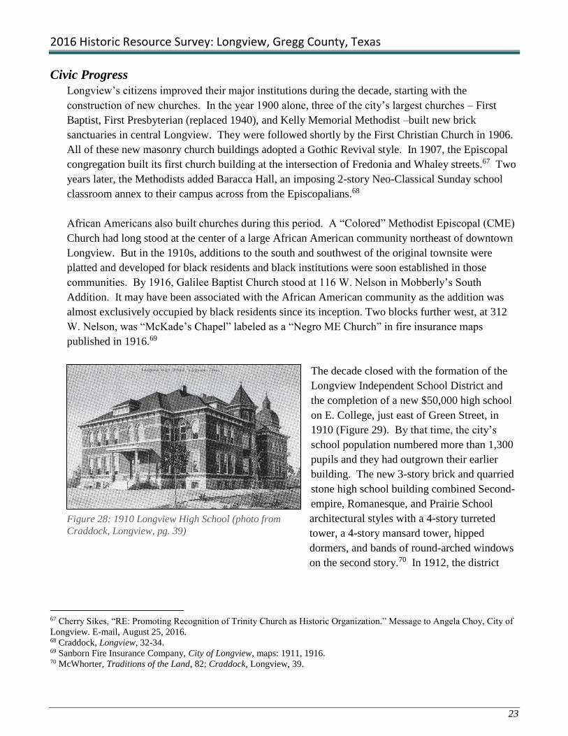
2016 Historic Resource Survey: Longview, Gregg County, Texas
23
Civic Progress
Longview’s citizens improved their major institutions during the decade, starting with the
construction of new churches. In the year 1900 alone, three of the city’s largest churches – First
Baptist, First Presbyterian (replaced 1940), and Kelly Memorial Methodist –built new brick
sanctuaries in central Longview. They were followed shortly by the First Christian Church in 1906.
All of these new masonry church buildings adopted a Gothic Revival style. In 1907, the Episcopal
congregation built its first church building at the intersection of Fredonia and Whaley streets.67 Two
years later, the Methodists added Baracca Hall, an imposing 2-story Neo-Classical Sunday school
classroom annex to their campus across from the Episcopalians.68
African Americans also built churches during this period. A “Colored” Methodist Episcopal (CME)
Church had long stood at the center of a large African American community northeast of downtown
Longview. But in the 1910s, additions to the south and southwest of the original townsite were
platted and developed for black residents and black institutions were soon established in those
communities. By 1916, Galilee Baptist Church stood at 116 W. Nelson in Mobberly’s South
Addition. It may have been associated with the African American community as the addition was
almost exclusively occupied by black residents since its inception. Two blocks further west, at 312
W. Nelson, was “McKade’s Chapel” labeled as a “Negro ME Church” in fire insurance maps
published in 1916.69
The decade closed with the formation of the
Longview Independent School District and
the completion of a new $50,000 high school
on E. College, just east of Green Street, in
1910 (Figure 29). By that time, the city’s
school population numbered more than 1,300
pupils and they had outgrown their earlier
building. The new 3-story brick and quarried
stone high school building combined Second-
empire, Romanesque, and Prairie School
architectural styles with a 4-story turreted
tower, a 4-story mansard tower, hipped
dormers, and bands of round-arched windows
on the second story.70 In 1912, the district
67 Cherry Sikes, “RE: Promoting Recognition of Trinity Church as Historic Organization.” Message to Angela Choy, City of
Longview. E-mail, August 25, 2016. 68 Craddock, Longview, 32-34. 69 Sanborn Fire Insurance Company, City of Longview, maps: 1911, 1916. 70 McWhorter, Traditions of the Land, 82; Craddock, Longview, 39.
Figure 28: 1910 Longview High School (photo from
Craddock, Longview, pg. 39)

2016 Historic Resource Survey: Longview, Gregg County, Texas
24
completed four new elementary schools in suburban areas of the city including Northcutt Heights,
Campus Ward, and First Ward schools, and one for black students on E. Marshall Avenue.71
New schools were built for black students during this period, as well. The black community on the
city’s north side had grown along with the rest of Longview and by the turn of the century its
students had outgrown their 1-story, four-room school on E. Marshall Avenue. About 1908, the
building was enlarged to two stories. Between 1911 and 1916, a long, 2-story wing was added to the
rear of building.72 This may have been the “Northside Elementary School for Negroes” that was
built along with some suburban elementary schools in 1912. Though some records show it as a new
building, it was likely this addition at the rear of the existing school on the site.
4) Longview in Decline: 1919-1929
Longview’s “Feel Good” era waned in the latter half of the 1910s, due in part to the failing cotton
industry in East Texas. High demand for cotton during World War I had stimulated crop production
by artificially inflating prices. When the war was over, cotton prices plummeted. East Texas cotton
already suffered from depleted soils and low per-acre yields, but the precipitous drop in prices forced
many area farmers to give up the plow and seek work elsewhere. Though Longview wasn’t entirely
dependent on cotton, as many regional communities had been, the impact was strong, reverberating
throughout the local economy. As a result, many modernization and development projects planned
for the city were shelved until conditions improved. That would not happen until the oil boom of the
1930s.
Longview Race Riot of 1919
As Longview’s citizens dealt with a flagging economy, they also had to contend with racial unrest
that resulted in violence in 1919. It was part of a larger trend that spread throughout the country in
the early postwar years. Many African Americans who served in the military returned home with a
new sense of pride in their contributions to the war effort and an expectation that they could forge
better lives for themselves and their communities upon returning to the civilian world. Veterans and
their families organized to achieve better living conditions, voting rights, employment opportunities,
and equal treatment in all aspects of American life. They were met with strong resistance from
whites who feared their determination to stand up for themselves and especially to pursue equal
rights as American citizens. These opposing attitudes led to conflict between blacks and whites
throughout the nation during that time. Some escalated into what were then-described as “race
71 “Longview Independent School District,” A Picture Postcard History of Longview, Texas, July 2009,
(http://freepages.history.rootsweb.ancestry.com/~katloregen/SC_LISD.html), accessed July 31, 2016. 72 Sanborn Fire Insurance Company, City of Longview, maps: 1911, 1916.

2016 Historic Resource Survey: Longview, Gregg County, Texas
25
riots,” the most notorious of which occurred in Tulsa, Chicago, Knoxville, Omaha, Washington D.C.
and Longview, Texas.73
The Longview “race riot” was less dramatic than some others of the period but its legacy haunted
race relations in the city for decades. The so-called riot was sparked by the beating and murder of a
black man, Lemuel Walters, who had been accused of making “indecent” advances toward a white
woman. Her brothers were incensed at Longview’s black leaders, teacher S. L. Jones and physician
Dr. Calvin P. Davis, for submitting the story of Waters’ murder to the nationally-distributed black
civil rights newspaper, The Chicago Defender. On July 10, 1919, after the article was published, the
brothers caught Jones on Methvin Street, across from the Gregg County Courthouse, and beat the
teacher severely. Dr. Davis rescued Jones from the street and took him back to his office for
treatment. As more whites learned about the “incendiary” article and blacks gathered at Davis’
office to hear of the attack on Jones, tensions erupted. Both whites and blacks formed gangs of men
who roamed the streets in search of vengeance. Some twelve to fifteen whites descended on Jones’
house, at the corner of W. College and Harrison Streets in southwest Longview, and were met with
gunfire from inside the house. Three white men were slightly wounded but it was enough to incite
the mob to greater violence.74
Whites burned a number of buildings in the
black neighborhood, starting with Jones’ and
Davis’s, and including Quick Hall, a dance
parlor. A white gang whipped a black man
and woman when they tried to save their
homes. Continuing skirmishes and armed
resistance to law enforcement led local
officials to request assistance from the state.
The next day, as fires in the black community
were still burning, Governor William P.
Hobby imposed martial law in the county and
called out the National Guard and the Texas
Rangers to restore order (Figure 30). Several
more days of sporadic violence ultimately ended in the arrest of 17 whites for attempted murder and
nine others for arson. All of the white men were released on a $1,000 bond each. None of their
cases ever went to trial. Twenty-one blacks were arrested on charges of assault with attempt to
murder. They were first jailed, and then exiled from the county “for their own good” with the
warning that they would be arrested and tried should they ever return. Two African Americans,
73 Kenneth R. Durham, Jr., “The Longview Race Riot of 1919,” East Texas Historical Journal, ed. Archie P. McDonald, Vol.
XVIII, No. 2 (Nacogdoches, Texas: Stephen F. Austin State University, 1980), 1. 74 Ibid, 6.
Figure 29: National Guardsmen and Texas Rangers
called to the race riot, 1919 (photo from Craddock,
Longview, pg. 53)

2016 Historic Resource Survey: Longview, Gregg County, Texas
26
including Davis’s 60-year old father-in-law, Marion Bush, were killed during the conflict.75 The
events of that summer ended further agitation for black civil rights in Longview for decades to
follow and its neighborhoods and institutions remained segregated into the 1970s.
Lingering Malaise in the 1920s
The economic slump that befell the city in the late 1910s, continued through the 1920s, a time when
most of the country enjoyed general prosperity. Longview leaders tried to attract positive attention
to the city. Several “booster” organizations formed to promote the city as a forward-thinking,
business-friendly community. The Longview Chamber of Commerce had formed in 1916 but the
movement didn’t really take off until after the war and in response to the lingering economic
malaise. The Rotary Club organized in 1920 and in 1926, a regional association, the East Texas
Chamber of Commerce, formed in Longview with R. Marvin Kelly of the Kelly Plow Works, as its
first president. On March 23, 1928, the chamber opened its new headquarters building just east of
the business district, next to the post office. Paid for by the city of Longview, the two-story Spanish
Eclectic style office and assembly building was clad in stucco with red clay tile roof accents.76 The
chamber was dedicated to promoting East Texas, and Longview in particular, to potential businesses
and industries that would invest in the area’s future and shore up the local economy.
The chamber and other booster organizations held numerous promotional events, published and sent
brochures touting area attractions to potential investors around the country, and hosted visiting
businessmen and industrialists to encourage interest in the area but little came of it in the 1920s.
New construction was largely limited to filling vacant lots in existing commercial and residential
districts in the city but few new subdivisions or large-scale commercial enterprises were launched in
the 1920s.
By the end of the decade, however, the
economy began to improve slightly and
several noteworthy projects were undertaken
in the city. Longview’s school-age
population had increased enough to warrant
several new school buildings in the late
1920s. A new high school was started in
1927 and completed in 1929 (Figure 31). The
Mediterranean style building occupied a 6.3-
acre campus at 410 S. Green Street, just south
of E. College Street. At the same time, the
75 According to Durham’s map of the events, most of the violence, including shootings and fires, took place in the new
African American neighborhoods on the city’s southwest side, in Carter’s and Mobberly’s South Additions, below College
Street and west of High Street. 76 Craddock, Longview, 58.
Figure 30: 1929 Longview High School, 410 S. Green
St.

2016 Historic Resource Survey: Longview, Gregg County, Texas
27
school board built Northside Elementary (renamed Janie Daniel Elementary) for African American
children. It opened for classes on E. Marshall Avenue, between N. First and Second Streets, in
Longview’s historic black neighborhood, in 1929.77
In 1929, the First Baptist Church finished a three-story education building with classrooms,
assembly rooms, offices, and a kitchen to serve its growing congregation in 1929.78 At the same
time, several local businessmen managed to raise $200,000 to build a first-class hotel in downtown
Longview. The five-story, 64-room Gregg Hotel was the largest ever built in the city. The project
was a gambit to impress outside investors in Longview’s future. The hotel was later acquired and
enlarged by Conrad Hilton.79
Just as the city seemed to be pulling out of its slump, however, the Texas and Pacific Railroad
Company announced its decision to move the Longview terminal to Mineola in January, 1929.
Along with the business, the company took with it some 700 employees, their families, and a million
dollar payroll.80 It was a stunning blow to the city and its citizens would always equate the
announcement with the start of the Great Depression in Longview, rather than with the stock market
crash that came later that fall. In the months after the railroad’s decision, Longview suffered high
unemployment, a major drought, a drop in cotton prices, decreased timber production – and then, the
onset of the Great Depression.81 Many of the gains made in the early years of the century were lost
in the 1920s, and many doubted that the city would recover. That bleak future was about to change.
5) Oil!: 1931-1941
On October 3, 1930, inveterate wildcatter,
seventy-year-old “Dad” Joiner struck oil after
many years of failed attempts at his Daisy
Bradford No. 3 well in nearby Rusk County.
Less than three months later, a second well
southwest of Kilgore came in strong, giving
rise to hopes that a larger-than-expected pool
lay beneath the surface. On January 26, 1931,
an estimated 15,000 people watched as a third
well, the F. K. Lathrop No. 1, hit a gusher
near Longview, confirming the existence of a
77 “Longview Independent School District” A Picture Postcard History of Longview, Texas (July 2009),
(http://freepages.history.rootsweb.ancestry.com/katloregen/SC_LISD.html). 78 Craddock, Longview, 57. 79 Ibid, 59. 80 Ibid, 52. 81 Craddock, Historic Gregg County, 27.
Figure 31: East Texas Oil Field c. 1935 (photo from
Craddock, Longview, pg. 67)

2016 Historic Resource Survey: Longview, Gregg County, Texas
28
vast sea of oil beneath the East Texas clay. The East Texas Oil Field, as it became known, ran 42
miles long and eight miles wide, and was thought to be the largest oil field in the world (Figure
32).82 In the span of a few short months, Gregg County found itself in the oil business and the boom
was on.
Thousands of people descended on
East Texas almost overnight, anxious
to get a part of the rich find (Figure
33). Among them were geologists,
petroleum engineers, refiners,
wildcatters, roughnecks and
roustabouts, some of their families, and
innumerable hangers-on. Kilgore’s
population rose from 500 before the
strike, to nearly 10,000 only weeks
after it was announced. Longview’s
population, which had actually
declined from 5,713 residents in 1920
to just at 5,000 in 1930, nearly six
decades after the founding of the city.83 During the oil boom, the city’s population nearly tripled to
13,758 by 1940, a phenomenal achievement!84 Some came to work the oil field while others hoped
to profit from the boom in other ways. The county was flooded with construction workers and
lumbermen. Trees left standing in the once-dense pine forests of East Texas were felled to build
wooden oil derricks and makeshift shelters. Existing buildings, from barns to banks, were torn down
and replaced with wells, while new ones were erected to house the tide of oilfield workers and others
who flocked to the region in search of a paycheck or more.85
At the periphery of the oil field, Longview was not as swamped by vast numbers of new arrivals as
were the former sawmill communities of Kilgore and Gladewater. Nevertheless, as the only city of
any size in the county, Longview was almost instantly populated by a legion of land men, financiers,
and others involved in the business of oil. At the same time, countless attorneys, law clerks, clerical
staff and others necessary to the oil industry set up shop in Longview where they had access to
county archives with the deed, tax, and court records necessary to complete land sales and oil leases.
They clamored for any available housing and office space and any vacancies left by the T & P
employees were quickly grabbed up by the first arrivals.
82 Ibid, 27-29. 83 McWhorter, Traditions of the Land, 104. 84 Craddock, Longview, 68. 85 Craddock, Historic Gregg County, 28.
Figure 32: Longview boomed after oil was discovered; Street
scene c. 1931 (photo from Craddock, Longview, pg. 65)

2016 Historic Resource Survey: Longview, Gregg County, Texas
29
The impact on Longview’s economy
and development was immediate and
profound. Builders flocked to the city
to meet the demand and within just a
few months, Longview was awash in
new housing starts, commercial
development, and government
projects. As downtown property
increased in value with the boom,
many small-scale buildings were torn
down and replaced with larger, more
impressive edifices befitting the city’s
new-found prosperity. Chief among
them was the six-story Glover-Crim
Building, which replaced Bodie Park
at the intersection of Fredonia and Tyler Streets in 1933 (Figure 34).86 Two years later, another six-
story structure, McWilliams Hardware and Furniture Building, was built at 208 N. Green Street, the
former site of the First Christian Church. Some older buildings, including the Gregg Hotel, received
extensive makeovers in the 1930s. When Conrad Hilton purchased the downtown hotel in 1935, he
immediately doubled its size to accommodate the movers and shakers of the petroleum industry and
changed its name to the Longview Hilton. Its success inspired Hilton to acquire other hotels and
ultimately create one of the world’s largest and most famous hotel chains.87
While the Longview Hilton attracted the oil elite to its doors, numerous motor courts sprang up
along city thoroughfares to provide “service and comfort without extravagance” to the less-
advantaged classes drawn to the area for work in the 1930s. Many, including Mission Courts, a
collection of stucco cottages with arched entries
and shaped parapets, and Jackson Courts, designed
in a Tudor Revival motif, appeared on busy U.S.
Highway 80 (Marshall Avenue) through the city
(Figure 35). Longview motor courts of the period
typically consisted of individual or linked cottages
that formed a “horseshoe” pattern around a larger,
central office/dining hall; they were generally
rendered in popular architectural fashions of the
period, including Spanish, Mission, and Tudor
86 Originally only two stories, four additional floors were added to the building in 1935 (Craddock 2010: 80). 87 Craddock, Longview, 81.
Figure 33: Glover-Crim Building, c. 1940 postcard (photo from
UNT's Portal to Texas History)
Figure 34: Mission Courts, c. 1940 postcard
(photo from Craddock, Longview, pg. 83)

2016 Historic Resource Survey: Longview, Gregg County, Texas
30
Revival styles. Some offered kitchenettes and on-site cafes or diners serving hot meals to their
transient tenants.88
City and county governments undertook civic
improvements during the 1930s. The most ambitious
project was the construction of a new County
Courthouse completed in 1932 to handle the
enormous increase in county business since the start
of the oil boom (Figure 36). Designed by the Wichita
Falls architectural firm of Voekler and Dixon, the Art
Deco style brick, terra cotta, and marble building
replaced the 1897 courthouse on the same site.
Annex buildings constructed in 1958 and 1982 flank
the courthouse at the center of the square. At the
same time, Longview voters approved the
construction of a new city hall on the site of the old
Magnolia Hotel. Contractor A. M. Campbell built
the Mediterranean Revival style municipal building
and adjacent fire station complex in 1936 (Figure
37).89 New fire stations designed in Period Revival
styles were built in growing suburban neighborhoods
during the 1930s. A stucco-clad Spanish Eclectic
style fire station appeared at the edge of upscale
Nuggett Hill, in Turner’s Addition, northeast of the
central business district, by the mid-1930s. At the
same time, a Tudor Revival style station sporting
faux half-timbering in its gables, was built on
Mobberly Avenue to serve the fashionable Mobberly
additions southeast of the city (Figure 38).
The great wave of new residents overwhelmed the
city’s existing school facilities; school enrollment
more than doubled between 1930 and 1932,
increasing from under 2,000 to 4,400 in only two years. The district launched a new building
campaign to avert a crisis. Longview High School was only three years old when it was found to be
too small. The 1929 building became a junior high and a new three-story Art Deco style high school
was erected on Whaley Street (demolished in 1988), east of the central business district. In 1932,
Longview residents W. R. and Ethel Nicholson funded the construction of a new Mediterranean style
88 Ibid, 83. 89 Ibid, 82.
Figure 35: 1932 Gregg County Courthouse
(photo from Craddock, Longview, pg. 72)
Figure 36: Longview Municipal Building/City
Hall (photo from Craddock, Longview, pg. 82)
Figure 37: (Mobberly Avenue Fire Station
(photo from Craddock, Longview, pg. 76)

2016 Historic Resource Survey: Longview, Gregg County, Texas
31
library on a lot adjacent to the 1929 high
school at S. Green and College Streets (Figure
39). The couple dedicated the new 5,220-
square-foot Nicholson Memorial Library to
their late son, Ronald, who died at the age of
twelve (Craddock 2010: 74). The Longview
School District scrambled to build schools to
serve the growing suburban areas around the
city. The original Northcutt Heights School at
515 N. Court Street that was destroyed by a
tornado, was rebuilt about 1933 in time to
serve the growing neighborhood that surrounded it. It was followed in 1934 by the South Ward
Elementary School on Mobberly Avenue and in 1936 by Southside Elementary School for African
American students.90
Other community projects begun during the oil boom developed into major institutions that today
employ thousands of people in the city. One of the most significant and far-ranging of these was the
establishment of Gregg Memorial Hospital, a small county-owned facility built on Marshall Avenue
(U.S. Highway 80) in 1935. Gregg Memorial grew to become the present 425-bed Good Shepherd
Medical Center, at the center of a sprawling medical complex that includes the Longview Regional
Hospital and serves patients from throughout East Texas and beyond.91
Suburban Expansion in the 1930s
Although much of the East Texas oil boom population was transient, many who relocated to
Longview decided to stay and make it their home. As a result, Longview’s population tripled during
the 1930s. Hotels, boarding houses, and motor courts were wholly insufficient to address the
housing needs of those who flooded into the city with the oil boom. Builders immediately
descended on existing additions like Mobberly’s East, south of the city, and Northcutt Heights, to the
northwest, both of which had languished since they were first platted in the 1910s. Even so, it
wasn’t enough to satisfy the housing demand and speculators looked to the fields and forests at the
fringes of the city for fresh development opportunities. Area farmers whose fields had grown less
and less productive with the passing years realized that the time had come to sell at a reasonable
price rather than just walk away from their mortgages. For the first since the 1910s, property owners
began platting new subdivisions from former homesteads that would define the city’s character and
growth patterns for years to come. A dozen new additions – more than were created in the previous
six decades combined – were filed in the county courthouse between 1931 and 1938. As soon as
90 “Longview Independent School District” A Picture Postcard History of Longview, Texas (July 2009),
(http://freepages.history.rootsweb.ancestry.com/katloregen/SC_LISD.html). 91 Craddock, Longview, 74.
Figure 38: Nicholson Memorial Library, 400 S. Green
St.

2016 Historic Resource Survey: Longview, Gregg County, Texas
32
they were platted – and sometimes before the ink was dry – contractors went to work building
thousands of new homes in these 1930s additions.
Houses of this period ranged widely in type and style, depending on the neighborhood and market.
Gone were the Craftsman bungalows and Classical Revival dwellings of the 1910s and 1920s. The
great majority of oil-boom dwellings were modest, side-gabled frame houses with minimal design
features. Most were geared to the multitude of working class families who poured into the city for
work and, while some followed Minimal Traditional or Early Ranch design models, others were
simple box-like houses with no appreciable style. In more middle-class neighborhoods, frame and
brick Tudor Revival style houses were built by the score. Toward the end of the 1930s, some good
examples of Early Ranch style houses made their appearance in these additions. More elaborate and
romantic Spanish Eclectic (Spanish Colonial Revival) and Mediterranean-inspired styles were found
in upscale additions like the North Longview’s Nuggett Hill and South Longview’s Surrey Place
(Covington) and Mobberly Place. Several prominent downtown churches relocated during this
period to the Nuggett Hill area where they built new sanctuaries in these more romantic architectural
styles. Among them were St. Anthony’s Catholic Church, the First Christian Church, and Trinity
Episcopal Church (Figure 40).
North Longview Additions
Marshall Avenue transformed from a sleepy country road through the community at the turn of the
20th century to a busy arterial across the north through the city as part of U. S. Highway 80 in the
1930s. When the oil field was discovered in the region in 1930, it was one of the only paved roads
through Gregg County. Consequently, it instantly became the county’s main transportation corridor
for oil field traffic. And, as such, it attracted substantial commercial development including motor
courts, restaurants, gas stations, auto repair businesses, and other commercial development along its
path. It was particularly so on the Marshall Avenue section of U. S. Highway 80 through Longview.
As downtown property increased in value with the oil boom, it wasn’t long before some began
looking at the African American neighborhood that lay between Marshall Avenue and the downtown
Figure 39: 1941 St. Anthony's Catholic Church (left; photo from Craddock, Longview, pg. 93) and 1935
Trinity Episcopal (right; photo courtesy of Gene McWhorter)

2016 Historic Resource Survey: Longview, Gregg County, Texas
33
business district for potential redevelopment. Efforts to acquire “the Grove” for oil production
ultimately failed92 but pressure continued to mount on the rest of the close-in community whose
principal institutions, including schools, churches, and social halls, lay north of Magrill (Padon)
Street and Marshall Avenue. As Longview continued to grow, it started to encroach on the
community with major projects like the new Longview High School and Gregg Memorial Hospital
built on its north side.
Extensive new subdivisions carved out of former homestead tracts also appeared on the north side
during the oil boom years. Among the largest was the nine-block Melrose Addition carved out of
the former 40-acre Ingram homestead north of Marshall Avenue. The addition extended from
Seventh Street, on the west, to Tenth Street, on the east, with a total of 202 building lots that soon
filled with modest frame houses. The undated plat map featured a hand drawn picture of an oil
derrick spewing crude from its shaft, a graphic reference to the boom.93 In 1932, property owner
Mrs. M. A. LeDuke teamed with the Trentman Company to develop Marshall Heights, a 43.54-acre
parcel that lay north of Marshall Avenue. The large addition was bounded by Wilson Street on the
south, Russell Street on the north, Second Street on the west and Fourth Street on the east, and
contained hundreds of new building lots. Northcutt Heights, which was originally platted in the
1910s, was revised in March, 1931, to take advantage of the oil-driven demand for housing. It, too,
was a large addition with some 200 building lots between N. Center Street on the east and McCann
Road on the west.94
One of Longview’s most architecturally significant additions was developed in the early, heady days
of the boom. In 1931, Harry Turner platted the Nuggett Hill subdivision from his earlier Turner’s
Addition northeast of the city limits. At the time, it was Longview’s most exclusive address with
deed restrictions requiring that houses in the
addition cost a minimum of $5,000 and be
constructed of masonry, brick, stone, or
stucco. Most of the addition’s elaborate
Spanish, Mediterranean, and Tudor Revival
style homes were designed by Dallas-area
architects, including Clifford Hutsell who
designed the Spanish Eclectic style house at
814 Charlotte Drive for James F. Stuckey
(Figure 41). The two-story brick and stucco-
clad dwelling featured a tower, sweeping
wing walls, arched entryways and windows,
a complex clay tile roof and wrought iron
92 Clear title to the land proved impossible to obtain. The city of Longview eventually purchased the site and adopted it as a
park now known as Magrill Plaza (OTHL). 93 Melrose Addition, Gregg County plat records, Vol. 183: 255. 94 Marshall Heights Addition, Gregg County plat records, Vol. 76: 245.
Figure 40: 1935 Stuckey House (photo from Craddock,
Longview, pg. 75)
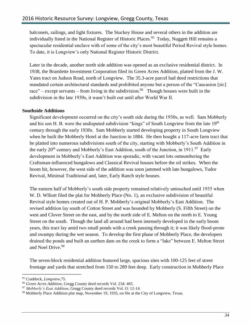
2016 Historic Resource Survey: Longview, Gregg County, Texas
34
balconets, railings, and light fixtures. The Stuckey House and several others in the addition are
individually listed in the National Register of Historic Places.95 Today, Nuggett Hill remains a
spectacular residential enclave with of some of the city’s most beautiful Period Revival style homes.
To date, it is Longview’s only National Register Historic District.
Later in the decade, another north side addition was opened as an exclusive residential district. In
1938, the Bramlette Investment Corporation filed its Green Acres Addition, platted from the J. W.
Yates tract on Judson Road, north of Longview. The 35.3-acre parcel had deed restrictions that
mandated certain architectural standards and prohibited anyone but a person of the “Caucasion [sic]
race” – except servants – from living in the subdivision.96 Though houses were built in the
subdivision in the late 1930s, it wasn’t built out until after World War II.
Southside Additions
Significant development occurred on the city’s south side during the 1930s, as well. Sam Mobberly
and his son H. B. were the undisputed subdivision “kings” of South Longview from the late 19th
century through the early 1930s. Sam Mobberly started developing property in South Longview
when he built the Mobberly Hotel at the Junction in 1884. He then bought a 117-acre farm tract that
he platted into numerous subdivisions south of the city, starting with Mobberly’s South Addition in
the early 20th century and Mobberly’s East Addition, south of the Junction, in 1911.97 Early
development in Mobberly’s East Addition was sporadic, with vacant lots outnumbering the
Craftsman-influenced bungalows and Classical Revival houses before the oil strikes. When the
boom hit, however, the west side of the addition was soon jammed with late bungalows, Tudor
Revival, Minimal Traditional and, later, Early Ranch style houses.
The eastern half of Mobberly’s south side property remained relatively untouched until 1935 when
W. D. Wlliott filed the plat for Mobberly Place (No. 1), an exclusive subdivision of beautiful
Revival style homes created out of H. P. Mobberly’s original Mobberly’s East Addition. The
revised addition lay south of Cotton Street and was bounded by Mobberly (S. Fifth Street) on the
west and Clover Street on the east, and by the north side of E. Melton on the north to E. Young
Street on the south. Though the land all around had been intensely developed in the early boom
years, this tract lay amid two small ponds with a creek passing through it; it was likely flood-prone
and swampy during the wet season. To develop the first phase of Mobberly Place, the developers
drained the ponds and built an earthen dam on the creek to form a “lake” between E. Melton Street
and Noel Drive.98
The seven-block residential addition featured large, spacious sites with 100-125 feet of street
frontage and yards that stretched from 150 to 289 feet deep. Early construction in Mobberly Place
95 Craddock, Longview,75. 96 Green Acres Addition, Gregg County deed records Vol. 234: 465. 97 Mobberly’s East Addition, Gregg County deed records Vol. O: 12-14. 98 Mobberly Place Addition plat map, November 19, 1935, on file at the City of Longview, Texas.

2016 Historic Resource Survey: Longview, Gregg County, Texas
35
consisted of elaborate Spanish Eclectic (Spanish Colonial Revival) houses with stucco walls, rooftop
terraces and balconets with wrought iron railings, and imposing brick Tudor Revival dwellings with
high-pitched, staggered rooflines and faux half-timbering in stuccoed gable ends. Many of the
houses in the first phase were set on small rises or hills above gently curving streets through the
addition. Many featured matching garages and servants’ quarters. The addition was only partly
built out when World War II erupted and nonessential domestic construction was halted for the
duration of the war. After the war, the addition retained its appeal but fashions had changed and
much of the later houses were designed in Colonial Revival, Georgian Revival, or Greek Revival
styles, with a few elegant Ranch and Postwar Modern houses in the mix. Final build-out occurred
about 1960. By the 1960s, most high-end residential development had shifted to the city’s north side
but Mobberly Place, with its outstanding Period Revival style architecture and gracious landscaped
lots remained a desirable place in which to live. Today it is considered one of the city’s most
significant historic neighborhoods.
Two additional phases of Mobberly Place were opened in 1937 (Mobberly Place No. 2, July 30,
1937; Mobberly Place No. 3 September 2, 1937). Mobberly Place No. 2 extended the Mobberly
Place No. 1 streets from Clover (Eleventh) east to Sixteenth Street and from Sylvan Drive on the
north, to Young Drive on the south. Mobberly Place No. 3 consisted only of the north side of Sylvan
Drive. Houses in these later phases were large and stylish but not to the level of those built in the
original Mobberly Place Addition. They were geared to middle- and upper-middle class families
rather than the city’s elite.
Surrey Place (Covington), a contemporary of the Mobberly Place Additions, was another high-end
subdivision platted in South Longview by 1934.99 The addition lies south of downtown Longview,
between the I. & G.N. Railroad tracks and S. Green Street. It appears to have been part of the
Horace Ware homestead. Surrey Place was a small addition of just thirty lots on two meandering
streets accessed from S. Green Street. The plat map portrayed the addition as a tree-studded haven
bounded by “Stratford Creek” at the edge of a park. The street names – Covington Drive and
Winchester Lane – are written in calligraphy, as is the title block “Surrey Place, A Residential
Addition to the City of Longview,” designed, apparently, to illustrate its status.100 In fact, Surrey
Place is indeed comprised of a gallery of fine homes designed in popular Period Revival styles of the
time. It remains an enclave of large, architecturally significant houses surrounded by a much larger
working- and middle-class neighborhood.
As the oil boom frenzy subsided somewhat toward the end of the 1930s, several significant
development projects were underway. In 1939, under the Works Progress Administration (WPA),
plans were initiated for a new Gregg County Airport to be built in the Longview area. Ground was
99 The original plat date is unknown but the addition appears on a map of Longview from 1934. A revised plat of the
subdivision was filed for record in 1936 (Surrey Place November 1936; Gregg County deed record 209: 208). 100 Surrey Place revised plat, 1936, on file at the City of Longview, Texas.

2016 Historic Resource Survey: Longview, Gregg County, Texas
36
broken for the 521-acre facility in April,
1941 but the project was temporarily
shelved when America entered World War
II.101 Another WPA project gave Longview
a new Greek Revival style downtown Post
Office in 1940 (Figure 42). That year the
city also welcomed a new Longview
National Bank at the corner of Tyler and
Fredonia Streets and the completion of an
attractive new passenger depot for the Texas
& Pacific Railroad at the Junction (Figure
43).102 As the decade closed, Longview
business leaders laid plans for new
industrial development in the city, but those
projects were shelved for the duration of the
war. They would resurface in the early
postwar years, sparking a second “boom”
period in Longview’s history.
In retrospect, the oil boom had a
phenomenal – and mostly-positive – impact
on Longview’s growth and development.
The city had entered the 1930s with its
population, business prospects, and
agricultural base in decline. By the end of
the decade, Longview had been transformed into a modern, bustling city with good prospects for
future growth and prosperity. Historian Eugene McWhorter imagined that Gregg County’s residents
saw the oil boom era as something out of a “fairy tale, [in which] they had been rescued from the
very jaws of the Great Depression and the decline of local agriculture.” 103
In Longview’s case, the city realized the indirect benefits of the boom – an influx of outside capital,
welcome commercial development, and new families – without the multitudes of disorderly oil field
workers and camp followers who descended on towns like Kilgore and Gladewater by the thousands,
creating chaos in their wake. Instead, oil money gave the city “high-rise” buildings like the Glover-
Crim and McWilliams Hardware in the downtown commercial district. It funded major civic and
institutional improvements including a new county courthouse, post office, municipal complex, and
101 After the war, the site grew to include more than 800 acres. The new airport was dedicated on July 15, 1947. 102 Today, the depot serves passengers on Amtrak’s American Eagle line. It was listed in the National Register of Historic
Places. 103 McWhorter, Traditions of the Land, 119.
Figure 41: 1940 U.S. Post Office, postcard from c. 1944
(photo from Craddock, Longview, pg. 98)
Figure 42: Texas & Pacific Depot

2016 Historic Resource Survey: Longview, Gregg County, Texas
37
numerous schools throughout the city. And, it spawned a dozen new subdivisions that vastly
increased the city’s footprint by the end of the 1930s.
6) World War II Projects: 1941-1945
When World War II erupted in December, 1941, the government imposed a nationwide moratorium
on all “nonessential domestic construction” for the duration of the war. Across the country, work
was halted on private construction and government-funded projects alike, unless they could be
proven to directly serve in the national defense. Longview succeeded in attracting two major
defense spending projects to the area, landing work to build Harmon General Hospital and to
develop the “Big Inch Pipeline.”
Harmon General Hospital was typical of
war-era defense projects that were spread in
communities across the country. Local
business and civic leaders worked tirelessly
to bring hefty defense contracts to the area
in the build-up to the war. Their efforts
were rewarded when the government
established Harmon General Army Hospital
on a 160-acre site on south of the city, on
Mobberly Avenue (Figure 44). The site
was transformed almost overnight into a
fully-equipped 1,700-bed army medical
complex housed in 220 buildings. Between
December 1942 and December, 1945, an estimated 23,000 wartime patients were treated at the
hospital. It also served as a camp for about 200 German POWs.104
Harmon General Hospital was a boon to Longview’s
wartime economy, employing hundreds of area
construction workers in the building campaign and
numerous other local workers who served the facility
in support roles over the course of the war. It
continued to serve the community after the war when
it was converted to civilian use as a major technical
training school and industrial plant, LeTourneau
Technical Institute (Figure 45). The school and
manufacturing plant attracted hundreds of students and
104 Craddock, Longview, 94.
Figure 43: Harmon General Hospital, photo c. 1944 (photo
from Craddock, Longview, pg. 94)
Figure 44: LeTourneau Technical Institute,
photo c. 1955 (photo from Craddock,
Longview, pg. 95)

2016 Historic Resource Survey: Longview, Gregg County, Texas
38
workers, as well as suburban development, to its south Longview location. Gradually, the wooden
barracks and other temporary military buildings were replaced by a modern campus that grew to
become present LeTourneau University.
The Big Inch Pipeline was anything but a typical wartime project (Figure 46). It was developed and
built to carry massive amounts of oil overland. When America entered the war, tanker ships
transported 99% of the nation’s crude oil – 90% of which originated in Texas – to East Coast
refineries. In February 1942, German submarines began sinking oil tankers en route from the Gulf
to the East Coast. Petroleum shipment
dropped from over 1 million barrels per day
to only 70,000 barrels per day. Searching
for a safer way to transport oil, Secretary of
the Interior Harold Ickes conceived of a plan
to build the largest pipeline in history. The
Big Inch Pipeline measured 24 inches in
diameter and extended 1,476 miles from
Longview to Norris City, Illinois, and
eventually to refineries in the East. Capable
of delivering over 3,000,000 barrels of oil
each day, the pipeline had a tremendous
impact on the war effort.105
7) Postwar Development Boom: 1945-1966
When the war ended and the troops returned to East Texas, Longview faced questions about the
direction it should take to prosper in the postwar economy. Agriculture could no longer sustain
Gregg County; its early 20th century downward trend was exacerbated by reduced markets and back-
to-back crop failures during the Great Depression. The oil boom of the 1930s contributed further to
its demise as Gregg County farmers realized that they could do better by selling out to oil interests
than they could from a lifetime of drudgery on unproductive farms.106 Agriculture continued to
decline through the 1940s, as veterans left the farm and moved to cities and industrial areas where
they found work in factories, learned trades, or pursued professional careers. The trend was so
pervasive that by 1950, nearly all of the county’s farms had been abandoned or reduced to hay and
pasture.107
The collapse of agriculture and the mercurial nature of the oil industry left Longview’s leaders
searching for new avenues to develop a stable, healthy economy going into the future. Even before
105 Craddock, Historic Gregg County, 36. 106 McWhorter, Traditions of the Land, 120. 107 Ibid.
Figure 45: Big Inch Pipeline, photo c. 1954 (photo from
Craddock, Longview, pg. 96)

2016 Historic Resource Survey: Longview, Gregg County, Texas
39
the war, Longview advocates like the News-Journal publisher Carl L. Estes had begun making plans
to attract greater and more industries to the city. Reportedly, Estes played an instrumental role in
bringing the army’s Harmon General Hospital to Longview during the war. As the war drew to a
close, he then brokered a deal between local businessmen, the U. S. government, and
inventor/entrepreneur R. G. LeTourneau to redevelop the site as a technical plant that ultimately
became LeTourneau University.108
After the war, Estes and
other city leaders launched
aggressive, well-organized
campaigns to bring other
businesses and industries to
Longview. They worked to
secure securing adequate
water sources and establish
dedicated industrial park
zones just outside the city
limits.109 Their efforts paid
off when they enticed the
Texas Eastman Company, a
branch of the Eastman
Kodak Company, to build a
new plastics and industrial
chemical manufacturing plant just east of Longview, in Harrison County (Figure 47). Ground was
broken on the company’s 2,400-acre site in 1950 and operations commenced in January 1952. The
plant grew to become Texas’ largest inland chemical complex and the Longview area’s largest
employer.110
In the same period, Gregg Memorial Hospital launched an $800,000 expansion of its facilities
between Fourth and Sixth Streets at E. Marshall Avenue. In 1960, the growing hospital was
renamed Good Shepherd Medical Center. Its state-of-the-art physical plant and reputation attracted
other healthcare industries to Longview and the city became known as a leader in East Texas
medicine. In 1980, Longview Regional Medical Center joined Good Shepherd on N. Fourth
Avenue.111 The area around them has grown into a major medical complex in downtown Longview
with entire city blocks dedicated to treatment and research.
108 McWhorter, Traditions of the Land, 124. 109 Ibid,122. 110 The company employed more than 2,000 local workers in 2005 (McWhorter, Traditions of the Land, 125). 111 Craddock, Longview,74.
Figure 46: Eastman Chemical Plant, postcard c. 1976 (photo from
Craddock, Longview, pg. 125)

2016 Historic Resource Survey: Longview, Gregg County, Texas
40
City leaders continued to promote Longview as a business and industry “friendly” environment into
the 1960s. In a promotional brochure published by the Chamber of Commerce about 1960,
Longview was described as the “City of Planned Progress” with six industrial parks located within
“easy driving distance” of its “skilled and cooperative labor supply.”112 In 1966, the Schlitz
Company established a brewery and associated container factory in Longview. The plant later made
Stroh beer and grew to become the largest brewery in Texas, producing an estimated 4,000,000
gallons per year.113
Housing and Subdivision Development
In response to Longview’s postwar boom, developers platted dozens of new additions, extending the
city’s reach well beyond its pre-war boundaries. The locations of new industries and businesses on
the city’s outskirts attracted new subdivisions and housing projects in those areas. For example, the
establishment of the LeTourneau Technical Institute on the former site of Harmon General Hospital,
far south of the city limits, resulted in a flurry of new additions and hundreds of modest homes
between the older Mobberly Place additions and the campus in the early postwar years. Likewise,
the Texas Eastman plant with its many employment opportunities directed the city’s expansion into
Harrison County, to the east of Longview.
The “baby boom” also played a major role in Longview’s great suburban expansion after World War
II when legions of returning veterans and other young people came to the city ready to marry and
start raising families. While job and training opportunities were largely responsible for bringing
these young families to Longview, it was the location and reputation of public schools that
influenced where they lived. In the automobile age, workers could easily commute to job sites from
any part of the city, but people with families wanted to live in places where their children could
attend good neighborhood schools. Eschewing the past, they equated “good” with “modern” and
“new” and in postwar Longview, as with most of America, modern new schools were built in the
suburbs rather than the central city. In the dozen years following World War II, Longview ISD
enlarged some of its existing schools and erected a new high school for black students, but it built
nine brand new schools to accommodate the flood of families to the city suburbs. The locations of
these schools reflected the city’s growth patterns at the time but they also helped determine the
direction of subsequent development.
Longview ISD’s initial response to the city’s increasing school-age population was to enlarge its
existing facilities; a major addition to Longview High School was built in 1945, followed by another
addition in 1955. Likewise, the district approved a major addition to South Ward Elementary School
in 1947 and another in 1954.114 South Ward School was originally built in 1934 to serve the many
112 Longview Chamber of Commerce, Longview, Texas, promotional brochure, c. 1960. 113 Eugene W. McWhorter, “Longview, TX,” Handbook of Texas Online, accessed July 3, 2016,
http://www.tshaonline.org/handbook/online/articles/HDL03. 114 “Longview Independent School District” A Picture Postcard History of Longview, Texas (July 2009),
(http://freepages.history.rootsweb.ancestry.com/katloregen/SC_LISD.html).

2016 Historic Resource Survey: Longview, Gregg County, Texas
41
neighborhoods that sprang up with the oil boom; its additions were a stop-gap effort to accommodate
yet another population boom – this time attracted to LeTourneau Technical Institute and other
employers that had located to the city’s south side after the war.
Longview ISD’s first entirely new postwar campus in 1948, as a replacement for the African
American high school on E. Marshall Avenue that had been destroyed by fire two years earlier.
Instead of rebuilding on the school’s historic E. Marshall Avenue site, however, the district located
the new building in the city’s southwest quadrant.115 The decision to move the high school from its
north-central location may have been made, in part, as a response to the African American
community on the southwest side, but it also may have been made in an effort to encourage blacks to
relocate from the north side to segregated sections on the city’s south side. In the early 1950s, the
district built several black elementary schools – Pinewood Park in 1950 and Rollins Elementary in
1953 – on the city’s south side, but none on its north side. As the baby boom continued through the
1950s and into the 1960s, the southern and southwestern sections of Longview became increasingly
associated with people of color, while the northern and eastern sections were identified largely with
whites.
Other new schools tracked the direction of suburban development to the north and east of Longview.
Valley View Elementary School, built on Alpine Road in 1953, and Forest Park Junior High School,
built on Lake Drive in 1957, reflected the influence of the new Texas Eastman Company on
suburban development to the east of the city. Erskine Bramlette Elementary, built in 1956 off
Judson Road, helped attract white families to the city’s northern suburbs. 116
Residential design in Longview followed national trends with the modern Ranch Style house
dominating its suburban landscape. In 1960, the Brownwood Residential District was platted in a
section of south Longview that had been essentially built out since the oil boom of the 1930s.
Surrounded by early 20th century bungalows and Minimal Traditional style houses, the new upscale
addition was filled largely with modern brick Ranch Style and Colonial Revival houses on wide
grassy lots set along streets that looped through the neighborhood. Similar subdivisions of this type
began to cover large swaths of former farmland and timber tracts around the city, but especially on
its north side, in the 1960s. Some contained boxy side-gabled Early Ranch style houses with little
exaggeration to its modest linear form. Others, especially additions off N. Fourth Street, featured
long, low “True” Ranch style houses that stretched the length of their wide suburban lots.
While the population of Gregg County, as a whole, dropped by a third between 1940 and 1960, the
population of Longview nearly tripled in that period, rising from 13,758 to 40,050. The increase was
due in large part to Longview’s annexation of several nearby communities which added thousands of
115 In 1959, the high school was renamed Mary C. Womack High School in honor of the educator. 116 “Longview Independent School District” A Picture Postcard History of Longview, Texas (July 2009),
(http://freepages.history.rootsweb.ancestry.com/katloregen/SC_LISD.html).
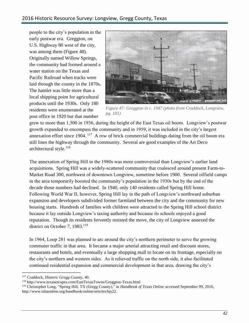
2016 Historic Resource Survey: Longview, Gregg County, Texas
42
people to the city’s population in the
early postwar era. Greggton, on
U.S. Highway 80 west of the city,
was among them (Figure 48).
Originally named Willow Springs,
the community had formed around a
water station on the Texas and
Pacific Railroad when tracks were
laid through the county in the 1870s.
The hamlet was little more than a
local shipping point for agricultural
products until the 1930s. Only 180
residents were enumerated at the
post office in 1920 but that number
grew to more than 1,500 in 1936, during the height of the East Texas oil boom. Longview’s postwar
growth expanded to encompass the community and in 1959, it was included in the city’s largest
annexation effort since 1904. 117 A row of brick commercial buildings dating from the oil boom era
still lines the highway through the community. Several are good examples of the Art Deco
architectural style.118
The annexation of Spring Hill in the 1980s was more controversial than Longview’s earlier land
acquisitions. Spring Hill was a widely-scattered community that coalesced around present Farm-to-
Market Road 300, northwest of downtown Longview, sometime before 1900. Several oilfield camps
in the area temporarily boosted the community’s population in the 1930s but by the end of the
decade those numbers had declined. In 1940, only 140 residents called Spring Hill home.
Following World War II, however, Spring Hill lay in the path of Longview’s northward suburban
expansion and developers subdivided former farmland between the city and the community for new
housing starts. Hundreds of families with children were attracted to the Spring Hill school district
because it lay outside Longview’s taxing authority and because its schools enjoyed a good
reputation. Though its residents fervently resisted the move, the city of Longview annexed the
district on October 7, 1983.119
In 1964, Loop 281 was planned to arc around the city’s northern perimeter to serve the growing
commuter traffic in that area. It became a major arterial attracting retail and discount stores,
restaurants and hotels, and eventually a large shopping mall to locate on its frontage, especially on
the city’s northern and western sides. As it relieved traffic on the north side, it also facilitated
continued residential expansion and commercial development in that area, drawing the city’s
117 Craddock, Historic Gregg County, 40. 118 http://www.texasescapes.com/EastTexasTowns/Greggton-Texas.html 119 Christopher Long, “Spring Hill, TX (Gregg County),” in Handbook of Texas Online accessed September 09, 2016,
http://www.tshaonline.org/handbook/online/articles/hjs22.
Figure 47: Greggton in c. 1947 (photo from Craddock, Longview,
pg. 101)

2016 Historic Resource Survey: Longview, Gregg County, Texas
43
population further away from the
downtown core. The city’s population
grew so significantly northward in the
1960s that the school district decided to
build the new Longview High School
on Tomlinson Parkway, off Loop 281
(Figure 49). The school was completed
in 1975.120 In 1966, Interstate 20 came
through Gregg County passing by
Longview to the south.121 Although it
aided commuter traffic in that area, it
did not instill suburban expansion to the
degree achieved by Loop 281 on the
north side.
Downtown Longview in the Postwar Era
The early postwar period saw considerable redevelopment in
downtown Longview where a number of modern new office
buildings replaced historic commercial structures in the
central business district. The Bramlette Building (1949) and
the Petroleum Building (1956) stand out for their Modern
commercial design with asymmetrical massing and sleek
horizontal lines interrupted by
dramatic vertical bays (Figure 50).
Another significant addition to the
downtown business district was the
ten-story First National Bank (now
Citizens National Bank), built in
1956 and considered to be
Longview’s first “skyscraper”
(Figure 51).122 Later downtown
development of the period included
sprawling chain retailers like the
Sears Roebuck Store on S. High
Street and Dillard’s Department
Store on W. Tyler Street.
120 Craddock, Longview, 121. 121 Craddock, Historic Gregg County, 41. 122 Ibid, 39.
Figure 48: 1975 Longview High School (photo from Craddock,
Longview, pg. 121)
Figure 49: Bramlette Building (top;
photo from Craddock, Longview, pg. 98)
Petroleum Building (bottom)
Figure 50: First
National Bank Building
(photo from Craddock,
Longview, pg. 113)

2016 Historic Resource Survey: Longview, Gregg County, Texas
44
At the same time, some of the city’s founding
churches built new sanctuaries, parochial schools,
and religious education classroom buildings,
putting considerable investment into their
downtown sites. The First Presbyterian
congregation had already built a new sanctuary on
its historic location in 1940, and in 1958, they
added a large education building on the same site.
St. Anthony’s Catholic Church had also built a
new church in its Nuggett Hill location before the
war. In 1949, the church added St. Anthony’s
School and in 1968 it built St. Mary’s School, all
in the same block. In 1951, the First Baptist
Church dedicated its new sanctuary and three years
later it added a children’s building to the complex
(Figure 52). The First Methodist Church dedicated
a new sanctuary on the site of its 1909 building in
1952. Four years later, they added a $500,000
children’s building on their corner.123 The Miracle
Tabernacle House of Prayer, an African-American
church constructed in 1947, expanded in circa
1960 in response to a growing congregation
(Figure 53). These churches greatly altered the
fabric of downtown Longview but, with the passage of time, these constructions have achieved
historic significance of their own as reflections of postwar architectural trends in religious buildings.
Despite these new arrivals, the downtown area
began to decline as the central shopping
district. As suburban growth continued to draw
the city’s population away from the central
core, retailers began to move with them. The
advent of conveniently-located suburban strip
shopping centers further drained retail business
from downtown Longview.124 For a time, the
large chain stores continued to attract shoppers
to the downtown district but they, too, made the
move to the suburbs when a new mall opened on Loop 281, in far north Longview. The loss of these
major retailers hastened the demise of downtown as the city’s principal shopping venue. Now, the
123 Craddock, Longview, 112. 124 Ibid, 107.
Figure 51: First Baptist Church 1951 sanctuary
(photo from Craddock, Longview, pg. 112)
Figure 52: Miracle Tabernacle House of Prayer at
206 E. Nelson St.
Figure 53: Kilgore College, 300 S. High St., in former
Sears building

2016 Historic Resource Survey: Longview, Gregg County, Texas
45
Dillard’s building is the home of Network Communications and the Sears site is occupied by a
branch of Kilgore College (Figure 54).
Downtown Longview remains home to the city’s founding churches, some with kindergartens,
auditoriums, and multiple classroom buildings. It is also the location of major financial and business
institutions. In recent years, an interest in historic preservation and alternative development has
helped to stimulate activity in the downtown district as a center for festive community events,
boutique retail shopping, and unique local dining and entertainment venues. In that process, efforts
have been made to preserve and restore historic buildings in the district for these adaptive uses.

2016 Historic Resource Survey: Longview, Gregg County, Texas
46
References, Survey, Methodology,
Deliverables, and Specifications

2016 Historic Resource Survey: Longview, Gregg County, Texas
47
References Cited
Centennial Book Committee. Longview, Texas Centennial: The Long View of a Hundred Years, 1870-
1970. Longview, Texas: The Centennial Book Committee, 1970.
Craddock, Van Jr. Historic Gregg County: An Illustrated History. San Antonio: Gregg County
Historical Commission (Historical Publishing Network), 2006.
Craddock, Van Jr. Longview. Charleston, South Carolina: Arcadia Publishing Co., 2010.
Durham, Kenneth R. Jr. “The Longview Race Riot of 1919” in East Texas Historical Journal, Volume
XVII, No. 2. Nacogdoches, Texas: Stephen F. Austin University, 1980.
Longview Chamber of Commerce. “Celebrating a Century: Your Longview Chamber of Commerce” in
Uniquely Longview. Longview: Hudson Printing and Graphic Design, 2016.
“Longview Independent School District,” A Picture Postcard History of Longview, Texas, July 2009,
(http://freepages.history.rootsweb.ancestry.com/~katloregen/SC_LISD.html), accessed July 31,
2016.
Longview Chamber of Commerce, Longview, Texas, promotional brochure, c. 1960, on file at the
Longview Public Library History Collection.
McWhorter, Eugene W. Traditions of the Land: The History of Gregg County, Texas. Longview,
Texas: Gregg County Historical Foundation, 1989.
McWhorter, Eugene W. “Longview, TX,” Handbook of Texas Online, accessed July 3, 2016,
http://www.tshaonline.org/handbook/online/articles/HDL03.
Preservation Longview. “Preservation Longview Newsletter”. Longview, Texas: November 2015.
Rosser, Howard W., ed. The First Fifty Years: A History of the East Texas Chamber of Commerce.
Longview, Texas: East Texas Chamber of Commerce, 1976.
Sanborn Fire Insurance Company, City of Longview, maps: 1885-1946. (New York).
Sikes, Cherry. “RE: Promoting Recognition of Trinity Church as Historic Organization.” Message to
Angela Choy, forwarded to Terri Myers, August 25, 2016. E-mail.

2016 Historic Resource Survey: Longview, Gregg County, Texas
48
Addition and Plat Maps on file at the Gregg County Clerk’s Office, plat and deed records
Lacy & Bass Addition, plat map, March 1909.
Northcutt Heights Addition, plat map, n.d.
Melrose Addition, plat map.
Marshall Heights Addition, plat map.
Green Acres Addition, plat map and deed record.
Mobberly East Addition, plat map.
Mobberly Place, plat map, November 19, 1935.
Surrey Place Residential District, plat map, November 1936.
Brownwood Addition, plat map, 1960.
Maps of the City of Longview located at the Gregg County Historical Museum
Jones, W. E. and W. D. Eliott. Map of Longview, Texas. Longview, Texas: Ledger Publishing Co. 1934.
Map of City of Longview, Gregg Co., Texas. Longview Chamber of Commerce, c. 1944.
City Map and Street Guide: Longview, Texas. Longview, Texas: Longview Chamber of Commerce,
Hudson Reprographics, Inc., c. 1964.

2016 Historic Resource Survey: Longview, Gregg County, Texas
49
Historic Resource Survey In accordance with the findings of the Historic Resource Survey Plan, three adjacent sections of
Longview’s downtown core were recommended for initial survey in Phase I of the proposed multi-
year, multi-phase documentation program. The area includes the original “hundred acre” Longview
townsite, the neighboring South Main residential district to the south, and part of the area known as
Longview Junction, or simply “the Junction” to the east along the I.& G.N. railroad tracks. This
central downtown core is identified in the Survey Plan as Sector 1; five additional sectors radiate
outward from the core to the c. 1966 city limits.
Historian and Preservation Central principal, Terri Myers, served as Project Director for the survey
effort. She was accompanied in the field by Historic Architect and preservation consultant, Karen
McGraw. Together they led survey teams that identified, documented, and evaluated historic
resources in downtown Longview in Phase I of a proposed multi-phase survey of Longview, Texas.
Longview resident Nancy Griffith and City Planner Angela Choy volunteered to assist the team
leaders in the survey efforts. They helped identify and document historic resources in the “Hundred
Acres” portion of the survey.
Research Methods This section of the survey report discusses the Research Methods used to identify and document
Longview’s cultural resources and develop an appropriate historic context for understanding and
evaluating their relative significance. Early in this project, a formal, annotated Research Design was
developed to help the consultants achieve these goals. The consultants collected and reviewed a
wide array of sources including previous survey reports, books, journal articles, newspaper files,
maps, photographs, and ephemera housed in a variety of repositories such as state, local, and
university libraries, Texas Historical Commission holdings, county archives, online web sites, and
eBay.
Researchers also obtained valuable information and insights from knowledgeable informants
including THC and City of Longview professional staff, members of Longview’s Historic
Preservation Commission, other interested parties, and local residents encountered in the field during
the course of this Survey Project. The Research Methods section is divided into general and
advanced research strategies.

2016 Historic Resource Survey: Longview, Gregg County, Texas
50
General Research
Preservation Central conducted general research at the outset of the project to gain a basic
understanding of city’s history and typical cultural resources prior to starting field investigations.
The most useful sources and repositories in this initial research effort are listed here.
Internet articles and databases
The Research Assistant first searched the internet for general information on the project area. The
Handbook of Texas Online yielded numerous articles on the history and development of Longview
and Gregg County, and the importance of the East Texas timber industry and oil discoveries to the
city’s growth and development. Relevant pieces were printed for use in the development of the
historic context.
Next, consultants searched the Texas Historical Commission’s Historic Sites Atlas online to locate
information on previously documented cultural resources within the Longview city limits. The
online Atlas contains abbreviated listings for National Register properties and districts, Recorded
Texas Historic Landmarks, Official Texas Historical Markers, State Archeological Landmarks,
Historic Cemeteries and Courthouses, Surveys, and other designations. These listings are organized
by county and information on those located in the city of Longview was recorded for further use.
The consultants also reviewed Texas Digital Sanborn Maps online to print and study a series of
overview maps depicting the city’s patterns of growth and development from 1885 to 1946.
Overview maps were printed and used to identify the original townsite boundaries, early additions to
the city, and changing development trends over time.
Texas Historical Commission
The Texas Historical Commission’s library is the agency’s main repository for information on the
state’s National Register properties, Recorded Texas Historic Landmarks, Official Texas Historical
Markers, State Archeological Landmarks, and other designated historic sites. Though the names,
locations, and brief information on these properties and sites were obtained from the online Texas
Historic Sites Atlas, property and marker files housed at the library often contain additional support
documentation, including narrative histories, historic photographs and maps, and correspondence
related to the sites. The Research Assistant made photocopies of additional information,
photographs, articles, maps, and other relevant information for this study.
The Project Director also reviewed previous survey reports, survey cards, and related documentation
on file at the agency’s History Program office. She subsequently obtained a CD from the Survey
Coordinator with a copy of the Gregg County Survey conducted in 1986 by historic preservation
consultants, Victor & Victor, which contains information on significant properties in the City of
Longview. This information was used to help document and assess changes that had occurred in
properties documented in the current effort since 1986.

2016 Historic Resource Survey: Longview, Gregg County, Texas
51
Longview Public Library
Upon arrival in Longview, the Project Director visited the city’s public library in the downtown
municipal complex. Research was conducted in the library’s special collections and genealogy room
where many vertical files containing newspaper clippings, biographies, family narratives, term
papers and theses, and a myriad of ephemera on local residents, buildings, and neighborhoods were
housed.
Some of the items were themselves historic, such as articles cut from editions of old local or regional
periodicals that might not otherwise be available to the researcher. Among the most useful of these
was a collection of historic promotional booklets and brochures published in the early 20th century
by local boosters to attract new residents and investment to the city. Some had good dated
photographs of downtown commercial buildings and homes of prominent families, some of which
are still standing and were documented in the survey. They offered “snapshots” of Longview and
Gregg County at pivotal points in their development. During this initial site visit, the Project
Director cataloged and prioritized the most important files for advanced research in future site visits.
The special collections room also featured a small number of informative books on the history of
Longview, Gregg County, and the entire East Texas region. As a group, they were well-written and
researched, and contained good photographs and illustrations portraying people, places, and events
of significance in the city’s history. Bibliographical information for each source was recorded for
use in obtaining copies for further research.
Gregg County Historical Museum
The Project Director visited the Gregg County Historical Museum on her initial trip to Longview.
Although the archives section of the museum was not open, she was able to purchase several of the
books found in the library for advanced research. Ms. Myers made future appointments for
advanced research with archivist Kelly Green.
City of Longview Planning and Development Office
The Project Director met with City Planner Angela Choy at the Planning and Development Office
and obtained several good maps of Longview’s downtown district and surrounding historic
neighborhoods. Among them was a current city map depicting building outlines and addresses to
use in conducting the windshield survey. Ms. Choy copied a historic plat map of the original
“Hundred Acres” for Ms. Myers and gave her several handouts on the city’s preservation program
and heritage sites in and around Longview.

2016 Historic Resource Survey: Longview, Gregg County, Texas
52
Advanced Research
As the project progressed, Preservation Central conducted advanced research to gain a greater
understanding of the city’s history, growth, and development, and to more precisely document
individual properties surveyed in this effort. The following sources and repositories contributed to
that study.
Books
While conducting general research, the consultant found several good histories of Longview and
Gregg County. She purchased copies of Van Craddock Jr.’s Historic Gregg County: An Illustrated
History (2006), the Centennial Book Committee’s Longview, Texas Centennial: The Long View of a
Hundred Years, 1870-1970 (1970), and Eugene W. McWhorter’s Traditions of the Land: The
History of Gregg County, Texas (1989) for study in this project. She also obtained several books
published by the East Texas Chamber of Commerce including East Texas: The First Fifty Years
(1976) and Celebrating a Century (Longview Chamber of Commerce, 2016).
Of particular use in this project was Van Craddock’s 2010 publication entitled simply Longview,
which chronicled the city’s history through “picture postcards” featuring scores of good photographs
and informative narratives of the city’s most prominent historic buildings and structures, good views
of the downtown commercial district over time, and scenes in older neighborhoods. Craddock
provided construction dates and names of architects and builders, when known.
Advanced Internet Research
The Project Director also conducted advanced internet research and found several articles of
importance to understanding African American community development in Longview. One was
Kenneth R. Durham, Jr.’s article “The Longview Race Riot of 1919” published in the East Texas
Historical Journal (Volume XVII, No. 2) in 1980 and accessed via the internet for this project. The
article outlined the causes, events, and results of racial violence that erupted in Longview as part of a
larger phenomenon that occurred throughout the country following World War I. It contained a map
that depicted crowd movements and events of the “riot” and showed the location of a substantial
black community in the city’s southwest quadrant by 1919.
Another important document found through an internet search was a history of the “Longview
Independent School District” accessed by the Project Director on July 31, 2016, from
http://freepages.history.rootsweb.ancestry.com/~katloregen/SC_LISD.html. The article discussed
the district’s building campaigns from the 1880s through the 1950s, with particular attention to
schools built specifically for African Americans. By tracing the construction of segregated schools
over time as detailed in the article, the Project Director was able to track changes in African
American settlement patterns and neighborhood development in the historic period.

2016 Historic Resource Survey: Longview, Gregg County, Texas
53
The Project Director also conducted advanced research in the online Texas Digital Sanborn Maps
collection to analyze the direction of the city’s growth over time, to identify African American
schools and churches, and to more accurately determine construction and alterations dates for
surveyed properties.
Gregg County Historical Museum
Advanced research was conducted in the archives of the Gregg County Historical Museum. The
Project Director met with archivist Kelly Green to see if the museum collection contained any
documents, photographs, maps, or other items relevant to the Survey Project. Mr. Green proved to
be an excellent source of information about the city’s historic neighborhoods, the locations of
historic minority communities, and development patterns since 1945. He produced a series of city
maps dating from the mid-1930s through the mid-1960s, and made photocopies of those useful to the
survey and research for this project. Mr. Green used the maps to illustrate how and to what extent
Longview expanded into the surrounding countryside, first with the oil boom, and then in the
postwar period.
Longview Public Library
The Project Director conducted advanced research in the Special Collections section of the
Longview Public Library during survey trips to the city. Using the catalog made while conducting
preliminary research in the library, she accessed, reviewed, and copied vertical files, articles, books,
and other materials of specific interest to this project.
City of Longview Planning and Development Office
Advanced research was conducted at the City of Longview Planning and Development office that
holds many historic plat and addition maps. The Project Director culled the city’s subdivision files
and copied plat maps and deed records for additions lying in the current project area and in areas
proposed for future survey efforts. The map and addition records identified the names of original
property owners and developers, subdivision boundaries, and deed restrictions.
Gregg County Clerk’s Office
Minimal research was conducted in the office of the County Clerk as the city’s subdivision files
contained most of the information needed for this project. An unsuccessful search was made for a
good map of the original Longview townsite.
2016 Historic Resource Survey: Longview, Gregg County, Texas
54
Survey Methods The Historic Resource Survey Plan prepared in the first part of this two-part project established
boundaries and priorities for conducting a comprehensive multi-year, multi-phase survey of
Longview’s historic resources. Survey areas were defined by geographic region relative to the
central downtown core and were prioritized according to their historic associations, architectural
character, and potential threats to their preservation. The Project Director conducted general and
advanced research, completed a windshield survey of the city’s oldest commercial and residential
neighborhoods, and consulted with preservation advocates, including the THC’s Survey Coordinator
Leslie Wolfenden, Longview City Planner Angela Choy, and members of the Longview Historic
Preservation Commission, to select a good candidate for intensive-level documentation in Phase I of
the Survey Project.
Windshield Survey
In her initial site visit (February 10-13, 2016), the Project Director conducted a vehicular
“windshield survey” of Longview to gather information on the city’s historic built environment and
identify a good candidate for the initial intensive-level survey. She focused her survey on areas
inside Loop 281 that encircles the city and contains its traditional downtown commercial district, its
early residential neighborhoods, and many of its historic properties. Though early resources are
known to exist outside the Loop, they are few in number and can be documented as part of their
geographic region in future phases of the survey.
Armed with a current city map, the Project Director drove through sections of Longview identified
by City, THC staff, and participants in the kick-off meeting as priorities for Phase I of the Survey
Project. She marked areas with good concentrations of historic resources on the map and took notes
on their property types, styles, development periods, and architectural styles. Results of the initial
windshield survey encouraged the Project Director to focus on the downtown business district and its
immediate neighbors. Specifically, she identified the original “Hundred Acre” Longview townsite,
the adjacent South Main residential district, and a largely commercial section known as “the
Junction” as likely candidates for further survey efforts (See Figure 2).
The Project Director conducted a resource count on a block-by-block basis in these three areas. She
found approximately 130 historic-age resources in the “Hundred Acres”, about 120 in the South
Main district, and 88 properties in “the Junction,” for an estimated 338 properties in the combined
region.125 This figure was somewhat less than the number proposed for intensive-level
documentation in this phase of the project and could be accommodated within the present scope of
work.
125 The final number totaled 353 properties surveyed.

2016 Historic Resource Survey: Longview, Gregg County, Texas
55
The Project Director discussed her findings with Ms. Choy and Ms. Wolfenden. She recommended
that all three areas be surveyed in the initial phase of the project. She explained that they met the
criteria for priority consideration as outlined in the Historic Resource Survey Plan. They each
possess high concentrations of historic buildings, structures, objects, and sites that: 1) date to the
earliest periods of Longview’s development, 2) have associations with significant people, trends,
and/or events in Longview’s history, 3) are outstanding, unique, or rare examples of an architectural
style or property type, and 4) may be endangered by neglect, insensitive renovation or remodeling
efforts, impending demolition, redevelopment initiatives, or other tangible threats to their
preservation. Furthermore, these areas were consistently identified by local residents, professional
staff, Longview Preservation Commissioners, librarians, archivists, and other interested parties as
among the city’s most significant, and potentially most vulnerable, historic areas.
She further recommended that the remaining field work slated for this phase of the project be
conducted as an abbreviated reconnaissance-level survey to identify and prioritize other
concentrations of historic resources for future intensive-level survey efforts. These
recommendations were accepted and the consultant proceeded with the intensive-level survey of the
downtown core.
Figure 54: Downtown core survey area (Sector 1)

2016 Historic Resource Survey: Longview, Gregg County, Texas
56
The Downtown Core Project Area
The intensive-level survey of the “downtown core” commenced on February 25, 2016 when Project
Director Terri Myers and Historic Architect Karen McGraw traveled to Longview to begin field
work starting with the original “Hundred Acres.” Over the course of a week, they systematically
identified, described, photographed, and evaluated all historic-age (pre-1966) cultural resources
found within the survey area. They repeated the process for the South Main district and part of “the
Junction” during the week of March 23-27, 2016. Finally, Ms. Myers returned to Longview and
completed the survey of “the Junction,” and went on to conduct a reconnaissance-level survey of
Longview’s remaining historic sections within Loop 281 in the week of May 15-20, 2016.
A brief description of the historic and architectural characteristics of each survey area and their
boundaries follows (see Figure 55).
The Hundred Acres
The “Hundred Acre” townsite is at the heart of both the historic and modern city of
Longview and by most criteria was considered the top priority for survey in this effort.
Though many of Longview’s retail stores, restaurants, hotels, and other commercial
properties have located outside the downtown core, in malls and shopping centers largely
along Loop 281, city and county offices, legal firms, major banks, and assorted businesses
remain in the downtown district. In addition, some of the city’s oldest and most prominent
churches lie in, or close by, the original “Hundred Acres.” Its historic resources include
some of the city’s earliest frame Folk Victorian style houses, numerous turn-of-the-20th
century brick commercial buildings, though many are clad in slipcovers, a grand Neoclassical
bank that now houses the Gregg County Historical Museum, a Depression-era municipal hall
and fire station, and a number of industrial warehouses along the central railroad sidings.
According to an 1895 map of Longview, the original townsite consisted of twenty-eight
blocks in an area bounded by North Street (now Whaley) on the north, South Street on the
south, Court Street on the west, and Green Street on the east. The Project Director expanded
the survey area to extend north of Whaley Street to Marshall Avenue (U.S. Highway 80), a
major arterial that passes through the city from east to west and divides it into north and
south halves. Thus, the boundaries ranged from the south side of Marshall Avenue on the
north, to the north side of South Street on the south, and from the west side of Court/Horaney
Street on the west, to the west side of Green Street on the east.

2016 Historic Resource Survey: Longview, Gregg County, Texas
57
The South Main District
The South Main district is the name by which an early fashionable “suburb” of Longview is
known. As early as the 1870s, members of the Lacy, Bivens, and Bass families established
multi-acre homesteads to the south of the city. By the turn of the 20th century, several
prominent families including the Northcutts and Campbells built elaborate Queen Anne and
Neoclassical style homes in the area. In 1909, the Lacy & Bass Addition was platted out of
the old homestead tracts, and soon early 20th century Classical Revival houses and Craftsman
and Tudor Revival bungalows appeared on lots along S. Fredonia, Main, and College streets
that were largely built out in the 1930s. In the same period, more modest dwellings including
frame shotgun houses, two-room cottages, and front-gabled vernacular “company” houses
were built along White City and in Mobberly’s South Addition in the southern part of the
district.
For the purpose of this survey, the Project Director established the boundaries for this area as
South Street on the north, Ware Street/MoPac Railroad tracks on the south/southeast, the east
side of S. High Street on the west, and the east side of S. Green Street, including the former
Longview High School, on the east. The boundaries correspond to the historic city limits
where the townsite ended and South Main commenced, the Lacy & Bass subdivision,
physical limits such as the railroad tracks and natural drainages on the south, southwest, and
southeast, and High Street, which retains historic fabric only on the east side.
The Junction
The area known as “the Junction” is a part of the International and Great Northern (I. &
G.N.) Railroad Company’s Addition platted east of the Longview townsite by the early
1880s. The railroad company hoped that it would compete with and possibly replace the
original townsite as the center of local development. By the turn of the 20th century, the
addition was filled with fairly modest frame Folk Victorian and vernacular dwellings, and
was home to both white and black residents, though in separate enclaves. Numerous frame
and brick commercial buildings lined E. Cotton and E. Methvin streets and clustered near the
railroad tracks. Over time, Craftsman style bungalows and Classical Revival houses dating
from the 1910s through the 1930s filled in the streets south of E. Cotton Street. Today, the
area remains a mixture of domestic, commercial, and some industrial resources with a
significant grouping of 1- and 2-part brick commercial buildings, some possibly dating to the
19th century, in the 800 block of E. Methvin Street at its juncture with the I. & G.N. railroad
tracks.
As defined for this project, “the Junction” extends primarily along E. Cotton, E. Methvin
streets, and Pacific and College avenues, from Avondale and Hoskins Streets (near Green
Street) on the west to S. Ninth Street on the east. It includes a small residential section that
lies between E. Cotton and the I. & G.N. railroad tracks. It does not include the entire I. &
2016 Historic Resource Survey: Longview, Gregg County, Texas
58
G.N. addition, which remains to be surveyed in future phases of the project. Its shape is
irregular and the survey somewhat inconsistent due to multiple sets of railroad tracks and
arterial streets that angle across the region against the grid. Some industrial resources in the
area were not surveyed because they are set along railroad tracks that are inaccessible to the
public and distant from the public right-of-way.
Field Investigations
Field investigations consisted of a pedestrian survey of all historic-age properties within each of the
three zones. Team leaders documented historic-age properties on separate streets starting at the
southwest corner of the “Hundred Acres” that is laid out on a slightly skewed grid. They began with
the east-west streets and then proceeded to the north-south streets until all blocks in the survey area
were covered. They surveyed alley resources as they encountered them. Non-historic properties
were not surveyed unless they were found to be within a few years of the recommended 50-year age
standard for National Register listing.
From their past experience with similar properties, the surveyors were able to identify historic-age
resources by their physical traits, such as plan type, massing, roof form and pitch, style, decorative
elements, and other distinguishing characteristics. They assigned unique site numbers to each
property and plotted their locations on current city street maps. They recorded the physical
attributes, known historic associations and designations, and brief architectural descriptions for each
resource on Texas Historic Sites Survey forms. Documentation included property address, property
type and subtype, dates of construction and alteration, style, porch type, window and door types, and
landscape features. When working with volunteers, the team leaders dictated the information to their
assistants, who conveyed it to the forms and plotted the resources on the map. Nancy Griffith and
Angela Choy assisted with field investigations for the “Hundred Acres.”
Each surveyed resource was photographed with multiple views whenever possible. In most cases,
surveyors photographed resources at an oblique angle to capture the front and at least one side
elevation. Additional photographs were taken to show unusual or distinguishing features, such as
decorative architectural details or construction methods. In some cases, photographs depict
resources within their physical context, such as commercial buildings in a downtown streetscape.
Resources were photographed in color digital JPEG format at 300 dpi resolution. Digital
photographs are 1200 x 1800 in size and are submitted on DVD-R. Images were later renamed
according to address.
Team leaders also assigned “preservation priorities” of High, Medium, or Low in the field.
Properties assessed as High priorities are almost always excellent examples of a recognized type or
style of architecture or they are associated with significant events, trends, or people in Longview’s
history. High priority resources may be eligible for individual listing in the National Register of
Historic Places and should be contributing elements in a potential historic district. Medium priority

2016 Historic Resource Survey: Longview, Gregg County, Texas
59
resources are usually good or typical examples of their architectural type or style and, while perhaps
not individually eligible for National Register listing, should be considered contributing elements of
a potential historic district. Low priority resources are either non-historic or are historic-age
properties that have been altered so that they no longer convey a good sense of history. Low priority
properties should be considered noncontributing elements within a potential historic district. Some
priorities were later changed when new information, such as historic significance, came to light.
This process was repeated for the South Main district and “the Junction” with minor variations. In
the South Main district, most of the resources lay along the north-south streets and these were
surveyed before the east-west streets. In “the Junction,” E. Cotton and E. Methvin streets were
surveyed first and secondary streets followed. Otherwise, the survey methods were the same for
each area.
Upon completion of the field work, all survey data was entered into a Microsoft Access database
compatible with that of the Texas Historical Commission. Photographic images were linked to
properties so that they appeared on the Image page for each one. Resources are organized by street
address in the database.
Reconnaissance-Level Survey
Preservation Central also conducted a reconnaissance survey during the week of May 15-20, 2016.
This survey was done specifically to identify additional historic neighborhoods, industrial parks, and
commercial nodes for future survey efforts in the city. The Project Director traveled within the city’s
1966 corporate limits which are roughly described by Loop 281 on the east, west, and north, and
Harrison Road/Interstate 20, on the south. Her findings form the foundation of the separate Historic
Resource Survey Plan which recommends a program for completing a multi-phase comprehensive
survey of Longview’s historic resources.
She conducted a street-by-street vehicular survey to determine the number and type of historic
resources located throughout the city’s c. 1966 city limits. She identified clusters or concentrations
of historic properties and recorded their:
Locations relative to the downtown core
Approximate dates or periods of construction
Predominant architectural styles and resource types
Known historic associations
General conditions
The Project Director identified six distinct areas around the downtown core that had good
concentrations of historic-age resources and shared historic or thematic development patterns. These
“sectors” are described and discussed in more detail in the separate Historic Resource Survey Plan

2016 Historic Resource Survey: Longview, Gregg County, Texas
60
prepared in this initial phase of the overall survey project. The Project Director minimally
documented the following historic areas and subdivisions in the reconnaissance survey:
1. South/Southeast of the Downtown Core
o Mobberly’s East Addition
o Mobberly Place Addition(s)
o Surrey Place (Covington)
o Brownwood
o Electra Street
o Rayburn and Sapphire Streets
2. East of the Downtown Core
o I. & G.N. Railroad Addition to Longview
o Nuggett Hill
3. West/Southwest of the Downtown Core
o Mobberly’s South Addition west of S. High Street
o Carter’s Addition
o Rembert’s Addition (Rembert’s old field)
4. Northeast of the Downtown Core
o Marshall Heights
o Melrose Addition
o Forest Hills
5. West/Northwest
o Northcutt Heights
o Green Acres Addition
Though a reconnaissance survey was not conducted in the following areas, they should be included
in any subsequent survey efforts:
o Pine Tree
o Spring Hill
o Greggton
The Project Director used the results of the reconnaissance survey to develop a plan for completing a
multi-year, multi-phase survey of historic resources throughout the City of Longview. She divided
the city into six sectors for future survey efforts. The reconnaissance survey is discussed in greater
detail in the separate Historic Resource Survey Plan prepared as part of this project. The following
map depicts the six survey sectors as outlined in the plan (Figure 56).

2016 Historic Resource Survey: Longview, Gregg County, Texas
61
Figure 55: Survey Sectors

2016 Historic Resource Survey: Longview, Gregg County, Texas
62
Results
Property Types
A total of 353 historic-age resources (50 years old or older) were documented at the intensive level
of survey for this project. The great majority of those – 334 resources – were buildings, but thirteen
structures, four objects, and two sites were also surveyed.
Nearly half of the resources – 163 – were classified as domestic properties. Most were single-family
houses or duplexes in the South Main district and the “Junction” but some apartment buildings and
garage apartments were also found. A few domestic resources still survive in the “Hundred Acres.”
A total of 129 resources were historically associated with commerce or trade. Since the city’s
historic downtown business district constituted a large part of the survey area, that was an expected
outcome. One resource was associated with both domestic and commercial activities. Scores of 1-
and 2-part brick commercial buildings line the streets of the historic central business district. In
addition, “the Junction” has good, relatively intact late 19th/early 20th century commercial buildings
along E. Methvin Street.
Eleven properties were identified as religious or social resources. This category includes downtown
and neighborhood churches, a Masonic Lodge on N. Center Street, and the Knights of Pythias Hall.
Eight properties were classified as government or civic resources. This category includes the Gregg
County Courthouse, the Nicholson Memorial Library, and the 1936 Municipal Hall and Fire Station.
The former Longview High School built in 1929 at 410 S. Green Street was the only educational
resource surveyed in the project area.
Fifteen resources historically functioned as infrastructure and/or transportation. They include the
Art Deco style railroad bridge on S. Green Street, the 1940 depot on Pacific Avenue, and the brick
streets in the 800 block of E. Methvin Street.
The few remaining properties were historically associated with industry, recreation and culture, and
healthcare. Three state historical markers were classified as commemorative properties. Two
properties could not be identified with any particular historic function.
Construction Dates
Dates of construction ranged from 1871, when the city was founded, to 1972. Most were estimated
according to property type, architectural style, or evidence found through research. A few were dated
from builders’ plates or sign panels mounted on the resources. In general, the surveyors were
conservative with their estimates. Only six were dated to the 19th century though others may exist.
Sixty-one appeared to have been built between 1900 and 1919. Another 76 properties were dated to
2016 Historic Resource Survey: Longview, Gregg County, Texas
63
the 1920s. Surveyors dated 89 properties to the oil boom era between 1930 and 1941. Postwar
properties included 67 built between 1944 and 1959 and another 53 constructed between 1960 and
1971.
These numbers give a somewhat skewed perspective of Longview’s growth and development. For
example, while the period between 1900 and 1919 was one of sustained growth, only 61 properties
survive from that time compared with 76 in the 1920s when development slowed. This is likely due
to the age of the property; older urban resources are often demolished for new construction as
fashions or uses change with time. More “modern” resources tend to remain. This appears to be the
case in this part of Longview.
Architectural Styles
Architectural styles found in Phase I are primarily associated with domestic properties. Commercial
properties tend to be classified only as “commercial” or as having “no style.” Many of the properties
surveyed for this project exhibit more than one stylistic influence; some were found to have both
Victorian and Classical elements or both Tudor Revival and Craftsman features. Among early
resources, nine were identified as “Classical Revival,” three as “Neoclassical” or with part of the
building as “Neoclassical.” Eight were identified as “Folk Victorian” and only two were considered
as “Queen Anne.”
During the 1920s, the Craftsman style was extremely popular and 31 properties were identified with
the Craftsman style. Properties built during the oil boom of the 1930s were found in a wide variety
of design types including Tudor Revival (18), Art Deco (11), Mediterranean Revival (2), and Art
Moderne (4) styles. Postwar styles in the project area were generally classified with “Modern” (4),
“Postwar Modern” (6), “International” (7) influences. Only one Ranch Style house was surveyed
and it had “Contemporary” influences.
Seventy-nine properties were classified as having a “Commercial Style” but that term is vague and
covers a wide variety of commercial types and uses. Many commercial buildings in the project area
displayed little or no architectural style and were identified simply as having “No Style.”
Many properties surveyed for this project could not be identified with any particular architectural
style; 150 resources were categorized as having “No Style” but that does not diminish their
significance. Most historic resources were built largely for function or use, rather than aesthetics. If
properties exhibited even modest stylistic design or embellishment, they were categorized according
to their architectural influences.
Priority Assessments
Surveyors assigned preservation priorities to properties during field investigations and then
reevaluated their assessments with regard to their historic context, other surveyed resources, and any

2016 Historic Resource Survey: Longview, Gregg County, Texas
64
additional information that may have come to light during the course of the project. Each property
was evaluated according to its integrity of location, setting, feeling, design, materials, workmanship
and its contextual association to determine its preservation priority. A general historic context,
Historic and Architectural Resources of Longview, Texas: 1870-1970, was developed to assist in
identifying and evaluating the historic-age resources surveyed for this project.
Of the 353 properties surveyed, 41 – nearly 12 percent– were assessed as High preservation
priorities based on their architectural merit and/or their known associations with significant people,
events, or trends in Longview’s history. Such properties may be eligible for individual listing in the
National Register of Historic Places or as designated City of Longview landmarks. They should be
considered contributing to any designated local or National Register historic district.
A majority of the resources surveyed – 210 properties or over 59% of the total – were identified as
Medium priorities; these properties were considered good or typical examples of a type or style and
would be contributing resources within a potential historic district.
Finally, 102 historic resources – almost 29% -- were evaluated as Low priorities, generally due to
severe alterations that detract from their historic appearance and character. Low priority properties
should be considered noncontributing to any potential historic district.
Three properties could not be assessed due to an obstructed view such as heavy vegetation or distant
location from the public right-of-way.
Potential Historic Districts
Results of the survey indicate that three sections within the Survey Area may qualify for designation
as local and/or National Register historic districts. They are the “White City,” “South Main,” and
the 800 block of E. Methvin Street in “the Junction.”
Each of these areas possess a good concentration of related historic-age resources with few
nonhistoric intrusions. Each has a positive ratio of contributing to noncontributing properties,
exceeding 50% of the total resources within the proposed district boundaries. Each has well-defined
boundaries based on historic associations and concentrations of historic resources. Each area
conveys a strong sense of history.
The first is the “South Main” district, a residential section that includes late Victorian-era and early
20th century houses in what was, at the time of their construction, considered to be a “suburban”
enclave of the city (Figure 57).

2016 Historic Resource Survey: Longview, Gregg County, Texas
65
Figure 56: Proposed South Main and White City Historic Districts
The potential “South Main” historic district lies adjacent
to and south of the original “Hundred Acre” townsite. It
is roughly bounded by South Street on the north, “Short
Main” on the south, S. High Street on the west, and S.
Green Street on the east. It includes noteworthy Queen
Anne and Folk Victorian style houses dating from the
late-19th and early years of the 20th century (Figure 58).
They are among the city’s oldest and most significant
historic resources.
As the city grew outward in the early 20th century, new
additions cropped up around its borders. In 1909, the
Lacy and Bass Addition was platted from homesteads
south of the city and the majority of properties in the proposed “South Main” historic district date
from that development effort, spanning the 1910s and 1920s. Good examples of Classical Revival,
Neoclassical, and Craftsman style houses are found in this section (Figure 59).
Figure 57: Lewis-Bivens House, 208 E.
College St., built 1885 or 1895

2016 Historic Resource Survey: Longview, Gregg County, Texas
66
Though some recent redevelopment has occurred in the
area, most of the replacement buildings are compatible
with the historic resources in property type (houses),
size, scale, and design, with many of them resembling
early 20th century bungalows. However, the majority
of resources found in the proposed district boundaries
date to the historic period (pre-1966) and retain their
architectural integrity to a good degree.
The second potential district is comprised of modest
frame houses on White City and adjoining lots on
Common Street (See Figure 57). Although the proposed “White City” historic district lies adjacent
to the South Main district on the east, it possesses a very different type of building stock and history.
It is comprised entirely of very early 20th century vernacular two-room and “Shotgun” houses that
line the narrow White City Street and intersecting Common Street (Figure 60).
While in only fair to poor condition, the frame houses convey an extraordinary sense of place and
time. All were built in the historic period, dating to c. 1910-1920; all are intact with only minor
alterations; all are recognizable to their period of significance; and all share a common history as
“company” houses, reportedly built for railroad workers. Further research is needed to flesh out its
history but it is clear from their design, fenestration, materials, and siting that the buildings were
constructed as part of a planned development program.
The third proposed historic district was identified along E. Methvin Street in “the Junction” (Figure
61). It consists primarily of attached 1- and 2-part brick buildings, some of which appear to date
from the late 19th century. While most are vacant with boarded windows and doors, their original
Figure 58: c. 1930 Neoclassical apartment
building at 406 S. Fredonia St.
Figure 59: White City Street, 100 block

2016 Historic Resource Survey: Longview, Gregg County, Texas
67
facades, fenestration, and brick detailing have not been obscured by modern “slipcovers” or layers of
stucco like many of their contemporaries in the “Hundred Acres” (Figure 62). As a result, the 800
block of E. Methvin conveys a good sense of its railroad-related late 19th/early 20th century history.
The exposed brick street also contributes to the district’s historic character.
Figure 60: Proposed Junction Historic District
Figure 61: 800 E. Methvin Street in the Junction
2016 Historic Resource Survey: Longview, Gregg County, Texas
68
Recommendations
Future Survey Efforts
First and foremost, the consultants recommend that the City of Longview maintain its commitment
to historic preservation by following the program laid out in the Historic Resource Survey Plan. The
Phase I survey conducted for the current project identified, documented, and evaluated historic
resources in the city’s original downtown commercial district, the South Main residential section,
and part of “the Junction.” Because this area was identified in the plan as the highest priority, it was
documented in this initial effort but many other significant properties and potential districts exist
elsewhere in the city as outlined in the Survey Plan.
The Survey Plan defines additional areas for survey and documentation in the coming years. When
completed, the proposed multi-year, multi-phase survey will provide the city with a comprehensive
inventory and evaluation of its historic resources to be used as a planning tool for future
development and redevelopment in Longview. It will also identify individual properties and
potential districts that may be eligible for historic designation and financial incentives.
Historic Designations
In the current project, Preservation Central recommends that the City of Longview pursue official
historical designations at the appropriate local, state, and/or national levels as a means to preserve
and protect the irreplaceable historic resources identified in Phase I of the survey. Such designations
would highlight their historic and architectural significance, thereby providing them with some
degree of protection or oversight for the education and enjoyment of future generations.
Properties assessed as High preservation priorities may be good candidates for designation as local
landmarks or listing in the National Register of Historic Places. Those listed as High priorities on
the basis of architecture may be eligible for recognition and preservation as Recorded Texas Historic
Landmarks.
High Priority Resources
The consultants identified 41 resources as High preservation priorities in the Phase I survey area
consisting of the original “Hundred Acre” Longview townsite, the South Main district, and “the
Junction.”
High priorities range from vernacular “company” houses on White City and the Folk Victorian F. L.
Whaley House at 101 E. Whaley Street, to the elaborate 2 ½-story Queen Anne style Northcutt
House at 313 S. Fredonia Street and the grand Neoclassical style Everett Building at 214-216 N.
Fredonia Street. Excellent examples of the Art Deco, Period Revival, Postwar Modern, and Art
Moderne architectural styles are also listed among the city’s High priority properties. Though not all

2016 Historic Resource Survey: Longview, Gregg County, Texas
69
display “high style” architecture, they are the most significant historic resources found in the project
area. They are either rare or excellent examples of an architectural type or style, or have significant
associations with persons, trends, or events of great importance to the city’s history. In all cases,
they must possess a high degree of historic and architectural integrity.
The High priority properties listed in the table on the following pages are among the city’s oldest,
rarest, and most important historic and architectural resources and should be preserved and protected
as an integral part of its municipal heritage. Preservation Central recommends that further research
should be conducted for these properties and attempts made to highlight their significance. It may be
appropriate to seek local, state, and national designations for high priority resources as City of
Longview Landmarks, Recorded Texas Historic Landmarks, and National Register listing.
High Preservation Priority Properties
Address Name Date of
Construction
Description
204 Boring St. c. 1915 Classical Revival house with
columned porch
108 E. College
St.
c. 1920 Brick Craftsman house with
wraparound porch and porte
cochere
208 E. College
St.
Lewis-Bivens House 1885 or 1895 Folk Victorian house with
Queen Anne decorative elements
400 Block E.
College St.
c. 1920 Blue and white mosaic tile street
signs on several curbs
100 E. Cotton
St.
Longview Municipal Building
and Central Fire Station
1936 Neoclassical masonry building
with connected Italianate fire
station
319 E. Cotton
St.
c. 1948 1940s Modern commercial
building with a mix of
commercial, office, and
warehouse spaces
101 E. Methvin
St.
Gregg County Courthouse 1932 Six-story Art Deco courthouse
201 E. Methvin
St.
United States Post Office 1939 Two-story Greek Revival post
office
406 E. Methvin
St.
c. 1915 Large Craftsman bungalow
101 (Front) E.
Methvin St.
Confederate Monument 1911 35-foot tall Confederate soldier
statue sculpted by Frank Teich
of Llano, Texas

2016 Historic Resource Survey: Longview, Gregg County, Texas
70
Address Name Date of
Construction
Description
206 E. Nelson
St.
Miracle Tabernacle House of
Prayer
1947 One-story church with physical
alterations
140 E. Tyler
Ave.
Grover-Crim Building c. 1932 Six-story Art Deco commercial
building
211 E. Tyler
Ave.
Citizen's National Bank c. 1954 10-story Art Deco bank building
101 E Whaley
St.
F.L. Whaley House 1871 Folk Victorian house with Late
Victorian stylistic elements
202 E. Whaley
St.
Petroleum Building 1956 Five-story Postwar Modern
office building
206-208
Hoskins St.
c. 1925 Mission Revival duplex
301 N. Center
St.
First Presbyterian Church 1940 Church with Gothic Revival
form and Art Deco details
431 N. Center
St.
c. 1938 Two-story, yellow brick,
Spanish Eclectic/Monterey style
house
436 N. Center
St.
Masonic Lodge 1949 One and a half-story Art Deco
building built with large cut
limestone blocks
440 N. Center
St.
Stone wells c. 1900 Two historic stone wells
211 N.
Fredonia St.
c. 1910 Two-story former bank building
with brown brick walls, wood
windows, and dentiled cornice
400 N.
Fredonia St.
First United Methodist Church 1933-35; 1951 Italianate church with Spanish
Colonial bell tower
214-216 N.
Fredonia St.
Citizens National Bank (now
Gregg CountyHistorical
Museum)
1910 Neoclassical building with pink
granite details and curved corner
entry
905 Pacific
Ave.
Longview Train Depot/Texas
and Pacific Railway Passenger
Station/Missouri
Pacific/Union Pacific
1940 One and a half-story red brick
train depot in Colonial Revival
style
908 Pacific
Ave.
Sidney Bell Willis Transit
Facility (Greyhound Bus
Station)
c. 1946 Moderne former commercial
building/warehouse
400 S. Center
St.
c. 1935 Tudor Revival house with
multicolored brick and stone
details

2016 Historic Resource Survey: Longview, Gregg County, Texas
71
Address Name Date of
Construction
Description
433 S. Center
St.
Judge J.N. Campbell House;
Asa B. Rucker House
c. 1872 Large house originally built in
Queen Anne style but renovated
to Neoclassical in the early
1900s
437 S. Center
St.
c. 1910 Frame Craftsman bungalow with
full-façade inset porch
313 S. Fredonia
St.
Northcutt House 1902 Two and a half-story Queen
Anne house with central hipped
roof and multiple gabled ells
316 S. Fredonia
St.
Rembert-Harrison House
(Frank Taylor and Kate
Womack Rembert)
1877-1879 Queen Anne house with
Classical modifications and
wraparound porch
406 (A-D) S.
Fredonia St.
c. 1930 Two-story Neoclassical
apartment building
408 S. Fredonia
St.
Bodenheim House c. 1915 Large 1 1/2-story Craftsman
bungalow with full-facade inset
porch
210 S. Green
St.
Welch Funeral Home c. 1937-1939 Two-story Colonial Revival
building with connected Greek
Revival chapel
400 S. Green
St.
Nicholson Memorial Library 1932 One-story, cross-gabled
Mediterranean Revival/Spanish
Eclectic building
415 S. Green
St.
c. 1915 Large two-story house with
Prairie influences
600 Block S.
Green St.
Texas and Pacific Railroad
Bridge
c. 1930s Art Deco concrete railroad
bridge
110 W.
Methvin St.
c. 1927 Two-story former apartment
building with Tudor Revival
elements
100 White City
St.
c. 1910 Shotgun house
107 White City
St.
c. 1910 Shotgun house
109 White City
St.
c. 1910 Shotgun house
111 White City
St.
c. 1910 Shotgun house

2016 Historic Resource Survey: Longview, Gregg County, Texas
72
Potential Historic Districts
The Phase I survey also identified three areas that may be eligible for local or national designation as
historic districts. Their distinctive attributes and boundaries are discussed in greater detail in the
Results section of this report. They are the South Main residential district south of the downtown
business district, White City, an enclave of related “company” dwellings on White City and
Common streets, and the commercial resources in the 800 block of E. Methvin Street in “the
Junction.”
Each of these potential historic districts possesses good concentrations of intact, related resources
with high levels of architectural integrity and positive ratios of contributing to noncontributing
properties. Minimal research and minor survey work is recommended to determine the number of
nonhistoric properties within the proposed boundaries and to gauge the effect of their presence on
the overall integrity of the potential districts.
The “Hundred Acres”
While the “Hundred Acre” downtown business district retains numerous historic-age buildings, too
many have been severely compromised by insensitive alterations to recommend a historic district
designation. Many historic commercial facades in the downtown core have been covered with metal
siding, cement stucco, and even plastic. Some have replaced or infilled their storefronts that make it
difficult to identify them as “historic.” In an effort to modernize their buildings, some property
owners have removed, replaced, or obscured their most significant and distinguishing architectural
features. In other cases, some have tried to make their buildings look “more” historic by adding
anachronistic details. In some cases, character-defining window and door openings have been
enlarged or truncated so that the fenestration pattern is no longer evident.
This assessment is subject to change if a sufficient number of properties are restored to reveal their
original facades and architectural detail. Many of these buildings can be redeemed by the removal
of slipcovers and the replacement or restoration of historic fabric and design elements. Enough
historic building stock still survives in the downtown core to make a reversal effort feasible and
render the area eligible for designation as a historic district. It is recommended that the city launch a
concerted campaign to reclaim its historic “Hundred Acres” by funding, incentivizing, and
promoting restoration projects to reveal its authentic character.
In addition to nominating individual resources as local or state landmarks, and local or national
historic districts, the City of Longview should apply for Official Texas Historical Markers for
significant sites identified in the survey. Subject markers may be the appropriate way to highlight
historic sites or events. Properties possessing exceptional levels of architectural significance may
also be candidates for designation as Recorded Texas Historic Landmarks (RTHL). Several
buildings in the survey area already designated RTHLs, but others identified in this survey may also
qualify for RTHL status.

2016 Historic Resource Survey: Longview, Gregg County, Texas
73
Deliverables
This Survey Report was written to record the objectives and activities of the project. It contains a
brief overview of Longview and describes the research and field methods used to identify,
document, and evaluate historic properties in three sections of the city’s downtown core. The report
includes the total number of historic resources recorded, and the numbers of High, Medium, and
Low priority properties surveyed for the project. It identifies 41 resources assessed as High
priorities for preservation and suggests the boundaries of potential historic districts. It also provides
some strategies for highlighting and preserving significant resources and districts identified in the
survey. Recommendations include nominating High priority resources to the National Register of
Historic Places and pursuing local or National Register designation for potential historic districts
Included with the report as appendices are a comprehensive inventory of properties, individual site
forms and photographs for all surveyed resources, and maps identifying the resources according to
preservation priority.
Final products include four bound copies and one unbound copy of the survey report containing the
inventory of properties and maps. It is recommended that one bound copy of the report be submitted
to the Longview Public Library. The City of Longview should retain the unbound report for
reproduction. Digital versions of the report, database, and photographs have been submitted to the
Texas Historical Commission and the City of Longview on DVD-R.
Photographs
Color digital photographs were taken of all historic-age properties and transferred to the THC and
the City of Longview on DVD-R. In most cases, multiple views of each property were
photographed.
Survey Maps
All surveyed sites are located on a base map provided by the City of Longview GIS Department.
Maps are of sufficient size to identify surveyed sites. All surveyed properties are indicated on the
map by address and priority.
Computer Data
All survey data was entered into a Microsoft Access database and copied onto a DVD-R as a work
product. The database includes a Texas Historical Commission Historic Resources Survey Form
including labeled photographs for each surveyed resource. All work products including digital
copies of the Survey Report, maps, inventory, historic sites forms, and color photographs have been
submitted to the THC and City of Longview on a DVD-R.

2016 Historic Resource Survey: Longview, Gregg County, Texas
74
Specifications
The Historic Resource Survey Plan and Historic Resource Survey were conducted in compliance with
applicable Texas Historical Commission (THC) and U.S. Department of the Interior standards. The
survey followed the Secretary of the Interior’s Standards and Guidelines for Identification and
Evaluation for reconnaissance level surveys. This project was funded in part through a Certified Local
Government (CLG) grant from the National Park Service, U.S. Department of the Interior, as
administered by the Texas Historical Commission. The contents and opinions, however, do not
necessarily reflect the views and policies of the Department of the Interior, nor does the mention of trade
names or commercial products constitute endorsement or recommendation by the Department of the
Interior.
This program receives federal funds from the National Park Service. Regulations of the U.S.
Department of the Interior strictly prohibit unlawful discrimination in departmental Federally Assisted
Programs on the basis of race, color, national origin, age or handicap. Any person who believes he or
she has been discriminated against in any program, activity, or facility operated by a recipient of Federal
assistance should write to: Director, Equal Opportunity Program, U.S. Department of the Interior,
National Park Service, P.O. Box 37127, Washington, D.C. 20013-7127.
All major tasks were performed by Preservation Central, Inc. Preservation Central is in compliance with
all terms and provisions of the Equal Employment Opportunity Commission and Title VI of the Civil
Rights Act (49 U.S.C. 5200d). Preservation Central does not discriminate on the basis of race, color,
age, ethnicity, religion, national origin, pregnancy, sexual orientation, gender identity, genetic
information, sex, marital status, disability, or status as a U.S. veteran in any of its projects.
All designations and codes set forth by the THC are used in the forms, inventory, and project report.
Architectural styles and terminology conform to those developed by Virginia and Lee McAlester, John
J.G. Blumenson, and Steven J. Phillips. The inventory will be reviewed by the Travis County Historical
Commission designee and THC.
The survey report complies with the Texas Historical Commission (THC) and State Historic
Preservation Officer's (SHPO) directives and shall be consistent with the Secretary of the Interior's
Standards and Guidelines for Identification and Evaluation. All activities and deliverables conform to
the requirements set out in the Scope of Work submitted with the Project Proposal.

2016 Historic Resource Survey: Longview, Gregg County, Texas
75
Appendices (in separate binders)
Appendix A: Inventory of Properties Organized by Address
Appendix B: Historic Resource Survey Forms
Appendix C: Labeled Digital Photographs
Appendix D: Survey Maps

2016 Historic Resource Survey: Longview, Gregg County, Texas
Appendix A: Inventory of Properties (Separate Appendix Binder)

2016 Historic Resource Survey: Longview, Gregg County, Texas
Appendix B: Historic Resources Survey Forms (Survey Form Binders)

2016 Historic Resource Survey: Longview, Gregg County, Texas
Appendix C: Labeled Digital Photographs (Separate Appendix Binder)

2016 Historic Resource Survey: Longview, Gregg County, Texas
Appendix D: Survey Maps (Separate Appendix Binder)