phase ib archaeological monitoring report for the
TRANSCRIPT
Phase IB Archaeological Monitoring Report for the Reconstruction
of a Portion of the Western Shoreline on Randall’s Island Project,
Borough of Manhattan (New York County), New York
Prepared for:
City of New York – Landmarks Preservation Commission
New York, NY
City of New York – Department of Parks & Recreation
New York, NY
and
Aspen Landscaping Contracting, Inc
Union, NJ
Prepared by:
Leah Mollin-Kling, M.A.A, R.P.A.
Chrysalis Archaeological Consultants, Inc.
Edited by:
Alyssa Loorya, Ph.D., R.P.A.,
Chrysalis Archaeological Consultants, Inc.
January 2019

ii
Phase IB Archaeological Monitoring Report for the Reconstruction of a Portion of the
Western Shoreline on Randall’s Island Project, Borough of Manhattan (New York
County), New York
Prepared for:
City of New York – Landmark Preservation Commission
New York, NY
City of New York – Department of Parks & Recreation
New York, NY
and
Aspen Landscaping Contracting, Inc
Union, NJ
Prepared by:
Leah Mollin-Kling, M.A.A., R.P.A.
Chrysalis Archaeological Consultants, Inc.
Edited by:
Alyssa Loorya, Ph.D., R.P.A.
Chrysalis Archaeological Consultants, Inc.
January 2019

iii
MANAGEMENT SUMMARY TABLE
Project Number: M104-116M
Involved State/Federal Agencies:
City of New York – Landmarks Preservation Commission
City of New York – Department of Parks & Recreation
Phase of Survey: Phase IB Archaeological Monitoring
Location Information: Randall’s Island, Manhattan, NY
Survey Area: less than one-acre
USGS 7.5 Quad Map: Central Park, NY-NJ (USGS 2016)
Archaeological Survey Overview: Monitoring of terracing in APE
Sensitivity Assessment: Low potential for historic resources and human remains.
Results of Archaeological Survey: Monitoring recommended for any future work in APE.
Field testing recommended for work exceeding 4” in depth.
Report Authors: Leah Mollin-Kling, M.A.A., R.P.A.
Date: January 2019

iv
MANAGEMENT SUMMARY TEXT
Chrysalis Archaeological Consultants, Inc. (Chrysalis) was contracted by Aspen Landscaping
Contracting, Inc. (Aspen), on behalf of the City of New York – Department of Parks and
Recreation to provide Phase IB Archaeological Monitoring for the Reconstruction of a Portion of
the Western Shoreline on Randall’s Island Project, Manhattan, NY (M104-116M). The Phase IB
Archaeological Monitoring Plan was approved by NYC Parks and NY LPC. The purpose of this
Phase IB Archaeological Monitoring was to assess whether the project area contained significant
(i.e. National Register eligible) cultural resources and to document and determine the extent of
potential archaeological resources, if encountered.
The purpose of the Reconstruction of a Portion of the Western Shoreline on Randall’s Island
Project (the Project) is to provide necessary updates to a specific area on the island, in part using
“green” and existing materials. Project plans include the reconstruction of damaged seawalls,
tidal pool construction, and general landscaping, among other improvements.
Randall’s Island is located in the East River, with Manhattan’s East Harlem neighborhood to the
west, the Astoria-Ditmars neighborhood of Queens to the east, and the Port Morris neighborhood
of the Bronx to the north. The Harlem River, a tidal strait connecting the Hudson and East
Rivers, runs west of the Island and is the body of water adjacent to the project area.
NYC Parks established the overall project area and defined the Area of Potential Effect (APE) as
a small portion of the western shoreline along Randall’s Island (Map 02). The zone of
archaeological sensitivity within the overall APE was defined based upon the appraisal of two
previous Phase IA Archaeological Documentary Studies (HPI 2012 and Bergoffen 2001), both of
which outlined the potential for a portion of the western shoreline to include historic cultural
materials and/or human skeletal remains.
The APE is a thin, 150-foot long area extending north from the “point of beginning” on project
engineering plans. Three construction impacts within the APE required archaeological
monitoring: seawall reconstruction adjacent to the floating dock and the construction of two tidal
pools.
No significant cultural resources were encountered during monitoring. However, based upon the
presence of intact substrata in certain locations and disarticulated building stones and bricks
found in Tidal Pool 1, any future construction plans within the APE should be subject to
archaeological monitoring, at a minimum.
All work was conducted in accordance with the National Historic Preservation Act of 1966, as
amended; the Advisory Council on Historic Preservation’s “Protection of Historic and Cultural
Properties” (36 CFR 800); the New York Archaeological Council’s (NYAC) guidelines (NYAC
1994, 2000, 2002); and NYC LPC guidelines (LPC 2018). All cultural resource specialists
satisfy the qualifications specified in 36 CFR 61, Appendix A.
v
Leah Mollin-Kling, M.A.A., R.P.A. served as Principal Investigator for this project and authored
this report. Alyssa Loorya, Ph.D., R.P.A. edited this report for Chrysalis Archaeology.
TABLE OF CONTENTS
Section: Page:
Management Summary (Table and Text) iii
Table of Contents v
List of Maps, Images and Tables vi
I. Introduction 01
II. Methodology 05
III. Phase IB Monitoring Results 05
Seawall Reconstruction Area 07
Tidal Pools 1 and 2 11
IV. Summary and Recommendations 17
V. References 18
Appendices
A: Complete Subconsultant Reports 19
B: Resumes of Project Personnel
C: Additional Field Images

vi
vii
LIST OF MAPS, IMAGES AND TABLES
Title: Page:
Map 01. Central Park NY-NJ 7.5-minute Topo 03
Map 02. Project Area, with detail of Area of Potential Effect as defined
by NYC Parks 04
Map 03. Archaeological field map of project area 06
Image 01. Excavation in progress of seawall reconstruction area 07
Image 02. Terrain of seawall reconstruction area 08
Image 03. Seawall terracing construction and stone relocation 09
Image 04. Seawall reconstruction and terracing 09
Image 05. Disarticulated concrete slabs underneath slope, seawall
reconstruction 10
Image 06. Seawall reconstruction area, post construction 11
Image 07. Tidal Pool 1 (right) and 2 (left), preconstruction 12
Image 08. Excavation of Tidal Pool 1 13
Image 09. Disarticulated building stones and bricks, Tidal Pool 1 14
Image 10. Tidal Pool 1, postconstruction 14
Image 11. Tidal Pool 2, preconstruction 15
Image 12. West wall profile of Tidal Pool 2 16
Image 13. Tidal Pool 2, postconstruction 16
Table 01. Stratigraphic profile - Seawall Reconstruction Area 10
Table 02. Stratigraphic profile - Tidal Pool 1 12
Table 03. Stratigraphic profile - Tidal Pool 2 15

1
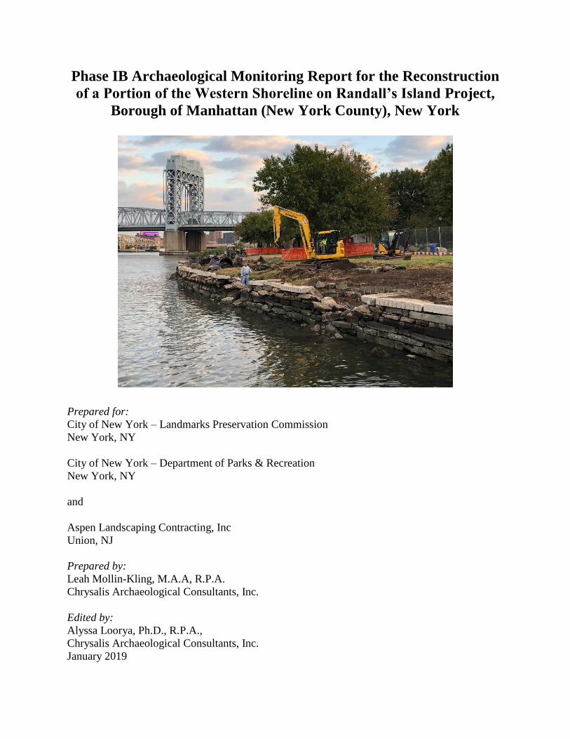
I. INTRODUCTION
On October 22 and 23, 2018, Chrysalis Archaeological Consultants, Inc. (Chrysalis) conducted
Phase IB archaeological monitoring within the APE for the Reconstruction of a Portion of the
Western Wall on Randall’s Island Project (the Project). The construction project is being
conducted by Aspen for the City of New York – Department of Parks & Recreation (Parks).
Randall’s Island is located in the East River with Manhattan’s East Harlem neighborhood to the
west, the Astoria-Ditmars neighborhood of Queens to the east, and the Port Morris neighborhood
of the Bronx to the north (Map 01). The Harlem River, a tidal strait connecting the Hudson and
East Rivers, runs west of the Island and is the body of water adjacent to the project area.
The APE is a thin, 150-foot long band extending north from the “point of beginning” (POB)
present on project engineering plans (Map 02). The zone of archaeological sensitivity within the
overall APE was determined based upon two previous Phase IA Archaeological Documentary
Studies (HPI 2012 and Bergoffen 2001), both of which outlined the potential for a portion of the
western shoreline to include historic cultural material and/or human skeletal remains.
Three areas were identified within the APE that would be impacted by construction plans and
required archaeological monitoring along the western shoreline of Randall’s Island: seawall
reconstruction on a promontory adjacent to the floating dock and the construction of two tidal
pools.
Phase IB archaeological monitoring was employed to determine whether the project area
contained significant (i.e. National Register eligible) cultural resources. As per the approved
Archaeological Work Plan Chrysalis would document any resources identified during the
investigation and, in the event of discovery, assess significance and recommend mitigation
strategies as appropriate.
No significant cultural resources were encountered during monitoring. However, based upon the
presence of intact substrata and disarticulated building stones and bricks found in the Tidal
Pools, any future construction plans within the APE should be subject to archaeological
monitoring, at a minimum.
This report presents the results of the archaeological field work. Section II describes the
methodology utilized by Chrysalis. Section III discusses the fieldwork itself and includes
examples of stratigraphic profiles and pictures of ground conditions. Section IV provides a
summary and offers conclusions and recommendations. Section V lists the references used in this
report. Appendix A: Additional Images includes extra photographs. Appendix B: Resumes
contains employment and experience records for Chrysalis staff involved in the Project.
All work was conducted in accordance with the National Historic Preservation Act of 1966, as
amended; the Advisory Council on Historic Preservation’s “Protection of Historic and Cultural
Properties” (36 CFR 800); the New York Archaeological Council’s (NYAC) guidelines (NYAC
1994, 2000, 2002); and NYC LPC guidelines (LPC 2018). All cultural resource specialists
satisfy the qualifications specified in 36 CFR 61, Appendix A.

2
Leah Mollin-Kling, M.A., R.P.A., served as Principal Investigator for this project. The report
was edited by Alyssa Loorya, Ph.D., R.P.A.
Map 01: Central Park NY-NJ 7.5-minute Topo (United States Geological Survey 2016).

3
Map 02: Project Area, with detail of Area of Potential Effect as defined by NYC Parks.

4
II. METHODOLOGY
Archaeological Monitoring occurred within the APE along the western shoreline area as outlined
in the NYC LPC approved Phase IA report (HPI 2012) and in the Scope of Work (SOW) issued
by NYC Parks (Map 02). The archaeologist was on site until the final construction depths were
reached in all archaeologically sensitive areas.
All monitoring activities were compliant with NYC LPC’s Guidelines for Archaeological Work
in New York City (LPC 2018) and NYAC’s Guidelines for the Use of Archaeological
Monitoring (NYAC 2002).
All subsurface measurements are tied to the North American Vertical Datum of 1988 (NAVD
88).
Chrysalis staff maintained field drawings, photographs, and descriptions of the soils encountered,
and field conditions. An up-to date log of all monitoring activities was kept, including the date,
time, and duration of all episodes and an accompanying description of the activity being
monitored.
III. PHASE IB MONITORING RESULTS
Chrysalis monitored project reconstruction efforts in the archaeologically sensitive zone on
October 22 and 23, 2018. Project tasks included the reconstruction of terrace walls and the
restoration of shore line rocks in a promontory adjacent to the floating dock and the construction
of two tidal pool areas along the western shore of Randall’s Island (Map 03).
Project plans called for limited subsurface disturbances during the construction of terraces and
seawall restoration. As per the approved Phase IB Archaeological Work Plan, no subsurface
disturbances in the APE by mechanical means (i.e. backhoe) could occur at depths greater than
4”. This condition was observed by the construction crew.
Terracing for seawall restoration and tidal pool construction occurred in areas previously
disturbed, either by the original seawall construction or by water action and erosion.
Stratigraphic information in the tidal pool areas indicated a high level of subsurface disturbance
in the APE, although a pocket of intact substrata was observed in the Tidal Pool 2 location.
Based upon HPI’s Phase IA historic map review (HPI 2012), it was concluded that there is a
potential, albeit low, for the APE to contain the remains of several mid- to late-nineteenth and
early-twentieth century buildings (Chrysalis 2018). Human remains were also deemed potential
as historic records indicate that several potter’s fields existed on the island in the nineteenth
century, although their exact locations are unknown. However, the Triborough Bridge (now the
Robert F. Kennedy Bridge) construction in the 1920s and 30s impacted the project area, making
intact or in situ cultural resources less likely to be encountered. This fact, coupled with the
shallow maximum excavation depth in the APE, led Chrysalis to determine that project plans had
a low potential to encounter significant cultural resources (Chrysalis 2018).

5
Map 03: Archaeological field map of project area.

6
No significant cultural resources or human remains were observed during archaeological
monitoring.
Seawall Reconstruction Area
Archaeological monitoring of project excavation on Randall’s Island began on Monday, October
22, 2018 for seawall reconstruction in a promontory adjacent to the floating dock, beginning at
station 23+49, just north of the “point of beginning” (POB) at station 23+00 (Image 01) (Map
03). While subsurface excavation of area soils did occur, seawall reconstruction largely involved
disturbances within its existing footprint.
Image 01: Excavation in progress of seawall reconstruction area (looking west).
The terrain in the seawall reconstruction area is open and grassy with a maple tree near the
promontory’s edge (Image 02). A stone seawall surrounds the promontory on its western and
southern edges. The stones are a mixture of large 7’x2.5’x1’ cut metamorphic stones and semi-
rounded and smaller more natural looking stones. Project excavation work in this area featured
minimal subsurface disturbances as the bulk of the work involved the removal and replacement
of disarticulated seawall stones. Some of the project work involved the removal of disarticulated
seawall stones directly from the river. No damming was needed in this area as the existing
seawall provided enough of a boundary against the river.

7
Using a small hydraulic excavator, construction crew repositioned existing stones that had fallen
out of place by water action to recreate the seawall. Some of the stones were placed along a
series of terraces created by the excavator (Image 03). The terracing utilized the existing slope
along the embankment, minimizing the level of subsurface disturbance (Image 04). For the most
part, the soil horizon impacted by project plans was redeposited A/topsoil (Table 01). Modern
trash, including plastic wrap, was observed in this area.
Image 02: Terrain of seawall reconstruction area (looking southwest).

8
Image 03: Seawall terracing construction and stone relocation (looking north).
Image 04: Seawall reconstruction and terracing (looking northwest).

9
Table 01: Stratigraphic profile - Seawall Reconstruction Area.
STRATUM DEPTH MUNSELL DESCRIPTION
Redeposited A
soils
12’-11.2’
NAVD88
(0–.8’bgs)
10YR 3/2 Fine sandy silt with modern trash (not saved)
Along the southern edge of the seawall reconstruction area and approximately 8’ southwest of an
adjacent maple tree, a collection of broken and disarticulated concrete slabs were discovered
during terracing (Image 05). The concrete slabs are relatively crude and featured large
inclusions. Given the position of the slabs, they were probably placed here at some point to help
protect the shore from destructive water action. The slabs were recorded and photographed, but
no further action was taken. The slabs remain in situ.
Image 05: Disarticulated concrete slabs underneath slope, seawall reconstruction area (looking
north)

10
Image 06: Seawall reconstruction area, post construction (looking east).
After terracing, eco-friendly materials were used in the construction of the new seawall. No
further subsurface activities are planned for this area (Image 06). No significant cultural
resources or intact stratigraphy were encountered during seawall reconstruction.
Tidal Pools 1 and 2
Two tidal pools were constructed at locations of seawall erosion along the western shoreline of
Randall’s Island in the APE and heading north from the POB. The Tidal Pool areas were placed
in locations previously disturbed by water action prior to the commencement of project plans
(Image 07). The seawalls were partially destroyed in the two locations, allowing the erosion of
adjacent banks. In order to decrease the level of erosion and to create the tidal pools, construction
methodology followed that of the seawall reconstruction and featured the repositioning of fallen
seawall stones, terracing via excavator, and the use of “green” materials.
11
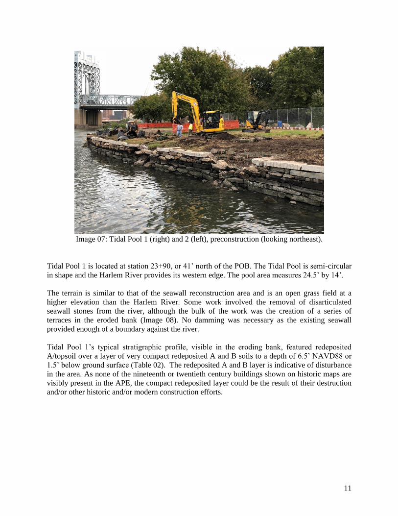
Image 07: Tidal Pool 1 (right) and 2 (left), preconstruction (looking northeast).
Tidal Pool 1 is located at station 23+90, or 41’ north of the POB. The Tidal Pool is semi-circular
in shape and the Harlem River provides its western edge. The pool area measures 24.5’ by 14’.
The terrain is similar to that of the seawall reconstruction area and is an open grass field at a
higher elevation than the Harlem River. Some work involved the removal of disarticulated
seawall stones from the river, although the bulk of the work was the creation of a series of
terraces in the eroded bank (Image 08). No damming was necessary as the existing seawall
provided enough of a boundary against the river.
Tidal Pool 1’s typical stratigraphic profile, visible in the eroding bank, featured redeposited
A/topsoil over a layer of very compact redeposited A and B soils to a depth of 6.5’ NAVD88 or
1.5’ below ground surface (Table 02). The redeposited A and B layer is indicative of disturbance
in the area. As none of the nineteenth or twentieth century buildings shown on historic maps are
visibly present in the APE, the compact redeposited layer could be the result of their destruction
and/or other historic and/or modern construction efforts.

12
Table 02: Stratigraphic profile - Tidal Pool 1.
STRATUM DEPTH MUNSELL DESCRIPTION
Redeposited A
soils 8.0-7.2’
NAVD88
(0–
0.8’bgs)
10YR 3/2 Fine sandy silt with modern trash (not saved)
Redeposited A
and B soils
7.2-6.5’
NAVD88
(0.8–1.5’
bgs)
10YR 4/6 mottled with
7.5YR 4/4
Medium sand trace silt with cobbles
Image 08: Excavation of Tidal Pool 1 (looking north).
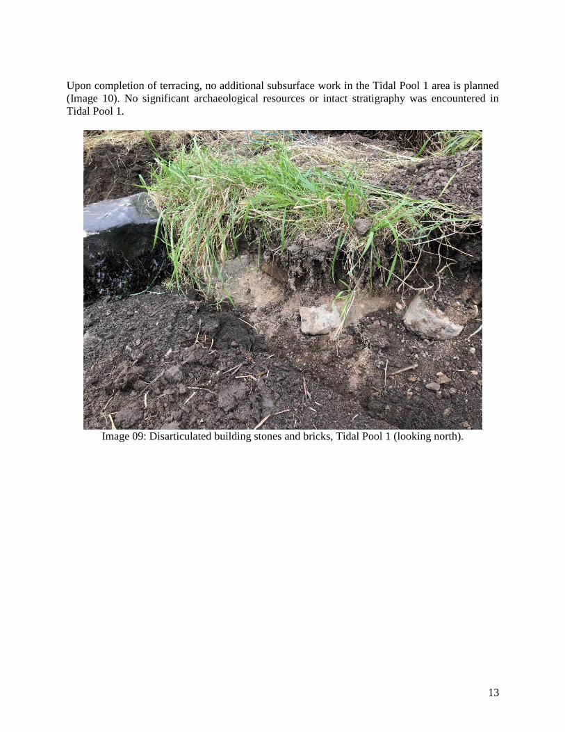
A series of disarticulated building stones and bricks were uncovered approximately 14’ north of
the southeastern edge of the tidal pool footprint and within the redeposited A and B layer (Image
09). The stones and bricks were recorded and photographed. No further impact to this particular
area was required by project plans and the stones and bricks were left in situ. The stones and
bricks are not considered significant cultural resources as they were not articulated and were
within obvious fill or redeposited subsoil. None of the bricks included maker’s marks and thus
could not be dated. However, they may indicate that buildings once stood in the area, possibly
the nineteenth or twentieth century buildings found on historic maps. It is also possible that the
materials were redeposited on Randall’s Island from a different location. However, at present
there is no known record of materials having been brought in from an off-island source.
13
Upon completion of terracing, no additional subsurface work in the Tidal Pool 1 area is planned
(Image 10). No significant archaeological resources or intact stratigraphy was encountered in
Tidal Pool 1.
Image 09: Disarticulated building stones and bricks, Tidal Pool 1 (looking north).
14
Image 10: Tidal Pool 1, postconstruction (looking north).
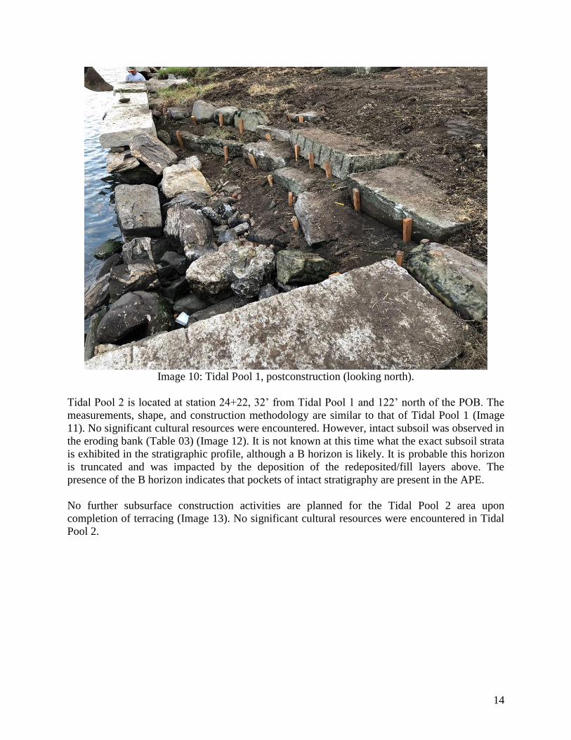
Tidal Pool 2 is located at station 24+22, 32’ from Tidal Pool 1 and 122’ north of the POB. The
measurements, shape, and construction methodology are similar to that of Tidal Pool 1 (Image
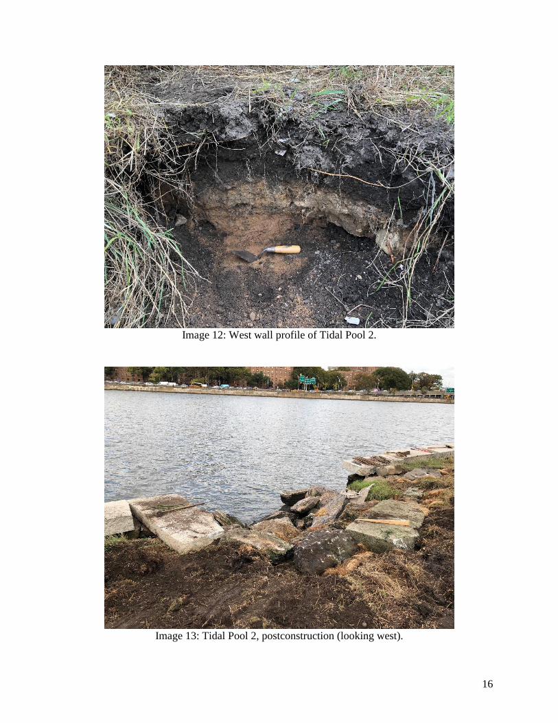
11). No significant cultural resources were encountered. However, intact subsoil was observed in
the eroding bank (Table 03) (Image 12). It is not known at this time what the exact subsoil strata
is exhibited in the stratigraphic profile, although a B horizon is likely. It is probable this horizon
is truncated and was impacted by the deposition of the redeposited/fill layers above. The
presence of the B horizon indicates that pockets of intact stratigraphy are present in the APE.
No further subsurface construction activities are planned for the Tidal Pool 2 area upon
completion of terracing (Image 13). No significant cultural resources were encountered in Tidal
Pool 2.

15
Image 11: Tidal Pool 2, preconstruction (looking south).
Table 03: Stratigraphic profile - Tidal Pool 2.
STRATUM DEPTH MUNSELL DESCRIPTION
Redeposited A
soils
8.0-7.2’
NAVD88
(0–0.8’
bgs)
10YR 3/2 Fine sandy silt with modern trash (not saved)
Redeposited A
and B soils
7.2-6.75’
NAVD88
(0.8–1.25’
bgs)
10YR 4/6 mottled with
7.5YR 4/4
Medium sand trace silt with cobbles
Indeterminate B 6.75-6.3’
NAVD88
(1.25’–1.7’
bgs)
7.5YR 4/4 Medium sand
16
Image 12: West wall profile of Tidal Pool 2.
Image 13: Tidal Pool 2, postconstruction (looking west).
17
IV. SUMMARY AND RECOMMENDATIONS
Chrysalis conducted Phase IB archaeological monitoring on October 22 and 23, 2018 for the
Reconstruction of Portions of the Western Shoreline on Randall’s Island Project on behalf of the
City of New York – Department of Parks & Recreation.
Phase IB monitoring attempted to determine whether construction sites within the APE contained
significant cultural resources and/or human remains.
Three areas were monitored: seawall reconstruction on a promontory adjacent to the POB and
floating dock and two tidal pools (1 and 2). No significant cultural resources or human remains
were encountered during monitoring of any of the three areas.
However, disarticulated building materials in Tidal Pool 1 and intact subsoil in Tidal Pool 2
increase the possibility that potentially significant cultural resources could still exist in the APE
at greater depths. Thus, any future work involving subsurface disturbances greater that 4” bgs in
the APE should require archaeological monitoring, at a minimum.

18
IV. REFERENCES
Bergoffen, Celia J.
2001 Phase IA Archaeological Assessment Report - Triborough Bridge and Tunnel
Authority Triborough Bridge Rehabilitation Project, Randall’s and Ward’s
Islands,
Manhattan. Report on file with the City of New York – Landmarks Preservation
Commission. New York, New York.
City of New York – Landmarks Preservation Commission.
2014 Response to Phase IA Report. Letter on file with the City of New York –
Landmarks Preservation Commission. New York, New York.
2018 Guidelines for Archaeological Work in New York City. Report on file with the
City of New York – Landmarks Preservation Commission. New York, New
York.
Historical Perspectives, Inc.
2012 Phase IA Archaeological Documentary Study – Randall’s Island Living Shoreline
Recreation Area Part of Block 1819, Lot 203 Randall’s Island, New York County,
New York. Report on file with the City of New York – Landmarks Preservation
Commission. New York, New York.
New York Archaeological Council.
1994 Standards for Cultural Resource Investigations and the Curation of
Archaeological Collections in New York State. Report on file with the New
York State Office of Parks, Recreation and Historic Preservation. Albany, New
York.
2000 Cultural Resource Standards Handbook: Guidance for Understanding and
Applying the New York Standards for Cultural Resource Investigations. Report
on file with the New York State Office of Parks, Recreation and Historic
Preservation. Albany, New York.
2002 Guidelines for the Use of Archaeological Monitoring as an Alternative to Other
Field Techniques. Report on file with the New York State Office of Parks,
Recreation and Historic Preservation. Albany, New York
United States – Geological Survey.
2016 USGS US Topo 7.5-minute map for Central Park, NY-NJ 2016: USGS - National
Geospatial Technical Operations Center (NGTOC).