phase 1b underwater archaeological report for the … · design the distribution of sites in the...
TRANSCRIPT
FINAL
Phase IB Underwater Archaeological Resources Report for Onondaga Lake Superfund Site
86
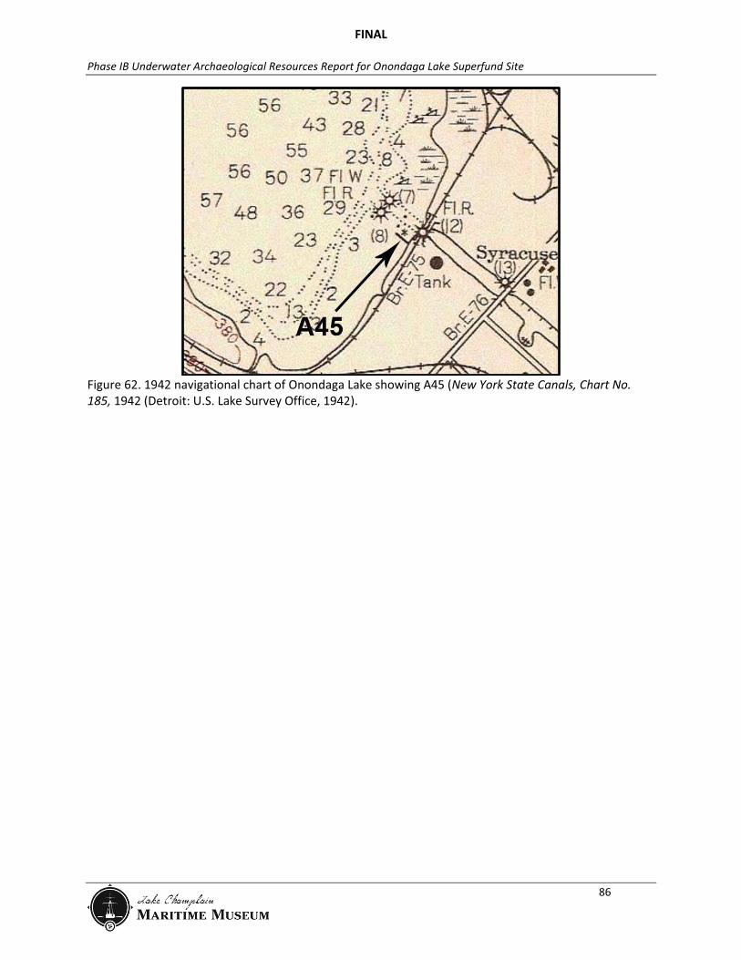
Figure 62. 1942 navigational chart of Onondaga Lake showing A45 (New York State Canals, Chart No. 185, 1942 (Detroit: U.S. Lake Survey Office, 1942).
FINAL
Phase IB Underwater Archaeological Resources Report for Onondaga Lake Superfund Site
87
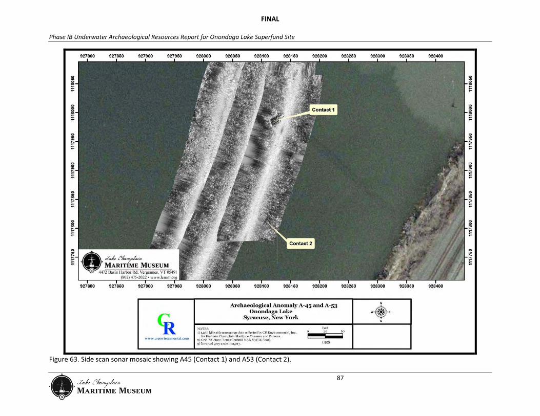
Figure 63. Side scan sonar mosaic showing A45 (Contact 1) and A53 (Contact 2).
FINAL
Phase IB Underwater Archaeological Resources Report for Onondaga Lake Superfund Site
88
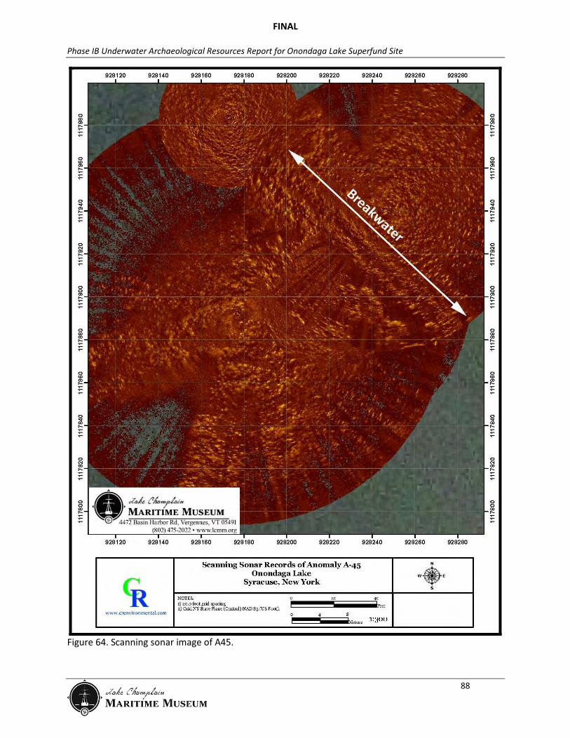
Figure 64. Scanning sonar image of A45.
FINAL
Phase IB Underwater Archaeological Resources Report for Onondaga Lake Superfund Site
89
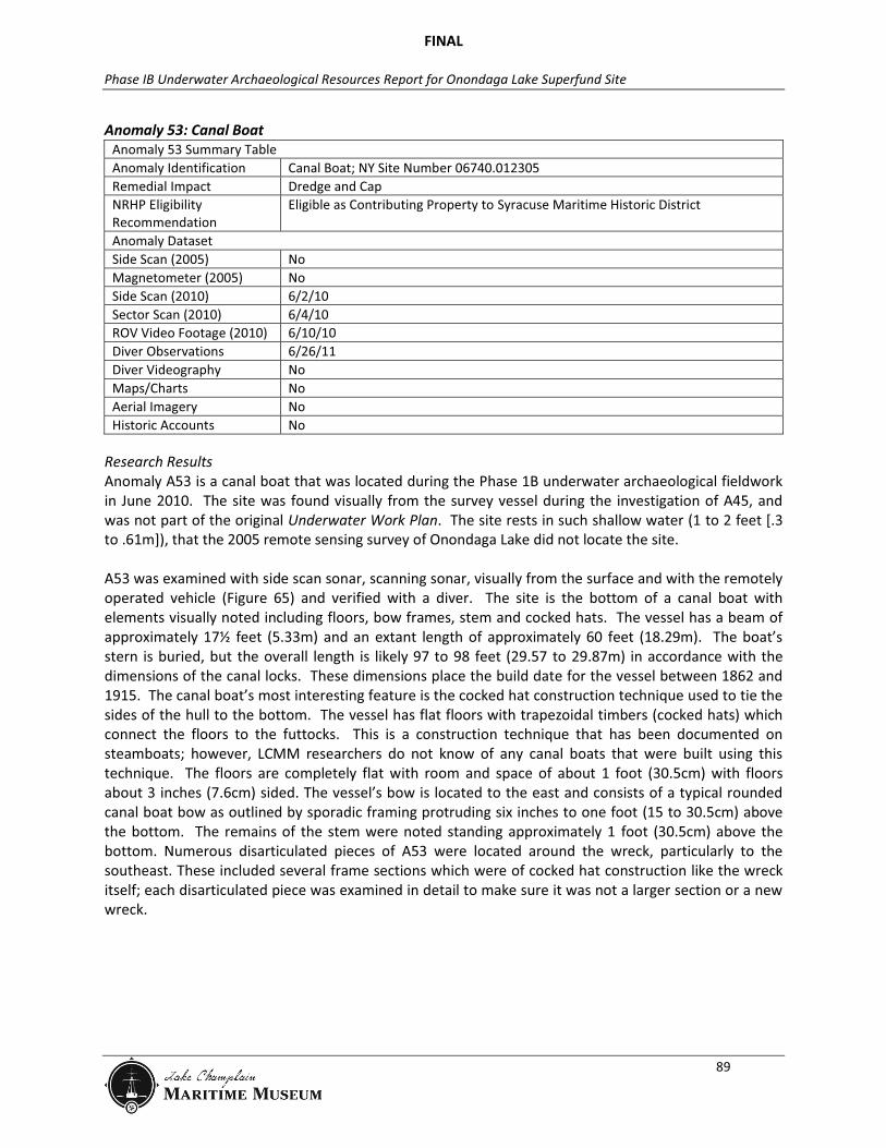
Anomaly 53: Canal Boat Anomaly 53 Summary Table Anomaly Identification Canal Boat; NY Site Number 06740.012305 Remedial Impact Dredge and Cap NRHP Eligibility Recommendation
Eligible as Contributing Property to Syracuse Maritime Historic District
Anomaly Dataset Side Scan (2005) No Magnetometer (2005) No Side Scan (2010) 6/2/10 Sector Scan (2010) 6/4/10 ROV Video Footage (2010) 6/10/10 Diver Observations 6/26/11 Diver Videography No Maps/Charts No Aerial Imagery No Historic Accounts No
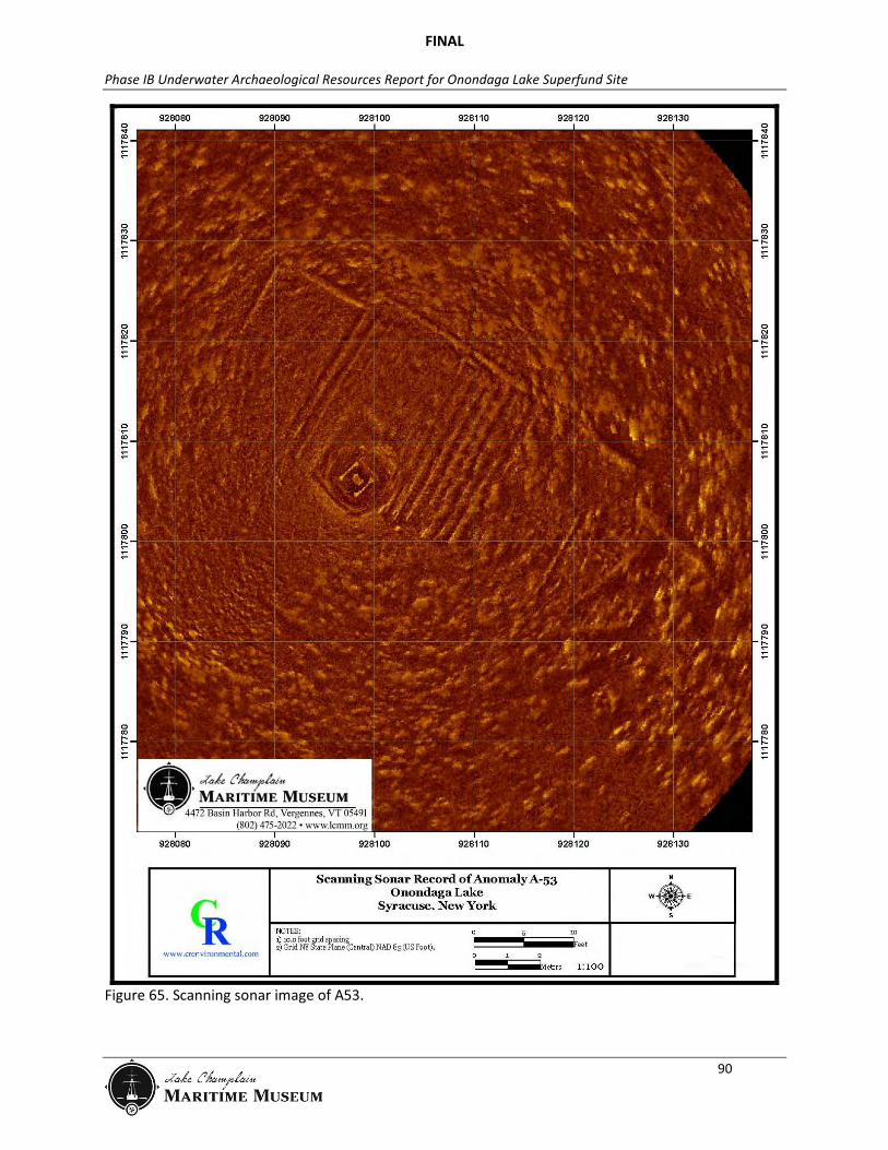
Research Results Anomaly A53 is a canal boat that was located during the Phase 1B underwater archaeological fieldwork in June 2010. The site was found visually from the survey vessel during the investigation of A45, and was not part of the original Underwater Work Plan. The site rests in such shallow water (1 to 2 feet [.3 to .61m]), that the 2005 remote sensing survey of Onondaga Lake did not locate the site. A53 was examined with side scan sonar, scanning sonar, visually from the surface and with the remotely operated vehicle (Figure 65) and verified with a diver. The site is the bottom of a canal boat with elements visually noted including floors, bow frames, stem and cocked hats. The vessel has a beam of approximately 17½ feet (5.33m) and an extant length of approximately 60 feet (18.29m). The boat’s stern is buried, but the overall length is likely 97 to 98 feet (29.57 to 29.87m) in accordance with the dimensions of the canal locks. These dimensions place the build date for the vessel between 1862 and 1915. The canal boat’s most interesting feature is the cocked hat construction technique used to tie the sides of the hull to the bottom. The vessel has flat floors with trapezoidal timbers (cocked hats) which connect the floors to the futtocks. This is a construction technique that has been documented on steamboats; however, LCMM researchers do not know of any canal boats that were built using this technique. The floors are completely flat with room and space of about 1 foot (30.5cm) with floors about 3 inches (7.6cm) sided. The vessel’s bow is located to the east and consists of a typical rounded canal boat bow as outlined by sporadic framing protruding six inches to one foot (15 to 30.5cm) above the bottom. The remains of the stem were noted standing approximately 1 foot (30.5cm) above the bottom. Numerous disarticulated pieces of A53 were located around the wreck, particularly to the southeast. These included several frame sections which were of cocked hat construction like the wreck itself; each disarticulated piece was examined in detail to make sure it was not a larger section or a new wreck.
FINAL
Phase IB Underwater Archaeological Resources Report for Onondaga Lake Superfund Site
90
Figure 65. Scanning sonar image of A53.
FINAL
Phase IB Underwater Archaeological Resources Report for Onondaga Lake Superfund Site
91
Anomaly 55: Canal Scow Anomaly 55 Summary Table Anomaly Identification Canal Scow; NY Site Number 06740.012306 Remedial Impact Dredge and Cap NRHP Eligibility Recommendation
Eligible as Contributing Property to Syracuse Maritime Historic District
Anomaly Dataset Side Scan (2005) No Magnetometer (2005) 781, 747, 780, 779, 745, 778, 761 Side Scan (2010) Na Sector Scan (2010) Na ROV Video Footage (2010) Na Diver Observations Yes Diver Videography Yes Maps/Charts No Aerial Imagery No Historic Accounts No
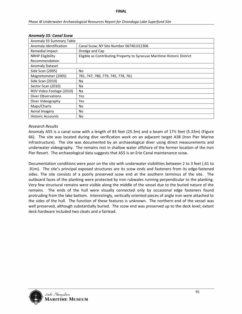
Research Results Anomaly A55 is a canal scow with a length of 83 feet (25.3m) and a beam of 17½ feet (5.33m) (Figure 66). The site was located during dive verification work on an adjacent target A38 (Iron Pier Marine Infrastructure). The site was documented by an archaeological diver using direct measurements and underwater videography. The remains rest in shallow water offshore of the former location of the Iron Pier Resort. The archaeological data suggests that A55 is an Erie Canal maintenance scow. Documentation conditions were poor on the site with underwater visibilities between 2 to 3 feet (.61 to .91m). The site’s principal exposed structures are its scow ends and fasteners from its edge-fastened sides. The site consists of a poorly preserved scow end at the southern terminus of the site. The outboard faces of the planking were protected by iron rubwales running perpendicular to the planking. Very few structural remains were visible along the middle of the vessel due to the buried nature of the remains. The ends of the hull were visually connected only by occasional edge fasteners found protruding from the lake bottom. Interestingly, vertically oriented pieces of angle iron were attached to the sides of the hull. The function of these features is unknown. The northern end of the vessel was well preserved, although substantially buried. The scow end was preserved up to the deck level; extant deck hardware included two cleats and a fairlead.

FINAL
Phase IB Underwater Archaeological Resources Report for Onondaga Lake Superfund Site
92
Figure 66. Plan view drawing of A55, a canal scow (Adam Kane, LCMM Collection).
Cleat
Rubwale Fairlead
Edge Fasteners
Angle Iron
FINAL
Phase IB Underwater Archaeological Resources Report for Onondaga Lake Superfund Site
93
Anomaly 72: Wood Pilings Anomaly 72 Summary Table Anomaly Identification Wood Pilings; NY Site Number 06740.012310 Remedial Impact Dredge and Cap NRHP Eligibility Recommendation
Eligible as Contributing Property to Syracuse Maritime Historic District
Anomaly Dataset Side Scan (2005) No Magnetometer (2005) No Side Scan (2010) No Sector Scan (2010) No ROV (2010) No Diver Observations 6/25/11 Diver Videography No Maps/Charts No Aerial Imagery No Historic Accounts No
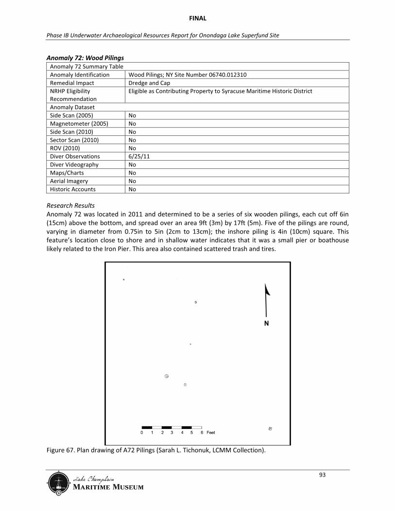
Research Results Anomaly 72 was located in 2011 and determined to be a series of six wooden pilings, each cut off 6in (15cm) above the bottom, and spread over an area 9ft (3m) by 17ft (5m). Five of the pilings are round, varying in diameter from 0.75in to 5in (2cm to 13cm); the inshore piling is 4in (10cm) square. This feature’s location close to shore and in shallow water indicates that it was a small pier or boathouse likely related to the Iron Pier. This area also contained scattered trash and tires.
Figure 67. Plan drawing of A72 Pilings (Sarah L. Tichonuk, LCMM Collection).
FINAL
Phase IB Underwater Archaeological Resources Report for Onondaga Lake Superfund Site
94
Anomaly 73: Bulkhead Anomaly 73 Summary Table Anomaly Identification Bulkhead; NY Site Number 06740.012307 Remedial Impact Dredge and Cap NRHP Eligibility Recommendation
Eligible as Contributing Property to Syracuse Maritime Historic District
Anomaly Dataset Side Scan (2005) No Magnetometer (2005) No Side Scan (2010) No Sector Scan (2010) No ROV (2010) No Diver Observations 6/25/11 Diver Videography No Maps/Charts No Aerial Imagery No Historic Accounts No
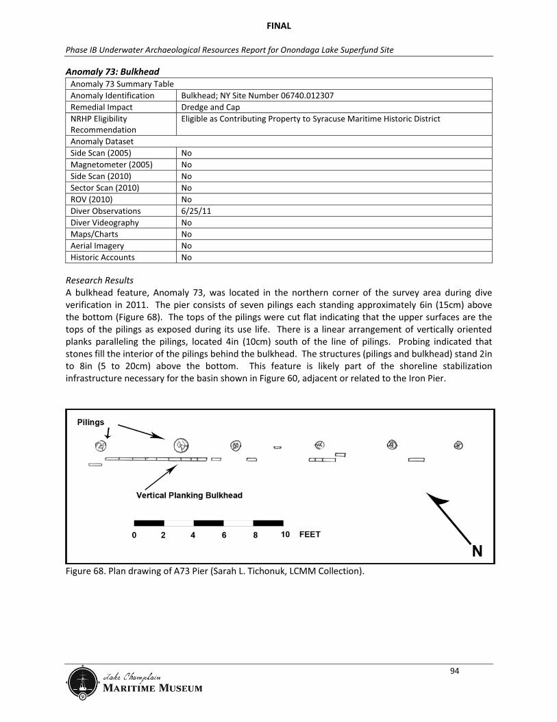
Research Results A bulkhead feature, Anomaly 73, was located in the northern corner of the survey area during dive verification in 2011. The pier consists of seven pilings each standing approximately 6in (15cm) above the bottom (Figure 68). The tops of the pilings were cut flat indicating that the upper surfaces are the tops of the pilings as exposed during its use life. There is a linear arrangement of vertically oriented planks paralleling the pilings, located 4in (10cm) south of the line of pilings. Probing indicated that stones fill the interior of the pilings behind the bulkhead. The structures (pilings and bulkhead) stand 2in to 8in (5 to 20cm) above the bottom. This feature is likely part of the shoreline stabilization infrastructure necessary for the basin shown in Figure 60, adjacent or related to the Iron Pier.
Figure 68. Plan drawing of A73 Pier (Sarah L. Tichonuk, LCMM Collection).
FINAL
Phase IB Underwater Archaeological Resources Report for Onondaga Lake Superfund Site
95
Anomaly 75: Rock Pile Anomaly 75 Summary Table Anomaly Identification Rock Pile; NY Site Number 06740.012308 Remedial Impact Dredge and Cap NRHP Eligibility Recommendation
Eligible as Contributing Property to Syracuse Maritime Historic District
Anomaly Dataset Side Scan (2005) No Magnetometer (2005) No Side Scan (2010) No Sector Scan (2010) No ROV (2010) No Diver Observations 6/26/11 Diver Videography No Maps/Charts No Aerial Imagery No Historic Accounts No
Research Results Anomaly 75 was located by a diver in 2011 and determined to be a pile of limestone rocks (rock size approximately 10in [25cm]) one layer deep; the pile is approximately 10ft (3m) long. No evidence of underlying wooden structure was noted.
FINAL
Phase IB Underwater Archaeological Resources Report for Onondaga Lake Superfund Site
96
Anomaly 76: Rock Pile Anomaly 76 Summary Table Anomaly Identification Rock Pile; NY Site Number 06740.012309 Remedial Impact Dredge and Cap NRHP Eligibility Recommendation
Eligible as Contributing Property to Syracuse Maritime Historic District
Anomaly Dataset Side Scan (2005) No Magnetometer (2005) No Side Scan (2010) No Sector Scan (2010) No ROV (2010) No Diver Observations 6/27/11 Diver Videography No Maps/Charts No Aerial Imagery No Historic Accounts No
Research Results Anomaly 76 was located by a diver in 2011 and determined to be a pile of small (8in [20cm] typical diameter) limestone rocks 41ft (12.5m) long by 24ft (7.3m) wide. The diver could not probe through the pile suggesting it is deeper than one layer. The pile stands approximately 12in (30cm) above the lake bottom. No evidence of underlying wooden structure was noted. One isolated piling was found near A76, although it is not clearly associated with the rock pile. The piling is a single square timber angled from the bottom, about 10in (25cm) square. This area has a high density of woody debris, tires and trash.

FINAL
Phase IB Underwater Archaeological Resources Report for Onondaga Lake Superfund Site
97
Syracuse Maritime Historic District Significance Evaluation National Register Evaluation Integrity of:
Location The Syracuse Maritime Historic District remains at its original location, thus LCMM recommends it retains integrity of location.
Design The distribution of sites in the District lacks purposeful design. However, the individual contributing properties retain design elements such as spatial organization, technology and materials that are reflective of the builders’ original activities. LCMM recommends that the Syracuse Maritime Historic District retains integrity of design.
Setting In the 80 years since boat disposal activities began at the site, the surrounding area retains a similar wetland/backwater setting which was one component of its formation. Additionally, the entrance to the adjacent Syracuse Inner Harbor and the Salina Pier and Iron Pier in-water remnants, both of which were causal factors in the district’s formation, remain in place. LCMM recommends that the Syracuse Maritime Historic District retains integrity of setting.
Materials Significant portions of the sites in the Syracuse Maritime Historic District are buried beneath the lake bed. Although this makes the assessment of the configuration of those materials difficult, if not impossible, it is safe to conclude that those materials remain intact. Moreover, those buried materials will be in a better state of preservation than those exposed above the lakebed. The fabric of the barges can reveal the boatbuilders’ construction preferences and (potentially) regional boat building traditions. LCMM recommends that the Syracuse Maritime Historic District retains integrity of materials.
Workmanship The sites in the proposed district have significant potential to yield information about the boatbuilders’ skill and techniques. LCMM recommends that the Syracuse Maritime Historic District retains integrity of workmanship.
Feeling The District’s feeling, or combination of its features with its setting, is conveyed by the sites which remain exposed above the lake’s surface (A3, A4-1, A7 and A12) and the undeveloped shoreline. The district also has a similar veiwshed to that of 50 to 80 years ago. LCMM recommends that the Syracuse Maritime Historic District retains integrity of feeling.
Association The contributing properties are sufficiently intact to convey to an observer that this is the area of the lake where boat disposal activities occurred. LCMM recommends that the Syracuse Maritime Historic District retains integrity of association.
Criterion: A: Event The Syracuse Maritime Historic District has a clear association with a pattern of events comprising the commercial use of the New York State Barge Canal. Areas of significance include commerce (all), transportation (all), engineering (dump scows A4-1 and A4-2), and government (canal scow A55). LCMM recommends that the Syracuse Maritime Historic District is eligible under Criterion A.
B: Person No known individually significant persons are associated with the Syracuse Maritime Historic District. LCMM recommends that the Syracuse Maritime Historic District is ineligible under Criterion B.
FINAL
Phase IB Underwater Archaeological Resources Report for Onondaga Lake Superfund Site
98
C: Design/ Construction
The properties in the Syracuse Maritime Historic District represent a significant and distinguishable entity with features that both lack individual distinction and individually distinctive features. Contributing properties A3, A4-1, A7 and A12 because of their partial exposure serve as focal points for the district. They embody the distinctive characteristics of twentieth century barge construction (which include edge-fastening construction and longitudinal bulkheads); and marine infrastructure. LCMM recommends that the Syracuse Maritime Historic District is eligible under Criterion C.
D: Information Potential
The sites in the Syracuse Maritime Historic District are likely to yield information about early twentieth century boatbuilding techniques and their operational history. The contributing properties are each likely to answer specific research questions that are not addressed in the archival record. What are the structural and mechanical requirements for wooden dump scows (A 3, A4-1 and A4-2)? What does the scatter of artifacts presumed to existing in proximity to Salina Pier and Iron Pier reveal about their use? What are the design and engineering considerations for the construction of spud holders (A12)? LCMM recommends that the Syracuse Maritime Historic District is eligible under Criterion D.
Recommendations LCMM’s analysis suggests that the Syracuse Maritime Historic District retains integrity and is eligible for the National Register of Historic Places under Criteria A, C and D. The remedial design for the area of the Syracuse Maritime Historic District calls for dredging and capping, which would potentially impact 14 sites. A3 and A76 lie outside of the remedial areas. As per the Section 106 process, LCMM recommends minimizing adverse effects to the above referenced archaeological sites. LCMM recommends dredging around each feature using a setback sufficient to not destabilize the feature. The historic property and setback would be capped consistent with surrounding area. Although the archaeological sites will be preserved in place with this proposed approach to the remedial design, adverse effects will not be eliminated. For any or all of the Syracuse Maritime Historic District properties, the proposed remedial approach may: remove through dredging related artifact collections associated with the uselife, disposal or decay of each property; adversely affect the sites’ structure through the deposition of capping material; and effectively limit the accessibly of the sites to future archaeological study.
Syracuse Maritime Historic District Data Recovery Based on the recommended remedial approach, LCMM recommends mitigating the adverse effects to the Syracuse Maritime Historic District through a data recovery effort on the exposed portions of selected sites. The contaminated nature of the sediments overlying the sites makes mitigation through further on-site data recovery from some of the sites impractical. The archaeological excavation of sites such as A55, A35, A4-2, and A38 where most of the remains are buried would require extensive excavation which could potentially disperse contaminants outside of the remediation areas, and expose researchers to potentially hazardous conditions.
FINAL
Phase IB Underwater Archaeological Resources Report for Onondaga Lake Superfund Site
99
Archaeological data recovery without any excavation is feasible and will yield potentially significant information from the exposed portions of A1/A2 (Salina Pier), A4-1 (Dump Scow), A53 (Canal Boat), A12 (Derrick Lighter Spud Barge) and A45 (Concrete breakwater). Photographic documentation of A7 (Pilings) will be implemented in accordance with the National Register of Historic Places Photo Policy (http://www.nps.gov/nr/publications/guidance/Photo_Policy_final.pdf) and will be sufficient to document this architectural feature. Anomalies A35 (unknown vessel type), A4-2 (dump scow), A38 (Iron Pier Marine Infrastructure), A55 (canal scow), and A73 (bulkhead) are largely buried, and have little research potential without significant excavation. Additionally, no further work is recommended for the three rock piles A34, A75, and A76 because they appear to lack intentional design and have limited research potential. Data recovery on A1/A2, A4-1, A12, A45, and A53 would include scale drawings and underwater video and photography. Because of the environmental concerns regarding archaeological excavation, only the exposed remains will be subject to data recovery.
FINAL
Phase IB Underwater Archaeological Resources Report for Onondaga Lake Superfund Site
100
RECOMMEND NO FURTHER WORK
Anomaly 5: Isolated Debris Anomaly 5 Summary Table Anomaly Identification Modern Isolated Debris Remedial Impact Dredge and Cap NRHP Eligibility Recommendation
Unevaluated
Anomaly Dataset Side Scan (2005) 2-6, 9-16 Magnetometer (2005) 625, 248, 678, 275 Side Scan (2010) 6/5/10 Sector Scan (2010) 6/7/10 ROV Video Footage (2010) 6/10/10 Diver Observations No Diver Videography No Maps/Charts No Aerial Imagery No Historic Accounts No
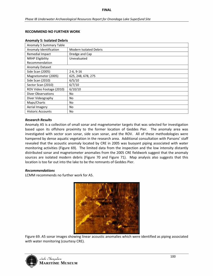
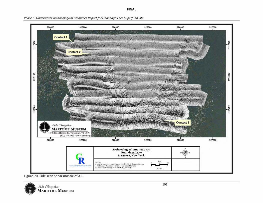
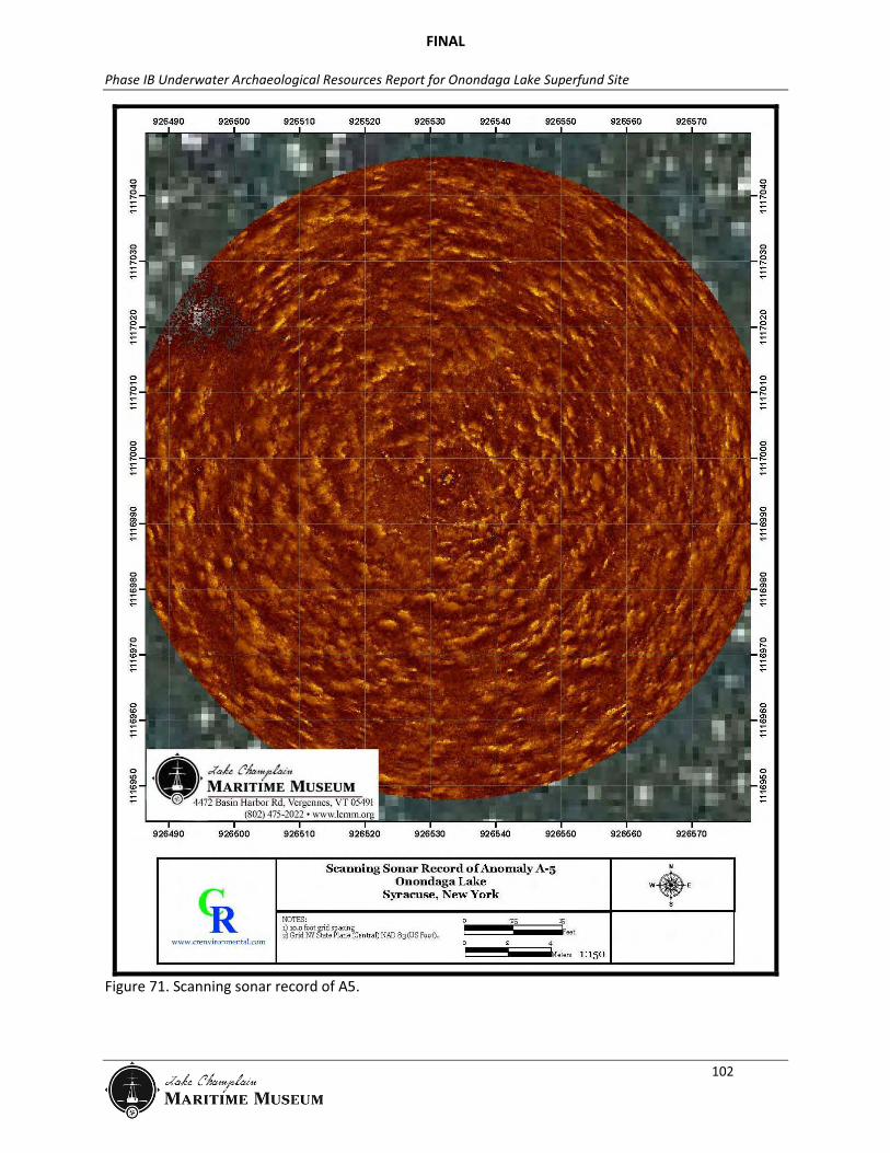
Research Results Anomaly A5 is a collection of small sonar and magnetometer targets that was selected for investigation based upon its offshore proximity to the former location of Geddes Pier. The anomaly area was investigated with sector scan sonar, side scan sonar, and the ROV. All of these methodologies were hampered by dense aquatic vegetation in the research area. Additional consultation with Parsons’ staff revealed that the acoustic anomaly located by CRE in 2005 was buoyant piping associated with water monitoring activities (Figure 69). The limited data from the inspection and the low intensity distantly distributed sonar and magnetometer anomalies from the 2005 CRE fieldwork suggest that the anomaly sources are isolated modern debris (Figure 70 and Figure 71). Map analysis also suggests that this location is too far out into the lake to be the remnants of Geddes Pier.
Recommendations LCMM recommends no further work for A5.
Figure 69. A5 sonar images showing linear acoustic anomalies which were identified as piping associated with water monitoring (courtesy CRE).
FINAL
Phase IB Underwater Archaeological Resources Report for Onondaga Lake Superfund Site
101
Figure 70. Side scan sonar mosaic of A5.
FINAL
Phase IB Underwater Archaeological Resources Report for Onondaga Lake Superfund Site
102
Figure 71. Scanning sonar record of A5.
FINAL
Phase IB Underwater Archaeological Resources Report for Onondaga Lake Superfund Site
103
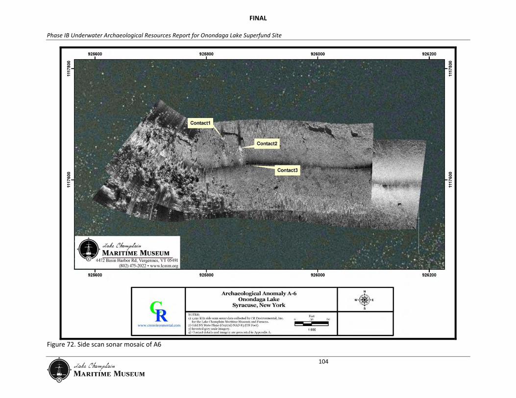
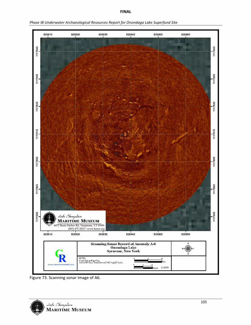
Anomaly 6: Solvay Waste Shelf Anomaly 6 Summary Table Anomaly Identification Solvay Waste Shelf Remedial Impact Dredge and Cap NRHP Eligibility Recommendation
Unevaluated
Anomaly Dataset Side Scan (2005) 30 Magnetometer (2005) 1256, 475 Side Scan (2010) 6/2/10 Sector Scan (2010) 6/6/10 ROV Video Footage (2010) 6/9/10 Diver Observations (2011) 6/21/11 Diver Videography No Maps/Charts No Aerial Imagery No Historic Accounts No
Research Results A6 is co-located with CRE’s 2005 digitized magnetic anomalies #475 and #1256 which were observed on parallel survey transects spaced 25ft (8m) apart at a depth of approximately 8ft (2m). The magnitude of these anomalies was approximately 10-15nT. Assuming a distance (range) of 7-16 ft (2-5 m), the ferrous mass of this anomaly might be 4.4 to 84lb (2 to 38kg). High resolution side scan sonar data collected in the vicinity of these anomalies in 2010 showed some isolated debris, but nothing characteristic of a cultural resource (Figure 72 and Figure 73). The ROV revealed the area to be flat bottomed with no vegetation and a layer of easily disturbed fine silt and green algae. The ROV did not locate the source of the anomaly. The area has dense aquatic vegetation with open areas of solvay waste. Diver verification in 2011, which included visual examination and metal detecting, did not locate any cultural material. The cumulative geophysical and observational data suggests that the original side scan anomaly was likely a result of the solvay waste shelf. The magnetic target is buried and remains unresolved, however, its low magnetic amplitude and limited spatial extent suggests that the target is the result of isolated ferrous debris rather than a larger, more complex archaeological property.
Recommendations LCMM recommends no further work for A6.
FINAL
Phase IB Underwater Archaeological Resources Report for Onondaga Lake Superfund Site
104
Figure 72. Side scan sonar mosaic of A6
FINAL
Phase IB Underwater Archaeological Resources Report for Onondaga Lake Superfund Site
105
Figure 73. Scanning sonar image of A6.
FINAL
Phase IB Underwater Archaeological Resources Report for Onondaga Lake Superfund Site
106
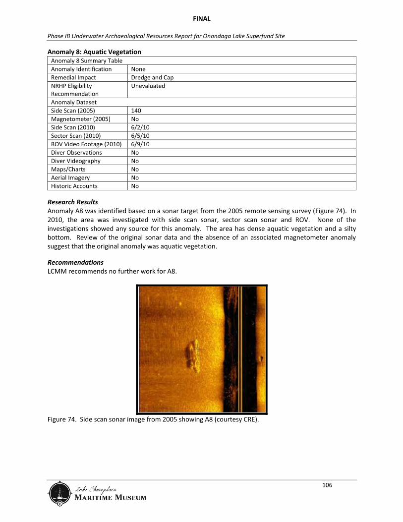
Anomaly 8: Aquatic Vegetation Anomaly 8 Summary Table Anomaly Identification None Remedial Impact Dredge and Cap NRHP Eligibility Recommendation
Unevaluated
Anomaly Dataset Side Scan (2005) 140 Magnetometer (2005) No Side Scan (2010) 6/2/10 Sector Scan (2010) 6/5/10 ROV Video Footage (2010) 6/9/10 Diver Observations No Diver Videography No Maps/Charts No Aerial Imagery No Historic Accounts No
Research Results Anomaly A8 was identified based on a sonar target from the 2005 remote sensing survey (Figure 74). In 2010, the area was investigated with side scan sonar, sector scan sonar and ROV. None of the investigations showed any source for this anomaly. The area has dense aquatic vegetation and a silty bottom. Review of the original sonar data and the absence of an associated magnetometer anomaly suggest that the original anomaly was aquatic vegetation.
Recommendations LCMM recommends no further work for A8.
Figure 74. Side scan sonar image from 2005 showing A8 (courtesy CRE).

FINAL
Phase IB Underwater Archaeological Resources Report for Onondaga Lake Superfund Site
107
Anomaly 9: Tree Branch Anomaly 9 Summary Table Anomaly Identification Tree Branch Remedial Impact Dredge and Cap NRHP Eligibility Recommendation
Unevaluated
Anomaly Dataset Side Scan (2005) 200 Magnetometer (2005) No Side Scan (2010) 6/2/10 Sector Scan (2010) 6/5/10 ROV Video Footage (2010) 6/9/10 Diver Observations No Diver Videography No Maps/Charts No Aerial Imagery No Historic Accounts No
Research Results Anomaly A9 was identified based on a sonar target from the 2005 remote sensing survey (Figure 75). In 2010, the area was investigated with side scan sonar, sector scan sonar and ROV. One tree branch with vegetation hung up on it was located. The area has a silty bottom with minimal vegetation. Review of the original sonar data and the absence of an associated magnetometer anomaly suggest that the original anomaly was this tree branch.
Recommendations LCMM recommends no further work for A9.
Figure 75. Sonar image from 2005 showing Anomaly 9 (courtesy CRE).
FINAL
Phase IB Underwater Archaeological Resources Report for Onondaga Lake Superfund Site
108
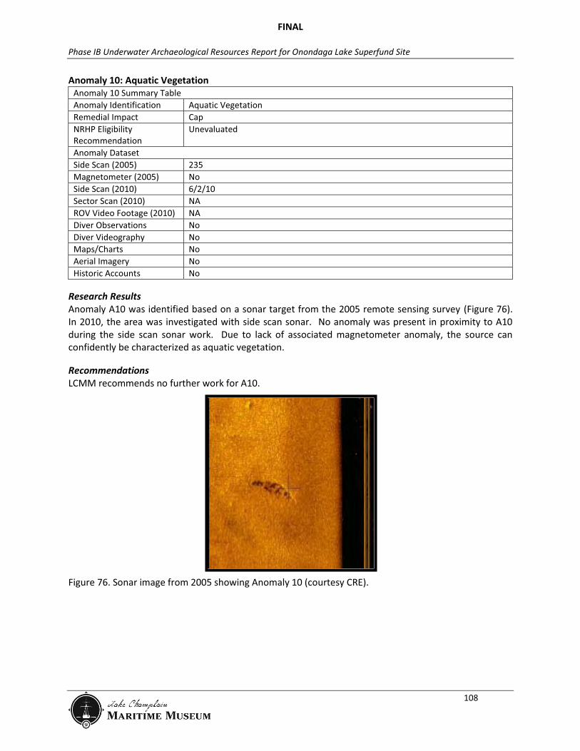
Anomaly 10: Aquatic Vegetation Anomaly 10 Summary Table Anomaly Identification Aquatic Vegetation Remedial Impact Cap NRHP Eligibility Recommendation
Unevaluated
Anomaly Dataset Side Scan (2005) 235 Magnetometer (2005) No Side Scan (2010) 6/2/10 Sector Scan (2010) NA ROV Video Footage (2010) NA Diver Observations No Diver Videography No Maps/Charts No Aerial Imagery No Historic Accounts No
Research Results Anomaly A10 was identified based on a sonar target from the 2005 remote sensing survey (Figure 76). In 2010, the area was investigated with side scan sonar. No anomaly was present in proximity to A10 during the side scan sonar work. Due to lack of associated magnetometer anomaly, the source can confidently be characterized as aquatic vegetation.
Recommendations LCMM recommends no further work for A10.
Figure 76. Sonar image from 2005 showing Anomaly 10 (courtesy CRE).
FINAL
Phase IB Underwater Archaeological Resources Report for Onondaga Lake Superfund Site
109
Anomaly 11: Pipes Anomaly 11 Summary Table Anomaly Identification Modern Pipes Remedial Impact Dredge and Cap NRHP Eligibility Recommendation
Unevaluated
Anomaly Dataset Side Scan (2005) 254 Magnetometer (2005) 776, 786 Side Scan (2010) 6/3/10 Sector Scan (2010) 6/7/10 ROV Video Footage (2010) NA Diver Observations 6/24/11 Diver Videography No Maps/Charts No Aerial Imagery No Historic Accounts No
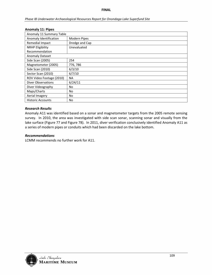
Research Results Anomaly A11 was identified based on a sonar and magnetometer targets from the 2005 remote sensing survey. In 2010, the area was investigated with side scan sonar, scanning sonar and visually from the lake surface (Figure 77 and Figure 78). In 2011, diver verification conclusively identified Anomaly A11 as a series of modern pipes or conduits which had been discarded on the lake bottom.
Recommendations LCMM recommends no further work for A11.

FINAL
Phase IB Underwater Archaeological Resources Report for Onondaga Lake Superfund Site
110
Figure 77. Side scan sonar mosaic showing A11.
FINAL
Phase IB Underwater Archaeological Resources Report for Onondaga Lake Superfund Site
111
Figure 78. Scanning sonar image showing A11.

FINAL
Phase IB Underwater Archaeological Resources Report for Onondaga Lake Superfund Site
112
Anomaly 19: Unidentified Anomaly 19 Summary Table Anomaly Identification Unknown Remedial Impact Dredge and Cap NRHP Eligibility Recommendation
Unevaluated
Anomaly Dataset Side Scan (2005) 484 Magnetometer (2005) 182, 187, 1073, 1078 Side Scan (2010) No Sector Scan (2010) 6/7/10 Surface Inspection (2010) 6/2, 3, 7/10 Diver Observations (2011) 6/28/11 Diver Videography No Maps/Charts No Aerial Imagery No Historic Accounts No
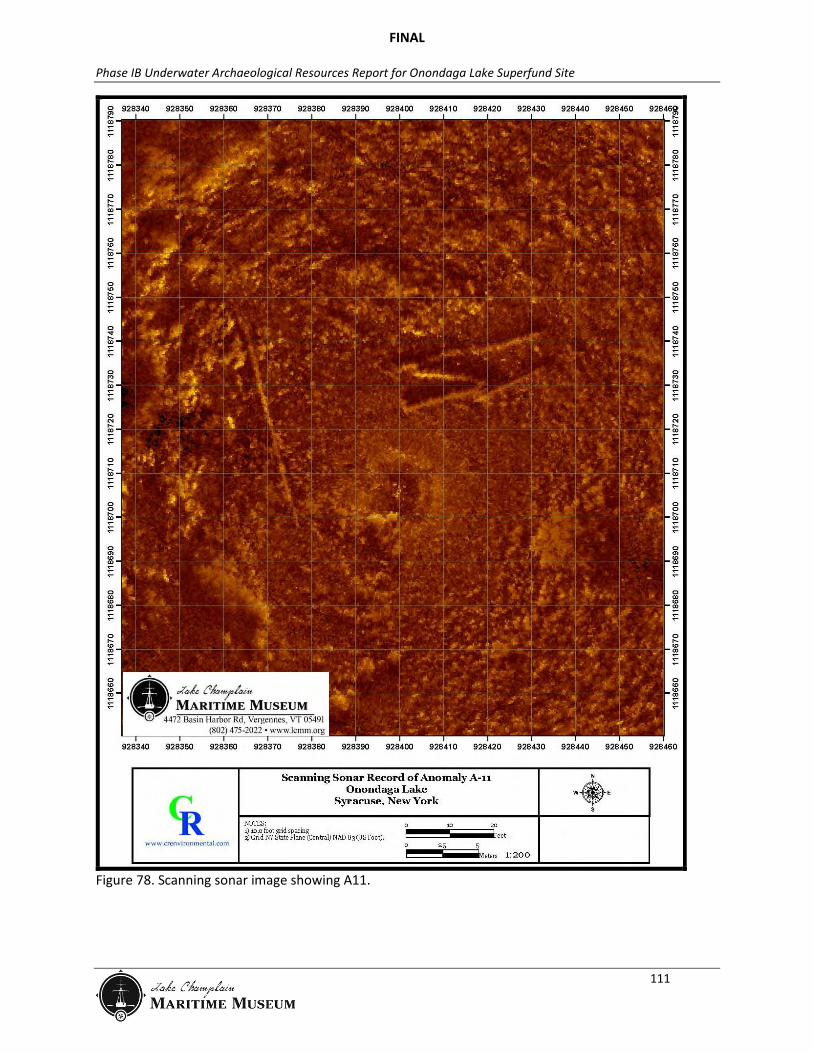
Research Results A19 is co-located with four magnetic anomalies digitized from CRE’s 2005 data: #182; #187; #1073; and #1078 (Figure 79). These anomalies were observed on four parallel survey transects spaced 25ft (8m) apart at a depth of approximately 3 to 6ft (1 to 2m). The magnitude of these anomalies was as high as approximately 100nT (Figure 80). Assuming a distance (range) of 7 to 16ft (2 to 5 m), the ferrous mass of this anomaly might be 35 to 551lb (16 to 250 kg). The anomaly was searched for on four different occasions during the 2010 fieldwork. The depth of the site and generally clear water allowed for a topside visual search for the anomaly. Despite three different visual survey efforts and excellent water clarity, the anomaly could not be located. A19 was dive verified in 2011 and after extensive metal detecting, no cultural materials were identified. The anomaly is in an area where the lake bottom drops off steeply suggesting that the linear sonar anomaly may have been a shelf. The cumulative geophysical and observational data suggests that the original side scan anomaly was likely a topographic feature related to the sloping lake bottom. The magnetic target is buried and remains unresolved. The spatial extent of the magnetic anomaly, which covers an area of approximately 120 by 120ft (37 by 37m), is consistent with the spatial extent of other vessels located in Onondaga Lake. However, the magnetic intensity is considerably lower and lacks the complexity of other vessel sites. Although, the specific origin of the magnetic anomaly is unknown, LCMM believes the collective data suggests that it is unlikely to represent a cultural resource.
Recommendations LCMM recommends no further work for A19.
FINAL
Phase IB Underwater Archaeological Resources Report for Onondaga Lake Superfund Site
113
Figure 79. Sonar image from 2005 showing Anomaly 19 (courtesy CRE).
Figure 80. Graphical overlay of fine-scale magnetism and side scan data on A19 (courtesy CRE).

FINAL
Phase IB Underwater Archaeological Resources Report for Onondaga Lake Superfund Site
114
Anomaly 36: Wire Rope Anomaly 36 Summary Table Anomaly Identification Wire Rope Remedial Impact Cap NRHP Eligibility Recommendation
Unevaluated
Anomaly Dataset Side Scan (2005) No Magnetometer (2005) 552, 73, 1007, 1009 Side Scan (2010) 6/2/10 Sector Scan (2010) No ROV (2010) 6/10/10 Diver Observations 6/21/11 Diver Videography No Maps/Charts No Aerial Imagery No Historic Accounts No
Research Results A36 is a magnetic anomaly discovered during the 2005 remote sensing survey (Figure 81). The anomaly was investigated using side scan sonar and ROV in 2010, with all results being inconclusive. Diver verification in 2011 revealed the target to be a 10ft (3m) coil of wire rope.
Recommendations LCMM recommends no further work for A36.
Figure 81. Magnetic intensity map of Onondaga Lake showing A36.

FINAL
Phase IB Underwater Archaeological Resources Report for Onondaga Lake Superfund Site
115
Anomaly 37: Unidentified Anomaly 37 Summary Table Anomaly Identification Unidentified Remedial Impact Cap NRHP Eligibility Recommendation
Unevaluated
Anomaly Dataset Side Scan (2005) No Magnetometer (2005) 499, 500, 276, 502, 503 Side Scan (2010) 6/2/10 Sector Scan (2010) 6/5/10 ROV (2010) 6/9/10 Diver Observations 6/28/11 Diver Videography No Maps/Charts No Aerial Imagery No Historic Accounts No
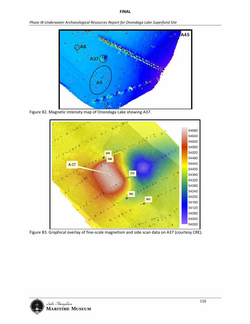
Research Results A37 is co-located with five magnetic anomalies digitized from CRE’s 2005 data: #276; #499; #500; #502; and #503 (Figure 82). These anomalies were observed on five parallel survey transects spaced 25 ft (8m) apart at a depth of approximately 10 to 12ft (3 to 4m). The magnitude of these anomalies was as high as approximately 400nT at the central dipolar anomaly #276 (Figure 83). Assuming a distance (range) of 7 to 16ft (2 to 5 m), the ferrous mass of this anomaly might be 141 to 2204lb (64 to 1000kg). Side scan sonar data collected in the vicinity of these anomalies in 2010 did not suggest the presence of surficial contacts (debris or structures). The anomaly was investigated using side scan sonar, sector scan sonar and ROV in 2010, and dive verification in 2011, with all results being inconclusive. The cumulative geophysical and observational data suggests that the magnetic target is buried. The spatial extent of the magnetic anomaly, which covers an area of approximately 200 by 100ft (61 by 30.5m), is consistent with the spatial extent of the barge and canal boat wrecks in Onondaga Lake. However, the magnetic intensity is lower and lacks the complexity of other vessel sites. Although, the specific origin of the magnetic anomaly is unknown, LCMM believes the collective data suggests that it is unlikely to represent a cultural resource.
Recommendations LCMM recommends no further work for A37.
FINAL
Phase IB Underwater Archaeological Resources Report for Onondaga Lake Superfund Site
116
Figure 82. Magnetic intensity map of Onondaga Lake showing A37.
Figure 83. Graphical overlay of fine-scale magnetism and side scan data on A37 (courtesy CRE).
FINAL
Phase IB Underwater Archaeological Resources Report for Onondaga Lake Superfund Site
117
Anomaly 43: Iron Pipe Anomaly 43 Summary Table Anomaly Identification Iron Pipe Remedial Impact Cap NRHP Eligibility Recommendation
Unevaluated
Anomaly Dataset Side Scan (2005) No Magnetometer (2005) 177, 1069 Side Scan (2010) 6/2/10 Sector Scan (2010) 6/5/10 ROV (2010) 6/10/10 Diver Observations No Diver Videography No Maps/Charts No Aerial Imagery No Historic Accounts No
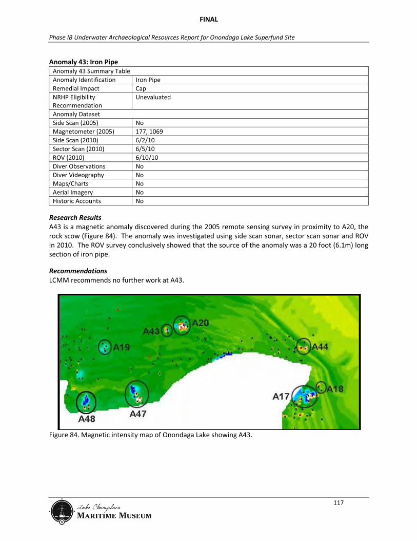
Research Results A43 is a magnetic anomaly discovered during the 2005 remote sensing survey in proximity to A20, the rock scow (Figure 84). The anomaly was investigated using side scan sonar, sector scan sonar and ROV in 2010. The ROV survey conclusively showed that the source of the anomaly was a 20 foot (6.1m) long section of iron pipe.
Recommendations LCMM recommends no further work at A43.
Figure 84. Magnetic intensity map of Onondaga Lake showing A43.
FINAL
Phase IB Underwater Archaeological Resources Report for Onondaga Lake Superfund Site
118
Anomaly 47: Pipeline Anomaly 47 Summary Table Anomaly Identification Pipeline Remedial Impact Dredge and Cap NRHP Eligibility Recommendation
Unevaluated
Anomaly Dataset Side Scan (2005) No Magnetometer (2005) 899, 896, 873, 871, 405, 404, 401, 402 Side Scan (2010) 6/2/10 Sector Scan (2010) 6/7/10 ROV (2010) 6/10/10 Diver Observations No Diver Videography No Maps/Charts Yes Aerial Imagery Yes Historic Accounts No
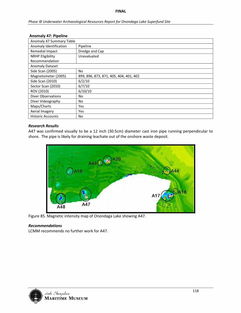
Research Results A47 was confirmed visually to be a 12 inch (30.5cm) diameter cast iron pipe running perpendicular to shore. The pipe is likely for draining leachate out of the onshore waste deposit.
Figure 85. Magnetic intensity map of Onondaga Lake showing A47.
Recommendations LCMM recommends no further work for A47.
FINAL
Phase IB Underwater Archaeological Resources Report for Onondaga Lake Superfund Site
119
Anomaly 48: Pipeline Anomaly 48 Summary Table Anomaly Location Anomaly Identification Pipeline Remedial Impact Dredge and Cap NRHP Eligibility Recommendation
Unevaluated
Anomaly Dataset Side Scan (2005) No Magnetometer (2005) 898, 897, 872, 406, 403 Side Scan (2010) 6/2 and 3/10 Sector Scan (2010) No ROV (2010) 6/11/10 Diver Observations No Diver Videography No Maps/Charts No Aerial Imagery No Historic Accounts No
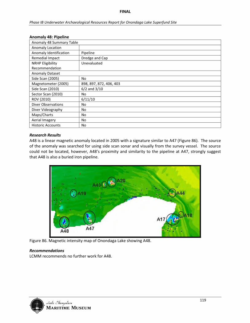
Research Results A48 is a linear magnetic anomaly located in 2005 with a signature similar to A47 (Figure 86). The source of the anomaly was searched for using side scan sonar and visually from the survey vessel. The source could not be located, however, A48’s proximity and similarity to the pipeline at A47, strongly suggest that A48 is also a buried iron pipeline.
Figure 86. Magnetic intensity map of Onondaga Lake showing A48.
Recommendations LCMM recommends no further work for A48.
FINAL
Phase IB Underwater Archaeological Resources Report for Onondaga Lake Superfund Site
120
Anomaly 51: Solvay Water Intake Anomaly 51 Summary Table Anomaly Identification Water Intake Remedial Impact Dredge and Cap NRHP Eligibility Recommendation
Not Eligible
Anomaly Dataset Side Scan (2005) 579 Magnetometer (2005) 479, 486, 480, 484, 1233, 200, 483, 201, 468. 459, 101, 99, 407, 412, 413, 419,
420, 465, 463, 433, 432, 428, 203, 434, 449, 204, 205, 450, 844, 843, 842, 841, 837, 836, 834, 835, 838, 839, 840
Side Scan (2010) 6/2/10 Sector Scan (2010) No ROV (2010) 6/9/10 Diver Observations No Diver Videography No Maps/Charts Yes Aerial Imagery No Historic Accounts Yes
Research Results A51 is an early to mid-twentieth century pipeline and water intake for the Solvay Process Company. The anomaly was located in 2005 based on a linear magnetic signature and sonar signature for the intake structure. Sonar and ROV work showed that there is only one visible intake at this location, although earlier magnetometer work indicates that there are several buried suction pipes in this area. The intake structure is a heavily corroded cast iron cylinder standing approximately 8 feet (2.4m) off the bottom. There is a large lifting loop on the top which was used for its installation. The pipeline associated with the intake is buried and could not be inspected. The engineering plans for the intake exist and are presented (in part) as Figure 87 and Figure 88.
FINAL
Phase IB Underwater Archaeological Resources Report for Onondaga Lake Superfund Site
121
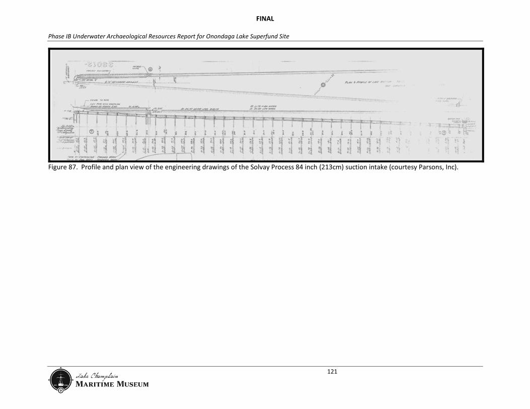
Figure 87. Profile and plan view of the engineering drawings of the Solvay Process 84 inch (213cm) suction intake (courtesy Parsons, Inc).

FINAL
Phase IB Underwater Archaeological Resources Report for Onondaga Lake Superfund Site
122
Figure 88. Engineering drawings of the intake structure for Solvay Process Company’s 84 inch (213cm) intake (courtesy Parsons, Inc).
FINAL
Phase IB Underwater Archaeological Resources Report for Onondaga Lake Superfund Site
123
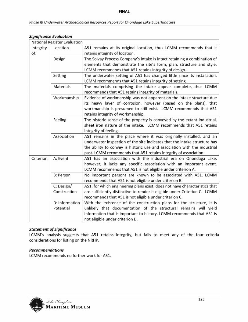
Significance Evaluation National Register Evaluation Integrity of:
Location A51 remains at its original location, thus LCMM recommends that it retains integrity of location.
Design The Solvay Process Company’s intake is intact retaining a combination of elements that demonstrate the site’s form, plan, structure and style. LCMM recommends that A51 retains integrity of design.
Setting The underwater setting of A51 has changed little since its installation. LCMM recommends that A51 retains integrity of setting.
Materials The materials comprising the intake appear complete, thus LCMM recommends that A51 retains integrity of materials.
Workmanship Evidence of workmanship was not apparent on the intake structure due its heavy layer of corrosion, however (based on the plans), that workmanship is presumed to still exist. LCMM recommends that A51 retains integrity of workmanship.
Feeling The historic sense of the property is conveyed by the extant industrial, sheet iron nature of the intake. LCMM recommends that A51 retains integrity of feeling.
Association A51 remains in the place where it was originally installed, and an underwater inspection of the site indicates that the intake structure has the ability to convey is historic use and association with the industrial past. LCMM recommends that A51 retains integrity of association
Criterion: A: Event A51 has an association with the industrial era on Onondaga Lake, however, it lacks any specific association with an important event. LCMM recommends that A51 is not eligible under criterion A.
B: Person No important persons are known to be associated with A51. LCMM recommends that A51 is not eligible under criterion B.
C: Design/ Construction
A51, for which engineering plans exist, does not have characteristics that are sufficiently distinctive to render it eligible under Criterion C. LCMM recommends that A51 is not eligible under criterion C.
D: Information Potential
With the existence of the construction plans for the structure, it is unlikely that documentation of the structural remains will yield information that is important to history. LCMM recommends that A51 is not eligible under criterion D.
Statement of Significance LCMM’s analysis suggests that A51 retains integrity, but fails to meet any of the four criteria considerations for listing on the NRHP.
Recommendations LCMM recommends no further work for A51.

FINAL
Phase IB Underwater Archaeological Resources Report for Onondaga Lake Superfund Site
124
Anomaly 52: Syracuse Yacht Club Anomaly 52 Summary Table Anomaly Identification Syracuse Yacht Club Remedial Impact Dredge and Cap NRHP Eligibility Recommendation
Not eligible
Anomaly Dataset Side Scan (2005) 333 Magnetometer (2005) 1139, 285 Side Scan (2010) 6/2/10 Sector Scan (2010) No ROV (2010) 6/9/10 Diver Observations No Diver Videography No Maps/Charts Yes Aerial Imagery Yes Historic Accounts Yes
Historic Context143 The Syracuse Yacht Club was constructed between 1898 and 1899 on the western shore of Onondaga Lake, south of Lake View Point (Figure 89). The yacht club consisted of a large clubhouse and several boat houses; all were built on wooden piers driven into the lake bottom. At a cost of $30,000, the clubhouse was a massive wooden structure (more than two stories in height), which became one of the area’s leading social centers. Luncheons and dinners were served daily to a membership that reached 2,000 at one time. By the 1910s, the yacht club also served as a boarding house. On May 10, 1917, a fire destroyed the clubhouse, reducing the large structure to ashes on top of the wooden piers. Nothing was salvageable within the clubhouse. At that time, there were up to 25 boarders. The boathouses, which did not burn during the fire, were used for several more years by owners who joined the Onondaga Yacht Club.144 Although it is not known how long these boathouses were used and what became of them, it is likely that they fell into disrepair and could have collapsed into the lake.
Figure 89. Postcard of the Syracuse Yacht Club facing south, circa 1901 (LCMM Collection).
FINAL
Phase IB Underwater Archaeological Resources Report for Onondaga Lake Superfund Site
125
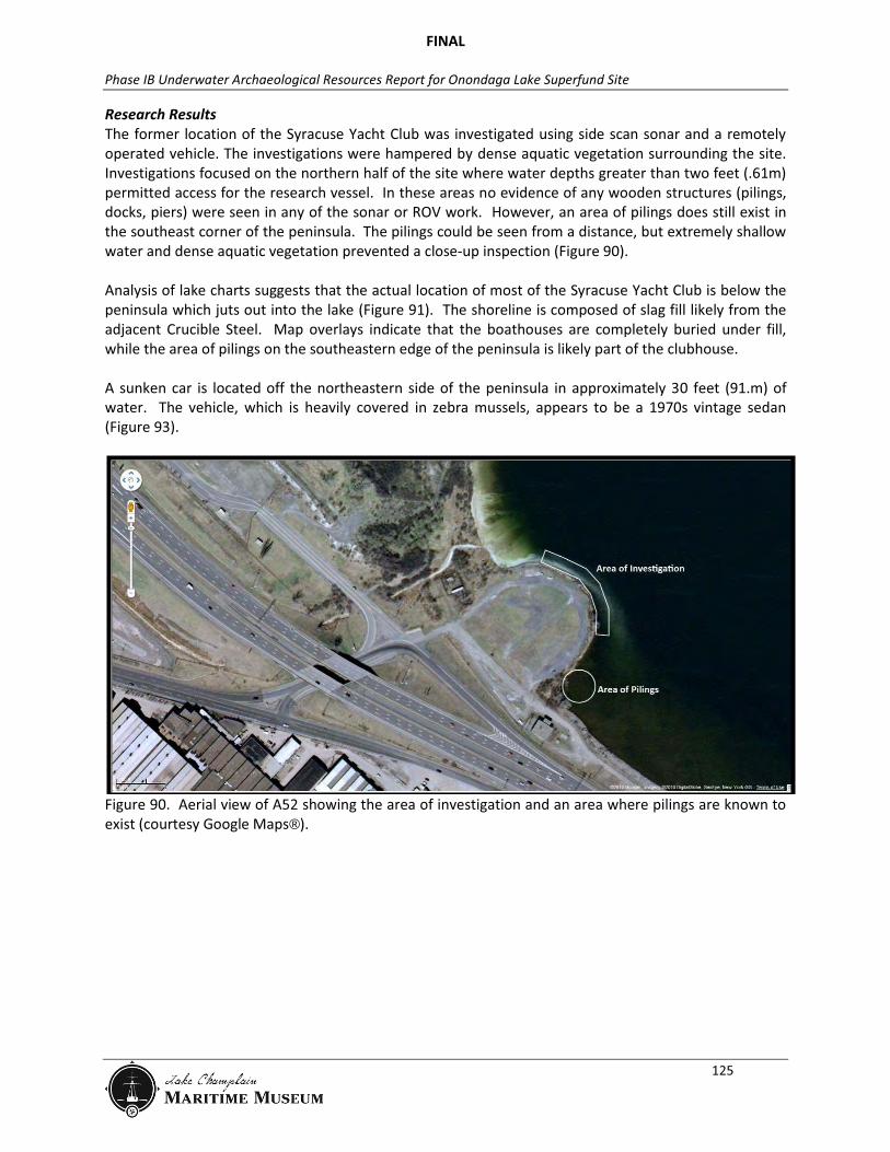
Research Results The former location of the Syracuse Yacht Club was investigated using side scan sonar and a remotely operated vehicle. The investigations were hampered by dense aquatic vegetation surrounding the site. Investigations focused on the northern half of the site where water depths greater than two feet (.61m) permitted access for the research vessel. In these areas no evidence of any wooden structures (pilings, docks, piers) were seen in any of the sonar or ROV work. However, an area of pilings does still exist in the southeast corner of the peninsula. The pilings could be seen from a distance, but extremely shallow water and dense aquatic vegetation prevented a close-up inspection (Figure 90). Analysis of lake charts suggests that the actual location of most of the Syracuse Yacht Club is below the peninsula which juts out into the lake (Figure 91). The shoreline is composed of slag fill likely from the adjacent Crucible Steel. Map overlays indicate that the boathouses are completely buried under fill, while the area of pilings on the southeastern edge of the peninsula is likely part of the clubhouse. A sunken car is located off the northeastern side of the peninsula in approximately 30 feet (91.m) of water. The vehicle, which is heavily covered in zebra mussels, appears to be a 1970s vintage sedan (Figure 93).
Figure 90. Aerial view of A52 showing the area of investigation and an area where pilings are known to exist (courtesy Google Maps®).

FINAL
Phase IB Underwater Archaeological Resources Report for Onondaga Lake Superfund Site
126
Figure 91. 1915 (left) and 1947 (right) navigational charts showing the location of the Syracuse Yacht Club (U.S. Lake Survey Office, Chart No. 5, New York State Canals, Brewerton to Cross Lake and Syracuse to Oswego, 1915; and U.S. Lake Survey Office, New York State Canals, Chart No. 185, 1947).
Figure 92. Photograph of the shoreline at A52 showing the slag fill (LCMM Collection).
FINAL
Phase IB Underwater Archaeological Resources Report for Onondaga Lake Superfund Site
127
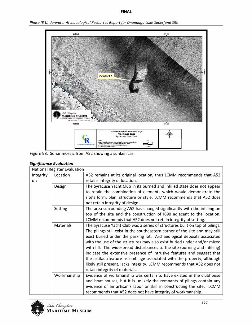
Figure 93. Sonar mosaic from A52 showing a sunken car.
Significance Evaluation National Register Evaluation Integrity of:
Location A52 remains at its original location, thus LCMM recommends that A52 retains integrity of location.
Design The Syracuse Yacht Club in its burned and infilled state does not appear to retain the combination of elements which would demonstrate the site’s form, plan, structure or style. LCMM recommends that A52 does not retain integrity of design.
Setting The area surrounding A52 has changed significantly with the infilling on top of the site and the construction of I690 adjacent to the location. LCMM recommends that A52 does not retain integrity of setting.
Materials The Syracuse Yacht Club was a series of structures built on top of pilings. The pilings still exist in the southeastern corner of the site and may still exist buried under the parking lot. Archaeological deposits associated with the use of the structures may also exist buried under and/or mixed with fill. The widespread disturbances to the site (burning and infilling) indicate the extensive presence of intrusive features and suggest that the artifact/feature assemblage associated with the property, although likely still present, lacks integrity. LCMM recommends that A52 does not retain integrity of materials.
Workmanship Evidence of workmanship was certain to have existed in the clubhouse and boat houses, but it is unlikely the remnants of pilings contain any evidence of an artisan’s labor or skill in constructing the site. LCMM recommends that A52 does not have integrity of workmanship.

FINAL
Phase IB Underwater Archaeological Resources Report for Onondaga Lake Superfund Site
128
Feeling The former site of the Yacht Club is now filled with slag, and none of the structures remain standing. The area retains a similar viewshed to that of the original property, however, this aspect is outweighed by the absence of other features that evoke the historic sense of the property. LCMM recommends that A52 does not retain integrity of feeling.
Association A52 remains in its original location, however, its overlying fill and absence of standing structures limits its ability to convey its former importance and grandeur. From an information potential perspective, integrity of association is measured in terms of the strength of the relationship between the site’s data and important research questions. The archaeological data gathered from A52 indicates the site’s historic burning and subsequent infilling have impaired its ability to answer any research questions which are important to history. LCMM recommends that A52 does not retain integrity of association.
Criterion: A: Event Na B: Person Na C: Design/ Construction
Na
D: Information Potential
Na
Statement of Significance LCMM’s research suggests that A52, the former location of the Syracuse Yacht Club, lacks integrity, and is ineligible for the National Register of Historic Places
Recommendations LCMM recommends no further work for A52.
FINAL
Phase IB Underwater Archaeological Resources Report for Onondaga Lake Superfund Site
129
Anomaly 56: Unidentified Anomaly 56 Summary Table Anomaly Identification Unidentified Remedial Impact Dredge and Cap NRHP Eligibility Recommendation
Unevaluated
Anomaly Dataset Side Scan (2005) No Magnetometer (2005) 538 Side Scan (2010) No Sector Scan (2010) No ROV (2010) No Diver Observations 6/23/11 Diver Videography No Maps/Charts No Aerial Imagery No Historic Accounts No
Research Results Anomaly 56 was a low amplitude magnetic anomaly. A-56 is co-located with CRE’s 2005 digitized magnetic anomaly #538 which possessed a 60nT dipolar signature. Assuming a distance (range) of 7 to 16ft (2 to 5m), the ferrous mass of this anomaly might be 22 to 551lb (10 to 250 kg). There were no side scan sonar contacts in the vicinity of this anomaly. Diver verification in 2011 produced small pieces of modern garbage and several buried anomalies, but nothing that could be conclusively identified. The buried metallic anomalies could not be found with modest hand probing, so they were left unresolved. The magnetic and dive verification data suggest that A56 is likely isolated ferrous debris.
Recommendations LCMM recommends no further work for A56.
FINAL
Phase IB Underwater Archaeological Resources Report for Onondaga Lake Superfund Site
130
Anomaly 57: Wooden Barrel with Iron Hoops Anomaly 57 Summary Table Anomaly Identification Wooden Barrel with Iron Hoops Remedial Impact Dredge and Cap NRHP Eligibility Recommendation
Unevaluated
Anomaly Dataset Side Scan (2005) No Magnetometer (2005) 546 Side Scan (2010) No Sector Scan (2010) No ROV (2010) No Diver Observations 6/23/11 Diver Videography No Maps/Charts No Aerial Imagery No Historic Accounts No
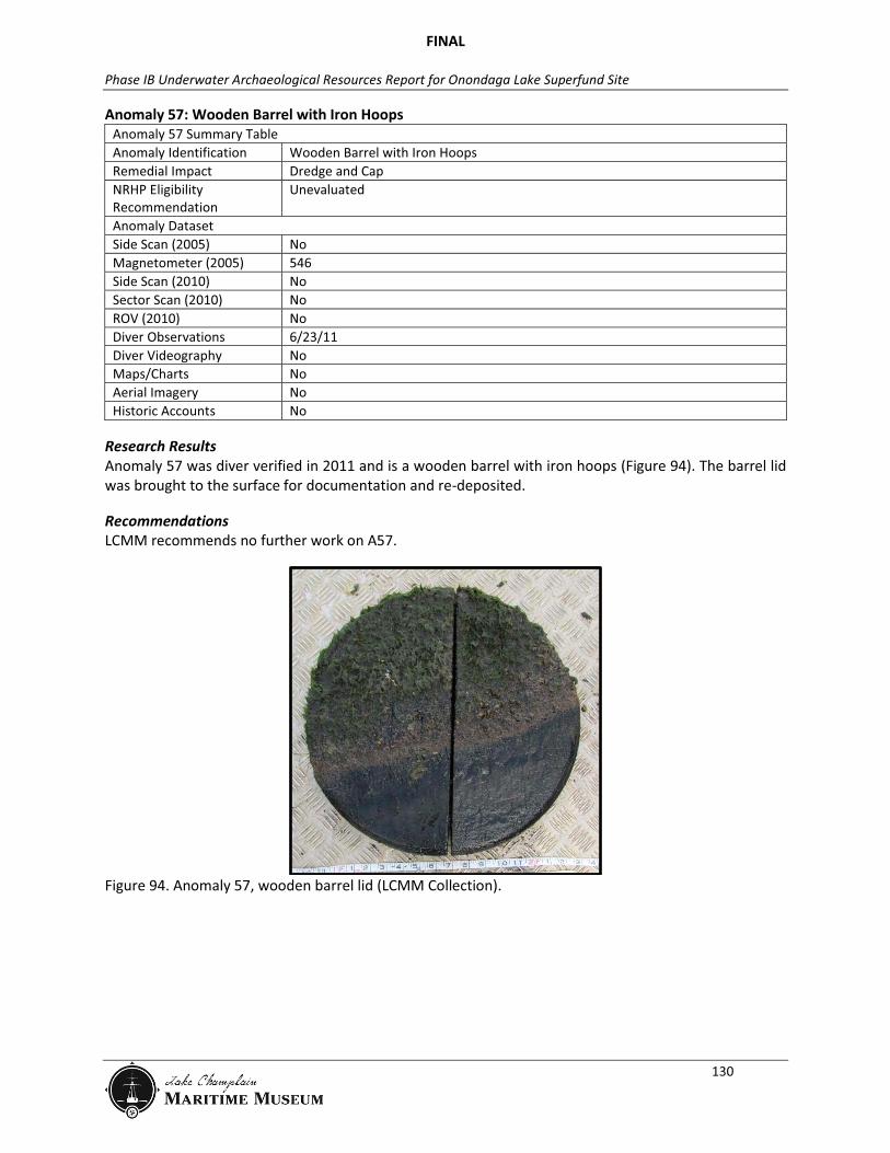
Research Results Anomaly 57 was diver verified in 2011 and is a wooden barrel with iron hoops (Figure 94). The barrel lid was brought to the surface for documentation and re-deposited.
Recommendations LCMM recommends no further work on A57.
Figure 94. Anomaly 57, wooden barrel lid (LCMM Collection).

FINAL
Phase IB Underwater Archaeological Resources Report for Onondaga Lake Superfund Site
131
Anomaly 58: 55-Gallon Drum Anomaly 58 Summary Table Anomaly Identification 55-Gallon Drum
Remedial Impact Cap and Dredge NRHP Eligibility Recommendation
Unevaluated
Anomaly Dataset Side Scan (2005) No Magnetometer (2005) 539 Side Scan (2010) No Sector Scan (2010) No ROV (2010) No Diver Observations 6/23/11 Diver Videography No Maps/Charts No Aerial Imagery No Historic Accounts No
Research Results Anomaly 58 was investigated by a diver in 2011. A58 is a broken-up 55-gallon drum (Figure 95).
Recommendations LCMM recommends no further work on A58.
Figure 95. Anomaly 58, a fragmentary 55-gallon drum (LCMM Collection).

FINAL
Phase IB Underwater Archaeological Resources Report for Onondaga Lake Superfund Site
132
Anomaly 59: Wire Rope Anomaly 59 Summary Table Anomaly Identification Wire Rope Remedial Impact Cap and Dredge NRHP Eligibility Recommendation
Unevaluated
Anomaly Dataset Side Scan (2005) No Magnetometer (2005) 603 Side Scan (2010) No Sector Scan (2010) No ROV (2010) No Diver Observations 6/23/11 Diver Videography No Maps/Charts No Aerial Imagery No Historic Accounts No
Research Results Anomaly 59 was investigated by a diver in 2011. A59 is a long coil of wire rope.
Recommendations LCMM recommends no further work on A59.
FINAL
Phase IB Underwater Archaeological Resources Report for Onondaga Lake Superfund Site
133
Anomaly 60: Unidentified Anomaly 60 Summary Table Anomaly Identification Unidentified Remedial Impact Cap and Dredge NRHP Eligibility Recommendation
Unevaluated
Anomaly Dataset Side Scan (2005) No Magnetometer (2005) 251, 628 Side Scan (2010) No Sector Scan (2010) No ROV (2010) No Diver Observations 6/23/11 Diver Videography No Maps/Charts No Aerial Imagery No Historic Accounts No
Research Results Anomaly 60 is approximately co-located with two anomalies digitized from CRE’s 2005 magnetic data. The separation between these two anomalies was approximately 13ft (4m). Anomaly #251 possessed a 120nT dipolar signature. Assuming a distance (range) of 7 to 16ft (2 to 5m), the ferrous mass of this anomaly might be 42 to 661lb (19 to 300kg). Anomaly #628 possessed a 100nT dipolar signature. Assuming a distance (range) of 7 to 16ft (2 to 5m), the ferrous mass of this anomaly might be 35 to 551lb (16 to 250kg). There were no side scan sonar contacts in the vicinity of this anomaly. Anomaly 60 was investigated by a diver in 2011. A ferrous target with a signature of approximately 3ft (1 m) in diameter was located. Probing into the sediment indicated the object was buried approximately 4ft (1.2m) below the lake bottom. Due to its depth in the sediment, Anomaly 60 could not be conclusively identified. Although the specific origin of the magnetic anomaly is unknown, its signature lacks the complexity and intensity expected of a larger cultural resource. LCMM believes the collective data suggests that it is unlikely to represent a cultural resource.
Recommendations LCMM recommends no further work for A60.
FINAL
Phase IB Underwater Archaeological Resources Report for Onondaga Lake Superfund Site
134
Anomaly 61: Unidentified Anomaly 61 Summary Table Anomaly Identification Unidentified Remedial Impact Cap and Dredge NRHP Eligibility Recommendation
Unevaluated
Anomaly Dataset Side Scan (2005) No Magnetometer (2005) 270, 683 Side Scan (2010) No Sector Scan (2010) No ROV (2010) No Diver Observations 6/24/11 Diver Videography No Maps/Charts No Aerial Imagery No Historic Accounts No
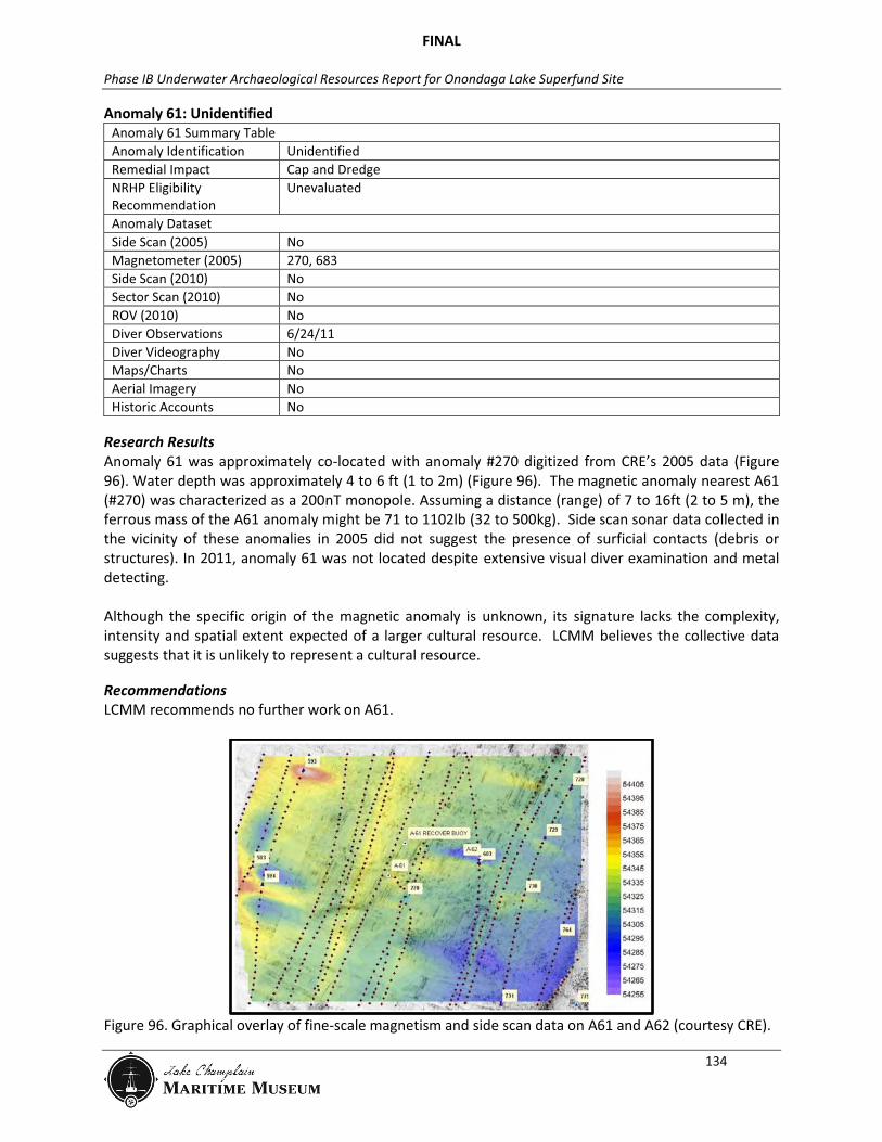
Research Results Anomaly 61 was approximately co-located with anomaly #270 digitized from CRE’s 2005 data (Figure 96). Water depth was approximately 4 to 6 ft (1 to 2m) (Figure 96). The magnetic anomaly nearest A61 (#270) was characterized as a 200nT monopole. Assuming a distance (range) of 7 to 16ft (2 to 5 m), the ferrous mass of the A61 anomaly might be 71 to 1102lb (32 to 500kg). Side scan sonar data collected in the vicinity of these anomalies in 2005 did not suggest the presence of surficial contacts (debris or structures). In 2011, anomaly 61 was not located despite extensive visual diver examination and metal detecting. Although the specific origin of the magnetic anomaly is unknown, its signature lacks the complexity, intensity and spatial extent expected of a larger cultural resource. LCMM believes the collective data suggests that it is unlikely to represent a cultural resource.
Recommendations LCMM recommends no further work on A61.
Figure 96. Graphical overlay of fine-scale magnetism and side scan data on A61 and A62 (courtesy CRE).

FINAL
Phase IB Underwater Archaeological Resources Report for Onondaga Lake Superfund Site
135
Anomaly 62: Unidentified Anomaly 62 Summary Table Anomaly Identification Unidentified Remedial Impact Cap and Dredge NRHP Eligibility Recommendation
Unevaluated
Anomaly Dataset Side Scan (2005) No Magnetometer (2005) 683 Side Scan (2010) No Sector Scan (2010) No ROV (2010) No Diver Observations 6/24/11 Diver Videography No Maps/Charts No Aerial Imagery No Historic Accounts No
Research Results Anomaly 62 was approximately co-located with anomaly #683 digitized from CRE’s 2005 data (see Figure 96). Water depth was approximately 4 to 6 ft (1 to 2m). The anomaly nearest A62 (#683) was characterized as a 71nT dipole. Assuming a distance (range) of 7 to 16ft (2 to 5m), the ferrous mass of the A62 anomaly might be 24 to 397lb (11 to 180 kg). Side scan sonar data collected in the vicinity of these anomalies in 2005 did not suggest the presence of surficial contacts (debris or structures). Anomaly 62 was not located despite extensive visual diver examination and metal detecting. Although the specific origin of the magnetic anomaly is unknown, its signature lacks the complexity, intensity and spatial extent expected of a larger cultural resource. LCMM believes the collective data suggests that it is unlikely to represent a cultural resource.
Recommendations LCMM recommends no further work on A62.

FINAL
Phase IB Underwater Archaeological Resources Report for Onondaga Lake Superfund Site
136
Anomaly 63: Unidentified Anomaly 63 Summary Table Anomaly Identification Unidentified Remedial Impact Cap and Dredge NRHP Eligibility Recommendation
Unevaluated
Anomaly Dataset Side Scan (2005) No Magnetometer (2005) 619 Side Scan (2010) No Sector Scan (2010) No ROV (2010) No Diver Observations 6/24/11 Diver Videography No Maps/Charts No Aerial Imagery No Historic Accounts No
Research Results Anomaly 63 was identified by CRE’s 2005 magnetic anomaly #619, which possessed a 318nT dipolar signature. Assuming a distance (range) of 7 to 16ft (2 to 5 meters), the ferrous mass of this anomaly might be 112 to 1763lb (51 to 800kg). There were no side scan sonar contacts in the vicinity of this anomaly. Anomaly 63 was investigated by a diver in 2011. A large metal detector signature was located, and probing suggested that its source was buried 3ft (1m) below the lake bed. A63 was not conclusively identified. Although the specific origin of the magnetic anomaly is unknown, its signature lacks the complexity, intensity and spatial extent expected of a larger cultural resource. LCMM believes the collective data suggests that it is likely isolated ferrous debris.
Recommendations LCMM recommends no further work for A63.

FINAL
Phase IB Underwater Archaeological Resources Report for Onondaga Lake Superfund Site
137
Anomaly 64: Unidentified Anomaly 64 Summary Table Anomaly Identification Unidentified Remedial Impact Cap and Dredge NRHP Eligibility Recommendation
Unevaluated
Anomaly Dataset Side Scan (2005) No Magnetometer (2005) 584 Side Scan (2010) No Sector Scan (2010) No ROV (2010) No Diver Observations 6/24/11 Diver Videography No Maps/Charts No Aerial Imagery No Historic Accounts No
Research Results Anomaly 64 was co-located with 2005 magnetic anomaly #584, characterized as a 289nT dipole (Figure 97). It was located in 2-5ft (1-2m) of water. Assuming a distance (range) of 7 to 16ft (2 to 5 m), the ferrous mass of the A64 anomaly might be 101 to 1593lb (46 to 723kg). Side scan sonar contacts were not observed in 2005 data collected at this location. Anomaly 64 was not located despite extensive visual diver examination and metal detecting in 2011. Although the specific origin of the magnetic anomaly is unknown, its signature lacks the complexity, intensity and spatial extent expected of a larger cultural resource. LCMM believes the collective data suggests that it is likely isolated ferrous debris.
Recommendations LCMM recommends no further work on A64.

FINAL
Phase IB Underwater Archaeological Resources Report for Onondaga Lake Superfund Site
138
Figure 97. Graphical overlay of fine-scale magnetism and side scan data for A64, A65, A66, A67, and A70 (courtesy CRE).
FINAL
Phase IB Underwater Archaeological Resources Report for Onondaga Lake Superfund Site
139
Anomaly 65: Unidentified Anomaly 65 Summary Table Anomaly Identification Unidentified Remedial Impact Cap and Dredge NRHP Eligibility Recommendation
Unevaluated
Anomaly Dataset Side Scan (2005) No Magnetometer (2005) 713 Side Scan (2010) No Sector Scan (2010) No ROV (2010) No Diver Observations 6/24/11 Diver Videography No Maps/Charts No Aerial Imagery No Historic Accounts No
Research Results Anomaly A65 was co-located with 2005 magnetic anomaly #713, characterized as an 873nT monopole (see Figure 97). It was located in 2 to 5ft (1 of 2m) of water. Assuming a distance (range) of 7 to 16ft (2 to 5m), the ferrous mass of the A64 anomaly might be 309 to 4850lb (140 to 2200kg). The lakebed at this location was obscured by aquatic vegetation in 2005 side scan sonar data. Anomaly 65 was not located despite extensive visual diver examination and metal detecting in 2011. Although the specific origin of the magnetic anomaly is unknown, its signature lacks the complexity, intensity and spatial extent expected of a larger cultural resource. LCMM believes the collective data suggests that it is likely isolated ferrous debris.
Recommendations LCMM recommends no further work on A65.
FINAL
Phase IB Underwater Archaeological Resources Report for Onondaga Lake Superfund Site
140
Anomaly 66: Unidentified Anomaly 66 Summary Table Anomaly Identification Unidentified Remedial Impact Cap and Dredge NRHP Eligibility Recommendation
Unevaluated
Anomaly Dataset Side Scan (2005) No Magnetometer (2005) 254, 630 Side Scan (2010) No Sector Scan (2010) No ROV (2010) No Diver Observations 6/24/11 Diver Videography No Maps/Charts No Aerial Imagery No Historic Accounts No
Research Results Anomaly A66 was co-located with 2005 magnetic anomalies #254 and #630 (see Figure 97). Anomaly #254 was characterized as a 24nT dipole. The ferrous mass estimate for this feature would range from 6.6 to 132lb (3 to 60kg) at an assumed range of 7 to 16ft (2 to 5m). Anomaly #630 was characterized as a 395nT dipole. The ferrous mass estimate for this feature would range from 139 to 2182lb (63 to 990kg) at an assumed range of 7 to 16ft (2 to 5 m). The lakebed at this location was obscured by aquatic vegetation in 2005 side scan sonar data. Anomaly 66 was not located despite extensive visual diver examination and metal detecting in 2011. Although the specific origin of the magnetic anomaly is unknown, its signature lacks the complexity, intensity and spatial extent expected of a larger cultural resource. LCMM believes the collective data suggests that it is likely isolated ferrous debris.
Recommendations LCMM recommends no further work on A66.
FINAL
Phase IB Underwater Archaeological Resources Report for Onondaga Lake Superfund Site
141
Anomaly 67: Unidentified Anomaly 67 Summary Table Anomaly Identification Unidentified Remedial Impact Cap and Dredge NRHP Eligibility Recommendation
Unevaluated
Anomaly Dataset Side Scan (2005) No Magnetometer (2005) 575, 1142 Side Scan (2010) No Sector Scan (2010) No ROV (2010) No Diver Observations 6/24/11 Diver Videography No Maps/Charts No Aerial Imagery No Historic Accounts No
Research Results Anomaly 67 was co-located with 2005 magnetic anomalies #575 and #1142 (see Figure 97). Anomaly #575 was characterized as a 93nT dipole. The ferrous mass estimate for this feature would range from 33 to 507lb (15 to 230kg) at an assumed range of 7 to 16ft (2 to 5m). Anomaly #1142 was characterized as a 630nT dipole. The ferrous mass estimate for this feature would range from 220 to 3527lb (100 to 1600kg) at an assumed range of 7 to 16ft (2 to 5m). The lakebed at this location was obscured by aquatic vegetation in 2005 side scan sonar data. Anomaly 67 was not located despite extensive visual diver examination and metal detecting in 2011. Although the specific origin of the magnetic anomaly is unknown, its signature lacks the complexity, intensity and spatial extent expected of a larger cultural resource. LCMM believes the collective data suggests that it is likely isolated ferrous debris.
Recommendations LCMM recommends no further work on A67.
FINAL
Phase IB Underwater Archaeological Resources Report for Onondaga Lake Superfund Site
142
Anomaly 69: Miscellaneous Metal Debris Anomaly 69 Summary Table Anomaly Identification Miscellaneous Metal Debris: Iron Ladder, Sheet Iron, Slag Remedial Impact NRHP Eligibility Recommendation
Unevaluated
Anomaly Dataset Side Scan (2005) No Magnetometer (2005) 800 Side Scan (2010) No Sector Scan (2010) No ROV (2010) No Diver Observations 6/25/11 Diver Videography No Maps/Charts No Aerial Imagery No Historic Accounts No
Research Results Anomaly 69 was investigated by a diver in 2011. It is miscellaneous metal debris including an iron step ladder, several pieces of sheet iron and fragments of slag.
Recommendations LCMM recommends no further work on A69.
FINAL
Phase IB Underwater Archaeological Resources Report for Onondaga Lake Superfund Site
143
Anomaly 70: Unidentified Anomaly 70 Summary Table Anomaly Identification Unidentified Remedial Impact Dredge and Cap NRHP Eligibility Recommendation
Unevaluated
Anomaly Dataset Side Scan (2005) No Magnetometer (2005) 789, 790, 802, 803, 804, 805, 822 Side Scan (2010) No Sector Scan (2010) No ROV (2010) No Diver Observations 6/25/11 Diver Videography No Maps/Charts No Aerial Imagery No Historic Accounts No
Research Results Anomaly 70 was surrounded by seven magnetic anomalies digitized from three parallel transects of 2005 magnetic data (see Figure 97):
#789, a 10nT dipole (~ 4.4 to 55lb [2 to 25kg] ferrous mass)
#790, a 42nT negative monopole (~18 to 220lb [8 to 100kg] ferrous mass)
#802, a 77nT dipole (~26 to 419lb [12 to 190kg] ferrous mass)
#803, a 24nT dipole (~9 to 132lb [4 to 60kg] ferrous mass)
#804, a 25nT negative monopole (~9 to 138lb [4 to 63kg] ferrous mass)
#805, an 18nT dipole (~7 to 99lb [3 to 45kg] ferrous mass)
#822, a 55nT dipole (~20 to 309lb [9 to 140kg] ferrous mass)
The lakebed at this location was obscured by aquatic vegetation in 2005 side scan sonar data. Anomaly 70 was not located despite extensive visual diver examination and metal detecting in 2011. Although the specific origin of the magnetic anomaly is unknown, its signature lacks the complexity and intensity expected of a larger cultural resource. LCMM believes the collective data suggests that it is likely isolated ferrous debris.
Recommendations LCMM recommends no further work on A70.
FINAL
Phase IB Underwater Archaeological Resources Report for Onondaga Lake Superfund Site
144
Anomaly 74: Isolated Piling Anomaly 74 Summary Table Anomaly Identification Isolated Piling Remedial Impact Dredge and Cap NRHP Eligibility Recommendation
Unevaluated
Anomaly Dataset Side Scan (2005) No Magnetometer (2005) No Side Scan (2010) No Sector Scan (2010) No ROV (2010) No Diver Observations 6/26/11 Diver Videography No Maps/Charts No Aerial Imagery No Historic Accounts No
Research Results Anomaly 74 was located by a diver in 2011. This isolated piling approximately 12in (30cm) in diameter stands 12in (30cm) off the bottom at a 45 degree angle. It is likely a piling from one of the adjacent dolphins that has torn loose.
Recommendations LCMM recommends no further work for A74.
FINAL
Phase IB Underwater Archaeological Resources Report for Onondaga Lake Superfund Site
145
Anomaly 77: Unidentified Anomaly 77 Summary Table Anomaly Identification Unidentified Remedial Impact Cap and Dredge NRHP Eligibility Recommendation
Unevaluated
Anomaly Dataset Side Scan (2005) No Magnetometer (2005) 258 Side Scan (2010) No Sector Scan (2010) No ROV (2010) No Diver Observations 6/27/11 Diver Videography No Maps/Charts No Aerial Imagery No Historic Accounts No
Research Results Anomaly 77 was co-located with 2005 magnetic anomaly #258, a 98nT dipole at a depth of approximately 5ft (2m) (Figure 98). The ferrous mass estimate for this feature would range from 35 to 540lb (16 to 245kg) at an assumed range of 7 to 16ft (2 to 5 m). The lakebed was obscured by aquatic vegetation in 2005 side scan sonar data. A77 was investigated by a diver in 2011. The area is filled with metallic trash including a tin can, zinc attachment for a boat and a small metal fragment. Despite extensive visual survey and metal detection, no features were found that were the likely source of the original magnetic anomaly, and therefore the results are inconclusive. Although the specific origin of the magnetic anomaly is unknown, its signature lacks the complexity and intensity expected of a larger cultural resource. LCMM believes the collective data suggests that it is likely isolated ferrous debris.
Recommendations LCMM recommends no further work for A77.