pennsylvania avenue se corridor - office of planning · fort davis / fairfax village sub-area...
TRANSCRIPT

Pennsylvania Avenue SE Corridor
Land Development PlanJanuary 2008Approved by DC Council July 15, 2008
Government of the District of ColumbiaOffi ce of PlanningAdrian M. Fenty, Mayor


PENNSYLVANIA AVENUE SE CORRIDOR LAND DEVELOPMENT PLAN - JANUARY 2008
3
Executive Summary ....................................................................5
Chapter 1 Study Background ..................................................9 Introduction & Project Context ........................................ 10 Coordination with Other Planning Eff orts ................... 15
Chapter 2 Study Area Conditions ....................................... 16 Historic Resources ................................................................ 17 Government & Institutional Resources & Facilities ... 19 Parks & Open Space ............................................................. 21 Transportation ....................................................................... 23 Land Use & Zoning ............................................................... 25
Chapter 3 Market Assessment ............................................. 29 Background & Methodology ............................................ 30 Existing Market Conditions ............................................... 31 Development Opportunity Projections ........................ 34 Market Economics ................................................................ 37
Chapter 4 Redevelopment Opportunities ...................... 39 Overview .................................................................................. 40 Capitol Hill Sub-Area ........................................................... 43 Potomac Avenue Sub-Area ............................................... 46 L’Enfant Sub-Area ................................................................. 55 Randle Highlands Sub-Area .............................................. 62 Penn Branch Sub-Area ........................................................ 64 Fort Davis / Fairfax Village Sub-Area .............................. 70
Chapter 5 Implementation ................................................... 75 General Corridor Improvements ..................................... 76 General Recommendations .............................................. 76 Strategies for Catalyzing Development ........................ 77 Site Characterization ........................................................... 77 Implementation Tables ...................................................... 78Acknowledgements ................................................................ 82Appendix- Notes on the Final Plan
Tables
Table 1.1: Meetings .............................................................. 12
Table 2.1: Historic Resources ............................................. 17
Table 2.2: Government and Institutional Resources and
Facilities ................................................................ 19
Table 2.3: Parks and Open Space ..................................... 21
Table 2.4: Zoning Categories ............................................ 27
Table 3.1 Summary of Market-Driven Development
Opportunity Projections, 20-Year Period .. 36
Table 5.1 Pennsylvania Avenue SE Corridor Strategy
and Implementation Plan .............................. 78
Table 5.2 Public Agency Action Agenda (I) ................. 79
Table 5.3 Public Agency Action Agenda (II) ................ 80
Table 5.4 Public Agency Action Agenda (III) .............. 81
Figures
Figure 1.1: Pennsylvania Avenue SE in the
District of Columbia ......................................... 10
Figure 1.2: Pennsylvania Avenue SE Study Area .......... 13
Figure 1.3: Project Sub-Areas .............................................. 14
Figure 2.1: L’Enfant Plan for Washington, D.C. .............. 17
Figure 2.2: Pennsylvania Avenue SE
Historic Resources ............................................. 18
Figure 2.3: Capitol Hill Cluster School ............................. 19
Figure 2.4: Metropolitan Police Department ................ 19
Figure 2.5: Randle Highlands School ............................... 19
Figure 2.6: Pennsylvania Avenue SE Government &
Institutional Resources ................................... 20
Figure 2.7: Fort Dupont Park ............................................... 21
Figure 2.8: Penn Branch ........................................................ 21
Figure 2.9: L’Enfant Square .................................................. 21
Figure 2.10: Pennsylvania Avenue SE Parks &
Open Space ......................................................... 22
Figure 2.11: Pennsylvania Avenue SE Planned
Transportation Improvements ..................... 24
Figure 2.12: Pennsylvania Avenue SE Corridor Land
Development Plan ............................................ 26
Figure 2.13 Pennsylvania Avenue SE Existing Zoning 28
Figure 3.1 Existing Land Uses ............................................ 31
Figure 3.2 COG Household Projections,
District of Columbia ......................................... 32
Figure 3.3 COG Household Projections,
PA Ave Corridor .................................................. 32
Figure 3.4 Map of Demographic Sub-Areas,
PA Ave Corridor .................................................. 32
Figure 3.5 Household Incomes, 2006 ............................. 32
Figure 3.6 Household Densities, 2006 ............................ 34
Figure 3.7 Single-Family Housing Values, 2006........... 34
Figure 3.8 Supportable Square Feet per Household,
2006 ....................................................................... 34
Figure 3.9 Number of Households Required to
Support a Typical Retail Establishment,
2006 ....................................................................... 34
Figure 3.10 High-Rise: 8+ Stories with Underground
Parking .................................................................. 38
Figure 3.11 Mid-Rise with Podium Parking:
6 to 8 Stories ....................................................... 38
Figure 3.12 Donut: 3 to 5 Stories Wrapped Around
Above-Grade Structured Parking ................ 38
Figure 3.13 Garden: 3 to 5 stories with
Surface Parking .................................................. 38
Table of ContentsTABLE OF CONTENTS

PENNSYLVANIA AVENUE SE CORRIDOR LAND DEVELOPMENT PLAN - JANUARY 2008
4
Figure 4.1 Pennsylvania Avenue SE
Redevelopment Sites ....................................... 42
Figure 4.2 Capitol Hill Sub-Area ........................................ 43
Figure 4.3 Capitol Hill Sub-Area ........................................ 44
Figure 4.4 Capitol Hill Sub-Area ........................................ 44
Figure 4.5 Capitol Hill Sub-Area ........................................ 44
Figure 4.6 Capitol Hill Sub-Area ........................................ 44
Figure 4.7 Capitol Hill Sub-Area ........................................ 44
Figure 4.8 Butterfi eld House .............................................. 45
Figure 4.9 Potomac Ave Sub-Area ................................... 46
Figure 4.10 Potomac Ave Sub-Area ................................... 47
Figure 4.11 Potomac Ave Sub-Area ................................... 47
Figure 4.12 Potomac Ave Sub-Area ................................... 47
Figure 4.13 1401 Penn. Ave, SE ............................................ 49
Figure 4.14 1401 Penn. Ave, SE ............................................ 49
Figure 4.15 Jenkins Row Development ............................ 49
Figure 4.16 Jenkins Row Development ............................ 49
Figure 4.17 Plan, 1401 Penn Ave, SE ................................. 50
Figure 4.18 View, 1401 Penn Ave, SE ................................ 50
Figure 4.19 1401 Penn. Ave, SE ............................................ 50
Figure 4.20 Concept Illustration - 1401 Penn Ave, SE . 51
Figure 4.21 Barney Circle ....................................................... 52
Figure 4.22 Barney Circle ....................................................... 52
Figure 4.23 Barney Circle ....................................................... 52
Figure 4.24 Barney Circle ....................................................... 52
Figure 4.25 Barney Circle Sites ............................................. 53
Figure 4.26 Plan - Barney Circle Sites ................................ 53
Figure 4.27 View - Barney Circle Sites ............................... 53
Figure 4.28 Concept Illustration - Barney Circle Sites .. 54
Figure 4.29 L’Enfant Square Sub-Area .............................. 55
Figure 4.30 L’Enfant Square Sub-Area .............................. 56
Figure 4.31 L’Enfant Square Sub-Area ............................... 56
Figure 4.32 L’Enfant Square Sub-Area ............................... 56
Figure 4.33 L’Enfant Square .................................................. 58
Figure 4.34 L’Enfant Square .................................................. 58
Figure 4.35 L’Enfant Squareh ................................................ 58
Figure 4.36 L’Enfant Square .................................................. 58
Figure 4.37 Plan, 2300-2500 Penn. Ave SE ...................... 59
Figure 4.38 Plan, 2500-2700 Penn. Ave SE ...................... 59
Figure 4.39 L’Enfant Square Sites ....................................... 59
Figure 4.40 L’Enfant Square Sites ........................................ 60
Figure 4.41 View, L’Enfant Square Sites ............................ 60
Figure 4.42 Concept Illustration - L’Enfant Sq Sites ...... 61
Figure 4.43 Randle Highlands Sub-Area .......................... 62
Figure 4.44 Randle Highlands Sub-Area .......................... 63
Figure 4.45 Randle Highlands Sub-Area .......................... 63
Figure 4.46 Randle Highlands Sub-Area .......................... 63
Figure 4.47 Randle Highlands Sub-Area ......................... 63
Figure 4.48 Penn Branch Sub-Area .................................... 64
Figure 4.49 Penn Branch Sub-Area .................................... 65
Figure 4.50 Penn Branch Sub-Area .................................... 65
Figure 4.51 Penn Branch Sub-Area ................................... 65
Figure 4.52 Penn Branch ....................................................... 67
Figure 4.53 Penn Branch ....................................................... 67
Figure 4.54 Penn Branch ....................................................... 67
Figure 4.55 Penn Branch ....................................................... 67
Figure 4.56 Penn Branch Sites.............................................. 67
Figure 4.57 Plan - Penn Branch Shopping Center ........ 68
Figure 4.58 View - Penn Branch Shopping Center ..... 68
Figure 4.59 Concept Illustration - Penn Branch
Shopping Center ............................................... 69
Figure 4.60 Fairfax Village/Fort Davis Sub-Area ............ 70
Figure 4.61 Fairfax Village/Fort Davis Sub-Area ............ 71
Figure 4.62 Fairfax Village/Fort Davis Sub-Area ............ 71
Figure 4.63 Fairfax Village/Fort Davis Sub-Area ............ 71
Figure 4.64 Fairfax Village/Fort Davis Sub-Area ............ 71
Figure 4.65 Fairfax Village/Fort Davis ................................ 72
Figure 4.66 Fairfax Village/Fort Davis ................................ 72
Figure 4.67 Fairfax Village/Fort Davis ................................ 72
Figure 4.68 Fairfax Village/Fort Davis ................................ 72
Figure 4.69 Fairfax Village/Fort Davis Sites ..................... 73
Figure 4.70 Plan - Fort Davis Shopping Center .............. 73
Figure 4.71 View - Fort Davis Shopping Center ............. 73
Figure 4.72 Concept Illustration - Fort Davis Shopping
Center .................................................................... 74
TABLE OFCONTENTS

PENNSYLVANIA AVENUE SE CORRIDOR LAND DEVELOPMENT PLAN - JANUARY 2008
5
EXECUTIVESUMMARY

PENNSYLVANIA AVENUE SE CORRIDOR LAND DEVELOPMENT PLAN - JANUARY 2008
6
BackgroundAs one of the city’s most important thoroughfares, Pennsylvania Avenue both deserves and requires special attention and consideration to retain its stature and vitality. The communities along this corridor are very active and passionate about their neighborhoods. While there are differences in the characters and needs of these neighborhoods, everyone agrees that Pennsylvania Avenue deserves sensitive redevelopment, special public realm treatment and better retail opportunities. Community leaders have been striving to achieve these goals for many years.
VisionThe guiding vision for the project is a revitalized urban corridor lined with the types of uses and services needed by the surrounding neighborhoods: housing, employment, and retail opportunities for all residents, long-time and new. This study has been undertaken with the understanding that solutions must balance neighborhood goals and city-wide objectives with market realities, and that redevelopment activities must complement the established character of the communities bordering on Pennsylvania Avenue, SE. The portion of the corridor west of the Anacostia River has seen an increase in development in recent years, and communities there seek to successfully manage this growth, some of which is occurring within an established historic district. There is also a need to balance issues of scale with proximity to two Metrorail stations and the city’s desire for having denser land uses near transit. East of the river has seen very little activity to date, and the communities there are hungry for investment. Attraction of good quality development and retail is the focus here, with sensitive design. The lack of Metrorail
stations here demands increased attention to bus service and walkability.
The Pennsylvania Avenue SE Land Development Plan provides the framework and foundation to guide redevelopment of key sites along the corridor. The elements of the plan are based on extensive research, professional analysis and substantial public input that helped guide the conclusions. This information was factored into the fi nal recommendations contained in this report.
FindingsInitial fi ndings concluded that, in large part, the core physical fabric along the corridor remains reasonably strong and intact. However, it was obvious that certain portions, particularly those east of the river, remain underutilized and do not fully support the needs of the surrounding community. The study also found that the current range of uses along the corridor does not mesh with the expressed needs of the community, nor does it provide the range of goods and services specifi ed by the residents during this and earlier public input processes.
As a result, it is imperative that redevelopment activities be undertaken and promoted that complement the nature of the different neighborhoods and satisfy the needs of their residents. As the community, the District and the private sector implement the plan, it is critical that all stakeholders remain actively engaged in the process and committed to its success. Patience and perseverance will be required to maintain perspective and protect the established vision, recognizing that progress will be incremental over time.
Recommendations
Recommendations and approaches have been developed for seven redevelopment sites along the corridor. These sites represent the greatest potential for generating a positive impact, and are designed to guide the redevelopment process and focus resources. On top of these specifi c site examples, general design guidelines and other recommendations serve to guide any development within the various sub-areas along the corridor.
West of the River SitesThis area has a number of redevelopment opportunities given its smattering of stand-alone fast food restaurants and other uses inconsistent with the original urban design of the street. The area will retain and expand its neighborhood-serving retail base, while preserving the existing architectural fabric and character. New development will occur in existing commercially zoned parcels, within the parameters of existing zoning. New buildings will be of high-quality architecture and designs compatible with the historic nature of the street. Specifi c sites include:
1401 Pennsylvania Avenue, SE• 1539-1557 and 1550 Pennsylvania Avenue, • SE
East of the River SitesThis area has a greater number of redevelopment opportunities, as well as signifi cant unmet retail demand. The area will retain and signifi cantly expand its neighborhood-serving retail base. Existing retail architecture is largely of inconsistent quality, and does not refl ect the importance of Pennsylvania Avenue, the vitality of the surrounding residential neighborhoods, or today’s retail standards. New development
EXECUTIVE SUMMARY

PENNSYLVANIA AVENUE SE CORRIDOR LAND DEVELOPMENT PLAN - JANUARY 2008
7
will better front the street, making ground fl oor retail more accessible to pedestrians and leaving most parking in the rear or underground. With the exception of the Penn Branch Shopping Center parking lot, currently zoned for residential use, new development will occur only in existing commercially zoned nodes. Existing buildings in residentially zoned areas are not considered for redevelopment. New buildings will be of high-quality architecture, and provide modern retail space attractive to a wide range of quality tenants. Any development in these nodes will likely include a mix of uses, much in the same way recommended for the area west of the river, with opportunities for new housing and offi ce to better support new retail establishments.
L’Enfant Square – 2300 block (south side)• L’Enfant Square – 2500-2600 block (south side)• Penn Branch Shopping Center• Fort Davis Shopping Center•
Density, Transportation and Retail LinksAt every public meeting held for this plan, the public called out for more and better retail opportunities along the corridor. At the same time, most people also expressed a strong interest in maintaining low density at area commercial nodes. Currently, most of the existing retail space is not of high quality (because the spaces are too small, poorly maintained, etc.), and will likely need to be redeveloped to attract the types of retailers desired by the community. In order to fi nance the redevelopment of aging retail spaces, developers very often must cross-subsidize with offi ce and residential development.
The proposed land use recommendations made in this document along with planned transportation improvements all work together to create an environment that can sustain the type of retail development desired by the communities along Pennsylvania Avenue, SE. The corridor cannot support continuous retail frontage,
and therefore this plan recommends concentrating clusters of commercial, residential and limited offi ce uses along the corridor at strategic distances from one another. New residents and offi ce workers combine with existing residents to support new and existing retail establishments morning, afternoon and evening. These clusters of residents and workers also justify future investments in rapid bus or other transit services that reduce dependencies on automobiles. Better pedestrian access also means that more people can choose to walk rather than drive when they are able, with increasingly convenient nearby retail destinations. Slower traffi c means that drivers are better able to see what retail options are available, and are more likely to stop on their way home to shop. Coming full circle, having a variety of local retail options means that fewer people have to get in their cars and drive to other areas for their shopping needs.
Will targeted commercial and housing development along Pennsylvania Avenue, SE add more people onto an already crowded corridor? Yes. But it will not make traffi c appreciably worse, and growth can be leveraged to increase local transit and mobility options, expand housing choices, attract the kind of new retail the community has been seeking for years, and improve pedestrian and vehicular safety. For these reasons, this study suggests that the benefi ts to the community of targeted redevelopment far outweigh any potential negative impacts on traffi c, and will ultimately increase quality of life for everyone.
ZoningWhat does the above discussion mean for zoning? Actually, only one zoning modifi cation. With one exception, the density and mix of uses needed to redevelop these key sites can be achieved within the existing zoning of commercial areas along the corridor. Most commercial sites are zoned C2A,
which allows for low to moderate density commercial development with 3-4 story (50 feet) buildings as a matter of right, and 5-6 stories (65 feet) if developed through the Planned Unit Development (PUD) process. The one exception is the Penn Branch Shopping Center, which is zoned C1, or low-density commercial, and R-1-B in the rear (currently a parking lot), or low-density residential. Penn Branch actually has the greatest potential of any site along the corridor to help meet pent up retail demand, but its current zoning makes it a serious challenge for viable redevelopment to occur. This Plan recommends altering the zoning at this one site, including the residentially zoned area currently used for surface parking, to allow for moderate density commercial and residential development, consistent with the other commercial nodes along the corridor. This would be achieved through a Planned Unit Development (PUD) application submitted by a developer before redevelopment.
This plan will serve as an amendment to the Future Land Use Map of the Comprehensive Plan, which currently calls for continued low density commercial and residential uses at the Penn Branch Shopping Center site. Given the community’s desire for retail, and the position of Penn Branch Shopping Center as the best opportunity for providing that retail, we feel it is a necessary change that will result in a short and long term win for current and future residents.
It is also worth reiterating here that this plan does NOT recommend changing any existing residentially zoned land along the corridor other than the current site of the Penn Branch Shopping Center parking lot.
Offi ce of Planning’s Development Review division will be embarking on a review and update of zoning regulations for the entire city in late 2007. This 2-3 year process will ensure that all future zoning is consistent with this plan, small area plans for other neighborhoods, and the Comprehensive Plan.
Appendix Reference 1*

PENNSYLVANIA AVENUE SE CORRIDOR LAND DEVELOPMENT PLAN - JANUARY 2008
8
Major Implementation ItemsIn addition to the development opportunity sites, this plan lays out several sub-area and corridor-wide implementation items that will be the responsibility of various DC government agencies and other groups. These items fall under fi ve basic categories: Trans-portation & Infrastructure, Economic Development, Clean & Safe, Land Use and Housing. Some of the major items under each category include . . .
Transportation & InfrastructureImplement Great Streets roadwork and • streetscaping east of the riverEncourage community groups west of the river to • request from DDOT similar streetscape improve-ments Explore rapid bus service along the corridor •
Economic DevelopmentCreate a marketing strategy to attract new retail-• ers to vacant spacesConduct analysis of technical assistance needs of • existing businessesUse commercial façade improvement grant pro-• gram to create more attractive storefronts where buildings are not expected to be redeveloped
Clean & SafeExplore creation of a “Clean & Safe” team• Conduct “Operation Fix It” at all commercial sites • along the corridor
Land UseEnsure that Zoning Review & Updates create • zoning for the corridor that supports the type of recommended redevelopment
HousingUtilize District and Federal resources to support • a variety of mixed-income housing opportunities near key redevelopment sites east of the river
PENNSYLVANIA AVENUE SE CORRIDOR LAND DEVELOPMENT PLAN - JANUARY 2008
9
CHAPTER 1
study background

PENNSYLVANIA AVENUE SE CORRIDOR LAND DEVELOPMENT PLAN - JANUARY 2008
10
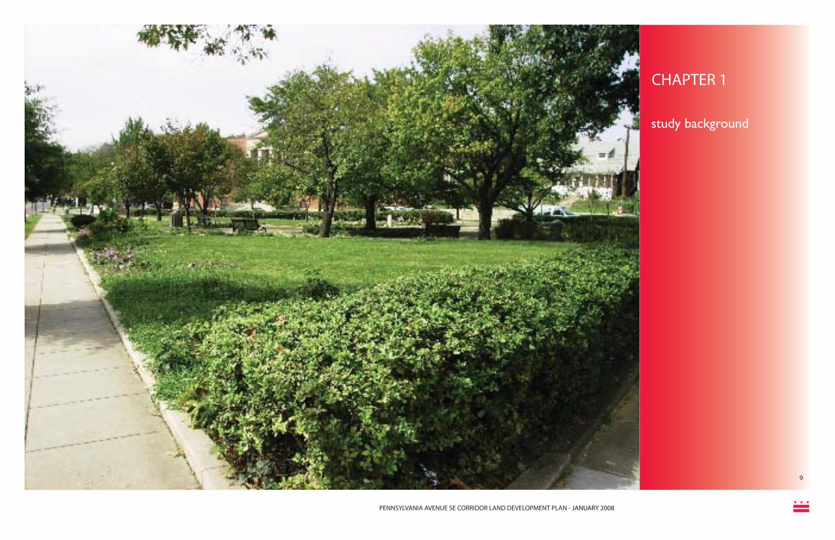
The District of Columbia Offi ce of Planning conducted the Pennsylvania Avenue SE Corridor Land Development Plan (“the Plan”) to identify development options for key sites that refl ect community goals, market analysis and site features. These development options will be used to guide future decisions for these key sites which have the potential to serve as catalysts for corridor-wide revitalization. The study area includes all properties fronting on Pennsylvania Avenue SE from Independence Avenue SE/2nd Street SE eastward to Southern Avenue. The study area is more than three miles long and runs through parts of Wards 6, 7, and 8 in the District of Columbia.
Serving as a gateway to the nation’s capital, Pennsylvania Avenue SE in Washington, DC is often referred to as “America’s Main Street.” In addition to its historic and symbolic importance to the District of Columbia and to the nation, it serves a vital role as a busy arterial road, a vibrant commercial hub, and a focal point for surrounding neighborhoods.
The District of Columbia designated Pennsylvania Avenue SE as one of seven major corridors as part of its Great Streets Initiative, a multi-disciplinary corridor-based program to spur redevelopment and increase neighborhood livability. The program uses strategic public investments to improve local quality of life and to attract private investment. The Great Streets Initiative is a partnership of the Offi ce of the Deputy Mayor for Planning and Economic Development (ODMPED), the District of Columbia Department of Transportation (DDOT), and the District of Columbia Offi ce of Planning (OP).
The Plan includes the following four distinct but interrelated components:
1. Land-use and zoning analysis - A detailed examination of existing land-use and zoning along the corridor and evaluation of potential land-use strategies to further the community’s vision for the future.
2. Urban design - Recommendations for functionality, form of development, and preservation and enhancement of neighborhood character.
3. Market and real estate analysis – Evaluation of the corridor’s capacity for development and potential market support for different goods and services and identifi cation of strategies for retail and commercial investment.
4. Public participation – Active and ongoing community participation through a broad range of outreach activities.
Through the study process, seven sites were identifi ed that held the highest potential for redevelopment and revitalization:• 1401 Pennsylvania Ave • 1539-1557 Pennsylvania Ave • 1550 Pennsylvania Ave• L’Enfant Square - 2300 block (south
side) • L’Enfant Square - 2500 & 2600 blocks
(south side) • Penn Branch shopping center• Fort Davis shopping center
introduction &project context
STUDY BACKGROUND
Figure 1.1: Pennsylvania Avenue SE in the District of Columbia

PENNSYLVANIA AVENUE SE CORRIDOR LAND DEVELOPMENT PLAN - JANUARY 2008
11
Community Involvement
A very important component of the study was ongoing community involvement through a variety of means including an Advisory Committee, multiple community meetings including a multi-day design charrette in December 2006, a project website (www.pennavese.com), email blasts to stakeholders and also door-to-door canvassing by OP staff. During the course of the study, the District Department of Transportation (DDOT) conducted a concurrent streetscape study for the corridor east of the Anacostia River. The two study efforts, including public participation activities, were closely coordinated.
Pennsylvania Avenue SE Advisory Committee
The Offi ce of Planning, in coordination with the Offi ces of Councilmembers Vincent Gray, Marion Barry and Sharon Ambrose1, formed the Pennsylvania Avenue SE Advisory Committee. The Advisory Committee included representatives from the many stakeholders in the study area, including government agencies and Councilmembers, Advisory Neighborhood Commissions (ANC’s), neighborhood and civic organizations, business associations, business and property owners and investors, and faith-based and non-profi t organizations. The Advisory Committee worked closely with the Offi ce of Planning, the consultant team, and other government agencies in guiding and developing the Corridor Land Development Plan. The Committee met fi ve times during the study in April, July and October of 2006, 1 Councilmember Sharon Ambrose retired from offi ce at the end of
her term. The Honorable Tommy Wells was elected to succeed her as the Ward 6 Councilmember. Councilmember Vincent Gray was elected as Council Chair, vacating his Ward 7 seat in Janu-ary. The Honorable Yvette Alexander was elected to succeed him as the Ward 7 Councilmember on May 1, 2007.
and in April and December 2007.
Advisory Committee Members
Marge Francese Councilmember Sharon Ambrose’s Offi ceWill Hill Advisory Neighborhood Commissioner 6B-06Antonette Russell Advisory Neighborhood Commissioner 6B-09Reuben Hameed Barney Circle Neighborhood Watch AssociationElizabeth HaverkampCapitol Hill Association of Merchants and ProfessionalsSusan Perry Capitol Hill Business Improvement District (BID)Dick Wolf Capitol Hill Restoration Society (CHRS)Jill Downing Penn East, Inc.John BegertJPIEd CopenhaverFrager’s HardwareDawn SlonnegerCouncilmember Vincent C. Gray’s Offi ceGilbert BussyPenn Branch Citizens/Civic AssociationVincent M. SpauldingHillcrest Community Civic AssociationBarbara MorganDupont Park Civic AssociationAkili CooperFort Davis Civic AssociationCornelius Bailey Randle Highlands Civic AssociationBarbara MorganPennsylvania Avenue Task Force Committee
Villareal JohnsonAdvisory Neighborhood Commissioner 7A-07 Lillian MooreAdvisory Neighborhood Commissioner 7B-03Raymond KeithAdvisory Neighborhood Commissioner 7B-06Robin Marlin Advisory Neighborhood Commissioner 7B-05Thelma Jones Fairlawn Civic AssociationAnthony Muhammad Advisory Neighborhood Commissioner 8A-01Christopher Jerry Fairlawn Civic AssociationBrad ChesevoirBrooks PropertiesStylianos Christofi des Infrastructure Capital GroupGayle Hazelwood National Park Service-US Department of the InteriorBrenda RichardsonCouncilmember Marion Barry’s Offi ce
STUDY BACKGROUNDintroduction &project context

PENNSYLVANIA AVENUE SE CORRIDOR LAND DEVELOPMENT PLAN - JANUARY 2008
1212
Community Meetings
Seven community meetings were held throughout the study process, including the following (see Table 1.1):• A presentation on the study by OP staff at
the Jun 29, 2006 kick-off meeting for the DDOT Pennsylvania Avenue Streetscape
• Participation by OP staff and the Consultant team in DDOT’s multi-day charrette – Jul 26 – 29, 2006
• A Community kick-off meeting held Sep 25, 2006 at the St. Francis Xavier Catholic Church
• A joint OP/DDOT meeting on Nov 9, 2006 held to allow citizens to gain information and provide comments on both study efforts
Charrette
The public charrette organized in December 2006 was an important component of the study and provided valuable public input for redevelopment of catalyst sites on the Pennsylvania Avenue corridor. Efforts were focused on bringing about a positive interaction between all stakeholders, including community residents, design consultant teams, municipal offi cials and developer groups.
The charrette opened with an overview of the project, charrette goals and schedule presented by the consultant team which tied together the economic and urban design aspects for establishing corridor wide planning principles and vision. While the objective of this session was to get a sense of what people want along the corridor, the following two full day workshops were targeted for gathering public input on type and character of development desired on specifi c sub-areas – Potomac Avenue, L’Enfant Square, Penn Branch, Fairfax Village and Fort Davis. Expression of need and desires by the community defi ned distribution of uses amongst study areas, for example – we can only support one grocery store, where
should it go? The discussions served as an initial reality check on general development scenarios for corridor revitalization, addressed identifi ed confl icts and highlighted areas of agreement.
On the fi nal day, the consultant team presented a summary and analysis of relevant information and conceptual sketches as an opportunity for open comment and review by the various public stakeholder groups involved.
Themes and Goals
Throughout the study, the project team heard consistent themes for the community’s goals and desires for future revitalization and redevelopment: Redevelopment• Consistent design guidelines• Diversity of housing types• More affordable housing• Increased mixed-use development
Table 1.1: Meetings
Streetscape Aesthetics/Mobility• Need a more attractive streetscape
– landscaping, trees, street furniture (benches, planters, etc,)
• Defi ne L’Enfant Square - possibly through gateway treatments
• Improve connections across the Anacostia River
• More trees and green space• Mid-block pedestrian crossings• New and better sidewalks• Better access and connection to the
Anacostia River
Retail Attraction• Retail that has more of a “street presence”• Large grocery store East of the River• Marketing campaign to attract people East
of the River• Increase neighborhood-oriented
commercial uses• More sit-down restaurants• Redevelopment has to address parking
issues• More cultural opportunities
6/29/2006 Community Meeting7/20/2006 Advisory Committee Meeting7/26/2006 - 7/29/2006 District Department of Transportation Multi-Day Charrette9/25/2006 Community Meeting PROJECT KICKOFF10/23/2006 Advisory Committee Meeting11/9/2006 Joint OP and DDOT Meeting12/7/2006 - 12/11/2006 Multi-day Charrette2/20/2007 Ward 6 Capitol Hill Restoration Society Corridor Study Briefi ngs2/26/2007 Ward 6 Barney Circle Neighborhood Association Corridor Study Briefi ngs3/5/2007 Ward 7 Fort Dupont Civic Association Corridor Study Briefi ngs3/5/2007 Ward 8 ANC 8A Corridor Study Briefi ngs3/13/2007 Ward 6 ANC 6B Corridor Study Briefi ngs3/13/2007 Ward 7 Penn Branch Citizens/Civic Association Corridor Study Briefi ngs3/17/2007 Ward 7 Fort Davis Civic Association Corridor Study Briefi ngs3/20/2007 Ward 7 Dupont Park Civic Association Corridor Study Briefi ngs3/22/2007 Ward 7 Randall Highlands Citizens Civic Association Corridor Study Briefi ngs
introduction &project context
STUDY BACKGROUND

PENNSYLVANIA AVENUE SE CORRIDOR LAND DEVELOPMENT PLAN - JANUARY 2008
13
STUDY BACKGROUNDstudy area
Figure 1.2: Pennsylvania Avenue SE Study Area

PENNSYLVANIA AVENUE SE CORRIDOR LAND DEVELOPMENT PLAN - JANUARY 2008
14
Fairfax Village / Fort Davis
/Fort Davis
STUDY BACKGROUNDproject sub-areas
Figure 1.3: Pennsylvania Avenue SE Project Sub Areas

PENNSYLVANIA AVENUE SE CORRIDOR LAND DEVELOPMENT PLAN - JANUARY 2008
15
Coordination with Other Planning Efforts
This plan strives to refl ect and incorporate, wherever possible, major recommendations of the multiple planning and project development activities in the corridor. DDOT is responsible for several planning efforts in the study area that have impacted the study process. The following list identifi es DDOT Plans, Studies and Projects recently completed or currently underway. For further description see Page 21.
Previous DDOT Plans and Studies
• Pennsylvania Avenue SE Transportation Study
• Pennsylvania Avenue Scenic Byway Corridor Management Plan
• District of Columbia Transit Improvements Alternatives Analysis
• Middle Anacostia River Crossings Transportation Study
• Capitol Hill Transportation Study
• Anacostia Waterfront Transportation Master Plan
Studies and Projects Currently Underway:
• 11th Street Bridges Environmental Impact Statement (EIS)
• Middle Anacostia Near Term Improvements Design (including reconfi guration of Pennsylvania Avenue and Potomac Avenue Intersection)
• Pennsylvania Avenue SE Great Streets Design (East of Anacostia River)
• District of Columbia Rapid Bus Study - Pennsylvania Avenue Corridor
Other relevant past studies include the follow-ing:
• The Memorials and Museums Master Plan was developed by the National Capital Planning Commission. It identifi ed one hundred potential sites for future memorials and museums in the District of Columbia and provided general guidelines for the placement of these facilities. It included inventories of existing memorials and museums, a projection of future requirements, an urban design framework for locating future sites, and policies to guide federal agencies in their review of future museums and memorials.
• Strategic Neighborhood Action Plans (SNAPs) were prepared by the DC Offi ce of Planning, starting in 2000, for each of the District of Columbia’s thirty-nine neighborhood clusters. The SNAPs outline the top priority issues in each neighborhood and inform decisions on the city budget.
Pennsylvania Avenue Task Force For the last seven years, a group of
citizens composed of representatives from local ANCs, civic associations, and other community groups have worked together to form a vision for the Pennsylvania Avenue, SE corridor east
of the river. Members of this group have been actively involved in this planning process. A market study was conducted in 2002 showing a demand and desire from the community for more sit down restaurants, cafes, drug stores, clothing stores, a hardware store, and other locally serving retail. Market strengths noted by this study included the area’s stable population and high traffi c volumes. Several weaknesses were also pointed out, including that the area is so close to other larger shopping areas such as Skyland Shopping Center, East River Shopping Center, and a variety of options in Prince George’s County. This study suggested that the Pennsylvania Avenue corridor is most likely to attract very locally serving retailers, and others that can take advantage of the commuter traffi c. Recommendations for attracting new retail included 1) Building a critical mass of new retail space large enough to overcome negative perceptions of the area, 2) Placing retail attractive to commuters on the south side of the street to attract people on their way home from work, 3) Making parking visible, ample and secure, 4) Improving pedestrian linkages across Pennsylvania Avenue, 5) Providing subsidies to developers and retailers to offset the high costs of construction and the need for reasonably priced leases, and 6) Marketing the area aggressively to new retailers and shoppers alike.
This plan takes the results of all of these previous studies into consideration, and incorporates them into its fi nal recommendations.
STUDY BACKGROUNDcoordination with other planning efforts

PENNSYLVANIA AVENUE SE CORRIDOR LAND DEVELOPMENT PLAN - JANUARY 2008
16
CHAPTER 2
study area conditions

PENNSYLVANIA AVENUE SE CORRIDOR LAND DEVELOPMENT PLAN - JANUARY 2008
17
Figure 2.1: L’Enfant Plan for Washington, D.C.
The Pennsylvania Avenue SE corridor includes several historic resources, some of which are included on the National Register of Historic Resources and/or the DC Inventory of Historic Sites. The National Register of Historic Places is the offi cial national list of historic properties considered worthy of preservation and is maintained by the National Park Service in the U.S. Department of the Interior. Listing on the National Register does not automatically protect a building or district from demolition or other modifi cation; however, it does require federal, state and local government agencies to take into consideration the effect of their plans or projects on the listed properties.
The DC Inventory of Historic Sites is a listing of properties designated by the District of Columbia Historic Preservation Review Board (HPRB). District of Columbia Historic Preservation Law protects all properties listed in the DC Inventory of Historic Sites and provides the HPRB with the authority to approve or deny proposed changes to historic landmarks and historic districts.
Additional buildings or sites along the Pennsylvania Avenue, SE Corridor may be considered for historic designation. Future redevelopment suggested by this plan shall fully respect any historic resources designated after this plan is published. HPRB will guide sensitive preservation and incorporation of these buildings within the context of new development.
Name Location National Register of Historic Places
District of Columbia Inventory of Historic Sites
Capitol Hill Historic District
Roughly bounded by Virginia Avenue SE., S. Capitol Street, F Street NE., and 14th Streets SE & NE
Yes Yes
Congressional Cemetery
1801 E Street SE Yes Yes
Old Naval Hospital
921 Pennsylvania Avenue SE
Yes Yes
Fort Dupont In proximity to intersec-tion of Pennsylvania Avenue SE and Alabama Avenue SE
Yes (Civil War Fort Sites)
Yes (Fort Circle Parks)
Fort Davis In proximity to intersec-tion of Pennsylvania Avenue SE and Alabama Avenue SE
Yes (Civil War Fort Sites)
Yes (Fort Circle Parks)
Eastern Market 7th and C Streets SE Yes Yes
Seward Square All Addresses No Yes
Engine Company #19 2813 Pennsylvania Avenue SE
No Yes (Pending Land-mark)
Friendship House 619 D Street SE Yes Yes
Table 2.1: Historic Resources STUDY AREACONDITIONShistoric resources

PENNSYLVANIA AVENUE SE CORRIDOR LAND DEVELOPMENT PLAN - JANUARY 2008
18Figure 2.2: Pennsylvania Avenue SE Historic Resources
STUDY AREACONDITIONS
historic resources

PENNSYLVANIA AVENUE SE CORRIDOR LAND DEVELOPMENT PLAN - JANUARY 2008
19
Figure 2.3: Capitol Hill Cluster School
Figure 2.4: Metropolitan Police Department
Figure 2.5: Randle Highlands School
The study area includes signifi cant government and institutional resources and facilities including Fire and Emergency Medical Services Department buildings, Metropolitan Police Department facilities, public and private schools, and a library. A list of these resources is included in Table 2.2 and their locations are noted in Figure 2.6 on page 18.
STUDY AREACONDITIONS government & institutional resources & facilities
NAME LOCATION
Fire And Emergency Medical Services DepartmentEngine Company 18 414 8th Street, SE
Engine Company 19 2813 Pennsylvania Avenue, SE
Metropolitan Police Department FacilitiesMetropolitan Police Department Sixth District Substation
2701 Pennsylvania Avenue, SE
Metropolitan Police Department Regional Op-erations Command-East
3244 Pennsylvania Avenue, SE
Public SchoolsHine Junior High School 335 8th Street, SE
C. Watkins Elementary School 420 12th Street, SE
Friendship-Edison PCS Chamberlain Campus (Public Charter School)
1345 Potomac Avenue SE
Randle Highlands Elementary School 1650 30th Street, SE
Private SchoolsSaint Francis Xavier School 2700 O Street, SE
LibrariesSoutheast Neighborhood Library 403 7th Street, SE
Other ResourcesUniversity Legal Services 3220 Pennsylvania Avenue SE
District of Columbia Department of Human Services
3851 Alabama Avenue SE
Friendship House Association 619 D Street SE
Table 2.2: Government and Institutional Resources and Facilities

PENNSYLVANIA AVENUE SE CORRIDOR LAND DEVELOPMENT PLAN - JANUARY 2008
20Figure 2.6: Pennsylvania Avenue SE Government & Institutional Resources
STUDY AREA CONDITIONS
government & institutional resources
PENNSYLVANIA AVENUE SE CORRIDOR LAND DEVELOPMENT PLAN - JANUARY 2008
21Figure 2.7: Fort Dupont Park
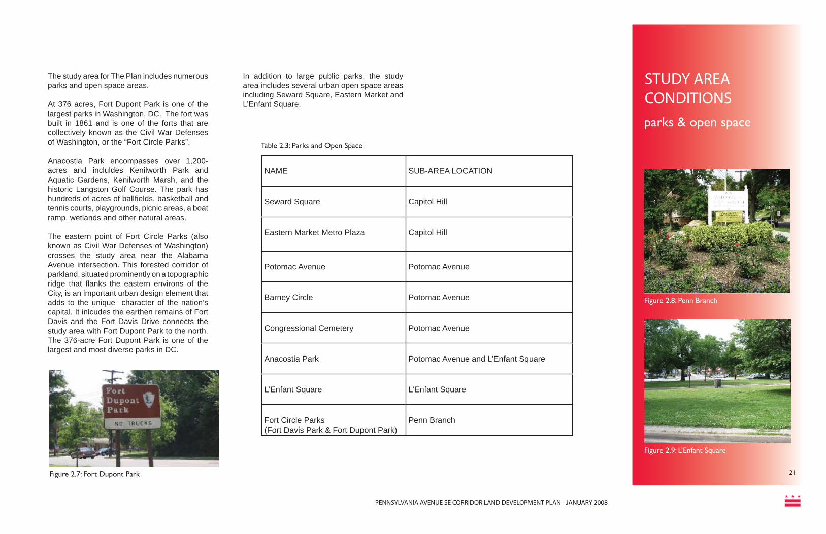
The study area for The Plan includes numerous parks and open space areas.
At 376 acres, Fort Dupont Park is one of the largest parks in Washington, DC. The fort was built in 1861 and is one of the forts that are collectively known as the Civil War Defenses of Washington, or the “Fort Circle Parks”.
Anacostia Park encompasses over 1,200-acres and incluldes Kenilworth Park and Aquatic Gardens, Kenilworth Marsh, and the historic Langston Golf Course. The park has hundreds of acres of ballfi elds, basketball and tennis courts, playgrounds, picnic areas, a boat ramp, wetlands and other natural areas.
The eastern point of Fort Circle Parks (also known as Civil War Defenses of Washington) crosses the study area near the Alabama Avenue intersection. This forested corridor of parkland, situated prominently on a topographic ridge that fl anks the eastern environs of the City, is an important urban design element that adds to the unique character of the nation’s capital. It inlcudes the earthen remains of Fort Davis and the Fort Davis Drive connects the study area with Fort Dupont Park to the north. The 376-acre Fort Dupont Park is one of the largest and most diverse parks in DC.
In addition to large public parks, the study area includes several urban open space areas including Seward Square, Eastern Market and L’Enfant Square.
NAME SUB-AREA LOCATION
Seward Square Capitol Hill
Eastern Market Metro Plaza Capitol Hill
Potomac Avenue Potomac Avenue
Barney Circle Potomac Avenue
Congressional Cemetery Potomac Avenue
Anacostia Park Potomac Avenue and L’Enfant Square
L’Enfant Square L’Enfant Square
Fort Circle Parks(Fort Davis Park & Fort Dupont Park)
Penn Branch
Table 2.3: Parks and Open Space
Figure 2.8: Penn Branch
Figure 2.9: L’Enfant Square
STUDY AREA CONDITIONS parks & open space

PENNSYLVANIA AVENUE SE CORRIDOR LAND DEVELOPMENT PLAN - JANUARY 2008
22Figure 2.10: Pennsylvania Avenue SE Parks & Open Spaces
STUDY AREACONDITIONS
parks & open spaces

PENNSYLVANIA AVENUE SE CORRIDOR LAND DEVELOPMENT PLAN - JANUARY 2008
23
Transportation Introduction and Background
The Pennsylvania Avenue SE Corridor is an important transportation corridor in the District of Columbia. Pennsylvania Avenue SE is classifi ed by the District Department of Transportation as a principal arterial road and is crossed by collector, local, and minor arterial roads and the Anacostia Freeway (I-295) on the east side of the Anacostia River and the Southeast Freeway on the west side of the Anacostia River.
Transportation Plans, Studies, and Projects
•Middle Anacostia River Crossings •11th Street Bridges Environmental Impact
Statement (EIS) •Middle Anacostia Near Term Improvements
Design (including reconfi guration of Pennsylvania Avenue and Potomac Avenue Intersection)
•Capitol Hill Transportation Study•Pennsylvania Avenue Streetscape Design (East of Anacostia River)•11th Street Bridge Realignment•Pennsylvania Ave SE Transportation Study •The District of Columbia Transit Improvements
Alternatives Analysis•Pennsylvania Avenue Scenic Byway Corridor Management Plan•District of Columbia Rapid Bus Study -
Pennsylvania Avenue Corridor
The Capitol Hill Transportation Study includes Pennsylvania Avenue SE from Independence Avenue SE and 2nd Avenue SE to Barney Circle. An important element of the Capitol Hill Transportation Plan study (originally contemplated in the Middle Anacostia River Crossings effort) is recommended improvements at the intersection of Potomac
Avenue SE and Pennsylvania Avenue SE. These recommendations include reconfi guring the intersection entirely and creating a fully functioning traffi c circle as well as other recommendations with a key goal of mitigating vehicle and pedestrian confl icts. Other recommendations emphasized pedestrian safety at the Eastern Market intersections with the goal of providing safer connections between bus, Metro, and pedestrian travel. These and other recommendations in the plan could potentially impact Pennsylvania Avenue as they would signifi cantly alter the land-use and circulation patterns along the corridor.
A second DDOT initiative is a streetscape design process for Pennsylvania Avenue SE east of the Anacostia River. The project has recommendations for intersection improvements and operational solutions and is part of the Great Streets program. DDOT held a four-day community workshop to identify, discuss, and review potential streetscape design options for the corridor. An important element of this study is recommendations for the design and layout of the L’Enfant Square intersection at Pennsylvania Avenue SE and Minnesota Avenue SE and a landscaped median running along the Avenue from L’Enfant Square to Southern Avenue. Proposed changes to the design and layout of the road could have signifi cant implications on land use and economic development for surrounding properties and thus could potentially impact the Plan. The Plan, however, is a living document, and can be amended to address any future transportation impacts. A third important DDOT initiative is the proposed replacement of the twin 11th Street Bridges over the Anacostia River and improvements to the interchanges at either end. Based on the
recommendations from the Middle Anacostia River Crossings Transportation Study, the proposed improvements include constructing new ramps east of the Anacostia River to connect both directions of the Anacostia Freeway with the crossriver bridges. Local traffi c would be separated from freeway traffi c. Wide, shared-use paths for easy walking, jogging, and bicycling would tie into existing and planned trails on both sides of the river. The 11th Street Bridges project will provide additional connections between interstate highways in the vicinity of the study area and potentially reduce cut-through traffi c on local streets. The project is currently in the environmental documentation phase. The 11th Street Bridges Draft Environmental Impact Statement (DEIS) was published in June 2006 and the Final Environmental Impact Statement (FEIS) was published in Fall 2007.
DDOT is also working to increase transit options in the Pennsylvania Avenue SE Corridor. A comprehensive study of the WMATA metrobus 30’s route, which operates in the Pennsylvania corridor, is currently underway. This study will examine the current service and recommend short range service improvements. The recommendations will compliment the fi ndings of the District of Columbia Rapid Bus Study - Pennsylvania Avenue Corridor.
The Pennsylvania Avenue SE Transportation Study documented the volume of automobiles traveling along the Pennsylvania Avenue SE corridor and presented recommendations for improvements to community cohesiveness and amenities, pedestrian accessibility, transit facilities, and overall circulation. DDOT is currently fi nalizing the District of Columbia Transit Alternatives Analysis (DCAA). The study outlines recommendations for increasing
surface transit options within the District and addresses service gaps in the existing Metro bus and rail system. The implementation timeframe extends over a thirty (30) year period and will include various premium transit technologies.
The Pennsylvania Avenue Scenic Byway Corridor Management Plan was prepared by DDOT for the National Scenic Byways Program. The plan is meant to encourage the conservation and enhancement of Pennsylvania Avenue’s historical and cultural qualities and to promote tourism and economic development.
How Land Use Informs Transportation Decisions:
To the average citizen, the link between land development and transportation is not always clear. The process begins with the Offi ce of Planning’s State Data Center (SDC). At least once a year, the SDC staff looks at population and development growth throughout the city, and makes predictions for growth in the coming year. The last update occurred in January 2007, and the next will be early in 2008. The Metropolitan Washington Council of Governments (MWCOG) then takes this information to create travel demand models that show expected traffi c increases and impacts on a regional level. DDOT takes this data and refi nes it to a more local level. In this way, future development is considered every time DDOT conducts a study.
More information on MWCOG’s travel model can be found on line at:
h t tp : / /www.mwcog.org / t ranspor ta t ion /activities/models/current.asp.

PENNSYLVANIA AVENUE SE CORRIDOR LAND DEVELOPMENT PLAN - JANUARY 2008
24Figure 2.11: Pennsylvania Avenue SE Planned & Recommended Transportation Improvements
Yellow lines: Proposed bicycle lanesOrange circles: Proposed transportation improvementsBlue circles: OP-recommended Bus Rapid Transit stopsRed triangles: Metrorail station entrances
Planned & Recommended Transportation ImprovementsSTUDY AREA CONDITIONS
planned transportation improvements

PENNSYLVANIA AVENUE SE CORRIDOR LAND DEVELOPMENT PLAN - JANUARY 2008
25
Land Use and Zoning
Cities use zoning regulations as part of a coordinated approach to implementing land use policies and community vision. At the most basic level, zoning regulations classify the city into different zoning districts. Each district has rules governing the character of the development allowed, such as permitted uses, building scale, parking, setbacks, and development intensity. These regulations are created to guide development, and prevent unwanted and incompatible land uses and construction. Zoning itself does not promote or foster development, rather it prevents projects not in compliance with the regulations.
As this is a land use plan, careful consideration and analysis of existing uses and zoning is essential. The land use maps here refl ect data from the District of Columbia and site visits by the consultant team. The sub-area maps that follow provide a more detailed description of existing land use conditions and are also based on data from the DC Offi ce of the Chief Technology Offi cer and site visits.
Corridor Land Use and Character
The corridor began its rich history as an extension of the L’Enfant Plan, see Figure 2.1, and was built on an axis with the U.S. Capitol Building. It was designated as a National Scenic Byway by the U.S. Department of Transportation. The Pennsylvania Avenue SE Corridor includes a variety of land uses as shown in Figure 2.12 on page 24. West of the Anacostia River, the corridor is predominantly commercial with adjacent residential development. There are signifi cant parks and open space areas in this portion of the study area at Seward Square, Eastern Market, Potomac Avenue, and Barney Circle and along the median on Pennsylvania
Avenue SE. The portion of the Pennsylvania Avenue SE corridor east of the Anacostia River from Fairlawn Avenue to 30th Street SE is more commercial in character. East of 30th Street, the corridor is more residential in character with commercial nodes at Branch Avenue SE and Alabama Avenue SE. This segment also includes signifi cant Public/Institutional and Parks and Open Space land use designations.
The consultant team conducted several site visits to assess the overall condition and character of the corridor. These observations are described below for both east and west of the Anacostia River, and also later on for the individual sub-areas in Chapter 4.
Pennsylvania Avenue East of the River
• Use as a major river crossing severely impacts the corridor and divides the community
• Less ceremonial than the west side of the corridor
• Retail pockets are automobile oriented and offer limited services
• Large setbacks and a green boulevard• Mostly fronted by single-family homes• Several major parks and small pocket
parks - poor pedestrian access to parks due to automobile orientation
• Lack of access to the Anacostia River because of I-295 and the interchange
• L’Enfant Square is a congested and dangerous intersection; roadways split the open space into traffi c islands
• Vehicular Right-of-Way widens appreciably once in Maryland
• Defi ned by single-family and multi-family residential with clearly defi ned retail and employment zones
• L’Enfant Square is a prominent gateway
to the neighborhoods East of the River
Pennsylvania Avenue West of the River
• Prototypical DC historic architecture and land uses dominate
• Majority of the homes are row houses constructed around the turn of the 19th century and earlier
• Some of the District’s earliest row houses are in the Capitol Hill community
• Scattered among the row houses are attractive small apartment buildings and corner stores
• Slow and steady transformation of the neighborhood’s commercial areas
• Excellent public transportation including connections to Metrorail Stations
• Where 7th and 8th Streets SE cross Pennsylvania Avenue SE, they create a lively intersection of services
• The renowned Eastern Market farmers market anchors the 7th Street commercial area and provides a hub for weekend shopping
• 8th Street SE, south of Pennsylvania Avenue SE, is known as Barracks Row and is a growing neighborhood retail area
• Includes historic Old Naval Hospital, school buildings, community garden, and pocket parks
• Pennsylvania Avenue SE intersects Seward Square, which was one of the original L’Enfant Squares and was named after President Lincoln’s Secretary of State
• New trees in the median
STUDY AREACONDITIONSland use & zoning

PENNSYLVANIA AVENUE SE CORRIDOR LAND DEVELOPMENT PLAN - JANUARY 2008
26Figure 2.12: Pennsylvania Avenue SE Existing Land Use
STUDY AREA CONDITIONSexisting land use

PENNSYLVANIA AVENUE SE CORRIDOR LAND DEVELOPMENT PLAN - JANUARY 2008
STUDY AREA CONDITIONSzoning categories
27
R-1-B Permits matter-of-right development of single-family residen-tial uses for detached dwellings with a minimum lot width of 50 feet, a minimum lot area of 5,000 square feet, a maximum lot occupancy of 60% for a church or public school use and 40% for all other structures; and a maximum height of three (3) stories/forty (40) feet.
R-2 Permits matter-of-right development of single-family residen-tial uses for detached and semi-detached structures, with a minimum lot width of 40 feet and lot area of 4000 square feet for detached structures, and 30 feet and 3000 square feet for semi-detached structures; a maximum lot occupancy of 60% for church and public school use and 40% for all other struc-tures, and a maximum height of three (3) stories/forty (40) feet.
R-4 Permits matter-of-right development of single-family residen-tial uses (including detached, semi-detached, row dwellings, and fl ats), churches and public schools with a minimum lot width of 18 feet, a minimum lot area of 1,800 square feet and a maximum lot occupancy of 60% for row dwellings, church-es and Flats, a minimum lot width of 30 feet and a minimum lot area of 3000 square feet for semi-detached structures, a minimum lot width of 40 feet and a minimum lot area of 4000 square feet and 40% lot occupancy for all other structures; and a maximum height of three (3) stories/forty (40) feet. Conver-sions of existing buildings to apartments are permitted for lots with a minimum lot area of 900 square feet per dwelling unit.
R-5-A Permits matter-of-right development of single-family residen-tial uses for detached and semi-detached dwellings, and with the approval of the Board of Zoning Adjustment, new residen-tial development of low density residential uses including row houses, fl ats, and apartments to a maximum lot occupancy of 40%, 60% for churches and public schools; a maximum fl oor area ratio (FAR) of 0.9, and a maximum height of three (3) stories/forty (40) feet. Conversion of existing buildings to Flat or Apartment use is permitted as a matter of right provided all other provisions of the zoning regulations are complied with.
R-5-B Permits matter-of-right moderate development of general resi-dential uses, including single-family dwellings, fl ats, and apart-ment buildings, to a maximum lot occupancy of 60%, a maxi-mum FAR of 1.8, and a maximum height of fi fty (50) feet.
C-1 Permits matter-of-right neighborhood shopping and low den-sity development to a maximum lot occupancy of 60% for resi-dential use, a maximum FAR of 1.0, and a maximum height of three (3) stories/forty (40) feet.
C-2-A Permits matter-of-right low density development, including of-fi ce, retail, and all kinds of residential uses to a maximum lot occupancy of 60% for residential use, a maximum FAR of 2.5 for residential use and 1.5 FAR for other permitted uses, and a maximum height of fi fty (50) feet
C-2-B Permits matter-of-right medium density development, includ-ing offi ce, retail, housing, and mixed uses to a maximum lot occupancy of 80% for residential use, a maximum FAR of 3.5 for residential use and 1.5 FAR for other permitted uses, and a maximum height of sixty-fi ve (65) feet.
C-M-1 Permits development of low bulk commercial and light man-ufacturing uses to a maximum FAR of 3.0, and a maximum height of three (3) stories/forty (40) feet with standards of ex-ternal effects and new residential prohibited.
Capitol Hill Commercial (CHC)
Established along the principal commercial corridors in the Capitol Hill Historic District to provide incentives for small of-fi ce and retail development for all permitted uses. Except in the CAP Overlay District, the CHC Overlay will increase the maximum permitted FAR to a maximum of 3.0 FAR for all per-mitted uses, allowing 100 percent (100%) commercial occu-pancy as a matter-of-right. In the CAP Overlay District, the CHC Overlay will increase the maximum permitted FAR to 2.5 FAR for all permitted uses. A planned unit development in the CHC Overlay District may not exceed the maximum FAR permitted in the CHC Overlay District. The CHC Overlay does not affect the underlying C-2-A or CAP Overlay height limita-tions or any other applicable area or use restriction.
CapitolInterest District(CAP)
Permits development of uses that are consistent with the US Capitol Master Plan, to a maximum FAR of 1.8, and a maxi-mum height of three (3) stories/forty (40) feet. This district is mapped in combination with other districts.
Table 2.4: Zoning Categories
The following zoning categories are all those that currently exist along the corridor, as shown in fi gure 2.13. Parcels fronting Pennsylvania Avenue, SE west of the river are predominantly zoned commercial, while east of the river the zoning consists of commercial nodes spaced between residential areas.

PENNSYLVANIA AVENUE SE CORRIDOR LAND DEVELOPMENT PLAN - JANUARY 2008
28Figure 2.13: Pennsylvania Avenue SE Existing Zoning
STUDY AREA CONDITIONSexisting zoning

PENNSYLVANIA AVENUE SE CORRIDOR LAND DEVELOPMENT PLAN - JANUARY 2008
29
CHAPTER 3
market assessment

PENNSYLVANIA AVENUE SE CORRIDOR LAND DEVELOPMENT PLAN - JANUARY 2008
30
The Pennsylvania Avenue corridor is incredibly diverse with regard to current market conditions and future market opportunities. The part of the corridor west of the Anacostia River ranges from established, mixed-use areas to emerging cores of activity; the market opportunities in this part of the corridor are near-term. The part of the corridor East of the River includes a mix of stable, middle-class neighborhoods and areas of physical blight and socioeconomic distress. There are opportunities for both near and longer-term redevelopment here, with a few pending projects close to approval at important locations.
The market assessment component of the study has helped guide the planning process to ensure that the plan is based upon achievable market and development assumptions within all sub-areas in the corridor. The objective of the market assessment component is to provide a broad overview of the future market conditions along the corridor, and the achievable demand assumptions by land use over the next 20-year period. The market assessment also addresses the market economics of the development opportunities and constraints along parts of the corridor, in particular the fi nancial feasibility of specifi c types of development and the critical issues density and site capacity.
Specifi c tasks of this market assessment have included:
• An assessment of existing land use conditions and current development trends along the corridor.
• An analysis of demographic and market trends within the corridor and its submarkets.
• A calculation of future demand by land use based upon demographic and market trend data, specifi cally:o Multifamily residentialo Retailo Offi ce
• A broad assessment of site capacity in selected cores of activity, with a specifi c focus on those areas that present immediate opportunities and those that are more site capacity constrained.
• An assessment of the fi nancial feasibility of specifi c types of development, given expected rents and prices along the corridor
MARKET ASSESSMENT
background & methodology

PENNSYLVANIA AVENUE SE CORRIDOR LAND DEVELOPMENT PLAN - JANUARY 2008
31
Existing Land Uses
The corridor offers a wide diversity with regard to the character and quality of land uses (see Figure 3.1 on page 41). The area West of the River has a greater concentration of commercial uses than the area East of the River, and the commercial uses in the western area tend to be healthier and are more effectively integrated within a vibrant, mixed-use environment. The quality of the commercial uses in the western portion of the study area does decline in the cores closest to the Sousa Bridge.
The area of the corridor East of the River has relatively few commercial nodes, the quality of these commercial nodes are generally poor, and the commercial activity is not as effectively integrated into surrounding neighborhoods. Much of the retail in the eastern portion of the study area serves the retail needs of passing commuters as much as those of local residents.
Multifamily housing is dispersed throughout the corridor, with a greater share of this housing type West of the River. The multifamily housing stock West of the River tends to be better integrated within mixed-product, mixed-use neighborhoods, and generally this stock of housing is healthier and more stable.
The multifamily housing East of the River tends to be more concentrated, with signifi cant pockets of distress; there are pockets of stable, healthy, moderate and middle-income multifamily housing, as well as a small amount of new, market-rate housing.
The Pennsylvania Avenue corridor is not a signifi cant offi ce market, and the offi ce space
that does exist within the corridor is generally located West of the River within the Capitol Hill neighborhood. This offi ce space tends to be smaller, boutique space. There are DC government offi ces East of the River, but this activity is not indicative of broader, private sector offi ce demand.
Development Trends
The Capitol Hill sub-area – the western most portion of the corridor, from 2nd Street to 11th Street – is an established, vibrant, mixed-use core. This market condition is moving eastward, and has already generated development opportunities east of 11th Street, (most notably the mixed-use Jenkins Row project). The Potomac Avenue sub-area is therefore already experiencing signifi cant redevelopment pressures, and the next logical step in the near term is further reinvestment in the Potomac Avenue Metro core and the stretch of underutilized parcels from 14th Street to the Sousa Bridge. These redevelopment pressures will impact, and be impacted by, the ongoing efforts to recapture the Anacostia waterfront.
The design of Barney Circle, the I-395 spur, and the Sousa Bridge represent signifi cant physical barriers, and this has historically limited the real and perceived market connection between the west and east sides of the River. Over time, this connection will strengthen, as redevelopment opportunities in the areas West of the River become more limited, and the redevelopment market forces continue to spread eastward.
The neighborhoods East of the River also are experiencing signifi cant redevelopment pressures due to strong pent-up demand for
higher-quality housing and retail from within the existing community. The East of the River market has historically been mostly ignored by the real estate development community; however, this is beginning to change as investment dollars seek out new opportunities in a highly competitive regional marketplace.
Demographic Characteristics
The District of Columbia, after decades of household losses, is projected to add approximately 40,000 net households from 2005 to 2025, after an estimated net gain of 15,600 households from 2000 to 2005 (see Figure 3.2 on page 42). The estimated and projected turnaround in household growth in the District is founded on the assumption that the District offers a variety of housing options in attractive and safe neighborhoods. The revitalization of the entirety of the Pennsylvania Avenue corridor is a key part of this overall growth assumption.
The Pennsylvania Avenue corridor is projected to capture a share of this net household growth (see Figure 3.3 on page 42). This household growth data is based upon the traffi c analysis zone (TAZ) districts, as defi ned by Washington Metropolitan Council of Governments (COG), that border the corridor (see map, Figure 3.4 on page 42).
Figure 3.1: Existing Land Uses
MARKET ASSESSMENTexisting market conditions

PENNSYLVANIA AVENUE SE CORRIDOR LAND DEVELOPMENT PLAN - JANUARY 2008
32
projections, and utilized this data to help understand future housing demand; however, it is very likely that these projections do not account for the full depth of demand for new housing along the corridor, and thus the project team conducted an independent analysis of housing demand conditions, as discussed below.
The corridor is varied with regard to household incomes (Figure 3.5 on page 42). The western part of the corridor has the largest concentrations of census tracts with high median incomes. The highest income households are generally concentrated around the Capitol Hill neighborhood core, with the census tracts immediately west of the Anacostia River having, in general, more modest household incomes.
In the part of the corridor East of the River, incomes are more modest in most of the surrounding census tracts. There are signifi cant pockets of middle-income households in the stable, single-family neighborhoods along Branch Avenue, most notably the neighborhood around Fort Dupont Park.
Net household growth along the Pennsylvania Avenue corridor is projected to be concentrated West of the River – approximately 4,350 net households in this part of the corridor from 2005 to 2025, or more than 10% of the District total. This represents an increase of 28% over this 20-year period. The projected net household growth West of the River is driven by the expected expansion of the Capitol Hill market into neighborhoods with signifi cant development opportunities, including larger sites adjacent to the corridor (such as Hill East Waterfront). The projected net household growth from 2005 to 2025 in the Pennsylvania Avenue corridor East of the River is relatively limited – with only approximately 900 net new households, or 3.2% growth, over 20 years. These projections are especially low, given that the same COG numbers estimate that from 2000 to 2005, this same area added approximately 1,200 households, or 8% of the District total net household growth.
The project team has analyzed the COG
MARKET ASSESSMENTexisting market
conditionsFigure 3.2: COG Household Projections, District of Columbia
Figure 3.3: COG Household Projections, PA Ave Corridor
Figure 3.4: Map of Demographic Sub-Areas, PA Ave Corridor
Figure 3.5: Household Incomes, 2006

PENNSYLVANIA AVENUE SE CORRIDOR LAND DEVELOPMENT PLAN - JANUARY 2008
33
Housing CharacteristicsThe area West of the River has higher household densities than the area East of the River (as shown in Figure 3.6, Claritas, Inc., estimates). Density is often, wrongly, equated with lower overall housing values; in fact the area West of the River has signifi cantly stronger housing values than the lower-density neighborhoods East of the River. Single-family home values (Figure 3.7, Claritas, Inc., estimates), in particular, show this contrast.
Single-family home values are indicative of the overall strength of residential market demand. Within the corridor, the highest single-family home values are concentrated in the Capitol Hill sub-area, with typical values decreasing as one heads eastward from Capitol Hill.
Based on 2000 Census data, 51% of total housing units in the census tracts along the corridor are owner-occupied – higher than the District as a whole. The area East of the River has a slightly higher rate of homeownership (52%) than the area West of the River.
The concentration of lowest single-family values is concentrated in the L’Enfant Square area, as well as the northern part of the Fairfax Village / Fort Davis sub-area. There are, however, large concentrations of stable single-family neighborhoods in the Randle Highlands and Penn Branch sub-areas East of the River.
Within the tenure data there are a variety of market conditions. The higher-income census tracts around the Capitol Hill core has a homeownership rate right around 50%, with a signifi cant number of middle and high-income renters – both in multifamily buildings and in rented single-family homes. The area East of the River has a more varied experience, with the lower-income census tracts experiencing
relatively low rates of homeownership (30% to 45%), but the stable, single-family neighborhoods experiencing high rates of homeownership (75% to 85%).
Housing vacancy rates along the corridor were at 9% per the 2000 U.S. Census. Vacancy rates were slightly higher East of the River (11%), with some census tracts experiencing vacancy rates as high as 15%. This is still below the 2000 average for the District as a whole (16%).
Retail ExpendituresRetail demand is derived from household expenditures, which is driven in great part by household incomes – although the relationship between retail expenditures for different types of retail and household incomes is not directly correlated, as many retail expenditures represent basic needs of all households, and some are more discretionary.
The supportable square feet of retail per households for different store types, for the market areas west and East of the River, is shown in Figure 3.8 on page 44. This analysis is based upon an analysis of the retail expenditures for these two market areas, as well as assumptions on sales per square foot thresholds based upon industry thumb rules.
Figure 3.9 provides another look at the same data – this time showing the number of households required to support a typical establishment. Certain store types require much larger formats, and thus require a much larger trade area.
Given income disparities, the market area West of the River supports more retail than the market area East of the River. The differences between the two market areas are less stark
in everyday needs – such as grocery stores (5% difference), pharmacies (14%), and convenience goods (20%). More discretionary retail expenditures are more sensitive to changes in income between the two trade areas. Some retail uses are partly discretionary, but also represent everyday needs – such as discount department stores, warehouse, grocery stores, and limited-service restaurants, where the difference in expenditures between the two market areas ranges from 25% to 30%. In the most discretionary categories, such as comparison goods and full-service restaurants, the differences between the two market areas range from 50% to 90%.
This data also shows the signifi cant number of households required to support the larger anchor retailers. The local market areas along the corridor do not come close to supporting these destination retailers, and therefore if these retailers were to consider a location along this corridor, they would need to draw from a much larger market area.
Offi ce Market TrendsThe corridor today is not an established offi ce core. The total Class A&B offi ce space inventory in the corridor is 275,000 square feet, and all of this space is located in the Capitol Hill core. There is scattered Class C (or below) space East of the River, but it is limited in quantity and quality, and not generally indicative of broader trends toward new, multi tenant offi ce development. The Capitol Hill core is very healthy, with current vacancy rates under 2% and rents in the $35 to $40 (full service) per square foot range. Net absorption – defi ned as the net new offi ce space occupied – has been limited in the past fi ve years, but absorption has been constrained by the lack of new inventory, as evidenced by the very low vacancy rate in the market today.
MARKETASSESSMENTexisting market conditions

PENNSYLVANIA AVENUE SE CORRIDOR LAND DEVELOPMENT PLAN - JANUARY 2008
34
multifamily housing demand was distributed among all the Great Streets corridors (with a share of demand set aside for non-Great Streets residential growth cores), based upon the known development pipeline and an assessment of the near, mid and long-term attractiveness of the corridors.
The net housing demand West of the River will be driven primarily by the ability to fi nd and develop sites, then the ability to capture available demand, over the next 20 years. The Capitol Hill core will have few sites that can be effectively redeveloped in the foreseeable future, especially at a high enough density to add a signifi cant number of net new households, and thus demand for housing will continue to head eastward from Capitol Hill into the Potomac Avenue sub-area. While the Potomac Avenue sub-area has a number of underutilized sites, these sites are not very large, and will likely be able to accommodate a small amount of the total development potential. Overall, the corridor West of the River is projected to be able to capture 1,000 to 1,500 net new households in multifamily housing by 2025.
The portion of the corridor East of the River will not experience similar market pressures in the near term, but already has shown the ability to capture demand for new, market-rate housing. The initial source of demand will be pent-up demand for higher-quality housing from the local market area, with demand spillover from the neighborhoods West of the River having a greater impact in the mid and long terms. Overall, the corridor East of the River is projected to be able to capture 850 to 1,425 net new households in multifamily housing by 2025. The range refl ects different assumptions on the pact of growth in the District as a whole.
There are very strong future market opportunities to leverage positive market trends in the District of Columbia and along the corridor, and increase the amount of development activity in this corridor, especially in the under-served markets East of the River.
Multifamily Residential Development Opportunities If the District of Columbia is to accommodate
its projected residential growth, underutilized corridors and sites will need to be revitalized and redeveloped. Given land values/costs of available sites, the predominant housing product type in the District will be multifamily housing.
In order to determine depth of future multifamily residential demand along the Pennsylvania Avenue corridor, the projected District-wide
MARKET ASSESSMENT
development opportunity projections
Figure 3.6: Household Densities, 2006
Figure 3.7: Single-Family Housing Values, 2006
Figure 3.8: Supportable Square Feet per Household, 2006
Figure 3.9: Number of Households Required to Support a Typical Retail Establishment, 2006

PENNSYLVANIA AVENUE SE CORRIDOR LAND DEVELOPMENT PLAN - JANUARY 2008
35
Retail Development OpportunitiesRetail growth typically follows household growth, but in urban environments, there often exists signifi cant pent-up demand for retail services from under-served residents. This is the case in the Pennsylvania Avenue corridor, especially East of the River.
Retail demand was determined based upon an analysis of retail demand for a variety of retail store types from selected retail trade areas, including trade areas outside of the immediate neighborhoods surrounding the corridor’s submarkets. Capture rates of available demand were based upon the competitiveness of the identifi ed sub-areas for retail development – visibility, access, surrounding land uses, etc. – as well as the quantity and quality of existing and planned retail nodes in other competitive locations. The corridor is not an ideal location for destination retail, especially given the proximity of existing and planned retail cores that will serve this demand. There are few, if any, sites available along the corridor that could accommodate the critical mass of retail – typically between 500,000 and 1,000,000 square feet – required to create a destination retail core. The neighborhoods along the Pennsylvania Avenue corridor are or will be served by several existing or planned destination retail cores, including Union Station area, the Baseball District, Poplar Point, and the redeveloped Skyland Mall.The Capitol Hill core, including Barracks Row, is an existing local destination for entertainment, restaurant, and boutique retail uses, and we project that this will continue to be a position of market strength for this core. However, most of the available demand for these uses has been accommodated, and the future evolution of this retail core will focus more on strengthening the existing base through replacement and repositioning, rather than signifi cant net new
retail square footage.
The strongest retail market opportunity along the corridor is infi ll neighborhood-serving retail, especially in the parts of the corridor that are today vastly underserved. Much of the projected retail development will replace older, lower-quality existing retail that is not adequately serving its customer base. The Potomac Avenue sub-area will be able to support an additional 200,000 to 250,000 square feet of local-serving retail, which includes the Harris Teeter grocery store that is currently under construction at 13th and Pennsylvania. The retail will likely be developed in small components, as part of mixed-use projects.
Approximately 300,000 to 350,000 square feet of retail development can be supported along the corridor East of the River. This includes demand for a new, full-scale grocery store, a pharmacy, other in-line neighborhood-serving tenants, and a mix of local-serving limited-service and full-service restaurants.
The natural location for the largest retail concentration of this new development is L’Enfant Square, given the strong visibility and access created by the intersection of Pennsylvania Avenue and Minnesota Avenue, the proximity to I-295, and its role as a gateway to the east side of the River neighborhoods. However, L’Enfant Square has few sites that can realistically accommodate this scale of retail, and given these constraints, it is more likely that L’Enfant develops as a smaller-scale retail core (50,000 to 75,000 square feet) focusing on convenience retail, boutique retail, and restaurants. The next logical destination for a node of neighborhood-serving retail is the Penn Branch sub-area, specifi cally the site that currently holds the older, obsolete Penn Branch center. This site could accommodate,
from a market demand perspective, 150,000 to 200,000 square feet of retail, assuming a grocery anchor. A more limited, unanchored retail program would support 30,000 to 50,000 square feet of retail. A smaller, local-serving retail node in the Fairfax Village sub-area could support 25,000 to 35,000 square feet of convenience retail and restaurants.
Offi ce Development OpportunityThe offi ce development opportunities along the corridor are relatively limited. The Capitol Hill core could certainly accommodate additional boutique offi ce development, given the low vacancy rates and the access provided to the Capitol district. The depth of this additional demand is based more on the viability of specifi c projects, but it is safe to assume that 50,000 to 75,000 square feet of additional offi ce space could be accommodated over the next 20 years. As with multifamily housing, site availability is a signifi cant constraint.
Offi ce development potential East of the River is relatively limited, as this area is not expected to benefi t from any signifi cant spillover from neighboring offi ce cores. However, there is likely some pent-up demand from local-serving, service-oriented offi ce tenants that aim to serve the local population. This demand is estimated at between 20,000 and 40,000 square feet in higher-activity cores such as L’Enfant Square and Penn Branch, specifi cally as part of a larger, mixed-use redevelopment.
Publicly-driven offi ce uses operate outside of the broader market context, and could provide viable offi ce tenants for any planned offi ce space along the corridor.
MARKETASSESSMENTdevelopment opportunity projections

PENNSYLVANIA AVENUE SE CORRIDOR LAND DEVELOPMENT PLAN - JANUARY 2008
36
Sub-Area Residential Opportunity Retail Opportunity Offi ce Opportunity
Capitol HillInfi ll development opportunities over 20-year period, but site availability a
signifi cant constraint
Continued strengthening of existing retail base, but relatively limited net
new retail development opportunities
50,000 to 75,000 square feet of net new offi ce can be supported, but
limited by site availability
Potomac Avenue 800 to 1,200 net new multifamily units along the corridor
200,000 to 250,000 square feet of neighborhood-serving retail Limited
L’Enfant Square 400 to 800 net new multifamily units50,000 to 75,000 square feet of
neighborhood-serving and boutique retail and restaurant
20,000 to 40,000 square feet of local-serving, boutique offi ce space
Randle Highlands Limited, given lack of infi ll sites Limited Limited
Penn Branch 400 to 800 net new multifamily units150,000 to 200,000 square feet of neighborhood-serving retail and
restaurants
20,000 to 40,000 square feet of local-serving, boutique offi ce space
Fairfax Village 100 to 200 net new units, although availability of sites is a constraint
25,000 to 35,000 square feet of local-serving retail Limited
Table 3.1 Summary of Market-Driven Development Opportunity Projections, 20-Year PeriodMARKETASSESSMENT
development opportunity projections

PENNSYLVANIA AVENUE SE CORRIDOR LAND DEVELOPMENT PLAN - JANUARY 2008
37
Market demand is only one component of future development opportunities. An area that could attract demand must also have the sites available to accommodate this demand, and the proposed projects must be fi nancially feasible given expected revenues (achievable prices or rents) and development costs. On a broad level, we have assessed the market economics of the projected development potential along the corridor, and provided some preliminary strategies on how to overcome near-term market constraints.
Site Opportunities and ConstraintsSite capacity is defi ned by a variety of factors:
• Value/Cost of Land (Including the cost of razing existing improvements): Existing uses, even if undesirable and not sustainable in the near term, can often support a land value that makes redevelopment diffi cult. Also, market speculation can often prohibit development for a period of time, at least until the actual value of the land catches up to the speculative value. These are often limiting factors for redevelopment efforts in emerging locations.
• Lot Size: Lot size includes not only the total square footage, but also the width and depth. An appropriate size greatly depends on the type of product that can be supported in any given location. Specifi cally, without costly solutions to parking needs (such as underground parking), many infi ll sites are nearly impossible to develop at a critical mass that makes fi nancial sense.
• Site Ownership: Since many redevelopment areas are comprised of smaller sites, land assembly is often a critical, and often costly, step in the redevelopment process. To the extent that a relatively few number of land owners are involved, land assembly can be realistically accomplished. In an area
where site ownership is fractured, land assembly is a very signifi cant impediment without direct public sector involvement (e.g., eminent domain).
Much of the corridor is impacted by some, or all of these constraints. The sites within the Capitol Hill core (and on its fringe) are able to overcome these constraints through the strength of the market opportunity – achievable rents and prices can afford to pay for additional development costs. In the Potomac Avenue sub-area, the near-term view is that growing market pressures will also help overcome many existing site constraints.
In the sub-areas East of the River, there are also signifi cant site constraints, but while market demand exists, in the near term the strength of the market forces may not be able to overcome the signifi cant constraints for many sites. L’Enfant Square represents the most signifi cant redevelopment challenge, given the large number of small sites with fractured ownership. The Penn Branch shopping center, in contrast, offers a strong redevelopment market opportunity, given the size of the site and the motivations of a single owner.
Financial Feasibility of Various Product TypesThe strength of the market opportunity drives the type of product that can be fi nancially supported, as higher revenue potential allows a site to accommodate denser and more costly construction types (including more costly parking solutions). The following is a review of a sample of residential product types, and their relationship to redevelopment opportunities in the sub-areas within the corridor:
• High-Rise: 7+ stories with underground parking. Only supportable in established urban cores, such as the Capitol Hill core (although height limitations and the historic designation make this product type highly
unlikely in the Capitol Hill neighborhood). In the longer term may be supportable in the L’Enfant Square core – a gateway project with world-class views of the Capitol.
• Mid-Rise with Parking: 5 to 7 stories above parking. Currently supportable in the Potomac Avenue sub-area, although near-term ability to deliver in this product in this submarket may be constrained by market softness. Supportable in the mid and long terms in mixed- or multiple-use cores East of the River.
• Donut: 3 to 5 stories wrapped around above-grade structured parking. Does not offer enough density to make fi nancial sense in an established location, except in cases where achievable density is limited by regulatory constraints.
• Garden: 3 to 5 stories with surface parking. Likely there are no sites that can realistically be redeveloped at this level density, given land values as well as the sizes of available sites, with the exception of smaller-scale projects where more creative parking solutions (such as on-street parking) are available.
All along the corridor, the Mid-Rise with parking product type is the most viable for larger parcels, while the Donut type is most likely for smaller, or oddly shaped lots. High-Rise and Garden style are unlikely anywhere along the corridor.
Note: The cost of affordable housing requirements, established as a market norm through the city’s Inclusionary Zoning policy, will be passed on to land values, thus reducing the strain on vertical construction costs.
MARKETASSESSMENTmarket economics

PENNSYLVANIA AVENUE SE CORRIDOR LAND DEVELOPMENT PLAN - JANUARY 2008
38
Figure 3.10: High-Rise: 8+ Stories with Underground Parking Figure 3.12: Donut: 3 to 5 Stories Wrapped Around Above-Grade Structured Parking
Figure 3.11: Mid-Rise with Podium Parking: 6 to 8 Stories Figure 3.13: Garden: 3 to 5 stories with Surface Parking
various product types
MARKETASSESSMENT

PENNSYLVANIA AVENUE SE CORRIDOR LAND DEVELOPMENT PLAN - JANUARY 2008
39
CHAPTER 4
redevelopment opportunity sites

PENNSYLVANIA AVENUE SE CORRIDOR LAND DEVELOPMENT PLAN - JANUARY 2008
40
There are many infl uences on successful development, including community needs and desires, market analysis, transportation and traffi c impacts, retail attraction and retention practices, urban design qualities, etc., and how density can be used to tie them all together. The ultimate recommendations made for each corridor sub-area and specifi c redevelopment opportunity site were developed by considering all of these factors, and balancing sometimes confl icting priorities.
Beginning in June 2006, OP and the project team carried out an array of activities, including extensive community outreach, market and demographic analysis and urban design to identify the most promising opportunity sites and realistic development programs. In early December, 2006, a multi-day community design charrette was held at the Randle Highlands Elementary School to gain further input on preferred options for redevelopment for the seven opportunity sites. Following the design charrette, the project team identifi ed development programs with the type and intensity of use for each of the sites. The team also prepared illustrative renderings and graphics. OP staff met with several community groups during February, March and June of 2007 to review the proposed development programs for the following sites:
• 1401 Pennsylvania Ave • 1539-1557 Pennsylvania Ave • 1550 Pennsylvania Ave• L’Enfant Square - 2300 block (south
side) • L’Enfant Square - 2500 & 2600 blocks
(south side) • Penn Branch shopping center • Fort Davis shopping center
The development program for each of the sites intends to illustrate their potential for redevelopment to act as catalytic anchors, in order to achieve a cohesive and vibrant development along the Pennsylvania Avenue SE Corridor.
The fi nal preferred development programs for the seven sites mentioned above, along with the community’s comments on goals and concerns, are included in this chapter, along with a discussion of recommendations for land use and design form. The development programs presented for each site are for schematic illustrative purposes only. Future development will be determined by public regulatory processes, private market decisions and ongoing public input from concerned communities.
In the context of this project, the current zoning on each opportunity site was analyzed to ensure that overly restrictive regulations are not impeding desired redevelopment and reinvestment. Current zoning was used as the basis for creating a development template throughout the corridor that refl ects both community and real-estate constituency desires for redevelopment and reinvestment.
Understanding the Links: Density & Transportation
The qualities of the surrounding single family neighborhoods East of the River that make them attractive also provide a “catch-22” for potential retail development. The density of the area is among the lowest of the city, and the area experienced a decline in population through the 2000 Census. The trade area surrounding the single family neighborhoods, while denser,
has a population that is signifi cantly poorer than many other parts of the city. The Metropolitan Washington Council of Governments (MWCOG) projected a net growth of 1,200 households from 2000 to 2005 in the Pennsylvania Avenue corridor east of the river. MWCOG projections for the same area from 2005 to 2025 show only approximately an additional 900 net new households, a signifi cant slow down. Further, the economic analysis shows that a signifi cant number of households are needed to support new retail. For example, it would take over 3500 households in the neighborhoods east of the river to support one sit-down restaurant. As it currently stands, all of the opportunity sites are operating well below the allowable development potential. More importantly, the obsolete format in which these commercial centers exist provides a serious challenge to addressing the urgent community need for retail.
Even with all of this being said, a broader look must be taken at how retail development along Pennsylvania Avenue, SE can and will be shaped from a regional perspective, especially from other parts of Wards 7 and 8. Currently, the Good Hope Marketplace is a fairly new neighborhood retail center offering a decent line of retail services. Adjacent to the site, is the future development at Skyland Shopping Center, which will offer a major retail anchor, along with convenience oriented shopping and housing. Potential development at Poplar Point could become a major regional shopping and entertainment venue for not only the District, but also Virginia and Maryland. The efforts to revitalize Anacostia and the Minnesota Avenue/Benning Road commercial district (“downtown Ward 7) also play a critical role in shaping the retail landscape for the entire East of the
REDEVELOPMENT OPPORTUNITY
overview

PENNSYLVANIA AVENUE SE CORRIDOR LAND DEVELOPMENT PLAN - JANUARY 2008
41
River region. In this context, new development on Pennsylvania Avenue, SE will have to be competitive with these other regional developments, or else intensely localized in focus.
In these challenging economic times, success in attracting retail will not come automatically. It will require persistence, coordinated development, and sound fi nancing. It is worth repeating here the fi ndings of the Pennsylvania Avenue Task Force market study from 2002, still relevant today, which found the following components critical for development success:
Critical Mass – Rehabilitation or new construction • of only a few small buildings will have little chance of success. Whatever is to be done must be done on large enough scale to overcome the negative perceptions that exist concerning this area. Parking – There must be ample parking and it • must be secure and visible. The overwhelming majority of shoppers will come by car, and their needs must be met if the retail development is to succeed. Good signage is also highly important.Linkage – It will be diffi cult to create a fl ow of • shoppers from one side of Pennsylvania Avenue to the other given the width of the street, the wide median strip and the heavy vehicular traffi c. The planned transportation improvements by the District Department of Transportation will provide a safer pedestrian environment on both sides of Pennsylvania Avenue SE, thereby increasing neighborhood foot traffi c.Aggressive Pricing – Southeast Washington is a • highly price sensitive market. Leasing will need to be at very competitive rates and terms. Very likely, subsidies – possibly substantial ones – will be necessary to offset the high costs associated either with new construction or substantial rehabilitation.Extensive Marketing – It is unrealistic to think that • tenants will appear as if by magic. Concentrated
and extensive marketing programs, employing all available tools, will be essential to securing the kinds of tenants desired by the community.
Development is sometimes a matter of trade offs. In this instance the need for additional density and height is needed in order to obtain certain retail amenities desired by the community. There is a pent-up demand for many retail services, especially in neighborhoods East of the River. What are the implications for new physical development? A mix of uses will be needed, including residential and offi ce, to attract and support new retail. This will result in many positives for the community; not only new neighborhood-serving retail, but new jobs, more housing choices, and ultimately better transit and transportation options.
Regarding transportation, one of the major concerns for area residents has been the increased traffi c that would occur as a result of new development. As stated earlier in this document and in numerous community meetings, traffi c along the portion of Pennsylvania Avenue, SE east of the Anacostia River is quite congested. The commuter-oriented nature of the corridor will continue and traffi c pressure will remain strong, due to inevitable growth in the abutting Maryland suburbs. Nevertheless, critical mass can be reached by strategically concentrating clusters of commercial, residential and limited offi ce uses along the corridor. Enough new residents and offi ce workers combine with existing residents to support new and existing retail establishments in the morning, afternoon and evening. These clusters of residents and workers also justify future investments in rapid bus or other transit services that reduce dependencies on automobiles.
In short, traffi c is bad and getting worse. The additional density needed to attract quality retail will indeed impact traffi c further, but only to a very small extent compared to existing and future commuter traffi c. And though it may seem counterintuitive at
fi rst, adding strategic nodes of mixed-use density and locally serving retail can actually serve to reduce traffi c impacts. When daily needs can be met within a neighborhood, more people walk or bicycle, and there are fewer car trips that originate locally. The community should consider this as new development is proposed along the corridor. Is it worth giving up access to better local retail in exchange for a negligible impact on traffi c?
In This Chapter
The following chapter takes a closer look at six sub-areas along the corridor: Capitol Hill, Potomac Avenue, L’Enfant Square, Randle Highlands, Penn Branch, and Fairfax Village/Fort Davis. These sections make recommendations for corridor-wide issues such as land assemblage, vacant property, and facade improvements. They also lay out a vision for each sub-area and a list of urban design guidelines for new development. This is followed by an analysis of seven specifi c sites that serve as the best or most catalytic opportunities for redevelopment.
REDEVELOPMENT OPPORTUNITY
overview
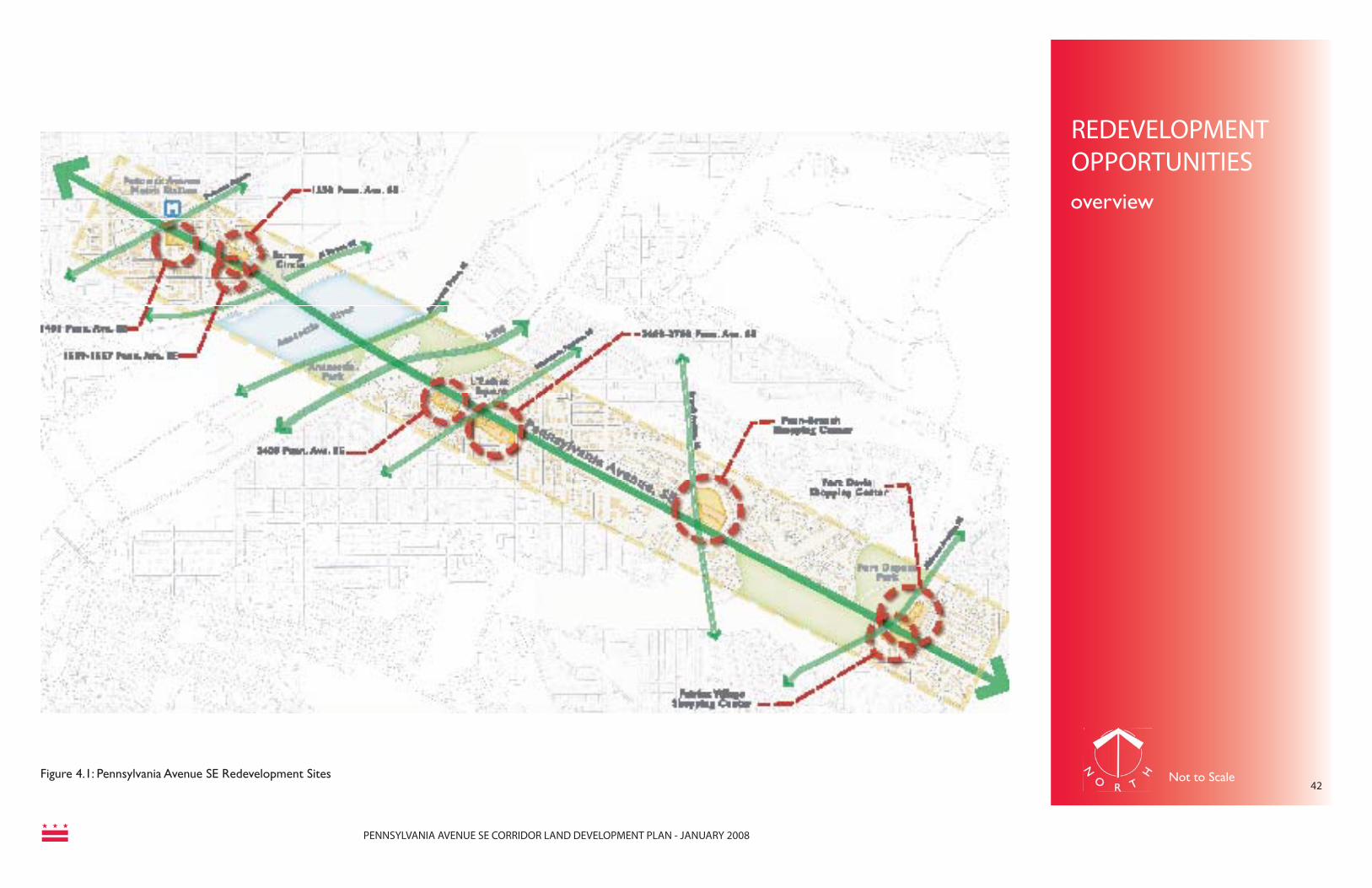
PENNSYLVANIA AVENUE SE CORRIDOR LAND DEVELOPMENT PLAN - JANUARY 2008
REDEVELOPMENT OPPORTUNITIESoverview
42Figure 4.1: Pennsylvania Avenue SE Redevelopment Sites Not to Scale

PENNSYLVANIA AVENUE SE CORRIDOR LAND DEVELOPMENT PLAN - JANUARY 2008
43Figure 4.2: Pennsylvania Avenue SE Capitol Hill Sub-Area
STUDY AREACONDITIONS
capitol hill sub-area
(Residential District)(Residential District)

PENNSYLVANIA AVENUE SE CORRIDOR LAND DEVELOPMENT PLAN - JANUARY 2008
44
Figure 4.3: Capitol Hill Sub-Area
Figure 4.4 Capitol Hill Sub-Area
Figure 4.5: Capitol Hill Sub-Area
CAPITOL HILL SUB-AREA
IntroductionThe Capitol Hill Sub-Area stretches from 2nd Street, SE to 11th Street, SE and falls entirely within the Capitol Hill Historic District. This area has only a limited opportunity for infi ll de-velopment, as most parcels are occupied by historic buildings.
Existing Land-Use
Signifi cant land uses include Eastern Market, a public market located in a 19th century brick building which is included in the National Register of Historic Places. Eastern Market, located on 7th Street SE, has operated as a public market since 1873. The fi rst in a larger city-owned public market system intended to attract residents to the City, it is the last of the city’s public markets still in operation. Recognized as the unoffi cial “town center” of Capitol Hill in the early 20th Century, it still serves as a working farmers’ market and popular attraction for tourists and residents. Tragically, Eastern Market was severely damaged by fi re on April 30, 2007. The District Government has placed the highest priority on rebuilding Eastern Market.
Observations of the consultant team:
Land Use
• Predominantly commercial land use; little underutilized land
• Residential uses generally row houses on narrow lots
• Commercial and residential zoning; portions within Capitol Hill Commercial (CHC) and Capitol Interest (CAP) Overlay
Districts
• Northwest end boasts a wide variety of restaurants, cafes, specialty stores, and other neighborhood oriented retail services
• Buildings set close to the street• On-street parking• Signifi cant open space at Seward Square
and Eastern Market• Pleasant sidewalks, trees, and parks• New condominium development at
Butterfi eld House
Historic, Cultural, and Institutional Resources
• Eastern Market Metrorail Station• Capitol Hill Historic District• Eastern Market• Old Naval Hospital• Hine Junior High School• Southeast Neighborhood Library• Capitol Hill United Methodist Church
Existing Zoning (see Fig. 4.2)
• R-4 (Residential District)• R-5-B (Residential District)• C-M-1 (Commercial Light Manufacturing
District)• C-2-A (Community Business Center
District)• C-3-A (Community Business Center
District)• SP-2 (Mixed Use District)• C-3-C (Community Business Center
District)• GOV (Government District)• CAP Overlay (Capitol Interest District)• CHC Overlay (Capitol Hill Commercial
District) Figure 4.7: Capitol Hill Sub-Area
Figure 4.6: Capitol Hill Sub-Area
STUDY AREACONDITIONScapitol hill sub-area
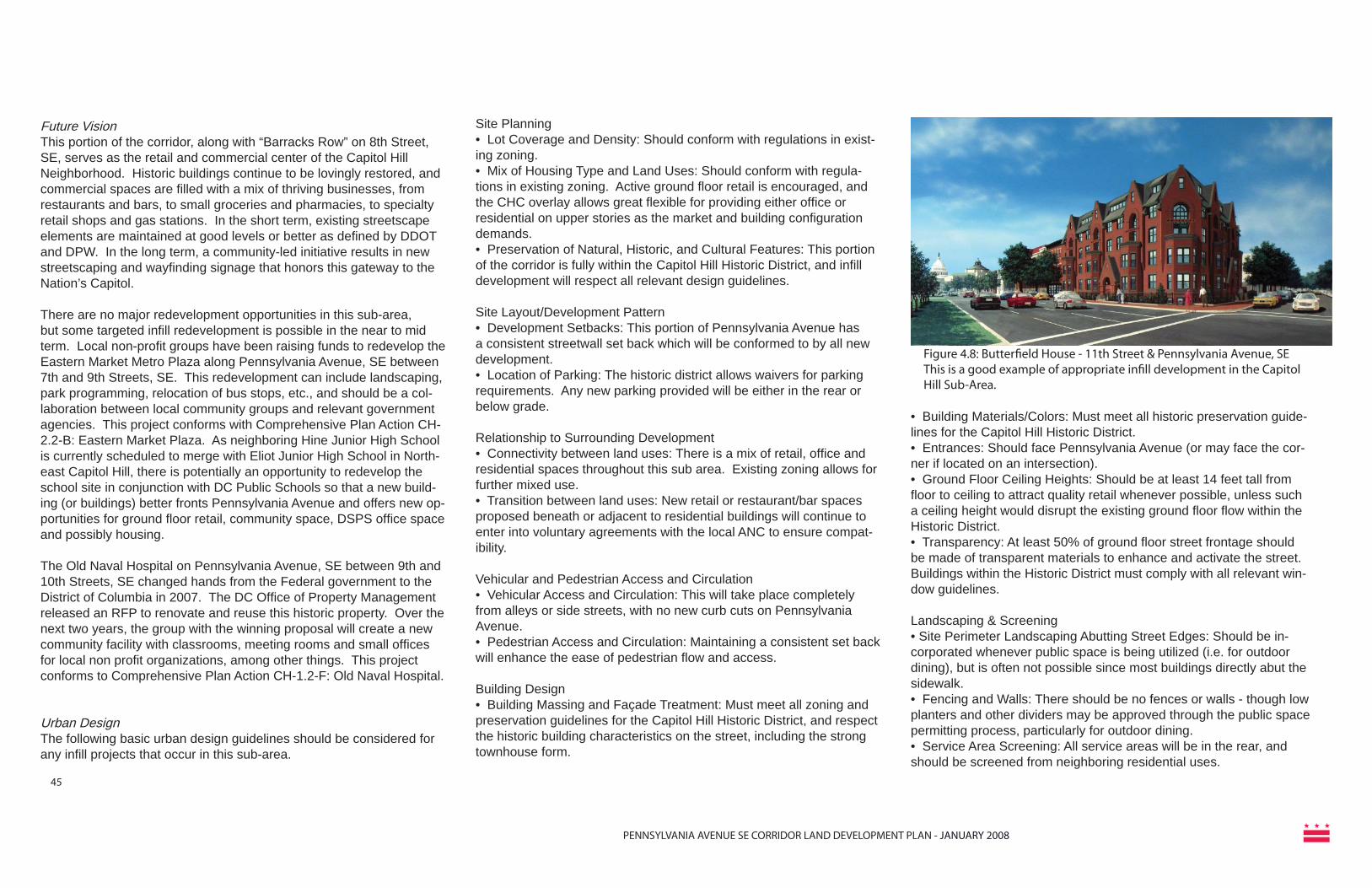
PENNSYLVANIA AVENUE SE CORRIDOR LAND DEVELOPMENT PLAN - JANUARY 2008
45
Future VisionThis portion of the corridor, along with “Barracks Row” on 8th Street, SE, serves as the retail and commercial center of the Capitol Hill Neighborhood. Historic buildings continue to be lovingly restored, and commercial spaces are fi lled with a mix of thriving businesses, from restaurants and bars, to small groceries and pharmacies, to specialty retail shops and gas stations. In the short term, existing streetscape elements are maintained at good levels or better as defi ned by DDOT and DPW. In the long term, a community-led initiative results in new streetscaping and wayfi nding signage that honors this gateway to the Nation’s Capitol.
There are no major redevelopment opportunities in this sub-area, but some targeted infi ll redevelopment is possible in the near to mid term. Local non-profi t groups have been raising funds to redevelop the Eastern Market Metro Plaza along Pennsylvania Avenue, SE between 7th and 9th Streets, SE. This redevelopment can include landscaping, park programming, relocation of bus stops, etc., and should be a col-laboration between local community groups and relevant government agencies. This project conforms with Comprehensive Plan Action CH-2.2-B: Eastern Market Plaza. As neighboring Hine Junior High School is currently scheduled to merge with Eliot Junior High School in North-east Capitol Hill, there is potentially an opportunity to redevelop the school site in conjunction with DC Public Schools so that a new build-ing (or buildings) better fronts Pennsylvania Avenue and offers new op-portunities for ground fl oor retail, community space, DSPS offi ce space and possibly housing.
The Old Naval Hospital on Pennsylvania Avenue, SE between 9th and 10th Streets, SE changed hands from the Federal government to the District of Columbia in 2007. The DC Offi ce of Property Management released an RFP to renovate and reuse this historic property. Over the next two years, the group with the winning proposal will create a new community facility with classrooms, meeting rooms and small offi ces for local non profi t organizations, among other things. This project conforms to Comprehensive Plan Action CH-1.2-F: Old Naval Hospital.
Urban DesignThe following basic urban design guidelines should be considered for any infi ll projects that occur in this sub-area.
Site Planning• Lot Coverage and Density: Should conform with regulations in exist-ing zoning. • Mix of Housing Type and Land Uses: Should conform with regula-tions in existing zoning. Active ground fl oor retail is encouraged, and the CHC overlay allows great fl exible for providing either offi ce or residential on upper stories as the market and building confi guration demands.• Preservation of Natural, Historic, and Cultural Features: This portion of the corridor is fully within the Capitol Hill Historic District, and infi ll development will respect all relevant design guidelines.
Site Layout/Development Pattern• Development Setbacks: This portion of Pennsylvania Avenue has a consistent streetwall set back which will be conformed to by all new development.• Location of Parking: The historic district allows waivers for parking requirements. Any new parking provided will be either in the rear or below grade.
Relationship to Surrounding Development• Connectivity between land uses: There is a mix of retail, offi ce and residential spaces throughout this sub area. Existing zoning allows for further mixed use. • Transition between land uses: New retail or restaurant/bar spaces proposed beneath or adjacent to residential buildings will continue to enter into voluntary agreements with the local ANC to ensure compat-ibility.
Vehicular and Pedestrian Access and Circulation• Vehicular Access and Circulation: This will take place completely from alleys or side streets, with no new curb cuts on Pennsylvania Avenue. • Pedestrian Access and Circulation: Maintaining a consistent set back will enhance the ease of pedestrian fl ow and access.
Building Design• Building Massing and Façade Treatment: Must meet all zoning and preservation guidelines for the Capitol Hill Historic District, and respect the historic building characteristics on the street, including the strong townhouse form.
Figure 4.8: Butterfi eld House - 11th Street & Pennsylvania Avenue, SEThis is a good example of appropriate infi ll development in the Capitol Hill Sub-Area.
• Building Materials/Colors: Must meet all historic preservation guide-lines for the Capitol Hill Historic District. • Entrances: Should face Pennsylvania Avenue (or may face the cor-ner if located on an intersection). • Ground Floor Ceiling Heights: Should be at least 14 feet tall from fl oor to ceiling to attract quality retail whenever possible, unless such a ceiling height would disrupt the existing ground fl oor fl ow within the Historic District.• Transparency: At least 50% of ground fl oor street frontage should be made of transparent materials to enhance and activate the street. Buildings within the Historic District must comply with all relevant win-dow guidelines.
Landscaping & Screening• Site Perimeter Landscaping Abutting Street Edges: Should be in-corporated whenever public space is being utilized (i.e. for outdoor dining), but is often not possible since most buildings directly abut the sidewalk. • Fencing and Walls: There should be no fences or walls - though low planters and other dividers may be approved through the public space permitting process, particularly for outdoor dining. • Service Area Screening: All service areas will be in the rear, and should be screened from neighboring residential uses.

PENNSYLVANIA AVENUE SE CORRIDOR LAND DEVELOPMENT PLAN - JANUARY 2008
46Figure 4.9: Pennsylvania Avenue SE Potomac Avenue Sub-Area
(Residential District)(Residential District)(Residential District)
(Commercial Medium Manufacturing
STUDY AREACONDITIONSpotomac avenue
sub-area

PENNSYLVANIA AVENUE SE CORRIDOR LAND DEVELOPMENT PLAN - JANUARY 2008
47Figure 4.10: Potomac Avenue Sub-Area
POTOMAC AVENUE SUB-AREA
IntroductionThe Potomac Avenue Sub-Area stretches from 11th Street, SE to Barney Circle, SE. The Capitol Hill Historic District currently ends at 13th Street, SE. However, there is much discussion in the community about expanding the historic district or creating a new one. In fact, an application from the Barney Circle neighborhood seeking historic district designation has been recently approved (though it does not include commercial properties along Pennsylvania Avenue). This area has a greater number of redevelopment opportunities than the Capitol Hill Sub-Area, given its smattering of stand along fast food restaurants and other uses inconsistent with the original urban design of the street.
Existing Land-UseThis sub- area extends from 11th Street SE to Barney Circle. The Potomac Avenue Metro station lies in the middle of this sub-area. This is currently an open plaza, with escalators and an elevator carrying passengers below ground to the underground Orange and Blue Lines of the regional subway system. There is a signifi cant amount of bus traffi c, and a few taxis regularly wait for passengers. Much of the existing development is either mixed use or residential in two-to-four story buildings built close to the street. Directly across Pennsylvania Ave, SE is a restaurant. There is a used car lot that fronts on Barney Circle on the north side of Pennsylvania Ave, and a fast-food restaurant fronting on Barney Circle on the south. The building form of these establishments is out of character with the area as they are set back from the street behind large parking areas- which is more typical of a suburban development
pattern. There is a large mixed residential / commercial development under construction on the southeast corner of Potomac Avenue and Pennsylvania Avenue. This will have almost 200 residential units above a grocery store that is expected to draw customers from around the region.
Observations of the consultant team:
Land Use• Mix of commercial and residential land
uses• Commercial and residential zoning;
portions within Capitol Hill Commercial (CHC)
• Two and three-story commercial and residential buildings
• Automobile-oriented retail not consistent with the historic character of the neighborhood
• More sparsely developed retail - predominantly fast food restaurants, liquor stores, and convenience stores
• Surface parking fronting on Pennsylvania Avenue SE
• Mixed-use Jenkins Row development at Potomac Avenue Metrorail Station
• Gas stations at prominent corner locations
• Row houses with curb cuts on Pennsylvania Avenue SE
• Barney Circle is an automobile-oriented traffi c circle
• Transitions from pedestrian-oriented commercial uses to car-oriented commercial uses
• On-street parking, street trees, deep sidewalks, and the wide green median serve to connect dramatically different segments of the avenue between 9th Street SE and the Anacostia River
• Neighborhood-scale and feel
Historical, Cultural, and Institutional Resources• Potomac Avenue Metrorail Station• Congressional Cemetery• C. Watkins Elementary School• Friendship-Edison PCS Chamberlain
Campus
Existing Zoning (see Fig. 4.9)• C-2-A (Community Business Center
District)• C-2-B (Community Business Center
District)• C-3-A (Community Business Center
District)• C-M-1 (Commercial Light Manufacturing
District)• C-M-2 Commercial Medium Manufacturing
District)• M (Manufacturing District)• GOV (Government District)• R-3 (Residential District)• R-4 (Residential District)• R-5-B (Residential District)• CHC (Capitol Hill Commercial District)
Figure 4.11: Potomac Avenue Sub-Area
Figure 4.12 Potomac Avenue Sub-Area
STUDY AREACONDITIONSpotomac avenue sub-area

PENNSYLVANIA AVENUE SE CORRIDOR LAND DEVELOPMENT PLAN - JANUARY 2008
potomac avenuesub-area
Future VisionThis portion of the corridor will retain and expand its neighborhood-serv-ing retail base. Existing architectural fabric and character will be pre-served. New development will occur only in existing commercially zoned parcels, within the parameters of existing zoning (including PUDs and inclusionary zoning). New buildings will be of high-quality architecture and compatible with the historic nature of the street. This all complies with Comprehensive Plan Policy CH-2.2.6: Potomac Ave Metro Station.
In the long term, this portion of the corridor will have a more attractive, unifying and user-friendly public realm, building off of any design cues from a renovated Eastern Market Metro Plaza. The area around the Po-tomac Ave Metro Station will be formalized into a public plaza with new landscaping, seating, kiosks, etc. It will serve as a local meeting point, funded, in part, by public amenity proffers from nearby developments.
Urban DesignThe following basic urban design guidelines should be considered for any projects that occur in this sub-area.
Site Planning• Lot Coverage/Density: Should conform with current zoning regulations.• Mix of Housing Type: Should conform with regulations in existing zon-ing. Housing types are most likely to include condominiums and apart-ments with some potential for townhouse or stacked townhouse styles. • Other Land Uses: Active ground fl oor retail is encouraged, with upper story small offi ces or residential.• Preservation of Natural, Historic, and Cultural Features: Infi ll devel-opment within the Capitol Hill Historic District will respect all relevant design guidelines. Development outside the Historic District is highly encouraged to also use these guidelines.
Site Layout/Development Pattern• Development Setbacks: This portion of Pennsylvania Avenue has a traditional streetwall set back which has been breached by some more modern development, including stand alone fast food restaurants. New developments will maintain or rectify the traditional setbacks to form a more consistent streetwall.
• Location of Parking: The historic district allows waivers for parking requirements. Any new parking within or outside the Historic District will be either in the rear or below grade.
Relationship to Surrounding Development• Connectivity between land uses: There is a mix of retail, offi ce and residential spaces throughout this sub-area. Existing zoning allows for further mixed use. • Transition between land uses: New retail or restaurant/bar spaces pro-posed beneath or adjacent to residential buildings will continue to enter into voluntary agreements with the local ANC to ensure compatibility.
Vehicular and Pedestrian Access and Circulation• Vehicular Access and Circulation: Will take place from alleys or side streets, with no new curb cuts on Pennsylvania Avenue. • Pedestrian Access & Circulation: Set backs consistent with other build-ings on the street will maintain good pedestrian access.
Building Design• Building Massing and Façade Treatment: Must meet all zoning and preservation guidelines for the Capitol Hill Historic District, and respect the historic building characteristics on the street, including the strong townhouse form. While developments outside the Historic District are not required to meet these design guidelines, it is strongly encouraged that they do so. Taller development should step down in the rear if it abuts existing townhouses.• Building Materials/Colors: Must meet all historic preservation guide-lines for the Capitol Hill Historic District if within the boundaries. Proper-ties outside the boundaries are highly encouraged to do the same. • Entrances: Should face Pennsylvania Avenue (or may face the corner if located on an intersection). • Ground Floor Ceiling Heights: Should be at least 14 feet tall from fl oor to ceiling to attract quality retail, unless such a ceiling height would dis-rupt the existing ground fl oor fl ow within the Historic District.• Transparency: At least 50% of ground fl oor street frontage should be made of transparent materials to enhance and activate the street. Build-ings within the Historic District must comply with all relevant window guidelines.
Landscaping & Screening• Site Perimeter Landscaping Abutting Street Edges: Should be incorpo-rated whenever public space is being utilized (i.e. for outdoor dining).• Fencing and Walls: There should be no fences or walls - though low planters and other dividers may be approved through the public space permitting process, particularly for outdoor dining. • Service Area Screening: All service areas will be in the rear, and should be screened from neighboring residential uses.
48
FUTURE VISION/URBAN DESIGN

PENNSYLVANIA AVENUE SE CORRIDOR LAND DEVELOPMENT PLAN - JANUARY 2008
49
1401 Penn Ave (Pizza Restaurant)
The southeast corner property along Pennsylvania Avenue and 14th Street is a prime location for redevelopment for higher density occupancy considering its immediacy to the Potomac Avenue metro station. At present, 1401 Pennsylvania Avenue belongs to a pizza restaurant and associated surface parking. This surrounding area presents a mix in scale and uses comprising of residential and small businesses as well as an institutional use offered by the Friendship-Edison PCS Chamberlain Campus Public Charter School.
Interesting recent developments in the vicinity of the present pizza restaurant property increase its viability as a successful catalyst site for revitalization of the corridor. The Jenkins Row project, located at the intersection of Pennsylvania and Potomac Avenues is being developed to include approximately 247 condominiums, a 47,000 SF Harris Teeter grocery store and an additional 5,000 SF of retail space.
Based on recommendations for the Middle Anacostia River Crossings Transportation Study and the Capitol Hill Transportation Study, the District Department of Transportation is designing improvements to the intersection of Pennsylvania Avenue, Potomac Avenue, and 14th Street SE. The reconfi guration of this intersection will create a more pedestrian-friendly streetscape and improve the pedestrian connections between the Metro Station, the traffi c circle and the subject site. New development at this site should take advantage of this enhancement by offering ground fl oor retail serving immediate residents, pedestrians and commuters.
The property comes under the current zoning C-2-A which allows commercial and residential uses. However this potential is unrealized in its present use.
Opportunities and Recommendations
• Optimum utilization of the property under current zoning by containing a mix of residential and commercial use.
• 4 to 6 stories is appropriate for this site, and developers are encouraged to build no taller than the Jenkin’s Row project in order to form a consistent frame for the Potomac and Pennsylvania Avenues intersection.
• Commercial uses may include accommodating existing small businesses in the area like the pizza restaurant itself.
• Explore the potential to leverage funds from development to create a public plaza at corner of site facing the Park Square at traffi c intersection.
• Completes a “neighborhood center” formed by the Potomac Avenue Metro Plaza, grocery store, neighborhood-serving retail, and transit.
Figure 4.13: 1401 Penn Ave, SE
Figure 4.14: 1401 Penn Ave, SE
Figure 4.15: Upcoming Jenkins Row Development
Figure 4.16: Upcoming Jenkins Row Development
REDEVELOPMENTOPPORTUNITY1401 penn ave, se

PENNSYLVANIA AVENUE SE CORRIDOR LAND DEVELOPMENT PLAN - JANUARY 2008
Figure 4.18: View - 1401 Penn Ave, SE50
Figure 4.17: Plan - 1401 Penn Ave, SE
REDEVELOPMENT OPPORTUNITIES1401 penn ave, se
Figure 4.19: 1401 Penn Ave, SE
Note: The following site plan, massing model and concept illustration were prepared as conceptual examples, and represent the type and scale of development appropriate for each location.
Site Name: 1401 Pennsylvania Avenue, SESite Area: 0.54 acres
- A range of 30-50 condominium units possible above ground fl oor retail. - Appropriate for upper-fl oor small offi ce de-velopment such as doctors’ offi ces, law fi rms, and other service-based businesses. - Parking underground, can accommodate roughly 60-65 spaces. - 5 story building falls within appropriate height range.- 14-foot heights from fl oor to ceiling on the ground level to attract quality retailers.- A range of 6,000 – 14,000 square feet of re-tail space is possible, which could accommo-date a sit-down restaurant, or 3-4 small shops.- Building has a strong face on Pennsylvania Avenue.- Rounded corner presents a strong counter-point to Jenkin’s Row to the west.- Vehicular access off side streets and alleys, no curb cut on Pennsylvania Avenue.
Not to Scale

PENNSYLVANIA AVENUE SE CORRIDOR LAND DEVELOPMENT PLAN - JANUARY 2008
51
Figure 4.20: Concept Illustration - 1401 Penn Ave, SE - Respects townhouse character of the neighborhood and provides a strong anchor at the intersection of Pennsylvania and Potomac Avenues, SE

PENNSYLVANIA AVENUE SE CORRIDOR LAND DEVELOPMENT PLAN - JANUARY 2008
52
Barney Circle Sites: 1550 Penn Ave & 1539-1557 Penn Ave
Barney Circle is an important transportation landmark along the Pennsylvania Avenue corridor marking its intersection with Southeast Freeway and M Street which pass under it. The two sites fl anking this traffi c intersection on either side are currently occupied by a used car lot and fast food restaurant.
The presence of a used car lot is suggestive of an economically unproductive and blighted neighborhood pocket, and its particular location in this case leaves a signifi cant impact on the quality of development in areas surrounding it. Current land-uses on these two important sites and lack of a neighborhood scale destination have added to the automobile oriented character of Barney Circle.
Opportunities and Recommendations
• The two sites fl anking Barney Circle should be treated in a unifi ed manner in architecture and massing as the Eastern Gateway to the Capitol Hill area and the Anacostia River.
• Explore allowable mix of uses under the current C-2-A zoning on these two sites.
• Tap potential view of the Anacostia River and Park which can be offered to condo occupants residing above ground level.
• Provision of a mixed scale and type of housing including condominiums, townhouses, and stacked townhouses to complement the existing residential fabric.
• Increased public presence encouraged by convenience retail stores and small scale dining destinations may result in decreased automobile dominance around Barney Circle and a more pedestrian-friendly character.
Figure 4.24: Barney Circle
Figure 4.23: Barney Circle
Figure 4.22: Barney Circle
Figure 4.21: Barney Circle
barney circle sites
REDEVELOPMENT OPPORTUNITIES

PENNSYLVANIA AVENUE SE CORRIDOR LAND DEVELOPMENT PLAN - JANUARY 2008
Figure 4.27: View - Barney Circle Sites53
Figure 4.26: Plan - Barney Circle Sites
Note: The following site plan, massing model and concept illustration were prepared as conceptual examples, and represent the type and scale of development appropriate for each location.
Site Name: 1539-1557 Pennsylvania Avenue, SE (fast food restaurant)Site Area: 0.45 acres
Site Name: 1550 Pennsylvania Avenue, SE (Used car lot)Site Area: 0.41 acres
- A range of 25-35 condominium units possible above ground fl oor retail at each site, or a combi-nation of townhouses or stacked townhouses and condominiums. - Parking underground if possible, though a limited number of surface parking spots might be necessary. - 4 story buildings fall within appropriate height range.- 14-foot heights from fl oor to ceiling on the ground level to attract quality retailers.- A range of 5,000 – 6,000 square feet of retail space is possible on each site, which could ac-commodate a cafe, or 1-2 small shops.- Both buildings have a strong face on Pennsyl-vania Avenue and help to re-anchor the triangular blocks of the L’Enfant grid.- Rounded corners present strong gateway fea-tures on either side of Barney Circle.- Vehicular access off side streets and alleys, curb cuts on Pennsylvania Avenue should be avoided if at all possible.
REDEVELOPMENTOPPORTUNITIES
Not to Scale
barney circle sites
Figure 4.25: Barney Circle Sites

PENNSYLVANIA AVENUE SE CORRIDOR LAND DEVELOPMENT PLAN - JANUARY 2008
54
Figure 4.28: Concept Illustration, Barney Circle Sites - This image represents the type of develop-ment appropriate at either site. It refl ects the townhouse char-acter of the street and offers a strong gateway statement into Capitol Hill and the Anacostia River area.

PENNSYLVANIA AVENUE SE CORRIDOR LAND DEVELOPMENT PLAN - JANUARY 2008
55Figure 4.29: Pennsylvania Avenue SE L’Enfant Square Sub-Area
(Residential District)(Residential District)(Residential District)
STUDY AREACONDITIONSl’enfant sub-area

PENNSYLVANIA AVENUE SE CORRIDOR LAND DEVELOPMENT PLAN - JANUARY 2008
56Figure 4.30: L’Enfant Square Sub-Area
Figure 4.31: L’Enfant Square Sub-Area
Figure 4.32: L’Enfant Square Sub-Area
L’ENFANT SQUARE SUB-AREA
IntroductionThe L’Enfant Square sub area extends from Fairlawn Avenue SE and the parkland along the Anacostia River to 18th Street SE. It is bisected by Minnesota Avenue SE.
Existing Land UseMost existing development is small to medium sized commercial in the area around the intersection of Pennsylvania and Minnesota avenues. Gas stations occupy almost all of the high-profi le intersections in the heart of the sub-area. Many facades on these commercial structures are in need of attention and repair. Building setback distances are not uniform, and some structures are drawn up to the street, while others are separated from the sidewalk by off-street parking areas. The Metropolitan Police Department Sixth District Substation is located to the southern end of the study area and is located across Pennsylvania Avenue from the Saint Francis Xavier School. L’Enfant Square itself is a small green space that is bound on all sides by very busy roadways, and is dissected by Pennsylvania Avenue, as well as turning lanes that carry Minnesota Avenue traffi c. In its current form, the Square is not a usable pedestrian amenity.
Observations of the consultant team:
Land Use• Predominantly commercial land use and
zoning with some residential development• Automobile-oriented convenience retail
and surface parking• Large building setbacks; wide sidewalks at
points• Underutilized and vacant properties• No continuous building line• Gas stations are prominent features at
entry location• Diminished pedestrian experience• Roadways splitting open space at L’Enfant
Square rendering it into traffi c islands• Pocket park on the north side of Pennsylvania
Avenue from 27th Street SE to 28th Street SE
• L’Enfant Square lacks aesthetic appeal and is underutilized urban space
• Limited amount of retail goods and services
• Dominated by traffi c
Historical, Cultural, and Institutional Resources• Metropolitan Police Department 6th District
Sub-Station• Saint Francis Xavier School
Existing Zoning (see Fig. 4.29)• C-1 (Neighborhood Shopping District• C-2-A (Community Business Center
District)• GOV (Government District)• R-2 (Residential District)• R-5-A (Residential District)• R-5-B (Residential District)
STUDY AREACONDITIONSl’enfant squaresub-area

PENNSYLVANIA AVENUE SE CORRIDOR LAND DEVELOPMENT PLAN - JANUARY 2008
57
Future VisionThis portion of the corridor should expand its neighborhood-serving retail and housing base. The quality of the existing retail is not condu-cive to uses that residents have desired; how-ever, by creating a mix of land uses at a mod-erate density scale, the retail capacity of this neighborhood will thrive. The reconfi guration of L’Enfant Square will also aid in improved pedestrian mobility along the corridor, allowing residents to walk to newly-created retail nodes which provide the desired neighborhood-serving uses, such as a drycleaners, coffee, and boutique shops. Vacant properties will be redeveloped, and existing storefronts will be physically improved and beautifi ed. Ground fl oors transparency and clear, but unobtrusive, signage will further enhance the pedestrian experience. While some gas stations will be maintained to serve the community, others will be redeveloped to help realize the vision described above.
Should any buildings in this sub-area be designated historic in the future, any redevelopment incorporating these structures will cooperate with the Historic Preservation Review Board to ensure that their salient historic features are preserved while they are adaptively reused to better serve the community.
Urban DesignThe following basic urban design guidelines should be considered for any projects that oc-cur in this sub-area.
Site Planning• Lot Coverage and Density: Should conform
with regulations in existing zoning. • Mix of Housing Type: Should conform with regulations in existing zoning. Housing types are most likely to include condominiums and/or apartments. • Other Land Uses: Active ground fl oor retail is encouraged, with upper story small offi ces and/or residential as the market allows.• Development Setbacks: Building setbacks should conform with existing zoning require-ments• Location of Parking: Any new parking should be located below grade wherever pos-sible, and to the rear where this is not pos-sible.
Relationship to Surrounding Development• Connectivity between land uses: There is a mix of retail, and residential spaces through-out this sub area. Existing zoning allows for a further mix of uses.
• Transition between land uses: New retail proposed adjacent to residential buildings will continue to enter into voluntary agreements with the local ANC to ensure compatibility.
Vehicular and Pedestrian Access and Circula-tion• Vehicular Access and Circulation: This will take place completely from alleys or side streets, with no new curb cuts on Pennsylva-nia Avenue.
Building Design and Materials• Building Massing and Façade Treatment: Building development must meet all zoning re-quirements. For PUD submissions, the Offi ce of Planning will provide guidance on architec-
tural components related to the project. De-velopments should respect neighboring lower-scale buildings by stepping down to them on the side and to the rear.• Building materials should be of high quality, using primarily brick and glass. These materi-als should be used to break up the massing of the structure and provide a differentiated rhythm along the building’s facade.• Entrances: Should face Pennsylvania Av-enue (or may face the corner if located on an intersection).• Ground Floor Ceiling Heights: Ceiling height should be 14 feet tall from fl oor to ceiling to attract quality retail• Transparency: At least 50% of ground fl oor street frontage should be made of transparent materials to enhance and activate the street.
Landscaping & Screening• Site Perimeter Landscaping Abutting Street Edges: Should be incorporated whenever public space is being utilized (i.e. for outdoor dining), but is often not possible since most buildings directly abut the sidewalk.• Fencing and Walls: There should be no fences or walls - though low planters and other dividers may be approved through the public space permitting process, particularly for outdoor dining.• Service Area Screening: All service areas will be in the rear, and should be screened from neighboring residential uses.
l’enfant squaresub-area
FUTURE VISION/URBAN DESIGN

PENNSYLVANIA AVENUE SE CORRIDOR LAND DEVELOPMENT PLAN - JANUARY 2008
Figure 4.36: L’Enfant Square
Figure 4.35: L’Enfant Square
L’Enfant Square Sites: 2300-2500 & 2500-2700 Penn. Ave
L’Enfant Square is the fi rst major node on Pennsylvania Avenue SE after the Sousa Bridge. Under transportation improvements proposed as part of the Great Streets Initiative, the corridor will undergo a major change at the intersection of 25th Street SE, Minnesota and Pennsylvania Avenues. The preferred plan allows the high volume of Pennsylvania Avenue through-traffi c to continue through the square as it does today, but redirects all turning traffi c and Minnesota Avenue traffi c around the outside of the park square.
The two parks to be developed on either side of Pennsylvania Avenue will act as a green pocket between the corridor’s new landscaped median throughout the corridor and the park is intended to perform the function of gathering spaces for surrounding communities. These enhancements are targeted to bring about an increase in pedestrian and bike use, and can be a driving factor in discouraging automobile oriented retail pockets which are prolifi c in areas east of Anacostia at present.
As mentioned in the market assessment chapter (Chapter 3) there is a possibility for the L’Enfant Square core area to support high rise (7+) stories with underground parking in the longer term, as a prominent gateway to neighborhoods East of the River with views of the Capitol. Even at six stories, the recommended maximum here, this should prove to be a dramatic vision for an area that is currently dominated by traffi c, marked by underutilized and vacant properties with gas stations at prominent locations and lacking a continuous building line. As per development
opportunity projections, this area can support about 400 to 800 new multifamily units, about 50,000 to 75,000 SF of retail and additional 20,000 to 40,000 SF of boutique offi ce space.
In light of the previously mentioned planned improvements and future possibilities, the two sites South of L’Enfant Square lying on either side of Minnesota Avenue have immense redevelopment potential to result in a unifi ed design for a vibrant and reconfi gured public park. The existing zoning allows development on these sites as Community Business Center District (C-2-A) and Neighborhood Shopping District (C-1). Presence of Public and Institutional uses such as Saint Francis Xavier School and the Metropolitan Police Department Sixth District Substation provides a desired mix of uses in the surrounding areas.
Opportunities and Recommendations
• 2300 - 2500 Block: Maximum of 5 to 6 stories with 65’ maximum height and 5’ bonus for ground fl oor non-residential uses. Any upzoning will occur in design review process such as PUD.
• 2500 - 2700 Block: Maximum of 5 to 6 stories with 65’ maximum height and 5’ bonus for ground fl oor non-residential uses.
• Create opportunities for an enhanced pedestrian environment that provides connectivity at L’Enfant Square
• Expand development area at 2300 block to north side of the street to create a major redevelopment node
• Pursue alternate uses for some gas station sites (particularly the site on the south side of the 2300 block) to provide pedestrian friendly and neighborhood serving activities (recognizing that maintaining some gas stations along the corridor is a positive thing for the community). In the near term, encourage improved landscaping and screening.
Figure 4.33: L’Enfant Square
Figure 4.34: L’Enfant Square
58
REDEVELOPMENTOPPORTUNITY
l’enfant square sites

PENNSYLVANIA AVENUE SE CORRIDOR LAND DEVELOPMENT PLAN - JANUARY 2008
Figure 4.38 Plan - 2500-2700 Penn Ave, SE 59
Figure 4.37: Plan - 2300-2500 Penn Ave, SE
Note: The following site plans, massing model and concept illustration were prepared as conceptual examples, and represent the type and scale of development appropriate for each location.
l’enfant square sites
REDEVELOPMENT OPPORTUNITIES
Not to Scale
Figure 4.39: L’Enfant Square Sites

PENNSYLVANIA AVENUE SE CORRIDOR LAND DEVELOPMENT PLAN - JANUARY 2008
60
Figure 4.41: View, L’Enfant Square Sites (Note: For illustrative purposes only - does not refl ect zoning lot-occupancy requirements.)
Not to Scale
l’enfant square sites
REDEVELOPMENTOPPORTUNITY
Figure 4.40: L’Enfant Square Sites
Site Name: 2300-2500 L’Enfant SquareSite Area: 0.69 acres
- 50 condominium units with ground fl oor retail. - All parking will occur below grade.- Maximum building height of 5-6 stories total-ling no more than 65 feet (not including 5’ bonus for ground fl oor retail.-14-foot heights from fl oor to ceiling on the ground level to attract quality retailers.- Approximately 22,000 square feet of retail space is possible on this site, which could accommodate a cafe, 1-2 small shops and possibbly a sit-down resturant.- Vehicular access off side streets and alleys, curb cuts on Pennsylvania Avenue should be avoided if at all possible.
Site Name: 2500-2700 L’Enfant SquareSite Area: 0.42 acres
- 65-70 condominium units with ground fl oor retail. - All parking will occur below grade.- Maximum building height of 5-6 stories total-ling no more than 65 feet (not including 5’ bonus for ground fl oor retail.- 14-foot heights from fl oor to ceiling on the ground level to attract quality retailers.- Approximately 42,000 square feet of retail space is possible on this site, which could ac-commodate a cafe, several small shops and possibbly a sit-down resturant.- Vehicular access off side streets and alleys, curb cuts on Pennsylvania Avenue should be avoided if at all possible.

PENNSYLVANIA AVENUE SE CORRIDOR LAND DEVELOPMENT PLAN - JANUARY 2008
61
Figure 4.42: Concept Illustration, L’Enfant Square sites - This image represents the type of develop-ment appropriate in the L’Enfant Square area.
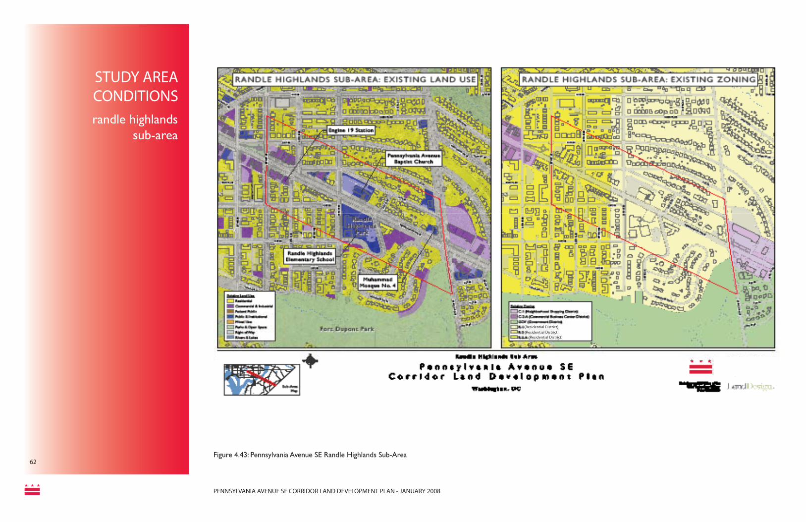
PENNSYLVANIA AVENUE SE CORRIDOR LAND DEVELOPMENT PLAN - JANUARY 2008
62Figure 4.43: Pennsylvania Avenue SE Randle Highlands Sub-Area
(Residential District)
(Residential District)(Residential District)
STUDY AREACONDITIONSrandle highlands
sub-area

PENNSYLVANIA AVENUE SE CORRIDOR LAND DEVELOPMENT PLAN - JANUARY 2008
63
Figure 4.47: Randle Highlands Sub-Area
RANDLE HIGHLANDS SUB-AREA
Introduction & Existing Land UseThe Randle Highlands sub-area extends from 28th Street SE to Branch Avenue SE. This area is mostly single family and low scale (less than fi ve-story) multifamily housing, punctuated by some signifi cant institutional uses. The Randle Highlands Elementary School is in the middle of the sub-area, and is directly across the street from the Pennsylvania Avenue Baptist Church. The Randle Highlands Fire Station (Engine 19) is located in a historic structure on the northern end of the sub-area. Most of the buildings are set back from the sidewalk behind a lawn or other landscaping, contributing to a boulevard-like feel.
Observations of the consultant team:
Land Use• Residential mixed with signifi cant
institutional land uses• Primarily residential zoning• Single-family and multi-family residential
structures• High-speed traffi c• Incomplete sidewalk network• Large setbacks giving it a feel of a green
boulevard• Narrow sidewalks• Steep topographic changes
Historical, Cultural, and Institutional Resources• Randle Highlands Elementary School• Randle Highlands Firehouse• Pennsylvania Avenue SE Baptist Church• Muhammad Mosque No. 4
Existing Zoning (see Fig. 4.43)
• C-1 (Neighborhood Shopping District)• C-2-A (Commercial Business Center
District)• GOV (Government District)• R-1-B (Residential District)• R-2 (Residential District)• R-5-A (Residential District)
Future Vision
Randle Highlands is a vibrant residential com-munity located on the south side of Pennsyl-vania Avenue. Current land use is primarily single-family residential with a few multi-family structures scattered throughout. Randle High-lands Elementary School is also located within this neighborhood. Preserving the character and land use of this community is a strong desire of existing residents. Although no new development has been proposed for this sub-area, any new development should be consis-tent with the existing character of the neigh-borhood. With its close proximity to L’Enfant Square and Penn Branch Shopping Center, Randle Highlands residents will be able to uti-lize the proposed retail establishments located at each of these sub-areas.
Figure 4.44: Randle Highlands Sub-Area
Figure 4.45: Randle Highlands Sub-Area
Figure 4.46: Randle Highlands Sub-Area
STUDY AREA CONDITIONSrandle highlands sub-area

PENNSYLVANIA AVENUE SE CORRIDOR LAND DEVELOPMENT PLAN - JANUARY 2008
64Figure 4.48: Pennsylvania Avenue SE Penn Branch Sub-Area
(Residential District)(Residential District)
(Residential District)
STUDY AREACONDITIONS
penn branch sub-area

PENNSYLVANIA AVENUE SE CORRIDOR LAND DEVELOPMENT PLAN - JANUARY 2008
65
Figure 4.51: Penn Branch Sub-Area
Figure 4.50: Penn Branch Sub-Area
penn branch sub-area
PENN BRANCH SUB-AREA
Introduction & Existing Land UseThe Penn Branch sub-area extends from Branch Avenue SE to Alabama Avenue SE. The northern end of the area is highlighted by the Penn Branch Shopping Center at the intersection of Pennsylvania Avenue and Branch Avenue. This two-story center is surrounded on all sides by a large off-street parking area, which is more characteristic of a suburban shopping area. The building is occupied by subprime tenants, and the façade and structure are in need of repair and updating. The southern side of the corridor is dominated by the Fort Dupont Park, which extends from the 3rd Street SE intersection to Alabama Avenue SE. This parkland makes pedestrian travel along Pennsylvania Avenue diffi cult because there are no sidewalks along the frontage and the terrain is fairly steep. The remaining portions of the sub-area are mostly single family and small multifamily residential in good condition.
Observations of the consultant team:
Land Use• Remaining area is residential, institutional,
and open space• Predominantly residential zoning with
commercial zone at Pennsylvania Avenue and Branch Avenue intersection
• Open space on majority of south side of Pennsylvania Avenue SE
• Penn Branch Shopping Centero Commercial node and defi ning featureo Automobile-oriented strip developmento Large surface parking lots in front and
behind buildingo Abutting property is an abandoned
laundromat on large lot
o Large setbackso Lacks pedestrian connectivity
• Commercial land uses on southwest portion of sub-areao Gas station at prominent corner
locationo Parking in fronto Large building setbacks
• Incomplete sidewalk network• Includes a small amount of local-serving
retail establishments• Inadequate parking at Penn Branch
Shopping Center and resulting spillover parking in residential neighborhoods
• Traffi c problems created by vehicles entering and exiting Penn Branch Shopping Center
Historical, Cultural, and Institutional Resources• Fort Dupont Park• Fort Davis• Metropolitan Police Department - Regional
Police Command East• Church of Jesus Christ, Inc.
Figure 4.49: Penn Branch Sub-Area
Existing Zoning (see Fig. 4.48)
• C-1 (Neighborhood Shopping District)• C-2-A (Community Business Center
District)• C-3-A (Community Business Center
District)• GOV (Government District)• R-1-B (Residential District)• R-2 (Residential District)• R-5-A (Residential District)
STUDY AREACONDITIONSpenn branch sub-area

PENNSYLVANIA AVENUE SE CORRIDOR LAND DEVELOPMENT PLAN - JANUARY 2008
FUTURE VISION/URBAN DESIGN
Future VisionThis sub-area represents the best opportunity for new retail in the corridor. It will be anchored by a newly redeveloped Penn Branch Shopping Center, which will consist of visually attractive architecture and landscap-ing, and provide high-quality, modern retail and offi ce space, as well as mixed-income housing. Other smaller redevelopment in the sub-area, including the laundromat and gas station sites, will add to the retail mix, and form a node at which local residents can take care of many of their daily needs. This node will be pedestrian and bicy-cle friendly, allowing residents to take advantage of the resources there without having to drive. Development in this sub-area, and particularly at the Penn Branch Shop-ping Center, will respect the adjoining residential neigh-borhoods, stepping down towards them and preserving their view sheds whenever possible.
Urban DesignThe following basic urban design guidelines should be considered for any projects that occur in this sub-area. Site Planning• Lot Coverage and Density: Should maximize the pro-posed range of lot coverage within a moderate-density scaled development project.- Mix of Housing Type: Should conform with require-ments of moderate scale zoning. Housing types are most likely to include condominiums, with some poten-tial for townhouse styles as the market permits. • Other Land Uses: Active ground fl oor retail is encour-aged, with limited opportunities for second fl oor retail. A strong offi ce component is expected, particularly on second and third stories, with government services and other service businesses. Housing is expected to make up the rest of the site.• Development Setbacks: Recognizing Pennsylvania Avenue as the grand boulevard it was intended to be, any development at this site should be brought to street level with appropriate setbacks for sidewalks and pedes-trian mobility.- Location of Parking: Any new parking should be located below grade wherever possible, and to the rear where this is not possible.
Relationship to Surrounding Development• Connectivity between land uses: The predominant land use throughout this sub area is residential. A change from the existing zoning to moderate density at key nodes will allow for a mix of uses needed to support the desired retail of the community.
• Transition between land uses: New development should physically step down towards existing resi-dential uses, particularly to the side and rear, and provide a buffer of trees and other plantings.
Vehicular and Pedestrian Access and Circulation• This will take place from alleys or side streets, with no new curb cuts on Pennsylvania Avenue.
Building Design• Building Massing and Façade Treatment: Building development must meet all zoning requirements. For PUD submissions, the Offi ce of Planning will provide guidance on architectural components related to the project. • Entrances: Should face Pennsylvania Avenue (or may face the corner if located on an intersection). • Ground Floor Ceiling Heights: Should be at least 14 feet tall from fl oor to ceiling to attract quality retail.• Transparency: At least 50% of ground fl oor street frontage should be made of transparent mate-rials to enhance and activate the street. Any second story retail should have prominent display windows.
Landscaping & Screening• Site Perimeter Landscaping Abutting Street Edges: Should be incorporated whenever public space is being utilized (i.e. for outdoor dining), but is often not possible since most buildings directly abut the sidewalk. • Fencing and Walls: There should be no fences or walls - though low planters and other dividers may be approved through the public space permitting process, particularly for outdoor dining. • Service Area Screening: All service areas will be in the rear, and should be screened from neighboring residential uses.
66
penn branch sub-area
Note 1 (See Appendix)*

PENNSYLVANIA AVENUE SE CORRIDOR LAND DEVELOPMENT PLAN - JANUARY 2008
67
Penn Branch Shopping Center Site:
The Penn Branch Shopping center is located on a large property of area about 1.7 acres along the intersection of Pennsylvania Avenue and Branch Avenue. The size and location of this site make it particularly suitable for redevelopment into a neighborhood defi ning landmark project in the future. This property currently houses the DC Department of Human Services, an automobile-oriented small retail pocket and a large rear portion occupied by surface parking. Surrounding properties include a church, a gas station and single family residences.
Analysis shows that the current split zoning of C-1 and R-1-B may create an impediment to redevelopment. Under the current zoning, the present structure occupies maximum height and fl oor area allowed. This means that any new building in the same zoning will be approximately of the same size. Unfortunately, realities of the marketplace make this option unlikely as the cost of replacing the existing building with a similarly sized building would be higher than the likely returns on this investment. Furthermore, it is likely that the types of tenants will not improve as the existing building is sub-standard in the present retail and offi ce market. This site needs design fl exibility that will increase the likelihood of redevelopment in a manner that attracts the types of tenants desired by the surrounding community.
It is important that any construction on the property respect the adjoining residential neighborhood. For example, the conceptual plan on the following page portrays the bulk of the building located along the street edges, with terraces transitioning down towards the single family homes abutting the rear end of the Penn Branch Shopping Center site.
The Council Resolution for this plan requested that the Offi ce of Planning clarify its intent on the following point:
1. The height of development at the Penn Branch Shopping Center opportunity site shall be measured from the lowest point of the existing grade.
Opportunities and Recommendations:
• Change in zoning through the PUD process to support a mix of moderate density commercial and residential development.
• Development of this site will be 5 stories from the lowest point of the site with 65’ maximum height, 5 stories with 65’ maximum height on south side of Pennsylvania Avenue as well. New development and redevelopment within Neighborhood Commercial Areas must be managed to conserve the economic viability of these areas while allowing additional development that complements existing uses.
• New retail to respond to requirement of neighborhood serving convenience stores like coffee shop, small restaurant, possibly a small grocer or pharmacy
• Underground parking garage for property uses and spill-over public parking spaces
• Improve access and circulation edging the property to encourage pedestrian connection from surrounding areas and bus transit stop
Figure 4.52: Penn Branch
Note 1 (See Appendix)*penn branch
REDEVELOPMENT OPPORTUNITIES
Figure 4.53: Penn Branch
Figure 4.54: Penn Branch
Note 1, 2 & 3 (See Appendix)*

PENNSYLVANIA AVENUE SE CORRIDOR LAND DEVELOPMENT PLAN - JANUARY 2008
68 Figure 4.58: View, Penn Branch Shopping Center
Figure 4.57: Plan - Penn Branch Shopping Center
Not to Scale
penn branchshopping center
REDEVELOPMENTOPPORTUNITY
Figure 4.56: Penn Branch Sites
Note: The following site plan, massing model and concept illustration were prepared as conceptual examples, and represent the type and scale of development appropriate for each location.
Site Name: Penn Branch Shopping CenterSite Area: 1.72 acres
- A range of 20,000 – 30,000 square feet of retail space is possible, which could accom-modate a restaurant/cafe and several small shops.- A range of 150-180 condominium units pos-sible to help support desired new retail.- A range of 20,000 - 40,000 square feet of offi ce space remains for small service busi-nesses and government services.- Parking underground, with a limited number of surface parking spots.- 5 story buildings fall within appropriate height range, though due to the site’s topography, this is likely to read closer to 3 stories on Pennsylvania Avenue.- 14-foot heights from fl oor to ceiling on the ground level to attract quality retailers.- A green space with trees and other plant-ings to the rear buffers new development from existing single-family homes.- Combining lots provides a strong face on Pennsylvania Avenue to attract shoppers.- Sensitive design provides an attractive envi-ronment for new and existing residents, shop-pers and employees.- Vehicular access off side streets and alleys; no new curb cuts on Pennsylvania Avenue.

PENNSYLVANIA AVENUE SE CORRIDOR LAND DEVELOPMENT PLAN - JANUARY 2008
69
Figure 4.59: Concept Illustration, Penn Branch Shopping Center - This rendering is an example of how the site could be sensitively redeveloped as an attractive new asset to the community.

PENNSYLVANIA AVENUE SE CORRIDOR LAND DEVELOPMENT PLAN - JANUARY 2008
70Figure 4.60: Pennsylvania Avenue SE Fairfax Village / Fort Davis Sub-Area
(Residential District)(Residential District)
(Residential District)(Residential District)
STUDY AREA CONDITIONS
fairfax village / fort davis sub-area

PENNSYLVANIA AVENUE SE CORRIDOR LAND DEVELOPMENT PLAN - JANUARY 2008
71
Figure 4.64: Fairfax Village Sub-Area
FAIRFAX VILLAGE/FORT DAVIS SUB-AREA
Introduction & Existing Land UseThe Fairfax Village/Fort Davis sub-area extends from Alabama Avenue SE to the end of the corridor at Southern Avenue SE (the District/Maryland line). At the intersection of Pennsylvania and Alabama Avenues, there is signifi cant commercial use contained by Fairfax Village Shopping Center and Fort Davis Shopping Center. While the two properties offer retail uses, they are automobile-oriented developments fronted with surface parking lots. A gas station caters to passing traffi c thereby leaving a very small proportion serving the surrounding residential community. Fort Davis Shopping Center currently houses the DC Department of Human Services, drawing in a mix of government/institutional uses.
The Fairfax Village Shopping Center is fairly stable, although it is experiencing some problems with parking. Neighbors and shop owners comment that much of the insuffi cient parking issue can be attributed to commuters from out of the area using the parking lot for full day parking. The surrounding area is predominantly multi-family residential setback from the street behind attractive lawns and landscaping. A gas station is located on the southwest corner of the Fort Davis Shopping Center, and the actual center has most of its frontage on Alabama Avenue.
Observations of the consultant team:
Land Use• Mostly residential land use and zoning• Signifi cant commercial land use and zoning
at intersection of Pennsylvania Avenue SE and Alabama Avenue SE
• Mostly multi-family with large setbacks• Fairfax Village Shopping Center and Fort
Davis Center - Automobile-oriented strip development
- Surface parking lots in front• Stable high-quality residences• Gas station at prominent corner location• Large concentration of multi-family on the
southeast side of the subarea• Includes small local-serving retail• Large setbacks• Lacks pedestrian connectivity
Historical, Cultural, and Institutional Resources• U.S. Post Offi ce• DC Department of Human Services Offi ce
Existing Zoning (see Fig. 4.60)• C-2-A (Community Business Center
District)• GOV (Government District)• R-1-B (Residential District)• R-2 (Residential District)• R-4 (Residential District)• R-5-A (Residential District)
Future VisionFairfax Village continues to be a viable and distinctive neighborhood shopping center, serving the surrounding neighbors with quality retail options. The unique neo-colonial buildings and surrounding landscaping are upgraded and well maintained. The parking area is redesigned to improve access. Redevelopment is not expected here until the buildings reach their natural life span, and will eventually place new buildings to the street edge with parking in the rear.
The Fort Davis Shopping Center represents the best near term opportunity for development and can accommodate a mixture of ground fl oor retail, and upper story offi ce space and housing.
Both properties will serve as attractive and appropriate gateways into DC.
Figure 4.61: Fairfax Village Sub-Area
Figure 4.62: Fairfax Village Sub-Area
Figure 4.63: Fairfax Village Sub-Area
STUDY AREACONDITIONS/FUTURE VISIONfairfax village / fort davis sub-area

PENNSYLVANIA AVENUE SE CORRIDOR LAND DEVELOPMENT PLAN - JANUARY 2008
Urban DesignThe following basic urban design guidelines should be considered for any projects that oc-cur in this sub-area.
Site Planning• Lot Coverage and Density: Should maxi-mum the proposed range of lot coverage within a moderate scaled density development project• - Mix of Housing Type: Should conform with requirements of moderate-scale zoning. Housing types are most likely to include con-dominiums with some potential for townhouse styles. • Other Land Uses: Active ground fl oor retail is encouraged. A small but signifi cant offi ce component is expected at Fort Davis, with government services and other service busi-nesses.• Development Setbacks: New development at this site should conform to moderate-scale density setback requirements.- Location of Parking: Any new parking should be located below grade wherever pos-sible, and to the rear where it is not.
Relationship to Surrounding Development• Connectivity between land uses: The pre-dominant land use throughout this sub area is residential. Moderate density zoning will allow for a mix of uses.• Transition between land uses: New devel-opment should physically step down towards existing residential uses, particularly to the side and rear, and provide a buffer of trees and other plantings.
Vehicular and Pedestrian Access and Circula-tion• Vehicular Access and Circulation: This will take place from Alabama Ave or alleys, with no new curb cuts on Pennsylvania Avenue.
• Pedestrian Access and Circulation: Main-taining a consistent set back with other build-ings on the street will improve pedestrian access.
Building Design• Building Massing and Façade Treatment: Building development must meet all zoning re-quirements. For PUD submissions, the Offi ce of Planning will provide guidance on architec-tural components related to the project. • Entrances: Should face Pennsylvania Av-enue (or may face the corner if located on an intersection). • Ground Floor Ceiling Heights: Should be at least 14 feet tall from fl oor to ceiling to attract quality retail, unless such a ceiling height would disrupt the existing ground fl oor fl ow.• Transparency: At least 50% of ground fl oor street frontage should be made of transparent materials to enhance and activate the street.
Landscaping & Screening• Site Perimeter Landscaping Abutting Street Edges: Should be incorporated whenever public space is being utilized (i.e. for outdoor dining), but is often not possible since most buildings directly abut the sidewalk.
• Fencing and Walls: There should be no fences or walls - though low planters and other dividers may be approved through the public space permitting process, particularly for outdoor dining. • Service Area Screening: All service areas will be in the rear, and should be screened from neighboring residential uses.
Opportunities and Recommendations:
• Explore potential under current zoning classifi cation on the site and promote higher density mix use residential and retail development
• DC Department of Human Services and the US Post offi ce may be re-housed in the project, thus maintaining a mix of uses offered in the present scenario
• New retail to be oriented towards neighborhood serving establishments like a small coffee shop, dining place, barber shop, deli, etc.
Figure 4.14: L’Enfant Square
Figure 4.67: Fairfax Village / Fort Davis
Figure 4.68: Fairfax Village / Fort Davis
Figure 4.65: Fairfax Village / Fort Davis Figure 4.66: Fairfax Village / Fort Davis 72
fairfax village / fort davis
URBAN DESIGN/REDEVELOPMENTOPPORTUNITY

PENNSYLVANIA AVENUE SE CORRIDOR LAND DEVELOPMENT PLAN - JANUARY 2008
fort davis shopping center
73
REDEVELOPMENT OPPORTUNITIES
Note: The following site plan, massing model and concept illustration were prepared as conceptual examples, and represent the type and scale of development appropriate for each location.
Site Name: Fort Davis Shopping CenterSite Area: 1.57 acres
- A range of 24,000 – 28,000 square feet of retail space is possible, which could accom-modate a cafe and several small shops.- Continued space for small service business-es and government services offi ces.- A range of 50-55 condominium units possible to better support ground fl oor retail.- Parking underground, though a limited num-ber of surface parking spots might be neces-sary. - 4-5 story buildings fall within appropriate height range.- 14-foot heights from fl oor to ceiling on the ground level to attract quality retailers.- Buildings front Alabama Avenue, but the por-tion facing Pennsylvania Avenue has entranc-es to shops and does not read as the “side” of the building.- Facade takes advantage of prominent corner of Pennsylvania and Alabama Avenues.- Vehicular access off Alabama Avenue and alleys; no new curb cuts on Pennsylvania Avenue.- Fairfax Village Shopping Center across the street is renovated, but not redeveloped, in the near future.
Figure 4.71: View, Fort Davis Shopping Center (left).
Figure 4.70: Plan, Fort Davis Shopping Center (background)
Not to Scale
Figure 4.69: Fort Davis / Fairfax Village Sites

PENNSYLVANIA AVENUE SE CORRIDOR LAND DEVELOPMENT PLAN - JANUARY 2008
Not to Scale
fairfax village shopping centerby-right approval
Figure 4.49: Fort Davis / Fairfax Village Sites
74
Figure 4.72 Concept Illustration, Fort Davis Shopping Center - takes advantage of its prominent corner location and presents ac-tive faces for both Pennsylvania and Alabama Avenues.

PENNSYLVANIA AVENUE SE CORRIDOR LAND DEVELOPMENT PLAN - JANUARY 2008
75
CHAPTER 5
implementation

PENNSYLVANIA AVENUE SE CORRIDOR LAND DEVELOPMENT PLAN - JANUARY 2008
General RecommendationsThis section discusses recommendations that are either appropriate to the whole corridor or more general in nature.
The Plan presents a framework for guiding the redevelopment of key opportunity sites along the corridor. The plan for these sites has been developed with an understanding that, in large part, the existing fabric of the corridor is strong and intact. However, portions of the corridor, especially those East of the River, are underutilized and detract from the overall character of the surrounding community. Furthermore, the current range of uses does not functionally serve the surrounding community with the range of goods and services that the residents need and desire. In many cases, existing development is more suited to commuters traveling through the area, both in design and use.
As the community and the District move forward with this plan, it is important that all stakeholders remain involved and committed. These stakeholders include individuals and neighborhood groups, businesses and property owners, developers and investors, non-profi t organizations, elected offi cials and District staff of every agency. It should be recognized that sustainable change does not happen overnight, rather it progresses incrementally. Patience and perseverance are both required to maintain vision and perspective that guarantee long-term success.
In an effort to more effectively service the communities arranged along Pennsylvania Avenue SE, it is important to promote activities that are complementary to the different neighborhoods. The purpose of this chapter is
to help guide this transformation from the current roadway into a Pennsylvania Avenue that lives up to the characterization as “America’s Main Street.” The chapter is divided into two general sections. The fi rst section provides general recommendations or guidance that is applicable all along the corridor. The second section speaks to specifi c redevelopment sites.
General Corridor Improvements• Continuity and Connections: The
District should move forward with the Pennsylvania Avenue roadway improvements to enhance linkages between the east and west sides of the Anacostia River.
• Streetscape and Signage: The District should consider developing identifi able streetscaping elements and signage that carries themes contained in the Sousa Bridge design to other portions of the corridor. These identifying elements should celebrate the neighborhoods and landmarks in the vicinity of the corridor and promote the concept of “America’s Main Street.” This signage should also help guide residents and visitors to key landmarks and destinations in the vicinity, including historic areas, parks, and the Metro stations at Pennsylvania Avenue, SE.
• Promoting Existing Businesses: The District should utilize funds available through the Offi ce of Deputy Mayor for Planning and Economic Development to promote existing business establishments so that they may grow and prosper. Examples of different
business assistance programs include the small business loans provided by the DC Department of Small and Local Business Development (currently through the reSTORE DC program), which assists neighborhood business districts with restructuring, promotion, design improvements, and other enhancements. In order to receive the reSTORE assistance, it would be necessary to create a business district for portions of the corridor east of the Anacostia. Starting an organization akin to a “Main Street” program would make available further funds and technical assistance for all types of corridor improvements.
• Design and Preservation: For portions of the corridor west of the Anacostia, there is a desire to develop design and use provisions to guide future construction and renovation. The best strategies for achieving this include extending the Capitol Hill Historic District further into the corridor, or creating a new historic district.
• Green Space: While portions of the corridor east of the Anacostia benefi t from the Anacostia River Park and Fort Davis Park, there are not as many recreation opportunities West of the River. The District should explore creating a green linear park along the Pennsylvania Avenue median in this portion of the corridor in cooperation with the National Park Service, which owns this land.
IMPLEMENTATION
general corridor improvements
general recommendations
76

PENNSYLVANIA AVENUE SE CORRIDOR LAND DEVELOPMENT PLAN - JANUARY 2008
77
Strategies for Catalyzing Development
In redeveloping corridors there is often the need for non-market interventions in order to capitalize emerging market trends. Strategies that can be employed include:
• Identifying and Investing In Catalytic Site Redevelopment: In this study, a number of catalytic sites have been identifi ed. Catalytic sites are those sites that are in critical locations, and will create a critical mass of activity that can impact the marketability of surrounding redevelopment sites. The strategy is to leverage the development on these sites – and any public investment -- to spur future private investment. The development of catalytic sites is a critical step towards generating market momentum and proving market acceptance of pioneering concepts.
• Site Acquisition Funds: Public dollars are not only spent on infrastructure, but can also be used to overcome key pre-development constraints, most notably site assembly. A public fund to help acquire sites, in order to create a larger redevelopment site, is often a critical step towards revitalization in areas with fractured site ownership and emerging, but not yet established, market demand. In the context of this study, L’Enfant Square is the most appropriate destination for this type of public sector intervention. Predevelopment for determining project feasibility is just as important as site acquisition. DHCD has predevelopment and site acquisition funds, but there is also the possibility of
working with Community Development Finance Institutions to target resources in the area.
• Facade Improvement Funds: Redevelopment is only one method to improve the quality and value of an area. Often, a more limited amount of investment is required. Specifi cally, low-cost loans or grants for façade improvements can often have a signifi cant, near-term impact where full-scale redevelopment is not wanted, needed, or feasible. Funding sources include: reSTORE DC, DHCD, DMPED, and existing or future CDCs.
• Project-level Financial Assistance: At the project level, public assistance can sometimes be required to cover economic feasibility gaps. The most common form of this assistance is tax increment fi nancing (TIF), where future tax revenues are used to fl oat a bond that pays for up front infrastructure – typically structured or underground parking in an area where density is highly preferred, but the near-term revenues of the project are not supportive of costly parking solutions. The use of this tool should be used on a case-by-case basis, where it is clear that there is a real gap in the economics of project that is viewed as critically important to the broader revitalization of the area. In order to determine the possibility of using TIF fi nancing for a project a feasibility analysis must be undertaken. Other fi nancial tools from the public and private sector should also be applied.
IMPLEMENTATION
strategies for catalyzing development

PENNSYLVANIA AVENUE SE CORRIDOR LAND DEVELOPMENT PLAN - JANUARY 2008
Priority Site Location IssueCurrent Zoning Proposed Actions Partners
Projected Completion
West of the Anacostia River1401 Pennsylvania
Avenue SeExisting structure and lot detracts from overall character of the area.Potential for property to be redeveloped into a higher density use that compliments the corridor
C-2-A Opportunity for signifi cant redevelopment. Monitor development applications and activity.
n/a
1550 Pennsylvania Avenue SE
This corner serves as a gateway to the western portion of the corridor and Capitol Hill. Current development is a visual eyesore.
C-2-A Opportunity for signifi cant redevelopment. Monitor development applications and activity. Require minimum façade improvements and building elevation to create visual cues to the entryway
OP; reSTORE DC; DHCD; WDCEP;
and existing or future CDCs1539-1557
Pennsylvania Avenue SE
East of the Anacostia River2300-2700
Pennsylvania Avenue SE
L’Enfant Square
Current buildings present a very haphazard appearance. Little building uniformity. Many structures in poor state of repair.Poor pedestrian experience throughout L’Enfant Square Area
C-2-A Major redevelopment opportunity.Reestablish L’Enfant Square as a true square.Pursue funds from other city agencies to promote redevelopment. Pursue façade improvement monies for buildings not being replaced. New development will occur within the parameters of a maximum of 5-6 stories with 65’ maximum height and 5’ bonus for ground fl oor non-residential uses.
DMPED; DDOT ; NCRC; OP;
reSTORE DC; DHCD; WDCEP;
and existing or future CDCs
Penn Branch Shopping Center
Current structure outdated and in need of improvement. Current development form very suburban, creates a poor pedestrian environment. Current tenants do not adequately serve neighborhood needs.Ideal size for a signifi cant neighborhood-serving use.
C-1/R-B-1 Development of this site will be 5 stories from lowest point of the site with 65’ maximum height. 5 stories, with the same parameters on the south side of Pennsylvania Avenue as well. New development and redevelopment within Neighborhood Commercial Areas must be managed to conserve the economic viability of these areas while allowing additional development that complements existing uses. This is the only site for which a zoning change is recommended to allow the development described above.
DMPED; NCRC; OP
Fort Davis Shopping Center
Gasoline station located in prominent corner of site. Property serves as gateway to DC from points outside of the District.Current uses inadequate for neighborhood needs.
C-2-A Explore site assemblage or façade improvements.Pursue programs to improve range of tenants in the site and ultimately redevelop.
DMPED; NCRC; OP; reSTORE DC; DHCD; WDCEP;
and existing or future CDC’s
Fairfax Village Shopping Center
Current building present an attractive appearance, but do not house the range of tenants adequate to serve the needs of neighborhood residents.Current parking lot routinely fi lled by commuters from other areas.
C-2-A Pursue programs to improve the range of tenants in the site. Explore parking facility improvements such as gates or meters to reduce the number of spaces occupied by non-customer vehicles. Maintain existing structure.
DMPED; NCRC; OP
Table 5.1: Pennsylvania Avenue SE Corridor Strategy and Implementation Plan
Note: all redevelopment opportunity sties are privately owned.
strategy and implementation plan
IMPLEMENTATION
78

PENNSYLVANIA AVENUE SE CORRIDOR LAND DEVELOPMENT PLAN - JANUARY 2008
79
Priority Proposed Action Potential Lead & Active Part-ners
Program/Funding Source
Timeframe/Potential Start
Relation to Comprehensive Plan
TRANSPORTATION & STREETSCAPINGHigh Implement Great Streets improvements as planned for the
corridor east of the Anacostia River, including roadwork, median improvements, streetscaping and signage elements.
DDOT DDOT Underway Far Northeast and South-east Area Element- Action FNS-2.6.B: Great Streets Improvements
High Implement recommendations from the Middle Anacostia River Crossings Study. Particularly those that aid in reducing regional traffi c along Pennsylvania Ave, SE and provide greater access to I-295 North.
DDOT DDOT Underway Far Northeast and South-east Area Element- Action FNS-2.6.A: Pennsylvania Avenue SE Transportation Study
High Explore Rapid Bus service along the Pennsylvania Avenue, SE corridor. Improved mass transit opportunities will be critical for serving the neighborhoods and supporting new clusters of retail and housing development, and should be a high priority for DDOT.
DDOT/WMATA DDOT/WMATA Currently a long-term project, OP recommends that DDOT strive to fund a study within the next two years.
Far Northeast and South-east Area Element- Policy FNS-1.1.9: Congestion Management
High Improve all public realm infrastructure west of the river to at least "good" level, as determined by DDOT's public realm rating criteria, within two years. Maintain this level of quality. (East of the river public realm infrastructure will be upgraded as described above, and also maintained at a "good" level.)
DDOT Near-Term. Infra-structure should be at "good" levels within two years.
Capitol Hill Area Ele-ment - Action CH-2.2-A: Streetscape Improve-ments
Moderate Stakeholders in the greater Capitol Hill community are encouraged to lobby DDOT for more extensive streetscape improvements west of the river. The community is empowered to seek streetscape improvements to enhance the corridor's role as the ceremonial gateway to the US Capitol, including landscaping, street furniture and street lighting improvements, maintenance of the esplanade and small parks, pedestrian improvements, and traffi c management measures. DDOT and the community will also have to work with NPS as they maintain ownership over the median "esplanade."
DDOT, NPS, Community Groups
DDOT Trans-portation En-hancement Program
The community is encouraged to con-tact DDOT with this request whenever they are able.
Capitol Hill Area Ele-ment - Action CH-2.2-A: Streetscape Improve-ments
Moderate Explore possibility of creating a heritage trail Cultural Tourism DC, Stakehold-er Groups
Heritage Trail development and signage costs about $250,000 and can be funded from a variety of sources.
Mid-term (Creat-ing a heritage trail is about a 2 year process, once it gets going)
Far Northeast and South-east Area Element- Action FNS-1.2.2: Connecting to the River
Table 5.2: Public Agency Action Agenda: Transportation & Streetscaping
The following tables summarizes actions that should be taken by key public agencies to promote the implementation of this plan and revitalization of the Pennsylvania Avenue SE. It also shows links to rlelevant supporting text in the comprehensive plan. Full implementation of the various recommendations proposed in this Plan are generally intended to happen in the next seven to ten years. However, full implementation of these actions may occur in a longer timeframe, or a shorter timeframe, depending on market conditions, development activity, landowner actions, and levels of investment. The timeframes are defi ned as follows:• Near-term: 12-18 months• Mid-term: 19 months- 4 years• Long-term: 4 years or more.
Abbreviations used in the table are as follows:• OP = Offi ce of Planning• DDOT = District Department. of
Transportation• DMPED = Deputy Mayor for Planning
and Economic Development• DHCD = Department of Housing and
Community Development• NPS = National Park Service• WDCEP = Washington DC Economic
Partnership• DSLBD = Department of Small and
Local Business Development
public agency action agenda
IMPLEMENTATION

PENNSYLVANIA AVENUE SE CORRIDOR LAND DEVELOPMENT PLAN - JANUARY 2008
80
Priority Proposed Action Potential Lead & Ac-tive Partners
Program/Funding Source
Timeframe/Potential Start
Relation to Comprehensive Plan
ECONOMIC DEVELOPMENTHigh Create marketing plan for vacant and new retail spaces -
work with property owners to promote spaces to desired retailers and local business owners.
ReStore DC, DMPED, DSLBD
ReStore DC has limited funds for such an effort
Near-Term (Could start late 2007 and continue as new retail space comes on board)
Economic Development Element- Action ED-2.1.B: Marketing Programs
High Identify existing businesses along Pennsylvania Ave, SE and evaluate specifc needs for technical assistance.
ReStore DC ReStore DC has limited funds for such an effort
Near-Term (Could start late 2007 and continue as new retail space comes on board)
Economic Development Element- Action ED-1.2.B: Technical Assistance
High Encourage the identifi cation or creation of a stakeholder coalition that can apply for public funding for business development, business area services, facade improvements, etc. Such a group is necessary before funds can be released.
OP Near-Term (Should explore possibilities very soon with existing organizations such as the Ward 7 Business As-sociation, Pennsylvania Ave Task Force, etc.)
Economic Development Element- Policy ED-3.1.7: Community Equity Invest-ment
High Extend pre-development assistance at key sites on the corridor east of the Anacostia River.
DMPED, DHCD
Economic Development Element- Action ED-1.2.3: Procurement and Out-sourcing Opportunities
High Create strategy for retention and/or relocation of existing businesses during any future construction or redevelopment. Should include physical plan and ways for businesses to remain viable and retain customers.
DSLBD, DMPED
DSLBD Near Term (Should get going no later than early Spring 2008 to be ready before fi rst rede-velopment projects get started.)
Economic Development Element- Policy ED-3.2.7: Assistance to Displaced Businesses
High Enlist the services of the Washington DC Economic Partnership to provide analysis and strategies that will aid in recruiting quality retailers for the identifi ed development sites.
WDCEP, DMPED, ReStore DC, DSLBD
WDCEP Near-term Economic Development Element-Policy ED-3.1.5: Public-Private Partner-ships
Moderate Plan for how Tax Increment Financing (TIF) District funds will be most effectively utilized.
DMPED Near-term to Mid-term
Moderate Expand the commercial façade improvement program to aid in the renovation of commercial properties along Pennsylvania Ave, SE
DHCD Façade Improve-ment Grants
Near-term to Mid-term Far Northeast and South-east Area Element- Ac-tion FNS-1.1.A: Façade Improvements
Moderate Implement recommendations for the 2300-2700 blocks of Pennsylvania Ave, SE as part of OP's citywide Retail Action Strategy.
OP Near-term (This study will be fi nalized in April 2008, and will include recommendations for this section of the cor-ridor)
Economic Development Element-Action ED-2.2.A: Retail Action Agenda
Table 5.3: Public Agency Action Agenda: Economic Development
IMPLEMENTATION
public agency action agenda
Economic Development

PENNSYLVANIA AVENUE SE CORRIDOR LAND DEVELOPMENT PLAN - JANUARY 2008
81
Priority Proposed Action Potential Lead & Active Partners
Program/Funding Source
Timeframe/Potential Start
Relation to Comprehensive Plan
CLEAN & SAFEHigh Encourage creation of a "Clean & Safe" team DSLBD, OP ReStore DC has
limited funds for such an effort
Near-Term (Can get started after ReStore DC completes its as-sessment of the cor-ridor)
Economic Develop-ment Element-Policy ED-3.1.4: Assistance for CDCs
Moderate Conduct "Operation Fix It" at all commercial sites along the corridor to ensure regulatory compliance.
MOCRS (with DCRA, OTR, ABRA, OAG, MPD, etc.)
MOCRS - Operation Fix It
Near-Term (Sessions already held at Fairfax Village and Fort Davis Shopping Centers in May 2007)
Economic Develop-ment Element-Policy ED-3.1.1: Neighbor-hood Commercial Vitality
LAND USEHigh Complete Zoning Review Process of current zoning code to
make sure that zoning accurately refl ects the intent of this Plan and the Comprehensive Plan.
OP OP - Development Review
Mid-term (This will be-gin October 2007 and continue for 2-3 years)
Housing Element- Action H-1.1.A: Rezoning of Marginal Commercial Land
HOUSINGHigh Utilize Site Acquisition Fund Initiative to secure affordable
housing opportunities near key redevelopment sites east of the river.
DHCD SAFI Mid-term Far Northeast and Southeast Area Ele-ment- Policy FNS-1.1.2: Development of New Housing
Moderate Encourage funding of mixed-income developments at key opportunity sites along the corridor
DHCD Mid-term Far Northeast and Southeast Area Ele-ment- Policy FNS-1.1.2: Development of New Housing
Table 5.4: Public Agency Action Agenda: Clean & Safe, Land Use and Housing
IMPLEMENTATION
public agency action agenda
Clean & Safe
Land Use
Housing

PENNSYLVANIA AVENUE SE CORRIDOR LAND DEVELOPMENT PLAN - JANUARY 2008
acknowledgments
Frager’s HardwareDawn SlonnegerCouncilmember Vincent C. Gray’s Offi ceGilbert BussyPenn Branch Citizens/Civic AssociationVincent M. SpauldingHillcrest Community Civic AssociationBarbara MorganDupont Park Civic AssociationAkili CooperFort Davis Civic AssociationCornelius Bailey Randle Highlands Civic AssociationBarbara MorganPennsylvania Avenue Task Force CommitteeVillareal JohnsonAdvisory Neighborhood Commissioner 7A-07 Lillian MooreAdvisory Neighborhood Commissioner 7B-03Raymond KeithAdvisory Neighborhood Commissioner 7B-06Robin Marlin Advisory Neighborhood Commissioner 7B-05Thelma Jones Fairlawn Civic AssociationAnthony Muhammad Advisory Neighborhood Commissioner 8A-01Christopher Jerry Fairlawn Civic AssociationBrad ChesevoirBrooks PropertiesStylianos Christofi des Infrastructure Capital GroupGayle Hazelwood National Park Service-US Department of the InteriorBrenda RichardsonCouncilmember Marion Barry’s Offi ce
Consultant TeamLandDesign, Inc.Robert Charles Lesser CompanyJustice & Sustainability Associates
District of ColumbiaThe Honorable Adrian M. Fenty - Mayor of the District of Columbia
Councilmembers Vincent Gray - Chairman of the Council
Tommy Wells - Member–Ward 6
Yvette Alexander - Member–Ward 7
Marion Barry - Member–Ward 8
Sharon Ambrose - Former Member–Ward 6
Offi ce of PlanningHarriet Tregoning - Director
Rosalynn Hughey - Deputy Director, Citywide and Neighborhood Planning
Project Management StaffGeraldine Gardner - Associate Director, Neighborhood Planning
Jeff C. Davis - Neighborhood Planning Coordinator, Ward 6
Evelyn D. Kasongo - Neighborhood Planning Coordinator-Ward 7
Aubrey Thagard - Neighborhood Planning Coordinator, Ward 8
Ed Estes - Community Planner/Graphic Design
Chris Faust - GIS Specialist
Agency PartnersOffi ce of the Deputy Mayor for Planning & Economic DevelopmentNeil O. Albert - Deputy MayorAyris ScalesDerrick Woody
District Department of TransportationEmeka C. Moneme - DirectorKarina Ricks - Associate DirectorAli Shakeri - P.E.
Department of Housing & Community Development
Department of Parks & RecreationD.C. Housing AuthorityD.C. Housing Finance AgencyD.C. Public LibraryD.C. Public Schools
Advisory Committee MembersMarge Francese Councilmember Sharon Ambrose’s Offi ceWill Hill Advisory Neighborhood Commissioner 6B-06Antonette Russell Advisory Neighborhood Commissioner 6B-09Reuben Hameed Barney Circle Neighborhood Watch AssociationElizabeth HaverkampCapitol Hill Association of Merchants and ProfessionalsSusan Perry Capitol Hill Business Improvement District (BID)Dick Wolf Capitol Hill Restoration Society (CHRS)Jill Downing Penn East, Inc.John BegertJPIEd Copenhaver 82
acknowledgements

PENNSYLVANIA AVENUE SE CORRIDOR LAND DEVELOPMENT PLAN - JANUARY 2008
Notes on the Final Plan
The following notes on the fi nal plan are in response to additional guidance off ered by the Council of the District of Columbia, Committee of the Whole. The Council approved R17-0706, the Pennsylvania Avenue SE Corridor Development Plan Approval Resolution of 2008 on July 15, 2008.
1) OP clarifi es that the intent of the proposed land use recommendations for the Penn Branch Shopping Center opportunity site is to support additional low density retail and residential development along Pennsylvania Avenue SE that is consistent with other low-moderate density opportunity sites along the corridor east of the Anacostia River.
2) OP clarifi es that any proposed zoning changes to the Penn Branch Shopping Center opportunity site in the plan are discretion-ary and require approval by Zoning Commission after giving great weight to the views of aff ected Advisory Neighborhood Com-missions (ANCs”). The Committee notes that some community members and ANC commissioners have already expressed a prefer-ence that development not exceed 50 feet in height and be classifi ed as low density.
3). OP clarifi es reinforces that the height of development at the Penn Branch Shopping Center opportunity site should be mea-sure from the lowest point of the existing grade.
APPENDIX