paul fajman noaa/nws/mdl september 7, 2011. ndfd ugly string ndfd forecasts and encoding ...
Post on 19-Dec-2015
217 views
TRANSCRIPT

NDFD Weather Element (“ugly string”) Verification
Paul FajmanNOAA/NWS/MDL
September 7, 2011
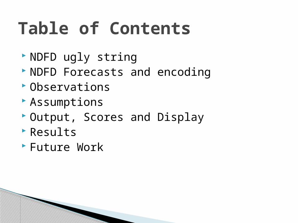
NDFD ugly string NDFD Forecasts and encoding Observations Assumptions Output, Scores and Display Results Future Work
Table of Contents
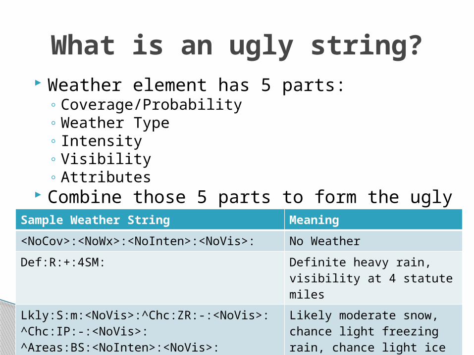
Weather element has 5 parts:◦ Coverage/Probability◦ Weather Type◦ Intensity◦ Visibility◦ Attributes
Combine those 5 parts to form the ugly string
What is an ugly string?
Sample Weather String Meaning
<NoCov>:<NoWx>:<NoInten>:<NoVis>: No Weather
Def:R:+:4SM: Definite heavy rain, visibility at 4 statute miles
Lkly:S:m:<NoVis>:^Chc:ZR:-:<NoVis>:^Chc:IP:-:<NoVis>:^Areas:BS:<NoInten>:<NoVis>:
Likely moderate snow, chance light freezing rain, chance light ice pellets, areas of blowing snow

Forecasts produced on a 5 km grid◦ Extract data (using degrib) at points where there
are METAR stations.◦ Very specific list of points which have been
approved by WFOs◦ At this time, only points are being verified
NDFD forecasts can be updated every hour. Forecasts are valid from the top of the hour
until 59 minutes past the hour.
NDFD Forecasts
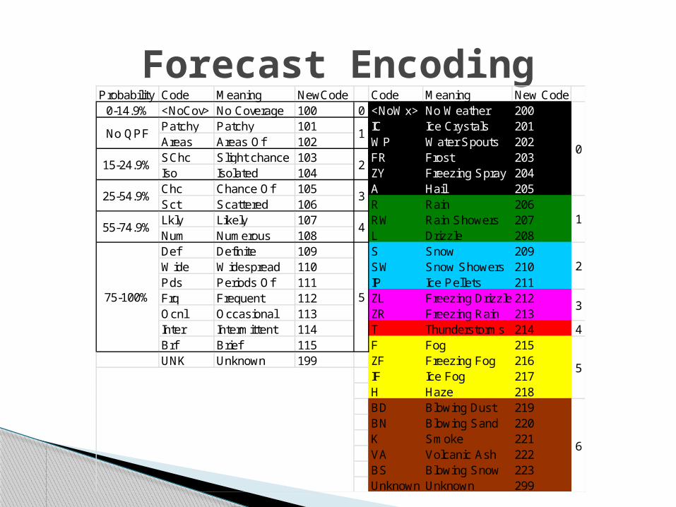
Forecast EncodingProbability Code Meaning NewCode Code Meaning New Code
0-14.9% <NoCov> No Coverage 100 0 <NoWx> No Weather 200Patchy Patchy 101 IC Ice Crystals 201Areas Areas Of 102 WP Water Spouts 202SChc Slight chance 103 FR Frost 203Iso Isolated 104 ZY Freezing Spray 204Chc Chance Of 105 A Hail 205Sct Scattered 106 R Rain 206Lkly Likely 107 RW Rain Showers 207Num Numerous 108 L Drizzle 208Def Definite 109 S Snow 209Wide Widespread 110 SW Snow Showers 210Pds Periods Of 111 IP Ice Pellets 211Frq Frequent 112 ZL Freezing Drizzle 212Ocnl Occasional 113 ZR Freezing Rain 213Inter Intermittent 114 T Thunderstorms 214 4Brf Brief 115 F Fog 215UNK Unknown 199 ZF Freezing Fog 216
IF Ice Fog 217H Haze 218BD Blowing Dust 219BN Blowing Sand 220K Smoke 221VA Volcanic Ash 222BS Blowing Snow 223Unknown Unknown 299
1No QPF
15-24.9%
25-54.9%
55-74.9%
75-100% 5
2
3
4
6
0
1
2
3
5
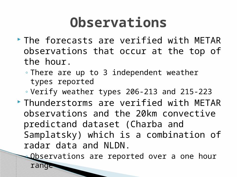
The forecasts are verified with METAR observations that occur at the top of the hour.◦ There are up to 3 independent weather types
reported◦ Verify weather types 206-213 and 215-223
Thunderstorms are verified with METAR observations and the 20km convective predictand dataset (Charba and Samplatsky) which is a combination of radar data and NLDN.◦ Observations are reported over a one hour range
Observations

Verification
Ignored
Forecasts◦ 1. Forecasts that fall within a chosen probability range
and their corresponding observations are used in the computation of the threat score.
◦ 2. Observations that have a corresponding valid forecast and were missed will count as both a false alarm and a miss. For example, if snow was forecasted and rain was observed, the event would be counted as a false alarm for the snow forecast and a miss for the rain.
◦ 3. Frost, freezing spray, water spouts, and snow grain forecasts were considered no weather forecasts.
Assumptions
Constrained by what is reported in the METARs and how those data are processed
Observations◦ 1. Multiple weather types can verify various forecast
precipitation types. Rain verifies rain, rain shower, and drizzle forecasts and so on.
◦ 2. Unknown precipitation verifies rain, rain shower, drizzle, snow, snow shower, ice pellet, freezing rain, and freezing drizzle forecasts.
◦ 3. All fog forecasts (normal, freezing, and ice) are verified by any fog observation.
◦ 4. Blowing dust or sand forecasts are verified by any observation of blowing dust or sand.
Assumptions

Observations◦ 5. Observations reported to be within sight of the
observation location do not verify a forecast as a hit. (e.g. 40 = VCFG Fog between 5-10 miles from the station.)
◦ 6. Dust, mist, spray, tornado, and blowing spray are considered no weather observations.
◦ 7. If a forecast is considered a false alarm, the observation is not always considered a miss. No weather and unknown precipitation observations are not counted as misses.
◦ 8. When the coded observation is ambiguous, only the most likely precipitation type is considered the missed observation. In most cases, this applies to coded observations 68 (light rain/snow/drizzle mix) and 69 (moderate or heavy mix).
Assumptions

Default setting: Analyze entire month of data for both the 00Z and 12Z cycle, for all locations, for all forecast projections, using all weather strings (except NoWx forecasts) outputting the results for each cycle and forecast projection.
In manual mode, a user can control these forecast parameters:◦ weather (ugly) string◦ cycle◦ date range◦ coverage/probability groups◦ forecast projection hours◦ locations (Region, WFO, or multiple stations)
The Script
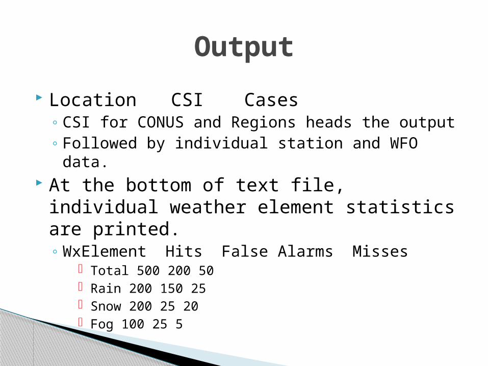
Location CSI Cases◦ CSI for CONUS and Regions heads the output◦ Followed by individual station and WFO data.
At the bottom of text file, individual weather element statistics are printed.◦ WxElement Hits False Alarms Misses
Total 500 200 50 Rain 200 150 25 Snow 200 25 20 Fog 100 25 5
Output
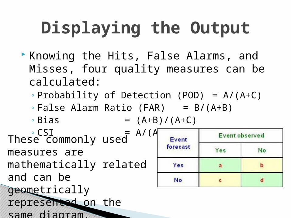
Knowing the Hits, False Alarms, and Misses, four quality measures can be calculated:◦ Probability of Detection (POD) = A/(A+C)◦ False Alarm Ratio (FAR) = B/(A+B)◦ Bias = (A+B)/(A+C)◦ CSI = A/(A+B+C)
Displaying the Output
These commonly used measures are mathematically related and can be geometrically represented on the same diagram.

Displaying the Output
BIAS
CSI
http://journals.ametsoc.org/doi/pdf/10.1175/2008WAF2222159.1
Overforecast Skillful
Not Skillful Underforecast
ManyFalse
Alarms
NoFalse
Alarms
Never Miss
Always Miss

Results (Cool Season Jan-Mar/2010 and Oct-Dec/2010)

Results (Warm SeasonApr – Aug 2010)
Thunderstorm forecast scores improved considerably with convective observations
Cool season had higher CSI for all probability groups.
Warm season had more cases in every prob group, except 75-100% and non-QPF probabilities.
Rarer events (freezing rain, freezing drizzle, ice pellets) don’t verify very well at any probability group.
Results

Verify GMOS at points Compare GMOS vs. NDFD Add ability to handle a matched sample of
cases for any number of forecast sources Add POD and FAR to text output. Automate the entire process from data
ingest to production of plots. Verify more seasons
Future Work

QUESTIONS?

Cool Season 00Z
Cool Season 12Z
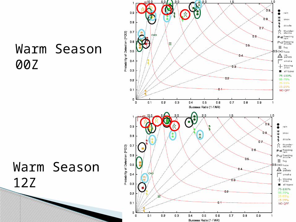
Warm Season 00Z
Warm Season 12Z