part 2 - the heritage conservation district plan · part 2 - the heritage . conservation district...
TRANSCRIPT

61Woodbridge Heritage Conservation District
Part 2 - The Heritage Conservation DistrictPlan

62
Schedule 10: New District Boundary

63Woodbridge Heritage Conservation District
5.0 HERITAGE CONSERVATION DISTRICT PLAN
5.1 Objectives
The purpose of the Proposed Heritage Conservation District is to:
1 Identify, document, maintain and restore the unique heritage village character of Woodbridge.
2 Conserve contributing buildings, landscapes, monuments and streetscapes.
3 Ensure new designs contribute to the Woodbridge heritage character.
4 Manage any development or redevelopment proposed within the district, in a manner that is sensitive and responsive to all aspects necessary to ensure the protection and conservation of the heritage resources, in order to maintain the village character of the Woodbridge District.
5 Ensure individual heritage structures and landscapes are maintained, and new development or redevelopment sensitively integrated, as part of a comprehensive district.
6 Maintain Woodbridge as both a local neighbourhood and a destination for residents of Vaughan and beyond.
7 Support a welcoming, interesting pedestrian environment by encouraging pedestrian amenities and by maintaining human-scaled development and connections to adjacent neighbourhoods.
8 Involve area residents, property and business owners, and interested individuals in the ongoing evolution of the HCD.
5.2 District Boundary
Areas within the District Boundary
The Woodbridge Heritage Conservation District Boundary has not changed radically from the existing study area boundary. The new district boundary includes: the majority of properties along Kipling Avenue, between Gordon Drive to the north and Rainbow Drive to the south, and including the fire hall and some properties along Burton’s Lane; some properties on Abell Avenue, Cheltenham Avenue and Burwick Avenue; all properties along William and James Streets, along Woodbridge Avenue - north to the Fairgrounds and south to Nort Johnson Park, Wallace Street, Park Drive, and Clarence Street north to Mounsey Street. As well, several landscapes are included, such as: the Fairgrounds and adjacent conservation lands east and south along James Street, Meeting House Road Memorial Parkette, Old Fire Hall Parkette, Memorial Hill Park, the Humber River Corridor and Parks, the southern portion of the Board of Trade Golf Course, and the ridge landscape east of Islington Avenue. (see Schedule 10, page 62)
Areas that have been excluded from the District Boundary
The new district boundary excludes: a portion of Meeting House Road, and all of Rosebury Lane and Rosewood Court properties; a few of the industrial properties west of Kipling Avenue; the properties east of Islington Avenue; and a portion of the southerly properties located east of Kipling Avenue and west of the rail corridor.
The West Industrial PropertiesOnly a few of the industrial properties within the study area are considered “contributing properties” to the Heritage Conservation District Boundary, namely a selection of workshops and sheds at the end of Burton’s Lane. These buildings are considered contributing because of their historical association with Toronto Grey and Bruce rail line and their former use as part of the Woodbridge Farmer’s Cooperative Company.

64
Meeting House Road Neighbourhood NorthNone of the northerly properties excluded from the boundary are considered contributing to the heritage character of the area. A large percentage of these properties are mainly of recent construction and collectively, these properties do not have the potential to significantly influence the HCD heritage character.
Islington Avenue EastThe collection of “contributing” properties east of Islington Avenue are recommended for a Part IV Study (of the Ontario Heritage Act), which considers individual designation of properties.
The South NeighbourhoodThe collection of “contributing” and “non-contributing” buildings within the boundaries of Abell and Burwick Avenues, east of Kipling Avenue and west of the rail corridor, were not included within the new boundary. It was assessed that collectively, these properties do not have enough potential to significantly influence the HCD heritage character.

65Woodbridge Heritage Conservation District
Woodbridge constitutes one of four historic villages within the City of Vaughan and has been an attractive place to live and to do business since its founding. This is mainly due to the village quality and character of the built and natural environment, its location within the valley and table lands associated with the Humber River, and its relative proximity to other communities. Woodbridge was historically a residential, industrial, commercial, social and community oriented destination within Vaughan. The village character and quality of the district should continue to be defined by:
• a mixture of residential, industrial, commercial and public amenities organized in a community oriented fashion, with main streets, a village core, open space and healthy neighbourhoods, all within an accessible and walkable environment;
• primarily a low density neighbourhood fabric with two to three storey building heights, with the exception of the Village Core (Woodbridge Avenue), having three to four storeys with some buildings stepping back to six storeys;
• lower density built form along Kipling Avenue with two to three storey building heights and a mixture of uses including residential, industry, open space and commerce;
• a concentration of increased height and density, and a mixed use built form at the village nodes of Kipling and Woodbridge Avenue and the valley portion of Woodbridge Avenue (the Woodbridge Core);
• a diversity and mixture of a minimum of 14 different architectural styles throughout the village;
• a variety of building setbacks, typically having deep frontages and sideyards;
• a “green” quality where the built form is generally integrated within the natural landscape and topography, with mature trees and tree canopies, creating a park-like development setting and context;
• tight tree canopied residential streets with varying single or double sided sidewalk conditions;
• significant views that capture the vast river corridor, the rolling topography, and the interplay of the natural landscape and the built form; and,
• the Fairgrounds as a major community open space.
In the context of this document, the Woodbridge (Commercial) Core is defined as the valley portion of Woodbridge Avenue from Wallace Street to Clarence Avenue. The Woodbridge Commercial Nodes are the two areas located at the intersection of Woodbridge and Kipling Avenues, and Woodbridge Avenue from Wallace Street to Clarence Avenue.
The heritage character of the Woodbridge HCD derives from the collection and association of its cultural heritage landscapes, properties and structures, and can be discerned from the following:
A. Woodbridge’s history and function, within Vaughan and surroundings
5.3 Heritage Character Statement
HERITAGE CONSERVATION DISTRICT
B. Woodbridge’s unique sense of identityC. Woodbridge’s unique elements
These categories are further described by their heritage attributes as follows:
5.3.1 Woodbridge’s history and function, within Vaughan and surroundings
5.3.1.1. Layered History• Many layers of history overlap in Woodbridge, from native
settlements, to a 1800s agricultural village, to a 1900s cotton mill village, to a present day mixed-use village, commercial core and destination for Vaughan.
• The existing built form includes and reflects the multiple layers of history, construction periods, and architectural styles.
5.3.1.2. Regional Function, Regional Destination• Woodbridge historically, has been the village hub within
the region for human settlements, human activity, and significant cultural events, and should continue to function as such.
• Woodbridge should continue to be a recreational and commercial destination for residents of Vaughan and beyond.
• The presence of the commercial core of activity shifted over time between the locations of Woodbridge Avenue and Kipling Avenue, Wallace Street and finally the valley portion of Woodbridge Ave. The hub of commercial activity should continue to grow at the Woodbridge Avenue and Kipling Avenue intersection as the commercial gateway and in the valley portion of Woodbridge Avenue, starting just west of Wallace Street and continuing to Clarence Street. Wallace Street, over time, has shifted to become solely residential and should continue in that manner.
• The recommendation for the commercial hub will be comprehensively reviewed, in terms of development activity within the Woodbridge Core and in terms of activity within the existing Special Policy Areas (SPA), as part of the Woodbridge Core Area Study, to be undertaken in 2009. The Woodbridge Core Area Study will determine the development capabilities of the area, especially within the areas of commercial activity.
• Any development approvals within the valley corridor, notwithstanding they may include heritage parcels, dwellings, or structures, need to get prior approvals from the TRCA and the City of Vaughan.
• The Fairgrounds should remain as the main open space, social, and recreational draw for the City of Vaughan and should broaden its use as a year round destination at its current location.

66
Schedule 11: Over half of the District is Open Space

67Woodbridge Heritage Conservation District
5.3.1.3. Open Spaces• Over half of the District is open space - 59%, which
includes: - River Corridor/Conservation Land 25%- Streets and Rail Corridor 13%- Golf Course 10%- The Fairgrounds 8%- Parks/Parkettes 3%
• A canopy of trees covers most of the area.• A system of trails exists, but many are not connected to one
another or to other elements of the open space system.
5.3.1.4. Topography• A rolling topography results in frequent views to the valley, and
towards the surrounding hills, especially to key areas such as the Woodbridge commercial core and the Humber River Valley flood plain, and to Kipling Avenue, which is on the ridge.
5.3.1.5. Woodbridge is changing and maturing• Woodbridge has never stopped changing and never will:
new buildings emerge every year and landscapes are frequently renewed.
• The original Woodbridge village character lingers amidst this change, and is reflected in many of its buildings in terms of architecture, scale and density, in some of the monuments and bridges, in its topography and open spaces, and in the pattern of walkable streets and trails.
HERITAGE CONSERVATION DISTRICT
Schedule 12: The District includes areas of potential archaeological significance
5.3.2 Woodbridge’s unique sense of identity
5.3.2.1. Village CharacterWoodbridge is experienced as a village, given its:
• pedestrian scale – people can walk to most places within the District.
• a mix of uses – people live here and can find a variety of activities within walking distance.
• scale of buildings – which are generally in good proportion in terms of height to street width.
• “green” park-like setting - the Humber River and its tributaries are intertwined in the built fabric and generally, buildings are generously spaced and set within a mature landscaped environment.
5.3.2.2. Archaeology• The District includes areas of potential archaeological
significance (mostly in proximity to the river).• The District is adjacent to areas of recognized
archaeological significance.
5.3.2.3. Architecture• Buildings of two to three storey building heights, from
different construction periods and uses coexist, side by side, including: residential homes, barns, farmhouses, commercial buildings, institutional and industrial buildings.
5.3.2.4. Scale and height• Buildings in Woodbridge are primarily of a two to three
storey scale and height that is pedestrian friendly, and allows ample sun penetration and open views. (OPA #240 allows for a concentration of increased height and scale of up to four storeys maximum at the historic commercial nodes of Woodbridge and Kipling Avenue, within the Woodbridge Avenue commercial core. A consideration for additional height to six storeys maximum, having a four storey podium is envisioned at this intersection in the Kipling Corridor Study and Official Plan Amendment. This height recommendation is also supported in this Plan.)
• Buildings include: doors and windows facing directly onto the street, creating an animated environment for pedestrians. There are no blank walls.
5.3.2.5. Circulation, vehicular access and parking• Pedestrians can move freely and comfortably on all streets
(there are sidewalks on both sides of the street, except for portions of Clarence Street, Wallace Street, William Street and James Street).
• Vehicles access properties directly from the street (there are no public laneways).
• Most streets include street side parking.• On-site parking, garages, and parking structures are
generally concealed behind or below inhabited buildings.
68
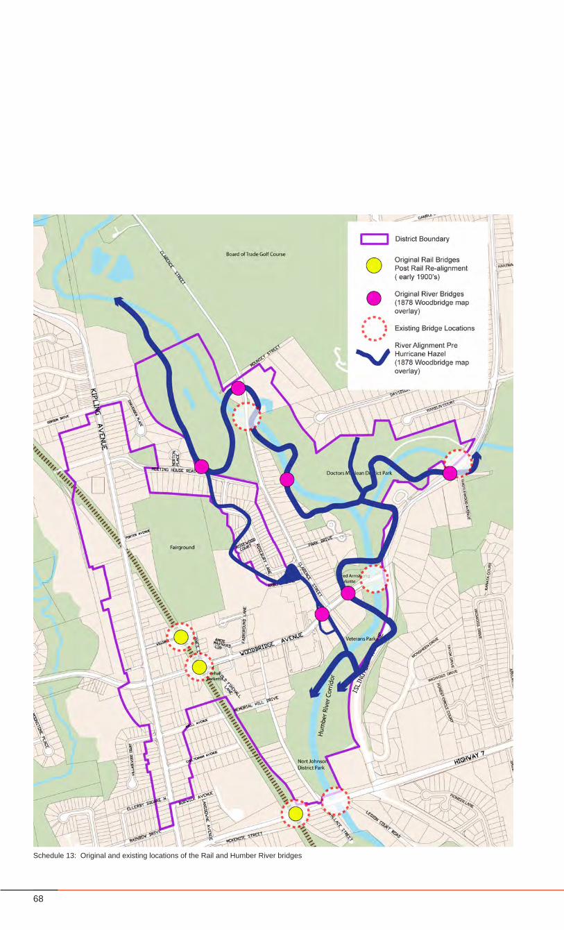
Schedule 13: Original and existing locations of the Rail and Humber River bridges

69Woodbridge Heritage Conservation District
HERITAGE CONSERVATION DISTRICT
5.3.3. Woodbridge’s unique elements
5.3.3.1. Character Areas• Woodbridge comprises several distinct ‘character areas’,
with distinct and intertwined identities:Kipling Avenue North and South1. William and James Streets2. The Fairgrounds3. Woodbridge Avenue4. Wallace Street5. Clarence Street and Park Drive6. The Humber River Corridor7.
• Each ‘character area’ contributes to the village experience of Woodbridge as a whole as described in Section 6.0.
5.3.3.2. Hidden Gems – special places and monuments
• The District includes several ‘hidden gems’, which contribute to the character and sense of place – including: The War Memorial, the bridges, the Humber trails and others.
5.3.3.3. Bridges• Woodbridge was formerly known as the “Town of Bridges”• 7 bridges can still be found within the area (3 CP Rail, 4
over the Humber - see Schedule 13, page 68).• Bridges are ever-present and visible and often act as
gateways.
5.3.3.4. StreetsStreets within the Study Area play a significant role in defining the village character of Woodbridge and can be generally defined as such:
• are walkable (albeit some have sidewalks on only one side of the street),
• have a tree canopy (less so on Woodbridge Avenue), and• have right-of-ways that range from 17.5m to 20m.
5.3.3.5. Open SpaceThere are several open spaces and open space systems within Woodbridge that are considered significant and contributing to the heritage character because of size, quality and character of landscape, and history, including:
• The Fairgrounds• Woodbridge Wesleyan Methodist Cemetery (Old Methodist
Church Cemetery) • Forested Conservation Land Areas• The Old Fire Hall Parkette• Memorial Hill Park• The Humber River Corridor, which includes parks, parkettes
and the Board of Trade Golf Course• The Humber River
5.3.3.6. The Humber River• The Humber River was designated as a Canadian Heritage
River in 1999, in recognition of its importance in the history of First Nations peoples, the early Euro-Canadian explorers and settlers of Upper Canada. Additionally, it contributed to the development of the Nation.
5.3.3.7. The Floodplain• Large portions of the district reside within the floodplain, as
outlined by the Toronto Regional Conservation Authority.
5.4 Reasons for Designation Under the Ontario Heritage Act
The Woodbridge HCD Study makes the following conclusions that, in summary, define Woodbridge as a “Village”, having a village quality and character as described in section 5.3 of this study.
• There is an HCD Heritage Character that emerges from the collection and association of properties of a certain age, architectural style and design, and of a particular density and scale. As well, there is an HCD Heritage Character that emerges from the collection and association of monumental structures and of landscapes. These elements in total, define Woodbridge as a “Village”.
• There are a number of properties that individually contribute to the HCD Heritage Character.
• There are significant clusters of properties that contribute to the HCD Heritage Character.
• There are a number of properties that individually do not contribute to the HCD Heritage Character because they may not have any or enough elements to represent a contributing heritage resource, but given their location, proximity, and characteristics have the potential to significantly influence the long-term heritage character of the HCD.
• The collection of ‘contributing’ and ‘non-contributing’ properties with the potential to significantly influence the HCD heritage character, have a definable boundary.
• There are unique Heritage Character Areas, with unique Heritage Attributes, that can be further identified within the HCD.
For this reason, the Study recommends designating the HCD, listing as the reasons for designation:
• The Heritage Character Statement; and• The Heritage Attributes of the District and of each Heritage
Character Area.

70
Schedule 14: HCD Character Areas within the New District Boundary