draft willoughby heritage farm conservation reserve … farm master plan.pdf · draft willoughby...
TRANSCRIPT

DRAFT
WILLOUGHBY HERITAGE FARM &
CONSERVATION RESERVE MASTER PLAN
Collinsville Area Recreation District
Prepared by:
Land Design Collaborative, Inc. Laurie Marston Associates
Applied Ecological Services, Inc.
May, 2003

WILLOUGHBY HERITAGE FARM &
CONSERVATION RESERVE MASTER PLAN
Collinsville Area Recreation District
Collinsville, Illinois
Prepared by:
Land Design Collaborative, Inc. Prime Consultant
Laurie Marston Associates
Applied Ecological Services, Inc.
May 2003

The development of a Master Plan for Willoughby Heritage Farm and Conservation Reserve involved many dedicated people. The following individuals are thanked for their time and effort in participating in the planning process:
COLLINSVILLE AREA RECREATION DISTRICT BOARD OF PARK COMMISSIONERS
Mark Ann Bitzer, President Stephen H. Helmkamp
Clarence "Spike" Bryant Kenneth Mumper, Sr.
Dale E. Willeford Joseph (Joe) Legendre (May 2003)
Mark E. Badasch, Executive Director
WILLOUGHBY FARM STEERING COMMITTEE Barbara Burstadt
Dean Dittmar Jeff Humes
Lynn Kerkemeyer, Missouri Botanical Garden Larry Trucano Fred Dalton
Michael Fries, TPL Janet Burnett, U of I Extension
Lisa Durham Diana Hankammer
Randy Holbrook, IDNR Eldon Klein Rick Rehg
Lisa Smith, CCVB
Paul Welch Mayor Stan Schaeffer
John Staubke Ed Weilbacher, SIRC&D
Richard Worthen Hank Sinda
Barry Wilson Greg Reising
Rev. David Stabenfeldt Brian Witty, CARD Staff
Kevin Brown, CARD Staff Spike Bryant, CARD Commissioner
Ken Mumper, Sr., CARD Commissioner Dale Willeford, CARD Commissioner
CONSULTANT TEAM Land Design Collaborative, Inc.
James C. Gamble, Principal in Charge Lawrence B. Raffel, Project Manager
Lisa Davis, Graphics Laurie B. Marston, AICP
Applied Ecological Services, Inc. &
Southwestern Illinois GIS Resource Center / Southwestern Illinois RC&D, Inc. for providing base information
Willoughby Heritage Farm & Conservation Reserve i Master Plan Report
TABLE OF CONTENTS LIST OF FIGURES, LIST OF TABLES, APPENDIX...................ii EXECUTIVE SUMMARY .....................................................1 SECTION 1 PROCESS and PROGRAMS..............................3
Introduction ................................................3 Consensus Process.......................................3 Mission / Vision Statement...........................5
SECTION 2 DESCRIPTION OF THE SITE............................9
Site Context ................................................9 Farm...........................................................9 Conservation Area ..................................... 10
SECTION 3 MASTER PLAN .......................................... 15
Introduction .............................................. 15 Master Plan Components............................ 15 Farm......................................................... 15 Conservation Reserve ................................ 22 Future Considerations ................................ 24
SECTION 4 IMPLEMENTATION ..................................... 26
Purpose..................................................... 26 Phasing..................................................... 27 Funding .................................................... 27 Revenue Generation................................... 29 Educational /Recreational Programs............ 29 Planning Partners....................................... 30 Volunteers ................................................ 31
Willoughby Heritage Farm & Conservation Reserve ii Master Plan Report
LIST OF FIGURES EXECUTIVE SUMMARY 1 Willoughby Farm Purchase......................... 1 2 Willoughby Family Home 1928 ................. 1 3 Schneider Ditch........................................... 2 SECTION 1 4 Public Listening Session............................. 3 5 Visioning Session........................................ 4 6 Steering Committee Workshop................... 4 7 Organizational Flow Chart.......................... 7 8 Public Process ............................................. 8
SECTION 2 9 Existing Barn .............................................. 9 10 Existing Deterioration............................... 10 11 Evasive Plant Species ............................... 10 12 Erosion of Schneider Ditch....................... 11 13 Context Plan.............................................. 12 14 Farm Inventory and Analysis.................... 13 15 Site Inventory and Analysis ...................... 14 SECTION 3 16 Willoughby Family Home 2003 ............... 15 17 Existing Silo.............................................. 16 18 Local Prairie Bank Barn............................ 16 19 Peak Roof Projecting Above Hayloft........ 17 20 Existing Garage......................................... 17 21 Existing Grain Bin .................................... 18 22 Willoughby Farm Entry ............................ 20 23 Existing Fence........................................... 21 24 Ford �Jubilee� Tractor .............................. 21 25 Master Plan Concept ................................. 25 SECTION 4 26 Willoughby Farm...................................... 26
LIST OF TABLES
1 Listening Session Summarization............. 32
APPENDIX (under separate cover)
Appendix A: Consensus Documentation
Appendix B: Conceptual Plan Alternatives
Appendix C: Natural Resource Inventory

Willoughby Heritage Farm & Conservation Reserve 1 Master Plan Report
EXECUTIVE SUMMARY Willoughby Farm has been a community fixture in the Collinsville area since the early 1900�s. Recognizing the significance of the interactive educational value of the farm and to preserve what may be the last significant tract of open space along the Collinsville bluff line, the Collinsville Area Recreation District (CARD) purchased the forty acres of land from the Trust for the Public Land with an IDNR Conservation 2000 Grant.
Prior to official purchase of the property, the CARD Board of Park Commissioners solicited proposals from qualified consultants to provide master planning services. Land Design Collaborative, Inc. (LDC) and its team of consultants were selected by the Recreation District to work with the Steering Committee, as well as numerous Planning Partners, to facilitate the development of a Master Plan. The constraints of the site were clearly evident by the deteriorated condition of the farm and the nature of the established conservation easement. A consensus building process was established to provide interactive discussion with the general public, as well as within the Steering Committee and the three Subcommittees. Through the public process, the Steering Committee was able to refine the Willoughby Farm Vision initially established by the CARD, thus defining the program requirements and issues to be considered in the planning and implementation of the Willoughby Heritage Farm and Conservation Reserve.
To understand the nature of the farm, LDC met with Willoughby family members at the remnants of the original farm and toured the decaying structures, as well as the interior of the original farmhouse. Reminiscent were the order of the day as the farmhouse came to life with the memories of Barbara Burstadt and Lisa Durham. Prior to commencement of the master planning process, the LDC Team performed a complete site investigation and natural resource inventory of the forty-acre Willoughby
Farm. The natural resource assessment is included as an Appendix to the Master Plan Report. The study identified dominant plant species and species of interest, recorded animal signs, documented physical site conditions and critical resource issues for the property.
Figure 1
Figure 2

Exe cut ive S umma ry
Willoughby Heritage Farm & Conservation Reserve 2 Master Plan Report
On February 20, 2003, the final Mission / Vision Statement was approved by the Steering Committee and concept plans representing the ideas and concerns of the Committee, as well as those of CARD and LDC, were presented. Subsequent discussions resulted in modifications, and a final Draft Master Plan was approved by the Steering Committee on April 24, 2003.
It is the vision of the Collinsville Area Recreation District to preserve quality open space for future generations. To that end, it is the intention of the Willoughby Heritage Farm and Conservation Reserve Master Plan and Report to act as a guide in assisting the community and the various Planning Partners in the establishment of an interactive educational farmstead and the restoration and preservation of a quality natural area.
Figure 3
Willoughby Heritage Farm & Conservation Reserve 3 Master Plan Report
SEC T IO N 1 PRO C ES S AN D P RO G R AM
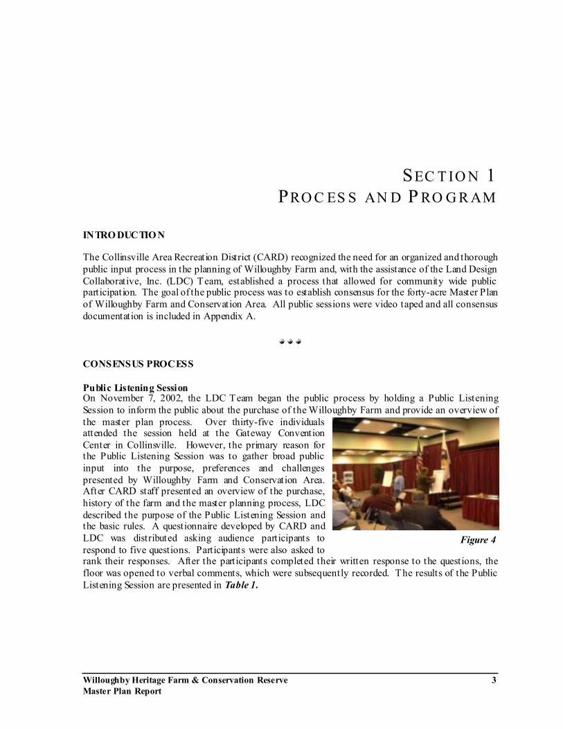
INTRO DUCTIO N The Collinsville Area Recreation District (CARD) recognized the need for an organized and thorough public input process in the planning of Willoughby Farm and, with the assistance of the Land Design Collaborative, Inc. (LDC) Team, established a process that allowed for community wide public participation. The goal of the public process was to establish consensus for the forty-acre Master Plan of Willoughby Farm and Conservation Area. All public sessions were video taped and all consensus documentation is included in Appendix A.
CONSENSUS PROCESS Public Listening Session On November 7, 2002, the LDC Team began the public process by holding a Public Listening Session to inform the public about the purchase of the Willoughby Farm and provide an overview of the master plan process. Over thirty-five individuals attended the session held at the Gateway Convention Center in Collinsville. However, the primary reason for the Public Listening Session was to gather broad public input into the purpose, preferences and challenges presented by Willoughby Farm and Conservation Area. After CARD staff presented an overview of the purchase, history of the farm and the master planning process, LDC described the purpose of the Public Listening Session and the basic rules. A questionnaire developed by CARD and LDC was distributed asking audience participants to respond to five questions. Participants were also asked to rank their responses. After the participants completed their written response to the questions, the floor was opened to verbal comments, which were subsequently recorded. The results of the Public Listening Session are presented in Table 1.
Figure 4

Proc ess an d Progra m
Willoughby Heritage Farm & Conservation Reserve 4 Master Plan Report
Visioning Workshop Using the information generated from the Public Listening Session, CARD Staff and LDC developed a draft Mission and Vision Statement. A Visioning Workshop was held on Saturday November 16, 2002 at the Collinsville Area Recreation District Activity Center. The Visioning Workshop was attended by the individuals of the Steering
Committee. After a brief presentation regarding the purpose of the Visioning Workshop and the basic ground rules, the individuals broke into four groups. Each individual was provided with a draft Mission / Vision Statement, the Public Listening Session Answers, which were categorized and grouped, and the Public Listening Session Questionnaire Answers, which were an accumulation of the written answers to the questionnaire. Each group was also provided with a map of the forty-acre parcel, as well as trace overlay, and asked to suggest how the site should be used.
Each group was asked to review the Mission and Vision Statement and suggest any modifications. The groups were also asked to use the Public Listening Session Answers to guide the group discussion for the vision of Willoughby Heritage Farm and Conservation Reserve. After working within their respective groups, the four groups then presented the findings of their group to the entire committee. Numerous specific ideas about the site were raised and discussed by the Steering Committee. The comments were categorized as they relate to the five components of the Mission/Vision Statement. Steering Committee Workshops Four Steering Committee Workshops were held (not including the Visioning Workshop), beginning on December 12, 2002 and ending on April 24, 2003. Each Steering Committee member was presented with a project binder containing all the process information generated to date as well as a compilation of site information including site images. At the Steering Committee Workshop on December 12, 2002, individuals were provided with the Group Comments from the Visioning Workshop and the revised Mission and Vision Statement. The Steering Committee was asked to review both documents to ensure that they reflected the Committee�s input. In addition, the CARD staff and LDC developed a Subcommittee Questionnaire based upon questions posed in the Visioning Session, as well as questions developed by the LDC. Questions were divided into four categories:
1) General 2) Plant 3) Animal 4) Man
Figure 5
Figure 6

Proc ess an d Progra m
Willoughby Heritage Farm & Conservation Reserve 5 Master Plan Report
The Steering Committee was subsequently split into three Subcommittees, each with the responsibility of addressing one of the three specific categories. After working within their respective groups, each group then presented the findings of their group to the entire Committee. Using the comments from the Steering Committee meeting, the CARD Staff and LDC developed an approved Mission / Vision Statement, as well as Program Elements It should be clearly noted that every time a document was prepared by the LDC Team, it was presented to the Steering Committee at the subsequent meeting for discussion and revisions. This process was adhered to until there was consensus on each item on the particular document. It was through the consensus process, that the Mission / Vision Statement was developed and revised until the following final version was written to incorporate all the comments and concerns expressed by the Steering Committee.
MISSION / VISION STATEMENT The Mission Statements are broad policy about what is planned for the site and are shown in bold. The Vision Statements explain how to implement the Mission. To preserve and expand, for future generations, quality open space. Preserve from residential development pressures what may be the last significant large tract of open space along the bluff line that is located within the territory of the Park District . And, when the opportunities arise, to purchase adjoining land to expand the open space. To educate the public about family farm life with guided or self-guided tours. Provide interactive educational opportunities for all ages through the development of a living history exhibit , presenting the stand-alone subsistence family farm of the 1920's through 1950's, in order to teach Midwestern history, the enormous amount of work required to subsist, development of present-day farming and the importance of individual skills, along with the negative impacts of farming. The presentation will include interpretations of the self-reliant nature of the Willoughby family farm and demonstrations of the importance of diversification, livestock management, crop rotation, truck gardening and explanations of the farm-to-consumer food industry. To provide opportunities for individuals and groups to experience the outdoors through interpretive trail hikes. Provide interpretive trails though the conservation area. The conservation area will interpret the region�s plant and animal life, geological history, history of Native Americans and history of pioneers before the settlers such as the Willoughby family.
Proc ess an d Progra m
Willoughby Heritage Farm & Conservation Reserve 6 Master Plan Report
To provide opportunities to educate the public on the importance and necessity of upland storm water management and urban erosion control. Work in cooperation with other local, State and Federal agencies to institute plans for the management of upland storm water and control of erosion, so as to reduce their impact on wetlands in the American Bottom, and thereby reduce flooding. To act as a repository of plant and animal life and provide opportunities for enjoying and learning about plant and animal life that exists within the region. Enhance the quality of plant and animal life, and protect, preserve, and manage plant and animal habitats by combating the spread of exotic species within the property and maintaining the native species that exist on the property.
It was also through the Steering Committee Workshops and considerable discussion that the Program Elements were developed to guide the design process. An interim progress meeting was held on February 5, 2003, at the LDC office with LDC Staff, CARD Staff and a representative of the Steering Committee. Items discussed at that meeting included the Program Statement and Program Elements, a draft Inventory & Analysis (including a Context Plan), Schematic Design and Building Analysis. At the second Steering Committee Workshop on February 20, 2003, prior to presenting the concept plans, LDC presented the Farm Inventory & Analysis, the Site Inventory & Analysis and a Context Plan. Each plan identified the issues and opportunities presented by the Willoughby Heritage Farm and Conservation Reserve. LDC then presented two alternative site concepts for the entire forty-acre parcel (farm and conservation easement), and a third concept that only addressed the farm area. The Mission / Vision Statement and Program Elements were also presented with the changes from the previous Workshop and changes suggested by the Committee. On April 10, 2003, the CARD staff conducted a third Steering Committee meeting without LDC in attendance to comment on a fourth concept prepared by the LDC Team, sent via e-mail to the CARD, and to discuss activities for the farm and conservation areas. A final Steering Committee meeting was held on April 24, 2003, to present the Draft Master Plan to the Committee. At that t ime, the Committee was allowed to comment on the Plan and to request any modifications prior to submittal of the report to the CARD Board of Commissioners.
Proce ss a nd P rog ra m
Willoughby Heritage Farm & Conservation Reserve 7 Master Plan Report
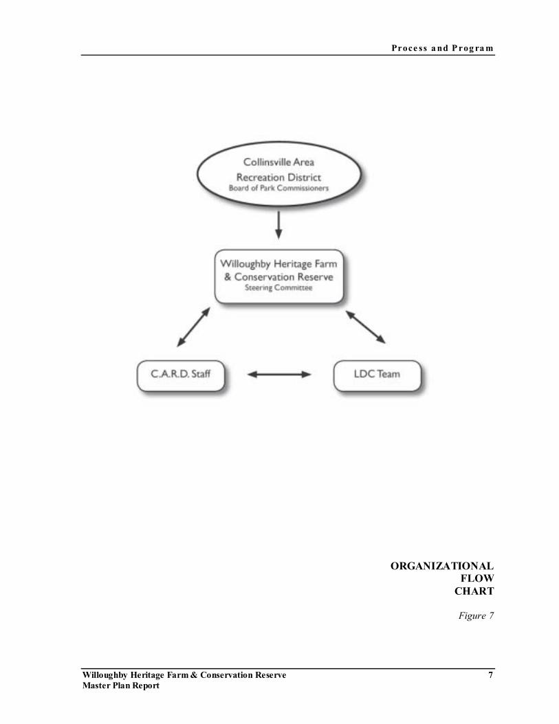
ORGANIZATIONAL FLOW
CHART
Figure 7

Proce ss a nd P rog ra m
Willoughby Heritage Farm & Conservation Reserve 8 Master Plan Report
PUBLIC PROCESS
Figure 8
Willoughby Heritage Farm & Conservation Reserve 9 Master Plan Report
S E C TI O N 2 D E S C RI P TI ON OF T HE SI T E
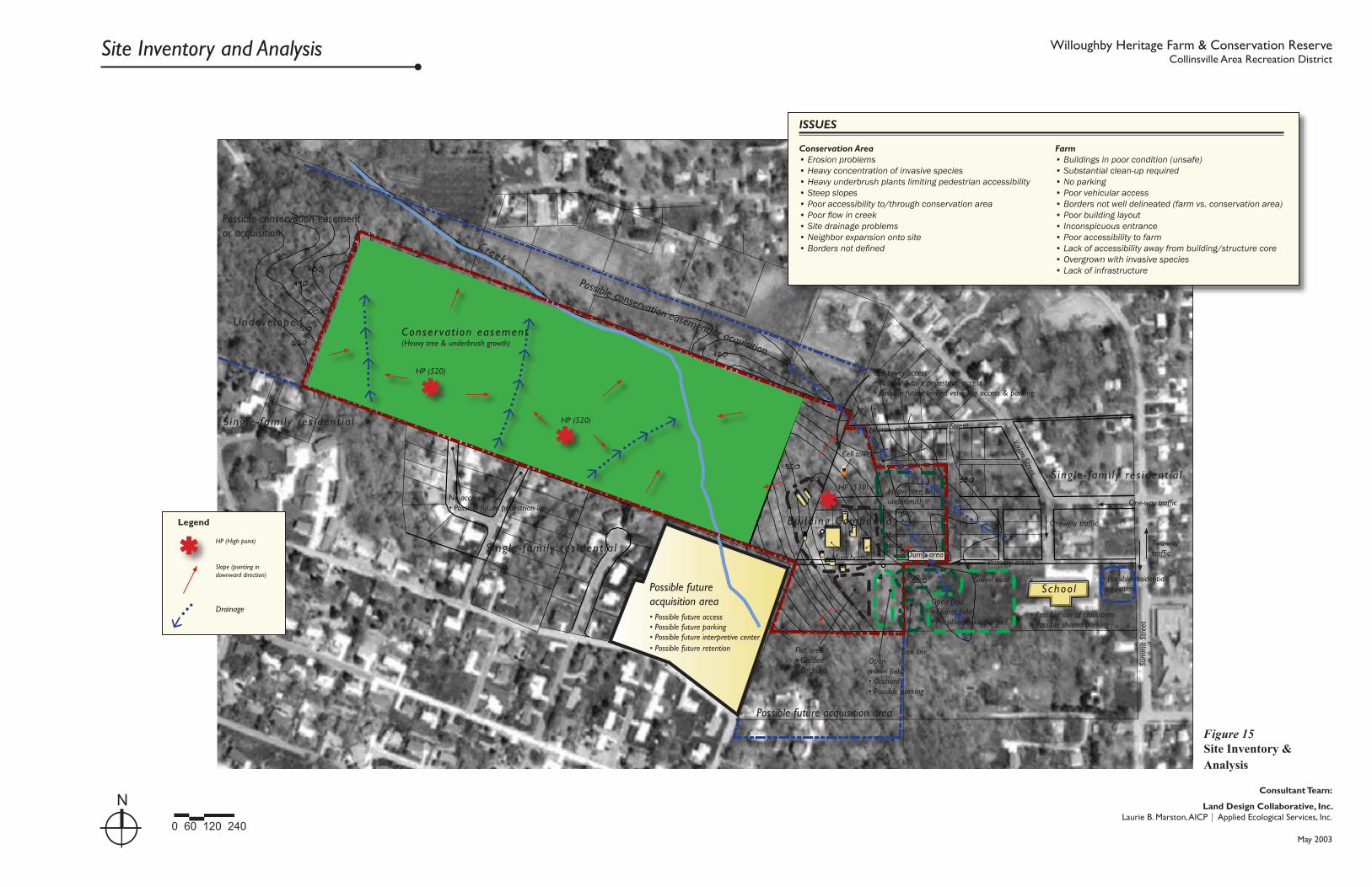
SITE CONTEXT As noted in the Conservation 2000 Ecosystem Project Grant Application, the Willoughby Farm and adjacent Conservation Area is the largest remaining tract of open space in the Collinsville Bluff line. The property is situated among residential properties and adjacent to Summit School, which accommodates grades K to 6th. The property has a current zoning of Residential (R-1 through R-4), which allows for parks, forest preserves and recreational areas, when publicly owned and, agricultural / animal uses. The farm and conservation area is east of Interstate 55/70 and northwest of downtown Collinsville. West of Interstate 55/70 is the Gateway Conference Center, the Collinsville Area Recreation District Community Center and Splash City Aquatic Facility. The area is also served by numerous motels and restaurants. Several other issues have been identified in the Context Plan (Figure 15) included within this section of the Report.
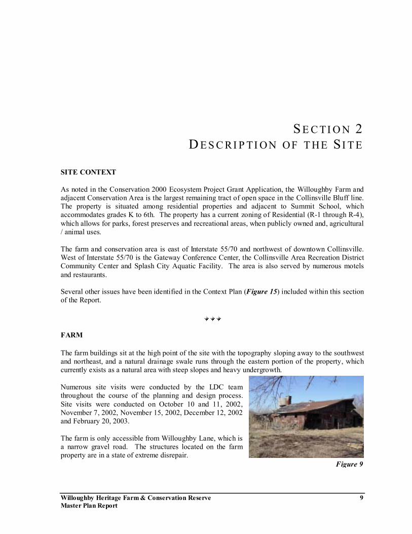
FARM The farm buildings sit at the high point of the site with the topography sloping away to the southwest and northeast, and a natural drainage swale runs through the eastern portion of the property, which currently exists as a natural area with steep slopes and heavy undergrowth. Numerous site visits were conducted by the LDC team throughout the course of the planning and design process. Site visits were conducted on October 10 and 11, 2002, November 7, 2002, November 15, 2002, December 12, 2002 and February 20, 2003. The farm is only accessible from Willoughby Lane, which is a narrow gravel road. The structures located on the farm property are in a state of extreme disrepair.
Figure 9

De script io n of t he Site
Willoughby Heritage Farm & Conservation Reserve 10 Master Plan Report
Figure 11
Buildings and structures are in poor condition and should be considered unsafe. Dumping of refuse has also occurred at various locations on the property. It also appears from a visual inspection, that the location of buildings and structures do not have a particularly well derived functional or spatial relationship. The location of the various farm buildings do not create a boundary, resulting in the familiar �farm yard� open space. A tour and visual inspection of the interior of the farm house indicates that the home is a �Sears Home� in reasonably good condition, and may be suitable for re-use.
In addition, an existing cell tower with a surrounding perimeter fence is located at the northeast portion of the property and is accessible only from Daniel Street. Several other issues have been identified in the Farm Inventory and Analysis (Figure 16) included within this section of the Report.
CONSERVATION AREA Natural History and Land-Use Prior to settlement, a mosaic of prairie, oak savanna, woodland, and floodplain communities characterized the region of Willoughby Farm known as the Sinkhole Plain/American Bottom area. Estimates from the Government Land office survey in 1820 indicate that Madison County was 40.2% forested and 57.8% prairie (IDNR). This transition zone from prairie to forest likely supported some of the best examples of tall grass savanna in the Midwest (Nuzzo 1986). During site visits, we observed evidence of oak savanna communities within property boundaries: a disturbed oak remnant with high restoration potential in addition to a disturbed shortgrass prairie. The historical aerial photograph used for the pre-1970s Madison County Soil Survey provides additional evidence of prairie and oak savanna habitats: Large oak trees dot the photo in the western portion of the site, and short-statured vegetation with sparse trees are seen on ridge tops (Figure 1). Other habitats onsite include formerly grazed pastures (grazed from early-1920s to mid-1970s; Burstadt, pers. comm.) that are now forested creek bottom, slope, ridge, and open farm. Major disturbances to the site include invasion by Honeysuckles (Lonicera spp.), and vines (Vinca spp. and Hedera helix) that prevent light from reaching the understory thereby inhibiting the growth of native forbs and grasses. The lack of understory growth has contributed to erosion, and most likely the loss of the native seedbank on slopes. In addition, increased stormwater from surrounding
Figure 10
De script io n of t he Site
Willoughby Heritage Farm & Conservation Reserve 11 Master Plan Report
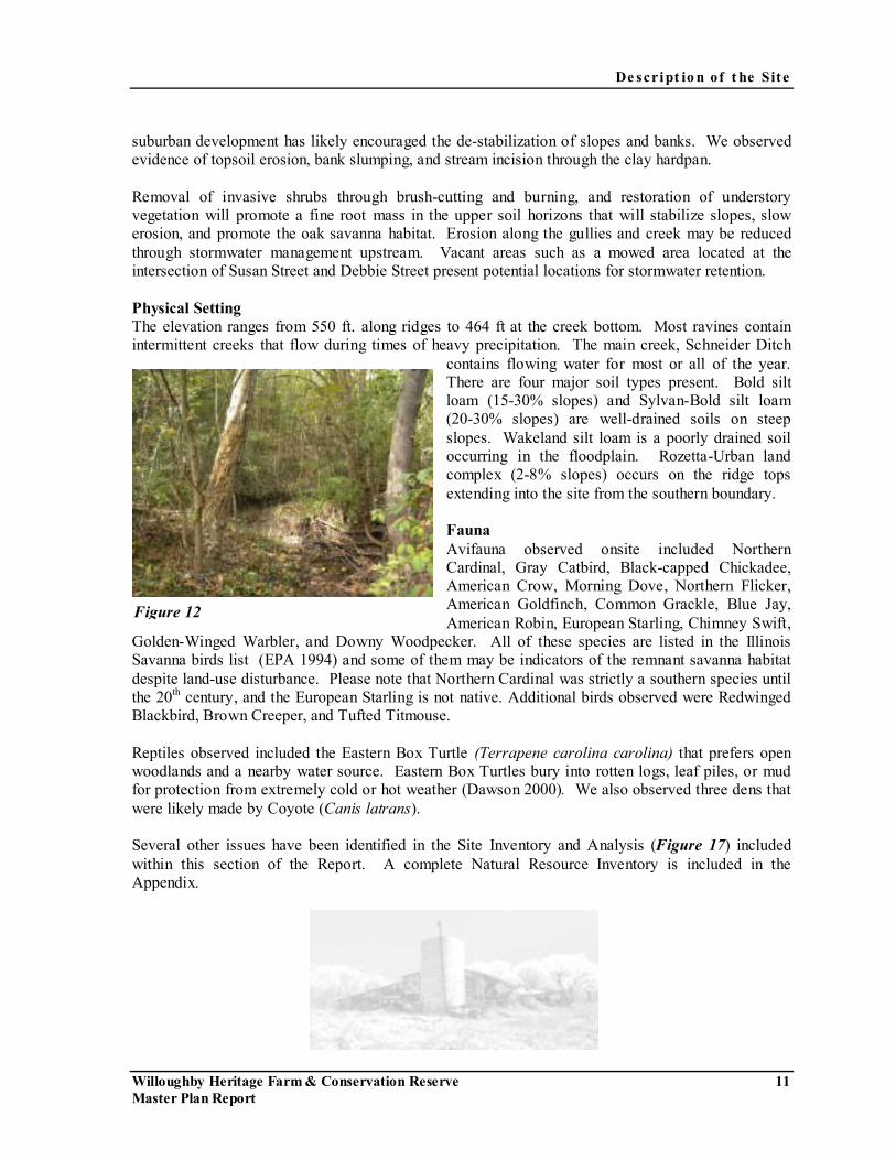
suburban development has likely encouraged the de-stabilization of slopes and banks. We observed evidence of topsoil erosion, bank slumping, and stream incision through the clay hardpan. Removal of invasive shrubs through brush-cutting and burning, and restoration of understory vegetation will promote a fine root mass in the upper soil horizons that will stabilize slopes, slow erosion, and promote the oak savanna habitat. Erosion along the gullies and creek may be reduced through stormwater management upstream. Vacant areas such as a mowed area located at the intersection of Susan Street and Debbie Street present potential locations for stormwater retention. Physical Setting The elevation ranges from 550 ft. along ridges to 464 ft at the creek bottom. Most ravines contain intermittent creeks that flow during times of heavy precipitation. The main creek, Schneider Ditch
contains flowing water for most or all of the year. There are four major soil types present. Bold silt loam (15-30% slopes) and Sylvan-Bold silt loam (20-30% slopes) are well-drained soils on steep slopes. Wakeland silt loam is a poorly drained soil occurring in the floodplain. Rozetta-Urban land complex (2-8% slopes) occurs on the ridge tops extending into the site from the southern boundary. Fauna Avifauna observed onsite included Northern Cardinal, Gray Catbird, Black-capped Chickadee, American Crow, Morning Dove, Northern Flicker, American Goldfinch, Common Grackle, Blue Jay, American Robin, European Starling, Chimney Swift,
Golden-Winged Warbler, and Downy Woodpecker. All of these species are listed in the Illinois Savanna birds list (EPA 1994) and some of them may be indicators of the remnant savanna habitat despite land-use disturbance. Please note that Northern Cardinal was strictly a southern species until the 20th century, and the European Starling is not native. Additional birds observed were Redwinged Blackbird, Brown Creeper, and Tufted Titmouse. Reptiles observed included the Eastern Box Turtle (Terrapene carolina carolina) that prefers open woodlands and a nearby water source. Eastern Box Turtles bury into rotten logs, leaf piles, or mud for protection from extremely cold or hot weather (Dawson 2000). We also observed three dens that were likely made by Coyote (Canis latrans). Several other issues have been identified in the Site Inventory and Analysis (Figure 17) included within this section of the Report. A complete Natural Resource Inventory is included in the Appendix.
Figure 12

0 200 400 800
N
Context Plan Willoughby Heritage Farm & Conservation ReserveCollinsville Area Recreation District
Stat
e R
t . 1
57
I n ter s tate 55/70E
astp
ort
Plaz
a D
rive
(Bike
rout
e)
Collinsville AreaRecreation DistrictOffice & Splash City
Gateway Conference Center
Mote l s
Mote l s
Mote l s
Res ident ia l
Res ident ia l
Res ident ia l
To downtown
Willoughby Farm & Conservation Area
To Cahokia Mounds(state historic site)
To Collinsville High SchoolCo
mm
ercia
l
Com
mer
cial
• Links to parks and schools • Connection to bike paths• Vehicular accessibility• Directions• Integration with other C.A.R.D. facilities• Accessibility across major roadways
ISSUES
Figure 13Context Plan
Land Design Collaborative, Inc.Laurie B. Marston, AICP | Applied Ecological Services, Inc.
Consultant Team:
May 2003

Farm Inventory and Analysis Willoughby Heritage Farm & Conservation ReserveCollinsville Area Recreation District
à���à���à
�����
������
����
à���à���à���à���à
���������������
à
à���à
���à
���à
���à
���à
���à
���à
���à
���à
���à
���à
ß
Possible future acquisition area
Sing le -Fami l y Res ident ia l
• Possible future access• Possible future parking• Possible future interpretive center
Flat area• Garden• Orchard
Primary pedestrian and vehicular access
Open field• Sports field• Possible parking area
Openmown field• Orchard• Possible parking
Tree line
Vivian Street
Conser vat ion easement(Heavy t ree & underbrush)
Gravel Road
Main barn
Garage
Shed/pump house
Chicken house
Smoke house
Corn crib
HP (530)
Main house
Cell Tower
Vehicular access to cell tower • Possible future pedestrian access• Possible future limited vehicular access & parking
Dump area
Natural areaHeavy growth& steep slopes
Narrow road Daniel Street
Metal tool/machine shed
Shed
Old well & small metal trailer
Creek
School
Tree line
ßLegend
Slope (pointing in downward direction)
HP (High point)
Drainage
���à
Metal grain bin
Old chicken coop
Barn #2
Truck trailer
Silo
Farm• Buildings in poor condition (unsafe)• Substantial clean-up required• No parking• Poor vehicular access• Borders not well delineated (farm vs. conservation area)• Poor building layout• Inconspicuous entrance• Poor accessibility to farm• Lack of accessibility away from building compound• Overgrown with invasive species• Lack of infrastructure
ISSUES
0 25 50 100
N
Figure 14Farm Inventory & Analysis
Land Design Collaborative, Inc.Laurie B. Marston, AICP | Applied Ecological Services, Inc.
Consultant Team:
May 2003
à��� à
���à
���à
à���à
���à
���à
���à
à���à���à���à
���à���à���à���à���à
���
à
���à���à���à
���à
���à
���à
���à
���
ß
ß
ß
Possible future acquisition area
HP (520)
HP (520)
HP (530)
Main house
Cell tower
Cell tower access• Possible future pedestrian access• Possible future limited vehicular access & parking
S ing le - fami l y res ident ia l
S ing le - fami l y res ident ia l
• Possible future access• Possible future parking• Possible future interpretive center• Possible future retention
No access• Possible future pedestrian link
S ing le - fami l y res ident ia l
Undeve loped
Flat area• Garden• Orchard
Schoo l
• Possible use of classroom• Possible shared parking
Primary access
Open field• Sports field• Possible parking area
Openmown field• Orchard• Possible parking
Tree line
Dump area
Heavy tree & underbrush growth
Creek
One-way traffic
One-way traffic
Two-way traffic
Sum
mit
Stre
et
Vivian Street
Narrow road Daniel Street
Conser vat ion easement(Heavy tree & underbrush growth)
Gravel road
Bu i ld ing Compound
ß
��
�
Legend
Slope (pointing in downward direction)
HP (High point)
Drainage
Tree line
Main barn
Possible conservation easement or acquisition
Possible conservation easement or acquisition
Possible future acquisition area
• Possible residential acquisition
Farm• Buildings in poor condition (unsafe)• Substantial clean-up required• No parking• Poor vehicular access• Borders not well delineated (farm vs. conservation area)• Poor building layout• Inconspicuous entrance• Poor accessibility to farm• Lack of accessibility away from building/structure core• Overgrown with invasive species• Lack of infrastructure
Conservation Area• Erosion problems • Heavy concentration of invasive species• Heavy underbrush plants limiting pedestrian accessibility• Steep slopes• Poor accessibility to/through conservation area• Poor flow in creek• Site drainage problems• Neighbor expansion onto site• Borders not defined
ISSUES
Site Inventory and Analysis Willoughby Heritage Farm & Conservation ReserveCollinsville Area Recreation District
Figure 15Site Inventory & Analysis
0 60 120 240
N Land Design Collaborative, Inc.Laurie B. Marston, AICP | Applied Ecological Services, Inc.
Consultant Team:
May 2003
Willoughby Heritage Farm & Conservation Reserve 15 Master Plan Report
S E C TI O N 3 M AS T E R P L AN
INTRODUCTION The Willoughby Heritage Farm and Conservation Reserve is a unique site that is heavily secluded from the adjacent properties as well as from Summit Street, which is the main thoroughfare providing access to the farm. The secluded nature of the farm presents both challenges in accessibility and opportunities in activity and education. As indicated in the Mission / Vision Statement, the farm will represent the stand alone subsistence family farm of the 1920�s through the 1950�s. This representation will be achieved through the design and program elements. It has been suggested that the farm buildings represent a sequence of time (i.e. 1920�s Barn 1930�s House 1940�s Machine Shed, etc.). Similarly, the conservation easement presents equal challenges and opportunities. Despite the nature of the surrounding development, the conservation area has the secluded feel of a wildlife preserve several miles from the nearest development. The major disturbances to the site include the habitation of invasive plant species that have inhibited the growth of native forbs and grasses and severe slopes causing erosion control problems. However, these conditions present a unique opportunity to, not only learn about the Collinsville Bluff Line, but to assist in its restoration. MASTER PLAN COMPONENTS Farm
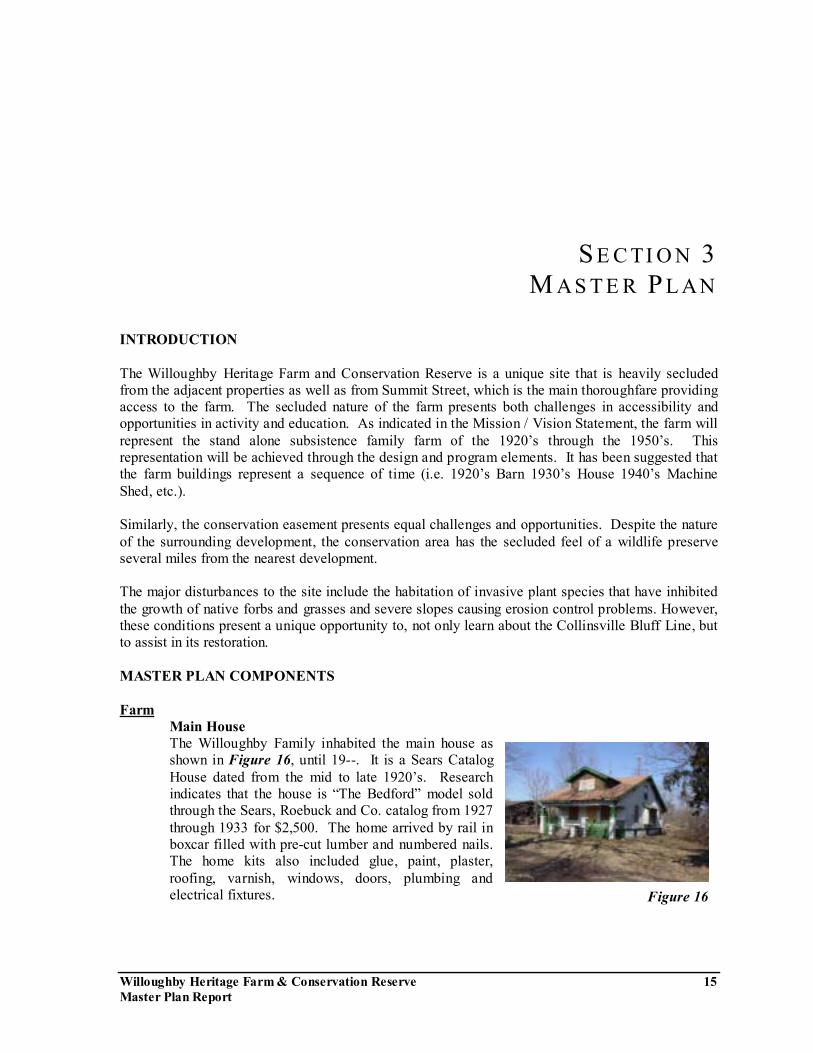
Main House The Willoughby Family inhabited the main house as shown in Figure 16, until 19--. It is a Sears Catalog House dated from the mid to late 1920�s. Research indicates that the house is �The Bedford� model sold through the Sears, Roebuck and Co. catalog from 1927 through 1933 for $2,500. The home arrived by rail in boxcar filled with pre-cut lumber and numbered nails. The home kits also included glue, paint, plaster, roofing, varnish, windows, doors, plumbing and electrical fixtures. Figure 16
Maste r P la n
Willoughby Heritage Farm & Conservation Reserve 16 Master Plan Report
The house is in reasonable good condition and appears to be structurally sound. The adaptive re-use of the main house as an interpretive center presents accessibility challenges. The following approaches have been considered:
1. Provide accessibility to the first floor and recreate the farm home experience for the public to view.
2. Use the second floor as administrative offices.
In addition to providing insight into the family home life, the house also presents an opportunity to learn about the Sears Catalog Homes that gained a large measure of popularity in the small towns and family farms throughout the country from the 1908 to 1939.
It is important to note that the examination of the house, as part of this study, is visual in nature and limited in scope. Prior to any programming and re-use, the house should be thoroughly examined by and architect and/or structural engineer. In addition, a complete infrastructure study should be conducted to determine the availability of utilities.
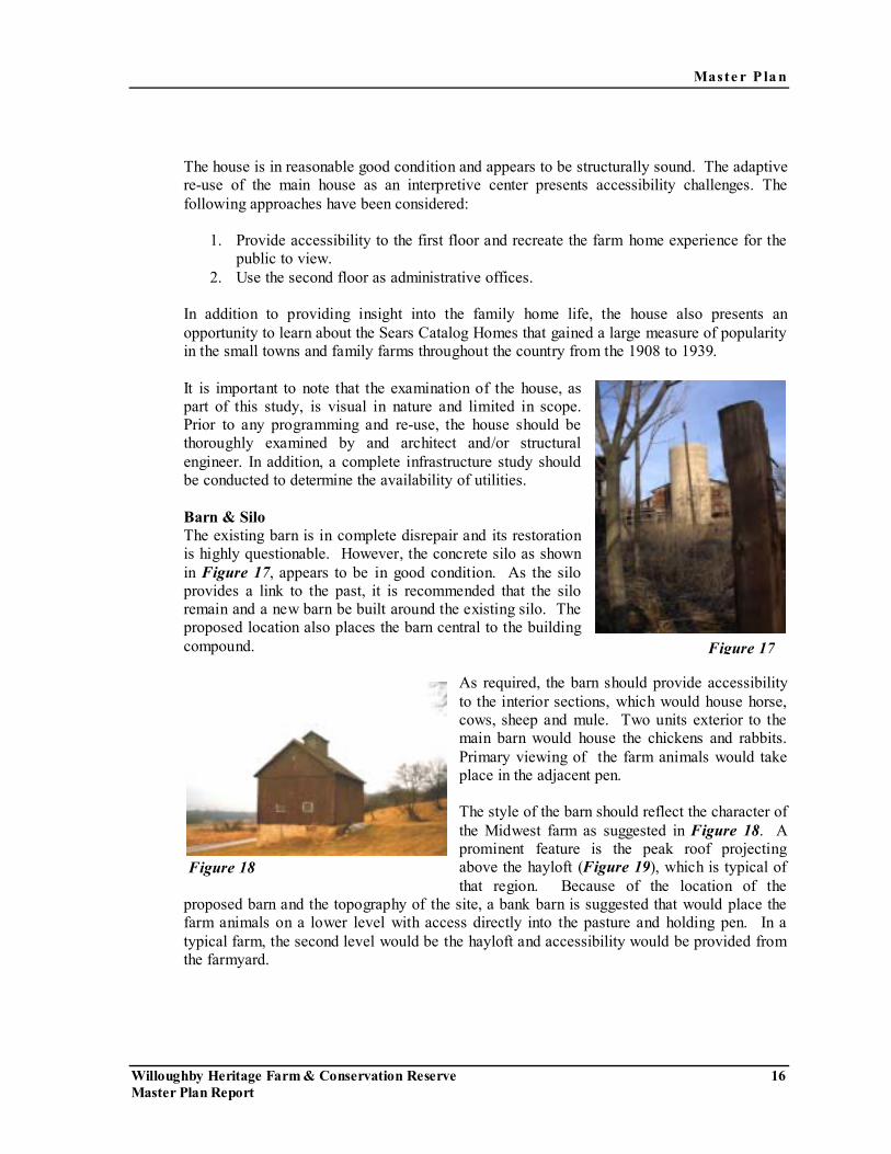
Barn & Silo The existing barn is in complete disrepair and its restoration is highly questionable. However, the concrete silo as shown in Figure 17, appears to be in good condition. As the silo provides a link to the past, it is recommended that the silo remain and a new barn be built around the existing silo. The proposed location also places the barn central to the building compound.
As required, the barn should provide accessibility to the interior sections, which would house horse, cows, sheep and mule. Two units exterior to the main barn would house the chickens and rabbits. Primary viewing of the farm animals would take place in the adjacent pen.
The style of the barn should reflect the character of the Midwest farm as suggested in Figure 18. A prominent feature is the peak roof projecting above the hayloft (Figure 19), which is typical of that region. Because of the location of the
proposed barn and the topography of the site, a bank barn is suggested that would place the farm animals on a lower level with access directly into the pasture and holding pen. In a typical farm, the second level would be the hayloft and accessibility would be provided from the farmyard.
Figure 17
Figure 18

Maste r P la n
Willoughby Heritage Farm & Conservation Reserve 17 Master Plan Report
However, since the barn is to be a new building built in the particular style of the era(s) represented, many options are possible. Considerations should include:
1. Animals located on main floor with accessibility to the holding pen and pasture.
2. Hayloft on the second floor with accessibility from the farmyard.
3. Possible meeting or programmable room(s) on the second floor.
As noted, the silo represents a link to the past. It can also provide a functional value. One suggested use of the silo is a look-out post that provides a panoramic view of the entire farm area and into the conservation area as well.
Garage/Smoke House
The existing garage as shown in Figure 20, is also in disrepair however, it appears to be sound and it�s location and outward appearance provides for a convenient re-use as a
restroom, vending machine and utility hook-up structure. It�s proximity to the main house, and centralized location makes it the ideal structure to provide such uses. It is also important to preserve the smoke house attached to the garage because of its historic value and integral use to the family farm.
Pavilion The existing tool/machine shed is also in disrepair and its stability is highly questionable by visual inspection. However, the building sits on a solid concrete foundation and its location at
the east portion of the farm compound adjacent to the natural area, make it a prime location for a pavilion space. It is suggested that the building structure be removed and a fabric or frame structure be used as a covering for the proposed pavilion.
Corn Crib The existing corn crib structure is in complete disrepair and its current location is not compatible with the proposed Master Plan. It is suggested that a new corn crib be built in a style compatible with the character and era(s) of the farm in the location suggested in the Master Plan.
Hog House & Pen It is suggested that the hog house and pen be placed at the northeast corner of the building compound to prevent the prevailing wind from directing the odorous smell throughout the
Figure 19
Figure 20
Maste r P la n
Willoughby Heritage Farm & Conservation Reserve 18 Master Plan Report
farmyard. As with the other proposed new structures, this housing and pen would be compatible with the character and era(s) of the farm.
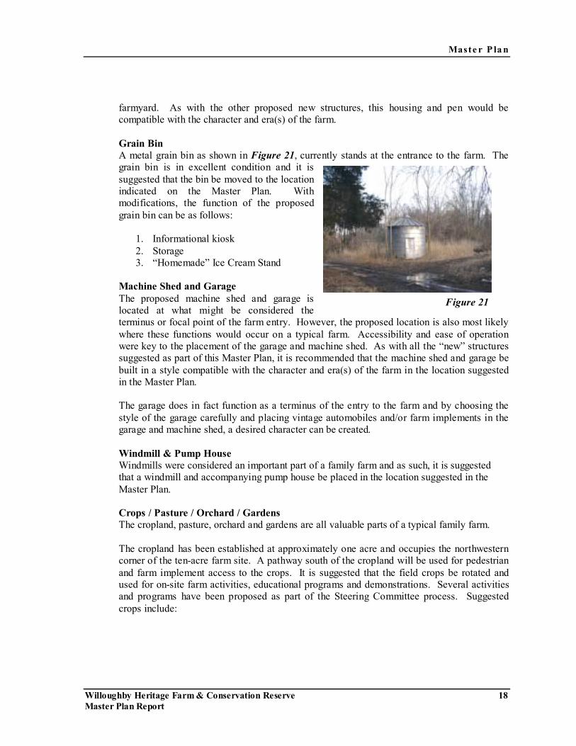
Grain Bin
A metal grain bin as shown in Figure 21, currently stands at the entrance to the farm. The grain bin is in excellent condition and it is suggested that the bin be moved to the location indicated on the Master Plan. With modifications, the function of the proposed grain bin can be as follows:
1. Informational kiosk 2. Storage 3. �Homemade� Ice Cream Stand
Machine Shed and Garage
The proposed machine shed and garage is located at what might be considered the terminus or focal point of the farm entry. However, the proposed location is also most likely where these functions would occur on a typical farm. Accessibility and ease of operation were key to the placement of the garage and machine shed. As with all the �new� structures suggested as part of this Master Plan, it is recommended that the machine shed and garage be built in a style compatible with the character and era(s) of the farm in the location suggested in the Master Plan. The garage does in fact function as a terminus of the entry to the farm and by choosing the style of the garage carefully and placing vintage automobiles and/or farm implements in the garage and machine shed, a desired character can be created.
Windmill & Pump House Windmills were considered an important part of a family farm and as such, it is suggested that a windmill and accompanying pump house be placed in the location suggested in the Master Plan.
Crops / Pasture / Orchard / Gardens The cropland, pasture, orchard and gardens are all valuable parts of a typical family farm.
The cropland has been established at approximately one acre and occupies the northwestern corner of the ten-acre farm site. A pathway south of the cropland will be used for pedestrian and farm implement access to the crops. It is suggested that the field crops be rotated and used for on-site farm activities, educational programs and demonstrations. Several activities and programs have been proposed as part of the Steering Committee process. Suggested crops include:
Figure 21
Maste r P la n
Willoughby Heritage Farm & Conservation Reserve 19 Master Plan Report
• Wheat • Alfalfa • Corn • Soybean
The pasture is located west of the farm-building compound and extends to the southeast down the slope. The pasture area is approximately one and one half acre including a holding pen for farm animals and activities. The clearing of the southwest slope for the pasture land works well with the existing topography of the land and fits comfortably with the concept of a bank barn built into the slope. The pasture will be totally enclosed by a barrier fence that fits with the character of the era(s) proposed for the farm with a gate located south of the garage to provide access for both service vehicles and pedestrians as appropriate. The size of the pastureland is more than adequate to support the quantity of livestock suggested by the Steering Committee. Designed into the slope east of the pasture is the orchard, which would be fruit trees representative of the type typically found on a family farm in the region. The orchard also delineates the pasture from a large (approximately one acre) multi-use space. This turf area would be used for a variety of functions, which may include:
• Farm Activity Exhibits • Festivals • Concerts • Picnics • Seasonal Displays
The proposed garden area is located directly south of the main house in a location where it likely would have been placed in a typical farm. The 7500 square foot garden has been separated into two sections with the path from the parking lot meandering through. The garden most likely would include:
• Vegetables • Herbs • Flowers
An important element included within the garden is an arbor structure that will define the eastern edge of the garden and be incorporated into the proposed perimeter fencing of the farm site. It has been suggested that the arbor be planted with grapes.
Parking and Drop Off
It is imperative that vehicular movements be safe and unobtrusive to the visitors and operations of the farm activities. The proposed drop off has the ability to circulate buses around the loop and approximately seventy feet for queuing of cars or buses. The gravel surface parking lot can accommodate thirty cars with the ability to provide parking for an

Maste r P la n
Willoughby Heritage Farm & Conservation Reserve 20 Master Plan Report
additional thirty cars on a turf area adjacent to the parking lot. If the need arises, the parking lot can be expanded to include the turf area. Access from the parking lot to the farm would make use of the meander walk through the garden. The amount of parking is a function of the programming of the farm and conservation area. A thirty-car parking lot, with the ability for expansion, is more than adequate for both the farm and conservation area. It is also suggested that for special events, parking can be accommodated in the Summit School parking lot or on the school�s turf area at the base of the slope. The Collinsville Area Recreation District has discussed with the School District, the possibility of revising the school drop off and utilizing a shared parking facility. In addition to the primary parking in the southeast corner, a small parking lot is also placed at the very northwest corner of the farm property. This ten-car parking lot is accessed by the existing road to the cell tower, would serve individuals utilizing the north conservation area trail head and farm employees.
Access & Circulation Primary access to the farm will utilize the existing gravel road that currently leads to the farm
as shown in Figure 22. Required improvements would be made to ensure accessibility. Secondary access would be achieved from the northern parking lot, utilizing the pathway east of the farm.
All buildings within the farm compound will be ADA accessible and crushed gravel or limestone screenings will form the pathways connecting the various structures.
Handicap accessibility to the overlook patio is achieved through the pathway northeast of the patio.
Overlook Patio An overlook patio is proposed for the natural area east of the farm. This natural plateau set below the grade of the farm buildings is an ideal location for a patio or hardscape element to be used as a performance stage or viewing area into the natural habitat east of the farm. A series of broad steps would access the patio with lawn on either side to act as an informal seating area for viewing performances. Handicap accessibility would be achieved as identified in the previous section.
Fencing Fencing plays a substantial role in defining the character of a farm. It is functional in containing the farm animals in the appropriate locations as well as ensuring the security and safety of the farm visitors. It also defines the boundaries of the farm property. The existing
Figure 22
Maste r P la n
Willoughby Heritage Farm & Conservation Reserve 21 Master Plan Report
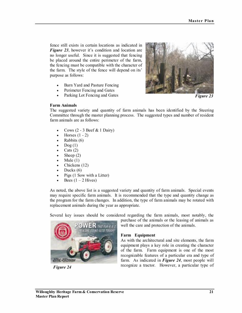
fence still exists in certain locations as indicated in Figure 23, however it�s condition and location are no longer useful. Since it is suggested that fencing be placed around the entire perimeter of the farm, the fencing must be compatible with the character of the farm. The style of the fence will depend on its� purpose as follows:
• Barn Yard and Pasture Fencing • Perimeter Fencing and Gates • Parking Lot Fencing and Gates
Farm Animals
The suggested variety and quantity of farm animals has been identified by the Steering Committee through the master planning process. The suggested types and number of resident farm animals are as follows:
• Cows (2 - 3 Beef & 1 Dairy) • Horses (1 - 2) • Rabbits (6) • Dog (1) • Cats (2) • Sheep (2) • Mule (1) • Chickens (12) • Ducks (6) • Pigs (1 Sow with a Litter) • Bees (1 � 2 Hives)
As noted, the above list is a suggested variety and quantity of farm animals. Special events may require specific farm animals. It is recommended that the type and quantity change as the program for the farm changes. In addition, the type of farm animals may be rotated with replacement animals during the year as appropriate. Several key issues should be considered regarding the farm animals, most notably, the
purchase of the animals or the leasing of animals as well the care and protection of the animals.
Farm Equipment As with the architectural and site elements, the farm equipment plays a key role in creating the character of the farm. Farm equipment is one of the most recognizable features of a particular era and type of farm. As indicated in Figure 24, most people will recognize a tractor. However, a particular type of
Figure 23
Figure 24

Maste r P la n
Willoughby Heritage Farm & Conservation Reserve 22 Master Plan Report
tractor can evoke strong visions of farm life. As identified through the master planning process, the following farm implements were suggested for representation at the Willoughby Heritage Farm:
• Ford �Jubilee� Tractor • Plow (1 �2 Bottom) • Planter (2 Row) • Harrow • Picker (1 � 2 Row) • Pull � Type Hay Rake • Hay Wagons • Grading Blade • Manure Spreader
As with the other elements of the farm, selection of the farm equipment should consider the functionality and required needs to maintain a farm of a particular era. The suggested farm implements only represent the large mechanical implements.
Conservation Reserve Access
Opportunity to access the Conservation Reserve is achieved at a variety of locations with no single primary access point. From the farm, access into the conservation area is at the north parking lot and, when the farm is open to the public, through a gated entry between the cropland and the pasture. Neighborhood access is provided from the south at both Debbie Drive and Susan Court. It has been suggested that the conservation area close at dusk. When the farm is closed to the public, parking will be available in the farm parking lot for users accessing the conservation area via the pathway east of the farm. Trail Heads To highlight the entries into the Conservation Reserve, it is suggested that a trail head structure be developed that would act as both entry point and rules and regulations kiosk. The structure itself would be simple in construction and the design would be complementary to the character of the farm. Trails The path through the conservation area would be a wood chip material that would be ADA accessible. A complete loop is created through the pathway system and although the loop is ADA accessible, it does present several challenges in maintaining the required accessibility slopes throughout grade changes that can drop eighty feet from the ridgeline to the creek bottom. Switchbacks will be utilized to achieve the required ADA accessibility standards.
Maste r P la n
Willoughby Heritage Farm & Conservation Reserve 23 Master Plan Report
Paths will also be provided to access group camping grounds, overlook areas and the creek bottom.
Steps At various points on the pathway system, steps will be utilized to traverse steep grades. It is important to note that steps have been provided in addition to the switchback paths as noted on the plan. Generally, the steps and the switchbacks will have a common landing configuration that makes the steps integral to the path. Steps will be designed and built to have a natural look through the use of either wood timbers or stone as appropriate to the region. In addition, the steps should be constructed to avoid erosion problems that will generate safety and maintenance issues. Bridges The conservation area has several ravines. Most of the ravines contain intermittent creeks that flow during heavy rains. The main creek, Schneider Ditch contains flowing water for most or all of the year. One appropriately sized bridge will be placed where the trail crosses Schneider Ditch at the southeast corner of the Conservation Reserve and smaller more naturally appearing bridges will be located where the path crosses natural drainage channels in the ravines. Overlooks Overlooks are provided at three points on the trail in the Conservation Reserve. The overlooks are located on the ridgeline and will provide excellent views into the interior of the conservation area. In addition, as the invasive species are eradicated and restoration of the natural habitat occurs, the views will become more inviting into the farm and the oak savanna community at the western end of the property. The overlook areas can also become points to have group educational programs. As previously noted, the natural area east of the farm also has an overlook patio. Group Camping Grounds Two group camping grounds are located within the interior of the Conservation Reserve. The camp grounds are hike in and hike out only. No structures or utilities will be provided. The general location of the campiong grounds are midway down the ridge line in a relatively flat area and placed to be the maximum distance from the main trail to ensure as much seclusion as possible. The issue of human waste and trash will require further consideration in that the appropriate disposal of both are critical to the health and safety of the Conservation Reserve and its users. Erosion Control / Stormwater Management Due to the severe slopes from the bluff line into the ravines, the conservation area has pronounced areas of erosion. As noted in the Natural Resource Inventory, removal of the invasive shrubs and groundcover will promote a fine root mass in the soil that will stabilize slopes and slow erosion.
Maste r P la n
Willoughby Heritage Farm & Conservation Reserve 24 Master Plan Report
In addition, the preservation of the woodlands is intended to prevent the upland areas from contributing to interior flooding and siltation problems in the American Bottom. One of the intended uses of this Master Plan is to work with the Army Corp of Engineers, Illinois Department of Natural Resources and all other environmental agencies to allow for stormwater management practices on this property, including the possible location of a retention area and/or dry dam.
Future Considerations The Willoughby Heritage Farm and Conservation Reserve Master Plan is intended to serve as a blueprint for the future development of the site. Information contained throughout the report will serve as a guide for future discussion and/or actions. Several future actions should be considered, including:
• Acquisition of neighboring properties to expand the open space. • Provide for a future Conservation / Interpretive Center • Use of the Lutheran Home, east of Summit School as a possible Interpretive Center. • Consider additional conservation easements to buffer the Conservation Reserve from
possible adjacent future development. • Linkages and connections to regional and local facilities.

Master Plan Concept Willoughby Heritage Farm & Conservation ReserveCollinsville Area Recreation District
S ing le -Fami l y Res ident ia l
Pedestrian link
Schoo l
• Possible Use of Classroom• Possible Shared Parking
Primary Access
Creek
One-way traffic
One-Way Traffic Two-Way Traffic
Sum
mit
Stre
et
Vivian Street
Conser vat ion Easement(Heavy Tree & Underbrush Growth)
Gravel Road
Bridge
Bridge
Bridge
Drop Off
Bridge
Accessible Path
Accessible Path
Accessible Path
Camping Ground
Trail Typ. (Wood Chips)
Camping Ground
Steps
Steps
Steps
Accessible Path
Overlook (Typ.)
Overlook (typ.)
Conservation/Interpretive Center
Orchard
Gravel road
Crops
Multi-Use Space (Turf)
Parking (30 cars)
Drop Off
Future Expanded Parking
Fence & Gate
Bridge
Enlarged Farm Area
Main House
Heavy Tree & Underbrush Growth
Crops
Pasture
Grain Bin
Multi-Use Space (Turf)
Parking (30 cars)
Pavilion
Drop-Off
Future Expanded Parking
Barn
Garage
Cell Tower
Orchard
Retention
Trail Head
Trail Head
GardenArbor
Pasture
Holding Pen
Bank Barn With Chicken Coop, Rabbit
Hutch & Windmill
Hog House & Pen
Main House
Heavy Tree & Underbrush GrowthGrain Bin
Overlook Patio/PerformancePavilion
Garage/Smoke House (Restrooms, Vending Machine, Utility Hook Up)
Corn Crib
Cell Tower
Trail Head
Trail Head
Retention
Trail Head
Employee Parking
Employee Parking
Crushed GravelSilo
Machine/Tool Shed
GarageFence & Gate
Tree Line
Bridge
Drop Off
Conservation/Interpretive Center
Tool Shed
BUILDINGS/STRUCTURES
• Main house • First floor open to public • Second floor administration• Main barn & silo (horses, cows, sheep & mule)• Chicken coop• Hog house & pen• Rabbit hutch• Corn crib• Grain bin• Garage• Tool/machine shed• Grape arbor• Root cellar• Windmill• Pump house• Smoke house• Pavilion
FARM ANIMALS
• Cows (2-3 beefs, 1 dairy) • Horses (1-2)• Rabbits (6)• Dog (1)• Cat (2)• Sheep (2)• Mule (1)• Chickens (12)• Ducks (6)• Pigs (1 sow with litter)• Bees (1-2 hives)
FARM EQUIPMENTS
• Ford “Jubilee” tractor• Plow (1-2 bottom)• Planter (2 row)• Harrow• Picker (1-2 row)• Pull-type hay rake• Hay wagons• Grading blade• Manure spreader
FARM COMPONENTS
0 40 80 160
N
0 60 120 240
N Figure 25Master Plan Concept
Land Design Collaborative, Inc.Laurie B. Marston, AICP | Applied Ecological Services, Inc.
Consultant Team:
May 2003
Willoughby Heritage Farm & Conservation Reserve 26 Master Plan Report
S E C TI O N 4 I M P L E ME N T AT I ON
PURPOSE The Willoughby Heritage Farm and Conservation Reserve Master Plan Report is intended to serve as the guiding document for future development of the forty acre site. The Master Plan and the Report are general in nature and will become more detailed as the implementation of the Master Plan proceeds. It is suggested that two types of organizational efforts be established in implementing the Master Plan:
• Administrative: dealing with organization, strategy, identification of resources and establishment of priorities.
• Activities: dealing with specific improvement programs, educational programs,
farm-related activities and conservation area guidelines. Primary issues that will direct the future development of the Willoughby Heritage Farm will include:
� Phasing � Funding � Revenue Generation � Educational / Recreational Programs � Planning Partners � Volunteers
It is suggested that each issue be evaluated at the appropriate time prior to the implementation of any of the elements of the Master Plan. In addition, research will be required to answer several questions that will be generated by the Master Plan and Report.
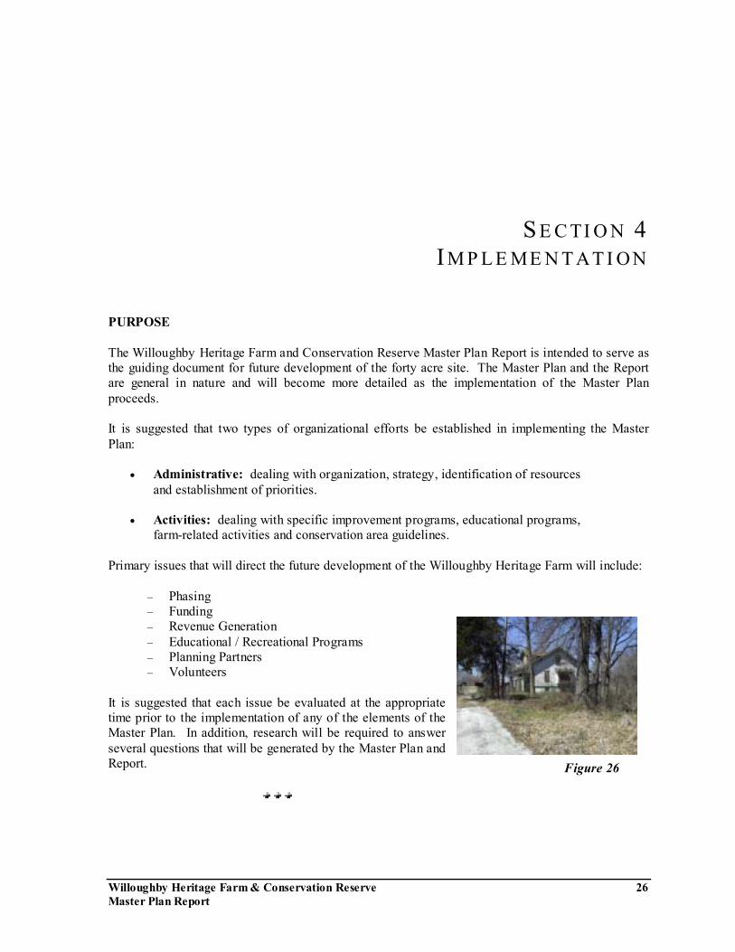
Figure 26
Imple me ntat io n
Willoughby Heritage Farm & Conservation Reserve 27 Master Plan Report
With the foresight to create a conservation easement, the Collinsville Area Recreation District (CARD) designated Southwestern Illinois Resource Conservation and Development (SIRCD) as the administrator of the thirty-area conservation area. A formal grant of conservation right and easement has been written that assures that the open space will be protected and conserved as a natural heritage resource. It is recommended that all improvements within the conservation easement be a cooperative project between the CARD and SIRCD. PHASING Necessary first steps for both the farm and the conservation area include an extensive clearing of debris and dangerous structures on the farm portion of the site and establishing a program for restoration of the conservation area to the natural pre-settlement character of the region. It is also key that an organizational structure be established as noted previously to set priorities and begin the process of locating and courting donors and volunteers. CARD has already begun the general clearing of the farm site and it is suggested that a thorough evaluation of the farm element be undertaken prior to the removal of any structures. Features and elements of the buildings, structures, fencing and so forth may be retained for future structures or educational purposes. Initial programs for the public related to the farm and conservation area should include:
• Walking trails that identify the future plans/design • Promotional signs with a simple explanation of what will be occurring and when. • Programs that allow the public to assist in the clean up of the farm and the restoration of the
conservation area. Phasing will also be depended on financing and funding. For the conservation area, restoration of the natural character will be an on-going process. A Natural Resource Inventory for the Willoughby Farm prepared by Applied Ecological Services, Inc. has been provided to CARD as part of the master planning process to assist in the restoration. Other elements such as trails, bridges, overlooks and steps can be implemented as funds and/or manpower become available.
FUNDING Several funding sources have been examined as part of the master planning process. Through the planning process, CARD has made a concerted effort to involve individuals and agencies that may lend assistance to the funding of the projects.
Imple me ntat io n
Willoughby Heritage Farm & Conservation Reserve 28 Master Plan Report
Funding can come from several sources:
• Federal and /or State assistance may be available through various grant programs.
• Corporate funding sources and/or sponsorships have been identified as follows:
� Monsanto � Pfizer � Con-Ag � Whitacre Foundation � Knight Foundation � Danforth Foundation � Owen Foundation
• Partnerships with educational facilities.
• Fund raising efforts that may include:
� Private gifts and grants � Special Events � Sales of farm related merchandise
• Professional public relations program to assist in the solicitation of donations Not all contributions and donations will be monetary. Another effort similar to funding and equally important is the donation of time, materials and equipment by local businesses. Animals and farm implements can be loaned to the Willoughby Heritage Farm. Local contractors and/or suppliers can assist in the construction and operation of the Farm. Since contributions of all types will be required to develop the Willoughby Heritage Farm and Conservation Reserve, fund raising will play a major role in the implementation of the plan. It is suggested that an additional study may be required to examine the funding of the project in more detail. Cost Estimating Preparation of a cost estimate at the level of detail identified within the Master Plan would be premature. It is also difficult to determine costs without knowing the full extent of the level of volunteerism and/or donated time, materials and equipment. More detailed design drawings and facility evaluations will need to be developed to generate costs for the proposed improvements. It is suggested that a subsequent phase of improvement refine the preliminary concept to the level of detail required to prepare an estimate of probable costs. Cost estimates can be prepared incrementally for individual elements or features as necessary.

Imple me ntat io n
Willoughby Heritage Farm & Conservation Reserve 29 Master Plan Report
REVENUE GENERATION Although the Willoughby Heritage Farm will most likely not generate enough revenue to be self reliant, it is important that the farm and farm programs produce revenue. Several revenue-generating sources have been suggested through the Steering Committee workshops and an example of programs is as follows:
• Admission fees • Memberships • Renting out the farm for special events. • A gift shop selling farm related products and merchandise • Registration fees for farm related classes • Conservation Area camping fees.
The issue of revenue generation is closely related to the funding of the project and any study examining the funding should also include a section on revenue. Several State and National resources exist that can assist in this evaluation.
EDUCATIONAL / RECREATIONAL PROGRAMS The primary purpose of the Willoughby Heritage Farm and Conservation Reserve, as stated in the Mission / Vision Statement, is education and recreation. Because of the co-existent nature of the farm and natural area, this project has the opportunity to educate the public about the family farm of the 1920�s to the 1950�s as well as the region�s plant and animal life and, geological history. The Conservation Reserve has tremendous recreation value as suggested by the Steering Committee.
• Interpretive Trails • Conservation Management Practices • Stormwater Management • Plant and Animal Studies • Geological Studies • Camping and Orienteering • Historical Research
Similarly, the farm also has tremendous historical and educational value. The next phase in the planning process should examine the type of programs to be represented on the farm, how the programs should be conducted and a suggested method to �rotate� programs to ensure that a variety of actives are represented to increase attendance each year. Revenue generation will also play a part in the selection and structure of the programs represented on the farm. Education programs can be conducted in cooperation with several local and/or national agencies including:

Imple me ntat io n
Willoughby Heritage Farm & Conservation Reserve 30 Master Plan Report
• Collinsville Area Recreation District • Collinsville Unit #10 School District • Madison County Soil & Water Conservation District • Madison County Farm Bureau • Madison County Extension Service • Southwestern Illinois Resource Conservation and Development • Missouri Botanical Garden • St. Louis Zoo • Collinsville Historic Preservation Commission • American Bottom Ecosystem Partnership • Illinois Department of Natural Resources • SWIC / Lewis and Clark Community College • U.S. Army Corp of Engineers
PLANNING PARTNERS Planning Partners are organizations identified by CARD that have a vested interest in the implementation of the Willoughby Farm Master Plan. The successful development of this project will be a benefit to the entire region and over the course of the implementation, each Planning Partner will play an important role. In addition to the agencies identified as providing education programs, the follow organizations and/or individuals have also been identified as Planning Partners:
• Collinsville Area Recreation District Board • Collinsville Area Recreation District Staff • Regional Superintendent of Schools • Collinsville Township • Collinsville Township Highway Department • City of Collinsville • Willoughby Family Representative(s) • Collinsville Convention and Visitor Bureau • Citizen Representative(s) • Science Teachers • Farm Implement Dealers • Media Representative(s) • Local Residents • Madison County • Main Street Collinsville
As the project progresses, the Planning Partners will change and evolve. However, it is critical that the Planning Partners be involved in the project as appropriate and necessary.
Imple me ntat io n
Willoughby Heritage Farm & Conservation Reserve 31 Master Plan Report
VOLUNTEERS Just as the planning and design of the Willoughby Heritage Farm and Conservation Reserve was guided by a dedicated group of volunteers, the future success of the farm and conservation area will rest on the assembly of a corp of volunteers to assist in all aspects of the planning, development and operation of the facilities. It is suggested that a subsequent phase be undertaken to develop a volunteering program that outlines the use of individuals and public and/or private organizations to build, operate and maintain the Willoughby Heritage Farm and Conservation Reserve in the manner consistent with the Mission / Vision Statement.

Willoughby Heritage Farm & Conservation Reserve Master Plan Report
32
LISTENING SESSION
SUMMARIZATION
Table 1
Willoughby Heritage Farm & Conservation Reserve Master Plan Report
33
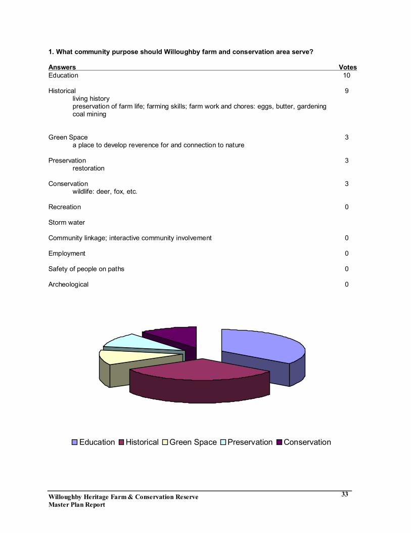
1. What community purpose should Willoughby farm and conservation area serve? Answers Votes Education 10 Historical 9 living history preservation of farm life; farming skills; farm work and chores: eggs, butter, gardening coal mining Green Space 3 a place to develop reverence for and connection to nature Preservation 3 restoration Conservation 3 wildlife: deer, fox, etc. Recreation 0 Storm water Community linkage; interactive community involvement 0 Employment 0 Safety of people on paths 0 Archeological 0
Education Historical Green Space Preservation Conservation
Willoughby Heritage Farm & Conservation Reserve Master Plan Report
34
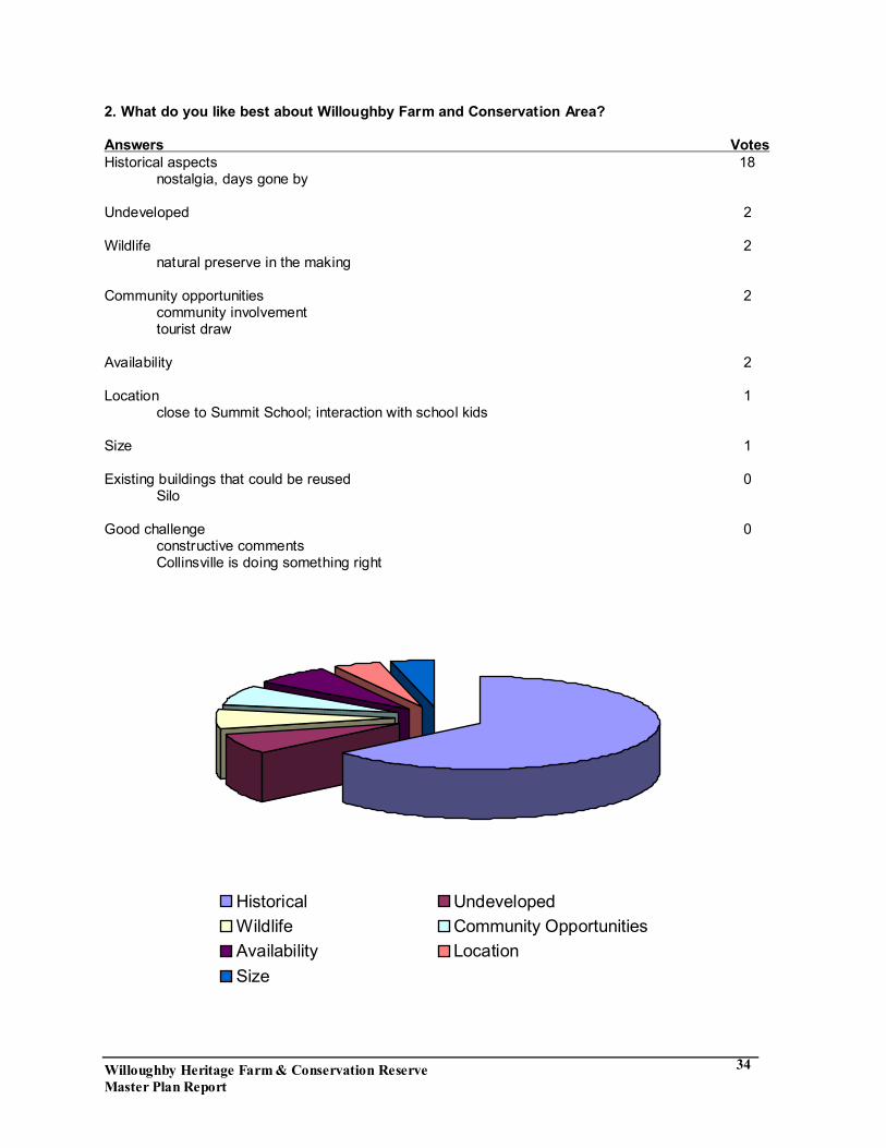
2. What do you like best about Willoughby Farm and Conservation Area? Answers Votes Historical aspects 18 nostalgia, days gone by Undeveloped 2 Wildlife 2 natural preserve in the making Community opportunities 2 community involvement tourist draw Availability 2 Location 1 close to Summit School; interaction with school kids Size 1 Existing buildings that could be reused 0 Silo Good challenge 0 constructive comments Collinsville is doing something right
Historical UndevelopedWildlife Community OpportunitiesAvailability LocationSize

Willoughby Heritage Farm & Conservation Reserve Master Plan Report
35
3. What things would you like to change about the Willoughby Farm and Conservation Area? Answers Votes Restoration of buildings 11
repair and improve buildings don�t tear down buildings Restoration of natural community 6 establishment of indigenous flora and fauna remove vines, honeysuckle and exotic plants Timeline for farm; consider multiple timelines 3 use farm to show progression of farming techniques; review through the years family activities Needs a lake 1 Improve access 0 walking tours bike trails
Restoration of buildings Restoration of natural communityFarm timelines Needs lake

Willoughby Heritage Farm & Conservation Reserve Master Plan Report
36
4. What is the greatest challenge to the utilization of the farm and conservation area? Answers Votes Money 12 long term maintenance and operation where is the funding stream free or paying fee Deciding how to develop and use 4 sticking to master plan flexibility in master plan trying to be all things to all people Community support 3
advertising sustained excitement during development and ongoing keeping positive relations with neighbors
Wildlife management 2
preserving wildlife during development conflict between human users and wildlife users bring back wildlife that isn�t there now � restore the native wildlife
Runoff and erosion that damage the ravines 1 impact of surrounding area on preservation area
do not over develop the preservation area development of infrastructure
develop primitive camping area no fires Accessibility 0 terrain of land parking Security 0 Making it safe with proper restoration
Money Deciding how to use Commnity SupportWildlife Management Runoff & erosion
Willoughby Heritage Farm & Conservation Reserve Master Plan Report
37
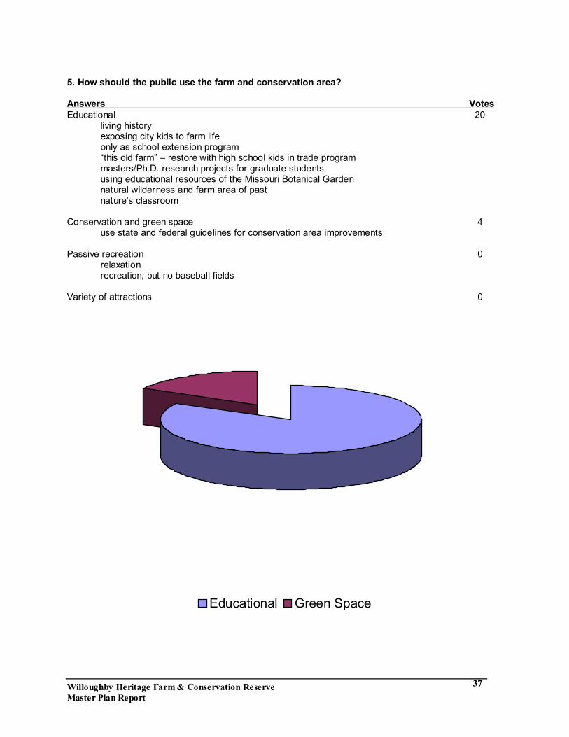
5. How should the public use the farm and conservation area? Answers Votes Educational 20 living history exposing city kids to farm life only as school extension program �this old farm� � restore with high school kids in trade program masters/Ph.D. research projects for graduate students
using educational resources of the Missouri Botanical Garden natural wilderness and farm area of past
nature�s classroom
Conservation and green space 4 use state and federal guidelines for conservation area improvements Passive recreation 0 relaxation recreation, but no baseball fields Variety of attractions 0
Educational Green Space