parks inventory 2005 - legislative-citizen commission on
TRANSCRIPT
Legislative Commission on Minnesota Resources
Greater Minnesota Park Inventory Regional Park Criteria
FINAL REPORT
January 2005
2
Project Partners Patricia Arndt – Department of Natural Resources
Dave Fricke - Minnesota Association of Townships Annalee Garletz – Association of Minnesota Counties
Craig Johnson - League of Minnesota Cities Al Lieffort (Douglas County) – Minnesota County Parks Association
John Lilly - Department of Natural Resources Wayne Sames – Department of Natural Resources
Michelle Snider - Minnesota Recreation and Park Association Peter Skwira – Department of Natural Resources
Arne Stefferud – Metropolitan Council John Von De Linde – Minnesota Recreation and Park Association
Jonathan Vlaming - Metropolitan Council David Weirens - Association of Minnesota Counties
Chuck Wocken (Stearns County) - Minnesota County Parks Association

3
Appendices: Appendix A – Sample Survey Letter and Sample Survey Appendix B – List of Surveyed Jurisdictions Appendix C – Complete list of responses Appendix D – 2004 Inventory of Regional Parks or Parks with Regional Potential Appendix E – 2004 Inventory of Regional Trails, or Trails with Regional Potential Appendix F – 2004 Inventory of Large Non-Regional Parks
4
Overview At this time there is no formal organization that coordinates or represents Greater Minnesota’s regional parks and consequently, there is no comprehensive list of regional parks in Greater Minnesota. Inadequate information on this developing system of parks hampered the ability of the 2003 Legislative Commission on Minnesota Resources (LCMR) Parks Study Group to effectively evaluate Greater Minnesota regional parks in the same manner as State Parks and Metropolitan regional parks. The purpose of this survey project is to provide a base information source to assist in the identification of regional parks outside of the metro area. It is important to note that the information reported in this survey is a snapshot of what is currently located in the jurisdictions that were surveyed. Some of the information may be incomplete due to minimal detail provided by respondents. In addition, there are new areas currently being considered for acquisition, which could be added to the list of potential regional parks in the near future. The park inventory project was financed by the LCMR. The original project budget allocated $2,000 each to the Department of Natural Resources (DNR), Metropolitan Council, and to outstate regional parks for work on recommendations contained in the 2003 LCMR parks report. In order to get a more comprehensive survey completed the DNR and the Metropolitan Council spoke to the importance of having a comprehensive inventory of regional parks in Greater Minnesota. Both of the agencies agreed to give the $2,000 originally specified to Metro Regional Parks and State Parks to the Outstate Regional Parks so they could complete an inventory. The following is the LCMR Parks Study Funding Authorization language that can be found in: Minn. Laws (2004) Chap. 255, Section 46 Sec. 46. [LCMR PARKS STUDY.] Subdivision 1. [REGIONAL PARKS.] The Legislative Commission on Minnesota Resources shall continue studying park issues, including the study of funding for operation and maintenance costs at regional parks within the seven-county metropolitan area and outside the seven-county metropolitan area. The commission may make additional recommendations on park issues to the 2005 legislature. Subd. 2. [FUNDING AUTHORIZATION.] To begin implementing the recommendations in the Legislative Commission on Minnesota Resources February 2004 parks report, up to $6,000 of the appropriation in Laws 2003, chapter 128, article 1, section 9, subdivision 3, paragraph (b), is for an agreement with the Association of Minnesota Counties to identify and develop a comprehensive list of regional parks outside of the seven-county metropolitan area, including an inventory of park facilities. [EFFECTIVE DATE.] This section is effective the day following final enactment. Methodology For the purpose of this project, the following five criteria were used to evaluate whether parks and trails in Greater Minnesota (the area outside of the seven county Twin Cities Metropolitan Area) are “regional”. The project committee reviewed, and based its criteria on, the DNR’s Regional Park Grant program criteria. This resulted in the five criteria used in the inventory
5
process to determine the regional status of a park. They are identical to those used for the Regional Park Grant program, with the exception that the DNR’s “Special Features” and “Statewide Significance” criteria were combined. A park or trail has been deemed ‘regional’ based on the information provided by inventory respondents, and the professional judgment of the LCMR Project Advisory Committee – Inventory of Greater Minnesota Regional Parks. The five criteria are: Regional Park Criteria 1) Size: 100+ acres (with exceptions based on use characteristics, special features, etc.) Discussion: Large tracts of land are often necessary to provide natural resource based recreation opportunities and protect the natural resources for long-term use for outdoor recreation. This criterion will not be exclusively used to determine that a park is not regional. Parks of less than 100 acres may still be determined to be regional in nature based on other criteria. 2) Use: Evidence that the park serves a regional clientele (as opposed to mostly local). Other factors may include evidence that the facility draws tourists from outside the local area. Discussion: The origination of people who use a park (residents of the jurisdiction that owns/operates the park vs. residents of other jurisdictions) is an indication of whether a park is regional or not. The exact percentage cannot be specified at this time, although the metro area regional park system has a 40% non-local visitation. Evaluation of this criteria will depend on the current methods used to collect origination data and how representative this is of all the people who use a park. 3) Recreation Activities Offered: The park should provide outdoor recreation facilities and activities that are primarily natural resource based (camping, picnicking, hiking, swimming, boating, canoeing, fishing, nature study). A related measure is the range of these activities accommodated within the park (e.g., a park with a beach, campground and boat launch facilities is more likely to attract a regional clientele than a park with only one of these facilities). 4) Special Features: Unique or unusual geologic features, historically significant sites, zoos, or parks containing characteristics that are of statewide significance. Discussion: This criteria could have particular importance for a park that is smaller than 100 acres, yet includes a special feature. A park with one or more special features will be likely to draw clientele from a broader area. 5) Scarcity of Recreational Resources: The park provides public natural resource based recreational opportunities that are not otherwise available within a reasonable distance. These might include water-based activities, such as swimming, fishing and boating; interpretive nature trails; public campgrounds; etc. Discussion: This criterion provides a measure of reasonable access to outdoor recreational opportunities.
6
It is important to note that very little is known throughout the state regarding user groups and the scarcity of recreational resources. This information was requested in the survey, however very few parks reported user information. Information about the scarcity of recreational areas is particularly difficult to identify by survey only. A good way to determine scarcity of a natural resource would be to utilize a GIS to visually depict the location of parks. Visits to the parks in question may also be necessary to better make this determination. The project committee also reviewed the following statements from “The Regional Recreation Open Space Policy Plan” of the Metropolitan Council regarding regional parks and trails:
• Regional parks (RP) should contain diverse natural resources… and the ability to provide for a wide range of natural resource related recreational opportunities. Access to water bodies suitable for recreation is particularly important. A regional park should be large enough to accommodate a variety of activities, preserve a pleasant natural aspect and buffer activity areas from each other. Regional parks are 200 to 500 acres. Occasionally, because of the quality of the resource an exception may be made and a RP may be as small as 100 acres.
• Park reserves are expected to provide a diversity of outdoor recreational activities. A reserve is also intended to provide, protect and manage representative areas of the original major landscape types in the metro area. Optimal size exceeds 2,000 acres, while the minimum size is about 1,000 acres.
• Regional trails are intended to provide recreational travel along linear pathways. They are selected to pass through, or provide access to, elements in the regional park system and to intersect with local trail systems.
• Special recreation features (SRF), which are called for in MS 473.121, are defined as regional park system opportunities not generally found in the parks, park reserves or regional trails. SRF often require a unique managing and programming effort on the part of the regional park implementing agency.
In addition to utilizing the five criteria, the project committee also referred to the following legal definition used by the Metropolitan Council to define a regional recreation open space. “Regional recreation open space” means land and water areas, or interests therein, and facilities determined by the metropolitan council to be of regional importance in providing for a balanced system of public outdoor recreation for the metropolitan area including but not limited to park reserves, major linear parks and trails, large recreation parks, and conservatories, zoos, and other special use facilities. (Minn. Statute 473.121 Subd. 14) The project committee reviewed each of the parks over 40 acres to determine if the park is a regional park. Some of the parks identified as regional parks are less than 100 acres. This designation is most likely due to a unique natural resource, or an exceptional recreational activity that is specifically offered at that park. In most cases parks over 100 acres that did not ‘qualify’ as a regional park did not do so because of their lack of natural open spaces. Parks containing large areas used for ball fields or other such activity areas that don’t require a natural resource base were generally considered to be large community parks. These parks do not qualify for regional status due to the fact that they do not offer natural resource based outdoor recreation
7
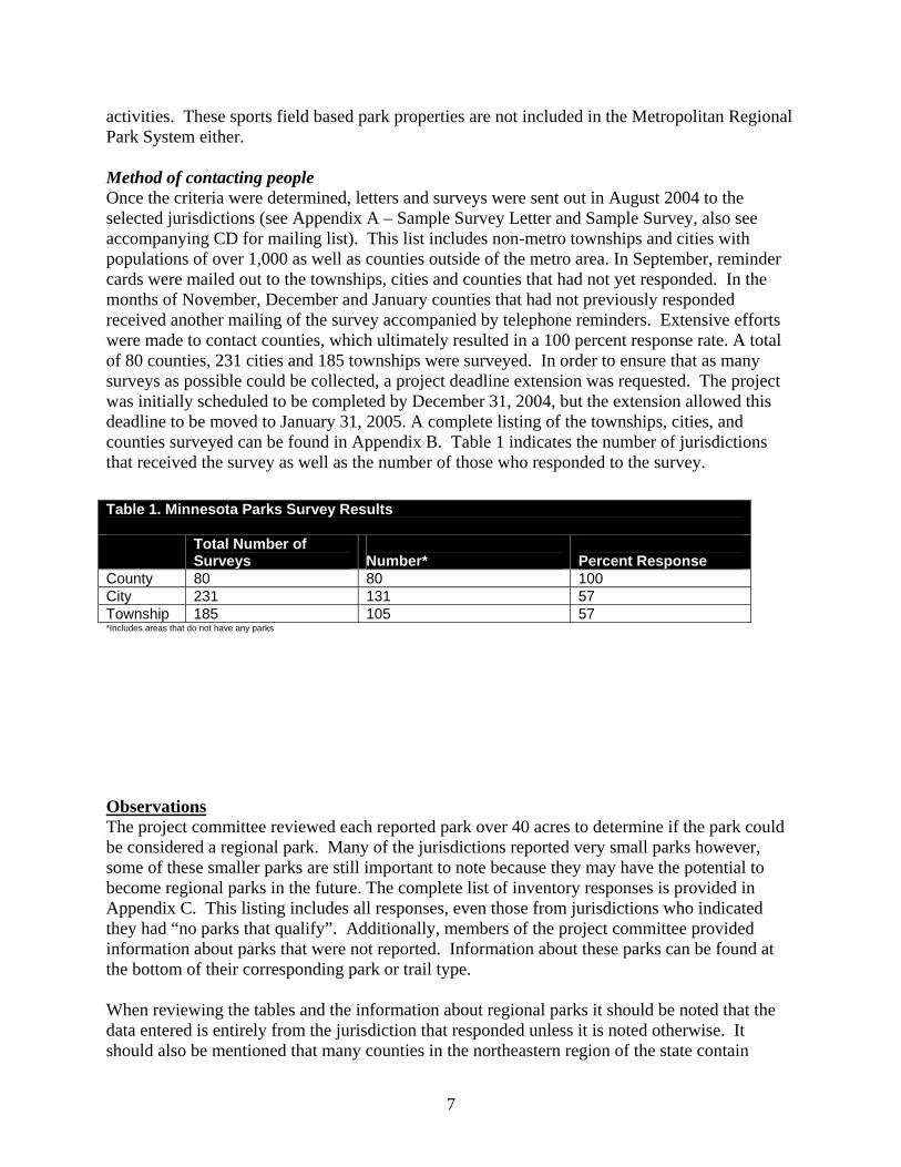
activities. These sports field based park properties are not included in the Metropolitan Regional Park System either. Method of contacting people Once the criteria were determined, letters and surveys were sent out in August 2004 to the selected jurisdictions (see Appendix A – Sample Survey Letter and Sample Survey, also see accompanying CD for mailing list). This list includes non-metro townships and cities with populations of over 1,000 as well as counties outside of the metro area. In September, reminder cards were mailed out to the townships, cities and counties that had not yet responded. In the months of November, December and January counties that had not previously responded received another mailing of the survey accompanied by telephone reminders. Extensive efforts were made to contact counties, which ultimately resulted in a 100 percent response rate. A total of 80 counties, 231 cities and 185 townships were surveyed. In order to ensure that as many surveys as possible could be collected, a project deadline extension was requested. The project was initially scheduled to be completed by December 31, 2004, but the extension allowed this deadline to be moved to January 31, 2005. A complete listing of the townships, cities, and counties surveyed can be found in Appendix B. Table 1 indicates the number of jurisdictions that received the survey as well as the number of those who responded to the survey.
Observations The project committee reviewed each reported park over 40 acres to determine if the park could be considered a regional park. Many of the jurisdictions reported very small parks however, some of these smaller parks are still important to note because they may have the potential to become regional parks in the future. The complete list of inventory responses is provided in Appendix C. This listing includes all responses, even those from jurisdictions who indicated they had “no parks that qualify”. Additionally, members of the project committee provided information about parks that were not reported. Information about these parks can be found at the bottom of their corresponding park or trail type. When reviewing the tables and the information about regional parks it should be noted that the data entered is entirely from the jurisdiction that responded unless it is noted otherwise. It should also be mentioned that many counties in the northeastern region of the state contain
Table 1. Minnesota Parks Survey Results Total Number of
Surveys Number*
Percent Response
County 80 80 100 City 231 131 57 Township 185 105 57 *Includes areas that do not have any parks
8
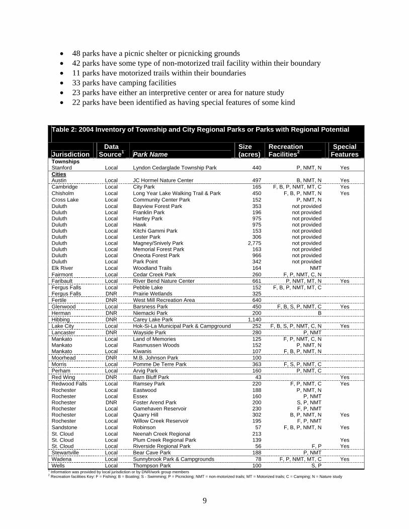
significant amounts of state tax forfeited land that is administered by counties. Cass County, for example, contains approximately 250,000 acres of County Administered State land. These acres offer significant recreational opportunities for residents and generally these lands are managed as county forestlands. Unless the county has actually designated a specific area of this land as county parkland, the group determined that the area could not be considered as a regional park. Regional Parks or Parks with Regional Potential A complete listing of regional parks can be found in Appendix D – Regional Parks, or Parks with Regional Potential. Generally, parks in this category are over 100 acres. In a few cases the project committee determined that based on the high quality of natural resources or recreational activities an area offered a few parks under 100 acres are listed as regional parks. Township Maintained Regional Parks Based on the responses received there is one township park consisting of 440 acres. The property tax levy and user fees from facility usage fund park operations. A summary of township park information can be found in Table 2. City Maintained Regional Parks Based on the responses received there are 46 city maintained regional parks located in 27 different cities. Some of the cities included in this list responded to the survey, the project group identified others and provided as much information about each park as possible. Regional city park acreage is 16,368 acres. These parks range in size from 78 to 2,775 acres with most of the reporting parks averaging 355 acres (see Table 2). The following is a summary of information regarding city parks:
• 15 parks have fishing piers or shore fishing • 10 parks have a boat launch within their boundary • 5 parks have swimming pools or beaches • 26 parks have a picnic shelter or picnicking grounds • 26 parks have some type of non-motorized trail facility within their boundary • 4 parks have motorized trails within their boundaries • 10 parks have camping facilities • 11 parks have either an interpretive center or area for nature study • 13 parks have been identified as having special features of some kind
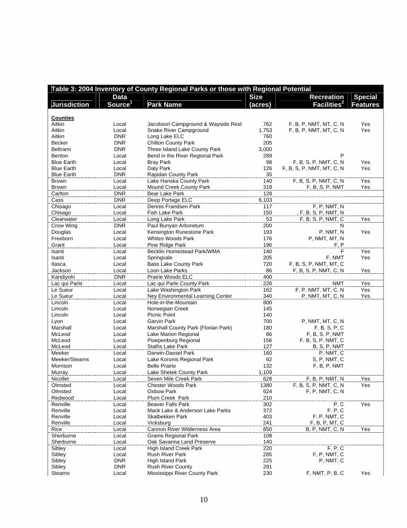
County Maintained Regional Parks Based on the responses received, there are 68 county maintained parks in 38 different counties. Some of the responses included here are from collected surveys and other information was provided by project group members. Regional county park acreage totaled nearly 31,000 acres. These parks range in size from 35 to 6,103 acres with most of the reporting park acreage averaging 455 acres (see Table 3 for more information). The following is a summary of information regarding county parks:
• 37 parks have fishing piers or shore fishing • 29 parks have a boat launch within their boundary • 18 parks have swimming pools or beaches
9
• 48 parks have a picnic shelter or picnicking grounds • 42 parks have some type of non-motorized trail facility within their boundary • 11 parks have motorized trails within their boundaries • 33 parks have camping facilities • 23 parks have either an interpretive center or area for nature study • 22 parks have been identified as having special features of some kind
Table 2: 2004 Inventory of Township and City Regional Parks or Parks with Regional Potential
Jurisdiction Data
Source1 Park Name Size (acres)
Recreation Facilities2
Special Features
Townships Stanford Local Lyndon Cedarglade Township Park 440 P, NMT, N Yes Cities Austin Local JC Hormel Nature Center 497 B, NMT, N Yes Cambridge Local City Park 165 F, B, P, NMT, MT, C Yes Chisholm Local Long Year Lake Walking Trail & Park 450 F, B, P, NMT, N Yes Cross Lake Local Community Center Park 152 P, NMT, N Duluth Local Bayview Forest Park 353 not provided Duluth Local Franklin Park 196 not provided Duluth Local Hartley Park 975 not provided Duluth Local Hawk 975 not provided Duluth Local Kitchi Gammi Park 153 not provided Duluth Local Lester Park 306 not provided Duluth Local Magney/Snively Park 2,775 not provided Duluth Local Memorial Forest Park 163 not provided Duluth Local Oneota Forest Park 966 not provided Duluth Local Park Point 342 not provided Elk River Local Woodland Trails 164 NMT Fairmont Local Cedar Creek Park 260 F, P, NMT, C, N Faribault Local River Bend Nature Center 661 P, NMT, MT, N Yes Fergus Falls Local Pebble Lake 152 F, B, P, NMT, MT, C Fergus Falls DNR Prairie Wetlands 325 Fertile DNR West Mill Recreation Area 640 Glenwood Local Barsness Park 450 F, B, S, P, NMT, C Yes Herman DNR Niemacki Park 200 B Hibbing DNR Carey Lake Park 1,140 Lake City Local Hok-Si-La Municipal Park & Campground 252 F, B, S, P, NMT, C, N Yes Lancaster DNR Wayside Park 280 P, NMT Mankato Local Land of Memories 125 F, P, NMT, C, N Mankato Local Rasmussen Woods 152 P, NMT, N Mankato Local Kiwanis 107 F, B, P, NMT, N Moorhead DNR M.B. Johnson Park 100 Morris Local Pomme De Terre Park 363 F, S, P, NMT, C Perham Local Arvig Park 160 P, NMT, C Red Wing DNR Barn Bluff Park 43 Yes Redwood Falls Local Ramsey Park 220 F, P, NMT, C Yes Rochester Local Eastwood 188 P, NMT, N Rochester Local Essex 160 P, NMT Rochester DNR Foster Arend Park 200 S, P, NMT Rochester Local Gamehaven Reservoir 230 F, P, NMT Rochester Local Quarry Hill 302 B, P, NMT, N Yes Rochester Local Willow Creek Reservoir 195 F, P, NMT Sandstone Local Robinson 57 F, B, P, NMT, N Yes St. Cloud Local Neenah Creek Regional 213 St. Cloud Local Plum Creek Regional Park 139 Yes St. Cloud Local Riverside Regional Park 56 F, P Yes Stewartville Local Bear Cave Park 188 P, NMT Wadena Local Sunnybrook Park & Campgrounds 78 F, P, NMT, MT, C Yes Wells Local Thompson Park 100 S, P
1 Information was provided by local jurisdiction or by DNR/work group members 2 Recreation facilities Key: F = Fishing; B = Boating; S - Swimming; P = Picnicking; NMT = non-motorized trails; MT = Motorized trails; C = Camping; N = Nature study
10
Table 3: 2004 Inventory of County Regional Parks or those with Regional Potential
Jurisdiction Data
Source1 Park Name Size (acres)
Recreation Facilities2
Special Features
Counties Aitkin Local Jacobson Campground & Wayside Rest 762 F, B, P, NMT, MT, C, N Yes Aitkin Local Snake River Campground 1,753 F, B, P, NMT, MT, C, N Yes Aitkin DNR Long Lake ELC 760 Becker DNR Chilton County Park 205 Beltrami DNR Three Island Lake County Park 3,000 Benton Local Bend in the River Regional Park 289 P Blue Earth Local Bray Park 98 F, B, S, P, NMT, C, N Yes Blue Earth Local Daly Park 126 F, B, S, P, NMT, MT, C, N Yes Blue Earth DNR Rapidan County Park 35 Brown Local Lake Hanska County Park 140 F, B, S, P, NMT, C, N Yes Brown Local Mound Creek County Park 318 F, B, S, P, NMT Yes Carlton DNR Bear Lake Park 128 Cass DNR Deep Portage ELC 6,103 Chisago Local Dennis Frandsen Park 117 F, P, NMT, N Chisago Local Fish Lake Park 150 , F, B, S, P, NMT, N Clearwater Local Long Lake Park 53 F, B, S, P, NMT, C Yes Crow Wing DNR Paul Bunyan Arboretum 200 N Douglas Local Kensington Runestone Park 193 P, NMT, N Yes Freeborn Local Whites Woods Park 176 P, NMT, MT, N Grant Local Pine Ridge Park 196 F, P Isanti Local Becklin Homestead Park/WMA 140 F Yes Isanti Local Springvale 205 F, NMT Yes Itasca Local Bass Lake County Park 720 F, B, S, P, NMT, MT, C Jackson Local Loon Lake Parks 86 F, B, S, P, NMT, C, N Yes Kandiyohi DNR Prairie Woods ELC 400 Lac qui Parle Local Lac qui Parle County Park 226 NMT Yes Le Sueur Local Lake Washington Park 162 F, P, NMT, MT, C, N Yes Le Sueur Local Ney Environmental Learning Center 340 P, NMT, MT, C, N Yes Lincoln Local Hole-in-the-Mountain 800 Lincoln Local Norwegian Creek 145 Lincoln Local Picnic Point 140 Lyon Local Garvin Park 700 P, NMT, MT, C, N Marshall Local Marshall County Park (Florian Park) 180 F, B, S, P, C McLeod Local Lake Marion Regional 86 F, B, S, P, NMT McLeod Local Pioepenburg Regional 156 F, B, S, P, NMT, C McLeod Local Stalhs Lake Park 127 B, S, P, NMT Meeker Local Darwin-Dassel Park 160 P, NMT, C Meeker/Stearns Local Lake Koronis Regional Park 62 S, P, NMT, C Morrison Local Belle Prairie 132 F, B, P, NMT Murray Local Lake Shetek County Park 1,109 Nicollet Local Seven Mile Creek Park 628 F, B, P, NMT, N Yes Olmsted Local Chester Woods Park 1380 F, B, S, P, NMT, C, N Yes Olmsted Local Oxbow Park 624 F, P, NMT, C, N Redwood Local Plum Creek Park 210 Renville Local Beaver Falls Park 302 P, C Yes Renville Local Mack Lake & Anderson Lake Parks 372 F, P, C Renville Local Skalbekken Park 403 F, P, NMT, C Renville Local Vicksburg 241 F, B, P, MT, C Rice Local Cannon River Wilderness Area 850 B, P, NMT, C, N Yes Sherburne Local Grams Regional Park 108 Sherburne Local Oak Savanna Land Preserve 140 Sibley Local High Island Creek Park 220 F, P, C Sibley Local Rush River Park 285 F, P, NMT, C Sibley DNR High Island Park 225 P, NMT, C Sibley DNR Rush River County 291 Stearns Local Mississippi River County Park 230 F, NMT, P, B, C Yes
11
Stearns Local Quarry Park & Nature Preserve 643 F,P, MT, S Yes Stearns Local Warner Lake County Park 241 F, B, S, C Stearns/Meeker Local Lake Koronis Regional Park 62 F, B, S, C Wadena Local Anderson's Crossing 113 B, P, C, N, NMT Wadena Local Old Wadena 229 B, P, NMT, C, N Waseca Local Courthouse Park 175 P, NMT, MT, C, N Yes Table 3: 2004 Inventory of Regional Parks or those with Regional Potential - continued
Jurisdiction Data
Source1 Park Name Size (acres)
Recreation Facilities2
Special Features
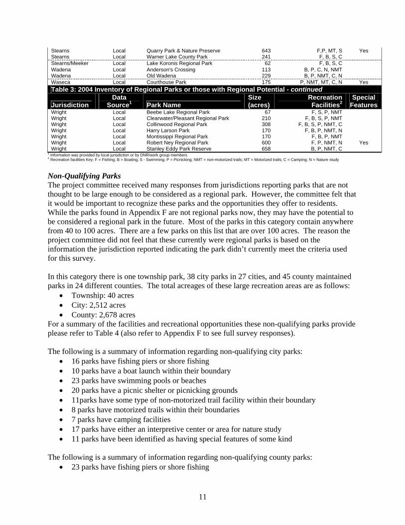
Wright Local Beebe Lake Regional Park 67 F, S, P, NMT Wright Local Clearwater/Pleasant Regional Park 210 F, B, S, P, NMT Wright Local Collinwood Regional Park 308 F, B, S, P, NMT, C Wright Local Harry Larson Park 170 F, B, P, NMT, N Wright Local Montissippi Regional Park 170 F, B, P, NMT Wright Local Robert Ney Regional Park 600 F, P, NMT, N Yes Wright Local Stanley Eddy Park Reserve 658 B, P, NMT, C
1 Information was provided by local jurisdiction or by DNR/work group members 2 Recreation facilities Key: F = Fishing; B = Boating; S - Swimming; P = Picnicking; NMT = non-motorized trails; MT = Motorized trails; C = Camping; N = Nature study Non-Qualifying Parks The project committee received many responses from jurisdictions reporting parks that are not thought to be large enough to be considered as a regional park. However, the committee felt that it would be important to recognize these parks and the opportunities they offer to residents. While the parks found in Appendix F are not regional parks now, they may have the potential to be considered a regional park in the future. Most of the parks in this category contain anywhere from 40 to 100 acres. There are a few parks on this list that are over 100 acres. The reason the project committee did not feel that these currently were regional parks is based on the information the jurisdiction reported indicating the park didn’t currently meet the criteria used for this survey. In this category there is one township park, 38 city parks in 27 cities, and 45 county maintained parks in 24 different counties. The total acreages of these large recreation areas are as follows:
• Township: 40 acres • City: 2,512 acres • County: 2,678 acres
For a summary of the facilities and recreational opportunities these non-qualifying parks provide please refer to Table 4 (also refer to Appendix F to see full survey responses). The following is a summary of information regarding non-qualifying city parks:
• 16 parks have fishing piers or shore fishing • 10 parks have a boat launch within their boundary • 23 parks have swimming pools or beaches • 20 parks have a picnic shelter or picnicking grounds • 11parks have some type of non-motorized trail facility within their boundary • 8 parks have motorized trails within their boundaries • 7 parks have camping facilities • 17 parks have either an interpretive center or area for nature study • 11 parks have been identified as having special features of some kind
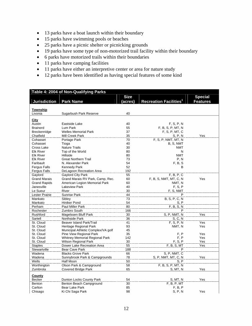
The following is a summary of information regarding non-qualifying county parks:
• 23 parks have fishing piers or shore fishing
12
• 13 parks have a boat launch within their boundary • 15 parks have swimming pools or beaches • 25 parks have a picnic shelter or picnicking grounds • 19 parks have some type of non-motorized trail facility within their boundary • 6 parks have motorized trails within their boundaries • 11 parks have camping facilities • 11 parks have either an interpretive center or area for nature study • 12 parks have been identified as having special features of some kind
Table 4: 2004 of Non-Qualifying Parks
Jurisdiction Park Name Size
(acres) Recreation Facilities1 Special
Features
Township
Livonia Sugarbush Park Reserve 40
City Austin Eastside Lake 40 F, S, P, N Brainerd Lum Park 55 F, B, S, P, MT, N Breckenridge Welles Memorial Park 37 F, S, P, MT, C Chatfield Mill Creek Park 35 S, P, N Yes Cohasset Portage Park 70 F, S, P, NMT, MT, N Cohasset Tioga 40 B, S, NMT Cross Lake Nature Trails 30 NMT Elk River Top of the World 80 N Elk River Hillside 80 NMT Elk River Great Northern Trail 73 P, N Faribault N. Alexander Park 54 F, B, S Fergus Falls Kennedy Park 52 B Fergus Falls DeLagoon Recreation Area 192 Gaylord Gaylord City Park 55 F, B, P, C Grand Marais Grand Marais RV Park, Camp, Rec. 60 F, B, S, NMT, MT, C, N Yes Grand Rapids American Legion Memorial Park 60 NMT, N Janesville Lakeview Park 40 F, S, P Le Sueur River 30 F, S, NMT Lester Prairie Sunrise Park 44 P Mankato Sibley 73 B, S, P, C, N Mankato Hiniker Pond 54 S, P Perham Paul Miller Park 80 F, B, S, N Rochester Zumbro South 166 P Rushford Magelssen Bluff Park 30 S, P, NMT, N Yes Sartell Northside Park 36 S, C, N St. Cloud Beaver Island Park/Trail 41 F, S, P, N Yes St. Cloud Heritage Regional Park 93 NMT, N Yes St. Cloud Municipal Athletic Complex/VA golf 45 St. Cloud Pine View Regional Park 35 F, P Yes St. Cloud Whitney Memorial Regional Park 142 F, P Yes St. Cloud Wilson Regional Park 30 F, S, P Yes Staples Dower Lake Recreation Area 55 F, B, S, MT Yes Stewartville Bear Cave Park 188 P Wadena Blacks Grove Park 66 S, P, NMT, C Wadena Sunnybrook Park & Campgrounds 78 S, P, NMT, MT, C, N Yes Wells Half Moon 50 S, P Worthington Olson Park & Campground 58 F, B, S, P, MT, N Zumbrota Covered Bridge Park 65 S, MT, N Yes
County Becker Dunton Locks County Park 54 S, MT, N Yes Benton Benton Beach Campground 30 F, B, P, MT Carlton Bear Lake Park 85 F, B, P Chisago Ki Chi Saga Park 98 S, P, N Yes
13
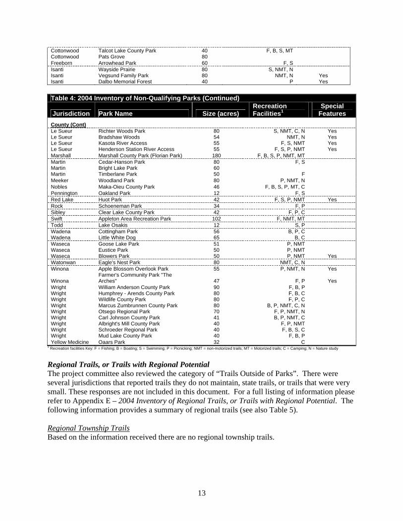
Cottonwood Talcot Lake County Park 40 F, B, S, MT Cottonwood Pats Grove 80 Freeborn Arrowhead Park 60 F, S Isanti Wayside Prairie 80 S, NMT, N Isanti Vegsund Family Park 80 NMT, N Yes Isanti Dalbo Memorial Forest 40 P Yes
Table 4: 2004 Inventory of Non-Qualifying Parks (Continued)
Jurisdiction Park Name Size (acres) Recreation Facilities1
Special Features
County (Cont) Le Sueur Richter Woods Park 80 S, NMT, C, N Yes Le Sueur Bradshaw Woods 54 NMT, N Yes Le Sueur Kasota River Access 55 F, S, NMT Yes Le Sueur Henderson Station River Access 55 F, S, P, NMT Yes Marshall Marshall County Park (Florian Park) 180 F, B, S, P, NMT, MT Martin Cedar-Hanson Park 80 F, S Martin Bright Lake Park 60 Martin Timberlane Park 50 F Meeker Woodland Park 80 P, NMT, N Nobles Maka-Oieu County Park 46 F, B, S, P, MT, C Pennington Oakland Park 12 F, S Red Lake Huot Park 42 F, S, P, NMT Yes Rock Schoeneman Park 34 F, P Sibley Clear Lake County Park 42 F, P, C Swift Appleton Area Recreation Park 102 F, NMT, MT Todd Lake Osakis 12 S, P Wadena Cottingham Park 56 B, P, C Wadena Little White Dog 65 B, C Waseca Goose Lake Park 51 P, NMT Waseca Eustice Park 50 P, NMT Waseca Blowers Park 50 P, NMT Yes Watonwan Eagle's Nest Park 80 NMT, C, N Winona Apple Blossom Overlook Park 55 P, NMT, N Yes
Winona Farmer's Community Park "The Arches" 47 F, P Yes
Wright William Anderson County Park 90 F, B, P Wright Humphrey - Arends County Park 80 F, B, C Wright Wildlife County Park 80 F, P, C Wright Marcus Zumbrunnen County Park 80 B, P, NMT, C, N Wright Otsego Regional Park 70 F, P, NMT, N Wright Carl Johnson County Park 41 B, P, NMT, C Wright Albright's Mill County Park 40 F, P, NMT Wright Schroeder Regional Park 40 F, B, S, C Wright Mud Lake County Park 40 F, B, P Yellow Medicine Oaars Park 32 C
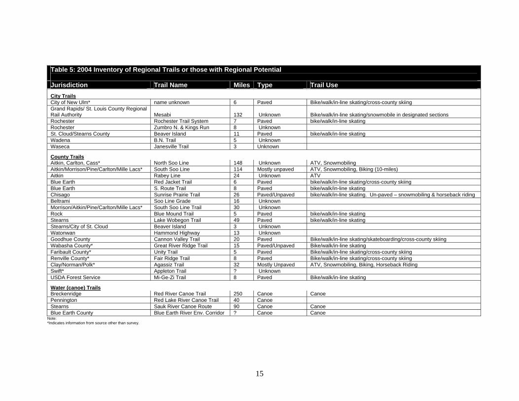
1 Recreation facilities Key: F = Fishing; B = Boating; S = Swimming; P = Picnicking; NMT = non-motorized trails; MT = Motorized trails; C = Camping; N = Nature study Regional Trails, or Trails with Regional Potential The project committee also reviewed the category of “Trails Outside of Parks”. There were several jurisdictions that reported trails they do not maintain, state trails, or trails that were very small. These responses are not included in this document. For a full listing of information please refer to Appendix E – 2004 Inventory of Regional Trails, or Trails with Regional Potential. The following information provides a summary of regional trails (see also Table 5). Regional Township Trails Based on the information received there are no regional township trails.

14
Regional City Trails There are eight cities that either reported trails, or that the project group contributed information about. One of these city trails is a canoe route and the remaining trails are for walking, biking and in-line skating. Some of the city trails appear to be sections of larger trails, but most are located only within the reporting jurisdiction. There were four cities that reported receiving funding in the form of donations or grants to maintain or create the trail (see Table 5). Regional County Trails Within counties there were 22 reported county maintained trails located outside of parks. Three of these trails are canoe routes, five are known to be utilized for ATV or snowmobiling activities, and the remainder appear to be paved to allow for activities such as biking, walking and in-line skating. Only one of the trails is reported to have an entry or user fee that funds the trail. Several others reported receiving grants or donations to fund their trails. The information that jurisdictions reported regarding trails outside of parks is not complete enough to determine how they are funded (see Table 5).
15
Table 5: 2004 Inventory of Regional Trails or those with Regional Potential Jurisdiction Trail Name Miles Type Trail Use City Trails City of New Ulm* name unknown 6 Paved Bike/walk/in-line skating/cross-county skiing Grand Rapids/ St. Louis County Regional Rail Authority Mesabi 132 Unknown Bike/walk/in-line skating/snowmobile in designated sections Rochester Rochester Trail System 7 Paved bike/walk/in-line skating Rochester Zumbro N. & Kings Run 8 Unknown St. Cloud/Stearns County Beaver Island 11 Paved bike/walk/in-line skating Wadena B.N. Trail 5 Unknown Waseca Janesville Trail 3 Unknown
County Trails Aitkin, Carlton, Cass* North Soo Line 148 Unknown ATV, Snowmobiling Aitkin/Morrison/Pine/Carlton/Mille Lacs* South Soo Line 114 Mostly unpaved ATV, Snowmobiling, Biking (10-miles) Aitkin Rabey Line 24 Unknown ATV Blue Earth Red Jacket Trail 6 Paved bike/walk/in-line skating/cross-county skiing Blue Earth S. Route Trail 8 Paved bike/walk/in-line skating Chisago Sunrise Prairie Trail 26 Paved/Unpaved bike/walk/in-line skating. Un-paved – snowmobiling & horseback riding Beltrami Soo Line Grade 16 Unknown Morrison/Aitkin/Pine/Carlton/Mille Lacs* South Soo Line Trail 30 Unknown Rock Blue Mound Trail 5 Paved bike/walk/in-line skating Stearns Lake Wobegon Trail 49 Paved bike/walk/in-line skating Stearns/City of St. Cloud Beaver Island 3 Unknown Watonwan Hammond Highway 13 Unknown Goodhue County Cannon Valley Trail 20 Paved Bike/walk/in-line skating/skateboarding/cross-county skiing Wabasha County* Great River Ridge Trail 15 Paved/Unpaved Bike/walk/in-line skating Faribault County* Unity Trail 5 Paved Bike/walk/in-line skating/cross-county skiing Renville County* Fair Ridge Trail 8 Paved Bike/walk/in-line skating/cross-county skiing Clay/Norman/Polk* Agassiz Trail 32 Mostly Unpaved ATV, Snowmobiling, Biking, Horseback Riding Swift* Appleton Trail ? Unknown USDA Forest Service Mi-Ge-Zi Trail 8 Paved Bike/walk/in-line skating
Water (canoe) Trails Breckenridge Red River Canoe Trail 250 Canoe Canoe Pennington Red Lake River Canoe Trail 40 Canoe Stearns Sauk River Canoe Route 90 Canoe Canoe Blue Earth County Blue Earth River Env. Corridor ? Canoe Canoe
Note: *Indicates information from source other than survey.
16
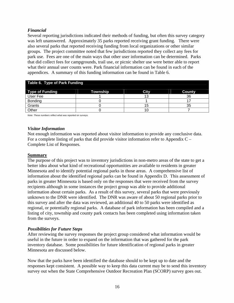
Financial Several reporting jurisdictions indicated their methods of funding, but often this survey category was left unanswered. Approximately 35 parks reported receiving grant funding. There were also several parks that reported receiving funding from local organizations or other similar groups. The project committee noted that few jurisdictions reported they collect any fees for park use. Fees are one of the main ways that other user information can be determined. Parks that did collect fees for campgrounds, trail use, or picnic shelter use were better able to report what their annual user counts were. Park financial information can be found in each of the appendices. A summary of this funding information can be found in Table 6. Table 6. Type of Park Funding Type of Funding Township City County User Fee 1 13 36 Bonding 0 1 17 Grants 0 15 35 Other 0 10 7 Note: These numbers reflect what was reported on surveys. Visitor Information Not enough information was reported about visitor information to provide any conclusive data. For a complete listing of parks that did provide visitor information refer to Appendix C – Complete List of Responses. Summary The purpose of this project was to inventory jurisdictions in non-metro areas of the state to get a better idea about what kind of recreational opportunities are available to residents in greater Minnesota and to identify potential regional parks in those areas. A comprehensive list of information about the identified regional parks can be found in Appendix D. This assessment of parks in greater Minnesota is based only on the responses that were received from the survey recipients although in some instances the project group was able to provide additional information about certain parks. As a result of this survey, several parks that were previously unknown to the DNR were identified. The DNR was aware of about 50 regional parks prior to this survey and after the data was reviewed, an additional 40 to 50 parks were identified as regional, or potentially regional parks. A database of park information has been compiled and a listing of city, township and county park contacts has been completed using information taken from the surveys. Possibilities for Future Steps After reviewing the survey responses the project group considered what information would be useful in the future in order to expand on the information that was gathered for the park inventory database. Some possibilities for future identification of regional parks in greater Minnesota are discussed below. Now that the parks have been identified the database should to be kept up to date and the responses kept consistent. A possible way to keep this data current may be to send this inventory survey out when the State Comprehensive Outdoor Recreation Plan (SCORP) survey goes out.
17
Additional feed back from counties and cities could potentially be sought at annual or mid-year conferences. Spatial data could be developed in the future to assist in the analysis of natural resource scarcity. Also, in order to truly determine if park users are traveling from outside of their jurisdictions to use park facilities, consistent user information may need to be gathered. Many of these regional parks appear to be developing as a response to being near a population center, or by being in close proximity to a special natural resource. It will be important to identify which areas of the state are lacking in parkland in relation to Federal and State projected growth rates. Utilization of Geographic Information Systems (GIS) would be a key component of this analysis, allowing for a more comprehensive outdoor recreational opportunity analysis. GIS could also be useful to assist in making determinations about natural resource scarcity and to visually depict regional significance and general scarcity of the recreational opportunity within its boundaries. Additional research on recreational areas may be needed, especially when parks are borderline in terms of size or facilities. This may require field checks of the parks or possibly follow-up interviews with local park officials. The survey revealed that many jurisdictions are lacking in visitor origination data. It is clear that more data is necessary for further analysis of a park’s regional status. In order to do this, additional work would need to be done to assist parks in determining if they serve a significant percentage of people who reside outside of the park agency’s jurisdiction. There are many different ways that jurisdictions could keep track of their visitors. However, if proper data was collected it would be expensive and a basic model for keeping track of visitors may need to be developed. In many cases, the resources needed to gather such information on a regular basis is simply not available. Another potential step in the identification and development of regional parks could be to provide greater encouragement, or assistance to interested groups for the formation of regional park systems. There are currently a few of these systems existing in the state that could be used as guides or examples. Some of the systems currently developing in the state are the:
• Central Minnesota Regional Parks and Trails Coordination Board – consisting of Stearns, Benton and Sherburne Counties
• Joint County Planning Commission – consisting of Douglas, Pope, Stevens, Grant, and Todd Counties
• Upper Minnesota River Valley Rural Development Commission – involved with trail planning in the upper Minnesota River valley
• Duluth Area Park Commission • Minnesota Parks and Recreation Association – working on trail linkages
Note: A mailing list for the parks survey (townships, cities, and counties) can be found on the CD submitted to the LCMR. This list will be helpful for future reference when seeking out park information.