paleomagnetic and plate tectonic constraints on the movement of tibet
TRANSCRIPT

Tec~onop/yrics, 98 ( 1983) I- 10 1
Elsevier Science Publishers B.V.. Amsterdam - Printed in The Netherlands
PALEOMAGNETIC AND PLATE TECTONIC CONSTRAINTS ON THE MOVEMENT OF TIBET
MICHEL WESTPHAL and JEAN-PIERRE POZZI
Institut de Physique du Globe de Strasbourg, 5 rue R. Descartes, F- 67084 Strasbourg (France)
Institur de Physique du Globe de Paris, 4 place Jussieu, F-75230 Paris (France)
(Received March 28, 1983)
ABSTRACT
Westphal, M. and Pozzi, J.-P., 1983. Paleomagnetism and plate tectonic constraints on the movement of
Tibet. In: E. McClelland Brown and J. VandenBerg (Editors), Palaeomagnetism of Orogenic Belts.
Tectonophysics, 98: I- 10.
The paleomagnetic results from Tibet, north of the Yarlung-Zang bo suture zone, show that Tibet was
at about 15”-20”N in Middle Cretaceous time. It then moved south down to 7”-10”N in the Late
Cretaceous-Pa&gene. The oceanic crust of the Xigaze ophiolites was magnetized at 13ON but thereafter
migrated further south. This movement is compared with the relative movement of India and Asia as
deduced from magnetic anomalies and paleomagnetism. Experimental models on deformation help us to
explain how Tibet moved during the Late Cretaceous under the constraint of the Africa-Arabia indenter
and during the Upper Tertiary under the constraint of the Indian indenter.
INTRODUCTION
Tibet, Iran and Afghanistan are fragments of continents now situated north of the
most evident suture zones between Asia and Africa-India, i.e. the Zagros and Indus
Zang bo sutures. But in former times, in the Paleozoic and probably still in the
Triassic, they were parts of Gondwana (Soffel and Forster, 1980; Wensink, 1982).
The special problem with Tibet is that it has been strongly pushed about 1000-2000
km into Asia. Present paleomagnetic data and plate tectonic models give us more
information about these movements.
STRUCTURE OF TIBET
Tibet is a broad domain situated between the High Himalayan fold belt and the
great shear zones of Kunlun and Altyn Tagh (Sengb, 198 1; Tapponnier et al., 1981).
Tibet can be divided in two main parts. The first, larger one lies north of the
Yarlung Zang bo suture zone (Fig. 1). Its southwestern part is called the Lhasa
OO40-1951/83/$03.00 0 1983 Elsevier Science Publishers B.V.

4RABIA -* , I.
‘i
,’
207 ‘) INQIA
-+++ri+++ ++++++ +t++t+-++
.‘.
.
. . . .
. . . . . . . . . . . . . . . . . . . . . . . . . . . .
Fig. 1. A. General outline of South Asia with the main blocks, strike-slip faults and suture zones. The
large arrows indicate the relative movement of India, Arabia, Tibet and Indochina. Za = Zagros suture.
YZb = Yarlung Zangbo suture, MCT = Himalaya main central thrust.
B. Geological outline of Lhasa region. Black dots: main sampling zones. K = Takena and Linzizong
formation, G = Gangdeze granites and granodiorites, TJ = Triassic and Jurassic north of Yarlung Zang
bo, P = Paleozoic, Xf = Xigaze flysch, 0 = ophiolites, Hf = North Himalayan flyschs.

3
Block. Its Mesozoic history is mainly continental and it seems to have been attached
to Asia since the Jurassic. To the north, older sutures zones have been identified or
are suspected. The folding of this part, mainly Tertiary, is not very important. The
south of this domain is bordered by the Gangdeze and the Ladakh-Kohistan
batholith, interpreted as Andean margins.
South of the Yarlung Zang bo suture zone the structure is very different. The
sedimentation is mostly marine and the deformations, much more importantly,
began earlier than in the north. The age of the radiolarites just on the top of the
ophiolites is Aptian-Cenomanian (Nicolas et al., 1981). The structure is interpreted
as a slow accretion ridge with an opening direction estimated as N30”W in its
present orientation.
THE PALEOMAGNETIC RESULTS
Paleomagnetic results are available north of the Yarlung Zang bo zone for
Jurassic limestones, Middle Cretaceous redbeds and Late Cretaceous-Early Tertiary
volcanics and sediments in the vicinity of Lhasa. The Jurassic limestones have been
studied by Chinese paleomagneticians (Zhu Zhi Wen et al., 1981). The samples have
been demagnetized only by alternating fields up to 40 mT and only 10% of the initial
magnetization was removed. These rocks show a reversed direction with a nearly
equatorial position for the Jurassic limestones. As the samples have not been
completely demagnetized, a systematic error due to hard viscous components is
possible. The true paleolatitude may be higher. The Middle-Late Cretaceous red-
beds (Takena formations of Aptian age and younger) have been studied by several
authors and at several widely-spread locations (Zhu Xiang Yuan et al., 1977; Zhu
Zhi Wen et al., 1981; Achache et al., 1982; Pozzi et al., 1982; Westphal et al., 1983).
Chinese paleomagneticians used only weak alternating field demagnetization.
They could not unravel all the magnetic components. Our samples (Pozzi et al.,
1982; Westphal et al., 1983) have been thermally cleaned step-by-step. A stable,
characteristic magnetic direction is obtained often only above 590°C. The compo-
nent shows a significantly positive fold test. The corresponding paleolatitude is
about 20°N. It has been argued that some of the magnetic directions are more
Indian-like than Asian-like and that, therefore, Tibet was attached to India and that
these formations were remagnetized at low latitudes (from 20”s to 5ON). This has
already been discussed by Pozzi et al. (1982). It would mean that all the sites have
been remagnetized at very different periods even though some sites are very close.
We feel that this is very improbable and that the positive fold test is a strong
argument for primacy of the magnetization. This magnetization was acquired in
Middle Cretaceous or, at the latest, just at the beginning of the folding (Late
Cretaceous).
The field direction is D = 333”, I = 38”, ffgs = 8”. Achache et al. (1982) have
extended the sampling to the north and obtained similar results. These redbeds yield

4
a paleolatitude of 15” to 20’N. A first site of green and red sandstones just on top of
the Takena formation gives a shallower inclination of 24” with a declination of 3”. A
second site of volcanics, belonging to the Lingzizong formation and dated by K-Ar
as 48 Ma (in Westphal et al., 1983) gives an inclination of 11’ with a declination of
358’. Maluski et al. (1982) have dated another flow from the same formation by the
39Ar/40Ar method. This method gave a single plateau at 60 Ma.
In both sites, normal and reversed magnetizations are present (Westphal et al.,
1983). The presence of such a shallow inclination in Early Tertiary volcanics has
been confirmed by Achache et al. (1982). The paleolatitude was about 5”- 10”N.
On the western end of the Indus Yarlung Zang bo suture zone, but north of it,
Klootwijk et al. (1979) found a shallow paleolatitude for the Ladakh intrusion of
about 7”-10”N and for the Late Paleocene-Eocene material. Younger, secondary
components give higher paleolatitudes (Table I).
On the suture zone itself, we have sampled basalts and pillow lavas on top of the
ophiolites, radiolarites just above them, and several sites in the Xigaze flysch. The
paleomagnetic results are complicated, secondary magnetization being often pre-
dominant (Pozzi and Westphal, in prep.). Our most reliable results have been
obtained on a lava-radiolarites sequence near Xigaze (Table I, site 14R and 14B).
The radiolarites are dated as Albian-Cenomanian. They have thus most probably
been magnetized during the Cretaceous long normal polarity interval. They show a
paleolatitude of 13”N with a strong anticlockwise rotation of 90”-100”. This means
that the crust now abducted there did not become magnetized far from the Lhasa
TABLE I
Main paleomagnetic results from Tibet
Components D(O) 1(O) Paleo- References
latitude
North of the Indus - Yarlung Zang bo suture zone
Lhasa region
Upper Takena and Lingzizong 0 18 9”N Westphal et al. (1982)
Takena redbeds 333 38 20”N Westphal et al. (1982)
Jurassic limestones 175 2 1”S Zhu Zhi Wen et al. (1982)
Lndakh intrusions Klootwijk et al. (1979)
Component 6 3 15 7”N
Component 5 355 19 lOoN
Zang bo suture zone, Xigare region Pozzi et al. (in prep.)
Basalts, primary magnetization, site 14B 239 24 12”N
Radiolarites, primary magnetization, site 14R 278 28 14”N
Basalts, Primary magnetization?, site 21 309 - 10 50s

5
block. The accretion direction, corrected for the rotation, is about N60”-N70”E.
A probably younger magnetization (site 21) gives a shallower paleolatitude.
INTERPRETATION
The Late Tertiary movements of Tibet were certainly driven by the India-Asia
collision. India and Eurasia’s relative displacements can be checked by separate
methods.
(1) Paleomagnetic measurements on both Eurasia and India. We have recalcu-
lated the expected paleolatitudes for a point of coordinates 30°N and 90°E (near
Lhasa). For Eurasia we took first Irving’s polar wander curve (1977) and we checked
it against Harrisson and Lindh’s (1982) composite paleomagnetic curve for Europe
(Fig. 2A). In the Tertiary the expected paleolatitudes are always between 28” and
33”N. Irving’s curve showed a slight decrease in paleolatitudes in the Lower
Tertiary, which is not seen in Harrisson and Lindh’s curve.
For the Cretaceous the curves are different. These differences are mainly due to
the lack of good Middle Cretaceous European data and also to possible errors in the
transfer from the North and South American poles to Eurasia in the Cretaceous,
where rotation parameters are less precise. We think that these two curves should be
taken as extreme values.
For India we used Klootwijk’s (1979a, b) compilation of Indian data. During the
Mesozoic, India was far into the Southern Hemisphere. It started its northward drift
in the Late Cretaceous and crossed the equator about 45 Ma ago (Fig. 2A).
(2) Paleomagnetic measurements on D.S.D.P. cores from the Indian plate (Pierce,
1978). These measurements gave only inclination data that are difficult to transfer to
the 30”N, 90’E point. Klootwijk (1979a) estimated paleodeclinations and was then
able to compute virtual geomagnetic poles. These were used in Fig. 2B. Here India
crossed the equator about 50 Ma ago.
(3) The India-Asia movement can be deduced from marine magnetic anomalies
found in the West Indian Ocean (India-Africa movement) and Atlantic Ocean
(Africa-America-Europe movement) (Patriat et al., 1982).
Assuming Asia to be fixed, it is possible to compute the relative movement of
India at the same point (Fig. 2C). This gives the relative paleolatitudes of India.
Obviously they should be corrected for the absolute movement of Asia in order to
compare them to other curves. As seen in Fig. 2A, corrections are small for the
Tertiary but unfortunately dubious for the Cretaceous. In this last figure India
crossed the equator about 55 Ma ago.
(4) The movement of Tibet from paleomagnetic data. The Chinese Jurassic results
show a low latitude for the Lhasa block. The actual error margin is not known. In
the Middle Cretaceous the Lhasa block was about 15’-20”N. Younger formations
again gave lower paleolatitudes about 7”-1O”N (Fig. 2A). Before 50 Ma the Lhasa
block, and probably the whole northern part of Tibet, was far from India but close

Ma
India
/ - -v
3: ,30N
0
50s
30N
Ma 100
Fig. 2. Latitudinal positions of Asia, India, Lhasa block, Xigaze region and Ladakh with time and
transferred to the point 30”N, 90’E.
A. Paleomagnetic datas from Asia (black circles--Irving, 1977; white circles-Harrisson and Lindh, -+

to Asia. The Late Cretaceous-Early Tertiary southward drift of the Lhasa block is
stronger than the Asian movement expected from Irving’s curve and opposite to the
one expected from Harrisson and Lindh’s curve. This means that although Tibet was
close to Asia, in contact with it, there was still some uncoupling between them. It is
very difficult, on geological grounds, to imagine that a basin opened between Tibet
and Asia in the Late Cretaceous-Early Tertiary and closed afterwards. There are no
traces of it. If longitudinal movements occurred along an oblique margin, such
movements are easier to explain.
The final part of the movement of Tibet is explained by experiments performed
by Peltzer et al. (1982) and Tapponnier et al. (1982). They studied the deformation
of a plasticine block compressed by a rigid rectangular indenter coming from the
south. The plasticine block has its north and west side bounded, but the east side is
free. These experiments showed the formation of a triangle in front of the indenter,
only weakly deformed, pushed toward the northeast. Parts located to the east of the
indenter are pushed toward the southeast in a clockwise rotation. For our present
purpose the triangle represents Tibet and the side blocks Indochina and south China
(Fig. 1).
But the southward movement of Tibet in the Late Cretaceous and Early Tertiary
is not explained by the Peltzer model when applied to India. At that same time India
was still far into the Southern Hemisphere and probably separated from Asia by an
oceanic crust. The movements of Africa and India relative to Eurasia are shown in
Fig. 3. For India, this movement is shown for a point now at 30”N and 90’E (near
Lhasa) and for Africa-Arabia for a point at 30”N and 50”E (near Abadan in the
Persian Gulf) (Fig. 3A).
The movement of Africa-Arabia is slower than India’s, but much more continu-
ous, and compression between Arabia and Asia began as soon as the Early
Cretaceous (Fig. 2D). Arabia may thus have behaved as a rigid indenter, like India.
If we pull Tibet backwards to the southwest in the more shallower latitudes as
suggested by paleomagnetic observations, in a direction more or less parallel to the
Altyn Tagh and Tien Chan faults, according to the Peltzer et al. (1982) experiments
we find that in the Middle Tertiary Tibet was much closer to Arabia. It is then an
attractive hypothesis that Tibet, and probably Iran, have been pushed to the
southeast like Indochina now. This explains the southward movements of Tibet. We
should note that a southward movement of Central Iran of about 5”-10” can also be
1982), India (triangles-Klootwijk et al., 1979), Lhasa block and Xigaze region (five point stars-Zhu Zhi
Wen 1981 and Westphal et al., 1983), and Ladakh (small star-Klootwijk et al., 1979).
B. Data from D.S.D.P. cores in the Indian plate (Peirce, 1978 and Klootwijk, 1979a).
C and D. Relative movement of India (C) Africa-Arabia (D) and Asia. They are given for different
anomalies: 6 (20 Ma), 13 (35 Ma), 24 (55 Ma), 34 (80 Ma) and MO (110 Ma). The movement of India is
calculated for point 30”N, 90”E and the movement of Africa for point 30”N, 50°E. These relative
paleolatitudes should be corrected on the basis of the Eurasia curve (in A) to get true paleolatitudes. This
correction is small from 60 Ma until now.
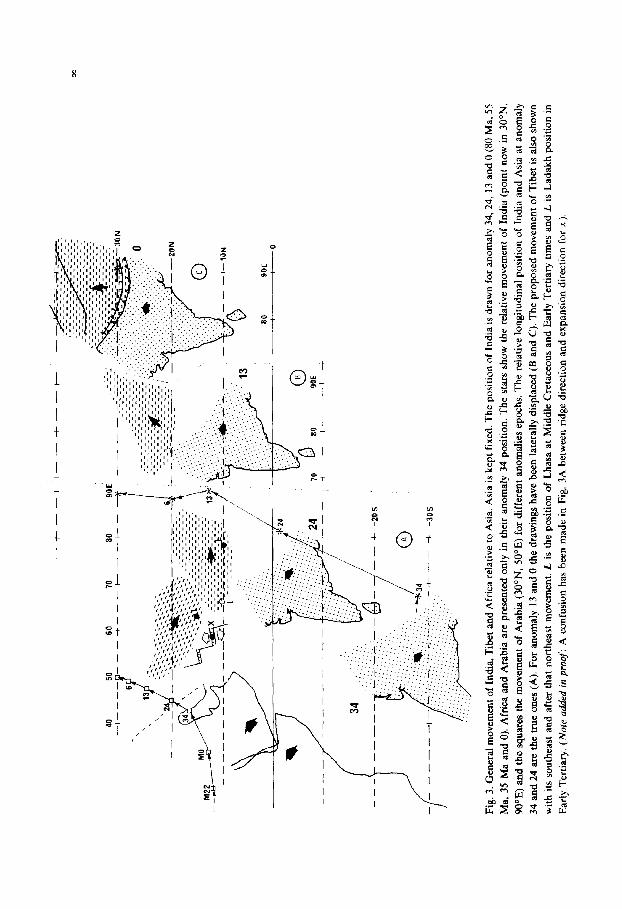
Fig.
3.
Gen
eral
m
ovem
ent
of I
ndia
, T
ibet
an
d A
fric
a re
lativ
e to
Asi
a.
Asi
a is
kep
t fi
xed.
T
he
posi
tion
of I
ndia
is
dra
wn
for
anom
aly
34,2
4,
13 a
nd
0 (8
0 M
a,
55
Ma,
35
Ma
and
0).
Afr
ica
and
Ara
bia
are
pres
ente
d on
ly
in
thei
r an
omal
y 34
pos
ition
. T
he
star
s sh
ow
the
rela
tive
mov
emen
t of
In
dia
(poi
nt
now
in
30
”N,
90°E
) an
d th
e sq
uare
s th
e m
ovem
ent
of
Ara
bia
(30°
N,
50’E
) fo
r di
ffer
ent
anom
alie
s ep
ochs
. T
he
rela
tive
long
itudi
nal
posi
tion
of
Indi
a an
d A
sia
at
anom
aly
34 a
nd
24 a
re
the
true
on
es
(A).
Fo
r an
omal
y 13
and
0
the
draw
ings
ha
ve
been
la
tera
lly
disp
lace
d (B
and
C
).
The
pr
opos
ed
mov
emen
t of
T
ibet
is
als
o sh
own
with
its
sou
thea
st
and
afte
r th
at
nort
heas
t m
ovem
ent.
L i
s th
e po
sitio
n of
L
hasa
at
M
iddl
e C
reta
ceou
s an
d E
arly
T
ertia
ry
times
an
d L
is
Lad
akh
posi
tion
in
Ear
ly
Ter
tiary
. (N
ote
ad
ded
in
pro
of:
A
con
fusi
on
has
been
m
ade
in
Fig.
3A
be
twee
n ri
dge
dire
ctio
n an
d ex
pans
ion
dire
ctio
n fo
r x)
.

9
seen in Soffel and Forster’s (1980, table 4) results for the beginning of the Tertiary. The presence of young oceanic crust in Xigaze can be explained by distension not
only similar to the extension now observed in the Andaman Sea or in the South China Sea but also, and more probably, the northern tip of the rift that separated India from Africa in the Early-Middle Cretaceous.
CONCLUSION
The history of Tibet may be now summarized as follows: in the Trias, Tibet, like Iran, was probably near Gondwana lands in the Southern Hemisphere (Soffel and Forster, 1980; Wensink, 1982). It moved north during a yet unknown period but was near the southern margin of Asia, at 15”-20”N, in the Middle Cretaceous. When Africa began to move northward toward Asia in the Middle Cretaceous, Tibet was pushed to the southeast. It is possible that a first tectonic phase between the then rapidly rising India and the pelagic crust already took place. Continental collision between Tibet and India began only later on, probably in the Eocene (Fig. 3B). The movement of India was then the main driving force for Tibet; strike-slip motion along Altyn Tagh, Tien Chan and crustal thickening may account for the northward movement of Tibet (Fig. 3C).
ACKNOWLEDGEMENTS
The paleomagnetic work, sampling and measurements have been done under a contract between the French Centre National de la Recherche Scientifique and the People’s Republic of China Ministry of Geology and Academy of Sciences.
The authors gratefully thank M.M. Zhou Yao Xiu, Xing Li Sheng and Chen Xian Yao for their help both in the field and the laboratories. They are also grateful to C. Klootwijk for critical and helpful discussions and comments.
This is a contribution of CNRS Laboratoire Associt de Geophysique Inteme de Strasbourg (LA 323) and Equipe de Recherche Associe de Gtomagnttisme et Pal6omagnetisme (ERA 922).
REFERENCES
Achache, J., Courtillot, V. and Zhou Yao Xiu, 1982. Etudes paleomagnetiques au nord de la suture du
Zang bo (Tibet). R&n. Ann. Sci. Terre, 9e, Paris, p. 1.
Irving, E., 1977. Drift of the major continental blocks since the Devonian. Nature, 270: 304-309.
Harrisson, C.G.A. and Lindh, T., 1982. Comparison between the hot spot and geomagnetic field reference
frames. Nature, 300: 251-252.
Klootwijk, C.T., 1979a. A review of palaeomagnetic data from the Indo-Pakistani fragment of Gondwana-
land. In: A. Farah and K. de Jong (Editors), Geodynamics of Pakistan. Geol. Surv. Pakistan, Quetta.
Klootwijk, C.T., 1979b. A summary of palaeomagnetic data from extra peninsular Indo Pakistan and
south central Asia: implications for collision tectonics. In: P.S. Saklani (Editor), Structural Geology of
the Himalaya. Today and Tomorrow’s Printers and Publishers, New Delhi, pp. 307-360.
10
Klootwijk, C.T., Sharma, M.L., Gergan, J., Tirkey, B., Shah, S.K. and Agarwal, V.K., 1979. The extent of
Greater India. 2. Paleomagnetic data from the Ladakh intrusives at Kargil, NW Himalaya. Earth
Planet. Sci. Lett., 44: 47-64.
Maluski, M., Proust, F. and Xiao Xuchang, 1982. First results of 39Ar/40Ar dating of the Transhimalayan
talc-alkaline magmatism of Southern Tibet. Nature, 298: 152- 154.
Nicolas, A., Girardeau, J., Marcoux, J., Dupre, B., Wang Xubin, Cao Yougong, Zheng Haiwiang and
Xiao Xuchang, 1981. The Xigaze ophiolite (Tibet): a peculiar oceanic lithosphere. Nature, 294:
414-417.
Patriat, Ph., Segoufin, J., Schlich, R., Goslin, J., Auzende, J.M., Beuzart, P., Bonnin, J. and Olivet, J.L..
1982. Les mouvements relatifs de l’Inde, de I’Afrique et de 1’Eurasie. Bull. Sot. Geol. Fr. (7). 24:
363-373.
Peirce, J.W., 1978. The northward motion of India since the Late Cretaceous. Geophys. J. R. Astron. Sot.,
52: 277-311.
Peltzer, G., Tapponnier, P. and Cobbold, P., 1982. Les grands decrochements de I’Est Asiatique:
evolution dans le temps et comparaison avec un modele experimantal. C.R. Acad. Sci., 294, Ser. II:
1341-1348.
Pozzi, J.P. and Westphal, M., 1983. Paleomagnetism in southern Tibet (Xizang). 2. The Xigaze forma-
tions. (In prep.)
Pozzi, J.P., Westphal, M., Zhou, Y.X., Xing, L.S. and Chen, X.Y., 1982. The position of the Lhasa block
(South Tibet) during Late Cretaceous time; new paleomagnetic results. Nature, 297: 319-321.
Sengor, A.M.C., 1981. The geological exploration of Tibet. Nature, 294: 403-404.
Soffel, H.C. and Forster, H.G., 1980. Apparent polar wander path of Central Iran and its geotectonic
interpretation. J. Geomagn. Geoelectr., 32 (suppl. III): 1 1 l- 135.
Tapponnier, P., Mercier, J.L., Proust, F., Andrieux, J., Armijo, R., Bassoulet, J.P., Brunei, M. Burg, J.P.,
Colchen, M., Dupre, B., Girardeau, J., Marcoux, J., Mascle, G. Matte, P., Nicolas, A., Li Tingdong,
Xiao Xuxhang, Chang Chenfa, Lin Paoyu, Li Guangcen, Wang Naiwen, Chen Guoming, Han
Tonglin, Wang Xibin, Den Wamning, Zhen Haixiang, Sheng Huaibin, Cao Yongong, Zhou Ji and Qui
Hongrong, 1981. The Tibetan side of the India-Eurasia collision. Nature, 294: 405-410.
Tapponnier, P., Peltzer, G., Le Dain, A.Y., Armijo, R. and Cobbold, P., 1982. Propagating extrusion
tectonics in Asia: new insights from simple experiments with plasticine. Geology, 10: 61 l-616.
Wensink, H., 1982. Tectonic inferences of Palaeomagnetic data from some mesozdic formations in
Central Iran. J. Geophys., 51: 12-23.
Westphal, M., Pozzi, J.P., Zhou Yao Xiu, Xing Li Sheng and Chen Xian Yao, 1983. Paleomagnetic data
about southern Tibet (Xigang). I. The Cretaceous formations of the Lhasa block. Geophys. J. R.
Astron. Sot., in press.
Zhu Xiang Yuan, Liu Chun, Ye Sujuan and Lin Jinlu, 1977. Remanence of red bed from Linzhou, Xizang
and the northward movement of the Indian plate. Sci. Geol. Sin., 1: 44-5 I (in Chinese, English abstr.).
Zhu Zhi Wen, Zhu Xiang Yuan and Zhang Yi Ming, 1981. Paleomagnetic observation in Xizang and
continental drift. Acta Geophys., 24: 40-49 (in Chinese, English abstract).