overview papers - hydrologie.orghydrologie.org/redbooks/a358/358 description, preface, c… ·...
TRANSCRIPT

Deltas: Landforms, Ecosystems and Human
Activities Editors Gordon Young & Gerardo M. E. Perillo Associate Editors Hafzullah Aksoy, Jim Bogen, Alexander Gelfan, Gil Mahé, Phillip Marsh & Hubert Savenije IAHS Publ. 358 (2013) ISBN 978-1-907161-36-0, 246 + x pp. Price £65.00
Deltas are environmental and economic hot spots, occupy about 1% of the global land surface, are home to some 500 million people and often are vibrant ecosystems. Deltas pose great challenges, whether marine or lacustrine as regions of purely natural conditions or regions of intense human activity set in the context of complex and often rapidly changing natural environments. Physically they are complex systems, the end-products of catchment processes involving water supply, sediment delivery and water quality – elements that are fast changing over time as a result both of human influences and change in climatic drivers. Tides, waves, sea level changes, storm surges, tsunamis and littoral currents all impact. The contributions result from a joint symposium of the International Associations of Hydrological Sciences (IAHS) and Physical Sciences of the Ocean (IAPSO)
Preface
With the creation of the Future Earth initiative in 2013, the global research community is embarking on a decade of scientific research that brings together the environmental and social sciences to promote sustainable development for the betterment of society. This same year marks the creation of a new decade of research within the hydrological community promoted by the International Association of Hydrological Sciences (IAHS); the decade will be named “Panta Rhei” meaning “everything flows”, embodying the concept that not only are hydrological processes evolving, but that they are doing so within human, economic and political environments that are also changing.
Thus, major overall initiatives are beginning – initiatives that will greatly influence the scientific research that will be undertaken and the ways in which that research will impact human and environmental developments, meaning that natural and social sciences must work hand-in-hand to understand our planet in an integrated way, its resources and how we can use them sustainably.
Simultaneously, a major decadal research initiative is being promoted on deltas. Deltas are the downstream products of river basin processes where the land meets the sea. They provide important sub-sets of Future Earth concerns and are the outcome of the interaction of hydrological and marine processes. Thus it is entirely appropriate that the International Association of Hydrological Sciences and the International Association for the Physical Sciences of the Oceans (IAPSP) are jointly sponsoring this symposium in Gothenburg.
Deltas, both marine and lacustrine are environmental and economic hot spots; occupying about 1% of the global land surface, they are home to some 500 million people and typically have vibrant ecosystems – thus they are vitally important human and natural habitats. Deltas pose great challenges, both as regions of purely natural conditions and as regions of intense human activity set in the context of complex and often rapidly changing natural environments.
Physically they are complex systems where land and marine/lacustrine environments meet. They are the end-products of catchment processes involving water supply, sediment delivery and water quality – elements that are fast changing over time as a result both of human influences and changes in climatic drivers. Tides, waves, sea level changes, storm surges, tsunamis and littoral currents result in influences from the marine environment. They are regions of natural subsidence, with rates of subsidence often increased by human extraction of groundwater and minerals.
In delta regions a significant portion of the global population often lives in very densely settled conditions, in regions that are, at the same time, areas of high food productivity. Thus, there are great challenges for the managers of water resources – challenges that are intensified by recurrent disasters from land- and ocean-based floods.
The set of papers within this volume provides overviews on delta processes and covers almost all types of delta environments, mostly marine, but also inland deltas. The scene is set with an overview paper on the “Delta Decadal Initiative: A framework of actionable research towards delta sustainability” followed by papers on changing fluvial sediment inputs and on the general theory of delta formation and evolution. A series of papers on the human influences on and uses of deltas and on their geomorphology and ecosystem characteristics follows. The special conditions of Arctic deltas, and both inland and marine deltas within the Niger River basin round out the volume.
This volume will not only provide important input to the Delta Decadal Initiative, but also will provide tools for both delta researchers and decision makers to better understand these significant elements of the Earth’s geography.

Editors-in-Chief
Gordon YoungPrincipal Convenor, IAHS
34 Vincent Avenue, Niagara on the Lake, L0S 1J0, Ontario, Canada
Gerardo M. E. PerilloPrincipal Convenor, IAPSO
CONICET-UNS Instituto Argentino de Oceanografía, CC 804 B8000FWB Bahía Blanca Argentina
and Departmento de Geología, Universidad Nacional del Sur
San Juan 670, 8000 Bahía Blanca, Argentina

Contents
Preface by Gordon Young & Gerardo M. E. Perillo v
1 Overview papers
A vision for a coordinated international effort on delta sustainability Efi Foufoula-Georgiou
3
Changing fluvial sediment inputs to the world’s deltas Des E. Walling 12
2 General theory
Salinity and tides in deltas. Can we predict tidal processes and salinity intrusion in poorly gauged deltas? Hubert H. G. Savenije
29
The effect of river discharge on tidal dynamics in three alluvial estuaries: the Scheldt, Modaomen and Yangtze cases Huayang Cai, Hubert H. G. Savenije & Marco Toffolon
39
Backwater hydrodynamics and sediment transport in the lowermost Mississippi River Delta: Implications for the development of fluvial-deltaic landforms in a large lowland river Jeffrey A. Nittrouer
48
Explaining the physical relation between estuary shape and bankfull discharge Jacqueline Isabella Anak Gisen & Hubert H. G. Savenije
62
3 Artic / cold regions
Changes in hydrological regime and morphology of river deltas in the Russian Arctic Dmitry Magritsky, Vadim Mikhailov, Vladislav Korotaev & Dmitry Babich
67
Bioavailability of sediment-associated metals in the Slave River Delta, Northwest Territories, Canada Leah Hagreen, Mike Stone, Warren Norwood & Jacqueline Ho
80
Geochemical mapping of Spitsbergen in the High Arctic using overbank sediments of deltas and floodplains Rolf Tore Ottesen & Jim Bogen
88
Estuarial-deltaic system of the Amur River Polina Sokolova & Tamara Ponomareva
96
4 West Africa
Monitoring flood propagation in the Niger River Inner Delta in Mali: prospects with the low resolution NOAA/AVHRR data Adama Mariko, Gil Mahe & Didier Orange
101
Relationships between water level at hydrological stations and inundated area in the River Niger Inner Delta, Mali Gil Mahe, Adama Mariko & Didier Orange
110
Geomorphic mapping and human activities along the southwestern Nigeria coastline Shakirudeen Odunuga, Abiodun Ajijola, Aiyede Patience, Thaddeus Delima & Abel Akpan
116
Analysis of surface water quality of upstream Niger Delta System O. Adeaga, G. Mahe, C. Dieulin, F. Elbaz-Poulichet, N. Rouche, J. L. Seidel & E. Servat
124
Environmental risk and water-resource management near the Port Harcourt refinery, Niger Delta Rodney L. Stevens, Enuvie Akpokodje & Onwusameka Ogbowuokara
126
Perception of hydrological changes and adaptation strategies in the Inner Niger Delta, Mali Aida Zare, Mahamadou Illou, Severe Fossi, Torou Mohamadou Bio, Gil Mahe, Jean-Emmanuel Paturel & Bruno Barbier
129
5 Human influences on and uses of deltas
Farming practices and anthropogenic delta dynamics Kimberly G. Rogers, James P. M. Syvitski, Irina Overeem, Stephanie Higgins & Jonathan M. Gilligan
133
The perils of human activity on South American deltas: lessons from Colombia’s experience with soil erosion Juan D. Restrepo A.
143
Effect of anthropogenic factors on the mangrove ecosystem in the Sundarban delta in India U. C. Sharma & Vikas Sharma
153
Flood-tidal and fluvial deltas of Tuggerah Lakes, Australia: Human impacts on geomorphology, sedimentology, hydrodynamics and seagrasses Wayne D. Erskine
159
Interdisciplinary research on new approaches for future management of the River Elbe Elmar Fuchs, Eva-Maria Bauer, Maike heuner, Carolin Schmidt-Wygasch & Uwe Schröder
168
A story of water, salt and sediments: constraints for adaptive management in the River Rhone delta Philippe Chauvelon, Olivier Boutron, Aurelien Loubet, Alain Sandoz & Patrick Höhener
176
6 Geomorphology / ecosystems
Late Pleistocene–Holocene deltas in southern Buenos Aires Province, Argentina Walter D. Melo, Gerardo M. E. Perillo, Mauricio M. Perillo, Roberto Schilizzi & M. Cintia Piccolo
187

Water balance and nutrient delivery in a densely populated delta for a future sustainable environment Didier Orange, Thi Nguyet Minh Luu, Thi Phuong Quynh Le, Hong Thai Tran4 Julien Nemery, Lan Anh Le, Gilles Billen, Josette Garnier & Georges Vachaud
196
Influence of ecosystem on hydrochemistry and stable isotope of surface and groundwaters in the Yellow River Delta Fadong Li, Qiang Liu, Qiuying Zhang, Jing Li, Yan Zhang, Shuai Song, Guangshuai Zhao & Nong Zhu
203
What can we learn from recent development of the Atchafalaya River Delta, USA and the Yellow River Delta, China? Timothy Rosen, Y. Jun Xu, Zongwen Ma & Xuegong Xu
209
Geomorphology and sedimentology of the Mogo Creek fluvial delta, NSW, Australia Wayne D. Erskine & Ruth Borgert
218
Hydrological process and its ecological effects on a re-established freshwater wetland in the Yellow River Delta, China Liu Bo, Liu Ge, Shu Longcang, Wang Xingong & Zhu Bing
226
Analysis of Krishna and Godavari river outflows to evaluate effects on river mouth changes Sarraju Venkata Vijaya Kumar
234
The Mekong River Delta – variation of sedimentation and morphology in a mega-delta Daniel Unverricht, Witold Szczuciński, Thanh Cong Nguyen, Christoph Heinrich, Karl Stattegger, Klaus Schwarzer, Niko Lahajnar & Thuyen Xuan Le
236
Key word index 239
Deltas: Landforms, Ecosystems and Human Activities Proceedings of HP1, IAHS-IAPSO-IASPEI Assembly, Gothenburg, Sweden, July 2013 (IAHS Publ. 358,( 2013)3-11.
A vision for a coordinated international effort on delta sustainability
EFI FOUFOULA-GEORGIOUDepartment of Civil Engineering and National Center for Earth-surface Dynamics, University of Minnesota, [email protected]
Abstract Deltas are economic and environmental hotspots, food baskets for many nations, home to a large part of the world population, and hosts of exceptional biodiversity and rich ecosystems. Deltas, being at the land–water interface, are international, regional, and local transport hubs, thus providing the basis for intense economic activities. Yet, deltas are disappearing and deteriorating at an alarming rate as “victims” of human actions (e.g. water and sediment reduction due to upstream basin development), climatic impacts (e.g. sea level rise and flooding from rivers and intense tropical storms), and local exploration (e.g. sand or aggregates, groundwater and hydrocarbon extraction). Although many efforts exist on individual deltas around the world, a comprehensive global delta sustainability initiative that promotes awareness, science integration, data and knowledge sharing, and development of decision support tools for an effective dialogue between scientists, managers and policy makers is lacking. Recently, the international scientific community proposed to establish the International Year of Deltas (IYD) to serve as the beginning of such a Global Delta Sustainability Initiative. The IYD was proposed as a year to: (1) increase awareness and attention to the value and vulnerability of deltas worldwide; (2) promote and enhance international and regional cooperation at the scientific, policy, and stakeholder level; and (3) serve as a launching pad for a 10-year committed effort to understand deltas as complex socio-ecological systems and ensure preparedness in protecting and restoring them in a rapidly changing environment. This paper articulates the vision for such an initiative as developed by a large number of international experts (see contributing authors) and pleads for a comprehensive and coordinated effort that spans continents and environments to demonstrate that indeed these “hot spots of vulnerability and change” can become again “seedbeds of sustainability and resilience.”Key words delta sustainability
Deltas: Landforms, Ecosystems and Human Activities Proceedings of HP1, IAHS-IAPSO-IASPEI Assembly, Gothenburg, Sweden, July 2013 (IAHS Publ. 358, 2013)12-26.
Changing fluvial sediment inputs to the world’s deltas
DES E. WALLINGGeography, College of Life and Environmental Sciences, University of Exeter, Exeter EX5 4RJ, [email protected]
Abstract The world’s deltas currently face many important threats to their longer term stability. Subsidence and sea level rise are key problems and their potential impact is strongly influenced by changes in sediment supply. Fluvial sediment inputs exert a key control on delta evolution and stability, as well as providing an important source of nutrients to delta ecosystems. The sediment loads of the world’s rivers are highly sensitive to both human impact and climate change, and the sediment loads of many rivers have changed markedly in recent decades. Some rivers have demonstrated increasing sediment loads, as a result of land clearance and intensification of land use, but in most cases sediment loads are declining. Dam building and associated sediment trapping are the primary causes of reduced sediment loads, but the implementation of large-scale soil conservation and sediment control programmes and the expansion of sand mining are also important. Climate change is increasingly seen as likely to cause further changes in fluvial sediment loads and thus sediment inputs to delta systems in the future. Rivers vary in the sensitivity of their sediment loads to changes in sediment mobilisation and storage in their upstream catchments, and some appear to possess considerable capacity to buffer changes in sediment delivery to their downstream reaches. Changes in the magnitude of sediment loads can also be coupled with changes in grain size and chemistry, which may have important implications for the receiving delta. There is currently widespread evidence of reducing sediment loads for the world’s rivers, particularly in Asia. Sediment trapping by dams is the major driver. However, some rivers are characterised by increases. It is suggested that most rivers pass through a phase of increasing loads due to land-use impacts, with

this being followed by a reduction due to dam construction. The precise timing of these changes depends on the location of the river basin and its stage of development. Key words sediment load; sediment inputs; deltas; human impacts; dams; reservoirs
Deltas: Landforms, Ecosystems and Human Activities Proceedings of HP1, IAHS-IAPSO-IASPEI Assembly, Gothenburg, Sweden, July 2013 (IAHS Publ. 358, 2013)29-38.
Salinity and tides in deltas. Can we predict tidal processes and salinity intrusion in poorly gauged deltas?
HUBERT H. G. [email protected]
Abstract Deltas are a special type of alluvial estuaries, which are complex systems. They form the interface between the terrestrial drainage system and the sea. Deltas have multiple functions: morphologic, hydraulic, hydrologic, ecologic and socio-economic. They are also the areas where different sources of energy converge: tidal energy, wind energy, potential energy from freshwater and sediments, and solar energy to feed the biotic system. The dissipation of all this energy has created a unique environment, with very special tidal and morphologic characteristics. One would expect that such a complex system is difficult to describe in simple mathematical terms, but the opposite is true. If considered at the right scale, deltas and estuaries appear to obey surprisingly simple “laws”. For instance: the shape of an alluvial estuary obeys a simple exponential law; the amplitude of the tidal velocity is 1 m/s at spring tide throughout the tidal region; and more surprisingly, this amplitude is the same throughout the world. If left undisturbed, estuaries tend to become “ideal” estuaries, where the tidal wave is undamped, propagating as a simple shallow water wave. As a result, there is also simplicity in the process of salt intrusion and the mixing of substances in estuaries. There are two important research questions related to this surprising simplicity. The first is of course the understanding of the more fundamental physical laws behind this surprising simplicity and uniformity; the second is how to predict the behaviour of estuaries in poorly-gauged regions, because this simplicity may help us to predict how estuaries behave when we have very limited knowledge on the ground. In this presentation, examples are given of two major deltas where predictive equations appear to work remarkably well.Key words ungauged deltas; estuaries; salt intrusion; geometry; prediction
Deltas: Landforms, Ecosystems and Human Activities Proceedings of HP1, IAHS-IAPSO-IASPEI Assembly, Gothenburg, Sweden, July 2013 (IAHS Publ. 358, 2013)39-47.
The effect of river discharge on tidal dynamics in three alluvial estuaries: the Scheldt, Modaomen and Yangtze cases
HUAYANG CAI1, HUBERT H. G. SAVENIJE1 & MARCO TOFFOLON2
1 Department of Water Management, Delft University of Technology, [email protected] Department of Civil, Environmental and Mechanical Engineering, University of Trento, Italy
Abstract A new analytical model for tidal hydrodynamics has been developed, which takes into account the effect of river discharge. For a given topography, friction, tidal amplitude at the seaward boundary and river discharge at the landward boundary, we are able to reproduce the main tidal dynamics (e.g. velocity amplitude, wave celerity, tidal amplitude, and phase lag) along the estuary axis by solving a set of four implicit equations. Analytical solutions are compared with observations in three real estuaries (i.e. the Scheldt, the Modaomen and the Yangtze). In these estuaries, the agreement with measurements is good, which suggests that the proposed model is a useful tool to evaluate the influence of human interventions on tidal dynamics, such as flow reduction. We also show that a model that does not consider river discharge will lead to substantial overestimation of the roughness in the upstream part of the estuaries if one tries to fit analytical model to observations.Key words tidal dynamics; river discharge; analytical solution
Deltas: Landforms, Ecosystems and Human Activities Proceedings of HP1, IAHS-IAPSO-IASPEI Assembly, Gothenburg, Sweden, July 2013 (IAHS Publ. 358, 2013)48-61.
Backwater hydrodynamics and sediment transport in the lowermost Mississippi River delta: Implications for the development of fluvial-deltaic landforms in a large lowland river
JEFFREY A. NITTROUERDepartment of Earth Science, Rice University, MS 126, PO Box 1892, Houston, Texas 77251-1892; [email protected]
Abstract Where rivers enter the coastal zone, gradually varying non-uniform flow conditions develop in the channel. This section of the river is referred to as the backwater segment, and for large rivers, backwater flow extends many hundreds of kilometres upstream of the river outlet. Studies from the Mississippi River document a persistent backwater zone that influences sediment mobility throughout the lowermost 500 km of the river. Reach-average shear stress varies temporally in accordance with the annual hydrograph, affecting the timing, magnitude, and grain size of transported sediment. A net reduction in shear stress restricts the downstream movement of coarse sediment, and this portion of the river’s sediment load does not reach the coastline. Instead, coarse sediment is caught at the backwater transition and is sequestered in the river channel. Information about the timing and magnitude of sediment flux in the backwater segments of large rivers is critical to addressing the landscape dynamics of deltas. Research from the Mississippi River delta, where roughly 5000 km2 of land has been converted to open water in the past century, is presented as a case study. The collapse of the Mississippi River delta is driven by rapid land subsidence associated with the extraction of subsurface fluids, eustatic sea-level rise, and the construction of levees, which prevent the movement of sediment to the neighbouring flood plain. Recent studies have demonstrated that current sediment loads in the Mississippi River are sufficient to offset much of the future land loss, if measures are undertaken to extract sediment for delta building. Local conditions favour the development of channel bars and such locations are optimal for river diversions that deliver sediment to the surrounding delta. Studies from the Mississippi River delta can be extended to other large river-delta systems around the world to assess appropriate measures for sustaining delta landscapes.Key words sediment transport; river-delta stratigraphy; backwater hydrodynamics
Deltas: Landforms, Ecosystems and Human Activities Proceedings of HP1, IAHS-IAPSO-IASPEI Assembly, Gothenburg, Sweden, July 2013 (IAHS Publ. 358, 2013)62-64.
Explaining the physical relation between estuary shape and bankfull discharge
JACQUELINE ISABELLA ANAK GISEN & HUBERT H. G. SAVENIJEWater Management, Civil Engineering and Geosciences, Deflt University of Technology, 2628CN Delft, [email protected]
Abstract River discharge, and in particular the bankfull discharge is a key parameter in morphological and hydrodynamic studies of estuaries. There appear to be empirical relations that link them together. However, research on morphology and hydrology of estuaries is generally done separately, and little research has been done to identify the relationship between these processes. This study aims to discover the physical explanation for the empirical relation that exists between geometrical characteristics of estuaries and the bankfull flood discharge. The relationship between the ideal estuary depth and the bankfull river discharge has been analysed in 13 estuaries around the world using stepwise regression. The outcome was compared to Lacey’s theory of hydraulic geometry. From the analysis, it shows that the ideal depth of an estuary is a function of the bankfull flood discharge to the power of 1/3 to 1/2 which indicates an agreement with Lacey’s formula. In order to verify the accuracy of the relation, existing and new measurement data from estuaries worldwide will be collected and compiled to strengthen the reliability of this finding.Key words estuaries; geometry; flood discharge; alluvial; tide

Deltas: Landforms, Ecosystems and Human Activities Proceedings of HP1, IAHS-IAPSO-IASPEI Assembly, Gothenburg, Sweden, July 2013 (IAHS Publ. 358, 2013)67-79.
Changes in hydrological regime and morphology of river deltas in the Russian Arctic
DMITRY MAGRITSKY, VADIM MIKHAILOV, VLADISLAV KOROTAEV & DMITRY BABICHMoscow State University, Faculty of Geography, PO Box 119991, Leninskie gory, GSP-1, Moscow, Russian [email protected]
Abstract This paper provides information on the current regime and morphological processes in the river deltas of the Northern Dvina, Pechora, Ob, Pur, Taz, Yenisey, Olenek, Lena, Yana, Indigirka and Kolyma, and their possible changes in the 21st century. This article contains data on morphological type, structure and size of the major deltas, about the current state and changes of the main river (water and sediment river runoff) and marine factors of delta formation processes.Key words river delta; water and sediment runoff; hydrological regime; morphological processes
Deltas: Landforms, Ecosystems and Human Activities Proceedings of HP1, IAHS-IAPSO-IASPEI Assembly, Gothenburg, Sweden, July 2013 (IAHS Publ. 358, 2013)80-87.
Bioavailability of sediment-associated metals in the Slave River Delta, Northwest Territories, Canada
LEAH HAGREEN1, MIKE STONE2, WARREN NORWOOD3 & JACQUELINE HO2
1 School of Planning, University of Waterloo, Waterloo Ontario, Canada N2L 3G12 Department of Geography and Environmental Management, University of Waterloo, Waterloo Ontario, Canada N2L 3G1 [email protected] Aquatic Contaminants Research Division, Environment Canada, Burlington, Ontario, Canada
Abstract The Slave River delta is a highly productive and biologically diverse ecosystem located on the south shore of Great Slave Lake in the Northwest Territories, Canada. There is concern regarding water quality in the Slave River delta due to the transfer of sediment-associated contaminants from upstream sources and long-range atmospheric transport. Previous studies report elevated metal levels in suspended sediment collected in the Slave River at Fort Smith and sediment deposited in the Slave River delta, which either meet or exceed Canadian sediment quality guidelines. However, little is known about the bioavailability and toxicity of sediment-associated metals to aquatic life in the delta. The present study examines the bioavailability of sediment-associated metals and their distribution across the delta. Surface sediment samples were collected in the outer, mid and apex sections of the delta and analysed for total metals, grain size and organic carbon content. Four-week bioaccumulation and toxicity tests were conducted on cultured Hyalella azteca. Although some sediment-bound metal levels exceeded National Sediment Quality Guidelines, relatively high rates of survival (mean = 80%) were observed during the four-week tests and sediment toxicity in these samples was low. Of the 10 metals assessed in this study, only nickel was found to exceed the lethal body concentration at one site, which caused 25% mortality (LBC25). Accordingly, metal bioavailability in the Slave River delta samples is low. Key words metals; sediment; bioavailability; bioaccumulation; Slave River Delta
Deltas: Landforms, Ecosystems and Human Activities Proceedings of HP1, IAHS-IAPSO-IASPEI Assembly, Gothenburg, Sweden, July 2013 (IAHS Publ. 358, 2013) 88-95.
Geochemical mapping of Spitsbergen in the High Arctic using overbank sediments of deltas and floodplains
ROLF TORE OTTESEN1 & JIM BOGEN2
1 Geological Survey of Norway, PO Box 6315 Sluppen, 7491 Trondheim, Norway
[email protected] Norwegian Water Resources and Energy Directorate, PO Box 5091 Maj. 0301 Oslo, Norway
Abstract Overbank sediment from deltas and floodplains was sampled to obtain geochemical maps of Spitsbergen, in the Svalbard Archipelago in the high Arctic. The purpose of the sampling programme was to produce geochemical maps that can be used for both mineral prospecting and environmental research. The overall aim is to detect anomalies where geochemical element abundances are higher than normal. It is concluded that overbank sediment is a representative sampling medium as it integrates sediments delivered from a number of different sources during floods. A review of sediment yield measurements show that yields from glacier-fed rivers range from 160–2900 t/km2 year whereas yields of 28–83 t/km2 year have been measured in the non-glacial areas. Sandur deltas and river fans are the dominating depositional landforms. Overbank sediment samples were collected from 650 locations and analysed for the content of 50 elements (total and acid soluble). The geochemical data are now available for public use and are actively used in mineral exploration. High concentrations of Au were discovered on the northwestern side of Spitsbergen and a gold deposit was discovered and drilled. The natural content and distribution of elements like arsenic, cadmium, copper, chromium, lead, mercury, nickel and zinc are documented for environmental purposes.Key words sediment load; sediment sources; deltas; geochemical elements; overbank sediment
Deltas: Landforms, Ecosystems and Human Activities Proceedings of HP1, IAHS-IAPSO-IASPEI Assembly, Gothenburg, Sweden, July 2013 (IAHS Publ. 358, 2013) 96-98.
Estuarial-deltaic system of the Amur River
POLINA SOKOLOVA & TAMARA PONOMAREVAFar Eastern Federal University, Sukhanova st, 8, Vladivostok, [email protected]
Abstract The Amur River mouth is an estuary-delta type. One of the main features of this estuary is the absence of the above-water delta. In current conditions the Amur River forms intensive underwater delta-sleeves and fairways of the Amur liman. The critical velocity of the stream, in which all sediments of a certain grain size stop moving, is calculated. Curves of the interface of surface level of the river and the sea in the quasi-steady flow of water and in periods of tides are calculated. A graphical relationship between the flow of water in the top of the estuarial area, and a fixed drop of water between the posts at the mouth of the river (Nikolaevsk-on-Amur) and in the near-shore zone (Cape Pronge), allows calculation of the water flow in the tidal estuary of the Amur River without measurement of tidal flow rates.Key words Amur River; estuary-delta type; runoff; velocity; near-shore zone
Deltas: Landforms, Ecosystems and Human Activities Proceedings of HP1, IAHS-IAPSO-IASPEI Assembly, Gothenburg, Sweden, July 2013 (IAHS Publ. 358, 2013) 101-109.
Monitoring flood propagation in the Niger River Inner Delta in Mali: prospects with the low resolution NOAA/AVHRR data
ADAMA MARIKO1, GIL MAHE2 & DIDIER ORANGE3 1 Ecole Nationale d’Ingénieurs Abderhamane Baba Touré (ENI-ABT), BP 242, Bamako, [email protected] 2 IRD, Université Mohamed V Agdal, BP 8967, 10 000 Rabat Agdal, Morocco3 IRD, LBI, Univ. Paris VI, Box 120, 4 place Jussieu, 75 252 Paris cedex 10, France
Abstract The low resolution NOAA/AVHRR14 data is used to characterize the space–time propagation of the flood and of the vegetation cover in the Inner Delta of the Niger River in Mali. We propose a method to identify the inundation front on satellite images, and to discriminate pixels of open water, flooded vegetation, vegetation on dry soil and bare soil. From the analysis of four images, taken at different dates well representing the whole cycle of water regime (from the filling to the emptying of the flood plain), we identify the four significant vegetative stages during the annual cycle: bare soil, vegetation on dry soil, flooded vegetation, open water. A selection of indexes sensitive to water surfaces and vegetation cover are presented. Then we propose an analysis of spectral signatures with a visual examination of coloured compositions to finally locate these four classes of pixels during the annual evolution of the flood.Key words flood monitoring; open water; flooded vegetation; AVHRR; River Niger; Inner Delta; Mali

Deltas: Landforms, Ecosystems and Human Activities Proceedings of HP1, IAHS-IAPSO-IASPEI Assembly, Gothenburg, Sweden, July 2013 (IAHS Publ. 358, 2013)110-115.
Relationships between water level at hydrological stations and inundated area in the River Niger Inner Delta, Mali
GIL MAHE1, ADAMA MARIKO2 & DIDIER ORANGE3
1 HydroSciences Montpellier, [email protected] 2 Ecole Nationale d’Ingénieur, Bamako, Mali3 IRD, UMR211-BIOEMCO, IRD, Centre Ile-de France, 93120 Bondy, France
Abstract The River Niger Inner Delta is a wide natural seasonal flood plain in Mali, where the two main streams of the River Niger gather. This area is only poorly influenced by hydraulic managements, thus the inundation dynamic is mostly natural. Many people live in this humid area, and their activities depend on the date of arrival of the flood peak, and of its duration. But the Inner Delta is very large, and there is a long delay of several weeks or months between the arrival of the flood at the Delta entry, and the occurrence of the flood at its exit. Previous studies using the low resolution AVHRR/NOAA14 satellite data, over the years 1990–2000 described the space–time propagation of the flood and of the inundated vegetation cover. These images help to study the relationships between the inundated areas and the water levels at several hydrological gauging stations, which have data series long enough and which cover several regions inside the Delta. The values of flooded areas obtained from both regional and local approaches are close, but always greater for the local approach. The results seem closer to the observations with the regional approach. Finally, we propose the reconstruction of possible past flooded areas from these relationships.Key words Inner Delta; River Niger; flooded area; regionalisation; water level
Deltas: Landforms, Ecosystems and Human Activities Proceedings of HP1, IAHS-IAPSO-IASPEI Assembly, Gothenburg, Sweden, July 2013 (IAHS Publ. 358, 2013)116-123.
Geomorphic mapping and human activities along the southwestern Nigeria coastline
SHAKIRUDEEN ODUNUGA1, ABIODUN AJIJOLA1, AIYEDE PATIENCE1, THADDEUS DELIMA2 & ABEL AKPAN1
1 Department of Geography, University of Lagos, [email protected] 2 Department of Geography, Adeniran Ogunsanya College of Education, Otto Ijanikin, Lagos
Abstract This paper identifies various coastal landforms and anthropogenic activities in relation to ecosystem degradation and stability on the southwestern Nigeria coastline. It uses topographical base maps, Landsat ETM+ imagery, field survey, and ancillary data to assess and map the various geomorphic units and ecosystem degradation in the study area. Identification of various coastal landforms was carried out using image interpretation elements, especially the tonal and shape differentiation. Some geomorphic units identified include islands, lagoons, peninsulas, coastal plains and beaches, pools and mud coastline. Recent morphological dynamics catalysed by sea-level rise have led to the decrease of some coastal landform units. Sand mining, urbanization, wetland reclamation, and industrialization were identified as causing perturbation of the ecosystem. For sustainable development of the fragile morphological systems of the study area, anthropogenic activities resulting in biodiversity loss and landform alterations should be controlled, while oil exploration activities around the mud coast should adopt best practices. Key words geomorphic units; geomorphic processes; ecosystem services
Deltas: Landforms, Ecosystems and Human Activities Proceedings of HP1, IAHS-IAPSO-IASPEI Assembly, Gothenburg, Sweden, July 2013 (IAHS Publ. 358, 2013)124-125.

Analysis of surface water quality upstream Niger Delta System
O. ADEAGA1, G. MAHE2, C. DIEULIN3, F. ELBAZ-POULICHET3, N. ROUCHE3, J. L. SEIDEL3 & E. SERVAT3
1 Department of Geography, University of Lagos, Lagos, [email protected] IRD, BP 8967, Rabat-Agdal, Morocco3 HydroSciences Montpellier, Case MSE, UM2, F-34095 Montpellier Cedex 5, France
The delta region is a complex, but fragile, natural endowment environment that occupies about 1% of the global land surface and is home to about 500 million people. The region is characterized by varied interaction between the fluvial (river) and marine systems with vibrant ecosystems, which make the region an environmental and economic hot spot. Deltas are also the end-products of catchment processes involving water supply, sediment delivery and water quality elements that are fast changing over time as a result of both of human influences and changes in climatic drivers.
The Niger Delta is an end-product of Lower Niger River catchment processes and is rich in a luxuriant diverse mosaic of ecological systems, with a wide-ranging culture and heritage system, with a population growth rate of about 2.7% per annum. It is therefore necessary to assess the quality of upstream surface water quality input to the Niger Delta, upon which the growing population depends highly and to consider the unsustainable water resource usage and water abstraction activities among the riparian states. In addition, studies on water quality in Nigeria are usually conducted at local scales and limited to restricted numbers of chemical contaminants with scarce data on trace metals (including arsenic) concentrations.
This study focuses on analysis of surface water resources quality of selected locations sampled for major ions and trace elements concentration, and provides an update of trace metal and arsenic concentrations in water of the River Niger basin and of the region of Lagos, Nigeria. For standardization and comparison, WHO maximum allowable concentrations in drinking water and mean annual European Quality standards (EQS) for priority metals in surface water were adopted; the dissolved trace element concentrations in the Seine, Rhone, Thames and Lena rivers are also provided for comparison (Elbaz-Poulichet et al., 2006).
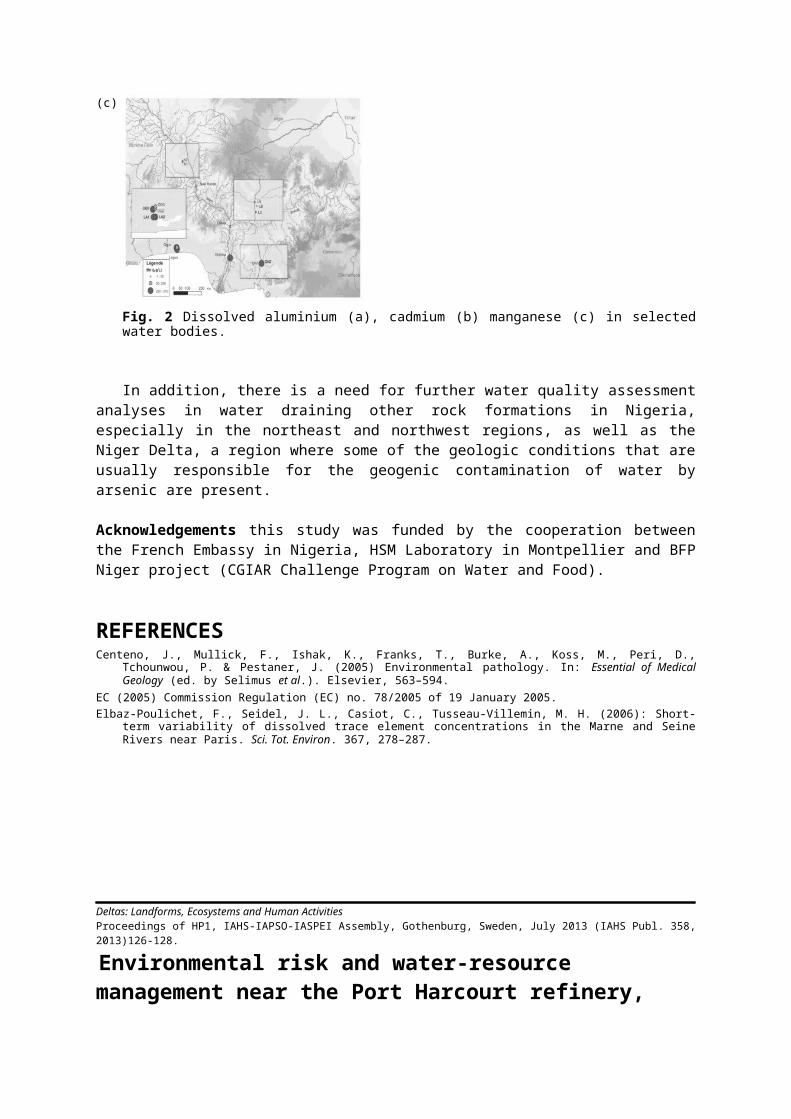
The water quality assessment reflects the fact that the water resource from the Niger and Benue river basins is moderately contaminated upstream of their confluence (Lokoja), with the exception of Pb. Downstream of their confluence, particularly around the Lagos region, drinking water exceeds the WHO quality standards for Mn, and to a lesser extent Al. Manganese is neurotoxic and can provoke Parkinsons disease (Centeno et al., 2005). The arsenic concentrations are lower than the drinking water quality standards and are safe for consumption and irrigation upstream of the Niger Delta (Figs 1 and 2).
Fig. 1 Piper diagram of sampled water of Lower Niger River basin and part of Lagos region.

Fig. 2 Dissolved aluminium (a), cadmium (b) manganese (c) in selected water bodies.
In addition, there is a need for further water quality assessment analyses in water draining other rock formations in Nigeria, especially in the northeast and northwest regions, as well as the Niger Delta, a region where some of the geologic conditions that are usually responsible for the geogenic contamination of water by arsenic are present.
Acknowledgements this study was funded by the cooperation between the French Embassy in Nigeria, HSM Laboratory in Montpellier and BFP Niger project (CGIAR Challenge Program on Water and Food).
REFERENCESCenteno, J., Mullick, F., Ishak, K., Franks, T., Burke, A., Koss, M., Peri, D., Tchounwou, P. & Pestaner, J. (2005) Environmental
pathology. In: Essential of Medical Geology (ed. by Selimus et al.). Elsevier, 563–594.EC (2005) Commission Regulation (EC) no. 78/2005 of 19 January 2005.Elbaz-Poulichet, F., Seidel, J. L., Casiot, C., Tusseau-Villemin, M. H. (2006): Short-term variability of dissolved trace element
concentrations in the Marne and Seine Rivers near Paris. Sci. Tot. Environ. 367, 278–287.
Deltas: Landforms, Ecosystems and Human Activities Proceedings of HP1, IAHS-IAPSO-IASPEI Assembly, Gothenburg, Sweden, July 2013 (IAHS Publ. 358, 2013)126-128.
Environmental risk and water-resource management near the
(a) (b)
(c)

Port Harcourt refinery, Niger Delta
RODNEY L. STEVENS1, ENUVIE AKPOKODJE2 & ONWUSAMEKA OGBOWUOKARA1
1 Department of Earth Sciences, Univ. Gothenburg, Box 460, SE-40530 Gothenburg, Sweden [email protected] 2 Centre for Natural Resources, University of Port Harcourt, East/West Road PMB 5323 Choba, Rivers State, Nigeria
Key words water resources; Niger Delta; remote sensing; groundwater; GIS; land-use classification
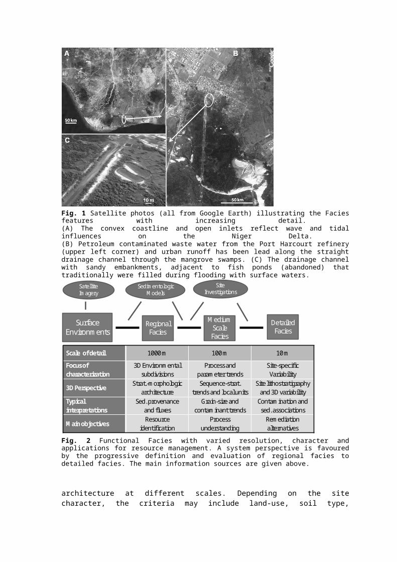
Water-resource management requires 3-D evaluation if it is to be robust and environmentally sustainable. The 3-D perspective may be limited by the accessible information, its qualitative character and 2-D capacity of GIS software. Using an area with extensive pollution threats near the Port Harcourt Refinery on the Niger Delta (Fig. 1), we illustrate several problems and possibilities for addressing complex environmental and resource problems, despite the methodological issues. In addition to the pollution stress of urban wastes, the refinery area has been exposed to effluent oil and hydrocarbon products. In particular, the drainage channel leading south through the mangrove swamps where there are scattered settlements, have been impacted. In order to structure, evaluate and apply information of different types and scales of detail, there are four main methodological steps, briefly explained below.
(1) Classification of Functional Facies These FF-classes integrate geological, geochemical and biological conditions and processes at the surface with the 3-D structure of sub-surface
Fig. 1 Satellite photos (all from Google Earth) illustrating the Facies features with increasing detail. (A) The convex coastline and open inlets reflect wave and tidal influences on the Niger Delta. (B) Petroleum contaminated waste water from the Port Harcourt refinery (upper left corner) and urban runoff has been lead along the straight drainage channel through the mangrove swamps. (C) The drainage channel with sandy embankments, adjacent to fish ponds (abandoned) that traditionally were filled during flooding with surface waters.

Surface Environments
RegionalFacies
Medium ScaleFacies
DetailedFacies
SatelliteImagery
SedimentologicModels
SiteInvestigations
Scale of detail 1000 m 100 m 10 m
Focus of characterization
3D Environmental subdivisions
Process and parameter trends
Site-specificVariability
3D PerspectiveStrat.-morphologic
architectureSequence-strat.
trends and local unitsSite lithostratigraphy
and 3D variabilityTypical interpretations
Sed. provenance and fluxes
Grain-size and contaminant trends
Contamination and sed. associations
Main objectivesResource
identificationProcess
understandingRemediation alternatives
Fig. 2 Functional Facies with varied resolution, character and applications for resource management. A system perspective is favoured by the progressive definition and evaluation of regional facies to detailed facies. The main information sources are given above.
architecture at different scales. Depending on the site character, the criteria may include land-use, soil type, geomorphic features and vegetation types. The classes stress functionality for the integrated processes relevant for the objectives. The main difference between this classification and other land-use or environmental sensitivity indexes is the addition of sub-surface information, which is especially important for water resources. This information is often less available than surface information, and there is often a need to use proxy data or conceptual models for extrapolation. In this connection, the Niger Delta has several advantages since it is has a well-established, regional stratigraphic architecture (3-D structure), typical of a wave and tide dominated delta, and both oil and groundwater exploration have created a considerable volume of well data that can be used for FF characterization with increasing detail.
(2) Mapping FF units Different ground and sub-surface conditions and pollution histories are documented using several scales of detail (identifying land features of 1000, 100 and 10 m size; Fig. 2). The focus of characterization shifts from regional mapping of environmental subdivisions to local processes and parameter trends that govern resource vulnerability. Satellite and air-photo imagery are combined with sedimentological and stratigraphic conceptual models for 3-D predictions where empirical data are lacking. Resource identification is initially a regional question, but local detail is necessary for practical management, especially protection and remediation actions. FF mapping can focus the need and limit the cost of site investigations that are needed for defining the detailed facies used for most practical applications.
(3) Calculation of water, sediment and selected contaminant budgets Within each FF type area, the parameter relationships increase the specificity of mass budgets, and allows for quantitative data to be combined with the qualitative information based on theory or local expertise. Therefore, the predictability increases within the detailed FF scales (10–100 m) where measurement data from site investigations are more common. The budget calculations are ideally treated within a GIS where both the local and regional mass-fluxes provide an input to the next step.
(4) Risk and resource ranking Complex resource and environmental issues are most easily approached if broken into sub-questions that can be parameterized. The use of proxies and human judgement in this Analytical Hierarchy Process (AHP) is often questioned, but the alternative is to ignore information (experience, theory and value judgement) that is central to the problems. In

each area, risk or resource ranking identifies sources for stressors (pollutants or environmental change) and the receptors and habitats that will be impacted. Using the multi-criteria approach of AHP, the impacts are evaluated and combined in order to give relative measures of the vulnerability or value of the end-point sensors.
Functional Facies modelling on different scales provides a 3-D system perspective and allows the combination of both empirical and conceptual information for a continual improvement of database and GIS procedures. Consequently, decision support for resource-use sustainability and remedial actions is subsequently improved.
Deltas: Landforms, Ecosystems and Human Activities Proceedings of HP1, IAHS-IAPSO-IASPEI Assembly, Gothenburg, Sweden, July 2013 (IAHS Publ. 358, 2013)129-130.
Perception of hydrological changes and adaptation strategies in the Inner Niger Delta in Mali
AIDA ZARE1, MAHAMADOU ILLOU2, SEVERE FOSSI1, TOROU MOHAMADOU BIO3, GIL MAHE4, JEAN-EMMANUEL PATUREL5 & BRUNO BARBIER6 1 Joint Research Center for Water and Climate, International Institute for Water and Environmental Engineering (2iE), Ouagadougou, Burkina [email protected] University of Zinder, Zinder, Niger3 IWMI, Ouagadougou, Burkina Faso 4 IRD/HSM, Mohamed V Agdal University, Rabat, Morocco5 IRD/HSM, Ouagadougou, Burkina Faso 6 CIRAD, Ouagadougou, Burkina Faso
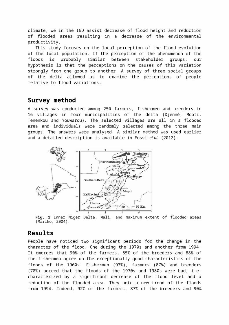
Introduction The Inner Niger Delta (IND) in Mali is subject to a transformation of its hydrologic functioning due to climatic variations. With a possible flooded area of up to 30 000 km2, the IND is an ecosystem where hydrologic regime, dynamics of the natural environment and human activities (fishing, agriculture, animal breeding) are closely associated (Kuper et al., 2000). One million people derive their livelihood from this ecosystem. Further to the variations of the climate, we in the IND assist decrease of flood height and reduction of flooded areas resulting in a decrease of the environmental productivity.
This study focuses on the local perception of the flood evolution of the local population. If the perception of the phenomenon of the floods is probably similar between stakeholder groups, our hypothesis is that the perceptions on the causes of this variation strongly from one group to another. A survey of three social groups of the delta allowed us to examine the perceptions of people relative to flood variations.
Survey methodA survey was conducted among 250 farmers, fishermen and breeders in 16 villages in four municipalities of the delta (Djenné, Mopti, Tenenkou and Youwarou). The selected villages are all in a flooded area and individuals were randomly selected among the three main groups. The answers were analysed. A similar method was used earlier and a detailed description is available in Fossi et al. (2012).
Fig. 1 Inner Niger Delta, Mali, and maximum extent of flooded areas (Mariko, 2004).
Results People have noticed two significant periods for the change in the character of the flood. One during the 1970s and another from 1994. It emerges that 90% of the farmers, 85% of the breeders and 88% of the fishermen agree on the exceptionally good characteristics of the floods of the 1960s. Fishermen (93%), farmers (87%) and breeders (78%) agreed that the floods of the 1970s and 1980s were bad, i.e. characterized by a significant decrease of the flood level and a reduction of the flooded area. They note a new trend of the floods from 1994. Indeed, 92% of the farmers, 87% of the breeders and 90% of the fishermen believe that floods have been increasing since 1994.
Several studies have shown that since 1970, the basins of the Niger River and its tributaries were subject to a strong rainfall deficit causing a decrease of flood and a reduction of the flooded area. From 1950–1969 to 1970–2000, the average flow deficit was –33% and –40% in Koulikoro on the Niger in Dire (Sangaré et al., 2002; Mahé et al., 2011). In the Bani sub-basin, rainfall went down from 15 to 25% since the beginning of the drought of the 1970s and the annual flow rate in Douna has decreased by more than 65% (Paturel et al., 2010). After 1970, the flood in the delta covered an area of around 12 000 km2 at its maximum, which is 50% less than before the drought (Mariko et al., 2003). Researchers confirm an increase of rainfall from 1994 (Mahé et al., 2010; Paturel et al., 2010), although levels of floods and rain have not reached those of the 1960s.
Local populations suggest the decrease of rainfall, God, and the upstream irrigated schemes as being the main causes of the variation of the floods. A large number of farmers blame the decrease of rainfall. However, the major cause for fishermen is seen to be the upstream irrigated schemes. As for the breeders, the main cause is of divine origin.
Scientists estimate that the majority of the 1970s flood variation is due to a lack of rainfall and to a lesser extent to the upstream dams and irrigation expansion. To deal with these changes, people have developed local strategies ranging from migration, diversification of activities and a change to production techniques.
Conclusion The study of the social perception of flood variations showed that the farmers have a thorough knowledge of their living environment. The three main groups of actors have a similar vision; the opposite case would be problematic, given that it is the utilization of the same resource. Farmers, breeders and fishermen can find a consensus on issues related to the impact of floods variation.
References Fossi, S., Barbier, B., Brou, T., Kodio, A. & Mahé, G. (2012) Perception sociale de la crue et réponse des pêcheurs à la baisse de

l’inondation des plaines dans le Delta Intérieur du Niger, Mali. Territoires en Mouvement 14–15, 55–71. Kuper, M., Mullon, C., Poncet, Y., Benga, E., Morand, P., Orange, D., Mahé, G., Arfi, R. & Bamba, F. (2000) La modélisation
intégrée d’un écosystème inondable. Le cas du delta intérieur du Niger. In: Séminaire International GIRN-ZIT, Colloques et séminaires, IRD Editions, 773–798.
Mahé, G., Diello, P., Paturel, J. E., Barbier, B., Karambiri, H., Dezetter, A., Dieulin, C. & Rouche, N. (2010) Baisse des pluies et augmentation des écoulements au Sahel : impact climatique et anthropique sur les écoulements du Nakambe au Burkina-Faso. Sécheresse 21(4), 330–332.
Mahé, G., Lienou, G., Bamba, F., Paturel, J. E., Adeaga, O., Descroix, L., Mariko, A., Olivry, J. C. & Sangare, S. (2011) Niger River and climate change over 100 years. In: Hydro-climatology: Variability and Change (ed. by S. W. Franks, E. Boegh, E. Blyth, D. M. Hannah & K. K. Yilmaz), 131–137. Proceedings of symposium J-H02 held during IUGG 2011 in Melbourne, Australia, July 2011. IAHS Publ. 344. IAHS Press, Wallingford, UK.
Marie, J., Morand, P. & N’Djim, H. (2003) Avenir du fleuve Niger, Rapport provisoire de synthèse. Bamako: IRD.Mariko, A. (2004) Caractérisation et suivi de la dynamique de l’inondation et du couvert végétal dans le Delta intérieur du Niger
(Mali) par télédétection. Thèse, Université Montpellier 2, France.Mariko, A., Mahé, G. & Servat, E. (2003) Les surfaces inondées dans le delta intérieur du fleuve Niger au Mali par
NOAA/AVHRR. Bulletin SFPT, 172, 61–68.Paturel, J. E., Diawara, A., Kong A Siou, L., Talin, E., Ferry, F., Mahé, G., Dezetter, A., Muther, N., Martin, D., Rouché, N.,
L’Aour-Cres, A., Seguis, L., Coulibaly, N., Bahire-Koné, S. & Koité, M. (2010) Caractérisation de la sécheresse hydropluviométrique du Bani, principal affluent du fleuve Niger au Mali. In: Global change: Facing Risks and Threats to Water Resources (Proc. of the Sixth World FRIEND Conference, Fez, Morocco, October 2010), 661–667. IAHS Publ. 340. IAHS Press, Wallingford, UK.
Sangaré, S., Mahé, G., Paturel, J. E. & Bangoura, Y. (2002) Bilan hydrologique du fleuve Niger en Guinée de 1950 à 2000. Sud Sciences et Technologies, EIER, Ouagadougou, 9, 21–33.
Deltas: Landforms, Ecosystems and Human Activities Proceedings of HP1, IAHS-IAPSO-IASPEI Assembly, Gothenburg, Sweden, July 2013 (IAHS Publ. 358, 2013)133-142.
Farming practices and anthropogenic delta dynamics
KIMBERLY G. ROGERS1, JAMES P. M. SYVITSKI1, IRINA OVEREEM1, STEPHANIE HIGGINS1 & JONATHAN M. GILLIGAN2
1 Community Surface Dynamics Modeling System, Institute for Arctic and Alpine Research, University of Colorado, Boulder, Colorado 80309, USA [email protected] Department of Earth and Environmental Sciences, Vanderbilt University, PMB 351805, 2301 Vanderbilt Place, Nashville, Tennessee 37235-1805, USA
Abstract Deltas are dynamic landforms that have been the foci of agri- and aquacultural development by humans for millennia. The dynamics of deltas are governed by changes in river discharge and reworking of sediment. While these dynamics make deltas highly productive areas, they also present challenges to farming practices, often resulting in complicated feedbacks. These dynamics include river and coastal flooding, compaction, subsidence, salinization, and moving land-water boundaries. Likewise, farming in a dynamic environment can lead to socio-economic conflicts. Adaptation to these constantly changing variables requires flexible farming practices that must keep pace with changing climate.
Key words river deltas; agriculture; Anthropocene; climate change
Deltas: Landforms, Ecosystems and Human Activities Proceedings of HP1, IAHS-IAPSO-IASPEI Assembly, Gothenburg, Sweden, July 2013 (IAHS Publ. 358, 2013) 143-152.
The perils of human activity on South American deltas: lessons from Colombia’s experience with soil erosion
JUAN D. RESTREPO A. Department of Geological Sciences, EAFIT University, Medellín, AA 3300, [email protected]
Abstract The Andean drainage basins of Colombian deltas exhibit a very delicate variety of ecosystems and environments along its prolonged trajectory, which has made it particularly vulnerable to the onslaught of modernity and human activity. While the increasing intensity of natural disasters in tropical areas is often blamed on global warming, the causes might not be as intractable. Soil erosion and deforestation, both caused by unrestrained human activity, can affect deltas more profoundly. Many anthropogenic influences, including
deforestation, an agriculture and pasture increase by 75%, poor soil conservation and mining practices, may have accounted for the overall increasing trends of sediment transport from rivers to Colombian deltas. According to our recent study of human activities in terms of deforestation, 32% of the observed variance in sediment transport from the Magdalena River to its delta could be explained by deforestation. Thus, the amount of sediment transported by the Magdalena to its delta plain, approximately 50 Mt annually, is probably due to deforestation. Also, the Patía River in the Pacific coast has witnessed an increase in sediment transport by 45% during the last decade, an increase mainly accounted for by deforestation. Drawing from Colombia’s experience with man-made ecological modifications, this paper offers a preliminary discussion on the implications of human pressure on fluvial ecosystems and their deltas, with the hope that this information will better equip citizens and policymakers across the developing world.
Key words Colombia; drainage basins; erosion; sediment load; human activities; deforestation; Magdalena; Patía
Deltas: Landforms, Ecosystems and Human Activities Proceedings of HP1, IAHS-IAPSO-IASPEI Assembly, Gothenburg, Sweden, July 2013 (IAHS Publ. 358, 2013) 153-158.
Effect of anthropogenic factors on the mangrove ecosystem in the Sundarban delta in India
U. C. SHARMA1 & VIKAS SHARMA2
1Centre for Natural Resources Management, VPO Tarore, district Samba 181133 J & K, India [email protected] University of Agricultural Sciences & Technology, Chatha, Jammu 180009, J & K, India
Abstract The Sundarban delta is intersected by a complex network of tidal waterways, mudflats and small islands of salt-tolerant mangrove forests. The fertile soils of the delta have been subject to intensive human use for centuries, and the eco-region has been mostly converted to intensive agriculture, with few enclaves of forest remaining. As a result of population pressure, half of this eco-region's mangrove forests have been cut down to supply fuel wood and other natural resources. Despite the intense and large-scale exploitation, this still is one of the largest contiguous areas of mangroves in the world. Due to their multiple uses, the people have exploited the mangrove forests indiscriminately and caused extensive damage to the mangrove ecosystem, resulting in ecological decline in the Sundarban. Human activities, including settlements in newer areas, indiscriminate use of natural resources and diversion of water have caused immense damage to the delta.Key words anthropogenic factors; mangrove ecosystem; Sundarban delta, India
Deltas: Landforms, Ecosystems and Human Activities Proceedings of HP1, IAHS-IAPSO-IASPEI Assembly, Gothenburg, Sweden, July 2013 (IAHS Publ. 358, 2013) 159-167.
Flood-tidal and fluvial deltas of Tuggerah Lakes, Australia: Human impacts on geomorphology, sedimentology, hydrodynamics and seagrasses
WAYNE D. ERSKINESchool of Environmental and Life Sciences, The University of Newcastle, Ourimbah Campus, PO Box 127, Ourimbah NSW 2258, Australia Environmental Research Institute of the Supervising Scientist, GPO Box 461, Darwin NT 0801, [email protected]
Abstract Tuggerah Lakes are a barrier or wave-dominated estuary consisting of three interconnected shallow lagoons impounded by a coastal sand barrier. Sea level rose by about 120 m during the late Pleistocene to about present sea level at about 7900–7700 cal BP. Sea level continued to rise to +1.5 m by 7400 cal BP and persisted until about 2000 cal BP when it regressed to the present level. Throughout most of the early and mid-Holocene, Tuggerah Lakes had two entrances, one in Tuggerah Lake at The Entrance and another in Budgewoi Lake near Budgewoi. Sand completely blocked the entrance near Budgewoi and the remaining channel at The Entrance became ensconced on bedrock. Nevertheless, sandy flood-tidal deltas developed at both entrances, although currently inactive. Where rivers debouche into the lagoons, silt jetties or fluvial deltas have formed. Deep channels have been dredged through river-mouth bars, altering natural sedimentation patterns and the
distribution of seagrasses. The geoheritage value of flood-tidal deltas and silt jetties needs to be determined for NSW estuaries so that the most significant can be protected appropriately.Key words sea level change; entrance atrophy; river-mouth bars; seagrass dynamics; dredging
Deltas: Landforms, Ecosystems and Human Activities Proceedings of HP1, IAHS-IAPSO-IASPEI Assembly, Gothenburg, Sweden, July 2013 (IAHS Publ. 358, 2013) 168-175.
Interdisciplinary research on new approaches for future management of the River Elbe
ELMAR FUCHS, EVA-MARIA BAUER, MAIKE HEUNER, CAROLIN SCHMIDT-WYGASCH & UWE SCHRÖDER Federal Institute of Hydrology, PO Box 200253, 56002 Koblenz, [email protected]
Abstract The tidal River Elbe, northern Germany, serves as an important international waterway feeding the port of Hamburg and thus indicates its function as a significant economic lifeline for that region. At the same time the estuarine riverscape is a valuable natural habitat, protected by national and European legislation. In recent centuries the estuary has been impacted by manmade changes, e.g. by ongoing river training. There are very limited data about the dynamic interaction between soils, sediment transport and budgets as well as vegetation development. This article compiles ongoing Elbe research that includes: (i) the response of tidal reeds and invasive plants to shifts in hydrodynamics and land use; (ii) the resilience of bank sediments against hydro-mechanical stress; and moreover (iii) the analyses of socio-economic aspects in the context of bank restoration by applying the approach of ecosystems services.Key words soil; vegetation; reed; resilience; ecosystem services; river banks; regional climate change
Deltas: Landforms, Ecosystems and Human Activities Proceedings of HP1, IAHS-IAPSO-IASPEI Assembly, Gothenburg, Sweden, July 2013 (IAHS Publ. 358, 2013 176-184
A story of water, salt and sediments: constraints for adaptive management in the River Rhone delta
PHILIPPE CHAUVELON1, OLIVIER BOUTRON1, AURELIEN LOUBET1,2, ALAIN SANDOZ1 & PATRICK HÖHENER2
1 Tour du Valat – Research Centre for the Conservation of Mediterranean wetlands, Le Sambuc, 13200 Arles, [email protected] Aix-Marseille University-CNRS, Laboratoire Chimie Environnement FRE 3416, 3 Place Victor Hugo, 13331 Marseille, France
Abstract The “Ile de Camargue” is a complex hydrosystem, including agricultural drainage basins, marshes, and the brackish shallow Vaccarès lagoon system. This hydrosystem is particularly affected by water management and its endykement from the river and the sea. Decrease of sediment river input to the coast and sea level rise contribute to a global erosion of the shoreline. Within the endyked hydrosystem, during the rice cultivation period, large amounts of water are pumped from the river for irrigation, generating important water and sediment fluxes. Hydrosystem modelling and multi-source data are used to derive the suspended sediment balance and salt stock dynamics. Current water management and climate forcing will make it impossible to manage efficiently both water levels and salinity in the delta. A more natural deltaic hydraulic functioning, which implies increased hydraulic connectivity with the river and sea appears to be the only sustainable way in the long term.Key words Rhone delta; Mediterranean wetland; coastal hydrosystem; rice irrigation; salt and suspended sediment budget
Deltas: Landforms, Ecosystems and Human Activities Proceedings of HP1, IAHS-IAPSO-IASPEI Assembly, Gothenburg, Sweden, July 2013 (IAHS Publ. 358, 2013 187-195
Late Pleistocene–Holocene deltas in southern Buenos Aires Province, Argentina
WALTER D. MELO1,2, GERARDO M. E. PERILLO1,3, MAURICIO M. PERILLO4, ROBERTO SCHILIZZI1,3 & M. CINTIA PICCOLO1,2
1 CONICET-Instituto Argentino de Oceanografía, CC 804, B8000FWB Bahía Blanca, [email protected] Depto. Geografía, Universidad Nacional del Sur, 12 de Octubre y San Juan, 8000 Bahía Blanca, Argentina3 Depto. Geología, Universidad Nacional del Sur, San Juan 670, 8000 Bahía Blanca, Argentina4 Dept. of Geological Sciences, University of Texas at Austin, 2225 Speedway, Stop C1160, Austin, TX 78712, USA
Abstract Along the Argentina coast there are only two present day deltas, the Paraná and Colorado deltas, both located in Buenos Aires Province. However, the Colorado Delta is only a minor remnant of a much larger delta system that was active from approximately 10 000 calibrated years BP, when mean sea level (msl) was about –30 m. Based on bathymetric and topographic maps, regional geology and bibliography, the evolution of the delta system is proposed. During the Last Glacial Maximum (LGM), 24 000 calibrated years BP, msl was –130 m, located at the present shelf break. During this period the fluvial drainage was minimum. As climate conditions changed, it can be deduced from well preserved terraces that the msl increased in pulses. The uppermost terrace, located at –25/–30 m corresponds to the deltaic front of the Colorado and Negro rivers. At this time, the fluvial discharge was large and a series of rivers (most of them no longer existing today) provided sediments to the deltas. The Colorado River and a set of unnamed rivers were active to the northern and central portion of this 430 km delta front, whereas the Negro River provided materials to the lower central and southern portions. We estimate that the major sediment and water inputs occurred at about 9000 calibrated years BP, when msl was –18 m. Delta evolution was significantly modified when msl was up to 6 m above the present, 6000 calibrated years BP. At this time, both the Colorado and Negro rivers migrated southward. Msl decreased at about 4 mm/year until it reached the lowest level, about –2 m during the Little Ice Age. Today, the only active delta is the one maintained by a diminished Colorado River in the central part of the area. The northern and southern portions are now extensive intertidal areas with remnant islands and large tidal channels corresponding, respectively, to Bahía Blanca Estuary and Anegada Bay. The Negro River has an estuary at its mouth but no delta is active today. Key words delta evolution; Colorado River Delta; Negro River; Argentina
Deltas: Landforms, Ecosystems and Human Activities Proceedings of HP1, IAHS-IAPSO-IASPEI Assembly, Gothenburg, Sweden, July 2013 (IAHS Publ. 358, 2013) 196-202
Water balance and nutrient delivery in a densely populated delta for a future sustainable environment
DIDIER ORANGE1, THI NGUYET MINH LUU2, THI PHUONG QUYNH LE3, HONG THAI TRAN4, JULIEN NEMERY5, LAN ANH LE2, GILLES BILLEN6, JOSETTE GARNIER6 & GEORGES VACHAUD5
1 IRD, UMR211-BIOEMCO, University Paris 6, [email protected] Institute of Chemistry, VAST, Hanoi, Vietnam3 Institute of Natural Products Chemistry, VAST, Hanoi, Vietnam4 Institute of Meteorology Hydrology Environment, MONRE, Hanoi, Vietnam5 UMR-LTHE, University of Grenoble, Grenoble, France6 CNRS, UMR7619-SISYPHE, University of Paris 6, Paris, France
Abstract Besides the inputs of material from land-based sources and the in-stream processes leading to trans-formation, retention and elimination of nutrients during their downstream travel, the nutrient flux transported by river systems depends on a number of factors, including the influence of hydrological fluctuations due to tidal movement. We monitored the daily water discharges and the corresponding nutrient loads within the Day-Nhue River System, and chose the right bank of the Red River Delta, where Hanoi City and its conurbation are located, to further understand the biogeochemical functioning of the delta system. We underline the large impact of the tide on nutrient balance up to more than 150 km from the coastline. The integration of positive and negative fluxes due to the daily tidal cycle allowed calculation of the real nutrients fluxes, which appeared to be underestimated by between 50% to 80% if the calculation is based on daily mean discharge.Key words Red River Delta; discharge; tidal influence; nutrient export; Vietnam

Deltas: Landforms, Ecosystems and Human Activities Proceedings of HP1, IAHS-IAPSO-IASPEI Assembly, Gothenburg, Sweden, July 2013 (IAHS Publ. 358, 2013) 203-208
Influence of ecosystem on hydrochemistry and stable isotope of surface and groundwaters in the Yellow River Delta
FADONG LI1, QIANG LIU1, QIUYING ZHANG2, JING LI1, YAN ZHANG1, SHUAI SONG1, GUANGSHUAI ZHAO1 & NONG ZHU1
1 Key Laboratory of Ecosystem Network Observation and Modeling, Institute of Geographic Sciences and Natural Resources Research, Chinese Academy of Sciences, Beijing 100101, [email protected]
2 Center for Agricultural Resources Research, IGDB, Chinese Academy of Sciences, 286 Huaizhong Road, Shijiazhuang 050021, China
Abstract To determine the influence of the increased amount of transferred water on groundwater quality in the Yellow River Delta, 12 ground- and 11 surface-water samples derived from three ecosystems were collected for major ions (Na, K, Mg, Ca, NO3, SO4, Br, Cl, HCO3) and stable isotope analysis (2H/18O). The land-use changes along the mainland towards the Bohai Sea from farmland to wetland to the coast. The hydrochemical compositions are most complicated in the farmland and wetland groundwater, indicating the mixing process with water transferred from the Yellow River, whereas the ones on the coast are dominated by NaCl. The ratios of 2H/18O in farmland and wetland groundwater are plotted on or close to the local meteoric water line (LMWL), and ones from the coast are enriched in both 2H and 18O (the seawater). The NO3 positively corresponds with Cl in the farmland and wetland, with 40% of groundwater samples exceeding the allowable nitrate drinking water level (10 mg/L). Therefore, it is inferred that irrigation water from the Yellow River and anthropogenic pollution are two nitrogen sources of nitrate.Key words Yellow River Delta; ecosystems; irrigation water; hydrochemistry; stable isotope
Deltas: Landforms, Ecosystems and Human Activities Proceedings of HP1, IAHS-IAPSO-IASPEI Assembly, Gothenburg, Sweden, July 2013 (IAHS Publ. 358, 2013) 209-217
What can we learn from recent development of the Atchafalaya River Delta, USA and the Yellow River Delta, China?
TIMOTHY ROSEN1, Y. JUN XU1, ZONGWEN MA2 & XUEGONG XU2 1 Louisiana State University and LSU Agricultural Center, School of Renewable Natural Resources, Baton Rouge, USA [email protected] College of Urban and Environmental Sciences, Peking University, Beijing 100871, China
Abstract Over the past century many river deltas throughout the world have been altered by anthropogenic disturbances, both to the deltas as well as to their drainage basins. Alterations such as dam construction, channel modification, and land cover changes in the drainage basins have led to changes in riverine sediment transport, deposition, distribution, and deltaic subsidence. Two of the most highly engineered rivers in the world are the Mississippi-Atchafalaya River system in the United States and the Yellow River (Huanghe) in China. Both have experienced tremendous hydrologic and land-use changes in the past. The anthropogenic changes have caused the Mississippi River Delta Plain to undergo land loss endangering coastal communities and impacting major economies. Even with land loss, the main distributary of the Mississippi, the Atchafalaya River, has developed a prograding delta feature at the man-made Wax Lake Outlet and main stem south of Morgan City, Louisiana. The Yellow River has also experienced many alterations with dams completed over the past 50 years, and agriculture expansion within the drainage basin. This has led to interrupted river discharge and large decline in sediment delivery to the river mouth. In the recent years, wetland loss has been observed in the Yellow River Delta. An understanding of how these two deltas respond to land and river alterations is integral to continued sustainability of environmental, commercial, and industrial capabilities. This study compares over 20 years (1989–2010) of delta development (growth/erosion) at approximately 5-year intervals in these two largely modified river systems using remotely sensed images, river discharge, and suspended sediment yield data to better understand the long-term effect of river alterations on deltaic development. Key words fluvial deltas; riverine sediment; river engineering; Mississippi-Atchafalaya River; Yellow River

Deltas: Landforms, Ecosystems and Human Activities Proceedings of HP1, IAHS-IAPSO-IASPEI Assembly, Gothenburg, Sweden, July 2013 (IAHS Publ. 358, 2013) 218-225
Geomorphology and sedimentology of the Mogo Creek fluvial delta, NSW, Australia
WAYNE D. ERSKINE1,2 & RUTH BORGERT3
1 School of Environmental and Life Sciences, The University of Newcastle, Ourimbah Campus, PO Box 127, Ourimbah, NSW 2258, Australia 2 Environmental Research Institute of the Supervising Scientist, GPO Box 461, Darwin, NT 0801, [email protected] School of Biological, Earth and Environmental Sciences, The University of New South Wales, Sydney, NSW 2052, Australia
Abstract Mogo Creek is an active sand-bed stream that drains a 213-km2 basin and flows into a blocked valley lake that functions as a terminal sediment sink. The blocked valley lake, in turn, discharges into the main stream, Macdonald River. A Gilbert-type fluvial delta has formed where Mogo Creek flows into the lake and a reverse delta has formed where the Macdonald River back floods into the blocked valley lake. The development of the fluvial delta since 1848 has been documented from a combination of maps, vertical air photographs and field surveys. The Mogo Creek fluvial delta prograded into the lake as a series of lobate sand bodies that episodically changed direction over time. Over a 13.5-year period 71 700 m3 of sand (94 600 t) was deposited on the delta plain and in the river channel and 1042 m3 (1150 t) was deposited on the delta front. Sediment bulk densities were determined so that the total delta depositional mass was computed as 95 790 t or 7095 t/year. Progradation of the delta front has segmented the lake by blocking a former side bay. Topset beds include channel sands and overbank deposits of levee sands, sand splays, chute sands and marsh muds. Foreset beds are delta front sets of planar tabular medium and coarse sands. Bottomset beds are horizontally-laminated prodelta sandy muds grading into massive, low density, lacustrine muds. From our survey of the lake volume, present rates of delta progradation will totally infill the blocked valley lake in 48 years.Key words blocked valley lake; delta lobes; lake segmentation; Gilbert delta, Australia; sand splays; delta facies model
Deltas: Landforms, Ecosystems and Human Activities Proceedings of HP1, IAHS-IAPSO-IASPEI Assembly, Gothenburg, Sweden, July 2013 (IAHS Publ. 358, 2013) 226-233
Hydrological process and its ecological effects on a re-established freshwater wetland in the Yellow River Delta, China
LIU BO1, LIU GE1, SHU LONGCANG1, WANG XINGONG2 & ZHU BING3
1 College of Hydrology and Water Resources, Hohai University, Nanjing, 210098, [email protected] Yellow River Basin Water Resources Protection Bureau, Zhengzhou, 450004, China3 Kunshan Design Institute of Water conservation, Suzhou, 215300, China
Abstract A national program for the restoration of freshwater wetlands in the Yellow River Delta National Natural Reserve was initiated in 2000. A new re-established freshwater wetland was constructed in the reserve and was first rewetted in 2009 during water regulation in the upper reaches of the Yellow River. This paper assesses the effects of the re-established wetland on local hydrological processes and the corresponding ecological response. Basic observation has shown that after water was diverted into the artificial wetland, the water body covers 1200 ha with an average water depth of 1.5 m. Regional groundwater level fluctuates with both net precipitation and the re-wet process. The rewetting process has a noticeable impact on reducing salinity of groundwater. Aquatic and herbaceous plants quickly respond during the growing season, switching from seepweed-dominated to ditch reed-dominated. A groundwater flow model was then built by Visual Modflow and a corresponding groundwater salinity prediction model was constructed by multi-variable regression method (from 23 June 2010 to 31 August 2010). Numerical simulation results show that local groundwater balance mainly consists of precipitation (73% of total recharge), wetland (26%) and evapotranspiration (92% of total discharge). Total infiltration to groundwater from the wetland during the simulation period is 112.8 × 10⁴ m3. The model simulation is in good agreement with the sample plots. Due to the fine sediment of this region, hydraulic conductivity of the aquifer is as low as 0.03 m/day, therefore groundwater infiltration is restricted to local scale and the radius of the capture zone of groundwater adjacent to the wetland is from 1000 m to 1500 m. Some management measures to increase infiltration and to enlarge the capture zone of the wetland are proposed in the last section.
Key words Yellow River Delta, China; re-established freshwater wetland; restoration; numerical simulation
Deltas: Landforms, Ecosystems and Human Activities Proceedings of HP1, IAHS-IAPSO-IASPEI Assembly, Gothenburg, Sweden, July 2013 (IAHS Publ. 358, 2013) 234-235.
Analysis of Krishna and Godavari river outflows to evaluate effects on river mouth changes
SARRAJU VENKATA VIJAYA KUMARNational Institute of Hydrology, Deltaic Regional Centre, [email protected]
Abstract Water resources projects are meant to store water or divert water mainly for irrigating crops and supplying water for drinking and industrial needs. The role of human activity has become a significant modifier of the hydrologic budget in a river basin. As the timing and quantity of river water have direct impact on the fragile ecosystem at the mouth of a river, especially along wetlands and delta formations, any changes in flow regime can cause irreparable damage to delta growth and its shoreline. In this paper, the impact of upstream developments and the resulting reduced outflows to the mouth of river delta of two large river basins draining peninsular India are studied. Variation in annual outflows to the sea of the two rivers, as observed at the most downstream gauge sites from 1973 to 2008, is analysed to evaluate the scale of reduction in river discharges to the sea to understand the consequences on the rate of delta progression and other consequential changes at the river mouths.Key words diversions; outflows; upstream development; deltas; sediments; shoreline; erosion; deposition
Deltas: Landforms, Ecosystems and Human Activities Proceedings of HP1, IAHS-IAPSO-IASPEI Assembly, Gothenburg, Sweden, July 2013 (IAHS Publ. 358, 2013) 236-238
The Mekong River Delta – variation of sedimentation and morphology in a mega-delta
DANIEL UNVERRICHT1, WITOLD SZCZUCIŃSKI2, THANH CONG NGUYEN1,5, CHRISTOPH HEINRICH1, KARL STATTEGGER1, KLAUS SCHWARZER1, NIKO LAHAJNAR3 & THUYEN XUAN LE4
1 Institute of Geosciences – Department of Sedimentology, Christian-Albrechts-University of Kiel, Germany unverricht@ gpi.uni- kiel .de 2 Institute of Geology, Adam Mickiewicz University, Poznań, Poland 3 Institute for Biogeochemistry and Marine Chemistry, University of Hamburg, Germany4 Institute of Resources Geography, VAST, Ho Chi Minh City, Vietnam5 Department of Oceanology, Meteorology and Hydrology, University of Sciences, Ho Chi Minh City, Vietnam
Key words Mekong River Delta; sedimentation; morphology; tides; resuspension; erosion
The Mekong DeltaVarious sediment- and hydrodynamic factors including tides (meso-tidal system), waves, coastal currents and seasonal-driven river discharge influence the coastal zone. Mega-deltas, especially like the Mekong River Delta (MRD), represent these land–ocean interactions. Subaerial and subaqueous coastal morphology are both regulated by the local energetic environment and supply of sediment. In reverse, delta morphology and sedimentary pattern reflect these impacts.
In the MRD that belongs to the Asian mega-deltas, the influence of different factors can be seen. Tidal processes influence the delta shaping permanently due to their persistent occurrence (Unverricht et al., 2012). Wave processes have a more long-term impact due to beach-ridge-shaping in the delta morphology (Tamura et al., 2012a,b). Outside the river mouth region, other factors have recently not

been sufficiently investigated.However, after the classification of Orton & Reading (1993) the MRD is a tide- and wave
dominated delta. Investigations on the delta plain support this classification. The transition from tide-dominated to tide and wave dominated regime appears around 3500 years BP (Ta et al., 2002). Its tidal regime changes from semi-diurnal tides over mixed tides to diurnal tides along a more than 500 km-long coastline (Nguyen, 2012). The eastward exposed coastline is more strongly influenced by waves than its western part in the Gulf of Thailand. The monsoon seasons dominate the flow regime and sediment transport along the river, in the delta plain and also in the subaqueous delta. Both coastal erosion and accretional progradation occur along the deltaic coast. However, only sparse data exist on delta dynamics and their footprints in the subaqueous delta.
The present study aims to contribute information about seafloor relief and sedimentation of the MRD to interpret modern sediment dynamics.
Applied methodsThree cruises in 2006, 2007 and 2008 were conducted in the subaqueous Mekong Delta Region between the Bassac River, the main distributary of the MRD, and the Gulf of Thailand. All cruises took place during the inter-monsoon season between March and May where wave and wind influences are not dominant in comparison to the summer monsoon (May to early October) and winter monsoon season (November to early March). Investigations present data of suspended matter (turbidity meter, water samples, LISST-instrument), seismic profiles (Boomer and C-Boom-system), grab and sediment core sampling and point and transect current-measurements (using ADCP) which provide data on current directions and velocities. Data of different tidal gauge stations in the MRD were also integrated, compared to the mixed semidiurnal–diurnal tidal cycle and related to our own relevant measurements (e.g. suspended matter, sediment transport direction).
Morpho- and sediment dynamic processes in the recent MRDTwo delta fronts were detected 200 km apart, one at the Bassac River mouth (the biggest branch of the MRD) and the other around Ca Mau Spit (most southwestern end of the MRD). It indicates a clockwise sediment transport in a southwesterly direction. The two fronts are connected by an area of mixed depositional and erosional characteristics, respectively. There, subaqueous clinoforms vary in shape and size. Into the subaqueous delta platform and slope is incised a large channel-like system up to 13 m deep and subparallel to the shore (Unverricht et al., 2013a,b). It consists of two approx. 4 km wide mega-furrows that extend over more than 120 km from east to west and serve as a sediment conveyor between the delta fronts.
Regional dependencies in variation of sediment supply and hydrodynamic processes lead to great variations of sediment accumulation rates that have reached up to 10 cm/year for the last century.
Sediment types of the subaqueous MRD could be reduced to two end members (well sorted sandy and poorly sorted silty sediment). Distant delta regions in conjunction with the open shelf are characterised as third end member consisting of medium to coarse sand. Sediment features of the delta-shelf-transition, such as increasing percentages of organic matter and carbonate content in the delta base area, shell fragments, foraminifera and concretions of palaeo-soils that do not occur in typical delta sediments, support the grain size-based classification (Unverricht et al., 2013b).
During the inter-monsoon season, LISST-data of suspended sediment show significantly distinct areas of suspended sediment concentrations (SSCs) greater 25 µL/L in the Mekong River delta branches and its subaqueous delta (Unverricht et al., 2012). However, only 20% of all measured SSCs in the subaqueous MRD exceed 100 µL/L and the highest concentrations were near the seabed. Regions transitional to the open shelf are characterised by a decrease in SSCs. The open shelf area has distinctly low suspension load, particularly on the southern shelf (99% of all samples <25 µL/L).
However, in the southern shelf area around Ca Mau Spit, in water depths of 20–25 m higher SSCs (>25 µL/L) occur close to the seabed. These can be attributed to resuspended sediment due to the strong tidal currents with velocities of up to 0.6 m/s near the sea bed during neap tide conditions. Additionally, tidal phases are asymmetric and lead to a sediment net-transport into the subaqueous delta (Unverricht et al., 2012).

Sediment cores show time variations in the sediment deposition and sediment distribution pattern. Seismic profiles of prograding delta regions show submarine landslides along the delta slope that may be triggered by the high seasonal sediment accumulation rates. Although the Mekong River Delta grows fast southwestwards, it erodes in other regions.
ReferencesNguyen, C. T. (2012) Processes and factors controlling and affecting the retreat of mangrove shorelines in South Vietnam.
Christian-Albrechts-Universität zu of Kiel, Kiel.Orton, G. J. & Reading, H. G. (1993) Variability of deltaic processes in terms of sediment supply, with particular emphasis on grain
size. Sedimentology 40, 475–512.Ta, T. K. O., Nguyen, V. L., Tateishi, M., Kobayashi, I., Tanabe, S. & Saito, Y. (2002) Holocene delta evolution and sediment
discharge of the Mekong River, southern Vietnam. Quaternary Science Reviews 21, 1807–1819.Tamura, T., Saito, Y., Bateman, M. D., Nguyen, V. L., Ta, T. K. O. & Matsumoto, D. (2012a) Luminescence dating of beach ridges
for characterizing multi-decadal to centennial deltaic shoreline changes during Late Holocene, Mekong River delta. Marine Geology 326–328, 140–153.
Tamura, T., Saito, Y., Nguyen, V. L., Ta, T. K. O., Bateman, M. D., Matsumoto, D. & Yamashita, S. (2012b) Origin and evolution of interdistributary delta plains; insights from Mekong River delta. Geology 40, 303–306.
Unverricht, D., Heinrich, C., Nguyen, C. T., Schwarzer, K. & Stattegger, K. (2013a) Mega-furrow-system of the subaqueous Mekong Delta, southern Vietnam (in preparation).
Unverricht, D., Nguyen, T.C., Heinrich, C., Szczuciński, W., Lahajnar, N. & Stattegger, K. (2012) Suspended sediment dynamics during the inter-monsoon season in the subaqueous Mekong Delta and adjacent shelf, southern Vietnam. J. Asian Earth Sciences.
Unverricht, D., Szczuciński, W., Stattegger, K., Jagodziński, R., Le, X. T. & Kwong, L. L. W. (2013b) Modern sedimentation and morphology of the subaqueous Mekong Delta, Southern Vietnam. Global and Planetary Change.