overview of meteorological - united...
TRANSCRIPT

OVERVIEW OF EARLY WARNING SYSTEMS FOR HYDRO-METEOROLOGICAL HAZARDS
IN SELECTED COUNTRIES IN SOUTHEAST ASIA (CAMBODIA, INDONESIA, LAO PDR, PHILIPPINES AND VIETNAM)
LOLITA GARCIA
July 2002
Asian Disaster Preparedness Center
PO Box 4 Klong Luang, Pathumthani 12120 Thailand www.adpc.net

Acknowledgement This publication is reviewed and edited by Mr. Aman Mehta, Mr. Glenn Dolcemascolo and Ms. Lolita Bildan. ADPC would also like to thank Mr. N.M.S.I. Arambepola, who kindly conceded to reviewing the publication and providing valuable comments. We are grateful to DIPECHO for providing the funds to publish this report. There has been a year’s delay in bringing out this publication. We recognize that there maybe some developments and changes in the early warning systems in the countries reviewed here. However these changes have not been reflected in this document. ADPC invites key organizations in these five countries, to review this publication and provide updates on the developments since the study was conducted.
Copyright © ADPC 2004 Asian Disaster Preparedness Center (ADPC), P.O. Box 4, Klong Luang, Pathumthani 12120, Thailand. Tel.: (66-2) 516-5900 to 5910, Fax: (66-2) 524-5360, Email: [email protected], Website: www.adpc.net

i
Contents
Annexes ……………………………………………………………………………...……iii List of Tables and Figures....................................................................................................iv Abbreviations and Acronyms...............................................................................................vi Preface…………………………………………………………………………………….vii Executive Summary ..............................................................................................................1 1. Introduction.....................................................................................................................7
1.1 Background ...........................................................................................................7 1.2 Hydro-meteorological Hazards and Extreme Climate Events ..............................7 1.3 Vulnerability .........................................................................................................9 1.4 Disaster Management and Early Warning Systems............................................10 1.5 Objectives............................................................................................................10 1.6 Methodology .......................................................................................................11 1.7 Limitations and Constraints ................................................................................12
2. The Early Warning System ...........................................................................................13
2.1 Components of the Early Warning System.........................................................13 2.1.1 Risk Assessment, Hazard Assessment and Vulnerability Analysis ................13 2.1.2 Hazard Detection and Prediction ....................................................................13 2.1.3 Formulation of Warning Message...................................................................15 2.1.4 Dissemination of Warning ..............................................................................16 2.1.5 Community Response to Warning ..................................................................16
2.2 International Contribution to Hydro-meteorological Early Warning..................17 2.2.1 Weather-related Warning ................................................................................17 2.2.2 Flood Warning in the Lower Mekong River Basin.........................................18
3. Cambodia ......................................................................................................................23
3.1 Background .........................................................................................................23 3.2 Hazard Detection.................................................................................................24
3.2.1 Weather Forecast.............................................................................................24 3.2.2 Flood Forecasting and Prediction ..................................................................24
3.3 Hazard Warning ..................................................................................................26 3.4 Warning Dissemination.......................................................................................26 3.5 Community Response .........................................................................................27
3.5.1 Deunn Rise Commune, Kandal Steung District, Kandal Province.................28 3.5.2 Sdao Kong Commune, Ba Phnum District, Prey Veang Province .................29
4. Indonesia .......................................................................................................................31
4.1 Background .........................................................................................................31 4.2 Institutional Arrangements for Early Warning ...................................................32 4.3 Hazard Detection.................................................................................................33
4.3.1 Seasonal Forecast ............................................................................................33 4.3.2 Flood Detection and Observation in Jakarta ...................................................34
4.4 Hazard Warning ..................................................................................................34 4.5 Warning Dissemination.......................................................................................34
4.5.1 Seasonal Forecast ............................................................................................34

Overview of Early Warning System in Cambodia, Indonesia, Lao PDR, Philippines and Vietnam
ii
4.5.2 Floods.............................................................................................................. 34 4.6 Community Level Flood Warning System ......................................................... 35
4.6.1 Mirit Sub-District, Kebumen, Central Java .................................................... 35 4.6.2 Flood Warning System ................................................................................... 35
5. Lao PDR........................................................................................................................ 38
5.1 Background......................................................................................................... 38 5.2 Institutional Arrangements.................................................................................. 38 5.3 Hazard Detection ................................................................................................ 39 5.4 Hazard Warning .................................................................................................. 39 5.5 Warning Dissemination ...................................................................................... 40 5.6 Community Response ......................................................................................... 40
6. Philippines..................................................................................................................... 43
6.1 Background......................................................................................................... 43 6.2 Institutional Arrangement for Early Warning..................................................... 43 6.3 Hazard Detection ................................................................................................ 44
6.3.1 Severe Weather Detection............................................................................... 44 6.4 Hazard Warning .................................................................................................. 45
6.4.1 Tropical Cyclone............................................................................................. 45 6.4.2 Flood Forecasting and Warning...................................................................... 46
6.5 Warning Dissemination ...................................................................................... 47 6.6 Community Response ......................................................................................... 49
6.6.1 Sitio Kinalumbacan, Barangay Capalong, Real, Quezon Province ................ 49 6.6.2 San Manuel Town, Pangasinan Province........................................................ 50
7. Vietnam......................................................................................................................... 51
7.1 Background......................................................................................................... 51 7.2 Institutional Arrangements.................................................................................. 52 7.3 Hazard Detection ................................................................................................ 53 7.4 Hazard Warning and Dissemination ................................................................... 54
8. Conclusion and Recommendations............................................................................... 55
8.1 Weather Forecast ................................................................................................ 55 8.2 Floods.................................................................................................................. 55
8.3 Hazard Warning and Dissemination ................................................................... 57 8.4 Community Response ......................................................................................... 58 8.5 Recommendations............................................................................................... 58
Overview of Early Warning System in Cambodia, Indonesia, Lao PDR, Philippines and Vietnam
iii
Annexes Annex 1 Guiding Principles for Effective Early Warning ……………………………. 61 Annex 2 Key Research Questions ……………………………………………………. 64 Annex 3 Research Informants: List of organizations visited and people interviewed…………………………………………………………………… 65 Annex 4 Documents Reviewed for the Research……………………………………… 67 Annex 5 Sample of a Flood Warning and Forecast by the Mekong River Commission…………………………………………………………………. 68 Annex 6A Sample of Report of Rainfall and Water Level in the Mekong River Tributaries………………………………………………………………69 Annex 6B Sample of Danger Level Warning in Mekong River Tributaries…………… 70 Annex 7 Public Storm Warning Signal in the Philippines……………………………. 71 Annex 8A Flood Bulletin Messages Issued by PAGASA, Philippines………………… 74 Annex 8B Sample Flood Bulletin Issued by PAGASA, Philippines……………………. 75
Overview of Early Warning System in Cambodia, Indonesia, Lao PDR, Philippines and Vietnam
iv
List of Tables and Figures Table 1.1 Relative intensity of hazards faced by five countries ........................................ 8 Figure 2.1 The major components of an Early Warning System as depicted by the World Meteorological Organization…………………………..….…...14 Figure 2.2. Information flow from the Regional Specialized Meteorological Center, Tokyo, to the National Weather Services in Southeast Asia………………….….18 Figure 2.3: A section of the Mekong River in Northern Laos. The riverbanks serve as fertile groups for growing vegetables……………..…………………….….……19 . Figure 2.4. Schematic diagram and description of flood warning levels issued by the Mekong River Commission……………………………………….….…….20 Figure 3.1. Flood information on 1 October 2001 from the MRC website…….…...…..25 Figure 3.2. Dissemination scheme for flood warning in Cambodia…….……..…....…..27 Figure 3.3. Traditional Khmer houses including boathouses…………...……….………28 Figure 3.4. Flow of warning from the District Chief to the villagers in Sdao Kong Commune, Cambodia…………...…………………….………….….….……29 Figure 3.5. A Khmer house raised on stilts, with lower grounds used for livestock or storage…………...……………………………………………….….….……30 Figure 4.1. Organizational structure of SATKORLAK PBP of Jakarta, which handles disaster management at the provincial level………………………..……..32 Figure 5.1 Release of water from Nam Ngum Dam, Lao PDR……………….……..…39 Figure 5.2. Flow of warning from the Department of Meteorology and Hydrology to the public in Lao PDR………………………….….…40 Figure 5.3: The protocol followed by the NDMO for disseminating warning from the Meteorological Department, Lao PDR……………………………...…41 Figure 5.4. The road to Bane Sanedin Village, Lao PDR, after only a few hours of rain………………………………………………………….…..41 Figure 5.5 Preparedness measures for flooding in Bane Sanedin, Lao PDR…………...42 Figure 6.1 Linkages of disaster agencies involved in the dissemination of and response to warnings in the Philippines………………………..…..44 Figure 6.2 Organizational structure of a disaster coordinating council in the Philippines…………………………………………………………………….………. …45
Overview of Early Warning System in Cambodia, Indonesia, Lao PDR, Philippines and Vietnam
v
Figure 6.3 Satellite image from the Japanese Geo-stationary Meteorological Satellite (GMS-5)……………………………………………….……......45 Figure 6.4 Severe weather warning dissemination schemes in the Philippines……...…47 Figure 6.5 FFWSDO and basin flood bulletins dissemination scheme……………….. 48 Figure 6.6 Location of communities visited in the Philippines………………...………49 Figure 6.7a A concrete house in Quezon Province……………………………...………49 Figure 6.7b A hut in Quezon Province………………………...………………...………49 Figure 7.1 A flood scene in Vietnam……………………………………………...…....51 Figure 7.2 Institutional structure for water disaster management in Vietnam……….…52 Figure 7.3. A typical Vietnamese village near a river demonstrating flood preparedness measures………………………………….………......54 Figure 7.4 Flood level marker in a Vietnamese village……………………..…..……...54 Table 8.1: Hazard forecast institutions and responsibilities...………………..….…..…...56 Table 8.2 Hazard Warning and Dissemination……………………………….…..……57
Overview of Early Warning System in Cambodia, Indonesia, Lao PDR, Philippines and Vietnam
vi
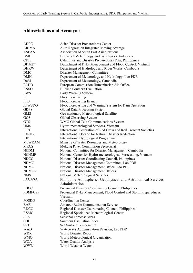
Abbreviations and Acronyms ADPC Asian Disaster Preparedness Center ARIMA Auto Regression Integrated Moving Average ASEAN Association of South East Asian Nations BMG Bureau of Meteorology and Geophysics, Indonesia CDPP Calamities and Disaster Preparedness Plan, Philippines DDMFC Department of Dyke Management and Flood Control, Vietnam DHRW Department of Hydrology and River Works, Cambodia DMC Disaster Management Committee DMH Department of Meteorology and Hydrology, Lao PDR DoM Department of Meteorology, Cambodia ECHO European Commission Humanitarian Aid Office ENSO El Niño Southern Oscillation EWS Early Warning System FF Flood Forecasting FFB Flood Forecasting Branch FFWSDO Flood Forecasting and Warning System for Dam Operation GDPS Global Data Processing System GMS Geo-stationary Meteorological Satellite GOS Global Observing System GTS WMO Global Tele-Communications System HMS Hydro-meteorological Services, Vietnam IFRC International Federation of Red Cross and Red Crescent Societies IDNDR International Decade for Natural Disaster Reduction IHP International Hydrological Programme MoWRAM Ministry of Water Resources and Meteorology MRCS Mekong River Commission Secretariat NCDM National Committee for Disaster Management, Cambodia NCHMF National Center for Hydro-meteorological Forecasting, Vietnam NDCC National Disaster Coordinating Council, Philippines NDMC National Disaster Management Committee, Lao PDR NDMO National Disaster Management Office, Lao PDR NDMOs National Disaster Management Offices NMS National Meteorological Services PAGASA Philippine Atmospheric, Geophysical and Astronomical Services
Administration PDCC Provincial Disaster Coordinating Council, Philippines PDMFCSP Provincial Dyke Management, Flood Control and Storm Preparedness,
Vietnam POSKO Coordination Center RAPI Amateur Radio Communication Service RDCC Regional Disaster Coordinating Council, Philippines RSMC Regional Specialized Meteorological Center SFA Seasonal Forecast Areas SOI Southern Oscillation Index SST Sea Surface Temperature WAD Waterways Administration Division, Lao PDR WDR World Disaster Report WMO World Meteorological Organization WQA Water Quality Analysis WWW World Weather Watch
vii
Preface Early warning empowers individuals and communities threatened by hazards to act in sufficient time and in an appropriate manner so as to reduce the possibility of injury, loss of life, and damage to property and environment (International Decade for Natural Disaster Reduction, 1997). Vulnerable populations, local communities, national governments, regional institutions and international bodies have responsibilities to contribute to this empowerment. As a regional institution, ADPC supports the sharing of early warning information especially among countries that share a common geographical environment. In 1995, the United Nations General Assembly requested the IDNDR Secretariat to review early warning capacities and recommend means by which global practices could become better coordinated and made more effective. In 1998 the International IDNDR Conference on Early Warning Systems for the Reduction of Natural Disasters was held in Potsdam, Germany, which underlined the importance of early warning in effective disaster preparedness and mitigation, and provided guidelines for effective early warning at local, national, regional and international levels. In this light, the 3rd ASEAN Regional Forum Inter-Sessional Meeting on Disaster Relief (ARF ISMDR) in April 1999 in Moscow recognized the need to take stock of current national capacities in early warning systems, identify gaps in expertise and resources, and recommend steps to enhance early warning capacities. It was planned to use this inventory in the preparation for an ARF Conference on Enhancing Capacities of Early Warning Systems, which Philippines proposed to conduct. The 4th ARF ISMDR in May 2000 in Hanoi recognized the urgency in the stock-taking of early warning capabilities, as they considered cooperation in early warning as a critical component of disaster preparedness and mitigation in the region. Cognizant of this need and in accordance with the International Decade for Natural Disaster Reduction (IDNDR) objectives, the Asian Disaster Preparedness Center (ADPC), with funding support from the Disaster Preparedness program of the European Commission Humanitarian Aid Office (DIPECHO), conducted in 2001 a review of international initiatives on early warning and a rapid appraisal of existing early warning systems for hydro-meteorological hazards in the DIPECHO target countries of Cambodia, Indonesia, Lao PDR, Philippines and Vietnam. Short case studies were also undertaken to assess community response to the hazard warning. The study revealed that most of the selected countries have been able to establish well-developed systems of data collection and sharing for short-range weather forecasting, with the support of the World Meteorological Organization and other regional and international organizations. There is, however, a need to enhance the technical infrastructure and capacity to produce, interpret and communicate seasonal and long-range forecasts in Cambodia, Lao PDR, and Vietnam. Capacities in flood forecasting in the Lower Mekong River Basin have improved with assistance from the Mekong River Commission. Cambodia, Lao PDR and Vietnam have been successful in documenting upstream real time hydro-meteorological data. However, there is still a need to increase the number of observation stations to extend coverage of forecast.

Overview of Early Warning System in Cambodia, Indonesia, Lao PDR, Philippines and Vietnam
viii
Dissemination systems exist in the countries, but require support to improve communication of the warning message to the public to enable timely and appropriate response. This would involve preparation of the warning message that will be well understood by the public, resources for communication hardware, and public awareness and education on warning. Risk assessment plays a vital role in identifying what communities, in which areas are most vulnerable, a critical input in effective response to the warning. Organizing the community to respond appropriately to the warning is a challenge. Public awareness on the impending impact of a hazard, and understanding the warning content and recommended action are required for the public to believe the warning and take the appropriate action. The International Strategy for Disaster Reduction (ISDR), the successor to the IDNDR, continues to maintain international momentum in the development of early warning capacities. The ISDR Working Group on Early Warning led by the United Nations Environment Programme (UNEP) is developing a global inventory of early warning systems as part of an ISDR initiative to develop a program on early warning.
Dr. Suvit Yodmani Executive Director Asian Disaster Preparedness Center
1
Executive Summary Globally, the incidence of hydro-meteorological disasters has doubled since 1996. In the past decade more than 90% of the people killed by natural hazards lost their lives due to droughts, windstorms and floods, of which 85% of the total deaths were reported from Asia (WDR, 2001) alone. Strengthening disaster reduction strategies throughout the region is an important step towards ensuring that natural hazards do not result in social and economic disasters. The UN International Decade on Natural Disaster Reduction (IDNDR) Conference on Early Warning Systems for Reduction of Natural Disasters (held in Potsdam, Germany in September 1998) declared that the successful application of early warning is the most practical and effective measure for disaster prevention. Ultimately, the declaration continues, early warning systems must be comprehended by and motivate communities at greatest risk, including those disenfranchised and particularly disadvantaged people who must take appropriate protective actions. One of IDNDR’s original program targets was for all countries to have in place, by the year 2000, ready access to global, regional, national and local warning systems as part of their national plans. Many governments and related disaster management organizations throughout Asia have already initiated Early Warning Systems; though, the resulting systems vary widely in their capacity to produce and communicate effective warnings. This report summarizes the findings of a study of Early Warning Systems in Cambodia, Indonesia, Lao PDR, Philippines and Vietnam, the countries targeted by the Disaster Preparedness Program of the European Commission Humanitarian Aid Office (DIPECHO). The study, conducted in accordance with the IDNDR objectives, was undertaken by Asian Disaster Preparedness Center's Partnerships for Disaster Reduction-South East Asia (PDR-SEA) project, which emphasizes the need to address disaster related issues within the context of sustainable development, with communities targeted as major beneficiaries1. Most broadly, the project aims to develop the capacities of communities to prevent or mitigate the impact of disasters. This report attempts to raise awareness of the early warning systems in the respective countries and to provide a basis for further enhancing institutional mechanisms, technical capacities and community response options for reducing vulnerability to extreme climate events. The study has the following objectives:
• Review the international initiatives on early warning system • Conduct a rapid appraisal of existing early warning system for hydro-meteorological
hazards in DIPECHO target countries, and • Undertake short case studies to assess community-level vulnerability and response to
hydro-meteorological hazards. Huge populations in the selected countries are highly vulnerable to hydro-meteorological hazards as large numbers of communities are settled in risk prone marginal areas. Fertile flood valleys, plains and deltas, such as the Lower Mekong River basin, are attractive to farmers as they provide access to livelihoods; but they are also most vulnerable to floods. 1 This project was funded by the Disaster Preparedness Program of the European Commission Humanitarian Aid Office (DIPECHO) in February 2001 as part of the Second DIPECHO Action Plan for Southeast Asia.
Overview of Early Warning System in Cambodia, Indonesia, Lao PDR, Philippines and Vietnam
2
In urban areas, burgeoning populations are in many instances located in areas vulnerable to hazards such as tropical storms. This study is limited to the EWS for hydro-meteorological hazards focusing on tropical cyclone and floods as recommended in the proposal approved by the European Commission Humanitarian Aid Office (ECHO). Early Warning Early warning provides communities with timely information, enabling them to prepare for an anticipated hazardous event such that the impacts of the event on lives, livelihood and property are minimized. The early warning process is dependent on the interplay of science, technology and socio-economic factors that dictate the manner in which people understand and react to disasters.
Five general components to effective early warning systems may be distinguished conceptually, though in practice these elements are closely inter-related. Nevertheless, these components provide a useful logical framework against which to assess early warning capacities.
• Risk Assessment, including hazard assessment and vulnerability analysis • Hazard detection and prediction • Formulation of warning messages • Dissemination of warning messages • Community response
Early Warning Capacity of Selected Countries Most of the selected countries have been able to establish well-developed systems of data collection and sharing for short-range weather forecasting, with the support from the World Meteorological Organization and other regional and international organizations. With respect to seasonal and long-range forecasts, there is a need to enhance the technical infrastructure and capacity to produce, interpret and communicate seasonal and long-range forecasts in Cambodia, Lao PDR and Vietnam. Even though El Niño and La Niña events have a significant impact on local weather and climate related hazards, as evidenced by the catastrophic floods that affected central Vietnam in 1999, there has not been enough effort to prioritise seasonal forecasts. The absence of an intermediate mechanism that interprets an ENSO forecast and converts it into locally usable information has also proved to be a formidable barrier to the decision making process. As floods cause maximum loss to life and property in Laos, Cambodia and Vietnam, flood forecasting is their prime concern. Lately, there has been substantial investment from donors to improve the hydro-meteorological network of these countries. Assisted by the forecast from the MRCS stations, these countries have been successful in documenting real time hydro-meteorological data from the upstream. However, the real time data is received from few stations and accordingly the forecasts are limited to a handful of sites. Communities show a high level of resilience and act from experience or on instinct to survive. In the study conducted, there were cases where communities hesitated to evacuate to safer places due to their reluctance to leave their personal properties. The case study from Indonesia is a good model of how the community can be a part of an early warning system.
Executive Summary
3
Recommendations Mitigation should be viewed as one part of an integrated disaster management system that includes sustained attention to risk management and mapping of vulnerable communities. There is an urgent need to promote community-based early warning systems based on maps of the vulnerable areas of villages, districts and provinces. Effective disaster management also requires coordination and cooperation between responsible agencies, institutions, officials, the media, political leaders and other players at local, national and international levels. Move towards a proactive approach and development of effective national and regional frameworks to facilitate prompt action. This can be realized through improved communications, mobilizing government support, raising awareness (impacts, safety measures, mitigation options and EWS) and building on existing knowledge and institutional structures and programs. Sustained political will is the most essential ingredient to establishing effective early warning capacity. Substantial progress may be achieved by capitalizing on momentum generated by international, regional and national level projects. With respect to seasonal and long-range forecasts, there is a need to enhance the technical infrastructure and capacity to produce, interpret and communicate seasonal and long-range forecasts. This need is most urgent in Cambodia, Lao PDR and Vietnam but the Philippines and Indonesia can benefit greatly from additional technical support as well. One way to strengthen existing Early Warning Systems is through ensuring the availability of trustworthy El Niño forecasts. Better forecasts will require application of new advances in modelling (statistical and dynamical) that enhance skill in downscaling, improve lead time, establish a community of trained technical personnel capable of forecasting, understanding the impacts of disasters and communicating this critical information to decision makers. In most countries the dissemination systems exist but are not maintained, in part because the sporadic incidence of hazards can lull decision makers into a false sense of security. Though in most countries the dissemination structure extends to the local level, the communication infrastructure is not effectively used. The reasons for the breakdown in communications need to be examined more closely and specific gaps need to be identified and bridged. As warning for hydro-meteorological hazards is limited to the capacity of the existing infrastructure to forecast potential disasters, the mutual exchange and cooperation between the five countries would serve as an important tool for efficient early warning. Finally, effective communication channels between local meteorology and climatological agencies, other relevant agencies and stakeholders in potentially affected sectors need to be set up with some urgency in order to facilitate appropriate means of dissemination of warnings and other information.

Overview of Early Warning System in Cambodia, Indonesia, Lao PDR, Philippines and Vietnam
4
Table 1: Hazard forecast institutions and responsibilities Country Forecast Institutions and Infrastructure Activities Cambodia Weather and
tropical storms
Department of Meteorology (DoM), Ministry of Water Resources and Meteorology (MoWRAM)
- Data collected from 14 synoptic stations and RSMC
- Issue of 24 hour forecast - Warning disseminated to Minister offices, NCDM,
Media, fishermen, farmers - Monitor ENSO impact on the country
- Monthly average and minimum temperature Floods Department of Hydrology and River
Works (DHRW), MoWRAM - 1 office for flood forecasting - 15 provincial hydro-
meteorological offices - 6 observation stations with 3 data
loggers - 72 newly established rain
stations
- Applies local models and Regression Analyses
and Sogreah Model Analyses for prediction - 3 days of water level prediction and warning - Communication by radio, messenger - Data sent to MRCS by facsimile - Receive water level data of 4 countries sent by
MRCS
Indonesia Weather Bureau of Meteorology and Geophysics (BMG) - Application of Stochastic Models
and ARIMA for weather prediction
- Assisted by the application of RAINMAN software from Australia
- 2 seasonal forecast and monthly forecast in the
SFA, dry season forecast (before March) and wet season forecast (before Sept.)
- Takes into account ENSO parameters for seasonal forecast
Lao PDR Weather and flood Department of Meteorology and Hydrology (DMH) - 74 hydro stations - 86 rainfall stations - 34 meteorological stations Water Administration Division (WAD) - 64 hydro stations - 23 rainfall stations
- Hydro-meteorological data collection - Daily and long range forecast - Provide hydro-meteorological services to Ministry
of Agriculture, Forestry and Environment - Data transferred from local stations by messenger,
post, television, internet - Hydro meteorology data collection - Data from WAD forwarded to MRCS by email
and fed in computers
Typhoon - World Area Forecast Center, Bracknell, Regional Specialized Meteorological Center (RSMC)
- Supplies tornadoes warning - Low resolution meteorological satellite receives
satellite photos from GMS-5 - Warning disseminated through the Bangkok node
Philippines
Weather, typhoon
Philippine Atmospheric, Geophysical and Astronomical Services Administration (PAGASA) - 60 synoptic stations that send
daily weather data to central forecast office
- Global spectrum model used to analyze and results translated into weather forecasts
- 3 hourly weather observation - Weather map as a tool for distribution of
atmospheric pressure, wind temperature and humidity
- Hourly satellite images from GMS-5 and cloud coverage
- Data sent from synoptic stations via single band radio, telephone, email
- 6 hourly weather observation sent to other countries, RSMC and Global Telecommunication System (GTS)
Flood Flood Forecasting Bureau (FFB) - Monitoring and data collection from rain gauges
and sent to Central Flood Forecasting Office. - Flood forecasting models used for analyses of
flood situation
Vietnam
Weather, flood
Hydro-meteorological Services (HMS)
- Prepares weather and flood forecast - Operates a high resolution satellite image
receiving system and five radar system - 2 regional hydro-meteorological centers - Plans for flood hazard zones in under a
UNDP/USAID project and a flood alert system on river basin m0st vulnerable to floods.
Executive Summary
5
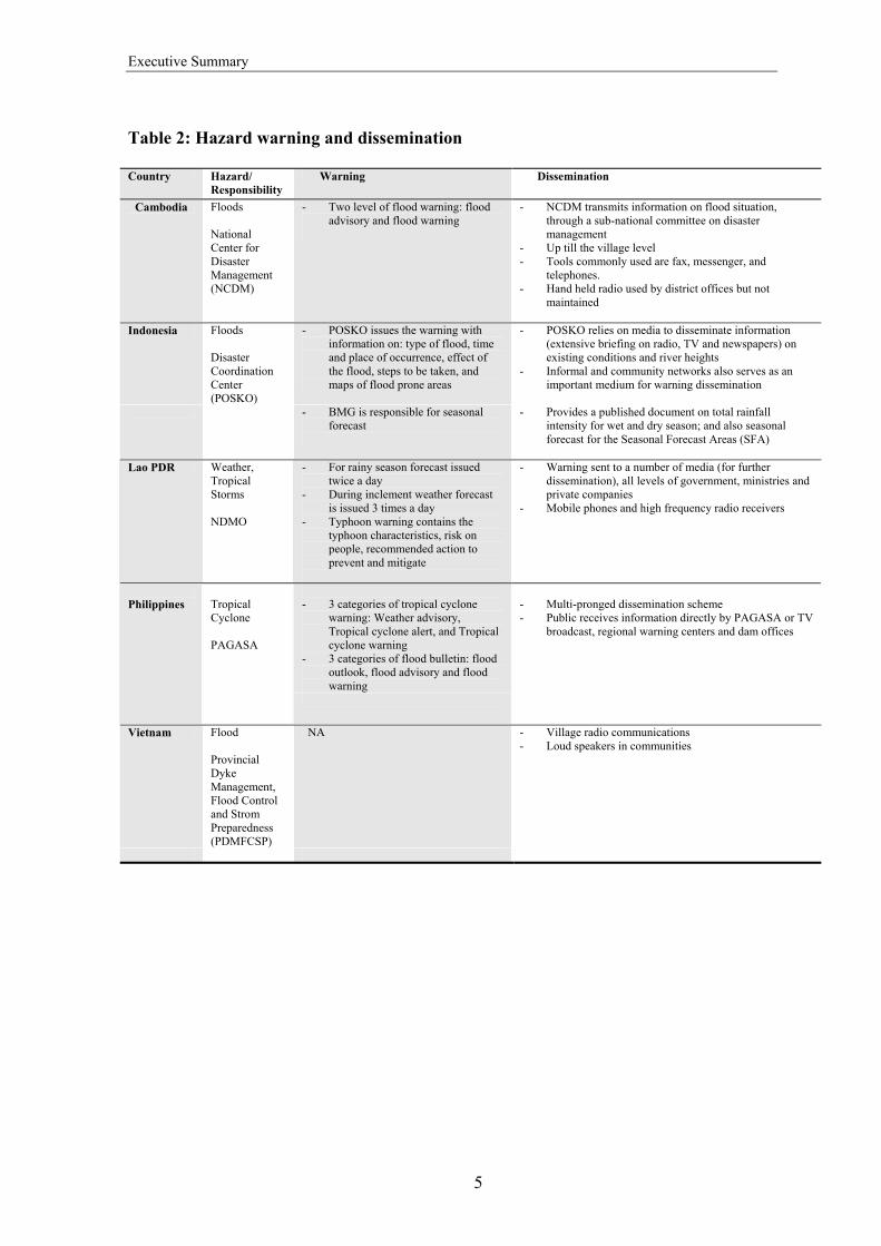
Table 2: Hazard warning and dissemination Country Hazard/
Responsibility Warning Dissemination
Cambodia Floods National Center for Disaster Management (NCDM)
- Two level of flood warning: flood advisory and flood warning
- NCDM transmits information on flood situation, through a sub-national committee on disaster management
- Up till the village level - Tools commonly used are fax, messenger, and
telephones. - Hand held radio used by district offices but not
maintained
Indonesia Floods Disaster Coordination Center (POSKO)
- POSKO issues the warning with information on: type of flood, time and place of occurrence, effect of the flood, steps to be taken, and maps of flood prone areas
- POSKO relies on media to disseminate information (extensive briefing on radio, TV and newspapers) on existing conditions and river heights
- Informal and community networks also serves as an important medium for warning dissemination
- BMG is responsible for seasonal
forecast
- Provides a published document on total rainfall intensity for wet and dry season; and also seasonal forecast for the Seasonal Forecast Areas (SFA)
Lao PDR Weather,
Tropical Storms NDMO
- For rainy season forecast issued twice a day
- During inclement weather forecast is issued 3 times a day
- Typhoon warning contains the typhoon characteristics, risk on people, recommended action to prevent and mitigate
- Warning sent to a number of media (for further dissemination), all levels of government, ministries and private companies
- Mobile phones and high frequency radio receivers
- 3 categories of tropical cyclone
warning: Weather advisory, Tropical cyclone alert, and Tropical cyclone warning
- 3 categories of flood bulletin: flood outlook, flood advisory and flood warning
Philippines
Tropical Cyclone PAGASA
- Multi-pronged dissemination scheme - Public receives information directly by PAGASA or TV
broadcast, regional warning centers and dam offices
Vietnam Flood Provincial Dyke Management, Flood Control and Strom Preparedness (PDMFCSP)
NA - Village radio communications - Loud speakers in communities

7
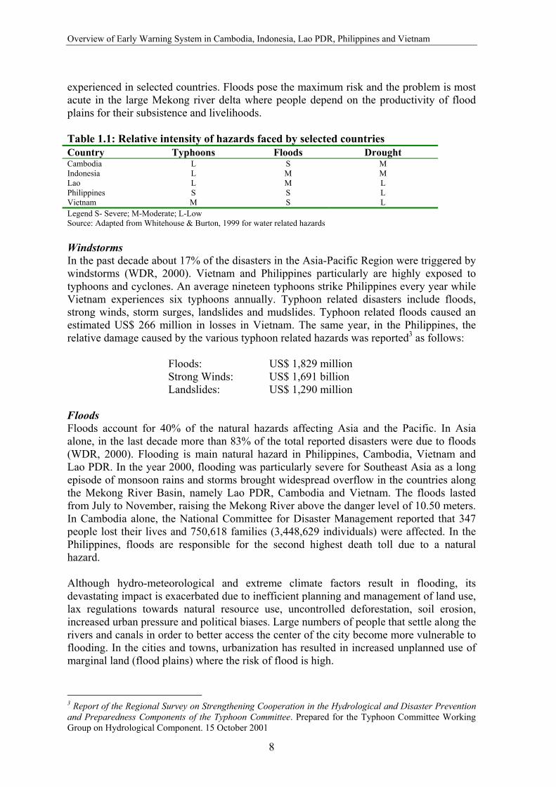
1. Introduction 1.1 Background The Asian region is the most disaster prone region in the world. It experiences almost every conceivable hazard - geological hazards such as earthquakes, landslides and volcanoes; hydro-meteorological hazards such as floods, cyclones and droughts; and other hazards such as epidemics, insect infestations, hot and cold waves, and forest fires. Amongst the hazards, hydro-meteorological hazards are the most common. Globally, the incidence of hydro-meteorological disasters has doubled since 1996. In the past decade more than 90% of the people killed by natural hazards lost their lives due to droughts, windstorms and floods, and Asia alone constituted 85% of the reported deaths (WDR, 2001). Strengthening disaster reduction strategies throughout the region is an important step towards ensuring that natural hazards do not result in social and economic disasters, leading towards sustainable development. The UN International Decade on Natural Disaster Reduction (IDNDR) Conference on Early Warning Systems for Reduction of Natural Disasters (held in Potsdam, Germany in September 1998) declared that the successful application of early warning is the most practical and effective measure for disaster prevention. Ultimately, the declaration continues, early warning systems must be comprehended by and motivate communities at greatest risk, including those disenfranchised and particularly disadvantaged people who must take appropriate protective actions. Many governments and related disaster management organizations throughout Asia have already initiated Early Warning Systems. These systems vary widely in their capacity to produce and communicate effective warnings and to mobilize appropriate response. Assessing capacity and identifying gaps is the first step to strengthening these critical life-saving systems. This report summarizes the findings of a study of Early Warning Systems in Cambodia, Indonesia, Lao PDR, Philippines and Vietnam, the countries targeted by the Disaster Preparedness Program of European Commission Humanitarian Aid Office (DIPECHO). The study was undertaken by Asian Disaster Preparedness Center's Partnership for Disaster Reduction-South East Asia (PDR-SEA) Project, which emphasizes the need to address disaster related issues within the context of sustainable development, with communities targeted as major beneficiaries2. Most broadly, the project aims to develop the capacities of communities to prevent or mitigate the impact of disasters. This report attempts to raise the awareness of early warning systems in the respective countries and to provide a basis for further enhancing institutional mechanisms, technical capacities and community response options for reducing vulnerability to extreme climate events. 1.2 Hydro-meteorological Hazards and Extreme Climate Events The most frequent hydro-meteorological hazards experienced in South East Asia are windstorms, floods and droughts. Table 1.1 illustrates the relative intensity of hazards
2 The Disaster Preparedness Program of the European Commission Humanitarian Aid Office (DIPECHO) funded this project in February 2001 as part of the Second DIPECHO Action Plan for Southeast Asia.
Overview of Early Warning System in Cambodia, Indonesia, Lao PDR, Philippines and Vietnam
8
experienced in selected countries. Floods pose the maximum risk and the problem is most acute in the large Mekong river delta where people depend on the productivity of flood plains for their subsistence and livelihoods. Table 1.1: Relative intensity of hazards faced by selected countries Country Typhoons Floods Drought Cambodia L S M Indonesia L M M Lao L M L Philippines S S L Vietnam M S L Legend S- Severe; M-Moderate; L-Low Source: Adapted from Whitehouse & Burton, 1999 for water related hazards Windstorms In the past decade about 17% of the disasters in the Asia-Pacific Region were triggered by windstorms (WDR, 2000). Vietnam and Philippines particularly are highly exposed to typhoons and cyclones. An average nineteen typhoons strike Philippines every year while Vietnam experiences six typhoons annually. Typhoon related disasters include floods, strong winds, storm surges, landslides and mudslides. Typhoon related floods caused an estimated US$ 266 million in losses in Vietnam. The same year, in the Philippines, the relative damage caused by the various typhoon related hazards was reported3 as follows:
Floods: US$ 1,829 million Strong Winds: US$ 1,691 billion Landslides: US$ 1,290 million
Floods Floods account for 40% of the natural hazards affecting Asia and the Pacific. In Asia alone, in the last decade more than 83% of the total reported disasters were due to floods (WDR, 2000). Flooding is main natural hazard in Philippines, Cambodia, Vietnam and Lao PDR. In the year 2000, flooding was particularly severe for Southeast Asia as a long episode of monsoon rains and storms brought widespread overflow in the countries along the Mekong River Basin, namely Lao PDR, Cambodia and Vietnam. The floods lasted from July to November, raising the Mekong River above the danger level of 10.50 meters. In Cambodia alone, the National Committee for Disaster Management reported that 347 people lost their lives and 750,618 families (3,448,629 individuals) were affected. In the Philippines, floods are responsible for the second highest death toll due to a natural hazard. Although hydro-meteorological and extreme climate factors result in flooding, its devastating impact is exacerbated due to inefficient planning and management of land use, lax regulations towards natural resource use, uncontrolled deforestation, soil erosion, increased urban pressure and political biases. Large numbers of people that settle along the rivers and canals in order to better access the center of the city become more vulnerable to flooding. In the cities and towns, urbanization has resulted in increased unplanned use of marginal land (flood plains) where the risk of flood is high.
3 Report of the Regional Survey on Strengthening Cooperation in the Hydrological and Disaster Prevention and Preparedness Components of the Typhoon Committee. Prepared for the Typhoon Committee Working Group on Hydrological Component. 15 October 2001
Introduction
9
Droughts Asia is also very vulnerable to droughts. In the last ten years 31 droughts have been recorded; many of which are associated with climate anomalies of unusual geographic extent or duration. The onset of drought is slow and the effects are long lasting. India, Pakistan, Afghanistan, Philippines, Indonesia, the South Pacific, Australia, Northern China, Korea and Bangladesh are among the most affected regions4. Recent droughts in South East Asia are clearly linked with the El Niño Southern Oscillation. El Niño Southern Oscillation (ENSO) The El Niño Southern Oscillation (El Niño and La Niña events) significantly affects society and the environment in Southeast Asian countries. Although there are significant local variations, rainfall in most parts of the region tends to be below average during an El Niño year, leading to droughts, while the occurrence of tropical cyclones and associated flood incidences tends to be below average. Indonesia and Malaysia experienced droughts due to this phenomenon. The most dramatic and disastrous effects of 1982-83 and 1997-98 El Niño events in Indonesia were manifested in the large-scale forest fires that destroyed an excess of 9 million hectares of forest and land. On the other hand, during a La Niña year, the rainfall tends to be above average with increased frequency of tropical cyclones, resulting in higher frequency and severity of floods. On the other hand, in some locales, a La Niña year also provides opportunities for advancing the planting season, leading to an early increased harvest as well as possibilities for harvesting one additional crop. 1.3 Vulnerability Natural hazards – such as floods or earthquakes – are inherently neutral. Natural disasters occur when a hazard impacts people, property, valued environments and critical infrastructure. A cyclone in a remote part of the ocean, for instance, is not a disaster but merely a meteorological event. Disasters are inextricably linked to the vulnerabilities of people, place and infrastructures. Vulnerability may be viewed as a function of exposure, sensitivity and resilience. Some sectors, for instance agriculture or transportation, are especially sensitive when exposed to extreme climate events. For other sectors or populations, sensitivity may be offset by resilience – the ability to resist or recover from the damage associated with the convergence of multiple stresses. The International Federation of Red Cross, Vietnam, for example, assessed the flood victims in the Mekong Delta and found that the wealthier inhabitants were more adaptive and resilient. They were better able to withstand floods because they could afford to raise the foundations of their houses above the usual flood level and, because they did not depend on a daily wage for their economic survival, their livelihoods were not so badly affected. The landless poor, on the other hand, had little room to manoeuvre; floods cut them off from food, fuel and income by stopping them from collecting wild vegetables, cutting firewood and working as day labourers (Twigg, 19995). Ninety per cent of disaster victims worldwide live in developing countries, where poverty and population pressures force growing numbers of poor people to live on marginal risk
4 ADPC, 2001; Overview of Disasters in Asia Pacific 5 http://www.bghrc.com/DMU/DEVRISK1/DEVRISK/TWIGG.HTM
Overview of Early Warning System in Cambodia, Indonesia, Lao PDR, Philippines and Vietnam
10
prone land – on flood plains, in earthquake-prone zones and on unstable hillsides. A study by CRED, 2001 concluded that in the past decade, on an average, every disaster in low human development6 countries claimed about 1062 lives and each disaster in middle human development countries claimed 145 lives. These figures stand in stark contrast to the average of 22.5 people killed per disaster in high human development countries (WDR, 2001). Huge populations in the countries studied in this project are highly vulnerable to hydro-meteorological hazards as many communities are settled in risk prone marginal areas. Fertile flood valleys, plains and deltas, such as the Lower Mekong River basin, are attractive to farmers as they provide access to livelihoods, but they are also most vulnerable to floods. In urban areas, burgeoning populations are in many instances located in areas vulnerable to hazards such as tropical storms. 1.4 Disaster Management and Early Warning Systems Disaster management seeks to reduce the impact of hazards through mitigation, preparedness, response and recovery. The application of climatological and hydrological knowledge to the assessment of risk, to land-use planning and to the design of structures contributes to disaster mitigation. Classical forecasts and warnings of impending severe weather, extreme temperatures, droughts or floods, contribute to preparedness. Timely and effective warnings of natural hazards coupled with local capability to take avoidance or mitigating actions are fundamental for disaster reduction. Updated warnings, forecasts, observations and consultation with emergency and relief agencies contribute to the response phase. Hydro-meteorological hazards are particularly appropriate targets for early warning enhancement efforts. The trans-boundary and regional character of the hazards provides substantial rationale for the appraisal of the existing early warning system in the selected countries. The review of the early warning system will further increase awareness of the early warning capacities of the respective countries and provide a platform for capitalizing on the countries’ strengths and create mechanism for exchange. 1.5 Objectives This study was conducted in accordance with the IDNDR objectives and builds on the needs and priorities identified at the 3rd and 4th ASEAN Regional Forum Inter-Sessional Meeting on Disaster Relief (ARF-ISMDR) to develop a review of current national capacities in early warning systems, identify gaps of expertise and resources, and recommend steps for improvement. The study has the following objectives: • Review the international initiatives on early warning system • Conduct a rapid appraisal of existing early warning system for hydro-meteorological
hazards in DIPECHO target countries, and • Undertake short case studies to assess community vulnerability and response to
hydro-meteorological hazards.
6 UNDP developed a human development index that is a composite of income, literacy and health level.

Introduction
11
1.6 Methodology Rapid appraisals of the early warning system were undertaken in the selected countries. The methodology was based on primary interviews, data collection and secondary references. The “Guiding Principles for Effective Early Warning” adopted by the 1998 IDNDR Early Warning Conference in Potsdam (Annex 1) were used as an important reference guide during the process of the appraisal. The key issues that were considered included: • Existing sources of observational data and the process of data communication to the
flood forecast office • Existing processes and systems for disseminating cyclone and flood warnings • Effectiveness of the flood and cyclone warnings as perceived by the community • Understanding of the types of warning by the community • Community knowledge of the steps to be taken when warning is disseminated • Role of various actors, political leaders, disaster managers and media in early
warning dissemination • Level of contribution from international organizations in enhancing the preparedness
of early warning • Current strategies and plans in place to enhance the EWS • Community preparedness and mitigation plans in progress.
The capacity of each country was measured following the four stages of early warning:
• Hazard detection • Hazard warning • Warning dissemination • Community awareness
The secondary information was based on document reviews, informant interviews conducted from mid-August to mid-September 2001, when all five countries were visited. Government organizations and leaders involved with EWS were also interviewed to assess the communication flow of warning from the originator to the target public (refer to Annex 3 for list of organizations visited). Secondary information was gathered through the Internet, library research and interviews by e-mail (refer to Annex 4 for list of documents reviewed). The sample communities were selected with the assistance of the national disaster management offices, based on several criteria including the level and frequency of hazard occurrence in selected communities. Information about flood-prone communities was provided by the central or national-level disaster management organization. Translators were employed as language proved to be a major barrier. The major stakeholders from each of the countries validated the results of the research through reviews.

Overview of Early Warning System in Cambodia, Indonesia, Lao PDR, Philippines and Vietnam
12
1.7 Limitations and Constraints This study is limited to the EWS for hydro-meteorological hazards focusing on tropical cyclone and floods as recommended in the proposal approved by the European Commission Humanitarian Aid Office (ECHO), the PDR-SEA funding institution. Fifteen days had been allocated for the field visits and data collection in the five countries included in the research. Due to the time limitation, only one community per country was studied. In the Indonesian country study, because bureaucratic requirements made the community studies difficult, the community-level information in this report was provided by Oxfam GB Indonesia and is based on their work on improving capacity for community level warning systems. Finally, although risk assessments are mentioned in subsequent sections of this report as a key element of early warning systems, an assessment of assessment capacity is beyond the scope of the current study.

13
2. The Early Warning System 2.1 Components of the Early Warning System Early warning provides communities with timely information, enabling them to prepare for an anticipated hazardous event such that the impacts of the event on lives, livelihood and property are minimized. The early warning process is dependent on the interplay of science, technology and socio-economic factors that dictate the manner in which people understand and react to disasters.
Five general components to effective early warning systems may be distinguished conceptually, though in practice these elements are closely inter-related. Nevertheless, these components provide a useful logical framework against which to assess early warning capacities.
• Risk Assessment, including hazard assessment and vulnerability analysis • Hazard detection and prediction • Formulation of warning messages • Dissemination of warning messages • Community response
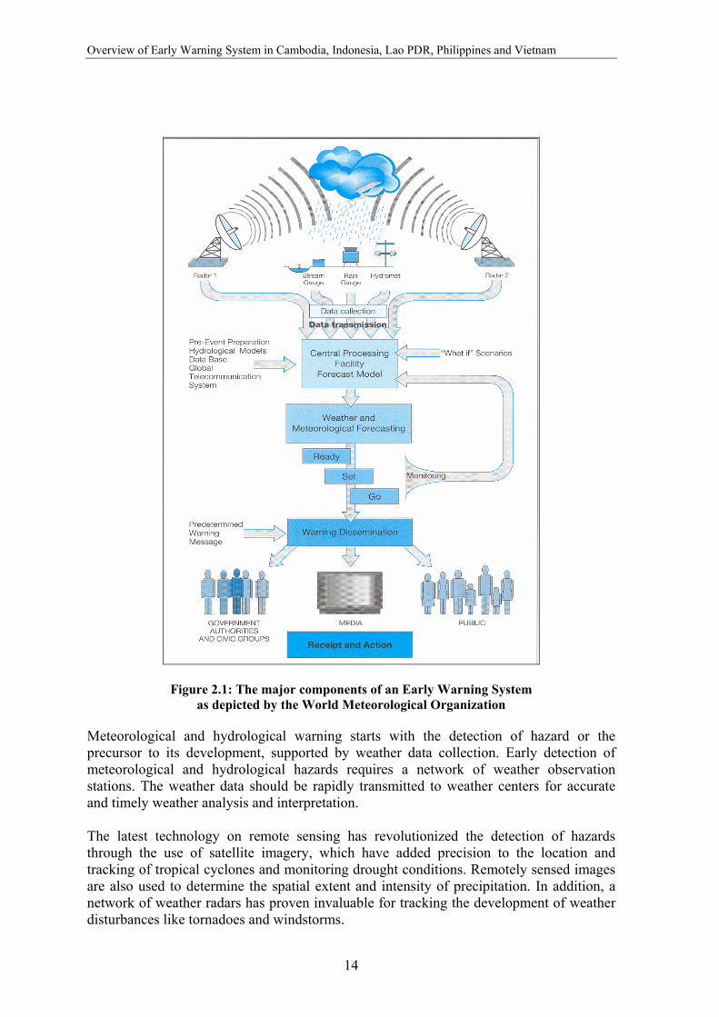
The interaction of these elements is illustrated in the diagram of WMO’s meteorological early warning system depicted in Figure 2.1.
2.1.1 Risk Assessment, Hazard Assessment and Vulnerability Analysis
Hazard assessment involves determining the probability of occurrence of such phenomenon based on data from observational records and assessing their aerial extent and duration. Vulnerability analyses include mapping areas likely to be affected by the hazards, like inundation from floods or windstorms and determining the potential for loss of life and damage to life and property. Risk assessment applies estimates of hazard and vulnerability to determine the likely impact. According to the IDNDR, risk assessment is essential for policy decisions that translate warning information into effective preventive action. Vulnerability to cyclones and floods is increasing with economic growth, high levels of investment and the establishment of infrastructure within the flood plains and coastal areas of the countries in South East Asia. Risk assessment is fundamental to disaster reduction and an essential component of a well-designed early warning, as it facilitates the targeting of early warning systems for optimum benefits in terms of communities at risk, both directly and indirectly. For instance, significant advances are being made in bringing the users and producers of climate information together in an effort to develop seasonal forecasts that are targeted to specific community and sectoral decision cycles. 2.1.2 Hazard Detection and Prediction
Loss of life and damage to property can be reduced significantly through accurate forecasts and timely warnings for disasters such as tropical cyclones and floods. Given the current state of forecasting skill and technologies, the lead-time for early warning ranges widely – from one hour for tornadoes and flash floods to seasonal and inter-annual forecasts of El Niño.
Overview of Early Warning System in Cambodia, Indonesia, Lao PDR, Philippines and Vietnam
14
Figure 2.1: The major components of an Early Warning System as depicted by the World Meteorological Organization
Meteorological and hydrological warning starts with the detection of hazard or the precursor to its development, supported by weather data collection. Early detection of meteorological and hydrological hazards requires a network of weather observation stations. The weather data should be rapidly transmitted to weather centers for accurate and timely weather analysis and interpretation. The latest technology on remote sensing has revolutionized the detection of hazards through the use of satellite imagery, which have added precision to the location and tracking of tropical cyclones and monitoring drought conditions. Remotely sensed images are also used to determine the spatial extent and intensity of precipitation. In addition, a network of weather radars has proven invaluable for tracking the development of weather disturbances like tornadoes and windstorms.
The Early Warning System
15
Globally, each day, some 20,000 weather observations (temperature, wind pressure, precipitation) are made at the ground surface, on ships, and in the air. These data are shared among national weather services and centers, and used for the preparation of daily weather analyses and forecasts. Currently, the low density and poor quality of observing networks in some developing countries presents a substantial barrier to improving the effectiveness of early warning. Subsequently the observational data from neighbouring countries becomes essential for the weather related hazard detection. Early detection also requires an efficient communication system. For meteorological and hydrological hazards, the World Meteorological Organization provides a primary telecommunications network for the relay of observational data and related information within the meteorological community especially for the international exchange of weather data and information. The prediction of meso-scale7 hazards such as tornadoes severe thunderstorms, squalls and flash floods requires early detection, near instantaneous assessment of the threat and rapid dissemination of warnings to the population. The limitation of providing effective early warning for the meso-scale hazards is due to the short lead-time. The problem is more acute in developing countries that do not yet possess advanced or costly technology like Doppler radar and telemetry system for early detection and rapid dissemination of warnings to remote areas. Prediction of droughts is very much dependent on monitoring the patterns of monthly and seasonal rainfall, stream flows, surface and ground water levels and soil moisture. Some progress has been made on reducing the lead-time by using the relationship between local weather and the ENSO phenomenon as an indicator. 2.1.3 Formulation of Warning Message
After the hazard has been detected or predicted, warning messages need to be drafted or synthesized. An effective hazard warning should contain the following messages:
• Characteristics of the hazard (time of detection, location, strength and speed of movement)
• Associated risk and the location of the population at risk (or an identification of the general area at risk)
• Recommended appropriate action. In some regions, warning messages originate from multiple sources, often with contradictory content that confuse decision makers and the public. To avoid such confusion, all the warnings should be issued by the responsible national or regional meteorological center so that there is a single authority for hazard warning in a given area. A WMO expert group defines the meteorological warning as the official issued bulletin of that event (severe weather) produced by the responsible National Meteorological Services (NMS).
7 Meso-scale hazards: Hazards that occur in a very short interval of time with a short lead-time for its detection (e.g. tornadoes, flash floods, squalls)

Overview of Early Warning System in Cambodia, Indonesia, Lao PDR, Philippines and Vietnam
16
2.1.4 Dissemination of Warning
Successful hazard detection and predictions are ineffective if warnings are not disseminated quickly and communicated effectively to the population at risk. To benefit the public, a warning system must strictly meet two criteria: it must reach the public on time and it must be easy to understand. Dissemination of warnings should be managed well to ensure timely delivery of messages to the public. The first criterion requires an effective communication system while the second requires a sustained public awareness program. Communication System: An effective communication system is a vital component of any effective early warning system. The effective dissemination of warnings to the public and local level disaster managers requires a communication system with a wide reach such as radio, television and community warning facilities. Reliance on exposed overhead telephones and power lines, and antennas leaves the communication vulnerable during windstorms. The local community warning systems such as sirens and loudspeakers are highly effective in these circumstances. Public Awareness and Understanding: For a warning to be effective, not only should it be received with a sufficient lead time but should also be well understood by the target public and authorities, who in turn should believe the message and perform the recommended action. Understanding the warning content and reacting accordingly can be best achieved through supporting on-going public awareness of potential risks. Thus, authorities in charge of the early warning system should ensure that public awareness and education on warning are given high priority and adequate commitment of resources. 2.1.5 Community Response to Warning
The last, but perhaps most critical component of an effective early warning system is community response. Getting the public to react to warning in an appropriate manner is the biggest challenge faced by disaster managers at the community level. Developing and implementing an early warning system at the community level is the most complex of the components. Organizing the community to act as one in responding to threat is a live drama that requires effective orchestration, direction and a well-written script that is memorized by all the players. It requires a scenario that needs to be practiced to perfection. Trigger events and hazard warning can prompt communities to take action for preparedness, increasing the safety of communities. Risk assessment plays a vital role in identifying what communities and which areas are most vulnerable to hazard, thus prioritising actions. In addition to the physical warning of an impending hazard, a vulnerability assessment creates order in the actual response to warning. Thus, vulnerability maps that are regularly updated serve as critical input in effective response to warning. The conditions that need to be met for a community to act appropriately upon receipt of a warning include:
• Getting free warning and hazard information • Receiving warning with sufficient lead time • Understanding the warning content

The Early Warning System
17
• Believing the warning • Believing that the threat is real • Knowing when and what appropriate action to take • Being in a state of preparedness
2.2 International Contribution to Hydro-meteorological Early Warning The international community has been instrumental in promoting the development of early warning systems as a priority strategy in the effort to reduce the impacts of disasters worldwide. In 1995, the United Nations General Assembly requested the IDNDR Secretariat to conduct a review of early warning capacities and to suggest ways and means by which global practices could become better coordinated and made more effective. One of IDNDR’s original program targets was for all countries to have in place, by the year 2000, ready access to global, regional, national and local warning systems as part of their national plans. The International Strategy for Disaster Reduction (ISDR), the successor to the IDNDR, continues to maintain international momentum in the development of early warning capacity. Reports8 produced through a range of expert working groups and international conferences outline key issues and specific recommendations to assist policy makers and disaster managers.
Regarding the technical aspects of early warning, substantial international infrastructure has been established to forecast weather and provide necessary observational data. Observational networks, prediction centers and telecommunication systems are standard components of existing infrastructure and are the cornerstone of any early warning system. At the global level, the World Weather Watch (WWW), Hydrology and Water Resources Programs coordinated by the World Meteorological Organization (WMO) provide a solid operational framework on which to build improved early warning capacity.
2.2.1 Weather-related Warning The World Weather Watch (WWW) launched by WMO in 1963 is a global system for the collection, exchange and processing of weather data and weather information. The WWW has three main components that help the national weather services produce the weather forecast and cyclone warning. These components are the Global Observing System (GOS) that provides the observed weather data; the Global Telecommunications System (GTS) that relays observations, forecasts and other products; and the Global Data Processing System (GDPS) that produces weather analyses, forecasts and guidance. Another important component of WWW is Regional Specialized Meteorological Centers (RSMC), which provide a range of diagnostic and prognostic products such as short, medium and long-term weather predictions. In Southeast Asia, the RSMC based at Tokyo provides the numerical weather prediction based on global and regional models and other diagnostic and prognostic forecasts to Cambodia, Indonesia, Lao PDR, Philippines and Vietnam. The information provided by the RSMC includes the formation, movement and development of tropical cyclone and associated meteorological phenomena. Figure 2.2 illustrates the flow of information from RSMC Tokyo to the National Weather Services in the countries included in the inventory, with the exception of Indonesia.
8 http://www.unisdr.org/unisdr/warningreports.htm

Overview of Early Warning System in Cambodia, Indonesia, Lao PDR, Philippines and Vietnam
18
The WWW also comprises of a well-coordinated system operated by the member government weather services. In the past few years, this system has also promoted the exchange of numerical weather prediction that helps in the preparation of daily weather forecasts and typhoon warnings. The WWW also supports the Hydrology and Water Resources Program that facilitates and assists the worldwide network of flood forecasting systems operated by national hydrology agencies. The UNESCO International Hydrological Programme (IHP) complements WMO’s Operational Hydrology programme through its focus on improving knowledge of hydrological processes, methodologies for water resource assessment and management and national capacities in related areas. Figure 2.2. Information flow from the Regional Specialized Meteorological Center, Tokyo, to
the National Weather Services in Southeast Asia
2.2.2 Flood Warning in the Lower Mekong River Basin The Lower Mekong River Basin experiences regular flooding due to the enormous water flow during the wet season. The flooding results in extensive destruction but also provides livelihood by supporting productive and diverse freshwater ecosystem. In response to the regular occurrence of floods in the Mekong region, the flood-forecasting and early warning operation for the Lower Mekong River Basin began in January 1968 as an area of intervention for the MRCS to take up regionally in parallel to the development of FMM strategy. Since then, forecasting operations using hydrologic models on a high-speed computer have been carried out during the wet season as one of the core activities of
Beijing
Hanoi
ManilaKuala Lumpur
Hong Kong
Bangkok
Phnom Penh
Vientiane
Seoul
TOKYO

The Early Warning System
19
the Mekong River Commission Secretariat9 (MRCS). For stations in the upper and middle reaches of the Mekong River, the forecasts for water level were made from one to five days in advance, while for the stations downstream the forecast ranges from one day to two weeks in advance.
Flood monitoring and forecasting Despite the forecasting system being operational since last three decades, it was only after the great floods of year 2000 that the flood monitoring and management system was upgraded. The floods, one of the most devastating events in the Lower Mekong Basin, led to the establishment of the strategy on Flood Management and Mitigation (FMM). One of its objectives is a well established and fully operational, user-oriented regional flood forecasting and early warning system for the Mekong River Basin. Its specific objectives are to solicit appropriate responses from the public that includes:
• Alert people (especially children) at risk • Encourage organizations and individuals to alert others, when at risk to the danger • Initiate flood-proofing activities • Assist farmers to decide when to harvest • Trigger relocation to a safer shelter and gather emergency supplies • Stimulate property-saving activities such as moving livestock, business stock, and
household effects to a safer place • Warn operational and relief organizations through a ready-set-go alert system • Advise operational government staff to undertake operational tasks such as
opening sluices/gates Hazard detection and forecasting During the flood season (July to November), data observed daily from major hydrological and meteorological stations within the Lower Mekong Basin are sent to the Secretariat at 9 The Mekong River Commission (MRC) was established on 5 April 1995. Member countries are
Cambodia, Lao PDR, Thailand and Vietnam. MRC maintains regular dialogue with the two upper states of the Mekong River Basin, China and Myanmar. Its predecessor, the International Committee on the Mekong River had done some work on the Mekong River towards development and helping the riparian countries deal with the annual flooding.
Figure 2.3: A section of the Mekong River in Northern Laos. The riverbanks serve as fertile grounds for growing vegetables.
The Mekong River Basin The Mekong River originates high on the Tibetan Plateau. Six countries share the Mekong Basin: China, Myanmar, Lao PDR, Thailand, Cambodia and Vietnam. At 4,800 kilometers (2,976 miles), the Mekong River ranks twelfth in the world in terms of length and eighth in terms of average annual runoff. The flow in the Mekong varies with the tropical monsoon climate. It begins to increase at the onset of the wet season in May, peaking in August or September, and decreasing rapidly until December.
Overview of Early Warning System in Cambodia, Indonesia, Lao PDR, Philippines and Vietnam
20
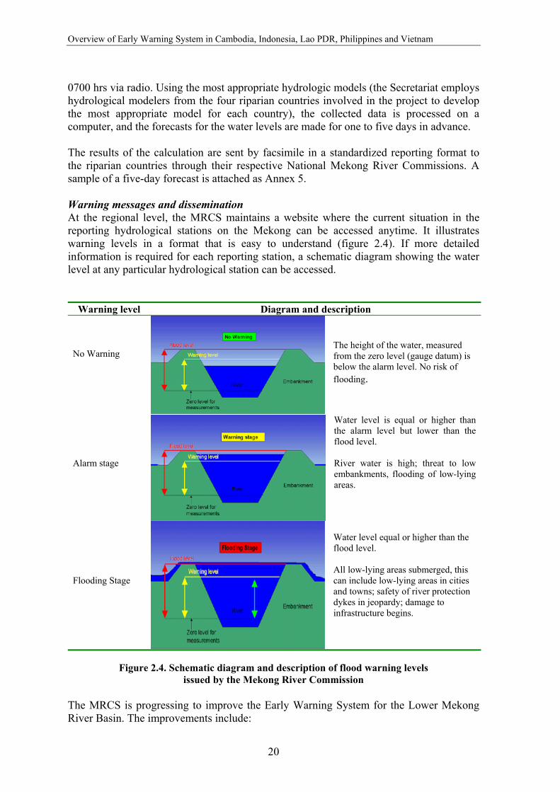
0700 hrs via radio. Using the most appropriate hydrologic models (the Secretariat employs hydrological modelers from the four riparian countries involved in the project to develop the most appropriate model for each country), the collected data is processed on a computer, and the forecasts for the water levels are made for one to five days in advance. The results of the calculation are sent by facsimile in a standardized reporting format to the riparian countries through their respective National Mekong River Commissions. A sample of a five-day forecast is attached as Annex 5. Warning messages and dissemination At the regional level, the MRCS maintains a website where the current situation in the reporting hydrological stations on the Mekong can be accessed anytime. It illustrates warning levels in a format that is easy to understand (figure 2.4). If more detailed information is required for each reporting station, a schematic diagram showing the water level at any particular hydrological station can be accessed.
Warning level Diagram and description No Warning
The height of the water, measured from the zero level (gauge datum) is below the alarm level. No risk of flooding.
Alarm stage
Water level is equal or higher than the alarm level but lower than the flood level. River water is high; threat to low embankments, flooding of low-lying areas.
Flooding Stage
Water level equal or higher than the flood level. All low-lying areas submerged, this can include low-lying areas in cities and towns; safety of river protection dykes in jeopardy; damage to infrastructure begins.
Figure 2.4. Schematic diagram and description of flood warning levels
issued by the Mekong River Commission The MRCS is progressing to improve the Early Warning System for the Lower Mekong River Basin. The improvements include:
The Early Warning System
21
a) Upgrading and improving the flood forecasting system at the MRC by using a mathematical model platform for flood forecasting and warning
b) Strengthening the forecasting capacity in terms of flood extent, duration and depth to meet wider ranges of requirements for flood preparedness, mitigation, and others
c) Coordinating flood forecasting with the activity of flood management and mitigation strategy formulation
d) Upgrading the flood warning dissemination system at the MRC by introducing warning dissemination and a program for public awareness.
MRCS flood forecasting would show more intensive and focused attention on the following:
a) Improved coordination between national and regional forecasts b) Incorporation of rainfall data in flood forecast models c) Forecast for duration and level of flooding d) Dissemination of data to the end user e) Flood hazard mapping
Appropriate Hydrological Network Improvement Project, financed by AusAID, with proposed real-time telemetering system along the Mekong mainstream and the study financed by JICA on the Hydro-meteorological Monitoring for Water Quality Rules in the Mekong River Basin provide vital contribution to the implementation of the project. The next five chapters provide a description of the early warning capacities in the DIPECHO target countries: Cambodia, Indonesia, Lao PDR, Philippines and Vietnam. Some country chapters also provide cases of community response to hydro-meteorological early warning. A case from Indonesia presents a community-based early warning system for floods.

23
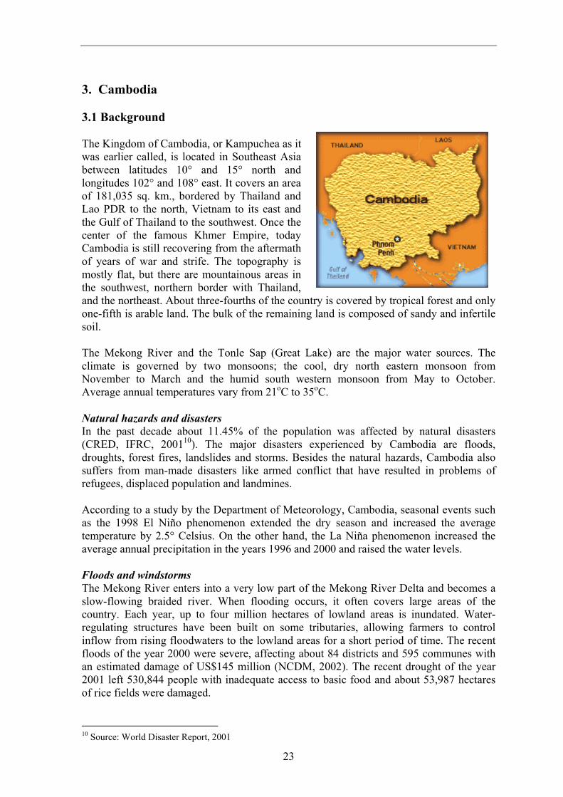
3. Cambodia 3.1 Background The Kingdom of Cambodia, or Kampuchea as it was earlier called, is located in Southeast Asia between latitudes 10° and 15° north and longitudes 102° and 108° east. It covers an area of 181,035 sq. km., bordered by Thailand and Lao PDR to the north, Vietnam to its east and the Gulf of Thailand to the southwest. Once the center of the famous Khmer Empire, today Cambodia is still recovering from the aftermath of years of war and strife. The topography is mostly flat, but there are mountainous areas in the southwest, northern border with Thailand, and the northeast. About three-fourths of the country is covered by tropical forest and only one-fifth is arable land. The bulk of the remaining land is composed of sandy and infertile soil. The Mekong River and the Tonle Sap (Great Lake) are the major water sources. The climate is governed by two monsoons; the cool, dry north eastern monsoon from November to March and the humid south western monsoon from May to October. Average annual temperatures vary from 21oC to 35oC. Natural hazards and disasters In the past decade about 11.45% of the population was affected by natural disasters (CRED, IFRC, 200110). The major disasters experienced by Cambodia are floods, droughts, forest fires, landslides and storms. Besides the natural hazards, Cambodia also suffers from man-made disasters like armed conflict that have resulted in problems of refugees, displaced population and landmines. According to a study by the Department of Meteorology, Cambodia, seasonal events such as the 1998 El Niño phenomenon extended the dry season and increased the average temperature by 2.5° Celsius. On the other hand, the La Niña phenomenon increased the average annual precipitation in the years 1996 and 2000 and raised the water levels. Floods and windstorms The Mekong River enters into a very low part of the Mekong River Delta and becomes a slow-flowing braided river. When flooding occurs, it often covers large areas of the country. Each year, up to four million hectares of lowland areas is inundated. Water-regulating structures have been built on some tributaries, allowing farmers to control inflow from rising floodwaters to the lowland areas for a short period of time. The recent floods of the year 2000 were severe, affecting about 84 districts and 595 communes with an estimated damage of US$145 million (NCDM, 2002). The recent drought of the year 2001 left 530,844 people with inadequate access to basic food and about 53,987 hectares of rice fields were damaged.
10 Source: World Disaster Report, 2001
Overview of Early Warning System in Cambodia, Indonesia, Lao PDR, Philippines and Vietnam
24
Cambodia is not as prone to typhoons as its neighbour, Vietnam. By the time the typhoon reaches Cambodia after crossing Vietnam, its intensity weakens and the wind is no longer threatening. However, even a low intensity typhoon brings rain that might cause flooding. Typhoon Linda, which crossed Cambodia in 1998, affected the southern coastal areas in which the island of Pou Lo Wei was most affected, reporting a wreckage of 81 fishing boats and hundreds of victims. 3.2 Hazard Detection 3.2.1 Weather Forecast Weather forecasts and typhoon detection and warning are the responsibility of the Department of Meteorology (DoM). The Meteorological Center at the DoM issues 24-hour weather forecasts based on the data received from 14 synoptic stations, the weather condition transmitted from the Japanese weather satellite, and information such as the results of numerical weather prediction coming from the Regional Specialized Meteorological Center (RSMC) in Tokyo. The data from the various stations in Cambodia is received through radio transreceiver and telephone. The DoM at present has no capabilities to issue long-range forecasts. MoWRAM undertakes studies on monthly average and minimum temperatures to monitor ENSO impact over the country. Weather prediction is undertaken considering the meteorological data from provinces and synoptic maps through Internet (displayed by Thailand). Weekly prediction is based upon the data available on the Internet while seasonal predictions are based on the Southern Oscillation Index (SOI), especially the model of average annual temperature. DoM is one of the members of the Typhoon committee. The forecasts and typhoon warnings are transmitted to the following disseminators and end-users of the forecast:
a) Ministry of Water Resources and Meteorology (MoWRAM) b) National Committee for Disaster Management (NCDM) c) Tri-media (television, radio and newspaper) d) Prime Minister’s Cabinet e) The King’s Cabinet f) Special users that include farmers, fishermen, businesses and media
The Typhoon Committee approves the format and content of the information within the forecast and warnings. The terminologies are used in accordance with the standard terminologies agreed upon by the Typhoon Committee. 3.2.2 Flood Forecasting and Prediction Flood forecasting is the most important activity carried out in the wet season by the Department of Hydrology and River Works (DHRW) of the Ministry of Water Resources and Meteorology (MoWRAM). The Hydrology Department is also responsible for the regular maintenance of gauging stations, maintenance of the database and flood prediction. The relevant data is received from 10 hydrological stations (along the Mekong main stream, Bassac and Tonle Sap River) and from the DoM to predict up to 3 days of water level in the Mekong River.
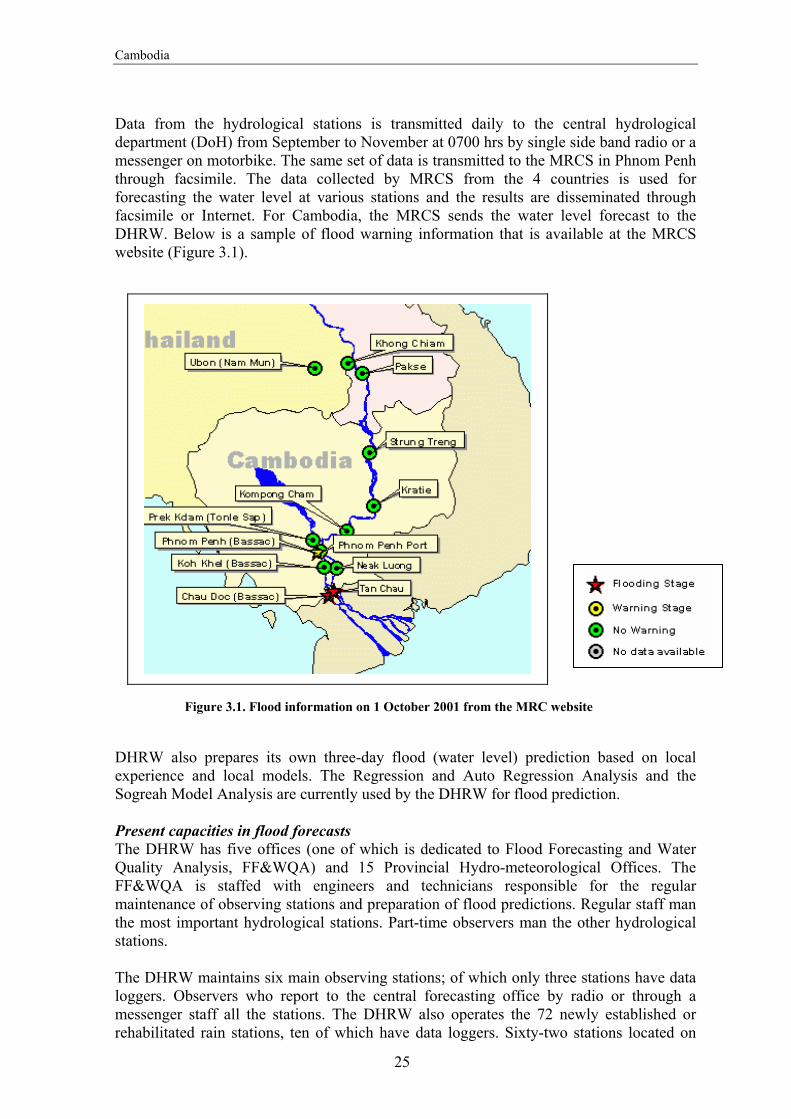
Cambodia
25
Data from the hydrological stations is transmitted daily to the central hydrological department (DoH) from September to November at 0700 hrs by single side band radio or a messenger on motorbike. The same set of data is transmitted to the MRCS in Phnom Penh through facsimile. The data collected by MRCS from the 4 countries is used for forecasting the water level at various stations and the results are disseminated through facsimile or Internet. For Cambodia, the MRCS sends the water level forecast to the DHRW. Below is a sample of flood warning information that is available at the MRCS website (Figure 3.1).
DHRW also prepares its own three-day flood (water level) prediction based on local experience and local models. The Regression and Auto Regression Analysis and the Sogreah Model Analysis are currently used by the DHRW for flood prediction. Present capacities in flood forecasts The DHRW has five offices (one of which is dedicated to Flood Forecasting and Water Quality Analysis, FF&WQA) and 15 Provincial Hydro-meteorological Offices. The FF&WQA is staffed with engineers and technicians responsible for the regular maintenance of observing stations and preparation of flood predictions. Regular staff man the most important hydrological stations. Part-time observers man the other hydrological stations. The DHRW maintains six main observing stations; of which only three stations have data loggers. Observers who report to the central forecasting office by radio or through a messenger staff all the stations. The DHRW also operates the 72 newly established or rehabilitated rain stations, ten of which have data loggers. Sixty-two stations located on
Figure 3.1. Flood information on 1 October 2001 from the MRC website

Overview of Early Warning System in Cambodia, Indonesia, Lao PDR, Philippines and Vietnam
26
the main tributaries are equipped with staff gauges to measure water levels. Some of these stations are also located with rain stations. Data from these stations are collected during regular inspections and used as input to run a computer model tried and tested to approximate the observed levels. 3.3 Hazard Warning Flood warning
There are two levels of flood bulletins issued to the public:
a) Flood Advisory: A flood advisory contains recommended actions to be taken by the public. It informs the public of an imminent flood situation. The advisory is issued when the hydrological condition deteriorates or when the condition improves but the public is still advised to be cautious.
b) Flood Warning: It is issued when flooding is predicted to occur within 24 hours.
The warning is maintained as long as the affected areas are inundated and the attendant dangers are present.
3.4 Warning Dissemination The DHRW warning system capitalizes on the existing disaster management system in Cambodia to relay the warning to the affected village level. The disaster management system was established in 1994 with the creation of the National Committee for Disaster Management (NCDM) through a sub-decree (No. 35 ANKR-BK, dated 27 March 1994) signed by the Prime Minister and later amended (No. 54 ANKR-BK, dated 14 June 1999). One of the functions of NCDM, through its Department of Emergency Preparedness and Training is to issue bulletins to provide information on all forms of disasters and to coordinate with related institutions to get information and data on disaster predictions. The NCDM transmits the information on the flood situation, flood advisory and flood warning through the sub-national committees on disaster management down to the village level. Figure 3.2 illustrates the flood warning dissemination scheme in Cambodia. From the central to the local level, warnings are disseminated through facsimile, telephone and through a messenger. Though some district offices use hand-held radios, they are expensive to maintain and most often are not functioning due to shortage of battery supply. At the village level, the Village Chief is responsible for disseminating warning. The Chief gathers the heads of families (mainly males) to provide information on the flood situation obtained from the Commune Chief, who in turn gets the information from the District Leader. In some villages, a Village Development Committee (VDC), which is usually organized by NGOs, assists the community on development work. This VDC is not organic to the village structure and thus its presence is not reflected in the warning dissemination scheme. However, VDC provides another channel for effective dissemination of warning to the public.
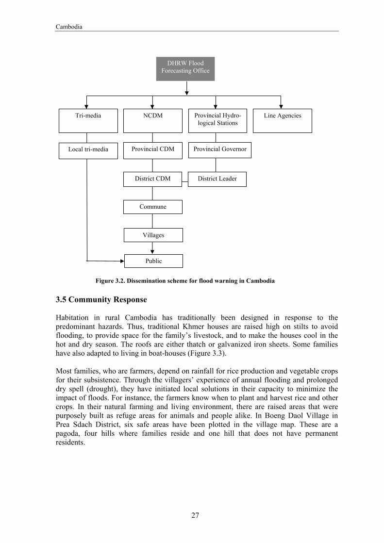
Cambodia
27
3.5 Community Response Habitation in rural Cambodia has traditionally been designed in response to the predominant hazards. Thus, traditional Khmer houses are raised high on stilts to avoid flooding, to provide space for the family’s livestock, and to make the houses cool in the hot and dry season. The roofs are either thatch or galvanized iron sheets. Some families have also adapted to living in boat-houses (Figure 3.3). Most families, who are farmers, depend on rainfall for rice production and vegetable crops for their subsistence. Through the villagers’ experience of annual flooding and prolonged dry spell (drought), they have initiated local solutions in their capacity to minimize the impact of floods. For instance, the farmers know when to plant and harvest rice and other crops. In their natural farming and living environment, there are raised areas that were purposely built as refuge areas for animals and people alike. In Boeng Daol Village in Prea Sdach District, six safe areas have been plotted in the village map. These are a pagoda, four hills where families reside and one hill that does not have permanent residents.
Figure 3.2. Dissemination scheme for flood warning in Cambodia
DHRW Flood Forecasting Office
Line Agencies
Villages
Tri-media
Local tri-media Provincial CDM
District CDM
Provincial Governor
District Leader
Provincial Hydro-logical Stations
Public
NCDM
Commune

Overview of Early Warning System in Cambodia, Indonesia, Lao PDR, Philippines and Vietnam
28
The communities studied from the flood-prone provinces of Kandal and Prey Veng, along the Mekong River provide an overview of how the hazard warning is disseminated and how the community responds to the warning. There is no systematic early warning system in these communities. No response guidelines have been issued by NCDM to the communities on early warning. People’s resilience and natural instinct to survive dictate the traditional response to natural
warning. In addition to these, those who have the capacities to respond to flooding and other threats naturally extend a helping hand to those who are in need of assistance. Alarm bells are used as a warning signal in the wake of continuous rainfall for a significant number of days in areas identified as flood prone due to past experience.
3.5.1 Deunn Rise Commune, Kandal Steung District, Kandal Province The Commune Chief, who is appointed by the District Chief, heads the Deunn Rise Commune. The commune is composed of a number of villages, each with about 65 families and an appointed Village Chief. It is prone to flooding from the Kantout River, a tributary of the Mekong River. It used to experience two to three flood episodes each year, but the construction of an irrigation dam has since protected the community from floods, except from extraordinary ones like the floods of year 2000. Within the commune is a pagoda, raised areas such as the road shoulder and the bridge. The local police take the responsibility for evacuating those in danger from the rising water while the government provides plastic sheets to serve as temporary roofs for the evacuees. Warning dissemination The District Office is responsible for issuing warnings to the Commune Chief through the radio or meetings called by the District Chief. The Commune Chief, with the help of Village Chiefs, issues house-to-house warnings about threats from floods and when a flood is likely to affect the community. Alternatively, the Commune Chief relays the warning through radio communication to the village leaders, who pass on the warning to the families. The warning also advises the public to evacuate, reiterating old and tested practices of evacuation, to prepare food and dry clothes for evacuation purposes, and to mobilize cattle to higher grounds. Community preparedness Before the water level rises to a dangerous level, the elderly are transferred to the pagoda. Normally constructed on the most elevated location, pagodas make a good refuge for people. Those who cannot be accommodated in the pagodas go to the other safe places like the roadside or bridge approach, which are normally higher than the surrounding fields and areas for habitation. Children go with their parents, and the animals are also evacuated with the families.
Figure 3.3. Traditional Khmer houses including boathouses

Cambodia
29
3.5.2 Sdao Kong Commune, Ba Phnum District, Prey Veang Province The commune is composed of 15 villages, each led by a village leader. The Sdao Kong Commune is located in a low-lying area near the River Trabaek. Flooding is a result of river overflow as well as from continuous rainfall. An irrigation canal traverses the farms, which serve as the main source of income for the community. Following the administrative practice, the District Chief appoints the Sdao Kong Commune Chief. The community receives warning from national radio stations and from meetings called by the District Chief. The local folks unintentionally learn about threats of flood or bad weather from warnings or advisories aired between drama broadcasts, which are popular in the community. Although 75% of families own radio sets, not all of them receive information about impending floods through radio broadcasts. Warning also reaches the community through the deliberate warning dissemination by the Commune Chief. Upon receipt of warning from the District Chief, the Commune Chief calls small meetings of Village Chiefs at the commune office (Figure 3.4). Since the commune has 15 villages, there will be 15 Village Chiefs calling meetings of 10 households each time. Under a critical situation, the Commune Chief also goes around disseminating the information.
Figure 3.4. Flow of warning from the District Chief to the villagers in Sdao Kong Commune, Cambodia
District Chief monthly meetings with Commune
Chiefs
Commune Chief meetings with Village Chiefs
Village Chief meeting with household heads of 10 families at a time. The call for meeting is personally delivered to
the household heads.
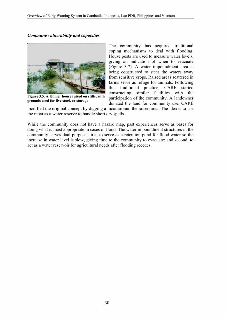
Overview of Early Warning System in Cambodia, Indonesia, Lao PDR, Philippines and Vietnam
30
Commune vulnerability and capacities
The community has acquired traditional coping mechanisms to deal with flooding. House posts are used to measure water levels, giving an indication of when to evacuate (Figure 3.7). A water impoundment area is being constructed to steer the waters away from sensitive crops. Raised areas scattered in farms serve as refuge for animals. Following this traditional practice, CARE started constructing similar facilities with the participation of the community. A landowner donated the land for community use. CARE
modified the original concept by digging a moat around the raised area. The idea is to use the moat as a water reserve to handle short dry spells. While the community does not have a hazard map, past experiences serve as bases for doing what is most appropriate in cases of flood. The water impoundment structures in the community serves dual purpose: first, to serve as a retention pond for flood water so the increase in water level is slow, giving time to the community to evacuate; and second, to act as a water reservoir for agricultural needs after flooding recedes.
Figure 3.5. A Khmer house raised on stilts, with grounds used for live stock or storage

31
4. Indonesia 4.1 Background Indonesia is the world's largest archipelago comprising 17,000 islands that stretch over 5,000 miles along the equator, with a total coastline exceeding 50,220 miles. Of these, only 6,000 islands are inhabited. It lies from 6o08’ north latitude to 11o15’ south latitude and from 94o 45’east longitude to 141o05’ east longitude, between the Asian and the Australian continental plates. The five main islands are Sumatra, Java, Kalimantan, Sulawesi, and Irian Jaya. Two of the islands, Kalimantan (known in the colonial period as Borneo, the world's third largest island) and Irian Jaya are shared with Malaysia and Brunei, and with Papua New Guinea, respectively. Indonesia is hot and humid most of the year round. It has two distinct seasons – the dry season between June and September caused by the easterly monsoons and the wet season between December and March caused by the westerly monsoons, which bring the rains. The condition of the current seasons depends on dynamics, such as Sea Surface Temperature (SST), Southern Oscillation Index (SOI) and other local parameters. Natural hazards and disasters Major natural hazards experienced by Indonesia are earthquakes, tsunamis, volcanic eruptions, forest fires, flood, and technological failures. Indonesia lies in one of the most unusual areas in the world, encompassing a major juncture of the Earth's tectonic plates. These factors make it most susceptible to seismic and volcanic activity. Floods Annually, waters inundate the western and central parts of Indonesia. The western part of Indonesia is wet with medium to high rainfall intensity while the eastern part is drier with high temperature in the dry season. During monsoon rains, overflows of shallow rivers flood South Sumatra, Jambi, Riau, West Sumatra, North Sumatra and Ache. The floods of year 2000 caused by continuous rain drenched the southern part of Belu District, West Timor. The affected area is flat and low-lying and forms the major rice growing area. About 20,000 people were affected and 100 houses destroyed. ENSO events significantly influence the rainfall intensity in Indonesia, where many areas receive below normal rainfall. During these El Niño warming events, the probability of forest fires and droughts increases in the region. From 1877 to 1997, 93 % of drought years have been linked to El Niño events. Several studies show a clear positive correlation between normalized Indonesian rainfall anomalies and SOI.
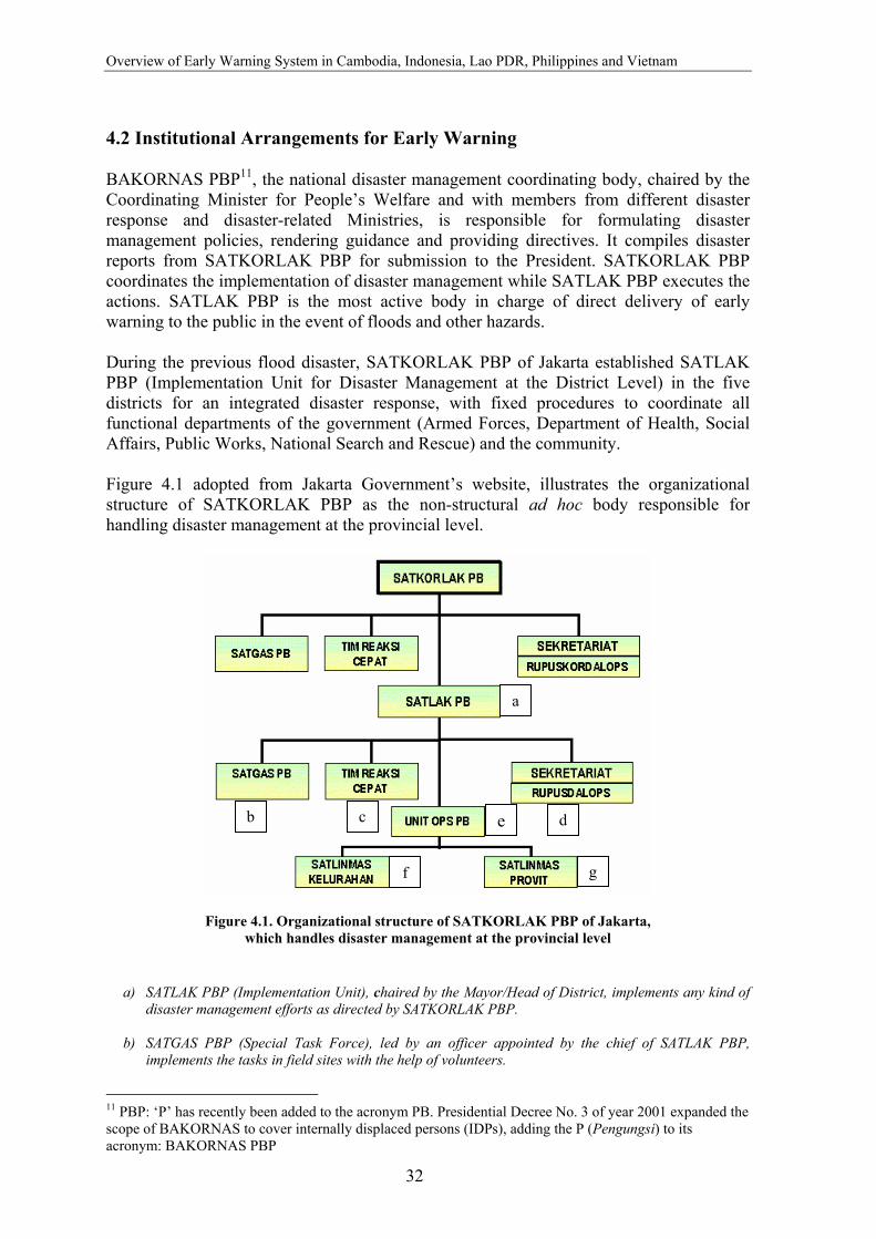
Overview of Early Warning System in Cambodia, Indonesia, Lao PDR, Philippines and Vietnam
32
4.2 Institutional Arrangements for Early Warning BAKORNAS PBP11, the national disaster management coordinating body, chaired by the Coordinating Minister for People’s Welfare and with members from different disaster response and disaster-related Ministries, is responsible for formulating disaster management policies, rendering guidance and providing directives. It compiles disaster reports from SATKORLAK PBP for submission to the President. SATKORLAK PBP coordinates the implementation of disaster management while SATLAK PBP executes the actions. SATLAK PBP is the most active body in charge of direct delivery of early warning to the public in the event of floods and other hazards. During the previous flood disaster, SATKORLAK PBP of Jakarta established SATLAK PBP (Implementation Unit for Disaster Management at the District Level) in the five districts for an integrated disaster response, with fixed procedures to coordinate all functional departments of the government (Armed Forces, Department of Health, Social Affairs, Public Works, National Search and Rescue) and the community. Figure 4.1 adopted from Jakarta Government’s website, illustrates the organizational structure of SATKORLAK PBP as the non-structural ad hoc body responsible for handling disaster management at the provincial level.
a) SATLAK PBP (Implementation Unit), chaired by the Mayor/Head of District, implements any kind of disaster management efforts as directed by SATKORLAK PBP.
b) SATGAS PBP (Special Task Force), led by an officer appointed by the chief of SATLAK PBP,
implements the tasks in field sites with the help of volunteers.
11 PBP: ‘P’ has recently been added to the acronym PB. Presidential Decree No. 3 of year 2001 expanded the scope of BAKORNAS to cover internally displaced persons (IDPs), adding the P (Pengungsi) to its acronym: BAKORNAS PBP
Figure 4.1. Organizational structure of SATKORLAK PBP of Jakarta, which handles disaster management at the provincial level
a
cb de
gf

Indonesia
33
c) Tim Reaksi Cepat (Quick Response Team) was established to rapidly assess the extent of damage and
analyse the need in the disaster area (collect and process data on medical aid, water supply, food aid, housing or resettlement, communication, and transportation).
d) SEKRETARIAT/RUPUSDALOPS (Center for Activity and Coordination of Disaster Management),
assigned to coordinate all administrative works of SATLAK PBP, follows up all incoming reports by sending warning or information on disasters to the public as fast as possible. The Secretariat also prepares an emergency operation strategy.
e) UNIT OPS PBP (Operational Unit for Disaster Management), set up as the command coordinator
controlling the implementation of all decisions made, reports the condition in the field to the RUPUSDALOPS.
f) SATLINMAS KELURAHAN (Team for the Protection of the Village Community) mobilizes all
possible associated governmental officials within the region, and also involves the community, Indonesian Red Cross, NGOs and other concerned community-based organizations.
g) SATLINMAS PROVIT (Team for the Protection of Vital Objects/Projects) works to protect vital
objects/projects within the area. It is chaired by the local chief of HANSIP (Civil Defense) or local chief of SATPAM (Civil Security Forces) with members coming from appointed individuals working in the disaster related projects.
To anticipate the recurrence of flood disaster, SATKORLAK PBP (Jakarta) has planned to conduct the following programs regularly:
• Further assessment on the flood-prone areas, in close collaboration with Jakarta’s Meteorological and Hydrological Forecasting Bureau
• Developing a strategy for better resources mobilization and evacuation programs (e.g. identification of better evacuation spots)
• Capacity building for SATKORLAK’s members (e.g. training) • Training for local community (e.g. self-preparedness training) • Better coordination with city planning agency in terms of supervision • Intensifying the maintenance of river basins, water gates and dams
4.3 Hazard Detection 4.3.1 Seasonal Forecast The Bureau of Meteorology and Geophysics (BMG), Indonesia prepares two seasonal forecasts every year. The dry seasonal forecast is prepared in early March, while the wet season forecast is prepared in early September. The seasonal forecasts are conducted in 101 areas called Seasonal Forecast Areas (SFA), where there is a clear difference between wet and dry seasons (monsoon type). Deterministic statistical models were used prior to the year 1990 for preparing seasonal forecast. Since 1990, BMG applies the stochastic models that include Auto Regression Integrated Moving Average (ARIMA) combined with deterministic models. Since the last two years, RAINMAN software developed in Australia used the ARIMA models to prepare seasonal and monthly forecasts. The ENSO parameters that include Sea Surface Temperature (SST) and Southern Oscillation Index (SOI) are also important variables used to prepare seasonal forecasts.

Overview of Early Warning System in Cambodia, Indonesia, Lao PDR, Philippines and Vietnam
34
4.3.2 Flood Detection and Observation in Jakarta POSKO (Coordination Center), located at the Governor's Office from where all SATKORLAK PBP’s (Provincial Coordinating Body for Disaster Management) components are coordinated, operates a round-the-clock surveillance of Jakarta. The Armed Forces provides a helicopter for daily air surveillance. Rainfall and river height data are collected from water gate stations throughout Jakarta and from volunteer observers. The “water gate observer,” who is under the SATLINMAS KELURAHAN Unit, operates up to 24 hours per day, measuring river heights in meters above the zero gauge (the low flow level of the stream). Originators of flood warning also come from Jakarta’s Meteorological and Hydrological Forecasting Bureau. There are particular circumstances where members of the public who detect a possible flood might alert POSKO. 4.4 Hazard Warning Data input is compiled for preparation of a flood-warning message through POSKO. The message includes the following information:
• Type of flood • Time and place of occurrence • Effect of the flood • Steps that should, or have already been taken • Maps of flood-prone areas
4.5 Warning Dissemination 4.5.1 Seasonal Forecast
For dissemination of the seasonal weather forecast BMG provides a published document of seasonal forecast with the format that consists of:
• General forecast of total rainfall intensity for wet and dry season • Seasonal forecasts for the 101 Seasonal Forecast Areas (SFA) that consists of the
onset of seasons, comparison between the onset and average, and rainfall characteristics during the related season.
4.5.2 Floods
POSKO disseminates the information and warnings to those who may be affected by the flood and those who need alerting so that they may respond appropriately. Recipients of warnings normally seek confirmation of the warning before they respond, and the media (primarily radio, secondly television) can be effective as confirmation sources. The media clearly plays an important role in preparing the public for flood and are key channels of information and communication about flood. POSKO, therefore, relies upon media broadcast to disseminate their forecast and to warn the public of floods. Extensive briefing on radio, TV and newspapers are conducted to give a summary of existing conditions and predictions of river heights at key locations.
Indonesia
35
Informal personal and community networks can also be highly effective in disseminating warnings, both through oral (mosque announcements, mobile patrol vehicles and public gatherings) and written communication (villages’ news boards, simple pamphlets and Internet). 4.6 Community Level Flood Warning System 4.6.1 Mirit Sub-District, Kebumen, Central Java Mirit, located in the district of Kebumen, Central Java Province is very prone to floods, affecting about 16,000 people. Most of the area lies in the southern coast while some part is located in the mountainous range. There are about 12 villages that are vulnerable to floods, some of which are below sea level resulting in longer inundation period. Underlying causes that make Mirit prone to floods include:
• Conversion of natural forest into monoculture plantation, agriculture and even clear cutting
• Poor design and quality of infrastructures due to the lack of consultation with the community during construction
• Poor and un-integrated land use spatial planning and management from the upstream to downstream areas
• Lack of awareness on the part of the community on sustainable water and land management.
Since 1982, floods have frequently hit Mirit. The floods of year 1992, early 1999 and end of 2000 are considered the most severe in which the Bonorawan villages were affected the most causing extensive socio-economic and physical infrastructure damage. The average crop loss to the farmers was 80%. Other livelihood practices such as fishing, livestock rearing and crop farming have been inadequate to earn a living. Recurring floods have also caused extensive damage to the irrigation network. Dykes often collapsed and water channels silt up. Houses and public services such as roads, schools and health centers were damaged. On the socio-cultural side, conflicts between farmers during the dry season were not unusual. Poor design of the water management has caused some parts of the area to be in bad need of water when the other parts have surplus water. Many young people of Mirit have fled the area and crime rate has also increased. 4.6.2 Flood Warning System The community serves as an important part of the early warning system as it provides useful information on level of rainfall and its duration in the upstream areas. Four villages of Mirit, i.e. Pujodadi, Tlogorejo, Rowosari and Pathukgawemulyo, were responsible for the operation and maintenance of the communication units. Those villages were at the highest risk of flood during the previous period of flooding. The Banorawan Farmers Association (PPB) established the flood Early Warning System for communities of Mirit, Kebumen, and Central Java during the flood of year 2000. EWS included 4 units of two-way radio communication equipment of 1.5 Watt. Two of the units
Overview of Early Warning System in Cambodia, Indonesia, Lao PDR, Philippines and Vietnam
36
were supported by Oxfam GB Indonesia, while the other two were contribution from the communities who were supporting the activities of the association. The system was operated with the official license from the Amateur Radio Communication Service (RAPI) of Kebumen district at 142.100 Mhz. On this frequency, the receiving power of the system could effectively cover the whole coverage areas of PPB. Without relay support, PPB could manage the communication with radio communication activities at the upstream areas in Wonosobo district. PPB has been applying the warning system on the possibility of floods during the monsoon period since the end of 2001 where the southern part of Mirit (Pathukgawemulyo dan Pathukrejomulyo) was already inundated. After a report of torrential rain during the previous night in the upstream area, PPB immediately carried out preparedness activities, passing on and disseminating the information on water level, coordinating with government officials at sub-district and village level to evacuate villagers before the river water inundated both villages. Supporting coordination between PPB During the dry season, the EWS has been utilized in supporting effective coordination between chair of PPB with the village coordinators or potential members in the coverage area of PPB. Potential members of PPB also made use of the equipment for exercising how to use radio communication. When the paddy field was in need of irrigation water, PPB conducted coordination with the Irrigation Service Office of Kebumen district and arranged the supplies and distribution of water to the villages in need. Building alliances This system also contributed to build the capacity of PPB in strengthening alliances. Direct communication with the communities in the upstream area in Wonosobo by means of radio communication has generated an alliance for management of information on flood risk. This system also allows a broader alliance for other external organizational issues. Precautions in using the EWS Information gathered through the community EWS should be carefully understood and interpreted. On one occasion, after PPB received information on the increase of the intensity and duration of rain, there was an effort for evacuation of villagers in Pujodadi fearing that flood will hit the area. However, there was no flooding in the area. Such cases decrease the confidence of the community on the organization and the EWS. Careful oral dissemination of information needs to be done since distortion of information is likely to happen by using this system. Recommendations and improvement Learning from the experience in using EWS, PPB identified the need to develop the system to become a more effective one while maintaining the existing system as the main source of information on flood risk from the upstream area. For this purpose, PPB has explored the possibility for developing the system into a Community Radio. The plan for development of this system has also taken into account the following consideration:

Indonesia
37
• The internal needs of the organization to: enhance performance of organization, strengthen organizational existence, and increase coverage of work and alliance
• To add to entertainment function • To serve as the media for campaigns at local level • To provide the means for community development as in line with the regional-
global issues
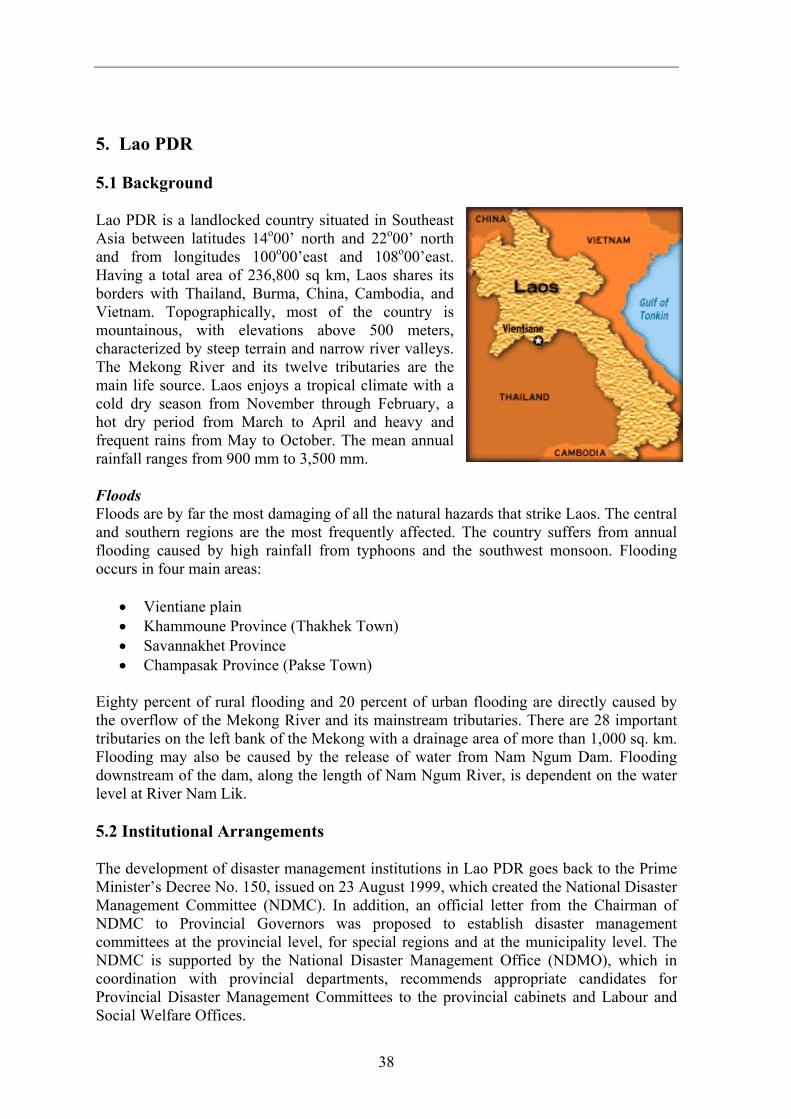
38
5. Lao PDR 5.1 Background Lao PDR is a landlocked country situated in Southeast Asia between latitudes 14o00’ north and 22o00’ north and from longitudes 100o00’east and 108o00’east. Having a total area of 236,800 sq km, Laos shares its borders with Thailand, Burma, China, Cambodia, and Vietnam. Topographically, most of the country is mountainous, with elevations above 500 meters, characterized by steep terrain and narrow river valleys. The Mekong River and its twelve tributaries are the main life source. Laos enjoys a tropical climate with a cold dry season from November through February, a hot dry period from March to April and heavy and frequent rains from May to October. The mean annual rainfall ranges from 900 mm to 3,500 mm. Floods Floods are by far the most damaging of all the natural hazards that strike Laos. The central and southern regions are the most frequently affected. The country suffers from annual flooding caused by high rainfall from typhoons and the southwest monsoon. Flooding occurs in four main areas:
• Vientiane plain • Khammoune Province (Thakhek Town) • Savannakhet Province • Champasak Province (Pakse Town)
Eighty percent of rural flooding and 20 percent of urban flooding are directly caused by the overflow of the Mekong River and its mainstream tributaries. There are 28 important tributaries on the left bank of the Mekong with a drainage area of more than 1,000 sq. km. Flooding may also be caused by the release of water from Nam Ngum Dam. Flooding downstream of the dam, along the length of Nam Ngum River, is dependent on the water level at River Nam Lik. 5.2 Institutional Arrangements The development of disaster management institutions in Lao PDR goes back to the Prime Minister’s Decree No. 150, issued on 23 August 1999, which created the National Disaster Management Committee (NDMC). In addition, an official letter from the Chairman of NDMC to Provincial Governors was proposed to establish disaster management committees at the provincial level, for special regions and at the municipality level. The NDMC is supported by the National Disaster Management Office (NDMO), which in coordination with provincial departments, recommends appropriate candidates for Provincial Disaster Management Committees to the provincial cabinets and Labour and Social Welfare Offices.
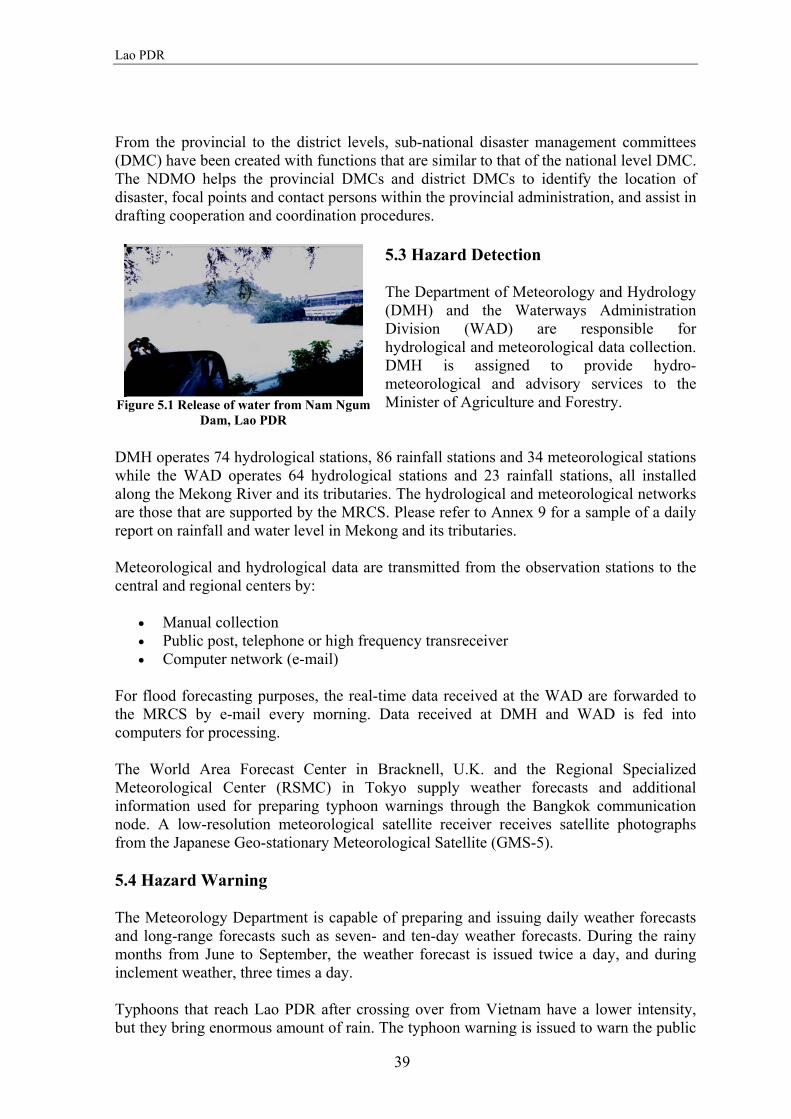
Lao PDR
39
From the provincial to the district levels, sub-national disaster management committees (DMC) have been created with functions that are similar to that of the national level DMC. The NDMO helps the provincial DMCs and district DMCs to identify the location of disaster, focal points and contact persons within the provincial administration, and assist in drafting cooperation and coordination procedures.
5.3 Hazard Detection The Department of Meteorology and Hydrology (DMH) and the Waterways Administration Division (WAD) are responsible for hydrological and meteorological data collection. DMH is assigned to provide hydro-meteorological and advisory services to the Minister of Agriculture and Forestry.
DMH operates 74 hydrological stations, 86 rainfall stations and 34 meteorological stations while the WAD operates 64 hydrological stations and 23 rainfall stations, all installed along the Mekong River and its tributaries. The hydrological and meteorological networks are those that are supported by the MRCS. Please refer to Annex 9 for a sample of a daily report on rainfall and water level in Mekong and its tributaries. Meteorological and hydrological data are transmitted from the observation stations to the central and regional centers by:
• Manual collection • Public post, telephone or high frequency transreceiver • Computer network (e-mail)
For flood forecasting purposes, the real-time data received at the WAD are forwarded to the MRCS by e-mail every morning. Data received at DMH and WAD is fed into computers for processing. The World Area Forecast Center in Bracknell, U.K. and the Regional Specialized Meteorological Center (RSMC) in Tokyo supply weather forecasts and additional information used for preparing typhoon warnings through the Bangkok communication node. A low-resolution meteorological satellite receiver receives satellite photographs from the Japanese Geo-stationary Meteorological Satellite (GMS-5). 5.4 Hazard Warning The Meteorology Department is capable of preparing and issuing daily weather forecasts and long-range forecasts such as seven- and ten-day weather forecasts. During the rainy months from June to September, the weather forecast is issued twice a day, and during inclement weather, three times a day. Typhoons that reach Lao PDR after crossing over from Vietnam have a lower intensity, but they bring enormous amount of rain. The typhoon warning is issued to warn the public
Figure 5.1 Release of water from Nam Ngum
Dam, Lao PDR
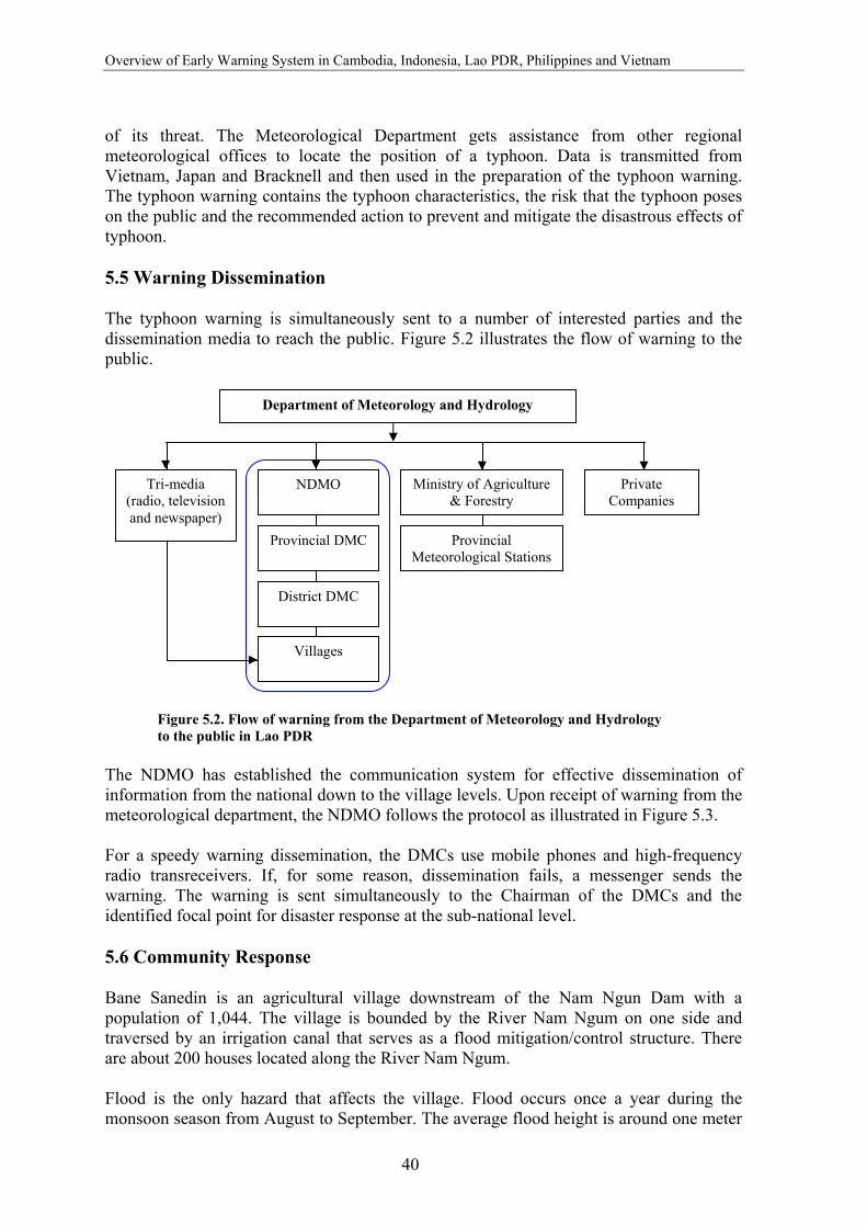
Overview of Early Warning System in Cambodia, Indonesia, Lao PDR, Philippines and Vietnam
40
of its threat. The Meteorological Department gets assistance from other regional meteorological offices to locate the position of a typhoon. Data is transmitted from Vietnam, Japan and Bracknell and then used in the preparation of the typhoon warning. The typhoon warning contains the typhoon characteristics, the risk that the typhoon poses on the public and the recommended action to prevent and mitigate the disastrous effects of typhoon. 5.5 Warning Dissemination The typhoon warning is simultaneously sent to a number of interested parties and the dissemination media to reach the public. Figure 5.2 illustrates the flow of warning to the public.
The NDMO has established the communication system for effective dissemination of information from the national down to the village levels. Upon receipt of warning from the meteorological department, the NDMO follows the protocol as illustrated in Figure 5.3. For a speedy warning dissemination, the DMCs use mobile phones and high-frequency radio transreceivers. If, for some reason, dissemination fails, a messenger sends the warning. The warning is sent simultaneously to the Chairman of the DMCs and the identified focal point for disaster response at the sub-national level. 5.6 Community Response Bane Sanedin is an agricultural village downstream of the Nam Ngun Dam with a population of 1,044. The village is bounded by the River Nam Ngum on one side and traversed by an irrigation canal that serves as a flood mitigation/control structure. There are about 200 houses located along the River Nam Ngum. Flood is the only hazard that affects the village. Flood occurs once a year during the monsoon season from August to September. The average flood height is around one meter
Figure 5.2. Flow of warning from the Department of Meteorology and Hydrology to the public in Lao PDR
Department of Meteorology and Hydrology
District DMC
Provincial DMC
NDMO
Provincial Meteorological Stations
Ministry of Agriculture & Forestry
Villages
Tri-media (radio, television and newspaper)
Private Companies
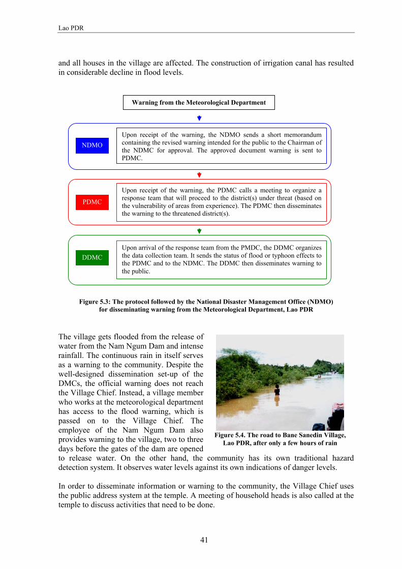
Lao PDR
41
and all houses in the village are affected. The construction of irrigation canal has resulted in considerable decline in flood levels.
The village gets flooded from the release of water from the Nam Ngum Dam and intense rainfall. The continuous rain in itself serves as a warning to the community. Despite the well-designed dissemination set-up of the DMCs, the official warning does not reach the Village Chief. Instead, a village member who works at the meteorological department has access to the flood warning, which is passed on to the Village Chief. The employee of the Nam Ngum Dam also provides warning to the village, two to three days before the gates of the dam are opened to release water. On the other hand, the community has its own traditional hazard detection system. It observes water levels against its own indications of danger levels. In order to disseminate information or warning to the community, the Village Chief uses the public address system at the temple. A meeting of household heads is also called at the temple to discuss activities that need to be done.
Figure 5.3: The protocol followed by the National Disaster Management Office (NDMO) for disseminating warning from the Meteorological Department, Lao PDR
Figure 5.4. The road to Bane Sanedin Village,
Lao PDR, after only a few hours of rain
Warning from the Meteorological Department
NDMO Upon receipt of the warning, the NDMO sends a short memorandum containing the revised warning intended for the public to the Chairman of the NDMC for approval. The approved document warning is sent to PDMC.
Upon receipt of the warning, the PDMC calls a meeting to organize a response team that will proceed to the district(s) under threat (based on the vulnerability of areas from experience). The PDMC then disseminates the warning to the threatened district(s).
Upon arrival of the response team from the PMDC, the DDMC organizes the data collection team. It sends the status of flood or typhoon effects to the PDMC and to the NDMC. The DDMC then disseminates warning to the public.
PDMC
DDMC
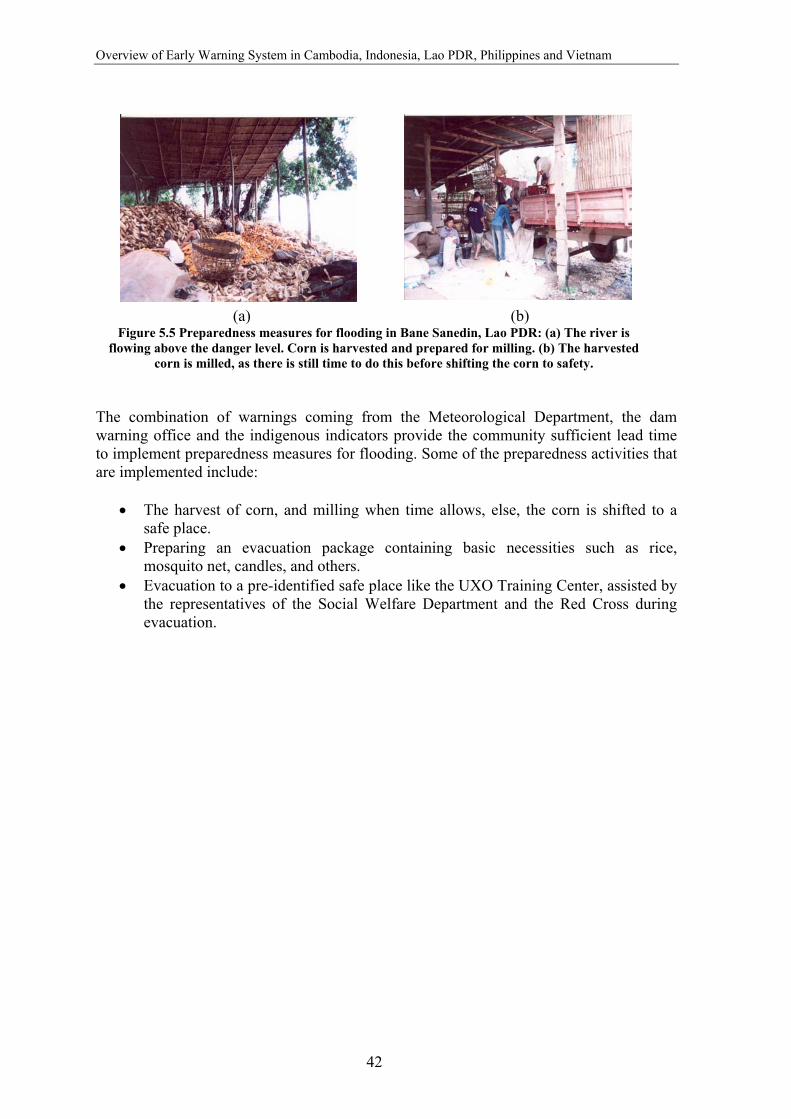
Overview of Early Warning System in Cambodia, Indonesia, Lao PDR, Philippines and Vietnam
42
(a) (b)
The combination of warnings coming from the Meteorological Department, the dam warning office and the indigenous indicators provide the community sufficient lead time to implement preparedness measures for flooding. Some of the preparedness activities that are implemented include:
• The harvest of corn, and milling when time allows, else, the corn is shifted to a safe place.
• Preparing an evacuation package containing basic necessities such as rice, mosquito net, candles, and others.
• Evacuation to a pre-identified safe place like the UXO Training Center, assisted by the representatives of the Social Welfare Department and the Red Cross during evacuation.
Figure 5.5 Preparedness measures for flooding in Bane Sanedin, Lao PDR: (a) The river is flowing above the danger level. Corn is harvested and prepared for milling. (b) The harvested
corn is milled, as there is still time to do this before shifting the corn to safety.

43
6. Philippines 6.1 Background The Philippines is an archipelago consisting of 7,100 islands located between the South China Sea and the Pacific Ocean, on the Southeast Asian continental shelf. It lies on the western rim of the Pacific and is part of the circum-Pacific seismic belt. It stretches more than 1,800 km from north to south and 1,046 km from east to west at its widest extent. Because of its geographical location, the Philippines is exposed to a variety of hazards ranging from typhoons, storms, floods, tsunamis, earthquakes, volcanic eruption, landslides and droughts. Typhoons Annually, an average of 30 typhoons occurs in the north-western Pacific Ocean, of which, 19 enter the Philippines Area of Responsibility, causing immense damage to life and property. The typhoons occur mainly between July and November. Storm surges The irregular coastlines and the numerous typhoons make the Philippines vulnerable to storm surges. High tides coinciding with a storm intensify the surge. Factors contributing to the height of storm surges are a concave coastline that prevents the rising water from moving laterally, a fast moving storm that does not allow time for the water to spread, and shallow coastal waters. Environmental degradation, such as destruction of mangroves, coral reefs and other forms of natural breakwater; siltation of river deltas and bays; and shoreline reclamation also increases the occurrence of the storm surge hazard. Floods Heavy rains accompanying typhoons usually cause extensive floods. Areas most prone to floods are Eastern Mindanao, Northern Samar, Central Luzon and the Bicol region. Flooding in Metro Manila occurs because it is lower than sea level and has inadequate drainage systems.
6.2 Institutional Arrangement for Early Warning With the annual occurrence of disasters, windstorms and flooding, the Philippine Government has given priority to a well-defined disaster management system. Presidential Decree 1566 dated 1978, otherwise known as the Philippine Disaster Management Act, laid the foundation for government action before, during and after a disaster. The Philippine Calamities and Disaster Preparedness Plan (CDPP) articulates a hazard warning system that includes the procedure and linkages among the disaster agencies (Figure 6.1) to ensure a well organized and coordinated dissemination and response to warnings.
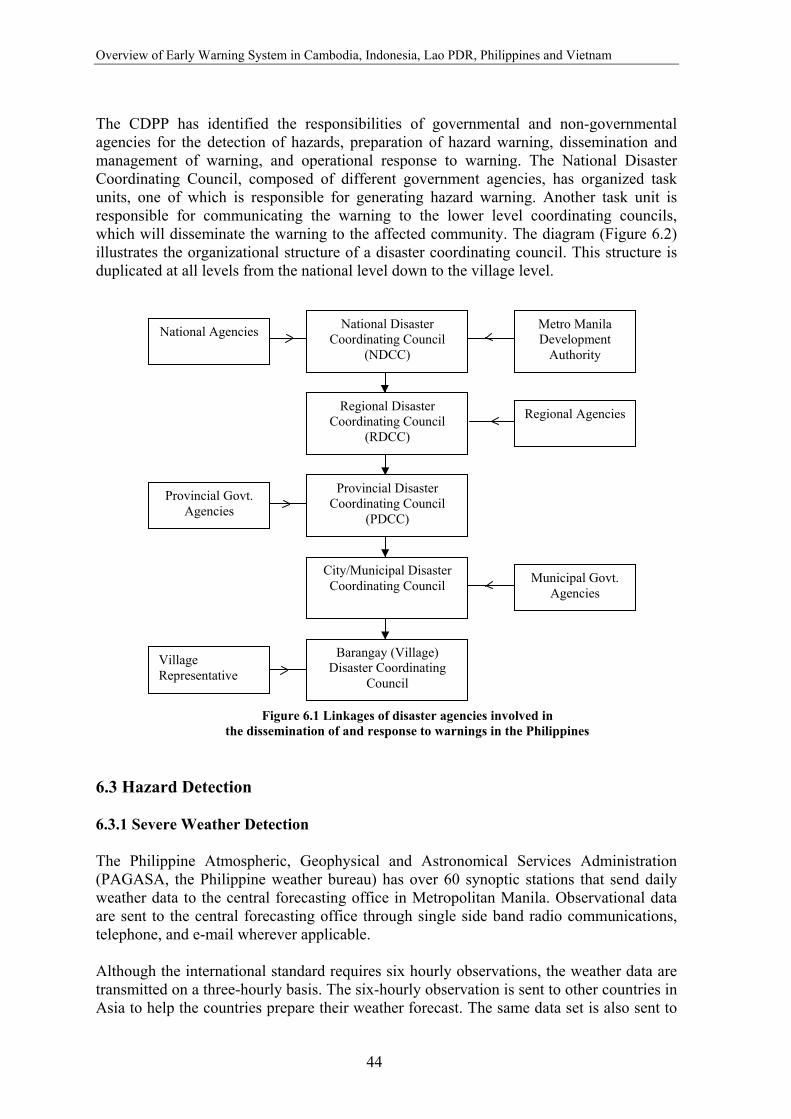
Overview of Early Warning System in Cambodia, Indonesia, Lao PDR, Philippines and Vietnam
44
The CDPP has identified the responsibilities of governmental and non-governmental agencies for the detection of hazards, preparation of hazard warning, dissemination and management of warning, and operational response to warning. The National Disaster Coordinating Council, composed of different government agencies, has organized task units, one of which is responsible for generating hazard warning. Another task unit is responsible for communicating the warning to the lower level coordinating councils, which will disseminate the warning to the affected community. The diagram (Figure 6.2) illustrates the organizational structure of a disaster coordinating council. This structure is duplicated at all levels from the national level down to the village level.
6.3 Hazard Detection 6.3.1 Severe Weather Detection The Philippine Atmospheric, Geophysical and Astronomical Services Administration (PAGASA, the Philippine weather bureau) has over 60 synoptic stations that send daily weather data to the central forecasting office in Metropolitan Manila. Observational data are sent to the central forecasting office through single side band radio communications, telephone, and e-mail wherever applicable. Although the international standard requires six hourly observations, the weather data are transmitted on a three-hourly basis. The six-hourly observation is sent to other countries in Asia to help the countries prepare their weather forecast. The same data set is also sent to
Figure 6.1 Linkages of disaster agencies involved in the dissemination of and response to warnings in the Philippines
National Disaster Coordinating Council
(NDCC)
Provincial Disaster Coordinating Council
(PDCC)
City/Municipal Disaster Coordinating Council
Barangay (Village) Disaster Coordinating
Council
Regional Disaster Coordinating Council
(RDCC)
National Agencies
Village Representative
Municipal Govt. Agencies
Provincial Govt. Agencies
Regional Agencies
Metro Manila Development
Authority

Philippines
45
the Regional Specialized Meteorological Center in Tokyo and other countries using the WMO Global Tele-Communications System (GTS).
The basic tool for weather forecasting is the weather map. This map depicts the distribution patterns of atmospheric pressure, wind, temperature and humidity at different levels of the atmosphere. In addition, PAGASA gets satellite imagery through the Japanese satellite GMS-5, which sends hourly photographs of the weather situation (Figure 6.3). Weather radars located along the length of the archipelago also provide cloud coverage. The weather map, satellite imagery and the result of numerical weather predictions using a global spectral model are analyzed and the results are translated into a weather forecast. 6.4 Hazard Warning 6.4.1 Tropical Cyclone PAGASA issues the following warning depending on the level of threat: Weather Advisory: Weather advisory provides general information on the presence of a cyclone in the general area of the western Pacific (or South China Sea). The cyclone at this stage does not pose a threat within three days of issuance. The weather advisory is issued once a day at 3:30 p.m. except for the first advisory, which may be issued anytime when a severe weather system is detected.
Figure 6.2 Organizational structure of a disaster coordinating council in the Philippines
Figure 6.3 Satellite image from the Japanese Geo-stationary Meteorological Satellite
(GMS-5)
TASK UNITS Communication
and Warning Transportation
Public Information
Rehabilitation
Health Fire Relief Police
Rescue and Engineering
Evacuation
Disaster Operation Center
Chairman, Disaster Coordinating Council (DCC)
Asst. Chairman, DCC

Overview of Early Warning System in Cambodia, Indonesia, Lao PDR, Philippines and Vietnam
46
Severe Weather Bulletin: Tropical Cyclone Alert. The alert stage indicates that a tropical cyclone poses a threat to a part of the country. The bulletin provides more detailed information about the cyclone including location, movement and intensity as well as a 24-hour forecast. The bulletin also gives advice to the public to undertake the appropriate safety measures and to continue monitoring development. The tropical cyclone alert is issued twice a day at 11:00 a.m. and 11:00 p.m. Severe Weather Bulletin: Tropical Cyclone Warning. The warning is issued when there is real and immediate danger to a part or parts of the country from a cyclone. At this stage, public storm signals are raised (refer Annex 7). The warning is issued four times a day: 5:00 a.m., 11:00 a.m., 5:00 p.m. and 11:00 p.m. 6.4.2 Flood Forecasting and Warning PAGASA monitors the flood situation in major urban areas and the four main river basins of the country. The Flood Forecasting Branch that produces the flood forecasts and warnings undertakes the hydrological warning for:
• Pampanga, Agno, Bicol and Cagayan river basins • Major dams, namely, Binga, Ambuklao, Angat, Pantabangan, and Magat • Pasig-Marikina-Laguna Lake complex system.
Flood forecasting consists of the following steps:
a) Monitoring and data collection: Data from rain gauges, water level and discharge rate are collected at regular intervals and sent to the Central Flood Forecasting Office. In the case of dam monitoring, some of the rainfall and river gauges data are telemetered to the central office.
b) Analysis: Flood-forecasting models tested for each river basin and dam sites are used to analyse the flood situation.
c) Preparation of flood forecast and warning: Appropriate warnings as well as the corresponding precautionary measures are incorporated in the flood bulletin.
There are three categories of flood bulletin:
• Flood outlook: Information on current hydrological situation that is intended to alert the residents within the vicinity of a river basin with potential deterioration in the river condition (e.g. gradual and continuous rise in the water level).
• Flood advisory: Informs the public of an imminent flood situation. The advisory is
issued when the hydrological condition deteriorates further or when the condition improves but the public is still advised to be cautious. A flood advisory contains recommended actions to be taken by the public.
• Flood warning: Issued when flooding is predicted to occur within 24 hours. The
warning category is maintained as long as the affected areas are inundated and the
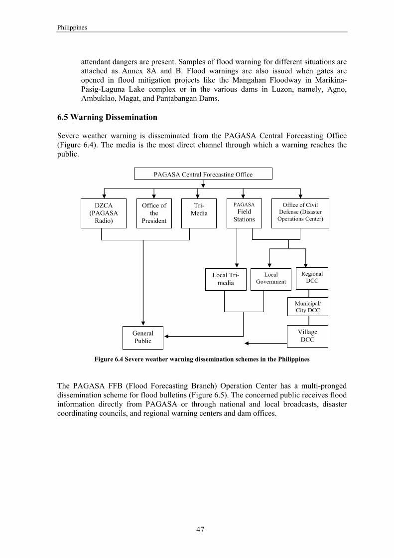
Philippines
47
attendant dangers are present. Samples of flood warning for different situations are attached as Annex 8A and B. Flood warnings are also issued when gates are opened in flood mitigation projects like the Mangahan Floodway in Marikina-Pasig-Laguna Lake complex or in the various dams in Luzon, namely, Agno, Ambuklao, Magat, and Pantabangan Dams.
6.5 Warning Dissemination Severe weather warning is disseminated from the PAGASA Central Forecasting Office (Figure 6.4). The media is the most direct channel through which a warning reaches the public.
Figure 6.4 Severe weather warning dissemination schemes in the Philippines The PAGASA FFB (Flood Forecasting Branch) Operation Center has a multi-pronged dissemination scheme for flood bulletins (Figure 6.5). The concerned public receives flood information directly from PAGASA or through national and local broadcasts, disaster coordinating councils, and regional warning centers and dam offices.
PAGASA Central Forecasting Office
General Public
Tri-Media
Local Government
PAGASAField
Stations
Office of Civil Defense (Disaster
Operations Center)
Regional DCC
Municipal/ City DCC
Village DCC
Local Tri-media
DZCA (PAGASA
Radio)
Office of the
President
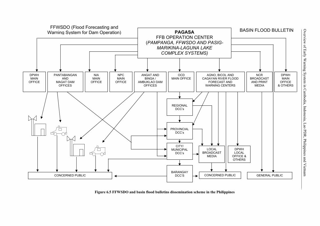
CITY/ MUNICIPAL
DCC’s
DPWH MAIN
OFFICE & OTHERS
PAGASA FFB OPERATION CENTER
(PAMPANGA, FFWSDO AND PASIG- MARIKINA-LAGUNA LAKE
COMPLEX SYSTEMS)
DPWH LOCAL
OFFICE & OTHERS
LOCAL BROADCAST
MEDIA
BARANGAY
DCC’S
PROVINCIAL
DCC’s
REGIONAL
DCC’s
ANGAT AND BINGA /
AMBUKLAO DAM OFFICES
OCD MAIN OFFICE
NPC MAIN
OFFICE
NIA MAIN
OFFICE
PANTABANGAN AND
MAGAT DAM OFFICES
DPWH MAIN
OFFICE
CONCERNED PUBLIC CONCERNED PUBLIC GENERAL PUBLIC
FFWSDO (Flood Forecasting and Warning System for Dam Operation) BASIN FLOOD BULLETIN
AGNO, BICOL AND CAGAYAN RIVER FLOOD
FORECAST AND WARNING CENTERS
NCR BROADCASTAND PRINT
MEDIA
Figure 6.5 FFWSDO and basin flood bulletins dissemination scheme in the Philippines
Overview
of Early Warning System
in Cam
bodia, Indonesia, Lao PDR
, Philippines and Vietnam
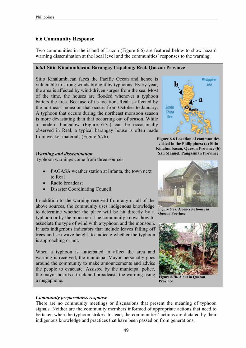
Philippines
49
6.6 Community Response Two communities in the island of Luzon (Figure 6.6) are featured below to show hazard warning dissemination at the local level and the communities’ responses to the warning. 6.6.1 Sitio Kinalumbacan, Barangay Capalong, Real, Quezon Province Sitio Kinalumbacan faces the Pacific Ocean and hence is vulnerable to strong winds brought by typhoons. Every year, the area is affected by wind-driven surges from the sea. Most of the time, the houses are flooded whenever a typhoon batters the area. Because of its location, Real is affected by the northeast monsoon that occurs from October to January. A typhoon that occurs during the northeast monsoon season is more devastating than that occurring out of season. While a modern bungalow (Figure 6.7a) can be occasionally observed in Real, a typical barangay house is often made from weaker materials (Figure 6.7b). Warning and dissemination Typhoon warnings come from three sources:
• PAGASA weather station at Infanta, the town next to Real
• Radio broadcast • Disaster Coordinating Council
In addition to the warning received from any or all of the above sources, the community uses indigenous knowledge to determine whether the place will be hit directly by a typhoon or by the monsoon. The community knows how to associate the type of wind with a typhoon and the monsoon. It uses indigenous indicators that include leaves falling off trees and sea wave height, to indicate whether the typhoon is approaching or not. When a typhoon is anticipated to affect the area and warning is received, the municipal Mayor personally goes around the community to make announcements and advise the people to evacuate. Assisted by the municipal police, the mayor boards a truck and broadcasts the warning using a megaphone. Community preparedness response There are no community meetings or discussions that present the meaning of typhoon signals. Neither are the community members informed of appropriate actions that need to be taken when the typhoon strikes. Instead, the communities’ actions are dictated by their indigenous knowledge and practices that have been passed on from generations.
Figure 6.7a. A concrete house in Quezon Province
Figure 6.7b. A hut in Quezon Province
Figure 6.6 Location of communities visited in the Philippines: (a) Sitio
Kinalumbacan, Quezon Province (b) San Manuel, Pangasinan Province
a
b
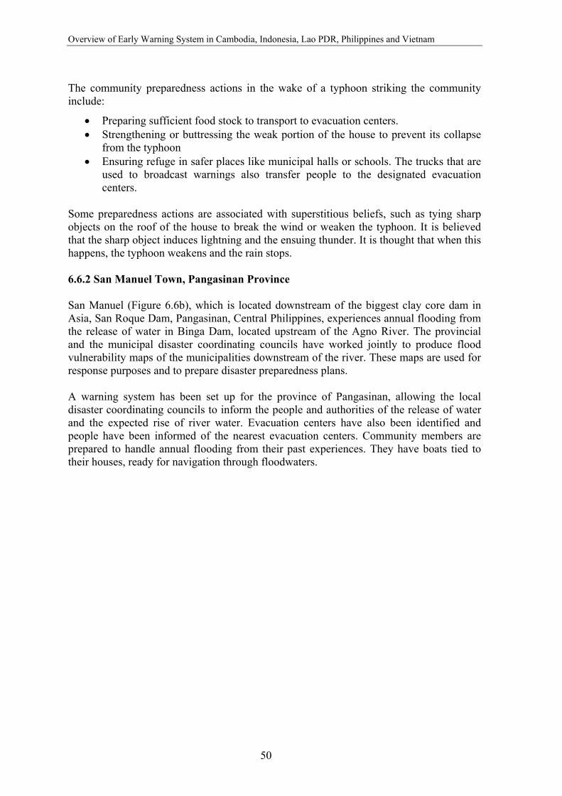
Overview of Early Warning System in Cambodia, Indonesia, Lao PDR, Philippines and Vietnam
50
The community preparedness actions in the wake of a typhoon striking the community include:
• Preparing sufficient food stock to transport to evacuation centers. • Strengthening or buttressing the weak portion of the house to prevent its collapse
from the typhoon • Ensuring refuge in safer places like municipal halls or schools. The trucks that are
used to broadcast warnings also transfer people to the designated evacuation centers.
Some preparedness actions are associated with superstitious beliefs, such as tying sharp objects on the roof of the house to break the wind or weaken the typhoon. It is believed that the sharp object induces lightning and the ensuing thunder. It is thought that when this happens, the typhoon weakens and the rain stops. 6.6.2 San Manuel Town, Pangasinan Province San Manuel (Figure 6.6b), which is located downstream of the biggest clay core dam in Asia, San Roque Dam, Pangasinan, Central Philippines, experiences annual flooding from the release of water in Binga Dam, located upstream of the Agno River. The provincial and the municipal disaster coordinating councils have worked jointly to produce flood vulnerability maps of the municipalities downstream of the river. These maps are used for response purposes and to prepare disaster preparedness plans. A warning system has been set up for the province of Pangasinan, allowing the local disaster coordinating councils to inform the people and authorities of the release of water and the expected rise of river water. Evacuation centers have also been identified and people have been informed of the nearest evacuation centers. Community members are prepared to handle annual flooding from their past experiences. They have boats tied to their houses, ready for navigation through floodwaters.

51
7. Vietnam 7.1 Background The Socialist Republic of Vietnam spans a total area of 329,560 sq. km. sharing borders with Laos and Cambodia in the west and China in the north. Being in the tropical region, it enjoys an abundance of water resources. Vietnam is basically an agrarian economy relying on its rivers. Therefore most of the settlements are found along rivers; the Red River in the north and the Mekong River in the south. Because of its geographic location, Vietnam is most prone to typhoons, floods, storms, and salinity intrusion. With environmental degradation, droughts and forest fires have also become a regular occurrence. Uneven distribution of rainfall is one of the main causes for the flooding of rivers. Situated close to the typhoon center of the South China Sea, Vietnam is vulnerable to typhoons. It is hit by an average of four to six typhoons per year. Floods The Mekong River forms a fertile and productive delta, which is hydraulically influenced by tidal effects from the South China Sea, by the discharge of the Mekong River from Cambodia, and by the heavy rain from monsoons and typhoons. The flooding in the year 2000 occurred approximately one month earlier than usual, in early July, reaching its first peak in August and the second peak in September. The second flood peak was higher than the floods that occurred in 1937 and 1961. The worst of these water disasters are caused by typhoons that raise sea levels and send storm surges up estuaries to inundate valuable croplands.
Figure 7.1 A flood scene in Vietnam: The year 2000 flood caused the most severe damage Vietnam has experienced in the last 70 years. Estimated losses and damage was about US$ 286 million.
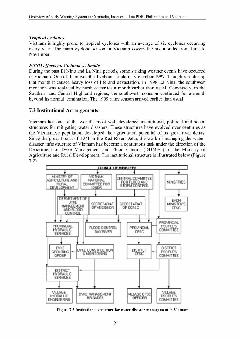
Overview of Early Warning System in Cambodia, Indonesia, Lao PDR, Philippines and Vietnam
52
Tropical cyclones Vietnam is highly prone to tropical cyclones with an average of six cyclones occurring every year. The main cyclone season in Vietnam covers the six months from June to November. ENSO effects on Vietnam’s climate During the past El Niño and La Niña periods, some striking weather events have occurred in Vietnam. One of them was the Typhoon Linda in November 1997. Though rare during that month it caused heavy loss of life and devastation. In 1998 La Niña, the southwest monsoon was replaced by north easterlies a month earlier than usual. Conversely, in the Southern and Central Highland regions, the southwest monsoon continued for a month beyond its normal termination. The 1999 rainy season arrived earlier than usual. 7.2 Institutional Arrangements Vietnam has one of the world’s most well developed institutional, political and social structures for mitigating water disasters. These structures have evolved over centuries as the Vietnamese population developed the agricultural potential of its great river deltas. Since the great floods of 1971 in the Red River Delta, the work of managing the water-disaster infrastructure of Vietnam has become a continuous task under the direction of the Department of Dyke Management and Flood Control (DDMFC) of the Ministry of Agriculture and Rural Development. The institutional structure is illustrated below (Figure 7.2)
Figure 7.2 Institutional structure for water disaster management in Vietnam
Vietnam
53
7.3 Hazard Detection The National Hydro-meteorological Services (NHMS) is the national agency authorized to prepare severe weather and flood forecasts over the country. The NHMS operates a high resolution satellite image receiving system at the National Center for Hydro-meteorological Forecasting (NCHMF) and five radar systems installed in different parts of the country: in Phu Lien (Hai Phong), Vinh (Nghe An), Tam Ky (Quang Nam), Viet Tri (Phu Tho), and Nha Trang (Khanh Hoa). There are two regional hydro-meteorological centers that perform forecasting in the Mekong Basin:
• Southern Region Hydro-meteorological Center located at Ho Chi Minh • Highland Region Hydro-meteorological Center located at Pleiku City
Forecasting The forecasts are required to cover a range of time scales, from a few hours (now casting), through short period forecasts for 2-3 days, to extended period forecasts for a week or more. The short-range forecasts in Vietnam achieve an accuracy of 75-80%, unless the weather is abnormal. Advisories and warnings of tropical storms and typhoons are issued 48 and 24 hours in advance, respectively. Three to five day forecasts of heavy rain can only be made in general terms: moderate, heavy and very heavy. Medium range forecasts are not quantitative and they do not meet the needs of many users, particularly for agriculture and disaster preparedness and prevention. Forecasts of the arrival of winter cold fronts in the Red River delta issued 5-10 days ahead have a probability of 80%. However, medium-term range forecasts do not predict long-term warm spells in winter. Monthly forecasts of rain and temperature are made in quantitative terms, indicating the expected relationship to the normal climate, i.e. above, approximate to, or below average. Seasonal forecasts are made for two seasons each year: the rainy and dry season. The method of forecasting is still very quantitative and not numeric, and relies on identifying the appropriate forecasting models. Proposed projects UNDP and USAID are joining hands in financially assisting the Government of Vietnam on a project entitled “Support to the Disaster Management System in Vietnam”. The objectives of the project are two-fold:
• To prepare disaster zoning maps to identify areas and populations at most risk of flooding in the seven central provinces of Quang Binh, Quang Tei, Thua Thien Hue, Da Nang, Quang Nam, Quang Ngai, and Binh Dinh. The map will show areas that are safe from flooding, locations where flood refuge buildings are needed and areas where disaster warnings are most urgently required.
• To install flood alert systems on the river basins in the region most prone to flash floods. These systems will provide up to 12-hour advance warning of imminent flash flooding to help protect lives, property and livelihoods. One of the systems will be installed in the Perfume (Huong) River Basin, to protect the City of Hue.

Overview of Early Warning System in Cambodia, Indonesia, Lao PDR, Philippines and Vietnam
54
7.4 Hazard Warning and Dissemination The Provincial Dyke Management, Flood Control and Storm Preparedness (PDMFCSP) undertake a key role in disaster forecasting, warning and preparedness. It also informs the Chief of People’s Village Committee of any impending flood, rise in floodwater or river water level. Flood warning is disseminated to the community through village radio communications. Loud speakers are attached to poles to ensure that the community hears the warning. The boat is a fixture in villages located in areas that normally get flooded. It serves a double purpose: for fishing and as transportation mode during evacuation.
The proposed UNDP and USAID project would provide valuable resources for dissemination of disaster warnings. A computer graphics-based disaster warning and severe storms information system will be installed on national TV networks to disseminate disaster warnings to the largest possible number of people in the disaster-prone areas of Vietnam. This will provide real-time information, warnings and disaster preparedness training for the population of Vietnam. Training will be provided for local disaster officials and grassroots communities to ensure effective utilization of warnings.
In some villages, especially the more recently established ones; the past flooding events have been used as an important feedback for village planning and also for preparing the villagers to respond to flooding. Flood markers installed in the villages provide the level of past flooding in the area, indicating the risk to flooding. The flood level marks also provide an important indicator for constructing houses.
Loudspeaker
Boat for evacuation
Figure 7.3. A typical Vietnamese village near a river demonstrating flood preparedness measures
Figure 7.4 Flood level marker in a Vietnamese village

55
8. Conclusion and Recommendations 8.1 Weather Forecast Most of the selected countries have been able to establish well-developed systems of data collection and sharing for short-range weather forecasting, with the support from the World Meteorological Organization and other regional and international organizations. With respect to seasonal and long-range forecasts, there is a need to enhance the technical infrastructure and capacity to produce, interpret and communicate seasonal and long-range forecasts in Cambodia, Lao PDR and Vietnam. Even though El Niño and La Niña events have a significant impact on local weather and climate related hazards, as evidenced by the catastrophic floods that affected central Vietnam in 1999, there has not been enough effort to prioritise seasonal forecasts. The absence of an intermediate mechanism that interprets ENSO forecast and converts it into locally usable information has also proved to be a formidable barrier to the decision making process. The existing Early Warning System can be strengthened by the availability of trustworthy El Niño forecasts. Following initiatives in the Philippines, each country should have a specific ENSO task force that involves all stakeholders such as meteorology, agriculture, water resources, public health and environment authorities. Better forecasts will require application of new advances in modelling (statistical and dynamical) that enhance skill in downscaling, improve lead time, and provide training of the technical staff in forecasting and understanding the impact of disasters. 8.2 Floods As floods cause the maximum loss to life and property in Laos, Cambodia and Vietnam, flood forecasting is their prime concern. Lately, there has been substantial investment from donors to improve the hydro-meteorological network of these countries. Assisted by forecasts from the MRCS stations, these countries have been successful in documenting real time hydro-meteorological data from the upstream. However, the real time data is received from few stations and accordingly the forecasts are limited to a handful of sites. The Vietnamese government has taken substantial measures to reduce the impact of floods. The measures include: drafting policies for various flood zones, developing a comprehensive system of disaster management, implementing water resource law, ordinances and implementation provisions on dykes, and on the prevention and control of floods and storms. In Lao PDR, Cambodia and Vietnam, flood data collection and sharing has significantly improved due to the support of Mekong River Commission. On the other hand Philippines and Indonesia have also improved on their flood forecasting and warning system. Table 8.1 highlights the hazard detection capacity in the selected countries.

Overview of Early Warning System in Cambodia, Indonesia, Lao PDR, Philippines and Vietnam
56
Table 8.1: Hazard forecast institutions and responsibilities Country Forecast Institutions and Infrastructure Activities Cambodia Weather and
tropical storms
Department of Meteorology (DoM), Ministry of Water Resources and Meteorology (MoWRAM)
Data collected from 14 synoptic stations and RSMC Issue of 24 hour forecast Warning disseminated to Minister offices, NCDM, Media, fishermen, farmers
MoWRAM Monitor ENSO impact on the country Monthly average and minimum temperature
Floods Department of Hydrology and River Works (DHRW), MoWRAM 1 office for flood forecasting 15 provincial hydro-meteorological offices 6 observation stations with 3 data loggers 72 newly established rain stations
Applies local models and Regression Analyses and Sogreah Model Analyses for prediction 3 days of water level prediction and warning Communication by radio, messenger Data sent to MRCS by facsimile Receive water level data of 4 countries sent by MRCS
Indonesia Weather Bureau of Meteorology and Geophysics (BMG) Application of Stochastic Models and ARIMA for weather prediction Assisted by the application of RAINMAN software from Australia
2 seasonal forecast and monthly forecast in the SFA, dry season forecast (before March) and wet season forecast (before Sept.) Takes into account ENSO parameters for seasonal forecast
Lao PDR Weather and Flood Department of Meteorology and Hydrology (DMH) 74 hydro stations 86 rainfall stations 34 meteorological stations Water Administration Division (WAD) 64 hydro stations 23 rainfall stations
Hydro-meteorological data collection Daily and long range forecast Provide hydro-meteorological services to Ministry of Agriculture, Forestry and Environment Data transferred from local stations by messenger, post, television, internet Hydro meteorology data collection Data from WAD forwarded to MRCS by email and fed in computers
Typhoon World Area Forecast Center, Bracknell, Regional Specialized Meteorological Center (RSMC)
Supplies tornadoes warning Low resolution meteorological satellite receives satellite photos from GMS-5 Warning disseminated through the Bangkok node
Philippines
Weather, Typhoon
Philippine Atmospheric, Geophysical and Astronomical Services Administration (PAGASA) 60 synoptic stations that send daily weather data to central forecast office Global spectrum model used to analyse and results translated into weather forecasts
3 hourly weather observation Weather map as a tool for distribution of atmospheric pressure, wind temperature and humidity Hourly satellite images from GMS-5 and cloud coverage Data sent from synoptic stations via single band radio, telephone, email 6 hourly weather observation sent to other countries, RSMC and Global Telecommunication System (GTS)
Flood Flood Forecasting Bureau (FFB) Monitoring and data collection from rain gauges and sent to Central Flood Forecasting Office. Flood forecasting models used for analyses of flood situation
Vietnam
Weather, flood
Hydro-meteorological Services (HMS)
Prepares weather and flood forecast Operates a high resolution satellite image receiving system and five radar system 2 regional hydro-meteorological centers Plans for flood hazard zones in under a UNDP/USAID project and a flood alert system on river basin m0st vulnerable to floods.

Conclusion and Recommendations
57
8.3 Hazard Warning and Dissemination The dissemination of weather and flood forecast needs improvement in most of the selected countries. Dissemination systems exist but require support to improve communications, which is a vital component of warning dissemination. The main constraints for warning identified in the study are: resources, cooperation and management efficiency, communication problems, limited scientific and technical understanding, and lapses in public awareness. In Philippines, with respect to warning and communication system, not all communities have access to public warning, and communication hardware and the quality of audibility is poor. Table 8.2 provides an overview of hazard warning and dissemination capacity in the selected countries. Table 8.2 Hazard warning and dissemination Country Hazard/
Responsibility Warning Dissemination
Cambodia Flood National Center for Disaster Management (NCDM)
Two level of flood warning: flood advisory and flood warning
NCDM transmits information on flood situation, through a sub-national committee on disaster management Up till the village level Tools commonly used are fax, messenger, and telephones. Hand held radio used by district offices but not maintained
Indonesia Floods Disaster Coordination Center (POSKO)
POSKO issues the warning with information on: type of flood, time and place of occurrence, effect of the flood, steps to be taken, and maps of flood prone areas
POSKO relies on media to disseminate information (extensive briefing on radio, TV and newspapers) on existing conditions and river heights Informal and community networks also serves as an important medium for warning dissemination
BMG is responsible for seasonal forecast
Provides a published document on total rainfall intensity for wet and dry season; and also seasonal forecast for the Seasonal Forecast Areas (SFA)
Lao PDR Weather, Tropical Storms NDMO
For rainy season forecast issued twice a day During inclement weather forecast is issued 3 times a day Typhoon warning contains the typhoon characteristics, risk on people, recommended action to prevent and mitigate
Warning sent to a number of media (for further dissemination), all levels of government, ministries and private companies Mobile phones and high frequency radio receivers
3 categories of tropical cyclone warning: Weather advisory, Tropical cyclone alert, and Tropical cyclone warning 3 categories of flood bulletin: flood outlook, flood advisory and flood warning
Philippines
Tropical Cyclone PAGASA
Multi-pronged dissemination scheme Public receives information directly by PAGASA or TV broadcast, regional warning centers and dam offices
Vietnam Flood Provincial Dyke Management, Flood Control and Strom Preparedness (PDMFCSP)
NA Village radio communications Loud speakers in communities
Overview of Early Warning System in Cambodia, Indonesia, Lao PDR, Philippines and Vietnam
58
Effective communication channels between local meteorological and climatological agencies, other relevant agencies and stakeholders in potentially affected sectors needs to be set up with some urgency in order to facilitate appropriate means of dissemination of warnings and other information 8.4 Community Response Public awareness programs exist at varying levels in all the selected countries but are insufficient to create a significant impact at the community level. There is good amount of awareness, though people are unable to quantify the would-be impact of the disaster due to lack of technical knowledge and low priority to disaster. The ability to assess impacts is essential to the formulation of effective and appropriate response strategies. Therefore, there is a need for a public awareness program that takes into consideration the most effective means to reach the public. Communities show a high level of resilience and act from experience or on instinct to survive. In the study conducted, there were cases where communities hesitated to evacuate to safer places due to their reluctance to leave their personal properties. The case study from Indonesia is a good model of how the community can be a part of an early warning system. 8.5 Recommendations Early warning can be an effective tool for mitigating the negative impacts of climate related hazards. However, mitigation should be viewed as one part of an integrated disaster management system that includes sustained attention to risk management and mapping of vulnerable communities. There is an urgent need to promote community-based early warning systems based on maps of the vulnerable areas of villages, provinces and districts. Effective disaster management also requires coordination and cooperation between responsible agencies, institutions, officials, the media, political leaders and other players at local, national and international levels. With the improved capacity of most countries in establishing the early warning system, there is need to move towards a proactive approach and development of effective national and regional frameworks to facilitate prompt action. This can be realized through improved communication, mobilizing government support, raising awareness (impacts, safety measures, mitigation options and EWS) and building on existing knowledge and institutional structures and programs. With growing international attention to climate change and climate related hazards, the public has become more aware of the importance of disaster mitigation, but sustained political will is the most essential ingredient to establishing effective early warning capacity. Substantial progress may be achieved by capitalizing on momentum generated by international, regional and national level projects. With respect to seasonal and long-range forecasts, there is a need to enhance the technical infrastructure and capacity to produce, interpret and communicate seasonal and long-range
Conclusion and Recommendations
59
forecasts. This need is most urgent in Cambodia, Lao PDR and Vietnam but the Philippines and Indonesia can benefit greatly from additional technical support as well. One way to strengthen existing Early Warning Systems is through ensuring the availability of trustworthy El Niño forecasts. Better forecasts will require application of new advances in modelling (statistical and dynamical) that enhance skill in downscaling, improve lead time, establish a community of trained technical personnel capable of forecasting, understanding the impacts of disasters and communicating this critical information to decision makers. In most countries the dissemination systems exist but are not maintained, in part because the sporadic incidence of hazards can lull decision makers into a false sense of security. Though in most countries the dissemination structure extends to the local level, the communication infrastructure is not effectively used. The reasons for the breakdown in communication need to be examined more closely and specific gaps need to be identified and bridged. As warning for hydro-meteorological hazards is limited to the capacity of the existing infrastructure to forecast potential disasters, the mutual exchange and cooperation between the five countries would serve as an important tool for efficient early warning. Finally, effective communication channels between local meteorological and climatological agencies, other relevant agencies and stakeholders in potentially affected sectors need to be set up with some urgency in order to facilitate appropriate means of dissemination of warnings and other information.

Annex 1: Guiding Principles for Effective Early Warning
61
Annex 1: Guiding Principles for Effective Early Warning Early Warning Programme of the International Decade for Natural Disaster Reduction (IDNDR), August 1997 THE OBJECTIVE of early warning is to empower individuals and communities, threatened by natural or similar hazards, to act in sufficient time and in an appropriate manner so as to reduce the possibility of personal injury, loss of life and damage to property, or nearby and fragile environments. RISK ASSESSMENT provides the basis for an effective warning system at any level of responsibility. It identifies potential threats from hazards and establishes the degree of local exposure or vulnerability to hazardous conditions. This knowledge is essential for policy decisions that translate warning information into effective preventive action. Several groups must contribute to this empowerment. Each has a set of essential overlapping functions for which it should be responsible:
• Members of vulnerable populations should be aware of the hazards and the related effects to which they are exposed and be able to take specific actions themselves which will minimize their personal threat of loss or damage;
• Local communities should have sufficient familiarity with hazards to which they are exposed, and the understanding of advisory information received, to be able to act in a manner to advise, instruct or engage the population in a manner that increases their safety or reduces the possible loss of resources on which the community depends;
• National governments should exercise the sovereign responsibility to prepare and issue hazard warnings for their national territory in a timely and effective manner, and to ensure that warnings and related protective guidance are directed to those populations determined to be most vulnerable to the hazard risk. The provision of support to local communities to utilize information and to develop operational capabilities is an essential function to translate early-warning knowledge into risk reduction practices;
• Regional institutions should provide specialized knowledge, advice or benefit of experience in support of national efforts to develop or to sustain operational capabilities related to hazard risks experienced by countries that share a common geographical environment. Regional organizations are crucial to linking macro-scale international capabilities to the particular needs of individual countries and in facilitating effective early warning practices among adjacent countries; and
• International bodies should provide means for the shared exchange of data and relevant knowledge among themselves as a basis for the efficient transfer of advisory information and the technical, material and organizational support necessary to ensure the development and operational capabilities of national authorities or agencies officially designated as responsible for early warning practice.
Overview of Early Warning System in Cambodia, Indonesia, Lao PDR, Philippines and Vietnam
62
Principles for the Application of Early Warning at National and Local Levels 1. Early warning practices need to be a coherent set of linked operational responsibilities
established at national and local levels of public administration and authority. To be effective, these early warning systems should themselves be components of a broader program of national hazard mitigation and vulnerability reduction.
2. Within each country, the sole responsibility for the issuance of early warnings for
natural and similar disasters should rest with an agency, or agencies, designated by the Government.
3. The decision to act upon receipt of warning information is political in character.
Authoritative decision-makers should be identified and have locally recognized political responsibility for their decisions. Normally, action resulting from warnings should be based on previously established disaster management procedures of organizations at national and local level.
4. In the chain of political responsibility, initial hazard information, is often technically
specialized or specific to a single type of hazard authority. To be applied effectively, warnings need to be clearly understood and operationally relevant to local agencies, which are more frequently oriented toward non-specific hazard functions.
5. Early warning systems must be based upon risk analysis that includes the assessment of
the occurrence of hazards, the nature of their effects and prevailing types of vulnerability, at national and local levels of responsibility. The warning process must lead to demonstrated practices that can communicate warning and advisory information to vulnerable groups of people so that they may take appropriate actions to mitigating loss and damage.
6. Locally predominant hazard types and patterns, including small-scale or localized
hydro-meteorological hazards related to patterns of human economic or environmental exploitation, must be incorporated if early warning is to be relevant to risk reduction practices.
7. There is a continuing need to monitor and forecast changes in vulnerability patterns,
particularly at local levels, such as sudden increases in vulnerability resulting from social developments. These may include conditions of rapid urbanization, abrupt migration, economic changes, nearby civil conflict or similar elements that alter the social, economic or environmental conditions of an area.
8. The primary responsibilities must rest at local levels of involvement for producing
detailed information on risks, acting on the basis of warnings, communicating warnings to those individuals at risk and, ultimately, for facilitating appropriate community actions to prevent loss and damage. A high resolution of local knowledge and developed experience of local risks, decision-making procedures, definitive authorities concerned, means of public communication, and established coping strategies are essential for functions to be relevant.
9. Groups of people that exhibit different types of vulnerability will have different
perceptions of risk and various coping strategies. Locally appropriate warning systems will provide a range of communication methods and should provoke multiple strategies
Annex 1: Guiding Principles for Effective Early Warning
63
for protection and risk reduction. 10. To be sustainable, all aspects of the design and implementation of early warning
systems require the substantive involvement of stakeholders at the local and national levels. This includes production and verification of information about perceived risks, agreement on the decision-making processes involved, and standard operational protocols. Equally important abilities involve the selection of appropriate communication media and dissemination strategies that can assure an effective level of participation in acting upon receipt of warning information.
Principles for Early Warning Systems at International and Regional Levels 1. In the interest of concerted international efforts to reduce the adverse effects of natural
and similar disasters, the technologically advanced countries have an obligation to encourage and support improved early warning practices in developing countries, small island developing states, economies in transition, and other disaster-prone countries with special circumstances.
2. Affected countries have an equal and primary responsibility to conduct a rigorous audit
of the effectiveness of their early warning capabilities, and identify gaps in the systems. The conduct of assessments of regional and national warning systems’ capabilities are particularly relevant following any disaster event.
3. Specialized regional and global centers involved in the preparation and dissemination of
warnings, such as the WMO Regional Specialized Meteorological Centers provide important links to national early warning systems. The application of their technical capabilities and the utility of their products should be carefully integrated with the needs of the countries being served, including any necessary clarification about the warning responsibilities between these centers and national agencies in the same region.
4. In the interest of protecting people from the risk of natural hazards, it is essential that
the formulation and presentation of warnings be based on the best available technical and scientific knowledge, and free of political distortion or manipulation.
5. International bodies and regional organizations must work to maintain the vital
importance of timely exchange and unrestricted access of observational data and other warning information between countries, particularly when hazardous conditions affect neighbouring countries.
6. Timely, accurate and reliable warnings should be understood in the context of
commonly accepted international standards, nomenclature, protocols and reporting procedures. Established or internationally agreed means of communications should be employed for the international and regional dissemination of any warning information to specific authorities designated in each country.
7. Collaboration and coordination is essential between scientific institutions, early warning
agencies, public authorities, the private sector, the media, and local community leaders to ensure that warnings are accurate, timely, and meaningful and can result in appropriate action by an informed population.
Overview of Early Warning System in Cambodia, Indonesia, Lao PDR, Philippines and Vietnam
64
Annex 2: Key Research Questions The following key questions served as the backbone of this research:
a) What are the source(s) of observational data and how are these data communicated to the weather and flood forecasting office?
b) How are, cyclone and flood warnings disseminated? What communication channels are used to disseminate the warnings?
c) How effective are the cyclone and flood warnings as perceived by the community?
d) Does the public understand the content of the warning, the different levels of warning signals used?
e) Does the public know what to do when a warning is given?
f) What is the role of the media in the Early Warning System?
g) What is the role of the political leaders and the disaster managers in disseminating warnings?
h) What is the contribution of international organizations in enhancing the preparation of the hazard warning?
i) Are there plans to enhance the present early warning system?
j) Is the community response based on vulnerability maps and/or disaster response plans in the community?
k) What preparedness and mitigation actions are practiced in the communities that are triggered by warning?
Annex 3: Research Informants
65
Annex 3: Research Informants: List of organizations visited and people interviewed Cambodia • H.E. Nhim Vanda, First Vice-President, National Committee for Disaster
Management • Mr. Khun Sokha, Assistant to the First Vice-President, National Committee for
Disaster Management • Mr. Peou Samy, Secretary General, National Committee for Disaster Management • Mrs. Seth Vannareth, Director, Cambodia Meteorological Department • Mr. Mao Hak, Deputy Director, Department of Hydrology and River Works,
Ministry of Water Resources and Meteorology • Mr. Long Saravuth, Deputy Director, Department of Hydrology and River Works,
Ministry of Water Resources and Meteorology • Mr. Te Navuth, Ministry of Water Resources • Mr. Lim Kin Ny, Department Secretary, Provincial Committee for Disaster
Management • Mr. Hem Hon, Chief, Sdao Kong Commune, Baphnom District, Prey Veng
Province • Management, Kandal Province • Mr. Limseng Duangsavanh, Deputy Director, Mekong River Commission, Phnom
Penh • Mr. Lieven Geerinck, Chairman of the Task Force on Flood Management and
Mitigation, Mekong River Commission • Mr. Tan Visal, Project Manager, Disaster Preparedness Action Plan, CARE
Cambodia Indonesia • Dr. Adang Setiana, Director, International Cooperation, BAKORNAS PBP,
Jakarta • Budi Atmadi, BAKORNAS PBP • Novian Reski, Kepala Sub-Bidang (Head of Training Sub-Division), Potlat,
Jakarta Satkorlak, Jakarta Selatan • Saiman, Kepala Sub-Bidang Penyelenggaraan & Pengendalian (Head of
Operations and Control Sub-Division), Bidang Tarlat • Syarifuddin Arsyad, Kepala Bidang Penataran dan Latihan (Head of Training),
Mawil Hansip DKI Jakarta (Civil Defense), Jakarta Pusat • Yuyun Sumirat, Balaikota • Theresia Wuryantari, OXFAM
Overview of Early Warning System in Cambodia, Indonesia, Lao PDR, Philippines and Vietnam
66
Lao PDR • Mr. Phetsavang Sounnalath, Director, National Disaster Management Office,
Department of Social Welfare, Ministry of Labor and Social Welfare, Vientiane, Lao PDR
• Mrs. Souvanny Phonevilay, Deputy Chief, Weather Forecasting Division, Department of Meteorology and Hydrology, Vientiane, Lao PDR
• Mr. Thone Pho Kham Inthasone, Planning Unit, National Disaster Management Office, Ministry of Labor and Social Welfare, Vientiane, Lao PDR
• Mr. Thatsanithan Khamphane, Village Chief, Bane Sanedin Philippines • Maj. Gen. Melchor P. Rosales, Administrator, Office of Civil Defense, and
Executive Officer, National Disaster Coordinating Council, Camp Gen. Emilio Aguinaldo, Quezon City
• Dr. Aida Jose, Chief, Climatology and Agrometeorology Branch, Philippine Atmospheric, Geophysical and Astronomical Services Administration, Quezon City
Vietnam • Mr. Dang Quang Tinh, Director, Department of Dike Management, Flood and
Storm Control, Hanoi
Annex 4: Documents Reviewed
67
Annex 4: Documents Reviewed for the Research ADPC (2000); ENSO Climate forecast Applications in Vietnam, Asian Disaster Preparedness Center, Thailand
CCFSC (1991); Organization Chart, DDMFC/MWR and CCFSC and VNC IDNDR, Information on Flood and Storm Control and Natural Disaster Reduction, December, 1991
Dinas Pekerjaan Umum Propinsi (November, 2000); Persiapan Menghadapi Musim Hujan (Preparation for the Rainy Season), 2000-2001, Jakarta
IDNDR (1997); Guiding Principles for Effective Early Warning, October 1997, Geneva
MoWRAM (2001); Flood Forecasting Management for Mekong River in Cambodia, Paper Presentation, Workshop on Evaluation and Improvement of Operational Flood Forecasting Models on Typhoon Committee Area, United Nations Conference Center, Bangkok, 21-24 August, 2001
MoWRAM (2002); Climate related to the El Niño and La Niña Impacts in Cambodia, Country report, Cambodia
MRC (2001); MRC Strategy on Flood Management and Mitigation, Phnom Penh, Mekong River Commission, 2001, Phnom Penh
MRC (2002): Flood warning and forecast; http://www.mrcmekong.org/info_resources/ffw/overview.htm, (referred for 11th July, 2002)
MRCS (2001); Capacity Building for the Application of Technical Products for Emergency Response Operations, The Mekong River Commission Project Proposal, November, 2001, Phnom Penh
MRCS (2001); MRC Flood Forecasting and Early Warning System: Immediate and Operational Improvement for the 2001 Floods, Project Document, June 2001, Phnom Penh
Philippines Weather Watch (2001); Philippines weather online, http://www.hotbitscafe.com/go/philweather/index.html
UNDP (2001); Strategy for Natural Disaster Mitigation in Vietnam, The Fifth Draft, Paper Presentation, Disaster Management Unit, UNDP, 2001, Hanoi
UNDP (2001); The Vietnam Disaster Management Unit online, http://www.undp.org.vn/dmu/dmu/en/intro.htm (2001, September)
UNEP, NCAR, UNU, WMO, ISDR (2000); Lessons Learnt from the 1997-98 El Niño: Once Burned, Twice Shy, Reducing the Impact of Environmental Emergencies through Early Warning and Preparedness: The Case of the 1997-98 El Niño
WMO (1994); A Decade Against Natural Disasters, WMO-No. 799, Geneva, Switzerland
http://www.bghrc.com/DMU/DEVRISK1/DEVRISK/TWIGG.HTM
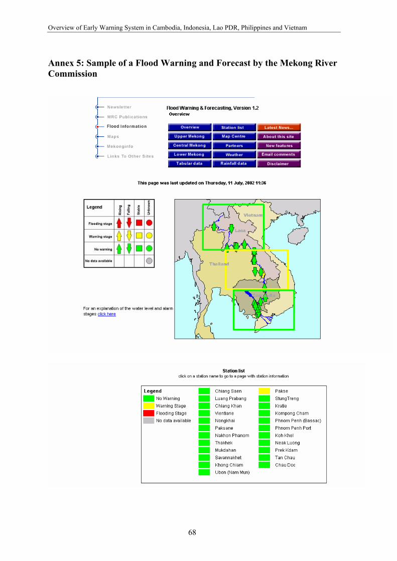
Overview of Early Warning System in Cambodia, Indonesia, Lao PDR, Philippines and Vietnam
68
Annex 5: Sample of a Flood Warning and Forecast by the Mekong River Commission
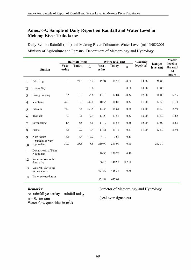
Annex 6A: Sample of Report of Rainfall and Water Level in Mekong River Tributaries
69
Annex 6A: Sample of Daily Report on Rainfall and Water Level in Mekong River Tributaries
Daily Report: Rainfall (mm) and Mekong River Tributaries Water Level (m) 13/08/2001
Ministry of Agriculture and Forestry, Department of Meteorology and Hydrology
Rainfall (mm) Water level (m)
Station Yest-erday
Today ∆ Yest-erday
Today ∆ Warning level (m) Danger
level (m)
Water level in the next
24 hours
1 Pak Beng 8.8 22.0 13.2 19.94 19.26 -0.68 29.00 30.00
2 Houay Xay 0.0 0.00 10.00 11.00
3 Luang Prabang 6.6 0.0 -6.6 13.18 12.84 -0.34 17.50 18.00 12.55
4 Vientiane 49.0 0.0 -49.0 10.56 10.88 0.32 11.50 12.50 10.70
5 Pakxam 74.9 16.4 -58.5 14.36 14.64 0.28 13.50 14.50 14.90
6 Thakhek 8.0 0.1 -7.9 13.20 13.52 0.32 13.00 13.50 13.82
7 Savannakhet 1.4 5.5 4.1 11.17 11.53 0.36 12.00 13.00 11.85
8 Pakxe 18.6 12.2 -6.4 11.51 11.72 0.21 11.00 12.50 11.94
9 Nam Ngum 16.6 4.4 -12.2 4.10 3.67 -0.43
10 Upstream of Nam Ngum dam 37.0 28.5 -8.5 210.90 211.00 0.10 212.30
11 Downstream of Nam Ngum dam 170.30 170.70 0.40
12 Water inflow to the dam, m3/s 1360.3 1462.3 102.00
13 Water inflow to the turbines, m3/s 427.59 428.37 0.78
14 Water released, m3/s 555.84 657.04
Remarks: ∆: rainfall yesterday – rainfall today ∆ = 0: no rain Water flow quantities in m3/s
Director of Meteorology and Hydrology (seal over signature)

Overview of Early Warning System in Cambodia, Indonesia, Lao PDR, Philippines and Vietnam
70
Annex 6B: Sample of Danger Level Warning in Mekong River Tributaries Khamouane Province Division: Date: 13/08/01 Report of Mekong River Level, Khamouane Province Warning of Danger Level: 13.50 m 1/8/01 = 11.55 m 2/8/01 = 11.43 m 3/8/01 = 11.40 m 4/8/01 = 11.49 m 5/8/01 = 11.61 m 6/8/01 = 11.80 m 7/8/01 = 11.85 m 8/8/01 = 12.05 m 9/8/01 = 12.31 m 10/8/01= 12.75 m 11/8/01= 12.82 m 12/8/01= 13.20 m 13/8/01= 13.52 m Remarks: Access road from Thakhek to Nong Bok was cut off Daily Reporter
(signed)
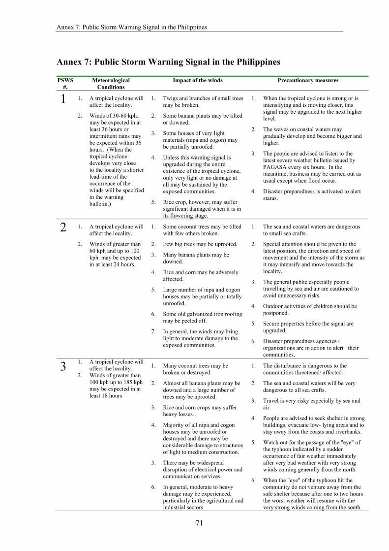
Annex 7: Public Storm Warning Signal in the Philippines
71
Annex 7: Public Storm Warning Signal in the Philippines PSWS
#. Meteorological
Conditions Impact of the winds Precautionary measures
1
1. A tropical cyclone will affect the locality.
2. Winds of 30-60 kph. may be expected in at least 36 hours or intermittent rains may be expected within 36 hours. (When the tropical cyclone develops very close to the locality a shorter lead-time of the occurrence of the winds will be specified in the warning bulletin.)
1. Twigs and branches of small trees may be broken.
2. Some banana plants may be tilted or downed.
3. Some houses of very light materials (nipa and cogon) may be partially unroofed.
4. Unless this warning signal is upgraded during the entire existence of the tropical cyclone, only very light or no damage at all may be sustained by the exposed communities.
5. Rice crop, however, may suffer significant damaged when it is in its flowering stage.
1. When the tropical cyclone is strong or is intensifying and is moving closer, this signal may be upgraded to the next higher level.
2. The waves on coastal waters may gradually develop and become bigger and higher.
3. The people are advised to listen to the latest severe weather bulletin issued by PAGASA every six hours. In the meantime, business may be carried out as usual except when flood occur.
4. Disaster preparedness is activated to alert status.
2 1. A tropical cyclone will affect the locality.
2. Winds of greater than 60 kph and up to 100 kph may be expected in at least 24 hours.
1. Some coconut trees may be tilted with few others broken.
2. Few big trees may be uprooted.
3. Many banana plants may be downed.
4. Rice and corn may be adversely affected.
5. Large number of nipa and cogon houses may be partially or totally unroofed.
6. Some old galvanized iron roofing may be peeled off.
7. In general, the winds may bring light to moderate damage to the exposed communities.
1. The sea and coastal waters are dangerous to small sea crafts.
2. Special attention should be given to the latest position, the direction and speed of movement and the intensity of the storm as it may intensify and move towards the locality.
3. The general public especially people travelling by sea and air are cautioned to avoid unnecessary risks.
4. Outdoor activities of children should be postponed.
5. Secure properties before the signal are upgraded.
6. Disaster preparedness agencies / organizations are in action to alert their communities.
3 1. A tropical cyclone will affect the locality.
2. Winds of greater than 100 kph up to 185 kph may be expected in at least 18 hours
1. Many coconut trees may be broken or destroyed.
2. Almost all banana plants may be downed and a large number of trees may be uprooted.
3. Rice and corn crops may suffer heavy losses.
4. Majority of all nipa and cogon houses may be unroofed or destroyed and there may be considerable damage to structures of light to medium construction.
5. There may be widespread disruption of electrical power and communication services.
6. In general, moderate to heavy damage may be experienced, particularly in the agricultural and industrial sectors.
1. The disturbance is dangerous to the communities threatened/ affected.
2. The sea and coastal waters will be very dangerous to all sea crafts.
3. Travel is very risky especially by sea and air.
4. People are advised to seek shelter in strong buildings, evacuate low- lying areas and to stay away from the coasts and riverbanks.
5. Watch out for the passage of the "eye" of the typhoon indicated by a sudden occurrence of fair weather immediately after very bad weather with very strong winds coming generally from the north.
6. When the "eye" of the typhoon hit the community do not venture away from the safe shelter because after one to two hours the worst weather will resume with the very strong winds coming from the south.

Overview of Early Warning System in Cambodia, Indonesia, Lao PDR, Philippines and Vietnam
72
PSWS #.
Meteorological Conditions
Impact of the winds Precautionary measures
7. Classes in all levels should be suspended and children should stay in the safety of strong buildings.
8. Disaster preparedness and response agencies/organizations are in action with appropriate response to actual emergency.
4
1. A very intense typhoon will affect the locality.
2. Very strong winds of more than 185 kph may be expected in at least 12 hours.
1. Coconut plantation may suffer extensive damage.
2. Many large trees may be uprooted.
3. Rice and corn plantation may suffer severe losses.
4. Most residential and institutional buildings of mixed construction may be severely damaged.
5. Electrical power distribution and communication services may be severely disrupted.
6. In the overall, damage to affected communities can be very heavy.
1. The situation is potentially very destructive to the community.
2. All travels and outdoor activities should be cancelled.
3. Evacuation to safer shelters should have been completed since it may be too late under this situation.
4. With PSWS #4, the locality is very likely to be hit directly by the eye of the typhoon. As the eye of the typhoon approaches, the weather will continuously worsen with the winds increasing to its strongest coming generally from the north. Then a sudden improvement of the weather with light winds (a lull) will be experienced. This means that the eye of the typhoon is over the locality. This improved weather may last for one to two hours depending on the diameter of the eye and the speed of movement. As the eye moves out of the locality, the worst weather experienced before the lull will suddenly commence. This time the very strong winds will come generally from the south.
5. The disaster coordinating councils concerned and other disaster response organizations are now fully responding to emergencies and in full readiness to immediately respond to possible calamity.
It is important to note that when any Public Storm Warning Signal Number is hoisted or put in effect for the first time, the corresponding meteorological conditions are not yet prevailing over the locality. This is because the purpose of the signal is to warn the impending occurrence of the given meteorological conditions. It must be noted also that the approximate lead time to expect the range of the wind speeds given for each signal number is valid only when the signal number is put in effect for the first time. Thus, the associated meteorological conditions are still expected in at least 36 hours when PSWS #1 is put in effect initially; in at least 24 hours with PSWS #2; in at least 18 hours with PSWS #3; and in at least 12 hours with PSWS #4. The lead-time shortens correspondingly in the subsequent issues of the warning bulletin when the signal number remains in effect as the tropical cyclone comes closer. It is also important to remember that tropical cyclones are constantly in motion; generally towards the Philippines when PAGASA is issuing the warning. Therefore, the Public Storm Warning Signal Number over a threatened or affected locality may be sequentially upgraded or downgraded. This means that PSWS #1 may be upgraded to PSWS #2, then to PSWS #3 and to PSWS #4 as necessary when a very intense typhoon is approaching or downgraded when the typhoon is moving away. However, in case of rapid improvement of the weather condition due to the considerable weakening or acceleration of speed of movement of the tropical cyclone moving away from the country, the downgrading of signal may jump one signal level. For example, PSWS #3 may be downgraded to PSWS #1 or all signals from PSWS #2 may be lowered.

Annex 7: Public Storm Warning Signal in the Philippines
73
The delineation of areas for a given signal number is based on the intensity, size of circulation and the forecast direction and speed of movement of the tropical storm or typhoon at the time of issue of the warning bulletin. The change in intensity, size of circulation or movement of the tropical cyclone also determines the change in the PSWS number over a given locality.

Overview of Early Warning System in Cambodia, Indonesia, Lao PDR, Philippines and Vietnam
74
Annex 8A: Flood Bulletin Messages Issued by PAGASA, Philippines
Flood warning
Condition* Action required from the public
Flooding is possible The expected significant rise of station water level exceeds level 4 within the next 24 hours; or the observed and the expected significant rise of station water level within the next 24 hours are between level 4 and level 6.
Awareness within the next 24 hours
Flooding is threatening
The expected significant rise of station water level exceeds level 6 within the next 24 hours; or the observed and the expected significant rise of station water level within the next 24 hours are between level 6 and level 10.
Preparedness within the next 24 hours
Flooding is expected to occur
The expected significant rise of station water level exceeds level 10 within the next 24 hours.
Response within the next 24 hours
Flooding is expected to persist
The observed and the expected station water level within the next 24 hours are above level 10.
Response within the next 24 hours
Flooding is no longer expected to occur
The observed station water level below level 10 is generally receding and no immediate significant rise is expected.
Flooding is no longer expected to persist
The observed station water level above level 10 is generally receding and no immediate significant rise is expected.
Flooding is no longer threatening
The observed station water level below level 10 is generally receding and no immediate significant rise is expected.
Flooding is no longer possible
The observed station water level below level 10 is generally receding and no immediate significant rise is expected.
*Flood assessment levels are explained below:
Level 4: The water level at the gauging station when the represented channel reach/lake/swamp is estimated to be 40% full on the average.
Level 6: The water level at the gauging station when the represented channel reach/lake/swamp is estimated to be 60% full on the average.
Level 10: The water level at the gauging station when a certain section of the represented channel reach/lake/swamp is estimated to be 100% full.
FLOOD ASSESSMENT LEVELS
LEVEL 10 LEVEL 6 LEVEL 4
WATER LEVEL/ DISCHARGE
LEVEL 10
LEVEL 6
LEVEL 4
TIME FLOOD HYDROGRAPH
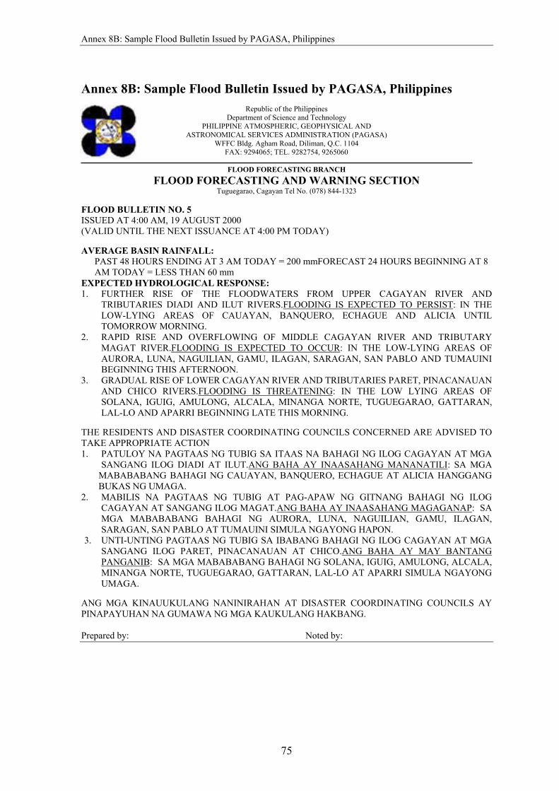
Annex 8B: Sample Flood Bulletin Issued by PAGASA, Philippines
75
Annex 8B: Sample Flood Bulletin Issued by PAGASA, Philippines
Republic of the Philippines Department of Science and Technology
PHILIPPINE ATMOSPHERIC, GEOPHYSICAL AND ASTRONOMICAL SERVICES ADMINISTRATION (PAGASA)
WFFC Bldg. Agham Road, Diliman, Q.C. 1104 FAX: 9294065; TEL. 9282754, 9265060
FLOOD FORECASTING BRANCH
FLOOD FORECASTING AND WARNING SECTION Tuguegarao, Cagayan Tel No. (078) 844-1323
FLOOD BULLETIN NO. 5 ISSUED AT 4:00 AM, 19 AUGUST 2000 (VALID UNTIL THE NEXT ISSUANCE AT 4:00 PM TODAY) AVERAGE BASIN RAINFALL:
PAST 48 HOURS ENDING AT 3 AM TODAY = 200 mmFORECAST 24 HOURS BEGINNING AT 8 AM TODAY = LESS THAN 60 mm
EXPECTED HYDROLOGICAL RESPONSE: 1. FURTHER RISE OF THE FLOODWATERS FROM UPPER CAGAYAN RIVER AND
TRIBUTARIES DIADI AND ILUT RIVERS.FLOODING IS EXPECTED TO PERSIST: IN THE LOW-LYING AREAS OF CAUAYAN, BANQUERO, ECHAGUE AND ALICIA UNTIL TOMORROW MORNING.
2. RAPID RISE AND OVERFLOWING OF MIDDLE CAGAYAN RIVER AND TRIBUTARY MAGAT RIVER.FLOODING IS EXPECTED TO OCCUR: IN THE LOW-LYING AREAS OF AURORA, LUNA, NAGUILIAN, GAMU, ILAGAN, SARAGAN, SAN PABLO AND TUMAUINI BEGINNING THIS AFTERNOON.
3. GRADUAL RISE OF LOWER CAGAYAN RIVER AND TRIBUTARIES PARET, PINACANAUAN AND CHICO RIVERS.FLOODING IS THREATENING: IN THE LOW LYING AREAS OF SOLANA, IGUIG, AMULONG, ALCALA, MINANGA NORTE, TUGUEGARAO, GATTARAN, LAL-LO AND APARRI BEGINNING LATE THIS MORNING.
THE RESIDENTS AND DISASTER COORDINATING COUNCILS CONCERNED ARE ADVISED TO TAKE APPROPRIATE ACTION 1. PATULOY NA PAGTAAS NG TUBIG SA ITAAS NA BAHAGI NG ILOG CAGAYAN AT MGA
SANGANG ILOG DIADI AT ILUT.ANG BAHA AY INAASAHANG MANANATILI: SA MGA MABABABANG BAHAGI NG CAUAYAN, BANQUERO, ECHAGUE AT ALICIA HANGGANG BUKAS NG UMAGA.
2. MABILIS NA PAGTAAS NG TUBIG AT PAG-APAW NG GITNANG BAHAGI NG ILOG CAGAYAN AT SANGANG ILOG MAGAT.ANG BAHA AY INAASAHANG MAGAGANAP: SA MGA MABABABANG BAHAGI NG AURORA, LUNA, NAGUILIAN, GAMU, ILAGAN, SARAGAN, SAN PABLO AT TUMAUINI SIMULA NGAYONG HAPON.
3. UNTI-UNTING PAGTAAS NG TUBIG SA IBABANG BAHAGI NG ILOG CAGAYAN AT MGA SANGANG ILOG PARET, PINACANAUAN AT CHICO.ANG BAHA AY MAY BANTANG PANGANIB: SA MGA MABABABANG BAHAGI NG SOLANA, IGUIG, AMULONG, ALCALA, MINANGA NORTE, TUGUEGARAO, GATTARAN, LAL-LO AT APARRI SIMULA NGAYONG UMAGA.
ANG MGA KINAUUKULANG NANINIRAHAN AT DISASTER COORDINATING COUNCILS AY PINAPAYUHAN NA GUMAWA NG MGA KAUKULANG HAKBANG. Prepared by: Noted by:
Safer Communities and Sustainable Development through Disaster Reduction