outcomes based curriculum design of bsc(hons) in … i/esmondmok.pdfoutcomes based curriculum design...
TRANSCRIPT

Outcomes Based Curriculum Design of
BSc(Hons) in Geomatics
3+3+4 Symposium
December 14, 2009
Prof. Esmond Mok
Department of Land Surveying & Geo-Informatics

• The University started to implement the outcomes
based teaching and learning approach about four
years ago. All undergraduate programme curricula
were required to convert to outcomes based
(OBC).
• Departments were given the OBC development
framework and guidelines. Within the framework,
departments had the flexibility to design their own
OBC according to the characteristics and emphasis of
the study programme. The current OBC of BSc(Hons)
in Geomatics is just one of many examples.
Current Programme Curriculum

• The goal of the future 4-year undergraduate
curriculum is to promote the all-round development of
human potentials to the fullest extent for the professions.
• In addition to developing students’ professional
competencies in a chosen discipline with a broad
knowledge base, the following generic competencies are
emphasized:
Future Programme Curriculum
Critical thinking and problem-solving abilities
Creativity and innovation
Communication and language skills Global outlook
Leadership and teamwork skills
Entrepreneurship
Cultural appreciationSocial and national responsibility
Healthy lifestyle Lifelong learning capability

Subject requirements for 4-year programmes
• General University Requirements (GUR)
• Discipline-specific Requirements (DSR)
GUR is to ensure that students are given sufficient opportunities in the 4-year undergraduate curriculum to:
• acquire the foundation knowledge and skills that underpin their major study
• acquire their language and communication skills to facilitate their university studies
• expand their intellectual capacity beyond their disciplinary domain so as to enable them to tackle professional and global challenges from a multi-disciplinary perspective, and in a holistic manner
• gain an increased understanding of China (e.g. its history, culture and society, as well as its emerging issues/challenges)
• develop a more healthy lifestyle, and• develop a sense of ethical conduct as a citizen and a professional

Subject requirements for 4-year programmes
• General University Requirements (GUR)
• Discipline-specific Requirements (DSR)
would follow the existing OBA curriculum design concept,
to help students develop discipline specific technical/
professional knowledge, as well as generic competencies
emphasized in the profession.

Experience sharing on curriculum design
of the current undergraduate Degree
Programme: BSc(Hons) in Geomatics
This approch would also be applied
in the development of the 4-year DSR
programmes and subject syllabi

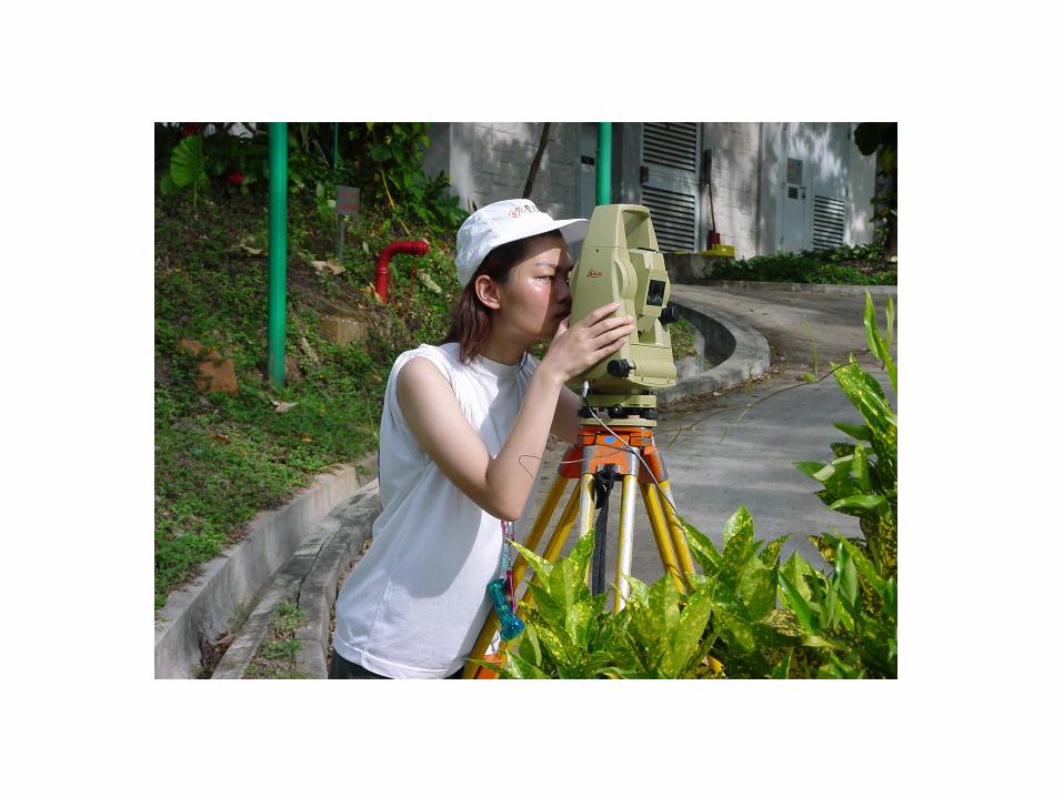
Geomatics:
Techniques and technologies on the
collection, processing, analysis,
interpretation, presentation,
management of spatial/geo data, for
a wide spectrum of applications.

Angle and
Distance
Measurements
Traditional Positioning Techniques

Satellite Positioning
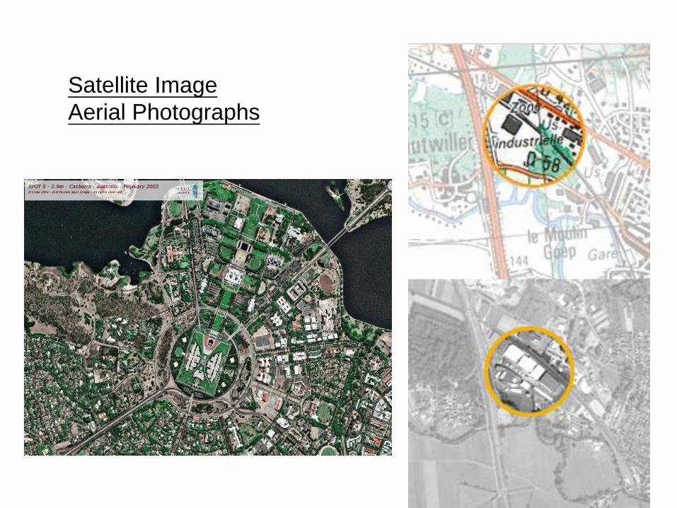
Satellite Image
Aerial Photographs
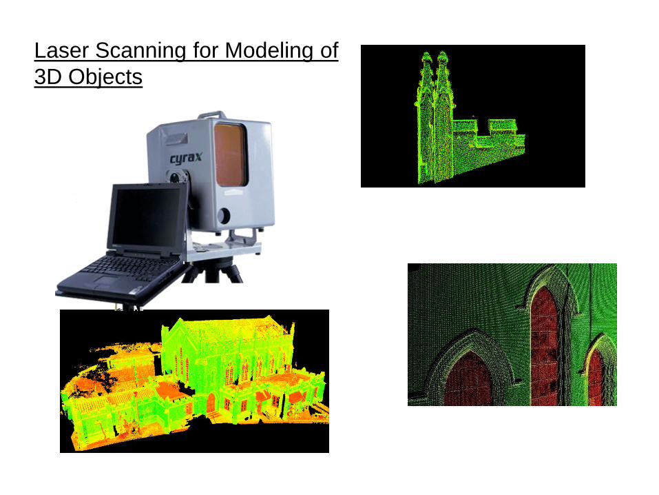
Laser Scanning for Modeling of
3D Objects

Map Making and Geo-spatial Information Management
Using Geographic Information Systems (GIS)

Vehicle Navigation
(satellite positioning, digital map, GIS)

Habitat Mapping
GIS
Web-Based Information
Query system
Data Query
Wireless device
equipped with GPS
GPS Data Capturing
System
Data Management
Data Sharing
Central Server &
Database
Field Survey
System Component
Hardware Device
Data Presentation
Habitat Mapping
(mapping of vegetation
distribution using GPS, GIS,
mobile communication)

Location Tracking
JAVA SIM
Client Side
Cellular Base Station
Location Polling
System
GIS Display
1 2
3
4 5
Service Provider Gateway
XML
URL
M
Satellite
Location
Server
GPS Measurement
GPS Measurement /
Positioning Result
Location Based Services
Provide advice on, e.g. “where are Chinese restaurants
around me, and how to get there?”
General Structure of
Outcomes Based Curriculum

Programme Outcomes
(Technical & Generic outcomes)
Technical and Generic Competences students
are expected to achieve at graduation
(T1, T2, …T?), (G1, G2, …G?)
Year 3/4 Subject -1
Technical & Generic Competences to
be developed/reinforced in subject 1
….Year 3/4 Subject -N
Technical & Generic Competences to
be developed/reinforced in subject N
Year 2 Subject -1
Technical & Generic Competences to
be developed/reinforced in subject 1
Year 2 Subject -M
Technical & Generic Competences to
be developed/reinforced in subject M
Year 1 Subject -1
Technical & Generic Competences to
be developed/reinforced in subject 1
Year 1 Subject -L
Technical & Generic Competences to
be developed/reinforced in subject L
….
….
General Structure of an Outcomes Based Curriculum


Programme Aims and
Programme Outcomes

Land Surveying Stream
To provide education to meet the modern land surveyor manpower
requirement of Hong Kong professional bodies.
Geo-Information Technology (Geo-IT) Stream
To provide education for graduates to work competently as GIS
professional with managerial responsibilities of the GIS system
design, analysis and management of geographic information in
transport & logistics, environmental, commercial, and construction
applications.
Programme Aims
Students after graduation will have acquired the knowledge and practical
Skills necessary for a land surveyor/Geo-IT professional at “Entry Level”

Major(Geo-IT) and Minor(COMP)
To provide education for graduates to be able to carry out and
manage technical details of GIS projects, software customization
and development.
Double Degree
To provide education for graduates competent in both Geo-IT and
Computer Science adaptable to the changing market demands on
Geo-IT and general IT in Hong Kong and Chinese mainland.
Programme Outcomes
Technical Outcomes
1. Academic Knowledge, 2. Professional Knowledge
Generic Outcomes

Technical Outcomes: Academic Knowledge
Understanding Level
Key Knowledge Areas LS Stream Geo-IT Stream Major(Geo-IT)
Minor (Comp)
Double
Degree
K1. Engineering Mathematics substantial
knowledge
fundamental
knowledge
fundamental
knowledge
substantial
knowledge
K2. Computer Science/Information
Technology
fundamental
knowledge
fundamental
knowledge
substantial
knowledge
in-depth
knowledge
K3. Geographic Information
System
fundamental
knowledge
in-depth
knowledge
substantial
knowledge
in-depth
knowledge
K4. Land & Hydrographic
Surveying
in-depth
knowledge
fundamental
knowledge
fundamental
knowledge
fundamental
knowledge
K5. Error Theory and Data
Analysis
in-depth
knowledge
fundamental
knowledge
fundamental
knowledge
fundamental
knowledge
K6. Management substantial
knowledge
substantial
knowledge
substantial
knowledge
substantial
knowledge
K7. Data Presentation and
Visualization
substantial
knowledge
substantial
knowledge
substantial
knowledge
substantial
knowledge
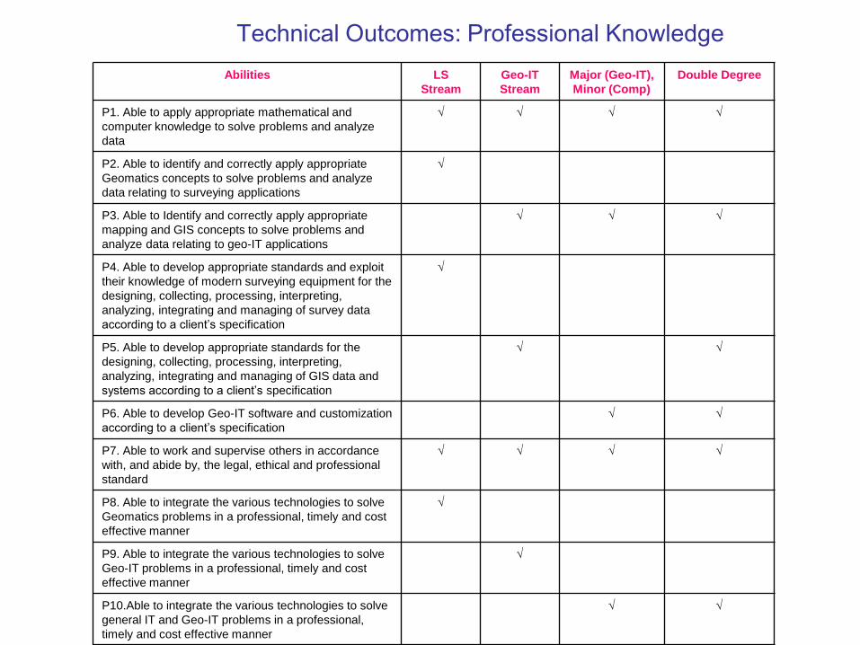
Abilities LS
Stream
Geo-IT
Stream
Major (Geo-IT),
Minor (Comp)
Double Degree
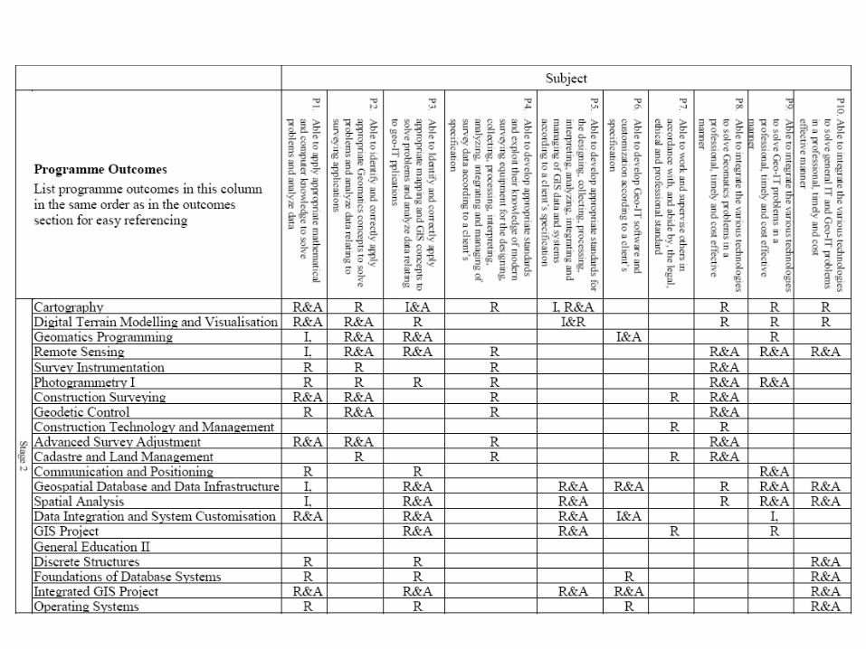
P1. Able to apply appropriate mathematical and
computer knowledge to solve problems and analyze
data
P2. Able to identify and correctly apply appropriate
Geomatics concepts to solve problems and analyze
data relating to surveying applications
P3. Able to Identify and correctly apply appropriate
mapping and GIS concepts to solve problems and
analyze data relating to geo-IT applications
P4. Able to develop appropriate standards and exploit
their knowledge of modern surveying equipment for the
designing, collecting, processing, interpreting,
analyzing, integrating and managing of survey data
according to a client’s specification
P5. Able to develop appropriate standards for the
designing, collecting, processing, interpreting,
analyzing, integrating and managing of GIS data and
systems according to a client’s specification
P6. Able to develop Geo-IT software and customization
according to a client’s specification
P7. Able to work and supervise others in accordance
with, and abide by, the legal, ethical and professional
standard
P8. Able to integrate the various technologies to solve
Geomatics problems in a professional, timely and cost
effective manner
P9. Able to integrate the various technologies to solve
Geo-IT problems in a professional, timely and cost
effective manner
P10.Able to integrate the various technologies to solve
general IT and Geo-IT problems in a professional,
timely and cost effective manner
Technical Outcomes: Professional Knowledge

Generic Outcomes
A1. Able to communicate effectively in English and demonstrate
suitable presentation skills
A2. Have correct attitudes and behavior of working with others
A3. Able to think critically and creatively
A4. Have developed entrepreneurship concepts and ideas
A5. Global outlook
Generic Outcomes (5 major areas)

Alignment of subject and programme outcomes
FOUNDATION
PROFICIENCY
EXTENSION/
BROADENING
Stage 1
Stage 2
Stage 3 & 4

• Develop students fundamental knowledge and concept
• Develop students equipment operation skills
• Develop students sufficient pre-requisite knowledge for the more
advanced surveying and Geo-IT concepts and methods to be
introduced in the second year.
• Field/laboratory work to help students develop the concept of
standards and specification requirements, field operation
procedures, and management concepts
Foundation

Proficiency
• Knowledge development stage
• Students to learn, compare and relate different methods in
the collection, processing, interpreting, analyzing and managing
geo-data
• Case-based learning and Problem-based learning are
emphasized in this year in order to help students achieve the
higher order thinking, and to relate knowledge to applications
Help students develop critical and creative thinking
• Experts and practitioners in the field are invited to share their
real-life experience and act as facilitators in the PBL process.

Extension/Broadening
• Students to receive a more in-depth knowledge in their specialised
areas
• Critical and creative thinking are reinforced through individual/group
projects, team discussions and presentation. Students learn from each
other and generate new ideas
• Professionals are invited to propose real-life project titles and/or
provide expert advice during the project period

Major Teaching and Learning Methods
Interactive Lecture
On-line delivery
Field/Lab Work
Field Scheme
Case-based/problem-based learning
Tutorial

Field Scheme
• Students stay in a project site for 1-2 weeks
• Students are given project requirements, they have
to complete the project within the project period
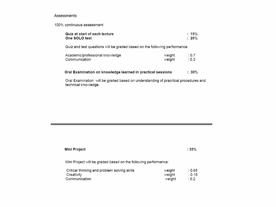
• Assessment: CA on field performance + oral examination


Subject Outcomes

Aims and Outcomes
A. Professional/academic knowledge and skills
Subject Syllabus
PART A – Subject specific information

Level 1 (L1): Recall definitions, do simple procedures and
calculations that largely rely on memorizing.
Level 2 (L2): Describe concepts and procedures, do intermediate
level of calculations that require some conceptual
understanding, discuss issues by combining different ideas.
Level 3 (L3): Compare, explain, analyze, relate and apply
mathematical models, ideas, theories and concepts.
Level 4 (L4): Discuss advanced theories and concepts,
derive mathematical models, theorize and
hypothesize study topic areas, generate new
knowledge, integrate knowledge to carry
out design and project work.

B. Attributes for all-roundedness
Keyword Syllabus
A. …
B. …
C. …
Content Distribution
A B C D E F
10% 20% 20% 20% 20% 10%

PART B - Teacher specific information
• Teaching and Learning Methodologies
• Assessment Methods
• Reading List
Design of Alignment Between
Subject and Programme Outcomes

I: Introduction, R:Reinforcement, A: Assessment

Teaching Plan and
Assessment Criteria for Students


University’s Grading System

Quality Assurance

Implement Outcome Based Approach of
Teaching and Learning
Collect Evidence and Feedbacks
Review and Reflect Alignments between
Programme Outcomes and Subject
Outcomes (T&L and Assessments)
Improve Programme Curriculum/
T&L and Assessment Methods
Outcomes Based Education
Continuous P
rocess

