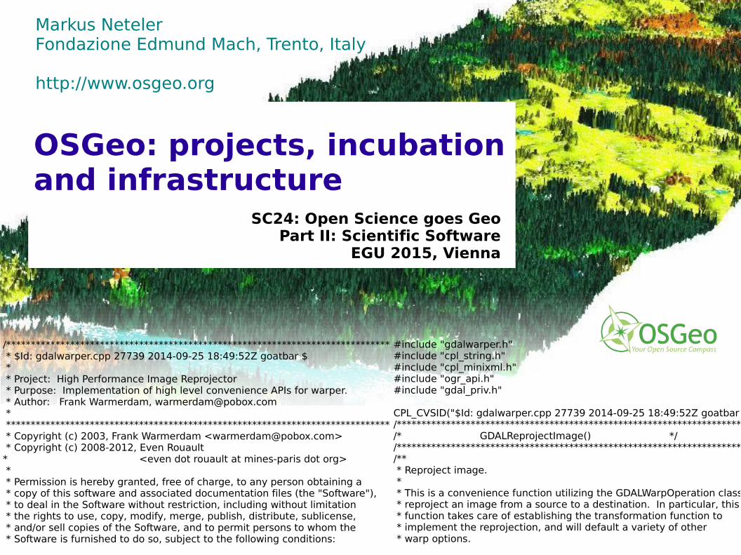
osgeo: projects, incubation and infrastructure
TRANSCRIPT
© 2
01
5,
Mark
us
Nete
ler,
Ita
ly –
CC
-BY-
SA
lic
ense
Markus NetelerFondazione Edmund Mach, Trento, Italy
http://www.osgeo.org
SC24: Open Science goes GeoPart II: Scientific Software
EGU 2015, Vienna
OSGeo: projects, incubation and infrastructure
/****************************************************************************** * $Id: gdalwarper.cpp 27739 2014-09-25 18:49:52Z goatbar $ * * Project: High Performance Image Reprojector * Purpose: Implementation of high level convenience APIs for warper. * Author: Frank Warmerdam, [email protected] * ****************************************************************************** * Copyright (c) 2003, Frank Warmerdam <[email protected]> * Copyright (c) 2008-2012, Even Rouault * <even dot rouault at mines-paris dot org> * * Permission is hereby granted, free of charge, to any person obtaining a * copy of this software and associated documentation files (the "Software"), * to deal in the Software without restriction, including without limitation * the rights to use, copy, modify, merge, publish, distribute, sublicense, * and/or sell copies of the Software, and to permit persons to whom the * Software is furnished to do so, subject to the following conditions:
#include "gdalwarper.h"#include "cpl_string.h"#include "cpl_minixml.h"#include "ogr_api.h"#include "gdal_priv.h"
CPL_CVSID("$Id: gdalwarper.cpp 27739 2014-09-25 18:49:52Z goatbar $");/************************************************************************//* GDALReprojectImage() *//************************************************************************//** * Reproject image. * * This is a convenience function utilizing the GDALWarpOperation class to * reproject an image from a source to a destination. In particular, this * function takes care of establishing the transformation function to * implement the reprojection, and will default a variety of other * warp options.

© 2
01
5,
Mark
us
Nete
ler,
Ita
ly –
CC
-BY-
SA
lic
ense
Geodata processing at its best
Distance to the outlet
Cinema style data visualization
Volume analysis
Big Geodatacrunching
ImageSegmentation
Web Services
LiDAR time seriesanalysis
Spatialdatabases
Pre / postdesaster assessment

© 2
01
5,
Mark
us
Nete
ler,
Ita
ly –
CC
-BY-
SA
lic
ense
Open Source Geospatial Foundation:OSGeo projects and related
DMZDMZ
Disk Array
BrowserBrowser MobileMobile
OpenLayers
TileCache
gvSig Mobile
Data Products
OSM
DesktopDesktop
QuantumGIS uDig
Mapbender
gvSigGrass GIS gvSigJUMP kosmo
Enterprise ServicesEnterprise Services
Information
Application Server
GeoNetworkMapServer deegreeGeoServer PostGIS
ZOO WPS pyWPS
Source: OSGeo-live presentation
Docker
… just anIncompleteView...!
© 2
01
5,
Mark
us
Nete
ler,
Ita
ly –
CC
-BY-
SA
lic
ense
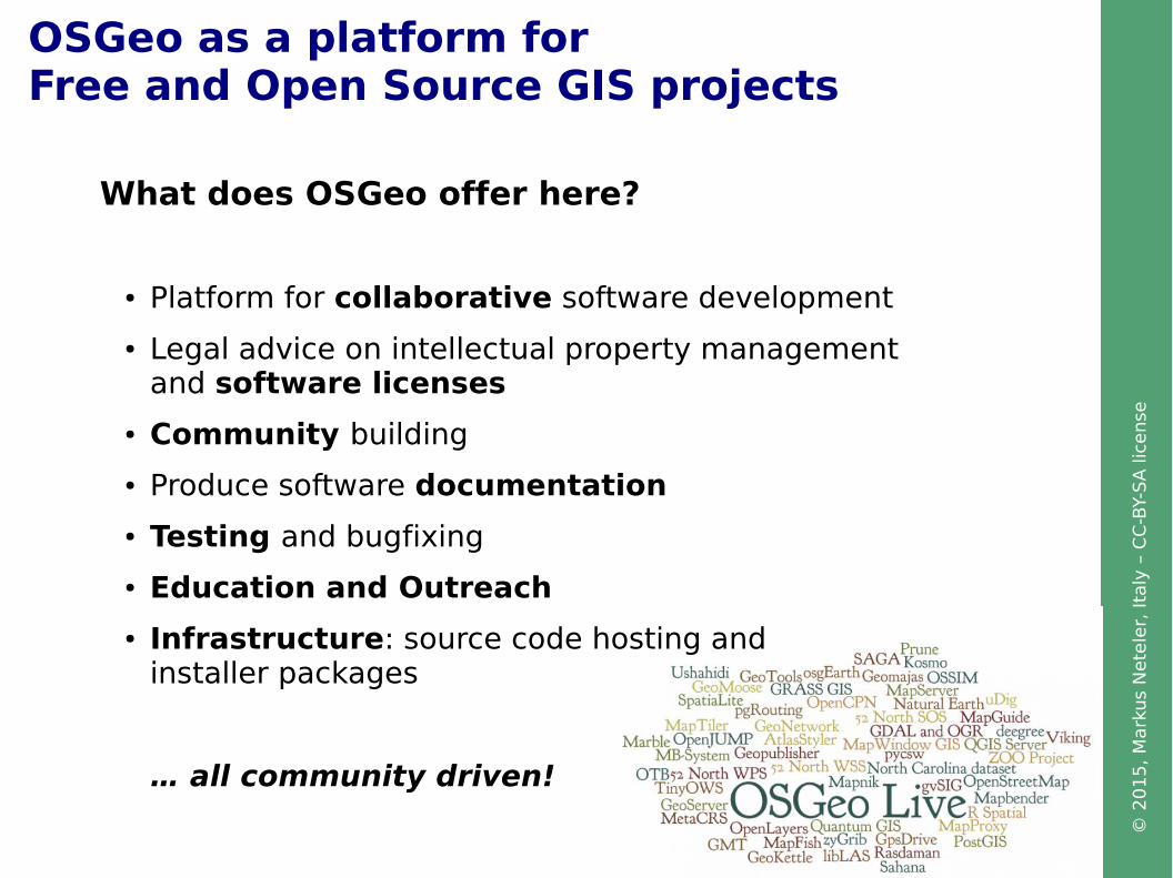
OSGeo as a platform forFree and Open Source GIS projects
What does OSGeo offer here?
● Platform for collaborative software development
● Legal advice on intellectual property management and software licenses
● Community building
● Produce software documentation
● Testing and bugfixing
● Education and Outreach
● Infrastructure: source code hosting and installer packages
… all community driven!
© 2
01
5,
Mark
us
Nete
ler,
Ita
ly –
CC
-BY-
SA
lic
ense
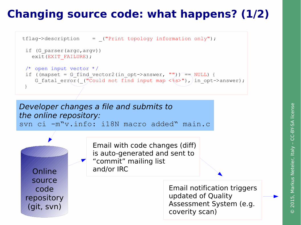
Changing source code: what happens? (1/2)
tflag->description = _("Print topology information only");
if (G_parser(argc,argv)) exit(EXIT_FAILURE);
/* open input vector */ if ((mapset = G_find_vector2(in_opt->answer, "")) == NULL) { G_fatal_error(_("Could not find input map <%s>"), in_opt->answer); }
Email with code changes (diff)is auto-generated and sent to“commit” mailing listand/or IRCOnline
sourcecode
repository(git, svn)
Email notification triggersupdated of QualityAssessment System (e.g. coverity scan)
Developer changes a file and submits to the online repository:svn ci -m“v.info: i18N macro added“ main.c

© 2
01
5,
Mark
us
Nete
ler,
Ita
ly –
CC
-BY-
SA
lic
ense
Code quality assessment
Changing source code: what happens? (2/2)
“Differences” (changes) email
Discussion triggeredamong developers
Improved source code after review
IRC robot feeds at #grass, #gdal, #qgis
IRC channel on freenode.net

© 2
01
5,
Mark
us
Nete
ler,
Ita
ly –
CC
-BY-
SA
lic
ense
Code vetting: stay clean!
How to become OSGeo project?
● Mentored Incubation phase:
● code vetting (IP), community health check
● Project sustainability
● Graduation (or not)
http://www.osgeo.org/incubator
Legal aspects
● License compliance
● Don't copy from books like “Numerical Receipes in C”
● Ensure that 3rd party contributions are clean
● Employers must agree that work time is spent on coding (if applies)
Transparency and peer review help to minimize the risk.
© 2
01
5,
Mark
us
Nete
ler,
Ita
ly –
CC
-BY-
SA
lic
ense
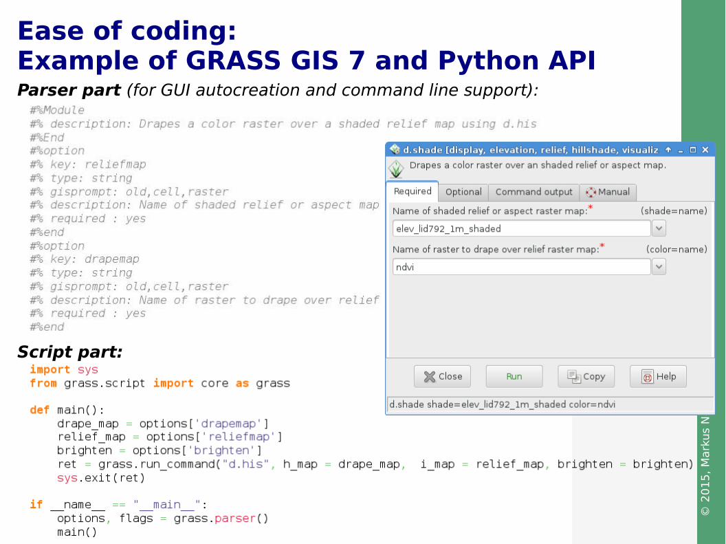
Script part:
Parser part (for GUI autocreation and command line support):
Ease of coding:Example of GRASS GIS 7 and Python API

© 2
01
5,
Mark
us
Nete
ler,
Ita
ly –
CC
-BY-
SA
lic
ense
Examples for programmer's manualshttp://grass.osgeo.org/programming7/
Additionally:● Wiki pages● Dev mailing lists

© 2
01
5,
Mark
us
Nete
ler,
Ita
ly –
CC
-BY-
SA
lic
ense
Funding model
Open source development is not gratis:
● Direct funding of developers through (scientific) projects● Crowdfunding campaigns● Company support● Voluntary work● Donations
https://www.openhub.net/p/grass_gis
(9/2014)
Example of cost analysis:
(2013)
© 2
01
5,
Mark
us
Nete
ler,
Ita
ly –
CC
-BY-
SA
lic
ense
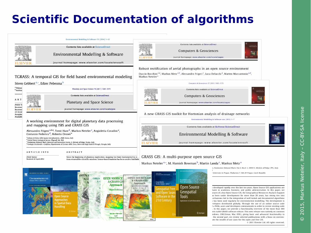
Scientific Documentation of algorithms

© 2
01
5,
Mark
us
Nete
ler,
Ita
ly –
CC
-BY-
SA
lic
ense
OSGeo software as a platformfor sustainable Open Science!
● Reproducibility: Open source is the natural habitat for science and research – wealth of scientific publications are documenting the algorithms
● Return of Investment:Example GRASS GIS' r.mapcalc: available since 1985, continuously developed, user can still run old scripts in latest GRASS GIS 7 without much update hassle while using latest implementation
● Auto-documentation: command line (besides GUI) generates map and command history – metadata preserved “forever”
● Reliability: Regression tests and quality control systems often integrated in the software itself
● Longevity for Open Science: code integrated in Open Source software “survives” even if original authors would not continue – 30 years of development
What's on offer?

© 2
01
5,
Mark
us
Nete
ler,
Ita
ly –
CC
-BY-
SA
lic
ense
Coding fun at international code sprints

© 2
01
5,
Mark
us
Nete
ler,
Ita
ly –
CC
-BY-
SA
lic
ense
Markus Neteler, PhD
Fondazione E. Mach (FEM)Research and Innovation CenterGIS and Remote Sensing Unit38010 S. Michele all'Adige (Trento), Italyhttp://gis.cri.fmach.ithttp://www.osgeo.org
[email protected]@osgeo.org
http://www.osgeo.org
Thanks!