osaka city univ.population density 12,000/km2 osaka city is one of the most hot and humid city in...
TRANSCRIPT

MinakoNABESHIMA,M.NISHIOKA,M.NAKAO,
M.MIZUNO,H.TOKURA,S.MIZUTANI
OsakaCityUniv.

Populationdensity
12,000/km2 OsakacityisoneofthemosthotandhumidcityinJapan 34.5degreeNorth
Osakacityhasalargepopulationandafewparks 2.6millionpeople Area222[km2] Parkarea3.5[m2/resident]

JapanKoreaCanadaGermanFranceEnglandU.S.A.U.S.A.AverageSeoulVancouverBerlinParisLondonN.Y.L.A.
[m2/resident] OsakaCity3.5[m2/resident]

Tosurveycurrentsituation WhereisvegetationinOsakaCity HowmuchvegetationinOsakaCity
Toconsiderurbanvegetationeffectson spatialvariabilityoftemperature

1. StudyareaandEquipment
2. Theindexesofvegetationcoverage
3. DiscussionA) Distributionofvegetationcoverage
usingtheindexesB) Vegetationeffectsontemperature
variability

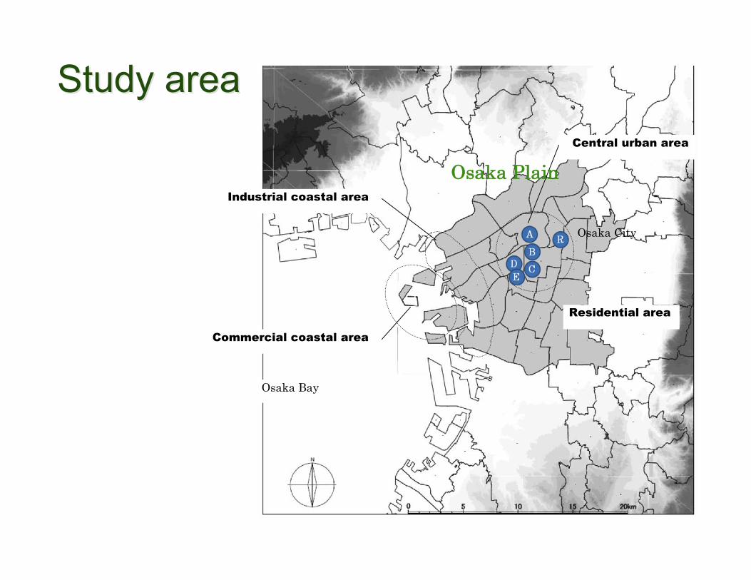
Study areaStudy areaCentral urban area
Industrial coastal area
Commercial coastal area
Residential area
Osaka Bay
Osaka Plain
Osaka City

!"#"$
%&''()
*+)'(&,(#()
*+)"-&,(#()./0
12(),&3&456(7
82(6#()
9-:)")(;$12(),&3&456($8(-7&)
<=>>?
@=>?
Douton-BoriRiver
KizuRiver
START
FINISH
theobservingcarequippedwithamobilemeasurementsystem
ObservationalDays1) 2ndAug.2008
• 14:30,19:30,+4:002) 5thAug.2008
• 14:30,+4:00


1. Coverageratio
2. Cindex
Theyarecalculatedfrom2kindsofGISdataset.

Theclassificationmap Photographyimagedataoflandcoverwascreatedfrom1‐meterresolutionaerialphotographs.
Pixelsareclassifiedinto5types:“grassfield”“treesorforest”“productivegreenarea”“bareground”“watersurface”.
(excludingbuildingsandroadsurfaces)
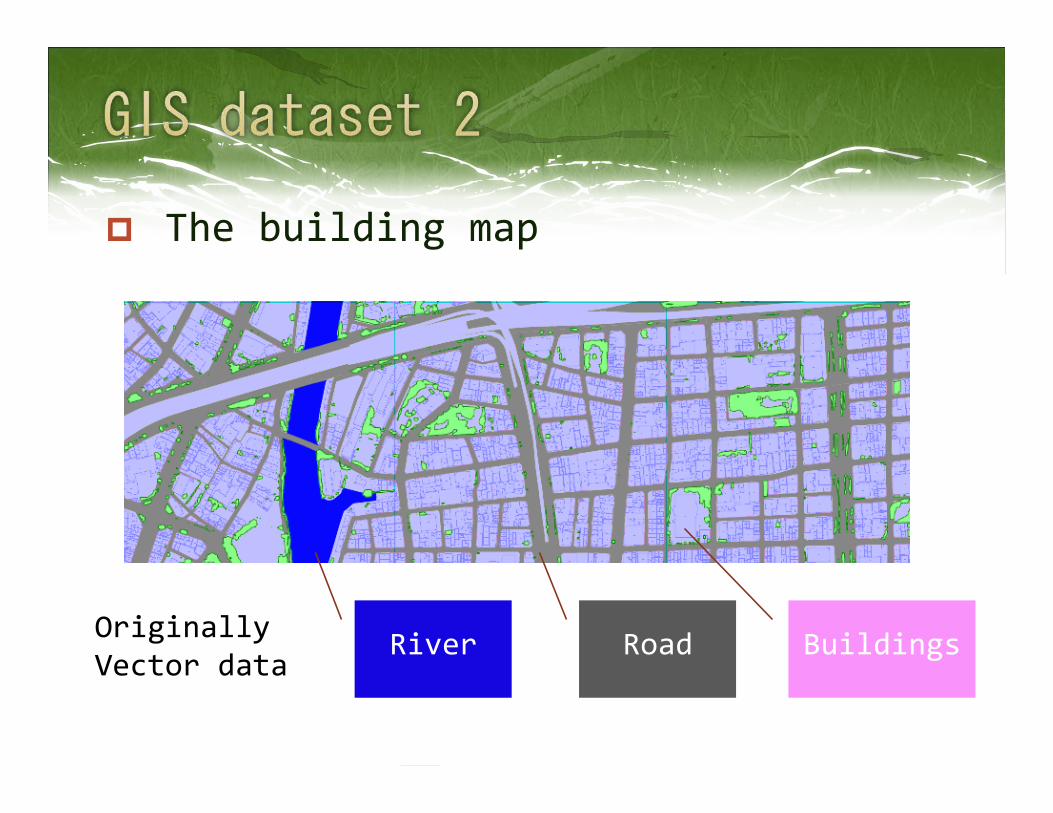
Thebuildingmap
OriginallyVectordata!"#$%&'(&)
*+,-./0%1(2
*"#$%3(&)
*+,-./0%1(1
River Road Buildings

Thevegetationcoverageratioiscountedineach500‐metersquare
VCR[%]
imagebinarization
Almostlessthan10%

! " " ! " ! !
" " ! " ! ! "
! " " " " ! "
! ! " " ! ! !
" " " " " " !
" " ! " ! " "
! " " ! " " !
The“Cindex”wassuggestedasanindexofconnectivity (Kobayashietal.2001)
Dataset:10‐meterresolutionimageofVCR
Inreality,theycanbefractions,0<=VCR<=1)

! " " ! " ! !
" " ! " ! ! "
! " " " " ! "
! ! " " ! ! !
" " " " " " !
" " ! " ! " "
! " " ! " " !
7
CNValue=7
CNValue
! " " ! # ! !
" $ ! $ ! ! #
! " % $ " ! #
! ! & & ! ! !
" $ % $ $ " !
' % ! $ ! $ "
! " " ! " " !
( )90,10
1
1
1
1
!!!!
= " "+
#=
+
#=
CNv
vCNx
xi
y
yj
ijxy

K
L

! " " ! " ! !
" " ! " ! ! "
! " " " " ! "
! ! " " ! ! !
" " " " " " !
" " ! " ! " "
! " " ! " " !
Numberof“1”=29
! " " ! # ! !
" $ ! $ ! ! #
! " % $ " ! #
! ! & & ! ! !
" $ % $ $ " !
' % ! $ ! $ "
! " " ! " " !
TotalofCNValue=154
Cindex=154/29=5.3
Theaverageof
CNvalues

CValue
Cindexinthisroad;
0~3
Cindexinthispark;
6~8


!
"!
#!
$!
%!
&!
'!
(!
)!
! "! #! $! %! &! '! (!!"#$%#&'()*+,-.',(-./#*012
*+,-.+/0-1234-5+.36*71/31*+1 8944+*8-12389,01231*+1
-/.6,0*-12389,01231*+13 8+/0*1236*71/31*+1VCR


気温
C値Cindex
Temperature
<UrbanCentralArea>

34
35
36
37
38
39
40
0 1 2 3 4 5 6
The C index of vegetation coverage ratio
on the major road on the river on the street other than the major road
On5thAug.,PM2:30

ItisfoundthattheCindexofthecellsaroundtheurbanparksisassignedahighscore.
ThereisanegativecorrelationbetweenthetemperatureonthestreetsotherthanthemajorroadsandtheCindex.
Continuityofurbanvegetationcoveragewasconfirmedtokeeptemperaturesatarelativelylowlevel.


Details and FindingsDetails and Findings

!"#$%&'(&)
*+,-./0%1(2
*"#$%3(&)
*+,-./0%1(1
!"#$%&'()
*+,-./0%&'1
#"#$%2'3)
*+,-./0%4'5
!"#$%&'()
*+,-./0%1'2
!"#!$%&'%(
)*+,-./$0'1
!"#$#%&#"'()%*#+$%,-)+)%."%'-)%
/.00)"'%1#+$%.2%!"#$#%&.'3!"#$%&'()
*+,-./0%&'1
#"#$%2'3)
*+,-./0%4'5

Survey area in detailSurvey area in detail
!"
#!"
$!"
%!"
&!"
'!"
(!"
)!"
*!"
+!"
#!!"
, - . / 0 1
2345 64782 942: ;<=>5=?@ 92=A478B398?BC94D8
Roadcoverratioisover20%
Buildingcoverratiois22~62%
Privateopenspaceis15~36%

!
"
#!
#"
$!
$"
% & ' ( ) *
+,-./0123+1425+/61 03+237289-:;-4< +/,= ,3/;
19%
2.5%1.5%
8.4%onprivateopenspace
7.5%ontheroad

Theredevelopmentzonehassucceededfromastandpointofincreasingthevegetationcoverageratio.

Thevegetationcoverageratioofthemodernbusinesszonesisfoundtobelessthan3%becauseofthehighdensityofbuildings,ontheorderof54%‐62%.
Mostroadshaveverylowvegetationcoverageintypicalbusinesszones,wherethereisroomforincreasingthenumberofroadsidetrees.

Itisimportantthatthesunnysideofstreetshouldbecoveredwithroadsidetreeswhichconnecttotheurbanparkassoonaspossible.