orienteering - orange county, florida
TRANSCRIPT

Hosted by FLO(Florida Orienteering)
Orienteeringat Moss Park

LEG
END
BEG
INNE
RSMoss Park andSplit Oak ForestMoss Park andSplit Oak Forest
BEGINNERS
Paved roadDirt roadVehicle trackTrailNarrow TrailLess district trailNarrow ride or cutlineBuilding, fenceUncrossable fenceRuined FenceContourForm line, slope lineSteep bankEarth wallDry ditchKnoll, small Knoll
DepressionShallow depression, pit
MarshIndistinct marsh
Uncrossable marshPond, LakeOpen land, fast runningOpen land; rough runningOpen land with sc, treesRough open with sc. treesForest, fast runningForest, slow runningForest, difficult to runForest, difficult to walkUndergrowth: slow runningUndergrowth:slow runningDistinct vegetation changeOpen sandy areaParking areaOut of Bounds
StreamSeasonal StreamNarrow marsh cairn
Special Symbols
Distinct, large thicketDistinct tree, root stockWater spigotOther man made oabjectScattered thickets
www.olles.Cz

ADV
AN
CED
Moss Park andSplit Oak ForestMoss Park andSplit Oak Forest
LEG
END A
G
B
E
D
F
C
ADVANCED
www.floridaorienteering.org
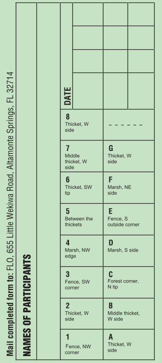
Mai
l com
plet
ed fo
rm to
: FLO
, 655
Litt
le W
ekiw
a R
oad,
Alta
mon
te S
prin
gs, F
L 32
714
NAM
ES O
F PA
RTIC
IPAN
TS
DAT
E
1Fence, NW corner
2Thicket, W side
3Fence, SW corner
4Marsh, NW edge
5Between the thickets
6Thicket, SW tip
7Middlethicket, W side
8Thicket, W side
AThicket, W side
BMiddle thicket, W side
CForest corner, N tip
DMarsh, S side
EFence, S outside corner
FMarsh, NE side
GThicket, W side
- - - - - -Beginners Advanced8 Thicket, W side - - - - - -

INSTRUCTIONS1. This Moss Park orienteering course offers two variations, one for beginning novices and one for the more advanced. The Beginner’s Course controls are numbered 1 through 8. The Advanced Course controls are lettered A through G.
2. Familiarize yourself with the map before you begin. Note the fi elds, roads and features visible from the starting kiosk and relate them to the features shown on the map. This
WHAT IS IT?Orienteering is a sport of Scandinavian origin. The game’s
objective is to locate fairly easy-to-fi nd markers, called
“controls”, in the forest with the aid of a map and, if you
like, a compass. The challenge arises from participants
not knowing the locations of the markers beforehand. The
test lies in determining the best routes between the marker
locations and in the sport’s competitive form, in fi nding all
these points (called controls) in the least possible time. At its
best, not only does orienteering improve your knowledge of
geography and practical navigation, it enhances physical and
mental fi tness as well.
Orienteering is a sport for a lifetime, for people of all ages,
abilities, and sexes. Participants may travel alone or in
groups, running or strolling, to win the contest or to merely
savor nature’s beauty, which, as any orienteer will attest,
winning itself. The sport provides ideal family recreation.
ORIENTEERING

familiarization is easier if you hold the map fl at in front of you and rotate it until it is “oriented’ to the terrain. Magnetic North line on the map will help if you have a compass but you will fi nd that the map is detailed enough that you should not need one for these courses.
3. Set out to visit the controls on the selected course in sequence. You will be starting and fi nishing at the kiosk defi ned by the red double circle overlaying the red triangle. The controls themselves will be at the exact center of the red circles printed on the map. Upon reaching each control, record the two number code printed on the marker post in the box provided on the control card portion of this brochure. (see illustration). You might also want to time yourself, using the start and fi nish spaces provided.
As an example, consider an imaginary control #9. Suppose it is marked on the map like so:
Referring to the map legend, you note that the control location – the exact center of the circle – seems to be a crossing of two paths. To check the terrain feature on which the control is located (it could be the pit instead), consult the description provided and fi nd the control locations precisely described as follows:
Suppose, after a fairly challenging and satisfying amount of navigation, you fi nally arrive at the vicinity of control #9. To
trailjunction
9
9

your delight, you sight it precisely where it should be – at the path junction.
Taking a closer look, you notice the ‘orienteering’ decal at the top.
Taking an even closer look you fi nd the control identifi cation number, “9” and a two-number combination. This combination (87 in the example) is the control code. Recording this code in the appropriate box on your control card you provide proof of your visit to the control for later verifi cation.
That’s it! You’re off to the next control, and so on to the Finish at the kiosk.
CERTIFICATIONWhen you fi nish either course, having located and recorded all the correct control codes, you may obtain an offi cial certifi cate of course completion from FLO. To do so, go to www.fl oridaorienteering.org, where you will fi nd instructions on how to obtain the Certifi cate on-line. Alternatively, you submit the detachable portion of this brochure, with the correct control numbers written in, and send it to the provided address. The website also has much more information on orienteering worldwide plus the dates of upcoming local events.
Congratulations and thank you for participating.
87
9
trailjunction
WWW.FLORIDAORIENTEERING.ORG
Taking an even closer look you find the control identification number, “9” and a two-number combination. This combination (87 in the example) is the control code. Recording this code in the appropriate box on your control card you provide proof of your visit to the control for later verification.

SAFETY NOTE: At the pace of a slow stroll, either course can be
completed in 60 to 90 minutes. It might be wise
to take this into account when setting off toward
dusk. Pace yourself so that you can complete the
course before the Park closes.
SAFETY NOTE: Park areas may contain hazards not normally
encountered. Be responsible for you and your
group’s safety.
COURTESY NOTE: A few areas are marked on your map as ‘off limits”
because they are Ranger residences. Please
respect their privacy. If you encounter Park Staff
during your visit to Moss Park and have enjoyed
your orienteering event, please let them know
how much you appreciate their support.
F • L • O • R • I • D • AORIENTEERINGF L O R I D AF L O R I D AF • L • O • R • I • D • AF L O R I D AORIENTEERINGORIENTEERINGORIENTEERING
.FLORIDAORIENTEERING.ORG

CREDITSFieldwork 2006: Ales Hejna, Vendula HejnovaCartography: Ales Hejna
Fieldwork 1997-2004: Joe Brautigam, Mark Adams, Richard DetwilerBasemap: Joe Brautigam, Mark Adams
COPYRIGHT NOTICEThis map is a copyright work created from real estate service photographs, USGS topographical map and field survey data and is the property of Florida Orienteering and may not be legally reproduced or copied in any form without explicit permission of the owners of its copyrights as listed below.
Copyright 2008, Florida Orienteering. All Rights Reserved.
ABOUT THESE MAPSThis map of Moss Park has been produced with the gracious cooperation of the staff of Moss Park and the Orange County Parks and Recreation Division.
Adjoining areas are private property. Possession of this map does not confer right of access. Please respect the rights of land owners. In addition, ranger residences are OFF LIMITS, so please respect their privacy.
WHAT IS ORIENTEERING?Orienteering is a recreational activity and competitive sport for people of all ages. It involves finding your way through unfamiliar terrain with the aid of a detailed topographical map. Using navigational skills and a compass to keep yourself oriented, you are free to select and follow the route you deem to be the best between designated points on a course marked solely by a series of distinctive flags located at each point. Florida Orienteering hosts public events on a monthly basis at one of several Central Florida venues. Everyone is always welcome at FLO events. Participate individually, or hike with a group. Instruction for first-timers is always available. No pre-registration required.
This map is a copyright work created from real estate service photographs, USGS topographical map and field survey data and is the property of Florida Orienteering and may not be legally reproduced or copied in any form without explicit permission of the owners of its copyrights as listed below. Copyright 2008, Florida Orienteering. All Rights Reserved.