open source geospatial -...
TRANSCRIPT

Open Source Geospatial
World Bank Conference on Land and Poverty 2017
Arnulf Christl (metaspatial)OSGeo Emeritus President

World Bank Conference Land and Poverty 2017 2
Agenda
Part IWhen is Open Source really Open Source?
Part IISoftware as a Service: STDM Online.

World Bank Conference Land and Poverty 2017 3
Part I
When is Open Source really Open Source?

World Bank Conference Land and Poverty 2017 4
Theses days everybody seems to have their own Open Source project. Many are kind of … not so good?
When is Open Source really Open Source and really good?

World Bank Conference Land and Poverty 2017 5
Software development teamSolves the problem
new version is released
Software users have new requirements, find bugs
Code is improved
Problem is identified
Publish Software (or Code)
Software Development
World Bank Conference Land and Poverty 2017 6
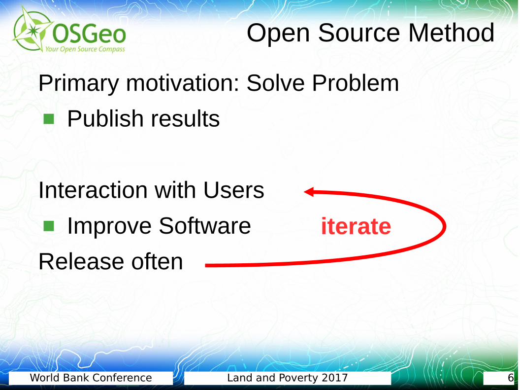
Primary motivation: Solve Problem
Publish results
Interaction with Users
Improve Software
Release often
Open Source Method
iterate
World Bank Conference Land and Poverty 2017 7
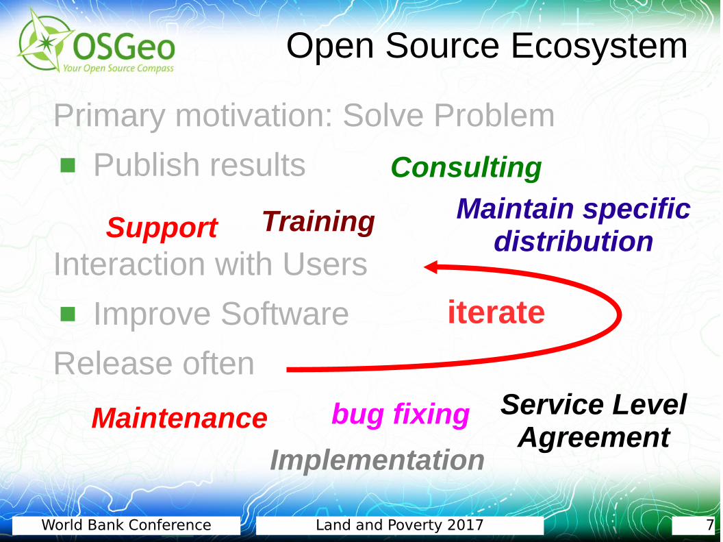
Primary motivation: Solve Problem
Publish results
Interaction with Users
Improve Software
Release often
Open Source Ecosystem
Implementation
Maintenance
Consulting
Support
bug fixing
Training
Service Level Agreement
Maintain specific distribution
iterate

World Bank Conference Land and Poverty 2017 8
Primary motivation: Solve Problem
Publish results
Interaction with Users
Improve Software
Release often
Open Source Ecosystem
Implementation
Maintenance
Consulting
Support
bug fixing
Training
Service Level Agreement
No Monopolies & Highly Competitive!
Maintain specific distribution
iterate

World Bank Conference Land and Poverty 2017 9
Anybody can call anything "Open Source"!
How do we know the software is good?
How do we know the software willbe around tomorrow?
What is Good Open Source?

World Bank Conference Land and Poverty 2017 10
Open Source Geospatial Foundation
http://www.osgeo.org
Your Open Source Compass...organizes spatial IT

World Bank Conference Land and Poverty 2017 11
The OSGeo Foundation
OSGeo is a not-for-profit organization founded in February 2006
Leading voice for Geospatial Open Source
Volunteer based
Funded by sponsorship
Does not provide direct end user services!
Quality Assurance for Open Source Projects

World Bank Conference Land and Poverty 2017 12
OSGeo's Structure
CommitteesCommittees
Committees
Board of 9 Directorsand President
LocalChaptersLocal
ChaptersLocalChapters
OfficersOfficers25 Officers
LocalChaptersLocal
ChaptersFoundationProjects
CommitteesCommittees
Committees
elected by Membership 312 Charter Members
Charter Members vote
represent
Sponsors

World Bank Conference Land and Poverty 2017 13
Summary
Open Source is just a model. Check how it has been implemented in the software you want to use.
Open Source Service Providers get you up to speed.
Use the right software to do the right thing. One solution does not always fit all!
Acquire your own know-how.
Invest your money in small improvements, not in one big chunk!

World Bank Conference Land and Poverty 2017 14
Copyright: Arnulf Christl, metaspatial. This slide set is copyrighted to the commons
The annual Conference on Free and Open Source Softwarefor Geospatial – FOSS4G 2018 will take place in Dar-es-Salaam
With friendly support by:
Thank you for your Attention!
http://www.metaspatial.net

World Bank Conference Land and Poverty 2017 15
Part II
The Social Tenure Domain Model Online
Open Source Software-as-a-Service

World Bank Conference Land and Poverty 2017 16 / 42World Bank Conference Land and Poverty 2017 16
Arnulf Christl
Geospatial Systems Architect● Consultant● Open Source Service Provider● STDM Online SaaS Provider● Owner of Metaspatial (http://www.metaspatial.net/)
This presentation is available for download at http://arnulf.us/Publications
World Bank Conference Land and Poverty 2017 17 / 42World Bank Conference Land and Poverty 2017 17
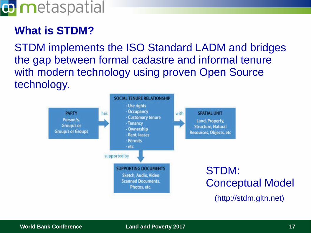
What is STDM?
STDM implements the ISO Standard LADM and bridges the gap between formal cadastre and informal tenure with modern technology using proven Open Source technology.
STDM: Conceptual Model (http://stdm.gltn.net)

World Bank Conference Land and Poverty 2017 18 / 42World Bank Conference Land and Poverty 2017 18
Web Server
QGIS Rendering Engine
Map
© Arnulf Christl
STDM
Report~~~~~~~~~~~~~~~~~~
TenureCertificate~~~~~~~~~~~~~~~~~~~~~~~~~~~~~~
Printed Output
Interview~~~~~~~~~~~~~~~~~~
Software ArchitectureSTDM is based on quality assured Open Source software inluding: ● Postgresql● PostGIS● QGIS● GDAL / OGR● Geraldo Reports
…and many more

World Bank Conference Land and Poverty 2017 19 / 42World Bank Conference Land and Poverty 2017 19
What is STDM Online?STDM Online brings this same functionality to the Web.
Users can create person data, structures (buildings), land parcels or farm land objects and link them through a tenure type using just an Internet Browser.
Interview~~~~~~~~~~~~~~~~~~
Datastore
© Arnulf Christl

World Bank Conference Land and Poverty 2017 20 / 42World Bank Conference Land and Poverty 2017 20
Map
Imagery Data
DatastorePostgres / PostGIS
Authoritative ServicesImagery Providers
© Arnulf Christl
Report~~~~~~~~~~~~~~~~~~
TenureCertificate~~~~~~~~~~~~~~~~~~~~~~~~
Printed Output
ETL
GDAL & OGR
Map Data
OpenStreetMapGPS Acquired, etc.
GPSInterview~~~~~~~~~~~~~~~~~~
TenureStructurePerson
Functionality:● Data Import● Data capture● Enumeration ● Tenure relation● Statistics● Reporting● Print Service● Data Export● Extensions...

World Bank Conference Land and Poverty 2017 21 / 42World Bank Conference Land and Poverty 2017 21
The Business Proposal ● Rent an STDM Service Platform and work on it with as
many users for as long as you need it. ● Once done, migrate all the data off. ● Or – simply take over the machine and continue
working as if nothing happenend – at no extra cost.
Service Level AgreementThe service level agreement with Metaspatial gives you peace of mind that services are online when you need them, the software is secure and up-to-date and your data is backed up.

World Bank Conference Land and Poverty 2017 22 / 42World Bank Conference Land and Poverty 2017 22
Thank you for your Attention.
For more information pleasevisit our website or talk to me after the presentation.
http://metspatial.net/en/stdm
Presenter: Arnulf Christl

World Bank Conference Land and Poverty 2017 23
References OSGeo Foundation website: http://www.osgeo.org
OSGeo Wiki: http://wiki.osgeo.org
Open Source: http://producingoss.org by Karl Fogel
OpenStreetMap: http://www.openstreetmap.org/
A note on Copyright: http://arnulf.us/Seven:Copyrights
Metaspatial: http://www.metaspatial.net
Mundialis GmbH: http://www.mundialis.de
STDM: http://stdm.gltn.net
PostGIS: http://postgis.org
QGIS: http://qgis.org
This presentation is available for download at http://arnulf.us/Publications