open source autodesk’s web – gis strategy frank von arx, director topobase solutions
TRANSCRIPT

Open Source
Autodesk’s Web – GIS StrategyFrank von Arx, Director Topobase Solutions

Web 1.0 & Web 2.0
• Web 1.0 – first generation publishingBritannica Online Yahoo!
Personal web pages Published content
– Mapping: MapGuide 6.x, MapXtreme, ArcIMS
– MapServer
• Web 2.0 – second generation participationWikipedia Google Maps YouTube/MySpace
Blogs Personal & collaborative content
– Mapping: MapGuide Open Source & FDO

Geospatial standardsProprietary Legacy
Geospatial follows IT standards
• SQL SQL/MM
• XML GML
• Web services WMS, WFS, WCS, and more
Open Source• GRASS (Geographic Resources Analysis Support System)
– Began 1982
• MapServer

Why open source?
• Web mapping becomes commoditized
– Active open source community for MapServer
– Less complex than desktop applications
– Revenue opportunities in vertical applications

• For customers:– Frequent software releases
– Faster innovation and support for standards
– Lower cost of ownership
• For the open-source geospatial community:– Increased presence and credibility
– Access to a modern, well-built platform
– Technical expertise, sponsorship and business resources
• For Autodesk:– Broader adoption of integrated technology
– Increased demand for related products
Benefits

Autodesk’s commitment to open source
Sponsor of the Open Geospatial Foundation - www.osgeo.org
• Support for MapGuide and FDO projects
– Member of technical steering committee
– Active with developer community
– Continued code contributions
• MapGuide open source development drives Autodesk MapGuide Enterprise
– Shared code base
– Enterprise version includes QA and support
Regional Chapters
have started• China• India• Japan• Canada
In formation • Brazil• France• Germany• Italy

MapGuide Open SourceLaunch Interactive mapping applications
• Advanced server-based geospatial platform– Publish Autodesk, ESRI, MapInfo, Oracle data and more– Create geospatial websites and web services– State-of-the-art code base
• Advanced, open source data access
– Same FDO technology as Map 3D and Raster Design– Direct access to different data formats– Read and write data access without data loss– Advanced API for web and server solutions

What is MapGuide?
Deliver web-based applications with:
• Dynamic data visualization
• Feature selection and attribute display
• Data query and update
• Geospatial analysis
Available as
• Open source
• Commercial version

MapGuide Open Source Downloads
25,000

Broad platform support
Deploy on…
Serve with…
Develop with…
Browse with…
Windows Linux
Microsoft IISApache Web Server
SafariMozilla Firefox
Internet Explorer
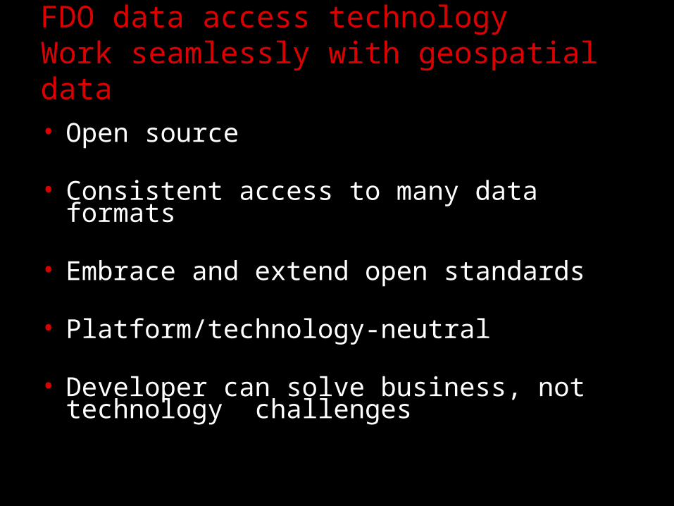
FDO data access technologyWork seamlessly with geospatial data
• Open source
• Consistent access to many data formats
• Embrace and extend open standards
• Platform/technology-neutral
• Developer can solve business, not technology challenges

FDO Data Access Technology Autodesk FDO Providers
– SDF
– ESRI SHP
– WFS
Vector Data Formats
– JPG2K
– MrSID®
– TIFF/GeoTIFF
– ECW
– DEM
– ESRI Grid
– DTED
– NITF
– WMS
Raster Data Formats
Databases– Oracle®
– Oracle Spatial
– ArcSDE®
– MySQL®
– Microsoft® SQL Server™
– ODBC Compliant DB
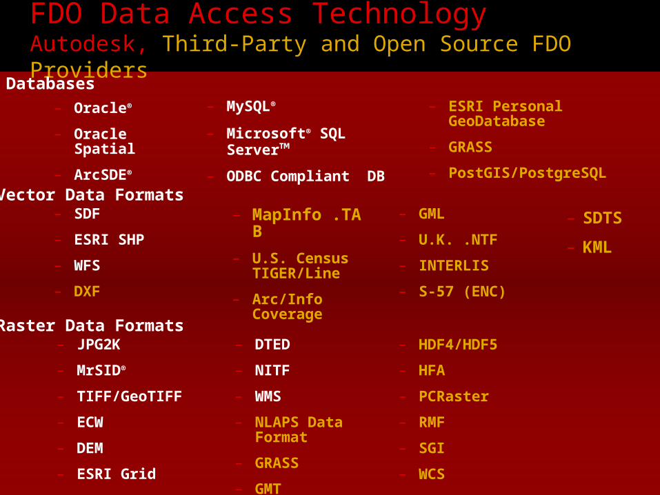
FDO Data Access Technology Autodesk, Third-Party and Open Source FDO Providers
– SDF
– ESRI SHP
– WFS
– DXF
– MapInfo .TAB
– U.S. Census TIGER/Line
– Arc/Info Coverage
– GML
– U.K. .NTF
– INTERLIS
– S-57 (ENC)
Vector Data Formats
– JPG2K
– MrSID®
– TIFF/GeoTIFF
– ECW
– DEM
– ESRI Grid
– DTED
– NITF
– WMS
– NLAPS Data Format
– GRASS
– GMT
– HDF4/HDF5
– HFA
– PCRaster
– RMF
– SGI
– WCS
Raster Data Formats
Databases
– Oracle®
– Oracle Spatial
– ArcSDE®
– MySQL®
– Microsoft® SQL Server™
– ODBC Compliant DB
– ESRI Personal GeoDatabase
– GRASS
– PostGIS/PostgreSQL
– SDTS
– KML

Open Source
MapGuide Open SourceIt’s free!