on. .j^? division of solid & hazardous waste ......payson city corporation os/28/06 constmction...
TRANSCRIPT

NOV 0 2 m on. . J ^ ? " DIVISION OF SOLID & HAZARDOUS WASTE
Permit Application for
Payson City Corporation Construction/Demolition Landflll (Class VI) Utah County
Payson City Corporation Payson City Engineering
August, 06

Table ofContents
1. PART I - GENERAL INFORMATION (R315-310-3 (1)(A)) 1
2. PART II - GENERAL REPORT 2
2.1. INTRODUCTION (R315-310-3(1)) 2 2./.I. General Description Of The Facility (R315- 310-3 (l)(b)) 2 2.1.2. LegalDe.icription (R315-310-3 (l)(c)) 2 2.1.3. Proof of Ownership (R315-310-3 (l)(c)) 2 2.1.4. Latitude And Longitude Of The Site (R315-310-3 (l)(c)) 2 2.1.5. LandUseAndZoniitgOfSurroundirtgArea(R3l5-310-3(l)(c)) 2
2.2. PLAN OF OPERATION (R315-310-3(1)(E)) 2 2.2.1. Intended Schedule Of Coivstruction(R315-302-2 (2)(a)) :. 2 2.2.2. On-Site Waste Handling Procedures (R315-302-2 (2)(b) and R315-310-3(1 )(t) 2 2.2.3. Inspections and Monitoring (R315-302-2(2)(c) , R315-302-2(5)(a). and R315-310- 3(l)(g)) 3 2.2:4. Contingency Plans In The Event Of A Fire Or Explosion (R315-302-2(2)(d)) 3 2.2.5. Corrective Action If Ground Water Is Contaminated (R315-302-2(2)(e)) 4 2.2.6. Contingeiicy Plans For Other Releases (R315- 302-2(2)(f) 4 2.2.7. Du.st Control Plan (R315-302-2 (g)) 4 2.2.8. Equipment Maintenance (R315-302-2 (2)(h)) 4 2.2.9. Exclu.iion Of Regulated Hazardous Or PCB's (R315-302-2 (2)(i)) 4 2.2.10. Disease Vector Control (R315-302-2 (2)0)) 5 2.2.11. Alternative Wa.ste Handling (R315-302-2 (2)(k)) 5 2.2.12. General Training And Safety Plan For Site Operations (R315-302-2 (2)(n)) 5
3. PART III TECHNICAL REPORT 6
3.1. MAPS ,....6 3.1.1. Topographic Map (R315-310-4(2)(a)(i)) '. ....6 3.1.2. U.S. Geological Survey Topographic Map (R315-310-4 (2)(a)(ii)) 6
3.2. ENGINEERING REPORT- PLANS, SPECIFICATIONS, AND CALCULATIONS 6 3.2.1. Landfill Design (R315-31 0-3(1 )(b)) 6
3.3. CLOSURE PLAN (R315-310-3(L)(H) ANDR315-310-5(2)(C)).... 7 3.3.1. Closure Schedule (R315-310-4 (2)(d)(i)) 7 3.3.2. Design Of Final Cover (R315-310-4 (2)(c)(iii) and R315-305-5(5)) 7 3.3.3. Capacity Of Site (R315- 310-4 (2)(d)(ii)) 8 3.3.4. Final Inspection (R315-31 0-4(2)(d)(iii)) 8
3.4. POST-CLOSURE CARE PLAN (R315-310-3(1)(H)) ; 8 3.4.1. Site Monitoring (R315-310-4 (2)(e)(I)) 8 3.4.2. Changes To Record Of Title. Land Use, And Zoning Restrictions (R3 15-3 10-4 (2)(e)(ii)) 8 3.4.3. Maintenance Activities (R315-31 0-4 (2)(e)(Hi)) 8 3.4.4. Post-Closure Care Period Contact Personnel (R315-310-4 (2)(e)(vi)) 9
3.5. FINANCIAL ASSURANCE (R3 15-3 L O - 3 (L)(J)) 9 3.5.1. Closure Co.its (R315-31 0-4 (2)(d)(iv)) 9 3.5.2. Post-Closure Care Costs (R315- 310-4 (2)(e)(iv)) 9 3.5.3. Financial Assurance Mechanism (R315-309-1 (1)) 9
4. APPENDIX A ; 10
5. APPENDIX B n

Payson City Corporation Construction and Demolition Landflll Part I - General Information
08/28/06
1
1. PART I - GENERAL INFORMATION (R315-310-3 (1)(a)) 1. Name of facility: Payson City Construction and Demolition Landfill
2. Site Location: 6220 West 10400 South (NW % Section 14, T.9S, RIE, SLBM)
3. Facility Owner: Payson City Corporation
4. Facility Operator: Payson City Corporation
5. Contact Person: Kent Fowden, Streets and Solid Waste Superintendent
6. Address: 439 West Utah Avenue
7. Payson, Utah 84651
8. Telephone: (801) 465-5200
9. Type of Facility: Class VI
10. Type of Application: Permit Renew
11. Property Ownership: Presently owned by applicant
12. Certification of submitted information
Kent Fowden Superintendent (Name of Official) (Title)
I certify under penalty of law that this document and all attachments were prepared under my direction of supervision in accordance with a system designed to assure that qualified personnel properly gather and evaluate the information submitted. Based on my inquiry of the person or persons who manage the system, or those persons directly responsible for gathering the information, the information submitted 1, to the best of my knowledge and belief true, accurate and complete. I and aware that there are significant penalties for submitting false information, including the possibility ofnjie and imprisotmient for knowing violations.
Signature:
SUBSCRIBED AND SWORN to Before This
Date: 7 0 ^ D Q
My commission expires on the \ ^ \ \ \
day ofOV^\>|U . 200^
. day of '^h\>\.'C<^\>M. 20(^
Notary Public in and for
r s^n^cX^Ay 5> N 5\V ^ \ \ - County, Utah
PAMBABKNIQHr aMifPUBuo'SiAiEvium
4MW UTAH AVENUE MrBOMin'64691
COMM. eXR 11/15/2009
Payson City Corporation OS/28/06 Constmction and Demolition Landfill 2 Part II - General Report
2. PART II - GENERAL REPORT
2.1. INTRODUCTION (R315-310-3(1))
2.1.1. General Description Of The Facility (R315- 310-3 (l)(b))
This application is for the operation of a Class VI landfill' facility for the disposal of inert waste, construction/demolition waste, yard waste, or dead animals. The landflll site is immediately adjacent to and southeasterly of the present Payson City Class V landflll. The facility currently occupies an area of approximately 38 acres, with an additional 18 Acres to the south for possible future expansion. The topography of the site generally slopes to the northeast. The vertical drop across the site is approximately 200 feet. The property is bounded on the east side by the Highline Canal. Because of the topography of the ground, the landfilling method to be used will be the ramp/slope method. A topographic map showing the site, the property lines, and the proximity to the adjacent sanitary landflll is included as Figure 1 Appendix A.
The area to be served by the facility is shown on Figure 2 Appendix A and includes the southem Utah County, south of Utah Lake, west of Spanish Fork, and east of Payson and including Genola. There is a critical need for a facility of this type in this service area. The facility is an important element of the counties solid waste management plan.
2.1.2. Legal Description (R315-310-3 (l)(c))
The legal description is shown on Figure 1 Appendix A and is included in the attached deeds obtained from the County Recorder's office at Utah County, Appendix B Figure 1.
2.1.3. Proof of Ownership (R315-310-3 (l)(c))
As shown on the deeds in Appendix B Figure 1, the property owner is Payson City.
2.1.4. Latitude And Longitude Of The Site (R315-310-3 (l)(c))
The landfill is located approximately Latitude 40°02'30"N and Longitude 111°48'01"W.
2.1.5. Land Use And Zoning Of Surrounding Area (R315-310-3 (l)(c))
The property is in the M & G (Mining and Grazing) Zone of Utah County. The property immediately east ofthe Highline Canal is in the Al (agricultural) Zone.
2.2. PLAN OF OPERATION (R315-310-3(1 )(e))
2.2.1. Intended Schedule Of Construction (R315-302-2 (2)(a))
It is the intent of Payson City to continue operation ofthe C&D landfill upon receipt ofa permit to operate a Class IV landfill from the Utah Department of Environmental Quality, Division of Solid & Hazardous Waste. Improvements constructed at the site were a bermed enclosure for access control defming the limits of the facility and an access road from the existing landfill operations building to the Class VI landfill area. Payson City began accepting waste in July 1995.
2.2.2. On-Site Waste Handling Procedures (R315-302-2 (2)(b) and R315-310-3(l)(t)
The landfilling method employed at the.site is the ramp/slope method because of the topography of the ground. Active disposal sites are to be limited to 5 acres. Each site will have the top 3-feet of soil removed and stockpiled on the uphill and downhill sides ofthe site. These stockpiles will serve to prevent any surface

Payson City Corporation 08/28/06 Constaiction and Demolition Landfill 3 Part HI - Technical Report
runoff fonn leaving the site and entering onto adjacent ground. These 5-acre areas will then be filled using the ramp/slope method, which will result in a terraced configuration of the site.
As haulers of waste arrive at the facility the load will be weighed and inspected to ensure that no materials are being placed in the facility other than those permitted. The hauler will then be directed to the disposal site and guided to the specified dump area. The waste will be compacted on a daily basis and covered based on the specific materials. Materials subject to blowing will be covered daily, and other materials such as concrete, wood products, dry wall, etc. will be covered monthly. When a 5-acre disposal site is filled that site will be closed and the final cover, contouring, and seeding will be completed simultaneous with the opening ofa new 5-acre disposal site immediately adjacent to the previous one. The electronic forms to be used to record weights are included as Figures 4 and 5 of Appendix B.
2.2.3. Inspections and Monitoring (R315-302-2(2)(c), R315-302-2(5)(a), and R315-310- 3(l)(g))
Payson City shall inspect the facility to prevent malfunctions and deterioration, operator errors, and discharges, which may cause or lead to the release of wastes to the environment or to a threat to human health. Payson City will conduct these inspections quarterly, attempting to identify problems in time to correct them before they harm human health or the environment. Payson City shall keep an inspection log including the date and time of inspection, the printed name and handwritten signature of the inspector, a notation of observations made, and the date and nature of any repairs or corrective action. The log or summary must be kept at the facility or other convenient location if permanent office facilities are not on-site, for at least three years from the date of inspection. Inspection records shall be available to the Executive Secretary or his authorized representative upon request. An example of the inspection log is included as Table I Appendix B.
2.2.4. Contingency Plans In The Event Of A Fire Or Explosion (R315-302-2(2)(d))
2.2 P.l. Fire
Comprehensive measures are taken at the landfill to prevent fires from starting. Firebreaks are constructed and maintained around the perimeter of the landflll to prevent an outside fire from spreading into the landfill. The working face of the landflll is kept small to prohibit a large amount of combustible materials being available to bum.
Fires that have occurred in the past have been a result of hot ashes placed in the waste and combustion has occurred. These fires will be extinguished by the bulldozer operator. The Operator will separate the buming waste from the working face and then spread it out, or cover it with soil.
In the event that a fire should occur at the landflll that cannot be extinguished by the bulldozer operator, the Payson City fire department would be notified by the use of the telephone that is located in the scale house. Once the fire department has been notified, the operators will assess the extent of the fire. If the fire endangers those who are present in the landflll depositing waste, they will be directed to cease any operation and exit the landfill in an orderly maimer. If the fire is small and doesn't present a risk to those in the landfill, they will be allowed to finish unloading the waste and then leave the landfill. If the operators feel that it is safe to continue operations at the landfill during the fire, incoming loads will be directed to another cell away from the fire to deposit the waste.
The fire department will respond and assess the fire and extinguish it with proper methods. Depending on the assessment of the trained fire officials, proper protective clothing, including respiratory protection will be used. Due to landfilling procedures used, it is felt that all fires that would occur at the landfill can be extinguished by the Payson City fire department.

Payson City Corporation 08/28/06 Construction and Demolition Landfill 4 Part III - Technical Report
2.2.4.2. Explosions
The methane gas monitoring system will be used to analyze the amount of methane concentrations to help prevent explosions from methane gas. In the unlikely event ofan explosion from unknown wastes, response will be handled similarly to the fires listed above.
2.2.5. Corrective Action If Ground Water Is Contaminated (R315-302-2(2)(e))
In case ground water becomes contaminated, corrective action will be determined once a sampling and analysis plan has been developed.
2.2.6. Contingency Plans For Other Releases (R315- 302-2(2)(f)
2.2.6.1. Release of Explosive Gases
It is unlikely that explosive gases would be encountered at the landfill. In the event that they did occur, contingency procedures similar to those used for a fire would be followed.
2.2.6.2. Failure ofa Run-off Containment System
Recent work has been completed to ensure that adequate mn-off collection and storage systems are installed at the landflll. The collection ditches and storage basin were oversized and constmcted to provide maximum protection. The mn-off system is inspected after each major storm and maintenance of the system is completed at that time if required.
2.2.7. Dust Control Plan (R315-302-2 (g))
The isolated location ofthe facility reduces the nuisance fugitive dust may cause. Covering ofthe wastes as indicated below as well as keeping the disposal areas to a maximum of 5 acres will also prevent emissions of fugitive dust. Closed cells will be vegetated to prevent long-term dust emissions.
2.2.8. Equipment Maintenance (R315-302-2 (2)(h))
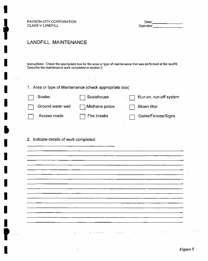
Landfill equipment will be maintained in accordance with vendor recommendations for the commercially procured items. The landfill site and installed systems will be maintained in conformity with good landfill practice. All maintenance performed at the landfill will be logged on the landfill-maintenance log sheet (see Appendix B Figure 5).
2.2.9. Exclusion Of Regulated Hazardous Or PCB's (R315-302-2 (2)(i))
Payson City has established strict acceptance standards for non-hazardous solid waste streams. The landfill employees will supervise the unloading ofall waste into the cell. Random inspections for hazardous waste, bulk liquids, used oil, automotive batteries, and any other prohibited waste wiil be conducted on approximately 10% ofthe loads (See inspection form in Appendix B Figure 4).
The landflll will not accept regulated hazardous waste, including PCB wastes. Wastes that are prohibited from being deposited at the landfill include the following:
(a) Listed wastes (Subpart C, 40 CFR part 261)
(b) Exhibits Hazardous Characteristics (Subpart C, 40 CFR Part 261)
(c) A mixture containing a "listed" waste.
(d) Wastes containing PCBs.

Payson City Corporation 08/28/06 . Construction and Demolition Landfill 5 Part III - Technical Report
2.2.10. Disease Vector Control (R315-302-2 (2)(j))
The expectations for the need to control disease in a constmction and demolition waste landfill are low. Therefore, the daily compacting and soil cover of the deposited waste, as described in Section 2.2 should be sufficient to control disease vectors. Keeping the open working face small, thoroughly compacting and covering the waste with soil have been effective in preventing disease vectors from becoming a problem at the landfill.
2.2.11. Alternative Waste Handling (R315-302-2 (2)(k))
It is anticipated that the only equipment items that have the potential to breakdown and cause the landfill to be inoperable would be the bulldozer and the scales. When the bulldozer fails, a rental unit will be obtained for use until the City's bulldozer can be repaired. A replacement bulldozer can be obtained within a day. The landflll has dual set of scales (one set for incoming and one set for exiting). If one scale became
. inoperable, the second set could be used. If both scales become inoperable, loads of waste will be required to present a weigh slip from a commercial scale in the area before being allowed to dump at the landfill. It is expected that the maximum time the scale would be down would not exceed one week.
2.2.12. General Training And Safety Plan For Site Operations (R315-302-2 (2)(n))
Each landfill operator will receive the necessary training and safety orientation before they are permitted to wOrk in the landfill. Local seminars that are provided by SWANA will be used for the majority of the training. Bi-monthly supervisor and operator safety meetings will be held to keep safety issues current. These meetings also allow for an exchange of information between the landfill operators and management.
Payson City Corporation 08/28/06 Construction and Demolition Landfill 6 Part [il - Technical Report
3. PART III TECHNICAL REPORT
3.1. MAPS
3.1.1. Topographic Map (R315-310-4(2)(a)(i))
Included, as Figure 1 of Appendix A is the topographic showing contours, the boundaries of the landfill unit, design and location ofthe mn-on/mn-off control structures; and borrow and fill areas.
3.1.2. U.S. Geological Survey Topographic Map (R315-310-4 (2)(a)(ii))
Also included, as Figure 3 of Appendix A is the most recent U.S. Geological Survey topographic map (7-1/2 minute series) showing the waste facility boundary, the property boundary, surface drainage channels, existing utilities and stmctures within 1/4 mile ofthe site, and the direction ofthe prevailing winds.
3.2. ENGINEERING REPORT- PLANS, SPECIFICATIONS, AND CALCULATIONS
3.2.1. Landflll Design (R315-31 0-3(l)(b))
3P.1.1. Cell Design
The facility will occupy an area of approximately 38 acres, the topography of the site slopes from a southwesterly to northeasterly direction with the vertical drop across the site of approximately 200 feet. As previously stated, the landfilling method to be employed at the site is the ramp/slope method because of the topography ofthe ground. Active disposal sites will be limited to 5 acres. (See Appendix A Figure 1)
3.2.1.2. Fill Methods
Each site will have the top 3-feet of soil removed and stockpiled on the uphill and downhill sides of the site. These stockpiles will serve to prevent any surface mnoff form leaving the site and entering onto adjacent ground. The cells will then be ftirther excavated on a 2:1 cut slopes to the lowest elevation of each cell (which happens to be the southeast comer of each cell). Cell will then be filled using the ramp/slope method, which will result in a terraced configuration of the site. (See Appendix A Figure 4)
3.2.1.3. Cover Design
A cell when filled will be final covered with 2-feet of cover soil and 6-inches of topsoil, salvaged from the cell when opened, for a total final cover of 2.5-feet. The maximum side slopes of a cell shall be 3:1. Following covering, contouring and topsoil placement the cell will be vegetated with a mixture of range grasses indigenous to the area. (See Appendix A Figure 5)
3.2.1.4. Runoff Control Systems (R315-310-5(2)(^))
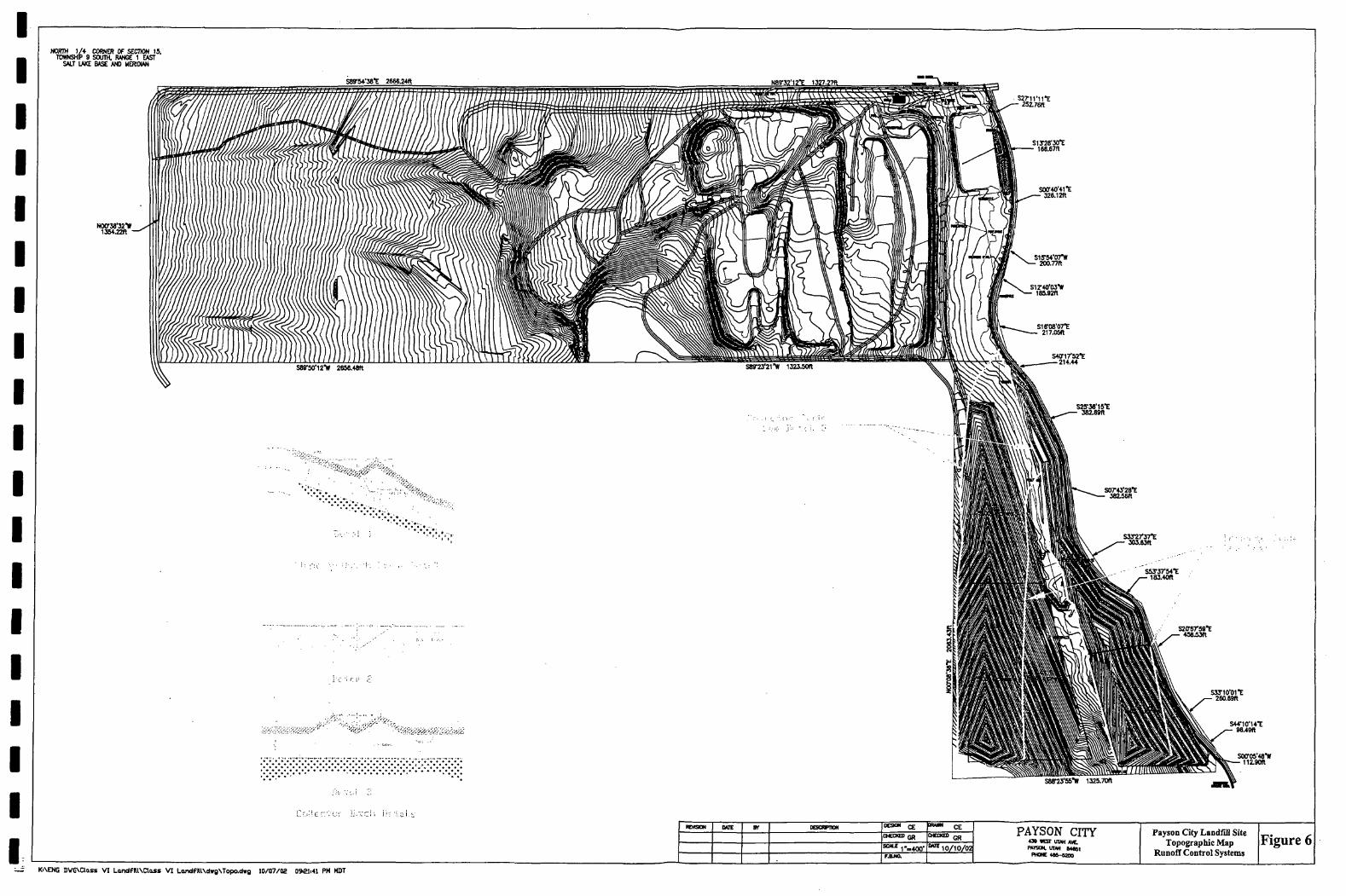
The barrow stockpiles placed around the open cells will prevent any surface mnoff form leaving the site and entering onto adjacent property. The site is sloped to the northeast and all water is channeled in this direction. Further more, the property is immediately west of the Highline Canal, therefore any mnoff escaping the large perimeter berms will be contained by the canal.
Post closure mnoff collection swales will be placed at toe of the west facing landflll slopes to channel any mn-on from the west and mnoff form the west facing landflll slopes to the Highline Canal (See Appendix A Figure 6). The calculated mnoff from the westem slopes is 15 cfs for the 24 hour 25 year event. Therefore, the swales will need to be as a minimum a 4 foot wide by 2-foot deep v-notch swale. At the design mnoff the velocity would be about 3 fps. Because the swales will be constmcted with a topsoil cap, erosion control measures will be needed in these swales. We are recommending that the swales be lined with coconut erosion-control blankets or an approved equivalent.
Payson City Corporation 08/28/06 Constmction and Demolition Landfiil 7 Part III - Technical Report
To decrease the chances of erosion on the constructed landflll slopes small 1.5-foot deep v-notch swales will need to be constmcted on the slopes every 200 horizontal feet on the slopes. These swales can be constmcted using topsoil and graded to as shown the Final Contour Site Plan Appendix A Figure 6. The capacity ofthe swales will need to be at a minimum 1.5 cfs. The flow velocity in these swales will exceed the recommended 2.5 fps maximum for topsoil therefore the swales will also need to be lined with coconut erosion-control blankets or and approved equivalent.
3.3. CLOSURE PLAN (R315-310-3(l)(h) and R315-310-5(2)(c))
3.3.1. Closure Schedule (R315-310-4 (2)(d)(i))
As previously stated cell, size will be kept to a maximum of 5 acres, so 5 acres will be the largest area of the disposal facility ever requiring final cover. At the present expected volume of
IOO tons per day (36,500 tons per year) it will take approximately 2 years to fill the smallest cell and 22 years to fill the largest. The yearly volume of solid waste may fluctuate depending on the amount of new constmction projects in and around the service area. At the present rate of waste disposal and a beginning date of June 1, 1994, cell closures would be expected as shown in Table 3-1.
Table 3-1 Closure dates are based on the current rate of waste disposal and the amounts of waste already disposed at the landfili as of October 2002.
Cell No.
1 2 3 4 5 '
Years Open
14 9
26 3 16
Closure Date Open 1994
2008 2018 2045 2049 2066
3.3.2. Design Of Final Cover (R315-310-4 (2)(c)(iii) and R315-305-5(5))
A cell when filled will be final covered with 2-feet of cover soil and 6-inches of topsoil salvaged from the cell when opened. The maximum side slopes ofthe cover shall be 3:1. Following covering, contouring and topsoil placement the cell will be vegetated with a mixture of range grasses indigenous to the area.
Table 3-2 Cover costs estimates for the landfills have been based on using the onsite materials and topsoil. Costs include placing and spreading materials utilizing an independent contractor.
6 Z
I.
2
3
4
.5
Total
cn
<
5.0
5.0
5.0
4.4 •
5.0
24.4
Design of Final Cover
6" Topsoil
Yd^
4,033
4,033
4,033
3,533
4,033
19,667
2' SoU
Cover
Yd^
17,000
17,000
17,000
14,892
17,000
82,892
Hydro Seed
240,000
240,000
240,000
210,240
240,000
1,170,240
Cost to Cover Land FUl
6" TopsoU
$2.5/Yd^
$ 10,083
$ 10,083
$ 10,083
$ 8,833
S 10,083
$ 49,167
2' SoU Cover
$2.5/Yd^
$ 42,500
$ 42,500
$ 42,500
$ 37,230
S 42,500
S 207,230
Hydro Seed
$0.03/ft^
$ 7,200
$ 7,200
$ 7,200
$ 6,307
S 7,200
$ 35,107
Total Cost of CeU
$ 59,783
$ 59,783
$ 59,783
$ 52,370
$ 59,783
$ 291,5M

Payson City Corporation Construction and Demolition Landfill Part in - Technical Report
3.3.3. Capacity Of Site (R315- 310-4 (2)(d)(ii))
The capacity ofthe site is as shown in Table 3-3.
Table 3-3 Tonnage is calculated using a 1.4 Tons/Yd' conversion rate. Estimated revenue is based on the current S15/Ton tipping fee.
08/28/06
d
"3 U
1 2 3 4 5
Total
rA Ol
u <
5.0 5.0 5.0 4.4 5.0 24.4
Construction Demolition Wkste
Yd3
155,616 210,651 605,479 69,625
387,210 1,428,581
Tons
217,862 294,911 847,671 97,475
542,0^ 2,000,013
Accum Yd3
155,616 366,267 971,746
1,(M1,371 1,428,581 1,428,581
Accum Tons
217,862 512,774
1,360,445 1,457,919 2,000,013 2,000,013
Estimated Revenue SlSTon
S 3,267,937 S 4,423,672 S 12,715,060 S 1,462,122 $ 8,131,411 S 30,000,202
3.3.4. Final Inspection (R315-31 0-4(2)(d)(iii))
A request will be made by the City for final inspection by the Division of Solid and Hazardous Waste at each sequential partial closure
3.4. POST-CLOSURE CARE PLAN (R315-310-3(1 )(h))
3.4.1. Site Monitoring (R315-310-4 (2)(e)(I))
At this site monitoring has not been recommended or required.
3.4.2. Changes To Record Of Title, Land Use, And Zoning Restrictions (R3 15-3 IO-4 (2)(e)(ii))
Payson City will:
a) Not later than 60 days after certification of closure, the owner or operator of a solid waste disposal facility shall:
i) submit plats and a statement of fact conceming the location of any disposal site to the county recorder to be recorded as part of the record of title; and
ii) submit proof of record of title filing to the Executive Secretary.
b) Records and plans specifying solid waste amounts, location, and periods of operation may be required by the local zoning authority with jurisdiction over land use and be made available for public inspection.
3.4.3. Maintenance Activities (R315-31 0-4 (2)(e)(iii))
Post-closure maintenance activities will consist of quarterly inspections of the cover and mn-on/mnoff control systems. Any required maintenance will be logged in the inspection log with an expected completion date for corrective measures completed. WT:ien the needed repairs are completed the effected area or areas will be re-inspected and a date corrective measure completed along with the inspectors signature will be logged on the inspection log.
Maintenance activities are to proceed in a timely manor in order to maintain fiinctionality ofthe cover and mn-on/mnoff control systems.

Payson City Corporation 08/28/06 Construction and Demolition Landfill 9 Part HI - Technical Report
3.4.4. Post-Closure Care Period Contact Personnel (R315-310-4 (2)(e)(vi))
Payson City Corporation 439 West Utah Avenue Payson, UT 84651 Telephone: l-(801)-465-5200
3.5. FINANCIAL ASSURANCE (R3 15-3 10-3 (l)(j))
Payson City estimates that waste hauled to the C & D landfill will average about 100 tons per day or 3,6000 tons per year. They will charge a dumping fee of $15 per ton. Payson residents will receive a punch pass and be charged $2.50 per pickup load. While none Payson residents will be charged $15 per pickup load. Revenues from dumping fees will be used for the daily operation of the C & D landflll as well as pay for the cost of closing a cell as it is filled.
3.5.1. Closure Costs (R315-31 0-4 (2)(d)(iv))
Money has been budgeted the final closure of the landfill. Payson City is a municipality and will remain solvent and therefore will be capable of providing the closure and post-closure care of the landfill. Costs associated with final closure are shown in Table 3-4. The estimated cost for closure is $291,504. This amount is based on the largest area that would require cover at closure, approximately 24 acres. Closure will include a 2-foot layer of cover soil covered by a six-inch layer of topsoil (for a total of 30 inches). Once the cover soil and topsoil are in place, the topsoil will be seeded with a range grass mixture that is indigenous to the area.
3.5.2. Post-Closure Care Costs (R315- 310-4 (2)(e)(iv))
Once the final cover has been placed on the landfill, the costs for post-closure will be those associated with the maintenance of the mn on/off systems and final cover stabilization, including residual settlement repair, erosion control or re-seeding. Yearly costs for these activities are estimated to be about $6,000.
Table 3-4 Closure costs are based on independent contractors perfonning tasks to complete closure.
Decription Place and corrpact soil cover Place and spread Topsoil Fertilize and Hydro Seed
Toal Cost
Cbst $ 207,230 $ 49,167 $ 35,107 $ 291,504
3.5.3. Financial Assurance Mechanism (R315-309-1 (1))
Payson City has deposited money in the Utah Public Treasurer's Investinent Fund (an interest bearing account) to cover the costs of closure and post-closure care of the landfili. The Fund currently contains $22,771.40. Approximately $54,000 will be deposited into the fund on July 1 each year. The funds to be deposited will be generated from solid waste revenues. The deposits each July will continue until the fund amount reaches the anticipated cost for closure and for the entire duration of post-closure care ofthe landfill. A copy ofthe most recent statement for this account is included as Figure 6 Appendix B.

STATEMENT OF ACCOUNT
1 P T I F UTAH PUBLIC TREASURERS' INVESTMENT FUND
Edward T. Alter, Utah State Treasurer, Fund Manager E315 State Capitol Complex
Salt Lake City, Utah 84114-2315 Local Call (801) 538-1042 Toll Free (800) 395-7665 PAGE
www.treasurer.iitah.gov
ESCROW-PAYSON-CLASS 5 POST CL ATTN: ELAINE 43 9 W UTAH AVE PAYSON UT 84 651
07/31/06
STATEMENT OF ACCOUNT NO: 214 3
REPORT PERIOD: 07/01/06 TO 07/31/06
DATE REFERENCE DEPOSITS WITHDRAWALS BALANCE
07/01/06 BEGBAL 0.00 0.00 272,541.34 07/31/06 NETEARN 1,195.06 0.00 273,736.40 07/31/06 ENDBAL 0.00 0.00 273,736.40
ACCOUNT SUMMARY
BEGINNING BALANCE: 272,541.34 DEPOSITS IN THE PERIOD: 1,195.06 WITHDRAWALS IN THE PERIOD: 0.0 0 ENDING BALANCE: 273,736.40 GROSS EARNINGS: 1,195.06 ADMINISTRATIVE FEE (0.0000%) 0.00 NET EARNINGS: 1,195.06 AVERAGE DAILY BALANCE: 2 72,541.34 GROSS EARNINGS RATE: 5.0 921% NET EARNINGS RATE: 5.0921%
06-30-06 GASB 31 FAIR VALUE PER SHARE FACTOR IS .99968
m m- i CT7 r>T?T- A ¥M T ^ u i c CTT A xiTlv/l P i v x TTOP TTI ITT TRI? R F F F R F N r ' F

UTAHI
STATEMENT OF ACCOUNT
P T I F UTAHIPUBLIC TREASURERS' INVESTMENT FUND
Edward T. Alter, Utah State Tieasurer, Fund Manager E315 State Capitol Complex
Salt Lake Cily, Utah 84114-2315 Local Call (801) 538-1042 Toll Free (800) 395-7665 PAGE:
Vv'w w .treasurer .Utah. gov
ESCROW-PAYSON CITY-CLASS IV ATTN: ELAINE 43 9 W UTAH AVE PAYSON UT 84651
07/31/06
STATEMENT OF ACCOUNT NO: 1276
REPORT PERIOD: 07/01/06 TO 07/31/06
DATE REFERENCE DEPOSITS WITHDRAWALS BALANCE
07/01/06 BEGBAL 0.00 0.00 202,439.26 07/31/06 NETEARN 887.67 0.00 203,326.93 07/31/06 ENDBAL 0.00 0.00 203,326.93
ACCOUNT SUMMARY
BEGINNING BALANCE: 202,439.26 DEPOSITS IN THE PERIOD: 887.67 WITHDRAWALS IN THE PERIOD: 0.00 ENDING BALANCE: 203,326.93 GROSS EARNINGS: " 887.67 ADMINISTRATIVE FEE (0.0000%) 0.00 NET EARNINGS: 887.67 AVERAGE DAILY BALANCE: 202,439.26 GROSS EARNINGS RATE: 5.0921% NET EARNINGS RATE: 5.0921%
06-30-06 GASB 31 FAIR VALUE PER SHARE FACTOR IS .99968
PT F ASF RFTATN THIS STATEMENT FOR FUTURE REFERENCE

4. Appendix A
Topographic Map Existing Contours Figure 1
Landflll Service Area Figure 2
USGS Quad '. Figure 3
Cell Design/Cut Contours Figure 4
Cover Design/Fill Contours Figure 5
Runoff Control System Figure 6

HORm 1/4 CORNER OF SECTION 15, TOWNSHIP 9 SOUTH, RANGE 1 EAST
SALT LAKE BASE AND MERIDIAN
I
S2T11'11-E
S1T28'30'E 16e.B7tt
S00r4tf41"E 32e.12ft
SCALE 1 = 400'
S53'37'54."E 1M.40ft
" " 1--W0'
GR
• 10/10/02
PAYSON CITY « • M57 UTAH AVE. PKISOH, titm H<9t
PHONE 4as-«2a)
Payson City Landfill Site Topographic Map Existing Contours
Figure 1
Ki\ENG DVGNCloss V I LandfR lNCloss V I L a n d f M \ e l w a \ T o p o , d » g 1 0 / 0 7 / 0 2 09i21i41 PM HDT

pPP7PWP':'7PfP:7-'
y;:~,i:!:j^/-;i):y;,j;jicy:::^j:-^-i/g:]~-;C:]!^^)'^y:_.- .• y . - . •: ,•:
pPp'W7p7\g2^^
i : • • - / • •P 'P \ . • • r . . - ' - J ' . - , i i ! : .W:*- - f f :
ktWp^^^M&W^fy:'-rte^iii/'l^l^iSl''^ i;lir'.v';>^\^^:.V.-- • •7S77p<0PpP; : :p ' ' ' - •'•'••' •• ' lp:-7 \:fp-P: /::--Ppi&<M77P:i-'7 'c :--
.«^;.j;-'.\i.:.'.".i«C'i3:;.'.'n ^H¥!.*Vv.'i.\..,v:.;''i.,i?jm!4r.;cj;i'fS.»'::.-:'-.•::• • ,• i : : ^ P ^ ' \ '. ; : i " - ' / ; U / ' * ; •= ' • ' " - I ' ^ • " " " ^
m
' • • •Mi
-^m'
ijJ;i:i^:^i:^-S ' : 7
2 Miles
Payson City Corporation Construction & Demolition
Class VI Landfill Service Area
Figure 2

NORTH 1 /+ CORNER OF SECTKJN 1 5 , TWNSHIP 9 SOUTH. RANGE 1 EWT
SALT LAKE BASE AND MERIDkAN
S89r54'M"E 2«68J4ft
S2Tiri1 'E 2S2.76ft
SITSB'JOTE 168.S7ft
SOOr.40'4.1"E • 326.12ft
SCALE r = 400'
" ^ 1-^400-
CE
-10/10/02
PAYSON CITY ' a t WST UTAH WE. ntrsM. unH S4<BI
PHCNC t n - t X K
Payson City Landfill Site Topographic Map
Cell Design/Cut Contours Figure 4
KiNENG BWGNClass V I L a n d f U l N D a s s V t LondflUNdwgSTopo.dwa 10 /07 /02 09i21i41 PM MDT

NORTH 1/4 CORNER OF SECUON 15, TOIimSHiP 9 SOUTH, RANGE 1 EAST
SALT LAKE BASE AND UEnOIAN
SBS'M'M'E 2 6 W J 4 f l
S2T11'11-E 252.76ft
STJTS'JO't ie8.67ft
S0ff40'41"E 326.12ft
SCALE r = 400'
' ^ r..4oo-
CE GR
• 10/10/02
PAYSON CITY a t MST tnm AVE.
n t m N . UTAH t4«61 PHONE * » - e a m
Payson City Landfill Site Topographic Map
Cover Design/Fill Contours Figure 5
Ki\ENG DWGNClass V I L o u n d f l U \ a a s s V I Landf lUSdwgNTopadwQ 10 /07 /02 09i21i41 PM MDT
NORTH 1/4 CORNER OF SECIION 15. TtWWSHiP 9 SOUTH, RANGE 1 EAST
SALT LAKE BASE AND MERIDIAN
S8y54'3a'E 2666.24ft
S 2 7 i n i ' E • aZTBft
C'-^as;-•;•;.:;• iJ.
S13-28'30'E 166.67ft
S00'40'41"E 326.12ft
REMSON UIE Bt CE CHECKD Qf^ GR
• 10/10/02
PAYSON CITY 43» » ISr UUH AVE. PAYSON. UTAH aMS|
PHONE 4a»-«3m
Payson City Landfill Site Topograpliic Map
Runoff Control Systems Figure 6
Ki\ENG DVG\aa£s VI LandFlllXClass V I Londfm\dw8\Topo.dwo 10/07/02 09i21i41 PM MDT

5. Appendix B
Property Ownership Deeds Figure 1
Weight Ticket Figure 2
Material Report Figure 3
Landfill Inspection Sheet Figure 4
Landflll Maintenance Sheet Figure 5
Financial Assurance Account Statement Figure 6

\V^-'l Norr..::....; :.
®d A l l to laijrtut al l |wr J^ri'flrittfl ^I ja l l (Eitnu^, (Bv^i^tiug:
WHEREAS. '..Fay.ssii.. .'vit,v.. .(:ar.H.Qrat.iDa.:
Payson.
^ ^r:r::^r::rr=^r::ir==r^=~:^^^ of.r;rr; .-.U.M.ah,_;„,•-.,... ..j-.. ^^ purchased from Ihc State of Utah, thc lands hereinafter described, pursuant to thc laws of said State in such case made and provided,
AND WHEREAS, the saii
haSr>paid for said lands, pursuant to" the conditions of said sale, and the laws of the State duly enacted in telation thereto, the
sum of>r:J!our_ii\mdg.eiLlaLeiity-fiJii.2I}/lQJD^ Dollars, and all legal interest theteon accrued, as fully appears by thc certificate of thc proper officer, now on file in the office of the Secretary of State of the State of Utah;
NOW THEREFORE, I?rrrJ:^..•Hc.bex...geJ^n.lpa»..JJ.r...:JlJ^J^...:;L•.^.-^^ Governor, in consideration of the premises, and hy virtue of the powet and authority vested in me by thc laws of the State of Utah, in such case made and provided, do issue this f/^TENT, in the tiahie and by the gjithority of thc State of Utah, hereby granting and confirming unto the-^iid "
..!!:..Z.'.':::! .::l. ! Jt..:r:..!r... -?r:: r: r. ?r. ^ Payson City Cprporation...r.?r..~tr^.rrr.T!r.-^-?r-?r.~j:;;.-- -r '- •:'^'rr.~:,'?r:^-rrr^rr:yr-y
J .Z.SLJlL2-:::j::.J .jr...:::...TJ:L.r.jr..:::.y... ^^^^ to. r:r2rr :....lt.5.....3.uc.cgaa.Qr.a...j..-..-:. ••-r:..!=tetife and assighs
forever, the following piece or parcel of land, situate in the County of..rr ::::rr7.rrr...U.tiah.„.r:....~..."....:.—:: .-,r..-r.r..=r..:i::... .-State aforesaid,
' to-wit.r:^:lot-.Diie..4lX»~oi^-Sex±ion.lourtefiri411i^^
> •^r::^..E.lf.t.e.Bn....(.lSi,^..lcamsMMifle-49)-5caith.,..Bange...QaB._(l)„..E
(Re.TsrYing to the S t a t e of Utah, a l l coa l and o t h e r mlnera lB ,
tho r i g h t to pronpoct fo r , uiinc and rcranve coa l and o the r
^».rli_^.u!i2i.ac..t„t.Q..-..til£_.liiiIii:i.tlQ.r.a._r^£...T±t.l,a.,3..Ci^ S t a t u t e s of Utah 19*35 and aoiRttcliiicntB thereto".)
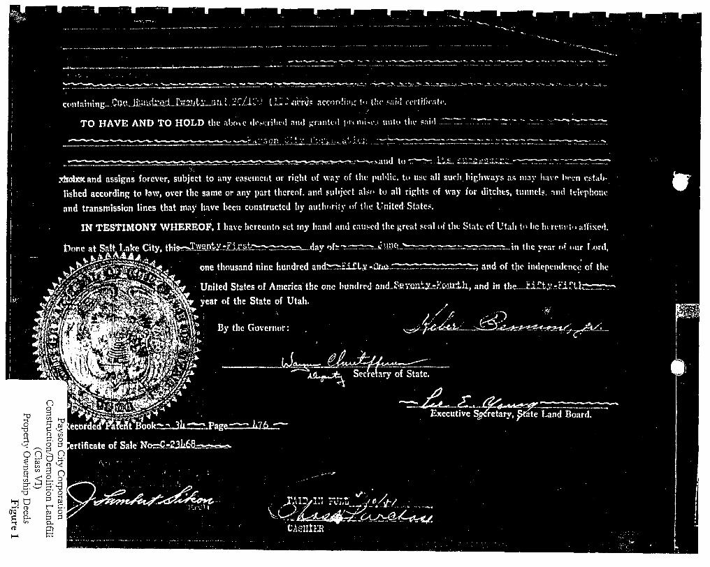
c«.nt;i!tung....Cn^vJlunda:rt.l...te^tX...:K.i.L..;;r/.l;.'.;' i U i i i P t h ncc'in!i:i;r (" the s;ii<I rcrlilicnti-.
TO HAVE AND TO HOLD the .IIKI C d.-.-i.riln-.l .md -raiilid I'tviiiiM-.; uiitu tin' s.ii"
-vand tl) '-•
xhclxxand assigns forever, subject to any easeincnt or ripht of way of tlic piiMic. lu use all such highways a.s iii.iy h.ivc li."..n rtt.ib-
lishcd according to law, over thc same or any part thereof, and sul'joct also tu all rights uf way for ditches, ttiniitU. -IIHI t-jli-phonc
and transmission lines that may have been constructed by aul!i"ri(y of tlie United State*.
IN TESTIMONY WHEREOF, 1 have hereunto set my hand and ctiiscd thc t;rc;it stai of tht State of Utah to lie hi riimt.. i.llixcd.
Done at Salt^Uke City, thisr-Xwenty.First,;.. .>-....day ofr-^. .in thc year nf nur Lord,
one thousand nine hundred and:rr:>.i:alLy -.Qxie.. T, and of the independence of the
United States of America thc one hundred and.>?.ey.Oll!.y.-r!.o.'.tllh, and in the i:.i.']!.t,yrr"iri.h:
year of the State of Utah. ,
o 'a 3
1 OTQ C t
cr. o o 3
O Q Pl 9.
f =" 3 oi
.ecor^rd''?aMt*^ookrrj:;jkiir;.Fag„
.ertificate of Sale Nor5C.-23k6.8-r--«iv-w
o 2 3 3 hi o
a.
jJL^.j;t\ Secretary of State.
- r : ; : - ^ ^ . t^.... Executive Sj f, Srate Und Board.

•THIS IS A LEGA" NDING CONTRACT. IF NOT UNDERSTOOD SEEK COMt JT ADVICE."
Recorded at Request of...5H:C3N£>-
I i
at M. Fee Paid $..
by
Mail tax notice to-
..____Dep. Book Page..
Address
QUIT-CLAIM DEEDl
HARVEY L. HUTCHINSON and VARO HUTCHINSON
to , County of Utah
Payson City Corporation Hy\LAJ. LK iaM ^ ^ e . -'(^•Sov,, LA oM -^ 1+43 I
iollar and a*^if'
the following described tract of land in
State of Utah;
of Alpine QUIT-CLAIM
of
grantor , State of Utah, hereby
graHtee for thc sum of DOLLARS,
Utah County,
I '! Conmencing at the NW Cor. of the HZk of Sec. 1«, T 9 S, R 1 E, SLB & M, said point being also N 89°32'04" Z along Section line 1327.25 according to Utah Coordinate Bearing Central Zone from the NW Corner of said .Section IA and S 0°08'43" W 2678.01'. Thence S 0°15'26" E. 724.5'; N 88°23'55" E 1325.70'; N 0°05'48" E 112;9' to the center of the Highline Canal; N 4A°l,0'Ut" W 96.49' along centerline of the Highline Canal; N 33°10'01" W 260.69'; N 20°57'59" W 458.53'; S 81°i5'30" W 958.52' to point of beginning. Containing approx. 20.38 acres.
Excepting therefrom for Blanch Whitclock a 20' easement inmediately p^^-^ <^* adjacent to the west side of the Highline Canal which traverses the east property boundary to her north property boundary for the purpose i f ^pd f - ^ X p L ^ . ? of ingress and egress to her property. ^ ^ j .
ffiZ.
'WrrNE&s the hand of taid grantor , this \2J June , A. D. one thoutand nine hundred and e i g b t ^ t w o .
Signed in the presence of
STATE OF UTAH,
Gomm 0* Utah
On the -?^*=^ personally appeared before me
the signer of the vrithin inatntment, who duly acknowledged to me that
same. _ _ - ^ • /?
N ti Payson City Corporation
My commission .^pir^ P^ -^^ -F . l i j ' ^ R<v»Ming in C/T^Pit-P 7cP*-ji Construction/Demolition Landfill
APPROVED FORM — UTAH SECURITIES COMMISSION FORM I03—OUIT CUAIH DEED—fK.J.Y CO.. •» w N<NTH VOUTM • i. C U l t M
(Class VI)
Propeity Ownership Deeds
Figure 1

i i
.0^
WHEN RECORDED. MAIL TO:
^2m7
Space Above for EecortiefcJ&'Bse
WARRANTY DEED
of
HARVEY L. and VARO C. HUTCHINSON
Alpine , County ol Utah
hereby CONVEY and WARRANT to PAYSON CITY CORPORATION
of Payson City , Cotmty of Utah
for the sum of A TRADE and One Dollar
, ffrantar
, State of Utah,
• srantee
, State ol Utah
DOLLARS,
I I
the loUowisg: described tract ot land in Utah Coonty, State ol Utah, to-wit:
Commencing at the Northwest Corner of the Nor-heast Quarter of the Northwest Quarter of Section 14, Township 9 South, Range 1 Eaat, Salt Lake Base and Meridian, said poinc being, -Iso ..orth 89'^32'04" East along the Section Line 1327.25 feet according to Utah Coordinate Bearings, Central Zone from the Northwest Corner of said Section 14, Thence South 00 08'43" West along the Quarter-quarter Section Line 2678.01 feet to the East-west Quarteir Section Line, N 81°35'30" E to centerline of Highling Canal, North 57 18'09" West 178.38 feet along Highline Canal, North 33°27'37" West 303.63 feet, North 07°43'23" West 382.56 feet. North 25°36'15" West 382.69 feet. North 40 17'52" West 214.44 feet. North 16*08'07" West 217.05 feet, North 12 40'03" East 185.92 feet. North 15°54'07" Eaat 200.77 feet. North 00°40'4I" E^st 326.12 feet. North 13°28'30" West 160.67 feet, North 21°11'11" West 252.76 feet to the Section Line, thence parting from said canal centerline South 89 32'04" West along the Section Line 185.44 feet to the point of beginning. Area 26.62 acres.
Excepting therefrom for Blanch Whitelock a .TO' easement immediately adjacent to the west side of the Highline Canal which traverses the east property boundary to her north property boundary for the purpose of ingress and egress to her property.
WITNESS the hand ol eaid grantor , this
Signed in the prese.<ice a t
29 day ol June 19 82.
P ' . ^£<j fyC. - . . . ^^
STATE OF UTAH,
County of " t c d J ^
On the ^ f ^
^^^^iSi^g appeared belorft ms
1-day of y p -
•-*." '% T K P
-fihe signer of the above instnmient, who duly acknowledged to me that he executed tha
My
I / Notary iE lblJ
commission expires CP-r-.PrJ,7fPP T?.wiMfag- in _PPA±2.c::..iLi^'\^,, ^g^-^tf^.-J?-
APFROVED FORM — UTAH SECURITIES COMMISSION PORM IOI — WAftflANTY OCKO - KKU.V . » . . •« w. Ml im. vo . . • . ._& L.IIM
Payson City Corporation
Construct ion/Demoli t ion Landfill
(Class VT)
Property Ownership Deeds
Figure 1

ch i3 ' i ; :n !"'a >'•::• CJn C:i.-by S o l i c i W a s i t e C « D L a n d f :i. :t. 1 P ' a y s o n , \..it: .vih \ i ^ & l ) AS5-- ' : :^S^ ' : : l D a t e
•f ;i. Ill s !t Vl •)•• :t. lii KO t j u t .1
o m e r
o m e r N o '
/ T o r i £i., 0 0
e v i b "FyiiJiv?
e T y p e m M m !••' (•:' B
o mill e n t s \
G I- o;;;.;;; T' a I- e
M t t t
1 e t T o Vi s
•| a ' t i..ri-B
.11::. > .1 h
fliiiourrb Te i ld e r( C h avii^iK
Out:; * >d
*
&..Gi&
0.. t30 B.. 0 0
Payson City Corporation ConstructioD/Demolition
(Class VI) •Weight Ticket
Figure 2

Material Report
September 17,2002 9:19:]4AIviI
MS
Date
MIXED WASTE
Trans # Net Tons
.74
.99 1.92
Ain.t
$ % $
)untl>ue
2.50 2.50
65.28
09/16/02 272455 09/16/02 272457 09/16/02 272463
E ^
Dots
TOTALS 3.6S $-70.28
KECYCUE WOOD
Trans # Wet Tons Amount Due
09/16/02 272434
ISX
Date
6.02
TOTALS fl.O^
$ 204.68
$204.<»
R o a d Ham OaL
Trans # Net Tans Amount Due
09/16/02 09/16/02
IW
Date
272423 272430
TOTALS
TIKE WASTE
Trans #
13.60 15.23
$ .00 .00
28.83 $0.00
Net Tons Amount Due
09/16/02 272414
TOTALS
GRAND TOTALS:
.01 3.00
.01
210.12 $3.00
$ 1,SS1.1«
Payson City Corporation Constructi on/Demolition (Class VI) Material Report
F igure 3

September 17,2002 9:19:14AM
IVlaterial Report
09/16/02
C«
Date
272473
TOTALS
.97 .00
3J33 $0.00
COOTON MIXED WASTE
Trans# Net Toni
1.03 .67 .68 .68 .67
13.14 .64 .84 .99 .20 .80
1.01 1.02
.62
.86
.74
Aniount Due
$ $ $ $ $ $ $ $ $ $ $ $ $ $ $ $
.00
.00
.00
.00
.00
.00
.00
.00
.00
.00
.00
.00
.00
.00
.00 ,00
09/16/02 09/16/02 09/16/02 09/16/02 09/16/02 09/16/02 09/16/02 09/16/02 09/16/02 09/16/02 09/16/02 09/16/02 09/16/02 09/16/02 09/16/02 09/16/02
272407 272409 272412 272413 272420 272426 272427 272433 272435 272438 272451 272452 272453 272454 272467 272469
TOTALS
EX
Date
24.59 $0.00
EXEMPT
Trans# Nel Tons
4.69 5.S7 4.S2 7.92 2.S9 5.77 3.65
AinouEitDue
$ .00 $ .00 $ .00 $ .00 $ .00 $ .00 $ .00
09/16/02 09/16/02 09/16/02 09/16/02 09/16/02 09/16/02 09/16/02
272404 272405 272410 272417 272422 272446 272447
TOTALS
GV
Date
35J61 $0.00
GKEEN WASTE WDOD
Trans# Net Tons Amount Due
09/16/02 09/16/02
272406 272418
.20
.63 $ $
.00
.00
TOTALS .83 $0.00
Payson City Corporation Construction/Demolition (Class VI) Material Report
Figure 3

PAYSON CITY CORPORATION Date:_ CLASS V LANDFILL
Inspectors:
LANDFILL INSPECTIONS
Instructions: Please fill in the requested information as outlined. If changes in operation practices or maintenance is required, notify the Superintendent upon completion of the inspection. Schedule a follow-up inspection after the time changes or repairs are to be made.
1. Type of inspection: [ ^ Routine | | • Other (specify).
2. Indicate area or operation of landfill that was inspected:
3. Results or findings of Inspection:
4. Recommendations:
Figure 4
PAYSON CITY CORPORATION CU\SS V LANDFILL
Date:_ Operator:.
LANDFILL MAINTENANCE
Instructions: Check the appropriate box for the area or type of maintenance that was performed at the landfill. Describe the maintenance work completed in section 2.
1. Area or type of Maintenance (check appropriate box)
I I Scales I I Scalehouse | [ Run-on, run-off system
I I Ground water well r~\ Methane probe F l Blown litter
I I Access roads FH Fire breaks j l Gates/Fences/Signs
2. Indicate details of work completed:
r I Figure 5
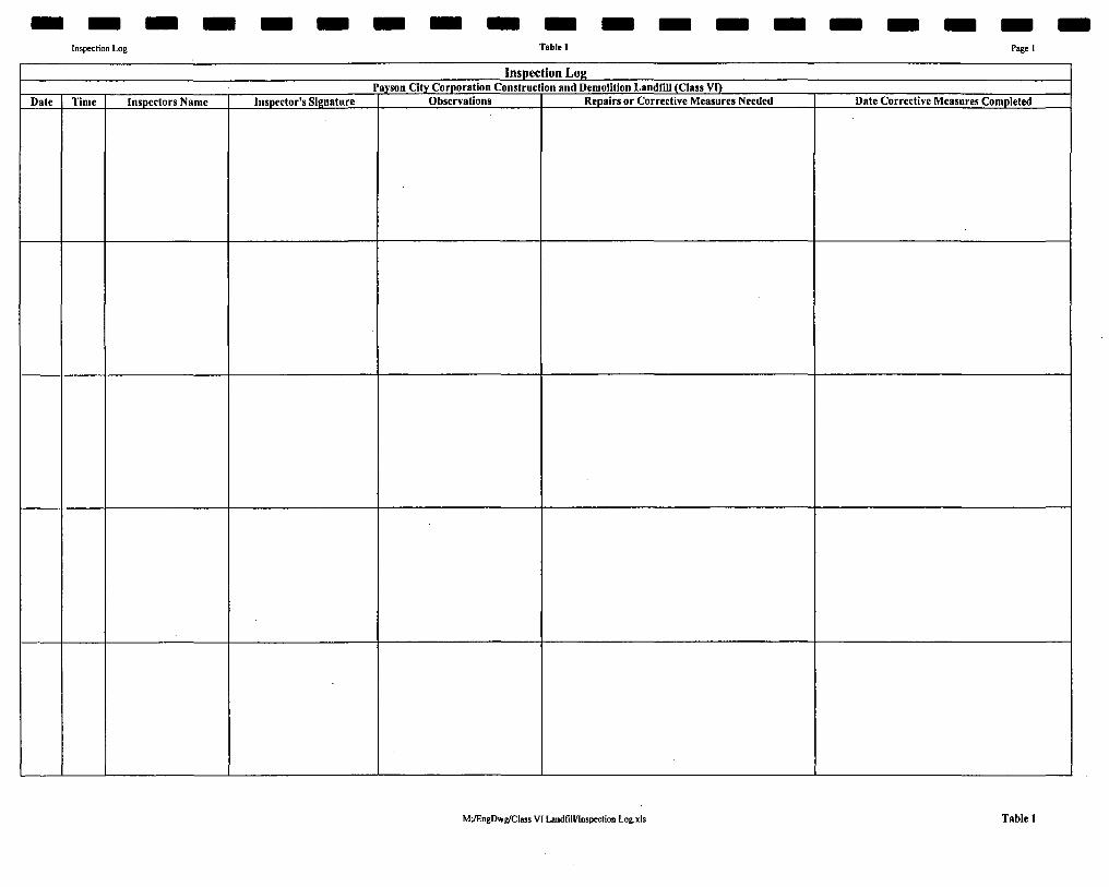
Inspection Log Table 1 Pagel
Inspection Log Payson City Corporation Construction and Demolition Landnil (Class VI)
Date Time Inspectors Name Inspector's Signature Observations Repairs or Corrective Measures Needed Date Corrective Measures Completed
M^EngOwg/CIass VI Land fil l/Iospcction Log.xis Table 1