okeechobee road from krome avenue to nw 79 avenue pd&e study presentation, july 23, 2014
TRANSCRIPT

Public Kick-Off Meeting
July 12th, 2012
2
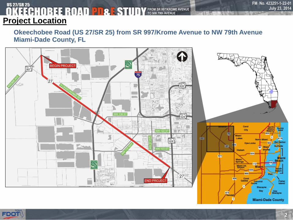
Project Location Okeechobee Road (US 27/SR 25) from SR 997/Krome Avenue to NW 79th Avenue Miami-Dade County, FL

3
Project Purpose and Need
• Implement roadway improvements that will enhance safety and mobility
• Provide intersection modifications to reduce overall vehicular delay along Okeechobee Road
• Develop frontage road enhancements
• Develop multimodal options
• Determine feasibility of providing grade separated improvements
• Determine needs for improvements to bridges over Miami Canal
• Develop short term and long term improvement options

4
Project Issues • High density residential area to the
north
o City of Hialeah
o City of Hialeah Gardens
• Large industrial area to the south
o Town of Medley
• Closely spaced parallel facilities
o Close Proximity of frontage roads causes severe weaving issues
o Truck queues block intersections at NW S River Drive
o 3 signalized intersection connections between NW S River Dr, Okeechobee Rd & Frontage Rd
• High truck traffic percentage along Okeechobee Rd
• Few Access Points

5
Key Project Components • Engineering Analysis
• Existing conditions o Crash Review o Access o Design o Operational o Structural (Bridges)
• Develop cost feasible solutions that address project needs
• Environmental Analysis • Analyze existing environmental
features • Determine environmental impacts
• Public Involvement • Perform comprehensive public
outreach plan • Coordination • Gain public consensus
oblique

6
Engineering Analysis
• Data Collection
• Traffic and Safety Analysis
• Analysis of existing roadway and structural features
• Alternative Development and Evaluation
o No Build
o Transportation Systems Management and
Operations (TSM&O) Options
o Build Options
o Project Phasing
Alternative Selection Process
7
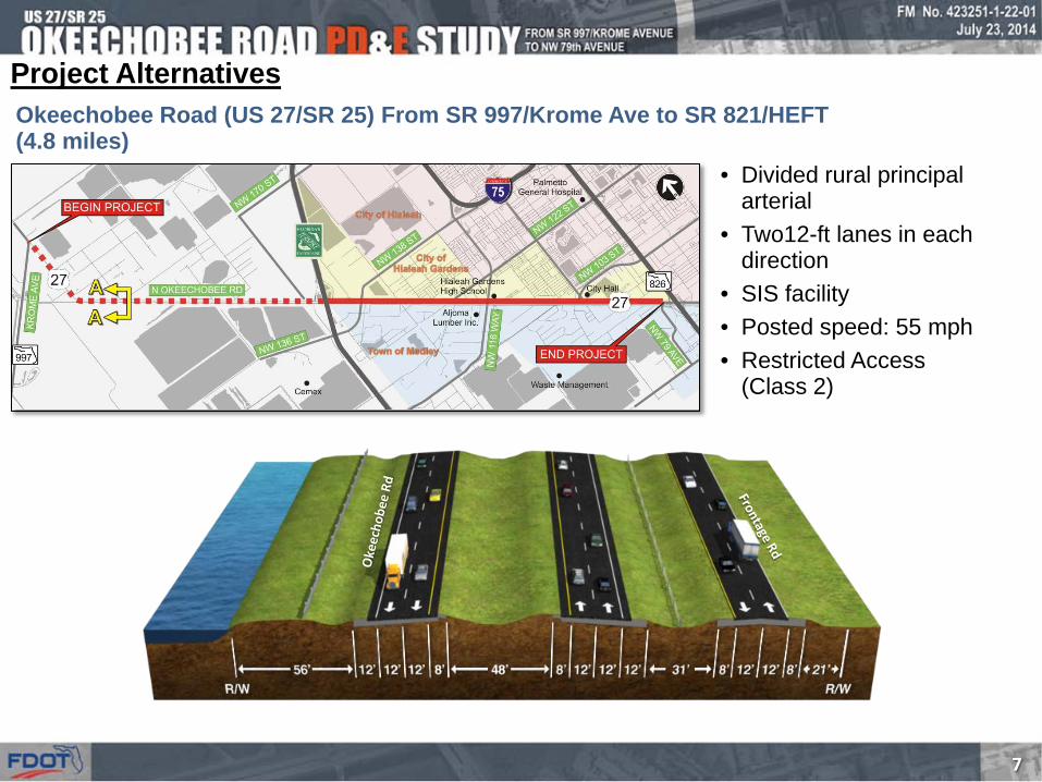
Okeechobee Road (US 27/SR 25) From SR 997/Krome Ave to SR 821/HEFT (4.8 miles)
Project Alternatives
• Divided rural principal arterial
• Two12-ft lanes in each direction
• SIS facility • Posted speed: 55 mph • Restricted Access
(Class 2)

8
Okeechobee Road (US 27/SR 25) From SR 997/Krome Ave to SR 821/HEFT (4.8 miles)
• Segmental Improvement Areas 1-4
Project Alternatives

9
Segmental Improvement Area 1 • Realigns Krome avenue intersections
• Provides additional capacity at the intersection
• Intersection improvements to allow adequate area for turning radius of large trucks

10
Segmental Improvement Area 2 • Provides a right-out only at Frontage Road to provide space for adequate
acceleration and deceleration lanes
• Intersection improvements to allow adequate area for turning radius of large trucks

11
Segmental Improvement Area 3 • Closure of the NW 127 Avenue Access to Okeechobee Road and provision of a new
access point at NW 129 Avenue to provide space for adequate acceleration and deceleration lanes
• Additional SB to EB left turn lane at the NW 154 Street intersection
• Intersection improvements to allow adequate area for turning radius of large trucks

12
Segmental Improvement Area 4 • Intersection improvements to allow adequate area for turning radius of large trucks
• In addition to improvements proposed as part of HEFT and the Gratigny West PD&E Studies, provides addition EB left to NB HEFT

13
Okeechobee Road (US 27/SR 25) From SR 821/HEFT to NW 79 Avenue (4.9 miles)
Project Alternatives
• Divided urban principal arterial
• Three12-ft lanes in each direction
• SIS facility • Restricted Access (Class 2) • Posted speed – 50 mph • Existing R/W varies – 260’
along most of the corridor & 350’ at intersections

14
Okeechobee Road (US 27/SR 25) From SR 821/HEFT to NW 79 Avenue (4.9 miles)
• Segmental Improvement Areas
Project Alternatives

15
Segmental Improvement Area 5 • Intersection improvements to provide additional intersection capacity and allow
adequate area for turning radius of large trucks
• NW 107 Avenue bridge widening to accommodate additional turning movements and provision of three WB turbo lanes

16
Segmental Improvement Area 6 • Elevates the Okeechobee Road mainline over NW 116 Way and provides a diamond
type configuration with the Frontage Road and NW South River Drive
• Provides flyover bridge from SB NW 116 Way to EB Okeechobee Road
• Provides improvements to the NW 121 Way intersection and widening of the bridge over the Miami Canal to accommodate additional turn lanes.

17
Segmental Improvement Area 7 • Depresses the Okeechobee Road mainline under NW 87 Avenue and provides a service
road for the local movements to NW 87 Avenue • Realigns NW 103 Street further to the north • Provides two flyover ramps from NB/SB NW 87 Avenue to WB/EB Okeechobee Road • Relocates the NW 105 Way bridge further west to NW 106 Street.
Alternative C

18
Segmental Improvement Area 8 • Provides additional through lanes along both the mainline from west of NW 95
Street to NW 79 Avenue (total 4 through lanes in each direction)
• Intersection improvements and bridge widening to provide additional intersection capacity and allow adequate area for turning radius of large trucks

19
Bicycle and Pedestrian Consideration
• Existing pedestrian facilities o Small link along Frontage Road
o N/S approaches along major crossing corridors
• Proposed pedestrian facilities o Connections across Okeechobee Road along
major corridors
o Continuous sidewalks on the north side of Frontage Road
o Continuous sidewalks on the south side of NW S River Drive

20
Bicycle and Pedestrian Consideration
DETAIL • Sidewalk across Okeechobee Road
connecting proposed pedestrian facilities along both sides of the road
Example 1

21
Bicycle and Pedestrian Consideration
DETAIL • Continuity of
pedestrian facility along north side of Frontage Road

22
Bicycle and Pedestrian Consideration
• Okeechobee Road from Krome Avenue to HEFT (existing bike lanes)
• Okeechobee Road from HEFT to NW 79 Avenue (proposed bike lanes) D.S.= 60 mph
D.S.= 65 mph
PROPOSED TYPICAL SECTIONS
23
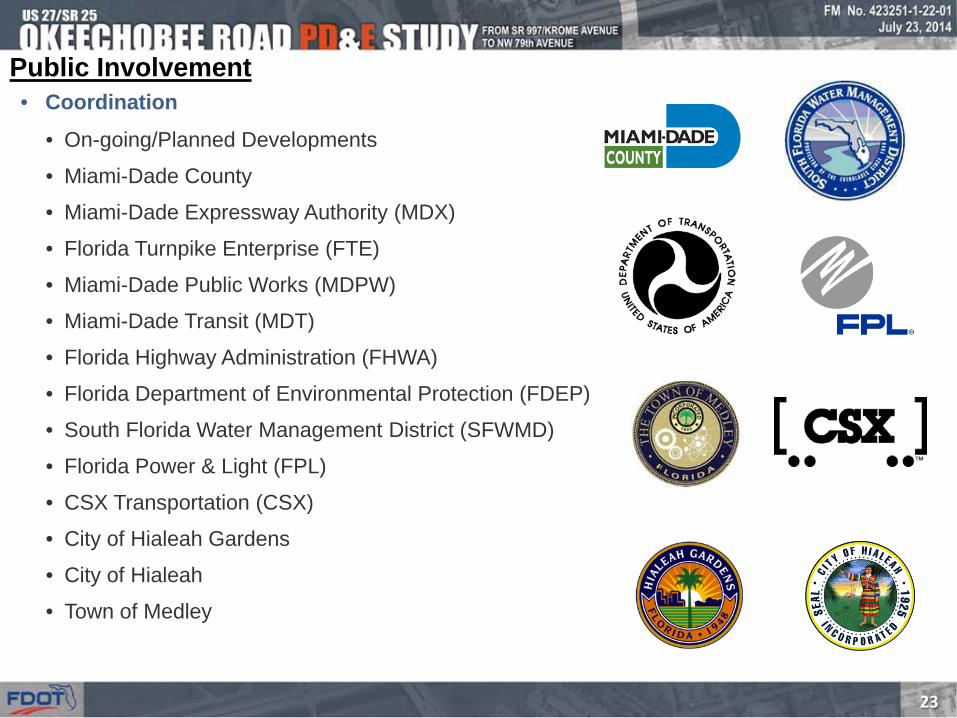
• On-going/Planned Developments
• Miami-Dade County
• Miami-Dade Expressway Authority (MDX)
• Florida Turnpike Enterprise (FTE)
• Miami-Dade Public Works (MDPW)
• Miami-Dade Transit (MDT)
• Florida Highway Administration (FHWA)
• Florida Department of Environmental Protection (FDEP)
• South Florida Water Management District (SFWMD)
• Florida Power & Light (FPL)
• CSX Transportation (CSX)
• City of Hialeah Gardens
• City of Hialeah
• Town of Medley
Public Involvement • Coordination

24
Public Involvement • Public Involvement Meetings Held
• Elected Official/Agency Kick-Off (July 12, 2012)
• Public Kick-Off (July 12, 2012)
• Project Advisory Committee #1 (September 6, 2012)
• Project Advisory Committee #2 ( January 29, 2013)
• Alternatives Public Work Shop (April 11, 2013)
• Project Advisory Committee #3 (February 27, 2014)
• Alternatives Public Workshop #2 (March 26, 2014)
• Upcoming Public Involvement Meetings
• Project Advisory Committee #4
• Public Hearing

25
Bao-Ying Wang, P.E. - FDOT Project Manager Florida Department of Transportation, District Six
1000 NW 111th Avenue, Room 6251, Miami, Florida 33172 Phone: (305) 470-521 Fax: (305) 640-7558
E-mail: [email protected]
Robert Linares, P.E. - Consultant Project Manager Metric Engineering, Inc.
13940 SW 136 Street, Miami, Florida 33186 Phone: (305) 235-5098 Fax: (305) 251-5894
E-mail: [email protected]
Okeechobee Rd PD&E Study Team Contact Information:
Or Visit the Project Website:
www.fdotmiamidade.com/okeechobeeroadstudy

26
Thank You!!