oil transport from the russian part of the barents region€¦ · oil transport from the russian...
TRANSCRIPT

Oil transport from the Russian part of the Barents Region
Status per January 2007
Alexei Bambulyak and Bjørn Frantzen
© The Norwegian Barents Secretariat © Akvaplan-niva AS
© WWF

Oil transport from the Russian part of the Barents Region. Status per January 2007
2
The authors, Alexei Bambulyak and Bjørn Frantzen, have been working for more than 10 years on environmental cooperation in the Barents Euro-Arctic Region with special emphasis on Russia. Frantzen lead the Norwegian Polar Institute in Svalbard, and Bambulyak was a project manager at the Karelian Information Barents Centre. From 1997 to 2005, both worked at Svanhovd Environmental Centre, they lead the Barents Council Environmental Management Program for the Murmansk Region (EMP-Murmansk), and facilitated environmental capacity building projects in Northwest Russia. Today, Alexei Bambulyak has his daily work at Akvaplan-niva as General Manager Russia, and Bjørn Frantzen works as Project Manager at Bioforsk – Soil and Environment, Svanhovd. Both are responsible for arranging cooperation between their companies and Russian environmental institutes under the Barents and bilateral Norwegian-Russian agreements. Authors and their companies have for many years closely collaborated with the Norwegian Barents Secretariat and been focused on the environmental aspect related to development of oil-and-gas industry in the Arctic regions. Frantzen and Bambulyak have personally visited many of the sites described in this report, had meetings with environmental authorities, petroleum and transport companies working in the region. The present work also describes their experience undertaken in this sphere. Vidar Bakken – Design of cover page Morten Günther – Edition of maps Paul Renaud – Proof-reading English text Anatoly Stikhin – Text translation from Norwegian to English
www.barents.no
The Norwegian Barents Secretariat serves the Norwegian-Russian relations in the north and provides grants to projects. The Barents Secretariat in Kirkenes, Norway was established in the aftermath of the signing of the Kirkenes Declaration in 1993. Today, the primary task of the Barents Secretariat is to assist the Barents Regional Council, Norwegian Authorities and other major regional structures. The Secretariat has an extensive network of contacts and cooperates closely with EU institutions and international organisations. The Secretariat has information centres in Russia – in Petrozavodsk, Arkhangelsk, Murmansk, and Naryan-Mar.
www.akvaplan.com
Akvaplan-niva is a private company owned by NIVA, Norwegian Institute for Water Research. Akvaplan-niva provides consultancy, research and laboratory services in environment and aquaculture to companies, authorities, NGO's and other customer worldwide. Akvaplan-niva has been working in Russia since the late 1980s, and developed an extensive network with Russian environmental institutes and companies, as well as Russian authorities and business. In 2006, Akvaplan-niva established a subsidiary company in Murmansk, Akvaplan-niva Barents.
www.bioforsk.no
Bioforsk, the Norwegian Institute for Agricultural and Environmental Research, is a national R&D institute under the Norwegian Ministry of Agriculture and Food. Bioforsk Soil and Environment have national responsibility for the research areas as soil, environment and resources. The department at Svanhovd works with issues related to natural resources, environment and agriculture in the Barents Region, as well as Norwegian and Russian environmental cooperation.
The report can be ordered from the Norwegian Barents Secretariat and Akvaplan-niva.
Front page: 1 © Sevmash 2 © Norwegian Coastal Administration 3 © Vadim Krasnopolsky, WWF 4 © Bjørn Frantzen, Bioforsk Svanhovd 5 © Lukoil
Recommended citation: Bambulyak, A. and Frantzen, B. (2007). Oil transport from the Russian part of the Barents Region. Status per January 2007. The Norwegian Barents Secretariat and Akvaplan-niva, Norway.
Oil transport from the Russian part of the Barents Region. Status per January 2007
3
Contents:
1 SUMMARY...............................................................................................................................................................................5
2 INTRODUCTION...................................................................................................................................................................6
3 OIL AND GAS PRODUCTION IN RUSSIA .....................................................................................................................8
3.1 OIL AND GAS RESERVES..............................................................................................................................................8
3.1.1 THE CONTINENTAL SHELF...............................................................................................................................9
3.1.2 OIL AND GAS RESERVES IN THE RUSSIAN PART OF THE BARENTS REGION .................................10
3.2 OIL AND GAS PRODUCTION ....................................................................................................................................13
3.2.1 OIL AND GAS PRODUCTION IN THE RUSSIAN PART OF THE BARENTS REGION..........................13
3.3 OIL AND GAS PRODUCTION PLANS......................................................................................................................14
3.3.1 OIL PRODUCTION PLANS IN THE RUSSIAN PART OF THE BARENTS REGION ...............................15
3.3.2 OIL PRODUCTION PROSPECTS FOR THE RUSSIAN WESTERN ARCTIC SHELF ................................15
3.3.2 GAS PRODUCTION PROSPECTS FOR THE RUSSIAN WESTERN ARCTIC SHELF...............................16
4 OIL AND GAS TRANSPORT ............................................................................................................................................18
4.1 TRANSPORT SYSTEM IN RUSSIA .............................................................................................................................20
4.1.1 RAILWAYS............................................................................................................................................................22
4.1.2 INLAND WATER-WAYS ....................................................................................................................................25
4.1.3 SEA TRANSPORTATION ...................................................................................................................................26
4.1.4 TRUNK PIPELINES..............................................................................................................................................29
4.2 OIL TRANSPORTATION ROUTES IN THE BARENTS REGION......................................................................... 34
4.2.1 THE LAPTEV SEA................................................................................................................................................36
4.2.2 THE KARA SEA....................................................................................................................................................37
4.2.3 THE PECHORA SEA............................................................................................................................................39
4.2.4 THE WHITE SEA..................................................................................................................................................44
4.2.5 THE BARENTS SEA, RUSSIA.............................................................................................................................49
4.2.6 THE BARENTS SEA, NORWAY ........................................................................................................................55

Oil transport from the Russian part of the Barents Region. Status per January 2007
4
5 ENVIRONMENTAL SAFETY...........................................................................................................................................61
5.1 ENVIRONMENTAL REQUIREMENTS FOR OIL TRANSHIPMENT....................................................................61
5.2 OIL TRANSPORTATION MONITORING AND EMERGENCY RESPONSE SYSTEM ......................................64
5.2.1 OIL TRANSPORTATION FROM NORTHWEST RUSSIA AND NORWEGIAN COAST EMERGENCY RESPONSE SYSTEM .......................................................................................................................................................64
5.2.2 VARDØ VESSEL TRAFFIC CENTRE ................................................................................................................69
5.2.3 NEW ROUTING FOR TANKERS IN NORWAY .............................................................................................70
5.2.4 NORWEGIAN–RUSSIAN COOPERATION IN OIL POLLUTION ABATEMENT AND MARITIME SAFETY .............................................................................................................................................................................71
5.3 ACCIDENTAL OIL POLLUTION................................................................................................................................72
5.3.1 THE SERVER DISASTER.....................................................................................................................................73
5.3.2 OIL POLLUTION AND RESPONSE IN THE RUSSIAN BARENTS REGION ............................................77
6 CONCLUSIONS...................................................................................................................................................................80
6.1 INTRODUCTION ...........................................................................................................................................................80
6.2 TARGET ISSUES IN RELATION TO OIL PROTECTION ..............................................................................................80
6.2.1 LAWS AND REGULATIONS .............................................................................................................................81
6.2.2 PERSONNEL .........................................................................................................................................................81
6.2.3 EQUIPMENT.........................................................................................................................................................81
6.2.4 TRANSPORT OPERATORS ................................................................................................................................82
6.2.5 NOTIFICATION SYSTEM...................................................................................................................................82
6.2.6 TRAFFIC MONITORING AND CONTROL.....................................................................................................82
6.2.7 TOWAGE CAPACIY............................................................................................................................................83
6.2.8 OIL SPILL RESPONSE SYSTEM.........................................................................................................................83
7 REFERENCES........................................................................................................................................................................84
8 ABBREVIATIONS .................................................................................................................................................................87

Oil transport from the Russian part of the Barents Region. Status per January 2007
5
1 Summary il transportation from the Russian part of the Barents Region along the Norwegian coast had insignificant volumes before 2002. However, in 2002 there was a dramatic increase in oil shipment, when 4 million tons of oil was transported across the northern regions. In 2003, the volume reached 8 million tons. The trend continued in 2004, and about 12 million tons of export oil and oil products were delivered from the Russian part of the Barents Region to the western market along the Norwegian coast. In 2005, the oil shipment volumes dropped to 9.5 million tons, and in 2006 increased to 10.5 million tons. The terminals loading oil for export from the Russian Western Arctic seas have been continuously developed, and the overall shipping capacity has been enlarged. The changes in oil volumes carried for export through the Barents Sea during the recent two years were not so much dependent on the terminals’ capacities and logistic systems as on the external factors. The change in the rates for cargo shipment by Russian railways, construction of the Baltic Pipeline System by Transneft and limitations on Volgotanker activities were a few examples that induced oil transport operators to develop new terminals in the Kola Bay and to focus more on oil products than crude oil. The new year of 2007 started with a big oil export challenge that gave another impulse for developing the northern oil traffic channel in Russia. The conflict between Russia and Belarus upon oil transit to Europe via the Druzhba (Friendship) pipeline made the Russian Government and Transneft reorient the Russian oil routes. Transneft proposed to expand the capacity of the Baltic Pipeline System from 76 to 120 million tons. The Northern pipeline Kharyaga–Indiga to the Barents Sea coast can also decrease the dependence of the southern routes and neighbouring countries. However, the Northern pipeline stands after the Baltic Pipeline System, East Siberia–Pacific Ocean pipeline, and Burgas–Alexandroupolis pipeline projects in the Transneft’s priority list.
According to the analysis carried out by the Norwegian authorities, the annual export of
Russian oil being carried along the Norwegian coast may reach the volume of 50-150 million tons in the next decade, and the size of oil transportation volumes depends on the perspective of constructing a trunk pipeline to the Barents Sea coast.
What we see now, is that the possible Northern pipeline would not play a major role in determining the oil volumes shipped in the Barents Sea.
In the present report on oil transportation from the Russian North, we have given special attention to the description of the existing and prospective offshore and onshore oil shipment terminals, and their connection to the oil reserves on one hand and to the export routes on the other. In this report we demonstrate that even without a trunk oil pipeline to the Barents Sea coast, the annual oil exports from the Russian part of the Barents Region may reach a volume of about 50-80 million tons in the next decade. About 50 million tons of crude oil and oil products can be delivered by railway to the Murmansk ports in the Barents Sea, and Kandalaksha and Arkhangelsk in the White Sea. In addition, up to 20 million tons of oil will come from the northern oil fields in the Nenets Autonomous Region, and from Prirazlomnoye oil field in the Pechora Sea. Prirazlomnoye is the first offshore industrial oil field in the Russian part of the Barents Region, the operations there will go on all year round, and most of the year in ice-covered waters. Dolginskoye oil field, which is also in the Pechora Sea and estimated to be three times as big as Prirazlomnoye, can produce the first oil in 2013. There will be stable increase in the amounts of oil shipped from Western Siberia. The terminals in the Kara Sea can load 2-3 million tons of crude oil for transhipment in the Kola Bay of the Barents Sea.
In the European part of Russia there are three possibilities for shipping oil for export. The first way is through the Black Sea via the Bosporus to the Mediterranean Sea. Another route is through the Baltic Sea via the Gulf of Finland and Kattegat. The third alternative is to transport oil through the Barents Sea along the coasts of north-western
O

Oil transport from the Russian part of the Barents Region. Status per January 2007
6
Russia and northern Norway. Out of these three options only the northern one, the Barents Sea route, can provide the possibility of stable shipping large amounts directly to European and other major harbours, avoiding the challenges of transit through the neighbouring countries or heavy traffic in the sea straits.
Oil pollution prevention should be the central issue during oil transportation in the Barents Sea. In this report we pay attention to the environmental safety matters in oil transportation and Norwegian-Russian co-operation in the oil pollution prevention. The increasing
internationalisation of the transport system in the region appears to affect the present trend toward more advanced and safer terminals and vessels that comply with international safety rules. Early warning and notification of ships passing through the Norwegian waters has been used more frequently and on voluntary basis, but still not as often as desired and can be arranged within a bilateral Russian-Norwegian agreement. The establishment of traffic control centres in Vardø and Murmansk will considerably improve the oil spill prevention and response preparedness.
Figure 1.1 Northern regions of Russia and Norway. Red dots with numbers (1-19) point the locations of the terminals shipping Russian oil for export. These terminals are described in the present report. The locations are: (1) the port of Tiksi on the Laptev Sea coast; (2) the port of Dudinka on the Yenisey River, (3) the port of Dikson, and (4) the terminal in the Ob Bay of the Kara Sea; (5) Varandey terminal, (6) Prirazlomnoye oil field, (7) the terminal on the Kolguev island, and (8) Indiga settlement in the Pechora Sea; (9) the terminal in Talagi near Arkhangelsk, (10) the town of Severodvinsk, (11) the terminal in the Onega Bay, and (12) Vitino port in the Kandalaksha Bay of the White Sea; (13) the terminals in Murmansk and in the Kola Bay, (14) the Pechenga Bay, (15) the terminal in Bøkfjord near Kirkenes, (16) the town of Vadsø, (17) the terminal in Sarnesfjord near the North Cape, (18) Kvalsund and Sørøya island near Hammerfest in West Finnmark, and (19) Grøtsund near Tromsø in the Barents Sea.

Oil transport from the Russian part of the Barents Region. Status per January 2007
7
2 Introduction il transportation along the coastline of northern Norway has become one of the hottest topics discussed in the region for the recent years. It is also an important issue of today’s political agenda and bilateral discussions between Norway and Russia.
This report is based on the two previous ones, namely “Oil Transport from the Russian Part of the Barents Region” published in 2003 and 2005. In 2003, Svanhovd Environmental Centre published the first report where we described the existing and planned oil terminals in the Russian part of the Barents Euro-Arctic Region. In 2005, the report was extended and updated, and we presented information about the oil transportation activities in the time period from 2002 to 2004. The report also gave an overview of the oil production and transport systems, as well as some environmental aspects of oil shipment. Both reports from 2003 and 2005 were prepared and published with the financial support from the Norwegian Barents Secretariat, and the second one was also co-financed by WWF Arctic Program.
The present report is a joint project of the Norwegian Barents Secretariat and Akvaplan-niva, with participation of Bioforsk Svanhovd. The purpose of this updated version is to provide the reader with new and additional information, both at general and concrete levels. We believe this is of importance as the logistic schemes of the oil shipment through the Barents Sea are being constantly developed. This report gives the current status of the terminals and logistic schemes for transportation of the Russian oil through the Barents Sea. We present the dynamics of the oil shipped to the end of 2006, and look at the development prospects in the northern regions of both Russia and Norway. Moreover, we try to look at the Barents export channel for Russian oil and gas in the perspective of developing the hydrocarbon production and transportation system in Russia in general. We pay attention to environmental safety of the oil shipment and Norwegian-Russian co-operation in oil pollution prevention.
In the section “Oil and Gas Production in Russia”, we give general information about reserves of hydrocarbons, oil and gas production
and development potential with a main focus on the Timano-Pechora oil-and-gas province and the western Arctic shelf of Russia.
General information about the transport systems in Russia, including information about railways, waterways and pipelines are given in the next section “Oil and Gas Transport”. Further, we present information about the oil transportation routes in the Barents Region where the Russian oil shipment terminals with logistic schemes and export routes are described.
In the next section, “Environmental Safety”, we present some information about environmental requirements to the transhipment terminals, Norwegian system of oil shipment monitoring and control, and Norwegian-Russian cooperation on oil pollution prevention. We also look at environmental problems that have occurred as a result of the oil transportation in the region. In particular, we focus on a recent oil spill and clean up operations carried out in Norway after the ship disaster.
In the last chapter we give our own reflections and comments about oil transportation safety, and point out factors that we believe are essential to achieve efficient oil spill protection inside the Russian Barents and further along the Norwegian coast. The report has used a number of sources that are given in detail in the list of references. In short, these sources of information consists of press releases from governmental institutions, transport operators and oil and gas companies; reports given at the international conferences; news published by information agencies and local newspapers; as well as materials from the web sites of the organisations working with oil and gas and environmental issues in Russia and Norway. Also, the facts of the report have been discussed with authorities, companies, research institutes, and environmental NGOs in Russia and Norway.
The Barents Euro-Arctic Region was founded in 1993. Today it includes 13 regions: Finnmark, Troms and Nordland in Norway; Norrbotten and Västerbotten in Sweden; Lapland, Oulu and Kainuu in Finland; Murmansk and Arkhangelsk Regions, the Republics of Karelia and Komi, and the Nenets Autonomous Region in Russia.
O

Oil transport from the Russian part of the Barents Region. Status per January 2007
8
Figure 3.1 Petroleum provinces of the Russian Federation.
Figure 3.2 Distribution of hydrocarbon resources by petroleum provinces in Russia.
3 Oil and Gas Production in Russia 3.1 OIL AND GAS RESERVES The main sources of information in this section are reports of the Ministry of Nature Resources of the Russia, Ministry of Industry and Energy of Russia, and the Federal Subsoil Resource Management Agency of Russia (Rosnedra), as well as news published in media.
According to the estimates made by British Petroleum, the proven reserves of natural gas in Russia (the resources that according to the available geological, technical and economical data can be extracted from the productive layer), at the end of 2004, were considered to be 48 trillion cubic metres or 26.7% of the world’s confirmed reserves. The proven oil reserves of the Russian Federation (including gas condensate and oil and gas containing liquids) were estimated at 9.9 billion tons, which is 6.1% of the world’s reserves. According to these estimates, Russia was the first in gas reserves and the seventh in oil reserves after Saudi Arabia (with 22.1% of the world’s reserves, Iran (11.1%), Iraq (9.7%), Kuwait (8.3%), United Arabian Emirates (8.2%) and Venezuela (6.5%). British Petroleum presented its independently researched estimates based on information from open sources. The official data on Russian fossil fuel reserves are classified.
According to the Russian Ministry of Industry and Energy, the explored reserves of Russia (categories A+B+C1) by early 2005 were 16.3 billion tons, the initially estimated reserves (С2) were 7.8 billion tons, the contingent and prospective resources (C3+D1+D2) were considered to 70 billion tons.
Ministry of Nature Resources of Russia stated that in 2006 Russia possessed 12% of world’s oil resources with 40.5 billion tons of oil, and 45% of world’s gas resources with 79.3 trillion cubic metres of gas. According to Rosnedra, the potential natural gas resources are estimated to be at the level of 150 trillion cubic metres. Up to 60% of the recovered natural gas is delivered to Russian consumers in gas export volume Russia still holds the first position in the world. In explored reserves of oil, which are 25% of initial
total resources, Russia holds the third position in the world. Selling 60% of the extracted oil at home, Russia is the second largest oil exporter in the world.
According to Rosnedra’s data, in 2006, in its oil and gas areas, Russia discovered about 3000 oil and gas fields, and 92% of the explored reserves of oil and 82% of the explored gas reserves were put on production. The largest Russian oil and gas
© SibSAC
© SibSAC

Oil transport from the Russian part of the Barents Region. Status per January 2007
9
area is Western Siberian oil-and-gas bearing province, which is expected to provide the main oil and gas production volumes in the next few decades. Western Siberian province is the highest priority area for the exploration and licensing.
The other region is Eastern Siberia, including the Republic of Sakha (Yakutia), which already has a number of discovered oil and gas fields. In 2005, Rosnedra worked out and started to realise the Program of geological research and licensing of mineral resources use. According to the Program, 200 areas are to be licensed for production by 2013. As a result of this work, by 2020, the level of annual production in Eastern Siberia may reach 50-55 million tons of oil and 60 billion cubic metres of gas.
3.1.1 THE CONTINENTAL SHELF According to the Ministry of Nature Resources of Russia the extractable reserves of hydrocarbons on the Russian Continental shelf are assessed to be 10.8 billion tons in oil equivalent, and hydrocarbon recoverable resources are estimated to be 98.7 billion tons in oil equivalent. The prospective oil and gas territory in the Russian sea areas is estimated as 4 million square kilometres of the total area of the continental shelf of 6.2 million square kilometres.
The Arctic shelf of Russia has a total area of about 4.5 million square kilometres and about 75% of it has prospects for hydrocarbon resources. The best researched area is the western sector of the Arctic shelf with large deposits of Prirazlomnoye, Shtokmanovskoye, Leningradskoye, Ledovoye, Rusakovskoye and others (the total of 22 deposits).
Figure 3.3 Distribution of hydrocarbon reserves and resources in the continental shelf of the Russian Federation, in million tons of oil equivalent.
© MNR RF

Oil transport from the Russian part of the Barents Region. Status per January 2007
10
Rosnedra agency has prepared a program for licensing mineral resources areas on the continental shelf, proposing holding auctions till 2010 and forecasts for the period ending in 2020. As proposed by the Program’s current draft, there should be 6 auctions held up until 2010. The land-use auctions will issue land-use rights for 20 areas in the western sector of the Arctic shelf in the following sequence: • Barents-2, consisting of 4 sectors in the eastern
part of the Pechora Sea with total recoverable reserves of 640-680 million tons in oil equivalent.
• Barents-3, including Barents-Pechora region with total recoverable reserves of 350-380 million tons in oil equivalent.
• Barents-4, including 4 sectors in Southern Prirazlomnoye region with total recoverable reserves of 1.2 billion tons in oil equivalent.
• Barents-5, including 2 sectors in Pri-Novozemelsky region with total recoverable reserves of 1.3 billion tons in oil equivalent.
• Barents-6 and Barents-7, including the central and western parts of the Russian territorial waters of the Barents Sea with total recoverable reserves of 3 billion tons in oil equivalent.
Besides, the Program proposes 5 auctions in the Okhotskoye Sea of the Far Eastern shelf. These are Sakhalin-3 and Sakhalin-6 on the Sakhalin shelf, Magadan-1, 2 and 3 on the Magadan shelf.
The Ministry of Nature Resources of Russia in cooperation with Rosnedra agency is developing the official long-term strategic plan on research and development of the Russian continental shelf.
The main purpose of the projected strategy is to work out an effective state policy, not only in the use of Russia’s oil and gas resources, but also for developing necessary prerequisites for sustainable development of Russian oil and gas industrial complex. The long-term state strategy, as expected, should allow the country to ensure high annual production on the shelf at the levels of 90 million tons of oil and 300 billion cubic metres of natural gas. 3.1.2 OIL AND GAS RESERVES IN THE RUSSIAN PART OF THE BARENTS REGION The main sources of information for the articles in this section were the reports of the Ministry of Nature Resources of Russia (2004), the Ministry of Energy of Russia (2003), the Administration of the Nenets Autonomous Region (2006), and the Ministry of Nature Resources and Environmental Protection of the Republic of Komi (2006). We also used press-releases and news from national and regional information agencies.
The amount of hydrocarbon resources in the Russian part of the Barents Euro-Arctic Region are mostly dependent on the Timano-Pechora oil-and-gas bearing province resources located in the territory of the Republic of Komi, the Nenets Autonomous Region and the shelf area of the south-eastern part of the Barents Sea – the Pechora Sea.
Natural occurrence of oil in Timano-Pechora was first registered as long ago as in 1762, and for
Figure 3.4 Oil and gas exploration and licensing in the Russian Western Arctic seas in 2006-2010.
Figure 3.5 Oil and gas exploration and licensing in the Russian Western Arctic seas in 2011-2020.
© MNR RF © MNR RF
Oil transport from the Russian part of the Barents Region. Status per January 2007
11
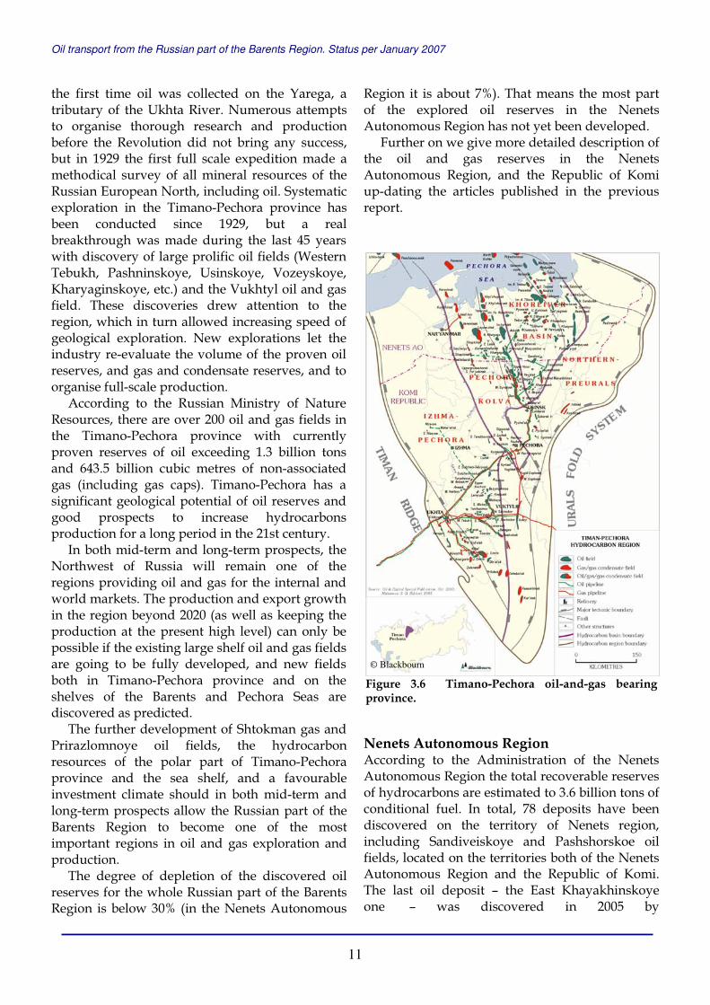
the first time oil was collected on the Yarega, a tributary of the Ukhta River. Numerous attempts to organise thorough research and production before the Revolution did not bring any success, but in 1929 the first full scale expedition made a methodical survey of all mineral resources of the Russian European North, including oil. Systematic exploration in the Timano-Pechora province has been conducted since 1929, but a real breakthrough was made during the last 45 years with discovery of large prolific oil fields (Western Tebukh, Pashninskoye, Usinskoye, Vozeyskoye, Kharyaginskoye, etc.) and the Vukhtyl oil and gas field. These discoveries drew attention to the region, which in turn allowed increasing speed of geological exploration. New explorations let the industry re-evaluate the volume of the proven oil reserves, and gas and condensate reserves, and to organise full-scale production.
According to the Russian Ministry of Nature Resources, there are over 200 oil and gas fields in the Timano-Pechora province with currently proven reserves of oil exceeding 1.3 billion tons and 643.5 billion cubic metres of non-associated gas (including gas caps). Timano-Pechora has a significant geological potential of oil reserves and good prospects to increase hydrocarbons production for a long period in the 21st century.
In both mid-term and long-term prospects, the Northwest of Russia will remain one of the regions providing oil and gas for the internal and world markets. The production and export growth in the region beyond 2020 (as well as keeping the production at the present high level) can only be possible if the existing large shelf oil and gas fields are going to be fully developed, and new fields both in Timano-Pechora province and on the shelves of the Barents and Pechora Seas are discovered as predicted.
The further development of Shtokman gas and Prirazlomnoye oil fields, the hydrocarbon resources of the polar part of Timano-Pechora province and the sea shelf, and a favourable investment climate should in both mid-term and long-term prospects allow the Russian part of the Barents Region to become one of the most important regions in oil and gas exploration and production.
The degree of depletion of the discovered oil reserves for the whole Russian part of the Barents Region is below 30% (in the Nenets Autonomous
Region it is about 7%). That means the most part of the explored oil reserves in the Nenets Autonomous Region has not yet been developed.
Further on we give more detailed description of the oil and gas reserves in the Nenets Autonomous Region, and the Republic of Komi up-dating the articles published in the previous report.
Nenets Autonomous Region According to the Administration of the Nenets Autonomous Region the total recoverable reserves of hydrocarbons are estimated to 3.6 billion tons of conditional fuel. In total, 78 deposits have been discovered on the territory of Nenets region, including Sandiveiskoye and Pashshorskoe oil fields, located on the territories both of the Nenets Autonomous Region and the Republic of Komi. The last oil deposit – the East Khayakhinskoye one – was discovered in 2005 by
Figure 3.6 Timano-Pechora oil-and-gas bearing province.
© Blackbourn

Oil transport from the Russian part of the Barents Region. Status per January 2007
12
Severgaznefteprom Company within the Lyzatynsky block.
Seven of the discovered deposits are referred to as large ones with initial recoverable reserves over 60 million tons of conditional fuel. Two of them are oil fields – Kharyaginskoye and Toboisko-Myadseiskoye, one is oil and gas – Yuzhno-Khylchuyuskoye, two are oil and gas condensate – Layavozhskoye and Vaneyvisskoye, and two are gas condensate – Kumzhinskoye and Vassilkovskoye. 52 licences have been given out for development of hydrocarbon resources.
In total 20 hydrocarbons fields are presently developed in the Nenets region, 16 of them are put into production: Kharyaginskoye, Ardalinskoye, Sredne-Kharyaginskoye, Tedinskoye, Inzy-reiskoye, Nyadeyuskoye, Khasyreiskoye, Cherpayuskoye, East-Kolvinskoye, Oshkotyn-skoye, Dyusushevskoye, Varandeyskoye, Toraveiskoye, East-Kharyaginskoye are oil fields; Peschanoozerskoye and Yuzhno-Shapkinskoye are oil and gas condensate fields; and Vassilkovskoye contains gas condensate.
The rate of production of proven reserves in the Nenets region is for oil 7.6%, and 0.7%for natural gas. The Administration of the Nenets Autonomous Region estimates that with the present production rate the proven reserves will provide oil (A+B+C1 categories) for 70 years and gas for 1000 years.
14 blocks of undistributed reserves are prepared for industrial exploitation (11 of them are oil fields); proven oil reserves in this group constitute 51%, natural gas – 99%. The largest fields prepared for industrial exploitation are Kumzhinskoye and Korovinskoye gas condensate ones, Vaneivisskoye oil and gas condensate field, Naulskoye and named after Trebs oil fields.
In the future, oil production in the Nenets Autonomous Region should increase significantly by putting new fields into exploitation. Vast territories in the western and eastern parts of the Nenets region are not explored yet. Exploration rate of total oil resources inland constitutes 38%, gas resources – 51.2%. The Republic of Komi The recoverable oil reserves in the Republic of Komi are estimated to be 1.6 billion tons, while the amount of natural gas is estimated to be 1.0 trillion cubic metres.
In 2005, the state register in the Republic of Komi included 133 proven oil and gas fields, among them 113 of oil, 35 of gas, and 10 of gas condensate. Small hydrocarbon fields (with reserves up to 10 million tons of conditional fuel) comprise 81% of the available reserves. 12 fields range from 10 to 30 million tons while only 8 fields have reserves of more than 30 million tons. The major oil and gas fields are: Usinskoye with initial recoverable reserves of 226.3 million tons of oil, Yaregskoye with 131.8 million tons of oil, Verkhnevozeyskoye with 53.3 million tons of oil and Vozeyskoye with 135.7 million tons of oil and gas.
More than 70% of industrial gas reserves in the Republic of Komi are located at the currently developed fields. The major part of the remaining oil reserves is located at the Vuktylskoye oil field, where production volumes are decreasing and where all the possibilities for increase have already been used. Other hydrocarbon fields in the Republic of Komi are either too low in reserves or too far from the major transportation routes.
54 oil and gas fields in the Republic of Komi are under industrial development, including 37 of oil, 11 of gas, and 6 of gas condensate. Most of the hydrocarbon fields are state registered as being explored.
The recoverable С1 oil reserves are allocated on 94 explored sites and constitute 130.2 million tons where the average reserve of one oil field is less than 1.5 million tons.
According to the Komi Ministry of Nature Resources and Environmental Protection, four new oil fields were opened in the Republic in 2006 – Western Vozeyshorskoye, Osokinskoye, Verkhnevolminskoye, and Iz’el-Petrovskoye. All of them are small – with the reserves less than 1 million tons of conditional fuel each.
The average rate of production of proven hydrocarbon reserves in the Republic is about 27%.
Thus, the explored oil fields do not represent a considerable reserve for oil production. The expected recoverable oil reserves in the Republic of Komi are estimated to be 1.0 billion tons. A negative factor for this area is a low concentration of the resources. It is predicted that the overwhelming number of currently discovered hydrocarbon fields will be in the small size range.
Oil transport from the Russian part of the Barents Region. Status per January 2007
13
050
100150200250300350400450500
1992
1994
1996
1998
2000
2002
2004
2006
mill
ion
to
ns
Figure 3.7 Total annual oil and gas condensate production in Russia (Source: Itar-Tass, Rosstat)
0
100
200
300400
500
600
700
1992
1994
1996
1998
2000
2002
2004
2006
bill
ion
cu
bic
met
res
Figure 3.8 Total annual natural gas production in Russia (Source: Ministry of Industry and Energy, Gazprom)
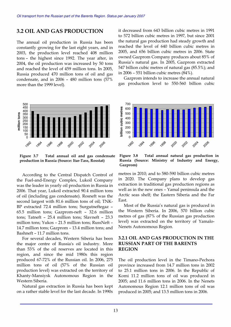
3.2 OIL AND GAS PRODUCTION The annual oil production in Russia has been constantly growing for the last eight years, and in 2003, the production level reached 408 million tons – the highest since 1992. The year after, in 2004, the oil production was increased by 50 tons and reached the level of 459 million tons. In 2005, Russia produced 470 million tons of oil and gas condensate, and in 2006 – 480 million tons (57% more than the 1999 level).
According to the Central Dispatch Control of the Fuel-and-Energy Complex, Lukoil Company was the leader in yearly oil production in Russia in 2006. That year, Lukoil extracted 90.4 million tons of oil (including gas condensate). Rosneft was the second largest with 81.6 million tons of oil; TNK-BP extracted 72.4 million tons; Surgutneftegaz – 65.5 million tons; Gazprom-neft – 32.6 million tons; Tatneft – 25.4 million tons; Slavneft – 23.3 million tons; Yukos – 21.5 million tons; RussNeft – 14.7 million tons; Gazprom – 13.4 million tons; and Bashneft – 11.7 million tons.
For several decades, Western Siberia has been the major centre of Russia's oil industry. More than 53% of the oil reserves are located in this region, and since the mid 1980s this region produced 67-72% of the Russian oil. In 2006, 275 million tons of oil (57% of the Russian oil production level) was extracted on the territory of Khanty-Mansiysk Autonomous Region in the Western Siberia.
Natural gas extraction in Russia has been kept on a rather stable level for the last decade. In 1990s
it decreased from 643 billion cubic metres in 1991 to 572 billion cubic metres in 1997, but since 2001 the natural gas production had steady growth and reached the level of 640 billion cubic metres in 2005, and 656 billion cubic metres in 2006. State owned Gazprom Company produces about 85% of Russia’s natural gas. In 2005, Gazprom extracted 547 billion cubic metres of natural gas (85.5%); and in 2006 – 551 billion cubic metres (84%).
Gazprom intends to increase the annual natural gas production level to 550-560 billion cubic
metres in 2010; and to 580-590 billion cubic metres in 2020. The Company plans to develop gas extraction in traditional gas production regions as well as in the new ones – Yamal peninsula and the Arctic seas shelf; the Eastern Siberia and the Far East.
Most of the Russia’s natural gas is produced in the Western Siberia. In 2006, 570 billion cubic metres of gas (87% of the Russian gas production level) was extracted on the territory of Yamalo-Nenets Autonomous Region. 3.2.1 OIL AND GAS PRODUCTION IN THE RUSSIAN PART OF THE BARENTS REGION The oil production level in the Timano-Pechora province increased from 14.7 million tons in 2002 to 25.1 million tons in 2006. In the Republic of Komi 11.2 million tons of oil was produced in 2005; and 11.6 million tons in 2006. In the Nenets Autonomous Region 12.1 million tons of oil was produced in 2005; and 13.5 million tons in 2006.
Oil transport from the Russian part of the Barents Region. Status per January 2007
14
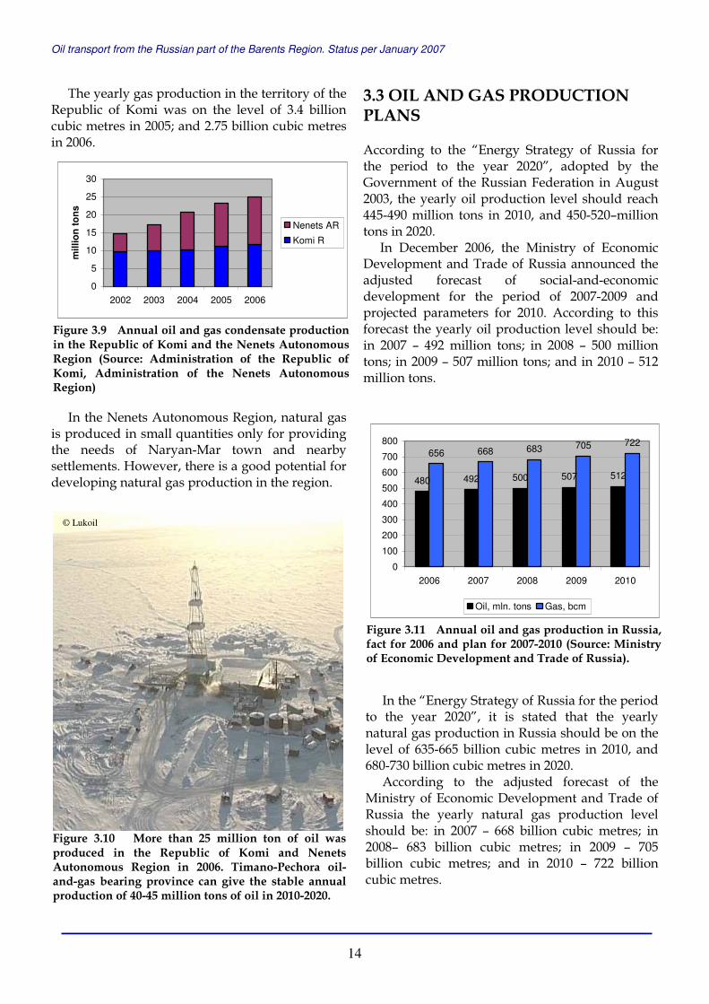
The yearly gas production in the territory of the Republic of Komi was on the level of 3.4 billion cubic metres in 2005; and 2.75 billion cubic metres in 2006.
In the Nenets Autonomous Region, natural gas is produced in small quantities only for providing the needs of Naryan-Mar town and nearby settlements. However, there is a good potential for developing natural gas production in the region.
3.3 OIL AND GAS PRODUCTION PLANS According to the “Energy Strategy of Russia for the period to the year 2020”, adopted by the Government of the Russian Federation in August 2003, the yearly oil production level should reach 445-490 million tons in 2010, and 450-520–million tons in 2020.
In December 2006, the Ministry of Economic Development and Trade of Russia announced the adjusted forecast of social-and-economic development for the period of 2007-2009 and projected parameters for 2010. According to this forecast the yearly oil production level should be: in 2007 – 492 million tons; in 2008 – 500 million tons; in 2009 – 507 million tons; and in 2010 – 512 million tons.
In the “Energy Strategy of Russia for the period to the year 2020”, it is stated that the yearly natural gas production in Russia should be on the level of 635-665 billion cubic metres in 2010, and 680-730 billion cubic metres in 2020.
According to the adjusted forecast of the Ministry of Economic Development and Trade of Russia the yearly natural gas production level should be: in 2007 – 668 billion cubic metres; in 2008– 683 billion cubic metres; in 2009 – 705 billion cubic metres; and in 2010 – 722 billion cubic metres.
480 492 500 507 512
656 668 683 705 722
0
100
200
300
400
500
600
700
800
2006 2007 2008 2009 2010
Oil, mln. tons Gas, bcm
Figure 3.11 Annual oil and gas production in Russia, fact for 2006 and plan for 2007-2010 (Source: Ministry of Economic Development and Trade of Russia).
Figure 3.10 More than 25 million ton of oil was produced in the Republic of Komi and Nenets Autonomous Region in 2006. Timano-Pechora oil-and-gas bearing province can give the stable annual production of 40-45 million tons of oil in 2010-2020.
0
5
10
15
20
25
30
2002 2003 2004 2005 2006
mill
ion
to
ns
Nenets AR
Komi R
Figure 3.9 Annual oil and gas condensate production in the Republic of Komi and the Nenets Autonomous Region (Source: Administration of the Republic of Komi, Administration of the Nenets Autonomous Region)
© Lukoil

Oil transport from the Russian part of the Barents Region. Status per January 2007
15
3.3.1 OIL PRODUCTION PLANS IN THE RUSSIAN PART OF THE BARENTS REGION In the Republic of Komi an insignificant production growth is expected for the period 2010-2020, i.e. with the annual volume of 12.9 million tons in 2010 and, subsequently, a slight decrease to 11.4 million tons in 2020.
The further development of the Komi hydrocarbon fields will be accompanied by a structural decline of major reserves with an increasing number of hard-to-extract fields. This will be followed by increase of production costs as well as use of more advanced extraction technologies.
According to estimates by the Administration of the Nenets Autonomous Region the annual oil production on the territory of the Nenets region in 2010 will be on the level of 25 million tons, and in the period of 2010-2020 can reach and be stabilised on the level of 30 million tons. The growth in production will be provided by newly developed and discovered fields.
In 2010-2020, Timano-Pechora oil-and-gas province can give the stable annual production of 40-45 million tons of oil. 3.3.2 OIL PRODUCTION PROSPECTS FOR THE RUSSIAN WESTERN ARCTIC SHELF The oil extraction on the shelf of the Barents Sea will begin with the start of operations at Prirazlomnoye oil field.
Prirazlomnoye oil field is one of the largest among the proven oil reserves in the Russian western Arctic shelf. Discovered in 1989, the Prirazlomnoye oil field is located in the Pechora Sea, about 60 kilometres north of the Nenets Autonomous Region coast, with the sea depth of 19 metres.
Initial geological oil reserves (С1+С2) of the field are estimated as 231.1 million tons. The cumulative oil production for the operation period of 23 years should amount to 75 million tons.
Since 2002 the license for the development of Prirazlomnoye oil field belongs to the Sevmor-neftegaz Company. Sevmorneftegas was founded by Gazprom and Rosneft in 2002, and in 2005 the Company became 100% subsidiary of Gazprom.
The platform Prirazlomnaya, that is built in Severodvinsk, Arkhangelsk Region, should be completed and delivered to the field in the Pechora Sea in 2007. The yearly production maximum of about 7 million tons of oil can be reached in the fifth year of development. Oil from Prirazlomnoye will be delivered by tankers to Rotterdam.
The major part in the future oil shipment in the Pechora Sea is linked to the production at Dolginskoye oil field. The licence for oil exploration and production at this field was given to Gazprom in December 2005. Dolginskoye field with proven reserves of 235 million tons of oil is located north of Prirazlomnoye. It is the largest among discovered oil fields in the Pechora Sea. From 2007 to 2009, Gazflot, subsidiary of Gazprom, plans to drill 7 new exploration wells at Dolginskoye, and get the first oil in 2015.
Oil production is planned on three more licensed sites in the Pechora Sea – Medynsko-Varandeyskiy area, Kolokolmorskiy and Pomorskiy blocks. The licenses are owned by Arktikshelfneftegaz, and the oil fields can be put in operation after 2010. The estimated recoverable
Figure 3.12 Prirazlomnoye oil field is one of the largest among the proven oil reserves in the Russian western Arctic shelf.
Oil transport from the Russian part of the Barents Region. Status per January 2007
16
hydrocarbon resources of these three blocks are in excess of 300 million tons of oil.
Russian Ministry of Energy stated in 2004 that the oil extraction from the four above mentioned sites in the Pechora Sea should reach 12.7 million tons a year by 2013.
Ministry of Industry and Energy of Russia reported to the Russian Duma in 2007 that the annual oil production on the whole Russian continental shelf is estimated to be on the level of 110 million tons in 2030.
3.3.2 GAS PRODUCTION PROSPECTS FOR THE RUSSIAN WESTERN ARCTIC SHELF The region's biggest hope is the Shtokman gas field in the Barents Sea shelf. The Shtokman project has been prioritised by the authorities and companies, as well as highlighted in media during the last five years. The Shtokman project development has several sides and challenges – economical, technological, environmental and political. Here we give the information from the
official Internet site of Gazprom, the project owner.
The Shtokman gas and condensate field development project is of strategic significance for Gazprom. The field will be the resource base for Russian gas exports to Europe via the Nord Stream gas pipeline currently under construction, with LNG technologies to be applied.
The Shtokman development process will involve using state-of-the-art technologies and technical know-how. Authoritative international companies will be invited for these purposes as contractors, with strict compliance to work deadlines and costs to be a critical contract clause. The conceptual scheme of the project management and foreign partner involvement for the first phase of the field development will be defined in 2007. Sevmorneftegaz Company owns the license for research, exploration and production of gas and gas condensate on Shtokman field; and the
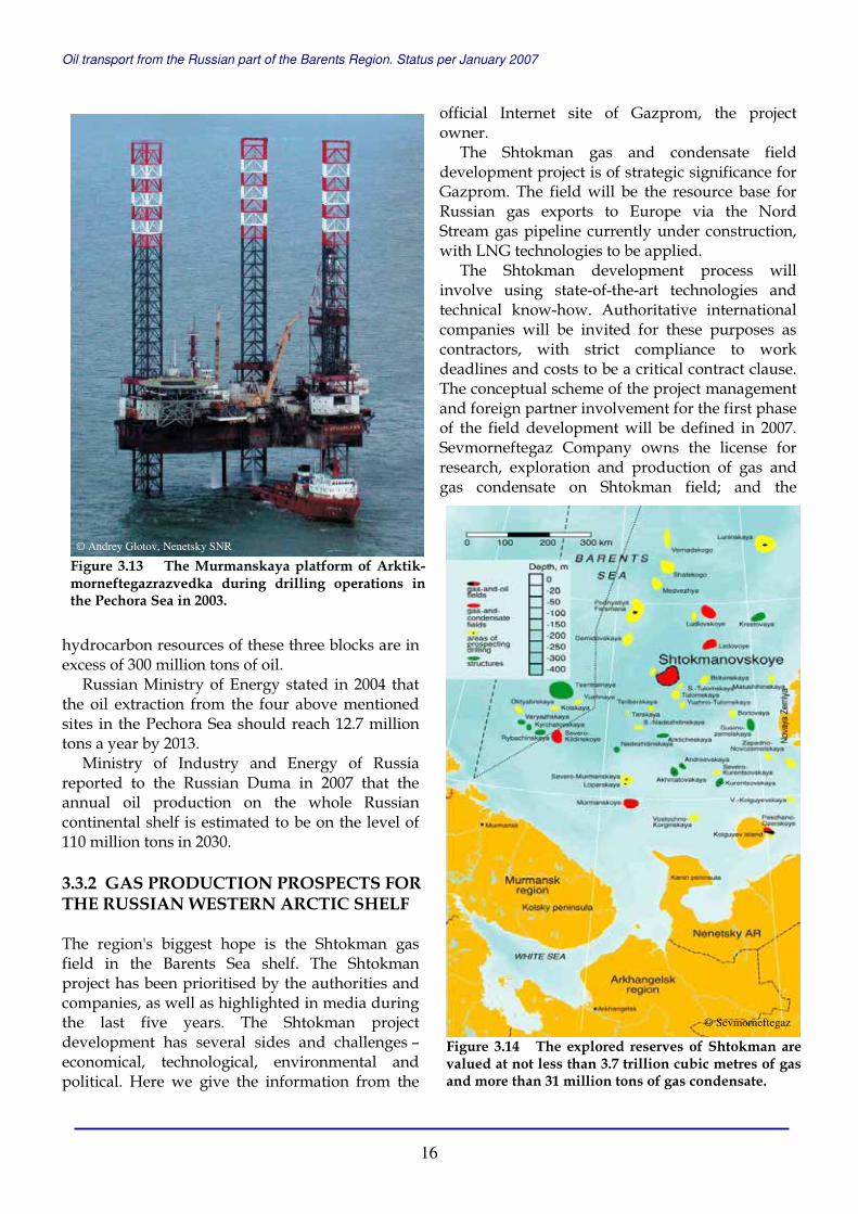
Figure 3.13 The Murmanskaya platform of Arktik-morneftegazrazvedka during drilling operations in the Pechora Sea in 2003.
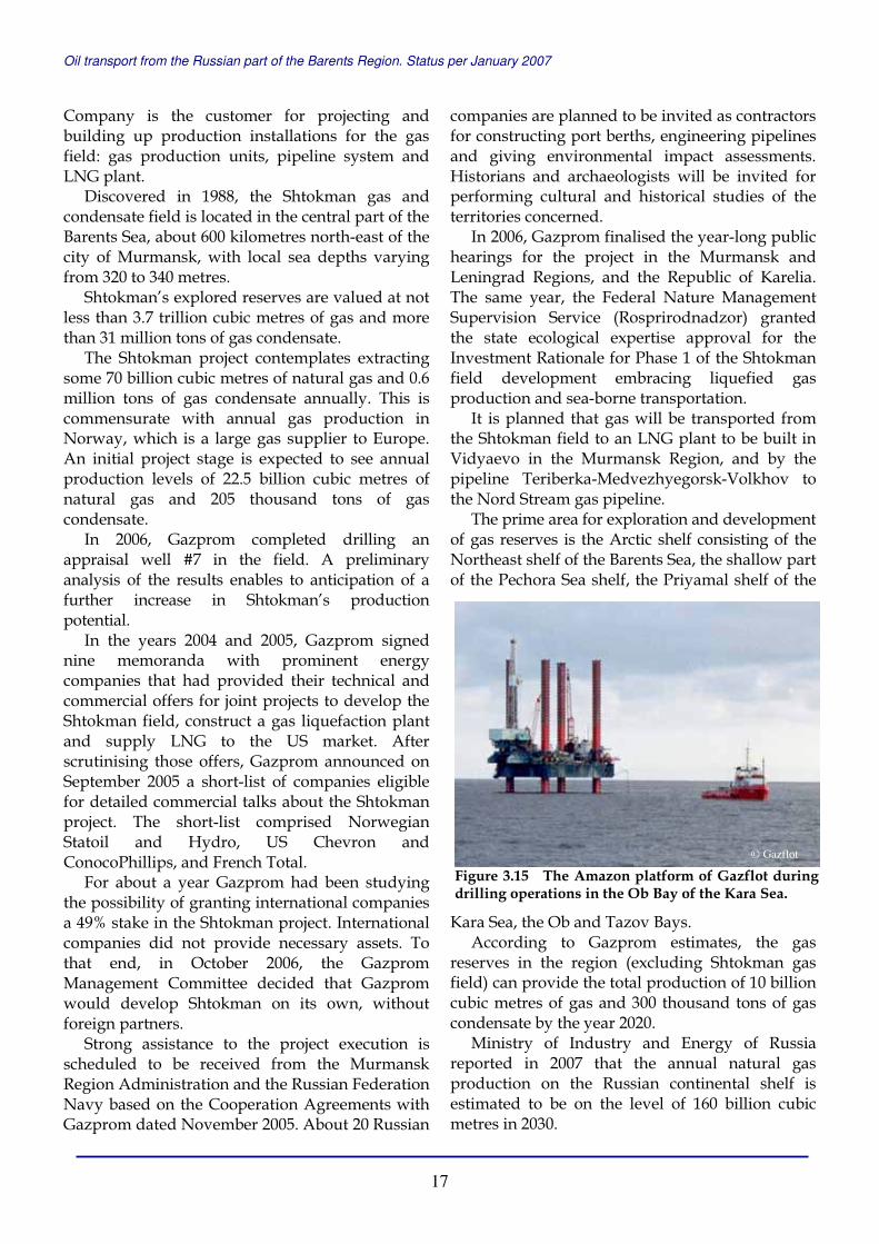
Figure 3.14 The explored reserves of Shtokman are valued at not less than 3.7 trillion cubic metres of gas and more than 31 million tons of gas condensate.
© Sevmorneftegaz
© Andrey Glotov, Nenetsky SNR
Oil transport from the Russian part of the Barents Region. Status per January 2007
17
Company is the customer for projecting and building up production installations for the gas field: gas production units, pipeline system and LNG plant.
Discovered in 1988, the Shtokman gas and condensate field is located in the central part of the Barents Sea, about 600 kilometres north-east of the city of Murmansk, with local sea depths varying from 320 to 340 metres.
Shtokman’s explored reserves are valued at not less than 3.7 trillion cubic metres of gas and more than 31 million tons of gas condensate.
The Shtokman project contemplates extracting some 70 billion cubic metres of natural gas and 0.6 million tons of gas condensate annually. This is commensurate with annual gas production in Norway, which is a large gas supplier to Europe. An initial project stage is expected to see annual production levels of 22.5 billion cubic metres of natural gas and 205 thousand tons of gas condensate.
In 2006, Gazprom completed drilling an appraisal well #7 in the field. A preliminary analysis of the results enables to anticipation of a further increase in Shtokman’s production potential.
In the years 2004 and 2005, Gazprom signed nine memoranda with prominent energy companies that had provided their technical and commercial offers for joint projects to develop the Shtokman field, construct a gas liquefaction plant and supply LNG to the US market. After scrutinising those offers, Gazprom announced on September 2005 a short-list of companies eligible for detailed commercial talks about the Shtokman project. The short-list comprised Norwegian Statoil and Hydro, US Chevron and ConocoPhillips, and French Total.
For about a year Gazprom had been studying the possibility of granting international companies a 49% stake in the Shtokman project. International companies did not provide necessary assets. To that end, in October 2006, the Gazprom Management Committee decided that Gazprom would develop Shtokman on its own, without foreign partners.
Strong assistance to the project execution is scheduled to be received from the Murmansk Region Administration and the Russian Federation Navy based on the Cooperation Agreements with Gazprom dated November 2005. About 20 Russian
companies are planned to be invited as contractors for constructing port berths, engineering pipelines and giving environmental impact assessments. Historians and archaeologists will be invited for performing cultural and historical studies of the territories concerned.
In 2006, Gazprom finalised the year-long public hearings for the project in the Murmansk and Leningrad Regions, and the Republic of Karelia. The same year, the Federal Nature Management Supervision Service (Rosprirodnadzor) granted the state ecological expertise approval for the Investment Rationale for Phase 1 of the Shtokman field development embracing liquefied gas production and sea-borne transportation.
It is planned that gas will be transported from the Shtokman field to an LNG plant to be built in Vidyaevo in the Murmansk Region, and by the pipeline Teriberka-Medvezhyegorsk-Volkhov to the Nord Stream gas pipeline.
The prime area for exploration and development of gas reserves is the Arctic shelf consisting of the Northeast shelf of the Barents Sea, the shallow part of the Pechora Sea shelf, the Priyamal shelf of the
Kara Sea, the Ob and Tazov Bays. According to Gazprom estimates, the gas
reserves in the region (excluding Shtokman gas field) can provide the total production of 10 billion cubic metres of gas and 300 thousand tons of gas condensate by the year 2020.
Ministry of Industry and Energy of Russia reported in 2007 that the annual natural gas production on the Russian continental shelf is estimated to be on the level of 160 billion cubic metres in 2030.
Figure 3.15 The Amazon platform of Gazflot during drilling operations in the Ob Bay of the Kara Sea.
© Gazflot
Oil transport from the Russian part of the Barents Region. Status per January 2007
18
4 Oil and Gas Transport he description of the transport system in Russia is based on the reports and the documents of the Ministry of Transport of Russia, and in particular, on the federal program “Strategy of transport development in the Russian Federation for the period until 2010”. The articles about railways were based on the information from the Russian Railways Company and its departments. In the articles about rivers, lakes and canals we basically used data from the internet portal Infoflot. Description of the sea transport was based on the information of the Federal Agency of Sea and River Transport; we also used news published by SeaNews, Portnews and Logistics information portals. The description of the oil and gas pipeline systems and development perspectives is based on the Ministry of Industry and Energy report “Prospects of development and use of the systems of transportation of hydrocarbons and products of their processing” given at the meeting of the Government Commission on the Fuel and Energy Complex in October 2006. We also used information and news published by Transneft, Transnefteprodukt and Gazprom.
The descriptions of the oil loading terminals are based on the first and second reports “Oil transport from the Russian part of the Barents Region”, and updated using information from press-releases, reports and news of the companies-operators, environmental authorities, regional information agencies, and local newspapers.
The system of transportation of hydrocarbons and the products of their processing includes subsystems of pipelines, railways and marine transport, and the necessary port terminals. Railway and marine transport belong to public-use types of transport as distinct from pipelines, which are a specialised type of transport that underpins the entire system of transportation of hydrocarbons. Russia’s energy strategy in the period to 2020 envisages: • development of the transport infrastructure for
the oil and gas sector: first, for timely formation of transportation systems in the new oil- and gas-extracting regions; second, for diversification of supplies to internal and external markets by direction, mode and route; and third, to increase returns on the export of gas, oil and petroleum products;
• regulation of access for producers of energy resources to pipeline systems;
• support of projects aimed at creating an energy transportation infrastructure on the basis of the principles of private-public partnership: coordination of goals, synergy of efforts and sharing of responsibility and risks.
The existing forecasts made by the Ministry of Industry and Energy speak of an increase of oil production by 2015 to 509-542 million tons (versus 480 million tons in 2006). The bulk of production growth will be achieved by developing the oil and gas resources of Eastern Siberia and the Far East of Russia. Oil production in that region will grow to 74 million tons through the launching of commercial exploitation of such major fields as Vankorskoye, Yurubcheno-Tokhomskoye, Kuyumbinskoye, Verkhnechonskoye and Talakanskoye and the achievement of design capacity of the Sakhalin-1 and Sakhalin-2 projects. The continuing development of the Timano-Pechora oil-and-gas province as well as of the continental shelf of the Arctic seas would increase oil production in that region by 63% (by 16 million tons), of which a growth by 7.5 million tons will be thanks to the development of the Prirazlomnoye oil field in the Pechora Sea.
0
50
100
150
200
250
300
1997
1998
1999
2000
2001
2002
2003
2004
2005
2006
mill
ion
to
ns
Figure 4.1 Oil export from Russia (Source: Rosstat)
T

Oil transport from the Russian part of the Barents Region. Status per January 2007
19
The volume of crude oil export in 2015 may reach an estimated 272-300 million tons (versus 249 million tons in 2006).
Export is expected to grow due to the increase of oil supplies to the countries of the “far abroad” while oil export to the CIS countries will be little changed.
The growth of primary oil processing is expected to reach 225-230 million tons by 2015. The production of petrol will increase by 1.2-1.3 times, and of diesel fuel by 17-23%. Export of oil products will remain stable. Given the expected rate for growth of the world market of oil and oil products, the targets set by the Energy Strategy of Russia for diversifying export transports and an insignificant increase in the volume of transit, the Ministry of Industry and Energy expects that the volume of oil supplies to the European market will remain stable (235 million tons). Oil shipments to the Asia Pacific countries will increase to 80 million tons and to the United States to 12 million tons. This would assure for Russian exported oil a share of over 20% in the end consumption in Europe, more than 5% in the China, and about 1% in the USA.
By 2015, gas production is variously predicted to increase to 742-754 billion cubic metres (versus 638 billion cubic metres in 2005). The bulk of the growth is expected in the North Western region, by 38 billion cubic metres due to the development of the Shtokman field, and in Eastern Siberia, by 33 billion cubic metres, partly due to the start of the development of fields in the Irkutsk Region, including the unique Kovykta field. In the Far East, Sakhalin-1 and -2 projects are to reach design capacity and the Sakhalin-3 project will begin to be exploited, increasing gas extraction in the region by 42 billion cubic metres.
The target is to fully meet the internal gas needs of the economy and the household while consumption is to increase from 442 billion cubic metres in 2005 to 470 billion cubic metres in 2010 and 490 billion cubic metres in 2015.
Gas export in 2015 may reach an estimated 274-281 billion cubic metres (versus 207 billion cubic metres in 2005). Given the trends in the development of the world gas market and Russia’s possible place in that market and the strategic decision to diversify export shipments, the structure of Russian gas export will be fundamentally changed: • due to the development of resources in the
Eastern part of Russia (Sakhalin-1 and -2) and the Shtokman field the share of liquefied natural gas delivered to the APR markets and to the East coast of the USA will reach 61 billion cubic metres (22% of the total exports);
• 30 billion cubic metres will be shipped (11%) along the western route to China (Altai project);
• gas supplies to Europe will grow from 154 to 173 billion cubic metres (its share in total exports will drop by 12% to 62%), while the routes of gas supply will be diversified via Nord Stream, and the Blue Stream will be extended to countries of Central Europe and southern regions of Italy;
• supplies of Russian gas to the countries of the former USSR will be balanced out (gradually replaced) by supplies of the Central Asian gas . As a result the export of Russian gas to this region will drop by 37 billion cubic metres and its share in total exports by 20% to 6%.
The development of production and export of oil and gas calls for a matching development of the infrastructure of the pipelines for the transportation of hydrocarbons and products of their processing.
Figure 4.2 In 2015, oil export from Russia may reach the level of 272-300 million tons a year.
© Administration of NAR
Figure 4.3 Gas export in 2015 may reach the level of 274-281 billion cubic metres per year.
© Dni.ru

Oil transport from the Russian part of the Barents Region. Status per January 2007
20
4.1 TRANSPORT SYSTEM IN RUSSIA Russia has its most advanced transportation infrastructure in the European part of the country. The total annual transportation turnover in Russia, including pipelines, railway, automotive transportation, inner waterways and sea shipping and aviation, amounts to more than 4.5 billion ton-kilometres.
The significance of various transportation types is determined by their share in the total transportation flow. The major part of the transportation activity in Russia belongs traditionally to pipelines and railways.
The yearly volume export-import cargo in Russia is more than 600 million tons and the volume of export exceeded the import by almost 1.5 times. The majority of annual exports from Russia is comprised of fuel. The oil export increased from 127 million tons in 1997 to 258 million tons in 2004. In 2005, Russia exported 253 million tons of oil, and in 2006 – 248 million tons.
In 2004, the Russian Ministry of Transport worked out a “Strategy of transport development in the Russian Federation for the period to 2010”. According to this strategy, the volume of export-imports in 2010 is expected to increase 3 times compared to the volume in 2003. The main trend of export infrastructural development is the creation of sufficient oil storage and loading capacities in the Russian seaports for oil shipments heading to both traditional and new markets.
In May 2005, the Ministry of Transport of Russia adopted the “Transport Strategy of the Russian Federation for the period to 2020”.
Realisation of the transport strategy of the Russian Federation should, in particular, allow reaching the following results: capacity of the ports infrastructure will supply up to 90-95% of export-import operations (versus 75% in 2003); more than 50% of tonnage of the commercial fleet controlled by Russia will be registered in the national registers (versus 35% in 2003); transit transportation through the Russian territory will be on the level of 90-100 million tons a year.
Special attention in the transport strategy is given to the development of the transport schemes for oil and gas industry.
The transport strategy is realised with carrying out a number of big infrastructure projects, among them: • Construction of the motor way Chita–
Khabarovsk for connecting Moscow and Vladivostok.
• The railway Berkakit–Tommot–Yakutsk should increase mineral resources development in the Republic of Sakha.
• Modernisation of existing roads and building new ones in the North and newly developed regions.
• Development of the Baltic Pipeline System in combination with establishment of the vessel traffic management system in the Baltic will increase export potential of Russia.
• Modernisation of the Arctic transport system will secure strategic control of the Russian Arctic, increase the life-quality for people above the Polar Circle, stimulate natural resource exploration in the north, create perquisites for transits along the Northern Sea Route, as well
0
1000
2000
3000
4000
5000
1995
1996
1997
1998
1999
2000
2001
2002
2003
2004
2005
bill
ion
tkm
Figure 4.4 The total annual freight turnover in Russia from 1995 to 2005 (Source: Rosstat, Prime-Tass)
Pipeline (55.1%)
Railway (41.4%)
Inland water-way (1.6%)
Marine (1.0%)
Motor (0.8%)
Aviation (0.1%)
Figure 4.5 Shares in freight ton-kilometres by public transport mode in 2005 (Rosstat)

Oil transport from the Russian part of the Barents Region. Status per January 2007
21
as contributing to improvement of the living standards of the indigenous peoples of the North and development of ecological tourism.
• Development of the port complex in Ust-Luga in the Baltic Sea.
• Completion of the railways Noviy Urengoy–Nadym and Noviy Urengoy–Yamburg for efficient development of the Yamalo-Nenets Autonomous Region and its natural resources.
• Creation of the transport corridor by the eastern Ural mountainside towards Polunochnaya–Labytnangi for developing the Yamal peninsula, the Kara Sea shelf and the Northern Sea Route.
• Complex system modernisation of the Far East ports with railway connection for developing economic relations with Asia Pacific countries.
• Construction of the oil pipeline from Eastern Siberia to the Asia Pacific countries for creating a new export route for Russian oil transport.
• Construction of the pipeline system to the Barents Sea coast and harbour complexes, with oil terminals for increasing the possibilities of oil transport from Russia to North American and European markets.
Figure 4.6. According to the “Strategy of transport development in the Russian Federation for the period to 2010”, the volume of export-imports in 2010 is expected to increase 3 times compared to the volume in 2003. The Special attention in the transport strategy is given to the development of the transport schemes for oil and gas industry. The main trend of export infrastructural development is the creation of sufficient oil storage and loading capacities in the Russian seaports for oil shipments heading to both traditional and new markets.
© CNIIMF
Oil transport from the Russian part of the Barents Region. Status per January 2007
22
4.1.1 RAILWAYS Railway transportation is a main mean of commercial transportation in Russia. Primarily, it can be explained by the country's geographical features. The length of railway tracks puts Russia on the second place in the world after the USA. Operational length of the Russian railways is 86.6 thousand kilometres, which comprise 11% of the world's total extent of the railway tracks.
More than 1 billion tons of cargo per year is transported by railways in Russia (1.3 billion tons in 2006), where the oil shares are about 18% (228 million tons in 2006).
In Russia, 85% of the railways are located in the European part of the country. This is accounted for by historical reasons as the economy of Russia is mainly concentrated in the European part. Both the major communications networks and freight traffic in Russia were built around the country's export-imports to the west and south where large ports and the main trade partners were located.
In the period from 1837 to 1890, Russia built a railway network in the European part of the country. In 1837, the first railway was built to connect Saint Petersburg to Tsarskoye Selo. Then, in 1851, Moscow–Saint Petersburg railway was put in operation. Today this route is the Russian railway's fastest line, and is an important part of the major communication channel between Moscow, Saint Petersburg and Murmansk on the October railway.
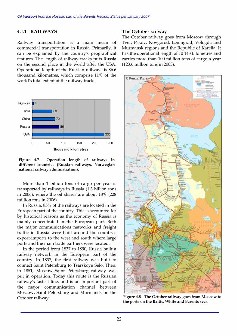
The October railway The October railway goes from Moscow through Tver, Pskov, Novgorod, Leningrad, Vologda and Murmansk regions and the Republic of Karelia. It has the operational length of 10 143 kilometres and carries more than 100 million tons of cargo a year (123.6 million tons in 2005).
230
86
72
63
4
0 50 100 150 200 250
USA
Russia
China
India
Norw ay
thousand kilometres
Figure 4.7 Operation length of railways in different countries (Russian railways, Norwegian national railway administration).
Figure 4.8 The October railway goes from Moscow to the ports on the Baltic, White and Barents seas.
© Russian Railways

Oil transport from the Russian part of the Barents Region. Status per January 2007
23
At present, the increase in the freight traffic going north along the October railway is mainly connected to crude and fuel oil exports. Since 1995, the export oil was delivered to the Beloye More station (Vitino port); and since 2004, the oil has been carried all the way to the port of Murmansk. In 2003, the railway delivered to Vitino port almost 6 million tons of export oil (about 100 000 railway tank cars), and in 2006, more than 7 million tons of export oil were sent to the terminals in the Murmansk Region.
In November 2004, at the joint meeting, the Russian Northwest port authorities and the October Railway management discussed the prospects of establishing a unified logistics centre for Northwest Russia with a head office in Saint-Petersburg. This centre should solve problems with unloading of freight trains in North-western ports in both mid and long-term prospects. A local logistics centre was also created in Murmansk.
In 2004, 52.1 million tons of cargo was delivered to the seaports by October railway; and in 2005 – 58 million tons. The October Railway Department plans to increase the freight flow to the sea ports considerably, and deliver 107 million tons in 2010; 137 million tons in 2010; and 152 million tons in 2020.
In 2005, the electrification of the October railway was completed all the way to Murmansk. Electrical power has given the possibility to enlarge the carrying capacity of cargo trains by 1.5 times.
According to the October Railway Department, the expected growth of freight at the Murmansk railway junction for the period 2010-2015 may reach 40 million tons. The modernisation of the railway's northern line (both tracks and service facilities) is carried out by the October Railway Department together with the interested parties of railway customers and carriers. By the year 2015, it is planned to develop and build new railway tracks to Kola and Murmansk on the eastern side of the Kola Bay; and to Lavna and Kulonga on its western side.
The October railway joins the Northern railway on the borders of the Republic of Karelia and Arkhangelsk Region, Tver and Yaroslavl regions, and in Vologda Region.
Figure 4.10 The expected growth of freight at Murmansk railway junction for the period 2010-2015 may reach 40 million tons. New railway tracks are to be constructed to Kola and Murmansk on the eastern side of the Kola Bay; and to Lavna and Kulonga on its western side.
© Russian Railways
Figure 4.9 Since 1995, the export oil was delivered by October railway to the Beloye More station (Vitino port); and since 2004, the oil has been carried all the way to the port of Murmansk. In 2003, the railway delivered to Vitino port almost 6 million tons of export oil (about 100 000 rail tank cars), and in 2006, more than 7 million tons of export oil were sent to the terminals in the Murmansk Region. The picture shows new line in the Vitino port for unloading oil from rail to storage.
© Bjørn Frantzen

Oil transport from the Russian part of the Barents Region. Status per January 2007
24
The Northern railway In 2008, the Northern railway will be 140 years old. The Northern railway goes along the oldest animal-drawn path from Moscow to Arkhangelsk, which connected the north of the country with its central provinces in the days of Ivan the Terrible. Nowadays, the Northern railway runs through Northern and North-eastern Russia, through the territory of Yamalo-Nenets Autonomous Region, the Republic of Komi, Arkhangelsk, Vologda, Kostroma, Ivanovo and Yaroslavl regions. The Northern railway has a favourable geographical position as it passes through the location of the major pipeline junction; the Ukhta-Yaroslavl-Kirishi pipeline joins the pipeline that goes through Surgut-Yaroslavl-Polotsk. The Baltic Pipeline System originates in Yaroslavl.
The operational length of the road is 8508 kilometres and it carries more than 70 million tons of cargo a year (76.4 million tons in 2006), where crude oil and oil products shares are about 25% (19 million tons in 2006).
In 2004, the Northern Railway Department signed a contract of intentions with the Arkhangelsk Regional Administration and cargo operators to cooperate in reconstruction work on some parts of the railway in order to expand the freight of oil to the ports of Arkhangelsk and Severodvinsk.
In 2005, the Northern railway delivered 4.7 million tons of oil and oil products to the terminal in Talagi near Arkhangelsk. According to the development concept of the Talagi oil terminal of the Rosneft-Arkhangelsknefteprodukt to 2008, it is planned to increase the oil products freight to 10.2 million tons a year.
In October 2006, Gazprom Company decided to resume construction of the 500-kilometres long Polar rail line Obskaya–Bovanenkovo that should connect the Northern railway with one of the largest oil and gas condensate field in the world – Bovanenkovskoye in the Yamal peninsula. The rail line should be completed in 2010.
Figure 4.11 The Northern railway runs through the Northern and North-Eastern Russia, through the territory of Yamalo-Nenets Autonomous Region, the Republic of Komi, Arkhangelsk, Vologda, Kostroma, Ivanovo and Yaroslavl regions. In 2005, the Northern railway delivered 4.7 million tons of oil and oil products to the terminal in Talagi near Arkhangelsk. In 2008, the freight of oil and oil products to Talagi terminal can reach10.2 million tons.
© Russian Railways
Oil transport from the Russian part of the Barents Region. Status per January 2007
25
4.1.2 INLAND WATER-WAYS The length of the rivers used in Russia for navigation on a regular basis totals 108 thousand kilometres. The freight ton-kilometres of the river transportation make about 2% of the total goods turnover in Russia.
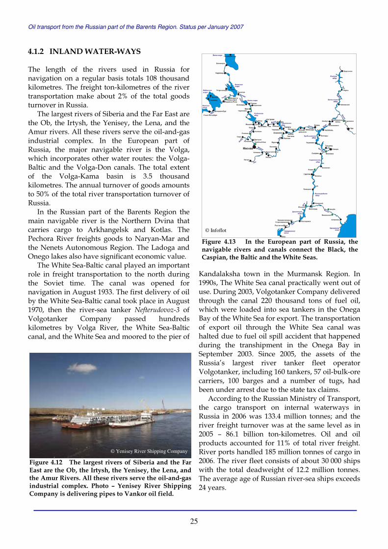
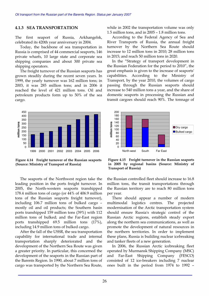
The largest rivers of Siberia and the Far East are the Ob, the Irtysh, the Yenisey, the Lena, and the Amur rivers. All these rivers serve the oil-and-gas industrial complex. In the European part of Russia, the major navigable river is the Volga, which incorporates other water routes: the Volga-Baltic and the Volga-Don canals. The total extent of the Volga-Kama basin is 3.5 thousand kilometres. The annual turnover of goods amounts to 50% of the total river transportation turnover of Russia.
In the Russian part of the Barents Region the main navigable river is the Northern Dvina that carries cargo to Arkhangelsk and Kotlas. The Pechora River freights goods to Naryan-Mar and the Nenets Autonomous Region. The Ladoga and Onego lakes also have significant economic value.
The White Sea-Baltic canal played an important role in freight transportation to the north during the Soviet time. The canal was opened for navigation in August 1933. The first delivery of oil by the White Sea-Baltic canal took place in August 1970, then the river-sea tanker Nefterudovoz-3 of Volgotanker Company passed hundreds kilometres by Volga River, the White Sea-Baltic canal, and the White Sea and moored to the pier of
Kandalaksha town in the Murmansk Region. In 1990s, The White Sea canal practically went out of use. During 2003, Volgotanker Company delivered through the canal 220 thousand tons of fuel oil, which were loaded into sea tankers in the Onega Bay of the White Sea for export. The transportation of export oil through the White Sea canal was halted due to fuel oil spill accident that happened during the transhipment in the Onega Bay in September 2003. Since 2005, the assets of the Russia’s largest river tanker fleet operator Volgotanker, including 160 tankers, 57 oil-bulk-ore carriers, 100 barges and a number of tugs, had been under arrest due to the state tax claims.
According to the Russian Ministry of Transport, the cargo transport on internal waterways in Russia in 2006 was 133.4 million tonnes; and the river freight turnover was at the same level as in 2005 – 86.1 billion ton-kilometres. Oil and oil products accounted for 11% of total river freight. River ports handled 185 million tonnes of cargo in 2006. The river fleet consists of about 30 000 ships with the total deadweight of 12.2 million tonnes. The average age of Russian river-sea ships exceeds 24 years.
Figure 4.12 The largest rivers of Siberia and the Far East are the Ob, the Irtysh, the Yenisey, the Lena, and the Amur Rivers. All these rivers serve the oil-and-gas industrial complex. Photo – Yenisey River Shipping Company is delivering pipes to Vankor oil field.
Figure 4.13 In the European part of Russia, the navigable rivers and canals connect the Black, the Caspian, the Baltic and the White Seas.
© Yenisey River Shipping Company
© Infoflot
Oil transport from the Russian part of the Barents Region. Status per January 2007
26
4.1.3 SEA TRANSPORTATION The first seaport of Russia, Arkhangelsk, celebrated its 420th year anniversary in 2004.
Today, the backbone of sea transportation in Russia is comprised of 44 commercial seaports, 146 private wharfs, 10 large state and corporate sea shipping companies and about 300 private sea shipping operators.
The freight turnover of the Russian seaports has grown steadily during the recent seven years. In 1999, the yearly turnover was 162 million tons; in 2003, it was 285 million tons; and in 2006 it reached the level of 421 million tons. Oil and petroleum products form up to 50% of the sea cargo.
The seaports of the Northwest region take the leading position in the ports freight turnover. In 2005, the North-western seaports transhipped 178.4 million tons of cargo (or 44% of 406.9 million tons of the Russian seaports freight turnover), including 106.7 million tons of bulked cargo – mostly oil and oil products; the Southern basin ports transhipped 159 million tons (39%) with 112 million tons of bulked; and the Far-East region ports transhipped 69.5 million tons (17%), including 14.9 million tons of bulked cargo.
After the fall of the USSR, the sea transportation capability for international trade and internal transportation sharply deteriorated and the development of the Northern Sea Route was given a greater priority. In particular, this concerned the development of the seaports in the Russian part of the Barents Region. In 1990, about 7 million tons of cargo was transported by the Northern Sea Route,
while in 2002 the transportation volume was only 1.5 million tons, and in 2005 – 1.8 million tons.
According to the Federal Agency of Sea and River Transports of Russia, the annual freight turnover by the Northern Sea Route should increase to 12 million tons in 2010; 28 million tons in 2015; and reach 50 million tons in 2020.
In the “Strategy of transport development in the Russian Federation for the period to 2010”, the great emphasis is given to the increase of seaports' capabilities. According to the Ministry of Transport, by the year 2010, the volumes of cargo passing through the Russian seaports should increase to 540 million tons a year, and the share of domestic seaports in processing the Russian and transit cargoes should reach 90%. The tonnage of
the Russian controlled fleet should increase to 16.8 million tons, the transit transportations through the Russian territory are to reach 80 million tons per year.
There should appear a number of modern multimodal logistics centres. The projected modernisation of the Arctic transportation system should ensure Russia's strategic control of the Russian Arctic regions, establish steady export along the northern sea communications, as well as promote the development of natural resources in the northern territories. In order to implement these plans, Russia is building nuclear icebreaking and tanker fleets of a new generation.
In 2006, the Russian Arctic icebreaking fleet operated by Murmansk Shipping Company (MSC) and Far-East Shipping Company (FESCO) consisted of 12 ice-breakers including 7 nuclear ones built in the period from 1974 to 1992 –
050
100150200250300350400450
1999 2000 2001 2002 2003 2004 2005 2006
mill
ion
to
ns
Figure 4.14 Freight turnover of the Russian seaports (Source: Ministry of Transport of Russia)
020406080
100120140160180200
North-west South Far East
mill
ion
to
ns
Dry cargo
Bulked cargo
Figure 4.15 Freight turnover in the Russian seaports in 2005 by regional basins (Source: Ministry of Transport of Russia)
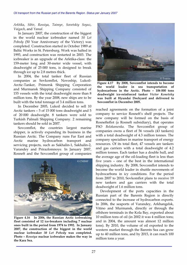
Oil transport from the Russian part of the Barents Region. Status per January 2007
27
Arktika, Sibir, Rossiya, Taimyr, Sovetskiy Soyuz, Vaigach, and Yamal.
In January 2007, the construction of the biggest in the world nuclear icebreaker named 50 Let Pobedy (50 Year Anniversary of the Victory) was completed. Construction started in October 1989 at Baltic Works in St. Petersburg. Work was halted in 1993, and construction was restarted in 2003. The icebreaker is an upgrade of the Arktika-class: the 159-meter long and 30-meter wide vessel, with deadweight of 25 000 tons, is designed to break through ice up to 2.8 metres thick.
In 2004, the total tanker fleet of Russian companies as Sovkomflot, Novoship, Lukoil-Arctic-Tanker, Primorsk Shipping Corporation and Murmansk Shipping Company consisted of 155 vessels with the total deadweight more than 8 million tons. By the year 2008, new ships are to be built with the total tonnage of 3.4 million tons.
In December 2005, Lukoil decided to sell 10 Arctic tankers – 5 of 15 000 tons deadweight and 5 of 20 000 deadweight. 8 tankers were sold to Turkish Palmali Shipping Company. 2 remaining tankers should be sold in 2007.
Sovcomflot, the countries largest marine shipper, is actively expanding its business in the Russian Arctic. The Company runs Far East and Arctic marine hydrocarbon transport and servicing projects, such as Sakhalin-1, Sakhalin-2, Varandey and Prirazlomnoye. In January 2007, Rosneft and the Sovcomflot group of companies
reached agreements on the formation of a joint company to service Rosneft’s shelf projects. The new company will be formed on the basis of Rosnefteflot (a Rosneft subsidiary), that operates FSO Belokamenka. The Sovcomflot group of companies owns a fleet of 56 vessels (43 tankers) with a total deadweight of 4.3 million tonnes. The company specialises in marine transport of energy resources. Of its total fleet, 47 vessels are tankers and gas carriers with a total deadweight of 4.2 million tonnes. Each tanker has a double hull, and the average age of the oil-loading fleet is less than five years – one of the best in the international shipping industry. By 2008, Sovcomflot intends to become the world leader in shuttle movements of hydrocarbons in icy conditions. For the period from 2007 to 2010, Sovkomflot plans to receive 19 new tankers and gas carriers with the total deadweight of 1.6 million tons.
Development of the ports capacities in the Russian part of the Barents Region is directly connected to the increase of hydrocarbon exports. In 2006, the seaports of Varandey, Arkhangelsk, Vitino and Murmansk, directly or through the offshore terminals in the Kola Bay, exported about 10 million tons of oil (in 2002 it was 4 million tons; and in 2004, the amount was almost 12 million tons). By 2010, the volume of oil exported to the western market through the Barents Sea can grow up to 40 million tons, and by 2015, it can reach 100 million tons a year.
Figure 4.16 In 2006, the Russian Arctic icebreaking fleet consisted of 12 ice-breakers including 7 nuclear ones built in the period from 1974 to 1992. In January 2007, the construction of the biggest in the world nuclear icebreaker 50 Let Pobedy was completed. Photo – Rossiya nuclear icebreaker makes the way in the Kara Sea.
Figure 4.17 By 2008, Sovcomflot intends to become the world leader in sea transportation of hydrocarbons in the Arctic. Photo – 106 000 tons deadweight ice-reinforced tanker Victor Konetskywas built at Hyundai Dockyard and delivered to Sovcomflot in December 2005.
© Transas
© CNIIMF

Oil transport from the Russian part of the Barents Region. Status per January 2007
28
Russian LNG export perspectives In December 2005, Russian Government adopted a decision to cancel export duties on liquefied natural gas (LNG). According to the Ministry of Economical Development and Trade, this decision should create attractive terms for investment in LNG plants and would help to enter new markets.
In April 2006, Gazprom Marketing & Trading Company, a subsidiary of Gazprom registered in Great Britain, stated that the Russian gas monopolist Gazprom intended to join forces with the key players on the market of LNG for operations on the North American LNG market. Gazprom intended to participate in all stages of this work, from the production of natural gas to its liquefaction and transportation and re-gasification. Gazprom also planned to win 10% of the United States' gas market by 2010 and subsequently to double its share.
There is no global market for natural gas so far due to high transportation outlays, depending on the distance. Besides, producers and consumers are tightly linked to each other by the policy of agreements and pipelines. As of now, Gazprom depends to a large extent on the existence of pipelines and on the attitudes of transit countries.
LNG is an alternative to pipeline gas transportation and is winning a growing share of the market. According to the Institute for International Economic and Political Studies of the Russian Academy of Sciences, in 2004, LNG share in the volume of global natural gas exports was more than 25%. LNG is produced by cooling natural gas to minus 162°C, which decreases its volume by 600 times, making for efficient transportation and storage. Upon delivery to special terminals, LNG is heated and pumped into ordinary gas transportation networks. In 2006, it accounted for about 6% of the global consumption of natural gas. The International Energy Agency has calculated that LNG's share of the market will grow to 16% by 2030.
The main projects for the creation of LNG production facilities in Russia are connected with the possible deliveries of LNG to the USA and East Asia, where Russian natural gas could not be delivered by pipeline in the foreseeable future.
Gazprom plans to produce LNG for future deliveries to the North American market at the Shtokman field in the Barents Sea and Kharasaveiskoye field on the Kara Sea coast in
Yamal. An independent LNG producer Novatek is also working on the Yamal peninsula. Another liquefaction plant is slated to be built in the Leningrad Region in cooperation with Petro-Canada. SG-Trans Company, the biggest liquefied gas transport operator in Russia, plans to build a terminal for 0.6 million tons of LNG there.
Russia's LNG projects in the Far East are meant to provide fuel to the East Asian countries – Japan, South Korea and China, and also to the North America. Two LNG production lines with the annual capacity of 9.6 million tons each are being built under the Sakhalin-2 project.
According to Shtokman development plans, gas is to be delivered to the LNG plant that should be built in Vidyaevo on the Barents Sea coast. The planned capacity of the LNG facility there is about 20 million tons annually. The major part of Shtokman LNG supposed to be sold in the USA and Canada.
Gazprom announced in October 2006 that it would develop the Shtokman field on its own, and turned down the proposals from Statoil, Hydro, Total, Chevron and ConocoPhillips, all companies previously short-listed as contenders for the project. It was also noted then that all gas produced at the Shtokman deposit would be supplied via the North European gas pipeline (Nord Stream). Later Gazprom stated that realisation of Shtokman LNG project would be delayed to after 2013, when the field itself should be set in production, and also said it could attract partners with expertise in liquefying natural gas and development in severe weather conditions as contractors, but that it would be the sole license holder.
Figure 4.18 The scheme of LNG transportation from Shtokman field.
© Sevmorneftegaz
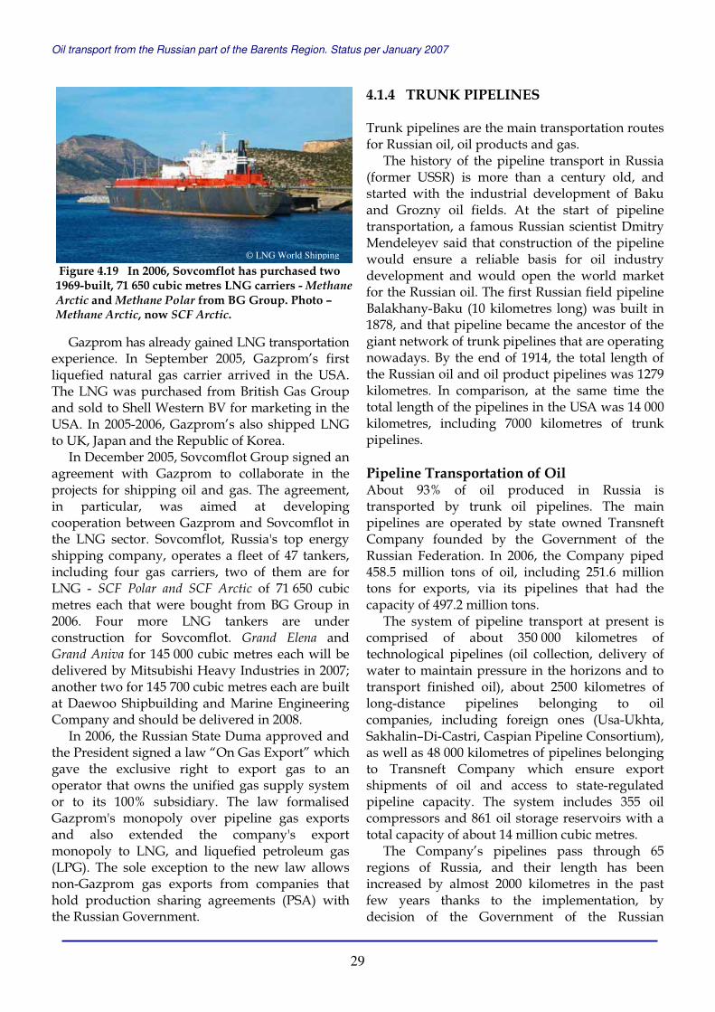
Oil transport from the Russian part of the Barents Region. Status per January 2007
29
Gazprom has already gained LNG transportation experience. In September 2005, Gazprom’s first liquefied natural gas carrier arrived in the USA. The LNG was purchased from British Gas Group and sold to Shell Western BV for marketing in the USA. In 2005-2006, Gazprom’s also shipped LNG to UK, Japan and the Republic of Korea.
In December 2005, Sovcomflot Group signed an agreement with Gazprom to collaborate in the projects for shipping oil and gas. The agreement, in particular, was aimed at developing cooperation between Gazprom and Sovcomflot in the LNG sector. Sovcomflot, Russia's top energy shipping company, operates a fleet of 47 tankers, including four gas carriers, two of them are for LNG - SCF Polar and SCF Arctic of 71 650 cubic metres each that were bought from BG Group in 2006. Four more LNG tankers are under construction for Sovcomflot. Grand Elena and Grand Aniva for 145 000 cubic metres each will be delivered by Mitsubishi Heavy Industries in 2007; another two for 145 700 cubic metres each are built at Daewoo Shipbuilding and Marine Engineering Company and should be delivered in 2008.
In 2006, the Russian State Duma approved and the President signed a law “On Gas Export” which gave the exclusive right to export gas to an operator that owns the unified gas supply system or to its 100% subsidiary. The law formalised Gazprom's monopoly over pipeline gas exports and also extended the company's export monopoly to LNG, and liquefied petroleum gas (LPG). The sole exception to the new law allows non-Gazprom gas exports from companies that hold production sharing agreements (PSA) with the Russian Government.
4.1.4 TRUNK PIPELINES Trunk pipelines are the main transportation routes for Russian oil, oil products and gas.
The history of the pipeline transport in Russia (former USSR) is more than a century old, and started with the industrial development of Baku and Grozny oil fields. At the start of pipeline transportation, a famous Russian scientist Dmitry Mendeleyev said that construction of the pipeline would ensure a reliable basis for oil industry development and would open the world market for the Russian oil. The first Russian field pipeline Balakhany-Baku (10 kilometres long) was built in 1878, and that pipeline became the ancestor of the giant network of trunk pipelines that are operating nowadays. By the end of 1914, the total length of the Russian oil and oil product pipelines was 1279 kilometres. In comparison, at the same time the total length of the pipelines in the USA was 14 000 kilometres, including 7000 kilometres of trunk pipelines. Pipeline Transportation of Oil About 93% of oil produced in Russia is transported by trunk oil pipelines. The main pipelines are operated by state owned Transneft Company founded by the Government of the Russian Federation. In 2006, the Company piped 458.5 million tons of oil, including 251.6 million tons for exports, via its pipelines that had the capacity of 497.2 million tons.
The system of pipeline transport at present is comprised of about 350 000 kilometres of technological pipelines (oil collection, delivery of water to maintain pressure in the horizons and to transport finished oil), about 2500 kilometres of long-distance pipelines belonging to oil companies, including foreign ones (Usa-Ukhta, Sakhalin–Di-Castri, Caspian Pipeline Consortium), as well as 48 000 kilometres of pipelines belonging to Transneft Company which ensure export shipments of oil and access to state-regulated pipeline capacity. The system includes 355 oil compressors and 861 oil storage reservoirs with a total capacity of about 14 million cubic metres.
The Company’s pipelines pass through 65 regions of Russia, and their length has been increased by almost 2000 kilometres in the past few years thanks to the implementation, by decision of the Government of the Russian
Figure 4.19 In 2006, Sovcomflot has purchased two 1969-built, 71 650 cubic metres LNG carriers - Methane Arctic and Methane Polar from BG Group. Photo – Methane Arctic, now SCF Arctic.
© LNG World Shipping
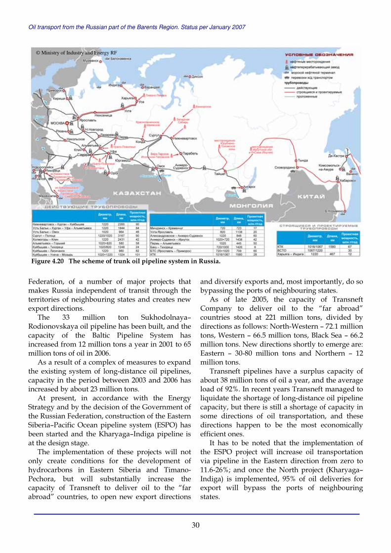
Oil transport from the Russian part of the Barents Region. Status per January 2007
30
Federation, of a number of major projects that makes Russia independent of transit through the territories of neighbouring states and creates new export directions.
The 33 million ton Sukhodolnaya–Rodionovskaya oil pipeline has been built, and the capacity of the Baltic Pipeline System has increased from 12 million tons a year in 2001 to 65 million tons of oil in 2006.
As a result of a complex of measures to expand the existing system of long-distance oil pipelines, capacity in the period between 2003 and 2006 has increased by about 23 million tons.
At present, in accordance with the Energy Strategy and by the decision of the Government of the Russian Federation, construction of the Eastern Siberia–Pacific Ocean pipeline system (ESPO) has been started and the Kharyaga–Indiga pipeline is at the design stage.
The implementation of these projects will not only create conditions for the development of hydrocarbons in Eastern Siberia and Timano-Pechora, but will substantially increase the capacity of Transneft to deliver oil to the “far abroad” countries, to open new export directions
and diversify exports and, most importantly, do so bypassing the ports of neighbouring states.
As of late 2005, the capacity of Transneft Company to deliver oil to the “far abroad” countries stood at 221 million tons, divided by directions as follows: North-Western – 72.1 million tons, Western – 66.5 million tons, Black Sea – 66.2 million tons. New directions shortly to emerge are: Eastern – 30-80 million tons and Northern – 12 million tons.
Transneft pipelines have a surplus capacity of about 38 million tons of oil a year, and the average load of 92%. In recent years Transneft managed to liquidate the shortage of long-distance oil pipeline capacity, but there is still a shortage of capacity in some directions of oil transportation, and these directions happen to be the most economically efficient ones.
It has to be noted that the implementation of the ESPO project will increase oil transportation via pipeline in the Eastern direction from zero to 11.6-26%; and once the North project (Kharyaga–Indiga) is implemented, 95% of oil deliveries for export will bypass the ports of neighbouring states.
Figure 4.20 The scheme of trunk oil pipeline system in Russia.
© Ministry of Industry and Energy RF

Oil transport from the Russian part of the Barents Region. Status per January 2007
31
The implementation of these projects will increase the capacity of the oil pipeline transport by 1.4 times. The possible excess capacity is estimated at 34-60 million tons (13-19%) which will make it possible to diversify export directions and consequently make them more efficient. The ongoing investment projects are: • Eastern Siberia – Pacific Ocean pipeline
system (ESPO) The construction of ESPO is being implemented to deliver West- and East- Siberian oil to the Pacific oil terminal. The pipeline is 4670 kilometres long (2764 kilometres at the first stage), has a diameter of 1067/1220 mm and a design capacity of 30 million tons at the first stage and 80 million tons when completed.
In April 2006, construction began of the first start-up complex of the ESPO system. Pursuant to the decisions of the meeting held in Tomsk in April 2006, chaired by the President of the Russian Federation, Transneft Company started implementing project and exploration work on the route of the Eastern Siberia–Pacific pipeline system beyond the water drainage basin of Lake Baikal. The Eastern Siberia-Pacific Ocean oil pipeline system is to be expanded and pass along the following route: Ust-Kut–Kirensk–Lensk–Olekminsk–Aldan–Tynda. The route of ESPO expansion over a stretch of 2050 kilometres has been divided into three sections: Ust-Kut–Talakansk field, Aldan–Tynda, and Talakansk field–Aldan.
• Kharyaga-Indiga pipeline The proposed pipeline is intended to deliver oil produced in Timano-Pechora to the oil terminal near Indiga settlement on the Barents Sea coast. The design capacity of the pipeline is 12 million tons and its length is 460 kilometres.
• Burgas-Alexandroupolis pipeline The proposal of expanding the capacity of the Caspian Pipeline Consortium (CPC) from 28 million tons to 60 million tons a year is under discussion. The implementation of the enlargement CPC project will increase supply of oil to the Black Sea area which, given the saturation of that market, will make Russian resources in that region less competitive. To prevent this construction is planned of a pipeline from the Bulgarian port of Burgas to the Greek port of Alexandroupolis to transport oil bypassing the Bosporus and Dardanelles.
Figure 4.22 The scheme of trunk oil pipelines in the Russian East with 80 million ton ESPO under construction.
Figure 4.23 The scheme of proposed 50 million ton Burgas–Alexandroupolis pipeline.
© Ministry of Industry and Energy RF © Ministry of Industry and Energy RF
Figure 4.21 Primorsk terminal in the end of the Baltic Pipeline System (BPS). The capacity of BPSincreased from 12 million tons in 2001 to 65 million tons in 2006. In future, its capacity can reach 120 million tons a year.
© Ministry of Transport RF

Oil transport from the Russian part of the Barents Region. Status per January 2007
32
This is the most economical project to bypass the straits. The design capacity of the pipeline is 35 million tons with possible enlargement to 50 million tons, the length is 287 kilometres and the maximum deadweight of tankers in the port of Alexandroupolis is 300 000 tons.
Pipeline Transportation of Oil Products The trunk oil products pipeline (TOPP) network runs latitudinally from the Kemerovo Region to the western borders of the Republic of Ukraine with Hungary and the Latvian port of Ventspils. The length of the TOPP is 19 100 kilometres, of which 15 200 kilometres is trunk pipeline and 3900 kilometres are branches. The pipeline system carries light petroleum products (engine fuels) from 14 oil refineries in the European part of Russia. The TOPP also includes two refineries in Belarus.
The average service life of Transnefteprodukt pipelines is 27.2 years against the standard life span of 33 years. The trend of extending the life span has been stopped. The technical condition of the main and auxiliary technological equipment of compressors and reservoirs is satisfactory. No accidents for technical reasons were registered since 2002.
The pumping of petroleum products by trunk pipelines of Transnefteprodukt Company system increased by 20.3% (from 23.1 million tons to 27.8 million tons) in 2000-2005, both due to the increased volume of petroleum product shipments to the Russian internal market (up 1.6 million tons) and for export (up 3.1 million tons, of which 2.3 million tons is increase of export to the “far abroad”).
The main goal of the Company for the coming years is to bring the trunk pipelines to the coasts of the Baltic and Black seas. That would minimise the dependence of Russian export on neighbouring countries and help to develop the economic infrastructure of the state and strengthen Russia’s defence capacity. This end is served by the construction of the trunk oil products pipeline Kstovo–Yaroslavl–Kirishi–Primorsk (The North project), reaching the coast of the Baltic Sea near the seaport of Primorsk, Leningrad Region, with the construction there of a terminal for light petroleum products. The design capacity of the first stage is 17 million tons, of which the first start-up complex accounts for 8.4 million tons, and
24.6 million tons when completed. The construction of the first start-up complex of the North project is scheduled for June 2007.
Another promising area of the Company’s development is taking oil products pipelines up to the Black Sea coast. That project is seen in conjunction with other aspects of the development of transport infrastructure for hydrocarbons and the products of their processing in the Black Sea basin.
Other projects, such as the construction of a branch from Primorsk towards the port of Vysotsk, and completing the Andreyevka-Almetyevsk pipeline, are under consideration.
The implementation of these projects may increase the capacity of the Transnefteprodukt pipeline system from 50 million to 74 million tons a year in the period from 2006 to 2012. Pipeline Transportation of Gas A key priority of the Energy Strategy is the preservation of the Unified Gas Transportation System, and its development through the construction or integration of new facilities of any forms of ownership, including on the basis of partnership.
The United Gas Transportation System of Russia (UGS) is a powerful and in many ways unique production complex. The UGS infrastructure comprises of 155 000 kilometres of trunk gas pipelines and branches; 6100 kilometres of gas condensate pipelines; 264 compressors with a capacity of 44.8 million kW of aggregate power; 24 underground gas storage facilities. The gas transportation system accounts for about 85% of the basic production assets of Gazprom Company
Figure 4.24 The scheme of trunk oil products pipeline network. Red line – The North project.
© Ministry of Industry and Energy RF
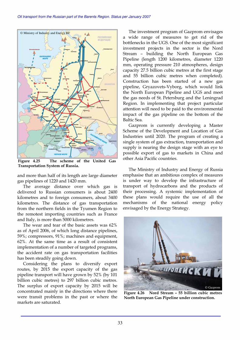
Oil transport from the Russian part of the Barents Region. Status per January 2007
33
and more than half of its length are large diameter gas pipelines of 1220 and 1420 mm.
The average distance over which gas is delivered to Russian consumers is about 2400 kilometres and to foreign consumers, about 3400 kilometres. The distance of gas transportation from the northern fields in the Tyumen Region to the remotest importing countries such as France and Italy, is more than 5000 kilometres.
The wear and tear of the basic assets was 62% as of April 2006, of which long distance pipelines, 59%; compressors, 91%; machines and equipment, 62%. At the same time as a result of consistent implementation of a number of targeted programs, the accident rate on gas transportation facilities has been steadily going down.
Considering the plans to diversify export routes, by 2015 the export capacity of the gas pipeline transport will have grown by 52% (by 101 billion cubic metres) to 297 billion cubic metres. The surplus of export capacity by 2015 will be concentrated mainly in the directions where there were transit problems in the past or where the markets are saturated.
The investment program of Gazprom envisages a wide range of measures to get rid of the bottlenecks in the UGS. One of the most significant investment projects in the sector is the Nord Stream – building the North European Gas Pipeline (length 1200 kilometres, diameter 1220 mm, operating pressure 210 atmospheres, design capacity 27.5 billion cubic metres at the first stage and 55 billion cubic metres when completed). Construction has been started of a new gas pipeline, Gryazovets-Vyborg, which would link the North European Pipeline and UGS and meet the gas needs of St. Petersburg and the Leningrad Region. In implementing that project particular attention will need to be paid to the environmental impact of the gas pipeline on the bottom of the Baltic Sea.
Gazprom is currently developing a Master Scheme of the Development and Location of Gas Industries until 2020. The program of creating a single system of gas extraction, transportation and supply is nearing the design stage with an eye to possible export of gas to markets in China and other Asia Pacific countries.
The Ministry of Industry and Energy of Russia emphasise that an ambitious complex of measures is under way to develop the infrastructure of transport of hydrocarbons and the products of their processing. A systemic implementation of these plans would require the use of all the mechanisms of the national energy policy envisaged by the Energy Strategy.
Figure 4.25 The scheme of the United Gas Transportation System of Russia.
© Ministry of Industry and Energy RF
Figure 4.26 Nord Stream – 55 billion cubic metres North European Gas Pipeline under construction.
© Gazprom

Oil transport from the Russian part of the Barents Region. Status per January 2007
34
4.2 OIL TRANSPORTATION ROUTES IN THE BARENTS REGION In 2002, 4 million tons of Russian oil was exported along the Norwegian coastline, in 2003 the amount doubled to 8 million tons, in 2004 it almost reached 12 million tons, in 2005 dropped to 9.5 million tons, and in 2006 rose to more than 10 million tons. Already in 2010, Russia may have the capacity to export up to 80 million tons of oil that way, and in 2015 the total capacity of the Arctic oil terminals can be over 100 million tons.
The coastal and offshore terminals listed in the table below are sending oil for export directly or via offshore transhipment terminals in the Kola Bay and even via terminals constructed in the northern Norway. These transhipment terminals are not listed in the table. Table 4.1. The oil shipment volumes in the period 2002-2006, the terminals capacity in 2006 and expected/planned capacity in 2010. The numbers are in thousand tons.
# Site Loaded, 2002
Loaded, 2003
Loaded, 2004
Loaded, 2005
Loaded, 2006
Capacity, 2006
Capacity, 2010
Laptev Sea 1. Tiksi 60’ - - - - 100’ -
Kara Sea 2. Dudinka 20’ 40’ - 20’ 20’ 100’ 100’3. Dikson - - - - - - -4. Ob Bay 110’ 220’ 240’ 360’ 460’ 600’ 3000’
Pechora Sea 5. Varandey 200’ 400’ 560’ 600’ 500’ 1500’ 12 500’6. Prirazlomnoye - - - - - - 7400’7. Kolguev 120’ 100’ 80’ 80’ 80’ 200’ 100’8. Indiga - - - - - - 12 000’
White Sea 9. Arkhangelsk 1930’ 1500’ 3450’ 4200’ 3100’ 4500’ 7200’
10. Severodvinsk - - - - - - -11. Onega Bay - 320’ - - - - -12. Vitino 2900’ 5700’ 3700’ 1600’ 3700’ 11 000’ 12 000’
Barents Sea 13. Murmansk - - 3700’ 2700’ 1700’ 8000’ 10 000’
Mokhnatkina Pakhta - - - - 730’ 2500’ 5 000 Lavna - - - - - - 10 000’
14. Pechenga - - - - - - -
0
2
4
6
8
10
12
14
2002 2003 2004 2005 2006
mill
ion
to
ns
Figure 4.27 Russian oil shipped along the Norwegian coast in 2002-2006, million tons a year.
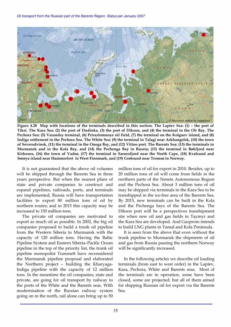
Oil transport from the Russian part of the Barents Region. Status per January 2007
35
It is not guaranteed that the above oil volumes will be shipped through the Barents Sea in three years perspective. But when the nearest plans of state and private companies to construct and expand pipelines, railroads, ports, and terminals are implemented, Russia will have transportation facilities to export 80 million tons of oil by northern routes; and in 2015 this capacity may be increased to 150 million tons.
The private oil companies are motivated to export as much oil as possible. In 2002, the big oil companies proposed to build a trunk oil pipeline from the Western Siberia to Murmansk with the capacity of 120 million tons. Having the Baltic Pipeline System and Eastern Siberia–Pacific Ocean pipeline in the top of the priority list, the trunk oil pipeline monopolist Transneft have reconsidered the Murmansk pipeline proposal and elaborated the Northern project – building the Kharyaga-Indiga pipeline with the capacity of 12 million tons. In the meantime the oil companies, state and private, are going for oil transport by railway to the ports of the White and the Barents seas. With modernisation of the Russian railway system going on in the north, rail alone can bring up to 50
million tons of oil for export in 2010. Besides, up to 20 million tons of oil will come from fields in the northern parts of the Nenets Autonomous Region and the Pechora Sea. About 3 million tons of oil may be shipped via terminals in the Kara Sea to be transhipped in the ice-free area of the Barents Sea. By 2015, new terminals can be built in the Kola and the Pechenga bays of the Barents Sea. The Dikson port will be a perspectives transhipment site when new oil and gas fields in Taymyr and the Kara Sea are developed. And Gazprom intends to build LNG plants in Yamal and Kola Peninsula.
It is seen from the above that even without the trunk pipeline to Murmansk the shipments of oil and gas from Russia passing the northern Norway will be significantly increased.
In the following articles we describe oil loading terminals (from east to west order) in the Laptev, Kara, Pechora, White and Barents seas. Most of the terminals are in operation, some have been closed, some are projected, but all of them aimed for shipping Russian oil for export via the Barents Sea.
Figure 4.28 Map with locations of the terminals described in this section. The Laptev Sea: (1) – the port of Tiksi. The Kara Sea: (2) the port of Dudinka, (3) the port of Dikson, and (4) the terminal in the Ob Bay. The Pechora Sea: (5) Varandey terminal, (6) Prirazlomnoye oil field, (7) the terminal on the Kolguev island, and (8) Indiga settlement in the Pechora Sea. The White Sea: (9) the terminal in Talagi near Arkhangelsk, (10) the town of Severodvinsk, (11) the terminal in the Onega Bay, and (12) Vitino port. The Barents Sea: (13) the terminals in Murmansk and in the Kola Bay, and (14) the Pechenga Bay in Russia; (15) the terminal in Bøkfjord near Kirkenes, (16) the town of Vadsø, (17) the terminal in Sarnesfjord near the North Cape, (18) Kvalsund and Sørøya island near Hammerfest in West Finnmark, and (19) Grøtsund near Tromsø in Norway.
© Microsoft and/or its supppliers

Oil transport from the Russian part of the Barents Region. Status per January 2007
36
4.2.1 THE LAPTEV SEA Tiksi The Tiksi port has not been shipping oil for export along the Northern Sea Route since 2002. However, we keep the Tiksi article in the report in order to show one of the most complicated logistic system established for delivering East Siberian oil to the western market.
The commercial sea port in Tiksi, in the north of the Republic of Sakha (Yakutia), was built in 1934, first of all, for carrying commercial cargo and essential supplies from the European part of Russia to Yakutia, and exporting coal and wood along the Northern Sea Route.
In 2001, the company Sakhaneftegaz in cooperation with the Murmansk Shipping Company started oil loading in Tiksi for shipping it for export via the Northern Sea Route. Then the first 19 000 tons of crude from Talakanskoye oil field in the Eastern Siberia were shipped into the tanker Magas and sent to the western market.
The oil produced at Talakhanskoye field was delivered via 110 kilometre local oil pipeline to the oil refinery and the terminal in Vitim on the Lena River. From there, oil was transported down by
the Lena River with Lenaneft tankers of the Lena River Shipping Company to oil storage facilities in the port of Tiksi. In Tiksi oil was shipped to sea tankers up to 20 000 tons deadweight and delivered through 9 time zones to Rotterdam. The capacity of this transportation scheme was about 100 000 tons a year.
In the summer of 2001, the port of Tiksi loaded 38 000 tons of oil for export, and in 2002 – 58 000 tons.
Since December 2003, the license for development of Talakanskoye oil and gas field belongs to Surgutneftegaz Company. Talakanskoye oil and gas field is the largest discovered in Yakutia with recoverable reserves of 124 million tons of oil and 47 billion cubic metres of gas. At the moment, Surgutneftegaz extract about 250 thousand tons of oil a year from the field that are refined and used for fuel supplies of the Republic of Sakha. The maximum oil production level will be 6 million tons a year. In 2008, when East Siberian – Pacific Ocean pipeline (ESPO) part is built to Talakan, Surgutneftegaz plans to produce 3 million tons of oil.
In January 2007, the Centre of ESPO Project Management Company, subsidiary of Transneft, started construction of 540 kilometres pipeline from Ust-Kut to Talakanskoye field – the first part of ESPO extension. ESPO is divided in two sub-projects – the first one consists of Taishet–Ust-Kut and Tynda-Skovorodino parts; and the second one includes Ust-Kut–Talakanskoye, Tynda–Aldan, and Talakanskoye–Aldan parts.
Figure 4.29 The Republic of Sakha in Eastern Siberia. (A) Vitim river terminal and (B) Tiksi terminal.
Figure 4.30 Talakan oil will go eastwards by Eastern Siberia – Pacific Ocean pipeline.
© Microsoft and/or its suppliers
© ITAR-TASS
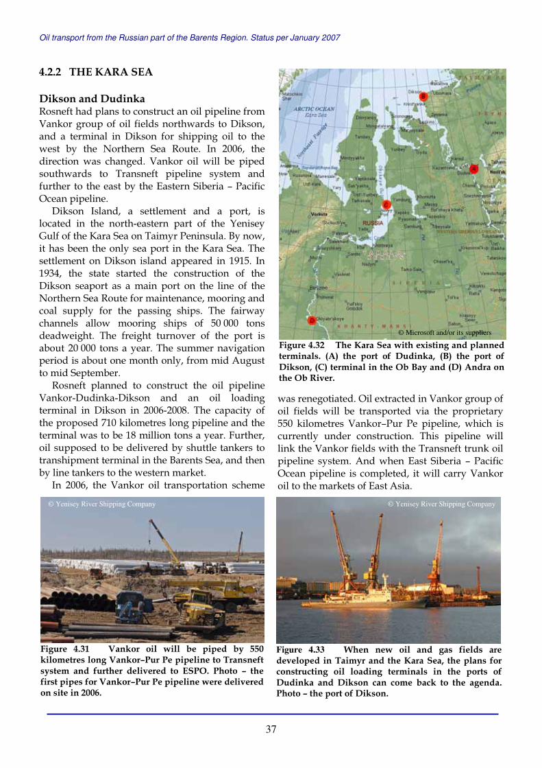
Oil transport from the Russian part of the Barents Region. Status per January 2007
37
4.2.2 THE KARA SEA Dikson and Dudinka Rosneft had plans to construct an oil pipeline from Vankor group of oil fields northwards to Dikson, and a terminal in Dikson for shipping oil to the west by the Northern Sea Route. In 2006, the direction was changed. Vankor oil will be piped southwards to Transneft pipeline system and further to the east by the Eastern Siberia – Pacific Ocean pipeline.
Dikson Island, a settlement and a port, is located in the north-eastern part of the Yenisey Gulf of the Kara Sea on Taimyr Peninsula. By now, it has been the only sea port in the Kara Sea. The settlement on Dikson island appeared in 1915. In 1934, the state started the construction of the Dikson seaport as a main port on the line of the Northern Sea Route for maintenance, mooring and coal supply for the passing ships. The fairway channels allow mooring ships of 50 000 tons deadweight. The freight turnover of the port is about 20 000 tons a year. The summer navigation period is about one month only, from mid August to mid September.
Rosneft planned to construct the oil pipeline Vankor-Dudinka-Dikson and an oil loading terminal in Dikson in 2006-2008. The capacity of the proposed 710 kilometres long pipeline and the terminal was to be 18 million tons a year. Further, oil supposed to be delivered by shuttle tankers to transhipment terminal in the Barents Sea, and then by line tankers to the western market.
In 2006, the Vankor oil transportation scheme
was renegotiated. Oil extracted in Vankor group of oil fields will be transported via the proprietary 550 kilometres Vankor–Pur Pe pipeline, which is currently under construction. This pipeline will link the Vankor fields with the Transneft trunk oil pipeline system. And when East Siberia – Pacific Ocean pipeline is completed, it will carry Vankor oil to the markets of East Asia.
Figure 4.31 Vankor oil will be piped by 550 kilometres long Vankor–Pur Pe pipeline to Transneft system and further delivered to ESPO. Photo – the first pipes for Vankor–Pur Pe pipeline were delivered on site in 2006.
Figure 4.32 The Kara Sea with existing and planned terminals. (A) the port of Dudinka, (B) the port of Dikson, (C) terminal in the Ob Bay and (D) Andra on the Ob River.
© Microsoft and/or its suppliers
Figure 4.33 When new oil and gas fields are developed in Taimyr and the Kara Sea, the plans for constructing oil loading terminals in the ports of Dudinka and Dikson can come back to the agenda. Photo – the port of Dikson.
© Yenisey River Shipping Company © Yenisey River Shipping Company

Oil transport from the Russian part of the Barents Region. Status per January 2007
38
The Vankor group of oil and gas field, located in the Turukhan District of the Krasnoyarsk Region and the Dudinsky District of the Taimyr Autonomous Region in Eastern Siberia. Vankor block consists of several oil and gas fields with estimated oil resources of more than 600 million tons. The licences are controlled by Rosneft and TNK-BP. The biggest field of the group – Vankor oil and gas field, has proven reserves of 135 million tons of oil. Rosneft plans to commence oil production at Vankor field in 2008. In 2015, according to Rosneft estimations, 43 million tons of oil can be produced at Vankor group of oil and gas fields a year.
When new oil and gas fields are developed in Taimyr and Kara Sea, the plans for constructing oil loading terminals in the ports of Dudinka and Dikson can come back to the agenda. In 2002-2006, Dudinka port – the main transport facility of Norilsk Nikel, shipped 20-40 thousand tons of oil a year for export through the Barents Sea. The Ob Bay In 1999, the RITEK Company made the first shipment of oil in the Ob Bay, and transported oil to the west by the Northern Sea Route. The oil, produced at Sredne-Khulymskoye and Sandbinskoye oil fields in the Western Siberia, is delivered via local pipelines to the petroleum storage facilities in Andra and Numgi on the Ob River coast. There, oil is shipped to the river-sea tankers of Lenaneft type (2100 tons deadweight) of Irtysh River Shipping Company and transported down by the river to the Ob Bay of the Kara Sea.
In 1999-2005, oil delivered to the Ob Bay was shipped directly to shuttle tankers of Astrakhan type (20 000) offshore in the area of Cape Kamenny. In the navigation period of 2006, Severomorsk tanker (40 000) was moored near the Cape Kamenniy and used as Floating Storage and Offloading vessel (FSO). Sea shuttle tankers, such as Khatanga (23 000), Saratov (20 000) and Varzuga (16 400) transported oil from the Ob Bay by the Northern Sea Route via the Kara Gate to FSO Belokamenka in the Kola Bay of the Barents Sea. The loading operations in the Ob Bay were supported by the icebreaker Taimyr.
In 1999-2005, oil spill prevention and response services at the terminal were provided by Murmansk Basin Emergency and Salvage Department (MBESD).
The Regional Centre of Ecological-Emergency Operations was established in Yamalo-Nenets Autonomous Region in 2006, and since July the same year, the emergency-salvage vessel Arkhangelsk was on watch during oil transhipment operations in the Ob Bay.
In the period from 1999 to 2003, RITEK loaded in the Ob Bay and sent to export 470 000 tons of crude oil in total; in 2004 the amount was 240 000 tons; in 2005 – 357 000 tons; and in 2006 – 454 500 tons (346 400 tons from Sredne-Khulymskoye and 109 100 from Sandbinskoye oil fields).
RITEK plans to build a pipeline from the oil fields in the Western Siberia to the Ob Bay terminal with the capacity of 3 million tons a year. In 2006, RITEK produced 2.6 million tons of oil (the level of 2005) in Western Siberia and Tatarstan, and exported 1.8 million tons. The plan for 2008 is to produce 3.5-4 million tons of oil. Recoverable oil reserves of the Company are estimated to 160 million tons (114 million tons in Western Siberia fields).
Figure 4.34 RITEK’s crude oil is delivered to the terminal in the Ob Bay by 2000 tons river-sea tankers and transhipped to 20 000 tons sea shuttle tankers, since 2006 via FSO Severomorsk. The terminal works during summer navigation period. Photo – river tanker Lenaneft is shipping oil to 15 500 tons ice-reinforced tanker Indiga of the Murmansk Shipping Company that will bring oil to the transhipment terminal in the Kola Bay, July 2005.
© MBESD
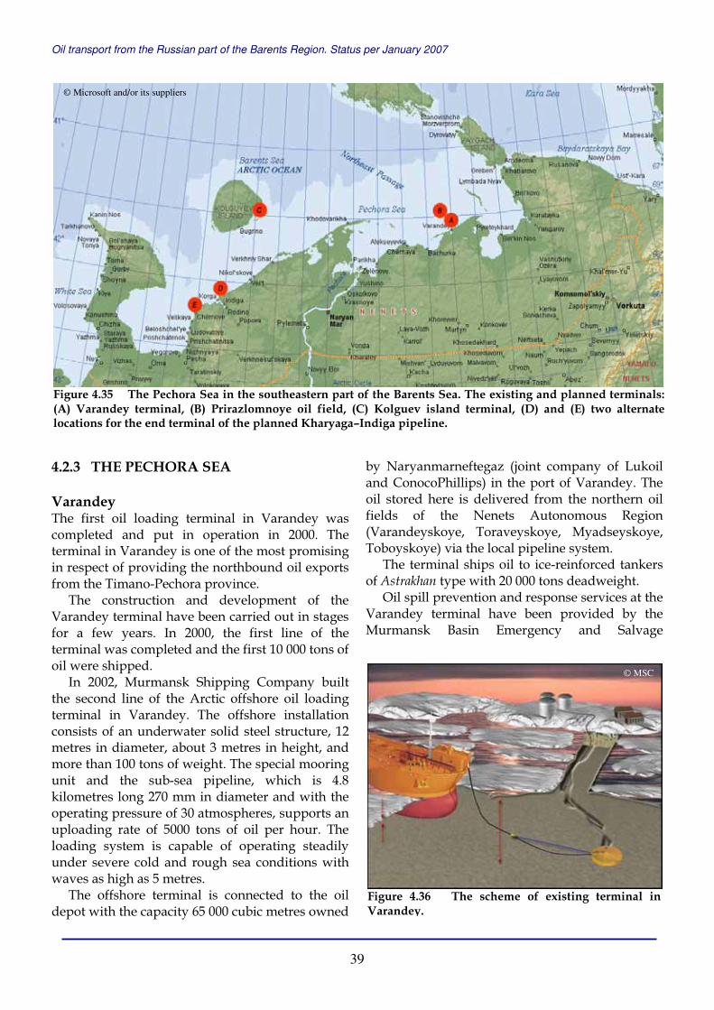
Oil transport from the Russian part of the Barents Region. Status per January 2007
39
4.2.3 THE PECHORA SEA Varandey The first oil loading terminal in Varandey was completed and put in operation in 2000. The terminal in Varandey is one of the most promising in respect of providing the northbound oil exports from the Timano-Pechora province.
The construction and development of the Varandey terminal have been carried out in stages for a few years. In 2000, the first line of the terminal was completed and the first 10 000 tons of oil were shipped.
In 2002, Murmansk Shipping Company built the second line of the Arctic offshore oil loading terminal in Varandey. The offshore installation consists of an underwater solid steel structure, 12 metres in diameter, about 3 metres in height, and more than 100 tons of weight. The special mooring unit and the sub-sea pipeline, which is 4.8 kilometres long 270 mm in diameter and with the operating pressure of 30 atmospheres, supports an uploading rate of 5000 tons of oil per hour. The loading system is capable of operating steadily under severe cold and rough sea conditions with waves as high as 5 metres.
The offshore terminal is connected to the oil depot with the capacity 65 000 cubic metres owned
by Naryanmarneftegaz (joint company of Lukoil and ConocoPhillips) in the port of Varandey. The oil stored here is delivered from the northern oil fields of the Nenets Autonomous Region (Varandeyskoye, Toraveyskoye, Myadseyskoye, Toboyskoye) via the local pipeline system.
The terminal ships oil to ice-reinforced tankers of Astrakhan type with 20 000 tons deadweight.
Oil spill prevention and response services at the Varandey terminal have been provided by the Murmansk Basin Emergency and Salvage
Figure 4.35 The Pechora Sea in the southeastern part of the Barents Sea. The existing and planned terminals: (A) Varandey terminal, (B) Prirazlomnoye oil field, (C) Kolguev island terminal, (D) and (E) two alternate locations for the end terminal of the planned Kharyaga–Indiga pipeline.
Figure 4.36 The scheme of existing terminal in Varandey.
© Microsoft and/or its suppliers
© MSC

Oil transport from the Russian part of the Barents Region. Status per January 2007
40
Department (MBESD). In summer, the MBESD specialised vessel Agat was on watch during each oil shipment; in winter oil spill combat equipment was located on the icebreaker Kapitan Nikolaev that supported offshore oil shipment.
In 2002, the Varandey terminal shipped 200 000 tons of oil; in 2003 – 400 000 tons; in 2004 – 560 000 tons; in 2005 – 600 000 tons; and in 2006 – 500 000 tons. In 2002-2005, oil was exported via FSO Trader (RPK-1) in the Kola Bay; and in 2006 via FSO Belokamenka (RPK-3).
In the nearest future the existing Varandey offshore shipment facility will be replaced by a new one being constructed by Lukoil Company.
In 2004, Lukoil Company presented a new project for construction of 12.5 million ton
terminal in Varandey that should ship oil from the oil fields of the joint Lukoil and ConocoPhillips Northern Territories project. The Northern Territories project includes Khylchuyuskoye, Southern Khylchuyuskoye, Yareygyuskoye and Inzyreyskoye fields, prospects in the northern part of Kolvinskiy megaswell and Khoreyverskaya hollow with estimated oil reserves (C1+C2) about 584 million tons. Lukoil and ConocoPhillips intend to produce 10 million tons of oil a year from the Northern Territories fields in 2008.
Oil from these fields will be piped to the new Varandey terminal. A 150 kilometres long pipeline from Southern Khylchuyuskoye field to Varandey oil depot should be completed in 2007.
Lukoil is building the specialised oil loading seaport Varandey that should be the central facility for transportation of oil produced in the northern fields of the Timano-Pechora province. Varandey oil terminal includes onshore oil depot with the total capacity of 325 000 cubic metres (including construction of new storages for 260 000 cubic metres) and infrastructure; 22.6 kilometres sub-sea oil pipeline (two lines, diameter of 820 mm); and the Fixed Offshore Ice-resistant Offloading Terminal (FOIROT).
FOIROT is designed in octagonal shape. The construction is 43 metres wide in its base structure, and 55 metres high. The base structure, that is to be piled to the seafloor, supports topsides consisting of turret, helicopter deck, and offloading boom. Weight of the construction is about 13 000 tons. It will be installed 20 kilometres
Figure 4.37 In 2004, Lukoil Company presented a new project for construction of 12.5 million ton terminal in Varandey.
Figure 4.38 FOIROT is designed in octagonal shape. The construction is 43 metres wide in its base structure, and 55 metres high.
Figure 4.39 Crude will come to the terminal from the onshore oil depot by 22.6 kilometres long sub-seapipeline.
© Lukoil
© Lukoil © Lukoil
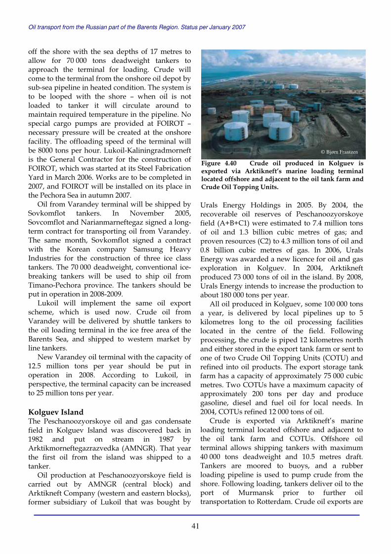
Oil transport from the Russian part of the Barents Region. Status per January 2007
41
off the shore with the sea depths of 17 metres to allow for 70 000 tons deadweight tankers to approach the terminal for loading. Crude will come to the terminal from the onshore oil depot by sub-sea pipeline in heated condition. The system is to be looped with the shore – when oil is not loaded to tanker it will circulate around to maintain required temperature in the pipeline. No special cargo pumps are provided at FOIROT – necessary pressure will be created at the onshore facility. The offloading speed of the terminal will be 8000 tons per hour. Lukoil-Kaliningradmorneft is the General Contractor for the construction of FOIROT, which was started at its Steel Fabrication Yard in March 2006. Works are to be completed in 2007, and FOIROT will be installed on its place in the Pechora Sea in autumn 2007.
Oil from Varandey terminal will be shipped by Sovkomflot tankers. In November 2005, Sovcomflot and Narianmarneftegaz signed a long-term contract for transporting oil from Varandey. The same month, Sovkomflot signed a contract with the Korean company Samsung Heavy Industries for the construction of three ice class tankers. The 70 000 deadweight, conventional ice-breaking tankers will be used to ship oil from Timano-Pechora province. The tankers should be put in operation in 2008-2009.
Lukoil will implement the same oil export scheme, which is used now. Crude oil from Varandey will be delivered by shuttle tankers to the oil loading terminal in the ice free area of the Barents Sea, and shipped to western market by line tankers.
New Varandey oil terminal with the capacity of 12.5 million tons per year should be put in operation in 2008. According to Lukoil, in perspective, the terminal capacity can be increased to 25 million tons per year. Kolguev Island The Peschanoozyorskoye oil and gas condensate field in Kolguev Island was discovered back in 1982 and put on stream in 1987 by Arktikmorneftegazrazvedka (AMNGR). That year the first oil from the island was shipped to a tanker.
Oil production at Peschanoozyorskoye field is carried out by AMNGR (central block) and Arktikneft Company (western and eastern blocks), former subsidiary of Lukoil that was bought by
Urals Energy Holdings in 2005. By 2004, the recoverable oil reserves of Peschanoozyorskoye field (A+B+С1) were estimated to 7.4 million tons of oil and 1.3 billion cubic metres of gas; and proven resources (С2) to 4.3 million tons of oil and 0.8 billion cubic metres of gas. In 2006, Urals Energy was awarded a new licence for oil and gas exploration in Kolguev. In 2004, Arktikneft produced 73 000 tons of oil in the island. By 2008, Urals Energy intends to increase the production to about 180 000 tons per year.
All oil produced in Kolguev, some 100 000 tons a year, is delivered by local pipelines up to 5 kilometres long to the oil processing facilities located in the centre of the field. Following processing, the crude is piped 12 kilometres north and either stored in the export tank farm or sent to one of two Crude Oil Topping Units (COTU) and refined into oil products. The export storage tank farm has a capacity of approximately 75 000 cubic metres. Two COTUs have a maximum capacity of approximately 200 tons per day and produce gasoline, diesel and fuel oil for local needs. In 2004, COTUs refined 12 000 tons of oil.
Crude is exported via Arktikneft’s marine loading terminal located offshore and adjacent to the oil tank farm and COTUs. Offshore oil terminal allows shipping tankers with maximum 40 000 tons deadweight and 10.5 metres draft. Tankers are moored to buoys, and a rubber loading pipeline is used to pump crude from the shore. Following loading, tankers deliver oil to the port of Murmansk prior to further oil transportation to Rotterdam. Crude oil exports are
Figure 4.40 Crude oil produced in Kolguev is exported via Arktikneft’s marine loading terminal located offshore and adjacent to the oil tank farm and Crude Oil Topping Units.
© Bjørn Frantzen
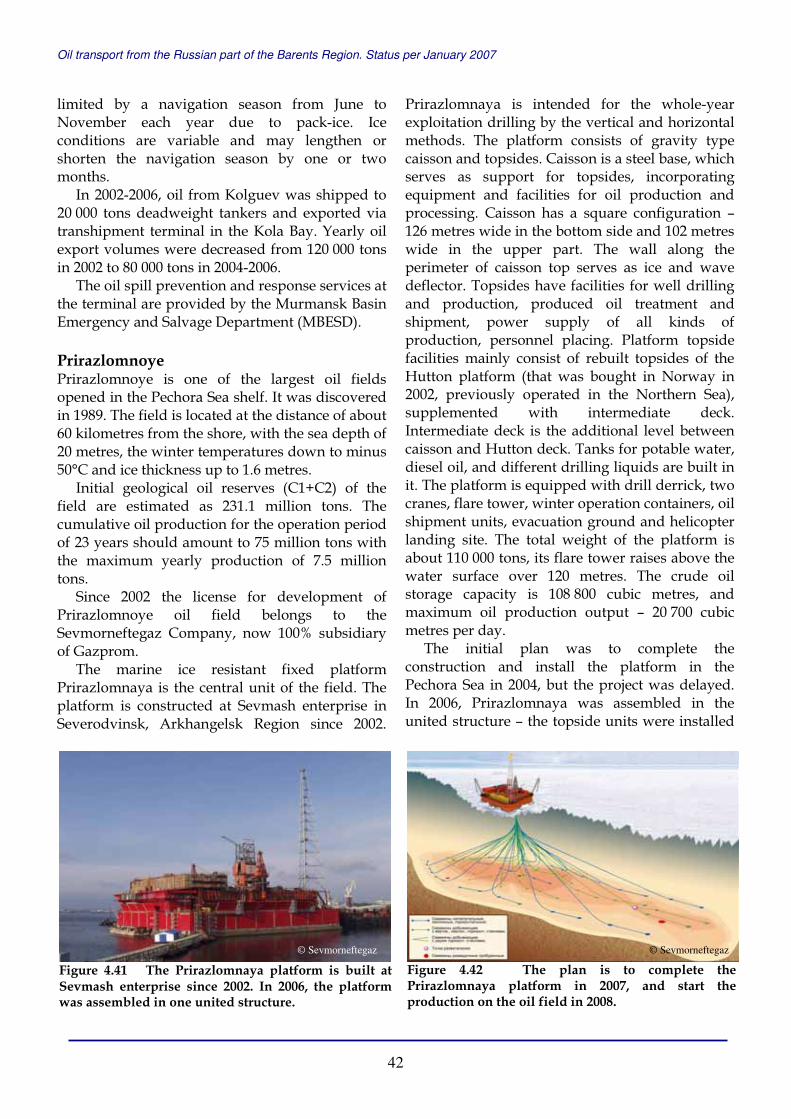
Oil transport from the Russian part of the Barents Region. Status per January 2007
42
limited by a navigation season from June to November each year due to pack-ice. Ice conditions are variable and may lengthen or shorten the navigation season by one or two months.
In 2002-2006, oil from Kolguev was shipped to 20 000 tons deadweight tankers and exported via transhipment terminal in the Kola Bay. Yearly oil export volumes were decreased from 120 000 tons in 2002 to 80 000 tons in 2004-2006.
The oil spill prevention and response services at the terminal are provided by the Murmansk Basin Emergency and Salvage Department (MBESD). Prirazlomnoye Prirazlomnoye is one of the largest oil fields opened in the Pechora Sea shelf. It was discovered in 1989. The field is located at the distance of about 60 kilometres from the shore, with the sea depth of 20 metres, the winter temperatures down to minus 50°C and ice thickness up to 1.6 metres.
Initial geological oil reserves (С1+С2) of the field are estimated as 231.1 million tons. The cumulative oil production for the operation period of 23 years should amount to 75 million tons with the maximum yearly production of 7.5 million tons.
Since 2002 the license for development of Prirazlomnoye oil field belongs to the Sevmorneftegaz Company, now 100% subsidiary of Gazprom.
The marine ice resistant fixed platform Prirazlomnaya is the central unit of the field. The platform is constructed at Sevmash enterprise in Severodvinsk, Arkhangelsk Region since 2002.
Prirazlomnaya is intended for the whole-year exploitation drilling by the vertical and horizontal methods. The platform consists of gravity type caisson and topsides. Caisson is a steel base, which serves as support for topsides, incorporating equipment and facilities for oil production and processing. Caisson has a square configuration – 126 metres wide in the bottom side and 102 metres wide in the upper part. The wall along the perimeter of caisson top serves as ice and wave deflector. Topsides have facilities for well drilling and production, produced oil treatment and shipment, power supply of all kinds of production, personnel placing. Platform topside facilities mainly consist of rebuilt topsides of the Hutton platform (that was bought in Norway in 2002, previously operated in the Northern Sea), supplemented with intermediate deck. Intermediate deck is the additional level between caisson and Hutton deck. Tanks for potable water, diesel oil, and different drilling liquids are built in it. The platform is equipped with drill derrick, two cranes, flare tower, winter operation containers, oil shipment units, evacuation ground and helicopter landing site. The total weight of the platform is about 110 000 tons, its flare tower raises above the water surface over 120 metres. The crude oil storage capacity is 108 800 cubic metres, and maximum oil production output – 20 700 cubic metres per day.
The initial plan was to complete the construction and install the platform in the Pechora Sea in 2004, but the project was delayed. In 2006, Prirazlomnaya was assembled in the united structure – the topside units were installed
Figure 4.41 The Prirazlomnaya platform is built at Sevmash enterprise since 2002. In 2006, the platform was assembled in one united structure.
Figure 4.42 The plan is to complete the Prirazlomnaya platform in 2007, and start the production on the oil field in 2008.
© Sevmorneftegaz © Sevmorneftegaz

Oil transport from the Russian part of the Barents Region. Status per January 2007
43
on the caisson. The current plan is to complete the platform in 2007, and start the production on Prirazlomnoye oil field in 2008.
In 2003, Far-East Marine Company (FEMCO) won the tender for shipping oil from Prirazlomnoye and serving the field. In January 2005, FEMCO was reorganised to Rosnefteflot Company and became 100% subsidiary of Rosneft. In October 2005, Gazprom, Sevmorneftegaz and Sovkomflot reached an agreement upon development and implementation of the oil transportation scheme for Prirazlomnoye oil field. In January 2007, Sovkomflot and Rosneft agreed on establishing joint shipping company on the basis of Rosnefteflot.
Sovkomflot assisted by Gazflot, subsidiary of Gazprom, elaborates an integrated oil transportation scheme for exporting oil from Prirazlomnoye field. The oil transport scheme includes two ice-reinforced shuttle tankers of 70 000 tons deadweight; 1-2 ice-reinforced shuttle tankers of 20 000 tons deadweight; FSO not less than 220 000 tons deadweight; four line tankers of about 150 000 tons deadweight; icebreakers; tugboats; oil spill response vessel; service and supply vessels.
Two 70 000 tons tankers are constructed for Sovkomflot at Admiralteyskie Shipyards in St. Petersburg. The first tanker will be delivered in 2008, and the second one – in 2009. Two icebreaking supply vessels Vladislav Strizhev and Yuriy Topchev were built at Havyard in Norway and delivered to Sovkomflot in 2006.
Crude from Prirazlomnoye will be carried by shuttle tankers to offshore oil storage in the ice-free area of the Barents Sea (FSO Belokamenka); whereupon delivered by line tankers to Europe and USA. Indiga Indiga is a small remote village situated in the western non-industrial part of the Nenets Autonomous Region. During recent three years, it is also a perspective area for building oil terminal ending Transneft’s pipeline to the Barents Sea coast.
The Kharyaga–Indiga oil pipeline project was developed as a result of the Western Siberia–Murmansk pipeline proposal. Back in 2002, five largest Russian oil companies Yukos, Lukoil, Sibneft, TNK and Surgutneftegaz proposed to
construct an oil pipeline from Western Siberia to Murmansk and an oil loading terminal in Murmansk with the capacity of up to 120 million tons a year. In 2003, the Government of Russia confirmed that all new built oil and gas pipelines should belong to the state. In 2004, Transneft developed a proposal for construction of the 50 million tons Western Sibera–Barents Sea coast oil pipeline from Surgut to Indiga. In 2005, the project was reduced to Kharyaga–Indiga part with 24 million tons capacity (first of all, due to big projects of Transneft for construction of Baltic Pipeline System and East Siberia–Pacific Ocean pipeline). And the current status of the North pipeline project is to build the Kharyaga–Indiga crude oil pipeline with the capacity of 12 million tons a year.
The North pipeline will stretch 468 kilometres from the Kharyaga oil field to Svyatoy Nos Cape near Indiga, pass 101 small and big water objects including the Pechora River. More than a half of the pipeline will be built underground. It will have diameter of 630 mm or 720 mm. Crude will be heated on its way from Kharyaga to the oil terminal on the Barents Sea coast. The oil terminal will include oil storage (9 tanks 50 000 tons each), onshore infrastructure and offshore oil shipment installation. The offshore installation of the tower type will be placed several kilometres from the coast. The sea depths will allow shipping 150 000 tons deadweight tankers. The offshore installation will be connected with the onshore oil storage by sub-sea pipeline (two lines with diameter of 1220 mm).
The time-frames for construction of Kharyaga–Indiga pipeline have not been defined yet.
Figure 4.43 The planned Kharyaga-Indige pipeline with two alternate locations for the end terminal.
© Transneft
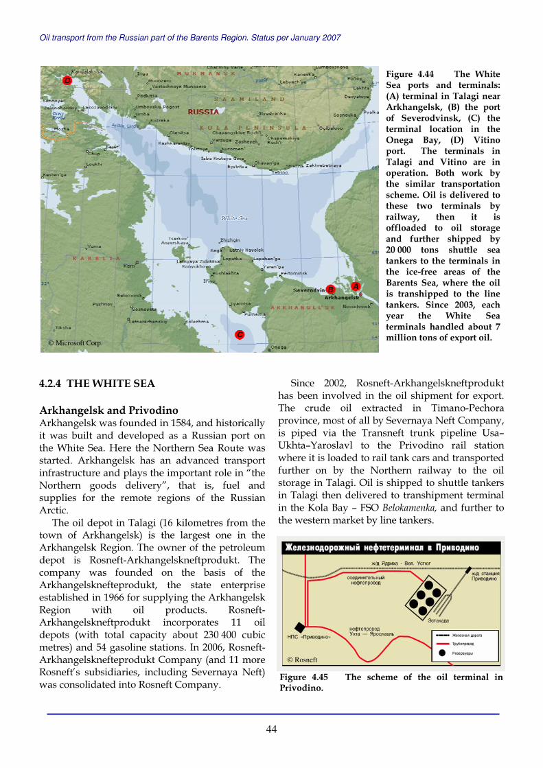
Oil transport from the Russian part of the Barents Region. Status per January 2007
44
4.2.4 THE WHITE SEA Arkhangelsk and Privodino Arkhangelsk was founded in 1584, and historically it was built and developed as a Russian port on the White Sea. Here the Northern Sea Route was started. Arkhangelsk has an advanced transport infrastructure and plays the important role in “the Northern goods delivery”, that is, fuel and supplies for the remote regions of the Russian Arctic.
The oil depot in Talagi (16 kilometres from the town of Arkhangelsk) is the largest one in the Arkhangelsk Region. The owner of the petroleum depot is Rosneft-Arkhangelskneftprodukt. The company was founded on the basis of the Arkhangelsknefteprodukt, the state enterprise established in 1966 for supplying the Arkhangelsk Region with oil products. Rosneft-Arkhangelskneftprodukt incorporates 11 oil depots (with total capacity about 230 400 cubic metres) and 54 gasoline stations. In 2006, Rosneft-Arkhangelsknefteprodukt Company (and 11 more Rosneft’s subsidiaries, including Severnaya Neft) was consolidated into Rosneft Company.
Since 2002, Rosneft-Arkhangelskneftprodukt has been involved in the oil shipment for export. The crude oil extracted in Timano-Pechora province, most of all by Severnaya Neft Company, is piped via the Transneft trunk pipeline Usa–Ukhta–Yaroslavl to the Privodino rail station where it is loaded to rail tank cars and transported further on by the Northern railway to the oil storage in Talagi. Oil is shipped to shuttle tankers in Talagi then delivered to transhipment terminal in the Kola Bay – FSO Belokamenka, and further to the western market by line tankers.
Figure 4.44 The White Sea ports and terminals:(A) terminal in Talagi near Arkhangelsk, (B) the port of Severodvinsk, (C) the terminal location in the Onega Bay, (D) Vitino port. The terminals in Talagi and Vitino are in operation. Both work by the similar transportation scheme. Oil is delivered to these two terminals by railway, then it is offloaded to oil storage and further shipped by 20 000 tons shuttle sea tankers to the terminals in the ice-free areas of the Barents Sea, where the oil is transhipped to the line tankers. Since 2003, each year the White Sea terminals handled about 7 million tons of export oil.
Figure 4.45 The scheme of the oil terminal in Privodino.
© Microsoft Corp.
© Rosneft
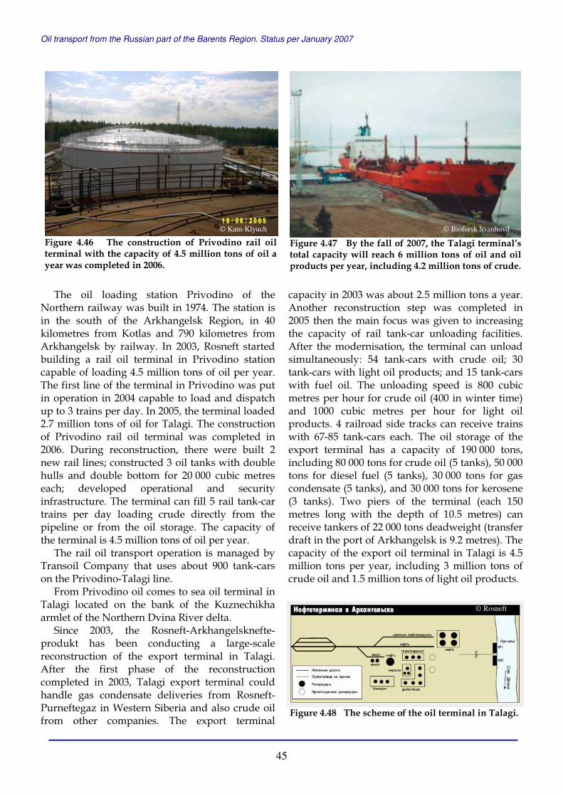
Oil transport from the Russian part of the Barents Region. Status per January 2007
45
The oil loading station Privodino of the Northern railway was built in 1974. The station is in the south of the Arkhangelsk Region, in 40 kilometres from Kotlas and 790 kilometres from Arkhangelsk by railway. In 2003, Rosneft started building a rail oil terminal in Privodino station capable of loading 4.5 million tons of oil per year. The first line of the terminal in Privodino was put in operation in 2004 capable to load and dispatch up to 3 trains per day. In 2005, the terminal loaded 2.7 million tons of oil for Talagi. The construction of Privodino rail oil terminal was completed in 2006. During reconstruction, there were built 2 new rail lines; constructed 3 oil tanks with double hulls and double bottom for 20 000 cubic metres each; developed operational and security infrastructure. The terminal can fill 5 rail tank-car trains per day loading crude directly from the pipeline or from the oil storage. The capacity of the terminal is 4.5 million tons of oil per year.
The rail oil transport operation is managed by Transoil Company that uses about 900 tank-cars on the Privodino-Talagi line.
From Privodino oil comes to sea oil terminal in Talagi located on the bank of the Kuznechikha armlet of the Northern Dvina River delta.
Since 2003, the Rosneft-Arkhangelsknefte-produkt has been conducting a large-scale reconstruction of the export terminal in Talagi. After the first phase of the reconstruction completed in 2003, Talagi export terminal could handle gas condensate deliveries from Rosneft-Purneftegaz in Western Siberia and also crude oil from other companies. The export terminal
capacity in 2003 was about 2.5 million tons a year. Another reconstruction step was completed in 2005 then the main focus was given to increasing the capacity of rail tank-car unloading facilities. After the modernisation, the terminal can unload simultaneously: 54 tank-cars with crude oil; 30 tank-cars with light oil products; and 15 tank-cars with fuel oil. The unloading speed is 800 cubic metres per hour for crude oil (400 in winter time) and 1000 cubic metres per hour for light oil products. 4 railroad side tracks can receive trains with 67-85 tank-cars each. The oil storage of the export terminal has a capacity of 190 000 tons, including 80 000 tons for crude oil (5 tanks), 50 000 tons for diesel fuel (5 tanks), 30 000 tons for gas condensate (5 tanks), and 30 000 tons for kerosene (3 tanks). Two piers of the terminal (each 150 metres long with the depth of 10.5 metres) can receive tankers of 22 000 tons deadweight (transfer draft in the port of Arkhangelsk is 9.2 metres). The capacity of the export oil terminal in Talagi is 4.5 million tons per year, including 3 million tons of crude oil and 1.5 million tons of light oil products.
Figure 4.46 The construction of Privodino rail oil terminal with the capacity of 4.5 million tons of oil a year was completed in 2006.
Figure 4.47 By the fall of 2007, the Talagi terminal’s total capacity will reach 6 million tons of oil and oil products per year, including 4.2 million tons of crude.
© Kam-Klyuch © Bioforsk Svanhovd
Figure 4.48 The scheme of the oil terminal in Talagi.
© Rosneft

Oil transport from the Russian part of the Barents Region. Status per January 2007
46
In 2006, Rosneft started the second phase of the Talagi export terminal reconstruction, which includes the freight pump station, boiler house and the construction of two railroad side tracks (in addition to the four already in operation). The works should be complete by the fall of 2007. Following reconstruction, the terminal’s total capacity will reach 6 million tons of oil and oil products per year, including 4.2 million tons of crude oil.
According to the Northern Railway Department, by 2008, Rosneft-Arkhangelsknefte-produkt freight turnover of oil products should be 10.2 million tons a year following the Arkhangelsk terminal development concept. The increase in volume will be phased: in 2006 – 7 million tons of oil and oil products will be transported, increasing to 8.5 million tons in 2007, and to 10.2 million tons in 2008.
The route from the Talagi oil terminal out to the sea is one of the challenges on the way of increasing the terminal shipping capacity. In particular, that concerns about 46 kilometres way from the terminal to the receiving buoy of the Arkhangelsk seaport by Kuznechikha armlet, which allows maximum 9.2 metres draft of the vessels and works one-way when the loaded tanker goes out. During winter navigation, tankers receive icebreaking assistance, provided by the Arkhangelsk seaport.
Oil transportation to FSO Belokamenka and oil products export from Talagi is managed by Rosnefteflot, subsidiary of Rosneft. In 2006, Rosneft ordered three 27 000 deadweight double-hull ice-reinforced tankers to be built at Factorias Vulkano Shipyards in Spain. The tankers will be delivered in 2008 and shuttle between Talagi and Belokamenka. In January 2007, Rosneft and the Sovcomflot reached an agreement on the formation of a joint company on the basis of Rosnefteflot.
Oil spill prevention and response is managed by the specialised unit of the Rosneft-Arkhangelskneftprodukt.
In 2002, the Rosneft-Arkhangelskneftprodukt terminal in Talagi shipped for export 1.9 million tons of oil and oil products; in 2003 the volume was 1.5 million tons; in 2004 – 3.4 million tons (2.2 million tons via Belokamenka); in 2005 – 4.2 million tons; and in 2006 – 3.1 million tons (in 2006, Talagi terminal was not shipping gas condensate).
By 2008, Rosneft-Arkhangelsknefteprodukt freight turnover of oil products should be to 10.2 million tons a year following the Arkhangelsk terminal development concept. The perspective plan of Rosneft is to increase the capacity of the export oil terminal in Talagi to 12 million tons a year. Severodvinsk Severodvinsk, the second largest city in the Arkhangelsk Region, was built in 1936. The city is situated in 30 kilometres to the West of Arkhangelsk. Severodvinsk is the centre of submarine shipbuilding, and the main enterprises of the city are machine-building factories Sevmash and Zvezdochka. Today Severodvinsk is also an important industrial and production base for the development of the hydrocarbon fields in the Russian Arctic continental shelf.
Severodvinsk seems as a suitable location for construction of the sea terminal. The town is situated on the White Sea coast. The navigation channel to Zvyozdocha factory has a strong water current, and it was built for the large size submarines. The sea depths in the area allow receiving 40 000 tons deadweight tankers.
In 2003, Tatneft and ARM-Nefteservice companies stated their intentions of building an export oil terminal in Severodvinsk with the capacity up to 5 million tons. The plan was to deliver oil by Northern railway. But in 2004, ARM-Nefteservice, and in 2005, Tatneft notified about changing their plans and looking for another location. ARM-Nefteservice looked at the Onega Bay of the White Sea, and Tatneft went to Kaliningrad Region on the Baltic Sea.
Figure 4.49 Severodvinsk is an important industrial base for the development of the hydrocarbon fields in the Russian Arctic continental shelf, and it seems as a suitable location for construction of the oil terminal. Photo – Severodvinsk washed by the White Sea.
© GriL

Oil transport from the Russian part of the Barents Region. Status per January 2007
47
The Onega Bay The Onega Bay of the White Sea was used for export oil transhipment operations during the summer navigation of 2003. Volgotanker Company started implementation of the project called “The White Sea”. The plan was to anchor an 80 000 deadweight tanker in the vicinity of Osinki islands (sea depths about 18 metres) using it as FSO, and tranship fuel oil (800 000 tons in 2003, and 1.5 million tons in 2004) delivered by 2700 deadweight Nefterudovoz river tankers shuttling through the White Sea–Baltic canal. FSO was not put on place. The Nefterudovoz tankers shuttled through 19 water-locks of the White Sea–Baltic canal to the Onega Bay and shipped fuel oil to 28 000 tons deadweight carrier tankers Zoja-I and Zoja-II of the Latvian Shipping Company that delivered the load to Rotterdam. In 2003, Volgatanker transhipped 220 000 tons of fuel oil in the Onega Bay. Apart from that, 100 000 tons of crude oil was carried from Vitino port and shipped to 127 000 deadweight tanker Trader.
Morskaya Liga Company from Kronstadt was to provide oil spill prevention and response services at the terminal.
In September 2003, Nefterudovoz-57M while moored to the tanker Zoja-I leaned over to the left shipboard, was dented and spilled fuel oil into the sea. A number of lawsuits followed the oil spill accident, and in the end, the court ruled that Volgotanker was to pay the municipality of Onega and the Onega District about 12.5 million roubles as compensation for the environmental damage caused by the oil spill. In 2004, Volgotanker has
not got a permit from the environmental authorities to resume the oil shipment operations in the Onega Bay.
Since 2003 the state taxes authorities have presented a number of taxation claims to Volgotanker. Lawsuits were run against the Company and its top-managers. Volgotanker assets, including 160 tankers, 57 oil-bulk-ore carriers, 100 barges and a number of tugs, have been under arrest and the accounts have been frozen since August 2005. The Company runs its business within the limits put by the Arbitration Court. The State owns 20% of the Volgotanker’s shares, and 80% is controlled by the Company’s Management.
In 2004, ARM-Nefteservice Company proposed to construct the sea oil transhipment complex near Onega building onshore facilities in Shendunets station on the White Sea coast (40 kilometres from Onega town) and offshore facilities in the vicinity of the Osinki islands in the Onega Bay. The oil terminal included: two rail trestles for offloading tank-cars with oil and oil products; oil storage for 180 000 cubic metres; 40 kilometres pipeline (9 kilometres onshore and 30 kilometres sub-sea); the offshore caisson type mooring installation; and 100 000 tons deadweight FSO. The plan was to deliver oil and oil products by Northern railway to Shendunets; unload rail tank-cars to oil storage onshore, pipe oil to FSO moored to offshore installation near Osinki islands; and ship it to tankers carrying oil to the customers abroad. The terminal capacity is estimated to 5 million tons operating all-year-round. The project has been frozen since 2004, as ARM-Nefteservice did not get the guarantees of oil deliveries in necessary volumes.
Figure 4.50 In 2003, Volgatanker transhipped 220 000 tons of fuel oil in the Onega Bay delivered by 3000 tons Nefterudovoz river tankers to 30 000 tons Zoja-Iand Zoja-II sea tankers.
Figure 4.51 Fuel oil spots on the Onega beaches after collision of two tankers at the Onega Bay terminal in September 2003.
© Sergey Gorbunov, Onega newspaper
© Sergey Gorbunov, Onega newspaper

Oil transport from the Russian part of the Barents Region. Status per January 2007
48
Vitino The seaport of Vitino is the first private seaport in Russia. It was developed as port terminal shipping oil to large tankers. The terminal was constructed using the capacities of the Belomorskaya Neftebaza (the White Sea oil depot) located on the southwest coast of the Kandalaksha Bay of the White Sea.
Belomorskaya Neftebaza was built during the years from 1972 to 1975 as a main storage facility for distribution of oil products throughout the Murmansk Region. With the investors came in 1993, the port was modernised and rebuilt to ship crude oil from rail tank-cars to sea tankers. Back in
1995, Vitino carried out the first export oil operation shipping crude to 31 000 tons deadweight tanker Probitas under the Maltese flag. That year, the port shipped 9 tankers with 250 000 tons of oil in total. Every year in the period from 1996 to 1999, Vitino was sending from 500 000 to 1 million tons of oil for export although operating only during the summer navigation.
Since 2001, Vitino has been carrying out large-scale modernisation and reconstruction of the oil terminal in phases. In 2002, the port of Vitino started to operate all-year-round. During winter navigation, oil is shipped to 20 000 tons ice-reinforced tankers, and shipment operations are assisted by the icebreakers of the Murmansk Shipping Company.
In 2004, the port of Vitino could ship tankers with 60 000 tons deadweight. The 18 nautical miles
(33 kilometres) fairway was dredged to the depth of 12.5 metres. Four mooring lines could serve one sea tanker and two river tankers simultaneously. The pumping equipment was modernised and reached the capacity of 3000 cubic metres per hour (versus 500 cubic metres per hour in 1996). The oil storage of the Belomorskaya Neftebaza had a capacity of 230 000 cubic metres. The terminal had two rail trestles to unload 82 tank-cars simultaneously. The terminal capacity was about 8 million tons a year.
In 2004, a big part of the crude oil flow went by rail to the port of Murmansk, and Vitino terminal was focused on increasing the capacity for shipping oil products and improving the logistic system. In 2005, the capacity of the oil terminal was increased to 11 million tons. The fairway was dredged and piers modernised to receive
Figure 4.52 In 2002, the port of Vitino started to operate all-year-round. During winter navigation, oil is shipped to 20 000 tons ice-reinforced tankers, and shipment operations are assisted by the icebreakers.
Figure 4.53 The pier and the Customs control point at Vitino seaport.
Figure 4.54 In 2003, the port of Vitino established a specialised oil spill prevention and response division.
© Bjørn Frantzen
© Bjørn Frantzen
© Bioforsk Svanhovd

Oil transport from the Russian part of the Barents Region. Status per January 2007
49
80 000 tons deadweight tankers. Four rail trestles have the capacity to unload 168 tank-cars (with crude oil, fuel oil, gas condensate and diesel fuel) simultaneously. The railroad side tracks of the oil terminal can have up to 7 trains. Vitino seaport could ship 900 000 tons of oil and oil products a month.
In 2005, Novatek together with Belomorskaya Neftebaza expanded the gas condensate loading and storage facilities in the port of Vitino. Novaek constructed their own storage reservoirs of 30 cubic metres each and the facilities for shipping gas condensate.
Also in 2005, Ros-oil Company, subsidiary of OBL Nefteprodukt, started building an oil terminal in Baklanka, the Northern railway station in the Vologda Region. The oil terminal, similar to Privodino, is constructed for crude oil deliveries to the port of Vitino. Crude transported by Ukhta-Yaroslavl trunk pipeline of Transneft will be piped to oil storage of Baklanka terminal, loaded to rail tank-cars and carried by Northern and Oktober railways to Vitino. The construction of the oil terminal should be completed in 2007 with the estimated capacity of 3.8 million tons.
Crude oil and oil products are delivered to the port of Vitino by rail. Crude transported from the terminals in Yaroslavl and Moscow regions where it comes by trunk pipelines of Transneft. Gas condensate produced at Purovsky processing plant of Novatek in Yamalo-Nenets Autonomous Region goes all the way by rail. In Vitino crude and oil products are shipped to sea tankers then delivered to the western ports directly or via offshore transhipment terminals in the Barents Sea. In 2002-2004, tankers of 20 000 deadweight shuttled between Vitino and the Kola Bay; and in 2005-2006 some offshore transhipment operation were carried out in Bøkfjord in the Northern Norway. In the winter 2006-2007 the STS operation was moved westwards to Sarnesfjord, near the North Cape.
In 2002, Vitino shipped 2.9 million tons of export crude oil and oil products; in 2003 – 5.7 million tons; the volumes dropped to 3.7 million tons in 2004, and in 2005 – to 1.6 million tons, including 830 000 tons of gas condensate. In 2006, Vitino terminal shipped 3.7 million tons of oil for export with the major part of light oil products.
4.2.5 THE BARENTS SEA, RUSSIA Murmansk and the Kola Bay The port of Murmansk located on the eastern coast of the Kola Bay is the only ice-free seaport in the Russian Arctic. The Murmansk seaport was constructed during the First World War in 1915, and in 20th century became one of the largest seaports in Russia and the World’s largest seaport above the Polar Circle.
The Murmansk seaport today is a huge transportation unit that integrates motor, rail and sea transportation of the region. The fairway depths of the mooring lines in the port of Murmansk allow shipping vessels with 15.5 metres draught. The annual freight turnover of the Murmansk seaport in 2002 and 2003 amounted to 10 million tons; in 2005 it increased to 16.5 million tons, and in 2006 exceeded 18 million tons.
Figure 4.55 Map of the Kola Bay with oil terminal locations. Coastal terminals: (A) Murmansk Sea Fishing Port, (B) Shipyard #35, (C) Mokhnatkina Pakhta, (D) Lavna, and (E) Safonovo. Offshore oil transhipment terminals: (1) RPK-1 of Murmansk Shipping Company, (2) RPK-2 of White Sea Service Company, and (3) RPK-3 Belokamenka.
© INGIT

Oil transport from the Russian part of the Barents Region. Status per January 2007
50
According to October Railway Department, the freight turnover of the Murmansk seaport may increase to 40 million tons a year in 2010-2015. And according to the general scheme of the Murmansk Port Traffic Centre development, the annual freight turnover may be increased to 42-65 million tons in 2010, and up to 83 million tons in 2015.
In 2003 and 2004, two new coastal export oil terminals for unloading rail tank cars and shipping sea tankers were put in operation in the port of Murmansk. Tangra Oil set in operation a terminal for shipping export oil and oil products at Shipyard #35, and developed the facilities of the Murmansk Sea Fishing Port for the same purpose. In the end of 2005, Commandit Service set in operation the terminal in the Cape Mokhnatkina Pakhta north of Murmansk. In the period from 2002 to 2004, three offshore oil transhipment terminals (hereafter RPK) were installed in the Kola Bay – RPK-1 of the Murmansk Shipping Company, RPK-2 of the White Sea Service Company, and RPK-3 (FSO Belokamenka) of Rosnefteflot and Bergesen Companies. At the moment, only FSO Belokamenka is in operation among these three offshore terminals. The Russian Ministry of Transport and the Murmansk Regional Administration proposes to develop Murmansk seaport as the multi-modal transportation complex building the infrastructure both on the eastern and western coasts of the Kola Bay and increasing the port’s oil shipment capacity.
Coastal oil terminals The first coastal oil terminal was constructed at the Shipyard #35, former Sevmorput, in the northern part of Murmansk. The Sevmorput factory was founded in 1932 as a maintenance factory for the merchant fleet. The factory building began in 1936 and was completed in 1938. In 1943, the factory was a part of the Northern Navy Fleet of the USSR. In 2003, Sevmorput changed the owner and was renamed into the Federal State Unitary Enterprise Shipyard #35 of the Ministry of Defence of Russia.
In 2003, Tangra Oil Company in cooperation with the Shipyard #35 constructed a port oil terminal on the territory of the factory. The 10 kilometres pipeline from the rail trestle leading to the mooring line was constructed. Oil from rail tank-cars was shipped by a pipeline straight to shuttle tankers Cheguevara (45 500) and Severomorsk (40 000) of Severnaya Stividorskaya Company, a subsidiary of Tangra Oil, that carried oil to 127 000 deadweight FSO Trader moored at RPK-1 in the Kola Bay. The first section of the terminal with the capacity of 3.5 million tons a year was commissioned in 2004. Gidrotekhservis Company was responsible for oil spill prevention and combat services at the terminal.
The modernisation of the oil terminal at Shipyard #35 continued during recent three years. In 2004, new rail trestle was constructed and the terminal got the capacity to unload 74 rail tank-cars with crude and oil products simultaneously.
Figure 4.56 FSO Belokamenka is the key unit in the norhern oil export channel. The 360 000 tons deadweight former Berge Pioneer was chartered by Rosneft for 20 years and put in operation in 2004. Belokamenka receives crude oil from the terminals in the Ob Bay in the Kara Sea, Varandey in the Pechora Sea and Arkhangelsk in the White Sea. It can also handle oil from Prirazlomnoye platform when it starts to produce.
© Vadim Krasnopolsky, WWF
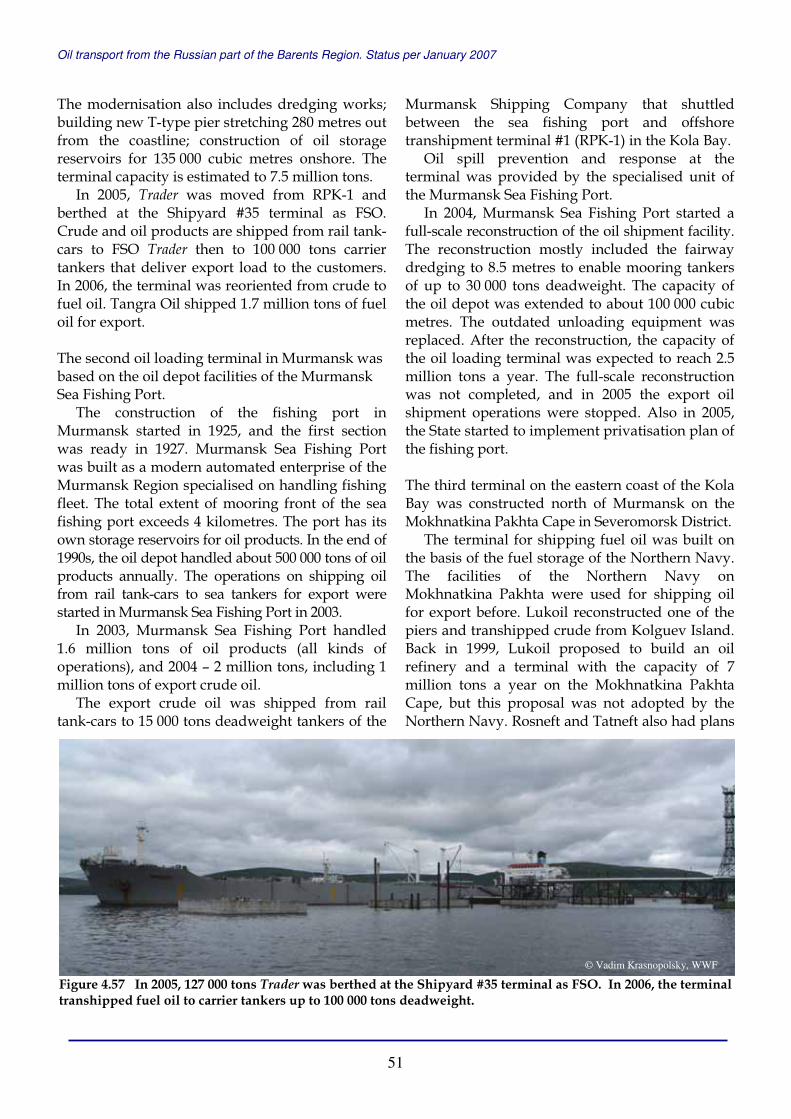
Oil transport from the Russian part of the Barents Region. Status per January 2007
51
The modernisation also includes dredging works; building new T-type pier stretching 280 metres out from the coastline; construction of oil storage reservoirs for 135 000 cubic metres onshore. The terminal capacity is estimated to 7.5 million tons.
In 2005, Trader was moved from RPK-1 and berthed at the Shipyard #35 terminal as FSO. Crude and oil products are shipped from rail tank-cars to FSO Trader then to 100 000 tons carrier tankers that deliver export load to the customers. In 2006, the terminal was reoriented from crude to fuel oil. Tangra Oil shipped 1.7 million tons of fuel oil for export. The second oil loading terminal in Murmansk was based on the oil depot facilities of the Murmansk Sea Fishing Port.
The construction of the fishing port in Murmansk started in 1925, and the first section was ready in 1927. Murmansk Sea Fishing Port was built as a modern automated enterprise of the Murmansk Region specialised on handling fishing fleet. The total extent of mooring front of the sea fishing port exceeds 4 kilometres. The port has its own storage reservoirs for oil products. In the end of 1990s, the oil depot handled about 500 000 tons of oil products annually. The operations on shipping oil from rail tank-cars to sea tankers for export were started in Murmansk Sea Fishing Port in 2003.
In 2003, Murmansk Sea Fishing Port handled 1.6 million tons of oil products (all kinds of operations), and 2004 – 2 million tons, including 1 million tons of export crude oil.
The export crude oil was shipped from rail tank-cars to 15 000 tons deadweight tankers of the
Murmansk Shipping Company that shuttled between the sea fishing port and offshore transhipment terminal #1 (RPK-1) in the Kola Bay.
Oil spill prevention and response at the terminal was provided by the specialised unit of the Murmansk Sea Fishing Port.
In 2004, Murmansk Sea Fishing Port started a full-scale reconstruction of the oil shipment facility. The reconstruction mostly included the fairway dredging to 8.5 metres to enable mooring tankers of up to 30 000 tons deadweight. The capacity of the oil depot was extended to about 100 000 cubic metres. The outdated unloading equipment was replaced. After the reconstruction, the capacity of the oil loading terminal was expected to reach 2.5 million tons a year. The full-scale reconstruction was not completed, and in 2005 the export oil shipment operations were stopped. Also in 2005, the State started to implement privatisation plan of the fishing port.
The third terminal on the eastern coast of the Kola Bay was constructed north of Murmansk on the Mokhnatkina Pakhta Cape in Severomorsk District.
The terminal for shipping fuel oil was built on the basis of the fuel storage of the Northern Navy. The facilities of the Northern Navy on Mokhnatkina Pakhta were used for shipping oil for export before. Lukoil reconstructed one of the piers and transhipped crude from Kolguev Island. Back in 1999, Lukoil proposed to build an oil refinery and a terminal with the capacity of 7 million tons a year on the Mokhnatkina Pakhta Cape, but this proposal was not adopted by the Northern Navy. Rosneft and Tatneft also had plans
Figure 4.57 In 2005, 127 000 tons Trader was berthed at the Shipyard #35 terminal as FSO. In 2006, the terminal transhipped fuel oil to carrier tankers up to 100 000 tons deadweight.
© Vadim Krasnopolsky, WWF

Oil transport from the Russian part of the Barents Region. Status per January 2007
52
upon this site, but those plans were not realised. In 2003, Commandit Service Company,
subsidiary of Progetra Group, as subcontractor and Sudkomgrupp Company as contractor started construction of the terminal for shipping fuel oil using the facilities of the fuel storage of the Northern Navy on Mokhnatkina Pakhta. In 2004 and 2005, the first stage of the project was implemented. Commandit Service carried out dredging works; reconstructed oil reservoirs; developed rail side roads and infrastructure; built rail trestle for 23 rail tank-cars; constructed floating dock structure; built 1 kilometre long pipeline (two lines of 426 mm diameter) from the rail trestle to floating dock structure; and moored 68 000 tons deadweight tanker Marshal Vasilevskiy as FSO. The terminal with the capacity of 2.5 million tons of fuel oil a year was set in operation in December 2005.
Oil is transported by rail to a new Mokhnatkina Pakhta station and a terminal, piped to FSO Marshal Vasilevskiy, and shipped to 50-60 000 tons deadweight tankers that carry oil to the western customers. In 2006, Commandit Service shipped 730 000 tons of oil products for export.
Murmansk Basing Emergency and Salvage Department (MBESD) provide oil spill prevention and response services at the terminal.
Progetra Group intends to upgrade the facilities in Mokhnatkina Pakhta for crude oil transhipment operations, and increase the terminal capacity to 5 million tons a year. Progetra (Commandit Service) and Sudkomgrupp also plan to built another oil terminal in Safonovo settlement near Severomorsk with the capacity of 15 million tons a year.
Offshore oil transhipment terminals in the Kola Bay The first offshore oil transhipment terminal (RPK-1) in the Kola bay was constructed by the Murmansk Shipping Company in nearby the Cape Mishukovo. In October 2002, RPK-1 transhipped its first crude oil, then 106 000 tons deadweight tanker Moscow River of Novoship was loaded with crude delivered from the port of Vitino by tankers Burgas (54 500) and Geroi Sevastopolya (55 800).
The terminal had eight anchorage-mooring systems (anchors, bridles, flanks) capable to serve sea tankers of up to 150 000 tons deadweight in heavy weather conditions with a wind of up to 20 metres per second. From 15 000 to 60 000 tons deadweight shuttle tankers were moored directly to line tankers for shipping oil. The terminal operated all-year-round. The projected capacity of RPK-1 is 5.4 million tons of oil a year. Oil spill prevention and response services for the terminal RPK-1 are provided by the Murmansk Basin Emergency and Salvage Department (MBESD).
From 2002 to 2004, RPK-1 was operating as a Ship-to-Ship transfer (STS) terminal. In August 2004, the Trader (127 000) tanker was anchored at the RPK-1. For one year Trader was used as Floating Storage and Offloading vessel (FSO) at RPK-1. Since Trader was moved to Shipyard #35 oil terminal in 2005, RPK-1 has not been transhipping oil.
Figure 4.58 The oil terminal in Mokhnatkina Pakhta with 68 000 tons FSO Marshal Vasilevsky was set in operation in 2005 .
© Vadim Krasnopolsky, WWF
Figure 4.59 In October 2002, RPK-1 terminal ran its first ship-to-ship transfer operation, then 106 000 tons deadweight tanker Moscow River of Novoship was loaded with crude oil delivered from the port of Vitino by two tankers - 54 500 ton Burgas and 55 800 tonGeroi Sevastopolya.
© Bioforsk Svanhovd

Oil transport from the Russian part of the Barents Region. Status per January 2007
53
Oil was delivered to RPK-1 from terminals in Varandey, Vitino, Murmansk Sea Fishing Port and Shipyard #35 by shuttle tankers. Further, oil was shipped for export to line tankers with about 100 000 tons deadweight.
In 2003, RPK-1 transhipped 3.7 million tons of oil for export; in 2004 – 4.3 million tons; and in 2005 – 3.4 million tons.
The second offshore oil transhipment terminal (RPK-2) in the Kola Bay was built by the White Sea Service Company, and put in operation in December 2003, but it worked for 3 months only as a STS facility. The third and the largest terminal (RPK-3) Belokamenka was set in operation as a FSO facility in March 2004. RPK-3 Belokamenka is the key component of the northern oil export channel developed by Rosneft.
The main unit of RPK-3 is an oil storage tanker Belokamenka (built in 1980), the largest tanker in Russia of 360 000 tons deadweight. The tanker is 340 metres long and 65 metres wide. The tanker Belokamenka, former Berge Pioneer, was chartered by Rosneft for 20 years with the right of the subsequent buy-out from the Norwegian company Bergesen d.y. ASA. The tanker came in the Kola Bay and was moored near Belokamenka settlement. The terminal operator, Belokamenka Company, was founded in 2004 as a joint venture of Bergesen and Far-East Marine Company (FEMCO), now Rosnefteflot.
After FSO Belokamenka was established, Rosneft obtained a new oil delivery route “from the oil
well to the consumer”. The oil extracted by Rosneft subsidiaries in Timano-Pechora province is delivered to the terminal in Arkhangelsk, and further carried by shuttle tankers to the storage tanker in the Kola Bay, from where it is exported by line tankers with up to 200 000 tons deadweight.
In February 2004, the storage tanker Belokamenka received the first oil from shuttle tankers Volgograd (16 000), Rundale (17 000) and Samburga (17 100) from Arkhangelsk. In March, RPK-3 shipped the first oil for export into the line tanker Moscow River (106 000). In August, Belokamenka shipped the first millionth ton of oil.
In 2004, RPK-3 Belokamenka transhipped 2.5 million tons of crude oil for export, in 2005 – 3.3 million tons, and in 2006 – 4 million tons. The documented operational capacity of RPK-3 Belokamenka today is 5 million tons a year. In the future it can be increased to 20 million tons. According to Belokamenka Company, the terminal can tranship 12 million tons of oil in 2008, and when new oil fields are developed in the Russian Arctic, the terminal can handle 20 million tons of oil per year.
FSO Belokamenka receives crude oil delivered to the Kola Bay by shuttle tankers from the terminals in the Ob Bay, Varandey and Arkhangelsk. In the future, Belokamenka will also handle oil from Prirazlomnoye oil field. In January 2007, Rosneft and the Sovcomflot reached an agreement on the formation of a joint company on the basis of Rosnefteflot. Sovcomflot will ship oil from new Varandey terminal and Prirazlomnoye oil field.
Figure 4.60 December 2003, Kuban was anchored in RPK-1 and Trader in RPK-2.
© Bjørn Frantzen
Figure 4.61 17 100 tons deadweigh tanker Samburgadelivered crude to FSO Belokamenka, November 2005.
© Bjørn Frantzen

Oil transport from the Russian part of the Barents Region. Status per January 2007
54
The oil spill prevention and response services at the terminal Belokamenka are provided by MBESD. In June 2004, the company arranged the first full scale oil spill response exercises in the Kola Bay simulating an accidental 500 tons oil spill at the terminal. MBESD, the Arctic Specialised Marine Inspection, Masko Company, the Department on Emergencies and the RPK-3 terminal took part in the exercises.
Development of the Murmansk Port Traffic Centre Ministry of Transport of Russia and the Administration of the Murmansk Region propose to build up the Murmansk multi-modal port complex using both eastern and western coasts of the Kola Bay.
According to the Master Growth Plan for the Murmansk Port Traffic Centre elaborated by LenmorNIIproekt, the Kola Bay’s east coast will boast the following transhipment complexes: • Special complexes for bulk freight with the
capacity of 8.3 million tons after renovation and expansion;
• Special coal complex that will occupy two areas by existing piers #13-14 and a new pier #22 (330 metres);
• Complex for mixed freight with 2 million tons capacity, located in I and II regions of the port;
• Special oil products terminal complex on the territory of the Shipyard #35 with the capacity of up to 10 million tons a year;
• Special complex for oil products at the pier #20 with up to 8 million tons shipping capacity.
Oil products will be delivered to the terminals in the eastern coast by rail and shipped to tankers.
The Kola Bay’s west coast in the area of Lavna and Kulonga rivers will house new complexes consisting of: • Oil terminal complex with shipping capacity of
4.5 million tons a year, consisting of 470 metres long pier to moor tankers from 120 000 to 300 000 tons deadweight, oil storage for 400 000 cubic metres, and rail trestles.
• Complex for coal transhipment with 15 million tons capacity;
• Complex for transhipment of mixed freight and containers with capacity of up to 3 million tons a year;
• Supply Depot and Oil Terminal Complex at the mouth of the Lavna River with the capacity of up to 25 million tons (crude oil), 0.86 million (bunker fuel) and 0.13 million (provision cargo) a year.
The construction of the port base in Lavna started in 1980s but stopped with the collapse of the Soviet Union. According to the new development plan, oil should be delivered to Lavna terminal by new constructed railway from Murmashi-II station, and shipped to line tankers of up to 250 000 tons deadweight. The capacity of the oil terminal in Lavna should reach 10 million tons in 2008; and 25 million tons in 2012. An oil refinery with the capacity of 6 million tons a year is planned in the area between Lavna River and the Kola Bay.
It is expected that the annual freight turnover of the Murmansk Port Traffic Centre will be 42-65 million tons in 2010 (including 18-34 million tons of bulked cargo), and up to 83 million tons in 2015.
Figure 4.62 Ministry of Transport of Russia and the Administration of the Murmansk Region propose to build up the Murmansk multi-modal port complex using both eastern and western coasts of the Kola Bay. The map shows the general plan of the port complex development near Lavna.
Figure 4.63 Old panorama - dumped ships near Lavna.
© LenmorNIIproekt
© EHEF

Oil transport from the Russian part of the Barents Region. Status per January 2007
55
The Pechenga Bay Sevneft Company proposes to build a Severniy (Northern) Port – Oil Complex and Dry-cargo Northern Sea Port in the Pechenga Bay of the Murmansk Region.
The planned total freight turnover is 65 million tons a year, with the perspective to increase the capacity up to 200 million tons. According to the technical project description, the port will consist of four shipping regions – oil and oil processing terminal; coal terminal; wood terminal; and general and container cargo terminal. The oil terminal has estimated shipping capacity of 30 million tons of oil and oil products a year. The terminal should have oil storage for 450 000 cubic metres; three double side rail trestles to handle 120 rail tank cars; and piers to ship four tankers of 150 000 tons deadweight. Oil will be transported to the port by rail, loaded to the oil storages and further shipped to tankers. Sevneft plans to start the construction in 2008, and the port can start operating in full scale in 2015. 4.2.6 THE BARENTS SEA, NORWAY Since the oil transportation from the Russian Barents Region started growing in 2002, there were visions and suggestions about the establishment of a transhipment terminal for Russian oil in the Norwegian County Finnmark. There were proposals to build such terminals in places such as Vardø, Paddeby, and Bøkfjord
outside Kirkenes. The formal requests for getting permits to establish oil transhipment terminals near Kirkenes were sent by ShipCargo Ltd and Bergesen d.y. ASA. The work to obtain the necessary permissions for the projected terminal has been going on since 2002, and is still not finished. The ship owner Bergesen d.y. ASA planned to anchor the old Berge Enterprise super tanker and use it as a Floating Storage and Offloading vessel (FSO) oil transfer terminal. This is a similar solution that Bergesen Company has with the ship Belokamenka (before Berge Pioneer) in the Kola Bay near Murmansk.
The anchored storage ship in Bøkfjord was considered as a permanent installation. The prospects to establish a terminal in Bøkfjord were based on the future increase in oil to be shipped from the Russian part of the Barents Region ports, and on the belief that the Russian side has not enough oil reloading facilities.
In May 2002, there was an oil transhipment operation in Bøkfjord run by ShipCargo. Three Lukoil tankers of Astrakhan type completed ship-to-ship (STS) loading of 15 000 tons of crude oil
Figure 4.65 Map of the proposed Oil Complex and Dry-cargo Northern Sea Port in the Pechenga Bay.
© Sevneft
Figure 4.64 Bøkfjord – location of the first Norwegian terminal for Russian oil. The permit for oil transhipment in the fjord was given in 2005 and annulled in 2006, when the authorities banned oil shipping activities in a salmon protected area.
© LDKN

Oil transport from the Russian part of the Barents Region. Status per January 2007
56
each into a 46 500 tons deadweight Greek tanker Shinoussa of Eletson Corporation. With this operation the entire process concerning transhipment in Northern Norway was started. In 2005, ShipCargo received a permit for STS from the Norwegian Coastal Administration, but would need permission from more governmental agencies to be able to start operations.
Also in 2005, a temporary permission for oil loading in the Ropelv near Kirkenes was given to Kirkenes Transit, and was annulled in 2006 when the authorities banned oil shipping activities in a salmon protected area. The company Kirkenes Transit got a permit to carry out oil loading in the Sarnesfjorden, further west and close to the North Cape. The company accomplished nine loadings in the winter of 2005-2006 in Bøkfjord, 55 000 tons of gas condensate each.
Since the Ropelv, Kirkenes and the Sarnesfjord, the North Cape are the first locations that obtained permissions for shipping oil transported from Russia, we will provide a more detailed review of the permission that the Norwegian Pollution Control Authority (SFT) has issued for oil shipments.
Bøkfjord In 2005, ShipCargo and Kirkenes Transit companies obtained official permission to carry out ship-to-ship (STS) oil transfer operations in Bøkfjord near Kirkenes. Kirkenes Transit ran operations with gas condensate that was loaded from an inbound ship into tankers of up to 75 000 tons deadweight anchored near Reinøy in the Bøkfjord. Gas condensate was transported by rail from Siberia to the White Sea, from where it was transported further by tankers to Kirkenes. Fewer tankers came from Vitino port in the Kandalaksha Bay of the White Sea.
In a statement by Norwegian authorities it is pointed out that the chosen oil loading sites are situated in the national salmon protected areas of Neiden, the Korsfjord and the Bøkfjord, where “an activity that represents a risk of emissions that damage salmon is forbidden”.
Kirkenes Transit shows that loading activities of gas condensate in the period from November 2005 until the end of 2006 grew up to 40 loadings while the Norwegian Pollution Control Authority (SFT) in their estimation of the concession requirements limited the number by 10 loadings.
Figure 4.66 Western Barents Sea coast. The locations of the terminals: (A) Pechenga Bay, Russia. (B) Bøkfjord near Kirkenes, (C) Paddeby near Vadsø, (D) Sarnesfjord near the North Cape, (E) Kvalsund, (F) Slettnes and (G) Dønnesfjord on Sørøya island, and (H) Grøtsund near Tromsø, Norway.
© Microsoft Corp and/or its suppliers
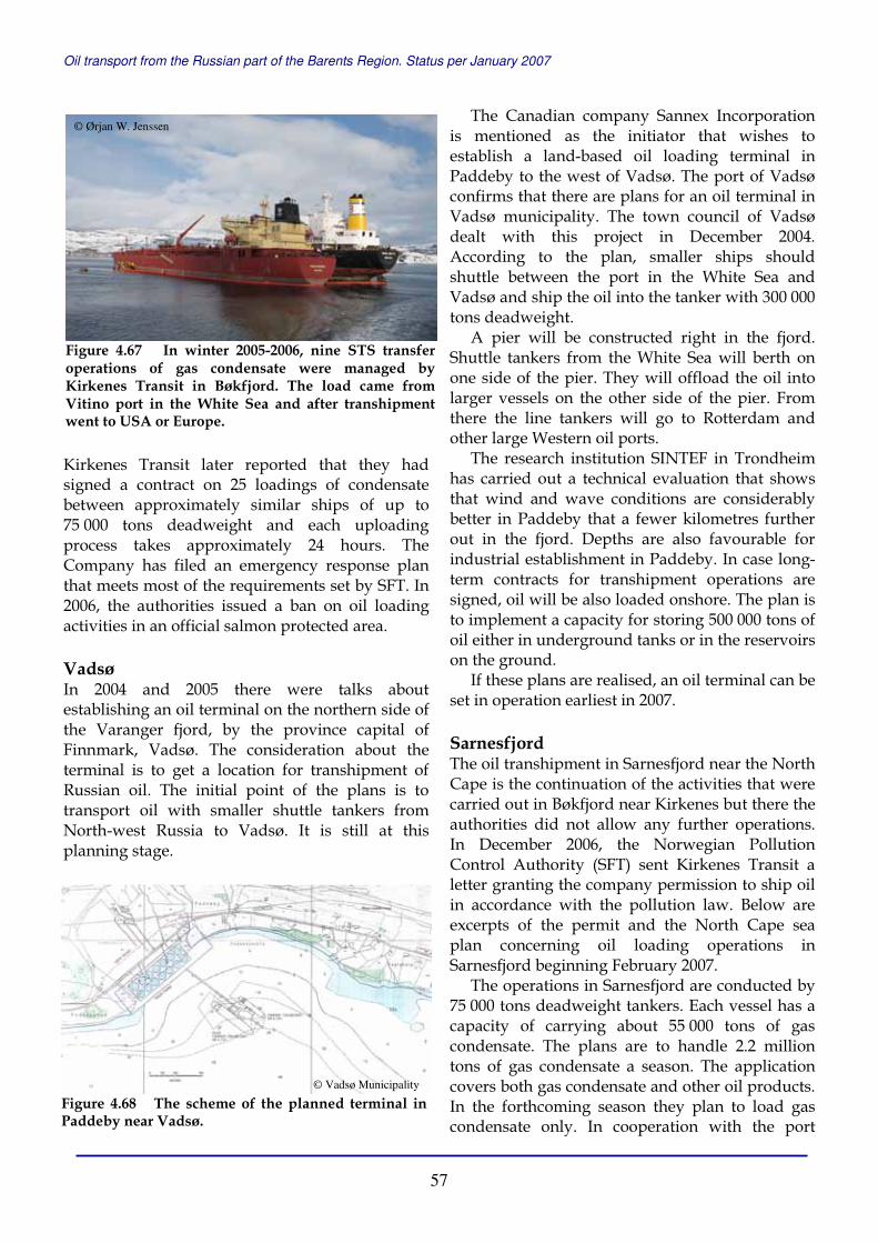
Oil transport from the Russian part of the Barents Region. Status per January 2007
57
Kirkenes Transit later reported that they had signed a contract on 25 loadings of condensate between approximately similar ships of up to 75 000 tons deadweight and each uploading process takes approximately 24 hours. The Company has filed an emergency response plan that meets most of the requirements set by SFT. In 2006, the authorities issued a ban on oil loading activities in an official salmon protected area. Vadsø In 2004 and 2005 there were talks about establishing an oil terminal on the northern side of the Varanger fjord, by the province capital of Finnmark, Vadsø. The consideration about the terminal is to get a location for transhipment of Russian oil. The initial point of the plans is to transport oil with smaller shuttle tankers from North-west Russia to Vadsø. It is still at this planning stage.
The Canadian company Sannex Incorporation is mentioned as the initiator that wishes to establish a land-based oil loading terminal in Paddeby to the west of Vadsø. The port of Vadsø confirms that there are plans for an oil terminal in Vadsø municipality. The town council of Vadsø dealt with this project in December 2004. According to the plan, smaller ships should shuttle between the port in the White Sea and Vadsø and ship the oil into the tanker with 300 000 tons deadweight.
A pier will be constructed right in the fjord. Shuttle tankers from the White Sea will berth on one side of the pier. They will offload the oil into larger vessels on the other side of the pier. From there the line tankers will go to Rotterdam and other large Western oil ports.
The research institution SINTEF in Trondheim has carried out a technical evaluation that shows that wind and wave conditions are considerably better in Paddeby that a fewer kilometres further out in the fjord. Depths are also favourable for industrial establishment in Paddeby. In case long-term contracts for transhipment operations are signed, oil will be also loaded onshore. The plan is to implement a capacity for storing 500 000 tons of oil either in underground tanks or in the reservoirs on the ground.
If these plans are realised, an oil terminal can be set in operation earliest in 2007. Sarnesfjord The oil transhipment in Sarnesfjord near the North Cape is the continuation of the activities that were carried out in Bøkfjord near Kirkenes but there the authorities did not allow any further operations. In December 2006, the Norwegian Pollution Control Authority (SFT) sent Kirkenes Transit a letter granting the company permission to ship oil in accordance with the pollution law. Below are excerpts of the permit and the North Cape sea plan concerning oil loading operations in Sarnesfjord beginning February 2007.
The operations in Sarnesfjord are conducted by 75 000 tons deadweight tankers. Each vessel has a capacity of carrying about 55 000 tons of gas condensate. The plans are to handle 2.2 million tons of gas condensate a season. The application covers both gas condensate and other oil products. In the forthcoming season they plan to load gas condensate only. In cooperation with the port
Figure 4.67 In winter 2005-2006, nine STS transfer operations of gas condensate were managed by Kirkenes Transit in Bøkfjord. The load came from Vitino port in the White Sea and after transhipment went to USA or Europe.
© Ørjan W. Jenssen
Figure 4.68 The scheme of the planned terminal in Paddeby near Vadsø.
© Vadsø Municipality
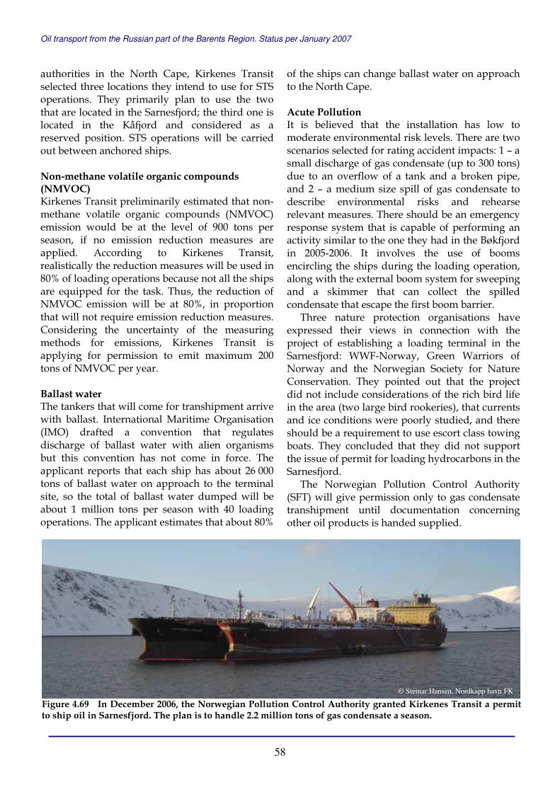
Oil transport from the Russian part of the Barents Region. Status per January 2007
58
authorities in the North Cape, Kirkenes Transit selected three locations they intend to use for STS operations. They primarily plan to use the two that are located in the Sarnesfjord; the third one is located in the Kåfjord and considered as a reserved position. STS operations will be carried out between anchored ships. Non-methane volatile organic compounds (NMVOC) Kirkenes Transit preliminarily estimated that non-methane volatile organic compounds (NMVOC) emission would be at the level of 900 tons per season, if no emission reduction measures are applied. According to Kirkenes Transit, realistically the reduction measures will be used in 80% of loading operations because not all the ships are equipped for the task. Thus, the reduction of NMVOC emission will be at 80%, in proportion that will not require emission reduction measures. Considering the uncertainty of the measuring methods for emissions, Kirkenes Transit is applying for permission to emit maximum 200 tons of NMVOC per year. Ballast water The tankers that will come for transhipment arrive with ballast. International Maritime Organisation (IMO) drafted a convention that regulates discharge of ballast water with alien organisms but this convention has not come in force. The applicant reports that each ship has about 26 000 tons of ballast water on approach to the terminal site, so the total of ballast water dumped will be about 1 million tons per season with 40 loading operations. The applicant estimates that about 80%
of the ships can change ballast water on approach to the North Cape. Acute Pollution It is believed that the installation has low to moderate environmental risk levels. There are two scenarios selected for rating accident impacts: 1 – a small discharge of gas condensate (up to 300 tons) due to an overflow of a tank and a broken pipe, and 2 – a medium size spill of gas condensate to describe environmental risks and rehearse relevant measures. There should be an emergency response system that is capable of performing an activity similar to the one they had in the Bøkfjord in 2005-2006. It involves the use of booms encircling the ships during the loading operation, along with the external boom system for sweeping and a skimmer that can collect the spilled condensate that escape the first boom barrier.
Three nature protection organisations have expressed their views in connection with the project of establishing a loading terminal in the Sarnesfjord: WWF-Norway, Green Warriors of Norway and the Norwegian Society for Nature Conservation. They pointed out that the project did not include considerations of the rich bird life in the area (two large bird rookeries), that currents and ice conditions were poorly studied, and there should be a requirement to use escort class towing boats. They concluded that they did not support the issue of permit for loading hydrocarbons in the Sarnesfjord.
The Norwegian Pollution Control Authority (SFT) will give permission only to gas condensate transhipment until documentation concerning other oil products is handed supplied.
Figure 4.69 In December 2006, the Norwegian Pollution Control Authority granted Kirkenes Transit a permit to ship oil in Sarnesfjord. The plan is to handle 2.2 million tons of gas condensate a season.
© Steinar Hansen, Nordkapp havn FK
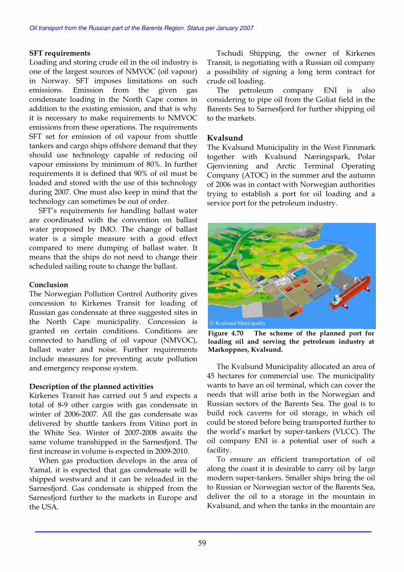
Oil transport from the Russian part of the Barents Region. Status per January 2007
59
SFT requirements Loading and storing crude oil in the oil industry is one of the largest sources of NMVOC (oil vapour) in Norway. SFT imposes limitations on such emissions. Emission from the given gas condensate loading in the North Cape comes in addition to the existing emission, and that is why it is necessary to make requirements to NMVOC emissions from these operations. The requirements SFT set for emission of oil vapour from shuttle tankers and cargo ships offshore demand that they should use technology capable of reducing oil vapour emissions by minimum of 80%. In further requirements it is defined that 90% of oil must be loaded and stored with the use of this technology during 2007. One must also keep in mind that the technology can sometimes be out of order.
SFT’s requirements for handling ballast water are coordinated with the convention on ballast water proposed by IMO. The change of ballast water is a simple measure with a good effect compared to mere dumping of ballast water. It means that the ships do not need to change their scheduled sailing route to change the ballast. Conclusion The Norwegian Pollution Control Authority gives concession to Kirkenes Transit for loading of Russian gas condensate at three suggested sites in the North Cape municipality. Concession is granted on certain conditions. Conditions are connected to handling of oil vapour (NMVOC), ballast water and noise. Further requirements include measures for preventing acute pollution and emergency response system. Description of the planned activities Kirkenes Transit has carried out 5 and expects a total of 8-9 other cargos with gas condensate in winter of 2006-2007. All the gas condensate was delivered by shuttle tankers from Vitino port in the White Sea. Winter of 2007-2008 awaits the same volume transhipped in the Sarnesfjord. The first increase in volume is expected in 2009-2010.
When gas production develops in the area of Yamal, it is expected that gas condensate will be shipped westward and it can be reloaded in the Sarnesfjord. Gas condensate is shipped from the Sarnesfjord further to the markets in Europe and the USA.
Tschudi Shipping, the owner of Kirkenes Transit, is negotiating with a Russian oil company a possibility of signing a long term contract for crude oil loading.
The petroleum company ENI is also considering to pipe oil from the Goliat field in the Barents Sea to Sarnesfjord for further shipping oil to the markets. Kvalsund The Kvalsund Municipality in the West Finnmark together with Kvalsund Næringspark, Polar Gjenvinning and Arctic Terminal Operating Company (ATOC) in the summer and the autumn of 2006 was in contact with Norwegian authorities trying to establish a port for oil loading and a service port for the petroleum industry.
The Kvalsund Municipality allocated an area of 45 hectares for commercial use. The municipality wants to have an oil terminal, which can cover the needs that will arise both in the Norwegian and Russian sectors of the Barents Sea. The goal is to build rock caverns for oil storage, in which oil could be stored before being transported further to the world’s market by super-tankers (VLCC). The oil company ENI is a potential user of such a facility.
To ensure an efficient transportation of oil along the coast it is desirable to carry oil by large modern super-tankers. Smaller ships bring the oil to Russian or Norwegian sector of the Barents Sea, deliver the oil to a storage in the mountain in Kvalsund, and when the tanks in the mountain are
Figure 4.70 The scheme of the planned port for loading oil and serving the petroleum industry at Markoppnes, Kvalsund.
© Kvalsund Municipality

Oil transport from the Russian part of the Barents Region. Status per January 2007
60
full, the oil is transported further by a super-tanker (VLCC) to the western markets.
The Kvalsund Municipality visualises a gradual development of loading facilities in this sequence: • Ship-to-ship loading in the Repparfjord. • Loading at the existing quay for smaller ship. • Construction of deepwater for super-tankers at
Markoppnes. • Transfer from smaller to larger vessels via rock
caverns. The following elements of the business can be arranged at Markoppnes: • Waste management facilities. • Services for vessel traffic. • Services for oil and gas industry in the Barents
Sea. • Industrial activities aimed at oil and gas
production. • Onshore terminal for oil from the Barents Sea. A new company, Polar Gjenvinning, was established to handle waste. Polar Gjenvinning is jointly (50/50) owned by Wergeland Holding and Franzefoss. ATOC applied to the Norwegian Pollution Control Authority (SFT) for permission to load oil ship-to-ship. ATOC is a company under the foundation that consists of five companies including the biggest partner – FenderCare Marine.
Sørøya Nordoil Caverns Company together with Hammerfest and Hasvik municipalities are developing the proposal for building an oil terminal in one of two alternate locations at Sørøya – in Slettnes, Hammerfest municipality or in Dønnesfjord, Hasvik municipality. Nordoil propose to build a storage for crude oil and oil products in rock caverns and a terminal for transhipping oil from Goliat field in the Barents Sea and from the Russian Barents Region. Nordoil Caverns AS was established in 2006 and owned by Baroil AS, Hammerfest Harbour KF and Hasvik Municipality.
Grøtsund In February 2006, Grøtsund near Tromsø, North Norway was again in the media as a possible location for ship-to-ship transfer of oil from Russia. International petroleum traders are looking at the possibilities for oil transhipments in this fjord close to Tromsø, the capital of the Troms County and a major city in the Northern Norway. This is still nothing more than a plan.
Tromsø Municipality has purchased Grøtsund fort from the Norwegian Armed Forces and is looking for the possibility to use the facility as a service base for the offshore petroleum industry.
Figure 4.72 Nordoil propose to build a storage forcrude oil and oil products in rock caverns and a terminal for transhipping oil from the Goliat field in the Barents Sea and from the Russian Barents Region.
Figure 4.71 Grøtsund fort – a possible location for ship-to-ship transfer of oil from Russia.
© Nordoil
© Skifte Eiendom

Oil transport from the Russian part of the Barents Region. Status per January 2007
61
5 Environmental Safety n the previous report issued in 2005, we published articles about environmental national policies in Russia and Norway based on the official documents of the Russian and Norwegian environmental authorities; examples of environmental policy documents of Russian and Norwegian oil companies; and brief description of oil pollution prevention systems in both countries.
Here we include a concrete example of the Norwegian Pollution Control Authority (SFT) requirements for oil transhipment operation in Bøkfjord.
Further in this section, we include the articles about the oil traffic monitoring and control system developed in Norway since 2002. The first article describes the Norwegian coast emergency response system, and was prepared by Commander Yngve Årøy, Chief of the Regional Headquarter North Norway Surveillance Centre in December 2004. The figures were updated in January 2007. The Norwegian Armed Forces monitored the oil traffic in cooperation with the Norwegian Coastal Administration. In January 2007, a new traffic centre of the Norwegian Coastal Administration was set in operation in Vardø. Further, we give a short description of Vardø Vessel Traffic Centre, and include information about new routing for tankers in Norway that will be in force from July 2007. We also give a status of the Norwegian-Russian cooperation in oil pollution abatement.
In 2005, we also wrote about environmental problems and gave detailed description of two accidents with Rocknes near Bergen in Norway and with Nefterudovoz in the White Sea in Russia. In the present report, we give a description of the recent accident with Server near Bergen and a clean-up operation.
5.1 ENVIRONMENTAL REQUIREMENTS FOR OIL TRANSHIPMENT In the following article we give an example of the Norwegian Pollution Control Authority (SFT) policy regarding requirements to environmental safety preparedness. These requirements were set for the offshore terminal in Bøkfjord in 2005, before the authorities set a ban on the oil shipment operations in the salmon protected areas, including Bøkfjord.
SFT stated that for gas condensate loading in the Bøkfjord, first of all, it must be ensured that acute pollution would never occur. On this basis, special attention must be paid to safety of operations and preventive measures. SFT pointed out that consequences of actual oil and gas condensate emission can be considerable, both environmentally and economically. The law on pollution obliges the party involved in activities with pollution hazards to carry out measures to prevent a pollution occurrence. In case of hazardous pollution events, the responsible party shall take measures to terminate, eliminate or delimit the impact of such occurrence. The responsible party is also required to take measures to avert damages and inconveniencies that are caused by the accident or by the pollution countermeasures. The responsible party shall bear the costs incurred by the pollution.
There are also conditions imposed on the restitution time for affected environmental resources that were damaged due to negligence to such conditions as the dark season, low temperatures, and snow/ice, seasonal differences. It is further conditioned that loading at sea is forbidden when wind velocity exceeds 10 metres per second and water current is over 0.3 metres per second, while the presented plan indicated 23 metres per second wind as the limit for operations and there is no mentioning of limitations for currents.
Environmental risk analysis assumes also that ships must have a double hull even if there are no vulnerable natural resources in the area.
I

Oil transport from the Russian part of the Barents Region. Status per January 2007
62
Oil pollution response for ship-to-ship loading of gas condensate in the Bøkfjord Environmental risk analysis While conducting loading operations the company should work out and keep updated an environmental risk analysis that cover both the inbound traffic route and the activities at the loading site. By the inbound traffic route in this context, SFT means the area the ship comes from to enter the Bøkfjord on approach to the loading site. The environmental risk analysis shall cover all the conditions at the operating facilities that lead to acute pollution hazardous to health and/or environment. The environmental risk analysis must indicate environmental resources that can be affected by pollution, and potential consequences to health and environment such pollution incident may incur. It should undertake a special estimation of probability of such occurrence and the impact that a potential condensate emissions can have on the national protected salmon population of Neidenfjord-Bøkfjord. It should determine, which activities that carry low risk can be continued without further special concern, which activities can be acceptable with taking measures to reduce the risk and which ones are not acceptable. The environmental risk analysis should be integrated into the company’s internal control system.
The contributed environmental risk analysis is based upon a number of suggestions that are described above and which are not in accordance with the rest of the documentation. The environmental risk analysis must therefore be updated to indicate realistic environmental risk at the condensate loading site with real operational limitations.
On the basis of the environmental risk analysis and the estimations provided by it, the operator should describe the measures that should be carried out to prevent acute pollution. The measures should be available and operative during the whole loading activities from the time the first ship comes in until the last one leaves the Bøkfjord. The preventive measures are carried out in addition to the measures of pollution response described below.
Operation/prevention measures Approach/departure, anchoring, mooring and transfer of cargo shall take place under favourable weather conditions, waves, current and light conditions. The operating company must have procedures for predicting emergencies including unscheduled break of condensate transfer, unplanned breakaway of one of the ships and the like.
The operator shall define and stipulate the relevant operational limitations under normal conditions and in emergency situations for different stages of the loading operation.
Operations shall be terminated and pipes disconnected when one the criteria for operational limitations are exceeded.
Operations in ice conditions must meet special requirements to technical standards of the ships, the operation and anchoring. In the emergency response situations ice will entail additional serious problems both for mechanical oil pollution and for dispersing conditions.
Since SFT is not aware of proven and operable emergency response methods for ice conditions or those that can be used for tankers, loading can not be carried out in case there is fast or broken ice on the sea surface within 2 nautical miles from the loading site.
There should be information about bottom conditions and other information concerning anchoring of the ships used in the operations. The anchoring conditions should be estimated in regard of the data about water currents and ice conditions in the area of the loading site.
An external institution should officially confirm that anchoring of the cargo ship is adequate to conditions that may occur at the loading site.
Kirkenes Transit shall establish and maintain necessary measures to prevent hazardous situations that may lead to acute pollution as well as measures for fast emergency response to a potential pollution accident that may damage vulnerable environmental resources.
When the cargo ship/tanker is anchored, it should be encircled by protective booms that can be operated under the minimum operational limitations that are described above. The booms must be of adequate size and length to contain an oil spill from the largest tank of the tanker. The booms under normal operating conditions should

Oil transport from the Russian part of the Barents Region. Status per January 2007
63
only be opened to let a ship in and out. In addition to the booms that are used to make a protective ring around the ships involved in loading, there should be an oil skimming capacity of 25 cubic metres per hour including a corresponding storage capacity.
This equipment should have a response time of 20 minutes and it should be independent upon the vessels that are needed to handle the booms. An additional boom system must be mobilised and operated in the area within an hour after an accident.
Only one loading operation of this type can be handled in the area at a time in Bøkfjord, that is, a pilot vessel should terminate the piloting and the ship should leave the site for safe sailing before the next ship can go in the fjord. Emergency response analysis On the basis of the revealed environmental risks and preventive measures the company must carry out the emergency response analysis for itself. The analysis should describe and estimate a necessary emergency response capacity based on the defined hazards and emergency situations covered in the environmental risk analysis. SFT emphasises that this concerns both inbound and outbound routes and activities at the loading site.
It should be indicated and evaluated which action forms and methods will be necessary for the relevant condensate and which priority the different methods will have. It is especially important to estimate which limitations and/or compensating measures will be carried out for the operation in the dark season and at low temperatures.
The chemical and physical features of condensate should be documented with considerations for personnel safety and protection of the environment, damage potentiality and other relevant conditions. The emergency response analysis will take into consideration the characteristics of condensate in evaluating equipment and personnel. The Emergency Response Plan The company must establish and maintain a full-fledged emergency response capability against acute pollution based on the environmental risk analysis and emergency response analysis. The
emergency response capability should cover all phases of pollution response action.
The emergency response activities should be documented in an emergency response plan and should at least contain: � a list of identified hazardous and disastrous
situations (disaster scenarios); � a list of condensate attributes related to
personal safety, environment and action; � response time for emergency actions; � evaluation of personnel, their training level and
necessary personal equipment for pollution response;
� evaluation of emergency material, types and amounts including boats, booms, oil skimming equipment etc;
� evaluation system of emergency response level; � description of emergency response cooperation
with external parties; � description of emergency response drills for
testing and training. When the emergency response system is up and running, a full scale exercise should be carried out in the actual area where most relevant disaster scenarios of acute pollution should be drilled. Such a test of emergency response should be carried out before loading operations start. SFT shall be informed well in advance about the test so SFT can have an opportunity to check if the emergency response is fit for the purpose. SFT can set further requirements for the emergency response system on the basis of the data obtained during the test.
After the initial testing the pollution response forces should have a drill at a minimum of once a year. Drills and exercises are planned in connection to a definite goal for the emergency response system.
Kirkenes Transit has filed an emergency response plan that meets most of these requirements.
Nevertheless, the plan should be updated in order to integrate the above mentioned requirements and suggestions. Pollution Warning of incident An occurrence of acute pollution or a threat of such must be publicly reported as required by the corresponding regulation. In this case, the company must inform SFT as soon as possible.
Oil transport from the Russian part of the Barents Region. Status per January 2007
64
5.2 OIL TRANSPORTATION MONITORING AND EMERGENCY RESPONSE SYSTEM 5.2.1 OIL TRANSPORTATION FROM NORTHWEST RUSSIA AND NORWEGIAN COAST EMERGENCY RESPONSE SYSTEM The article describing the Norwegian coast emergency response system was prepared by Commander Yngve Årøy, Chief of Regional Headquarter North Norway Surveillance Centre in December 2004, and the figures were up-dated in January 2007. Introduction The transit line from Northwest Russia to the continent along the Norwegian coast became busy due to the large-scale oil transportation from 2001-2002. This brought along a potential environmental threat to the vulnerable coastal areas. The Norwegian Coastal Administration and the Defence Department were the authorities that had to handle the situation on behalf of the state. Well-founded resources along the coast, especially in the Northern Norway, including control over the necessary supplies and monitoring system, made the Armed Forces the key player in the area.
The Norwegian Coastal Administration is the main responsible authority in the emergency response system. By the emergency response system we mean plans and measures that are carried out or are to be carried out in order to prevent or reduce the threat to the marine environment.
The Navy was the only state authority that had a permanent presence in the sea areas until the tug readiness system was established. On these grounds, the Navy is real contributor to sea safety and to the emergency response system. Other divisions of the Armed Forces also contribute, especially maritime patrol aircraft and rescue helicopters. The Armed Forces participation from its different divisions is coordinated by the operative headquarters in Stavanger (Norwegian National Joint Headquarters – NO NJHQ) and in Bodø (Regional Headquarters North Norway - RHQNN). The contribution of the Armed Forces is
rendered as support to the Norwegian Coastal Administration.
Two sea accidents/near accidents that occurred in 2000 and 2001 demonstrated the importance of establishing an adequate emergency response system in connection to the growing oil traffic.
At Christmas 2000, the freighter John R ran ashore in the Northern Troms. The vessel was completely wrecked and broke in two. In July 2001, the newly built and fully loaded Russian oil tanker Kaliningrad had a main engine failure almost in the same area. The vessel was driven ashore when it finally managed to start the machine and was again underway.
These two incidents made the state authorities that are in charge of maritime safety and coastal emergency response system focus more on the oil transports from Northwest Russia. This part of the report gives an account of the way the Norwegian Armed Forces and the Norwegian Coastal Administration follow up oil transportation from Northwest Russia. In addition, the report provides data about the traffic dynamics since 2002. Daily tracking of the traffic Practice up till 2003 The 2001 accidents and the engine stoppage of the fully loaded 100 000 tons deadweight tanker Moscow outside the North Cape in 2003 demonstrated the drawbacks of the emergency response system on day-to-day basis. Because the Armed Forces had all the resources and monitoring capabilities, this authority eventually got a leading supervising position in respect of monitoring and control over the oil traffic.
At first the control was limited to monitoring tankers by the radar operators at Regional Headquarters North Norway in Bodø. There was little communication with the tankers and there was no system for notification of approaching oil transports. The tankers were kept in view and reported to superior and subordinate units as well as to the Norwegian Coastal Administration Daily Routines (2003 – 2006) In 2003, the following-up of oil transports came into more structured forms. The main emphasis was given to routines for informing the tankers about the required route 12 nautical miles from the shore and the coastal emergency response regulations in Norway. Also, a database was

Oil transport from the Russian part of the Barents Region. Status per January 2007
65
established for keeping register of the traffic. This information has later been used for dimensioning the tugboat readiness system in the area Røst-Varangerfjord and for the planning and implementation of mandatory traffic lanes inside Norwegian territorial waters between Vardø and the North Cape.
These general routines were followed for monitoring oil tanker traffic until January 2007: When tankers head northward in ballast When tankers are in transit to Northwest Russia, RHQNN sends an information fax to the vessels. This contains information about: • The emergency response system regime along
the Norwegian Coast, the Armed Forces role in this, information about free-of-charge tug boat assistance and the role of the Main Rescue Coordination Centre (MRCC);
• The Norwegian authorities request to be informed on the transit before vessels enter the Norwegian Economic Zone (NEZ).
• Norwegian authorities also request the vessels to report position and status every twelve hours while transiting the Norwegian coast. It is emphasised that both pre-arrival notification and underway reporting is voluntary.
• Norwegian authorities request the vessel to keep a distance of minimum 12 nautical miles off the coast. The traffic separation zones are established inside 12 nautical miles in the area Vardø-North Cape;
• Telephone and fax numbers, mail addresses of NO NJHQ, RHQNN, Fedje Vessel Traffic Centre – VTC and the MRCC.
RHQNN contacts the vessels to make sure that the contents of the fax are understood.
Attached to the fax is a notification form that should be used by the vessels to inform the Norwegian authorities before they approach the Norwegian coast. The form requires the following information to be submitted: • Vessel data (ownership, flag, communication,
captain, dimensions, hull type, tug assistance mode),
• Type of cargo (type, amount) and • Transit data (entry in the Norwegian Economic
Zone (NEZ), exit of the NEZ, port of departure, destination, ports of call in Norway, sailing route).
The pre-arrival notification shall help to make a proper use of the monitoring resources and to gather the necessary information for managing coastal rescue operations (if necessary).
Previously, the Governor of Finnmark took up the matter of existing problems in vessel notification practice directly with the commercial operators involved in tanker traffic and got some results. In 2003, the Governor stated that the responsibility should be assigned to the Norwegian Coastal Administration, as the authority in charge. Today the Norwegian Coastal Administration, through the Vessel Traffic Centre, receives most of the notifications. These are
Figure 5.1 RHQNN tracked the first operation transhipping oil products in Bøkfjord. On 27-28 December 2005, Marlin received 52 588 tons of gas condensate delivered by Perseverance from Arkhangelsk, and headed for Houston, USA.
© LDKN© LDKN

Oil transport from the Russian part of the Barents Region. Status per January 2007
66
forwarded to the military authorities for the respective use as stated above.
It should be emphasised again that the submission of notifications and reports requested by the Armed Forces is a voluntary, goodwill action. Vessels can not be forced to submit such notifications and reports to the Norwegian authorities but most of them understand probably that this is also done for their own advantage. Returning from Russia with cargo When vessel appears on Automatic Identification System (AIS), on the coastal radar picture or is observed by coast guard vessels or others, RHQNN notifies the NO NJHQ, vessels in tugboat readiness service, other military vessels and Norwegian Coastal Administration. The latter is also informed via AIS.
If the vessel has not sent out a notification message and/or missing the information fax, RHQNN establishes communication with the vessel for information exchange. Southbound transit along the coast The operators at RHQNN and NO NJHQ register position course and speed of the vessel at least every 30 minutes. The vessels are requested to report position and status to respective headquarters every 12 hours. When crossing 65 degrees north, RHQNN sends an update to NO NJHQ about the vessel’s status and this headquarter will take over tracking of the vessels from then on.
RHQNN and NO NJHQ regularly send out information about the status of a vessel to the Coastal Administration, vessels in the tugboat readiness service and other military units.
If there is an engine failure or a sudden course/speed change that can not be logically accounted for in respect to normal sailing mode, RHQNN, NO NJHQ or the Vessel Traffic Centre contact the vessel directly and request explanations. If it appears that the vessel is in trouble or lacks its navigation safety integrity, a tugboat or another vessel can be ordered to assist the vessel or to follow it. Based on experiences so far, the chances for such developments are quite low.
The vessels are tracked or followed to the limits of the Norwegian Economic Zone. Other actions carried out by the Norwegian Coastal Authorities in response to the threat In addition to the actions described above, two measures have been implemented in order to reduce the chances or limit the affects of a possible environmental disaster connected with the oil traffic. Both are responsibilities of the Norwegian Coastal Administration.
The first thing eventually carried out was the establishment of the state tugboat readiness service in the area of Røst-Varanger. This was done in fall of 2003 by positioning three tugs in three zones. The coast guards placed vessels in two zones while the Norwegian Coastal Administration positioned the Skandi Beta to attend to the third zone.
The other measure was the establishment of traffic separation zones in the area of Vardø-North Cape. The zones were allocated in January 2004, together with the expansion of the territorial waters to 12 nautical miles. The regulations oblige vessels according to the defined criteria (including tankers) to follow the traffic separation zones if they want to sail in Norwegian territorial waters. The purpose of the traffic zones is to reduce danger of vessel collision.
The Norwegian Coastal Administration decided to build a vessel traffic centre in Vardø, which in the long run takes over the functions as oil traffic monitoring and tracking carried out by the Norwegian Armed Forces. The Vardø Vessel Traffic Centre was officially opened and set in operation in January 2007.
Figure 5.2 When vessel appears on Automatic Identification System (AIS), on the coastal radar picture or is observed by coast guard vessels or others, RHQNN notifies the NO NJHQ, vessels in tugboat readiness service, other military vessels and Norwegian Coastal Administration. Photo - 20 000 ton deadweight tanker Rhonestern shipping oil from Russia along the north Norwegian coast.
© LDKN

Oil transport from the Russian part of the Barents Region. Status per January 2007
67
Monitoring system experiences The Norwegian authorities wish that the majority of the vessels passing along the coast comply with the requests imposed on sailing routes and preliminary notification procedures. That is to say: no vessel should sail inside 12 nautical miles of the coast. There is still much to be done in respect of preliminary notifications from the approaching vessels but the number of vessels that comply is growing. The Armed Forces and the Norwegian Coastal Administration stay in good dialog with the vessels and do not interfere unless there is a need to do so.
So far there has not been any incident with a tanker from Northwest Russia that has led to environmental damage. In two cases (Kaliningrad and Moscow) certain measures were taken to prevent the possible damage. In both cases, the vessels managed to make way themselves.
Traffic and cargo volume growth The Norwegian Defense, as mentioned before, was tracking the oil traffic from 2003 to 2006.
The tracking activities have generated a large amount of data about traffic volume, cargo amounts and vessels participating in transportation. These data are systematised so they can be used to assess, for example, needs for salvage services and traffic zoning. The data for 2002 are also available. Together with the available data it has given a good perspective of oil traffic trends from the point of view of coastal emergency response system. Cargo volumes The monthly cargo volumes changed as it is shown in the diagram. According to RHQNN records, the total amount transported in 2002 was 4 266 700 tons of oil and oil products, in 2003 – 8 084 500 tons, in 2004 – 11 751 900 tons, in 2005 –
0
200000
400000
600000
800000
1000000
1200000
1400000
Jan Feb Mar Apr May Jun Jul Aug Sep Oct Nov Dec
Car
go
vo
lum
es, t
on
s
2002
2003
2004
2005
2006
Figure 5.3 The monthly cargo volumes from the Russian Barents Region that was transported through the Norwegian Economic Zone during 2002-2006. The data were collected and processed by RHQNN.
0
5
10
15
20
25
30
35
Jan Feb Mar Apr May Jun Jul Aug Sep Oct Nov Dec
Nu
mb
er o
f ta
nke
rs 2002
2003
2004
2005
2006
Figure 5.4 Number of cargo carrying vessels from the Russian Barents Region that monthly passed through the Norwegian Economic Zone during 2002-2006. The data are collected and processed by RHQNN.
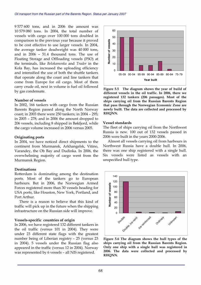
Oil transport from the Russian part of the Barents Region. Status per January 2007
68
9 577 600 tons, and in 2006 the amount was 10 579 080 tons. In 2004, the total number of vessels with cargo over 100 000 tons doubled in comparison to the previous year because it proved to be cost effective to use larger vessels. In 2004, the average tanker deadweight was 40 000 tons, and in 2006 – 51.4 thousand tons. The use of Floating Storage and Offloading vessels (FSO) at the terminals, like Belokamenka and Trader in the Kola Bay, has increased the uploading efficiency and intensified the use of both the shuttle tankers that operate along the coast and line tankers that come from Europe for oil cargo. Most of them carry crude oil, next in volume is fuel oil followed by gas condensate. Number of vessels In 2002, 166 tankers with cargo from the Russian Barents Region passed along the North Norway coast; in 2003 there were 250 tankers; in 2004 – 295; in 2005 – 278; and in 2006 the amount dropped to 206 vessels, including 8 shipped in Bøkfjord, while the cargo volume increased in 2006 versus 2005.
Originating ports In 2004, we have noticed direct shipments to the continent from Murmansk, Arkhangelsk, Vitino, Varandey, the Ob Bay and Dudinka. In 2006, the overwhelming majority of cargo went from the Murmansk Region. Destinations Rotterdam is dominating among the destination ports. Most of the tankers go to European harbours. But in 2006, the Norwegian Armed Forces registered more than 30 vessels heading for USA ports, like Houston, New York, Portland, and Port Arthur.
There is a reason to believe that this kind of traffic will pick up in the future when the shipping infrastructure on the Russian side will improve. Vessels-specific countries of origin In 2006, we have registered 132 different tankers in the oil traffic (versus 101 in 2004). They were under 23 different state flags with the greatest number being of Liberian registry – 25 (versus 23 in 2004). 5 vessels under the Russian flag also appeared in the traffic (versus 12 in 2004). Norway was represented by 6 vessels – all NIS registered.
Vessel standards The fleet of ships carrying oil from the Northwest Russia is new. 100 out of 132 vessels passed in 2006 were built in the years 2000-2006.
Almost all vessels carrying oil from harbours in Northwest Russia have a double hull. In 2006, there was one ship registered with a single hull. Six vessels were listed as vessels with an unspecified hull type.
0
10
20
30
40
50
60
05-09 00-04 95-99 90-94 85-89 80-84 75-79
Year built
Nu
mb
er o
f ve
ssel
s
Figure 5.5 The diagram shows the year of build of different vessels in the oil traffic. In 2006, there we registered 132 tankers (206 passages). Most of the ships carrying oil from the Russian Barents Region that pass through the Norwegian Economic Zone are newly built. The data are collected and processed by RHQNN.
0
20
40
60
80
100
120
140
Double
Double
, ice-
reinf
.
Ice-re
infor
ced
Ordina
ry
Unkno
wn
Nu
mb
er o
f ve
ssel
s
Figure 5.6 The diagram shows the hull types of the ships carrying oil from the Russian Barents Region. Only one ship with a single hull was registered in 2006. The data were collected and processed by RHQNN.

Oil transport from the Russian part of the Barents Region. Status per January 2007
69
Summary and conclusions Oil traffic from Northwest Russia is on the serious rise, especially in the amount of transported oil. There is a growing number of countries that get oil from Northwest Russia and a growing number of countries that send their ships to transport oil from there. That shows that oil shipping from this area is getting a more important international status. The weak link today is the infrastructure that hinders the oil flow to the export harbours. When this problem is solved, it will be more cost effective to use even larger size tankers than it is for now and the long expected traffic to USA will become reality.
The vessels used in the traffic are mostly new and generally advanced in shipping technology. Various sea accidents in the last few years have resulted in revision of international requirements for sea vessel standards and these regulations seem to have been implemented by major actors in oil transportation from Northwest Russia. 5.2.2 VARDØ VESSEL TRAFFIC CENTRE Vardø Vessel Traffic Centre (VTC), the Norwegian Coastal Administration’s new vessel traffic service for Northern Norway, is in operation from January 2007.
Vardø VTC monitors and coordinates oil tankers and other vessels carrying dangerous or polluting goods in the area extending from Rørvik in the south to the border between the Norwegian and Russian Economic Zones in the north. The VTC provides, on behalf of the Norwegian authorities, vessel traffic services conforming to national and international regulations.
Vardø VTC was established on commission from the Ministry of Fisheries and Coastal Affairs to improve safety at sea and protection of the marine environment from acute pollution. The budget limit for the project was 134 million Norwegian crowns and annual operating costs are close to 20 million Norwegian crowns. Vardø VTC has a permanent staff of 9 people. The Norwegian Coastal Administration is the national agency for coastal management, maritime traffic safety and preparedness against acute pollution.
The establishment of Vardø VTC has strengthened the ability of the Norwegian Coastal Administration to exercise its responsibility within
traffic monitoring and coordination. Vardø VTC is also coordinating the emergency towing vessels in Northern Norway in close cooperation with the Regional Headquarters North Norway. Vardø VTC shall alert key emergency personnel and emergency towing vessels in critical situations. Vardø VTC is part of the Norwegian emergency response capability in cooperation with the Coastal Administration’s Department of Emergency Response and the Joint Rescue Coordination Centre North Norway.
Figure 5.7 Areas of responsibility of the Emergency Towing Vessels. The emergency towing service consists of three Emergency Towing Vessels (ETVs) from October to April, and two ETVs during summer. The ETVs are positioned in the area from Røst, Lofoten to the Russian border. Two of the ETVs are under the command of military authorities, but are operated by Vardø VTC in close co-operation. One ETV is on hire by the Norwegian Coastal Administration.
© Norwegian Coastal Administration
Figure 5.8 Vardø Vessel Traffic Centre is located together with Vardø Radio on the mountain behind the town.
© Gjøran Einvik, Norwegian Coastal Administration

Oil transport from the Russian part of the Barents Region. Status per January 2007
70
The system for monitoring, communications and crisis management used by Vardø VTC is based on novel technology. Automatic Identification System (AIS) is the main sensor for traffic monitoring providing dynamic, static and voyage related information as transmitted by vessels.
Another important sensor for traffic monitoring is the Norwegian Defence Coastal Radar Network. Static and voyage related information relies on the Coastal Administration’s ship reporting system, SafeSeaNet. In combination these novel technological systems provide Vardø VTC with an early warning capability enabling preventive measures to be taken in order to avoid critical situations.
Procedures for communication and reporting between ships and Vardø VTC have been established to contribute to the safety of life at sea, safety of navigation and protection of the marine environment. The Norwegian Coastal Administration requests all tankers, all vessels larger than 5000 gross tonnage and ocean towages to report to Vardø VTC upon entering the area within the Norwegian Economic Zone (NEZ) from Rørvik (65ºN) to the Norwegian/Russian Economic Zones border.
Vardø VTC provides detailed information on navigation routes, fishery activity, emergency towing vessels and traffic, and weather conditions to vessels within its area of responsibility. Communication with shipping is based on VHF, e-mail and telephony. Vardø VTC is co-located with Vardø coast radio station and close cooperation has been established.
5.2.3 NEW ROUTING FOR TANKERS IN NORWAY Norway has developed a new mandatory traffic separation scheme. The loaded tankers from the North of Russia will from July 2007 follow the new route between Vardø and Røst that mainly lies within 30 nautical miles outside the Norwegian coast. International Maritime Organisation (IMO) rarely accepts routes for such connected areas as Vardø-Røst. The Norwegian Ministry of Fisheries and Coastal Affairs' dialog with delegations of other countries prior to the approval, especially with Russia, has been very important for getting support for the proposal.
The United Nations (UN) maritime organisation, IMO gave the green light to the new regulations in December 2006, but it will take six months to spread information along all the official channels as required by the UN.
The goal is that the super-tankers, which can be particularly dangerous for environment, will keep far away from the coastline so Norway will have enough time to get the towing gear on board and stop them when the technical failure occurs. The regulation is applicable to all ships over 5 000 tons deadweight. The new regulation for the stretch of Vardø-Røst implies that vessels shall follow the separation routes, almost as exactly as cars follow the motorway, both northward and southward.
The Norwegian Coastal Administration says that before 2010 Norway will have a rule that would require that all utility traffic along the coast not only should sail in the international waters minimum 30 nautical miles from the shore, but will also be continuously monitored.
Figure 5.9 Arne Bratland, the first manager of Vardø Vessel Traffic Centre.
Figure 5.10 The new mandatory traffic separation scheme for loaded tankers.
© Norwegian Coastal Administration
© Gjøran Einvik Norwegian Coastal Administration
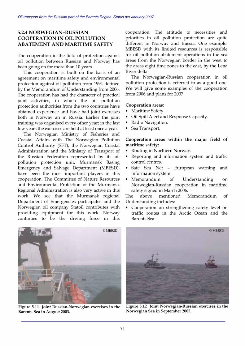
Oil transport from the Russian part of the Barents Region. Status per January 2007
71
5.2.4 NORWEGIAN–RUSSIAN COOPERATION IN OIL POLLUTION ABATEMENT AND MARITIME SAFETY The cooperation in the field of protection against oil pollution between Russian and Norway has been going on for more than 10 years.
This cooperation is built on the basis of an agreement on maritime safety and environmental protection against oil pollution from 1994 defined by the Memorandum of Understanding from 2006. The cooperation has had the character of practical joint activities, in which the oil pollution protection authorities from the two countries have obtained experience and have had joint exercises both in Norway an in Russia. Earlier the joint training was organised every other year; in the last few years the exercises are held at least once a year.
The Norwegian Ministry of Fisheries and Coastal Affairs with The Norwegian Pollution Control Authority (SFT), the Norwegian Coastal Administration and the Ministry of Transport of the Russian Federation represented by its oil pollution protection unit, Murmansk Basing Emergency and Salvage Department (MBESD), have been the most important players in this cooperation. The Committee of Nature Resources and Environmental Protection of the Murmansk Regional Administration is also very active in this work. We see that the Murmansk regional Department of Emergencies participates and the Norwegian oil company Statoil contributes with providing equipment for this work. Norway continues to be the driving force in this
cooperation. The attitude to necessities and priorities in oil pollution protection are quite different in Norway and Russia. One example: MBESD with its limited resources is responsible for oil pollution abatement operations in the sea areas from the Norwegian border in the west to the areas eight time zones to the east, by the Lena River delta.
The Norwegian-Russian cooperation in oil pollution protection is referred to as a good one. We will give some examples of the cooperation from 2006 and plans for 2007.
Cooperation areas: • Maritime Safety. • Oil Spill Alert and Response Capacity. • Radio Navigation. • Sea Transport. Cooperation areas within the major field of maritime safety: • Routing in Northern Norway. • Reporting and information system and traffic
control centres. • Safe Sea Net – European warning and
information system. • Memorandum of Understanding on
Norwegian-Russian cooperation in maritime safety signed in March 2006.
The above mentioned Memorandum of Understanding includes: • Cooperation on strengthening safety level on
traffic routes in the Arctic Ocean and the Barents Sea.
Figure 5.11 Joint Russian-Norwegian exercises in the Barents Sea in August 2003.
Figure 5.12 Joint Norwegian-Russian exercises in the Norwegian Sea in September 2005.
© MBESD © MBESD

Oil transport from the Russian part of the Barents Region. Status per January 2007
72
• Modernisation of the existing and establishment of new vessel routing systems
• Establishment of Barents VTMIS – Joint Vessel Traffic Management and Information Services
• Integration of AIS systems and development of AIS exchange between Vardø Vessel Traffic Centre and Murmansk Vessel Traffic Centre.
Cooperation in 2006 among other things included three seminars with reference to oil spill preparedness, loading of oil, oil pollution preparedness and waste handling in harbours. A few meetings in accordance with the Norwegian-Russian agreement were accomplished and a joint Norwegian-Russian rescue and oil spill response exercises were held in the Norwegian-Russian border areas by NCA and MBESD. The cooperating sides suggested creating a laboratory in Murmansk to improve knowledge database on Russian crude oils.
The plans for 2007 are based on the follow-up of the established cooperation in the framework of Norwegian-Russian agreement on environmental protection against oil pollution. In addition, the sides will make efforts to accomplish activities aimed at improvement of the prioritised issue of oil spill preparedness in ice conditions. Vardø Vessel Traffic Centre was opened in January 2007. Emergency Prevention, Preparedness, and Response secretariat of the Arctic Council will be opened after the next meeting in Longyearbyen, Svalbard, which will provide training on oil pollution abatement related to activities in the shore areas and at sea. Annual joint exercises of rescue and oil pollution response will be carried out in the Barents Sea.
5.3 ACCIDENTAL OIL POLLUTION In the previous report, we described several incidents that occurred during the oil transportation in Norway and Russia in 2003 and 2004. We aimed to highlight the possible environmental effects of such transports. Seen in a European perspective, the volumes of oil transported along the Russian and Norwegian Arctic coast are not significant yet. Nevertheless, in the near-term perspective, this situation is likely to change considerably. Statistically, accidents rarely occur during the transportation of oil. However, since the total volume of oil transported by sea worldwide is formidable, accidents still occur all over the world. And when they do happen, the effects are often wide-ranging, both to the environment and to the human beings that are dependent on the areas impacted. The transportation of oil in the Arctic waters may present challenges that are greater and of a different nature than in warmer climates. This is due partly to the fact that the sea areas are covered by ice during part of the year, which is a challenge to the recovery of oil spills, and partly because the slow dissolving oil in cold temperatures is an additional threat to the environment.
In the report published in 2005, we gave a special attention to an oil spill caused by a collision between two tankers in the Onega Bay in the White Sea in September 2003. We also focused in more detail on two ship accidents, namely the Cristoforo Colombo accident at Sakhalin in Russian Far East in September 2004, and the Rocknes disaster in the vicinity of Bergen which happened in January 2004 – one of the most costly environmental operations in the shipping industry in Norway. The experience Russian and Norwegian environmental authorities and the institutes gained after the accidents in the Onega Bay and Bergen stimulated bilateral cooperation for developing the joint methods for environmental risk analyses, impact and damage assessments, and monitoring during oil shipment in the Barents Region.
In the present report we give a detail description of the recent Server incident, which happened near Bergen, and write about the following clean-up operation.
Figure 5.13 Joint Planning Group meeting at MBESD office in Murmansk, September 2006.
© Norwegian Coastal Administration
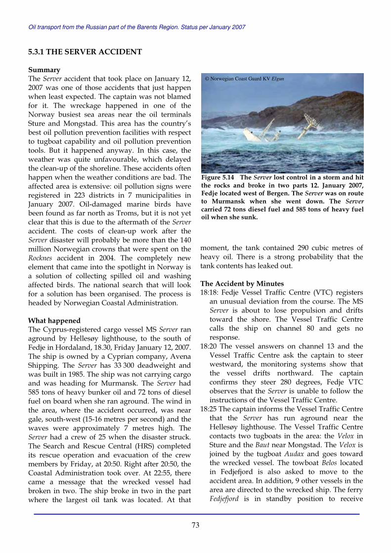
Oil transport from the Russian part of the Barents Region. Status per January 2007
73
5.3.1 THE SERVER ACCIDENT Summary The Server accident that took place on January 12, 2007 was one of those accidents that just happen when least expected. The captain was not blamed for it. The wreckage happened in one of the Norway busiest sea areas near the oil terminals Sture and Mongstad. This area has the country’s best oil pollution prevention facilities with respect to tugboat capability and oil pollution prevention tools. But it happened anyway. In this case, the weather was quite unfavourable, which delayed the clean-up of the shoreline. These accidents often happen when the weather conditions are bad. The affected area is extensive: oil pollution signs were registered in 223 districts in 7 municipalities in January 2007. Oil-damaged marine birds have been found as far north as Troms, but it is not yet clear that this is due to the aftermath of the Server accident. The costs of clean-up work after the Server disaster will probably be more than the 140 million Norwegian crowns that were spent on the Rocknes accident in 2004. The completely new element that came into the spotlight in Norway is a solution of collecting spilled oil and washing affected birds. The national search that will look for a solution has been organised. The process is headed by Norwegian Coastal Administration. What happened The Cyprus-registered cargo vessel MS Server ran aground by Hellesøy lighthouse, to the south of Fedje in Hordaland, 18.30, Friday January 12, 2007. The ship is owned by a Cyprian company, Avena Shipping. The Server has 33 300 deadweight and was built in 1985. The ship was not carrying cargo and was heading for Murmansk. The Server had 585 tons of heavy bunker oil and 72 tons of diesel fuel on board when she ran aground. The wind in the area, where the accident occurred, was near gale, south-west (15-16 metres per second) and the waves were approximately 7 metres high. The Server had a crew of 25 when the disaster struck. The Search and Rescue Central (HRS) completed its rescue operation and evacuation of the crew members by Friday, at 20:50. Right after 20:50, the Coastal Administration took over. At 22:55, there came a message that the wrecked vessel had broken in two. The ship broke in two in the part where the largest oil tank was located. At that
moment, the tank contained 290 cubic metres of heavy oil. There is a strong probability that the tank contents has leaked out. The Accident by Minutes 18:18: Fedje Vessel Traffic Centre (VTC) registers
an unusual deviation from the course. The MS Server is about to lose propulsion and drifts toward the shore. The Vessel Traffic Centre calls the ship on channel 80 and gets no response.
18:20 The vessel answers on channel 13 and the Vessel Traffic Centre ask the captain to steer westward, the monitoring systems show that the vessel drifts northward. The captain confirms they steer 280 degrees, Fedje VTC observes that the Server is unable to follow the instructions of the Vessel Traffic Centre.
18:25 The captain informs the Vessel Traffic Centre that the Server has run aground near the Hellesøy lighthouse. The Vessel Traffic Centre contacts two tugboats in the area: the Velox in Sture and the Baut near Mongstad. The Velox is joined by the tugboat Audax and goes toward the wrecked vessel. The towboat Belos located in Fedjefjord is also asked to move to the accident area. In addition, 9 other vessels in the area are directed to the wrecked ship. The ferry Fedjefjord is in standby position to receive
Figure 5.14 The Server lost control in a storm and hit the rocks and broke in two parts 12. January 2007, Fedje located west of Bergen. The Server was on route to Murmansk when she went down. The Server carried 72 tons diesel fuel and 585 tons of heavy fuel oil when she sunk.
© Norwegian Coast Guard KV Elgun

Oil transport from the Russian part of the Barents Region. Status per January 2007
74
injured crew members if any. The Vessel Traffic Centre directly alerts the parties in accordance with its action plan: Joint Rescue Coordination Centre Emergency Response department at Norwegian Coastal Administration Pilot Master in West Coastal Administration Rogaland radio
From this point the Vessel Traffic Centre is in continuous contact with The Search and Rescue Administration.
18:40 the TB Velox informs that she is underway from Sture.
18:41 the TB Audax informs that she is leaving Sture.
18:52 the TB Belos arrives at the scene of the wreck. 19:00 Fedje Vessel Traffic Centre sends a warning
to Fedje Municipality about the situation and asks to be ready with the emergency room to receive the rescued crew, to arrange transport from the landing area to the emergency room etc. in case the crew will be brought to Fedje.
19:20 the TB Audax and the TB Velox arrive at the scene of the wreck.
19:30 The first helicopter, the Air Ambulance, arrives at the scene of the wreck.
19:42 The MV Edda Fonn approaches the wrecked Server.
19:48 The Sea King rescue helicopter is on location and begins immediate evacuation. The Pilot Master helicopter arrives.
19:55 The Vessel Traffic Centre sends a warning to the ships and agents that due to the strong wind the waters on approach to Sture and Mongstad are closed for all inbound vessels requiring pilot service. The wind exceeds 23 metres per second.
20:30 The Sea King helicopter lands on Fedje with 19 crew members.
20:40 The Vessel Traffic Centre gets a message from the Pilot Master that the ship should not be towed before they get a go from the Emergency Response Department . The TB Belos, which has hooked the wrecked vessel with a hawser, is informed.
20:55 The helicopter Helibus 611 lands on Fedje with 6 other crew members. The whole team is evacuated.
20:55 Mayday cancelled.
Clean-up Operation During Saturday, January 13, oil was found on the shore south-west of Fedje. Oil flecks were also registered in the north-east of Fedje. Later the Coastal Administration confirmed the findings of oil spillage in the nature protected area of Herdla. The Coastal Administration established that all the oil had run out of one of the Server tanks, the one that had 290 tons of bunker oil. The KV Eigun and the KV Tromsø installed booms and the oil spill by Fedje was contained.
Ship diesel easily disperses in water mass. It has a shorter life on water surface than heavier oil but has higher toxicity that originates from its lighter fractions. Heavy bunker oil has a longer life on the surface, about three days; these are the conditions in Fedje now.
Coast guard vessels the KV Eigun and the KV Tromsø have collected 130 tons oil emulsion. In addition, a great amount of oil naturally degraded. Weather and forecasts The weather conditions were difficult with a strong wind and high waves. The forecasts predicted that the night’s storm should calm down by the middle of the day on Monday but it only became stronger past the evening. The forecasts for Tuesday and Wednesday did not promise any improvement; just slightly weaker wind and lower waves. Action The vessels involved in the operation: • Coast guard vessels (all equipped with oil spill
response gear): the KV Tromsø, the KV Ålesund, the KV Lafjord, and the KV Eigun.
• Oil spill response vessels: the Oljevern 01, the MS Trænen.
• Ferries (intermediate storage): MF Osterøy, MF Flekkerøy.
• External (private) vessels: the Mob.båt 23, (the Rune Trovåg), the MS Nargtind and the Suletrål (the salvage tugboat for the Eigun).
• Private tugs: salvage boats. The operation itself and further actions were complicated due to the harsh weather conditions and high waves at Fedje. In the beginning, the beach cleaning could not even start under the current conditions considering the lack of personnel safety. The Coastal Administration mobilised resources from Hydro, equipment and

Oil transport from the Russian part of the Barents Region. Status per January 2007
75
personnel from Statoil and the depot forces from Stavanger and Sandnessjøen. At Askøy, especially in the nature protected area of Herdla, the clean-up started nevertheless. The KV Ålesund observed approximately 10 individual oil-coated eider ducks.
Both private and public equipment was mobilised, and the Norwegian Coastal Administration Action Command was working in close cooperation with Oil Spill Prevention and Response units at Sture and Mongstad terminals. The Coastal Administration observation aircraft continued mapping of the oil spill area.
On Saturday the stern of the wrecked vessel was towed off and set to rest at 6 metres depth by the CCB-Base at Ågotnes, outside Bergen. The wreckage was surrounded by booms and the work on making the vessel more secure continued. On Monday the plan was to send down a diver team to inspect the condition the tanker was in.
After the recovery of almost 40 tons of oil masses from land during January 18, the total amount of oil collected after the Server accident was almost 230 tons.
On Saturday night, it was reported that out of the total 230 tons of recovered oil 143 tons were collected from the sea, while more than 80 tons of were recovered from the areas along the coast. But the complete clean-up is planned to be finished by summer.
On January 30, 110 persons, 26 vessels, Norwegian Coastal Administration systems and aircrafts were involved in the beach cleaning action, most of them in the areas of Austrheim,
Øygarden and Fedje. Approximately 300 cubic metres of oil sludge were collected from the shore, 95 tons of dispersed oil was pumped out from the wrecked ship at Ågotnes and 97 tons of oil emulsion was recovered from the sea. The stern was examined by a ROV on January 23. The action plan consisted of stages: Stage 1 – mapping of the damaged area of the ship and investigating the possibility of removing the remaining oil fuel. Stage 2 included the removal of the stern and the plan for finalising the salvage operation. Approximately 1400 articles appeared in the media. The air monitoring of other damaged areas continues, and so far 70 locations have been identified as affected by the accident. The duration of the clean-up operation is estimated. The program for documenting environmental damage inventory is initiated.
In January, 220 oil-affected beach sites were registered after the Server accident. 118 persons are involved in the clean-up activities along the coast, the work that was made the highest priority on the grounds of safety, environment and integrity of the traditional breeding areas for birds.
There are a few limiting factors for clean-up and they hinder the progress. The operation can only continue during low tide. At high tide the clean-up is impossible. Besides, the cleaning cannot be done after dark, and for the sake of personnel safety, weather, wind and sea conditions must be taken into consideration.
Figure 5.16 WWF Norway volunteers are cleaning a small bay polluted by oil from Server. By January 18, 230 tons of oil was collected from the sea and cleaned off the coast.
Figure 5. 15 The front part of Server before offloading.
© Nina Jensen, WWF
© Nina Jensen, WWF
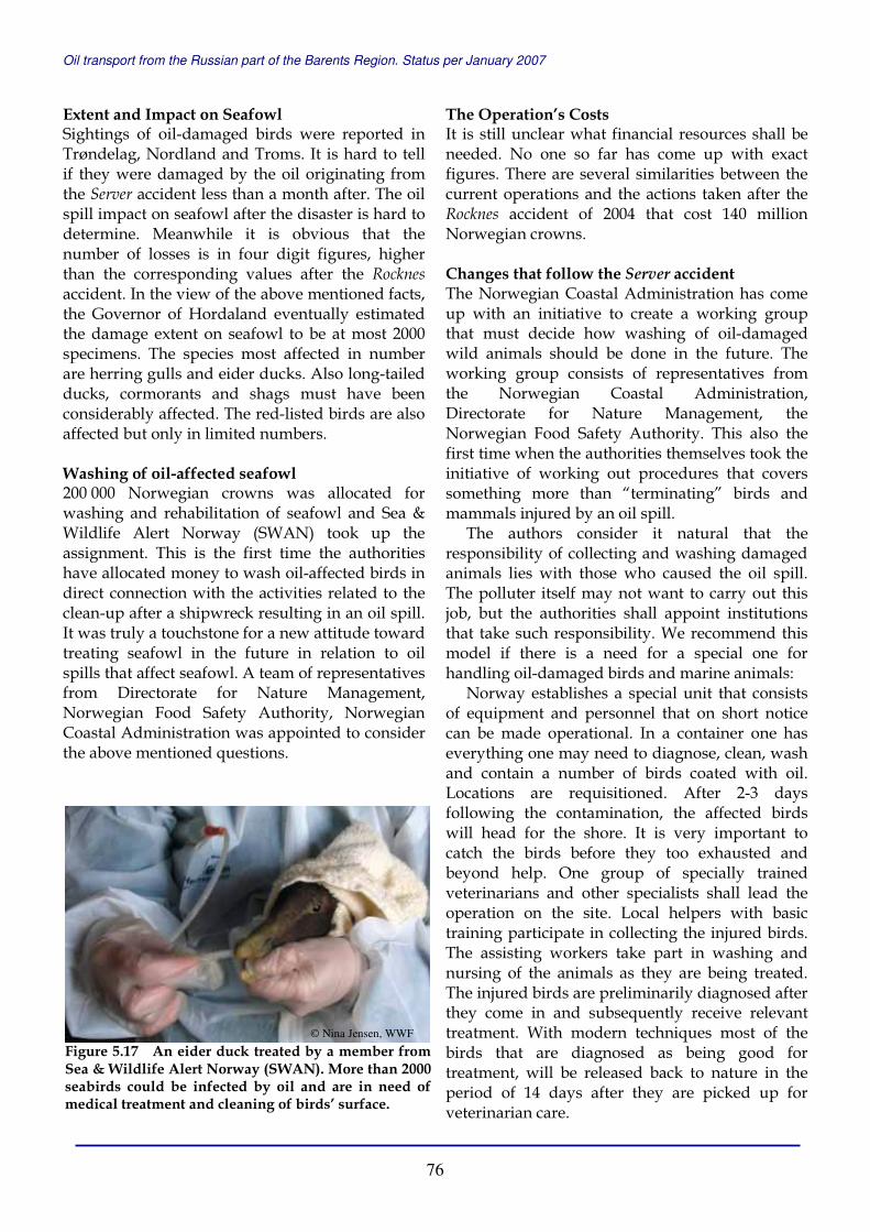
Oil transport from the Russian part of the Barents Region. Status per January 2007
76
Extent and Impact on Seafowl Sightings of oil-damaged birds were reported in Trøndelag, Nordland and Troms. It is hard to tell if they were damaged by the oil originating from the Server accident less than a month after. The oil spill impact on seafowl after the disaster is hard to determine. Meanwhile it is obvious that the number of losses is in four digit figures, higher than the corresponding values after the Rocknes accident. In the view of the above mentioned facts, the Governor of Hordaland eventually estimated the damage extent on seafowl to be at most 2000 specimens. The species most affected in number are herring gulls and eider ducks. Also long-tailed ducks, cormorants and shags must have been considerably affected. The red-listed birds are also affected but only in limited numbers. Washing of oil-affected seafowl 200 000 Norwegian crowns was allocated for washing and rehabilitation of seafowl and Sea & Wildlife Alert Norway (SWAN) took up the assignment. This is the first time the authorities have allocated money to wash oil-affected birds in direct connection with the activities related to the clean-up after a shipwreck resulting in an oil spill. It was truly a touchstone for a new attitude toward treating seafowl in the future in relation to oil spills that affect seafowl. A team of representatives from Directorate for Nature Management, Norwegian Food Safety Authority, Norwegian Coastal Administration was appointed to consider the above mentioned questions.
The Operation’s Costs It is still unclear what financial resources shall be needed. No one so far has come up with exact figures. There are several similarities between the current operations and the actions taken after the Rocknes accident of 2004 that cost 140 million Norwegian crowns. Changes that follow the Server accident The Norwegian Coastal Administration has come up with an initiative to create a working group that must decide how washing of oil-damaged wild animals should be done in the future. The working group consists of representatives from the Norwegian Coastal Administration, Directorate for Nature Management, the Norwegian Food Safety Authority. This also the first time when the authorities themselves took the initiative of working out procedures that covers something more than “terminating” birds and mammals injured by an oil spill.
The authors consider it natural that the responsibility of collecting and washing damaged animals lies with those who caused the oil spill. The polluter itself may not want to carry out this job, but the authorities shall appoint institutions that take such responsibility. We recommend this model if there is a need for a special one for handling oil-damaged birds and marine animals:
Norway establishes a special unit that consists of equipment and personnel that on short notice can be made operational. In a container one has everything one may need to diagnose, clean, wash and contain a number of birds coated with oil. Locations are requisitioned. After 2-3 days following the contamination, the affected birds will head for the shore. It is very important to catch the birds before they too exhausted and beyond help. One group of specially trained veterinarians and other specialists shall lead the operation on the site. Local helpers with basic training participate in collecting the injured birds. The assisting workers take part in washing and nursing of the animals as they are being treated. The injured birds are preliminarily diagnosed after they come in and subsequently receive relevant treatment. With modern techniques most of the birds that are diagnosed as being good for treatment, will be released back to nature in the period of 14 days after they are picked up for veterinarian care.
Figure 5.17 An eider duck treated by a member from Sea & Wildlife Alert Norway (SWAN). More than 2000 seabirds could be infected by oil and are in need of medical treatment and cleaning of birds’ surface.
© Nina Jensen, WWF
Oil transport from the Russian part of the Barents Region. Status per January 2007
77
5.3.2 OIL POLLUTION AND RESPONSE IN THE RUSSIAN BARENTS REGION Oil spills occur all the time and everywhere – in Russia, in Norway, and in the rest of the world. Below, we have selected clippings directly from Russian and international newspapers and news portals related to oil spills and response system in the Russian Barents Region. Our intention has been not to list every oil spill, but to focus on the fact that oil spills happen during the transportation, and to motivate the industry to prevent the oil spills and reduce oil pollution as far as possible. January 2006. The Kola Bay, Murmansk Region There are 260 abandoned ships in and around the Kola Bay, the Regnum news agency reports. The vessels, many of which are located under water, pose a major threat to environment. A total of 300 tons of unloaded fuel is believed to still be onboard the ships. 70 percent of the vessels belong to the Northern Navy. The regional authorities in Murmansk have not allocated sufficient funding for the cleaning up of the bay. In 2006 budget, only 20 million roubles (650 000 Euro) are reserved for environmental projects. Scrap metal from the abandoned ships is believed to cover only about 30 percent of expenses needed to raise the vessels. February 15, 2006. Komi Republic Minister of Natural Resources of the Komi Republic, Aleksandr Borovinskikh, says the number of registered oil spills in the Komi Republic last year increased threefold. The minister says to Komiinform.ru that a total of 30 spills were registered in the Republic compared to 11 in 2004, he expresses special concern about the fact that oil companies more often conceal spills.
A number of the registered 2005 spills came as a result of accidents with tanker trucks which subsequently polluted areas along roads. Minister says the gradual cut in powers of the regional authorities in Russia is a part of the problem. He believes it has become easier for oil companies to conceal spills after regional authorities were deprived powers within nature protection control. February 28, 2006. Pechora, Komi Republic Another oil spill in Pechora – a 19 cubic meter gasoline truck last Sunday collided on the Irael-
Izhma road in the Pechora region, Komi Republic. A total of 9 cubic meter of oil spilled into the surrounding land area. According to regional authorities, accidents with gasoline trucks account for a significant number of oil spills in Komi, BarentsObserver writes referring to Severinform. March 9, 2006. Arkhangelsk Region Companies in Arkhangelsk Region are not prepared for oil spills. Only 3 of 16 companies engaged in petroleum-related activities in Arkhangelsk Region have elaborated oil spill contingency plans, DvinaInform reports. In the 94 enterprises inspected this year, 300 violations were detected. “It is illegal for the companies not to have oil spill liquidation equipment”, says Sergey Yastrebtsev from the port Administration. “But how can we deal with disobeying company leaders, when fines for violations are between 1500-2000 roubles”, he adds.
In a meeting in the Marine Council under the Arkhangelsk Governor's office, it was decided to establish a new survey with information about all companies engaged in petroleum-related activities. The survey will show the companies' location, potential threats and their preparedness capacities. Sergey Yastrebtsev stresses that there at present is no regional emergency division on oil spills, nor is there a joint plan on early warning. Head of the Arkhangelsk Regional Committee on Environment, Tatyana Dolgoschelova, says present experiences show that owners of tankers are not interested in safe conditions for oil shipping, despite several major spills. In 2003, oil from a river tanker of Volgatanker Company spilled oil into the Onega Bay during unloading. April 18, 2006. Murmansk city Official arrested over plot to blow up oil tanker. Russian authorities have arrested a local official accused of plotting to blow up an oil tanker, it emerged yesterday. The official, whose name was withheld, was arrested on Thursday on terrorism charges, the Murmansk branch of the intelligence services said in a statement, according to the RIA Novosti and ITAR-TASS news agencies. The statement said the official, who was a deputy chief administrator in an unspecified town in the Murmansk region, was accused of preparing to blow up an oil tanker in Kola Bay in order to cause an environmental catastrophe.

Oil transport from the Russian part of the Barents Region. Status per January 2007
78
April 19, 2006. Arkhangelsk Region Arkhangelsk companies not ready for oil spills. Most Arkhangelsk companies responsible for liquidation of oil spills have no respective subdivisions. Since late 2004, the order of the Russian Emergencies Ministry has been fulfilled only by the Northern Sea Shipping Company, the Bunker Company, and the Arkhangelsk Commercial Seaport. Other companies, among them Krasnaya Kuznitsa, Northern River Shipping Company, Arktikreyd, and Rosneft-Arkhangelsk-nefteprodukt, do not observe oil spill preparedness regulations. The Arkhangelsk Regional Administration in May 2003 presented a list of 27 companies, which are committed to develop oil spill preparedness mechanism. Only three of these, however, have elaborated mechanisms, BarentsObserver writes. August 8, 2006. Northern Dvina River, Arkhangelsk Region Fuel oil ran into Northern Dvina. 150 litres of fuel oil last week ran into the Northern Dvina River, Regnum reports. The spill is believed to have come from the Layskiy Shipyard. Specialists from the federal Agency of Environmental Control (Rosprirodnadzor), police representatives, as well as representatives from the regional administration, have been at the site to assess the situation. According to Regnum, the regional Emergency Situations Department has already tracked the development of the spill. Regional prosecutors have charged the management of the shipyard for the environmental violations. The maximum fines for oil pollution amount to 40 000 roubles. October 10, 2006. Laya River, Arkhangelsk Region An oil spill from the Layskiy Shipyard in Arkhangelsk Oblast has polluted the Laya River. A 50 meter wide and 750 meter long oil slick now stretches along the river shore. The spill comes from a ship docked in the Layskiy shipyard. Oil booms have been placed on the Laya River to prevent oil ingress to the Northern Dvina River and the White Sea, DvinaInform reports. Specialists of the Arkhangelsk emergency service unit have already collected about 800 litres of oil wastes.
October 12, 2006. Kola Bay, Murmansk Region A fuel oil line break happened in the Murmansk Region, about 200 square metres of the Kola Bay coastline was polluted, reported the North-West Regional Centre of the Ministry of Emergency Situations. The pipeline blowout with 300 mm in diameter occurred October 12 in the neighborhood of Chan-Ruchei settlement of the Kola Region in the Murmansk Region at a 500-600 m distance from the bay offshore area. 24 persons of a military unit and one clean sweep truck are taking part in mitigating consequences. Oil products have not got into a water intake, thus there is no danger for the local population. Coast cleaning is going on, as was said at the Ministry of Emergency Situations regional centre. October 16, 2006. Rosprirodnadzor will check oil companies Russia's environmental authority Rosprirodnadzor plans to carry out checks to make sure license agreements are being followed by all oil companies working in Russia, Interfax reports. "We are warning other companies: if you reached an agreement with officials and went far away from Moscow, you are taking a great risk. We will do everything to make sure deals with officials do not replace legislation," the Rosprirodnadzor’s deputy chief, Oleg Mitvol, said at a press conference in Moscow. Checks similar to that performed on Lukoil "await other companies. If a company undertakes obligations it must fulfil them," he said. The checks "will reveal that a considerable amount of license agreements are at a zero phase of development," Mitvol said. If this is the case, the company must return the license to the government, he added. "A business has developed where a company received a license and then holds and IPO and receives money for subsoil resources without developing them. These resources are left to await an institutional investor," he said. Rosprirodnadzor will receive money from the Natural Resources Ministry for the checks. "Rosprirodnadzor asked the Natural Resources Ministry for additional funds. The ministry allocated 11.5 million roubles," Mitvol said. Renting a plane for checks in Sakhalin cost $150 000, for Komi checks - $50 000, he said. Rosprirodnadzor has withdrawn a total of 87 licenses, he said. "I consider that a small amount. It should be hundreds," he added.

Oil transport from the Russian part of the Barents Region. Status per January 2007
79
November 7, 2006. Russian pipelines The government's technical standards authority, Rostekhnadzor warned on Thursday that almost all the country's oil and gas pipelines were in critical condition, a possible sign of more shutdowns after the closure of a link to Lithuania, The St-Petersburg Times reports. "Russia's pipeline transport is in an unsatisfactory state. Environmental damage caused by oil and gas pipelines is inexcusable," said Konstantin Pulikovsky, the head of Rostekhnadzor – the Federal Service for Ecological, Technological and Atomic Inspection. November 7, 2006. No oil spill prevention in the Arkhagelsk Region There are neither specialists nor money to localize and eliminate oil spills in the Arkhangelsk Region, including the port of Arkhangelsk. This was said by the Head of Management Department of the Federal Service for Supervision of Natural Resource in the Arkhangelsk Region (Rosprirodnzdzor) Alexander Popov at the meeting of the coordinating board on environmental issues, Regnum reports. According to his words, there is no coordination between federal and local authorities on discovering oil spills, their localization and elimination. Similar problems have already been solved by passing the “Technical Regulations of Oil Shipment in Bulk Including Bunker Fuel” at the local level.
The Federal Service for Supervision of Natural Resources in the Arkhangelsk Region suggests using the experience of St. Petersburg where the Inter-Departmental Commission on Coordination of Oil Products Movement was established at the St. Petersburg Administration to solve problems. Representatives of the Environmental Committee of the Arkhangelsk Region Administration think that it is necessary for all municipal units of the region, especially for port cities, to have their own emergency rescue teams with necessary equipment or to sign a contract with other organisations. November 12, 2006. The Kola Bay, Murmansk Region About 120 ship wrecks are covering the seabed of the Kola Bay, the Nasha Versia newspaper writes. The abandoned ships pollute the water and makes navigation dangerous, the weekly reports. Federal
authorities have not allocated necessary funding for the cleanup of the bay, although this is their responsibility. Regional Murmansk authorities do not have sufficient money for cleanup operations, which have an estimated cost of about 1 billion roubles. December 19, 2006. Neftepechorsk, Ukhta, Komi Republic A spill from an oil pipeline in the Ukhta area, Komi Republic has polluted the Pechora River, environmentalists say, BarentsObserver reports referring to BusinessKomi.
The spill is reported to have taken place December 19; however operator Lukoil only reported about the incident several days later. Lukoil claims that the oil did not end up in the Pechora River.
The incident became known only after locals reported to local authorities. Two representatives of the Committee Save Pechora subsequently addressed local Lukoil representatives for more information about the spill, without getting a response from the company. The Committee Save Pechora also applied for permission to conduct tests in the affected area, without success. The area was sealed by Lukoil. Still, representatives of Committee Save Pechora managed to make it by foot to the site of the spill. They found a crew of clean-up specialists in the process of removing spilled oil.
According to the organisation, Lukoil liquidated the waste oil on the Pechora river ice. Between 20-50 metres of the Pechora river ice was used for the oil liquidation, and black smoke covered the area for more than 24 hours.
The spill is reported to have happed in the vicinity of the town of Neftepechorsk. The amount of oil spilled remains unknown. However, Committee Save Pechora claims that the amount was “extraordinary”.
A commission with representatives of regional control authorities later came to the site and confirmed the burning of spilled oil. Commission members also found that 20-25 cm of the ground layers were polluted by oil. Further investigations will be made, the official commission confirms. The affected Pashnya oil pipeline is 90 kilometres long.
Oil transport from the Russian part of the Barents Region. Status per January 2007
80
6 Conclusions he purpose of this report has been to present an overview of the level and extent of oil transportation within the Russian part of the Barents Region and further along the Norwegian coast. We have also presented the visions about the northern oil shipment development perspective and environmental challenges connected with that. We hope that this information can contribute to more focus on oil transportation safety, and in this last chapter we give some recommendations in an 8-step, for us, logical order. 6.1 INTRODUCTION All oil transportation represents a risk of oil pollution. It is complicated to remove oil and oil products discharged to land and water environments. Practices from oil cleaning operations show that only 10-15% of the oil spilled is successfully removed in Arctic conditions. From our point of view, this should lead to a strategy where the goal is a considerable reduction of oil spill risks. A central element in this oil pollution protection is related to overall oil transportation safety.
In this report, we have presented information related to a complete oil transportation line from the production site in Russia and transportation along the Norwegian coast. Today, a relatively small amount of oil is extracted in the immediate areas of the Russian part of the Barents Region. Most of it is carried over long distances and the transportation route starts in areas far away from the Barents Sea. Before it reaches the final destination, oil is transported by various transportation systems: pipelines, railroads and tankers.
During the recent years, the oil transportation logistic system in Russia has been both improved and more controlled by the state monopolies.
Before we continue the discussion about oil transportation safety and oil pollution prevention, we would like to underline some elements that
influence the level of oil spill response preparedness standards: 1. Oil spills will happen – oil transportation will
lead to increased risk of accidents, but the level of risk can be assessed.
2. Oil spills are in most cases detected too late and most of the spilled oil will never be removed.
3. It is resource demanding and therefore expensive to clean up oil polluted areas.
4. It will be a political question how much oil pollution a society will tolerate – prevention expenses will be evaluated against the costs of cleaning up after the accident.
5. Improvement of regulations always takes place after accidents have already happened.
6.2 TARGET ISSUES IN RELATION TO OIL PROTECTION In the following presentation about oil transportation safety, we have structured our reflections and comments in some selected categories, which we recognise as central in oil spill protection.
We have divided oil spill protection in eight categories: • laws and regulations; • personnel; • equipment; • transport operators; • notification system; • traffic monitoring and control; • towage capacity; • oil spill response system. All these factors are essential in an oil protection system and often work simultaneously, regardless of the fact that they are partially dependent on each other. In this respect, it is important to emphasise that oil spill protection in a broad sense is both extensive and dynamic. It is extensive because it contains numerous elements both public and private in character. It is dynamic because conditions and the framework of it in each and every area are constantly changing.
T
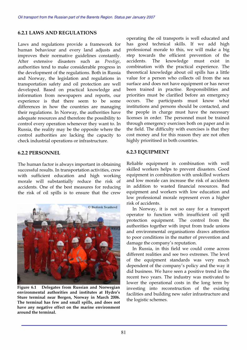
Oil transport from the Russian part of the Barents Region. Status per January 2007
81
6.2.1 LAWS AND REGULATIONS Laws and regulations provide a framework for human behaviour and every land adjusts and improves their normative guidelines constantly. After extensive disasters such as Prestige, authorities tend to make considerable progress in the development of the regulations. Both in Russia and Norway, the legislation and regulations in transportation safety and oil protection are well developed. Based on practical knowledge and information from newspapers and reports, our experience is that there seem to be some differences in how the countries are managing their regulations. In Norway, the authorities have adequate resources and therefore the possibility to control every operation whenever they want to. In Russia, the reality may be the opposite where the control authorities are lacking the capacity to check industrial operations or infrastructure. 6.2.2 PERSONNEL The human factor is always important in obtaining successful results. In transportation activities, crew with sufficient education and high working morale will substantially reduce the risk of accidents. One of the best measures for reducing the risk of oil spills is to ensure that the crew
operating the oil transports is well educated and has good technical skills. If we add high professional morale to this, we will make a big step towards the efficient prevention of the accidents. The knowledge must exist in combination with the practical experience. The theoretical knowledge about oil spills has a little value for a person who collects oil from the sea surface and does not have equipment or has never been trained in practise. Responsibilities and priorities must be clarified before an emergency occurs. The participants must know what institutions and persons should be contacted, and the people in charge must have the necessary licenses in order. The personnel must be trained through emergency exercises both on paper and in the field. The difficulty with exercises is that they cost money and for this reason they are not often highly prioritised in both countries. 6.2.3 EQUIPMENT Reliable equipment in combination with well skilled workers helps to prevent disasters. Good equipment in combination with unskilled workers and low morale can increase the risk of accidents in addition to wasted financial resources. Bad equipment and workers with low education and low professional morale represent even a higher risk of accidents.
In Norway, it is not so easy for a transport operator to function with insufficient oil spill protection equipment. The control from the authorities together with input from trade unions and environmental organisations draws attention to poor conditions in the matter of prevention and damage the company’s reputation.
In Russia, in this field we could come across different realities and see two extremes. The level of the equipment standards was very much dependent of the company’s policy and the way it did business. We have seen a positive trend in the recent two years. The industry was motivated to lower the operational costs in the long term by investing into reconstruction of the existing facilities and building new safer infrastructure and the logistic schemes.
Figure 6.1 Delegates from Russian and Norwegian environmental authorities and institutes at Hydro’s Sture terminal near Bergen, Norway in March 2006. The terminal has few and small spills, and does not have any negative effect on the marine environment around the terminal.
© Bioforsk Svanhovd
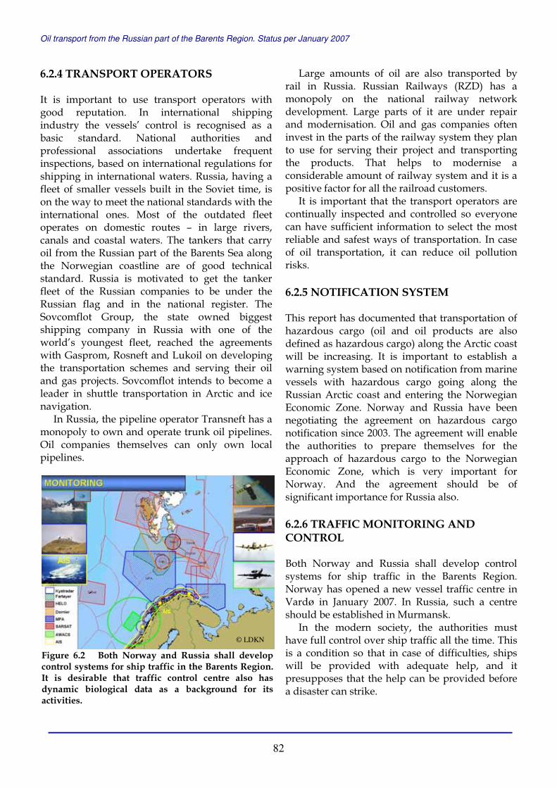
Oil transport from the Russian part of the Barents Region. Status per January 2007
82
6.2.4 TRANSPORT OPERATORS It is important to use transport operators with good reputation. In international shipping industry the vessels’ control is recognised as a basic standard. National authorities and professional associations undertake frequent inspections, based on international regulations for shipping in international waters. Russia, having a fleet of smaller vessels built in the Soviet time, is on the way to meet the national standards with the international ones. Most of the outdated fleet operates on domestic routes – in large rivers, canals and coastal waters. The tankers that carry oil from the Russian part of the Barents Sea along the Norwegian coastline are of good technical standard. Russia is motivated to get the tanker fleet of the Russian companies to be under the Russian flag and in the national register. The Sovcomflot Group, the state owned biggest shipping company in Russia with one of the world’s youngest fleet, reached the agreements with Gasprom, Rosneft and Lukoil on developing the transportation schemes and serving their oil and gas projects. Sovcomflot intends to become a leader in shuttle transportation in Arctic and ice navigation.
In Russia, the pipeline operator Transneft has a monopoly to own and operate trunk oil pipelines. Oil companies themselves can only own local pipelines.
Large amounts of oil are also transported by rail in Russia. Russian Railways (RZD) has a monopoly on the national railway network development. Large parts of it are under repair and modernisation. Oil and gas companies often invest in the parts of the railway system they plan to use for serving their project and transporting the products. That helps to modernise a considerable amount of railway system and it is a positive factor for all the railroad customers.
It is important that the transport operators are continually inspected and controlled so everyone can have sufficient information to select the most reliable and safest ways of transportation. In case of oil transportation, it can reduce oil pollution risks. 6.2.5 NOTIFICATION SYSTEM This report has documented that transportation of hazardous cargo (oil and oil products are also defined as hazardous cargo) along the Arctic coast will be increasing. It is important to establish a warning system based on notification from marine vessels with hazardous cargo going along the Russian Arctic coast and entering the Norwegian Economic Zone. Norway and Russia have been negotiating the agreement on hazardous cargo notification since 2003. The agreement will enable the authorities to prepare themselves for the approach of hazardous cargo to the Norwegian Economic Zone, which is very important for Norway. And the agreement should be of significant importance for Russia also. 6.2.6 TRAFFIC MONITORING AND CONTROL Both Norway and Russia shall develop control systems for ship traffic in the Barents Region. Norway has opened a new vessel traffic centre in Vardø in January 2007. In Russia, such a centre should be established in Murmansk.
In the modern society, the authorities must have full control over ship traffic all the time. This is a condition so that in case of difficulties, ships will be provided with adequate help, and it presupposes that the help can be provided before a disaster can strike.
Figure 6.2 Both Norway and Russia shall develop control systems for ship traffic in the Barents Region.It is desirable that traffic control centre also has dynamic biological data as a background for its activities.
© LDKN
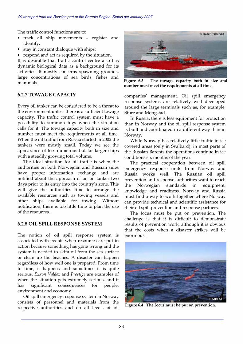
Oil transport from the Russian part of the Barents Region. Status per January 2007
83
The traffic control functions are to: • track all ship movements – register and
identify; • stay in constant dialogue with ships; • respond and act as required by the situation. It is desirable that traffic control centre also has dynamic biological data as a background for its activities. It mostly concerns spawning grounds, large concentrations of sea birds, fishes and mammals. 6.2.7 TOWAGE CAPACIY Every oil tanker can be considered to be a threat to the environment unless there is a sufficient towage capacity. The traffic control system must have a possibility to summon tugs when the situation calls for it. The towage capacity both in size and number must meet the requirements at all time. When the oil traffic from Russia started in 2002 the tankers were mostly small. Today we see the appearance of less numerous but far larger ships with a steadily growing total volume.
The ideal situation for oil traffic is when the authorities on both Norwegian and Russian sides have proper information exchange and are notified about the approach of an oil tanker two days prior to its entry into the country’s zone. This will give the authorities time to arrange the available resources such as towing vessels and other ships available for towing. Without notification, there is too little time to plan the use of the resources. 6.2.8 OIL SPILL RESPONSE SYSTEM The notion of oil spill response system is associated with events when resources are put in action because something has gone wrong and the system is needed to skim oil from the sea surface or clean up the beaches. A disaster can happen regardless of how well one is prepared. From time to time, it happens and sometimes it is quite serious. Exxon Valdez and Prestige are examples of when the situation gets extremely serious, and it has significant consequences for people, environment and economy.
Oil spill emergency response system in Norway consists of personnel and materials from the respective authorities and on all levels of oil
companies’ management. Oil spill emergency response systems are relatively well developed around the large terminals such as, for example, Sture and Mongstad.
In Russia, there is less equipment for protection than in Norway and the oil spill response system is built and coordinated in a different way than in Norway.
While Norway has relatively little traffic in ice covered areas (only in Svalbard), in most parts of the Russian Barents the operations continue in ice conditions six months of the year.
The practical cooperation between oil spill emergency response units from Norway and Russia works well. The Russian oil spill prevention and response authorities want to reach the Norwegian standards in equipment, knowledge and readiness. Norway and Russia must find a way to work together where Norway can provide technical and scientific assistance for their oil spill prevention and response partners.
The focus must be put on prevention. The challenge is that it is difficult to demonstrate results of prevention work, although it is obvious that the costs when a disaster strikes will be enormous.
Figure 6.3 The towage capacity both in size and number must meet the requirements at all time.
© Rederiforbundet
Figure 6.4 The focus must be put on prevention.© MBESD

Oil transport from the Russian part of the Barents Region. Status per January 2007
84
7 References 7.1 LIST OF INFORMATION SOURCES Press Releases and Publications of the Authorities, Companies and Institutes: Government of The Russian Federation – www.government.ru Federal State Statistics Service of Russia – www.gks.ru Federal Subsoil Resource Management Agency of Russia– www.rosnedra.ru Ministry of Economical Development and Trade of The Russian Federation – www.economy.gov.ru Ministry of Industry and Energy of The Russian Federation – www.minprom.gov.ru Ministry of Nature Resources of The Russian Federation – www.mnr.gov.ru Ministry of Transport of The Russian Federation – www.mintrans.ru Ministry of Environment of Norway – www.regjeringen.no Ministry of Fisheries and Coastal Affairs of Norway – www.regjeringen.no Norwegian Coastal Administration – www.kystverket.no Arktikmorneftegazrazvedka JSC – www.amngr.ru Gazprom JSC – www.gazprom.ru Lukoil JSC – www.lukoil.com Rosneft JSC – www.rosneft.ru Transneft JSC – www.transneft.ru Yukos JSC – www.yukos.ru Arkhangelsk Sea Commercial Port JSC – www.ascp.ru LenmorNIIproekt – www.lenmor.ru Murmansk Sea Fishing Port JSC – www.portofmurmansk.ru Murmansk Shipping Company JSC – www.msco.ru Northern Shipping Company JSC – www.ansc.ru Norwegian National Rail Administration – www.jernbaneverket.no Nordoil Caverns AS – www.nordoil.no Pechenga port project – pechengaport.narod.ru Progetra Group – www.progetra.com Russian Railways JSC – www.rzd.ru Seaport Vitino Ltd. – www.vitino.ru ShipCargo Kirkenes AS – www.shipcargo.no Sovcomflot JSC – www.sovcomflot.ru Tschudi Shipping Company AS – www.tschudishipping.com Volgotanker Company JSC – www.volgotanker.com Association of Ecological Organizations of Arkhangelsk region – www.arkheco.ru Bellona – www.bellona.no Greenpeace – www.greenpeace.com Russian Environmental Digest Redfiles TEIA – www.teia.org Sakhalin Environment Watch – www.sakhalin.environment.ru WWF Russia – www.wwf.ru

Oil transport from the Russian part of the Barents Region. Status per January 2007
85
Internet Portals: Equasis Ship Register – www.equasis.com Lloyd’s List – www.lloydlist.com Logistic transport and customs portal – www.logistic.ru Murmansk Business portal – www.b-port.ru Russian logistic services and links – www.loglink.ru Russian rivers portal – www.infoflot.ru Wikipedia – www.wikipedia.org World Shipping Register – www.world-register.net News and Information Agencies: EuroArctic Petroleum Newsletter – www.petrobarents.com BarentsObserver – www.barenetsobserver.com BNA Prime-tass – www.prime-tass.ru IA ATK-Media – www.atkmedia.ru IA Dvina Inform – www.dvinainform.ru IA Komiinform.ru – www.komiinform.ru IA Mineral – www.mineral.ru IA Murman – www.murman.ru IA Regions – www.regions.ru IA REGNUM – www.regnum.ru IA REGNUM–Arkhangelsk news – www.arnews.ru IA Rosbalt – www.rosbalt.ru IA Russian North – www.rsia.ru Magentanews – www.magentanews.com RIA Novosti – www.rian.ru RusEnergy – www.rusenergy.com SeaNews – www.seanews.ru Newspapers, Weekly Papers and Journals: “Business Class” newspaper, Arkhangelsk “Gazeta.ru” internet newspaper – www.gazeta.ru “Izvestia” newspaper – www.izvestia.ru “Moscow Times” – www.moscowtimes.ru “Moryak Severa” newspaper, Arkhangelsk “Murmanskiy Vestnik” newspaper, Murmansk “Neft Rossii” journal – press.lukoil.ru “Neftyanoe obozrenie” weekly – info.forest.ru/oil “OilCapital.ru” internet journal – www.oilcapital.ru “Pravda.ru” internet newspaper – www.pravda.ru “Pravda Severa” newspaper, Arkhangelsk – www.pravdasevera.ru “Rossiyskaya gazeta” newspaper – www.rg.ru “Word Energy” journal – www.worldenergy.ru

Oil transport from the Russian part of the Barents Region. Status per January 2007
86
Reports and publications Bambulyak, A. and Frantzen, B. (2005). Oil transport from the Russian part of the Barents Region. Status per January 2005. Svanhovd, Norway. 91 pp. Bambulyak, A. and Frantzen, B. (2005). Oil shipment from the Russian Arctic. AMAP Symposium on Oil and Gas Development in the Arctic. Proceedings of RAO/CIS Offshore 2005 Conference. St-Petersburg, Russia. Bambulyak, A. and Frantzen, B. (2005). Oil transport routes in the Barents Region. Proceedings of POAC’05 – 18th International Conference. Clarkson University. Potsdam, New York, USA. p. 615-624. Bichuk, N.I. (2006). Environmental safety of the Murmansk region during hydrocarbon extraction and transportation in the Barents Region. Administration of the Murmansk region. Murmansk, Russia. 42 pp. Frantzen, B. and Bambulyak, A. (2003). Oil transport from the Russian part of the Barents Region. July 1, 2003. Svanhovd, Norway. 27 pp. Frantzen, B. and Bambulyak, A. (2006). Petroleum transport from the Russian sector of the Barents Region. Barentswatch 2006. Bioforsk Soil and Environment, Svanhovd. Svanvik, Norway. p. 24-25. Guseinov, R. (2005). Strategy of Logistics Development in Russia. Murmansk Multimodal Complex project. Proceedings of the 4th International Conference on Russian and CIS Logistics and Transportation. RPI. Moscow, Russia. 52 pp. Kokarev, S. (2006). Perspectives for future development of Nenets Autonomous Okrug. Report and presentation. NMC Strategy Workshop – 2006. St. Petersburg, Russia. 37 pp.
Korenev, V. (2005). Murmansk Basin Emergency and Salvage Department. Report and presentation. Proceeding of Oil&Gas Industry and Sustainable Development in the Barents Region Conference. Murmansk, Russia. 35 pp. Leus, S. (2006). Murmansk Region potential for hydrocarbons transportation. Report and presentation. NMC Strategy Workshop – 2006. St. Petersburg, Russia. 16 pp. Risikolast statistikk. (2006). Monthly reports. LDKN, Norway. Risikolast statistikk. (2005). Monthly reports. LDKN, Norway. Sevmorneftegaz JSC (2006). Development of Shtokman, Prirazlomnoya and Yamal. Report and presentation. NMC Strategy Workshop – 2006. St. Petersburg, Russia. 28 pp. Ushakov, A. (2006). Perspectives of the transportation system. Report and presentation. NMC Strategy Workshop – 2006. St. Petersburg, Russia. 12 pp. Varandey Terminal JSC (2006). Varandey terminal – construction and future perspectives. Report and presentation. NMC Strategy Workshop – 2006. St. Petersburg, Russia. 18 pp. Varlamov, A.I. (2007). Development Prospects of Russian Arctic Shelf’s Subsurface Resources. Report and presentation. Arctic Frontiers 2007 Conference. Tromsø, Norway. 23 pp.

Oil transport from the Russian part of the Barents Region. Status per January 2007
87
8 Abbreviations
AIS - Automatic Identification System AMNGR - Arktikmorneftegazraavedka ATOC - Arctic Terminal Operating
Company BPS - Baltic Pipeline System CIS - Commonwealth of Independent
States CNIIMF - Central Marine Research & Design
Institute COTU - Crude Oil Topping Unit CPC - Caspian Pipeline Consortium EIA - Environmental Impact Assessment ESPO - East Siberia–Pacific Ocean pipeline ETV - Emergency towing vessel FEMCO - Far East Marine Company FESCO - Far Eastern Shipping Company FOIROT - Fixed Offshore Ice-resistant
Offloading Terminal FSO - Floating Storage and Offloading
Vessel HRS - Search and Rescue Central IMO - International Maritime
Organisation LNG - Liquefied natural gas LPG - Liquefied petroleum gas MARPOL - International Convention on the
Prevention of Pollution from Ships MBESD - Murmansk Basin Emergency and
Salvage Administration MNR RF - Ministry of Nature Resources of the
Russian Federation MRCC - Main Rescue Coordination Centre MSC - Murmansk Shipping Company NAR - Nenets Autonomous Region NCA - Norwegian Coastal Administration
NEZ - Norwegian Economic Zone NGO - Non-governmental organisation NMVOC - Non-methane volatile organic
compounds NO NJHQ - Norwegian National Joint
Headquarters NOFO - Norwegian Clean Seas Association
for Operating Companies OSPAR - Convention for the Protection of the
Marine Environment of the North-East Atlantic
POLREP - Pollution Reporting System PSA - Production sharing agreement RF - Russian Federation RHQNN - Regional Headquarters North
Norway RPK - Offshore oil transhipment complex SFT - Norwegian Pollution Control
Authorities STS - Ship-to-Ship Transfer TB - Tug boat TOPP - Trunk oil products pipeline UGS - United Gas Transportation System UK - United Kingdom UN - United Nations USA - United States of America USSR - Union of the Soviet Socialist
Republics VLCC - Very large crude carrier VOC - Volatile organic compounds VTC - Vessel Traffic Centre VTMIS - Vessel Traffic Management and
Information Services VTS - Vessel Traffic Services Conversion factor for oil: 1 barrel = 159 litre 1 ton = 7.49 barrel