of features resource summary naming cabrillo resource... · 08-11-2004 · the point cabrillo light...
TRANSCRIPT

The Point Cabrillo Light Station and Preserve Project
Inventory of Features ‐ Resource Summary and Recommendations for
Classification and Naming
April 2008

CCaalliiffoorrnniiaa SSttaattee PPaarrkkss MMiissssiioonn
To provide for the health, inspiration and education of the people of California by helping to preserve the state’s extraordinary biological diversity, protecting its most valued natural and cultural resources, and creating opportunities for high-quality outdoor recreation.
Photo on reverse: Point Cabrillo Light Station and preserve

THE POINT
CABRILLO LIGHT STATION AND
PRESERVE PROJECT
Inventory of Features ‐ Resource Summary and Recommendations for Classification and Naming
Arnold Schwarzenegger Governor
Mike Chrisman
Secretary for Resources
Ruth Coleman Director of California State Parks
State of California
The Resources Agency California State Parks
P.O. Box 942896 Sacramento, California 94296-0001
April 2008

Photo on reverse: Whale watching at Point Cabrillo Lighthouse 2004 Whale Festival
Point Cabrillo Light Station Resource Summary
Table of Contents Introduction ..................................................................................................................... 1 Naming and Classification Recommendation.................................................................. 1 Project Description .......................................................................................................... 1 Project History................................................................................................................. 6 Natural Resources........................................................................................................... 7
Topography ................................................................................................................. 7 Meteorology................................................................................................................. 7 Hydrology .................................................................................................................... 7 Geology ....................................................................................................................... 7 Soils............................................................................................................................. 8 Plant Life...................................................................................................................... 8 Wildlife ....................................................................................................................... 15 Ecology...................................................................................................................... 16
Cultural Resources........................................................................................................ 17 Prehistoric Context .................................................................................................... 17 Historic Context ......................................................................................................... 19 Property Transfers To The State Of California .......................................................... 21
Recreation, Interpretation, and Education Resources................................................... 23 Aesthetic Resources ..................................................................................................... 23 Potential for Future Land Acquisitions........................................................................... 24 Classification Alternatives ............................................................................................. 24
State Historic Park ..................................................................................................... 24 State Park.................................................................................................................. 25 State Cultural Reserve............................................................................................... 25 Sub-classifications ..................................................................................................... 26
Recommendation .......................................................................................................... 26 Unit Name ..................................................................................................................... 26 Public Input ................................................................................................................... 27 Declaration Of Purpose................................................................................................. 28 Selected References ..................................................................................................... 30 Appendix A: Land Ownership Record Map ................................................................... 33 Appendix B: Public Use Guidelines............................................................................... 35 Appendix C: Plant List ................................................................................................... 43 Appendix D: Bird List..................................................................................................... 59 Appendix E: Eight Principles for Naming Units of the State Park System ..................... 61 Project Contributors....................................................................................................... 63 Photo Credits ................................................................................................................ 63 Figure 1: Overview Map ................................................................................................. 3 Figure 2: Vegetation Communities ................................................................................ 11


Point Cabrillo Light Station Resource Summary
The Point Cabrillo Light Station and Preserve Project Resource Summary
INTRODUCTION In March 2002 California State Parks acquired the beautiful Point Cabrillo Light Station and preserve from the California State Coastal Conservancy (SCC). The light station is a 30.5-acre coastal parcel with six main historic structures that include the Point Cabrillo Lighthouse, oil house, blacksmith shop, and the three lightkeepers’ residences. The “preserve” (not officially classified as such) is a 266-acre open space area surrounding the light station (see Appendix A, Landownership Map). California Public Resources Code Section 5002.1 requires that a summary of the natural and cultural
features and landscapes be provided to the California State Park and Recreation Commission when classifying or reclassifying a California State Park unit. The unit’s Inventory of Features, also known as the Resource Summary, is intended to provide the commission with necessary information on classification as specified in Article 1.7 of the Public Resources Code.
Point Cabrillo Lighthouse c. 1911
This Resource Summary describes significant natural and cultural resources and provides an overview of the project area. Information contained in this document has been compiled from various reports and field investigations and will be useful to the Department in developing resource policies and resource management programs, and as background information for land use planning, park operation and maintenance, and interpretation and education.
NAMING AND CLASSIFICATION RECOMMENDATION The California Department of Parks and Recreation recommends that the California State Park and Recreation Commission approve the naming and classification of the Point Cabrillo Light Station and preserve as Point Cabrillo State Historic Park.
PROJECT DESCRIPTION The Point Cabrillo Light Station is located on the scenic coast in an unincorporated area of Mendocino County, approximately two miles north of the town of Mendocino and eight miles south of the city of Fort Bragg. The property consists of a 266-acre natural area referred to as the “preserve,” and the 30.5-acre light station located on the western edge of the property. It is bounded on the north and south by small rural subdivisions and a private recreational vehicle park and campground, on the east by Point Cabrillo Drive, and on the west by the Pacific Ocean. Primary access to the property is from Point Cabrillo Drive, which is a semi-loop road off Highway 1. There is one nine- acre in-holding property on the eastern edge of the property that is currently operated as a trailer park. Two nearby State Park units, Russian Gulch State Park and Jug Handle State Natural Reserve, are within three miles of Point Cabrillo. Point Cabrillo is one of seventeen park units in the Mendocino District.
1

Resource Summary Point Cabrillo Light Station
2

Point Cabrillo Light Station Resource Summary
Figure 1: Overview Map Figure 1: Overview Map 11X 17 size
3

Resource Summary Point Cabrillo Light Station
<back side of map>
4

Point Cabrillo Light Station Resource Summary
The lighthouse is operational and the Fresnel lens is maintained by the United States Coast Guard. The Point Cabrillo Lightkeepers Association (a private nonprofit organization), operates the light station through an Interpretive Concession Agreement with California State Parks that includes a gift store and interpretive displays, a bed and breakfast in the Principal Lightkeeper’s house, and a small museum located in the First Assistant Lightkeeper’s house. These visitor facilities are open to the public 365 days a year.
Rehabilitated Principal and First Assistant Lightkhouses, from left to right, as viewed from the prese
eepers’ rve
The preserve surrounding the light station includes rare native plant communities, special status plant, bird and reptile species, and an array of wildlife that forage in this area. Cultural resources include remnants of historic occupation by indigenous people and non-indigenous settlers. Current recreation uses include visiting and learning about the light station, sightseeing, hiking, picnicking, wildlife study and bird watching. The Point Cabrillo Lighthouse is one of the lighthouses frequently visited along the California coast. The core of the park is dominated by the Point Cabrillo Lighthouse and appurtenant structures and facilities, which were constructed for the United States Light-House Board by the Army Corps of Engineers and Lingreen and Company of San Francisco between1908 and 1909. The lighthouse is equipped with an unusual British-made Fresnel lens. The lighthouse became operational on June 10, 1909. The United States Lighthouse Service became part of the United States Coast Guard in 1939, and the United States Air Force leased a portion of the property in 1962 for a radar tracking facility. Additional buildings and support facilities were constructed or modified until the light station was decommissioned in 1974. The buildings on the property were boarded up until 1976, when the Coast Guard modified the interiors of the three residences and reopened them for use by Noyo Harbor Coast Guard personnel. In 1991, the property was purchased from the United States Coast Guard by the California State Coastal Conservancy (SCC) who then transferred ownership to California State Parks in 2002. The California SCC funded the rehabilitation of the light station, which took place from 1998 to 2007. The rehabilitation of the lighthouse was administered by the Point Cabrillo Lightkeepers Association under the direction of the California SCC and California State Parks. The Agreement for the Transfer and Control and Possession of State-owned Real Property between California State Parks and California State Coastal Conservancy states:
5

Resource Summary Point Cabrillo Light Station
• The Point Cabrillo Preserve is to be held and managed as a unit of California State Parks consistent with Point Cabrillo Public Use Guidelines (Appendix B), in consideration of the Point Cabrillo Preserve’s natural resources and provision of low-impact recreational opportunities.
• The Point Cabrillo Light Station is to be held and managed as a unit of California State Parks consistent with the Point Cabrillo Public Use Guidelines.
The majority of the park property consists of lands that retain a natural character, but have undergone modification from past human activities, including homestead development, cattle grazing, production of crops and the planting of non-native and non-indigenous trees for windbreaks or woodlots. Peter Thompson, a member of one of Kit Carson's trapper parties, initiated homesteading in the area about 1851. Most of the alteration to native habitats outside of the core area of the park occurred in the late 1800s and early 1900s. Although exotic plant species are on the property, significant natural resources, including rare natural plant communities and special plant species, exist on much of the property. Wildlife on this site includes special status species including the northern red-legged frog and the northern harrier. The unit occupies a series of three coastal terraces with gentle to moderate slopes. Elevations range from sea level to approximately 200 feet. Vegetation includes grasslands, coastal scrub, coniferous forests, riparian woodlands and wetlands. Four small perennial streams cross the unit, one of which has been dammed to create a pond. Along the steep coastal margin of the property is approximately one mile of rocky shoreline and marine habitats that extend to 1000 feet (see Figure 1 Overview Map).
PROJECT HISTORY • Light station constructed, 1908-1909 • Became part of the United States Coast Guard in 1939 (operated from 1939-
1972) • Lighthouse automated in 1972 • Light station decommissioned in 1974 • Properties surrounding the light station purchased by the California State
Coastal Conservancy, 1988-1991 • Light station purchased from the United States Coast Guard by the California
State Coastal Conservancy • Property placed on the National Register of Historic Places, 1990 • Property transferred to California State Parks, 2002 • Cultural Landscape Report, 2003 • Rehabilitation work, 1991-2007 • First Assistant Lightkeeper’s house and overnight accommodations opened,
2005-06 • California State Lands Commission leased 83 acres of tidal and submerged
lands to California State Parks, 2004-2029 • Public meeting held regarding the naming and classification, February 2008
6

Point Cabrillo Light Station Resource Summary
NATURAL RESOURCES
Topography The headland where the Point Cabrillo Lighthouse stands is land on loan from the Pacific Ocean. The topography of Point Cabrillo reflects and illuminates the local geologic processes. At various locations along the Mendocino coast, terraces sculpted at sea out of greywacke sandstone have been lifted and presented as solid ground through the process of plate tectonics. These terraces are generally lifted up flat with short rises between terraces with a visible discoloration difference. Three exposed terraces exist at Point Cabrillo and thus elevations at Point Cabrillo range from sea level to approximately 200 feet. The rocky coastal bluffs rise from sea level to 50 to 75 feet. The light station is located on the gentle sloping surface of the first marine terrace and elevations range from 50 to approximately 110 feet. The second terrace elevations
range from 110 to 160 feet above sea level. A portion of the third terrace is present from 160 feet to the eastern boundary of the property and extends beyond the park boundary. Terrace topography is relatively gentle, with several incised stream channels, the largest located in the northern half of the park.
Meteorology The climate of the Mendocino Coast is Mediterranean, moderated by marine influences. Winter rains and cool, dry
summers with frequent coastal fog characterize the climate pattern. Annual precipitation is approximately 40 inches along the coast. Point Cabrillo extends into the ocean, creating a microclimate that generates higher intensity wind and rain. The terraced topography of the site means that the lighthouse can be blanketed in fog while the upper reaches of the property are fog free and sunny in the summer.
Point Cabrillo bluffs and fog
Hydrology The park’s small creeks are not part of a larger watershed, but instead drain directly to the Pacific Ocean. The northern half of the park (north of the lighthouse road) contains several larger creeks, with some incised drainages with watersheds that extend to the east off the park property. The southern half of the park has smaller streams that appear to originate from numerous springs and seeps on the middle and lower terrace areas.
Geology Point Cabrillo is located within the California Coast Range Geomorphic Province, a northwest trending chain of mountains that forms the central and northern California coastlines. Marine terrace deposits overlie the sandstone and interbedded siltstone and shale bedrock of the Coastal Belt of the Franciscan Formation. A series of three marine terraces is present. The terraces have been named by Kilbourne (1983), in progression from west to east (youngest to oldest), as the Caspar Point Terrace, the Jug Handle
7

Resource Summary Point Cabrillo Light Station
Farm Terrace and the Railroad Terrace. The thickness of the marine deposits ranges from zero to over ten feet. Gray to black topsoil containing root fragments occupies the upper four feet. The topsoil is underlain by iron-stained silica-cemented marine terrace sandstone, similar to the “pygmy soil” of nearby Jug Handle State Natural Reserve. Below the iron-stained sandstone, a six- to nine-foot thick zone of massive, well-sorted marine terrace sandstone overlies bedrock. Point Cabrillo is in a tectonically active region where elevating marine terraces, oscillating sea level and active seismicity combine to provide a dynamic and scenic coastal setting. A small but visible fault (unofficially referred to as “Lighthouse Fault”) connects the two coves on either side of the lighthouse and a 6 foot displacement can be observed. It is unknown when the last movement occurred on this fault but it is possible that movement on the San Andreas Fault which parallels the coast three to four miles offshore could trigger movement on Lighthouse Fault.
Soils The terrace processes outlined above have affected the soil composition throughout the property. Moving from ocean to inland, each terrace encountered is about a hundred thousand years older than the one below. These stair step terraces were generally lifted up flat, instead of being tilted through seismic activity. Terrace sloping would have allowed nutrients liberated by rainfall and other processes to run off to the next level down. Flat terraces resulted in surface nutrients leaching through to layers below. In the Caspar Point Terrace, soils are relatively young. The Jug Handle Farm Terrace soils are approximately one hundred thousand years older and more leached than the first terrace, and the Railroad Terrace soils are another hundred thousand years older and thus even more leached. The soil series present are Biaggi loam, Cabrillo-Heeser complex, Heeser sandy loam and Tropaquepts. These soils derived from sandstone and shale bedrock or eolian sands (Heeser sandy loam) are developed on marine terraces bordering the Pacific Ocean.
Plant Life Native plant communities at Point Cabrillo (see Appendix C, Plant List) include coastal strand, northern coastal bluff scrub, Northern coastal terrace prairie, northern Bishop pine and beach pine forests, and a variety of wetland types including riparian, ponds, and seeps. Formerly planted groves of non-native eucalyptus, Monterey pine, and Monterey cypress⎯used as windbreaks⎯also occur at Point Cabrillo and have expanded into the native communities. Refer to Figure 2, Vegetation Communities Map.
Coastal Strand (Beach) Rocky cliffs and intertidal zones are more prevalent than sandy beaches at Point Cabrillo, but pockets of coastal strand can still be found, mostly in the small coves. Coastal strand is the sandy area from the upper intertidal zone to the bluff faces. The plants growing here tolerate high salt content and high winds, and are susceptible to being inundated during ocean storms. Dominant plants include European sea rocket (Cakile maritima) and beach bur (Ambrosia chamissonis). Both species of non-native iceplant (Carpobrotus edulis and C. chilensis) are found here, as well as on the coastal bluffs.
8
Point Cabrillo Light Station Resource Summary
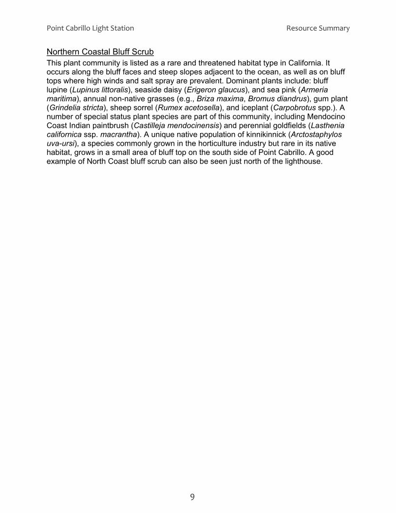
Northern Coastal Bluff Scrub This plant community is listed as a rare and threatened habitat type in California. It occurs along the bluff faces and steep slopes adjacent to the ocean, as well as on bluff tops where high winds and salt spray are prevalent. Dominant plants include: bluff lupine (Lupinus littoralis), seaside daisy (Erigeron glaucus), and sea pink (Armeria maritima), annual non-native grasses (e.g., Briza maxima, Bromus diandrus), gum plant (Grindelia stricta), sheep sorrel (Rumex acetosella), and iceplant (Carpobrotus spp.). A number of special status plant species are part of this community, including Mendocino Coast Indian paintbrush (Castilleja mendocinensis) and perennial goldfields (Lasthenia californica ssp. macrantha). A unique native population of kinnikinnick (Arctostaphylos uva-ursi), a species commonly grown in the horticulture industry but rare in its native habitat, grows in a small area of bluff top on the south side of Point Cabrillo. A good example of North Coast bluff scrub can also be seen just north of the lighthouse.
9

Resource Summary Point Cabrillo Light Station
10

Point Cabrillo Light Station Resource Summary
Figure 2: Vegetation Communities
11 X 17
11

Resource Summary Point Cabrillo Light Station
<back side of map>
12

Point Cabrillo Light Station Resource Summary
Northern Coastal Terrace Prairie Northern coastal terrace prairie is another habitat type at Point Cabrillo that is listed as rare and threatened. This community occurs on the first marine terrace above the ocean and is generally dominated by perennial bunchgrasses. Soils are typically sandy and salty with an upper horizon of decomposing organic material. Native plants in this community are adapted to wind, salt, and native hydrological conditions (which vary across the type), but are not well suited to heavy grazing and trampling. Only scattered fragments of true native coastal terrace prairie persist here, and most of the native species have been displaced by non-native perennial grasses and herbs. Remaining coastal terrace prairie areas are dominated chiefly by tufted hairgrass (Deschampsia cespitosa), or creeping wildrye (Leymus triticoides). Pacific reed grass (Calamagrostis nutkaensis) is an especially impressive (2-3 ft. tall) native bunchgrass that forms dense patches within the wetter areas of the coastal prairie and intersperses with the slough sedge community. Other native grasses present include California oatgrass (Danthonia californica), California brome (Bromus carinatus var. maritimus), blue wildrye (Elymus glaucus), and meadow barley (Hordeum brachyantherum).
Wetland Communities Five major wetland types comprise the other rare and protected natural communities at Point Cabrillo. These include freshwater seeps, ponds, slough sedge, Hooker willow, and Sitka willow. Natural freshwater seeps occur as water emerges from small outlets, primarily on the coastal bluffs. The vegetation here is dominated zonally by silverweed (Potentilla anserina ssp. pacifica), watercress (Rorippa nasturtium-aquaticum), saltgrass (Distichlis spicata), and willow dock (Rumex salicifolius) among the common plants in the clay loam on the slope, with common threesquare (Scirpus pungens) or saltgrass dominant where the moisture saturates beach sand. The small pond in the southwest section of Point Cabrillo provides freshwater habitat for numerous wildlife species, as well as serving as the main domestic water source for the unit. The most noticeable species in the pond is the yellow pond lily (Nuphar luteum ssp. polysepalum). This large-leaved plant provides important cover for aquatic organisms, including the northern red-legged frog. Slough sedge (Carex obnupta) is the dominant species among a diversity of sub-shrubs and herbs, including Nootka rose (Rosa nutkana), salal (Gaultheria shallon), and water parsley (Oenanthe sarmentosa). The rare coast lily (Lilium maritimum) and fringed false-hellebore (Veratrum fimbriatum) often grow within this pond plant community.
Point Cabrillo pond
Dense thickets dominated by Hooker willow (Salix hookeriana) occur in wet drainages, including the area below the pond. Sitka willow (Salix sitchensis) riparian forest is
13

Resource Summary Point Cabrillo Light Station
another rare community that provides important wildlife cover and nesting habitat, and protection to fragile wetland hydrology and soils, particularly along the stream channels in Point Cabrillo.
Pine Forests Remnants of two rare forest communities, the northern Bishop pine (Pinus muricata) and beach pine (Pinus contorta ssp. contorta) are also found at Point Cabrillo. These natural communities occur mostly in the eastern and southern areas of the property. Bishop pines were also planted in the historic zone, and most specimens growing around the buildings have now reached maturity.
Introduced Perennial Grassland This community currently covers much of the landscape at Point Cabrillo, displacing primarily what was once native grass-dominated coastal terrace prairie. Extensive long-term grazing of the property in the past was largely responsible for the type conversion of the former native grasslands. Sweet vernal grass (Anthoxanthum odoratum) and velvet grass (Holcus lanatus) are two of the most prevalent non-native bunchgrasses at Point Cabrillo. Widespread soil disturbance and compaction by domestic livestock, as well as cultivation, also contributed to the introduction of other non-native species characteristic of this community, including wild radish (Raphanus sativus), ripgut brome (Bromus diandrus), large quaking grass (Briza maxima), dogtail grass (Cynosurus echinatus), and wild oats (Avena spp). Special status plants that occur on the property are:
Status (CNPS List)
Latin Binomial Common Name Life History /Form
Habitat
1B.2 Erigeron supplex supple daisy perennial coastal bluffs 1B.2 Hesperevax sparsiflora
var. brevifolia short-leaved evax
annual sandy soil; bluffs
1B.2 Lasthenia californica ssp. macrantha
goldfields perennial grassland
4.2 Lotus formosissimus harlequin lotus perennial moist grassland 4.3 Ceanothus gloriosus
var. exaltatus glory brush shrub scrub
4.3 Ceanothus gloriosus var. gloriosus
glory mat shrub coastal bluffs, slopes
1B.2 Castilleja mendocinensis
Mendocino Coast paintbrush
perennial coastal bluffs
1B.2 Carex saliniformis deceiving sedge perennial wetlands, grasslands, scrub
1B.1 Lilium maritimum coast lily perennial (rhizome)
moist, sandy sites in woodland, forest
4.3 Veratrum fimbriatum fringed false-hellebore
perennial (rhizome)
in seasonal creek bed
1B.2 Agrostis blasdalei Blasdale's bentgrass
perennial (rhizome)
grassland; woodland
14

Point Cabrillo Light Station Resource Summary
Wildlife Typical wildlife habitats in the area include coastal grassland, wetland, riparian forest, forest patches, vernal pools and ponds. The site was altered by a variety of uses during the past century, including cattle grazing and the planting of eucalyptus, cypress and other non-native trees for wind breaks. Red-shouldered hawks (Buteo lineatus), ravens (Corvus corax) and other birds nest in these groves. The grasslands and the wetlands provide important nesting and foraging habitat for raptors, such as the northern harrier (Circus cyaneus), white-tailed kite (Elanus leucurus) and osprey (Pandion haliaetus). Songbirds are abundant in all habitats. Northern flicker (Colaptes auratus) nest in aging trees throughout the property. Seabirds, including the black oystercatcher, are common on near-shore reefs. California brown pelicans (Pelecanus occidentalis californicus) and
pelagic cormorants (Phalacrocorax pelagicus) can be seen on the reefs as well. Pelagic cormorants nest on the property in the rocky cove north of the lighthouse. Barn owls (Tyto alba) and burrowing owls (Athene cunicularia) have been seen on the property on rare occasions. The spring-fed water supply pond and perennial streams provide habitat for many amphibians, including northwestern salamanders (Ambystoma gracile), coastal (Pacific) giant salamanders (Dicamptodon ensatus) rough-skinned newts (Taricha granulosa), ensatina (Ensatina eschscholtzii) and the California slender salamander (Batrachoseps attenuatus). Several frog species can be heard in the spring, including
the northern red-legged frog (Rana aurora aurora). Reptiles that make Point Cabrillo their home include a variety of snakes such as the western terrestrial garter snake (Thamnophis elegans), as well as several species of lizards. Turtles are suspected, though they have not yet been located. Large mammals include the Coast blacktail deer (Odocoileus hemionus), coyote (Canis latrans), and bobcat (Lynx rufus) and probably include the mountain lion (Felis concolor) on at least a transient basis. Smaller mammals include grey fox (Urocyon cinereoargenteus), river otter (Lutra canadensis), longtail weasel (Mustela frenata), hares, rabbits, raccoons, skunks, tree and ground squirrels, rodents and several species of bats, including the pallid bat (Antrozous pallidus) and yuma myotis (Myotis yumanensis).
Western terrestrial garter snake
Coast blacktail deer at Point Cabrillo
The lotis blue butterfly (Lycaeides argyrongnomon lotis) is a federally endangered, possibly extinct species that prefers moist coastal habitats with harlequin lotus (Lotus formisissimus) plants. These lotus plants and the Bolander's sweet pea (Lathyrus
15
Resource Summary Point Cabrillo Light Station
vestitus ssp. bolanderi) provide important food sources for the developing butterfly larvae. Although it is not known with certainty whether the lotis blue butterfly still occurs at Point Cabrillo, the lotus host plant is relatively abundant, primarily in the wet meadow areas. The intertidal areas at Point Cabrillo contain a rich and diverse population of intertidal invertebrate and vertebrate species. A marine reserve extends for 200 yards from the high tide mark. Point Cabrillo has been the site of several marine research projects including a long range subtidal survey by scientists from Humboldt State University and a multi-year project conducted by the Partnership for Interdisciplinary Studies of Coastal Oceans group. Marine mammals are plentiful on the rocks and in the waters off the shore of Point Cabrillo. Members of the Phocidae, including harbor seals (Phoca vitulina) haul out on nearby rocks and pupping has been observed during the last three seasons. Juvenile northern elephant seals (Mirounga angustirostris) occasionally haul out in the protected coves of Point Cabrillo. Of the Otariidae, the most frequently seen and heard representative of that group is California sea lion (Zalophus californianus), though northern (Steller’s) sea lions (Eumatopias jubata) have been reported on nearby buoys. Whales and dolphins of many species are frequently observed from Point Cabrillo’s headlands. Views of spouting, breeching, mating and frolicking eastern Pacific gray whales (Eschrichtius robustus) during their spring migration is the focal point for Point Cabrillo’s celebration of the annual Whale Festivals of Fort Bragg and Mendocino in March. Other members of the Mysticeti that can be seen from Lighthouse Point include humpback whales (Megaptera novaeangliae) and blue whales (Balaenoptera musculus), usually during the summer months. Toothed whales of the Odontoceti occur frequently, including harbor porpoise (Phocoena phocoena), Risso’s dolphins (Grampus griseus), Dall’s porpoise (Phocoenoides dalli) and orca (Orcinus orca). So-called “resident” orca were noticed and confirmed by photographs sent to the Orca Lab in Friday Harbor during Whale Festival 2007, and confirmed “transient” orca behavior was confirmed by volunteers in the lighthouse who watched a pod attack and kill a baby gray whale in 2005.
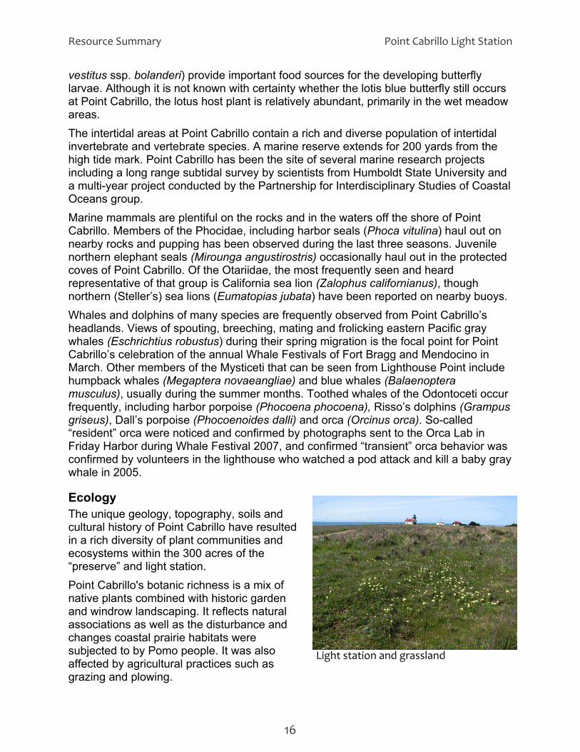
Ecology
Light station and grassland
The unique geology, topography, soils and cultural history of Point Cabrillo have resulted in a rich diversity of plant communities and ecosystems within the 300 acres of the “preserve” and light station. Point Cabrillo's botanic richness is a mix of native plants combined with historic garden and windrow landscaping. It reflects natural associations as well as the disturbance and changes coastal prairie habitats were subjected to by Pomo people. It was also affected by agricultural practices such as grazing and plowing.
16
Point Cabrillo Light Station Resource Summary
17
Point Cabrillo is located within the broad designation of the North Coast Temperate Rain Forest Biome. Plant communities at Point Cabrillo include coastal strand, coastal bluff scrub, coastal grassland, woodland, riparian, scrub, marsh and pond. In the spring, native wildflowers abound, particularly on less disturbed areas near bluffs. Overgrown historic plantings of Monterey cypress stand as evidence of light keepers’ windrows, and provide some of the more picturesque profiles at the light station. Agricultural practices such as clearing, plowing and grazing had a pronounced effect on the native coastal terrace vegetation, converting much of what was likely coastal prairie and pine savannah into a community of non-native perennial grasses. Yet, rare and unique native plant communities still remain at Point Cabrillo, including coastal bluff scrub, coastal terrace prairie, pine forest, riparian and wetland communities. The abundance of groundwater draining toward the ocean creates pools and lush wetland vegetation throughout the property. The wind sculpting and stunting of woody vegetation becomes more pronounced as you approach the bluffs. Healthy native trees and shrubs show the effects of coastal wind, salt, and spray in their lopsided growth, characteristics that indicate and imitate the direction of prevailing winds and salt spray.
CULTURAL RESOURCES
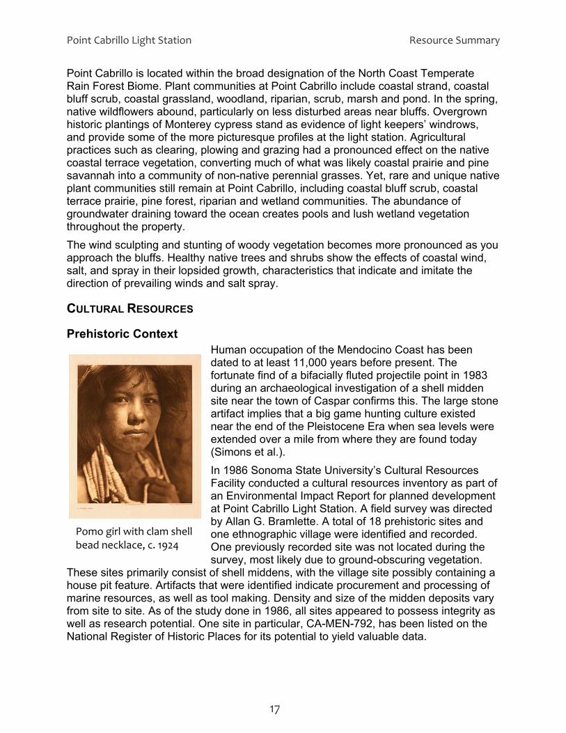
Prehistoric Context Human occupation of the Mendocino Coast has been dated to at least 11,000 years before present. The fortunate find of a bifacially fluted projectile point in 1983 during an archaeological investigation of a shell midden site near the town of Caspar confirms this. The large stone artifact implies that a big game hunting culture existed near the end of the Pleistocene Era when sea levels were extended over a mile from where they are found today (Simons et al.).
Pomo girl with clam shell bead necklace, c. 1924
In 1986 Sonoma State University’s Cultural Resources Facility conducted a cultural resources inventory as part of an Environmental Impact Report for planned development at Point Cabrillo Light Station. A field survey was directed by Allan G. Bramlette. A total of 18 prehistoric sites and one ethnographic village were identified and recorded. One previously recorded site was not located during the survey, most likely due to ground-obscuring vegetation.
These sites primarily consist of shell middens, with the village site possibly containing a house pit feature. Artifacts that were identified indicate procurement and processing of marine resources, as well as tool making. Density and size of the midden deposits vary from site to site. As of the study done in 1986, all sites appeared to possess integrity as well as research potential. One site in particular, CA-MEN-792, has been listed on the National Register of Historic Places for its potential to yield valuable data.
Resource Summary Point Cabrillo Light Station
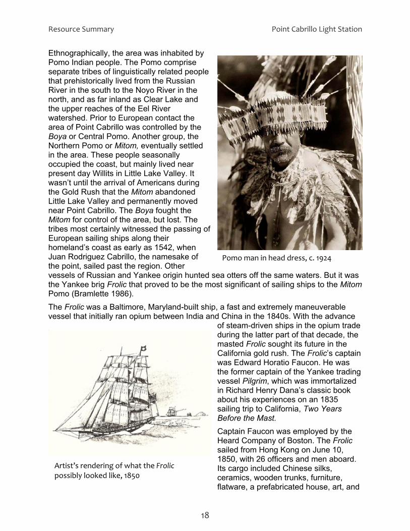
Ethnographically, the area was inhabited by Pomo Indian people. The Pomo comprise separate tribes of linguistically related people that prehistorically lived from the Russian River in the south to the Noyo River in the north, and as far inland as Clear Lake and the upper reaches of the Eel River watershed. Prior to European contact the area of Point Cabrillo was controlled by the Boya or Central Pomo. Another group, the Northern Pomo or Mitom, eventually settled in the area. These people seasonally occupied the coast, but mainly lived near present day Willits in Little Lake Valley. It wasn’t until the arrival of Americans during the Gold Rush that the Mitom abandoned Little Lake Valley and permanently moved near Point Cabrillo. The Boya fought the Mitom for control of the area, but lost. The tribes most certainly witnessed the passing of European sailing ships along their homeland’s coast as early as 1542, when Juan Rodriguez Cabrillo, the namesake of the point, sailed past the region. Other vessels of Russian and Yankee origin hunted sea otters off the same waters. But it was the Yankee brig Frolic that proved to be the most significant of sailing ships to the Mitom Pomo (Bramlette 1986).
Pomo man in head dress, c. 1924
The Frolic was a Baltimore, Maryland-built ship, a fast and extremely maneuverable vessel that initially ran opium between India and China in the 1840s. With the advance
of steam-driven ships in the opium trade during the latter part of that decade, the masted Frolic sought its future in the California gold rush. The Frolic’s captain was Edward Horatio Faucon. He was the former captain of the Yankee trading vessel Pilgrim, which was immortalized in Richard Henry Dana’s classic book about his experiences on an 1835 sailing trip to California, Two Years Before the Mast. Captain Faucon was employed by the Heard Company of Boston. The Frolic sailed from Hong Kong on June 10, 1850, with 26 officers and men aboard. Its cargo included Chinese silks, ceramics, wooden trunks, furniture,
Artist’s rendering of what the Frolic possibly looked like, 1850
flatware, a prefabricated house, art, and
18

Point Cabrillo Light Station Resource Summary
ale (Layton 1997). On the approach to California the ship hit an unknown reef ofMendocino Coast and sank on July 25, 1850. Faucon
Pine Grove Brewery
f the
and the surviving seamen made their way to San Francisco where they told a
ered
tedly
d
itom
Historic Context a began in earnest after the wreck of the Frolic. Salvagers from
of t
efly
he
primarily support farming, but also a hotel
a
ibly built
tale to insurance investors that the ship sank deep at sea with all of its cargo, a versionthat brought up fewer questions than if the ship had gone down in shallow water. The story was believed and insurance covered the loss of the cargo and the ship. Yet whatactually happened was that the Frolic did hit an outside reef and begin to sink, but the wounded ship was sailed as far into shore as possible before its final demise. The Frolic’s cargo was ultimately salvaged by Mitom Pomo Indians. They recovmany of the goods, including Chinese pottery, glass and elaborate silks. In 1984 Dr. Thomas Layton of San Jose State University, while excavating a protohistoric archaeological site called Three Chop Village in Mitom Pomo country, unexpecdiscovered Chinese pottery sherds and worked green bottle glass amidst the Native California Indian artifacts. These finds led him back to a small cove on the coast callePottery Cove, the site of the Frolic wreck. Subsequent underwater archaeology confirmed that the artifacts found at Three Chop Village were recovered by the MPomo from the Frolic. As Layton noted, “Scholarly research often leads one down unexpected paths (Layton 1997).”
Settlement of the areSan Francisco, although too late to recover anything from the shipwreck, returned withstories of the immense nearby redwoods. As a result of these stories, an entrepreneur from San Francisco named Henry Meiggs built the first sawmill in Mendocino County in 1852 on Big River. The Caspar lumber mill near Point Cabrillo was established in 1861. The Pine Grove settlement at Point Cabrillo became established as part the network of mill and market towns thasprang up along the Mendocino coast in association with the emerging timber industry. The settlement flourished brias part of a regional economy based on the export of coast redwood lumber to the San Francisco markets and the import of manufactured goods from tcity that helped sustain the Pine Grove agricultural settlement. Situated midwaybetween Fort Bragg and Mendocino nearthe Caspar lumber mill, Pine Grove grew toand dance hall for travelers and mill workers, a rudimentary three-room hospital, a brewery and a racetrack. Early settlers in the community included Peter Thompson,Scot who arrived in California with Colonel Frémont’s overland expedition and acquiredland in Pine Grove in the late 1850s, the Brinzing family from Austria who ran the local brewery, and several families of American settlers. The present visitor center (constructed in 2004) at Point Cabrillo stands on the site of a farmhouse, possby John K. McDonald around 1890, which was part of the Pine Grove community.
19

Resource Summary Point Cabrillo Light Station
For almost 100 years, timber was the most important commodity on the coast. It was the raw material for the lumber, railroad ties, shingles, pilings and and other wood products made by the sawmills dotting the Mendocino coast from Shelter Cove and Bear Harbor in the north to Gualala and Stewarts Point to the south. The ocean was the highway to the markets of the United States and abroad for the redwood lumber products of Mendocino County. The schooners⎯both sail and steam powered—provided the means of delivery, summer and winter, through any kind of wind and weather the Pacific Ocean could throw at their hardy and skilled crews. The trade lasted almost a century, beginning in 1853 and ending in the depression years of the 1930s, as the railcar and the road truck replaced the once-ubiquitous cargo vessels off the coast. The sturdy schooners also carried passengers up and down the coast. For many years these vessels offered speedier and, usually, more comfortable journeys than could be had by stagecoach. Poor county roads, before the advent of rail, provided rough travel by land on the north coast of California. To aid maritime transportation along the northern coast, the Cape Mendocino Light Station was established in 1868, followed by the Point Arena Light Station in 1870. But there was not another lighthouse for the 115 miles of coast that lay between these two stations. Due to its location and its prominence on the coastline, the Point Cabrillo vicinity was chosen as the location of another lighthouse. A Presidential Order in 1867 reserved two tracts of land for a light station, and a land survey was conducted. However it was not until the early 1900s that actions were taken to actually build the lighthouse. Petitions from local residents and Senator George Perkins finally resulted in the recommendation for a light station at Point Cabrillo in 1904. Major C.H. McKinstry, Engineer for the 12th Light-House District, wrote to the United States Light-House Board recommending the Point Cabrillo site. He noted that mounting a light on a “frame tower of the usual construction” would allow for the focal plane of the light to be “about 80 feet above high water.”
Assistant Lightkeeper and family, c. 1911
Additionally, the adjacent land provided a “favorable site for quarters.” This was an important consideration since McKinstry noted that, “This station will require the services of three keepers.” The land to the east sloped gently down to the point and was suitable for building, the site was accessible via a county road that was located only a half mile from the point, and there were a spring and stream to provide the fresh water that would be needed for the operation of the light station and for the keepers and their families. The United States Senate passed a bill In June 1906 to appropriate $25,000 for the establishment of a light station at Point Cabrillo. A second appropriation, also $25,000, was made in 1907, and over 30 acres of land was purchased from David and Margaret A. Gordon of Pine Grove for $3,195.15. Plans and specifications for the main buildings
20

Point Cabrillo Light Station Resource Summary
(light tower and fog signal building, blacksmith/carpenter shop, three houses for the lightkeepers and a barn) were approved by the Light-House Board in March 1908. A
$21,985 contract for their construction was awarded to the Lindgren Company, a San Francisco construction firm, in July 1908. These buildings were completed in 1909. The light at Point Cabrillo was first lit at midnight June 10, 1909 by the first Principal Keeper, Wilhelm Baumgartner, an immigrant from Bavaria. For over 60 years Point Cabrillo supported an active lightkeeper community. During the Lighthouse Service years from 1910 to 1939 Point Cabrillo was regarded by the United States Lighthouse Service (the successor to the Light-House Board) as a married keepers’ station. Both the principal keeper and the first assistant keeper were expected to be married while serving at Point Cabrillo, and many had children. In 1939 the Lighthouse Service merged with the United States Coast Guard. The Coast Guard operated the lighthouse from 1939 to 1972, when the light was automated. Automation meant that lighthouse keepers no longer needed to be stationed at the site. The keepers’ quarters were then
designated as housing for Coast Guard personnel stationed on the Coast Guard cutter Point Ledge.
Close‐up of the Fresnel lens
During World War II, from 1942 to 1945, a naval coastal patrol detachment was stationed at Point Cabrillo to guard the coast and maintain a radio watch at the point. A Quonset hut was added on the west side of the blacksmith shop as barracks for the navy men, and the blacksmith shop was used as the galley and mess. A radio room, radio towers and antenna were installed on the headlands just north of the lighthouse. In the 1960s the United States Air Force established a radar training facility at Point Cabrillo to the south of the lighthouse where the original barn stood at the time. The barn was modified to provide accommodations for the Air Force personnel, and trailers were installed for the electronic equipment. This facility was closed in the late 1960s and the barn deteriorated over the years. It was finally destroyed in a training exercise burn for the local fire department in 1982.
Property Transfers To The State Of California In the mid 1970s, following the automation of the light and decommissioning of the light station, the local community became concerned that the historic light station could be lost. Much of the surrounding land in private ownership was scheduled for development for residential housing. The County of Mendocino and community members enlisted the support of the California State Coastal Conservancy and local politicians to lobby for the protection of the light station and surrounding lands from development and for future
21

Resource Summary Point Cabrillo Light Station
public ownership. Between 1988 and 1990 the California State Coastal Conservancy purchased a total of 266 acres of privately-owned land parcels surrounding the light station. The Point Cabrillo Light Station was approved for inclusion on the National Register of Historic Places in 1990. It was one of ten light stations that were submitted for the National Register for their importance in the historic context of “Maritime Transportation in California, 1840-1940.” An exchange contract was signed by the United States Coast Guard and the California State Coastal Conservancy in 1991. This contract gave the state ownership of the Point Cabrillo Light Station in exchange for new housing for the Coast Guard in Fort Bragg. The North Coast Interpretive Association (NCIA) was incorporated as a supporting nonprofit organization to the State Coastal Conservancy in order to provide, among other things, for management and restoration of the light station and preserve. From 1991 to 2000 the NCIA managed the property, maintained the light station structures, and completed the restoration of the Point Cabrillo Lighthouse and its rare, British-built Fresnel lens. The third-order Fresnel lens continues to operate as an aid to navigation, and remains the property of the United States Coast Guard. The operation and maintenance of the lens is performed by a unique partnership between the Coast Guard Group Humboldt Bay and the Flotilla 87 U.S. Coast Guard Auxiliary, Mendocino County. In 2002 the California State Coastal Conservancy transferred the light station (30.5 acres for $4,000,000) and the “preserve” (266 acres as a gift valued at $6,000,000) to California State Parks. As a condition of transfer, California State Parks agreed to manage the unit consistent with the Point Cabrillo Public Use Guidelines (Appendix B). This document states that the “Light Station shall be restored consistent with the Secretary of the Interior’s Standards for the rehabilitation of historic structures.” In order to ensure the rehabilitation of the structures, California State Coastal Conservancy reserved the $4,000,000 for the project. California State Parks, the California State Coastal Conservancy and NCIA signed a document entitled “Memorandum of Understanding (MOU) for the Cooperative Management and Restoration of the Point Cabrillo Light Station and Preserve”. That same year the North Coast Interpretive Association changed its name to the Point Cabrillo Lightkeepers Association, and revised their charter and bylaws. Between 2001 and 2007 rehabilitation work continued at the light station. The rehabilitation work included the rehabilitation of the remaining historic structures, landscaping and circulation patterns; rehabilitation of the residences and adjacent outbuildings for adaptive use; and the repair, improvements/upgrade, or replacement of inadequate or failed infrastructure (water, sewer, roads, etc). In 2005, the First Assistant Lightkeeper’s house was rehabilitated and opened as a museum. The second floor provides the administrative office for the Point Cabrillo Lightkeepers Association. In 2006 the Principal Lightkeeper’s house and two outbuildings were rehabilitated and opened as an overnight accommodation for visitors (Lighthouse Inn Bed and Breakfast). The Second Assistant Lightkeeper’s house has recently undergone a partial exterior rehabilitation to match the exterior finish of the other two keepers’ houses. It is currently being occupied by the Executive Director of the Point Cabrillo Lightkeepers Association. Due to the high cost of the rehabilitation work, the funding was not enough to complete the rehabilitation of all the buildings and
22
Point Cabrillo Light Station Resource Summary
landscaping. The Point Cabrillo Lightkeepers Association and California State Parks are continuing to seek funding for the completion of the rehabilitation project.
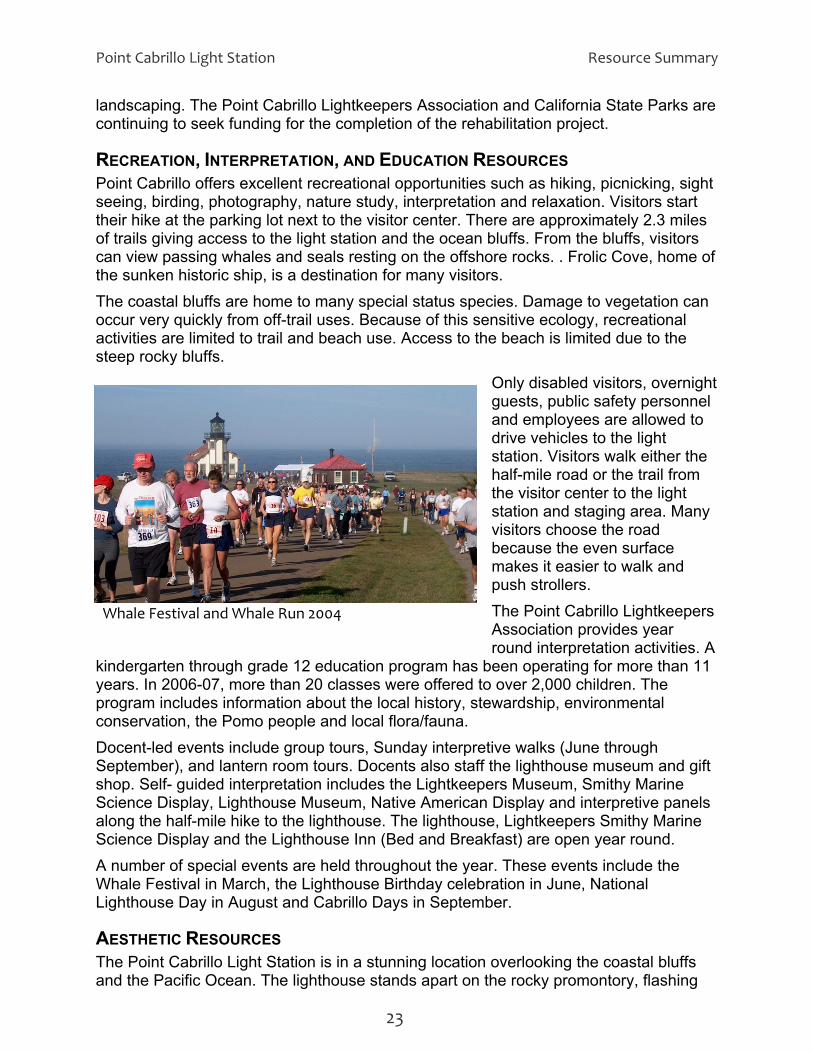
RECREATION, INTERPRETATION, AND EDUCATION RESOURCES Point Cabrillo offers excellent recreational opportunities such as hiking, picnicking, sight seeing, birding, photography, nature study, interpretation and relaxation. Visitors start their hike at the parking lot next to the visitor center. There are approximately 2.3 miles of trails giving access to the light station and the ocean bluffs. From the bluffs, visitors can view passing whales and seals resting on the offshore rocks. . Frolic Cove, home of the sunken historic ship, is a destination for many visitors. The coastal bluffs are home to many special status species. Damage to vegetation can occur very quickly from off-trail uses. Because of this sensitive ecology, recreational activities are limited to trail and beach use. Access to the beach is limited due to the steep rocky bluffs.
Only disabled visitors, overnight guests, public safety personnel and employees are allowed to drive vehicles to the light station. Visitors walk either the half-mile road or the trail from the visitor center to the light station and staging area. Many visitors choose the road because the even surface makes it easier to walk and push strollers. The Point Cabrillo Lightkeepers Association provides year round interpretation activities. A
kindergarten through grade 12 education program has been operating for more than years. In 2006-07, more than 20 classes were offered to over 2,000 children. Tprogram includes information about the local history, stewardship, environmental
11
he
ift
e
the in June, National
Lighthouse Day in August and Cabrillo Days in September.
AESTHETIC RESOURCES The Point Cabrillo Light Station is in a stunning location overlooking the coastal bluffs and the Pacific Ocean. The lighthouse stands apart on the rocky promontory, flashing
Whale Festival and Whale Run 2004
conservation, the Pomo people and local flora/fauna. Docent-led events include group tours, Sunday interpretive walks (June through September), and lantern room tours. Docents also staff the lighthouse museum and gshop. Self- guided interpretation includes the Lightkeepers Museum, Smithy Marine Science Display, Lighthouse Museum, Native American Display and interpretive panelsalong the half-mile hike to the lighthouse. The lighthouse, Lightkeepers Smithy MarinScience Display and the Lighthouse Inn (Bed and Breakfast) are open year round. A number of special events are held throughout the year. These events include Whale Festival in March, the Lighthouse Birthday celebration
23

Resource Summary Point Cabrillo Light Station
its warning light every ten secondsThe building, with an octagonal tower housing its original Fresnel lens, resembles a small white church. Three lightkeepers’ residences and several outbuildings are clustered near lighthouse. Two of the residences are beautifully restored and maintained. The dramatically steeprocky bluffs provide unreviews of the lighthouse and the ocean. At the park entrance, the newly reconstructed Kearns Farmhouse (Visitor Center) sets the historic tone for the property, reminding visitors a
.
the
stricted
nd passersby of the small
e Point Cabrillo ighland is a private small trailer park and campground adjacent to ential acquisition list for many years.
a state
analysis was done to determine the most suitable classification for this unit. Three ric Park, State Park, and State Cultural Reserve—
on alifornia Public Resources Code, as follows:
PRC § 5019.59 – State Historic Parks and State Historical Monuments consist of areas established primarily to preserve objects of historical, archaeological, and
Point Cabrillo coastline farmhouses that populated the area in the early 1900s. The historic portion of the light station is obscured by trees, buildings and topography for those passing on Point Cabrillo Drive. However, for visitors who walk from the parking area to the lighthouse, it is laid out like a historic vignette, captured in time. The open space area is habitat to many plant and animal species. Deer graze in fields, and hawks soar looking for their next meal.
the
POTENTIAL FOR FUTURE LAND ACQUISITIONS Th H s the park. It has been on California State Parks’ potAlthough the property is currently for sale, it is not a high enough priority for the Department to use its currently limited funds to purchase and operate this facility. The acquisition of the Highlands property does have the potential of providing visitorspark campground and day use facilities, and would be compatible in the future if acquisition and operating funds become available.
CLASSIFICATION ALTERNATIVES Anpotential classifications—State Histowere identified during this process. The potential of sub-classifications was also considered. Classification categories are described in Division 5, Chapter 1, Article 1.7, Secti5019 of the C
State Historic Park
24

Point Cabrillo Light Station Resource Summary
scientific interest, and archaeological sites and places commemorating important
in agricultural, mercantile, or other commercial
ed for
Staf relatively spacious areas of outstanding
scenic or natural character, oftentimes also containing significant historical, gical, ecological, geological, or other similar values. The purpose of
,
for which the park was established. g
sistent
in able
Stand
managed for the purpose of preserving and protecting the integrity of places that toric structures, villages, or settlements, archaeological
persons or historic events. Areas outside the primary historic zone may be designated as recreation zones to provide limited recreational opportunities that will supplement the public's enjoyment of the unit. Certaactivities may be permitted if those activities are a part of the history of the individual unit and any developments retain or restore historical authenticity. Motor vehicle use in State Historic Parks and State Historical Monuments is confined to paved areas and other areas specifically designed and maintainnormal ingress, egress and parking.
te Park PRC § 5019.53 State Parks consist o
archaeolostate parks shall be to preserve outstanding natural, scenic, and cultural values,indigenous aquatic and terrestrial fauna and flora, and the most significant examples of ecological regions of California, such as the Sierra Nevada, northeast volcanic, great valley, coastal strip, Klamath-Siskiyou Mountains, southwest mountains and valleys, redwoods, foothills and low coastal mountainsand desert and desert mountains. Each state park shall be managed as a composite whole in order to restore, protect, and maintain its native environmental complexes to the extent compatible with the primary purposeImprovements undertaken within state parks shall be for the purpose of makinthe areas available for public enjoyment and education in a manner conwith the preservation of natural, scenic, cultural, and ecological values for present and future generations. Improvements may be undertaken to provide forrecreational activities including, but not limited to, camping, picnicking, sightseeing, nature study, hiking, and horseback riding, so long as those improvements involve no major modification of lands, forests, or waters. Improvements that do not directly enhance the public’s enjoyment of the natural, scenic, cultural, or ecological values of the resource, which are attractionsthemselves, or which are otherwise available to the public within a reasondistance outside the park, shall not be undertaken within state parks.
te Cultural Reserve PRC § 5019.65 (b) State Cultural Reserves consist of areas selected a
contain historic or prehisfeatures, ruins, artifacts, inscriptions made by humans, burial grounds, landscapes, hunting or gathering sites, or similar evidence of past human lives or cultures. These areas may also be places of spiritual significance to California Native Americans. Within State Cultural Reserves, the highest level of resource protection shall be sought. Living and nonliving resources contained within State Cultural Reserves
25
Resource Summary Point Cabrillo Light Station
may be used for ceremonial or spiritual purposes, consistent with other laws, andif the use is not harmful to threatened or endangered species or to the cultural resources intended for protection by this designation. Management actions shall be consistent with the preservation of cultural resources and with federal and state laws. Improvements may be undertaken for the purpose of providing public access, enjoyment,
and education, and for cultural resource protection. Improvements
Sub-classifications o allows for an area within a classified unit of the State
classified as a Natural or Cultural Preserve. The management f
the ration of
sed on the invent y of natural and cultural resources presented in this document tion units in California State Parks (Point Sur State Historic Park,
nt
ultural Reserve classification was
ified as a State Historic Park, a Zone
f
of
The name “Point Cabrillo Light Station and Preserve” was used by the State Coastal Conservancy when they acquired the property, and has continued to be used by the
made for the purpose of cultural resource protection shall take into account thepossible need for access to the site for ceremonial or spiritual purposes. Motor vehicle use in State Cultural Reserves is confined to paved areas and other areas specifically designed and maintained for normal ingress, egress and parking.
The Public Resources Code alsPark System to be sub-intent for these sub-classifications is to provide for further preservation and protection othe significant natural and cultural resources. Areas identified for sub-classification require that an approved boundary be defined for State Park and Recreation Commission approval. Typically, sub-classifications are undertaken during the preparation of a general plan, when more in-depth analysis is done along withcollection of more detailed resource information than is typical during the prepaa classification document.
RECOMMENDATION Ba orand the other light staPigeon Point Light Station State Historic Park) the Department recommends that the Point Cabrillo project area be classified as a State Historic Park. Deed restrictions, Public Use Guidelines and the Light Station Interim Master Plan provide a managemeoverlay within the State Historic Park classification. The State Park classification was considered too broad for the unit based on the historical significance of the light station. The State Cconsidered too restrictive for potential visitor use. The natural and cultural preserve sub-classifications should be considered during a future general planning process. If the unit is classof Primary Cultural Interest will be established to focus visitor use and preservation efforts on the primary cultural resource. The area to the north and south of the light station may receive future consideration as a natural preserve due to the presence osensitive species and habitat. As noted in the Natural Resource section, the propertyprovides habitat for a number of listed plant and animal species. Where warranted, giving a selected area of the park a preserve designation would provide a higher level resource management and protection.
UNIT NAME
26

Point Cabrillo Light Station Resource Summary
Point Cabrillo Lightkeepers Association after acquisition by California State Parks. t t
rove State Historic Park use in California, all worthy of preservation and
1 between Caspar Cove and subdivided, with the exception of the Point
oastal California settlement and use. These include:
ding
,
Force facility
oint Cabrillo Light Station State Historic Park is not recommended because it only ot
long and cumbersome
of naming and classification of the Point Cabrillo Light Station and preserve project was initially brought up in the January 2007 quarterly meeting between
Parks and Point Cabrillo Lightkeepers Association (PCLK). Everyone
Some signs call the area Point Cabrillo Light Station State Park, and others call it PoinCabrillo Light Station and Preserve. In considering the names used in the past, currennames, and the natural and cultural history of the area, the following names were considered:
• Point Cabrillo State Historic Park • Point Cabrillo Light Station State Historic Park • Pine G
The site represents a rich history of land interpretation. The coastal margin west of old highway Russian Gulch has all been residentiallyCabrillo property. This site was preserved for its important natural and scenic resource values, and the overall historic story of settlement and use that defines the site beyond just the lighthouse and station. Although the light and the light station are the visual focal point of the property, Point Cabrillo represents much more than that. Its stories and features portray a continuum ofhistory typical in many ways of c
• Native California Indian settlement and resource use, represented by sites inclurecorded shell middens
• Gold-rush era coastal and international trade, represented by the wreck of the Frolicwhich also led to the timber industry and European settlement of the coast.
• The light station, and maritime shipping and transportation on the coast • Growth of the timber industry, which led in part to the settlement and growth of Pine
Grove • The 1960s cold war era, represented by the site of the United States Air • Coastal agriculture, including grazing, represented by the farmhouse and landscape
The Department recommends that the name Point Cabrillo State Historic Park be approved for this new unit of the California State Park System. Pidentifies one area and one aspect of the park and its history. The light station does nencompass the 266 acres of surrounding open space, and it is aname. Pine Grove State Historic Park is not recommended, because there are no historic structures except for the rehabilitated farmhouse that was part of the historic town. Pine Grove is not identified on a current map, and most people would not know where it was.
PUBLIC INPUT The discussion
California State agreed that the naming and classification process should take place in 2008 in preparation of the 100th anniversary celebration of the light station in 2009. The progress of this process was discussed at each of the quarterly meetings in 2007. In February 2008 a public meeting was held at the Russian Gulch Recreation Hall from 6:30 to 8:30. The public was notified through a press release in the local papers, the
27

Resource Summary Point Cabrillo Light Station
Mendocino Beacon and the Fort Bragg Advocate, and local radio stations. The prrelease was also distributed by PCLK Executive Director, Jim Kimbrell, to all their members and volunteers. Twenty-six people attended the meeting. Over half of the attendees were volunteers of PCLK. Karyn Gear, a representative from the CaliforniaState Coastal Conservancy, was also present. The majority of the attendees were in favor of naming the park “Point Cabrillo Light Station” and classifying it as a State Historic Park. Two resolutions were passed by PCLK recommending this name and classification. Two written comments were received through an e-mail address provided at
ess
the public meeting. One comment
e Historic Park” because the site reflects a continuum of
nd with
lic.”
he following is the proposed Declaration of
Historic Park:
itat values. provide the focal point for educational
l
nctioning for the U. S. the
ade
t
re
supported Point Cabrillo Lightkeepers Association’s recommendation. The other commenter thought the name was too long and clumsy and suggested Point CabrilloLight State Historic Park. This issue was brought before the California State Park Planning, Policy and Programming Committee (PPPC) in March 2008. After a brief presentation by the Mendocino District and long discussion by the committee, the PPPC recommended thname “Point Cabrillo Statehistory representative in many ways of coastal California settlement and use acontains more history than just the light station. Also, the name was in compliance naming principle #5, “A unit name that is long and clumsily constructed, cumbersome or difficult to use in written or spoken form does not serve the best interest of the pub(See Appendix E, “Eight Principles for Naming Units of the State Park System”.)
DECLARATION OF PURPOSE The Declaration of Purpose defines the overall purpose of a park unit, and outlines broad management goals. It also establishes long-range management objectivesconsistent with the unit classification. TPurpose for Point Cabrillo StateProposed Declaration of Purpose:
The purpose of Point Cabrillo State Historic Park is to preserve its outstanding beauty, cultural significance and natural habThe restored 1909 light station willprograms and exhibits to promote understanding of the local cultural and naturahistory, reflecting the period when the station was under the management of theU. S. Lighthouse Services. The lighthouse will continue fuCoast Guard aids-to-navigation. Historic integrity and public safety shall beprimary considerations in management and maintenance decisions. The park will also provide pedestrian-oriented recreational opportunities for the local community and visitors to the Mendocino coast, and preserve the flora, fauna, and wildlife habitat, with provisions for public safety and access. Hiking, bird watching, whale watching and tours of the light station shall be maccessible to all visitors to Point Cabrillo. Point Cabrillo State Historic Park management shall be consistent with the PoinCabrillo Public Use Guidelines in consideration of the natural and cultural resources and provision of low-impact recreational opportunities, and assulong-term community involvement.
28

Point Cabrillo Light Station Resource Summary
California State Parks will protect, manage and restore the natural and cultural resources and values of the State Historic Park, and provide appropriate programs, facilities and opportunities for public use consistent with preservatioof the resource values.
n
29

Resource Summary Point Cabrillo Light Station
SELECTED REFERENCES Bowen, Winston. The Frolic Saga: 1984-1850. Unpublished Paper, February 2008. Bradley, Denise Final Cultural Landscape Report, Point Cabrillo Light Station Mendocino, California; October 2003. Bramlette, Allan G. “An Archaeological Study for the Point Cabrillo Lighthouse Planned Development Environmental Impact Report,” Mendocino County California, August 18, 1986. California Coastal Conservancy, Point Cabrillo Public Use Guidelines Revised – February 2001. California Department of Parks and Recreation, Acquisition and Development. Initial Study Mitigated Negative Declaration: Point Cabrillo Light Station and Preserve Buildings and Infrastructure Rehabilitation Project; December 2003. California Department of Parks and Recreation Natural Resource Division. Eight Principles for Naming Units of the State Park System, October 2006. California Department of Parks and Recreation, Sue Worley & Carrie Bemis, Point Cabrillo Light Station and Preserve Amphibian Survey; 2003. California Department of Parks and Recreation, Carrie Bemis, Point Cabrillo Light Station and Preserve, Northern Harrier Survey; 2003. Fitzgerald, Richard and Hanselmann, Frederick. DRAFT 1850 Frolic State Underwater Park Management Plan. December 2007. Kilbourne, R.T., 1983, DMG Open-File Report 83-15, Geology and Geomorphic Features Related to Landsliding, Mendocino 7.5' Quadrangle, Mendocino County, California Layton, Thomas N. Western Pomo Prehistory: Excavations at Albion Head, Nightbird’s Retreat, and Three Chop Village, Mendocino County, California. Monograph 32 Institute of Archaeology University of California, Los Angeles; 1990. McLendon, Sally, and Robert L. Oswalt Pomo Introduction. In the Handbook of North American Indians. Vol. 8: California, edited by Robert F. Heizer, 274-288. Washington D.C.: Smithsonian Institution.1978. Rogerson, Bruce and Jim Kimbrell, Point Cabrillo Light Station, California. The United States Lighthouse Society’s The Keeper’s Log – Summer 2007. Simons, Dwight D., Thomas N. Layton, and Ruthann Knudson, A Fluted Point from the Mendocino County Coast, California Journal of California and Great Basin Anthropology; 1985(2): 260-269.
30
Point Cabrillo Light Station Resource Summary
Smith, Dr. Shelli O., The PAST Foundation, Frolic Archaeological Survey 2003- 2004; 2005. Warner, Peter, and Teresa Sholars. Point Cabrillo Preserve – Vascular Plants. Unpublished List. 2006. Wildlife Research Associates, Greg Tatarian, Final Report of Bat Surveys, Point Cabrillo Light Station and Preserve, Mendocino County; June 17, 2003.
31

Resource Summary Point Cabrillo Light Station
32
Point Cabrillo Light Station Resource Summary
Appendix A: Land Ownership Record Map 33
APPENDIX A: LAND OWNERSHIP RECORD MAP

Resource Summary Point Cabrillo Light Station
Appendix A: Land Ownership Record Map 34

Point Cabrillo Light Station Resource Summary
Appendix B: Public Use Guidelines 35
APPENDIX B: PUBLIC USE GUIDELINES

Resource Summary Point Cabrillo Light Station
Appendix B: Public Use Guidelines 36

Point Cabrillo Light Station
Appendix B: Public Use Guidelines 37
Resource Summary

Resource Summary Point Cabrillo Light Station
Appendix B: Public Use Guidelines 38

Point Cabrillo Light Station
Appendix B: Public Use Guidelines 39
Resource Summary
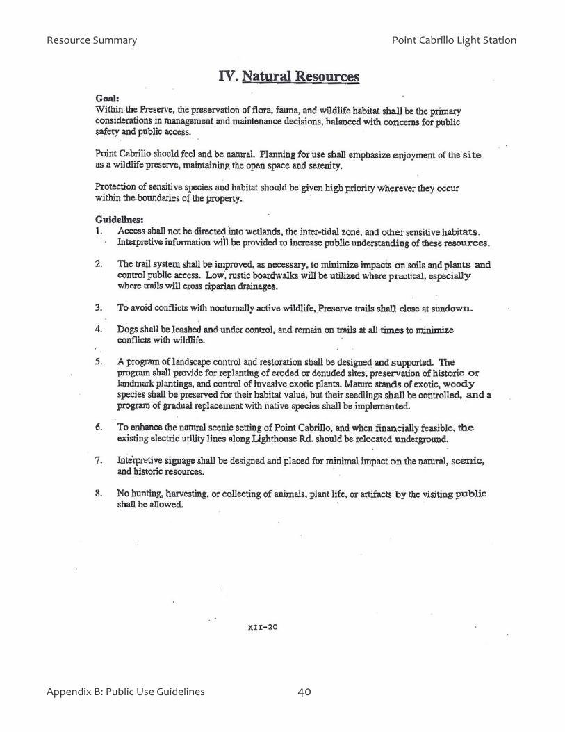
Resource Summary
Appendix B: Public Use Guidelines 40
Point Cabrillo Light Station

Point Cabrillo Light Station Resource Summary
Appendix B: Public Use Guidelines 41
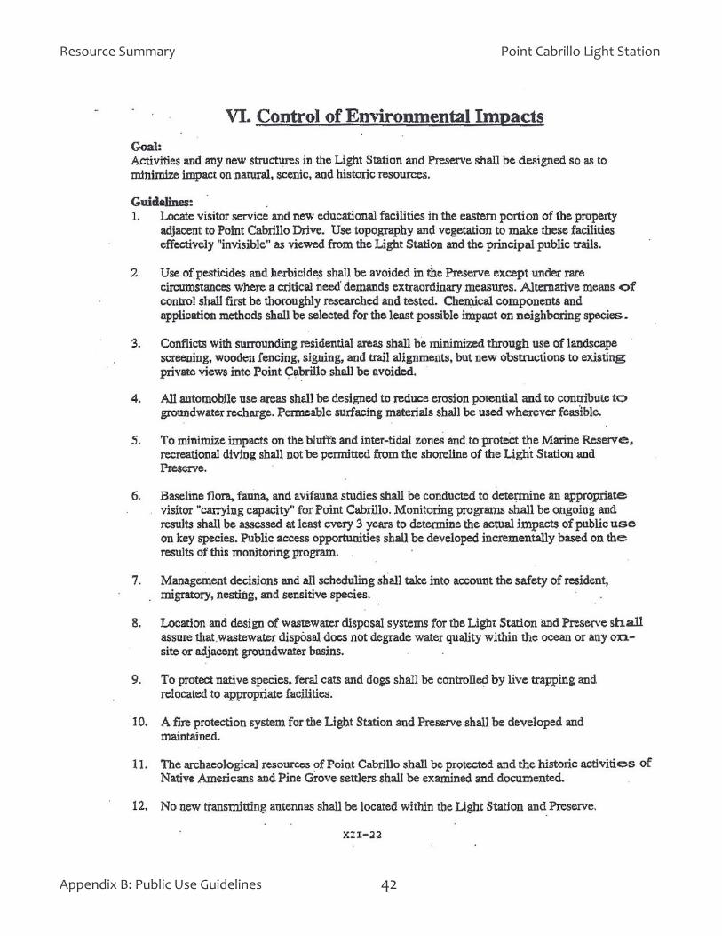
Resource Summary Point Cabrillo Light Station
Appendix B: Public Use Guidelines 42

Point Cabrillo Light Station Resource Summary
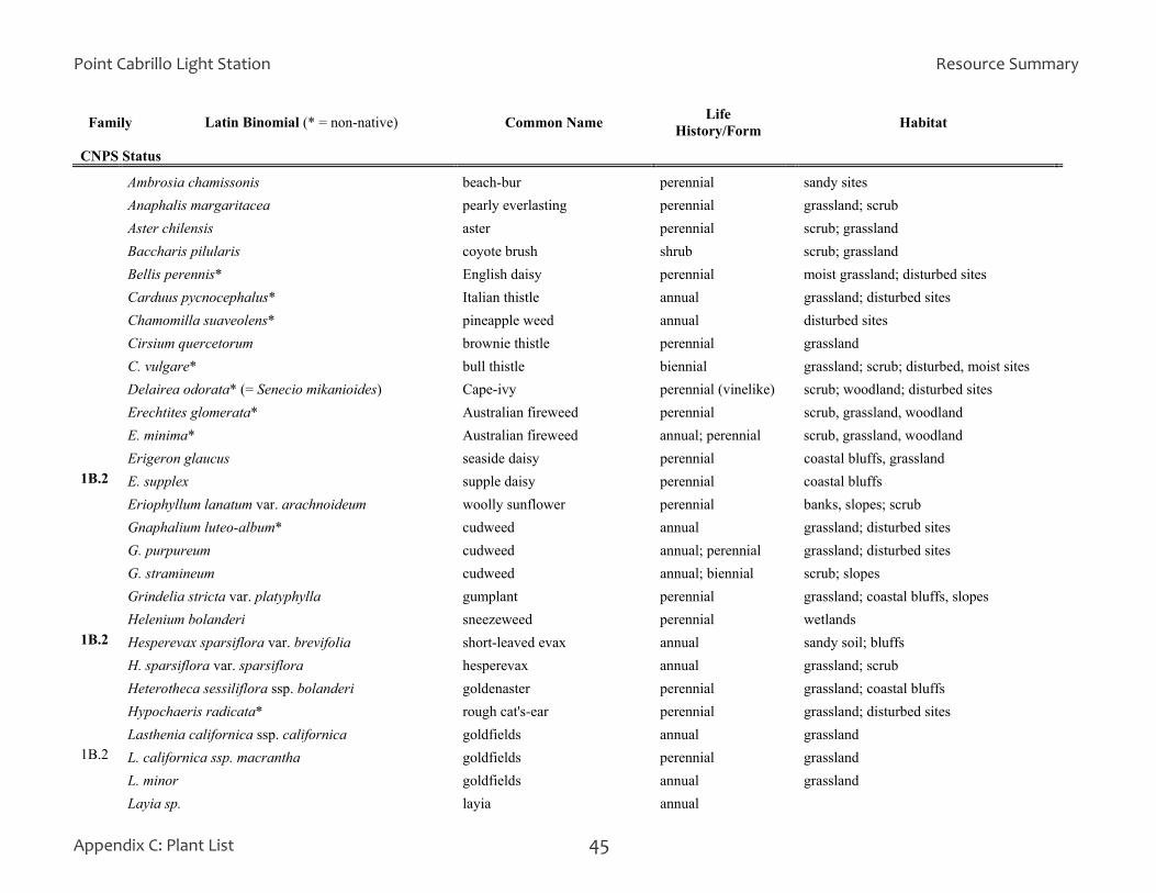
~ 319 taxa recorded to date List compiled by Teresa Sholars and Peter Warner. Revised 5-17-06 by Peter Warner. APPENDIX C: PLANT LIST
Family Latin Binomial (* = non-native) Common Name Life
History/Form Habitat
CNPS Status
Phylum SPHENOPHYTA
Equisetaceae (Horsetail Family) - 2 taxa Equisetum arvense common horsetail perennial wet soils near streams, seeps E. telmateia ssp. braunii giant horsetail perennial streambanks, wet soils Phylum PTEROPHYTA Blechnaceae (Deer Fern Family) - 1 taxon Blechnum spicant deer fern perennial along Point Cabrillo Road Dennstaedtiaceae (Bracken Family) - 1 taxon Pteridium aquilinum var. pubescens bracken perennial widespread in grassland, scrub Dryopteridaceae (Wood Fern Family) - 3 taxa Athyrium filix-femina var. cyclosorum lady fern perennial moist woods, forests Cystopteris gracilis fragile fern perennial wetlands Polystichum munitum western sword fern perennial damp forests, scrub, along streams Polypodiaceae (Polypody Family) - 2 taxa Polypodium californicum California polypody perennial on banks, slopes P. scouleri leather leaf fern perennial on rocks, cliffs near ocean Phylum CONIFEROPHYTA perennial Cupressaceae (Cypress Family) -1 taxon C. macrocarpa* Monterey cypress tree coastal grassland Pinaceae (Pine Family) - 6 taxa Abies grandis grand fir tree scrub Picea sitchensis Sitka spruce tree 1 tree along stream Pinus contorta ssp. contorta shore pine small tree scrub; woodland; landscaped areas P. muricata Bishop pine tree woodland
Appendix C: Plant List 43

Resource Summary Point Cabrillo Light Station
Appendix C: Plant List 44
Family Latin Binomial (* = non-native) Common Name Life History/Form Habitat
CNPS Status P. radiata* Monterey pine tree landscaped areas Pseudotsuga menziesii Douglas-fir tree scrub Phylum ANTHOPHYTA Class DICOTYLEDONES Aizoaceae (Carpetweed or Fig-marigold Family) - 2 taxa Carpobrotus chilensis* sea fig perennial (trailing, mat-forming) C. edulis* Hottentot-fig; iceplant perennial (trailing, mat-forming) Anacardiaceae (Cashew or Sumac Family) - 1 taxon Toxicodendron diversilobum poison-oak shrub; vine scrub; woodland; forest Apiaceae (Carrot, Parsley, Dill Family) aka Umbelliferae - 11 taxa Angelica hendersonii angelica perennial scrub; grassland Cicuta sp. water hemlock perennial freshwater Conium maculatum* poison hemlock perennial moist, disturbed sites; scrub, streamsides Daucus carota* Queen Anne's lace annual grassland; disturbed sites D. pusillus rattlesnake weed annual grassland Eryngium armatum coyote thistle perennial moist grassland Heracleum lanatum cow parsnip perennial moist coastal scrub, grassland Ligusticum apiifolium lovage perennial shady banks Oenanthe sarmentosa ditch-carrot perennial marshes; streamsides Sanicula arctopoides footsteps-of-spring perennial coastal bluffs; grassland S. crassicaulis snakeroot perennial grassland; woodland Apocynaceae (Dogbane Family) - 1 taxon
Vinca major* periwinkle perennial (groundcover) disturbed sites; homesteads
Araliaceae (Ginseng Family) 1 taxon Hedera helix* English ivy perennial shaded woodland, landscaped areas Asteraceae (Sunflower Family) aka Compositae - 40 taxa Achillea millefolium yarrow perennial grassland
Point Cabrillo Light Station Resource Summary
Appendix C: Plant List 45
Family Latin Binomial (* = non-native) Common Name Life History/Form Habitat
CNPS Status
Ambrosia chamissonis beach-bur perennial sandy sites Anaphalis margaritacea pearly everlasting perennial grassland; scrub Aster chilensis aster perennial scrub; grassland Baccharis pilularis coyote brush shrub scrub; grassland Bellis perennis* English daisy perennial moist grassland; disturbed sites Carduus pycnocephalus* Italian thistle annual grassland; disturbed sites Chamomilla suaveolens* pineapple weed annual disturbed sites Cirsium quercetorum brownie thistle perennial grassland C. vulgare* bull thistle biennial grassland; scrub; disturbed, moist sites Delairea odorata* (= Senecio mikanioides) Cape-ivy perennial (vinelike) scrub; woodland; disturbed sites Erechtites glomerata* Australian fireweed perennial scrub, grassland, woodland E. minima* Australian fireweed annual; perennial scrub, grassland, woodland Erigeron glaucus seaside daisy perennial coastal bluffs, grassland 1B.2 E. supplex supple daisy perennial coastal bluffs Eriophyllum lanatum var. arachnoideum woolly sunflower perennial banks, slopes; scrub Gnaphalium luteo-album* cudweed annual grassland; disturbed sites G. purpureum cudweed annual; perennial grassland; disturbed sites G. stramineum cudweed annual; biennial scrub; slopes Grindelia stricta var. platyphylla gumplant perennial grassland; coastal bluffs, slopes Helenium bolanderi sneezeweed perennial wetlands 1B.2 Hesperevax sparsiflora var. brevifolia short-leaved evax annual sandy soil; bluffs H. sparsiflora var. sparsiflora hesperevax annual grassland; scrub Heterotheca sessiliflora ssp. bolanderi goldenaster perennial grassland; coastal bluffs Hypochaeris radicata* rough cat's-ear perennial grassland; disturbed sites Lasthenia californica ssp. californica goldfields annual grassland 1B.2 L. californica ssp. macrantha goldfields perennial grassland L. minor goldfields annual grassland Layia sp. layia annual

Resource Summary Point Cabrillo Light Station
Appendix C: Plant List 46
Family Latin Binomial (* = non-native) Common Name Life History/Form Habitat
CNPS Status Lessingia filaginifolia var. californica California-aster perennial grassland; slopes Madia sativa coast tarweed annual grassland Madia sp. tarweed annual Microseris bigelovii microseris annual coastal bluffs Senecio jacobaea* tansy ragwort perennial coastal grassland, scrub Silybum marianum* milk thistle annual; biennial disturbed sites Solidago californica California goldenrod perennial scrub, grassland Soliva sessilis* soliva annual disturbed, compacted soil Sonchus asper* ssp. asper prickly sow-thistle annual disturbed sites; grassland Sonchus oleraceus* common sow-thistle annual disturbed sites; grassland; scrub Taraxacum officinale* dandelion perennial disturbed, moist sites; grassland Wyethia angustifolia narrow-leaved mule's-ears perennial grassland Betulaceae (Birch Family) - 2 taxa Alnus rubra red alder tree streamsides Corylus cornuta var. californica hazelnut; filbert shrub damp woodland; forest Boraginaceae (Borage Family) - 3 taxa Cynoglossum grande hound's-tongue perennial scrub Myosotis discolor* blue scorpion-grass annual; biennial disturbed sites M. latifolia* forget-me-not annual disturbed sites Brassicaceae (Mustard Family) aka Cruciferae - 7 taxa Cardamine californica milk-maids perennial grassland; wet places C. oligosperma bitter cress annual grassland; wet or disturbed places Cakile maritima* sea rocket annual dunes, beaches Coronopus didymus* swine cress annual disturbed sites Erysimum menziesii ssp. concinnum wallflower bien/perennial grassland Raphanus sativus* wild radish annual disturbed sites Rorippa nasturtium-aquaticum water cress perennial wet places, streams, seeps Caprifoliaceae (Honeysuckle Family) - 6 taxa

Point Cabrillo Light Station Resource Summary
Appendix C: Plant List 47
Family Latin Binomial (* = non-native) Common Name Life History/Form Habitat
CNPS Status
Lonicera hispidula var. vacillans honeysuckle perennial vine woodland; scrub L. involucrata twinberry shrub wet scrub; streamsides L. japonica* (sp.?) Japanese honeysuckle perennial vine fence along Point Cabrillo Rd. Sambucus racemosa var. racemosa red elderberry shrub wet places; scrub Symphoricarpos albus var. laevigatus snowberry shrub scrub S. mollis creeping snowberry vining perennial grassland; scrub Caryophyllaceae (Pink Family) - 7 taxa Cerastium arvense field chickweed perennial grassland; scrub Cerastium glomeratum* mouse-ear chickweed annual grassland; disturbed sites Sagina maxima ssp. crassicaulis big pearlwort perennial coastal bluffs Silene gallica* windmill pink annual grassland; disturbed sites Spergularia rubra* sand-spurrey annual; perennial disturbed, compacted soil Stellaria borealis ssp. sitchana chickweed perennial marshes; streamsides S. media* common chickweed annual moist, disturbed sites Convolvulaceae (Morning-glory Family) - 1 taxon Convolvulus arvensis* field bindweed perennial disturbed grassland Crassulaceae (Stonecrop Family) - 2 taxa Dudleya farinosa live-forever perennial coastal bluffs; rocky sites Sedum spathulifolium stonecrop perennial moist, shaded, rocky bluffs Cucurbitaceae (Gourd Family) - 1 taxon Marah oreganus coast man-root perennial (trailing) scrub; canyons Ericaceae (Heather Family) - 6 taxa Arctostaphylos columbiana hairy manzanita shrub woodland openings A. uva-ursi bearberry shrub (low) marine terrace Calluna vulgaris* (sp.?) heather shrub grassland Gaultheria shallon salal shrub (low) woodland; forest; scrub Ledum glandulosum western Labrador-tea shrub coastal wetlands Vaccinium ovatum blue huckleberry shrub woodland; forest; scrub

Resource Summary Point Cabrillo Light Station
Appendix C: Plant List 48
Family Latin Binomial (* = non-native) Common Name Life History/Form Habitat
CNPS Status Fabaceae (Legume Family) aka Leguminosae - 23 taxa Astralagus nuttallii var. virgatus milkvetch perennial sandy soils; coastal strand; scrub; bluffs Cytisus scoparius* Scotch broom shrub disturbed sites; roadsides; grassland Lathyrus sp. pea 4.2 Lotus formosissimus harlequin lotus perennial moist grassland L. purshianus var. purshianus Spanish clover annual disturbed sites; grassland Lupinus littoralis lupine perennial grassland; coastal bluffs L. variicolor vari-colored lupine perennial grassland; coastal bluffs Medicago arabica* spotted burclover annual disturbed sites M. polymorpha* bur-clover annual disturbed sites Melilotus indica* sourclover annual disturbed sites; roadsides Trifolium albopurpureum clover annual grassland T. barbigerum clover annual grassland T. depauperatum clover annual grassland T. dubium* shamrock clover annual disturbed sites; grassland T. fucatum bull clover annual grassland T. glomeratum* clover annual grassland; disturbed sites T. repens* white clover perennial moist, disturbed sites T. subterraneum* subterranean clover perennial grassland; disturbed sites T. wormskioldii cow clover perennial grassland; moist sites Vicia americana American vetch perennial grassland V. gigantea giant vetch perennial scrub; seeps; streamsides V. lutea* vetch annual disturbed grassland V. sativa ssp. nigra* common vetch annual grassland; disturbed site Fagaceae (Oak, Beech Family) - 1 taxon Lithocarpus densiflorus var. densiflorus tanbark oak tree forest Garryaceae (Silktassel Family) - 1 taxon Garrya elliptica silktassel shrub scrub; coastal bluffs

Point Cabrillo Light Station Resource Summary
Appendix C: Plant List 49
Family Latin Binomial (* = non-native) Common Name Life History/Form Habitat
CNPS Status Geraniaceae (Geranium Family) - 6 taxa Erodium cicutarium* red-stemmed filaree annual disturbed sites; grassland Erodium sp.* Geranium carolinianum geranium annual shady woodland G. dissectum* cutleaf geranium annual disturbed sites; grassland G. molle* softleaf geranium annual; biennial disturbed sites; grassland G. retrorsum* geranium perennial along Point Cabrillo Road Hydrophyllaceae (Waterleaf Family) - 3 taxa Nemophila menziesii baby blue-eyes annual grassland Phacelia nemoralis phacelia perennial rocky places P. ramosissima phacelia perennial coastal bluffs Hypericaceae (St. John's Wort Family) - 1 taxon Hypericum anagalloides Tinker's penny perennial streams, wetlands Lamiaceae (Mint Family) - 6 taxa Mentha pulegium* pennyroyal perennial moist to wet places M. spicata var. spicata* spearmint perennial moist to wet places Prunella vulgaris var. lanceolata self-heal perennial moist places; grassland Satureja douglasii yerba buena perennial moist scrub understory; woodland Stachys ajugoides var. rigida hedge-nettle perennial grassland; scrub; woodland S. chamissonis coast hedge-nettle perennial wet places Linaceae (Flax Family) - 2 taxa Linum bienne* flax perennial grassland L. usitatissimum* common flax annual disturbed sites, roadsides Lythraceae (Loosestrife Family) - 1 taxon Lythrum hyssopifolium* loosestrife annual; biennial moist, disturbed sites Malvaceae (Mallow Family) - 2 taxa Lavatera arborea* tree-mallow perennial-shrub disturbed sites
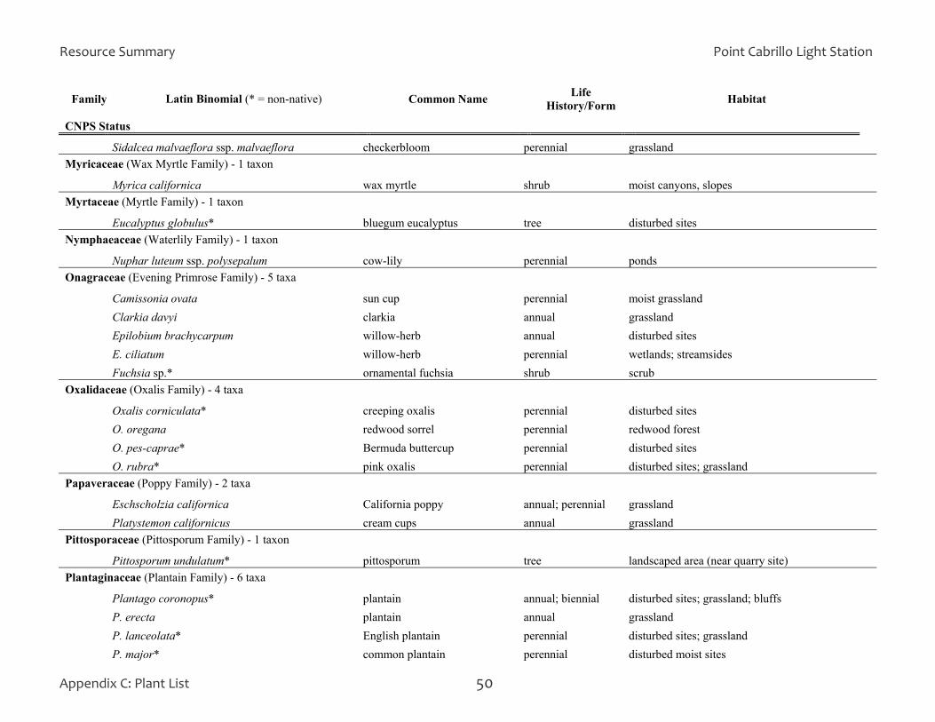
Resource Summary Point Cabrillo Light Station
Appendix C: Plant List 50
Family Latin Binomial (* = non-native) Common Name Life History/Form Habitat
CNPS Status Sidalcea malvaeflora ssp. malvaeflora checkerbloom perennial grassland Myricaceae (Wax Myrtle Family) - 1 taxon Myrica californica wax myrtle shrub moist canyons, slopes Myrtaceae (Myrtle Family) - 1 taxon Eucalyptus globulus* bluegum eucalyptus tree disturbed sites Nymphaeaceae (Waterlily Family) - 1 taxon Nuphar luteum ssp. polysepalum cow-lily perennial ponds Onagraceae (Evening Primrose Family) - 5 taxa Camissonia ovata sun cup perennial moist grassland Clarkia davyi clarkia annual grassland Epilobium brachycarpum willow-herb annual disturbed sites E. ciliatum willow-herb perennial wetlands; streamsides Fuchsia sp.* ornamental fuchsia shrub scrub Oxalidaceae (Oxalis Family) - 4 taxa Oxalis corniculata* creeping oxalis perennial disturbed sites O. oregana redwood sorrel perennial redwood forest O. pes-caprae* Bermuda buttercup perennial disturbed sites O. rubra* pink oxalis perennial disturbed sites; grassland Papaveraceae (Poppy Family) - 2 taxa Eschscholzia californica California poppy annual; perennial grassland Platystemon californicus cream cups annual grassland Pittosporaceae (Pittosporum Family) - 1 taxon Pittosporum undulatum* pittosporum tree landscaped area (near quarry site) Plantaginaceae (Plantain Family) - 6 taxa Plantago coronopus* plantain annual; biennial disturbed sites; grassland; bluffs P. erecta plantain annual grassland P. lanceolata* English plantain perennial disturbed sites; grassland P. major* common plantain perennial disturbed moist sites
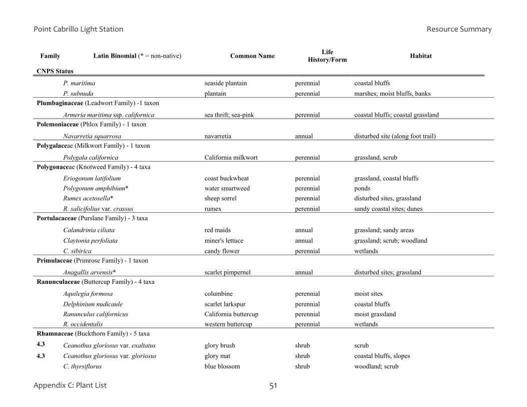
Point Cabrillo Light Station Resource Summary
Appendix C: Plant List 51
Family Latin Binomial (* = non-native) Common Name Life History/Form Habitat
CNPS Status P. maritima seaside plantain perennial coastal bluffs P. subnuda plantain perennial marshes; moist bluffs, banks Plumbaginaceae (Leadwort Family) -1 taxon Armeria maritima ssp. californica sea thrift; sea-pink perennial coastal bluffs; coastal grassland Polemoniaceae (Phlox Family) - 1 taxon Navarretia squarrosa navarretia annual disturbed site (along foot trail) Polygalaceae (Milkwort Family) - 1 taxon Polygala californica California milkwort perennial grassland, scrub Polygonaceae (Knotweed Family) - 4 taxa Eriogonum latifolium coast buckwheat perennial grassland, coastal bluffs Polygonum amphibium* water smartweed perennial ponds Rumex acetosella* sheep sorrel perennial disturbed sites, grassland R. salicifolius var. crassus rumex perennial sandy coastal sites; dunes Portulacaceae (Purslane Family) - 3 taxa Calandrinia ciliata red maids annual grassland; sandy areas Claytonia perfoliata miner's lettuce annual grassland; scrub; woodland C. sibirica candy flower perennial wetlands Primulaceae (Primrose Family) - 1 taxon Anagallis arvensis* scarlet pimpernel annual disturbed sites; grassland Ranunculaceae (Buttercup Family) - 4 taxa Aquilegia formosa columbine perennial moist sites Delphinium nudicaule scarlet larkspur perennial coastal bluffs Ranunculus californicus California buttercup perennial moist grassland R. occidentalis western buttercup perennial wetlands Rhamnaceae (Buckthorn Family) - 5 taxa 4.3 Ceanothus gloriosus var. exaltatus glory brush shrub scrub 4.3 Ceanothus gloriosus var. gloriosus glory mat shrub coastal bluffs, slopes C. thyrsiflorus blue blossom shrub woodland; scrub
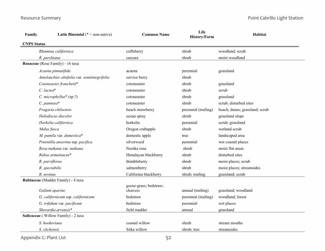
Resource Summary Point Cabrillo Light Station
Appendix C: Plant List 52
Family Latin Binomial (* = non-native) Common Name Life History/Form Habitat
CNPS Status Rhamnus californica coffeberry shrub woodland; scrub R. purshiana cascara shrub moist woodland Rosaceae (Rose Family) - 16 taxa Acaena pinnatifida acaena perennial grassland Amelanchier alnifolia var. semiintegrifolia service berry shrub Cotoneaster franchetii* cotoneaster shrub grassland C. lactea* cotoneaster shrub scrub C. microphyllus* (sp.?) cotoneaster shrub grassland C. pannosa* cotoneaster shrub scrub; disturbed sites Fragaria chiloensis beach strawberry perennial (trailing) beach; dunes; grassland; scrub Holodiscus discolor ocean spray shrub grassland slope Horkelia californica horkelia perennial scrub; grassland Malus fusca Oregon crabapple shrub wetland scrub M. pumila var. domestica* domestic apple tree landscaped area Potentilla anserina ssp. pacifica silverweed perennial wet coastal places Rosa nutkana var. nutkana Nootka rosa shrub moist flat areas Rubus armeniacus* Himalayan blackberry shrub disturbed sites R. parviflorus thimbleberry shrub moist places; scrub R. spectabilis salmonberry shrub moist places; streamsides R. ursinus California blackberry shrub; trailing grassland; scrub Rubiaceae (Madder Family) - 4 taxa
Galium aparine goose-grass; bedstraw; cleavers annual (trailing) grassland; woodland
G. californicum ssp. californicum bedstraw perennial (trailing) woodland; forest G. trifidum var. pacificum bedstraw perennial wet places Sherardia arvensis* field madder annual grassland Salicaceae ( Willow Family) - 2 taxa S. hookeriana coastal willow shrub stream mouths S. sitchensis Sitka willow shrub; tree streamsides
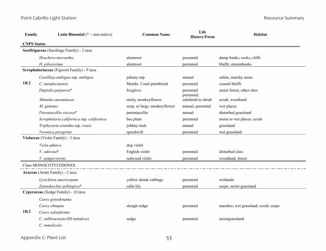
Point Cabrillo Light Station Resource Summary
Appendix C: Plant List 53
Family Latin Binomial (* = non-native) Common Name Life History/Form Habitat
CNPS Status Saxifrigaceae (Saxifrage Family) - 2 taxa Heuchera micrantha alumroot perennial damp banks, rocks, cliffs H. pilosissima alumroot perennial bluffs; streambanks Scrophulariaceae (Figwort Family) - 9 taxa Castilleja ambigua ssp. ambigua johnny-nip annual saline, marshy areas 1B.2 C. mendocinensis Mendo. Coast paintbrush perennial coastal bluffs Digitalis purpurea* foxglove perennial moist forest, other sites
Mimulus aurantiacus sticky monkeyflower perennial; subshrub to shrub scrub; woodland
M. guttatus seep, or large, monkeyflower annual, perennial wet places Parentucellia viscosa* parentucellia annual disturbed grassland Scrophularia californica ssp. californica bee plant perennial moist to wet places; scrub Triphysaria eriantha ssp. rosea johhny-tuck annual grassland Veronica peregrina speedwell perennial wet grassland Violaceae (Violet Family) - 3 taxa Viola adunca dog violet V. odorata* English violet perennial disturbed sites V. sempervirens redwood violet perennial woodland, forest
Class MONOCOTYLEDONES Araceae (Arum Family) - 2 taxa Lysichiton americanum yellow skunk cabbage perennial wetlands Zantedeschia aethiopica* calla lily perennial seeps; moist grassland Cyperaceae (Sedge Family) - 10 taxa Carex gynodynama Carex obnupta slough sedge perennial marshes; wet grassland, scrub; seeps 1B.2 Carex saliniformis C. subbracteata (ID tentative) sedge perennial moistgrassland C. tumulicola

Resource Summary Point Cabrillo Light Station
Appendix C: Plant List 54
Family Latin Binomial (* = non-native) Common Name Life History/Form Habitat
CNPS Status Eleocharis macrostachya spikerush perennial marshes Scirpus californicus California bulrush perennial marshes; ponds S. cernuus bulrush perennial wet ground; marshes; seeps S. microcarpus panicled bulrush perennial seeps; streamsides; marshes S. pungens threesquare perennial marshes; wet, alkaline soils Iridaceae (Iris Family) - 5 taxa
Iris douglasiana Douglas iris perennial (rhizome) grassland; open woodland
Iris sp.* iris perennial (rhizome) disturbed sites; landscaped areas
Sisyrinchium bellum blue-eyed grass perennial (rhizome) grassland; open woodland
S. californicum golden-eyed grass perennial (rhizome) moist to wet, open sites
Watsonia meriana* watsonia perennial (corm) grassland Juncaceae (Rush Family) - 10 taxa Juncus bolanderi Bolander's rush perennial wet ground; marshes; seeps J. breweri Brewer's rush perennial wet grassland; seeps J. bufonius var. bufonius toad rush annual seasonally moist ground J. capitatus* rush annual vernally wet grassland, slopes J. covillei rush perennial wet grassland (upper prairie) J. effusus common rush perennial marshes; wet grassland, seeps, slopes J. ensifolius rush perennial marshes; wet grassland J. patens gray rush perennial damp grassland, slopes; streamsides J. phaeocephalus rush perennial wetlands Luzula comosa wood rush perennial moist grassland, woodland, slopes Lemnaceae (Duckweed Family) - 1 taxon Lemna minuscula duckweed perennial surface of pools, ponds, slow-moving water Liliaceae (Lily Family) - 18 taxa Allium amplectens wild onion perennial (bulb) grassland A. dichlamydeum onion perennial (bulb) grassland; rocky bluffs

Point Cabrillo Light Station Resource Summary
Appendix C: Plant List 55
Family Latin Binomial (* = non-native) Common Name Life History/Form Habitat
CNPS Status
A. triquetrum* onion perennial (bulb) disturbed sites Amaryllis belladonna* naked ladies perennial (bulb) grassland Brodiaea coronaria brodiaea perennial (bulb) grassland B. terrestris ssp. terrestris ground brodiaea perennial (corm) grassland; open woodland Calochortus tolmiei pussy ears perennial (bulb) grassland; woodland
Disporum hookeri fairy bells perennial (rhizome) shaded sites; woodland; forest
Disposporum smithii Fritillaria affinis ssp. affinis checker lily perennial (bulb) grassland
1B.1 Lilium maritimum coast lily perennial (rhizome) moist, sandy sites in woodland, forest
Maianthemum dilatatum false lily-of-the-valley perennial (rhizome) marshes
Narcissus sp.* daffodil perennial (bulb) grassland
Smilacina racemosa false Solomon's-seal perennial (rhizome) wet, shaded sites; streamsides
S. stellata slim false Solomon's-seal perennial (rhizome) moist sites; scrub; woodland; forest
Triteleia laxa Ithuriel's spear perennial (corm) dry flats, slopes in scrub, woodland
4.3 Veratrum fimbriatum fringed false-hellebore perennial (rhizome) in seasonal creek bed
Zigadenus fremontii var. fremontii star lily perennial (rhizome) drier sites, slopes; scrub; woodland; grassland
Orchidaceae (Orchid Family) - 3 taxa
Goodyera oblongifolia rattlesnake plantain perennial (rhizome) dry forest
Piperia sp. orchid perennial (rhizome)
Spiranthes sp. hooded ladies' tresses perennial (rhizome)
Poaceae (Grass Family) aka Graminae - 41 taxa
1B.2 Agrostis blasdalei Blasdale's bentgrass perennial (rhizome) grassland; woodland
A. capillaris* colonial bentgrass perennial (rhizome) grassland

Resource Summary Point Cabrillo Light Station
Appendix C: Plant List 56
Family Latin Binomial (* = non-native) Common Name Life History/Form Habitat
CNPS Status
A. densiflora* bentgrass perennial (rhizome) grassland
A. hallii Hall's bentgrass perennial (rhizome) woodland
A. scabra bentgrass perennial (rhizome)
Aira caryophyllea* silver European hairgrass annual grassland; disturbed sites A. praecox* hairgrass annual bluffs; grassland
Anthoxanthum odoratum* sweet vernal grass perennial (cespitose) moist grassland
Avena barbata* slender wild oat annual disturbed sites Briza maxima* rattlesnake grass annual grassland; disturbed sites; roadcuts B. minor* little quaking grass annual grassland; disturbed sites Bromus carinatus var. carinatus
Bromus carinatus var. maritimus California brome perennial (cespitose) grassland; woodland
B. diandrus* ripgut brome annual sandy soils; grassland; disturbed sites B. hordeaceus* soft chess annual grassland; woodland; disturbed sites B. madritensis ssp. rubens* red brome annual grassland; disturbed sites
Calamagrostis nutkaensis Pacific reed grass perennial (cespitose) moist coastal grassland
Cynodon dactylon* Bermudagrass perennial (rhizomes) disturbed sites
Dactylis glomerata* orchard grass perennial (rhizomes) grassland; disturbed sites
Danthonia californica var. californica California oatgrass perennial (cespitose) moist grassland
Danthonia pilosa* hairy oatgrass perennial (cespitose) disturbed sites
Deschampsia cespitosa ssp. holciformis tufted hairgrass perennial (cespitose) grassland
Distichlis spicata saltgrass perennial (rhizomes) salt marshes, saline seeps
Elymus glaucus blue wildrye perennial (rhizomes) grassland; woodland
Festuca arundinacea* tall fescue perennial moist grassland; disturbed sites
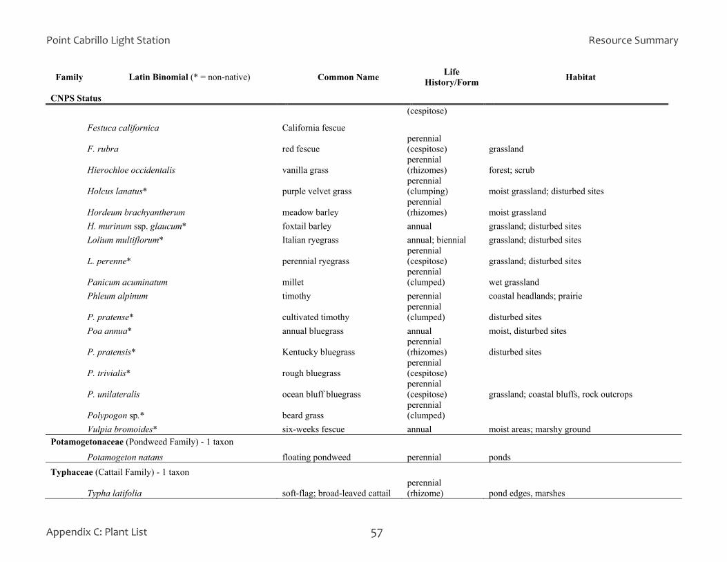
Point Cabrillo Light Station Resource Summary
Appendix C: Plant List 57
Family Latin Binomial (* = non-native) Common Name Life History/Form Habitat
CNPS Status (cespitose)
Festuca californica California fescue
F. rubra red fescue perennial (cespitose) grassland
Hierochloe occidentalis vanilla grass perennial (rhizomes) forest; scrub
Holcus lanatus* purple velvet grass perennial (clumping) moist grassland; disturbed sites
Hordeum brachyantherum meadow barley perennial (rhizomes) moist grassland
H. murinum ssp. glaucum* foxtail barley annual grassland; disturbed sites Lolium multiflorum* Italian ryegrass annual; biennial grassland; disturbed sites
L. perenne* perennial ryegrass perennial (cespitose) grassland; disturbed sites
Panicum acuminatum millet perennial (clumped) wet grassland
Phleum alpinum timothy perennial coastal headlands; prairie
P. pratense* cultivated timothy perennial (clumped) disturbed sites
Poa annua* annual bluegrass annual moist, disturbed sites
P. pratensis* Kentucky bluegrass perennial (rhizomes) disturbed sites
P. trivialis* rough bluegrass perennial (cespitose)
P. unilateralis ocean bluff bluegrass perennial (cespitose) grassland; coastal bluffs, rock outcrops
Polypogon sp.* beard grass perennial (clumped)
Vulpia bromoides* six-weeks fescue annual moist areas; marshy ground Potamogetonaceae (Pondweed Family) - 1 taxon Potamogeton natans floating pondweed perennial ponds Typhaceae (Cattail Family) - 1 taxon
Typha latifolia soft-flag; broad-leaved cattail perennial (rhizome) pond edges, marshes

Resource Summary Point Cabrillo Light Station
Appendix C: Plant List 58

Point Cabrillo Light Station Resource Summary
APPENDIX D: BIRD LIST Key to Abbreviations Seasons: Abundance Codes: W: winter (Dec, Jan, Feb) c: common r: rare Sp: spring (Mar, Apr, May) fc: fairly common x: extremely rare S: summer (June, July)* u: uncommon F: fall (Aug, Sept, Oct, Nov) *Early May through June for shorebirds
Appendix D: Bird List 59

Resource Summary Point Cabrillo Light Station
Appendix D: Bird List 60
Point Cabrillo Light Station Resource Summary
Appendix E: State Park Naming Principles 61
APPENDIX E: EIGHT PRINCIPLES FOR NAMING UNITS OF THE STATE PARK SYSTEM Naming a park unit carries significant and long-term impacts to the State Park System and to its users. Extreme care and thoughtful evaluation should be invoked whenever naming is being considered. The principles below should guide the naming of units of the State Park System. Listed with some of the principles are examples of appropriate (listed first) names followed by inappropriate names. Note that some of the inappropriate names provided are fictitious.
Principles 1-4 are positive factors that should be considered in determining a name, while principles 5-8 are negative factors that should be avoided.
1. General Usage or Name Changes
Names that have a long-established use in reference to an area of the park or the park itself are the most easily established and adopted in public use, and least confusing.
Examples: Mount Diablo vs. Mount Kawukum
2. Sense of Location
Park unit names that provide a sense of location are more informative and helpful, particularly in a large, diverse state like California.
Examples: Calaveras Big Trees State Park, Mendocino Headlands State Park vs. John Little State Reserve
3. Sense of Expectation
Park unit names that provide information about what can be expected at the unit are the most helpful to potential visitors dealing with a large system of different types of places and experiences.
Examples: Antelope Valley Indian Museum State Historic Park, Tolowa Dunes State Park, San Onofre State Beach vs. Henry W. Coe State Park, Eastshore State Park classified as a State Seashore
4. Historic, Indigenous and Ethnic Names
Names that preserve a sense of history and cultural identity can convey the legacy of California’s ethnic and ancient heritage. Such names, however, should be avoided if they are not appropriate to the area in which the unit is located, if they are used in place of names of wide general usage, or are noticeably long, awkward or difficult to pronounce.
Examples: Tomo-Kahni, Anza-Borrego Desert State Park vs. Snomme State Park
5. Long Names
A park unit name that is long and clumsily constructed, cumbersome, or difficult to use in written or spoken form does not serve the best interests of the public. Oftentimes users adopt one or more abbreviated forms which can also create confusion.
Examples: Oceano Dunes State Vehicular Recreation Area vs. Arthur B. Ripley Desert Woodland State Park

Resource Summary Point Cabrillo Light Station
Appendix E: State Park Naming Principles 62
6. Duplicative Names
Common names are often applied over and over again in the naming process. Duplication leads to confusion or the lack of a unique identity.
Examples: Morro Strand State Beach, Lake Tahoe State Recreation Area, Pfeiffer Big Sur State Park, Caspar State Beach
7. Derogatory Names
An exception to the primary principle of using names in established general usage is when a name, no matter how well established, is shown to be derogatory or highly offensive to a particular racial or ethnic group, gender, or religious group.
Examples: Squaw Creek State Park, China Beach State Beach
8. Commemorative Names
Commemorative naming not directly associated with the purpose of a unit does not provide the usefulness to the public as do names that impart a sense of location and what to expect. This is particularly true of names of individuals that are not popularly recognized or that have no obvious association with the unit. While commemorative naming is a way to honor important individuals or to educate, commemoration may be better applied to facilities, features, or places within a unit.
Examples: Will Rogers State Historic Park, Jack London State Historic Park, Jedediah Smith Redwoods State Park vs. Robert H. Meyer Memorial State Beach, Robert W. Crown Memorial State Beach
Natural Resources Division, Oct. 2006
Point Cabrillo Light Station Resource Summary
Contributors and Photo Credits 63
PROJECT CONTRIBUTORS This project was made possible through the valuable and concerted efforts of the following individuals:
California State Parks Mendocino District Marilyn Murphy, District Superintendent Morgan Zeitler, Sector Superintendent Todd Lewis, State Park Peace Officer Supervisor Jeff Reed, State Park Peace Officer Supervisor Fred Andrews, State Park Interpreter II Renee Pasquinelli, Senior Environmental Scientist Peter Warner, Associate Environmental Scientist
California State Parks Planning Division, General Plan Section Scott Green, Associate State Archaeologist Dave Keck, Section Supervisor Alan Kilgore, Research Analyst II (GIS) Carolyn Schimandle, State Park Interpreter II Laura Westrup, Associate Park and Recreation Specialist
Point Cabrillo Lightkeepers Association Ron Eich, President Bruce Rogerson, Vice President Jim Kimbrell, Executive Director Tanya Smart, Director Dan Feaster, Treasurer
Point Cabrillo Lightkeepers Association - Docents Winston Bowen Bruce Lewis Warren and Ginny Wade
California State Coastal Conservancy Sheila Semans, Project Manager Karyn Gear, North Coast Program Manager
PHOTO CREDITS Front cover, title page, and pages 5, 7, 15 (deer), 21, and 24 © Bruce Lewis Pages 13 and 16 © Renee Pasquinelli Page 23 © Bruce Rogerson