nutrient management plan: 121 king road, oakford wa 6121
TRANSCRIPT

Integrating Resource Management
Nutrient Management Plan:
121 King Road, Oakford WA 6121
Kieu LP Family Pty Ltd
74 Gladstone Road Rivervale 6103
Western Australia
July, 2016
OCM151.3/08/16

Nutrient Management Plan
2 | P a g e Nutrient Management Plan - 121 King Road. Issue 4
Nutrient Management Plan
121 King Road, Oakford WA 6121
Prepared by
Didier Alanoix
Environmental Scientist
Project Supervisor
Peter Keating
Managing Director
Bioscience Pty Ltd
488 Nicholson Road
Forrestdale 6112
9397 2446
www.biosciencewa.com
Document Control
Issue Date Author Reviewer Approved
1 08/09/2015 D. Alanoix P. Keating P. Keating
2 19/11/2015 D. Alanoix P. Keating P. Keating
3 06/01/2016 D. Alanoix P. Keating P. Keating
4 07/07/2016 D. Alanoix P. Keating P. Keating
OCM151.3/08/16

Nutrient Management Plan
Nutrient Management Plan - 121 King Road. Issue 3 3 | P a g e
Contents
Introduction ........................................................................................................................... 5
1 Summary of the Land Use Proposal .............................................................................. 5
2 Project Setting ............................................................................................................... 5
3 Land Use and Nutrient Application Details .................................................................... 6
4 Local Rainfall, Evaporation and Interception.................................................................. 7
5 Soils and Landform Description ..................................................................................... 8
5.1 Land Contours ........................................................................................................ 8
5.2 Soil Type ................................................................................................................. 8
5.3 Soil Strata ............................................................................................................... 8
5.4 PRI ......................................................................................................................... 8
5.5 Acid Sulphate Soil ................................................................................................... 8
5.6 Proposed Earthwork Details .................................................................................... 8
5.7 Imported Soil Amendments ..................................................................................... 9
6 Water Resources Description and Use .......................................................................... 9
6.1 Sensitive Water Resources ..................................................................................... 9
6.1.1 Wetlands .......................................................................................................... 9
6.1.2 Groundwater Users .......................................................................................... 9
6.2 Seasonal or Occasional Flooding ............................................................................ 9
6.3 Groundwater Description ...................................................................................... 10
6.3.1 Aquifer Description......................................................................................... 10
6.3.2 Groundwater Flow, Discharge and recharge .................................................. 10
6.3.3 Groundwater Level ........................................................................................ 10
6.3.4 Groundwater Quality ...................................................................................... 11
6.4 Source of Irrigated Water ...................................................................................... 11
7 Site Management ........................................................................................................ 12
7.1 Irrigation Scheme .................................................................................................. 12
7.1.1 Description ..................................................................................................... 12
7.1.2 Drainage Water Management ........................................................................ 12
7.1.3 Water Application Rate .................................................................................. 13
7.1.4 Discharge Water ............................................................................................ 13
7.2 Nutrient Application ............................................................................................... 14
7.3 Waste Management .............................................................................................. 14
7.3.1 Plant Matter ................................................................................................... 14
7.3.2 Spent Growing Media .................................................................................... 15
OCM151.3/08/16

Nutrient Management Plan
4 | P a g e Nutrient Management Plan - 121 King Road. Issue 4
8 Drainage and Contaminant Leaching Control .............................................................. 15
9 Protection of Natural Water Resources ....................................................................... 15
10 Surface Water Protection ............................................................................................ 15
11 Groundwater Protection............................................................................................... 15
12 Vegetation Management ............................................................................................. 15
12.1 Vegetated Screen .............................................................................................. 16
12.2 Production Area ................................................................................................. 16
13 Pesticide and Storage Use .......................................................................................... 16
14 Site Monitoring and Reporting ..................................................................................... 17
15 Contingency Plans ...................................................................................................... 17
References ......................................................................................................................... 17
OCM151.3/08/16

Nutrient Management Plan
Nutrient Management Plan - 121 King Road. Issue 3 5 | P a g e
Introduction
This Nutrient and Irrigation Management Plan (NIMP) was prepared by Bioscience Pty Ltd,
as per the guidelines of WQPN 33, on behalf of Kieu LP Family Pty Ltd. This NIMP follows
the guidance information of WQPN 25 and was written in conjunction with advice and
recommendations found in WQPN 17.
Kieu LP Family Pty Ltd has recently purchased Lot 14 (121) King Road Oakford. The
proponent is seeking to develop the property as a vegetable farm, growing cucumbers under
25 tunnel houses. The property is 4.05 ha, of which 1 ha will be used for the production.
The property is within a Priority 2 (P2) area of the Jandakot Mound Public Drinking Water
Source Area (PDWSA). The proponent understands the risk minimisation principle of P2
areas and in the non-commercial areas of the property, commits to not over-water, avoid
excessive or poorly timed use of fertilisers or pesticides, and to avoid inappropriate storage
of chemicals and disposal of wastes that can leach contaminants.
A closed system, recirculating fertigation will be used for commercial operations on the site.
1 Summary of the Land Use Proposal
Proponent's name: Kieu LP Family Pty Ltd of 74 Gladstone rd, Rivervale WA 6103
Contact details: 04 1358 8330
Site location: Lot 4 (121) King Rd, Oakford WA 6121 (Figure 1)
Project description: The proponent is seeking to develop the property as a vegetable farm,
growing cucumbers under 25 tunnel houses. The property is around
4.05 ha, of which 1 ha will be used for the production.
Timetable: Anticipated start of production is within 8 weeks of acceptance.
Operations on site will last over 30 years.
2 Project Setting
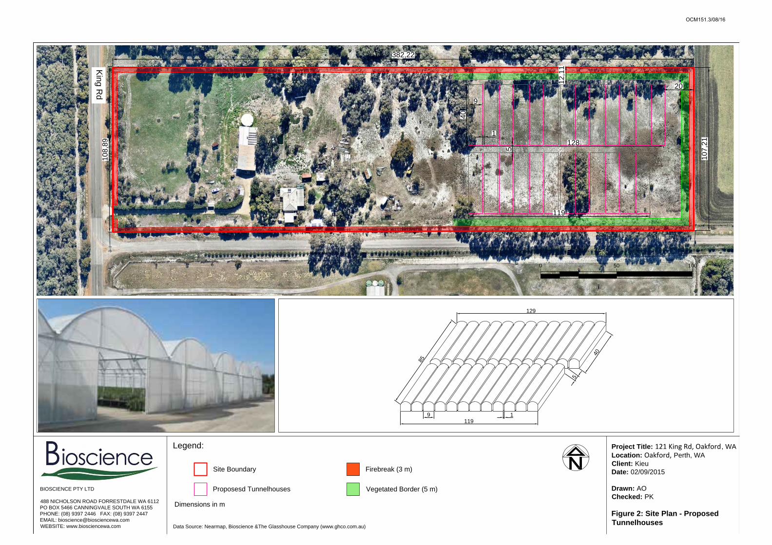
A site layout map is presented in Figure 2. As per the shire's requirement, a 10 m and a 20
m setbacks are planned respectively to the north/south and east of the proposed
development. The site will also include a 3 m firebreak and a 5 m vegetated screen.
The site is zoned "Rural Groundwater Protection" under the Shire of Serpentine-Jarrahdale's
local planning scheme 2, and is surrounded by properties of the same zoning to the south
and the north, by Modong Nature Reserve to the west and by rural lots to the east. The
boundary of the Groundwater Protection Zone is the Eastern border of Lot 14.
Lot 14 (121) King Rd is thus within a Priority 2 (P2) area of the Jandakot Mound Public
Drinking Water Source Area (PDWSA). The property is not within an area currently defined
as WHPZ or RPZ or originally proposed as WHPZ's when the GPZ was envisaged in the
1990's.
OCM151.3/08/16

Nutrient Management Plan
6 | P a g e Nutrient Management Plan - 121 King Road. Issue 4
3 Land Use and Nutrient Application Details
Kieu LP Family Pty Ltd intends to establish a vegetable farm, growing cucumbers under 25
tunnel houses. The tunnel houses will occupy 1 ha of the 4.05 ha property.
Non-commercial (domestic) gardening operations that require negligible irrigation and
chemical inputs, as proposed by Kieu LP Family Pty Ltd, is a compatible activity in P2 areas,
as long as conditions 6 and 11, as they appear in WQPN 25, are respected. Both conditions
are detailed below:
Condition 6. Pesticides should be applied in accordance with best management
practices (i.e. in accordance with label directions). For more information see the
Department of Water’s Statewide policy no. 2: Pesticide use in public drinking water
source areas, WQPN no. 104: Aerial spraying of crops with pesticides, WQPN no.
22: Herbicide use in wetlands, brochure: Liquid chemicals on agricultural land:
transport, blending, storage and disposal and the Department of Health’s A guide to
the use of pesticides in Western Australia and Circular no. PSC88: Use of herbicides
in water catchment areas.
Condition 11. Fertilisers should be applied in accordance with best management
practices. For information on fertiliser management refer to the activity-specific
documents in the Guidance information column and our brochures Fertiliser
application on pasture or turf near sensitive water resources and Liquid chemicals on
agricultural land: transport, blending, storage and disposal.
No livestock will be living on the property. A peak number of 5 people will be working on site.
OCM151.3/08/16

Nutrient Management Plan
Nutrient Management Plan - 121 King Road. Issue 3 7 | P a g e
4 Local Rainfall, Evaporation and Interception
The area has a Mediterranean climate with cool wet winters and warm to hot dry summers.
Average rainfall data was obtained from the Bureau of Meteorology records, recorded at the
Medina Research Centre situated 9.5 km to the north west of the property. Average monthly
rainfall data and annual totals recorded since 1983 are presented in Table 1. The majority of
rainfall occurs between April and September whilst the remaining months are
characteristically dry and hot, resulting in large evaporation losses.
Evaporation data obtained from Perth Regional Office is also presented in Table 1.
Evaporation is likely to be similar to the Perth area which has an annual evaporation of 1716
mm, exceeding annual average rainfall by a factor of 2:1. Monthly rainfall typically only
exceeds evaporation during the winter months.
Soil on site consists mostly of coarse to medium textured sand. Infiltration in such soils is in
the order of 10-4- 10-5 m sec-1(Look 2007). This translates to the capacity of soil to handle
rainfall in excess of 36 – 360 mm per hour. Accordingly, even in the heaviest rainfall events,
rain water in the undeveloped parts of the property will infiltrate soils and not lead to runoff.
Table 1: Average annual rainfall and evaporation data
Jan Feb Mar Apr May Jun Jul Aug Sep Oct Nov Dec Total
Average
Rainfall
(mm)
11.5 18.8 19.3 39.4 98.5 140.8 145.9 112.5 78.2 40.1 31.4 11.4 752.5
Average
Evaporat
ion
(mm)
257 218 195 120 78 57 71 102 99 148 189 253 1716
OCM151.3/08/16

Nutrient Management Plan
8 | P a g e Nutrient Management Plan - 121 King Road. Issue 4
5 Soils and Landform Description
5.1 Land Contours
The site has not been surveyed. Discussions of land contours are based on Nearmap
observations. The site is generally flat with surface elevations ranging between 23 and 25
mAHD (Figure 3).
5.2 Soil Type
The Geological Survey of WA's Environmental Geology Map (Armadale) describes the site
as Qpb/Qpa, i.e. thin Bassendean Sand layer over Guildford Formation (Figure 4).
5.3 Soil Strata
The property is located within the Perth (sedimentary) Basin and is overlain by superficial
formations of Quaternary age comprising of Bassendean Sand and the Guildford Formation.
Locally the superficial formation unconformably overlies the Leederville Formation consisting
of the Pinjar, Wanneroo and Mariginiup Members of Cretaceous age. The Leederville
Formation conformably overlies the South Perth Shale.
Superficial formations within the area consist of a variable sequence of fine and medium
sand with minor silt and limestone (mainly Bassendean sand) that interfinger with a
sequence of clay and clayey sand (Davidson & Yu, 2006).
5.4 PRI
Bassendean sands system is known to have very low PRI, ranging between 2 and 5 mg/L
within the vicinity of the site (Safstrom and Short 2012). PRI has not been used as an
analytical measure of phosphate sorbance since 1992, but rather phosphate sorbance is in
current use, and has been measured at 6.1%, so is considered a low phosphate sorbing
capacity.
5.5 Acid Sulfate Soil
The ASS Risk Map (Figure 5) defines the area as Class 2 - moderate to low risk of ASS for depths within 3m below natural ground.
5.6 Proposed Earthwork Details
A drainage sump (i.e. a 2,000 L sunken concrete tank lined with waterproof rubber paint) will
be installed within the production area.
The installation of the sump will involve minor earthworks and under the threshold volume
specified by DER as requiring an Acid Sulfate Assessment and Management Plan. Apart
OCM151.3/08/16
Nutrient Management Plan
Nutrient Management Plan - 121 King Road. Issue 3 9 | P a g e
from these, minor earthworks are expected in the property by moving surface soil to make
the site level for tunnel houses.
5.7 Imported Soil Amendments
No imported soil amendments will occur within the property. However it is noted that
commercial greenhouse plants will be grown in porous soil media contained on sealed
drainage channels.
6 Water Resources Description and Use
6.1 Sensitive Water Resources
6.1.1 Wetlands
Five sensitive water resources exist within a 500 m radius of the site (Figures 6 and 7.2), of
which:
Two are Conservation wetlands; UFI 15181 and UFI 7182, located respectively 500
north west and 300 m south east of the proposed operations;
Two are Resource Enhancement wetlands; UFI 7184 and UFI 7180, located
respectively 490 m south and 100 m south east of the operations; and,
One Multiple use wetland, existing at proximity of the property.
Regional groundwater flow, based on groundwater contours of the Perth Groundwater Atlas,
is in a south easterly direction.
Wetlands located down-gradient (with respect to groundwater flow) of the proposed activities
might be prone to some risks should the closed system, recirculating fertigation be
compromised. Best management practise is expected to prevent such event from
happening.
6.1.2 Groundwater Users
Three groundwater users abstracting water from the Superficial aquifer (GWLs 58947,
58776, 101661) are located down gradient of the proposed activities. Best management
practice will be used on site to prevent negative impacts on these users.
6.2 Seasonal or Occasional Flooding
Based on the maximum water level recorded within the vicinity of the site (i.e. around 23
mAHD, Perth Groundwater Atlas) and Nearmap observations, the site is not prone to
flooding.
OCM151.3/08/16

Nutrient Management Plan
10 | P a g e Nutrient Management Plan - 121 King Road. Issue 4
6.3 Groundwater Description
The groundwater resources of the central Perth Basin are described in detail by Davidson
(Hydrogeology and Groundwater Resources of the Perth Region Western Australia) and
Davidson & Yu (Perth Region Aquifer Modelling System). The following description of the
superficial aquifer is drawn from Davidson (1995), Davidson and Yu (2006) and regional
monitoring bore data provided by the Department of Water.
6.3.1 Aquifer Description
An unconfined aquifer with an average thickness of 30 m occurs beneath the site and the
surrounding area. Regionally, the sediments of the superficial formation are comprised of
predominantly Bassendean Sand and with some clayey sediments of the Guildford
Formation. The Bassendean Sand represents a highly permeable sandy aquifer with an
average horizontal conductivity of 15 m per day. In comparison, the Guildford Clay has a low
hydraulic conductivity of less than 0.1 m per day (Davidson, 1995).
Underlying the Superficial aquifer, the Leederville aquifer is a multi-layered aquifer consisting
of discontinuous inter-bedded sandstone, siltstone and shale of the Leederville Formation.
The thickness of the Leederville aquifer ranges from 0 m at the base of the Darling Scarp
and increases towards the West to approximately 150 m thickness below the site.
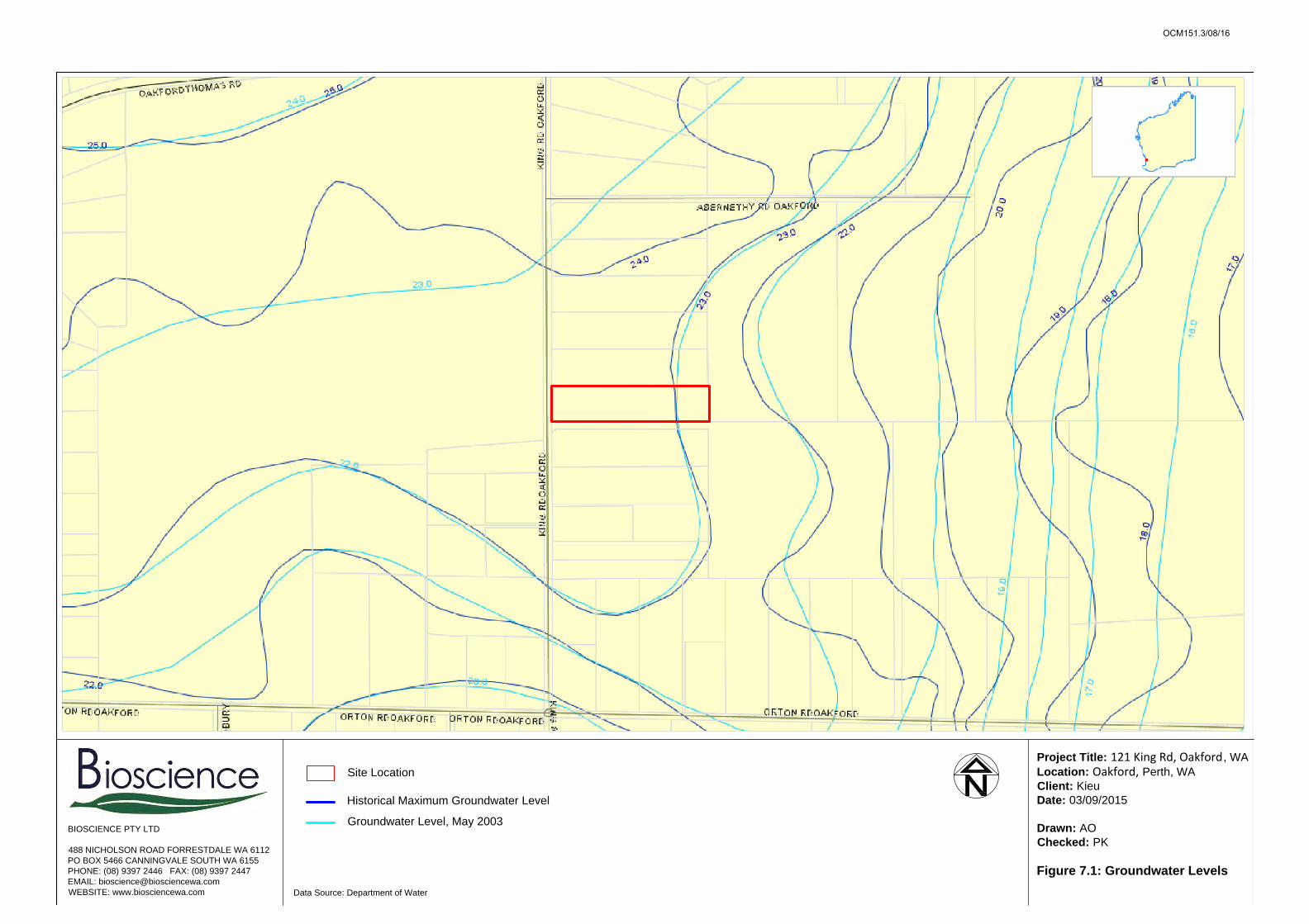
6.3.2 Groundwater Flow, Discharge and recharge
Groundwater flow within the superficial aquifer is influenced by gravity, with a downward
hydraulic gradient and away from the crests of the groundwater mounds. Groundwater flow
direction was interpreted from the Perth Groundwater Atlas. The direction of flow is in a
south easterly direction (Figure 7.1) and terminates at the discharge boundary formed by
major drains within the area.
The superficial aquifer within the Perth region is divided into a number of discrete
hydrogeological areas. The site is situated on the south eastern boundary of the Jandakot
Mound. Recharge within the Jandakot Groundwater Mound occurs directly by rainfall
infiltration and apart from discharge boundaries, are characterised by the absence of surface
runoff. Based on Jandakot Mound estimates of groundwater flow in the superficial aquifer
(Davidson, 1995), 11% of total rainfall recharges the aquifer of which 1% is downward
leakage and 10% net through-flow.
6.3.3 Groundwater Level
Topography, hydraulic conductivity of the sediments and location within the groundwater
flow system influence the depth to the watertable. Based on Perth Groundwater Atlas
hydrography, the local depth to groundwater is within a range of two to four meters
depending on the seasons and surface elevations.
OCM151.3/08/16

Nutrient Management Plan
Nutrient Management Plan - 121 King Road. Issue 3 11 | P a g e
6.3.4 Groundwater Quality
The physical and chemical properties of groundwater within the superficial aquifer vary
mainly with geological location and position within the groundwater flow system relative to
recharge and discharge points. To the north of the site recharge areas associated with the
Jandakot Mound have low groundwater salinity.
Based on the groundwater salinity contour map of the superficial aquifer presented by
Davidson (1995), salinity gradually increases in the direction of groundwater flow away from
the Jandakot Mound. Underlying the site, groundwater is fresh ranging from 500-1000 mg/L
TDS becoming brackish to saline (>1500 mg/L TDS) towards regional discharge areas in the
south and increasing prevalence of Guildford Clay within the superficial formation.
Groundwater at the watertable within the Bassendean Sand is generally acidic, with a pH
range of 4.0 to 6.5 and becomes neutral towards the base of the aquifer (pH range of 6.5-
7.5). Groundwater within the Bassendean Sand is typically sodium chloride-rich.
Water quality observed on site (Appendix A) was deemed to be of an excellent quality and
will not require reverse osmosis.
6.4 Source of Irrigated Water
The site lies within the Jandakot Mount 1 subarea of the Serpentine groundwater area.
Groundwater resources are administered under the Rights in Water and Irrigation Act (1914,
amended 2001) by the Department of Water (formally the Water and Rivers Commission).
The property currently has a groundwater well licence, GWL 165673 allowing abstraction of
10,630 kL/annum. The current allocation is insufficient for the proposed activities; it is
therefore Kieu LP Family Pty Ltd's intention to apply to amend the current licence and
increase the allocation to 40,000 kL/annum. A Form 3G has been submitted to the
Department of Water.
Abstraction will be done on site via the existing production bore (screened in the Superficial
aquifer).
OCM151.3/08/16

Nutrient Management Plan
12 | P a g e Nutrient Management Plan - 121 King Road. Issue 4
7 Site Management
7.1 Irrigation Scheme
7.1.1 Description
A closed system, recirculating fertigation will be used on site. The recirculation fertigation
systems used to grow cucumbers delivers a nutrient solution to plants growing in soil
conforming to the Australian Standard 4419 contained within a polyethylene plastic
membrane over a Styrofoam box section gully which ends in a PVC drainage channel. The
gully is set on a 1:50 slope and the drainage channel is set at a 1:100 slope. Drainage water
flows from the end of the gully then via the drainage channel to a drainage sump. Water is
pumped from the drainage sump to recirculation tanks. Double protection is afforded by all
gullies being on waterproof plastic coreflute.
Water from the recirculation tank is blended with fresh water, then fertiliser salts, dissolved in
two fertiliser concentrate tanks are added to produce the fertigation solution to a
concentration specified by the stage of development of the crop, and automatically controlled
by dosing pumps with feedback via the measurement of electrical conductivity. This nutrient
solution is pumped into greenhouses, then to irrigate plants via t-tape laid across the top of
the soil in the gully. The system is thus hydraulically closed from the external environment,
with nutrient solutions separated by a) disposable polyethylene film, b) Permanent
polystyrene gullies and c) polyethylene “coreflute” double layered plastic liners.
The reticulation of fertigation solutions uses PN15 grade polyethylene pipes which have a
lifetime decades longer than the greenhouse structures.
7.1.2 Drainage Water Management
Recirculating Nutrient systems are managed on the basis that the applied volume of nutrient
solution results in about 30% runoff (i.e. excess of the water holding capacity of the
containerised soil.) Thus, for every 100 L applied, about 30 L is recovered as drainage.
Further, the salinity of this recovered drainage is 50% higher than what was applied.
Growers typically will adjust the irrigation time to ensure the EC of the drainage solution is
150% of the EC of the applied nutrient solution
The collected drainage solution is then blended with fresh water at initially 30% of the total
volume, then further nutrient concentrates are added, but at about 70% of the initial rate. The
next drainage solution is still 50% more concentrated than the irrigation solution, however
the nature of the composition progressively changes, as it becomes relatively depleted in
phosphate and trace elements, but relatively concentrated in calcium, sulphate, sodium and
chloride. Progressively less drainage water is blended with fresh water, thus drainage water
accumulates.
When drainage water has reached a salinity greater than 1,000 parts per million sodium
chloride, this drainage water will be used to grow watercress. A permanent bed of
watercress will be maintained in the same closed system as used to grow cucumbers, with
the exception that it will be completely closed and not drain. The only addition to the
OCM151.3/08/16
Nutrient Management Plan
Nutrient Management Plan - 121 King Road. Issue 3 13 | P a g e
drainage water used to grow watercress will be phosphate, added as monopotassium
phosphate. Watercress is harvested on a weekly basis. Watercress Nasturtium officianale is
a very salt tolerant plant, and has been used as a nutrient stripper of brackish water. It is
unusual in that it takes up sodium at much higher levels than other related plants belonging
to the Brassica family. At present, it is uncertain how long a watercress garden remains
productive, however other growers in the Oakford area have maintained systems in a
productive state for longer than three years, merely topping up beds with fresh water and
fertiliser if they start to dry out because of insufficient drainage water being available.
By the combination of reusing drainage water to grow cucumbers until sodium chloride
reaches 1000 ppm, then applying such drainage water to closed water cress production,
there will be no discharge of nutrient solution to the environment.
7.1.3 Water Application Rate
Irrigation application rates in closed systems, recirculating fertigation have the advantage
over the field systems described in WQPN 22 in that hypothetical water use parameters like
evapo-transpiration rates can be directly and continuously measured.
A major part of process optimisation in closed systems, recirculating fertigation is the
continuous and automatic measurement and recording of volumes of irrigation and drainage
water volumes, pH's and Electrical Conductivity. It is this routine procedure which has made
closed systems, recirculating fertigation the most water efficient, fertiliser efficient, and
thence, capital efficient plant production systems in the history of agriculture.
The time proven rules for Perth closed systems, recirculating fertigation are:
Irrigation times are the time it takes until 30% of the applied water is recovered as
drainage. (Now measured automatically, with the last irrigation data fed back to the
computer).
Irrigation EC (fertiliser content) is the amount which causes a 50% increase in EC in
the 30% applied water recovered.
Modern closed systems, recirculating fertigation use the minimum amount of water and
fertilisers to produce the maximum yield that the temperature (whether ambient or controlled)
and sunlight (whether ambient or attenuated) allow.
7.1.4 Discharge Water
The discharge water will become unsuitable for further use because of the accumulation of
too much calcium sulphate and common salt. However, these levels are not problematic for
the irrigation of watercress which is a salt tolerant crop and the nitrate and potassium also
present makes the discharge a useful fertiliser.
Lot 121 is immediately neighbouring a cattle farm which is not on the PDWSA. This may
elect in the future to use discharge water to irrigate and fertilise this neighbouring farm.
OCM151.3/08/16

Nutrient Management Plan
14 | P a g e Nutrient Management Plan - 121 King Road. Issue 4
If this eventuates, they would store discharge water in a 18,000 L tank. A pressure pump,
connected fixed polyethylene pipes will feed the water to one of 8 knocking sprinklers with a
25 m radius, sequentially turned on by solenoid valves. This type of irrigation is already
installed on the farm. Each irrigation event will deliver 7.2 mm of water to spinklers irrigating
well established pasture.
This disposal process will commence once DER clear the property to be so irrigated. This is
expected to take about a year.
Should the watercress production system prove to be a poor commercial solution, the water,
sludge and concentrated salt will be recovered and disposed of in Class 2 landfill.
7.2 Nutrient Application
The amount of nutrient solution applied to grow Lebanese cucumbers depends on the age of
the plant and the prevailing climatic conditions. The frequency of application depends on the
size of growing channels.
Each grower uses slightly different irrigation regimes according to their preference, however
typically mature, fruiting plants in troughs are irrigated every 4 hours during daylight hours in
summer, and once per day in winter.
Lebanese cucumbers vines reach full size in about 6 weeks and thereafter they require
around 1.5 L of water per day in summer, and around 0.5 L of water per day in winter.
Planting density is in the order of 3 plants per square meter, or 1000 plants in a 40 x 9 m
tunnel house. Such a house at full production in summer would use about 1500 L of water
per day. Across a year growing season (typically 8 months, unless greenhouses are
heated), a greenhouse would use 225,000 L
A total of 1440 g of fertiliser is applied in each 1500 L of irrigation water. Of this applied
fertiliser about 140 g is contained is the discharged drainage water, giving initially a 90%
fertiliser use efficiency for the cucumber crop. Of the fertiliser in the drainage water, about
half remains as useful fertiliser in the form of nitrate and potassium, well suited for pasture
fertiliser, particularly in P sensitive environments. The remainder is calcium sulphate or
gypsum which is a useful soil conditioner, and common salt. Because the drainage solution
will be blended with fresh water and re-used, ultimately the fertiliser use efficiency of
cucumbers will be 96%. The remaining 4% will be removed as watercress biomass.
7.3 Waste Management
7.3.1 Plant Matter
During the growth cycle, there is a very minor amount of leaf and stem pruning undertaken
to train plants. At the completion of the growth cycle, plants are cut from the growing gully
and removed. This plant matter will be placed in steel skip bins. When the skip bin is full, it
will be transported to a licensed composting facility as below.
OCM151.3/08/16

Nutrient Management Plan
Nutrient Management Plan - 121 King Road. Issue 3 15 | P a g e
7.3.2 Spent Growing Media
Growing media is replaced typically every 3 years. As and when replacement is undertaken,
soil will be placed in steel skips. Once filled, skips will be taken to Aussie Organics in
Serpentine for incorporation into landscaping mixes. Aussie Organics are a DER licensed
composter and soil blender.
8 Drainage and Contaminant Leaching Control
Drainage water reports by gravity from the gullies to a drainage sump which is a 2,000 L
sunken concrete tank lined with rubber paint . A float valve-activated sump pump sends this
water to the recirculation tank for subsequent reuse. The system is hydraulically closed, and
because of the long life and durability of polyethylene tanks, the risk of rupture and spillage
is minimal.
9 Protection of Natural Water Resources
Drainage water will be discharge in watercress ponds. Watercress Nasturtium officianale is a
relatively salt tolerant plant, and has been used as a nutrient stripper of brackish water.
These ponds will prevent impacts on the nearby sensitive water resources.
10 Surface Water Protection
No stream banks or damp land vegetation exist within the vicinity of the site.
There is no native vegetation existing within the property.
Crop-growing will not happen on site except as described in completed closed and
recirculating systems. There are no steep slopes or rocky terrain on the property.
11 Groundwater Protection
The site is not prone to waterlogging and groundwater separation is higher than two meters
in the production area. In addition to these geographical aspects, advanced controls for both
irrigation and fertilizer application will be used on site. As such, impacts on groundwater from
the proposed activities are deemed to minimal.
12 Vegetation Management
The site is substantially cleared of native vegetation. The proposed development would
remove a line of non endemic trees near the central and northern part of the production area
(Figure 1). All other existing trees will be retained.
OCM151.3/08/16

Nutrient Management Plan
16 | P a g e Nutrient Management Plan - 121 King Road. Issue 4
12.1 Vegetated Screen
A substantial vegetated screen consisting of E. camaldulensis already exist on the property.
Where gaps exist within the screen, tree and shrub species will be planted as per the
brochure "Keeping it Local" produced by the Serpentine Jarrahdale Community Landcare
Centre. Vegetation species that have a low nutrient-demand will be selected and branches
hanging over the proposed tunnel houses will be routinely cut.
12.2 Production Area
Ground cover outside greenhouses will not be removed; as such erosion protection
measures are not necessary. Areas between greenhouses will be mowed.
Water and nutrient will be applied to match the growth cycle plant's needs. Slight changes
will be made as crops develop and mature. Fine tuning will be based on leaf tissue analyses
and by the growers' many years of experience. The fertigation system is closed so will not
discharge water or nutrient to the external environment.
13 Pesticide and Storage Use
The use of pesticides in Australian agriculture is regulated through the Australian Pesticides
and Veterinary Medicines Authority. The increasing trend in registration of products is to
restrict the use of insecticides, fungicides and fumigants which have half lives of more than a
few days. Environmentally persistent pesticides have been progressively deregistered and
removed over the last 20 years. Advanced closed systems, recirculating fertigation in tunnel
houses is increasingly using chemical-free systems based on the use of natural predators to
control pests, and climatic control to manage fungal diseases.
The proponent will adopt chemical free integrated pest management (IPM) systems
wherever possible. Relative to the open environment, passive and IMP methods are usually
sufficient in tunnel houses. However, if pests and diseases pose significant economic
threats, they reserve the right to use chemical pesticides provided and will:
Follow regulations set by the Australian Pesticides and Veterinary Medicines
Authority governing the use, storage, and disposal of pesticides and fungicides and
training of applicators and pest control advisors.
Follow manufacturers' recommendations and label directions.
Use pesticides only if there is an actual pest problem (not on a regular preventative
schedule) and use the minimum amount of chemical needed for the job.
Do not mix and prepare pesticides within 30m of any well, stream or pond.
Do not get rid of unused pesticides by washing them down drains.
Employ techniques to minimize off-target application (e.g. spray drift) of pesticides,
including consideration of alternative application techniques.
Clean pavement and sidewalk if chemicals are spilled on these surfaces.
OCM151.3/08/16
Nutrient Management Plan
Nutrient Management Plan - 121 King Road. Issue 3 17 | P a g e
All chemicals will be stored in a locked area (concrete floor). All applications of chemicals will
be entered into a log book.
All remaining mixtures will be disposed of according to label instructions. All equipment used
for pesticide preparations will be triple rinsed both inside and out to minimize pesticide
residues.
14 Site Monitoring and Reporting
The scale of operation, both in terms of water use and level of activity, is quite modest. A
groundwater licence of only 40,000 kL usually does not have any monitoring or reporting
requirements.
The technical service Bioscience provides to horticultural operations involves routine
monitoring of recirculating nutrient solutions and leaf tissue analysis of growing plants.
Combined with ongoing computer recording of all production parameters, this enables a
complete record of water and fertiliser use, and enables the progressive optimisation of
production operations towards maximum yield and quality.
15 Contingency Plans
The following section discusses actions planned to minimize loss of chemicals to water
resources during wildfire or major storm events or via spillage and leakage of chemicals.
The minimum necessary amount of chemicals will be stored on site. All chemicals will be
stored in allocated sheds (with concrete floors) that will be located at least 10 m away from
the nearest tree.
References
Davidson, W.A. 1995, Hydrogeology and Groundwater Resources of the Perth Region,
Western Australia, Western Australia Geological Survey, Bulletin No. 142.
Davidson, W.A. & Yu, W, 2006, Perth Region Aquifer Modelling System – PRAMS,
Hydrogeology and Modelling, Western Australia Department of Water, Hydrogeology
Record Series HG 20.
Lock, B. L. (2007) Handbook of Geotechnical Investigations and Design Tables, Taylor and
Francis Group, London UK
Safstrom R. and Short N. 2012. Agriculture Futures: Potential Rural Land Uses on the
Palusplain. Department of Agriculture and Food.
OCM151.3/08/16
Figures
OCM151.3/08/16

King R
d
0 50 100
30 km
BIOSCIENCE PTY LTD
488 NICHOLSON ROAD FORRESTDALE WA 6112
PO BOX 5466 CANNINGVALE SOUTH WA 6155
PHONE: (08) 9397 2446 FAX: (08) 9397 2447
EMAIL: [email protected]
WEBSITE: www.biosciencewa.comData Source: Nearmap & Google Maps
Legend:
Site Boundary
Dimensions in m
Project Title: 121 King Rd, Oakford, WA
Location: Oakford, Perth, WA
Client: Kieu
Date: 02/09/2015
Drawn: AO
Checked: PK
Figure 1: Location Plan
OCM151.3/08/16
382,22
10
7,2
1
Kin
g R
d
0 50 100
40
119
5
10
8,8
9
1
12
,1
1
128
20
9
119
129
5
9 1
8
5
4
0
BIOSCIENCE PTY LTD
488 NICHOLSON ROAD FORRESTDALE WA 6112
PO BOX 5466 CANNINGVALE SOUTH WA 6155
PHONE: (08) 9397 2446 FAX: (08) 9397 2447
EMAIL: [email protected]
WEBSITE: www.biosciencewa.comData Source: Nearmap, Bioscience &The Glasshouse Company (www.ghco.com.au)
Legend:
Dimensions in m
Project Title: 121 King Rd, Oakford, WA
Location: Oakford, Perth, WA
Client: Kieu
Date: 02/09/2015
Drawn: AO
Checked: PK
Figure 2: Site Plan - Proposed
Tunnelhouses
Proposesd Tunnelhouses
Site Boundary Firebreak (3 m)
Vegetated Border (5 m)
OCM151.3/08/16

Kin
g R
d
0 50 100
BIOSCIENCE PTY LTD
488 NICHOLSON ROAD FORRESTDALE WA 6112
PO BOX 5466 CANNINGVALE SOUTH WA 6155
PHONE: (08) 9397 2446 FAX: (08) 9397 2447
EMAIL: [email protected]
WEBSITE: www.biosciencewa.com
Project Title: 121 King Rd, Oakford, WA
Location: Oakford, Perth, WA
Client: Kieu
Date: 04/09/2015
Drawn: AO
Checked: PK
Figure 3: Topography
Data Source: zonums.com
Site Location
1 m Contours (mAHD)
OCM151.3/08/16

BIOSCIENCE PTY LTD
488 NICHOLSON ROAD FORRESTDALE WA 6112
PO BOX 5466 CANNINGVALE SOUTH WA 6155
PHONE: (08) 9397 2446 FAX: (08) 9397 2447
EMAIL: [email protected]
WEBSITE: www.biosciencewa.com
Project Title: 121 King Rd, Oakford, WA
Location: Oakford, Perth, WA
Client: Kieu
Date: 03/09/2015
Drawn: AO
Checked: PK
Figure 4: Geology
Site Boundary
BASSENDEAN SAND (Qpb)- white to
pale grey at surface, yellow at depth, fine
to medium grained, moderately sorted,
subangular to subrounded, minor heavy
minerals
Armadale
Geological Survey of Western Australia
Swamp deposits (Qrw)- peaty sand, grey
to black, fine to medium-grained,
moderately sorted quartz sand, slightly
peaty, of lacustrine origin
THIN BASSENDEAN SAND over
Guildford Formation (Qpb/ Qpa) - clayey
sand of the Guildford Formation, of
eolian origin
Swamp deposits (Qrw)- peaty sand, grey
to black, fine to medium-grained,
moderately sorted quartz sand, slightly
peaty, of lacustrine origin
OCM151.3/08/16

Kin
g R
d
0 50 100
BIOSCIENCE PTY LTD
488 NICHOLSON ROAD FORRESTDALE WA 6112
PO BOX 5466 CANNINGVALE SOUTH WA 6155
PHONE: (08) 9397 2446 FAX: (08) 9397 2447
EMAIL: [email protected]
WEBSITE: www.biosciencewa.com
Project Title: 121 King Rd, Oakford, WA
Location: Oakford, Perth, WA
Client: Kieu
Date: 03/09/2015
Drawn: AO
Checked: PK
Figure 5: ASS risk map
Site Boundary
Data Source: WA Atlas
Moderate to low risk of ASS
OCM151.3/08/16

Kin
g R
d
0 50 100
7180
15787
15181
BIOSCIENCE PTY LTD
488 NICHOLSON ROAD FORRESTDALE WA 6112
PO BOX 5466 CANNINGVALE SOUTH WA 6155
PHONE: (08) 9397 2446 FAX: (08) 9397 2447
EMAIL: [email protected]
WEBSITE: www.biosciencewa.com
Project Title: 121 King Rd, Oakford, WA
Location: Oakford, Perth, WA
Client: Kieu
Date: 03/09/2015
Drawn: AO
Checked: PK
Figure 6: Geomorphic Wetlands
Site Boundary
Data Source: WA Atlas
Multiuse Wetland
Conservation Category Wetland
Resource Enhancement Dampland
OCM151.3/08/16
BIOSCIENCE PTY LTD
488 NICHOLSON ROAD FORRESTDALE WA 6112
PO BOX 5466 CANNINGVALE SOUTH WA 6155
PHONE: (08) 9397 2446 FAX: (08) 9397 2447
EMAIL: [email protected]
WEBSITE: www.biosciencewa.com
Project Title: 121 King Rd, Oakford, WA
Location: Oakford, Perth, WA
Client: Kieu
Date: 03/09/2015
Drawn: AO
Checked: PK
Figure 7.1: Groundwater Levels
Data Source: Department of Water
Site Location
Historical Maximum Groundwater Level
Groundwater Level, May 2003
OCM151.3/08/16

15181
7180
7182
7181
15787
7184
14704
14872
7097
14873
7096
BIOSCIENCE PTY LTD
488 NICHOLSON ROAD FORRESTDALE WA 6112
PO BOX 5466 CANNINGVALE SOUTH WA 6155
PHONE: (08) 9397 2446 FAX: (08) 9397 2447
EMAIL: [email protected]
WEBSITE: www.biosciencewa.com
Project Title: 121 King Rd, Oakford, WA
Location: Oakford, Perth, WA
Client: Kieu
Date: 03/09/2015
Drawn: AO
Checked: PK
Figure 7.2: Sensitive water
resources based on groundwater
flow
Data Source: WA Atlas
Multiuse Wetland
Conservation Category Wetland
Resource Enhancement Dampland
Site Boundary
OCM151.3/08/16

Appendices
OCM151.3/08/16

BIOSCIENCE PTY LTD ABN: 26 547 517 746
488 NICHOLSON ROAD, FORRESTDALE WA 6112 PO BOX 5466 CANNING VALE SOUTH WA 6155
PHONE (08) 9397 2446, FAX (08) 9397 2447 EMAIL [email protected]
WEB www.biosciencewa.com
Integrating Resource Management Page 1 of 1
ANALYTICAL REPORT
CLIENT: Tan Kieu REPORT NO: 5331_2015 TEST REQUEST: Standard Potability Suite LAB SAMPLE ID: 5331 ADDRESS: DATE RECEIVED: 17/12/2015 CLIENT SAMPLE ID: 121 King Rd Bore DATE TESTED: 23/12/2015 SAMPLING LOCATION: Oakford DATE REPORTED: 4/01/2016
TEST RESULTS
Analytes Results Unit Method / Standard Potability Standard
Electrical Conductivity (EC) 0.355 mS/cm EC Sensor
pH 6.27 - IJ pH Sensor 6.5-8.5 (2a)
Total Dissolved Salts* 237 mg/L ≤500 (2a), ≤1500 (1)
Ammonium-N 0.22 mg/L Colorimetric Assay ≤0.4 (2a)
Nitrate-N 0.006 mg/L Colorimetric Assay ≤11 (1,2h)
Phosphate-P 0.065 mg/L Colorimetric Assay
Potassium 1.78 mg/L Flame AAS
Calcium 5.49 mg/L Flame AAS ≤200 (1)
Magnesium 6.91 mg/L Flame AAS ≤150 (1)
Sodium 42 mg/L Flame AAS ≤180 (2a)
Chloride 40 mg/L Precipitation ≤250 (2a)
Sulphate 15.8 mg/L Turbidity Assay ≤250 (2a)
Iron 2.79 mg/L Flame AAS ≤0.3 (2a)
Manganese 0.03 mg/L Flame AAS ≤0.1 (2a), ≤0.5 (2h)
Copper 0.001 mg/L Flame AAS ≤1 (2a), ≤2 (2h)
Zinc 0.009 mg/L Flame AAS ≤3 (2a)
These results reflect our findings of the received sample only. Notes: (1) = World Health Authority; (2) = NHMRC/NRMMC Australian Drinking Water Guidelines 2011, a) aesthetic value, h) health value. * Estimated from EC mg/L (milligrams per litre) is equivalent to parts per million (ppm) “≤”: “less than or equal to” AAS: Atomic Absorption Spectrometry
Tested by: Genevieve Massam Date: 23/12/2015 Approved by: Kylie Macpherson, Laboratory Manager Date: 24/12/2015
This report is not to be reproduced, except in full, without the approval of Bioscience Pty Ltd.
OCM151.3/08/16