ntrs.nasa.gov · 2017-07-01 · j ~ j i , j 1 i -~ , ~ , , .j 4 i i i i j , , i -~ i i i l , 1 , .1...
TRANSCRIPT
.ul", I
, I,
.. ~ :E a: o
----- _ .. _----.-:=-==== =--:=---------===-
C»)6 to C°'- tober 1, 1967
I •
.< , /
\THRUI
t CDC)
ICATEGIORY
-,J
https://ntrs.nasa.gov/search.jsp?R=19690030630 2020-07-05T05:36:39+00:00Z
J
J 1
~1 l 1 . ! ~ , .~ , ~ 1 l
1 ~ ~ 1
1 .i 1 ~.
.; --l -j
, -,
1 ] ~. i
'I i i
1 ~ ] -j s j ~
j i , j
1 i -~
,
~ , ,
.j i 4
i i i j , ,
i
-~ I i
I l , 1
,
.1 i
i i
1 , i 1 , i , !
I J i i I
i
j '\
~ i
~
..
..
Jo.
ASTROGEOLOGIC ~~'IUDIES
ANNUAL PROGRESS REPORT
July 1, 1966 to
October 1, 1967
December 1967
This preliminary report is distributed
without editorial and technical review
for conformity with official" standards
and nomenclature. It should not be
quoted without permission.
This report concerns work done on behalf of the
National Aeronaut~cs and Space Administration.
DEPARTMENT OF THE INTERIOR
UNITED STATES GEOLOGICAL SURVEY
DISTRIBUTION
National Aeronautics and Space Administration
No. of Copies
Washington, D. C. . . . • . • . . . . . . . . . . .• 20
U.S. Geological Survey.
Abelson, Dr. P. H., Director Geophysical Laboratory Carnegie Institution
· . . . . . . . . 10
l~ashington, D. C. . .. . ........••....•..• 1
A 11 en, Mr. H • J. Ames Research Center Moffett Field, California . . . . . . . . . . . . . . . . . . 1
Babcock, Dr. H. W., Director Ht. Hilson and ?alomar Observatories Hount Hilson, California. . . . . . . . . . . . . . . . . . . . . 1
Beattie, Mr. D. A. National Aeronautics and Space Administration
Brown, Professor Harrison Division of Geological Sciences Oalifornia Institute of Technology Pasadena, California.
Bryson, Mr. R. P.
1
. . . · . . . . . . . . • . . 1
National Aeronautics and Space Administration Was hi n g t on, D. C. . . • . . . . . . • '- . . . • • . . . • • • . • 2
Cannell, Mr. H. D. Aeronautical Chart Lowell Observatory Flagstaff, Arizona.
Carder, Mr. R. H.
and Information Center
. . . . . .. . . . . .
Aeronautical Chart and Information Center ~econd and Arsenal Streets St. Louis, Missouri . . . . . . . . . ~ . Chapman, Dr. D. R.
· ~ . . . . . . . . . . 1
· . . . . . , . . . . . 1
Ames Research Centet Moffett Field, California . . . . . . . . . . . . . .. . . . . 1
ii
DISTRIBUTION--Continued
Clark, Dr. J. F., Acting Director Goddard Space Flight Center
No. of Copies
Greenbe 1 t, Ma ry land . '. • • • . . • . • • • • • • • • • • • • . .1
Davin, Hr. E. M. National Aeronautics and Space Administration \--lasllillgton, D. C. . . . . . . . . . . . . • . • • . . . . • • . .1
Dollfus, Dr. Audouin Observatoire de Paris Meudon, France ......... _ ... e _ •••••••••••• 1
Dornbach, Hr. J. E. Manned Spacecraft Center Hous ton, Texas... . • • • · . . . . . . . . . . . . . . . . . I
Dm·mey, Hr. J. A. George C. Marshall Space Flight Center Huntsville, Alabama ..•••.•••••••••.••••• •. 1
Faget, Mr. Haxime Manned Spacecraft Center Houston, Texas ..• • • . • • . • . . • • . • 1
Fredrick, Professor Laurence, Director Leander HcCormick Observatory University of Virginia Charlottesville, Virginia . • . • • • • • • • • • . • • • • • • . 1
Foster, Mr. W. B., Director Manned Space Sciences Division National Aeronautics and Space Administration Washington, D. ~ ..•..•..••••••• . . . ... . . . . . 1
Gault, Hr. D. E. Ames Research Center Moffett Field, California
Gilruth, Dr. R. R., Director Hanned Spacecraft Center Houston, Texas .•••••
· . . . . . . , . • . . . . . . . . 1
· . • • • . . • • • . • • . • • • . 1
Hall, Dr. J. S., Director Lowell Observatory Flagstaff, Arizona ..•• . . . . . . . . . . . • . . . . . . . . 1
iii
I ~ . 1
I j 1 'j
..
DISTRIBUTION·· -Con.tinued
Director Canada
No. of Copies
Harrison, Dr. J. H., Geological Survey of Ottavl8., Ontario Canada .•...• . . . . . . . . . . . . . . . . . . . . . . 1
Hess, Professor H. H. Department of Geology Princeton University Princeton, New Jersey • . . • • • • • • • • . . • . • . . . . 1
Hess, Dr. loJ. N. Manned Spacecraft Center Hous ton, Texas. . . . . co • • • • • • • • • • • • • • • • • '" • • 1
Hodgson, Dr. J. H. Chief, Observatories Branch Ottawa, Ontario Canada. . . . . . . . . . . . . . . . . . . . . . . . . . . . . . 1
Jaffe, Dr. L. D.
California Institute of Technology Pasadena, California.
Kopa1, Dr. Zdenek Department of Astronomy University of Manchester Manchester, England ..•
Kron, Dr. G. E., Director U.S. Naval Observatory P. O. Box 1149 Flagstaff, Arizona ... . . . . . Kuiper, Professor G. P., Director Lunar and Planetary Laboratory University of Arizona
• . . . . • . . . . . • • . . 1
• .. . . . • . . . . 1
. . . . . . . . . . . . . . . . 1
Tucson, Arizona .•••••.•.•••.•.••••••••.• 1
MacDonald, Professor G. J. F. Institute of Geophysics University of California at Los Angeles Los Angeles 24, ~alifornia. . . . .
iv
. . . . . . . . . . . . .1
__ ... 4i '~ __ •• '" __
•
DISTRIBUTION--Continued
Mayall, Dr~ N. U., Director Kitt Peak National Observatory Tucson, Arizona .•. r
Hegreblian, Dr. Robert
. . . . . . . . . . . . .
Jet Propulsion Laboratory California Institute of Technology
No. of Copies
. . . . 1
Pasadena, California .•.••.•••••••••.••.•• •• 1
Heinel, Dr. A. B., Director Stevlard Observatory University of Arizona Tucson, Arizona .......................1
Mueller, Dr. G. E., Director Office of Manned Space Flight National Aeronautics and Space Administration Washington, D. C ......................... 1
Murray~ Professor B. C. ULV1S J.ULl UJ. i.:r~u .i.U)'!,l~ct:;' ..j~ iCilL.c;:,
California Institute of Technology Pasadena, California ....... .
Newell, Dr. H. E., Director
. . . . . . . .
Office of Space Sciences and Applications National Aeronautics and Space Administration
. . . . . . . 1
Washington, D. C .......................... 1
Nicks, Hr. O. W., Director Lunar and Planetary Programs National Aeronautics and Space Administration Washington, D. C ..•.••.•..••..•
O'Keefe, Dr. J. A. Goddard Space Flight Center Greenbelt, Maryland ....
Pickering~ Dr. W. H., Director
. . . . . . . . . . . . ..
. i
4' • • .1
Jet Propulsion Laboratory California Institute of Technology Pasadena, California. . . . . . . . . . . . . . . . 1
Pierce, Dr. K. S . Kitt Peak National Observatory Tucson, Arizona ....•.•...•••••.•..••.• •• 1
v
DISTRIBUTION--Continued
Rosch, Dr. Jean, Directeur Observatoire du Pic-du-Midi
No. of Copies
Pic-du-Midi, France . . . . . . . . . . . . . • • . . . . . • . . 1
Salisbury, Dr. J. W. Cambridge Air Force Research Laboratories Bedford, Massachusetts. . . . . • . • . . . . . . . . . .• .1
Sonnett, Dr. C. P. Ames Research Center Moffett Field, California . , . . . . . . . . . . . . . . . . 1
Steinhoff, Dr. E. A. Air Force Missile Development Center Holloman A. F. B., New Mexico .........•...•.••.. 1
Stuhlinger, Dr. Ernst George C. Marshall Space Flight Center Huntsville, Alabama ....•....•
Thompson, Dr. F. L., Director Langley Research Center
. . . . . . . . . . . . . 1
Hampton, Virginia . . . • •. •••...•......•.. 1
TT.,..on P.,..~-FoCCt"\r t:r " .- - '- j, - - - - - - - _. - _..... ~ ..
·Scripps Institute of Oceanography University of California La Jolla, California ...•..........•...•.•.. 1
Vasilev$kis, Dr. Stanley Lick Obsel~atory Mt. Haruilton, California.
von Braun, Dr. tvernher, Director George C. Marshall Space Flight Center
. . . . '. . . . . . . . . 1
Huntsville, Alabama. . . . . . . • . . . . . . . . . • . . • • . . 1
Vrebalovich, Dr. Thomas Jet Propulsion Laboratory California Institute of Technology Pasadena, California .••..........•.......•. 1
Whipple, Dr. F. L., Director Smithsonian Astrophysical Observatory 60 Garden Street Cambridge, Hassachusetts.
Whitford, Dr. A. E., Director Lick Observatory
. . . . . . . . . . . . . . . . . . 1
1-1t. Hamil ton, California. • . « • • '- • • • • • . . . . ._ . . 1
vi
! • !
CONTENTS
Page
Introduc tion. · . . . . . . . . . . . . · . . . . . 1
8
8
Part A, Lunar 'and Planetary Investigations. . • ~
Mapping at a scale of 1:1,000,000 •..
Compilations at a scale of 1:5,000,000 · . . Apollo site mapping. • •
Ranger geologic mapping.
· . . . . . . . · . ..... . . .
· . . .
· . . · . . • • . 18
· . • 18
• • • 25
· . . .'. 28 Part B, Crater Investigations
Flynn Creek crater . . •
Sierra Madera structure.
· . . . . . . . . • • • 28
· . . . . . . . . . • • • 30
Gosses Bluff structure .
Impact metamorphism.
· . . . . . . . . . · . . . . .
Volcanic studies . • • .
Hissile impact investigations.
Experimental impact investigations •
Part C, Cosmic Chemistry and ~etrology .•
· . . . . · .
· . . . . Chemistry of cosmic and related materials. · · Petrology of tektites. . · · . · · · · · Petrology of meteorites. · . · · . · · · • · ·
· . . 31
· • . 35
• • 37
42
· . . . 46 , " · . . • <fb
·
·
· . . 48
• • • 52
· . • 53
Cosmic dus t. · . . . .• . · ~ . · . . . . . · . • 53
Part D, Space Flight Investigations · . . . . . · . . . 55
Orbiter. . . . . . ~ . · . . . . · • . • 55
Surveyor · . . . · . . . . . . . . 59
Hars spacecraft. . . . . · . . . . . · . . . 63
References cited. . . • . . . · . . · . . · . • • • 64
vii
-\
'J
;
i . ~ 1 i 'i
,~ ~ J 1 ;1
I
t ~ , "

INTRODUCTION
This Annual Report is the eighth of a series describing the:
results of research by the U.S. Geological Survey 011 behalf of
the National Aeronautics and Spa.ce Administration under contract
R-66. The report was prepared by the Branch of Astrogeologic
Studies, previously the Astrogeologic Studies Section of the
Branch of Astrogeology. The other former section is now the
Branch of Surface Planetary Exploration, and work done by its
personnel for the Branch of Astrogeologic Studies is also des
cribed here. This report covers July 1, 1966 to October 1, 1967;
15 rather than 12 months are covered so that future report peri
ods will correspond to contract years. This one-volume summary
replaces the multi··volume annual reports of previous years. Sup
plemental maps are no longer ~nc:i.ucieci out: are cii~t:riuuLl.:!u d.s
they are completed.
Long-range objectives of the astrogeologic studies program
are to determine and map the stratigraphy and structure of the
crust of the Hoon and other planets, to determi~le the sequence
of events that lsd to the present condition of the surfaces of
the planets, and to describe how these events took place. Work
currently leading toward these objectives includes: (1) a pro
gram of lunar geologic mapping from both telescopic and space
craft photographs supported by photometric studies; (2) field
studies of natural structures of impa.ct and volcanic origin and
of crater.s produced by missile impact and explosive devices; (3)
laboratory studies of the behavior of rocks and minerals sub
jected to shock; (4) study of the chemical, petrographic, and
physical properties of tektites, meteorites, and cosmic dust
and development of specialized analytical techniques.
1
i "
, I
'.
This volume comprises four sections, each corresponding to
an entire volume of previous years. Part A, Lunar and Planetary
Investigations, discusses the program of lunar geologic mapping"
including .(1) regional mapping at a scale of 1:1,000,000; (2)
synoptic compilation of the mapping results at the 1:5,000,000
scale; (3) Apollo site mapping at the 1:100,000, 1:25,000, and
1:5,000 scales; (4) Ranger mapping at a variety of scales. Part
B, Crater Investigations, reporte progress in field and labora
tory studies of craters and related phenomena. Field investi
gations are being made of naturally formed craters and roots of
craters of impact and volcanic origin: (1) Flynn Creek, Tennessee;
(2) Sierra Madera, Texas; (3) Gosses Bluff, Australia; (4) l1u1e
Ear diatreme, Utah; (5) Moses Rock diatreme, Utah; (6) Lunar
Crater, Nevada; (7) San Francisco volcanic field, Arizona; and
(8) Ubehebe Crater, California. Impact-metamorphosed rocks and
minerals from several large impact structures are being in ten
e';'U~'n Qh1tH~n irrHIp. l:tboratorv. Man-made craters that are
being studied range from those produced by missile impact at
White Sands Missile Range to those formed in sand by small low
velocity Iprojectiles. Part C, Cosmic Chemistry and Petrology,
includes Ireports on techniques of study, analysis,' and inter
pretation of data on materials of known or suspected extrater
<restrial origin. Part D, Space Flight Investigations, covers
studies from Surveyor photographs and includes a.briefsummary
of work done in support of space flight operat~ons, mainly of
Surveyor and Orbiter but including preliminary planning for Mars ,
vehicles that necessarily accompanies data gathering for planet
ary studies.
The following were published during the period July L 1966 to
October 1, 1967~
Batson, R. M., and Larson, K. B., 1967, Compilation of Surveyor
television mosaics: Photogramm. Eng., v. 33, no. 2, p. 163-
173.
2
. ~
i~ • .)
:1 j
I .~ -';
I j '"
. ' ,,1'
" ~:
1 ;',
I
] 1
Brett, Robin, 1967, Cohell.ite--Its occurrence and a proposed ori
gin: Geochim. et Cosmochim. Acta, v. 31, no. 2, p. 143-
160.
Brett, Robin, and Henderson, E. P., 1967, The occurrence and
origin of lamellar troilite in iron meteorites: Geochim.
et Cosmochim. Acta, v. 31, no. 5, p. 721-730.
Brett, Robin, and Higgins, G. T., 1967, C1iftonite in meteorites-
A proposed origin: Science, v. 156, no. 3776, p. 819-820.
_____ 1967, A proposed origin of c1iftonite [abs.]: Am. Geophys.
Union Trans. v. 48, no. 1, p. 160.
Brett, Robin, and Ku11erud, G., 1967, The Fe-Pb .. S system: Econ.
Geology, v. 62, no. 3, p. 354-369.
Carr, H. H., 1966, Geologic map of the Hare Serenitatis region of
the Moon: U. S. Geol. Survey Misc. Geol. Inv. Hap I-489 •
Carr, N. H., and Gabe, H. J., 1967, Micrometeo.rite flux deter
mined from the 1965 Luster 'sounding rocket collection: Jour.
Geophys. Research, v. 72, no. 15, p. 4007-4010.
Chao, E. c. T., 1~6b, Meteor~te impact me~amorphi~m andco~mic
petrology' [abs.), ~ Abstracts for 1965~ Geo1. Soc. America
Spec .. Paper 87, p. 30-31.
___ 1967, Impact metamorphism, in Abelson, P. E., ed., Researches
in geochemistry, v. 2: Ne'w York, Hiley, p •. 204-233.
___ 1967, Shock effects in certain rock-forming minerals:
Science, v. 156, no. 3772, p. 192-202 •
Chao, E. C. T., Dwornik, E. J., and Merrill, C. W., 1966, Nickel
iron spherules from Aouelloul glass: Science, v. 154,
no. 3750, p. 759-760, 765.
Chidester, A. H., and others, 1967, Report of Geology Horking
Group, in 1967 summer study of lunar science and exploration, . .
Univers ity of California-Santa Cruz) Santa Cruz, Calif.,
July 31-August 13, 1967·: U.S. Natl. Aeronautics and Space
Adm. Spec. ·Pub. 157 ,po 30-120.
3
I: r
Cuttita, F. C., Clarke, R. S., Jr., Carron, M. K., and Annel,
C. S., 1967,Martha's Vineyard and_selected Georgia tektites-
New chemical data: Jour. Geophys. Research, v. 72, no. 4,
p. 1343-1350.
Elston, D. P., and Titley, S. R., 1966, Manned exploration of the
lunar surface: New York Acad. Sci. Annals, v. 40, p. 628-
646.
Freeberg, J. H., 1966, Terrestrial impact structures--A biblio
graphy: U.S. Geol. Survey Bu11~ 1220, 91 p.
Gault, D. E., Quaide, W. L., Oberbeck, V. R., and Moore, H. J.,
1966, Luna 9 photographs--Evidence for a fragmental surface
layer: Science, v. 153, no. 3739, p. 985-988.
Gault, D. E., and others, 1967, Lunar theory and processes, in
Surveyor III mission report, part II--Scientific results ~
California Inst. Technology, Jet Propulsion Lab. Tech. Rept.
32-1177, p. 187-188; also ~ Surveyor III, a preliminary
report: U.S. Natl. Aerc.:;'lq.utics and Space Adm. Spec. Pub.
146 , p. 141- 15 G.
---1967, Surveyor V--Discussion of chemical analysis: Science,
v. 158, no. 3801, p. 641-642.
Jaff~, L. D., and others, 1967 j Principal scientific results of
the Surveyor III mission, in Surveyor III mission report, : --- .
part II--Scientific results: California Inst~ Technology,
Jet Pl~opu1sion Lab. Te~h. Rept. 3-2-1177, p. 3-7.
McCauley, J. F., 1966, The geological exploration of the Moon,
in Conference on changing identity of graduate science
education, 1965, Proc.: Atlanta, Georgia Inst. Technology,
p. 74-82.
___ 1967, Geologic map of the Hevelius region of the Moon:
U. S.Geol. Survey Misc. Geol. Inv. Hap 1-49l.
___ 1967, Geologic results from the lunar precursor probes:
Am. lnst. Aeronautics and Astronautics Paper 67-862, 8 p.
4
HcCauley, J. F., 1967, The nature of the lunar surface as deter
mined by systematic geologic mapping, in Runcorn, S. K.,
ed., Hant1es of the Earth and terrestrial planets: New York,
Interscience, p. 43l-lj·60.
Hasursky, Harold, 1966, Lunar impact, volcanism, and tectonism-
Rationale and results [abs.], in Abstracts for 1965: Geol.
Soc. America Spec. Paper 87, p. 102.
May, Irving, and Cuttitta, Frank, 1967, New instrumental techni
ques in geochemical analysis, in Abelson, P. H., ed., Re
searches in geochemistry, v. 2: New York, Wiley~
}Uesch, A. T., Chao, E. C. T., and Cuttitta, Frank, 1966, Multi
variate analysis of geochemical data on tektites: Jour.
Geology, v. 74, no. 5, p. 673-691.
Milton, D. J.', 1966, Drifting organisms in the Precambrian sea:
Science, v. 153, no. 3733, p. 293-294.
---1967, Slopes on the Moon: Science, v. 156, no. 3778, p. 1135.
Mo'rris, E. C., and Wilhelms, D. E., 1967, Geologic map of the - ... C 1 1 c JU.!..J..ut>a€!t:lctJ.. y'u8.o.rang e. 0:"
Misc. Geol. Inv. Map 1-510.
the }1con: u.s. Geel. c. .... ,....,.,.n",. --- "._j
Rennilson, J. J., Dragg, J. L., Morris,E. C., Shoemaker, E. M.,
and Turkevich, A., 1966, Lunar surface topography, in
Surveyor I ,mission report, part II--Scientific data and
results: California Inst. Technology, Jet Propulsion Lab.
Tech. Rept. 32-1023, p. 7-44.
Roddy, D. J., 1967" Minimum energy of formation of Ubehebe Crater,
Death Val~e.y, California [abs.]: Geoi. Soc. America, Ann.
Mtg. Proc., p. 187.
Rowan, L. C., 1967, Orbiter observations of the lunar surface, in
Symposium on the physics of the Moon: . Am. Astronaut. Soc.
Paper 66-180, 42 p.
Schmitt, H. H., Trask, N. J., and .Shoemaker, E. H., 1967, Geo
logic map of the Copernicus quadrangle of the Moon: 'U.S.
Geoi. Survey Misc. Geol. Inv. Map 1-515.
5
, ' , , J
"
,~ , J
•
I .~ "
Shoemaker, E. M., al~d others, 1967, Surveyor V--Television
pictures: Science, v. 158, no. 3801, p. 642-652.
_____ 1967, Te~evision observations from Surveyor III, in Surveyor
III mission report, part II--Scientific results: California
Inst. Technology, Jet Propulsion Lab. Tech. Rept. 32-1177,
p. 9-67; also in Surveyor III, a preliminary report: U.S.
Nat1. Aeronautics and Space Adm. Spec. Pub. 146, p. 9-59.
Spradley, L. H., Steinbacher, R., Grolier, M. J., and Byrne, C.,
1967, Surveyor I--Location and identification: Science,
v. 157, no. 3789, p. 681-683.
Titley, S. R., 1967, Geologic map of the Mare Humorum region of
the Hoon: U. S. Geo1. Survey Misc. Geo1. Inv. Hap 1-495.
Trask, N. J., 1966, Stratigraphy of the Noon [abs.]: Pacific
Petroleum Geologists, v. 20, no. 2, p.4.
___ 1967, Distribution of lunar craters according to morphology
from Ranger VIII and IX photographs: Icarus, v. 6, no. 2,
D. 270-276.
Trask, N. J., and Titley, S. R., 1966, Geologic map of the Pitatus
region of the Hoon: U. S. Geo 1. Survey Misc. Geo 1. Inv. Map
1-485.
Wildey, R. L., 1966, On terrain figure of merit for spacecraft
landers: Jour. Spacecraft and Rockets., v. 3, p. 1551-1552.
___ 1967, Physical categories of the Moon's nocturnal hotspots
[abs.]: Astron. Jour., v. 72, no. 7, p. 837.
____ 1967, On the treatment of radiative transfer in the lunar
diurnal,heatflow: Jour. Geophys. Research, v. 72, no. 18,
p. 4765-4767.
___ 1967, Spatial filtering of astronomical photographs: Astron.
Soc. Pacific Pub., v. 79, no. 468, p.220-425.
___ 1967, Spatial filtering of astronomical photographs, II-
Theory: Astron. Jour., v. 72, no. 7, p. 884-886 .
6
:~'!I(~"'t:"_.,,,...,.,._,... .. , .... ~ ..... -r· .. ~v.' .. t_ ... =·!ii 1G_'Ilt'~ .. ··~~~.", .. '\), __ ""_"",~·,,,,_· __ ..... __ • ___ ~ ___ ,_, ~ ____ ... __ ~_ •
. '
. ;
Contributions to administrative reports include:
Lunar Orbiter Photo Data Screening Group, 1967, Preliminary ter
rain evaluation and Apollo landing site analysis based on
Lunar Orbiter I photography: U. S. Nat1. Aeronautics and
Space Adm., Langley Research Center, Langley Working Paper
322.
---1967, Preliminary geologic evaluation and Apollo landing
analysis of areas photographed by Lunar Orbiter II: U.S.
Nat1. Aeronautics and Space Adm., Langley Research Center,
Langley Horking Paper 363.
___ ,1967, Preliminary geologic evaluation and Apollo landing
analysis of areas photographed by l.unar Orbiter III: Nat1.
Aeronautics and Space Adm., Langley Research Center, Langley
Working Paper 407.
---1967, Preliminary geologic evaluation of areas photographed
by Lunar Orbiter V including an Apollo landing analysis of
one of the areas: U.S. Natl. Aeronautics and Space Adm.,
Langley Research Center, Langley Worl<.ing l:'aper )Ub.
Lunar Orbiter Project Office, 1966, Lunar Orbiter project,
mission A description: U.S. Natl. Aeronautics and Space
Adm., Langley Research Center, LOTD-102-0.
---1966, Lunar Orbiter project, mission B description: U.S.
Nat1. AeronOautics and Space Adm., Langley Research Center,
LOTD-107-0.
_____ 1966, Lunar Orbiter project, mission II description: U.S.
Nat1. Aeronau tics and Space Adm., Langley Research Center,
LOTD-107 -1.
______ 1966, Lunar Orbiter project, mission III description: U.S.
Natl. Aeronautics and Space Adm., Langley Research Center,
LOTD-113-0.
---1967, ~unar Orbiter project, mission V description: U.S •
Natl. Aeronautics and Space Adm., Langley Research Center,
LOTD-120-0 •
7
, -5
•
i ,
~ , I
Part A. LUNAR AND PLANETARY I1~ESTIGATIONS
During contract year 1967, the lunar and planetary program
roncentrated on Lunar Orbiter and Surveyor space flights. Photo
graphs and other data from these highly successful spacecraft
were screened, mainly for· their application to the Apollo pro
gram, and an intensive program of mapping Apollo sites was
begun. In addition, mission operations (reported in Part D)
occupied the time of 10 lunar geologists during space flights.
As a result, few new 1:1,000,000 scale maps were· completed,
although substantial progress was made on those of the 44 quad
rangles at this scale that are contracted for but as yet unpub
lished.· Work also advanced on a 1:5,000,000 earthside compila
tion.
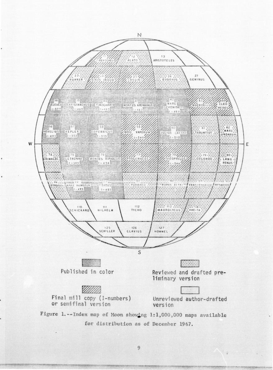
I. Mapping at a scale of 1:1,000,000
Progress report
made toward the eventual publication of 1:1,000,000 maps of the
entire lunar earthside hemisphere (tables 1-3). Seven maps whose
content was summarized in the previous annual report (Seleucus,
Pitatus, Mare Humorum, Mare Serenitatis, Hevelius, Julius Caesar, i
Copernicus) were published. All of these are in the central and
westRrn parts of the equatorial belt of 28 quadrangles where the
lunar geologic mapping program began; 12 maps in this belt of
quadrangles are now published (fig. 1, table 1). One map that
also was summarized last year (Mare Vaporum) is completed and
will soon be published (table 1). Two additional maps in this
belt were readied for publication and are summarized in this
report; one (Theophilus) was submitted for publication but has
been conSiderably delayed because of base-registration problems;
another (Ptolemaeus)· is in the final editorial stages; both will
be published in fiscal year 1968. Three preliminary maps in the
northtvest quadr~nt of the Moon completed last year (Cassini,
8
i. _,~....,~_ ~,,!",~.,..~...,.,:u.""-"""""""'_'''''.'''_. _________ _
N
112 TYCHO
126 C LA 1 U S
Publ ' sh d i n col or
Fi nal mill copy (I -n mbers ) or semi f i al ers i on
s
1:::::::::;:::::;:::]
Revi wed an d drafted preli minary ersi on
U revie~e d au hor-dr fted vers i on
Fig r 1. - Ind x ap of 0 0 S 0"t""J., g :1 , 000,000 rna s avai 1ab1
or distr O i n as 0 Dec rnber 19 7 .
9

Table 1. --Haps at 1~ 1,000,000 scale pubfisbed or in press at end
of contract year 1967 (publication date of maps not yet printed
indicated by parentheses)
Author
Kepler Hackman
Letronne Harshall
Riphaeus }fts. Eggleton
Timocharis Carr
Aristarchus Noore
Hontes Apenninus Hackmann
Pitatus Trask, Titley
Mare Serenitatis Carr
Hevelius McCauley
Mare Humorum Titley
Julius Caesar Morris, Wilhelms
Copernicus Schmit t, 'rrask, t;hoemat<:er
Seleucus Moore
Mare Vaporum Hilhelms
Theophi1us Hi1 ton
Pto1emaeus Howard, Hasursky
Number
1-355
1-385
1-458
1-462
1-465
1-463
1-485
1-489
1-491
1-495
1-510
1-515
1-527
1-5 ll-8
1-546
none as s igned-J~
Publication" date
1962
1963
1965
1965
1965
1966
1966
1966
1967
1967
1967
1967
1967
(early 1968)
(mid-1968)
(mid-1968)
*The Ptolcmaeus quadrangle was not yet in press at the end of
fiscal year 1967; it will be submitted in December 1967.
10
• !
i I !
Sinus Iridum, J. Herschel) have been revised, and ~-lill soon. be
submitted for publication (table 2); they are discussed here in
the light of Orbiter data. Four preliminary maps of quadrangles
in the eastern part of the Moon completed 2 years ago are being
revised for publication and should also be published in fiscal
year 1968 (table 2). T'\>70 of these (Hacrobius, Cleomedes) as 'Hellas
all the unpublished maps so far discussed are available in sub-
stantially revised form (~ig. 1); author's working copies of two
others (Taruntius, Colombo) can be consulted·. Work tm.;rards a
published version also progressed on five other previously sub
mitted preliminary maps (Rupes Altai, Plato, Langrenus, Purbach,
Grimaldi) (table 2).
Among the uncolored ozalid preliminary maps not previously
completed, one of a quadrangle in the nor~heast quadrant of the
Moon (Eudoxus) was completed in fiscal year 1967 and is being
revised for publication (table 2). Three maps of quadrangles in
t:hp Rontbenl hlP.'hlands (HomlTiel. Clavius. Schiller) were brought
near to completion (table 3). Two in the northeast (Aristoteles,
Geminus) and three in the southern highlands (Tycho, Hilhelm,
Schic~ard) are less. advanced but will be finished in preliminary
form before October 1968. These five are the last of the group
of 44 quadrangles originally assigned, and with their completion
approximately one-third of the Moon (total, 144 quadrangles) will
be mapped at least in preliminary form.
Quadrangle and regional sllmmarie,s
Highlands (terra) occupy most of the Theophilus quadranile.
Stratigraphic correlation of the hl.ghlands units with the stand
ard lunar stratigraphic section in the Imbrium region proved
difficult, and units were discriminated primarily cn the basis
of the local phys iographic charac,teris tics. The three principal
units as mapped by D. J. Milton are characterized by (1) level
flat or gently undulating low-lying plains (Cayley Formation) ,
(2) rolling plateaus of smooth surface texture (material of Kant
11
e.~
i: .. t
L
L
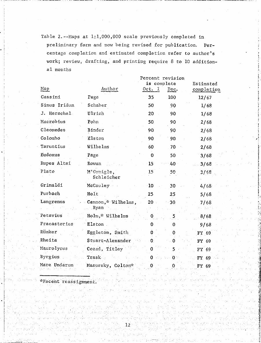
. : Table 2.--Haps at 1:1,000,000 scale previously completed in
preliminary form and noV7 being revised for publication. Per
centage completion and estimated completion refer to author's
'tvorlc; review~ drafting, and printing require 8 to 10 addition
al months
Hap
Cassini
Sinus Iridum
J. Herschel
Macrobius
C1eomedes
Colombo
Taruntius
Eudoxus
Rupes Altai
Plato
Grimaldi
Purbach
Langrenus
Petavius
Fracastorius
Rumker
Rheita
Haurolycus
Byrgius
Hare. Undarum
Author
Page
Schaber
Ulrich
Pohn
Binder
Elston
Wilhelms
Page
Rowan
'M ' r:.""'n .j c:r 1 0. _ .. ....... '- .. -..0--' Schleicher
McCauley
Holt
Cannon,* Wilhelms, Ryan
Ho 1m,7~ Wi lhe lms
Elston
Eggleton, Smith
Stuart-Alexander
Cozad, Titley
Trask
Masursky, Co1ton*
*Recent reassignment.
12
Percent revision is complete
Oct. I Dec.
35 100
50 90
20 90
50
90
90
60
o 15
15
10
25
20
o o o o o o o
90
90
90
70
50
40
so
30
25
30
5
o o o 5
o o
Estimated completio~
12/67
1/68
1/68
2/68
2/68
2/68
2/68
3/68
3/68
4/68
5/68
7/68
8/68
9/68
FY 69'
FY 69
FY 69
FY 69
FY 69
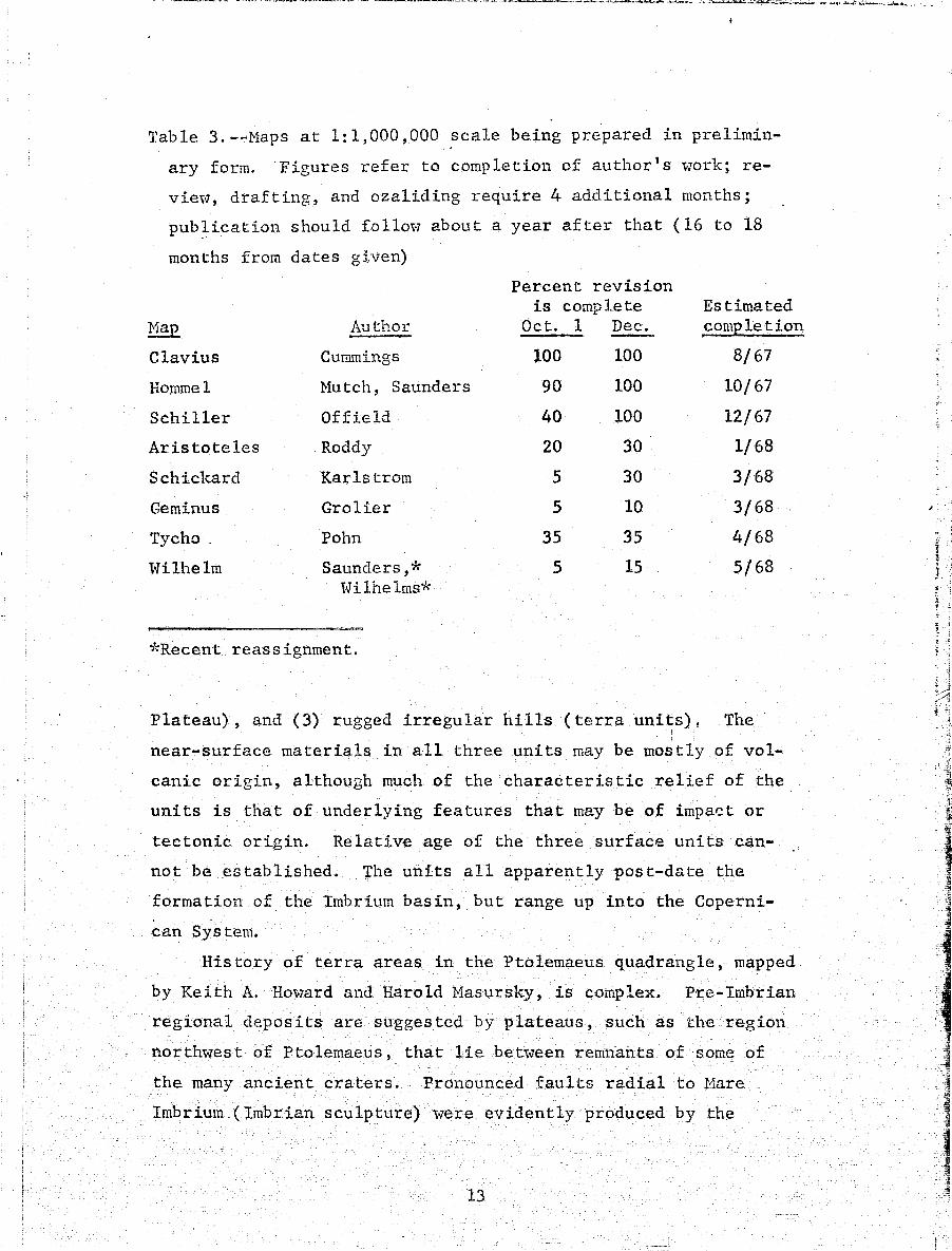
Table 3. --Maps at 1: 1,000,000 scale being prepared in prelimin
ary form. Figures refer to completion of author's work; re
view, drafting, and ozaliding require 4 additional months;
pub~ication should fol101;'7 about a year after that (16 to 18
months from dates gi.ven)
Percent revision is complete Estimated
Hap Author Oct. 1 Dec. comEletion --Clavius Cummings 100 100 8/67
Hommel Hutch, Saunders 90 100 10/67
Schiller Offield 40 100 12/67
Aristoteles Roddy 20 30 1/68
Schickard Karlstrom 5 30 3/68
Geminus Grolier 5 10 3/68
Tycho. Pohn 35 35 4/68
Wilhelm Saunders,* 5 15 5/68 Hilhelms*
*Recent reassignment.
Plateau), and (3) rugged irregular hills (terra uni~s). The
near-surface materials in all three units may be mostly of vol
canic origin, al·though much of the characteristic relief of the
units is that of underlying features that may be of impa~t or
tectonic origin. Relative age of the three surface units can
not be established. The units all apparently post-date the
formation of the Imbrium basin, but range up into the Coperni
can System.
History of terra areas in the Ptolemaeus quadrangle, mapped
by Keith A.Howard and Harold Masursky, is complex. P·re-Imbrian
regional deposits are suggested by plateaus, such as the region
northwest of Ptolemaeus, that lie between remnants of some of
the many ancient craters. Pronounced fa.ults ra.dial to Hare
Imbrium (Imbrian sculpture) were evidently produced by the
13
;
Imbrium impact. Evidence of reactivation of the sculpture is pre
sented by the rilles and scarps in Ptolemaeus, Alphonsus, and
Hind that follow the sculpture direction but are younger than
the Imbrian material Hhich fills these craters. Th 1 s fill, the
smooth, plains-forming Cayley Formation, occupies most other
terra depressions in the quadrangle as well, and here, as in
other regions of the southern highlands, appears to grade lateral
ly into a thin mantle of material that smooths large areas of
intervening hills. The Cayley an0. this apparent thin equivalent
are interpreted either as the result of mass wasting or as ash
f10\·7s. Various volcanic landforms occur in the quadrangle, in
cluding pitted uplands near Muller, dark-halo craters in Alphon
sus, the bright-halo crater Davy G, and craters as much as 17
km wide in the Vogel chain. Age relations indicate volcanic
crater formation in the terra from Copernican back through at
least Imbrian time, and impact cratering throughout the decipher-
All 1:1,000,000 maps made or revised after the flight of
Lunar Orbiter IV (that is, those listed in tab1eR 2 and 3) will
benefit-from the superb photographs obtained by that spacecraft;
mapping will be more meaningful and will progress faster. An
important example of this is the increased understanding of the
origin of terrain surrounding mare basins that was made possible
by Lunar Orbiter IV photographs of the Mare Orientale basin.
Structures and geologic units of Orientale are fresh and re1ative-
By 1y unmodified by erosion, tectonism,_ and post-basin depps~ts.
comparin.g them with the degraded structures and units of other
basins, the elements of the other basins dating from the time of
basin formation can now be discriminated from those produced by
later events.
Such a comparison has been made bet'Vleen Imbrium and Orient
ale and has led to clarification of terrain inside the Apennine
scarp and north of the Imbrium basin. There are three major com
ponents in this terrain: a set of concentric structural rings
14
I i
r' , I
1 I
i 1 I
. !: .
j 1 oJ J • -j oJ. ;\1 '01
"I; " "."' t:
:~ ', . .. ). ;"/
'.
Ii,
~
formed simultaneol,sly '\-lith the basin, surface units also most
likely contemporaneous with the basin (probably ejecta), and post
be.sin materials, Hatching of the structural rings among basins
is a necessary preliminary to matching surface materials. Hart
mann and Kuiper (of the Lunar and Planetary Laboratory of the
University of Arizona) demonstrated (Ref. 1) that a similar pat
tern exists among the rings of all frontside basins, but the
exact manner of correspondence between O;:"ientale and Imbrium was
not kno~rn until Orbiter IV photogra.phed the western limb. The
photographs show a close match among four principal structural
rings of both Orientale and Imbrium: (1) an inner basin (covered
in both basins); (2) a ring of peaks (exposed in Orientale; in
Imbrium, the inner ring of steep'islands--Straight Range, Spitze
bergen, etc. -- that was prevj.ously thought to border the inner
basin directly) ;(3) another. ring of peaks (in Orientale the Rook
Mountains; in Imbrium, the Alpes and the rugged terrain adjacent
to Archimedes): (4) the outer scarp (in Orientale, the Cordillera:
in Imbrium, the Apennines and Carpathians and the north edge of
Mare Frigoris), This clarification of the relation of the rings
of the two basins clarifies the correspondence of the surface
depos its. Mos t significantly, be t~'leen the third and fourth rings
of Orientale (and in depressions outside the fourth ring) is a
rough pimply terrain that is like terrain that has long been
known near Imbrium but whose relation to the Fra Mauro Formation
(a more gently hummocky blanket long interpreted as the ejecta
from the Imbrium basin) was not understood. Now that the cor
respondence of the structural rings is established, it is seen
that some of the :Lugged terrain of Imbrium occurs in the same
relative position as that in Orientale, between the third and
fourth rings. (The rest, interestingly, may occur in the same
position relative to the Serenitatis basin and thus be genetical
ly related to that basin and not to Imbrium,) The outer deposit
around Orientale, outside the Cordilleras and called the Cordil-
lera ~ormation, resembles the Fra Mauro Formation except for its
15
delicately grooved pattern, which presumably has not been pre
served in the older Imbrium equivalent. The origin of the inner
rugged material is uncertain, although it probably formed al.ong
with the basin; the upper surface of the outer material within
one basin diameter was apparently emplaced by radial flo\vage,
possibly by a base surge.
Differences between the basins are apparently due to the age
of the Imbrium basin. Hany of the structural peaks and hills of
rough ejec t('.(?) are smoo ther in Imbrium than Orientale, and de
pressions are filled with light plains-forming materials.
These ne';" insights facilitate completion of 1: 1,000 ,000-
scale maps of the northe 1"n Imbrium region. Three quadrangles
(Cassini, Sinus Iridum, and J. Herschel) are in final stages of
completion and will be submitted for publication within 2 or 3
months. Tv70 others (Plato and Eudoxus) will also be submitted
fot publication within FY 1968. Mapping of a quadrangle in the
Orientale reeion (Grimaldi) will also be completed in FY 19-68.
Other basins also are now better understood, although they
are all older than Imbrium and Orientale, and diagnostic surface
textures are acco rdingly less discernible. HOv1ever, four raised
structures comparable to 'those surrounding Orientale and Imbrium
can be recognized around the Crisium and Nectaris basins (Ref. 1),
and progress has been made in matching surface textures with
those of the younger basins. For example, rugged terrain around
Crisium previously thought to be part of the ejecta of the crater'
Cleomedes is now thought comparable to the rugged terrain between
the third and fourth structural rings of Orientale and Imbrium
because the Crisium material also occurs between the third and
fourth rings. Little Crisium material comparable to the Fra
Mauro and Cordillera Formctions outside the fourth ,ring has been
recognized, and the reason is no'w believed to be snsceptibility
of the distinctive fine texture of the material to erosion. Many
deep radial structures occur here that are very similar to those
of Orientale. Anothe.r example of a unit now be tter unders tood is
. '
':
.; -,-
j ·'1'
':'1 . :1 11
j
?" ,. I , /.
;,
~i
,t,
I ~.3
,~~: ,
"
,.
1 .. ,,:1 ,"
it
,.
the Secchi Formation southwest of Tar.untius, whose rough surface
texture suggested basin impact ejecta but 'tvhose distribution
argued against this interpretation. It occurs close to the
Fecunditatis basin, which seemed excluded as a source because
of its grea~ age, and is sporadically distributed relative to
the Nectaris basin, otherwise a more likely source. Now it is
seen that the Secchi is distributed relative to Nectaris exactly
as some of the rough material is distributed relative to Orient~
ale--in a low radial trough outside the main scarp (at Nectaris,
a continuation of the Altai Scarp northeast of the basin). Maps
soon to be published that 'tvill benefit from this improved under
standing of Crisium and Nectaris are Cleomedes, Macrobills, Tar
untius, and Colombo.
Considerable progress was made in geologic mapping of the
southern lunar highlands. First versions of preliminary maps
for three quadrangles (Hommel, Claviua, Schiller) \Vere nearly
comoleted in the year and three others (Tvcho. Wilhelm, Schickard)
were worked on. Stratigraphic units can be correlated between
quadrangles, and an integrated geologic history for the region
can be developed. There are two broad classes of rock-strati
graphic ~nits: I} crater materials. and 2) plains-forming units.
Craters are being mapped according to a c1assific~tion recently
developed especially for use in the highlands, a classification
which employs both morphology and crater,size as 'variables (and
is similar in concept· to the classification used in mapping
Apollo sites; see section III). Plains-formil'lg units form level
areas both inside and outside craters. Variations in surface
texture signify at le~s t, three periods of emplacement. There is
a general decrease in areal extent of plains units from west to
east,possiblyan indication of volcanic flooding transgressive
from west to east. Plains-formingunits--some of them apparently
very thick ... -are superposed on older. sculptured and structured
terrae. These old surfaces are formed by a complex interaction
of cratering, ejecta blanketing, structural disturbance, volcanism,
and mass was tinge
17
, •
Geologic mapping of the type being developed within the
southern highlands will probably apply also to similarly rugged
highlands which· occupy most of the far side of the Moon.
II. Compilations at a scale of 1; 5, 000, 000
A geolo~ic map of the equatorial belt--lats 32° N.-32° S.,
longs 70° E.-70° W. --at a scale of 1:5,000,000 is being prepared
for publication by Don E. Wilhelms and John F. McCauley. This
map will supersede a preliminary one compiled in July 1965 by
Wilhelms, N. J. Trask, and J. A. Keith (Ref. 2). The ne~v map
't-lill have the same areal coverage qnd about the same density of
lines as the old one but ~'lill embody improved interpretations
of the last 2 years, particularly in terra and mare-basin geology ..
Like its preliminary predecessor, the map will have as base the
ACIC orthogra.phic LEl'-f-l photographic mosaic. The work of the
mappers should be finished in February 1968. Further compila
tions of this type, on different bases, are pl?-nned as more area .:- ..... ,.~~--,....--~-.: -~~ .,&.1. '-"-'.L):ii.. ...... '-~ '- ..t..u"l':"
as the near side.
III. Apollo site mapping
side -- ---" Q..:J w~.i."'-
Geologic mapping of prime Apollo sites f~om Lunar Orbiter
photographs began during FY 1967 and is currently being inten
sively pursued (table 4). The entire medium-resolution Orbiter -
coverage of eight Apollo sites is being mapped at a sleale of
1:100,000 and one ellipse (plus its surroundings) in the high
resolution coverage of each of the eight is being mapped at a
scale of 1:25,000 (fig. 2). Each map has already passed through
at least two versions and will be improved additionally before
publication. Mapping from medium-resolution photographs began
't'lith the screening report for each mission (Refs. 3-6; see also
Part D); additional sites subsequently rejected for an Apollo
mission ~ere also mapped then, -as was a ninth site (A-lor III
P-2 or V-8) that will probably become a prime site and will
therefore be worked upon additionally. Revisions of these
18
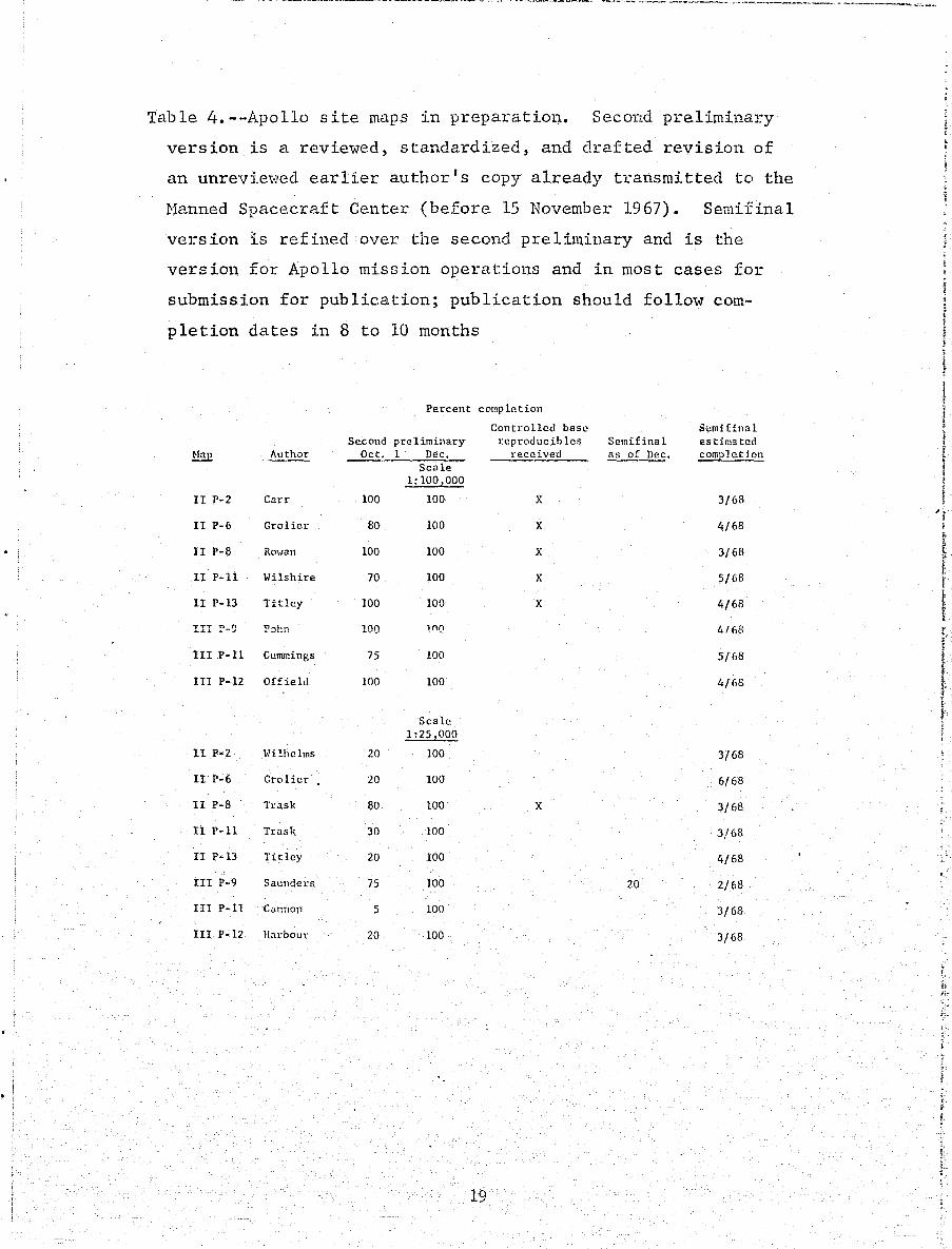
Table 4.--Apollo site maps in preparatio~. Second preliminary
version is a reviewed, standardized, and drafted revision of
an unrevie,·:red earlier author r s copy already transmitted to the
Manned Spacecraft Center (before 15 November 1967). Semifinal
version is refined over the second prelin1inary and is the
version for Apollo mission operations and in most cases for
submission for publication; publication should follow com
pletion dates in 8 to 10 months
Percent complC!tion
Controlled base S(:mifinal Second pre liminary reproducibles Semifinal estimated
Nap Author Oct. 1 Dec. received as of Dec. comp]etjon Scale
1:100!000
II P-2 Carr 100 100 X 3/68
II P-6 GroHer 80 100 X 4/68
II P-8 ROHan 100 100 X 3/68
II P-ll Wilshire 70 100 X 5/68
II P-13 Titley 100 100 X 4/68
III !"'-9 P::;i:n 100 lnQ 4/('8
III P-ll Cummings 75 100 5/68
III P-12 Offield 100 100 4/68
Scale 1:25!000
II P-2 Hilhelms 20 100 3/68
II P-6 Grolier 20 100 6/68
II P-8 Trask 80 100 X 3/68
II P-ll Trask 30 100 3/68
I! P-13 Titley 20 100 4/68
III P-9 Saunders 75 100 20 2/68
II! P-ll Cannon 5 100 3/68
III P-12 Harbour 20 100 3/68
19 ,
'i i
t t i' I
r . ( f ' . .. i
I , to. J.
1
i~ /r-
ii.
: >-I , i
~'
L ~

d O
TI OCflARIS
1- 4 2
58
COP R ICUS
1- 515
N
12 PLATO
25 C 551 I
77
liNUS
IPH EUS PTOL - EUS
9 4 PITATUS
1- " 85
F ' g c 2. - po l lo si cs
\ 95 PU B CH
112 TYC HO
s
ci g a pc
pho ograp s .
2
26 EUOO liS
42 E
S E ITATIS
I -H9
0
JULIUS C
n
7 THEOPHILUS
1- 5H
9 RUPES LTAI
113 "'A U RO L Yeus
61
T
7 COLO MBO
eo logically from
2 RE
U o RUN
80
bi er
screening maps on uncontrolled base mosaics at approximately the
1:100,000 scale have been for,varded to the Manned Spacecraft
Genter, as have first preliminary versions of the 1:25,000 el
lipse maps (table 4). Further revisions of the 1:100,000 maps,
mostly on controlled mO'saics and better standardized with one
another, are being transmitted as this report is being written.,
and revisions of the 1:25,000 maps will follow soon. Additional
tevisions at both scales will follow as the sites are studied
further and thoroughly compared and standardized. They will be
published when this process is complete.
Mapping at the 1:5,000' scale of four sites (II P-6, II P-8,
II P-13, II P-ll) will begin soon.
Because craters are the most a.bundant, conspicuous and
readily mappable topographic features on large-scale Lunar
Orbiter photographs, considerable effort has gone into devising
a system for the geologic mapping of crater materials. A mor
phologic range from sharply sculptured, blocky high-rim craters
to gentle de.pre.s s ions is COlmllOll to all map arl2as. The. C011tiIiLuiHl
of crater types suggests that, with tim~ fresh craters are de
graded to gentle depressions. A working assumption for geologic
mapping is that all circular cr~ters were originally fresh appear
ing and have undergone degradation in varying degree. In such
a model, small craters would be degraded faster than large ones,
so that a relatively small subdued crater might be the same age
as a larger sharper-appearing one. The relation between the
SiZE, morphology, and age of craters is shown in figure 3. The
crater classification scheme is in part arbitrary and in part
based on ,.;That appear to be reasonable estimates of the .relative
rates of crater degradation that are consistent with the time
scale used earlier in 1:1,000,000 mapping. Where superposition
relations are clear, higher-number craters are superposed on
l01'Jer-number craters in virtually every case encountered in the
large-scale mapping so far. Efforts to make the system more
objective are underway. The principle uncertainties lie in the
21
;

8
"-"-
"-"
7
w c 0
(!) u
c:t .~ .. 6 Q.
W 8 > ~ c:t ..J 5 w a::
tl
3
2
c D .r: .. -£
~ ~
IOn, 20m 50m 100m 200m 500m I I'm 2Km 5 KiiI'- ~Km
CRATER DIAMETER
Figure 3.--Relation between diameters, pro
perties, and ages of craters. Categories
are intergradational.
22
..
relative ages assigned to the oldest craters. Craters that came
into being at the same time but "lith differing depth-diameter
ratios "]Quld, after considerable degradation, appear to be of
different ages according to figure 3. Also the rate of degrada
tion may be higher on lunar slopes than on level ground, so that
craters of the same size and morphology in these tiVO environments
might not actually be of the same age. The chief utility of
classifying craters according to their geologic age lie~ in plan~
ning geochemical sampling in a local area. Samples of ejected
blocks from craters with a wide varSety of ages will.provide
material that has been exposed to radiation from space for vary
ing lengths of time. Such a suite or samples' w'ill yield informa
tion on the effects of radiation with time and possibly on the
histt.?ry of the radiation itself. .Evidence bea14 ing on the origin
of craters, such as shock phases, is most likely to be found in
the youngest craters but may be missing in degraded craters.
The distributions of craters of various ages may also give
inrormar:ion on. the. age::; ur the SUl'ICiceS on whicil. they, U(';(';UL.
Craters designated I and 2 are considerably larger on sites in
Mare Tranquillitat'is, Sinus Nedii and eastern Oceanus Procellarum
than on sites in western Oceanus Procellarum. Nuch of the mare
material in western Oceanus Procellarum i~ therefore younger
than the mare material to the east. This ~onclusion is consis
tent with crater statistics developed over very large areas by
Gault and others (personal communication) and with the fact that
solid rock app~ars to be nearer the surface in western Oceanus
Procellarum than else"7here as indicated by the abundance of re
solvable blocks around craters as small as 30 m in diameter.
Small relatively fresh-appearing domes are also conspicuous in
the mare material of western Oceanus Procellarum but apparently
are missing to the .·eas t. The younger mare material in wes tern
Oceanus Ptocellarum may be different chemically and mineralogi
cally from the older mare material to the east. Early Apollo
missions should be planned so that both of these two contrasting
23

areas of mare material can be visited.
Progress has also been made in mapping mare subunits in
Apollo sites. Stereoscopic examination of large-s"cale Orbiter
photographs has revealed the presence of many ill-defined, dis
continuous sinuous scarps which may be the remnants of flm.; fronts
like those photographed in Hare Imbrium at Orbiter site V-3.8.
Chemical and physical differences among the mare materials may be
present across these scarps. Hany low hitherto unrecognized . ridges have also been mapped. These 10\<] ridges appear to be the
older, more cratered and worn-down equivalents of the higher,
better-defined mare ridges. They suggest that mare ridge develop
ment, like crater development, may have continued over an extend- '.
ed period of time. Around some mare ridges, there is a suggestion
that the ridges" may have been the site of extrusion of some of
the mare material. In the young mare material of Oceanus Procell
arum, approximately 40 low circular domes, 100-300 m in diameter,
have been recognized. These features also appear to be related
in some way to the extrusion of the mare mat:erial.
Orbiter: photographs both of Apollo and non-Apollo sites
were examined for features whic? might be useful in determining
the engineering properties of the lunar surface materials or to
extrapolate properties beyond the Surveyor sites. Features sought
included: (1) Block tracks and their associated blocks, (2) craters
and associated secondary craters t (3) fresh craters with or without
blocky ejecta, (4) small craters showing evidence of slope failure,
and (5) variations in crater shapes. Some 290 block tracks were
found (Grolier, Hoore, and Hartin, ,in Ref. 6). These were sought
because the tracks and their associated. blocks might be used for
both static (Refs. 7; 4, p.' 107) and dynamic analyses of soil
properties. Preliminary static analyses of three blocks at the
end of tracks shown in photographs of Apollo site A-I (V-B) yielded 342 mass bearing capacities between 10 and 10 g per cm on footings
of one to several meters radius and at depths near 0.5 to 1. 0 m.
Bloc~<. densities were taken as 2.7 g per cm3• Nearly 30 lunar
24
I . I
I
I I .
f • I . I
I I I I I I I · I I
craters \'lere found \'lith secondary impa.ct 'craters and blocks
that could be associated ,vith their corresponding secondary impact
craters (Hoore and Lawry, in Ref. 6). These secondary craters and
their blocks will be studied further to try to assess engineering
properties along lines.previously suggested (Moore, in Ref. 5,
p. I08-120;Moore,inRef.4, p. 106).
Studies of ejecta showed that the peripheral margins of some
lunar craters 'l:07ere extremely rough and blocky and comparable to
those around experimental craters produced by explosives at the
Nevada Test Site (Robertson, in Ref. 5, p. 122-124). Slope fail
ures 'l:vere found on many small craters with s lopes ranging from 20°
to 45°. The slope failures are currently being studied. Varia
tions in crater outlines and profiles may result partly from
layers with differing properties (Refs. 8; 9; Moore, in Ref. 4,
p. 108; Eggleton, in Ref. 4, p. Ill), but estimates of the thick
ness of the lunar soil layer made from such variations in crater
morphology \Vere ambiguous (Stuart-Alexander and Hoore, in Ref. 6;
Harbour, Ref. 10).
IV. Ranger geologic mapping
Work on geologic mapping from Ranger photographs was slowed
during the past year by the precedence given to Lunar Orbiter
screening operations and the initial phases of Apollo ~ite mapping.
Although not all maps of the Ranger series have been completed, the
preliminary work done on all of them provided a sound base from
which to begin both of these later activities •
. A preliminary 1:50,000-scale geologic map of part of the floor
of Alphonsus (RLC 15) was completed by J. F. McCauley (Ref. 11).
The map shows the distribution patterns of four floor-filling units
of differing ages and craters with three distinct types of exterior
rim morphologies. The degree of degradation of all craters
greater than 300 m in diameter was estimated by considering the
percentage of the floor appearing in shadow on the photographs
used. Impact and volcanic craters a.re both present.
25

A preliminary map of a portion of Mare Cognitum at a scale of
1:100,000 by S. R. Titley demonstrates the intensity of modifica
tion of the marc surface by a Tycho ray. The modification consists
of grooves, elongated craters, crater clusters, and chains of
craters connected by grooves. The elongate features are oriented
north to north-northwes t at"proximately radial to Tycho. Similar
intense modification of the mare material by Tycho rays in other
areas is clearly visible in Lunar Orbiter photographs.
A closeup view of the Ranger VIII impact area is provided
by a preliminary 1:5,000 scale map (RLC 11) by P. J. Cannon. This
is one of the first maps made at this large scale and may well
serve as a prototype for large-scale maps of pot'ential Apollo
landing sites to be used on board the spacecraft and in the mission
control center. Craters are classed into five categories on the
basis of morphology, and several morphologic units within the mare
material are recognized.
A map of a portion of Mare Tranquillitatis (RLC 9) at a scale
of 1:50,000 was cU~lipli:!i..et1 iu .LiLla::' .conll ciiHl tJuum1.tLeu by N. J. Tra3k
for technical revie~'l. Progress on all the Ranger maps is sho\\1Il
in table 5.
Table 5.--Maps of Ranger sites in preparation. Percent completion and estimated completion of final refers to author's work; review, drafting, and printing require 8 to 10 additional months
Percent cOlTIj?letion
Preliminary Final Estimated Hap Scale Author Oct. 1 Dec. . (Dec.) cOrnp Ie t ion
RLC 2 1:500,000 Eggleton 80 80 4/68 RLC 3 1:100,000 Titley 50 90 2/68 RLC 4 1:10,000 Titley 50 50 4/68 RLC 7 1:250,000 Wilshire 100 100 ?
(prelim. only) RLC 9 1:50,000 Trask 100 100 100 12/67 RLC 11 . 1:5,000 Cannon 50 100 1/68 RLC 14 1:250,000 Carr 100 100 IOU 12/67 RLC 15 1:50,000 McCauley 100 100 100 12/67 RLC 16 1:10,000 Grolier 50 50 4/68
26
t I It
r:
~ . ~ t rj
1 "l~ .~ J j ;~ :)
j
",·1'
.. , '
" 1
1
i 1 4
J
I i · l '1 ~ :!
1
A topical study by Trask (Ref. 12) on the distribution of
craters according to morphology and size based on Ranger VIII and
IX photographs wa·s published.
.) "i t:.,
•
I ~
j
I \I • r r 'I
··1:.: .' , .
~' j ,
f r I i
I 1 ,
0-
Part B. CRATER INVESTIGATIONS
Field investigations are being concluded at t"JO impact
structures, Flynn Creek, Tennessee, and Sierra }ladera, -Texas.
Field\\70I'k has begun at a third, Gosses Bluff, Northern Territory,
Australia, which is larger and is in a clastic rather than a
carbonate sequence. Investigation of impact metamorphism is
continuing, with emphasis on material from the Ries crater, Germany,
and the Bosumtwi crater, Ghana.
Primary objectives in the studies of volcanic rocks include
quantitative measurement of volcano and lava flow morphology for
comparison with lunar analogs; identification, by morphologic
characteristics, of volcanic rocks that contain rock fragments
of deep-seated origin; and determination of the effect of principal
controls such as depth of eruption, magma composition, and tec
tonic structures on differences in surface forms of volcanic rocks.
Happing of craters produced by missile impacts has continued
and in addition several
geophysical studies were conducted, and remote-sensing imagery was
obtained for eight craters.
Experimental impact investigations applied experimental data
on cratering to selected lunar problems, supported by Ames Research
Center, and conducted studies of low-velocity impact penetration in
sand.
Flynn Creek Crater
Core drilling comprised the final phase of D. J. Roddy's
f~eld\'lolk at the Flynn Creek crater, Tennessee. Surface geo logic
mapping combined vlith the drilling indicates that the Flynn Creek
crater contains a very shallow, bowl-shaped lens of breccia under
lain by faulted and folded limestone. Six NX (5.4 cm diameter)
cores were dOri11ed along an east-wes't line within the crater to
depths f_rom 84 to l80 m. THO holes were drilled on each side of
the central uplift, two holes ha.lfwa.y bet't']een the central uplift
and the crater walls, and two holes immediately inside the crater
28

walls. The drill cores contain a sequence of bedded dolomite 1 to
2 m thick "'7hich is underlain by a graded, bedded dolomitic breccia
as much as 15 m thick. No lake beds or fallback deposits were
identified in any of the cores. The bedded dolomitic breccia is
underlain by a coarse, chaotic breccia. with fragments derived
from the local strata; the size of these fragments increases near
the base of the chaotic breccia. The Hermitage Formation, a 20-m
thick shale with interbedded limestone, is the lowest unit com
pletely brecciated. Extremely incompetent and plastic, it forms
the matrix for much of the chaotic breccia. The thickness of the
chaotic breccia lens averages about 35 m. No mineralization or
volcanic or meteoritic materials were observed in the six cores.
Limestones directly below the base of the breccia lens are
highly fa,nl !::ed and folded, but the deformation decreases do'tVTIward
and the rocks are nearly flat lying and relatively undisturbed
be lo't·] ahou t 100 m beneath the breccia lens. The s tra tigraphic
sention 's repeated between faults in several of the cores, and
both normal and reverse faults occur. Folding immediately belo"\v
the base of the breccia lens extends 30 to 40 m deeper on the
eastern side of the crater than on the western wide. A circular
high or anticline may be present about halh·;ay between the center
of the crater and the crater walls.
The absence of lake deposits and a fallback zone and the
occurrence of the bedded dolomitic breccia containing marine cono
donts suggest that the shallow waters of the initial Chattanooga
Sea occupied the area 'Hhen the crater formed, probably in early
late Devonian time. The core drill evidence of a shallow 10'tver
boundary of the chaotic breccia lens and the decrease in deforma-
tion in the rocks below the breccia lens indicate an origin
involving surface deformation (i.e., an impact). The asymmetry
in surface and subsurface deformation suggests that the impacting
body traveled from the southeas t to the north'wes t. The very shallow'
breccia lens, the absence of mineralization and volcanic or meteoritic
materials, the types of rim deformation, and the central uplift
29
i·
f
f !
f.
I i
I . I !
are consistent with the impact of a low-density body, possibly a
comet. The structural information from surface mapping, combined
with the core-drill data, strongly suggests that the Flynn Creek
crater was produced by the impact of a cometary body.
Sierra Madera Structure
Mapping of the Sierra Madera structure in west Texas was
completed by T. H. Offield, David Cummings, K. A. Howard and
H. G. Wilshire. The structure consists of a central core of
uplifted Permian and Cretaceous carbonate rocks about 3 miles in
diameter, a surrounding synclinal depression 1/2 to 2 miles wide,
and an outer rim of mainly Cretaceous rocks that are locally
folded and extensively cut by concentric normal faults.
Cretaceous rocks in the ring syncline are depressed slightly
below regional position, but there is more than 600 feet of
structural relief between the ring syncline and Cretaceous rocks
of the outer, structurally high zone. The zone beyond the ring
center; pods and dikes of Cretaceous sandstone and shatter-coned
Permian dolomite 'Here injected up along some of the faults and
other concentric fractures.
Permian rocks of the central uplift are extensively shattered
and brecciated, generally without associated faulting or mixing
of adjacent beds. The larger rock fragments in these monomict
brec~ias are themse1ves shattered, and the fractures are filled
with recrystallized mylonite. A mixed breccia, composed of rock
fragments derived from several formations, occurs in isolated
patches that apparently lie unconformably on the underlying rocks,
and locally in dike-like bodies that either crosscut or conform to
the adjacent structure. The mixed breccia includes individual
fragments of monomict breccia and broken shatter cones.
Shatter cones occur in all Permian units in the central uplift
and predate folding. ~Vhen shatter-coned beds are restored to hori
zontal, the cones point generally inward and upNard tOHard a
central focus.
30
• f.
· 1 ! ,
! i~
fll." r I
Quartz and carbonate minerals from both brecciated and unbrec
ciated rocks in the core of the structure have multiple sets of
planar features, and the refractive index of quartz is apparently
significantly lm·]er than normal. Such deformational features are
omnipresent in the mixed breccia.
The oldest exposed beds in the core were uplifted approxi
mately 4,000 feet above their normal position. The center is
characterized by steep to inverted beds, and steep folds vlhose
plunges diminish outward. The folds are cut by numerous, generally
steep faults. Details of the style of structural deformation in
the central uplift indicate that the rocks moved inward as well as
upward to arrive at their present position. The structure is not
compatible with any of the most strongly supported terrestrial
models that have been advanced as explanations of cryptoexplosion
structures, such as reactivated basement structure, igneous or
sedimentary intrusion, or explosion, but is compatible \i1ith the
hypothp.Ris of a.n jmnact origin.
Gosses Bluff Structure
Gosses Bluff, in the Amadeus Basin about 120 miles west of
Alice Springs, Northern Territor~Australia, is a circular range
about 3 miles in diameter r.ising about 800 feet from the sur~ounding
plain and encircling a hollow about 1 1/2 mi1es in diameter that ,
is only slightly higher than the outside plain. Intense disturb-
ance of bedrock is exhibited not only in the Bluff but in a .
circular area with a diameter of about 15 miles centered on the
Bluff. On the bas is of reconnaissance by the Australian Bureau
of Mineral Resources and by commercial exploration groups; the
Gosses Bluff structure has been variously considered to have
originated by diapiric action, by volcanic or cryptovolcanic
activity, or by impacL A joint project of the U.S. Geological
Survey and the Australian Bureau of Mineral Resource'S to carry out
a complete geological and geophysical study of the structure
beg8n in the 1967 field season.
31
· '
D. J. Milton and P. R. Brett of the U.S. Ge~logical Survey
and G. Berryman of the Australian Bureau of Mineral Resources
spent 3 months' in the field; P. J. Cook of the Australian Bureau
of Mines spent 2 weeks. Principal effort was put into mapping
the, Bluff proper and the interior hollow on enlargements to approxi
mately 1" = 300' of low-level aerial photographs furnished by
Exoil Pty., Ltd. This mapping is now virtually complete.
The high Bluff is composed of Mereenie Sandstone and sand
stones and siltstones of the lower Pertnjara Group; the interior
is underlain by less-resistant sandstones, shales and siltstones
of the upper Larapinta Group. The basic structural units in this
area are vertical or steeply dipping bedrock plates, each extending
on the average perhaps 500-600 feet along strike and "lith upper
and lower boundaries commonly following horizons of incompetent
beds. Some open folding and minor faulting occurs within individual
plates, but major changes of attitude generally correspond to
clearly defined faults separating plates. Some plates are terminated
along strike by faults chat cue across at a 111gb angle:, bat j\l8t
as commonly the bedding-plane faults above or below gradually
curve to cross the bedding at II small angle. Through-goi.ng
radial faults are conspicuously absent.
The strikes of the plates range from concentric to the
structure to radial; the facing is to the outside. Very commonly
in plan the plates appear to have slid past one another on sur
faces nearly toncentric with the structure so as to overlap en
echelon pr to li:e parallel, doubling p,art of the se,ction. In at
least one place where strikes are cioncentric with the structure,
a pair of convergent faults cutting the bedding at a small angle
have allowed the plate between them to slide laterally telescope
fashion, wedging the beds apart. In some places where plates abut
along approximately radial faults, the strike curves outward into
the fault in both plates rather than shmving the opposed 'directions
of drag usual along ordinary faults. These observations indicate
that the plates have moved inward and upward from their original
32
;
~ :~ ~
.1
~.
,'" .;r
",
'I "
j'
1 "
;~ ~
J ,''\I
i
':li, '~
c.
•
flat-lying position to lie on a shortened perimeter. The centri
petal movement, which seems to rule out either a diapiric o?'i.gin
or a "cryptoexplosion" \vith a focus at depth, seems most likely
to be the consequences of centralized uplift beneath the focus of
a shallow explosive-type event. In conjunction with the evidence
of high-shock pressures, the only mechanism that can account for
such an event is impact.
The polygonality of the structure is in part a consequence of
tendency of the more competent units to deform as elongate plates.
The marked asymmetries in the structural style around the Bluff,
hOHever, remain to be explained.
As the plates were emplaced, their upper edges fragmented to
form breccia in what "i;·]as presumably a crater floor. Such breccia
is presel~ed in numerous patches that occupy perhaps 10 percent of
the area of the Bluff proper. Plates of the more competent beds
(notably a silicified sandstone at the top of the Mereenie lower
formed bedrock walls against monomict breccia of adjoining weaker
beds. In many places these walls toppled over outward ( or possibly
't"ere projected 't-lith their original momentum) to lie as large
blocks or somewhat broken plates gently dipping face dOHn, or
even vertical and facing inward, on top of breccia of stratigraphic-'
ally higher beds. Nany of the areas of breccia occupy valleys
within the Bluff, suggesting that the present topography of the
Bluff (presumably, but not necessarily, excepting the central
hollow) fairly closely reflects the bedrock profile of the original
central uplift.
Gosses Bluff appears to be the outstanding structure in the
world at which to study shock-produced fracturing. Only qualitative
observations were made this field season; quan,titative measure
ments remain to be made. Complete shatter cones are scarce, buf
fracture surfaces with the char~cteristic striations of shatter
cones are commonly found in random hand specimens., The nature of
the shatter fracturing (as it may be called) is controlled by the
33
rock invo1ved--certain beds are characterized by cone segments
5-6 feet long, others by very sho.rt cones or none at all. Shatter
fracturing is initiated at discontinuities in the rock; \'lOrm tubes
normal to the bedding, for example, commonly serve as cone axes.
In some units shatter fracturing is expressed not by cones but by
several sets of planar fractures. The intersecting sets cut the
rock into rhombohedral blocks, and in some units the ends of the
rhombohedron grade from three-sided angular corners into rounded
shatter cones. The geometry of the planar fracture pattern differs
markedly from that of intersecting cleavages or joints in any
ordinarily deformed rock. Planar shatter fracturing has not pre-
viously been reported from any structure and should be muc.h more
useful than simple cones in determining the stress pattern during
the shock event.
Reconnaissance indicates that the greater the distance from
the center of the structure, the greater the angle bet\veen the
normal to the bedding and the shatter cone axes; this relation
suggests a focus above .the original elevation ot the beds. More
interes tingly, cones in plates concentric '\vith the structure are
bilaterally symmetrical about a plane normal to the bedding, while
in plates oriented at an angle or radial to the structure, the
cones are asymmetric, with axes pointing imvard after rotation of
the bedding back to the horizontal. Heasurement of i shatter
fracturing geometry should aid greatly in determination of the ori
ginal orientation and perhaps even position of the plates that
compose th~ Bluff. i
Only teconnaissance was done in the structure exterior to the
Bluff proper. The east peak of Ht. Pyroclast is composed of mixed
and highly shocked breccia very similar in appearance to suevite
at the Ries crater, Germany. This apparently overlies less
shocked monomict breccia. Hydrofluoric acid treatment of pro
mising speci'ihens for detection of coesiteand stishovite is in
progress.
34

:.
Some observations of significance to the regional s trati
graphy were made. A sharp contact was found in the Hereenie
Sands tone be t,·]een a lo'Her unit 400-500 fee t thick, cons is ting of
uniform thin-bedded sandstone with no worm tubes, and an upper
unit 800-1,000 feet thick consisting of more varied thick- and
thin-bedded sandstones with several zones of vertical worm tubes.
At the base of the upper unit is a zone 10-50 feet thick consisting
largely of red sandstone. The fossils found by P. J. Cook and
identified by J. G. Tomlinson as fragments of arthrodire armour
of Devonian age occur not in the Pertnjara red beds but in the
red sandstone at the base of the upper Mereenie within one of the
overturned displaced blocks of the type mentioned above that lies
adjacent to Pertnjara beds. This is the first datable fossil from
the Mereenie and confirms ,the Devonian age that has been suggested
on the basis of correlation with other basins. Very limited
reconnaissance suggests the possibility, hO"7ever, that the contact
Mereenie in the Macdonnell Ranges, and the lower unit may be in
fact a unit in the Ordovician Larapinta Group that is absent in the
Macdonnell Ranges but occurs at Gasses Bluff and in the James
Ranges to the south.
Impact Hetamorphism
A paper in press entitled "Pressure and temperature histories
of impact metamorphosed rocks--Based on petrographic observations,"
by E. C. T. Chao in~~rprets the ~bserved shock effects on granitic
and other crystalline and metamorphic fragments in the fallout
breccia of the Ries crater of southern Germany and the Lake Bosumtwi
crater of Ghana, Africa. Features of deformation, evidence of
partial or complete and selective phase transitions, and evidence
ofbrea:kdo,offi, decomposition, or melting of quartz, plagioclase,
biotite, amphibole, magnetitie, ilmenite, titanite; rutile, and
zircon are described and clarified.
In order to interpret the shock features, diagrams showing
the pressure and temperature. histories of fragments metamorphosed
35
.. , i·..:

• i
by impact-induced shock wave are given in terms of a concept of
the formation of the fallout breccia during the crater-forming
event. Es timates of the pressure and temperature ind icated by
the observed shock effects are derived from the comparison with
available shock wave experimental data on single crystals of quartz
and plagioclase.
Fromidetailed observations and the availability of Rugoniot
equati6n-of-stat~ data on quartz, partial transition from quartz
to silica glass observed in quartz can be explained in terms of
selective disordering. Such a mechanism can be extended to the
interpretation of the vitrification of feldspars by shock.
Evidence and arguments presented sho~v that the formation of
coesite and stishovite from quartz is not accomplished by direct
transition. They '<Jere probably derived and nucleated from a
metastable dense glassy phase~
In contras t 'toli th the resul ts of shock wave experiments on
fdpe1p. crv 8 t (lls, the effects of natural shock on rock are a great
deal more complex. The role of bulk density, porosicy, moaal
mineral composition, the compressibility or shock impedance and
the thermal conductivity of one mineral with respect to adjoining
minerals, water content, and macrostructures such as mineral
banding, bedding, joints, and fractures are briefly discussed.
The volume and phase changes throughout the compression and expan
sion stages of the event are considered. Recrystallization and
criteria of the cooling histories of shock-heated fragments are
also discussed.
By correlating the shock features with peak pressures and
t;:emperatures, the degree of impact metamorphism under nonequi1ibrium
conditions can also be determined. As an example, the impact
metamorphosed granitic rocks of the Ries are clas~ified into
seven categories .
The. shock phase project of D. J. Milton was largely devoted to
preparation of a comprehensive review of the geology of terrestrial
~mpa~t structures, of which the first draft is now completed.
36

.., ....
Volcanic Studies·
Hule Ear diatreme.--Investigation of the Hule Ear diatreme,
Utah, was reactivated in June 1967. Detailed mapping was con
tinued by Desiree Stuart-Alexander at the scale used by Shoemaker
and Moore in 1957 and Hoore in 1962; the final map compilation,
scheduled for FY 1968, m'Jaits a joint field check by all mappers.
Formation and enlargement of the Hule Ear vent occurred by
spalling and ejection, presumably along a fracture or weak zone.
Country rocks in contact ;;vith the diatreme are not folded or
faulted. Nultiple explosion periods resulted in a zonal distri
bution of rock fragments within the vent, so that the core
contains mainly rocks from the lower part of the vented area
(perhaps the basal 2/3 or 1/2) which were all mixed within a few
feet or tens of feet, and the perimeter contains fragments from
the entire cross-cut section, with the upper part being m()st
heavily represented.
Procedures to date include primarily petrographic examination and
limited X-ray mineral determinations. These data suggest that
carbonatization has occurr.ed on a large scale; the "kimberlite"
mineralogy seems to be mainly chlorites and clays with very little
serpentine so far detected. A suite of specimens is being chemically
analyzed to determine the nature of the additive materials.
Hoses Rock diatreme.--A detailed study of the Moses Rock
diatreme, Utah, was completed by T. R. McGetchin. Field investi
gations led to the following conclusions: 1) The breccias were
fluidized when emplaced because they are particulate on all scales,
they have size-frequency distributions like comminution curves,
fragments from \videly separated positions are intricately mixed on
all scales, and kimberlite components are greatly dispersed;
2) no silicate 'melt existed at the present level of exposure;
3) the dike grew laterally parallel to tensile fractures by
slumping or spalling of wallrocks into the dike; these fragments
then became comminuted and mixed with the erupting material, and
37
:j ;.; .•.. ~., .... ~ , L ,
i.~ . .", 1 'it
;~ j.
I
!< !!
, ,
. ,
. '
transported according to their size, shape, and density; 4) sedi
mentary fragments transported upward in the dike have an inverse
s ize-dep th relationship; \'7hen app lied to fragments of crys talline
rock, this provides an empirical rationale for reconstruction of
the vertical sequence bused on size; 5) fragments are displaced
dm·mward a maximum of 1,500 feet, providing a minimum figure for
the overburden at the time of eruption; and 6) calculation of the
settling velocity of the largest fragments displaced upward in the
dike sugges ts that the upward flm·] velocity (for assumed fluid
density) was at least 10 to 50 m per sec.
Petrologic investigations led to the folloHing conclusions:
1) Compositions of coexisting clinopyroxene-orthopyroxene and
orthopyroxene-pyrope indicate equilibrium conditions at 95 ±5 km
depth and 9500 C ±60° C, the depth and temperature of the kimber
lite reservoir; 2) size-depth relations and relative abundance of
crystalline fragments suggest that the crust consisted of granite
and abundant metabasalt near the surface; gabbro, diorite, amphi-
huJ.iL~ ai..
granulite with minor zoisite-eclogite at greater d~pths; 3) dense
fragments include true eclogite, spinel-bearing websterite, rare
spinel-lherzolite, and abundant serpentine-tremolite schist; all
except the spinel-lherzolite contain minerals distinctly different
in composition from those in the kimberlite and are inferred to be
accidental inclusions sampled from the vent v7alls during the
eruption of the kimberlite; 4) source rock for the kimberlite
'-las garnet-lherzolite; 5) the erupting kimberlite is inferred to
have been a volatile phase, principally water with CO2 and particu
late grains of mainly olivine; 6) the abundance of the serpentine
tremolite schist suggests a hydrated upper mantle; 7) the upper
mantle above 100 km may be phase-layered: the upper part spinel
lherzolite, the lower part garnet-lherzolite .
Lunar Crater, volcanic field.--The Quaternary Lunar Crater
volcanic field, an area of alkali basalt in the Pancake Range of
northern Nye County, Nevada, contains a wide variety of morphologic
38
features including ciTldcr cones, spatter-and-cinder cones, and
maars that are being studied by N. J. Trask and D. R. Scott. Lunar
Crater itself is ~ maar, approximately 1,200 m in diameter, which
resembles in morphology many craters of comparable size on the
Moon. The volcanic field is of special ir . rest because of the
presence of ultramafic inclusions in the ejecta and flows sur
round ing several of the vents. Mas t of the £10\']8 and vents occur
in a northeas t- trending band about 30 km long and 5 to 8 km wide.
This band is situated ,\Tithin an elevated valley surrounded on three
sides by outward-dipping be~s of Tertiary ignimbrites and related
silicic volcanic& typical of the Basin and Range Province.
Structural and stratigraphic relations within and between
the Quaternary be,salts, the surrounding Tertiary ignimbrites,
and slices of Paleozoic sedimentary rocks 'tvithin the ignimbrites
are being studied by D. H. Scott. Five mappable units within the
Paleozoic rocks and nine separate cooling units within the ash
flO'1j.] tuffs have been identified and carre lated. Al though the
ash-flow tuffs partly surrounding the basalt field form a roughly
circular series of arcuate plateaus, unconformities between ash
flows as well as substantial thickness variations within units
suggest that the present topography in the adjacent area does
not necessarily reflect the presence of an ancient caldera.
Basalts rich in olivine and plagioclase phenocrysts are exposed
in the \-mlls of Lunar Crater and are among the oldest Quaternary
basalts in the f.ield. Some of the younger flows are jagged scori
aceous autobreccias with individual blocks exceeding 10 feet in
diameter. The youngest :flo'VlS bear abundant ultramafic inclusions
and xenocrysts derived from these inclusions.
Unconsolidated to poorly consolidated ejecta making up the
raised rim of Lunar Crater and of a second maar to the north,
known locally as Grandfather's Chair, consists of vitric lithic
tuffs containing rounded to subangular fragments of the basalt
flows exposed. in the walls and of fragments of the Tertiary ignim
brites. Very little doming of the underlying b,lsalts andignim-
39

brites apparently occurred at the time of ·eruption. Fragments
range from microscopic sizes up to 2 m in diameter with lapilli
sizes predominating.
Ultramafic xenoliths are abundant in flows that iSSUGd from
a cinder-and-spatter cone at t!1e north end of Grandfather's Chair
and from a cinder cone and nearby low linear vent 5 km to the north.
They also occur in cores of bombs around the cinder cone. Arncng
the inclusions examined to date by N. J. Trask, most are wehrlite
and pyroxenite, but one inclusion of lherzolite has been noted.
This is of significance because of the widely held opinion that
lherzolite inclusions are either pieces of the earth's mantle or
refractory residues formed by partial melting of: the mantle (Refs. 13-
15). Metamorphic textures have been noted in several of the inclu
sions, and olivine with well-developed cleavag~ is a common and
somev1hat surprising constituent. Although relatively large
xenoliths are confined to only a few flows, some xenocrysts of
oli.vine ... glassy pyroxene. and plagioclase occur in most of the
Quaternary basalts.
This investigation is part of a program designed to establish
criteria by which volcanic eruptions that have brought up deep
seated material may.be identified; such criteria will aid in the
identification of analagous features on the Moon that may provide
direcr. information on deep-seated lunar rocks. Regional mapping
will be completed in FY 1968, and a final report is scheduled for
FY 1969.
San Francisco volcanic field.--Work on the morphology and
general geology of the lunar volcanic analogs of the San Francisco
field near Flagstaff, Arizona, W8.S begun by J. F. McCauley in
April, 1967, and has continued in termittently to the present.
Emphasis has been placed on three types of features because of
their common' occurrence in Lunar Orbiter photographs: 1) individual
linear to coalescing pyroclastic cones best developed near S.P.
crater; 2) a steep-sided flat-topped dome near Merriam crater
'Nhich is similar in form and scale to those seen in the Harius
40
Hills region of the Hoon (a potential late Apollo landing site);
and 3) a small broad low dome or shield volcano called Howard Mesa
which is also very similar to some of the Marius Hills domes.
Vertical and oblique aerial photographs of these features
have been obtained, and fieldwork is in progress at the flat
topped dome near Merriam crater. Initial work suggests that it
is the product of early magmatic inflation and later collapse as
lavas drained from its flank. Preliminary field reconnaissance
has been completed at HOHard Nesa, but detailed fieldwork \vill have
to be deferred until spring because of snow cover. Completion of
a final report is scheduled for early 1969.
pbehebe Cr?-ter.--A preliminary study was made of the Ubehebe
maar, Death Valley, California, by D. J. Roddy. The 10 sq km
volcanic field contains basalt flows and younger maars and cinder
cones surrounded by basaltic ash. The larger maars, including
Ubehebe Crater, which is 230 m deep and 730 m in diameter, ar~
rpnt~rerl nn a nnrth-trendin2 fault zone. Smooth, layered ejecta
10-25 m thick surrounds the crater and consists of basaltic ash,
cinders, an:l sedimentary fragments. A minimum volume of 5 x 10¹³
cu cm
(1014 g) of interbedded conglomerates and sandstones was fractured
and removed from the crater. On the basis of reported comminution
studies, the m~n~mum energy required to eject the rock was calcu-
lated as 8 x 21 The minimum total required 10 ergs. energy to
form Ubehebe Crater is 1022 ergs if the energies in heating and
'friction during init.ial stages of deformation are neglected. An
energy of 1022 ergs is available for work in an adiabatic expansion
of volcanic gases and (or) ground-water steam, assuming initial
temperatures of 250 0 C and 10 percent porosity for the sedimentary
rock. Gas pressures computed for these conditions are at least 10
times greater than the tensile strengths of these sedimentary
rocks and would be sufficient to fracture and eject the mass of
rock occupied by Ubehebe Crater.
Topographically, Ubehebe Crater is comparable to certain
low-rimmed, steep-walled, bowl-shaped craters seen in the Ranger
41
( .... .:.... "~ ~ _~:,," ,'," "0 ~~ ',~.,._. "'~""''''''' . ...:._ ... , _. ,.~:."""~:":" __ \ec .. _:. , ... '-""".' .... ,~~~ __ ._"" __ .~~ • ....;."~ .... ~._~~~, .... ...:.,;;.~~, .. "" .. ,.,;, __ .... ; ....
~
! I
and Orbiter photographs of the Moon. If a volcanic gas eruption
22 f d d . d" of 10 ergs occurred on the lunar sur ace un er ynam~c con ~t~ons
similar to the Ea~th, and if only the effect of gravity is con
Sidered, the crater formed should be at least 2 times deeper than
Ubehebe Crater, about 1.5 times larger in diameter, and 3.5 to 4 times
larger in volume.
Other ...EE£jects. --Two projects described' in the work plan for
FY 1968 have not 'vet been started. These are: }iaars and cinder
cones near Bend, Oregon (L. C. RO,\·7B.:'1., project chief), and compara
tive morphological study of. tholeiitic and alkali basaltic craters,
Nunivak Island, Alaska (T. R. McGetchin, project chief). Fieldwork
on these projects is scheduled to start next summer.
Missile Impact Investigations
During the period July 1, 1966-September 30, 1967, maps of
18 missile impact craters and 3 explosive craters were prepared,
4 missile impact craters were trenched, 4 remote-sensin.g flights
'i'Jere tlown, se~smic sr.uciies \\H:~r~ ~uJ.ltlUl..:LI:!~ uu ~ CL'CitcL'5, ---' --- ... .: .. ..,..-Q.l.1U f-/c.:.&.loJu ..... ·v'-
seismic studies were started.
The data collected by mapping the craters include crater
dimensions, volume, target properties, and geologic features which
have application to the space program. Target materials, angles
of impact, kinetic energies, and diameters of the craters mapped
are listed in table 1; the last two types of data are compared
with those of uther craters studied previously in figure 1. Three
craters (19-21) which were not mapped are sho'~vn and listed; data
for these were furnished by the Comrrlanding General, White Sands
Missile Range. The explosion craters (22-24) were produced using
60 percent Amogel #1 by Dr. G. Latham of Lamont Geological Labora
tories as part of the calibration of passive seismic equipment
(ALSEP). It is note\\lorthy that the veolicities of some of the
missiles can be ·specified. For example, the missile that pro
duced crater 15 impacted with a velocity of 4.25 krn per sec.
Trenching of t~e missile impact craters to depths of 8.5 feet
belo'\-1 the crate'r rims showed that the floors of the craters were
4·2
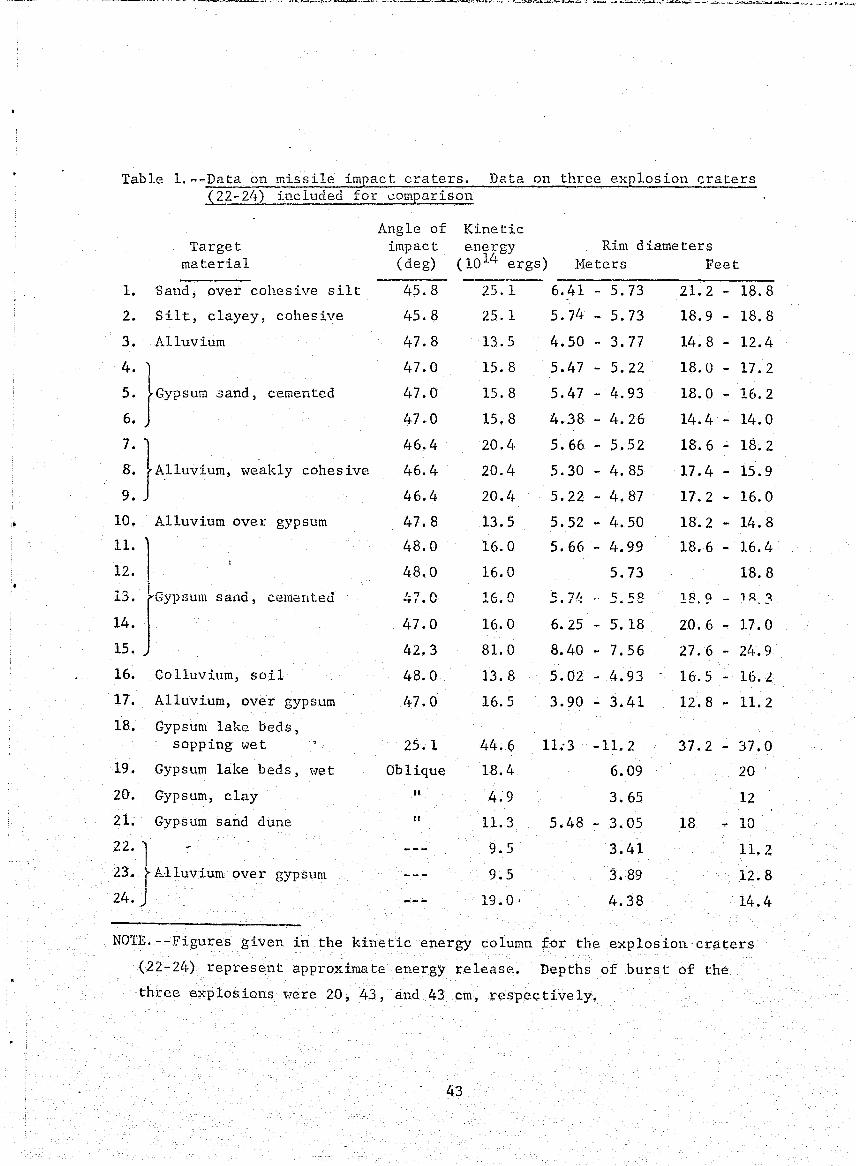
iO
Table l.--Data on missile impact craters. Data on three explosion craters Q2-2lj) included for I..:.omparison
Target material
1. Sand, over cohesive silt
2. Silt, clayey, cohesive
3. Alluvium
5. Gypsum sand, cemented 4. }
6.
7. } 8. A.1luvium, \veakly cohes ive
9.
10. Alluvium over gypsum
11.
12.
13. sano, cemented
14.
15.
16. Colluvium, soil
17. Alluvium, over gypsum
18. Gypsum lake beds, sopping wet
19. Gypsum lake beds, "let
20. Gypsum, clay
21. Gypsum sand dune
22. } - . 23. A11uvium over
24.
gypsum
Angle of impact (deg)
45.8
45.8
47.8
47.0
47.0
47.0
46.4
46.4
46.4
47.8
48.0
48.0
47.0
47.0
42.3
48.0
47.0
25.1
Oblique
" "
Kinetic energy Rim diameters
(10 14 ergs) Heters Feet
25.1 6.41 - 5.73 21.2 - 18.8
25.1 5.74 - 5.73 18.9 - 18.8
13.5 4.50 - 3.77 14.8 - 12.4
15.8
15.8
15.8
20.4
20.4
20. t~
l3.5
16.0
16.0
16.0
81. 0
13.8
16.5
11. 3
9.5
9.5
19.0'
5.47 - 5.22
5.47 - 4.93
4.38 - 4.26
5.66 5.52
5.30 - 4.85
5.22 - 4.87
5.52 - 4.50
5.66 - 4.99
5.73
.5.7l: S. 5~
6.25 - 5.18
8.40 - 7.56
5.02 4.93
3.90 - 3.41
11.'3 -11. 2
6.09
3.65
5.48 - 3.05
3.41
3.89
4.38
18.0 - 17.2
18.0 - 16.2
14.4 - 14.0
18.6 - 18.2
17.4 - 15.9
17.2 - 16.0
18.2 - 14.8
18.6 - 16.4
18.8
l8,9 - 1 A ~
20.6 - 17.0
27.6 - 24.9
16.5 16. L
12.8 - 11. 2
37.2 37.0
20
12
18 - 10
11. 2
12.8
14.4
NOTE. --Figures given in the kinetic energy column for the explosion craters
(22-24) represe.nt approximate energy release. Depths of burst of the
three exp los ions "7e re 20, 43, and 43 cm, res pee t i ve 1y.
43
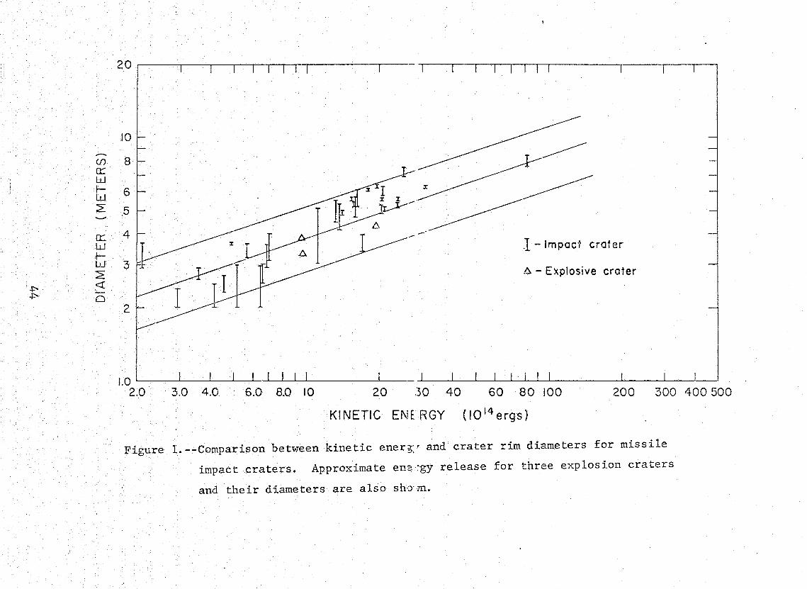
(f)
n::: w ~ w ~ --a: w ~ w 2:
+:-- <r +:-- 0
10
8
6 -5
4 .1 - Impac1 cra1 er
3 6 - Explosive crater
2
1.0 '--_--"-_--l..---L_I-.-LI----LI--L--I -L.I ____ JI __
2.0 3.0 4.0 6.0 8.0 10 20 30 40 60 80 100 200 300 400500
KINETIC ENERGY (IO I4 ergs)
Figure 1. --Comparison between kinetic eners:' and crater rim diameters for missile
impact craters. Approximate en?~gy release for three explosion craters
and their diameters are also sh-:ym.
underlain by a brecciated mixture of fragments of projectile and
sheared and compressed target material. The mixed breccia was over
lain by a thin veneer of talus and fallback. A se.cond breccia zone
composed of banded brecciated target material was found adjacent
to the mixed breccia. This second breccia was bandel.. parallel to
the contact with intensely fractured target material, suggesting
flowage of the materials. The intensity of fracturing of' the
targe t material decreased outward R\·my from the crater, and
conjugate fractures were well developed in some craters. Trenching
of one crater in a layered target of alluvium und gypsum showed
that the deep layers 1;vere til ted up\.;rard in the down- trajec tory
direction and at right angles to the trajectory but not in the
up-trajectory direction. The layer interface was 1/7 of the crater
diameter. In another crater, the layering interface was deeper
and little or no upward deflection of the layer was observed.
HO\\lever, in the up-trajectory side, the layer was deformed to a
Preliminary results using infrared and photographic imagery
of the craters obtained from remote-sensing flights indicate:
1) The images on daylight infrared imagery are strongly dependent
on topography, but under ideal conditions the image of crater ejecta
is excellent; 2) color photography is valuable in delineating
ejecta and fallout patterns; 3) images on black and white photography
are good but not as clear as color photography; and 4) the ejecta
patterns were shown by the ultraviolet photography. (See Ref. 16.)
The imagery of the craters was obtained by the Earth Resources
Program Aircraft of the Hanned Spacecraft Center, Houston, Tex2.G.
Active seismic studies using a hammer energy source and
engineering seismometer (MD-3) on 10 foot source-geophone spacings
showed a decrease of acoustic -velocities from about 3,000 fps
beyond one crater diameter to 1,000 fps and less a ~-~. the crater 'edge.
The decreasing acoustic velocity correlates with increasing fracture
intensity and decreasing strengths measured with a shear vane.
45
Active seismic studies of two craters conducted by Hans Ackermann
and Neil Thompson using explosive sources and standard seismic
refraction equipment, showed that the time-distance curves for the
missile impact craters are similar to those of Meteor Crater, Arizona,
and those of the explosion craters at the Cinder. Lake Test Site.
A computer program is being written by Ackermann to determine the
velocity distribution in the crater area.
Passive seismic experiments by G. Latham of the Lamont
Geological Observatory were started. Because of damage to lines,
possibly caused by the local fauna (field mice), the seismic
equipment did not operate properly at the correct time. The
calibration shots worked well however.
Experimental Impact Investigations
The experimental impact investigations project applied
experimental data on cratering to lunar problems, supported Ames
Research Center in a study of repeated impacts in sand targets, . ._ . . 1 ~ ~ 4 • I 1 ~ ..- -. ~ ... ..! __ --: J- ~ '"""v~&.'-'-~_ .......... _ - ...... " ....... '--- - ..... r-- ..;.. .... _-_ ... _- ':. . ..:-- !~~ ~-1--4~~ p~n~nr~ilo nonp~~o~i"n
., ,... .J'
and constructed components for a low-velocity projector.
As part of Lunar Orbiter Mission Operations Screening, the
frequency distribution of blocks around a nuclear explosive crater
in flow basalt (Danny Boy) 'was compared with that around a lunar
crater (S i te II P-II-B);· the two 'Y]ere found to be similar. On
the basis of the block counts, the nuclear crater Danny Boy was
recommended as a test site for vehicles designed to operate on
locally rough lunar terrain (Ref. 17).
Preliminary studies of secondary impact craters around small
lunar craters indicate the presence of an easily cratered lunar
regolith or soil like layer (Ref. 18). Further investigations are
itl progress to explore the possibility of using secondary impact
craters to estimate the mechanical properties of the lunar surface
materials. As a first step, a search of Lunar Orbiter photographs
was initiated, and a preliminary list had been made of craters
with their cOrJ:-esponding secondary impact craters (Moore & Lawry,
46
! :.
I I I
Lun<11: Orbiter V Screening Rept., in prep.). In a Lunar Orbiter II
screen~ng report, Moore sho'\'led that lunar photographs can be used
to extend some terrestrial data to larger features, such as the
relationship between largest blocks ejected from a crater a~1
crater diameter (Ref. 19). The application of data on experimental
cratering is also discussed in Part A of this report.
As part of a cooperative program of research with Ames Research
Center, four topographic maps and four planimetric maps were prepared
by R. v. Lugn from stereophotographs of sand targets subjected to
experimental bombardment. The experiments were designed to simulate
micrometeoroid bombardment of the lunar surface. Three different
flux distributions were used, and the effects of slopes on crater
destruction were examined. The topographic maps can be used to
compare experimental slope-frequency distributions with lunar
slope-frequency distributions.
Studies of low-velocity impacts of small rods (1/8, 1/4, and
1/2 inch diam.) with fine-grained sand at velocities up to 630 cm
per
rod. Such a relationship suggests that penetration resistance of
the fine-grained sand should be proportional to the velocity of
the rod. Time-penetration histories recorded by high-speed camera
have partly confirmed th~s, but more data are needed. The time
penetration histories also indicated that accelerations on the rod
did not change markedly with depth of penetration, but were nearly
constant with pene~ration.
In order ~o further study low-velocity impacts, a projector
and velocity-measuring system have been built. A vacuum system
will be constructed to study penetration and fragmentation resulting
from low-velocity impacts.
47
Part C. COS}HC CHEHISTRY AND PETROLOGY
Three projects in the Astrogeologic Studies group are responsible
for most of the work reported here: 1) Chemistry of cosmic and
related materials; 2) petrography of tektites; and 3) petrology of
meteorites. Separate projects of cosmic dust investigations,
though receiving support from different sources, are reported here
because they overlap to some extent. Work on tektites has necessarily
been related to ,>\7ork on impactites reported on in more detail in
Part B, Crater Investigations.
I. Chemistry of cosmic and related materials
1. Chemical investigations and. research
This project continues to provide the chemical research,
investigations, and support to studies undertaken by the
Branch of Astrogeo1ogic Studies and the Branch of Surface
Planetary Exploration.
and Anne11, 1967, see p. 4 )
b. Comparison of Hacedon and Darwin glass (Ref. 20)
c. Hultivariate analysis of geochemical data on tektites
(Miesch, Chao, and Cuttitta, 1966, see p. 5 )
d. Indochinites - Analytical work has been completed on
the determination of the major-element composition
and the abundances of 22 trace elements of a suite of
12 tektites from Da1at, Viet Nam, selected to cover
the range of indices of refraction and specific gravities
exhibited by several hundred indochinite specimens in
the u.s. Geological Survey collection. The data are
still being evaluated, and a report intended for
publication is forthcoming.
e. Impactites - In'co11aboration with the impact
metamorphism project, four impact glasses (colors:
white, grey, green, and black) carefully selected,
from suevite-1ike breccia from the Lake Bosumtwi Crater
48
t
f I
f
f I
f ~
2.
",
of Ghana \\7ere analyzed for major elements and 18 mi1.10r
elements. The data suggest that: 1) The white glass
could have been derived from vein quartz, and 2) the
grey glass (predominates in abundance) and black glass
are derived from different parent materials (the two
glasses differ in total iron, ferric-ferrous ratio,
HgO, CaO, Na20, K
20, and H20). In order to identify
the parent materials of the Lake Bosumtwi impactites,
detailed chemical studies have been made of slates,
phyllites, mica schis ts, graytvackes, and metavolcanic
samples. The 19 specimens studied were selected on
the basis of extensive evidence of shock metamorphism.
Evaluation of these data is in progress.
f. Phosphorus fractionation (Ref. 21)
g. The distribution of Mn between coexisting biotite
and hornblende in plu~oEj~~~:ocks (Ref. 22)
h. <~£.l~~~~,?rative analyticat efforts - Other projects
(in situ geologic studies, geologil: ins l-LUiUt!L'1L-ti
studies, and advanced systems and geological methods)
required concurrent chemical support. Chemical analyses
for major and 18 minor elements have been made on 20
basalts from Coconino County, Arizona; 11 drill-core
samples from Mt. Diablo, Mono and Inyo Counties,
California; and 15 samples of volcanic ash and olivine
basalt from Zuni Sal t Lake, New Mexico. Abundances.
of 18 trace elements in 8 samples of whole meteorite
and mineral separates were also determined.
The strengthening and broadening of Astrogeol;:>gy's chemical
capability and potentia~.
In order to ensure the successful completion of any
chemical investigation required by current or contemplated
Branch programs, efforts related to methods research and
increasing the Branch's instrumental capability have continued,
49

particularly in the areas of atomic absorption spectroscopy,
emission spectroscopy, gas chromalography, radiochemistry,
and X-ray fluorescence. The conservation of valuable and rare
specimens of astrogeologic interest and the capability to
obtain pertinent and meaningful chemical data on very small
samples are problems inherent in space exploration programs.
a. Atom!~ absorption spec trome tr'y - This technique is
being applied to the determination of refractory
elements (Si, AI, V, Ti, etc.).
b. Emission spectroscoEX - Studies continue in the
application of controlled atmospheres (Ar, He, Ne,
and their mixtures) to the spectrographic determination
of the more refractory elements such as Hf, Nb, Ta,
W, and the rare earths (also see Ref. 23).
c. Gas chromatography - Application of this technique to
the determination of H20, CO
2, and (or) S in very
small quantities of materials of astrogeo10gic interest
impactites) is the subject of continuing research.
d. X-ray fluorescence analysis - Research and service
1i\Tork p till continue \I1i th research efforts being
principally focused upon the light major and minor
elements where Z = 6 - 12 (C, 0, F, Na, and Mg) and
also upon the rare earths, and the halogens (Ref. 24).
e. Radioactivation analysis
(1) Gene~a1 multi-element analyses
General multi-element analyses utilizing radio
chemical separ:ations and (or) nondestructive
instrumental techniques are being developed and
used as illustrated by the determination of Ta
and Hf in tektit(::s and impactites as a continuing
contribution to existing selective volatilization
studies. Procedures for determining P, Ta, and f~f
in silicates have been developed (Refs. 25, 26).
50
1
I r j .f
} 1 ! !

;
""
!~
3.
(2) Achondrite studies
Interrelationships of the various types of
achondrites and their evolution are not clearly
understood. Studies of the variation of typically
lithophilic elements (Ta, Hf, and P), siderophilic
elements (Ni, Co), and highly fractionated
chalcophilic elements (Cd, In, TI) can provide
a better understanding of their history and their
relationship (if any) to ordinary chondrites and
the Moon. The determination of Cd, In, and Tl
in achondrites was made possible by the recent I
acquisitiou> of a new low-level beta counter.
In order to obtain meaningful data, analytical
work conceirning thesecha1cophilic elements will
continue to monopolize the new beta counter for
probably 1 year.
(3'\ 1nstrumental ana1vses (nondestructive)
The application of coincidence-counting techniques
to instrumental analyses of silicates is being
investigated. Calculations strongly support the" I
feasibility of determining Co, Cu, Fe, Mn, Na,
and Sc by "these techniques. Dete~mination of Hf,
Cl, and certain rare earths by these techniques
also may Be feasible. Completely nondes'tructive,
theybffeJ the advantage of permitting subsequent
physical and other chemical studies of the same
specimen (see Ref. 27 on Co and Cs).
Invited contri.butions to reference textbooks
Three invited contributions were made to textbooks:
a. New ins trumental._~echniques in geochemical analys is
(Hay and Cuttitta, 1967, see p.5)
b. X-ray fluorescence spectroscopy in the analysis of ores,
minerals, and ,:·mter~ (Ref. 28)
c. Ga~liu~ (Ref. 29)
51
i -~ -"- _. -----.-- ~--•. ~ ._- -- _._- - .. --------.--~---~-.----.~"----.----~.--.~~ ... __ ~.,.....:.~~.,~~.: 7'0'""""'1': ,H

I I . I I .
I I
II. Petrography of tektites
Three aspects of the problem of the origin of tektites are
being studied by E. C. T. Chao."
1. Data have been collected on the chemical variation and
characteristics of tektites of every strewn field. They
were obtained by complete high-precision chemical analyses
of major elements and 21 minor elements in approximately
105 selected tektite samples. Interpretation of these
data is pending. The correlation coefficients among" 25
parameters are to be interpreted after the closed-system
effect has" been eliminated through a computer program
(1'-1iesch, Chao, and Cuttitta, 1966, see p. 5 ).
2. Relict mineral fragments have been found in the chuI)ky I
3.
type of Thailand tektites. Optical study and electron
probe analyses shoHed that some of these relict minerals
are quartz. These minerals are very sparse, small (up to
such relict minerals are being explored. Identification
of these minerals will provide new clues to the specific
type of parent material, whether igneous or sedimentary,
from which the Thailand tektites were formed. ,
A joint <'s tudy is being made of shock-produced glass~s;
(Ries and Lake Bosumtwi impactites) and tektites (moldavites
and Ivory Coast tektites) (Ref. 30). A detailed petrographic,
X-ray, and thermal experimental study of the Ries and
Bosumtwi glasses is in progress (Chao, 1967, see p. 3
also Ref. 31). Tektite glass resembles the most intensely
shocked Ries glass in texture and probably in pressure
and' temperature history of formation. This is a continuing
study to demonstrate derivatio1:l8 of glasses from crystalline
materials by shock and to demonstrate the change or lack
of ~hange in the bulk composition of the fused glass as
compared to the parent material.
52
1 , • 1
1.
2.
3.
1.
,<
III. Petrology of meteorites
Robin Brett (1967, see p. 3; Brett and Higgins, 1967, see p. 3;
also see Ref. 32) continued his invest:'gations of minor phases
in iron meteorites as they bear ':;i1 the conditions of origin of
the meteorites. Previous work showing that cohenite is not
necessarily a product of high-pressure crystallization was
extended by investigations of the cliftonite form of graphite,
which ~\las ShO'Wl1 to be a decomposition product of cohenite.
Others had suggested that cliftonite formed as a decomposition
produc t of diamond, ~vhich "lOuld requ ire a high-pressure his tory.
Synthesis of cliftonite from cohenite at low pressures effectively
demonstrated that the minor mineral phases of iron meteorites
do not necessarily indicate a high-pressure history.
Brett continued his studie~' of sulfide crystallization with a
review of the origin of lamellartroilite (called Reichenbach
lamellae) in iron meteorites (Brett and Kul1erud, 1967, see p. 3,
and Henderson showed that latne11ar troi1ite crystallized from
a residual sulfide melt after metal phases were crystalline.
Several modes of crystallization were identified, and it was
proposed that the term "Reichenbach lamellae" be abandoned.
M. B. Duke's description of the petrology of eucrites, howardites,
and mesosiderites was completed with electron-microprobe
analyses of pyroxenes from five meteorites. A lunar origin "las
proposed for these meteorites on the basis of their petrology
and inferen'ces from lunar stratigraphic history (Ref. 34).
IV. Cosmic dust
M. H. Carr investigated particulate materials collected from
the upper atmosphere by a Luster sounding rocket experiment
and a Litton Industries high-altitude (135,400 ft) balloon.
Electron diffraction studies of 0.05 - 0.5~ particles collected
by the balloon suggest that these particles are an iron spinel,
possibly the result of meteorite ablation. Studies of the
53
Luster samples showed that there were at least 30 times as
many particles representative of contamination as there were
possible ,extraterres trial materials (Carr and Gabe, 1967, see
p. 3). Only upper limits to the abundance of extraterrestrial
material could be established, but these were at least two
orders of magnitude lower than those determined from earlier
Venus Fly trap experiments.
2. Results of electron microscopic investigations of samples t>
col~ected on the Gemini 9 mission were C0Iisistent with the
Luster results. The number of particles collected was much
lO'i\7er than predicted from earlier measurements.
3. H. T. Millard and M. B. Duke studied magnetic spherules from
4.
a deep-sea sediment and spherules collected from the atmosphere
(Ref. 35). Hagnetite, wustite and a-iron are the principal
phases of the deep-sea spherules, which range from lOO-40~"
in diameter. Only magnetite was found in the atmospheric .• 1 J ~ __ t.. .: _'- ~ _ ~ .. 1 1· ,,...,...... to h .,.,
-r .... -~ ----, .. --- ~--Mn ;'Inn TT
contents of the deep-sea spherules support the hypothesis that
the spherules are ablation products of iron meteorites. A
technique for mounting, sectioning, and polishing small particles
for electron-microprobe analysis was described by Finkelman
and Duke (Ref. 36).
A description of the Shergotty meteorite, a eucrite with uncommon
magmatic and shock-metamorphic features 1 was completed by
additional heating experiments on maskelynite. Time'· temperature
curves indicate that immediately after the maskelyr .. ite formed,
the temperature of the meteorite remained belol" 45.)° C (Ref. 37).
54
Part D. SPACE FLIGHT INVESTIGATIONS
1. Orbiter
The Lunar Orbiter program has produced a rich photographic·
data bank upon "(vhich studies of regional geology and manned landing
sites will be based for years to come. Preliminary studies of
Orbiter photographs are summarized in reports on the appropriate
mapping programs in ?~rt A, Lunar and Planetary Investigations.
Part D is a report of the operations of preliminary planning, site
selection, mission flight operations, and post-mission screening
in which personnel of the Branches of Astrogeologic Studies and
Surface Planetary Exploration participated in support of the
Orbiter program (table 1). The purpose of this participation was
to assure maximum. effective scientific return from the program.
All five Lunar Orbiter missions were successful. All were
nearly on schedule, and the entire program "(vas completed within a
year (August ~966 to August 1967). The primary objective of the
of potential early Apollo landing sites in the equatorial belt,
and eight prime sites ,;]ere selected. Scientific sites of potential
interest as later Apollo sites also were photographed however,
especially in the later missions. Considerable area on the far
side was also photographed by the first three missions.
Missions IV and V were very different from the first three:.,
they obtained photographic coverage of all parts of the M,?on by
flying a near-polar orbit and Here mainly directed at regional and ! -
topical scientific questions in addition to local landing site
evaluation. Mission IV photographed the entire front side at from
60 to 100 m resolution (except for parts in the east which have
either less resolution or--in a 10 degreestrip--are badly fogged)
and also much of the far side. The invaluable photographs from
this mission are nOv7 the primary source material for regional lunar
studies. (Use of Hhat is probably the single most valuable product
of the mission--Mare Orientale·photography ... -is discussed in Part A.)
55

Table 1. --Geolosists and technicians (T) participating in the cJerational phases of the Lunar Orbiter program. Roman numerals refer to Orbiter mission
Mission planning (only the principal participants are listed; all Branch geologists contributed to site selec tion)
Mission operations (at JPL SFOF, Pasadena, Calif.) Screening and Evaluation
N. J. Grolier Harold Hasursky L. C. Rowan D. E. Wilhelms S. L. Dowd (T) J. R. Running (T) Anne Umphrey (T)
M. H. Garr (IV) M. J. Grolier (11,111) R. E. Holt (I) K. A. Howard (IV) T. N. V. Karlstrom (II) Harold Masursky (I-V) T. W. Offield (1,111) H. A. Pohn (IV,V) L. C. Rowan (I) G. G. Schaber (V) D. E. Wilhelms (IV,V) Anne Umphrey (T) (III)
N. G. Bailey (II) P. J. Carnon (V) M. H. Ca.lr (117<, V) A. H. Ch:,des ter (II) H. D. C~:= ttenden (III, V) David C'almings (V) D. H. DaLlem (II) R. E. Egr.leton (I*,II,V) D. P. Elrton (V) H. J. Grclier (1*,IP"',III*,V) M. T. Ha ",t (II) H~ E. Ho :C.t (II) K. A. HO'Jard (II, V) T. N. V. Karlstrom (1,11,111) J. F. Hct'!auley (V) J. W. M";onigle (1I,V) G. 1. Ma-tin (V) Harold }1-Lsursky (1*) H. J. Mo<)re (II,III,V) J. T. 0' ::onnor (II) T. W. Of:ield (III,V) N. J Pa~e (V)
* Participated at Langley Research Center, Hampton, Va.
i._PJiilUl'illlfiM'jinjfutA,' ir~.jlh."'ln •• ~i~ifirliiif(j~tt~~~d:~~'L4~ 1·:;4~tlh.~tHrm~H:~:~:~~4~;~·:,>J;i! .• ~4;~_".'tl., , -;.~ .... ,"~. _,,_\<\, •• __ "~> ~' •• _h ... .
H. A. Pohn (II,II1,V) F. G. Robertson (III) L. C. ROHan (Ii<,II"~,I1I,V) G. G. Schaber (II,III,V) D. L. Schleicher (II,V) D. E. Stuart-Alexander (V) R. L. Sutton (II) G. A. Swann (II) N. J. Trask (I1*,III~~,V) S. R. Titlcy (II,II1,V) G. E. Ulrich (II) D. E. Wilhelms (II*,III,V) H. G. Wilshire (II,V) L. C. Calk (T) (I) H. J. Gabe (T) (II*) M. M. La,vry (T) (V) M. R. Ligon (T) (III) R. V. Lugn (T) (I~'<, III) G. M. Nakata (T) (II,!II) Gail New (T) (I) J. R. Running (T) (1*,III) Anne Umphrey (T) (I*,1I*,I1I*) J. J. Wooldridge (T) (I*,II*,III*)
Mission V, the most nearly flawless of all the missions, produced
a quite different product and one that \'lill supplement l'1ission IV:
high-resolution (2~-20 m) photographs of carefully chosen individual
scientific sites, as well as ne'\'l photographs of early Apollo sites,
including an important site (V-8) that had not been '\vell covered
before. Among the many superb photographs obtained, particularly
noteworthy were those of the young craters Aristarchus, Tycho, and
Copernicus with their incredible detail of "ponds," "mudflo'\'lS,"
blocks, and fractures; of the smaller fresh craters Censorinus,
Petavius B, Dawes, Stevinus·A, Copernicus 11., Dionysius, and Hessier;
of small fresh volcanic feature~ such as the Hyginus Rille craters,
Rima Bode II crater, Gruithuisen-region domes and craters, Tobias
Mayer dome, and the Harius Hills; of young dark volcanic d.eposits
such as those near Littrow, Sulpicius Gallus, Copernicus CD, Rima
Bode II, and the Aristarchus Plateau; of sinuous rilles such as
Hadley, Rima Plato II, Schroter's Valley, and those of the
terrains such as Eratosthenes, Gassendi, and the Altai Scarp, which
~7ill help calibrate young terrains. Mission V also filled in
almost all the gaps in photographic coverage of the far side of
the Moon. In photographs of many sites, features are visible that
provide inform8-tion on surface engineering properties. Block
tracks and the objects that formed them are an example. Many sites
will be studied intensively as potential late-Apollo landing sites,
and a program of exploration is now being devised that '\.;ill maximize
the geologic product from this rich set of sites.
Each of the first three missions (I, II, and III) was preceded
by the selec.tion of primary and secondary photographic sites.
Among the geologists'\vho collected data from earlier 1: 1,000 ,000
geologic and terrain maps for the selection and documentation of
these sites, J. F. 'HcCauley, L. C. Rmvan, D. E. Wilhelms,
M. J. Grolier, and Harold Masu-rsky were especially active. Pre
evaluations of the nine Mi.ssion I sites, '\vhich appeared as Technical
Letters Astrogeology 13 through 21, were discussed in Part D of
57
, f
I ·
I I • I I
I I: l
I:
I
I I I ' I . I
the last annual report. Descriptions of all missions except IV
(Lunar Orbiter Proj. Office, 1966-67, see p. 7 ) were prepared
with the help of Survey geologists, mainly L. C. Rowan for }1issions I
and II, N. J. Trask for Mission III, and D. E. Wilhelms for
Mission V. Geologic analyses conducted during the screening and
evaluation phase were especially important in planning subsequent
missions.
Sites 'I;\Tere not selected for Nission IV because it was a
whole-Moon survey, but the conduct of this important mission ~vas
determined in part by the efforts of Survey geologists, especially
Harold Masursky and L. C. Rowan, who succeeded in demonstrating
the need for the mission. Nearly all Branch geologists participated
in the selection of Mission V sites; their opinions were collected,
coordinated, and presented to the Lunar Orbiter Mission V Planning
Group by Harold Masursky and D. E. Wilhelms.
During each of the missions, geologists acted as mission
~~'74an¥c ~~ ~h~ Rn~rp ~liah~ nnprA~ions FAcilitv (SFOF) at the
Jet Propulsion Laboratory, Pasadena, California, (table 1) providing
geologic and photometric information on the individual sites
needed by the flight operations crews in monitoring and adjusting
the miss ion.
The screening and evaluation phase consisted of geologic and
terrain analyses of the primary photographic sites, leading to
recommendations to the Lunar Orbiter Project Office concerning the
relative roughness and scientific merits of the sites. On the
basis of these recommendations and those of Manned Spacecraft Center
scientists and engineers who studied the laudability and radar
approach paths, subsequent missions were planned and eight potential
Apollo landing sites Here selected for further study (see Part A).
Preliminary analyses f.nd accompanying maps for these sites as
well as rejected ones are in four screening reports (Refs. 3 - 6),
on which the Manned Spacecraft Center collaborated (Mission IV
'\-7as not screened). Summaries of His s ions I and II were also prepared
58
I I . I
I
(Lunar Orbiter Proj. Office, 1966, s~e p. 7). Some observations
by ROHan on Hissions I and II Here published (1967, see p. 5 ).
Generalizations that can be dra,·m about the lunar surface at large
scales on the bas is of the firs t three mis s ions 't<lere surrunarized in
a paper by Trask and Rowan (Ref. 38), which ,<Jas in press at the end
of the fiscal year.
All three phases involved oral presentations and press
conferences in addition to the technical documents. Participants
\V'ere: L. C. RO\\1an, I, II, III; T. W. Offield, II; T. N. V. Karlstrom,
II; N. J. Trask, III; M. J. Grolier, I, II; J. F. McCauley, I;
H. J. Moore, I; Haro 1d Hasursky, I-V.
II. Surveyor television investigations
This section of the Annual Report describes work done by the
U.S. Geological Survey on behalf of the Jet Propulsion Laboratory
under contract WO 3027. The Survey is analyzing high-resolution
Surveyor television pictures in order to interpret the geologic
nature or t:ne J.UllCii.
upon it, as well as to produce geologic and physiographic maps of
Surveyor landing sites. E. M. Shoemaker, principal investigator
of the Surveyor television camera experiment, heads a U.S. Geological
Survey team of 10 to 12 full-time employees. During Surveyor
mission operations at the Jet Propulsion Laboratory in Pasadena,
California, members of the team mosaic the many small pictures,
about 2 x 2 inches, into larger sectors of about 75 pictures.
Other members study' the newly acquired pictures inordel: to guide
the continuing 'collection of new data. Surveyor data are later
analyzed to determine the nature of the lunar terrain; size
distribution of craters and fragments; and the fabric, coherence,
and approximate thickness of the surficial layer of fragmental
debris, as well as the photometric properties, including colorimetry,
photometry, and polarimetry.
Two successful Surveyor missions were j~lown during the report
period: Surveyor III to Oceanus Proce1larum and Surveyor V to
Mare Tranquillitatis.. During the Surveyor III mission about
59
90 mosaic::! composed of 4,500 pictures were compiled; the Surveyor V
mission produced 180 mosaics totaling over 9,000 individual
pictures. During post-mission periods an equal number of semi
improved mosaics are compiled, and each individual picture is
annotated ''lith its G}lT (time when picture 'tvas transmitted to Earth).
Surveyor III landed April 20, 1967, in a subdued, rounded
crater about 210 m in diameter and 15 m deep, about 370 km south
of the crater Copernicus atlat 2.92° S., long 23.25° W. The
crater and spa~ecraft '\'lere located by comparing features in the
television pictures with those in a high-resolution Lunar Orbiter III
photograph.
The lunar surface surrounding the crater was outside t.he
camera's field of vie'w, but the crater's sloping 't.;ralls permitted
nearby features to be viewed more clearly than 't'lould have been
possible on flat terrain. The size/frequency distribution of
observable craters is closely similar to the mean distribution
l.i::co:cUcd
Surveyor I. Bright fragmental debris appears to be irregularly
scattered over much of the visible finer grained lunar surface.
The debris, which covers about 12 percent of the surface, and a
finer grained matrix in which it is embedded, together compose a
particulate layer of low cohesion. The layer is at least 1 m thick
along the upper parts of the crater in which Surveyor III landed,
but blocky ejecta around superposed craters indicates the presence
of coarser fragments or more coherent material at a depth of not
more than a few meters. Small superposed craters near the bottom
of the main crater lack blocky rims, indicating that the thickness
of the relatively fine-grained debris layer ~i\ere is probably 10
meters or more.
,Although Surveyor I landed on relatively flat smooth mare and
Surveyor III la~ded in a subdued crater about 210 m in diameter,
comparisons of the pictures from these different sites indicate
that the smaller craters and the fragmental debris.are similar in
distribution, size, and shape. Host craters at both sites are
60
, " " .
considered to be of impact origin. Craters '\-lith sharp raised rims
are associated withanguJ.ar blocks that are perched on top of the
local surface and they are interpreted as being young relative to
other nearby craters that have rounded rims and less prominent
debris. Similarly, degree of roundness of the blocks is interpreted
as reflecting length of exposure to abrading forces; blocks
associated with subdued (older) craters are significantly rounder
than those associated with raised-rim craters. In addition, the
relation of blocks to the surrounding surface suggests that
freshly transported blocks are perched on top of the surface and
older rocks are buried in varying deg~ee.
Disturbance of surface material by the footpads on Surveyor I
and III was similar at the two sites. A soil mechanics surface
sampler on Surveyor III made bearing and impact tests and dug
four trenches. The geologic conclusion from the footpad imprints
and areas disturbed by the surface sampler is that the fine-grained
oArtic.111ate lunar surface material is slightly compressible and
has relatively low cohesion.
The normaf'" ~eflec tance of the IUllar surface ( albedo) was
determined at both Surveyor I and III landing sites for different
materials observed. The albedo of the tine-grained undisturbed
surficial material was 7.3 percent at Surveyor I site and 8.5 percent
at Surveyor III s:ite. The blocks or rock frag,llents at both sites
were noticeably lighter; their albedo was about 14 to 19 percent:
All disturbances of the surficial materials exposed darker material
at depths as small as a few millimeters below the optically
observed surface. The albedo of this darker fine-grained material
is as much .as 20-30 percent lower than that of the undisturbed
surficial material. The smooth \·mlls and bottom of the footpad
imprints differ photometrically from the undisturbed surface.
At larger phase angles they reflect about 30 percent more light
than the undisturbed lunar surface material, suggesting that
small irregularities, which normally cast shadO'\vs, have been
partly flattened out by the pressure of the smooth footpads.
61
I· ., . , .
,. .,
. , )
Color filters were incorporated in the'Surveyor television
cameras to enable color differences of lunar surficial materials
to be delineated. All the material observed appeared gray.
A topographic map of the visible part of the Surveyor III crater
was constructed by utilizing the Lunar Orbiter high-resolution
pictures for planimetric control and spot elevations; contour
lines were then dravffi from interpolation of the spot elevation
data. Another contour map of the crater waR prepared from
photoclinometric profiles derived from Lunar Orbiter III 11igh
resolution photograph H154. It sho'\'led a crater ranging from
210 to 230 meters in diameter with'a depth of 15 meters. Near
the vicinity of the Surveyor spacecraft, the general slope of the
crater wall was determined photoclinometrically to be about 12°.
Surveyor V landed September 11, 1967, in the southwestern
part of Mare Tranquillitatis, at about lat 1.5° N., long 23.2° E.
It first touched down on the edge of a small crater and then skidded • r ., _ ,., __ .... _ ....
'&''-«..4'-A.4'-\.A, ....... 4'- .... .... v~"'"' ..).i- _ .. i.i-. __ ~ ___ •
The television camera's view of the terrain outside the crater was
greatly restricted. A topographic map of the landing site is
being compiled.
The crater in which Surveyor V landed is elongate in a northwest
southeast direction and is the largest member of a chain of small
craters trending northwest. It appears to be a rimless compound
crater, about 9 m wide by 12 m long, consisting of two partly
merged components se'parated by a subdued north- trending ridge .
The crater is probably a member of the family of elongate craters
and crater pairs visible in the Lunar Orbiter V high-resolution
pictures of the vicinity of the landing site. It has not been
identified on these pictures.
The crater may have formed by drainage of surficial fragmental
material into a subsurface cavity or fissure. The lunar surface
debris layer is exposed in the walls of this crater. At depths
belo\v about 10 cm the debris appears to be composed mainly of
62
clods of shock~compressed aggregates ranging from a few millimeters
up to 3 cm in diameter, set in a matrix of less coherent finer
particles. Rocky chips and fragments are dispersed as a subordinate"
constituent of the debris. A fe\v larger fragments, up to 20 cm
across, appear to be complex aggregates or individual angular
pieces of rocky material.
III. Mars spacecraft
A proposal for an investigation of the stratigraphy and
str'.lcture of l·lars Has sub!.i1itted by Ee.rold Masursky, J. F. McCauley,
and D. E. Wilhelms to NASA on October 31, 1967, shortly after
cancellation of the Voyager 1973 Announcement of Opportunity.
The document outlin~s a series of graduated exploration objectives
and discusses the type of data reduction considered desirable.
It is> applicable to pre-Voyager orbital missions as tV'ell as to
later Voyager missions that will utilize landing vehicles.
63

. '
• !
REFERENCES CITED
1. Hartmann, H. K., and Kuiper, G. P., 1962, Concentric structures
surrounding lunar basins: Univ. Arizona Lunar and Planetary
Lab. Commun., v. 1, no. 12, p. 51-66.
2. Wilhelms, D. E., Trask, N. J., and Keith, J. A., 1965, Preliminary
geologic map of the equatorial belt of the Moon, scale I
!
1:5,000,000: Menlo Park, Calif., U.S. Geol. Survey.
3. Lunar Orbiter Photo Data Screening Group, 1967, Preliminary
terrain evaluation and Apollo landing site analysis based
on Lunar Orbiter I photography: U.S. Natl. 'Aeronautics
4.
5.
and Space Adm., Langley Research Center, Working Paper 323,
60 p., 58 figs.
1967, Preliminary geologic evaluation and Apollo landing
analysis of areas photographed by Lunar Orbiter II: U.S.
Nat1. Aeronautics and Space Adm., Langley Research Cen'ter,
Working Paper 363, 113 p., 77 figs.
analysis of areas photographed by Lunar Orbiter III: U.S.
Natl. Aeronautics and Space Adm., l,angley Research Center,
Working Paper 407, 128 p., 54 figs.
6. 1967, Preliminary geologic evaluation of areas photographed
by Lunar Orbiter V including an Apollo landing analysis
of one of the areas: U.S. Natl. Aeronautics and Space Adm.,
Langley Research Center, l;Jorking Paper 506.
7. Filice, A. L., 1967, Lunar surface strength estimate from
Orbiter II photograph: Science, v. 156, no. 3781,' p. 1486-1487.
8. Fortson, E. P., Jr., and others, 1958, Effects of a soil-rock
inte.rface on cratering: U. S. Waterways Expt. S tat. Tech.
Rept. 2-478, 28 p.
9. Oberbeck" V. R., and Quaide; W. L., 1967, Estimated thickness
of a fragmental surface layer of Oceanus Procellarum: ~
Jour. Geophys. Researeh~ v. 72, no. 18, p. 4697-4704~
64
10. Harbour, Jerry, 1967, Preliminary. geologic map of ellipse III
12-1, scale 1:25,000: Flagstaff, Arizona, U.S. Geol. Survey.
11. McCauley, J. F., 1967, Preliminary geologic map of the Alphonsus GA
region of the Moon: U.S. Geol. Survey open-file report.
12. Trask, N. J., 1967, Distribution of lunar craters according to
morphology from Ranger VIII and IX photographs: Icarus,
v. 6, p. 270-276.
13. Hhite, R. l~., 1966, Ultramafic inclusions in basaltic rocks
from Hawaii: Contr. Mineralogy and Petrology, v. 12,
p. 245-314.
14. Green, D. H., and Ringt'JQod, A. E., 1967, The genesis of basaltic
magmas: Contr. Mineralogy and Petrology, v. 15, p. 126-189.
15. Kuno, H., Mafic and u~tramafic nodules in basaltic rocks of
Hawaii: Geol. Soc. America Mem. (in press).
16. Moore, H. J., Cummings, David, and Gault, D. E., 1967, Use of
infrared imagery and color photography in study of tnissi1e . . .
•• . ~ z .... at ... t't0.4- ~ _ ......... __ • _.
17. Robertson, F. G., 1967, Comparison of ejecta from a lunar crater
and a terrestrial crater, app. B in Preliminary geologic
evaluation atld Apollo landing analysis of areas photographed
by Lunar Orbiter III: U.S. Natl. Aeronautics and Space Adm.,
Langley Research Center, Horking Paper 407, p. 122-124,
4 figs.
18. Moore, H. J., 1967, The' use of ejected blocks and secondary
impact craters as penetrometers on the lunar surface,
19.
app. A in Preliminary geologic evaluation and Apollo landing
analysis of .areas photographed by Lunar Orbiter Ill: U.S.
Natl. A~ronautics and Space Adm., Langley Research Center,
Working Paper 407, p. 108-121, 4 figs.
___________ 1967, Nature of lunar surface materials as indicated by
craters on Lunar Orbiter I and II, app. A in Preliminary
geologic evaluation and Apollo landing analysis of areas
photographed by Lunar Orbiter II: U. S. Natl. Aeronautics
and Space Adm., Langley Research Center, Working Paper 363,
p. 106-110, 5 figs.
65
·;
c
,. i/
.-
¥
~ :E . ... ! "
•
•
,.
20.
21.
Chapman, D. R., Keil, Klaus ,- and Anne 11, Charles, 1967, Comparison of Nacedon and Darwin glass: Geochim. et Cosmochim. Acta,
v. 31, p. 1595-1603 •
Anderson, A. T., and Greenland, L. P., 1968, Phosphorus fractionation-
A direct mea9ure of the amount of crystallization of basaltic
liquids: Submitted to Geochim. et Cosmochim. Acta.
22. Greenland, L. P., Gottfried, D., and Tilling, R. I., 1968, The
23.
distribution of mangane~e between coexisting biotite and
hornblende in plutonic rocks: Submitted to Geochim. et
Cosmochim. Acta. - I
Anne 11 , Charles, 1967, Spectrographic determination of volatile
elements in silicates and carbonates of geologic interest
using an argon D.C. arc: U.S. Geo1. Survey Prof. Paper 575-C,
p. C132-C136.
24. Cuttitta, rrank, and Rose, H. J., Jr., 1968,· The slope-.ratio
technique for the determination of trace elements by x-ray
f;npC'.troscooy--A new approach to matrix problems: Submitted
to the Soc. for App. Spectroscopy.
25. Greenland, L. P., 1967, Determination of phosphorous in silicate
rocks by neutron activation: U.S. Geo1. Survey Prof. Paper
757-C, p. C137-C140.
26.
27.
1968, The simultaneous determination of Ta ~nd Hf in
silicates by neutron activat-ion analysis: Submitted to
Analytica Chimica Acta.
1967, Application of coincidence counting to neutron
act.ivatiop. analysis, Co and Cs: Submitted to U.S.G.S.
Annual Review.
28. Rose, H. J., Jr., and Cuttitta, Frank, 1968, X-ray fluorescence-
29.
spectroscopy in the analysis of ores, minerals, and waters,
in G. R. Mallett, ed., Advances in X-ray analysis: New York,
Plenum PreGs.
Greenland, L. P., 1968, Gallium, in v. IV (Geochemistry and
mineralogy) £f Encyclopedia of earth sciences series:
Ne-w York, Reinhold Pub. Corp.
66
•
"i
30. Chao, E. C. T., Cuttitta, Frank, Carron, M. K., Anne11, Charles,
and Hount, P., 1965, New data on some Ivory Coast tektites:
Am. Geophys. Union Trans., v. 46, no. 2, p. 427 •
31. Chao, E. C. T., 1967, Pressure and temperature histories of impact
metamorphosed rocks--based on petrographic observations:
Conf. o~ Shock Metamorphism Proc., Goddard Space Flight
Center, Greenbelt, Md. (will also be pub. in Neues Jahrb.
fur Mineralogic).
32. Brett, Robin, 1966, Cohenite in meteorites--A proposed origin:
Science v. 153, p. 60-62.
33. Brett, Robin, and Ku11erud, 1966, Melting relationships of galena -
pyrite - pyrrhotite assemblages--A homogeneous sulfide melt
at 718°C [abs. J: Econ. Geology, v. 61~' p. 1302.
34. Duke, Mo. B., and Silver, L. T., 1967, Petrology of eucrites,
hOvlardites and mesosiderites: Geochim. et Cosmochim. Acta,
V. 31, p. 1637-1665.
35. Millard •. H. T •• · Jr .• Finkelman, R. B., and Duke, M. B., 1967,
The mineralogical and chemical compositions ot suspecteo
extraterrestrial particles [abs.J: Meteorit. Soc. Mtg.,
Moffett Field, Calif., 1967.
36. Finkelman, R. B., and Duke, M. B., 1968, A technique for
mounting, sectioning and polishing particles smaller than,
3011 diameter: Am. Hineralogist (in press).
37. Duke, M. B .• , 1966, Shergotty meteorite--Magmatic and shock
metamprphic features [abs. J: Am. Geophys. Union Trans. " I
v. 47, no. 3, p. 481-482.
38. Trask, N. J., and ROT,'7an, L. C., 1967, Lunar Orbiter photographs-
Some fundamental observations: Science, v. 158, no. 3808,
p. 1529-1535.
67