northern america (modern world cultures)
TRANSCRIPT


Africa South of the Sahara
u
Australia and the Pacific
u
East Asia
u
Europe
u
Latin America
u
North Africa and the Middle East
u
Northern America
u
Russia and the Former Soviet Republics
u
South Asia
u
Southeast Asia
u

This is what the earth looks like at night. This image is actually a composite of hundreds of pictures made by orbiting satellites. Man-made lights high-light the developed or populated areas of the earth’s surface. The dark areas include the central parts of South America, Africa, Asia, and Australia.
(Credit: C. Mayhew and R. Simmon; NASA/GSFC, NOAA/NGDC, DMSP Digital Archive.)
NorthernAmerica
Kristi L. Desaulniers andCharles F. Gritzner
Series Consulting Editor
Charles F. GritznerSouth Dakota State University
MODERN WORLD CULTURESMODERN WORLD CULTURES
Northern America
Copyright © 2006 by Infobase Publishing
All rights reserved. No part of this book may be reproduced or utilized in any form or by anymeans, electronic or mechanical, including photocopying, recording, or by any information storage or retrieval systems, without permission in writing from the publisher. For informationcontact:
Chelsea HouseAn imprint of Infobase Publishing132 West 31st StreetNew York NY 10001
Library of Congress Cataloging-in-Publication Data
Desaulniers, Kristi L.Northern America / Kristi L. Desaulniers and Charles F. Gritzner.
p. cm. — (Modern world cultures)Includes bibliographical references and index.ISBN 0-7910-8141-9 (hard cover)
1. North America. 2. North America—Geography. I. Gritzner, Charles F. II. Title. III. Series. E38.D375 2005917—dc22
2005031766
Chelsea House books are available at special discounts when purchased in bulk quantities for busi-nesses, associations, institutions, or sales promotions. Please call our Special Sales Department inNew York at (212) 967-8800 or (800) 322-8755.
You can find Chelsea House on the World Wide Web at http://www.chelseahouse.com
Text and cover design by Takeshi Takahashi
Printed in the United States of America
Bang MCC 10 9 8 7 6 5 4 3 2 1
This book is printed on acid-free paper.
All links and web addresses were checked and verified to be correct at the time ofpublication. Because of the dynamic nature of the web, some addresses and links may have changed since publication and may no longer be valid.
Cover: Farmers rake hay in Vermont.

T A B L E O F C O N T E N T S
Introduction vi
Northern America: A Region Blessed 1
Nature’s Gifts and Challenges 10
Historical Geography 30
Population and Settlement 44
Culture and Society 63
Political Geography 73
Economic Geography 81
Regions of Northern America 94
Northern America Looks Ahead 104
History at a Glance 111Further Reading 114Index 116
1
2
3
4
5
6
7
8
9

I N T R O D U C T I O N
Geography is the key that unlocks the door to the world’s wonders.
There are, of course, many ways of viewing the world and its di-
verse physical and human features. In this series—MODERN WORLD CUL-
TURES—the emphasis is on people and their cultures. As you step
through the geographic door into the ten world cultures covered in this
series, you will come to better know, understand, and appreciate the
world’s mosaic of peoples and how they live. You will see how different
peoples adapt to, use, and change their natural environments. And you
will be amazed at the vast differences in thinking, doing, and living
practiced around the world. The MODERN WORLD CULTURES series was
developed in response to many requests from librarians and teachers
throughout the United States and Canada.
As you begin your reading tour of the world’s major cultures, it is
important that you understand three terms that are used throughout
the series: geography, culture, and region. These words and their mean-
ings are often misunderstood. Geography is an age-old way of viewing
the varied features of Earth’s surface. In fact, it is the oldest of the ex-
isting sciences! People have always had a need to know about and un-
derstand their surroundings. In times past, a people’s world was their
immediate surroundings; today, our world is global in scope. Events
occuring half a world away can and often do have an immediate impact
on our lives. If we, either individually or as a nation of peoples, are to
vi
Charles F. Gritzner

be successful in the global community, it is essential that we know and un-
derstand our neighbors, regardless of who they are or where they may live.
Geography and history are similar in many ways; both are method-
ologies—distinct ways of viewing things and events. Historians are
concerned with time, or when events happened. Geographers, on the
other hand, are concerned with space, or where things are located. In
essence, geographers ask: “What is where, why there, and why care?” in re-
gard to various physical and human features of Earth’s surface.
Culture has many definitions. For this series and for most geogra-
phers and anthropologists, it refers to a people’s way of life. This means
the totality of everything we possess because we are human, such as our
ideas, beliefs, and customs, including language, religious beliefs, and all
knowledge. Tools and skills also are an important aspect of culture. Dif-
ferent cultures, after all, have different types of technology and levels of
technological attainment that they can use in performing various tasks.
Finally, culture includes social interactions—the ways different people
interact with one another individually and as groups.
Finally, the idea of region is one geographers use to organize and ana-
lyze geographic information spatially. A region is an area that is set apart
from others on the basis of one or more unifying elements. Language, reli-
gion, and major types of economic activity are traits that often are used by
geographers to separate one region from another. Most geographers, for ex-
ample, see a cultural division between Northern, or Anglo, America and
Latin America. That “line” is usually drawn at the U.S.-Mexico boundary,
although there is a broad area of transition and no actual cultural line exists.
The ten culture regions presented in this series have been selected on
the basis of their individuality, or uniqueness. As you tour the world’s
culture realms, you will learn something of their natural environment,
history, and way of living. You will also learn about their population and
settlement, how they govern themselves, and how they make their living.
Finally, you will take a peek into the future in the hope of identifying each
region’s challenges and prospects. Enjoy your trip!
Charles F. “Fritz” Gritzner
Department of Geography
South Dakota State University
May 2005
viiIntroduction


The culture region of Northern America has been blessed in
countless ways. It is blessed by nature: No area of comparable
size in the world exhibits greater environmental diversity or abun-
dance in terms of resource wealth. It has been blessed by history:
Although no stranger to human strife, the region has been less rav-
aged by conflict than any area of comparable size in the world. It has
been blessed culturally: Never in all of human history have more peo-
ple of more varied cultural backgrounds joined and melded to form
a relatively unified cultural “melting pot.”
Northern America is unique among the world’s cultural realms
in many other ways. It is composed of only two countries, Canada
and the United States. Although both countries have substantial
C H A P T E R
Northern America:A Region Blessed
1C H A P T E R
1
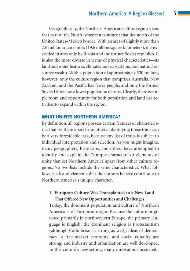
minority populations, throughout the region the fundamen-
tal culture (way of life) is quite similar. In Canada, for ex-
ample, people of French heritage take great pride in their
cultural uniqueness, but the way they live on a day-to-day
basis differs little from that of Anglo (English-speaking)
Canadians.
Someone who travels between the United States and
Canada will note few differences and feel little discomfort. To
appreciate this relative homogeneity, one must have traveled in
other culture realms. In the European culture region, for exam-
ple, it is possible to travel through a half-dozen or more cultural
microrealms, each with its own languages, diet, architectural
style, and other observable traits, in a single day! In Northern
America, one can travel from the remote shores of the Arctic
Ocean to Miami, Florida, or Honolulu, Hawaii, and feel “at
home” in a cultural sense.
CULTURE REGIONSCulture is a word with many different meanings. For purposes
of this book, it can be defined as learned (rather than biologi-
cally acquired) human behavior. What we learn determines the
way we live. A culture is a human society that shares a common
way of life. Most, if not all, members of the group share similar
ideas, outlooks, values, institutions, technology, behaviors, and
other aspects of life.
Regions can best be thought of as geographers’ “conven-
ience packages.” They are areas that are in some way unique, or
set apart, from others. A region must possess one or more sim-
ilar elements (historians use centuries, periods, and eras in
much the same way). In essence, the regional concept allows ge-
ographers to say, “this area is like this” and “that area is like
that.” The Northern American culture region, then, is an area
in which most people share a somewhat similar way of life. The
differences between the Western Hemisphere’s two culture
regions—Anglo (or Northern) America and Latin America—
2 Northern America

illustrate the point. Simply stated, people who live in Edmon-
ton, Alberta, Canada, and Orlando, Florida, will have much
more in common with one another than they will with residents
of Mexico City or Lima, Peru.
At best, regions are abstractions that are often little more
than stereotypical or “average” conditions. Throughout this
book, the authors often write in very general and broadly
sweeping terms. For every “rule,” however, geographically
there are often one or more “exceptions.” This illustrates both
a major strength and a primary weakness of the regional con-
cept. Using the idea of regions allows the user to identify an area
and speak of its primary characteristics in very general terms. In
doing so, however, it tends to ignore conditions that do not
conform to the generalization. Referring to “Anglo America,”
for example, ignores the French-speaking Canadians and other
non-English-speaking peoples. Readers must recognize and
understand this problem.
To the best of the authors’ knowledge, this book repre-
sents the first use of the term Northern America in reference to
this cultural realm. In the past, it has been almost universally
recognized as Anglo America, based on the dominance of the
English language and other British culture traits within the re-
gion. Clearly, however, this designation ignores the rich diver-
sity of minority cultures that flourish within the region. These
include Native American peoples of numerous cultures,
French Canadians, the rapidly growing Hispanic and Asian
communities, and others. To avoid such conflict, many schol-
ars now use North America. The authors disagree with this
emerging practice. Adopting a continental place name to
designate a culture region is both confusing and misleading.
Geographically, North America and South America are conti-
nents, whereas Anglo America and Latin America are culture
regions. To avoid confusion and the appearance of cultural
bias, the authors have elected to create and use a neutral term:
Northern America.
3Northern America: A Region Blessed

4 Northern America
160°W
20°N
155°W
22°N
0 100 Km
0 100 Mi
50
50
Mt. McKinley(20,320 ft.6,194 m)
RO
CK
YM
OU
NT
AI
NS
CA
SC
AD
ER
AN
GE
CO
AS
TR
AN
GE
SC
OA
ST
MO
UN
TAIN
SS
IER
RA
NE
VA
DA
BR
OOKS
R
ANGE
ALASKARA
NG
E
GR
EA
TP
LA
IN
S
APPALAC
HIA
N
MT
S.
CA
NA
DI A N
S H I E L D
GREATBASIN
Labrador
QueenCharlotte
Islands
VancouverIsland
VictoriaIsland
EllesmereIsland
NovaScotia
Newfoundland
Bermuda
Baff in Is land
Greenland
LakeWinnipeg
Great SlaveLake
Great BearLake
LakeAthabasca
Platte R.
Red R.
Snake R.
LakeMichigan
LakeHuron
LakeErie
LakeOntario
LakeSuperior
Mis
siss
ippi
R.
Yukon R.
Macken
zieR
.
Colorado R.
Misso
uri R.
OhioR.
Rio Grand
e
St.La
wre
nce
R.
Peace R.
G u l f o fM e x i c o
H u d s o nB a y
BeringSea
Gulf ofAlaska
BaffinBay
LabradorSea
Davis
Strait
BeaufortSea
ATLANTIC
OCEAN
PACIFIC
OCEAN
A R C T I C
O C E A N
Hawaii(U.S.)
C A N A D A
U N I T E DS T A T E S
30°N
40°N
50°N
20°NTropic of Cancer
50°W
40°W
60°W
70°W
30°W
20°W
10°W
10°N10°N
70°N
80°W90°W100°W110°W120°W
130°W
140°W
150°W
160°W
170°W
170°E
180°
30°N
20°N
40°N
50°N
70°N
80°N
80°N
Arc
ticC
ircle
Arctic
Circle
Washington
Edmonton
New York
Chicago
Winnipeg
Iqaluit
Houston
Honolulu
Los Angeles Phoenix
Seattle
Ottawa
Miami
Atlanta
FeetOver 10,000
5,001–10,0002,001–5,0001,001–2,000
0–1,000
MetersOver 3,0501,526–3,050611–1,525306–6100–305
Elevation
National capitalOther city
N
S
EW
0 1000 Kilometers
0 1000 Miles
500
500
This is a general physical map of Northern America. The topography of the regionvaries, and two of the more prominent geographical features are the Great Plainsand the Rocky Mountains.
Geographically, the Northern American culture region spans
that part of the North American continent that lies north of the
United States–Mexico border. With an area of slightly more than
7.6 million square miles (19.6 million square kilometers), it is ex-
ceeded in area only by Russia and the former Soviet republics. It
is also the most diverse in terms of physical characteristics—its
land and water features, climates and ecosystems, and natural re-
source wealth. With a population of approximately 330 million,
however, only the culture region that comprises Australia, New
Zealand, and the Pacific has fewer people, and only the former
Soviet Union has a lower population density. Clearly, there is am-
ple room and opportunity for both population and land use ac-
tivities to expand within the region.
WHAT UNIFIES NORTHERN AMERICA?By definition, all regions possess certain features or characteris-
tics that set them apart from others. Identifying those traits can
be a very formidable task, because any list of traits is subject to
individual interpretation and selection. As you might imagine,
many geographers, historians, and others have attempted to
identify and explain the “unique character” or elements of
unity that set Northern America apart from other culture re-
gions. No two lists include the same characteristics. What fol-
lows is a list of elements that the authors believe contribute to
Northern America’s unique character.
1. European Culture Was Transplanted to a New Land
That Offered New Opportunities and Challenges
Today, the dominant population and culture of Northern
America is of European origin. Because the culture origi-
nated primarily in northwestern Europe, the primary lan-
guage is English; the dominant religion is Protestantism
(although Catholicism is strong as well); ideas of democ-
racy, a free-market economy, and social equality are
strong; and industry and urbanization are well developed.
In this culture’s new setting, many innovations occurred.
5Northern America: A Region Blessed

2. Aboriginal (Native) Cultures Were Submerged by Eu-
ropean Peoples and Their Way of Life
Before the arrival of Europeans, the Americas were home to
many varied native peoples. Throughout what is now
Northern America, indigenous cultures have largely been
replaced by the now-dominant European-introduced and
often imposed way of living.
3. An Abundance of Space and Natural Resources Lured
Migrating Peoples
It is safe to say that never before have migrating peoples in-
vaded an area with more unoccupied (or underoccupied)
high-quality land or land more richly endowed with abun-
dant and varied natural resources. In terms of space, a
seemingly endless expanse of potentially productive land
stretched “from sea to shining sea.” Because of this abun-
dance, until recently, a frontier attitude toward the natural
environment has existed. Little care or concern was given to
the pollution of water and air, the destruction of forests and
erosion of soil, or the waste of mineral resources.
4. Huge Areas Remain Open to Human Settlement and
Economic Development
Much of the world appears to suffer from overpopulation,
but Northern America offers a vast area of land suitable for
settlement and development. The idea of new land and op-
portunity lying “just over the horizon” has been a key
theme in the culture history of both Canada and the United
States. Perhaps 2 million square miles (5.9 million square
kilometers)—the central and western interior of the United
States and much of Canada—can support millions of addi-
tional people with existing technologies and a comfortable
living standard. Economic incentives must exist before this
will occur.
5. Cultural Assimilation Occurred on a Grand Scale
What has happened culturally in the United States and much
of Canada is unique in the human experience. The original
national motto of the United States is E pluribus unum, a
6 Northern America

Latin phrase that means “from many, one.” With few excep-
tions, people from hundreds of different cultures have come
together to form one Northern American way of life. Never
before or since has such cultural assimilation occurred on
such a grand scale. It is a process that continues today.
6. Individuals Enjoy Great Personal Freedom and Pro-
tection Under the Law
Perhaps more so than any other people in the world, North-
ern Americans are free, within the limits of the law and cus-
toms, to be themselves. They can express their thoughts,
beliefs, and individuality. Canadians and Americans enjoy
tremendous mobility—both vertically, on the so-called so-
cioeconomic scale, and horizontally, in terms of migration,
circulation, and information exchange.
7. Northern America Is a Global Power
Economically, militarily, materialistically, and as a center of
innovations and ideas, Northern America is unsurpassed as
a global powerhouse. Although Northern America (partic-
ularly the United States) is often criticized by much of the
global community, migration data suggest that Northern
America remains the dream, envy, and desired destination
of millions of people throughout the world.
8. The Region’s Population Is Deeply Immersed in Popu-
lar Culture
Perhaps two of every three people in the world continue to
practice what geographers call folk culture, or very tradi-
tional, self-sufficient lifestyles. In a folk culture, the way of
living changes little from year to year or even from genera-
tion to generation. In contrast, Northern America is the
global leader in creating and living by the traits identified
with popular (contemporary) culture. Progress, fad, change,
growth, and specialization are buzzwords by which most
Canadians and Americans live. Northern American popular
culture—dress, entertainment (music, movies, television
programs, literature, and so on), scientific achievements,
medicine, technology, ideology, and much more—floods
7Northern America: A Region Blessed
the world, bringing joy to some and evoking bitter hostility
from others.
As you will learn, a number of significant differences
between the United States and Canada do exist. Such dif-
ferences tend to be rather insignificant when considered in
the context of a major culture region. Canada, for example,
is bilingual, with both English and French as official lan-
guages. Nonetheless, both tongues are Western European.
Each of the foregoing characteristics, as well as significant
differences between the two countries that compose the
Northern American culture realm, will be discussed in
much greater detail elsewhere in this book.
After this brief introduction, your journey through
Northern America will begin with a tour of its marvelous
8 Northern America
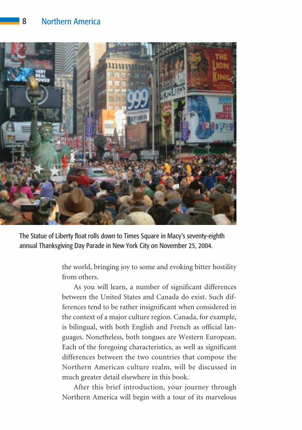
The Statue of Liberty float rolls down to Times Square in Macy’s seventy-eighth annual Thanksgiving Day Parade in New York City on November 25, 2004.

natural environment. You will see people at work, cultur-
ally adapting to, using, and changing the lands and ecosys-
tems that they occupy. Your trip will follow the footsteps of
the people and events responsible for shaping this land and
its unique culture. You will stop to view its people, patterns
of settlement, and basic culture traits—the things that
stamp Northern Americans with their cultural individuality
and as a unique people. To understand Northern America,
one also must study its institutions, social patterns, govern-
ment, and economic systems and activities. Your travels
would not be complete without taking side trips into each
of Northern America’s many subregions. Each of these ar-
eas forms a small piece of the mosaic that, when completed,
presents a composite picture of Northern America. Finally,
as your journey comes to an end, you will peek over the
horizon in hope of gaining a vision of the future of this cul-
ture realm that has been blessed in so many ways.
9Northern America: A Region Blessed
Nature has blessed Northern America. Its abundant resources and
environmental diversity is unsurpassed. Landform features are
varied and often spectacular. Vast rolling plains with rich soils are
homes to the world’s largest area of productive agricultural land.
Within the region, all of the world’s climates and ecosystems can be
found. These range from Hawaii’s steaming wet tropics to the
parched deserts of the Southwest. Frigid polar conditions span the
northern latitudes of Canada and Alaska. Such environmental diver-
sity affords unparalleled opportunity for various types of human land
use, economic development, and settlement. Water resources are
abundant and include shorelines that face three of the world’s five
oceans, the world’s largest network of freshwater lakes, and many
C H A P T E R
Nature’s Gifts and Challenges
2C H A P T E R
10

large and useful rivers. The world’s greatest tidal range—a
whopping 52.5 feet (16 meters)—occurs in Canada’s Bay of
Fundy. Plant and animal life is varied and plentiful, as is the
wealth of fossil fuels, metals, and other useful minerals.
As you will learn in this chapter, nature also presents some
challenges. Many natural hazards pose a risk to life and prop-
erty. This chapter focuses on the natural environment and its
importance to the people of Northern America.
CULTURE AND NATURECultural ecology—the study of relationships between humans
and the natural environments that they occupy—is one of ge-
ography’s most fundamental and time-honored traditions.
Some geographers once believed that nature strongly influ-
enced or even determined the way in which people lived. They
spoke of groups such as “rain-forest people” or “desert people”
as if they were mere pawns of nature. Within each of Earth’s
ecosystems, however, great cultural diversity—different ways of
living, thinking, and doing—exists. Within Northern America,
for example, culture is similar from place to place, yet the re-
gion is home to all of Earth’s landform types, climates, and
ecosystems. If nature played the deciding role, each different re-
gion would be home to a distinct way of life. This simply is not
the case. Whether you are reading this book in Fairbanks,
Alaska; Phoenix, Arizona; or Hilo, Hawaii—or anyplace in be-
tween—your culture is nearly the same.
Today, when considering the culture-environment rela-
tionship, most geographers identify three key elements. First,
they want to know how different cultures adapt to environ-
mental conditions. Second, they study how various elements of
the natural environment and its resources are used. Finally,
they are interested in knowing how human activity has changed
the environment and the human consequences of such changes.
Each of these themes is considered, as appropriate, in the
following discussion of the natural environment.
11Nature’s Gifts and Challenges

LAND FEATURESNorthern America’s land features offer remarkable contrasts.
Within the region, each major landform type—plains, hills,
plateaus, and mountains—occurs over vast areas. Such diver-
sity is important because each type of feature presents different
options (or perhaps obstacles) for land use. Think for a mo-
ment of the type of landform environment best suited to each
of the following activities: skiing (steep slopes), grain farming
using large mechanized equipment (broad plains), building
ground transportation linkages and large urban areas (relatively
flat, stable land), shipping from a harbor (protected coastal in-
dentation), building a dam and reservoir (deep, narrow valley),
and attracting tourists (unusual or scenic natural feature).
What activities can you think of for which each of those envi-
ronments is poorly suited?
Northern America’s major landforms are shared by the
United States and Canada. On a map of the region’s terrain,
three major patterns appear: coastal lowlands backed by high-
lands in the east and Gulf Coast; vast low-lying plains in the in-
terior, stretching from the Gulf of Mexico to Hudson Bay and
the Arctic Ocean; and of rugged mountains, plateaus, and
basins in the west.
Atlantic and Gulf Coastal PlainsThe east coast is bordered by a low, gently rolling coastal plain
that extends from Texas to the Gulf of St. Lawrence. The low-
lands that border the Gulf of Mexico form the Gulf coastal
plain. Those that border the ocean from eastern Florida north-
ward into Canada form the Atlantic coastal plain. These plains
are areas of generally fertile soil that support a high population
density. Ground transportation linkages, from earliest Euro-
pean settlement, were easy and relatively inexpensive to build.
Coastal indentations and islands have provided places of shel-
ter for seaports around which many urban centers grew.
Tampa, Florida; New York City; Boston, Massachusetts; and
12 Northern America

Halifax, Nova Scotia, all thrived because of their location on
natural harbors.
Inland from the coastal plains, land rises abruptly to form
the Piedmont, a hilly upland that lies at the eastern foot of the
Appalachian Mountains. Where the Piedmont meets the
coastal plain is a narrow zone called the fall line. The sharp
break in terrain results in falls or rapids, which, in turn, form
the head of navigation on streams that flow to the Atlantic.
Here, goods being transported by water had to be transferred to
land-based conveyances or vice versa. The rapid stream flow
also could be harnessed to power water mills. To take advantage
of these natural opportunities, many communities were estab-
lished along the fall line. Columbia, South Carolina; Raleigh,
North Carolina; Richmond, Virginia; and Lowell, Massachu-
setts, are among the cities that benefited from this unique
natural condition.
Appalachian MountainsTo the west of the Piedmont lie the Appalachian Mountains
and associated features. These ancient folded mountains with
softly rounded crests extend from Alabama northward into
eastern Canada. They reach their highest elevation atop North
Carolina’s Mount Mitchell (6,684 feet; 2,037 meters). Viewed
from above, they form a generally southwest-to-northeast-
trending series of parallel ridges and valleys. The mountains
form a natural barrier between the coastal plain and interior of
the continent. In places, ancient rivers carved out narrow
east–west-trending valleys as the mountains gradually rose mil-
lions of years ago. These valleys, called gaps, created openings
that are easily followed by trails, highways, and railroads. Be-
cause of the ruggedness of terrain, much of Appalachia re-
mained relatively isolated for years. Isolation allowed the scat-
tered and fiercely independent people of this region to retain
traditional ways of living long after most Northern Americans
had adopted a fast-paced and rapidly changing popular culture.
13Nature’s Gifts and Challenges

St. Lawrence–Great Lakes Lowlands andCanadian ShieldIn Canada, to the west of the Appalachians, lie two regions that
do not extend into the United States. Lowlands border the St.
Lawrence River and also the Canadian side of the Great Lakes.
Both features were formed during the Ice Age, when glaciers
scoured basins and leveled terrain. When the glaciers began to
melt and recede about 12,000 years ago, basins—including the
Great Lakes—began to fill with water. Glacial meltwater also
rushed down the St. Lawrence Valley, forming the river that
now occupies the trench.
The Canadian shield is a horseshoe-shaped area of rolling
uplands that covers nearly half of Canada. It is composed of
very ancient rock that has been heavily worn down by millions
of years of glacial erosion. The shield is an area of poor, thin
soils and millions of lakes, wetlands, and small streams—all the
result of the region’s glacial past. At several sites, rivers that flow
over falls or rapids have been harnessed to produce hydroelec-
tric power. The shield also is rich in minerals, and mining ac-
counts for much of the area’s scant settlement and population.
Because of the many lakes and rivers, few transportation routes
penetrate the shield. Other than the far north, it is Northern
America’s least-populated area.
Interior Lowland PlainsIn the central interior of Northern America is a vast lowland
plain that extends from the Appalachians westward to the
Rocky Mountains. The plains are divided into three regional di-
visions. The wetter eastern portion in the United States is called
the Central Plains; the drier and slightly higher western portion
is called the Great Plains; the northward extension of these into
Canada is known as the Western Interior Plains. Most of the re-
gion has very good soil and ample moisture that help make it
the world’s largest and most productive grain-growing “bread-
basket.” It is also an area of extensive livestock grazing.
14 Northern America

Rocky Mountains and Interior Basins and PlateausMuch of the western interior of Northern America is a land of
towering mountains, sprawling plateaus, and gaping canyons.
It is a region of rugged, spectacular scenery. To a person travel-
ing westward across the plains, the Rocky Mountains appear as
a giant dark curtain on the distant horizon. Their majestic
glaciated peaks offer some of Northern America’s most impres-
sive scenery. Colorado alone has 17 peaks that reach an eleva-
tion of more than 14,000 feet (4,267 meters). Although the
Canadian Rockies are not as lofty, they are even more spectac-
ular because of the jagged peaks formed by extensive glaciation.
The Rockies actually are a series of ranges, each with a regional
name, such as Sangre de Cristo in New Mexico and Colorado,
Bitterroot in Montana and Idaho, Columbia in Canada, and
Brooks in Alaska.
Lands to the west of the Rocky Mountains include three
huge plateaus and a large stretch of relatively low, isolated
mountains separated by broad basins. The Colorado Plateau is
centered on the “Four Corners” area, where Arizona, New
Mexico, Utah, and Colorado meet. It is a rugged area of spec-
tacular cliffs, arches, gorges (including the Grand Canyon on
the Colorado River in Arizona), and other erosional features.
To the north, the volcanic Columbia Plateau covers portions of
eastern Washington and Oregon and reaches into southern
Idaho. In addition to many unique volcanic features, it offers a
variety of spectacular erosional features, including Hell’s
Canyon on the Snake River and the “scablands” of eastern
Washington. Scablands—bare rock with most soil removed—
were created during the late Ice Age. A glacial lobe created an ice
dam on the Clark Fork River near Sandpoint, Idaho, creating a
huge inland water body, ancient Lake Missoula. When the lake
reached a depth of perhaps 2,000 feet (610 meters), the ice be-
gan to float. The resulting torrent of water—a volume esti-
mated to have been ten times as great as the combined flow of
all the world’s rivers!—rushed toward the distant Pacific at
15Nature’s Gifts and Challenges

speeds of up to 65 miles per hour (105 kilometers per hour).
The force of this vast flood removed or altered everything in its
path and left an erosional landscape found nowhere else in the
world. In the interior of Canada’s British Columbia, the Fraser
Plateau is a rugged and remote area of sparse settlement and few
people.
Elsewhere in the region, stretching from west Texas to the
Pacific Coast of western Alaska, the terrain is dotted with scat-
tered mountain ranges that are separated by broad basins.
Many of the basins have no drainage outlet. Salts deposited in
the basins by inflowing water cannot be removed. The result is
an accumulation of salts such as the deep deposits of Utah’s
Bonneville Salt Flats and saline water bodies such as Great Salt
Lake and Southern California’s Salton Sea.
16 Northern America
This is a view of the Grand Canyon from Hopi Point, Arizona. Every year, over5 million tourists visit the canyon. The canyon is 275 miles (443 kilometers) longand up to 1 mile (1,700 meters) deep.
In the interior West, rugged terrain and a lack of moisture
combine to make most types of land use—including building
transportation linkages—somewhat difficult and costly. Much
of the region has undergone two stages of settlement: Until the
mid-1900s, many locations experienced a “boom and bust”
economy based on mining. During recent decades, a spurt in
development has been fueled primarily by increased tourism
and people moving to the region because of its weather,
scenery, and other natural amenities.
Pacific Coast Mountains and ValleysThe Pacific Coast, which extends from California to Alaska and
includes Hawaii, is a region of mountains and scattered large,
fertile valleys. In the United States, low coastal ranges border
the Pacific. In many places, including San Diego and San Fran-
cisco, California; Seattle, Washington; Vancouver, British Co-
lumbia; and Anchorage, Alaska, large natural indentations
form protected harbors. Inland from the coast are areas of very
productive farmlands, including California’s Imperial and Cen-
tral valleys and the Willamette Valley in Oregon.
Farther inland lie mountain ranges that geologically are
part of a continuous range that surrounds nearly all of the
Pacific Ocean basin. The Sierra Nevada range forms the huge
“backbone” of central California. Here, Mount Whitney, the
highest peak in the adjoining 48 states, reaches an elevation of
14,494 feet (4,418 meters). Just 70 miles (113 kilometers) to the
east, Death Valley plunges to a depth of 282 feet (86 meters)
below sea level, the lowest area of dry land in the Western
Hemisphere.
Beginning in northern California and extending northward
into Washington are the Cascades, a volcanic range. The high-
est peak is majestic snowcapped Mount Rainier, which towers
14,410 feet (4,392 meters) above the surrounding lowlands. In
Canada and Alaska, higher mountains hug the coast, creating
spectacular scenery. Here, the Coast Ranges form an almost
17Nature’s Gifts and Challenges

continuous barrier of offshore islands, leaving a semiprotected
“inland” water passage. The coast is broken with deep fjords,
glacially scoured trenches that are now arms of the sea. Inland,
Canada’s Mount Logan reaches an elevation of 19,550 feet
(5,959 meters) and Alaska’s snow- and glacier-shrouded
Mount McKinley, also called Denali, soars to 20,320 feet (6,194
meters), the highest peak in North America.
The Hawaiian Islands were formed by volcanic activity, a
process that continues to occur regularly on the big island of
Hawaii. Despite their tropical location, the volcanic peaks of
Mauna Kea and Mauna Loa occasionally sport crowns of snow.
Mauna Kea rises 20,000 feet (6,096 meters) from the floor of the
Pacific and reaches an elevation of 13,796 feet (4,205 meters).
With a bottom-to-top span of almost 34,000 feet (10,360 me-
ters), it is the world’s “tallest” mountain!
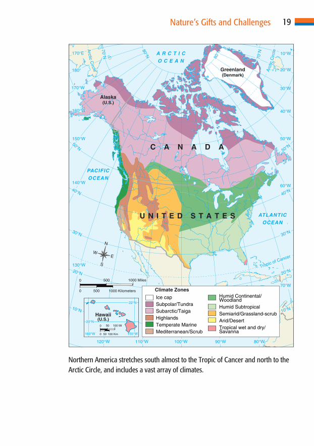
CLIMATES AND ECOSYSTEMSMost of Northern America lies within the middle latitudes.
Only in the far north does it extend into the bitterly cold polar
latitudes, and only the Hawaiian Islands fall within the tropical
zone. The region’s position is of considerable geographical im-
portance. Areas that experience extreme climatic conditions
(cold, dry, hot, wet, or a combination of these) can be much
more difficult and costly to develop. As a result, they may at-
tract fewer people. The middle latitudes, however, tend to ex-
perience more moderate weather (day-to-day conditions) and
climate (average weather over decades). They therefore tend to
be easier to develop. Historically, they also were more attractive
to other mid-latitude peoples seeking new lands. The cultural
importance of this reality will be discussed in greater depth in
later chapters.
Northern America is unique in that it is the world’s only
culture realm that includes each of the world’s climates and
ecosystems somewhere within its territory. This unmatched
variety of environmental conditions is important for several
18 Northern America
19Nature’s Gifts and Challenges
160°W
20°N
155°W
22°N
0 100 Km
0 100 Mi
50
50
ATLANTIC
OCEAN
PACIFIC
OCEAN
A R C T I C
O C E A N
U N I T E D S T A T E S
C A N A D A
Alaska(U.S.)
Greenland(Denmark)
Hawaii(U.S.)
30°N
40°N
50°N
20°NTropic of Cancer
50°W
40°W
60°W
70°W
30°W
20°W
10°W
10°N10°N
70°N
80°W90°W100°W110°W120°W
130°W
140°W
150°W
160°W
170°W
170°E
180°
30°N
20°N
40°N
50°N
70°N
80°N
80°N
Arc
ticC
ircle
Arctic
Circle
Climate Zones
Ice capSubpolar/TundraSubarctic/TaigaHighlandsTemperate MarineMediterranean/Scrub
Humid Continental/WoodlandHumid SubtropicalSemiarid/Grassland-scrubArid/DesertTropical wet and dry/Savanna
N
S
EW
0 1000 Kilometers
0 1000 Miles
500
500
Northern America stretches south almost to the Tropic of Cancer and north to theArctic Circle, and includes a vast array of climates.

reasons. First, climate is the primary influence on ecosystems.
The great variety of conditions contributes to a tremendous di-
versity of flora and fauna (plants and animals), soil types, and
moisture conditions. Second, all human activities, including
the growing of any type of agricultural crop, can find a suitable
environmental “home” someplace within the region. Finally,
“variety,” it has been said, “is the spice of life.” Geographically,
people enjoy and seem to thrive in environments that offer a va-
riety of conditions and opportunities.
Most of eastern Northern America experiences a humid
continental climate. Depending on latitude, winters are cool in
the south and cold in the north and summers are hot in the
south and cool in the north. The entire region receives ample
rainfall to support agricultural crops or dense vegetation, and
moisture is distributed fairly evenly throughout the year. Under
natural conditions, the region would support a dense cover of
needleleaf evergreen, broadleaf deciduous, or mixed forests.
Today, much of the natural vegetation cover has been removed
for settlements, agriculture, and other types of human land use.
In the southern United States, however, much of the land that
was once forest covered and then farmed is again reverting to
woodland.
In the central interior of Northern America, the climate is
considerably drier and temperature extremes are greater. Most
of the area receives 10 to 20 inches (25 to 50 centimeters) of pre-
cipitation annually, much of which falls in summer thunder-
showers. Temperatures range from hot to frigid, depending on
latitude and season. Before the arrival of European settlers,
much of the central interior was covered with a sea of grass. Tall
prairie grasses dominated the landscape of the wetter eastern
margin, and shorter steppe grasslands thrived in the drier west-
ern edge. This was home to the American bison (buffalo),
millions of which roamed the grass-covered plains. Today, cul-
tivated grains have largely replaced the natural grasslands and
domesticated livestock herds have replaced the native bison.
20 Northern America
Between the eastern slopes of the Sierra Nevada, Cascades,
and Canadian Pacific ranges and the Rockies, the climate is dry
and temperatures vary greatly depending on latitude, eleva-
tion, and, of course, season. The region’s aridity results from
the high western mountains blocking moisture-bearing winds
from the Pacific. East of the Pacific ranges, only scattered high
mountains receive enough moisture to support forest growth.
Throughout most of the region, annual average precipitation
measures less than 10 inches (25 centimeters), reaching a low
on the parched desert floor of Death Valley, which receives less
than 1.5 inches (3.8 centimeters) per year. Temperatures have
reached a sizzling 135°F (57°C) in California’s Death Valley.
Ironically, during the very wet spring of 2005, much of Death
21Nature’s Gifts and Challenges
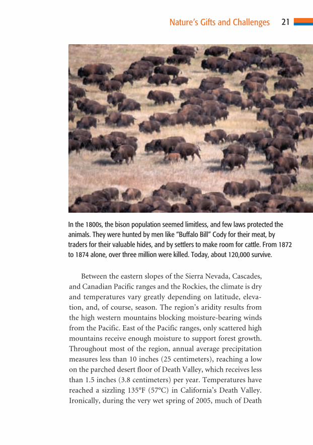
In the 1800s, the bison population seemed limitless, and few laws protected theanimals. They were hunted by men like “Buffalo Bill” Cody for their meat, bytraders for their valuable hides, and by settlers to make room for cattle. From 1872to 1874 alone, over three million were killed. Today, about 120,000 survive.

Valley’s floor became a huge lake. Throughout the region,
nearly all locations experience cool to cold winter temperatures.
Coastal Southern California experiences a mild Mediter-
ranean climate. It lacks temperature extremes and, despite a
prolonged summer drought, has enough moisture to support
fairly lush vegetation cover. From Northern California north-
ward to Alaska, heavy coastal rainfall supports a dense cover of
needleleaf evergreen forests. Until recent years, these forests
provided much of Northern America’s high-quality construc-
tion wood harvest.
Hawaii, although tropical, supports a variety of microcli-
matic conditions and ecosystems. On the island of Kauai, one
can stand in an area of short grasses, scattered cacti, and less than
10 inches (25 centimeters) of annual rainfall and gaze on the
world’s wettest spot—Mount Waialeale (annual average 460
inches [1,168 centimeters] of rainfall)—only a few miles away!
The far north is a region of short summers and very long
harsh winters. Moisture is scant, but evaporation is low. A
broad band of taiga (also called “boreal forest”) extends from
interior Alaska to the shores of the Atlantic Ocean north of the
St. Lawrence River. This dense forest of spruce, larch, pine, and
aspen is the largest in North America. Because of its remote lo-
cation and the scrawny size of most trees, however, only re-
cently has logging begun here. The forests teem with wildlife,
including deer, elk, moose, and bears. North of the taiga is the
tundra, a region of mosses, lichens, grasses, and small flowering
plants. Here, the growing season is too short and the soil too
shallow for trees to grow. This fragile land is home to large
herds of caribou and other wildlife.
WATER FEATURESWater is essential to life. In areas that have an abundance of
moisture, population density tends to be high and, under natu-
ral conditions, vegetation is plentiful. Where moisture is scarce,
population thins out and vegetation becomes scant.
22 Northern America

Generally speaking, it can be said that the eastern half of
Northern America has ample water resources, including lakes,
rivers, and groundwater. In many places, however, it faces
problems of pollution and overuse. Much of the western half of
the region lacks adequate water resources.
LakesAn estimated 90 percent of the world’s lakes occupy basins
scoured by glaciers. During the Ice Age, nearly all of Canada and
most of the United States north of the Missouri and Ohio rivers
was covered by continental ice sheets. A detailed map of any part
of the United States or Canada that was glaciated will reveal thou-
sands of lakes. Outside the glaciated areas, very few natural lakes
(as opposed to reservoirs, or lakes located behind dams) exist.
The Great Lakes, shared by the United States and Canada,
form the world’s largest body of freshwater. Their natural out-
flow is through the St. Lawrence River. Since 1959, ships have
been able to navigate all of the lakes and sail into the Atlantic
Ocean through the St. Lawrence Seaway. Ocean-going ships can
leave the most inland port city, Duluth, Minnesota, located at the
western tip of Lake Superior, and eventually reach the Atlantic,
2,340 miles (3,766 kilometers) distant. On its trip, a ship would
pass through four of the five Great Lakes and descend more than
600 feet (183 meters) through a network of 19 locks and 6 canals.
RiversNorthern America is drained by a number of great rivers. The
largest system is that formed by the Missouri, Ohio, and Mis-
sissippi rivers and their many tributaries. Combined, they drain
an area of about 1,245,000 square miles (3,225,000 square kilo-
meters), an area surpassed only by South America’s Amazon
and Africa’s Congo rivers.
From the eastern slope of the Rocky Mountains in Mon-
tana, the combined Missouri–Mississippi River system flows
3,700 miles (5,970 kilometers). It finally reaches the Gulf of
23Nature’s Gifts and Challenges

Mexico through its bird’s-foot-shaped delta south of New Or-
leans, Louisiana. Barges can travel upstream on the Missouri
River to Sioux City, Iowa; the Ohio River to Pittsburgh, Penn-
sylvania; and the Mississippi to St. Paul, Minnesota.
In the Southwest, the Colorado River and Rio Grande cas-
cade southward from the Colorado Rockies. Although rela-
tively small in volume, these rivers create oases in otherwise
arid areas. As a result, they have attracted considerable human
settlement, much of which is based on irrigated agriculture. The
importance of water in a desert is illustrated by the Colorado
River. Between the point where it enters the state of Arizona
and its mouth in the Gulf of California, the river’s flow is con-
24 Northern America
The Soo Locks in Sault Sainte Marie, Michigan, are an indispensable gatewayalong the Great Lakes shipping route. Vessels pass through the locks more than7,000 times annually.

trolled by eight dams and reservoirs, including Glen Canyon
Dam and Lake Powell on the Utah–Arizona border, and the
huge Hoover Dam and Lake Mead just east of Las Vegas,
Nevada. So much of the river’s flow is diverted for human, in-
dustrial, and agricultural use in Arizona, California, Nevada,
and Mexico that almost no water reaches its delta at the head of
the Gulf of California. In addition, hydroelectric power is pro-
duced and the river and reservoirs provide wonderful recre-
ational opportunities in an otherwise parched landscape.
Other important rivers in the United States include the Co-
lumbia in the Pacific Northwest and the Hudson River in the
Northeast. Inland, the Tennessee River and its many tributaries
were the focus of one of the nation’s greatest reclamation proj-
ects, the Tennessee Valley Authority (TVA). Begun on the heels
of the Great Depression of the 1930s, the TVA was one of the
most ambitious engineering projects ever attempted. Dams
were built to control flooding and produce hydroelectric en-
ergy. Canals were dug and locks were built to facilitate naviga-
tion. These and other related projects began to transform the
previously impoverished region in many positive ways.
Canada’s most important river, historically, economically,
and in terms of human settlement, is the St. Lawrence. To the
north, Alaska’s Yukon River and Canada’s Mackenzie River
drain areas of very low population and little economic activity.
Because of the sharp seasonal variability of their flow (up to 90
percent of their annual volumetric flow occurs in a two-month
period after the spring thaw), the rivers cannot be harnessed for
hydroelectric development and are of little use for navigation.
Human Use of Water ResourcesToday, as in the past, water is a magnet for settlement, eco-
nomic development, and transportation. Nearly all early settle-
ments, whether native or European, bordered rivers, freshwater
lakes, springs, or natural harbors. Water was used for domestic
purposes, industry, and agriculture. It also served as a thor-
25Nature’s Gifts and Challenges

oughfare for easy travel before the days of railroads and high-
ways. Mills for sawing timber or milling grain could be built at
points where streams cascaded over falls or rapids. Fish pro-
vided a reliable source of food. The importance of water to set-
tlement is often indicated in place names that include words
such as “Lake,” “River,” “Port,” “Harbor,” “Springs,” “Falls,”
and “Rapids.” In arid regions, oasis sites often grew into thriv-
ing communities. Along coasts, settlements often were founded
at or near the mouth of a navigable river or on a natural harbor.
Today, water resources are still of great importance. In ad-
dition to their historical uses, streams are now harnessed to
provide electrical energy. In arid regions, water is transferred
great distances, as is the case with diversion from the Colorado
River to Phoenix and Tucson, Arizona, and the Los Angeles
basin in southern California. California also diverts water from
the Sierra Nevada southward to its major population centers.
California is the most populated political unit in Northern
America, with more than 35 million residents. Without the
massive diversion of precious water resources, the state could
support only a small fraction of its current population.
ENVIRONMENTAL HAZARDSAlthough Northern America has been blessed by nature in
countless ways, the region also has been cursed. No other re-
gion of comparable size is subject to a greater array of devastat-
ing natural hazards. From within the earth come shattering
earthquakes and violent volcanic eruptions. From the atmos-
phere come torrential rains, pounding hail, freezing ice, and
howling blizzards of snow or dust. Each year, nature’s most vi-
olent storms, tornadoes and hurricanes, take a tragic toll on hu-
man life and property unfortunate enough to lie in their path.
Waters, too, can pose an omnipresent hazard to humans and
property. Few places are free of occasional drought, periodic
river or lowland flooding, or coastal inundation by tsunamis
(incorrectly called “tidal waves”) or storm-driven waves. Rock
26 Northern America

and snow avalanches, mud flows, and other hazards caused by
gravity often devastate property and people who live below.
Of course, not all places are subject to the ravages of all of
the environmental hazards. In fact, natural hazards show a
rather distinct pattern of regional distribution. Hurricanes, for
example, wreak their havoc along the Gulf and Atlantic coasts.
Downgraded to tropical storms, they often penetrate well into
the interior, where they can cause devastating floods. In
September 1900, a violent storm swept ashore from the Gulf of
Mexico in the area of Galveston, Texas. Its fierce winds drove a
wall of water across low-lying Galveston Island. By the time the
howling winds and churning floodwaters receded, an estimated
27Nature’s Gifts and Challenges
In terms of loss of life, the Galveston, Texas, hurricane of 1900 was the worst disas-ter in American history. More than 8,000 people perished September 8, 1900,when the Category 4 hurricane barreled into Galveston, where many people wereon vacation. (The practice of naming hurricanes did not begin until 1953.)

8,000 people had died. As measured by loss of life, the Galve-
ston hurricane ranks as Northern America’s greatest natural
disaster.
In late August 2005, Hurricane Katrina struck the Gulf
Coast of Louisiana, Mississippi, and Alabama with powerful
145 mile-per-hour (235 kilometer-per-hour) winds. In her
wake, Katrina left an estimated 1,200 deaths, 1.5 million people
displaced, an area of 90,000 square miles (235,000 square kilo-
meters) almost totally destroyed, and more than 200 billion
dollars in property damage. In terms of destruction and cost, it
was the greatest natural disaster in Northern American history.
Because they require heat, hurricanes—tropical storms with
winds in excess of 74 miles per hour (119 kilometers per
hour)—occur during the summer and early autumn months.
Tornadoes, or “twisters,” as they are often called, have oc-
curred in most states and provinces but are concentrated in the
continental interior. “Tornado Alley”—the path along which
the greatest number of these treacherous storms occurs—is a
belt several hundred miles wide that extends from Texas to the
Great Lakes. These storms, with upward spiraling winds that
can exceed 250 miles per hour (400 kilometers per hour), can
destroy nearly everything in their path.
Earthquakes tend to be localized but can cause tremendous
loss of life and property. Although the Pacific Coast—which lies
on the Pacific Ring of Fire—is the most earthquake-prone area,
seismic events have occurred in most areas of Northern Amer-
ica. San Francisco, located astride the well-known San Andreas
Fault, is in constant peril, as is the Los Angeles area. In terms of
loss of life, the 1906 San Francisco earthquake, with 500 deaths,
remains the most tragic. Perhaps the most intense earthquake
on record, which measured 9.2 on the Richter scale, by which
earthquake intensity is measured, struck a huge area of south-
ern Alaska in 1964. Although only 131 people lost their lives,
much of the state’s largest city, Anchorage, and several other
communities lay in ruin.
28 Northern America

Certainly one of the most spectacular events in Northern
America’s recent history was the violent 1980 eruption of
Washington’s Mount St. Helens. Fortunately, the peak is quite
isolated and there was ample advance warning. A huge area was
affected by the explosion and following nine-hour eruption.
Fortunately, only 57 people died and property losses were min-
imal despite the incredible violence of the event.
Natural Disasters or Human Risk?Cultural geographers question whether “natural” disasters ac-
tually exist. Nearly all hazards, after all, can be predicted. If you
live on the Gulf or Atlantic coast, you know that a hurricane will
eventually strike. The same holds true for people who live near
fault zones on the West Coast, people who build homes in areas
of highly combustible woodland, or those who live at the base
of an active volcano such as Mount St. Helens.
Many hazard zones have highly desirable qualities. People
are drawn to coastal waters, the shores of rivers and lakes,
densely forested mountains, and other hazard zones. In so do-
ing, they are taking a calculated risk: It won’t happen to me.
Some places, of course, are much safer than others. Nearly
all of Canada is relatively free of severely damaging events. In
the United States, the northern Great Plains region is relatively
hazard free. Ironically, a comparison of population patterns
and property values clearly shows that the most hazardous ar-
eas also are those that are experiencing the greatest gains in
population and increases in property value. Relatively safe areas
such as the continental interior tend to be experiencing out-
migration and stable or declining property values.
29Nature’s Gifts and Challenges

Think for a moment about a person your age living in a distant
land. How would your lives be similar? How would your lives be
different? How might such similarities and differences be explained?
Throughout the world, people share certain similarities in the
ways they live. Differences based on where people live do exist, yet
there are common threads that define their culture, or way of life. For
example, people have holidays and special occasions during which
particular foods are enjoyed. They have belief systems, languages,
ways of earning a living, forms of entertainment, and a heritage—all
of which are unique to that particular region. Why certain traits or
traditions have developed can be better investigated by studying a
region’s historical geography, with emphasis on its cultural history.
C H A P T E R
Historical Geography
3C H A P T E R
30
As you read in Chapter 2, Canada and the United States
share many physical geographic features. In this chapter, you
will explore the ways in which Northern America’s culture his-
tory evolved. You will find that, in many ways, the United
States and Canada share a common history, yet in other ways,
they differ in terms of their past. Similar historical threads in-
clude pre-European native cultures; European exploration,
settlement, and colonization; population growth as a result of
immigration; westward expansion; and a wealth of natural re-
sources.
THE FIRST AMERICANSNorthern America’s first people came from elsewhere. Half a
century ago, scientists believed that they knew who these early
people were, where they came from, how and by what route
they traveled to this new land, and when they arrived. Asian
peoples, they believed, pursued large game animals across
Beringia, the Bering Strait “land bridge”—exposed when the
sea level dropped during the Ice Age. They then passed through
an ice-free corridor located between two huge masses of glacial
ice that covered much of northern North America. Finally, as
suggested by the Clovis site and its unique stone projectile
points, they reached what is now New Mexico perhaps 12,000
to 13,000 years ago.
Today, many scientists are less sure of this scenario. In fact,
the origin of the first Americans appears to be a great unan-
swered “mystery.” Archaeological finds have been interpreted
by at least some scientists to suggest multiple origins of Amer-
ica’s earliest people. Southeast Asia, Japan, and eastern Siberia
have all been suggested as the source area(s), but so have Aus-
tralia, Europe, and Africa. Some archaeologists still believe that
the original theory holds true. A growing number of scientists
now believe that this route would have been far too cold and in-
hospitable for travel, however, and some even doubt the exis-
tence of the proposed ice-free corridor.
31Historical Geography
Support for a coastal route is gaining. During the Ice Age,
sea level was several hundred feet lower than it is now, and
land that is now underwater would have been exposed—a nat-
ural corridor for human migration. Certain scientists even be-
lieve that some of the earliest settlers may have traveled by
boat during at least part of their long journey. The time of
arrival also is now in serious doubt. Various estimates based
on the interpretation of “evidence” by scientists place the ear-
liest arrivals at any time from perhaps 13,000 to more than
100,000 years ago!
Perhaps the full story of the earliest Northern Americans
will never be known. In fact, the question is much more aca-
demic than practical in nature. Almost certainly, pre-European
arrivals represented a variety of human physical types, includ-
ing Mongoloid, Negroid, and Caucasoid. This suggests multiple
migrations from different source areas, which almost certainly
was the case. Such migrations may have occurred by both land
and water over thousands of years.
NATIVE CULTURESNative people of Northern America recognized themselves by
many names, both as individual (tribal) groups and collectively.
Indian is the most common term used in reference to them, but
many prefer to be called “Native Americans,” “First Ameri-
cans,” or “First Nations” (“First Nations” is preferred in
Canada). Indian, after all, is derived from one of the great geo-
graphical errors of all time—Columbus’s belief that he had
reached the Indies of southeastern Asia.
Several things can be said with some certainty about the
earliest Northern Americans. When Europeans arrived on the
shores of the “New World,” they reached a land that had been
“discovered” and settled thousands of years earlier. The native
peoples were dominantly East Asian in terms of physical char-
acteristics and geographical origin. The ways of life practiced by
native peoples varied greatly in terms of language, economic
32 Northern America

activity, housing, dress, and many other aspects of culture.
Levels of cultural attainment ranged from well-organized high
level “civilizations” to small groups of isolated peoples who
possessed a very meager level of material culture.
In the southwestern United States, Pueblo tribes grew crops
of maize (corn), beans, and squash. Some, such as the Hohokam
(in what is today central Arizona), practiced a very advanced
type of irrigation, diverting water great distances in well-
constructed canals. Many of their adobe (clay and straw) or
stone structures remain today, a tribute to their building skills.
East of the Mississippi River and south of the Great Lakes
and St. Lawrence River, woodland peoples practiced productive
farming combined with hunting and fishing. An adequate and
33Historical Geography
The Anasazi cliff dwelling ruins in Mesa Verde, Colorado, are the best preservedancient cliff dwellings in the United States. The name Anasazi is from the Navajolanguage and means “ancient ones.”

reliable food supply made relatively large populations, settled
communities, and high levels of social organization possible.
Along the Pacific Coast from northern California through
the Alaskan panhandle, many people turned to rivers and the
sea for their livelihood. Here, salmon and other types of marine
life provided an abundance of food. People were able to live in
large, well-built wooden buildings in permanently settled com-
munities. They also were skilled in the construction and use of
sturdy watercraft.
Bison (buffalo) hunters occupied the continent’s interior
from the Rio Grande northward into central Canada. Millions
of these huge beasts roamed the interior plains. They provided
meat, hides, bone, horn, and sinew (thread), all of which were
important resources to these skilled hunters. Because the bi-
son were migratory, the Plains Indians were as well. As a re-
sult, they had few material possessions, often little more than
their clothing, tools, and weapons.
In parts of the dry interior west, low populations of season-
ally wandering peoples depended on hunting and gathering of
wild seeds. Their material culture was the most meager of all
Northern American peoples.
Across the vast subarctic region of taiga forest, people
depended on caribou hunting, fishing, and gathering for their
livelihood. Some groups made sturdy canoes from the bark
of birch trees. During the winter, snowshoes and toboggans
were used to make travel across the snow-covered surface
easier. Their meager way of life stood in sharp contrast to that
of the tundra and Arctic coast Inuit (Eskimo). Inuit material
culture ranked among the most advanced of all the world’s
preagricultural peoples. It featured sturdy buildings, includ-
ing the igloo. Travel was by dogsled in the winter and sleek
kayaks and larger seagoing umiaks during the summer. As
skilled hunters and fishermen, they had few equals. The Inuit
harpoon is one of the most effective hunting weapons ever
devised. Inuit clothing, designed to protect against tempera-
34 Northern America
tures that drop far below freezing for months at a time, is ex-
cellent. In fact, much of our own winter clothing design—
jackets, gloves, headgear, and footwear—was adopted from
the Inuit.
Northern America’s native peoples made numerous contri-
butions to present-day culture. Many land features are identi-
fied by names given them by the original settlers. Anyone
familiar with the American Thanksgiving story knows that early
European settlers owed a great debt to the Native Americans.
From them, the colonists learned of different crops and foods
and new ways of using the land and its resources. Canoes and
kayaks have become popular recreational watercraft, and
throughout much of Northern America, various ruins and
other historical sites serve as important links to the region’s first
cultures and their important legacy.
DID A BULL CHANGE HISTORY?Today, tourists can visit a reconstructed Viking settlement at
L’Anse aux Meadows, a National Historic Site on the northern
tip of Newfoundland. Here, according to ancient sagas (sto-
ries), a group of 160 Norse men and women from Greenland
settled in the summer of 1003. In “Vineland the Good,” they es-
tablished a village called Hop under the leadership of Thorfinn
Karlsefni. The Vikings had escaped the cold of Greenland and
planned to start a permanent colony in this new land that of-
fered great abundance. They even brought livestock, including
Karlsefni’s bull.
The Vikings met and began to trade with a group of people
who arrived by canoe. They called these strangers skraelings.
Things seemed to go well, until one day Karlsefni’s bull sud-
denly charged from the forest. The skraelings, who had never
seen cattle, fled in terror. They soon returned and attacked the
Vikings, killing several and injuring others. The Norse soon re-
alized that they were outnumbered and would never be safe in
Vineland. They decided to abandon Hop and return to
35Historical Geography

Greenland, thereby ending the Norse attempt to settle North
America. Karlsefni’s enraged bull evidently delayed the perma-
nent European settlement of the Americas for some 500 years!
How different might Northern America’s history and culture
have been had it not been for one bull?
EARLY EUROPEAN EXPLORATIONEuropean exploration of Northern America began in earnest
approximately 500 years ago. Beginning with Columbus’s voy-
age in 1492, European navigators began to sail westward in
search of an all-water route to the Orient and its fabulous
riches. The quest drew explorers from Italy, Spain, France, Por-
tugal, the Netherlands and Great Britain across the Atlantic to
the shores of the newly found land that, by 1507, had been
named “America.”
Sailing across the Atlantic in 1497, Giovanni Caboto,
known as John Cabot, explored under the orders of King Henry
VII of England. His mission was to find a new trade route to the
Orient for the ever-expanding British empire. What Cabot dis-
covered instead was perhaps the world’s richest fishing
grounds, which lay off of the eastern shore of Canada. When
news of the cod-rich waters of the Grand Banks reached the
king’s ears, more ships departed. Soon, a thriving fishing in-
dustry developed on the eastern coast. This was the first of
many instances in which Northern America’s rich natural re-
sources affected its cultural history. Later, some vessels began to
venture south into the Gulf of St. Lawrence. Here, Europeans
came in contact with native people and fishing crews exchanged
beads and other trinkets for furs. Little did they know at the
time that this initial trading soon would develop into a valuable
fur-trading network.
Kings and other leaders still were eager to find a water route
through Northern America to the Orient’s rich spice markets.
Eventually, however, a shift in thinking renewed interest in
Northern America’s natural riches. Far to the south, in Latin
36 Northern America
America, Spanish explorers had discovered huge deposits of gold
and silver. Spurred by tales of the vast wealth in the New World,
the King of France sent Florentine explorer Giovanni da Ver-
razano on a voyage of exploration in 1524. Verrazano landed on
the coast of North Carolina and continued northward, suppos-
edly to avoid conflict with the Spanish, who were already estab-
lishing claims in Florida. His voyage carried him along the
eastern seaboard as far as Nova Scotia and Newfoundland. Ver-
razano, believed to be the first European to follow the coast of
present-day New England, and his “discoveries” soon drew other
explorers.
EUROPEAN ROOTS IN AMERICAN SOILDuring four voyages between 1534 and 1543, Jacques Cartier,
also dispatched by France, gathered more documentation of the
lands and people in this area. He also ventured into the interior
of Canada. Cartier had located the inviting water highway of the
St. Lawrence River, which promised a route westward to the
Great Lakes. He hoped to discover precious metals such as sil-
ver and gold. Instead, he found a resource of comparable value
in the region’s abundant fur-bearing animals.
The French continued to stream farther inland to other
areas of Northern America. Trading posts were established
where valuable furs could be collected both from trappers
and through trade with native peoples. Small settlements
and fur-trading posts continued to expand along the St.
Lawrence River, the Great Lakes, and south along the Mis-
sissippi River to the Gulf of Mexico. Fur-trapping routes,
mapped with knowledge gained from the native populations,
were developed by both French and British trappers. Ex-
pansion of the fur trade was pushed by fashionable European
hat makers, who desired the furs for their customers. Popula-
tion increased, and with the more permanent settlements
came increased economic activity and, for some individuals,
prosperity.
37Historical Geography

As trade expanded, so did the European populations in
Northern America. The French secured their first foothold,
Port Royal, in what is now Nova Scotia, in 1605, three years
before Samuel de Champlain founded Quebec on the St.
Lawrence River. To the south, along the eastern coast of the
United States, English settlers established Jamestown (Virginia)
in 1607. English Puritans settled at Plymouth (Massachusetts)
in 1620 and from there spread throughout much of New Eng-
land. Dutch, Scandinavian, and German settlers soon were
added to the growing diversity of Northern America’s cultural
mosaic. An ethnic mix of farmers, merchants, and tradesmen
colonized what would become known as New York and Penn-
sylvania. By the mid-1700s, these diverse peoples lived in a
group of colonies under British control.
38 Northern America
This is a drawing of Quebec City from the 1800s. Today, Quebec City is a bustlingurban center widely known for its “Old World” charm.

SPANISH CLAIMSNorthern American history often is told with a northwest Euro-
pean slant. It is important to remember that huge areas of what is
now the United States were first explored and claimed by Spain.
In fact, St. Augustine, now in Florida, was settled by Spaniards in
1565, four decades before the French and British established their
first permanent settlements. In the Southwest, Santa Fe (New
Mexico) was established as a capital in 1610, a decade before the
Pilgrims landed at Plymouth Rock. Spanish territorial claims and
cultural influence stretched from Florida across the South and
Southwest to California. They also reached far inland to include
much of the interior West. Spain and later Mexico eventually lost
political control of these lands, but the Hispanic cultural imprint
remains strong throughout much of that region.
THE PLANTATION SOUTHIn the American South, ample moisture and a long, hot growing
season were favorable for cultivation of plantation crops such as
tobacco and cotton. North Europeans, primarily from the British
Isles, were not accustomed to working in the sweltering heat and
humidity, and Native Americans proved to be unsatisfactory as la-
borers. Throughout the seventeenth century, Europeans had
brought a small number of Africans to America as slaves. African
peoples were accustomed to hard work and steaming weather
conditions, and they became able field hands. For more than a
century, the South’s plantation economy thrived, carried—liter-
ally—on the backs of slave laborers. Although the slave trade
became illegal by 1808, the use of slaves as laborers was not termi-
nated until 1863. By that time, several hundred thousand Africans
had been added to the growing population. Yet another piece had
been added to Northern America’s richly diverse human mosaic.
STRUGGLES FOR WEALTH AND POWEREven with the economic support of the fur trade, the French
and British relied heavily on their mother countries both
39Historical Geography
politically and militarily. Inevitably, the French and British
struggled to control colonial lands in Northern America. This
disruption caused much conflict between the French and
British colonists, particularly along the eastern coastlands of
Northern America during the 1700s and early 1800s.
As European settlement and political control spread, so,
too, did European diseases and critical disruptions of native
ways of life. In many areas, native populations were decimated
and their lands taken, often by force. This loss of native people
and their traditional ways of living altered the cultural history
of Northern America. Coastal fishing peoples, eastern wood-
land farming cultures, southwestern pueblo dwellers, plains bi-
son hunters, and northern Indian and Arctic Inuit families were
forever changed by the “Angloization” of Northern America.
NORTHERN AMERICA MOVES WESTWARDWhat began as a trickle of movement westward from the well-
established east coast and St. Lawrence Valley settlements be-
came a flood by the early 1800s. Land-hungry pioneers spilled
across the Appalachian Mountains into the Ohio Valley and
beyond. The interior valleys and plains were seen as a fertile
farming frontier for hundreds of thousands of European immi-
grants. Scandinavian and German settlers were familiar with
woodland living. They were skilled axmen who could use the
forest resources to build sturdy log homes and fences and could
clear land to farm. Rivers, the Great Lakes, and, later, canals
provided vital transportation links.
By the mid-1800s, two events stimulated a rush across the
continent. In the United States, gold was discovered in 1848 at
a site in the western foothills of the Sierra Nevada east of San
Francisco. The following year, tens of thousands of optimistic
gold-seekers—the “49ers”—rushed across the continent in
hope of finding their fortune. At the time, Russians had estab-
lished a toehold along the California coast north of San Fran-
cisco. With their position threatened by the sudden explosion
40 Northern America

of settlers, they withdrew to western Canada and eventually to
Alaska. Finally, with the American purchase of Alaska in 1867,
the Russians left Northern America.
With large populations now established on both coasts, the
nation’s attention turned to the need to link them with a safe
and rapid means of transportation—the railroad. Trips by
wagon were long, difficult, and very dangerous; so, too, was
travel by water around the tip of South America or to Panama
and then across the isthmus by land and northward to Califor-
nia by sea. In 1869, at Promontory Summit, a point just north
of Utah’s Great Salt Lake, tracks of the Union Pacific met those
laid by workers for the Central Pacific. Completion of the
world’s first transcontinental railroad was celebrated with the
driving of the final “Golden Spike.”
41Historical Geography
The first train between Montreal and the British Columbia coast is pictured in this1886 photograph. The railroads were pivotal to westward expansion in NorthernAmerica.

Westward expansion also occurred in Canada, where set-
tlers were first attracted to the fertile farmlands in southern On-
tario. Agricultural expansion in Canada moved at a slower pace
than in the United States, in part because of soil differences, a
cooler climate, and a shorter growing season. The vision of two
individuals greatly accelerated the pace of westward migration.
The transcontinental railroad, the dream of Canada’s first
prime minister, Sir John A. Macdonald, was completed in 1885.
As was the case in the United States, Chinese workers provided
much of the labor. Descendents of these laborers established
substantial Chinese communities in many U.S. and Canadian
cities. Another important development was the introduction of
Marquis wheat by Sir Charles Saunders in 1903. This strain of
wheat was very well suited to Canada’s shorter growing season
and also could resist the strong winds that blow endlessly across
the prairies. Just as the rails drew immigrants westward, so did
this well-adapted crop. Thousands of people began to move
into the interior to profit from agricultural expansion. Villages
and towns bustled with growth as land rushes and westward ex-
pansion occurred in Northern America.
The excitement of seeking new lands and opportunities was
interrupted by the struggles of two world wars and the Great
Depression. World War I (1914–1918) and II (1941–1945)
called for courage from Northern American citizens. They re-
sponded vigorously, contributing both natural and human
resources to the military effort. The Dust Bowl and Great
Depression of the 1930s also were tests of courage. Fortunately,
urban and industrialized Northern America had beckoned mil-
lions of new immigrants whose courage and strength proved to
be a blessing during this difficult time.
CREATING A NEW CULTURE REALMSeeking new lands, resources, and opportunities, Europeans
transformed the cultural landscape of Northern America. The
region is held together by a net of culture history. Key elements
42 Northern America

include European colonization, immigration, and cultural dif-
fusion that included shared beliefs in representative democracy,
individual freedoms, and a market economy. Today, there are
signs that the net may be fraying, allowing certain interests to
slip through. In Canada, political tensions between French-
speaking Quebec and her English-speaking provincial neigh-
bors often reach the boiling point. Native peoples are involved
in treaty disputes with both the U.S. and Canadian govern-
ments. Today, the traditional Anglo-European flavor of North-
ern America’s culture is being further challenged. Both Canada
and the United States are magnet destinations, attracting mil-
lions of immigrants, both legal and undocumented. Perhaps
California offers a sneak preview of this region’s future: More
than half of the state’s residents are now of a background other
than Anglo (northwestern) European.
For several centuries, the Northern American experience
was marked by cultural assimilation. This includes the Africans
who were brought to the New World involuntarily but gradu-
ally adopted a dominantly European lifestyle. Today, however,
Northern America is becoming increasingly culturally diverse.
Asian and Hispanic populations, for example, are rapidly ex-
panding. Once again, we are offered an opportunity to redefine
this relatively uniform, yet incredibly diverse, culture region.
43Historical Geography
C H A P T E R
Population andSettlement
4C H A P T E R
44
Northern America occupies an area of roughly 7,500,000 square
miles (19.5 million square kilometers) divided almost equally
between Canada (3.85 million square miles; 10 million square kilo-
meters) and the United States (3.7 million square miles; 9.6 million
square kilometers). The population of both countries is increasing
slowly, at a rate well below the world average of about 1.2 percent
per year. People in both countries are generally well-off in terms of
life quality, educational attainment and literacy, and life ex-
pectancy. The similarities cease here, however. There are nearly 10
Americans to every Canadian, resulting in a U.S. population and
population density nearly 10 times greater than that of its northern
neighbor.
In terms of space, natural resources, and people—human
resources—Northern America is blessed in countless ways.
Nearly all land is suitable for some type of economic develop-
ment and thus human settlement. Natural resources have
supported widespread settlement, economic growth, and the
development of human resources at a level perhaps unmatched
anyplace else in the world. Each of these factors plays an im-
portant role in both the demographics (statistical data that re-
late to the human population) and settlement (where people
live) of Northern America.
NUMBERS AND THEIR MEANINGBoth the United States and Canada undertake detailed censuses
(the United States in ’00 years and Canada in ’01 and ’06 years).
A census is any country’s single most important source for data
about its people. It involves much more than a “head count”;
rather, in Northern America, the census provides a detailed sta-
tistical profile about each country’s population.
Northern America is home to some 330 million people,
about 33 million Canadians and 297 million Americans (2005
data). Only the culture realm that encompasses Australia and
the Pacific has fewer people. Population within the region is
growing annually at a quite sustainable rate of just less than one
percent. Only rapidly aging Europe has a lower rate of growth.
Few areas of comparable size have a population density
lower than Northern America’s 44 people per square mile (17
per square kilometer). Population density figures can be terribly
misleading, however: Canada’s density is just under 9 people per
square mile (3.4 per square kilometer). As can be seen on The
World at Night image, however, vast areas of the country have
almost no people at all. Even the United States, with about 80
people per square mile (31 per square kilometer), does not have
an evenly distributed population. Most Americans cling to the
country’s coasts, leaving much of the interior sparsely popu-
lated. In fact, 75 percent of all Northern Americans live on only
45Population and Settlement
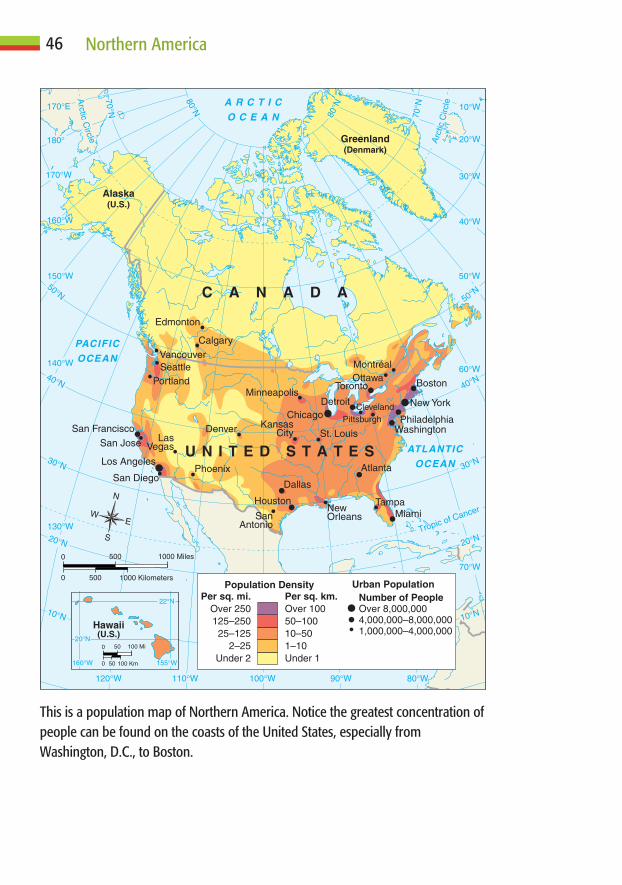
46 Northern America
160°W
20°N
155°W
22°N
0 100 Km
0 100 Mi
50
50
ATLANTIC
OCEAN
PACIFIC
OCEAN
A R C T I C
O C E A N
PhoenixSan Diego
Denver
SeattleVancouver
Calgary
MontréalOttawa
Cleveland
KansasCity
SanAntonio
Minneapolis
Edmonton
NewOrleans
Tampa
Pittsburgh
Portland
St. LouisSan Jose Las
Vegas
San Francisco Washington
Detroit
Dallas
Houston
Atlanta
Philadelphia
BostonToronto
Miami
Los Angeles
New YorkChicago
U N I T E D S T A T E S
C A N A D A
Alaska(U.S.)
Greenland(Denmark)
Hawaii(U.S.)
30°N
40°N
50°N
20°NTropic of Cancer
50°W
40°W
60°W
70°W
30°W
20°W
10°W
10°N10°N
70°N
80°W90°W100°W110°W120°W
130°W
140°W
150°W
160°W
170°W
170°E
180°
30°N
20°N
40°N
50°N
70°N
80°N
80°N
Arc
ticC
ircle
Arctic
Circle
Population Density Urban PopulationNumber of PeopleOver 8,000,0004,000,000–8,000,0001,000,000–4,000,000
Per sq. mi.Over 250125–25025–125
2–25Under 2
Per sq. km.Over 10050–10010–501–10Under 1
N
S
EW
0 1000 Kilometers
0 1000 Miles
500
500
This is a population map of Northern America. Notice the greatest concentration ofpeople can be found on the coasts of the United States, especially fromWashington, D.C., to Boston.
about 2 percent of the land area! Certainly, none of the forego-
ing information suggests a condition of overpopulation. Neither
Canada nor the United States has too many people to be sup-
ported by available space and resources.
Other demographic data also provide important informa-
tion about the region’s population and trends. For example, the
total fertility rate (the average number of children born to each
woman during her lifetime) has slipped below the replacement
level of 2.1. It is 2.0 in the United States and 1.5 in Canada. This
means that, in a matter of decades, if the trend continues, the
population of both countries will begin to decline unless it is
maintained by immigration. Both countries do receive a sub-
stantial number of immigrants.
In terms of health and life expectancy, Northern Ameri-
cans, on average, live 78 years, longer than people in any of the
world’s other cultural realms. The worldwide average is 67
years. Canadians have a slight edge over Americans, with a life
expectancy of 80 years versus 78 years. In both countries,
women outlive men by about five years. With declining births
and ever-lengthening life expectancies, the median age (cur-
rently about 37 years in both countries) is rising rapidly. In fact,
only a handful of other industrial countries such as Japan and
several Western European states have an older population.
An aging population creates a number of problems. There
are fewer people to enter the workforce, and as the population
ages, it is particularly difficult to find people to fill entry-level
and lower-paying jobs. An aging population also means more
retirees, who have a greater need for medical and retirement
facilities, and financial retirement packages. The most obvious
solution to the problems imposed by an aging population is to
increase immigration. Both countries are experiencing substan-
tial net gains in immigration. This, however, can cause problems
as well as solve them. According to census data, an estimated 11
million immigrants—nearly 3.7 percent of the country’s total
population—live in the United States illegally.
47Population and Settlement
PEOPLE AS RESOURCESPeople are any country’s most important resource—at least,
potentially. Populations differ greatly, however, in terms of ed-
ucation, health, and productivity. Northern America enjoys
one of the world’s highest rates of literacy. Fully 97 percent of
the people in both Canada and the United States can read and
write. A substantial percentage of people in both countries also
have college degrees. A well-educated population is essential if
a country is to succeed in a postindustrial economy marked by
information exchange, skilled services, and taking advantage of
global linkages.
Good health, too, is essential if people are going to make
significant contributions to society. An aging population with a
long life expectancy is an indicator of good health, as are low
rates of infant mortality. In Northern America, infant mortality
is about 6 per 1,000 annually, the lowest in any of the world’s
culture realms.
A healthy and well-educated population, supported by a
strong work ethic and good government, will be highly produc-
tive. Certainly, Northern America is blessed with each of these
conditions. It is little wonder that the region also enjoys the
world’s strongest economy as measured by productivity, per
capita income, and purchasing power.
EARLY SETTLEMENT“Settlement” refers to where people live and why they choose to
live there. When Europeans arrived on the shores of Northern
America, they reached a land already occupied for thousands of
years. Generally speaking, the outcome of this clash of civiliza-
tions favored the more powerful Europeans. Native lands were
claimed and settled at will by the newcomers.
Estimates vary greatly in regard to Northern America’s pop-
ulation at the time of European contact. Some anthropologists
believe that fewer than one million people occupied the area that
is now Canada and the United States, whereas others have placed
48 Northern America

the figure as high as 18 million. It seems most likely that 3 to 5
million people inhabited this part of the “New World” by A.D.
1500. Disease, warfare, and other factors reduced this number to
about 400,000 by 1900. Also, as the wave of newcomers engulfed
their homelands, native peoples often were forced onto lands
judged to be less desirable by Europeans.
The first permanent European settlers in Northern America
came as two distinctly different groups. Spaniards settled in a
band that stretched from Florida to California, and Northwest
Europeans first settled along the eastern seaboard. The first per-
manent European settlement in Northern America was St. Au-
gustine, Florida, founded in 1565 by Spaniards. During the first
decade of the seventeenth century, French and British outposts
were established along the East Coast in 1605 and 1607, respec-
tively. By 1625, the Dutch had joined the feeding frenzy for
land, founding New Amsterdam (now New York City) at the
mouth of the Hudson River. Meanwhile, Spaniards were push-
ing into present day New Mexico. By 1610, they had established
Santa Fe as the capital of their growing empire in the Upper Rio
Grande region.
British economic interests focused primarily on fishing and
timber cutting. The Grand Banks in the waters off of Newfound-
land proved to be perhaps the world’s richest fishing area. Inland
from the coast, the region’s vast dense forests were an economic
blessing to people who came from a largely deforested homeland
across the Atlantic. As a result, early settlements clung tightly to
the coastal region. Soon after securing their foothold in the St.
Lawrence Valley and part of eastern Canada that they named
“Acadia” (Nova Scotia), they began to move inland. Many of the
French settlers were attracted by the abundance of fur-bearing
animals found in the interior of North America. Pelts such as
beaver sold for a premium in European markets. Spanish settle-
ment focused on California and the Southwest. Here, the
Spaniards sought gold and religious converts to the Roman
Catholic faith among the Pueblo and other native peoples.
49Population and Settlement

EARLY MIGRATION AND SETTLEMENTBy 1700, Northern America was on the brink of what was to be-
come the greatest mass migration in human history. Nearly 50
million people are believed to have immigrated to the United
States and Canada during a 250-year period. They came for
many reasons. Some sought new lives, lands, and opportunities.
Others were escaping oppression for their religious, political, or
other views considered unpopular by the dominant population
in their homeland. Some came unwillingly as slaves.
Most immigrants came from Europe. During the eighteenth
century and the first half of the nineteenth, the British Isles were
the primary source of immigrants for both the United States and
Canada. More than one million Irish came to America during
the potato famine of the mid-1800s alone. Among early immi-
50 Northern America
The Castillo de San Marcos has stood in St. Augustine, Florida, since the 1600s.Although the Castillo has served a number of nations throughout its history, ithas never been taken by military force.

grants, Germans ranked a close second. Newcomers from Scan-
dinavia, Eastern Europe (including Russia), and Italy numbered
in the millions.
In the southern United States, a growing plantation econ-
omy dependent on extensive hand labor thrived. Throughout
tropical and subtropical areas of the Americas, this need was
filled by Africans brought to the New World as slaves. Actual
numbers of slaves taken from Africa are unknown. The most
reasonable figures appear to be in the range of 9 to 10 million.
Of this total, only about 6 percent were brought to the United
States (540,000 to 600,000). Asians, particularly Chinese, also
came. Most of them initially settled in cities on the West Coast.
Eventually, however, Asians became the chief labor force in
building the western segments of the transcontinental railroads.
Wherever newcomers settled, they introduced their culture,
a process called “relocation diffusion.” Northern America’s
population was growing numerically. It was also accepting and
absorbing people of vastly different cultures on a scale never be-
fore experienced in human history. With few exceptions, peo-
ple shed many traits of their cultural past and melded into the
emerging Northern American way of life. In this “melting pot”
process, a wonderfully diverse cultural mosaic was fashioned.
Northern American culture was forged from the contributions
of many others. (A hint of this rich diversity is suggested by a
random scan of word origins in any good English dictionary.)
In terms of migration, early nineteenth-century New York
City newspaperman Horace Greeley recognized future opportu-
nity by urging, “Go West, young man, go West!” By the millions,
people in both the United States and Canada heeded Greeley’s
advice. Nearly 200 years later, they continue to do so. In 1790, the
center of the U.S. population was in northeastern Maryland, east
of Chesapeake Bay. By 2000, it had moved to southeastern Mis-
souri. Canada’s population, too, has moved westward through
time. One interesting fact about Canada’s population is that the
majority of Canadians live at the same latitude as Michigan and
51Population and Settlement
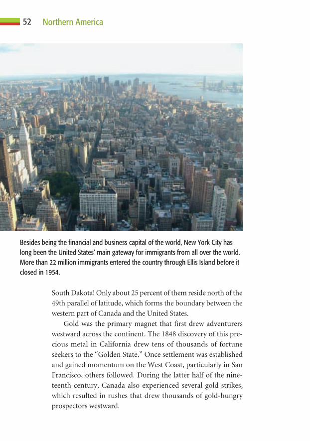
South Dakota! Only about 25 percent of them reside north of the
49th parallel of latitude, which forms the boundary between the
western part of Canada and the United States.
Gold was the primary magnet that first drew adventurers
westward across the continent. The 1848 discovery of this pre-
cious metal in California drew tens of thousands of fortune
seekers to the “Golden State.” Once settlement was established
and gained momentum on the West Coast, particularly in San
Francisco, others followed. During the latter half of the nine-
teenth century, Canada also experienced several gold strikes,
which resulted in rushes that drew thousands of gold-hungry
prospectors westward.
52 Northern America
Besides being the financial and business capital of the world, New York City haslong been the United States’ main gateway for immigrants from all over the world.More than 22 million immigrants entered the country through Ellis Island before itclosed in 1954.
Whether “transportation follows people” or “people follow
transportation” depends on circumstances. Obviously, both
occur and are important for settlement. Generally speaking,
people hesitate to settle in areas that are not linked to other
places by transportation facilities. Coastal settlements had ac-
cess to the sea and shipping routes, but a vast distance and in-
credibly difficult journey—overland or thousands of miles by
water—separated the established settlements in the east from
growing populations in the west. With few exceptions, the en-
tire vast interior of the continent was all but void of European
settlers. Visionary leaders began to call for the building of a
transcontinental railroad.
By 1869, rails spanned the United States to link thriving
San Francisco with major East Coast cities. By 1885, Canada
completed its transcontinental route. Beginning in Halifax,
Nova Scotia, rails snaked westward, passing through Montreal
and Winnipeg and across the Prairie Provinces to Calgary.
From there, they crossed the rugged Rocky Mountains and
stretched to Vancouver, Canada’s largest West Coast city. In
both instances, governments and companies saw the need to
attract settlers. Railroad companies were given land to help
support the cost of building. Later, they established hundreds
of communities along their tracks in hope of financially sup-
porting their operations. As the rail network grew, settlement
followed. Soon, the dawn of the automotive age further im-
proved access. By the early twentieth century, European settle-
ment had spread to all areas of Northern America, with the
exception of a few very cold and extremely remote areas in the
far north.
THE IMPORTANCE OF LOCATIONAs anyone involved in real estate knows, location is perhaps the
single most important factor in determining where people
choose to settle. Whether as individuals or groups, people do
not decide willy-nilly to simply “stop here.” They select a loca-
tion that is to become their home for a reason. Traditionally,
53Population and Settlement

economic factors—the ability to make a living by any means—
have been the chief determinants of where people settle. Settlers
sought well-protected harbors, good farm land, lakeshores or
rivers that offered waterpower potential and access, or sites that
offered mineral or some other resource wealth. Later, railroads,
highways, and growing industrial centers that offered jobs all
drew settlers. As culture and technology have changed, so too
have perceptions of “ideal” places to live. In neither Canada nor
the United States are population and settlement spread evenly
across the land. What factors can help explain this seemingly
strange pattern?
The Attraction of WaterAs can be seen on the “nighttime” map and map of population
density (page 46), Northern Americans have a strong prefer-
ence for living near water. In fact, more than 80 percent of them
live within 200 miles of the Atlantic or Pacific Ocean, the Great
Lakes, or a major navigable river such as the Mississippi or St.
Lawrence. Water, of course, is essential to life. It is also impor-
tant for transportation, irrigation, and industry. More recently,
people have flocked to seacoasts and lakeshores because of the
scenic landscape they offer. The importance of water features is
often suggested by a settlement’s name. Many communities in-
clude within their name environmental terms such as “Har-
bor,” “River,” “Lake,” “Falls,” “Rapids,” “Springs,” or “Beach.”
Others suggest the use of water features, such as “Port,” “Mill,”
or “Well.”
In both Canada and the United States, most large cities were
initially established and ultimately thrived because of their func-
tion as ports. On the Atlantic Coast, Boston, New York,
Philadelphia, Charleston, Savannah, Jacksonville, and Miami
grew as major port cities. Along the Pacific Coast, San Diego, San
Francisco, Seattle, and Vancouver owed much of their success to
this function. Toronto, Chicago, Milwaukee, Detroit, Cleve-
land, and Buffalo all grew as inland ports on the Great Lakes.
54 Northern America

Inland, water routes also played a major role in the growth
of many cities. Quebec City and Montreal thrived as Canadian
ports on the St. Lawrence River. Minneapolis–St. Paul, St. Louis,
Memphis, and New Orleans grew as ports on the Mississippi.
Kansas City and Omaha prospered along the Missouri River, as
did Cincinnati and Pittsburgh on the Ohio. Portland, Oregon, is
located at the juncture of the Willamette and Columbia rivers.
Hundreds of smaller communities throughout the United States
and Canada also have benefited from their riverside locations.
In the dry western interior and throughout much of Cali-
fornia, most settlement—both past and present—has depended
on the availability of water. A detailed map reveals that nearly all
communities within this region were located on streams. Chief
exceptions include some mining communities and railroad
centers. In some areas, local water sources were inadequate to
provide for booming populations, and even today, much of
southern California receives its water supply from elsewhere.
Sustaining population growth in this region is much like some-
one on a life-support system. Aqueducts that serve as thin life-
lines bring water from distant sources that include the northern
Sierra Nevada range and the Colorado River. In the Southwest,
Phoenix, Tucson, and Las Vegas rank among Northern Amer-
ica’s most rapidly growing urban centers. Much of their growth
depends on water diverted from the Colorado River.
In the future, water surely will become an increasingly im-
portant factor in the region’s settlement. As regions within the
United States begin to grow beyond their available water sup-
plies, they will have to look elsewhere. Water, in fact, is perhaps
the single most important natural limit imposed on population
growth and settlement within the region.
Fertile FarmlandNorthern America offers some of the world’s finest farmland.
Good soils, flat land, and adequate moisture are essential for
successful farming. Once settlement moved inland from the
55Population and Settlement

coast, farmland was the primary attraction. Rich alluvial
(stream-deposited) soils drew settlers across the broad Atlantic
and Gulf coastal plains and into the interior river valleys and
basins. In the mid-nineteenth century, the Homestead Act of-
fered free land to people willing to settle and develop it. This
lure drew hundreds of thousands of people into the interior
United States. Later, the westward migration continued as peo-
ple were attracted to the Central Valley of California, Oregon’s
Willamette Valley, Washington’s Puget Sound region, and the
Fraser River Valley in southern British Columbia. The last
“agricultural frontier” was the vast interior plains. In both the
United States and Canada, much of this area was not settled by
large numbers of people until the latter part of the nineteenth
century. The land could not be farmed until the steel-tipped
moldboard plow was developed. This sharp-tipped, curved-
surface plow could break through the thick prairie sod and turn
the soil so that it could be tilled.
Improved AccessThroughout much of Northern America, railroads proved to be
the primary magnets for settlement. In fact, in the vast region
between the Rocky Mountains and the Appalachians, an esti-
mated 80 percent of all communities can attribute their origin
to railroads. Look closely at a detailed highway map that shows
states or provinces east of a line that roughly coincides with the
100th meridian. (West of this, less than 20 inches [50 centime-
ters] of precipitation falls annually, thereby limiting agricul-
tural potential). You will note that small towns are spaced at
intervals of about 6 to 8 miles. A farmer could travel to town
and back by horse-pulled wagon in one day if the community
was no more than about 3.5 miles (5.6 kilometers) from a place
of residence. Every 40 to 70 miles along the railroad is a larger
population center. This pattern is not random. Railroads, hop-
ing to profit from the sale of town lots and from serving the
needs of surrounding farmers, located communities at the 6- to
56 Northern America
8-mile interval. The larger communities served regional market
functions and also as service centers for engines and other rail-
road equipment. Many large cities, such as Winnipeg, Chicago,
and St. Louis, also grew as major centers based primarily on rail
transportation.
Automobiles and roadways became a major factor of settle-
ment in the early twentieth century. With few exceptions, it can
be said that “people followed the railroads, but highways fol-
lowed people.” At the outset, at least, the building of railroads
was a national task that served national needs. Building roads,
on the other hand, was primarily a local (state, province, or
community) task. Roadways thus were built in response to lo-
cal needs. As the demand for fast and easy access grew, high-
ways expanded to meet the need. In the 1950s, the United States
began to develop an interstate highway system. Few govern-
ment decisions have been more beneficial for commerce and
travelers. In terms of contemporary population and settlement,
the interstate system plays a major role. Most communities
along these highways are stable or growing, and many towns
and cities that were bypassed by the interstate system are
declining in population.
Other Factors That Influence SettlementNumerous other factors influence where people settle. Many
early settlements, particularly in the arid and mountainous
west, sprouted where ores were found. They boomed as min-
ing centers and withered away as the minerals played out.
Some coastal communities grew as fishing centers, and, in the
interior, others thrived on logging. Although most such settle-
ments underwent a boom-and-bust cycle, a number of them
are once again thriving. They have become tourist centers that
focus on scenery, local history, recreation, or some other
modern attraction.
In both Canada and the United States, several hundred com-
munities include “Fort” in their name, attesting to their (often
57Population and Settlement

former) strategic importance. Some cities, including Washing-
ton, D.C., and Ottawa, Ontario, Canada, were developed as
centers of government. Certainly, many state and provincial
capitals, as well as county seats, grew because of their govern-
ment functions. Some towns flourish as university centers or
centers for scientific research. Increasingly throughout North-
ern America, many communities depend on tourism as their
primary source of revenue and hence, population growth.
CHANGING PATTERNS OF SETTLEMENTPeoples’ perceptions of “good” and “bad” places to live are
based on their culture—particularly, how they make a living.
During the past half-century, significant changes in culture
have had a major effect on settlement patterns.
58 Northern America
Ottawa began as Bytown, a logging community at the convergence of three rivers.It became the city of Ottawa in 1855 and was named the Canadian capital onDecember 31, 1857, by Queen Victoria.

Rural to UrbanDuring the past century, millions of people have moved from
the country to the city. Today, in fact, nearly 80 percent of all
Northern Americans live in a metropolitan area. This rural-to-
urban migration began with the shift from a self-sufficient folk
culture and economy to a specialized popular culture based on
a cash economy. Simply stated, people no longer could make
an adequate living from a small plot of land; therefore, they
moved from the country to the city in search of wage-paying
jobs. Cities also offered many amenities other than jobs: bet-
ter education, health care, entertainment, shopping, and many
other activities and services. As industrial cities grew, so did
the need for services. Educators, physicians, nurses, and attor-
neys were needed, and so were people involved in business,
transportation, entertainment, and many other lines of work.
As centers of industry, commerce, and services, New York,
Chicago, and Los Angeles exploded in population to become
some of the world’s largest cities. In Canada, Toronto and
Montreal also thrived.
Urban to SuburbanWith the development of improved transportation facilities,
people no longer needed to live near their place of work. They
could move to the edge of the city and still work in town. Sub-
urbia—smaller towns on the edges of cities—began to grow.
Suburbs offered a more “natural” landscape with more space
and greenery. They also were remote from the growing decay,
congestion, and other problems associated with the inner city.
Many people, however, soon came to realize that suburban life
was rather “sterile.” The “action” was in the city itself. There
were other problems associated with suburban living, as well.
Anyone familiar with both Canadian and American cities
cannot help but notice some major differences between them.
Quebec City, Montreal, Ottawa, Toronto, and Vancouver are
constantly ranked among the world’s finest urban centers.
59Population and Settlement
Meanwhile, to the south, cities such as Detroit, Cleveland,
Buffalo, and Rochester suffer from urban blight and other
problems common to many, if not most, American cities. How
can these sharp differences be explained? The answer lies in dif-
ferent government policies. In the United States, many people
live in suburbs and work in the inner city but pay property,
sales, and other taxes to their suburban community. The inner
city, strapped for revenue, is unable to provide adequate serv-
ices or maintain its infrastructure. In Canada, on the other
hand, taxes go to benefit the entire metropolitan area (a city and
its suburbs). Under this arrangement, cities have adequate
funds to support urban needs.
“Snowbelt” to “Sunbelt”During the latter half of the twentieth century, millions of peo-
ple left the industrial northeastern United States (the “Snow-
belt” or “Rustbelt”) and moved to the warmer South and
Southwest (the “Sunbelt”). Climate alone cannot account for
this major shift settlement. Many other factors were involved.
Property, taxes, and other costs of living were very high in the
North relative to the Sunbelt. Many northern cities were be-
coming dilapidated and factories obsolete. Wages were high,
but most services were increasingly expensive. The Sunbelt, a
region that extends from Virginia to California, offered relief
from these conditions. Ultimately, however, a single technolog-
ical innovation proved to be most responsible for this major
shift: The air-conditioner made it possible for people to live
comfortably in the Sunbelt’s often scorching temperatures.
It was not until effective and relatively inexpensive air-
conditioning became available in the 1960s that the region’s
population began to explode.
“Must” to “Want”During recent decades, yet another major change has occurred
in regard to where Northern Americans decide to settle. In
60 Northern America

times past, most people’s place of residence was determined by
where they must reside in order to make a living. Most jobs were
in industrial centers and so were most people. Today, many
people hold jobs that make it possible for them to live where
they want to reside. Society has moved from an industrial to a
postindustrial service- and information-based economy. This
means that millions of Americans and Canadians can “do their
job” someplace other than in an urban factory or office. In ad-
dition, millions of retirees have adequate financial resources to
retire to a location of their choice. Geographers refer to these
new destinations as “amenity” locations—places that people
choose because of scenery, climate, size, recreational opportu-
nities, or some other factor.
The impact of this recent change in circumstances has been
profound. Half a century ago, outside of major port cities, most
coastal regions supported a small and dwindling population.
The Appalachians and Ozarks were considered by many to be
home to isolated and culturally-deprived “hillbillies.” Former
mining towns were seen as decaying “ghost towns” with dusty
streets and abandoned buildings. Today, however, many such
areas are booming and property values have become some of
the nation’s highest. Improved transportation, a society no
longer tied to urban employment, and retirees who can live
where they like have turned such areas into desirable amenity
locations.
WHAT DOES THE FUTURE HOLD?For several decades, Northern America’s population has grown
primarily because of immigration. With immigration comes
both demographic and cultural change. In 2000, Hispanics
squeezed ahead of blacks as America’s dominant minority. In
Canada, an Asian cultural imprint is widespread, particularly in
Vancouver, Toronto, and other large urban centers. Migration
certainly will continue in both countries, resulting in further
social and cultural changes.
61Population and Settlement
Fortunately, available space, good government, and a strong
economy should allow Northern America to accommodate fu-
ture population growth with minimal disruption. It is more dif-
ficult to estimate where population will decline or grow. There
are signs that urban renewal is beginning to attract people back
into American inner cities. Both the United States and Canada
have huge areas of unsettled land. Canada’s Maritime Provinces
offer tremendous natural beauty, as do portions of the country’s
interior west. Isolation and a lack of economic development
must be overcome if these areas are to develop. The U.S. interior
plains and lowlands also offer many attractive settlement op-
tions. One thing is certain. Fifty years from now, statistical data
and maps of population, settlement, and ethnicity will be differ-
ent—perhaps surprisingly so—from those that show today’s
patterns of population and settlement.
62 Northern America

C H A P T E R
Culture and Society
5C H A P T E R
63
Geographers have found that a people’s way of life, or culture, is
perhaps the most meaningful way to divide the world into
regions. Also important is its society, how people interact with one
another individually and as groups. Whether a society is cohesive and
cooperative or divided and divisive is extremely important to cultural
and social stability. Cultures are drawn together by shared symbols
(such as languages, flags, and religious figures), common values, and
similar historical experiences. In this chapter, you will learn about the
ways in which diverse peoples have forged a relatively unified North-
ern American culture realm.
FLAGS AS SYMBOLS OF UNITYSymbols are images that represent an object, an idea, or even a
country. In order for them to be understood and appreciated,
they must be placed within their cultural context. Consider the
Canadian flag, with its red rectangular ends on either side of the
single red maple leaf standing proudly in a white center rectan-
gle. You know that in terms of Canada’s European history, the
British and French were the most important players. The flag’s
design shows no allegiance to either country, despite the role
each has played. In regard to the maple leaf, long before the first
Europeans arrived, native peoples knew of the sweet bounty of
maple sap collected each spring from the sugar maple. Because
of the tree’s importance as a source of sugar, the maple leaf be-
gan to serve as an unofficial symbol of Canada as early as the
1700s. In 1965, when the current Canadian flag was first un-
furled, thousands of Canadians gathered in Ottawa to witness
the event. When presented, it was stated that the flag was a sym-
bol of the nation’s unity, for it represented all citizens of Canada
without distinction of race, language, belief, or opinions.
The American flag also is rich in symbolism. The 13 stripes
represent the original thirteen colonies that joined to form the
United States of America. The 50 stars each represent a state in
the union. As symbols, flags “stand” for the countries that they
represent. As a result, much political action is strongly linked to
the representative symbols. Americans and Canadians display
their flags as symbols of national pride. Individuals who
strongly disagree with national policy also may vent their anger
using the nation’s flag.
LANGUAGE: TIE THAT BINDS OR WEDGETHAT SEPARATES?Language is perhaps the single most important “glue” that
bonds any culture. Throughout the world, most countries with
a common tongue are unified and harmonious. When a coun-
try is divided by language, dissension and conflict are common.
64 Northern American

Europeans came to Northern America from many countries;
thus, they spoke a babel of tongues. In the United States, despite
the fact that most immigrants came from German-speaking
roots, English ultimately became the dominant language.
The two countries within Northern America share many
common experiences: European exploration and settlement,
waves of immigration, westward expansion, and a tradition of
democracy and individual freedom. There are some notewor-
thy exceptions to this commonality, however. One difference is
the ongoing issue of French-speaking Quebec; another is the
formation of Canada’s native-governed territory of Nunavut.
French QuebecDoes language isolate its speakers? Does it unify its speakers?
French and English are both official languages in Canada, but
French is spoken almost exclusively in Quebec. Within the
province, many Quebecois (French speakers who live in Que-
bec) fiercely believe that language unifies them and allows them
to preserve their culture. Nearly 80 percent of the province’s
residents speak French as their first language. This language
dominance is represented with pride in Quebec’s media, he-
roes, and arts. Some French Canadians who live in Quebec feel
that seceding (separating from the rest of Canada) is the best
way to preserve their cultural heritage. Other French Canadians
and most English speakers wish for all ten provinces and three
territories in the country to remain united. They, along with the
First Nations Cree of northern Quebec, who would also be
affected by secession, oppose separatism. This divisive issue
continues to make newspaper headlines regularly.
The Inuit and NunavutCulture-based separatism is alive and well elsewhere in Canada.
In 1999, the country’s Inuktitut-speaking Inuit (Eskimo) peo-
ple were granted Canada’s third and newest territory—
Nunavut. Its population is largely Inuit, the indigenous peoples
65Culture and Society

who have lived there for several thousand years. The harshness
of the remote land they now govern is suggested by the fact the
Inuit language has more than 40 descriptive words for snow
and ice! In this endless, windswept region of the far north,
28,000 residents occupy an area that of about 735,000 square
miles (1,900,000 square kilometers), roughly one-fifth of
Canada’s entire landmass. Within this vast area, there are only
about 30 communities that range in population from a few
dozen to about 6,000 living in Iqaluit, the capital city located on
remote Baffin Island.
Inuit cultural values and beliefs are recognized by the Cana-
dian government as Nunavut strives to make this governing
process succeed. Cultural, social, and political challenges are
being addressed with the determination to maintain and hope-
fully increase the population scattered across this territory.
66 Northern American
The flags of Canada’s ten provinces and three territories are displayed on this stageduring a ceremony to mark the birth of the new Canadian territory of Nunavut,April 1, 1999.

Nunavut faces many critical challenges, however. Its people are
learning that there is a high cost to preserving a minority cul-
ture. Unemployment is widespread, levels of education are low,
and suicide rates are alarmingly high. Substance abuse is ram-
pant, the cost of goods is astronomical (the equivalent of about
ten U.S. dollars for one gallon of milk), and public services are
poor to nonexistent. No road, railroad, or scheduled airline
service connects the territory to any outside location.
Many people in Canada and elsewhere wonder whether
Nunavut will become a successful model for other indigenous
groups that wish to become self-governing. Some fear that the
experiment will ultimately spotlight the folly of culture-based
politics that lead to self-government. Nunavut has been in place
only since 1999, and its outcome remains in doubt.
Language, Diversity, and Stability in theUnited States“Becoming American” has always been the key to achieving in-
dividual success in the United States. The most important step
in this process has always been learning English. Nearly all so-
cially, economically, and politically successful Americans were
and continue to be English speakers. According to recent cen-
sus data, however, the number of families that do not speak
English as their first language is increasing rapidly. In a country
that has become accustomed to the “celebration of diversity,”
cultural differences can and should be accepted. Many, how-
ever, question whether non-English speakers will be able to
compete successfully in the dominant English-speaking society.
Others suggest that the rapid increase in Spanish-speaking peo-
ple in the United States is a prelude to cultural conflict. They
need only point to Canada and the problems that have resulted
from its linguistic divisions.
FREEDOM TO WORSHIPMany early European settlers of Northern America came be-
cause they suffered religious persecution in their homelands.
67Culture and Society

The New World offered freedom of worship; it was a place where
groups such as the Puritans and Pilgrims could practice their
faith without fear of reprisal. Ultimately, the religious makeup
of Northern America became as diverse as the many faces of its
population.
The majority of Northern Americans—75 to 80 percent—
claim a form of Christianity as their faith. In the United States,
Protestants outnumber Roman Catholics by a margin of about
two to one. In Canada, Catholics slightly outnumber Protes-
tants. With religious intolerance increasingly evident in various
areas of the world, one statistic stands out in regard to Northern
America: Nearly 3,000 different religious faiths are practiced!
This amazing figure certainly spotlights the belief in an individ-
ual’s fundamental right to freedom of worship.
68 Northern American
Youths wave flags for Pope John Paul II at the papal welcoming ceremony inToronto, July 25, 2002. The pope visited Toronto for the seventeenth annualWorld Youth Day.

Generally speaking, Northern America has been the world’s
most tolerant region in its acceptance of diverse religious be-
liefs. In addition to Christianity, some faiths, such as Judaism,
have been here since the countries were founded. Others have
arrived more recently. Islam, Buddhism, Hinduism, Sikhism,
and several smaller religious sects have a million or more fol-
lowers. The religious composition of Northern America will
continue to mirror the growing diversity of beliefs within this
culturally expansive region.
FOOD AND DIETWhat people eat and drink is one of the most fundamental traits
of any culture. Throughout much of the world, diets are un-
changing: People eat the same foods prepared in the same way
day after day throughout their lifetime.
Readers who enjoy a varied diet may consider themselves
very fortunate. No place else in the world offers a greater variety
of food and beverage options than Northern America. Few com-
munities of any size are without a Mexican, Italian, or Chinese
restaurant. Greek, French, Middle Eastern, Thai, Japanese, and
other ethnic restaurants can be found in most middle-sized
communities. Large cities, of course, offer a wonderful smor-
gasbord of food options.
Most of the world’s people drink water and one other bev-
erage on a regular basis. Think of the mealtime options avail-
able to Northern Americans: tea or coffee, beer or wine (in
many different varieties), sodas of various flavors, milk (with
various percentages of fat content) and, of course, water (tap or
bottled). Most Northern Americans long ago gave up eating
three meals a day. Which two are consumed? Some opt for
breakfast and dinner (supper), whereas others eat lunch and the
evening meal. There is even some confusion over the naming of
our meals. Farm people generally refer to breakfast, dinner, and
supper, whereas urbanites prefer breakfast, lunch, and dinner.
Dinner usually is the largest meal of the day, traditionally con-
sumed midday by farmers.
69Culture and Society

CULTURAL RELATIVITY AND CHANGECulture is a very relative thing. It is difficult, if not impossible,
to “rank” people’s ways of living. Some cultures, including
Northern America, are highly ranked as measured by diverse
technology, strong economy, huge vocabulary, and other meas-
urable traits. Even so, many people who live in less-developed
countries (LDCs) are dismayed over certain aspects of North-
ern American culture. They are often shocked over the high di-
vorce rate and the way senior citizens are treated. They cannot
begin to comprehend the lack of respect shown by many
youngsters toward their elders, and they resent the United
States’s “bully-of-the-block” approach to relationships with
other countries.
Cultures, like all organisms, grow and change through time.
This occurs in one of two ways: through local development
(discovery, invention, or innovation) or by way of diffusion
(the acceptance of traits that originated elsewhere). New traits
can be developed anywhere. The Inuit igloo, for example, is one
of the great architectural developments of all time and was the
inspiration for the geodesic dome—yet it was first built in a very
remote location. Generally speaking, however, cities have been
the centers of culture change. In Northern America, most ur-
ban residents are formally educated and many hold advanced
degrees or well-honed skills. Universities, research centers,
great libraries, and industries that depend on innovation are
found in most cities. A single technology such as the computer
(developed in Northern America) can bring about huge change
within a culture. Think of the countless ways in which we have
come to depend on the computer and its many functions and
how its use has changed our lives.
The second way in which culture changes is through diffu-
sion, the movement of traits from elsewhere. Some traits are
transferred by moving people. Europeans who came to America
brought their ways of living with them. Northern American re-
ligion, language, market economy, and ideas about democracy
70 Northern American

and individual freedoms (and responsibilities) all originated in
the Old World. So, too, are many crops and domesticated ani-
mals, preferred beverages and food staples, the idea of men
wearing a tie, and the way the inner spaces of homes are built and
divided. Because there are so many linkages to other lands and
peoples, Northern Americans have benefited from diffusion as
have no other people.
Cultures also change through time. Values change, technol-
ogy changes, society changes. In a very fast-paced culture, many
people find it difficult to keep up with the kaleidoscopic pace of
changes. They are bewildered by CD players and televisions
with 80 buttons and knobs, the computer and all of its func-
tions, and the fast pace of scientific breakthroughs. With
change, however, progress often comes. It is doubtful that
many Northern Americans would want to return to the “good
old days,” which, in most respects, were rather bad.
THE EXPORT OF POPULAR CULTUREBoth authors have had the good fortune to experience consid-
erable international travel, and they never cease to be amazed at
the “imprint” of Northern American culture in even the most
remote areas of the world. The American hamburger can be
found almost everywhere beef is consumed. It can be washed
down with an American soft drink as the diner listens to the lat-
est popular song by an American artist. Blue jeans, American
cigarettes, and motion pictures are almost everywhere. Fads
that began in California, New York, or Aspen, Colorado, are
rapidly adopted by youngsters worldwide.
Some cultures resent the widespread diffusion of Northern
America’s popular culture. Consumption of alcohol, scantily
clad women, and displays of great wealth bother them, as do the
lyrics of rap and other songs, the flood of American manufac-
tured products, and the spread of many emerging social pat-
terns. Can they be criticized for wanting to protect their values
and way of life? This is a very important question. Increasingly,
71Culture and Society
many people, including some Northern Americans, are worried
about the process of “globalization,” which includes the spread
of Western culture. They see a bland future world in which
Western economy, society, and values will prevail worldwide.
Cultural concerns exist even within Northern America.
French Canadians proudly resist many Anglo culture traits, as
do many indigenous peoples. In the United States, there are
growing concerns over how best to accommodate the growing
Hispanic population. At the country level, Canadians are often
extremely critical of many aspects of U.S. culture that seep
northward across the border. An overwhelming majority of
Canada’s population hugs the U.S. border. With this close
proximity to the United States, Canadians are constantly bom-
barded by American popular culture. American-made products
and chain retailers flood the Canadian market. American cur-
rent events, magazines, television programming, movies, and
sports are well-known in Canada and influence the lives of
Canadians. With few exceptions, Canadian current events, me-
dia, and political developments rarely reach south of the border
into the United States. With some exceptions, Canadian hap-
penings tend not to have much effect on the daily lives of peo-
ple who live in the United States. Helen Gordon McPherson
once stated, “Canadians have been so busy explaining to the
Americans that we aren’t British, and to the British that we
aren’t Americans that we haven’t had time to be Canadians!”
72 Northern American

Good government may be the single most important factor in de-
termining a country’s well-being. Northern America, perhaps
more than any other region, has been blessed with good govern-
ments. In this respect, its people and institutions have been extremely
fortunate. Political geographers believe that a “good government” is
one that achieves two vital goals: First, it protects its territory and
population from foreign aggression; second, it allows its people and
institutions to function in the most effective manner for the benefit
of all citizens.
Think for a moment about the various ways in which political de-
cisions affect your life. Each day, government—both directly and
indirectly—has an impact on our lives in hundreds, if not thousands,
Political Geography
6C H A P T E R
73
of ways. Countless laws influence our actions. We benefit from
postal services, law enforcement, and various social services
such as health care and retirement programs. Nearly all roads
and highways are built and maintained as public facilities,
as are government buildings and many other structures.
Government-imposed survey systems divide our land, and laws
determine its ownership and, through zoning laws, often its
use. Public lands—including forests, parks, monuments, and
other areas—are set aside for our use and enjoyment. A strong
military has protected Northern America from foreign inva-
sion. Sadly, these blessings often are taken for granted. Many
people simply do not realize how uniquely fortunate Canadians
and Americans are! In this chapter, these and other important
aspects of government are considered from the perspective of
political geography.
NATION BUILDINGA country is much like an organism: It can grow, maintain, or
wither. Some parts can be healthy and functioning while others
are plagued with problems. Many changes occur over time.
Both the United States and Canada began as relatively small
footholds along their eastern margins. Eventually, they grew to
span the North American continent from the Atlantic shore to
the Pacific (and, in the case of Hawaii, far beyond). As pieces of
a puzzle fall into place to create a complete picture, Northern
America’s two countries grew piece by piece.
The territorial expansion of present-day Canada began in
1867. In that year, a confederation (union) that included On-
tario, Quebec, New Brunswick, and Nova Scotia, was formed.
Three years later, in 1870, Manitoba and the Northwest Terri-
tories were added. A year later, British Columbia entered the
federation; Prince Edward Island joined in 1873. In 1898, the
remote Yukon region gained territory status within the confed-
eration. The Prairie Provinces of Saskatchewan and Alberta
were admitted in 1905. Finally, in 1949, ten years before Hawaii
74 Northern America
and Alaska gained statehood in the United States, Newfound-
land and Labrador completed Canada’s territorial expansion.
Nunavut was granted territory status in 1999, but was created
from the Northwest Territories that had been part of the union
for more than a century.
Territorial growth within the United States was somewhat
different than that of Canada. Pieces of the Canadian political
puzzle were what became provinces or territories. The growth
of the United States was by large areas that did not necessarily
coincide with what became political boundaries. Land acquired
by the Louisiana Purchase, for example, ultimately was divided
into all or part of 15 states.
In 1776, the United States was composed of 13 former
colonies. These lands extended from the Appalachian Moun-
tains to the Atlantic Coast and from Maine to Georgia. By 1783,
the country had pushed westward to include nearly all lands east
of the Mississippi River. The vast interior of the United States
was acquired in the Louisiana Purchase of 1803. Lands from
Florida westward to Texas and a narrow strip that extended into
Wyoming were gained from Spain between 1819 and 1845. The
Pacific Northwest (Oregon Territory) was acquired in 1846, and
most of the Southwest was gained in the Mexican Cession of
1846. In 1853, with the Gadsden Purchase, the territorial ex-
panse occupied by the 48 U.S. states was completed.
Alaska was purchased from Russia in 1867 in what must
rank as one of the greatest real estate bargains of all time—7.2
million dollars, or about two cents per acre (one cent per
hectare)! At the time, most Americans were highly critical of the
purchase, which earned the nickname “Seward’s Folly,” after
U.S. Secretary of State William Henry Seward, who initiated the
purchase. Today, Alaska produces more wealth in a single day
than its original purchase price. Finally, Hawaii was annexed in
1898. Alaska and Hawaii did not achieve statehood until
1959—ten years after Canada’s present-day political map was
filled in.
75Political Geography

In expanding their respective territories, both the United
States and Canada had to overcome huge obstacles of distance,
rugged terrain, and harsh climates (aridity in the United States
and cold in Canada). Such physical handicaps were overcome
by both countries’ fierce desire to survive and expand as politi-
cal units.
GOVERNMENTSPolitical structure of the United States and Canada is similar in
some ways, but quite different in others. One difference is that
the United States became fully independent in 1776. Canada
did not achieve the full power of self-government from Great
Britain until 1982. Both countries, however, are strongly dem-
ocratic, and both enjoy relative political stability. Both also have
many layers of government that range in scope from national to
state or provincial and down to the local level. In both coun-
tries, a federal system prevails in which constitutions grant
states and provinces the right to share powers with the national
governments. In Canada, considerable competition exists
among the provinces and territories. In the competition for re-
sources and local decision making, Canadian provinces are
much more independent than are U.S. states. Ironically,
Canada is often judged to be a “liberal” country, whereas the
United States is more conservative.
The United States and Canada both have a constitutionally
guaranteed balance of political power, with executive, legisla-
tive, and judicial branches of government. Here, the similarity
begins to vanish. Whereas the United States has an elected pres-
ident, Canada’s chief of state is the British monarch, who is
represented by a governor general. The Canadian head of gov-
ernment is the prime minister. Rather than being elected to of-
fice, the prime minister is appointed. After legislative elections,
the majority party (or coalition of parties) leader in the House
of Commons is automatically designated prime minister by the
governor general.
76 Northern America

Legislative branches of both governments function in a
somewhat similar manner. In the United States, Congress is di-
vided into two branches. The Senate has 100 members, two
from each state, who are popularly elected to six-year terms.
The House of Representatives has 435 members; each state’s
representation is based on its population. Members are elected
to two-year terms. Canada’s Parliament consists of a 105-
member Senate and 308-seat House of Commons. Senators are
appointed by the governor general, with the advice of the prime
minister, and can serve until they reach 75 years of age. Mem-
bers of the House of Commons are elected by direct, popular
vote to serve terms of up to five years.
77Political Geography
U.S. President George W. Bush shakes hands with Canadian Prime Minister PaulMartin in the rotunda of Centre Block (the main building of Parliament) aftersigning the guest book on November 30, 2004, in Ottawa, Ontario, Canada.
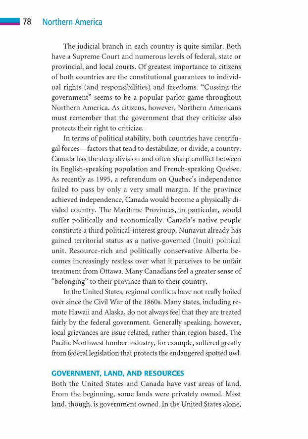
The judicial branch in each country is quite similar. Both
have a Supreme Court and numerous levels of federal, state or
provincial, and local courts. Of greatest importance to citizens
of both countries are the constitutional guarantees to individ-
ual rights (and responsibilities) and freedoms. “Cussing the
government” seems to be a popular parlor game throughout
Northern America. As citizens, however, Northern Americans
must remember that the government that they criticize also
protects their right to criticize.
In terms of political stability, both countries have centrifu-
gal forces—factors that tend to destabilize, or divide, a country.
Canada has the deep division and often sharp conflict between
its English-speaking population and French-speaking Quebec.
As recently as 1995, a referendum on Quebec’s independence
failed to pass by only a very small margin. If the province
achieved independence, Canada would become a physically di-
vided country. The Maritime Provinces, in particular, would
suffer politically and economically. Canada’s native people
constitute a third political-interest group. Nunavut already has
gained territorial status as a native-governed (Inuit) political
unit. Resource-rich and politically conservative Alberta be-
comes increasingly restless over what it perceives to be unfair
treatment from Ottawa. Many Canadians feel a greater sense of
“belonging” to their province than to their country.
In the United States, regional conflicts have not really boiled
over since the Civil War of the 1860s. Many states, including re-
mote Hawaii and Alaska, do not always feel that they are treated
fairly by the federal government. Generally speaking, however,
local grievances are issue related, rather than region based. The
Pacific Northwest lumber industry, for example, suffered greatly
from federal legislation that protects the endangered spotted owl.
GOVERNMENT, LAND, AND RESOURCESBoth the United States and Canada have vast areas of land.
From the beginning, some lands were privately owned. Most
land, though, is government owned. In the United States alone,
78 Northern America

763 million acres (309 million hectares) of land is in the public
domain. Government ownership of land reaches 90 percent in
Alaska and Nevada. Obviously, an early and extremely impor-
tant task of both governments was to establish a land policy:
Who would own the land? How would it be acquired? How
would land be divided (surveyed)? What controls would be
placed on land use?
Today, public lands include vast areas of particularly
sparsely populated Northern America. Such areas are often
woodlands, mountainous terrain, or regions in which eco-
nomic potential is limited by climatic conditions. In addition,
there are national parks, monuments, wilderness areas, and
Indian trust lands. Governments also have capitals, govern-
ment buildings, transportation right of ways, and other facili-
ties such as military bases.
Land survey systems, perhaps more than any other political
element, create their own distinctive imprint on the landscape.
Much of eastern Northern America has a very irregular survey
pattern. Roads seem to wander, fields are irregular in shape, and
little “order” is evident. This “random” pattern changed with
the implementation of the rectangular survey system, adopted
in the late eighteenth century. The Midwest, for example, re-
sembles a checkerboard with roadways spaced at intervals of
one mile. Fields are rectangular, and everything is neatly ori-
ented in the cardinal directions. Elsewhere, Spanish land grants
and the French long lot system also gave rise to distinctive land
division patterns.
Many Europeans and others who travel in Northern Amer-
ica are surprised by the density of rural settlement. Throughout
most of the world, rural people live in villages. As early as 1862
in the United States and 1872 in Canada, a quarter section
(.25 square mile; .65 square kilometer) of land could be ac-
quired for a minimal fee. Owners had to settle on and improve
the land they claimed by building a house, farm, and fence, for
example. In this way, rural settlement was scattered and eco-
nomic development was more evenly distributed.
79Political Geography

Governments also can control the use of land and other nat-
ural resources in many ways. Laws place restrictions on grazing,
farming, logging, hunting and fishing, mining, and many other
activities. Water and soil resources also are protected by both fed-
eral and local laws. Zoning restrictions prohibit certain land uses
in urban areas. A factory or warehouse, for example, cannot be
built in a residential area. Such restrictions are in place to protect
people’s health, economic, amenity, and other interests.
GOVERNMENT AND ECONOMYIn Northern America, a government-supported capitalist (free-
market) economy has been the foundation of widespread pros-
perity. Governments play a vital role in economic development
in many ways. Nearly all businesses, for example, depend on re-
liable transportation. Railroads were constructed with govern-
ment support; highways, including the U.S. interstate system,
were built and are maintained by local, state, and federal govern-
ments; and shipping and air traffic are government regulated.
As any farmer or rancher knows, the government plays a
very important role in agriculture, including direct economic
support in some instances. Industry, too, is both assisted and
occasionally controlled by government. The government can
provide incentives and support, such as building municipal in-
dustrial parks or offering tax benefits. It can also regulate busi-
nesses. If a business becomes a monopoly or threatens people’s
health or safety, the government will step in.
Having an ample supply of relatively inexpensive energy is
essential to economic growth and development. In some ways,
governments are directly involved in the production of energy,
as is the case with huge hydroelectric dams. In most instances,
government policy promotes and also regulates resource devel-
opment, distribution, and cost.
Good government and a strong economy go hand in hand.
In the following chapter, you will learn how Northern America
has prospered economically.
80 Northern America
What career options would I have if I lived in Vancouver, Miami,
Chicago, Toronto, or a less-populated area of Northern Amer-
ica?” “How do the forests, minerals, mountains, and fertile plains
support not only people in Northern America, but also many
throughout the world?” Questions such as these can best be answered
by learning about a region’s economic geography.
By nearly any measure, Northern America is the world’s leading
economic powerhouse. The combined annual gross domestic prod-
uct (GDP) of the United States and Canada is nearly 13 trillion U.S.
dollars (2005 estimate). This amounts to a staggering one-third of
the total global value of production and services! California alone
Economic Geography
7C H A P T E R
81
“

would be the world’s fifth-ranking economic power if it were an
independent country. This chapter explains the foundations
that have contributed to the region’s economic well-being.
Many factors contribute to a region’s economic success,
and Northern America possesses most, if not all, of them. Spa-
tially, it occupies 13 percent of Earth’s land surface, most of
which has been or can be made productive in some way. In
terms of trade, the region is strategically located between West-
ern Europe and rapidly growing markets in Eastern Asia. It
faces three of the world’s oceans. These water bodies offer pro-
tection for the region’s borders and provide easy access to
global markets. The region has a cornucopia of resource wealth,
including fuels, metals, forests, water, and many other essential
elements. It also has a great diversity of terrain, climate, and
ecosystems.
People, too, are resources, and Northern America is blessed
with a healthy, well-educated, hard-working workforce. In ad-
dition, the region does not suffer from a condition of overpop-
ulation. Ample space and other opportunities for future growth
and development exist. Finally, a country’s economic system—
its means of production, variety and efficiency of services, and
ways of distributing wealth—and government are keys to pros-
perity (or failure). Northern America has been blessed with
strong market economies and stable governments. Businesses
and individuals are free to pursue their economic interests with
minimal governmental interference. In Northern America, the
market itself determines what will be produced, in what quan-
tities, and at what cost.
FOUNDATIONS OF ECONOMIC DEVELOPMENTThere is no assurance that vast land, abundant resources, or a
large population will contribute to a region’s economic pros-
perity. Many factors influence the nature and success of
economic activity. Some are physical in nature and others his-
torical, and, ultimately, all depend on a people’s cultural system.
82 Northern America

Natural EnvironmentThe natural environment can provide a foundation for eco-
nomic development. No area, regardless of its environment,
lacks economic potential. Ultimately, however, people—their
culture, technology, needs, and so forth—make things possible.
(As a tourist, would you like to see Greenland’s ice cap, watch
polar bears along the shore of Hudson Bay, or visit a remote
Inuit village?) Northern America’s varied natural conditions,
including climates, ecosystems, landforms, and natural re-
sources, offer the widest possible range of economic activities.
In Chapter 2, you learned that Northern America is the only re-
gion that includes all of the world’s climates and ecosystems
somewhere within its territory. Such diversity makes it possible
to grow any of the world’s crops or raise any breed of livestock.
Other industries also are favored by varied environmental con-
ditions. The logging industry depends on abundant forests re-
sources, and fisheries depend on extensive marine resources.
Many other industries are favored by environmental condi-
tions, as well. The Sunbelt, for example, has attracted millions
of people and billions of dollars because of its mild climate.
Northern America also benefits from varied terrain. Broad
plains favor farming with large equipment, the construction of
highways and railroads, and building homes, businesses, facto-
ries, and other structures. Towering mountain peaks attract
skiers and many other tourists because of their deep winter
snow, rugged beauty, and cool summer temperatures. Any crop
can be grown and any activity pursued someplace in the region.
Because of its environmental diversity, Northern America is the
world’s only potentially self-sufficient region.
The region’s economy also benefits enormously from its
wealth of natural resources. Fertile soils, vast forests, an abundant
supply of surface and groundwater, and diverse wildlife have
been important keys to economic development from the earliest
period of European settlement. Mineral resources such as coal,
petroleum, natural gas, and uranium have fueled economic de-
83Economic Geography
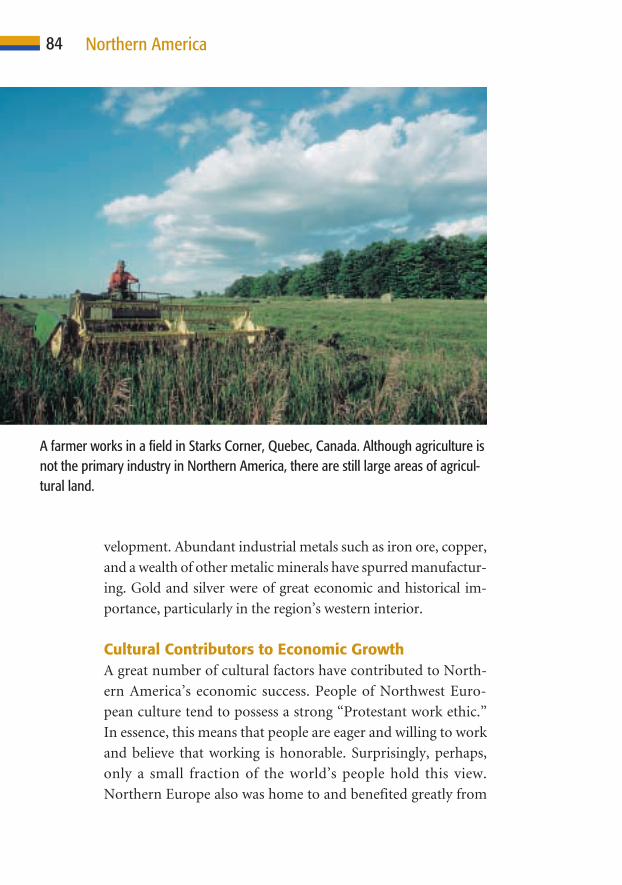
velopment. Abundant industrial metals such as iron ore, copper,
and a wealth of other metalic minerals have spurred manufactur-
ing. Gold and silver were of great economic and historical im-
portance, particularly in the region’s western interior.
Cultural Contributors to Economic GrowthA great number of cultural factors have contributed to North-
ern America’s economic success. People of Northwest Euro-
pean culture tend to possess a strong “Protestant work ethic.”
In essence, this means that people are eager and willing to work
and believe that working is honorable. Surprisingly, perhaps,
only a small fraction of the world’s people hold this view.
Northern Europe also was home to and benefited greatly from
84 Northern America
A farmer works in a field in Starks Corner, Quebec, Canada. Although agriculture isnot the primary industry in Northern America, there are still large areas of agricul-tural land.

the Industrial and Commercial revolutions. Manufacturing
and selling—as well as serving those who do either—spread
rapidly from the British Isles throughout much of Northern
America. The idea of a market-based economy also diffused to
the region from northwestern Europe. Northern America has
long been a world leader in technology. The region is home to
many of the world’s most important ideas, tools and tech-
niques, and skills. From the harnessing of electricity to devel-
opment of the computer and the Internet, each innovation has
helped the region’s economy grow.
A well-integrated infrastructure is also an essential element
of economic development. Northern America is served by an
excellent network of railroads, highways, airways, pipelines,
and other distribution networks. Only very sparsely populated
areas of the western interior and far north remain relatively in-
accessible. Finally, as previously mentioned, the region’s politi-
cal institutions and economic systems have played a vital role in
fostering its economic prosperity. Generally speaking, they en-
courage and support the production, distribution, and services
that are essential for economic stability.
In today’s global economy, an understanding of geography
is essential. People simply cannot compete successfully if they
are geographically illiterate. To be successful economically, one
must know much more than local environmental conditions,
production, and sales. One must think globally. How can a
freeze in Brazil affect the price of orange juice in Alaska? How
does increasing prosperity in China mean higher gas prices at
your local station? Why does an investor in Arizona keep a
sharp eye on the day’s stock market activity in Japan, elsewhere
in Asia, and in major European countries? Can religion-based
terrorist activity in Europe affect the economy in Toronto or
Montreal? Can a weak South Asian monsoon that results in
drought be a boon to wheat farmers in Montana and
Saskatchewan? Has your community been hurt (or helped) by
the practice of “outsourcing,” in which a company looks abroad
85Economic Geography

for less-expensive manufacturing and services? These are only a
few examples of ways in which each individual and community
in Northern America is closely linked to lands, peoples, condi-
tions, and events worldwide.
CATEGORIES OF ECONOMIC ACTIVITYGeographers divide economic activities in several ways. Perhaps
the most commonly used method focuses on what people do in
terms of complexity and involvement with the natural environ-
ment. Some jobs, such as mining, logging, farming, and fishing,
require great skill and much physical labor but little formal edu-
cation. Incomes of workers in these industries tend to be quite
low. Jobs, and thus workers, are very much tied to one place. Peo-
ple involved in these “primary” industries often have a very lim-
ited awareness of the “outside” world. At the other extreme are
people engaged in professional services, which includes executive
decision makers and managers, educators and researchers, doc-
tors and attorneys, and many others. These jobs require extensive
formal education and considerable knowledge and skill. They
generally pay quite well. People engaged in these activities have
considerable mobility. Increasingly, they also must possess a de-
tailed “mental map” of both the region and the world. Jet aircraft
place nearly any destination within a day’s reach. Computers and
other instant communications have brought the world together
as one giant neighborhood. The electronic expressway brings us
instant communication and up-to-the-minute information from
every corner of the planet. It has changed the way business is now
done in the global marketplace.
Primary IndustriesPrimary industries are those that are directly involved with the
exploitation of natural resources, such as agriculture, fishing,
mining, and logging. Each of these industries is extractive in na-
ture—things are taken from the land or sea. As a result, they have
become increasingly pressured by environmental restrictions.
86 Northern America

87Economic Geography
160°W
20°N
155°W
22°N
0 100 Km
0 100 Mi
50
50
ATLANTIC
OCEAN
PACIFIC
OCEAN
A R C T I C
O C E A N
U N I T E D S T A T E S
C A N A D A
Alaska(U.S.)
Greenland(Denmark)
Hawaii(U.S.)
30°N
40°N
50°N
Tropic of Cancer
50°W
40°W
60°W
30°W
20°W
10°W
10°N
70°N
130°W
140°W
150°W
160°W
170°W
170°E
180°
30°N
20°N
40°N
50°N
70°N
80°N
80°N
Arc
ticC
ircle
Arctic
Circle
Land Use Resources
Hunting and gatheringCommercial farmingNomadic herdingGrazingCommercial fishingForestryTrade and manufacturingLittle or no activity
CoalHydroelectric powerIronNatural gasPetroleumPrecious metals(gold, silver, copper)Uranium
N
S
EW
0 1000 Kilometers
0 1000 Miles
500
500
This is a land use map of Northern America. Although large areas of land supportprimary industries, such as agriculture and logging, the majority of the populationis involved in manufacturing, trade, or providing services.
88 Northern America
Fewer than 5 percent of Northern Americans are engaged in pri-
mary industries today, and the number is rapidly declining.
AgricultureTraditionally, agriculture has been the primary industry that
involves the greatest number of people. Today, less than one
percent of all Northern Americans are engaged in farming or
ranching, yet those few people are the world’s greatest produc-
ers of food, beverages, and fiber. Many factors have combined
to help make this remarkable achievement possible. Much of
the region has good soils. Climatic conditions, including mois-
ture and an adequate growing season, are favorable (some
hardy crops are grown as far north as Fairbanks, Alaska). Huge
expanses of relatively flat land make the use of large mechanized
equipment possible. The region also has benefited from its lead-
ership role in agricultural research and technology. Although
the number of farmers and ranchers has decreased, the average
size of operations has greatly increased. In fact, production has
never been higher.
FishingWaters that surround Northern America have provided an
abundance of fish, crabs, shrimp, lobsters, oysters, and other
valuable marine resources since the dawn of settlement. Be-
cause of overharvesting, particularly on Canada’s Grand Banks,
many commercially valuable species are becoming depleted.
Today, some species, including salmon, shrimp, and oysters,
are even “farmed.” As the demand for seafood increases, har-
vests will decline unless appropriate steps are taken to conserve
this important resource.
Mineral ExtractionMining long has been and continues to be a very important
contributor to Northern America’s economy. In fact, some
would argue that a wealth of mineral resources was the primary
89
factor that contributed to the region’s rise as the world’s lead-
ing economic power. For two centuries, this region was self-
sufficient in mineral fuels, with huge reserves of coal and, later,
petroleum and natural gas. Metals such as iron and copper were
found in huge deposits, as were other minerals essential for in-
dustrial growth. Only recently has the region had to begin to
import certain minerals. Most critical to the region’s future
economic well-being is the increasing dependence on imported
petroleum.
LoggingLumber, pulp, paper, and other industrial products depend on
the logging industry. Throughout much of Northern America,
however, the industry is under attack. Forests once covered much
of the Atlantic and Gulf coast regions inland to the Mississippi
River and Lake Winnipeg. A broad band of forest spanned the
northern part of the continent from Alaska to Canada’s Atlantic
shore. On the West Coast, dense forests of redwood, spruce, pine,
and other valuable species extended from central California into
the Alaskan panhandle. Today, much of the lumber-grade timber
is gone. It has been used to build homes and other frame struc-
tures, railroad ties, and dozens of other important things that we
take for granted. As natural woodlands are cut over, secondary
growth (often planted, as in “tree plantations”) is usually of lower
quality. It can take decades or even centuries for trees to grow to
a harvestable size.
Secondary IndustriesSecondary industries manufacture or process primary materials
in some way. They take natural resources or raw materials and
turn them into something useful. Examples include manufac-
turing industries, building industries (using wood, stone,
cement, or other earthen materials), and energy production.
Smelting, refining, steelmaking, textile and clothing manufac-
turing, and chemical manufacturing all fall within this category,
Economic Geography

90 Northern America
as do the automobile and aircraft industries. Today, much of
the world’s secondary economic activity is taking place in parts
of the world where wages are low. The number of people en-
gaged in secondary industries has declined sharply in Northern
America, to less than 20 percent.
Tertiary and Other Related ActivitiesToday, nearly 80 percent of all employed Northern Americans
are engaged in tertiary, or service-related, activities. Have you
heard of the postindustrial or information-based economy? This
is the economic activity to which those terms refer.
Tertiary activities involve businesses and other enterprises
that provide some specialized service. For example, many peo-
ple are engaged in wholesale or retail sales. People who deliver
meat, produce, canned goods, and other items to your grocery
store are contributing to the tertiary economy, as are the people
who stock the shelves, prepare the ads and coupons that influ-
ence your shopping decisions, check you out, and bag your gro-
ceries. The store’s manager, buyers, butchers, and pharmacists
are as well. Today, millions of Americans and Canadians spend
their workday at a computer. They and many others are in-
volved in the changing economy based on the “information
revolution.” People who provide all of these services need to be
educated, healthy, legally protected, and insured. Ensuring that
these needs are met employs millions of skilled professionals.
TRADE AND COMMERCEFamilies have needs that they are unable to meet themselves.
They also provide something of worth—whether some material
item or a service—for which they receive an income. Of course,
there are always bills to pay for goods and services received. The
United States and Canada manufacture many items and pro-
vide many services that are exported. They also have needs that
cannot be met domestically. These items or services must be
imported. All such exchanges involve selling and buying.

91
Not surprisingly, the United States and Canada are each
other’s major trading partner. In fact, these two countries do
more business together than any other two countries in the
world! Between 85 and 90 percent of all Canadian exports are
destined for U.S. markets. Major items include automobiles
and auto parts, wood pulp, and electricity. About 60 percent of
Canada’s imports, including many consumer goods and indus-
trial supplies, also come from its neighbor. Nearly one-quarter
of all U.S. exports and 15 to 20 percent of imports involve trade
with Canada. In 1988, Canada and the United States signed the
Canada-U.S. Free Trade Agreement (FTA). This economic
dance, negotiated between the world’s two greatest trading
partners, was designed to remove high tariffs (fees) on goods
Economic Geography
Beer made for Canada’s Mountain Crest Brewing Company rolls into the shippingarea at Joseph Huber Brewing Company in Monroe, Wisconsin. The Canadianbrewer’s products are sold in Canada as well as in Wisconsin and otherMidwestern states.

traded between the two countries. In 1994, the agreement was
expanded to include Mexico and became the North American
Free Trade Agreement (NAFTA). So far, trade with Mexico has
been rather limited.
The business relationship that exists between Northern
America’s neighboring countries is not without conflict.
Canada, for example, can provide softwood (mostly for con-
struction, newsprint, and wood pulp) to the United States for a
lower price than that produced within the United States. To
make up for the price difference, the United States government
has imposed hefty duties (fees) on imported Canadian soft-
wood. This added duty increases the price, so that consumers
are more likely to purchase U.S. lumber. Canada has lost thou-
sands of jobs because of this dispute, and the controversy has
increased the cost of paper, homes, and other construction
projects in the United States.
Other difficulties have also strained economic relations. In
January 2003, a single cow in Alberta tested positive for mad
cow disease. Canada’s 4.1-billion-dollar beef export market im-
mediately dropped to virtually zero because many countries
imposed a ban on imported Canadian beef. The outbreak of se-
vere acute respiratory syndrome (SARS) initially had a signifi-
cant negative impact on tourism, particularly in Toronto. The
two countries also argue over water resources (of which Canada
has plenty and the United States is increasingly in need) and Pa-
cific salmon. Overall, however, Canada and the United States
are extremely dependent on one another economically as well
as in many other ways.
ECONOMIC ISSUESOverall, the economy of Northern America is the world’s
strongest and most stable. Unemployment remains relatively
low, averaging 4 to 8 percent during the past decade. Inflation
is in check. The United States, in particular, labors under a huge
national debt and trade deficit. The country is about 7 trillion
92 Northern America

dollars in debt (about $23,500 per man, woman, and child). It
also imports nearly 700 billion dollars’ worth of goods and serv-
ices more than it exports every year, and the gap is growing.
Both countries face the problem of an aging population.
There are fewer workers, particularly for entry-level jobs, and
more people are approaching their retirement years or are
retired. Immigration can provide some relief in providing
workers. In both countries, however, pension plans are being
severely stressed. It will take foresight and political courage to
solve these problems.
As jobs change from those that require mainly brawn
(primary industries) to those dependent on brainpower, both
countries face the challenge of better educating certain seg-
ments of their respective populations. It is important that all
able citizens be able to compete successfully in the twenty-first
century’s complex global economy.
93Economic Geography

Regions exist at many scales and are based on many factors. For
example, North America is a continental region, Northern
America is a cultural region, and the United States and Canada are
political regions. You may live in Canada’s Prairie Provinces or the
American Southwest. There are landform regions, climatic and
ecosystem regions, economic regions, and many others. This book is
one in a series based on culture regions. Within Northern America
alone, there are many differences in the ways in which people live.
Foods, houses, agricultural crops, how people make a living, and
many other aspects of life vary greatly from place to place, as do lan-
guages and accents, religious beliefs, and political views. This chapter
presents a brief overview of subregions within Northern America.
Regions of NorthernAmerica
8C H A P T E R
94

THE EASTERN COREA core region is defined by its importance. Historically, eco-
nomically, and in terms of population, eastern Northern
America has been and is now the most important region. The
United States grew from coastal settlements that extended
from Georgia to New England. Canada grew from its histori-
cal foothold in the St. Lawrence Valley. Here were the first
farms, factories, and cities. Both the Canadian and U.S. capi-
tals, Ottawa and Washington, D.C., are located in the cores of
their countries, as are the countries’ largest cities, Toronto (5
million) and New York (21 million), respectively. The region
has been and continues to be the industrial, business, and fi-
nancial heart of both countries.
The Atlantic Northeast includes the New England states
and the neighboring Atlantic-facing provinces of eastern
Canada. This region clings to four centuries of European his-
tory and tradition, resulting in a strong sense of regional iden-
tity. Much of the land is rugged and forest covered. There are
few natural resources and little fertile soil. In this harsh envi-
ronment, people have long turned to the sea for their liveli-
hood. Coastal waters teem with lobsters and other marine life.
The Grand Banks, off the coast of Newfoundland, was one of
the world’s richest fishing grounds. Today, however, the indus-
try has suffered from overfishing. Families that for generations
turned to the sea to make a living now must find some other
source of income. A growing tourist industry, including winter
skiers, has helped some areas. The recent discovery of offshore
oil and natural gas deposits also holds considerable promise for
future economic development. Today, however, the Atlantic
Northeast lags behind other regions in terms of economic de-
velopment and population growth.
The industrial core extends from the Atlantic Coast,
between Boston and Washington, D.C., inland to the Missis-
sippi River. In this region, many cities became associated with
particular manufactured products: Detroit was the center of the
95Regions of Northern America

automotive industry, just as Pittsburgh was with steel and
Akron, Ohio, with tires. On the western edge of the region,
Chicago grew as a major transportation and industrial hub.
St. Louis, a port city on the Mississippi River, lay claim to being
the “Gateway to the West.” Toronto grew as Canada’s leading
industrial, commercial, and financial center, a position held by
New York City in the United States. Portions of Illinois, Indi-
ana, Ohio, and Iowa lie within the Cornbelt, one of the world’s
most productive agricultural regions.
96 Northern America
At the center of Washington, D.C., sits the Capitol, where the Senate and House ofRepresentatives meet to make the laws that govern the nation. Flags are flownfrom the north wing of the Capitol when the Senate is in session and from thesouth wing when the House is in session.
97Regions of Northern America
The Southeastern United States was an economically de-
pressed region, dependent on agriculture and human labor for
a long time. During the past 50 years, however, tremendous
changes have occurred in the region’s political, social, and eco-
nomic landscape. Today, the South is progressive and prosper-
ing. Agriculture continues to be important, but it has been
replaced by industry, services, and tourism as the chief sources
of income. Atlanta, Georgia, has boomed during recent decades
and become the region’s major urban center. Orlando, Florida,
with Disney World and other attractions, has become one of the
country’s leading tourist destinations.
Canada’s core area centers on the St. Lawrence Valley and
Great Lakes and the provinces of Quebec and Ontario. Here,
early French and British settlers established towns. Along the
St. Lawrence, the city of Quebec, steeped in Old World charm,
stands as a sentinel above the river. Upstream, Montreal has
boomed as Quebec’s leading industrial and commercial center.
It is Canada’s second-largest city, with a metropolitan area pop-
ulation of 3.6 million. It is also the world’s second-largest
French-speaking city.
To the west is southern Ontario, home to 12 million people,
roughly one-third of Canada’s total population, and the coun-
try’s economic hearth. Ontario means “sparkling” or “beautiful
water” in the Iroquois language. The province faces four of the
Great Lakes and extends northward to Hudson Bay. To many
Canadians, the region’s natural essence is captured by views of
lakes on misty mornings and the chants of loons floating over
their glassy surfaces. Ontario’s economy was built on natural
resources such as fur, minerals, and timber. Today, southern
Ontario is a magnet for manufacturing and service industries,
science, and the arts.
“Change” may be the word that best describes the Eastern
core today. Smoke-belching factories surrounded by dreary
residential areas are largely a thing of the past. Today, down-
town banks and other businesses create an urban skyline of
prosperity. In many areas, suburban areas teem with gleaming
buildings that house postindustrial businesses: services, infor-
mation-based industries, and corporate headquarters.
After decades of decline, the “Rustbelt” is beginning to
show signs of revival. As is true throughout most of Northern
America, huge malls, supermarkets, chain hotels and motels,
and other corporate enterprises long ago replaced most small
family-owned-and-operated businesses.
THE SPACIOUS HEARTLANDThe “heartland” is a difficult region to define. Here, it is identi-
fied as the interior of the continent—a vast area that extends
from roughly the Mississippi River westward across the Great
Plains and includes the mountains, basins, and plateaus of the
interior West. In a north-south direction, the heartland extends
from the Gulf of Mexico to the Arctic shores. It is a region char-
acterized by somewhat harsh and challenging environmental
conditions, a low population density, and dependence on pri-
mary industries. For nearly a century, much of the region has
experienced economic-decline and outmigration, leaving small
rural settlements to wither away.
In both Canada and the United States, the heartland was the
last settlement frontier. Throughout the entire area, few com-
munities were settled before the second half of the nineteenth
century. The primary exceptions are some native settlements
(several Southwestern Native American pueblos date to the
mid-eleventh century), Spanish-settled communities in the
Southwest, and lands that surround the western Great Lakes.
Economically, the region can be divided into several zones
defined—although not well—by the primary industry. From
the wetter east to drier west, they are mixed crop agriculture
and livestock; livestock ranching and irrigated agriculture; and
mining, logging, and tourism. East of the 100th meridian,
which passess roughly through the center of the U.S. and
Canada, enough moisture falls to allow the growing of most
98 Northern America

99Regions of Northern America
crops without irrigation. Corn, small grains, soybeans, hay, and
other crops thrive throughout the region. In the Great Plains,
hardy grains such as wheat and grain sorghum are raised on
huge farms that often cover thousands of acres. In the South-
west, cotton is a major crop in a band that stretches from Texas
to southern Arizona. Livestock ranching is also a major activity,
here, particularly on the drier western margins, where most
crops can be grown only with irrigation.
Farther west, rugged terrain limits agriculture and access.
Here, from Arizona northward into Canada, mineral resources
proved to be the primary magnet for early settlement and eco-
nomic activity. In Texas and Oklahoma and, more recently, Al-
berta and northern Alaska, petroleum fueled development.
Throughout the mountainous West, settlers were lured first by
rich deposits of gold and silver and then by copper and other
nonprecious minerals. Today, much of the Western landscape
is dotted with abandoned mining operations, tailings (residue)
dumps, and ghost towns. The vast north, although inhabited by
various native groups, remained a remote frontier to European
settlers.
On the western plains, Denver, the “Mile High City,”
thrives as a regional trade center, as do Winnipeg, Manitoba,
and Calgary, Alberta, in Canada. Farther north in Alberta is Ed-
monton, one of the great surprises of Northern America. Here,
at 53 degrees north latitude, is a city of nearly one million peo-
ple that is home to the world’s largest shopping mall! In the
West Edmonton Mall, in addition to shopping and dining, one
can ride a roller coaster or submarine, bungee jump or surf (on
the world’s largest indoor lake), or ice skate.
Many areas within the heartland are now undergoing great
change. Some areas, particularly small communities, are experi-
encing rapid decline. Larger regional centers, however, are grow-
ing, particularly those in the Sunbelt. Houston, Dallas, and Okla-
homa City are large metropolitan centers with diverse and
thriving economies, as are Albuquerque, Phoenix, and Tucson.

Las Vegas, of course, has exploded in population as a tourist
destination because of its casinos. People are attracted to the
Southwest’s dry climate, sunshine, and opportunities to pursue
outdoor recreational activities, such as golf, all year. Air-
conditioning makes comfortable year-round living possible. Wa-
ter is drawn from wells hundreds of feet deep or diverted from
streams often hundreds of miles distant. Culture and technology
have combined to make this the fastest-growing region of North-
ern America.
In the mountainous interior, many of the old mining com-
munities are now thriving tourist centers, often built around ski
100 Northern America
The World Waterpark at West Edmonton Mall contains the world’s largest indoorwave pool. There are 23 slides and attractions within the waterpark. The highestslides are 85 feet (26 meters).
101Regions of Northern America
resorts. After decades of decline, many areas in the rugged west-
ern interior are once again thriving. The region offers many
spectacular landscapes, a fascinating frontier history, numerous
native cultures, and countless recreational opportunities. From
Arizona to Alaska, tourism is booming. The area also is draw-
ing a great number of retirees who boost local populations and
economies.
THE BOOMING WEST COASTThe Pacific Coast, which includes Alaska and Hawaii, has led
Northern America in population and economic growth during
the past half-century. Because of the rugged nature of the
land—it is sandwiched between towering mountains and the
sea—the region is dominated by cities. From south to north,
San Diego, Los Angeles, and San Francisco form a huge conur-
bation (continuous urban area), “San-San,” that has a popula-
tion of nearly 30 million. California long ago became the first
ranking state in population, agriculture, manufacturing, trade
and commerce, services, the entertainment industry, and
tourism. To the north, Portland, Oregon, and Seattle, Wash-
ington, are thriving urban centers, as is Vancouver, British Co-
lumbia. These cities are growing rapidly both in population and
in economic importance. Many visitors also would agree that
they are among Northern America’s most attractive cities. An-
chorage, Alaska, and Honolulu, Hawaii, although not huge,
have shared in the region’s growth.
Initially, the West Coast economy was based on primary in-
dustries. Gold attracted early fortune seekers to the California
gold fields and later to British Columbia and Alaska. Fishing
was once of great importance throughout the region. Although
the industry is in decline, it is of major importance in British
Columbia and Alaska. Logging has long been a major activity
from northern California northward into Alaska’s panhandle.
Today, because of stricter environmental laws—such as those
that protect the endangered spotted owl—this industry has
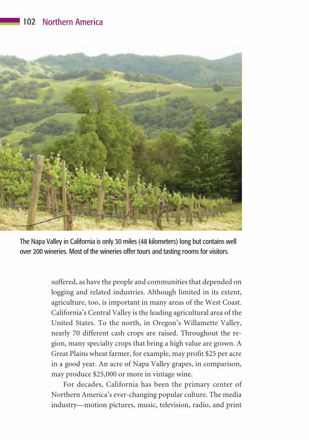
suffered, as have the people and communities that depended on
logging and related industries. Although limited in its extent,
agriculture, too, is important in many areas of the West Coast.
California’s Central Valley is the leading agricultural area of the
United States. To the north, in Oregon’s Willamette Valley,
nearly 70 different cash crops are raised. Throughout the re-
gion, many specialty crops that bring a high value are grown. A
Great Plains wheat farmer, for example, may profit $25 per acre
in a good year. An acre of Napa Valley grapes, in comparison,
may produce $25,000 or more in vintage wine.
For decades, California has been the primary center of
Northern America’s ever-changing popular culture. The media
industry—motion pictures, music, television, radio, and print
102 Northern America
The Napa Valley in California is only 30 miles (48 kilometers) long but contains wellover 200 wineries. Most of the wineries offer tours and tasting rooms for visitors.

103Regions of Northern America
media—in particular, has influenced fads and trends through-
out the region and the world. Today, it still is a center of culture
change. With the possible exception of New York City, the West
Coast has always been Northern America’s region of greatest
cultural and ethnic diversity. San Francisco and Vancouver are
famous for their tolerance and openness to cultural change. As
documented by the 2000 census, people of northwestern Euro-
pean culture are now in the minority in California. California’s
non-Anglo population is dominantly Latino and Asian; else-
where in the western region, people from various East Asian
countries dominate the ethnic landscape.
Much like a kaleidoscope, Northern America’s regions will
continue to change. Some areas will grow, others will decline.
Economic activities will change, as will population and settle-
ment. Certainly, culture and ethnicity will continue to diversify
as an increasing number of people are attracted to this prosper-
ous region of expanding opportunity.
As anyone who depends on weather reports knows, forecasting
future events can be difficult and the results are not always accu-
rate. Geographer Erhard Rostlund noted that “the present is the fruit
of the past and contains the seeds of the future.” Simply stated, if a
person looks first to the past and observes trends that led to present
conditions, the task of looking ahead is made simpler and forecasts
are more apt to be accurate. Using historical geography, past trends,
and present-day conditions as their guide, the authors will attempt
paint a picture of Northern America’s future.
Changes within the physical environment usually occur slowly.
Mountains grow and erode, continents drift, and water bodies come
and go, as do ice ages. Such changes occur at a pace measured by
Northern AmericaLooks Ahead
9C H A P T E R
104

geologic time, over thousands or even millions of years. Some
changes—such as earthquakes, tsunamis, volcanic eruptions,
and earth slides—occur rapidly and with greater frequency. The
same is true of tornadoes, hurricanes, floods, and droughts.
Every year, fires ravage woodlands and grasslands. Nature is al-
ways restless, and each of these events will continue to occur.
Data suggest that the global climate is warming. In terms of
temperature, precipitation, drought, and other weather-related
events, the potential outcome remains unclear. It seems certain,
however, that a warmer climate will bring many changes
throughout Northern America. Much of Canada and Alaska is
underlain by permafrost. Warming conditions will cause
ground frozen beneath the surface to thaw, which, in turn, will
result in catastrophic damage. Buildings, highways, railroads,
and other structures will be affected as their foundation of
frozen ground begins to turn to earthen mush. With a warming
climate, hurricanes are becoming more numerous and intense.
As temperatures warm and some places become drier and oth-
ers wetter, ecosystems will change. This will cause a migration
of many species of plants and animals. Others will become ex-
tinct because of their inability to adapt to rapidly changing en-
vironmental conditions.
Certainly, the thirst for water used in irrigation, industry,
and home consumption will increase. Providing adequate sup-
plies of this essential resource will become increasing costly and
challenging. This is particularly true for water-starved areas
such as California and the desert Southwest. Today, rivers such
as the Colorado and Rio Grande often are dry long before their
channels reach their mouths. Few areas in the United States
have an adequate supply of clean water. The future almost cer-
tainly will bring massive water diversion projects from areas of
plenty to places of need. Canada has abundant fresh water re-
sources, which, ultimately, may be diverted southward. Cur-
rently, however, many details must be worked out between the
two countries if this is to happen.
105Northern America Looks Ahead
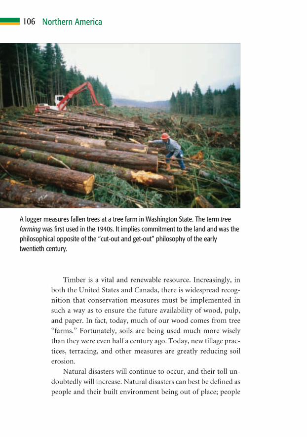
Timber is a vital and renewable resource. Increasingly, in
both the United States and Canada, there is widespread recog-
nition that conservation measures must be implemented in
such a way as to ensure the future availability of wood, pulp,
and paper. In fact, today, much of our wood comes from tree
“farms.” Fortunately, soils are being used much more wisely
than they were even half a century ago. Today, new tillage prac-
tices, terracing, and other measures are greatly reducing soil
erosion.
Natural disasters will continue to occur, and their toll un-
doubtedly will increase. Natural disasters can best be defined as
people and their built environment being out of place; people
106 Northern America
A logger measures fallen trees at a tree farm in Washington State. The term treefarming was first used in the 1940s. It implies commitment to the land and was thephilosophical opposite of the “cut-out and get-out” philosophy of the earlytwentieth century.
place themselves at risk by living and building in hazardous
zones. This is true of cities located on fault zones, such as Los
Angeles and San Francisco. There are many communities in
low-lying hurricane prone coastal regions, such as Miami and
recently devastated New Orleans (much of which is actually be-
low sea level!). In the West, many settlements are in areas sub-
ject to frequent raging forest fires; others are built on top of or
at the base of unstable land that can break away as an avalanche
or earth flow. There are many other examples of people taking
environmental risks. Sadly, as more people choose to place
themselves in jeopardy, nature’s toll of destruction undoubt-
edly will increase.
During the coming decades, many changes in population
will occur. Both countries are experiencing a sharp decline in
their rate of natural population increase. Populations in both
countries continue to grow, primarily as a result of immigra-
tion. This suggests that Northern America’s economic health
surely will become increasingly dependent on immigrants. Im-
migration policies, therefore, must be cautious yet flexible. Fu-
ture employment needs must be thoughtfully considered. Of
particular concern will be the need for laborers to offset an ag-
ing society that places strain on retirement programs and other
needs.
Major changes also can be anticipated in settlement. Many
cities, particularly in the United States, are decaying. It remains
to be seen whether current efforts at inner-city renewal will bear
fruit. Planner Kyle Ezell, a cultural geographer, believes that in-
ner-city revitalization will change the urban landscape much as
the growth of suburbs did during the twentieth century. Others
believe that the growth of megacities will stall during coming
decades. As jobs become less tied to place, many people may
choose to live in places where the pace of life is slower and less
stressful. Because these people are accustomed to the things that
cities can offer, this will particularly favor middle-size commu-
nities. Attractive rural areas, such as Appalachia, the Ozarks,
107Northern America Looks Ahead

and western mountain areas will continue to grow in impor-
tance. Even Canada’s chilly interior and beautiful eastern Mar-
itime Provinces may begin to attract new settlers if access and
economic opportunity improve.
Culture and society certainly will change at a fast pace dur-
ing coming decades. Northern America will become increas-
ingly multicultural. In many areas, including California, people
of Anglo-European origin already are in a minority, and that
trend will continue. A culturally diverse society offers many
benefits. Diversity can also create problems, however. It is es-
sential that all peoples are respected and have an equal oppor-
tunity to partake of the bounty offered by the region’s way of
life. For this to occur, all groups must be able to compete on an
equal footing. The best way to ensure widespread social inte-
gration and economic success is through education, which
must be a top priority. Also important are the ability to com-
municate with one another and a set of shared values.
Both the United States and Canada have a long history of
good government. People, it can be said, have the government
that they deserve, and there are troubling signs on the political
landscape. Political parties and many politicians seem more
concerned with their own advancement than they are in serving
the public that elected them to office. Many citizens are becom-
ing increasingly polarized and extreme in their views. Many
also are woefully ignorant of the issues. They either fail to vote
or cast votes based on political party affiliation rather than on
the merit of candidates’ views on issues themselves. Much po-
litical debate has become little more than a mudslinging con-
test. Rarely are issues debated in depth or thoughtfully ex-
plained. Many people feel that elected officials are influenced
more by lobbyists than by their constituents’ wishes. Northern
America’s political systems may be among the world’s best, but
they cannot be taken for granted. Some major changes must be
implemented if the blessing of good government is to last.
Canada’s political future remains in doubt. The country is
more geographically and ideologically fragmented than the
108 Northern America
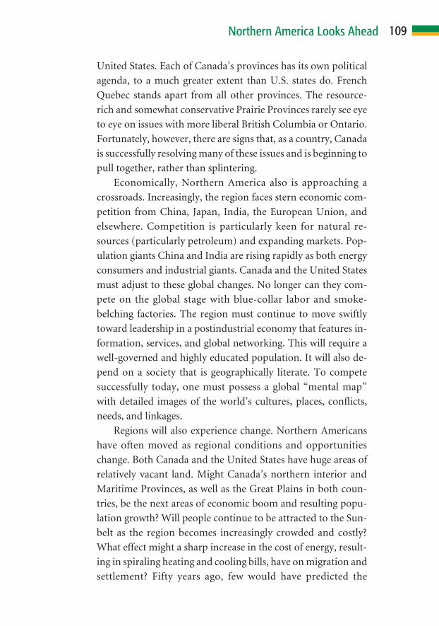
United States. Each of Canada’s provinces has its own political
agenda, to a much greater extent than U.S. states do. French
Quebec stands apart from all other provinces. The resource-
rich and somewhat conservative Prairie Provinces rarely see eye
to eye on issues with more liberal British Columbia or Ontario.
Fortunately, however, there are signs that, as a country, Canada
is successfully resolving many of these issues and is beginning to
pull together, rather than splintering.
Economically, Northern America also is approaching a
crossroads. Increasingly, the region faces stern economic com-
petition from China, Japan, India, the European Union, and
elsewhere. Competition is particularly keen for natural re-
sources (particularly petroleum) and expanding markets. Pop-
ulation giants China and India are rising rapidly as both energy
consumers and industrial giants. Canada and the United States
must adjust to these global changes. No longer can they com-
pete on the global stage with blue-collar labor and smoke-
belching factories. The region must continue to move swiftly
toward leadership in a postindustrial economy that features in-
formation, services, and global networking. This will require a
well-governed and highly educated population. It will also de-
pend on a society that is geographically literate. To compete
successfully today, one must possess a global “mental map”
with detailed images of the world’s cultures, places, conflicts,
needs, and linkages.
Regions will also experience change. Northern Americans
have often moved as regional conditions and opportunities
change. Both Canada and the United States have huge areas of
relatively vacant land. Might Canada’s northern interior and
Maritime Provinces, as well as the Great Plains in both coun-
tries, be the next areas of economic boom and resulting popu-
lation growth? Will people continue to be attracted to the Sun-
belt as the region becomes increasingly crowded and costly?
What effect might a sharp increase in the cost of energy, result-
ing in spiraling heating and cooling bills, have on migration and
settlement? Fifty years ago, few would have predicted the
109Northern America Looks Ahead

tremendous population growth in the hot, arid, American
Southwest. Massive water projects and the development of ef-
fective air-conditioning, however, contributed to spectacular
growth. Who could have predicted a doubling of Alaska’s pop-
ulation over a 30-year period, largely as a result of tapping the
state’s petroleum resources? Since the 1960s, the U.S. South has
undergone tremendous change, largely as a result of civil rights
legislation and racial integration. What will result from immi-
gration? Specific changes are difficult to forecast. The authors
can predict, however, that the regional map of Northern Amer-
ica look much different 50 years from now.
As you have seen, Northern America has been blessed in
countless ways. It is a region rich in environmental diversity,
vast space, and a wealth of natural resources. It also is blessed
with a boundless gift of diverse human resources. Perhaps the
insight contained in Rostlund’s statement gives us the best
glimpse of the future: Northern America’s past has produced an
abundance of fine fruit, and this fruit, almost certainly, has
sown the seeds of a very positive future.
110 Northern America
Before Ice Age glaciers begin to recede; earliest evidence places humans in 12000 B.C. Northern America.
9000 B.C. Most of Northern America is inhabited by native peoples.
A.D.1003 Vikings establish a settlement at Hop (L’Anse aux Meadows) innorthern Newfoundland.
1497 Giovanni Caboto (John Cabot) is the first European explorer toreach the shores of Northern America.
1507 The name “America” first appears on a map.
1540 Coronado leads a band of Spanish explorers into present-day NewMexico and as far as present-day Kansas.
1547 Maps begin to call the land north of the St. Lawrence River“Canada.”
1565 Spaniards establish St. Augustine (Florida), which becomes the firstpermanent settled European community in Northern America.
1605 The French settle Annapolis (Nova Scotia).
1607 The British settle at Jamestown (Virginia).
1608 Samuel de Champlain establishes the settlement of Quebec on theSt. Lawrence River.
1610 Henry Hudson explores the bay that later bears his name; theSpanish settle Santa Fe (New Mexico).
1670 The Hudson’s Bay Company is founded.
1776 The American Revolution begins; America gains independence onJuly 4.
1793 Alexander Mackenzie crosses Canada to reach the Pacific Coast.
1803 The United States buys the Louisiana Territory from France for15 million dollars, expanding its territory by 800,000 square miles(2 million square kilometers).
1804 President Thomas Jefferson sends the Corps of Discovery, anexpedition headed by Lewis and Clark, to explore the west to theshores of the Pacific Ocean; the exploration lasts two years.
1841 The Province of Canada is formed from Upper and Lower Canada.
1848 Gold is discovered at Sutter’s Mill, east of San Francisco, California,resulting in the massive gold rush of 1849.
111
H I S T O R Y A T A G L A N C E

1861–1865 The Civil War bitterly divides the United States, pitting the slave-holding Southern states against the North.
1863 The Emancipation Proclamation frees slaves in the United States.
1867 The British North American Act establishes the Dominion ofCanada; Alaska is purchased from Russia for 7.2 million dollars.
1869 The United States completes the first transcontinental railway.
1885 Canada’s transcontinental railroad is completed.
1897 The Klondike gold rush begins.
1900 The Galveston (Texas) hurricane kills as many as 8,000 people inNorthern America’s greatest natural disaster as measured by loss oflife.
1906 A San Francisco earthquake kills 500 and nearly destroys the city.
1929 The Great Depression begins, bringing financial ruin to millions.
1930s Much of interior Northern America suffers severe drought, resultingin “Dust Bowl” conditions; thousands of displaced people migrateto California, beginning the state’s population boom.
1939–1945 Canada and United States are involved in World War II.
1959 Alaska and Hawaii become the forty-ninth and fiftieth U.S. states,respectively, and the United States’s current flag is adopted.
1964 Alaska experiences a 9.2 magnitude earthquake, perhaps thestrongest quake ever recorded, resulting in more than 130 deaths.
1965 Canada adopts a new flag.
1980 Mount St. Helens (Washington) erupts violently, killing 57 peopleand destroying an area of several thousand square miles.
1989 The Canada–U.S. Free Trade Agreement (FTA) is signed.
1992 Hurricane Andrew strikes Florida and Louisiana, resulting in a then-record 25 billion dollars in property losses.
1994 The FTA is re-signed as the North American Free Trade Agreement(NAFTA); it includes Mexico and spurs trade among the threecountries.
1995 A Quebec government referendum on secession fails by a narrowmargin.
112
H I S T O R Y A T A G L A N C E

2001 On September 11, terrorists hijack four commercial flights andattack the Twin Towers of the World Trade Center in New York Cityand the Pentagon in Washington, D.C.; an estimated 3,000 lives arelost.
2005 Hurricane Katrina strikes the Gulf Coast, resulting in 1,200 deathsand 200 billion dollars in property losses from Louisiana toAlabama.
113
H I S T O R Y A T A G L A N C E

Atlas of the United States of America. Washington, D.C.: United States De-partment of the Interior–U. S. Geological Survey, 1970.
Birdsall, Stephen S., John W. Florin, and Margo L. Price. Regional Land-scapes of the United States and Canada. New York: John Wiley & Sons,1999.
Boal, Frederick W., and Stephen A. Royle, eds. North America: A Geographi-cal Mosaic. London: Arnold, 1999.
Desaulniers, Kristi L. Canada. Philadelphia: Chelsea House Publishers,2003.
Garreau, Joel. The Nine Nations of North America. Boston: Houghton Mif-flin Company, 1981.
Garrett, Wilbur E., ed. Atlas of North America. Washington, D.C.: NationalGeographic Society, 1985.
Garrett, Wilbur E., ed. Historical Atlas of the United States. Washington,D.C.: National Geographic Society, 1988.
Grabowski, John F. Canada. San Diego, CA: Lucent Books, 1998.
Hakim, Joy. The First Americans, Prehistory–1608. New York: Oxford Uni-versity Press, 2003.
King, David C. Smithsonian Children’s Encyclopedia of American History.New York: DK Publishing, 2003.
McKnight, Tom L. Regional Geography of the United States and Canada, 4thedition. Upper Saddle River, NJ: Pearson Education, Inc., 2004.
McNeese, Tim. The Mississippi River. Philadelphia: Chelsea HousePublishers, 2004.
McNeese, Tim. The St. Lawrence River. Philadelphia: Chelsea HousePublishers, 2005.
The National Atlas of Canada. Toronto: Macmillan, 1974.
Pang, Guek-Cheng. Cultures of the World, Canada. New York: MarshallCavendish International—Benchmark Books, 2004.
Rogers, Barbara Radcliffe, and Stillman D. Rogers. Canada, Enchantment ofthe World. New York: Children’s Press, 2000.
114
F U R T H E R R E A D I N G

Rooney, John F., Jr., Wilbur Zelinsky, and Dean R. Louder, eds. This Re-markable Continent: An Atlas of United States and Canadian Society andCultures. College Station, TX: Texas A&M University Press, 1982.
Smolan, Rick, ed. A Day in the Life of Canada. Don Mills, Ontario: CollinsPublishers, 1984.
NOTE: For further and current information on the United States orCanada, any of their political subunits, or specific topics such as theenvironment, population, and economic, political, social, or other data,please use Internet search engines as appropriate. An excellent general in-formation source for any of the world’s countries is the CIA factbook atwww.cia.gov/cia/publications/factbook (Canada; United States).
115
F U R T H E R R E A D I N G
116
Acadia, 49. See also Nova ScotiaAfricans, 39, 51agriculture, 20. See also farming; plan-
tationsin Canada/U.S., 42, 96–97as primary industry, 86–88settlement, water and, 24–26, 56soils and, 10, 14, 42on West Coast, 101–102westward expansion and, 42, 56
air-conditioners, 60, 99, 110aircraft industry, 90air traffic, 80Alaska, 10, 28, 74–75, 78, 110amenity locations, 61Anasazi cliff dwellings, 33Anglo America, 2–3animals, 20, 71, 78, 101. See also spe-
cific animalsAppalachian Mountains, 13, 40, 61,
107–108aqueducts, 55architecture, 70, 71Asians, 3, 31, 43, 51, 61, 103. See also
Chinese people; JapanAtlantic and Gulf Coastal Plains,
12–13Australia, 5, 45automobiles, 53, 56–57, 90, 95–96avalanches, 26–27, 107
basins, 12, 14, 23interior plateaus and, 15–17
Bay of Fundy, 11beer, 91Beringia (Bering Strait “land bridge”),
31bison, 20–21, 34blacks, 61blizzards, 26Bonneville Salt Flats, 16Britain, 3, 36–40, 49, 72, 76Buddhism, 69buffalo. See bisonBuffalo Bill, 21
bull, changing of history by, 35–36Bush, George W., 77businesses, 80, 82, 83Bytown, 58. See also Ottawa
Cabot, John, 36California
climate of, 22as economic power, 81–82, 101gold rush, 40, 52, 101Gulf of, 25Los Angeles, 28, 59, 101, 107population of, 26, 43, 55, 108San Francisco, 28, 101, 103, 107water and, 26, 55, 105
Canada. See also specific cities/regionsagriculture in U.S. v., 42, 96–97area/sq. miles of, 44Britain and, 72, 76cities in U.S. and, 59–60, 95–103culture of U.S. v., 1–2, 8, 31eastern core of, 95–97English language in, 2, 8, 43, 65, 78flags of, 64, 66French language/people in, 2, 3, 8,
38, 43, 65, 72, 78, 109gold rush, 52governments of U.S. v., 60, 76–78,
108–109heartland region of, 98–101Maritime Provinces, 62, 78, 108,
109minorities in, 2, 61, 103nation building and, 74–76politics and, 43, 94, 108–109population of U.S. v., 44–48ports in, 55safety of, 29separatism in, 65–67taxes in U.S. v., 60tidal range in, 11trade between U.S. and, 91–92travel between U.S. and, 2U.S. border with, 52, 72Vikings and, 35–36
I N D E X
117
I N D E X
water, U.S. and, 92, 105westward expansion and, 42,
51–53, 74–76Canadian Rockies, 15Canadian shield, 14canals, 23, 25, 40canyons, 15, 16Cartier, Jacques, 37Catholicism, 5, 49, 68census data, 45, 47, 103Champlain, Samuel de, 38China, 109Chinese people, 42, 51Christianity, 68–69cities. See also specific cities
cultural change in, 70in eastern core, 95–97in heartland, 99–100settlement and, 57–62in U.S. and Canada, 59–60, 95–103on West Coast, 101, 103
civil rights legislation, 110climates, 10, 11, 18. See also global
warmingecosystems and, 18–22, 83, 94zones, 19
clothing, 35, 71, 89Clovis site, 31coal, 83, 89coastal indentations, 12–13, 17coasts. See also Pacific Coast; West
Coast regionpopulation on, 45–47, 54ranges, 17–18settlements on, 53, 95shipping and, 53
colonies, 31, 37–40, 43, 49, 75Colorado Rockies, 24Columbus, Christopher, 32, 36commerce, 57, 59, 90–92communication, instant, 86computers, 70–71, 85, 86, 90confederation, 74Congress, 77conservation, 106
constitutions, 76, 78continents, 3, 5, 94, 104conurbation (continuous urban area),
101Cornbelt, 96courts, 78cows, diseased, 92crops, 83, 98–99cultural change, 70, 103cultural ecology, 11cultural history, 36–40cultural relativity, change and, 70–71cultures, 2. See also native cultures
adaptation by, 9, 11assimilation of, 6–7, 43of Canada v. U.S., 1–2, 8, 31common threads defining, 30development and diffusion of, 70–71diversity of, 1, 43, 61–62, 103, 108economic growth and, 84–86folk, 7, 59indigenous, 6, 65–67, 72native, 32–35nature and, 11popular, 7–8, 13, 59, 71–72,
102–103regions, 1–9, 2–5, 63, 94settlement patterns and, 58–61society and, 63–72symbols of, 63–69technology and, 54, 70–71
dams, 12, 15–16, 23, 25, 80Death Valley, 17, 21–22democracy, 5, 43, 70, 76demographics, 45, 47deserts, 10, 24–25development
climate’s impact on, 18diffusion of culture and, 70–71economic, 6, 10, 25–26, 45, 62,
79–80, 82–86tourism and, 17
diet, food and, 69, 71droughts, 22, 26, 105

118
Dust Bowl, 42Dutch settlers, 38, 49
earthquakes, 26, 28, 105earth slides, 105, 107eastern core region, 95–98economic activities, 86–90, 103economic development
foundations of, 82–86government and, 80settlement and, 6, 10, 45, 62, 79water and, 25–26
economic geography, 81–93economic issues, 92–93economic stability, 85economy
“boom and bust,” 17competition with, 109of eastern core, 95–98folk/popular culture and, 59government and, 80, 82growth of, cultural contributors to,
84–86of heartland, 98–101information and, 48, 61, 90, 109market, 5, 43, 70, 80, 82, 85measures of, 48postindustrial/information-based,
61, 90, 109settlement and, 54, 62of West Coast region, 101–102
ecosystems, 10climates and, 18–22, 83, 94culture’s impact on, 9diversity in, 11
Edmonton Mall, West, 100education, 44, 48, 86, 93, 109Ellis Island, 52energy, 80, 89, 109. See also hydroelec-
tric powerEnglish language, 3, 5, 65, 67
in Canada, 2, 8, 43, 65, 78environment
changes in, 104–105natural, 83–84, 86
environmental hazards, 26–29environmental laws, 80, 101environmental restrictions, 86, 88E pluribus unum (from many, one),
6–7erosion, 6, 15, 106Eskimos. See InuitEurope, 2
colonization by, 31, 37–40, 43, 49
exploration by, 31, 32, 36–39immigration and, 31, 40–43, 48–51,
65Native Americans impacted by, 6,
36, 40, 49Northern America impacted by, 3,
5–6, 8, 31–32, 35–43, 65, 70–71,95
population in, 45, 47religion and, 67, 70settlement and, 31, 37–40, 48–51
European Union, 109exports, 71–72, 90–93Ezell, Kyle, 107
factories, 83, 97fall line, 13farming. See also crops
fish, 88government and, 80by native cultures, 33–34on Pacific Coast, 17on plains, 12, 83in Quebec, 84railroads and, 56–57ranching and, 88reverting to woodland, 20soil fertility and, 55–56, 88tree, 106
fault zones, 28, 29, 107fertility rate, 47fires, 29, 105, 107First Americans, 31–32First Nations, 32
Cree, 65
I N D E X
119
fishing, 26Britain and, 49economy and, 83, 86, 88Grand Banks, 36, 49, 88, 95settlement and, 57on West Coast, 101
fjords, 18flags, 63–64, 66, 68, 96floods, 15–16, 26–28, 105Florida, 39, 49, 50, 97folk culture, 7, 59food
diet and, 69, 71production, 88
forests, 6, 20, 22, 107. See also logging;taiga; trees
Fort, in community names, 57–58fossil fuels, 11“Four Corners” area, 15France
exploration/colonization by, 37–40,49
land survey system, 79freedoms
individual/personal, 7, 43, 71, 78to worship, 67–69
Free Trade Agreement (FTA), 91–92
French Canadians, 2, 3, 8, 38, 43, 65,72, 78, 109
FTA. See Free Trade Agreementfur trade, 36–37, 39, 49
Gadsden Purchase, 75gaps, 13GDP. See gross domestic productgeography, 20
economic, 81–93historical, 30–43political, 73–80
German settlers, 38, 40, 50–51, 65glaciers, 14, 15, 18, 23, 31globalization, 72global markets/economy, 82, 85–86,
93, 109
global warming, 105gold, 37, 49, 84, 99
rush, 40, 52, 101governments, 9, 48
of Canada v. U.S., 60, 76–78,108–109
capitals, 58, 95criticizing, 78economy and, 80, 82Executive/Legislative/Judical
branches of, 76–78good, 73, 108land, resources and, 78–80political geography and, 73–80self-, 67, 76taxes and, 60, 80
grains, 14, 20, 99. See also Marquiswheat
Grand Banks, Newfoundland, 36, 49,88, 95
Grand Canyon, 15, 16grasslands, 20Great Depression, 25, 42Great Lakes, 14, 23–24, 37, 54
lowlands, 14Great Plains, 14, 29, 99, 109Great Salt Lake, 16Greeley, Horace, 51gross domestic product (GDP), 81groundwater, 23Gulf of California, 25Gulf of Mexico, 12, 27, 37, 98Gulf of St. Lawrence, 12, 36
hail, 26harbors, natural, 12–13, 17, 26Hawaii, 10, 18, 22, 75, 78hazards
environmental, 26–29natural, 11zones, 29, 107
health, 47–48, 74heartland region, 98–101Hell’s Canyon, 15Henry VII (king of England), 36
I N D E X

120
highways, 54, 56–57economy and, 83, 85government and, 80roads and, 57, 74
Hinduism, 69Hispanics, 3, 39, 43, 61, 72historical geography, 30–43history
bull’s changing of, 35–36conflicts in, 1cultural, 36–40
Homestead Act, 56House of Commons, 76–77House of Representatives, 77, 96humans
impacts of, 11, 20, 24–26land use by, 10, 12, 17, 20as resources, 45, 48, 82, 110risk, natural disasters and, 29, 107water use by, 25–26
hurricanes, 26–29, 105hydroelectric power, 14, 25, 26, 80
iceages, 14, 15, 23, 31–32, 104dams, 15–16freezing, 26Inuit words for snow and, 66sheets, continental, 23
immigration, 110. See also migrationby Europeans, 31, 40–43, 48–51,
65jobs and, 93legal/illegal, 43, 47population and, 47, 107railroads and, 41–42settlement and, 61–62
imports, exports and, 90–93India, 109Indians, 32, 32–34, 79. See also Native
Americansindigenous cultures, 6, 65–67, 72Industrial and Commercial Revolu-
tions, 85industrial core, 95–97
industries. See also specific industriesbuilding, 83, 89environmental restrictions on, 86,
88extractive, 83, 86–89government and, 78, 80lumber, 78, 92primary, 84, 86–89, 93, 98–99,
101–102secondary, 89–90settlement patterns and, 59, 61tertiary, 90urbanization and, 5, 42
inflation, 92information, 7, 48, 61, 90, 109integration, 108, 110interior lowland plains, 14interior plateaus and basins, 15–17Internet, 85Inuit (Eskimo), 34–35, 40, 65–67, 70Ireland, 50Islam, 69islands, 12–13, 18, 52. See also HawaiiItaly, 51
Jamestown, Virginia, 38Japan, 47, 109jobs. See also retirement
aging population and, 47–48, 93economy and, 86–93education and, 86, 93immigration and, 93outsourcing, 85–86settlement and, 47, 54, 58–61
John Paul II, 68Judaism, 69
Karlsefni, Thorfinn, 35–36
lakes, 10, 23canals and, 23Great Lakes, 14, 23–24, 37, 54Great Salt, 16locks and, 23–24Mead, 25Missoula, 15
I N D E X

121
Powell, 25ships on, 23–24Superior, 23Winnipeg, 89
land features, 10, 11. See also specificfeatures
names of, 35patterns for, 12
lands. See also lowlands; scablands;woodlands
government, resources and, 78–80Indian trust, 79public, 74, 78–79purchasing, 79survey systems, 74, 79
land use, 5, 12government control of, 80by humans, 10, 12, 17, 20map, 87
languagesdiversity, and stability in U.S., 67English, 2, 3, 5, 8, 43, 65, 67, 78French, 2, 3, 8, 38, 43, 65, 72, 78,
109Inuit, 65–66Iroquois, 97Spanish, 67as symbols, 63, 64–67
L’Anse aux Meadows, Newfoundland,35–36
Latin America, 2–3, 36–37Latinos, 103latitudes, 18laws, 7, 74, 80, 101less-developed countries (LDCs), 70life expectancies, 44, 47–48life quality, 44literacy, education and, 44, 48livestock, 14, 20–21, 83, 99locations, 53–58, 61locks, 23–24, 25logging, 22, 106. See also lumber in-
dustryBritain and, 49economy and, 83, 86–87, 89
settlement and, 57, 58on West Coast, 101
Louisiana Purchase, 75lowlands, 12
Great Lakes, 14lumber industry, 78, 92. See also mills
Macdonald, Sir John A., 42Macy’s Thanksgiving Day parade, 8manufacturing, 84–87, 89–90, 95–97maple sugar, 64Marquis wheat, 42Martin, Paul, 77McPherson, Helen Gordon, 72media, 71–72, 102–103melting pot, 1, 51metals, 84, 89Mexico, 39
Cession of 1846, 75Gulf of, 12, 27, 37, 98trade with, 92
migration, 7of First Americans, 31–32natural resources and, 6property values and, 29, 61settlement and, 50–53, 109–110westward expansion and, 51–53
military, 74mills, 13, 26mineral resources, 6, 11, 57, 83–84
in Canadian shield, 14extraction of, 88–89gold, 37, 40, 49, 52, 84, 99, 101silver, 37, 84, 99
mining, 55, 100in Canadian shield, 14economy and, 17, 86, 88–89ghost towns, 61, 99
minorities, 2, 3, 61, 72, 103, 108. Seealso specific minorities
mobility, 7Montreal, 41, 55, 59, 97mountains, 12, 83. See also ranges
Appalachian, 13, 40, 61, 107–108basins separating, 16–17
I N D E X
122
changes in, 104climate impacted by, 21–22Denali, 18Logan, 18Mauna Kea, 18Mauna Loa, 18McKinley, 18Mitchell, 13Ozarks, 61, 107–108Pacific Coast, 17–18Rainier, 17Rocky, 15–17St. Helens, 29Waialeale, 22Whitney, 17
mud flows, 27“must” to “want” settlement pattern,
60–61
NAFTA. See North American FreeTrade Agreement
nation building, 74–76Native Americans, 3, 32, 98
Europe’s impact on, 6, 36, 40, 49native cultures, 32–35. See also Indi-
ans; indigenous cultures; NativeAmericans
contributions of, 35, 37European impact on, 6, 36, 40, 49Hohokam, 33Inuit, 34–35, 40, 65–67on Pacific Coast, 34, 40physical characteristics of, 32Pueblo, 33, 40, 49religious conversion of, 49treaties and, 43
natural disasters, 26–29, 105, 106–107natural environment, 83–84, 86natural gas, 83, 89natural hazards, 11natural resources
cultural history impacted by, 36–39diversity/abundance of, 1, 10–11,
31, 36, 83–84, 110frontier attitude toward, 6
impacts on/use of, 11industry and, 86–90migration and, 6settlement and, 45
nature, gifts and challenges of, 10–29New Amsterdam, 49. See also New
York CityNew England, 37–38, 95Newfoundland, 35–36, 36, 49, 88, 95New Mexico, 39, 49New York City, 8, 52, 59, 95, 96, 103New Zealand, 5North America, 3, 94North American Free Trade Agree-
ment (NAFTA), 92Northern America, 1–2, 3, 5. See also
Canada; United States“Angloization” of, 40area/sq. miles of, 5, 6, 44European impacts on, 3, 5–6, 8,
31–32, 35–43, 65, 70–71, 95future of, 104–110as global power, 7land surface occupied by, 82physical characteristics of, 4, 5population of, 5regions of, 9, 94–103unifying characteristics of, 5–8
Nova Scotia, 38, 49, 74Nunavut, 65–67, 75, 78
oceans, 10, 17, 54, 82Ontario, 58, 97Orient, route to, 36Ottawa, 58, 59, 78, 95overpopulation, 47, 82owl, spotted, 78, 101
Pacific Coast, 22, 34, 40, 101–103mountains and valleys, 17–18
Pacific culture region, the, 5, 45Pacific Northwest, 75, 78Pacific ranges, 21Pacific Ring of Fire, 28parks, national, 79
I N D E X
123
Parliament, 77pension plans, 93people. See humanspetroleum, 83, 89, 99, 109the Piedmont, 13Pilgrims, 39, 68plains
agriculture and soils on, 10, 14Atlantic and Gulf Coastal, 12–13Central, 14farming on, 12, 83Great, 14, 29, 99, 109Indians, 34in interior, 12interior lowland, 14western, 99–100
plantations, 39, 51, 89plants, 20plateaus, 12
Colorado, 15Columbia, 15Fraser, 16interior, 15–17
plow, steel-tipped moldboard, 56Plymouth, Massachusetts, 38, 39polar regions, 10political geography, 73–80political stability, 78politics, 43, 94, 108–109pollution, water/air, 6, 23popular culture, 7–8, 13, 59, 71–72,
102–103populations, 5. See also minorities;
overpopulation; specific locationsaging, 47–48, 93declines in, 57, 61, 99, 107density, 44–46, 54growth of, 44–45, 47, 51, 55, 58–62,
107–109immigration and, 47, 107map, 46property values and, 29, 61settlement and, 44–62soils and, 12water and, 22, 54–55
Port Royal (Nova Scotia), 38ports. See seaportspostal services, 74precipitation, 20–22. See also specific
typespresidents, 76, 77prime ministers, 76, 77Promontory Summit, 41property values, 29, 61Protestantism, 5, 68, 84provinces, 62, 74–75, 78, 108, 109public lands, 74, 78–79Puget Sound region, Washington, 56Puritans, 38, 68
Quebec, 59, 74, 84, 97Quebec City, 38, 43, 55, 59, 97Quebec, French, 65, 78, 109Quebecois, 65
railroads, 41–42Chinese people and, 42, 51economy and, 83, 85government and, 80settlements and, 53–57
rain, 20, 22, 26ranching, 88, 99. See also livestockranges
Bitterroot, 15Brooks, 15Canadian Pacific, 21Cascade, 17, 21Coast, 17–18Columbia, 15Sangre de Cristo, 15Sierra Nevada, 17, 21, 40, 55tidal, 11
regions, 2–3, 94–103, 95. See also spe-cific regions
changes in, 109–110characteristics of, 3, 5culture, 1–9, 2–5, 63, 94eastern core, 95–98heartland, 98–101West Coast, 101–103
I N D E X

124
religions, 5. See also specific religionsEurope and, 67, 70freedom to worship and, 67–69Spain, natives and, 49symbols and, 63, 67–69
relocation diffusion, 51reservoirs, 12, 23, 25resources, 82. See also specific resources
government, land and, 78–80humans as, 45, 48, 82, 110
retirement, 47, 61, 74, 93, 107rivers, 10, 13, 23–25
Amazon/Congo, 23Clark Fork, 15–16Colorado, 24–25, 26, 55, 105Columbia, 25, 55Hudson, 25, 49hydroelectric power and, 14Mackenzie, 25Mississippi, 23–24, 37, 54, 55, 89,
96Missouri, 23–24Ohio, 23–24, 55Rio Grande, 24, 105St. Lawrence, 14, 23, 25, 37–38, 54,
55, 97Tennessee, 25Willamette, 55Yukon, 25
roads, 57, 74. See also highwaysRocky Mountains, 15–17Rostlund, Erhard, 104, 110rural areas, 79, 107–108rural-to-urban settlement pattern, 59Russia, 40–41, 51, 75Rustbelt, 60, 98
Salton Sea, 16San Andreas Fault, 28SARS (severe acute respiratory syn-
drome), 92Saunders, Sir Charles, 42scablands, 15Scandinavian settlers, 38, 40, 51seaports, 12–13, 54–55, 61, 96
Senate, 77, 96separatism, 65–67service-related activities, 90, 97, 98,
109settlements, 20, 45
agriculture, water and, 24–26, 56boom-and-bust cycle of, 57cities and, 57–62early, 48–49economic development and, 6, 10,
45, 62, 79Europe and, 31, 37–40, 48–51factors influencing, 57–58future of, 61–62in interior West, 17migration and, 50–53, 109–110natural resources and, 45patterns, 9, 58–61population and, 44–62railroads and, 53–57transportation and, 12–13, 53, 59,
61Seward, William Henry, 75shipping, 12, 23–24, 53, 54, 80Sikhism, 69silver, 37, 84, 99skiing, 12, 83, 95, 100skraelings, 35slaves, 39, 50–51snow, 26, 66Snowbelt, 60social equality, 5social services, 74society, 63, 63–72socioeconomic mobility, 7soils
agriculture and, 10, 14, 42in Canadian shield, 14diversity of, 20erosion of, 6, 106fertility and farming, 55–56, 88laws protecting, 80population and, 12
South America, 3South, U.S., 39, 51, 110
I N D E X

125
Southwest, 10, 99, 105, 110Spain, 37, 39, 49, 75, 79, 98Spanish language, 67St. Lawrence, Gulf of, 12, 36St. Lawrence River, 14, 23, 25, 37–38,
54, 55, 97St. Lawrence Seaway, 23St. Lawrence Valley, 14, 40, 49, 95storms, 26–28, suburban areas, 59–60, 98summers, 20Sunbelt, 60, 83, 99Supreme Court, 78symbols, 63–69
taiga, 22, 34tariffs, 91–92taxes, 60, 80technology, 54, 70–71, 85, 88, 90temperatures, 20–22, 60, 105Tennessee River Authority (TVA), 25territorial expansion, 74–76terrorism, 85Thanksgiving, 8, 35tidal ranges, 11tornadoes, 26, 28, 105Toronto, 59, 95–96tourism
development and, 17in eastern core, 95, 97economy and, 83, 92in heartland, 99–101landform type for, 12settlement and, 57, 58
towns, spacing of, 56–57trade, 82, 87, 90–93, 99–100trains. See railroadstransportation. See also automobiles;
railroads; shippinglinkages, 12–13, 17settlement and, 12–13, 53, 59, 61water for, 25–26, 40
travel, 2, 26, 41, 56–57, 71treaties, 43trees, 89, 106. See also logging
tsunamis, 26, 105tundra, 22, 34TVA. See Tennessee River Authority
unemployment, 92United States (U.S.). See also specific
cities/regions/statesagriculture in, 42, 96–97area/sq. miles of, 44Canada border with, 52, 72cities in Canada and, 59–60,
95–103Civil War, 78culture of Canada v., 1–2, 8, 31debt/trade deficit of, 92–93eastern core of, 95–98flags of, 64, 96governments of Canada v., 60,
76–78, 108–109heartland region of, 98–101language, diversity and stability in,
67minorities in, 2, 61, 72, 103, 108national motto of, 6–7nation building and, 74–76politics and, 94, 108–109population of Canada v., 44–48relationship with other countries,
70South, 39, 51, 110taxes in Canada v., 60trade between Canada and, 91–92travel between Canada and, 2water, Canada and, 92, 105westward expansion and, 40–42,
51–53, 74–76uranium, 83urban areas. See also conurbation
in eastern core, 97–98rural-to-, settlement patterns, 59to suburban settlement pattern,
59–60zoning in, 80
urbanization, 5, 12, 42urban renewal, 62, 107
I N D E X

126
valleys, 13Central, 17, 56, 102Death, 17, 21–22Fraser River, 56Imperial, 17Napa, 102Ohio, 40Pacific Coast, 17–18St. Lawrence, 14, 40, 49, 95Willamette, 17, 56, 102
values, 29, 61, 71, 108vegetation, 20, 22Verrazano, Giovanni da, 37Victoria, Queen, 58Vikings, 35–36volcanoes, 15, 17–18, 26, 28–29,
105
wars, 42, 78Washington, DC, 58, 95, 96water, 10–11. See also floods; ground-
water; lakes; oceans; rain; riversattraction of, 54–55California and, 26, 55, 105Canada, U.S. and, 92, 105changes in, 104, 105, 110
of eastern v. western NorthernAmerica, 23
economic development and, 25–26as environmental hazard, 26–28features, 22–26human use of, 25–26laws protecting, 80place names and, 26, 54pollution, 6, 23population and, 22, 54–55saline, 16settlement, agriculture and, 24–26,
56for transportation, 25–26, 40for travel, 26, 41
weather, 18. See also climatesWest Coast region, 101–103Western Hemisphere, 2–3westward expansion, 31, 40–42,
51–53, 56wilderness areas, 79wildlife, 22, 34, 83. See also animalswinds, 21wineries, 102winters, 20woodlands, 20, 29, 33–34, 40, 89, 105
I N D E X

127
P I C T U R E C R E D I T S
4: © Mapping Specialists, Ltd.8: © KRT/NMI16: © New Millennium Images19: © Mapping Specialists, Ltd.21: © Layne Kennedy/CORBIS24: © New Millennium Images27: © Reuters Photo Archive/NMI33: © New Millennium Images38: © New Millennium Images41: © National Archives of Canada/NMI46: © Mapping Specialists, Ltd.50: © KRT/NMI52: © New Millennium Images
58: © New Millennium Images66: © Reuters Photo Archive/NMI68: © AFP/NMI77: © Zuma Press/NMI84: © KRT/NMI87: © Mapping Specialists, Ltd.91: © KRT/NMI96: © New Millennium Images100: © KRT/NMI102: © New Millennium Images106: © Matthew Mcvay/CORBISCover: © James P. Blair/CORBIS
page:
128
A B O U T T H E C O N T R I B U T O R S
KRISTI L. DESAULNIERS is an educator who enjoys incorporating her inter-
national teaching experiences with students’ learning. As an elementary
school teacher with a master’s degree in geography, Desaulniers has
taught in England, Switzerland, and her home state of South Dakota. She
studied as a Keizai Koho Center Fellow in Japan and was the recipient of
a Distinguished Teaching Achievement Award from the National Coun-
cil for Geographic Education. She also taught in Canada on a Fulbright
exchange, where she had the opportunity to explore much of the beauti-
ful landscape described in Northern America. Her love of learning about
people and places has taken her to many locations around the globe. Cur-
rently, she resides in Sioux Falls, South Dakota, with her husband, Rob,
and their children, Dawson and Aida.
CHARLES F. “FRITZ” GRITZNER is Distinguished Professor of Geography at
South Dakota State University in Brookings. He is now in his fifth decade
of college teaching, scholarly research, and writing. In addition to teach-
ing, he enjoys traveling, writing, working with teachers, and sharing his
love of geography with students and readers alike. As the consulting edi-
tor and frequent author for the Chelsea House MODERN WORLD NATIONS
and MODERN WORLD CULTURES series, he has a wonderful opportunity to
combine each of these “hobbies.” Gritzner has traveled extensively in all
50 states (including having lived in 7) and throughout much of Canada.
Professionally, Gritzner has served as both president and executive di-
rector of the National Council for Geographic Education (NCGE). He has
received numerous awards in recognition of his academic and teaching
achievements, including the NCGE’s George J. Miller Award for Distin-
guished Service to geography and geographic education.