norte brasileira ridge system, an example of natural ... · the continental shelf throughout the...
TRANSCRIPT
Norte Brasileira Ridge System, an example of natural component or natural
prolongation of the Brazilian Continental Margin?
Author 1: Luiz Carlos, TORRES, BRAZILIAN
FEMAR - Fundação de Estudos do Mar
Author 2: Helio Heringer, VILLENA, BRAZILIAN
UERJ – University of State of Rio de Janeiro
hvillena @gmail.com
Author 3: Angela Alonso, RANGEL, BRAZILIAN
DGN – Directorate of General Navigation – Brazilian Navy
Abstract
The anomalous morphology of the seafloor is evidence which provide a clear idea of how
dynamic the underwater world is and how often changes occur in geologic time scale. So,
volcanic underwater chains linear or not appear as a common and sometimes distinctive
submarine features. Additionally, tectonic and sedimentary processes, in conjunction or
isolated, are responsible for the continental margin building and morphology.
The UNCLOS in Article 76 mentioned the underwater features and Scientific and Technical
Guidelines (STG) present details regarding the types of features cited on UNCLOS. The STG
presents three types of underwater features: oceanic ridge, submarine ridge and submarine
elevation and also introduce the approach of natural prolongation and natural component in
which these features may be entitled.
The Norte Brasileira (NBR) and Fernando de Noronha (FNR) ridges are two conspicuous
submarine features in the Equatorial Brazilian Continental Margin (EBCM). Both ridges
present segments parallels and orthogonal to the coastline and this geometry associated with
tectonics and sedimentary process observed since South American and Africa plates break up
affected and shaped the margin in these region and provided special role in its building. This
study will deal with this issue in a combination of events which may be better understood if
considering the Norte Brasileira Ridge and inner seabed surrounded by it as an integrated
system.
In conclusion, we suggest that the Norte Brasileira Ridge (NBR) System, supported by
geomorphologic and geophysics data and scientific bibliography may be, at least, entitled as a
natural prolongation of the EBCM.

1 - Introduction
The Norte Brasileira and Fernando de Noronha Ridges are two conspicuous features of
Brazilian Equatorial Continental Margin. The current paper will focus on the Norte Brasileira
Ridge as a feature and its role in the building of adjacent portion of the margin. Also, it will
try to develop a view of closed system focused on the Norte Brasileira Ridge feature per se
and its role as structural barrier confining continental sediments behind it.
The public domain scientific bibliography provides many works on this field (Hayes &
Ewing 1970, Gorini 1977, and Gorini 1981) supported by a great range of data, such as:
bathymetry, gravity, magnetic, seismic, piston core, heat flow, sonobuoys and bottom
photographs and even nowadays they may be considered updated.
Considerations will be done in order to characterize the system applying
geomorphologic, geological and geophysical data and pieces of information combined with
scientific bibliography available and then provide a discussion regarding its entitlement in
accordance to UNCLOS Article 76 and the Scientific and Technical Guideline in order to
conclude in which type of ridge or elevation the Norte Brasileira Ridge System may be better
fitted.
2 - Brazilian Equatorial Continental Margin (BECM)
The Brazilian Continental Margin evolution has begun around 200 million years when
occurs the fragmentation of the supercontinent Gondwana resulting in the separation of Africa
and South America continents (Asmus & Porto, 1972; Viro at all, 1985). This process is
described by Thomaz Filho at all (2000) based on 380 K/Ar dating performed in basics and
alkaline magmatic rocks.
Geo-chronological, micropalaeontological, sedimentological and geochemical data
suggest that the final break up between Brazil and Africa occurred in vicinity of
Cumuruxatiba/Mucuri and Pernambuco basins around 90 million years ago (Thomaz Filho at
all, 2000) and magmatics rocks from this region are the link that Heilbron & Valeriano
(1993) describe as the second distentional event in Eocretaceous/Paleocene.
Although the Brazilian Continental Margin (BCM) is classified as the type Atlantic or
passive this classification do not means that the margin is a monotonous place along its
almost 8500km coastline length. Deep sea submarine fan in Northern and Southern, plateaus,
ridges, fracture zones, sedimentary basins (Figure 1), may be cited as example of some
features which are responsible for the margin geomorphologic complexity and an idea of how
often changes are performed in the seafloor regarding geologic time scale.
The BCM in its portion Equatorial (BECM) from Calcanhar Cape presents a change in
the coastline direction from SW-NE to ESE-WNW and the margin acquires transcurrent
characteristics until the vicinity of Amazonas Deep Sea Fan, where the coastline direction
change one more time, to SE-NW.
Mohriak (2000) describes the BECM as characterized by a few aborted rift along
continental shelf in the on shore region and by some sedimentary basins that are characterized
by an extensional phase followed by transcurrent movements associated with wrench
tectonics and transform faults, forming compressional structures, as (e.g., along the western
part of Ceará basin).
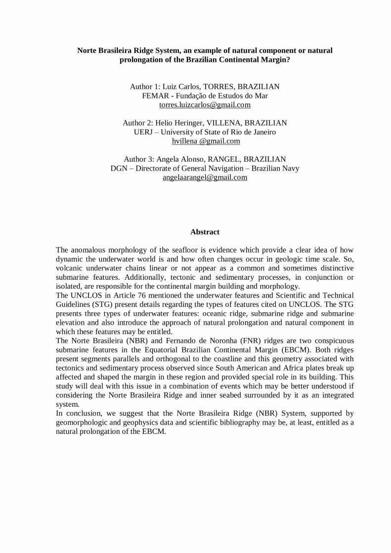
Figure 1 – Geomorphologic Map showing the Brazilian Continental Margin and its submarine
features. In the right side it is displayed the study area (yellow square) in details emphasizing
the most important features.
The Norte Brasileira and Fernando de Noronha Ridges divide the BECM influencing
its physiographiy by confining of part of terriginous sedimentation between the rectilinear
portions of the Norte Brasileira Ridge and between the Southern segment of the Norte
Brasileira and the Fernando de Noronha ridges. The Norte Brasileira Ridge runs parallel to the
coastline with 1,300km in length and its seabed relief level inner and outer varies from 300m
to 400m (Hayes and Ewing, 1970). It forms an alignment of continuous seamounts portraying
a geographic pattern where alterning E-W segments are controlled by the St Paul’s and
Romanche fracture zones; NW-SE is aligned parallel to the coastline. The genesis of the
Norte Brasileira Ridge is related to the tectonic and volcanic activities originated from
shearing stress caused by the separation of the South American and Africa continents in the
equatorial region that formed structural highs. These structural highs on the continental shelf
propagated towards the currently ocean in the same way as transversal of the mid-ocean
Romanche and St Paul’s fracture zones were formed (Gorini, 1977 and 1981), however this
process occur in the continental crust domain. The second compartment of the Brazilian
Equatorial Margin corresponds to the Fernando de Noronha Basin, limited to the north by the
southern segment of the Norte Brasileira Ridge and to the south by the Fernando de Noronha
Ridge. The sediment of the Fernando de Noronha Basin is originated basically from the
Barreirinhas-Piaui and Ceará basins, following a W-E dispersion pattern.
3 – Methodology and Data
Since 1986 Brazilian Continental Outer Limit Project (LEPLAC) carried out more
than 150,000km of seismic multichannel and bathymetric (single-beam and multi-beam) data
in the BCM to establish the outer limits of continental shelf, according to the United Nation
Convention on the Law of the Sea (UNCLOS) and Scientific and Technical Guidelines
published by the Commission of the Limits of the Continental Shelf. The maps presented in
the current paper are result of the integration of bathymetric, gravimetric, multi-channel
seismic profile data and age of oceanic crust data. The bathymetric data and maps followed
the same methodology as described in (Torres & Villena, 2007). Free-air gravity data were
downloaded from public domain (Smith & Sandwell, 1997) in WGS-84 datum and 2 miles of
sample distance spacing. The data of age of the oceanic crust were obtained at the National
Geophysical Data Center (NGDC, 2010). Preliminary field seismic multichannel and
bathymetric data acquired by LEPLAC project in the current year were used in this paper.
Usually data (except seismic data) were submitted on GEOSOFT Oasis Montaj 7.2 software,
in which were done procedures of quality control, gridding and mapping.
A consistent scientific bibliographic research was conduct in order to have a better
comprehension of the study area and its relation with the vicinity.
4 – Legal Support
The current paper will focus on the United Nations Convention on the Law of the Sea
(UNCLOS) and the Scientific and Technical Guidelines (STG) basic publications regarding
the process to the establishment of the outer limit of continental shelf by a coastal State.
The STG is a document edited by the Commission on the Limits of the Continental
Shelf (CLCS) and form the basis for the Commission to make recommendations with respect
to submissions prepared by States according to article 76. Its purpose is providing direction to
coastal States which intend to submit data and other material concerning the outer limits of
the continental shelf in areas where those limits extend beyond 200 miles from the baselines.
Additionally, the STG helps the CLCS to clarify its interpretation of scientific, technical and
legal terms contained in the UNCLOS. Clarification is required in particular because the
UNCLOS uses scientific terms in a legal context which at times depart significantly from
accepted scientific definitions and terminology.
Special attention will be given to the Article 76 of UNCLOS and to the STG
paragraphs concerning submarine features.
5 – Results and Discussion
This part of the paper will be developed trying to join the legal aspects with results and
bibliographic research. This discussion will be developed over two large approaches: analyze
of CNB System as a natural prolongation of the Brazilian Equatorial Continental Margin and
analyze of CNB System as a natural component of the Brazilian Equatorial Continental
Margin.
5.1 – CNB System as a natural prolongation of the Brazilian Equatorial Continental Margin
The UNCLOS, in its Article 76, paragraph 1 and 3, introduces the concept of natural
prolongation of the land mass over the sea and provides the concept of continental margin and
its essentials components:
“Paragraph 1 - The continental shelf of a coastal State comprises the seabed and
subsoil of the submarine areas that extend beyond its territorial sea throughout the natural
prolongation of its land territory to the outer edge of the continental margin, or to a distance
of 200 nautical miles from the baselines from which the breadth of the territorial sea is
measured where the outer edge of the continental margin does not extend up to that distance.”
“Paragraph 3 - The continental margin comprises the submerged prolongation of the
land mass of the coastal State, and consists of the seabed and subsoil of the shelf, the slope
and the rise. It does not include the deep ocean floor with its oceanic ridges or the subsoil
thereof.”
The CLPS defines in the STG paragraph 2.2.2 the test of Appurtenance which is
designed to determine the legal entitlement of a coastal State to delineate the outer limits of
the continental shelf throughout the natural prolongation its land territory to the outer edge of
the continental margin, or to a distance of 200 nautical miles from the baselines from which
the breadth of the territorial sea is measured where the outer edge of the continental margin
does not extend up to that distance.
“Paragraph 2.2.2. - The Commission defines the term “test of the appurtenance” as the
process by means of which the above provision is examined. The test of appurtenance is
designed to determine the legal entitlement of a coastal State to delineate the outer limits of
the continental shelf throughout the natural prolongation its land territory to the outer edge of
the continental margin, or to a distance of 200 nautical miles from the baselines from which
the breadth of the territorial sea is measured where the outer edge of the continental margin
does not extend up to that distance.”
In order to submit the CNB System to the provisions presented above and then to
reach the entitlement of the system as a natural prolongation over the continental margin will
be adopt two different ways, although both related .
The first one, showing the progradation and distribution of the sediments in the margin
and the role the CNB Ridge as a structural barrier to the sedimentation, characterizing
distinctive standards inside and outside of the feature. This is shown by the distribution and
peculiar inflections of isobaths as demonstrate in the Geomorphologic Map (figure 2). The
4300m isobath (red line) may be understood as a roughly reference to the outer limit of the
Amazon Deep Sea Fan, CNB Ridge and Fernando de Noronha Ridge and 3000m isobath
understood as the inner limit of the same features. Regarding the CNB Ridge, the yellow
isobaths displacement is the geomorphologic evidence of the progradation of the continental
sedimentation in the seaward.
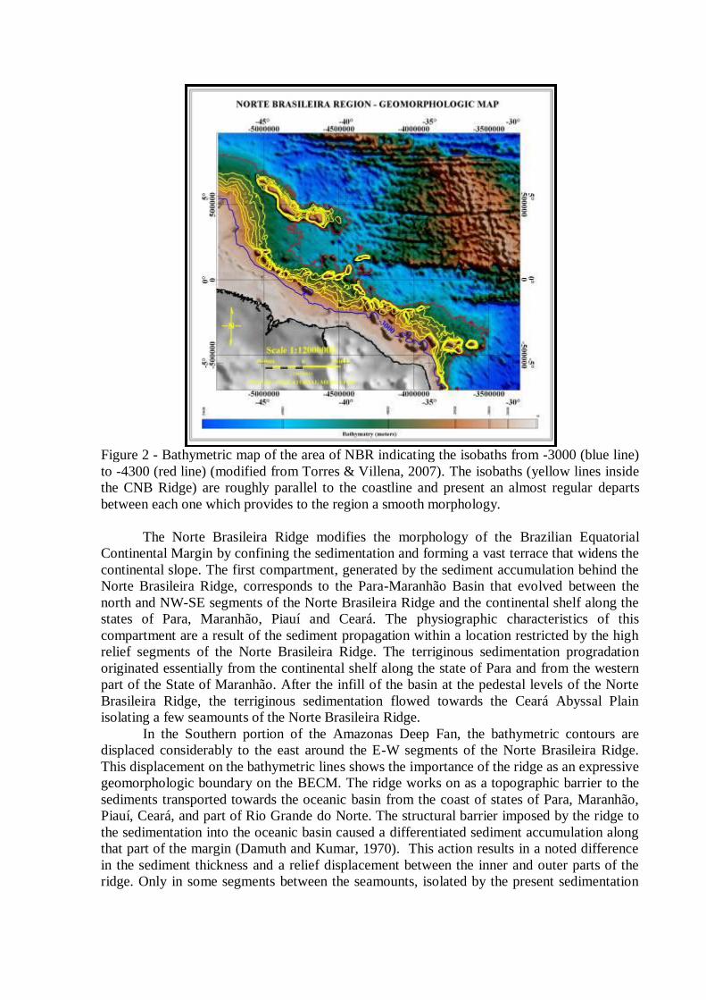
Figure 2 - Bathymetric map of the area of NBR indicating the isobaths from -3000 (blue line)
to -4300 (red line) (modified from Torres & Villena, 2007). The isobaths (yellow lines inside
the CNB Ridge) are roughly parallel to the coastline and present an almost regular departs
between each one which provides to the region a smooth morphology.
The Norte Brasileira Ridge modifies the morphology of the Brazilian Equatorial
Continental Margin by confining the sedimentation and forming a vast terrace that widens the
continental slope. The first compartment, generated by the sediment accumulation behind the
Norte Brasileira Ridge, corresponds to the Para-Maranhão Basin that evolved between the
north and NW-SE segments of the Norte Brasileira Ridge and the continental shelf along the
states of Para, Maranhão, Piauí and Ceará. The physiographic characteristics of this
compartment are a result of the sediment propagation within a location restricted by the high
relief segments of the Norte Brasileira Ridge. The terriginous sedimentation progradation
originated essentially from the continental shelf along the state of Para and from the western
part of the State of Maranhão. After the infill of the basin at the pedestal levels of the Norte
Brasileira Ridge, the terriginous sedimentation flowed towards the Ceará Abyssal Plain
isolating a few seamounts of the Norte Brasileira Ridge.
In the Southern portion of the Amazonas Deep Fan, the bathymetric contours are
displaced considerably to the east around the E-W segments of the Norte Brasileira Ridge.
This displacement on the bathymetric lines shows the importance of the ridge as an expressive
geomorphologic boundary on the BECM. The ridge works on as a topographic barrier to the
sediments transported towards the oceanic basin from the coast of states of Para, Maranhão,
Piauí, Ceará, and part of Rio Grande do Norte. The structural barrier imposed by the ridge to
the sedimentation into the oceanic basin caused a differentiated sediment accumulation along
that part of the margin (Damuth and Kumar, 1970). This action results in a noted difference
in the sediment thickness and a relief displacement between the inner and outer parts of the
ridge. Only in some segments between the seamounts, isolated by the present sedimentation

level, sediments are transferred to the oceanic basin thus contributing to the eastern extension
of the Ceará Abyssal Plain.
The Northern of CNB shows (Figure 2) a great gap between 4300m (red line) isobath
and the other yellow ones in contrast with the Eastern, which presents a sharp bathymetric
difference. This regional morphology, as showed in Figures 3 and 4, characterizes the quasi-
plateau feature composed by the flat part (inner CNB and sediment progradation), CNB per se
(escarpment) and deep ocean floor.
Figure 3 – Seismic multichannel line S7 (undefined vertical exaggeration). The CNB Ridge
seamounts work on as a structural barrier, an escarpment that confines the terriginous
sedimentation and provide to the region geomorphologic characteristics of a plateau.
Figure 4 – Synthetic bathymetric profile extract from de bathymetric grid (Torres & Villena,
2007) over de seismic line S7. The bathymetric contrast inside and outside of CNB may be
viewed around 4000m. The synthetic bathymetric profile in conjunction with the seismic line
emphasizes the quasi-plateau approach.
The role of the NBR as structural barrier and its consequence in the geomorphology of
the margin was presented above. Then, the second way of prove, or, emphasize the NBR per
se as a natural prolongation will be discussed as follow. The construction of the support
argumentation will take into account the continuity of the ridge and its link to the continent.
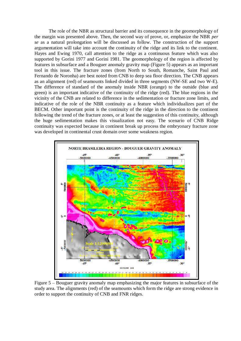
Hayes and Ewing 1970, call attention to the ridge as a continuous feature which was also
supported by Gorini 1977 and Gorini 1981. The geomorphology of the region is affected by
features in subsurface and a Bouguer anomaly gravity map (Figure 5) appears as an important
tool in this issue. The fracture zones (from North to South, Romanche, Saint Paul and
Fernando de Noronha) are best noted from CNB to deep sea floor direction. The CNB appears
as an alignment (red) of seamounts linked divided in three segments (NW-SE and two W-E).
The difference of standard of the anomaly inside NBR (orange) to the outside (blue and
green) is an important indicative of the continuity of the ridge (red). The blue regions in the
vicinity of the CNB are related to difference in the sedimentation or fracture zone limits, and
indicative of the role of the NBR continuity as a feature which individualizes part of the
BECM. Other important point is the continuity of the ridge in the direction to the continent
following the trend of the fracture zones, or at least the suggestion of this continuity, although
the huge sedimentation makes this visualization not easy. The scenario of CNB Ridge
continuity was expected because in continent break up process the embryonary fracture zone
was developed in continental crust domain over some weakness region.
Figure 5 – Bouguer gravity anomaly map emphasizing the major features in subsurface of the
study area. The alignments (red) of the seamounts which form the ridge are strong evidence in
order to support the continuity of CNB and FNR ridges.
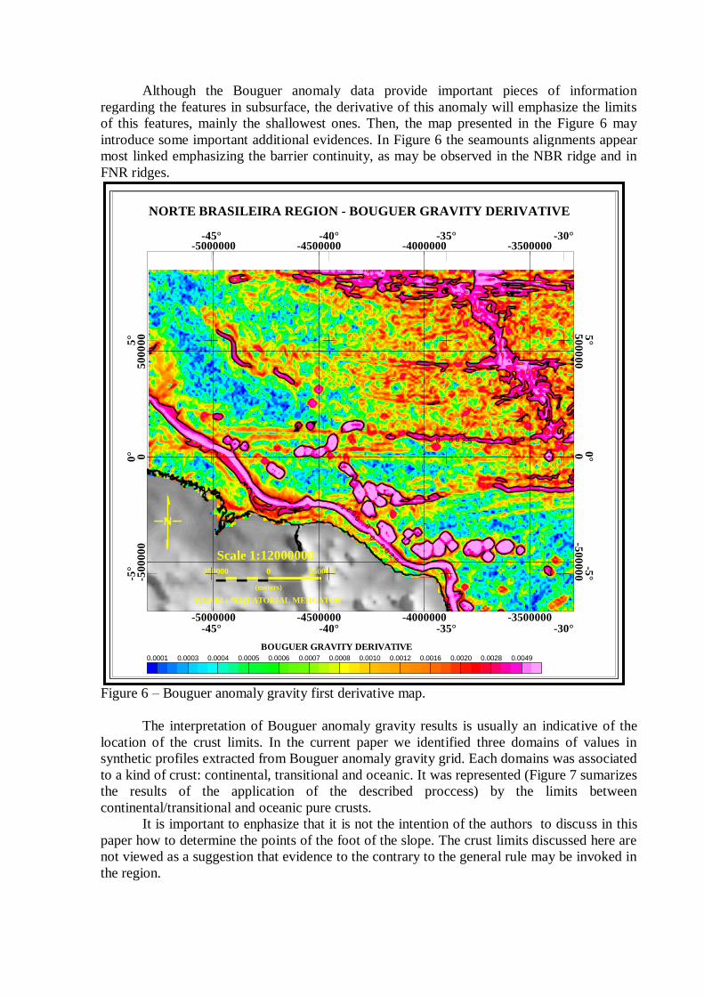
Although the Bouguer anomaly data provide important pieces of information
regarding the features in subsurface, the derivative of this anomaly will emphasize the limits
of this features, mainly the shallowest ones. Then, the map presented in the Figure 6 may
introduce some important additional evidences. In Figure 6 the seamounts alignments appear
most linked emphasizing the barrier continuity, as may be observed in the NBR ridge and in
FNR ridges.
Figure 6 – Bouguer anomaly gravity first derivative map.
The interpretation of Bouguer anomaly gravity results is usually an indicative of the
location of the crust limits. In the current paper we identified three domains of values in
synthetic profiles extracted from Bouguer anomaly gravity grid. Each domains was associated
to a kind of crust: continental, transitional and oceanic. It was represented (Figure 7 sumarizes
the results of the application of the described proccess) by the limits between
continental/transitional and oceanic pure crusts.
It is important to enphasize that it is not the intention of the authors to discuss in this
paper how to determine the points of the foot of the slope. The crust limits discussed here are
not viewed as a suggestion that evidence to the contrary to the general rule may be invoked in
the region.
NORTE BRASILEIRA REGION - BOUGUER GRAVITY DERIVATIVE
250000 0 250000
(meters)
WGS 84 / *EQUATORIAL MERCATOR
Scale 1:12000000
0.0001 0.0003 0.0004 0.0005 0.0006 0.0007 0.0008 0.0010 0.0012 0.0016 0.0020 0.0028 0.0049
BOUGUER GRAVITY DERIVATIVE
-50
00
00
05
00
00
0
-50
00
00
05
00
00
0
-5000000 -4500000 -4000000 -3500000
-5000000 -4500000 -4000000 -3500000
-5°
0°
5°
-5°
0°
5°
-45° -40° -35° -30°
-45° -40° -35° -30°
52
00.
0
0.
00
25
0 . 0 0 2 5
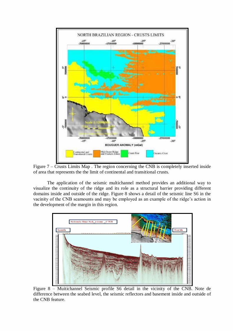
Figure 7 – Crusts Limits Map . The region concerning the CNB is completely inserted inside
of area that represents the the limit of continental and transitional crusts.
The application of the seismic multichannel method provides an additional way to
visualize the continuity of the ridge and its role as a structural barrier providing different
domains inside and outside of the ridge. Figure 8 shows a detail of the seismic line S6 in the
vacinity of the CNB seamounts and may be employed as an example of the ridge’s action in
the development of the margin in this region.
Figure 8 – Muitichannel Seismic profile S6 detail in the vicinity of the CNB. Note de
difference between the seabed level, the seismic reflectors and basement inside and outside of
the CNB feature.
5.2 – CNB System as a natural component of the Brazilian Equatorial Continental
Margin
Volcanic or sedimentary, linear or not, rises, chains or ridge, appear as a common and
sometimes distinctive submarine features in the passive continental margins. Paragraph 6
contemplates two types of submarine features in the continental margin, submarine ridge and
submarine elevation, and introduces the concept of natural component:
“Paragraph 6 - Notwithstanding the provisions of paragraph 5, on submarine ridges,
the outer limit of the continental shelf shall not exceed 350 nautical miles from the baselines
from which the breadth of the territorial sea is measured. This paragraph does not apply to
submarine elevations that are natural components of the continental margin, such as its
plateaux, rises, caps, banks and spurs.”
The expression: such as, in the list describing the features which may be classified as
natural components, suggests that this one is not complete. The STG in paragraph 7.1.2
mentions three types of sea floor highs: oceanic ridges of the deep ocean floor, submarine
ridges and submarine elevations; paragraph 7.1.3 admits that these terms are not precisely
defined. Regarding NBR System, despite of what was previously showed like a natural
prolongation of the continental margin, just a rapid comparison between the distance of NW-
SE segment to the coastline (around 150 nautical miles) and the distance to the mid ocean
spreading center (around 900 nautical miles) is an absolute evidence that the system can be
not entitled as Oceanic Ridge. The System is linked to the continental margin and, as
consequence, completely independent of mid ocean ridge feature process.
“Paragraph 7.1.2 - Article 76 mentions three types of sea floor highs:
Oceanic ridges of the deep ocean floor (para. 3);
Submarine ridges (para. 3);
Submarine elevations (para. 6).”
“Paragraph 7.1.3 - None of these terms is precisely defined. It seems that the term
“ridges” is used on purposes, but the link between the “oceanic ridges” of paragraph 3 and the
“submarine ridges” of paragraph 6 is unclear. Both terms are distinct from the term
“submarine elevations” of paragraph 6.“
The STG in paragraph 7.1.8 mentions that distinction between “submarine ridges” and
“submarine elevations” shall not be based on the name that the features are known in public
domain but on basis of scientific evidence as presented in the own STG. Regarding NBR
System (Jinno & Souza, 1999) the following names may be available: the complete feature
“Cadeia Norte Brasileira (IHO-SCUFN Gazetteer); only the North part of the feature,
“Cadeia Belem” (IHO-SCUFN Gazetteer) and only the South part of the feature “Parnaíba
Chain” (ACUF – USA Advisory Committee on Undersea Features).
“Paragraph 7.1.8 - The distinction between the “submarine elevations” and “submarine
ridges” or “oceanic ridges” shall not be based on their geographical denominations and names
used so far in the preparation of the published maps and charts and other relevant literature.
Such a distinction for the purpose of article 76 shall be made on the basis of scientific
evidence taking into account the appropriate provisions on these Guidelines”.
The STG paragraph 7.2.1 shows a list not complete (as mentioned in STG paragraph
7.2.2) of geological process that form oceanic and submarine ridges. The CNB System is
contemplated only in the last option related rifting process that culminated with the break up
between South American and Africa plates (Hayes & Ewing 1970, Gorini 1977, and Gorini
1981). This entitlement will be improved taking into account the provision of paragraph 7.2.4
once the CNB Ridge performed an important role in the development and growth of BECM.
“Paragraph 7.2.1. - Ridges under the sea may be formed in a variety of geological
processes, including:
Ridges formed by the sea-floor spreading and associated volcanic-magmatic
processes;
Ridges formed along transform faults and created as an inherent part of the
sea-floor spreading process;
Ridges formed by later tectonic activity resulting in uplift of oceanic crust;
Ridges formed by volcanic activity related to the movement of crust over a hot
spot. These ridges are commonly composed of coalescing volcanic features or
seamounts and generally occur on oceanic crust;
Ridges formed by interaction of oceanic crustal plates;
Ridges formed by regional excessive volcanism related to plumes of
anomalously hot mantle;
Ridges associated with active plate boundaries and the formation of island arc
systems. They could occur as active and inactive (remnant) volcanic arcs, and
forearc and back-arc ridges. Such ridges commonly reflect different stages in
the progressive development of island arc system and may result from
variations in factors such as the rate and direction of convergence, and from the
nature of the plate being subducted;
Ridges formed by rifting (extension and thinning) of continental crust. This
process commonly forms broader features, such as marginal plateau and rises,
but some times creates elongated slivers of continental crust separated by
oceanic or highly extended continental crust.”
“Paragraph 7.2.2. - This categorization of ridges is not exhaustive and complete owing
to the variety of tectonic settings of the sea floor.”
“Paragraph 7.2.4.- Some ridges located within the continental margins have been
present since the early evolution of the margin and have influenced it since then. Because of
their presence, sediment dispersal and thickness and the morphology of the sea floor may
have acquired a unique configuration and individualization within the regional context.”
The STG in paragraph 7.2.9 treats about the application of geological type of crust as
qualifier to the classification of submarine ridge and submarine elevation although the CLCS
admits that the criteria do not be the sole one. Regarding NBR System, as showed in the
current paper as Crusts Limits Map (Figure 7), is completely outside of the region
denominated exclusively by oceanic crust. The NBR System is inserted in the polygon which
contours the region that delimited the continental and transitional crusts domain. This may be
understood as important argument in order to entitle the NBR system at least as submarine
ridge.
“Paragraph 7.2.9. - Article 76 makes no systematic reference to the different types of
the earth’s crust. Instead it only makes reference to the two terms:” the natural prolongation of
… land territory” and “the submerged prolongation of the land mass” of coastal States as
opposed to oceanic ridges of the deep ocean floor. The terms “land mass” and “land territory”
are both neutral terms with regard to crustal types in the geological sense. Therefore, the
Commission feels that geological crust types cannot be the sole qualifier in the classification
of ridges and elevations of the sea floor into the legal categories of paragraph 6 of article76,
even in the case of island States.”
The STG 7.3.1 presents a not complete list of highs, suggesting the possibility of other
types of “highs” may be included in the mentioned list and comments that the listed
elevations are classified as “natural components” of the continental margin. Additionally,
once that the feature is a natural component is important to consider the processes responsible
by the development of the continental margin and the continent. As the geological processes
has and had relevant role in the present continents shape they must be considered in the
classification of a feature as submarine elevation. In the item b, of same paragraph, is
presented considerations of Commission regarding passive continental margins.
“Paragraph 7.3.1. - The term “submarine elevations” in paragraph 6 includes a
selection of highs: “such as plateau, rises, caps, banks and spurs”. The phrase “such as”
implies that the list is not complete. Common to all these elevations is that they are natural
components of the continental margin. This makes it relevant to consider the processes that
form the continental margins and how continents grow. The growth of present continents is
and/or was primarily caused by geological processes along the continental margins (e.g.,
Rudnick, 1995). Consequently, the Commission will base its views on “submarine elevations”
mainly on the following considerations:
(a) ...
(b) In the passive margins, the natural process by which a continent breaks up
prior to the separation by sea floor spreading involves thinning, extension and rifting of the
continental crust and extensive intrusion of magma into and extensive extrusion of magma
through that crust. This process adds to the growth of the continents. Therefore, sea floor
highs that are formed by this break up process should be regarded as natural components of
the continental margin where such highs constitute an integral part of the prolongation of the
land mass.”
Concerning the adjustment of the CNB System to the STG provision on 7.3.1 the CNB
System age, Hayes and Ewing (1970) proposed it around 100 My. As during the survey it was
not dredged fresh rocks the age was not supported by means of rocks isotopic age. Combining
crustal ages available in public domain database (NGDC, 2010) with bathymetric data (Torres
& Villena, 2007) was generated a map (Figure 9) which shows that all CNB System age
ranging between 80 and 100 My. Thomaz Filho at all (2000) suggest that the final break up
between Brazil and Africa occurred in vicinity of Cumuruxatiba/Mucuri and Pernambuco
basins around 90 My, coinciding with the second distentional event in the Brazilian
Continental Margin described by Heilbron & Valeriano (1993). The LEPLAC Project carried
out in the current year 17 fresh rocks sample in the CNB Seamounts. It is expected that
laboratorial isotopic dating results of this sample will provide any contribution in order to
clarify CNB age.
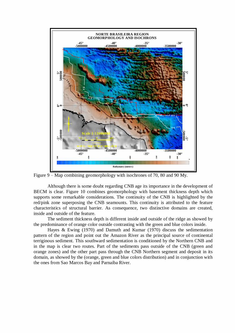
Figure 9 – Map combining geomorphology with isochrones of 70, 80 and 90 My.
Although there is some doubt regarding CNB age its importance in the development of
BECM is clear. Figure 10 combines geomorphology with basement thickness depth which
supports some remarkable considerations. The continuity of the CNB is highlighted by the
red/pink zone superposing the CNB seamounts. This continuity is attributed to the feature
characteristics of structural barrier. As consequence, two distinctive domains are created,
inside and outside of the feature.
The sediment thickness depth is different inside and outside of the ridge as showed by
the predominance of orange color outside contrasting with the green and blue colors inside.
Hayes & Ewing (1970) and Damuth and Kumar (1970) discuss the sedimentation
pattern of the region and point out the Amazon River as the principal source of continental
terriginous sediment. This southward sedimentation is conditioned by the Northern CNB and
in the map is clear two routes. Part of the sediments pass outside of the CNB (green and
orange zones) and the other part pass through the CNB Northern segment and deposit in its
domain, as showed by the (orange, green and blue colors distribution) and in conjunction with
the ones from Sao Marcos Bay and Parnaiba River.
NORTE BRASILEIRA REGIONGEOMORPHOLOGY AND ISOCHRONS
250000 0 250000
(meters)
WGS 84 / *EQUATORIAL MERCATOR
Scale 1:12000000
-540
0
-450
0
-400
0
-350
0
-300
0
-200
0
0
Bathymatry (meters)
-50
000
00
50
00
00
-500
000
0500
00
0
-5000000 -4500000 -4000000 -3500000
-5000000 -4500000 -4000000 -3500000
-5°
0°
5°
-5°
0°
5°
-45° -40° -35° -30°
-45° -40° -35° -30°
07
07
08
08
09
09
00
1
00
1

Figure 10 – Geomorphologic and basement map (CIRM, 2006).
As discussed in this paper the CNB has an important role in the development of the
BECM. The morphology of the region was strongly conditioned by its presence. The system
formed by the CNB per se and the confining continental sediments attributes to the region
geomorphological characteristic similar to a plateau feature.
5 – Final Remarks
The UNCLOS and STG mention how difficult it is to classify a submarine feature as
natural prolongation or natural component of the continental margin and shall not be based on
the name that the features are known in public domain but on basis of scientific evidence as
presented in the own STG.
As result of the recognized role performed in the development and in the growth of the
Brazilian Equatorial Continental Margin, the Norte Brasileira Ridge System, composed by the
Norte Brasileira Ridge per se and the confining continental sedimentation trapped by the
structural barrier represented by the ridge since of its formation during the separation process
between South American and Africa continents confirms that the system can be entitled as a
natural component of the Brazilian Continental Margin.
The discussions and results showed in this paper, supported by scientific, legal and
technical evidences, confirm that the Norte Brasileira Ridge per se can be entitled, at least, as
a natural prolongation of the Brazilian Continental Margin.
Fernando de Noronha Ridge presents some geomorphologic, geophysical and
geological similarities with Norte Brasileira Ridge and FNR also has a important role in the
development of continental margin in its vicinity, so, the methodology applied in this paper if
used in FNR may presents results concerning entitlement of the feature, very closer to the
results discussed in the current paper regarding NBR.
The views in this paper are the authors’ personal observations and do not necessarily
reflect the official views of the Brazilian government.
6 - Acknowledgements
The authors would like to express the deepest gratitude to the following Brazilian
experts: Alexandre T. M. de Albuquerque, Dieter C. E. H. Muehe, Marcus Aguiar Gorini,
Paulo Roberto Maldonado, Akashi Motoki, Benedito Souza Gomes e Ana Angelica Tavares.
7 – References
Asmus, H.E.; Porto, R. (1972) – Classificação das Bacias Sedimentares Brasileiras Segundo a
Tectônica de Placas – Anais do XXVI Congresso Brasileiro de Geologia – Belém – Vol. 2 pp
67-90.
CIRM, 2006. The Brazilian submission to the Commission on the Limits of the Continental
Shelf pursuant to article 76 of the United Nations Convention on the Law of the Sea.
Addendum to the Executive Summary dated 17 May 2004 (18 p.). Available on:
http://www.un.org/Depts/los/clcs_new/submissions_files/submission_bra.htm
Damuth, J.E., and R.W. Fairbridge 1970 - Equatorial Atlantic deep-sea arkosic sands and ice-
age aridity in tropical South America: Geological Soc. Amer. Bull., v. 81, p. 189-206.
GEOSOFT 2010, OASIS MONTAJ. Data Processing System for Science Earth Applications.
7.2 Version.
Gorini, M.A. 1997. The tectonic fabric of equatorial atlantic and adjoining continental
margins: gulf of Guinea to northeastern Brazil (1977). Ph.D. dissertation, Columbia
University.
Gorini, M.A. - The Tectonic of Equatorial Atlantic and adjoining continental margins. Gulf
of Guinea to Northeastern Brazil, In Estruturas e tectonismo da margem continental brasileira,
e suas implicações nos processos sedimentares e na avaliação do potencial de recursos
minerais (Final Report), edited by Asmus, H.E.,p.11-116, Petrobras/CENPES/DINTEP, Rio
de Janeiro.
Hayes, D. & Ewing, M. 1970- North Brazilian Ridge and adjacent continental margin
American Association of Petroleum Geologist Bulletim.
Jinno, K. and Souza, J.M., 1999 – Brazilian undersea features: A Gazetteer of Geographical
names. Sixth International Congress of Brazilian Geophysical Society. Rio de Janeiro RJ,
Brasil. Paper SBGF278.
LEPLAC – Brazilian Outer Limit Continental Shelf Project Brazilian. Government Plan to
establishment of the the Brazilian outer limit of the continental shelf according to the United
Nation Convention on the Law of the Sea (UNCLOS).
Mohriak, W. U. (Org.) ; Talwani, M. (Org.) 2000. Atlantic rifts and continental margins.
American Geophysical Union. 350 p.
NGDC 2010 - http://www.ngdc.noaa.gov/mgg/ocean_age/ocean_age_2008.html
Scientific and Technical Guidelines – United Nations Convention on The Law of The Sea –
Commission on the Limits of the Continental Shelf – New York, NY, USA, 13th MAY 1999.
Smith, W.H.F. And D.T. Sandwell, 1997. Global Sea Floor Topography from Satellite
Altimetry and Ships Soundings. Science Magazine, Vol 277, issue 5334. U.S.A.
Thomaz FFilho, A.; De Cesero, P.; Milani, E.J.; Mizusaki, A.M.P. 2000 – Rifting and
Magmatism Associated with the South America Break Up. Revista Brasileira de Geociências.
Vol 30(1), pp. 17-19.
Torres, L.C., Villena, H.H., Barreira, L.M., Santos, D.I., Rangel, A.A. 2003. Base de Dados
Batimétricos do Atlântico Sul. XXI Congresso Brasileiro de Cartografia. Belo Horizonte,
MG. Anais do Congresso.
Torres, L.C., Villena, H.H. 2007. Mapa de relevo submarino brasileiro In: XXIII Congresso
Brasileiro de Cartografia, 2007, Rio de Janeiro, RJ. Anais do XXIII Congresso Brasileiro
Cartografia.
UNCLOS - United Nations Convention on the Law of the Sea, 1982. United Nations, New
York, United States of America, 294p.
Valeriano, C.M. & Heilbron, M. – 1193 - A Zonas de Transtensão de Volta Redonda e sua
Importância na Junção entre os Rifts do Vale do Paraíba e da Guanabara: Dados Preliminares
Simpósio de Geologia do Sudeste, Rio de Janeiro. Pp 09-15.
Viro, E.J. Ed. 1985 - Avaliação das Formações no Brasil. Sociedade Comercial Brasileira de
Pesquisas pelo Método Schlumberger Ltd 280pp.