noi long hill quarry - epa tasmaniaepa.tas.gov.au/documents/hazell_bros_long_hill_quarry... ·...
TRANSCRIPT

ENVIRONMENTAL EFFECTS REPORT
QUARRY DEVELOPMENT
LONG HILL - SASSAFRAS
Prepared for: Hazell Bros Group
Prepared by: Barry Williams
19 January 2010
Issue Date Recipient Organisation
Draft 1 20 November 2009 Peter Bennett Hazell Bros. Group
Final 15 December 2009 Peter Bennett Hazell Bros. Group
Final 15 January 2010 Shane Hogue EPA
Final 19 January 2010 Leanne Rabjohns MVC

ENVIRONMENTAL EFFECTS REPORT - LONG HILL QUARRY Final
Integrated Land Management and Planning | part a – proponent information 2
PART A – PROPONENT INFORMATION
Name Hazell Bros Group Pty. Ltd.
ABN 27 088 345 804
Residential
Address
8B Lampton Avenue
Derwent Park
Postal Address PO Box 430
Moonah TAS 7009
Phone (03) 6277 7888
Fax (03) 6273 4160
Contact Peter Bennett
Mobile 0488672522
Table of Figures
Figure 1: General layout plan ................................................................................................... 7
Figure 2: Location plan (topographic) ...................................................................................... 8
Figure 3: Mining Plan ................................................................................................................. 9
Figure 4: Cross section aa from Railton Road to Quarry Excavation Area .............................. 10
Figure 5: Cross setion bb from Bass Highway to Quarry Excavation Area .............................. 11
Figure 6: Cross section cc from Quarry Excavation to WTE nest 144 ...................................... 12
Figure 7: Cross section dd from Quarry Excavation to WTE nest 507 ..................................... 12
Figure 8: Typical cross section through sediment retention basin ......................................... 14
Figure 9: Typical cross section (rehabiilitation) ....................................................................... 21

ENVIRONMENTAL EFFECTS REPORT - LONG HILL QUARRY Final
Integrated Land Management and Planning | 3
CONTENTS part a – proponent information ................................................................................................ 2
part b – project description ....................................................................................................... 4
1. Description of project .................................................................................................... 4
2. Project area ................................................................................................................... 5
3. Operations planning ...................................................................................................... 6
part C – potential environmental effects ................................................................................ 13
1. Flora and fauna ............................................................................................................ 13
2. Rivers, creeks, wetlands and estuaries ........................................................................ 14
3. Groundwater ............................................................................................................... 15
4. Significant areas ........................................................................................................... 15
5. Air emissions ................................................................................................................ 16
6. Liquid effluent ............................................................................................................. 18
7. Solid wastes ................................................................................................................. 18
8. Noise emissions ........................................................................................................... 18
9. Transport impacts ........................................................................................................ 19
10. Other offsite impacts ............................................................................................... 19
11. Dangerous goods and chemicals ............................................................................. 19
12. Site contamination .................................................................................................. 19
13. Cultural heritage ...................................................................................................... 19
14. Site of high public interest ....................................................................................... 20
15. Rehabilitation .......................................................................................................... 20
part D – management commitments ...................................................................................... 22
part E – public consultation ..................................................................................................... 23
appendices ............................................................................................................................... 26

ENVIRONMENTAL EFFECTS REPORT - LONG HILL QUARRY Final
Integrated Land Management and Planning | part b – project description 4
PART B – PROJECT DESCRIPTION 1. Description of project
Hazell Bros. Group Pty Ltd propose establishing a hard rock quarry on a parcel of land
located approximately three kilometres north east of Kimberly in the central north of
Tasmania. The quarry is targeting a Jurassic dolerite sill overlying Permian mudstones, which
is a common geological sequence locally. The quarry will be operated on a campaign style
basis using drill and blast techniques for rock extraction and a mobile crusher / screener for
processing.
It is anticipated that the assessment of
the proposal will be completed in the
second quarter of 2010. Engineering
design will commence after a permit is
issued and construction of the main
features of the development will take
place in the third quarter of 2010. In
stages 1 and 2 of the development
900,000 cubic metres of resource will be
extracted. This volume will produce
1,130,000 cubic metres of processed
product.
The proponent will build up to a
maximum production rate of 100,000
cubic metres of processed product
annually. Excavation stages 1 and 2 will
equate to an operational life of 15 years.
Further development will extend the life of the quarry for at least another 5 years.
Blasting will occur between 0900 and 1500 on weekdays only and the crushing plant will
operate between 0600 to 1900 weekdays and 0600 to 1800 on Saturdays. Carting can occur
at any time according to demand and supply contracts.
Blasting will occur approximately five times annually and will consist of four shots each time
extracting a solid volume of 16,000 cubic metres. Five campaigns per year will produce a
solid volume of 80,000 cubic metres which when processed will bulk to the maximum
allowable of 100,000 cubic metres of processed product. Crushing will be timed according to
the availability of a mobile crusher and screener and ‘’stock on hand” to service contracts.
Hobart
Queenstown
Triabunna
Burnie Smithton
Launceston
100 0

ENVIRONMENTAL EFFECTS REPORT - LONG HILL QUARRY Final
Integrated Land Management and Planning | part b – project description 5
2. Project area
The quarry is located approximately three kilometres northeast of the township of Kimberly.
At its closest approach the Bass Highway is 1.2 kilometres away but the quarry is concealed
by intervening topography. The site is situated on top of a ridge line running parallel to and
south of, the Long Hill ridgeline. Another lesser ridgeline runs between this unnamed
ridgeline and the Mersey River. The ridgelines run approximately NNW and rise to R.L. 350
metres above the Rubicon River plain at R.L. 160 metres to the east and the Mersey River
plain at R.L. 50 to the west.
The native forest on the areas encompassing the quarry and processing area footprint have
been recently harvested and are still the subject of a forest practices plan number GPS0566.
Conservation features specified in the forest practices plan are retained for this
development. These features are described in Figure 1 as ‘wedge-tailed eagle exclusion’,
‘landscape reserve’ and ‘wildlife habitat clump’. Forest communities recently harvested from
the development site include Eucalyptus amygdalina forest and woodland on dolerite (DAD)
and Eucalyptus amygdalina – Eucalyptus obliqua damp sclerophyll forest (DSC). A nearby
area of Acacia dealbata forest (NAD) will not be affected by the quarry development.
Forestry Tasmania has extracted road construction materials from a quarry in this location to
service harvesting and plantation development activities over a number of years. These
products have been won using drill and blast techniques and processed using a mobile
crushing facility. The balance of the area that will be affected by the quarry has been
managed by Forestry Tasmania. The majority of area affected by the quarry development is
forest unsuitable for plantation development because of outcropping rock.
The quarry is located on crown land managed by Forestry Tasmania. The Mining lease
overlies one property CT 132658/2 and a cadastral parcel over Dan Road which is owned and
maintained by Forestry Tasmania. A forest reserve (Long Hill Forest Reserve) is located to
the west of the mining lease on the lease boundary.
The quarry site is immediately surrounded by forest operations including regrowth
Eucalyptus species forest, Eucalypt plantation forest and Pinus radiata plantation forest.
Formal and informal forest reserves are located further away to the south and west. The
river plains to the east and west are developed for production agriculture with a small area
of residential land located at Kimberley. This land is zoned ‘village’ under the Meander
Valley Planning Scheme most likely because of historic small cadastral parcels. Currently
there are few dwellings although it is possible that residential density will increase in the
future. Figure 2 is an extract from the 1:25000 topographic map with land use zoning
overlayed.
The closest existing residence in this community is located 1.7 kilometres away from the
closest approach of the processing area development. The new Meander Valley Planning
Scheme will seek to constrain residential density on the east side of Railton Road, closest to

ENVIRONMENTAL EFFECTS REPORT - LONG HILL QUARRY Final
Integrated Land Management and Planning | part b – project description 6
the proposal site. The existing residences closest to the development areas are identified on
the aerial image Figure 1.
Much of the development site has Jurassic dolerite rock outcropping and skeletal orange
gravelly / clay topsoil derived from weathered dolerite. This soil is moderately erodible being
imperfectly drained but forms highly stable aggregates
3. Operations planning
The extraction site is at present a small slot cut across the ridge line running roughly east -
west. The first stage of development will include advancing the south face of the existing pit
to daylight on the SE corner and leaving a face to the SW. This will expose an operations area
at R.L. 328m leaving a face rising to 7 m high. The stage 1 operations area will be around 1.2
ha. Extracted volume is around 50,000m3 solid.
In stage 2 the SW face will be taken back until the top of the face is at around R.L. 331 m and
then the floor of the pit will be taken out down to R.L. 316m. Future expansion will advance
the pit into the area to the west. It is expected that stage 2 will add an area of 1.5 ha to the
operations area.
A material processing and stockpiling area will be developed across a shallow saddle to the
SE. This area will be around 3.5 ha in area and will be constructed by excavating a flat area
across the top of the crest gently graded from access road level R.L. 314m to R.L. 318. A low
cutting face will remain on the SW side of the ridge. Extracted volume is around 80,000 m3
solid.
Figure 3 shows the mining plan with extraction area for stage one and two and the
processing area. The processing area will remain operational for the life of the quarry.
Alternatives for future development include lowering the floor below R.L. 316 within the
existing footprint and expanding into the area marked future expansion on the mining plan.

Long Hill Quarry
FIGURE 1: GENERAL LAYOUT PLAN - showing project features, 1000 metres attenuation distance and records of sensitive values.
(Image date 27 Jan 2003)
north
Bass Highway
Mersey River
A
0 500 1000 1500 2000
B
B
Railton Road
A
Wedge-tailed eagle exclusion
Landscape reserve
Wildlife habitat clump
Processing
Possible future expansion
Stages 1 & 2
Kimberly
C
C
D
D

Long Hill Quarry
FIGURE 2: LOCATION PLAN (TOPOGRAPHIC) - showing surrounding local government areas; zoning and land use types; defined
watercourses with Conservation Management Priority status (base map extracted from 1:25000 series topographic)
Zoning: Latrobe - Rural A
Land use: Plantation forestry
Zoning: Meander Valley - Rural
Land use: Plantation forestry
Forest reserve
Zoning: Meander Valley - Rural
Land use: Agriculture
Zoning: Meander Valley - Village
Land use: Residential
Zoning: Kentish - Natural Resources
Land use: Agriculture, Rural residential
1000 metres
Staggs Creek CMP Moderate
297816 CMP Very High
297821 CMP High
297838 CMP Moderate
297824 CMP Very High

Long Hill Quarry
FIGURE 3: MINING PLAN - showing Stages 1 and 2 extraction areas and processing area. (Image date 27 Jan 2003)
Mobile crusher and screens
Processing and stockpile area
Future extraction area
Stage 2 extraction area
Stage 1 extraction area
(1.2 ha)
(3.5 ha)
(1.5 ha)
Stage 1 extraction
Stage 2 extraction Haul road
Stripping Regrowth
Haul road
Table drain
Sediment
retention basin
Existing access road (Dan 1 Rd)
Mining lease boundary
0 50 100 200 150
Mobile crusher
Stripping Product stockpiles
Cross section D - D processing area
Cross section C - C extraction area
north
C
C
D
D Diffuse discharge
Fall
Fall
Fall
New boom gate by HBG
RL 316
RL 316 RL 328
Culvert

40
0
60
0
80
0
100
0
120
0
200
700
300
5
00
900
110
0
100
Rai
lto
n R
oad
Wat
er
cou
rse
130
0
140
0
200
150
FIGURE 4: CROSS SECTION AA from Railton Road to Quarry Excavation Area
160
0
180
0
120
0
140
0
150
0
170
0
130
0
Long Hill Forest Reserve (Eucalypt forest) Agricultural land (class 3) in production
Me
rse
y R
ive
r
00
250
Ve
hic
le t
rack
M L
Bo
un
dar
y
200
0
190
0
210
0
100
50
300
250
350
200
Pit
acc
ess
Softwood plantation Long Hill Forest Reserve (Eucalypt forest) Stage 1 and 2
Re
sid
en
ce
40
0
60
0
80
0
10
00
20
0
70
0
30
0
50
0
90
0
10
0
Bas
s H
igh
way
Wat
er
cou
rse
250
200
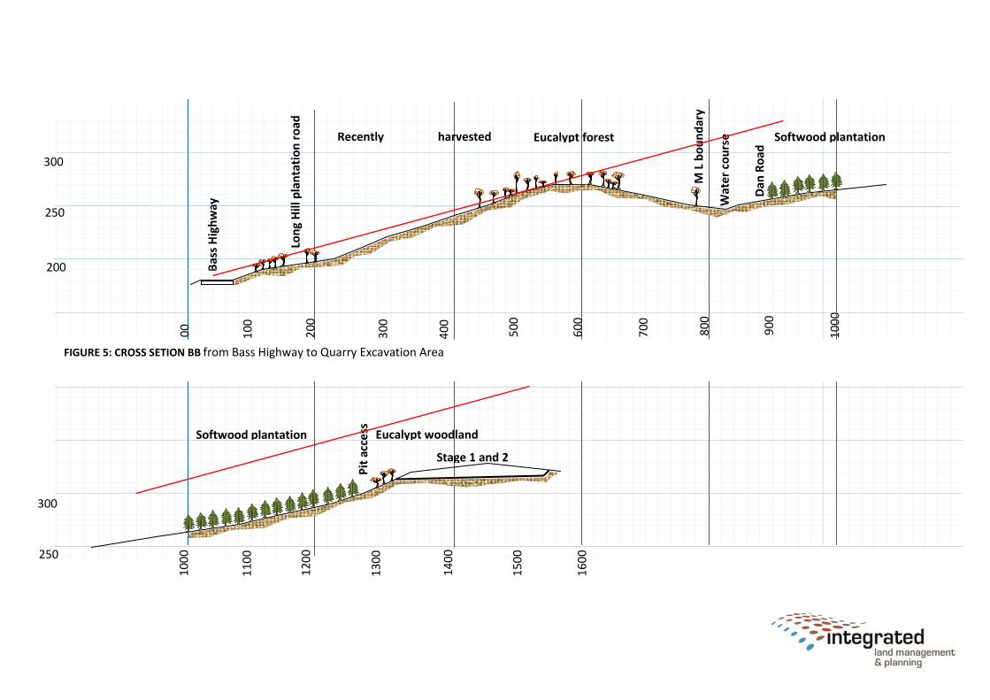
FIGURE 5: CROSS SETION BB from Bass Highway to Quarry Excavation Area
Eucalypt forest Recently harvested plantation
Lon
g H
ill p
lan
tati
on
ro
ad
00
300
Dan
Ro
ad
M L
bo
un
dar
y
Softwood plantation
160
0
110
0
12
00
14
00
150
0
130
0
Eucalypt woodland
Pit
acc
ess
100
0
Stage 1 and 2
Softwood plantation
250
300

Trac
k
M L
bo
un
dar
y
350
FIGURE 6: CROSS SECTION CC from Quarry Excavation to WTE nest 144
400
600
00
200
300
5
00
100
Long Hill Forest Reserve (Eucalypt forest)
WTE
ne
st 1
44
M L
Bo
un
dar
y
800
700
900
Softwood plantation Eucalypt forest
Trac
k
300
250
Trac
k Stag
e 1
Stag
e 2
40
0
60
0
80
0
10
00
12
00
20
0
70
0
30
0
50
0
90
0
11
00
10
0
00
350
300
250
Stag
e 1
Stag
e 2
Trac
k
Long Hill Forest Reserve (Eucalypt forest) Softwood plantation Eucalypt forest
WTE
nes
t 5
07
(go
ne)
FIGURE 7: CROSS SECTION DD from Quarry Excavation to WTE nest 507

ENVIRONMENT EFFECTS REPORT- LONG HILL QUARRY Final
Integrated Land Management and Planning | part C – potential environmental effects 13
PART C – POTENTIAL ENVIRONMENTAL EFFECTS 1. Flora and fauna
Bushways Environmental Services were engaged to undertake a comprehensive flora and fauna survey of
the proposal site and to evaluate the risk of the development disturbing any of the values found. Bushways
conducted a desk top survey of available data and used this to inform a field survey conducted 6 October
2009.
The survey found no threatened vegetation communities on the site and no threatened flora species were
identified. The site has been recently harvested and it is possible that threatened flora species disturbed by
the logging have not had time to regenerate.
Three threatened fauna species are likely to be present or use the site. Spotted-tailed Quolls and
Tasmanian Devils might use the site for foraging, recent logging would have disturbed denning activities.
Wedge-tailed Eagles are known to nest nearby in the Long Hill Forest Reserve and may forage on the site.
A recent survey of the Wedge-tailed Eagle nests shows that no other nests are located closer to the
proposed development and that nest number 507 has gone. The location of nest 507 remains a potential
new nest site. The Flora and Fauna Assessment found that no Wedge-tailed Eagles nests are located within
500 metres of the proposal or 1000 metres ‘line of sight’.
Major risks to the site are the loss of 8 hectares of native bushland and possible disturbance to the breeding
activities of Wedge-tailed Eagles. Other impacts such as the spread of weeds and diseases can be controlled
with management programs.
Recommendations included in the report are:
Clearing for the project should be kept to an absolute minimum and as progressive rehabilitation
takes place only local native species (selected from the plant species list included in the
assessment) should be utilised in revegetation works.
Expert advice should be sought on the risk of this development disturbing the breeding activities of
Wedge-tailed Eagles; Initial construction work should occur outside the Wedge-tailed Eagle
breeding season (as varies for year to year) and the eagle’s behaviour should be monitored during
the progress of the works to determine whether disturbance is occurring. If it is clear that
disturbance is occurring consideration should be given to constraining the expansion of
development and timing activities to occur only under favourable conditions.
A flora survey should be conducted over the damp sclerophyll forest in the proximity of stage 3 to
check for any threatened species that may have regenerated since the original survey.
Implement the recommendations of the ‘Weed Management Plan’ (Appendix 6), the ‘Washdown
Guidelines for Weed and Disease Control Edition 1’ (available from the DPIPWE website) and the
‘Quarry Code of Practice 1999’ to keep the site weed and disease free.
(Bushways Environmental Services - Tasmania A, 2009)

ENVIRONMENT EFFECTS REPORT - LONG HILL QUARRY Final
Integrated Land Management and Planning | part C – potential environmental effects 14
The complete assessment can be found in this report as Appendix 1.
2. Rivers, creeks, wetlands and estuaries
Figure 2 shows that the quarry site is located on a ridgeline with two tributaries of Stagg Creek situated in
the valleys on either side. The watercourse 297816 located on the southern side has a conservation
management priority of ‘very high’. The proposed processing area is located closest to this water course.
There are records of Engaeus granulates, the central north burrowing crayfish in the vicinity of his
watercourse. This species is listed as endangered under the Threatened Species Protection Act (Tas) and
the Environment Protection and Biodiversity Conservation Act (Com). These species are particularly
vulnerable to stream siltation and water quality.
The processing area will have a slight fall towards the access road with a sediment retention basin located
on the western side of the cleared area. The runoff water from the quarry and the processing area will be
directed to the sediment retention basin through road side drains and culverts see mining plan Figure 3.
The sediment retention basin and drainage infrastructure will be sized to manage a one in twenty year
reoccurrence storm event see calculation in Appendix 2.
The sediment retention basin will have a diffuse outfall directed into the neighbouring vegetation. The
closest point of discharge will be over 400 metres away from the closest approach of the watercourse. The
sediment control infrastructure will be included in the first stage of the quarry development and will be
operational throughout the development and operational phases.
FIGURE 8: TYPICAL CROSS SECTION THROUGH SEDIMENT RETENTION BASIN
The proponent will implement best practice sediment management techniques during construction and
operation to minimise the quantity of sediment produced. These techniques along with the sediment
control infrastructure and the great distance between the single discharge area and the vulnerable
watercourse will protect the watercourse from any adverse impact from this operation.
Strip topsoil and windrow separately.
Strip subsoil and screen to recover cobbles for spillways.
Use site won cobbles to armour spillways along embankment.
Periodically excavate accumulated sediment and stockpile for rehabilitation.
Place topsoil over basin wall formation and revegetate.
2.0m
TWL R.L 310 m
Place and compact gravelly subsoil in basin to form liner.

ENVIRONMENT EFFECTS REPORT - LONG HILL QUARRY Final
Integrated Land Management and Planning | part C – potential environmental effects 15
The watercourse 297838 has a conservation management priority of moderate. All drainage from the
quarry development is directed away from this watercourse and dust emissions from blasting and
processing activities will be intercepted by the intervening pine plantation. Existing road drainage
infrastructure will serve to protect the watercourse from the effects of traffic on the access road.
The proposal will not require any impoundments or infrastructure to be established on any natural
watercourses.
3. Groundwater
The nearest groundwater bores are located at Merseylea (No. 2108) and in the vicinity of Staggs Creek (No.
2144). Both boreholes investigate different geology and hence are not representative of the development
site. The majority of the development area has bedrock either out-cropping or very close to the surface. It
is possible for dolerite to have confined aquifers within the rock as a result of water entering via fractures
and creating lenses in the rock by chemical weathering.
The existing quarry has a face height of 8 metres and a length of 60 metres and shows no sign of clay lenses
or aquifers confined or otherwise. The table drain on Dan 1 Road between the extraction site and the
processing area contains water only after recent rains and low positions in the topography are not
permanently wet. The southern side of the ridgeline has more abundant herbs as would be expected but
otherwise the vegetation is consistent over the development area with no localised communities of rushes
or reeds that might indicate a spring.
From surface investigations it is unlikely that the extraction taken to the depths planned will encounter
groundwater. By grading the site to control overland flow as shown in the mining plan excessive recharge of
the existing groundwater table can be controlled.
4. Significant areas
The Mersey River valley adjacent to the development area is part of the Central Highlands Cainozoic Glacial
Area predictive region. This area of the valley has a sensitivity value of 5. These sites are sensitive to
damage by high intensity shallow linear impact such as road or trench excavation. The development site is
outside the predictive region and will not impact on this geo-conservation feature.
The Water Information System of Tasmania (WIST) shows the section of the Mersey River Valley adjacent to
the development site as being a karst system. This system is not identified in the Latrobe Planning Scheme
under special areas. The quarry development is outside this area and on unrelated geology and will not
impact on this karst area.
Both the Bass Highway and the Railton Road are significant tourist routes and any development in bushland
along these routes should be considered for visual impact. Figure 1 shows two white cross section lines, one
originating from Railton Road and the other from the Bass Highway. Figures 4 and 5 show a graphical
representation of the natural topography along these lines at a vertical exaggeration of 2. It can be seen
that in each case the ridgelines running parallel to the ridgeline where the quarry is located effectively
screen current and future development from view.
The mining lease on the western side shares a cadastral boundary with the Long Hill Forest Reserve. This
formal forest reserve is managed by Forestry Tasmania and occupies the western slope from the lesser

ENVIRONMENT EFFECTS REPORT - LONG HILL QUARRY Final
Integrated Land Management and Planning | part C – potential environmental effects 16
ridgeline down to the bank of the Mersey River. There are no roads or established tracks in this area of the
forest reserve although neighbouring plantation development has provided road access to the eastern edge
of the reserve.
As part of securing the quarry development site to protect the public from hazardous vertical faces, the
proponent will establish a boom gate on Dan 1 road (see Figure 3). When combined with the existing
Forestry Tasmania boom gate on the other end of this road vehicle access to the quarry and the forest
reserve will be better controlled.
5. Air emissions
Under certain weather conditions all activities on the site can be expected to cause dust emissions.
Weathered dolerite is often associated with fine clays. Handling these materials with earthmoving
equipment especially loading into trucks and hoppers under dry conditions can produce dust. Blasting can
cause dust created by the drilling equipment, to be ejected off the surface and into the air. Blasting can
cause an acute problem that although potentially visible will be short lived.
The crushing equipment, especially the mobile equipment can cause a chronic dust problem. Quantities will
be small but because the equipment is operating for extended hours the accumulated volume over time
can become a problem.
Another chronic source of dust will be vehicles using the haul road between the extraction and processing
areas and the access road between the quarry and the Bass Highway. Both light vehicles and trucks can
cause dust from the gravel road surface directly and can cause mud from the gravel roads to be trafficked
onto the sealed road. When this deposited mud dries it can create dust from the sealed road surface.
A mitigating factor in dust generated from blasting is that the substrate is pure dolerite and the drilling will
produce mainly chips rather than dust. Dust from blasting should be kept to a minimum by stripping the
topsoil from new extraction areas.
The crusher will be transported to the site and setup on the processing area. The surrounding natural and
plantation forest will capture much of the dust produced by crushing activities. On very windy days water
sprays will be directed onto drop points. The stockpiles will be hosed down periodically to keep dust from
the surface of the piles.
Dust generated by loading road trucks from the stockpiles will be controlled using a water spray where
required. Loads will be kept level to the sides of trucks or covered to prevent dust coming from the trucks
during haulage. The proponent will maintain the access road leading to the Bass Highway to a very high
standard. A well maintained road will prevent mud from developing on the road surface in wet conditions
and limit the amount of dust generated in dry conditions.
The quarry development site is surrounded by forest or established plantations. The nearest observers
likely to see dust emanating from activities on the site would be either on the Bass Highway or on the
Railton Road. Analysis undertaken by the Bureau of Metrology and represented in Appendix 3 by seasonal
wind roses provides an insight into the seasonal wind strength and direction at the closest weather station
at Sheffield. It is likely that dust will arise while activities are undertaken at the site. It is less likely that wind
will pick up dust from the surface of stockpiles or traffic areas during periods of inactivity. Analysis of the
observation records show that:

ENVIRONMENT EFFECTS REPORT - LONG HILL QUARRY Final
Integrated Land Management and Planning | part C – potential environmental effects 17
1. In summer, during working hours the wind will be coming from the north the majority of the time.
Less frequently stronger winds will come from the west in the afternoon.
2. In autumn the majority of the winds will be lighter and coming from the north. Less frequent but
stronger winds will come from the northwest or southeast.
3. In winter the majority of the wind will come from the northwest and to a lesser degree from the
west in the afternoon.
4. In springtime the stronger winds will come from the west but the more common winds will come
from the north.
It is fortuitous that the site has a steep sided ridgeline to the west that will deflect the less frequent but
stronger westerly winds upwards causing the wind at ground level to be lower velocity. Less energy wind
will be unable to carry the dust particles a great distance. Dust transported by the northerly or nor-westerly
winds will not carry far because these winds are lower energy. The surrounding tall forest and plantations
will further dissipate the wind energy causing the particulate load to drop out close to the quarry site.

ENVIRONMENT EFFECTS REPORT - LONG HILL QUARRY Final
Integrated Land Management and Planning | part C – potential environmental effects 18
6. Liquid effluent
The operation will create no liquid effluent other than stormwater runoff. A transportable toilet will be
used during each campaign for human waste and no equipment will be serviced on the site. Accidental oil
spills as a result of hydraulic failure or refuelling activities will be immediately cleaned up using a ‘spill kit’.
Discharge of stormwater runoff will be strictly control using a series of surface swales and drains and a
sediment retention facility described in section 2.
7. Solid wastes
The dolerite deposit has little overburden. Materials unsuitable for processing will be retained in low
windrows, to be used in future rehabilitation activities. Oversized material will be retained on the benches
and periodically treated with an excavator mounted rock breaker.
Wrappers from lunches and failed parts, rags and grease cartridges will be taken off site at the end of each
day. At the end of each campaign an employee will inspect the site to ensure that no rubbish remains.
8. Noise emissions
Blasting, crushing and loading activities are responsible for generating noise and vibration. The
development area has been located to ensure that any sensitive uses including residences are outside the
Standard Recommended Attenuation Distance for noise of 1000 metres. In addition to the attenuation
distance the intervening topography that screens the development from view provides the best protection
from noise. Figures 4 and 5 are cross sectional representations through the topography on either side of the
development. These distant topographic features will effectively screen sensitive uses on lower ground
from noise generated by the quarry. Additionally the sensitive uses are located on sediments and not on
the same geological formation as the blasting and hence ground vibration will not be as readily transmitted
to those properties.
Figure 1 shows the location of those residences that are located closest to the proposed quarry; the mining
lease boundary and a white line indicting a separation distance of 1000 metres from the mining lease
boundary. Extraction activities will be confined to the coloured shaded areas shown on this plan and will
not approach the mining lease boundary. The separation distance between sensitive uses and the actual
noise producing activities is therefore greater than that shown.
Figure 2 shows the mining plan in which both the extraction and processing areas have faces remaining on
the western side. The noise producing activities in the processing area will occur behind the face. The face
will act as a noise barrier close to the source. As blasting proceeds in the extraction areas the benches will
be lowered to below the remaining face. The noise from blasting will be further attenuated by this
intervening face.

ENVIRONMENT EFFECTS REPORT - LONG HILL QUARRY Final
Integrated Land Management and Planning | part C – potential environmental effects 19
9. Transport impacts
The Proponent commissioned Terry Eaton (Consulting Engineer) to undertake a Traffic Impact Assessment
on the proposal. The complete report is included as Appendix 4 and the conclusions are summarised here.
Over twenty years of quarry operation the traffic volume on the Bass Highway is expected to increase to
around 14,000 vehicles per day. The Traffic Impact Assessment found that maximum traffic movements
during periods of operation will be up to 19 truck / trailer movements per day and 5 right turn movements
from the southbound lane on the Bass Highway per hour.
The assessment found that the intersection required an upgrade to the left turn exit radius and encouraged
widening of the gravel verge opposite Dan Road to enable stored right turn vehicles to be passed safely.
The report also recommends the installation of ‘Truck Turning’ signage to be erected at times when carting
is occurring.
(Eaton, 2009)
The final report is included in this document as Appendix 4.
10. Other offsite impacts
It is highly unlikely that upgrading this quarry to a commercial operation will have any offsite impacts other
than those dealt with in other sections of this report.
11. Dangerous goods and chemicals
No dangerous goods or explosives will be stored at the site. Equipment will be refuelled with mobile
refuelling vehicle. Similarly oils will be brought onto site as required. If it is necessary to temporarily store
fuel at the site the drums will be stored on a bunded pallet.
The blasting contractor will bring sufficient explosives onto the site as are required for the current
campaign. The explosives will remain in the designated vehicle until deployment. Unused explosives will be
removed from the site at the end of the day.
12. Site contamination
There are no signs of historic or current contamination. The development will not cause contamination in
either the construction or operational phases. Any localised contamination caused by accidental spills or
breakages will be cleaned up immediately with best practices earthmoving techniques, including the
deployment of ‘spill kits’ and booms.
13. Cultural heritage
The Proponent engaged Cultural Heritage Management Australia to undertake an aboriginal heritage
survey and prepare a report to be submitted to Aboriginal Heritage Tasmania (AHT). The survey and report
have been prepared in accordance with AHT’s brief for consulting archaeologists. An essential part of an
investigation into Aboriginal cultural heritage is consultation with the Aboriginal community. Mr Leigh
Maynard was engaged by the proponent to undertake this work.

ENVIRONMENT EFFECTS REPORT - LONG HILL QUARRY Final
Integrated Land Management and Planning | part C – potential environmental effects 20
After preliminary searches of the Tasmanian Aboriginal Site Index and all relevant literature a field survey
was undertaken on 29 October 2009. The entire area that will be disturbed over the life of the project was
mapped on the ground including areas of possible future expansion. The study area included stripping and
overburden stockpile areas behind the excavation faces and areas for sediment retention infrastructure.
The Archaeological Team were accompanied by the Aboriginal Heritage Officer for the duration of the field
survey.
The study found no Aboriginal cultural heritage sites or artefacts during the survey or any areas of potential
archaeological deposits. The report includes no specific cultural heritage management recommendations
other than to provide details of a ‘plan’ to be initiated should an unanticipated heritage item or site be
discovered during the works.
(Cultural Heritage Management Australia, 2009)
The final report is included in this document as Appendix 5.
14. Site of high public interest
The Long Hill area is most noted for the extensive pine plantation that has been harvested recently and has
now been replanted. This pine plantation dominates the landscape from the Bass Highway viewpoint. From
the Railton Road viewpoint the Long Hill Forest Reserve can be seen up to the skyline. This view field will
remain unchanged through the life of the project. There are no other sites of high public interest that can
be affected by this proposal.
15. Rehabilitation
During the active life of the quarry it will be necessary to maintain a cleared processing and stockpiling
area. The area developed for processing and stockpiles will be 3.5 hectares. This size is required because of
the campaign nature of the operation. Large stockpiles must be developed to services contacts between
campaigns. If five campaigns are staged each year the stockpile area will have to accommodate at least
20,000 cubic metres of processed product. Assuming that there will be three different products or grades of
aggregate stockpiled the stockpiles will have a base area of 3000 square metres each. With separation
distances, 1.5 hectares will be required for stockpiling processed product. The shot rock will have to be
stockpiled and room set aside for the mobile crusher and discharge stockpiles as well as heavy vehicle
manoeuvring.
The extraction area will be developed in two stages (see Figure 3). At the completion of the second stage a
decision will be made regarding future development. If the rock on the floor of the combined stage 1 and
stage 2 areas is sound it is likely that another face will be cut in the floor. If areas of unsuitable material
have been exposed the third extraction area shown on the mining plan will be developed and the stages 1
and 2 extraction areas will be rehabilitated.
As areas are developed stripping materials will be stockpiled in low windrows (average height not
exceeding one metre) along the western edge of the disturbance. The vegetation will be placed outside the
topsoil and subsoil materials and unsuitable will be placed closest to the disturbance.
Rehabilitation will take the form of fracturing the floor of the area and cutting down the face on the
western side, overburden and unsuitable material will placed along the toe of the face and new surface

ENVIRONMENT EFFECTS REPORT - LONG HILL QUARRY Final
Integrated Land Management and Planning | part C – potential environmental effects 21
contoured to a maximum grade of 1 in 3. Stripping will then be drawn over the surface and seeds of native
plants selected from the list found in the flora and fauna survey will be broadcast over the surface.
FIGURE 9: TYPICAL CROSS SECTION (REHABIILITATION) through worked out quarry face to show rehabilitation
earthworks.
This work will occur in autumn to give time for the rehabilitation effort to consolidate over winter in
preparation for spring germination. The progressive rehabilitation effort will be monitored for seedling
failure and weed infestation and works instigated at least once per year to repair failed areas and control
weeds.
At the end of the quarry’s life the entire area of disturbance will be rehabilitated. The land that will be
occupied by the quarry development is currently naturally regenerated forest and the final land use will be
similar. The proponent will ensure that the final surfaces are self draining and all drainage infrastructure is
self sustaining. Once natural vegetation has stabilised areas of exposed soil the sediment retention facility
and connecting culvert will be removed and drainage re-established as existing.
The rehabilitation effort will be inspected by officers of Mineral Resources Tasmania to ensure that it is self-
sustaining before the proponent (Lessee) can claim for a return of a security deposit and the lease can be
surrendered.
Cut away edge of face
Place cut, overburden and unsuitable material at toe
Fracture pit floor to
promote drainage
Re-contour new surface to 1:3 max. slope
Spread stripping roughly over surface
ENVIRONMENT EFFECTS REPORT - LONG HILL QUARRY Final
Integrated Land Management and Planning | part D – management commitments 22
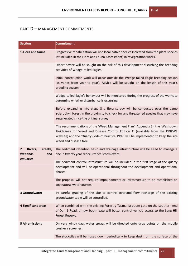
PART D – MANAGEMENT COMMITMENTS
Section Commitment
1.Flora and fauna Progressive rehabilitation will use local native species (selected from the plant species
list included in the Flora and Fauna Assessment) in revegetation works.
Expert advice will be sought on the risk of this development disturbing the breeding
activities of Wedge-tailed Eagles.
Initial construction work will occur outside the Wedge-tailed Eagle breeding season
(as varies from year to year). Advice will be sought on the length of this year’s
breeding season.
Wedge-tailed Eagle’s behaviour will be monitored during the progress of the works to
determine whether disturbance is occurring.
Before expanding into stage 3 a flora survey will be conducted over the damp
sclerophyll forest in the proximity to check for any threatened species that may have
regenerated since the original survey.
The recommendations of the ‘Weed Management Plan’ (Appendix 6), the ‘Washdown
Guidelines for Weed and Disease Control Edition 1’ (available from the DPIPWE
website) and the ‘Quarry Code of Practice 1999’ will be implemented to keep the site
weed and disease free.
2 Rivers, creeks,
wetlands and
estuaries
The sediment retention basin and drainage infrastructure will be sized to manage a
one in twenty year reoccurrence storm event.
The sediment control infrastructure will be included in the first stage of the quarry
development and will be operational throughout the development and operational
phases.
The proposal will not require impoundments or infrastructure to be established on
any natural watercourses.
3 Groundwater By careful grading of the site to control overland flow recharge of the existing
groundwater table will be controlled.
4 Significant areas When combined with the existing Forestry Tasmania boom gate on the southern end
of Dan 1 Road, a new boom gate will better control vehicle access to the Long Hill
Forest Reserve.
5 Air emissions On very windy days water sprays will be directed onto drop points on the mobile
crusher / screener.
The stockpiles will be hosed down periodically to keep dust from the surface of the

ENVIRONMENT EFFECTS REPORT - LONG HILL QUARRY Final
Integrated Land Management and Planning | part E – public consultation 23
piles.
6 Liquid effluent Any fuel temporarily stored on the site will be stored in drums resting on bunded
pallets.
7 Solid wastes At the end of each campaign an employee will inspect the site to ensure that no
rubbish remains.
10 Traffic impact The proponent will improve the intersection with the Bass Highway to ensure the
safety of road users and their own employees and contractors.
11 Dangerous goods
and chemicals
Unused explosives will be removed from the site at the end of the day.
13 Site contamination Any localised contamination caused by accidental spills or breakages will be cleaned
up immediately with ‘best practice’ earthmoving techniques, including the
deployment of ‘spill kits’ and booms.
14 Cultural heritage If an item of cultural heritage is unearthed in the course of the works an
‘unanticipated discovery plan’ will be put into effect.
16 Rehabilitation The progressive rehabilitation effort will be monitored for seedling failure and weed
infestation and works instigated at least annually to repair failed areas and control
weeds.
Once natural vegetation has stabilised areas of exposed soil, the sediment retention
facility and connecting culvert will be removed and drainage re-established as
existing.
PART E – PUBLIC CONSULTATION
1. Stakeholder Consultation Process
The Proponent has already held meetings Forestry Tasmania and negotiated an amicable financial
settlement to transfer operation of the quarry including agreement on access arrangements, maintenance
of road infrastructure and supply of road construction and maintenance materials.
A Notice of Intent was forwarded to Mr Shane Hogue of the Environment Protection Authority subsequent
to a site visit on 31 July 2009. The same NOI was forwarded to Mr Peter Rowlands District Manager of the
Mersey District of Forestry Tasmania. A mining lease application has been made to Mr Brett Stewart, Senior
Leasing Officer of Mineral Resources Tasmania. The mining lease application number is 7m/2009. The
application process will proceed once this document is finalised and can accompany the application.
The Meander Valley council requires a Development Application (DA) to change the use of the quarry from
a private forestry pit to a commercial operation. The Council planning department have been consulted and

ENVIRONMENT EFFECTS REPORT - LONG HILL QUARRY Final
Integrated Land Management and Planning | part E – public consultation 24
a representative from the planning department attended a site visit with representatives of the
Environment Protection Authority on 30 July 2009.
As part of the Aboriginal cultural heritage investigation Mr Leigh Maynard conducted Aboriginal community
consultation on behalf of the proponent. The results of this consultation form part of the Aboriginal cultural
heritage report included, in part in the Appendices.

ENVIRONMENT EFFECTS REPORT - LONG HILL QUARRY Final
Integrated Land Management and Planning | part E – public consultation 25
References:
BOM. (2008, July 25). Rainfall Intensity Frequency Duration Data. Retrieved December 8, 2008, from
Australian Government Bureau of Meteorology: http://www.bom.gov.au/hydro/has/cdirswebx/index.shtml
Bushways Environmental Services - Tasmania. (2009). Flora and Fauna Assessment - Long Hill Proposed
Quarry Site. Trevallyn: Bushways Environmental Services - Tasmania.
Cultural Heritage Management Australia. (2009). Long Hill Quarry - Aboriginal Heritage Assessment.
Canberra: Cultural Heritage Management Australia.
Eaton, T. (2009). Proposed Quarry Activity - Hazell Brothers Long Hill Access to Bass Highway Traffic
Assessment. Bridgenorth: Terry Eaton Consulting Engineer.

ENVIRONMENT EFFECTS REPORT- LONG HILL QUARRY Final
Integrated Land Management and Planning | appendices
APPENDICES Appendix 1 - Flora and Fauna Survey Report (Bushways Environmental Services - Tasmania A, 2009)

ENVIRONMENT EFFECTS REPORT - LONG HILL QUARRY Final
Integrated Land Management and Planning | appendices
Appendix 2 – Sediment retention basin design calculations
Runoff retention capacity Primary Retention Pond
For sediment retention facilities use 1 in 20 year reoccurrence interval
Flood intensity for this location is 30mm/hr (BOM, 2008).
The total area of Stages 1 and 2 is 2.7 ha.
The total area of the processing area is 3.5 ha.
Total volume of runoff to be considered in 0.030 * 27000+35000 = 1860 cubic metres
Assuming the blast fracturing in the extraction area is only effective to 0.75 m deep, the capacity in the
floor is: 2.7 ha * depth of 0.75 m * 0.05 = 1010 cubic metres
The capacity of the sediment retention basin must be (1860-1010) cubic metres to retain the runoff from a
1 in 20 year reoccurrence rainfall event with duration of 1 hour.
A pond with an area of 600 square metres on the surface and 300 square metres on the bottom and an
average depth of 2.0 metres will provide the necessary capacity of 850 cubic metres.
If the flood intensity of 30mm/hr is exceeded the pond will discharge through a diffuse discharge area into
a densely forested area.
The basin will be constructed from permeable materials so that the runoff contained will seep away over
time. Periodically the accumulated silt will be recovered and stockpiled for use as rehabilitation material.
Routine cleaning will prevent an increase in the permeability of the lining materials and a consequent
reduction in rate water will filter through the structure.

ENVIRONMENT EFFECTS REPORT - LONG HILL QUARRY Final
Integrated Land Management and Planning | appendices
Appendix 3 – BOM seasonal wind direction and strength roses for Sheffield
ENVIRONMENT EFFECTS REPORT - LONG HILL QUARRY Final
Integrated Land Management and Planning | appendices
Appendix 4 – Traffic Impact Assessment (Eaton, 2009)

ENVIRONMENT EFFECTS REPORT - LONG HILL QUARRY Final
Integrated Land Management and Planning | appendices
Appendix 5 – Cultural Heritage Report (Cultural Heritage Management Australia, 2009)

ENVIRONMENT EFFECTS REPORT - LONG HILL QUARRY Final
Integrated Land Management and Planning | appendices
Appendix 6 – Weed Management Plan (Bushways Environmental Services - Tasmania B, 2009)