noaa satellite update and mcidas at espc · noaa satellite update and mcidas at espc ... – goes...
TRANSCRIPT

1
NOAA Satellite Update and McIDAS at ESPC
Matthew SeyboldSatellite User Services Coordinator
NESDIS Operations (OSPO)
2012 McIDAS Users Group Meeting – Madison, WIMay 7‐8, 2012

2
Talk Collaborators
• Natalia Donoho – User Services Co‐Coordinator• Thomas Renkevens – SPSD Deputy Division Chief• Tim Schmit – NESDIS/StAR GOES Senior Scientist• Jessica Staude – SSAI GOES & McIDAS Guru• Bonnie Morgan – GOES Product Area Lead• Mark Ruminski – SAB Fire Team Lead & All Desks• Gregg Gallina – SAB COOP Team Lead & All Desks• Tony Salemi – SAB Ash, Fire, Oil, Tropical Desks• Russ Lancaster – SSAI Senior Systems Analyst
I needed and received a lot of help!

3
Talk Outline• OSPO Overview• Operational Satellite Status
– GOES, POES, NPP, Non‐NOAA• Future GEO Plans
– Meteosat, Himawari• Future LEO Plans
– METOP‐B, Suzuki• Anomalies, Outages, and
Retirements– Envisat Failure– GOES‐7 De‐Orbit– Missing GOES‐15 scans in
AWIPS
– GOES‐15 Imager Calibration – GOES‐15 Yaw Flip Maneuver
• Maneuvers, Eclipse, Stray
Light, Schedules• McIDAS in ESPC• New and Enhanced
Products & Services• Data Access Policy & CRM
Command & Control & NSOF

4
NESDIS Office of Satellite and Product Operations (OSPO)
EngineeringCindy Hampton
IT ServicesAndre Hammond
Matthew Seybold
Work: (301)763‐8051 x106
Cell: (202) 557‐4997
Natalia Donoho
Work: (301)763‐8051 x134
Cell: (202) 604‐0734
Acronyms
CDA – Command and Data AcquisitionMOD – Mission Operations DivisionSPSD –
Satellite Products and Services Division
OperationsJoe Perez (acting)
SupportMike Settles
Satellite
ProductsRicky Irving
SystemsAlva Barnette
OperationsAl McMath
Systems
EngineeringBob Clark
Admin OfficerLinda Brown
Special Projects
Selina Nauman
DirectorKathy Kelly
Deputy DirectorMark Moran (a)
CorporateServices
Keith Amburgey
Fairbanks CDALarry Ledlow
Wallops CDADoug Crawford
MODRon Mahmot
National Ice CenterSharolyn Young
SPSDDave Benner
Satellite Analysis Davida Streett
Direct ServicesChris O’Connors
SupportStephen Howard
Deputy: Linda Stathoplos Deputy: Tom Renkevens
SPSD User Services Co‐Coordinators

5
Operates the Nation’s 17 environmental
satellites
– 4 Geostationary (GOES) by NOAA– 5 Polar‐Orbiting (POES) by NOAA– 6 Defense Meteorological Satellite
Program (DMSP) operated by NOAA
– 1 OSTM Jason‐2 (Ocean Surface
Topography Mission) Joint NOAA, NASA,
CNES, EUMETSAT effort
– 1 Suomi National Polar‐orbiting
Partnership (NPP) by NOAA & NASA
Locations at four facilities housing 700 people
– NOAA Satellite Operations Facility (NSOF)
in Suitland, MD ‐
$5B facility operating
$5B of satellites
– World Weather Building (WWB) in Camp
Springs, MD
– Command and Data Acquisition Stations
at Fairbanks, AK and Wallops, VA
NESDIS Office of Satellite and Product Operations (OSPO)
WWB
NSOF

6
Key Roles
– Ground System Command & Control,
Ingest, Generation, and Distribution
– Pre‐Launch and Post‐Launch Testing– Operational Testing, Validation, and
Verification
– User Readiness for Broadcast Services
and Product Delivery
– Long‐Term Continuity of Products and
Services
Interpret products and manage services including
GVAR, LRIT, SARSAT, EMWIN, DCS, Argos,
Geonetcast
Issue critical environmental data and imagery
used for tracking and predicting
– Hurricanes, Tornadoes, Floods– Wild Fire, Ash Plumes, Vegetation
– Ocean Color, Sea Surface Temperature
NESDIS Office of Satellite and Product Operations (OSPO)
Wallops CDA
Fairbanks CDA

7
NOAA Center for Weather and Climate Prediction (NCWCP) in College Park, Maryland
Home to NWS / NCEP (NCO, EMC, HPC); NWS / ARL; NESDIS / STaR & OSPO
Public access photo log: http://www.ncep.noaa.gov/news/ncwcp/

8
NOAA Center for Weather and Climate Prediction (NCWCP) in College Park, Maryland

9
NCWCP in College Park, Maryland

10
NCWCP in College Park, Maryland

11
Satellite Information Flow
Fairbanks GroundStation - POES
Wallops GroundStation - GOES
Users
METOP-A (AM)
GOES 15 (West) GOES 13 (East)
POES NOAA 19 (PM)
Archive and Access(CLASS)
Environmental Satellite Processing Center
Process and Distribute
DataProducts
Non-NOAA
Command and Control
Satellite Operations Control Center
Polar Acquisition Stations for POES, MetOp, EOS- Wallops, VA- Fairbanks, AK- Gilmore Creek, AK- Svalbard- Honolulu, HI- Miami, FL- Australia- Monterey, CA- NASA DAACs
Ancillary observations & model data.

12
GOES Data Delivery Summary• Broadcast Services – GVAR, LRIT• Various Websites• GINI / NOAAPORT – for AWIPS display• DDS – mostly polar data and products, some GOES derived products• SATEPSDIST
– Geostationary satellite data is ingested on a Satellite Data Ingestor (SDI),
converted to McIDAS format and placed on a server. This data can then
be transferred to the various workstations via McIDAS ADDE software
– Data
NSOF Server
ADDE Name– Derived Products
SATEPSDIST1e
DPD– GOES‐E
SATEPSDIST2e
GER– GOES‐W
SATEPSDIST3e
GWR– Polar
SATEPSDIST4e
PLR– Model data
SATEPSDIST5
MOD– Global Mosaic 5 Sat. Comp.
SATEPSDIST6
MOS– MSG/MET
SATEPSDIST6e
MSG / MET– FY‐2D from SSEC
SATEPSDIST7
FY2D– MTSAT
SATEPSDIST7e
MTS– Select requested data
SATEPSANONE
PUB– Surface/Ship Buoy/RAOBs
FOS2
FOS (Family of Services)

13
Sample of GINI and AWIPS Products• Created and distributed through GINI
– Imagery– Sounder “images”
• Created outside of GINI, but distributed through GINI– Five satellite composite files (VIS, IR, WV)– Sounder Derived Products (TPW, LI, CTP, ECA, Skin‐T)– Imager Derived Products (LCB)– Polar (POES and DMSP) microwave derived products (TPW, Rain Rate, blended
TPW)
– SSM/I AMSU Blended RR products
• Created outside of GINI, distributed outside of GINI, but
appearing within AWIPS– Precipitation Autoestimator (PG on satepsdist1, PD from DDS to AWIPS)– GOES BUFR and POES BUFR Soundings– High Density Winds– ASCAT– Text Messages: SPENES, VAA, Tropical Bulletins, Help Desk messages– ASOS Satellite Cloud Products

14
Total Precipitable Water SuperN.PW.1A
Cloud-Top Height SuperN.CTP.1A
Surface Skin Temperature SuperN.SKT.1A
Lifted Index SuperN.LI.1A
Not shown…
Effective Cloud Amount SuperN.ECA.1A

15
Direct Service OperationsEmergency Managers Weather Information Network (EMWIN):• NOAA satellites relay critical information to users across the country.
http://www.weather.gov/emwin/index.htm
Low Resolution Image Transmission (LRIT):• NOAA satellites are used to relay satellite and weather products
to users in remote locations, that do not have
landlines or internet connections.http://www.noaasis.noaa.gov/LRIT/
Data Collection:• NOAA satellites are used to collect and relay scientific data from around the globe.
http://www.noaasis.noaa.gov/DCS/
http://www.noaasis.noaa.gov/ARGOS/
Search and Rescue:• NOAA satellites are used to relay distress alerts from aviators,
mariners and land‐based users
http://www.sarsat.noaa.gov/
Geonetcast Americas:• Data from NOAA for diverse societal benefits ‐
agriculture, energy, health, climate,
weather, disaster mitigation, biodiversity, water resources, and
ecosystems.http://www.geonetcastamericas.noaa.gov/index.html

16
Operational Satellite Status

17
GOES Constellation
GOES‐15135°
West GOES‐1375°
West GOES‐14 105°W
GOES‐1260°
West
• Primary source of data for short term forecasting, especially of
severe
weather such as tropical storms
• Continuity of Operations since 1974• GOES 13/14/15 improvements over GOES 10/11/12– Spring and fall eclipse outages are avoided by larger onboard batteries– Improved navigation and radiometrics

18
…just in case… GOES‐West Transition
• In December, 2011 GOES‐15 replaced GOES‐11 at GOES‐West
• GOES‐11 was decommissioned to a higher “retirement”
orbit
• GOES‐15 sounder requires a yaw flip twice per year, creating 30 additional hours of unstable data
• GVAR format (version 3) for GOES-15 and GOES-14 is different from earlier GOES satellites
• The data for the 8th detector has been added to block 0• Instrument Factory Coefficients are located in Block 11• Instrument Nadir and Detector Offsets located in Block 11 but are also
located in Block 0• Detector Offsets located in block 0, words 7933 to 8028• Instrument Nadir located in block 0, words 8033 to 8038

19
GOES Flyout Schedule
http://www.nesdis.noaa.gov/FlyoutSchedules.html
http://www.goes‐r.gov

20
KeyOperational
Spacecraft issues
but no user
impacts
Operational with
limitations
Non‐operational
G
R
S/C
Y
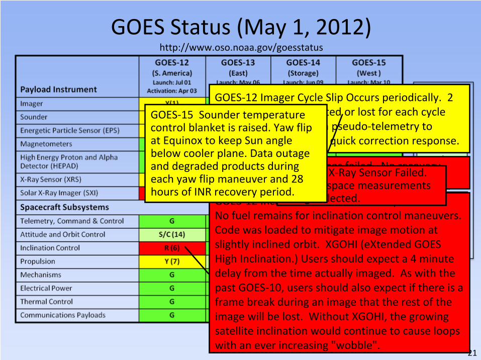
GOES Status (May 1, 2012) http://www.oso.noaa.gov/goesstatus
21
KeyOperational
Spacecraft issues
but no user
impacts
Operational with
limitations
Non‐operational
G
R
S/C
Y
GOES Status (May 1, 2012) http://www.oso.noaa.gov/goesstatus
GOES‐12 Imager Cycle Slip Occurs periodically. 2
to 3 images are corrupted or lost for each cycle
slip. OSPO Developed a pseudo‐telemetry to
detect the anomaly for quick correction response.
GOES‐12 X‐ray Imager has failed. No recovery
possible.
GOES‐12 Inclination Control is non‐operational.
No fuel remains for inclination control maneuvers.
Code was loaded to mitigate image motion at
slightly inclined orbit. XGOHI (eXtended GOES
High Inclination.) Users should expect a 4 minute
delay from the time actually imaged.
As with the
past GOES‐10, users should also expect if there is a
frame break during an image that the rest of the
image will be lost.
Without
XGOHI, the growing
satellite inclination would continue to cause loops
with an ever increasing "wobble".
GOES‐13 X‐Ray Sensor Failed.
No x‐ray space measurements
being collected.
GOES‐15 Sounder temperature
control blanket is raised. Yaw flip
at Equinox to keep Sun angle
below cooler plane. Data outage
and degraded products during
each yaw flip maneuver and 28
hours of INR recovery period.

22
POES Constellation
•Two polar operational satellites; one in
morning and one in afternoon orbit. Each
orbit is 102 minutes
•Since May 2007, NOAA using EUMETSAT
satellite operationally for mid‐morning
orbit through NOAA/EUMETSAT
partnership
•Each satellite provides world‐wide
coverage every 12 hours (6‐hour global
sampling for the pair)
•Directly broadcasts data to users
worldwide
•Continuity of operations since early 1960s
2 pm Orbit (NOAA‐19)10 am Orbit (Metop‐A)
S
N
Orbit Path
530 Mi
Equator
Fairbanks,Alaska
Wallops,Virginia
Data Acquisition
Sites
• Primary source of data for longer term
weather prediction, global
environmental monitoring, and long‐
term predictions
23
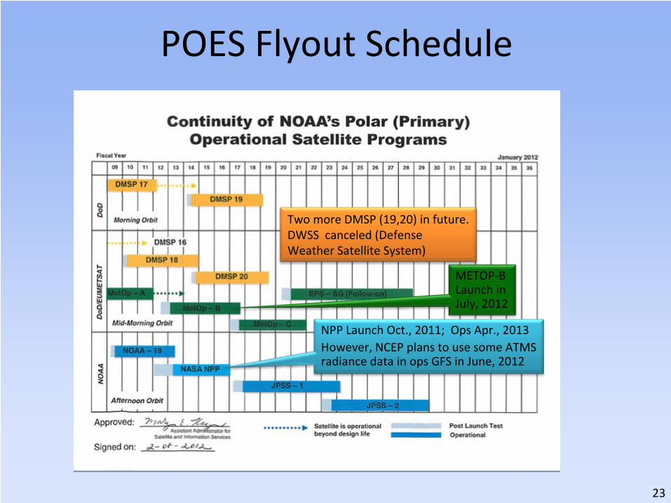
NPP Launch Oct., 2011; Ops Apr., 2013However, NCEP plans to use some ATMS
radiance data in ops GFS in June, 2012
POES Flyout Schedule
Two more DMSP (19,20) in future.
DWSS canceled (Defense
Weather Satellite System)
METOP‐B
Launch in
July, 2012

24
Operational G
Spacecraft Issue but no User Impact S/C
Operational with Limitation Y
Non-Operational R
Not Applicable N/A
POES Status (May 1, 2012) http://www.oso.noaa.gov/poesstatus/index.asp

25
Operational G
Spacecraft Issue but no User Impact S/C
Operational with Limitation Y
Non-Operational R
Not Applicable N/A
POES Status (May 1, 2012) http://www.oso.noaa.gov/poesstatus/index.asp
Transmitter off, no LRPT
AVHRR Scan Motor Failed
AMSU –A1 Scan Motor FailedN15 still available to users
HIRS Longwave channel noise
APT 1 & 2 Failed, N19
still available to users
HIRS Filter Wheel Stalled,
N17 & METOP‐A still
available to users
AMSU‐B Antenna Scan
Motor Failed, METOP‐A
MHS still availalble to users

26Slide credit: Renee Smith‐Dearring

27
Suomi NPP (National Polar‐orbiting Partnership)
• Launched in October, 2011 • What is the NPP Blue Marble?
• 6 composite RGB swaths in an 8 hour
period (not full disk)
NPP, 2012
Apollo‐17, 1972Images Credit: NASA

28
Suomi NPP Instrument Status ‐
May 6, 2012
• VIIRS: In Nominal operations mode, full science data production• CrIS: In Nominal operations mode ‐‐‐
Full science data production ‐‐
‐
On‐orbit performance evaluation shows CrIS is meeting its top
level performance requirements
• ATMS: In Nominal operations mode (Scan profile 1) • OMPS: In Nominal operations mode (Operate), Full science data
production
• CERES: In Nominal operations mode (Cross track), Full science data
production – Instrument performance supports product accuracy requirements – Earth Radiation Budget Climate Analysis Research System (ERBCARS)
is fully operational
– Solar presence sensor anomaly occurred on orbit 2280 (April 6) during
lunar calibration scan and resulted in no science data for nine orbits

29
Suomi NPP ‐
Mission Status• The number of NPP Data Access requests from OSPO is growing
• Testing with primary customers is well underway with the NDE group at
NSOF testing with NCEP, AFWA, NAVO, FNMOC, EUMETSAT, and others
• NCEP will ingest ATMS to the GFS in June, 2012
• The plan for data access requests and delivery to customers is still being
finalized between NESDIS/OSD and NESDIS/OSPO
• OSD will provide 8 x 5 (and best effort) monitoring
• Hand over from OSD to OSPO is slated for _________
Resources:
• Common Data Format Control (CDFC) book of NPP products being
delivered to NDE:
http://jointmission.gsfc.nasa.gov/science/documents.html
• FY11 Project Acquisition Plan: http://projects.osd.noaa.gov/NDE/ pub‐
docs/NDE_FY2011_Project_Acquisition_Plan.pdf
• Project Summary: http://projects.osd.noaa.gov/NDE/pub‐
docs/NDE_Concept_of_Operations‐v4.pdf
30
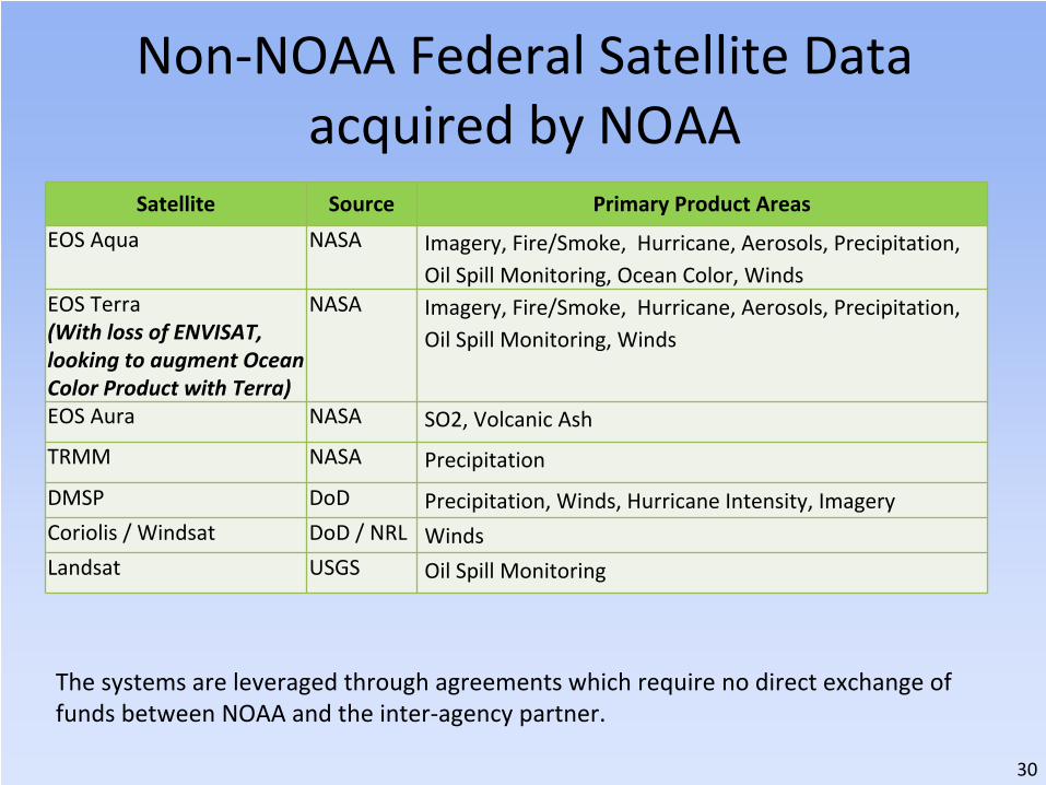
Non‐NOAA Federal Satellite Data acquired by NOAA
Satellite Source Primary Product Areas
EOS Aqua NASA Imagery, Fire/Smoke, Hurricane, Aerosols, Precipitation,
Oil Spill Monitoring, Ocean Color, Winds
EOS Terra(With loss of ENVISAT,
looking to augment Ocean
Color Product with Terra)
NASA Imagery, Fire/Smoke, Hurricane, Aerosols, Precipitation,
Oil Spill Monitoring, Winds
EOS Aura NASA SO2, Volcanic Ash
TRMM NASA Precipitation
DMSP DoD Precipitation, Winds, Hurricane Intensity, ImageryCoriolis / Windsat DoD / NRL WindsLandsat USGS Oil Spill Monitoring
The systems are leveraged through agreements which require no direct exchange of
funds between NOAA and the inter‐agency partner.

31
Non‐NOAA International Satellite Data acquired by NOAA
Satellite Source Primary Product AreasMeteosat‐7 EUMETSAT Imagery, Tropical Cyclones, Precipitation,
Snow & IceMeteosat‐9(Meteosat‐8 is
backup)
EUMETSAT Imagery, Tropical Cyclones, Precipitation, Snow
& Ice, Sea Surface Temperature, Fire
Metop‐A EUMETSAT Imagery, Tropical Cyclones, Precipitation,
Winds, Snow & Ice, Volcanic Ash, Sea Surface
Temperature, FireMTSAT‐2
(MTSAT‐1R is
backup)
JMA (Japan) Imagery, Tropical Cyclones, Precipitation,
Winds, Snow & Ice, Volcanic Ash, Sea Surface
Temperature, FireFY‐2D CMA (China) Imagery, Tropical Cyclone (Limited usage –
mainly at night over Indian Ocean)Jason‐2 NOAA & CNES Sea Surface HeightsEnvisat (Failed
on April 9, 2012)ESA Snow and Ice, Ocean Color, Oil

32
Non‐NOAA International Satellite Data acquired by NOAA
Satellite Source Primary Product AreasCOSMIC NSPO Taiwan Soundings (Radio Occultation)Oceansat ISRO (India)Radarsat‐1,
Radarsat‐2*CSA (Canada) Snow and Ice, Oil
TerraSAR‐X German
Aerospace Center
DLR / EADS
Astrium
Oil Spill Monitoring
SPOT CNES (France) Oil Spill MonitoringWorldview Digital Globe
(Commercial)Oil Spill Monitoring
The systems are leveraged through agreements which require no direct exchange of
funds between NOAA and the international partner, except for Radarsat‐2. *Radarsat‐2 is a public‐private venture. NOAA pays for or leverages other Federal
agency acquisitions of data from this system.

33
Future GEO & LEO Plans

34
Prepare for GOES‐R transition to GOES Rebroadcast (GRB) (Replaces GVAR and will be tested during PLT)
Slide Credit: Vanessa Griffin, GOES‐R GSNWS plans to use NHC as primary downlink and PD point to other prediction centers.

35
GRB Ground Antenna Sizes
NOTES:1.Calculations based on available data as of May 20112.Each antenna size is usable within the indicated contour3.Rain attenuations included are:
1.3/1.6/2.0/2.2/2.5 dB (3.8 to 6 m)4.
An operating margin of 2.5 dB is included as the dual polarization isolation is likely to
vary within each antenna size area
Slide Credit: Vanessa Griffin, GOES‐R GS

36
GRB Downlink Characteristics• Input Center Frequency: 1690.0 MHz
• Content (specified for each of two polarization channels: LHCP, RHCP)– L1b data, QC data and metadata: ABI, SUVI, EXIS, SEISS, MAG
– L2 data, QC data, metadata: GLM
– GRB Information Packets
• Data rate– 31 Mbps maximum data rate
– 15.5 Mbps instantaneous maximum for each polarization channel
– Down link margin: 2.5 db
• Compression ‐
Lossless compression required– JPEG2000 and SZIP are candidates that are being considered/studies
• Format– Inner Frame Format: CCSDS Space Packet
– Outer Frame Format: DVB‐S2
• Coding– BCH + LDPC (2/3) for 8‐PSK and LDPC (9/10) for QPSK
• Modem Required C/No (dB‐Hz): 78.6
• Maximum Demodulator Required Eb/No (dB) for 1x10‐10
BER: 4.8 dB/Hz
• Minimum Antenna System G/T (dB/K) : 15.2
These specs
should be
considered
preliminary and
will be finalized
in 2012
Slide Credit: Vanessa Griffin, GOES‐R GS

37
GRB Simulators• Purpose
– On‐site testing of user ingest and data handling systems, aka GRB field
terminal sites
– Simulates GRB downlink functionality by generating Consultative Committee
for Space Data Systems (CCSDS) formatted GRB output data based on user‐
defined scenarios, test patterns, and proxy data files.
– Available in 2013• Key Capabilities and Features
– Transportable• Fully self contained• Configurable hardware units
– Outputs simulated GRB– “Off‐line Mode”
to create and setup configurations and scenarios• Also, create test patterns and input proxy data
– “On‐line Mode”
to continuously output GRB data stream at IF or baseband
levels
• Includes monitoring and logging of events
Slide Credit: Vanessa Griffin, GOES‐R GS

38
Future GEO Plans – METEOSAT‐10 (MSG‐3)
• Launches in June 19, 2012• From French Guiana• Operational Transition Plans in progress at
EUMETSAT• Heard unofficially and without timelines…
‐10 will go to 0°‐9 will go to 5°
East in backup status
‐8 will go to Indian Ocean‐7 will go ?

39
Future GEO Plans – Himawari‐8/9 (sunflower)
• There is no L‐band on these satellites. There is dialogue with JMA and
COPC partners on if/how to get data back to the U.S.
• JMA plans to launch Himawari‐8 in 2014 and begin its operation in 2015
• The launch of Himawari‐9 for in‐orbit standby is also scheduled in 2016
• Himawari‐8/9 will be in operation around 140 degrees East covering the
East Asia and the Western Pacific

40
Future GEO Plans
• At this point, NESDIS is not pursuing COMS (Korea) or Elektro‐L (Russia) GEO data

41
Future LEO Plans – METOP‐B• Launch in July 2012 (already on site, but postponed from May to ensure
safe liftoff drop zones for launch components)
• From Baikonur, Kazakhstan• 50 minutes behind METOP‐A (morning)• More…
– ASCAT –
Winds– IASI, AMSU‐A, HIRS/4 –
Soundings– AVHRR –
Fires– GOME‐2 – Ozone– MHS –
Cyclones– Searth & Rescue– SEM – Space Obs
• NOAA will continue to receive Metop‐A as Metop‐B completes checkout
and is expected to get Metop‐A data indefinitely, on a best effort basis
from EUMETSAT, in conjunction with operational Metop‐B.
• Once Metop‐B is declared operational, 1/2 orbit dumps, a minimum of 9
dumps/day are expected to be received from the Antarctic Data
Acquisition (ADA) site in McMurdo. Metop‐A will not be available via ADA
after that time.

42
Future LEO Plans –
“Shizuku” (water droplet)
• GCOM‐W1 (Global Change
Observation Mission – Water
1st) ‐
JAXA
• Launch by Sept, 2012
• Joins afternoon “A‐Train”
• AMSR2
• Focus is water observations
• It is a successor to Aqua and
is part of the GEOSS (Global
Earth Observation System of
Systems)
• http://www.jaxa.jp/countdo
wn/f21/index_e.html
43
Anomalies, Outages, Retirements

44
Satellite Anomalies ‐
Envisat
• April 12, 2012: After 10 years of service, Envisat has
stopped sending data to Earth
• ESA still trying to re‐ establish communications
• Remains in stable orbit• Applications:
– snow and ice cover analysis – ocean color
MERIS image before loss of contact.
Photo courtesy: ESA

45
Aloha GOES‐7!• GOES‐7 is the only satellite in
the history of NOAA’s
geostationary program to serve
both as the GOES‐East and
GOES‐West spacecraft in the
course of normal operations
• In 1999, NOAA leased GOES‐7 to
the Pan‐Pacific Education and
Communication Experiments by
Satellite (PEACESAT) program,
which used the satellite to
provide critical communications
for the Pacific islands
• On April 12, GOES‐7 was de‐
orbited and “retired”
from
service

46
• Discovered by SSEC’s Jordan Gerth and others… Thanks!
• Interestingly, GOES‐15 4km WV imagery for CONUS scale (only) was not in AWIPS
– CONUS was available at 8km– 4km was available at regional scale
• AWIPS addressed this oversight February 7, 2012
• Appreciated by Andy Edman ‐
NWS Western Region Scientific Services Division Chief
Missing GOES‐15 CONUS 4km WV in AWIPS

47
• Discovered by SSEC’s Scott Bachmeier and Jordan
Gerth…
Thanks!
• Due to logic in the AWIPS‐I configuration files, scans at 15 and 45 after the hour do not appear in the "every
image" loop on the CONUS scale
• The bug in the code logic is not going to be fixed since
AWIPS‐II is coming on line
Missing GOES‐15 CONUS Scans in AWIPS‐I “Every Image Loops”
GOES‐West Routine Imager Schedule:
http://www.ospo.noaa.gov/Operations/GOES/west/imager‐routine.html

48
Missing GOES‐15 CONUS Scans in AWIPS‐I “Every Image Loops”
GOES‐West Routine Imager Schedule:
http://www.ospo.noaa.gov/Operations/GOES/west/imager‐routine.html
Subsequent discussions about
expanding the subconus region
to capture more of the NWS
western region’s upstream
weather have been tabled for
now, due to lack of resources.

49
Recent Major Outages
• Dec 29, 2011 EMC SAN Outage– 21 hours, 40 minutes; backlogged data processed– 6 Disk Failures on EMC SAN caused failed data distribution
through DDS, Polar Dev, Satepsdev9...– While replicating to each spare disk, another would fail
causing corrupted tracks to be recorded– Root Cause: bug in EMC SAN software
• Jan 1, 2012 EMC SAN Outage– 8 hours– Derived products outage, mostly GOES– Root Cause: EMC technician replaced drives without
setting up correct synchronization

50
Recent Major Outages• Jan 21‐22, 2012 Bad IMC Load to GOES‐15 [ORB]
– 6 hour outage, Period: 2230Z (Jan 21) –
0415Z (Jan 22)– Impact: Pitch in attitude and 25km image offset and Attitude
Error– Products Impacted: Volcano and Fire products– Image Motion Compensation (IMC) is used on board for bus
pointing and image navigation– Root Cause: GOES‐15 bad IMC (Integrated Memory Controller)
Load • GOES Imagery Dropouts –
Wallops facility remains susceptible to
thunderstorm activity• Recent (April, 2012) ESPC notifications regarding missing GOES
13/15 images and causes of “RFI”, “BER”, “GOES‐R Construction”– An uplink antenna at Wallops has identified hardware shortfalls
that are being addressed

51
GOES‐15 Imager Calibration Anomaly [ORB] http://cimss.ssec.wisc.edu/goes/blog/archives/9995
CIMSS Satellite Blog
• The Sensor Processing Subsystem (SPS) for GOES‐15 (operational
as GOES‐West) was changed at 20:45 UTC on March 12, 2012.
• This change that should have been transparent to the users
introduced an error to the calibrated data that was especially
apparent in the Imager Water Vapor Channel (Channel 3). Watch
the 5% cool brightness temperatures.
• ESPC distributed 5 days worth of erroneous band 3 (WV) data due
to this calibration mistake. It situation was not completely
remedied until March 17th.

52
Beginning of the anomaly Encompassing the anomaly
GOES‐15 Imager Calibration Anomaly [ORB] (monitored by ECMWF)

53
GOES‐15 outage in March 21‐23, 2012 [ORB]Event: GOES15 failed to sun acquisition mode during a momentum dump
following the yaw‐flip maneuver (fault trip #1) and again during
recovery, detecting a low state of charge (fault trip #2)
Date/Time of Events:
• 2048z, Wednesday, March 21 (Day 81) ‐Fault trip #1
• 1006z, Thursday, March22 (Day 82) – Fault trip #2
• 2017z, Friday, March 23 (Day 83) – return to normal data
operations
Impact: Spacecraft (s/c) went from earth point mode to sun acquisition
mode due to two different faults. Loss of all GOES15 data for almost 48
hours
Major Cause:
• Fault Trip #1
‐
Orbital and Attitude Tracking System (OATS) error in
calculation of ECI‐to‐Body direction cosine matrix.
• Fault Trip #2 –
Error in the STOL Proc ZWEBCMCHGRAT, thus the s/c
was not commanded to “High Charge”
while going through eclipse.

54
GOES‐15 outage in March 21‐23, 2012 [ORB]Contributing Factors:
• Antenna swap during the momentum dump slowed the recognition of
the problem.
• GOES 15 did not get a full check‐out during Post Launch Testing (PLT). It
was never put into storage mode and a storage mode database was
never created. The STOL Proc error might have been prevented and the
recovery process would have been quicker with the storage data base.
Note
• This momentum dump just happened to be near the 24 hour mark since
the yaw‐flip maneuver which might
have been the reason the OATS
solution was incorrect. This was the 11th
yaw flip maneuver of the NOP
series, the 7th
for GOES 15, but the first at its new location at 135’
west
longitude. Thus, it was the first time the maneuver occurred at
the
same time of day as the momentum dump during the housekeeping
period. This needs further research to find the actual source of
the error
(Action Item #1, below).

55
March Anomaly Communications [ORB]
• Shortfalls identified in the prior two March Anomalies resulted in a separate Help Desk &
User Services ORB
• The ESPC notifications, User Services Outreach, and Procedures for email
contingencies were investigated and actions were taken to remedy shortfalls

56
GOES Maneuvers, Eclipse Season, SLZs, and Schedules

57
GOES Maneuvers and Schedules
• Successful orbital keeping maneuvers this year– GOES‐13 E/W on May 1, 2012 (15‐30 minute impact)– GOES‐12 E/W on April 11, 2012 (12 hour impact)– GOES‐15 E/W on April 10, 2012 (15‐30 minute impact)– GOES‐13 E/W on March 6, 2012 (15‐30 minute impact)– GOES‐13 N/S on February 21, 2012 (~2 hour impact for N/S)– GOES‐12 E/W on January 25‐26, 2012 (12 hour impact)– GOES‐15 E/W on January 25, 2012 (15‐30 minute impact)
• The Spring eclipse schedule (1/31‐4/28) has passed, but the Fall
eclipse schedule with shifted frames, keep out zones, and stray
light recovery periods will be distributed & posted August, 2012– http://www.ospo.noaa.gov/Operations/GOES/eclipse.html

58
GOES Eclipse Season• GOES solar panels are blocked from sunlight up to 72 minutes/day
– Insufficient power for instruments on GOES‐12 causes prolonged frame outages– Cannot image for up to 3 hours during daily eclipse on GOES‐12
• Midwest thunderstorms occur during Vernal Equinox• Hurricane season occurs during Autumnal Equinox
• GOES‐12, as well as GOES 13/14/15 are susceptible to stray light intrusion as
the satellite passes in and out of the eclipse
http://www.ssd.noaa.gov/PS/SATS/eclipse.html

59
Stray Light Correction (SLC)• GOES‐13/14/15 imagers and sounders are capable of scanning the
sun without health and safety issues
• However, imaging within 6 degrees must be canceled or replaced
due to intolerable sun intrusion
• The annual loss is equivalent to 6 days of imaging
• ITT Exelis has characterized the effect of the sun intrusion and
developed a correction algorithm to claim >95% of lost images
• SLC is Operational on GOES‐13 as of Feb 22, 2012
• Algorithm promotion to GOES‐15 is planned for the Fall of 2012
Slide Credit: Hyre Bysal & Tim Schmit, NESDIS

60Slide Credit: Tim Schmit, NESDIS
SLC: Results for all channels corrected 1o
from Sun
Mostly affects imager band 2 (4 micrometer), but all bands can be affected

61
Net Scan Time gained (hours per season):
Scan Sector Eclipse StrayLightCorr Both
CONUS 5.8 5.4 11.2
SHEMI 5.5 5.5 11.0
NHEMX 15.2 21.2 36.4
FD 0.0 16.0 16.0
TOTAL 26.4 48.2 74.6
Number of Frames Saved (per season):
Scan Sector Eclipse StrayLightCorr Both
CONUS 69 65 134
SHEMI 73 73 146
NHEMX 65 91 156
FD 0 37 37
TOTAL 207 266 473
SLC: Spring Eclipse (GOES‐13 Imager)
Slide Credit: Tim Schmit, NESDIS

62
GOES‐13 (East) Imager Coverage during Eclipse w/o SLC
JD=077; March 17, 2011
(04:10 to 06:15 UTC); GOES‐13 Imager
Several frames canceled during Eclipse PeriodSlide Credit: CIMSS & Tim Schmit, NESDIS

63
GOES‐13 (East) Imager Coverage during Eclipse w/ SLC
JD=077; March 18, 2012
(04:10 to 06:15 UTC); GOES‐13 Imager
SLC saves those frames that were previously canceled.Slide Credit: CIMSS & Tim Schmit, NESDIS
64
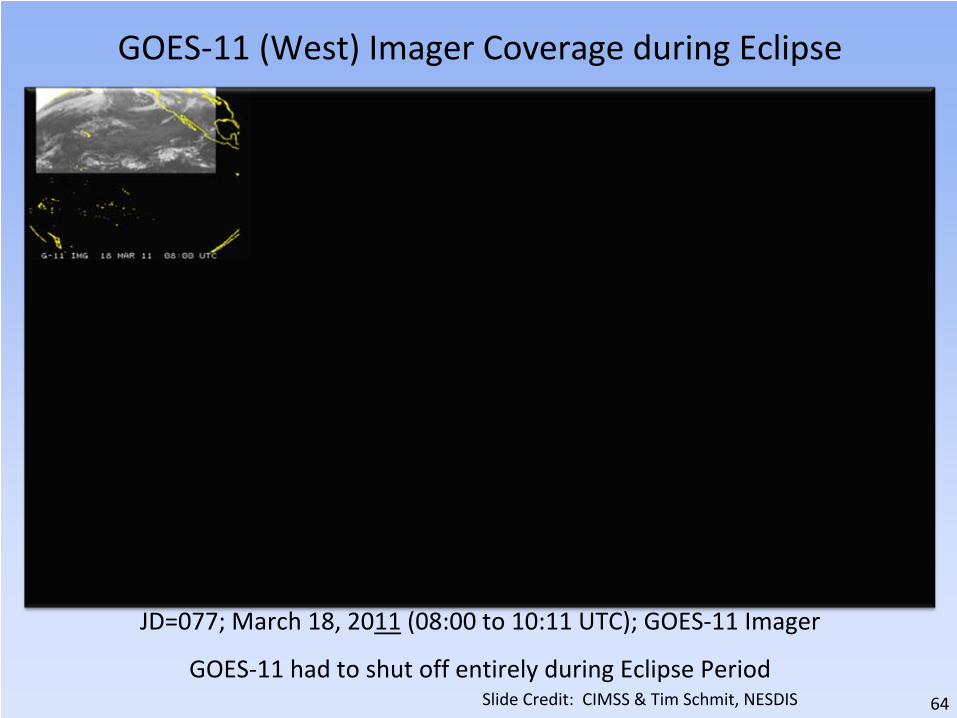
GOES‐11 (West) Imager Coverage during Eclipse
JD=077; March 18, 2011
(08:00 to 10:11 UTC); GOES‐11 Imager
GOES‐11 had to shut off entirely during Eclipse PeriodSlide Credit: CIMSS & Tim Schmit, NESDIS

65
GOES‐15 (West) Imager Coverage during Eclipse w/ SLC
JD=077; March 17, 2012
(08:00 to 10:11 UTC); GOES‐15 Imager
SLC saves those frames that were previously canceled.Slide Credit: CIMSS & Tim Schmit, NESDIS

66
SLC: Info in the GVAR stream• Stray Light correction status bits are sent out over GVAR (GOES VARiable
data transmission format) and are now part of the McIDAS area line prefix
– Enabled, performed relative position of the sun, etc.
• An example of the type of output of Stray Light Correction information
found in the GVAR stream, in the area line prefix for the GOES‐13 Imager
data is shown below. This provides a summary of how each image is
modified depending on the time of year (i.e. relative declination of the
sun and GOES platform). – Directory information (sensor #, image ccyyddd, image hhmmss): 180, 2012068, 54500
– SLCE (# lines w/SLC enabled) = 2705
– SLCD (# lines w/SLC disabled) = 0
– SLCP (# lines w/SLC performed) = 2705
– SLCNP (# lines w/SLC not performed) = 0
– SLC_FRST (1st ln w/SLC performed) = 1
– SLC_LST (last ln w/SLC performed) = 2705
– SUNE (# lines w/sun on e/side earth) = 2705
– SUNW (# lines w/sun on w/side earth) = 0
– SUNN (# lines w/sun on n/side earth) = 0
– SUNS (# lines w/sun on s/side earth) = 2705
– 2705 nonzero values were found for parameter: min_sun_angle
– Smallest sun angle value = 5 found at line # 1419
– Largest sun angle value = 15 found at line # 1
Slide Credit: Hyre Bysal & Tim Schmit, NESDIS

67
GOES‐East Eclipse Schedule / Frames
http://www.ospo.noaa.gov/Operations/GOES/eclipse.html
Imager Sounder
Green ‐
Shifted or ClippedRed ‐
Canceled due to SLYellow ‐
Recovered by SL algorithm
Red ‐
Canceled due to KOZOrange ‐
Canceled due to SL

68
GOES‐West Eclipse Schedule / Frames
http://www.ospo.noaa.gov/Operations/GOES/eclipse.html
Imager Sounder
Green ‐
Shifted or ClippedRed ‐
Canceled due to SL
Red ‐
Canceled due to KOZOrange ‐
Canceled due to SLTan ‐
Off‐Earth striping frames
69
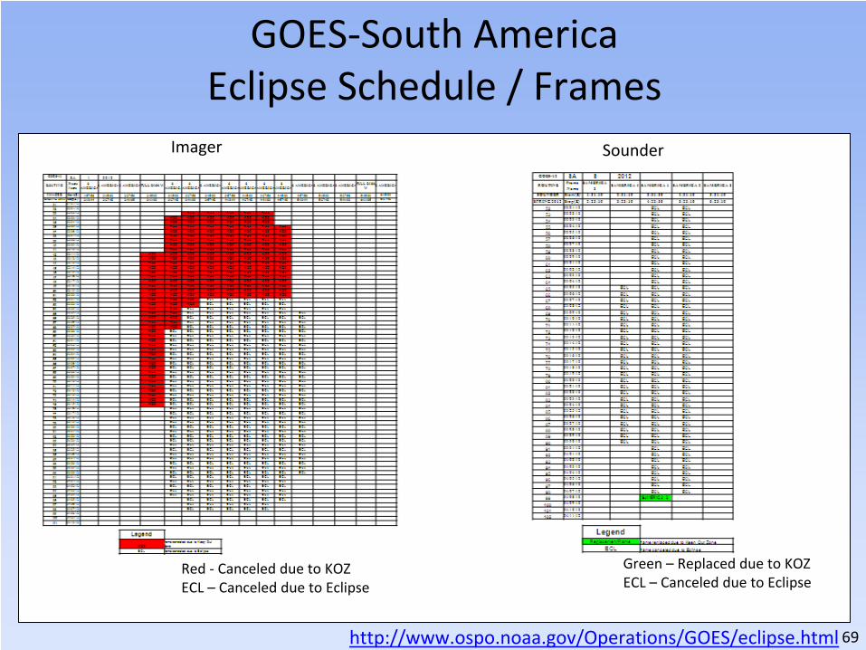
GOES‐South America Eclipse Schedule / Frames
http://www.ospo.noaa.gov/Operations/GOES/eclipse.html
Imager Sounder
Red ‐
Canceled due to KOZECL – Canceled due to Eclipse
Green – Replaced due to KOZECL – Canceled due to Eclipse

70
DMSP Half Orbit data from the Antarctica Data Acquisition (ADA) Station at McMurdo
• Operational Processing and
Delivery began June 10, 2011 for Metop‐A
• DMSP F‐17 & F‐18 became operational in
February, 2012
•McMurdo Station – Ross Island•
77.5°S (similar in Latitude to Svalbard)•
166.6°E (below Australia/New Zealand)
Reference for Map: Capt Gaber, Defense Weather Systems Directoratehttp://directreadout.noaa.gov/miami11/docs/5.9_Gaber_DWSD.pptxReference for Image: http://www.eumetsat.int/Home/Main/News/Features/807695?l=en

71
DMSP ADA Benefit to Users• There are 14 DMSP orbit
ingests at McMurdo per day
per satellite• DMSP ADA provides ~ 30
minutes of improved latency
for the first half orbit• Second half of orbit does not
benefit (like Metop‐A) due to
the DMSP CDAs at Fairbanks,
Wallops, Suitland (compared
to the single other Metop‐A
CDA at Svalbard) • Impacts these files:
EDR/TDR/SDR/UPP (unifed
pre‐process) data (ESPC
names “TDUP”))SVL CDA –
Svalbard Command &
Data Acquisition ADA – Antarctica Data Acquisition

72
McIDAS at ESPC

73
McIDAS at ESPC• Over 50 applications in ESPC use McIDAS, McIDAS libraries,
input files (AREA), or serve McIDAS files (AREA) via ADDE
• ADT, ABBA, CSBT, HMS, others…

74
McIDAS at ESPC• Windsat is in McIDAS area on ESPC polar server for brightness
temperature
• Heavily using the local GINI server in McIDAS format for
validation checks (image previews) prior to sending test data
to NWS AWIPS
• McIDAS was relied upon for the GOES‐11 to GOES‐15
conversion to AWIPS
• Cons – Lack of AIX support (GOES‐East, GOES‐West, TCFP,
MTCSWA are all on AIX servers)
• ESPC is working on moving the GINI’s from SGI IRIX to Linux
75
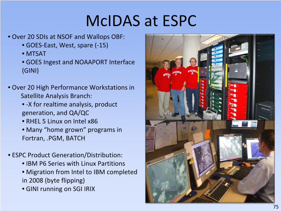
McIDAS at ESPC• Over 20 SDIs at NSOF and Wallops OBF:
• GOES‐East, West, spare (‐15)• MTSAT• GOES Ingest and NOAAPORT Interface
(GINI)
• Over 20 High Performance Workstations in Satellite Analysis Branch:• ‐X for realtime analysis, product
generation, and QA/QC• RHEL 5 Linux on Intel x86• Many “home grown”
programs in
Fortran, .PGM, BATCH
• ESPC Product Generation/Distribution:• IBM P6 Series with Linux Partitions• Migration from Intel to IBM completed
in 2008 (byte flipping)• GINI running on SGI IRIX

76
McIDAS Advantages at ESPC• The ADDE protocol allows for many users accessing single
systems with one port (112) • Common legacy (and future?) formats for satellite remote
sensing data (GOES and POES) and ancillary information for research and operations

77
McIDAS Advantages in SAB• Ability to have quick, efficient load of 900+ frames is
essential. The ability to load (display) imagery literally as it
is coming in to the servers. This is important when every
minute counts for products that are fast developing ‐
like
volcanic eruptions and flash floods and to some extent
fires. This cannot be done with NAWIPS or HMS. In fact,
depending on the area of concern up to 20 minutes is lost
waiting for imagery to show up on these other systems vs
McIDAS. • SAB Analysts have great familiarity with McIDAS• Since the NWS is the primary user of many SAB products
(e.g. volcanic ash and heavy precipitation), there are
benefits for SAB to conduct PG on the NWS platform,
NAWIPS for communication, firewall, and security reasons• Analysts find this to be a hindrance because McIDAS allows
for greater manipulation, interrogation, and imagery
generation than NAWIPS or HMS (Fires & Smoke)

78
McIDAS Challenges at ESPC• Maintaining efficient access to servers for operations
• Additional customer requirements for advanced data formats
(GIS, KMZ)…
writing own local code for NPP VIIRS, Windsat,
others to convert them to AREA files as there are no local
servers
• Learning Curve with commands
• Color Tables – only 8 bit – problem with upcoming GOES‐R
78

79
Band 1Spectral Range
0.402‐0.422 um
Band 4Spectral Range0.545‐0.565 um
Band 5Spectral Range0.662‐0.682 um
NPP VIIRS EDR Imager‐Band
Conversion from NetCDF to
McIDAS(provided by Jerry Guo)
Imagery ResolutionBand for EDR:NPP/EDRI1NPP/EDRI2NPP/EDRI3NPP/EDRI4NPP/EDRI5If you would like, may add Moderate ResolutionBand for EDR:NPP/EDRM1STNPP/EDRM2NDNPP/EDRM3RDNPP/EDRM4THNPP/EDRM5THNPP/EDRM6THDay Night Band for EDR:NPP/NCCModerate ResolutionBand for SDR:NPP/SDRM2NPP/SDRM3NPP/SDRM5NPP/SDRM6NPP/SDRM8NPP/SDRM11NPP/SDRM12NPP/SDRM13 NPP/SDRM7NPP/SDRM10

80
New or Enhanced Products & Services

81
http://projects.osd.noaa.gov/spsrb https://requesttracker.osd.noaa.gov/admin_login.asp
SPSRB Requests (Satellite Products & Services Review Board)
Several new requests since last quarterly meeting –
Gridded Clouds
(format, res), Elektro‐L radiances for fire/aerosols, NPP VegetationAll new development projects require a user request from a federal
agency.
81

82
In addition to the 3‐ day and 14‐day space
environment plots, a new time series of
108 days has been add for both GOES‐13
and GOES‐15 satellites
Promoted April, 2012Image courtesy of NESDIS/NGDC
http://satdat.ngdc.noaa.gov/sem/goes/data/new_plots/latest/goes15/g15_summary_latest108days.pdf
Space Weather Data Plot

83
Blended TPW (Total Precipitable Water)
• Blended TPW replaced the MIRS AMSU TPW from N18, N19 and Metop‐A with those from the
MSPPS over ocean, while still keeping MIRS TPW over land.
• Improved spatial and temporal continuity for the blended TPW products , especially over west
pacific ocean.
• The changes were implemented into operation on March 26 , 2012

84
Global Hydro‐Estimator (GHE)• Instantaneous rain rate, 1 hour, 3 hour, 6 hour, 24 hour and also multi‐day
precipitation accumulation
• Available in GRIB, McIDAS and netCDF4 formats through DDS and ADDE servers
• Can be accessed through NAWIPS, but no requirement for AWIPS
• The operational promotion occurred on April 30, 2012
0300 utc ‐1200 utc March 16, 2009 0300 utc ‐
1200 utc March 16, 2009

85
Promotion Readiness Activities• ESPC systems freeze is months removed and promotion activities are hot!• Green Vegetation Fraction (GVF) data continuity and upgrades for
NPP/VIIRS (GVF) Critical Design Review (CDR) held April 3rd– The GVF system will produce a Weekly Green Vegetation Fraction (GVF) global
(4km) and regional (1km) map using VIIRS Surface Reflectance, Cloud Mask,
and Geolocation
• Infrared Atmospheric Sounding Interferometer (IASI) Phase 2 Software
Code Review held April 4th – Overall the IASI code meets the SPSRB software coding standards,
the review
team highlighted several issues that need to be resolved before proceeding to
operational transition.
• Microwave Integrated Retrieval System (MiRS) NPP/ATMS Integration into
NDE System Readiness Review (SRR) held April 19th – The review included open risks and actions, system requirements,
system
integration of MiRS into the NPOESS Data Exploitation (NDE) environment and
system readiness (incl. system test, readiness for users and
maintenance/operations).

86
Data Access Policy, CRM, Upcoming Conferences, Feedback

87
Data Access & Distribution Policy Contact: [email protected] • To consistently vet user requests
for near real‐time satellite data
and products based on
organizational affiliation or type
of application
• To effectively manage
data
distribution resources to ensure
effective system performance
• To be in compliance with policy,
procedures and required
interconnection agreements
with NIST/DOC IT security
regulations
• To factor ESPC IT system
planning
and future distribution
resource availability and capacity
needs into data access decisions
www.ospo.noaa.gov

88
• DDS Re‐Validation is nearly complete
– User list was validated and finalized– New DDS is set up with test data
available
– DDS Adminstrator, Donna
McNamara, has asked all DDS users
to confirm their connectivity to the
new DDS
– Users who need early access to
Metop‐B data after the May 23
launch will be set to get that data
only from the New DDS
– The new DDS will be operational in
June or later. The exact date will be
provided when it is known.
– The count of accounts to be
removed on the new DDS ‐
24!
That's 17%.
• Satepsdist Re‐Validation exercise will be
conducted this summer
Data Access & Distribution Policy Contact: [email protected]
www.ospo.noaa.gov

89
• The Goal is for improved management of– Product Monitoring Procedures– Trouble Tickets– Notifications– Tracking of Interactions with Users
• Data Load Status– Complete
• Satellites• Instruments• Applications• End Products• Servers
– In Progress• Organizations and Contacts• User / End Product Linkage
• Training for Help Desk and PALs– Complete – Incident Tracking– Next – Queries & Notifications
• Web Portal (Future)– User Help Ticket Submission– User Contact Information and
Reaffirmation
Organizations&
Contacts
End Products
Incidents(Help
Tickets)NotificationsApplications
Servers
Instruments
Satellites
Reporting
Customer Relationship Management (CRM) Database

90
CRM ‐
Application Usage
• An Application is the image or science software running in ESPC
that ingests satellite data & generates End Products
• 168 Applications produced for All Users
• 93 Applications used by 37 NWS centers / offices / branches
• 55% of available Applications are used by NWS
• 37% of Applications used by NWS use GOES (Any combination of
GOES‐12/13/15 including Blended Applications with NOAA
and/or Non‐NOAA POES)

91
CRM ‐
End Product Usage
• An End Product is generated by an Application and may vary by
satellite, instrument, region, format, resolution, etc.
• 30,560 End Products produced for All Users– Those are unique End Product‐to‐User records.
– Some of the records include multiple satellites and sensors, some do not.
It
depends on how the product is typically characterized by the Product Area Lead
(PAL) and users.
• 6,050 End Products used by 37 NWS centers / offices / branches
• 21% of available End Products are used by NWS
• 79% of available End Products are produced for use by Non‐
NWS users

92
• EUMETSAT Meteorological Satellite Conference
– September 3‐7, 2012
– Sopot, Poland– http://www.eumetsat.int/Home/Main/News/Conferences_and_Event
s/810062?l=en
• SeaSpace International Remote Sensing Conference
– October 21‐24, 2012– San Diego, CA– http://www.seaspace.com/?mid=conference
•
NOAA Satellite Conference !!! …see next slide
Upcoming Conferences

93
Attention Users!
If you go to DRO, this is for you!
If you go to GUC or Polar Year, this is for
you!
If you care about GOES‐R or JPSS, this
is for you!

94
Looking for Feedback – Let’s Talk!
• The focus of NOAA Satellite Operations– Availability– Timeliness– Quality
• On a scale of 1 to 10, how would you rate the quality of our relationship (or service, or a
specific product) during the FY12?
• What would it take to make our operations a 10?
95
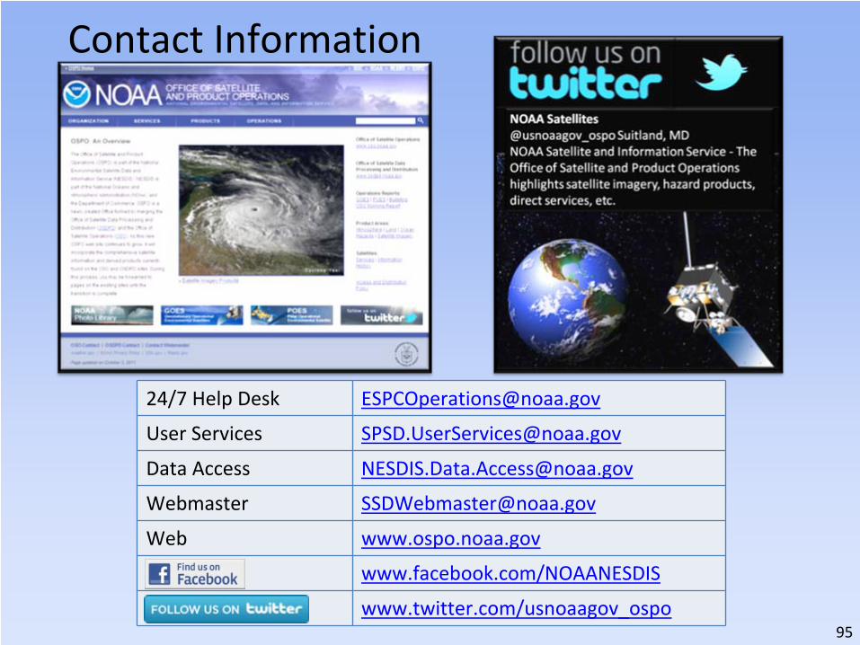
24/7 Help Desk [email protected]
User Services [email protected]
Data Access [email protected]
Webmaster [email protected]
Web www.ospo.noaa.gov
www.facebook.com/NOAANESDIS
www.twitter.com/usnoaagov_ospo
Contact Information

96
http://www.nnvl.noaa.gov/MediaDetail2.php?MediaID=1008&MediaTypeID=3&ResourceID=104489or http://www.youtube.com/watch?v=TWSua5ysuag
Office of Satellite and Product Operations (OSPO) Video