new york harbor upper bay and narrows , anchorage … new york harbor upper bay and narrows ,...
TRANSCRIPT

BookletChart™ New York Harbor – Upper Bay and Narrows, Anchorage Chart NOAA Chart 12334
A reduced-scale NOAA nautical chart for small boaters When possible, use the full-size NOAA chart for navigation.

2
Published by the National Oceanic and Atmospheric Administration
National Ocean Service Office of Coast Survey
www.NauticalCharts.NOAA.gov 888-990-NOAA
What are Nautical Charts?
Nautical charts are a fundamental tool of marine navigation. They show water depths, obstructions, buoys, other aids to navigation, and much more. The information is shown in a way that promotes safe and efficient navigation. Chart carriage is mandatory on the commercial ships that carry America’s commerce. They are also used on every Navy and Coast Guard ship, fishing and passenger vessels, and are widely carried by recreational boaters.
What is a BookletChart?
This BookletChart is made to help recreational boaters locate themselves on the water. It has been reduced in scale for convenience, but otherwise contains all the information of the full-scale nautical chart. The bar scales have also been reduced, and are accurate when used to measure distances in this BookletChart. See the Note at the bottom of page 5 for the reduction in scale applied to this chart.
Whenever possible, use the official, full scale NOAA nautical chart for navigation. Nautical chart sales agents are listed on the Internet at http://www.NauticalCharts.NOAA.gov.
This BookletChart does NOT fulfill chart carriage requirements for regulated commercial vessels under Titles 33 and 44 of the Code of Federal Regulations.
Notice to Mariners Correction Status
This BookletChart has been updated for chart corrections published in the U.S. Coast Guard Local Notice to Mariners, the National Geospatial Intelligence Agency Weekly Notice to Mariners, and, where applicable, the Canadian Coast Guard Notice to Mariners. Additional chart corrections have been made by NOAA in advance of their publication in a Notice to Mariners. The last Notices to Mariners applied to this chart are listed in the Note at the bottom of page 7. Coast Pilot excerpts are not being corrected.
For latest Coast Pilot excerpt visit the Office of Coast Survey website at http://www.nauticalcharts.noaa.gov/nsd/searchbychart.php?chart=12334
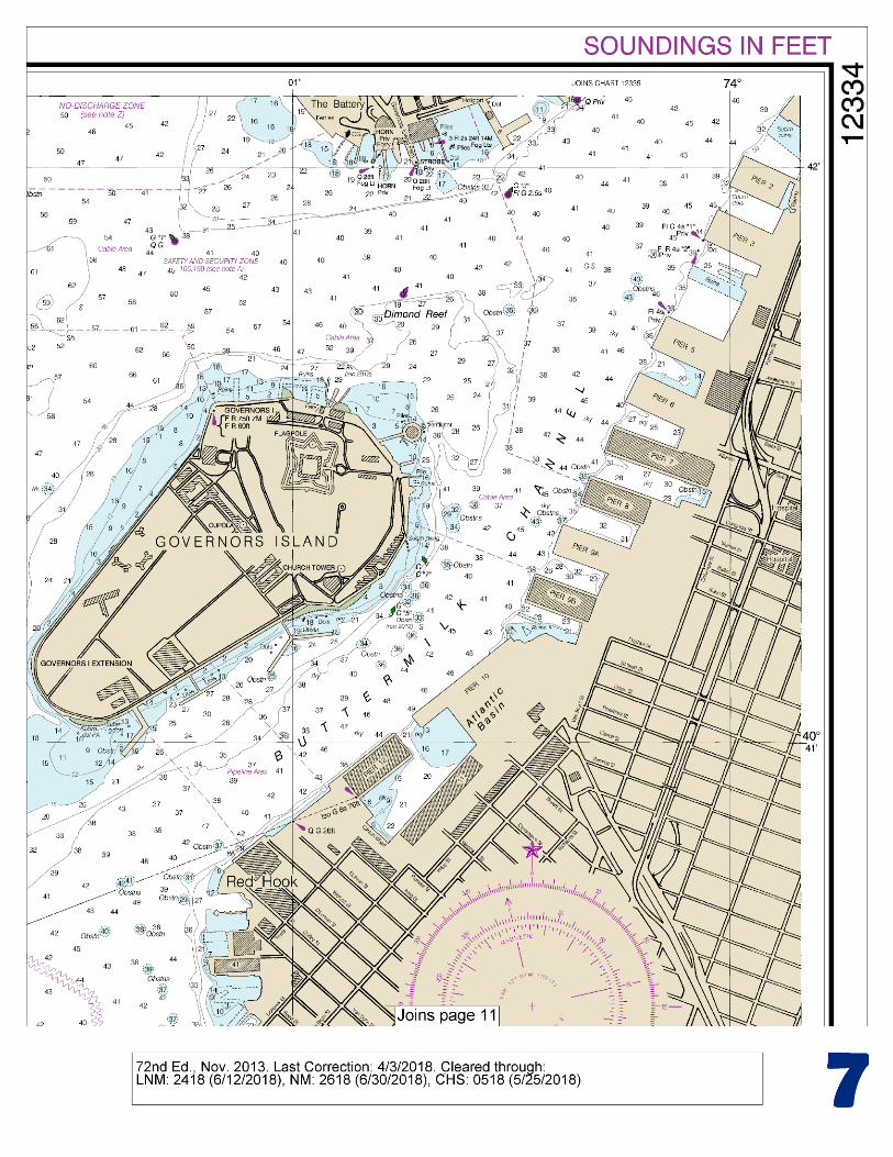
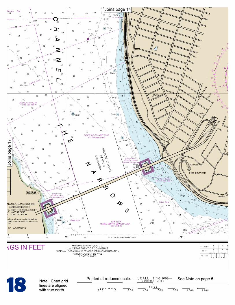
(Selected Excerpts from Coast Pilot) The New York City Bureau of Marine and Aviation ferries generally follow a prescribed route between The Battery and St. George on Staten Island, placing them to the extreme right-hand side of the channel. All mariners are strongly encouraged not to transit close aboard of the ferry slips at The Battery and St. George due to ferries maneuvering. The Narrows connecting Lower Bay and
Upper Bay of New York Harbor, has a clear width of over 0.6 mile at its narrowest point between Fort Wadsworth and Fort Hamilton. The Verrazano Narrows Bridge, a fixed suspension span, crosses The Narrows at these two points linking Staten Island with Brooklyn. The
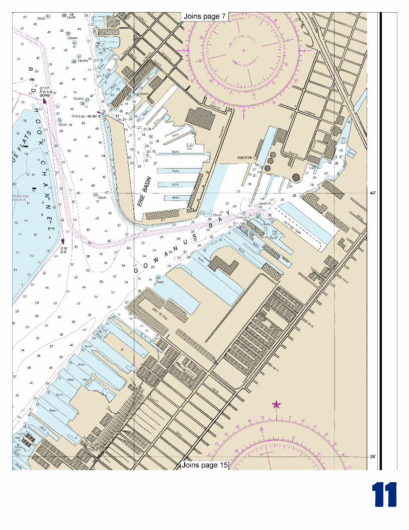
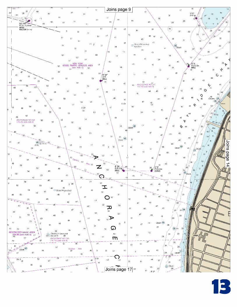
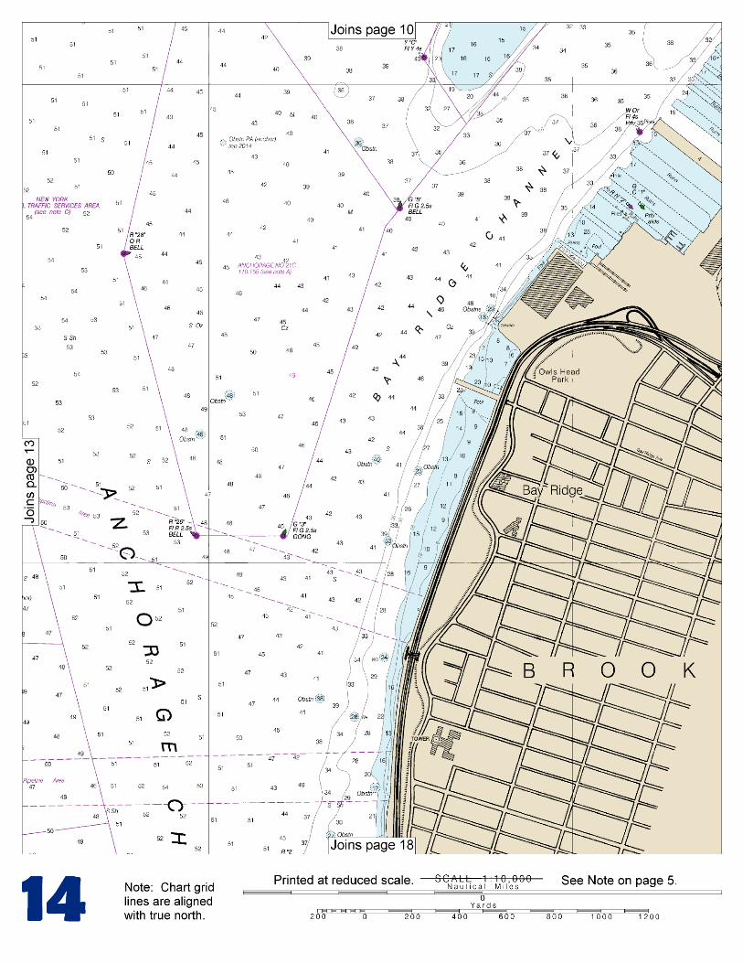
bridge has a vertical clearance of 217 feet for a midchannel width of 2,000 feet. Note: A traveling maintenance platform, when in operation, reduces the vertical clearances by 15 feet. A fog signal is sounded from the eastern end of the bridge. Coast Guard Station New York, numerous deep-draft piers, and ferry terminals are on the east side of Staten Island between Fort Wadsworth and St. George. Upper Bay is that portion of New York Harbor between The Narrows and The Battery. Anchorage Channel, marked by lighted buoys, is the main passage through the middle of the bay. Bay Ridge Flats s is a shoal area with depths of 8 to 20 feet east of Anchorage Channel. Gowanus Flats is at the north end of Bay Ridge Flats. Jersey Flats, the area on the New Jersey side west of Anchorage Channel, is much shoaler with depths up to 9 feet. Channels have been dredged through these shoal areas to provide access to the piers on both sides of the bay. Bay Ridge Channel and Buttermilk Channel follow the Brooklyn piers from The Narrows to East River. Midchannel depths in these channels are generally 35 to 40 feet with lesser depths on the sides; see the latest chart for guidance. Caution should be exercised when docking and undocking vessels along the southeasterly side of Bay Ridge Channel because the current may flow in a direction opposite to the normal channel flow, especially between the piers. Gowanus Bay, at the junction of Bay Ridge and Red Hook Channels, is a bight in the Brooklyn shore at the mouth of Gowanus Canal. A dredged channel leads from Gowanus Bay to the Hamilton Avenue Bridge, about 1 mile above the mouth of the bay. In April 1990, the controlling depths were 21 feet (25 feet at midchannel) to Sigourney Street, about 0.15 mile below the head of the project, thence 22 feet to the Hamilton Avenue Bridge. The improved section of Gowanus Canal above Hamilton Avenue has depths of about 8 to 12 feet. The Third Street, Carroll Street, and Union Street bridges across the canal have the following minimum clearances: drawbridges, 3 feet; fixed bridges, 90 feet. The fixed bridge across that part of the canal that extends southward along Fifth Street has a clearance of 20 feet. The Hamilton Avenue and Ninth Street drawbridges, 1 and 1.2 miles above the entrance of Gowanus Bay, respectively, are equipped with radiotelephones. The bridgetenders monitor VHF-FM channel 13; call signs KX–8183 and KX–8186, respectively. Gowanus Bay, at the junction of Bay Ridge and Red Hook Channels, is a bight in the Brooklyn shore at the mouth of Gowanus Canal. A dredged channel leads from Gowanus Bay to the Hamilton Avenue Bridge, about 1 mile above the mouth of the bay. In April 1990, the controlling depths were 21 feet (25 feet at midchannel) to Sigourney Street, about 0.15 mile below the head of the project, thence 22 feet to the Hamilton Avenue Bridge. The improved section of Gowanus Canal above Hamilton Avenue has depths of about 8 to 12 feet. The Third Street, Carroll Street, and Union Street bridges across the canal have the following minimum clearances: drawbridges, 3 feet; fixed bridges, 90 feet. The fixed bridge across that part of the canal which extends southward along Fifth Street has a clearance of 20 feet. (See Coast Pilot 2 117.1 through 117.59 and 117.787, chapter 2, for drawbridge regulations.) The Hamilton Avenue and Ninth Street drawbridges, 1 and 1.2 miles above the entrance of Gowanus Bay, respectively, are equipped with radiotelephones. The bridgetenders monitor VHF-FM channel 13; call signs KX-8183 and KX-8186, respectively.
U.S. Coast Guard Rescue Coordination Center 24 hour Regional Contact for Emergencies
RCC Boston Commander 1st CG District (617) 223-8555 Boston, MA

G
NOAA’s navigation managers serve as ambassadors to the maritime community. They help identify navigational challenges facing professional and recreational mariners, and provide NOAA resources and information for safe navigation. For additional information, please visit nauticalcharts.noaa.gov/service/navmanagers
To make suggestions or ask questions online, go to nauticalcharts.noaa.gov/inquiry. To report a chart discrepancy, please use ocsdata.ncd.noaa.gov/idrs/discrepancy.aspx.
Lateral System As Seen Entering From Seaward on navigable waters except Western Rivers
PORT SIDE
ODD NUMBERED AIDS
GREEN LIGHT ONLY
FLASHING (2)
PREFERRED CHANNEL
NO NUMBERS – MAY BE LETTERED
PREFERRED CHANNEL TO
STARBOARD
TOPMOST BAND GREEN
PREFERRED CHANNEL
NO NUMBERS – MAY BE LETTERED
PREFERRED CHANNEL
TO PORT
TOPMOST BAND RED
STARBOARD SIDE
EVEN NUMBERED AIDS
RED LIGHT ONLY
FLASHING (2)
FLASHING FLASHING
OCCULTING GREEN LIGHT ONLY RED LIGHT ONLY OCCULTING QUICK FLASHING QUICK FLASHING
ISO COMPOSITE GROUP FLASHING (2+1) COMPOSITE GROUP FLASHING (2+1) ISO
"1"
Fl G 6s
G "9"
Fl G 4s
GR "A"
Fl (2+1) G 6s
RG "B"
Fl (2+1) R 6s
"2"
Fl R 6s
8
R "8"
Fl R 4s
LIGHT
G
C "1"
LIGHTED BUOY
G
"5"
GR
"U"
GR
C "S"
RG
N "C"
RG
"G"
LIGHT
6
R
N "6"
LIGHTED BUOY
R
"2
"
CAN DAYBEACON
CAN NUN NUN
DAYBEACON
For more information on aids to navigation, including those on Western Rivers, please consult the latest USCG Light List for your area.
These volumes are available online at http://www.navcen.uscg.gov
Navigation Managers Area of Responsibility
Northeast
Lt. Meghan McGovern
Northwest and
Pacific Islands
Crescent Moegling
Great Lakes Region
Tom Loeper
Chesapeake and
Delaware Bay
Steve Soherr
California
Jeff Ferguson
[email protected] Mid-Atlantic
Lt. Ryan Wartick
Alaska
Lt. Timothy M. Smith
Western Gulf Coast
Alan Bunn
Central Gulf Coast
Tim Osborn
[email protected] South Florida
Puerto Rico
U.S. Virgin Islands
Michael Henderson
Southeast
Kyle Ward
2
2 C U 5
1


VHF Marine Radio channels for use on the waterways:Channel 6 – Inter-ship safety communications.Channel 9 – Communications between boats and ship-to-coast.Channel 13 – Navigation purposes at bridges, locks, and harbors.Channel 16 – Emergency, distress and safety calls to Coast Guard and others, and to initiate calls to other
vessels. Contact the other vessel, agree to another channel, and then switch.Channel 22A – Calls between the Coast Guard and the public. Severe weather warnings, hazards to navigation and safety warnings are broadcast here.Channels 68, 69, 71, 72 and 78A – Recreational boat channels.
Getting and Giving Help — Signal other boaters using visual distress signals (flares, orange flag, lights, arm signals); whistles; horns; and on your VHF radio. You are required by law to help boaters in trouble. Respond to distress signals, but do not endanger yourself.
EMERGENCY INFORMATION
Distress Call Procedures
• Make sure radio is on.• Select Channel 16.• Press/Hold the transmit button.• Clearly say: “MAYDAY, MAYDAY, MAYDAY.”• Also give: Vessel Name and/or Description;Position and/or Location; Nature of Emergency; Number of People on Board.• Release transmit button.• Wait for 10 seconds — If no responseRepeat MAYDAY call.
HAVE ALL PERSONS PUT ON LIFE JACKETS!
This Booklet chart has been designed for duplex printing (printed on front and back of one sheet). If a duplex option is not available on your printer, you may print each sheet and arrange them back-to-back to allow for the proper layout when viewing.
QR
Quick ReferencesNautical chart related products and information - http://www.nauticalcharts.noaa.gov
Interactive chart catalog - http://www.charts.noaa.gov/InteractiveCatalog/nrnc.shtmlReport a chart discrepancy - http://ocsdata.ncd.noaa.gov/idrs/discrepancy.aspx
Chart and chart related inquiries and comments - http://ocsdata.ncd.noaa.gov/idrs/inquiry.aspx?frompage=ContactUs
Chart updates (LNM and NM corrections) - http://www.nauticalcharts.noaa.gov/mcd/updates/LNM_NM.html
Coast Pilot online - http://www.nauticalcharts.noaa.gov/nsd/cpdownload.htm
Tides and Currents - http://tidesandcurrents.noaa.gov
Marine Forecasts - http://www.nws.noaa.gov/om/marine/home.htm
National Data Buoy Center - http://www.ndbc.noaa.gov/
NowCoast web portal for coastal conditions - http://www.nowcoast.noaa.gov/
National Weather Service - http://www.weather.gov/
National Hurrican Center - http://www.nhc.noaa.gov/
Pacific Tsunami Warning Center - http://ptwc.weather.gov/
Contact Us - http://www.nauticalcharts.noaa.gov/staff/contact.htm
NOAA’s Office of Coast Survey The Nation’s Chartmaker
For the latest news from Coast Survey, follow @NOAAcharts
NOAA Weather Radio All Hazards (NWR) is a nationwide network of radio stations broadcasting continuous weather information directly from the nearest National Weather Service office. NWR broadcasts official Weather Service warnings, watches, forecasts and other hazard information 24 hours a day, 7 days a week. http://www.nws.noaa.gov/nwr/