new towns of canberra - december 1971 - archives.act.gov.au
TRANSCRIPT

ArchivesACT
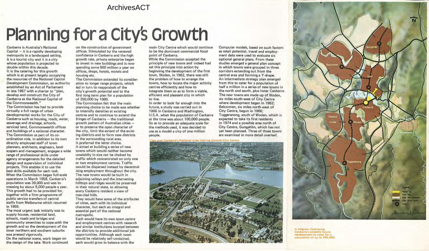
Planning for aCityS Growth Canberra is Australia's National . Capital - it is a rapidly developing metropolis in a landscaped setting, it is a tourist city and it is a city whose population is projected to double within this decade. It is the catering for this growth which is at present largely occupying the resources of the National Capital Development Commission, an authority established by an Act of Parliament in late 1957 with a charter to "plan, develop and construct the City of Canberra as the National Capital of the Commonwealth." The Comm ission has had to provide virtually a full range of urban developmental works for the City of Canberra such as housing, roads, water, sewerage and drainage, schools, serviced land, Commonwealth offices and buildings of a national character. The Commission as part of its co· ordination role, in addition to its own directly employed staff of town planners, architects, engineers, land· scapers and management, engages a wide range of professional skills under agency arrangements for the detailed design and supervision of individual projects. This enables it to use the best skills available for each task. When the Commission began full-scale operations in March 1958, Canberra's population was 39,000 and was in· creasing by about 5,000 people a year. This growth had to be provided for, together with a firm programme of public service transfers of central staffs from Melbourne which resumed in 1959. The most urgent task initially was to supply houses, residential land, schools, roads and bridges and community amenities to cope.with the growth and so the development of the inner northern and southern suburbs was pressed vigorously. On the national scene, work began on the design of the lake. Work continued
on the construction of government offices. Stimulated by the renewed confidence in Canberra and the high growth rate, private enterprise began to invest in new buildings and is now spending some $60 million a year on offices, shops, hotels, motels and housing etc. The Commission extended its consider· ation to longer range projects, which led in turn to reappraisals of the city's growth potential and to the first long term plan for a population of 250,000 by 1980. The Commission felt that the main planning choice to be made was whether to intensify densities at existing centres and to continue to extend the fringes of Canberra - the traditional growth pattern of Australian cities or to preserve the open character of the city, limit the extent of the exist· ing districts and to form new districts in the surrounding rural area. It preferred the latter choice. It aimed at building a series of new towns which would neither become unwieldly in size nor be choked by traffic which concentrated on only one or two employment centres. Traffic would be dispersed instead by decentral· ising employment throughout the city. The new towns would be built in adjoining valleys and the intervening hilltops and ridges would be preserved in their natural state, so allowing every Canberra resident a view of tree-clad hills. They would have some of the attributes of cities, each with its individual character, but each an integral and essential part of the national metropolis. Each would have its own town centre and employment centres with research and similar institutions located between the districts to provide additional job opportunities. Although each town would be relatively self-contained, each would grow in balance with the
main City Centre which would continue to be the dominant commercial focal point of Canberra. While the Commission accepted the principle of new towns and indeed had set this principle into action by beginning the development of the first town, Woden, in 1962, there was still the problem of how to arrange the towns, how to locate the major activity centres efficiently and how to integrate them so as to form a viable, efficient and pleasant city in wh ich to live. In order to look far enough into the future, a study was carried out in 1966 in Canberra and Washington, U.S.A. when the population of Canberra at the time was about 100,000 people. So as to provide an adequate scale for the methods used, it was decided to use as a model a city of one million people.
Computer models, based on such factors as retail potential, travel and employ· ment data were used to evaluate six optional general plans. From these studies emerged a general plan concept in which towns were grouped in three corridors extending out .from the central area and forming a Y-shape. An intermediate strategy plan emerged from this to cater for a population of half a million in a series of new towns in the north and south, plus Inner Canberra. The new towns are made up of Woden, six miles south-west of City Centre where development began in 1962; Belconnen, six miles north-west of City Centre, begun in 1966; Tuggeranong, south of Woden, which is expected to take its first residents in 1974 and a possible area north of City Centre, Gungahlin, which has not yet been planned. Three of these towns are examined in more detail overleaf.
A diagram llho11t1•tln11 Canberr8'a pots1bla future tf11Yalopm1int to cater for o siopulatlon CJ! up to 4100,000 .
ArchivesACT
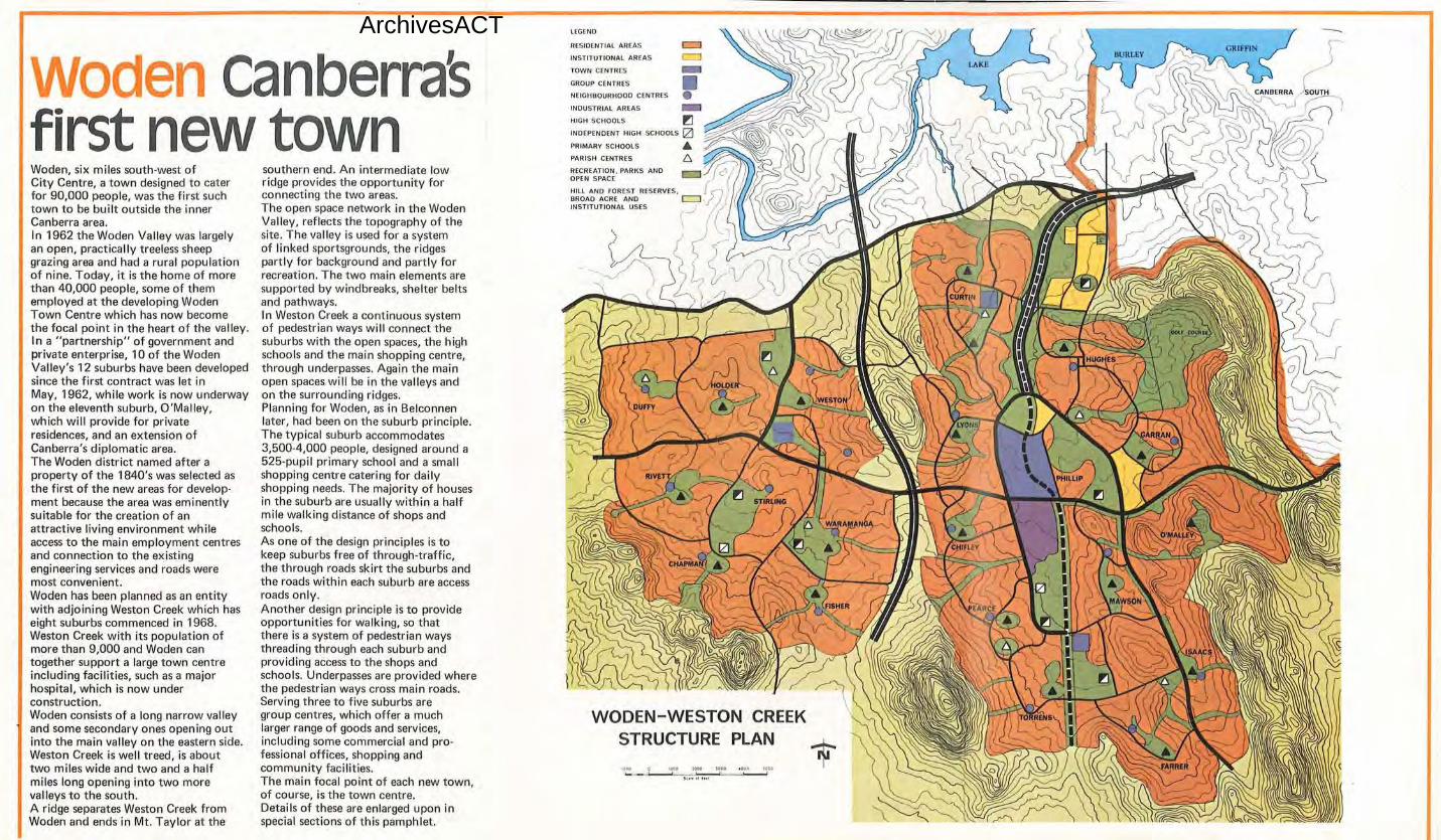
wo en canberraS first new town Woden, six miles south-west of City Centre, a town designed to cater for 90,000 people, was the first such town to be bui lt outside the inner Canberra area. In 1962 the Woden Valley was largely an open, practically treeless sheep grazing area and had a rural population of nine. Today, it is the home of more than 40,000 people, some of them employed at the developing Woden Town Centre which has now become the focal point in the heart of the valley. In a "partnership" of government and private enterprise, 10 of the Woden Valley's 12 suburbs have been developed since the first contract was let in May, 1962, while work is now underway on the eleventh suburb, O'Malley, which will provide for private residences, and an extension of Canberra's diplomatic area. The Woden district named after a property of the 1840's was selected as the first of the new areas for development because the area was eminently suitable for the creation of an attractive living environment whi le access to the main employment centres and connection to the existing engineering services and roads were most convenient. Woden has been planned as an entity with adjoining Weston Creek which has eight suburbs commenced in 1968. Weston Creek with its population of more than 9,000 and Woden can together support a large town centre including facilities, such as a major hospital, which is now under construction. Woden consists of a long narrow valley and some secondary ones opening out into the main valley on the eastern side. Weston Creek is well treed, is about two mi les wide and two and a half miles long opening into two more valleys to the south. A ridge separates Weston Creek from Woden and ends in Mt. Taylor at the
southern end. An intermediate low ridge provides the opportunity for connecting the two areas. The open space network in the Woden Valley, reflects the topography of the site. The valley is used for a system of linked sportsgrounds, the ridges partly for background and partly for recreation. The two main elements are supported by windbreaks, shelter belts and pathways. In Weston Creek a continuous system of pedestrian ways will connect the suburbs with the open spaces, the high schools and the main shopping centre, through underpasses. Again the main open spaces will be in the valleys and on the surrounding ridges. Planning for Woden, as in Belconnen later, had been on the suburb principle. The typical suburb accommodates 3,500-4,000 people, designed around a 525-pupil primary school and a small shopping centre catering for daily shopping needs. The majority of houses in the suburb are usually within a half mile walking distance of shops and schools. As one of the design principles is to keep suburbs free of through-traffic, the through roads skirt the suburbs and the roads within each suburb are access roads only. Another design principle is to provide opportunities for walking, so that there is a system of pedestrian ways threading through each suburb and providing access to the shops and schools. Underpasses are provided where the pedestrian ways cross main roads. Serving three to five suburbs are group centres, which offer a much larger range of goods and services, including some commercial and professional offices, shopping and community fac ilities. The main focal point of each new town, of course, is the town centre. Details of these are enlarged upon in special sections of this pamphlet.
WODEN- WESTON CREEK STRUCTURE PLAN
lECENO
RESIDENTIAL AREAS c::::::J INSTITUTIONAL AREAS c::;J
TOWN CENTRES
CROUP CENTRES
NEIGHBOURHOOD CENTRES
INDUSTRIAL AREAS
HIGH SCHOOLS ~ INDEPENDENT HIGH SCHOOLS IZJ PRIMARY SCHOOLS APARISH CENTRES
RECREATION . PARKS AND OPEN SPACE
~~L~A~N~C~~R~S,JDRESERVES. l=:J 5' INSTITUTIONAL USES - I,
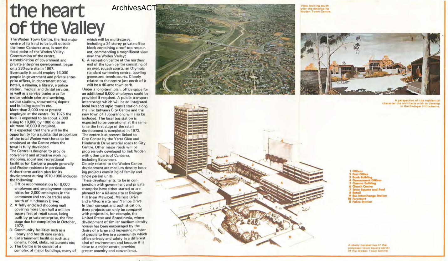
ArchivesACTthe heart of the valley The Woden Town Centre, the first major centre of its kind to be built outside the inner Canberra area, is now the focal point of the Woden Valley. Construction of the centre, a combination of government and private enterprise development, began on a 230-acre site in 1967. Eventually it could employ 16,000 people in government and private enterprise offices, in department stores, hotels, a cinema, a library, a police station, medical and dental services, as well as a service trades area for motor vehicle sales and servicing, service stations, showrooms, depots and building supplies etc. More than 3,000 are at present employed at the centre. By 1975 the level is expected to be about 7,000 rising to 10,000 by 1980 onto an ultimate 16,000 if required. It is expected that there will be the opportunity for a substantial proportion of the total Woden workforce to be employed at the Centre when the town is fully developed. The Centre is designed to provide convenient and attractive working, shopping, social and recreational facilities for Canberra people generally and Woden residents in particular. A short-term action plan for its development during 1970-1980 includes the following: 1. Office accommodation for 8,000
employees and employment opportunities for 2,000 employees in the commerce and service trades area south of Hindmarsh Drive;
2. A fu lly enclosed shopping mall covering more than half a mill ion square feet of retail space, being built by private enterprise, the first stage due for completion in October, 1972;
3. Community faci lities such as a library and health care centre.
4. Entertainment facilities such as a cinema, hotel, clubs, restaurants etc;
5. The Centre is to consist of a complex of major buildings, many of
which will be multi-storey, including a 24-storey private office block containing a roof-top restaurant, commanding a magnificent view over the Woden Valley;
6. A recreation centre at the northern end of the town centre consisting of an oval, squash courts, an Olympic standard swimming centre, bowling greens and tennis courts. Closely related to the centre just north of it will be a 40-acre town park.
Under a long-term plan, office space for an additional 6,000 employees cou ld be provided if required. A publ ic transport interchange which will be an integrated local bus and rapid transit station along the link between City Centre and the new town of Tuggeranong will also be included . The local bus station is expected to be operational at the same time the first stage of the retail development is completed in 1972. The centre is at present linked to City Centre by the Yarra Glen and Hindmarsh Drive arterial roads to City Centre. Other major roads will be progressively developed to link Woden with other parts of Canberra, including Belconnen. Closely related to the Woden Centre development are medium density housing projects consisting of tam ily and single person units. These developments, to be in conjunction with government and private enterprise have either started or are planned for a 63-acre site at Swinger Hi ll (near Mawson), Melrose Drive and a 40-acre site near Yamba Drive. In their concept and sophistication, these projects can only be compared with projects in, for example, the United States and Scandinavia, where development of similar medium density houses has been encouraged by the desire of a large and increasing number of people to live in a community which offers privacy and safety in a different kind of environment and because it is close to a major centre, provides greater amenity and convenience.
View IODli;lno 90Uth ov•r tll• d8'1eloplng Woden Town C1tr1lr•.
A perspec1lv• o f tlla retlde111 lal • harac:ter th• arc:hltecu with to d•v•lop
In lh• Swinger Hiii 1ehama
A sludy pers;>ecl lve of thepropotOCJ town 11ouara sector of the Woden Town Centre
1 Off"ocu 2 PcKt Office3 Bank Culldlog4 Gaweuunant Offi<m 5 Cln- llulldlno6 Chunh Centre7 Town Square cmd ~ 8 Retall 9 Bus Int rchango Station
10 forvcourttl Police Station
\. ,.. ' f
CAllB(RRA I )/) NORTH . \
. ~ ( . 0:
I t'
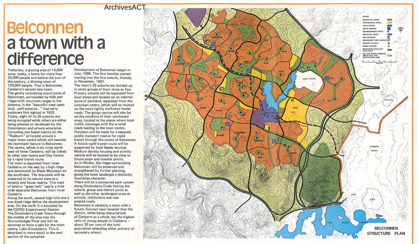
BELCONNEN STRUCTURE PLAN
ArchivesACT
B I nnen atown with a difference Yesterday, a grazing area of 14,800 acres, today, a home for more than 20,000 people and before the turn of the century, a thriving town of 120,000 people. That is Belconnen, Canberra's second new town. The gently undulating countryside of Belconnen, surrounded by hills and ridges with mountain ranges in the distance, is the "beautiful clear open land ... well watered... " that early explorers first sighted in 1820. Today, eight of its 26 suburbs are being occupied while others are either being planned or developed by the Commission and private enterprise (including one based mainly on the "Radburn" principle) around a major town centre which will become the dominant feature in Belconnen. The centre, which is six miles north west of Inner Canberra, will be linked to other new towns and City Centre by a rapid transit route. The town is separated from Inner Canberra on the east by 3 high ridge and dominated by Black Mountain on the south-east. The mountain will be preserved in its natural state as a botanic and fauna reserve. This tract of land or "green belt" nearly a mile wide separates Belconnen from Inner Canberra. Along the south, several high hills and a tree-lined ridge define the development area. On the north it is bounded by the CSI RO Experimental Station. The Ginninderra Creek flows through the middle of the area into the Murrumbidgee River and will be dammed to form a lake for the town centre, Lake G inninderra. This is described in more detail in the next section of the pamphlet.
Development of Belconnen began in July, 1966. The first families started moving into the first suburb, Aranda, in November, 1967. The town's 26 suburbs are divided up in seven groups of from three to five. Primary schools will be separated from local shops and located on an internal spine of parkland, separated from the suburban centre, which will be located on the more lightly trafficked feeder roads. The group centres will also be on the outskirts of their catchment areas, located at the places where local traffic converges with the arterial roads leading to the town centre. Provision will be made for a separate public transport reserve for rapid transit through the centre of Belconnen. A future rapid transit route will be supported by local feeder services. Medium density housing and activity centres will be located to be close to future stops and transfer points. As in Woden, the ridges surrounding Belconnen will be preserved and strengthened by further planting, giving the town landscape a distinctly Australian character. There will be a connected park system along G inninderra Creek linking the suburb, group and district parks as wel I as the other landscaped areas at schools, institutions and near arterial roads. Belconnen is certainly a town with a future. Surveys have revealed that the district, while being characteristic of Canberra as a whole, has the highest ratio of young people in Canberra about 20 per cent of the total population attending either primary or secondary school.

ArchivesACT
First Government Offices Office Complex
-------Shops and Offices .----Civic and Cultural Group
--- Lakeside Entertainment Shops
Service Trades Group
Residential ..,.,.....1---·•-,•--
Lakeside Recreation Park
Town Park
College of Advanced Education
---11-
centre to employ 2s,ooo The Belconnen Town Centre, now being constructed on a 1,070-acre site in the geographical centre of the district, is one of the more exciting town planning and architectural projects to be undertaken in Canberra. Through the combined efforts of government and private enter-prise, the Belconnen Town Centre wi ll become an employment centre for 20,000-25,000 people by the turn of the century as well as providing for a residential popu lation for some 10,500, some of whom will be living in tower type flats and modern apartments in
the heart of the town. Two major structural elements of the town are now under way - the Canberra College of Advanced Education, which began in 1970 taking the first of a possible 10,000 students, and the first of the two government office complexes for the centre, the Cameron Offices which won an architectural award for its designer, Professor John Andrews, an Australian-born architect who has been working in Toronto, Canada for a number of years. The centre's first major retail
facilities are programmed to open around 1976 when Belconnen's population is expected to be more than 50,000. Further major retai l releases will be made as the population grows. One feature in particu lar which will distinguish the Belconnen Centre from others, is a proposal to use a road embankment to dam the Ginninderra Creek which runs through the site to form a V-shaped artificial lake, about one sixth the size of Lake Burley Griffin, giving the centre a distinct "lake in the town" character. The basic design attitude calls for a
direct relationship between the centre and the lake, Lake Ginninderra. The main aim is to design a centre which wi ll provide Belconnen residents with varied and interesting opportunities fo r shopping, working, social and leisure activities. The main commercial area will be directly associated with the lakeshore area and largely completed by 1980. It will contain the major shops, a substantial part of the offices, banks, hotels, a motel, community and cultural facilities, cinemas and other entertainment facilities as well as
some residential accommodation. It will be sited on the prominent Emu Bank ridge adjacent to the south· ern end of the lake and is planned to provide a dense, active centre related to a system of pedestrian ways, plazas and squares, segregated from vehicular traffic. The build ing groups generally will occupy high ground while parking areas and parks will be located on the lower slopes. To the south of the core, but an integral part of it, wil l be the Cameron Offices, while to the west will be another government office complex, along with private offices and commercial and entertainment facilities. These will form a separate entity but will be linked to the core by a system of pedestrian ways. Construction of the Cameron Offices began during 1970 eventually to accommodate 3,000 office workers, the first 2, 100 officers of the Bureau of Census and Statistics to begin moving in during 1973 when shopping facilities, being constructed as part of the complex, will be available. The offices wil l consist of seven three-storey wings set at right angles to the road. On the road frontage of each wing will be a three-storey unit built above a pedestrian mall at first floor level. The complex will include a computer centre, a heating and cooling station and associated car parks. Between the wings are landscaped courtyards opening to car parks at the western end.
Other major elements of the centre proposed are: -1. Some 700 acres to the east of the
site for major institutions, such as the College of Advanced Education and a private hospital;
2. A public hospital on a 45-acre site north of the Town Park, one of two parks for the centre;
3. Sites for hostels catering for some 650 people near the College;
4. Tower type flats for the core and modern apartments and various types of town houses for three major residential areas around the lake;
5. Areas for hostels; 6. About 120 acres for sites for
service stations, other motor trades, public utilities and building services etc., for early release;
7. Sites for a swimming centre, tennis courts and bowling green.
As in the whole of Belconnen, the landscape will be timbered and essentially Austral ian in character, with mass plantings of Eucalypts. There will be parkland around the lake edge while the Town Park will form the continuation of the open space system of the College and is intended to provide for the more active recreation close to the core. A more extensive recreation park for quieter fami ly enjoyment will be provided to the north-west edge of the lake, near the dam. As is the case with Lake Burley Griffin, the Belconnen lake will offer Canberra's residents and visitors further opportunities for aquatic recreation.
• •
RAJltO TRAN'SIT ROUU:
RESIOUfflAl ARl'A$ a::I
IHSTITUTIONAL ARlo\S [:=J
TOWHCUffAf GROUP C£NTR(S
lOCAl ((NTRlS
INOUSTIUAl ARtAS
t41GH SCHOOL.$ -l!llHOEPl.NOfHT HIGH SCHOOlS CZJ
PRIMARV SCHOOLS •
PARISH ClHTAC$
~~~:"::~~~,PARKS AtlO HIU. ANO rOR(ST RlSIRVlSANO 81tOAO ACRE US[S c=t
6
ArchivesACT
T the home of tomorrow
ggeranong
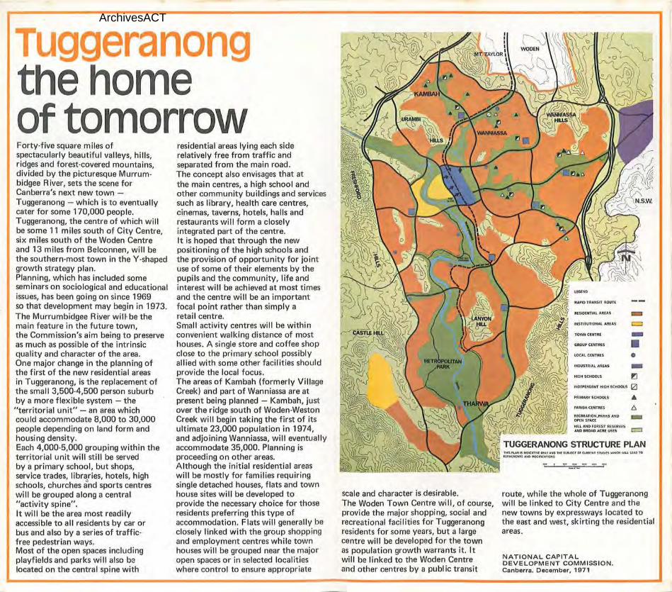
Forty-five square miles of spectacularly beautiful valleys, hills, ridges and forest-covered mountains, divided by the picturesque Murrum· bidgee River, sets the scene for Canberra's next new town -Tuggeranong - which is to eventually cater for some 170,000 people. Tuggeranong, the centre of which will be some 11 miles south of City Centre, six miles south of the Woden Centre and 13 miles from Belconnen, will be the southern-most town in the Y-shapedgrowth strategy plan. Planning, which has included some seminars on sociological and educationalissues, has been going on since 1969 so that development may begin in 1973.The Murrumbidgee Riyer wm be the main feature in the future town, the Commission's aim being to preserve as much as possible of the intrinsic quality and character of the area. One major change in the planning of the first of the new residential areas in Tuggeranong, is the replacement of the small 3,500-4,500 person suburb by a more flexible system - the "territorial unit" - an area which could accommodate 8,000 to 30,000 people depending on land form and housing density. Each 4,000-5,000 grouping within the territorial unit will still be served by a primary school, but shops, service trades, libraries, hotels, high schools, churches and sports centres will be grouped along a central "activity spine". It will be the area most readily accessible to all residents by car or bus and also by a series of traffic· free pedestrian ways. Most of the open spaces including playfields and parks will also be located on the central spine with
residential areas lying each side relatively free from traffic and separated from the main road. The concept also envisages that at the main centres, a high school and other community buildings and services such as library, health care centres, cinemas, taverns, hotels, halls and restaurants will form a closely integrated part of the centre. It is hoped that through the new positioning of the high schools and the provision of opportunity for joint use of some of their elements by the pupils and the community, life and interest will be achieved at most times and the centre will be an important focal point rather than simply a retail centre. Small activity centres will be within convenient walking distance of most houses. A single store and coffee shop close to the primary school possibly allied with some other faci lities should provide the local focus. The areas of Kambah (formerly Village Creek) and part of Wanniassa are at present being planned - Kam bah, just over the ridge south of Woden-Weston Creek will begin taking the first of its ultimate 23,000 population in 1974, and adjoining Wanniassa, will eventually accommodate 35,000. Planning is proceeding on other areas. Although the initial residential areas will be mostly for families requiring single detached houses, flats and town house sites will be developed to provide the necessary choice for those residents preferring this type of accommodation. Flats will generally be closely linked with the group shopping and employment centres while town houses will be grouped near the major open spaces or in selected localities where control to ensure appropriate
scale and character is desirable. The Woden Town Centre will, of course,provide the major shopping, social and recreational facilities for Tuggeranong residents for some years, but a large centre will be developed for the town as population growth warrants it. It will be linked to the Woden Centre and other centres by a public transit
route, while the whole of Tuggeranong will be linked to City Centre and the new towns by expressways located to the east and west, skirting the residential areas.
NATIONAL CAPITALDEVELOPMENT COMM ISSION. Canberra. December, 1971