new priority nickel sulphide target confirmed at … 21 july 2014 asx/media announcement new...
TRANSCRIPT

1
21 July 2014
ASX/Media Announcement
New priority nickel sulphide target confirmed at Fairwater Project
• Pioneer Resources Pioneer Resources Pioneer Resources Pioneer Resources (A(A(A(ASSSSX: PIO) X: PIO) X: PIO) X: PIO) has has has has defineddefineddefineddefined a high priority nickel sulphide target at a high priority nickel sulphide target at a high priority nickel sulphide target at a high priority nickel sulphide target at
the Fairwater Project in the Albanythe Fairwater Project in the Albanythe Fairwater Project in the Albanythe Fairwater Project in the Albany----Fraser Fraser Fraser Fraser OrogenOrogenOrogenOrogen
• New target New target New target New target ((((FWNi003FWNi003FWNi003FWNi003) ) ) ) idenidenidenidentified from tified from tified from tified from recent recent recent recent soil geochemistry, soil geochemistry, soil geochemistry, soil geochemistry, which returnedwhich returnedwhich returnedwhich returned
sssstandtandtandtand----out nickelout nickelout nickelout nickel----ccccopperopperopperopper ++++chrome and chrome and chrome and chrome and PGE PGE PGE PGE resultsresultsresultsresults
• New target has sNew target has sNew target has sNew target has structural analogies tructural analogies tructural analogies tructural analogies with Sirius Resources’ with Sirius Resources’ with Sirius Resources’ with Sirius Resources’ Nova and Bollinger Nova and Bollinger Nova and Bollinger Nova and Bollinger
Nickel DepositsNickel DepositsNickel DepositsNickel Deposits
• Concentric, oConcentric, oConcentric, oConcentric, ovvvval hostal hostal hostal host----structurestructurestructurestructure interpreted asinterpreted asinterpreted asinterpreted as a a a a possible possible possible possible mafmafmafmaficicicic----ultramafic ultramafic ultramafic ultramafic
intrusive intrusive intrusive intrusive complexcomplexcomplexcomplex based on geochemistrybased on geochemistrybased on geochemistrybased on geochemistry and aeromagnetic imageryand aeromagnetic imageryand aeromagnetic imageryand aeromagnetic imagery
• Company now plans to conduct Company now plans to conduct Company now plans to conduct Company now plans to conduct aaaaircore drilling at ircore drilling at ircore drilling at ircore drilling at initial fourinitial fourinitial fourinitial four targetstargetstargetstargets
• Company has expanded its AlbanyCompany has expanded its AlbanyCompany has expanded its AlbanyCompany has expanded its Albany----Fraser project area via the pegging of an Fraser project area via the pegging of an Fraser project area via the pegging of an Fraser project area via the pegging of an
aaaadditional dditional dditional dditional 92929292kmkmkmkm2222 tenement tenement tenement tenement adjaceadjaceadjaceadjacent nt nt nt to current to current to current to current holdingsholdingsholdingsholdings
Pioneer Resources Limited ("Pioneer" or the "Company" is pleased to announce it has identified a new,
high priority nickel sulphide target at its 75%-held Fairwater Project in the Albany-Fraser Province in south-
east Western Australia.
The new target, currently designated FWNi003, was defined from results of its latest reconnaissance soil
geochemistry program at the project, which included 698 new samples at the target.
A technical report has been received from by Pioneer’s geochemistry consultant, providing an
interpretation of these latest soil geochemistry results. The report highlighted the stand-out FWNi003
nickel sulphide target, which is a nickel anomaly with supporting coincident copper, chrome and platinum
group element (PGE) results. Together these elements are recognised as pathfinders when exploring for
magmatic nickel sulphide deposits.
The Fairwater Project’s nickel targets are located in likely Proterozoic-aged Albany Fraser Orogen rocks,
between 100 and 130km south-west of Sirius Resources (ASX: SIR) major Nova and Bollinger nickel
discoveries, and approximately 220 kilometres south-east of Kalgoorlie.
Pioneer’s Managing Director, Mr David Crook said:
“The Pioneer board, management and specialist consultants are very encouraged by the latest available
data. The FWNi003 anomaly has already fulfilled the objective of our recent soil geochemistry program,
which was to define Ni-Cr, with Cu and PGE soil anomalism that coincide with aeromagnetic highs, being the
characteristic signatures of a potentially mineralised mafic-ultramafic intrusion such as that hosting the
Nova and Bollinger Nickel-Copper Deposits.”

2
Figure 1. Total Magnetic Intensity image of
the FWNi003 Prospect area.
Of importance:
• the 8 kilometre long oval structure
truncates more linear geological
units implying that has a relatively
younger age, and therefore
possibly an intrusive complex;
• Ni-Cr-Cu and PGE anomalies
representing FWNi003 coincide
with the magnetic peaks of the
central core (see Figures 2-4).
Imagery from 200m line-spaced
aeromagnetic data shows an 8 kilometre
long, NW-trending oval structure
An internal 2 kilometre long core of
clustered, chrome-anomalous, magnetic
rocks represents FWNi003.

3
Figure 2a: Nickel Probability plot Figure 3a: Chrome Probability plot Figure 4a: Copper Probability plot
Figure 2b: Image of nickel geochemistry values, with
coincident anomalous Pd+Pt (PGE) value locations outlined
in yellow.
Figure 3b: Image of chrome geochemistry values. Higher
values indicate the presence of mafic or ultramafic rocks.
Figure 4b: Image of copper geochemistry values. Cu and
PGE anomalies which coincide with mafic or ultramafic
rocks may indicate the presence of magmatic Ni-Cu
sulphides.
Each image is of the centrally located framed area in Figure 1.
The red outline encloses the cluster of high magnetic rocks that form the central core of the 8km FWNi003 oval structure. Yellow outline encloses anomalous Pd + Pt values in soils
Anomaly Threshold
Anomaly Threshold
Anomaly Threshold
4
ALBANY-FRASER OROGEN – THE RIGHT GEOLOGICAL SETTING
The Fairwater Project tenements (granted and applications) cover an area of 747km2. Geological units
comprise Proterozoic-aged (1.8-1.65 Ba) Biranup Zone rocks of the Albany-Fraser Orogen and Archaean
aged (>2.5 Ba) Yilgarn Craton rocks.
The Albany-Fraser Province has become the focus of intense exploration activity since the discovery of the
Proterozoic-aged Nova and Bollinger Nickel-Copper Deposits and also the Archaean-aged Tropicana Gold
Mine, now 8 million ounces, which recently commenced production.
Pioneer completed a number of soil geochemistry programs to follow up anomalous gold and nickel trends
identified in data released by Pan Australian Resources NL and Anglogold Ashanti Australia Limited. This
included collecting and additional 698 reconnaissance samples at the FWNi003 Target.
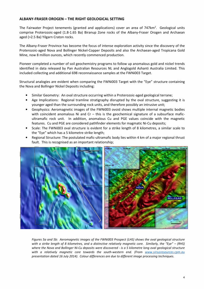
Structural analogies are evident when comparing the FWNi003 Target with the “Eye” structure containing
the Nova and Bollinger Nickel Deposits including:
• Similar Geometry: An oval structure occurring within a Proterozoic-aged geological terrane;
• Age Implications: Regional tramline stratigraphy disrupted by the oval structure, suggesting it is
younger aged than the surrounding rock units, and therefore possibly an intrusive unit;
• Geophysics: Aeromagnetic images of the FWNi003 ovoid shows multiple internal magnetic bodies
with coincident anomalous Ni and Cr – this is the geochemical signature of a subsurface mafic-
ultramafic rock unit. In addition, anomalous Cu and PGE values coincide with the magnetic
features. Cu and PGE are considered pathfinder elements for magmatic Ni-Cu deposits;
• Scale: The FWNi003 oval structure is evident for a strike length of 8 kilometres, a similar scale to
the “Eye” which has a 5 kilometre strike length;
• Regional Structure: The postulated mafic-ultramafic body lies within 4 km of a major regional thrust
fault. This is recognised as an important relationship;
Figures 5a and 5b: Aeromagnetic images of the FWNi003 Prospect (LHS) shows the oval geological structure
with a strike length of 8 kilometres, and a distinctive relatively magnetic core. Similarly, the “Eye” – (RHS)
where the Nova and Bollinger Ni-Cu deposits were discovered - is a 5 kilometre long oval geological structure
with a relatively magnetic core towards the south-western end. (From www.siriusresources.cpm.au
presentation dated 16 July 2014). Colour differences are due to different image processing techniques.

5
Figure 6: Regional interpreted geology, nickel and gold prospects.
ADDITIONAL TARGETS AT FAIRWATER – WORK CONTINUES
Pioneer has informed the market of progress at other high-priority Ni-Cu-Cr geochemistry (and VTEM)
anomalies including initial targets at FWNi001 and FWNi002 shown on Figure 6 (ASX release 24 June 2013).
These prospects remain within a pipeline of exploration targets advancing towards drill-testing. .
In addition, three other nickel and six gold target areas have been reconnaissance-sampled following up
anomalies in sampling undertaken by Pan Australian and Anglo-Gold-Ashanti between the mid-1990s and
2012. Verification of pXRF results for samples is currently in progress with results expected in August 2014.
IMMEDIATE OUTLOOK
Following the grant of key tenements Pioneer will commence its programs of detailed fieldwork. The
current schedule for the grant of the tenements is mid-September 2014.
Forthcoming work will include:
• RAB or Aircore drilling at FWNi001 and FWNi003 (and other) prospects to confirm regolith
geochemistry anomalies and rock types;
• Subject to results, ground EM surveys; and
• RC drilling to test for magmatic nickel sulphides.
Additional gold exploration will be planned following the receipt of assays in August 2014

6
Yours faithfully
Managing Director
For further information please contact:
David Crook James Moses
Managing Director Media and Investor Relations
Pioneer Resources Mandate Corporate
T: +61 8 9322 6974 M: +61 420 991 574
E: [email protected] E: [email protected]
Competent Person
The information in this report that relates to Exploration Results is based on information supplied to and compiled by
Mr David Crook. Mr Crook is a full time employee of Pioneer Resources Limited and a member of The Australasian
Institute of Mining and Metallurgy (member 105893). Mr Crook has sufficient experience which is relevant to the
styles of mineralisation and types of deposit under consideration and to the activities undertaken to qualify as a
Competent Person as defined in the 2012 Edition of the ‘Australasian Code for Reporting of Exploration Results,
Mineral Resources and Ore Reserves’. Additional information in respect of soil geochemical data and interpretations
was provided by Dr Nigel Brand. Mr Crook and Dr Brand consent to the inclusion in the report of the matters based
on their information in the form and context in which it appears.
Caution Regarding Forward Looking Information
This document may contain forward looking statements concerning the projects owned by the Company. Statements
concerning mining reserves and resources may also be deemed to be forward looking statements in that they involve
estimates based on specific assumptions.
Forward-looking statements are not statements of historical fact and actual events and results may differ materially
from those described in the forward looking statements as a result of a variety of risks, uncertainties and other
factors. Forward-looking statements are inherently subject to business, economic, competitive, political and social
uncertainties and contingencies. Many factors could cause the Company’s actual results to differ materially from
those expressed or implied in any forward-looking information provided by the Company, or on behalf of, the
Company. Such factors include, among other things, risks relating to additional funding requirements, metal prices,
exploration, development and operating risks, competition, production risks, regulatory restrictions, including
environmental regulation and liability and potential title disputes.
Forward looking statements in this document are based on the Company’s beliefs, opinions and estimates of the
Company as of the dates the forward looking statements are made, and no obligation is assumed to update forward
looking statements if these beliefs, opinions and estimates should change or to reflect other future developments.
There can be no assurance that the Company’s plans for development of its mineral properties will proceed as
currently expected. There can also be no assurance that the Company will be able to confirm the presence of
additional mineral deposits, that any mineralisation will prove to be economic or that a mine will successfully be
developed on any of the Company’s mineral properties. Circumstances or management’s estimates or opinions could
change. The reader is cautioned not to place undue reliance on forward-looking statements.

7
Glossary:
“g/t” means grams per tonne (used for precious metals) and is equivalent to ppm.
“ppm” means 1 part per million by weight.
“pXRF” means portable XRF. Pioneer owns an Olympus Delta analyser which was used for the reported work.
“RAB” means rotary air blast, a cost-effective drilling technique used to test the regolith (near surface unconsolidated
and weathered rock) for plumes of trace-level gold that may have dispersed from a nearby primary source of gold. In
this type of work gold values above 0.2g/t are considered anomalous and above 1g/t, very anomalous.
“RC” means reverse circulation, a drilling technique that is used to return uncontaminated pulverised rock samples
through a central tube inside the drill pipes. RC samples can be used in industry-standard Mineral Resource estimates.
“N”, “S”, “E”, or “W” refer to the compass orientations north, south, east or west respectively.
“Au” means gold.
“Cu” means copper.
“Cr” means chrome.
“Ni” means nickel.
“PGE” means platinum group elements. In this case it means platinum plus palladium.

8
APPENDIX 1. Soil Sampling Information, Result Summary and Competent Person
Table 1
Soil Sample Location Summary
Grid Line North East Range Length Number Std Dup Sample Number Range Spacing
ID
(m)
From
(m) To (m) (m) (n) (n) (n)
m
FWNi003 1 6389400 423800 - 425800 2000 41 1 1 148945 - 148987 50
FWNi003 2 6389600 423700 - 425700 2000 41 1 2 148988 - 149031 50
FWNi003 3 6389800 423550 - 425600 2050 41 2 2 149032 - 149076 50
FWNi003 4 6390000 423400 - 425500 2100 43 1 1 149077 - 149121 50
FWNi003 5 6390200 423300 - 425400 2100 43 2 2 149122 - 149168 50
FWNi003 6 6390400 423150 - 425250 2100 43 1 1 149169 - 149213 50
FWNi003 7 6390600 423000 - 425150 2150 44 1 2 149214 - 149260 50
FWNi003 8 6390800 422900 - 425050 2150 43 2 2 149261 - 149307 50
FWNi003 9 6391000 422800 - 424900 2100 43 1 1 149308 - 149352 50
FWNi003 10 6391200 422800 - 424800 2000 41 1 2 149353 - 149396 50
FWNi003 11 6391400 422800 - 424700 1900 38 2 2 149397 - 149438 50
FWNi003 12 6391600 422800 - 424600 1800 37 1 1 149439 - 149477 50
FWNi003 13 6391800 422800 - 424500 1700 35 1 1 149478 - 149514 50
FWNi003 14 6392000 422800 - 424400 1600 33 1 1 149515 - 149549 50
FWNi003 15 6392200 422800 - 424250 1450 30 1 1 149550 - 149581 50
FWNi003 16 6392400 422800 - 424350 1550 32 1 1 149582 - 149615 50
FWNi003 17 6392600 422800 - 424000 1200 25 1 1 149616 - 149642 50
FWNi004 1 6388000 422000 - 423000 1000 21 0 1 146770 - 146791 50
FWNi004 2 6388200 422000 - 423000 1000 21 1 0 146792 - 146813 50
Table 2
Key Anomalous Soil Sample Results by pXRF1 or ICP-MS2
Prospect Sample ID Cr1
(ppm)
Cu1
(ppm)
Fe1
(ppm)
Mn1
(ppm)
Ni1
(ppm)
Pd+Pt2
(ppb)
Pd2
(ppb)
Pt2
(ppb)
Au2
(ppb)
FWNI003 PRL149145 202 19 18183 226 149
FWNI003 PRL149146 373 43 20100 499 313
FWNI003 PRL149147 298 27 24434 571 219
FWNI003 PRL149148 166 26 18748 315 110
FWNI003 PRL149182 254 27 15314 315 145
FWNI003 PRL149183 419 27 22146 428 169
FWNI003 PRL149184 659 88 26417 888 416
FWNI003 PRL149185 265 34 20530 628 191
FWNI003 PRL149186 293 36 24537 275 143
FWNI003 PRL149187 186 31 20582 227 134
FWNI003 PRL149188 180 24 17782 188 104
FWNI003 PRL149191 212 23 20799 173 148
FWNI003 PRL149192 196 21 16762 227 169
FWNI003 PRL149193 336 28 21045 380 333
FWNI003 PRL149194 508 32 25589 359 366
FWNI003 PRL149195 347 36 27391 263 309
FWNI003 PRL149196 261 36 23093 235 123
FWNI003 PRL149234 379 21 26458 191 109

9
Table 2
Key Anomalous Soil Sample Results by pXRF1 or ICP-MS2
Prospect Sample ID Cr1
(ppm)
Cu1
(ppm)
Fe1
(ppm)
Mn1
(ppm)
Ni1
(ppm)
Pd+Pt2
(ppb)
Pd2
(ppb)
Pt2
(ppb)
Au2
(ppb)
FWNI003 PRL149235 373 33 26798 191 110 3.3 2.1 1.2 4
FWNI003 PRL149236 641 25 29660 275 265 2.7 1.3 1.4 2
FWNI003 PRL149237 411 34 17492 463 431 6.3 2.8 3.5 3
FWNI003 PRL149238 521 38 22672 611 540 5.5 2.4 3.1 3
FWNI003 PRL149239 590 36 27559 455 565 8.3 3.8 4.5 10
FWNI003 PRL149240 719 33 29097 595 565 5.6 2.5 3.1 4
FWNI003 PRL149241 1266 54 57006 519 509 5.7 2.7 3 5
FWNI003 PRL149242 879 92 45359 356 370 4.1 1.9 2.2 4
FWNI003 PRL149243 441 95 22210 377 193 2.2 1 1.2 3
FWNI003 PRL149244 287 32 18660 304 144
FWNI003 PRL149245 247 34 18883 373 119
FWNI003 PRL149246 219 37 20837 213 114
FWNI003 PRL149247 196 28 16089 156 113
FWNI003 PRL149248 237 51 19493 259 193
FWNI003 PRL149276 339 44 26945 379 200
FWNI003 PRL149277 565 46 22351 298 230
FWNI003 PRL149278 311 39 28483 296 202
FWNI003 PRL149279 151 45 16530 291 130
FWNI003 PRL149280 150 21 16158 259 120
FWNI003 PRL149281 124 28 14031 237 108
FWNI003 PRL149282 154 41 17528 302 84
FWNI003 PRL149283 207 79 21436 282 74
FWNI003 PRL149284 170 33 21270 217 86
10
APPENDIX 2
JORC Code, 2012 Edition – Table 1 report
Section 1 - Sampling Techniques and Data
(Criteria in this section apply to all succeeding sections.) Fairwater Project.
Criteria JORC Code explanation Commentary
Sampling
techniques
• Nature and quality of sampling (eg cut Faces, random chips, or specific specialised
industry standard measurement tools appropriate to the minerals under
investigation, such as down-hole gamma sondes, or handheld XRF instruments,
etc). These examples should not be taken as limiting the broad meaning of
sampling.
• Soil samples: a 100g sample of -250 micron soil taken from approximately 20cm
below surface.
• Samples are collected into a paper (manilla) geochemistry sample packet.
• Include reference to measures taken to ensure sample representivity and the
appropriate calibration of any measurement tools or systems used.
• pXRF is calibrated daily
• Duplicate samples are taken at the rate of 3 per hundred
• Aspects of the determination of mineralisation that are Material to the Public
Report.
• In cases where ‘industry standard’ work has been done this would be relatively
simple (eg ‘reverse circulation drilling was used to obtain 1 m samples from which 3
kg was pulverised to produce a 30 g charge for fire assay’). In other cases more
explanation may be required, such as where there is coarse gold that has inherent
sampling problems. Unusual commodities or mineralisation types (eg submarine
nodules) may warrant disclosure of detailed information.
• A 100g sample of -250 micron screened soil was taken for analysis.
Drilling techniques • Drill type (eg core, reverse circulation, open-hole hammer, rotary air blast, auger,
Bangka, sonic, etc) and details (eg core diameter, triple or standard tube, depth of
diamond tails, face-sampling bit or other type, whether core is oriented and if so, by
what method, etc).
• N/A - soil sampling.
Drill sample
recovery
• Method of recording and assessing core and chip sample recoveries and results
assessed.
• N/A - soil sampling.
• Measures taken to maximise sample recovery and ensure representative nature of
the samples.
• N/A - soil sampling.
• Whether a relationship exists between sample recovery and grade and whether
sample bias may have occurred due to preferential loss/gain of fine/coarse
material.
• N/A - soil sampling.
Logging • Whether core and chip samples have been geologically and geotechnically logged • N/A - soil sampling.
11
Criteria JORC Code explanation Commentary
to a level of detail to support appropriate Mineral Resource estimation, mining
studies and metallurgical studies.
• Whether logging is qualitative or quantitative in nature. Core (or costean, Face, etc)
photography.
• N/A - soil sampling.
• The total length and percentage of the relevant intersections logged. • The entire length of the drill holes were logged.
Sub-sampling
techniques and
sample preparation
• If core, whether cut or sawn and whether quarter, half or all core taken.
• If non-core, whether riffled, tube sampled, rotary split, etc and whether sampled
wet or dry.
• For all sample types, the nature, quality and appropriateness of the sample
preparation technique.
• The sample collection method has been scientifically demonstrated to be fit for
purpose.
• Quality control procedures adopted for all sub-sampling stages to maximise
representivity of samples.
• No field subsampling. QA/QC process includes duplicate samples to assess
whether sampling and subsampling is biased.
• The conclusion is that the technique is “fit for purpose”.
• Measures taken to ensure that the sampling is representative of the in situ material
collected, including for instance results for field duplicate/second-half sampling.
• A technique induction is undertaken for samplers before the commencement of
sampling programs. Periodic monitoring of sampling occurs.
• Duplicate samples (3%) are assessed.
• Whether sample sizes are appropriate to the grain size of the material being
sampled.
• Studies by Pioneer have shown that a 100g sample of sieved, -250 microns soil
produces repeatable results bearing in mind the purpose of the result.
Quality of assay
data and
laboratory tests
• The nature, quality and appropriateness of the assaying and laboratory procedures
used and whether the technique is considered partial or total.
• No further sample preparation for soil samples.
• Initial analysis is through-the-packet using an Olympus Delta pXRF analyser.
• pXRF results are uncertified for precision and accuracy, however standards and
duplicates provide understanding of the results generated.
• Selected pXRF samples that are considered anomalous may be assayed by a
commercial certified laboratory.
• Subsequent analysis of selected soil samples is of a 0.5g subsample with an aqua
regia digest, ICP-ES finish for a suite of 30 elements. ACME Analytical Laboratories
Ltd, Vancouver Group 1D package; and/or ICP-MS for a suite additional elements
Group 3BMS package.
• Results are considered “fit for purpose”.
• For geophysical tools, spectrometers, handheld XRF instruments, etc, the
parameters used in determining the analysis including instrument make and model,
reading times, calibrations factors applied and their derivation, etc.
• Pioneer owns an Olympus Delta handheld pXRF instrument.
• Sampling time is 30 seconds.
• Mode is “soil mode”
• Calibrations run daily.
• Nature of quality control procedures adopted (eg standards, blanks, duplicates,
external laboratory checks) and whether acceptable levels of accuracy (ie lack of
• Standard Reference Material is included at a rate of 3 per 100 samples.
• Duplicate field samples are included at a rate of 3 per 100 samples.
• Laboratory quality control samples are also monitored.

12
Criteria JORC Code explanation Commentary
bias) and precision have been established.
Verification of
sampling and
assaying
• The verification of significant intersections by either independent or alternative
company personnel.
• The use of twinned holes.
• Undertaken by an independant qualified geochemical consultant, Dr N Brand.
• Duplicates taken at the rate of 3 per 100.
• Documentation of primary data, data entry procedures, data verification, data
storage (physical and electronic) protocols.
• Pioneer has a digital SQL drilling database where information is stored.
• The Company uses a range of consultants to load and validate data, and appraise
quality control samples.
• Discuss any adjustment to assay data. • Pioneer has not adjusted any assay data.
Location of data
points
• Accuracy and quality of surveys used to locate drill holes (collar and down-hole
surveys), trenches, mine workings and other locations used in Mineral Resource
estimation.
• Sample sites are recorded using a hand-held GPS with an accuracy of +-5 metres.
• Specification of the grid system used. • MGA94 (Zone 51)
• Quality and adequacy of topographic control. • N/A - soil sampling.
Data spacing and
distribution
• Data spacing for reporting of Exploration Results. • Refer to Table 1 of appendix 1.
• Whether the data spacing and distribution is sufficient to establish the degree of
geological and grade continuity appropriate for the Mineral Resource and Ore
Reserve estimation procedure(s) and classifications applied.
• N/A - soil sampling.
• Whether sample compositing has been applied. • No.
Orientation of data
in relation to
geological structure
• Whether the orientation of sampling achieves unbiased sampling of possible
structures and the extent to which this is known, considering the deposit type.
• If the relationship between the drilling orientation and the orientation of key
mineralised structures is considered to have introduced a sampling bias, this should
be assessed and reported if material.
• N/A - soil sampling.
Sample security • The measures taken to ensure sample security. • Pioneer uses commercial couriers for transporting samples to the laboratory, and
has its own lock-up facility for storing samples after analysis.
Audits or reviews • The results of any audits or reviews of sampling techniques and data. • Sampling techniques follow a written standard operating procedure developed by
Pioneer’s consultant geochemist.
• The assay data and quality control samples, and the ACME Laboratory, are
periodically audited by Pioneer’s consultant geochemist.

13
Section 2 - Reporting of Exploration Results (Criteria listed in the preceding section also apply to this section.)
Criteria JORC Code explanation Commentary
Mineral tenement
and land tenure
status
• Type, reference name/number, location and ownership including agreements or
material issues with third parties such as joint ventures, partnerships, overriding
royalties, native title interests, historical sites
• The samples reported herein were taken from within tenement E63/1665 which is
an Exploration Licence application.
• The tenement was pegged by Pioneer Resources Ltd which has a 75% registered
share, and National Minerals Pty Ltd, which has a 25% registered share. The
relationship between the companies is governed by the terms of the Fairwater Joint
Venture Agreement.
• The tenement is located approximately 220km SE of Kalgoorlie WA.
• The Nadju People have a registered Native Title Claim which covers the tenement.
This Claim remains unresolved.
• The tenement falls within the Dundas Nature Reserve 36957. The Company has a
compliant Conservation Management Plan lodged with the DPaW which governs the
Company’s land-disturbance activities.
• The security of the tenure held at the time of reporting along with any known
impediments to obtaining a licence to operate in the area. • At the time of this Statement E63/1665 is an Exploration Licence application. To the
best of the Company’s knowledge, other than industry standard permits to operate,
once granted there are no impediments to Pioneer’s operations within the
tenement.
• To the best of Pioneer’s knowledge the tenement has been applied for in accordance
with the Mining Act (WA) 1978 (as amended).
Exploration done
by other parties
• Acknowledgment and appraisal of exploration by other parties. • This report refers to results from open file information lodged by Pan Australian
Resources NL and Anglogold Ashanti Australia Limited, however none of this
information is presented here-in.
• This reports shows an aeromagnetic image from a presentation hosted on
www.siriusresources.com.au. The presentation is dated 16 July 2014 and was
accessed on 21 July 2014.
Geology • Deposit type, geological setting and style of mineralisation.
• Targeted mineralisation style is mafic-ultramafic hosted Ni-Cu deposits.
Drill hole
Information
• A summary of all information material to the understanding of the exploration
results including a tabulation of the following information for all Material drill
holes, including easting and northing of the drill hole collar, elevation or RL
(Reduced Level – elevation above sea level in metres) of the drill hole collar, dip and
azimuth of the hole, down hole length and interception depth plus hole length.
• If the exclusion of this information is justified on the basis that the information is
not Material and this exclusion does not detract from the understanding of the
report, the Competent Person should clearly explain why this is the case.
• Refer to Appendix 1 of this announcement.
14
Criteria JORC Code explanation Commentary
Data aggregation
methods
• In reporting Exploration Results, weighting averaging techniques, maximum and/or
minimum grade truncations (eg cutting of high grades) and cut-off grades are
usually Material and should be stated.
• Where aggregate intercepts incorporate short lengths of high grade results and
longer lengths of low grade results, the procedure used for such aggregation
should be stated and some typical examples of such aggregations should be shown
in detail.
• The assumptions used for any reporting of metal equivalent values should be
clearly stated.
• Assays are of individual samples.
• No metal equivalent values have been used.
Relationship
between
mineralisation
widths and
intercept lengths
• These relationships are particularly important in the reporting of Exploration
Results.
• If the geometry of the mineralisation with respect to the drill hole angle is known,
its nature should be reported.
• If it is not known and only the down hole lengths are reported, there should be a
clear statement to this effect (eg ‘down hole length, true width not known’).
• N/A Soil samples
Diagrams • Appropriate maps and sections (with scales) and tabulations of intercepts should
be included for any significant discovery being reported These should include, but
not be limited to a plan view of drill hole collar locations and appropriate sectional
views.
• Refer to maps and figures in this report.
Balanced reporting • Where comprehensive reporting of all Exploration Results is not practicable,
representative reporting of both low and high grades and/or widths should be
practiced to avoid misleading reporting of Exploration Results.
• Summary information for all locations and selected soil sample assays that are
relevant to the interpretation are provided in Appendix 1 and Appendix 2 of this
announcement.
Other substantive
exploration data
• Other exploration data, if meaningful and material, should be reported including
(but not limited to): geological observations; geophysical survey results;
geochemical survey results; bulk samples – size and method of treatment;
metallurgical test results; bulk density, groundwater, geotechnical and rock
characteristics; potential deleterious or contaminating substances.
• All meaningful and material exploration data has been reported.
Further work • The nature and scale of planned further work (eg tests for lateral extensions or
depth extensions or large-scale step-out drilling).
• Diagrams clearly highlighting the areas of possible extensions, including the main
geological interpretations and future drilling areas, provided this information is not
commercially sensitive.
• Fences of RAB drill holes, on a nominal 200x40m m grid are planned.