ncics/cics-nc highlights 2015 - university of...
TRANSCRIPT

CICS—NC Overview
Otis Brown
November 29, 2016

Introduction
Seven Streams of Effort • Administration • Access and Services Development • Assessments • Reference Environmental Data Records & Data Stewardship • Climate Literacy, Outreach, Engagement, & Communications • Surface Observing Networks • Workforce Development
Plus Consortium and Other Projects

Support improvements to access mechanisms for NCEI’s data and product holdings NOAA Big Data Project (BDP)
https://aws.amazon.com/noaa-big-data/nexrad/
Access and Services Development
• Delivering environmental data via cloud providers (Amazon, Microsoft, Google, IBM, and Open Cloud Consortium)
• High-performance computing infrastructure
• Technical, scientific, data expertise
• NEXRAD Level 2 live on AWS on October 27th, 2015
• Led to 2.3 times access with 80% from AWS
• Developing GOES/GOES-R service prototype

NOAA Big Data Project (BDP) [continued] Changing the paradigm
Ref: Ansari et al., 2016 Unlocking the potential of NEXRAD data through NOAA’s Big Data Partnership, BAMS (in review)
Access and Services Development

Access and Services Development
NCEI Ingest System Software Engineering Stood up an Agile development team for ingest activities at Asheville NCEI location. • Installed a proof-of-concept instance
of the Common Ingest System used at NCEI Boulder location on CICS-NC hardware.
• Created monitoring tools for the ingest system to facilitate proactive problem resolution.

Assessments
Support interagency activities for global, national and regional assessments of climate change
NOAA Assessments Technical Support Unit • US Global Change Research Program (USGCRP) activities • USGCRP Climate and Health Assessment released April 4, 2016 • 50-state NOAA State Climate Summary project in progress • Globalchange.gov website support • Completed and published NOAA NESDIS Technical Report comparing
CMIP3 and CMIP5 projections for United States • ~10 FTE staff

Climate Assessments
Climate and Health Assessment • Project and process management,
building on 2014 NCA experience • Science and modeling support • Contributing authors • Editorial support: Communicating science
clearly, accurately • Visual communications: Infographics and
improving scientific figures, designing PDF layouts & supplemental materials
• Report released on April 4, 2016 • health2016.globalchange.gov

Climate Assessments
State Summaries Project • Four-page climate summaries for each state • Observed and projected changes for key climate variables
• Almost 500 primary figures created, along with 1,000 supplemental figures that will be available on the website
• Comments and inputs from Regional Climate Centers, state climatologists
• Currently in final stages of NOAA-led peer-review process and publication
• Release expected late 2016

Climate Assessments
Web Support for US Global Change Research Program • Took over support US Global Change Research Program websites,
including Globalchange.gov, in October 2014 • Developed new site used to solicit nominations and technical inputs • New author collaboration website
released May 2016 • New metadata collection site released
August 2016

Climate Assessments
Sustained Assessment Process • Supporting the development of USGCRP Climate Science Special Report
– Will serve as technical foundation for 4th National Climate Assessment – First order draft complete
• Planning underway for 4th NCA
• Working with the LOCA (Localized Climate Analogs) dataset for NCA 4 – New statistically-downscaled daily data set – based on CMIP5 simulations at 1/16-degree spatial resolution for CONUS – 11 Terabytes of data – Flexible, scalable analysis code being developed – Initial set of 23 derived climate variables calculated
Reference Environmental Data Records
Provide quality satellite and in situ climate observing datasets to document the Earth’s climate • Planning and implementation of large-scale (~300 TB) GOES satellite imagery
reprocessing
• Development of a Climate Data Record for the High-Resolution Infrared Radiation Sounder (HIRS) satellite atmospheric temperature and humidity profile
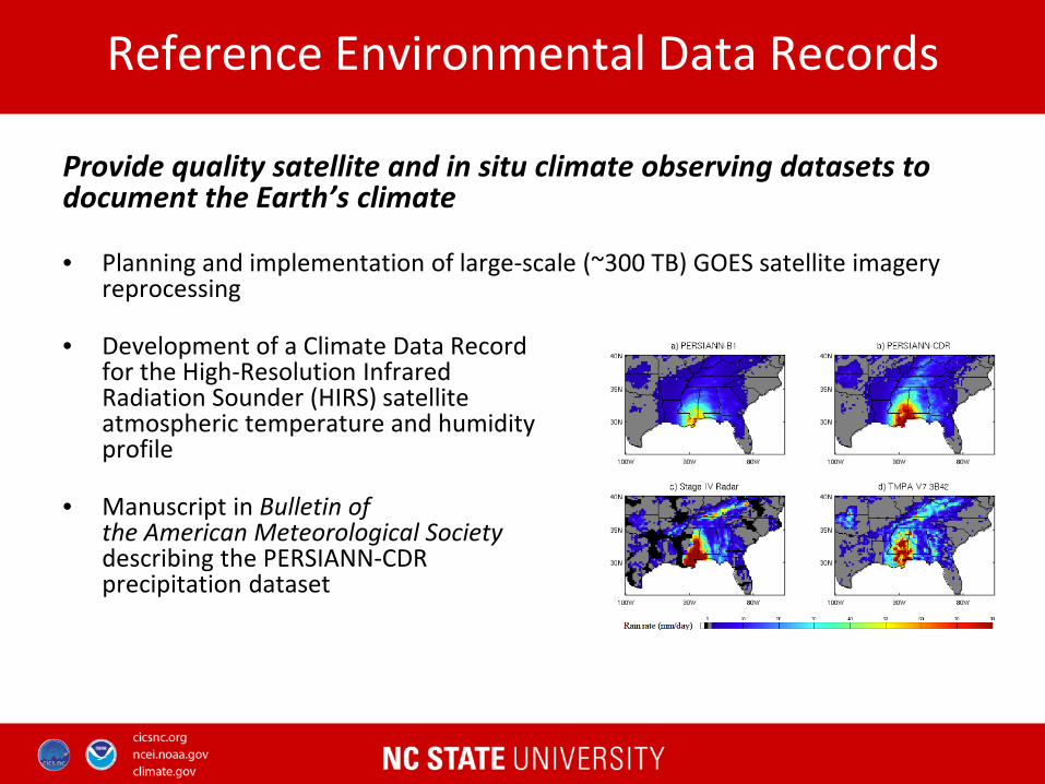
• Manuscript in Bulletin of the American Meteorological Society describing the PERSIANN-CDR precipitation dataset

Reference Environmental Data Records
• Extensive support for the transition of the ISCCP satellite cloud data set to NCEI, including contributions to the next generation H-series ISCCP cloud data satellite products and a paper on visible calibration of ISCCP B1U data
• Spatial-temporal data fusion of land surface albedo products (collaboration with NC State University Statistics Department)
Reference Environmental Data Records
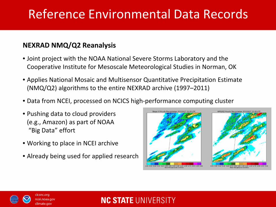
NEXRAD NMQ/Q2 Reanalysis
• Joint project with the NOAA National Severe Storms Laboratory and the Cooperative Institute for Mesoscale Meteorological Studies in Norman, OK
• Applies National Mosaic and Multisensor Quantitative Precipitation Estimate (NMQ/Q2) algorithms to the entire NEXRAD archive (1997–2011)
• Data from NCEI, processed on NCICS high-performance computing cluster
• Pushing data to cloud providers (e.g., Amazon) as part of NOAA “Big Data” effort
• Working to place in NCEI archive
• Already being used for applied research

Reference Environmental Data Records
• Refactoring production software for High resolution Infrared Radiation Sounder (HIRS) Outgoing Long-wave Radiation (OLR) Monthly CDR in preparation for production operations within NCEI
• Evaluation of the accuracy of the NOAA NCEI High Resolution Infrared Radiation Sounder (HIRS) near-surface air temperatures in the Arctic, using 1-year, QC’d data from Surface Heat Budget of the Arctic Ocean (SHEBA) project

Reference Environmental Data Records
• Generated obs4MIPs datasets from the entire period of record for three different Climate Data Records: – HIRS Outgoing Long-wave Radiation CDR – Optimum Interpolation Sea Surface Temperature (OISST) CDR – Sea Ice Concentration CDR
• Datasets available on ESGF
(Earth System Grid Federation: http://esgf.llnl.gov/)
• Analyzed other NCEI holdings for possible use in the obs4MIPs effort

• Cutting-edge research on the scientific stewardship of individual digital environmental data products – New data stewardship maturity matrix for environmental
data records – Stewardship maturity evaluation of NOAA Climate Data
Records – Peer-reviewed paper published introducing
roles/responsibilities of data, scientific, and tech stewards – Currently applied to > 250 NCEI products
Data Stewardship

Surface Observing Networks
Sustaining and improving the quality of in situ observations and observing networks
Developed a sub-monthly tool for monitoring impacts of temperature extremes in the United States.
• Near-real-time station data is aggregated at various levels (states, NCA regions, and CONUS)
• Data is updated on a daily basis to analyze current temperatures against the period of record
• Deployed experimental web-based visualization tool

Surface Observing Networks
• Developing next version of NOAA’s global temperature product, known as the Global Historical Climatology Network–Monthly (GHCN-M) dataset: – Nearly four times as many stations – Updated QC and bias corrections – Version 4 beta released Oct 2015
• Used USCRN soil climate observations to evaluate the national changes in soil moisture for improved drought monitoring
• Deployed a new precipitation algorithm for the U.S. Climate Reference Network (USCRN), improving the network’s capacity to monitor precipitation at a 5-minute frequency

Surface Observing Networks
• Analyzed changes to USCRN precipitation patterns over the 2012 drought and compared USCRN soil conditions to a commonly used reanalysis model—the North American Regional Reanalysis.
• Research highlighted severity of the 2012 drought and the model’s capacity to simulate the evolution of hydrological extremes.
• Developing soil product for the USCRN that can monitor both droughts and floods.
Other Projects
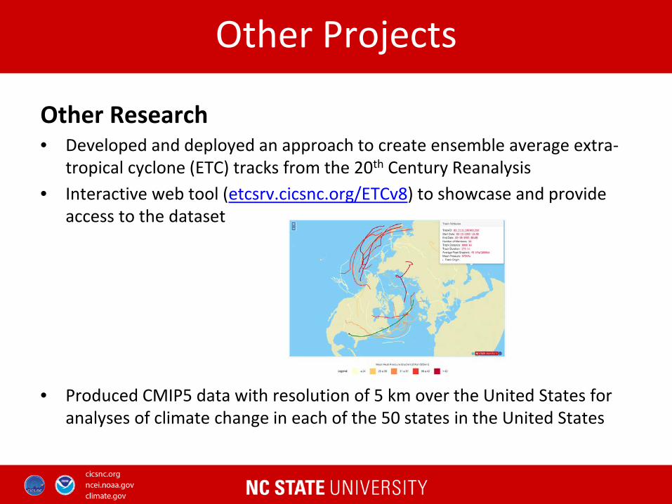
Other Research • Developed and deployed an approach to create ensemble average extra-
tropical cyclone (ETC) tracks from the 20th Century Reanalysis • Interactive web tool (etcsrv.cicsnc.org/ETCv8) to showcase and provide
access to the dataset
• Produced CMIP5 data with resolution of 5 km over the United States for
analyses of climate change in each of the 50 states in the United States

Other Projects
• Launched an improved version of website for monitoring and prediction of the Madden–Julian Oscillation and other tropical variability
• Serves ~800 unique users each month
• http://monitor.cicsnc.org/mjo/

Other Projects DoD — Strategic Environmental Research and Development Program (SERDP) • Ken Kunkel, lead PI, with Tom Karl & David Easterling (NOAA) • 5-year, $2.8 million ($1.53 million to NCSU) • Incorporation of effects of climate change into rainfall design values
NSF — Urban resilience to climate change-driven extreme events • Ken Kunkel, Co-PI • 5-year, $400K • Multi-institution collaborative project, ASU lead
NASA— Multi-scale interactions Between the MJO, Equatorial Waves, and the Diurnal Cycle Over the Maritime Continent
•Carl Schreck, Lead PI •3-year, $385K •Multi-institution collaborative project (NCICS/NCSU, MEAS/NCSU, NCAT)

Climate Literacy, Outreach, Engagement and Communications
Improving public knowledge and understanding of climate change, its impacts, and options for adaptation and mitigation
Educational Outreach • Participated in more than a dozen regional climate
literacy outreach events, including K-12 STEM programs, Career Day activities, and adult continuing education programs, including: – NC Science Festival activities, including the
Mountain Science Expo at the NC Arboretum – Middle school summer camp at Purchase Knob
in Smoky Mountain National Park – Video chat teaching middle-school students
about scientific computer programming Teaching computer programming to students in Waynesville, NC

Supporting NCEI Engagement, and Communications • Leading development of a robust customer information and engagement
management solution for NCEI • Working with NCEI to develop sector-based prioritization plan • Science writing/editing support for NCEI • Uncertainty quantification for NCEI’s database of billion-dollar
climate/weather disaster events • Support for January 2016 NCEI Engagement event on “Moving from
Environmental Data to Resilience: Forging Public-Private Partnerships in the Energy Sector” at AMS Annual Meeting
Climate Literacy, Outreach, Engagement and Communications

Other Engagement Activities • Worked with Asheville–Buncombe Sustainable Community Initiative to
develop The Collider — an event and business center in downtown Asheville intended to advance climate/environmental literacy and development of climate services business. The Collider’s office/co-working space opened for business in early 2016
• Working with the Asheville Museum of Science to broaden use and membership and to improve exhibit space
Climate Literacy, Outreach, Engagement and Communications

CICS-NC Communications • Developed various CICS-NC/NCICS communications
materials, including a new institute brochure and latest issue of the CICS-NC newsletter Trends
• Promoted research results and other activities via press releases and social media
• Coordinated communication efforts with NCEI for joint projects
Climate Literacy, Outreach, Engagement and Communications

Workforce Development
Prepare the next generation of climate scientists, engineers and technicians • Student interns (high school and university) and post-docs • Estimation of topographic variables at high resolution (1 km) for the contiguous
U.S. using Global 30 Arc-Second DEM (GTOPO 30) for a project using high-resolution radar reanalysis (NEXRAD)
• Evaluation of new spatial interpolator based on topography, using cross-validation against other methods
• Collocated and analyzed HIRS surface temperature to USCRN station data from 2006–2013. Constructed a best-fit equation to bias correct the HIRS surface temperatures

IT Infrastructure
Supporting research, development and computational demands
IT Infrastructure
• High speed networking – 802.11 AC WIFI – Video Communications – 10 Gigabit Ethernet
• High-performance computing – 45 Nodes – 528Cores / 3.2TB RAM
• Virtual Machine Platform – 6 Hosts / 72 Cores / 640GB RAM – >30 virtualized systems
• Data services – Over 1.2 PB on disk – Over 2.25 PB on Tape – 8 Gigabit Fiber Channel
High Performance Computing
Virtualization Platform
Network Communication
Data Storage Services
Services
Applications
Development
CDR / REDR Processing
Climate Assessment

Contacts Otis Brown, Director [email protected] Jenny Dissen, Outreach & Engagement [email protected] Tom Maycock, Communications [email protected] Janice Mills, Finance & Administration [email protected] Theresa Stone, Program Coordination [email protected] URL: http://www.ncics.org