ncics / cics-nc overview - university of marylandcicsmd.umd.edu/assets/1/7/1-7_otis_brown.pdf · 4...
TRANSCRIPT
1 1
NCICS / CICS-NC Overview Otis Brown
NCSU/ORIED November 2017

2 2
NCICS (NC Institute for Climate Science)
• Inspire cutting-edge research and collaboration
• Advance understanding and communicate the current and future state of the climate
• Engage with business, academia, government, and the public to enhance decision-making
• Current NCICS support is from NOAA, NASA, NSF, DoD/SERDP, and private industry
• Primary activity is the operation of the NOAA Cooperative Institute for Climate and Satellites-NC (CICS-NC)
Introduction
3 3
CICS-NC: a focus of NCICS, does the following… • Collaborative research into the use of in situ and remotely sensed
observations in climate research and applications
• Innovates new products and create new methods to understand the state and evolution of the full Earth system
• Prepares the next generation of the workforce needed to address climate science and its applications
• Engages with corporate leaders to develop climate-literate citizens and a climate-adaptive society
• Facilitates regional economic development through engagement activities
Introduction
4 4
CICS-NC – Seven Streams of Effort • Administration • Access and Services Development • Assessments • Reference Environmental Data Records & Data Stewardship • Climate Literacy, Outreach, Engagement, & Communications • Surface Observing Networks • Workforce Development
Plus Consortium and Other Projects
Introduction
5 5
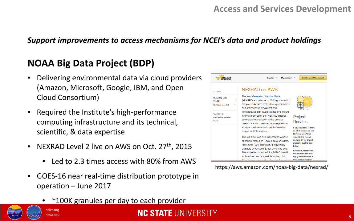
Support improvements to access mechanisms for NCEI’s data and product holdings NOAA Big Data Project (BDP)
https://aws.amazon.com/noaa-big-data/nexrad/
Access and Services Development
• Delivering environmental data via cloud providers (Amazon, Microsoft, Google, IBM, and Open Cloud Consortium)
• Required the Institute’s high-performance computing infrastructure and its technical, scientific, & data expertise
• NEXRAD Level 2 live on AWS on Oct. 27th, 2015
• Led to 2.3 times access with 80% from AWS
• GOES-16 near real-time distribution prototype in operation – June 2017
• ~100K granules per day to each provider
Innovative Approaches to High Speed Data Access Jonathan Brannock

6 6
NOAA Big Data Project (BDP) [continued] Changing the paradigm
Ansari et al., 2017 Unlocking the potential of NEXRAD data through NOAA’s Big Data Partnership, Bull. Amer. Meteor. Soc., https://doi.org/10.1175/BAMS-D-16-0021.1
Access and Services Development Innovative Approaches to High Speed Data Access Jonathan Brannock
7 7
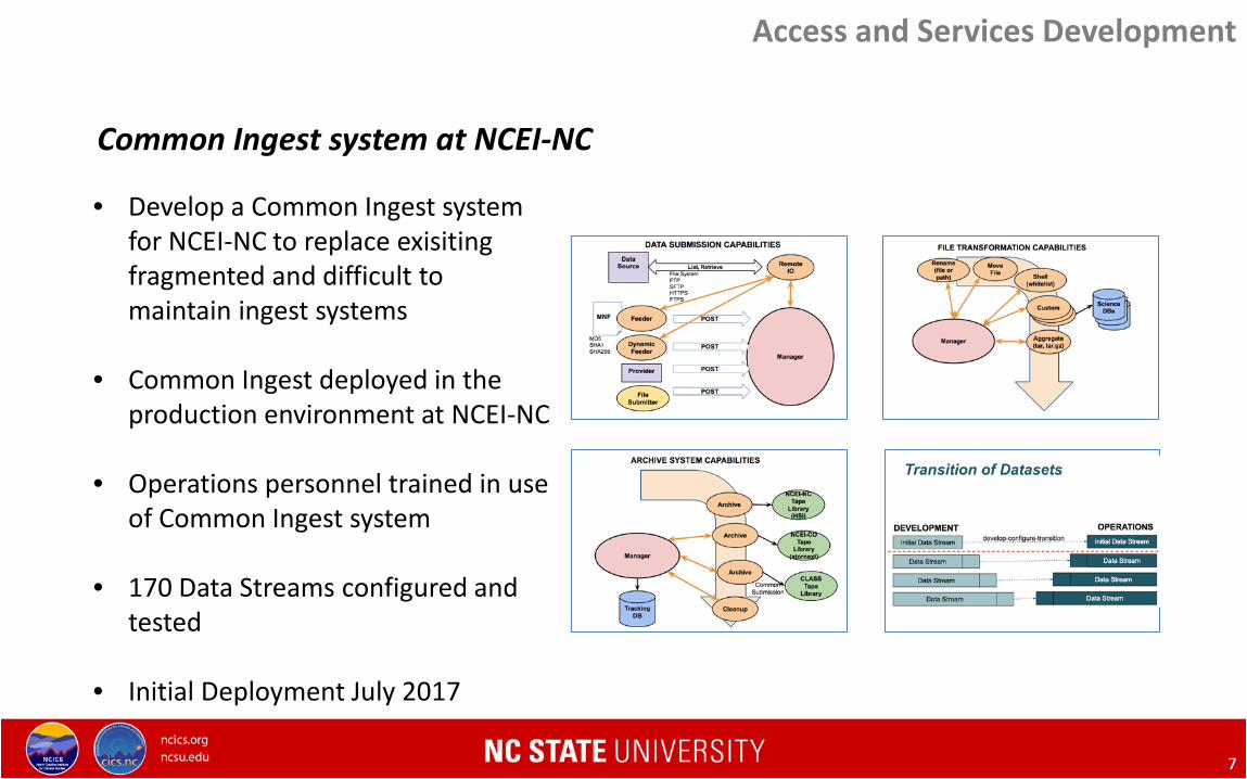
Common Ingest system at NCEI-NC
• Develop a Common Ingest system for NCEI-NC to replace exisiting fragmented and difficult to maintain ingest systems
• Common Ingest deployed in the production environment at NCEI-NC
• Operations personnel trained in use of Common Ingest system
• 170 Data Streams configured and tested
• Initial Deployment July 2017
Access and Services Development

9 9
Fourth National Climate Assessment (NCA4) Volume 1: The Climate Science Special Report (CSSR)
• USGCRP Climate Science Special Report, released November 3, 2017. https://science2017.globalchange.gov/
• Provides scientific foundation for NCA4, including observed and projected changes. US-focused. Includes new info on attribution, potential surprises.
Climate Science Special Report Projected US Temp Changes
Global Temp Change Observed Increases in Heavy Precip
Climate Assessments

10 10
Fourth National Climate Assessment (NCA4) Volume 2: Climate Change Impacts, Risks, and Adaptation in the United States.
• Draft for public comment & National Academies Review, released November 3, 2017. https://review.globalchange.gov/
• Assesses climate impacts, adaptation efforts, mitigation options. New in NCA4: Expanded regional focus, international context, etc.
Cities: Projected Very Hot Days
Projected US Temp Changes
Changes in Freeze-Free Season Projected Changes in Vapor Pressure Deficit
Climate Assessments
11 11
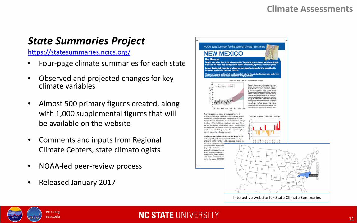
Climate Assessments
State Summaries Project https://statesummaries.ncics.org/ • Four-page climate summaries for each state • Observed and projected changes for key climate variables
• Almost 500 primary figures created, along with 1,000 supplemental figures that will be available on the website
• Comments and inputs from Regional Climate Centers, state climatologists
• NOAA-led peer-review process
• Released January 2017
Interactive website for State Climate Summaries
12 12
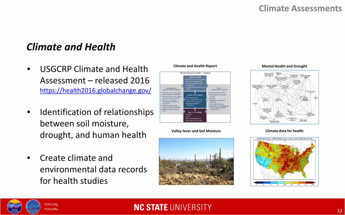
Climate and Health
• USGCRP Climate and Health Assessment – released 2016 https://health2016.globalchange.gov/
• Identification of relationships between soil moisture, drought, and human health
• Create climate and environmental data records for health studies
Climate and Health Report Mental Health and Drought
Valley fever and Soil Moisture Climate data for health
Climate Assessments
14 14
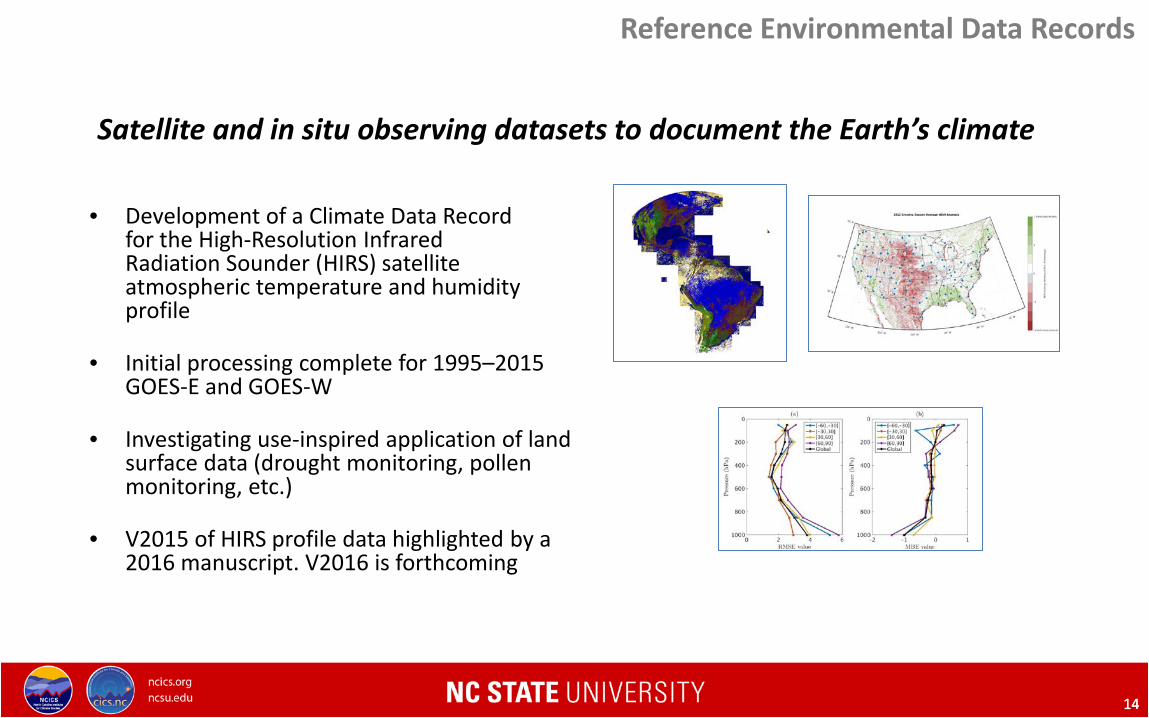
Reference Environmental Data Records
• Development of a Climate Data Record
for the High-Resolution Infrared Radiation Sounder (HIRS) satellite atmospheric temperature and humidity profile
• Initial processing complete for 1995–2015 GOES-E and GOES-W
• Investigating use-inspired application of land surface data (drought monitoring, pollen monitoring, etc.)
• V2015 of HIRS profile data highlighted by a 2016 manuscript. V2016 is forthcoming
Satellite and in situ observing datasets to document the Earth’s climate

15 15
• Extensive support for the transition of the ISCCP satellite cloud dataset to NCEI.
• Research and expertise for calibration, validation, algorithm development, and quality control.
• Next generation H-series ISCCP product released in August 2017.
• Spatial-temporal data fusion of land surface albedo products (collaboration with NCSU Statistics Department)
Reference Environmental Data Records

16 16
• obs4MIPs: making observational data more accessible for climate model comparisons.
• Generated obs4MIPs datasets for 3 different Climate Data Records: – HIRS Outgoing Long-wave Radiation REDR (CDR) – Optimum Interpolation Sea Surface Temperature (OISST) REDR (CDR) – Sea Ice Concentration REDR (CDR)
• Datasets available on ESGF (Earth System Grid
Federation: http://esgf.llnl.gov/)
• Analyzed other NCEI holdings for possible use in the obs4MIPs effort
Reference Environmental Data Records
Improve data use by international modeling and analysis communities
17 17
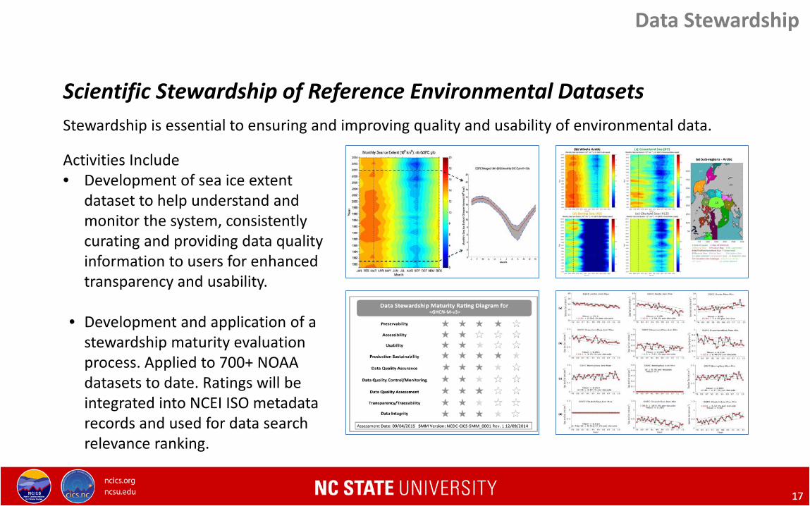
Stewardship is essential to ensuring and improving quality and usability of environmental data.
Data Stewardship
Scientific Stewardship of Reference Environmental Datasets
Activities Include • Development of sea ice extent
dataset to help understand and monitor the system, consistently curating and providing data quality information to users for enhanced transparency and usability.
• Development and application of a stewardship maturity evaluation process. Applied to 700+ NOAA datasets to date. Ratings will be integrated into NCEI ISO metadata records and used for data search relevance ranking.

18 18
• Interact with Global Historical Climatology Network (GHCN) and International Surface Temperature Initiative (ISTI) teams on development of improved land surface temperature records
• Supporting software development for next version of GHCN-Monthly (version 4)
• Updated climatology of snowfall extremes used by FEMA for determining assistance.
• Created database of county level drought, comparing with CDC health data.
• Developed tool to assess current and past extreme heat events.
Top Left: Temperature anomaly, plus uncertainty estimates, for both GHCN-M version 4 and CRUTEM. Top Right: 2 day snowfall totals for Western North Carolina during the 1993 Superstorm. Bottom Left: Mann-Kendall Z-Scores of SPEI drought data from 1950-2015. Bottom Right: 3 week temperature ranks for NCA regions ending on 3/4/17.
Surface Observing Networks
GHCN, ISTI, Snowfall, Drought, and Heat
19 19
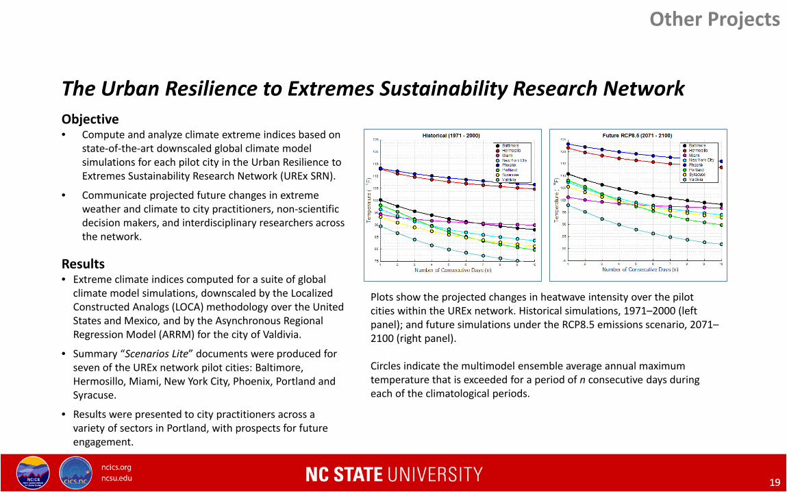
Objective • Compute and analyze climate extreme indices based on
state-of-the-art downscaled global climate model simulations for each pilot city in the Urban Resilience to Extremes Sustainability Research Network (UREx SRN).
• Communicate projected future changes in extreme weather and climate to city practitioners, non-scientific decision makers, and interdisciplinary researchers across the network.
Results • Extreme climate indices computed for a suite of global
climate model simulations, downscaled by the Localized Constructed Analogs (LOCA) methodology over the United States and Mexico, and by the Asynchronous Regional Regression Model (ARRM) for the city of Valdivia.
• Summary “Scenarios Lite” documents were produced for seven of the UREx network pilot cities: Baltimore, Hermosillo, Miami, New York City, Phoenix, Portland and Syracuse.
• Results were presented to city practitioners across a variety of sectors in Portland, with prospects for future engagement.
Plots show the projected changes in heatwave intensity over the pilot cities within the UREx network. Historical simulations, 1971–2000 (left panel); and future simulations under the RCP8.5 emissions scenario, 2071–2100 (right panel). Circles indicate the multimodel ensemble average annual maximum temperature that is exceeded for a period of n consecutive days during each of the climatological periods.
The Urban Resilience to Extremes Sustainability Research Network
Other Projects
20 20
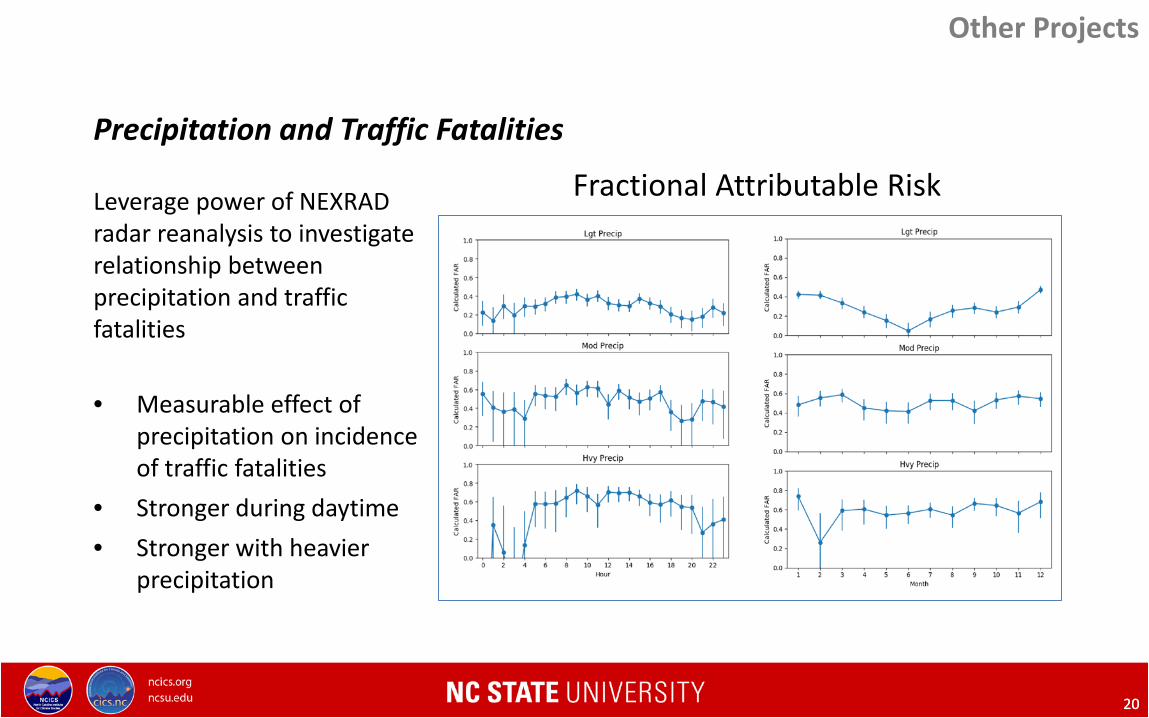
Leverage power of NEXRAD radar reanalysis to investigate relationship between precipitation and traffic fatalities
• Measurable effect of precipitation on incidence of traffic fatalities
• Stronger during daytime • Stronger with heavier
precipitation
Fractional Attributable Risk
Precipitation and Traffic Fatalities
Other Projects
21 21
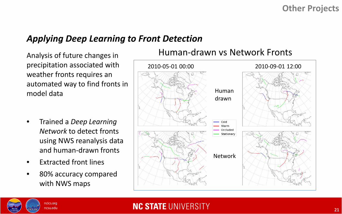
Analysis of future changes in precipitation associated with weather fronts requires an automated way to find fronts in model data
• Trained a Deep Learning Network to detect fronts using NWS reanalysis data and human-drawn fronts
• Extracted front lines • 80% accuracy compared
with NWS maps
Human-drawn vs Network Fronts 2010-05-01 00:00 2010-09-01 12:00
Human drawn
Network
Other Projects
Applying Deep Learning to Front Detection

23 23
• Promote awareness of, and interest in, Institute activities, products, and research outcomes.
• Enhance science communication capabilities and reach of institute staff.
CICS-NC Communications
Climate Literacy, Outreach, Engagement and Communications

24 24
IT Infrastructure
Supporting research, development and computational demands
IT Infrastructure
• High speed networking – 802.11 AC WIFI – Video Communications – 10 Gigabit Ethernet
• High-performance computing – 45 Nodes – 528Cores / 3.2TB RAM
• Virtual Machine Platform – 6 Hosts / 72 Cores / 640GB RAM – >30 virtualized systems
• Data services – Over 1.2 PB on disk – Over 2.25 PB on Tape – 8 Gigabit Fiber Channel
High Performance Computing
Virtualization Platform
Network Communication
Data Storage Services
Services
Applications
Development
CDR / REDR Processing
Climate Assessment
26 26
Contacts
Otis Brown, Director [email protected]
Jenny Dissen, Outreach & Engagement [email protected]
Tom Maycock, Communications [email protected]
Janice Mills, Finance & Administration [email protected] URL: http://ncics.org