nature and distribution of loess in canterbury, new zealand
TRANSCRIPT

This article was downloaded by: [Simon Fraser University]On: 14 November 2014, At: 10:24Publisher: Taylor & FrancisInforma Ltd Registered in England and Wales Registered Number: 1072954Registered office: Mortimer House, 37-41 Mortimer Street, London W1T 3JH,UK
New Zealand Journal ofGeology and GeophysicsPublication details, including instructions forauthors and subscription information:http://www.tandfonline.com/loi/tnzg20
Nature and distribution of loessin Canterbury, New ZealandDavid Ives aa Soil Bureau , DSIR , Christchurch , New ZealandPublished online: 14 Feb 2012.
To cite this article: David Ives (1973) Nature and distribution of loess in Canterbury,New Zealand, New Zealand Journal of Geology and Geophysics, 16:3, 587-610, DOI:10.1080/00288306.1973.10431382
To link to this article: http://dx.doi.org/10.1080/00288306.1973.10431382
PLEASE SCROLL DOWN FOR ARTICLE
Taylor & Francis makes every effort to ensure the accuracy of all theinformation (the “Content”) contained in the publications on our platform.However, Taylor & Francis, our agents, and our licensors make norepresentations or warranties whatsoever as to the accuracy, completeness,or suitability for any purpose of the Content. Any opinions and viewsexpressed in this publication are the opinions and views of the authors, andare not the views of or endorsed by Taylor & Francis. The accuracy of theContent should not be relied upon and should be independently verified withprimary sources of information. Taylor and Francis shall not be liable for anylosses, actions, claims, proceedings, demands, costs, expenses, damages,and other liabilities whatsoever or howsoever caused arising directly orindirectly in connection with, in relation to or arising out of the use of theContent.
This article may be used for research, teaching, and private study purposes.Any substantial or systematic reproduction, redistribution, reselling, loan,

sub-licensing, systematic supply, or distribution in any form to anyone isexpressly forbidden. Terms & Conditions of access and use can be found athttp://www.tandfonline.com/page/terms-and-conditions
Dow
nloa
ded
by [
Sim
on F
rase
r U
nive
rsity
] at
10:
24 1
4 N
ovem
ber
2014

No. 3
NATURE AND DISTRIBUTION OF LOESS IN CANTERBURY, NEW ZEALAND
DAVID lVES
Soil Bureau, DSIR, Christchurch, New Zealand
(Received 11 October 1972
ABSTRACT
587
Loess of variable thickness occurs over 26% of the land surface of Canterbury. Areas where loess is currently accumulating, areas where loess ceased to accumulate at the close of the last glaciation and areas where loess has been transported and redeposited by water are shown on maps.
It is suggested that the extensive thick deposits of loess on the Canterbury downlands and foothills were derived from pre-existing loess deposits on the fan surfaces of the Canterbury Plains. The phase of relocation of the loess was of brief duration, probably 2000 years, and was followed by a period of deposition of younger loess on to the now deflated fan surfaces of the Plains.
It is proposed to call the thick loess layers which were deposited during brief periods in the late Pleistocene "post-stadia! loess". Loess which accumulated at a ~lower rate on the fan surfaces adjacent to the major rivers crossing the Plains is designated "interstadial loess". Recent or Post-glacial loess is an example of interstadial loess. In relation to loess deposits overseas, interstadial loe·;s is from a fluvio-glacial source and post-stadia! loess is, in the broadest ~ense, from a continental source.
INTRODUCTION
Loess deposits in Canterbury (Fig. 1) are more extensive, show greater variability in thickness, and have more varied morphological expression than elsewhere in New Zealand. Raeside (1964) estimated that loess of greater thickness than 30 em influenced the pedogenesis of more than 1 125 000 hectares of the South Island. This was perhaps a wnservative estimate on his part.
Raeside (1964) defined New Zealand loess as " ... any fine textured deposit of aeolian origin other than dune sands ... ", noting that in New Zealand the term was applied in a wider sense than in the United States
The loesses of Canterbury are derived from the wacke sediments of the or Europe. This definition has been accepted, with little debate, by subsequent workers. Southern Alp~ and subsidiary ranges, and are approximately 90% quartz and plagioclase, in equal proportion. Accessory minerals include epidotes, mica, zircon, amphiboles, tourmaline and sphene. Volcanic glass, plant opal and sponge spicules have also been identified (Raeside 1956; 1964).
LoESS TYPES
In Other Countries Obruchev (1945) outlined differences between primary loess (of aeolian
origin) and Eecondary loess which included primary loess "altered or degraded" in situ, or deposited by water. Primary loesses were grouped as "cold loess" or "warm loess" according to climate and topography of
N.Z. jottma/ of Geology and Geophysics 16 (3): 587-610
Dow
nloa
ded
by [
Sim
on F
rase
r U
nive
rsity
] at
10:
24 1
4 N
ovem
ber
2014
588 N.Z. JoURNAL OF GEOLOGY AND GEOPHYSICS VoL. 16
A - Mowbray Catchment
8 - Methven - Barrhill Area
lOOkm
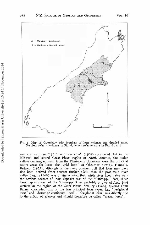
FIG. 1-Map of Canterbury with locations of loess columns and detailed maps. Numbers refer to columns in Fig. 6; letters refer to maps in Fig. 4 and 9.
source areas. Frye (1951) and Frye et a!. (1968) considered that in the Midwest and central Great Plains region of North America, the major valleys carrying outwash from the Pleistocene glaciation, were the principal source areas for loess-the "cold loess" of Obruchev ( 1945). Hanna &
Bidwell (1955), although of the same opinion, felt that loess may have also been derived from sources further afield than the proximate river valley. Lugn (1968) was of the opinion that, while river floodplains were the obvious sources of loess deposits east of the Mississippi River, those loess deposits west of the Mississippi River probably originated from land surfaces in the region of the Great Plains. Smalley (1966), quoting from Butzer, concluded that of the two principal loess types, i.e., "periglacial loess" and "desert or continental loess", "periglacial loess" was directly due to the action of glaciers and should therefore be called "glacial loess".
Dow
nloa
ded
by [
Sim
on F
rase
r U
nive
rsity
] at
10:
24 1
4 N
ovem
ber
2014

No.3 IVES -LOESS IN CANTERBURY 589
The "typical loess" of Europe was deposited under a steppe-type climate and was of aeolian origin, whereas "dust loam" or "gleyed loess" (Fink 1968) accumulated under surface water gley condition. Pesci (1968) recorded that in addition to "typical loess", "fluviatile loess silts", rewashed loessial material, and "slope loess" (typical loess modified by slope processes) were recognised as loess types in Hungary.
In the Danube Valley, Yugoslavia, two kinds of loess are recognised: "glacial" and "interglacial" (Markovic-Marjonovic 1968). "Glacial loess" forms thicker deposits than "interglacial loess" but otherwise both types have similar composition and both indicate cold climatic conditions. Pewe (1951) and Reiger & Juve (1961) established the existence and documented the characteristics of "recent loess" in Alaska.
Journaux et al. (1969) used chemical composition as the basis of differentiation when separating the "calcareous loess" and "non-calcareous loess" deposits of Normandy. Rozycki (1968) outlined the use of the texture of the loess in the grouping of loesses in Bulgaria.
Based on a collation of overseas information it appears that loess may be divided into two major categories. These are, primary loess, from either fluvio-glacial or continental sources and secondary loess, which may result from alteration of primary loess in place, or reworking and redeposition under water-logged conditions. Sub-groups within these categories are established on the basis of the event leading to the production of the loess, and the chemical nature of the deposit. These conclusions are summarised in Table 1.
In the South Island, New Zealand Loess deposits of the South Island were grouped into three regional
categories by Raeside (1964). These regions have been differentiated on the basis of the nature of the parent rocks that have given rise to the loess. Loess in Southland is derived from tuffaceous wackes. Loess derived essentially from metamorphic rocks occurs in northern Southland and Otago. In Marlborough, Canterbury and north-east Otago, loess deposits are derived from the wackes of the Southern Alps and foothills. Each loess region is further identified by the mineralogic composition of the loess.
The terms "recent loess" and "Post-glacial loess" have been applied to loess which has accumulated in the Post-glacial period (Grange 1935; Raeside 1964). "Reworked" or "rewashed loess" is considered to have been derived from eroding loess deposits, and to have been redeposited in low-lying locations and under water (Kear et al. 1967).
Textural variations have been noted but have not been used to differentiate loesses on a regional basis (N .Z. Soil Bureau 1968).
DISTRIBUTION OF LOESS IN CANTERBURY
Soils which have a loess influence to a greater or lesser extent (N.Z. Soil Bureau 1968) occupy 25·9% of the total area of the province. Thts is nearly 1 000 000 hectares (Table 2). Fifty-four percent of the area of these
Dow
nloa
ded
by [
Sim
on F
rase
r U
nive
rsity
] at
10:
24 1
4 N
ovem
ber
2014

590 N.Z. JOURNAL OF GEOLOGY AND GEOPHYSICS VoL. 16
TABLE 1--Loess types, collated from published data (various sources).
Level of Source Period of Chemistry Subdivision Deposition
{ calcareous
r glacial/ stadia!
fluvio-glacial j non-calcareous interglacial/
l interstadial/ { calcareous
Primary loess post-glacial non·calcareous (=recent)
f calcareous
r glacial/stadia! l continental
t non-calcareous
(desert) interglacial/
{ calmreous interstadial/ post-glacial non-calcareous ( = recent)
altered/
r degraded (in place)
Secondary loess l rewashed/ reworked (redeposited)
TABLE 2-Area and proportions of loess types in Canterbury.
Area %of '7o of %of (ha) group all loess Canterbury
deposits Province
Post-glacial Loess (thickness) 361 540 37 9·5 < 0·5m 169 450 47 17 4·4
(usually 0·3-0·'i m) 1·0-0·5m 161) 170 46 17 4·4
> 1·0m 25 920 7 3 0·6 Rewashed or Redepos1ted Loes5 85 700 100 9 2·2 Late Pleistocene Loess (thickness) 542 180 54 14·2
<0·5m 183 710 34 19 4·8 1·0-0·5 m 75 370 14 7 2·0
> 1·0m 283 100 52 29 7·4 (usually > 3m)
Total 989 420 25 ·9
Dow
nloa
ded
by [
Sim
on F
rase
r U
nive
rsity
] at
10:
24 1
4 N
ovem
ber
2014

No.3 IVES -LOESS IN CANTERBURY 591
loess deposits is of late Pleistocene age, and half of that amount is loess of greater thickness than 1·0 m. The distribution of various types of loess is shown in Fig. 2 and 3.
Post-glacial Loess
Post-glacial loess deposits occur adjacent to the major rivers and on the fan surfaces between these rivers (Fig. 2). The most extensive deposits are usually found on the higher parts of the fan and outwash surfaces, both on the Canterbury Plains and in the high country basin. They are thickest on the south bank immediately adjacent to the river and thin rapidly down-wind, away from the river bank.
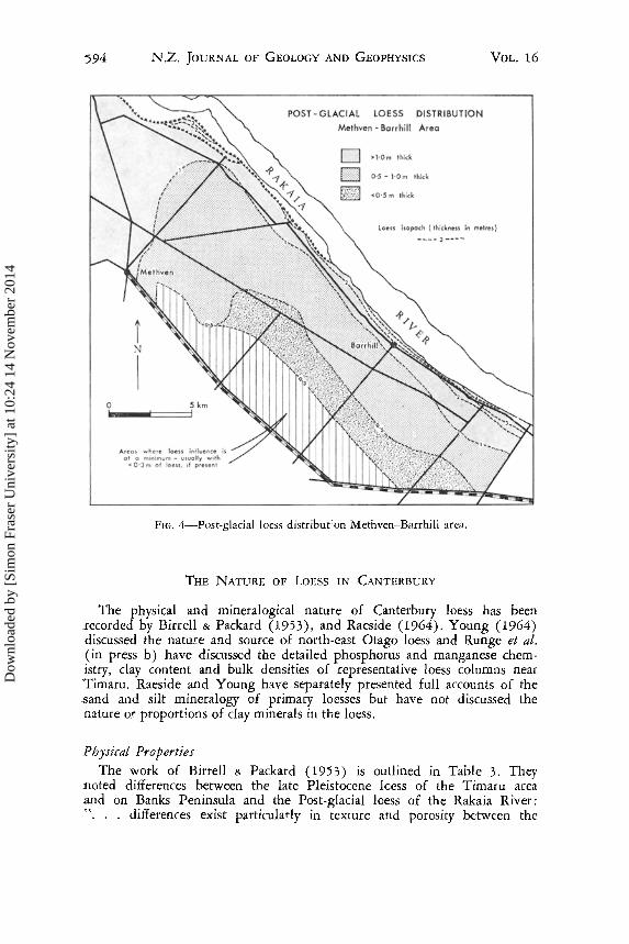
Studies conducted on the Post-glacial loess on the south bank of the Rakaia River between Barrhill and the Methven area reveal that the loess thickness decreases rapidly with distance from the River (Fig. 4). The relationship between loess thickness and distance from the. Rakaia River is shown in Fig. 5 and is expressed by the equation
(thickness in em) Y = 203·7 - 35·9log X where X = distance from the Rakaia River m metres for 35 sites
ranging from the river bank to 14 km from the river. This relationship is similar to that determined by Hutton (as quoted by Ruhe 1969) for loess in southern Iowa, i.e.,
(thickness in in.) Y = 1250·5 - 528·5 log X Where X = distance from source (the Missouri River) in miles.
Late Pleistocene Loess
This term embraces loess deposits which ceased to accumulate about 10 000 years ago (NZ1258, see Table 5) and loess which has been buried by deposits of younger loess (Fig. 6). These deposits are found over the undulating, rolling and in some cases hilly land which (a) fringes the Canterbury Plains on the south, west and north ; and which (b) occurs on the peripheries of high country basins such as the Mackenzie, Waimakariri and Culverden-Hanmer basins, on moraines, fans and hillsides (see Fig. 3).
In Canterbury these deposits are deepest on the downland of South Canterbury and on Banks Peninsula. They commonly exceed 3m in thickness and contain at least one palaeosol (Fig. 6).
Rewashed or Redeposited Loess
Redeposited loess is generally associated with areas of imperfectly and poorly drained soils. Loess of this type usually occurs in pockets in the low-lying parts of the backs of terraces, on the floodplains of small streams in areas where thick loess deposits occur, and on the peripheries of fans, particularly the extremities of the coalescing fans which form the Canterbury Plains (Fig. 2).
Dow
nloa
ded
by [
Sim
on F
rase
r U
nive
rsity
] at
10:
24 1
4 N
ovem
ber
2014

592 N.Z. JOURNAL OF GEOLOGY AND GEOPHYSICS
FIG. 2-Distribution of Post-glacial loess in Canterbury.
VoL. 16
Dow
nloa
ded
by [
Sim
on F
rase
r U
nive
rsity
] at
10:
24 1
4 N
ovem
ber
2014

No.3 lvEs -LoEss IN CANTERIJURY
1'. i \
(\ ~ .. j '· I . i '· .... , . .... 1 I .,·""'·,
Distribution of Late Pleistocene i ., ,_,.-·"'
LoeS$,
• ~ • >l·Om thick (u~~~::a;J:_or;,.:;:iT~
'/ O·S - I·Om thick i
i <O·Sm thick I
; I ;
/
·ot==============:fs~ {~ Kilometres ;
; r
·i ;
_,.,·'l
/ /
I i i i
l i i i j
_,·' I
,i
FIG. 3-Distribution of late Pleistocene loess in Cantnbury.
593
Dow
nloa
ded
by [
Sim
on F
rase
r U
nive
rsity
] at
10:
24 1
4 N
ovem
ber
2014
594 N.Z. JoURNAL OF GEOLOGY AND GEOPHYSICS VoL. 16
POST- GLACIAL LOESS DISTRIBUTION
Methven - Barrhill Area
>l·Om thick
O·S • 1·0 m thick
<0·5 m thick
Loess isopach (thickness in metres}
0 5km ----==:=:::1 Areas where loess influence is
ol a minimum - usually with ..: 0·3 m of loess, if present
---- 3 __ ... _
FrG. 4-Post-glacial loess distribut'on Methven-Barrhill area.
THE NATURE OF LOESS IN CANTERBURY
The physical and mineralogical nature of Canterbury loess has been :recorded by Bi:r:rell & Packard (1953), and Raeside (1964). Young (1964) discussed the natu!e and source of north-east Otago loess and Runge et a!. (in press b) have discussed the detailed phosphorus and manganese chemistry, clay content and bulk densities of representative loess columns near Timaru. Raeside and Young have separately presented full accounts of the .sand and silt mineralogy of primary loesses but have not discussed the nature o! proportions of clay minerals in the loess.
Physical Properties
The work of Birrell & Packard (1953) is outlined in Table 3. They noted differences between the late Pleistocene lcess of the Timaru area .and on Banks Peninsula and the Post-glacial loess of the Rakaia River: ". . . differences exist particularly in texture and porosity between the
Dow
nloa
ded
by [
Sim
on F
rase
r U
nive
rsity
] at
10:
24 1
4 N
ovem
ber
2014

No.3
250
200
:2 ~ 150
<3
0 100 . c
~
'!'>- 50
0
IVES- LOESS IN CANTE'lBCRY 595
POST·GlACIAl lOESS THICKNESS IN RELATION TO DISTANCE FROM SOURCE
{ Methven • Borrhill Area J
0
0 0
0
0~Cb 0 o 0
0 0
0
0
00 00~ 0 0 0
0 00
100 l,O()() 10,000 metres
X "" Distance from source ( Rokoia River).
FIG. 5-Post-glacial loess thickness in relation to distance from source. MethvenBarrhill area.
"loess" deposits in the South Island and what is accepted as loess overseas. . . . The occurrence of material more nearly resembling continental loess near Rakaia township may be ascribed to the recent nature of this deposit."
As Birrell and Packard have noted, late Pleistocene loess has a higher clay content and is less porous than the Post-glacial loess. The difference in clay content may be attributed to differences in weathering within the loesses both during and after deposition. 'I;he marked difference in porosity however is unique and appears to be a characteristic which can be used to separate the two loess types, not only on the basis of laboratory measurement but also by observation. In exposed cuttings Post-glacial loess appears to be massive, has few distinct vertical cracks and is generally not as compact as late Pleistocene loess. Late Pleistocene loess on the other hand usually displays coarse prismatic structure, a colour pattern in distinct vertical cracks and the soils formed on thicker (greater than 2 m) deposits display a fragipan in the upper part of the parent material (C horizon).
Chemical Properties
The chemical data obtained by Runge et al. (in press b) was designed to indicate the presence of palaeosols and of unweathered loess in deep loess columns. It is possible however to gain a general idea of the characteristics of the two main loess types by reference to the analysis of the parent material (C horizons) of soils derived from loess. Ten separate analyses of C horizons of soils formed from Post-glacial loess and 18
Dow
nloa
ded
by [
Sim
on F
rase
r U
nive
rsity
] at
10:
24 1
4 N
ovem
ber
2014

596 N.Z. JoURNAL OF GEOLOGY AND GEOPHYSICS
Redcliffs 122m
2
3b
/ /
/ /
/
I
I I'
/ m
n,
I !~o':,o: /
I
10 ·~~~ I
· wf_
2 Hook 73m
3 Normanby 2
4 Darling 5
120m
5 Claremont 1
150m
VoL. 16
6 Dashing
Rocks 15m
FIG. 6-Some representative loess columns, south-north across Canterbury. locations of numbered columns are shown in Fig. 1.
Dow
nloa
ded
by [
Sim
on F
rase
r U
nive
rsity
] at
10:
24 1
4 N
ovem
ber
2014

No.3
7 'Kellands
Hill s•m
8 Kakahu 240m
!VES- LOESS IN CANTERBURY
9 Barr hill
207m
I
I I
I I
I I
I
I I
I
10 Birdlings
Flat 23m
I I Ia
I
I '
II>
" 3
I " I I I \ 1 •• ?m
I I
I I
I I
I I
I / I /
I I
12
" I
I
11 Barrys
Bay 183m
3
4
oa ooo 0 Q
~ late Pleistocene loess deposits • Timaru basalt
597
12 Leithlield
\ 25m \
\ \
\ \
\
2•
---- ~~"\
3
? /"
/ /
/ /
/ /
/
.~ ~ Mixed basalt and loess colluvium
D
Post- Glacial loess deposit
Loess containing free calcium carbonate
• Remainder of loess column not observed
~ Alluvial gravels' bu Burnham Formation go wl
Georgetown Formation
Pliocene grav~ls ·Palaeosols { =
= easily recognised
indistinct
strongly w~athered {probably of lo.st Interglacial age)
FIG. 6-Continued from opposite page.
Dow
nloa
ded
by [
Sim
on F
rase
r U
nive
rsity
] at
10:
24 1
4 N
ovem
ber
2014

598 N.Z. JoURNAL OF GEOLOGY AND GEOPHYSICS VoL. 16
analyses of C horizons of soils formed from late Pleistocene loess were extracted from New Zealand Soil Bureau (1968) and this information is summarised in Table 4.
Late Pleistocene loess is more acid and has a higher cation exchange capacity than Post-glacial loess. A key feature in the separation of the two loess types may be the higher exchangeable (and probably total) calcium content of Post-glacial loess. Values for the exchangeable Cajexchangeable Mg ratios tend to be greater than 2·0 for Post-glacial loess and less than 1·6 for late Pleistocene loess.
The variable influence of periodic and permanent water-logging on the chemical, mineralogical and physical properties of rewashed or redeposited loess makes it difficult to generalise on the nature of these deposits. Broadly however, they are less porous than Post-glacial loess, have higher day contents than late Pleistocene loess, have weakly acid to alkaline reaction and have high levels of exchangeable calcium, with exchangeable Ca/ exchangeable Mg ratios of about 2·0.
TABLE 3-Comparison of some I hysical characteristics of Canterbury loess types.
2--0·2 mm 0·2- 0·02- 0·01-coarse sand 0 · 02 mm 0 · 002 mm 0·002 mm 0·05 mm Porosity
% fine sand silt clay% % % % %
Post-glacial Upper range (average of 7 to 4 68 35 18 52 48·0 samples) Median 1 58 28 12 44 42 2
Lower range to Nil 45 24 7 35 38·3
Late Pleisto- Upper range cene (average to Nil 69 37 23 57 39·3 of 9 samples) Median Nil 57 28 15 50 35·7
Lower range to Nil 40 22 8 42 30·4
TABLE 4-Comparison of some chemical characteristics of Canterbury loess types based on chemical analysis of C horizons.
Post-glacial ( 10 Upper range to samples) Median
Lower range to Late Pleistocene Upper range to loess ( 18 sam- Median pies) Lower range to
pH (1: 2· 5 CEC H20) me%*
7·4 I3·4 6·3 8·9 5·7 4·2 6·0 12. 1 5·4 10·5 4·4 5·3
*1 me = 1 mmol/ion charge number.
BS %
97 65 17 52 31 4
Ca me%
7·8 3·9 1· I 4·3 1·6 0·0
Ratio Mg exchange-
me % able Ca/Mg
6·7 1·9 3·37 0·4 2·I 1·4 1·27 0·2
Dow
nloa
ded
by [
Sim
on F
rase
r U
nive
rsity
] at
10:
24 1
4 N
ovem
ber
2014

No.3 lVES- LOESS IN CANTERBURY 599'
DISCUSSION
Origin of Canterbury Loess Deposits
Post-glacial Loess It has been long inferred, and studies by J. E. Cox (pers. comm.) and the author have established, that Post-glacial loess is· derived from the beds of braided rivers of the Canterbury Plains and in adjacent high country basins. How long primary material remains at the initial site of deposition is unknown, but there is gradual movement of this material, by a series of extended jumps, across the fans and plains adjacent to the aggrading rivers. The amount of loess moved from any site, relative to the amount deposited, increases with distance from source and hence there is a net gain, closest to source, which decreases rapidly with increasing distance from source.
It is logical to assume that loess with similar properties to Post-glacial' loess was deposited during intervals in the Pleistocene when the rivers were actively aggrading. Such deposits would have accumulated in similar fashions and locations to those observed today, but any contemporary expression would be difficult to find as they would have been eroded andjor buried during subsequent periods of degradation and aggradation.
In some locations, noticeably on high terraces or bluffs, predominantly on the northern sides of aggrading rivers or once actively aggrading rivers, loess deposits containing layers with free calcium carbonate occur (Fig. 6). At Redcliffs, on Banks Peninsula (Griffiths 1973) and at the Waipara River mouth these loess layers containing free carbonate occur in stratigraphic positions which suggest that they did not accumulate in the Postglacial period. In appearance, apart from the calcium carbonate in the form of loess "dolls" or tubules, these layers closely resemble Post-glacial loess deposits.
It may be argued that the proximity to the sections listed of lime-rich deposits (limestones are found near Redcliffs and close to the Waipara river mouth, and marine deposits of a calcareous nature would occur around Banks Peninsula at times of lower sea level), can account for the presence of free carbonate. The lack of major structure, their porous appearance and their low clay content suggest however, that these loesses could have deposited in a similar fashion to Post-glacial loess probably during past interstadial periods.
If loess, similar in nature to Post-glacial loess, was deposited during interstadial (or interglacial) periods it is probable that the following observations about Post-glacial loess were also true for previous depositions of similar material. (a) A blanket of loess has been deposited over the landscape and this
deposit, thickest closest to source, is still evident some considerable distance from source.
(b) Under natural conditions loess continues to accumulate, at variable rates, over a long period of time; e.g., on the Canterbury Plains, over most of the Post-glacial period.
Late Pleistocene Loess Thick, multiple loess deposits, particularly those near Oamaru, Timaru and on Banks Peninsula (Young 1964; Raeside 1964,
Dow
nloa
ded
by [
Sim
on F
rase
r U
nive
rsity
] at
10:
24 1
4 N
ovem
ber
2014

600 N.Z. JouRNAL OF GEOLOGY AND GEOPHYSICS VoL. 16
W. F. Rennie photo
FIG. 7-Loess section exposed at Dashing Rocks, Timaru. Four loess layers overlie the eroded surface of the Timaru Basalt.
Bruce et al. 1973), have compact layers with well defined vertical jointing (Fig 7, 8). This joint pattern gives rise to a distinct prismatic structure, commonly outlined by grey veins and generally overtopped successively by a fragipan and a softer, diffusely mottled zone. Where these. latter two features are found below a uniform deposit with coarse vertical joints they ·show the position of a former soil developed on an earlier loess deposit.
Recent advances in radiometric dating of loess deposits (Bailey 197L fig. 8; Runge et al. in press a) have suggested that these loess deposits may have accumulated in a very short time. In particular, near Timaru, the upper loess layer of about 3·4 m thickness probably accumulated in 1900 years. The radiocarbon ages 11 800 -1- 190 years B.P. (NZ1265) and 9900 -1- 100 years B.P. (NZ1258) (Runge et al. in press a) indicating the minimum possible time period when this loess layer could have accumulated (Table 5).
Raeside (1964) suggested that the source of the extensive, multi-layered (late Pleistocene) loess deposits in South Canterbury was the large coales
·cing piedmont alluvial fans forming the Canterbury Plains and their seaward extension at times of lower sea level. Raeside (1964) and Young (1964) both cite the mineralogic similarity of the loess and the finer fan
Dow
nloa
ded
by [
Sim
on F
rase
r U
nive
rsity
] at
10:
24 1
4 N
ovem
ber
2014

No.3 lVES --LOESS IN CANTERBURY 601
" ----._ __ ··-·- ··-· ·········- ,,, _____ , ··-·····-·· ---·------· ·-· -··
.. ':···· • .dlllll..r~~~
--·-········-··--·--·----
W. F. Rennie photo
FIG. 8-Barrys Bay loess section, Banks Peninsula. Three late Pleistocene loess layers and one thin loess mixed with basaltic colluvium. Arrow indicates site of soil sample which gave date (NZ1163) of 17 450 ± 2070 years B.P.
sediments in support of this thesis. In accepting that the plains and their seaward extension were the source area for the late Pleistocene loess it is necessary to postulate a process which would transport and redeposit a considerable thickness of loess in a relatively short time interval, 3·4 m in 1900 years (Tonkin et al. in press) for the youngest late Pleistocene loess.
Two possible explanations may be offered. Firstly, during early phases of interstadial periods, the rapidly aggrading rivers crossing the Canterbury Plains could have supplied vast amounts of silt size material for transport and deposition elsewhere as aeolian sediment. This suggests an almost bare Canterbury Plains, crisscrossed with stream channels containing vast quantities of potential loess. It is more probable, however, that while the major rivers were building fans in the upper parts, the lower reaches were aggrading only slightly more vigorously than occurred in the immediate Post-glacial period. The plains would almost certainly have been covered with vegetation of either tussock or scrub and any bare areas formed by rapid aggradation would quickly be clothed once abandoned. Consequently any formation of loess deposits would be greatest closest to the rivers and least, furtherest from the rivers.
However, the general uniformity in thickness of loess layer 1 measured at a variety of sites (Fig. 6) suggests regional, rather than local influence in source and transport. There appears to be no obvious pattern in the thinning of layer 1 either southwards away from the plains or westwards
Geology-20
Dow
nloa
ded
by [
Sim
on F
rase
r U
nive
rsity
] at
10:
24 1
4 N
ovem
ber
2014

0\ 0
TABLE 5-Summary of some radiocarbon dates from Canterbury loess deposits. N
Grid Depth Material Date Locality Reference below Loess layer dated (years B.P.) NZ 14C No. Significance
(NZMS 1) surface z Barrys Bayl S94/227275 5·5 m Top of 2nd Whole 17 450 ± 2070 NZ1163 Dates natural fires prior N
youngest loess soil to beginning of last major '--< extract period of loess accumu- 0
cj lation ?0
Roadside Sl11/773477 2·2m Top of young- Peat 9 900 ± 100 (R4015/1) Dates termination of last z > depression est loess under NZ1258 major period of loess r-'
3 km south peat accumulation 0 of Timaru2 >'%j
Darling No. Sll1/766480 5·0m Base of young- Peat 12 000 ± 120 (R4015/2) Dates beginning of the c;J 1 Shaft2 est loess on NZ1259 last major period of ti1
0 buried peat loess accumulation r-' Darling No. Sl11/766480 5·25 m Base of buried Peat 27 200 ± 600 (R4015/3) Dates termination of 0
Cl 1 Shaft2 peat on 2nd NZ1260 penultimate period of ><:
youngest loess loess accumulation > Darling No. Sl11/766480 1·1-1·23m Lower incre- Humic 9 400 ± 100 (R4015/11) With NZ1258 dates ter- z 1 Shaft2 ment of surfi- acid NZ1268 ruination of last major
0
cia! peat period of loess accumu- c;J ti1
lation 0 Darling No. Sl11/766480 5·0-5·25 m Buried peat on Fulvic 11 800 ± 190 (R4015/8) Youngest age from "0
:I: 1 Shaft2 2nd youngest acid NZ1265 buried peat and indi- ><: loess cates minimum time for
Ul ;::;
start of deposition of Ul
youngest loess at Timaru Darling No. Sl11/766480 5·0-5·25 m Buried peat on Humic 31 000 ± 1100 (R4015/12) Probably more precise 1 Shaft2 2nd youngest acid - 900 NZ1269 indication of cessation
loess of penultimate period of loess accumulation than NZ1260 < 0
Sources: lBailey (1971), 2Runge et al. (in press a); Tonkin et al. (in press). r ...... 0\
Dow
nloa
ded
by [
Sim
on F
rase
r U
nive
rsity
] at
10:
24 1
4 N
ovem
ber
2014

No.3 IVES- LOESS IN CANTERBURY 603
away from the projected extension of the plains on to the continental shelf; nor is there morphological evidence to suggest trends in particle size southwards and westwards away from the potential source areas. Such trends, if present, would indicate a limited source area such as a river floodplain (Hutton 1950; Ruhe 1969).
It is suggested that extensive deposits of loess on the downlands of Canterbury only occurred after loess, similar in form and origin to Postglacial loess, had accumulated on the plains. During the late Pleistocene, accumulation would have occurred adjacent to the rivers during interstadial (or interglacial) periods. Removal of this material and its redeposition on the fringing downland would have been rapid once the surface had been bared. The removal of the vegetation however, required a dramatic event, such as widespread natural fires. Add to this an inherent vegetation imbalance induced by the climatic fluctuations during the late Pleistocene (Hendy & Wilson 1968; Dansgaard et al. 1969; Epstein et al. 1970) and conditions would have been ideal for the rapid deflation of the surface. Processes similar to that envisaged occur today in the Canterbury mountains. In the montane and alpine regions, where temperatures resemble those experienced at lower elevations during glacial advances, any disturbance of the vegetation can initiate a phase of wind deflation which is assisted by the formation of needle ice and the physical nature of the soil. Deflation continues until the source material is exhausted or a stone pavement develops.
It is suggested then that the whole of the Canterbury Plains, and any eastward extension, were the source areas for rapidly accumulated deposits of late Pleistocene loess. Four such periods occurred during the last glaciation (Bruce et al. 1973; Tonkin et al. in press). The initiation of the period of deposition depended upon three prerequisites:
(a) availability of material of loess size in the source areas, (b) a climatic/vegetation imbalance to delay the re-establishment of a new
cover once disturbed, and (c) rapid removal of the existing cover by some natural agency.
Further evidence to support this hypothesis can be seen in the Mowbray Catchment (Fig. 9; Site A on Fig. 1), a typical small high country catchment where loess has accumulated on the undulating and rolling terrain of the hillsides fringing a centrally located fan. Loess is thickest on those hillsides just above the fan surface and thickness decreases with increasing altitude. Slight variations in slope have little or no effect on loess thickness (Ives 1970).
Observations of dust storms on the Canterbury Plains indicate that the bulk of the material transported is carried relatively dose to the ground. Any barrier to winds would cause deposition to a greater or lesser amount. The thickest deposits then would be expected on the areas of somewhat higher, but not greatly higher, altitude than the source areas (Fig. 3). They are most extensive in areas down-wind from the source area. The prevailing winds on the Canterbury Plains vary from north-west, adjacent to the foothills through north, over the east-central portion of the plains to north-easterly and easterly on the eastern margin (Fig. 10). A pattern
Dow
nloa
ded
by [
Sim
on F
rase
r U
nive
rsity
] at
10:
24 1
4 N
ovem
ber
2014

604 N.Z. JOURNAL OF GEOLOGY AND GEOPHYSICS VoL. 16
Distribution of Late
Pleistocene loess in the
Mowbray Catchment.
D Loess >l·Om thick
Loess <l·Om thick & underlain by colluvium
i N
I
FIG. 9-Distribution of late Pleistocene loess in the Mowbray Catchment.
such as this would serve to funnel winds and any transported sediment into the South Canterbury area, where loess deposits in Canterbury are thickest and most extensive.
The most extensive areal extent of Post-glacial loess is where the deposit is less than 1 m in thickness. Thus, if previous deposits of loess of similar nature and origin to Post-glacial loess were the sources of material for the late Pleistocene loess most of the material forming late Pleistocene loess would have its origin in deposits less than 1 m thick and probably influenced by pedogenic processes. Late Pleistocene loesses would have been derived, not from primary materials, but in the main from partially preweathered materials. Consequently, one would expect the chemistry of the unweathered portions of the late Pleistocene loess to more closely resemble that of the soils formed on Post-glacial loess rather than the unweathered Post-glacial loess itself. A comparison of analytical data from
Dow
nloa
ded
by [
Sim
on F
rase
r U
nive
rsity
] at
10:
24 1
4 N
ovem
ber
2014

No.3 IVES -LOESS IN CANTERBURY
Wind direction frequencies : Canterbury Stations N
(f'·-; '',2o%''
FIG. 10-Wind direction frequencies for Canterbury stations.
605
N.Z. Soil Bureau (1968) reveals that, broadly speaking, this relationship exists (Fig. 11). For the four characteristics chosen, the C horizons of late Pleistocene loess show greater similarity, in median and range of values, with the B horizons than with the C horizons of Post-glacialloess.
Rewashed or Redeposited Loess Not all loess was transported exclusively by wind. Local sheet erosion
of loess and subsequent transport by small streams and rivers would have resulted in the redeposition, from water, of loess-like material in low-lying areas along the peripheries of the fans. The distribution of this secondary loess, in relation to Post-glacial loess is shown on Fig. 2.
Dow
nloa
ded
by [
Sim
on F
rase
r U
nive
rsity
] at
10:
24 1
4 N
ovem
ber
2014

606
pH
7·0
6·0
5·0
N.Z. JOURNAL OF GEOLOGY AND GEOPHYSICS
..
I i •
..
CEC mmol/ion chge no.
15
.. 1 14
13 .. 12
11
• 10
7 .. 6
..
•
100
t 80
I
60
40
20
85/.
..
• •
I I I I I I I ..
Co mmol/ion chge no.
i " I •
VoL. 16
0
A
I I I I I I I I I I I
" I I I I I I I ..
FIG. 11-Comparison of some chemical properties of 'C' and 'B' horizons of soils from Post-glacial loess and late Pleistocene loess. Bold line = C horizon of late Pleistocene loess (18 samples); fine line= B horizon of post-glacial loess (21 samples) ; dashed line = C horizon of post-glacial loess ( 10 samples); dot = median; triangle·= upper and lower limits of range.
Chronology and Correlation with Glaciation
The stratigraphy and <"hronology of late Pleistocene glacial events, notably that of the last (Otira) glaciation have been established on the basis of a partial radiocarbon record on the West Coast of the South Island (Suggate 1965; Suggate & Moar 1970). Gage (1958) and Soons (1963) dowmented the glacial history of the W aimakariri and Rakaia River valleys. As radiocarbon dateable material appears to be absent from the late Pleistocene moraines and outwash on the eastern side of the Southern Alps, crossalpine glacial correlations lean heavily on stratigraphy.
Six loess layers, the greatest number so far observed (Fig. 6), overlie the gently eastward-sloping surface of the Timaru Basalt (Bruce et at. 1973, Tonkin et al. in press). The exact status of layer 6 is still unresolved but it is considered to be the remnant of a strongly weathered soil which developed in material deposited on the eroded surface of the basalt. The rather sharp basalt/layer 6 contact does suggest however that this may in fact be a waterlaid deposit. The paleosol identified on layer 5 is the most strongly weathered of any of the paleosols identified in the loess columns. On the basis of the degree of weathering, the paleosol on layer 5 is considered to represent a longer and probably warmer interval than those
Dow
nloa
ded
by [
Sim
on F
rase
r U
nive
rsity
] at
10:
24 1
4 N
ovem
ber
2014

No.3 IVES- LOESS IN CANTERBURY 607
intervals represented by any of the paleosols recognised on younger loess layers and it most probably represents the last interglacial. The four layers above the strongly weathered paleosol (interglacial soil) on loess 5 have been called the Dashing Rocks Formation (Fig. 8) which may be correlated with the last glaciation.
Tonkin et al. (in press) have compared the late glacial events of Suggate (1965) and Suggate & Moar (1970) with the partial radiocarbon chronology from the contemporary and buried peats in Darling No. 1 shaft (Table 6). They suggest that during the period 31 000 to 11 800 years B.P. ( 19 200 years), deposition of late Pleistocene loess did not take place .in the Timaru region. Suggate (1965) and Suggate & Moar (1970) record three advances on the West Coast during that time.
If the Timaru radiocarbon dates are acceptable (at this stage there is no good evidence to discredit these dates), and it is also believed that rapid aggradation on the plains should be accompanied by loess deposition elsewhere, then some logical explanation must be found to account for the lack of deposition of loess in Timaru between 31 000 and 11 800 years B.P.
Several possible reasons could account for this period of non-deposition of loess: lack of loess size material in the aggrading deposits; insufficiently strong winds to transport the material; prevailing winds with vectors different to those in the Post-glacial. The simplest explanation, however, is that loess was depositing but this was loess similar to Post-glacial loess· and deposited on the banks of the aggrading rivers and over the adjacent fans. The presence of a truncated paleosol with overlying stoneline in the
TABLE 6--Correlation of late glacial events and loess deposition after Tonkin et al. (in press).
(Years B.P.)
Present
10 000
20 000
30 000
Glacial events
Post-glacial (interglacial conditions)
major glacial recession
stadia! conditions multiple glacial advances, K3 and later K2 14 000-22 300+ years B.P.
interstadial conditions? major glacial recession?
I.oess stratigraphy
loess deposition 9 900-11 800 years B.P.
loess deposition > 31 ooo+ years B.P.
Soil formation
Soil formation. (non-deposition of late Pleistocene loess)
Soil formation. (non-deposition of late Pleistocene loess)
Dow
nloa
ded
by [
Sim
on F
rase
r U
nive
rsity
] at
10:
24 1
4 N
ovem
ber
2014

608 N.Z. JoURNAL OF GEOLOGY AND GEOPHYSICS VoL. 16
base of Post-glacial loess on the south bank of the Rakaia River (Fig. 4) is probably the eroded remnant of a previous Post-glacial type loess deposit formed on the higher parts of the Burnham Formation. This material probably accumulated over a long period of time. During the period of changing climate at the end of the Pleistocene (i.e., 12 000-10 000 years B.P.) the vegetation was removed and the exposed soils were rapidly eroded. Subsequent deposition of the eroded material to form loess layer No. 1 (Fig. 6) occurred on the adjacent downlands.
Tonkin et al. (in press) have suggested that the major periods of loess deposition as seen in the 4 loess layers of the Dashing Rocks Formation occur at times when conditions were ameliorating following a major period of ice advances. During this period the climate changed from a colder montane type climate when soils would have been in an easily erodable state to slightly warmer conditions, and these changes would have been accompanied by changes in vegetation. An ideal situation leading to the erosion and subsequent redeposition of former loess deposits.
CONCLUSION
The .radiocarbon chronology indicates that loess ceased to deposit on the downlands and foothills of Canterbury about 10 000 years ago. These deposits of late Pleistocene loess have distinct physical and chemical properties which distinguish them from loess which has deposited in the Post-glacial period. Post-glacial loess is currently depositing on the banks and nearby fan surfaces adjacent to the major braided rivers in Canterbury. Where loess-like material has been eroded, transported and deposited by water rewashed or redeposited loess is formed.
The partial radiocarbon record from loess columns shows that the second last loess layer stopped accumulating before 31 000 years B.P. A long interval followed during which soils were formed and no loess was deposited on the downlands and foothills. It is suggested though, that at some time during this period, loess, similar in :;ource and nature to Postglacial loess, was deposited over the fan surfaces of the primitive Canterbury Plains. This Post-glacial type loess was subsequently eroded, probably about 12 000 years ago, and .redeposited to form another (the youngest) late Pleistocene loess layer on the downlands andfoothills.
Extrapolation from paleotemperature curves (Hendy & Wilson 1968; Dansgaard et a!. 1969; Epstein et al. 1970) indicates that the two upper late Pleistocene loess layers were deposited during the initial brief periods orf warming-up immediately following much colder periods, i.e., when major stadia! periods had just ended. It is possible that layers 3 and 4 of the Dashing Rocks Formation were also deposited in this manner.
It is proposed, in order to categorise Canterbury loess deposits in terms of the outlined classification of loess types (Table 1), that loess which has been called late Pleistocene and which has formed .rapidly during an immediate post-stadia! period of warming be called post-stadia! loess.
Dow
nloa
ded
by [
Sim
on F
rase
r U
nive
rsity
] at
10:
24 1
4 N
ovem
ber
2014

No.3 IVES- LOESS IN CANTERBURY 609
Loess which was deposited on the banks and fan surfaces adjacent to major rivers, i.e., in this discussion called Post-glacial loess, can be designated interstadial loess. Interstadial loess is of Fluvio-glacial origin, poststadia! loess is of continental (in the widest sense of the word) origin.
AcKNOWLEDGMENTS
Thanks to Dr R. P. Suggatc (N.Z. Geological Survey), and Mr M. L. Leamy (Soil Bureau) for advice and encouragement and especially to Mr P. ]. Tonkin (Lincoln College), for his critical reading of the manuscript and for the many contributions to discussions. The figures were drawn up by W. F. Rennie, Soil Bureau, Lincoln. Statistical analyses by Miss Elizabeth Stevenson, Applied Mathematics Division, DSIR, Lincoln.
BAILEY, }.
REFERENCES
M. 1971: Extraction and radiocarbon dating of dispersed organic material from loess in the South Island of New Zealand. N.Z. Journal of Science 14: 490-3.
BIRRELL, K. S.; PACKARD, R. Q. 1953: Some physical properties of New Zealand "Loess". N.Z. Journal of Science and Technology B35: 30-5.
BRUCE, ]. G.; lvEs, D. W.; LMMY, M. L. 1973: Maps and sections showing distribution and stratigraphy of South Island loess deposits, New Zealand ( 1:1 000 000). N.Z. Soil Survey Report 7.
DANSGAARD, W.; JOHNSEN, S. }.; MoLLER, ].; LANGWAY, C. C. 1969: One thousand centuries of climatic record from Camp Century on the Greenland Ice Sheet. Science 166: 377-81.
EPSTEIN, S.; SHARP, R. P.; Gow, A. ]. 1970: Antarctic ice sheet: Stable isotope analyses of Byrd station cores and interhemispheric climatic implications. Science 168: 1570-2.
FINK, ]. 1968 : General report: Progress of investigations of loess in Europe. Pp. 281-4 in ScHULTZ, C. B.; FRYE, ]. C. (Ed.): "Loess and related eolian deposits of the world". Proceedings of the VII INQUA Congress 12.
FRYE, ]. C. 1951: Soil forming intervals evidenced in the Kansan Pleistocene. Soil Science 71: 403-8.
FRYE, ]. C.; WILLMAN, H. B.; GLASS, H. D. 1968: Correlation of midwestern loesses with the glacial succession. Pp. 3-21 in ScHuLTZ, C. B.; FRYE, ]. C. (Ed.): "Loess and related eolian deposits of the world". Proceedings of the VII INQUA Congress 12.
GAGE, M. 1958: Late Pleistocene glaciation of the Waimakariri Valley, Canterbury, New Zealand. N.Z. Journal of Geology and Geophysics 1: 123-55.
GRANGE, L. T. 1935: Soils of Ashburton County in relation to irrigation. N.Z. Department of Scientific and Industrial Research, 9th Annual Report: 56-68.
GRIFFITHS, E. 1973: Loess of Banks Peninsula. N.Z. Journal of Geology and Geophysics (This issue).
HANNA, R. M.; BIDWELL, 0. W. 1955: The relation of some loessial soils of northeastern Kansas to the texture of the underlying loess. Soil Science Society of America Proceedings 19: 354-9.
HENDY, C. H.; WILSON, A. T. 1968: Palaeoclimatic data from speleothems. Nature 219: 48-51.
HUTTON,
lVES, D.
C. E. 1950: Studies of the chemical and physical characteristics of a chrono-litho-sequence of loess derived Prairie soils in south-western Iowa. Soil Science Society of America Proceedings 15: 318-24.
W. 1970: Soils of the Mowbray Catchment, South Canterbury. (Unpublished M. Agric. Sci. Thesis lodged in Lincoln College library, Canterbury, New Zealand.) 304 p.
Geology-21
Dow
nloa
ded
by [
Sim
on F
rase
r U
nive
rsity
] at
10:
24 1
4 N
ovem
ber
2014

610 N.Z. JOURNAL OF GEOLOGY AND GEOPHYSICS VoL. 16
}ouRNAUX, A.; HELLIUN, M.; LAUTRIDOU, }. P.; P~LLERIN, ]. 1969: Distribution, source and age of the loess on the Plam of Caen, Normandy, France. Pp. 303-20 in PF.w£, T. L. (Ed.): "The Periglacial Environment".
KEAR, B. S.; GIBBS, H. S.; MILLER, R. B. 1967: Soils of the downs and plains of Canterbury and North Otago, New Zealand. N.Z. Soil Bureau Bulletin 14. 92 p.
LUGN, A. L. 1968 : The origin of loesses and their relation to the Great Plains in North America. Pp. 139-82 in SCHULTZ, C. B.; FRYE, ]. C. (Ed.): "Loess and related eolian deposits of the world". Proceedings of the VII INQUA Congress 12.
MARKOVIC-MARJANOVIC, ]. 1968: Loess sections in the Danube valley Yugoslavia and their importance for the Quaternary stratigraphy of south-eastern Europe. Ibid: 261-78.
NEW ZEALAND SoiL BuREAU 1968: General Survey of the Soils of South Island, New Zealand. N.Z. Soil Bureau Bulletin 27. 404 p.
OBRUCHEV, V. A. 1945: Loess types and their origin. American Journal of Science 243: 256-62.
PESCI, M. 1968: The main genetic types of Hungarian loesses and loess-like sediments. Pp. 317-20 in ScHuLTZ, C. B.; FRYE, ]. C. (Ed.): "Loess and related eolian deposits of the world". Proceedings of the VII INQUA Congress 12.
PF.w£, T. L. 1951: An observation of wind-blown silt. Journal of Geology 59: 399-401.
RAESIDE, ]. D. 1956: Yellow-grey earths of South Island, New Zealand: An example of polygenesis in soil development. 6th International Congress of Soil Science, Paris V: 665-72.
1964: Loess deposits of South Island, New Zealand, and soils formed on them. N.Z. Journal of Geology and Geophysics 7: 811-38.
REIGER, S.; }uvE, R. L. 1961: Soil development in recent loess in the Matanuska Valley, Alaska. Soil Science Society of America Proceedings 25: 243-8.
RoZYCK,I, S. Z. 1968 : The directions of winds carrying loess dust as shown by analyses of accumulative loess forms in Bulgaria. Pp. 233-46 in SCHULTZ, C. B.; FRYE, ]. C. (Ed.): "Loess and related eolian deposits of the world". Proceedings of the VII INQU A Congress 12.
RuHE, R. V. 1969: "Quaternary landscapes in Iowa". Iowa State University Press, Ames. 255 p.
RuNGE, E. C. A.; GoH, K. M.; RAFTER, T. A. (in press a): J4C chronology and problems in their interpretation for Quaternary loess deposits-Timaru,. New Zealand. Soil Science Society of America Proceedings.
RuNGE, E. C. A.; WALKER, T. W.; HoWARTH, D. (in press b): A study of Ja,te Pleistocence loess deposits, South Canterbury, New Zealand. Part I. Identification of paleosols by distribution of phosphorus with a comparison to some other techniques. Journal of Quaternary Research.
SMALLEY, I. ]. 1966: The properties of glacial loess and the formation of loess deposits. Journal of Sedimentary Petrology 36: 669-76.
SooNs, J. M. 1963: The glacial sequence in part of the,Rakaia Valley, Canterbury, New Zealand. N.Z. Journal of Geology and Geophpics 6: 735-56.
SuGGATE, R. P. 1965: Late Pleistocene geology of the northern part of the South Island, New Zealand. N.Z. Geological Survey Bulletin 77. 91 p.
SUGGATE, R. P.; MoAR, N. T. 1970: Revision of the chronology of the late Otira Glacial. N.Z. Geology and Geophysics 13: 742-6.
TONKIN, P. ].; RUNGE, E. C. A.; IvEs, D. W. (in press): A study of late Pleistocene loess deposits, South Canterbury, New Zealand. Part II: Palaeosols and their stratigraphic implications. Journal of Quaternary Research.
YouNG, D. ]. 1964: Stratigraphy and petrography of north-east Otago loess. N.Z. Journal of Geology and Geophysics 7: 839-63.
Dow
nloa
ded
by [
Sim
on F
rase
r U
nive
rsity
] at
10:
24 1
4 N
ovem
ber
2014