natural heritage & environmental maagement strategy nh… · this natural heritage...
TRANSCRIPT


C i t y o f B r a m p t o n N a t u r a l H e r i t a g e a n d E n v i r o n m e n t a l M a n a g e m e n t S t r a t e g y ( N H E M S ) B a c k g r o u n d R e p o r t ( J u l y 2 0 1 5 ) P a g e | i
Acknowledgements
This Natural Heritage Environmental Management Strategy (NHEMS) has been developed with input from broad
consultation with municipal, agency and community stakeholders. The City of Brampton appreciates the time, energy
and valuable contributions that each individual and organization has provided to this project. Staff and/or organizations
that have participated in this process are listed alphabetically.
The City would like to specifically acknowledge Credit Valley Conservation (CVC) and Toronto and Region Conservation
Authority (TRCA) for all of their hard work, experience, knowledge and enthusiasm that was brought to the preparation
of the Conservation Authorities Natural Heritage System Mapping project undertaken on behalf of the City of Brampton.
City Project Team
Susan Jorgenson, Manager, Environmental Planning
(Project Lead)
Michael Hoy, Environmental Planner (Project Lead)
Dave Kenth, Senior Stormwater Engineer
Rob Landry, Supervisor, Works Operations
Gary Linton, Manager, Central Operations
Mike Parks, Director, Roads Maintenance & Operations
Jim Pitman, Manager, Parks Maintenance
Jessica Skup, Community Development Coordinator
John Spencer, Manager, Parks & Facility Planning
Technical Advisory Team
City of Brampton
Kelly Brooks, Senior Advisor, Communications
Paul Clarkson, Programmer, Outdoor Education
Travis Dorn, GIS Analyst
Susan Evans, Supervisor, Traffic Streetlights
Ed Fagan, Supervisor, Urban Forestry
Rob Gasper, Manager Parks Assets and Infrastructure
Hamid Hatami, Manager, Environmental Engineering
Barb Jaskulski, Supervisor, Horticulture
Stavroula Kassaris, Heritage Co-ordinator
Werner Kuemmling, Landscape Architect
Antonietta Minichillo, Heritage Co-ordinator
Natasha Rea, Land Use Policy Planner
Jacqueline Svedas, Special Projects Coordinator
Simone Banz, Planning Manager, Integrated Planning,
Region of Peel
Mark Head, Manager, Research and Analysis, Integrated
Planning, Region of Peel
Josh Campbell, Senior Planner, CVC
Bob Morris, Manager of Natural Heritage, CVC
Leilani Lee-Yates, Senior Planner, TRCA
Lionel Normand, Project Manager, TRCA
Brampton Environmental Planning Advisory Committee
David Laing, Citizen Member
Francis Sim, Citizen Member
Ian Drever, Development Industry
Jayne Pilot, Industry/Business Sector
Kelly Crawford, Citizen Member
Pauline Dykes, Academic Community
Councillor Bob Callahan
Councillor John Hutton
Councillor Paul Palleschi

C i t y o f B r a m p t o n N a t u r a l H e r i t a g e a n d E n v i r o n m e n t a l M a n a g e m e n t S t r a t e g y ( N H E M S ) B a c k g r o u n d R e p o r t ( J u l y 2 0 1 5 ) P a g e | ii
Conservation Authority Natural Heritage System Mapping for City of Brampton - Technical Working Group
Aviva Patel, CVC
Dawn Renfrew, CVC
Kamal Paudel, CVC
Liam Marray, CVC
Scott Sampson, CVC
Yvette Roy, CVC (Project Manager)
Dena Lewis, TRCA
Jason Tam, TRCA
Leilani Lee-Yates, CVC
Lionel Normand, TRCA
Stakeholders Organizations
We would also like to thank the many individuals and organizations who attended workshops and provided input to the
development of the NHEMS, including, but not limited to, the following:
Beacon Environmental
Brampton Environmental Planning Advisory Committee
Brampton Etobicoke Working Group
Chrysler
Credit Valley Conservation
Dufferin-Peel Catholic District School Board
Etobicoke-Mimico Coalition
Evergreen
Mayor's Youth Team
Metrus Properties
Mississauga Environmental Advisory Committee
Mississauga’s of the New Credit First Nation
Ontario Ministry of Natural Resources and Forestry
Ontario Ministry of Transportation
Ontario Streams
Peel District School Board
Peel Public Health
Region of Peel
Rotaract Brampton
Sandalwood Heights Secondary School
Sierra Club-Peel
Toronto and Region Conservation Authority
Urban Forest Innovations Inc.
West Humber Naturalist
Natural Heritage & Environmental Management Strategy Consulting Team
Brent Tegler, North-South Environmental Inc.
Susan Hall, Lura Consulting
Leah Winter, Lura Consulting
Mirek Sharp, North-South Environmental Inc.
Richard Czok, North-South Environmental Inc.
In association with:
Ron Scheckenberger, AMEC Environmental
Mark Schollen, Schollen and Company
Philip van Wassenaer, Urban Forest Innovations Inc.
Paul Lowes, Sorensen Gravely Lowes Planning
Associates Inc.
Photo Credits
All photos in this document were provided courtesy of
the City of Brampton and North-South Environmental,
unless otherwise noted.
C i t y o f B r a m p t o n N a t u r a l H e r i t a g e a n d E n v i r o n m e n t a l M a n a g e m e n t S t r a t e g y ( N H E M S ) B a c k g r o u n d R e p o r t ( J u l y 2 0 1 5 ) P a g e | iii
Natural Heritage and Environmental Management Strategy Contents and Organization
The Natural Heritage and Environmental Management Strategy (NHEMS) for the City of Brampton is a compendium of
three documents: Conservation Authority Natural Heritage System, a Background Report and an Implementation Action
Plan.
The Conservation Authority Natural Heritage System Mapping for the City of Brampton – Final Technical Report – 2014
(CA NHS) was prepared under separate cover. The CA NHS was developed using Brampton’s natural heritage features
and areas (as per Schedule D, Official Plan 2006) and local natural heritage system planning (as per approved secondary
and block plans), with recommended expansions based on current science in landscape ecology and monitoring data.
The CA NHS was prepared with the objective to improve the health, resilience and connectedness of existing areas and
features to form a robust natural heritage system. The NHEMS Implementation Action Plan, also available under
separate cover, identifies four goals, 19 objectives and 101 actions to realize the vision of the Strategy.
This Background Report for Brampton’s NHEMS provides an overview of natural heritage system planning in Brampton,
a snapshot of the current state of the environment, including Brampton’s Natural Heritage System (NHS), open space
system, green infrastructure and urban forest, and an overview of the NHEMS framework.
The Background Report is organized under the following sections:
Section 1 contains an overview of the relevant plans, policies and strategies that were considered in the development of
the NHEMS, and the general process for developing the Strategy.
Section 2 provides an overview of natural heritage system planning and the regional and watershed natural systems that
define the local context. It also describes the development of the Conservation Authority Natural Heritage System (CA
NHS) that supports Brampton’s natural heritage system planning.
Section 3 provides an overview of the state of the natural heritage system and built green spaces in Brampton, including
issues and opportunities as they relate to the city’s NHS, open spaces, green infrastructure and the urban forest.
Section 4 provides an introduction to the NHEMS Framework that links the Background Report to the Implementation
Action Plan, and which identifies the mission, guiding principles, targets, goals, objectives, actions and timelines for
implementation.
Section 5 provides a Glossary of Terms that defines the technical terms used throughout the report. Note terms
included in the glossary are italicized for the first use only.
Section 6 provides a Summary of Documents reviewed in support of this Strategy.
Appendices provide a summary of the policy gaps in the Brampton Official Plan 2006, stakeholder consultation that
helped shape the plan, a presentation of best practices relating to infrastructure corridors, open space and urban
forests, as well as a series of maps that illustrate watershed natural heritage system components and subwatershed
studies in support of the NHEMS.

C i t y o f B r a m p t o n N a t u r a l H e r i t a g e a n d E n v i r o n m e n t a l M a n a g e m e n t S t r a t e g y ( N H E M S ) B a c k g r o u n d R e p o r t ( J u l y 2 0 1 5 ) P a g e | iv
Table of Contents
1. Introduction .................................................................................................................................................................... 1
1.1 The Need for a Natural Heritage and Environmental Management Strategy ........................................................ 1
1.2 The Natural Heritage and Environmental Management Strategy .......................................................................... 4
1.2.1 Natural Heritage System ................................................................................................................................. 5
1.2.2 Built Environment ........................................................................................................................................... 5
1.2.3 System Sustainability ...................................................................................................................................... 6
1.3 The NHEMS in Relation to Other City-Wide Plans .................................................................................................. 7
1.4 The Process to Develop the NHEMS ....................................................................................................................... 9
1.5 Consultation .......................................................................................................................................................... 11
1.6 Effecting Change ................................................................................................................................................... 12
2. Natural Heritage System Planning ................................................................................................................................ 15
2.1 Context .................................................................................................................................................................. 15
2.2 Natural Heritage System Policy, Plan and Program Guidance .............................................................................. 15
2.2.1 Federal Government ..................................................................................................................................... 15
2.2.2 Province of Ontario ....................................................................................................................................... 16
2.2.3 Region of Peel ............................................................................................................................................... 21
2.2.4 Conservation Authorities .............................................................................................................................. 23
3. State of the Environment in Brampton ......................................................................................................................... 25
3.1 Brampton’s Natural Heritage System ................................................................................................................... 26
3.1.1 Natural Heritage Systems in the Urban Context ........................................................................................... 26
3.1.2 Brampton’s Current Natural Heritage System .............................................................................................. 27
3.1.3 Brampton’s Future (Proposed) Natural Heritage System ............................................................................. 31
3.1.4 Natural Heritage System Issues and Opportunities ...................................................................................... 36
3.2 Brampton’s Open Space System ........................................................................................................................... 47
3.2.1 Open Space Issues and Opportunities .......................................................................................................... 48
3.3 Brampton’s Green Infrastructure ......................................................................................................................... 55
3.3.1 Green Infrastructure Issues and Opportunities ............................................................................................ 57
3.4 Brampton’s Urban Forest ...................................................................................................................................... 60
3.4.1 Urban Forest Issues and Opportunities ........................................................................................................ 63
4. Overview of the NHEMS Framework ............................................................................................................................ 64
5. Glossary of Terms .......................................................................................................................................................... 65
6. Summary of Documents Reviewed in Support of this Strategy .................................................................................... 68

C i t y o f B r a m p t o n N a t u r a l H e r i t a g e a n d E n v i r o n m e n t a l M a n a g e m e n t S t r a t e g y ( N H E M S ) B a c k g r o u n d R e p o r t ( J u l y 2 0 1 5 ) P a g e | v
Figures
Figure 1: Current and projected population growth in Brampton (Source: Preliminary forecasts prepared for the City of
Brampton by Hemson Consulting Ltd., February 2015)
Figure 2: Ecosystem services and human well-being (Source: Corvalan, C., Hales, S., & McMichael, A. (2005). Ecosystems
and Human Well-Being: Health Synthesis. Geneva: WHO)
Figure 3: Brampton’s living landscape is comprised of functionally interconnected natural (wild) and built green spaces
and built (hard) spaces
Figure 4: Relationship of NHEMS to city-wide strategic plans
Figure 5: NHEMS planning process and consultation activities
Figure 6: Brampton in the context of regional natural systems (Source: City of Brampton, 2015)
Figure 7: Parkway Belt West Plan Area near Brampton (Source: Ministry of Municipal Affairs and Housing, 2008)
Figure 8: Core Areas of the Region of Peel Greenlands System (Source: City of Brampton, 2015)
Figure 9: Brampton’s natural heritage features and areas (Source: City of Brampton Official Plan, 2006)
Figure 10: Schedule 1 City Concept of the Official Plan (Source: City of Brampton Official Plan, 2006)
Figure 11: Land cover in Brampton (Source: CVC and TRCA, 2014)
Figure 12: Conservation Authority Natural Heritage System for Brampton (Source: CVC and TRCA, 2014)
Figure 13: Natural Core Areas in the City of Brampton (Source: City of Brampton)
Figure 14: Illustration of the basic cycle of adaptive management
Figure 15: Brampton’s Major Recreational Open Space (Source: City of Brampton Official Plan, 2006)
Figure 16: Brampton’s Pathways System (Source: Brampton’s Pathways Routing Plan, 2010)
Figure 17: Brampton’s Open Spaces (Source: City of Brampton, 2015)
Figure 18: Brampton’s Green Infrastructure Corridors (Source: City of Brampton, 2015)
Figure 19: TransCanada infrastructure corridor trail between McLaughlin and Chingaucousy Roads (Source: City of
Brampton, 2015)
Figure 20: Site plan for greening corporate grounds at Brampton Memorial Gardens (Source: Credit Valley Conservation,
2012)
Figure 21: Percentage of existing and possible tree cover (TC) in Brampton (Source: Brampton Urban Forest Study, 2011)
Figure 22: Components of the NHEMS framework

C i t y o f B r a m p t o n N a t u r a l H e r i t a g e a n d E n v i r o n m e n t a l M a n a g e m e n t S t r a t e g y ( N H E M S ) B a c k g r o u n d R e p o r t ( J u l y 2 0 1 5 ) P a g e | vi
Tables
Table 1: Relative ecological services provided by natural and built green spaces (Source: Toronto and Region
Conservation Authority, 2015)
Table 2: Current and proposed land uses in Brampton (Compilation of City of Brampton, CVC and TRCA data)
Table 3: Differences between Schedule D of Brampton’s Official Plan (2006) and the proposed Conservation Authority
Natural Heritage System (2013)
Table 4: Percentage of natural and semi-natural vegetation along watercourses (CVC and TRCA, 2014)
Table 5: Key issues and opportunities for the NHS
Table 6: Key issues and opportunities for Open Space
Table 7: Key issues and opportunities for Green Infrastructure
Table 8: Key issues and opportunities for the Urban Forest
Appendices
Appendix A: Official Plan Policy Gap Analysis
Appendix B: Stakeholder Consultation Summaries
Appendix C: Conservation Authority Natural Heritage System Strategies
Appendix D: Mount Pleasant Community - Building a Natural Heritage System
Appendix E: Subwatershed Boundaries
Appendix F: Valley Naturalization Planting Program 2003-2014

C i t y o f B r a m p t o n N a t u r a l H e r i t a g e a n d E n v i r o n m e n t a l M a n a g e m e n t S t r a t e g y ( N H E M S ) B a c k g r o u n d R e p o r t ( J u l y 2 0 1 5 ) P a g e | vii
C i t y o f B r a m p t o n N a t u r a l H e r i t a g e a n d E n v i r o n m e n t a l M a n a g e m e n t S t r a t e g y ( N H E M S ) B a c k g r o u n d R e p o r t ( J u l y 2 0 1 5 ) P a g e | 1
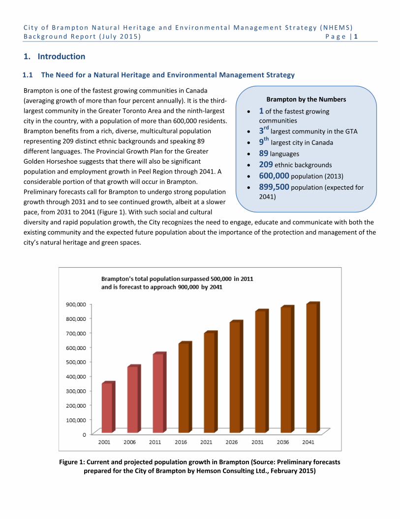
Brampton by the Numbers
1 of the fastest growing
communities
3rd largest community in the GTA
9th largest city in Canada
89 languages
209 ethnic backgrounds
600,000 population (2013)
899,500 population (expected for
2041)
1. Introduction
1.1 The Need for a Natural Heritage and Environmental Management Strategy
Brampton is one of the fastest growing communities in Canada
(averaging growth of more than four percent annually). It is the third-
largest community in the Greater Toronto Area and the ninth-largest
city in the country, with a population of more than 600,000 residents.
Brampton benefits from a rich, diverse, multicultural population
representing 209 distinct ethnic backgrounds and speaking 89
different languages. The Provincial Growth Plan for the Greater
Golden Horseshoe suggests that there will also be significant
population and employment growth in Peel Region through 2041. A
considerable portion of that growth will occur in Brampton.
Preliminary forecasts call for Brampton to undergo strong population
growth through 2031 and to see continued growth, albeit at a slower
pace, from 2031 to 2041 (Figure 1). With such social and cultural
diversity and rapid population growth, the City recognizes the need to engage, educate and communicate with both the
existing community and the expected future population about the importance of the protection and management of the
city’s natural heritage and green spaces.
Figure 1: Current and projected population growth in Brampton (Source: Preliminary forecasts prepared for the City of Brampton by Hemson Consulting Ltd., February 2015)
C i t y o f B r a m p t o n N a t u r a l H e r i t a g e a n d E n v i r o n m e n t a l M a n a g e m e n t S t r a t e g y ( N H E M S ) B a c k g r o u n d R e p o r t ( J u l y 2 0 1 5 ) P a g e | 2
Rapid urbanization and population growth brings environmental impacts and threats to our remaining natural areas and
ecosystems. Finding a balance between managing growth and resources and protecting the natural heritage system is a
key component of creating complete, healthy and livable communities.
Environmental challenges also threaten the sustainability of the city’s natural heritage and built green spaces, i.e. open
space (parklands), green infrastructure1 and urban forest. Some of these challenges include habitat loss due to changing
climatic conditions, invasive species, air and water pollution, and encroachment activities that put pressure on the city’s
living landscape and its functions. Many of these challenges and stresses not only impact the environment, but have
adverse impacts to public health and quality of life.
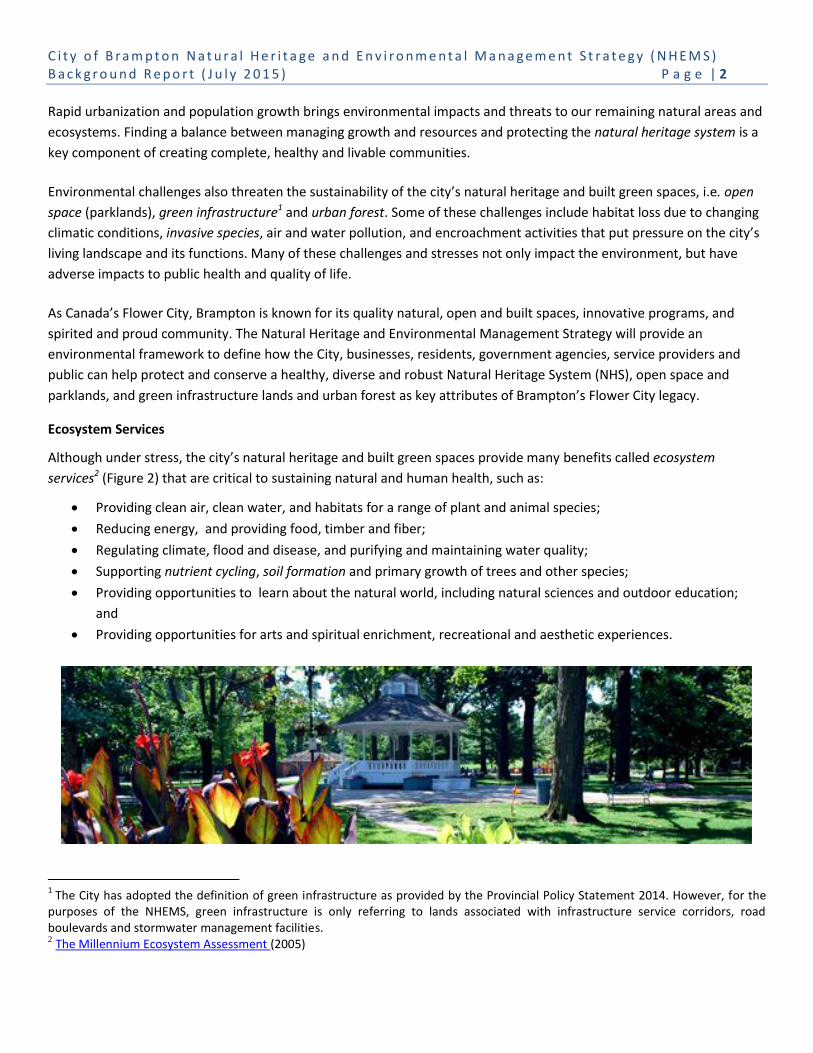
As Canada’s Flower City, Brampton is known for its quality natural, open and built spaces, innovative programs, and
spirited and proud community. The Natural Heritage and Environmental Management Strategy will provide an
environmental framework to define how the City, businesses, residents, government agencies, service providers and
public can help protect and conserve a healthy, diverse and robust Natural Heritage System (NHS), open space and
parklands, and green infrastructure lands and urban forest as key attributes of Brampton’s Flower City legacy.
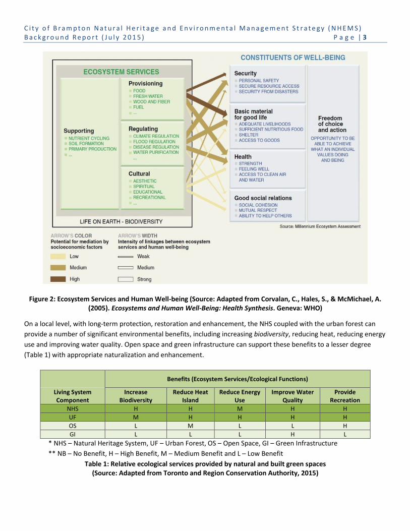
Ecosystem Services
Although under stress, the city’s natural heritage and built green spaces provide many benefits called ecosystem
services2 (Figure 2) that are critical to sustaining natural and human health, such as:
Providing clean air, clean water, and habitats for a range of plant and animal species;
Reducing energy, and providing food, timber and fiber;
Regulating climate, flood and disease, and purifying and maintaining water quality;
Supporting nutrient cycling, soil formation and primary growth of trees and other species;
Providing opportunities to learn about the natural world, including natural sciences and outdoor education;
and
Providing opportunities for arts and spiritual enrichment, recreational and aesthetic experiences.
1 The City has adopted the definition of green infrastructure as provided by the Provincial Policy Statement 2014. However, for the
purposes of the NHEMS, green infrastructure is only referring to lands associated with infrastructure service corridors, road boulevards and stormwater management facilities. 2 The Millennium Ecosystem Assessment (2005)
C i t y o f B r a m p t o n N a t u r a l H e r i t a g e a n d E n v i r o n m e n t a l M a n a g e m e n t S t r a t e g y ( N H E M S ) B a c k g r o u n d R e p o r t ( J u l y 2 0 1 5 ) P a g e | 3
Figure 2: Ecosystem Services and Human Well-being (Source: Adapted from Corvalan, C., Hales, S., & McMichael, A. (2005). Ecosystems and Human Well-Being: Health Synthesis. Geneva: WHO)
On a local level, with long-term protection, restoration and enhancement, the NHS coupled with the urban forest can
provide a number of significant environmental benefits, including increasing biodiversity, reducing heat, reducing energy
use and improving water quality. Open space and green infrastructure can support these benefits to a lesser degree
(Table 1) with appropriate naturalization and enhancement.
Benefits (Ecosystem Services/Ecological Functions)
Living System Component
Increase Biodiversity
Reduce Heat Island
Reduce Energy Use
Improve Water Quality
Provide Recreation
NHS H H M H H
UF M H H H H
OS L M L L H
GI L L L H L
* NHS – Natural Heritage System, UF – Urban Forest, OS – Open Space, GI – Green Infrastructure
** NB – No Benefit, H – High Benefit, M – Medium Benefit and L – Low Benefit
Table 1: Relative ecological services provided by natural and built green spaces (Source: Adapted from Toronto and Region Conservation Authority, 2015)

C i t y o f B r a m p t o n N a t u r a l H e r i t a g e a n d E n v i r o n m e n t a l M a n a g e m e n t S t r a t e g y ( N H E M S ) B a c k g r o u n d R e p o r t ( J u l y 2 0 1 5 ) P a g e | 4
Understanding the value of our living system and the potential benefits it provides at the local level will help to inform
our decisions as the City establishes municipal conservation and environmental management priorities and actions,
develops its greenfields, intensifies within the built boundary, and retrofits existing neighbourhoods.
1.2 The Natural Heritage and Environmental Management Strategy
The City recognizes that it is responsible as a corporation, community leader, land manager, and land use approval
authority to ensure that Brampton’s environmental goals are integrated across municipal departments and shared with
our conservation partners, residents, businesses and stakeholders. This will ensure that Brampton’s policies, plans and
practices achieve sustainable, healthy natural and built environments.
The principle of sustainable development represents the foundation of Brampton’s Official Plan (2006), and in
combination with the City’s long standing ecosystem approach to land use planning, recognizes the dynamic
interrelationship of all elements of the biophysical community that are necessary to achieve sustainable, healthy natural
and built environments. Building on the ‘Preserving’ pillar of the Strategic Plan, the City’s Official Plan gives clear
direction to protect, restore and enhance Brampton’s NHS and to sustainably manage Brampton’s natural resources,
open space, green infrastructure and the urban forest.
Brampton’s Natural Heritage and Environmental Management Strategy (NHEMS) is a proactive approach to ensure that
the abundance of natural heritage and built green spaces found in the city are conserved, restored, connected and
enhanced to support the health and diversity of the natural and built environments. To do so, this Strategy examines the
city’s natural heritage with a full systems approach that recognizes the challenges and opportunities presented by
protecting and conserving natural features, functions and linkages in an urban setting. Furthermore, the NHEMS
addresses the implementation, management and enhancement of the city’s open space, green infrastructure and urban
forest that both provide, and contribute to, sustaining the NHS and ecosystem services.
Figure 3: Brampton’s living landscape is comprised of functionally interconnected natural (wild)
and built green spaces and built (hard) spaces
C i t y o f B r a m p t o n N a t u r a l H e r i t a g e a n d E n v i r o n m e n t a l M a n a g e m e n t S t r a t e g y ( N H E M S ) B a c k g r o u n d R e p o r t ( J u l y 2 0 1 5 ) P a g e | 5
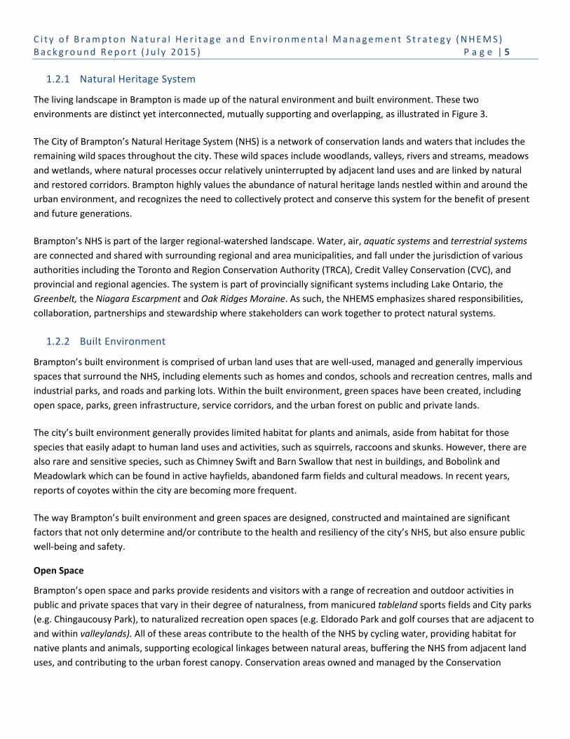
1.2.1 Natural Heritage System
The living landscape in Brampton is made up of the natural environment and built environment. These two
environments are distinct yet interconnected, mutually supporting and overlapping, as illustrated in Figure 3.
The City of Brampton’s Natural Heritage System (NHS) is a network of conservation lands and waters that includes the
remaining wild spaces throughout the city. These wild spaces include woodlands, valleys, rivers and streams, meadows
and wetlands, where natural processes occur relatively uninterrupted by adjacent land uses and are linked by natural
and restored corridors. Brampton highly values the abundance of natural heritage lands nestled within and around the
urban environment, and recognizes the need to collectively protect and conserve this system for the benefit of present
and future generations.
Brampton’s NHS is part of the larger regional-watershed landscape. Water, air, aquatic systems and terrestrial systems
are connected and shared with surrounding regional and area municipalities, and fall under the jurisdiction of various
authorities including the Toronto and Region Conservation Authority (TRCA), Credit Valley Conservation (CVC), and
provincial and regional agencies. The system is part of provincially significant systems including Lake Ontario, the
Greenbelt, the Niagara Escarpment and Oak Ridges Moraine. As such, the NHEMS emphasizes shared responsibilities,
collaboration, partnerships and stewardship where stakeholders can work together to protect natural systems.
1.2.2 Built Environment
Brampton’s built environment is comprised of urban land uses that are well-used, managed and generally impervious
spaces that surround the NHS, including elements such as homes and condos, schools and recreation centres, malls and
industrial parks, and roads and parking lots. Within the built environment, green spaces have been created, including
open space, parks, green infrastructure, service corridors, and the urban forest on public and private lands.
The city’s built environment generally provides limited habitat for plants and animals, aside from habitat for those
species that easily adapt to human land uses and activities, such as squirrels, raccoons and skunks. However, there are
also rare and sensitive species, such as Chimney Swift and Barn Swallow that nest in buildings, and Bobolink and
Meadowlark which can be found in active hayfields, abandoned farm fields and cultural meadows. In recent years,
reports of coyotes within the city are becoming more frequent.
The way Brampton’s built environment and green spaces are designed, constructed and maintained are significant
factors that not only determine and/or contribute to the health and resiliency of the city’s NHS, but also ensure public
well-being and safety.
Open Space
Brampton’s open space and parks provide residents and visitors with a range of recreation and outdoor activities in
public and private spaces that vary in their degree of naturalness, from manicured tableland sports fields and City parks
(e.g. Chingaucousy Park), to naturalized recreation open spaces (e.g. Eldorado Park and golf courses that are adjacent to
and within valleylands). All of these areas contribute to the health of the NHS by cycling water, providing habitat for
native plants and animals, supporting ecological linkages between natural areas, buffering the NHS from adjacent land
uses, and contributing to the urban forest canopy. Conservation areas owned and managed by the Conservation

C i t y o f B r a m p t o n N a t u r a l H e r i t a g e a n d E n v i r o n m e n t a l M a n a g e m e n t S t r a t e g y ( N H E M S ) B a c k g r o u n d R e p o r t ( J u l y 2 0 1 5 ) P a g e | 6
Authorities are both part of the NHS but also programmed for passive recreation, eco-tourism and environmental
education.
Green Infrastructure
Green infrastructure provides necessary services to Brampton’s built environment, including transportation and
electricity corridors and flood control. In the context of the NHEMS, green infrastructure means those lands associated
with stormwater management facilities, hydro transmission lines, gas pipelines and major transportation corridors.
These major infrastructure corridors that traverse the city provide habitat for native plants and animals, and have the
potential to serve as important ecological linkages between the natural valley systems in the city, buffer the NHS from
adjacent land uses, and contribute to the urban forest canopy. In addition to linking natural systems, the corridors
connect neighbourhoods and communities through pedestrian and trail networks on a local and regional scale.
Urban Forest
Brampton’s urban forest includes natural
woodlands and provides numerous services to the
city’s natural and built environments, such as:
habitat for wildlife, linkages between natural
areas, improved air quality, reduced energy use in
homes and businesses, and special places for
people to enjoy. Prior to European settlement,
Brampton was largely forested. Agriculture and
urbanization have reduced the pre-settlement
forest to individual woodlands in valleys, farm
woodlots, and individual groupings of trees, shrubs
and plants across Brampton’s natural and built
environments. This Strategy focuses on the urban
forest within the built environment on public and
private lands, including parks, infrastructure
corridors and stormwater management ponds, street boulevards, parking lots, front and backyards, and manicured
areas of businesses and institutions.
1.2.3 System Sustainability
The sustainability of Brampton can be measured, in part, by the ability of its living landscape to sustain biodiversity and
ecosystem services, as well as the environmental health of the city and its residents. The history of settlement in
Brampton has involved the extensive clearing of forests and wetlands for agricultural land uses followed by rapid
urbanization which has left the city’s remaining natural areas in need of environmental care and management. Natural
heritage management includes the need to identify and protect the remaining natural areas, restore and enhance
ecological features and functions, connect fragmented habitat patches to create healthier and larger core areas, and
mitigate impacts of climate change, public encroachment, pets and invasive species.
The City of Brampton also recognizes that the way the built green spaces and hard spaces are designed, constructed and
maintained on public and private lands can have a profound impact on the functionality and biodiversity of Brampton’s

C i t y o f B r a m p t o n N a t u r a l H e r i t a g e a n d E n v i r o n m e n t a l M a n a g e m e n t S t r a t e g y ( N H E M S ) B a c k g r o u n d R e p o r t ( J u l y 2 0 1 5 ) P a g e | 7
natural environment and the community’s public health and well-being. With this Strategy, the City is demonstrating its
commitment to protecting, restoring, and enhancing its natural environment, as well as developing and managing its
built environment to provide a range of ecosystem services that will result in a more complete, healthy and liveable
community.
With a diverse, resilient natural heritage system, the potential for human and wildlife interactions may occur. The
majority of interactions are mutually beneficial, as residents learn to appreciate wildlife and respect its right to share
Brampton’s living landscapes. There may be some interactions that are a nuisance, for example, urban wildlife foraging
in garbage cans, lawns or gardens. On rare occasions, some contact with wildlife may seem threatening, such as
confrontations with coyotes. While this contact does point to a healthy natural heritage system, through robust
education and outreach programs and management activities, most of these interactions can be avoided.
Community engagement and education are critical components to successful implementation of the NHEMS and the
conservation of the city’s natural heritage and built green spaces.
1.3 The NHEMS in Relation to Other City-Wide Plans
The NHEMS provides a framework to guide and integrate the diverse policies, programs and activities of City
departments, conservation partners and stakeholders. This approach aims to ensure that our collective efforts are
directed to secure the long-term sustainability, biodiversity and health of the city and its watersheds for present and
future generations.
There are four key municipal plans and strategies that function together as an integrated community sustainability plan
for Brampton: the Strategic Plan, Official Plan, Environmental Master Plan and Growth Management Program. The
NHEMS is designed to support these plans, as illustrated in Figure 4.

C i t y o f B r a m p t o n N a t u r a l H e r i t a g e a n d E n v i r o n m e n t a l M a n a g e m e n t S t r a t e g y ( N H E M S ) B a c k g r o u n d R e p o r t ( J u l y 2 0 1 5 ) P a g e | 8
Figure 4: Relationship of NHEMS to city-wide strategic plans
City of Brampton 2016-2018 Strategic Plan
The 2016-2018 Strategic Plan was approved by Council in December 2015 with a vision of Brampton as a connected city
that is innovative, inclusive and bold. Four priorities – Good Government, Move & Connect, Smart Growth, and Strong
Communities – address the outcomes Council and City staff are focused on achieving. The NHEMS is an initiative within
the Smart Growth priority.
City of Brampton Official Plan (2006)
The City’s Official Plan (2006) outlines Brampton’s sustainable city concept and ecosystem approach to land use planning
which includes: balancing the social and economic needs of the community with environmental and cultural
C i t y o f B r a m p t o n N a t u r a l H e r i t a g e a n d E n v i r o n m e n t a l M a n a g e m e n t S t r a t e g y ( N H E M S ) B a c k g r o u n d R e p o r t ( J u l y 2 0 1 5 ) P a g e | 9
conservation; making wise use of non-renewable resources; and protecting, enhancing and restoring the natural
heritage system and environmental resources for future generations.
Official Plan policies define the City’s responsibilities to identify, conserve, maintain,
restore, enhance and manage its natural heritage and open space systems, green
infrastructure and urban forest to ensure a sustainable, healthy community and
ecosystem. The NHEMS supports the Official Plan by: defining a natural heritage system;
identifying actions to address policy, program and best management practice gaps; and by
recommending targets to monitor and track Brampton’s environmental performance to
sustain its natural heritage and built green spaces.
Brampton Grow Green (2014)
The NHEMS is directed by the vision of Brampton Grow
Green (2014), the City’s first Environmental Master Plan.
Brampton Grow Green provides a sustainable environmental framework and monitoring
tool to: guide and support healthy, diverse natural and built environments; ensure
matters of environmental sustainability are considered in City decisions that affect both
the corporation and community-at-large; and develop broad, ongoing education and
engagement with staff, stakeholders and conservation partners, and the broader
community.
The Plan has six core components (goals): People, Air, Water, Land, Energy and Waste. It
identifies priority indicators (short and long-term metrics), targets, and establishes
monitoring and communications tools to report the City’s environmental progress with
the public. The People, Water and Land goals of Brampton Grow Green are directly related to the NHEMS (Figure 4). The
NHEMS integrates and builds on Brampton Grow Green metrics, targets and recommended actions, and coordinates
environmental monitoring and reporting. Section 2 defines how the NHEMS is complementary to existing plans and
strategies being implemented in Brampton.
1.4 The Process to Develop the NHEMS
Developing the NHEMS has been undertaken in two distinct phases.
Phase 1 involved the development of a science-based Natural Heritage System for the
City of Brampton that was led by CVC and TRCA in consultation with City staff, Region of
Peel and Ontario Ministry of Natural Resources and Forestry (MNRF). The Conservation
Authority Natural Heritage System Mapping for the City of Brampton – Final Technical
Report – 2014 (CA NHS) was prepared under separate cover and is briefly described in
Sections 2.2.4 and 3.1.3 of this Background Report. TRCA and CVC refined their
watershed-based natural heritage systems using current science in landscape ecology and
current conservation values. The CA NHS will be used to inform the City’s 2006 Official
Plan Review.

C i t y o f B r a m p t o n N a t u r a l H e r i t a g e a n d E n v i r o n m e n t a l M a n a g e m e n t S t r a t e g y ( N H E M S ) B a c k g r o u n d R e p o r t ( J u l y 2 0 1 5 ) P a g e | 10
Phase 2 of the NHEMS was led by City of Brampton in collaboration with North-South Environmental and Lura
Consulting, and includes this Background Report and the Implementation Action Plan. The preparation of these
documents has involved research and collaboration with conservation partners and key stakeholders. The mission, goals,
objectives and actions were informed through consultation activities held directly as part of this process, as well as those
for the development of Brampton Grow Green and the City’s Strategic Plan.
The process included a review of:
Current plans, policies, initiatives and practices of the City of Brampton and those of partner agencies (i.e.
neighbouring municipalities, the Region of Peel and Conservation Authorities);
The state of Brampton’s NHS, open space, green infrastructure and urban forest today;
Best practices in natural heritage, environmental management, infrastructure, open space, urban forest and
stewardship; and
Recommended actions to strengthen Brampton’s NHS and green spaces within the built environment.
Official Plan Policy Gap Analysis
Working with City staff, the consulting team identified policy gaps within the existing Brampton Official Plan (2006)
required to implement the NHEMS and address broader environmental issues. These gaps are summarized under eleven
theme areas: Sustainability, Green Infrastructure, Natural Heritage Systems, Regional Natural Heritage System
Connections, Other Land Use Designations, Parks and Open Space, Management and Restoration, Natural Hazards,
Community Stewardship, Urban Forests and Light Pollution. Appendix A summarizes the gaps within the eleven theme
areas, and the NHEMS Implementation Action Plan includes specific actions for reviewing and strengthening Official Plan
policies to improve the protection, restoration and enhancement of the NHS, urban forest, open space and green
infrastructure.
C i t y o f B r a m p t o n N a t u r a l H e r i t a g e a n d E n v i r o n m e n t a l M a n a g e m e n t S t r a t e g y ( N H E M S ) B a c k g r o u n d R e p o r t ( J u l y 2 0 1 5 ) P a g e | 11
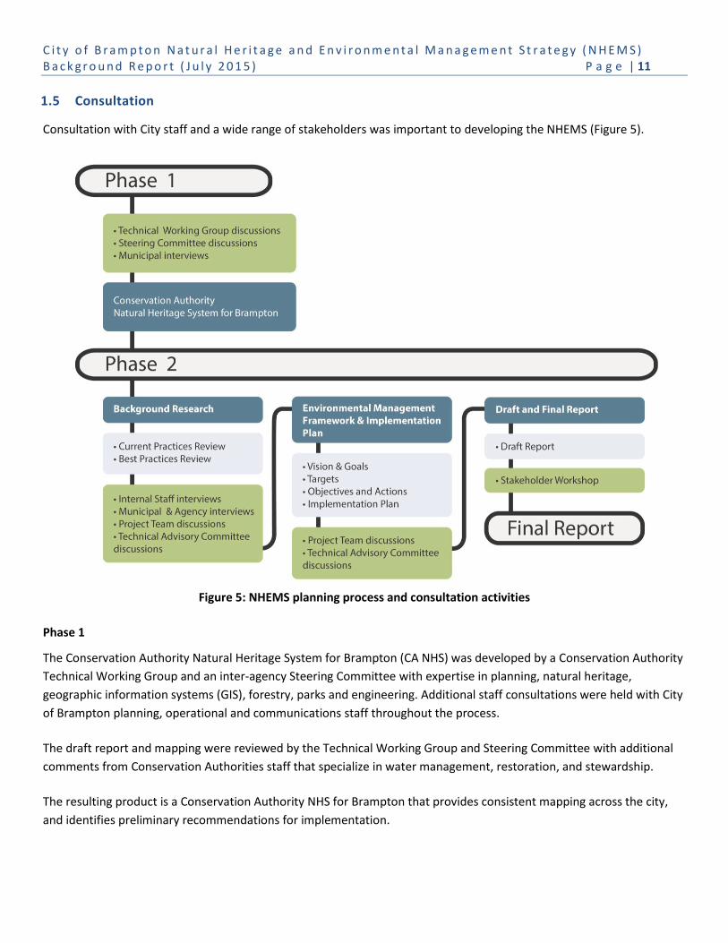
1.5 Consultation
Consultation with City staff and a wide range of stakeholders was important to developing the NHEMS (Figure 5).
Figure 5: NHEMS planning process and consultation activities
Phase 1
The Conservation Authority Natural Heritage System for Brampton (CA NHS) was developed by a Conservation Authority
Technical Working Group and an inter-agency Steering Committee with expertise in planning, natural heritage,
geographic information systems (GIS), forestry, parks and engineering. Additional staff consultations were held with City
of Brampton planning, operational and communications staff throughout the process.
The draft report and mapping were reviewed by the Technical Working Group and Steering Committee with additional
comments from Conservation Authorities staff that specialize in water management, restoration, and stewardship.
The resulting product is a Conservation Authority NHS for Brampton that provides consistent mapping across the city,
and identifies preliminary recommendations for implementation.

C i t y o f B r a m p t o n N a t u r a l H e r i t a g e a n d E n v i r o n m e n t a l M a n a g e m e n t S t r a t e g y ( N H E M S ) B a c k g r o u n d R e p o r t ( J u l y 2 0 1 5 ) P a g e | 12
Phase 2
A project Engagement Plan was developed for Phase 2 that divided the consultations into two stages, as defined below:
Stage 1 consultation focused on gathering input for the development of the NHEMS mission, guiding principles,
goals, and objectives, as well as providing opportunities to discuss issues and ideas on preliminary directions
through stakeholder meetings. Representatives from the following key stakeholders groups3 were invited to
facilitated meetings in the Fall 2013:
o Aboriginal organizations;
o Government and agencies (including adjacent municipalities and local Conservation Authorities);
o Local educational institutions;
o Environmental groups, youth groups, community groups and residents associations;
o Environmental consultants;
o Local recreation facilities (including golf courses);
o Business and development organizations;
o Local utility and transit companies; and
o Local arboriculture firms.
Stage 2 consultation focused on gathering input on the Draft NHEMS obtained through a stakeholder workshop
held in Fall 2014 with approximately 40 participants, including representatives from City staff and other
stakeholders. The purpose of the session was to collect feedback on all aspects of the Draft Strategy, including
the mission, guiding principles, goals, objectives, targets and actions. Participant feedback was incorporated into
the final NHEMS.
For both rounds of consultation, participants were invited to provide comments verbally at the meetings (all comments
were recorded), on feedback forms provided and made available on-line, or via email directly to the Project Manager. A
summary of this feedback is provided in Appendix B.
1.6 Effecting Change
The success of the NHEMS is a long-term commitment by the City, its conservation partners and the Brampton
community, and relies on three key activities: education and awareness; collaboration and partnerships; and
performance monitoring and reporting. These activities align with the Brampton Grow Green corporate actions and will
ensure successful coordination and implementation of the Environmental Master Plan and the NHEMS.
3 Workshop stakeholders are alphabetically listed in the Acknowledgements at the front of the Strategy.

C i t y o f B r a m p t o n N a t u r a l H e r i t a g e a n d E n v i r o n m e n t a l M a n a g e m e n t S t r a t e g y ( N H E M S ) B a c k g r o u n d R e p o r t ( J u l y 2 0 1 5 ) P a g e | 13
Photo Credit: TRCA
Education and Awareness
Internal and external education must focus on engaging
stakeholders and building support to undertake environmental
actions. City Council and staff, conservation partners and the
public must understand what it is they are expected to do, what
supports are in place to assist them, and what benefits can be
achieved from their actions.
Implementation of the NHEMS (and Environmental Master Plan)
requires dedicated staff resources to support and coordinate
operational activities for the natural heritage and built green
spaces, as well as monitor, report progress and update the
Strategy as appropriate.
Collaboration and Partnerships
As recognized by Brampton Grow Green: “The environment is a
precious resource and at the heart of the quality of life that residents of Brampton enjoy.”
To sustain the environmental health and diversity of Brampton’s green spaces, there is a need to align and strengthen
current operations and environmental programs of the City and its conservation partners. Brampton needs to work
collaboratively within and across its own departments and rely on the support and partnerships with other levels of
government, conservation agencies, community based organizations, infrastructure services providers, local industry,
businesses, schools and the public.
City Council is a key partner in protecting and managing Brampton’s natural heritage and open space systems, green
infrastructure and urban forest. Capital budget approval, community education and engagement with ward residents,
and staff support are just a few of the ways that Council can recognize the value of the ecosystem services that are
contributing to a liveable and healthy community.
Brampton’s parks and roads operations have primary responsibility for the management and maintenance of
Brampton’s open space and parkland, road boulevards and stormwater management facilities, and urban tree canopy.
Municipal environmental committees of Council support the City’s environmental stewardship efforts, including the
Brampton Environment Advisory Committee (BEAC). Brampton Grow Green and the NHEMS envision the role of BEAC as
a community resource for education and outreach. CVC and the TRCA are key partners in protecting, restoring and
enhancing the city’s NHS, and can be considered Brampton’s ‘environmental action arm’4 for restoration, stewardship
and educational services on a watershed basis. CVC and TRCA also provide the leadership and technical support for
natural heritage system inventorying, monitoring and adaptive management.
4 Personal communication with Robert Morris, Manager, Natural Heritage, Credit Valley Conservation.

C i t y o f B r a m p t o n N a t u r a l H e r i t a g e a n d E n v i r o n m e n t a l M a n a g e m e n t S t r a t e g y ( N H E M S ) B a c k g r o u n d R e p o r t ( J u l y 2 0 1 5 ) P a g e | 14
Working with land managers such as Ontario Hydro, TransCanada Pipeline, and the Ontario Ministry of Transportation
(MTO) to undertake stewardship programs ensures the green infrastructure corridors are enhanced to improve natural
features, functions and linkages, and the urban forest.
Opportunities for collaboration and partnership with conservation organizations (i.e. Ontario Streams, Sierra Club Peel,
Evergreen and LEAF, etc.) are critical in helping the City to engage with residents, local industry, businesses, schools,
institutions and places of worship, in conservation education and programming, and in community stewardship.
Performance Monitoring
Implementation of the NHEMS requires baseline data collection, ongoing monitoring, and a refinement of the
performance framework and strategies over time to ensure effectiveness. Performance benchmarking involves choosing
metrics and targets that reflect municipal priorities, are measurable, and can establish the City’s environmental
progress.
Reporting on the City’s environmental progress is a critical component of education and awareness for all audiences.
The NHEMS should align with the environmental performance monitoring and reporting of Brampton Grow Green,
including annual and long-term sustainability reports.
CVC and TRCA are vital partners in reporting on Brampton’s ecosystem health and diversity through their unique
watershed services and programs, such as science-based research, inventories, natural heritage conservation
monitoring, water management, adaptive management, cumulative impacts and ecosystem services.

C i t y o f B r a m p t o n N a t u r a l H e r i t a g e a n d E n v i r o n m e n t a l M a n a g e m e n t S t r a t e g y ( N H E M S ) B a c k g r o u n d R e p o r t ( J u l y 2 0 1 5 ) P a g e | 15
2. Natural Heritage System Planning
2.1 Context
Natural heritage systems can be developed at various scales, including provincial (regional) plans, and watershed and
subwatershed (local) studies. Provincial plans and watershed studies facilitate natural heritage systems that coordinate
ecosystem-based and watershed-based issues across municipalities, and recognize important linkages (e.g. physical
features such as valleylands, and ecological functions such as hydrological connectivity) that go beyond planning
authority boundaries.
Local natural heritage system planning is best undertaken as a cooperative, community-based activity that involves
senior government (i.e. Province, regional municipality), the City and Conservation Authorities, and includes residents,
landowners and community groups (e.g. naturalist clubs). Local natural heritage system plans need to recognize
ecological ties to other physical features and areas in the regional landscape, including urban green spaces, in order to
support the overall diversity, health and interconnectivity of natural areas, features and functions, and contribute to
human health and well-being.
Each system is designed to capture important natural areas and linkages, as well as areas for protection and
enhancement, to ensure the long-term provisioning of ecosystem services at each scale.
Section 2.2 describes provincial and watershed-based natural systems and plans that guide Brampton’s natural heritage
system planning and policies.
The identification, conservation and maintenance of natural heritage systems is an ongoing process undertaken by the
responsible planning authority. Natural ecosystems are dynamic (especially in a growing urban center and a changing
climate), and as a result, natural heritage systems plans should be updated and refined as new information becomes
available.
This study is Brampton’s first effort to develop a city-wide plan for its NHS and a sustainable environmental framework
for the management of its open space, green infrastructure and urban forest.
2.2 Natural Heritage System Policy, Plan and Program Guidance
2.2.1 Federal Government
There are several pieces of Federal legislation and guidance that relate to municipal natural heritage system protection
and the urban forest:
Species At Risk Act (2002) protects federally listed vegetation and wildlife species on federal lands. The purpose
of the Act is to prevent wildlife species from being extirpated or becoming extinct; to provide for the recovery of
wildlife species that are extirpated, endangered or threatened as a result of human activity; and to manage
species of special concern to prevent them from becoming endangered or threatened.
Fisheries Act (2015) governs marine and inland fish habitat, and the Migratory Birds Convention Act (1994)
prohibits damage or disturbance of many bird species and their nests during breeding season.

C i t y o f B r a m p t o n N a t u r a l H e r i t a g e a n d E n v i r o n m e n t a l M a n a g e m e n t S t r a t e g y ( N H E M S ) B a c k g r o u n d R e p o r t ( J u l y 2 0 1 5 ) P a g e | 16
“How Much Habitat is Enough” (April 2013, 3rd Edition) is science-based and
provides landscape-level guidance to help sustain minimum viable wildlife
populations, and to help maintain selected ecosystem functions and attributes.
“Area Sensitive Forest Birds in Urban Areas”, a report of the Canadian Wildlife
Service (2006), provides more urban specific guidance.
The Canadian Food Inspection Agency and Canadian Forest Service are
responsible for monitoring and controlling the spread of high risk invasive urban
forest pests (most notably Asian Long-horned Beetle and Emerald Ash Borer).
Lastly, a national network of urban forest professionals that comprise the
Canadian Urban Forest Network has developed a Canadian Urban Forest
Strategy; however, this group has no formal status or tie to the Federal
government.
2.2.2 Province of Ontario
Provincial ministries and agencies develop and apply legislation and regulations, policies, plans, guidelines and programs
that deliver services to residents and direct the Region of Peel and City of Brampton as corporations, land use planning
authorities and service providers.
Provincial Policy Statement (2014)
The Provincial Policy Statement (2014) (PPS) establishes the overarching policy framework
for natural heritage system planning (Section 2.1.3), conservation of long-term ecological
function and biodiversity (Section 2.1.2) and protection of features related to
development under the Planning Act (Sections 2.1.4 and 2.1.5).
Technical manuals and guidelines, such as the Natural Heritage Reference Manual (2010),
provide guidance to municipalities and agencies on implementing the PPS, including
defining significant natural areas and features and linking these areas through corridors,
as well as restoration and enhancement areas.
The MNRF has also developed other guidelines and reference material such as:
Significant Wildlife Habitat Technical Guide;
Ecosystems of Ontario, Part 1: Ecozones and Ecoregions and the Ecological Land Classification system; and
Fish Management Plans prepared in collaboration with Conservation Authorities.
Other provincial legislation, strategies and plans that influence NHS planning, land management and urban development
include:
The Ontario Endangered Species Act (2007), which regulates the protection of all species and their habitat in the
Province that are listed as extirpated, endangered or threatened, on both public and private lands. Screening is
required for regulated species for virtually any public and/or private development proposal, and for
development within regulated habitat, compensation and an overall net benefit may be required for critical

C i t y o f B r a m p t o n N a t u r a l H e r i t a g e a n d E n v i r o n m e n t a l M a n a g e m e n t S t r a t e g y ( N H E M S ) B a c k g r o u n d R e p o r t ( J u l y 2 0 1 5 ) P a g e | 17
habitat of certain species. Species specific Recovery Strategies can guide compensation plans, as well as efforts
to restore and enhance species habitat.
The Ontario Invasive Species Strategy (2012) is intended to “prevent new invaders from arriving and surviving in
Ontario, to slow and where possible reverse the
spread of existing invasive species, and to reduce
the harmful impacts of existing invasive species.”
The Ontario Biodiversity Strategy (2011) highlights
four goals critical to Ontario’s Biodiversity: Engage
People, Reduce Threats, Enhance Resiliency, and
Improve Knowledge. Each goal is supported by
long-term objectives, outcomes, key actions and
targets. Target 12 specifically states that “By 2015,
natural heritage system plans and biodiversity
conservation strategies are developed and
implemented at the municipal and landscape
levels”.
The Provincial Standing Committee on Regulations and Private Bills is considering Bill 6, the Great Lakes
Protection Act (2014) which is intended to protect and restore the Great Lakes-St. Lawrence River. This Act will
support Ontario’s Great Lake Strategy (2012) and the Lake Ontario Lakewide Management Plan. While these
plans are focused on Lake Ontario, they recognize the supporting role of watersheds, such as the Credit River
watershed.
Provincial Landscapes
Through legislation, the Province has developed three regional plans that have implications to the Region of Peel, the
TRCA and CVC watersheds, and the City of Brampton, including:
Oak Ridges Moraine Conservation Plan (2002);
Niagara Escarpment Plan (2005); and
Greenbelt Plan (2005), which includes land within, and builds upon, the Niagara Escarpment Plan and the Oak
Ridges Moraine Conservation Plan.
The regional natural systems within these plans are inter-connected, as well as connected through Brampton to Lake
Ontario via the city’s river valleys, including the Credit River, Etobicoke Creek and the West Humber River, as shown in
Figure 6.
Provincial plans and policies for each of these regional plans require municipal policy conformance in protecting the
significant natural areas and functions of the natural systems and their buffers. Specifically, the Brampton Official Plan
has addressed the Greenbelt Plan (2005).

C i t y o f B r a m p t o n N a t u r a l H e r i t a g e a n d E n v i r o n m e n t a l M a n a g e m e n t S t r a t e g y ( N H E M S ) B a c k g r o u n d R e p o r t ( J u l y 2 0 1 5 ) P a g e | 18
Greenbelt Plan (2005)
The Greenbelt Plan and Greenbelt boundary were established under the Greenbelt Act
in 2005. The Greenbelt is a broad band of 700,000 hectares (ha), or 1.8 million acres,
stretching around Lake Ontario from the Region of Durham, west to the Niagara River,
and north to the Bruce Peninsula. The Greenbelt’s natural heritage system is connected
to other regional systems beyond the Greenbelt boundary, including the Niagara
Escarpment and Oak Ridges Moraine, and the surrounding major lake system, to
protect wildlife habitat, provide for the movement of plants and animals, and maintain
and/or enhance water resources (both quantity and quality of water).
Approximately 202 ha (500 acres) of land adjacent to the Credit River Valley in
northwest Brampton are designated as Protected Countryside and identified as Natural
System. The Natural System includes areas with the highest concentration of the most sensitive and/or significant
natural features and functions.

C i t y o f B r a m p t o n N a t u r a l H e r i t a g e a n d E n v i r o n m e n t a l M a n a g e m e n t S t r a t e g y ( N H E M S ) B a c k g r o u n d R e p o r t ( J u l y 2 0 1 5 ) P a g e | 19
Figure 6: Brampton in the context of regional natural systems (Source: City of Brampton, 2015)

C i t y o f B r a m p t o n N a t u r a l H e r i t a g e a n d E n v i r o n m e n t a l M a n a g e m e n t S t r a t e g y ( N H E M S ) B a c k g r o u n d R e p o r t ( J u l y 2 0 1 5 ) P a g e | 20
Growing the Greenbelt
There are eleven (11) external river valley connections identified by the Greenbelt Plan to Lake Ontario, including the
Credit River, Etobicoke Creek and three (3) tributaries of the West Humber River that traverse the City of Brampton. The
Greenbelt Plan policies encourage recognition and enhancement of these external connections. In 2008, the Province
released ‘Growing the Greenbelt Consultation Paper’ which presented draft criteria for growing the Greenbelt and which
stimulated environmental non-government organizations (NGOs) to request municipalities in the Greater Toronto and
Hamilton Area to consider an expansion of the Greenbelt on public lands along external river valley connections.
While municipalities such as the Cities of Toronto (Don and Humber Rivers) and Mississauga (Credit River) were studying
these requests, the Province passed Amendment 1 to the Greenbelt Plan in January 2013. Section 1.1 was amended to
indicate that “The Greenbelt Plan is structured to provide for the inclusion of publicly owned lands in urban river valleys
that were not in the Greenbelt at the time the Plan was approved in 2005. These lands, while not part of the Protected
Countryside, are part of the Greenbelt and these areas assist in recognizing the importance of connections to Lake
Ontario and other areas in Southern Ontario”.
Section 6.0 of the Plan outlines an Urban River Valley (URV) policy that identifies that
“Key river valleys in urban areas adjacent to the Greenbelt provide opportunities for
additional connections to help expand and integrate the Greenbelt and its systems into
the broader Southern Ontario landscape. The Urban River Valley designation provides
direction to those areas where the Greenbelt occupies river valleys in an urban context.
These urban river valleys may be the setting for a network of uses and facilities including
recreational, cultural and tourist amenities and infrastructure, which are needed to
support urban areas”. As provided in Amendment 1, public lands in URVs will be
governed by the City’s Official Plan policies, although our actions will have to be in
conformity with the Greenbelt Plan for parkland, open space and trails.
The Official Plan (2006) Schedule D and natural heritage policies identify and protect all of the city’s valley and
watercourse corridors, including lands in both public and private ownership. The true value of the URV designation will
be a means to engage Brampton Council and the community in recognizing the relationship of Brampton’s NHS and
urban environment to this unique regional natural system. The City of Brampton will examine the opportunities,
challenges and feasibility of growing the Greenbelt along the city’s river valleys through a separate study as part of the
2006 Official Plan Review.
Parkway Belt West Plan
The Province established the Parkway Belt West Plan Area (PBWPA) in 1978 “For the purposes of creating a multi-
purpose utility corridor, urban separator and linked open space system”.
While the Plan identifies a land reserve for provincial infrastructure (i.e. highways, hydro corridors and pipelines), it also
expresses a goal to “provide a system of open space and recreational facilities linked with each other, nearby
communities and other recreational areas”.
It should be noted that within and adjacent to the PBWPA, is the Highway 407 Express Toll Route (407 ETR).

C i t y o f B r a m p t o n N a t u r a l H e r i t a g e a n d E n v i r o n m e n t a l M a n a g e m e n t S t r a t e g y ( N H E M S ) B a c k g r o u n d R e p o r t ( J u l y 2 0 1 5 ) P a g e | 21
Although a provincial infrastructure corridor, the PBWPA (and 407 ETR) is bisected by the numerous valleys and
watercourse corridors that traverse Brampton. The PBWPA is comprised of a variety of existing land uses such as urban
areas, open space (e.g. active parkland), agriculture, successional areas and natural cover that contribute to local natural
heritage systems, as well as create linkages across the landscape. This Strategy acknowledges the unique environmental
opportunities the PBWPA/407 ETR green infrastructure corridors provide to Brampton’s NHS, open space and urban
forest.
Figure 7: Parkway Belt West Plan Area near Brampton (Source: Ministry of Municipal Affairs and
Housing, 2008)
2.2.3 Region of Peel
The Region of Peel applies policies, plans and programming that deliver services directly
to residents, and which guide the development of Brampton, including the conservation
of the NHS, and support its (remaining) agricultural lands.
In this regard, the Region of Peel Official Plan (ROP) provides policy for the protection,
restoration and enhancement of a Greenlands System in Peel, which consists of Core
Areas, Natural Areas and Corridors (NACs) and Potential Natural Areas and Corridors
(PNACs). Core Greenlands are significant natural areas, including provincially and/or
regionally designated lands, such as: Provincially Significant Wetlands (PSW),
Environmentally Significant Areas (ESA), habitats of threatened or endangered species,
Provincial Life Science Areas of Natural Interest (ANSI), and valley corridors and core
woodlands. These areas are all protected in the Region’s and Brampton’s Official Plans, as illustrated in Figure 8.

C i t y o f B r a m p t o n N a t u r a l H e r i t a g e a n d E n v i r o n m e n t a l M a n a g e m e n t S t r a t e g y ( N H E M S ) B a c k g r o u n d R e p o r t ( J u l y 2 0 1 5 ) P a g e | 22
Figure 8: Core Areas of the Region of Peel Greenlands System
(Source: City of Brampton, 2015)
NACs contain important ecological features, forms and/or functions that play a crucial role in supporting the integrity of
Core Areas and are to be protected in Brampton’s Official Plan. PNACs may also contain important ecological features,
forms and/or functions that support the integrity of the Greenlands System in Peel, and may require further study and
evaluation for protection, as identified by Brampton’s Official Plan policies.
The Region seeks to secure significant natural areas and features using a range of tools, including planning policy,
stewardship and monitoring (first steps in the securement process) and as appropriate, through acquisition. In 2007, the
Region established the Greenland Securement Program for the protection of key natural heritage landscapes in

C i t y o f B r a m p t o n N a t u r a l H e r i t a g e a n d E n v i r o n m e n t a l M a n a g e m e n t S t r a t e g y ( N H E M S ) B a c k g r o u n d R e p o r t ( J u l y 2 0 1 5 ) P a g e | 23
Greenland Securement
The Region of Peel, Conservation Authorities and City of Brampton have active ‘securement’ programs to bring natural areas on private lands into public ownership.
The Region of Peel Greenland Securement Program provides funds to match municipal and/or conservation authority monies (up to 50 percent) towards total property acquisition costs. The Region’s program is funded annually, and properties that are potential candidates for securement are reviewed and approved by the Greenland Securement Subcommittee comprised of Regional Councillors.
As part of the Greenland Securement Program, the Region funds the Landowner Securement Contact and Education Project that is being implemented in Brampton through Orland Conservation. This project seeks to educate private landowners about the securement program, and explore options to place private lands deemed environmentally valuable under public management. Participation in the program by landowners is strictly voluntary.
collaboration with area municipalities, Conservation Authorities and local organizations in Peel. The Program supports
the acquisition of land through mechanisms such as bequests, easements, donations or purchase.
The Region is currently undertaking a review of the Greenlands
System policies with the purpose of updating direction for
natural heritage systems planning and identifying a regional
natural heritage system to complement existing policies.
The Region is also leading strategic partnership projects with
the area municipalities and Conservation Authorities, including
the Peel Climate Change Strategy, and Peel Urban Forest
Strategy and associated Priority Tree Planting Project. The
NHEMS integrates direction from these projects and supports
implementation, particularly as it relates to targets and actions.
2.2.4 Conservation Authorities
CVC and TRCA apply regulations, policies, plans and
programming that deliver services directly to residents, protect
natural hazards and natural heritage systems, and engage and
educate the community and schools. In this regard, the
Conservation Authorities:
Regulate development and activities within floodplains,
riparian and valley slope and erosion hazards, wetlands,
and the Lake Ontario shoreline;
Guide development to eliminate, minimize and mitigate
impacts to natural features, functions and linkages,
including terrestrial and aquatic systems, and the water
cycle;
Develop and support science-based research, inventories
and monitoring programs for natural heritage conservation, water management, adaptive management,
cumulative impacts and ecosystems services;
Manage conservation lands, including natural features and functions, and hazards lands for their protection,
restoration and enhancement, and for passive public recreation and education opportunities.
Secure natural areas and features in public ownership in collaboration with the Region of Peel and area
municipalities;
Collaborate with regional and area municipalities, school boards, NGOs and other levels of government to
deliver environmental education and stewardship programs to residents, local businesses, community
organizations and schools; and
Own and manage conservation lands, including natural features, functions and linkages and natural hazard lands
for their protection, restoration and enhancement, and for passive public recreation and education
opportunities.

C i t y o f B r a m p t o n N a t u r a l H e r i t a g e a n d E n v i r o n m e n t a l M a n a g e m e n t S t r a t e g y ( N H E M S ) B a c k g r o u n d R e p o r t ( J u l y 2 0 1 5 ) P a g e | 24
CVC and TRCA have developed watershed natural heritage systems through science-based models that aim to identify the
land base necessary to protect and restore biodiversity and ecosystem function over the long-term in the rapidly
developing Greater Toronto and Hamilton Area (GTAH). Current conservation authority data and analyses indicate that
protecting current levels of natural heritage cover will not be sufficient to sustain long-term ecosystem health (CVC and
TRCA, 2014). In response, both CAs have developed “targeted systems” (Appendix C) comprised of existing natural cover
and areas with the potential to be restored and/or managed to increase ecosystem function. Further, long-term
management of the entire landscape (within and beyond the NHS) is recognized by CVC and TRCA as being important to
sustaining ecosystem health and promoting complete communities.
A brief description of the CA’s respective watershed natural heritage systems and associated mapping is provided in
Appendix C. More detailed information regarding the Conservation Authorities watershed natural heritage systems is
available on their respective websites; TRCA Terrestrial Natural Heritage (http://www.trca.on.ca/the-living-
city/land/terrestrial-natural-heritage/), and CVC Natural Heritage System for the Credit River Watershed
(http://www.creditvalleyca.ca/watershed-science/our-watershed/natural-heritage-system-credit-river-watershed/).
As identified in Section 1.4, CVC and TRCA collaborated to prepare the City of Brampton CA NHS Technical Report that is
based on comprehensive conservation authority data and common principles across the city. CVC and TRCA further
refined the system to capture local linkages within Brampton, as well as linkages that extended outside the City’s
jurisdiction, allowing for watershed and regional linkages to be maintained. The CA NHS helps to integrate with other
ongoing strategies and plans, such as Conservation Authority greenlands securement projects and programs, and
subwatershed studies and restoration plans. An overview of the CA NHS is provided in Section 3.1.3.
The CAs are also leading strategic partnership projects with the Region of Peel, City of Brampton and each other (as
appropriate), including:
TRCA: Peel Channels Remediation Study, Terrestrial Ecosystem Services Compensation Protocol (underway),
Partners in Project Green (Pearson Eco-business Park), and the County Court Sustainable Neighbourhood
Retrofit Action Plan.
CVC: Credit River Watershed – Peel Natural Areas Inventory, City of Brampton Natural Areas Inventory,
Stormwater Management – Low Impact Development, and the Fletcher’s Creek Sustainable Neighbourhood
Retrofit Action Plan.
The NHEMS integrates direction from these projects and supports implementation, particularly as it relates to targets
and actions.

C i t y o f B r a m p t o n N a t u r a l H e r i t a g e a n d E n v i r o n m e n t a l M a n a g e m e n t S t r a t e g y ( N H E M S ) B a c k g r o u n d R e p o r t ( J u l y 2 0 1 5 ) P a g e | 25
3. State of the Environment in Brampton
This section provides an overview of current conditions and management needs and opportunities for Brampton’s NHS
and built landscapes, which include open space, green infrastructure and urban forest (Table 2).
Table 2: Current and proposed land uses in Brampton (Source: Compilation of City of
Brampton, CVC and TRCA data)
State of the Environment in Brampton
Current Land Cover
Natural Cover Agriculture Manicured Open
Space Urban
17% 21% 7% 55%
Current Natural Heritage Land Ownership
Public Private
57% (2,650 ha) 43% (1,990 ha)
Current Public Natural Heritage Land Ownership
City Conservation Authority
64% (1,690 ha) 43% (960 ha)
Natural Heritage System
Existing NHS Conservation Authority NHS (proposed)
17% 21%

C i t y o f B r a m p t o n N a t u r a l H e r i t a g e a n d E n v i r o n m e n t a l M a n a g e m e n t S t r a t e g y ( N H E M S ) B a c k g r o u n d R e p o r t ( J u l y 2 0 1 5 ) P a g e | 26
3.1 Brampton’s Natural Heritage System
The City of Brampton comprises an area of approximately 269 square kilometres and is characterized by the numerous
river and valley corridors of the Credit River, Etobicoke Creek, Mimico Creek, and the Humber/West Humber River
watersheds that connect the city to some of Ontario’s most significant landscapes and regional ecosystems, including
the Niagara Escarpment, Oak Ridges Moraine and Lake Ontario, as illustrated in Figure 6.
Brampton’s NHS is a network of conservation lands and waters, linked by natural and restored corridors that together
will provide a natural landscape for future generations. The quality of a community’s natural landscape can be measured
by its biological diversity and landscape health, as well as the health of the city’s built environment.
3.1.1 Natural Heritage Systems in the Urban Context
Current guidelines for establishing natural heritage systems recommend identifying large core areas and functional
linkages based on ecological principles. However, protecting biodiversity and a full range of ecological functions and
natural features in urban environments presents both challenges and opportunities.
Urban natural systems generally consist of the remaining
fragmented natural features on the landscape today, including
valley and watercourse corridors, woodlands, wetlands and
vegetation communities. Many existing natural features,
especially those on tablelands, tend to be small and lack
functional ecological linkages to other features. Urban natural
areas are also subject to a host of stresses associated with
urban land uses, such as encroachment and unauthorized uses,
invasive species, and changing climate and weather events.
Day-to-day human activities have a dominant influence on
urban natural heritage systems that require ongoing
management. This often calls for creative stewardship and restoration approaches to sustain and enhance existing
natural heritage areas, functions and linkages.
One such approach is recognizing that Brampton’s built green spaces (i.e. open spaces, green infrastructure and urban
forest, and hard spaces) can provide supporting functions to the natural heritage system. For example, there are many
urban-adapted wildlife species (e.g. coyote, skunks, raccoons, and deer) that use parks, sports fields, cemeteries, golf
courses and infrastructure corridors to move and disperse among natural features. These green spaces may already
provide other supporting functions, such as surface water infiltration and groundwater recharge, urban heat island
reduction (particularly if they are treed), and support insect populations that provide pollinator functions and a food
source for some birds.
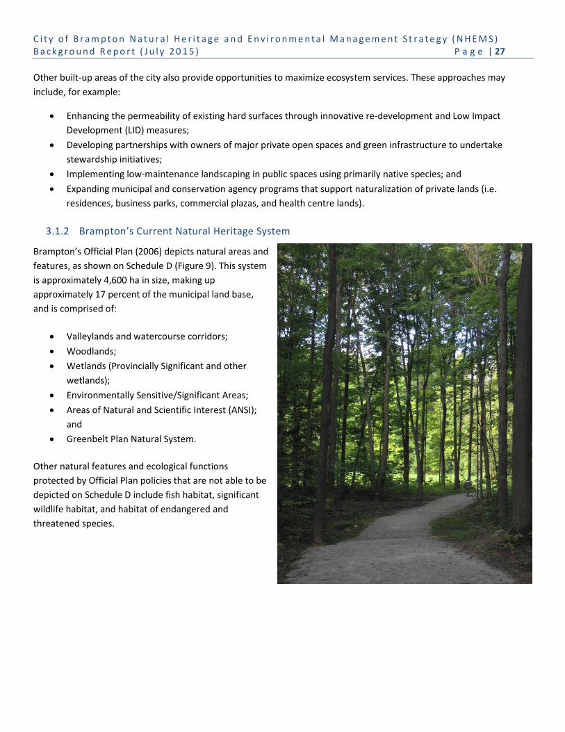
C i t y o f B r a m p t o n N a t u r a l H e r i t a g e a n d E n v i r o n m e n t a l M a n a g e m e n t S t r a t e g y ( N H E M S ) B a c k g r o u n d R e p o r t ( J u l y 2 0 1 5 ) P a g e | 27
Other built-up areas of the city also provide opportunities to maximize ecosystem services. These approaches may
include, for example:
Enhancing the permeability of existing hard surfaces through innovative re-development and Low Impact
Development (LID) measures;
Developing partnerships with owners of major private open spaces and green infrastructure to undertake
stewardship initiatives;
Implementing low-maintenance landscaping in public spaces using primarily native species; and
Expanding municipal and conservation agency programs that support naturalization of private lands (i.e.
residences, business parks, commercial plazas, and health centre lands).
3.1.2 Brampton’s Current Natural Heritage System
Brampton’s Official Plan (2006) depicts natural areas and
features, as shown on Schedule D (Figure 9). This system
is approximately 4,600 ha in size, making up
approximately 17 percent of the municipal land base,
and is comprised of:
Valleylands and watercourse corridors;
Woodlands;
Wetlands (Provincially Significant and other
wetlands);
Environmentally Sensitive/Significant Areas;
Areas of Natural and Scientific Interest (ANSI);
and
Greenbelt Plan Natural System.
Other natural features and ecological functions
protected by Official Plan policies that are not able to be
depicted on Schedule D include fish habitat, significant
wildlife habitat, and habitat of endangered and
threatened species.

C i t y o f B r a m p t o n N a t u r a l H e r i t a g e a n d E n v i r o n m e n t a l M a n a g e m e n t S t r a t e g y ( N H E M S ) B a c k g r o u n d R e p o r t ( J u l y 2 0 1 5 ) P a g e | 28
Figure 9: Brampton’s natural heritage features and areas (Source: City of Brampton Official Plan, 2006)

C i t y o f B r a m p t o n N a t u r a l H e r i t a g e a n d E n v i r o n m e n t a l M a n a g e m e n t S t r a t e g y ( N H E M S ) B a c k g r o u n d R e p o r t ( J u l y 2 0 1 5 ) P a g e | 29
Brampton’s NHS is primarily contained within valley corridors and along the associated watercourses of the city’s four
major watersheds – Credit River, Etobicoke Creek, Mimico Creek and Humber/West Humber Rivers. Individual wetlands
and woodlands are scattered across the city’s tablelands. Although fragmented, the city’s natural areas and features
support a number of species at risk and significant habitat, such as:
Habitat for Atlantic Salmon (a Heritage Species) within the Credit River, which is one of the few remaining
coldwater tributaries on the Peel Plain;
Habitat for Redside Dace (Clinostomus elongatus), a provincially endangered fish species, present in eleven (11)
tributaries;
Aquatic habitat for American Eel; and
Bobolink, Meadowlark and Barn Swallow, which are found in both agricultural lands and grasslands (which in
some cases are currently proposed for development).
As of 2014, approximately 2,650 ha (57%) of Brampton’s natural areas and features are in public ownership (1,690 ha
City of Brampton, and 960 ha Conservation Authorities) and the remaining 1,990 ha (43%) are in private ownership.
Most of these remaining natural areas within private ownership will come into City ownership through the development
planning approvals process.
TRCA owns and manages the Heart Lake Conservation Area (HLCA) and Claireville Conservation Area (CCA) located
within the Etobicoke Creek and Humber River watersheds, respectively. These conservation areas (897 ha) are part of
Brampton’s natural heritage and open space systems, conserving both natural ecosystems and cultural heritage
resources, and providing active and passive recreation and educational opportunities. Other lands owned by the
Conservation Authorities, but managed by the City of Brampton, include lands within the Etobicoke Creek valley (TRCA)
and Fletcher’s Creek/Mains Creek Tributary (CVC).
Heart Lake Conservation Area
Named after a spring-fed kame lake shaped like a heart, Heart Lake Conservation Area is a 169 ha provincially and regionally significant natural ecosystem that is designated as a woodland ESA, an Earth and Life Science ANSI, contains 15 wetlands (part of the Heart Lake Provincially Significant Wetland Complex), and provides habitat for federal and provincial Species of Concern and significant wildlife habitat. Heart Lake and Teapot Lake are natural kame lakes on the Brampton Esker within the HLCA. The area is a destination for residents and visitors alike, offering active and passive outdoor recreation (fishing, hiking, swimming, picnicking), environmental education and activities, and protected and celebrated cultural heritage resources.
Claireville Conservation Area
The Claireville Conservation Area is a 728 ha natural oasis located in the Cities of Brampton and Toronto and abutting the Cities of Mississauga and Vaughan. The CCA is one of the most accessible TRCA properties available for public use in the Greater Toronto Area, and is an integral part of the city’s natural heritage system, cultural heritage fabric and recreation destinations. The West Humber River system provides habitat for species at risk, and the surrounding agricultural lands and rural roads include several designated built cultural resources. Residents and visitors enjoy many outdoor recreation opportunities from camping, to horseback riding, to water activities.

C i t y o f B r a m p t o n N a t u r a l H e r i t a g e a n d E n v i r o n m e n t a l M a n a g e m e n t S t r a t e g y ( N H E M S ) B a c k g r o u n d R e p o r t ( J u l y 2 0 1 5 ) P a g e | 30
The current land cover within the City of Brampton shows there is a predominance of urban land (55% of lands within
the Built Boundary), as illustrated in Figure 10 (Schedule 1, City Concept of the Official Plan, 2006). As the City develops
to its urban boundary (i.e. lands shown as Designated Greenfield Area on Schedule 1), urban land cover is expected to
grow to approximately 80%, displacing areas of existing agriculture (21%) and successional (10%) land cover (CVC and
TRCA, 2014). The refinement of local natural heritage systems within the City’s “designated greenfield” development
areas will occur as part of secondary and block planning.
Figure 10: Schedule 1 City Concept of the Official Plan (Source: City of Brampton Official Plan, 2006
Currently Brampton’s natural cover is at 17% and consists of 10% successional meadows, 4% forests, 1% cultural forest,
1% wetlands, and 1% aquatic communities (CVC and TRCA, 2014) as illustrated in Figure 11.

C i t y o f B r a m p t o n N a t u r a l H e r i t a g e a n d E n v i r o n m e n t a l M a n a g e m e n t S t r a t e g y ( N H E M S ) B a c k g r o u n d R e p o r t ( J u l y 2 0 1 5 ) P a g e | 31
Figure 11: Land cover in Brampton (Source: CVC and TRCA, 2014)
The amount of natural cover within major urban centres in southern Ontario varies greatly and depends on a host of
factors: location relative to significant landforms (e.g. Niagara Escarpment and Oak Ridges Moraine) and general
topographical features (e.g. large valley systems), as well as extent of natural features protected through the
development process. For example, natural cover in the City of Mississauga is 9.5%, and in the City of Vaughan is 25%.
TRCA and CVC undertake individually, and/or in collaboration with the City of Brampton and the Region of Peel,
watershed and subwatershed plans which guide the City’s natural heritage system planning at the secondary plan scale.
These plans rely on the emerging science for defining and protecting natural features and functions, as well as
establishing NHS management priorities for restoration and enhancement efforts.
3.1.3 Brampton’s Future (Proposed) Natural Heritage System
CVC and TRCA have undertaken a science-based review of their watershed-scale natural
heritage systems in consultation with the Region of Peel and MNRF to assist Brampton in
developing a city-wide NHS. This resulted in the Conservation Authority Natural Heritage
System Mapping for the City of Brampton – Final Technical Report – 2014 (CA NHS),
prepared under separate cover and part of the NHEMS family of documents. The CA NHS
will be used to inform the City’s 2006 Official Plan Review. The CA NHS is briefly described
below.
Refinement of Watershed-based Natural Heritage Systems
The NHEMS Phase 1 CA NHS for Brampton, as shown in Figure 12, was developed using the city’s current natural
heritage features and areas (as per Schedule D, Official Plan 2006) and local natural heritage system planning (as per
approved secondary and block plans), with recommended expansions based on current science in landscape ecology and
55%
7%
21%
1%
4%
1%
1%
10%
Agriculture
Manicured Open Space
Urban
Forest
Cultural Forest
Wetland
Aquatic
Successional
Natural Cover in
Brampton 17%

C i t y o f B r a m p t o n N a t u r a l H e r i t a g e a n d E n v i r o n m e n t a l M a n a g e m e n t S t r a t e g y ( N H E M S ) B a c k g r o u n d R e p o r t ( J u l y 2 0 1 5 ) P a g e | 32
Natural Heritage Strategies
TRCA has developed a regional ‘Terrestrial Natural Heritage System Strategy’ that identifies a Natural Heritage System for the nine watersheds in its jurisdiction. This regional scale NHS has been further refined through the Humber River and Etobicoke-Mimico watershed plans, which were completed in consultation with watershed municipalities and stakeholders and can be found at: www.trca.on.ca/humber and www.trca.on.ca/EMCommunity.
CVC has developed the ‘Credit Valley Conservation Natural Heritage System Strategy’, in consultation with a Technical and Municipal Advisory Committee, which has also undergone extensive external peer-review. Appendix C further explains and illustrates the TRCA and CVC watershed scale natural systems, respectively.
monitoring data. The CA NHS was prepared with the objective of improving the health, resilience and connectedness of
existing areas and features to form a robust urban natural heritage system.
The refinement of the CVC and TRCA watershed Natural
Heritage Systems for the City of Brampton was undertaken
through the following steps:
1. Define the base data – TRCA and CVC watershed
data sources were compiled for comparison and
refinement of the NHS, including up to date aerial
photography and GIS layers containing natural
heritage information.
2. Examine watershed boundaries in comparison
with watershed systems – The CVC-TRCA
jurisdictional boundary was examined to ensure
that the NHSs aligned across the respective
watersheds. Of note is that the CA NHS for
Brampton provides watershed scale linkages to
neighbouring municipalities (i.e. Halton, Caledon,
Mississauga and Vaughan).
3. Update mapping based on aerial photography –
Aerial photography from 2012 was used to update
the mapping in areas of the city that had recently
undergone development.
4. Incorporate existing approved Secondary Plans and Block Plans – Local-scale NHSs that have been
determined or refined through the City’s planning process were incorporated into the CA NHS for Brampton.
5. Review elements and definitions included in NHS – The watershed NHSs were reviewed to ensure the systems
were compatible and where outstanding differences were identified, they are discussed in the CA NHS report
for the City of Brampton’s consideration in implementation through the NHEMS.
6. Map screening areas and areas for additional consideration – Additional features that provide natural or
social functions but did not meet criteria for inclusion in the CA NHS were mapped for further consideration
(e.g. small woodlands that provide local scale social functions such as recreation opportunities or ecosystem
functions such as increased woodland cover, or Headwater Drainage Features that should be evaluated at the
site level). Further, Ecologically Significant Groundwater Recharge Areas, Significant Groundwater Recharge
Areas and High Volume Groundwater Recharge Areas were mapped as ‘Important Groundwater Recharge
Areas’ in Brampton to be considered when implementing the NHS.
The resulting CA NHS for Brampton is comprised of existing natural cover, as well as areas with the potential to be
restored or managed (i.e. potential natural cover/enhancement areas) for improved ecosystem function.
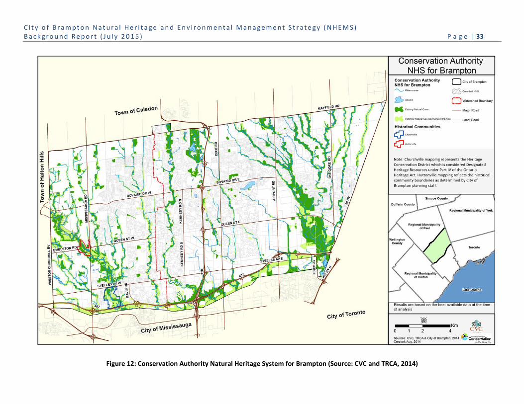
C i t y o f B r a m p t o n N a t u r a l H e r i t a g e a n d E n v i r o n m e n t a l M a n a g e m e n t S t r a t e g y ( N H E M S ) B a c k g r o u n d R e p o r t ( J u l y 2 0 1 5 ) P a g e | 33
Figure 12: Conservation Authority Natural Heritage System for Brampton (Source: CVC and TRCA, 2014)

C i t y o f B r a m p t o n N a t u r a l H e r i t a g e a n d E n v i r o n m e n t a l M a n a g e m e n t S t r a t e g y ( N H E M S ) B a c k g r o u n d R e p o r t ( J u l y 2 0 1 5 ) P a g e | 34
The CA NHS is approximately 5,642 ha in size and covers approximately 21% of Brampton’s land base. Forty-seven
percent (47%) of the CA NHS overlaps with public lands owned by the City of Brampton, CVC or TRCA. The remaining
53% is in private or other public agency ownership at this time.
The CA NHS mapping was overlaid with provincially and regionally designated natural features, including known
locations of species at risk in CVC’s and TRCA’s jurisdictions, Regionally Significant ANSIs, ESAs, PSWs, conservation
authority floodplain and crest of slope mapping, and Region of Peel Core Greenlands. The mapping also captured all
locations of rare vegetation communities in Brampton and it is anticipated that it will capture the majority of significant
wildlife habitat (not currently mapped).
Finally, the CA NHS mapping was compared to the natural heritage features and areas in Schedule D of the City of
Brampton Official Plan (2006). Both Schedule D and the CA NHS include the majority of the city’s remaining natural
cover of watercourses, valleylands, woodlands and wetlands. Table 3 describes the differences between Schedule D and
the proposed CA NHS.
Table 3: Differences between Schedule D of Brampton’s Official Plan (2006) and the proposed Conservation Authority Natural Heritage System (2013)
Land Area
(ha)
Municipal Land Base
(percentage) System Elements and Basic
Differences
Official Plan 2006, Schedule D
4,639 ha 17% Existing natural features
Includes majority of remnant tableland woodlands
Proposed CA NHS 5,642 ha 21% Existing natural features
Applies 30m buffers to natural features5
Includes areas of potential enhancement in the PWBPA, water bodies, and stormwater management facilities within a natural feature
Screens out small woodlands based on watershed scale criteria
As illustrated in Table 3, the CA NHS identifies a natural heritage system that is approximately 1,000 ha larger than the
current natural areas and features shown on Schedule D. These differences are the result of the CA NHS recognizing the
city’s aquatic cover (e.g. Professor’s Lake), the application of buffers to natural features and watercourses, and the
identification of potential natural cover/enhancement areas. For example, there is approximately 359 ha (36%) of the CA
NHS potential natural cover/enhancement area that has been identified in the Parkway Belt West Plan Area that is
outside of Schedule D natural areas and features.
This recognition parallels current natural heritage system planning as undertaken for the Mount Pleasant Community.
The expansion of the Mount Pleasant Community NHS was the result of connecting areas of fragmented woodlands and
5 Thirty (30) metre buffers were applied to some natural features in CVC’s jurisdiction (i.e. High Functioning woodlands, wetlands
and aquatic habitat, and the crest of slope or meander belt of High Functioning valleylands). TRCA did not explicitly define buffers; however, the modelled potential natural cover often provided a buffer to natural features.

C i t y o f B r a m p t o n N a t u r a l H e r i t a g e a n d E n v i r o n m e n t a l M a n a g e m e n t S t r a t e g y ( N H E M S ) B a c k g r o u n d R e p o r t ( J u l y 2 0 1 5 ) P a g e | 35
Mount Pleasant Community
The Huttonville and Fletcher’s Creeks Subwatershed Study is an excellent example of local natural heritage system planning to support the Mount Pleasant Secondary Plan Area, located north of Bovaird Drive, east of Mississauga Road.
In the rural landscape, areas of fragmented woodlands and wetlands, and altered watercourses, including agricultural drains and headwater swales, comprised 8% of the secondary plan area. The subwatershed study prepared for the Mount Pleasant Community identified an integrated terrestrial and aquatic natural heritage system that comprised 18% of Block Plans 51-1 and 51-2.
Building the Mount Pleasant NHS is described in Appendix D and illustrated in Figures D2 to D8.
wetlands, restoring watercourses and corridors, and naturalizing potential natural cover/enhancement areas to
mitigate/compensate for the loss of natural features and functions, as illustrated in Appendix D.
Potential Natural Cover / Enhancement Areas
Potential natural cover/enhancement areas have been
identified as areas that can be managed or restored to
improve ecosystem integrity of the natural system and
provide ecological linkages. These areas generally
complement ongoing stewardship and restoration efforts
currently being undertaken by the City, Conservation
Authorities, infrastructure service corridors providers and
volunteer organizations. Some of these areas may be in the
process of succeeding to natural communities, while other
areas provide additional opportunities to enhance
connectivity, biodiversity and ecosystem function.
Management of these areas depends on a variety of factors,
including landowner interest and site suitability. Some
locations may be suitable for full-scale restoration to forests,
wetlands or meadows, or for specific improvements such as
native species plantings, invasive species management and
wildlife habitat creation. Other areas may be targeted for
best management practices such as LID measures, and
fertilizer and/or no-mow management plans.
The largest area of potential natural cover is associated with the Parkway Belt West Plan Area (PBWPA).
Parkway Belt West Plan Area
The Parkway Belt West Plan Area (PBWPA), including the 407 ETR corridor as shown in Figure 7, is comprised of
approximately 645 ha. The CA NHS has identified 459 ha of land, of which 100 ha is existing natural cover, and 359 ha is
potential natural cover/enhancement areas comprised of agriculture or successional tablelands, as illustrated in Figure
12. By including the PBWPA land base, the City is recognizing the unique ability of green infrastructure corridors to
provide an east-west linkage between Brampton’s north-south oriented valleyland corridors.
It is understood that the PBWPA lands are first and foremost identified for provincial infrastructure planning and
stewardship efforts. However, the NHEMS can open up partnership opportunities that help meet the PBWPA goals for a
‘linked open space system’ and can be used to identify opportunities to enhance and link natural areas across the urban
landscape.
The City of Brampton will work with provincial agencies, including the MTO and 407 ETR, to undertake stewardship
activities within the PBWPA lands, as appropriate. CVC has also initiated discussions with Ontario Hydro for
naturalization activities within their corridors.
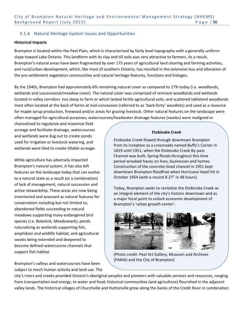
C i t y o f B r a m p t o n N a t u r a l H e r i t a g e a n d E n v i r o n m e n t a l M a n a g e m e n t S t r a t e g y ( N H E M S ) B a c k g r o u n d R e p o r t ( J u l y 2 0 1 5 ) P a g e | 36
Etobicoke Creek
Etobicoke Creek flowed through downtown Brampton from its inception as a crossroads named Buffy’s Corner in 1819 until 1951, when the Etobicoke Creek By-pass Channel was built. Spring floods throughout this time period wreaked havoc on lives, businesses and homes. Construction of the concrete-lined channel in 1951 kept downtown Brampton floodfree when Hurricane Hazel hit in October 1954 (with a record 8.27” in 48 hours).
Today, Brampton seeks to revitalize the Etobicoke Creek as an integral element of the city’s historic downtown and as a major focal point to unlock economic development of Brampton’s ‘urban growth center’.
(Photo credit: Peel Art Gallery, Museum and Archives (PAMA) and the City of Brampton)
3.1.4 Natural Heritage System Issues and Opportunities
Historical Impacts
Brampton is located within the Peel Plain, which is characterized by fairly level topography with a generally uniform
slope toward Lake Ontario. This landform with its clay and till soils was very attractive to farmers. As a result,
Brampton’s natural areas have been fragmented by over 175 years of agricultural land clearing and farming activities,
and rural/urban development, which, like most of southern Ontario, has resulted in the extensive loss and alteration of
the pre-settlement vegetation communities and natural heritage features, functions and linkages.
By the 1940s, Brampton had approximately 6% remaining natural cover as compared to 17% today (i.e. woodlands,
wetlands and successional/meadow cover). The natural cover was comprised of remnant woodlands and wetlands
located in valley corridors too steep to farm or which lacked fertile agricultural soils; and scattered tableland woodlands
most often located at the back of farms at mid-concession (referred to as ‘back-forty’ woodlots) and used as a resource
for maple syrup production, firewood and/or areas for grazing livestock. Other natural features on the landscape were
often managed for agricultural purposes; watercourses/headwater drainage features (swales) were realigned or
channelized to regularize and maximize field
acreage and facilitate drainage, watercourses
and wetlands were dug out to create ponds
used for irrigation or livestock watering, and
wetlands were tiled to create tillable acreage.
While agriculture has adversely impacted
Brampton’s natural system, it has also left
features on the landscape today that can evolve
to a natural state as a result (or a combination)
of lack of management, natural succession and
active stewardship. These areas are now being
inventoried and assessed as natural features for
conservation including but not limited to;
abandoned fields succeeding to natural
meadows supporting many endangered bird
species (i.e. Bobolink, Meadowlark); ponds
naturalizing as wetlands supporting fish,
amphibian and wildlife habitat; and agricultural
swales being extended and deepened to
become defined watercourse channels that
support fish habitat.
Brampton’s valleys and watercourses have been
subject to much human activity and land use. The
city’s rivers and creeks provided Ontario’s aboriginal peoples and pioneers with valuable services and resources, ranging
from transportation and energy, to water and food; historical communities (and agriculture) flourished in the adjacent
valley lands. The historical villages of Churchville and Huttonville grew along the banks of the Credit River in combination

C i t y o f B r a m p t o n N a t u r a l H e r i t a g e a n d E n v i r o n m e n t a l M a n a g e m e n t S t r a t e g y ( N H E M S ) B a c k g r o u n d R e p o r t ( J u l y 2 0 1 5 ) P a g e | 37
Natural Core Areas
The Credit River valley is an important naturally vegetated cross-regional corridor linking Lake Ontario to the Niagara Escarpment and the Oak Ridges Moraine. The Credit River Valley Area includes two City of Brampton parks: Eldorado Park and Churchville Park, as well as private lands in natural cover. The area includes the Huttonville Valley ESA and the Provincially Significant Churchville Norval Wetland Complex. The river winds across a valley bottom characterized by a broad riparian zone with a wide variety of habitat types supporting a diversity of flora and fauna, including species at risk and regionally rare species. This part of the valley lies near the north edge of the Carolinian Zone, providing habitat for Carolinian species (e.g. Shagbark Hickory (Carya ovata) and the regionally rare Spicebush (Lindera benzoin)).
The Heart Lake Natural Area extends from north of Bovaird Drive to Mayfield Road and lies along the Brampton Esker, a regional terrestrial and hydrological linkage to the Provincial Greenbelt and Oak Ridges Moraine natural systems. TRCA’s Heart Lake Conservation Area (HLCA) is the ‘heart’ of this Natural Area, and includes designated woodland ESA, life and earth ANSI, and provincially significant wetlands, and two kame lakes. The Heart Lake Provincially Significant Wetland complex extends along the Esker, is one of the largest remaining wetland complexes on the Peel South Slope, and is home to locally and regionally rare species, and provincial and federal species at risk.
The West Humber River Valley Natural Area, part of the Humber River watershed, extends south from Castlemore Road to Finch Avenue (and Highway 427), including the Claireville Conservation Area and Claireville Reservoir. The Humber River watershed originates in the Niagara Escarpment and the Oak Ridges Moraine and links to Lake Ontario. The natural area is a mixture of forest, successional forest, meadows and wetlands, and lies on the boundary between the Great Lakes-St. Lawrence and the Carolinian floristic regions, the latter of which is composed of mixed coniferous-deciduous forest. The West Humber tributaries are a significant fishery and provide habitat for Redside Dace, an endangered fish species.
with dams and mills to grind grains and produce
power; the village of Brampton prospered and
expanded along Etobicoke Creek.
Human settlement along rivers and within
valleys has led to the management of natural
flooding and erosion hazards that resulted in
watercourse alterations ranging from
channelization and hardening, as evidenced
along Etobicoke Creek in downtown Brampton,
Spring Creek in Bramalea, and Mimico Creek,
and the impoundment of the West Humber
River as the Claireville Reservoir in TRCA’s
Claireville Conservation Area.
Many of these historical activities which have
impacted natural areas, features and functions
remain in-situ today. The historical villages are
valued and unique communities in the city, and
although environmental impacts persist,
ongoing and future management and
enhancement of the urban fabric and built
green spaces will do much to restore ecological
services in these valley areas. Remediation,
restoration and naturalization of watercourses
can mitigate existing impacts and restore
ecological functions and ecosystem services,
while still maintaining the original hazard
management objectives.
Natural Core Areas of Brampton’s NHS
Brampton is characterized by three major
watersheds and five major valley corridors – the
Credit River (with Levis Creek and Fletcher’s
Creek), Etobicoke Creek (with four major
tributaries) and the West Humber River and
Tributaries. Each of these watersheds/valley
corridors has unique attributes. They:
Are provincially and regionally
significant designated natural areas,
habitat for federal and provincial species at
risk, and significant wildlife habitat;

C i t y o f B r a m p t o n N a t u r a l H e r i t a g e a n d E n v i r o n m e n t a l M a n a g e m e n t S t r a t e g y ( N H E M S ) B a c k g r o u n d R e p o r t ( J u l y 2 0 1 5 ) P a g e | 38
Figure prominently in the city’s cultural heritage landscape; and
Provide outdoor educational and recreation opportunities.
Natural ‘core’ areas of the NHS associated with these three watersheds include the Credit River Valley, Heart Lake and
West Humber River Valley Natural Areas, as shown in Figure 13. These represent the City’s first efforts to identify
municipally significant natural areas and features. The City will continue these efforts in conjunction with CVC and TRCA,
as well as identify significant natural features in accordance with the Provincial Policy Statement, 2014.
Species Habitat
Natural Heritage Systems that are healthy, diverse and resilient provide habitat to sustain endangered and threatened
species, significant wildlife habitat, species of conservation concern, and uncommon habitat as identified by the
Province and Conservation Authorities.
In Brampton, protecting, restoring and enhancing natural features, functions and processes are necessary to maintain
existing habitat and species, and to create/expand habitat to enrich species diversity. As an example, conserving and
remediating watercourse (channel) fluvial processes, and maintaining stream temperatures (by protecting groundwater
contributions and riparian cover along watercourses and managing stormwater drainage) is particularly important to
protect fish habitat. Watercourses that traverse Brampton provide some of the few remaining coldwater fish habitat on
the Peel Plain; the Credit River supports heritage fish species such as Atlantic Salmon; and eleven tributaries of the
Credit River and the West Humber River systems have been identified to provide regulated (i.e. occupied and recovery)
habitat for Redside Dace.
Redside Dace (Photo Credit: K. Schmidt)
Brampton must also sustain and link healthy wetland habitat with large undisturbed woodlands (as essential NHS
components) to protect habitat capable of sustaining other significant and rare birds, mammals, amphibians, reptiles
and plants, including species at risk. In some cases the protection of habitat will require active management and
stewardship of natural areas, such as: managing open habitat for birds; providing ecological linkages by installing eco-
passages under/over roads for amphibians, reptiles and small mammals; or protecting specialized habitats (e.g. human
structures) for Barn Swallow and Chimney Swift and exposed bluffs for Bank Swallows.

C i t y o f B r a m p t o n N a t u r a l H e r i t a g e a n d E n v i r o n m e n t a l M a n a g e m e n t S t r a t e g y ( N H E M S ) B a c k g r o u n d R e p o r t ( J u l y 2 0 1 5 ) P a g e | 39
Figure 13: Natural Core Areas in the City of Brampton (Source: City of Brampton)

C i t y o f B r a m p t o n N a t u r a l H e r i t a g e a n d E n v i r o n m e n t a l M a n a g e m e n t S t r a t e g y ( N H E M S ) B a c k g r o u n d R e p o r t ( J u l y 2 0 1 5 ) P a g e | 40
Ecosystem Diversity and Biodiversity
Ecosystem diversity and biodiversity can refer to the variety of species, ecological communities and ecological processes
that occur in different physical settings. The quality of natural cover and species present within the NHS and built green
spaces is critical to providing habitat and supporting the protection of native floral and faunal biodiversity. In southern
Ontario, environmental disturbances have been responsible for historical and current impacts to natural system
biodiversity. This includes disturbances related to agricultural activities and crops, including introduced weeds; rural
land uses; urbanization, including human encroachment, and noise and light; climate change; and invasive species.
Watercourse Channelization
In the 1950s and 1960s, urbanization prompted engineering practices that altered and hardened watercourses with
concrete or other hard bed and bank treatments, as a means to convey water quickly downstream and avoid local
flooding. Stormwater management was not yet part of city building, and natural area conservation focused more on
providing recreation space than ecosystem health. Current knowledge recognizes that this treatment has negatively
impacted the overall health of the aquatic system. In addition, the design life (50+ years) of many of these hardened
channels is ending, with some major failures already experienced. In anticipation of weather systems increasing in
intensity within southern Ontario, the rate of deterioration may accelerate. Major failures have already been observed,
including that of the channel structures along Spring Creek after the storm event on July 8, 2013.
Channel condition pre- and post-July 8, 2013 storm event (Photo Credit: TRCA, Peel Channels
Remediation Strategy Interim Report – Spring Creek Pilot Project, July 2014)
Invasive Species
Human agricultural activities, climate change, immigration and world trade
has been responsible for introducing the majority of non-native invasive
species into Ontario. Without ecological controls (i.e. natural control
provided by vegetation or insects), many of these species can dominate
natural forests, wetland and meadow communities, and pose a risk to
ecosystem health and biodiversity, as well as public health and well-being.

C i t y o f B r a m p t o n N a t u r a l H e r i t a g e a n d E n v i r o n m e n t a l M a n a g e m e n t S t r a t e g y ( N H E M S ) B a c k g r o u n d R e p o r t ( J u l y 2 0 1 5 ) P a g e | 41
Invasive species such as Norway Maple, European Buckthorn, Garlic Mustard, Asian Long-horned Beetle and Emerald
Ash Borer can drastically reduce the quality of native habitats, making them unsuitable for native flora and fauna. Giant
Hogweed poses a serious public health risk as the the clear watery sap of this plant contains toxins that can cause severe
inflammation of the skin (dermatitis)6.
Invasive plant Fig Buttercup invading floodplain
Invasive species management plans should identify the presence of native and invasive species and the extent of
impacts to public and ecosystem health, and provide recommendations for remedial, restoration and enhancement
measures to mitigate the threat to the NHS and community. A good example is the work being undertaken by the City's
Urban Forestry division, which is closely monitoring the spread of Emerald Ash Borer in Brampton and addressing the
removal and replacement of infected trees. The City of Brampton has also been successful in working with partners such
as CVC and schools (i.e. Hickory Woods Public School), community volunteers (i.e. in the Valleywood community) and
developers (i.e. in the Credit Valley Secondary Plan) to remove invasive plants from natural areas. There remain,
however, many natural areas in the city where invasive species constitute a significant threat to native flora and fauna.
Encroachment
The quality of natural areas in the city’s NHS may also be impacted by unrestricted uses including: unauthorized access
to natural areas which can lead to trampling of sensitive areas; unauthorized trails and active recreation uses, such as
mountain biking, leading to erosion on slopes and loss of vegetation and habitat; and encroachment where private and
public property intersect, such as dumping of yard waste, landscaping and mowing of natural areas, or inappropriate
placement of storage buildings and gardens.
Management of encroachment can include by-law enforcement to halt detrimental activities, and stewardship and
restoration activities to remediate impacts and improve ecological features and functions. To eliminate unauthorized
recreation uses, the City may need to consider providing alternative, suitable municipal facilities (e.g. BMX parks) to
encourage appropriate behaviour in natural areas.
6 OFAH/OMNR Invading Species Awareness Program. (2012). Giant Hogweed. Retrieved from: http://www.invadingspecies.com

C i t y o f B r a m p t o n N a t u r a l H e r i t a g e a n d E n v i r o n m e n t a l M a n a g e m e n t S t r a t e g y ( N H E M S ) B a c k g r o u n d R e p o r t ( J u l y 2 0 1 5 ) P a g e | 42
Noise and Light
Urbanization generates significant noise and light pollution that can affect
normal patterns of behaviour in animals and physiology in plants. For
example, singing birds may have difficulty establishing breeding territory or
attracting mates in noisy roadside habitats. Light pollution affects human
and wildlife circadian rhythms, wastes energy and disrupts ecosystems.
Impacts include the fatal attraction of birds and insects to lit buildings,
facilities, and street lights. Plants also may not enter winter dormancy
when exposed to light at night. Reducing and/or shielding of noise and light pollution sources adjacent to natural areas
can reduce these impacts.
Greenland Securement
The majority of Brampton’s city-owned natural areas and features have been gratuitously dedicated through the
development approvals process in accordance with the Official Plan (2006) policies. The purchase of lands for long-term
conservation has generally only occurred as part of the City’s active parkland acquisition, as evidenced at Creditview-
Sandalwood Park (East Huttonville Creek woodland-wetlands) and Gore Meadows Park (West Humber River). In 2012,
Council approved the Greenlands Landowner Securement Contact and Education Project that has identified where there
is merit in the City acquiring ecologically important lands.
The Conservation Authorities have acquired lands in Brampton, as illustrated in Figure 13, for management of the
environmental hazards of flooding and erosion, and for the conservation of land. TRCA owns four properties, including
the Heart Lake Conservation Area, Etobicoke Creek valley (south of Mayfield Road), the Etobicoke Creek Bypass Channel
(downtown Brampton), and the Claireville Conservation Area and Reservoir. CVC owns the Main’s Creek Channel (a
tributary of Fletcher’s Creek) and a reach of Fletcher’s Creek immediately upstream of Queen Street, as shown in Figure
13.
At noted in Section 3.1.3, forty-seven percent (47%) of the CA NHS overlaps with City of Brampton, CVC or TRCA owned
(public) property. The remaining 53% is in other public or private ownership at this time.
Conservation Area Land Acquisitions
The Etobicoke-Mimico Conservation Authority (now TRCA) acquired the Heart Lake Conservation Area (169 ha from ten properties) from 1956 to 1982 to protect the area’s diverse and significant natural features and wildlife habitat, enhance natural water storage for the Etobicoke Creek system, and for the development of recreation facilities and trails. The Etobicoke-Mimico CA also built the Etobicoke Creek Channel in downtown Brampton in 1952, just before Hurricane Hazel struck in 1954.
TRCA acquired the numerous agricultural lands that now constitute the Claireville Conservation Area (728 ha) in 1957 to construct a dam and reservoir to control flooding in the Lower Humber River valley lands. The Claireville Dam and Reservoir were built in 1964. The CCA is now one of the most important recreation, education and environmental appreciation destinations in the GTA.

C i t y o f B r a m p t o n N a t u r a l H e r i t a g e a n d E n v i r o n m e n t a l M a n a g e m e n t S t r a t e g y ( N H E M S ) B a c k g r o u n d R e p o r t ( J u l y 2 0 1 5 ) P a g e | 43
Natural Area Management and Monitoring
The City of Brampton and its conservation partners, including the Province, Peel Region, TRCA and CVC, recognize that
research, knowledge, management, monitoring and stewardship are key tools to addressing past and present impacts to
the natural system and improving natural features and
functions.
Management plans can be scaled based on the natural
heritage system or natural areas/features under consideration,
such as the Provincial Greenbelt Plan, conservation authority
watershed and subwatershed plans, and conservation area and
park management plans. Each of these plans provides direction
which, when implemented, make important contributions to
the achievement of sustainable land use planning and long-
term protection and enhancement of Brampton’s NHS.
Developing management plans for the city’s natural areas and
open space/parkland will enable Brampton to plan and budget
for active conservation and restoration efforts through
municipal and/or community programs. TRCA has completed
management plans for the Heart Lake and Claireville
Conservation Areas. These plans provide an excellent basis
from which Brampton could develop management plans for
the city’s Natural Core Areas that include the HLCA, CCA and
portions of the Credit River valley.
Monitoring strategies and plans also range in scale, both
geographically and temporally, based on identified issues, proponents and funding. Current monitoring that tracks
environmental indicators in Brampton include the long-term provincial Integrated Water Quality Monitoring Network,
CVC’s Integrated Watershed Monitoring Program (IWMP) and Effectiveness Monitoring Program, the Mount Pleasant
Community 5-year monitoring project, and the Heart Lake Road Ecology Monitoring Project.
The NHEMS identifies targets and actions that require monitoring and reporting in conjunction with Brampton Grow
Green. Brampton will need to integrate and leverage, where possible, data already being collected or that can be easily
collected by the City and its conservation partners.
Management Plans
Comprehensive and integrated management plans such as the Claireville Conservation Area Management Plan are needed for all natural areas which make up the NHS in Brampton. Management plans identify significant natural features and functions as well as environmental threats, and provide direction for actions (i.e. restoration, trails and signage).

C i t y o f B r a m p t o n N a t u r a l H e r i t a g e a n d E n v i r o n m e n t a l M a n a g e m e n t S t r a t e g y ( N H E M S ) B a c k g r o u n d R e p o r t ( J u l y 2 0 1 5 ) P a g e | 44
Figure 14: Illustration of the basic cycle of
adaptive management (in which “check” could
be replaced with “monitor”)
Brampton’s Valleyland Naturalization Program
Brampton’s comprehensive Valleyland Naturalization Program, established in 2002, is a successful example of ongoing restoration efforts to re-establish indigenous plant communities in the city’s valley lands. In the past 12 years, the program has planted over 161 ha, as illustrated in Valley Naturalization Planting Program 2003-2014 Map (in Appendix F), with 29,000 native trees, 224,000 native shrubs and 100,000 native perennials, that have enhanced vegetation communities, introduced new wildlife habitat and improved fish habitat by stream shading and floodplain stabilization.
Adaptive Management
Natural systems and built green spaces (i.e. urban forests, open
space, parks and green infrastructure) are subject to natural,
social and economic events and changes (i.e. climate change,
severe weather, invasive species, encroachment, and changing
resource allocation priorities) that are difficult to predict.
Adaptive management7 is a tool for land use and resource
managers that acknowledges that our understanding of natural
systems and ecosystem services is incomplete, and that a
systematic process is needed to continually assess and improve
management policies and practices to best ensure robust
decision-making in the face of uncertainty. Adaptive
management also enables a balance between gaining
knowledge to improve management in the future and achieving
the best short-term outcome based on current knowledge.
Stewardship of Brampton’s NHS
Brampton and its conservation partners must work collaboratively to achieve mutual environmental goals through the
delivery of agency mandates and legislative responsibilities, through educating and engaging residents and the public,
and through the delivery of community programs. While the NHEMS focuses on what the City of Brampton can do to
improve its environmental performance, the environment transcends political borders. The City, therefore, is committed
to working with all levels of government, including adjacent municipalities and community partners, to advance the
goals of the NHEMS.
7 Description of Adaptive management has been adapted from: United Nations Millennium Ecosystem Assessment 2005, and Allan &
Stankey 2009. (Catherine Allan and George H. Stankey (2009). Adaptive Environmental Management: A Practitioner’s Guide. The Netherlands: Dordrecht. ISBN 978-90-481-2710-8).

C i t y o f B r a m p t o n N a t u r a l H e r i t a g e a n d E n v i r o n m e n t a l M a n a g e m e n t S t r a t e g y ( N H E M S ) B a c k g r o u n d R e p o r t ( J u l y 2 0 1 5 ) P a g e | 45
Some of the most ecologically important areas to restore are associated with valley and watercourse corridors. Within
these areas, natural riparian cover protects and enhances aquatic environments; trees shade channels and lower stream
temperatures and prevent bank erosion, provide wildlife habitat, and support ecological linkages across the landscape.
Table 4 identifies the extent of natural and semi-natural vegetation along Brampton’s watercourses that traverse the
city, including woodland communities located within 30 metres of channel banks. Appendix E illustrates these fourteen
subwatersheds across the city.
Table 4: Percentage of natural and semi-natural vegetation along watercourses (CVC and TRCA, 2014)
Natural & Semi-Natural Vegetation Along Watercourses
Subwatershed Natural and semi-natural
vegetation within 30m buffer
Woodland within 30m buffer
Churchville Tributary 77.8 % 44.6 %
Fletcher's Creek 67.9 % 23.5 %
Huttonville Creek 52.4 % 30.5 %
Levi Creek 56.1 % 28.7 %
Mullett Creek 70.7 % 13.0 %
Norval to Port Credit 65.2 % 30.7 %
Springbrook Tributary 63.1 % 36.8 %
Etobicoke Headwaters 72.6 % 39.6 %
Etobicoke Tributary 3 44.5 % 0.0 %
Etobicoke West Branch 64.3 % 18.9 %
Main Humber 27.6 % 1.4 %
Mimico Creek 47.2 % 2.8 %
Spring Creek 54.7 % 21.3 %
West Humber 77.2 % 30.3 %
City of Brampton 65.6 % 26.5 %
Community organizations will be vital in implementing the NHEMS. The TRCA has supported two watershed citizens
groups, the Humber River Alliance and the Etobicoke-Mimico Coalition that focus stewardship efforts on these
subwatersheds, including the Claireville and Heart Lake Conservation Areas, respectively. Sierra Club Peel is a non-
governmental organization (NGO) that promotes sustainable urban centres and transportation, and protecting and
enhancing the Credit River, Etobicoke Creek and Humber River watersheds in Peel.
Ontario Streams, established in 1995, is a non-profit environmental organization dedicated to the conservation and
rehabilitation of streams and wetlands through education and community involvement with municipalities, landowners,
and school groups. To date, many of Ontario Streams’ projects have occurred in and around the GTA, including activities
such as tree planting, debris and garbage clean-up, habitat creation, bioengineering, biological monitoring, mitigating
fish barriers and restoring and creating wetlands.

C i t y o f B r a m p t o n N a t u r a l H e r i t a g e a n d E n v i r o n m e n t a l M a n a g e m e n t S t r a t e g y ( N H E M S ) B a c k g r o u n d R e p o r t ( J u l y 2 0 1 5 ) P a g e | 46
Everyone has a role to play in environmental stewardship. The actions contained in the NHEMS make clear the long-term
environmental goals Brampton is working towards, and identify opportunities to achieve the City’s objectives.
The information provided above highlights the role of Brampton’s NHEMS in prioritizing, implementing and monitoring
active restoration and management of the NHS. Key issues and opportunities for the NHS are summarized in Table 5.
Table 5: Key issues and opportunities for the NHS
NHS Issues NHEMS Opportunities
Large areas of ‘potential’ natural cover requiring
restoration
Watercourses and valleylands lacking natural cover
Inappropriate public use and encroachment negatively
impact the NHS
Invasive species impact vegetation community health and
diversity
Residents and visitors may not recognize ecosystem
services, importance of protecting species habitat and
relationship of natural areas to their quality of life and
experiences
Lack of community acceptance of naturalization activities
and success
Long-term funding and commitment is needed for NHS
securement and management
Need to update operations and maintenance programs to
reflect best management practices
Prioritize and implement restoration with
conservation organizations and stakeholders
Expand current valleyland naturalization programs
Improve public trails and signage and undertake
enforcement of unauthorized uses as necessary
Prioritize and implement invasive species
management plans
Engage the community in learning more about the
NHS through stewardship programs, homeowner
guides, educational signage, environmental education
in schools
Engage residents in local naturalization projects
A dedicated budget and external funding
opportunities to support ongoing planning and
management of the NHS
Update operational and maintenance standard
operating procedures (SOP) and relate to capital and
operational budgets
Redside Dace Habitat Rehabilitation Initiative
Ontario Streams developed the Redside Dace Habitat Rehabilitation Initiative in 2001 that is directed towards the recovery of the provincially endangered Redside Dace in accordance with the Draft Recovery Strategy for Redside Dace in Ontario prepared by the Redside Dace Recovery Team.
In 2009, the City of Brampton and Ontario Streams signed a Memorandum of Understanding for the Kilmanagh Creek Redside Dace Habitat Restoration Pilot Project. To date, Ontario Streams has restored and enhanced approximately 4 kilometers of Kilmanagh Creek from Castlemore Road to Countryside Drive. Rehabilitations works have included but are not limited to: debris jam and beaver dam removals, stream bank stabilization, riparian plantings, and garbage removal. Ontario Streams undertook this work using volunteers from the Ontario Stewardship Rangers and Sandalwood Heights Secondary School students. Ontario Streams is now supporting the City’s efforts to improve Fletcher’s Creek for Redside Dace.

C i t y o f B r a m p t o n N a t u r a l H e r i t a g e a n d E n v i r o n m e n t a l M a n a g e m e n t S t r a t e g y ( N H E M S ) B a c k g r o u n d R e p o r t ( J u l y 2 0 1 5 ) P a g e | 47
3.2 Brampton’s Open Space System
Brampton’s Open Space System includes the NHS as discussed above, and Recreational Open Space lands, such as Public
Parkland (active and passive tableland areas), Conservation Areas and Private Commercial Recreation Areas, as shown
on Schedule E of the Official Plan (Figure 15).
This study recognizes on the role of Recreational Open Spaces to supporting a sustainable, healthy, NHS and urban
forest.
Figure 15: Brampton’s Major Recreational Open Space (Source: City of Brampton Official Plan, 2006)
Linking the City
Brampton’s pathways system8 creates a unique linkage between the city’s natural and built environments. Brampton’s
pathways and trails are critical infrastructure to support active transportation, a fundamental aspect of creating healthy
communities and allowing people to move around the city by means other than personal vehicles. The City and our
conservation partners provide on and off-road multi-use paths, as well as a trail network, through the majority of
Brampton’s valley and watercourse corridors and active parklands. These paths and trails connect residents, visitors and
8 As defined by Brampton’s Pathways Routing Plan, 2010.

C i t y o f B r a m p t o n N a t u r a l H e r i t a g e a n d E n v i r o n m e n t a l M a n a g e m e n t S t r a t e g y ( N H E M S ) B a c k g r o u n d R e p o r t ( J u l y 2 0 1 5 ) P a g e | 48
employees to local and regional destinations, such as schools, shopping, recreation centres, employment areas and
other municipalities, as shown in Figure 16. With greater accessibility comes the need for appropriate design,
construction and maintenance of trails adjacent to, and within, the natural heritage and open space systems and green
infrastructure. Trail planning and design includes, but is not limited to, ecological features, site drainage, viewscapes,
accessibility, safety, visibility, aesthetics, sustainability, maintenance, access, etc.
Figure 16: Brampton’s Pathways System (Source: Brampton’s Pathways Routing Plan, 2010)
3.2.1 Open Space Issues and Opportunities
Public and Private Open Spaces
Public and private open spaces and recreation areas, including institutional lands, provide green spaces where the
community and visitors engage in active organized sports (e.g. cricket, soccer, baseball, golf) and passive recreation
where families can enjoy the outdoors in a safe, natural environment. The large urban population of Brampton relies on
the open space system for active, healthy living, including the use of trail networks that support active transportation for
walking, running and biking to every day destinations (i.e. schools, work, shopping and sports facilities).
C i t y o f B r a m p t o n N a t u r a l H e r i t a g e a n d E n v i r o n m e n t a l M a n a g e m e n t S t r a t e g y ( N H E M S ) B a c k g r o u n d R e p o r t ( J u l y 2 0 1 5 ) P a g e | 49
Peel Village Golf Course
The City of Brampton owns and operates the Peel Village Golf Course within the Etobicoke Creek valley, that offers golfers a unique experience of playing in a natural garden setting of aquatic and terrestrial features. Peel Village joined the Audubon program in 1995 and became the first municipal golf course to become fully certified under the Audubon Co-operative Sanctuary System in 1998.
Conservation Areas
As described earlier in this document, the TRCA owns and manages the Heart Lake and Claireville Conservation Areas that are part of the city’s natural heritage and open space systems. While the conservation areas protect some of the most significant natural areas within the city, they also provide outdoor education and passive recreation for both residents and visitors. The tableland areas and aquatic lake resources support unique active uses, including: First Nation’s cultural heritage gardens, public events and dragon boat racing (HLCA); urban agriculture (Farm Start); as well as campgrounds and a water park (CCA).
Public and private open space provides social and economic benefits for Brampton’s urban population and ecological
benefits for the NHS and urban forest. Open space can be strategically managed for human use as well as ecological
features, functions and linkages.
Figure 17 builds on Schedule E (Figure 15) by illustrating public and private valley lands, including Conservation Areas,
public and private parklands, cemeteries, and institutional and school properties. The City of Brampton is currently
examining opportunities to share recreation and parking facilities with the Peel District Public School Board.
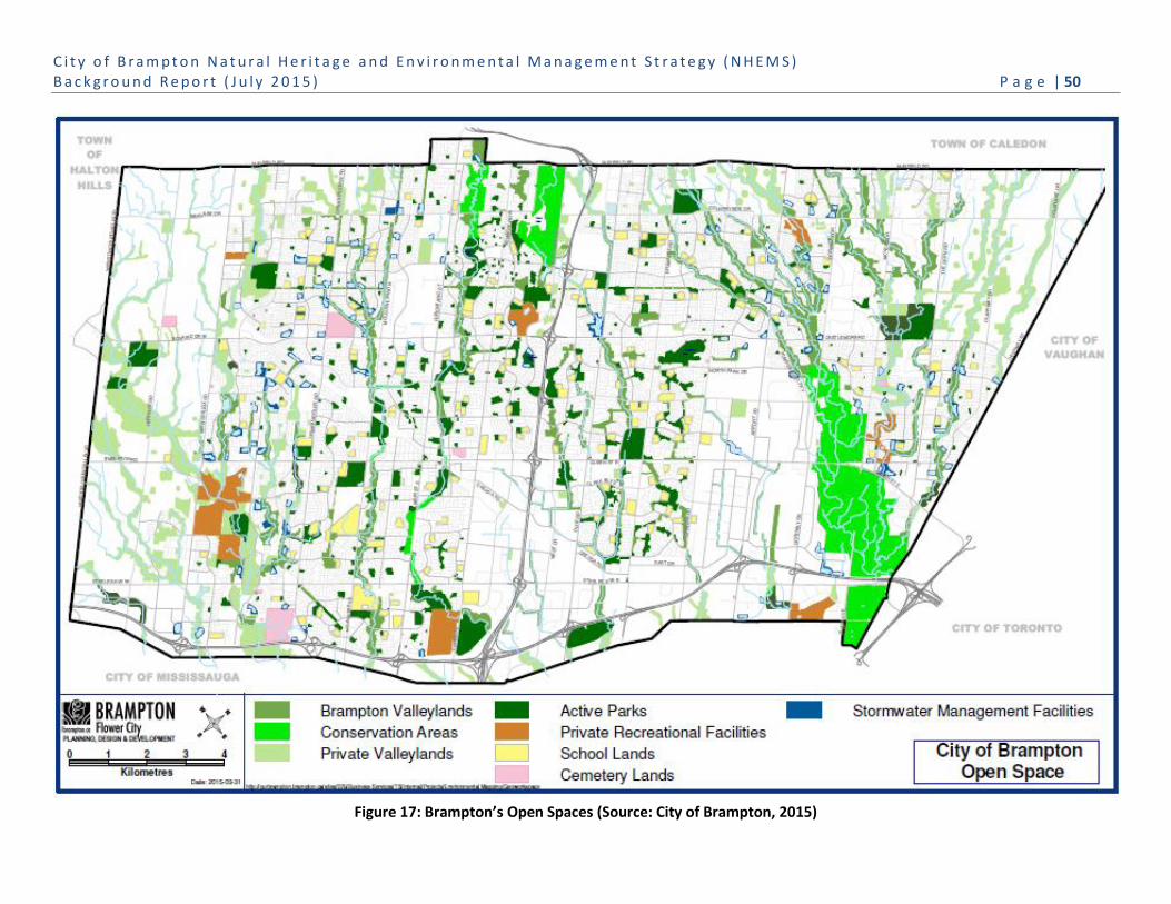
C i t y o f B r a m p t o n N a t u r a l H e r i t a g e a n d E n v i r o n m e n t a l M a n a g e m e n t S t r a t e g y ( N H E M S ) B a c k g r o u n d R e p o r t ( J u l y 2 0 1 5 ) P a g e | 50
Figure 17: Brampton’s Open Spaces (Source: City of Brampton, 2015)

C i t y o f B r a m p t o n N a t u r a l H e r i t a g e a n d E n v i r o n m e n t a l M a n a g e m e n t S t r a t e g y ( N H E M S ) B a c k g r o u n d R e p o r t ( J u l y 2 0 1 5 ) P a g e | 51
Photo Credit: TRCA
Open Space Natural Features and Functions
Brampton’s Official Plan Open Space policies acknowledge the relationship between open space and the NHS: “Where
recreational open space lands include or abut natural heritage features such as woodlands, wetlands, valleylands and
watercourse corridors, the relevant policies in Section 4.6 must be applied to ensure the protection of these features and
the environmental functions and linkages they perform (Section
4.7.4.1)”.
Open space areas can be managed to provide a spectrum of ecosystem
services that support natural features and functions, and provide a
land base for natural vegetation communities and the urban forest.
Open spaces can contribute to the water cycle in urban environments
dominated by hardscapes (i.e. roads and parking areas) that are
impermeable to water. Sports fields, neighbourhood parks, golf
courses and cemeteries are softscapes that can support the natural
water cycle by allowing rainwater or snowmelt to infiltrate into the
ground; conveying clean runoff to watercourses; and supporting
vegetation (grass and trees) that cycles water into the atmosphere through
evapotranspiration9.
There are many ways open space can be enhanced and/or managed to be more sustainable, including: implementation
of stormwater management facilities (i.e. Low Impact Development measures – swales/infiltration galleries) to store
water, increase infiltration and enhance the quality of surface water runoff; reduced mowing to reduce greenhouse gas
(GHG) emissions; and naturalization with trees and shrubs to increase the urban forest canopy, reduce the urban heat
island effect and improve local air quality.
9 Pending appropriate design, construction and management, manicured areas are often considered the second most impervious
surface (in some studies) due to soil compaction, along with being a source of fertilizers/pesticides, and when cut short offer little compensation in terms of evapo-transpiration functions in reducing storm runoff (Source: CVC, 2015).
Brampton’s Recreational Open Space
Currently Brampton has 4,930 ha of recreational open space which includes 2,650 ha of public natural heritage system and 2,280 ha of tableland parkland. The parkland is characterized by 990 parks with 38 recreation centres; 1,147 ha of active sports fields; 290 playgrounds; 388 km of trails; 54 pedestrian bridges (across watercourses) and five community gardens. The NHS (currently 1,690 ha in City ownership) has 413 km of stream channels, and within and/or adjacent to the NHS are 143 stormwater management ponds that provide city-wide water quantity and quality control. The number of stormwater management facilities is expected to increase to 370 by 2031.
Specialty environmental services include: arboricultural and horticultural, community stewardship and education, and community garden installation and management.

C i t y o f B r a m p t o n N a t u r a l H e r i t a g e a n d E n v i r o n m e n t a l M a n a g e m e n t S t r a t e g y ( N H E M S ) B a c k g r o u n d R e p o r t ( J u l y 2 0 1 5 ) P a g e | 52
Open Space Naturalization
Active sport fields and manicured open spaces provide limited natural habitat functions that can contribute to, or
support, the NHS and urban forest. Active and manicured areas require regular mowing that eliminates naturalizing
plant species, and regular fertilizing that can export nutrients and other pollutants to local streams affecting water
quality; these areas tend to have few trees to minimize shade on turf or interfere with active sports play.
While active sports fields are critical infrastructure of the City’s recreation and sports tourism programming,
naturalization plans that include reduced mowing of passive open spaces provide opportunities for natural processes
and increase habitat diversity, particularly for areas adjacent to the NHS and the urban forest canopy.
To ensure successful naturalization of open space, it is critical to secure public acceptance of converting mown areas
into natural vegetation communities that buffer and/or expand natural features, provide habitat, or link natural areas.
Open Space Ecological Linkages and Buffers
The proximity of recreation open space to the NHS can provide ecological linkages between natural heritage features,
and buffer the NHS from adjacent land uses. The built environment presents many barriers (e.g. roads, buildings, fences)
that impact daily, seasonal and year-to-year movement patterns of species between natural areas, such as between
woodlands and wetlands. Active open spaces can facilitate wildlife movement between natural areas, and passive open
spaces with naturalizing vegetation and an urban tree canopy can provide stronger ecological linkage options, as well as
habitat for some species.
Open space also provides a buffering
function for the NHS, reducing impacts of
adjacent urban land uses, such as noise
from roads, higher temperatures and
drying winds from hardscapes, and light
pollution from street lights and buildings at
night. Naturalization efforts such as tree
planting or reduced mowing, and the
creation of natural habitats, such as
meadows, can greatly improve the
ecological linkage and buffering functions
provided by these areas.
Green Space Management
The City’s Maintenance and Operations divisions are responsible for the good care of Brampton’s green spaces, which
include the NHS, open space, green infrastructure and urban forest.
Operational service levels for the management and maintenance of green spaces are a balance of environmental, social
and economic objectives, including ecosystem services, public health and safety, quality of life, property values, passive
and active recreation and play, and staff and budget resources.

C i t y o f B r a m p t o n N a t u r a l H e r i t a g e a n d E n v i r o n m e n t a l M a n a g e m e n t S t r a t e g y ( N H E M S ) B a c k g r o u n d R e p o r t ( J u l y 2 0 1 5 ) P a g e | 53
Operational divisions have implemented numerous corporate and community stewardship initiatives, such as
remediation and naturalization (e.g. Spring Creek channels in conjunction with TRCA, Kenpark wetland restoration),
street and park tree inventory, One Million Bulbs, Community Forest, and community invasive species management (e.g.
Hickory Woods Park and Valleybrook).
Annual and seasonal maintenance programs in these green spaces include but are not limited to:
Parks – trail and pedestrian bridges, urban tree care and replacement, hazard tree removal, sports field repair,
mowing and irrigation, and garbage removal;
Animals Services – pet safety, wildlife rescue and management, and community education; and
Roads – multi-use pathways, repair and remediation of watercourse channels and road crossings, winter
plowing and road salt management.
The Maintenance and Operations divisions are also responsible for handling the impacts of extreme weather events on
public lands, such as the Ice Storm 2013 and invasive species (e.g. Emerald Ash Borer), as well as resident and Council
requests for public land maintenance, nuisance wildlife, and community and institutional/school environmental events.
Each of these management issues has the opportunity to benefit the provision of ecosystem services and the
conservation of natural features, functions, and linkages.
Of critical importance to the success of the City’s efforts to manage and naturalize green spaces is the continuous long-
term education and engagement of Council and the community. For example, the cultural values and perceptions of
local residents and businesses result in numerous requests to mow natural areas to project a manicured park look. As
previously noted, manicured open space provides limited ecosystem services, while at the same time demanding
significant staff and budget resources to maintain. These resource demands are compounded by the associated impact
of GHG emissions as a result of mowing. To achieve a healthier community and NHS, local residents need to understand
the benefits associated with naturalized spaces and the costs associated with manicured spaces.
Service requests from residents and Council must be assessed with regard to negative impacts to the health and
diversity of the natural and built green spaces, requirements for unallocated staff and budget resources, and the effect
on the City’s environmental objectives and targets, such as reducing greenhouse gas (GHG) emissions, water
conservation and expanding the urban tree canopy.
The NHEMS will aid the City in its goal to prioritize, implement and monitor the management of recreational open space
to maximize ecological services without impacting its primary role of providing active and passive recreation,
opportunities for public gathering, space for community gardens, and support for Brampton’s place-making efforts.
Ecological services can be derived through targeted restoration and management programs. Key issues and
opportunities for recreational open space are summarized in Table 6.

C i t y o f B r a m p t o n N a t u r a l H e r i t a g e a n d E n v i r o n m e n t a l M a n a g e m e n t S t r a t e g y ( N H E M S ) B a c k g r o u n d R e p o r t ( J u l y 2 0 1 5 ) P a g e | 54
Table 6: Key issues and opportunities for Open Space
Recreational Open Space Issues Recreational Open Space NHEMS Opportunities
Open space may not include active stormwater
management
Manicured areas provide few ecological benefits, and
maintenance practices impact GHG emissions
Manicured areas are less effective in providing
ecological linkage and buffering
Community perception may not recognize the
ecological value of naturalized areas
Open space may have low tree cover
Retrofit lands for stormwater management measures
including LIDs, to manage runoff , support site water
balance and improve water quality
Develop a city-wide maintenance/operation strategy to
reduce mowing and increase natural vegetation where
possible
Naturalization programs can target improvements to
ecological linkages and buffers and urban forest canopy
Combine naturalization programs with environmental
education and signage
Establish a city-wide tree canopy cover target
Prepare naturalization plans for each open space park
to increase tree canopy cover
Promote the social and environmental benefits of the
urban forest

C i t y o f B r a m p t o n N a t u r a l H e r i t a g e a n d E n v i r o n m e n t a l M a n a g e m e n t S t r a t e g y ( N H E M S ) B a c k g r o u n d R e p o r t ( J u l y 2 0 1 5 ) P a g e | 55
3.3 Brampton’s Green Infrastructure
The social and economic sustainability of Brampton is dependent on infrastructure, including hydro transmission lines,
gas pipelines, roads and transportation corridors, potable water supply lines and sanitary sewers, and stormwater
management facilities. These infrastructure corridors and facilities are often characterized by green landscapes which
vary in the amount of natural vegetation communities and habitat present.
To date Brampton has primarily focused on management of
stormwater management facilities that provide an opportunity
to buffer the NHS, expand the urban forest, and maximize
environmental features and functions associated with green
infrastructure. Stormwater ponds manage flows during storm
events, improve water quality and, through natural
landscaping, provide areas of aquatic and terrestrial vegetation
that supports native wildlife.
There has been little recognition of the existing or potential ecological services that can be provided by green
infrastructure corridor lands in support of Brampton’s NHS and urban forest. Linear infrastructure corridors (e.g. hydro
transmission lines, Parkway Belt West Plan Area) may provide substantial areas of contiguous habitat as well as upland
terrestrial ecological linkages across regional landscapes, particularly for large urban areas. Landscape management
practices of these corridors should encourage the conservation, restoration and enhancement of natural vegetation that
can enhance ecological features and functions, while withstanding impacts associated with infrastructure maintenance.
The Parkway Belt West Plan Area (PBWPA) is an important green
infrastructure corridor that crosses east to west across south Brampton,
and can support natural habitat as well as provide linkage functions. The
PBWPA connects the majority of the city’s valley and watercourse corridors,
which are typically aligned north to south. Much of the land within the
PBWPA can provide natural cover and/or opportunities for potential natural
cover. The City of Brampton recognizes that, first and foremost, these
corridor lands are meant to provide infrastructures services that support
communities across the GTA and southern Ontario.
Figure 18 identifies the location of the existing and anticipated major infrastructure present in Brampton. The amount of
green spaces and the linear connections provided by these major corridors highlight the landscape opportunities that
green infrastructure can provide in support of the NHS, particularly in creating ecological connections, as well as
providing urban forest canopy cover.
Green infrastructure corridors can also connect communities. As noted in Section 3.1.3, a goal of the Parkway Best West
Plan is for a “linked open space system”. In addition, the City of Brampton has an agreement with TransCanada Pipelines
(TCPL) for a major pedestrian pathway that will span the city, conditions permitting, as illustrated in Figure 19.
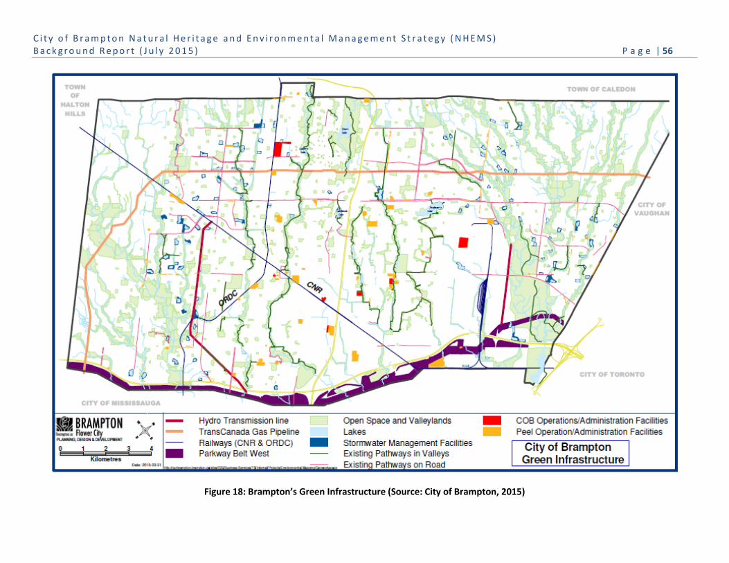
C i t y o f B r a m p t o n N a t u r a l H e r i t a g e a n d E n v i r o n m e n t a l M a n a g e m e n t S t r a t e g y ( N H E M S ) B a c k g r o u n d R e p o r t ( J u l y 2 0 1 5 ) P a g e | 56
Figure 18: Brampton’s Green Infrastructure (Source: City of Brampton, 2015)
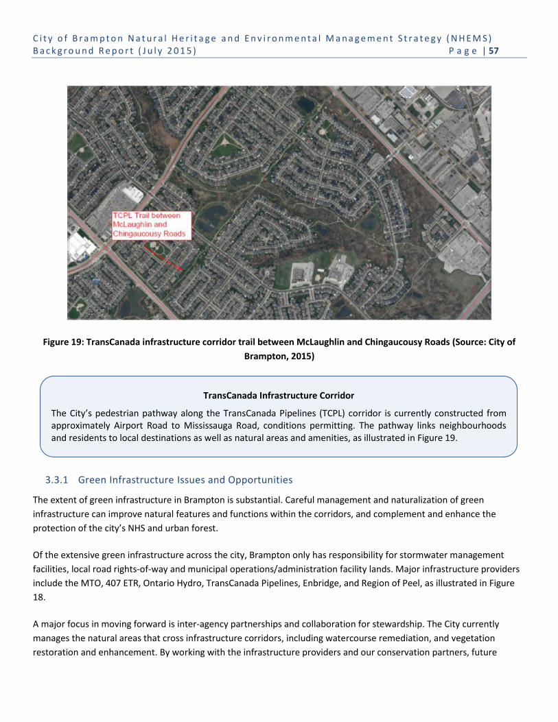
C i t y o f B r a m p t o n N a t u r a l H e r i t a g e a n d E n v i r o n m e n t a l M a n a g e m e n t S t r a t e g y ( N H E M S ) B a c k g r o u n d R e p o r t ( J u l y 2 0 1 5 ) P a g e | 57
TransCanada Infrastructure Corridor
The City’s pedestrian pathway along the TransCanada Pipelines (TCPL) corridor is currently constructed from approximately Airport Road to Mississauga Road, conditions permitting. The pathway links neighbourhoods and residents to local destinations as well as natural areas and amenities, as illustrated in Figure 19.
Figure 19: TransCanada infrastructure corridor trail between McLaughlin and Chingaucousy Roads (Source: City of
Brampton, 2015)
3.3.1 Green Infrastructure Issues and Opportunities
The extent of green infrastructure in Brampton is substantial. Careful management and naturalization of green
infrastructure can improve natural features and functions within the corridors, and complement and enhance the
protection of the city’s NHS and urban forest.
Of the extensive green infrastructure across the city, Brampton only has responsibility for stormwater management
facilities, local road rights-of-way and municipal operations/administration facility lands. Major infrastructure providers
include the MTO, 407 ETR, Ontario Hydro, TransCanada Pipelines, Enbridge, and Region of Peel, as illustrated in Figure
18.
A major focus in moving forward is inter-agency partnerships and collaboration for stewardship. The City currently
manages the natural areas that cross infrastructure corridors, including watercourse remediation, and vegetation
restoration and enhancement. By working with the infrastructure providers and our conservation partners, future

C i t y o f B r a m p t o n N a t u r a l H e r i t a g e a n d E n v i r o n m e n t a l M a n a g e m e n t S t r a t e g y ( N H E M S ) B a c k g r o u n d R e p o r t ( J u l y 2 0 1 5 ) P a g e | 58
efforts can focus on restoration of tableland natural features within the corridors, and naturalization of potential natural
cover/enhancement areas.
Within the public road rights-of-way, the implementation of stormwater management LID measures is a primary
consideration, particularly where stormwater controls are limited in older neighbourhoods. Providing LID quantity and
quality controls can improve runoff to watercourses, and lessen impacts to fish and wildlife habitat and riparian
vegetation communities through the reduction of stream erosion, sedimentation and poor water quality.
Key issues and opportunities for green infrastructure are summarized in Table 7.

C i t y o f B r a m p t o n N a t u r a l H e r i t a g e a n d E n v i r o n m e n t a l M a n a g e m e n t S t r a t e g y ( N H E M S ) B a c k g r o u n d R e p o r t ( J u l y 2 0 1 5 ) P a g e | 59
Table 7: Key issues and opportunities for Green Infrastructure
Green Infrastructure Issues Green Infrastructure NHEMS Opportunities
Infrastructure providers may not recognize the natural
landscape and/or local NHS context of the
infrastructure corridor
Infrastructure providers may not manage linear
corridors for linkage functions across a diversity of
landscapes
Linear corridors have an extensive edge across the
landscape that provides significant pathways for
invasive plants within the corridor, and/or to extend
invasive species to other natural areas
Conventional landscaping is intended to minimize
maintenance (i.e. trees not typically planted along
hydro transmission lines)
Green infrastructure generally includes minimal
stormwater management controls (e.g.
ditches/swales)
Infrastructure corridor intersections with
roads/highways may impact wildlife safety
Stormwater facility naturalization may conflict with
wildlife species conservation
There may be specific management requirements for
certain types of infrastructure (i.e. pipelines and hydro
transmission corridors)
Community perception may not recognize the
ecological value of naturalized areas within areas of
green infrastructure
NHEMS can educate and engage stakeholders on the
benefits and opportunities of naturalization and
stewardship efforts
NHEMS can guide management and naturalization
efforts to maximize ecological benefits
Adopt programs to prioritize and implement invasive
species management, combined with naturalization
efforts
Select native species to enhance ecological diversity
while minimizing infrastructure conflict
Seek opportunities to maximize/retrofit LID measures to
address site and adjacent natural area water balances
Manage for safe eco-passage using road ecology
measures, including barriers, culverts, etc.
Stormwater facility landscaping should enhance
ecological functions, but not conflict with wildlife
conservation
Establish working groups with the managers of green
infrastructure to address special management
requirements
Combine naturalization programs of green infrastructure
with signage for public education

C i t y o f B r a m p t o n N a t u r a l H e r i t a g e a n d E n v i r o n m e n t a l M a n a g e m e n t S t r a t e g y ( N H E M S ) B a c k g r o u n d R e p o r t ( J u l y 2 0 1 5 ) P a g e | 60
3.4 Brampton’s Urban Forest
All of the trees present throughout the City of Brampton on public and
private lands constitute its urban forest; this includes trees within
natural woodlands and green infrastructure. The urban forest can also
be found in the most urbanized parts of the city, including street trees
in road boulevards and parking lots, and trees planted on institutional
lands, employment lands (i.e. head office properties, commercial
centres, and industrial areas) and the thousands of trees planted in the
front and back yards of residential neighbourhoods.
Ecological Value of the Urban Forest
Trees provide multiple benefits to urban communities: they reduce the
urban heat island effect by shading hard areas including roads, parking
lots and buildings; reduce cooling costs by shading buildings in the
summer; increase property values; mitigate climate change by
sequestering carbon; woodlands create urban cool islands; provide
habitat for wildlife; and provide areas for passive recreation. Many
urban municipalities establish Urban Forest Management Plans that
strategically guide programs to maintain the health and expand urban
tree cover over time.
City of Brampton Urban Forest Study
The City of Brampton Urban Forest Study (2011) provides the following summary:
The City of Brampton’s 3.6 million trees cover 11 percent of the total land area, providing
145 km2 of total leaf area. Average tree density in Brampton is 134 trees per hectare. By
ownership type, homeowners and tenants control the largest percentage of the city’s
urban forest. Nearly one third of the existing tree cover is located within the residential
area.
Within Brampton, 41% of the tree cover is located in natural woodland, most of which is
protected within the city’s NHS. Surprisingly, the majority of the urban forest canopy
(59%) is located within open space, green infrastructure, and/or on private lands,
representing trees that have been intentionally planted. This demonstrates the
substantial contribution stewardship and tree planting programs make to the health of
the built environment.
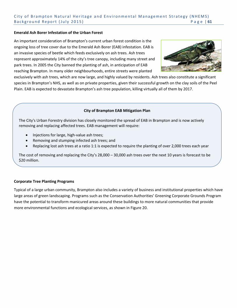
C i t y o f B r a m p t o n N a t u r a l H e r i t a g e a n d E n v i r o n m e n t a l M a n a g e m e n t S t r a t e g y ( N H E M S ) B a c k g r o u n d R e p o r t ( J u l y 2 0 1 5 ) P a g e | 61
City of Brampton EAB Mitigation Plan
The City's Urban Forestry division has closely monitored the spread of EAB in Brampton and is now actively removing and replacing affected trees. EAB management will require:
Injections for large, high-value ash trees;
Removing and stumping infected ash trees; and
Replacing lost ash trees at a ratio 1:1 is expected to require the planting of over 2,000 trees each year
The cost of removing and replacing the City’s 28,000 – 30,000 ash trees over the next 10 years is forecast to be $20 million.
Emerald Ash Borer Infestation of the Urban Forest
An important consideration of Brampton’s current urban forest condition is the
ongoing loss of tree cover due to the Emerald Ash Borer (EAB) infestation. EAB is
an invasive species of beetle which feeds exclusively on ash trees. Ash trees
represent approximately 14% of the city’s tree canopy, including many street and
park trees. In 2005 the City banned the planting of ash, in anticipation of EAB
reaching Brampton. In many older neighbourhoods, entire streets were planted
exclusively with ash trees, which are now large, and highly valued by residents. Ash trees also constitute a significant
species in Brampton’s NHS, as well as on private properties, given their successful growth on the clay soils of the Peel
Plain. EAB is expected to devastate Brampton’s ash tree population, killing virtually all of them by 2017.
Corporate Tree Planting Programs
Typical of a large urban community, Brampton also includes a variety of business and institutional properties which have
large areas of green landscaping. Programs such as the Conservation Authorities’ Greening Corporate Grounds Program
have the potential to transform manicured areas around these buildings to more natural communities that provide
more environmental functions and ecological services, as shown in Figure 20.

C i t y o f B r a m p t o n N a t u r a l H e r i t a g e a n d E n v i r o n m e n t a l M a n a g e m e n t S t r a t e g y ( N H E M S ) B a c k g r o u n d R e p o r t ( J u l y 2 0 1 5 ) P a g e | 62
Figure 21: Percentage of existing and possible tree cover (TC) in Brampton (Source: Brampton Urban Forest Study, 2011)
Figure 20: Site plan for greening corporate grounds at Brampton
Memorial Gardens (Source: Credit Valley Conservation, 2012)
Priority Areas to Increase Brampton’s Tree Cover
There remain many areas in Brampton where tree planting can be expanded to increase the total tree cover. These
areas include front and back yards; industrial, commercial and institutional lands; recreational open space and parks;
and the NHS. The Brampton Urban Forest Study (2011) shows broad areas of low existing tree cover (TC) for which
municipal, conservation authority and private stewardship and tree planting programs can make a substantial
improvement to Brampton’s total possible tree cover, as shown in Figure 21.

C i t y o f B r a m p t o n N a t u r a l H e r i t a g e a n d E n v i r o n m e n t a l M a n a g e m e n t S t r a t e g y ( N H E M S ) B a c k g r o u n d R e p o r t ( J u l y 2 0 1 5 ) P a g e | 63
The Peel Urban Forest Working Group is developing a GIS tool to assist with prioritizing tree planting within the urban
areas of Peel Region10. Community programs such as the CVC’s ‘Green Yard’, ‘Greening Corporate Grounds’ and
‘Landowner Tree Give Away’, TRCA’s ‘ Sustainable Neighbourhood Retrofit Action Plan’, and Trees Ontario Street
Planting program are examples of tree planting programs that can and do make important contributions to tree cover in
Brampton.
3.4.1 Urban Forest Issues and Opportunities
Trees present throughout Brampton provide significant contributions to ecologically diverse and resilient natural areas
and healthy communities. Landscaping on public and private land makes a substantial contribution to the urban forest
and there are many areas of the city where tree cover can be expanded. Key issues and opportunities for the urban
forest are summarized in Table 8.
Table 8: Key Issues and Opportunities for the Urban Forest
Urban Forest Issues Urban Forest NHEMS Opportunities
Brampton’s agriculture and rural/urban development
have eliminated natural woodlands, vegetation
groupings and hedgerows
Trees do not live forever and can be negatively
impacted by insects, diseases, invasive species, extreme
weather, etc.
Natural vegetation and urban forest communities
experience tree health impacts and may be hazardous
to public health and property
Loss of vegetation diversity and declining ecological
integrity affects resiliency of natural community and
urban forest
Urban lands are generally comprised of highly
disturbed, minimal space and compacted soils that pose
challenges to naturalization and tree planting efforts
Stewardship efforts are managed by multiple agencies
with varying priorities
NHEMS can target and prioritize tree planting areas and
build on existing naturalization/tree planting programs
A comprehensive urban forest management program
can reduce impacts of invasive species, extreme
weather events, etc.
Municipal and private land maintenance and
arboricultural programs can improve tree canopy
stability and health, and manage hazardous trees in
natural areas, parks and streets
A comprehensive Urban Forest Management Plan can
address short and long-term impacts to natural
woodlands and urban tree canopy
Municipal development criteria and guidelines can
address planting standards and soil management
The City can facilitate agency coordination of
stewardship and tree planting programs to address
NHEMS priorities
10
The Priority Tree Planting Areas to Grow Peel’s Urban Forest project is underway to develop a map-based tool to help identify potential areas for tree planting based on environmental, economic and social (including human health) considerations within Peel’s urban areas.
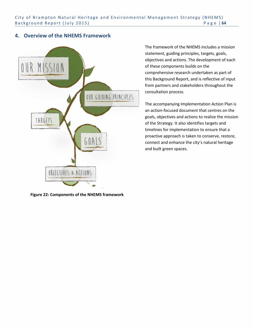
C i t y o f B r a m p t o n N a t u r a l H e r i t a g e a n d E n v i r o n m e n t a l M a n a g e m e n t S t r a t e g y ( N H E M S ) B a c k g r o u n d R e p o r t ( J u l y 2 0 1 5 ) P a g e | 64
Figure 22: Components of the NHEMS framework
4. Overview of the NHEMS Framework
The framework of the NHEMS includes a mission
statement, guiding principles, targets, goals,
objectives and actions. The development of each
of these components builds on the
comprehensive research undertaken as part of
this Background Report, and is reflective of input
from partners and stakeholders throughout the
consultation process.
The accompanying Implementation Action Plan is
an action-focused document that centres on the
goals, objectives and actions to realize the mission
of the Strategy. It also identifies targets and
timelines for implementation to ensure that a
proactive approach is taken to conserve, restore,
connect and enhance the city’s natural heritage
and built green spaces.
C i t y o f B r a m p t o n N a t u r a l H e r i t a g e a n d E n v i r o n m e n t a l M a n a g e m e n t S t r a t e g y ( N H E M S ) B a c k g r o u n d R e p o r t ( J u l y 2 0 1 5 ) P a g e | 65
5. Glossary of Terms
Active transportation – Human-powered travel, including but not limited to, walking, cycling, inline skating and travel
with the use of mobility aids, including motorized wheelchairs and other power-assisted devices moving at a comparable
speed (Provincial Policy Statement, 2014).
Adaptive management – A tool for land use/resource managers that acknowledges that our understanding of natural
systems and ecosystem services is incomplete, and that a systematic process is necessary to continually assess and
improve management policies and practices to best ensure robust decision making in the face of uncertainty, and
enables a balance between gaining knowledge to improve management in the future and achieving the best short-term
outcome based on current knowledge. Description adapted from: United Nations Millennium Ecosystem Assessment
2005, and Allan & Stankey 2009. (Catherine Allan and George H. Stankey (2009). Adaptive Environmental Management:
A Practitioner’s Guide. The Netherlands: Dordrecht. ISBN 978-90-481-2710-8).
Aquatic systems – Water based systems such as rivers, streams, ponds and lakes.
Biodiversity – All living things and the ways they interact with each other and their environment. Three levels of
biodiversity are noted: genetic diversity — the variety of genetic information contained in individual plants, animals and
micro-organisms; species diversity — the variety of species; and ecosystem diversity — the variety of habitats, ecological
communities and ecological processes (Ontario Biodiversity Strategy 2011).
Ecological features – Environmental components which are most visible, both living things like plants and animals, as
well as non-living things such as soil, topography, water, rock, etc.
Ecological functions – The natural processes, products or services that living and non-living environments provide or
perform within or between species, ecosystems and landscapes. These may include biological, physical and socio-
economic interactions (Provincial Policy Statement, 2014).
Ecological interactions – The relation between species that live together in a community; specifically, the effect an
individual of one species may exert on an individual of another species.
Eco-passage – A series of guidewalls and under-highway tunnels that allow wildlife to safely cross roadways.
Edge – Most often considered along the perimeter of a woodland patch, but may also be associated with other habitat
types such as wetlands or meadow habitats. The concern is edge effects may not provide ideal habitat conditions due to
a different micro-environment of light, wind, humidity, temperature, etc., and due to the presence of competing and/or
invasive species that invade edge habitat.
Fish habitat – As defined in the Fisheries Act , c. F-14 , means spawning grounds and nursery, rearing, food supply, and
migration areas on which fish depend directly or indirectly in order to carry out their life processes (Provincial Policy
Statement, 2014).
Fusion landscaping – A landscaping and garden design that brings together the lush splendour of traditional gardens
with modern, eco-friendly plants, flowers, colours and textures.
C i t y o f B r a m p t o n N a t u r a l H e r i t a g e a n d E n v i r o n m e n t a l M a n a g e m e n t S t r a t e g y ( N H E M S ) B a c k g r o u n d R e p o r t ( J u l y 2 0 1 5 ) P a g e | 66
Greenbelt – An area of permanently protected green space, farmland, communities, forests, wetlands and watersheds.
The Greenbelt protects environmentally sensitive land and farmland in Ontario’s Golden Horseshoe area from urban
development, and serves as a legacy for all Ontarians by preserving and enhancing our natural and cultural heritage.
Green infrastructure – Natural and human-made elements that provide ecological and hydrological functions and
processes. Green infrastructure (GI) can include components such as natural heritage features and systems, parklands,
stormwater management systems, street trees, urban forests, natural channels, permeable surfaces, and green roofs
(Provincial Policy Statement, 2014). The Green Infrastructure Coalition also notes that GI means to incorporate natural
vegetation and vegetative technologies in the built environment http://www.greeninfrastructureontario.org/report. For
the purposes of the NHEMS, Green infrastructure is referring only to lands associated with infrastructure service
corridors, road boulevards and stormwater management facilities.
Interior habitat – Also known as core habitat, the habitat that is most representative of the woodland, wetland or open
habitat patch, providing the most suitable or preferred habitat of native plants and animals. Interior habitat is not
influenced by edge effects.
Invasive species – A plant or animal that is not native to a specific location (an Introduced species) and has a tendency to
spread, which is believed to cause impacts and/or damage to the environment, human economy and/or human health.
Natural heritage system – A system made up of natural heritage features and areas, with linkages intended to provide
connectivity (at the regional or site level) and support natural processes, which are necessary to maintain biological and
geological diversity, natural functions, viable populations of indigenous species, and ecosystems (Provincial Policy
Statement, 2014).
Niagara Escarpment – Ontario’s Niagara Escarpment is a working countryside and a cornerstone of Ontario’s Greenbelt.
It is a protected area, recognized provincially and internationally as a significant landform with a system of development
control in place to guide development in its area.
Nutrient cycling – The movement and exchange of organic and inorganic matter back into the production of living
matter. The process is regulated by food web pathways that decompose matter into mineral nutrients.
Oak Ridge Moraine - An environmentally sensitive, geological landform in south central Ontario, covering 190,000
hectares.
Open space system – Components include parks, open space links, the multi-use trail system, natural features and
stormwater management facilities. Open space systems provide a key structural element of the community, and
perform several principle functions, including establishing the character of neighbourhoods, enhancing the built
environment, and providing both passive and active recreational opportunities within the various types of open space
and parks.
Riparian cover – Also called riparian vegetation; refers to plant communities along the river margins and banks.
Soil formation – The process by which soil is made.

C i t y o f B r a m p t o n N a t u r a l H e r i t a g e a n d E n v i r o n m e n t a l M a n a g e m e n t S t r a t e g y ( N H E M S ) B a c k g r o u n d R e p o r t ( J u l y 2 0 1 5 ) P a g e | 67
Soundscape – Refers to both the natural acoustic environment that consists of natural sounds, such as the sounds of
weather and other natural elements including animal vocalizations, and environmental sounds created by humans
including ordinary human activities (e.g. conversation, work, music), and mechanical sounds resulting from technology
(e.g. industry, vehicles, equipment). The disruption of these acoustic environments results in noise pollution.
Stable top of bank – The edge of the channel or bank, if there is a sharp change from the steep slope of the channel or
bank to the shallower slope of the field area, or the normal full extent of the watercourse when it contains the
maximum volume of water without flooding, if the change in slope does not exist (Greenbelt Plan, 2005).
Systems approach – The management of natural heritage as a unified, purposeful system composed of interrelated
parts.
Tableland – Any land that does not contain hazard, open space, or other limiting features that would prohibit
development.
Terrestrial systems – Land based systems such as forests, thickets, meadows and wetlands.
Urban forest – Includes all trees, shrubs, understory plants, as well as the soils that sustain them (Peel Urban Forest
Strategy, 2011).
Urban heat island effect – A condition that occurs when the average temperature in a city is higher than nearby rural
areas. The temperature is mostly caused by materials in urban areas like concrete and asphalt that absorb sunlight and
store it in large thermal masses. A secondary cause is waste heat generated by buildings, traffic, etc. The difference
between urban temperatures over regional averages is most striking at night, and especially during the winter.
Valleyland – A natural area that occurs in a valley or other landform depression that has water flowing through or
standing for some period of the year (Provincial Policy Statement, 2014).
Vegetation protection zone – A vegetated buffer area surrounding a key natural heritage feature or key hydrologic
feature within which only those land uses permitted within the feature itself are permitted. The width of the vegetation
protection zone is to be determined when new development or site alteration occurs within 120 metres of a key natural
heritage feature or key hydrologic feature, and is to be of sufficient size to protect the feature and its functions from the
impacts of the proposed change and associated activities that will occur before, during, and after, construction, and
where possible, restore or enhance the feature and/or its function (Greenbelt Plan, 2005).
Wildlife habitat – Areas where plants, animals and other organisms live, and find adequate amounts of food, water,
shelter and space needed to sustain their populations. Specific wildlife habitats of concern may include areas where
species concentrate at a vulnerable point in their annual life cycle; and areas that are important to migratory and non-
migratory species (Provincial Policy Statement, 2014).

C i t y o f B r a m p t o n N a t u r a l H e r i t a g e a n d E n v i r o n m e n t a l M a n a g e m e n t S t r a t e g y ( N H E M S ) B a c k g r o u n d R e p o r t ( J u l y 2 0 1 5 ) P a g e | 68
6. Summary of Documents Reviewed in Support of this Strategy
City of Brampton
Brampton Development Design Guidelines (2003)
Brampton Grow Green Environmental Master Plan (2014)
Brampton Urban Forest Study (2011)
Brampton Natural Areas Inventory (2009-2011)
Landscape Guidelines for Site Plan Approval Process (2015)
Measuring the Sustainability Performance of New Development (2013)
Official Plan (2006)
Parks, Culture and Recreation Master Plan (2008)
PathWays Master Plan (2002)
Stormwater Management Master Plan (2010)
2016-2018 Strategic Plan
Urban Forest Technical Study (2011)
Province of Ontario
Connecting Nature and People. A Guide to Designing and Planning Natural Heritage Systems (NHS) in Growing the Greenbelt Criteria (2008)
Conservation Authorities Act (2006)
Endangered Species Act (2007)
Great Lakes Protection Act (2014)
Greenbelt Plan (2005)
Growing the Greenbelt Consultation Paper (2008)
Growth Plan for the Greater Golden Horseshoe (2006, Office Consolidation Jan. 2012)
Natural Heritage Reference Manual for Natural Heritage Policies of the Provincial Policy Statement, 2005 (OMNR 2009)
Niagara Escarpment Plan (2005)
Oak Ridges Moraine Conservation Plan (2002)
Ontario’s Biodiversity Strategy (2011)
Ontario’s Great Lake Strategy (2012)
Ontario Invasive Species Strategy (2012)
Ontario Natural Spaces Program (2005)
Provincial Policy Statement (2014)
Places to Grow Act (2006)
Parkway Belt West Plan (1978)
Region of Peel
Peel Climate Change Strategy (2011)
Peel-Caledon Significant Woodlands and Significant Wildlife Habitat Study (2009)
Peel Core Greenlands Mapping Update (2011)
Peel Urban Forest Strategy (2011)
Region of Peel Healthy Development Index Standards (2011)
Region of Peel Official Plan (2008)

C i t y o f B r a m p t o n N a t u r a l H e r i t a g e a n d E n v i r o n m e n t a l M a n a g e m e n t S t r a t e g y ( N H E M S ) B a c k g r o u n d R e p o r t ( J u l y 2 0 1 5 ) P a g e | 69
Credit Valley Conservation11
Credit River Watershed and Region of Peel Natural Areas Inventory
Greenland Securement Strategy
Invasive Species Strategy
Credit Valley Conservation Natural Heritage System Strategy
Toronto and Region Conservation Authority (TRCA)
Claireville Conservation Area Site Securement and Protection Plan (2008)
Claireville Conservation Area Management Plan
The Living City Policies for Planning and Development
Terrestrial Natural Heritage System Strategy
LID stormwater management planning and design guidelines (TRCA/CVC) (2011)
Government of Canada
Area-Sensitive Birds in Urban Areas (2006)
Fisheries Act (1985)
How Much Habitat is Enough (April 2013, 3rd Edition)
Migratory Birds Convention Act (1994)
Species At Risk Act (2002)
Other Relevant Documents Considered
Canadian Urban Forest Strategy2013 – 2018 (2014). Canadian Urban Forest Network.
Conservation Authority Natural Heritage System Mapping for the City of Brampton – Final Technical Report – 2014 (CA NHS)
Corvalan, C., Hales, S., & McMichael, A. (2005). Ecosystems and Human Well-Being: Health Synthesis. Geneva: World Health Organization.
11
The following documents were not reviewed for the NHEMS, but can provide additional guidance for implementation including: Credit River Water Management Strategy Update, Credit River Fisheries Management Plan, and CVC NHS and Wetland Restoration Strategy.

C i t y o f B r a m p t o n N a t u r a l H e r i t a g e a n d E n v i r o n m e n t a l M a n a g e m e n t S t r a t e g y ( N H E M S ) B a c k g r o u n d R e p o r t ( J u l y 2 0 1 5 ) P a g e | 70
Appendix A: Policy Gaps in the Brampton Official Plan
Working with City staff, the consulting team has identified policy gaps in the Brampton Official Plan (2006) that must be
addressed to implement the NHEMS and address broader environmental gaps. These gaps are summarized under 11
theme areas.
1. Sustainability
Gap: The Official Plan policies only promote sustainable development, but do not require it. Sustainability should also
consider the incorporation of bird-friendly designs and lighting policies
Policy Revisions
The policies of Section 1: Vision should recognize and refer to Brampton documents that identify sustainability
requirements i.e. the Strategic Plan, Environmental Management Plan (EMP) and Sustainable Community Development
Guidelines.
The policies of Section 2: Context of the Official Plan should reflect the Strategic Plan priorities and the Environmental
Management Plan (EMP) sustainable environment framework.
The policies of Section 3: Sustainable City Concept should be updated to:
Draw a relationship between sustainability, quality of life, and direct social and economic benefits; and
Recognize natural heritage system planning through science-based modelling and subwatershed studies.
Section 3.2.11: Open Space System should provide additional discussion of:
The role of City parks and other open space to enhance the natural heritage system and provide linkage
opportunities in an urban setting;
The importance of expanding the Greenbelt along the urban river valleys;
The role of urban forestry to sustainability, its relationship to open space, and its role in the natural heritage system,
i.e. canopy cover and migratory birds; and
The importance of green infrastructure and its role in sustainability and in enhancing the natural heritage system.
Section 3.3 should give consideration to reframing the Flower City Strategy from a visual streetscape strategy to being a
platform for environmental sustainability, as well as a community engagement opportunity.
Section 4 policies for development could also provide direction to develop bird-friendly design guidelines, including
retrofitting existing structures and lighting policies to minimize bird-building collisions.

C i t y o f B r a m p t o n N a t u r a l H e r i t a g e a n d E n v i r o n m e n t a l M a n a g e m e n t S t r a t e g y ( N H E M S ) B a c k g r o u n d R e p o r t ( J u l y 2 0 1 5 ) P a g e | 71
2. Green Infrastructure
Gap: The Official Plan doesn’t recognize the importance of green infrastructure, nor promote the creation, restoration
and enhancement of green infrastructure. In a fully urban setting, green infrastructure can be used as linkages and
enhancement to the natural heritage system.
Policy Revisions
Section 3.1: Sustainable Planning Framework (Environmental Management) and Section 3.2.11: Open Space System
should promote the importance of green infrastructure and recognize the need to work with infrastructure providers.
Section 4.6: Natural Heritage and Environmental Management should provide a broadened discussion on the forms of
green infrastructure beyond just stormwater management ponds.
Section 4.6.: Restoration Areas
Section 4.6.: Corridors, Linkages should discuss the role that green infrastructure could play in natural heritage system
linkages and enhancement adjacent to existing natural heritage features.
Section 4.8: Infrastructure and Utilities should include policies that explain what green infrastructure is, the benefit it
provides, and how and where it should be promoted.
Section 4.11.2.5: Urban Design – Open Space Systems should add a bullet that promotes the naturalization of parkland
and green infrastructure.
3. Natural Heritage System
Gap: Section 4.6.6 of the Official Plan discusses the natural heritage system. Although the policies promote a systems
approach to the natural heritage system, it is largely a features-based system with no delineation or designation of an
overall system. On the Land Use Schedule (Schedule A), the natural heritage features are captured under the Open
Space designation. Schedule D identifies the specific Natural Heritage Features and Areas, but it doesn’t delineate the
system or any linkages or restoration areas.
In a nearly fully urbanized municipality such as Brampton, the opportunities for creating a systems-based natural
heritage system throughout the city are limited. However, with the vast majority of the significant natural heritage
features identified and protected, the policy focus can more readily shift to a single natural heritage system designation
with feature specific policies provided where necessary to ensure conformity with the Regional Official Plan and
consistency with the PPS.
The policies also do not recognize the role that parks, other open space, green infrastructure and the urban forest can
play in providing linkages and enhancement to an overall natural heritage system in an urban setting.

C i t y o f B r a m p t o n N a t u r a l H e r i t a g e a n d E n v i r o n m e n t a l M a n a g e m e n t S t r a t e g y ( N H E M S ) B a c k g r o u n d R e p o r t ( J u l y 2 0 1 5 ) P a g e | 72
Policy Revisions
Reorganization of the NHS policies in Section 4.6 to include a shift from a feature-based policy approach to a systems-
based policy approach, which still address the identification of significant natural heritage features while also
emphasizing how linkages, restoration and enhancement are part of the system and can be provided through other
open space features.
Consideration should also be given to adding a Natural Heritage System designation to the general land use schedule
(Schedule A) based on the CA NHS (CVC and TRCA 2014). To ensure consistency with the PPS, Schedule D identifying the
boundaries of specific features within the Natural Heritage System should remain. Schedule D could also identify
conceptually potential linkages, restoration areas and enhancement area.
Emphasize that impact on natural heritage functions must be addressed through appropriate studies, and that
mitigation/compensation will be undertaken to ensure no net loss to the overall system and a net benefit to the system
where possible.
In addition, strengthening of the existing policies could also be achieved by:
Addressing the conservation and naturalization of lands, including enhancement of existing vegetation next to
natural heritage features;
Discussing Brampton’s NHS relationship with the TRCA and CVC watershed natural heritage systems;
Including restoration areas as a part of the natural heritage system and not something to be added to the natural
heritage system at a later time;
Recognizing species at risk, which include both fish and wildlife;
More explicit criteria on how to identify and delineate linkages within the natural heritage system and the role that
parks, other open space, green infrastructure and the urban forest can play in creating the linkages in an urban
setting; and
Introducing the potential to consider compensation for loss of the natural heritage system in certain areas for
compensation elsewhere.
4. Regional Natural Heritage System Connections
Gap: The Official Plan policies should speak to relevance within, and relationship to, broader regional natural systems,
including the Greenbelt Plan Natural System, and the role that river valleys play in the city’s natural heritage system and
creating regional linkages.
Policy Revisions
Section 2.1: Physical and Environmental Considerations, Section 3: Sustainable City Concept and Section 4.6: Natural
Heritage and Environmental Management should recognize the interconnection of Brampton’s natural heritage system
in the context of the provincial and regional systems, including the Greenbelt Plan.

C i t y o f B r a m p t o n N a t u r a l H e r i t a g e a n d E n v i r o n m e n t a l M a n a g e m e n t S t r a t e g y ( N H E M S ) B a c k g r o u n d R e p o r t ( J u l y 2 0 1 5 ) P a g e | 73
Section 4.13: Parkway Belt West should identify functional relationship of the Parkway Belt West Plan Area (PBWPA) to
the city’s natural heritage system. As the city’s NHS is comprised primarily of north-south valley and watercourse
corridors, the PBWPA can provide a functional east-west linkage. The policies should also recognize that restoration and
enhancement of the PBWPA natural features and functions will be through stewardship and partnership.
Section 4.6.15: Protecting Public Health and Safety should recognize that proactive management of local water
resources and stormwater drainage is critical to protecting Lake Ontario and Peel’s potable water supply.
Section 4.6.14: Greenbelt should recognize the value of Brampton’s river valleys.
5. Other Land Use Designations
Gap: The land use policies in Section 4 are not linked to the intent of other policy sections of the Official Plan and, in
particular, to the provision of urban forestry, green infrastructure and natural heritage system enhancement.
Policy Revisions
Update policies that address the functional relationship of the city’s built environment to the natural heritage system,
and how other land use designations can assist in enhancing and achieving the natural heritage system and urban forest
in an urban setting.
Recognize that supportive policies in Sections 4.1, 4.2, 4.3 and 4.4 (Central Area, Residential, Commercial, Employment)
may be necessary to promote NHS linkages, private and public land naturalization, green infrastructure, resource
conservation and urban forestry.
Include policies that address that Institutional and Public Uses are often located on substantial properties, and that
these lands could contribute to green infrastructure and urban forest, as well as support ecological features, functions
and linkages.
Recognize that roads, in addition to green infrastructure and stormwater management facilities, provide areas for
improving urban forest and green spaces linkage. The policies should provide design and management direction.
Recognize that the management of roads should consider environmental, social and cultural issues as well as
transportation/traffic related issues.
6. Recreational Open Space and Parks
Gap: The Official Plan policies do not consider how recreational open space and parks can contribute to the Natural
Heritage System and urban forest, and the importance of naturalization within parks and open space.
Policy Revisions
C i t y o f B r a m p t o n N a t u r a l H e r i t a g e a n d E n v i r o n m e n t a l M a n a g e m e n t S t r a t e g y ( N H E M S ) B a c k g r o u n d R e p o r t ( J u l y 2 0 1 5 ) P a g e | 74
Section 4.7.1: General Recreational Open Space should discuss the conservation of treed areas in parks and open space
and opportunities for naturalization of parks and open space particularly where such areas could enhance the natural
heritage system and urban forest.
Section 4.7.1.14 needs to clarify the relationship between incorporating significant treed areas into the open space
network and the inclusion of such features in the natural heritage system.
Section 4.7.2: Public Parkland should provide policy guidance on the right trail for the right location. Policies should be
added to address trail planning and design considerations in natural features and areas in order to mitigate the impact
of construction and long-term use.
Section 4.7.2: Public Parkland should recognize that high noise and light generating recreation facilities may not be
compatible with the natural heritage system and require mitigation where applicable.
7. Management and Restoration
Gap: The Official Plan policies do not currently address long-term management of the natural heritage system including
restoration initiatives.
Policy Revisions
Section 4.6: Natural Heritage and Environmental Management should identify the need for management plans for
natural areas, set targets for improving the natural heritage system, and provide guidance on monitoring the success of
restoration efforts.
Section 4.8: Infrastructure and Utilities should include a policy for the management and naturalization of utility corridors
to restore and enhance ecological features, functions and linkages.
8. Natural Hazards
Gap: The Official Plan policies regarding natural hazards should emphasize the ecosystem benefit as well as the
risk/safety benefit of protecting natural hazard lands and remediating natural hazards.
Policy Revisions
The Preamble of Section 4.6: Natural Heritage and Environmental Management should recognize that Natural hazard
protection has two benefits. It protects the community from risk while also positively contributing to water quality,
stormwater management, reducing soil erosion and improving slope stability.
Within Section 4.6.15.5: Natural Hazards, the policies should:
Recognize urban flooding as a hazard; and
Recognize remediation of stream channels and valleys both as infrastructure maintenance and enhancing
ecosystem functions.

C i t y o f B r a m p t o n N a t u r a l H e r i t a g e a n d E n v i r o n m e n t a l M a n a g e m e n t S t r a t e g y ( N H E M S ) B a c k g r o u n d R e p o r t ( J u l y 2 0 1 5 ) P a g e | 75
9. Community Stewardship
Gap: The Official Plan should more explicitly set out a program on community stewardship.
Policy Revisions
Section 4.6: Natural Heritage and Environmental Management should be revised to:
Require the City to undertake internal and external education, including engagement of homeowners living
adjacent to the natural heritage system; and
Require new development approvals include development and distribution of Homeowner Guides for new
residents, which explain the importance of NHS and what residents can do to improve the system.
10. Urban Forestry
Gap: The current Official Plan does not provide sufficient policy guidance on urban forestry.
Policy Revisions
In order to emphasize the importance of urban forests, the Official Plan should include a separate section specific to
urban forestry. This section could provide specific policies on street and park trees, and trees on private property, and
the contribution these trees make to the urban canopy.
A section on urban forests should include policies requiring:
o Regular assessment of urban canopy coverage and targets;
o Urban forest management strategy and plans to be prepared;
o Development of compensation requirements for the removal of trees to facilitate development which is related
to loss of canopy coverage;
o Planting densities requirements for parks and street boulevards;
o Biodiversity to be addressed in planting standards;
o Soil quality criteria for tree planting; and
o Establishment of targets for canopy coverage – e.g. providing substantial shade within 10 years on tree lined
streets.
11. Light Pollution
Gap: The Official Plan policies need to recognize the need to mitigate light pollution on the natural heritage system.
Policy Revisions
Sections 3.2.11: Open Space System and Sections 4.6.15: Protecting Public Health and Safety should include policies
pertaining to light pollution in relation to the natural heritage system.
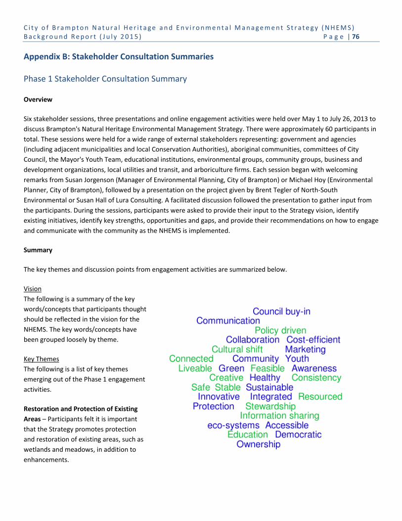
C i t y o f B r a m p t o n N a t u r a l H e r i t a g e a n d E n v i r o n m e n t a l M a n a g e m e n t S t r a t e g y ( N H E M S ) B a c k g r o u n d R e p o r t ( J u l y 2 0 1 5 ) P a g e | 76
Appendix B: Stakeholder Consultation Summaries
Phase 1 Stakeholder Consultation Summary
Overview
Six stakeholder sessions, three presentations and online engagement activities were held over May 1 to July 26, 2013 to
discuss Brampton's Natural Heritage Environmental Management Strategy. There were approximately 60 participants in
total. These sessions were held for a wide range of external stakeholders representing: government and agencies
(including adjacent municipalities and local Conservation Authorities), aboriginal communities, committees of City
Council, the Mayor's Youth Team, educational institutions, environmental groups, community groups, business and
development organizations, local utilities and transit, and arboriculture firms. Each session began with welcoming
remarks from Susan Jorgenson (Manager of Environmental Planning, City of Brampton) or Michael Hoy (Environmental
Planner, City of Brampton), followed by a presentation on the project given by Brent Tegler of North-South
Environmental or Susan Hall of Lura Consulting. A facilitated discussion followed the presentation to gather input from
the participants. During the sessions, participants were asked to provide their input to the Strategy vision, identify
existing initiatives, identify key strengths, opportunities and gaps, and provide their recommendations on how to engage
and communicate with the community as the NHEMS is implemented.
Summary
The key themes and discussion points from engagement activities are summarized below.
Vision
The following is a summary of the key
words/concepts that participants thought
should be reflected in the vision for the
NHEMS. The key words/concepts have
been grouped loosely by theme.
Key Themes
The following is a list of key themes
emerging out of the Phase 1 engagement
activities.
Restoration and Protection of Existing
Areas – Participants felt it is important
that the Strategy promotes protection
and restoration of existing areas, such as
wetlands and meadows, in addition to
enhancements.

C i t y o f B r a m p t o n N a t u r a l H e r i t a g e a n d E n v i r o n m e n t a l M a n a g e m e n t S t r a t e g y ( N H E M S ) B a c k g r o u n d R e p o r t ( J u l y 2 0 1 5 ) P a g e | 77
Urban Forestry and Tree Planting – There were a series of suggestions to improve uptake of tree planting on private
property including: providing informational materials on which trees to plant, approaching residents in less developed
areas, making tree planting a strategic priority of the City. Another suggestion for improving tree canopy was to
decrease the standard road widths in order to allow more room for trees and urban boulevards. Youth audiences
recommended that a focus on other plantings, such as shrubs and gardens, might be more palatable for families.
Planning Tools and Policy – The NHEMS should promote the land use planning tools (i.e. zoning by-laws) to protect and
enhance natural areas. These tools can provide regulatory strength and promote consistency in decision-making. The
City also has the ability to use the authority under the Ontario Heritage Act to protect natural heritage landscapes.
Greening Infrastructure – Participants suggested a variety of opportunities to enhance natural heritage through
‘greening’ infrastructure; for example, creating green roofs, urban boulevards and pervious or stacked parking lots.
There was also support for looking at micro-habitats and supporting functions for foraging or wildlife movement through
existing infrastructure.
Development and Land-use Planning – Participants thought that higher density development offers an opportunity to
promote natural heritage by protecting existing natural areas and green spaces. There are opportunities to protect
natural areas by maintaining a site’s typography and leaving soil on site during development. Transect planning and
planning new developments to maintain connectivity between green spaces were also suggested.
Stormwater Management and Low Impact Development (LID) – Participants identified a variety of opportunities to
improve the natural heritage value of stormwater management ponds by: piloting new techniques such as the floating
islands; using financial incentives to reduce runoff; engaging residents in maintenance and naturalization; and creating a
fund for retrofitting existing ponds. Concerns about maintenance costs, safety and needing successful local examples
were raised.
Design Innovation – There is willingness from the development community to implement alternative approaches to
protect or enhance the natural environment, provided that approvals are not negatively impacted. One suggestion was
to develop an approved toolbox or set of design guidelines for use when reviewing development applications.
Community Engagement and Volunteerism – There were a range of suggestions about how to engage community
members in environmental initiatives. It was suggested that many people are interested in participating in tree planning
and other environmental initiatives but don’t know where to go. There are a number of groups working on the ground
doing excellent environmental work who have already established networks in their communities.
Engaging Homeowners – Participants felt there are a variety of opportunities to improve the natural heritage value of
individual properties, such as natural landscaping, rain gardens and tree planting. Demonstration projects are a good
way to encourage homeowners to implement these initiatives. Another suggestion was to engage people when they are
buying a home. For example, home buyers could be provided with a suite of options to consider, including on their
property during construction.
Education and Awareness – Participants felt that many residents lack understanding of Brampton’s natural heritage
system and its value. Suggestions were made in terms of raising awareness and educating the community about the
value of natural heritage system and how to contribute on their own properties. These included:

C i t y o f B r a m p t o n N a t u r a l H e r i t a g e a n d E n v i r o n m e n t a l M a n a g e m e n t S t r a t e g y ( N H E M S ) B a c k g r o u n d R e p o r t ( J u l y 2 0 1 5 ) P a g e | 78
Conducting pilot projects and demonstration sites;
Placing signage along trails and rivers;
Encouraging the use of trails and providing opportunities for experiencing nature;
Distributing brochures and informational materials;
Delivering messages through youth; and
Hosting an Eco-Tradeshow.
Opportunities with Schools and School Yards – School yards make up a large portion of the city’s urban greenspace and,
therefore, provide an important opportunity for enhancing natural heritage. There is a general interest from students
and teachers, as well as funding and support for environmental initiatives and, specifically, community gardens on
school properties.
Consistency and Enforcement – Participants noted there is a need for enforcement and consistency in application of by-
laws relating to tree removal and natural heritage protection. The City needs consistent enforcement of City by-laws and
communication with residents.
Communication – Participants indicated that communication with a focus on benefits of naturalization will be a critical
component of making this Strategy a success.
Council Buy-in – Participants suggested that City Council and senior management support are critical to the Strategy’s
success. Educating Council and staff, as well as residents, on the benefits of natural heritage is needed to help improve
support.
Youth – There are a number youth groups and initiatives that encourage participation in environmental initiatives.
Several suggestions were made for how to engage youth in natural heritage, including:
Host events that get youth out into nature and promote outdoor education;
Connect eco-schools and green clubs to help them join forces;
Go into the schools and engage students face-to-face;
Educate and train those who are doing environmental work in schools; and
Host student competitions for environmental ideas.
Faith Grounds and Commercial Properties – There are opportunities to naturalize and enhance urban green space
surrounding faith grounds and commercial properties. Funding and programs exists to support these initiatives.
Incentives – There are opportunities to use financial incentives to encourage conservation among residents and
businesses.
Implementation – The Strategy needs to include a detailed Implementation Action Plan that defines roles and
responsibilities for each department (as appropriate). The Implementation Action Plan should also include realistic
budget allocations.
Linked to Strategic Plan – It is important that the Strategy is linked to other City strategic planning documents, and that
natural heritage is included in these documents.

C i t y o f B r a m p t o n N a t u r a l H e r i t a g e a n d E n v i r o n m e n t a l M a n a g e m e n t S t r a t e g y ( N H E M S ) B a c k g r o u n d R e p o r t ( J u l y 2 0 1 5 ) P a g e | 79
Aboriginal Consultation
Overview
In an effort to use stakeholders’ time efficiently, aboriginal groups were invited to participate in individual discussions
with the City of Brampton staff, City of Mississauga staff and the consulting team to provide input to both Brampton’s
NHEMS and Mississauga’s Natural Heritage & Urban Forest Strategy (NH&UFS). The purpose of these discussions was to
provide early insights to the development of Brampton’s NHEMS and gain input on key aspects of the draft Mississauga
NH&UFS. Invitations were provided to seven aboriginal organizations represented in Brampton and Mississauga. A
representative from the Mississaugas of the New Credit First Nation participated in the conference call on June 18, 2013.
The discussion began with a brief welcome from Susan Jorgenson (Manager of Environmental Planning, City of
Brampton) and Olav Sibille (Project Manager, City of Mississauga), followed by an overview about the two projects given
by Mirek Sharp (North-South Environmental). Following the presentation, Susan Hall from Lura Consulting facilitated the
discussion.
The key themes and discussion points are summarized below.
Recognize aboriginal cultural and ancestry: There are many opportunities to recognize aboriginal history in both
Brampton and Mississauga. For example, there is rich ancestry along the Credit River that can help tell the story
of the First Nations peoples. There is an opportunity to create a specific site that can show series of images,
photography, mapping, and include interactive educational features or creative experiences. In addition, there is
interest in developing and promoting a series of markers along Brampton’s and Mississauga’s waterways to
recognize historical sites (i.e. similar to the Yellow Fish Road program) and be promoted during Heritage Month.
This could include developing an in-school program where students would research where their school is
located, which First Nation is there, then paint a moccasin (marker) of the indigenous people to recognize their
history.
Recognize First Nations in the landscape: When travelling through southern Ontario, First Nations are not
reflected in the landscape. There are good examples of integrating function within nature and reflecting natural
values in buildings (e.g. Montreal airport with cultural and natural elements in the stone and archways).
Incorporate Carolinian and other native plants: There is a list of heritage plant species available that could be
used for plantings and an opportunity to educate people about medicinal plants and promote their protection.
Create a memorable experience: Commemoration of aboriginal sites is a good start, but there is a need to
create a memorable experience that will help people understand the value of nature and protect urban forests.
There are opportunities to integrate educational walking tours around water and sacred sites to increase
cultural knowledge.
Continue to educate: Education plays an important role in stewardship. There is a need to educate people about
native and non-native plantings and invasive species. People need tools to help them learn how to protect
natural heritage.
Integrate natural heritage protection in the Official Plan: Green lands need to be included in the Official Plan
and clearly defined so that they can be recognized and protected.

C i t y o f B r a m p t o n N a t u r a l H e r i t a g e a n d E n v i r o n m e n t a l M a n a g e m e n t S t r a t e g y ( N H E M S ) B a c k g r o u n d R e p o r t ( J u l y 2 0 1 5 ) P a g e | 80
Phase 2 Stakeholder and Public Consultation Summary
Overview
A stakeholder workshop was held on October 29, 2014 to discuss Brampton's Natural Heritage Environmental
Management Strategy. There were approximately 40 participants in total. The workshop was held for a wide range of
City staff and external stakeholders to secure additional input to the draft NHEM Strategy and ensure that the final draft
is reflective of stakeholder values and input.
The workshop began with welcoming remarks from Susan Jorgenson (Manager of Environmental Planning, City of
Brampton) followed by an overview presentation on the draft Strategy given by Brent Tegler, North-South
Environmental Inc., followed by facilitated discussions lead by Susan Hall of Lura Consulting. Participants formed smaller
groups to review and prioritize the draft objectives and actions, as well as collectively review the draft targets.
Summary
The key themes and discussion points from engagement activities are summarized below.
Vision
Key feedback on the draft vision included:
Considering repositioning as a Mission statement;
Considering adding a focus on watershed protection; and
Recognizing the need to identify and expand the NHS.
Guiding Principles
Key feedback on the draft guiding principles included:
Modifying language to be more definitive and simplified;
Thinking beyond Southern Ontario, recognizing best practices from abroad;
Using them as a decision-making tool;
Recognizing that there will be trade-off decisions and highlighting how the City will ensure balance; and
Relating actions and targets to guiding principles more explicitly.
Objectives
Overall, participants suggested rolling up some of the objectives under management and collaboration specifically, and
participants added a few additional objectives to the list. For all goals and objectives discussed, participants suggested
refinements to wording. These are captured in Section 4.0.

C i t y o f B r a m p t o n N a t u r a l H e r i t a g e a n d E n v i r o n m e n t a l M a n a g e m e n t S t r a t e g y ( N H E M S ) B a c k g r o u n d R e p o r t ( J u l y 2 0 1 5 ) P a g e | 81
Goal 1: Establish an Effective Policy and Planning Framework for the NHEMS
Participants were generally supportive of the objectives under Goal 1.
The key recommendation was to add the following new Objectives:
o To revise the Official Plan (OP) to integrate NHEMS into all OP sections (this would replace all other
Objectives O1.1-O1.4);
o To create a planning framework that creates Development Planning Team meetings to integrate cross-
disciplinary considerations; and
o To monitor and report on the success of implementing the OP - A question was raised on who reports on
all departments/disciplines.
Participants also suggested key elements that can be integrated into actions, such as recognizing the need to
protect endangered species and their habitats, supporting stormwater management retrofits, connecting low
impact trails, including private land planning and management, and addressing effective water management.
Goal 2: Manage Natural Heritage, Urban Forests, Open Space and Green Infrastructure to Maximize the Ecosystem
Services Provided
Participants were generally supportive of the objectives under Goal 2.
Participants suggested the following new Objectives be added:
o To extend management practices beyond NHS into green infrastructure lands and open space;
o To develop a Pathway Master Plan that considers the NHS;
Participants suggested that Objectives 2.2 and 2.4 could be merged.
Participants suggested a number of enhancements to the objectives, including a focus on defining who we are
trying to increase understanding for, a need to recognize partnership, a need for management strategies that
recognize protection of endangered species, and a focus on linkages as well as enhancement of NHS.
Goal 3: Invest in efforts to collaborate, engage & create partnerships with all interested stakeholders in the
development and implementation of NHEMS actions
Participants were generally supportive of the objectives under Goal 2.
Participants suggested that “partnerships” objectives be merged as one overarching objective with sub bullets
describing the various partnerships with provincial and regional agencies, infrastructure service providers, NGOs
and community groups and local schools, etc.
Participants suggested that a stronger emphasis be placed on engagement with Council and achieving political
support and approval to accomplish actions of the NHEMS.
Actions
Participants were asked to select their top two priority Objectives under each of the three Goals that they wanted to
spend time discussing at the workshop. The Actions related to these top priority Objectives were the focus of the
discussion.

C i t y o f B r a m p t o n N a t u r a l H e r i t a g e a n d E n v i r o n m e n t a l M a n a g e m e n t S t r a t e g y ( N H E M S ) B a c k g r o u n d R e p o r t ( J u l y 2 0 1 5 ) P a g e | 82
Goal 1: Establish an Effective Policy and Planning Framework for the NHEMS
Feedback on Actions supporting Objective 1.1: Revise Official Plan policies related to the protection, restoration and
enhancement of the Natural Heritage System:
Participants felt that some of the Actions were too specific and that a review of the OP to identify gaps would be
most beneficial.
Some suggested additional Actions include:
o To identify performance measures and monitoring process;
o To review OP to integrate NHEMS into all OP sections;
o To conduct a gap analysis of OP to ensure policies support all NHEMS objectives and actions;
o To look for barriers to NHEMS Objectives and Actions (e.g. water) in OP; and
o To include developing OP to protect endangered species and their habitat.
Feedback on Actions supporting Objective 1.4: Incorporate the results of the CA NHS study (CVC and TRCA 2014) into the
Official Plan policies and schedules:
Participants felt that A1.4.1. needed to be revised to:
o Focus on undertaking a municipally lead review to identify the policy implications and potential policy
changes if incorporating the CA NHS; and
o Define the “process” for bringing in the CA NHS into the OP with ongoing support and involvement of CA
partners/Region/MNRF.
Goal 2: Manage Natural Heritage, Urban Forests, Open Space System and Green Infrastructure Lands to Maximize the
Ecosystem Services Provided
Feedback on Actions supporting Objective 2.2: Actively restore natural features and functions in all areas of the Natural
Heritage System:
Participants were supportive of the Actions identified.
They suggested two additional actions:
o To develop a more comprehensive city-wide Plan for the City’s Valleyland Naturalization Program; and
o To formalize a partnerships strategy with stakeholders.
Feedback on Actions supporting Objective 2.2: Develop and implement an Open Space Naturalization Program to
prioritize areas to be naturalized in city-wide and community parks, and open spaces:
Participants were supportive of the Actions identified with a recommendation to clearly define active and
passive recreation.
They suggested two additional actions:
o To develop a new “dark skies” system standards; and
o To develop planting standards for boulevards.

C i t y o f B r a m p t o n N a t u r a l H e r i t a g e a n d E n v i r o n m e n t a l M a n a g e m e n t S t r a t e g y ( N H E M S ) B a c k g r o u n d R e p o r t ( J u l y 2 0 1 5 ) P a g e | 83
Goal 3: Invest in efforts to collaborate, engage & create partnerships with all interested stakeholders in the
development and implementation of NHEMS actions
Feedback on Actions supporting Objective 3.1: Engage Council for approval and funding to support natural heritage
protection and environmental management of the city’s natural and built green space:
• Participants were supportive of the Actions identified to engage Council.
• They suggested:
o There is a need to engage and empower Council by bringing forth information to understandable
problems; and
o There is a need to ensure Council understands why the environment is important, how they can be
advocates, and how they can respond to residents.
Feedback on Actions supporting Objective 3.4: Develop a community environmental stewardship network to support
and expand private and public land stewardship and partnerships activities:
Participants were supportive of the Actions identified for environmental stewardship.
They suggested the following additional actions:
o To provide a shared communications platform for stewardship and community groups; and
o To build a network of businesses that are seeking to sponsor stewardship programs, events and activities
on public and/or private lands.
Targets
Key feedback on the draft targets for the NHEMS included:
• The number of targets is appropriate;
• The linkage of targets to the Brampton Grow Green plan is appropriate;
• The Conservation Authorities will work with the City to further refine some of the targets;
• Link targets to the guiding principles;
• Make it explicit that measurement needs to be carried out and who is responsible; and
• Ensure there is an action that speaks to adaptive management.

C i t y o f B r a m p t o n N a t u r a l H e r i t a g e a n d E n v i r o n m e n t a l M a n a g e m e n t S t r a t e g y ( N H E M S ) B a c k g r o u n d R e p o r t ( J u l y 2 0 1 5 ) P a g e | 84
Appendix C: Conservation Authority Natural Heritage System Strategies
Toronto and Region Conservation Authority
TRCA’s approach to the development of a natural system is based on providing a targeted level of ecological function for
the whole system that accounts for predicted future land conversion and optimizes the location of natural cover in the
region. TRCA used two sets of criteria - a vector analysis (patch size, shape and matrix influence) to evaluate both the
existing system and the target system function, and a raster model (ecological and feasibility criteria) to evaluate what
should be included in the target system. The approach, target system and model policies are found in the TRCA’s
Terrestrial Natural Heritage System Strategy (TNHSS).
The TNHS model and target system was used in the development of watershed plans, and the refined natural systems
from the Humber River and Etobicoke and Mimico watershed plans. It should be noted that the relationship between
the aquatic system and the terrestrial NHS can be found in the watershed plans.
TRCA is also leading strategic partnership projects with the Region of Peel, City of Brampton and CVC (as appropriate),
including the Peel Channels Remediation Study, Terrestrial Ecosystem Services Compensation Protocol (underway),
Partners in Project Green (Pearson Eco-business Park) and the County Court Sustainable Neighbourhood Retrofit Action
Plan. The NHEMS will integrate direction from these projects and support implementation, particularly as it relates to
targets and actions.

C i t y o f B r a m p t o n N a t u r a l H e r i t a g e a n d E n v i r o n m e n t a l M a n a g e m e n t S t r a t e g y ( N H E M S ) B a c k g r o u n d R e p o r t ( J u l y 2 0 1 5 ) P a g e | 85

C i t y o f B r a m p t o n N a t u r a l H e r i t a g e a n d E n v i r o n m e n t a l M a n a g e m e n t S t r a t e g y ( N H E M S ) B a c k g r o u n d R e p o r t ( J u l y 2 0 1 5 ) P a g e | 86
Credit Valley Conservation
CVC’s integrated terrestrial and aquatic Credit Valley Conservation Natural Heritage System Strategy (CVCNHSS) is
similar in principle to TRCA. Utilizing a systems approach based on current science in landscape ecology, the CRWNHS
intent was two-fold: (i) protect, restore or enhance the ecological integrity of the watershed’s natural features, functions
and systems, and (ii) protect or enhance the quantity and quality of surface and ground water for environmental and
human uses. The watershed NHS methodology has been integrated into recent subwatershed studies, refining the
system at a local scale12.
The components of the CVCNHSS consist of natural heritage features and their buffers, and natural heritage areas
identified as Centres for Biodiversity, that were mapped using (vector based) GIS algorithms that classified features into
High Functioning, Supporting and Contributing. The resulting system was reviewed and compared to recommended
natural cover targets, as well as the Credit River Watershed Landscape Scale Analysis to ascertain inclusion of high
quality habitat patches from a landscape perspective, and to adjust criteria if necessary. It is the combination of these
features, their buffers and areas together, that define a resilient, robust system for the Credit River watershed.
12
As identified by CVC staff (pers. comm. Yvette Roy) the CRWNS was consulted to inform the development of Mississauga’s approved Natural Heritage System.

C i t y o f B r a m p t o n N a t u r a l H e r i t a g e a n d E n v i r o n m e n t a l M a n a g e m e n t S t r a t e g y ( N H E M S ) B a c k g r o u n d R e p o r t ( J u l y 2 0 1 5 ) P a g e | 87

C i t y o f B r a m p t o n N a t u r a l H e r i t a g e a n d E n v i r o n m e n t a l M a n a g e m e n t S t r a t e g y ( N H E M S ) B a c k g r o u n d R e p o r t ( J u l y 2 0 1 5 ) P a g e | 88
Appendix D: Mount Pleasant Community – Building a Natural Heritage System
The Mount Pleasant Community Natural Heritage System planning was founded on extensive studies that included:
North West Brampton Environmental Open Space Study (2005) that examined supporting the urban boundary
expansion related to the Region of Peel Official Plan Amendment;
North West Brampton Landscape Scale Analysis (2007) to provide the subwatershed ecological context for the
Huttonville & Fletcher’s Creeks Subwatershed Study;
Credit Valley Conservation: Effectiveness Monitoring Strategy - 5 Year Review, May 2009 for Huttonville and
Fletcher’s Creek; and,
Huttonville and Fletcher’s Creeks Subwatershed Study (2010). The HFSWS was undertaken in four phases; Phase
1 Subwatershed Characterization, Phase 2 Impact Analysis, Phase 3 Management Strategies and
Implementation, and Phase 4 Long-Monitoring, as illustrated in Figure D1.
Figure D1: Subwatershed Planning Process (Source: AMEC)

C i t y o f B r a m p t o n N a t u r a l H e r i t a g e a n d E n v i r o n m e n t a l M a n a g e m e n t S t r a t e g y ( N H E M S ) B a c k g r o u n d R e p o r t ( J u l y 2 0 1 5 ) P a g e | 89
The Mount Pleasant Community Natural Heritage System was developed based on achieving ecological targets
related to:
Surface water – flow time series, instream erosion, contaminants of concern and protection of life and property;
Groundwater – discharge, recharge areas, water table elevations and stream low flow function;
Fisheries - healthy fish communities;
Fluvial – maintenance of drainage density, flushing flow (sediment mobility) and low flow function; and
Terrestrial – riparian cover, forest cover, wetland cover, interior forest/core habitat, species at risk and special
status species, natural area protection, natural corridors and linkages, multi-functional supporting linkage and
significant woodlands.
In total, the HFSWS and the Mount Pleasant Community represent an excellent example of local natural heritage system
planning. Natural areas and features in the rural landscape (that represented 8% of the secondary plan area) comprised
of fragmented woodlands and wetlands and altered watercourses, including agricultural drains and headwater swales,
were transformed into an integrated terrestrial, and aquatic natural heritage system that comprised of 18% of Block
Plans 51-1 and 51-2.
The building blocks of the NHS are depicted in Figures D2 to D8.
Figure D2: Existing Conditions

C i t y o f B r a m p t o n N a t u r a l H e r i t a g e a n d E n v i r o n m e n t a l M a n a g e m e n t S t r a t e g y ( N H E M S ) B a c k g r o u n d R e p o r t ( J u l y 2 0 1 5 ) P a g e | 90
Figure D3: Protected Woodlands
Figure D4: Protected Woodlands and Wetlands

C i t y o f B r a m p t o n N a t u r a l H e r i t a g e a n d E n v i r o n m e n t a l M a n a g e m e n t S t r a t e g y ( N H E M S ) B a c k g r o u n d R e p o r t ( J u l y 2 0 1 5 ) P a g e | 91
Figure D5: Protected Woodlands, Wetlands and Watercourse Corridors
Figure D6: Protected Woodlands, Wetlands, Watercourse Corridors and Restoration Areas
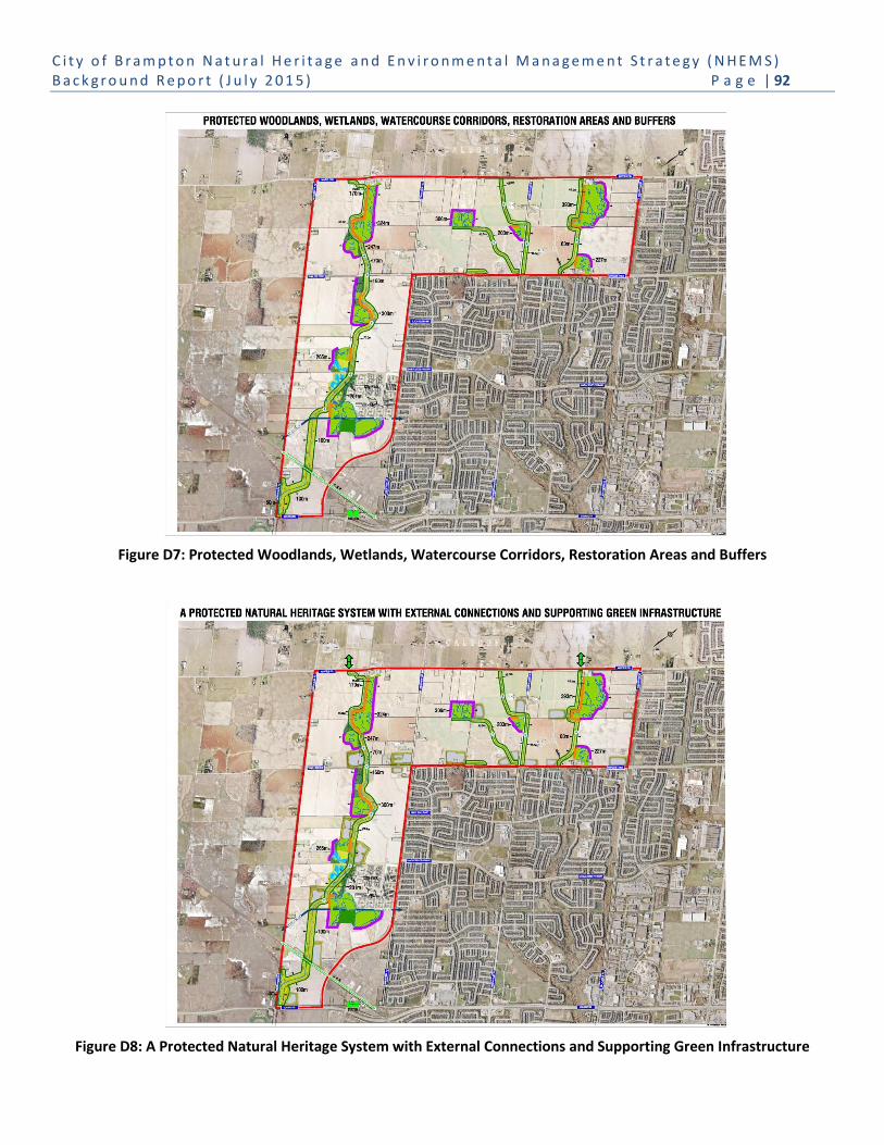
C i t y o f B r a m p t o n N a t u r a l H e r i t a g e a n d E n v i r o n m e n t a l M a n a g e m e n t S t r a t e g y ( N H E M S ) B a c k g r o u n d R e p o r t ( J u l y 2 0 1 5 ) P a g e | 92
Figure D7: Protected Woodlands, Wetlands, Watercourse Corridors, Restoration Areas and Buffers
Figure D8: A Protected Natural Heritage System with External Connections and Supporting Green Infrastructure

C i t y o f B r a m p t o n N a t u r a l H e r i t a g e a n d E n v i r o n m e n t a l M a n a g e m e n t S t r a t e g y ( N H E M S ) B a c k g r o u n d R e p o r t ( J u l y 2 0 1 5 ) P a g e | 93
Appendix E: Subwatershed Boundaries

C i t y o f B r a m p t o n N a t u r a l H e r i t a g e a n d E n v i r o n m e n t a l M a n a g e m e n t S t r a t e g y ( N H E M S ) B a c k g r o u n d R e p o r t ( J u l y 2 0 1 5 ) P a g e | 94
Appendix F: Valley Naturalization Planting Program 2003-2014