national capital region - integration and application...
TRANSCRIPT

National Park ServiceU.S. Department of the Interior
Natural Resource Stewardship and Science
Harpers Ferry National Historical Park Natural Resource Condition Assessment—SUMMARYNational Capital Region

Harpers Ferry National Historical Park Natural Resource Condition Assessment—SUMMARYNational Capital Region
Jane E. Thomas, Simon D. Costanzo, R. Heath Kelsey, William C. DennisonIntegration & Application NetworkUniversity of Maryland Center for Environmental SciencePO Box 775Cambridge, MD 21613
Patrick Campbell, Mark Lehman, Megan NortupNational Capital Region Inventory & MonitoringNational Park Service4598 MacArthur Blvd NW, Washington, DC 20007
Mia Parsons, Dale NisbetHarpers Ferry National Historical ParkNational Park ServicePO Box 165Harpers Ferry, WV 25425
This document has adapted the Executive Summary of the Natural Resource Condition Assessment report that the University of Maryland Center for Environmental Science produced in collaboration with staff from the National Capital Region Network Inventory & Monitoring Program and Harpers Ferry National Historical Park.
The full 134-page report can be accessed via https://irma.nps.gov/App/Reference/Profile/2205992 and http://www.ian.umces.edu/press.
ACKNOWLEDGEMENTS
Geoff Sanders, John Paul Schmit, Jim Pieper, Marian Norris, and NPS National Capital Region Inventory & Monitoring, who provided data support. Rebecca Harriett, Superintendent at Harpers Ferry National Historical Park. Holly Salazer, Air Resources Coordinator, Northeast Region and Ellen Porter, Drew Bingham, and John Ray, NPS Air Resources Division, for advice on air quality metrics. Katie Foreman, Chesapeake Bay Program for assistance with benthic metrics. Staff at the Center for Urban Ecology who assisted with data sourcing, scoping, and proofing. Tim Carruthers, Joanna Woerner, and Melissa Andreychek at the Integration and Application Network for assistance with project scoping and initia-tion.
ON THE COVER
John Brown’s Fort was the building built in 1848 that was originally constructed for use as a guard and fire engine house for the federal Harpers Ferry Armory.Photo by Joy Schoenberger.
February 2014
U.S. Department of the Interior National Park Service Natural Resource Stewardship and Science Fort Collins, Colorado

1
Background and Context
BACKGROUND AND CONTEXT
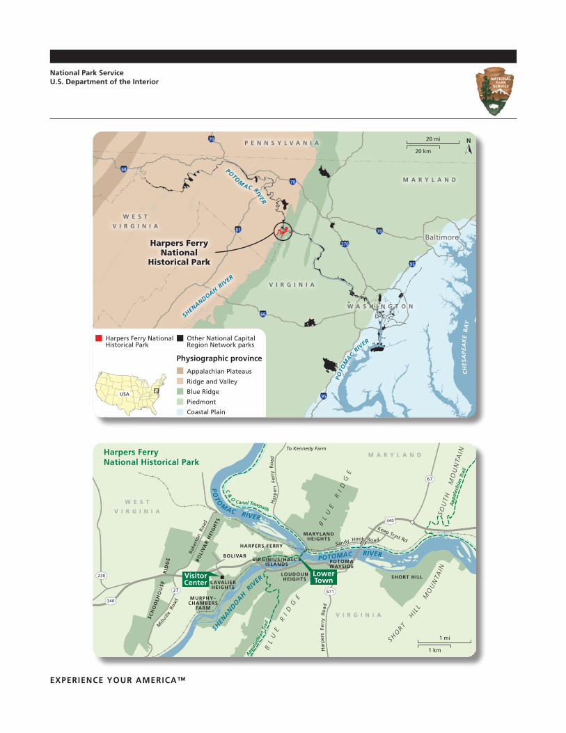
Harpers Ferry National Historical Park was established in 1944 to “be a public national memorial commemorating historical events at or near Harpers Ferry.” At the confluence of the Shenandoah and Potomac Rivers, the park contains riparian habitats, floodplains, agricultural fields, geologic exposures, rare limestone glades, developed areas, and upland forests.
Harpers Ferry National Historical Park’s natural resources are challenged by multiple regional and local stressors. Air pollution from power plants, industry, and vehicle emis-sions result in reduced air quality through large regions of the central eastern seaboard of North America. The park is therefore subjected to high ozone and atmospheric deposi-tion, potentially impacting flora, fauna, and park visitors. Watershed-wide urbanization and development result in challenges to water quality. Increased nutrients, pollutants, and flashiness of river flow can result in impacts to wetland flora and fauna as well as stream-bank erosion. Other threats to the park include exotic species, deer overpopulation, and gypsy moths.
Old Town. Photo: Rob-ert Baker/NPS.

2
APPROACH
The Vital Signs framework was used to assess natural resource condition within Cato-Harpers Ferry National Historical Park. Within each Vital Sign, indicators were identified that would inform the assessment and data was sourced for these indicators. Reference conditions were established for each indicator, and the percentage attainment of refer-ence condition was calculated. Once attainment was calculated for each indicator, an unweighted mean was calculated to determine the condition for each Vital Sign category and then similarly to combine Vital Sign categories to calculate an overall park assess-ment. Based on these key findings, management recommendations and data gaps were developed.
Habitat Framework
Vital Signs framework used in this assess-ment.
Vital Signs framework
—Landscape Dynamics—Forest interior areaForest coverImpervious surfaceRoad density
—Air Quality—Wet sulfur depositionWet nitrogen depositionOzoneVisibilityParticulate matter
—Water Resources—pHDissolved oxygenWater temperatureAcid neutralizing capacitySpecific conductanceNitrateTotal phosphorusMacroinvertebratesPhysical habitat —Biological Integrity—
Exotic herbaceous speciesExotic trees & saplingsForest pest speciesNative seedlingsStream fishesBirdsDeer density

3
FEATURES OF HARPERS FERRY NATIONAL HISTORICAL PARK
The majority of Harpers Ferry National Historical Park is located in the Blue Ridge physiographic province. The wide range of riparian and terrestrial environments found in the park creates a mosaic of habitats that support a diverse flora and fauna.
The Shenandoah and Potomac Rivers con-verge at Harpers Ferry. The rivers are not within the national historical park’s author-ized boundary but do constitute approxi-mately 24 km (15 mi) of shoreline within the park. In addition to the two major rivers, there are three perennial streams and several canals within the national histori-cal park boundaries. The streams are Elks Run and Flowing Springs in West Virginia and Piney Run in Virginia. The wetlands, floodplains, and forests of the park support many species of plants and animals. The park contains, or has habitat suitable for, a number of federally and state-listed species and species of concern, such as the Allegheny woodrat (Neotoma magister)and the American peregrine falcon (Falco peregrinus). Visitors also come to Harpers Ferry to seek a variety of experiences related to the natural soundscapes and lightscapes found in the park.
THREATS TO HARPERS FERRY NATIONAL HISTORICAL PARK
Exotic plants and diseases are prevalent within the park. AMore than 260 non-native species of plants have been docu-mented within the park. Exotic and invasive plants compete with native species, while insect and other pests cause damage to forest trees. Several pests and diseases threaten forest resources, among them the gypsy moth (Lymantria dispar) and hem-lock woolly adelgid (Adelges tsugae). Exces-sive numbers of white-tailed deer use the park as a refuge, resulting in overgrazing of native flora, particularly tree seedlings. Population and housing densities continue to increase in the areas adjacent to the park, which reduces the habitat available for native flora and fauna. On a regional scale, degraded air quality associated with vehicular traffic affects aquatic habitats and sensitive species.
Features and Threats
Cannon at the Murphy Farm. Photo: Marsha B. Wassel/NPS.
Gypsy moth larva. Photo: Ferenc Lakatos.

4
Features and Threats
Features of and threats to the natural resources of Catoctin Mountain Park.
Invasive exotic species (including gypsy moth , hemlock woolly adelgid , and plant species )
Deer overpopulation
Exotic diseases and tree death
Scenic views (good air quality)
Historic places and events
Native plant communities
Obstructed scenic views (poor air quality)
Adjacent land use
Global climate change
Sustainable visitor use
Natural resources Threats to park natural resources

5
KEY FINDINGS, RECOMMENDATIONS, AND DATA GAPS
Overall, the natural resources of Harpers Ferry National Historical Park were in degraded condition.
The Vital Signs framework showed that air quality condition was generally very degraded, water resources condition was moderate, biological integrity condition was variable but degraded overall, and landscape dynamics condition was generally moderate.
Air quality was in a very degraded condition, with 7% attainment of the reference condi-tions. Degraded air quality is a problem throughout the eastern United States, the causes of which are out of the park’s control. The specific implications to the habitats and spe-cies in the park are less well known. Gaining a better understanding of how reduced air quality is impacting sensitive habitats and species within the park would help prioritize management efforts. Air quality is measured and interpolated on regional and national scales. Implementation of park-scale air quality monitoring would give better insights into park-level air quality condition and possible effects on park habitats and species.
The close connection between climate and air quality is reflected in the impacts of cli-mate change on air pollution levels. In particular, the U.S. EPA has concluded that climate change could increase ozone concentrations and change amounts of particle pollution.
Key Findings, Recommendations, and Data Gaps
Natural resource condition assessment of Harpers Ferry National Historical Park.
Vital Sign Reference condition attainment Current condition
Air Quality 6.6% Very degraded
Water Resources 58% Moderate
Biological Integrity 37% Degraded
Landscape Dynamics 54% Moderate
Harpers Ferry National Historical Park 39% Degraded
Air Quality. Key findings, management implications, and recommended next steps for air quality in Harpers Ferry National Historical Park.
Key findings Management implications Recommended next steps• Air quality is very
degraded• Habitats and species in the park
may be affected• Monitor for local effects
• Air quality is a regional problem
• Habitats and species in the park may be affected
• Support regional air quality initiatives
Air Quality. Data gaps, justification, and research needs for air quality in Harpers Ferry National Histori-cal Park.
Data gaps Justification Research needs• Ecological thresholds for
mercury wet deposition• Wet deposition is monitored
but the only available reference condition is for fish tissue concentration
• Relate fish tissue concentrations to wet deposition
• Park-scale air quality data • Need to implement park-specific management actions
• Use transport and deposition models
• Calibrate with roadside data within the park
• Effects of poor air quality on park habitats and species
• Need to implement park-specific management actions
• Investigate effects of poor air quality on sensitive habitats and species within the park

6
Water resources were in a moderate condition overall, with 58% attainment of reference conditions. Nutrients (nitrogen and phosphorus), specific conductance, and the Benthic Index of Biotic Integrity (BIBI) were in poor to very degraded condition while pH, dissolved oxygen, water temperature and acid neutralizing capacity were in very good condition, simi-lar to results found in parks throughout the region.
Water quality is only measured at one site within the park, so it is recommended to expand monitoring to include sites in Elk Run and Piney Run. These streams do not originate in the park and only run through the park for a short distance but it would be informative to monitor what is coming through the park from upstream. Data gaps and research recom-mendations revolve around maintaining good water quality by identification of nutrient sources and sensitive organisms.
Water temperature increase is one of the most immediate threats from climate change, and this would result in the loss of fish and other organisms that depend upon cooler water.
Key Findings, Recommendations, and Data Gaps
Water Resources. Data gaps, justification, and research needs for water resources in Harpers Ferry Na-tional Historical Park.
Data gaps Justification Research needs• Origins of nitrogen and
phosphorus pollution are uncertain
• Affects stream flora and fauna• Reduces quality of visitor
experience
• Identify sources of nutrients
• Karst features in and around the park are poorly understood
• Karst landscapes influence water flows into and through the park
• Locate, map, and monitor groundwater and springs
• Monitor water quantity as well as quality
Water Resources. Key findings, management implications, and recommended next steps for water resources in Harpers Ferry National Historical Park.
Key findings Management implications Recommended next steps• Very degraded condition
for nitrogen and phosphorus
• Affects stream flora and fauna• Reduces quality of visitor
experience
• Reduce non-point source nutrient inputs from watershed (in partnership with agencies)
• Continue riparian buffer establishment
• Maintain implementation of best management practices on leased agricultural lands
• Water quality parameters are measured at only one site
• Only have data for one stream within the park
• Establish regular water quality monitoring in other streams within the park
• Water quantity • Affects stream flora and fauna• Reduces quality of visitor
experience
• Monitor water quantity as well as quality
• Benthic Index of Biotic Integrity (BIBI) and Physical Habitat Index (PHI) data have not been updated since 2004
• Current status of BIBI and PHI are poorly known
• Update and regularly repeat BIBI and PHI monitoring (scheduled to be repeated in 2013)

7
Key Findings, Recommendations, and Data Gaps
Biological integrity was in a degraded condition overall, with 37% attainment of reference conditions. Deer density and the seedling stocking index were both in very degraded con-dition. Studies show a relationship between high deer density and poor forest regenera-tion and as such, deer management should continue to be a top priority. Other monitoring recommendations include exotic species monitoring and education, and continuing to monitor pests and diseases. Data gaps and research needs include developing a bird index for non-forest species and modeling the effects of climate change and other stressors on the region’s forests.
How climate change may affect the park’s resources and habitats should be an ongoing research focus, in particular how it might affect the introduction and spread of exotic spe-cies and forest pests and diseases.
Biological Integrity. Data gaps, justification, and research needs for biological integrity in Harpers Ferry National Historical Park.
Data gaps Justification Research needs• Bird data is limited to forest species only • Knowledge about usage of other
habitats by birds is needed• Development of indices related to bird
use of other habitats (e.g., grasslands)
• Limited knowledge on how the return of larger predators (coyotes, black bears) to the region may impact ecosystems
• The return of these predators will impact populations of prey animals which in turn may impact deer tick populations and occurrence of Lyme disease
• Research and modeling into the effects of these predators on the ecosystem
• Monitor occurrence and behavior of predators
• Limited knowledge on how forests might change in light of new and future stressors (climate change, pests, and diseases)
• These stressors are already present or will be present in the near future
• Research and modeling into the effects of these stressors on the region’s forests
Biological Integrity. Key findings, management implications, and recommended next steps for biological integrity in Harpers Ferry National Historical Park.
Key findings Management implications Recommended next steps• Deer overpopulation
may be impacting forest regeneration and agriculture
• Increased herbivory reducing desired plant and bird species, and lowering yields in agricultural areas
• More road collisions• Potential for spread of chronic wasting disease
• Develop a deer management plan• Implement deer population control measures• Use exclosure studies to quantify effect of deer on
forest regeneration
• Presence of exotic plants
• Displacement of native species, reducing biodiversity
• Prioritize species and locations/habitats for implementing control measures
• Restore and maintain native species and communities
• Amphibians are not monitored
• Amphibians are an important ecosystem component
• Identify and map wetland and stream sites where monitoring could take place
• Design and implement an amphibian monitoring program
• Small mammals are not monitored
• Small mammals, and bats in particular, are an important ecosystem component
• Design and implement an mammalian monitoring program, including monitoring bats in caves
• Map cave systems and karst features
• Fish Index of Biotic Index (FIBI) is in poor condition
• Fish are an important ecosystem component • Identify sensitive locations and unpack the Index to identify which measurements are showing degraded condition
• Emerald ash borer has been detected in the park
• Has the potential to spread throughout the park
• Continue to monitor for emerald ash borer in the park and implement management actions
• Plan for the future forest with the absence of hemlock and ash trees
• Establish a seed bank of hemlock and ash seeds
8
Key Findings, Recommendations, and Data Gaps
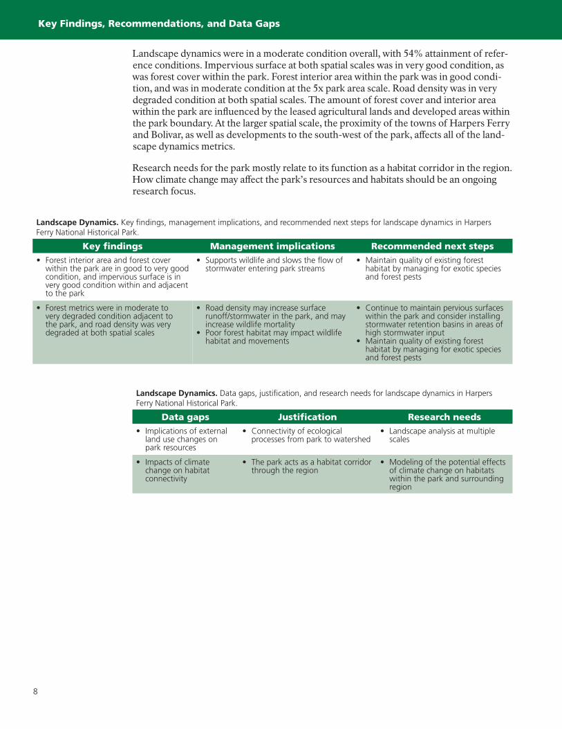
Landscape dynamics were in a moderate condition overall, with 54% attainment of refer-ence conditions. Impervious surface at both spatial scales was in very good condition, as was forest cover within the park. Forest interior area within the park was in good condi-tion, and was in moderate condition at the 5x park area scale. Road density was in very degraded condition at both spatial scales. The amount of forest cover and interior area within the park are influenced by the leased agricultural lands and developed areas within the park boundary. At the larger spatial scale, the proximity of the towns of Harpers Ferry and Bolivar, as well as developments to the south-west of the park, affects all of the land-scape dynamics metrics.
Research needs for the park mostly relate to its function as a habitat corridor in the region. How climate change may affect the park’s resources and habitats should be an ongoing research focus.
Landscape Dynamics. Data gaps, justification, and research needs for landscape dynamics in Harpers Ferry National Historical Park.
Data gaps Justification Research needs• Implications of external
land use changes on park resources
• Connectivity of ecological processes from park to watershed
• Landscape analysis at multiple scales
• Impacts of climate change on habitat connectivity
• The park acts as a habitat corridor through the region
• Modeling of the potential effects of climate change on habitats within the park and surrounding region
Landscape Dynamics. Key findings, management implications, and recommended next steps for landscape dynamics in Harpers Ferry National Historical Park.
Key findings Management implications Recommended next steps• Forest interior area and forest cover
within the park are in good to very good condition, and impervious surface is in very good condition within and adjacent to the park
• Supports wildlife and slows the flow of stormwater entering park streams
• Maintain quality of existing forest habitat by managing for exotic species and forest pests
• Forest metrics were in moderate to very degraded condition adjacent to the park, and road density was very degraded at both spatial scales
• Road density may increase surface runoff/stormwater in the park, and may increase wildlife mortality
• Poor forest habitat may impact wildlife habitat and movements
• Continue to maintain pervious surfaces within the park and consider installing stormwater retention basins in areas of high stormwater input
• Maintain quality of existing forest habitat by managing for exotic species and forest pests

9
Conclusions
CONCLUSIONS
Natural resoures in Harpers Ferry National Historical Park are in degraded condition overall and are under threat from surrounding land use, regionally poor air quality, and overpopulation of deer. Climate change is predicted to negatively affect many of the natu-ral resources of the park, including increasing ozone levels and particle pollution, raising the water temperature of cold-water, trout-supporting streams, changing forest composi-tion, and affecting exotic species and forest pests and diseases.
National Park ServiceU.S. Department of the Interior
EXPERIENCE YOUR AMERICA™
671
230
67
27
340
340
SO
UT
H
MO
UN
TAIN
BL
UE
R
ID
GE
BL
UE
R
ID
GE
SHO
RT H
I LL
M
OU
NTA
IN
SC
HO
OLH
OU
SE
RID
GE
W E S T
V I R G I N I A
M A R Y L A N D
V I R G I N I A
Bake
rton
Roa
d
Keep Tryst Rd
Mill
ville
Roa
d
Har
per
s F
erry
Ro
ad
Sandy Hook Road
Ha
rpe
rs
Ferr
y R
oad
BOLIVAR
BO
LIV
AR
HEI
GH
TS
HARPERS FERRY
MARYLANDHEIGHTS
LOUDOUNHEIGHTS SHORT HILL
POTOMAWAYSIDE
MURPHY–CHAMBERS
FARM
POTOMAC RIVER
SHEN
AN
DO
AH R
IVER
PO
TO
MAC RIVER
To Kennedy Farm
Appal
achi
an T
rail
App
alac
hian
Tra
il
C & O Canal Towpath
VisitorCenter
LowerTown
1 mi
1 km
Harpers FerryNational Historical Park
VIRGINIUS/HALL’SISLANDS
CAVALIERHEIGHTS
95
70
70
95
66
81
270
70
68
V I R G I N I A
W E S T
V I R G I N I A
P E N N S Y L V A N I A
M A R Y L A N D
Baltimore
W A S H I N G T O N
D C
Harpers FerryNational
Historical Park
20 mi
20 km
N
POTOM
AC RIVER
POTO
MA
C RIV
ER
CH
ES
AP
EA
KE B
AY
SHENANDOAH RIVER
USA
Physiographic province
Appalachian Plateaus
Ridge and Valley
Blue Ridge
Piedmont
Coastal Plain
Harpers Ferry National Historical Park
Other National Capital Region Network parks