nasa research strategy for earth system science: climate component
TRANSCRIPT

1309Bulletin of the American Meteorological Society
1. Introduction
As part of its strategic plan, the National Aeronau-tics and Space Administration (NASA) formulated thegoal of “utilizing the knowledge of the Sun, Earth andother planetary bodies to develop predictive environ-mental, climate, and natural resource models to helpensure sustainable development, and improve the qual-ity of life on Earth” (NASA 1998). We know now that,over geologic periods, the earth climate is governedby the interplay of two major cycles: the cycling ofcarbon through the earth atmosphere, terrestrial veg-etation, oceans, sediments, and lithosphere, and thecycling of water through the atmosphere, rivers, and
oceans. The recognition of multiple linkages betweenthe earth’s physical environment and the biosphere isa discovery of the twentieth century, which led to thenew concept of earth system science. This new scien-tific paradigm is founded on the notion that the glo-bal earth environment can be understood only as aninteractive system embracing the atmosphere, oceans,and sea ice, glaciers, and ice-sheets, as well as marineand terrestrial ecosystems. The NASA Earth ScienceEnterprise (ESE) aims to obtain a scientific under-standing of the entire earth system, on a global scale,by describing how the system’s component partsevolve, how they function and interact, and how theymay be expected to change in the future.
In its report Global Change Research Pathways forthe Next Decade (NRC 1999), the National ResearchCouncil (NRC) highlighted the complexity of earthsystem science and the multiplicity of interactionsbetween component processes. In drafting this scien-tific strategy for the U.S. Global Change ResearchProgram (USGCRP), the NRC identified a wide rangeof unsolved scientific questions, but also emphasizedthe need for a focused plan, concentrating researchefforts and resources on critical scientific problemsthat are most relevant to economy and national policy
NASA Research Strategy for EarthSystem Science: Climate Component
Ghassem Asrar,* Jack A. Kaye,* and Pierre Morel+
*Office of Earth Science, National Aeronautics and Space Ad-ministration, Washington, D.C.+Goddard Earth Sciences and Technology Center, University ofMaryland, Baltimore County, Baltimore, Maryland.Corresponding author address: Dr. Pierre Morel, GEST, Univer-sity of Maryland, Baltimore County, 1000 Hilltop Circle, Balti-more, MD 21250.E-mail: [email protected] final form 8 February 2001.©2001 American Meteorological Society
ABSTRACT
This paper describes the principles adopted by the NASA Earth Science Enterprise in formulating a comprehensive2002–2010 research strategy for earth system science, and outlines one component of this broad interdisciplinary pro-gram, focused on physical climate research. Before embarking upon topical discussions of each element of the program,the authors sketch NASA’s overall strategy for climate research and organize the main research thrusts according to alogical progression from documenting climate variability and trends in relevant climate forcing factors, to the investiga-tion of key climate responses and feedback mechanisms, consequences for weather and water resources, and climateprediction issues. The ultimate challenge for NASA’s earth system science program, a major contribution to the U.S.Global Change Research Program, is to consolidate scientific findings in the different disciplines into an integrated rep-resentation of the coupled atmosphere, ocean, ice, land, and biosphere system. The hallmark of NASA programs is in-deed the integration of observations, principally global observation from research and operational satellite andsurface-based observation networks, into consistent global datasets to support its scientific research programs and theverification of earth system model predictions against observed phenomena.
1310 Vol. 82, No. 7, July 2001
issues. NASA’s earth science program is one of themajor components of the Global Change ResearchProgram (USGCRP 2000). NASA defined the objec-tives of its program by formulating a set of overarchingscientific questions (Table 1) that reflect the prioritieshighlighted by the NRC and also the nature of NASA’sspecific contributions to interdisciplinary earth systemscience research. NASA’s contribution includes aunique combination of research capabilities: space-based global observing systems and long-range air-borne observing facilities, integrated global dataanalysis and modeling programs, and the ability tofacilitate the development of applications to practicalproblems in food and fiber production, water and natu-ral resource management, natural hazard reduction,and other environment-dependent activities.
The scientific questions formulated by NASA canbe envisioned as successive steps in a logical progres-sion from observation and scientific understanding toprediction:
• How is the global earth system changing?• What are the primary forcings of the earth system?• How does the earth system respond to natural and
human-induced changes?• What are the significant consequences of global
change for human civilization?• What changes in the earth system will take place
in the future?
This conceptual approach applies in principle toany aspect of earth system science, but it is particu-larly relevant to the study of climate and climaticchange. The present paper focuses on two componentsof the ESE’s research strategy, the study of the globalwater and energy cycle, and the role of oceans and icein the climate system, addressing specifically the ques-tions italicized in Table 1. The other components ofthis interdisciplinary strategy—atmospheric chemis-try and its relation to climate, ecosystem and carboncycle research, solid earth science—will be addressedelsewhere.
Information for global change research comes froma multiplicity of national and international sources,including research and operational satellite programs,as well as surface-based observations carried out byresearch institutions and government agencies. TheESE seeks the cooperation of these national and for-eign partners to maximize returns from its own scien-tific investments. In particular, the ESE activelycooperates with operational environmental agencies in
the United States and abroad to ensure the long-termcontinuity of key environmental measurements, andparticipates in related applied research programs suchas the U.S. Weather Research Program. Relevance tooperational needs or commercial applications is im-portant for NASA, since such applications imply apotential for cooperation with responsible federal,state, and local government agencies. The ESE hasinitiated a focused applications program to facilitaterelevant applied research activities and applicationdemonstration projects through partnership with thesegovernment agencies and the private sector. Consistentwith its mission as a research and technology agency,NASA is attentive to opportunities to enhance space,airborne, or ground-based technologies that may beapplied to its scientific research efforts. The ESE tech-nology development program and its linkages to theresearch strategy are described in the ESE Technol-ogy Plan.
2. A strategy for climate research
What do we need to know about climate change?Basically, climate science questions can be boileddown to three fundamental (and distinct) issues:
• The existence—or absence—of significant varia-tions or trends in climate and the global watercycle, and the extent to which these changes areconsistent with observed trends in climate forcingsand current understanding of climate responseprocesses.
• The extent to which variations in global climate(current or predicted) induce predictable changesin the frequency, intensity, and geographic distri-bution of weather systems that generate winds andrain, control the replenishment of freshwater re-sources, and, generally, govern mean fluxes ofwater and energy that drive all components of theglobal earth system.
• What climate surprises may be in store for the fu-ture, such as extensive melting of Arctic sea ice,weakening of the overturning circulation of the At-lantic Ocean and associated heat transport, surg-ing of Antarctic ice streams, and accelerated massloss from polar ice sheets.
The first issue is that of establishing the scientificbasis for assessing the extent of natural variations andthe impact of human activities on global climate. This
1311Bulletin of the American Meteorological Society
includes documenting majorvariations in the earth climate(general circulation of the atmo-sphere and global water cycle,ocean transport and heat storage,global ice mass balance), moni-toring natural and anthropogenicforcing factors, and quantifyingthe response of the climate sys-tem to forcings, in particular thefeedback mechanisms associ-ated with cloud and land surfaceprocesses.
The second issue is that ofdetermining the extent to whichprojected changes in global cli-mate will affect local or regionalweather and weather-relatedphenomena, such as rain orsnow. This involves both ap-plied weather forecasting researchand fundamental investigationof the influence of large-scalechanges in mean atmosphericcirculation and surface boundaryconditions on weather statistics(Rind 1999).
The third issue, largely raisedby paleoclimatic and historicalevidence of relatively abruptpast climatic variations, leads toinvestigating the dynamics ofthe coupled atmosphere–ocean–land–ice system, the globalocean circulation, the ice sheetmass balance, etc. that under-pins climate variability, andexperimenting with model pre-dictions of climate variationson seasonal-to-interannual andlonger timescales. Exploring cli-mate variability can be based onanalyzing both observed or re-constructed records of pastglobal changes (historical orpaleoclimatic), and ensemblesof climate predictions generatedby free-running numerical mod-els of the interactive atmosphere,ocean, ice, and land surfacesystem.
NASA Earth Science Research Questions
How is the global earth system changing?• How are global precipitation, evaporation, and the cycling of water changing?• How is the global ocean circulation varying on interannual, decadal, and longer
timescales?• How are global ecosystems changing?• How is stratospheric ozone changing, as the abundance of ozone-destroying
chemicals decreases and that of new substitutes increases?• What changes are occurring in the mass of the earth’s ice cover?• What are the motions of the earth and the earth’s interior, and what information
can be inferred about earth’s internal processes?
What are the primary forcings of the earth system?• What trends in atmospheric constituents and solar radiation are driving global
climate?• What changes are occurring in global land cover and land use, and what are their
causes?• How is the earth’s surface being transformed, and how can such information be
used to predict future changes?
How does the earth system respond to natural and human-induced changes?• What are the effects of clouds and surface hydrologic processes on the earth’s
climate?• How do ecosystems respond to and affect global environmental change and the
carbon cycle?• How can climate variations induce changes in the global ocean circulation?• How do stratospheric trace constituents respond to change in climate and
atmospheric composition?• How is global sea level affected by climate change?• What are the effects of regional pollution on the global atmosphere, and the
effects of global chemical and climate changes on regional air quality?
What are the consequences of change in the earth system for human civilization?• How are variations in weather, precipitation, and water resources related to
global climate change?• What are the consequences of land cover and land use change for the
sustainability of ecosystems and economic productivity?• What are the consequences of climate and sea level changes, and increased
human activities on coastal regions?
How well can we predict the changes to the earth system that will take place in thefuture?
• How can weather forecast duration and reliability be improved by new space-based observations, data assimilation, and modeling?
• How well can transient climate variations be understood and predicted?• How well can long-term climatic trends be assessed or predicted?• How well can future atmospheric chemical impacts on ozone and climate be
predicted?• How well can cycling of carbon through the earth system be modeled, and how
reliable are future atmospheric concentrations of carbon dioxide and methanepredicted by these models?
TABLE 1. Overarching NASA earth system research questions organized in a progres-sion from documenting key global variations and understanding the operative processes, topredicting changes that may occur in the future. Italicized questions concern the physicalaspects of global change.
1312 Vol. 82, No. 7, July 2001
Turning to paleoclimatic information is an attrac-tive option, which is being actively pursued by otherUSGCRP partners, particularly the National ScienceFoundation. The analysis of paleoclimatic data is apowerful discovery tool for exploring the range of pastclimate changes, but proxy climate indicators are usu-ally insufficient to constrain the climate system andprovide quantitative answers about operative mecha-nisms. On the other hand, it is simply not acceptableto wait for many decades into the future until decadalor centennial variations will be fully documented bymodern observations.
For this reason, essential elements of climate re-search are the development of comprehensive climatesystem models (or equivalent hierarchy of interactivecomponent models), a verification strategy to build upconfidence in the accuracy of these models, and thecapability to assess the consequences of globalchanges that can affect humans and the environment.Although not widely recognized, verification againstobserved climate statistics has its own limits for thepurpose of testing models and reducing the uncertain-ties in climate simulations. The fundamental reason isthat the observed record of the earth’s climate is onesingle realization of the chaotic dynamics of the earthsystem. We know, from numerical experimentationwith ensembles of independent model runs under thesame boundary conditions, that free-running climatepredictions diverge from each other in the course oflong-term integrations. There is no reason why theobserved record should coincide with any of thesepredictions, even if they were produced by a perfectmodel. Expected differences are on the same order ofmagnitude as the variance of independent model runs.This irreducible margin of uncertainty is usually toolarge to use observed mean climate quantities for un-ambiguously identifying and correcting weaknesses inmodel formulation of individual component processes(Cane et al. 1995).
Thus, the model verification strategy must reachdown to the level of component processes, which op-erate on relatively short “internal” timescales and caneffectively be treated as predictable consequences ofthe more slowly varying large-scale state. Process rep-resentations may then be tested against duration-limited but detailed observations of both processes andgoverning large-scale parameters, in the framework ofshort model runs that have not yet substantially di-verged from the observed state of the climate system.
The recognition of the need to verify not just modelpredictions of mean climate variables, but also the
internal working of models at the process level, is thescientific underpinning of NASA’s programmatic vi-sion: a three-tier program consisting of 1) systematicglobal measurements of a limited set of key climatevariables; 2) investigations of component processesthat may call for one or more “exploratory” globalobservations from space, dedicated field and airbornemeasurement campaigns, and laboratory and theoreti-cal studies; and 3) the development of a hierarchy ofclimate models to integrate results from process stud-ies and fill the gaps between incomplete systematicobservations.
Systematic measurements acquired by research andoperational observing systems are indispensable todetect the occurrence of significant variations in themajor components of the climate system and indepen-dently determine changes in representative variablesthat currently cannot be inferred from other measuredquantities (e.g., the structure of precipitating cloudsand associated precipitation that cannot yet be reliablyrelated to bulk atmospheric variables). Systematicmeasurements need to be maintained consistently fora long period of time, but need not embrace all envi-ronmental variables. Indeed, it is NASA’s goal to con-tinue working with the scientific community andidentify a limited set of high-priority climate param-eters that should be monitored from space. In the longterm, the expectation is that the needed systematicmeasurements can be obtained from, or implementedin partnership with, operational agencies and main-tained with appropriate continuity and calibration con-sistency. NASA recognizes the crucial need forclimate-quality datasets and will continue to supportthe scientific analysis of systematic measurementsfrom both research and operational observing systems,as well as remote sensing algorithm science, calibra-tion, and validation.
Exploratory measurements, data analysis, andmodeling are needed to enable detailed investigationsof the operative physical, chemical, and/or biologicalprocesses. Exploratory global measurements and dedi-cated field campaigns will be required to resolve thespatial and temporal scales that characterize internalprocess dynamics and to sample the expected rangeof variations in governing large-scale atmospheric,oceanic, ice, or land parameters (but not necessarilyobserve the interannual, decadal, or centennial vari-ability of all such parameters). Altogether, the NASAearth science strategy is following a new approach toprogram implementation, focused on answering spe-cific scientific questions (identified in Table 1)

1313Bulletin of the American Meteorological Society
through investments in observational research andmodeling.
3. Climate variability and trends
For the purpose of identifying significant changesin the state of the physical climate system, three ma-jor components need to be considered, each involvingdistinctly different timescales: the atmospheric circula-tion (hours to weeks), the oceanic circulation (weeks tocenturies), and the polar ice sheets (years to millennia).
a. The global water cycleAccording to model predictions, the most signifi-
cant manifestation of climate change for humans andthe environment is an intensification of the globalwater cycle, leading to increased global precipitation,faster evaporation, and a general exacerbation of ex-treme hydrologic regimes, floods, and droughts. Amore active water cycle would also be expected togenerate more frequent and/or more severe weatherdisturbances. We know there have been generally up-ward trends in measured surface temperatures,amounting to a significant global mean temperatureincrease over the last 20 years. We also know that,during the same period, upper-air (tropospheric) tem-peratures have experienced contrasted, positive ornegative changes in different regions of the earth,which add up to no clear global-mean trend (Bengtssonet al. 1999; NRC 2000). Average precipitation over theUnited States appears to have increased by 5%–10%during the last century, much of the change resultingfrom an increase in the frequency and intensity ofheavy rainfall. On the other hand, global records ofcloud cover (Rossow and Schiffer 1999), precipitation(Arkin and Xie 1994; McCollum and Krajewski 1998;Lin and Rossow 1997), and water vapor (Randel et al.1996) are not yet accurate nor extensive enough tounambiguously identify significant global trends. Asits highest priorities for systematic observation, NASAselected three key existing or potential space-basedmeasurements that can serve, in conjunction with on-going operational observations, to identify majorchanges in atmospheric circulation and the globalwater cycle: global atmospheric temperature and hu-midity, global precipitation, and continental soil mois-ture. In addition NASA supports a major researcheffort to understand and predict the role of clouds inregulating radiation transfer in the atmosphere andradiation fluxes at the earth’s surface.
Atmospheric temperature implicitly determines thelarge-scale flow of the atmosphere, including dynami-cal instabilities that cause cyclogenesis. Atmosphericwater vapor is the principal source of energy that feedsthe development of weather systems, and also a strongabsorber of infrared radiation with a large impact onthe planetary greenhouse effect. The NASA EarthObserving System (EOS) program made a major sci-entific and technological investment in the develop-ment of the experimental Atmospheric Infra-RedSounder (AIRS) instrument (Aumann and Pagano1994). The combination of AIRS, the Advanced Mi-crowave Sounding Unit (AMSU), and the HumiditySounder for Brazil (HSB) deployed on the EOS Aquamission (2001–2006) is expected to greatly enhancethe accuracy of global atmospheric temperature andhumidity soundings and, for the first time, approachglobally the utility of conventional balloon soundingsavailable over continents. Following upon this invest-ment, NASA’s long-term strategy is to enable similarresearch-quality measurements on operational envi-ronmental satellites. To this effect, NASA cooperateswith the National Polar-Orbiting Operational Environ-mental Satellite System (NPOESS) in the realizationof a joint NPOESS Preparatory Project (NPP), alsoknown as the “Bridge Mission,” which will test theprototypes of next-generation operational atmosphericsounders (including a new Advanced TechnologyMicrowave Sounder developed by NASA) and assurethe continuity of climate-quality atmospheric tempera-ture and humidity measurements beyond the EOSAqua mission through the period 2006–2012.
Global precipitation is the principal indicator of therate of the global water cycle. Changes in precipita-tion over continents have immediate implications foragriculture and natural ecosystems, river flow, and thereplenishment of freshwater resources. At high lati-tudes, solid precipitation drives the mass balance ofglaciers and polar ice sheets. Establishing the exist-ence of significant global trends requires dense, glo-bal rainfall measurements that can only be acquiredby a combination of surface and space-based measure-ments (Xie and Arkin 1997). The experimental Tropi-cal Rainfall Measuring Mission (TRMM), realizedjointly by NASA and the Japanese National Space De-velopment Agency (Kummerow et al. 2000), demon-strated the capability of a nadir-looking radar toresolve the vertical structure of precipitating cloudsand thereby allow considerably more accurate esti-mates of instantaneous precipitation rates (Fig. 1).TRMM results, validated by several field measurement

1314 Vol. 82, No. 7, July 2001
campaigns (Kwajalein Experiment in the tropical Pa-cific, Convection and Atmospheric Moisture Experi-ments at various locations in the Tropics, theLarge-Scale Biosphere–Atmosphere project in Bra-zil), showed that quantitative rainfall estimates maybe inferred from passive microwave measurementsonly, provided retrieval algorithms are calibratedagainst nadir-looking radar data. This seminal find-ing enables conceiving a global precipitation measur-ing system based on observations by one active radarsatellite and a constellation of six to eight passivemicrowave imaging spacecraft in staged polar orbits.A two-frequency radar on a high inclination orbit isneeded to cover high latitudes and extend the rangeof retrievals to include solid precipitation. A constel-lation of passive sensors is needed for frequent sam-pling of precipitation events, at intervals of about3 hours. NASA’s strategy is to enlist the participationof several domestic and international partners in a full-scale demonstration with an experimental constella-tion that could eventually lead to an operational globalrainfall measuring system in the future.
Closing the water budget over all regions of theworld is a central objective of climate research.
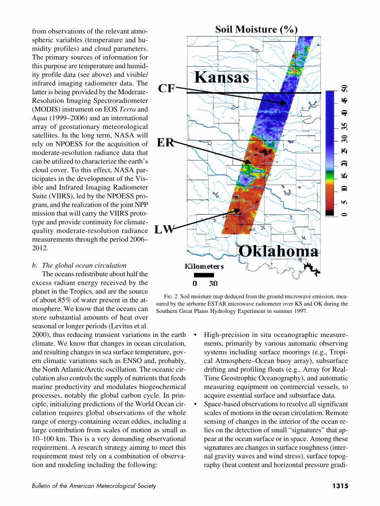
Changes in soil moisture have amajor impact on terrestrial lifeand human uses. Soil moisture isalso a controlling parameter ofevaporation from the land sur-face (mainly plant-mediatedevapotranspiration) and a pre-dictive factor for summer rain-fall over continents (Koster et al.2000). Remote sensing of soilmoisture in terrain covered bysubstantial vegetation posesconsiderable scientific and tech-nical challenges. Extensive ex-perience with airborne sensors[notably the ElectronicallyScanned Thinned Array Radi-ometer (ESTAR) microwaveradiometer] showed that the sig-nature of soil moisture under alow-density vegetation canopyis best observed at relatively lowmicrowave frequencies on the or-der of 1.4–3 GHz (Fig. 2). At suchfrequencies, meaningful groundresolution can be achieved fromspace only with a very large an-
tenna. This is a significant challenge that has hamperedspace-based soil moisture measurement so far. The Eu-ropean Space Agency is considering an experimentalSoil Moisture and Ocean Salinity satellite project withrelatively modest ground resolution on the order of50 km. NASA, for its part, continues to study severalexperimental remote sensing concepts, using active(radar) and/or passive (radiometer) microwave tech-niques, that may be used in a future exploratory mis-sion to observe soil moisture and freezing/thawingtransition at spatial resolution on the order of 1–10 km(Running et al. 1999).
Clouds are essential elements of the climate sys-tem because of their controlling impact on the earth’sradiation balance, atmospheric radiative heating orcooling, and surface radiation. Net surface radiationis a major component of oceanic and continental en-ergy budgets, and an important boundary forcing thatdrives the ocean circulation and land surface pro-cesses. Since atmospheric general circulation modelsare not yet advanced enough to enable accurate com-putations of radiant energy fluxes at particular loca-tions and times, it is essential to maintain thecapability to infer surface radiation fluxes directly
FIG. 1. Precipitation and winds observed over the Atlantic Ocean, as Hurricane Floyd isapproaching Florida on 13 Sep 1999. Precipitation rate in deduced from the distribution ofice and water drops measured by active and passive microwave sensors on the Tropical RainMeasuring Mission spacecraft. Ocean surface winds are deduced from microwave back-scatter measured by the Seawinds instrument on Quikscat.
1315Bulletin of the American Meteorological Society
from observations of the relevant atmo-spheric variables (temperature and hu-midity profiles) and cloud parameters.The primary sources of information forthis purpose are temperature and humid-ity profile data (see above) and visible/infrared imaging radiometer data. Thelatter is being provided by the Moderate-Resolution Imaging Spectroradiometer(MODIS) instrument on EOS Terra andAqua (1999–2006) and an internationalarray of geostationary meteorologicalsatellites. In the long term, NASA willrely on NPOESS for the acquisition ofmoderate-resolution radiance data thatcan be utilized to characterize the earth’scloud cover. To this effect, NASA par-ticipates in the development of the Vis-ible and Infrared Imaging RadiometerSuite (VIIRS), led by the NPOESS pro-gram, and the realization of the joint NPPmission that will carry the VIIRS proto-type and provide continuity for climate-quality moderate-resolution radiancemeasurements through the period 2006–2012.
b. The global ocean circulationThe oceans redistribute about half the
excess radiant energy received by theplanet in the Tropics, and are the sourceof about 85% of water present in the at-mosphere. We know that the oceans canstore substantial amounts of heat overseasonal or longer periods (Levitus et al.2000), thus reducing transient variations in the earthclimate. We know that changes in ocean circulation,and resulting changes in sea surface temperature, gov-ern climatic variations such as ENSO and, probably,the North Atlantic/Arctic oscillation. The oceanic cir-culation also controls the supply of nutrients that feedsmarine productivity and modulates biogeochemicalprocesses, notably the global carbon cycle. In prin-ciple, initializing predictions of the World Ocean cir-culation requires global observations of the wholerange of energy-containing ocean eddies, including alarge contribution from scales of motion as small as10–100 km. This is a very demanding observationalrequirement. A research strategy aiming to meet thisrequirement must rely on a combination of observa-tion and modeling including the following:
• High-precision in situ oceanographic measure-ments, primarily by various automatic observingsystems including surface moorings (e.g., Tropi-cal Atmosphere–Ocean buoy array), subsurfacedrifting and profiling floats (e.g., Array for Real-Time Geostrophic Oceanography), and automaticmeasuring equipment on commercial vessels, toacquire essential surface and subsurface data.
• Space-based observations to resolve all significantscales of motions in the ocean circulation. Remotesensing of changes in the interior of the ocean re-lies on the detection of small “signatures” that ap-pear at the ocean surface or in space. Among thesesignatures are changes in surface roughness (inter-nal gravity waves and wind stress), surface topog-raphy (heat content and horizontal pressure gradi-
color
FIG. 2. Soil moisture map deduced from the ground microwave emission, mea-sured by the airborne ESTAR microwave radiometer over KS and OK during theSouthern Great Plains Hydrology Experiment in summer 1997.
1316 Vol. 82, No. 7, July 2001
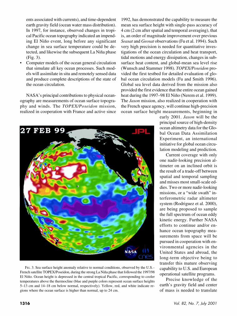
ents associated with currents), and time-dependentearth gravity field (ocean water mass distribution).In 1997, for instance, observed changes in tropi-cal Pacific ocean topography indicated an impend-ing El Niño event, long before any significantchange in sea surface temperature could be de-tected, and likewise the subsequent La Niña phase(Fig. 3).
• Computer models of the ocean general circulationthat simulate all key ocean processes. Such mod-els will assimilate in situ and remotely sensed dataand produce complete descriptions of the state ofthe ocean circulation.
NASA’s principal contributions to physical ocean-ography are measurements of ocean surface topogra-phy and winds. The TOPEX/Poseidon mission,realized in cooperation with France and active since
1992, has demonstrated the capability to measure themean sea surface height with single-pass accuracy of4 cm (2 cm after spatial and temporal averaging), thatis, an order of magnitude improvement over previousSeasat and Geosat observations (Fu et al. 1994). Suchvery high precision is needed for quantitative inves-tigations of the ocean circulation and heat transport,tidal motions and energy dissipation, changes in sub-surface heat content, and global-mean sea level rise(Wunsch and Stammer 1998). TOPEX/Poseidon pro-vided the first testbed for detailed evaluation of glo-bal ocean circulation models (Fu and Smith 1996).Global sea level data derived from the mission alsoprovided the first evidence that the entire ocean gainedheat during the 1997–98 El Niño (Nerem et al. 1999).The Jason mission, also realized in cooperation withthe French space agency, will continue high-precisionocean surface height measurements, beginning in
early 2001. Jason will be theprincipal source of high-densityocean altimetry data for the Glo-bal Ocean Data AssimilationExperiment, an internationalinitiative for global ocean circu-lation modeling and prediction.
Current coverage with onlyone nadir-looking precision al-timeter on an inclined orbit isthe result of a trade-off betweenspatial and temporal samplingand misses most small-scale ed-dies. Two or more nadir-lookingmissions, or a “wide swath” in-terferometric radar altimetersystem (Rodriguez et al. 2000),are being proposed to samplethe full spectrum of ocean eddykinetic energy. Further NASAefforts to continue and/or en-hance ocean topography mea-surements from space will bepursued in cooperation with en-vironmental agencies in theUnited States and abroad, thelong-term objective being totransfer this mature observingcapability to U.S. and Europeanoperational satellite programs.
Precise knowledge of theearth’s gravity field and centerof mass is needed to translate
FIG. 3. Sea surface height anomaly relative to normal conditions, observed by the U.S.–French satellite TOPEX/Poseidon, during the strong La Niña phase that followed the 1997/98El Niño. Ocean height is depressed in the central tropical Pacific, corresponding to coolertemperatures above the thermocline (blue and purple colors represent ocean surface heights5–13 cm and 14–18 cm below normal, respectively). Yellow, red, and white indicate re-gions where the ocean surface is higher than normal, up to 24 cm.
1317Bulletin of the American Meteorological Society
raw satellite altimetry data into useful dynamical in-formation, that is, the height above the reference sur-face of the earth’s gravitational potential (geoid). Thecooperative German–U.S. Challenging MinisatellitePayload mission, launched in July 2000, is the latestin a series of satellite missions that contributed to thesystematic refinement of earth gravity field modelsthrough precise orbit tracking (ground-based satellitelidar ranging and space-based differential Global Po-sitioning System measurements). The exploratoryGravity Recovery and Climate Experiment (GRACE)mission, to be launched by NASA in 2001, is expectedto yield yet another major improvement in knowledgeof the earth gravity field and determine the geoid toan unprecedented accuracy of 1–2 cm at spatial scaleslarger than 200 km. It is anticipated that space-basedgravity measurements may eventually become sensi-tive enough to detect the gravitational signature ofchanges in the distribution of seawater mass (in effectocean bottom pressure) and determine vertically inte-grated ocean currents. NASA is investing in the fur-ther development of space-based earth gravitymeasuring techniques that may open a new avenue of“photonless” earth remote sensing (NRC 1997).
Accurate surface wind information is essential todrive global or regional ocean circulation models(Millif et al. 1999). On account of the small width ofocean currents, wind observations are required at ahorizontal resolution of 10–20 km for adequate esti-mation of wind stress curl that determines vertical mo-tions. The NASA active microwave scatterometer(NSCAT) deployed on the Japanese space agency’sAdvanced Earth Observing Satellite-1 (ADEOS-1)mission demonstrated the effectiveness of this tech-nique for accurate measurement of ocean vector wind,albeit at relatively coarse resolution (Freilich andDunbar 1999). The next-generation Seawinds scan-ning microwave scatterometer, developed by NASAunder the EOS program, has already been launched onthe Quikscat rapid-deployment mission. The follow-on ADEOS-2 mission (to be launched by Japan in2001) will carry the second flight model of the sameinstrument. Seawinds microwave backscatter mea-surements also provide unique observations of sea-icecover and drift velocity, which complement sea-icemeasurements made operationally by the Special Sen-sor Microwave/Imager imaging microwave radiom-eter on Defense Meteorological Satellite Programsatellites and yield significantly higher spatial resolu-tion, on the order of 10 km (Liu et al. 1999). The ex-tent and concentration of sea ice is a sensitive indicator
of climate change, as the annual cycling of the icecover is determined by a finely tuned balance betweenheat exchanges with the ocean and atmosphere, andthe absorption of solar radiation during summer(Vinnikov et al. 1999).
Ocean wind data are also a very significant inputfor operational weather and sea state forecasting ap-plications. For this reason, global ocean wind obser-vations will be continued for the foreseeable future bythe NPOESS program, currently planning to use apassive polarimetry technique developed by the U.S.Navy. Pending flight testing of this technique on thenavy’s Coriolis experimental mission in 2002, NASAmaintains the option of flying advanced active vectorwind sensors on Japan’s Global Change ObservationMission series or other suitable platforms in the future.
Sea surface temperature (SST) is the principal gov-erning parameter of energy exchanges between atmo-sphere and oceans, and a primary indicator of globalclimate change. SST is measured routinely by exist-ing ocean monitoring systems, including operationalenvironmental satellites, drifting or moored meteoro-logical buoys, and voluntary observing ships.Improvements in accuracy and/or all-weather avail-ability of space-based SST measurements are expectedfrom the EOS Terra and Aqua missions. If confirmed,these advances will be implemented on NPP and op-erational NPOESS missions in the future.
c. Mass balance of polar ice sheetsWe know that ice sheets alternatively advanced
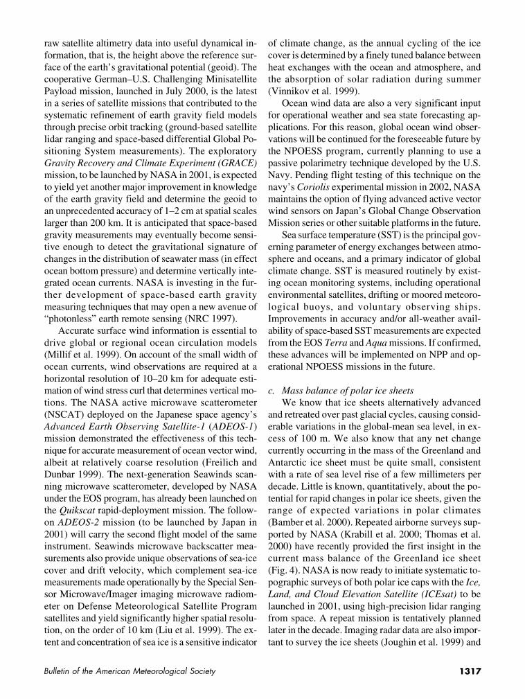
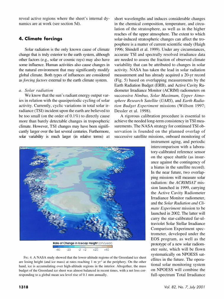
and retreated over past glacial cycles, causing consid-erable variations in the global-mean sea level, in ex-cess of 100 m. We also know that any net changecurrently occurring in the mass of the Greenland andAntarctic ice sheet must be quite small, consistentwith a rate of sea level rise of a few millimeters perdecade. Little is known, quantitatively, about the po-tential for rapid changes in polar ice sheets, given therange of expected variations in polar climates(Bamber et al. 2000). Repeated airborne surveys sup-ported by NASA (Krabill et al. 2000; Thomas et al.2000) have recently provided the first insight in thecurrent mass balance of the Greenland ice sheet(Fig. 4). NASA is now ready to initiate systematic to-pographic surveys of both polar ice caps with the Ice,Land, and Cloud Elevation Satellite (ICEsat) to belaunched in 2001, using high-precision lidar rangingfrom space. A repeat mission is tentatively plannedlater in the decade. Imaging radar data are also impor-tant to survey the ice sheets (Joughin et al. 1999) and
1318 Vol. 82, No. 7, July 2001
reveal active regions where the sheet’s internal dy-namics are at work (see section 5d).
4. Climate forcings
Solar radiation is the only known cause of climatechange that is truly exterior to the earth system, althoughother factors (e.g., solar or cosmic rays) may also havesome influence. Human activities also cause changes inthe natural environment that may significantly modifyglobal climate. Both types of influences are consideredas forcing factors external to the earth climate system.
a. Solar radiationWe know that the sun’s radiant energy output var-
ies in relation with the quasiperiodic cycling of solaractivity. Currently, cyclic variations in total solar ir-radiance (TSI) incident upon the earth are believed tobe too small (on the order of 0.1%) to directly causemore than barely detectable changes in troposphericclimate. However, TSI changes may have been signifi-cantly larger over the last several centuries. Furthermore,solar variability is much larger (in relative terms) at
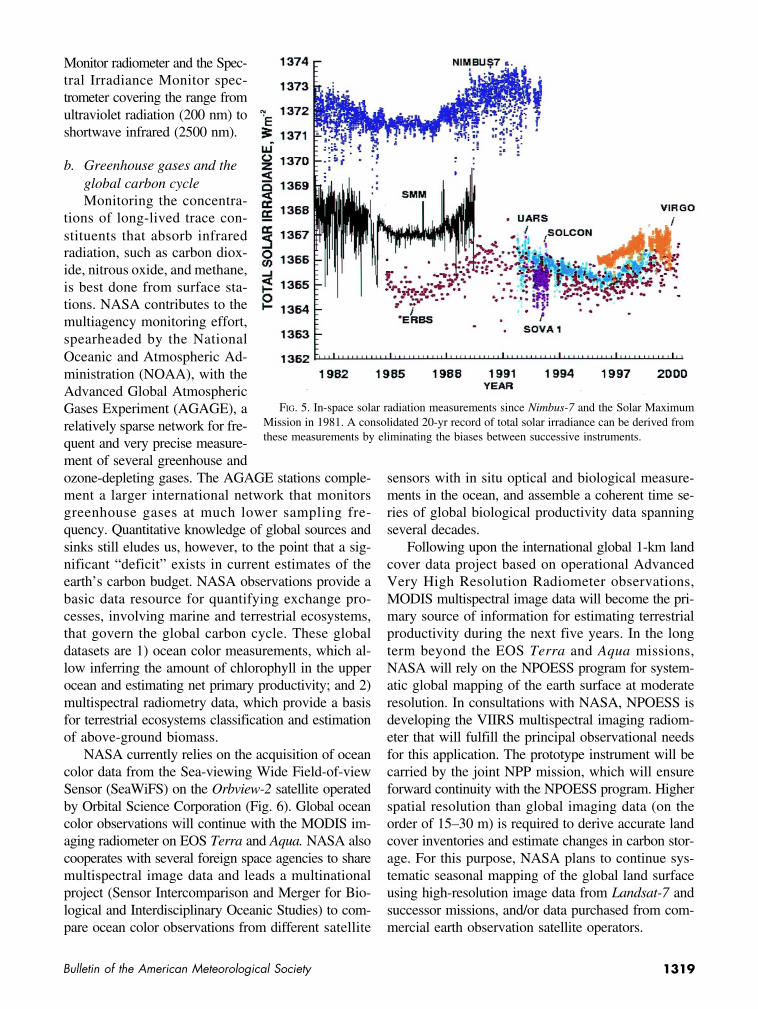
short wavelengths and induces considerable changesin the chemical composition, temperature, and circu-lation of the stratosphere, as well as in the higherreaches of the upper atmosphere. The extent to whichsolar-induced stratospheric changes can affect the tro-posphere is a matter of current scientific study (Haigh1996; Shindell et al. 1999). Under any circumstances,accurate TSI and spectrally resolved irradiance dataare needed to assess the fraction of observed climatevariability that can be attributed to changes in solaractivity. NASA has taken the lead in solar radiationmeasurement and has already acquired a 20-yr record(Fig. 5) based on overlapping measurements by theEarth Radiation Budget (ERB), and Active Cavity Ra-diometer Irradiance Monitor (ACRIM) radiometers onsuccessive Nimbus, Solar Maximum, Upper Atmo-sphere Research Satellite (UARS), and Earth Radia-tion Budget Experiment missions (Willson 1997;Dessler et al. 1998).
A rigorous calibration procedure is essential toachieve the needed long-term consistency in TSI mea-surements. The NASA strategy for continued TSI ob-servation is founded on the planned overlap ofsuccessive satellite missions, onboard monitoring of
instrument aging, and periodicintercomparison with a labora-tory-calibrated reference sensoron the space shuttle (as insur-ance against the contingency ofa hiatus in the satellite record).In the near future, two overlap-ping missions will measure solarradiation: the ACRIMSAT mis-sion launched in 1999, carryingthe Active Cavity RadiometerIrradiance Monitor radiometer,and the Solar Radiation and Cli-mate Experiment mission to belaunched in 2002. The latter willcarry the star-calibrated far-ul-traviolet Solar Stellar IrradianceComparison Experiment spec-trometer, developed under theEOS program, as well as theprototype of a new solar radiom-eter suite, which will be flownsystematically on NPOESS sat-ellites in the future. The opera-tional solar monitoring systemon NPOESS will combine thefull-spectrum Total Irradiance
FIG. 4. A NASA study showed that the lower-altitude regions of the Greenland ice sheetare losing height (and ice mass) at rates reaching 1 m yr−1 at the periphery. On the otherhand, ice is accumulating over high-altitude regions in the interior. Altogether, the massbudget of the Greenland ice sheet was almost balanced in recent times, with a net loss cor-responding to a global mean sea level rise of 0.1 mm annually.
1319Bulletin of the American Meteorological Society
Monitor radiometer and the Spec-tral Irradiance Monitor spec-trometer covering the range fromultraviolet radiation (200 nm) toshortwave infrared (2500 nm).
b. Greenhouse gases and theglobal carbon cycleMonitoring the concentra-
tions of long-lived trace con-stituents that absorb infraredradiation, such as carbon diox-ide, nitrous oxide, and methane,is best done from surface sta-tions. NASA contributes to themultiagency monitoring effort,spearheaded by the NationalOceanic and Atmospheric Ad-ministration (NOAA), with theAdvanced Global AtmosphericGases Experiment (AGAGE), arelatively sparse network for fre-quent and very precise measure-ment of several greenhouse andozone-depleting gases. The AGAGE stations comple-ment a larger international network that monitorsgreenhouse gases at much lower sampling fre-quency. Quantitative knowledge of global sources andsinks still eludes us, however, to the point that a sig-nificant “deficit” exists in current estimates of theearth’s carbon budget. NASA observations provide abasic data resource for quantifying exchange pro-cesses, involving marine and terrestrial ecosystems,that govern the global carbon cycle. These globaldatasets are 1) ocean color measurements, which al-low inferring the amount of chlorophyll in the upperocean and estimating net primary productivity; and 2)multispectral radiometry data, which provide a basisfor terrestrial ecosystems classification and estimationof above-ground biomass.
NASA currently relies on the acquisition of oceancolor data from the Sea-viewing Wide Field-of-viewSensor (SeaWiFS) on the Orbview-2 satellite operatedby Orbital Science Corporation (Fig. 6). Global oceancolor observations will continue with the MODIS im-aging radiometer on EOS Terra and Aqua. NASA alsocooperates with several foreign space agencies to sharemultispectral image data and leads a multinationalproject (Sensor Intercomparison and Merger for Bio-logical and Interdisciplinary Oceanic Studies) to com-pare ocean color observations from different satellite
sensors with in situ optical and biological measure-ments in the ocean, and assemble a coherent time se-ries of global biological productivity data spanningseveral decades.
Following upon the international global 1-km landcover data project based on operational AdvancedVery High Resolution Radiometer observations,MODIS multispectral image data will become the pri-mary source of information for estimating terrestrialproductivity during the next five years. In the longterm beyond the EOS Terra and Aqua missions,NASA will rely on the NPOESS program for system-atic global mapping of the earth surface at moderateresolution. In consultations with NASA, NPOESS isdeveloping the VIIRS multispectral imaging radiom-eter that will fulfill the principal observational needsfor this application. The prototype instrument will becarried by the joint NPP mission, which will ensureforward continuity with the NPOESS program. Higherspatial resolution than global imaging data (on theorder of 15–30 m) is required to derive accurate landcover inventories and estimate changes in carbon stor-age. For this purpose, NASA plans to continue sys-tematic seasonal mapping of the global land surfaceusing high-resolution image data from Landsat-7 andsuccessor missions, and/or data purchased from com-mercial earth observation satellite operators.
FIG. 5. In-space solar radiation measurements since Nimbus-7 and the Solar MaximumMission in 1981. A consolidated 20-yr record of total solar irradiance can be derived fromthese measurements by eliminating the biases between successive instruments.

1320 Vol. 82, No. 7, July 2001
Chemically active, shorter-lived greenhouse gasesexperience complex variations that result from theinterplay of multiple dynamical, physical, and chem-ical processes in the atmosphere. Variations in thesereactive gases, particularly ozone, can induce signifi-cant changes in stratospheric temperature profiles andclimate. Building on the long-term record provided bythe Total Ozone Mapping Spectrometer (TOMS), theStratospheric Aerosol and Gas Experiment (SAGE)and several instruments aboard (UARS), NASA plansto acquire the most accurate ever global climatologyof stratospheric and upper-tropospheric ozone with asuite of new instruments that will be deployed on theforthcoming EOS Aura mission (especially the Tro-pospheric Emission Spectrometer). Continued system-a tic measurements of ozone are planned, notably withthe operational Ozone Mapping and Profiling Suitesensors on NPOESS.
c. AerosolsWe know that stratospheric aerosols, such as pro-
duced by large volcanic eruptions, most recently the
eruption of Mount Pinatubo (McCormick et al. 1995),can cause significant warming of the stratosphere andcooling of the earth’s troposphere and surface.Tropospheric aerosols, on the other hand, can produceeither cooling or warming depending upon aerosol op-tical properties and the albedo of the underlying sur-face. Tropospheric aerosols can also influence climateindirectly by modifying the microphysical propertiesand life cycle of clouds (Ackerman et al. 2000; Taylorand Ackerman 1999), as well as precipitation(Rosenberg 2000). The specific effects of aerosols onatmospheric radiation strongly depend upon the vari-able distribution, sizes, shapes, and chemical composition of aerosol particles; understanding the complexprocesses that govern these aerosol parameters is amajor scientific challenge.
Currently, no single observing technique or com-bination of techniques can document all relevant pro-perties of aerosols globally. The problem is particularlychallenging in the troposphere, where aerosol lifetimeis only a few days and their distribution and compo-sition are highly variable. Determining total aerosol
FIG. 6. Third anniversary image produced by the SeaWiFS project, depicting the global biosphere, the ocean’s average chloro-phyll concentration over the period Sep 1997 to Aug 2000, and a map of the normalized difference vegetation index over land duringJul 2000. In the oceans, yellow and green colors show regions where dense phytoplankton life exists, while abundant land vegetationis indicated by dark greens.

1321Bulletin of the American Meteorological Society
amounts, as well as spatial andtemporal variations reflectingaerosol microphysical and chemi-cal processes, is an importantelement of NASA’s climate re-search program. The objective isultimately to develop reliableaerosol chemistry and transportmodels that can be used to predictthe climatic impacts of aerosolsfrom all sources (King et al.1999). Systematic NASA mea-surements include the following:
• global mapping of total-column aerosol content andmean particle size, based on the analysis of visibleand near-infrared reflectance data from MODIS onEOS Terra and Aqua, SeaWiFS, and the Multi-angle Imaging Spectro-Radiometer sensor on Terra;
• global mapping of total-column aerosol content,based on the measurement of solar ultraviolet back-scatter measurements by TOMS sensors on severalEarth Probe missions and similar follow-on instru-ments (Ozone Monitoring Instrument on EOSAura, Ozone Mapping and Profiling Suite onNPOESS); ultraviolet backscatter observationsalso allow discriminating between UV-absorbingaerosols (mineral dust, smoke) and nonabsorbingaerosols (sulfates, sea salt);
• stratospheric and upper-tropospheric aerosol pro-files, inferred from solar occultation measurementsby a series of SAGE missions (Fig. 7); and
• total aerosol measurements by the Aerosol RoboticNetwork of multispectral solar photometers in-stalled by NASA at a number of sites (currentlyabout 75) with the cooperation of local institutionsaround the globe.
In view of the complexity of aerosol microphys-ics, comprehensive airborne and field measurementcampaigns, such as the Southern Africa Regional Sci-ence Initiative, are essential to validate and comple-ment global measurements. In addition NASA hasundertaken, in cooperation with the French spaceagency, a major experimental satellite mission (thePathfinder Instrument for Cloud and Aerosol Space-borne Observations-Climatologie Etendue des Nuageset des Aerosols; PICASSO-CENA) designed specifi-cally to study the distribution and optical propertiesof aerosols. Following the Lidar In-space Technology
Experiment on the space shuttle (Winker et al. 1995),PICASSO-CENA will be, in 2003, the first long-dura-tion mission specially designed to probe the full depthof the atmospheric column with an active lidar sen-sor. Formation flying of PICASSO-CENA with theEOS Aqua spacecraft will allow simultaneous acqui-sition of lidar, MODIS, and Cloud and the Earth’sRadiant Energy System (CERES) data. These mea-surements will enable determining separately aerosolparticle density, optical properties, and optical depth,and inferring aerosol radiative forcing, essentially freefrom a priori model assumptions. In addition, obser-vation of aerosol infrared absorption by the High-Resolution Dynamics Limb Sounder (HIRDLS)spectrometer on EOS Aura may yield new (experimen-tal) diagnostics of aerosol types and distribution in thestratosphere.
5. Climate responses and feedbackmechanisms
Among the multiplicity of mechanisms and pro-cesses that influence climate, NASA selected fourhigh-priority research topics that are amenable to fo-cused investigations involving intensive field mea-surements, exploratory global satellite surveys anddata analysis, and specialized process-resolving modelstudies. These four research foci are 1) the controllingrole of water vapor and clouds in radiation transfer andthe earth’s radiant energy balance, 2) land surface hy-drologic processes and their effects on large-scale soilwater storage and water resources, 3) the freshwaterbudget of the upper ocean and consequences for deepwater formation and the global ocean circulation, and
FIG. 7. Time–latitude record of aerosol optical depth in the stratosphere, measured bySAGE during the period 1985–97. In 1991, the Mount Pinatubo eruption injected a largeamount of particulate matter into the stratosphere. The anomaly persisted for almost twoyears.

1322 Vol. 82, No. 7, July 2001
4) “fast” dynamic phenomena in polar ice sheets andtheir potential impact on global-mean sea level.
a. Water vapor, clouds, and the planetary radiationbalanceWe know that water vapor is a strong absorber of
infrared radiation and contributes more to the green-house effect of the atmosphere than all other green-house gases together. Atmospheric humidity respondsstrongly to changes in atmospheric temperature, thusconstituting a net positive climate feedback mecha-nism. Our knowledge of atmospheric transport ofwater and transformations among its three physicalstates is far from sufficient to quantify water fluxesto the required accuracy, and fully understand the con-nections with the development of weather systems.
Liquid water and ice clouds are the principal fac-tors controlling rapid fluctuations in radiant energyfluxes and radiative heating (or cooling) of the atmo-spheric column. The formation, life cycle, and opticalproperties of clouds remains the largest source of un-certainty in climate change predictions, due largely tothe complexity of cloud microphysical processes andtheir linkage to the dynamics of weather systems.NASA has invested considerable efforts in the studyof cloud processes and their impact on atmosphericradiation, locally and globally. Observations by theEarth Radiation Budget Experiment, the current EOSCERES project, and the international surface radiationnetwork provide the basic information for relatingtime-averaged radiation fluxes to cloud distributionand optical properties (Wielicki et al. 1995). In paral-lel, the International Satellite Cloud ClimatologyProject provides basic 3-hourly global data for relat-ing clouds to weather phenomena (Rossow andSchiffer 1999). As a result, considerable advances havebeen made in representing cloud and radiation pro-cesses in both general circulation and climate models.Observation requirements for further progress havekept pace with these advances; observational goals arenow to 1) determine individually the principal cloudcharacteristics, such as water and ice content, particlesize and optical properties, and cloud optical depth; 2)resolve the three-dimensional structure of cloud en-sembles; and 3) relate cloud structure and propertiesto the weather systems and aerosol environment inwhich they are embedded.
In addition to systematic observation of the globalcloud distribution by research and operational environ-mental satellites, NASA is planning a major explor-atory satellite program to support fundamental cloud
process studies. The program calls for the deploymentof a constellation of three spacecraft flying in closeformation on the same orbit:
• EOS Aqua satellite, carrying passive radiometricsensors that will measure radiation fluxes at the topof the atmosphere (CERES), cloud-top opticalproperties (MODIS), atmospheric temperature andhumidity profiles (AIRS), and microwave absorp-tion or backscatter by heavy ice particles andwater droplets (Advanced Microwave ScanningRadiometer);
• Cloudsat exploratory satellite equipped with amillimeter-wave cloud profiling radar, whichwill probe the vertical structure of clouds of inter-mediate thickness, including nonprecipitatingstratiform clouds and drizzle (Brown et al. 1995);and
• PICASSO-CENA exploratory satellite carrying apolarimetric lidar to observe particulate matter inthe atmosphere at the lowest range of optical depths(aerosols and optically thin clouds).
The PICASSO-CENA and Cloudsat missions willbe launched simultaneously in 2003 to match the or-bit of EOS Aqua and will provide the first direct mea-surements of multilayered cloud systems. Twolimb-viewing sensors on the EOS Aura mission(Microwave Limb Sounder, HIRDLS) will also ob-serve temperature and water vapor profiles in thestratosphere and upper troposphere. Solar ultravioletbackscatter measurements by TOMS provide comple-mentary information on cloud fraction and cloud-topaltitude. Additionally, the Geostationary Imaging Fou-rier Transform Spectrometer technology demonstra-tion mission, planned for launch in 2004, will providehigh spatial and temporal tropospheric water vapordata to improve prediction of cloud generation andevolution. From these combined efforts, a majoradvance is expected in knowledge of the three-dimensional structure of clouds, and their relationshipto weather systems globally.
NASA will continue to organize intensive airborneobservation campaigns for characterizing microphysi-cal processes and radiative transfer in the cloudy at-mosphere, and cooperates with other agencies thatprovide needed surface-based observations, princi-pally the Atmospheric Radiation Measurement pro-gram of the U.S. Department of Energy and the SurfaceRadiation Budget Network program of NOAA. Theprincipal field campaigns planned in the near future

1323Bulletin of the American Meteorological Society
will be part of the Cirrus Regional Study of TropicalAnvils and Layers, a research program to investigatehigh-altitude water vapor and ice clouds in storms andmesoscale weather systems. NASA also plans to sup-port the development of a hierarchy of model tools,from microphysical models of cloud particle forma-tion and growth, to cloud ensemble models that canbe directly compared to single-column parametric for-mulations in climate models.
b. Land surface hydrologic processesFreshwater is a critical resource upon which the
existence of life depends. Long-range atmospherictransport and condensation of water vapor, precipita-tion, river runoff, and evapotranspiration from veg-etated areas all contribute to determining thefreshwater budget of land areas and the fate of waterreserves available to ecosystems and human societ-ies. These diverse phenomena have yet to be quanti-fied with sufficient accuracy to enable hydrologicapplications of climate predictions for flood forecast-ing and water system management. From a broaderperspective, the functioning of the earth system canbe envisioned as interconnected cycles of water, en-ergy, carbon, and other nutrients. Hydrologic pro-cesses play a central role in connecting these cyclesacross land, atmosphere, and ocean. Soil moisturecontrols evaporation from land and plant transpiration.River flow carries nutrients and sediments to estuar-ies, providing an effective link between terrestrial andoceanic systems. Atmospheric transport connects thefreshwater budgets of land, ice, and ocean reservoirs.
Within this wide research domain, NASA’s prior-ity in the next decade is to develop global measure-ments that contribute to fundamental understanding ofland surface hydrologic processes. In addition to glo-bal precipitation measurements (see section 3a above),NASA is considering various space-based techniquesto estimate soil moisture, the most extensive indica-tor of the state of the hydrologic system and an im-portant initial value for prediction of summertimerainfall over large continental regions (Beljaars et al.1996; Koster et al. 2000). The challenge is to detectthe soil moisture signal from terrain covered by veg-etation while, at the same time, achieving useful spa-tial resolution on the ground (on the order 10–30 kmor better). Very large antennas are required to meet thelatter requirement at the low microwave frequenciesthat penetrate a moderate vegetation canopy. NASAis studying a variety of passive and active microwavetechniques that would enable observing soil moisture
and changes in land surface conditions such as freez-ing and thawing. NASA also supports fundamentalland surface process studies, including intensive in situand aircraft observations, and participates in severalcontinental-scale water and energy budget studies,notably the Global Energy and Water Cycle Experi-ment (GEWEX) Continent-scale International Project(Lawford 1999) and the GEWEX America PredictionProject over the continental United States as well asthe Large-scale Biosphere–Atmosphere experimentover the Amazon River basin.
The interiors of the North American and Eurasiancontinents and high-altitude mountains receive muchof their annual precipitation in the form of snow dur-ing winter months, with distinctive consequences forthe seasonal regimes of the rivers they feed. The soilfreeze/thaw transition determines the relative amountsof snowmelt and precipitation that contribute to run-off versus infiltration, and also triggers the onset ofvegetation growth in spring. NASA expects that fu-ture exploratory satellite projects may allow observ-ing these cold climate hydrologic phenomena on aglobal scale.
An exciting new prospect has been opened by theTOPEX/Poseidon mission, which demonstrated thecapability to measure the stage height of large riversand inland water bodies with a space-based radar al-timeter (Fig. 8). The ICESat mission will demonstrateanother means of acquiring similar data with muchfiner spatial resolution (170 m along track) using a li-dar altimeter. Although river stage height can be con-veniently observed in situ, the discharges of many ofthe world’s rivers are not currently being monitored,or the data are not available to the scientific commu-nity. Homogeneous, readily accessible measurementsof the stage of rivers and other inland water bodieswould be a valuable source of global hydrologic in-formation at a time when the world’s water resourcesare being stressed and international disputes are aris-ing about water sharing.
In a more visionary perspective, NASA is investi-gating the feasibility of gravity field measurementsthat may be sensitive enough to detect the minutegravitational signature of changes in the distributionof surface water over continents and the discharge/re-charge of ground water. Such developments (to betested for the first time by the exploratory GRACEmission in 2001) may usher revolutionary newphotonless remote sensing methods that directly yieldgravimetric measurements of changes in ground wa-ter storage or snow accumulation over continents, as

1324 Vol. 82, No. 7, July 2001
well as similar changes in ocean mass distribution(NRC 1997).
c. Impact of deep water formation on the globalocean circulation and climateThe rate of formation of dense water that sinks to
intermediate depths or to the bottom of the ocean hasprofound implications for the global ocean circulation,long-term oceanic storage of heat and chemicals, thecycling of nutrients, marine primary productivity, andcarbon intake, in addition to direct impact on climatearound ocean basins. There is theoretical and paleo-climatic evidence that the overturning circulation ofthe Atlantic Ocean is sensitive to a decrease in salin-ity of surface waters that may be caused by climatechange (Broecker 1997). A transition from the currentcirculation regime of the Atlantic Ocean to anotherregime with significantly reduced rate of deep waterformation would induce a major climatic shift in theNorth Atlantic region.
The sinking of surface water exposed to cold air isthe primary mechanism that governs the thermohalinecirculation of the ocean. Since air temperature at highlatitude eventually falls below the freezing tempera-ture of seawater, the ability of surfacial waters to sinkinto the deep ocean is controlled by preexisting salin-ity. Thus, the key to understanding the likelihood of a
transition toward a markedly differentoceanic circulation regime is accurateprediction of the freshwater budget of theWorld Ocean.
This is a tall order, considering thescarcity of oceanic precipitation, evapo-ration, or sea surface salinity data world-wide. Global measurements of sea surfacesalinity [to an accuracy of 1 practical sa-linity unit (PSU) or less, out of 35 PSU forstandard ocean water] would constitute abreakthrough in the study of the oceanicfresh water budget. This appears achiev-able through careful analysis of multifre-quency microwave radiometry data andjoint retrieval of surface roughness, tem-perature, and salinity. Developing therelevant remote sensing techniques is apriority of the NASA physical oceanog-raphy program; encouraging preliminaryresults have been obtained with an ex-perimental airborne low-frequency mi-crowave radiometer.
d. Ice sheet dynamics and sea level riseCould changes in the mass balance of the Greenland
and Antarctic ice sheets accelerate to the point wheresubstantial rise in global sea level would result overperiods of a few decades, much faster than the currentrate of 1–2 mm yr−1? The traditional perception ofcontinental ice sheets as a sluggish component of theearth system, evolving with literally “glacial” slow-ness, precludes rapid changes in melting rate or ice-berg discharge. This reassuring view is beingchallenged by the realization that parts of the Antarc-tic ice sheet are undergoing considerable transforma-tion. The first high-resolution radar survey ofAntarctica (Radarsat Antarctic Mapping Mission) dis-covered massive ice streams, huge rivers of ice reach-ing far inland, and introduced a new paradigm forassessing the likelihood of relatively fast ice flows thatcould discharge vast volumes of ice in a matter of de-cades instead of centuries (Fig. 9).
NASA plans to continue exploring the dynamicregions of the Greenland and Antarctic ice sheets, andestimating the mass flow of major ice streams. For thispurpose the tool of choice is a new synthetic apertureradar (SAR) “interferometry” method, based on com-bining the intensity and phase information from suc-cessive SAR images obtained at short time intervals, thatallows rapid mapping of ice surface topography and
FIG. 8. Time series of stage heights measured over the same section of theAmazon River by the TOPEX/Poseidon altimetry satellite. Note the near-coincidence of TOPEX data (triangles) and in situ measurements at theManacapuru River gauging station (solid line). The single-pass accuracy ofTOPEX height measurements over a sufficiently wide water body is 4 cm.

1325Bulletin of the American Meteorological Society
velocity fields (Joughin et al. 1999). NASA is currentlyconducting a second Modified Antarctic MappingMission focused on observing the periphery of the icesheet. NASA aims to pursue this line of investigationand acquire further SAR observations from futureNASA-managed earth observation mission(s), commer-cial satellite operators, and/or international partners.
In addition, the NASA polar research program sup-ports airborne surveys and field campaigns, aiming toacquire critical ice sheet measurements such as the depthof the ice column and the topography of the underly-ing terrain. Repeated airborne laser altimeter surveysof the Greenland icesheet in 1993–94 and 1998–99provided the first clear indication of significant re-gional differences in polar ice mass balance andtrends (Krabill et al. 2000; Thomas et al. 2000).
6. Consequences of climate change:The climate–weather connection
From a fundamental standpoint, one could ar-gue that the ultimate goal of climate science is torelate the large-scale mean properties of the earth’s atmo-sphere, ocean, ice, and biogeochemical environmentto the basic laws of physics and chemistry operatingat molecular scale. Linking phe-nomena across such a huge rangeof characteristic space and timescales cannot be done in onestroke. Realistic steps in thatdirection are bridging the gapsin observation and models be-tween the planetary-scale cir-culation and the development ofweather disturbances, and be-tween synoptic weather systemsand cloud ensemble dynamics,eventually reaching out to in-clude microphysical processes.
Furthermore, climate is anabstract statistical concept:people are sensitive to weatherphenomena, especially extremeevents, or natural climate inte-grators like the length of thegrowing season, not climaticaverages. We know that a dis-proportionately large fraction ofthe global energy and waterfluxes that determine global cli-
mate is governed by the nonlinear dynamics of activeweather systems. In particular, much of the rainfall intropical and subtropical regions is associated withtropical cyclones, squall lines, and other mesoscaleweather disturbances. Thus a crucial objective forclimate science, from both practical and fundamentalperspectives, is to determine the extent to which thefrequency, intensity, and distribution of transientweather systems (and related precipitation, riverflow, and freshwater recharge) are predictable, given thestate of global climate, and the extent to which suchstatistics are liable to evolve with climate change(Easterling et al. 2000).
Connecting weather and climate processes is, initself, a major challenge. Weather forecasters and prac-tical water resource managers are striving for accuratedeterministic predictions of time-dependent variationsin atmospheric circulation, precipitation, or river flowbut, at the same time, use empirical representations offlux-controlling processes that are rooted in currentclimate statistics and thus may be invalid under a dif-ferent climate regime. Global change scientists, on theother hand, strive for fundamental understanding of thephysical, chemical, and biological processes that gov-ern climate, but do not normally make use of the enor-
FIG. 9. SAR picture composite of the Antarctic ice sheet, produced by the AntarcticMapping Mission, a joint project conducted by NASA and the Canadian Space Agency usingRadarsat data. The full-resolution image shows ice streams reaching far inland.
1326 Vol. 82, No. 7, July 2001
mous flow of meteorological data that describes theevolution of weather systems globally. As a result, theyare not well positioned to analyze the linkages betweenatmospheric–hydrologic processes and the atmosphericcirculation transients in which they are embedded.
The NASA program aims to overcome this chal-lenge and offers a unique combination of capabilitiesto study the climate–weather connection. NASA’sEOS and successor programs will produce, for an ex-tended period of time, research-quality data coveringmost aspects of the global physical environment. Inparticular, dense ocean wind observations acquired bythe NSCAT sensor on Japan’s ADEOS-1 mission andthe Seawinds sensor on NASA’s Quikscat missionhave been used effectively to characterize the path andlife cycle of organized weather systems at sea, wherethe dynamics of weather disturbances are the simplest.NASA plans to pursue this successful technical av-enue and deploy a second model of the Seawinds in-strument on Japan’s follow-on ADEOS-2 mission, tobe launched in 2001. Likewise space-based observa-tion of precipitation rates in active storm systems, pro-vided by TRMM and similar future missions, areinstrumental in helping achieve quantitative precipi-tation forecasts, a foremost objective of the U.S.Weather Research Program. Also significant in thiscontext is NASA’s development of the experimentalGeostationary Imaging Fourier Transform Spectrom-eter (GIFTS), which will demonstrate the applicationof advanced atmospheric sounding technologies ingeostationary orbit. GIFTS would allow rapid track-ing of moisture and dynamical features at high timeand space resolution, initially over the United Statesand later over the Indian Ocean. GIFTS is being po-tentially viewed by NOAA as the next-generationoperational geostationary atmospheric sounder, whensuccessfully demonstrated.
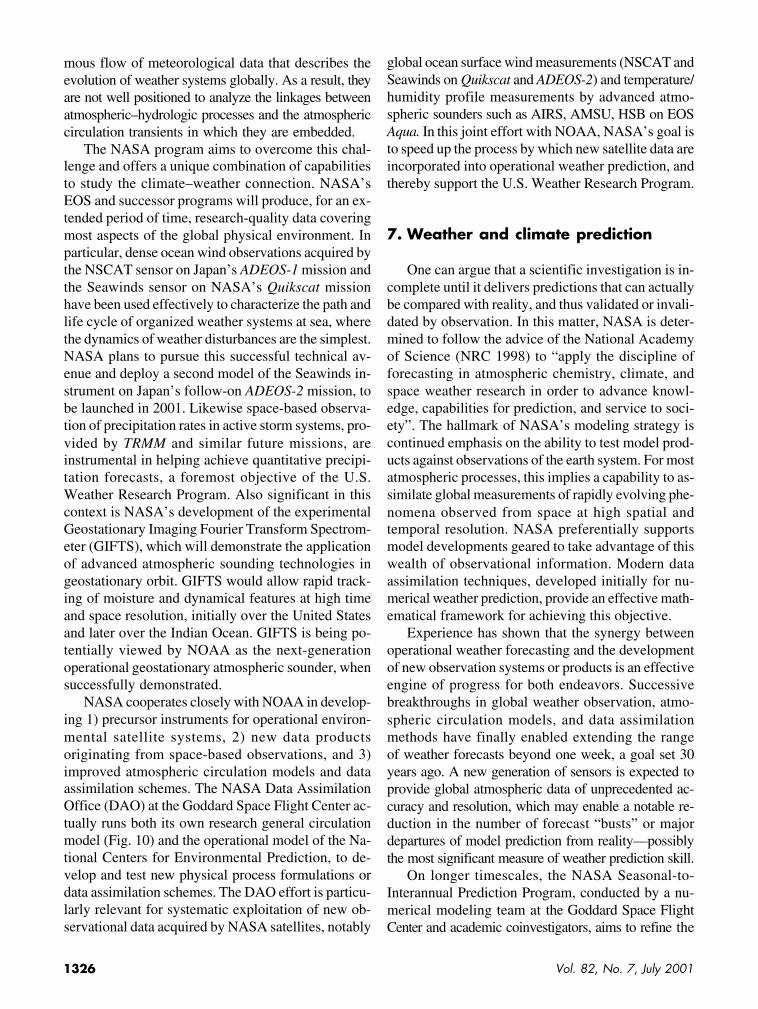
NASA cooperates closely with NOAA in develop-ing 1) precursor instruments for operational environ-mental satellite systems, 2) new data productsoriginating from space-based observations, and 3)improved atmospheric circulation models and dataassimilation schemes. The NASA Data AssimilationOffice (DAO) at the Goddard Space Flight Center ac-tually runs both its own research general circulationmodel (Fig. 10) and the operational model of the Na-tional Centers for Environmental Prediction, to de-velop and test new physical process formulations ordata assimilation schemes. The DAO effort is particu-larly relevant for systematic exploitation of new ob-servational data acquired by NASA satellites, notably
global ocean surface wind measurements (NSCAT andSeawinds on Quikscat and ADEOS-2) and temperature/humidity profile measurements by advanced atmo-spheric sounders such as AIRS, AMSU, HSB on EOSAqua. In this joint effort with NOAA, NASA’s goal isto speed up the process by which new satellite data areincorporated into operational weather prediction, andthereby support the U.S. Weather Research Program.
7. Weather and climate prediction
One can argue that a scientific investigation is in-complete until it delivers predictions that can actuallybe compared with reality, and thus validated or invali-dated by observation. In this matter, NASA is deter-mined to follow the advice of the National Academyof Science (NRC 1998) to “apply the discipline offorecasting in atmospheric chemistry, climate, andspace weather research in order to advance knowl-edge, capabilities for prediction, and service to soci-ety”. The hallmark of NASA’s modeling strategy iscontinued emphasis on the ability to test model prod-ucts against observations of the earth system. For mostatmospheric processes, this implies a capability to as-similate global measurements of rapidly evolving phe-nomena observed from space at high spatial andtemporal resolution. NASA preferentially supportsmodel developments geared to take advantage of thiswealth of observational information. Modern dataassimilation techniques, developed initially for nu-merical weather prediction, provide an effective math-ematical framework for achieving this objective.
Experience has shown that the synergy betweenoperational weather forecasting and the developmentof new observation systems or products is an effectiveengine of progress for both endeavors. Successivebreakthroughs in global weather observation, atmo-spheric circulation models, and data assimilationmethods have finally enabled extending the rangeof weather forecasts beyond one week, a goal set 30years ago. A new generation of sensors is expected toprovide global atmospheric data of unprecedented ac-curacy and resolution, which may enable a notable re-duction in the number of forecast “busts” or majordepartures of model prediction from reality—possiblythe most significant measure of weather prediction skill.
On longer timescales, the NASA Seasonal-to-Interannual Prediction Program, conducted by a nu-merical modeling team at the Goddard Space FlightCenter and academic coinvestigators, aims to refine the
1327Bulletin of the American Meteorological Society
formulation of coupled atmo-sphere–ocean–land models andthe assimilation of new space-based observations of ocean sur-face topography, temperature,winds, and eventually continen-tal soil moisture. Initial values oftropical ocean parameters areprincipally useful for ENSO pre-diction, while continent-scalesoil moisture will significantlyinfluence summertime precipita-tion forecasts over the interior ofcontinents (Beljaars et al. 1996).Recent advances in seasonal pre-diction resulted from more real-istic treatment of mesoscaleweather systems, as could beexpected since one of the mostsignificant manifestations oftransient ENSO anomalies is ashift in midlatitude storm tracks.NASA contributes to progress inall aspects of this research prob-lem, from improvements ofmodels and data assimilationmethods to advances in globalobservation.
On still longer timescales, NASA supports a broadand diverse program of model studies, ranging fromdetailed simulations of selected climate processes(e.g., process-resolving cloud ensemble models) tomodel-based projections of potential global climatechanges. The principal NASA climate modeling effort,based at the Goddard Institute for Space Studies(GISS), is leading the field in quantitative computa-tion of the various radiative forcings factors that caninfluence global climate. GISS is now engaged in adetailed reexamination of physical and dynamical pro-cess representations in climate models, from turbulentmixing to sea-ice physics and land surface hydrology.Because of the chaotic nature of climate dynamics, anylong-term climate prediction must be based not on justone, but a number of parallel model runs, in order toquantify the random uncertainty associated with natu-ral variability. GISS is producing such “ensemble fore-casts” to explore the range of natural climate variationsand assess the degree of confidence in the outcome ofmodel predictions.
Beyond the immediate goal of demonstrating thecapability to produce meaningful climate change pro-
jections, the scientific objective is to understand thedynamics of the coupled atmosphere–ocean–land sys-tem, and ultimately provide a basis for the develop-ment of earth system models embracing the fulldiversity of physical, chemical, and biological pro-cesses that govern climate, the global cycles of water,carbon, and other nutrients, and the chemical compo-sition of the earth atmosphere and oceans.
NASA recognizes this agenda requires consider-able investments in supercomputer equipment andsoftware engineering that can fulfill the computingneeds for advanced earth system models, detailed repre-sentation of relevant processes, and sufficient spa-tial resolution to resolve all important scales of naturalvariability. The NASA effort focuses on constructinga common Earth System Modeling Framework(ESMF). The ESMF is intended to enable the creationof next-generation earth system models and allow fora variety of plug-in components to operate inter-changeably within these models. A current High Per-formance Computing and Communication programinitiative will facilitate the joint definition of theESMF by the earth system modeling community andthe migration of their codes to this framework.
FIG. 10. Numerical simulation of an Atlantic hurricane realized by the NASA Data As-similation Office, using a recent general circulation model developed in collaboration withthe National Center for Atmospheric Research. This version of the model utilizes a 0.5° ×0.5° global grid, but nevertheless resolves the mesoscale structure of the hurricane and thecentral eye.

1328 Vol. 82, No. 7, July 2001
8. Conclusions
Constructing a coherent research program and se-lecting research priorities is a major challenge in abroad scientific domain that crosses over a number ofdifferent disciplines, each evoking many scientificquestions. The special challenge faced by NASA isbalancing the competing demands placed on its lim-ited resources and addressing the critical scientificquestions most relevant to national policy issues, whileachieving optimal use of the agency’s unique capabili-ties for global observation, data acquisition and analy-sis, and basic research. In the process of formulatingthis research strategy, NASA has been fortunate toreceive the support of many scientific experts in theearth system science community, particularly the U.S.National Academy of Sciences and NASA’s EarthSystem Science and Application Advisory Committee.
We have described here one component ofNASA’s cross-disciplinary global change researchstrategy, focused on physical climate science, climateprediction, and the study of consequences for weatherhazards and water resources. Notwithstanding thisdisciplinary focus, NASA is convinced that the ulti-mate challenge of earth system science is to consoli-date scientific findings in various disciplines into anintegrated representation of the coupled atmosphere,ocean, ice, land and biosphere system. No earth sys-tem science program is complete without such a syn-thesis. The hallmark of the NASA earth scienceprogram is indeed the integration of observations andmodels, and the verification of model predictionsagainst observed phenomena. The “discipline ofprediction and verification” advocated by the NationalResearch Council is adopted by NASA as a tool forprogress and a necessary condition to ensure that en-vironmental research delivers reliable science-basedanswers to the questions posed by society.
Acknowledgments. The authors are indebted to colleaguesin the NASA Office of Earth Science and NASA centers whohelped formulate a coherent research strategy and contributed to drafting the NASA Earth Science Research Plan from whichthis review article is derived. We thank particularly AntonioBusalacchi, Moustafa Chahine, Anthony Del Genio, JamesHansen, William Rossow, and Bruce Wielicki for many insight-ful comments and clarifications. We also wish to acknowledge the help of Robert Atlas, Michael King, Dennis Lettenmaier, KimPartington, and Bruce Wielicki in assembling the illustrationsshown in this paper.
References
Ackerman, A., O. B. Toon, D. Stewart, A. Heymsfield,V. Ramanathan, and E. J. Walton, 2000: Reduction of tropi-cal cloudiness by soot. Science, 288, 1042–1047.
Arkin, P. A., and P. Xie, 1994: The Global Precipitation Clima-tology Project: First algorithm intercomparison. Bull. Amer.Meteor. Soc., 75, 401–419.
Aumann, H. H., and R. J. Pagano, 1994: Atmospheric InfraredSounder on the Earth Observing System. System. Opt. Eng.,33, 776–784.
Bamber, J. L., D. G. Vaugham, and I. Joughin, 2000: Widespreadcomplex flow in the interior of the Antarctic ice sheet. Science,287, 1248–1250.
Beljaars, A. C., P. Viterbo, M. Miller, and A. Betts, 1996: Theanomalous rainfall over the United States during July 1993:Sensitivity to land surface parameterization and soil moistureanomalies. Mon. Wea. Rev., 124, 362–383.
Bengtsson, L., F. Roeckner, and M. Stendel, 1999: Why is globalwarming proceeding much slower than expected? J. Geophys.Res., 104, 3865–3876.
Broecker, W. S., 1997: Thermohaline circulation, the Achilles heelof our current climate system: Will man-made CO
2 upset the
current balance? Science, 278, 1582–1588.Brown, P. R. A., A. Ellingworth, A. Heymsfeld, G. McFarquhar,
K. A. Browning, and M. Gosset, 1995: The role of spacebornemillimeter-wave radar in the global monitoring of ice clouds.J. Appl. Meteor., 34, 2346–2366.
Cane, M. A., S. E. Zebiak, and Y. Xue, 1995: Model studies ofthe long-term behavior of ENSO. Natural Climate Variabilityon Decade-to-Century Time Scales, National Academy Press,442–457.
Dessler, A. E., and Coauthors, 1998: Selected science highlightsfrom the first five years of the Upper Atmosphere ResearchSatellite (UARS) program. Rev. Geophys., 36, 183–210.
Easterling, D. R., G. A. Meehl, C. Parmesan, S. A. Changnon,T. A. Karl, and L. O. Mearns, 2000: Climate extremes: obser-vations, modeling, and impacts. Science, 289, 2068–2074.
Freilich, M. H., and R. S. Dunbar, 1999: The accuracy of theNSCAT vector winds: Comparisons with National Data BuoyCenter buoys. J. Geophys. Res., 104, 11 231–11 246.
Fu, L.-L., and R. D. Smith, 1996: Global ocean circulation fromsatellite altimetry and high-resolution computer simulation.Bull. Amer. Meteor. Soc., 77, 2625–2636.
——, E. J. Christensen, C. A. Yamarone, M. Lefebvre, Y. Ménard,M. Dorrer, and P. Escudier, 1994: TOPEX/Poseidon missionoverview. J. Geophys. Res., 99, 24 369–24 381.
Haigh, J. D., 1996: The impact of solar variability on climate.Science, 272, 981–984.
Joughin, I., L. Gray, R. Bindschadler, S. Price, D. Mosse, C. Hulbe,K. Mattar, and C. Werner, 1999: Tributaries of West Antarcticice streams revealed by Radarsat interferometry. Science, 286,283–286.
King, D. M., Y. J. Kaufman, D. Tanré, and T. Nakajima, 1999:Remote sensing of tropospheric aerosols from space: Past,present, and future. Bull. Amer. Meteor. Soc., 80, 2229–2259.
1329Bulletin of the American Meteorological Society
Koster, R. D., M. J. Suarez, and M. Heiser, 2000: Variance andpredictability of precipitation at seasonal to interannual time-scale. J. Hydrometeor., 1, 26–46.
Krabill, W., and Coauthors, 2000: Greenland ice sheet: High el-evation balance and peripheral thinning. Science, 289, 428–430.
Kummerow, C., and Coauthors, 2000: The status of the TropicalRainfall Measuring Mission (TRMM) after two years in orbit.J. Appl. Meteor., 39, 1965–1982.
Lawford, R. G., 1999: A mid-term report on the GEWEX Conti-nental-scale International Project. J. Geophys. Res., 104,19 279–19 292.
Levitus, S., J. I. Antonov, T. P. Boyer, and C. Stephens, 2000:Warming of the World Ocean. Science, 287, 2225–2229.
Lin, B., and W. B. Rossow, 1997: Precipitation water path andrainfall estimates over the oceans using SSM/I and ISCCP data.J. Geophys. Res., 102, 9359–9374.
Liu, A. K., Y. Zhao, and S. Y. Wu, 1999: Sea-ice drift from waveletanalysis of NSCAT and Special Sensor Microwave ImagerData. J. Geophys. Res., 104, 11 529–11 538.
McCollum, J. R., and W. F. Krajewski, 1998: Investigation of er-ror sources in the GPCP emission algorithm. J. Geophys. Res.,103, 28 711–28 719.
McCormick, M. P., L. W. Thomason, and C. H. Trepte, 1995:Atmospheric effects of the Mt Pinatubo eruption. Nature, 373,399–404.
Millif, R. F., W. G. Large, J. Morzel, G. Danabasoghu, and T. M.Chin, 1999: Ocean general circulation model sensitivity to forcing by scatterometer winds. J. Geophys. Res., 104, 11 337–11 358.
NASA, 1998: Earth Science Strategic Enterprise Plan 1998–2002.National Aeronautics and Space Administration, Washington,DC, 54 pp.
Nerem, R. S., D. P. Chambers, E. W. Leuliette, G. T. Mitchum, and B. S. Giese, 1999: Variations in global mean sea level associated with the 1997–98 ENSO event. Geophys. Res. Lett.,
26, 3005–3008.NRC, 1997: Satellite gravity and the geosphere. Board on Earth
Sciences and Resources, National Research Council, NationalAcademy Press, Washington, DC, 112 pp.
——, 1998: Atmospheric sciences entering the 21st century.Board on Atmospheric Sciences and Climate, National Re-search Council, National Academy Press, Washington, DC,364 pp.
——, 1999: Global change research pathways for the next decade.Committee on Global Change Research, National ResearchCouncil, National Academy Press, Washington, DC, 595 pp.
Randel, D. L., T. Vonder Haar, M. A. Ringerud, G. L. Stephens,T. J. Greenwald, and C. L. Combs, 1996: A new global watervapor dataset. Bull. Amer. Meteor. Soc., 77, 1233–1246.
Rind, D., 1999: Complexity and climate. Science, 284, 105–107.Rodriguez, E., B. Pollard, and J. Martin, 2000: Wide swath ocean
altimetry using radar interferometry. IEEE Trans. Geosci. Re-mote Sens., in press.
Rosenberg, D., 2000: Suppression of rain and snow by urban andindustrial air pollution. Science, 287, 1793–1796.
Rossow, W., and R. A. Schiffer, 1999: Advances in understandingclouds from ISCCP. Bull. Amer. Meteor. Soc., 80, 2261–2287.
Running, S. W., J. B. Way, K. C. McDonald, J. S. Kimball,S. Frolking, A. R. Keyser, and R. Zimmerman, 1999: Radarremote sensing proposed for monitoring freeze-thaw transi-tions in boreal regions. Eos, Trans. Amer. Geophys. Union, 80,213–217.
Shindell, D., D. Rind, N. Balachandran, J. Lean, and P. Lonergan,1999: Solar cycle variability, ozone, and climate. Science, 284,305–308.
Taylor, J. P., and A. S. Ackerman, 1999: A case study of pro-nounced perturbation to cloud properties and boundary layerdynamics due to aerosol emissions. Quart. J. Roy. Meteor.Soc., 288, 1997–2002.
Thomas, R., T. Aking, B. Csatho, M. Fahnestock, P. Gogenini,C. Kim, and J. Sonntag, 2000: Mass balance of the Greenlandice sheet at high elevations. Science, 289, 426–428.
USGCRP, 2000: Our changing planet; The FY2000 U.S. GlobalChange Research Program. Committee on Environment andNatural Resources, National Science and Technology Coun-cil, USGCRP Office, Washington, DC, 100 pp.
Vinnikov, K. Y., and Coauthors, 1999: Global warming and North-ern Hemisphere sea ice extent. Science, 286, 1934–1937.
Willson, R. C., 1997: Total solar irradiance trend during solarcycles 21 and 22. Science, 277, 1963–1965.
Wielicki, B. A., R. D. Cess, M. D. King, D. A. Randall, and E. F.Harrison, 1995: Mission to Planet Earth: Role of clouds andradiation in climate. Bull. Amer. Meteor. Soc., 76, 2125–2153.
Winker, D., R. H. Couch, and M. P. McCormick, 1995: An over-view of LITE: NASA’s Lidar In-space Technology Experi-ment. Proc. IEEE, 84, 164–180.
Wunsch, C., and D. Stammer, 1998: Satellite altimetry, the ma-rine geoid, and the oceanic general circulation. Annu. Rev.Earth Planet. Sci., 26, 219–253.
Xie, P., and P. A. Arkin, 1997: Global precipitation: A 17-yearmonthly analysis based on gauge observations, satellite esti-mates, and numerical model outputs. Bull. Amer. Meteor. Soc.,78, 2539–2558.