naaman williams memorial park - njtpa
TRANSCRIPT

Crime Prevention Through Environmental Design Audit and Site Assessment
Township of Franklin, Somerset County, NJ 2020
Naaman Williams Memorial Park

About the ReportThis report has been prepared as part of the North Jersey Transportation Planning Authority (NJTPA) Complete Streets Technical Assistance Program, with financing by the Federal Transit Administration and the Federal Highway Administration of the U.S. Department of Transportation. This report is disseminated under the sponsorship of the U.S. Department of Transportation in the interest of information exchange. The United States Government assumes no liability for its contents or its use thereof.
The report was authored by Charles T. Brown, Aashna Jain, and James Sinclair of the Alan M. Voorhees Transportation Center (VTC) at Rutgers, The State University of New Jersey, and reviewed by Sustainable Jersey and the NJTPA.
The Alan M. Voorhees Transportation CenterThe Alan M. Voorhees Transportation Center (VTC) is a national leader in the research and development of innovative transportation policy. Located within the Edward J. Bloustein School of Planning and Public Policy at Rutgers University, VTC has the full array of resources from a major research university on transportation issues of regional and national significance.
Alan M. Voorhees Transportation CenterEdward J. Bloustein School of Planning and Public PolicyRutgers, The State University of New Jersey33 Livingston Avenue, Fourth FloorNew Brunswick, New Jersey 08901
Sustainable JerseySustainable Jersey (SJ) is a nonprofit organization that provides tools, training and financial incentives to support communities as they pursue sustainability programs. By supporting community efforts to reduce waste, cut greenhouse gas emissions, and improve environmental equity, Sustainable Jersey is empowering communities to build a better world for future generations.
Sustainable JerseySustainability Institute at the College of New JerseyForcina Hall, 3rd Floor2000 Pennington Rd.Ewing, NJ 08628
North Jersey Transportation Planning AuthorityThe North Jersey Transportation Planning Authority (NJTPA) is the federally authorized Metropolitan Planning Organization for 6.7 million people in the 13-county northern New Jersey region. Each year, the NJTPA oversees more than $2 billion in transportation improvement projects and provides a forum for interagency cooperation and public input. It also sponsors and conducts studies, assists county planning agencies, and monitors compliance with national air quality goals.
North Jersey Transportation Planning AuthorityOne Newark Center, 17th FloorNewark, NJ 07102
AcknowledgmentsThe authors of this report would like to extend special thanks to Franklin Mayor Philip Kramer; Councilmember Theodore Chase; Councilmember Carl Wright; Director of Planning Mark Healey; Special Projects Manager Saffie Kallon; Franklin Township Police Department Sergeant Sean Hebbon; and Lieutenant Mark Reiner for making this project possible. The team would also like to thank all those who participated in the online webinar and were able to provide their valuable insights into the study area. Lastly, Rutgers graduate students Jiajia Jiayu Zhou, Julio Mora, and Maxim Gladkiy provided support in the preparation of this report.

Table of ContentsExecutive Summary .................................................................................................... 1Background .................................................................................................................. 2
What is Crime Prevention Through Environmental Design? ......................... 3What is a Complete Street? .................................................................................. 6Benefits of Complete Streets ................................................................................ 7Linking CPTED and Complete Streets ............................................................... 10
Naaman Williams Memorial Park ........................................................................... 12Study Area .............................................................................................................. 12Assessment of Need .............................................................................................. 13
CPTED Safety Audit and Assessment .................................................................... 16Naaman Williams Memorial Park Community Survey .................................. 16Two-Phased CPTED Safety Audit and Assessment ......................................... 16
Complete Streets ......................................................................................................... 25Matilda Avenue ..................................................................................................... 25Mark Street ............................................................................................................. 26Parkside Street ....................................................................................................... 27Hamilton Street (CR 514) ..................................................................................... 27Franklin Boulevard ............................................................................................... 28Somerset Street (Route 27) ................................................................................... 28
Additional Recommendations ................................................................................ 29Appendix ...................................................................................................................... 33

Disclaimer:No CPTED recommendations can positively ensure
or guarantee a crime free environment.

1
Executive SummaryComplete Streets are streets designed for all users, all modes of transportation, and all ability levels. They balance the needs of drivers, pedestrians, bicyclists, transit riders, emergency responders, and goods movement based on local context.
-State of New Jersey Complete Streets Design Guide
The Township of Franklin, New Jersey, participated in the North Jersey Transportation Planning Authority (NJTPA) Complete Streets Technical Assistance (CSTA) Program in 2020. The CSTA Program selected eight municipalities to receive up to $10,000 in technical assistance to advance complete streets projects. This report identifies several recommendations to promote the use of Naaman Williams Memorial Park, a 17-acre active park located alongside the eastern border of Franklin Township in Somerset County. The Township applied for technical assistance with an overall goal of helping to address real and perceived personal safety concerns in the park via a Crime Prevention Through Environmental Design (CPTED) Audit and Site Assessment.
Due to COVID-19 and restrictions on public gatherings, the CSTA team and Franklin Township staff agreed to a modified and yet expanded approach which included a technical memo providing background on the project area; an educational webinar; a two-phased CPTED audit and site assessments; a community survey; and a final report and recommendations. With the exception of the CPTED municipal website and community survey, the majority of this report focuses on the findings from the Phase 1 and Phase 2 CPTED audit & site assessments.
The most noted challenges/observations from the Phase 1 – Franklin Township Resident CPTED Audit and Assessment included: illegal dumping; alcohol and drug use; drug dealing; gun violence; gang activity; overgrown vegetation; park wetlands; police harassment; lack of security; tension between neighboring towns; and lighting spilling from the park into the homes along Mark Street. The resident recommendations included: installing security cameras in and around the park that could be monitored remotely; increasing routine police patrols; improving management of the wetlands area by providing access through trails, or, conversely, restricting access through fencing; closing or relocating the park; organizing community clean ups; installing enhanced lighting in and around the park; and establishing a police substation within the park with dedicated officers who can become more familiar with park users.
Participants expressed a desire for increased surveillance within the park, which could be achieved through security cameras or drones, regular management and maintenance of bushes and hedges, and community education about recognizing and reporting suspicious behavior.
The Phase 2 – CPTED Audit and Assessment highlighted issues associated with enhancing first-, second-, and third generation CPTED elements such as natural surveillance, natural access control, territorial reinforcement, image maintenance and management, legitimate activity support, geographical juxtaposition, and complete streets. Key recommendations include: institutionalizing CPTED via a newly-formed Franklin Township task force; advancing and prioritizing complete streets implementation; installing cameras at strategic locations around and within the park; developing and/or adhering to a routine maintenance plan; installing decorative park entrance and wayfinding signage; encouraging law enforcement to patrol the area on foot; developing a branding and marketing plan for the park; considering additional year-round and nighttime programming activities and events; installing LED lighting; and promoting social cohesion, community connectivity, community culture, and inclusivity.

Naaman Williams Memorial Park CPTED Audit and Site Assessment2
BackgroundThe North Jersey Transportation Planning Authority (NJTPA) created the Complete Streets Technical Assistance (CSTA) Program in 2018 to assist municipalities in advancing or implementing complete streets, a need identified by the Together North Jersey (TNJ) consortium. TNJ was created in 2011 to develop the first comprehensive plan for sustainable development for North Jersey. Sustainable Jersey (SJ) and the Alan M. Voorhees Transportation Center (VTC) at Rutgers University were retained to provide technical assistance for this program. In its first year, the program successfully supported nine municipal governments seeking to implement complete streets in their communities.
Franklin Township in Somerset County is one of eight municipalities selected to participate in the second year of the CSTA Program. The Township applied for a Crime Prevention Through Environmental Design (CPTED) Audit and Site Assessment of Naaman Williams Memorial Park, a 17-acre active park located alongside its eastern border. The Township was selected due to the strength of its application based on the following criteria: the need for technical assistance; commitment to project implementation; opportunity for public engagement; the strength of their respective municipal teams; and the project’s potential effects on Environmental Justice (EJ) populations. Franklin Township was the only municipality that requested technical assistance related to CPTED.
The primary goal of this Naaman Williams Memorial Park CPTED Safety Audit and Site Assessment is to reduce opportunities for crime that may be inherent in the design, operation, and maintenance of the park and the surrounding areas. The study area was expanded to include areas surrounding the park after a March 31, 2020 kick-off meeting between the CSTA team, Franklin Township staff and police officers (Figure 1). The request to expand the project boundary was based on a number of factors including recent and proposed development patterns surrounding the park and along the select roadways; reported and anecdotal criminal activity within and outside of the park; vehicular and pedestrian movement and behaviors throughout the entire area; and feedback from residents, businesses, and other stakeholders who stated the ways in which the surrounding areas impact perceptions of safety within and outside the park.
The original tasks included a two-phased CPTED safety audit and site assessment, with in-person workshops and day and nighttime site assessments. However, due to COVID-19 and restrictions on public gatherings, the CSTA team and Franklin Township staff modified the project to include a technical memo providing background on the study area; an educational webinar; a two-phase CPTED audit and site assessment; a community survey; and a final report and recommendations. This report highlights these efforts and includes a series of recommendations aimed at improving personal and traffic safety around the park by incorporating complete streets design concepts with CPTED.
Figure 1. Map of Naaman Williams Memorial Park and expanded study area.
3
What is Crime Prevention Through Environmental Design?CPTED is a multi-disciplinary approach to crime prevention that uses urban design and the management of built and natural environments to create a culture of safety. CPTED is based on the principle that proper design and effective use of buildings and public spaces in neighborhoods can lead to a reduction in the fear and incidence of crime, and an improvement in the quality of life for citizens. Coined in the early 1970’s, CPTED has been refined and updated over a series of generations, as described below.
First-Generation Crime Prevention Through Environmental DesignFirst-generation CPTED is a proactive crime prevention strategy used by law enforcement agencies, planners, architects, security professionals, and everyday citizens. Criminologist C. Ray Jeffrey coined the term in 1971, defining CPTED as the “proper design and effective use of the built environment that can lead to a reduction in the fear and incidence of crime, and an improvement in the quality of life of all residents.” It is based on the premise that the design of a space may influence an individual’s decision to pursue a criminal act there. CPTED’s end goal is to improve the safety and quality of life by reducing opportunities for crime that may be “inherent in the design of structures or neighborhoods.”
Benefits of CPTEDThere are many notable and well-researched benefits associated with CPTED. In addition to reducing crime and the potential for crime, CPTED can improve safety and security, the physical environment, and the quality of life for residents and visitors. It can revitalize and preserve neighborhoods and increase business activity. CPTED may also lead to more efficient use of city personnel and equipment in crime prevention, allow local government departments to work toward a common goal, and increase communication between municipal government and the general public.
Applying CPTED starts by asking what the designated purposes of the space are, including how it is defined and how well the physical design supports the intended function. These questions help highlight problem areas that provide space for undesirable activity. For instance, dense vegetation in a park could create blind spots that facilitate criminal behavior. Proper landscaping, adequate lighting, location of access points and regular maintenance of facilities can discourage inappropriate usage of a space by increasing visibility, regulating access, and creating a sense of community control and ownership.
These strategies refer to the four underlying and three additional concepts of first-generation CPTED:
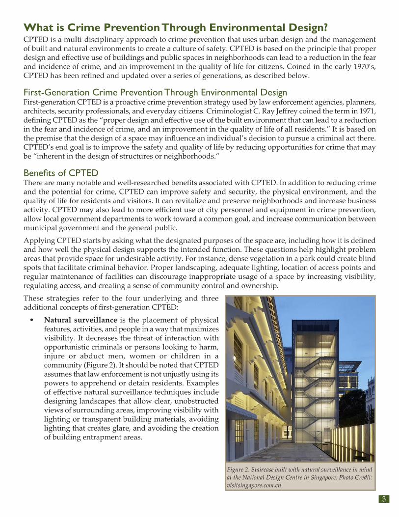
• Natural surveillance is the placement of physical features, activities, and people in a way that maximizes visibility. It decreases the threat of interaction with opportunistic criminals or persons looking to harm, injure or abduct men, women or children in a community (Figure 2). It should be noted that CPTED assumes that law enforcement is not unjustly using its powers to apprehend or detain residents. Examples of effective natural surveillance techniques include designing landscapes that allow clear, unobstructed views of surrounding areas, improving visibility with lighting or transparent building materials, avoiding lighting that creates glare, and avoiding the creation of building entrapment areas.
Figure 2. Staircase built with natural surveillance in mind at the National Design Centre in Singapore. Photo Credit: visitsingapore.com.cn

Naaman Williams Memorial Park CPTED Audit and Site Assessment4
• Natural access control means controlling access to a site and location (Figure 3). This can be done by ensuring entrances are visible, defining all entryways and highlighting the main entrance; marking public walkways and paths, and installing a wayfinding system for residents and visitors to the site.
• Territorial reinforcement refers to people’s sense of ownership and the use of physical attributes that express that ownership (Figure 4). It is an umbrella concept embodying all natural surveillance and access control principles. Examples include fencing, pavement treatments, signage and landscaping.
• Image maintenance and management refers to properly maintaining and managing a space that indicates active involvement of and guardianship and ownership among legitimate users (Figure 5). Examples include strategic and continued use of a space for its intended purpose(s), regular maintenance and care of a site, and branding and marking to serve as an additional expression of ownership of a site or area.
• Legitimate activity support refers to activities and uses that encourage legitimate users of a space (Figure 6).
• Target hardening refers to physical barriers that restrict access to an area.
• Geographical juxtaposition refers to the idea that an area’s surrounding environment can influence criminal behavior and safety in that space and vice-versa.
Because these strategies are meant to act in congruence with one another, specific techniques can serve the purpose of fulfilling multiple of the four concepts (Figure 7).
Figure 3. A well-defined access point and walkway to a commercial center. Photo Credit: Terrance Glover
Figure 4. Territorial reinforcement provides defined property lines and clear distinction between public, semi-private and private spaces. Photo Credit: Terrance Glover
Figure 5. An apartment complex entrance before and after maintenance, showing ownership and encourage legitimate activities. Photo Credit: ICP Consulting
Figure 6. Legitimate activity support provides facilities and infrastructures for legitimate activities to encourage public participation and enhance natural surveillance. Photo Credit: Level Crossing Removal Project
Figure 7. Natural surveillance access control, territorial reinforcement, and image management can be combined, like in this example next to a park. Photo Credit: Marc Howard
5
Second-Generation Crime Prevention Through Environmental DesignCPTED also focuses on how social environmental factors affect crime in the space, which involves considering how the community interacts with and defends their space, and how well their presence supports its intended functions. For instance, a community artwork initiative could brighten up a dark space, instill positive perceptions about it and increase its usage, thereby deterring illegitimate users. By providing community CPTED training and leadership opportunities, establishing resident teams, gathering community feedback and organizing community meetings and events, CPTED cultivates a sense of belonging and builds a platform for residents to take unified ownership of their environment.
The aforementioned strategies refer to the five underlying concepts of second-generation CPTED:
• Social cohesion refers to enhancing mutual respect and understanding in a community along with an appreciation for diversity and differences, as a cohesive community is more likely to be able to effectively undertake collective actions.
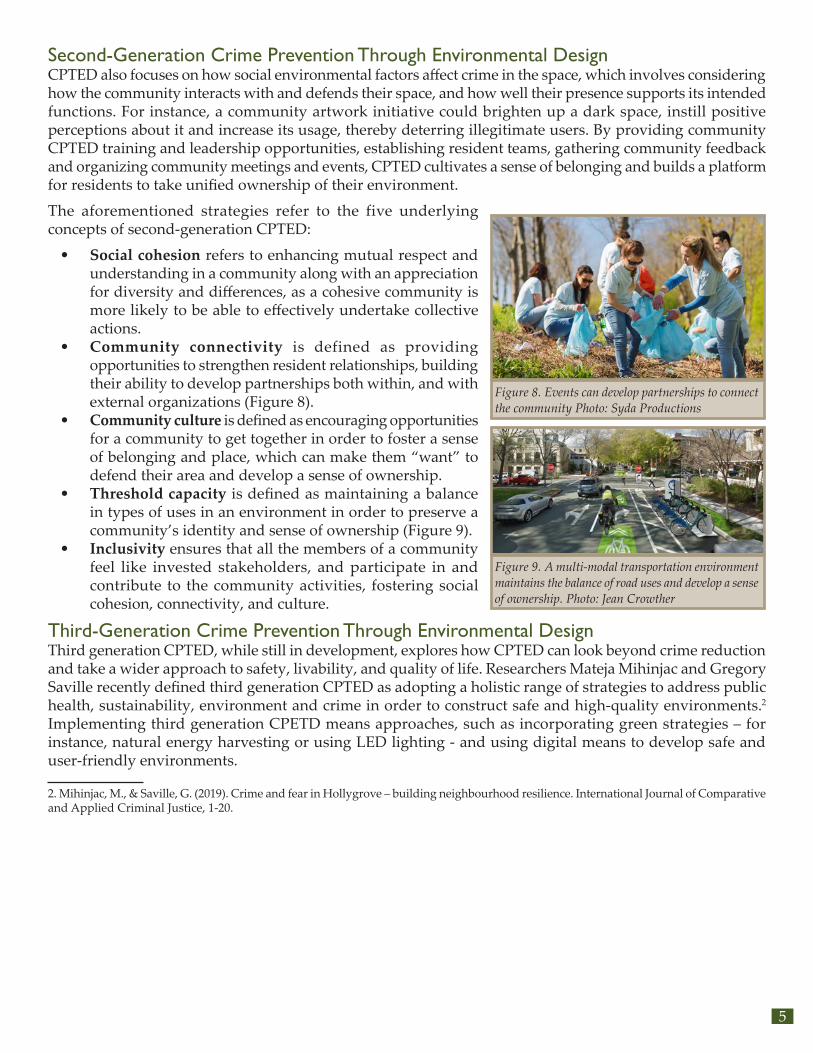
• Community connectivity is defined as providing opportunities to strengthen resident relationships, building their ability to develop partnerships both within, and with external organizations (Figure 8).
• Community culture is defined as encouraging opportunities for a community to get together in order to foster a sense of belonging and place, which can make them “want” to defend their area and develop a sense of ownership.
• Threshold capacity is defined as maintaining a balance in types of uses in an environment in order to preserve a community’s identity and sense of ownership (Figure 9).
• Inclusivity ensures that all the members of a community feel like invested stakeholders, and participate in and contribute to the community activities, fostering social cohesion, connectivity, and culture.
Third-Generation Crime Prevention Through Environmental DesignThird generation CPTED, while still in development, explores how CPTED can look beyond crime reduction and take a wider approach to safety, livability, and quality of life. Researchers Mateja Mihinjac and Gregory Saville recently defined third generation CPTED as adopting a holistic range of strategies to address public health, sustainability, environment and crime in order to construct safe and high-quality environments.2 Implementing third generation CPETD means approaches, such as incorporating green strategies – for instance, natural energy harvesting or using LED lighting - and using digital means to develop safe and user-friendly environments.
2. Mihinjac, M., & Saville, G. (2019). Crime and fear in Hollygrove – building neighbourhood resilience. International Journal of Comparative and Applied Criminal Justice, 1-20.
Figure 8. Events can develop partnerships to connect the community Photo: Syda Productions
Figure 9. A multi-modal transportation environment maintains the balance of road uses and develop a sense of ownership. Photo: Jean Crowther

Naaman Williams Memorial Park CPTED Audit and Site Assessment6
What is a Complete Street?Complete streets are roads designed for all users, all modes of transportation, and all ability levels (Figure 10). They balance the needs of drivers, pedestrians, bicyclists, transit riders, emergency responders, and goods movement based on the local context. Complete streets should tailor to the specific needs of the surrounding environment. A school zone, for instance, may require reduced speed limits, narrower travel lanes, and wider sidewalks to achieve a safer setting for students. Meanwhile, streets along transit routes should incorporate the needs of bus and rail commuters by installing benches, shelters, and enhanced lighting and signs.
Regardless of the context, complete streets should be designed to improve safety for pedestrians and bicyclists who are the most vulnerable road users. Reduced speed limits, raised medians, and other design elements can help create a safer environment for seniors, children, and people with disabilities.
To put traffic speeds into perspective, a 10 mph reduction in vehicle speed dramatically decreases the chance of pedestrian fatalities in a collision. The U.S. Department of Transportation (USDOT) cites collisions in which pedestrians are struck by a vehicle traveling 40 mph as being fatal 85 percent of the time. Comparatively, at 30 mph, pedestrian fatality rates drop to 45 percent, and down to five percent at 20 mph (Figure 11 and Figure 12). Complete streets recognize that all users of the transportation network, whether traveling by car, bus, train, or taxi, become a pedestrian at some point during their journey. Creating a safer environment benefits everyone.
Figure 10. A complete street, as seen in New Brunswick, New Jersey. No two complete streets are alike, as they should always reflect the context of the street and the character of the community.
Figure 11. Graphic showing increased fatality rate as vehicle speeds increase.
Figure 12. Graphic showing increased stopping distance as vehicle speeds increase.

7
Benefits of Complete StreetsWhile the primary benefit of complete streets is improved safety for all roadway users, there are other positive outcomes. Complete streets create better places to live, work, and do business. These benefits include mobility, equity, health, quality of life, economic vitality, and environmental health.
MobilityCreating or enhancing multi-modal transportation options expands mobility opportunities for everyone, including nondrivers, youth, and senior citizens (Figure 13). In turn, increased mobility improves access to jobs and services, which is crucial for people who cannot afford or choose not to own a car, as well as those who are unable to drive due to a disability or their age.
EquityComplete streets help decrease the necessity of the automobile for access to opportunity. Transportation costs comprise a significant portion of a household budget, approximately 20 percent in the United States. Much of this is due to the high cost of automobile ownership, including insurance, fuel, maintenance, registration fees, and financing. However, household transportation costs drop to just 9 percent in communities with improved street connectivity and accommodations for other modes.
Connected communities allow residents to use less energy and spend less money to get around, allowing for fewer car trips and the use of other less expensive modes of transportation like bicycling, walking, or public transit. Providing a variety of transportation choices across different price points allows families to free up more money for housing or other needs.
HealthComplete streets enhance opportunities for increased walking and bicycling which in turn leads to the numerous health benefits associated with increased physical activity. The Center for Disease Control (CDC) supports complete streets to combat obesity (Figure 14).
Quality of LifeLivable, walkable communities diminish the need for automobiles. Walking or bicycling around town creates a sociable environment, fostering interactions between family, friends, or clients and increasing community involvement. These interactions, in turn, entice users to enjoy the surroundings they would otherwise ignore in a car. A reduction in vehicle use can also increase the quality of life thanks to reductions in noise and stress associated with congestion and crashes (Figure 15).
Figure 13. When a street lacks accessible sidewalks and ramps, it is not complete.
Figure 14. Trails, such as this one in Monroe, New Jersey, can encourage exercise and lead to improved health.
Figure 15. Complete Streets in Asbury Park help foster a lively social environment.

Naaman Williams Memorial Park CPTED Audit and Site Assessment8
Economic VitalityImproving streetscapes revitalizes business districts. Complete streets generate more foot traffic when they create great places where people want to be, which can encourage both residents and visitors to spend more money at local shops and restaurants that they may have driven past before. Such is the experience in Somerville, New Jersey, where one block of Division Street was converted to a pedestrian plaza. The area witnessed a sharp decline in vacant commercial properties; vacancy dropped from 50 percent to zero after the plaza was developed (Figure 16)1.
Environmental HealthBy reducing automobile use, complete streets can contribute to cleaner air. Additional sustainable design elements installed along complete streets can also bring other environmental benefits. For example, landscape improvements (green streets) can reduce impervious cover, reduce or filter stormwater runoff, and contribute to water quality improvement. (Figure 17).
Complete Streets in New Jersey, Somerset County, and Franklin TownshipNew Jersey is a national leader in the complete streets movement. In 2009, NJDOT was among the first state departments of transportation (DOTs) in the nation to adopt an internal complete streets policy. In 2010, the National Complete Streets Coalition ranked that policy first among 210 state, regional, county, and municipal policies nationwide. Since 2009, NJDOT has funded five Complete Streets Summits, and over a dozen local, regional and statewide in-person and online educational workshops intended to disseminate the latest information about complete streets to planners, engineers, elected officials, and advocates. In 2017, NJDOT released the New Jersey Complete Streets Design Guide to inform New Jersey communities on how to implement complete streets projects. In 2019, NJDOT released the Complete & Green Streets for All: Model Complete Streets Policy and Guide to serve as a new resource for local best practices in policy language. One of the positive outcomes of these efforts is that communities of all sizes throughout the state have joined NJDOT in adopting complete streets policies. Of New Jersey’s 21 counties, eight have adopted complete streets policies. Additionally, 167 municipalities have implemented complete streets policies affecting 3.8 million (44 percent) of the state’s residents (Figure 18).
Both Somerset County and Franklin Township have enacted policies in support of complete streets. Franklin Township passed a complete streets policy in 2019, in which the township council resolved to “provide safe and accessible accommodations for existing and future pedestrian, bicycling and transit facilities” that “consider opportunities to improve public health through promotion of healthy lifestyles and improving mental and physical health,” including “increasing health and wellness benefits by improving access to necessary amenities for vulnerable populations; and increasing the sense of social connectivity and sense of belonging to a community.” Somerset County passed its complete streets policy in October, 2016.
1. “Complete Streets Case Study: Somerville, New Jersey,” Alan M. Voorhees Transportation Center, 2016.
Figure 16. Division Street in Somerville was converted into a pedestrian plaza that has become a popular gathering space.
Figure 17. Green infrastructure used to narrow the roadway and provide a shorter crossing distance for pedestrians.

9
Figure 18. Complete Streets Policies in New Jersey, as of October 15, 2020. Visit http://njbikeped.org/services/complete-streets-policy-compilation/ for a constantly updated list of policies.
Naaman Williams Memorial Park CPTED Audit and Site Assessment10
Linking CPTED and Complete StreetsMany researchers have investigated the connection between complete streets and CPTED, particularly regarding increasing active transportation, physical activity, and the use of parks and open space. Below are a few examples of evidence from the literature that support this important connection, particularly in the context of increasing safety in and around Naaman Williams Memorial Park:
Active TransportationExisting research on the relationship between CPTED and walking and bicycling shows that CPTED can be used to reduce crime and fear of crime and increase pedestrian usage.,3 Researchers studied walking in 12 crime-ridden neighborhoods with CPTED improvements (experimental group) in Seoul, South Korea in comparison to 12 similar neighborhoods without improvements (control group) and found that the participants in the experimental group walked more and were less afraid of crime than those in the control group.4 Additionally, the analysis found that CPTED elements such as lighting, maintenance, and presence of closed-circuit television (CCTV) cameras had a significant effect on reducing the fear of crime. Reducing the fear of crime also had a significant effect on increasing walking, as additional research suggests that people are more likely to be physically active in areas that are safe or are perceived to be safe.5 Another study that surveyed adults in Forsyth County, North Carolina and Jackson, Mississippi found people’s perceptions of safety are correlated with increased outdoor physical activity, which included walking and bicycling.6
TrailsResearchers examined the design characteristics of three urban trails and found that CPTED elements such as lighting, location of access points, condition of facilities, and vegetation density, affected real and perceived safety and correlated with trail usage.7 An article featured in the National Recreation and Park Association newsletter notes that CPTED can be used to address perception of trail safety through engineering and design.8 Landscape architects who presented at the International Trails Symposium revealed how CPTED could be incorporated into the design and development of trails to enhance safety from the starting stage of a project.9 Numerous trail master plans, and planning and feasibility studies also refer to CPTED as a design guideline or objective focused on developing a safe environment for users.10,11,12,13
Parks and Open Space Existing research examining the relationship between CPTED and safety in parks and open space suggests that the physical layout and design of parks and open spaces aids in minimizing crime and fear of crime associated with park usage.14 A study that analyzed people’s perception of safety in three urban parks in Malaysia found that CPTED strategies such as lighting, visibility, landscaping, and park design are important
3. Painter, K. (1996). The influence of street lighting improvements on crime, fear and pedestrian street use, after dark. Landscape and Urban Planning 35, 193-201.4. Lee, J. S., Park, S., & Jung, S. (2016). Effect of Crime Prevention through Environmental Design (CPTED) Measures on Active Living and Fear of Crime. Sustainability.5. Harrison, R. A., Gemmell, I., & Heller, R. (2006). The population effect of crime and neighbourhood on physical activity: An analysis of 15,461 adults. Journal of Epidemiology & Community Health, 34-39.6. McGinn, A. P., Evenson, K. R., Herring, A. H., Huston, S. L., & Rodriguez, D. A. (2008). The Association of Perceived and Objectively Measured Crime With Physical Activity: A Cross-Sectional Analysis. Journal of Physical Activity and Health, 117-131.7. Reynolds, K. D., Wolch, J., Byrne, J., Chow, C.-P., Feng, G., Weaver, S., & Jerrett, M. (2007). Trail Characteristics as Correlates of Urban Trail Use. American Journal of Health Promotion, 21(4), 335-345.8. Young, M. A. (2014, July 1). Trail Safety: The Perception and Reality. Retrieved April 2020, from National Recreation and Park Association: https://www.nrpa.org/parks-recreation-magazine/2014/july/trail-safety-the-perception-and-reality/9. Storck, B., Walker, J. R., & Beyer, L. (2017). Reducing Crime One Trail at a Time. Retrieved from American Trails: https://www.americantrails.org/resources/reducing-crime-one-trail-at-a-time10. Alta Planning + Design, Iowa Bicycle Coalition. (2014). Marion Master Trails Plan - City of Marion, Iowa. City of Marion.11. Alta Planning + Design. (2015). Piedmont Greenway Triad Park/Reedy Fork Section - Feasibility Study. Piedmont Greenway.12. Alta Planning + Design. (2016). Flyway Trail Feasibility Study. Buffalo County Land & Trails Trust.13. Alta Planning + Design, Community Foundation of Greater Huntsville. (2019). Singing River Trail Master Plan. The Land Trust of North Alabama.14. Syed Othman Thani, S., Hashim, N., & Ismail, W. (2016). Surveillance by Design: Assessment using principles of Crime Prevention through Environmental Design (CPTED) in urban parks. Procedia - Social and Behavioral Sciences, 506-514.

11
to improve perceptions of safety in urban parks.15 Another study based in Sweden evaluated the use of CPTED principles to inventory safety in an urban park and found a direct relationship between crime hotspots and a park’s design and maintenance.16 Additionally, research used virtual environments to ask college students in the Mid-Atlantic region for their perception of safety and found that respondents perceived parks with CPTED principles as safer than those without CPTED.17 These studies demonstrate that design and maintenance of open spaces is an essential concept that needs to be considered in planning and development, which can be achieved through CPTED.
This is even more important in communities where studies have found a direct relationship between crime or fear of crime and parks and open space usage. A survey of residents in Greater Cleveland found that one-third of the respondents in the low-income category reported that they were afraid of using parks because of crime.18 Another study examined crime rates in Philadelphia, and found that crime was higher around neighborhood parks compared to the city as a whole.19 The analysis further found that parks in residential areas had higher crime levels than those in non-residential areas that have a higher level of natural surveillance. Additionally, a 2016 analysis of over 1,000 parks in New York City demonstrated that crime in parks increased from 2015 to 2016—rapes grew by 40 percent, felony assaults by 34 percent, robberies increased by 15 percent, and murders increased from two to six.20
Community Engagement and Leadership ModelsThe second-generation principles of CPTED provide a working means for residents to actively participate in the process, fostering community building, developing their ability to implement social programming and reinforcing a community’s presence in their environment.21,22 Research indicates that resident participation in adopting CPTED strategies (even simple cleanup, greening, or painting exercises) could enhance the neighborhood’s social ties and feelings of cohesion. A study of an inner-city neighborhood in Chicago, found community-engaged greening efforts could bolster informal interactions and strengthen neighborhood social ties.23 Another study of CPTED interventions in a residential neighborhood in Penang, Malaysia found that residents involved in the project perceived a higher level of social cohesion in their communities.24
CPTED has been used as a platform to involve residents in neighborhood improvements, enabling coordination and interaction between a variety of stakeholders ranging from residents and local businesses to local government and law enforcement. It has been combined with elements of complete streets to enhance and improve the overall safety of residents and visitors of a site, trail, park or open space, particularly in regard to real and perceived traffic and personal safety. These examples can be applied to improve safety in and around Naaman Williams Park, the goal of this project.
15. Thani, S. K., Hashim, N. H., & Ismail, W. H. (2016, October 16). Surveillance by Design: Assessment Using Principles of Crime Prevention through Environmental Design (CPTED) in Urban Parks. Procedia - Social and Behavioral Sciences, 234, 506-514.16. Iqbal, A., & Ceccato, V. (2016). Is CPTED Useful to Guide the Inventory of Safety in Parks? A Study Case in Stockholm, Sweden. International Criminal Justice Review, 26(2), 150-168.17. McCormick, J. G. (2006). Empirically Testing the Principles of Crime Prevention Through Environmental Design (CPTED) Theory: An Explanatory Investigation of Perceived Safety in Virtual Parks and Green Spaces. Theses, Dissertations & Honors Papers, Longwood University.18. Scott, D., & Munson, W. (1994). Perceived Constraints to Park Usage Among Individuals With Low Incomes. Journal of Park and Recreation Administration, 12(4), 79-96.19. Groff, E., & McCord, E. S. (2012). The Role of Neighborhood Parks as Crime Generators. Security Journal, 25, 1-24.20. News 4 New York, New York Parks Advocates. (2016, August 8). Violent Crime on the Rise in NYC Parks. Retrieved from NBC New York: https://www.nbcnewyork.com/news/local/violent-crime-on-the-rise-in-nyc-parks/989516/21. Saville, G., & Cleveland, G. (1998). 2ND GENERATION CPTED: An Antidote to the Social Y2K Virus of Urban Design. 3rd International CPTED Association Conference. Washington, D.C.22. Cozens, P., & Love, T. (2015). A Review and Current Status of Crime Prevention through Environmental Design (CPTED). Journal of Planning Literature, 1-20.23. Kuo, F. E., Sullivan, W. J., Coley, R. L., & Brunson, L. (1998). Fertile Ground for Community: Inner-City Neighborhood Common Spaces. American Journal of Community Psychology, 823-851.24. Abdullah, A., H. Marzbali, M., & M. Tilaki, M. J. (2013). Predicting the influence of CPTED on perceived neighbourhood cohesion: Considering differences across age. Journal of Environmental Psychology, 54-64.

Naaman Williams Memorial Park CPTED Audit and Site Assessment12
Naaman Williams Memorial ParkStudy AreaThe project kicked off March 31, 2020 with a meeting that included the project team, Franklin Township elected officials, police officers, staff, and residents. At the meeting, the Township requested the project boundary be expanded beyond Naaman Williams Memorial Park to include the areas immediately surrounding the park (see Figure 1). This request was based on a number of factors including recent and proposed developments; reported and anecdotal criminal activity; vehicular and pedestrian movement and behaviors; and feedback from residents, businesses, and other stakeholders who stated the ways in which the surrounding areas impact perceptions of safety in the area. The study area was expanded to an area bordered by following streets: Matilda Avenue between Hamilton Street and Ray Street; Ray Street between Matilda Avenue and Juliet Avenue; Juliet Avenue between Ray Street and NJ Route 27; NJ Route 27 between Juliet Avenue and Franklin Boulevard; Franklin Boulevard between NJ Route 27 and Hamilton Street; and Hamilton Street between Franklin Boulevard and Matilda Avenue.
Naaman Williams Memorial Park is a 17-acre active park within the most densely populated area of Franklin Township, New Jersey. Franklin Township is in Somerset County along the Raritan River. It has a population of 65,452 with a median age of 41.2 years and a median household income of $95,799. The Township’s 5.8 percent poverty rate is only slightly higher than the county’s poverty rate of 4.7 percent. However, the 10.4 percent poverty rate of the Naaman Williams Memorial Park’s census tract (533) is double that of the county, and the park’s surrounding census tract (532) is triple the township percentage at 15.1 percent. While the percentage of Hispanic or Latino populations in Franklin Township is 14.4 percent, roughly equal to the county’s 14.5 percent, about 43.5 percent of the park census tract, and 25.5 percent of its surrounding census tract populations are Hispanic or Latino. Overall, both the park and its surrounding tract have a significantly higher concentration of racial/ethnic minorities–81.7 percent and 78.8 percent of their residents respectively–than the Township overall, which is 64.6 percent racial/ethnic minorities (US Census, 2018).
About 9.6 percent of Naaman Williams Memorial Park’s census tract households do not own a car compared to 2.2 percent in Somerset County. Approximately 12.3 percent of the individuals within this tract walk, 11.9 percent carpool, and 3.1 percent take transit to work, compared to Franklin Township’s 2.7 percent who walk, 8.5 percent who carpool, and 7.8 percent who take transit. Within the tract surrounding the park, fewer workers take transit compared to the Township but a higher share of them walk and carpool: 6.2 percent walk, 19.4 percent carpool, and 3.7 percent take transit for commuting.
Figure 19. Looking south over Naaman Williams Memorial Park.

13
Naaman Williams Memorial Park is a widely used public space, particularly during warm weather, and serves as a hub for recreation, exercise, sports activities and community events in Franklin Township. The park has a baseball field, handball court, basketball and tennis courts, bathrooms, walking/biking paths, picnic facilities, several playgrounds, a community pool, a spray park, and a large open field for play and community activities. While the park is accessible to pedestrians from all different sides, its primary entrance points are via Matilda Avenue on the east, Mark Street on the north, and Parkside, Minetta, and Fuller streets on the west. Visitors who drive to the park can access parking through the Matilda Avenue and Fuller Street entrances.
Most of Naaman Williams Memorial Park is immediately surrounded by residential developments, including Parkside Senior Housing and Leewood Renaissance. Both complexes include affordable housing units, as do other multi-family housing developments north of Hamilton Street, west of Franklin Boulevard, and east of Matilda Avenue. There is a park-and-ride lot near the western entrance, between the park and Parkside Senior Housing. Township officials noted that people who park in the lot cut through the park to get to the other side, rather than walking around it.
Residents and township officials said wetlands at the south-eastern portion of the park hinder daytime and nighttime visibility creating challenges. Although the park closes at sundown, this area can be easily accessed from High and Koolidge streets and attracts illegitimate uses. Franklin Township Police Department routinely patrols the area and conducts frequent park checks to prevent and deter crime. The department also offers a crime watch program, which gives the public a safe way to report suspicious activity as well as crime prevention guidelines to help secure local household safety.
Naaman Williams Memorial Park is also near two emphasis areas for Franklin Township: Hamilton Street Mixed Use Corridor and the Renaissance Redevelopment Area, the latter of which is centered on NJ Route 27 (Somerset Street). These areas are the focus of the township’s revitalization efforts, and have been redeveloped with a mix of commercial and residential uses, including several hundred units of affordable and senior housing units that are within a five minute walk of the park.
Assessment of NeedNaaman Williams Memorial Park is a vital community resource for all residents and visitors, but particularly those proximate to the park, many of whom are low-income and identify as a racial and ethnic minority. The park provides both active and passive recreational health and fitness opportunities to the township year-round. However, the park is in an area that also sees a high number of aggravated assaults and non-fatal shootings, according to annual crime data and testimonials. During the project kick-off meeting, Franklin officials said incidents mostly occur after the park —which has no cameras— closes and cannot depend on the collective supervision of its users. In some cases, sanctioned uses, like birthday parties, have escalated into dangerous situations, which is what happened in May 2019, when there was a fatal shooting in the park.
While the township has seen an overall reduction in crime in the study area, it still sees a disproportionately high amount of the crime. The CPTED audit complements Franklin’s ongoing safety and redevelopment efforts by offering new opportunities for reducing crime in the area. Additionally, these recommendations could assist the Township in tackling the negative perceptions of surrounding residents who continue to feel wary of the area.
Naaman Williams Memorial Park CPTED Audit and Site Assessment14
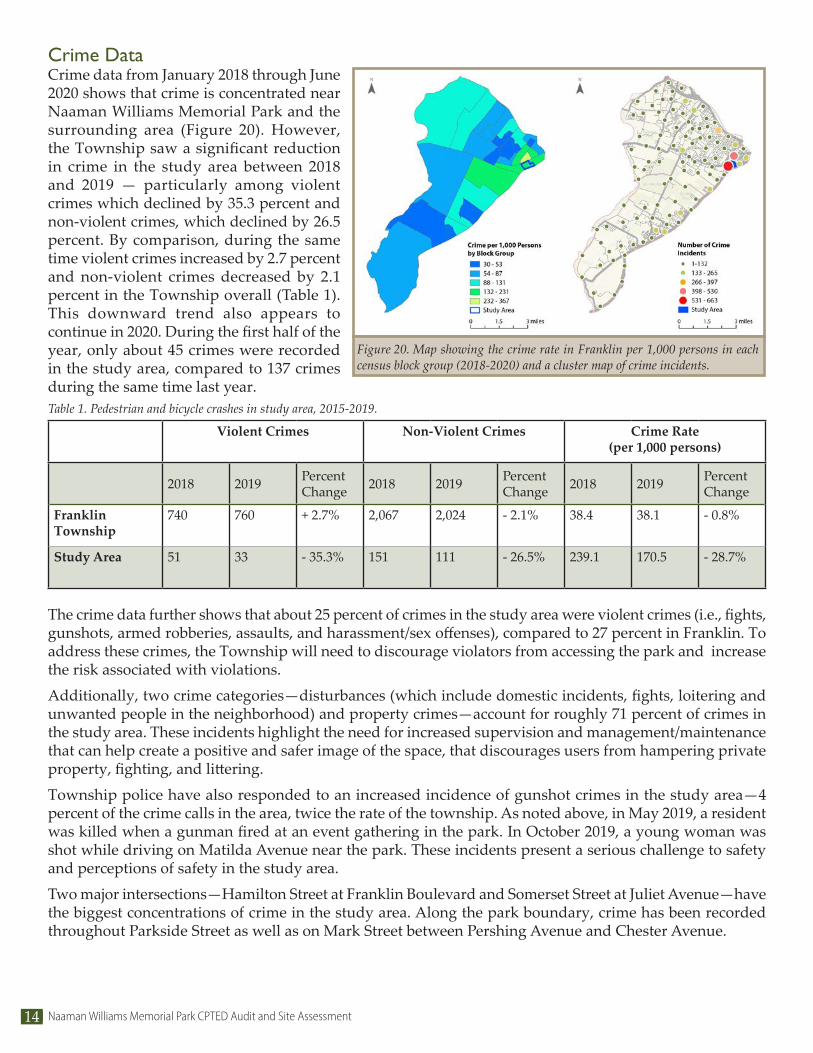
Crime DataCrime data from January 2018 through June 2020 shows that crime is concentrated near Naaman Williams Memorial Park and the surrounding area (Figure 20). However, the Township saw a significant reduction in crime in the study area between 2018 and 2019 — particularly among violent crimes which declined by 35.3 percent and non-violent crimes, which declined by 26.5 percent. By comparison, during the same time violent crimes increased by 2.7 percent and non-violent crimes decreased by 2.1 percent in the Township overall (Table 1). This downward trend also appears to continue in 2020. During the first half of the year, only about 45 crimes were recorded in the study area, compared to 137 crimes during the same time last year.
The crime data further shows that about 25 percent of crimes in the study area were violent crimes (i.e., fights, gunshots, armed robberies, assaults, and harassment/sex offenses), compared to 27 percent in Franklin. To address these crimes, the Township will need to discourage violators from accessing the park and increase the risk associated with violations.
Additionally, two crime categories—disturbances (which include domestic incidents, fights, loitering and unwanted people in the neighborhood) and property crimes—account for roughly 71 percent of crimes in the study area. These incidents highlight the need for increased supervision and management/maintenance that can help create a positive and safer image of the space, that discourages users from hampering private property, fighting, and littering.
Township police have also responded to an increased incidence of gunshot crimes in the study area—4 percent of the crime calls in the area, twice the rate of the township. As noted above, in May 2019, a resident was killed when a gunman fired at an event gathering in the park. In October 2019, a young woman was shot while driving on Matilda Avenue near the park. These incidents present a serious challenge to safety and perceptions of safety in the study area.
Two major intersections—Hamilton Street at Franklin Boulevard and Somerset Street at Juliet Avenue—have the biggest concentrations of crime in the study area. Along the park boundary, crime has been recorded throughout Parkside Street as well as on Mark Street between Pershing Avenue and Chester Avenue.
Figure 20. Map showing the crime rate in Franklin per 1,000 persons in each census block group (2018-2020) and a cluster map of crime incidents.
Violent Crimes Non-Violent Crimes Crime Rate (per 1,000 persons)
2018 2019 Percent Change 2018 2019 Percent
Change 2018 2019 Percent Change
Franklin Township
740 760 + 2.7% 2,067 2,024 - 2.1% 38.4 38.1 - 0.8%
Study Area 51 33 - 35.3% 151 111 - 26.5% 239.1 170.5 - 28.7%
Table 1. Pedestrian and bicycle crashes in study area, 2015-2019.

15
Crash DataNJDOT 2015 – 2019 Crash Data for the study area highlights the traffic safety challenges in bicycling, walking or driving to Naaman Williams Memorial Park from the surrounding areas. As seen in Figure 21, crashes in the study area are concentrated near the two largest intersections on Franklin Boulevard (at Hamilton Street and Somerset Street) and the three major roads in the area (Hamilton Street, Somerset Street, and Franklin Boulevard) that likely experience the greatest amount of traffic. There are no crash hotspots in the immediate park surroundings where most of the crashes occurred on intersections along Parkside Street, Millstone Road, and Davis Avenue.
Crime and Crash Data OverlaysFigure 22 depicts how crime and crash concentrations overlap in the Naaman Williams Memorial Park study area. It shows that the study area touches on multiple crime and crash hotspots, while the area adjacent to the park is relatively safer. Surrounding crime and crash hotspots include Hamilton Street near Franklin Boulevard and Norma Avenue; Franklin Boulevard near Somerset Street and Fuller Street; and Somerset Street at Juliet Avenue.
Traffic Route 27 had an AADT of 22,792 vehicles in 2018, according to the most recent data available from NJDOT. Franklin Boulevard, just south of Hamilton Street, had an AADT of 12,782, while Hamilton Street, west of the study area, had a traffic volume of 15,016.
Figure 21. Map showing the location of vehicle crashes in the study area, 2015-2019.
Figure 22. Map showing the location of crime incident and vehicle crash hotspots 2015-2019.

Naaman Williams Memorial Park CPTED Audit and Site Assessment16
CPTED Safety Audit and AssessmentNaaman Williams Memorial Park Community SurveyNaaman Williams Memorial Park was one of 12 parks in nine communities where VTC conducted a pedestrian intercept survey in the summer and early fall of 2019. The surveys were part of the “New Jersey Access to Open Space Report” commissioned by NJDOT. The study investigated how people use public open spaces in New Jersey, and included questions on proximity to open space, distance, mode of access, ease of access by sidewalks and bike lanes, frequency of use, purpose of use, attractive park attributes, reasons for not using open spaces more often, specific types of barriers to using open spaces, the use of activity monitoring devices such as Fitbit, and also several questions pertaining to demographic and socioeconomic attributes of the respondents. For access to the full report visit: http://njbikeped.org/wp-content/uploads/Report-draft-3.0.pdf
VTC engaged potential respondents inside and outside the park. Of the 30 people that responded to the Naaman Williams Park survey, the majority were Somerset residents and identified racially as Black or African-America and ethnically as Hispanic. The majority were also male, between the ages of 45 to 54 years old, have a high school or GED diploma, have some college but no degree, and have full-time employment with access to two or more cars in the household.
When asked about their purpose for visiting the park along with how frequently they visit and the travel mode they used most frequently to get there, respondents reported visiting the park five or more times a week, with some staying less than five minutes and others staying between 15 to 19 minutes. The majority consider it “very easy” to walk to the park and walk as their most preferred travel option. Although many stated that they would drive when they can’t walk to the park, they were divided on the ease of bicycling to the park. Their main purposes for visiting the park were to walk, supervise or play with children, relax, and socialize with friends and family, in that order.
When asked about their specific park needs and concerns, most respondents were concerned about being a victim of a crime, being stopped by police, and being attacked by animals and insects while at or in the park. Survey respondents listed parking lots/areas, benches and places to sit and relax, year-round restrooms, streetlights along the park’s paths and trails, picnic areas, and soccer and baseball fields as important park features they would like to see.
Two-Phased CPTED Safety Audit and AssessmentPhase 1 - Franklin Township Resident Safety Audit and AssessmentThe project kicked off in August 2020 with a Crime Prevention Through Environmental Design Educational Workshop. The CSTA team provided Franklin Township elected officials, police officers, staff, and residents a project overview, an introduction to first-, second-, and third-generation CPTED, a virtual photographical tour of Naaman Williams Park, and an overview and link to a CPTED Audit and Site Assessment Checklist. The CTSA team strongly recommended that participants share the link so that as many residents as possible could watch the recorded meeting and conduct an individual and independent CPTED assessment of the park. The workshop was open to the public and advertised in both English and Spanish. The CSTA team also had bilingual staff in attendance. Sixty-four people registered for the public meeting and 44 participated.
In October 2020 the CSTA Team hosted a Crime Prevention Through Environmental Design Site Audit and Assessment Webinar to provide Franklin Township elected officials, police officers, staff, and residents a recap of the project overview and key highlights from the August meeting, as well as an introduction to the findings from the 2019 community survey and the initial findings from the 12 responses the CSTA team received to the online safety audit and assessment that was distributed at the first meeting. Lastly, the CSTA team shared initial findings from its own CPTED safety audit and assessment and reminded workshop participants to again share the link with other residents. Fifty-one people registered for the public meeting and 38 participated.

17
Phase 1 - Observations and Recommendations Due to COVID-19 restrictions and safety precautions, the CTSA team advised participants to conduct independent CPTED audits and safety assessments of the park or to practice social distancing when visiting the park with others. This process was developed as an alternative to the in-person group visit originally planned. The CSTA team received 12 responses from residents before the October 2020 workshop and an additional six responses from residents following the workshop. The most noted challenges/observations included: illegal dumping; alcohol and drug use; drug dealing; gun violence; gang activity; overgrown vegetation; park wetlands; police harassment; lack of security; tension between neighboring towns; and lighting spilling from the park into the residential neighborhood on Mark St (Figures 23-27).
When asked to identify which improvements they’d like to see in the park, the recommendations included: installation of security cameras in and around the park that could be monitored remotely; increased routine police patrols; complete closure and relocation of the park; organization of community clean ups; installing enhanced lighting in and around the park; and adding a police substation within the park so “dedicated officers would get to know the people who frequent the park and offer the desired safety and security.” Some recommendations were conflicting, for example, one person suggested eliminating or fencing off wetland areas, while another recommended making the wetlands more accessible and open to the park patrons.
Others noted the need for more “ongoing and regular open communication (with township officials), which is invaluable and will foster greater understanding and collaboration and minimize miscommunication;” “24/7 drone and security camera surveillance—as these cost saving steps will not only save money for the Township by reducing patrols but also prevent crime;” regular management and maintenance of bushes and hedges; and educating residents on how to recognize suspicious behavior and the need to not be afraid to report dangerous behavior.
The CSTA team would like to note that only 18 residents completed an independent CPTED audit and assessment. Therefore, while every one of these observations are important and valued, they do not necessarily reflect the opinions, needs, and concerns of all Franklin Township residents. Lastly, no photos were submitted by the residents that completed the CPTED safety audit and assessment.
Figure 23. Illegally dumped tires and other materials. Figure 24. Trash, including beer and liquor bottles.
Figure 25. Flooded areas. Figure 26. Graffiti. Figure 27. Visibility limited by vegetation.

Naaman Williams Memorial Park CPTED Audit and Site Assessment18
Phase 2 - CSTA Team Safety Audit and AssessmentDuring Phase 2, the CSTA team conducted an independent CPTED safety audit and site assessment to determine cultural, social, political, economic, and environmental factors that may impact the actual and perceived safety of the site for potential users. While adhering to COVID-19 restrictions and safely practicing social distancing, the CSTA team conducted both day and nighttime site visits to assess and investigate various design aspects of the park. The CSTA team was led by Charles T. Brown, MPA, CPD, LCI of VTC, who has a Crime Prevention Through Environmental Design Professional Designation (CPD) from the National Institute of Crime Prevention (NICP). The CSTA team conducted the assessment on various days throughout the summer using the same CPTED Audit and Site Assessment Checklist that was provided to Franklin Township residents for consistency across the project.
Phase 2 - Observations and RecommendationsGeneral Park ImpressionsNaaman Williams Memorial Park is a valuable public asset in Franklin Township. The neighborhood surrounding the park is home to a diverse mix of residential and commercial properties, including new developments and older structures. The First Baptist Church of Lincoln Gardens, located adjacent to the study area, is noted for its work supporting affordable housing in the neighborhood. The park is accessible by most modes of transport, is relatively large and open, offers a variety of active and passive recreational and social activities, and is home to attractive yet underutilized wetlands (Figure 28).
Due to a history of criminal activity, including physical assaults, robberies, drug use and dealings, shootings, and recent murder, the park has a reputation as a dangerous place among residents. However, during multiple field visits by CTSA team members in late summer and early fall of 2020, during both light and dark conditions, team members did not experience significant personal safety concerns. When questioned by the CSTA team, park patrons said the park has transitioned from a place of violence to one that is welcoming and safe to local families. Many said the park was much safer, nicer, cleaner and more attractive than in previous years. The observations and recommendations below highlight the CSTA team’s findings through the lens of CPTED and complete streets—revealing and balancing both positive and negative elements of the park.
Figure 28. The basketball courts at the park.

19
Natural SurveillanceThe overall location, layout, and placement of physical features and activities within the 17-acre Naaman Williams Memorial Park already provides a healthy amount of natural surveillance both during the day and at night. As shown in Figures 29 to 32, the residential homes fronting Mark Street and the senior facility along Parkside Street provide residents with unobstructed views of the park and thus the opportunity to monitor criminal behavior within and around it. With proper communication and trust in place between residents and law enforcement, this could severely decrease the threat of apprehension by opportunistic criminals or persons looking to harm men, women or children in the park and surrounding area.
There are, however, several areas within the park that do not maximize opportunities for natural surveillance and should be addressed in order to reduce the threat of apprehension and violence against local residents and park patrons. These areas include the portable toilets near the entrance to the park’s public restrooms, which are adjacent to the park entrance on Matilda Avenue; the overgrown landscaping area buffering the senior facility near the children’s play area next to Mark Street; the gazebo positioned between the children’s play area and the splash pool, which is also buffered from the senior facility by overgrown landscaping; the wetland area and community garden near the parking lot and path connecting the residential development along Irving Street and Pfeiffer Place; the wetland area near the center of the park and the area near the children’s play area near Koolidge Court and Matilda Avenue.
Figure 29. Homes overlooking the park. Figure 30. Senior apartments overlooking the park.
Figure 31. The park seen at night. Figure 32. The park, as seen from the residential neighborhood.

Naaman Williams Memorial Park CPTED Audit and Site Assessment20
Public Restroom/Porta PottiesWhile the park’s public restrooms are positioned in a place that allows for the maximum natural surveillance, the placement of portable restrooms reduce the natural surveillance for park patrons (Figure 33 and Figure 34). This is of particular concern for young children, teens, and women who are disproportionately more likely to be targeted by criminals. Coupled with the fact that they are adjacent to the parking lot, this increases the likelihood of apprehension. The CSTA team also noted during its visit that a large number of men were gathering and perceived as taking ownership of this area. Park patrons stated that this made them uncomfortable. It is not known whether this is the area of the park (or the gazebo; see below) where residents noted the drug use and dealing in the community surveys.
Recommendation: The township should realign the portable restrooms to align with the public restrooms and discourage patrons from gathering near the entrance for extended periods of time. The public restrooms should also be reopened and made available to park patrons to increase the number of available restrooms. Lastly, the township should consider installing cameras near this area.
Senior Facility Landscape BufferThe landscaping area that buffers the park and the children’s play area from the senior facility provides natural access control, territorial reinforcement, and natural surveillance from the senior facility. However, in its current state, its infrequent maintenance and overgrowth does not allow for clear, unobstructed views of the play area and parking lot. This provides opportunity for criminal activity and contributes to fear of harm against children at the playground (Figure 35).
Recommendation: The township should establish or adhere to its routine maintenance schedule to ensure that this area, as well as other landscaped areas throughout the park, are maintained with safety in mind. The township should also consider installing cameras near this area.
Figure 33. People congregating by the restrooms and Porta Potties.
Figure 34. The restrooms and Porta Potties.
Figure 35. The landscaping area between the playground and the senior facility on the right.

21
WetlandsThe wetland area is repeatedly mentioned as a point of contention and concern by park patrons and local residents. Due to its large size and overall lack of maintenance, the wetland area—while an important feature and asset to the community—reduces natural surveillance of park patrons at multiple locations. These include: the parking lot and path connecting the residential development along Irving Street and Pfeiffer Place; near the center of the park where women and children reported feeling isolated; and the children’s play area near Koolidge Court and Matilda Avenue, where parents expressed concerns about their children’s safety while enjoying some of the newer playground equipment (Figure 36 and Figure 37).
Recommendation: To significantly enhance natural surveillance and decrease personal safety concerns at these select wetland areas throughout the park, the township should consider design treatments that maximize legal access and utility of the wetlands for recreational and educational opportunities. This will help to continue the protection of the wetland area as a critical part of the natural environment, but also allow residents and park users to learn from its wide diversity of plants and animals. Figures 38 and 39 show examples of how other parks have created access to wetland areas while preserving them.
Figure 36. The wetland area, on the left, as seen from above.
Figure 37. The walking trail runs next to the wetland area.
Figure 38. An example of a walking path built over wetlands in a sustainable manner.
Figure 39. An example of a walking path built over wetlands in a sustainable manner.

Naaman Williams Memorial Park CPTED Audit and Site Assessment22
Natural Access ControlThe park employs a variety of methods of controlling pedestrian, bicyclist and vehicle access. This includes wooden posts that form a penetrable fence around the property boundary; the overgrown wetland area; the strategic placement of the parking lots and on-street parking; public walkways to and within the park itself; and local roadways that control the movement of cars in and around the site (Figure 40 and Figure 41).
However, outside of one Naaman Williams Memorial Park sign, which can easily be missed while traveling along Matilda Avenue, the park’s entryways are not clearly celebrated, marked, or branded in a way that ensures and defines entryways into the park. Similarly, there is no apparent wayfinding system in and around the park, which makes it difficult for visitors to locate parking spaces, restrooms, or the number of recreational and social activity locations across the 17-acre site.
Recommendation: In order to maximize natural access control, the township should install a map/wayfinding system in the parking lots adjacent to the park and brand key entryways. This will not only notify patrons of the park and ensure entrances are visible, but also enhance local pride and ownership of the park via banners at select locations within and around the park. The signs, placed at key locations, can also be used to let walkers and runners know how far they traveled during their exercise routines and point patrons to other attractions within the study area, particularly Hamilton Street (Figure 42).
Territorial ReinforcementGiven the fact that the park is bordered by Matilda Avenue to the east, Mark Street to the north, the large wetland area to south, and the senior facility to the west, territorial reinforcement is provided by the design of Naaman Williams Memorial Park. Similarly, the strategic placement of a low, penetrable wooden fence and landscaping throughout the park reinforces and expresses ownership. It is however important to note that one of the concerns parents shared is that the wooden fence does not protect children from running towards speeding cars along Matilda Avenue and Mark Street.
Recommendation: The township should consider reinforcing the existing wooden posts with an added barrier between each post or replacing the penetrable wooden posts with a low decorative fence that protects children from speeding cars along both streets. This will enhance overall aesthetics and strengthen territorial reinforcement (Figure 43).
Figure 40. An unpaved entrance to the park.
Figure 41. The wooden posts around the park as seen from above.
Figure 42. An example of a park sign, in Rahway, New Jersey.
Figure 43. Wooden fencing and informational signage.
23
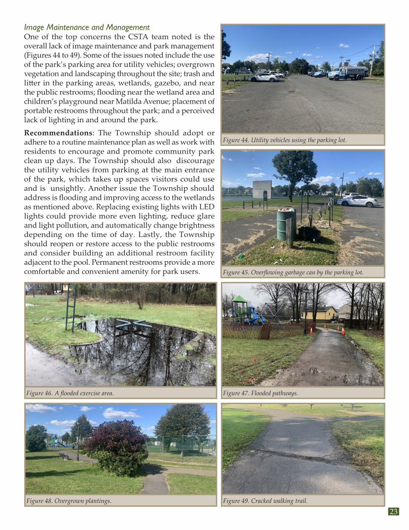
Image Maintenance and ManagementOne of the top concerns the CSTA team noted is the overall lack of image maintenance and park management (Figures 44 to 49). Some of the issues noted include the use of the park’s parking area for utility vehicles; overgrown vegetation and landscaping throughout the site; trash and litter in the parking areas, wetlands, gazebo, and near the public restrooms; flooding near the wetland area and children’s playground near Matilda Avenue; placement of portable restrooms throughout the park; and a perceived lack of lighting in and around the park.
Recommendations: The Township should adopt or adhere to a routine maintenance plan as well as work with residents to encourage and promote community park clean up days. The Township should also discourage the utility vehicles from parking at the main entrance of the park, which takes up spaces visitors could use and is unsightly. Another issue the Township should address is flooding and improving access to the wetlands as mentioned above. Replacing existing lights with LED lights could provide more even lighting, reduce glare and light pollution, and automatically change brightness depending on the time of day. Lastly, the Township should reopen or restore access to the public restrooms and consider building an additional restroom facility adjacent to the pool. Permanent restrooms provide a more comfortable and convenient amenity for park users.
Figure 44. Utility vehicles using the parking lot.
Figure 45. Overflowing garbage can by the parking lot.
Figure 46. A flooded exercise area. Figure 47. Flooded pathways.
Figure 48. Overgrown plantings. Figure 49. Cracked walking trail.

Naaman Williams Memorial Park CPTED Audit and Site Assessment24
Supporting Legitimate ActivityThe gazebo provides an excellent opportunity for parents, guardians, friends and family members to watch their loved ones as they enjoy the swimming pool and children’s playground (Figure 50). However, the CSTA team observed on several park visits, that like the area around the public restrooms described above, there is a perception that the gazebo area is reserved for a select number of young men who did not appreciate or welcome others into that space. For example, when a CSTA team member approached the gazebo during one visit, he was quickly questioned as to whether he was a law enforcement officer or “spy.” The CSTA team member also noted that the young-to-middle aged men were smoking marijuana, were very inhospitable, and were frequently making trips to and from their vehicles that were parked in the private parking area near the rear of the senior facility. It is now known whether this is an area where survey respondents observed drug use, as the responses did not specify the location. However, the CSTA team did not observe drug use in any other area.
Recommendations: The Township should consider allowing patrons to schedule use of gazebos by patrons, which can serve as a way to prevent unwanted drug or gang behavior from happening. The Police Department should also conduct routine foot patrols near this area and the Township can install signage to ensure that all park patrons have equal access to the gazebo. Lastly, the Township or Franklin Housing Authority should also enforce its parking laws and consider installing cameras near this area.
Geographical JuxtapositionThrough the community survey and discussions with CSTA team members, residents questioned whether the criminal activity in the park was a result of tension and hostility between Township residents and park patrons visiting from New Brunswick (Figure 51).
Recommendation: In order to address these issues, the township should work with residents, community organizations and others to develop an action plan centered in strengthening and promoting social cohesion, community connectivity, and inclusivity.
Figure 50. The gazebo, seen between the pool and playground. Figure 51. The Franklin/New Brunswick border is the roadway seen just beyond the townhouses.

25
Complete StreetsComplete atreets are streets that are designed, operated, and maintained with all users, all modes, and all abilities in mind. As discussed earlier in this report, it is important for the Township and the CSTA team to not only assess crime in the study area, but also to consider what role select streets play in increasing traffic safety and access in and around the park, particularly for residents and patrons who walk or bike to the park. Matilda Avenue, Mark Street, Somerset Street, Hamilton Street, Parkside Avenue, and Franklin Boulevard were selected for analysis based on crash and crime data, proximity to the park and feedback from residents. Below are recommendations for these roads.
Matilda AvenueMatilda Avenue is the main roadway providing vehicular access to the parking lot and entrance on the east side of Naaman Williams Memorial Park (Figure 52). With a posted speed limited of 25 mph, the street intersects with Hamilton Street to the north and Somerset Street (SR 27) to the south. The roadway width ranges from a minimum of 24 feet to a maximum of 30 feet, with one travel lane in each direction, limited pedestrian accommodations, and no on-street parking (Figure 53 and Figure 54).
Residents, park patrons, and the CSTA team observed speeding along the roadway and expressed the need for safer pedestrian and bicycle accommodations. Most of the vehicle crashes occurred at its intersection with Hamilton Avenue to the north. As such, the CSTA team proposes that the township reconfigure and restripe the roadway to add 5-foot sidewalks and 5-foot bicycle lanes on both sides from Hamilton Street to Ray Street, and bicycle sharrows (shared-lane markings) with sidewalks from Ray Street to Somerset Street (Figure 55 and Figure 56). This will reduce overall speeding and improve the safety, access, and mobility of pedestrians and bicyclists in and around the park.
Figure 52. Looking south over Matilda Avenue.
Figure 53. Matilda Ave., Somerset St. to Ray St., existing conditions.
Figure 54. Matilda Ave., Victor St. to Hamilton St., existing conditions.
Figure 55. Matilda Ave., Somerset St. to Ray St., proposed conditions.
Figure 56. Matilda Ave., Victor St. to Hamilton St., proposed conditions.

Naaman Williams Memorial Park CPTED Audit and Site Assessment26
Mark StreetMark Street is located on the north side of the park, connecting to Matilda Avenue to the northeast and Millstone Road to the southwest. The street has one travel lane in each direction with intermittent sidewalk on the north side of the roadway and on-street parking throughout. The street serves as a natural buffer and key connection between the residential development on the north and the park to the south (Figure 57 and 58).
While Mark Streets does not experience a high number of vehicle crashes relative to other streets in the study area, the CSTA team observed vehicles speeding along the roadway during the day and night. As shown in Figure 59, there is already a sign discouraging speeding along the roadway. During one of the site visits, residents discussed the need for speed bumps to reduce or eliminate the speeding. They expressed concern with their children safely crossing the street to the park from their homes to north. In fact, one parent even attempted to demonstrate how difficult it was to do so.
Chester Avenue terminates at Mark Street from the north, creating a T-intersection in front of the park. However, this intersection lacks marked crosswalks, and there is no paved connection to the walking trail within the park.
Given these findings, the CSTA recommends that the Township monitor and enforce speed limits on Mark Street via routine traffic patrols and consider adding speed bumps to slow traffic. This will ease residents’ concerns and increase the safety of children and adults traveling to and from the park.
There are several ways to improve the intersection with Chester Avenue. Marked crosswalks and a new pedestrian entrance to the park at Chester Avenue could provide increased access to the park for nearby residents at a relatively low cost. The Township should also consider creating a raised intersection, in place of speed bumps, to both calm traffic and provide a level entrance to the park for pedestrians. If that option does not prove feasible, curb extensions should be considered instead.
Figure 57. Looking north from the park to the intersection of Mark Street and Chester Avenue.
Figure 58. Looking north from the park to Mark Street.
Figure 59. Looking west on Mark Street, an advisory sign and a speed limit sign hidden behind tree branches.

27
Parkside StreetParkside Street is a residential street that intersects with Mark Street to the north and Somerset Street to the south. The roadway has one travel lane in each direction, with on-street parking and sidewalks on both sides of the roadway—except for the segment between Fuller Street and Somerset Street. The senior complex is accessed from Parkside Street (Figure 60).
Similar to Mark Street, the roadway does not experience a high number of vehicle crashes. However, the CSTA team did record several vehicles speeding on the roadway during the day and nighttime. This was surprising given the narrow width of the roadway. Given the roadways proximity to the park and senior facility, the CSTA team recommends that the township monitors and enforces speeding on the roadway via routine traffic patrols. Additionally, crosswalks, curb extensions, or a raised intersection at Minetta Street could both calm traffic and improve access to the park entrance that is already located there.
Hamilton Street (CR 514)The segment of Hamilton Street included in the study area intersects with Matilda Avenue to the east and Franklin Boulevard to the west. The mainly commercial corridor is approximately 40 feet wide, has a posted limit of 25 mph, AADT between 11,471 and 15,016, and one lane in each direction. The roadway has sidewalks on both sides; however, on-street parking availability varies from no parking to parking on both sides throughout this segment of the corridor (Figure 61). Of the streets within the study area, Hamilton Street is second only to Somerset Street, in terms of the number of vehicular crashes. Its intersection with Franklin Boulevard experiences the most crashes of the intersections on the roadway. The roadway does not have any bicycle accommodations.
Given the existing roadway width and AADT, the CSTA team proposes reconfiguring the roadway with one lane in each direction, parking on one side, and bicycle lanes on each side of the roadway (Figure 62). Approaching major intersections, the remaining parking lane should be replaced with a left turn lane as dictated by traffic volumes. This unfortunately requires the removal of some on-street parking. However, as research has shown, this greatly increases the safety of all modes with nominal impacts on vehicular travel time. Any changes made on Hamilton Street must be done in coordination with, and with the approval of Middlesex County, and consider the potential for future bus service, which is something township officials are interested in pursing.
Figure 60. On the left is the intersection of Parkside Street and Fuller Street. On the right is the intersection of Parkside Street and Minetta Street, which also provides access to the senior community.
Figure 61. Hamilton Street, existing conditions between Matilda Avenue and Norma Avenue.
Figure 62. Hamilton Street, proposed conditions between Matilda Avenue and Norma Avenue.

Naaman Williams Memorial Park CPTED Audit and Site Assessment28
Franklin BoulevardThe segment of Franklin Boulevard included in the study area intersects with Hamilton Avenue to the north and Somerset Street to the south. The mainly commercial corridor is approximately 44 feet wide, has a posted limit of 25 mph, AADT of 12,782, and two lanes in each direction. The roadway has sidewalks on both sides and no on-street parking. The street experiences a significant number of vehicle crashes, mainly at its intersections with Hamilton Street and Somerset Street. The roadway does not have any bicycle accommodations (Figure 63).
As shown in Figure 64, the CSTA team proposes a road diet with one lane in each direction, a center turn lane, and protected bicycle lanes on each side of the roadway. As research has shown, this greatly increases the safety of all modes with nominal impacts on vehicular travel time.
Somerset Street (Route 27)The segment of Somerset Street included in the study area intersects with Matilda Avenue to the east and Franklin Boulevard to the west. The commercial corridor is 46 feet wide, has a posted limit of 40 mph, AADT of 22,294, and two lanes in each direction. The roadway is under state jurisdiction and has sidewalks on both sides, with no on-street parking or bicycle accommodations (Figure 65). Of the streets within the study area, Somerset Street experiences the highest number of vehicle crashes, with the majority occurring at its intersection with Franklin Boulevard.
The CSTA team proposes that a study be undertaken to investigate the feasibility of a road diet or other changes to the roadway that could improve safety for pedestrians and bicyclists while accommodating or improving existing vehicle patterns. Any changes made on Somerset Street must be done in coordination with, and with the approval of NJDOT.
Figure 63. Franklin Boulevard, existing conditions between Field Street and Ellen Street.
Figure 64. Franklin Boulevard, proposed conditions between Field Street and Ellen Street.
Figure 65. Somerset Street, existing conditions between Millstone Road and Matilda Avenue.

29
Additional Recommendations 1. Institutionalize CPTED within Franklin Township The Township should pass an ordinance to establish a CPTED Task Force with representatives from law enforcement, public works, code enforcement, parks and recreation, faith-based communities, residents, business leaders, and other stakeholders. The Task Force members should be nominated and selected through a competitive process. The Task Force would report directly to the Mayor and Council and would develop an action plan to ensure that CPTED is fully incorporated and integrated into planning, development review, code enforcement and other municipal functions.
2. Advance and Prioritize Complete Streets ImplementationThe Township passed a complete streets policy in 2019; however, it has been slow to fully embrace and execute on its promise of providing “safe and accessible accommodations for existing and future pedestrian, bicycling and transit facilities” for all. In order to increase the safety, access and mobility of all modes, the Township should work diligently and intentionally to advance and prioritize complete streets implementation on municipally-owned roads, particularly those highlighted within the study area such as Matilda Avenue and Mark Street.
3. Install Cameras Strategically Around and Within the ParkOn several occasions, the Township mentioned that it was in the process of or considering installing cameras at Naaman Williams Memorial Park. The CSTA team strongly encourages the Township to move forward with the installation of cameras particularly at key points within and around the perimeter of the park. The proposed locations include both parking lots, near the public restroom facility, near the gazebo, near the children play areas, and one camera along Mark Street near the rear of the senior facility.
4. Execute a Routine Maintenance PlanIt is not known whether the Township has a routine maintenance plan for the park. However, based on the comments received from the community survey, insights from park patrons, and multiple CSTA team visits to the park, it appears that the current frequency of maintenance is inadequate. This is of critical importance given how vital park maintenance is to not only keeping the park attractive but also safe and operating efficiently to serve the needs of visitors and to protect the value of adjacent residential and community properties.
The Township should also work with the community to formally identify and acknowledge “park ambassadors” to organize periodic park clean up days. This will ensure that the community shares ownership in keeping the park safe and beautiful.
5. Maximize Access and Utility of the Wetland AreaAs mentioned earlier, park patrons and residents repeatedly cited the wetland area as a point of contention and concern. Although it is an important feature and asset to the community, the area’s large size and overall lack of maintenance reduces natural surveillance of park patrons at multiple locations. These include: near the parking lot and path connecting the residential development along Irving Street and Pfeiffer Place; near the center of the park where women and children reported feeling isolated; and the children’s play area near Koolidge Court and Matilda Avenue, where parents expressed concerns about their children’s safety while enjoying some of the newer playground equipment. To significantly enhance natural surveillance and decrease personal safety concerns at these select wetland areas throughout the park, the Township should consider design treatments that maximize access and utility of the park for recreational and educational opportunities. This will help to continue protecting the wetland area as a critical part of the natural environment but also allow residents and park users to learn from its wide diversity of plants and animals.

Naaman Williams Memorial Park CPTED Audit and Site Assessment30
6. Install Decorative Park Entrance and Wayfinding SignageWhile there is signage in the park, the entrances on main roads lack signs and wayfinding. Adding eye level signage along the main roads such as Matilda Avenue and Fuller/Irving Street would make it easier to locate park entrances. Additionally, the existing signs are less attractive than those at the entrance to Middlebush Park, which is across town (Figure 66). The Township should install a park map and wayfinding signage at strategic locations throughout the site so that park patrons are aware of all the park amenities, can better calculate walking and jogging distances, and can learn how to navigate to other attractions nearby, particularly along Hamilton Avenue and Somerset Street.
7. Encourage Police to Patrol the Area on FootThe Township should encourage police officers to not only patrol the area by car, but also to spend more time patrolling the park by foot. This will help establish and build relationships and familiarity with frequent park patrons and ensure that areas that are harder to access and monitor by car (e.g., the gazebo) are receiving the necessary attention to remain safe, clean, and welcoming for everyone.
8. Develop a Branding and Marketing PlanAlthough many township residents view Naaman Williams Memorial Park as dangerous, there are also many that feel the park has gone through a positive and rewarding transformation. To build upon this renewed sense of pride and ownership of the park, the Township should develop and execute a new branding and marketing strategy for the park. Generating positive news and placing cultural banners strategically around the park will signal that the park is safe, clean, and an asset for all residents and visitors.
9. Increase ProgrammingThe current size, location, and layout of the park provides many opportunities for increased year-round programming and events during the day and night. Currently, the park closes at night, so park patrons do not have an ample opportunity to enjoy all that the park has to offer. While it may appear that closing the park at night diminishes the opportunities for crime, this may not be the case, as case studies have shown hosting activities at night can diminish crimes after hours in the park. As such, the Township should create a strategic list of programming activities beyond organized sports and playground, offer tours of the wetland area—once it’s open to visitors—and bring food concessions along the park’s edge. Lastly, the Township should host nighttime activities such as music festivals (with community’s approval), outdoor movies, and organized tournaments. Of course, the expectation is that these events include law enforcement and community involvement to ease concerns about violence and noise.
Figure 66. Signage at Middlebush Park.
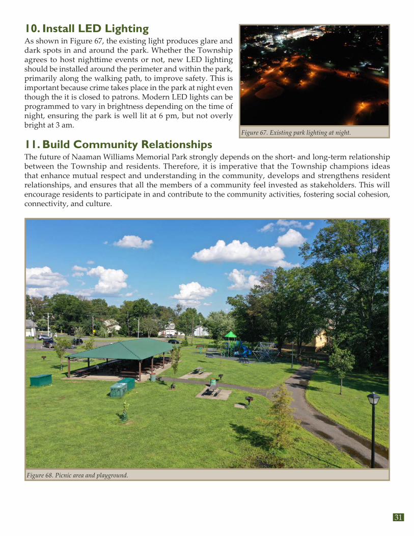
31
10. Install LED LightingAs shown in Figure 67, the existing light produces glare and dark spots in and around the park. Whether the Township agrees to host nighttime events or not, new LED lighting should be installed around the perimeter and within the park, primarily along the walking path, to improve safety. This is important because crime takes place in the park at night even though the it is closed to patrons. Modern LED lights can be programmed to vary in brightness depending on the time of night, ensuring the park is well lit at 6 pm, but not overly bright at 3 am.
11. Build Community Relationships The future of Naaman Williams Memorial Park strongly depends on the short- and long-term relationship between the Township and residents. Therefore, it is imperative that the Township champions ideas that enhance mutual respect and understanding in the community, develops and strengthens resident relationships, and ensures that all the members of a community feel invested as stakeholders. This will encourage residents to participate in and contribute to the community activities, fostering social cohesion, connectivity, and culture.
Figure 67. Existing park lighting at night.
Figure 68. Picnic area and playground.

Naaman Williams Memorial Park CPTED Audit and Site Assessment32

33
AppendixA. Additional Crime Maps
B. Workshop Flyers
C. Audit Form
D. Park Survey
E. Street Smart NJ Campaign Resources
F. Potential Funding Resources
G. Design Resources

Naaman Williams Memorial Park CPTED Audit and Site Assessment34
A. Additional Crime Maps
Disturbance Property Crime Violent Persons CrimeNon-Violent Persons Crime Gunshots Missing PersonsOther
1819, 27%
4980, 73%
Violent and Non-violent Crimes in Franklin Township (left) and the study area (right), 2018-2020
Note: The data ranges from January 2018 to June 2020.
97, 25%
294, 75%
Violent Crime
Non-violent Crime
20%
38%
18%
11%
2%5%
6%
41%
30%
14%
7%4% 3%1%
Crime Call Categories in Franklin Township (left) and the study area (right), 2018-2020

35

Naaman Williams Memorial Park CPTED Audit and Site Assessment36
B. Workshop Flyers
FRANKLIN IS INTERESTED in improving public safety at Naaman Williams Park and the surrounding community. The final product, a Crime Prevention Through Environmental Design (CPTED) Safety Audit and Assessment Report, will recommend a variety of changes to increase safe and positive uses of the park area.
Please join us in a virtual meeting to learn about making Franklin’s streets and open spaces safer from crime and provide your feedback! The meeting is open to all, pre-registration is required.
Naaman Williams ParkCrime Prevention Through Environmental Design
Workshop
ONLINE MEETING THURSDAY, AUGUST 6 , 2020 1 :00PM TO 2:30PM
For more information, email: [email protected] here: https://go.rutgers.edu/franklin
The Complete Streets Technical Assistance Program is a collaboration between Sustainable Jersey, the Voorhees Transportation Center at Rutgers University, and the North Jersey Transportation Planning Authority (NJTPA). Funded by the NJTPA, the program is designed to support municipal government efforts to advance complete streets initiatives.

37
FRANKLIN ESTÁ INTERESADO en mejorar la seguridad pública en el Parque Naaman Williams y la comunidad circundante. El producto final, un auditoria de seguridad e informe sobre la prevención del crimen a través del diseño ambiental, recomendará una variedad de cambios para aumentar los usos seguros y positivos del parque.
Por favor únete a nosotras en una reunión virtual para aprender cómo hacer que las calles y espacios abiertos de Franklin sean más seguros contra el crimen y para dar su opinión. La reunión está abierta a todos, pero se requiere inscripción previa.
Parque Naaman Williams
REUNIÓN VIRTUAL JUEVES, AGOSTO 6 , 2020 1 :00PM A 2:30PM
Regístrese aquí: https://go.rutgers.edu/franklin
El programa de asistencia técnica de calles completas es una colaboración entre Sustainable Jersey, el Voorhees Transportation Center de Rutgers University, y el North Jersey Transportation Planning Authority (NJTPA). Financiado por el NJTPA, el programa está diseñado para apoyar los esfuerzos del gobierno municipal para avanzar las iniciativas de calles completas.
Curso Práctico: Prevención del crimen a través del diseño ambiental
Para más información, envíe un correo electrónico: [email protected]

Naaman Williams Memorial Park CPTED Audit and Site Assessment38
FRANKLIN IS INTERESTED in improving public safety at Naaman Williams Memorial Park and the surrounding community. On August 6, 2020 a virtual Crime Prevention Through Environmental Design (CPTED) Workshop gave participants the opportunity to learn about safety and the built environment and how to use checklists to perform Safety Audits and Assessments. Based on input provided by the community during and after the presentation, the study team developed recommendations that aim to make Franklin’s streets and open spaces safer from crime. Your feedback is needed to help use finalize these recommendations.
Please join us in a virtual meeting to learn about the audit, assessment and view initial strategies to increase the overall use of the Naaman Williams Memorial Park. The meeting is open to all, pre-registration is required.
Register here: https://go.rutgers.edu/franklin2 For more information, email: [email protected]
The Complete Streets Technical Assistance Program is a collaboration between Sustainable Jersey, the Voorhees Transportation Center at Rutgers University, and the North Jersey Transportation Planning Authority (NJTPA). Funded by the NJTPA, the program is designed to support municipal government efforts to advance complete streets initiatives.
11:00AM TO 12:30PM WEDNESDAY, OCTOBER 7, 2020 ONLINE MEETING
Naaman Williams ParkCrime Prevention Through Environmental Design
Workshop

39
C. Audit Form
NAAMAN WILLIAMS PARK CRIME PREVENTION THROUGH ENVIRONMENTAL
DESIGN (CPTED) WORKSHOP FRANKLIN TOWNSHIP, NJ
CPTED AUDIT &
SITE ASSESSMENT CHECKLISTS
This walk audit form is a part of the Complete Streets Technical Assistance Program, which is a collaboration between Sustainable Jersey, the Voorhees Transportation Center at Rutgers University, and the North Jersey Transportation Planning Authority (NJTPA). Funded by the NJTPA, the program is designed to support municipal government efforts to advance complete streets initiatives.
This form is adapted from a version created by the State Graffiti Taskforce, Western Australia. Please submit your responses by August 20, 2020. When conducting the audit, photos and notes are incredibly valuable. Please send us your photos to Anne Heasley at [email protected].

Naaman Williams Memorial Park CPTED Audit and Site Assessment40
2
SAFETY AUDITS AND SITE SAFETY ASSESSMENTS and DESIGN CHECKLIST
Planning for a Site Assessment
Why Conduct a Site Assessment?
To determine community safety factors which increase actual and perceived
vulnerability for users
To determine measures and design applications which will enhance the safety of
a site for users
To identify measures and design application which will deter potential offenders
(for example, by increasing the actual or perceived risk of apprehension).
What do you look for during a Site Assessment?
Site assessments are undertaken by professionals with expertise in CPTED, who will
involve particular specialists as required, to provide comment and solutions on
community safety related issues that are within their areas of expertise (for example,
lighting, landscaping, urban design). During a Site Assessment the locations of
vulnerable areas or uses are noted. This can include community facilities, cultural
centres, parking lots, bus stops, open space, schools and colleges, key pedestrian routes
and public toilets.
Site Assessments also look at the potential presence of vulnerable groups, who they are,
how they use the area, whether they are potential or actual targets and why.
Two practical procedures are used to undertake an assessment of an area or site with
respect to community safety. These are the Site Assessment and Safety Audit.

41
3
What is a Site Assessment?
A Site Assessment is the process by which professionals and specialists assess a site by
applying Community Safety principles, to determine the factors that are impacting on the
actual and perceived safety of that site for potential users.
It also involves the input and analysis of a broader range of data that should include an
exploration of the wider social, economic and environmental issues. Recommendations
for improvements to the safety of the area are based on this assessment and Crime
Prevention Through Environmental Design principles.
A Site Assessment may include several site visits to assess and investigate various
design aspects of the area. It can also include a subjective process of assessment
known as a Safety Audit.
What is a Safety Audit?
A Safety Audit is a practical way to assess the perceived safety of an area. It involves
representatives of various sectors of the community assessing a site to identify those
factors that impact both negatively and positively on their feelings of safety. It typically
involves a group of people walking around a defined area, with each participant writing
their individual feelings down for later analysis. Participants may be given an overview of
the purpose of the audit prior to undertaking it, but there is no professional input during
the audit. A Safety Audit can be conducted at differing times of the day and night using
the same groups or individuals.
Outcomes from a Safety Audit can include suggestions of practical solutions for issues
that are recognised as having a negative impact on safety.
A Safety Audit allows for the detailed subjective interpretation of the environment from
the perspective of particular user groups (women, youth, people with disabilities), who
may see an area differently from professionals and experts.

Naaman Williams Memorial Park CPTED Audit and Site Assessment42
4
A Safety Audit should ensure that the changes made to an environment are relevant and
meet the needs of user groups. These changes may include:
Different weekend uses or users of an area
Location of generators/attractors for example, licensed premises and gathering
places
Potential for mixed uses/activities such as community events
Fixed activities in the daytime
Level of after hours usage
People’s perception, recognising that crime and perceptions of safety are related
to: gender, aged, mobility, level of disability, culture, etc
Public transit routes and shops – distance to residential areas
General appearance of the area
Lighting
Extent of housing mix
Police activity
Method and location of access to an areas by potential offenders
Existence of Neighbourhood or Business Watch
Role of other business or community bodies
Community development programs
Other programs/processes/systems in existence.
It is also important to take into consideration and anticipate, future trends likely to affect
the areas, including the social mix, and demographics such as age distribution,
education and employment, as well as the nature of catchments for potential offenders
and victims. Future police activity in the area and major change to the urban
infrastructure should also be considered.
Site assessments should be undertaken and submitted with a planning application by an
appropriately qualified professional. Any site assessment should consider a full range of
technical analyses and cover the following steps:-

43
5
Step 1 - Preparing for Site Assessments The following should be taken into account when planning a site assessment from a
safety perspective:
Define the site, context, development or related policies
What are the safety issues?
Who should you involve and/or consult in your assessment?
When to assess the site? Day or night, peak use times, special events times, over
what period?
Tools to take, camera, maps, video, clipboard, tape-recorder
What mode of transport to best assess access issues, e.g. walking, cycling, public
transit, motor vehicle or all?
What method? Full site assessment or safety audit? Step 2 - Assessment of Wider Context
When assessing the safety related issues of the wider spatial context, the following
should be taken into account:
Main pedestrian routes from activities to transit stops and car parking;
Car parking location;
Underpasses/overpasses/alleyways
Naaman Williams Memorial Park CPTED Audit and Site Assessment44
6
Step 3 - Taking account of Vulnerable Land Uses
The following vulnerable land uses should be taken into account when undertaking a site
assessment or safety audit:
Licensed premises – (including taverns, hotels, entertainment venues, licensed
clubs, off-premises bottle shops and nightclubs)
Large entertainment and recreational venues,
Large institutional uses (e.g. campuses, hospitals)
Schools
Parking lots (50 spaces and greater),
Any use operating at night-time (after 9.00pm) or over a 24 hour period - (ATM’s,
service stations, institutions or educational facilities, public transit interchanges);
Any large scale project considered to have wide ranging safety implications such
as (but not limited to) major shopping centres.
Public telephones
Public toilets
Automatic Teller Machines
Public open space, parks etc. Step 4 - Safety Through Other’s Eyes
When undertaking a site assessment or safety audit the following are issues related to
people which should be taken into consideration:
Footpath surfaces.
Distance between parking lots and entrances to facilities and shopping centres.
Safe facilities for children.
Safe movement from edges to centres.
Heights of signs.
Access to public transit.
Ease of mobility.

45
7
Consultation –
with different cultural groups to improve understanding of the design
environment;
with diverse gender identity and sexual orientation groups to understand
differences relating to different feelings of safety and different levels of fear;
with the aged and disabled on access, mobility, signage and safety.
Planning for a Safety Audit Why conduct a Safety Audit
It is recognised that poor urban design and management are contributing factors to fear
of crime in a community. However, those best placed to determine the factors that
contribute to fear of crime are often not the specialists or crime prevention professionals
but people who live, work or play in the community of interest. A Safety Audit involves
those user groups in identifying vulnerable areas and factors that contribute to, or detract
from feelings of safety in areas. It is a qualitative process that records subjective feelings
and perceptions from the participants as a means of identifying community safety issues.
Safety Audits can:
Identify factors that enhance the actual and perceived vulnerability of a site and
therefore, the potential problems
Provide guidance for future planning and building development
Assist in developing a sense of community ownership and responsibility.

Naaman Williams Memorial Park CPTED Audit and Site Assessment46
9
Audit Findings:
IDENTIFIED SITE ISSUES ARISING
(DIFFERENTIATE BETWEEN ACTUAL AND PERCEIVED)
SUGGESTIONS FOR CRIME PREVENTION STRATEGIES
CPTED PRINCIPLES INVOLVED
STAKEHOLDER INVOLVEMENT RECOMMENDED
1.
2.
3.
4.

47
Page 10
1. General Impressions What are your gut reactions to this place? How comfortable do you feel? What makes you feel this way?
2. Lighting How good is the lighting? Does it evenly illuminate the area or create shadows? Are any lights broken and are there any signs indicating who to report this to? Do trees or bushes obscure lighting? How well are pedestrian walkways illuminated? Are you able to identify a face 80 feet away? Does lighting illuminate directional signs or maps?
3. Signage Are there directional signs nearby? Are there signs to show you where to seek emergency assistance? What signs should be added?
4. Sightlines Can you see clearly what’s ahead, if not, why? Are there hiding places? Does landscaping block sightlines? What would make it easier to see? (angled corners, mirrors, trimmed bushes etc)
5. Isolation Does the area feel isolated? Is it easy to predict when people will be around? Do you feel safe waiting for public transit here? How far away is the nearest person to call for help? Is the area patrolled or monitored with surveillance equipment? Is the area designed to facilitate natural surveillance? (e.g. windows on the street vs. blank walls)
6. Movement Predictors How easy is it to predict a pedestrian’s route? Is there an alternative well-lit route? Can you see what is at the end of this route?
7. Entrapment sites Are there recessed areas that could be locked? e.g. alleyways. Are there small confined areas where someone could hide? (between garbage bins, doorways, construction sites)
CPTED AUDIT CHECKLIST (1)

Naaman Williams Memorial Park CPTED Audit and Site Assessment48
Page 11
8. Escape Routes How easy would it be for an offender to disappear? Is there more than one exit?
9. Activity uses How much activity is there in the area, during the day or at night? Does the activity levels provide for passive surveillance of the area? Are activity uses compatible with each other?
10. Maintenance Is there evidence of graffiti or vandalism? Is there litter lying around? Do you know who to report maintenance to? Does the place feel cared for? Are there other materials/textures/colours/features that would make the place feel safer?
11. Territorial Definition Is the site clearly defined? Are transitional zones defined? Is there conflicting use of space? Is there a clear definition between public and private space?

49
Page 12
CPTED AUDIT CHECKLIST (2)
SATISFACTORY UNSATISFACTORY Finding your way around 1. Lighting of safe routes 2. Sightlines 3. Signage 4. Hardware to summons help 5. Choice of pathway routes 6. Problem spots
Surveillance and visibility 7. Land use mix 8. Activity generation in public places 9. Social mix 10. Natural surveillance of gathering areas 11. Concealment opportunities 12. Building floor/ plans and observation/window placement 13. Site layout 14. Playgrounds 15. Pathways 16. Service areas 17. Public utilities – telephones, ATMs, bus shelters/ stops 18. Youth recreation facilities 19. Public toilets 20. After hours surveillance 21. Car parking 22. Fences and gates 23. Blind corner visibility
Landscaping 24. Mature vegetation 25. Planting size, type and number 26. Concealment opportunities 27. Sightlines 28. Relationship to lighting
Lighting 29. Lighting levels 30. Glare 31. Parking lot/underpass/overpass/crossing lighting 32. Lighting type/design 33. Ease of maintenance 34. Lighting of pedestrian routes 35. Needs of special groups 36. Relationship to landscaping Territorial Definition 37. Site definition 38. Transitional zones defined 39. Signs/cues 40. Territorial entrance – privacy 41. Conflicting space use 42. Licensed premises
Image 43. Maintenance
44. Graffiti and vandalism

Naaman Williams Memorial Park CPTED Audit and Site Assessment50
Page 13
Planning 45. Conflicting land uses 46. Land use mix 47. Social mix for interaction Management 48. Attention to needs of vulnerable groups activity 49. Management and maintenance 50. Opportunities for intervention 51. Transportation, location of bus stops in relation to 52. Surface materials/unevenness 53. Obstructions of pathways Building materials/structures/furniture 54. Vandal resistant materials 55. Level of maintenance 56. Street furniture 57. Quality of doors/shutters 58. Construction image Access/egress control 59. Entrance control systems – staff, hardware etc. 60. Entry points – number/location 61. Safe routes to parking lots/street 62. Fencing 63. Signage 64. Non legitimate user access 65. Alleyways 66. Overpasses/tunnels 67. Security hardware 68. Reception/high risk spaces 69. Windows and grilles 70. Balcony access 71. External storage 72. Visibility of post boxes
73. Separation of conflicting uses – pedestrian/vehicle/cyclist
Activity Uses 74. Current users 75. After hours use 76. Activity conflict

51
D. Park Survey
NJ ACCESS TO OPEN SPACE SURVEYThe Alan M. Voorhees Transportation Center (VTC) at Rutgers, The State University of New Jersey, invites you to participate in a study for the New Jersey Department of Transportation. The purpose of this research is to identify NJ residents’ needs and barriers to access local parks. Your participation will influence recommendations for new policies to promote safe access to parks throughout New Jersey.
This survey should take you between 5 and 10 minutes to complete. Your participation in the survey is completely voluntary and there are no risks to participation. You may skip any questions you are not comfortable answering. If at any time you wish to stop participating you are free to exit the survey with no penalty to you. This research is confidential. Confidential means that the research records will include some information about you. However, the research team and the Institutional Review Board at Rutgers University are the only parties that will be allowed to see the full set of data. Please note that by completing the survey you can enter into a drawing for a chance to win one of three $100 gift cards. To qualify for the drawing, you must complete the contact information on the cover page.
If you have questions at any time about the research or the procedures described above, or if you need assistance in completing the survey, you may contact the study principal investigator:
Charles T. Brown, Principal [email protected]
If you have any questions about your rights as a participant in this study, you may contact:
Institutional Review Board, Rutgers, The State University of New Jersey335 George Street Liberty Plaza, 3rd Floor, Suite 3200New Brunswick, NJ [email protected]
Informed ConsentYes, I consent to take the survey. Please initial here: _____
Contact information for $100 Gift Card Drawing
If you are interested in participating in the drawing, please provide your name and contact information.Name:________________________________________ Phone:________________________________________Email:_________________________________________

Naaman Williams Memorial Park CPTED Audit and Site Assessment52
Alan M. Voorhees Transportation Center | Rutgers, The State University of New Jersey | vtc.rutgers.edu
Alan M. Voorhees Transportation Center | Rutgers, The State University of New Jersey | vtc.rutgers.edu
Please complete the following questions.
1. How often do you usually visit ________________________Park? (Select one)About twice a month 2 to 4 times a week Never (Go to Question 6)
About once a month About once a week 5 or more times a week
2. How long does/will it take you to walk from your home to this park? (Select one) Less than 5 minutes 10 to 14 minutes 20 minutes or more 5 to 9 minutes 15 to 19 minutes Don’t know
3. How do you most commonly travel to this park? (Select one) Walk Bicycle Drive Public transit Uber, Lyft, etc. Get rides from others Other ________________________________(Specify)
4. How else do you visit this park? (Select all that apply) There is no other way Walk Bicycle Drive Public transit Uber, Lyft, etc. Get rides from others Other ________________________________(Specify)
5. For what purpose do you visit this park? (Select all that apply) Relax Walk Jog/run Bike Swim Supervise or play with children Participate in sports (e.g., play tennis, basketball, etc.) Fishing and/or boating Socialize with friends or family members (e.g., picnic) Attend sporting or cultural event Other purposes __________________________________________(Specify)
6. Why don’t you visit this park more frequently? (Select all that apply) The park is too far to walk from my home
The park is not maintained well I may be harassed by people on my way to the park I may be harassed by people in the park I don’t have reliable transportation I have no time I may be a victim of crime while at the park My health and/or disability prevents me I am concerned about bugs, ticks, or animals I have no desire to visit parks The people who use the park are not like me I may be stopped by police for no reason I have to cross one or more major roads or highways to get there Other____________________________________________________(Specify)
7. Considering sidewalk availability and quality, how easy or difficult is it for you to walk to thispark from your home?(Select one)
Very easy Somewhat easy
Neither easy nor difficult
Somewhat difficult
Very difficult
I don’tknow
53
Alan M. Voorhees Transportation Center | Rutgers, The State University of New Jersey | vtc.rutgers.edu
8. Considering bike lane or path availability and quality, how easy or difficult is it for you to bike to this park from your home? (Select one)
9. How concerned are you of the following when you think about visiting this park during daytime? (Circle one number for each topic) Not at all afraid Very afraid (a) Being harassed by people in the park 0 1 2 3 4 5 6 7 8 9 10(b) Being a victim of crime 0 1 2 3 4 5 6 7 8 9 10(c) Being hit by cars 0 1 2 3 4 5 6 7 8 9 10(d) Being hit by bicyclists 0 1 2 3 4 5 6 7 8 9 10(e) Being stopped by police 0 1 2 3 4 5 6 7 8 9 10(f) Being attacked by animals or bitten by insects
0 1 2 3 4 5 6 7 8 9 10
10. How important are the following for parks to be more attractive to you? (Circle one number for each topic) Not at all important Very important (a) Having trails and paths separated from cars
0 1 2 3 4 5 6 7 8 9 10
(b) Having year-round restrooms 0 1 2 3 4 5 6 7 8 9 10(c) Having benches to sit and relax 0 1 2 3 4 5 6 7 8 9 10(d) Having picnic areas 0 1 2 3 4 5 6 7 8 9 10(e) Having parking lots 0 1 2 3 4 5 6 7 8 9 10(f) Having police presence for safety 0 1 2 3 4 5 6 7 8 9 10(g) Having street lights along paths and trails 0 1 2 3 4 5 6 7 8 9 10(h) Having organized group-walking programs 0 1 2 3 4 5 6 7 8 9 10(i) Having soccer and/or baseball fields 0 1 2 3 4 5 6 7 8 9 10(j) Having tennis and/or basketball courts 0 1 2 3 4 5 6 7 8 9 10(k) Having fitness/exercise equipment 0 1 2 3 4 5 6 7 8 9 10
11. How frequently do you walk or jog for exercise outside of home or gym for more than 15 minutes at a time (not necessarily in a park)? (Select one) Never About twice a month 2 to 4 times a week About once a month About once a week 5 or more times a week
12. How frequently do you bicycle for exercise outside of home or gym for more than 15 minutes at a time (not necessarily in a park)? (Select one) Never About twice a month 2 to 4 times a week About once a month About once a week 5 or more times a wee
Very easy Somewhat easy
Neither easy nor difficult
Somewhat difficult
Very difficult
I don’tknow

Naaman Williams Memorial Park CPTED Audit and Site Assessment54
Alan M. Voorhees Transportation Center | Rutgers, The State University of New Jersey | vtc.rutgers.edu
Alan M. Voorhees Transportation Center | Rutgers, The State University of New Jersey | vtc.rutgers.edu
13. How important is it for you to walk, bike, or exercise regularly for your health and wellbeing? (Select one)
14. Do you wear Fitbit or similar device to monitor your daily steps or physical activities? (Select one) Yes No
15. What is your age? (Select one) 18 to 24 35 to 44 55 to 64 75 or over 25 to 34 45 to 54 65 to 74 16. What is your sex? (Select one) Female Male Other 17. What is the highest level of education you attained? (Select one) Some high school Some college but no degree Bachelor’s degree High school or GED diploma Associate degree Postgraduate degree
18. What is your occupation? (Select all that apply) Student Employed full time Employed part time Not employed and not looking for work Retired Not employed and looking for work Volunteer Other ____________________________ (Specify)
19. How many cars are in your household? (Select one) None One Two Three or more
20. Considering all sources and all household members, what is your annual household income? (Select one) Less than $15,000 $50,000 to $ 99,999 $150,000 to $199,999 $15,000 to $24,999 $100,000 to $149,999 $200,000 or over $25,000 to $49,999
21. What is your race? (Select one) Black or African American Asian or Pacific Islander White American Indian or Alaskan Native Multi-racial
22. Are you Hispanic or Latino? (Select one) Yes No
23. What is the zip code of your home address? ____________________________
24. What is the name of the Town or City? __________________________________
Thank you for your participation!
Not at allimportant
Notimportant
ImportantVeryimportant

55
E. Street Smart NJ Campaign Resources
STREET SMART NJ FACT SHEET
What is Street Smart NJ?
Street Smart NJ is a public education, awareness and behavioral change pedes- trian safety campaign created by the North Jersey Transportation Planning Authority (NJTPA). The campaign combines grassroots public awareness efforts with social media, public outreach efforts and law enforcement to address pedestrian safety.
There are a number of different ways communities can participate. Nearly all campaigns enlist the involvement of community leaders, businesses and organizations and ask police to step up enforcement of pedestrian safety laws. Some campaigns have an evaluation component, including pre- and post-campaign surveys and observations at crash prone locations. Smaller campaigns may be limited to handing out information at community events and dis-playing signage around town.
More than 140 communities have participated in Street Smart in some way since the program’s inception in 2013. NJTPA’s goal is to continue growing theprogram across the state. Communities everywhere are invited to use the strategies and materials on the Street Smart website, bestreetsmartnj.org, to create their own campaigns. The website includes a ‘How To’ guide, printable materials, social media posts and a sample press release among other resources.
NJTPA staff are available to sit down with interested towns to discuss how to bring Street Smart NJ to their community.

Naaman Williams Memorial Park CPTED Audit and Site Assessment56
Why do we need Street Smart?
Part of the impetus behind Street Smart NJ was that the Federal Highway Administration identified New Jersey as a pedestrian “focus” state due to the high incidence of pedestrian injuries and fatalities. In 2019, 179 pedestrians died as a result of pedestrian-vehicle crashes in New Jersey. From 2015 to 2019, 876 pedestrians were killed and thousands were injured on New Jersey’s roadways. That translates to one death every two days and 12 injuries daily.
Campaign Messages
The Street Smart NJ campaign urges pedestrians and motorists to keep safety in mind when traveling New Jersey’s roads. The program’s core message is “Walk Smart – Drive Smart – BeStreet Smart” with specific messages including We look before crossing; Heads up, phones down; We slow down for safety; We stop for people – it’s the law; We use crosswalks; We cross at corners; We cross at the light; and We wait for the walk. The NJTPA has developed pedestrian safety tip cards, in English and Spanish, for public distribution built around the messages. The messages are also printed on posters, banners, street signs, coasters, tent cards and coffee sleeves.
Police Enforcement
One of the keys to Street Smart NJ’s success is law enforcement participation. Police officers engage and educate, rather than simply issue citations. In many communities that participate in Street Smart NJ police have issued warnings rather than citations and even rewarded good behavior with coupons, gift cards and free t-shirts. Street Smart NJ public awareness efforts are often conducted in conjunction with this increased enforcement.

57
Results
Evaluations of previous Street Smart NJ campaigns have shown positive results. There was a 60 percent improvement in drivers stopping for people crossing before turning right at a red light or stop sign and 45 percent reduction in drivers running a red light or stop sign, based on an analysis of eight campaigns conducted in 2018 and 2019. There was also a 40 percent improvement in drivers stopping for pedestrians before turning at a green light and a 21 percent reduction in the number of people crossing unsafely against a signal or outside a crosswalk. The full report can be viewed at BeStreetSmartNJ.org.
Naaman Williams Memorial Park CPTED Audit and Site Assessment58
F. Potential Funding ResourcesThis appendix provides a list of common grant programs available to New Jersey communities for the advancement of complete streets initiatives, including both infrastructure and non-infrastructure projects, and programs to increase walking and bicycling. A table has been included that lists the most common grant sources for complete street related projects. Links to two online databases with additional funding sources has also been included. Grants listed are highly competitive and grant application requirements should be carefully reviewed before making the decision to apply. From the reviewers’ perspective, application review is time-consuming and often applications will not be reviewed if all the required elements are not received by the published deadline. The most successful applications tell the story of the populations most in need of the proposed improvements, especially disadvantaged communities or vulnerable groups such as seniors. Applications should use compelling pictures, data and other documentation, and indicate how and why improvements are prioritized.
New Jersey Department of TransportationThe Division of Local Aid and Economic Development at the New Jersey Department of Transportation (NJDOT) provides funds to local public agencies such as municipal governments for construction projects to improve the state’s transportation system. The state’s Transportation Trust Fund and the federal Safe, Accountable, Flexible, Efficient Transportation Equity Act — A Legacy for Users (SAFETEA-LU) legislation provides the opportunity for funding assistance to local governments for road, bridge and other transportation projects. NJDOT and the three metropolitan planning organizations that cover the state administer federal aid programs. NJDOT administers state aid programs. Below are some options for funding infrastructure projects through NJDOT.
State Aid Infrastructure Grant ProgramsMunicipal Aid: This program assists municipalities in funding local transportation projects, and all municipalities in New Jersey are eligible to apply. NJDOT encourages applications for pedestrian safety improvements, bikeways, and streetscapes. Additionally, a common strategy to implement on-street bike lanes is to include bike lane striping within repaving projects that are funded through this program. Learn more here: https://www.state.nj.us/transportation/business/localaid/municaid.shtm
County Aid: County Aid funds are available for the improvement of public roads and bridges under county jurisdiction. Public transportation and other transportation projects are also included. Learn more here: https://www.state.nj.us/transportation/business/localaid/countyaid.shtm
Bikeways: This program funds bicycle projects that create new bike path mileage, working towards NJDOTs goal of 1,000 miles of dedicated bikeways in New Jersey. Special consideration will be given to bikeways physically separated from vehicle traffic, but on-road bike lanes or other bike routes are also eligible for funding. Learn more here: https://www.state.nj.us/transportation/business/localaid/bikewaysf.shtm
Safe Streets to Transit: This program encourages counties and municipalities to construct safe and accessible pedestrian linkages to all types of transit facilities and stations, in order to promote increased usage of transit by all segments of the population and decrease private vehicle use. Learn more here: https://www.state.nj.us/transportation/business/localaid/safe.shtm
Transit Village: This program awards grants for transportation projects that enhance walking, biking, and/ or transit ridership within a ½ mile of the transit facility. Municipalities must already be designated as a Transit Village by the Commissioner of Transportation and the inter-agency Transit Village Task Force in order to be eligible to apply. Learn more here: https://www.state.nj.us/transportation/business/localaid/transitvillagef.shtm
59
Other NJDOT AssistanceBicycle and Pedestrian Planning Assistance: NJDOT offers Local Technical Assistance (LTA) funding through the Office of Bicycle and Pedestrian Programs. Under this program, on-call consultants are paired with communities to complete a variety of projects including bicycle and pedestrian circulation and master plan studies, safety assessments, trail feasibility studies, bikeway plans, and improvement plans for traffic calming projects. For more information, please contact the state bicycle and pedestrian program coordinator at [email protected]
Federal Aid Infrastructure Grant Programs Safe Routes to School: The Safe Routes to School Program provides federal funds for infrastructure projects that enable and encourage children in grades K-8, including those with disabilities, to safely walk and bicycle to school. Applicants can receive bonus points on the grant if they have School Travel Plans, a Complete Street Policy and Transit Village designation. Learn more here: https://njdotlocalaidrc.com/federally-funded-programs/safe-routes-to-school
Transportation Alternatives Program: The Transportation Alternatives Program provides federal funds for community based “non-traditional” transportation projects designed to strengthen the cultural, aesthetic and environmental aspects of the nation’s intermodal system. Municipalities can receive bonus points on the grant if they have an adopted Complete Street Policy and are a designated Transit Village. Learn more here: https://njdotlocalaidrc.com/federally-funded-programs/transportation-alternatives
New Jersey Department of Environmental Protection: The Recreational Trails Program administered by the NJDEP Green Acres Program provides federal funds for developing new trails and maintaining and restoring existing trails and trail facilities including trails for non-motorized, multi-use (including land and water) and motorized purposes. Learn more here: https://www.nj.gov/dep/greenacres/trails/grants.html
Health and Environment FundingSustainable Jersey: The Sustainable Jersey Small Grants program provides capacity building awards to municipalities to support local green teams and their programs, and is not project specific. Learn more here: http://www.sustainablejersey.com/
Sustainable Jersey for Schools: Sustainable Jersey for Schools grants are intended to help districts and schools make progress toward Sustainable Jersey for Schools certification. Learn more here: http://www.sustainablejerseyschools.com
New Jersey Healthy Communities Network: The New Jersey Healthy Communities Network is a partnership of grantees, funders and advocate organizations who seek to have collective impact on community well- being to support healthy eating and active living. The Community Grant Program provides opportunities to develop healthy environments for people to live, work, learn and play by funding policies, projects and programs that support walking and bicycling. Learn more here: https://www.njhcn.org/
Funding from Other Sources Various other funding sources exist that may help municipalities further complete streets projects. Both Sustainable Jersey and Together North Jersey have developed comprehensive online databases that catalog the many funding sources available. They can be found at the following locations:
Sustainable Jersey Grants Portal: https://www.sustainablejersey.com/grants/
Together North Jersey Funding and Resources Database: https://togethernorthjersey.com/funding-tools-database/

Naaman Williams Memorial Park CPTED Audit and Site Assessment60
Federal Funding1. US Department of Transportation (USDOT)
a. Better Utilizing Investments to Leverage Development (BUILD, replaced TIGER)2. Federal Highway Administration (FHWA) Programs
a. Congestion Mitigation and Air Quality Improvement (CMAQ)b. Surface Transportation Program (STP)c. Highway Safety Improvement Program (HSIP)d. National Highway Performance Program (NHPP)e. Transportation Alternatives Program (TAP)f. Safe Routes to School (SRTS)g. Local Safety / High Risk Rural Roads Program (HRRR)h. National Highway System (NHS)i. Recreational Trails Program - Including hiking, bicycling, in-line skating, equestrian use, cross-country skiing,
snowmobiling, off-road motorcycling, all-terrain vehicle riding, four-wheel driving, or using other off-road motorized vehicles.
j. Federal Lands Access Program (FLAP) - The Access Program supplements State and local resources for public roads, transit systems, and other transportation facilities, with an emphasis on high-use recreation sites and economic generators.
k. Emergency Relief - Repair or reconstruction after national disaster, can include bicycle and pedestrian facilities3. National Highway Traffic Safety Association
a. NHTSA Section 402 State Highway Safety Programb. NHTSA Section 405 Non-Motorized Safety Grants
4. Federal Transit Administration Programsa. Urbanized Area Formula Program (UZA) - Public transit and bike routes to transitb. Fixed Guideway Capital Investment Grants - Transit systems and bike parkingc. Bus and Bus Facilities Formula Grants - Includes bike parking facilitiesd. Enhanced Mobility of Seniors and Individuals with Disabilities - Access to transit facilities for seniors
State Funding5. Municipal Aid ($140m)6. County Aid ($150m)7. Local Bridges ($44m)8. Safe Streets to Transit ($1m)9. Transit Village ($1m)10. Bikeways ($1m)11. Local Aid Infrastructure Fund ($7.5m)12. Safe Corridors Highway Safety Funds13. Urban Aid ($10m)14. New Jersey Trails Program (Department of Environmental Protection)15. Other Funding Sources16. Regional/Local CMAQ Initiatives Program (NJTPA)17. NJ Division of Highway Traffic Safety18. Open Space &Farmland Preservation19. Homeland Security Transit Security Grant Program (TSGP)
Other Sources20. County Capital Program21. Municipal Capital Programs22. Foundations

61
NACTO GuidesG. Design Resources
Urban Street Design Guide
Global Street Design Guide
Urban Bikeway Design Guide
Transit Street Design Guide
ADA Standards for Accessible Design
Blueprint for Autonomous Urbanism
Urban Street Stormwater Guide
Bike Share Station Siting Guide
NJDOT Guides ADA Guidelines
2017 State of New Jersey
Complete Streets Design Guide
2017 State of New Jersey Complete Streets Design Guide
Complete & Green Streets for All: Model Policy and Guide
MAKING COMPLETE STREETS A REALITY:A GUIDE TO POLICY DEVELOPMENT
A Guide to Policy Development
December 2012
A GUIDE TO CREATING A COMPLETE STREETS IMPLEMENTATION PLANNEW JERSEY DEPARTMENT OF TRANSPORTATION
A Guide to Creating A Complete Streets Implementation Plan
Somerset County
Walk, Bike Hike, Somerset County Design Book

Naaman Williams Memorial Park CPTED Audit and Site Assessment62 62
Tactical Urbanism Guides
urbanismurbanismtacticaltactical
55Italy
Valentina TaluPaola Bazzu
Tactical Urbanism 1 Tactical Urbanism 2 Tactical Urbanism 3 Tactical Urbanism 4
Tactical Urbanism 5 Tactical Urbanism
The Open Streets Guide
Tactical Urbanist’s Guide to Materials and Design Version 1.0
Mercado: Lessons from 20 Markets Across South America
Public Space Stewardship Guide

63